\ Governing Board Meeting Agenda and Meeting Information June 24, 2008 9:00 a.m. District Headquarters 2379 Broad Street • Brooksville, Florida (352) 796-7211 • 1-800-423-1476 Weeki Wachee River

Welcome message from author
This document is posted to help you gain knowledge. Please leave a comment to let me know what you think about it! Share it to your friends and learn new things together.
Transcript
\
Governing Board Meeting
Agendaand
Meeting Information
June 24, 2008
9:00 a.m.
District Headquarters 2379 Broad Street • Brooksville, Florida
(352) 796-7211 • 1-800-423-1476
Weeki Wachee River
2379 Broad Street, Brooksville, Florida 34604-6899
(352) 796-7211 or 1-800-423-1476 (FL only)
TDD only 1-800-231-6103 (FL only)
On the Internet at: WaterMatters.org
An Equal Opportunity Employer
The Southwest Florida Water Management District (District) does not discriminate upon the basis of any individual’s disability status. This nondiscrimination policy involves every aspect of the District’s functions including one’s access to participation, employment, or treatment in its programs or activities. Anyone requiring reasonable accommodations as provided for in the Americans with Disabilities Act should co tact n the General Services Department at (352) 796-7211 or 1-800-423-1476 (FL only), extension 4527, TDD only 1-800-231-6103 (FL only).
MEE
TIN
G N
OTI
CE
AGENDA
GOVERNING BOARD MEETING
JUNE 24, 2008
9:00 a.m.
All meetings are open to the public.
Viewing of the Board meeting is available at each of the District offices. Public input will be taken only at the Brooksville office. Public input for issues not listed on the published agenda will be heard
shortly after the meeting begins.
Unless specifically stated, scheduled items will not be heard at a time certain.
At the discretion of the Board, items may be taken out of order to accommodate the needs of the Board and the public.
The meeting will recess for lunch at a time to be announced and a closed attorney-client session will be held during the break
(notice follows ANNOUNCEMENTS).
The current Governing Board agenda and the minutes of previous meetings are on the District's web site: www.WaterMatters.org
9:00 A.M. CONVENE MEETING OF THE GOVERNING BOARD
AND PUBLIC HEARING (TAB A)
1. Call to Order 2. Pledge of Allegiance and Invocation 3. Additions/Deletions to Agenda 4. Oath of Office for Newly Appointed Board Member 5. Employee Recognition 6. Public Input for Issues Not Listed on the Published Agenda
SWFWMD GOVERNING BOARD AGENDA - 2 - JUNE 24, 2008
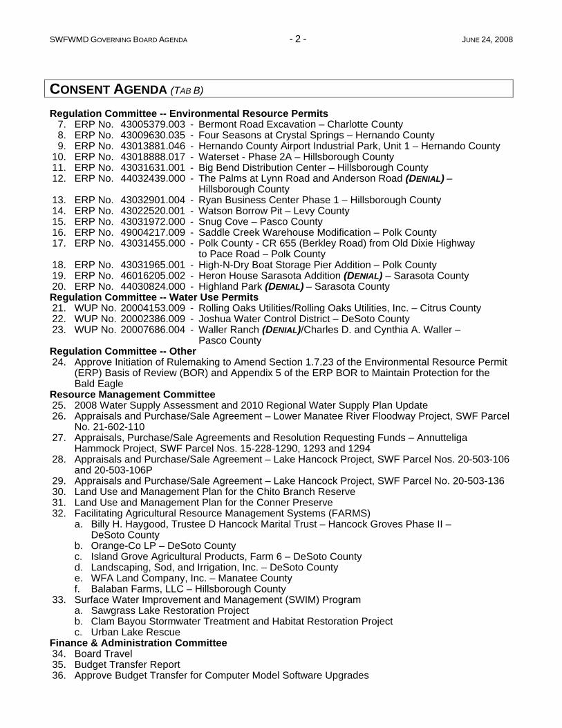
CONSENT AGENDA (TAB B)
Regulation Committee -- Environmental Resource Permits 7. ERP No. 43005379.003 - Bermont Road Excavation – Charlotte County 8. ERP No. 43009630.035 - Four Seasons at Crystal Springs – Hernando County 9. ERP No. 43013881.046 - Hernando County Airport Industrial Park, Unit 1 – Hernando County 10. ERP No. 43018888.017 - Waterset - Phase 2A – Hillsborough County 11. ERP No. 43031631.001 - Big Bend Distribution Center – Hillsborough County 12. ERP No. 44032439.000 - The Palms at Lynn Road and Anderson Road (DENIAL) –
Hillsborough County 13. ERP No. 43032901.004 - Ryan Business Center Phase 1 – Hillsborough County 14. ERP No. 43022520.001 - Watson Borrow Pit – Levy County 15. ERP No. 43031972.000 - Snug Cove – Pasco County 16. ERP No. 49004217.009 - Saddle Creek Warehouse Modification – Polk County 17. ERP No. 43031455.000 - Polk County - CR 655 (Berkley Road) from Old Dixie Highway
to Pace Road – Polk County 18. ERP No. 43031965.001 - High-N-Dry Boat Storage Pier Addition – Polk County 19. ERP No. 46016205.002 - Heron House Sarasota Addition (DENIAL) – Sarasota County 20. ERP No. 44030824.000 - Highland Park (DENIAL) – Sarasota County Regulation Committee -- Water Use Permits 21. WUP No. 20004153.009 - Rolling Oaks Utilities/Rolling Oaks Utilities, Inc. – Citrus County 22. WUP No. 20002386.009 - Joshua Water Control District – DeSoto County 23. WUP No. 20007686.004 - Waller Ranch (DENIAL)/Charles D. and Cynthia A. Waller –
Pasco County Regulation Committee -- Other 24. Approve Initiation of Rulemaking to Amend Section 1.7.23 of the Environmental Resource Permit
(ERP) Basis of Review (BOR) and Appendix 5 of the ERP BOR to Maintain Protection for the Bald Eagle
Resource Management Committee 25. 2008 Water Supply Assessment and 2010 Regional Water Supply Plan Update 26. Appraisals and Purchase/Sale Agreement – Lower Manatee River Floodway Project, SWF Parcel
No. 21-602-110 27. Appraisals, Purchase/Sale Agreements and Resolution Requesting Funds – Annutteliga
Hammock Project, SWF Parcel Nos. 15-228-1290, 1293 and 1294 28. Appraisals and Purchase/Sale Agreement – Lake Hancock Project, SWF Parcel Nos. 20-503-106
and 20-503-106P 29. Appraisals and Purchase/Sale Agreement – Lake Hancock Project, SWF Parcel No. 20-503-136 30. Land Use and Management Plan for the Chito Branch Reserve 31. Land Use and Management Plan for the Conner Preserve 32. Facilitating Agricultural Resource Management Systems (FARMS) a. Billy H. Haygood, Trustee D Hancock Marital Trust – Hancock Groves Phase II –
DeSoto County b. Orange-Co LP – DeSoto County c. Island Grove Agricultural Products, Farm 6 – DeSoto County d. Landscaping, Sod, and Irrigation, Inc. – DeSoto County e. WFA Land Company, Inc. – Manatee County f. Balaban Farms, LLC – Hillsborough County 33. Surface Water Improvement and Management (SWIM) Program a. Sawgrass Lake Restoration Project b. Clam Bayou Stormwater Treatment and Habitat Restoration Project c. Urban Lake Rescue Finance & Administration Committee 34. Board Travel 35. Budget Transfer Report 36. Approve Budget Transfer for Computer Model Software Upgrades
SWFWMD GOVERNING BOARD AGENDA - 3 - JUNE 24, 2008
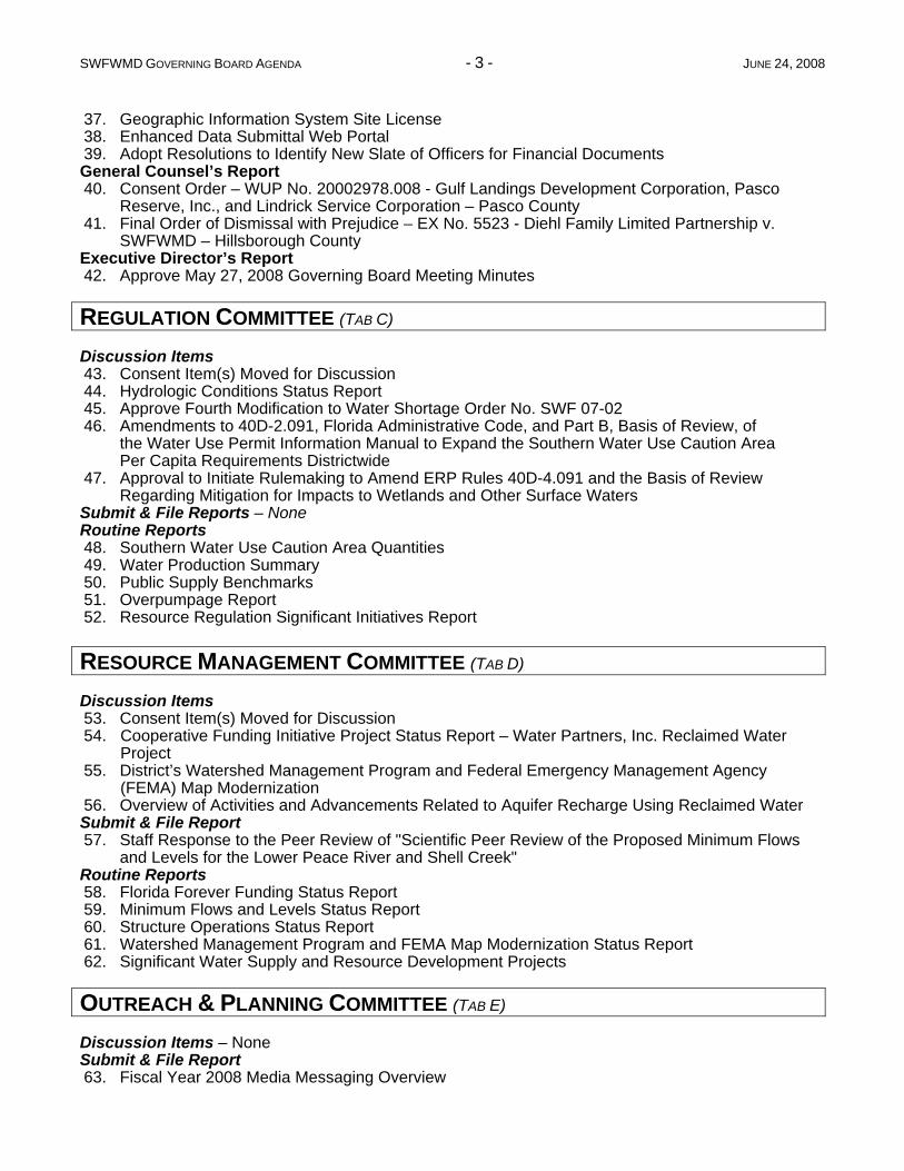
37. Geographic Information System Site License 38. Enhanced Data Submittal Web Portal 39. Adopt Resolutions to Identify New Slate of Officers for Financial Documents General Counsel’s Report 40. Consent Order – WUP No. 20002978.008 - Gulf Landings Development Corporation, Pasco
Reserve, Inc., and Lindrick Service Corporation – Pasco County 41. Final Order of Dismissal with Prejudice – EX No. 5523 - Diehl Family Limited Partnership v.
SWFWMD – Hillsborough County Executive Director’s Report 42. Approve May 27, 2008 Governing Board Meeting Minutes
REGULATION COMMITTEE (TAB C)
Discussion Items 43. Consent Item(s) Moved for Discussion 44. Hydrologic Conditions Status Report 45. Approve Fourth Modification to Water Shortage Order No. SWF 07-02 46. Amendments to 40D-2.091, Florida Administrative Code, and Part B, Basis of Review, of
the Water Use Permit Information Manual to Expand the Southern Water Use Caution Area Per Capita Requirements Districtwide
47. Approval to Initiate Rulemaking to Amend ERP Rules 40D-4.091 and the Basis of Review Regarding Mitigation for Impacts to Wetlands and Other Surface Waters
Submit & File Reports – NoneRoutine Reports 48. Southern Water Use Caution Area Quantities 49. Water Production Summary 50. Public Supply Benchmarks 51. Overpumpage Report 52. Resource Regulation Significant Initiatives Report
RESOURCE MANAGEMENT COMMITTEE (TAB D)
Discussion Items 53. Consent Item(s) Moved for Discussion 54. Cooperative Funding Initiative Project Status Report – Water Partners, Inc. Reclaimed Water
Project 55. District’s Watershed Management Program and Federal Emergency Management Agency
(FEMA) Map Modernization 56. Overview of Activities and Advancements Related to Aquifer Recharge Using Reclaimed Water Submit & File Report 57. Staff Response to the Peer Review of "Scientific Peer Review of the Proposed Minimum Flows
and Levels for the Lower Peace River and Shell Creek" Routine Reports 58. Florida Forever Funding Status Report 59. Minimum Flows and Levels Status Report 60. Structure Operations Status Report 61. Watershed Management Program and FEMA Map Modernization Status Report 62. Significant Water Supply and Resource Development Projects
OUTREACH & PLANNING COMMITTEE (TAB E)
Discussion Items – NoneSubmit & File Report 63. Fiscal Year 2008 Media Messaging Overview
SWFWMD GOVERNING BOARD AGENDA - 4 - JUNE 24, 2008
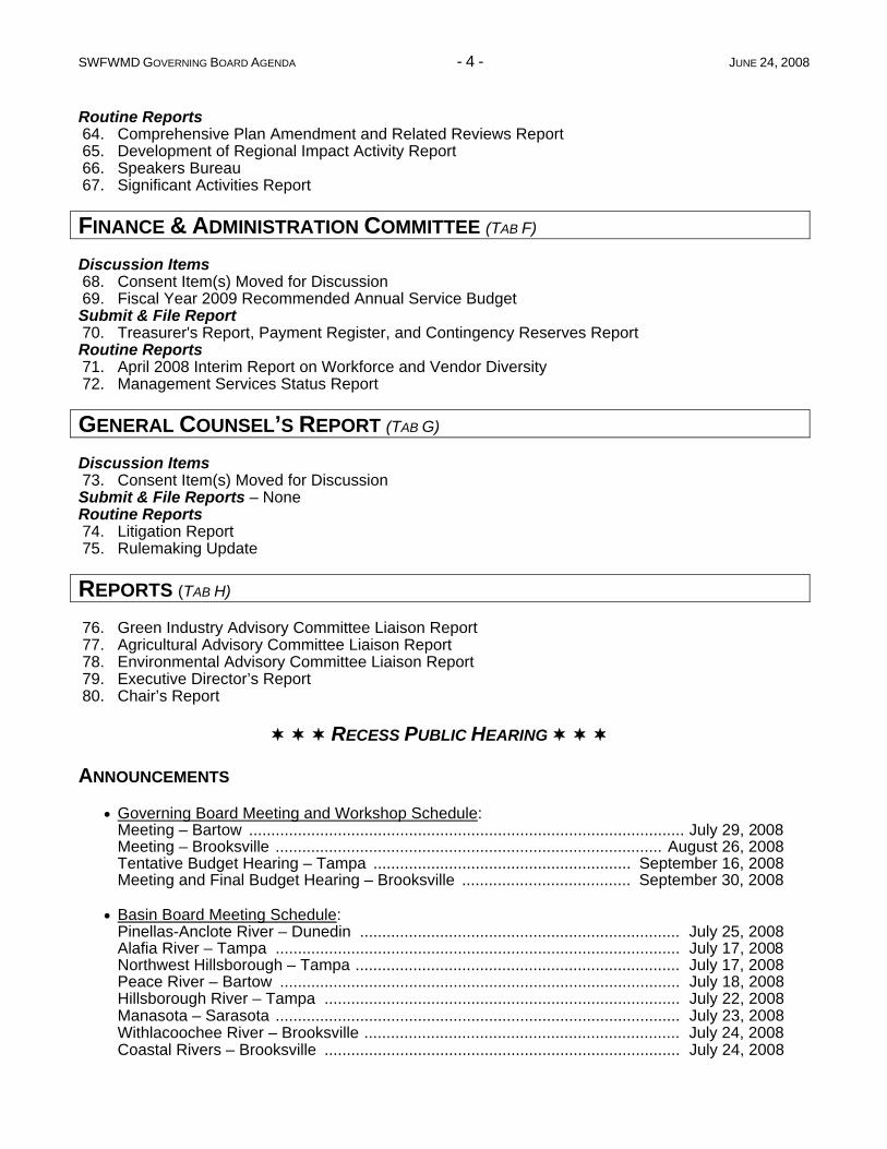
Routine Reports 64. Comprehensive Plan Amendment and Related Reviews Report 65. Development of Regional Impact Activity Report 66. Speakers Bureau 67. Significant Activities Report
FINANCE & ADMINISTRATION COMMITTEE (TAB F)
Discussion Items 68. Consent Item(s) Moved for Discussion 69. Fiscal Year 2009 Recommended Annual Service Budget Submit & File Report 70. Treasurer's Report, Payment Register, and Contingency Reserves Report Routine Reports 71. April 2008 Interim Report on Workforce and Vendor Diversity 72. Management Services Status Report
GENERAL COUNSEL’S REPORT (TAB G)
Discussion Items 73. Consent Item(s) Moved for Discussion Submit & File Reports – NoneRoutine Reports 74. Litigation Report 75. Rulemaking Update
REPORTS (TAB H)
76. Green Industry Advisory Committee Liaison Report 77. Agricultural Advisory Committee Liaison Report 78. Environmental Advisory Committee Liaison Report 79. Executive Director’s Report 80. Chair’s Report
RECESS PUBLIC HEARING ANNOUNCEMENTS
Governing Board Meeting and Workshop Schedule: Meeting – Bartow .................................................................................................. July 29, 2008 Meeting – Brooksville ....................................................................................... August 26, 2008 Tentative Budget Hearing – Tampa .......................................................... September 16, 2008 Meeting and Final Budget Hearing – Brooksville ...................................... September 30, 2008
Basin Board Meeting Schedule: Pinellas-Anclote River – Dunedin ........................................................................ July 25, 2008 Alafia River – Tampa ........................................................................................... July 17, 2008 Northwest Hillsborough – Tampa ......................................................................... July 17, 2008 Peace River – Bartow .......................................................................................... July 18, 2008 Hillsborough River – Tampa ................................................................................ July 22, 2008 Manasota – Sarasota ........................................................................................... July 23, 2008 Withlacoochee River – Brooksville ....................................................................... July 24, 2008 Coastal Rivers – Brooksville ................................................................................ July 24, 2008
SWFWMD GOVERNING BOARD AGENDA - 5 - JUNE 24, 2008
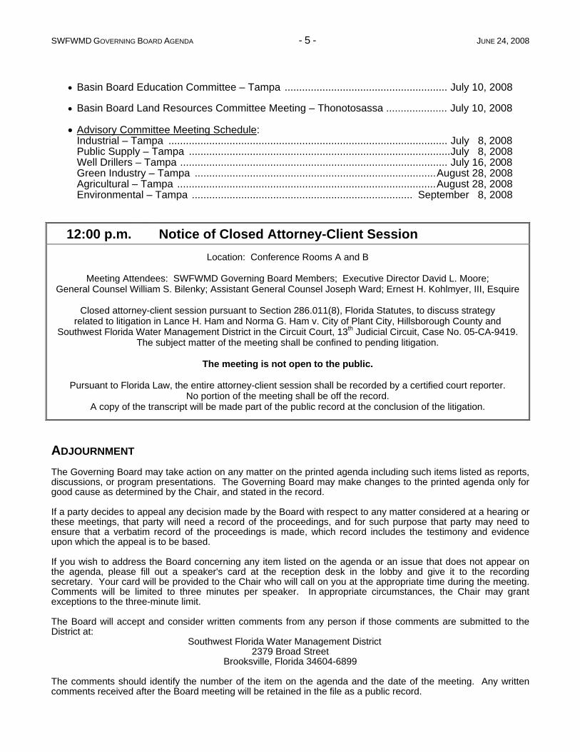
Basin Board Education Committee – Tampa ........................................................ July 10, 2008
Basin Board Land Resources Committee Meeting – Thonotosassa ..................... July 10, 2008
Advisory Committee Meeting Schedule: Industrial – Tampa ................................................................................................ July 8, 2008 Public Supply – Tampa ..........................................................................................July 8, 2008 Well Drillers – Tampa ............................................................................................ July 16, 2008 Green Industry – Tampa ...................................................................................August 28, 2008 Agricultural – Tampa .........................................................................................August 28, 2008 Environmental – Tampa ............................................................................ September 8, 2008
12:00 p.m. Notice of Closed Attorney-Client SessionLocation: Conference Rooms A and B
Meeting Attendees: SWFWMD Governing Board Members; Executive Director David L. Moore; General Counsel William S. Bilenky; Assistant General Counsel Joseph Ward; Ernest H. Kohlmyer, III, Esquire
Closed attorney-client session pursuant to Section 286.011(8), Florida Statutes, to discuss strategy related to litigation in Lance H. Ham and Norma G. Ham v. City of Plant City, Hillsborough County and
Southwest Florida Water Management District in the Circuit Court, 13th Judicial Circuit, Case No. 05-CA-9419. The subject matter of the meeting shall be confined to pending litigation.
The meeting is not open to the public.
Pursuant to Florida Law, the entire attorney-client session shall be recorded by a certified court reporter. No portion of the meeting shall be off the record.
A copy of the transcript will be made part of the public record at the conclusion of the litigation.
ADJOURNMENT The Governing Board may take action on any matter on the printed agenda including such items listed as reports, discussions, or program presentations. The Governing Board may make changes to the printed agenda only for good cause as determined by the Chair, and stated in the record.
If a party decides to appeal any decision made by the Board with respect to any matter considered at a hearing or these meetings, that party will need a record of the proceedings, and for such purpose that party may need to ensure that a verbatim record of the proceedings is made, which record includes the testimony and evidence upon which the appeal is to be based.
If you wish to address the Board concerning any item listed on the agenda or an issue that does not appear on the agenda, please fill out a speaker's card at the reception desk in the lobby and give it to the recording secretary. Your card will be provided to the Chair who will call on you at the appropriate time during the meeting. Comments will be limited to three minutes per speaker. In appropriate circumstances, the Chair may grant exceptions to the three-minute limit.
The Board will accept and consider written comments from any person if those comments are submitted to the District at: Southwest Florida Water Management District
2379 Broad Street Brooksville, Florida 34604-6899
The comments should identify the number of the item on the agenda and the date of the meeting. Any written comments received after the Board meeting will be retained in the file as a public record.
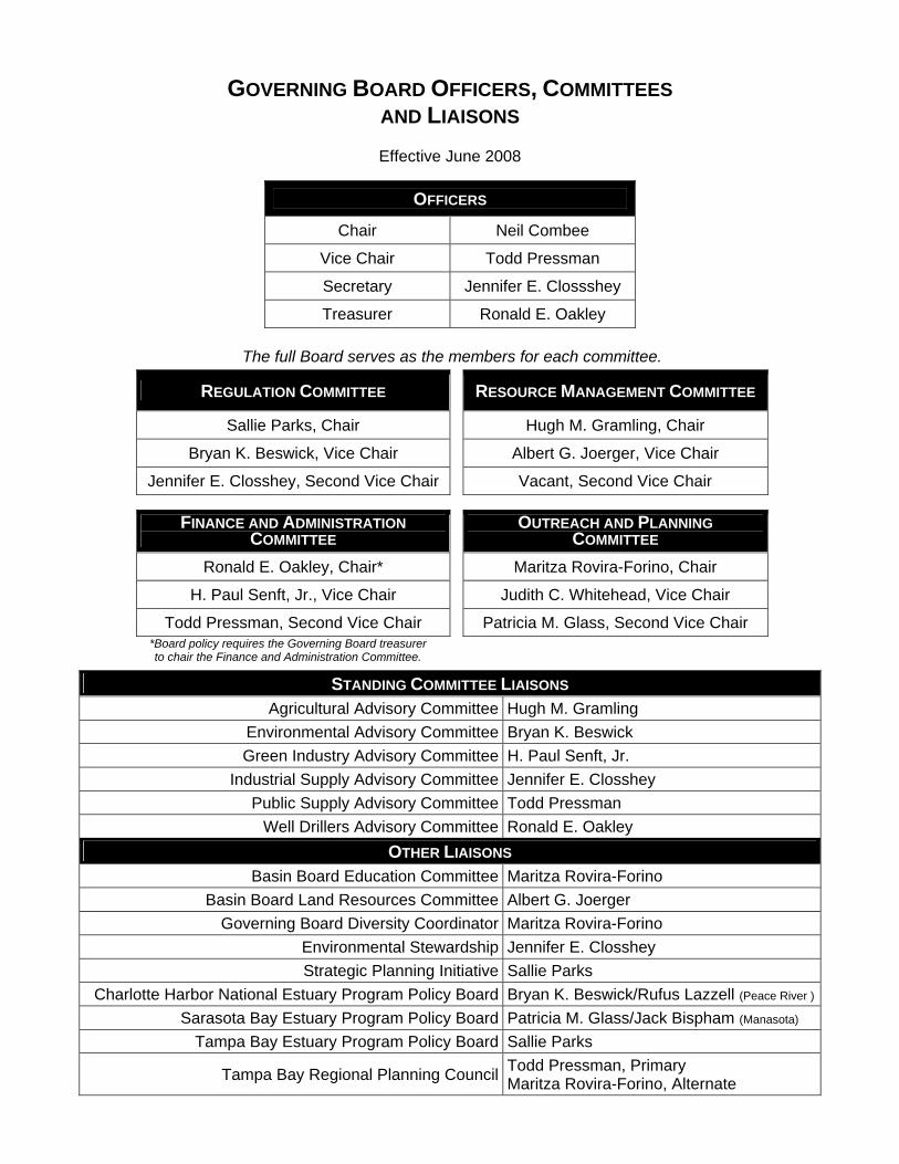
GOVERNING BOARD OFFICERS, COMMITTEES AND LIAISONS Effective June 2008
OFFICERS
Chair Neil Combee
Vice Chair Todd Pressman
Secretary Jennifer E. Clossshey
Treasurer Ronald E. Oakley
The full Board serves as the members for each committee.
REGULATION COMMITTEE RESOURCE MANAGEMENT COMMITTEE
Sallie Parks, Chair Hugh M. Gramling, Chair
Bryan K. Beswick, Vice Chair Albert G. Joerger, Vice Chair
Jennifer E. Closshey, Second Vice Chair Vacant, Second Vice Chair
FINANCE AND ADMINISTRATION COMMITTEE
OUTREACH AND PLANNING COMMITTEE
Ronald E. Oakley, Chair* Maritza Rovira-Forino, Chair
H. Paul Senft, Jr., Vice Chair Judith C. Whitehead, Vice Chair
Todd Pressman, Second Vice Chair Patricia M. Glass, Second Vice Chair *Board policy requires the Governing Board treasurer to chair the Finance and Administration Committee.
STANDING COMMITTEE LIAISONS Agricultural Advisory Committee Hugh M. Gramling
Environmental Advisory Committee Bryan K. Beswick Green Industry Advisory Committee H. Paul Senft, Jr.
Industrial Supply Advisory Committee Jennifer E. Closshey Public Supply Advisory Committee Todd Pressman
Well Drillers Advisory Committee Ronald E. Oakley OTHER LIAISONS
Basin Board Education Committee Maritza Rovira-Forino Basin Board Land Resources Committee Albert G. Joerger
Governing Board Diversity Coordinator Maritza Rovira-Forino Environmental Stewardship Jennifer E. Closshey Strategic Planning Initiative Sallie Parks
Charlotte Harbor National Estuary Program Policy Board Bryan K. Beswick/Rufus Lazzell (Peace River )
Sarasota Bay Estuary Program Policy Board Patricia M. Glass/Jack Bispham (Manasota)
Tampa Bay Estuary Program Policy Board Sallie Parks
Tampa Bay Regional Planning Council Todd Pressman, Primary Maritza Rovira-Forino, Alternate

A.Public
Hearing
&M
eeting
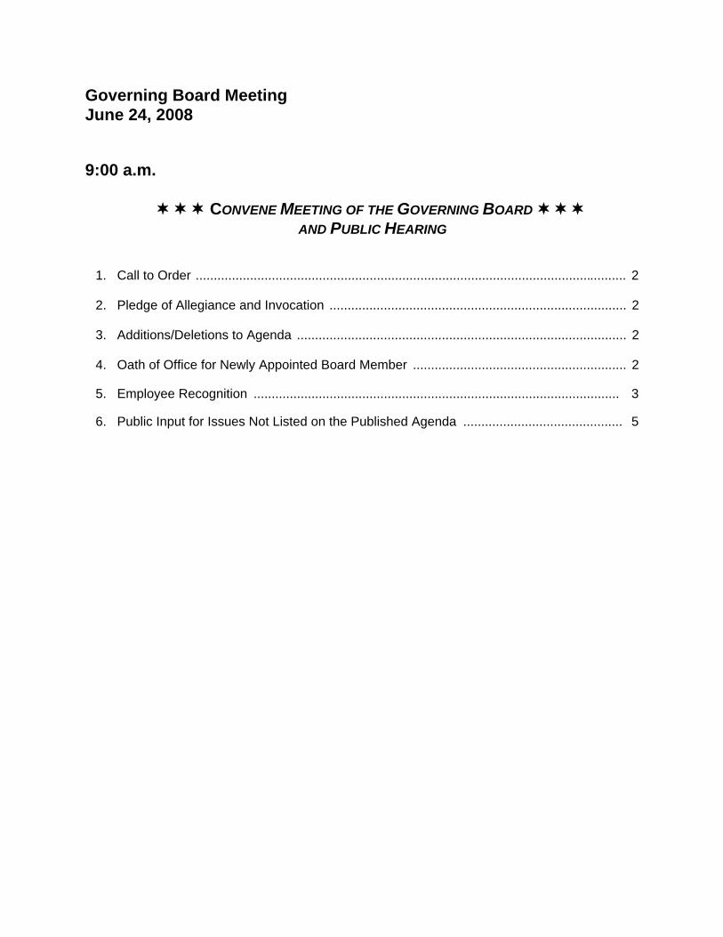
Governing Board Meeting June 24, 2008
9:00 a.m. CONVENE MEETING OF THE GOVERNING BOARD
AND PUBLIC HEARING
1. Call to Order ....................................................................................................................... 2
2. Pledge of Allegiance and Invocation .................................................................................. 2
3. Additions/Deletions to Agenda ........................................................................................... 2
4. Oath of Office for Newly Appointed Board Member ........................................................... 2
5. Employee Recognition ..................................................................................................... 3
6. Public Input for Issues Not Listed on the Published Agenda ............................................ 5
Items 1 - 4
Governing Board Meeting June 24, 2008
1. Call to Order
The Board Chair calls the meeting to order. The Board Secretary confirms that a quorum is present. The Board Chair then opens the public hearing.
Anyone wishing to address the Governing Board concerning any item listed on the agenda or any item that does not appear on the agenda should fill out and submit a speaker's card. Comments will be limited to three minutes per speaker, and, when appropriate, exceptions to the three-minute limit may be granted by the Chair. Several individuals wishing to speak on the same issue/topic should designate a spokesperson.
2. Pledge of Allegiance and Invocation
The Board Chair leads the Pledge of Allegiance to the Flag of the United States of America. Mr. Bilenky offers the invocation.
3. Additions/Deletions to Agenda
According to Section 120.525(2), Florida Statutes, additions to the published agenda will only be made for "good cause" as determined by the "person designated to preside." The items that have been added to the agenda were received by the District after publication of the regular agenda. The Board was provided with the information filed and the District staff's analyses of these matters. Staff has determined that action must be taken on these items prior to the next Board meeting.
Therefore, it is the District staff's recommendation that good cause has been demonstrated and should be considered during the Governing Board's meeting.
Staff Recommendation:
Approval of the recommended additions and deletions to the published agenda.
Presenter: David L. Moore, Executive Director
4. Oath of Office for Newly Appointed Board Member
If a new Board member is appointed, the Oath of Office will be administered by Ms. Lou Kavouras, Deputy Executive Director.
2
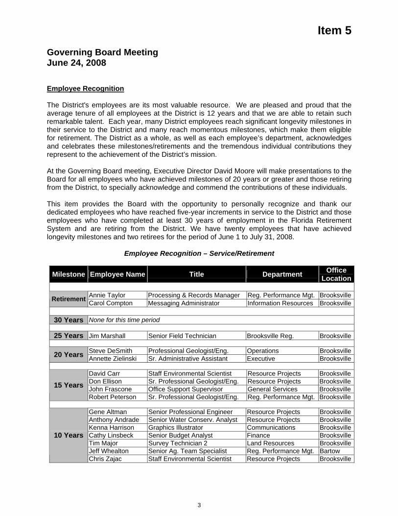
Item 5
Governing Board Meeting June 24, 2008
Employee Recognition
The District's employees are its most valuable resource. We are pleased and proud that the average tenure of all employees at the District is 12 years and that we are able to retain such remarkable talent. Each year, many District employees reach significant longevity milestones in their service to the District and many reach momentous milestones, which make them eligible for retirement. The District as a whole, as well as each employee’s department, acknowledges and celebrates these milestones/retirements and the tremendous individual contributions they represent to the achievement of the District’s mission.
At the Governing Board meeting, Executive Director David Moore will make presentations to the Board for all employees who have achieved milestones of 20 years or greater and those retiring from the District, to specially acknowledge and commend the contributions of these individuals.
This item provides the Board with the opportunity to personally recognize and thank our dedicated employees who have reached five-year increments in service to the District and those employees who have completed at least 30 years of employment in the Florida Retirement System and are retiring from the District. We have twenty employees that have achieved longevity milestones and two retirees for the period of June 1 to July 31, 2008.
Employee Recognition – Service/Retirement
Milestone Employee Name Title Department Office Location
Annie Taylor Processing & Records Manager Reg. Performance Mgt. BrooksvilleRetirement Carol Compton Messaging Administrator Information Resources Brooksville
30 Years None for this time period
25 Years Jim Marshall Senior Field Technician Brooksville Reg. Brooksville
Steve DeSmith Professional Geologist/Eng. Operations Brooksville20 Years Annette Zielinski Sr. Administrative Assistant Executive Brooksville
David Carr Staff Environmental Scientist Resource Projects BrooksvilleDon Ellison Sr. Professional Geologist/Eng. Resource Projects BrooksvilleJohn Frascone Office Support Supervisor General Services Brooksville15 Years Robert Peterson Sr. Professional Geologist/Eng. Reg. Performance Mgt. Brooksville
Gene Altman Senior Professional Engineer Resource Projects BrooksvilleAnthony Andrade Senior Water Conserv. Analyst Resource Projects BrooksvilleKenna Harrison Graphics Illustrator Communications BrooksvilleCathy Linsbeck Senior Budget Analyst Finance BrooksvilleTim Major Survey Technician 2 Land Resources BrooksvilleJeff Whealton Senior Ag. Team Specialist Reg. Performance Mgt. Bartow
10 Years
Chris Zajac Staff Environmental Scientist Resource Projects Brooksville
3
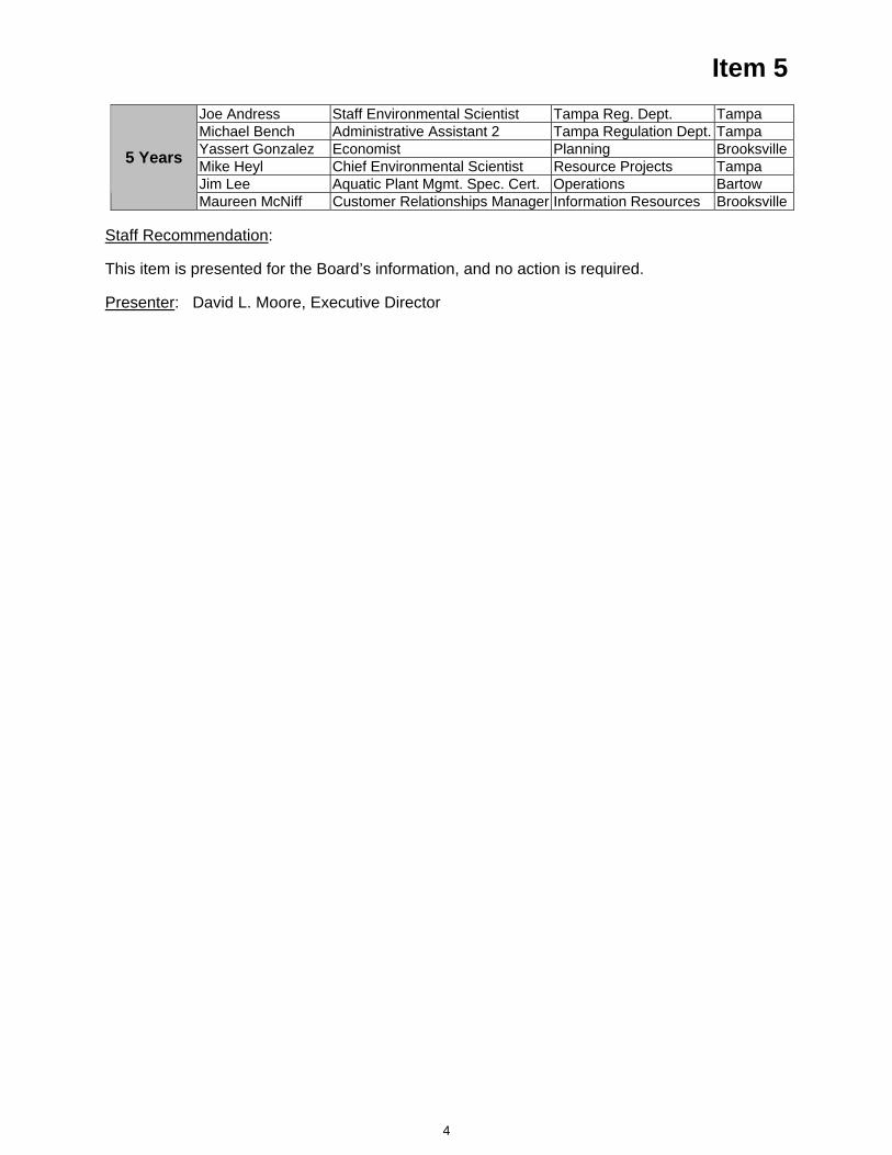
Item 5 Joe Andress Staff Environmental Scientist Tampa Reg. Dept. TampaMichael Bench Administrative Assistant 2 Tampa Regulation Dept. TampaYassert Gonzalez Economist Planning BrooksvilleMike Heyl Chief Environmental Scientist Resource Projects TampaJim Lee Aquatic Plant Mgmt. Spec. Cert. Operations Bartow
5 Years
Maureen McNiff Customer Relationships Manager Information Resources Brooksville
Staff Recommendation:
This item is presented for the Board’s information, and no action is required.
Presenter: David L. Moore, Executive Director
4

Item 6
Governing Board Meeting June 24, 2008
Public Input for Issues Not Listed on the Published Agenda
At this time, the Board will hear public input for issues not listed on the published agenda.
5

B.C
onsentA
genda
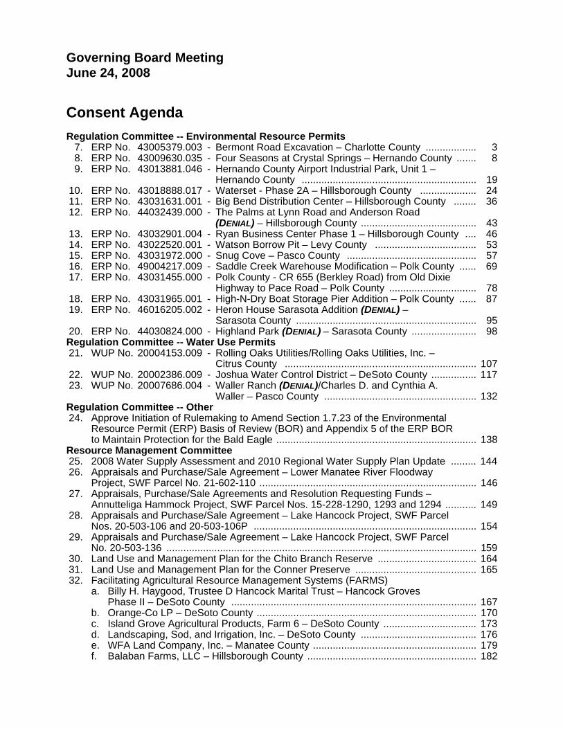
Governing Board Meeting June 24, 2008 Consent Agenda Regulation Committee -- Environmental Resource Permits 7. ERP No. 43005379.003 - Bermont Road Excavation – Charlotte County .................. 3 8. ERP No. 43009630.035 - Four Seasons at Crystal Springs – Hernando County ....... 8 9. ERP No. 43013881.046 - Hernando County Airport Industrial Park, Unit 1 –
Hernando County .............................................................. 19 10. ERP No. 43018888.017 - Waterset - Phase 2A – Hillsborough County .................... 24 11. ERP No. 43031631.001 - Big Bend Distribution Center – Hillsborough County ........ 36 12. ERP No. 44032439.000 - The Palms at Lynn Road and Anderson Road
(DENIAL) – Hillsborough County ......................................... 43 13. ERP No. 43032901.004 - Ryan Business Center Phase 1 – Hillsborough County .... 46 14. ERP No. 43022520.001 - Watson Borrow Pit – Levy County .................................... 53 15. ERP No. 43031972.000 - Snug Cove – Pasco County .............................................. 57 16. ERP No. 49004217.009 - Saddle Creek Warehouse Modification – Polk County ...... 69 17. ERP No. 43031455.000 - Polk County - CR 655 (Berkley Road) from Old Dixie
Highway to Pace Road – Polk County ............................... 78 18. ERP No. 43031965.001 - High-N-Dry Boat Storage Pier Addition – Polk County ...... 87 19. ERP No. 46016205.002 - Heron House Sarasota Addition (DENIAL) –
Sarasota County ................................................................ 95 20. ERP No. 44030824.000 - Highland Park (DENIAL) – Sarasota County ....................... 98 Regulation Committee -- Water Use Permits 21. WUP No. 20004153.009 - Rolling Oaks Utilities/Rolling Oaks Utilities, Inc. –
Citrus County .................................................................... 107 22. WUP No. 20002386.009 - Joshua Water Control District – DeSoto County ................ 117 23. WUP No. 20007686.004 - Waller Ranch (DENIAL)/Charles D. and Cynthia A.
Waller – Pasco County ...................................................... 132 Regulation Committee -- Other 24. Approve Initiation of Rulemaking to Amend Section 1.7.23 of the Environmental
Resource Permit (ERP) Basis of Review (BOR) and Appendix 5 of the ERP BOR to Maintain Protection for the Bald Eagle ....................................................................... 138
Resource Management Committee 25. 2008 Water Supply Assessment and 2010 Regional Water Supply Plan Update ......... 144 26. Appraisals and Purchase/Sale Agreement – Lower Manatee River Floodway
Project, SWF Parcel No. 21-602-110 ............................................................................. 146 27. Appraisals, Purchase/Sale Agreements and Resolution Requesting Funds –
Annutteliga Hammock Project, SWF Parcel Nos. 15-228-1290, 1293 and 1294 ........... 149 28. Appraisals and Purchase/Sale Agreement – Lake Hancock Project, SWF Parcel
Nos. 20-503-106 and 20-503-106P ............................................................................... 154 29. Appraisals and Purchase/Sale Agreement – Lake Hancock Project, SWF Parcel
No. 20-503-136 .............................................................................................................. 159 30. Land Use and Management Plan for the Chito Branch Reserve ................................... 164 31. Land Use and Management Plan for the Conner Preserve ........................................... 165 32. Facilitating Agricultural Resource Management Systems (FARMS) a. Billy H. Haygood, Trustee D Hancock Marital Trust – Hancock Groves
Phase II – DeSoto County ....................................................................................... 167 b. Orange-Co LP – DeSoto County .............................................................................. 170 c. Island Grove Agricultural Products, Farm 6 – DeSoto County ................................. 173 d. Landscaping, Sod, and Irrigation, Inc. – DeSoto County ......................................... 176 e. WFA Land Company, Inc. – Manatee County .......................................................... 179 f. Balaban Farms, LLC – Hillsborough County ............................................................ 182
33. Surface Water Improvement and Management (SWIM) Program a. Sawgrass Lake Restoration Project ......................................................................... 185 b. Clam Bayou Stormwater Treatment and Habitat Restoration Project ...................... 187 c. Urban Lake Rescue ................................................................................................. 192 Finance & Administration Committee 34. Board Travel ................................................................................................................... 194 35. Budget Transfer Report ................................................................................................. 195 36. Approve Budget Transfer for Computer Model Software Upgrades .............................. 198 37. Geographic Information System Site License ................................................................ 199 38. Enhanced Data Submittal Web Portal ............................................................................ 201 39. Adopt Resolutions to Identify New Slate of Officers for Financial Documents ............... 203 General Counsel’s Report 40. Consent Order – WUP No. 20002978.008 - Gulf Landings Development
Corporation, Pasco Reserve, Inc., and Lindrick Service Corporation – Pasco County ................................................................................................................. 208
41. Final Order of Dismissal with Prejudice – EX No. 5523 - Diehl Family Limited Partnership v. SWFWMD – Hillsborough County ........................................................... 209
Executive Director’s Report 42. Approve May 27, 2008 Governing Board Meeting Minutes ........................................... 210
2
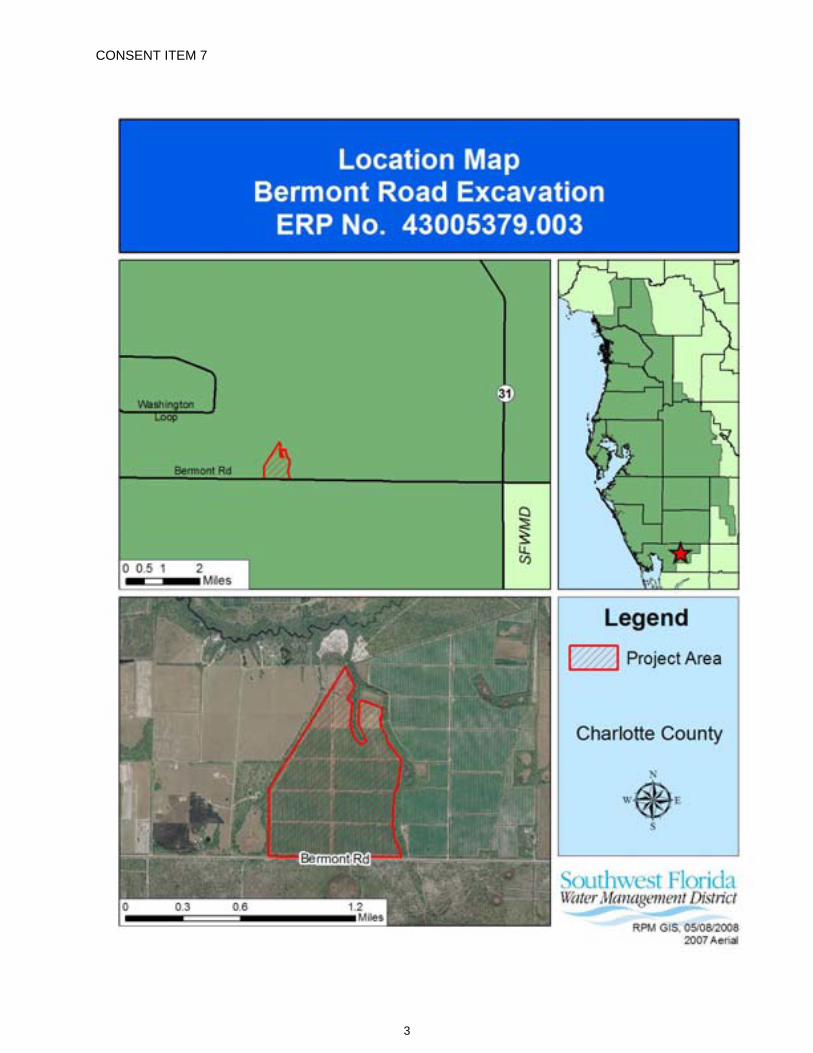
CONSENT ITEM 7
3
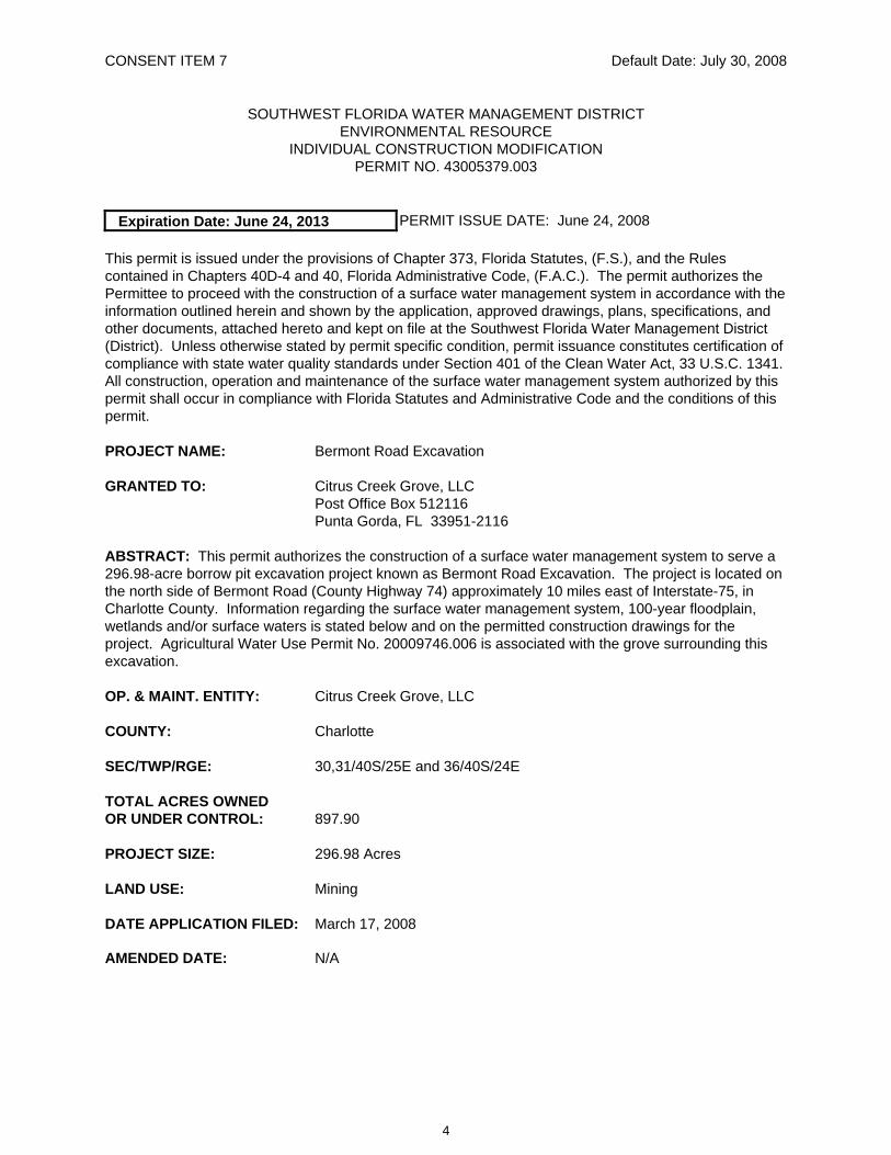
CONSENT ITEM 7 Default Date: July 30, 2008
SOUTHWEST FLORIDA WATER MANAGEMENT DISTRICT ENVIRONMENTAL RESOURCE
INDIVIDUAL CONSTRUCTION MODIFICATION PERMIT NO. 43005379.003
Expiration Date: June 24, 2013 PERMIT ISSUE DATE: June 24, 2008
This permit is issued under the provisions of Chapter 373, Florida Statutes, (F.S.), and the Rules contained in Chapters 40D-4 and 40, Florida Administrative Code, (F.A.C.). The permit authorizes the Permittee to proceed with the construction of a surface water management system in accordance with the information outlined herein and shown by the application, approved drawings, plans, specifications, and other documents, attached hereto and kept on file at the Southwest Florida Water Management District (District). Unless otherwise stated by permit specific condition, permit issuance constitutes certification of compliance with state water quality standards under Section 401 of the Clean Water Act, 33 U.S.C. 1341. All construction, operation and maintenance of the surface water management system authorized by this permit shall occur in compliance with Florida Statutes and Administrative Code and the conditions of this permit.
PROJECT NAME: Bermont Road Excavation
GRANTED TO: Citrus Creek Grove, LLC Post Office Box 512116 Punta Gorda, FL 33951-2116
ABSTRACT: This permit authorizes the construction of a surface water management system to serve a 296.98-acre borrow pit excavation project known as Bermont Road Excavation. The project is located on the north side of Bermont Road (County Highway 74) approximately 10 miles east of Interstate-75, in Charlotte County. Information regarding the surface water management system, 100-year floodplain, wetlands and/or surface waters is stated below and on the permitted construction drawings for the project. Agricultural Water Use Permit No. 20009746.006 is associated with the grove surrounding this excavation.
OP. & MAINT. ENTITY: Citrus Creek Grove, LLC
COUNTY: Charlotte
SEC/TWP/RGE: 30,31/40S/25E and 36/40S/24E
TOTAL ACRES OWNED OR UNDER CONTROL: 897.90
PROJECT SIZE: 296.98 Acres
LAND USE: Mining
DATE APPLICATION FILED: March 17, 2008
AMENDED DATE: N/A
4
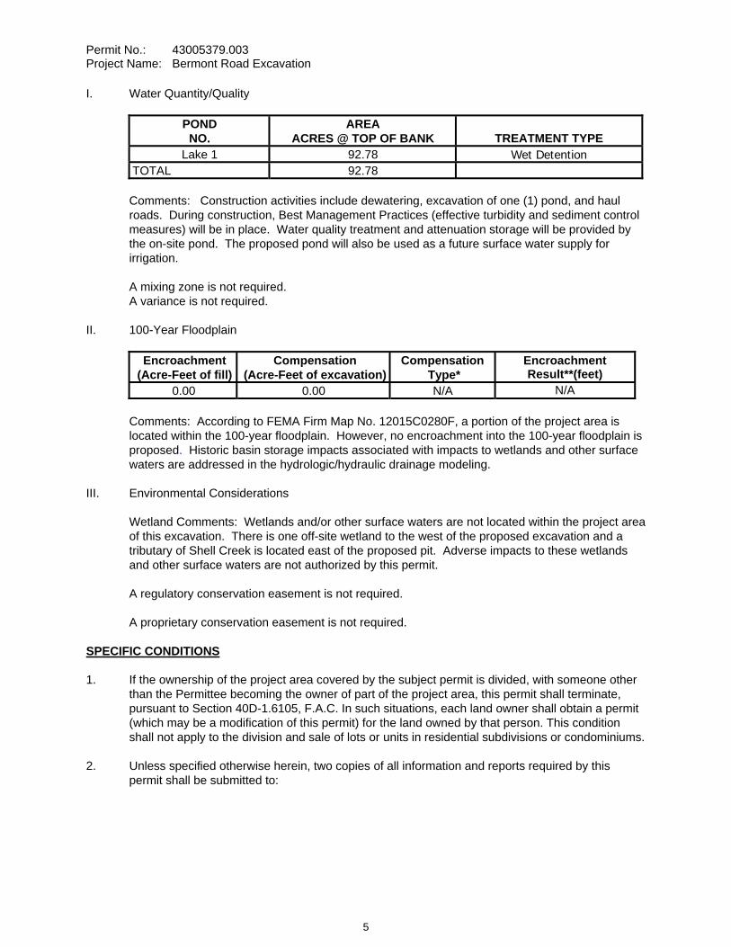
Permit No.: 43005379.003 Project Name: Bermont Road Excavation
I. Water Quantity/Quality
POND NO.
AREA ACRES @ TOP OF BANK TREATMENT TYPE
Lake 1 92.78 Wet Detention TOTAL 92.78
Comments: Construction activities include dewatering, excavation of one (1) pond, and haul roads. During construction, Best Management Practices (effective turbidity and sediment control measures) will be in place. Water quality treatment and attenuation storage will be provided by the on-site pond. The proposed pond will also be used as a future surface water supply for irrigation.
A mixing zone is not required. A variance is not required.
II. 100-Year Floodplain
Encroachment (Acre-Feet of fill)
Compensation (Acre-Feet of excavation)
Compensation Type*
Encroachment Result**(feet)
0.00 0.00 N/A N/A
Comments: According to FEMA Firm Map No. 12015C0280F, a portion of the project area is located within the 100-year floodplain. However, no encroachment into the 100-year floodplain is proposed. Historic basin storage impacts associated with impacts to wetlands and other surface waters are addressed in the hydrologic/hydraulic drainage modeling.
III. Environmental Considerations
Wetland Comments: Wetlands and/or other surface waters are not located within the project area of this excavation. There is one off-site wetland to the west of the proposed excavation and a tributary of Shell Creek is located east of the proposed pit. Adverse impacts to these wetlands and other surface waters are not authorized by this permit.
A regulatory conservation easement is not required.
A proprietary conservation easement is not required.
SPECIFIC CONDITIONS 1. If the ownership of the project area covered by the subject permit is divided, with someone other
than the Permittee becoming the owner of part of the project area, this permit shall terminate, pursuant to Section 40D-1.6105, F.A.C. In such situations, each land owner shall obtain a permit (which may be a modification of this permit) for the land owned by that person. This condition shall not apply to the division and sale of lots or units in residential subdivisions or condominiums.
2. Unless specified otherwise herein, two copies of all information and reports required by this permit shall be submitted to:
5
Permit No.: 43005379.003 Project Name: Bermont Road Excavation
Sarasota Regulation Department Southwest Florida Water Management District 6750 Fruitville Road Sarasota, FL 34240-9711
The permit number, title of report or information and event (for recurring report or information submittal) shall be identified on all information and reports submitted.
3. The Permittee shall retain the design engineer, or other professional engineer registered in Florida, to conduct on-site observations of construction and assist with the as-built certification requirements of this project. The Permittee shall inform the District in writing of the name, address and phone number of the professional engineer so employed. This information shall be submitted prior to construction.
4. Within 30 days after completion of construction of the permitted activity, the Permittee shall submit to the Sarasota Service Office a written statement of completion and certification by a registered professional engineer or other appropriate individual as authorized by law, utilizing the required Statement of Completion and Request for Transfer to Operation Entity form identified in Chapter 40D-1.659, F.A.C., and signed, dated and sealed as-built drawings. The as-built drawings shall identify any deviations from the approved construction drawings.
5. The District reserves the right, upon prior notice to the Permittee, to conduct on-site research to assess the pollutant removal efficiency of the surface water management system. The Permittee may be required to cooperate in this regard by allowing on-site access by District representatives, by allowing the installation and operation of testing and monitoring equipment, and by allowing other assistance measures as needed on site.
6. The operation and maintenance entity shall submit inspection reports in the form required by the District, in accordance with the following schedule.
For systems utilizing retention or wet detention, the inspections shall be performed two (2) years after operation is authorized and every two (2) years thereafter.
7. The removal of littoral shelf vegetation (including cattails) from wet detention ponds is prohibited unless otherwise approved by the District. Removal includes dredging, the application of herbicide, cutting, and the introduction of grass carp. Any questions regarding authorized activities within the wet detention ponds shall be addressed to the District's Surface Water Regulation Manager, Sarasota Service Office.
8. The District, upon prior notice to the Permittee, may conduct on-site inspections to assess the effectiveness of the erosion control barriers and other measures employed to prevent violations of state water quality standards and avoid downstream impacts. Such barriers or other measures should control discharges, erosion, and sediment transport during construction and thereafter. The District will also determine any potential environmental problems that may develop as a result of leaving or removing the barriers and other measures during construction or after construction of the project has been completed. The Permittee must provide any remedial measures that are needed.
9. Dewatering associated with this mining operation shall not occur until the Permittee obtains the appropriate Water Use Permit from the District.
6
Permit No.: 43005379.003 Project Name: Bermont Road Excavation
10. The existing wells located within the footprint of the borrow pit must be shown to be properly abandoned through plugging and a completion report for the plugging must be provided at the time of the as-built inspection for this construction permit.
11. If prehistoric or historic artifacts, such as pottery or ceramics, stone tools or metal implements, dugout canoes, or any other physical remains that could be associated with Native American cultures, or early colonial or American settlement are encountered at any time within the project site area, the permitted project should cease all activities involving subsurface disturbance in the immediate vicinity of such discoveries. The Permittee, or other designee, should contact the Florida Department of State, Division of Historical Resources, Review and Compliance Section at (850) 245-6333 or (800) 847-7278, as well as the appropriate permitting agency office. Project activities should not resume without verbal and/or written authorization from the Division of Historical Resources. In the event that unmarked human remains are encountered during permitted activities, all work shall stop immediately and the proper authorities notified in accordance with Section 872.05, Florida Statutes.
12. A copy of the Cultural Resource Survey requested by the Department of Historic Resources must be provided to the District prior to commencement of construction activities.
13. This permit is issued based upon the design prepared by the Permittee’s consultant. If at any time it is determined by the District that the Conditions for Issuance of Permits in Rules 40D-4.301 and 40D-4.302, F.A.C., have not been met, upon written notice by the District, the Permittee shall obtain a permit modification and perform any construction necessary thereunder to correct any deficiencies in the system design or construction to meet District rule criteria. The Permittee is advised that the correction of deficiencies may require re-construction of the surface water management system and/or mitigation areas.
GENERAL CONDITIONS 1. The general conditions attached hereto as Exhibit "A" are hereby incorporated into this permit by
reference and the Permittee shall comply with them.
____________________________________________ Authorized Signature
7
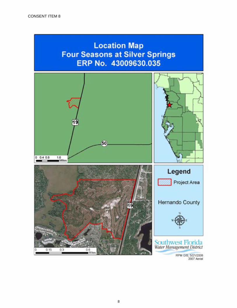
CONSENT ITEM 8
8
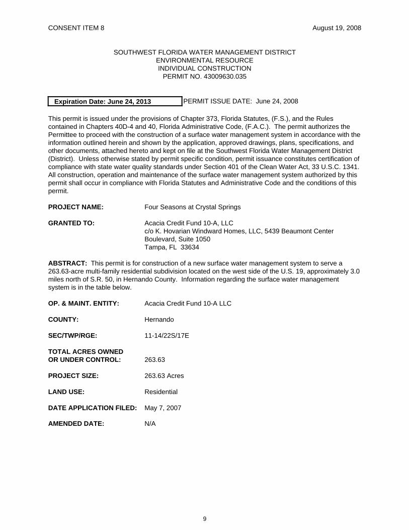
CONSENT ITEM 8 August 19, 2008
SOUTHWEST FLORIDA WATER MANAGEMENT DISTRICT ENVIRONMENTAL RESOURCE INDIVIDUAL CONSTRUCTION
PERMIT NO. 43009630.035
Expiration Date: June 24, 2013 PERMIT ISSUE DATE: June 24, 2008
This permit is issued under the provisions of Chapter 373, Florida Statutes, (F.S.), and the Rules contained in Chapters 40D-4 and 40, Florida Administrative Code, (F.A.C.). The permit authorizes the Permittee to proceed with the construction of a surface water management system in accordance with the information outlined herein and shown by the application, approved drawings, plans, specifications, and other documents, attached hereto and kept on file at the Southwest Florida Water Management District (District). Unless otherwise stated by permit specific condition, permit issuance constitutes certification of compliance with state water quality standards under Section 401 of the Clean Water Act, 33 U.S.C. 1341. All construction, operation and maintenance of the surface water management system authorized by this permit shall occur in compliance with Florida Statutes and Administrative Code and the conditions of this permit.
PROJECT NAME: Four Seasons at Crystal Springs
GRANTED TO: Acacia Credit Fund 10-A, LLC c/o K. Hovarian Windward Homes, LLC, 5439 Beaumont Center Boulevard, Suite 1050 Tampa, FL 33634
ABSTRACT: This permit is for construction of a new surface water management system to serve a 263.63-acre multi-family residential subdivision located on the west side of the U.S. 19, approximately 3.0 miles north of S.R. 50, in Hernando County. Information regarding the surface water management system is in the table below.
OP. & MAINT. ENTITY: Acacia Credit Fund 10-A LLC
COUNTY: Hernando
SEC/TWP/RGE: 11-14/22S/17E
TOTAL ACRES OWNED OR UNDER CONTROL: 263.63
PROJECT SIZE: 263.63 Acres
LAND USE: Residential
DATE APPLICATION FILED: May 7, 2007
AMENDED DATE: N/A
9
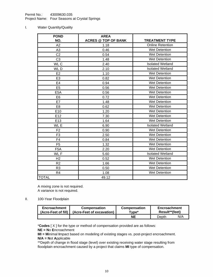
Permit No.: 43009630.035 Project Name: Four Seasons at Crystal Springs
I. Water Quantity/Quality
POND NO.
AREA ACRES @ TOP OF BANK TREATMENT TYPE
A2 1.18 Online Retention A3 0.46 Wet Detention C2 0.54 Wet Detention C3 1.48 Wet Detention
WL C 2.40 Isolated Wetland WL D 2.10 Isolated Wetland
E2 1.10 Wet Detention E3 0.82 Wet Detention E4 0.94 Wet Detention E5 0.56 Wet Detention
E5A 0.56 Wet Detention E6 0.72 Wet Detention E7 1.48 Wet Detention E8 0.62 Wet Detention
E10 1.20 Wet Detention E12 7.30 Wet Detention E13 1.64 Wet Detention
WL E 6.90 Isolated Wetland F2 0.90 Wet Detention F3 2.50 Wet Detention F4 0.84 Wet Detention F5 1.32 Wet Detention
F5A 2.20 Wet Detention WL F 5.60 Isolated Wetland
H2 0.52 Wet Detention R2 1.66 Wet Detention R3 0.50 Wet Detention R4 1.08 Wet Detention
TOTAL 49.12
A mixing zone is not required. A variance is not required.
II. 100-Year Floodplain
Encroachment (Acre-Feet of fill)
Compensation (Acre-Feet of excavation)
Compensation Type*
Encroachment Result**(feet)
NE Depth N/A
*Codes [ X ] for the type or method of compensation provided are as follows: NE = No EncroachmentMI = Minimal Impact based on modeling of existing stages vs. post-project encroachment. N/A = Not Applicable**Depth of change in flood stage (level) over existing receiving water stage resulting from floodplain encroachment caused by a project that claims MI type of compensation.
10
Permit No.: 43009630.035 Project Name: Four Seasons at Crystal Springs
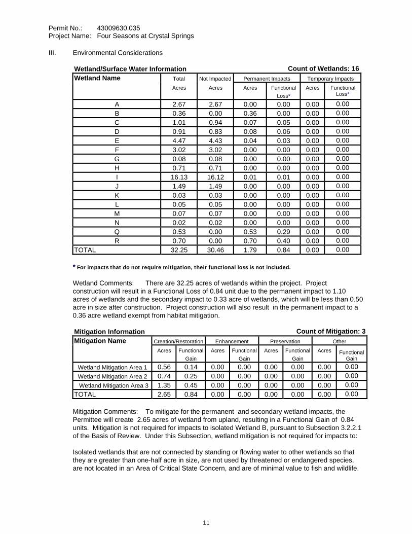
III. Environmental Considerations
Wetland/Surface Water Information Count of Wetlands: 16Wetland Name Total Not Impacted Permanent Impacts Temporary Impacts Acres Acres Acres Functional
Loss*Acres Functional
Loss*
A 2.67 2.67 0.00 0.00 0.00 0.00B 0.36 0.00 0.36 0.00 0.00 0.00C 1.01 0.94 0.07 0.05 0.00 0.00D 0.91 0.83 0.08 0.06 0.00 0.00E 4.47 4.43 0.04 0.03 0.00 0.00F 3.02 3.02 0.00 0.00 0.00 0.00G 0.08 0.08 0.00 0.00 0.00 0.00H 0.71 0.71 0.00 0.00 0.00 0.00I 16.13 16.12 0.01 0.01 0.00 0.00J 1.49 1.49 0.00 0.00 0.00 0.00K 0.03 0.03 0.00 0.00 0.00 0.00L 0.05 0.05 0.00 0.00 0.00 0.00M 0.07 0.07 0.00 0.00 0.00 0.00N 0.02 0.02 0.00 0.00 0.00 0.00Q 0.53 0.00 0.53 0.29 0.00 0.00R 0.70 0.00 0.70 0.40 0.00 0.00
TOTAL 32.25 30.46 1.79 0.84 0.00 0.00
* For impacts that do not require mitigation, their functional loss is not included.
Wetland Comments: There are 32.25 acres of wetlands within the project. Project construction will result in a Functional Loss of 0.84 unit due to the permanent impact to 1.10 acres of wetlands and the secondary impact to 0.33 acre of wetlands, which will be less than 0.50 acre in size after construction. Project construction will also result in the permanent impact to a 0.36 acre wetland exempt from habitat mitigation.
Mitigation Information Count of Mitigation: 3Mitigation Name Creation/Restoration Enhancement Preservation Other Acres Functional
Gain Acres Functional
Gain Acres Functional
Gain Acres Functional
Gain
Wetland Mitigation Area 1 0.56 0.14 0.00 0.00 0.00 0.00 0.00 0.00Wetland Mitigation Area 2 0.74 0.25 0.00 0.00 0.00 0.00 0.00 0.00Wetland Mitigation Area 3 1.35 0.45 0.00 0.00 0.00 0.00 0.00 0.00
TOTAL 2.65 0.84 0.00 0.00 0.00 0.00 0.00 0.00
Mitigation Comments: To mitigate for the permanent and secondary wetland impacts, the Permittee will create 2.65 acres of wetland from upland, resulting in a Functional Gain of 0.84 units. Mitigation is not required for impacts to isolated Wetland B, pursuant to Subsection 3.2.2.1 of the Basis of Review. Under this Subsection, wetland mitigation is not required for impacts to:
Isolated wetlands that are not connected by standing or flowing water to other wetlands so that they are greater than one-half acre in size, are not used by threatened or endangered species, are not located in an Area of Critical State Concern, and are of minimal value to fish and wildlife.
11
Permit No.: 43009630.035 Project Name: Four Seasons at Crystal Springs
SPECIFIC CONDITIONS 1. If the ownership of the project area covered by the subject permit is divided, with someone other
than the Permittee becoming the owner of part of the project area, this permit shall terminate, pursuant to Section 40D-1.6105, F.A.C. In such situations, each land owner shall obtain a permit (which may be a modification of this permit) for the land owned by that person. This condition shall not apply to the division and sale of lots or units in residential subdivisions or condominiums.
2. Unless specified otherwise herein, two copies of all information and reports required by this permit shall be submitted to:
Brooksville Regulation Department Southwest Florida Water Management District 2379 Broad Street Brooksville, FL 34604-6899
The permit number, title of report or information and event (for recurring report or information submittal) shall be identified on all information and reports submitted.
3. The Permittee shall retain the design engineer, or other professional engineer registered in Florida, to conduct on-site observations of construction and assist with the as-built certification requirements of this project. The Permittee shall inform the District in writing of the name, address and phone number of the professional engineer so employed. This information shall be submitted prior to construction.
4. Within 30 days after completion of construction of the permitted activity, the Permittee shall submit to the Brooksville Service Office a written statement of completion and certification by a registered professional engineer or other appropriate individual as authorized by law, utilizing the required Statement of Completion and Request for Transfer to Operation Entity form identified in Chapter 40D-1.659, F.A.C., and signed, dated and sealed as-built drawings. The as-built drawings shall identify any deviations from the approved construction drawings.
5. The District reserves the right, upon prior notice to the Permittee, to conduct on-site research to assess the pollutant removal efficiency of the surface water management system. The Permittee may be required to cooperate in this regard by allowing on-site access by District representatives, by allowing the installation and operation of testing and monitoring equipment, and by allowing other assistance measures as needed on site.
6. WETLAND MITIGATION SUCCESS CRITERIA MITIGATION AREA - Wetland Creation Area M-1, M-2 and M-3 - Totaling 2.65 acres
Mitigation is expected to offset adverse impacts to wetlands and other surface waters caused by regulated activities and to achieve viable, sustainable ecological and hydrological wetland functions. Wetlands constructed for mitigation purposes will be considered successful and will be released from monitoring and reporting requirements when the following criteria are met continuously for a period of at least one year without intervention in the form of irrigation or the additional or removal of vegetation.
a. The mitigation area can reasonably be expected to develop into a freshwater marsh (with minor forested component), as determined by the Florida Land Use and Cover and Forms Classification System (third edition; January 1999).
b. Topography, water depth and water level fluctuation in the mitigation area are characteristic of the wetlands/ surface water type specified in criterion "a".
12
Permit No.: 43009630.035 Project Name: Four Seasons at Crystal Springs
c. Planted or recruited herbaceous or shrub species (or plant species providing the same function) shall meet the criteria specified:
ZONE PERCENT COVER SPECIESUpper 50 Laurel Oak
Upper/Middle 50 Red Maple 40 Cordgrass 20 Paspalum
Middle/Lower 20 Softrush 20 Maidencane
d. Species composition of recruiting wetland vegetation is indicative of the wetland type specified in criterion "a".
e. Coverage by nuisance or exotic species does not exceed 10 percent at any location in the mitigation site and 10 percent for the entire mitigation site.
f. The wetland mitigation area can be determined to be a wetland or other surface water according to Chapter 62-340, F.A.C.
This criterion must be achieved within five years of mitigation area construction. The Permittee shall complete any activities necessary to ensure the successful achievement of the mitigation requirements by the deadline specified. Any request for an extension of the deadline specified shall be accompanied with an explanation and submitted as a permit letter modification to the District for evaluation.
The mitigation area may be released from monitoring and reporting requirements and be deemed successful at any time during the monitoring period if the Permittee demonstrates that the conditions in the mitigation area have adequately replaced the wetland and surface water functions affected by the regulated activity and that the site conditions are sustainable.
7. The Permittee shall monitor and maintain the wetland mitigation areas until the criteria set forth in the Wetland Mitigation Success Criteria Conditions above are met. The Permittee shall perform corrective actions identified by the District if the District identifies a wetland mitigation deficiency.
8. The Permittee shall undertake required maintenance activities within the wetland mitigation areas as needed at any time between mitigation area construction and termination of monitoring, with the exception of the final year. Maintenance shall include the manual removal of all nuisance and exotic species, with sufficient frequency that their combined coverage at no time exceeds the Wetland Mitigation Success Criteria Conditions above. Herbicides shall not be used without the prior written approval of the District.
9. A Wetland Mitigation Completion Report shall be submitted to the District within 30 days of completing construction and planting of the wetland mitigation areas. Upon District inspection and approval of the mitigation areas, the monitoring program shall be initiated with the date of the District field inspection being the construction completion date of the mitigation areas. Monitoring events shall occur between March 1 and November 30 of each year. An Annual Wetland Monitoring Report shall be submitted upon the anniversary date of District approval to initiate monitoring.
Annual reports shall provide documentation that a sufficient number of maintenance inspection/activities were conducted to maintain the mitigation areas in compliance with the Wetland Mitigation Success Criteria Conditions above. Note that the performance of
13
Permit No.: 43009630.035 Project Name: Four Seasons at Crystal Springs
maintenance inspections and maintenance activities will normally need to be conducted more frequently than the collection of other monitoring data to maintain the mitigation areas in compliance with the Wetland Mitigation Success Criteria Conditions above.
Monitoring Data shall be collected semi-annually.
10. Termination of monitoring for the wetland mitigation areas shall be coordinated with the District by:
a. notifying the District in writing when the criteria set forth in the Wetland Mitigation Success Criteria Conditions have been achieved;
b. suspending all maintenance activities in the wetland mitigation areas including, but not limited to, irrigation and addition or removal of vegetation; and
c. submitting a monitoring report to the District one year following the written notification and suspension of maintenance activities.
Upon receipt of the monitoring report, the District will evaluate the wetland mitigation sites to determine if the Mitigation Success Criteria Conditions have been met and maintained. The District will notify the Permittee in writing of the evaluation results. The Permittee shall perform corrective actions for any portions of the wetland mitigation areas that fail to maintain the criteria set forth in the Wetland Mitigation Success Criteria Conditions.
11. Following the District’s determination that the wetland mitigation has been successfully completed, the Permittee shall operate and maintain the wetland mitigation areas such that they remain in their current or intended condition for the life of the surface water management facility. The Permittee must perform corrective actions for any portions of the wetland mitigation areas where conditions no longer meet the criteria set forth in the Wetland Mitigation Success Criteria Conditions.
12. The Permittee shall commence construction of the mitigation areas within 30 days of wetland impacts, if wetland impacts occur between February 1 and August 31. If wetland impacts occur between September 1 and January 31, construction of the mitigation areas shall commence by March 1. In either case, construction of the mitigation areas shall be completed within 120 days of the commencement date unless a time extension is approved in writing by the District.
13. The construction of all wetland impacts and wetland mitigation shall be supervised by a qualified environmental scientist/specialist/consultant. The Permittee shall identify, in writing, the environmental professional retained for construction oversight prior to initial clearing and grading activities.
14. Wetland buffers shall remain in an undisturbed condition except for approved drainage facility construction/maintenance.
15. The following boundaries, as shown on the approved construction drawings, shall be clearly delineated on the site prior to initial clearing or grading activities:
wetland and surface water areaswetland buffers
limits of approved wetland impactsconstruction access for M-1, M-2, and M-3
14
Permit No.: 43009630.035 Project Name: Four Seasons at Crystal Springs
The delineation shall endure throughout the construction period and be readily discernible to construction and District personnel.
16. All wetland boundaries shown on the approved construction drawings shall be binding upon the Permittee and the District.
17. The following language shall be included as part of the deed restrictions for each lot:
"No owner of property within the subdivision may construct or maintain any building, residence, or structure, or undertake or perform any activity in the wetlands, wetland mitigation areas, buffer areas, upland conservation areas and drainage easements described in the approved permit and recorded plat of the subdivision, unless prior approval is received from the Southwest Florida Water Management District, Brooksville Regulation Department."
18. Rights-of-way and easement locations necessary to construct, operate and maintain all facilities, which constitute the permitted surface water management system (including wetlands and wetland buffers), shall be shown on the final plat recorded in the County Public Records. Documentation of this plat recording shall be submitted to the District with the Statement of Completion and Request for Transfer to Operation Entity Form, and prior to beneficial occupancy or use of the site.
19. Copies of the following documents in final form, as appropriate for the project, shall be submitted to the Brooksville Regulation Department:
a. homeowners, property owners, master association or condominium association articles of incorporation, and
b. declaration of protective covenants, deed restrictions or declaration of condominium.
The Permittee shall submit these documents either: (1) within 180 days after beginning construction or with the Statement of Completion and as-built construction plans if construction is completed prior to 180 days, or (2) prior to any lot or unit sales within the project served by the surface water management system, whichever occurs first.
20. The following language shall be included as part of the deed restrictions for each lot:
"Each property owner within the subdivision at the time of construction of a building, residence, or structure shall comply with the construction plans for the surface water management system approved and on file with the Southwest Florida Water Management District."
21. The operation and maintenance entity shall submit inspection reports in the form required by the District, in accordance with the following schedule.
For systems utilizing retention or wet detention, the inspections shall be performed two (2) years after operation is authorized and every two (2) years thereafter.
22. The removal of littoral shelf vegetation (including cattails) from wet detention ponds is prohibited unless otherwise approved by the District. Removal includes dredging, the application of herbicide, cutting, and the introduction of grass carp. Any questions regarding authorized activities within the wet detention ponds shall be addressed to the District's Surface Water Regulation Manager, Brooksville Service Office.
15
Permit No.: 43009630.035 Project Name: Four Seasons at Crystal Springs
23. The operation and maintenance entity shall submit inspection reports in the form required by the District, in accordance with the following schedule.
For systems utilizing retention or wet detention, the inspections shall be performed two (2) years after operation is authorized and every two (2) years thereafter.
24. If limestone bedrock is encountered during construction of the surface water management system, the District must be notified and construction in the affected area shall cease.
25. The Permittee shall notify the District of any sinkhole development in the surface water management system within 48 hours of discovery and must submit a detailed sinkhole evaluation and repair plan for approval by the District within 30 days of discovery.
26. The District, upon prior notice to the Permittee, may conduct on-site inspections to assess the effectiveness of the erosion control barriers and other measures employed to prevent violations of state water quality standards and avoid downstream impacts. Such barriers or other measures should control discharges, erosion, and sediment transport during construction and thereafter. The District will also determine any potential environmental problems that may develop as a result of leaving or removing the barriers and other measures during construction or after construction of the project has been completed. The Permittee must provide any remedial measures that are needed.
27. This permit is issued based upon the design prepared by the Permittee’s consultant. If at any time it is determined by the District that the Conditions for Issuance of Permits in Rules 40D-4.301 and 40D-4.302, F.A.C., have not been met, upon written notice by the District, the Permittee shall obtain a permit modification and perform any construction necessary thereunder to correct any deficiencies in the system design or construction to meet District rule criteria. The Permittee is advised that the correction of deficiencies may require re-construction of the surface water management system and/or mitigation areas.
28. Prior to initiating activities authorized by this permit, the Permittee shall execute the final draft financial responsibility instrument approved by the District in the amount of $86,454.50. The final draft financial responsibility instrument shall be consistent with the draft instrument submitted with the permit application and approved by this permit.
29. If prehistoric or historic artifacts, such as pottery or ceramics, stone tools or metal implements, dugout canoes, or any other physical remains that could be associated with Native American cultures, or early colonial or American settlement are encountered at any time within the project site area, the permitted project should cease all activities involving subsurface disturbance in the immediate vicinity of such discoveries. The Permittee, or other designee, should contact the Florida Department of State, Division of Historical Resources, Review and Compliance Section at (850) 245-6333 or (800) 847-7278, as well as the appropriate permitting agency office. Project activities should not resume without verbal and/or written authorization from the Division of Historical Resources. In the event that unmarked human remains are encountered during permitted activities, all work shall stop immediately and the proper authorities notified in accordance within Section 872.05, Florida Statutes.
30. The Permittee shall execute the final draft financial responsibility instrument approved by the District prior to initiating activities authorized by this permit. The final draft financial responsibility instrument shall be consistent with the draft instrument submitted with the permit application and approved by this permit.
16
Permit No.: 43009630.035 Project Name: Four Seasons at Crystal Springs
31. The Permittee shall submit the original executed financial responsibility instrument to the District at the address below:
Southwest Florida Water Management District Brooksville Regulation Department 2379 Broad Street Brooksville, Florida 34604-6899
32. The Permittee shall provide the financial responsibility required by Rule 40D-4.301(1)(j), Florida Administrative Code until the District determines that the specific success criteria contained in this permit have been met; or the District approves a request to transfer the permit to a new owner and receives an acceptable substitute financial responsibility mechanism from the new owner.
33. The Permittee may request, in writing, a release from the obligation to maintain certain amounts of the financial assurance required by this permit as phases of the mitigation plan are successfully completed. The request shall include documentation that the mitigation phase or phases have been completed and payment for their completion has been made. Following the District's verification that the phase or phases have been completed in accordance with the mitigation plan, the District will authorize release from the applicable portion of the financial assurance obligation.
34. The District will notify the Permittee within 30 days of its determination that the specific success criteria contained in this permit have been met. Concurrent with this notification, the District will authorize, in writing, the appropriate entity to cancel or terminate the financial responsibility instrument.
35. The Permittee's failure to comply with the terms and conditions of this permit pertaining to the successful completion of all mitigation activities in accordance with the mitigation plan shall be deemed a violation of Chapter 40D-4, Florida Administrative Code. In addition to other remedies that the District may have, the District may draw upon the financial responsibility instrument for any funds necessary to remedy a violation, upon such notice to the Permittee as may be specified in the financial responsibility instrument or if none, upon reasonable notice.
36. The Permittee shall notify the District by certified mail within 10 days of the commencement of a voluntary or involuntary proceeding:
a. To dissolve the Permittee; b. To place the Permittee into receivership; c. For entry of an order for relief against the Permittee under Title XI (Bankruptcy), U.S.
Code. d. To assign of the Permittee's assets for the benefit of its creditors under Chapter 727,
Florida Statutes.
37. In the event of bankruptcy or insolvency of the issuing institution; or the suspension or revocation of the authority of the issuing institution to issue letters of credit or performance bonds, the Permittee shall be deemed without the required financial assurance and shall have 60 days to reestablish the financial assurance required by Rule 40D-4.301(1)(j), Florida Administrative Code.
17

Permit No.: 43009630.035 Project Name: Four Seasons at Crystal Springs
GENERAL CONDITIONS 1. The general conditions attached hereto as Exhibit "A" are hereby incorporated into this permit by
reference and the Permittee shall comply with them.
____________________________________________ Authorized Signature
18
CONSENT ITEM 9
19
CONSENT ITEM 9 Default Date: August 5, 2008
SOUTHWEST FLORIDA WATER MANAGEMENT DISTRICT ENVIRONMENTAL RESOURCE INDIVIDUAL CONSTRUCTION
PERMIT NO. 43013881.046
Expiration Date: June 24, 2013 PERMIT ISSUE DATE: June 24, 2008
This permit is issued under the provisions of Chapter 373, Florida Statutes, (F.S.), and the Rules contained in Chapters 40D-4 and 40, Florida Administrative Code, (F.A.C.). The permit authorizes the Permittee to proceed with the construction of a surface water management system in accordance with the information outlined herein and shown by the application, approved drawings, plans, specifications, and other documents, attached hereto and kept on file at the Southwest Florida Water Management District (District). Unless otherwise stated by permit specific condition, permit issuance constitutes certification of compliance with state water quality standards under Section 401 of the Clean Water Act, 33 U.S.C. 1341. All construction, operation and maintenance of the surface water management system authorized by this permit shall occur in compliance with Florida Statutes and Administrative Code and the conditions of this permit.
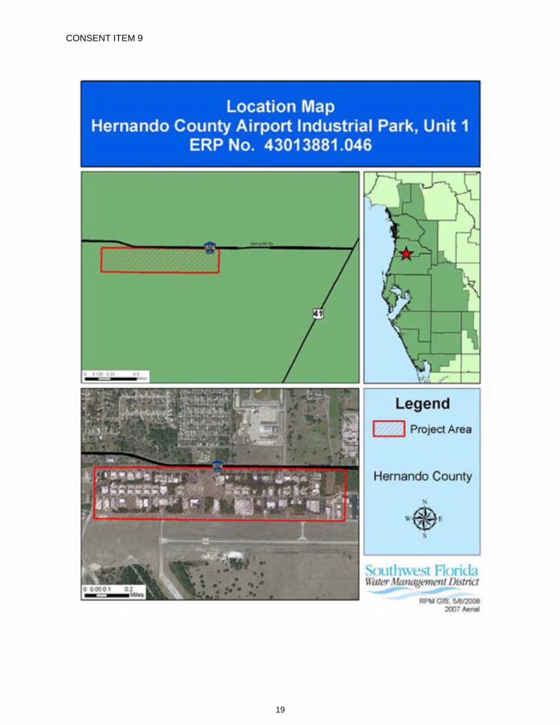
PROJECT NAME: Hernando County Airport Industrial Park, Unit 1
GRANTED TO: Hernando County Airport 16110 Aviation Loop Drive Brooksville, FL 34604
ABSTRACT: This permit is for the expansion of an existing surface water management system to serve a 148.62-acre industrial park. The project site is located in Hernando County, west of the intersection of US 41 and Spring Hill Drive. Adjacent properties include developments associated with the Hernando County Airport facility. Information regarding the surface water management system is contained in the tables below.
OP. & MAINT. ENTITY: Hernando County Airport
COUNTY: Hernando
SEC/TWP/RGE: 24/23S/18E
TOTAL ACRES OWNED OR UNDER CONTROL: 2,423.00
PROJECT SIZE: 148.62 Acres
LAND USE: Industrial
DATE APPLICATION FILED: February 28, 2008
AMENDED DATE: N/A
20
Permit No.: 43013881.046 Project Name: Hernando County Airport Industrial Park, Unit 1
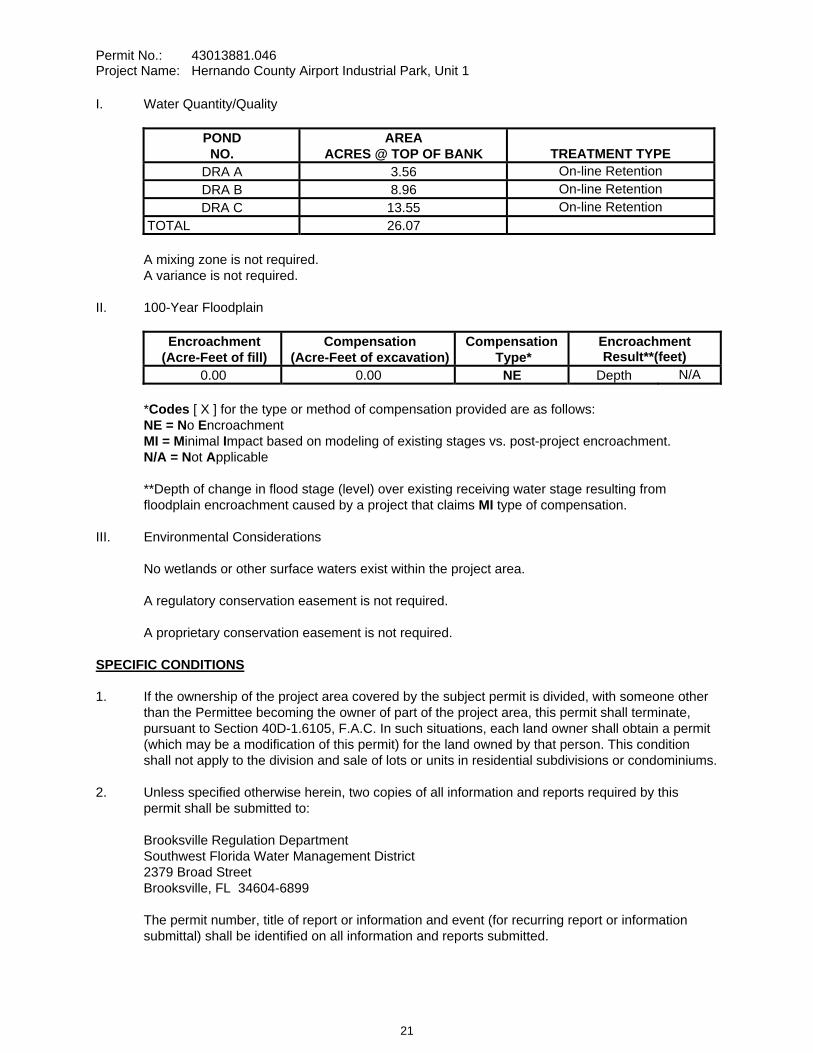
I. Water Quantity/Quality
POND NO.
AREA ACRES @ TOP OF BANK TREATMENT TYPE
DRA A 3.56 On-line Retention DRA B 8.96 On-line Retention DRA C 13.55 On-line Retention
TOTAL 26.07
A mixing zone is not required. A variance is not required.
II. 100-Year Floodplain
Encroachment (Acre-Feet of fill)
Compensation (Acre-Feet of excavation)
Compensation Type*
Encroachment Result**(feet)
0.00 0.00 NE Depth N/A
*Codes [ X ] for the type or method of compensation provided are as follows: NE = No EncroachmentMI = Minimal Impact based on modeling of existing stages vs. post-project encroachment. N/A = Not Applicable
**Depth of change in flood stage (level) over existing receiving water stage resulting from floodplain encroachment caused by a project that claims MI type of compensation.
III. Environmental Considerations
No wetlands or other surface waters exist within the project area.
A regulatory conservation easement is not required.
A proprietary conservation easement is not required.
SPECIFIC CONDITIONS 1. If the ownership of the project area covered by the subject permit is divided, with someone other
than the Permittee becoming the owner of part of the project area, this permit shall terminate, pursuant to Section 40D-1.6105, F.A.C. In such situations, each land owner shall obtain a permit (which may be a modification of this permit) for the land owned by that person. This condition shall not apply to the division and sale of lots or units in residential subdivisions or condominiums.
2. Unless specified otherwise herein, two copies of all information and reports required by this permit shall be submitted to:
Brooksville Regulation Department Southwest Florida Water Management District 2379 Broad Street Brooksville, FL 34604-6899
The permit number, title of report or information and event (for recurring report or information submittal) shall be identified on all information and reports submitted.
21
Permit No.: 43013881.046 Project Name: Hernando County Airport Industrial Park, Unit 1
3. The Permittee shall retain the design engineer, or other professional engineer registered in Florida, to conduct on-site observations of construction and assist with the as-built certification requirements of this project. The Permittee shall inform the District in writing of the name, address and phone number of the professional engineer so employed. This information shall be submitted prior to construction.
4. Within 30 days after completion of construction of the permitted activity, the Permittee shall submit to the Brooksville Service Office a written statement of completion and certification by a registered professional engineer or other appropriate individual as authorized by law, utilizing the required Statement of Completion and Request for Transfer to Operation Entity form identified in Chapter 40D-1.659, F.A.C., and signed, dated and sealed as-built drawings. The as-built drawings shall identify any deviations from the approved construction drawings.
5. The District reserves the right, upon prior notice to the Permittee, to conduct on-site research to assess the pollutant removal efficiency of the surface water management system. The Permittee may be required to cooperate in this regard by allowing on-site access by District representatives, by allowing the installation and operation of testing and monitoring equipment, and by allowing other assistance measures as needed on site.
6. The operation and maintenance entity shall submit inspection reports in the form required by the District, in accordance with the following schedule.
For systems utilizing retention or wet detention, the inspections shall be performed two (2) years after operation is authorized and every two (2) years thereafter.
7. The Permittee shall notify the District at least 48 hours prior to the maximum excavation of each retention/detention pond and must notify the District upon the completion of each retention/detention pond.
8. If limestone bedrock is encountered during construction of the surface water management system, the District must be notified and construction in the affected area shall cease.
9. The Permittee shall notify the District of any sinkhole development in the surface water management system within 48 hours of discovery and must submit a detailed sinkhole evaluation and repair plan for approval by the District within 30 days of discovery.
10. The District, upon prior notice to the Permittee, may conduct on-site inspections to assess the effectiveness of the erosion control barriers and other measures employed to prevent violations of state water quality standards and avoid downstream impacts. Such barriers or other measures should control discharges, erosion, and sediment transport during construction and thereafter. The District will also determine any potential environmental problems that may develop as a result of leaving or removing the barriers and other measures during construction or after construction of the project has been completed. The Permittee must provide any remedial measures that are needed.
11. This permit is issued based upon the design prepared by the Permittee’s consultant. If at any time it is determined by the District that the Conditions for Issuance of Permits in Rules 40D-4.301 and 40D-4.302, F.A.C., have not been met, upon written notice by the District, the Permittee shall obtain a permit modification and perform any construction necessary thereunder to correct any deficiencies in the system design or construction to meet District rule criteria. The Permittee is advised that the correction of deficiencies may require re-construction of the surface water management system and/or mitigation areas.
22
Permit No.: 43013881.046 Project Name: Hernando County Airport Industrial Park, Unit 1
12. Additional permitting will be required for any new construction within the project area.
GENERAL CONDITIONS 1. The general conditions attached hereto as Exhibit "A" are hereby incorporated into this permit by
reference and the Permittee shall comply with them.
____________________________________________ Authorized Signature
23
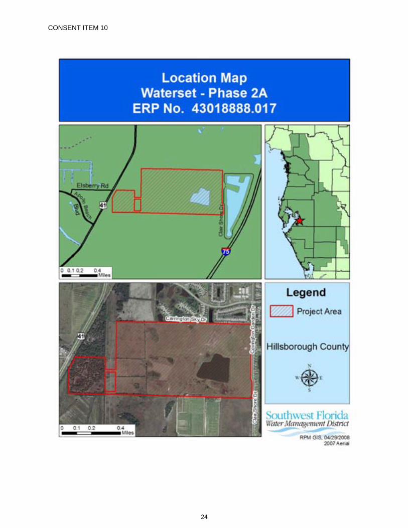
CONSENT ITEM 10
24
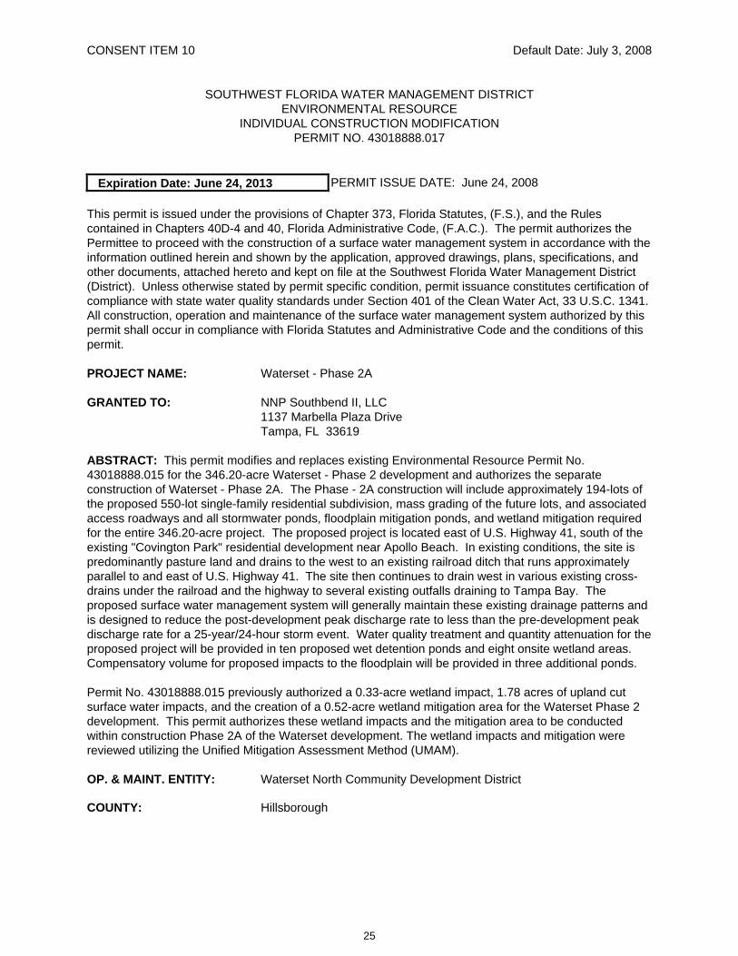
CONSENT ITEM 10 Default Date: July 3, 2008
SOUTHWEST FLORIDA WATER MANAGEMENT DISTRICT ENVIRONMENTAL RESOURCE
INDIVIDUAL CONSTRUCTION MODIFICATION PERMIT NO. 43018888.017
Expiration Date: June 24, 2013 PERMIT ISSUE DATE: June 24, 2008
This permit is issued under the provisions of Chapter 373, Florida Statutes, (F.S.), and the Rules contained in Chapters 40D-4 and 40, Florida Administrative Code, (F.A.C.). The permit authorizes the Permittee to proceed with the construction of a surface water management system in accordance with the information outlined herein and shown by the application, approved drawings, plans, specifications, and other documents, attached hereto and kept on file at the Southwest Florida Water Management District (District). Unless otherwise stated by permit specific condition, permit issuance constitutes certification of compliance with state water quality standards under Section 401 of the Clean Water Act, 33 U.S.C. 1341. All construction, operation and maintenance of the surface water management system authorized by this permit shall occur in compliance with Florida Statutes and Administrative Code and the conditions of this permit.
PROJECT NAME: Waterset - Phase 2A
GRANTED TO: NNP Southbend II, LLC 1137 Marbella Plaza Drive Tampa, FL 33619
ABSTRACT: This permit modifies and replaces existing Environmental Resource Permit No. 43018888.015 for the 346.20-acre Waterset - Phase 2 development and authorizes the separate construction of Waterset - Phase 2A. The Phase - 2A construction will include approximately 194-lots of the proposed 550-lot single-family residential subdivision, mass grading of the future lots, and associated access roadways and all stormwater ponds, floodplain mitigation ponds, and wetland mitigation required for the entire 346.20-acre project. The proposed project is located east of U.S. Highway 41, south of the existing "Covington Park" residential development near Apollo Beach. In existing conditions, the site is predominantly pasture land and drains to the west to an existing railroad ditch that runs approximately parallel to and east of U.S. Highway 41. The site then continues to drain west in various existing cross-drains under the railroad and the highway to several existing outfalls draining to Tampa Bay. The proposed surface water management system will generally maintain these existing drainage patterns and is designed to reduce the post-development peak discharge rate to less than the pre-development peak discharge rate for a 25-year/24-hour storm event. Water quality treatment and quantity attenuation for the proposed project will be provided in ten proposed wet detention ponds and eight onsite wetland areas. Compensatory volume for proposed impacts to the floodplain will be provided in three additional ponds.
Permit No. 43018888.015 previously authorized a 0.33-acre wetland impact, 1.78 acres of upland cut surface water impacts, and the creation of a 0.52-acre wetland mitigation area for the Waterset Phase 2 development. This permit authorizes these wetland impacts and the mitigation area to be conducted within construction Phase 2A of the Waterset development. The wetland impacts and mitigation were reviewed utilizing the Unified Mitigation Assessment Method (UMAM).
OP. & MAINT. ENTITY: Waterset North Community Development District
COUNTY: Hillsborough
25

Permit No.: 43018888.017 Project Name: Waterset – Phase 2A
SEC/TWP/RGE: 22, 23/31S/19E
TOTAL ACRES OWNED OR UNDER CONTROL: 1,672.90
PROJECT SIZE: 346.20 Acres
LAND USE: Single-family Residential
DATE APPLICATION FILED: November 21, 2007
AMENDED DATE: N/A
I. Water Quantity/Quality
POND NO.
AREA ACRES @ TOP OF BANK TREATMENT TYPE
E1 4.38 Wet Detention E2 7.20 Wet Detention F1 2.81 Wet Detention F2 1.81 Wet Detention J1 2.44 Wet Detention J2 1.27 Wet Detention K 1.13 Wet Detention L1 5.52 Wet Detention L2 2.00 Wet Detention L3 3.61 Wet Detention
Wetland A 3.20 Wet Detention Wetland C 2.81 Wet Detention Wetland E 3.45 Wet Detention Wetland F 6.13 Wet Detention Wetland G 1.31 Wet Detention
Wetland I/Pond Z 32.39 Wet Detention Wetland J 7.56 Wet Detention Wetland M 1.67 Wet Detention
TOTAL 90.64
Comments: The total 25-year/24-hour post-development discharge rate under U.S. Highway 41 is 790.1 cubic feet per second, which is less than the pre-development 25-year/24-hour peak discharge rate of 838.7 cubic feet per second.
A mixing zone is not required. A variance is not required.
II. 100-Year Floodplain
Encroachment (Acre-Feet of fill)
Compensation (Acre-Feet of excavation)
Compensation Type*
Encroachment Result**(feet)
4.68 7.13 EE N/A
26
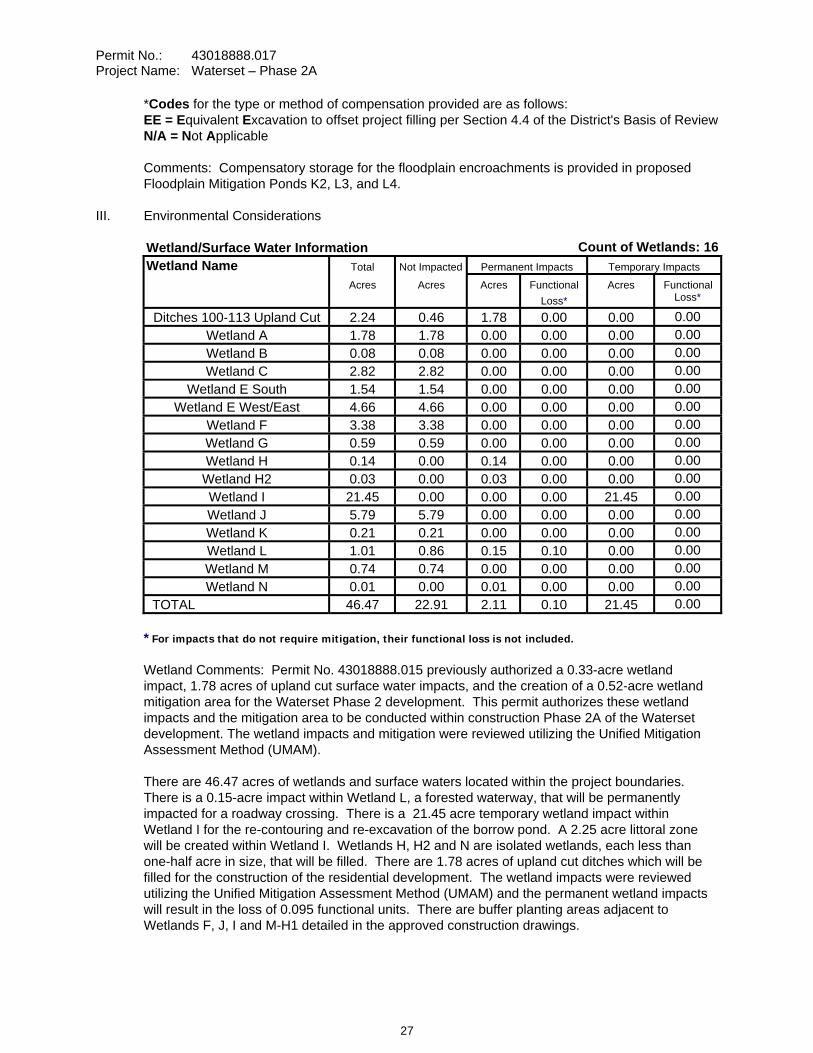
Permit No.: 43018888.017 Project Name: Waterset – Phase 2A
*Codes for the type or method of compensation provided are as follows: EE = Equivalent Excavation to offset project filling per Section 4.4 of the District's Basis of Review N/A = Not Applicable
Comments: Compensatory storage for the floodplain encroachments is provided in proposed Floodplain Mitigation Ponds K2, L3, and L4.
III. Environmental Considerations
Wetland/Surface Water Information Count of Wetlands: 16Wetland Name Total Not Impacted Permanent Impacts Temporary Impacts
Acres Acres Acres Functional Loss*
Acres Functional Loss*
Ditches 100-113 Upland Cut 2.24 0.46 1.78 0.00 0.00 0.00Wetland A 1.78 1.78 0.00 0.00 0.00 0.00Wetland B 0.08 0.08 0.00 0.00 0.00 0.00Wetland C 2.82 2.82 0.00 0.00 0.00 0.00
Wetland E South 1.54 1.54 0.00 0.00 0.00 0.00Wetland E West/East 4.66 4.66 0.00 0.00 0.00 0.00
Wetland F 3.38 3.38 0.00 0.00 0.00 0.00Wetland G 0.59 0.59 0.00 0.00 0.00 0.00Wetland H 0.14 0.00 0.14 0.00 0.00 0.00
Wetland H2 0.03 0.00 0.03 0.00 0.00 0.00Wetland I 21.45 0.00 0.00 0.00 21.45 0.00Wetland J 5.79 5.79 0.00 0.00 0.00 0.00Wetland K 0.21 0.21 0.00 0.00 0.00 0.00Wetland L 1.01 0.86 0.15 0.10 0.00 0.00Wetland M 0.74 0.74 0.00 0.00 0.00 0.00Wetland N 0.01 0.00 0.01 0.00 0.00 0.00
TOTAL 46.47 22.91 2.11 0.10 21.45 0.00
* For impacts that do not require mitigation, their functional loss is not included.
Wetland Comments: Permit No. 43018888.015 previously authorized a 0.33-acre wetland impact, 1.78 acres of upland cut surface water impacts, and the creation of a 0.52-acre wetland mitigation area for the Waterset Phase 2 development. This permit authorizes these wetland impacts and the mitigation area to be conducted within construction Phase 2A of the Waterset development. The wetland impacts and mitigation were reviewed utilizing the Unified Mitigation Assessment Method (UMAM).
There are 46.47 acres of wetlands and surface waters located within the project boundaries. There is a 0.15-acre impact within Wetland L, a forested waterway, that will be permanently impacted for a roadway crossing. There is a 21.45 acre temporary wetland impact within Wetland I for the re-contouring and re-excavation of the borrow pond. A 2.25 acre littoral zone will be created within Wetland I. Wetlands H, H2 and N are isolated wetlands, each less than one-half acre in size, that will be filled. There are 1.78 acres of upland cut ditches which will be filled for the construction of the residential development. The wetland impacts were reviewed utilizing the Unified Mitigation Assessment Method (UMAM) and the permanent wetland impacts will result in the loss of 0.095 functional units. There are buffer planting areas adjacent to Wetlands F, J, I and M-H1 detailed in the approved construction drawings.
27
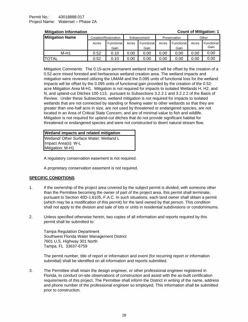
Permit No.: 43018888.017 Project Name: Waterset – Phase 2A
Mitigation Information Count of Mitigation: 1Mitigation Name Creation/Restoration Enhancement Preservation Other Acres Functional
Gain Acres Functional
Gain Acres Functional
Gain Acres Functional
Gain
M-H1 0.52 0.10 0.00 0.00 0.00 0.00 0.00 0.00TOTAL 0.52 0.10 0.00 0.00 0.00 0.00 0.00 0.00
Mitigation Comments: The 0.15-acre permanent wetland impact will be offset by the creation of a 0.52-acre mixed forested and herbaceous wetland creation area. The wetland impacts and mitigation were reviewed utilizing the UMAM and the 0.095 units of functional loss for the wetland impacts will be offset by the 0.095 units of functional gain provided by the creation of the 0.52-acre Mitigation Area M-H1. Mitigation is not required for impacts to isolated Wetlands H, H2, and N, and upland-cut Ditches 100-113, pursuant to Subsections 3.2.2.1 and 3.2.2.2 of the Basis of Review. Under these Subsections, wetland mitigation is not required for impacts to isolated wetlands that are not connected by standing or flowing water to other wetlands so that they are greater than one-half acre in size, are not used by threatened or endangered species, are not located in an Area of Critical State Concern, and are of minimal value to fish and wildlife. Mitigation is not required for upland-cut ditches that do not provide significant habitat for threatened or endangered species and were not constructed to divert natural stream flow.
Wetland impacts and related mitigation Wetland/ Other Surface Water: Wetland L Impact Area(s): W-L Mitigation: M-H1
A regulatory conservation easement is not required.
A proprietary conservation easement is not required.
SPECIFIC CONDITIONS 1. If the ownership of the project area covered by the subject permit is divided, with someone other
than the Permittee becoming the owner of part of the project area, this permit shall terminate, pursuant to Section 40D-1.6105, F.A.C. In such situations, each land owner shall obtain a permit (which may be a modification of this permit) for the land owned by that person. This condition shall not apply to the division and sale of lots or units in residential subdivisions or condominiums.
2. Unless specified otherwise herein, two copies of all information and reports required by this permit shall be submitted to:
Tampa Regulation Department Southwest Florida Water Management District 7601 U.S. Highway 301 North Tampa, FL 33637-6759
The permit number, title of report or information and event (for recurring report or information submittal) shall be identified on all information and reports submitted.
3. The Permittee shall retain the design engineer, or other professional engineer registered in Florida, to conduct on-site observations of construction and assist with the as-built certification requirements of this project. The Permittee shall inform the District in writing of the name, address and phone number of the professional engineer so employed. This information shall be submitted prior to construction.
28
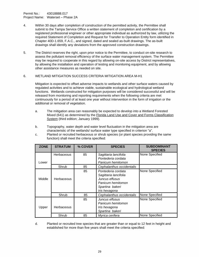
Permit No.: 43018888.017 Project Name: Waterset – Phase 2A
4. Within 30 days after completion of construction of the permitted activity, the Permittee shall submit to the Tampa Service Office a written statement of completion and certification by a registered professional engineer or other appropriate individual as authorized by law, utilizing the required Statement of Completion and Request for Transfer to Operation Entity form identified in Chapter 40D-1.659, F.A.C., and signed, dated and sealed as-built drawings. The as-built drawings shall identify any deviations from the approved construction drawings.
5. The District reserves the right, upon prior notice to the Permittee, to conduct on-site research to assess the pollutant removal efficiency of the surface water management system. The Permittee may be required to cooperate in this regard by allowing on-site access by District representatives, by allowing the installation and operation of testing and monitoring equipment, and by allowing other assistance measures as needed on site.
6. WETLAND MITIGATION SUCCESS CRITERIA MITIGATION AREA M-H1
Mitigation is expected to offset adverse impacts to wetlands and other surface waters caused by regulated activities and to achieve viable, sustainable ecological and hydrological wetland functions. Wetlands constructed for mitigation purposes will be considered successful and will be released from monitoring and reporting requirements when the following criteria are met continuously for a period of at least one year without intervention in the form of irrigation or the additional or removal of vegetation.
a. The mitigation area can reasonably be expected to develop into a Wetland Forested Mixed (641) as determined by the Florida Land Use and Cover and Forms Classification System (third edition; January 1999).
b. Topography, water depth and water level fluctuation in the mitigation area are characteristic of the wetlands/ surface water type specified in criterion "a".
c. Planted or recruited herbaceous or shrub species (or plant species providing the same function) shall meet the criteria specified:
ZONE STRATUM % COVER SPECIES SUBDOMINANT SPECIES
Lower
Herbaceous 85 Sagittaria lancifolia Pontederia cordata Panicum hemitomon
None Specified
Shrub 85 Cephalanthus occidentalis
Middle Herbaceous
85 Pontederia cordata Sagittaria lancifolia Juncus effusus Panicum hemitomon Spartina bakeri Iris hexagona
None Specified
Shrub 85 Cephalanthus occidentalis None Specified
Upper Herbaceous
85 Juncus effusus Panicum hemitomon Iris hexagona Spartina bakeri
None Specified
Shrub 85 Myrica cerifera None Specified
d. Planted or recruited tree species that are greater than or equal to 12 feet in height and established for more than five years shall meet the criteria specified:
29
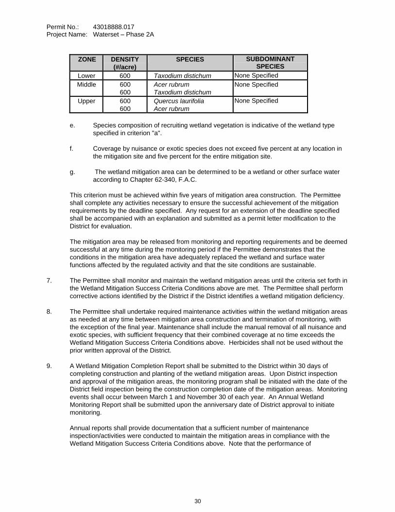
Permit No.: 43018888.017 Project Name: Waterset – Phase 2A
ZONE DENSITY (#/acre)
SPECIES SUBDOMINANT SPECIES
Lower 600 Taxodium distichum None Specified Middle 600
600Acer rubrum Taxodium distichum
None Specified
Upper 600 600
Quercus laurifolia Acer rubrum
None Specified
e. Species composition of recruiting wetland vegetation is indicative of the wetland type specified in criterion "a".
f. Coverage by nuisance or exotic species does not exceed five percent at any location in the mitigation site and five percent for the entire mitigation site.
g. The wetland mitigation area can be determined to be a wetland or other surface water according to Chapter 62-340, F.A.C.
This criterion must be achieved within five years of mitigation area construction. The Permittee shall complete any activities necessary to ensure the successful achievement of the mitigation requirements by the deadline specified. Any request for an extension of the deadline specified shall be accompanied with an explanation and submitted as a permit letter modification to the District for evaluation.
The mitigation area may be released from monitoring and reporting requirements and be deemed successful at any time during the monitoring period if the Permittee demonstrates that the conditions in the mitigation area have adequately replaced the wetland and surface water functions affected by the regulated activity and that the site conditions are sustainable.
7. The Permittee shall monitor and maintain the wetland mitigation areas until the criteria set forth in the Wetland Mitigation Success Criteria Conditions above are met. The Permittee shall perform corrective actions identified by the District if the District identifies a wetland mitigation deficiency.
8. The Permittee shall undertake required maintenance activities within the wetland mitigation areas as needed at any time between mitigation area construction and termination of monitoring, with the exception of the final year. Maintenance shall include the manual removal of all nuisance and exotic species, with sufficient frequency that their combined coverage at no time exceeds the Wetland Mitigation Success Criteria Conditions above. Herbicides shall not be used without the prior written approval of the District.
9. A Wetland Mitigation Completion Report shall be submitted to the District within 30 days of completing construction and planting of the wetland mitigation areas. Upon District inspection and approval of the mitigation areas, the monitoring program shall be initiated with the date of the District field inspection being the construction completion date of the mitigation areas. Monitoring events shall occur between March 1 and November 30 of each year. An Annual Wetland Monitoring Report shall be submitted upon the anniversary date of District approval to initiate monitoring.
Annual reports shall provide documentation that a sufficient number of maintenance inspection/activities were conducted to maintain the mitigation areas in compliance with the Wetland Mitigation Success Criteria Conditions above. Note that the performance of
30
Permit No.: 43018888.017 Project Name: Waterset – Phase 2A
maintenance inspections and maintenance activities will normally need to be conducted more frequently than the collection of other monitoring data to maintain the mitigation areas in compliance with the Wetland Mitigation Success Criteria Conditions above.
Monitoring Data shall be collected annually.
10. Termination of monitoring for the wetland mitigation areas shall be coordinated with the District by:
a. notifying the District in writing when the criteria set forth in the Wetland Mitigation Success Criteria Conditions have been achieved;
b. suspending all maintenance activities in the wetland mitigation areas including, but not limited to, irrigation and addition or removal of vegetation; and
c. submitting a monitoring report to the District one year following the written notification and suspension of maintenance activities.
Upon receipt of the monitoring report, the District will evaluate the wetland mitigation sites to determine if the Mitigation Success Criteria Conditions have been met and maintained. The District will notify the Permittee in writing of the evaluation results. The Permittee shall perform corrective actions for any portions of the wetland mitigation areas that fail to maintain the criteria set forth in the Wetland Mitigation Success Criteria Conditions.
11. Following the District’s determination that the wetland mitigation has been successfully completed, the Permittee shall operate and maintain the wetland mitigation areas such that they remain in their current or intended condition for the life of the surface water management facility. The Permittee must perform corrective actions for any portions of the wetland mitigation areas where conditions no longer meet the criteria set forth in the Wetland Mitigation Success Criteria Conditions.
12. The Permittee shall, within 30 days of initial wetland impact and prior to beneficial use of the site, complete all aspects of the mitigation plan, including the grading, mulching, and planting, in accordance with the design details in the final approved construction drawings received by the District on April 4, 2008 and information submitted in support of the application.
13. The Permittee shall commence construction of the mitigation areas within 30 days of wetland impacts, if wetland impacts occur between February 1 and August 31. If wetland impacts occur between September 1 and January 31, construction of the mitigation areas shall commence by March 1. In either case, construction of the mitigation areas shall be completed within 120 days of the commencement date unless a time extension is approved in writing by the District.
14. The construction of all wetland impacts and wetland mitigation shall be supervised by a qualified environmental scientist/specialist/consultant. The Permittee shall identify, in writing, the environmental professional retained for construction oversight prior to initial clearing and grading activities.
15. Wetland buffers shall remain in an undisturbed condition except for approved drainage facility construction/maintenance.
16. The following boundaries, as shown on the approved construction drawings, shall be clearly delineated on the site prior to initial clearing or grading activities:
a. wetland and surface water areas,
31
Permit No.: 43018888.017 Project Name: Waterset – Phase 2A
b. wetland buffers, andc. limits of approved wetland impacts.
The delineation shall endure throughout the construction period and be readily discernible to construction and District personnel.
17. Wetland boundaries as shown on the approved construction drawings shall be binding upon the Permittee and the District.
18. Rights-of-way and easement locations necessary to construct, operate and maintain all facilities, which constitute the permitted surface water management system, shall be shown on the final plat recorded in the County Public Records. Documentation of this plat recording shall be submitted to the District with the Statement of Completion and Request for Transfer to Operation Entity Form, and prior to beneficial occupancy or use of the site. The plat shall include the locations and limits of the following:
a. all wetlands,b. wetland buffers, andc. floodplain compensation areas.
19. Copies of the following documents in final form, as appropriate for the project, shall be submitted to the Tampa Regulation Department:
a. homeowners, property owners, master association or condominium association articles of incorporation, and
b. declaration of protective covenants, deed restrictions or declaration of condominium.
The Permittee shall submit these documents either: (1) within 180 days after beginning construction or with the Statement of Completion and as-built construction plans if construction is completed prior to 180 days, or (2) prior to any lot or unit sales within the project served by the surface water management system, whichever occurs first.
20. The following language shall be included as part of the deed restrictions for each lot:
"Each property owner within the subdivision at the time of construction of a building, residence, or structure shall comply with the construction plans for the surface water management system approved and on file with the Southwest Florida Water Management District."
21. The operation and maintenance entity shall submit inspection reports in the form required by the District, in accordance with the following schedule.
For systems utilizing retention or wet detention, the inspections shall be performed two (2) years after operation is authorized and every two (2) years thereafter.
22. The removal of littoral shelf vegetation (including cattails) from wet detention ponds is prohibited unless otherwise approved by the District. Removal includes dredging, the application of herbicide, cutting, and the introduction of grass carp. Any questions regarding authorized activities within the wet detention ponds shall be addressed to the District's Surface Water Regulation Manager, Tampa Service Office.
23. This modification, Construction Permit No. 43018888.017, amends and replaces the previously issued Construction Permit No. 43018888.015, and all conditions are replaced by the conditions herein.
32
Permit No.: 43018888.017 Project Name: Waterset – Phase 2A
24. For the areas shown on the construction drawings as "Phases 2B, 2C, and 2D", a permit modification shall be obtained for any construction in this/these areas. As a requirement of the permit modification for this/these areas, the Permittee shall submit a Statement of Completion and as-built drawings.
25. If limestone bedrock is encountered during construction of the surface water management system, the District must be notified and construction in the affected area shall cease.
26. The Permittee shall notify the District of any sinkhole development in the surface water management system within 48 hours of discovery and must submit a detailed sinkhole evaluation and repair plan for approval by the District within 30 days of discovery.
27. The District, upon prior notice to the Permittee, may conduct on-site inspections to assess the effectiveness of the erosion control barriers and other measures employed to prevent violations of state water quality standards and avoid downstream impacts. Such barriers or other measures should control discharges, erosion, and sediment transport during construction and thereafter. The District will also determine any potential environmental problems that may develop as a result of leaving or removing the barriers and other measures during construction or after construction of the project has been completed. The Permittee must provide any remedial measures that are needed.
28. The Permittee shall execute the final draft financial responsibility instrument approved by the District prior to initiating activities authorized by this permit. The final draft financial responsibility instrument shall be consistent with the draft instrument submitted with the permit application and approved by this permit.
29. The Permittee shall submit the original executed financial responsibility instrument to the District at the address below:
Tampa Regulation Department Southwest Florida Water Management District 7601 U.S. Highway 301 North Tampa, FL 33637-6759
30. The Permittee shall provide the financial responsibility required by Rule 40D-4.301(1)(j), F.A.C., until the District determines that the specific success criteria contained in this permit have been met; or the District approves a request to transfer the permit to a new owner and receives an acceptable substitute financial responsibility mechanism from the new owner.
31. The Permittee may request, in writing, a release from the obligation to maintain certain amounts of the financial assurance required by this permit as phases of the mitigation plan are successfully completed. The request shall include documentation that the mitigation phase or phases have been completed and payment for their completion has been made. Following the District's verification that the phase or phases have been completed in accordance with the mitigation plan, the District will authorize release from the applicable portion of the financial assurance obligation.
32. The District will notify the Permittee within 30 days of its determination that the specific success criteria contained in this permit have been met. Concurrent with this notification, the District will authorize, in writing, the appropriate entity to cancel or terminate the financial responsibility instrument.
33
Permit No.: 43018888.017 Project Name: Waterset – Phase 2A
33. The Permittee's failure to comply with the terms and conditions of this permit pertaining to the successful completion of all mitigation activities in accordance with the mitigation plan shall be deemed a violation of Chapter 40D-4, F.A.C. In addition to other remedies that the District may have, the District may draw upon the financial responsibility instrument for any funds necessary to remedy a violation, upon such notice to the Permittee as may be specified in the financial responsibility instrument or if none, upon reasonable notice.
34. The Permittee shall notify the District by certified mail within 10 days of the commencement of a voluntary or involuntary proceeding:
a. To dissolve the Permittee; b. To place the Permittee into receivership; c. For entry of an order for relief against the Permittee under Title XI (Bankruptcy), U.S.
Code.; and d. To assign of the Permittee's assets for the benefit of its creditors under Chapter 727,
Florida Statutes.
35. In the event of bankruptcy or insolvency of the issuing institution; or the suspension or revocation of the authority of the issuing institution to issue letters of credit or performance bonds, the Permittee shall be deemed without the required financial assurance and shall have 60 days to reestablish the financial assurance required by Rule 40D-4.301(1)(j), F.A.C.
36. This permit is issued based upon the design prepared by the Permittee’s consultant. If at any time it is determined by the District that the Conditions for Issuance of Permits in Rules 40D-4.301 and 40D-4.302, F.A.C., have not been met, upon written notice by the District, the Permittee shall obtain a permit modification and perform any construction necessary thereunder to correct any deficiencies in the system design or construction to meet District rule criteria. The Permittee is advised that the correction of deficiencies may require re-construction of the surface water management system and/or mitigation areas.
37. The Permittee shall begin the planting of the buffer enhancement areas adjacent to Wetlands F, J, I, and M-H1 within 30 days following the completion of the final grading of the slopes, and complete the planting prior to beneficial use of the site. The buffer plantings shall be implemented in accordance with the design details in the final approved construction drawings received by the District on April 4, 2008.
38. Following completion of the buffer plantings, the Permittee shall notify the District in writing the buffer planting is complete. One annual monitoring report documenting the survival and percent coverage of the species planted within the buffer planting areas shall be provided to the District one year following completion of planting.
39. The buffer planting areas shall be deemed successful when the combined coverage of the forested and shrub species achieves 85 percent coverage.
40. If prehistoric or historic artifacts, such as pottery or ceramics, stone tools or metal implements, dugout canoes, or any other physical remains that could be associated with Native American cultures, or early colonial or American settlement are encountered at anytime within the project site area, the permitted project should cease all activities involving subsurface disturbance in the immediate vicinity of such discoveries. The Permittee, or other designee, should contact the Florida Department of State Division of Historical Resources, Review and Compliance Section at (850) 245-6333 or (800) 847-7278, as well as the appropriate permitting agency office. Project
34
Permit No.: 43018888.017 Project Name: Waterset – Phase 2A
activities should not resume without verbal and/or written authorization from the Division of Historical Resources. In the event that unmarked human remains are encountered during permitted activities, all work shall stop immediately and the proper authorities notified in accordance with Section 872.05, Florida Statutes.
GENERAL CONDITIONS 1. The general conditions attached hereto as Exhibit "A" are hereby incorporated into this permit by
reference and the Permittee shall comply with them.
____________________________________________ Authorized Signature
35
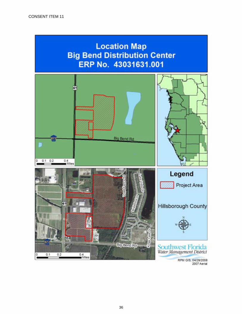
CONSENT ITEM 11
36
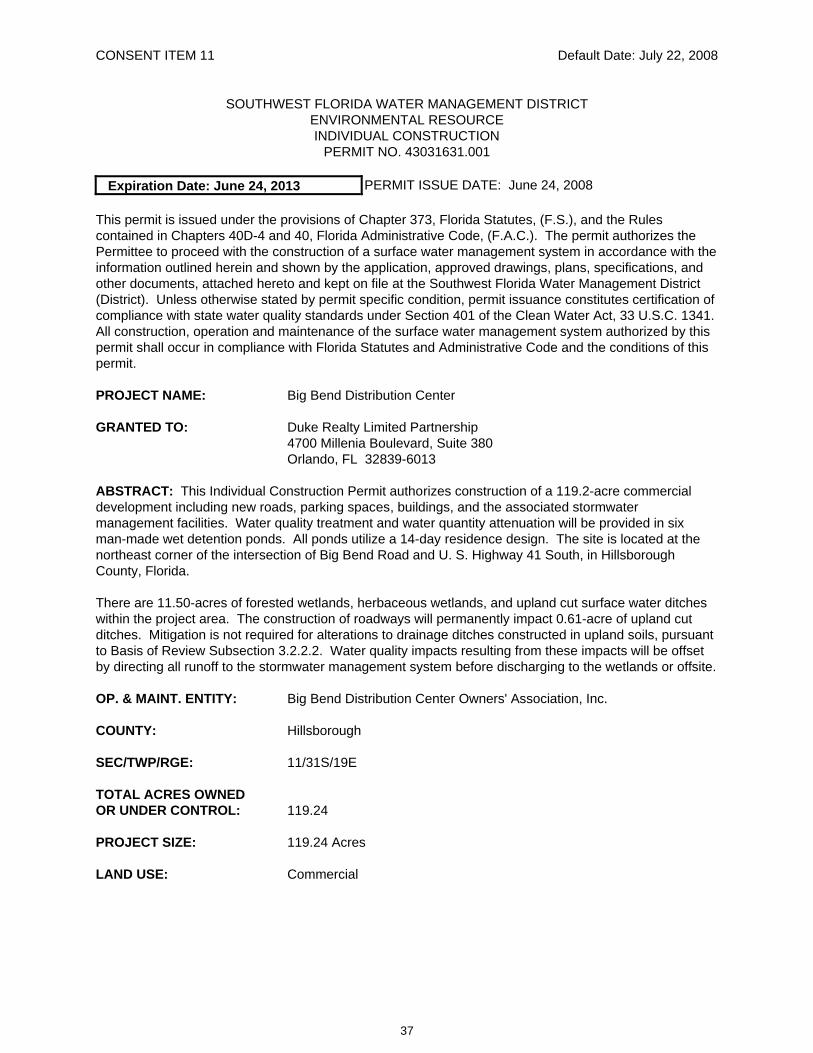
CONSENT ITEM 11 Default Date: July 22, 2008
SOUTHWEST FLORIDA WATER MANAGEMENT DISTRICT ENVIRONMENTAL RESOURCE INDIVIDUAL CONSTRUCTION
PERMIT NO. 43031631.001
Expiration Date: June 24, 2013 PERMIT ISSUE DATE: June 24, 2008
This permit is issued under the provisions of Chapter 373, Florida Statutes, (F.S.), and the Rules contained in Chapters 40D-4 and 40, Florida Administrative Code, (F.A.C.). The permit authorizes the Permittee to proceed with the construction of a surface water management system in accordance with the information outlined herein and shown by the application, approved drawings, plans, specifications, and other documents, attached hereto and kept on file at the Southwest Florida Water Management District (District). Unless otherwise stated by permit specific condition, permit issuance constitutes certification of compliance with state water quality standards under Section 401 of the Clean Water Act, 33 U.S.C. 1341. All construction, operation and maintenance of the surface water management system authorized by this permit shall occur in compliance with Florida Statutes and Administrative Code and the conditions of this permit.
PROJECT NAME: Big Bend Distribution Center
GRANTED TO: Duke Realty Limited Partnership 4700 Millenia Boulevard, Suite 380 Orlando, FL 32839-6013
ABSTRACT: This Individual Construction Permit authorizes construction of a 119.2-acre commercial development including new roads, parking spaces, buildings, and the associated stormwater management facilities. Water quality treatment and water quantity attenuation will be provided in six man-made wet detention ponds. All ponds utilize a 14-day residence design. The site is located at the northeast corner of the intersection of Big Bend Road and U. S. Highway 41 South, in Hillsborough County, Florida.
There are 11.50-acres of forested wetlands, herbaceous wetlands, and upland cut surface water ditches within the project area. The construction of roadways will permanently impact 0.61-acre of upland cut ditches. Mitigation is not required for alterations to drainage ditches constructed in upland soils, pursuant to Basis of Review Subsection 3.2.2.2. Water quality impacts resulting from these impacts will be offset by directing all runoff to the stormwater management system before discharging to the wetlands or offsite.
OP. & MAINT. ENTITY: Big Bend Distribution Center Owners' Association, Inc.
COUNTY: Hillsborough
SEC/TWP/RGE: 11/31S/19E
TOTAL ACRES OWNED OR UNDER CONTROL: 119.24
PROJECT SIZE: 119.24 Acres
LAND USE: Commercial
37
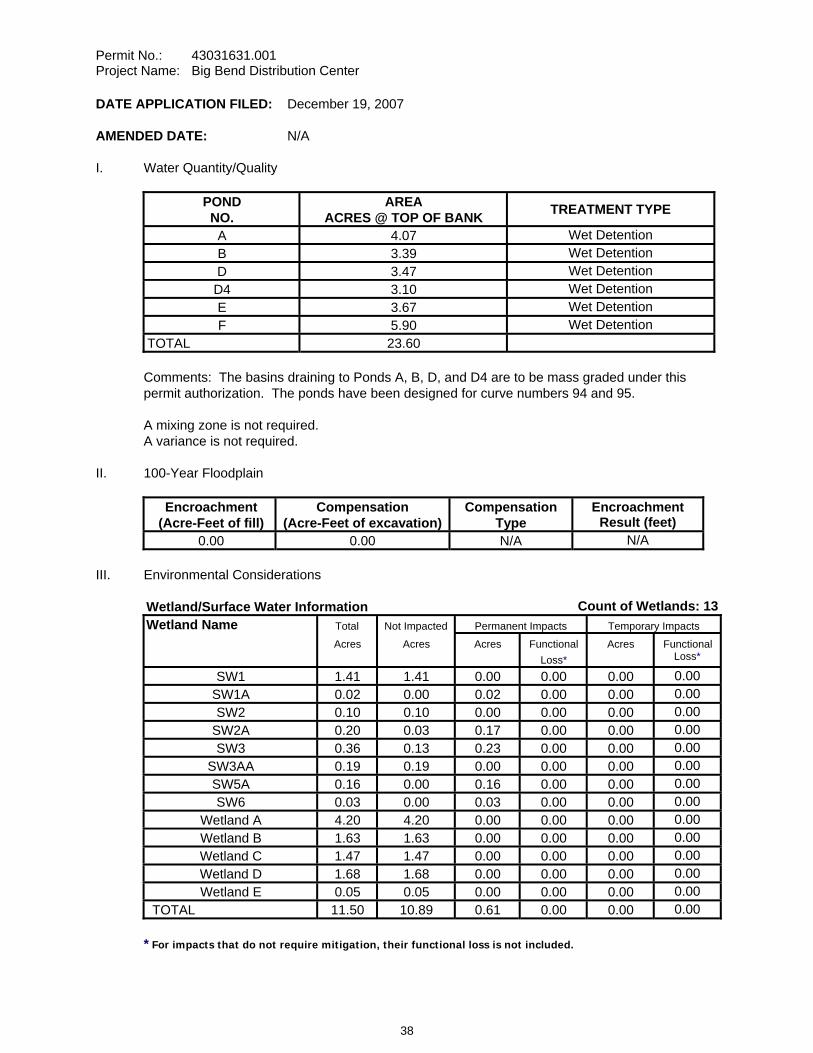
Permit No.: 43031631.001 Project Name: Big Bend Distribution Center
DATE APPLICATION FILED: December 19, 2007
AMENDED DATE: N/A
I. Water Quantity/Quality
POND NO.
AREA ACRES @ TOP OF BANK TREATMENT TYPE
A 4.07 Wet Detention B 3.39 Wet Detention D 3.47 Wet Detention D4 3.10 Wet Detention E 3.67 Wet Detention F 5.90 Wet Detention
TOTAL 23.60
Comments: The basins draining to Ponds A, B, D, and D4 are to be mass graded under this permit authorization. The ponds have been designed for curve numbers 94 and 95.
A mixing zone is not required. A variance is not required.
II. 100-Year Floodplain
Encroachment (Acre-Feet of fill)
Compensation (Acre-Feet of excavation)
Compensation Type
Encroachment Result (feet)
0.00 0.00 N/A N/A
III. Environmental Considerations
Wetland/Surface Water Information Count of Wetlands: 13Wetland Name Total Not Impacted Permanent Impacts Temporary Impacts
Acres Acres Acres Functional Loss*
Acres Functional Loss*
SW1 1.41 1.41 0.00 0.00 0.00 0.00SW1A 0.02 0.00 0.02 0.00 0.00 0.00SW2 0.10 0.10 0.00 0.00 0.00 0.00
SW2A 0.20 0.03 0.17 0.00 0.00 0.00SW3 0.36 0.13 0.23 0.00 0.00 0.00
SW3AA 0.19 0.19 0.00 0.00 0.00 0.00SW5A 0.16 0.00 0.16 0.00 0.00 0.00SW6 0.03 0.00 0.03 0.00 0.00 0.00
Wetland A 4.20 4.20 0.00 0.00 0.00 0.00Wetland B 1.63 1.63 0.00 0.00 0.00 0.00Wetland C 1.47 1.47 0.00 0.00 0.00 0.00Wetland D 1.68 1.68 0.00 0.00 0.00 0.00Wetland E 0.05 0.05 0.00 0.00 0.00 0.00
TOTAL 11.50 10.89 0.61 0.00 0.00 0.00 * For impacts that do not require mitigation, their functional loss is not included.
38
Permit No.: 43031631.001 Project Name: Big Bend Distribution Center
Wetland Comments: There are 11.50-acres of wetland and surface waters located within the project boundaries. Wetland Area A is 4.20 acres of highly disturbed forested wetland situated in the northeast corner of the site. Wetland Area B is a 1.63-acre mixed forest wetland south of Wetland Area A, along the eastern boundary of the project area. Wetland Area C, 1.47-acres, will be utilized for treatment as part of the stormwater management system and is located in the southeast corner of the site. Wetland Area D, 1.68-acres, is centrally located adjacent to SW3. Wetland Area E is a 0.05-acre depressional marsh partially located along the northern property boundary. SW1 is a 1.41-acre upland cut ditch situated along the eastern perimeter of the site. SW1A, 0.02-acre, is located in the northwest corner of the southern parcel of the project area. SW1A will be filled as a result of the construction activities. SW2 is a 0.10-acre upland cut ditch located along the southern boundary of the site. SW3 is a 0.36-acre upland cut ditch transecting the centerline of the site. SW3 will have four impacts, SW3A (0.07-acre). SW3B (0.08-acre), SW3C (0.08-acre), and SW3D (0.003-acre) totaling a 0.22-acre permanent impact due to the creation of roadway crossings. SW3AA is a 0.20-acre upland cut ditch located in the south west corner of the southern parcel of the project area. SW5A is a 0.16-acre upland cut ditch located in the southern portion of the site and will be filled during construction. SW6 is a 0.03-acre section of the roadside ditches adjacent to U.S. Highway 41 and will be impacted. Mitigation is not required for alterations to drainage ditches constructed in upland soils, pursuant to Basis of Review Subsection 3.2.2.2.
A regulatory conservation easement is not required.
A proprietary conservation easement is not required.
SPECIFIC CONDITIONS 1. If the ownership of the project area covered by the subject permit is divided, with someone other
than the Permittee becoming the owner of part of the project area, this permit shall terminate, pursuant to Section 40D-1.6105, F.A.C. In such situations, each land owner shall obtain a permit (which may be a modification of this permit) for the land owned by that person. This condition shall not apply to the division and sale of lots or units in residential subdivisions or condominiums.
2. Unless specified otherwise herein, two copies of all information and reports required by this permit shall be submitted to:
Tampa Regulation Department Southwest Florida Water Management District 7601 U.S. Highway 301 North Tampa, FL 33637-6759
The permit number, title of report or information and event (for recurring report or information submittal) shall be identified on all information and reports submitted.
3. The Permittee shall retain the design engineer, or other professional engineer registered in Florida, to conduct on-site observations of construction and assist with the as-built certification requirements of this project. The Permittee shall inform the District in writing of the name, address and phone number of the professional engineer so employed. This information shall be submitted prior to construction.
39
Permit No.: 43031631.001 Project Name: Big Bend Distribution Center
4. Within 30 days after completion of construction of the permitted activity, the Permittee shall submit to the Tampa Service Office a written statement of completion and certification by a registered professional engineer or other appropriate individual as authorized by law, utilizing the required Statement of Completion and Request for Transfer to Operation Entity form identified in Chapter 40D-1.659, F.A.C., and signed, dated and sealed as-built drawings. The as-built drawings shall identify any deviations from the approved construction drawings.
5. The District reserves the right, upon prior notice to the Permittee, to conduct on-site research to assess the pollutant removal efficiency of the surface water management system. The Permittee may be required to cooperate in this regard by allowing on-site access by District representatives, by allowing the installation and operation of testing and monitoring equipment, and by allowing other assistance measures as needed on site.
6. Wetland buffers shall remain in an undisturbed condition except for approved drainage facility construction/maintenance.
7. The following boundaries, as shown on the approved construction drawings, shall be clearly delineated on the site prior to initial clearing or grading activities:
a. wetland and surface water areas andb. wetland buffers.
The delineation shall endure throughout the construction period and be readily discernible to construction and District personnel.
8. Wetland boundaries as shown on the approved construction drawings shall be binding upon the Permittee and the District.
9. Rights-of-way and easement locations necessary to construct, operate and maintain all facilities, which constitute the permitted surface water management system, shall be shown on the final plat recorded in the County Public Records. Documentation of this plat recording shall be submitted to the District with the Statement of Completion and Request for Transfer to Operation Entity Form, and prior to beneficial occupancy or use of the site.
10. Copies of the following documents in final form, as appropriate for the project, shall be submitted to the Tampa Regulation Department:
a. homeowners, property owners, master association or condominium association articles of incorporation, and
b. declaration of protective covenants, deed restrictions or declaration of condominium.
The Permittee shall submit these documents either: (1) within 180 days after beginning construction or with the Statement of Completion and as-built construction plans if construction is completed prior to 180 days, or (2) prior to any lot or unit sales within the project served by the surface water management system, whichever occurs first.
11. The following language shall be included as part of the deed restrictions for each lot:
"Each property owner within the subdivision at the time of construction of a building, residence, or structure shall comply with the construction plans for the surface water management system approved and on file with the Southwest Florida Water Management District."
40
Permit No.: 43031631.001 Project Name: Big Bend Distribution Center
12. The Permittee shall provide notice of District permitting requirements to all buyers of individual parcels or lots located within Big Bend Distribution Center. The notice shall be stated in the sales contract or as a deed restriction and shall include the following instructions:
"The Buyer is hereby notified that this property is subject to the requirements of Surface Water Management Permit No. 43031631.001 issued by the Southwest Florida Water Management District. In addition, the Buyer is required to inform the Southwest Florida Water Management District at the beginning of construction that a Professional Engineer registered in Florida has been retained to supervise construction; and upon completion of construction on this parcel or lot, the buyer must submit to the District a Statement of Completion and as-built certification of compliance with the permit."
13. The Permittee shall provide notice of District permitting requirements to all buyers of individual parcels or lots located within Big Bend Distribution Center. This notice shall be stated in the sales contract or as a deed restriction and shall include the following instructions:
"The Buyer is hereby notified that this property is subject to the requirements of Surface Water Management Permit No. 43031631.001 issued by the Southwest Florida Water Management District. In addition, the Buyer is required to obtain a surface water management permit in accordance with Chapter 40D-4, F.A.C., from the Southwest Florida Water Management District prior to initiating any construction or alteration of a surface water management system on this property."
14. The operation and maintenance entity shall submit inspection reports in the form required by the District, in accordance with the following schedule.
For systems utilizing retention or wet detention, the inspections shall be performed two (2) years after operation is authorized and every two (2) years thereafter.
15. The removal of littoral shelf vegetation (including cattails) from wet detention ponds is prohibited unless otherwise approved by the District. Removal includes dredging, the application of herbicide, cutting, and the introduction of grass carp. Any questions regarding authorized activities within the wet detention ponds shall be addressed to the District's Surface Water Regulation Manager, Tampa Service Office.
16. For the areas shown on the construction drawings as "Future", a permit modification shall be obtained for any construction in this/these areas. As a requirement of the permit modification for this/these areas, the Permittee shall submit a Statement of Completion and as-built drawings.
17. If limestone bedrock is encountered during construction of the surface water management system, the District must be notified and construction in the affected area shall cease.
18. The Permittee shall notify the District of any sinkhole development in the surface water management system within 48 hours of discovery and must submit a detailed sinkhole evaluation and repair plan for approval by the District within 30 days of discovery.
19. The District, upon prior notice to the Permittee, may conduct on-site inspections to assess the effectiveness of the erosion control barriers and other measures employed to prevent violations of state water quality standards and avoid downstream impacts. Such barriers or other measures should control discharges, erosion, and sediment transport during construction and thereafter. The District will also determine any potential environmental problems that may develop as a result of leaving or removing the barriers and other measures during construction or after construction of the project has been completed. The Permittee must provide any remedial measures that are needed.
41
Permit No.: 43031631.001 Project Name: Big Bend Distribution Center
20. This permit is issued based upon the design prepared by the Permittee’s consultant. If at any time it is determined by the District that the Conditions for Issuance of Permits in Rules 40D-4.301 and 40D-4.302, F.A.C., have not been met, upon written notice by the District, the Permittee shall obtain a permit modification and perform any construction necessary thereunder to correct any deficiencies in the system design or construction to meet District rule criteria. The Permittee is advised that the correction of deficiencies may require re-construction of the surface water management system and/or mitigation areas.
GENERAL CONDITIONS 1. The general conditions attached hereto as Exhibit "A" are hereby incorporated into this permit by
reference and the Permittee shall comply with them.
____________________________________________ Authorized Signature
42
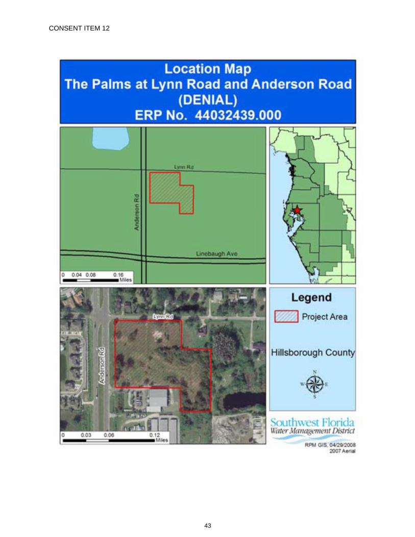
CONSENT ITEM 12
43

CONSENT ITEM 12 Default Date: July 24, 2008
SOUTHWEST FLORIDA WATER MANAGEMENT DISTRICT ENVIRONMENTAL RESOURCE GENERAL CONSTRUCTION
DENIAL OF GENERAL CONSTRUCTION PERMIT APPLICATION NO. 44032439.000
DATE OF DENIAL: June 24, 2008
Staff recommends denial of this application for permit due to lack of completeness, in accordance with District Rule 40D-1.1020 and Rule 40D-40.302, Florida Administrative Code, (F.A.C.).
PROJECT NAME: The Palms at Lynn Road and Anderson Road
OWNER/APPLICANT: Lynn & Anderson Homes, LLC One Tampa City Center, Suite 2505 Tampa, FL 33602
ABSTRACT: The proposed project is for a 6.50-acre, 58-unit townhome development, the associated infrastructure, and a man-made wet detention pond. The pond is designed to attenuate for a 5-year/24-hour pre-development peak discharge rate using a 25-year/24-hour post development storm event. The applicant has not adequately responded to the District’s February 28, 2008 “Clarification of Received Information” letter, which addressed the issue of lack of ownership or control over the offsite construction area. The site is located on the east side of Anderson Road and the south side of Lynn Road, in Hillsborough County, Florida.
February 7, 2007 Application Received February 23, 2007 Request for Additional Information (RAI) sent July 11, 2007 Response received August 8, 2007 Clarification Letter sent October 22, 2007 Response received November 16, 2007 Clarification Letter sent February 7, 2008 Response received February 28, 2008 Clarification Letter sent
COUNTY: Hillsborough
SEC/TWP/RGE: 18/28S/18E
TOTAL ACRES OWNED: 6.50
PROJECT SIZE: 6.50 Acres
LAND USE: Multi-family Residential
DATE APPLICATION FILED: February 7, 2007
AMENDED DATE: N/A
The following are reasons for denial:
44
Permit No.: 44032439.000 Project Name: The Palms at Lynn Road and Anderson Road (DENIAL)
Plans 1. The applicant has not adequately indicated the limits of fill on the adjacent property and provided
grading to ensure that the area will drain to the pond. [Rule 40D-4.101(1)(c), F.A.C.] Operation & Maintenance & Legal Documentation 2. The plans indicate there is offsite construction but the applicant states that the area in question
has been purchased. The applicant has not adequately provided proof of ownership or control over this area. [Rule 40D-4.301(1)(j), F.A.C.]
45
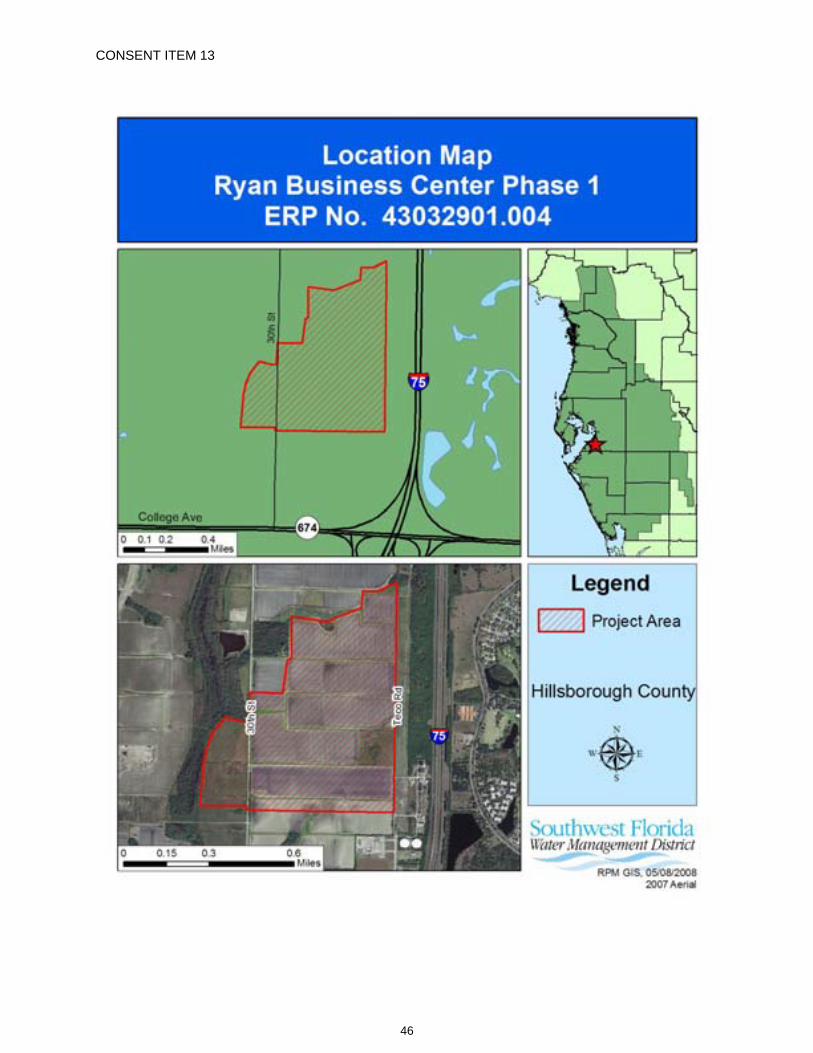
CONSENT ITEM 13
46
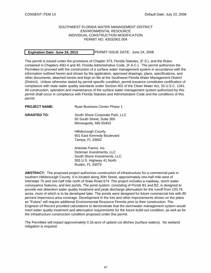
CONSENT ITEM 13 Default Date: July 23, 2008
SOUTHWEST FLORIDA WATER MANAGEMENT DISTRICT ENVIRONMENTAL RESOURCE
INDIVIDUAL CONSTRUCTION MODIFICATION PERMIT NO. 43032901.004
Expiration Date: June 24, 2013 PERMIT ISSUE DATE: June 24, 2008
This permit is issued under the provisions of Chapter 373, Florida Statutes, (F.S.), and the Rules contained in Chapters 40D-4 and 40, Florida Administrative Code, (F.A.C.). The permit authorizes the Permittee to proceed with the construction of a surface water management system in accordance with the information outlined herein and shown by the application, approved drawings, plans, specifications, and other documents, attached hereto and kept on file at the Southwest Florida Water Management District (District). Unless otherwise stated by permit specific condition, permit issuance constitutes certification of compliance with state water quality standards under Section 401 of the Clean Water Act, 33 U.S.C. 1341. All construction, operation and maintenance of the surface water management system authorized by this permit shall occur in compliance with Florida Statutes and Administrative Code and the conditions of this permit.
PROJECT NAME: Ryan Business Center Phase 1
GRANTED TO: South Shore Corporate Park, LLC 50 South Street, Suite 300 Minneapolis, MN 55403
Hillsborough County 601 East Kennedy Boulevard Tampa, FL 33602
Artesian Farms, Inc. Dickman Investments, LLC South Shore Investments, LLC
305 U.S. Highway 41 North Ruskin, FL 33570
ABSTRACT: The proposed project authorizes construction of infrastructure for a commercial park in southern Hillsborough County. It is located along 30th Street, approximately one-half mile west of Interstate 75 and one-half mile north of State Road 674. The project includes a roadway, storm water conveyance features, and two ponds. The pond system, consisting of Ponds B1 and B2, is designed to provide wet detention water quality treatment and peak discharge attenuation for the runoff from 233.76 acres, most of which is to be developed later. The ponds were designed for future commercial lots with 80 percent impervious area coverage. Development in the lots and other improvements shown on the plans as "Future" will require additional Environmental Resource Permits prior to their construction. The Engineer-of-Record provided calculations to demonstrate that the stormwater management system would meet water quality treatment and attenuation requirements for the future build-out condition, as well as for the infrastructure construction condition proposed under this permit.
The Permittee will impact approximately 0.16-acre of upland cut ditches (surface waters). No wetland mitigation is required.
47
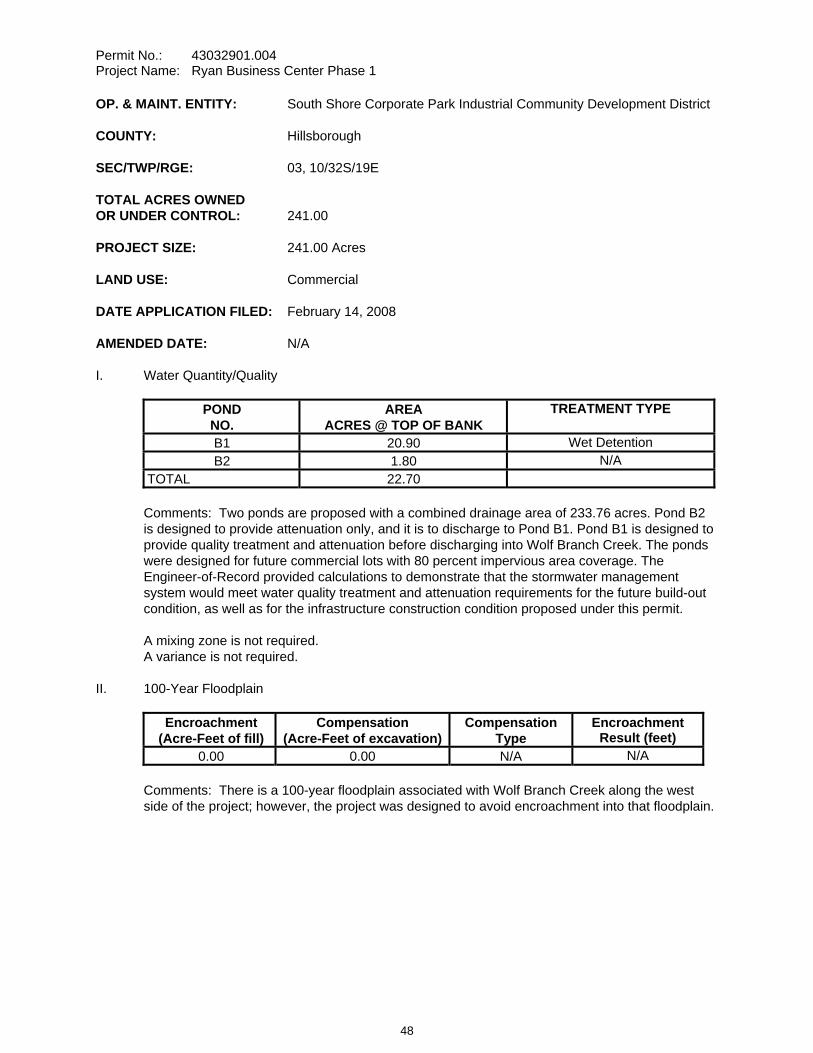
Permit No.: 43032901.004 Project Name: Ryan Business Center Phase 1
OP. & MAINT. ENTITY: South Shore Corporate Park Industrial Community Development District
COUNTY: Hillsborough
SEC/TWP/RGE: 03, 10/32S/19E
TOTAL ACRES OWNED OR UNDER CONTROL: 241.00
PROJECT SIZE: 241.00 Acres
LAND USE: Commercial
DATE APPLICATION FILED: February 14, 2008
AMENDED DATE: N/A
I. Water Quantity/Quality
POND NO.
AREA ACRES @ TOP OF BANK
TREATMENT TYPE
B1 20.90 Wet Detention B2 1.80 N/A
TOTAL 22.70
Comments: Two ponds are proposed with a combined drainage area of 233.76 acres. Pond B2 is designed to provide attenuation only, and it is to discharge to Pond B1. Pond B1 is designed to provide quality treatment and attenuation before discharging into Wolf Branch Creek. The ponds were designed for future commercial lots with 80 percent impervious area coverage. The Engineer-of-Record provided calculations to demonstrate that the stormwater management system would meet water quality treatment and attenuation requirements for the future build-out condition, as well as for the infrastructure construction condition proposed under this permit.
A mixing zone is not required. A variance is not required.
II. 100-Year Floodplain
Encroachment (Acre-Feet of fill)
Compensation (Acre-Feet of excavation)
Compensation Type
Encroachment Result (feet)
0.00 0.00 N/A N/A
Comments: There is a 100-year floodplain associated with Wolf Branch Creek along the west side of the project; however, the project was designed to avoid encroachment into that floodplain.
48
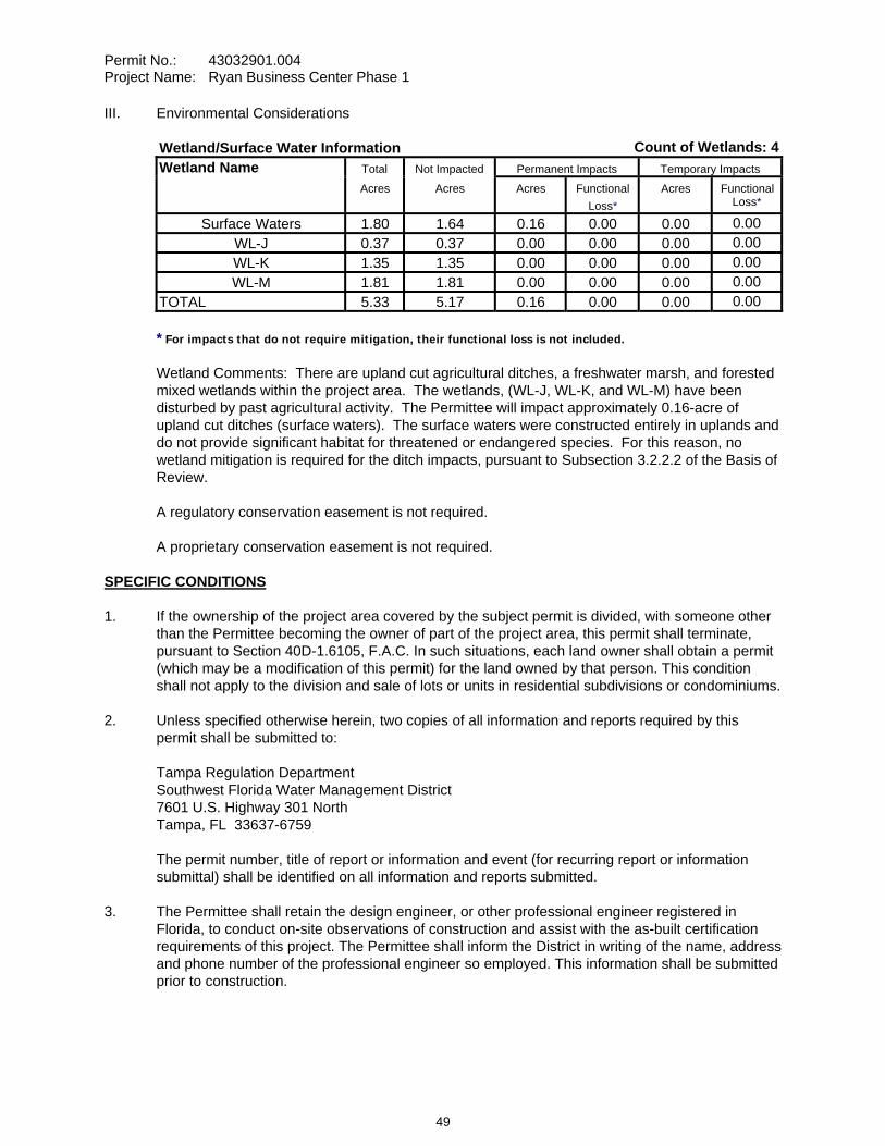
Permit No.: 43032901.004 Project Name: Ryan Business Center Phase 1
III. Environmental Considerations
Wetland/Surface Water Information Count of Wetlands: 4Wetland Name Total Not Impacted Permanent Impacts Temporary Impacts Acres Acres Acres Functional
Loss*Acres Functional
Loss*
Surface Waters 1.80 1.64 0.16 0.00 0.00 0.00WL-J 0.37 0.37 0.00 0.00 0.00 0.00WL-K 1.35 1.35 0.00 0.00 0.00 0.00WL-M 1.81 1.81 0.00 0.00 0.00 0.00
TOTAL 5.33 5.17 0.16 0.00 0.00 0.00
* For impacts that do not require mitigation, their functional loss is not included.
Wetland Comments: There are upland cut agricultural ditches, a freshwater marsh, and forested mixed wetlands within the project area. The wetlands, (WL-J, WL-K, and WL-M) have been disturbed by past agricultural activity. The Permittee will impact approximately 0.16-acre of upland cut ditches (surface waters). The surface waters were constructed entirely in uplands and do not provide significant habitat for threatened or endangered species. For this reason, no wetland mitigation is required for the ditch impacts, pursuant to Subsection 3.2.2.2 of the Basis of Review.
A regulatory conservation easement is not required.
A proprietary conservation easement is not required.
SPECIFIC CONDITIONS 1. If the ownership of the project area covered by the subject permit is divided, with someone other
than the Permittee becoming the owner of part of the project area, this permit shall terminate, pursuant to Section 40D-1.6105, F.A.C. In such situations, each land owner shall obtain a permit (which may be a modification of this permit) for the land owned by that person. This condition shall not apply to the division and sale of lots or units in residential subdivisions or condominiums.
2. Unless specified otherwise herein, two copies of all information and reports required by this permit shall be submitted to:
Tampa Regulation Department Southwest Florida Water Management District 7601 U.S. Highway 301 North Tampa, FL 33637-6759
The permit number, title of report or information and event (for recurring report or information submittal) shall be identified on all information and reports submitted.
3. The Permittee shall retain the design engineer, or other professional engineer registered in Florida, to conduct on-site observations of construction and assist with the as-built certification requirements of this project. The Permittee shall inform the District in writing of the name, address and phone number of the professional engineer so employed. This information shall be submitted prior to construction.
49
Permit No.: 43032901.004 Project Name: Ryan Business Center Phase 1
4. Within 30 days after completion of construction of the permitted activity, the Permittee shall submit to the Tampa Service Office a written statement of completion and certification by a registered professional engineer or other appropriate individual as authorized by law, utilizing the required Statement of Completion and Request for Transfer to Operation Entity form identified in Chapter 40D-1.659, F.A.C., and signed, dated and sealed as-built drawings. The as-built drawings shall identify any deviations from the approved construction drawings.
5. The District reserves the right, upon prior notice to the Permittee, to conduct on-site research to assess the pollutant removal efficiency of the surface water management system. The Permittee may be required to cooperate in this regard by allowing on-site access by District representatives, by allowing the installation and operation of testing and monitoring equipment, and by allowing other assistance measures as needed on site.
6. Wetland buffers shall remain in an undisturbed condition except for approved drainage facility construction/maintenance.
7. The following boundaries, as shown on the approved construction drawings, shall be clearly delineated on the site prior to initial clearing or grading activities:
a. wetland and surface water areas,b. wetland buffers, and c. limits of approved wetland impacts.
The delineation shall endure throughout the construction period and be readily discernible to construction and District personnel.
8. Wetland boundaries as shown on the approved construction drawings shall be binding upon the Permittee and the District.
9. Rights-of-way and easement locations necessary to construct, operate and maintain all facilities, which constitute the permitted surface water management system, shall be shown on the final plat recorded in the County Public Records. Documentation of this plat recording shall be submitted to the District with the Statement of Completion and Request for Transfer to Operation Entity Form, and prior to beneficial occupancy or use of the site. The plat shall include the locations and limits of the following:
a. all wetlands,b. wetland buffers, andc. 100-year floodplain areas.
10. The Permittee shall provide notice of District permitting requirements to all buyers of individual parcels or lots located within Ryan Business Center Phase 1. The notice shall be stated in the sales contract or as a deed restriction and shall include the following instructions:
"The Buyer is hereby notified that this property is subject to the requirements of Surface Water Management Permit No. 43032901.004 issued by the Southwest Florida Water Management District. In addition, the Buyer is required to inform the Southwest Florida Water Management District at the beginning of construction that a Professional Engineer registered in Florida has been retained to supervise construction; and upon completion of construction on this parcel or lot, the buyer must submit to the District a Statement of Completion and as-built certification of compliance with the permit."
50
Permit No.: 43032901.004 Project Name: Ryan Business Center Phase 1
11. The operation and maintenance entity shall submit inspection reports in the form required by the District, in accordance with the following schedule.
For systems utilizing retention or wet detention, the inspections shall be performed two (2) years after operation is authorized and every two (2) years thereafter.
12. The removal of littoral shelf vegetation (including cattails) from wet detention ponds is prohibited unless otherwise approved by the District. Removal includes dredging, the application of herbicide, cutting, and the introduction of grass carp. Any questions regarding authorized activities within the wet detention ponds shall be addressed to the District's Surface Water Regulation Manager, Tampa Service Office.
13. This modification, Construction Permit No. 43032901.004, amends the previously issued Construction Permit No. 44032901.000, and all conditions are replaced by the conditions herein.
14. For the areas shown on the construction drawings as "Future", a permit modification shall be obtained for any construction in this/these areas. As a requirement of the permit modification for this/these areas, the Permittee shall submit a Statement of Completion and as-built drawings.
15. The District, upon prior notice to the Permittee, may conduct on-site inspections to assess the effectiveness of the erosion control barriers and other measures employed to prevent violations of state water quality standards and avoid downstream impacts. Such barriers or other measures should control discharges, erosion, and sediment transport during construction and thereafter. The District will also determine any potential environmental problems that may develop as a result of leaving or removing the barriers and other measures during construction or after construction of the project has been completed. The Permittee must provide any remedial measures that are needed.
16. This permit is issued based upon the design prepared by the Permittee’s consultant. If at any time it is determined by the District that the Conditions for Issuance of Permits in Rules 40D-4.301 and 40D-4.302, F.A.C., have not been met, upon written notice by the District, the Permittee shall obtain a permit modification and perform any construction necessary thereunder to correct any deficiencies in the system design or construction to meet District rule criteria. The Permittee is advised that the correction of deficiencies may require re-construction of the surface water management system and/or mitigation areas.
17. Copies of the following documents in final form, as appropriate for the project, shall be submitted to the Tampa Service Office:
a. Community Development District articles of incorporation, and
b. Declaration of protective covenants, deed restrictions or declaration of condominium
The Permittee shall submit these documents either: (1) within 180 days after beginning construction or within the Statement of Completion and as-built construction plans if construction is completed prior to 180 days, or (2) prior to any lot or unit sales within the project served by the surface water management system, whichever occurs first.
51

Permit No.: 43032901.004 Project Name: Ryan Business Center Phase 1
GENERAL CONDITIONS 1. The general conditions attached hereto as Exhibit "A" are hereby incorporated into this permit by reference and the Permittee shall comply with them.
____________________________________________ Authorized Signature
52

CONSENT ITEM 14
53
CONSENT ITEM 14 Default Date: July 23, 2008
SOUTHWEST FLORIDA WATER MANAGEMENT DISTRICT ENVIRONMENTAL RESOURCE INDIVIDUAL CONSTRUCTION
PERMIT NO. 43022520.001
Expiration Date: June 24, 2013 PERMIT ISSUE DATE: June 24, 2008
This permit is issued under the provisions of Chapter 373, Florida Statutes, (F.S.), and the Rules contained in Chapters 40D-4 and 40, Florida Administrative Code, (F.A.C.). The permit authorizes the Permittee to proceed with the construction of a surface water management system in accordance with the information outlined herein and shown by the application, approved drawings, plans, specifications, and other documents, attached hereto and kept on file at the Southwest Florida Water Management District (District). Unless otherwise stated by permit specific condition, permit issuance constitutes certification of compliance with state water quality standards under Section 401 of the Clean Water Act, 33 U.S.C. 1341. All construction, operation and maintenance of the surface water management system authorized by this permit shall occur in compliance with Florida Statutes and Administrative Code and the conditions of this permit.
PROJECT NAME: Watson Borrow Pit
GRANTED TO: Freebie Landholdings, Inc. 940 NW 247th Drive Newberry, FL 32669
ABSTRACT: This permit is for the construction of a new surface water management system to serve a 134.20-acre borrow pit. The access road was previously constructed under Environmental Resource Permit [ERP] Nos. 440017629.003 (WG Johnson & Son) and 440017629.004 (Watson Construction Borrow Pit). The project is located south of SR 24 in Levy County. Adjacent permitted properties include ERP Nos. 44022520.002 (WG Johnson & Son Borrow Pit), 440017629.003 (WG Johnson & Son) and 440017629.004 (Watson Construction Borrow Pit). Information regarding the surface water management system is contained in the tables below.
OP. & MAINT. ENTITY: Freebie Landholdings, Inc.
COUNTY: Levy
SEC/TWP/RGE: 24,36/11S/17E
TOTAL ACRES OWNED OR UNDER CONTROL: 134.20
PROJECT SIZE: 134.20 Acres
LAND USE: Mining
DATE APPLICATION FILED: October 15, 2007
AMENDED DATE: N/A
54
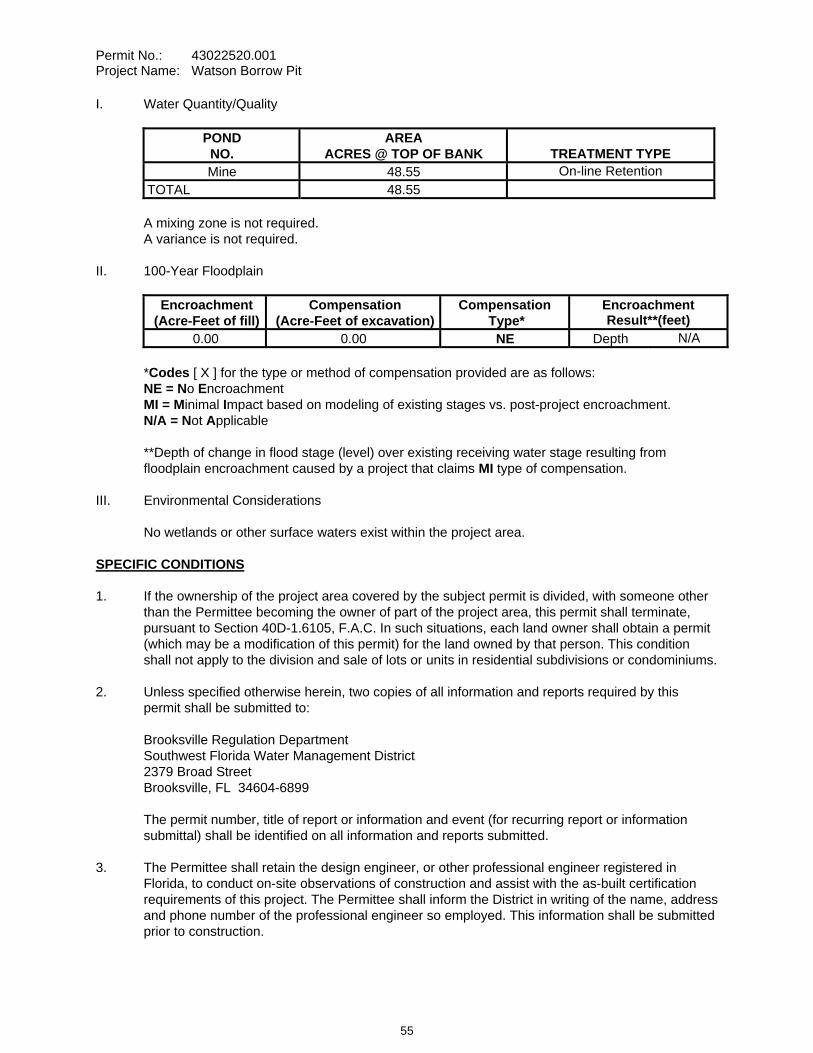
Permit No.: 43022520.001 Project Name: Watson Borrow Pit
I. Water Quantity/Quality
POND NO.
AREA ACRES @ TOP OF BANK TREATMENT TYPE
Mine 48.55 On-line Retention TOTAL 48.55
A mixing zone is not required. A variance is not required.
II. 100-Year Floodplain
Encroachment (Acre-Feet of fill)
Compensation (Acre-Feet of excavation)
Compensation Type*
Encroachment Result**(feet)
0.00 0.00 NE Depth N/A
*Codes [ X ] for the type or method of compensation provided are as follows: NE = No EncroachmentMI = Minimal Impact based on modeling of existing stages vs. post-project encroachment. N/A = Not Applicable
**Depth of change in flood stage (level) over existing receiving water stage resulting from floodplain encroachment caused by a project that claims MI type of compensation.
III. Environmental Considerations
No wetlands or other surface waters exist within the project area.
SPECIFIC CONDITIONS 1. If the ownership of the project area covered by the subject permit is divided, with someone other
than the Permittee becoming the owner of part of the project area, this permit shall terminate, pursuant to Section 40D-1.6105, F.A.C. In such situations, each land owner shall obtain a permit (which may be a modification of this permit) for the land owned by that person. This condition shall not apply to the division and sale of lots or units in residential subdivisions or condominiums.
2. Unless specified otherwise herein, two copies of all information and reports required by this permit shall be submitted to:
Brooksville Regulation Department Southwest Florida Water Management District 2379 Broad Street Brooksville, FL 34604-6899
The permit number, title of report or information and event (for recurring report or information submittal) shall be identified on all information and reports submitted.
3. The Permittee shall retain the design engineer, or other professional engineer registered in Florida, to conduct on-site observations of construction and assist with the as-built certification requirements of this project. The Permittee shall inform the District in writing of the name, address and phone number of the professional engineer so employed. This information shall be submitted prior to construction.
55
Permit No.: 43022520.001 Project Name: Watson Borrow Pit
4. Within 30 days after completion of construction of the permitted activity, the Permittee shall submit to the Brooksville Service Office a written statement of completion and certification by a registered professional engineer or other appropriate individual as authorized by law, utilizing the required Statement of Completion and Request for Transfer to Operation Entity form identified in Chapter 40D-1.659, F.A.C., and signed, dated and sealed as-built drawings. The as-built drawings shall identify any deviations from the approved construction drawings.
5. The District reserves the right, upon prior notice to the Permittee, to conduct on-site research to assess the pollutant removal efficiency of the surface water management system. The Permittee may be required to cooperate in this regard by allowing on-site access by District representatives, by allowing the installation and operation of testing and monitoring equipment, and by allowing other assistance measures as needed on site.
6. The operation and maintenance entity shall submit inspection reports in the form required by the District, in accordance with the following schedule.
For systems utilizing retention or wet detention, the inspections shall be performed two (2) years after operation is authorized and every two (2) years thereafter.
7. If limestone bedrock is encountered during construction of the surface water management system, the District must be notified and construction in the affected area shall cease.
8. The Permittee shall notify the District of any sinkhole development in the surface water management system within 48 hours of discovery and must submit a detailed sinkhole evaluation and repair plan for approval by the District within 30 days of discovery.
9. The District, upon prior notice to the Permittee, may conduct on-site inspections to assess the effectiveness of the erosion control barriers and other measures employed to prevent violations of state water quality standards and avoid downstream impacts. Such barriers or other measures should control discharges, erosion, and sediment transport during construction and thereafter. The District will also determine any potential environmental problems that may develop as a result of leaving or removing the barriers and other measures during construction or after construction of the project has been completed. The Permittee must provide any remedial measures that are needed.
10. This permit is issued based upon the design prepared by the Permittee’s consultant. If at any time it is determined by the District that the Conditions for Issuance of Permits in Rules 40D-4.301 and 40D-4.302, F.A.C., have not been met, upon written notice by the District, the Permittee shall obtain a permit modification and perform any construction necessary thereunder to correct any deficiencies in the system design or construction to meet District rule criteria. The Permittee is advised that the correction of deficiencies may require re-construction of the surface water management system and/or mitigation areas.
GENERAL CONDITIONS 1. The general conditions attached hereto as Exhibit "A" are hereby incorporated into this permit by
reference and the Permittee shall comply with them.
____________________________________________ Authorized Signature
56
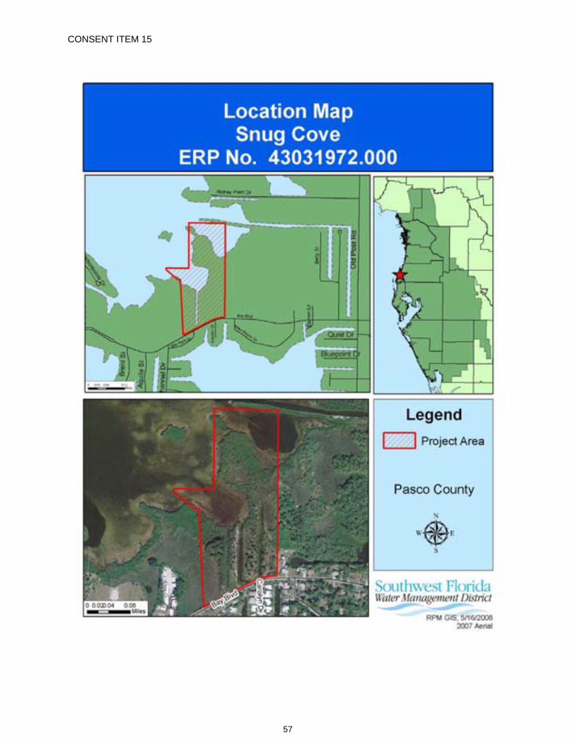
CONSENT ITEM 15
57
CONSENT ITEM 15 Default Date: August 6, 2008
SOUTHWEST FLORIDA WATER MANAGEMENT DISTRICT ENVIRONMENTAL RESOURCE INDIVIDUAL CONSTRUCTION
PERMIT NO. 43031972.000
Expiration Date: June 24, 2013 PERMIT ISSUE DATE: June 24, 2008
This permit is issued under the provisions of Chapter 373, Florida Statutes, (F.S.), and the Rules contained in Chapters 40D-4 and 40, Florida Administrative Code, (F.A.C.). The permit authorizes the Permittee to proceed with the construction of a surface water management system in accordance with the information outlined herein and shown by the application, approved drawings, plans, specifications, and other documents, attached hereto and kept on file at the Southwest Florida Water Management District (District). Unless otherwise stated by permit specific condition, permit issuance constitutes certification of compliance with state water quality standards under Section 401 of the Clean Water Act, 33 U.S.C. 1341. All construction, operation and maintenance of the surface water management system authorized by this permit shall occur in compliance with Florida Statutes and Administrative Code and the conditions of this permit.
PROJECT NAME: Snug Cove
GRANTED TO: Sunsouth One Corp. 4303 Brau Rivage Lutz, FL 33558
ABSTRACT: This permit is for the construction of a new surface water management system to serve a multi-family condominium development within a project area of 7.54 acres and total land area of 24.92 acres, known as Snug Cove. The project site is located on the north side of Bay Boulevard, west of US 19 in Pasco County. Adjacent properties include Research Development International LTD Property (Environmental Resource Permit [ERP] No. 42030827.000) to the east, Paradise Estates (ERP No. 44024971.000) and Harbor Pointe Subdivision (Management and Storage of Surface Water Permit No. 40001706.003) to the west. Information regarding the surface water management system and wetlands is contained within the tables below.
OP. & MAINT. ENTITY: Sunsouth One Corp.
COUNTY: Pasco
SEC/TWP/RGE: 29,30/25S/16E
TOTAL ACRES OWNED OR UNDER CONTROL: 24.92
PROJECT SIZE: 7.54 Acres
LAND USE: Residential
DATE APPLICATION FILED: October 26, 2006
AMENDED DATE: August 30, 2007
58
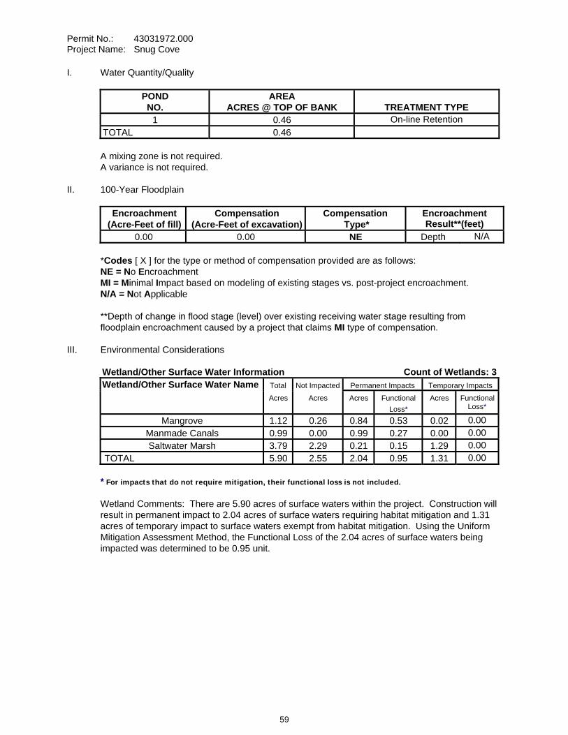
Permit No.: 43031972.000 Project Name: Snug Cove
I. Water Quantity/Quality
POND NO.
AREA ACRES @ TOP OF BANK TREATMENT TYPE
1 0.46 On-line Retention TOTAL 0.46
A mixing zone is not required. A variance is not required.
II. 100-Year Floodplain
Encroachment (Acre-Feet of fill)
Compensation (Acre-Feet of excavation)
Compensation Type*
Encroachment Result**(feet)
0.00 0.00 NE Depth N/A
*Codes [ X ] for the type or method of compensation provided are as follows: NE = No EncroachmentMI = Minimal Impact based on modeling of existing stages vs. post-project encroachment. N/A = Not Applicable
**Depth of change in flood stage (level) over existing receiving water stage resulting from floodplain encroachment caused by a project that claims MI type of compensation.
III. Environmental Considerations
Wetland/Other Surface Water Information Count of Wetlands: 3Wetland/Other Surface Water Name Total Not Impacted Permanent Impacts Temporary Impacts Acres Acres Acres Functional
Loss*Acres Functional
Loss*
Mangrove 1.12 0.26 0.84 0.53 0.02 0.00Manmade Canals 0.99 0.00 0.99 0.27 0.00 0.00Saltwater Marsh 3.79 2.29 0.21 0.15 1.29 0.00
TOTAL 5.90 2.55 2.04 0.95 1.31 0.00
* For impacts that do not require mitigation, their functional loss is not included.
Wetland Comments: There are 5.90 acres of surface waters within the project. Construction will result in permanent impact to 2.04 acres of surface waters requiring habitat mitigation and 1.31 acres of temporary impact to surface waters exempt from habitat mitigation. Using the Uniform Mitigation Assessment Method, the Functional Loss of the 2.04 acres of surface waters being impacted was determined to be 0.95 unit.
59
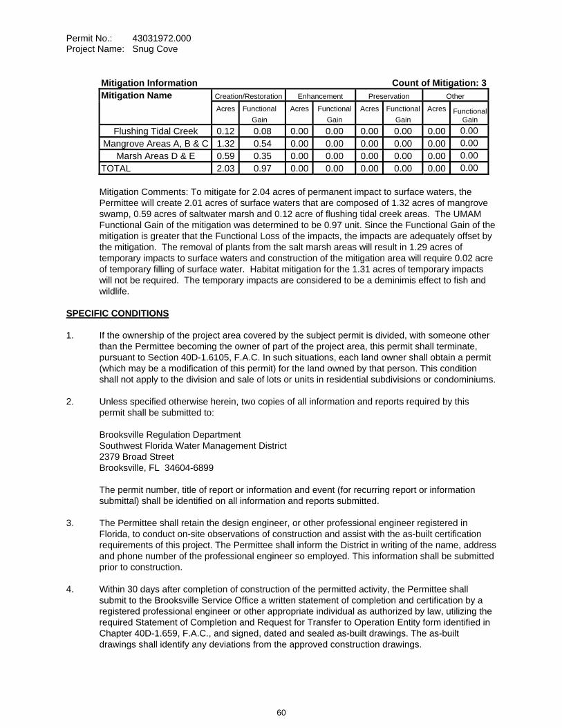
Permit No.: 43031972.000 Project Name: Snug Cove
Mitigation Information Count of Mitigation: 3Mitigation Name Creation/Restoration Enhancement Preservation Other Acres Functional
Gain Acres Functional
Gain Acres Functional
Gain Acres Functional
Gain Flushing Tidal Creek 0.12 0.08 0.00 0.00 0.00 0.00 0.00 0.00
Mangrove Areas A, B & C 1.32 0.54 0.00 0.00 0.00 0.00 0.00 0.00Marsh Areas D & E 0.59 0.35 0.00 0.00 0.00 0.00 0.00 0.00
TOTAL 2.03 0.97 0.00 0.00 0.00 0.00 0.00 0.00
Mitigation Comments: To mitigate for 2.04 acres of permanent impact to surface waters, the Permittee will create 2.01 acres of surface waters that are composed of 1.32 acres of mangrove swamp, 0.59 acres of saltwater marsh and 0.12 acre of flushing tidal creek areas. The UMAM Functional Gain of the mitigation was determined to be 0.97 unit. Since the Functional Gain of the mitigation is greater that the Functional Loss of the impacts, the impacts are adequately offset by the mitigation. The removal of plants from the salt marsh areas will result in 1.29 acres of temporary impacts to surface waters and construction of the mitigation area will require 0.02 acre of temporary filling of surface water. Habitat mitigation for the 1.31 acres of temporary impacts will not be required. The temporary impacts are considered to be a deminimis effect to fish and wildlife.
SPECIFIC CONDITIONS 1. If the ownership of the project area covered by the subject permit is divided, with someone other
than the Permittee becoming the owner of part of the project area, this permit shall terminate, pursuant to Section 40D-1.6105, F.A.C. In such situations, each land owner shall obtain a permit (which may be a modification of this permit) for the land owned by that person. This condition shall not apply to the division and sale of lots or units in residential subdivisions or condominiums.
2. Unless specified otherwise herein, two copies of all information and reports required by this permit shall be submitted to:
Brooksville Regulation Department Southwest Florida Water Management District 2379 Broad Street Brooksville, FL 34604-6899
The permit number, title of report or information and event (for recurring report or information submittal) shall be identified on all information and reports submitted.
3. The Permittee shall retain the design engineer, or other professional engineer registered in Florida, to conduct on-site observations of construction and assist with the as-built certification requirements of this project. The Permittee shall inform the District in writing of the name, address and phone number of the professional engineer so employed. This information shall be submitted prior to construction.
4. Within 30 days after completion of construction of the permitted activity, the Permittee shall submit to the Brooksville Service Office a written statement of completion and certification by a registered professional engineer or other appropriate individual as authorized by law, utilizing the required Statement of Completion and Request for Transfer to Operation Entity form identified in Chapter 40D-1.659, F.A.C., and signed, dated and sealed as-built drawings. The as-built drawings shall identify any deviations from the approved construction drawings.
60
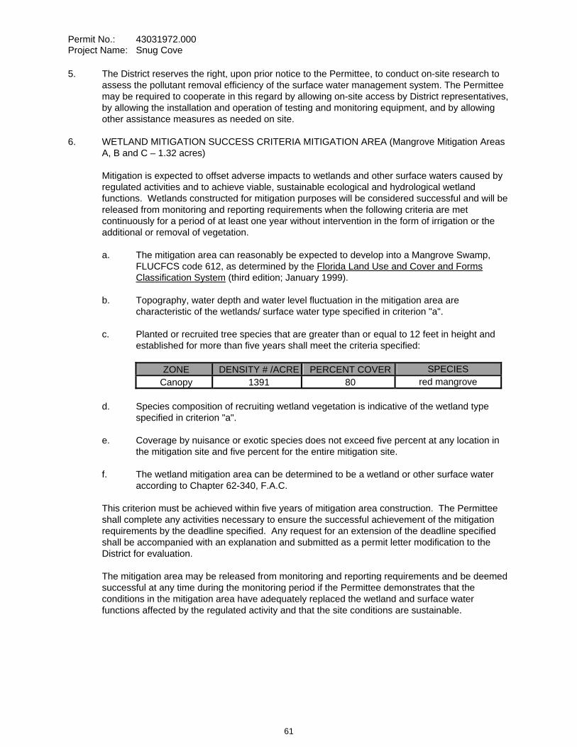
Permit No.: 43031972.000 Project Name: Snug Cove
5. The District reserves the right, upon prior notice to the Permittee, to conduct on-site research to assess the pollutant removal efficiency of the surface water management system. The Permittee may be required to cooperate in this regard by allowing on-site access by District representatives, by allowing the installation and operation of testing and monitoring equipment, and by allowing other assistance measures as needed on site.
6. WETLAND MITIGATION SUCCESS CRITERIA MITIGATION AREA (Mangrove Mitigation Areas A, B and C – 1.32 acres)
Mitigation is expected to offset adverse impacts to wetlands and other surface waters caused by regulated activities and to achieve viable, sustainable ecological and hydrological wetland functions. Wetlands constructed for mitigation purposes will be considered successful and will be released from monitoring and reporting requirements when the following criteria are met continuously for a period of at least one year without intervention in the form of irrigation or the additional or removal of vegetation.
a. The mitigation area can reasonably be expected to develop into a Mangrove Swamp, FLUCFCS code 612, as determined by the Florida Land Use and Cover and Forms Classification System (third edition; January 1999).
b. Topography, water depth and water level fluctuation in the mitigation area are characteristic of the wetlands/ surface water type specified in criterion "a".
c. Planted or recruited tree species that are greater than or equal to 12 feet in height and established for more than five years shall meet the criteria specified:
ZONE DENSITY # /ACRE PERCENT COVER SPECIESCanopy 1391 80 red mangrove
d. Species composition of recruiting wetland vegetation is indicative of the wetland type specified in criterion "a".
e. Coverage by nuisance or exotic species does not exceed five percent at any location in the mitigation site and five percent for the entire mitigation site.
f. The wetland mitigation area can be determined to be a wetland or other surface water according to Chapter 62-340, F.A.C.
This criterion must be achieved within five years of mitigation area construction. The Permittee shall complete any activities necessary to ensure the successful achievement of the mitigation requirements by the deadline specified. Any request for an extension of the deadline specified shall be accompanied with an explanation and submitted as a permit letter modification to the District for evaluation.
The mitigation area may be released from monitoring and reporting requirements and be deemed successful at any time during the monitoring period if the Permittee demonstrates that the conditions in the mitigation area have adequately replaced the wetland and surface water functions affected by the regulated activity and that the site conditions are sustainable.
61
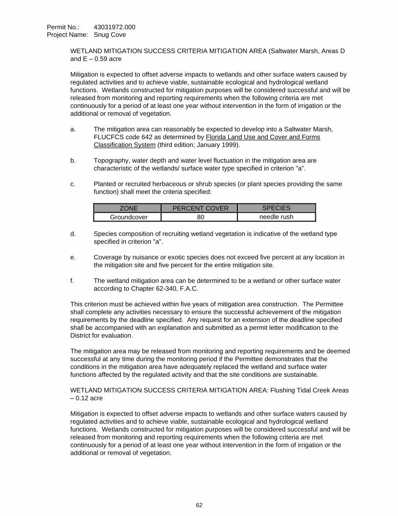
Permit No.: 43031972.000 Project Name: Snug Cove
WETLAND MITIGATION SUCCESS CRITERIA MITIGATION AREA (Saltwater Marsh, Areas D and E – 0.59 acre
Mitigation is expected to offset adverse impacts to wetlands and other surface waters caused by regulated activities and to achieve viable, sustainable ecological and hydrological wetland functions. Wetlands constructed for mitigation purposes will be considered successful and will be released from monitoring and reporting requirements when the following criteria are met continuously for a period of at least one year without intervention in the form of irrigation or the additional or removal of vegetation.
a. The mitigation area can reasonably be expected to develop into a Saltwater Marsh, FLUCFCS code 642 as determined by Florida Land Use and Cover and Forms Classification System (third edition; January 1999).
b. Topography, water depth and water level fluctuation in the mitigation area are characteristic of the wetlands/ surface water type specified in criterion "a".
c. Planted or recruited herbaceous or shrub species (or plant species providing the same function) shall meet the criteria specified:
ZONE PERCENT COVER SPECIESGroundcover 80 needle rush
d. Species composition of recruiting wetland vegetation is indicative of the wetland type specified in criterion "a".
e. Coverage by nuisance or exotic species does not exceed five percent at any location in the mitigation site and five percent for the entire mitigation site.
f. The wetland mitigation area can be determined to be a wetland or other surface water according to Chapter 62-340, F.A.C.
This criterion must be achieved within five years of mitigation area construction. The Permittee shall complete any activities necessary to ensure the successful achievement of the mitigation requirements by the deadline specified. Any request for an extension of the deadline specified shall be accompanied with an explanation and submitted as a permit letter modification to the District for evaluation.
The mitigation area may be released from monitoring and reporting requirements and be deemed successful at any time during the monitoring period if the Permittee demonstrates that the conditions in the mitigation area have adequately replaced the wetland and surface water functions affected by the regulated activity and that the site conditions are sustainable.
WETLAND MITIGATION SUCCESS CRITERIA MITIGATION AREA: Flushing Tidal Creek Areas – 0.12 acre
Mitigation is expected to offset adverse impacts to wetlands and other surface waters caused by regulated activities and to achieve viable, sustainable ecological and hydrological wetland functions. Wetlands constructed for mitigation purposes will be considered successful and will be released from monitoring and reporting requirements when the following criteria are met continuously for a period of at least one year without intervention in the form of irrigation or the additional or removal of vegetation.
62
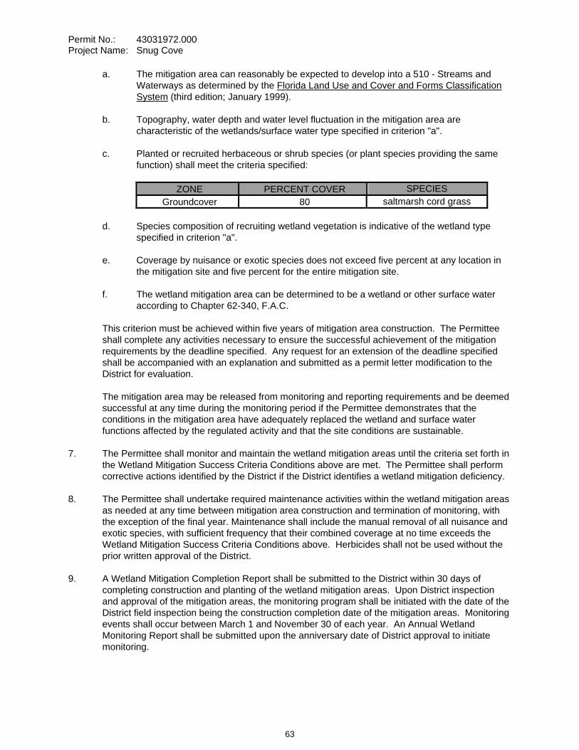
Permit No.: 43031972.000 Project Name: Snug Cove
a. The mitigation area can reasonably be expected to develop into a 510 - Streams and Waterways as determined by the Florida Land Use and Cover and Forms Classification System (third edition; January 1999).
b. Topography, water depth and water level fluctuation in the mitigation area are characteristic of the wetlands/surface water type specified in criterion "a".
c. Planted or recruited herbaceous or shrub species (or plant species providing the same function) shall meet the criteria specified:
ZONE PERCENT COVER SPECIESGroundcover 80 saltmarsh cord grass
d. Species composition of recruiting wetland vegetation is indicative of the wetland type specified in criterion "a".
e. Coverage by nuisance or exotic species does not exceed five percent at any location in the mitigation site and five percent for the entire mitigation site.
f. The wetland mitigation area can be determined to be a wetland or other surface water according to Chapter 62-340, F.A.C.
This criterion must be achieved within five years of mitigation area construction. The Permittee shall complete any activities necessary to ensure the successful achievement of the mitigation requirements by the deadline specified. Any request for an extension of the deadline specified shall be accompanied with an explanation and submitted as a permit letter modification to the District for evaluation.
The mitigation area may be released from monitoring and reporting requirements and be deemed successful at any time during the monitoring period if the Permittee demonstrates that the conditions in the mitigation area have adequately replaced the wetland and surface water functions affected by the regulated activity and that the site conditions are sustainable.
7. The Permittee shall monitor and maintain the wetland mitigation areas until the criteria set forth in the Wetland Mitigation Success Criteria Conditions above are met. The Permittee shall perform corrective actions identified by the District if the District identifies a wetland mitigation deficiency.
8. The Permittee shall undertake required maintenance activities within the wetland mitigation areas as needed at any time between mitigation area construction and termination of monitoring, with the exception of the final year. Maintenance shall include the manual removal of all nuisance and exotic species, with sufficient frequency that their combined coverage at no time exceeds the Wetland Mitigation Success Criteria Conditions above. Herbicides shall not be used without the prior written approval of the District.
9. A Wetland Mitigation Completion Report shall be submitted to the District within 30 days of completing construction and planting of the wetland mitigation areas. Upon District inspection and approval of the mitigation areas, the monitoring program shall be initiated with the date of the District field inspection being the construction completion date of the mitigation areas. Monitoring events shall occur between March 1 and November 30 of each year. An Annual Wetland Monitoring Report shall be submitted upon the anniversary date of District approval to initiate monitoring.
63
Permit No.: 43031972.000 Project Name: Snug Cove
Annual reports shall provide documentation that a sufficient number of maintenance inspection/activities were conducted to maintain the mitigation areas in compliance with the Wetland Mitigation Success Criteria Conditions above. Note that the performance of maintenance inspections and maintenance activities will normally need to be conducted more frequently than the collection of other monitoring data to maintain the mitigation areas in compliance with the Wetland Mitigation Success Criteria Conditions above.
Monitoring Data shall be collected semi-annually.
10. Termination of monitoring for the wetland mitigation areas shall be coordinated with the District by:
a. notifying the District in writing when the criteria set forth in the Wetland Mitigation Success Criteria Conditions have been achieved;
b. suspending all maintenance activities in the wetland mitigation areas including, but not limited to, irrigation and addition or removal of vegetation; and
c. submitting a monitoring report to the District one year following the written notification and suspension of maintenance activities.
Upon receipt of the monitoring report, the District will evaluate the wetland mitigation sites to determine if the Mitigation Success Criteria Conditions have been met and maintained. The District will notify the Permittee in writing of the evaluation results. The Permittee shall perform corrective actions for any portions of the wetland mitigation areas that fail to maintain the criteria set forth in the Wetland Mitigation Success Criteria Conditions.
11. Following the District’s determination that the wetland mitigation has been successfully completed, the Permittee shall operate and maintain the wetland mitigation areas such that they remain in their current or intended condition for the life of the surface water management facility. The Permittee must perform corrective actions for any portions of the wetland mitigation areas where conditions no longer meet the criteria set forth in the Wetland Mitigation Success Criteria Conditions.
12. The Permittee shall, within 120 days of initial wetland impact and prior to beneficial use of the site, complete all aspects of the mitigation plan, including the grading, mulching, and planting, in accordance with the design details in the final approved construction drawings and information submitted in support of the application.
13. The construction of all wetland impacts and wetland mitigation shall be supervised by a qualified environmental scientist/specialist/consultant. The Permittee shall identify, in writing, the environmental professional retained for construction oversight prior to initial clearing and grading activities.
14. The following boundaries, as shown on the approved construction drawings, shall be clearly delineated on the site prior to initial clearing or grading activities:
surface water areaslimits of approved surface water impacts
The delineation shall endure throughout the construction period and be readily discernible to construction and District personnel.
64
Permit No.: 43031972.000 Project Name: Snug Cove
15. Surface water boundaries shown on the approved construction drawings shall be binding upon the Permittee and the District.
16. Rights-of-way and easement locations necessary to construct, operate and maintain all facilities, which constitute the permitted surface water management system (including all wetlands and wetland buffers), shall be shown on the final plat recorded in the County Public Records. Documentation of this plat recording shall be submitted to the District with the Statement of Completion and Request for Transfer to Operation Entity Form, and prior to beneficial occupancy or use of the site.
17. Copies of the following documents in final form, as appropriate for the project, shall be submitted to the Brooksville Regulation Department:
a. homeowners, property owners, master association or condominium association articles of incorporation, and
b. declaration of protective covenants, deed restrictions or declaration of condominium.
The Permittee shall submit these documents either: (1) within 180 days after beginning construction or with the Statement of Completion and as-built construction plans if construction is completed prior to 180 days, or (2) prior to any lot or unit sales within the project served by the surface water management system, whichever occurs first.
18. The following language shall be included as part of the deed restrictions for each lot:
"Each property owner within the subdivision at the time of construction of a building, residence, or structure shall comply with the construction plans for the surface water management system approved and on file with the Southwest Florida Water Management District."
19. The operation and maintenance entity shall submit inspection reports in the form required by the District, in accordance with the following schedule.
For systems utilizing retention or wet detention, the inspections shall be performed two (2) years after operation is authorized and every two (2) years thereafter.
20. If limestone bedrock is encountered during construction of the surface water management system, the District must be notified and construction in the affected area shall cease.
21. The Permittee shall notify the District of any sinkhole development in the surface water management system within 48 hours of discovery and must submit a detailed sinkhole evaluation and repair plan for approval by the District within 30 days of discovery.
22. The District, upon prior notice to the Permittee, may conduct on-site inspections to assess the effectiveness of the erosion control barriers and other measures employed to prevent violations of state water quality standards and avoid downstream impacts. Such barriers or other measures should control discharges, erosion, and sediment transport during construction and thereafter. The District will also determine any potential environmental problems that may develop as a result of leaving or removing the barriers and other measures during construction or after construction of the project has been completed. The Permittee must provide any remedial measures that are needed.
65
Permit No.: 43031972.000 Project Name: Snug Cove
23. This permit is issued based upon the design prepared by the Permittee’s consultant. If at any time it is determined by the District that the Conditions for Issuance of Permits in Rules 40D-4.301 and 40D-4.302, F.A.C., have not been met, upon written notice by the District, the Permittee shall obtain a permit modification and perform any construction necessary thereunder to correct any deficiencies in the system design or construction to meet District rule criteria. The Permittee is advised that the correction of deficiencies may require re-construction of the surface water management system and/or mitigation areas.
24. To mitigate for 2.04 acres of permanent impact to surface waters, the Permittee will create 2.01 acres of surface waters that are composed of 1.32 acres of mangrove swamp, 0.59 acres of saltwater marsh and 0.12 acre of flushing tidal creek areas. The excess 0.02 unit of Functional Gain identified in this permit is not available for future projects involving impacts to wetlands or surface waters.
25. The Standard Manatee Conditions for In-Water Work (revision 2005) shall be followed by the Permittee for all in-water activity as indicated below:
A. All personnel associated with the project shall be instructed about the presence of manatees and manatee speed zones, and the need to avoid collisions with and injury to manatees. The permittee shall advise all construction personnel that there are civil and criminal penalties for harming, harassing, or killing manatees which are protected under the Marine Mammal Protection Act, the Endangered Species Act, and the Florida Manatee Sanctuary Act.
B. All vessels associated with the construction project shall operate at "Idle Speed/No Wake” at all times while in the immediate area and while in water where the draft of the vessel provides less than a four-foot clearance from the bottom. All vessels will follow routes of deep water whenever possible.
C. Siltation or turbidity barriers shall be made of material in which manatees cannot become entangled, shall be properly secured, and shall be regularly monitored to avoid manatee entanglement or entrapment. Barriers must not impede manatee movement.
D. All on-site project personnel are responsible for observing water-related activities for the presence of manatee(s). All in-water operations, including vessels, must be shutdown if a manatee(s) comes within 50 feet of the operation. Activities will not resume until the manatee(s) has moved beyond the 50-foot radius of the project operation, or until 30 minutes elapses if the manatee(s) has not reappeared within 50 feet of the operation. Animals must not be herded away or harassed into leaving.
E. Any collision with or injury to a manatee shall be reported immediately to the FWC Hotline at 1-888-404-FWCC. Collision and/or injury should also be reported to the U.S. Fish and Wildlife Service in Jacksonville (1-904-232-2580) for north Florida or Vero Beach (1-561-562-3909) for south Florida.
F. Temporary signs concerning manatees shall be posted prior to and during all in-water project activities. All signs are to be removed by the permittee upon completion of the project. Awareness signs that have already been approved for this use by the Florida Fish and Wildlife Conservation Commission (FWC) must be used. One sign measuring at least 3 ft. by 4 ft. which reads Caution: Manatee Area must be posted. A second sign measuring at least 8-1/2" by 11" explaining the requirements for “Idle Speed/No Wake” and the shut down of in-water operations must be posted in a location prominently visible to all personnel engaged in water-related activities.
66
Permit No.: 43031972.000 Project Name: Snug Cove
26. If prehistoric or historic artifacts, such as pottery or ceramics, stone tools or metal implements, dugout canoes, or any other physical remains that could be associated with Native American cultures, or early colonial or American settlement are encountered at any time within the project site area, the permitted project should cease all activities involving subsurface disturbance in the immediate vicinity of such discoveries. The Permittee, or other designee, should contact the Florida Department of State, Division of Historical Resources, Review and Compliance Section at (850) 245-6333 or (800) 847-7278, as well as the appropriate permitting agency office. Project activities should not resume without verbal and/or written authorization from the Division of Historical Resources. In the event that unmarked human remains are encountered during permitted activities, all work shall stop immediately and the proper authorities notified in accordance within Section 872.05, Florida Statutes.
27. The Permittee shall execute the final draft financial responsibility instrument approved by the District prior to initiating activities authorized by this permit. The final draft financial responsibility instrument shall be consistent with the draft instrument submitted with the permit application and approved by this permit.
28. The Permittee shall submit the original executed financial responsibility instrument to the District at the address below:
Southwest Florida Water Management District Brooksville Regulation Department 2379 Broad Street Brooksville, Florida 34604-6899
29. The Permittee shall provide the financial responsibility required by Rule 40D-4.301(1)(j), Florida Administrative Code until the District determines that the specific success criteria contained in this permit have been met; or the District approves a request to transfer the permit to a new owner and receives an acceptable substitute financial responsibility mechanism from the new owner.
30. The Permittee may request, in writing, a release from the obligation to maintain certain amounts of the financial assurance required by this permit as phases of the mitigation plan are successfully completed. The request shall include documentation that the mitigation phase or phases have been completed and payment for their completion has been made. Following the District's verification that the phase or phases have been completed in accordance with the mitigation plan, the District will authorize release from the applicable portion of the financial assurance obligation.
31. The District will notify the Permittee within 30 days of its determination that the specific success criteria contained in this permit have been met. Concurrent with this notification, the District will authorize, in writing, the appropriate entity to cancel or terminate the financial responsibility instrument.
32. The Permittee's failure to comply with the terms and conditions of this permit pertaining to the successful completion of all mitigation activities in accordance with the mitigation plan shall be deemed a violation of Chapter 40D-4, Florida Administrative Code. In addition to other remedies that the District may have, the District may draw upon the financial responsibility instrument for any funds necessary to remedy a violation, upon such notice to the Permittee as may be specified in the financial responsibility instrument or if none, upon reasonable notice.
33. The Permittee shall notify the District by certified mail within 10 days of the commencement of a voluntary or involuntary proceeding :
a. To dissolve the Permittee; b. To place the Permittee into receivership;
67
Permit No.: 43031972.000 Project Name: Snug Cove
c. For entry of an order for relief against the Permittee under Title XI (Bankruptcy), U.S. Code.
d. To assign of the Permittee's assets for the benefit of its creditors under Chapter 727, Florida Statutes.
34. In the event of bankruptcy or insolvency of the issuing institution; or the suspension or revocation of the authority of the issuing institution to issue letters of credit or performance bonds, the Permittee shall be deemed without the required financial assurance and shall have 60 days to re-establish the financial assurance required by Rule 40D-4.301(1)(j), Florida Administrative Code.
GENERAL CONDITIONS 1. The general conditions attached hereto as Exhibit "A" are hereby incorporated into this permit by
reference and the Permittee shall comply with them.
____________________________________________ Authorized Signature
68
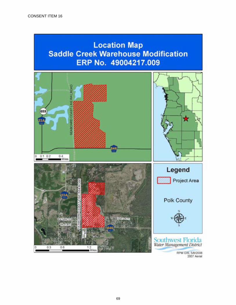
CONSENT ITEM 16
69
CONSENT ITEM 16 Default Date: June 24, 2008
SOUTHWEST FLORIDA WATER MANAGEMENT DISTRICT ENVIRONMENTAL RESOURCE
INDIVIDUAL CONSTRUCTION MODIFICATION PERMIT NO. 49004217.009
Expiration Date: June 24, 2013 See Specific Condition No. 21
PERMIT ISSUE DATE: June 24, 2008
This permit is issued under the provisions of Chapter 373, Florida Statutes, (F.S.), and the Rules contained in Chapters 40D-4 and 40, Florida Administrative Code, (F.A.C.). The permit authorizes the Permittee to proceed with the construction of a surface water management system in accordance with the information outlined herein and shown by the application, approved drawings, plans, specifications, and other documents, attached hereto and kept on file at the Southwest Florida Water Management District (District). Unless otherwise stated by permit specific condition, permit issuance constitutes certification of compliance with state water quality standards under Section 401 of the Clean Water Act, 33 U.S.C. 1341. All construction, operation and maintenance of the surface water management system authorized by this permit shall occur in compliance with Florida Statutes and Administrative Code and the conditions of this permit.
PROJECT NAME: Saddle Creek Warehouse Modification
GRANTED TO: Saddle Creek Corporation 3010 Saddle Creek Road Lakeland, FL 33801
ABSTRACT: This permit authorization is for the modification of a surface water management system serving a 202.26-acre industrial warehouse project as named above and as shown on the approved construction plans, replacing Permit No. 49004217.008. The project site is located on the north side of Saddle Creek Road, at its intersection with Fish Hatchery Road, in Polk County. Information regarding the surface water management system, 100-year flood plain, and wetlands is contained within the tables and comments below.
OP. & MAINT. ENTITY: Saddle Creek Corporation
COUNTY: Polk
SEC/TWP/RGE: 03/28S/24E, 34/27S/24E
TOTAL ACRES OWNED OR UNDER CONTROL: 214.89
PROJECT SIZE: 202.26 Acres
LAND USE: Industrial
DATE APPLICATION FILED: January 18, 2008
AMENDED DATE: N/A
70
Permit No.: 49004217.009 Project Name: Saddle Creek Warehouse Modification
I. Water Quantity/Quality
POND NO.
AREA ACRES @ TOP OF BANK TREATMENT TYPE
1/3 9.08 Wet Detention 5A/5B 3.33 N/A - Attenuation Only
5E 25.01 Wet Detention 8 (SW-7) 1.46 Wet Detention TOTAL 38.88
A mixing zone is not required. A variance is not required.
II. 100-Year Floodplain
Encroachment (Acre-Feet of fill)
Compensation (Acre-Feet of excavation)
Compensation Type*
Encroachment Result**(feet)
0.00 0.00 NE Depth N/A
*Codes [ X ] for the type or method of compensation provided are as follows: NE = No EncroachmentN/A = Not Applicable
**Depth of change in flood stage (level) over existing receiving water stage resulting from floodplain encroachment caused by a project that claims MI type of compensation.
III. Environmental Considerations
Wetland/Surface Water Information Count of Wetlands: 26Wetland Name Total Not Impacted Permanent Impacts Temporary Impacts Acres Acres Acres Functional
Loss*Acres Functional
Loss*
WL-1 12.26 0.00 12.26 7.85 0.00 0.00WL-2 0.39 0.00 0.39 0.16 0.00 0.00WL-3 3.90 0.00 3.90 2.46 0.00 0.00WL-4 1.57 1.57 0.00 0.00 0.00 0.00WL-5 4.87 4.87 0.00 0.00 0.00 0.00WL-6 0.89 0.89 0.00 0.00 0.00 0.00WL-7 0.05 0.05 0.00 0.00 0.00 0.00
WL-7A 0.01 0.01 0.00 0.00 0.00 0.00WL-8 0.02 0.02 0.00 0.00 0.00 0.00WL-9 0.89 0.89 0.00 0.00 0.00 0.00WL-10 0.77 0.77 0.00 0.00 0.00 0.00WL-11 0.23 0.23 0.00 0.00 0.00 0.00WL-12 0.65 0.65 0.00 0.00 0.00 0.00WL-13 0.31 0.31 0.00 0.00 0.00 0.00SW-11 0.22 0.22 0.00 0.00 0.00 0.00
SW-11A 0.09 0.09 0.00 0.00 0.00 0.00
71
Permit No.: 49004217.009 Project Name: Saddle Creek Warehouse Modification
Wetland/Surface Water Information Wetland Name Total Not Impacted Permanent Impacts Temporary Impacts Acres Acres Acres Functional
Loss*Acres Functional
Loss*
SW-12 0.11 0.11 0.00 0.00 0.00 0.00SW-13 0.14 0.14 0.00 0.00 0.00 0.00SW-14 0.13 0.13 0.00 0.00 0.00 0.00SW-15 0.11 0.11 0.00 0.00 0.00 0.00SW-16 0.14 0.14 0.00 0.00 0.00 0.00SW-17 0.17 0.17 0.00 0.00 0.00 0.00SW-18 0.03 0.03 0.00 0.00 0.00 0.00SW-19 0.07 0.07 0.00 0.00 0.00 0.00SW-20 0.05 0.05 0.00 0.00 0.00 0.00SW-21 0.03 0.03 0.00 0.00 0.00 0.00
TOTAL 28.10 11.55 16.55 10.47 0.00 0.00
* For impacts that do not require mitigation, their functional loss is not included.
Wetland Comments: The project area contains 26.81 acres of wetlands and 1.29 acres of upland cut ditches. Of the 26.81 acres of wetlands, 21.05 acres are herbaceous (wetlands WL-1, WL-2, WL-3, WL-4, WL-7, WL-7A, WL-8, WL-9, WL-10, WL-11, WL-12, and WL-13) and 5.76 acres are forested (wetlands WL-5 and WL-6).
Permanent impacts, previously permitted under ERP No. 49004217.008, are proposed to 16.55 acres of herbaceous wetlands and 1.29 acres of upland cut ditches.
The impacts to the upland cut ditches are not recorded in the table above because they are not used by threatened or endangered species and were deemed insignificant.
Mitigation Information Count of Mitigation: 5Mitigation Name Creation/Restoration Enhancement Preservation Other Acres Functional
Gain Acres Functional
Gain Acres Functional
Gain Acres Functional
Gain
WC-1 25.25 10.10 0.00 0.00 0.00 0.00 0.00 0.00WL-9 0.00 0.00 0.89 0.14 0.00 0.00 0.00 0.00WL-10 0.00 0.00 0.77 0.12 0.00 0.00 0.00 0.00WL-11 0.00 0.00 0.23 0.04 0.00 0.00 0.00 0.00WL-12 0.00 0.00 0.65 0.11 0.00 0.00 0.00 0.00
TOTAL 25.25 10.10 2.54 0.41 0.00 0.00 0.00 0.00
Mitigation Comments: Mitigation for the permanent impacts to onsite wetlands, previously permitted under ERP No. 49004217.008, is provided by 25.25 acres of herbaceous wetland creation (WC-1) and 2.54 acres of herbaceous wetland enhancement (WL-9, WL-10, WL-11, and WL-12).
No mitigation is required for the impacts to the upland cut ditches because they were constructed in uplands, do not provide significant habitat for threatened or endangered species, and were not constructed to divert natural stream flow.
72
Permit No.: 49004217.009 Project Name: Saddle Creek Warehouse Modification
The functional loss of 10.47 due to the wetland impacts associated with this project is offset by the functional gain of 10.51 provided by the mitigation. The amount of mitigation required was determined through the use of the Uniform Mitigation Assessment Methodology (Chapter 62-345 F.A.C.).
A regulatory conservation easement is not required.
A proprietary conservation easement is not required.
SPECIFIC CONDITIONS 1. If the ownership of the project area covered by the subject permit is divided, with someone other
than the Permittee becoming the owner of part of the project area, this permit shall terminate, pursuant to Section 40D-1.6105, F.A.C. In such situations, each land owner shall obtain a permit (which may be a modification of this permit) for the land owned by that person. This condition shall not apply to the division and sale of lots or units in residential subdivisions or condominiums.
2. Unless specified otherwise herein, two copies of all information and reports required by this permit shall be submitted to:
Bartow Regulation Department Southwest Florida Water Management District 170 Century Boulevard Bartow, FL 33830-7700
The permit number, title of report or information and event (for recurring report or information submittal) shall be identified on all information and reports submitted.
3. The Permittee shall retain the design engineer, or other professional engineer registered in Florida, to conduct on-site observations of construction and assist with the as-built certification requirements of this project. The Permittee shall inform the District in writing of the name, address and phone number of the professional engineer so employed. This information shall be submitted prior to construction.
4. Within 30 days after completion of construction of the permitted activity, the Permittee shall submit to the Bartow Service Office a written statement of completion and certification by a registered professional engineer or other appropriate individual as authorized by law, utilizing the required Statement of Completion and Request for Transfer to Operation Entity form identified in Chapter 40D-1.659, F.A.C., and signed, dated and sealed as-built drawings. The as-built drawings shall identify any deviations from the approved construction drawings.
5. The District reserves the right, upon prior notice to the Permittee, to conduct on-site research to assess the pollutant removal efficiency of the surface water management system. The Permittee may be required to cooperate in this regard by allowing on-site access by District representatives, by allowing the installation and operation of testing and monitoring equipment, and by allowing other assistance measures as needed on site.
6. A. WETLAND MITIGATION SUCCESS CRITERIA MITIGATION AREA WC-1
Mitigation is expected to offset adverse impacts to wetlands and other surface waters caused by regulated activities and to achieve viable, sustainable ecological and hydrological wetland functions. Wetlands constructed for mitigation purposes will be
73
Permit No.: 49004217.009 Project Name: Saddle Creek Warehouse Modification
considered successful and will be released from monitoring and reporting requirements when the following criteria are met continuously for a period of at least one year without intervention in the form of irrigation or the additional or removal of vegetation.
a. The mitigation area can reasonably be expected to develop into a PALUSTRINEEMERGENT wetland as determined by the Florida Land Use and Cover and Forms Classification System (third edition; January 1999).
b. Topography, water depth and water level fluctuation in the mitigation area are characteristic of the wetlands/ surface water type specified in criterion "a".
c. Planted or recruited herbaceous or shrub species (or plant species providing the same function) shall meet the criteria specified:
ZONE % COVER SPECIESA 80 Scirpus spp. Pontederia cordata Sagittaria latifolia
B 80 Juncus effuses Pontederia cordata
d. Species composition of recruiting wetland vegetation is indicative of the wetland type specified in criterion "a".
e. Coverage by nuisance or exotic species does not exceed five (5%) percent at any location in the mitigation site and five (5%) percent for the entire mitigation site.
f. The wetland mitigation area can be determined to be a wetland or other surface water according to Chapter 62-340, F.A.C.
g. The wetland mitigation area can be determined to be a wetland or other surface water according to Chapter 62-340, F.A.C.
This criterion must be achieved within three years of mitigation area construction. The Permittee shall complete any activities necessary to ensure the successful achievement of the mitigation requirements by the deadline specified. Any request for an extension of the deadline specified shall be accompanied with an explanation and submitted as a permit letter modification to the District for evaluation.
The mitigation area may be released from monitoring and reporting requirements and be deemed successful at any time during the monitoring period if the Permittee demonstrates that the conditions in the mitigation area have adequately replaced the wetland and surface water functions affected by the regulated activity and that the site conditions are sustainable.
B. WETLAND MITIGATION SUCCESS CRITERIA MITIGATION AREA WL-9, WL-10, WL-11, and WL-12
Mitigation is expected to offset adverse impacts to wetlands and other surface waters
caused by regulated activities and to achieve viable, sustainable ecological and hydrological wetland functions. Wetlands constructed for mitigation purposes will be
74
Permit No.: 49004217.009 Project Name: Saddle Creek Warehouse Modification
considered successful and will be released from monitoring and reporting requirements when the following criteria are met continuously for a period of at least one year without intervention in the form of irrigation or the additional or removal of vegetation.
a. The mitigation area can reasonably be expected to develop into a PALUSTRINEEMERGENT wetland as determined by the Florida Land Use and Cover and Forms Classification System (third edition; January 1999).
b. Topography, water depth and water level fluctuation in the mitigation area are characteristic of the wetlands/ surface water type specified in criterion "a".
c. Planted or recruited herbaceous or shrub species (or plant species providing the same function) shall meet the criteria specified:
ZONE % COVER SPECIESC 80 Juncus effusus Pontederia cordata
d. Species composition of recruiting wetland vegetation is indicative of the wetland 4type specified in criterion "a".
f. Coverage by nuisance or exotic species does not exceed five (5%) percent at any location in the mitigation site and five (5%) percent for the entire mitigation site.
g. The wetland mitigation area can be determined to be a wetland or other surface water according to Chapter 62-340, F.A.C.
h. The wetland mitigation area can be determined to be a wetland or other surface water according to Chapter 62-340, F.A.C.
This criterion must be achieved within three years of mitigation area construction. The Permittee shall complete any activities necessary to ensure the successful achievement of the mitigation requirements by the deadline specified. Any request for an extension of the deadline specified shall be accompanied with an explanation and submitted as a permit letter modification to the District for evaluation.
The mitigation area may be released from monitoring and reporting requirements and be deemed successful at any time during the monitoring period if the Permittee demonstrates that the conditions in the mitigation area have adequately replaced the wetland and surface water functions affected by the regulated activity and that the site conditions are sustainable.
7. The Permittee shall monitor and maintain the wetland mitigation areas until the criteria set forth in the Wetland Mitigation Success Criteria Conditions above are met. The Permittee shall perform corrective actions identified by the District if the District identifies a wetland mitigation deficiency.
8. The Permittee shall undertake required maintenance activities within the wetland mitigation areas as needed at any time between mitigation area construction and termination of monitoring, with the exception of the final year. Maintenance shall include the manual removal of all nuisance and exotic species, with sufficient frequency that their combined coverage at no time exceeds the Wetland Mitigation Success Criteria Conditions above. Herbicides shall not be used without the prior written approval of the District.
75
Permit No.: 49004217.009 Project Name: Saddle Creek Warehouse Modification
9. A Wetland Mitigation Completion Report shall be submitted to the District within 30 days of completing construction and planting of the wetland mitigation areas. Upon District inspection and approval of the mitigation areas, the monitoring program shall be initiated with the date of the District field inspection being the construction completion date of the mitigation areas. Monitoring events shall occur between March 1 and November 30 of each year. An Annual Wetland Monitoring Report shall be submitted upon the anniversary date of District approval to initiate monitoring.
Annual reports shall provide documentation that a sufficient number of maintenance inspection/activities were conducted to maintain the mitigation areas in compliance with the Wetland Mitigation Success Criteria Conditions above. Note that the performance of maintenance inspections and maintenance activities will normally need to be conducted more frequently than the collection of other monitoring data to maintain the mitigation areas in compliance with the Wetland Mitigation Success Criteria Conditions above.
Monitoring Data shall be collected semi-annually.
10. Termination of monitoring for the wetland mitigation areas shall be coordinated with the District by:
A. notifying the District in writing when the criteria set forth in the Wetland Mitigation Success Criteria Conditions have been achieved;
B. suspending all maintenance activities in the wetland mitigation areas including, but not limited to, irrigation and addition or removal of vegetation; and
C. submitting a monitoring report to the District one year following the written notification and suspension of maintenance activities.
Upon receipt of the monitoring report, the District will evaluate the wetland mitigation sites to determine if the Mitigation Success Criteria Conditions have been met and maintained. The District will notify the Permittee in writing of the evaluation results. The Permittee shall perform corrective actions for any portions of the wetland mitigation areas that fail to maintain the criteria set forth in the Wetland Mitigation Success Criteria Conditions.
11. Following the District’s determination that the wetland mitigation has been successfully completed, the Permittee shall operate and maintain the wetland mitigation areas such that they remain in their current or intended condition for the life of the surface water management facility. The Permittee must perform corrective actions for any portions of the wetland mitigation areas where conditions no longer meet the criteria set forth in the Wetland Mitigation Success Criteria Conditions.
12. The Permittee shall, within 120 days of initial wetland impact and prior to beneficial use of the site, complete all aspects of the mitigation plan, including the grading, mulching, and planting, in accordance with the design details in the final approved construction drawings .
13. The Permittee shall commence construction of the mitigation areas within 30 days of wetland impacts, if wetland impacts occur between February 1 and August 31. If wetland impacts occur between September 1 and January 31, construction of the mitigation areas shall commence by March 1. In either case, construction of the mitigation areas shall be completed within 120 days of the commencement date unless a time extension is approved in writing by the District.
76
Permit No.: 49004217.009 Project Name: Saddle Creek Warehouse Modification
14. The following boundaries, as shown on the approved construction drawings, shall be clearly delineated on the site prior to initial clearing or grading activities:
wetland and surface water areaslimits of approved wetland impactsconstruction access for WC-1
The delineation shall endure throughout the construction period and be readily discernible to construction and District personnel.
15. The operation and maintenance entity shall submit inspection reports in the form required by the District, in accordance with the following schedule.
For systems utilizing retention or wet detention, the inspections shall be performed two (2) years after operation is authorized and every two (2) years thereafter.
16. The removal of littoral shelf vegetation (including cattails) from wet detention ponds is prohibited unless otherwise approved by the District. Removal includes dredging, the application of herbicide, cutting, and the introduction of grass carp. Any questions regarding authorized activities within the wet detention ponds shall be addressed to the District's Surface Water Regulation Manager, Bartow Service Office.
17. This modification, Construction Permit No. 49004217.009, amends the previously issued Construction Permit No. 49004217.008, and all conditions are replaced by the conditions herein.
18. For the areas shown on the construction drawings as Future, a permit modification shall be obtained for any construction in this/these areas. As a requirement of the permit modification for this/these areas, the Permittee shall submit a Statement of Completion and as-built drawings.
19. The Permittee shall notify the District of any sinkhole development in the surface water management system within 48 hours of discovery and must submit a detailed sinkhole evaluation and repair plan for approval by the District within 30 days of discovery.
20. This permit is issued based upon the design prepared by the Permittee’s consultant. If at any time it is determined by the District that the Conditions for Issuance of Permits in Rules 40D-4.301 and 40D-4.302, F.A.C., have not been met, upon written notice by the District, the Permittee shall obtain a permit modification and perform any construction necessary thereunder to correct any deficiencies in the system design or construction to meet District rule criteria. The Permittee is advised that the correction of deficiencies may require re-construction of the surface water management system and/or mitigation areas.
21. Within 180 days of issuance of this permit, the Permittee shall complete all corrective construction work authorized by this permit as described on the approved construction drawings for this project.
GENERAL CONDITIONS 1. The general conditions attached hereto as Exhibit "A" are hereby incorporated into this permit by
reference and the Permittee shall comply with them.
____________________________________________ Authorized Signature
77
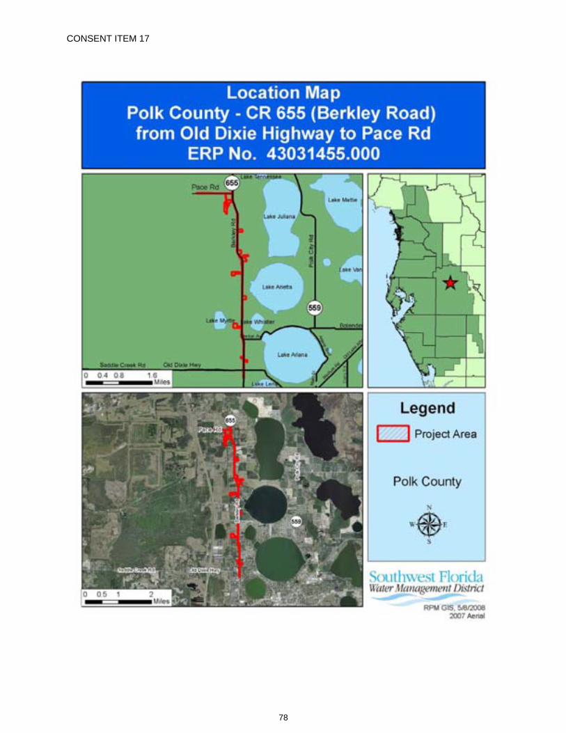
CONSENT ITEM 17
78
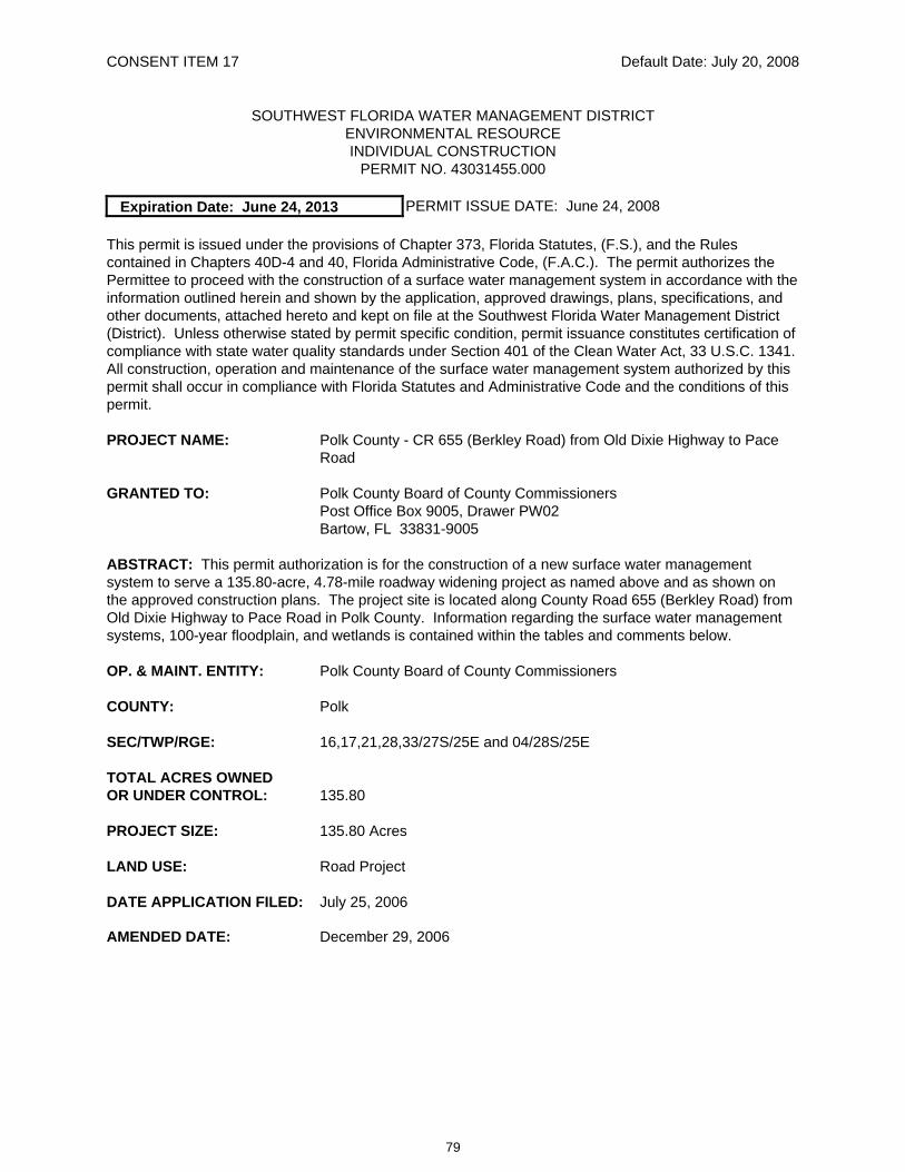
CONSENT ITEM 17 Default Date: July 20, 2008
SOUTHWEST FLORIDA WATER MANAGEMENT DISTRICT ENVIRONMENTAL RESOURCE INDIVIDUAL CONSTRUCTION
PERMIT NO. 43031455.000
Expiration Date: June 24, 2013 PERMIT ISSUE DATE: June 24, 2008
This permit is issued under the provisions of Chapter 373, Florida Statutes, (F.S.), and the Rules contained in Chapters 40D-4 and 40, Florida Administrative Code, (F.A.C.). The permit authorizes the Permittee to proceed with the construction of a surface water management system in accordance with the information outlined herein and shown by the application, approved drawings, plans, specifications, and other documents, attached hereto and kept on file at the Southwest Florida Water Management District (District). Unless otherwise stated by permit specific condition, permit issuance constitutes certification of compliance with state water quality standards under Section 401 of the Clean Water Act, 33 U.S.C. 1341. All construction, operation and maintenance of the surface water management system authorized by this permit shall occur in compliance with Florida Statutes and Administrative Code and the conditions of this permit.
PROJECT NAME: Polk County - CR 655 (Berkley Road) from Old Dixie Highway to Pace Road
GRANTED TO: Polk County Board of County Commissioners Post Office Box 9005, Drawer PW02 Bartow, FL 33831-9005
ABSTRACT: This permit authorization is for the construction of a new surface water management system to serve a 135.80-acre, 4.78-mile roadway widening project as named above and as shown on the approved construction plans. The project site is located along County Road 655 (Berkley Road) from Old Dixie Highway to Pace Road in Polk County. Information regarding the surface water management systems, 100-year floodplain, and wetlands is contained within the tables and comments below.
OP. & MAINT. ENTITY: Polk County Board of County Commissioners
COUNTY: Polk
SEC/TWP/RGE: 16,17,21,28,33/27S/25E and 04/28S/25E
TOTAL ACRES OWNED OR UNDER CONTROL: 135.80
PROJECT SIZE: 135.80 Acres
LAND USE: Road Project
DATE APPLICATION FILED: July 25, 2006
AMENDED DATE: December 29, 2006
79
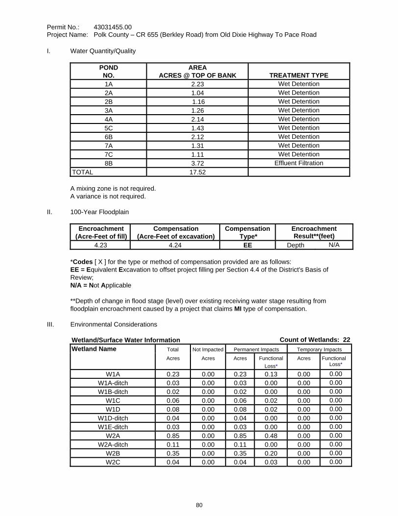
Permit No.: 43031455.00 Project Name: Polk County – CR 655 (Berkley Road) from Old Dixie Highway To Pace Road
I. Water Quantity/Quality
POND NO.
AREA ACRES @ TOP OF BANK TREATMENT TYPE
1A 2.23 Wet Detention 2A 1.04 Wet Detention 2B 1.16 Wet Detention 3A 1.26 Wet Detention 4A 2.14 Wet Detention 5C 1.43 Wet Detention 6B 2.12 Wet Detention 7A 1.31 Wet Detention 7C 1.11 Wet Detention 8B 3.72 Effluent Filtration
TOTAL 17.52
A mixing zone is not required. A variance is not required.
II. 100-Year Floodplain
Encroachment (Acre-Feet of fill)
Compensation (Acre-Feet of excavation)
Compensation Type*
Encroachment Result**(feet)
4.23 4.24 EE Depth N/A
*Codes [ X ] for the type or method of compensation provided are as follows: EE = Equivalent Excavation to offset project filling per Section 4.4 of the District's Basis of Review; N/A = Not Applicable
**Depth of change in flood stage (level) over existing receiving water stage resulting from floodplain encroachment caused by a project that claims MI type of compensation.
III. Environmental Considerations
Wetland/Surface Water Information Count of Wetlands: 22Wetland Name Total Not Impacted Permanent Impacts Temporary Impacts
Acres Acres Acres Functional Loss*
Acres Functional Loss*
W1A 0.23 0.00 0.23 0.13 0.00 0.00W1A-ditch 0.03 0.00 0.03 0.00 0.00 0.00W1B-ditch 0.02 0.00 0.02 0.00 0.00 0.00
W1C 0.06 0.00 0.06 0.02 0.00 0.00W1D 0.08 0.00 0.08 0.02 0.00 0.00
W1D-ditch 0.04 0.00 0.04 0.00 0.00 0.00W1E-ditch 0.03 0.00 0.03 0.00 0.00 0.00
W2A 0.85 0.00 0.85 0.48 0.00 0.00W2A-ditch 0.11 0.00 0.11 0.00 0.00 0.00
W2B 0.35 0.00 0.35 0.20 0.00 0.00W2C 0.04 0.00 0.04 0.03 0.00 0.00
80
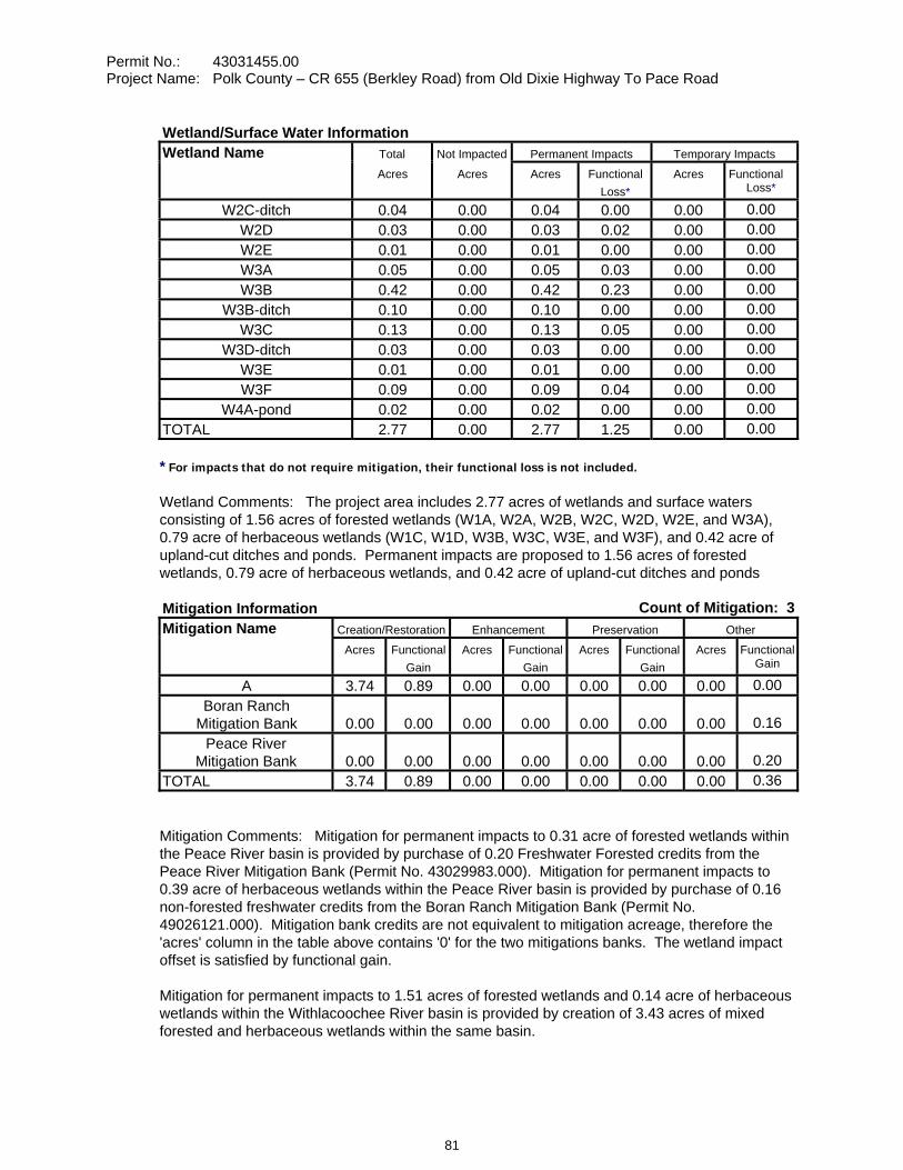
Permit No.: 43031455.00 Project Name: Polk County – CR 655 (Berkley Road) from Old Dixie Highway To Pace Road
Wetland/Surface Water Information Wetland Name Total Not Impacted Permanent Impacts Temporary Impacts
Acres Acres Acres Functional Loss*
Acres Functional Loss*
W2C-ditch 0.04 0.00 0.04 0.00 0.00 0.00W2D 0.03 0.00 0.03 0.02 0.00 0.00W2E 0.01 0.00 0.01 0.00 0.00 0.00W3A 0.05 0.00 0.05 0.03 0.00 0.00W3B 0.42 0.00 0.42 0.23 0.00 0.00
W3B-ditch 0.10 0.00 0.10 0.00 0.00 0.00W3C 0.13 0.00 0.13 0.05 0.00 0.00
W3D-ditch 0.03 0.00 0.03 0.00 0.00 0.00W3E 0.01 0.00 0.01 0.00 0.00 0.00W3F 0.09 0.00 0.09 0.04 0.00 0.00
W4A-pond 0.02 0.00 0.02 0.00 0.00 0.00TOTAL 2.77 0.00 2.77 1.25 0.00 0.00
* For impacts that do not require mitigation, their functional loss is not included.
Wetland Comments: The project area includes 2.77 acres of wetlands and surface waters consisting of 1.56 acres of forested wetlands (W1A, W2A, W2B, W2C, W2D, W2E, and W3A), 0.79 acre of herbaceous wetlands (W1C, W1D, W3B, W3C, W3E, and W3F), and 0.42 acre of upland-cut ditches and ponds. Permanent impacts are proposed to 1.56 acres of forested wetlands, 0.79 acre of herbaceous wetlands, and 0.42 acre of upland-cut ditches and ponds
Mitigation Information Count of Mitigation: 3 Mitigation Name Creation/Restoration Enhancement Preservation Other Acres Functional
Gain Acres Functional
Gain Acres Functional
Gain Acres Functional
Gain
A 3.74 0.89 0.00 0.00 0.00 0.00 0.00 0.00Boran Ranch
Mitigation Bank 0.00 0.00 0.00 0.00 0.00 0.00 0.00 0.16Peace River
Mitigation Bank 0.00 0.00 0.00 0.00 0.00 0.00 0.00 0.20TOTAL 3.74 0.89 0.00 0.00 0.00 0.00 0.00 0.36
Mitigation Comments: Mitigation for permanent impacts to 0.31 acre of forested wetlands within the Peace River basin is provided by purchase of 0.20 Freshwater Forested credits from the Peace River Mitigation Bank (Permit No. 43029983.000). Mitigation for permanent impacts to 0.39 acre of herbaceous wetlands within the Peace River basin is provided by purchase of 0.16 non-forested freshwater credits from the Boran Ranch Mitigation Bank (Permit No. 49026121.000). Mitigation bank credits are not equivalent to mitigation acreage, therefore the 'acres' column in the table above contains '0' for the two mitigations banks. The wetland impact offset is satisfied by functional gain.
Mitigation for permanent impacts to 1.51 acres of forested wetlands and 0.14 acre of herbaceous wetlands within the Withlacoochee River basin is provided by creation of 3.43 acres of mixed forested and herbaceous wetlands within the same basin.
81
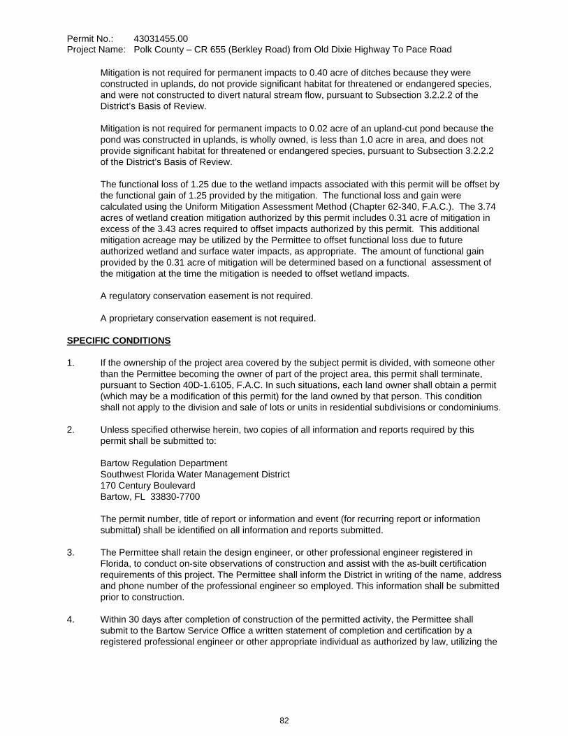
Permit No.: 43031455.00 Project Name: Polk County – CR 655 (Berkley Road) from Old Dixie Highway To Pace Road
Mitigation is not required for permanent impacts to 0.40 acre of ditches because they were constructed in uplands, do not provide significant habitat for threatened or endangered species, and were not constructed to divert natural stream flow, pursuant to Subsection 3.2.2.2 of the District’s Basis of Review.
Mitigation is not required for permanent impacts to 0.02 acre of an upland-cut pond because the pond was constructed in uplands, is wholly owned, is less than 1.0 acre in area, and does not provide significant habitat for threatened or endangered species, pursuant to Subsection 3.2.2.2 of the District’s Basis of Review.
The functional loss of 1.25 due to the wetland impacts associated with this permit will be offset by the functional gain of 1.25 provided by the mitigation. The functional loss and gain were calculated using the Uniform Mitigation Assessment Method (Chapter 62-340, F.A.C.). The 3.74 acres of wetland creation mitigation authorized by this permit includes 0.31 acre of mitigation in excess of the 3.43 acres required to offset impacts authorized by this permit. This additional mitigation acreage may be utilized by the Permittee to offset functional loss due to future authorized wetland and surface water impacts, as appropriate. The amount of functional gain provided by the 0.31 acre of mitigation will be determined based on a functional assessment of the mitigation at the time the mitigation is needed to offset wetland impacts.
A regulatory conservation easement is not required.
A proprietary conservation easement is not required.
SPECIFIC CONDITIONS 1. If the ownership of the project area covered by the subject permit is divided, with someone other
than the Permittee becoming the owner of part of the project area, this permit shall terminate, pursuant to Section 40D-1.6105, F.A.C. In such situations, each land owner shall obtain a permit (which may be a modification of this permit) for the land owned by that person. This condition shall not apply to the division and sale of lots or units in residential subdivisions or condominiums.
2. Unless specified otherwise herein, two copies of all information and reports required by this permit shall be submitted to:
Bartow Regulation Department Southwest Florida Water Management District 170 Century Boulevard Bartow, FL 33830-7700
The permit number, title of report or information and event (for recurring report or information submittal) shall be identified on all information and reports submitted.
3. The Permittee shall retain the design engineer, or other professional engineer registered in Florida, to conduct on-site observations of construction and assist with the as-built certification requirements of this project. The Permittee shall inform the District in writing of the name, address and phone number of the professional engineer so employed. This information shall be submitted prior to construction.
4. Within 30 days after completion of construction of the permitted activity, the Permittee shall submit to the Bartow Service Office a written statement of completion and certification by a registered professional engineer or other appropriate individual as authorized by law, utilizing the
82
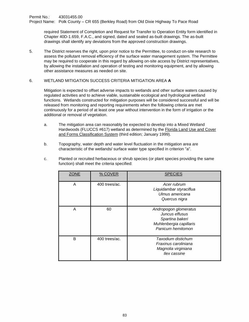
Permit No.: 43031455.00 Project Name: Polk County – CR 655 (Berkley Road) from Old Dixie Highway To Pace Road
required Statement of Completion and Request for Transfer to Operation Entity form identified in Chapter 40D-1.659, F.A.C., and signed, dated and sealed as-built drawings. The as-built drawings shall identify any deviations from the approved construction drawings.
5. The District reserves the right, upon prior notice to the Permittee, to conduct on-site research to assess the pollutant removal efficiency of the surface water management system. The Permittee may be required to cooperate in this regard by allowing on-site access by District representatives, by allowing the installation and operation of testing and monitoring equipment, and by allowing other assistance measures as needed on site.
6. WETLAND MITIGATION SUCCESS CRITERIA MITIGATION AREA A
Mitigation is expected to offset adverse impacts to wetlands and other surface waters caused by regulated activities and to achieve viable, sustainable ecological and hydrological wetland functions. Wetlands constructed for mitigation purposes will be considered successful and will be released from monitoring and reporting requirements when the following criteria are met continuously for a period of at least one year without intervention in the form of irrigation or the additional or removal of vegetation.
a. The mitigation area can reasonably be expected to develop into a Mixed Wetland Hardwoods (FLUCCS #617) wetland as determined by the Florida Land Use and Cover and Forms Classification System (third edition; January 1999).
b. Topography, water depth and water level fluctuation in the mitigation area are characteristic of the wetlands/ surface water type specified in criterion "a".
c. Planted or recruited herbaceous or shrub species (or plant species providing the same function) shall meet the criteria specified:
ZONE % COVER SPECIES
A 400 trees/ac. Acer rubrum Liquidambar styraciflua
Ulmus americana Quercus nigra
A 60 Andropogon glomeratus Juncus effusus Spartina bakeri
Muhlenbergia capillaris Panicum hemitomon
B 400 trees/ac. Taxodium distichum Fraxinus caroliniana Magnolia virginiana
Ilex cassine
83
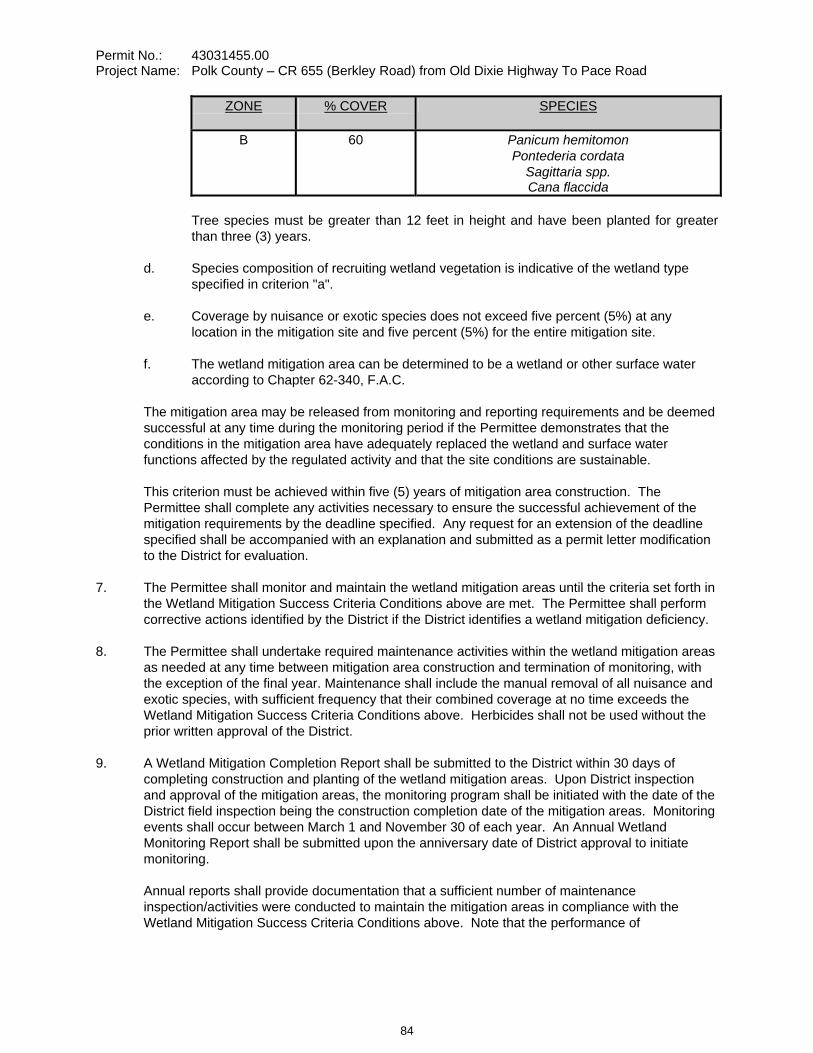
Permit No.: 43031455.00 Project Name: Polk County – CR 655 (Berkley Road) from Old Dixie Highway To Pace Road
ZONE % COVER SPECIES
B 60 Panicum hemitomon Pontederia cordata
Sagittaria spp. Cana flaccida
Tree species must be greater than 12 feet in height and have been planted for greater than three (3) years.
d. Species composition of recruiting wetland vegetation is indicative of the wetland type specified in criterion "a".
e. Coverage by nuisance or exotic species does not exceed five percent (5%) at any location in the mitigation site and five percent (5%) for the entire mitigation site.
f. The wetland mitigation area can be determined to be a wetland or other surface water according to Chapter 62-340, F.A.C.
The mitigation area may be released from monitoring and reporting requirements and be deemed successful at any time during the monitoring period if the Permittee demonstrates that the conditions in the mitigation area have adequately replaced the wetland and surface water functions affected by the regulated activity and that the site conditions are sustainable.
This criterion must be achieved within five (5) years of mitigation area construction. The Permittee shall complete any activities necessary to ensure the successful achievement of the mitigation requirements by the deadline specified. Any request for an extension of the deadline specified shall be accompanied with an explanation and submitted as a permit letter modification to the District for evaluation.
7. The Permittee shall monitor and maintain the wetland mitigation areas until the criteria set forth in the Wetland Mitigation Success Criteria Conditions above are met. The Permittee shall perform corrective actions identified by the District if the District identifies a wetland mitigation deficiency.
8. The Permittee shall undertake required maintenance activities within the wetland mitigation areas as needed at any time between mitigation area construction and termination of monitoring, with the exception of the final year. Maintenance shall include the manual removal of all nuisance and exotic species, with sufficient frequency that their combined coverage at no time exceeds the Wetland Mitigation Success Criteria Conditions above. Herbicides shall not be used without the prior written approval of the District.
9. A Wetland Mitigation Completion Report shall be submitted to the District within 30 days of completing construction and planting of the wetland mitigation areas. Upon District inspection and approval of the mitigation areas, the monitoring program shall be initiated with the date of the District field inspection being the construction completion date of the mitigation areas. Monitoring events shall occur between March 1 and November 30 of each year. An Annual Wetland Monitoring Report shall be submitted upon the anniversary date of District approval to initiate monitoring.
Annual reports shall provide documentation that a sufficient number of maintenance inspection/activities were conducted to maintain the mitigation areas in compliance with the Wetland Mitigation Success Criteria Conditions above. Note that the performance of
84
Permit No.: 43031455.00 Project Name: Polk County – CR 655 (Berkley Road) from Old Dixie Highway To Pace Road
maintenance inspections and maintenance activities will normally need to be conducted more frequently than the collection of other monitoring data to maintain the mitigation areas in compliance with the Wetland Mitigation Success Criteria Conditions above.
Monitoring Data shall be collected semi-annually.
10. Termination of monitoring for the wetland mitigation areas shall be coordinated with the District by:
a. notifying the District in writing when the criteria set forth in the Wetland Mitigation Success Criteria Conditions have been achieved;
b. suspending all maintenance activities in the wetland mitigation areas including, but not limited to, irrigation and addition or removal of vegetation; and
c. submitting a monitoring report to the District one year following the written notification and suspension of maintenance activities.
Upon receipt of the monitoring report, the District will evaluate the wetland mitigation sites to determine if the Mitigation Success Criteria Conditions have been met and maintained. The District will notify the Permittee in writing of the evaluation results. The Permittee shall perform corrective actions for any portions of the wetland mitigation areas that fail to maintain the criteria set forth in the Wetland Mitigation Success Criteria Conditions.
11. Following the District’s determination that the wetland mitigation has been successfully completed, the Permittee shall operate and maintain the wetland mitigation areas such that they remain in their current or intended condition for the life of the surface water management facility. The Permittee must perform corrective actions for any portions of the wetland mitigation areas where conditions no longer meet the criteria set forth in the Wetland Mitigation Success Criteria Conditions.
12. The Permittee shall, within 90 days of initial wetland impact and prior to beneficial use of the site, complete all aspects of the mitigation plan, including the grading, mulching, and planting, in accordance with the design details in the final approved construction drawings received by the District and information submitted in support of the application.
13. The construction of all wetland impacts and wetland mitigation shall be supervised by a qualified environmental scientist/specialist/consultant. The Permittee shall identify, in writing, the environmental professional retained for construction oversight prior to initial clearing and grading activities.
14. All construction is prohibited within the permitted project area until the Permittee acquires legal ownership or legal control of the project area as delineated in the permitted construction drawings.
15. The Permittee shall notify the District of any sinkhole development in the surface water management system within 48 hours of discovery and must submit a detailed sinkhole evaluation and repair plan for approval by the District within 30 days of discovery.
16. This permit is issued based upon the design prepared by the Permittee’s consultant. If at any time it is determined by the District that the Conditions for Issuance of Permits in Rules 40D-4.301 and 40D-4.302, F.A.C., have not been met, upon written notice by the District, the Permittee shall obtain a permit modification and perform any construction necessary thereunder
85
Permit No.: 43031455.00 Project Name: Polk County – CR 655 (Berkley Road) from Old Dixie Highway To Pace Road
to correct any deficiencies in the system design or construction to meet District rule criteria. The Permittee is advised that the correction of deficiencies may require re-construction of the surface water management system and/or mitigation areas.
17. The Permittee shall, prior to any wetland impacts, perform a cultural resource survey of the wetland impact areas pursuant to the recommendation by the Florida Department of State, Division of Historical Resources (DHR), as stated in the letter from DHR, dated May 8, 2007. The survey must be submitted to the DHR for review and all subsequent requirements complied with prior to construction activities authorized by this permit.
18. The Permittee shall, prior to any wetland impacts in the Peace River Basin, provide to the District documentation of the purchase of 0.20 herbaceous mitigation credit from the Boran Ranch Mitigation Bank. That documentation shall be in the form of a Modification by Letter of Permit 49026121.000, issued to the Boran Ranch Mitigation Bank, which deducts 0.20 mitigation credit from the bank’s credit ledger.
19. The Permittee shall, prior to any wetland impacts in the Peace River Basin, provide to the District documentation of the purchase of 0.16 forested mitigation credit from the Peace River Mitigation Bank. That documentation shall be in the form of a Modification by Letter of Permit 43029983.000, issued to the Peace River Mitigation Bank, which deducts 0.16 mitigation credit from the bank’s credit ledger.
20. This modification, Construction Permit No. 43031455.000 modifies a portion of previously issued Permit No. 44015931.000, and affects only the project area identified in this modification application submittal.
GENERAL CONDITIONS 1. The general conditions attached hereto as Exhibit "A" are hereby incorporated into this permit by
reference and the Permittee shall comply with them.
____________________________________________ Authorized Signature
86
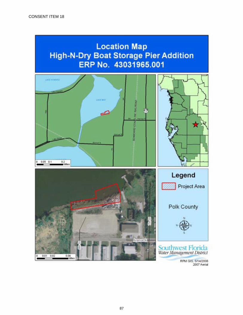
CONSENT ITEM 18
87
CONSENT ITEM 18 Default Date: June 29, 2008
SOUTHWEST FLORIDA WATER MANAGEMENT DISTRICT CONSOLIDATED ENVIRONMENTAL RESOURCE PERMIT (ERP) AND
SOVEREIGN SUBMERGED LAND AUTHORIZATION (SL) INDIVIDUAL CONSTRUCTION SURFACE WATER MANAGEMENT SYSTEMS
PERMIT NO. 43031965.001 AND
SOVEREIGNTY LANDS STANDARD LEASE
ERP Expiration Date: June 24, 2013 PERMIT ISSUE DATE: June 24, 2008 SL Expiration Date: N/A
This permit, issued under the provisions of Chapter 373, Florida Statutes, (F.S.), and Chapter 40D-4, Florida Administrative Code, (F.A.C.), authorizes the Permittee to perform the work outlined herein and shown by the application, approved drawings, plans, and other documents, attached hereto and kept on file at the Southwest Florida Water Management District (District).
Authorization is granted to use sovereign submerged lands as outlined herein and shown by the application, approved drawings, plans, and other documents attached hereto and kept on file at the District under the provisions of Chapter 253, F.S., and Chapter 18-21, F.A.C., as well as the policies of the Board of Trustees of the Internal Improvement Trust Fund (Board of Trustees). This approval does not disclaim any title interests that the Board of Trustees may have in the project site. Any subsequent authorizations by the Board of Trustees or its designated agents may contain conditions necessary to satisfy the fiduciary responsibilities of the Board of Trustees as well as other applicable statutory or rule requirements implemented by the Department of Environmental Protection's Division of State Lands or other governmental agencies authorized by Florida Statutes.
All construction, operation, and maintenance of the surface water management system authorized by this permit shall occur in compliance with Florida Statutes and Administrative Code and the conditions of this permit.
PROJECT NAME: High-N-Dry Boat Storage Pier Addition
GRANTED TO: Chain of Lakes Marine Storage Center, Inc. 9457 Waterford Oaks Drive Winter Haven, FL 33884
ABSTRACT: This authorization is for construction of a docking facility with 14-boat slips and 5-jet ski slips to serve a commercial development (authorized under ERP No. 44031965.000, entitled High-N-Dry Boat Storage), as named above and as shown on the approved construction plans. A five (5)-year, standard term sovereignty submerged lands lease with the Board of Trustees of the Internal Improvement Trust Fund is required because the activity is located on sovereign submerged lands. The project site is located on Lake May north of Avenue K Southwest, approximately one quarter of a mile west of U.S. Highway 17, in Polk County. Information regarding the surface water management system, 100-year flood plain, and wetlands is contained within the tables and comments below.
OP. & MAINT. ENTITY: Chain of Lakes Marine Storage Center, Inc.
COUNTY: Polk
WATERBODY NAME: Lake May
88
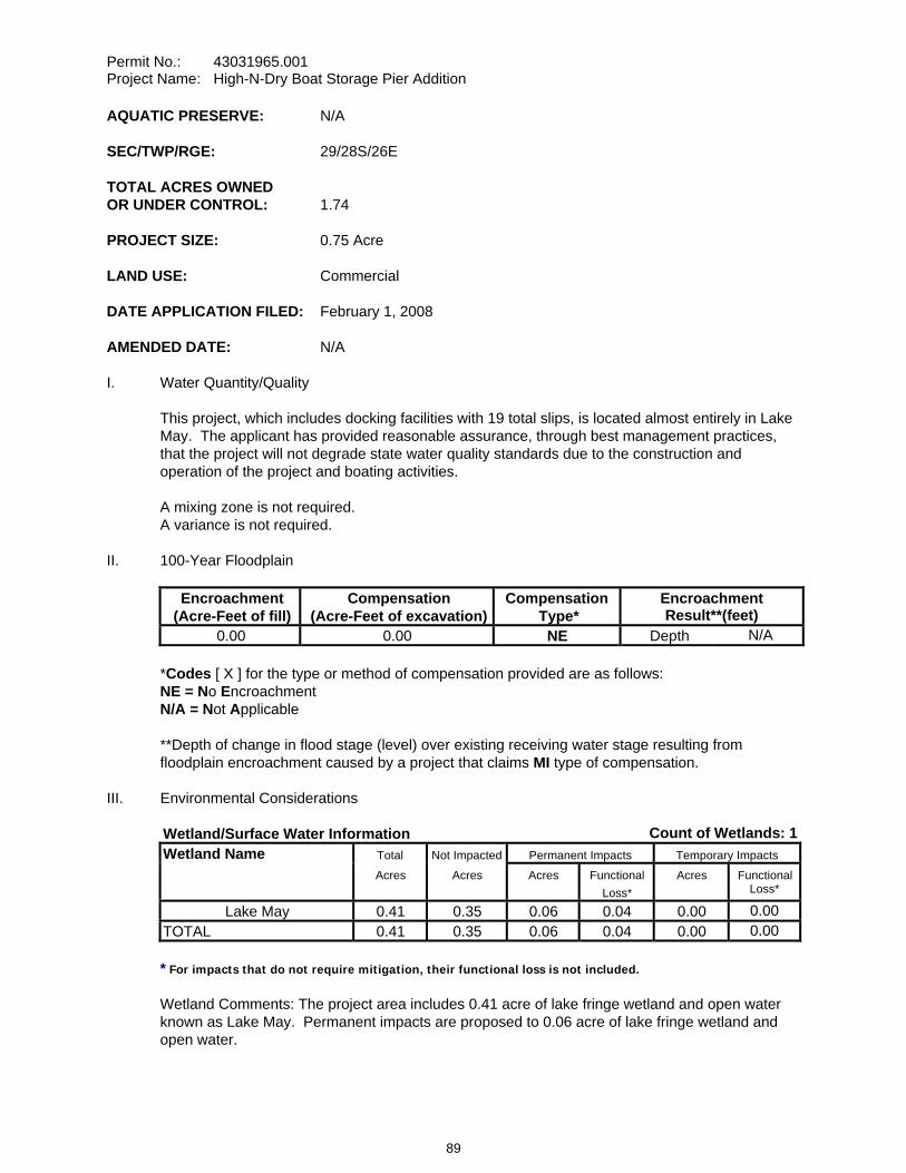
Permit No.: 43031965.001 Project Name: High-N-Dry Boat Storage Pier Addition
AQUATIC PRESERVE: N/A
SEC/TWP/RGE: 29/28S/26E
TOTAL ACRES OWNED OR UNDER CONTROL: 1.74
PROJECT SIZE: 0.75 Acre
LAND USE: Commercial
DATE APPLICATION FILED: February 1, 2008
AMENDED DATE: N/A
I. Water Quantity/Quality
This project, which includes docking facilities with 19 total slips, is located almost entirely in Lake May. The applicant has provided reasonable assurance, through best management practices, that the project will not degrade state water quality standards due to the construction and operation of the project and boating activities.
A mixing zone is not required. A variance is not required.
II. 100-Year Floodplain
Encroachment (Acre-Feet of fill)
Compensation (Acre-Feet of excavation)
Compensation Type*
Encroachment Result**(feet)
0.00 0.00 NE Depth N/A
*Codes [ X ] for the type or method of compensation provided are as follows: NE = No EncroachmentN/A = Not Applicable
**Depth of change in flood stage (level) over existing receiving water stage resulting from floodplain encroachment caused by a project that claims MI type of compensation.
III. Environmental Considerations
Wetland/Surface Water Information Count of Wetlands: 1Wetland Name Total Not Impacted Permanent Impacts Temporary Impacts
Acres Acres Acres Functional
Loss*Acres Functional
Loss*
Lake May 0.41 0.35 0.06 0.04 0.00 0.00TOTAL 0.41 0.35 0.06 0.04 0.00 0.00
* For impacts that do not require mitigation, their functional loss is not included.
Wetland Comments: The project area includes 0.41 acre of lake fringe wetland and open water known as Lake May. Permanent impacts are proposed to 0.06 acre of lake fringe wetland and open water.
89
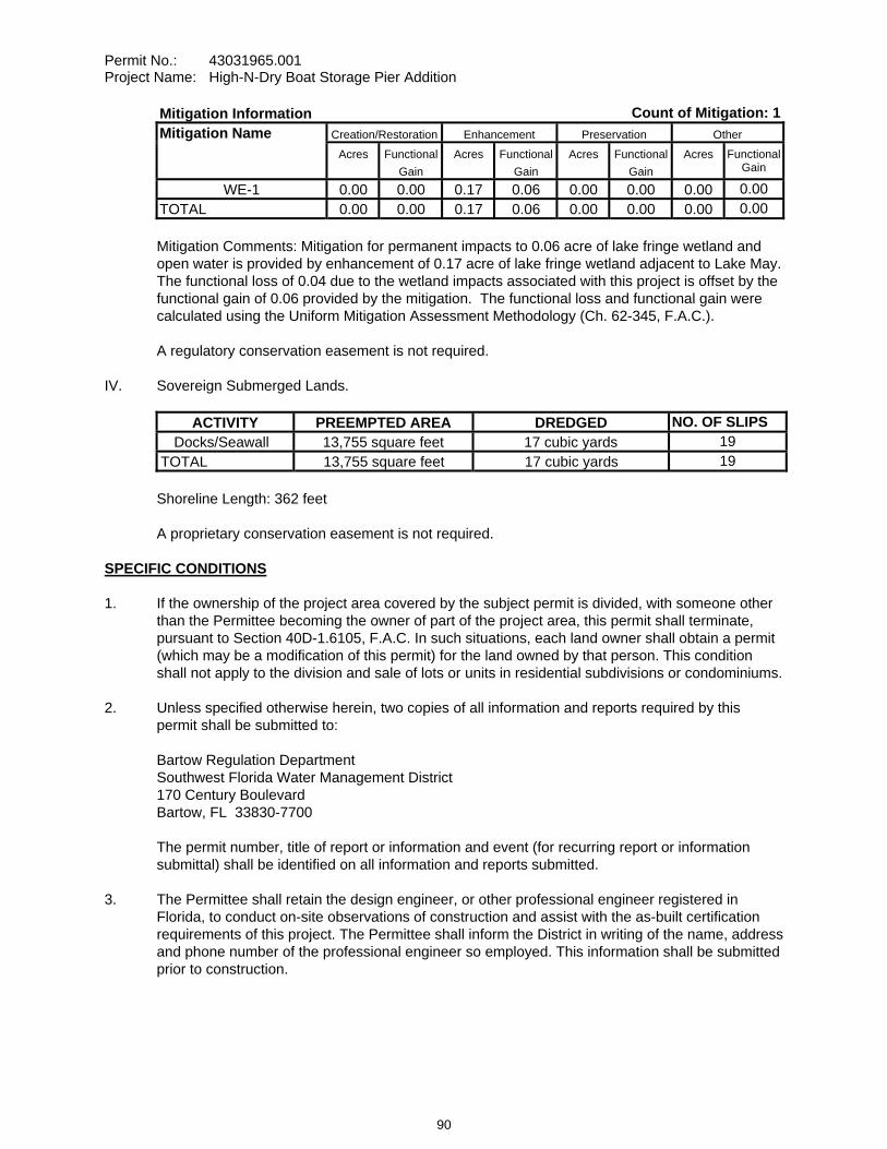
Permit No.: 43031965.001 Project Name: High-N-Dry Boat Storage Pier Addition
Mitigation Information Count of Mitigation: 1Mitigation Name Creation/Restoration Enhancement Preservation Other
Acres Functional Gain
Acres Functional Gain
Acres Functional Gain
Acres FunctionalGain
WE-1 0.00 0.00 0.17 0.06 0.00 0.00 0.00 0.00TOTAL 0.00 0.00 0.17 0.06 0.00 0.00 0.00 0.00
Mitigation Comments: Mitigation for permanent impacts to 0.06 acre of lake fringe wetland and open water is provided by enhancement of 0.17 acre of lake fringe wetland adjacent to Lake May. The functional loss of 0.04 due to the wetland impacts associated with this project is offset by the functional gain of 0.06 provided by the mitigation. The functional loss and functional gain were calculated using the Uniform Mitigation Assessment Methodology (Ch. 62-345, F.A.C.).
A regulatory conservation easement is not required.
IV. Sovereign Submerged Lands.
ACTIVITY PREEMPTED AREA DREDGED NO. OF SLIPS Docks/Seawall 13,755 square feet 17 cubic yards 19
TOTAL 13,755 square feet 17 cubic yards 19
Shoreline Length: 362 feet
A proprietary conservation easement is not required.
SPECIFIC CONDITIONS 1. If the ownership of the project area covered by the subject permit is divided, with someone other
than the Permittee becoming the owner of part of the project area, this permit shall terminate, pursuant to Section 40D-1.6105, F.A.C. In such situations, each land owner shall obtain a permit (which may be a modification of this permit) for the land owned by that person. This condition shall not apply to the division and sale of lots or units in residential subdivisions or condominiums.
2. Unless specified otherwise herein, two copies of all information and reports required by this permit shall be submitted to:
Bartow Regulation Department Southwest Florida Water Management District 170 Century Boulevard Bartow, FL 33830-7700
The permit number, title of report or information and event (for recurring report or information submittal) shall be identified on all information and reports submitted.
3. The Permittee shall retain the design engineer, or other professional engineer registered in Florida, to conduct on-site observations of construction and assist with the as-built certification requirements of this project. The Permittee shall inform the District in writing of the name, address and phone number of the professional engineer so employed. This information shall be submitted prior to construction.
90
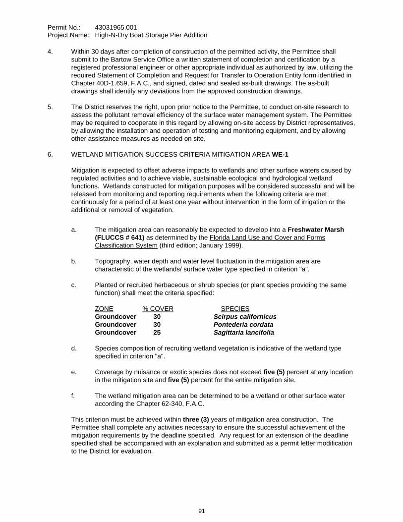
Permit No.: 43031965.001 Project Name: High-N-Dry Boat Storage Pier Addition
4. Within 30 days after completion of construction of the permitted activity, the Permittee shall submit to the Bartow Service Office a written statement of completion and certification by a registered professional engineer or other appropriate individual as authorized by law, utilizing the required Statement of Completion and Request for Transfer to Operation Entity form identified in Chapter 40D-1.659, F.A.C., and signed, dated and sealed as-built drawings. The as-built drawings shall identify any deviations from the approved construction drawings.
5. The District reserves the right, upon prior notice to the Permittee, to conduct on-site research to assess the pollutant removal efficiency of the surface water management system. The Permittee may be required to cooperate in this regard by allowing on-site access by District representatives, by allowing the installation and operation of testing and monitoring equipment, and by allowing other assistance measures as needed on site.
6. WETLAND MITIGATION SUCCESS CRITERIA MITIGATION AREA WE-1
Mitigation is expected to offset adverse impacts to wetlands and other surface waters caused by regulated activities and to achieve viable, sustainable ecological and hydrological wetland functions. Wetlands constructed for mitigation purposes will be considered successful and will be released from monitoring and reporting requirements when the following criteria are met continuously for a period of at least one year without intervention in the form of irrigation or the additional or removal of vegetation.
a. The mitigation area can reasonably be expected to develop into a Freshwater Marsh (FLUCCS # 641) as determined by the Florida Land Use and Cover and Forms Classification System (third edition; January 1999).
b. Topography, water depth and water level fluctuation in the mitigation area are characteristic of the wetlands/ surface water type specified in criterion "a".
c. Planted or recruited herbaceous or shrub species (or plant species providing the same function) shall meet the criteria specified:
ZONE % COVER SPECIESGroundcover 30 Scirpus californicus Groundcover 30 Pontederia cordata Groundcover 25 Sagittaria lancifolia
d. Species composition of recruiting wetland vegetation is indicative of the wetland type specified in criterion "a".
e. Coverage by nuisance or exotic species does not exceed five (5) percent at any location in the mitigation site and five (5) percent for the entire mitigation site.
f. The wetland mitigation area can be determined to be a wetland or other surface water according the Chapter 62-340, F.A.C.
This criterion must be achieved within three (3) years of mitigation area construction. The Permittee shall complete any activities necessary to ensure the successful achievement of the mitigation requirements by the deadline specified. Any request for an extension of the deadline specified shall be accompanied with an explanation and submitted as a permit letter modification to the District for evaluation.
91
Permit No.: 43031965.001 Project Name: High-N-Dry Boat Storage Pier Addition
The mitigation area may be released from monitoring and reporting requirements and be deemed successful at any time during the monitoring period if the Permittee demonstrates that the conditions in the mitigation area have adequately replaced the wetland and surface water functions affected by the regulated activity and that the site conditions are sustainable.
7. The Permittee shall monitor and maintain the wetland mitigation areas until the criteria set forth in the Wetland Mitigation Success Criteria Conditions above are met. The Permittee shall perform corrective actions identified by the District if the District identifies a wetland mitigation deficiency.
8. The Permittee shall undertake required maintenance activities within the wetland mitigation areas as needed at any time between mitigation area construction and termination of monitoring, with the exception of the final year. Maintenance shall include the manual removal of all nuisance and exotic species, with sufficient frequency that their combined coverage at no time exceeds the Wetland Mitigation Success Criteria Conditions above. Herbicides shall not be used without the prior written approval of the District.
9. A Wetland Mitigation Completion Report shall be submitted to the District within 30 days of completing construction and planting of the wetland mitigation areas. Upon District inspection and approval of the mitigation areas, the monitoring program shall be initiated with the date of the District field inspection being the construction completion date of the mitigation areas. Monitoring events shall occur between March 1 and November 30 of each year. An Annual Wetland Monitoring Report shall be submitted upon the anniversary date of District approval to initiate monitoring.
Annual reports shall provide documentation that a sufficient number of maintenance inspection/activities were conducted to maintain the mitigation areas in compliance with the Wetland Mitigation Success Criteria Conditions above. Note that the performance of maintenance inspections and maintenance activities will normally need to be conducted more frequently than the collection of other monitoring data to maintain the mitigation areas in compliance with the Wetland Mitigation Success Criteria Conditions above.
Monitoring Data shall be collected semi-annually.
10. Termination of monitoring for the wetland mitigation areas shall be coordinated with the District by:
a. notifying the District in writing when the criteria set forth in the Wetland Mitigation Success Criteria Conditions have been achieved;
b. suspending all maintenance activities in the wetland mitigation areas including, but not limited to, irrigation and addition or removal of vegetation; and
c. submitting a monitoring report to the District one year following the written notification and suspension of maintenance activities.
Upon receipt of the monitoring report, the District will evaluate the wetland mitigation sites to determine if the Mitigation Success Criteria Conditions have been met and maintained. The District will notify the Permittee in writing of the evaluation results. The Permittee shall perform corrective actions for any portions of the wetland mitigation areas that fail to maintain the criteria set forth in the Wetland Mitigation Success Criteria Conditions.
92
Permit No.: 43031965.001 Project Name: High-N-Dry Boat Storage Pier Addition
11. Following the District’s determination that the wetland mitigation has been successfully completed, the Permittee shall operate and maintain the wetland mitigation areas such that they remain in their current or intended condition for the life of the surface water management facility. The Permittee must perform corrective actions for any portions of the wetland mitigation areas where conditions no longer meet the criteria set forth in the Wetland Mitigation Success Criteria Conditions.
12. The Permittee shall commence construction of the mitigation areas within 30 days of wetland impacts, if wetland impacts occur between February 1 and August 31. If wetland impacts occur between September 1 and January 31, construction of the mitigation areas shall commence by March 1. In either case, construction of the mitigation areas shall be completed within 120 days of the commencement date unless a time extension is approved in writing by the District.
13. The construction of all wetland impacts and wetland mitigation shall be supervised by a qualified environmental scientist/specialist/consultant. The Permittee shall identify, in writing, the environmental professional retained for construction oversight prior to initial clearing and grading activities.
14. The following boundaries, as shown on the approved construction drawings, shall be clearly delineated on the site prior to initial clearing or grading activities:
wetland and surface water areaslimits of approved wetland impacts
The delineation shall endure throughout the construction period and be readily discernible to construction and District personnel.
15. The Permittee shall notify the District of any sinkhole development in the surface water management system within 48 hours of discovery and must submit a detailed sinkhole evaluation and repair plan for approval by the District within 30 days of discovery.
16. This permit is issued based upon the design prepared by the Permittee’s consultant. If at any time it is determined by the District that the Conditions for Issuance of Permits in Rules 40D-4.301 and 40D-4.302, F.A.C., have not been met, upon written notice by the District, the Permittee shall obtain a permit modification and perform any construction necessary thereunder to correct any deficiencies in the system design or construction to meet District rule criteria. The Permittee is advised that the correction of deficiencies may require re-construction of the surface water management system and/or mitigation areas.
17. As Lake May is a sovereign water body, the extent of private ownership of the adjacent uplands extends only to the sovereign submerged lands boundary of Lake May, unless ownership of the sovereign lands has been conveyed by the Board of Trustees of the Internal Improvement Trust Fund of the State of Florida. A ‘Safe Upland Line’ elevation of 131.5 feet NGVD, which approximates that sovereign submerged lands boundary, was determined for Lake May by the Florida Department of Environmental Protection’s Division of State Lands.
18. The District has requested that the Florida Department of Environmental Protection's (FDEP) Recurring Revenue Section of the Bureau of Land Administration prepare the Standard Lease instrument. No construction on the sovereign submerged lands of Lake May is authorized until the lease document (Board of Trustees No. 530343423) prepared by the FDEP has been fully executed and a copy of the executed lease has been provided to the District.
93
Permit No.: 43031965.001 Project Name: High-N-Dry Boat Storage Pier Addition
19. All CCA-treated dock support piles shall have a HDPE wrapping sufficient to prevent leaching as detailed in the approved construction plan set submitted to the District on March 31, 2008.
20. The establishment of permanent residences and liveaboard stays is prohibited on the leased premises.
21. Hull cleaning, painting or other external maintenance is prohibited on the leased premises.
22. Vessel fueling and/or the use of portable fueling devices on the leased premises are not authorized by this permit. All fueling activities must be conducted on the upland location of the facility as detailed in the approved construction plan set submitted to the District on March 31, 2008.
GENERAL CONDITIONS 1. The general conditions attached hereto as Exhibit "A" are hereby incorporated into this permit by
reference and the Permittee shall comply with them.
PROPRIETARY GENERAL CONDITIONS 1. The general conditions attached hereto as Exhibit "B" are hereby incorporated by reference and
the Permittee shall comply with them.
____________________________________________ Authorized Signature
94
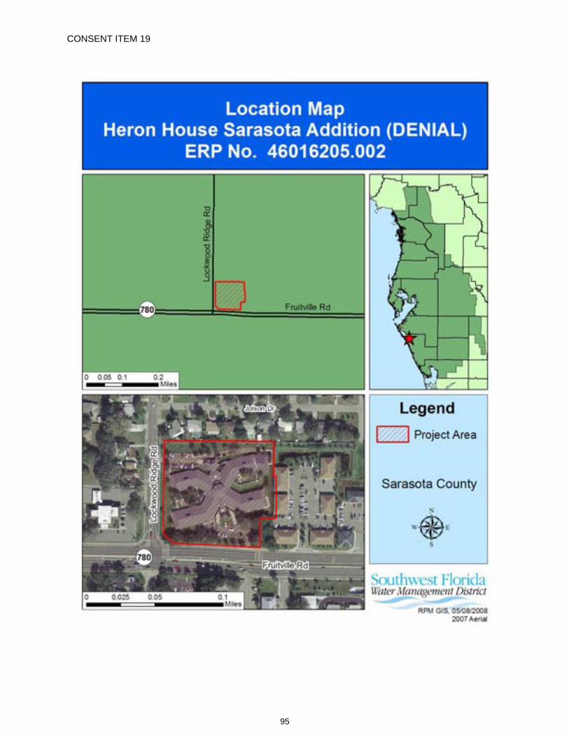
CONSENT ITEM 19
95
CONSENT ITEM 19 Default Date: N / A
SOUTHWEST FLORIDA WATER MANAGEMENT DISTRICT ERP GENERAL FOR MINOR SURFACE WATER MANAGEMENT SYSTEMS
DENIAL OF GENERAL FOR MINOR SYSTEMS PERMIT APPLICATION NO. 46016205.002
DATE OF DENIAL: June 24, 2008 Staff recommends denial of this application for permit due to lack of completeness, in accordance with District Rules 40D-1.1020 and 40.301, Florida Administrative Code (F.A.C.).
PROJECT NAME: Heron House Sarasota Addition
OWNER/APPLICANT: Jim Soper, President
Horizon Senior Lifestyles 3221 Fruitville Road Sarasota, FL 34237
ABSTRACT: This application denial is for a proposed modification to the surface water management system previously permitted under Environmental Resource Permit (ERP) No. 46016205.001, entitled Heron House Sarasota Addition, dated November 22, 2000. The existing permitted surface water management system was previously permitted to function as an online retention system to serve a 3.78-acre residential/assisted living development. The site is located at the northeast corner of the Fruitville Road and Lockwood Ridge Road intersection in Sarasota County.
COUNTY: Sarasota
SEC/TWP/RGE: 21/36S/18E
TOTAL ACRES OWNED: 3.78 acres
PROJECT SIZE: 3.78
LAND USE: Commercial
DATE APPLICATION FILED: February 5, 2007
AMENDED DATE: N/A
The following are reasons for denial:
ADMINISTRATIVE 1. The applicant has failed to respond to the District's Request for Additional Information (RAI) letter
dated March 2, 2007. In accordance with Rule 40D-1.1020, if the additional information is not supplied within 30 days after notice by the District, the application will be denied for lack of completeness.
96
Permit No.: 46016205.002 Project Name: Heron House Sarasota Addition (Denial)
2. The applicant did not provide reasonable assurance that the construction, alteration, and maintenance of the surface water management system will be conducted by an entity with financial, legal, and administrative capability of ensuring the activity will be undertaken in accordance with the terms and conditions of the permit. The submitted application did not meet all the requirements of Chapter 2.0 of the Basis of Review. Specifically, the Owner as listed on the ERP Application was not the actual Landowner at the time of application according to County Property Appraiser information. A Warranty Deed was not provided to clarify or document current ownership. Refer to the Conditions for Issuance of Permits in 40D-40.301(1)(j), F.A.C.
EXPLANATION OF CHANGES NECESSARY TO ADDRESS REASONS FOR DENIAL Provide the information requested in the District's RAI letter dated March 2, 2007. Provide a current copy of the Warranty Deed for the property. Signatures from all current property owners on the ERP Application are required.
APPLICATION REVIEW TIMELINE: Feb. 5, 2007 The application was received. March 2, 2007 RAI letter sent to Applicant (Horizon Senior Lifestyles). April 10, 2007 Notice of Incomplete Application sent to Applicant (Horizon Senior Lifestyles). Nov. 7, 2007 Staff research found that the property had been sold. District staff telephoned the
new owner (RSC Heron House, LLC) on need to transfer permit to their name and complete the pending application process. No further response was received.
Dec. 6, 2007 Notice of Incomplete Application sent to Applicant (Horizon Senior Lifestyles); new owner was copied. Dec. 20, 2007 New owner called District staff and stated they have no idea what this issue was about; as requested, District staff provided (by FAX) copies of the application and the March 2, 2007 RAI letter. Jan. 28, 2008 District staff telephoned new owner, who advised that they are new owners and are still working on it. Notice of Incomplete Application sent to new owner (RSC Heron House, LLC). No further response was received. April 3, 2008 Notice of Incomplete Application sent to new owner (RSC Heron House, LLC). April 10, 2008 New owner came to District office and spoke with staff regarding transferring ownership of the project. File of record copies were provided and new owner advised they would keep the District informed on their proposed course of action. May 1, 2008 Pursuant to telephone contact with District staff, an email was received from Engineer of Record stating that his firm is no longer working for Horizon Senior Lifestyles on this job and it does not have the authority to act on this permit.
PERMITABILITY OF SUBJECT PARCEL This denial should not be construed as a statement of denial of any development potential for the subject parcel. The District is merely denying the specific proposal, based on the supporting information, which the applicant has made in this application.
97
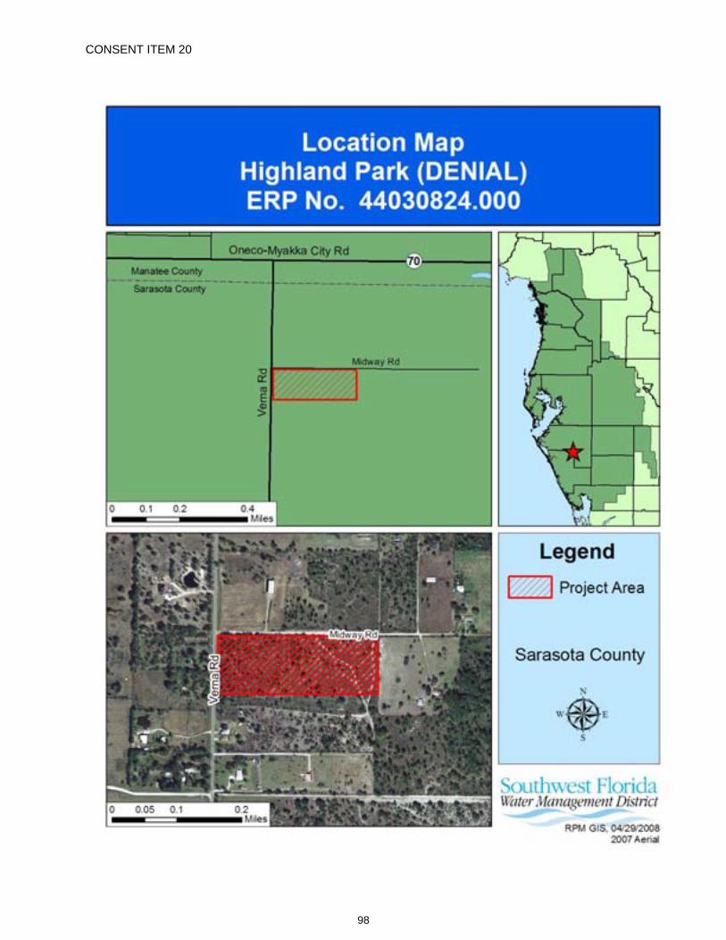
CONSENT ITEM 20
98
CONSENT ITEM 20 Default Date: N / A
SOUTHWEST FLORIDA WATER MANAGEMENT DISTRICT ENVIRONMENTAL RESOURCE GENERAL CONSTRUCTION
DENIAL OF GENERAL CONSTRUCTION PERMIT APPLICATION NO. 44030824.000
DATE OF DENIAL: June 24, 2008 Staff recommends denial of this application for permit due to lack of completeness, in accordance with District Rule 40D-1.1020 and Rule 40D-40.302, Florida Administrative Code, (F.A.C.).
PROJECT NAME: Highland Park
OWNER/APPLICANT: Heritage Development of Central Florida, LLC 2390 Cattlemen Road Sarasota, FL 34232-6207
ABSTRACT: This application denial is for a proposed surface water management system serving a 12.00-acre residential development. The project is located on Verna Road, approximately one half mile south of SR 70 in Sarasota County.
COUNTY: Sarasota
SEC/TWP/RGE: 1/36S/20E
TOTAL ACRES OWNED: 12.00
PROJECT SIZE: 12.00 Acres
LAND USE: Road Project
DATE APPLICATION FILED: April 13, 2006
AMENDED DATE: N/A
The applicant has failed to respond to the District’s Request for Additional Information letter dated May 11, 2006. In accordance with Rule 40D-1.1020, F.A.C., if the additional information is not supplied within 30 days after notice by the District, the application will be denied for lack of completeness.
The following are reasons for denial:
APPLICATION AND APPLICATION CERTIFICATION
The permit application does not accurately reflect the project acreage in Section A, Part 4 of the Environmental Resource Permit (ERP) application. A revised application with the correct project area has not been provided. Refer to 40D-4.101(1)(e), F.A.C., and Section A, Part 4 of the ERP application.
SITE INFORMATION
Requested information regarding the natural grade vertical datum (NGVD) and seasonal high water elevation(SHWE) of the retention area has not been provided. Refer to 40D-4.301(1)(a) and (e), F.A.C.
99
Permit No.: 44030824.000 Project Name: Highland Park (DENIAL)
PLANS The following information has not been provided on the construction plans:
Pond area at control elevation and top of bank, appropriate side slopes, design high water elevation (DHWE), skimmer elevation, and water quality treatment stages. Refer to 40D-4.301(1)(a) and (e), and 40D-4.101(1)(e), F.A.C.
Representative cross sections, proposed grading, and limits of construction. Refer to 40D-4.301(1)(a) and (b),F.A.C.
DRAINAGE INFORMATION Requested information regarding the pre-development and post-development drainage basins, points of discharge, flow rates, and impervious surface within the project area has not been provided. Refer to 40D-4.301(1)(a) and (e), F.A.C.
Requested information regarding basin curve numbers in the hydrologic/hydraulic analysis of the project has not been provided. Refer to 40D-4.301(1)(a) and (b), F.A.C.
OPERATION AND MAINTENANCE AND LEGAL DOCUMENTATION Requested information for a homeowners association and the entity responsible for the perpetual operation andmaintenance of the surface water management facilities has not been provided. Refer to Chapter 2.6 of the Basis of Review.
EXPLANATION OF CHANGES NECESSARY TO ADDRESS REASONS FOR DENIAL Provide the information requested in the District’s Request for Additional Information letter dated May 11, 2006.
APPLICATION REVIEW TIMELINE
April 13, 2006 An ERP application was received. May 11, 2006 A Request for Additional Information (RAI) letter was sent. June 26, 2006 A request for a 30-day extension to respond to the RAI was received. June 30, 2006 A time extension was sent. August 2, 2006 A second request for a time extension was received. August 3, 2006 A time extension was sent. September 5, 2006 A third request for a time extension was received. September 6, 2006 A time extension was sent. October 20, 2006 A fourth time extension request was received. November 8, 2006 A time extension was sent. January 25, 2007 A fifth time extension request was received. January 31, 2007 A time extension was sent. January 8, 2008 A Notification of Incomplete Application letter was sent to the consultant. February 26, 2008 District staff advised consultant that the permit will be denied if RAI response or withdrawal request is not received.
100

Permit No.: 44030824.000 Project Name: Highland Park (DENIAL)
PERMITABILITY OF SUBJECT PARCEL This denial should not be construed as a statement of denial of any development potential for the subject parcel. The District is merely denying the specific proposal, based on the supporting information, which the applicant has made in this application.
101

The following General Conditions are included on all Environmental Resource Permits issued pursuant to 40D-4 and 40D-40, Florida Administrative Code.
102
EXHIBIT "A"
1. All activities shall be implemented as set forth in the plans, specifications and performance criteria as approved by this permit. Any deviation from the permitted activity and the conditions for undertaking that activity shall constitute a violation of this permit.
2. This permit or a copy thereof, complete with all conditions, attachments, exhibits, and modifications, shall be kept at the work site of the permitted activity. The complete permit shall be available for review at the work site upon request by District staff. The permittee shall require the contractor to review the complete permit prior to commencement of the activity authorized by this permit.
3. For general permits authorizing incidental site activities, the following limiting general conditions shall also apply:
a. If the decision to issue the associated individual permit is not final within 90 days of issuance of the incidental site activities permit, the site must be restored by the permittee within 90 days after notification by the District. Restoration must be completed by re-contouring the disturbed site to previous grades and slopes re-establishing and maintaining suitable vegetation and erosion control to provide stabilized hydraulic conditions. The period for completing restoration may be extended if requested by the permittee and determined by the District to be warranted due to adverse weather conditions or other good cause. In addition, the permittee shall institute stabilization measures for erosion and sediment control as soon as practicable, but in no case more than 7 days after notification by the District.
b. The incidental site activities are commenced at the permittee's own risk. The Governing Board will not consider the monetary costs associated with the incidental site activities or any potential restoration costs in making its decision to approve or deny the individual environmental resource permit application. Issuance of this permit shall not in any way be construed as commitment to issue the associated individual environmental resource permit.
4. Activities approved by this permit shall be conducted in a manner which does not cause violations of state water quality standards. The permittee shall implement best management practices for erosion and a pollution control to prevent violation of state water quality standards. Temporary erosion control shall be implemented prior to and during construction, and permanent control measures shall be completed within 7 days of any construction activity. Turbidity barriers shall be installed and maintained at all locations where the possibility of transferring suspended solids into the receiving waterbody exists due to the permitted work. Turbidity barriers shall remain in place at all locations until construction is completed and soils are stabilized and vegetation has been established. Thereafter the permittee shall be responsible for the removal of the barriers. The permittee shall correct any erosion or shoaling that causes adverse impacts to the water resources.
5. Water quality data for the water discharged from the permittee's property or into the surface waters of the state shall be submitted to the District as required by the permit. Analyses shall be performed according to procedures outlined in the current edition of Standard Methods for the Examination of Water and Wastewater by the American Public Health Association or Methods for Chemical Analyses of Water and Wastes by the U.S. Environmental Protection Agency. If water
103
quality data are required, the permittee shall provide data as required on volumes of water discharged, including total volume discharged during the days of sampling and total monthly volume discharged from the property or into surface waters of the state.
6. District staff must be notified in advance of any proposed construction dewatering. If the dewatering activity is likely to result in offsite discharge or sediment transport into wetlands or surface waters, a written dewatering plan must either have been submitted and approved with the permit application or submitted to the District as a permit prior to the dewatering event as a permit modification. A water use permit may be required prior to any use exceeding the thresholds in Chapter 40D-2, F.A.C.
7. Stabilization measures shall be initiated for erosion and sediment control on disturbed areas as soon as practicable in portions of the site where construction activities have temporarily or permanently ceased, but in no case more than 7 days after the construction activity in that portion of the site has temporarily or permanently ceased.
8. Off-site discharges during construction and development shall be made only through the facilities authorized by this permit. Water discharged from the project shall be through structures having a mechanism suitable for regulating upstream stages. Stages may be subject to operating schedules satisfactory to the District.
9. The permittee shall complete construction of all aspects of the surface water management system, including wetland compensation (grading, mulching, planting), water quality treatment features, and discharge control facilities prior to beneficial occupancy or use of the development being served by this system.
10. The following shall be properly abandoned and/or removed in accordance with the applicable regulations:
a. Any existing wells in the path of construction shall be properly plugged and abandoned by a licensed well contractor.
b. Any existing septic tanks on site shall be abandoned at the beginning of construction. c. Any existing fuel storage tanks and fuel pumps shall be removed at the beginning of
construction.
11. All surface water management systems shall be operated to conserve water in order to maintain environmental quality and resource protection; to increase the efficiency of transport, application and use; to decrease waste; to minimize unnatural runoff from the property and to minimize dewatering of offsite property.
12. At least 48 hours prior to commencement of activity authorized by this permit, the permittee shall submit to the District a written notification of commencement indicating the actual start date and the expected completion date.
13. Each phase or independent portion of the permitted system must be completed in accordance with the permitted plans and permit conditions prior to the occupation of the site or operation of site infrastructure located within the area served by that portion or phase of the system. Each phase or independent portion of the system must be completed in accordance with the permitted plans and permit conditions prior to transfer of responsibility for operation and maintenance of that phase or portion of the system to a local government or other responsible entity.
104
14. Within 30 days after completion of construction of the permitted activity, the permittee shall submit a written statement of completion and certification by a registered professional engineer or other appropriate individual as authorized by law, utilizing the required Statement of Completion and Request for Transfer to Operation Entity form identified in Chapter 40D-1, F.A.C. Additionally, if deviation from the approved drawings are discovered during the certification process the certification must be accompanied by a copy of the approved permit drawings with deviations noted.
15. This permit is valid only for the specific processes, operations and designs indicated on the approved drawings or exhibits submitted in support of the permit application. Any substantial deviation from the approved drawings, exhibits, specifications or permit conditions, including construction within the total land area but outside the approved project areas, may constitute grounds for revocation or enforcement action by the District, unless a modification has been applied for and approved. Examples of substantial deviations include excavation of ponds, ditches or sump areas deeper than shown on the approved plans.
16. The operation phase of this permit shall not become effective until the permittee has complied with the requirements of the conditions herein, the District determines the system to be in compliance with the permitted plans, and the entity approved by the District accepts responsibility for operation and maintenance of the system. The permit may not be transferred to the operation and maintenance entity approved by the District until the operation phase of the permit becomes effective. Following inspection and approval of the permitted system by the District, the permittee shall request transfer of the permit to the responsible operation and maintenance entity approved by the District, if different from the permittee. Until a transfer is approved by the District, the permittee shall be liable for compliance with the terms of the permit.
17. Should any other regulatory agency require changes to the permitted system, the District shall be notified of the changes prior to implementation so that a determination can be made whether a permit modification is required.
18. This permit does not eliminate the necessity to obtain any required federal, state, local and special District authorizations including a determination of the proposed activities' compliance with the applicable comprehensive plan prior to the start of any activity approved by this permit.
19. This permit does not convey to the permittee or create in the permittee any property right, or any interest in real property, nor does it authorize any entrance upon or activities on property which is not owned or controlled by the permittee, or convey any rights or privileges other than those specified in the permit and Chapter 40D-4 or Chapter 40D-40, F.A.C.
20. The permittee shall hold and save the District harmless from any and all damages, claims, or liabilities which may arise by reason of the activities authorized by the permit or any use of the permitted system.
21. Any delineation of the extent of a wetland or other surface water submitted as part of the permit application, including plans or other supporting documentation, shall not be considered binding unless a specific condition of this permit or a formal determination under section 373.421(2), F.S., provides otherwise.
22. The permittee shall notify the District in writing within 30 days of any sale, conveyance, or other transfer of ownership or control of the permitted system or the real property at which the permitted system is located. All transfers of ownership or transfers of a permit are subject to the requirements of Rule 40D-4.351, F.A.C. The permittee transferring the permit shall remain liable for any corrective actions that may be required as a result of any permit violations prior to such sale, conveyance or other transfer.
105
23. Upon reasonable notice to the permittee, District authorized staff with proper identification shall have permission to enter, inspect, sample and test the system to insure conformity with District rules, regulations and conditions of the permits.
24. If historical or archaeological artifacts are discovered at any time on the project site, the permittee shall immediately notify the District and the Florida Department of State, Division of Historical Resources.
25. The permittee shall immediately notify the District in writing of any previously submitted information that is later discovered to be inaccurate.
106
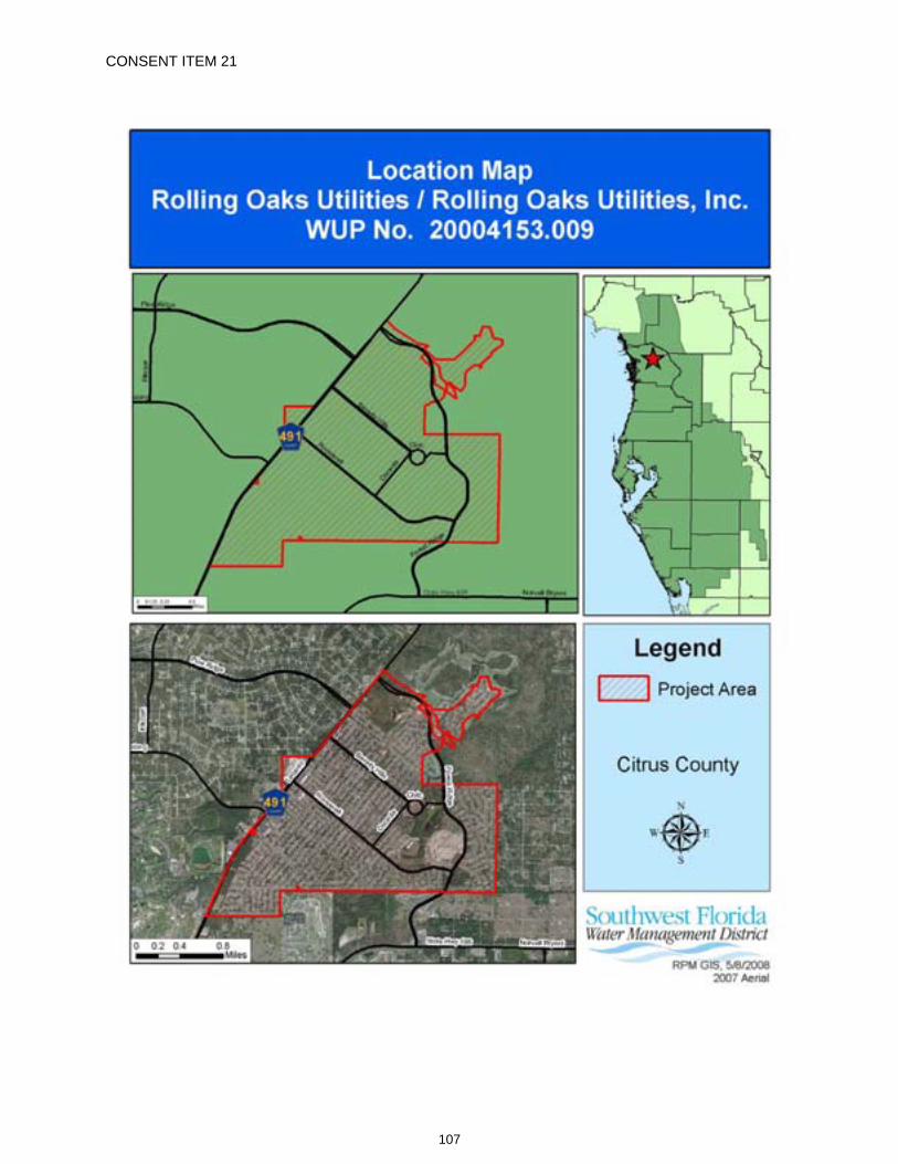
CONSENT ITEM 21
107
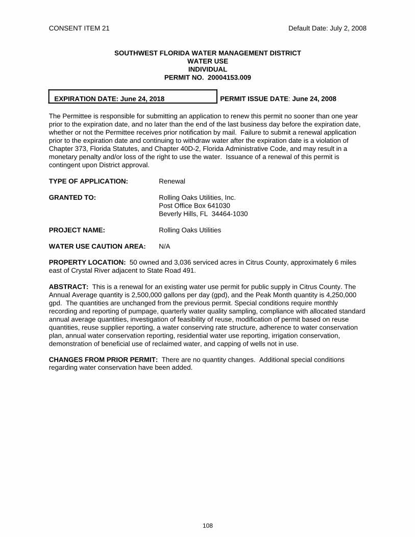
CONSENT ITEM 21 Default Date: July 2, 2008
SOUTHWEST FLORIDA WATER MANAGEMENT DISTRICT WATER USE INDIVIDUAL
PERMIT NO. 20004153.009
EXPIRATION DATE: June 24, 2018 PERMIT ISSUE DATE: June 24, 2008
The Permittee is responsible for submitting an application to renew this permit no sooner than one year prior to the expiration date, and no later than the end of the last business day before the expiration date, whether or not the Permittee receives prior notification by mail. Failure to submit a renewal application prior to the expiration date and continuing to withdraw water after the expiration date is a violation of Chapter 373, Florida Statutes, and Chapter 40D-2, Florida Administrative Code, and may result in a monetary penalty and/or loss of the right to use the water. Issuance of a renewal of this permit is contingent upon District approval.
TYPE OF APPLICATION: Renewal
GRANTED TO: Rolling Oaks Utilities, Inc. Post Office Box 641030 Beverly Hills, FL 34464-1030
PROJECT NAME: Rolling Oaks Utilities
WATER USE CAUTION AREA: N/A
PROPERTY LOCATION: 50 owned and 3,036 serviced acres in Citrus County, approximately 6 miles east of Crystal River adjacent to State Road 491.
ABSTRACT: This is a renewal for an existing water use permit for public supply in Citrus County. The Annual Average quantity is 2,500,000 gallons per day (gpd), and the Peak Month quantity is 4,250,000 gpd. The quantities are unchanged from the previous permit. Special conditions require monthly recording and reporting of pumpage, quarterly water quality sampling, compliance with allocated standard annual average quantities, investigation of feasibility of reuse, modification of permit based on reuse quantities, reuse supplier reporting, a water conserving rate structure, adherence to water conservation plan, annual water conservation reporting, residential water use reporting, irrigation conservation, demonstration of beneficial use of reclaimed water, and capping of wells not in use.
CHANGES FROM PRIOR PERMIT: There are no quantity changes. Additional special conditions regarding water conservation have been added.
108
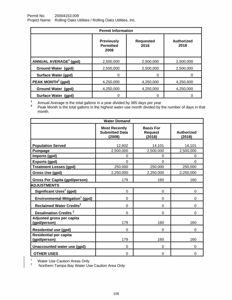
Permit No. 20004153.009 Project Name: Rolling Oaks Utilities / Rolling Oaks Utilities, Inc.
Permit Information
Previously Permitted
2008
Requested
2018
Authorized
2018
ANNUAL AVERAGE1 (gpd) 2,500,000 2,500,000 2,500,000
Ground Water (gpd) 2,500,000 2,500,000 2,500,000
Surface Water (gpd) 0 0 0
PEAK MONTH2 (gpd) 4,250,000 4,250,000 4,250,000
Ground Water (gpd) 4,250,000 4,250,000 4,250,000
Surface Water (gpd) 0 0 0 1 Annual Average is the total gallons in a year divided by 365 days per year 2 Peak Month is the total gallons in the highest water-use month divided by the number of days in that
month.
Water Demand
Most Recently Submitted Data
(2008)
Basis For Request (2018)
Authorized (2018)
Population Served 12,602 14,101 14,101Pumpage 2,500,000 2,500,000 2,500,000 Imports (gpd) 0 0 0 Exports (gpd) 0 0 0 Treatment Losses (gpd) 250,000 250,000 250,000 Gross Use (gpd) 2,250,000 2,250,000 2,250,000
Gross Per Capita (gpd/person) 179 160 160 ADJUSTMENTS Significant Uses1 (gpd) 0 0 0
Environmental Mitigation1 (gpd) 0 0 0
Reclaimed Water Credits2 0 0 0
Desalination Credits 2 0 0 0 Adjusted gross per capita (gpd/person) 179 160 160
Residential use (gpd) 0 0 0 Residential per capita (gpd/person) 179 160 160
Unaccounted water use (gpd) 0 0 0
OTHER USES 0 0 0 1 Water Use Caution Areas Only 2 Northern Tampa Bay Water Use Caution Area Only
109
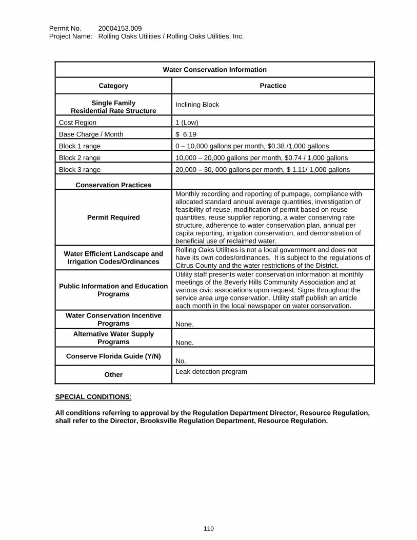
Permit No. 20004153.009 Project Name: Rolling Oaks Utilities / Rolling Oaks Utilities, Inc.
SPECIAL CONDITIONS:
All conditions referring to approval by the Regulation Department Director, Resource Regulation, shall refer to the Director, Brooksville Regulation Department, Resource Regulation.
Water Conservation Information
Category Practice
Single Family Residential Rate Structure
Inclining Block
Cost Region 1 (Low)
Base Charge / Month $ 6.19
Block 1 range 0 – 10,000 gallons per month, $0.38 /1,000 gallons
Block 2 range 10,000 – 20,000 gallons per month, $0.74 / 1,000 gallons
Block 3 range 20,000 – 30, 000 gallons per month, $ 1.11/ 1,000 gallons
Conservation Practices
Permit Required
Monthly recording and reporting of pumpage, compliance with allocated standard annual average quantities, investigation of feasibility of reuse, modification of permit based on reuse quantities, reuse supplier reporting, a water conserving rate structure, adherence to water conservation plan, annual per capita reporting, irrigation conservation, and demonstration of beneficial use of reclaimed water.
Water Efficient Landscape and Irrigation Codes/Ordinances
Rolling Oaks Utilities is not a local government and does not have its own codes/ordinances. It is subject to the regulations of Citrus County and the water restrictions of the District.
Public Information and Education Programs
Utility staff presents water conservation information at monthly meetings of the Beverly Hills Community Association and at various civic associations upon request. Signs throughout the service area urge conservation. Utility staff publish an article each month in the local newspaper on water conservation.
Water Conservation Incentive Programs None.
Alternative Water Supply Programs None.
Conserve Florida Guide (Y/N) No.
Other Leak detection program
110
Permit No. 20004153.009 Project Name: Rolling Oaks Utilities / Rolling Oaks Utilities, Inc.
1. All reports and data required by conditions of the permit shall be submitted to the District according to the due dates contained in the specific condition. If the report or data is received on or before the tenth day of the month following data collection, it shall be deemed as a timely submittal. The Permittee may use the District’s website to submit data, plans or reports online. To set up an account, the Permittee can address the request to [email protected]. All mailed reports and data are to be sent to:
Permit Data Section, Regulation Performance Management Department Southwest Florida Water Management District 2379 Broad Street Brooksville, Florida 34604-6899
Submission of plans and reports: Unless submitted online or otherwise indicated in the special condition, the original and two copies of each plan and report, such as conservation plans, environmental analyses, aquifer test results, per capita annual reports, etc. are required.
Submission of data: Unless otherwise indicated in the special condition, an original (no copies) is required for data submittals such as crop report forms, meter readings and/or pumpage, rainfall, water level evapotranspiration, or water quality data.
2. The Permittee shall investigate the feasibility of using reclaimed water as a water source and submit a report describing the feasibility to the Permit Data Section, Regulation Performance Management Department, by April 1, 2009. The report shall contain an analysis of reclaimed water sources for the area, including the relative location of these sources to the Permittee's property, the quantity of reclaimed water available, the projected dates of availability, costs associated with obtaining the reclaimed water, and an implementation schedule for reuse, if feasible. Infeasibility shall be supported with a detailed explanation.
3. The Permittee shall meter withdrawals from surface waters and/or the ground water resources, and meter readings from each withdrawal facility shall be recorded on a monthly basis within the last week of the month. The meter readings shall be reported to the Data Management Section, Regulation Performance Management Department on or before the tenth day of the following month. District-supplied scanning forms shall be used to submit the meter readings unless another arrangement for submission of this data has been approved by the District. The following withdrawal facilities shall be metered:
Existing permitted withdrawal facilities shall continue to be metered with non-resettable, totalizing flow meters or other flow measuring devices as approved by the Regulation Department Director, District ID Nos. 1, 2, 4, 5, 6, 7, 8, 9 and 10, Permittee ID Nos. 1, 2, 4, 5, 6, 7, 8, 9 and 10.
The meters shall adhere to the following descriptions and shall be installed or maintained as follows:
A. The meters shall be non-resettable, totalizing flow meters that have a totalizer of sufficient magnitude to retain total gallon data for a minimum of the three highest consecutive months permitted quantities. If other measuring devices are proposed, prior to installation, approval shall be obtained in writing from the Regulation Department Director.
B. The Permittee shall report non-use on all metered standby withdrawal facilities on the scanning form or approved alternative reporting method.
C. If a metered withdrawal facility is not used during any given month, the meter report shall be submitted to the District indicating the same meter reading as was submitted the previous month.
D. The flow meters or other approved devices shall have and maintain an accuracy within five percent of the actual flow as installed.
E. Accuracy testing requirements: 1. For newly metered withdrawal points, the flow meter installation shall be designed for
inline field access for meter accuracy testing.
111
Permit No. 20004153.009 Project Name: Rolling Oaks Utilities / Rolling Oaks Utilities, Inc.
2. The meter shall be tested for accuracy on-site, as installed, every five years beginning from the date of its installation for new meters or from the date of initial issuance of this permit containing the metering condition with an accuracy test requirement for existing meters.
3. The testing frequency will be decreased if the Permittee demonstrates to the satisfaction of the District that a longer period of time for testing is warranted.
4. The test will be accepted by the District only if performed by a person knowledgeable in the testing equipment used.
5. If the actual flow is found to be greater than 5% different from the measured flow, within 30 days, the Permittee shall have the meter re-calibrated, repaired, or replaced, whichever is necessary. Documentation of the test and a certificate of re-calibration, if applicable, shall be submitted within 30 days of each test or re-calibration.
F. The meter shall be installed according to the manufacturer’s instructions for achieving accurate flow to the specifications above, or it shall be installed in a straight length of pipe where there is at least an upstream length equal to ten (10) times the outside pipe diameter and a downstream length equal to two (2) times the outside pipe diameter. Where there is not at least a length of ten diameters upstream available, flow straightening vanes shall be used in the upstream line.
G. Broken or malfunctioning meter: 1. If the meter or other flow measuring device malfunctions or breaks, the Permittee shall
notify the District within 15 days of discovering the malfunction or breakage. 2. The meter must be replaced with a repaired or new meter, subject to the same
specifications given above, within 30 days of the discovery. 3. If the meter is removed from the withdrawal point for any other reason, it shall be
replaced with another meter having the same specifications given above, or the meter shall be reinstalled within 30 days of its removal from the withdrawal. In either event, a fully functioning meter shall not be off the withdrawal point for more than 60 consecutive days.
H. While the meter is not functioning correctly, the Permittee shall keep track of the total amount of time the withdrawal point was used for each month and multiply those minutes times the pump capacity (in gallons per minute) for total gallons. The estimate of the number of gallons used each month during that period shall be submitted on District scanning forms and noted as estimated per instructions on the form. If the data is submitted by another approved method, the fact that it is estimated must be indicated. The reason for the necessity to estimate pumpage shall be reported with the estimate.
I. In the event a new meter is installed to replace a broken meter, it and its installation shall meet the specifications of this condition. The permittee shall notify the District of the replacement with the first submittal of meter readings from the new meter.
4. Water quality samples shall be collected and analyzed, for parameters, and frequency specified below. Water quality samples from production wells shall be collected whether or not the well is being used, unless infeasible. If sampling is infeasible the Permittee shall indicate the reason for not sampling on the water quality data form. Water quality samples shall be analyzed by a laboratory certified by the Florida Department of Health utilizing the standards and methods applicable to the parameters analyzed and to the water use pursuant to Chapter 64E-1, Florida Administrative Code, “Certification of Environmental Testing Laboratories”. At a minimum, water quality samples shall be collected after pumping the well at its normal rate for a pumping time specified in the table below, or to a constant temperature, pH, and conductivity. In addition, the Permittee's sampling procedure shall follow the handling and chain of custody procedures designated by the certified laboratory which will undertake the analysis. Any variance in sampling
112
Permit No. 20004153.009 Project Name: Rolling Oaks Utilities / Rolling Oaks Utilities, Inc.
and/or analytical methods shall have prior approval of the Regulation Department Director, Resource Regulation. Reports of the analyses shall be submitted to the Permit Data Section, Regulation Performance Management Department, (using District forms) on or before the tenth day of the following month, and shall include the signature of an authorized representative and certification number of the certified laboratory which undertook the analysis. The parameters and frequency of sampling and analysis may be modified by the Regulation Department Director, Resource Regulation, as necessary to ensure the protection of the resource.
District Permittee Minimum Pumping ID No. ID No. Time (minutes) Parameter Sampling Frequency
1,2,4,5,6, 1,2,4,5,6, Chlorides, February, May, 7,8,9, and 10 7,8,9 and 10 15 Sulfates, and August and November
T.D.S.
Water quality samples shall be collected based on the following timetable:
Quarterly Same week of months specified
Analyses shall be performed according to procedures outlined in the current edition of Standard Methods for the Examination of Water and Wastewater by the American Public Health Association-American Water Works Association-Water Pollution Control Federation (APHA-AWWA-WPCF) or Methods for Chemical Analyses of Water and Wastes by the U.S. Environmental Protection Agency (EPA).
5. Any wells not in use, and in which pumping equipment is not installed shall be capped or valved in a water tight manner in accordance with Chapter 62-532.500(3)(a)(4), F.A.C.
6. At such time as the use of reclaimed water reaches 500,000 gpd on an annual average basis, the Permittee shall apply to modify this permit to decrease the quantity of water permitted from the on site wells.
7. Compliance with the allocated standard annual average quantity and drought annual average quantities is based on a rolling 12-month calculation where the current pumpage is added to the pumpage for the previous 11 months, and the total is then divided by the number of days in those 12 months for gallons per day. If the Permittee exceeds the allocated standard annual average quantity or drought annual average quantities during any month, within 30 days the Permittee must submit a report to the District that includes reasons why the allocated quantities were exceeded, efforts already taken to attempt meeting the allocated quantities, and a plan to bring the permit into compliance. Reports for Permittees not achieving the allocated quantities are subject to District approval. Justification for exceeding the allocated quantities does not constitute a waiver of the District's authority to enforce the terms and conditions of the permit.
8. The Permittee shall continue to carry out the provisions of the Water Conservation Plan received on April 3, 2009, including those additional water conservation provisions received during this permit evaluation. The Permittee shall continue to develop, improve upon, and expand the water conservation programs to reduce the per capita use rate.
A. The Permittee shall study the effectiveness of the water rate structure toward encouraging conservative use of water, and shall study the feasibility and merit of rate structure adjustments to increase the conservation effectiveness of the rate structure. The number of rate tiers, the tier breakpoints, and the incline of rate tiers are factors that should be considered for each customer class, toward the objectives of conservative use of water and causing reduced per capita water use within the service area.
B. The Permittee shall study the County ordinances which affect landscape management choices and the associated water uses for landscape irrigation within Marion County, with
113
Permit No. 20004153.009 Project Name: Rolling Oaks Utilities / Rolling Oaks Utilities, Inc.
an objective of providing opportunities and options for the revision or adoption of ordinances toward three purposes: 1) to encourage the use of low-water-demand landscaping through the use of plant materials well suited to the site-specific soils and landscape conditions; 2) to encourage use of the most efficient irrigation techniques practically feasible, and; 3) to encourage irrigation operation only when necessary to sustain developed landscapes through droughts. Ordinance objectives would be to provide incentives for use of low-water-landscaping materials and practices, and to provide disincentives for use of high-water-demand landscaping materials and practices in existing and future development.
C. The Permittee shall encourage voluntary compliance with water shortage restrictions and water conservation rules through education efforts. The Permittee shall observe the success of voluntary compliance, as well as activities by the local government to enforce compliance.
D. Prior to submission of a formal application to renew or increase quantities of this permit, the Permittee shall submit a written report on the feasibility of supplying reclaimed water to existing or proposed water users for non-potable beneficial uses, such as golf course irrigation, lawn and landscaping irrigation, and/or crop irrigation applications. The report shall include a feasibility study, including cost analysis for supplying reclaimed water to customers (e.g. construction or upgrade of wastewater treatment facilities, transmission lines, etc.). Infeasibility shall be supported with a detailed explanation.
9. The Permittee shall submit an annual water conservation report, by April 1 of each year for the preceding calendar year. The report shall identify the average per capita use rate within the service area for the calendar year, and report on the activities and effectiveness of each element of the conservation plan. If the goal of per capita use rate reduction has not been achieved, the report shall address measures being pursued during the current calendar year to increase the effectiveness of the water conservation plan.
A. The Report shall include a residential water use report for the preceding calendar year, detailing the following:
1. The number of single family dwelling units served and their total water use; 2. The number of multi-family dwelling units served and their total water use; 3. The number of mobile homes and their total water use.
Where separate indoor and outdoor meters exist, residential water use quantities shall include both the indoor and outdoor water uses associated with the dwelling units, including irrigation water.
B. With the calculation of the average per capita use rate, the report shall include the following:
1. The population served; 2. Significant deducted uses and their significant use quantities; 3. Total withdrawals; 4. Treatment losses and utility uses.
C. The report shall address compliance with water shortage restrictions within the service area. The success of education efforts to cause voluntary compliance shall be addressed, and statistics shall be provided from the County regarding enforcement of water shortage restrictions during the calendar year, including the number of warnings and citations issued.
114
Permit No. 20004153.009 Project Name: Rolling Oaks Utilities / Rolling Oaks Utilities, Inc.
D. The report shall address reuse, including the following: 1. Quantity of total reclaimed water provided by the Permittee for reuse both on an Annual Average daily and monthly basis; 2. The account name, address, and metered or estimated unmetered quantities for each account receiving reclaimed water.
E. For common area landscaping, the Permittee shall: 1. Incorporate best water management practices, specifically including but not limited
to irrigation practices, as recommended for the permitted activities in reports and publications by the IFAS.
2. Limit daytime irrigation to the greatest extent practicable to reduce losses from evaporation. Daytime irrigation for the purposes of system maintenance, control of heat stress, crop protection, plant establishment, or for other reasons which require daytime irrigation are permissible; but should be limited to the minimum amount necessary as indicated by best management practices.
3. Implement leak detection and repair program as an element of an ongoing system maintenance program. This program shall include a system-wide inspection at least once per year.
4. Evaluate the feasibility of improving the efficiency of the current irrigation system or converting to a more efficient system. This condition includes implementation of the improvements or conversion when determined to be operationally and economically feasible.
10. The Permittee is encouraged to demonstrate that beneficial reuse of treated effluent is maximized so that 50% or more of the total annual treated effluent flow is beneficially reused. The calculation of the percentage beneficially reused will be based on the Permittee's waste water treatment plants that have a capacity of 0.5 million gallons per day or greater. Beneficial reuse includes:
A. Landscape irrigation of golf courses, playing fields, cemeteries, parks, playgrounds, school yards, retail nurseries and commercial, industrial and residential properties.
B. Agricultural irrigation of food, fiber, fodder and seed crops, wholesale nurseries, “cut flowers", sod farms and improved pastures.
C. Ground water recharge where such recharge results in environmental or water supply benefit.
D. Industrial uses for cooling water, process water and wash waters. E. Wetlands restoration. F. Fire protection. G. Environmental enhancement, including discharges to surface waters to replace
withdrawals.Other useful purposes accepted by the District or allowed under a DEP permit pursuant to Chapter 62-610, F.A.C.
11. By April 1 of each year, the Permittee shall submit a residential water use report for the preceding calendar year or fiscal year (October 1, through September 30), detailing:
A. The number of single family dwelling units served and their total water use, B. The number of multi-family dwelling units served and their total water use, C. The number of mobile homes served and their total water use.
Where separate indoor and outdoor meters exist, residential water use quantities shall include both the indoor and outdoor water uses associated with the dwelling units, including irrigation water.
115
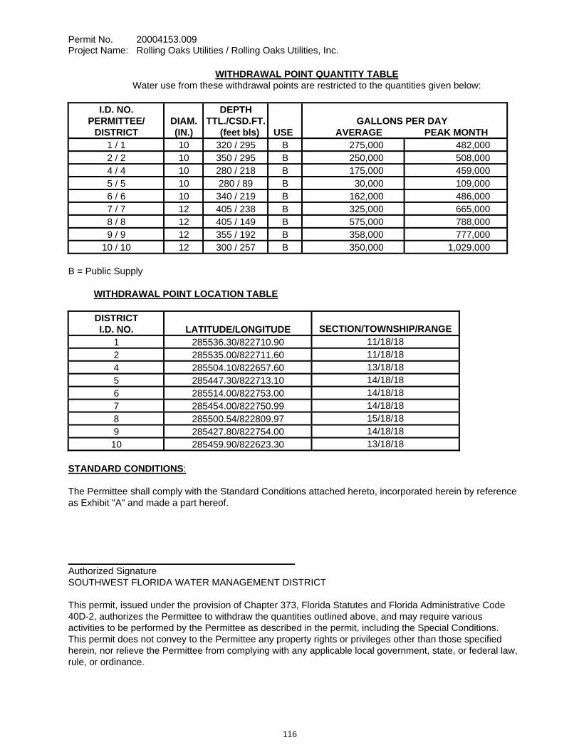
Permit No. 20004153.009 Project Name: Rolling Oaks Utilities / Rolling Oaks Utilities, Inc.
WITHDRAWAL POINT QUANTITY TABLE Water use from these withdrawal points are restricted to the quantities given below:
I.D. NO. PERMITTEE/
DISTRICT
DIAM. (IN.)
DEPTH TTL./CSD.FT.
(feet bls)
USE
GALLONS PER DAY AVERAGE PEAK MONTH
1 / 1 10 320 / 295 B 275,000 482,000 2 / 2 10 350 / 295 B 250,000 508,000 4 / 4 10 280 / 218 B 175,000 459,000 5 / 5 10 280 / 89 B 30,000 109,000 6 / 6 10 340 / 219 B 162,000 486,000 7 / 7 12 405 / 238 B 325,000 665,000 8 / 8 12 405 / 149 B 575,000 788,000 9 / 9 12 355 / 192 B 358,000 777,000
10 / 10 12 300 / 257 B 350,000 1,029,000 B = Public Supply
WITHDRAWAL POINT LOCATION TABLE DISTRICT I.D. NO.
LATITUDE/LONGITUDE
SECTION/TOWNSHIP/RANGE
1 285536.30/822710.90 11/18/182 285535.00/822711.60 11/18/184 285504.10/822657.60 13/18/185 285447.30/822713.10 14/18/186 285514.00/822753.00 14/18/187 285454.00/822750.99 14/18/188 285500.54/822809.97 15/18/189 285427.80/822754.00 14/18/1810 285459.90/822623.30 13/18/18
STANDARD CONDITIONS:
The Permittee shall comply with the Standard Conditions attached hereto, incorporated herein by reference as Exhibit "A" and made a part hereof.
___________________________________________ Authorized Signature SOUTHWEST FLORIDA WATER MANAGEMENT DISTRICT
This permit, issued under the provision of Chapter 373, Florida Statutes and Florida Administrative Code 40D-2, authorizes the Permittee to withdraw the quantities outlined above, and may require various activities to be performed by the Permittee as described in the permit, including the Special Conditions. This permit does not convey to the Permittee any property rights or privileges other than those specified herein, nor relieve the Permittee from complying with any applicable local government, state, or federal law, rule, or ordinance.
116
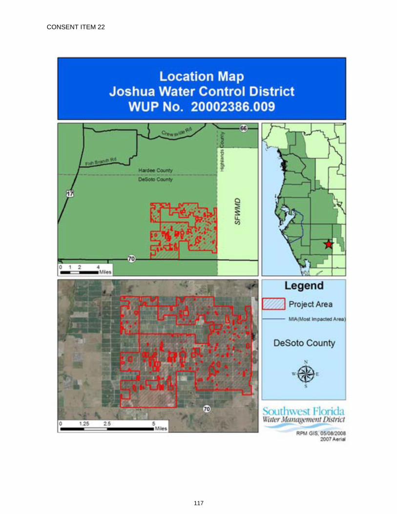
CONSENT ITEM 22
117
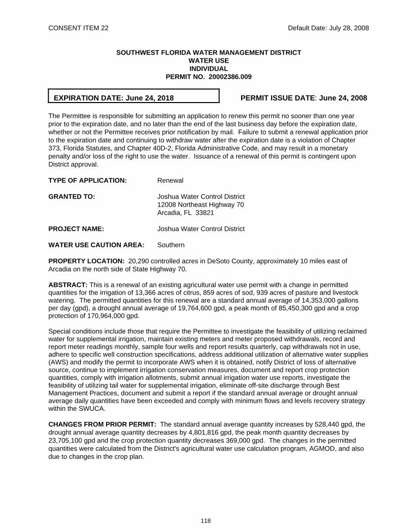
CONSENT ITEM 22 Default Date: July 28, 2008
SOUTHWEST FLORIDA WATER MANAGEMENT DISTRICT WATER USE INDIVIDUAL
PERMIT NO. 20002386.009
EXPIRATION DATE: June 24, 2018 PERMIT ISSUE DATE: June 24, 2008 The Permittee is responsible for submitting an application to renew this permit no sooner than one year prior to the expiration date, and no later than the end of the last business day before the expiration date, whether or not the Permittee receives prior notification by mail. Failure to submit a renewal application prior to the expiration date and continuing to withdraw water after the expiration date is a violation of Chapter 373, Florida Statutes, and Chapter 40D-2, Florida Administrative Code, and may result in a monetary penalty and/or loss of the right to use the water. Issuance of a renewal of this permit is contingent upon District approval.
TYPE OF APPLICATION: Renewal
GRANTED TO: Joshua Water Control District 12008 Northeast Highway 70 Arcadia, FL 33821
PROJECT NAME: Joshua Water Control District
WATER USE CAUTION AREA: Southern
PROPERTY LOCATION: 20,290 controlled acres in DeSoto County, approximately 10 miles east of Arcadia on the north side of State Highway 70.
ABSTRACT: This is a renewal of an existing agricultural water use permit with a change in permitted quantities for the irrigation of 13,366 acres of citrus, 859 acres of sod, 939 acres of pasture and livestock watering. The permitted quantities for this renewal are a standard annual average of 14,353,000 gallons per day (gpd), a drought annual average of 19,764,600 gpd, a peak month of 85,450,300 gpd and a crop protection of 170,964,000 gpd.
Special conditions include those that require the Permittee to investigate the feasibility of utilizing reclaimed water for supplemental irrigation, maintain existing meters and meter proposed withdrawals, record and report meter readings monthly, sample four wells and report results quarterly, cap withdrawals not in use, adhere to specific well construction specifications, address additional utilization of alternative water supplies (AWS) and modify the permit to incorporate AWS when it is obtained, notify District of loss of alternative source, continue to implement irrigation conservation measures, document and report crop protection quantities, comply with irrigation allotments, submit annual irrigation water use reports, investigate the feasibility of utilizing tail water for supplemental irrigation, eliminate off-site discharge through Best Management Practices, document and submit a report if the standard annual average or drought annual average daily quantities have been exceeded and comply with minimum flows and levels recovery strategy within the SWUCA. CHANGES FROM PRIOR PERMIT: The standard annual average quantity increases by 528,440 gpd, the drought annual average quantity decreases by 4,801,816 gpd, the peak month quantity decreases by 23,705,100 gpd and the crop protection quantity decreases 369,000 gpd. The changes in the permitted quantities were calculated from the District's agricultural water use calculation program, AGMOD, and also due to changes in the crop plan.
118
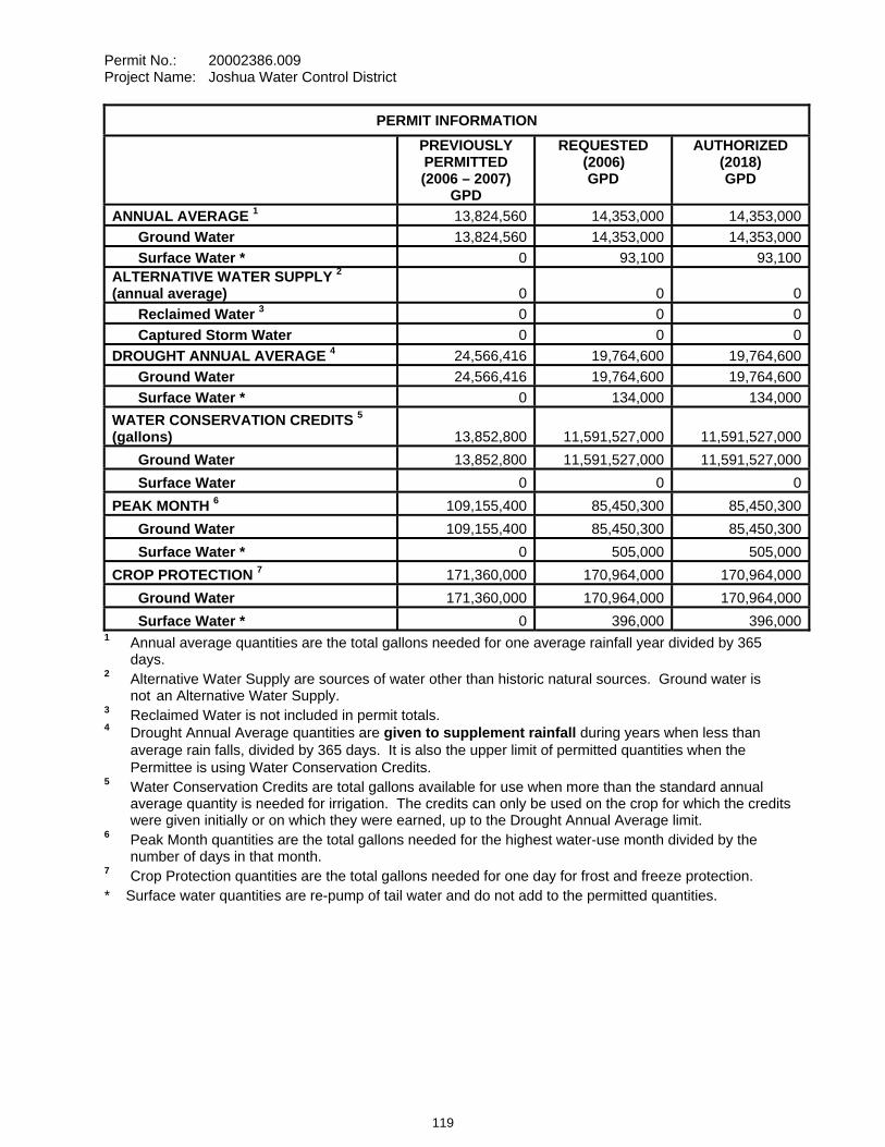
Permit No.: 20002386.009 Project Name: Joshua Water Control District
PERMIT INFORMATION PREVIOUSLY
PERMITTED (2006 – 2007)
GPD
REQUESTED (2006) GPD
AUTHORIZED (2018) GPD
ANNUAL AVERAGE 1 13,824,560 14,353,000 14,353,000 Ground Water 13,824,560 14,353,000 14,353,000 Surface Water * 0 93,100 93,100ALTERNATIVE WATER SUPPLY 2 (annual average) 0 0 0 Reclaimed Water 3 0 0 0 Captured Storm Water 0 0 0DROUGHT ANNUAL AVERAGE 4 24,566,416 19,764,600 19,764,600 Ground Water 24,566,416 19,764,600 19,764,600 Surface Water * 0 134,000 134,000WATER CONSERVATION CREDITS 5
(gallons) 13,852,800 11,591,527,000 11,591,527,000 Ground Water 13,852,800 11,591,527,000 11,591,527,000 Surface Water 0 0 0PEAK MONTH 6 109,155,400 85,450,300 85,450,300 Ground Water 109,155,400 85,450,300 85,450,300 Surface Water * 0 505,000 505,000CROP PROTECTION 7 171,360,000 170,964,000 170,964,000 Ground Water 171,360,000 170,964,000 170,964,000 Surface Water * 0 396,000 396,000
1 Annual average quantities are the total gallons needed for one average rainfall year divided by 365 days. 2 Alternative Water Supply are sources of water other than historic natural sources. Ground water is
not an Alternative Water Supply. 3 Reclaimed Water is not included in permit totals. 4 Drought Annual Average quantities are given to supplement rainfall during years when less than average rain falls, divided by 365 days. It is also the upper limit of permitted quantities when the Permittee is using Water Conservation Credits. 5 Water Conservation Credits are total gallons available for use when more than the standard annual
average quantity is needed for irrigation. The credits can only be used on the crop for which the credits were given initially or on which they were earned, up to the Drought Annual Average limit.
6 Peak Month quantities are the total gallons needed for the highest water-use month divided by the number of days in that month.
7 Crop Protection quantities are the total gallons needed for one day for frost and freeze protection. * Surface water quantities are re-pump of tail water and do not add to the permitted quantities.
119

Permit No.: 20002386.009 Project Name: Joshua Water Control District
WATER DEMAND PREVIOUSLY PERMITTED (2006 – 2007)
PROJECTED (2018)
AUTHORIZED (2008-2018)
CITRUS – Annual Average Quantity (gpd) 13,206,560 11,976,500 11,976,500 Irrigated Area (acres) 17,367 13,366 13,366 Standard Irrigation Rate (in/yr) 11.80 11.94 11.94 Drought Irrigation Rate (in/yr) 18.60 17.10 17.10SOD - Annual Average Quantity (gpd) 349,400 2,212,400 2,212,400 Irrigated Area (acres) 131 859 859 Standard Irrigation Rate (in/yr) 35.80 30.97 30.97 Drought Irrigation Rate (in/yr) 37.60 34.29 34.29PASTURE - Annual Average Quantity (gpd) 268,600 160,700 160,700 Irrigated Area (acres) 1,570 939 939 Standard Irrigation Rate (in/yr) 2.30 2.30 2.30LIVESTOCK – Annual Average Quantity (gpd) 4,200 2,400 2,400
OTHER – Annual Average Quantity (gpd) 0 1,000 1,000
SPECIAL CONDITIONS:
All conditions referring to approval by the Regulation Department Director, Resource Regulation, shall refer to the Director, Sarasota Regulation Department, Resource Regulation. 1. All reports and data required by conditions of the permit shall be submitted to the District according
to the due dates contained in the specific condition. If the report or data is received on or before the tenth day of the month following data collection, it shall be deemed as a timely submittal. The Permittee may use the District’s website to submit data, plans or reports online. To set up an account, the Permittee can address the request to [email protected]. All mailed reports and data are to be sent to:
Permit Data Section, Regulation Performance Management Department Southwest Florida Water Management District 2379 Broad Street Brooksville, Florida 34604-6899
Submission of plans and reports: Unless submitted online or otherwise indicated in the special condition, the original and two copies of each plan and report, such as conservation plans, environmental analyses, aquifer test results, per capita annual reports, etc. are required.
Submission of data: Unless otherwise indicated in the special condition, an original (no copies) is required for data submittals such as crop report forms, meter readings and/or pumpage, rainfall, water level evapotranspiration, or water quality data.
2. The Permittee shall investigate the feasibility of using reclaimed water as a water source and submit a report describing the feasibility to the Permit Data Section, Regulation Performance Management Department, by Date. The report shall contain an analysis of reclaimed water sources for the area, including the relative location of these sources to the Permittee's property,
120
Permit No.: 20002386.009 Project Name: Joshua Water Control District
the quantity of reclaimed water available, the projected date of availability, costs associated with obtaining the reclaimed water, and an implementation schedule for reuse, if feasible. Infeasibility shall be supported with a detailed explanation.
3. The Permittee shall meter withdrawals from surface waters and/or the ground water resources, and meter readings from each withdrawal facility shall be recorded on a monthly basis within the last week of the month. The meter readings shall be reported to the Permit Data Section, Regulation Performance Management Department on or before the tenth day of the following month. District-supplied scanning forms shall be used to submit the meter readings unless another arrangement for submission of this data has been approved by the District. The following withdrawal facilities shall be metered:
A. Withdrawal facilities that are not yet constructed, District ID Nos. 46, 47, 52, 53, 57, 58, 59, 60, 65, 70, 73, 75, 76, 79, 80, 82, 84, 85 and 86, Permittee ID Nos. J46, J47, J52, J53, J57, J58, J59, J60, J65, J70, J73, J75, J76, J79, J80, J82, J84, J85 and J86 shall be metered within 90 days of completion of construction of the withdrawal.
B. Existing permitted withdrawal facilities shall continue to be metered with non-resettable, totalizing flow meters or other flow measuring devices as approved by the Regulation Department Director, District ID Nos.1, 2, 4, 7, 9, 11, 14, 15, 17, 20, 21, 23, 24, 26, 27, 28, 29, 32, 33, 34, 35, 38, 39, 40, 41, 43, 44, 45, 48, 49, 50, 51, 54, 61, 62, 63, 64, 66, 68, 71, 72, 74, 77, 78, 81, 83 and 87, Permittee ID Nos. J1, J2, J4, J7, J9, J11, J14, J15, J17, J20, J21, J23, J24, J26, J27, J28, J29, J32, J33, J34, J35, J38, J39, J40, J41, J43, J44, J45, J48, J49, J50, J51, J54, J61, J62, J63, J64, J66, J68, J71, J72, J74, J77, J78, J81, J83 and J87.
The meters shall adhere to the following descriptions and shall be installed or maintained as follows:
A. The meters shall be non-resettable, totalizing flow meters that have a totalizer of sufficient magnitude to retain total gallon data for a minimum of the three highest consecutive months permitted quantities. If other measuring devices are proposed, prior to installation, approval shall be obtained in writing from the Regulation Department Director.
B. The Permittee shall report non-use on all metered standby withdrawal facilities on the scanning form or approved alternative reporting method.
C. If a metered withdrawal facility is not used during any given month, the meter report shall be submitted to the District indicating the same meter reading as was submitted the previous month.
D. The flow meters or other approved devices shall have and maintain an accuracy within five percent of the actual flow as installed.
E. Accuracy testing requirements: 1. For newly metered withdrawal points, the flow meter installation shall be designed
for inline field access for meter accuracy testing.
2. The meter shall be tested for accuracy on-site, as installed, every five years beginning from the date of its installation for new meters or from the date of initial issuance of this permit containing the metering condition with an accuracy test requirement for existing meters.
3. The testing frequency will be decreased if the Permittee demonstrates to the satisfaction of the District that a longer period of time for testing is warranted.
4. The test will be accepted by the District only if performed by a person knowledgeable in the testing equipment used.
121
Permit No.: 20002386.009 Project Name: Joshua Water Control District
5. If the actual flow is found to be greater than 5% different from the measured flow, within 30 days, the Permittee shall have the meter re-calibrated, repaired, or replaced, whichever is necessary. Documentation of the test and a certificate of re-calibration, if applicable, shall be submitted within 30 days of each test or re-calibration.
F. The meter shall be installed according to the manufacturer’s instructions for achieving accurate flow to the specifications above, or it shall be installed in a straight length of pipe where there is at least an upstream length equal to ten (10) times the outside pipe diameter and a downstream length equal to two (2) times the outside pipe diameter. Where there is not at least a length of ten diameters upstream available, flow straightening vanes shall be used in the upstream line.
G. Broken or malfunctioning meter: 1. If the meter or other flow measuring device malfunctions or breaks, the Permittee
shall notify the District within 15 days of discovering the malfunction or breakage. 2. The meter must be replaced with a repaired or new meter, subject to the same
specifications given above, within 30 days of the discovery. 3. If the meter is removed from the withdrawal point for any other reason, it shall be
replaced with another meter having the same specifications given above, or the meter shall be reinstalled within 30 days of its removal from the withdrawal. In either event, a fully functioning meter shall not be off the withdrawal point for more than 60 consecutive days.
H. While the meter is not functioning correctly, the Permittee shall keep track of the total amount of time the withdrawal point was used for each month and multiply those minutes times the pump capacity (in gallons per minute) for total gallons. The estimate of the number of gallons used each month during that period shall be submitted on District scanning forms and noted as estimated per instructions on the form. If the data is submitted by another approved method, the fact that it is estimated must be indicated. The reason for the necessity to estimate pumpage shall be reported with the estimate.
I. In the event a new meter is installed to replace a broken meter, it and its installation shall meet the specifications of this condition. The permittee shall notify the District of the replacement with the first submittal of meter readings from the new meter.
4. Water quality samples shall be collected and analyzed, for parameters, and frequency(ies) specified below. Water quality samples from production wells shall be collected whether or not the well is being used, unless infeasible. If sampling is infeasible the Permittee shall indicate the reason for not sampling on the water quality data form. Water quality samples shall be analyzed by a laboratory certified by the Florida Department of Health utilizing the standards and methods applicable to the parameters analyzed and to the water use pursuant to Chapter 64E-1, F.A.C., "Certification of Environmental Testing Laboratories". At a minimum, water quality samples shall be collected after pumping the well at its normal rate for a pumping time specified in the table below, or to a constant temperature, pH, and conductivity. In addition, the Permittee's sampling procedure shall follow the handling and chain of custody procedures designated by the certified laboratory which will undertake the analysis. Any variance in sampling and/or analytical methods shall have prior approval of the Regulation Department Director, Resource Regulation. Reports of the analyses shall be submitted to the Permit Data Section, Regulation Performance Management Department, (using District forms) on or before the tenth day of the following month, and shall include the signature of an authorized representative and certification number of the certified laboratory which undertook the analysis. The parameters and frequency of sampling and analysis may be modified by the Regulation Department Director, Resource Regulation, as necessary to ensure the protection of the resource.
122
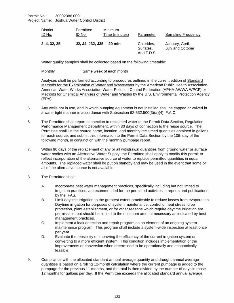
Permit No.: 20002386.009 Project Name: Joshua Water Control District
District Permittee Minimum ID No. ID No. Time (minutes) Parameter Sampling Frequency 2, 4, 32, 35 J2, J4, J32, J35 20 min Chlorides, January, April, Sulfates, July and October And T.D.S.
Water quality samples shall be collected based on the following timetable:
Monthly Same week of each month
Analyses shall be performed according to procedures outlined in the current edition of Standard Methods for the Examination of Water and Wastewater by the American Public Health Association-American Water Works Association-Water Pollution Control Federation (APHA-AWWA-WPCF) or Methods for Chemical Analyses of Water and Wastes by the U.S. Environmental Protection Agency (EPA).
5. Any wells not in use, and in which pumping equipment is not installed shall be capped or valved in a water tight manner in accordance with Subsection 62-532.500(3)(a)(4), F.A.C.
6. The Permittee shall report connection to reclaimed water to the Permit Data Section, Regulation Performance Management Department, within 30 days of connection to the reuse source. The Permittee shall list the source name, location, and monthly reclaimed quantities obtained in gallons, for each source, and submit this information to the Permit Data Section by the 10th day of the following month, in conjunction with the monthly pumpage report.
7. Within 90 days of the replacement of any or all withdrawal quantities from ground water or surface water bodies with an Alternative Water Supply, the Permittee shall apply to modify this permit to reflect incorporation of the alternative source of water to replace permitted quantities in equal amounts. The replaced water shall be put on standby and may be used in the event that some or all of the alternative source is not available.
8. The Permittee shall:
A. Incorporate best water management practices, specifically including but not limited to irrigation practices, as recommended for the permitted activities in reports and publications by the IFAS.
B. Limit daytime irrigation to the greatest extent practicable to reduce losses from evaporation. Daytime irrigation for purposes of system maintenance, control of heat stress, crop protection, plant establishment, or for other reasons which require daytime irrigation are permissible; but should be limited to the minimum amount necessary as indicated by best management practices.
C. Implement a leak detection and repair program as an element of an ongoing system maintenance program. This program shall include a system-wide inspection at least once per year.
D. Evaluate the feasibility of improving the efficiency of the current irrigation system or converting to a more efficient system. This condition includes implementation of the improvements or conversion when determined to be operationally and economically feasible.
9. Compliance with the allocated standard annual average quantity and drought annual average quantities is based on a rolling 12-month calculation where the current pumpage is added to the pumpage for the previous 11 months, and the total is then divided by the number of days in those 12 months for gallons per day. If the Permittee exceeds the allocated standard annual average
123
Permit No.: 20002386.009 Project Name: Joshua Water Control District
quantity or drought annual average quantities during any month, within 30 days the Permittee must submit a report to the District that includes reasons why the allocated quantities were exceeded, efforts already taken to attempt meeting the allocated quantities, and a plan to bring the permit into compliance. Reports for Permittees not achieving the allocated quantities are subject to District approval. Justification for exceeding the allocated quantities does not constitute a waiver of the District's authority to enforce the terms and conditions of the permit.
10. Permittees whose maximum daily permitted water use is 1,000,000 gpd or more shall document and report on District forms, the beginning and ending hours and dates of operation of each withdrawal source used for the protection of crops from frost or freeze damage. The report shall include the gallons per day pumped from each withdrawal source based on irrigation system capacity, or if available, totalizing flow meter readings. This report shall be submitted by the 10th day of the month following irrigation for crop protection. The crop protection daily quantities specified in this permit are solely for the purpose of crop protection, and do not apply to routine irrigation practices. Irrigation for crop protection shall not exceed the crop protection daily quantity listed on the permit and shall not cause water to go to waste.
Even if your maximum daily permitted water use is less than 1,000,000 gpd, please be aware that it is in your best interest to document this usage as described above so that quantities pumped for crop protection can be excluded from the compliance calculation of your annual average use and in the determination of credit amounts.
11. This Permit is located within the Southern Water Use Caution Area (SWUCA). Pursuant to Section 373.0421, Florida Statutes, the SWUCA is subject to a minimum flows and levels recovery strategy, which became effective on January 1, 2007. The Governing Board may amend the recovery strategy, including amending applicable water use permitting rules based on an annual assessment of water resource criteria, cumulative water withdrawal impacts, and on a recurring five-year evaluation of the status of the recovery strategy up to the year 2025 as described in Chapter 40D-80, Florida Administrative Code. This Permit is subject to modification to comply with new rules.
12. The Permittee shall not exceed the quantity determined by multiplying the total irrigated acres by the total allocated acre-inches per irrigated acre per season for each crop type. For all crops except citrus, an irrigated acre, hereafter referred to as "acre," is defined as the gross acreage under cultivation, including areas used for water conveyance such as ditches, but excluding uncultivated areas such as wetlands, retention ponds, and perimeter drainage ditches. For citrus, an irrigated acre is based on 74% shaded area, equivalent to 89.4% of the gross acreage minus uncultivated areas such as wetlands, retention ponds, and perimeter drainage ditches.
An Applicant or Permittee within the Southern Water Use Caution Area may obtain the total allocated acre-inches per acre per season for their crops, plants, soil types, planting dates, and length of growing season by completing the "Irrigation Water Allotment Form" and submitting it to the District. The District will complete and return the form with the calculated total allocated acre-inches and water conserving credit per acre per season per crop, if applicable, based on the information provided. The "Irrigation Water Allotment Form" is available upon request.
13. The Permittee shall record the following information on the appropriate "Irrigation Water Use Form", provided by the District, for each permitted irrigation withdrawal:
A. Items (1) through (7) for seasonal crops (example: vegetables) and nurseries; B. Items (1) through (4) and item (7) for annual crops and plants (example: citrus, pasture,
lawn and landscape); C. Items (1) through (4) and item (8) for golf courses (annual); The list of items are:
124
Permit No.: 20002386.009 Project Name: Joshua Water Control District
1) Crop type; 2) Monthly irrigated acres per crop for seasonal crops; annual irrigated acres for
annual crops (Citrus growers, give total acres; the District will calculate "shaded area" for the groves.)
3) The dominant soil type per crop or the number of acres per crop on that dominant soil type;
4) Irrigation methods;
5) Planting dates (the date the plants are actually placed in the beds, not the date the field is prepared);
6) Season length (in days); 7) Crop protection quantities (total gallons); and 8) Number of acres of tees and greens.
D. Additionally, if used, the following shall be documented separately: 1) Beginning and ending dates of irrigation for field preparation/crop establishment
and supplemental irrigation; 2) Beginning and ending hour and date of each use of quantities for crop protection; 3) Non-irrigation use from irrigation well: Quantities from the withdrawals listed on
these forms that were for other uses not related to irrigation demand. Such uses may include filling of spray tanks, livestock needs, and cleaning equipment and facilities.
4) Use of tailwater recovery.
This information shall be submitted to the Permit Data Section, Regulation Performance Management Department, for irrigation activity during the previous season or year on the appropriate District form according to the following schedule:
Irrigation Water Use Form No. Form Title Submit ByWUP-10 Form 46.20-010 (10/01) Annual Crops March 1
14. By June 1, 2009 the Permittee shall submit a detailed study regarding the feasibility of utilizing a tailwater recovery system on the property for the purposes of irrigation. The report shall address and include:
A. Economic factors, water quality, the total quantity of tailwater available, and other associated considerations; and
B. An implementation schedule for the tailwater reuse, if such use is determined by the Permittee and the District to be feasible.
If the use of a tailwater recovery system is found not to be feasible, information detailing why such an operation is not feasible will be included.
If the use of a tailwater recovery system for irrigation purposes is determined to be feasible by the Permittee and the District, the Permittee shall submit an implementation plan to the Permit Data Section, Regulation Performance Management Department, for review and approval, within 30 days after the feasibility report is approved in writing by the Regulation Department Director, Resource Regulation. The District will require the construction and implementation of the approved tailwater recovery system into the Permittee's irrigation operation within a period of time agreed upon by the District and the Permittee. A modification of the Water Use Permit may be required by the District after approval of the implementation plan.
125
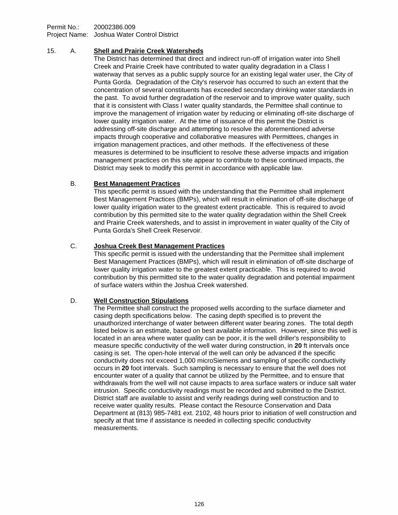
Permit No.: 20002386.009 Project Name: Joshua Water Control District
15. A. Shell and Prairie Creek Watersheds The District has determined that direct and indirect run-off of irrigation water into Shell
Creek and Prairie Creek have contributed to water quality degradation in a Class I waterway that serves as a public supply source for an existing legal water user, the City of Punta Gorda. Degradation of the City's reservoir has occurred to such an extent that the concentration of several constituents has exceeded secondary drinking water standards in the past. To avoid further degradation of the reservoir and to improve water quality, such that it is consistent with Class I water quality standards, the Permittee shall continue to improve the management of irrigation water by reducing or eliminating off-site discharge of lower quality irrigation water. At the time of issuance of this permit the District is addressing off-site discharge and attempting to resolve the aforementioned adverse impacts through cooperative and collaborative measures with Permittees, changes in irrigation management practices, and other methods. If the effectiveness of these measures is determined to be insufficient to resolve these adverse impacts and irrigation management practices on this site appear to contribute to these continued impacts, the District may seek to modify this permit in accordance with applicable law.
B. Best Management Practices This specific permit is issued with the understanding that the Permittee shall implement
Best Management Practices (BMPs), which will result in elimination of off-site discharge of lower quality irrigation water to the greatest extent practicable. This is required to avoid contribution by this permitted site to the water quality degradation within the Shell Creek and Prairie Creek watersheds, and to assist in improvement in water quality of the City of Punta Gorda's Shell Creek Reservoir.
C. Joshua Creek Best Management Practices This specific permit is issued with the understanding that the Permittee shall implement
Best Management Practices (BMPs), which will result in elimination of off-site discharge of lower quality irrigation water to the greatest extent practicable. This is required to avoid contribution by this permitted site to the water quality degradation and potential impairment of surface waters within the Joshua Creek watershed.
D. Well Construction Stipulations The Permittee shall construct the proposed wells according to the surface diameter and
casing depth specifications below. The casing depth specified is to prevent the unauthorized interchange of water between different water bearing zones. The total depth listed below is an estimate, based on best available information. However, since this well is located in an area where water quality can be poor, it is the well driller's responsibility to measure specific conductivity of the well water during construction, in 20 ft intervals once casing is set. The open-hole interval of the well can only be advanced if the specific conductivity does not exceed 1,000 microSiemens and sampling of specific conductivity occurs in 20 foot intervals. Such sampling is necessary to ensure that the well does not encounter water of a quality that cannot be utilized by the Permittee, and to ensure that withdrawals from the well will not cause impacts to area surface waters or induce salt water intrusion. Specific conductivity readings must be recorded and submitted to the District. District staff are available to assist and verify readings during well construction and to receive water quality results. Please contact the Resource Conservation and Data Department at (813) 985-7481 ext. 2102, 48 hours prior to initiation of well construction and specify at that time if assistance is needed in collecting specific conductivity measurements.
126
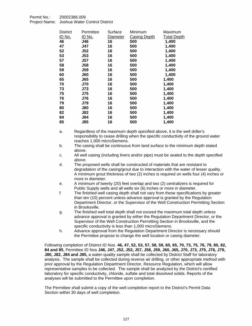
Permit No.: 20002386.009 Project Name: Joshua Water Control District
District Permittee Surface Minimum Maximum ID No. ID No. Diameter Casing Depth Total Depth46 J46 16 500 1,400 47 J47 16 500 1,400 52 J52 16 500 1,400 53 J53 16 500 1,400 57 J57 16 500 1,400 58 J58 16 500 1,400 59 J59 16 500 1,400 60 J60 16 500 1,400 65 J65 16 500 1,400 70 J70 16 500 1,400 73 J73 16 500 1,400 75 J75 16 500 1,400 76 J76 16 500 1,400 79 J79 16 500 1,400 80 J80 16 500 1,400 82 J82 16 500 1,400 84 J84 16 500 1,400 85 J85 16 500 1,400
a. Regardless of the maximum depth specified above, it is the well driller's
responsibility to cease drilling when the specific conductivity of the ground water reaches 1,000 microSiemens.
b. The casing shall be continuous from land surface to the minimum depth stated above.
c. All well casing (including liners and/or pipe) must be sealed to the depth specified above.
d. The proposed wells shall be constructed of materials that are resistant to degradation of the casing/grout due to interaction with the water of lesser quality. A minimum grout thickness of two (2) inches is required on wells four (4) inches or more in diameter.
e. A minimum of twenty (20) feet overlap and two (2) centralizers is required for Public Supply wells and all wells six (6) inches or more in diameter.
f. The finished well casing depth shall not vary from these specifications by greater than ten (10) percent unless advance approval is granted by the Regulation Department Director, or the Supervisor of the Well Construction Permitting Section in Brooksville.
g. The finished well total depth shall not exceed the maximum total depth unless advance approval is granted by either the Regulation Department Director, or the Supervisor of the Well Construction Permitting Section in Brooksville, and the specific conductivity is less than 1,000 microSiemens.
h. Advance approval from the Regulation Department Director is necessary should the Permittee propose to change the well location or casing diameter.
Following completion of District ID Nos. 46, 47, 52, 53, 57, 58, 59, 60, 65, 70, 73, 75, 76, 79, 80, 82,84 and 85, Permittee ID Nos J46, J47, J52, J53, J57, J58, J59, J60, J65, J70, J73, J75, J76, J79, J80, J82, J84 and J85, a water-quality sample shall be collected by District Staff for laboratory analysis. The sample shall be collected during reverse air drilling, or other appropriate method with prior approval by the Regulation Department Director, Resource Regulation, which will allow representative samples to be collected. The sample shall be analyzed by the District's certified laboratory for specific conductivity, chloride, sulfate and total dissolved solids. Reports of the analyses will be submitted to the Permittee upon completion.
The Permittee shall submit a copy of the well completion report to the District's Permit Data Section within 30 days of well completion.
127
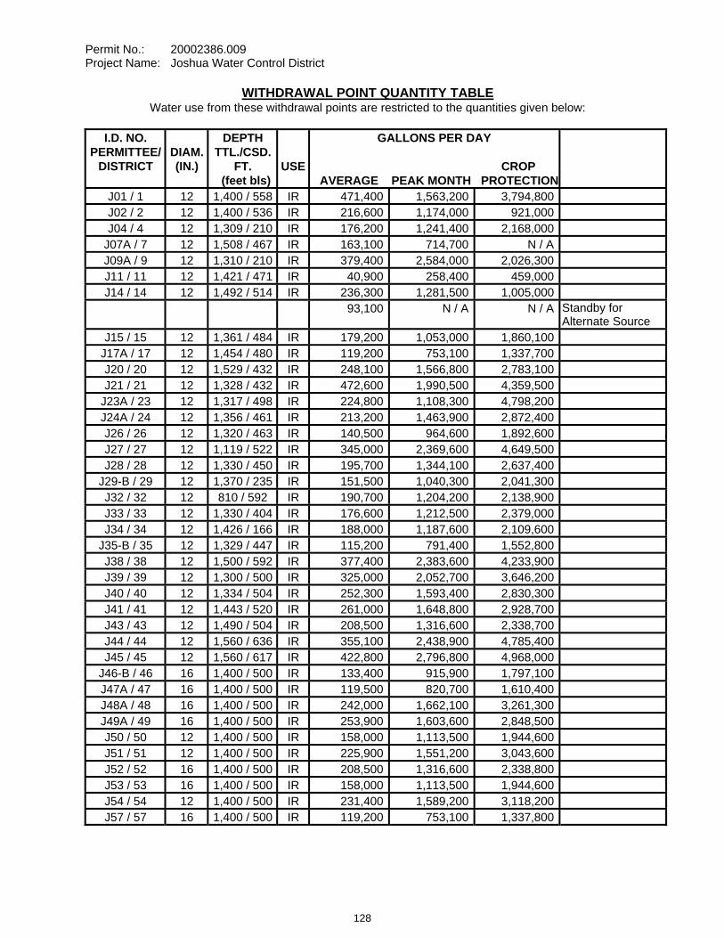
Permit No.: 20002386.009 Project Name: Joshua Water Control District
WITHDRAWAL POINT QUANTITY TABLE Water use from these withdrawal points are restricted to the quantities given below:
I.D. NO. PERMITTEE/
DISTRICT
DIAM. (IN.)
DEPTH TTL./CSD.
FT. (feet bls)
USE
GALLONS PER DAY
CROP AVERAGE PEAK MONTH PROTECTION
J01 / 1 12 1,400 / 558 IR 471,400 1,563,200 3,794,800 J02 / 2 12 1,400 / 536 IR 216,600 1,174,000 921,000 J04 / 4 12 1,309 / 210 IR 176,200 1,241,400 2,168,000
J07A / 7 12 1,508 / 467 IR 163,100 714,700 N / A J09A / 9 12 1,310 / 210 IR 379,400 2,584,000 2,026,300 J11 / 11 12 1,421 / 471 IR 40,900 258,400 459,000 J14 / 14 12 1,492 / 514 IR 236,300 1,281,500 1,005,000
93,100 N / A N / A Standby for Alternate Source
J15 / 15 12 1,361 / 484 IR 179,200 1,053,000 1,860,100 J17A / 17 12 1,454 / 480 IR 119,200 753,100 1,337,700 J20 / 20 12 1,529 / 432 IR 248,100 1,566,800 2,783,100 J21 / 21 12 1,328 / 432 IR 472,600 1,990,500 4,359,500
J23A / 23 12 1,317 / 498 IR 224,800 1,108,300 4,798,200 J24A / 24 12 1,356 / 461 IR 213,200 1,463,900 2,872,400 J26 / 26 12 1,320 / 463 IR 140,500 964,600 1,892,600 J27 / 27 12 1,119 / 522 IR 345,000 2,369,600 4,649,500 J28 / 28 12 1,330 / 450 IR 195,700 1,344,100 2,637,400
J29-B / 29 12 1,370 / 235 IR 151,500 1,040,300 2,041,300 J32 / 32 12 810 / 592 IR 190,700 1,204,200 2,138,900 J33 / 33 12 1,330 / 404 IR 176,600 1,212,500 2,379,000 J34 / 34 12 1,426 / 166 IR 188,000 1,187,600 2,109,600
J35-B / 35 12 1,329 / 447 IR 115,200 791,400 1,552,800 J38 / 38 12 1,500 / 592 IR 377,400 2,383,600 4,233,900 J39 / 39 12 1,300 / 500 IR 325,000 2,052,700 3,646,200 J40 / 40 12 1,334 / 504 IR 252,300 1,593,400 2,830,300 J41 / 41 12 1,443 / 520 IR 261,000 1,648,800 2,928,700 J43 / 43 12 1,490 / 504 IR 208,500 1,316,600 2,338,700 J44 / 44 12 1,560 / 636 IR 355,100 2,438,900 4,785,400 J45 / 45 12 1,560 / 617 IR 422,800 2,796,800 4,968,000
J46-B / 46 16 1,400 / 500 IR 133,400 915,900 1,797,100 J47A / 47 16 1,400 / 500 IR 119,500 820,700 1,610,400 J48A / 48 16 1,400 / 500 IR 242,000 1,662,100 3,261,300 J49A / 49 16 1,400 / 500 IR 253,900 1,603,600 2,848,500 J50 / 50 12 1,400 / 500 IR 158,000 1,113,500 1,944,600 J51 / 51 12 1,400 / 500 IR 225,900 1,551,200 3,043,600 J52 / 52 16 1,400 / 500 IR 208,500 1,316,600 2,338,800 J53 / 53 16 1,400 / 500 IR 158,000 1,113,500 1,944,600 J54 / 54 12 1,400 / 500 IR 231,400 1,589,200 3,118,200 J57 / 57 16 1,400 / 500 IR 119,200 753,100 1,337,800
128
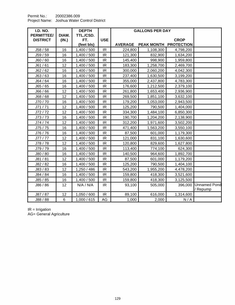
Permit No.: 20002386.009 Project Name: Joshua Water Control District
I.D. NO. PERMITTEE/
DISTRICT
DIAM. (IN.)
DEPTH TTL./CSD.
FT. (feet bls)
USE
GALLONS PER DAY
CROP AVERAGE PEAK MONTH PROTECTION
J58 / 58 16 1,400 / 500 IR 224,800 1,108,300 4,798,200J59 / 59 16 1,400 / 500 IR 121,300 832,900 1,634,200J60 / 60 16 1,400 / 500 IR 145,400 998,900 1,959,800J61 / 61 12 1,400 / 500 IR 183,300 1,258,700 2,469,700J62 / 62 16 1,400 / 500 IR 300,000 2,060,200 4,042,300J63 / 63 16 1,400 / 500 IR 237,400 1,630,500 3,199,200J64 / 64 16 1,400 / 500 IR 355,000 2,437,800 4,783,300J65 / 65 16 1,400 / 500 IR 176,600 1,212,500 2,379,100J66 / 66 12 1,400 / 500 IR 261,800 1,653,400 2,936,900J68 / 68 12 1,400 / 500 IR 269,500 1,851,100 3,632,100J70 / 70 16 1,400 / 500 IR 179,200 1,053,000 2,943,500J71 / 71 12 1,400 / 500 IR 125,200 790,500 1,404,000J72 / 72 12 1,400 / 500 IR 334,300 1,484,100 6,850,300J73 / 73 16 1,400 / 500 IR 190,700 1,204,200 2,138,900J74 / 74 12 1,400 / 500 IR 312,200 1,971,600 3,502,200J75 / 75 16 1,400 / 500 IR 471,400 1,563,200 3,550,100J76 / 76 16 1,400 / 500 IR 87,500 601,000 1,179,300J77 / 77 12 1,400 / 500 IR 121,000 831,100 1,630,600J78 / 78 12 1,400 / 500 IR 120,800 829,600 1,627,800J79 / 79 16 1,400 / 500 IR 113,400 774,100 624,300J80 / 80 16 1,400 / 500 IR 140,500 964,600 1,892,700J81 / 81 12 1,400 / 500 IR 87,500 601,000 1,179,200J82 / 82 16 1,400 / 500 IR 125,200 790,500 1,404,100J83 / 83 12 1,250 / 486 IR 543,200 1,955,200 4,478,200J84 / 84 16 1,400 / 500 IR 159,800 418,300 3,521,600J85 / 85 16 1,400 / 500 IR 159,800 418,300 3,125,500J86 / 86 12 N/A / N/A IR 93,100 505,000 396,000 Unnamed Pond
/ Repump J87 / 87 12 1,050 / 600 IR 89,100 616,000 1,314,600J88 / 88 6 1,000 / 615 AG 1,000 2,000 N / A
IR = Irrigation AG= General Agriculture
129
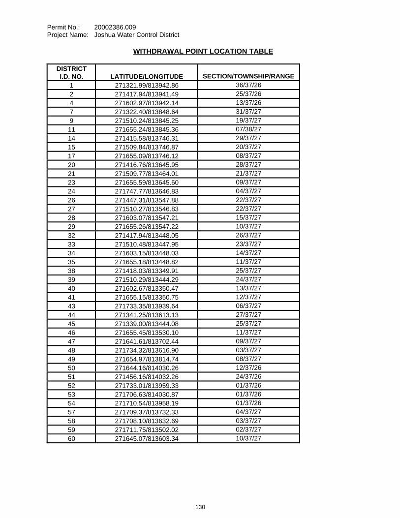
Permit No.: 20002386.009 Project Name: Joshua Water Control District
WITHDRAWAL POINT LOCATION TABLE
DISTRICT I.D. NO.
LATITUDE/LONGITUDE
SECTION/TOWNSHIP/RANGE
1 271321.99/813942.86 36/37/262 271417.94/813941.49 25/37/264 271602.97/813942.14 13/37/267 271322.40/813848.64 31/37/279 271510.24/813845.25 19/37/2711 271655.24/813845.36 07/38/2714 271415.58/813746.31 29/37/2715 271509.84/813746.87 20/37/2717 271655.09/813746.12 08/37/2720 271416.76/813645.95 28/37/2721 271509.77/813464.01 21/37/2723 271655.59/813645.60 09/37/2724 271747.77/813646.83 04/37/2726 271447.31/813547.88 22/37/2727 271510.27/813546.83 22/37/2728 271603.07/813547.21 15/37/2729 271655.26/813547.22 10/37/2732 271417.94/813448.05 26/37/2733 271510.48/813447.95 23/37/2734 271603.15/813448.03 14/37/2735 271655.18/813448.82 11/37/2738 271418.03/813349.91 25/37/2739 271510.29/813444.29 24/37/2740 271602.67/813350.47 13/37/2741 271655.15/813350.75 12/37/2743 271733.35/813939.64 06/37/2744 271341.25/813613.13 27/37/2745 271339.00/813444.08 25/37/2746 271655.45/813530.10 11/37/2747 271641.61/813702.44 09/37/2748 271734.32/813616.90 03/37/2749 271654.97/813814.74 08/37/2750 271644.16/814030.26 12/37/2651 271456.16/814032.26 24/37/2652 271733.01/813959.33 01/37/2653 271706.63/814030.87 01/37/2654 271710.54/813958.19 01/37/2657 271709.37/813732.33 04/37/2758 271708.10/813632.69 03/37/2759 271711.75/813502.02 02/37/2760 271645.07/813603.34 10/37/27
130
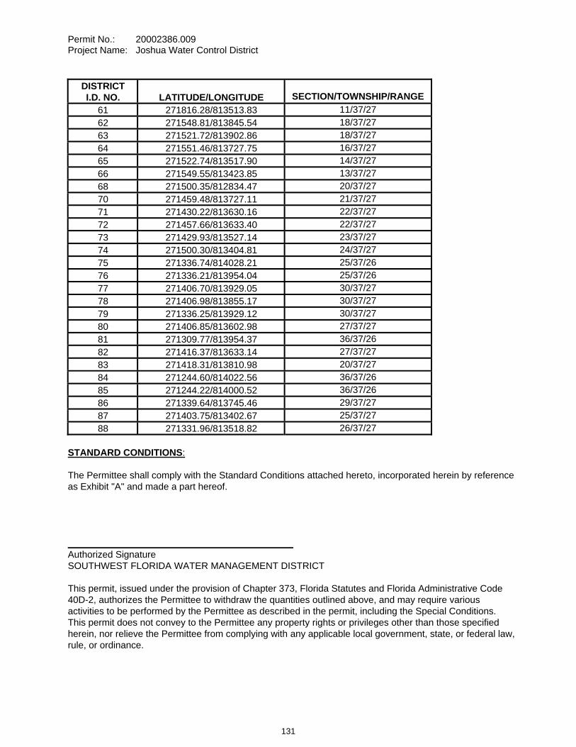
Permit No.: 20002386.009 Project Name: Joshua Water Control District
DISTRICT I.D. NO.
LATITUDE/LONGITUDE
SECTION/TOWNSHIP/RANGE
61 271816.28/813513.83 11/37/2762 271548.81/813845.54 18/37/2763 271521.72/813902.86 18/37/2764 271551.46/813727.75 16/37/2765 271522.74/813517.90 14/37/2766 271549.55/813423.85 13/37/2768 271500.35/812834.47 20/37/2770 271459.48/813727.11 21/37/2771 271430.22/813630.16 22/37/2772 271457.66/813633.40 22/37/2773 271429.93/813527.14 23/37/2774 271500.30/813404.81 24/37/2775 271336.74/814028.21 25/37/2676 271336.21/813954.04 25/37/2677 271406.70/813929.05 30/37/2778 271406.98/813855.17 30/37/2779 271336.25/813929.12 30/37/2780 271406.85/813602.98 27/37/2781 271309.77/813954.37 36/37/2682 271416.37/813633.14 27/37/2783 271418.31/813810.98 20/37/2784 271244.60/814022.56 36/37/2685 271244.22/814000.52 36/37/2686 271339.64/813745.46 29/37/2787 271403.75/813402.67 25/37/2788 271331.96/813518.82 26/37/27
STANDARD CONDITIONS:
The Permittee shall comply with the Standard Conditions attached hereto, incorporated herein by reference as Exhibit "A" and made a part hereof.
___________________________________________ Authorized Signature SOUTHWEST FLORIDA WATER MANAGEMENT DISTRICT
This permit, issued under the provision of Chapter 373, Florida Statutes and Florida Administrative Code 40D-2, authorizes the Permittee to withdraw the quantities outlined above, and may require various activities to be performed by the Permittee as described in the permit, including the Special Conditions. This permit does not convey to the Permittee any property rights or privileges other than those specified herein, nor relieve the Permittee from complying with any applicable local government, state, or federal law, rule, or ordinance.
131
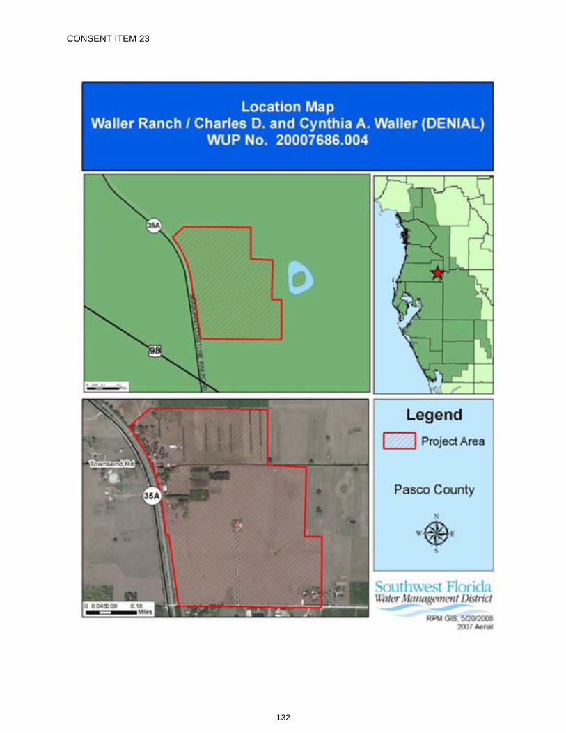
CONSENT ITEM 23
132
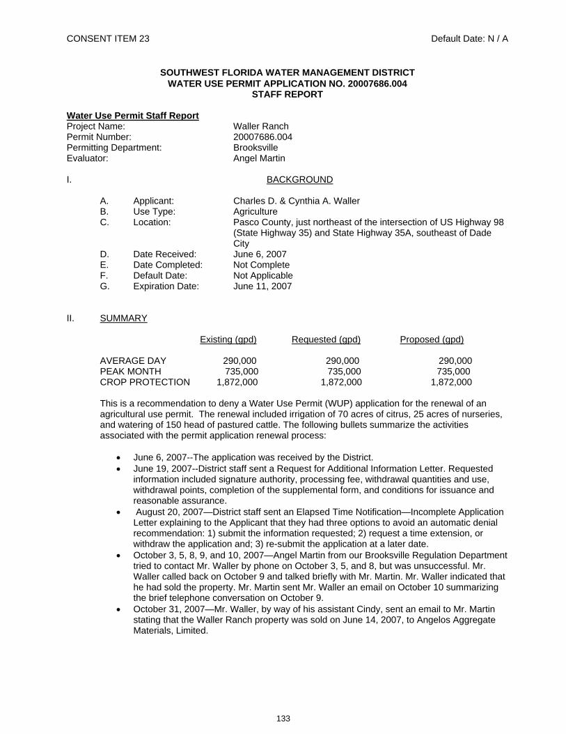
CONSENT ITEM 23 Default Date: N / A
SOUTHWEST FLORIDA WATER MANAGEMENT DISTRICT WATER USE PERMIT APPLICATION NO. 20007686.004
STAFF REPORT Water Use Permit Staff Report Project Name: Waller Ranch Permit Number: 20007686.004 Permitting Department: Brooksville Evaluator: Angel Martin
I. BACKGROUND
A. Applicant: Charles D. & Cynthia A. Waller B. Use Type: Agriculture C. Location: Pasco County, just northeast of the intersection of US Highway 98
(State Highway 35) and State Highway 35A, southeast of Dade City
D. Date Received: June 6, 2007 E. Date Completed: Not Complete F. Default Date: Not Applicable G. Expiration Date: June 11, 2007
II. SUMMARY
Existing (gpd) Requested (gpd) Proposed (gpd)
AVERAGE DAY 290,000 290,000 290,000 PEAK MONTH 735,000 735,000 735,000 CROP PROTECTION 1,872,000 1,872,000 1,872,000
This is a recommendation to deny a Water Use Permit (WUP) application for the renewal of an agricultural use permit. The renewal included irrigation of 70 acres of citrus, 25 acres of nurseries, and watering of 150 head of pastured cattle. The following bullets summarize the activities associated with the permit application renewal process:
June 6, 2007--The application was received by the District. June 19, 2007--District staff sent a Request for Additional Information Letter. Requested
information included signature authority, processing fee, withdrawal quantities and use, withdrawal points, completion of the supplemental form, and conditions for issuance and reasonable assurance.
August 20, 2007—District staff sent an Elapsed Time Notification—Incomplete Application Letter explaining to the Applicant that they had three options to avoid an automatic denial recommendation: 1) submit the information requested; 2) request a time extension, or withdraw the application and; 3) re-submit the application at a later date.
October 3, 5, 8, 9, and 10, 2007—Angel Martin from our Brooksville Regulation Department tried to contact Mr. Waller by phone on October 3, 5, and 8, but was unsuccessful. Mr. Waller called back on October 9 and talked briefly with Mr. Martin. Mr. Waller indicated that he had sold the property. Mr. Martin sent Mr. Waller an email on October 10 summarizing the brief telephone conversation on October 9.
October 31, 2007—Mr. Waller, by way of his assistant Cindy, sent an email to Mr. Martin stating that the Waller Ranch property was sold on June 14, 2007, to Angelos Aggregate Materials, Limited.
133
Permit No.: 20007686.004 Project Name: Waller Ranch (DENIAL) / Charles D. and Cynthia A. Waller
March 2008—Robert Jaques from our Brooksville Regulation Department contacted Angelo's Aggregate Materials Limited and discussed the permitting issues with them.
April 16, 2008 ---Robert Jaques sent an Activity Without a Water Use Permit letter to Angelo's Aggregate Materials Limited explaining the permitting issues.
May 20, 2008—Jim Marshall from our Brooksville Regulation Department made a field visit to the site and found that the wells were in operation.
May 20, 2008—John Arnold, engineer for Angelos Aggregates, called Angel Martin inquiring about the permit status. Mr. Martin informed Mr. Arnold that there was no current permit at the site and that Angelos Aggregates had to apply for a new permit. Mr. Martin explained the permitting process and requirements. Mr. Arnold said that he would talk to officials at Angelos Aggregates to determine how to proceed with filing a new permit application.
III. RULE CRITERIA
Chapter 40D-2, Florida Administrative Code (F.A.C.), sets forth the conditions for issuance of a Water Use Permit. An Applicant must demonstrate that the water use is reasonable and beneficial, is in the public interest, and will not interfere with any existing legal use of water, by providing reasonable assurances, that the water use meets the criteria set forth in Subsections 40D-1.607(7), Rules 40D-1.1020, 40D-2.091, 40D-2.101, 40D-2.301, 40D-2.801, and the Basis of Review. A discussion of each of the criterion not met as it pertains to the application is provided below.
1. The Applicant has not provided documentation which supports that the withdrawals will not cause quantity or quality changes that adversely impact the water resources, including both surface and groundwater resources [Rule 40D-2.091, Section 4.0, of the Basis of Review, and Subsection 40D-2.301(1)].
2. The Applicant has not provided documentation which supports that the withdrawals will not interfere with a reservation of water as forth in Rule 40D-2.302, F.A.C. [Rule 40D-2.091, Section 4.0, Basis of Review, and Subsection 40D-2.301(1)].
3. The Applicant has not provided documentation which supports that the withdrawals will comply with the provisions of 4.3 of the Basis of Review described in Rule 40D-2.091, F.A.C. [Rule 40D-2.091, Section 4.0, Basis of Review, and Subsection 40D-2.301(1)].
4. The Applicant has not provided documentation which supports that the withdrawals will not otherwise be harmful to the water resources within the District. [Rule 40D-2.091, Section 4.0, Basis of Review, and Rule 40D-2.301(1)].
IV. RECOMMENDATION
Approval
X Denial according to Chapters 40D-1 and 40D-2, Florida` Administrative Code and Section 120.60, Florida Statutes.
Application Reviewed By:
______________________________ Date:___________________ Angel Martin.
______________________________ Date____________________ Paul M. Williams, P.G., Water Use Regulation Manager
134
The following Standard Conditions are included on all Water Use Permits issued pursuant to 40D-2, Florida
Administrative Code.
135
40D-2Exhibit "A"
WATER USE PERMIT STANDARD CONDITIONS 1. If any of the statements in the application and in the supporting data are found to be untrue and
inaccurate, or if the Permittee fails to comply with all of the provisions of Chapter 373, F.S., Chapter 40D, or the conditions set forth herein, the Governing Board shall revoke this permit in accordance with Rule 40D-2.341, following notice and hearing.
2. This permit is issued based on information provided by the Permittee demonstrating that the use of water is reasonable and beneficial, consistent with the public interest, and will not interfere with any existing legal use of water. If, during the term of the permit, it is determined by the District that the use is not reasonable and beneficial, in the public interest, or does impact an existing legal use of water, the Governing Board shall modify this permit or shall revoke this permit following notice and hearing.
3. The Permittee shall not deviate from any of the terms or conditions of this permit without written approval by the District.
4. In the event the District declares that a Water Shortage exists pursuant to Chapter 40D-21, the District shall alter, modify, or declare inactive all or parts of this permit as necessary to address the water shortage.
5. The District shall collect water samples from any withdrawal point listed in the permit or shall require the Permittee to submit water samples when the District determines there is a potential for adverse impacts to water quality.
6. The Permittee shall provide access to an authorized District representative to enter the property at any reasonable time to inspect the facility and make environmental or hydrologic assessments. The Permittee shall either accompany District staff onto the property or make provision for access onto the property.
7. Issuance of this permit does not exempt the Permittee from any other District permitting requirements.
8. The Permittee shall cease or reduce surface water withdrawal as directed by the District if water levels in lakes fall below applicable minimum water level established in Chapter 40D-8 or rates of flow in streams fall below the minimum levels established in Chapter 40D-8.
9. The Permittee shall cease or reduce withdrawal as directed by the District if water levels in aquifers fall below the minimum levels established by the Governing Board.
10. The Permittee shall practice water conservation to increase the efficiency of transport, application, and use, as well as to decrease waste and to minimize runoff from the property. At such time as the Governing Board adopts specific conservation requirements for the Permittee's water use classification, this permit shall be subject to those requirements upon notice and after a reasonable period for compliance.
11. The District may establish special regulations for Water Use Caution Areas. At such time as the Governing Board adopts such provisions, this permit shall be subject to them upon notice and after a reasonable period for compliance.
136
12. The Permittee shall mitigate any adverse impact to existing legal uses caused by withdrawals. When adverse impacts occur or are imminent, the District shall require the Permittee to mitigate the impacts. Adverse impacts include:
A. A reduction in water levels which impairs the ability of the well to produce water; B. Significant reduction in levels or flows in water bodies such as lakes, impoundments,
wetlands, springs, streams or other watercourses; or C. Significant inducement of natural or manmade contaminants into a water supply or into a
usable portion of any aquifer water body.
13. The Permittee shall mitigate any adverse impact to environmental features or offsite land uses as a result of withdrawals. When adverse impacts occur or are imminent, the District shall require the Permittee to mitigate the impacts. Adverse impacts include:
A. Significant reduction in levels or flows in water bodies such as lakes, impoundments, wetlands, springs, streams or other watercourses;
B. Sinkholes or subsidence caused by reduction in water levels; C. Damage to crops and other vegetation causing financial harm to the owner; and D. Damage to the habitat of endangered or threatened species.
14. When necessary to analyze impacts to the water resource or existing users, the District shall require the Permittee to install flow metering or other measuring devices to record withdrawal quantities and submit the data to the District.
15. A District identification tag shall be prominently displayed at each withdrawal point by permanently affixing the tag to the withdrawal facility.
16. Notwithstanding the provisions of Rule 40D-1.6105, F.A.C., persons who wish to continue the water use permitted herein and who have acquired ownership or legal control of permitted water withdrawal facilities or the land on which the facilities are located must apply to transfer the permit to themselves within 45 days of acquiring ownership or legal control of the water withdrawal facilities or the land.
17. All permits issued pursuant to these Rules are contingent upon continued ownership or legal control of all property on which pumps, wells, diversions or other water withdrawal facilities are located.
18. Within the Southern Water Use Caution Area, if the District determines that significant water quantity or quality changes, impacts to existing legal uses, or adverse environmental impacts are occurring, the Board, upon reasonable notice to the permittee, including a statement of facts upon which the District based its determination, may reconsider the quantities permitted or other conditions of the permit as appropriate to address the change or impact but only after an opportunity for the permittee to resolve or mitigate the change or impact or to request a hearing.
R. 08/08/2007
137
Item 24
Consent Agenda June 24, 2008
Regulation Committee -- Other
Approve Initiation of Rulemaking to Amend Section 1.7.23 of the Environmental Resource Permit (ERP) Basis of Review (BOR) and Appendix 5 of the ERP BOR to Maintain Protection for the Bald Eagle The District’s ERP rules afford particular protection to certain aquatic and wetland dependent wildlife species that have been classified by the Florida Fish and Wildlife Conservation Commission (FWC) as endangered, threatened or a species of special concern. These protections include protecting the existing upland nesting and denning habitat for such species because uplands serve a critical role in these species’ life cycles. Specifically, Section 3.2.7(b), BOR, requires an applicant to provide reasonable assurance that the construction, alteration, and intended or reasonably expected uses of a proposed surface water management system will not adversely impact the ecological value of uplands to these animal species for enabling existing nesting or denning. Appendix 5 then identifies these species by name. Currently, this table includes the Bald Eagle as a threatened species.
The FWC, at it's meeting on April 9, 2008, accepted recommendations that the Bald Eagle be removed from Florida's list of wildlife species that are classified as threatened. Concerned that a stable or increasing population of Bald Eagles is maintained throughout Florida, the FWC also approved a Bald Eagle Management Plan, which is incorporated by reference in new rules for non-listed nongame birds that are specific to the Bald Eagle (68A-16.002, F.A.C.). This plan acknowledges the need for continued protection of upland nesting habitat and that implementation will require the cooperation of local, state, and federal governmental agencies; non-governmental organizations; business, agricultural, and forestry interests; universities; and the public.
Although the Bald Eagle is no longer classified as threatened in Florida, protection is continued under the Bald and Golden Eagle Protection Act (Eagle Act), a federal law. The Eagle Act prohibits a "take" of any Bald Eagle or of any Bald Eagle part, egg or nest except as authorized by federal regulations. The term “take” covers a broad range of actions including those that disturb an eagle. "Disturb" is to agitate or bother a Bald Eagle “to a degree that causes or is likely to cause (1) injury to an eagle, (2) a decrease in its productivity, by substantially interfering with normal breeding, feeding, or sheltering behavior, or (3) nest abandonment, by substantially interfering with normal breeding, feeding, or sheltering behavior.” The new FWC rules specific to the Bald Eagle defines disturb in the same way.
Given the acknowledged importance of uplands to the Bald Eagle for nesting and, thus, to its survival, and the continuing protections afforded the Bald Eagle by the Eagle Act, it is proposed that the existing upland nesting habitat of Bald Eagles continue to be protected under the District’s ERP rule. To accomplish this goal, staff is recommending that the definition of “listed species” be amended to specifically include the Bald Eagle. The remaining amendments update rule and statutory references to listed wildlife and plants in the definition of “listed species,” and reflect that the Bald Eagle is no longer classified by FWC as a threatened species in Florida.
138
Item 24 If the initiation of rulemaking is approved, the attached draft rule language will be provided to the members of the Environmental Resource Permitting Advisory Groups and the District's Environmental Advisory Committee. If no substantive comments are received, District staff will proceed with the proposed rule changes without further Governing Board action.
Staff Recommendation: See Exhibit
Approve staff's request to initiate rulemaking, approve the proposed rule language and authorize staff to complete the rulemaking process, provided no substantive comments are received requesting changes to the proposed rules.
Presenter: H. Clark Hull, Jr., ERP Program Director, Regulation Performance Management
139
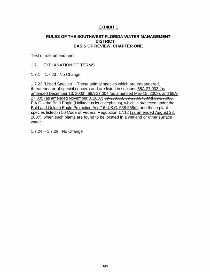
EXHIBIT 1
RULES OF THE SOUTHWEST FLORIDA WATER MANAGEMENT DISTRICT
BASIS OF REVIEW, CHAPTER ONE
Text of rule amendment:
1.7 EXPLANATION OF TERMS
1.7.1 – 1.7.23 No Change
1.7.23 "Listed Species" - Those animal species which are endangered, threatened or of special concern and are listed in sections 68A-27.003 (as amended December 13, 2003), 68A-27.004 (as amended May 15, 2008), and 68A-27.005 (as amended November 8, 2007) 39-27.003, 39-27.004, and 39-27.005,F.A.C.;, the Bald Eagle (Haliaeetus leucocephalus), which is protected under the Bald and Golden Eagle Protection Act (16 U.S.C. 668-668d); and those plant species listed in 50 Code of Federal Regulation 17.12 (as amended August 28, 2007), when such plants are found to be located in a wetland or other surface water.
1.7.24 – 1.7.29 No Change
140
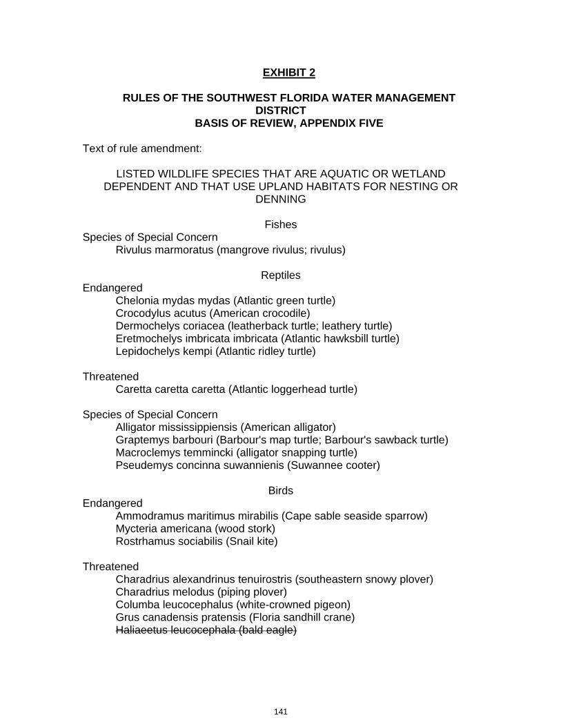
EXHIBIT 2
RULES OF THE SOUTHWEST FLORIDA WATER MANAGEMENT DISTRICT
BASIS OF REVIEW, APPENDIX FIVE
Text of rule amendment:
LISTED WILDLIFE SPECIES THAT ARE AQUATIC OR WETLAND DEPENDENT AND THAT USE UPLAND HABITATS FOR NESTING OR
DENNING
FishesSpecies of Special Concern
Rivulus marmoratus (mangrove rivulus; rivulus)
ReptilesEndangered
Chelonia mydas mydas (Atlantic green turtle) Crocodylus acutus (American crocodile) Dermochelys coriacea (leatherback turtle; leathery turtle) Eretmochelys imbricata imbricata (Atlantic hawksbill turtle) Lepidochelys kempi (Atlantic ridley turtle)
ThreatenedCaretta caretta caretta (Atlantic loggerhead turtle)
Species of Special Concern Alligator mississippiensis (American alligator) Graptemys barbouri (Barbour's map turtle; Barbour's sawback turtle) Macroclemys temmincki (alligator snapping turtle) Pseudemys concinna suwannienis (Suwannee cooter)
BirdsEndangered
Ammodramus maritimus mirabilis (Cape sable seaside sparrow) Mycteria americana (wood stork) Rostrhamus sociabilis (Snail kite)
ThreatenedCharadrius alexandrinus tenuirostris (southeastern snowy plover) Charadrius melodus (piping plover) Columba leucocephalus (white-crowned pigeon) Grus canadensis pratensis (Floria sandhill crane) Haliaeetus leucocephala (bald eagle)
141
Picoides borealis (red-cockaded woodpecker) ONLY IN LEE, COLLIER ANDCHARLOTTE COUNTIES. Sterna antillarum (least tern) Sterna dougallii (roseate tern) Polyborus plancus audubonii (Audubon's crested caracara)
Species of Special Concern Ajaia ajaia (roseate spoonbill) Ammodramus maritumus juncicolus (Wakulla seaside sparrow) Ammodramus maritimus peninsulae (Scott's seaside sparrow) Aramus quarauna (limpkin) Cistothorus palustris griseus (Worthington's marsh wren) Cistothorus palustris marianae (Marian's marsh wren) Egretta caerulea (little blue heron) Egretta rufescens (reddish egret) Egretta thula (snowy egret) Egretta tricolor (tricolored heron; Louisiana heron) Haematopus palliatus (American oystercatcher) Pandion haliaetus (osprey) ONLY IN MONROE COUNTY. Pelecanus occidentalis (brown pelican) Rhynchops niger (black skimmer)
OtherHaliaeetus leucocephalus (bald eagle)
MammalsEndangered
Felis concolor coryi (Florida panther) Microtus pennsylvanicus dukecambelli (Duke's saltmarsh vole; Florida saltmarshvole)Myotis grisescens (gray bat) Myotis sodalis (Indiana bat) Odocoileus virginianus clavium (Key deer; toy deer) Oryzomys agentatus (silver rice rat)
ThreatenedMustela vison evergadensis (Everglades mink) Sciurus niger avicennia (Big Cypress fox squirrel; mangrove fox squirrel) Ursus americanus floridanus (Florida black bear)
Species of Special Concern Orytzomys palustris sanibeli (Sanibel Island rice rat) Sorex longirostris eionis (Homosassa shrew)
142
EXHIBIT 3
RULES OF THE SOUTHWEST FLORIDA WATER MANAGEMENT DISTRICT
CHAPTER 40D-4 INDIVIDUAL ENVIRONMENTAL RESOURCE PERMITS
Text of rule amendment:
40D-4.091 Publications and Agreements Incorporated by Reference. The following documents are hereby incorporated into this chapter and Chapters 40D-40 and 40D-400, F.A.C.:
(1) Environmental Resource Permitting Information Manual Part B, Basis of Review, Environmental Resource Permit Applications within the Southwest Florida Water Management District, __________ May 20, 2008. This document is available from the District upon request.
(2) – (5) No Change
143
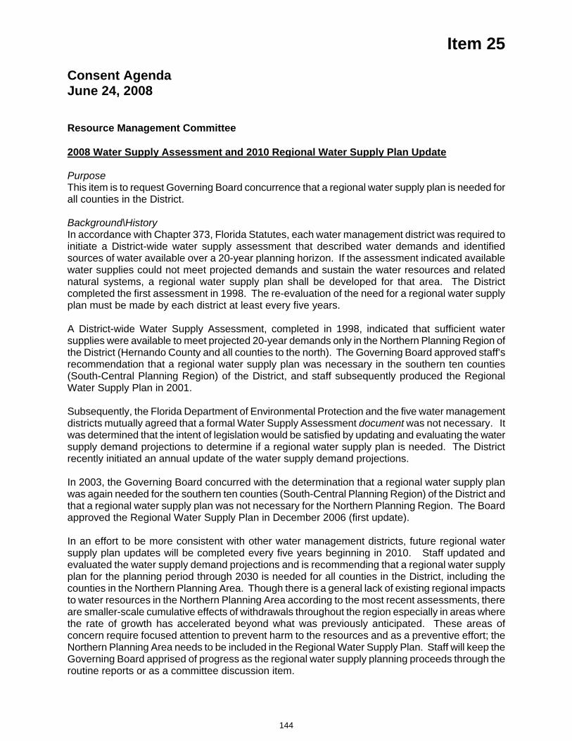
Item 25
Consent Agenda June 24, 2008
Resource Management Committee 2008 Water Supply Assessment and 2010 Regional Water Supply Plan Update
PurposeThis item is to request Governing Board concurrence that a regional water supply plan is needed for all counties in the District.
Background\HistoryIn accordance with Chapter 373, Florida Statutes, each water management district was required to initiate a District-wide water supply assessment that described water demands and identified sources of water available over a 20-year planning horizon. If the assessment indicated available water supplies could not meet projected demands and sustain the water resources and related natural systems, a regional water supply plan shall be developed for that area. The District completed the first assessment in 1998. The re-evaluation of the need for a regional water supply plan must be made by each district at least every five years.
A District-wide Water Supply Assessment, completed in 1998, indicated that sufficient water supplies were available to meet projected 20-year demands only in the Northern Planning Region of the District (Hernando County and all counties to the north). The Governing Board approved staff’s recommendation that a regional water supply plan was necessary in the southern ten counties (South-Central Planning Region) of the District, and staff subsequently produced the Regional Water Supply Plan in 2001.
Subsequently, the Florida Department of Environmental Protection and the five water management districts mutually agreed that a formal Water Supply Assessment document was not necessary. It was determined that the intent of legislation would be satisfied by updating and evaluating the water supply demand projections to determine if a regional water supply plan is needed. The District recently initiated an annual update of the water supply demand projections.
In 2003, the Governing Board concurred with the determination that a regional water supply plan was again needed for the southern ten counties (South-Central Planning Region) of the District and that a regional water supply plan was not necessary for the Northern Planning Region. The Board approved the Regional Water Supply Plan in December 2006 (first update).
In an effort to be more consistent with other water management districts, future regional water supply plan updates will be completed every five years beginning in 2010. Staff updated and evaluated the water supply demand projections and is recommending that a regional water supply plan for the planning period through 2030 is needed for all counties in the District, including the counties in the Northern Planning Area. Though there is a general lack of existing regional impacts to water resources in the Northern Planning Area according to the most recent assessments, there are smaller-scale cumulative effects of withdrawals throughout the region especially in areas where the rate of growth has accelerated beyond what was previously anticipated. These areas of concern require focused attention to prevent harm to the resources and as a preventive effort; the Northern Planning Area needs to be included in the Regional Water Supply Plan. Staff will keep the Governing Board apprised of progress as the regional water supply planning proceeds through the routine reports or as a committee discussion item.
144
Item 25 With Board approval, staff will begin development of the updated plan and anticipates a draft Regional Water Supply Plan for public comment in April 2010. After opportunities are provided for stakeholder input, primarily through public workshops and the Advisory Committees, the Regional Water Supply Plan will be ready for Board Approval in late 2010.
Staff Recommendation:
Governing Board concurrence in the determination that a regional water supply plan will be prepared (updated) for all the counties located in the District.
Presenter: Lisann C. Morris, Senior Professional Engineer, Resource Projects Department
145
Item 26
Consent Agenda June 24, 2008
Resource Management Committee Appraisals and Purchase/Sale Agreement – Lower Manatee River Floodway Project, SWF Parcel No. 21-602-110
PurposeThe purpose of this item is to request the Governing Board approve the purchase of approximately 43± acres that has been negotiated with the owner, Wilderness Bend, LLC, as part of the District’s and Manatee County's Lower Manatee River Floodway project. A general location map of the parcel is included in the board packet as an exhibit to this item.
Background/HistoryAcquisition of this parcel is consistent with the District’s Florida Forever Work Plan, which specifically identifies the Lower Manatee River Floodway project for acquisition. The Governing Board approved an acquisition and management agreement between the District and Manatee County on February 22, 2005 which calls for the County to manage the properties within the project.
Acquisition of these lands will meet the following Florida Forever program goals: Increase the protection of Florida's biodiversity at the species, natural community and landscape levels
Protect, restore, and maintain the quality and natural functions of land, water and wetland systems of the state
Increase natural resource-based public recreational and educational opportunities
These Florida Forever goals are consistent with the District's goals for water resource management.
Property DescriptionLocation and Access – The parcel is located at the southeast quadrant of Rye and Woodstock Roads, north of SR 64 in Manatee County. Access is provided by approximately 1320 feet of frontage along Woodstock Road. Utilities and/or Improvements – Electric and telephone lines are in the area and available for the property. The Manatee County Planning Department indicated to the appraisers that municipal water and sewer services are located in the subdivision adjacent and south of the subject and there is capacity to extend it.
Zoning –The subject is zoned A (Agriculture). The future land use classification for the subject is UF-3 (Urban Fringe-3). Permitted uses include residential uses, convenience retail uses and professional/personal service uses, and recreation facilities.
Summary of Appraisals and Value Comparisons - In accordance with District policy, two appraisals were obtained for the parcel from Nick Mancuso, with Mancuso Appraisal Services, and Tod Marr, with Marr and Associates. The appraisals were reviewed by Andrew Hupp, with Hupp Realty Advisors. The appraisal reports were prepared on June 29, 2007, meet the necessary legal or District requirements and contain the appraiser’s factual data leading to the value conclusion.
Highest and Best Use – The highest and best use as, determined by the appraisers, based on the physically possible, legally permissible and financially feasible uses for this property, would be to hold the property speculatively until development with a single-family subdivision would be
146
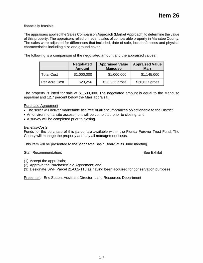
Item 26 financially feasible.
The appraisers applied the Sales Comparison Approach (Market Approach) to determine the value of this property. The appraisers relied on recent sales of comparable property in Manatee County. The sales were adjusted for differences that included, date of sale, location/access and physical characteristics including size and ground cover. The following is a comparison of the negotiated amount and the appraised values:
Negotiated
AmountAppraised Value
Mancuso Appraised Value
Marr Total Cost $1,000,000 $1,000,000 $1,145,000
Per Acre Cost $23,256 $23,256 gross $26,627 gross
The property is listed for sale at $1,500,000. The negotiated amount is equal to the Mancuso appraisal and 12.7 percent below the Marr appraisal.
Purchase Agreement The seller will deliver marketable title free of all encumbrances objectionable to the District; An environmental site assessment will be completed prior to closing; and A survey will be completed prior to closing.
Benefits/CostsFunds for the purchase of this parcel are available within the Florida Forever Trust Fund. The County will manage the property and pay all management costs.
This item will be presented to the Manasota Basin Board at its June meeting.
Staff Recommendation: See Exhibit
(1) Accept the appraisals; (2) Approve the Purchase/Sale Agreement; and (3) Designate SWF Parcel 21-602-110 as having been acquired for conservation purposes.
Presenter: Eric Sutton, Assistant Director, Land Resources Department
147
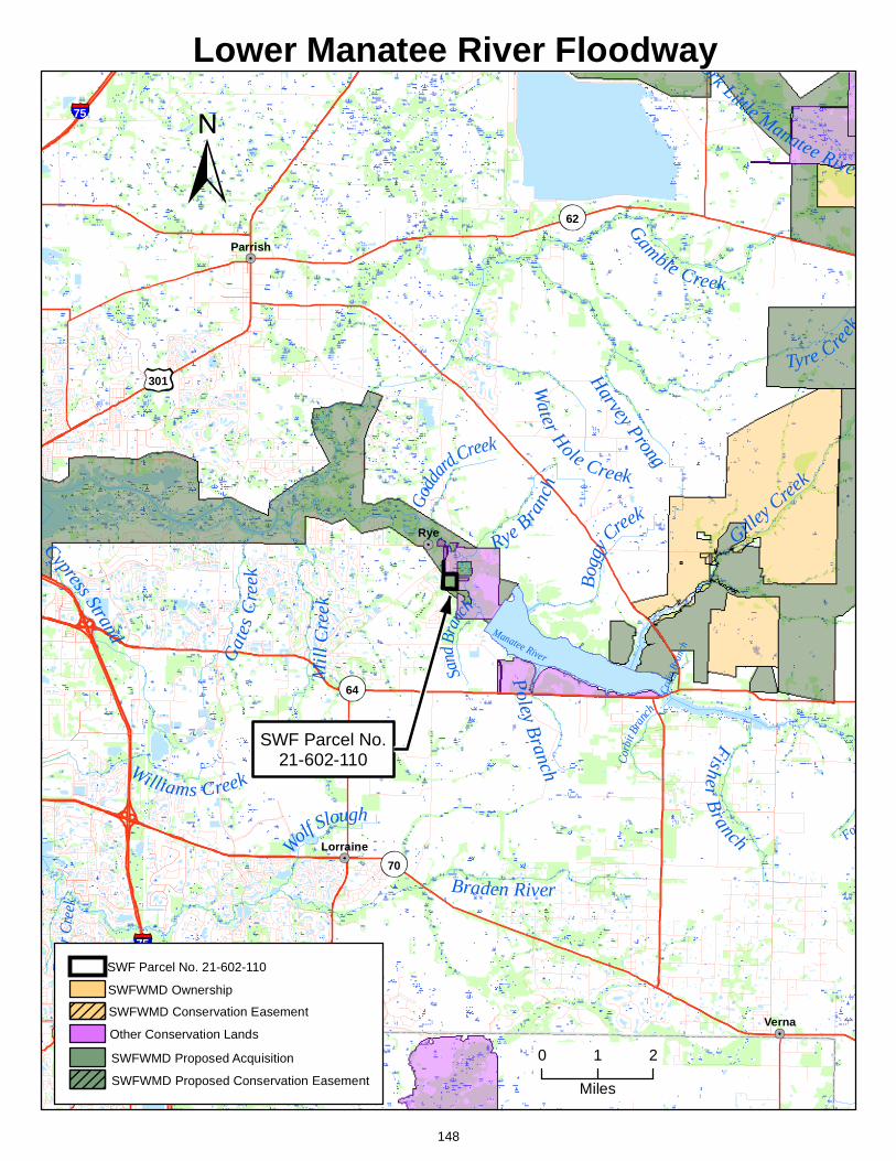
ork Little Manatee River
Gamble Creek
Braden River
Tyre Creek
Gilley Cree
k
Cypress Strand
Mill
Cre
ek
Williams Creek
Water Hole Creek
Fisher B
ranch
Rye Branc
h
Gat
es C
reek
Harvey Prong
h
Bogg
y Creek
Coope
r C
reek
Wolf Slough
Poley Branch Co
rbit B
ranch
Godd
ard Creek
Fort
Sand
Bran
ch
Ceda
r Cre
ek
Manatee RiverCr
aig B
ranc
h
75
75
301
62
64
70
Rye
Verna
Parrish
Lorraine
Lower Manatee River Floodway
0 1 2
Miles
SWF Parcel No.21-602-110
SWFWMD Conservation Easement
SWFWMD Proposed Conservation Easement
SWFWMD Ownership
Other Conservation Lands
SWF Parcel No. 21-602-110
SWFWMD Proposed Acquisition
148
Item 27
Consent Agenda June 24, 2008
Resource Management Committee Appraisals, Purchase/Sale Agreements and Resolution Requesting Funds – Annutteliga Hammock Project, SWF Parcel Nos. 15-228-1290, 1293 and 1294
PurposeThe purpose of this item is to request the Governing Board approve the purchase of approximately 16.26 acres that has been negotiated in three separate transactions with owners Ronald Hadley, Rozalia Both and Carolyn M. Koblis for a total cost of $374,714 as part of the District's Annutteliga Hammock project. To date, approximately 2,200 acres have been acquired within the project. Other publicly owned lands in the area of the project total approximately 76,500 acres. A general location map of the parcels is included in the board packet as Exhibit 1 to this item.
Background/HistoryThe purchase of three parcels has been negotiated as part of the District’s Annutteliga Hammock project. The owners and acreage of each parcel is in the table that follows.
SWF Parcel Number Acres Owner 15-228-1290 5.00 Ronald Hadley 15-228-1293 6.26 Rozalia Both 15-228-1294 5.00 Carolyn M. Koblis
Acquisition of the parcels is consistent with the District’s Florida Forever Work Plan, which specifically identifies the Annutteliga Hammock project for acquisition. The Governing Board approved the Annutteliga Hammock Resource Evaluation Report in 1996, authorizing acquisition within the project. The project consists of approximately 14,073 acres of high quality sand hills and upland hardwood forests (hammocks) located in the northwestern region of Hernando County. The Annutteliga Hammock project provides a corridor connection to large areas of public lands. To the west of the project across U.S. Highway 19 are the Chassahowitzka National Wildlife Refuge, the Chassahowitzka Swamp Conservation and Recreational Lands (CARL) project, the Longleaf Pine Ecosystem CARL project, and the District’s Chassahowitzka River and Coastal Swamps, and Weekiwachee Preserve projects.
In 2007 the Governing Board authorized the Land Resources Director to proceed directly to the Governing Board with appraisals and purchase/sale agreements which do not exceed the appraised value for parcels within the northern area of Annutteliga Hammock (Block 1). See Exhibit 2 included in the board packet.
Acquisition of these lands will meet the following Florida Forever program goals: Enhance the coordination and completion of land acquisition projects Increase the protection of Florida's biodiversity at the species, natural community and landscape levels
Increase natural resource-based public recreational and educational opportunities
These Florida Forever goals are consistent with the District's goals for water resource management.
Property DescriptionLocation and Access – All of the parcels are located north of Thrasher Road. Parcel 1290 is located on the east side of Little Dove Road and the west side of Jenifer Lane and is accessed via both Little Dove Road and Jenifer Lane.
149
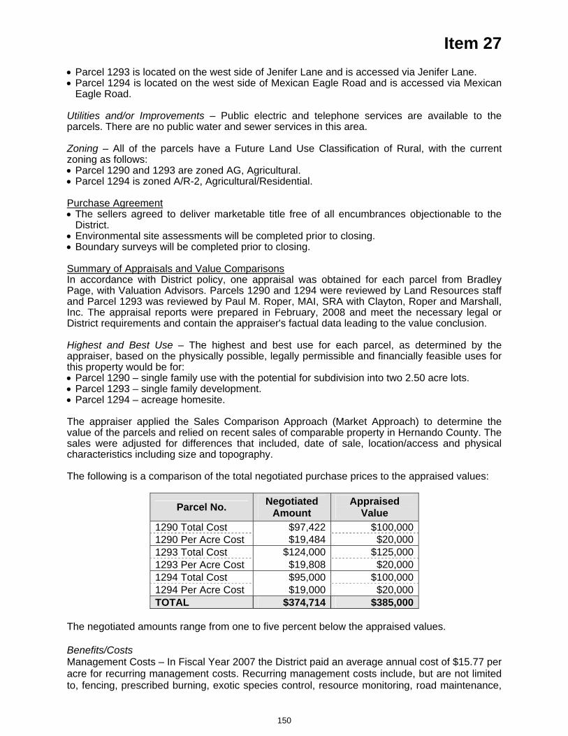
Item 27 Parcel 1293 is located on the west side of Jenifer Lane and is accessed via Jenifer Lane. Parcel 1294 is located on the west side of Mexican Eagle Road and is accessed via Mexican Eagle Road.
Utilities and/or Improvements – Public electric and telephone services are available to the parcels. There are no public water and sewer services in this area.
Zoning – All of the parcels have a Future Land Use Classification of Rural, with the current zoning as follows: Parcel 1290 and 1293 are zoned AG, Agricultural. Parcel 1294 is zoned A/R-2, Agricultural/Residential.
Purchase Agreement The sellers agreed to deliver marketable title free of all encumbrances objectionable to the District.
Environmental site assessments will be completed prior to closing. Boundary surveys will be completed prior to closing.
Summary of Appraisals and Value ComparisonsIn accordance with District policy, one appraisal was obtained for each parcel from Bradley Page, with Valuation Advisors. Parcels 1290 and 1294 were reviewed by Land Resources staff and Parcel 1293 was reviewed by Paul M. Roper, MAI, SRA with Clayton, Roper and Marshall, Inc. The appraisal reports were prepared in February, 2008 and meet the necessary legal or District requirements and contain the appraiser's factual data leading to the value conclusion.
Highest and Best Use – The highest and best use for each parcel, as determined by the appraiser, based on the physically possible, legally permissible and financially feasible uses for this property would be for: Parcel 1290 – single family use with the potential for subdivision into two 2.50 acre lots. Parcel 1293 – single family development. Parcel 1294 – acreage homesite.
The appraiser applied the Sales Comparison Approach (Market Approach) to determine the value of the parcels and relied on recent sales of comparable property in Hernando County. The sales were adjusted for differences that included, date of sale, location/access and physical characteristics including size and topography. The following is a comparison of the total negotiated purchase prices to the appraised values:
Parcel No. Negotiated Amount
Appraised Value
1290 Total Cost $97,422 $100,0001290 Per Acre Cost $19,484 $20,0001293 Total Cost $124,000 $125,0001293 Per Acre Cost $19,808 $20,0001294 Total Cost $95,000 $100,0001294 Per Acre Cost $19,000 $20,000TOTAL $374,714 $385,000
The negotiated amounts range from one to five percent below the appraised values.
Benefits/CostsManagement Costs – In Fiscal Year 2007 the District paid an average annual cost of $15.77 per acre for recurring management costs. Recurring management costs include, but are not limited to, fencing, prescribed burning, exotic species control, resource monitoring, road maintenance,
150
Item 27 recreational development, resource protection, restoration and contract administration. Based on the District's average annual management costs, it would cost approximately $256 annually to manage the parcels. No fixed capital outlay has been identified at this time.
Impact If Not Funded/Funding Funds are available from the Florida Forever Trust Fund. In order for funds to be released from the Trust Fund by the Florida Department of Environmental Protection, a resolution signed by the Governing Board must accompany the request.
Staff Recommendation: See Exhibits
(1) Acceptance of appraisals; (2) Approval of purchase/sale agreements; (3) Approval of resolution requesting funds; and (4) Designation of SWF Parcel Nos. 15-228-1290, 1293 and 1294 as having been acquired for
conservation purposes.
Presenter: Eric Sutton, Assistant Director, Land Resources Department
151
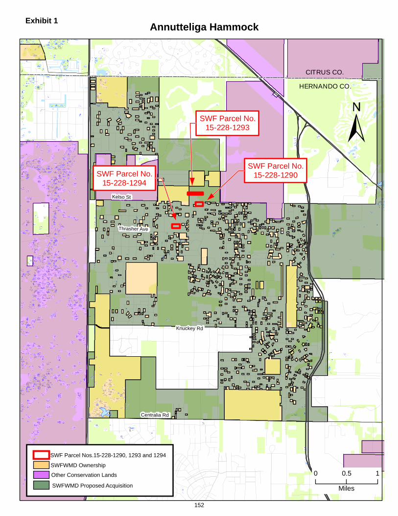
HERNANDO CO.
CITRUS CO.
Centralia Rd
Thrasher Ave
Knuckey Rd
Kelso St
Annutteliga Hammock
0 0.5 1
Miles
SWF Parcel No.15-228-1293
SWF Parcel No.15-228-1294
SWF Parcel No.15-228-1290
SWFWMD Ownership
Other Conservation Lands
SWF Parcel Nos.15-228-1290, 1293 and 1294
SWFWMD Proposed Acquisition
Exhibit 1
152
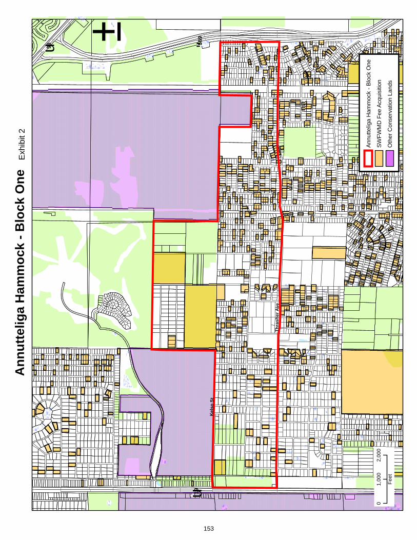
Thr a
sher
Ave
Kel
soSt
t u19
t u98 !"589
Ann
utte
liga
Ham
moc
k - B
lock
One
±
01,
000
2,00
0
Feet
SWFW
MD
Fee
Acqu
isiti
on
Oth
er C
onse
rvat
ion
Land
s
Annu
ttelig
a H
amm
ock
-Blo
ckO
ne
Exh
ibit
2
153
Item 28
Consent Agenda June 24, 2008
Resource Management Committee Appraisals and Purchase/Sale Agreement – Lake Hancock Project, SWF Parcel Nos. 20-503-106 and 20-503-106P
PurposeThe purpose of this item is to request the Governing Board approve the purchase of 122 acres in fee ownership and accept a combination of title interests including perpetual flowage/inundation easements on 27 acres and mineral rights involving approximately 313 acres of property as a result of negotiations with the owners, Summertimes Ranch, Inc. and Southern Resources, Inc., as part of the District’s Lake Hancock project. A general location map of the parcel in relation to the project (Exhibit 1) and a detailed map of the parcel (Exhibit 2) are included in the Board packet as exhibits to this item.
Background/HistoryOn September 25, 2007, the Governing Board authorized the implementation of the Lake Hancock Lake Level Modification Project including acquisition of lands (placing priority emphasis on voluntary acquisitions) necessary for the project. The Board also approved the use of eminent domain, if necessary, to complete the acquisition process. The Lake Hancock Project is a result of the District being required by state law (Section 373.042, Florida Statutes (F.S.)) to develop minimum flows and levels (MFL) on priority water bodies and aquifers. The purpose of the MFL is to ensure that adequate flows or levels are maintained to protect the state's water resources. The District has set minimum flows for the upper Peace River including 17 cubic feet per second (cfs) at Bartow, 27 cfs at Fort Meade, and 45 cfs at Zolfo Springs. Flows in the upper Peace River were below the minimum flows at Fort Meade approximately 28 percent of the time during the last 30 years. The District's Southern Water Use Caution Area (SWUCA) Recovery Strategy includes a specific recovery strategy, as required by state law (Section 373.0421, F.S.), for the upper Peace River because the minimum flows are not currently being met.
Ground-water withdrawals in the SWUCA have resulted in declines in aquifer levels throughout the SWUCA and contribute to reduced flows in the upper Peace River. The District determined that it is not feasible to reduce groundwater withdrawals to achieve the minimum flows for the upper Peace River. The Lake Hancock Lake Level Modification Project is critical in the District's strategies for meeting the minimum flows in the upper Peace River. The goal of the project is to store water by raising the control elevation of the existing outflow structure on Lake Hancock from 98.7 to 100.0 feet and to slowly release water during the dry season to help meet the flow requirements in the upper Peace River. Historically, prior to man-made alterations, the lake level was approximately one to two feet higher than the current operating level. The Lake Level Project is anticipated to recover up to approximately 50 percent of the minimum flows for the upper Peace River.
Project/Parcel Benefits – In addition to the Lake Level Project providing up to 50 percent of the minimum flows for the upper Peace River, the Project will also improve the function of approximately 1,000 acres of wetlands around the lake and preserve approximately 4,800 acres of floodplain. To date, the District has acquired 6,980 acres in fee simple interest and 718 acres via perpetual conservation/inundation easements within the project. This acquisition could provide additional public recreation partnership opportunities and restoration/ mitigation opportunities on the west side of Saddle Creek depending on the outcome of the Lake Hancock Land Use Alternatives Plan currently under development. Upon completion of this acquisition, the District will own approximately eight and one-half miles of the 11 total miles of affected lake front properties on Lake Hancock. The land and rights acquired to date were accomplished through 14 transactions, and the remaining acreage is fractionalized over 56 parcels.
154
Item 28 Property DescriptionLocation and Access – The property is located (see Exhibit 2) north of Bartow and east of US 98 with 1,475 feet of highway frontage and approximately one mile of frontage split equally between the southwestern shore of Lake Hancock and west side of Saddle Creek. The property located on the west side of Lake Hancock/Saddle Creek will include 122 acres to be acquired in fee, portions of 12 of 15 waterfront lots that are part of the River Lake and Summertimes Plantation subdivisions over which the District will be conveyed perpetual flowage/inundation easements, as well as other lands that have not been platted. The property consists of approximately 83 percent uplands and 17 percent wetlands. Also, as part of the negotiations, the owner agreed to facilitate the transfer of perpetual flowage/inundation easements on two of the three lots he no longer owns. The acquisition also includes 313 acres of mineral rights held by the owner located on the east side of Saddle Creek that are within the District’s Old Florida Plantation Development of Regional Impact (DRI) property. The mineral rights and perpetual flowage/inundation easements will be conveyed to the District at no cost. The acquisition acreage is broken down as follows:
Interest Location Fee Easements Mineral
Rights Total
West of Lake Hancock/Saddle Creek 122 27 0 149East of Saddle Creek 0 0 313 313
Total 462
Utilities and/or Improvements – The property has electric and telephone service, and municipal water available along US Highway 98. These portions of the property also include developed lots within the River Lake subdivision and areas that are approved for development of single family estate lots known as Summertimes Plantation. The owner has not started construction of the infrastructure for the approved development.
Zoning – The property is affected by two Land Use Classifications under the Polk County Comprehensive Plan and additionally is in the US Highway 98 Selected Area Plan which provides for additional development incentives. The western half of the property is designated Residential Low – 1X (RL-1X) allowing one unit per acre. The remaining portions are designated Residential Suburban – X (RS-X) allowing three units per acre. The property has the potential for 256 units, currently reflecting a density of 2.29 units per gross acre.
Summary of Appraisal and Value Comparisons – In accordance with District policy, two appraisals were obtained for the parcel from Michael A. McElveen, MAI of Urban Economics, Inc. and Martin C. Engelmann, Jr., MAI of Tropical Realty Appraisal Services. The appraisals were reviewed by Stephen Jamir, MAI of Jamir and Associates, Inc. The appraisal reports were prepared on January 24, and February 4, 2008, respectively. The appraisals have an effective date of December 27, 2007 and January 22, 2008, respectively, and meet the necessary legal or District requirements and contain the appraisers’ factual data leading to the value conclusion.
Highest and Best Use – The highest and best use, as determined by the appraisers, based on the physically possible, legally permissible and financially feasible uses for this property, would be for residential subdivision development (McElveen) or to hold the property for future residential subdivision development (Engelmann).
The appraisers applied the Sales Comparison Approach (Market Approach) to determine the value of this property. The appraisers relied on recent sales of comparable property in Polk County. The sales were adjusted for differences that included site characteristics, utilities, location, size and zoning density.
The appraisers utilized different upland acre information sources for their value estimates, as the survey information was incomplete at the time of appraisal. A survey will be completed to account for ordinary high water line and other boundary issues prior to closing. The negotiated price per
155
Item 28 acre was based on 106 developable upland acres for the property located west of Lake Hancock/Saddle Creek. The following is a comparison of the negotiated amount to the appraised values:
Negotiated Price Appraised Value McElveen
Appraised Value Engelmann
Land Value $9,500,000 $12,500,000 $8,415,000Upland Acre Cost $89,623(1) $96,154(2) $85,000(3)
(1) Based on upland estimate of 106 acres. (2) Based on upland estimate of 130 acres. (3) Based on upland estimate of 99 acres.
The property is not listed for sale. The total negotiated settlement is 24 percent below the McElveen appraisal and 13 percent above the Engelmann appraisal, considering only the 106 acres to be acquired in fee simple. The easements and mineral rights were offered as part of the purchase negotiations and their respective values were not included in the appraisals, and, as such, represent additional value to the District. This negotiated settlement will eliminate the necessity of litigation.
Voluntary acquisition avoids the significant expense and investment of staff time that is required when eminent domain proceedings are initiated. In the eminent domain process the District can incur substantial costs in the form of attorneys fees and expert witness fees. Moreover, the District is not only responsible for the costs of its attorneys and experts, but also those costs incurred by the landowner in the condemnation suit.
Purchase Agreement The sellers agreed to deliver marketable title free of all encumbrances objectionable to the District.
An environmental site assessment will be completed prior to closing. The District acknowledges that the sellers intend to claim a form of a charitable donation associated with this transaction.
The sellers will convey oil, gas, and mineral rights east of Saddle Creek on lands which are part of the Old Florida Plantation DRI, SWF Parcel 20-502-101, acquired by the District in 2003.
The sellers will convey certain ingress, egress and utility easements affecting the property being acquired in fee simple.
The sellers will retain a cattle grazing license until construction/completion of the Project. The sellers have agreed to convey perpetual conservation/inundation easements to those areas not being acquired in fee. The easements will be conveyed with terms and conditions to implement the District’s Project.
Potential Surplus Lands – Any lands not used for project purposes can be surplused and sold on the open market. Staff will evaluate the potential for surplus lands associated with this acquisition at the appropriate time in the future. Section 373.139, Florida Statutes, requires any revenue generated from the sale of lands be used only for the purchase of other lands.
Impact If Not Funded/FundingFunds are available from the Governing Board's General Fund Water Supply and Resource Development Reserves for the acquisition/purchase of this parcel. If not funded, the Lake Hancock Lake Level Modification Project cannot be implemented.
Staff Recommendation: See Exhibits
(1) Accept the appraisals; and (2) Approve the Purchase/Sale Agreement.
Presenter: Fritz H. Musselmann, Director, Land Resources Department
156
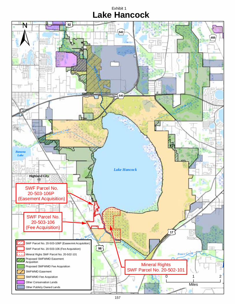
SaddleCreek
Phy llisBranch
Peace Creek
Banana Creek
Lake Lena Run
Saddle Creek
PeaceRiver
P
17
92
98
60
542
540
540A
655
Highland City
Lake Hancock
0 1 2
Miles
SWF Parcel No.20-503-106P
(Easement Acquisition)
Lake Hancock
BananaLake
SWF Parcel No.20-503-106
(Fee Acquisition)
Exhibit 1
Mineral RightsSWF Parcel No. 20-502-101
SWFWMD Fee Acquisition
Other Conservation Lands
Proposed SWFWMD EasementAcqusition
Other Publicly Owned Lands
Proposed SWFWMD Fee Acquisition
SWF Parcel No. 20-503-106 (Fee Acquisition)
SWFWMD Easement
SWF Parcel No. 20-503-106P (Easeemnt Acquisition)
Mineral Righs SWF Parcel No. 20-502-101
157
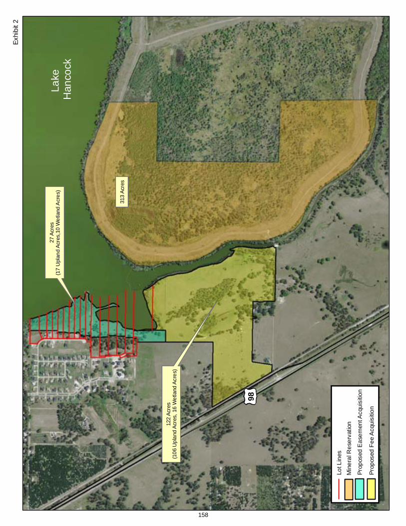
98
Lake
Han
cock
27Ac
res
(17
Upl
and
Acre
s,10
Wet
land
Acr
es)
122
Acre
s(1
06U
plan
dAc
res,
16W
etla
ndAc
res)
313
Acre
s
Exhi
bit2
Prop
osed
Eas
emen
tAcq
uisi
tion
LotL
ines
Min
eral
Res
erva
tion
Prop
osed
Fee
Acq
uisi
tion
158
Item 29
Consent Agenda June 24, 2008
Resource Management Committee Appraisals and Purchase/Sale Agreement - Lake Hancock Project, SWF Parcel No. 20-503-136
PurposeThe purpose of this item is to request the Governing Board approve the purchase of a home and an approximately 1.62-acre lot within the Waterwood Subdivision which has been negotiated with the owners, Calvin P. and Laura R. Cole, as part of the District’s Lake Hancock project. A general location map of the parcel in relation to the project (Exhibit 1) and a detailed map of the parcel (Exhibit 2) are included in the board packet as exhibits to this item.
Background/HistoryOn September 25, 2007, the Governing Board authorized the implementation of the Lake Hancock Lake Level Modification Project including acquisition of lands (placing priority emphasis on voluntary acquisitions) necessary for the project. The Board also approved the use of eminent domain, if necessary, to complete the acquisition process. The Lake Hancock Project is a result of the District being required by state law (Section 373.042, Florida Statutes (F.S.)) to develop minimum flows and levels (MFL) on priority water bodies and aquifers. The purpose of the MFL is to ensure that adequate flows or levels are maintained to protect the state's water resources. The District has set minimum flows for the upper Peace River including 17 cubic feet per second (cfs) at Bartow, 27 cfs at Fort Meade, and 45 cfs at Zolfo Springs. Flows in the upper Peace River were below the minimum flows at Fort Meade approximately 28 percent of the time during the last 30 years. The District's Southern Water Use Caution Area (SWUCA) Recovery Strategy includes a specific recovery strategy, as required by state law (Section 373.0421, F.S.), for the upper Peace River because the minimum flows are not currently being met.
Ground-water withdrawals in the SWUCA have resulted in declines in aquifer levels throughout the SWUCA and contribute to reduced flows in the upper Peace River. The District determined that it is not feasible to reduce groundwater withdrawals to achieve the minimum flows for the upper Peace River. The Lake Hancock Lake Level Modification Project is critical in the District's strategies for meeting the minimum flows in the upper Peace River. The goal of the project is to store water by raising the control elevation of the existing outflow structure on Lake Hancock from 98.7 to 100.0 feet and to slowly release water during the dry season to help meet the flow requirements in the upper Peace River. Historically, prior to man-made alterations, the lake level was approximately one to two feet higher than the current operating level. The Lake Level Project is anticipated to recover up to approximately 50 percent of the minimum flows for the upper Peace River.
Project/Parcel Benefits – In addition to the Lake Level Project providing up to 50 percent of the minimum flows for the upper Peace River, the Project will also improve the function of approximately 1,000 acres of wetlands around the lake and preserve approximately 4,800 acres of floodplain. To date, the District has acquired 6,980 acres in fee simple interest and 718 acres via perpetual conservation/inundation easements within the project. This acquisition could provide additional restoration/ mitigation opportunities. Upon completion of this acquisition, the District will own approximately eight and one-half miles of the 11 total miles of affected lake front properties on Lake Hancock. The land and rights acquired to date were accomplished through 14 transactions, and the remaining acreage is fractionalized over 56 parcels.
Property DescriptionLocation and Access – The property is located at 5236 Waterwood Run in Bartow which is a publicly maintained road. The property has about 175 feet of frontage on the west side of Lake Hancock and contains 1.62 acres.
159
Item 29 Utilities and/or Improvements – The property has electric and telephone service available and is on a private well and septic system. It is improved with a three-bedroom, two and one-half bath, 3,692-(gross) square foot single family residence built in 1986. The Coles purchased the property in 1996 for $150,000.
Zoning – The property is zoned RS (Residential Suburban) by Polk County.
Summary of Appraisal and Value Comparisons - In accordance with District policy, two appraisals were obtained for the parcel from Nicholas J. Mancuso, MAI with Mancuso Appraisal Services, Inc. and Woodman S. Herr, MAI with Herr Valuation Services, Inc. The appraisals were reviewed by Stephen Jamir, MAI of Jamir and Associates, Inc. The appraisal reports were prepared on January 10, 2008 and December 4, 2007, respectively. The appraisals have an effective date of December 14, 2007 and November 26, 2007, respectively, and meet the necessary legal or District requirements and contain the appraisers’ factual data leading to the value conclusion.
In addition, the sellers provided an appraisal prepared by Michael P. Bobbitt with Applied Economics Group. This report was also reviewed by Mr. Jamir. The appraisal has an effective date of October 15, 2007 and, according to the reviewer, did not meet the District requirements or have adequate support for its conclusions.
Highest and Best Use – The highest and best use, as determined by the appraisers, based on the physically possible, legally permissible and financially feasible uses for this property, would be for single family residential.
The appraisers applied the Sales Comparison Approach (Market Approach) to determine the value of this property. The appraisers relied on recent sales of comparable property in Polk County. The sales were adjusted for differences that included improvement characteristics (pool, garage size), location/access, and physical characteristics including size of house and lot and other improvements (outbuildings). The following is a comparison of the total negotiated purchase price to the appraised values:
Negotiated Amount
Appraised Value Mancuso
Appraised Value Herr
Appraised Value Bobbitt
$840,000 $615,000 $610,000 $1,490,000
The property is not listed for sale. The total acquisition cost of this property also includes consideration of the sellers’ moving expenses, a premium paid for a replacement residence meeting the sellers’ needs, attorney fees, and the property tax implications of relocating to a new residence.
Voluntary acquisition avoids the significant expense and investment of staff time that is required when eminent domain proceedings are initiated. In the eminent domain process the District can incur substantial costs in the form of attorneys fees and expert witness fees. Moreover, the District is not only responsible for the costs of its attorneys and experts, but also those costs incurred by the landowner in the condemnation suit.
Purchase Agreement The sellers agreed to deliver marketable title free of all encumbrances objectionable to the District.
An environmental site assessment will be completed prior to closing. The Purchase/Sale Agreement includes a provision to lease the property back to the sellers for a maximum of three months at a rate of $1,500 per month. o If the seller stays 90 days or less, no rent will be due; or o If the seller stays beyond 90 days, rent is due at the agreed-upon rate for the entire term of their
occupancy, including the first 90 days.
160
Item 29 Impact If Not Funded/FundingFunds are available from the Governing Board's General Fund Water Supply and Resource Development Reserve for the acquisition/purchase of this parcel. If not funded, the Lake Hancock Lake Level Modification Project cannot be implemented.
Staff Recommendation: See Exhibits
(1) Accept the appraisals; and (2) Approve the Purchase/Sale Agreement.
Presenter: Fritz Musselmann, Director, Land Resources Department
161
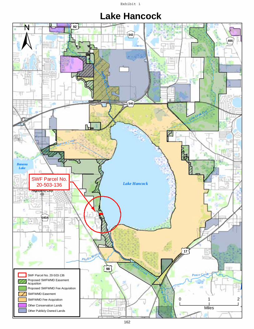
SaddleCreek
Phy llisBranch
Peace Creek
Banana Creek
Lake Lena Run
Saddle Creek
PeaceRiver
P
17
92
98
60
542
540
540A
655
Highland City
Lake Hancock
0 1 2
Miles
SWF Parcel No.20-503-136 Lake Hancock
BananaLake
SWFWMD Fee Acquisition
Other Conservation Lands
Proposed SWFWMD EasementAcqusition
Other Publicly Owned Lands
Proposed SWFWMD Fee Acquisition
SWF Parcel No. 20-503-136
SWFWMD Easement
162
Exhibit 1
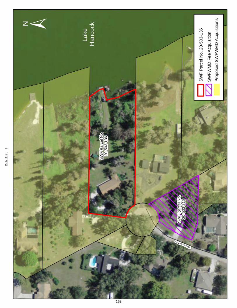
SWF
Par
celN
o.20
-503
-136
SWF
Par
celN
o.20
-503
-216
WaterwoodRun
Lake
Han
cock
SWFW
MD
Fee
Acq
uisi
tion
Prop
osed
SWFW
MD
Acqu
isiti
ons
SWF
Parc
elN
o.20
-503
-136
163
Exhibit2
Item 30
Consent Agenda June 24, 2008
Resource Management Committee Land Use and Management Plan for the Chito Branch Reserve
PurposeTo approve the Land Use and Management Plan for the Chito Branch Reserve.
Background and History The Chito Branch Reserve encompasses 5,515 acres in southeastern Hillsborough County. The Reserve was acquired in 2001, in cooperation with Tampa Bay Water for regional water supply purposes. Tampa Bay Water constructed and operates the C.W. “Bill” Young Reservoir on 1,100 acres of the Reserve. The remaining 4,414 acres are a combination of mitigation and natural areas that are managed by the District. District staff has developed a ten-year land use and management plan, primarily for the 4,414 acres.
The Chito Branch Reserve is located in the Alafia River Watershed. The property consists of a variety of habitats including wetlands, pine flatwoods, scrubby flatwoods, scrub, freshwater marshes and improved pasture. The plan describes the condition and special management needs related to the protection of the Reserve’s water resource values, natural systems and endangered species known to exist on the property. Strategic objectives developed to protect natural resources and guide public use on the Reserve are summarized in the plan.
Consistent with Governing Board Policy 610-3, the purposes for acquisition, resource values and sensitivity of the Reserve were evaluated and zoned to demonstrate the level of protection needed to preserve or enhance the resources. During the zoning process, consideration was given to the Reserve’s habitat quality, hydrological functions, ecological indicators, sensitivity of natural communities and their inhabitants to disturbance, and user experience values. Recommendations in the plan are consistent the District's objectives to balance Tampa Bay Water’s operation of the reservoir, protection of natural resources and public use at the Reserve. District staff conducted a recreation needs assessment to determine future local and regional recreation needs that may be suitable at the Reserve. Uses that are deemed compatible with the sensitive natural resources at the Reserve and consistent with the results of the needs assessment include hiking, bicycling, equestrian, primitive camping, wildlife observation, interpretive uses, nature study, outdoor nature photography, picnicking and trail running. Subsequent to the recreation needs assessment, staff conducted a public workshop in August 2007 to receive public input on the results of the assessment and the conceptual plan. Input from the workshop was considered and evaluated relative to strategic objectives to protect the natural resources at the Reserve. A copy of the plan is included in the board packet for review.
This item will be presented to the Alafia River Basin Board at its June meeting.
Benefits and Costs The plan describes future management needs for the Reserve and outlines strategic initiatives for the next ten years.
Staff Recommendation: See Plan
Approve the Land Use and Management Plan for the Chito Branch Reserve.
Presenter: Will Miller, Land Use and Protection Manager, Land Resources Department
164
Item 31
Consent Agenda June 24, 2008
Resource Management Committee Land Use and Management Plan for the Conner Preserve
PurposeTo approve the Land Use and Management Plan for the Conner Preserve.
Background and History The Conner Preserve encompasses 2,980 acres in the eastern central portion of Pasco County. A map showing location is included in the attached management plan. The Preserve was acquired in 2003 as part of the Pasco 1 project. The land was purchased for preservation of natural systems, groundwater recharge, water quality, flood protection and passive recreation. The Preserve functions as a key wildlife corridor link between the Starkey Wilderness Preserve and Cypress Creek Preserve in Pasco County. Staff has developed a ten-year land use and management plan for the Preserve.
The Preserve is located in the Hillsborough Watershed (875 acres) and Springs Coast Watershed (2,098 acres) and contains the headwaters of Five Mile Creek. The property consists of a variety of habitats including wetlands, pine flatwoods, cypress domes, freshwater marshes, mixed uplands and improved pasture. The plan describes the condition and special management needs related to the protection of the Preserve's water resource values, natural systems and endangered species known to exist on the property. Strategic objectives developed to protect natural resources and guide public use on the Preserve are summarized in the plan.
Consistent with District Governing Board Policy 610-3, the purposes for acquisition, resource values and sensitivity of the Preserve were evaluated and zoned to demonstrate the level of protection needed to preserve the resources. During the zoning process consideration was given to the Preserve's habitat quality, hydrological functions, ecological indicators, sensitivity of natural communities and their inhabitants to disturbance, and user experience values. Subsequent to zoning the property, District staff conducted an assessment to determine local and regional resource-dependant recreation needs. A 15-mile radius was established around the Preserve for the assessment and the results contributed to the determination that hiking, bicycling, horseback riding, camping (primitive, tents), wildlife observation, geocaching, interpretive uses, nature study, outdoor nature photography, picnicking and trail running were compatible uses for the Preserve.
Accordingly, staff conducted a public workshop in August 2007 to receive public input on the results of the assessment and the conceptual plan. Input from the workshop primarily focused on horseback riding within the Preserve. Staff considered the purposes for acquisition, resource values and sensitivity of the Preserve, the results of the assessment and public input. Given the sensitivity of the natural systems at the Preserve, major restoration activities and the small size of the property, horseback riding was initially determined to be incompatible with the management objectives for the Preserve. However, after further consideration and public input, staff determined that a limited equestrian experience could be provided within the Preserve. Public Use recommendations contained in the plan are consistent with the District's objectives to balance protection of natural resources while providing a quality public use experience at the Preserve. A copy of the plan is included in the board packet for review.
165
Item 31 Benefits and Costs The plan establishes future management needs for the Preserve and outlines strategic initiatives for the next ten years.
This item will be presented to the Hillsborough and Coastal Rivers Basin Boards at their April meetings.
Staff Recommendation: See Plan
Approve the Land Use and Management Plan for the Conner Preserve.
Presenter: Will Miller, Land Use and Protection Manager
166
Item 32.a.
Consent Agenda June 24, 2008
Resource Management Committee Facilitating Agricultural Resource Management Systems – Billy H. Haygood, Trustee D Hancock Marital Trust - Hancock Grove Project Phase II – DeSoto County
PurposeTo request approval for a Phase II Facilitating Agricultural Resource Management Systems (FARMS) project with Billy H. Haygood, Trustee D Hancock Marital Trust - Hancock Grove Project Phase II, and approval to reimburse FARMS eligible costs up to a not-to-exceed limit of $300,000 (75 percent of total project costs). Of this amount, the 2008 State Appropriations will be used for $150,000, the Governing Board is requested to fund $75,000, and the Peace River Basin Board is requested to fund $75,000. Total project costs are estimated at $400,000.
Background/History The District's FARMS Program, developed by the District and Florida Department of Agriculture and Consumer Services, is a public/private agricultural Best Management Practices (BMPs) cost-share reimbursement program. FARMS is intended to expedite the implementation of production-scale agricultural BMPs that provide water resource benefits. Resource benefits of the FARMS Program include reduced Floridan aquifer withdrawals, water quality improvements (both from groundwater and surface water sources) and/or conservation, restoration and augmentation of the area's water resources and ecology. The District's emphasis through the FARMS Program is on reductions in Upper Floridan aquifer withdrawals that will improve groundwater conditions as documented in the Southern Water Use Caution Area (SWUCA) recovery strategy. In addition, the District also provides funding for projects that improve water quality affected by the use of mineralized groundwater as documented in the Shell and Prairie Creek Watershed Management Plan – Reasonable Assurance Documentation. Reimbursement cost-share rates are capped at 50 percent for water quantity withdrawal reductions from the Upper Floridan aquifer or water quality improvements realized from decreasing the use of mineralized groundwater, and at 75 percent for both water quantity and water quality improvements.
FARMS Program staff received a proposal for a Phase II project with Hancock Grove located in south-central DeSoto County, approximately 15 miles upstream of the city of Punta Gorda's drinking water reservoir. The property drains to the east where surface water enters Myrtle Slough and continues into Prairie Creek. The Water Use Permit authorizes groundwater and surface water withdrawals up to an annual average daily quantity of 1,252,000 gallons per day (gpd). Reported groundwater use for the Hancock Grove is currently averaging approximately 80 percent of the total use. The primary goal of the project is to reduce Upper Floridan aquifer withdrawals through the use of an existing 25 acre pond as an irrigation source. The reduction in use of groundwater in the Upper Floridan aquifer for irrigation and the subsequent increase in use of surface water will improve the water quality of Myrtle Slough. Irrigation wells that are currently used in the project area have shown specific conductivities as high as 2,329 uS/cm, which is well above the management level of 775 uS/cm identified in the Shell and Prairie Creek Watershed Management Plan. FARMS project components consist of two surface water irrigation pump stations, filtration, and the piping necessary to connect the proposed surface water reservoir system to the existing irrigation system.
167
Item 32.a. This site currently has a FARMS project that is in the third year of a five year contract term. This project has been successful in capturing and reusing surface water and tailwater for citrus irrigation. Over the period of record, this project has offset 248 million gallons of lower quality groundwater by using surface water, which averages 430,253 gpd. This amounts to 193.4 percent of the original projected groundwater offset. The second phase to this project will enhance the previous FARMS project goal by further reducing highly mineralized groundwater withdrawals by a conservative estimate of 76,980 gpd.
Benefits/CostsThe proposed project will reduce mineralized groundwater withdrawals and involves both water quantity and quality BMPs. Therefore, the project qualifies for a 75 percent cost-share reimbursement rate under the FARMS Program. Using an estimate of 30 percent savings of permitted quantities in the project area (8 percent of total permitted quantities), or approximately 76,980 gpd, yields a daily cost of $3.27 per thousand gallons of groundwater reduced over the proposed five-year contract term, and $0.98 per thousand gallons of groundwater reduced over a thirty-year term. Both projected values for groundwater savings costs are within the guidelines for the generally accepted average cost savings per thousand gallons for the implementation of alternative water supplies for flatwoods citrus operations. Total project costs are estimated at $400,000. The fiscal year 2008 State Appropriations will be used to fund one-half of the project reimbursement, with the remainder divided evenly between the Peace River Basin Board and the Governing Board. Upon approval, the Governing Board and Peace River Basin Board will have $1,125,402 and $141,421, respectively, remaining in their FARMS Program budgets.
Staff Recommendation: See Exhibit
(1) Approve the Billy H. Haygood, Trustee D Hancock Marital Trust – Hancock Grove Phase II FARMS Project for a not-to-exceed project reimbursement of $300,000, with $75,000 provided by the Peace River Basin, $75,000 provided by the Governing Board, and $150,000 provided from 2008 State Appropriations;
(2) Authorize the transfer of $75,000 from fund 020 H017 Peace River Basin FARMS funds, $75,000 from fund 010 H017 Governing Board FARMS funds, $150,000 from the 2008 State Appropriations allocated to fund 010 H017 FARMS funds, to 010 H516, Billy H. Haygood, Trustee D Hancock Marital Trust – Hancock Grove Phase II project fund;
(3) Authorize the Executive Director to execute the agreement.
Presenter: Eric C. DeHaven, P.G., Director, Resource Conservation and Data Department
168
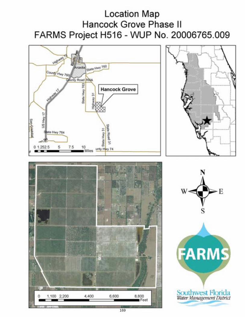
169
Item 32.b.
Consent Agenda June 24, 2008
Resource Management Committee Facilitating Agricultural Resource Management Systems – Orange-Co, LP – DeSoto County
PurposeTo request approval for a Facilitating Agricultural Resource Management Systems (FARMS) project with Orange-Co, LP and approval to reimburse FARMS eligible costs up to a not-to-exceed limit of $131,250 (75 percent of total project costs). Of this amount, the balance of the 2007 ($9,888) and $55,737 of the 2008 State Appropriations will be used for $65,625, the Governing Board is requested to fund $32,813 and the Peace River Basin Board is requested to fund $32,813. Total project costs are estimated at $175,000.
Background/History The District's FARMS Program, developed by the District and Florida Department of Agriculture and Consumer Services, is a public/private agricultural Best Management Practices (BMPs) cost-share reimbursement program. FARMS is intended to expedite the implementation of production-scale agricultural BMPs that provide water resource benefits. Resource benefits of the FARMS Program include reduced Floridan aquifer withdrawals, water quality improvements (both from ground water and surface water sources) and/or conservation, and restoration and augmentation of the area's water resources and ecology. The District's emphasis through the FARMS Program is on reductions in Upper Floridan aquifer withdrawals that will improve ground water conditions as documented in the Southern Water Use Caution Area (SWUCA) recovery strategy. In addition, the District also provides funding for projects that improve water quality affected by the use of mineralized ground water as documented in the Shell and Prairie Creek Watershed Management Plan – Reasonable Assurance Documentation. Reimbursement cost-share rates are capped at 50 percent for water quantity withdrawal reductions from the Upper Floridan aquifer or water quality improvements realized from decreasing the use of mineralized ground water, and at 75 percent for both water quantity and water quality improvements. FARMS policy also allows for a 75 percent reimbursement if Upper Floridan aquifer withdrawals will be reduced by 50 percent or more.
FARMS Program staff received a project proposal from Orange-Co, LP for their Section 29 Grove, a 111-acre citrus grove in DeSoto County. This project area is located within the 20,300-acre Joshua Creek Water Control District, which drains south into Prairie Creek and west into Joshua Creek. The annual average groundwater withdrawal authorized by their Water Use Permit to irrigate this grove by seepage is 300,140 gallons per day (gpd). Reported groundwater use since January 2004 has averaged five percent over the permitted amount, but this quantity is within the drought allowance and pumpage for the overall Water Use Permit is within compliance. The primary goal of the project is to reduce Upper Floridan aquifer withdrawals through the construction and operation of a linear surface water irrigation reservoir, one surface water irrigation pump station, filtration, and the mainline piping necessary to connect the proposed surface water reservoir to a proposed, more efficient microjet irrigation system. The linear reservoir will be formed by placing two large culverts with adjustable risers within an existing internal drainage ditch and withdrawing water that will be stored behind the risers.
170
Item 32.b.
Benefits/CostsThe proposed project will reduce withdrawals from the Upper Floridian aquifer by more than 75 percent of permitted quantities over the project area, as well as improve water quality due to elevated levels of specific conductivity measured in ground water withdrawn from this well. The FARMS Program allows for a 75 percent reimbursement if Upper Floridian aquifer withdrawals are reduced by 50 percent or more. Using an estimated 75 percent savings of permitted quantities, or 225,100 gpd, yields a daily cost of $0.49 per thousand gallons of groundwater reduced over the proposed five-year contract term, and $0.15 per thousand gallons of groundwater reduced over a thirty-year term. Both values are within the guidelines for the generally accepted average cost savings per thousand gallons for the implementation of alternative supplies and improved irrigation techniques for flatwood citrus operations. The fiscal years 2007 and 2008 State Appropriations will be used to fund one-half of the project reimbursement, with the remainder divided evenly between the Peace River Basin Board and the Governing Board. Upon approval, the Governing Board and Peace River Basin Board will have $1,350,402 and $216,421, respectively, remaining in their FARMS Program budgets.
Staff Recommendation: See Exhibit
(1) Approve the Orange-Co, LP project for a not-to-exceed project reimbursement of $131,250 with $32,813 provided by the Peace River Basin, $32,813 provided by the Governing Board, and $65,625 provided from State Appropriations;
(2) Authorize the transfer of $32,813 from fund 020 H017 Peace River Basin Board FARMS funds, $32,813 from fund 010 H017 Governing Board FARMS funds, $9,888 from the 2007 State Appropriations allocated to fund 020 H017 FARMS funds, and $55,737 from the 2008 State Appropriations allocated to fund 010 H017 FARMS funds, to H555 Orange-Co, LP project fund;
(3) Authorize the Executive Director to execute the agreement.
Presenter: Eric C. DeHaven, P.G., Director, Resource Data and Restoration Department
171
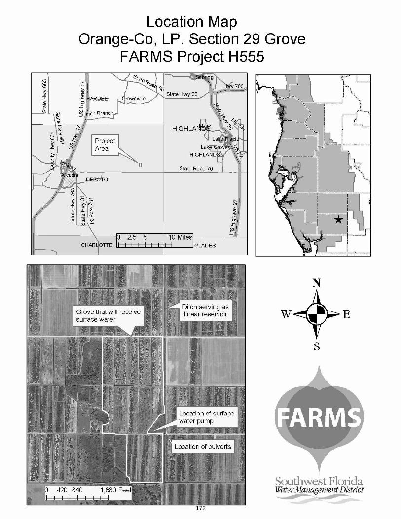
172
Item 32.c.
Consent Agenda June 24, 2008
Resource Management Committee Facilitating Agricultural Resource Management Systems – Island Grove Agricultural Products, Farm 6 – DeSoto County
PurposeTo request approval for a Facilitating Agricultural Resource Management Systems (FARMS) project with Island Grove Agricultural Products Farm #6 and approval to reimburse FARMS eligible costs up to a not-to-exceed limit of $285,000 (75 percent of total project costs). Of this amount, the 2008 State Appropriations will be used for $142,500, the Governing Board is requested to fund $71,250 and the Peace River Basin Board is requested to fund $71,250. Total project costs are estimated at $380,000.
Background/History The District's FARMS Program, developed by the District and Florida Department of Agriculture and Consumer Services, is a public/private agricultural Best Management Practices (BMPs) cost-share reimbursement program. FARMS is intended to expedite the implementation of production-scale agricultural BMPs that provide water resource benefits. Resource benefits of the FARMS Program include reduced Floridan aquifer withdrawals, water quality improvements (both from ground water and surface water sources) and/or conservation, restoration and augmentation of the area's water resources and ecology. The District's emphasis through the FARMS Program is on reductions in Upper Floridan aquifer withdrawals that will improve groundwater conditions as documented in the Southern Water Use Caution Area (SWUCA) recovery strategy. In addition, the District also provides funding for projects that improve water quality affected by the use of mineralized ground water as documented in the Shell and Prairie Creek Watershed Management Plan – Reasonable Assurance Documentation. Reimbursement cost-share rates are capped at 50 percent for water quantity withdrawal reductions from the Upper Floridan aquifer or water quality improvements realized from decreasing the use of mineralized ground water, and at 75 percent for both water quantity and water quality improvements. FARMS policy also allows for a 75 percent reimbursement if Upper Floridan withdrawals will be reduced by 50 percent or more.
FARMS Program staff received a project proposal from Island Grove, L.L.C. for their blueberry farm #6 located in the Myrtle Slough Watershed of Prairie Creek, east of State Road 31 in DeSoto County. Myrtle Slough drains to Prairie Creek which is approximately sixteen miles upgradient of the city of Punta Gorda's drinking water reservoir. The Water Use Permit authorizes an annual average groundwater withdrawal of 109,800 gallons per day (gpd) for the irrigation of 72 acres of blueberries from one well completed in the Upper Floridan aquifer. Prior to the property's acquisition by Island Grove L.L.C, the property was a citrus grove permitted for quantities less than 100,000 gpd, therefore, there is no history of reported pumpage. If the project is approved, the surface water withdrawal used for irrigation will be metered and reported to the District. This is the third FARMS project presented for approval to the Board with Island Grove Agricultural Products. The two existing projects are operational and have offsets that average 130,141 gpd, and 49,334 gpd, which are above projections. The primary goal of this project is to reduce Upper Floridan aquifer withdrawals through the creation of a two-acre reservoir within an existing storm water and tailwater retention area. The project will also include the construction of a surface water irrigation pump station, filtration, and the piping necessary to connect the proposed surface water reservoir system to the existing irrigation system.
173
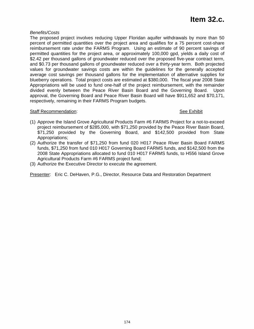
Item 32.c. Benefits/CostsThe proposed project involves reducing Upper Floridan aquifer withdrawals by more than 50 percent of permitted quantities over the project area and qualifies for a 75 percent cost-share reimbursement rate under the FARMS Program. Using an estimate of 90 percent savings of permitted quantities for the project area, or approximately 100,000 gpd, yields a daily cost of $2.42 per thousand gallons of groundwater reduced over the proposed five-year contract term, and $0.73 per thousand gallons of groundwater reduced over a thirty-year term. Both projected values for groundwater savings costs are within the guidelines for the generally accepted average cost savings per thousand gallons for the implementation of alternative supplies for blueberry operations. Total project costs are estimated at $380,000. The fiscal year 2008 State Appropriations will be used to fund one-half of the project reimbursement, with the remainder divided evenly between the Peace River Basin Board and the Governing Board. Upon approval, the Governing Board and Peace River Basin Board will have $911,652 and $70,171, respectively, remaining in their FARMS Program budgets.
Staff Recommendation: See Exhibit
(1) Approve the Island Grove Agricultural Products Farm #6 FARMS Project for a not-to-exceed project reimbursement of $285,000, with $71,250 provided by the Peace River Basin Board, $71,250 provided by the Governing Board, and $142,500 provided from State Appropriations;
(2) Authorize the transfer of $71,250 from fund 020 H017 Peace River Basin Board FARMS funds, $71,250 from fund 010 H017 Governing Board FARMS funds, and $142,500 from the 2008 State Appropriations allocated to fund 010 H017 FARMS funds, to H556 Island Grove Agricultural Products Farm #6 FARMS project fund;
(3) Authorize the Executive Director to execute the agreement.
Presenter: Eric C. DeHaven, P.G., Director, Resource Data and Restoration Department
174
175
Item 32.d.
Consent Agenda June 24, 2008
Resource Management Committee Facilitating Agricultural Resource Management Systems - Landscaping, Sod, and Irrigation, Inc. – DeSoto County
PurposeTo request approval for a Facilitating Agricultural Resource Management Systems (FARMS) project with Landscaping, Sod, and Irrigation, Inc. and approval to reimburse FARMS eligible costs up to a not-to-exceed limit of $127,500 (75 percent of total project costs). Of this amount, the 2008 State Appropriations will be used for $63,750, the Governing Board is requested to fund $31,875, and the Peace River Basin Board is requested to fund $31,875. Total project costs are estimated at $170,000.
Background/History The District's FARMS Program, developed by the District and Florida Department of Agriculture and Consumer Services, is a public/private agricultural Best Management Practices (BMPs) cost-share reimbursement program. FARMS is intended to expedite the implementation of production-scale agricultural BMPs that provide water resource benefits. Resource benefits of the FARMS Program include reduced Floridan aquifer withdrawals, water quality improvements (both from ground water and surface water sources) and/or conservation, restoration and augmentation of the area's water resources and ecology. The District's emphasis through the FARMS Program is on reductions in Upper Floridan aquifer withdrawals that will improve groundwater conditions as documented in the Southern Water Use Caution Area (SWUCA) recovery strategy. In addition, the District also provides funding for projects that improve water quality affected by the use of mineralized ground water as documented in the Shell and Prairie Creek Watershed Management Plan – Reasonable Assurance Documentation. Reimbursement cost-share rates are capped at 50 percent for water quantity withdrawal reductions from the Upper Floridan aquifer or water quality improvements realized from decreasing the use of mineralized ground water, and at 75 percent for both water quantity and water quality improvements. FARMS policy also allows for a 75 percent reimbursement if Upper Floridan withdrawals will be reduced by 50 percent or more.
FARMS Program staff received a project proposal from Landscaping, Sod, and Irrigation, Inc. for their sod farm located in the Hawthorne Creek Watershed of the Peace River, two miles east of U.S. Highway 17 in DeSoto County. The applicant has been growing sod on the property for more than 3 years, using a well not associated with a water use permit. A Water Use Permit was recently issued and authorizes an annual average groundwater withdrawal of 160,400 gallons per day (gpd) for the irrigation of 80 acres of sod from one proposed well to be completed in the Upper Floridan aquifer. The primary goal of this project is to replace the permitted Upper Floridan aquifer withdrawal through the use of two surface water reservoirs and the construction of two surface water irrigation pump stations, filtration, and the piping necessary to connect the proposed surface water reservoirs to the existing irrigation system.
Benefits/CostsThe proposed project involves replacing the permitted Upper Floridan aquifer well, which will reduce withdrawals by more than 50 percent of permitted quantities. Therefore, the project qualifies for a 75 percent cost-share reimbursement rate under the FARMS Program. Using an estimate of 80 percent savings of permitted quantities for the project area, or approximately 129,000 gpd, yields a daily cost of $0.83 per thousand gallons of groundwater reduced over the
176
Item 32.d. proposed five-year contract term, and $0.25 per thousand gallons of groundwater reduced over a thirty-year term. Both projected values for groundwater savings costs are within the guidelines for the generally accepted average cost savings per thousand gallons for the implementation of alternative supplies for sod operations. Total project costs are estimated at $170,000. The fiscal year 2008 State Appropriations will be used to fund one-half of the project reimbursement, with the remainder divided evenly between the Peace River Basin Board and the Governing Board. Upon approval, the Governing Board and Peace River Basin Board will have $816,027 and $38,296, respectively, remaining in their FARMS Program budgets.
Staff Recommendation: See Exhibit
(1) Approve the Landscaping, Sod, and Irrigation, Inc. FARMS Project for a not-to-exceed project reimbursement of $127,500, with $31,875 provided by the Peace River Basin Board, $31,875 provided by the Governing Board, and $63,750 provided from State Appropriations;
(2) Authorize the transfer of $31,875 from fund 020 H017 Peace River Basin Board FARMS funds, $31,875 from fund 010 H017 Governing Board FARMS funds, and $63,750 from the 2008 State Appropriations allocated to fund 010 H017 FARMS funds, to H557 Landscaping, Sod, and Irrigation, Inc. FARMS project fund;
(3) Authorize the Executive Director to execute the agreement.
Presenter: Eric C. DeHaven, P.G., Director, Resource Data and Restoration Department
177
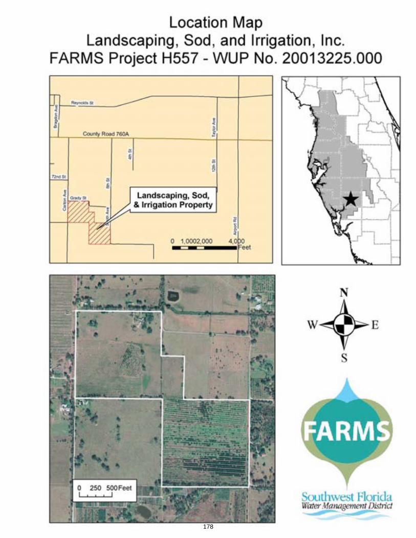
178
Item 32.e.
Consent Agenda June 24, 2008
Resource Management Committee Facilitating Agricultural Resource Management Systems – WFA Land Company, Inc. – Manatee County
PurposeTo request approval for a Facilitating Agricultural Resource Management Systems (FARMS) project with WFA Land Company, Inc. and approval to reimburse FARMS eligible costs up to a not-to-exceed limit of $135,000 (50 percent of total project costs). Of this amount, $67,500 of the 2005 State Appropriations will be used for one-half of the reimbursement, the Governing Board is requested to fund $33,750, and the Manasota Basin Board is requested to fund $33,750. Total project costs are estimated at $270,000.
Background/History The District's FARMS Program, developed by the District and Florida Department of Agriculture and Consumer Services, is a public/private agricultural Best Management Practices (BMPs) cost-share reimbursement program. FARMS is intended to expedite the implementation of production-scale agricultural BMPs that provide water resource benefits. Resource benefits of the FARMS Program include reduced Floridan aquifer withdrawals, water quality improvements (both from ground water and surface water sources) and/or conservation, and restoration and augmentation of the area's water resources and ecology. The District's emphasis through the FARMS Program is on reductions of Upper Floridan aquifer withdrawals that will improve ground water conditions as documented in the Southern Water Use Caution Area (SWUCA) recovery strategy. In addition, the District also provides funding for projects that improve water quality affected by the use of mineralized ground water as documented in the Shell and Prairie Creek Watershed Management Plan – Reasonable Assurance Documentation. Reimbursement cost-share rates are capped at 50 percent for water quantity withdrawal reductions from the Upper Floridan aquifer or water quality improvements realized from decreasing the use of mineralized ground water, and at 75 percent for both water quantity and water quality improvements.
FARMS Program staff received a project proposal from WFA Land Company, Inc. for their 1,460 acre citrus grove and sod farm on the north fork of the Manatee River. The property is within the SWUCA and lies along the eastern boundary of the Most Impacted Area. The Water Use Permit for this grove authorizes an annual average groundwater withdrawal of 1,807,000 gallons per day (gpd) for the irrigation of 1,460 acres of citrus and sod from five wells completed in the Upper Floridan aquifer. The moving annual average as of April 28, 2008 is 2,005,037 gpd, or about 110 percent of permitted quantities but below their permitted drought quantity of 2,189,193 gpd. The primary goal of the project is to reduce Upper Floridan aquifer groundwater withdrawals through the use of an integrated irrigation system that will include two weather stations, soil moisture sensors, and automated pump controls for the five Upper Floridan wells to reduce the number and duration of irrigation events.
Benefits/CostsThe proposed project involves water quantity BMPs which qualifies for a 50 percent cost-share reimbursement rate under the FARMS Program. Using an estimated 10 percent savings of permitted quantities, or approximately 180,700 gpd, yields a daily cost of $.94 per thousand gallons of groundwater reduced over the proposed five-year contract term, and $0.28 per thousand gallons of groundwater reduced over a thirty-year term. Both values are within the
179
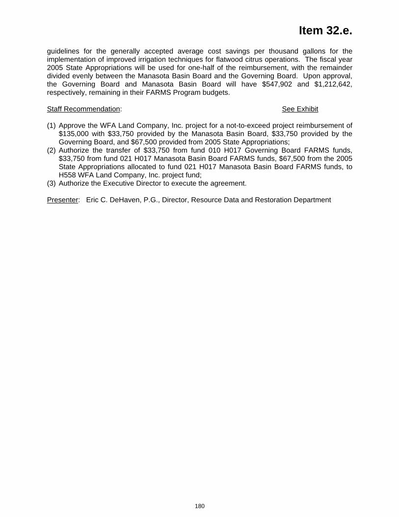
Item 32.e. guidelines for the generally accepted average cost savings per thousand gallons for the implementation of improved irrigation techniques for flatwood citrus operations. The fiscal year 2005 State Appropriations will be used for one-half of the reimbursement, with the remainder divided evenly between the Manasota Basin Board and the Governing Board. Upon approval, the Governing Board and Manasota Basin Board will have $547,902 and $1,212,642, respectively, remaining in their FARMS Program budgets.
Staff Recommendation: See Exhibit
(1) Approve the WFA Land Company, Inc. project for a not-to-exceed project reimbursement of $135,000 with $33,750 provided by the Manasota Basin Board, $33,750 provided by the Governing Board, and $67,500 provided from 2005 State Appropriations;
(2) Authorize the transfer of $33,750 from fund 010 H017 Governing Board FARMS funds, $33,750 from fund 021 H017 Manasota Basin Board FARMS funds, $67,500 from the 2005 State Appropriations allocated to fund 021 H017 Manasota Basin Board FARMS funds, to H558 WFA Land Company, Inc. project fund;
(3) Authorize the Executive Director to execute the agreement.
Presenter: Eric C. DeHaven, P.G., Director, Resource Data and Restoration Department
180
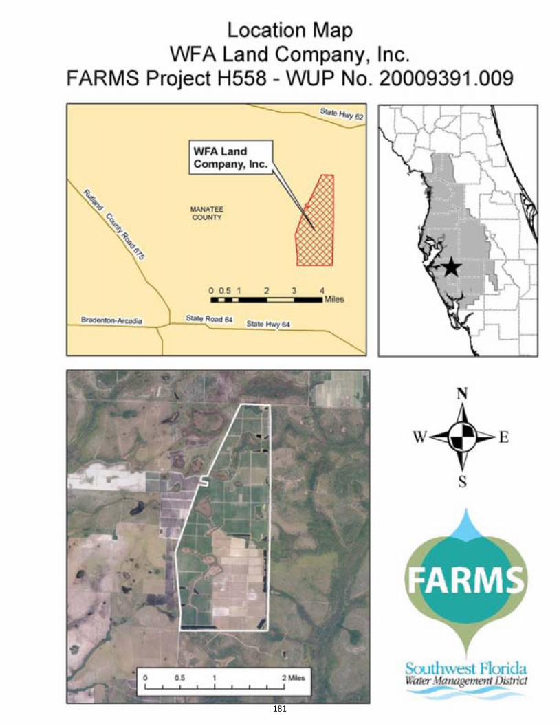
181
Item 32.f.
Consent Agenda June 24, 2008
Resource Management Committee Facilitating Agricultural Resource Management Systems – Balaban Farms, LLC – Hillsborough County
PurposeTo request approval for a Facilitating Agricultural Resource Management Systems (FARMS) project with Balaban Farms, LLC, and approval to reimburse FARMS eligible costs up to a not-to-exceed limit of $312,500 (50 percent of total project costs). Of this amount, the 2008 State Appropriations will be used for 50 percent, or $156,250, of the reimbursement, the Governing Board share is 25 percent, or $78,125, and the Hillsborough River Basin Board share is 25 percent, or $78,125. The Hillsborough River Basin’s share will come from funds remaining in its FARMS Program budget, which total $33,437, and $44,688 will come from a transfer out of the Basin’s Water Supply and Resource Development Reserves. Total project costs are estimated at $625,000.
Background/History The District's FARMS Program, developed by the District and Florida Department of Agriculture and Consumer Services, is a public/private agricultural Best Management Practices (BMPs) cost-share reimbursement program. FARMS is intended to expedite the implementation of production-scale agricultural BMPs that provide water resource benefits. Resource benefits of the FARMS Program include reduced Floridan aquifer withdrawals, water quality improvements (both from ground water and surface water sources) and/or conservation, restoration and augmentation of the area's water resources and ecology. The District's emphasis through the FARMS Program is on reductions in Upper Floridan aquifer withdrawals that will improve ground water conditions as documented in the Southern Water Use Caution Area (SWUCA) recovery strategy. In addition, the District also provides funding for projects that improve water quality affected by the use of mineralized ground water as documented in the Shell and Prairie Creek Watershed Management Plan – Reasonable Assurance Documentation. Reimbursement cost-share rates are capped at 50 percent for water quantity withdrawal reductions from the Upper Floridan aquifer or water quality improvements realized from decreasing the use of mineralized ground water, and at 75 percent for both water quantity and water quality improvements.
FARMS Program staff received a proposal for a project with Balaban Farms, LLC for a farm located in the Hillsborough River watershed, in north-central Hillsborough County, within the Northern Tampa Bay Water Use Caution Area. The property drains predominantly to the west where surface water enters Flint Creek and continues into the Hillsborough River. The previous Water Use Permit authorizes a standard annual average groundwater withdrawal of 255,000 gallons per day (gpd for 55 acres of citrus from two Upper Floridan aquifer withdrawals. The citrus grove has been destroyed due to disease and is being converted to strawberries and row crops. The Water Use Permit is currently in house for a modification due to the crop change, however, the expected annual average groundwater withdrawal that will be allowed under the permit modification will remain at 255,000 gpd. Due to the location of the property within the Hillsborough River Groundwater Basin, there cannot be an increase in groundwater irrigation quantities. Prior to removal of the citrus grove, the reported water use was approximately 45 percent of their permitted quantities. In the past six months, since the conversion of citrus to row crop, the water use averages approximately 70 percent of the expected permitted quantities. The primary goal of the project is to reduce Upper Floridan aquifer groundwater withdrawals through the installation and automation of three surface water irrigation pump
182
Item 32.f. stations, filtration, and the piping necessary to connect the designed tailwater interception and surface water reservoir system to the existing irrigation system. The tailwater interception and surface water reservoir system will consist of three reservoirs of approximately 3 acres, 3.3 acres, and 4.5 acres.
Benefits/CostsThe proposed project involves water quantity BMPs and therefore, the project qualifies for a 50 percent cost-share reimbursement rate under the FARMS Program. Using an estimate of 50 percent savings of permitted quantities, or approximately 127,500 gpd, yields a daily cost of $1.91 per thousand gallons of groundwater reduced over the proposed nine-year contract term, and $0.93 per thousand gallons of groundwater reduced over a thirty-year term. Both projected values for groundwater savings costs are within the guidelines for the generally accepted average cost savings per thousand gallons for the implementation of alternative water supplies on row crop operations. Total project costs are estimated at $625,000. The fiscal year 2008 State Appropriations will be used to fund one-half of the project reimbursement with the remainder divided evenly between the Hillsborough River Basin Board and the Governing Board. Upon approval, the Governing Board and the Hillsborough River Basin Board will have $581,652 and $0, respectively, remaining in their FARMS Program budgets. The Hillsborough River Basin Water Supply and Resource Development Reserves will have $3,879,802 remaining.
Staff Recommendation: See Exhibit
(1) Approve the Balaban Farms, LLC FARMS Project for a not-to-exceed project reimbursement of $312,500, with $44,688 provided from the Hillsborough River Basin Water Supply and Resource Development Reserves, $33,437 provided by the Hillsborough River Basin, $78,125 provided by the Governing Board, and $156,250 provided from 2008 State Appropriations;
(2) Authorize the transfer of $44,688 from fund 013 H100 Hillsborough River Basin Water Supply and Resource Development Reserves, $33,437 from fund 013 H017 Hillsborough River Basin FARMS funds, $78,125 from fund 010 H017 Governing Board FARMS funds, and $156,250 from the 2008 State Appropriations allocated to fund 010 H017 FARMS funds, to the H559 Balaban Farms project fund;
(3) Authorize the Executive Director to execute the agreement.
Presenter: Eric C. DeHaven, P.G., Director, Resource Data and Restoration Department
183
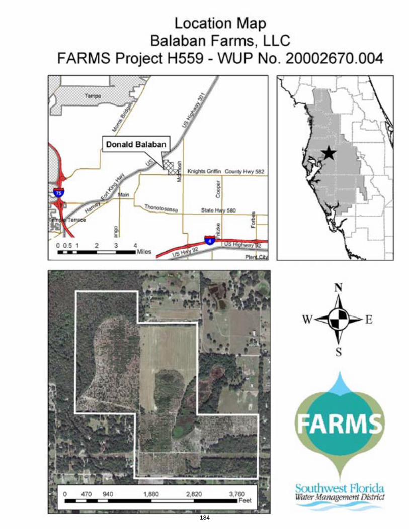
184
Item 33.a.
Consent Agenda June 24, 2008
Resource Management Committee Surface Water Improvement and Management Program – Sawgrass Lake Restoration Project
PurposeThis is an action item requesting approval of an agreement between the City of St. Petersburg and the District to relocate an existing 36-inch potable water transmission line as part of the Sawgrass Lake Restoration Project. The District will fund the project at a total estimated cost of $800,000, the funds to come from the existing project reserve, which currently has $18,599,530 available. The relocation of the pipeline was anticipated in the approved remedial action plan.
Background/HistoryTesting conducted at the District-owned Sawgrass Lake Park Water Management Area (WMA), including field testing conducted by the Florida Department of Environmental Protection (FDEP) and a Contamination Assessment Report completed in August 2000 by SCS Engineers, Inc., documented contaminated conditions in the area of the WMA and the adjacent Skyway Trap and Skeet Club property. Elevated levels of lead and arsenic were found in surface waters, soils, sediments and ground water. The area of contamination is coincident with portions of the Sawgrass Lake Park WMA used as a drop-zone for spent shot and where contaminants associated with the spent shot have migrated. The source of the spent shot is from skeet and trap shooting activities conducted west of the District's ownership.
Several years of litigation and new state legislation passed in April 2004 resulted in a settlement agreement between the District and the Skyway Trap and Skeet Club. Under the terms of the agreement, the District will undertake removal of lead shot and other contaminants from areas within the Sawgrass Lake Park WMA. Independently, the Skyway Trap and Skeet Club will be responsible for cleanup of its property. The settlement agreement also requires a transfer of ownership of five acres of District lands to the gun club. In exchange for receiving title to five acres of District lands, the Skyway Trap and Skeet Club will surrender the perpetual easement it holds over District lands east of the south inflow canal. The gun club also agreed to construct a shot barrier to prevent shot from entering District property in the future.
On December 11, 2007, the FDEP approved the District’s Remedial Action Plan (RAP), which summarizes the contamination assessment, feasibility study findings, risk-based site cleanup goals, and outlines a cleanup strategy for the site. Subsequent to approval of the RAP, the District and FDEP developed a Rehabilitation and Reclamation Agreement, to replace the original 2001 FDEP Consent Order. The terms of the Rehabilitation and Reclamation Agreement require the District to clean up contaminated areas within the Sawgrass Lake Park WMA in accordance with state regulations and guidelines and includes a schedule approved by both parties. The Rehabilitation and Reclamation Agreement was fully executed in March 2008. With the FDEP's approval of the RAP and Rehabilitation and Reclamation Agreement, the District has initiated the design and permitting phase of the project. Construction and remediation are anticipated to begin in 2009.
On March 25, 2008 as part of preliminary design work, District staff met with representatives of the City of St. Petersburg Water Resources Department (City) to discuss the relocation of an existing 36-inch water transmission line that is currently located in the area to be excavated for lead contamination remediation per the approved RAP. Based on discussions with the City, the
185
Item 33.a. water transmission line will be relocated around the cleanup and restoration area prior to construction to avoid damage and potential interruptions in service. The City has requested to be the lead entity responsible for the design, permitting, and construction of the water main relocation. The City had no plans to replace this section of the water transmission line and does not have funds budgeted for its relocation. The District anticipated funding the relocation of the water transmission line and this was included in the cost estimate detailed in the RAP. The City developed a cost estimate for the design and construction of the water transmission line relocation and it is comparable with the estimate included in the RAP.
Other Sawgrass Lake Restoration project activities separate from the Rehabilitation and Reclamation Agreement, include the development of a plan to improve the quality of water discharging from Sawgrass Lake to Tampa Bay. This plan includes conceptual designs and cost estimates for best management practice (BMP) alternatives to reduce nutrient loadings to Tampa Bay. The recommended water quality BMPs will be incorporated into the final design of the remediation project.
Benefits/CostsThe principal elements of this project will result in the cleanup and restoration of water resources and wetland areas within the Sawgrass Lake Park WMA. Site cleanup and reclamation of spent shot from the drop zone area will remove lead and associated contaminants from the system. Water quality BMPs will reduce potential nutrient loadings to Tampa Bay. The cost estimate for the required cleanup of the site, detailed in the RAP, is approximately $19,900,000, which includes $800,000 for the relocation of the water transmission line. A cost estimate for implementation of the water quality BMPs is approximately $4,500,000. Over the past several years (fiscal year [FY] 2005 – [FY] 2008) the Pinellas-Anclote River Basin Board budgeted a total of $18,599,530 for this project, which includes $1,000,000 of State appropriated funds for Tampa Bay. There is currently $18,015,386 available for design, permitting, and construction. The proposed FY2009 budget includes $4,500,000, for construction of the water quality BMPs. This additional $4,500,000 is based on updated cost estimates for the project. Additionally, staff is pursuing other potential outside funding sources for implementation of this project.
Staff Recommendation:
Approve the agreement with the City of St. Petersburg for the relocation of the City's water transmission line for an amount not to exceed $800,000 and authorize the Executive Director to sign the agreement. Funds to come from the existing reserve (in B085).
Presenter: Jennette Seachrist, SWIM Program Manager, Resource Data and Restoration Dept.
186
Item 33.b.
Consent Agenda June 24, 2008
Resource Management Committee Surface Water Improvement and Management Program - Clam Bayou Stormwater Treatment and Habitat Restoration Project
PurposeTo amend a contract with the City of St. Petersburg to add project funds in the amount of $200,000 to complete land acquisition tasks and authorize the Executive Director to send a letter to the City of St. Petersburg formally requesting that the City pursue condemnation proceedings to acquire the final properties necessary for the Clam Bayou Stormwater Treatment and Habitat Restoration Project.
Background/HistoryClam Bayou is a 90-acre estuary system located off the eastern reaches of Boca Ciega Bay, part of Tampa Bay. Public land holdings immediately surrounding the bayou include 130-acres owned by the District, St. Petersburg and Gulfport for water quality or habitat preservation/restoration purposes. Recognizing an opportunity to improve water quality and increase habitat utilization in Clam Bayou beginning in 1994, the three entities have partnered on projects aimed at achieving these objectives and have entered into a tri-party management agreement for long-term maintenance of the project lands.
Two phases of the Clam Bayou project have been completed and District staff is currently working on a third phase. Phases 1 and 2 of the project were completed in 1995 and 2001, respectively. Under these phases, the District, with financial assistance from the cities of St. Petersburg and Gulfport, the Florida Department of Environmental Protection (FDEP), and U.S. Fish and Wildlife Service, restored 20 acres of coastal habitat, created park lands, and provided stormwater treatment in portions of Clam Bayou within both Gulfport and St. Petersburg. The total cost of those projects was approximately $420,000. The District is also the lead entity implementing Phase 3 and has budgeted and encumbered approximately $8 million for land acquisition, design, permitting, and construction. Once complete, this phase will address primary issues impacting the bayou – sedimentation, trash accumulation and nutrients from untreated stormwater originating in St. Petersburg and Gulfport. Phase 3 will also restore coastal habitats and provide land for a recreational trail (extension of the 34-mile long Pinellas Trail), which will connect several local schools and provide scenic views of the restored areas. The City of St. Petersburg is leading the design and construction of the trail.
The District entered into a cooperative funding agreement with the City of St. Petersburg in October 2005 for the acquisition of land needed to address the stormwater treatment elements of Phase 3. Under the terms of this agreement, the District is reimbursing the City for the actual land purchase price up to a maximum of $900,000. To date, the City has acquired a total of 65 lots and has one additional lot under contract. Four lots remain that the City has not successfully obtained purchase agreements with the owners. Without two of these lots, one of the three stormwater ponds cannot be constructed as planned. The City is working diligently to acquire these properties and has indicated that they will pursue condemnation proceedings at the District's request. The Pinellas-Anclote Basin, at its June 4, 2008 meeting, authorized the Executive Director to send a letter to the City of St. Petersburg formally requesting the City pursue condemnation proceedings to acquire the final properties necessary for this project. The city has also requested additional funding to complete the land acquisitions. The City and District estimates the cost to acquire the final five lots may be a total of $351,000 including the costs associated with condemnation. A total of $151,800 of the original total budget for land remains. Therefore, the City is requesting an additional $200,000 for land acquisition and condemnation proceedings. The additional $200,000 will come from funds currently allocated in W242 for land acquisition costs.
187
Item 33.b.
Design of the final phase is nearing completion. The permit application should be submitted by September 2008 and permits received by November 2008. Upon receipt of the permits, the request for bids will be advertised. Once bids are received, the District will enter into a construction agreement and commence construction. It is anticipated construction will commence by March 2009 and be completed by December 2009.
At the April 2, 2008, Pinellas-Anclote River Basin Board meeting in Gulfport, the Basin Board members heard presentations from District staff as well as from local citizens regarding the restoration efforts currently underway. Although the parties seem to agree the proposed projects address key issues in the bayou, those individuals representing City of Gulfport and local citizen interests are of the opinion that the project stops short in a complete restoration effort because the District currently did not have plans for dredging in the bayou. The District considered sediment removal throughout the bayou as a component of the restoration when it was finishing the Surface Water Improvement and Management (SWIM) plan for the bayou in 1999. A sediment study was conducted by the FDEP and the United States Geological Survey in 2002 on behalf of the District. This study focused on the condition of the existing sediments in the bayou, not on the source of the sediments, as it is recognized by all that they have been transported into the system from urban runoff in areas of St. Petersburg and Gulfport developed prior to the State's implementation of stormwater regulations. In addition, historic dredge and fill activities have greatly altered the configuration and the tidal circulation of the bayou by filling approximately 28-acres of bay bottom. The analysis of the sediments included quality and habitat value parameters. The results indicated that the sediment quality is similar to that found throughout Tampa Bay and the system functions as a mangrove dominated mudflat, supporting typical biota found in other areas of Tampa Bay. Clam Bayou is a shallow low-energy system supporting wildlife typical of such environments. Based on the environmental benefits attributed to mangrove-dominated mudflats, dredging has not been part of the District's planned restoration activities. This is consistent with the District's approach to habitat restoration in Tampa Bay and other estuarine systems. The information generated by the study, and the need for dredging, was discussed among the scientific community associated with the Agency on Bay Management (ABM) at a meeting April 12, 2007, at the request of Senator Bill Nelson. The ABM group, which reviewed the data and resulting recommendations, was made up of scientists and program managers from the Hillsborough County, Manatee County, Pinellas County, the cities of St Petersburg and Clearwater, FDEP, U.S. Fish and Wildlife Service, the U.S. Army Corps of Engineers, National Marine Fisheries, Florida's Coastal Islands Sanctuaries, Tampa Bay Estuary Program, and Tampa Bay Watch. The consensus of the group supported the District's restoration plan and agreed with the conclusion that dredging would not improve habitat value in Clam Bayou.
As directed by the Basin Board, staff scientists reviewed the issue of improving tidal flushing in Clam Bayou. District staff member, Dr. XinJian Chen, P.E., a nationally recognized specialist in hydrodynamic and water quality modeling, was consulted regarding the effects of removing sediments from the bayou on tidal flushing. Dr. Chen indicated tidal circulation would be marginally improved with sediment removal at depths within the zone of tidal fluctuation, which is estimated at depths to -0.5 feet National Geodetic Vertical Datum (NGVD) elevation. He also indicated dredging at deeper depths within the navigational channel would not improve tidal circulation but would serve to improve navigational access. The District's statutory authority, as determined in a recent legal review (Exhibit A) does not extend to maintenance dredging of an existing water body solely to improve navigation. Therefore, in the case of Clam Bayou, dredging to improve habitat and/or water quality is consistent with the District's authority and mission, but, navigational dredging is not. Since the April Basin Board meeting staff performed a survey of reported "choke points" along the main channel of the bayou that was previously dredged in an effort to quantify the material within the tidal zone. Results of this effort indicate that tidal flushing could be minimally improved by removing material that is exposed on extreme low tides. The actual amount of material is estimated to be less than 1,000 cubic yards, however, additional analysis will be performed to better quantify this amount. It is important to note that the area along the main channel considered for dredging functions as a productive, natural, mudflat environment with oyster beds, marsh grasses, and mangroves located in close
188
Item 33.b.proximity. Funds in the amount of $50,000 have been added to the Pinellas-Anclote River Basins FY2009 budget to perform the dredging project.
In addition to sedimentation, the accumulation of trash and debris in Clam Bayou is a major concern. The stormwater projects currently in design will address this, however, there are known areas in the bayou with large debris and accumulated trash, such as shopping carts and garbage cans that act as sediment traps when lodged in the channels. District staff is looking at partnering with St. Petersburg and Gulfport on a new, more in-depth plan to remove large submerged objects known to exist in the bayou. In addition, the current plan contains a component to perform a "clean sweep" to remove visible trash from the estuary following the completion of the stormwater ponds. This will be accomplished either through volunteer efforts organized by the partners or through procurement of a contractor to remove trash and large debris. Funds in the amount of $50,000 have been added to the Pinellas-Anclote River Basins FY2009 budget to perform the debris removal project.
District regulatory and project management staff also inspected the channel east of the Twin Brooks Golf Course. At the time of the visit, no regulatory violations were noted. The City of St. Petersburg was in the process of removing exotic vegetation and stabilizing the banks with fill and concrete/tile rubble. District regulatory staff noted that the practice employed is an acceptable method and the quantity of material represented a "deminimus" amount that would not be subject to permitting. Streambank erosion is a common problem contributing to sedimentation, especially in highly urbanized areas such as Pinellas County. The District has in the past partnered with local governments on streambank protection projects. District staff recently discussed, with the City of St. Petersburg, options to incorporate erosion control at the channel east of the Twin Brooks Golf Course into the Phase 3 project. The City indicated they do not have funds, but are able to provide in-kind services, such as construction inspection services for the Phase 3 construction. Funds in the amount of $200,000 have been added to the Pinellas-Anclote River Basins FY2009 budget to perform the streambank protection project.
Benefits/CostsThe total current project budget for Phase 3, including land acquisition by the City of St. Petersburg, is $8,047,800. The District's share of the current project budget totals $6 million, of which $1 million is funded by State Appropriations, $500,000 is funded by an Environmental Protection Agency (EPA) Grant specifically for construction, and the remainder is divided, $1,850,000 from the Pinellas-Anclote River Basin Board and $2,650,000 from State SWIM funds. The City of St. Petersburg land purchases total $2,047,800, of which $300,000 was funded by City funds, $750,000 was funded by a Florida Communities Trust Fund Grant, and $997,800 was funded by an EPA Grant. The proposed FY2009 budget includes $300,000 for erosion control measures at the Twin Brooks Golf Course ($200,000), debris removal ($50,000), and dredging along the navigational channel to improve tidal circulation ($50,000).
Staff Recommendation: See Exhibit
(1) Approve the amendment with the City of St. Petersburg to provide an additional $200,000 from funding currently allocated in W242 for land acquisition costs, including potential condemnation costs, and authorize the Executive Director to sign the agreement; and
(2) Authorize the Executive Director to send a letter to the City of St. Petersburg formally requesting that the City pursue condemnation proceedings to acquire the final properties necessary for the Clam Bayou Stormwater Treatment and Habitat Restoration Project.
Presenter: Jennette Seachrist, SWIM Program Manager, Resource Data and Restoration Dept.
189
May 20, 2008 MEMORANDUM TO: David L. Moore, Executive Director FROM: William S. Bilenky, General Counsel SUBJECT: District Authority to undertake dredging for the sole purpose of
improving navigation for the benefit of a small number of waterfront property owners.
Question: The question is whether the District has authority to seek an environmental resource permit and sovereign submerged lands authorization from the Department of Environmental Protection to maintenance dredge Clam Bayou exclusively for the purpose of improving navigation for the benefit of a limited group of individual waterfront property owners. Short Answer: The District's statutory authority does not extend to maintenance dredging of an existing water body solely to improve navigation. Improving a channel solely for the benefit of a limited group of individual property owners would not be good public policy. Analysis: The District's only statutory authority with respect to improving navigability is found in section 373.016 (3)(i), Florida Statutes (F. S.) that states: "It is further declared to be the policy of the Legislature . . . (t)o promote recreational development, protect public lands, and assist in maintaining navigability of rivers and harbors;" There are no cases directly interpreting section 373.016(3)(i), F. S. so it must be interpreted using the "plain meaning" of the words used by the Legislature. GTC, Inc. v. Edgar, 967 So. 2d 781 (Fla. 2007). Authority for maintenance of rivers and harbors is expressly delegated by the Congress to the Army Corps of Engineers pursuant to the Rivers and Harbors Act of 1899, 33 U.S.C. Sections 401 et seq. U.S. v. Joseph G. Moretti, Inc., 478 F.2d 418 (C.A.5, 1973). The Army Corps of Engineers is primarily concerned with dredging and filling and has no mission statement with regard to the protecting of the environment. Sierra Club v. Flowers, 423 F.Supp.2d 1273 (S. D. Fla., 2006). The Legislature has granted the District limited authority to assist with maintaining navigability but has not granted the authority to "initiate or undertake" maintaining navigability. The Legislature is also presumed to know when it uses language such as the term "assist" that primary authority to carry out that function is vested in another entity such as the Army Corps of Engineers. State ex rel. Christian v. Austin, 302 So.2d 811 (Fla. App. 1st 1974) (Assist found to mean "to give support or aid.) Nothing in section 373.016, F. S. authorizes the District to initiate or undertake dredging in a river or harbor, but instead is limited to assisting others in the performance
Page 1 of 2
190
of that function. The statutory language also places a second limitation on the District's authority to conduct maintenance dredging. That authority is limited to maintenance of navigability within rivers and harbors. This is keeping with the authority delegated by Congress to the Army Corps of Engineers. There is no delegation to the District to initiate or undertake dredging or maintenance dredging of lesser water bodies, outside of rivers and harbors and no authority to do so except while assisting another agency of the state or federal government. While it is true that the project is exclusively for the purpose of improving navigability, it is not assisting the Corps in the activity, nor is the proposed project to be conducted within a river or harbor. Therefore section 373.016 (3)(i), F. S. has no applicability to this proposed dredging. Other districts cite the authority of section 373.086, F. S. to define certain water bodies as "works of the district" as enabling them "to clean out, straighten, enlarge or change the course of any water body within the district." However, this District has repealed all rules identifying various water bodies as "works of the district." 40D-6.011, Florida Administrative Code. Therefore, the District has not identified Clam Bayou as a "work of the district" and section 373.086, F. S. has no applicability to this proposed dredging. All expenditure of public funds should be based upon sound policy considerations. Dredging of the Clam Bayou for the purpose of improving the navigation for a limited group of waterfront property owners would certainly raise a question whether such an expenditure is good public policy. It is difficult to imagine how the taxpayers in the sixteen counties of the district would benefit from the proposed dredging. It seems reasonably clear that the dredging is for the sole and exclusive benefit of a limited number of individual property owners on Clam Bayou who are seeking to have better navigability to and from their properties. Those individuals are capable of seeking the necessary permits to undertake such a project. The ultimate benefit that would most likely arise from improving the navigation would almost exclusively inure to the benefit of those property owners. As such, it is easy to conclude that the use of public funds to enhance a few individuals' property values would be unreasonable. Certainly, the District may undertake to dredge a water body incident to a surface water improvement project where it is authorized pursuant to the delegated authority to improve the water quality or for flood protection. Those projects can be shown to meet a public interest test. However, there is no authority to undertake such a project where it is solely for the purpose of improving navigation for individual waterfront property owners. Conclusion: Therefore, I must conclude that the initiation of maintenance dredging of Clam Bayou by the District solely for the purpose of improving navigability for a limited group of property owners is not authorized by Florida law.
Page 2 of 2
191
Item 33.c.
Consent Agenda June 24, 2008
Resource Management Committee Surface Water Improvement and Management Program – Urban Lake Rescue
PurposeTo request approval of the first amendment to the agreement with the City of Tampa to provide an additional $136,916 for construction of the Urban Lake Rescue Project for Lake Roberta and Lake Kipling (W268).
Background/History The District, on behalf of the Hillsborough River and Northwest Hillsborough Basin Boards, entered into a Cooperative Funding Agreement with the City of Tampa in May 2006 for the Urban Lake Rescue Project to improve water quality and restore habitat in three urban lakes (Lake Edna, Lake Roberta and Lake Kipling). Lake Kipling is tidally connected to Tampa Bay which is a District Surface Water Improvement and Management (SWIM) priority water body; Lakes Edna and Roberta discharge to the Hillsborough River, a major tributary to Tampa Bay. Lake Edna is a 1.75 acre lake located in the Wellswood neighborhood; Lake Roberta is a 2.2 acre lake located in Seminole Heights; and Lake Kipling is a 2.1 acre lake located in Sunset Park; all three lakes are within the City of Tampa. The lakes are heavily silted from years of untreated stormwater inflow, the contributing drainage basin areas are highly urbanized, and in each case, stormwater passes through the lakes without much water quality treatment, adversely impacting these systems and down-stream receiving water bodies. This project involves the evaluation, design, permitting and construction of three separate lake projects. The City of Tampa is taking the lead in these activities and is responsible for long-term maintenance of the project. District funding was based on the City’s cooperative funding request and is for design, permitting and construction of the projects.
Benefits/CostsThe objectives of the project include lake habitat restoration, erosion control, water quality treatment, and citizen involvement and education. The District's total contribution to this project (including all three lakes) is $420,000, of which $103,000 is from the Hillsborough River Basin, $107,000 is from the Northwest Hillsborough Basin, and $210,000 is from State SWIM funds. The City's matching contribution of $420,000 is from an established Capital Improvement Program for the lake improvement project. The anticipated construction cost for Lake Roberta was $232,000 and $367,000 for Lake Kipling.
Design and permitting of the Lake Roberta portion of the project was completed in September 2007. The City is the lead agency responsible for the project design, construction, and long-term operation and maintenance and advertised a request for bid in July 2007 to secure a contractor to construct the project. All bids exceeded the amount budgeted for construction. The low bidder, Kamminga & Roodvoets Contracting, placed a bid of $315,909, which exceeded the budgeted amount by $83,909. In order to move forward with construction in this fiscal year, the City is using $83,909 from the City's Stormwater Funds and is requesting the District to reimburse 50 percent ($41,955) to meet the funding shortfall.
Design and permitting of the Lake Kipling portion of the project were completed in February 2008. The City is the lead agency responsible for the project design, construction, and long-term operation and maintenance and advertised a request for bid in February 2008 to secure a contractor to construct the project. All bids exceeded the amount budgeted for construction.
192
Item 33.c. The low bidder, Kimmins Contracting, placed a bid of $556,921, which exceeded the budgeted amount by $189,921. In order to move forward with construction in this fiscal year, the City is using $189,921 from the City's Stormwater Funds and is requesting the District to reimburse 50 percent ($94,961) to meet the funding shortfall.
Staff Recommendation:
(1) Authorize the transfer of $41,955 from the Hillsborough River Basin Board's Stormwater Implementation Reserves Fund (Z969), to W268, Urban Lake Rescue Project for Lake Roberta improvements;
(2) Authorize the transfer of $94,961 from the Northwest Hillsborough Basin Board's Stormwater Implementation Reserves Fund (Z969), to W268, Urban Lake Rescue Project for Lake Kipling improvements; and
(3) Authorize the Executive Director to approve and execute an amendment to the agreement.
Presenter: Shelley Thornton, Staff Engineer, SWIM Program, Resource Data & Restoration Dept.
193
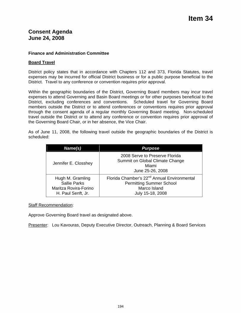
Item 34
Consent Agenda June 24, 2008
Finance and Administration Committee
Board Travel
District policy states that in accordance with Chapters 112 and 373, Florida Statutes, travel expenses may be incurred for official District business or for a public purpose beneficial to the District. Travel to any conference or convention requires prior approval.
Within the geographic boundaries of the District, Governing Board members may incur travel expenses to attend Governing and Basin Board meetings or for other purposes beneficial to the District, excluding conferences and conventions. Scheduled travel for Governing Board members outside the District or to attend conferences or conventions requires prior approval through the consent agenda of a regular monthly Governing Board meeting. Non-scheduled travel outside the District or to attend any conference or convention requires prior approval of the Governing Board Chair, or in her absence, the Vice Chair.
As of June 11, 2008, the following travel outside the geographic boundaries of the District is scheduled:
Name(s) Purpose
Jennifer E. Closshey
2008 Serve to Preserve Florida Summit on Global Climate Change
MiamiJune 25-26, 2008
Hugh M. Gramling Sallie Parks
Maritza Rovira-Forino H. Paul Senft, Jr.
Florida Chamber’s 22nd Annual Environmental Permitting Summer School
Marco Island July 15-18, 2008
Staff Recommendation:
Approve Governing Board travel as designated above.
Presenter: Lou Kavouras, Deputy Executive Director, Outreach, Planning & Board Services
194
Item 35
Consent Agenda June 24, 2008
Finance and Administration Committee
Budget Transfer Report
PurposeRequest approval of the Budget Transfer Report covering all budget transfers made during the month of May 2008.
Background In accordance with Board Policy No. 130-8, all transfers approved by the Basins, Executive Director and Finance Director under delegated authority are regularly presented to the Finance and Administration Committee for approval on the Consent Agenda at the next scheduled meeting. The exhibit for this item reflects all such transfers executed since the date of the last report for the Committee's approval.
Staff Recommendation: See Exhibit
Request approval of the Budget Transfer Report covering all budget transfers for May 2008.
Presenter: Linda R. Pilcher, Assistant Director, Finance Department
195
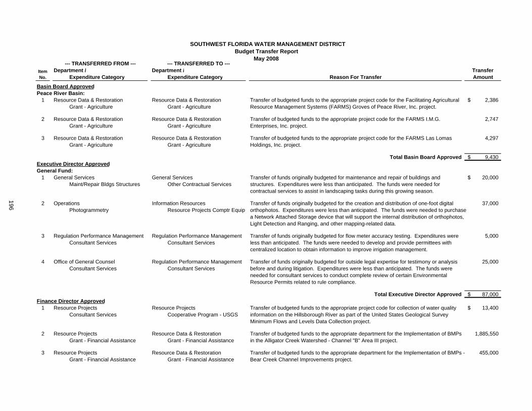
SOUTHWEST FLORIDA WATER MANAGEMENT DISTRICTBudget Transfer Report
May 2008
Department / Department /Expenditure Category Expenditure Category
Basin Board ApprovedPeace River Basin:
1 3Resource Data & Restoration 3Resource Data & Restoration 2,386$ 8107 Grant - Agriculture 8107 Grant - Agriculture
2 3Resource Data & Restoration 3Resource Data & Restoration 2,7478107 Grant - Agriculture 8107 Grant - Agriculture
3 3Resource Data & Restoration 3Resource Data & Restoration 4,2978107 Grant - Agriculture 8107 Grant - Agriculture
Total Basin Board Approved 9,430$ Executive Director ApprovedGeneral Fund:
1 0General Services 0General Services 20,000$ 4602 Maint/Repair Bldgs Structures 3401 Other Contractual Services
2 6Operations 0Information Resources 37,0003413 Photogrammetry MAN3 Resource Projects Comptr Equip
3 4Regulation Performance Management 4Regulation Performance Management 5,0003111 Consultant Services 3111 Consultant Services
4 0Office of General Counsel 4Regulation Performance Management 25,0003111 Consultant Services 3111 Consultant Services
Total Executive Director Approved 87,000$ Finance Director Approved
1 5Resource Projects 5Resource Projects 13,400$ 3111 Consultant Services 3411 Cooperative Program - USGS
2 5Resource Projects 3Resource Data & Restoration 1,885,550 8101 Grant - Financial Assistance 8101 Grant - Financial Assistance
3 5Resource Projects 3Resource Data & Restoration 455,000 8101 Grant - Financial Assistance 8101 Grant - Financial Assistance
ItemNo.
--- TRANSFERRED FROM --- --- TRANSFERRED TO ---TransferAmountReason For Transfer
Transfer of budgeted funds to the appropriate project code for collection of water quality information on the Hillsborough River as part of the United States Geological Survey Minimum Flows and Levels Data Collection project.
Transfer of budgeted funds to the appropriate department for the Implementation of BMPs - Bear Creek Channel Improvements project.
Transfer of budgeted funds to the appropriate project code for the FARMS I.M.G. Enterprises, Inc. project.
Transfer of budgeted funds to the appropriate project code for the FARMS Las Lomas Holdings, Inc. project.
Transfer of funds originally budgeted for flow meter accuracy testing. Expenditures were less than anticipated. The funds were needed to develop and provide permittees with centralized location to obtain information to improve irrigation management.
Transfer of budgeted funds to the appropriate department for the Implementation of BMPs in the Alligator Creek Watershed - Channel "B" Area III project.
Transfer of budgeted funds to the appropriate project code for the Facilitating Agricultural Resource Management Systems (FARMS) Groves of Peace River, Inc. project.
Transfer of funds originally budgeted for maintenance and repair of buildings and structures. Expenditures were less than anticipated. The funds were needed for contractual services to assist in landscaping tasks during this growing season.
Transfer of funds originally budgeted for outside legal expertise for testimony or analysis before and during litigation. Expenditures were less than anticipated. The funds were needed for consultant services to conduct complete review of certain Environmental Resource Permits related to rule compliance.
Transfer of funds originally budgeted for the creation and distribution of one-foot digital orthophotos. Expenditures were less than anticipated. The funds were needed to purchase a Network Attached Storage device that will support the internal distribution of orthophotos, Light Detection and Ranging, and other mapping-related data.
196
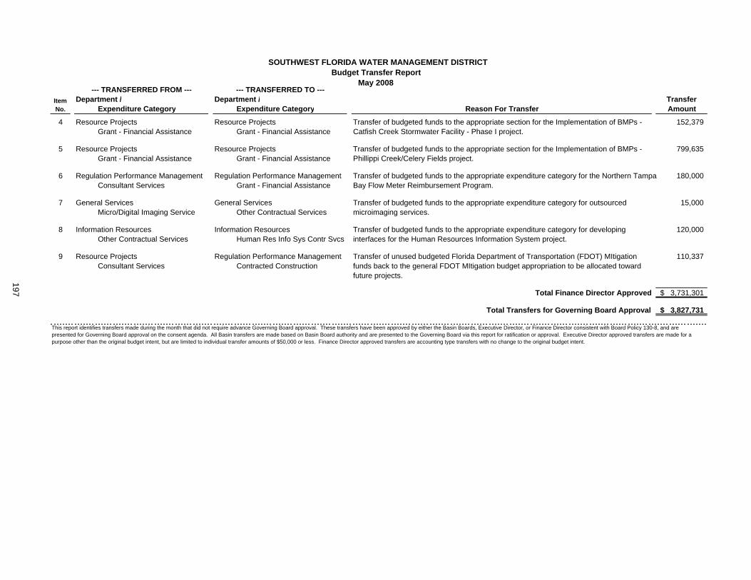
SOUTHWEST FLORIDA WATER MANAGEMENT DISTRICTBudget Transfer Report
May 2008
Department / Department /Expenditure Category Expenditure Category
ItemNo.
--- TRANSFERRED FROM --- --- TRANSFERRED TO ---TransferAmountReason For Transfer
4 5Resource Projects 5Resource Projects 152,379 8101 Grant - Financial Assistance 8101 Grant - Financial Assistance
5 5Resource Projects 5Resource Projects 799,635 8101 Grant - Financial Assistance 8101 Grant - Financial Assistance
6 4Regulation Performance Management 4Regulation Performance Management 180,000 3111 Consultant Services 8101 Grant - Financial Assistance
7 0General Services 0General Services 15,000 4702 Micro/Digital Imaging Service 3401 Other Contractual Services
8 0Information Resources 0Information Resources 120,000 3401 Other Contractual Services HRS6 Human Res Info Sys Contr Svcs
9 5Resource Projects 4Regulation Performance Management 110,337 3111 Consultant Services 3431 Contracted Construction
Total Finance Director Approved 3,731,301$
Total Transfers for Governing Board Approval 3,827,731$
Transfer of budgeted funds to the appropriate expenditure category for developing interfaces for the Human Resources Information System project.
Transfer of budgeted funds to the appropriate section for the Implementation of BMPs - Catfish Creek Stormwater Facility - Phase I project.
Transfer of budgeted funds to the appropriate expenditure category for outsourced microimaging services.
This report identifies transfers made during the month that did not require advance Governing Board approval. These transfers have been approved by either the Basin Boards, Executive Director, or Finance Director consistent with Board Policy 130-8, and arepresented for Governing Board approval on the consent agenda. All Basin transfers are made based on Basin Board authority and are presented to the Governing Board via this report for ratification or approval. Executive Director approved transfers are made for a purpose other than the original budget intent, but are limited to individual transfer amounts of $50,000 or less. Finance Director approved transfers are accounting type transfers with no change to the original budget intent.
Transfer of budgeted funds to the appropriate expenditure category for the Northern Tampa Bay Flow Meter Reimbursement Program.
Transfer of budgeted funds to the appropriate section for the Implementation of BMPs - Phillippi Creek/Celery Fields project.
Transfer of unused budgeted Florida Department of Transportation (FDOT) MItigation funds back to the general FDOT MItigation budget appropriation to be allocated toward future projects.197

Item 36
Consent AgendaJune 24, 2008 Finance and Administration Committee Approve Budget Transfer for Computer Model Software Upgrades PurposeThis is a request to transfer funds within Regulation Performance Management to purchase the most recent versions of ICPR©, CHAN©, and PONDS© computer modeling software and to train Resource Regulation staff in the use of this software in the review of Environmental Resource Permit (ERP) applications. The amount of the requested budget transfer is $117,000.
Background ICPR©, CHAN©, and PONDS© software are used by consultants submitting ERP applications and by Resource Regulation staff evaluating those applications. All three of these software packages are desk top tools for engineers that will be needed during and after WMIS; these do not affect IRD's five-year Plan or the development of WMIS. Two of these software packages (ICPR©, and PONDS©) were recently upgraded, necessitating follow-up training of staff. Although the CHAN© model has not been updated for several years, several regional watershed studies being developed by the District to upgrade FEMA maps use this software product. It is anticipated that permit applicants will be relying on approved District watershed studies to generate information required in an ERP application. More frequent use of all three modeling software packages is expected to occur in association with ERP application submittal.
Benefits/CostsThe proposed training will be provided at District offices, reducing travel costs. Registration costs are significantly reduced compared to training otherwise available outside the District. The following is an estimate of costs to provide software upgrades and "hands-on" staff training by an outside consultant at the District's Brooksville and Tampa computer training centers:
SOFTWARE NUMBER OF UPGRADES COST NUMBER
TRAINED COST TOTAL ITEM COST
CHAN© None at this time $0.00 50 $22,500 $22,500 ICPR© 35 $35,000 50 $22,500 $57,500 PONDS© 27 $12,000 50 $25,000 $37,000 TOTALS $47,000 $70,000 $117,000
Impact If Not Funded If not funded, District staff will no longer be current with changing technology and will be unable to adequately evaluate permit applications using the upgraded software or to verify information submitted based on District approved watershed studies.
Staff Recommendation:
Approve the budget transfer within Regulation Performance Management in the amount of $117,000 for CHAN©, ICPR©, and PONDS© computer modeling software upgrades and associated staff training.
Presenter: Paul O'Neil, P.E., Director, Regulation Performance Management Department
198
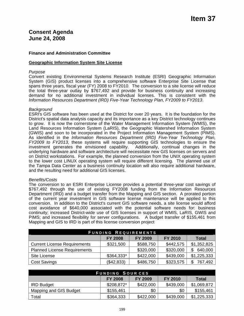
Item 37
Consent AgendaJune 24, 2008 Finance and Administration Committee Geographic Information System Site License
PurposeConvert existing Environmental Systems Research Institute (ESRI) Geographic Information System (GIS) product licenses into a comprehensive software Enterprise Site License that spans three years, fiscal year (FY) 2008 to FY2010. The conversion to a site license will reduce the total three-year outlay by $767,492 and provide for business continuity and increasing demand for no additional investment in individual licenses. This is consistent with the Information Resources Department (IRD) Five-Year Technology Plan, FY2009 to FY2013.
Background ESRI's GIS software has been used at the District for over 20 years. It is the foundation for the District's spatial data analysis capacity and its importance as a key District technology continues to grow. It is now the cornerstone of the Water Management Information System (WMIS), the Land Resources Information System (LaRIS), the Geographic Watershed Information System (GWIS) and soon to be incorporated in the Project Information Management System (PIMS). As identified in the Information Resources Department (IRD) Five-Year Technology Plan, FY2009 to FY2013, these systems will require supporting GIS technologies to ensure the investment generates the envisioned capability. Additionally, continual changes in the underlying hardware and software architecture will necessitate new GIS licenses on servers and on District workstations. For example, the planned conversion from the UNIX operating system to the lower cost LINUX operating system will require different licensing. The planned use of the Tampa Data Center as a business continuity location will also require additional hardware, and the resulting need for additional GIS licenses.
Benefits/CostsThe conversion to an ESRI Enterprise License provides a potential three-year cost savings of $767,492 through the use of existing FY2008 funding from the Information Resources Department (IRD) and a budget transfer from the Mapping and GIS section. A prorated portion of the current year investment in GIS software license maintenance will be applied to this conversion. In addition to the District's current GIS software needs, a site license would afford cost avoidance of $640,000 associated with the potential software needs for: business continuity; increased District-wide use of GIS licenses in support of WMIS, LaRIS, GWIS and PIMS; and increased flexibility for server configurations. A budget transfer of $155,461 from Mapping and GIS to IRD is part of this license conversion project
F U N D I N G R E Q U I R E M E N T S FY 2008 FY 2009 FY 2010 Total Current License Requirements $321,500 $588,750 $442,575 $1,352,825Planned License Requirements $320,000 $320,000 $ 640,000Site License $364,333* $422,000 $439,000 $1,225,333Cost Savings ($42,833) $486,750 $323,575 $ 767,492
F U N D I N G S O U R C E S FY 2008 FY 2009 FY 2010 Total IRD Budget $208,872* $422,000 $439,000 $1,069,872Mapping and GIS Budget $155,461 $0 $0 $155,461Total $364,333 $422,000 $439,000 $1,225,333
199
Item 37
* The $364,333 site license cost and $208,872 funding from the IRD budget assumes the ESRI Enterprise Site License is signed in July 2008 and remaining software maintenance is prorated against the $405,000 first year cost. The first year cost will not exceed $405,000. Subsequent years will be budgeted at $422,000 and $439,000 in FY2009 and FY2010, respectively.
Impact If Not Funded Without an ESRI Enterprise license for GIS software, the District would spend at least $767,492 more to meet current and planned GIS-related requirements over the next three years. These Licenses support a business continuity project in the Tampa Service Office, the build out of WMIS, LaRIS, GWIS and PIMS and accommodate changes in the District's architecture as we move to the LINUX operating System and higher capacity servers
Staff Recommendation:
(1) Authorize the District's Executive Director to execute a three-year software enterprise site license agreement with the Environmental Systems Research Institute for a total cost not to exceed $1,266,000 subject to annual appropriation by the Governing Board as part of the District's annual adopted budget for fiscal years 2009 and 2010; and
(2) Authorize a $155,461 budget transfer from the Mapping and GIS Section, Operations Department to the Information Resources Department to fund the ESRI software site license agreement.
Presenters: Terry Redman, Director, Information Resources Department Charles L. Gausche, Ph.D., Enterprise Architecture Manager Steve Dicks, Mapping and GIS Program Director
200
Item 38
Consent AgendaJune 24, 2008 Finance and Administration Committee Enhanced Data Submittal Web Portal
PurposeTransfer a total of $171,000 from the Automatic Meter Reading (AMR) pilot ($81,000) and Flow Meter Accuracy Testing ($90,000) projects to the Information Resources Department The added capability will create an improved web portal to collect water use information. This portal is an addition to the existing core Water Management Information System (WMIS) project and requires additional funding not included in the currently approved WMIS budget.
Background The Governing Board approved funding for the AMR and for outsourcing of the Flow Meter Accuracy Testing projects in the FY2008 budget. The intent of these projects was to help the District improve the quality and quantity of water use pumpage data.
The AMR pilot project uses a satellite to transmit withdrawal level pumpage data to a third party that sends the data to the District via the internet. Pending the successful outcome of the pilot project, the intent was to expand the data collection District wide. The original pilot project provided was successful and needs to continue for the District to assess the AMR technology before this technology is expanded to specific critical sites. One of the lessons learned from the pilot project is that the current cost of the AMR system may make it prohibitive for a large scale expansion of the project beyond the current pilot project. Therefore, staff has investigated economical alternatives to a large AMR system. The recommended alternative was to develop a water use reporting web portal that would provide quality data to the planned WMIS functionality.
There are over 5,500 permits in the District that are required to report metered pumpage data. To ensure the accuracy of this information, the District provided funds to outsource the meter accuracy testing for a representative number of these sites. This year as a result of the 2003 implementation of the Southern Water Use Caution Area (SWUCA) rule, many permittees had their flow meters tested on their own; therefore, the full budgeted amount for this project is not needed.
The WMIS consultant provided a written cost estimate of $171,000, to design and create the data submittal portal. This portal will be designed to improve the quality and quantity of water use data and interact with existing and planned WMIS capabilities. In addition to pumpage data, the portal will collect crop reporting forms that have historically been submitted in paper format. Data will be compared to historical information and if needed, users will be prompted to make any corrections before the data is entered into the District's database system. This portal will allow the users to compare their reported information to historical and regional data. In addition, the portal will include features to reduce water use, reduce pumpage costs, and save fuel. The portal will feature climatic and hydrological data for the permittees to use. There will be graphics, graphs, and other objects to entice the permittees to use this page for data submittal and analysis.
Benefits/CostThe transfer of $171,000 to IRD for the creation of a web data submittal portal is a cost effective way to improve on the quality and quantity of reported water use data in WMIS. The portal will provide some data quality control and will entice permittees to use this system. In addition, this portal will collect crop reporting data, making it easier for the permittees and the District to process water use information through WMIS.
201
Item 38 Impact if Not Funded: Currently reported water use data quality and quantity will continue to make it difficult for the District to make data based resource decisions within WMIS. Also, the District will continue to need additional resources to try and resolve pumpage data quality and quantity issues. In addition, water conservation tools to help permittees reduce their water use will not be available.
Staff Recommendation:
Approve the transfer of $171,000 from the AMR Pilot and Outsourced Flow Meter Accuracy Projects to the Information Resources Department to create an enhanced web data submittal portal with graphics, graphs, and tools to help permittees conserve water.
Presenter: Paul O'Neil, Director, Regulation Performance Management
202
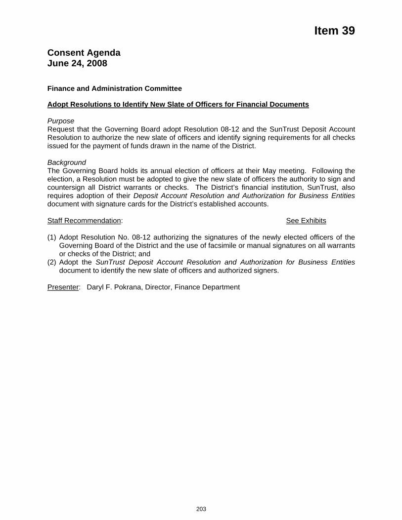
Item 39
Consent Agenda June 24, 2008
Finance and Administration Committee
Adopt Resolutions to Identify New Slate of Officers for Financial Documents
PurposeRequest that the Governing Board adopt Resolution 08-12 and the SunTrust Deposit Account Resolution to authorize the new slate of officers and identify signing requirements for all checks issued for the payment of funds drawn in the name of the District.
Background The Governing Board holds its annual election of officers at their May meeting. Following the election, a Resolution must be adopted to give the new slate of officers the authority to sign and countersign all District warrants or checks. The District’s financial institution, SunTrust, also requires adoption of their Deposit Account Resolution and Authorization for Business Entities document with signature cards for the District’s established accounts.
Staff Recommendation: See Exhibits
(1) Adopt Resolution No. 08-12 authorizing the signatures of the newly elected officers of the Governing Board of the District and the use of facsimile or manual signatures on all warrants or checks of the District; and
(2) Adopt the SunTrust Deposit Account Resolution and Authorization for Business Entitiesdocument to identify the new slate of officers and authorized signers.
Presenter: Daryl F. Pokrana, Director, Finance Department
203
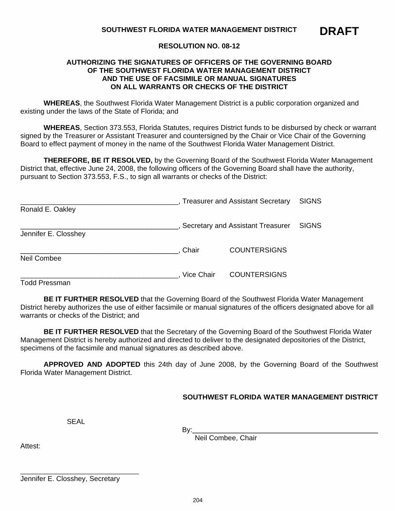
SOUTHWEST FLORIDA WATER MANAGEMENT DISTRICT
RESOLUTION NO. 08-12
AUTHORIZING THE SIGNATURES OF OFFICERS OF THE GOVERNING BOARD OF THE SOUTHWEST FLORIDA WATER MANAGEMENT DISTRICT
AND THE USE OF FACSIMILE OR MANUAL SIGNATURES ON ALL WARRANTS OR CHECKS OF THE DISTRICT
WHEREAS, the Southwest Florida Water Management District is a public corporation organized and existing under the laws of the State of Florida; and
WHEREAS, Section 373.553, Florida Statutes, requires District funds to be disbursed by check or warrant signed by the Treasurer or Assistant Treasurer and countersigned by the Chair or Vice Chair of the Governing Board to effect payment of money in the name of the Southwest Florida Water Management District.
THEREFORE, BE IT RESOLVED, by the Governing Board of the Southwest Florida Water Management District that, effective June 24, 2008, the following officers of the Governing Board shall have the authority, pursuant to Section 373.553, F.S., to sign all warrants or checks of the District:
________________________________________, Treasurer and Assistant Secretary SIGNS Ronald E. Oakley
________________________________________, Secretary and Assistant Treasurer SIGNS Jennifer E. Closshey
________________________________________, Chair COUNTERSIGNS Neil Combee
________________________________________, Vice Chair COUNTERSIGNS Todd Pressman
BE IT FURTHER RESOLVED that the Governing Board of the Southwest Florida Water Management District hereby authorizes the use of either facsimile or manual signatures of the officers designated above for all warrants or checks of the District; and
BE IT FURTHER RESOLVED that the Secretary of the Governing Board of the Southwest Florida Water Management District is hereby authorized and directed to deliver to the designated depositories of the District, specimens of the facsimile and manual signatures as described above.
APPROVED AND ADOPTED this 24th day of June 2008, by the Governing Board of the Southwest Florida Water Management District.
SOUTHWEST FLORIDA WATER MANAGEMENT DISTRICT
SEALBy:
Neil Combee, Chair Attest:
______________________________Jennifer E. Closshey, Secretary
204
DRAFT
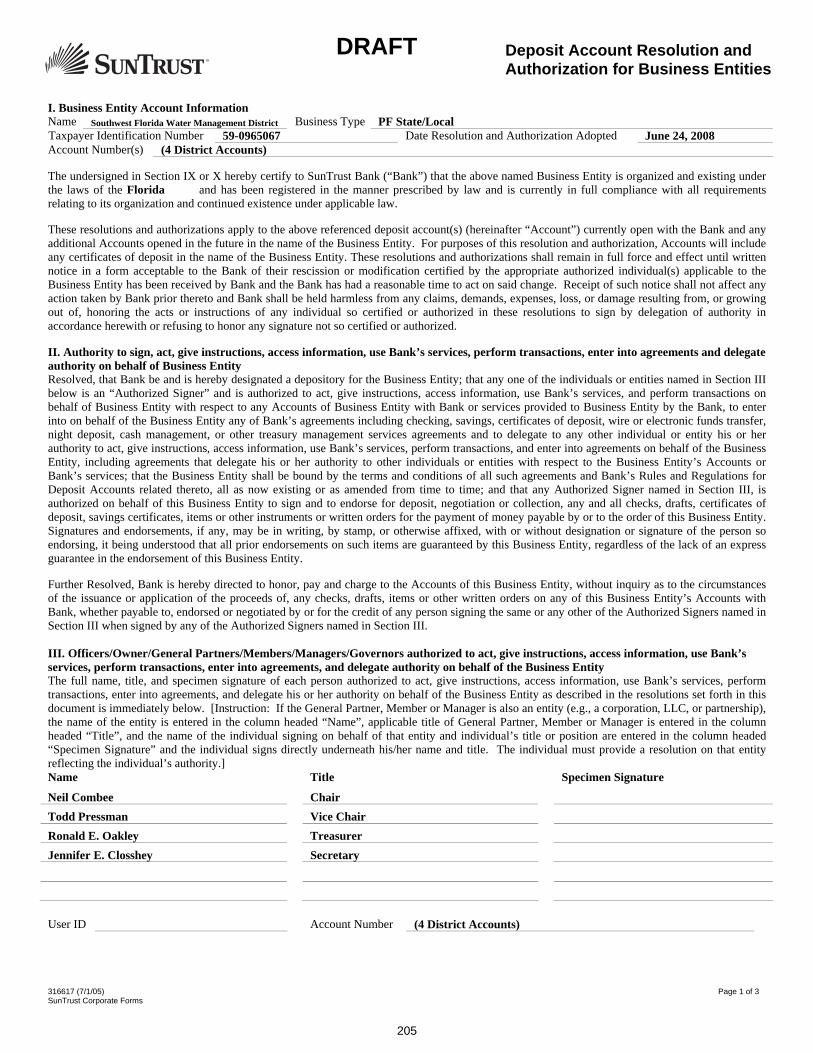
316617 (7/1/05) Page 1 of 3 SunTrust Corporate Forms
I. Business Entity Account Information Name Southwest Florida Water Management District Business Type PF State/Local Taxpayer Identification Number 59-0965067 Date Resolution and Authorization Adopted June 24, 2008 Account Number(s) (4 District Accounts)
The undersigned in Section IX or X hereby certify to SunTrust Bank (“Bank”) that the above named Business Entity is organized and existing under the laws of the Florida and has been registered in the manner prescribed by law and is currently in full compliance with all requirements relating to its organization and continued existence under applicable law.
These resolutions and authorizations apply to the above referenced deposit account(s) (hereinafter “Account”) currently open with the Bank and any additional Accounts opened in the future in the name of the Business Entity. For purposes of this resolution and authorization, Accounts will include any certificates of deposit in the name of the Business Entity. These resolutions and authorizations shall remain in full force and effect until written notice in a form acceptable to the Bank of their rescission or modification certified by the appropriate authorized individual(s) applicable to the Business Entity has been received by Bank and the Bank has had a reasonable time to act on said change. Receipt of such notice shall not affect any action taken by Bank prior thereto and Bank shall be held harmless from any claims, demands, expenses, loss, or damage resulting from, or growing out of, honoring the acts or instructions of any individual so certified or authorized in these resolutions to sign by delegation of authority in accordance herewith or refusing to honor any signature not so certified or authorized.
II. Authority to sign, act, give instructions, access information, use Bank’s services, perform transactions, enter into agreements and delegate authority on behalf of Business EntityResolved, that Bank be and is hereby designated a depository for the Business Entity; that any one of the individuals or entities named in Section III below is an “Authorized Signer” and is authorized to act, give instructions, access information, use Bank’s services, and perform transactions on behalf of Business Entity with respect to any Accounts of Business Entity with Bank or services provided to Business Entity by the Bank, to enter into on behalf of the Business Entity any of Bank’s agreements including checking, savings, certificates of deposit, wire or electronic funds transfer, night deposit, cash management, or other treasury management services agreements and to delegate to any other individual or entity his or her authority to act, give instructions, access information, use Bank’s services, perform transactions, and enter into agreements on behalf of the Business Entity, including agreements that delegate his or her authority to other individuals or entities with respect to the Business Entity’s Accounts or Bank’s services; that the Business Entity shall be bound by the terms and conditions of all such agreements and Bank’s Rules and Regulations for Deposit Accounts related thereto, all as now existing or as amended from time to time; and that any Authorized Signer named in Section III, is authorized on behalf of this Business Entity to sign and to endorse for deposit, negotiation or collection, any and all checks, drafts, certificates of deposit, savings certificates, items or other instruments or written orders for the payment of money payable by or to the order of this Business Entity. Signatures and endorsements, if any, may be in writing, by stamp, or otherwise affixed, with or without designation or signature of the person so endorsing, it being understood that all prior endorsements on such items are guaranteed by this Business Entity, regardless of the lack of an express guarantee in the endorsement of this Business Entity.
Further Resolved, Bank is hereby directed to honor, pay and charge to the Accounts of this Business Entity, without inquiry as to the circumstances of the issuance or application of the proceeds of, any checks, drafts, items or other written orders on any of this Business Entity’s Accounts with Bank, whether payable to, endorsed or negotiated by or for the credit of any person signing the same or any other of the Authorized Signers named in Section III when signed by any of the Authorized Signers named in Section III.
III. Officers/Owner/General Partners/Members/Managers/Governors authorized to act, give instructions, access information, use Bank’sservices, perform transactions, enter into agreements, and delegate authority on behalf of the Business Entity The full name, title, and specimen signature of each person authorized to act, give instructions, access information, use Bank’s services, perform transactions, enter into agreements, and delegate his or her authority on behalf of the Business Entity as described in the resolutions set forth in this document is immediately below. [Instruction: If the General Partner, Member or Manager is also an entity (e.g., a corporation, LLC, or partnership), the name of the entity is entered in the column headed “Name”, applicable title of General Partner, Member or Manager is entered in the column headed “Title”, and the name of the individual signing on behalf of that entity and individual’s title or position are entered in the column headed “Specimen Signature” and the individual signs directly underneath his/her name and title. The individual must provide a resolution on that entity reflecting the individual’s authority.] Name Title Specimen Signature
Neil Combee Chair Todd Pressman Vice Chair Ronald E. Oakley Treasurer Jennifer E. Closshey Secretary
User ID Account Number (4 District Accounts)
Deposit Account Resolution and Authorization for Business Entities
205
DRAFT
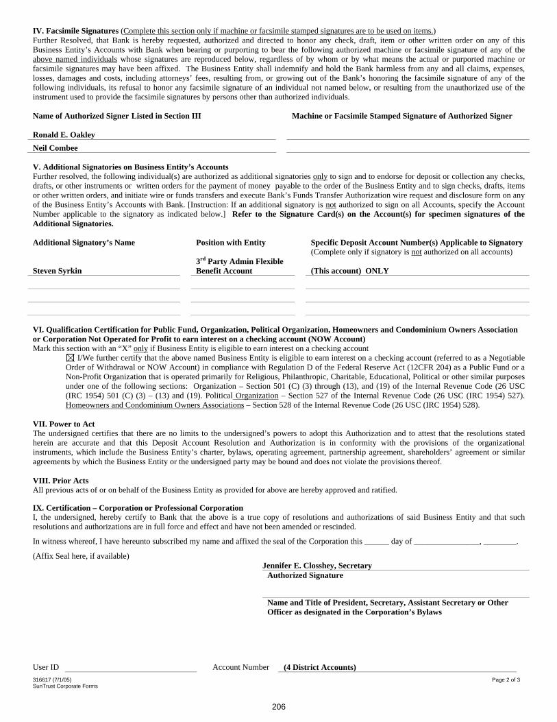
316617 (7/1/05) Page 2 of 3 SunTrust Corporate Forms
IV. Facsimile Signatures (Complete this section only if machine or facsimile stamped signatures are to be used on items.)Further Resolved, that Bank is hereby requested, authorized and directed to honor any check, draft, item or other written order on any of this Business Entity’s Accounts with Bank when bearing or purporting to bear the following authorized machine or facsimile signature of any of the above named individuals whose signatures are reproduced below, regardless of by whom or by what means the actual or purported machine or facsimile signatures may have been affixed. The Business Entity shall indemnify and hold the Bank harmless from any and all claims, expenses, losses, damages and costs, including attorneys’ fees, resulting from, or growing out of the Bank’s honoring the facsimile signature of any of the following individuals, its refusal to honor any facsimile signature of an individual not named below, or resulting from the unauthorized use of the instrument used to provide the facsimile signatures by persons other than authorized individuals.
Name of Authorized Signer Listed in Section III Machine or Facsimile Stamped Signature of Authorized Signer
Ronald E. Oakley Neil Combee
V. Additional Signatories on Business Entity’s Accounts Further resolved, the following individual(s) are authorized as additional signatories only to sign and to endorse for deposit or collection any checks, drafts, or other instruments or written orders for the payment of money payable to the order of the Business Entity and to sign checks, drafts, items or other written orders, and initiate wire or funds transfers and execute Bank’s Funds Transfer Authorization wire request and disclosure form on any of the Business Entity’s Accounts with Bank. [Instruction: If an additional signatory is not authorized to sign on all Accounts, specify the Account Number applicable to the signatory as indicated below.] Refer to the Signature Card(s) on the Account(s) for specimen signatures of the Additional Signatories.
Additional Signatory’s Name Position with Entity Specific Deposit Account Number(s) Applicable to Signatory (Complete only if signatory is not authorized on all accounts)
Steven Syrkin 3rd Party Admin Flexible Benefit Account (This account) ONLY
VI. Qualification Certification for Public Fund, Organization, Political Organization, Homeowners and Condominium Owners Associationor Corporation Not Operated for Profit to earn interest on a checking account (NOW Account) Mark this section with an “X” only if Business Entity is eligible to earn interest on a checking account
I/We further certify that the above named Business Entity is eligible to earn interest on a checking account (referred to as a Negotiable Order of Withdrawal or NOW Account) in compliance with Regulation D of the Federal Reserve Act (12CFR 204) as a Public Fund or aNon-Profit Organization that is operated primarily for Religious, Philanthropic, Charitable, Educational, Political or other similar purposes under one of the following sections: Organization – Section 501 (C) (3) through (13), and (19) of the Internal Revenue Code (26 USC (IRC 1954) 501 (C) (3) – (13) and (19). Political Organization – Section 527 of the Internal Revenue Code (26 USC (IRC 1954) 527). Homeowners and Condominium Owners Associations – Section 528 of the Internal Revenue Code (26 USC (IRC 1954) 528).
VII. Power to Act The undersigned certifies that there are no limits to the undersigned’s powers to adopt this Authorization and to attest that the resolutions stated herein are accurate and that this Deposit Account Resolution and Authorization is in conformity with the provisions of the organizational instruments, which include the Business Entity’s charter, bylaws, operating agreement, partnership agreement, shareholders’ agreement or similar agreements by which the Business Entity or the undersigned party may be bound and does not violate the provisions thereof.
VIII. Prior Acts All previous acts of or on behalf of the Business Entity as provided for above are hereby approved and ratified.
IX. Certification – Corporation or Professional CorporationI, the undersigned, hereby certify to Bank that the above is a true copy of resolutions and authorizations of said Business Entity and that such resolutions and authorizations are in full force and effect and have not been amended or rescinded.
In witness whereof, I have hereunto subscribed my name and affixed the seal of the Corporation this ______ day of ________________, ________.
(Affix Seal here, if available) Jennifer E. Closshey, Secretary
Authorized Signature
Name and Title of President, Secretary, Assistant Secretary or Other Officer as designated in the Corporation’s Bylaws
User ID Account Number (4 District Accounts)
206
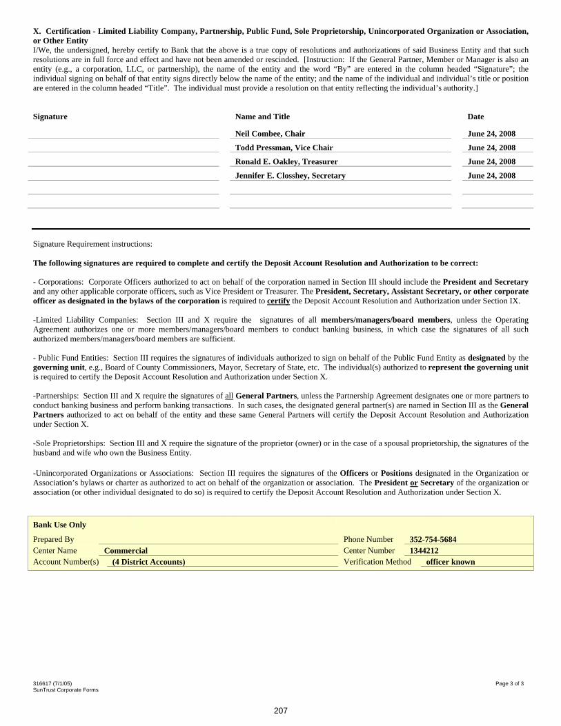
316617 (7/1/05) Page 3 of 3 SunTrust Corporate Forms
X. Certification - Limited Liability Company, Partnership, Public Fund, Sole Proprietorship, Unincorporated Organization or Association, or Other EntityI/We, the undersigned, hereby certify to Bank that the above is a true copy of resolutions and authorizations of said Business Entity and that such resolutions are in full force and effect and have not been amended or rescinded. [Instruction: If the General Partner, Member or Manager is also an entity (e.g., a corporation, LLC, or partnership), the name of the entity and the word “By” are entered in the column headed “Signature”; the individual signing on behalf of that entity signs directly below the name of the entity; and the name of the individual and individual’s title or position are entered in the column headed “Title”. The individual must provide a resolution on that entity reflecting the individual’s authority.]
Signature Name and Title Date
Neil Combee, Chair June 24, 2008
Todd Pressman, Vice Chair June 24, 2008
Ronald E. Oakley, Treasurer June 24, 2008
Jennifer E. Closshey, Secretary June 24, 2008
Signature Requirement instructions:
The following signatures are required to complete and certify the Deposit Account Resolution and Authorization to be correct:
- Corporations: Corporate Officers authorized to act on behalf of the corporation named in Section III should include the President and Secretaryand any other applicable corporate officers, such as Vice President or Treasurer. The President, Secretary, Assistant Secretary, or other corporate officer as designated in the bylaws of the corporation is required to certify the Deposit Account Resolution and Authorization under Section IX.
-Limited Liability Companies: Section III and X require the signatures of all members/managers/board members, unless the Operating Agreement authorizes one or more members/managers/board members to conduct banking business, in which case the signatures of all such authorized members/managers/board members are sufficient.
- Public Fund Entities: Section III requires the signatures of individuals authorized to sign on behalf of the Public Fund Entity as designated by the governing unit, e.g., Board of County Commissioners, Mayor, Secretary of State, etc. The individual(s) authorized to represent the governing unitis required to certify the Deposit Account Resolution and Authorization under Section X.
-Partnerships: Section III and X require the signatures of all General Partners, unless the Partnership Agreement designates one or more partners to conduct banking business and perform banking transactions. In such cases, the designated general partner(s) are named in Section III as the General Partners authorized to act on behalf of the entity and these same General Partners will certify the Deposit Account Resolution and Authorization under Section X.
-Sole Proprietorships: Section III and X require the signature of the proprietor (owner) or in the case of a spousal proprietorship, the signatures of the husband and wife who own the Business Entity.
-Unincorporated Organizations or Associations: Section III requires the signatures of the Officers or Positions designated in the Organization or Association’s bylaws or charter as authorized to act on behalf of the organization or association. The President or Secretary of the organization or association (or other individual designated to do so) is required to certify the Deposit Account Resolution and Authorization under Section X.
Bank Use Only
Prepared By Phone Number 352-754-5684Center Name Commercial Center Number 1344212Account Number(s) (4 District Accounts) Verification Method officer known
207
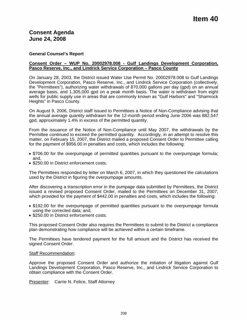
Item 40
Consent Agenda June 24, 2008
General Counsel’s Report Consent Order – WUP No. 20002978.008 - Gulf Landings Development Corporation, Pasco Reserve, Inc., and Lindrick Service Corporation – Pasco County
On January 28, 2003, the District issued Water Use Permit No. 20002978.008 to Gulf Landings Development Corporation, Pasco Reserve, Inc., and Lindrick Service Corporation (collectively, the "Permittees"), authorizing water withdrawals of 870,000 gallons per day (gpd) on an annual average basis, and 1,305,000 gpd on a peak month basis. The water is withdrawn from eight wells for public supply use in areas that are commonly known as "Gulf Harbors" and "Shamrock Heights" in Pasco County.
On August 9, 2006, District staff issued to Permittees a Notice of Non-Compliance advising that the annual average quantity withdrawn for the 12-month period ending June 2006 was 882,547 gpd, approximately 1.4% in excess of the permitted quantity.
From the issuance of the Notice of Non-Compliance until May 2007, the withdrawals by the Permittee continued to exceed the permitted quantity. Accordingly, in an attempt to resolve this matter, on February 15, 2007, the District mailed a proposed Consent Order to Permittee calling for the payment of $956.00 in penalties and costs, which includes the following:
$706.00 for the overpumpage of permitted quantities pursuant to the overpumpage formula; and,
$250.00 in District enforcement costs.
The Permittees responded by letter on March 6, 2007, in which they questioned the calculations used by the District in figuring the overpumpage amounts.
After discovering a transcription error in the pumpage data submitted by Permittees, the District issued a revised proposed Consent Order, mailed to the Permittees on December 31, 2007, which provided for the payment of $442.00 in penalties and costs, which includes the following:
$192.00 for the overpumpage of permitted quantities pursuant to the overpumpage formula using the corrected data; and,
$250.00 in District enforcement costs.
This proposed Consent Order also requires the Permittees to submit to the District a compliance plan demonstrating how compliance will be achieved within a certain timeframe.
The Permittees have tendered payment for the full amount and the District has received the signed Consent Order.
Staff Recommendation:
Approve the proposed Consent Order and authorize the initiation of litigation against Gulf Landings Development Corporation, Pasco Reserve, Inc., and Lindrick Service Corporation to obtain compliance with the Consent Order.
Presenter: Carrie N. Felice, Staff Attorney
208
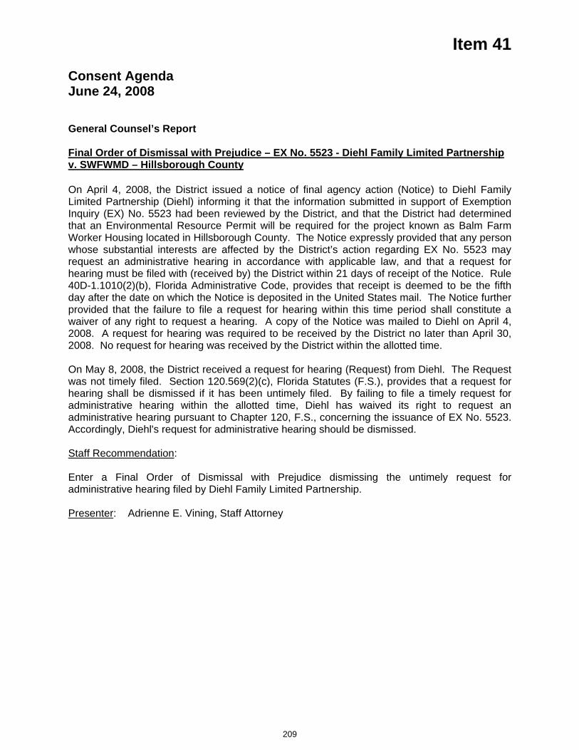
Item 41
Consent Agenda June 24, 2008
General Counsel’s Report Final Order of Dismissal with Prejudice – EX No. 5523 - Diehl Family Limited Partnership v. SWFWMD – Hillsborough County
On April 4, 2008, the District issued a notice of final agency action (Notice) to Diehl Family Limited Partnership (Diehl) informing it that the information submitted in support of Exemption Inquiry (EX) No. 5523 had been reviewed by the District, and that the District had determined that an Environmental Resource Permit will be required for the project known as Balm Farm Worker Housing located in Hillsborough County. The Notice expressly provided that any person whose substantial interests are affected by the District’s action regarding EX No. 5523 may request an administrative hearing in accordance with applicable law, and that a request for hearing must be filed with (received by) the District within 21 days of receipt of the Notice. Rule 40D-1.1010(2)(b), Florida Administrative Code, provides that receipt is deemed to be the fifth day after the date on which the Notice is deposited in the United States mail. The Notice further provided that the failure to file a request for hearing within this time period shall constitute a waiver of any right to request a hearing. A copy of the Notice was mailed to Diehl on April 4, 2008. A request for hearing was required to be received by the District no later than April 30, 2008. No request for hearing was received by the District within the allotted time.
On May 8, 2008, the District received a request for hearing (Request) from Diehl. The Request was not timely filed. Section 120.569(2)(c), Florida Statutes (F.S.), provides that a request for hearing shall be dismissed if it has been untimely filed. By failing to file a timely request for administrative hearing within the allotted time, Diehl has waived its right to request an administrative hearing pursuant to Chapter 120, F.S., concerning the issuance of EX No. 5523. Accordingly, Diehl's request for administrative hearing should be dismissed.
Staff Recommendation:
Enter a Final Order of Dismissal with Prejudice dismissing the untimely request for administrative hearing filed by Diehl Family Limited Partnership.
Presenter: Adrienne E. Vining, Staff Attorney
209
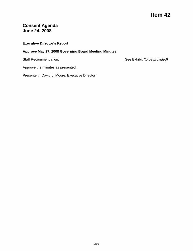
Item 42
Consent Agenda June 24, 2008
Executive Director’s Report
Approve May 27, 2008 Governing Board Meeting Minutes
Staff Recommendation: See Exhibit (to be provided)
Approve the minutes as presented.
Presenter: David L. Moore, Executive Director
210

MINUTES OF THE MEETING
Governing Board Southwest Florida Water Management District
Brooksville, Florida May 27, 2008
The Governing Board of the Southwest Florida Water Management District (SWFWMD) met at 9:00 a.m. on May 27, 2008, at Brooksville headquarters. The following persons were present:
Board Members Present Judith C. Whitehead, Chair Neil Combee, Vice Chair Todd Pressman, Secretary Jennifer E. Closshey, Treasurer Bryan Beswick, Member Hugh Gramling, Member Albert G. Joerger, Member Ronald E. Oakley, Member Sallie Parks, Member Maritza Rovira-Forino, Member H. Paul Senft, Member Board Members Absent Patricia M. Glass, Member
Staff Members PresentDavid L. Moore, Executive Director William S. Bilenky, General Counsel Lou Kavouras, Deputy Executive Director Richard S. Owen, Deputy Executive Director Eugene A. Schiller, Deputy Executive Director Bruce C. Wirth, Deputy Executive Director Recording SecretaryAnnette D. Zielinski, Senior Admin. Assistant
A list of others present who signed the attendance roster is filed in the permanent files of the District. Approved minutes from previous meetings can be found on the District's Web site (www.WaterMatters.org). Public Hearing 1. Call to Order
Chair Whitehead called the meeting to order and opened the public hearing. Mr. Pressman noted a quorum was present. (CD 1/Track 01 – 00:00/00:38)
2. Pledge of Allegiance and Invocation
Chair Whitehead led the Pledge of Allegiance to the Flag of the United States of America. Mr. Bilenky offered the invocation. (CD 1/Track 02 – 00:00/03:38)
Public Hearing Chair Whitehead noted that this Governing Board meeting was being broadcast to the Bartow, Sarasota, and Tampa Service Offices. Public input was only taken during the meeting onsite. The Governing Board’s meeting was recorded for broadcast on government access channels. Chair Whitehead stated that anyone wishing to address the Governing Board concerning any item listed on the agenda or any item that does not appear on the agenda should fill out and submit a speaker's card. To assure that all participants have an opportunity to speak, a member of the public may submit a speaker’s card to comment on one agenda item only during today's meeting. If additional time is needed or if the speaker wishes to address the Board on an issue not on today's agenda, a speaker’s card may be submitted for comment at the end of the meeting during "Public Input." Chair Whitehead stated that comments would be limited to three minutes per speaker, and, when appropriate, exceptions to the three-minute limit may be granted by the Chair. She also requested that several individuals wishing to speak on the same issue/topic designate a spokesperson.
Minutes of the Meeting May 27, 2008 SWFWMD Governing Board Page 2 of 15 3. Additions/Deletions to Agenda
According to Section 120.525(2), Florida Statutes, additions or deletions to the published agenda will only be made for "good cause" as determined by the "person designated to preside." Mr. Moore noted the items deleted from the agenda were deleted after publication of the regular agenda. (CD 1/Track 03 – 00:00/02:08) Meeting and Public Hearing The following item was deleted from consideration: 4. Oath of Office for Newly Appointed Board Member Consent Agenda The following item was deleted from consideration: 36. Initiation of Litigation – Well Construction - License No. 7317 - Allen Rhodes – Citrus County
4. Oath of Office for Newly Appointed Board Member This item was deleted from the agenda.
5. Ceremony to Honor Former Board Member Patsy C. Symons Chair Whitehead said Ms. Symons was appointed to the Governing Board in 2004 and has championed causes for agriculturalists and her local community. Her support has been critical in establishing the Facilitating Agricultural Resource Management Systems (FARMS) Program in DeSoto and Charlotte counties. Ms. Symons also served as the Governing Board's secretary. Chair Whitehead presented Ms. Symons with a plaque and a resolution honoring her service.
6. Ceremony to Honor Former Board Member and Chair Heidi B. McCree
Chair Whitehead noted that Ms. McCree was initially appointed to the Governing Board in 2000 and reappointed in March 2004. Ms. McCree has a long history of public service and environmental causes. In 2005, she was elected the first female chair of the Governing Board. During her tenure, she was instrumental in helping the District renegotiate terms for the desalination plant. Chair Whitehead presented Ms. McCree with a plaque and a resolution honoring her service, and a framed article commemorating her service as Governing Board chair.
7. Ceremony to Honor Former Board Member and Chair Thomas G. DabneyChair Whitehead said Mr. Dabney was also appointed to the Governing Board in 2000 and reappointed in March 2004. He served as chair and two terms as vice chair of the Governing Board. During his tenure, he lent his support to the regulation community. He served on the Well Drillers Advisory Committee and was involved in the development of online permitting. Mr. Dabney was instrumental in the settlement with Weeki Wachee Springs. Chair Whitehead presented Mr. Dabney with a plaque and a resolution honoring his service, and a framed article commemorating his service as Governing Board chair. (CD 1/Track 04 – 00:00/17:48) Mr. Stuart Anderson, representing the Well Drillers Advisory Committee, presented Mr. Dabney with a plaque commemorating his service to the Committee. Mr. Dabney said it was phenomenal experience working with the well drilling contractors, and noted they are a professional and progressive group.
Governing Board members expressed their gratitude to their departing fellow Board members and thanked them for their leadership and service. Mr. Moore said the Governing Board's leadership is a key factor to the success of this District. He noted some milestones and accomplishments that took place during the past eight years. This fall staff plans to invite current and past Governing and Basin Board members to an annual meeting which will be the first of this type. (CD 1/Track 04 – 17:48/35:55)
Minutes of the Meeting May 27, 2008 SWFWMD Governing Board Page 3 of 15 8. District Recognition – Best Places to Work Award
Ms. Elaine Kuligofski, Director, Human Resources and Risk Management Department, said the District has received, for the second consecutive year, the annual Best Places to Work® Award for large employers in Hernando County. Best Places to Work®, sponsored by the Pasco Hernando Jobs and Education Partnership, places a spotlight on local businesses who exhibit extraordinary focus on and investment in their employees.
Organizations in three separate size categories were judged by an independent consultant on such metrics as diversity, turnover, training, compensation and benefits, and growth percentages. The District competed against 64 local employers in Hernando and Pasco counties for this prestigious award. Ms. Kuligofski said she was happy to report that the District's turnover was the lowest of any of the organizations that participated in this program. She said staff works very hard to make the District's work environment enjoyable for all of its employees. Another interesting fact is that 94 percent of the District's employees received some form of training last year, which was also higher than any of the other participating organizations. Ms. Kuligofski thanked Board members for their continued support of programs and benefits for staff.
This item was presented for the Board’s information, and no action was required. (CD 1/Track 05 – 00:00/02:47)
9. District Recognition – Florida Public Relations Association Image AwardsMr. David T. Rathke, Director, Community and Legislative Affairs (CLA), said each year the Florida Public Relations Association holds an Image Award competition at both the local level and statewide level. The District won five awards, four from the Central West Coast Chapter and one from the Tampa Bay Chapter. An Award of Distinction for the 20th Anniversary Events of the District's Surface Water Improvement and Management (SWIM) Program was received which included three events celebrating the program's history and successes and all took place at SWIM project locations. Several positive press hits resulted from the events and the District was able to recognize and thank project partners and legislators who have supported SWIM funding. Mr. Rathke commended staff members Karen Kobil, Susan Kessel, Robyn Felix and Carrieann Adkins for their hard work. In the category of Public Relations Programs, Public Affairs, CLA won an Award of Distinction for the West-Central Florida Water Restoration Action Plan (WRAP) legislative initiative which included gathering community and legislative support for the WRAP and an objective to secure $25 million in the Governor's Recommended Budget. Ms. Colleen Thayer's work was instrumental in this project. District staff won an Image Award for their work in successfully advocating for new mining ordinances in Charlotte and DeSoto counties that would give special consideration to the District's Facilitating Agricultural Resource Management Systems (FARMS) program. Mr. Rathke said Eric DeHaven and Terri Behling were responsible for this award. The District won an Award of Distinction and a Judges' Award for the WRAP booklet. This booklet gave a comprehensive description of the projects included in the WRAP and was used to raise awareness and educate the community and legislators about the program. Mr. Rathke congratulated Pati Twardosky, Karen Kobil and Colleen Thayer for the distinction. This item was presented for the Board’s information, and no action was required. (CD 1/Track 06 – 00:00/04:38)
10. Employee Recognition Mr. Moore made presentations to the Board for the employees who had achieved milestones of 20 years or greater to specially acknowledge and commend the
Minutes of the Meeting May 27, 2008 SWFWMD Governing Board Page 4 of 15
contributions of these individuals. The following individuals celebrated 20-year milestones: Ms. Susan Caye, Senior Regulatory Systems Analyst, Regulation Performance Management; and Mr. Michael Beach, Senior Professional Engineer, Resource Projects Department. Ms. Susie Holton, Senior Administrative Assistant, Operations Department, celebrated 25 years of service. Mr. Manny Lopez, Senior Environmental Scientist, Resource Projects Department, celebrated 30 years of service.
This item was presented for the Board’s information, and no action was required. (CD 1/Track 07 – 00:00/03:55) 11. Election of Officers
In accordance with Board Policy 110-7, the Governing Board members participated in Election of Officers, which occurs in May. During this process, a Chair, Vice Chair, Secretary and Treasurer would be elected. The newly elected officers will assume their duties at the end of today's meeting. Chair Whitehead entertained nominations for the position of Chair. Chair Whitehead nominated Mr. Combee. A motion was made by Mr. Senft to close nominations, and Mr. Oakley seconded the motion. The Board voted unanimously to close nominations and cast their ballots. Mr. Moore collected the ballots and tallied the results. Chair Whitehead announced a unanimous vote for Mr. Combee. Chair Whitehead entertained nominations for the position of Vice Chair. Mr. Oakley nominated Mr. Pressman. Ms. Rovira-Forino nominated Ms. Closshey. Mr. Joerger nominated Ms. Parks. A motion was made by Ms. Parks to close nominations, and Ms. Closshey seconded the motion. The Board voted unanimously to close nominations and cast their ballots. Mr. Moore collected the ballots and tallied the results. Chair Whitehead announced a majority vote for Mr. Pressman. Chair Whitehead entertained nominations for the position of Secretary. Mr. Gramling nominated Ms. Parks. Mr. Joerger nominated Ms. Closshey. A motion was made by Mr. Gramling to close nominations, and Mr. Combee seconded the motion. The Board voted unanimously to close nominations and cast their ballots. Mr. Moore collected the ballots and tallied the results. Chair Whitehead announced a majority vote for Ms. Closshey. Chair Whitehead entertained nominations for the position of Treasurer. Ms. Closshey nominated Ms. Rovira-Forino. Mr. Gramling nominated Mr. Oakley. Mr. Beswick nominated Mr. Gramling. A motion was made by Mr. Oakley to close nominations, and Mr. Gramling seconded the motion. The Board voted unanimously to close nominations and cast their ballots. Mr. Moore collected the ballots and tallied the results. Chair Whitehead announced a majority vote for Mr. Oakley. (CD 1/Track 8 – 00:00/12:23)
12. Public Input for Issues Not Listed on the Published Agenda No person(s) came forward to speak at this time. Consent Agenda Item 36 was deleted from consideration. Regulation Committee -- Environmental Resource Permits 13. ERP No. 46030727.000 - Precision Custom Homes Commercial Building (DENIAL) –
Charlotte County 14. ERP No. 49028609.002 - Hickory Hill – Hernando County
Minutes of the Meeting May 27, 2008 SWFWMD Governing Board Page 5 of 15 15. ERP No. 43032551.000 - Hernando County - Deltona Boulevard, from Spring Hill Drive
to Forest Oaks Boulevard – Hernando County 16. ERP No. 43027847.008 - Maury Carter Site - 19th Avenue Improvements – Hillsborough
County 17. ERP No. 43033407.000 - Rosedale Addition – Manatee County 18. ERP No. 43033070.000 - Pinch-A-Penny Headquarters - Phase One – Pinellas County Regulation Committee -- Water Use Permits 19. WUP No. 20006413.005 - Alafia North Prong/Hillsborough County (DENIAL) –
Hillsborough County 20. WUP No. 20005514.008 - Duette Farm/McClure Properties, Ltd. – Manatee County 21. WUP No. 20013048.000 - Pasco County Master Reuse Water System - Supplemental
Wells –Pasco County 22. WUP No. 20000097.005 - Gapway - Fort Meade Grove/Gapway Grove Corporation –
Polk County 23. WUP No. 20004658.011 - City of Lake Wales – Polk County Regulation Committee -- Other 24. Approve Initiation of Rulemaking to Revise the Small General Water Use Permit
Category and Application Processing Requirements Staff recommended to approve the initiation of rulemaking to amend Rules 40D-1.607,
40D-1.659, 40D-021, 40D-2.041 and 40D-2.091, F.A.C., and the District's Water Use Permit Information Manual Part B, "Basis of Review" to revise the small general water use permit category and the application processing and permit requirements for small general water use permits.
Resource Management Committee 25. Declaration and Conveyance of Surplus Lands, SWF Parcel No. 21-477-107S, and
Permanent Easement, SWF Parcel No. 21-477-108X, to Sarasota County for Fruitville Road Widening – Sarasota Service Office
Staff recommended to (1) declare SWF Parcel No. 21-477-107S surplus and approve conveyance of the property to Sarasota County; (2) approve conveyance of a permanent easement over SWF Parcel No. 21-477-108X to Sarasota County; (3) accept the appraised value of $315,126 for fee title to SWF Parcel No. 21-477-107S and the appraised value of $210,503 for a permanent easement over SWF Parcel No. 21-477-108X; and (4) authorize the transfer of $10,000 from the General Fund Contingency Reserves to the General Services Department’s fiscal year 2008 operating budget for relocation of improvements within the road right-of way.
26. Resolution Requesting Funds from the Water Management Lands Trust Fund for Payment in Lieu of Taxes to Charlotte, Citrus, DeSoto, Hernando and Sumter Counties
Staff recommended to approve a resolution requesting funds from the Water Management Lands Trust Fund for payments in lieu of taxes to Charlotte, Citrus, DeSoto, Hernando, and Sumter Counties in the total amount of $315,565.25.
27. Transfer Unused Funds from the Tampa Bay Regional Reclaimed Water Project to Water Supply and Resource Development Reserves
Staff recommended to approve the transfer of $14,713,530, recently liquidated from the Tampa Bay Regional Reclaimed Water Projects (H300-H310) to the Governing Board’s Water Supply and Resource Development Reserves (H100) for allocation to future projects consistent with the District's Long Range Water Supply and Water Resource Development Funding Plan.
28. District’s Watershed Management Program and Federal Emergency Management Agency Map Modernization – Hernando County Cooperative Funding Agreements
Staff recommended to approve the amendments and authorize the Executive Director to execute the Amendments to the Cooperative Funding Agreements with Hernando County to allow the funds originally budgeted for alternatives analysis to be used to update the watershed models for the Oman Quarry ($38,000), Indian Creek ($25,000), Blue Sink ($179,000), Little Withlacoochee River ($83,500), and Wiscon ($163,000) watersheds.
Minutes of the Meeting May 27, 2008 SWFWMD Governing Board Page 6 of 15 Finance & Administration Committee 29. Board Travel
No action was required at this time 30. Budget Transfer Report Staff recommended to approve the Budget Transfer Report covering all budget transfers
for April 2008. 31. Planned Storage Area Network
Staff recommended to (1) authorize the District's Executive Director to execute a lease-purchase agreement with a vendor chosen through the competitive process for the financing of a Storage Area Network (SAN) including associated hardware, software, warranty and services for a total financing cost not to exceed $2,062,350 contingent upon the annual appropriation of the lease purchase payment by the Governing Board as part of the District's annual adopted budget for fiscal years 2009, 2010 and 2011; and (2) authorize the District's Executive Director to execute an escrow agreement to open an escrow account for the deposit of the funds from the financing vendor and authorize the escrow agent to make disbursements to the SAN manufacturer in accordance with the terms of the escrow agreement. General Fund contingency reserves ($106,500) will be required to accomplish both objectives.
General Counsel’s Report 32. Consent Order – Surface Water Activity - Edward Renna, Fran B. Renna, and Robert
J. Renna – Polk County Staff recommended to approve the proposed Consent Order and authorize the initiation of
litigation in the event that Edward Renna, Fran B. Renna, or Robert J. Renna fails to comply with the Consent Order.
33. Consent Order – WUP Nos. 20009791.005 and 20002842.006 – Citrus County Board of County Commissioners (Sugar Mill Woods & Citrus Springs/Pine Ridge Service Areas) – Citrus County
Staff recommended to approve the proposed Consent Order and authorize the initiation of litigation against Citrus County to obtain compliance with the Consent Order.
34. Initiation of Litigation – Surface Water Activity - AJ & J Property Investment Corporation - Hernando County
Staff recommended to authorize the initiation of litigation against AJ & J Property Investment Corporation and any other appropriate parties, to obtain compliance, a monetary penalty and recovery of District enforcement costs, litigation costs and attorney’s fees.
35. Initiation of Litigation – WUP No. 20010923.000 - Spruce Creek Development Company of Ocala, Inc. – Sumter County
Staff recommended to authorize the initiation of litigation against Spruce Creek Development of Ocala, Inc. and any other appropriate parties to obtain compliance, a monetary penalty, and recovery of District enforcement costs, court costs, and attorney’s fees.
36. Initiation of Litigation – Well Construction - License No. 7317 - Allen Rhodes – Citrus County - This item was deleted from consideration.
37. Initiation of Litigation – Well Construction - License No. 9376 - Robert Barfield – Polk County
Staff recommended to authorize the initiation of litigation against Mr. Barfield to take disciplinary action against his license, recover an administrative fine/civil penalty, and recover District enforcement costs, court costs and attorney’s fees.
38. Interagency Agreement – Southwest Florida Water Management District and South Florida Water Management District for Designation of Regulatory Responsibility - Delray Plants, Inc. – Highlands County
Staff recommended to approve the Interagency Agreement between the Southwest Florida Water Management District and the South Florida Water Management District for Designation of Regulatory Responsibility for the Delray Plants Project.
Minutes of the Meeting May 27, 2008 SWFWMD Governing Board Page 7 of 15 39. Amendment of Conservation Easement – ERP No. 44026192.004 - Maconi-Crosland
Oak Creek, L.L.C. – Pasco County Staff recommended to approve and to execute the First Amendment to Conservation
Easement in order to correct the incorrect legal description contained in the original Conservation Easement.
40. Denial of Deborah A. Kos Petition for Waiver of Section 4.4 of the District ERP Basis of Review – Highlands County
Staff recommended to approve the denial of Deborah A. Kos Petition for Waiver of Section 4.4 of the District Environmental Resource Permitting Information Manual Part B, Basis of Review.
Executive Director’s Report 41. Approve April 29, 2008 Governing Board Meeting Minutes Staff recommended to approve the minutes as presented. Following consideration, Ms. Parks moved, seconded by Mr. Combee, to approve the Consent Agenda as amended. Motion carried unanimously. (CD 1/Track 09 – 00:00/01:25) Chair Whitehead relinquished the gavel to Outreach and Planning Committee Chair Combee. Outreach and Planning Committee Discussion Items 42. Tampa Bay Estuary Program Update
Ms. Jennette Seachrist, SWIM Program Manager, Resource Data and Restoration Department, introduced Ms. Holly Greening, the new Executive Director of the Tampa Bay Estuary Program (TBEP). Ms. Greening provided a short presentation outlining her history with the TBEP, the contributions local agencies have made to Bay recovery, the benefits the TBEP provides to the region and the challenges the partners face. In 1987, the Florida Legislature established the Surface Water Improvement and Management Program (SWIM) Act having recognized that water quality and habitat in surface waters throughout the state have degraded or are in danger of being degraded. The Act requires the District maintain a priority list of waterbodies of regional or statewide significance within their boundaries. The Act listed Tampa Bay as the District's number one priority. The District prepared the first SWIM Plan for Tampa Bay in 1988 with updates in 1992 and 1999. A fourth update is underway. In 1990, the United States Environmental Protection Agency (USEPA) identified Tampa Bay as an estuary of Federal Significance and included it in the National Estuary Program. As a result of this designation, the Tampa Bay National Estuary Program was established in 1991 to assist the region in developing a comprehensive plan for the restoration and protection of Tampa Bay. The first Comprehensive Conservation and Management Plan (CCMP) for Tampa Bay, entitled "Charting the Course," was prepared in 1996 and updated in 2006. The Federal government provided the majority of funding during the first five years. The members of the original effort decided to continue with the program and in 1998, through an Interlocal Agreement, formed the Tampa Bay Estuary Program (TBEP) (dropping the Federal designation) as a partnership of federal, state, and local agencies and governments including several private industries. These entities include the USEPA, Florida Department of Environmental Protection, the District, Hillsborough, Manatee, and Pinellas counties and the cities of St. Petersburg, Tampa, and Clearwater. The Interlocal Agreement identified a long-term commitment to the program, which for the District requires annual funding approval at the Basin Board level. Since 1998 the District and other partners have completed numerous stormwater retrofit and habitat restoration projects toward achieving the goals of the CCMP and the SWIM Plan.
Minutes of the Meeting May 27, 2008 SWFWMD Governing Board Page 8 of 15
This item was for the Board’s information only; no action was required. (CD 1/Track 10 – 00:00/14:09)
43. Legislative Summary Mr. David Rathke, Director, Community and Legislative Affairs Department, said the Legislature concluded its session on May 2, 2008 and statewide, the environment and natural resources fared well. The District also succeeded on several fronts this year with regards to the budget. The state maintained the Water Management Lands Trust Fund at $59 million and fully funded Florida Forever at $105 million. The Legislature also funded Everglades Restoration at $50 million.
The Water Protection and Sustainability Trust Fund was substantially reduced to a total of $7.7 million statewide. Additionally, a total of $66.5 million in water projects were funded statewide. The District will receive funding for two projects: $1 million to continue efforts to restore Tampa Bay and $1 million to continue the Myakka River Watershed Initiative. A number of water projects were also funded for District cooperators. The District received $15 million for the West-Central Florida Water Restoration Action Plan, a significant amount given the current budget climate. The Florida Forever program will continue for another ten years with the passage of Senate Bill 542 this Session. The legislation moves the program forward and adds new provisions including the establishment of a funding mechanism for working waterfronts. Of particular interest to water management districts is the redirection of five percent of the 35 percent that water management districts receive in funding to the Department of Agriculture and Consumer Services (DACS) and Florida Communities Trust (FCT). This item was presented for the Board’s information; no action was required. (CD 1/Track 11 – 00:00/10:47)
44. Fiscal Year 2010 Strategic Plan UpdateMr. Roy Mazur P.E., Director, Planning Department, said the purpose of this agenda item was to apprise the Governing Board on the progress of the Fiscal Year (FY) 2010 Strategic Plan Update, and to communicate the significant discussion items deliberated in the process. The presentation informed the Governing Board on the progress of the Strategic Plan update process, and in particular, highlighted the three points of emphasis: Building Upon Last Year’s Success, Inclusive Process, and Refined Success Indicators. Examples of discussion items derived from the Subject Matter Expert and Strategic Team meetings were featured, such as the enhancement of strategic alignments and the continued integration of the Strategic Plan into District operations. Mr. Mazur pointed out that the latest version of the Five-Year Technology Plan is a perfect example of this strategic planning process. In addition, the presentation informed the Governing Board on the project milestones reached and the planned objectives on target to be achieved. This item was presented for the Board’s information; no action was required. (CD 1/Track 12 – 00:00/13:41)
Submit & File Reports – None Routine Reports The following items were provided for the Committee’s information, and no action was required. 45. Comprehensive Plan Amendment and Related Reviews Report 46. Review of Developments of Regional Impact47. Speakers Bureau 48. Significant Activities Report
Minutes of the Meeting May 27, 2008 SWFWMD Governing Board Page 9 of 15 Outreach and Planning Committee Chair Combee relinquished the gavel to Chair Whitehead. Chair Whitehead said to accommodate those who came to today's meeting to hear items on the Resource Management Committee the Board would take those items up next. Chair Whitehead relinquished the gavel to Resource Management Committee Chair Pressman.
Resource Management Committee Discussion Items
58. Consent Item(s) Moved for Discussion – None
59. Cooperative Funding Initiative Project Status Report – Water Partners, Inc. Reclaimed Water Project
Mr. Moore reviewed the parties involved in the Water Partners, Inc. (WPI). They included: Hillsborough County, Mosaic, and TECO. Other organizations that have been included in meetings and conversations with the WPI include: the City of Tampa, Lakeland, Polk County, Tampa Bay Water, and the Florida Department of Environmental Protection. He said this project has great potential to maximize the beneficial use of reclaimed water. It furthers the District's legislative mandate to promote the availability of sufficient water supply for all existing and future reasonable and beneficial uses and natural systems. It is consistent with the Southern Water Use Caution Area Recovery Strategy and eliminates nitrogen loading to Tampa Bay.
Details of the different components for the project were presented using aerial maps of the
region. Future meetings will focus on governance, infrastructure sizing, regulation, and recharge. Mr. Moore said as this project unfolds and is further investigated the Board will be updated on a regular basis; at this point he said he plans to address the Board in July with a project proposal. Board members discussed the project and expressed their collective desire to be kept informed. Ms. Closshey suggested that a historical report regarding the District's use of recharge, one that includes scientific and technological advances, be prepared for the Governing Board well in advance of the July Governing Board meeting. Mr. Combee said he hopes Lake Wales Ridge can benefit from any potential recharge project. Mr. Senft concurred with Mr. Combee's comments. He said since this project is so large he hopes it can benefit many. Mr. Gramling said he hopes this is the beginning of a regional reclaimed project.
This item was presented for the Board’s information; no action was required. (CD 1/Track
13 – 00:00/28:38) 60. Lower Hillsborough River Recovery Strategy Implementation Annual Update
Martin H. Kelly, Ph.D., Minimum Flows and Levels Program Director, Resource Projects Department, provided the annual update to the Board regarding the implementation of the various projects outlined in the recovery strategy needed to meet the adopted minimum flow for the Lower Hillsborough River (LHR). Dr. Kelly reviewed progress on individual projects and outlined the various phases that have been implemented to date and summarized progress on various elements currently underway. Projects to be jointly funded by the District and the City of Tampa and their timelines for implementation were as follows:
(1) Sulphur Springs weir modifications and pump station, October 1, 2010, (2) Blue Sink Project, October 1, 2011, (3) Transmission Pipe, October 1, 2013, and (4) Investigation of Storage Options, October 1, 2016.
Minutes of the Meeting May 27, 2008 SWFWMD Governing Board Page 10 of 15
In addition, the District was to construct three temporary pump stations to transfer water from the Tampa Bypass Canal to the base of the Hillsborough River Dam and to explore the feasibility of developing and implementing a project to transfer water from Morris Bridge Sink to the base of the dam. This item was presented for the Committee's information, and no action was required. (CD 1/Track 13 – 28:38/49:42)
61. Tampa Bay Water System Overview
Chair Pressman and Mr. Moore introduced Mr. Gerald J. Seeber, General Manager, Tampa Bay Water. Mr. Seeber said this year marks the ten-year anniversary of the reorganization of Tampa Bay Water and its historic partnership with the Southwest Florida Water Management District in the development of new water supplies for the metropolitan region. Over the past decade, together, amazing strides have been made in the development of a diverse potable water supply system that balances surface water from the rivers, desalinated seawater from Tampa Bay and groundwater from the three county service area. Mr. Seeber provided an overview and update of the current water supply system; a review of the current operations at the seawater desalination plant; a progress report regarding the milestones in the desalination funding agreement; the current status of operations at the northern Tampa Bay area central-system well fields; and an update on the initiative to reclassify the Alafia River as a Class 1 waterway. In 2007, Tampa Bay Water and the District partnered a second time by expanding the successful surface water system to provide drinking water to the region through 2017. Construction projects are underway to expand the Regional Surface Water Treatment Plant and add pumping and piping where necessary to fully utilize the available surface water and further enhance reliability and flexibility of the regional drinking water supply system. Mr. Seeber also updated the Governing Board on the status of the agency’s efforts on the Long-Term Water Supply Plan. The Tampa Bay Water Board approved a list of 16 potential projects and approved inter-regional coordination to meet those future water demands, including a Future Surface Water Expansion Study to look more closely at additional Alafia River withdrawals, downstream augmentation of the Hillsborough River or Alafia River, a potential second reservoir and a potential second surface water treatment plant. This item was presented for the Committee's information, and no action was required. (CD 1/Track 14 – 00:00/18:58)
62. Withlacoochee Regional Water Supply Authority Transition
Mr. Kenneth R. Herd, Water Supply Program Director, Resource Projects Department, said this action item addresses the Withlacoochee Regional Water Supply Authority's funding request to expand the efforts of the Authority to meet the growing need for regional water supplies. The Authority has requested the District provide $400,000 annually to the Authority for the next five years to support administrative costs associated with staff, office and operation elements. After the five-year period, it is the Authority's goal to be self supporting through the sale of water from existing and new sources. In April, Mr. Sullivan presented an overview of the request to the Withlacoochee River and Coastal Rivers Basin Boards for consideration as part of their FY2009 budget. A similar presentation was made at the joint meeting between the Authority and the District Governing Board in Ocala on March 24, 2008. The Authority also requested the District consider amending the Charles Black wellfield agreement to allow revenue generated by the sale of water to be used for the Authority's administrative costs.
Minutes of the Meeting May 27, 2008 SWFWMD Governing Board Page 11 of 15
Based upon District staff discussions with members of the Authority and feedback from District basins, and in light of the economic environment affecting local governments, the District is proposing the following: • No funding from the District to the Authority at this time; and • District will provide in-kind services for administrative support including:
Office and storage space at the District's Brooksville complex Technical support from existing District staff Clerical support from existing District staff Miscellaneous communication support including phone service, computer services, etc.
Staff recommended approval of the proposed plan to support WRWSA's administrative requirements by providing the in-kind services outlined above and providing no additional funding at this time.
Committee Chair Pressman heard public comment at this time. Commissioner Rose Rocco, Hernando County, encouraged Governing Board members to approve the staff recommendation to continue moving forward with a regional approach to water management. Committee Chair Pressman asked Mr. Jack Sullivan why the Authority used a five-year planning period. Mr. Sullivan said the five-year period was the proper timeframe for them at this point. Ms. Janey Baldwin, Withlacoochee River Basin Board Member, said she believes there are benefits to a regional water supply authority; however, she is not in favor of one at this time. She believes it is premature and not the right economic climate. Following consideration, Mr. Combee moved, seconded by Ms. Whitehead, to approve the staff recommendation as outlined above. Motion carried unanimously. (CD 1/Track 15 – 00:00/29:23)
Committee Chair Pressman recessed the public hearing for a short lunch break. 63. District Hurricane Preparedness Overview
Mr. Michael L. Holtkamp, Director, Operations Department, provided an overview of District emergency preparedness for the 2008 hurricane season which included a discussion of the operation of the District’s Emergency Operations Center (EOC). Following District staff’s presentation, representatives from Tampa Bay Water and the Peace River/Manasota Regional Water Supply Authority made brief presentations on their respective hurricane preparedness plans. The District operates and maintains 78 water control structures ranging in size from major flood control structures capable of discharging 26,700 cubic feet per second to small water conservation structures consisting of a simple culvert and riser with stop logs. To date 28 of the District’s structures have been instrumented to be operated by remote control to improve upon response time in the event of a pending hurricane or other emergency situation. Three additional structures are currently in the process of being instrumented for remote control in fiscal year 2008. All major flood control structures are remotely controllable. The District has developed a Comprehensive Emergency Management Plan. The Plan provides guidance to District staff on procedures, organization, and responsibilities of an "all hazards" approach to emergency planning. In the event of an emergency, the District Emergency Operations Center (EOC) is activated. The EOC is the facility through which
Minutes of the Meeting May 27, 2008 SWFWMD Governing Board Page 12 of 15
the District provides direction and control during all emergency events. All emergency response efforts and resource deployment is coordinated through the EOC. District emergency management activities revolve around a four-phased cycle of preparedness, response, recovery and mitigation. District preparedness activities include: Incident Command System (ICS) and National Incident Management Systems (NIMS) training, updates to emergency action plans, increased monitoring and data acquisition, pre-storm structure operations to increase storage levels, and structure remote control installations. State and local governments provide recovery assistance to citizens and businesses. The District is signatory to two mutual aid agreements – the “Statewide Mutual Aid Agreement” and the “Florida Water Management Districts Mutual Aid Agreement for Catastrophic Emergency Response/Recovery.” These agreements provide reciprocal emergency aid and assistance during an emergency or disaster. This item was presented for the Committee's information, and no action was required. (CD 1/Track 16 – 00:00/23:17; CD 1/Track 17– 00:00/05:49; CD 1/Track 18 – 00:00/06:09)
Submit & File Report This item was submitted for the Committee’s information, and no action was required. 64. Report from the Peer Review Panel of the Proposed Minimum Flows and Levels for
the Lower Peace River and Shell Creek Routine Reports The following items were provided for the Committee’s information, and no action was required. 65. Florida Forever Funding Status Report 66. Minimum Flows and Levels Status Report 67. Structure Operations Status Report 68. Watershed Management Program and Federal Emergency Management Agency
Map Modernization Status Report 69. Significant Water Supply and Resource Development Projects Committee Chair Pressman relinquished the gavel to Regulation Committee Chair Rovira-Forino. Regulation Committee Discussion Items 49. Consent Item(s) Moved for Discussion – None 50. Hydrologic Conditions Status Report
Mr. Granville Kinsman, Manager, Hydrologic Data Section, provided information on the general state of the District's hydrologic conditions, by comparing rainfall, surface water, and groundwater levels for the current month to comparable data from the historical record. The month of May revealed some setbacks to recent improvements. The fire danger remains elevated. In light of these current conditions the District is not recommending any changes to the restrictions. The precipitation forecast for the upcoming month is promising with an above normal rainfall prediction. Staff will continue to closely monitor conditions in accordance with the District's updated Water Shortage Plan, including any necessary supplemental analysis of condition data. This item was provided for the Committee's information, and no action was required. (CD 1/Track 19 – 00:00/07:40)
51. Per Capita and Enhanced Water Conservation Rulemaking Status Report Mr. Bobby Lue, P.E., Director, Brooksville Regulation Department, provided a status report of the ongoing activities to develop rules to expand the Southern Water Use Caution Area (SWUCA) per capita requirements Districtwide and adopt rules that will
Minutes of the Meeting May 27, 2008 SWFWMD Governing Board Page 13 of 15 enhance water conservation requirements in the District. In addition, staff sought Board concurrence with no longer pursuing the establishment of new water use caution areas in the northern portions of the District.
Mr. Lue provided a status report on each of these initiatives: Water Conservation Summit, Potential Establishment of a Water Use Caution Area in Portions of Marion and Sumter Counties, Expansion of the NTBWUCA, Potential Establishment of a Water Use Caution Area in Portions of Citrus and Hernando Counties, and Enhanced Water Conservation Requirements. The Governing Board approved adoption of rule revisions at its August 28, 2007 meeting to implement the SWUCA per capita requirements Districtwide. Subsequent to this action, a number of stakeholders expressed concerns with the requirements, particularly for utilities with low persons-per-household. District staff have been working with these stakeholders to develop options to address these concerns. At its September 25, 2007 meeting, the Board authorized additional changes to the proposed rules; however several parties have continued to request further changes. Staff are scheduled to return to the Board at the June 2008 meeting with additional rule revisions. Because of the breadth of the proposed water conservation requirements and the fact that they will be implemented Districtwide, staff believes that these proposed rules will negate the need for the designation of any additional Water Use Caution Areas in the northern District, at this time. Hence, staff is recommending that the establishment of Water Use Caution Areas be removed from consideration as a Northern District strategy. Staff recommended to remove from further consideration the establishment of Water Use Caution Areas in portions of Marion-Sumter and Citrus-Hernando counties as part of the management strategies to address water resource concerns in the northern portions of the District.
Following consideration, Ms. Parks moved, seconded by Mr. Oakley, to approve the staff recommendation as amended by adding the language "at this time" to the end of the staff recommendation. Motion carried unanimously. (CD 1/Track 20 – 00:00/37:48)
Submit & File Reports – None Routine Reports The following items were provided for the Committee’s information, and no action was required. 52. Southern Water Use Caution Area Quantities53. Water Production Summary 54. Public Supply Benchmarks55. Overpumpage Report56 . Resource Regulation Significant Initiatives Report Committee Chair Rovira-Forino relinquished the gavel to Finance and Administrative Committee Chair Closshey. Finance and Administration Committee Discussion Items 70. Consent Item(s) Moved for Discussion
71. Fiscal Year 2009 Budget Update Treasurer Closshey said we are now at the point in the fiscal year 2009 budget
development process, where the first components of the budget are brought to this Committee for review and initial approval. This review process will continue from now until
Minutes of the Meeting May 27, 2008 SWFWMD Governing Board Page 14 of 15
the end of September when the budget is adopted, effective October 1. The Recommended Annual Service Budget will be presented at the Annual Budget Workshop which will be held as a part of the Board's next meeting on June 24, 2008.
Treasurer Closshey said it has been a pleasure working with staff these past two years
and a very interesting time period for the function of Treasurer. Ms. Linda Pilcher, Assistant Director, Finance Department, reviewed the FY2009 Budget
Calendar and highlighted the critical dates. Ms. Pilcher said the Basin Boards will be asked to adopt proposed millage rates at the June Basin Board meetings and presented an example of the millage rate options that would be considered by the Basins in compliance with the 2007 tax reform legislation Section 200.185, Florida Statutes, as amended in 2008. She also explained how the 2008 Legislative actions will impact the budget. (CD 1/Track 21 - 00:00/25:38)
Mr. Terry Redman, Director, Information Resources Department, said staff aligns the Draft Information Resources Five-Year Technology Plan FY2009 through FY2013 with the projects outlined in the District's Strategic Plan. He reviewed the Date Management and IT Governance Framework in detail and Ms. Rita Harrod presented information on the Project Information Management System.
Ms. Linda Pilcher, Assistant Finance Director, said the Five-Year Capital Improvements Plan (CIP) is updated annually and must be included in the Consolidated Annual Report due March 1st of each year pursuant to section 373.036(7), Florida Statutes. Ms. Pilcher highlighted the planned expenditures for land acquisition, basin construction costs and other related capital project costs.
Staff recommended to (1) accept for budget planning purposes, the draft FY2009 through FY2013 Information Resources Five-Year Technology Plan forecasts and Computer Renewal and Replacement Sinking Fund Investment and expenditure schedule, and the draft FY2009 through FY2013 Capital Improvements Plan; and (2) authorize the inclusion of these plans into the Recommended Annual Service Budget for presentation at the Annual Budget Workshop on June 24.
Following consideration, Mr. Combee moved, seconded by Mr. Oakley, to approve the staff recommendation. Motion carried unanimously. (CD 1/Track 22 - 00:00/25:26)
Submit & File Report This item was submitted for the Committee’s information, and no action was required. 72. Treasurer's Report, Payment Register, and Contingency Reserves Report Mr. Schiller reported that, regarding the State Board of Administration issue, $36.9 million
have been released from Fund A. In June, he anticipates another $8 million being released as funds mature from Fund B. (CD 1/Track 23 - 00:00/02:14)
Routine Reports This item was provided for the Committee’s information, and no action was required. 73. Management Services Status Report Finance and Administration Committee Chair Closshey relinquished the gavel to Chair Whitehead. General Counsel's Report Discussion Items
74. Consent Item(s) Moved for Discussion - None
Minutes of the Meeting May 27, 2008 SWFWMD Governing Board Page 15 of 15 Submit & File Reports – None
Routine Reports The following items were provided for the Committee’s information, and no action was required. 75. Litigation Report 76. Rulemaking Update Reports 77. Executive Director’s Report Mr. Moore said the District is trying a new and more formalized approach to helping new
Board members get acquainted with the policies, processes, and current issues. Governing Board members received a copy of the New Governing Board Member(s) Briefing Schedule. Mr. Moore asked Board members to review the hand-out and provide their comments to Ms. Kavouras.
Governing Board members also received a ONE BAY Fact Sheet hand-out. Mr. Moore
called the Board's attention to the Scenario Guide and encouraged the Board to provide comments.
The Senior Staff Workshop was held offsite over a two-day period. Mr. Moore said it was
productive, and discussions covered current topics and management philosophies. Staff members thought the meeting was valuable and asked that they be held quarterly rather than annually.
On behalf of the entire staff, Mr. Moore thanked Chair Whitehead for her service leading the Board for the past year. He said staff looks forward to planning an event to honor her service in that leadership role.
78. Chair’s Report
Chair Whitehead said the Volunteer Appreciation Day event went well and was inspirational. She also thanked her fellow Board members for their dedication and cooperativeness; she said it was an honor to serve as the Board's chair.
There being no further business to come before the Board, Ms. Parks moved, seconded by Mr. Combee, to adjourn the meeting. Motion carried unanimously.
The meeting was adjourned at 3:52 p.m. (CD 1/Track 24 - 00:00/09:50) The Southwest Florida Water Management District does not discriminate upon the basis of any individual's disability status. This non-discrimination policy involves every aspect of the District's functions including one's access to, participation, employment, or treatment in its programs or activities. Anyone requiring reasonable accommodation, as provided for in the Americans with Disabilities Act, should contact the Executive Department, telephone 1-800-423-1476 (Florida only), extension 4610; TDD ONLY 1-800-231-6108 (Florida only); FAX 352-754-6874.

C.R
egulationC
omm
ittee
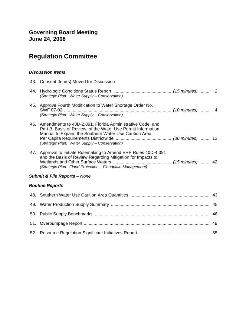
Governing Board Meeting June 24, 2008 Regulation Committee
Discussion Items
43. Consent Item(s) Moved for Discussion
44. Hydrologic Conditions Status Report ............................................... (15 minutes) ......... 2 (Strategic Plan: Water Supply – Conservation)
45. Approve Fourth Modification to Water Shortage Order No. SWF 07-02 ....................................................................................... (10 minutes) ......... 4
(Strategic Plan: Water Supply – Conservation)
46. Amendments to 40D-2.091, Florida Administrative Code, and Part B, Basis of Review, of the Water Use Permit Information Manual to Expand the Southern Water Use Caution Area Per Capita Requirements Districtwide ............................................. (30 minutes) ......... 12
(Strategic Plan: Water Supply – Conservation)
47. Approval to Initiate Rulemaking to Amend ERP Rules 40D-4.091 and the Basis of Review Regarding Mitigation for Impacts to Wetlands and Other Surface Waters ............................................... (15 minutes) ......... 42
(Strategic Plan: Flood Protection – Floodplain Management)
Submit & File Reports – None
Routine Reports
48. Southern Water Use Caution Area Quantities ................................................................. 43
49. Water Production Supply Summary ................................................................................. 45
50. Public Supply Benchmarks .............................................................................................. 46
51. Overpumpage Report ....................................................................................................... 48
52. Resource Regulation Significant Initiatives Report .......................................................... 55
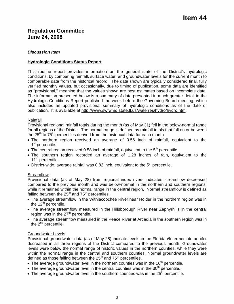
Item 44
Regulation Committee June 24, 2008 Discussion Item
Hydrologic Conditions Status Report
This routine report provides information on the general state of the District's hydrologic conditions, by comparing rainfall, surface water, and groundwater levels for the current month to comparable data from the historical record. The data shown are typically considered final, fully verified monthly values, but occasionally, due to timing of publication, some data are identified as "provisional," meaning that the values shown are best estimates based on incomplete data. The information presented below is a summary of data presented in much greater detail in the Hydrologic Conditions Report published the week before the Governing Board meeting, which also includes an updated provisional summary of hydrologic conditions as of the date of publication. It is available at http://www.swfwmd.state.fl.us/waterres/hydro/hydro.htm.
RainfallProvisional regional rainfall totals during the month (as of May 31) fell in the below-normal range for all regions of the District. The normal range is defined as rainfall totals that fall on or between the 25th to 75th percentiles derived from the historical data for each month The northern region received an average of 0.56 inch of rainfall, equivalent to the 1st percentile.
The central region received 0.58 inch of rainfall, equivalent to the 5th percentile. The southern region recorded an average of 1.28 inches of rain, equivalent to the 11th percentile.
District-wide, average rainfall was 0.82 inch, equivalent to the 5th percentile.
StreamflowProvisional data (as of May 28) from regional index rivers indicates streamflow decreased compared to the previous month and was below-normal in the northern and southern regions, while it remained within the normal range in the central region. Normal streamflow is defined as falling between the 25th and 75th percentiles. The average streamflow in the Withlacoochee River near Holder in the northern region was in the 12th percentile.
The average streamflow measured in the Hillsborough River near Zephyrhills in the central region was in the 27th percentile.
The average streamflow measured in the Peace River at Arcadia in the southern region was in the 2nd percentile.
Groundwater LevelsProvisional groundwater data (as of May 28) indicate levels in the Floridan/Intermediate aquifer decreased in all three regions of the District compared to the previous month. Groundwater levels were below the normal range of historic values in the northern counties, while they were within the normal range in the central and southern counties. Normal groundwater levels are defined as those falling between the 25th and 75th percentiles. The average groundwater level in the northern counties was in the 16th percentile. The average groundwater level in the central counties was in the 30th percentile. The average groundwater level in the southern counties was in the 25th percentile.
2
Item 44 Lake LevelsProvisional data (as of May 20) indicates lake levels decreased in all regions of the District during the month. Regionally, average lake levels were below the base of the annual normal range. Normal lake levels are generally considered to be levels that fall between the minimum low management level and the minimum flood level. Average levels in the Northern region decreased 0.54 foot and were 4.33 feet below the base of the annual normal range.
Average lake levels in the Tampa Bay region decreased 0.38 foot and were 1.84 feet below the base of the annual normal range.
Average lake levels in the Polk Uplands region decreased 0.28 foot and were 2.08 feet below the base of the annual normal range.
Average lake levels in the Lake Wales Ridge region decreased 0.53 foot and were 5.49 feet below the base of the annual normal range.
Issues of Significance
The month of May historically marks the last month of the annual dry season and rainfall for the month was well below normal in all regions of the District. The twelve-month District-wide rainfall deficit worsened slightly during May, ending the month approximately 6.2 inches below the long-term average. It has been below-average for 24 consecutive months. Rainfall accumulations for the month were regionally variable, mainly associated with the passage of a weak cold front in mid-May, and were not sufficient to improve hydrologic conditions in most areas. All regional hydrologic indicators throughout the District, including the Peace River basin area, declined during the month and long-term drought conditions intensified.
The US Drought Monitor (as of May 28) indicates dry conditions have intensified throughout the District, with the majority of counties experiencing either "abnormally dry" or "moderate drought" conditions, with the exception of Hernando, Pasco, Pinellas and parts of Sumter and Citrus counties, which were experiencing normal moisture conditions. NOAA climate models and forecasts indicate uncertain (equal chance for normal or above/below-normal) rainfall conditions for June and above-normal rainfall for the three-month period of June/July/August 2008, due to diminishing (neutral) La Niña conditions in the Pacific Ocean and an active tropical weather season in the Gulf of Mexico and Atlantic Ocean. Below-normal rainfall would continue to worsen overall hydrologic conditions and increase resource-related impacts.
Updated weather forecasts will be available in mid-June. Staff will continue to closely monitor conditions in accordance with the District's updated Water Shortage Plan, including any necessary supplemental analysis of condition data.
Staff Recommendation:
This item is presented for the Committee's information, and no action is required.
Presenter: Granville Kinsman, Manager, Hydrologic Data Section
3
Item 45
Regulation Committee June 24, 2008
Discussion Item
Approve Fourth Modification to Water Shortage Order No. SWF 07-02 In response to the ongoing drought (please refer to the "Hydrologic Conditions Status Report" item on the Regulation Committee's discussion agenda), applicable provisions of the District's Water Shortage Plan (Rule 40D-21, Florida Administrative Code) have been activated. On January 9, 2007, the District issued Water Shortage Order No. SWF 07-02 to declare once-per-week lawn watering restrictions and other modified Phase II (Severe Water Shortage) restrictions for the entire sixteen county area. Since that time, the Governing Board has extended the water shortage restrictions on three occasions. Most recently, at the November 26, 2007 meeting the Governing Board extended the expiration date to June 30, 2008.
Based on the combination of drought indicators specified in the Water Shortage Plan (rainfall patterns, ground water levels, surface water flow and weather predictions) and related considerations (such as local water conservation efforts), District staff believe that current conditions warrant continuing the current water shortage declaration through September 30, 2008. Assuming the Governing Board approves the staff recommendation, staff will continue to monitor hydrologic conditions so that these restrictions can be modified or rescinded prior to the expiration date if sufficient drought recovery occurs.
Staff Recommendation: See Exhibit
Approve the Fourth Modification to Water Shortage Order No. SWF 07-02 to extend the current modified Phase II restrictions through September 30, 2008 and to expand the order to include all of unincorporated Marion County in accordance with the Interagency Agreement with the St. Johns River Water Management District.
Presenter: Lois Ann Sorensen, Demand Management Coordinator, Water Use Program - Regulation Performance Management Department
4
SOUTHWEST FLORIDA WATER MANAGEMENT DISTRICT
IN RE:
DECLARATION OF WATER SHORTAGE _________________________________
FOURTH BOARD ORDER MODIFYING WATER SHORTAGE ORDER No. SWF 07-02
The Governing Board of the Southwest Florida Water Management District (District), during a public hearing held on June 24, 2008 in Brooksville, Florida, received testimony, including data and recommendations from District staff, and comment from the public regarding the existence of an ongoing water shortage within the District.Based upon the testimony, data, staff recommendations and public comment, the Governing Board makes the following Findings of Fact and Conclusions of Law.
FINDINGS OF FACT
1. At its November 30, 2006 meeting, pursuant to Section 373.083(5), Florida Statutes (F.S.), the District's Governing Board authorized the Executive Director to declare a water shortage in accordance with the non-emergency provisions of 40D-21, Florida Administrative Code (F.A.C.), the District's Water Shortage Plan ("Plan"), if, in his judgment, it was appropriate to do so prior to the Governing Board meeting on January 30, 2007.
2. The Executive Director held a public hearing on January 9, 2007 at the District's Brooksville headquarters for the purpose of considering data, including quantitative and qualitative indicators, staff recommendations and public input. Upon careful consideration of this information, the Executive Director determined that a District-wide modified Phase II "Severe Water Shortage" declaration is necessary and should be ordered prior to the next regularly scheduled Governing Board meeting.
3. The Governing Board concurred with the Executive Director's decision to issue Water Shortage Order No. SWF 07-02 during its meeting on January 30, 2007.Furthermore, on July 31, 2007, September 25, 2007, and November 26, 2007, the Governing Board considered then-current data, staff recommendations and public input. Upon careful consideration of updated information, the Governing Board determined that a modification to extend the expiration date of this Order was necessary on each of these three occasions. The most recent modification extended the terms of this Order to June 30, 2008.
5
4. The Plan specifies that the District will monitor certain sources of national predictions, indices and conditions and current hydrologic data, including rainfall, stream flow, groundwater levels and certain sources of national predictions and conditions.
5. The Plan establishes Drought Condition Levels that relate the extent to which current rainfall, stream flows and groundwater levels are below normal levels. Drought Condition Levels include Moderately, Severely, Extremely and Critically Abnormal.Drought Condition Levels consider regional conditions, and national predictions, indices and conditions (individually "Drought Indicator", collectively "Drought Indicators").
6. Drought Indicators are summarized as follows:
a. Rainfall
i. As of May 31, 2008, the District-wide rainfall deficit, measured as a twelve-month moving sum, is about 6.1 inches. This deficit is categorized as Moderately Abnormal.
ii. Eight of the sixteen counties within the District are currently experiencing below-normal rainfall on a countywide average basis.
iii. Two counties are predominantly experiencing rainfall conditions categorized as Extremely Abnormal: Hardee and Sarasota.
b. Groundwater conditions
i. As of June 3, 2008, all three of the major groundwater regions of the District (i.e., northern, central and southern counties) are experiencing conditions categorized as Moderately Abnormal
c. Surface water conditions
i. One major river within the District is experiencing substantially below-normal conditions as defined by the Plan.
ii. As of May 29, 2008, the eight-week moving mean stream flow for the Withlacoochee River (as measured near Holder) is 132 cubic feet per second (cfs), which equates to the 16th percentile, so this flow is categorized as Severely Abnormal.
iii. Although not currently classified as abnormal based the eight-week moving mean stream flow, the other three major rivers within the District have experienced an overall downward trend for four or more weeks.
2
6
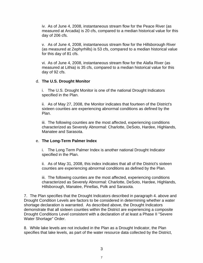
iv. As of June 4, 2008, instantaneous stream flow for the Peace River (as measured at Arcadia) is 20 cfs, compared to a median historical value for this day of 206 cfs.
v. As of June 4, 2008, instantaneous stream flow for the Hillsborough River (as measured at Zephyrhills) is 53 cfs, compared to a median historical value for this day of 81 cfs.
vi. As of June 4, 2008, instantaneous stream flow for the Alafia River (as measured at Lithia) is 35 cfs, compared to a median historical value for this day of 92 cfs.
d. The U.S. Drought Monitor
i. The U.S. Drought Monitor is one of the national Drought Indicators specified in the Plan.
ii. As of May 27, 2008, the Monitor indicates that fourteen of the District's sixteen counties are experiencing abnormal conditions as defined by the Plan.
iii. The following counties are the most affected, experiencing conditions characterized as Severely Abnormal: Charlotte, DeSoto, Hardee, Highlands, Manatee and Sarasota.
e. The Long-Term Palmer Index
i. The Long Term Palmer Index is another national Drought Indicator specified in the Plan.
ii. As of May 31, 2008, this index indicates that all of the District's sixteen counties are experiencing abnormal conditions as defined by the Plan.
iii. The following counties are the most affected, experiencing conditions characterized as Severely Abnormal: Charlotte, DeSoto, Hardee, Highlands, Hillsborough, Manatee, Pinellas, Polk and Sarasota.
7. The Plan specifies that the Drought Indicators described in paragraph 4. above and Drought Condition Levels are factors to be considered in determining whether a water shortage declaration is warranted. As described above, the Drought Indicators demonstrate that all sixteen counties within the District are experiencing a composite Drought Conditions Level consistent with a declaration of at least a Phase II "Severe Water Shortage" Order.
8. While lake levels are not included in the Plan as a Drought Indicator, the Plan specifies that lake levels, as part of the water resource data collected by the District,
3
7
shall be considered in determining whether a water shortage should be declared. Data used to prepare the May 2008 Hydrologic Conditions Report indicate:
a. Lakes in the northern region are about 4.11 feet below the bottom of the normal range.
b. Lakes in the Tampa Bay region are about 2.05 feet below the bottom of the normal range.
c. Lakes in the Polk Uplands region are about 2.23 feet below the bottom of the normal range.
d. Lakes in the Lake Wales Ridge region are about 5.58 feet below the bottom of the normal range.
9. In addition to evaluating and analyzing quantifiable Drought Indicators to determine the degree to which geographic area(s) and water source(s) are affected by a water shortage, the Plan specifies that District shall take into account several qualitative factors when considering what Phase of restrictions and other response mechanisms should be declared. Pertinent factors at this time include:
a. Surface water-dependent public supply systems serving the City of Tampa, Tampa Bay Water's member governments and the Peace River Manasota Regional Water Supply Authority's customer governments were significantly affected by this water shortage prior to its impact reaching regional proportions and, after experiencing some improvement during the wet winter months, are once again at-risk due to low storage.
b. Tampa Bay Water's three-county Drought Mitigation Plan activation triggers have not indicated that its water supplies have returned to pre-drought conditions.
c. The Peace River Manasota Regional Water Supply Authority continues to require two emergency authorizations to help meet current water demand.Executive Director Order No. SWF 07-045, as modified, provides a temporary permit change which allows the agency to maximize river diversions when available. Executive Director Order No. SWF 08-003 provides a temporary permit change which allows the withdrawal of ground water from ASR wells because previously-stored river water has been depleted from these wells.
d. Local water conservation efforts by Peace River Manasota Regional Water Supply Authority's customer governments and other local governments, including enforcement of current restrictions, continue to help minimize the need for more stringent District restrictions in the southern portion of the District.
4
8
e. The District and the adjacent St. Johns River Water Management District (St. Johns) entered into an Interagency Agreement in February 2008 which allows the District to declare a water shortage in the portion of Marion County physically located in St. Johns so that all of unincorporated Marion County will follow the same water shortage restrictions at any given point in time. The District's portion of Marion County is already included in Water Shortage Order No. SWF 07-02.
f. To varying degrees, all groundwater and surface water sources throughout the District are currently affected by this water shortage event. All categories of water users are impacting the available sources and are expected to continue to impact available water supply from these sources and contribute to the potential for harm to the natural systems.
CONCLUSIONS OF LAW
10. The Governing Board of the District is duly authorized by Section 373.246(2), F.S., and Chapter 40D-21, F.A.C., to issue Orders declaring the existence of a water shortage within all or part of the District and to impose such restrictions and require such measures as may be necessary to reduce demand on available water supplies.
11. County and city officials and all law enforcement authorities are required to enforce orders lawfully issued by the Executive Director pursuant to the Plan and Section 373.609, F.S.
ORDERED
THEREFORE, based upon the foregoing Findings of Fact and Conclusions of Law, it is hereby ORDERED:
12. Water Shortage Order No. SWF 07-02 is hereby extended throughSeptember 30, 2008, unless further extended, modified or rescinded by Governing Board or Executive Director action on or before that date.
13. The portion of unincorporated Marion County located in the St. Johns River Water Management District is hereby added to the geographic area encompassed by Water Shortage Order No. SWF 07-02.
14. Except as modified herein, all other terms and conditions of Water Shortage Order No. SWF 07-02 shall remain in full force and effect.
5
9
DONE AND ORDERED in Hernando County, Florida, on this 24th day of June, 2008.
SOUTHWEST FLORIDA WATER MANAGEMENT DISTRICT
By: _______________________ C. A. "Neil" Combee Governing Board Chair
Attest:
By: _______________________ Jennifer E. Closshey Governing Board Secretary
Filed this ____ dayof June, 2008
________________Agency Clerk
6
10
NOTICE OF RIGHTS
Persons to whom this Executive Director Order is directed, or whose substantial interests are affected, may request pursuant to subsection 373.119(3), Florida Statutes (F.S.), to petition for an administrative hearing in accordance with Sections 120.569 and 120.57, F.S., and Chapter 28-106, Florida Administrative Code (F.A.C.). A request for a hearing must: 1) explain how the petitioner’s or other person’s substantial interests will be affected by the District’s action; 2) state all material facts disputed by the petitioner or other person, or state that there are no disputed facts; and 3) otherwise comply with Chapter 28-106, F.A.C.
A request for hearing must be filed with and received by the Agency Clerk of the District at District Headquarters, 2379 Broad Street, Brooksville, Florida 34604-6899 within twenty-one (21) days of receipt of this notice. Receipt is deemed to be the fifth day after the date on which this notice is deposited in the United States mail. Failure to file a request for hearing within this time period shall constitute a waiver of any right you or any other person may have to request a hearing under Sections 120.569 and 120.57, F.S.
Mediation pursuant to Section 120.573, F.S., and Rule 28-106.111, F.A.C., to settle an administrative dispute regarding the District’s action in this matter is not available prior to the filing of a request for hearing.
In accordance with subsection 120.569(1), F.S., the following additional administrative or judicial review may be available.
A party who is adversely affected by final agency action may seek review of the action in the appropriate District Court of Appeal pursuant to Section 120.68, F.S., by filing a Notice of Appeal pursuant to Rule 9.110, Florida Rules of Appellate Procedure, within thirty (30) days after the rendering of the final action by the District.
PURSUANT TO SUBSECTION 373.119(3), F.S., AND NOTWITHSTANDING ANY OTHER PROVISION UNDER CHAPTER 120, F.S., PERSONS TO WHOM THE ORDER IS DIRECTED SHALL COMPLY THEREWITH IMMEDIATELY, AND THE TIMELY FILING OF A PETITION SHALL NOT STAY SUCH PERSON'S OBLIGATION TO MAINTAIN SUCH COMPLIANCE DURING THE PENDENCY OF ANY ADMINISTRATIVE PROCEEDING.
7
11

Item 46
Regulation Committee June 24, 2008 Discussion Item
Amendments to 40D-2.091, Florida Administrative Code (F.A.C.), and Part B, Basis of Review, of the Water Use Permit Information Manual to Expand the Southern Water Use Caution Area Per Capita Requirements Districtwide
Background/History The Governing Board approved the first comprehensive per capita water use calculation, reporting and efficiency standards in the original three water use caution areas (Highlands Ridge, Eastern Tampa Bay and Northern Tampa Bay) in the early 1990s. These requirements, including a per capita standard of 150 gallons per capita per day, have been in effect for over 15 years. Refinements to these requirements, a standardized current year population estimation methodology, and utility service area delineation and reporting requirements were included in the most recently approved Southern Water Use Caution Area (SWUCA) rules. However, the result is that the per capita and related reporting requirements are different between the SWUCA and Northern Tampa Bay Water Use Caution Area (NTBWUCA) and do not exist at all in the northern portion of the District outside a water use caution area.
In August and September 2007, the Governing Board approved for adoption amendments to Chapter 40D-2, F.A.C., to extend the SWUCA per capita and reporting requirements to those portions of the District outside the SWUCA.
Rule provisions from the SWUCA that would become effective in areas outside of the SWUCA and/or replace similar requirements in the NTBWUCA include:
Refined service area delineation requirements and reporting – necessary for enhanced use of GIS technology and accurate population estimation and projection;
Per capita calculation – removal of deduction for desalination in Northern Tampa Bay WUCA to be consistent with SWUCA;
Per capita calculation – refined and additional significant use deductions for large or regional commercial, industrial and institutional uses;
Per capita calculation – consistent service area population methodology, permanent and seasonal functional population estimation required, tourist and net commuter population optional but methodology prescribed;
Per capita compliance – 150 gallons per capita per day for utilities in existing WUCAs, 150 gallons per capita per day phased in over time for utilities outside existing water use caution areas;
Annual residential water use reporting – number of dwelling units by type served and their use – already required in all water use caution areas; and
Annual reclaimed/stormwater reporting – already required in all water use caution areas.
As reported to the Board last fall and winter, prior to District staff beginning the statutory publications and filings to adopt the rules, representatives of The Villages and Bay Laurel Community Development, which provides the water service for On Top of the World in Marion County, asked to meet with District staff regarding concerns about how those developments would meet the 150 per capita requirement and how the 150 per capita rate is calculated. The representatives for these developments are concerned that the developments are long-standing, age-restricted developments, and so have a relatively low per household population that, by itself, will result in a higher per capita usage rate compared to other public supply utilities, all other factors being equal. Additionally, these particular developments have expansive common areas and multiple golf courses, and have little residential water use other than single family residential. This pattern of development would also result in a higher per capita rate compared to other communities. An additional factor that concerns these
12
Item 46 developments' representatives is that these developments restrict homeowners from installing their own irrigation wells, thereby eliminating the possibility that the per capita rate would be lowered by this form of source-substitution, as occurs elsewhere in the District, such as the extensive residential irrigation wells that exist in Pinellas and Sarasota counties. Comments and requested changes to the 150 per capita requirement received from the Villages and Bay Laurel were summarized in the February 2008 recap. Since that time, Marion County Utilities staff has raised similar issues in a meeting with District staff. In addition, concerns were raised that the quantities that are allowed to be deducted for per capita compliance are not adequately addressed in the permit application process, particularly if the permitted quantity is limited to a gross per capita water use of 150 gpcd.
Current StatusStaff has analyzed the comments and has drafted revisions to the proposed rules that address concerns raised as shown in the Exhibit. Staff proposes that the draft rule amendments include revisions to the formula used to calculate a permittee's per capita rate to allow deductions and adjustments that would lower the per capita rate value used for purposes of compliance. These deductions and adjustments include:
A. Golf course irrigation within the permittee's service area where the irrigation quantities are included in the permitted quantities for the service area and reported as withdrawals;
B. Stormwater use inside the permittee's service area, used other than for golf course irrigation, and included in the permitted quantities for the service area and are reported as withdrawals; and
C. 50% of the reclaimed water provided outside the permittee's service area or 25,000 gpd or more annual average provided to a single-site within the permittee's service area, except not if used for residential or common area irrigation.
D. Allow a persons-per-household (pph) of 2.01 to be substituted for the actual service area pph in the calculation of the functional population when compliance with the 150 gpcd cannot be achieved by all allowable deductions and credits and the actual pph is less than 2.01. This addresses the concerns of utilities that have a high per capita water use, in part due to a low service area pph. (The 2.01 pph value has been developed based upon an analysis of service area persons-per-household from Census data.)
In addition, staff proposed to formalize the permit application permitted quantity calculation process in which projected allowable deductions are explicitly incorporated into the future allowable withdrawals. This will provide additional assurance that a permittee that is in compliance with the 150 gpcd compliance standard will not likely face an overpumpage compliance issue.
The specific rule language for revision D. and the permit application permitted quantity calculation, both of which have a significant impact on compliance, have not been presented to the Public Supply Advisory Committee.
Staff are scheduled to take these proposed amendments to the July 8, 2008 Public Supply Advisory Committee meeting. It should be noted that all the aforementioned parties that have expressed concerns with the rule revisions are members of the Advisory Committee. Subsequent to receiving input at the Advisory Committee and incorporating appropriate input, staff will bring the proposed rule revisions back to the Governing Board for approval in August 2008.
Staff Recommendation See Exhibit
This item is presented for the Committee’s information, and no action is required.
Presenter: Jay Yingling, Senior Economist, Planning Department
13
1
EXHIBIT
RULES OF THE SOUTHWEST FLORIDA WATER MANAGEMENT DISTRICT
CHAPTER 40D-2 WATER USE PERMITS
DraftJune 9, 2008
District-wide Per Capita Amendments
40D-2.091 Publications Incorporated by Reference. The following publications are hereby incorporated by reference into this Chapter, and are available from the District upon request:
(1) Water Use Permit Information Manual, Part B, "Basis of Review ( ) (5/08) and Part D, "Requirements for the Estimation of Permanent and Temporal Service Area Populations in the Southern Water Use Caution Area ( ) (1/07);
(2) - (5) No change
Specific Authority 373.044, 373.113, 373.118, 373.171, F.S. Law Implemented 373.036, 373.0361, 373.042, 373.0421, 373.0831, 373.116, 373.117, 373.118, 373.149, 373.171, 373.1963, 373.216, 373.219, 373.223, 373.229, 373.239, 373.243, F.S. History – New 10-1-89, Amended 11-15-90, 2-10-93, 3-30-93, 7-29-93, 4-11-94, 7-15-98, 7-28-98, 7-22-99, 12-2-99, 8-3-00, 9-3-00, 4-18-01, 4-14-02, 9-26-02, 1-1-03, 2-1-05, 10-19-05, 1-1-07, 8-23-07, 10-1-07, 10-22-07, 11-25-07, 12-24-07, 2-13-08, 4-7-08, 5-12-08, .
WATER USE PERMIT INFORMATION MANUAL PART B, BASIS OF REVIEW
2.0 ADMINISTRATIVE CONSIDERATIONS
Within Section 2.5 the title of subsection "Public Water Supply Service Area Within SWUCA" is changed as follows:
PUBLIC WATER SUPPLY SERVICE AREA WITHIN THE SWUCA
In addition to the paragraph above, a public supply utility permit Applicant must define the entire area proposed to be serviced by the public supply system or utility with potable water during the term of the permit. A public water supply utility may have separate, discreet service areas; however, if water is routinely transferred between service areas, the service areas are counted as one. An applicant’s public supply service area is composed of the following, unless the applicant demonstrates that factors unique to its utility make one or more of these situations inapplicable to the determination of the applicant’s service area:
1. The current and projected geographic retail area for which a public water supply utility intends to provide and bill for potable water for the duration of the permit.
14

2
2. The current and projected geographical retail areas of a public water supply utility that is not required to have a Wholesale Water Use Permit but which purchases water wholesale from the Applicant. 3. Areas where the Applicant bills for water use although another entity or utility has a Wholesale Water Use Permit for distribution of the water to the population.
The area for which a Wholesale Public Supply Permittee distributes potable water and bills customers for that water is not included in the wholesaler supplier's service area.
Public water supply applicants and their wholesale customers that operate “community water systems” as that term is defined by the Florida Department of Environmental Protection in Rule 62-550.200, F.A.C., shall be considered public water supply “utilities.” For the purposes of this rule, an entity which submeters a master-metered connection to a utility and bills for the metered water use is not considered a public water supply utility.
Public supply permit Applicants with a defined service area must submit an up-to-date map of the service area with clearly marked, identifiable boundaries at the time of application for a new permit, permit modification (not letter modification) or permit renewal. The map submitted must clearly show any changes to the service area relative to the service area depicted in the District’s electronic public supply area boundary map. The map must clearly delineate the current area served from any proposed service area(s) if the current and proposed areas are not the same, and the applicant is applying for quantities for the proposed service area. The map may be paper or District compatible electronic file format. During the term of the permit, for permits with durations longer than six years, an up-to-date service area map shall be submitted every six years. With each service area map submittal, the following information must be included:
1. A current general utility contact person name, title, email address and phone number.
2. A current contact person name, title, email address and phone number whom District staff may call concerning the service area map.
3. The metadata for the map if the map is submitted as an electronic file that is compatible with the District's format.
4. The District permit numbers and Florida Department of Environmental Protection Public Water Supply Identifier (PWSI) numbers and area designation names for each service area or sub-service area, as applicable.
5. An indication of routine water transfer interconnections between service areas and other utilities or wholesale suppliers or recipients.
6. The name, contact person, phone number, and District permit number(s) of each utility that purchases water from the permittee on a routine basis and the most recent year’s purchase quantity in millions of gallons per day.
7. The name, contact person, phone number, and District permit number(s) of each utility that the permittee purchase water from on a routine basis and the most recent year’s purchase quantity in millions of gallons per day.
Definable areas within a service area which are served by domestic potable wells shall be delineated and designated by the permittee as non-served areas unless documentation such as a capital improvement plan is provided that demonstrates that the area will be supplied by the applicant within the term of the permit. Quantities shall not be permitted for overlapping service areas or service areas that are in dispute.
New 1-1-07, Amended .
15
3
3.0 REASONABLE WATER NEEDS
Within Section 3.6 Public Supply the first paragraph is changed as follows:
In order to accurately calculate demand, public supply Applicants must identify the demand for each of the uses listed in this section. Information typically required to demonstrate reasonable demand for each component may include the number, type, and size of service connections; past monthly pumpage records by use type; projected permanent and temporal seasonal population data for the service area; data on the specific uses; development projections; and data specific to the forecasting models used. Demand quantities should be based on quantities required by end-use customers, not withdrawal quantities. The quantities must be expressed in average annual gallons per day for each component of demand. Revised _____.
Within Section 3.6 Public Supply the following changes are made:
A new heading "PERMIT APPLICATION DATA PROJECTIONS" is created and added before the existing provisions titled "PER CAPITA DAILY WATER USE" and the following five provisions are subheadings under "PERMIT APPLICATION DATA PROJECTIONS"
PERMIT APPLICATION DATA PROJECTIONS
Projected Per Capita Daily Water Use PER CAPITA DAILY WATER USE
Per capita daily water use is a guideline used to measure the reasonable withdrawal requests of public supply Applicants. Per capita water use is generally considered to be population-related withdrawals associated with residential, business, institutional, industrial, miscellaneous metered, and unaccounted uses. Projected per capita daily use is calculated by adding the quantities identified for the uses shown in the previous list, except for treatment losses, and then dividing by the permanent or temporally seasonally adjusted population of the service area. Where the per capita daily water use rate exceeds 150 gpd the applicant must address reduction of the high rate in the conservation plan.Revised _______.
The following four sections are relocated to this portion of Section 3.6 from the original location shown in strike through format further below and revised as indicated.
Service Area Population Projection Data POPULATION DATA Population data are available from the following sources: the District, Bureau of the Census,University of Florida Bureau of Economics and Business Research (BEBR), Regional Planning Council (RPC), County Planning Departments, the District Planning Department, and the orComprehensive Land Use Plan (developed under Chapter 9J-5, F.A.C.). Use of other population data or methods other than those provided by the District shall identified above may be considered if thoroughly documented. Counties and municipalities are required to estimate seasonal population as part of the comprehensive planning process. If such data are not available, seasonal service area population may be estimated using methods recommended by the State of Florida Department of Community Affairs (DCA). Applicants may also identify tourist population, if known. Revised ____.
16
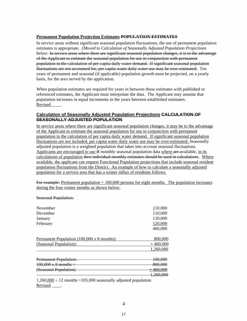
4
Permanent Population Projection Estimates POPULATION ESTIMATESIn service areas without significant seasonal population fluctuations, the use of permanent population estimates is appropriate. [Moved to Calculation of Seasonally Adjusted Population Projections below: In service areas where there are significant seasonal population changes, it is to the advantage of the Applicant to estimate the seasonal population for use in conjunction with permanent population in the calculation of per capita daily water demand. If significant seasonal population fluctuations are not accounted for, per capita water daily water use may be over-estimated. Ten years of permanent and seasonal (if applicable) population growth must be projected, on a yearly basis, for the area served by the application.
When population estimates are required for years in between those estimates with published or referenced estimates, the Applicant must interpolate the data. The Applicant may assume that population increases in equal increments in the years between established estimates. Revised ____.
Calculation of Seasonally Adjusted Population Projections CALCULATION OF SEASONALLY ADJUSTED POPULATION In service areas where there are significant seasonal population changes, it may be to the advantage of the Applicant to estimate the seasonal population for use in conjunction with permanent population in the calculation of per capita daily water demand. If significant seasonal population fluctuations are not included, per capita water daily water use may be over-estimated. Seasonally adjusted population is a weighted population that takes into account seasonal fluctuations. Applicants are encouraged to use If monthly seasonal population data where are available, in its calculations of population then individual monthly estimates should be used in calculations. Where available, the applicant can request Functional Population projections that include seasonal resident population fluctuations from the District. An example of how to calculate a seasonally adjusted population for a service area that has a winter influx of residents follows.
For example: Permanent population = 100,000 persons for eight months. The population increases during the four winter months as shown below:
Seasonal Population:
November 110,000 December 110,000 January 120,000 February 120,000 460,000
Permanent Population (100,000 x 8 months): 800,000(Seasonal Population): + 460,000 1,260,000
Permanent Population: 100,000 100,000 x 8 months = 800,000 (Seasonal Population) + 460,000
1,260,000 1,260,000 12 months =105,000 seasonally adjusted population Revised ____.
17
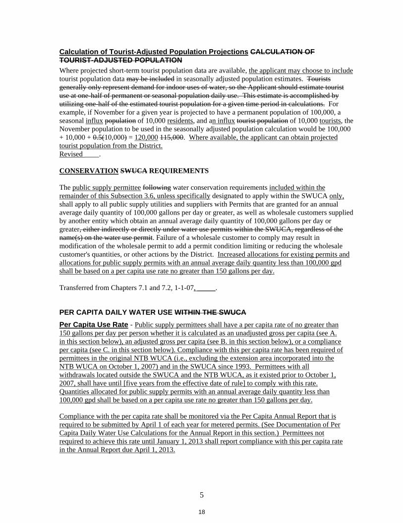
5
Calculation of Tourist-Adjusted Population Projections CALCULATION OF TOURIST-ADJUSTED POPULATION Where projected short-term tourist population data are available, the applicant may choose to include tourist population data may be included in seasonally adjusted population estimates. Tourists generally only represent demand for indoor uses of water, so the Applicant should estimate tourist use at one-half of permanent or seasonal population daily use. This estimate is accomplished by utilizing one-half of the estimated tourist population for a given time period in calculations. For example, if November for a given year is projected to have a permanent population of 100,000, a seasonal influx population of 10,000 residents, and an influx tourist population of 10,000 tourists, the November population to be used in the seasonally adjusted population calculation would be 100,000 + 10,000 + 0.5(10,000) = 120,000 115,000. Where available, the applicant can obtain projected tourist population from the District.Revised ____.
CONSERVATION SWUCA REQUIREMENTS
The public supply permittee following water conservation requirements included within the remainder of this Subsection 3.6, unless specifically designated to apply within the SWUCA only,shall apply to all public supply utilities and suppliers with Permits that are granted for an annual average daily quantity of 100,000 gallons per day or greater, as well as wholesale customers supplied by another entity which obtain an annual average daily quantity of 100,000 gallons per day or greater, either indirectly or directly under water use permits within the SWUCA, regardless of the name(s) on the water use permit. Failure of a wholesale customer to comply may result in modification of the wholesale permit to add a permit condition limiting or reducing the wholesale customer's quantities, or other actions by the District. Increased allocations for existing permits and allocations for public supply permits with an annual average daily quantity less than 100,000 gpd shall be based on a per capita use rate no greater than 150 gallons per day.
Transferred from Chapters 7.1 and 7.2, 1-1-07, _____.
PER CAPITA DAILY WATER USE WITHIN THE SWUCA Per Capita Use Rate - Public supply permittees shall have a per capita rate of no greater than 150 gallons per day per person whether it is calculated as an unadjusted gross per capita (see A. in this section below), an adjusted gross per capita (see B. in this section below), or a compliance per capita (see C. in this section below). Compliance with this per capita rate has been required of permittees in the original NTB WUCA (i.e., excluding the extension area incorporated into the NTB WUCA on October 1, 2007) and in the SWUCA since 1993. Permittees with all withdrawals located outside the SWUCA and the NTB WUCA, as it existed prior to October 1, 2007, shall have until [five years from the effective date of rule] to comply with this rate.Quantities allocated for public supply permits with an annual average daily quantity less than 100,000 gpd shall be based on a per capita use rate no greater than 150 gallons per day.
Compliance with the per capita rate shall be monitored via the Per Capita Annual Report that is required to be submitted by April 1 of each year for metered permits. (See Documentation of Per Capita Daily Water Use Calculations for the Annual Report in this section.) Permittees not required to achieve this rate until January 1, 2013 shall report compliance with this per capita rate in the Annual Report due April 1, 2013.
18
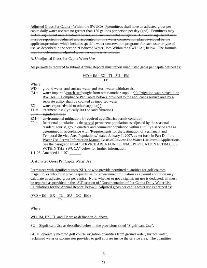
6
Adjusted Gross Per Capita - Within the SWUCA Ppermittees shall have an adjusted gross per capita daily water use rate no greater than 150 gallons per person per day (gpd). Permittees may deduct significant uses, treatment losses, and environmental mitigation. However significant uses must be reported if deducted and accounted for in a water conservation plan developed by the applicant/permittee which includes specific water conservation programs for each user or type of use, as described in the section “Deducted Water Uses Within the SWUCA”, below. The formula used for determining adjusted gross per capita is as follows:
A. Unadjusted Gross Per Capita Water Use
All permittees required to submit Annual Reports must report unadjusted gross per capita defined as:
WD + IM - EX - TL- SU – EMFP
Where:WD = ground water, and surface water and stormwater withdrawals, IM = water imported/purchasedbought from other another supplier(s). Irrigation water, excluding
RW (see C. Compliance Per Capita below), provided to the applicant's service area by a separate utility shall be counted as imported water
EX = water exported/sold to other supplier(s)TL = treatment loss (typically R/O or sand filtration) SU = significant usesEM = environmental mitigation, if required as a District permit conditionFP = functional population is the served permanent population as adjusted by the seasonal
resident, tourist, group quarters and commuter population within a utility's service area as determined in accordance with "Requirements for the Estimation of Permanent and Temporal Service Area Populations," dated January 1, 2007, as set forth in Part D of the Water Use Permit Information Manual Basis of Review For Water Use Permit Applications.See the paragraph titled “SERVICE AREA FUNCTIONAL POPULATION ESTIMATES WITHIN THE SWUCA” below for further information.
1-1-03, Amended 1-1-07, ______.
B. Adjusted Gross Per Capita Water Use
Permittees with significant uses (SU), or who provide permitted quantities for golf coursesirrigation, or who must provide quantities for environment mitigation as a permit condition may calculate an adjusted gross per capita. [Note: whether or not a significant use is deducted, all must be reported as provided in the "SU" section of "Documentation of Per Capita Daily Water Use Calculations for the Annual Report" below.] Adjusted gross per capita water use is defined as:
(WD + IM – EX – TL – SU – GC - EM) FP
Where:
WD, IM, EX, TL and FP are as defined in A. above.
SU = Significant Use as described below in the provisions titled "Significant Use".
GC = Separately metered golf course irrigation quantities from ground water, surface water, reclaimed water or stormwater provided to golf courses inside the service area. The quantities
19
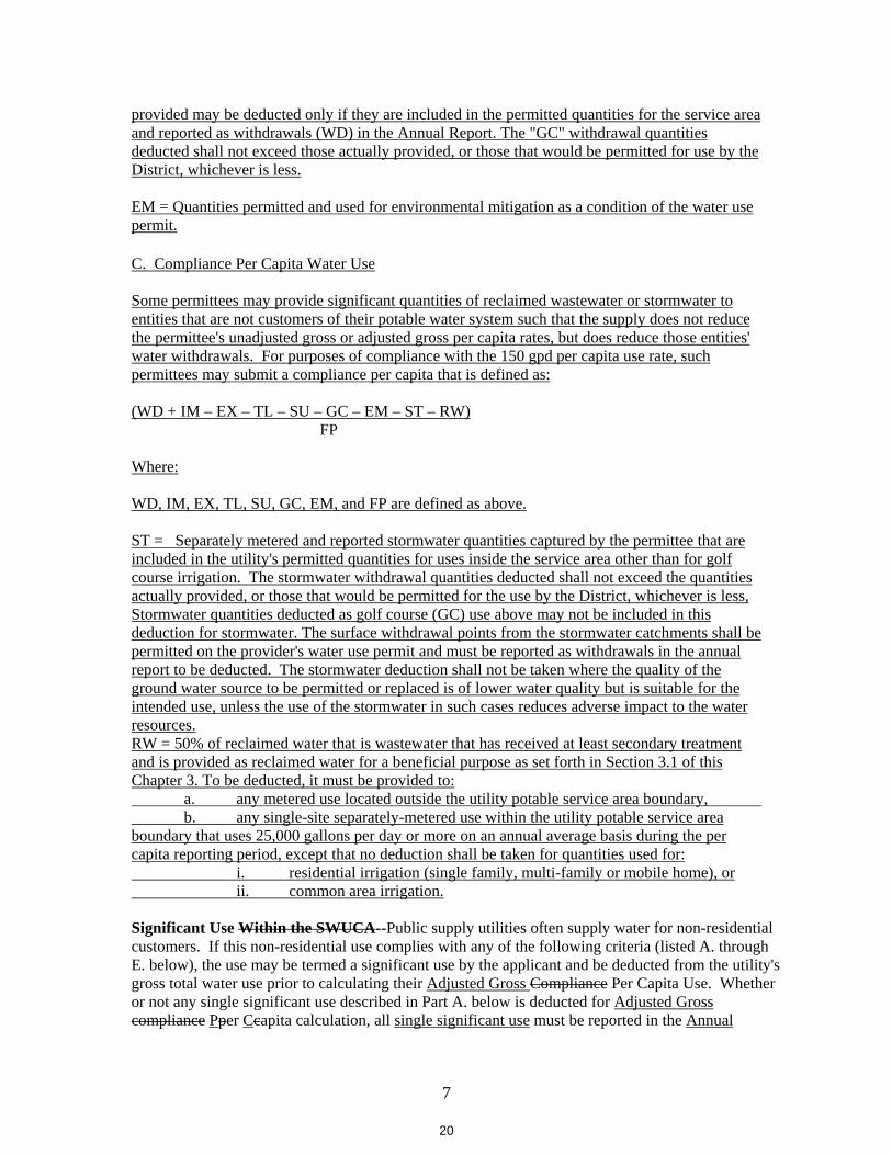
7
provided may be deducted only if they are included in the permitted quantities for the service area and reported as withdrawals (WD) in the Annual Report. The "GC" withdrawal quantities deducted shall not exceed those actually provided, or those that would be permitted for use by the District, whichever is less.
EM = Quantities permitted and used for environmental mitigation as a condition of the water use permit.
C. Compliance Per Capita Water Use
Some permittees may provide significant quantities of reclaimed wastewater or stormwater to entities that are not customers of their potable water system such that the supply does not reduce the permittee's unadjusted gross or adjusted gross per capita rates, but does reduce those entities' water withdrawals. For purposes of compliance with the 150 gpd per capita use rate, such permittees may submit a compliance per capita that is defined as:
(WD + IM – EX – TL – SU – GC – EM – ST – RW) FP
Where:
WD, IM, EX, TL, SU, GC, EM, and FP are defined as above.
ST = Separately metered and reported stormwater quantities captured by the permittee that are included in the utility's permitted quantities for uses inside the service area other than for golf course irrigation. The stormwater withdrawal quantities deducted shall not exceed the quantities actually provided, or those that would be permitted for the use by the District, whichever is less, Stormwater quantities deducted as golf course (GC) use above may not be included in this deduction for stormwater. The surface withdrawal points from the stormwater catchments shall be permitted on the provider's water use permit and must be reported as withdrawals in the annual report to be deducted. The stormwater deduction shall not be taken where the quality of the ground water source to be permitted or replaced is of lower water quality but is suitable for the intended use, unless the use of the stormwater in such cases reduces adverse impact to the water resources.RW = 50% of reclaimed water that is wastewater that has received at least secondary treatment and is provided as reclaimed water for a beneficial purpose as set forth in Section 3.1 of this Chapter 3. To be deducted, it must be provided to: a. any metered use located outside the utility potable service area boundary, b. any single-site separately-metered use within the utility potable service area boundary that uses 25,000 gallons per day or more on an annual average basis during the per capita reporting period, except that no deduction shall be taken for quantities used for: i. residential irrigation (single family, multi-family or mobile home), or ii. common area irrigation.
Significant Use Within the SWUCA--Public supply utilities often supply water for non-residential customers. If this non-residential use complies with any of the following criteria (listed A. through E. below), the use may be termed a significant use by the applicant and be deducted from the utility's gross total water use prior to calculating their Adjusted Gross Compliance Per Capita Use. Whether or not any single significant use described in Part A. below is deducted for Adjusted Gross compliance Pper Ccapita calculation, all single significant use must be reported in the Annual
20
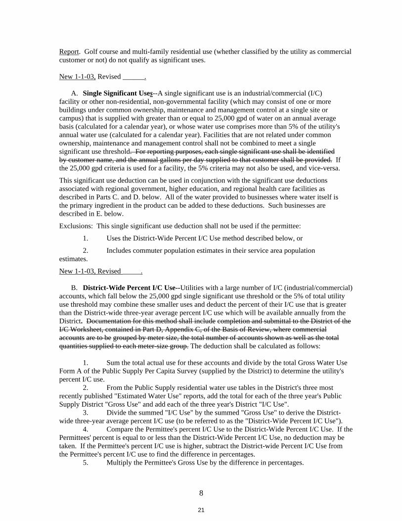
8
Report. Golf course and multi-family residential use (whether classified by the utility as commercial customer or not) do not qualify as significant uses.
New 1-1-03, Revised ______.
A. Single Significant Uses--A single significant use is an industrial/commercial (I/C) facility or other non-residential, non-governmental facility (which may consist of one or more buildings under common ownership, maintenance and management control at a single site or campus) that is supplied with greater than or equal to 25,000 gpd of water on an annual average basis (calculated for a calendar year), or whose water use comprises more than 5% of the utility's annual water use (calculated for a calendar year). Facilities that are not related under common ownership, maintenance and management control shall not be combined to meet a single significant use threshold. For reporting purposes, each single significant use shall be identified by customer name, and the annual gallons per day supplied to that customer shall be provided. If the 25,000 gpd criteria is used for a facility, the 5% criteria may not also be used, and vice-versa.
This significant use deduction can be used in conjunction with the significant use deductions associated with regional government, higher education, and regional health care facilities as described in Parts C. and D. below. All of the water provided to businesses where water itself is the primary ingredient in the product can be added to these deductions. Such businesses are described in E. below.
Exclusions: This single significant use deduction shall not be used if the permittee:
1. Uses the District-Wide Percent I/C Use method described below, or
2. Includes commuter population estimates in their service area population estimates.
New 1-1-03, Revised _____.
B. District-Wide Percent I/C Use--Utilities with a large number of I/C (industrial/commercial) accounts, which fall below the 25,000 gpd single significant use threshold or the 5% of total utility use threshold may combine these smaller uses and deduct the percent of their I/C use that is greater than the District-wide three-year average percent I/C use which will be available annually from the District. Documentation for this method shall include completion and submittal to the District of the I/C Worksheet, contained in Part D, Appendix C, of the Basis of Review, where commercial accounts are to be grouped by meter size, the total number of accounts shown as well as the total quantities supplied to each meter-size group. The deduction shall be calculated as follows:
1. Sum the total actual use for these accounts and divide by the total Gross Water Use Form A of the Public Supply Per Capita Survey (supplied by the District) to determine the utility's percent I/C use. 2. From the Public Supply residential water use tables in the District's three most recently published "Estimated Water Use" reports, add the total for each of the three year's Public Supply District "Gross Use" and add each of the three year's District "I/C Use". 3. Divide the summed "I/C Use" by the summed "Gross Use" to derive the District-wide three-year average percent I/C use (to be referred to as the "District-Wide Percent I/C Use"). 4. Compare the Permittee's percent I/C Use to the District-Wide Percent I/C Use. If the Permittees' percent is equal to or less than the District-Wide Percent I/C Use, no deduction may be taken. If the Permittee's percent I/C use is higher, subtract the District-wide Percent I/C Use from the Permittee's percent I/C use to find the difference in percentages. 5. Multiply the Permittee's Gross Use by the difference in percentages.
21
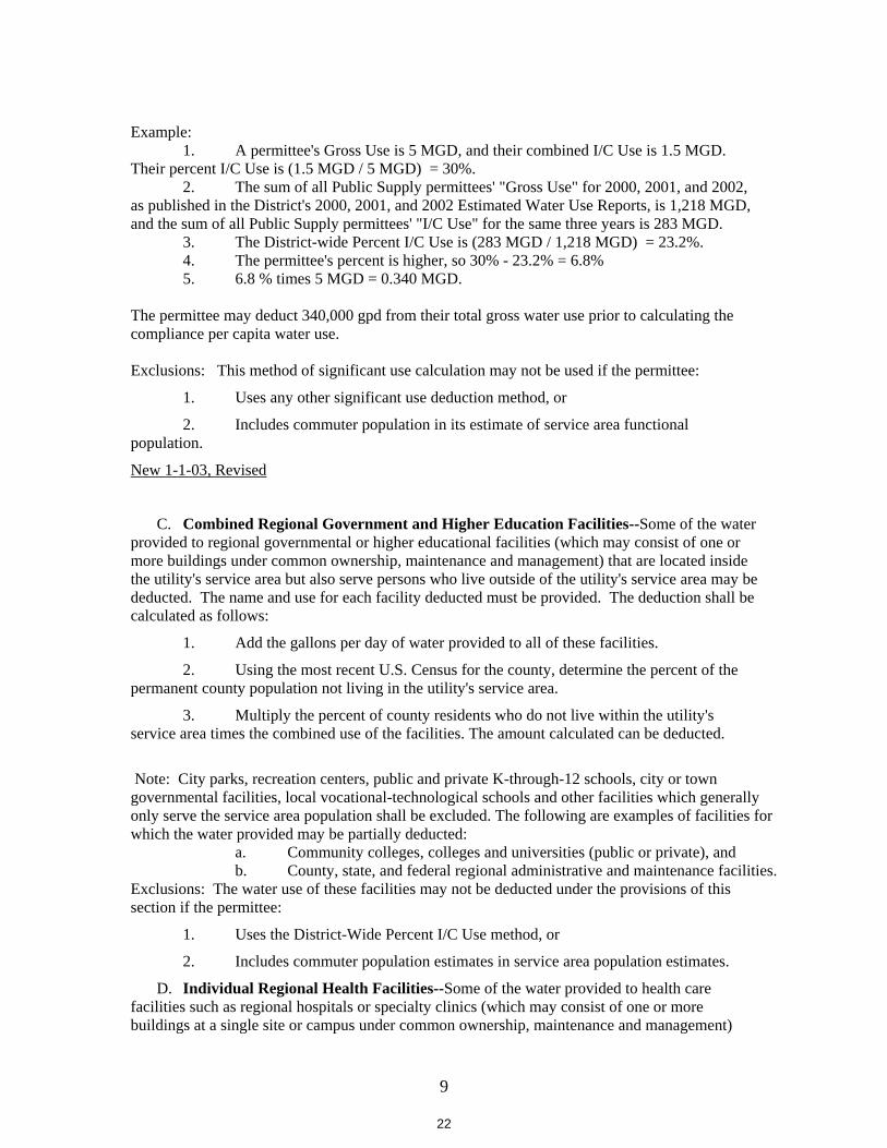
9
Example: 1. A permittee's Gross Use is 5 MGD, and their combined I/C Use is 1.5 MGD.
Their percent I/C Use is (1.5 MGD / 5 MGD) = 30%. 2. The sum of all Public Supply permittees' "Gross Use" for 2000, 2001, and 2002,
as published in the District's 2000, 2001, and 2002 Estimated Water Use Reports, is 1,218 MGD, and the sum of all Public Supply permittees' "I/C Use" for the same three years is 283 MGD. 3. The District-wide Percent I/C Use is (283 MGD / 1,218 MGD) = 23.2%. 4. The permittee's percent is higher, so 30% - 23.2% = 6.8% 5. 6.8 % times 5 MGD = 0.340 MGD.
The permittee may deduct 340,000 gpd from their total gross water use prior to calculating the compliance per capita water use.
Exclusions: This method of significant use calculation may not be used if the permittee:
1. Uses any other significant use deduction method, or
2. Includes commuter population in its estimate of service area functional population.
New 1-1-03, Revised
C. Combined Regional Government and Higher Education Facilities--Some of the water provided to regional governmental or higher educational facilities (which may consist of one or more buildings under common ownership, maintenance and management) that are located inside the utility's service area but also serve persons who live outside of the utility's service area may be deducted. The name and use for each facility deducted must be provided. The deduction shall be calculated as follows:
1. Add the gallons per day of water provided to all of these facilities.
2. Using the most recent U.S. Census for the county, determine the percent of the permanent county population not living in the utility's service area.
3. Multiply the percent of county residents who do not live within the utility's service area times the combined use of the facilities. The amount calculated can be deducted.
Note: City parks, recreation centers, public and private K-through-12 schools, city or town governmental facilities, local vocational-technological schools and other facilities which generally only serve the service area population shall be excluded. The following are examples of facilities for which the water provided may be partially deducted:
a. Community colleges, colleges and universities (public or private), and b. County, state, and federal regional administrative and maintenance facilities. Exclusions: The water use of these facilities may not be deducted under the provisions of this section if the permittee:
1. Uses the District-Wide Percent I/C Use method, or
2. Includes commuter population estimates in service area population estimates.
D. Individual Regional Health Facilities--Some of the water provided to health care facilities such as regional hospitals or specialty clinics (which may consist of one or more buildings at a single site or campus under common ownership, maintenance and management)
22
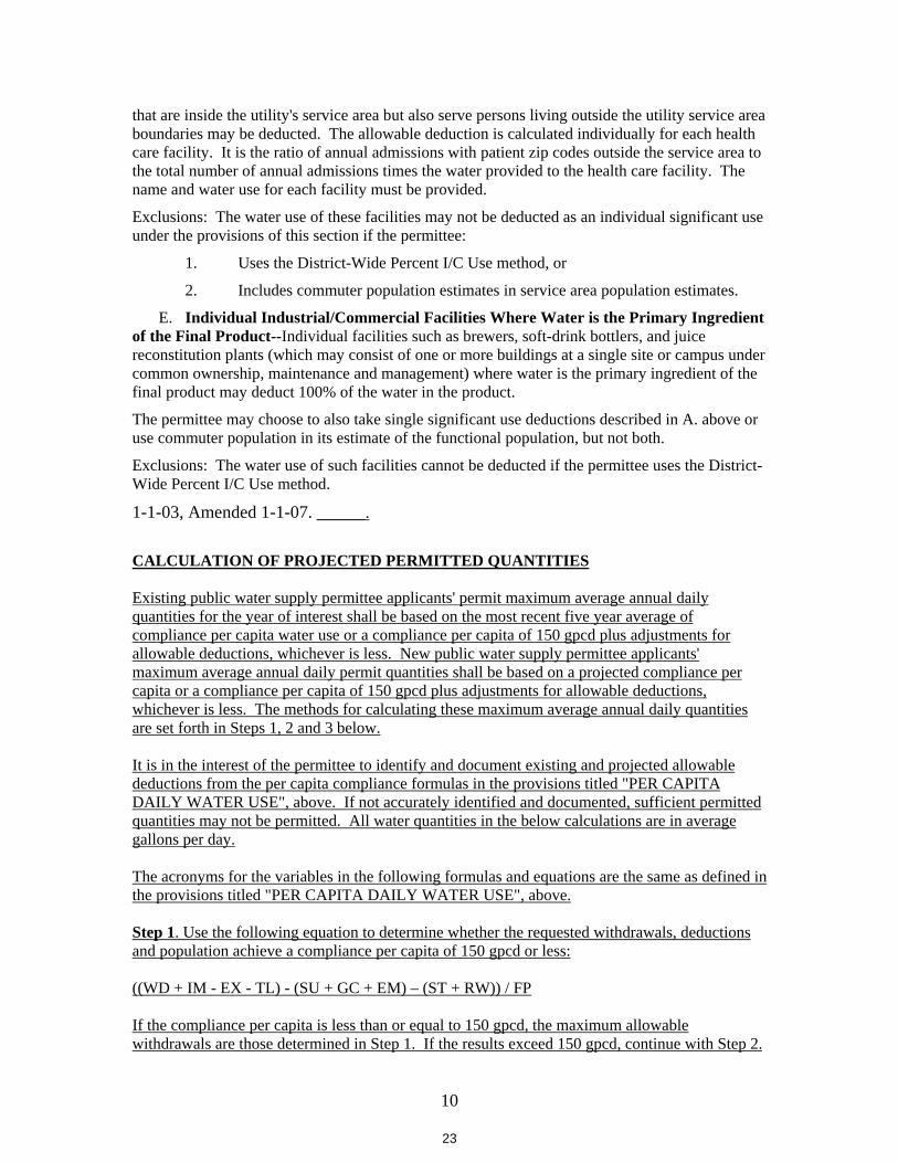
10
that are inside the utility's service area but also serve persons living outside the utility service area boundaries may be deducted. The allowable deduction is calculated individually for each health care facility. It is the ratio of annual admissions with patient zip codes outside the service area to the total number of annual admissions times the water provided to the health care facility. The name and water use for each facility must be provided.
Exclusions: The water use of these facilities may not be deducted as an individual significant use under the provisions of this section if the permittee:
1. Uses the District-Wide Percent I/C Use method, or
2. Includes commuter population estimates in service area population estimates.
E. Individual Industrial/Commercial Facilities Where Water is the Primary Ingredient of the Final Product--Individual facilities such as brewers, soft-drink bottlers, and juice reconstitution plants (which may consist of one or more buildings at a single site or campus under common ownership, maintenance and management) where water is the primary ingredient of the final product may deduct 100% of the water in the product.
The permittee may choose to also take single significant use deductions described in A. above or use commuter population in its estimate of the functional population, but not both.
Exclusions: The water use of such facilities cannot be deducted if the permittee uses the District-Wide Percent I/C Use method.
1-1-03, Amended 1-1-07. ______.
CALCULATION OF PROJECTED PERMITTED QUANTITIES
Existing public water supply permittee applicants' permit maximum average annual daily quantities for the year of interest shall be based on the most recent five year average of compliance per capita water use or a compliance per capita of 150 gpcd plus adjustments for allowable deductions, whichever is less. New public water supply permittee applicants' maximum average annual daily permit quantities shall be based on a projected compliance per capita or a compliance per capita of 150 gpcd plus adjustments for allowable deductions, whichever is less. The methods for calculating these maximum average annual daily quantities are set forth in Steps 1, 2 and 3 below.
It is in the interest of the permittee to identify and document existing and projected allowable deductions from the per capita compliance formulas in the provisions titled "PER CAPITA DAILY WATER USE", above. If not accurately identified and documented, sufficient permitted quantities may not be permitted. All water quantities in the below calculations are in average gallons per day.
The acronyms for the variables in the following formulas and equations are the same as defined in the provisions titled "PER CAPITA DAILY WATER USE", above.
Step 1. Use the following equation to determine whether the requested withdrawals, deductions and population achieve a compliance per capita of 150 gpcd or less:
((WD + IM - EX - TL) - (SU + GC + EM) – (ST + RW)) / FP
If the compliance per capita is less than or equal to 150 gpcd, the maximum allowable withdrawals are those determined in Step 1. If the results exceed 150 gpcd, continue with Step 2.
23
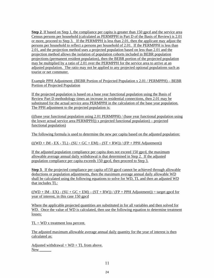
11
Step 2. If based on Step 1, the compliance per capita is greater than 150 gpcd and the service area Census persons per household (calculated as PERMPPH in Part D of the Basis of Review) is 2.01or more, proceed to Step 3. If the PERMPPH is less than 2.01, then the applicant may adjust the persons per household to reflect a persons per household of 2.01. If the PERMPPH is less than 2.01, and the projection method uses a projected population based on less than 2.01 and the projection method allows the isolation of population cohorts included in BEBR population projections (permanent resident population), then the BEBR portion of the projected population may be multiplied by a ratio of 2.01 over the PERMPPH for the service area to arrive at an adjusted population. The ratio may not be applied to any projected optional populations such as tourist or net commuter.
Example PPH Adjustment: (BEBR Portion of Projected Population x 2.01 / PERMPPH) – BEBR Portion of Projected Population
If the projected population is based on a base year functional population using the Basis of Review Part D methodology times an increase in residential connections, then 2.01 may be substituted for the actual service area PERMPPH in the calculation of the base year population. The PPH adjustment to the projected population is:
(((base year functional population using 2.01 PERMPPH) / (base year functional population using the lower actual service area PERMPPH)) x projected functional population) – projected functional population)
The following formula is used to determine the new per capita based on the adjusted population:
(((WD + IM - EX - TL) - (SU + GC + EM) – (ST + RW)) / (FP + PPH Adjustment))
If the adjusted population compliance per capita does not exceed 150 gpcd, the maximum allowable average annual daily withdrawal is that determined in Step 2. If the adjusted population compliance per capita exceeds 150 gpcd, then proceed to Step 3.
Step 3. If the projected compliance per capita of150 gpcd cannot be achieved through allowable deductions or population adjustments, then the maximum average annual daily allowable WD shall be calculated using the following equations to solve for WD, TL and then an adjusted WD that includes TL:
((WD + IM - EX) - (SU + GC + EM) – (ST + RW)) / (FP + PPH Adjustment)) = target gpcd for year of interest, in this case 150 gpcd
Where the applicable projected quantities are substituted in for all variables and then solved for WD. Once the value of WD is calculated, then use the following equation to determine treatment losses:
TL = WD x treatment loss percent.
The adjusted maximum allowable average annual daily quantity for the year of interest is then calculated as:
Adjusted withdrawal = WD + TL from above.New ______
24
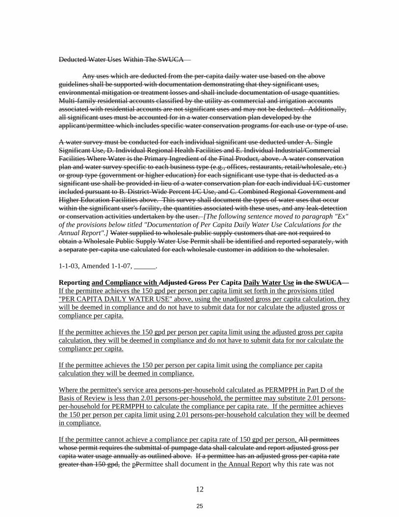
12
Deducted Water Uses Within The SWUCA—
Any uses which are deducted from the per-capita daily water use based on the above guidelines shall be supported with documentation demonstrating that they significant uses, environmental mitigation or treatment losses and shall include documentation of usage quantities. Multi-family residential accounts classified by the utility as commercial and irrigation accounts associated with residential accounts are not significant uses and may not be deducted. Additionally, all significant uses must be accounted for in a water conservation plan developed by the applicant/permittee which includes specific water conservation programs for each use or type of use.
A water survey must be conducted for each individual significant use deducted under A. Single Significant Use, D. Individual Regional Health Facilities and E. Individual Industrial/Commercial Facilities Where Water is the Primary Ingredient of the Final Product, above. A water conservation plan and water survey specific to each business type (e.g., offices, restaurants, retail/wholesale, etc.) or group type (government or higher education) for each significant use type that is deducted as a significant use shall be provided in lieu of a water conservation plan for each individual I/C customer included pursuant to B. District-Wide Percent I/C Use, and C. Combined Regional Government and Higher Education Facilities above. This survey shall document the types of water uses that occur within the significant user's facility, the quantities associated with these uses, and any leak-detectionor conservation activities undertaken by the user. [The following sentence moved to paragraph "Ex" of the provisions below titled "Documentation of Per Capita Daily Water Use Calculations for the Annual Report".] Water supplied to wholesale public supply customers that are not required to obtain a Wholesale Public Supply Water Use Permit shall be identified and reported separately, with a separate per-capita use calculated for each wholesale customer in addition to the wholesaler.
1-1-03, Amended 1-1-07, ______.
Reporting and Compliance with Adjusted Gross Per Capita Daily Water Use in the SWUCA—If the permittee achieves the 150 gpd per person per capita limit set forth in the provisions titled "PER CAPITA DAILY WATER USE" above, using the unadjusted gross per capita calculation, they will be deemed in compliance and do not have to submit data for nor calculate the adjusted gross or compliance per capita.
If the permittee achieves the 150 gpd per person per capita limit using the adjusted gross per capita calculation, they will be deemed in compliance and do not have to submit data for nor calculate the compliance per capita.
If the permittee achieves the 150 per person per capita limit using the compliance per capita calculation they will be deemed in compliance.
Where the permittee's service area persons-per-household calculated as PERMPPH in Part D of the Basis of Review is less than 2.01 persons-per-household, the permittee may substitute 2.01 persons-per-household for PERMPPH to calculate the compliance per capita rate. If the permittee achieves the 150 per person per capita limit using 2.01 persons-per-household calculation they will be deemed in compliance.
If the permittee cannot achieve a compliance per capita rate of 150 gpd per person, All permittees whose permit requires the submittal of pumpage data shall calculate and report adjusted gross per capita water usage annually as outlined above. If a permittee has an adjusted gross per capita rate greater than 150 gpd, the pPermittee shall document in the Annual Report why this rate was not
25
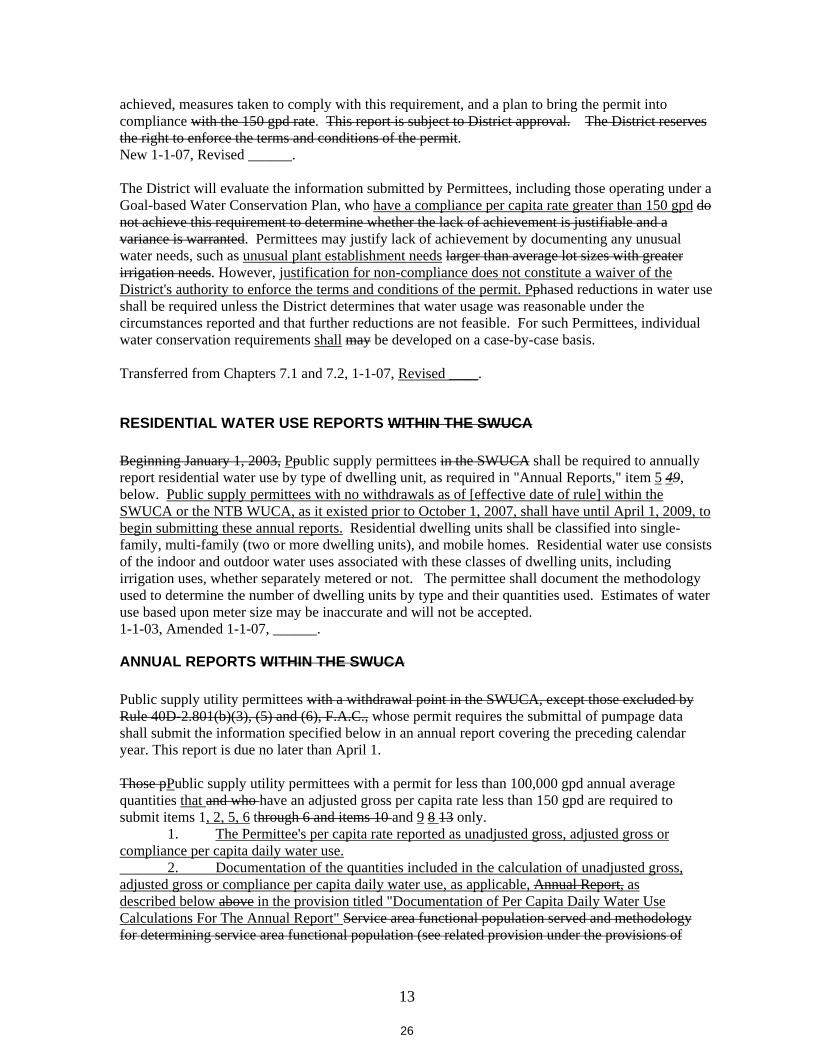
13
achieved, measures taken to comply with this requirement, and a plan to bring the permit into compliance with the 150 gpd rate. This report is subject to District approval. The District reserves the right to enforce the terms and conditions of the permit.New 1-1-07, Revised ______.
The District will evaluate the information submitted by Permittees, including those operating under a Goal-based Water Conservation Plan, who have a compliance per capita rate greater than 150 gpd do not achieve this requirement to determine whether the lack of achievement is justifiable and a variance is warranted. Permittees may justify lack of achievement by documenting any unusual water needs, such as unusual plant establishment needs larger than average lot sizes with greater irrigation needs. However, justification for non-compliance does not constitute a waiver of the District's authority to enforce the terms and conditions of the permit. Pphased reductions in water use shall be required unless the District determines that water usage was reasonable under the circumstances reported and that further reductions are not feasible. For such Permittees, individual water conservation requirements shall may be developed on a case-by-case basis.
Transferred from Chapters 7.1 and 7.2, 1-1-07, Revised ____.
RESIDENTIAL WATER USE REPORTS WITHIN THE SWUCA
Beginning January 1, 2003, Ppublic supply permittees in the SWUCA shall be required to annually report residential water use by type of dwelling unit, as required in "Annual Reports," item 5 49,below. Public supply permittees with no withdrawals as of [effective date of rule] within the SWUCA or the NTB WUCA, as it existed prior to October 1, 2007, shall have until April 1, 2009, to begin submitting these annual reports. Residential dwelling units shall be classified into single-family, multi-family (two or more dwelling units), and mobile homes. Residential water use consists of the indoor and outdoor water uses associated with these classes of dwelling units, including irrigation uses, whether separately metered or not. The permittee shall document the methodology used to determine the number of dwelling units by type and their quantities used. Estimates of water use based upon meter size may be inaccurate and will not be accepted. 1-1-03, Amended 1-1-07, ______.
ANNUAL REPORTS WITHIN THE SWUCA
Public supply utility permittees with a withdrawal point in the SWUCA, except those excluded by Rule 40D-2.801(b)(3), (5) and (6), F.A.C., whose permit requires the submittal of pumpage data shall submit the information specified below in an annual report covering the preceding calendar year. This report is due no later than April 1.
Those pPublic supply utility permittees with a permit for less than 100,000 gpd annual average quantities that and who have an adjusted gross per capita rate less than 150 gpd are required to submit items 1, 2, 5, 6 through 6 and items 10 and 9 8 13 only. 1. The Permittee's per capita rate reported as unadjusted gross, adjusted gross or compliance per capita daily water use. 2. Documentation of the quantities included in the calculation of unadjusted gross, adjusted gross or compliance per capita daily water use, as applicable, Annual Report, as described below above in the provision titled "Documentation of Per Capita Daily Water Use Calculations For The Annual Report" Service area functional population served and methodology for determining service area functional population (see related provision under the provisions of
26
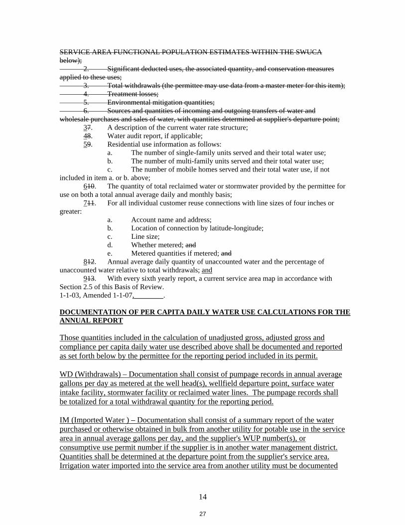
14
SERVICE AREA FUNCTIONAL POPULATION ESTIMATES WITHIN THE SWUCA below);
2. Significant deducted uses, the associated quantity, and conservation measures applied to these uses;
3. Total withdrawals (the permittee may use data from a master meter for this item);4. Treatment losses;5. Environmental mitigation quantities;6. Sources and quantities of incoming and outgoing transfers of water and
wholesale purchases and sales of water, with quantities determined at supplier's departure point; 37. A description of the current water rate structure; 48. Water audit report, if applicable; 59. Residential use information as follows: a. The number of single-family units served and their total water use; b. The number of multi-family units served and their total water use; c. The number of mobile homes served and their total water use, if not included in item a. or b. above; 610. The quantity of total reclaimed water or stormwater provided by the permittee for use on both a total annual average daily and monthly basis; 711. For all individual customer reuse connections with line sizes of four inches or greater: a. Account name and address;
b. Location of connection by latitude-longitude; c. Line size; d. Whether metered; and e. Metered quantities if metered; and
812. Annual average daily quantity of unaccounted water and the percentage of unaccounted water relative to total withdrawals; and 913. With every sixth yearly report, a current service area map in accordance with Section 2.5 of this Basis of Review. 1-1-03, Amended 1-1-07,________.
DOCUMENTATION OF PER CAPITA DAILY WATER USE CALCULATIONS FOR THE ANNUAL REPORT
Those quantities included in the calculation of unadjusted gross, adjusted gross andcompliance per capita daily water use described above shall be documented and reported as set forth below by the permittee for the reporting period included in its permit.
WD (Withdrawals) – Documentation shall consist of pumpage records in annual average gallons per day as metered at the well head(s), wellfield departure point, surface water intake facility, stormwater facility or reclaimed water lines. The pumpage records shall be totalized for a total withdrawal quantity for the reporting period.
IM (Imported Water ) – Documentation shall consist of a summary report of the water purchased or otherwise obtained in bulk from another utility for potable use in the service area in annual average gallons per day, and the supplier's WUP number(s), or consumptive use permit number if the supplier is in another water management district. Quantities shall be determined at the departure point from the supplier's service area. Irrigation water imported into the service area from another utility must be documented
27
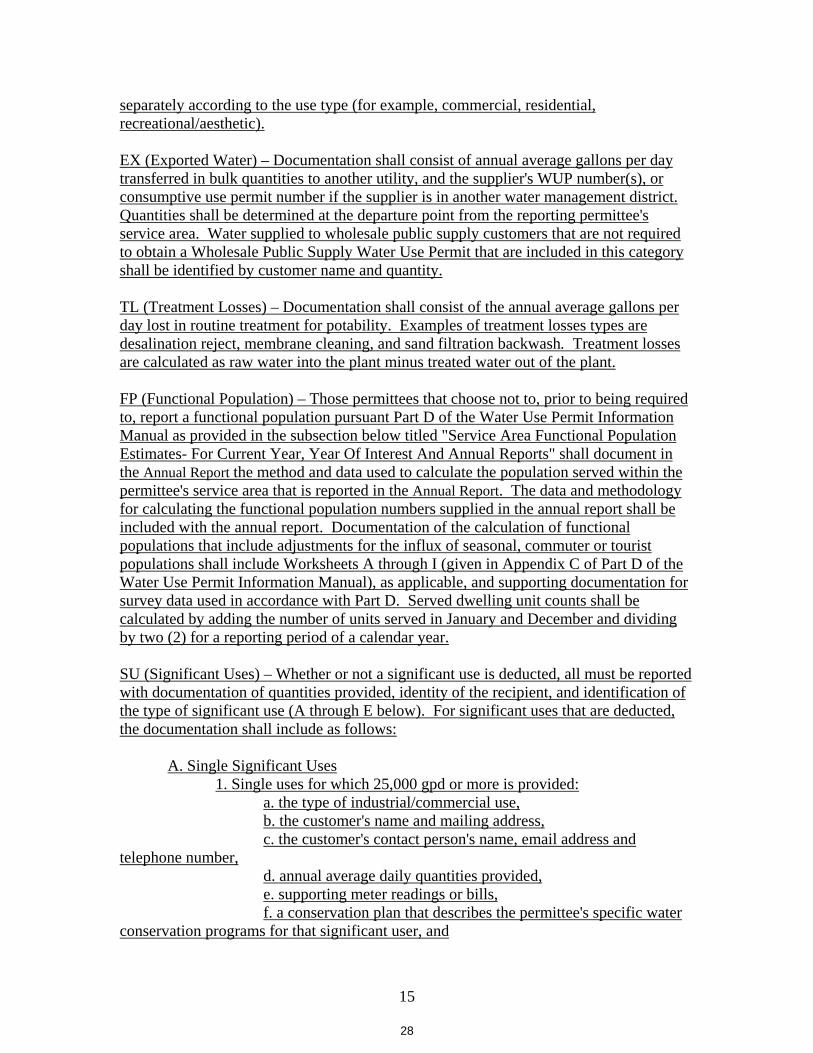
15
separately according to the use type (for example, commercial, residential, recreational/aesthetic).
EX (Exported Water) – Documentation shall consist of annual average gallons per day transferred in bulk quantities to another utility, and the supplier's WUP number(s), or consumptive use permit number if the supplier is in another water management district. Quantities shall be determined at the departure point from the reporting permittee's service area. Water supplied to wholesale public supply customers that are not required to obtain a Wholesale Public Supply Water Use Permit that are included in this category shall be identified by customer name and quantity.
TL (Treatment Losses) – Documentation shall consist of the annual average gallons per day lost in routine treatment for potability. Examples of treatment losses types are desalination reject, membrane cleaning, and sand filtration backwash. Treatment losses are calculated as raw water into the plant minus treated water out of the plant.
FP (Functional Population) – Those permittees that choose not to, prior to being required to, report a functional population pursuant Part D of the Water Use Permit Information Manual as provided in the subsection below titled "Service Area Functional Population Estimates- For Current Year, Year Of Interest And Annual Reports" shall document in the Annual Report the method and data used to calculate the population served within the permittee's service area that is reported in the Annual Report. The data and methodology for calculating the functional population numbers supplied in the annual report shall be included with the annual report. Documentation of the calculation of functional populations that include adjustments for the influx of seasonal, commuter or tourist populations shall include Worksheets A through I (given in Appendix C of Part D of the Water Use Permit Information Manual), as applicable, and supporting documentation for survey data used in accordance with Part D. Served dwelling unit counts shall be calculated by adding the number of units served in January and December and dividing by two (2) for a reporting period of a calendar year.
SU (Significant Uses) – Whether or not a significant use is deducted, all must be reported with documentation of quantities provided, identity of the recipient, and identification of the type of significant use (A through E below). For significant uses that are deducted, the documentation shall include as follows:
A. Single Significant Uses 1. Single uses for which 25,000 gpd or more is provided: a. the type of industrial/commercial use, b. the customer's name and mailing address, c. the customer's contact person's name, email address and telephone number, d. annual average daily quantities provided, e. supporting meter readings or bills, f. a conservation plan that describes the permittee's specific water conservation programs for that significant user, and
28
16
g. a water survey that documents the type(s) of water uses that occur within the significant user's facility, quantities used per type, leak detection and other water conservation activities undertaken by the user.
2. Water uses that comprise more than 5% of the utility's calendar annual use a. list of industrial/commercial customers in this category, grouped by business type, b. the customers' names and mailing addresses, c. the customers' contact person's name, email address and telephone number, d. annual average daily quantities provided, e. supporting meter readings or bills, and f. a conservation plan that describes the permittee's specific water conservation programs for each type of use.
B. District-Wide Percent I/C Use – Documentation shall include, by meter size, the number of I/C connections and use in average gallons per day, the total unadjusted gross use (gpd) and the District three-year average I/C % used. A water conservation plan specific to each business type deducted (e.g., offices, restaurants, retail/wholesale, etc.) shall be provided in lieu of a water conservation plan for each individual I/C customer.
C. Combined Regional Government and Higher Education Facilities –Documentation shall include for each facility included in the deduction calculation, the facility name, the facility's contact person's name, email address and telephone number, quantity provided in gpd and, from the most recent Census, the percent of the county total population not living in the utility service area. A water conservation plan specific to each group type (regional and or higher education facilities) shall be provided in lieu of a water conservation plan for each individual customer deducted.
D. Individual Regional Health Facilities – Documentation shall include for each facility included in the deduction, the name of the facility, the facility's contact person's name, email address and telephone number, types of water use and the gallons per day provided for each type of use, total number of patients during the reporting period, and the number of patients with postal zip codes outside the service area. Document the types of water uses that occur within the significant water user's facility, the quantities associated with these uses, and any leak detection or conservation activities undertaken by the user shall also be documented.
E. Individual I/C Facilities Where Water Is the Primary Ingredient of the Product – Documentation shall include for each facility the name of the facility, type of facility, the facility's contact person's name, email address and telephone number, the average gallons per day provided during the reporting period, and the percent of the final product that is water. Document the types of water uses that occur within the significant water
29
17
user's facility, the quantities associated with these uses, and any leak detection or conservation activities undertaken by the user shall also be documented.
GC (Golf Courses) – Documentation shall include a report on the permitted and separately metered quantities from ground water, surface water, reclaimed and stormwater sources used for golf course irrigation. To deduct these quantities, the quantities must be authorized for golf course irrigation in the permit for which per capita is being calculated.
EM (Environmental Mitigation) – Documentation shall include a report on the permitted and used quantities for the reporting period in gallons per day for environmental mitigation as required by the permit for which per capita is being calculated.
ST (Stormwater) – Documentation shall include a report on the separately metered stormwater quantities generated and used in the service area that are included in the utility's permit for the service area for uses other than golf course irrigation. If the stormwater quantities are not reported as withdrawals (WD), they may not be deducted. The report shall include the number of connections by use type (e.g., residential, commercial, recreation aesthetic, etc.)
RW (Reclaimed Water Credit) – Documentation shall include a report on separately metered reclaimed water quantities generated by: a. name of the customer, b. account number, c. customer service address, d. quantities provided during the reporting period in average gallons per day, e. claimed deduction during the reporting period in average gallons per day, f. meter size, g. whether the use is inside or outside of the potable service area boundary, and h. description of the use (may not include residential or common area irrigation).
The following four provisions are moved ahead in Section 3.6 as shown above.
POPULATION ESTIMATES In service areas without significant seasonal population fluctuations, the use of permanent population estimates is appropriate. In service areas where there are significant seasonal population changes, itis to the advantage of the Applicant to estimate the seasonal population for use in conjunction with permanent population in the calculation of per capita daily water demand. If significant seasonal population fluctuations are not accounted for, per capita water daily water use may be over-estimated. Ten years of permanent and seasonal (if applicable) population growth must be projected, on a yearly basis, for the area served by the application.
When population estimates are required for years in between those estimates with published or referenced estimates, the Applicant must interpolate the data. The Applicant may assume that population increases in equal increments in the years between established estimates.
30
18
POPULATION DATA Population data are available from the following sources: University of Florida Bureau of Economics and Business Research (BEBR), Regional Planning Council (RPC), County Planning Departments, the District Planning Department, or Comprehensive Land Use Plan (developed under Chapter 9J-5,F.A.C.). Use of other population data or methods other than those identified above may be considered if thoroughly documented. Counties and municipalities are required to estimate seasonal population as part of the comprehensive planning process. If such data are not available, seasonal service area population may be estimated using methods recommended by the State of Florida Department of Community Affairs (DCA). Applicants may also identify tourist population, if known.
CALCULATION OF SEASONALLY ADJUSTED POPULATION Seasonally adjusted population is a weighted population that takes into account seasonal fluctuations. If monthly seasonal population data are available, then individual monthly estimates should be used in calculations.
For example:Seasonal Population:
November 10,000 December 110,000 January 120,000 February 120,000
460,000
Permanent Population: 100,000 100,000 x 8 months = 800,000 (Seasonal Population) + 460,000
1,260,000
1,260 12 months =105,000 seasonally adjusted population
CALCULATION OF TOURIST-ADJUSTED POPULATION Where projected short-term tourist population data are available, tourist population data may be included in seasonally adjusted population estimates. Tourists generally only represent demand for indoor uses of water, so the Applicant should estimate tourist use at one-half of permanent or seasonal population daily use. This estimate is accomplished by utilizing one-half of the estimated tourist population for a given time period in calculations. For example, if November for a given year is projected to have a permanent population of 100,000, a seasonal population of 10,000, and a tourist population of 10,000, the November population to be used in the seasonally adjusted population calculation would be 100,000 + 10,000 + 0.5(10,000) = 115,000.
SERVICE AREA FUNCTIONAL POPULATION ESTIMATES – FOR CURRENT YEAR, YEAR OF INTEREST AND ANNUAL REPORTS WITHIN THE SWUCA
Permittees required to submit service area functional population estimates in the SWUCA shall estimate permanent resident, temporal resident, and group quarter populations. Service area tourist and net commuter population may be estimated as well. All estimates must be prepared in accordance with "Requirements for the Estimation of Permanent and Temporal Service Area Populations," dated January 1, 2007, as set forth in Part D of the Basis of Review For Water Use
31
19
Permit Applications. Public supply permittees whose permit requires the submittal of pumpage data shall submit the applicable Worksheets from Part D and supporting documentation for calculations of per capita rates utilizing this standardized methodology beginning two years from January 1, 2007. For those permittees with no withdrawals in the SWUCA as of [effective date of rule], this date shall be beginning two years from [effective date of rule].New 1-1-07, Revised _______.
WATER AUDITS CONSERVATION REQUIREMENTS WITHIN THE SWUCA
Water Audit--All water supply permittees within the SWUCA shall implement water audit programs within 2 years of permit issuance. Water audits which identify a greater than 12% unaccounted water shall be followed by appropriate remedial actions. A thorough water audit can identify what is causing unaccounted water and alert the utility to the possibility of significant losses in the distribution system. Unaccounted water can be attributed to a variety of causes, including unauthorized uses, line flushing, authorized unmetered uses, under-registration of meters, fire flows, and leaks. Any losses that are measured and verifiably documented are not considered unaccounted water. Large, complex water supply systems may conduct the audit in phases, with prior approval by the District. Each annual report shall state the percentage of unaccounted water. If any annual report reflects a greater than 12% unaccounted water, the permittee must complete a water audit within 90 days of submittal of the annual report. A water audit report shall be submitted within 90 days of completion of the water audit. The water audit report shall include a summary of the water audit and an implementation schedule for remedial actions to reduce the unaccounted water below 12%. The District shall take into account a permittee's adherence to the remedial action plan in any subsequent years when the permittee's annual report reflects greater than 12% unaccounted water. 1-1-03, Revised _______.
EXEMPTIONS FROM WATER CONSERVATION REQUIREMENTS
Permittees within the SWUCA whose permitted annual average quantity is less than 100,000 gallons per day are exempted from the residential water use report, water conserving rate structure, and water audit requirements, if otherwise applicable.1-1-03, Revised _______.
6.0 PERMIT CONDITIONS
The following public supply permit conditions are changed as follows:
28. Data Gathering (Public Supply > 100,000 500,000)
Condition: The Permittee shall establish and/or maintain data gathering procedures that allow amounts of water to be accounted into various categories. These categories may be by either meter size or use, such as residential, commercial, industrial, unaccounted, and other. The procedures must produce data suitable for developing reliable estimates of current water use and projections of future water demand.
Conditions 29. – 32. are renumbered as 28. – 31.
32

20
7.0 WATER USE CAUTION AREAS
7.3 NORTHERN TAMPA BAY WATER USE CAUTION AREA
The following provisions are deleted from Section 7.3.
1.1 Per-Capita Use
Per-capita daily water use is defined as population-related withdrawals associated with residential, business, institutional, industrial, miscellaneous metered, and unaccounted uses.Permittees with per-capita daily water use which is skewed by the demands of significant water uses can deduct these uses provided that these uses are separately accounted. Generally, the formula used for determining gallons per day per capita is as follows: total withdrawal minus significant uses, environmental mitigation, and treatment losses, divided by the population served (adjusted for seasonal and tourist populations, if appropriate). For interconnected systems, incoming transfers and wholesale purchases of water shall be added to withdrawals; outgoing transfers and wholesale sales of water shall be deducted from withdrawals.
A significant use, which may be deducted, is defined as an individual non-residential customer using 25,000 gallons per day or greater on an annual average basis, or an individual non-residential customer whose use represents greater than 5% of the utility's annual water use.
Any uses which are deducted from the per-capita daily water use based on the above guidelinesshall be supported with documentation of the use and associated quantities. Additionally, all significant deducted uses must be accounted for in a water conservation plan developed by the applicant/permittee which includes specific water conservation goals for each use or type of use. Environmental mitigation quantities permitted by the District and treatment losses such as desalination reject water and sand-filtration backwash water shall be identified and reported separately, and shall not be included in the calculation of per-capita use. Treatment losses for each type of treatment plant (e.g., desalination, sand filtration) shall be calculated separately. Treatment losses are calculated as raw water into the plant minus treated water out of the plant.
All permittees shall calculate and report gross per-capita water usage as outlined above.However, for purposes of compliance with per-capita requirements, a permittee may also calculate and report a per-capita use rate that reflects incentives for reuse and the use of desalination sources.
For compliance purposes, a permittee may deduct the quantity of reclaimed water delivered for uses not served by the permittee's water utility. Allowable deductions shall be limited to those quantities that would normally be permitted for the activity (e.g., if reuse is supplied for golf course irrigation, the acreage of greens, tees, and fairways must be submitted, and the quantity of potable water that would be permitted for that use would be deducted from the total quantity used for compliance with the per-capita requirement). Where the ground water source to be permitted or replaced is of significantly lower water quality but is suitable for the intended use, the reuse credit may not be claimed (e.g., reclaimed water replaces saline withdrawals used for irrigation, where the saline water is suitable for the irrigation and the withdrawals do not threaten the water resources). Reclaimed water is wastewater that has received at least secondary treatment and is reused for a beneficial purpose. A permittee may deduct only the quantity of reclaimed water under the control of the utility, supplier, or governmental unit holding the water use permit.
33
21
For compliance purposes, a permittee may deduct 50% of the quantity of finished water from desalination sources prior to blending with water derived from freshwater sources. A desalination source is a plant which removes salts and other chemicals from highly mineralized water of greater than 500 mg/l Total Dissolved Solids.
Acceptable data sources for service area population and seasonal/tourist population adjustments are described in Section 3.6 of the Basis of Review. If the service area population is developed using a person per unit factor, then calculation of the factor must be documented indicating that the factor is reasonable for the service area. In cases where seasonal adjustment is appropriate and the service area is smaller than the area covered by the applicable comprehensive or regional plan, then the same seasonal adjustment factors used to adjust the permanent population of the planning area may be applied to the permanent population of the service area. Other methods of calculating service area population may be used provided that the methodology is accepted by the District as appropriate for the service area. Estimates of population shall be based on information developed or reported no more than twelve months prior to the applicable management period. When reporting per capita rates, the service area of a permitted public supply utility or supplier shall consist of the area which the permittee exerts management control for public water supply.
January 1, 1993 Management PeriodPublic Supply uses within the Water Use Caution Area shall meet, at a minimum, an overall maximum per capita water use rate of 150 gallons per day for the January 1, 1993 management period. This standard shall remain in effect until modified by rule. However, for planning purposes, also listed are per-capita goals for future management periods. Public supply permittees shall also document the quantities supplied to deducted uses, and the water conservation measures employed for deducted significant uses.
January 1, 1997 Management PeriodBased on information collected for the period 1990-1992, the per-capita rate will be developed for the January 1, 1997 management period and adopted by rule with sufficient time for permittees to prepare for the 1997 management period. Based on current information, the per capita water use rate goal would be 140 gallons per day.
January 1, 2001 Management PeriodBased on information collected for the period 1993-1996, the per-capita rate will be developed for the January 1, 2001 management period and adopted by rule with sufficient time forpermittees to prepare for the 2001 management period. Based on current information, the per capita water use rate goal would be 130 gallons per day.
January 1, 2011 Management PeriodBased on information collected for the period 1997-2000, the per-capita rate will be developed for the January 1, 2011 management period and adopted by rule with sufficient time for permittees to prepare for the 2011 management period. Based on current information, the per-capita water use rate goal would be 130 gallons per day.
This requirement shall be implemented by applying the following permit conditions to all existing and new public supply permits:
1. By January 1, 1993, the Permittee shall achieve a per capita water rate equal to or less than 150 gpd. This standard shall remain in effect until modified by rule. For planning purposes, listed below are per-capita goals for future management periods. These goals may be established as requirements through future rulemaking by the District:
34
22
a. By January 1, 1997, the District may establish a new per capita water use standard. Based on current information, the per capita water use goal may be established by rule at 140 gpd;
b. By January 1, 2001, the District may establish a new per capita water use standards. Based on current information, the per capita water use goal may be established by rule at 130 gpd; and,
c. By January 1, 2011, the District may establish a new per capita water use standard. Based on current information, the per capita water use goal may be established by rule at 130 gpd;
2. By April 1 of each year for the preceding fiscal year (October 1 through September 30), the permittee shall submit a report detailing:
a. The population served;b. Significant deducted uses, the associated quantity, and conservation measures
applied to these uses;c. Total withdrawals;d. Treatment losses.e. Environmental mitigation quantities.f. Sources and quantities of incoming and outgoing transfers of water and
wholesale purchases and sales of water, with quantities determined at the supplier's departure point.
g. Documentation of reuse and desalination credits, if taken.
As of January 1, 1993, if the permittee does not achieve the specified per capita rates, the report shall document why these rates and requirements were not achievable, measures taken to attempt meeting them, and a plan to bring the permit into compliance. This report is subject to District approval. If the report is not approved, the Permittee is in violation of the Water Use Permit.
3. The District will evaluate information submitted by Permittees who do not achieve these requirements to determine whether the lack of achievement is justifiable and a variance is warranted. Permittees may justify lack of achievement by documenting unusual water needs, such as larger than average lot sizes with greater water irrigation needs than normal-sized lots.However, even with such documented justification, phased reductions in water use shall be required unless the District determines that water usage was reasonable under the circumstances reported and that further reductions are not feasible. For such Permittees, on a case-by-case basis, individual water conservation requirements may be developed for each management period.
Prior to the 1997, 2001, and 2011 management periods, the District will reassess the per-capitaand other uses conservation goals. As a result of this reassessment, these goals may be adjusted upward or downward through rulemaking and will become requirements.
1.4 Residential Water Use Reports
Beginning April 1, 1993, public supply permittees shall be required to annually report residential water use by type of dwelling unit. Residential dwelling units shall be classified into single family, multi-family (two or more dwelling units), and mobile homes. Residential water use consists of the indoor and outdoor water uses associated with these classes of dwelling units, including irrigation uses, whether separately metered or not. The permittee shall document the methodology used to determine the number of dwelling units by type and their quantities used. Estimates of water use based upon meter size may be inaccurate and will not be accepted.
35
23
This requirement shall be implemented by applying the following permit condition to all public supply permits:
Beginning in 1993, by April 1 of each year for the preceding fiscal year (October 1 through September 30), the permittee shall submit a residential water use report detailing:
a. The number of single family dwelling units served and their total water use,b. The number of multi-family dwelling units served and their total water use,c. The number of mobile homes served and their total water use.
Residential water use quantities shall include both the indoor and outdoor water uses associatedwith the dwelling units, including irrigation water.
THE REMAINDER OF THIS PAGE LEFT BLANK INTENTIONALLY
36
24
WATER USE PERMIT INFORMATION MANUAL Part D
The following change is made to the title of Part D:
Requirements for the Estimation of Permanent and Temporal Service Area Populations in the Southern Water Use Caution Area
The following changes are made in Part D:
List of Acronyms and Definitions
PERMPOP - permanent resident population for the year of interest - the estimated permanent resident population of the service area (not including group quarters population) that does not reside outside the service area for a portion of the year.
RESUNITS – average residential account housing units for the year of interest – the number of residential housing units served in the retail service area in January and December of the year of interest divided by two.
1.0 Introduction
The calculation of per capita water use requires an estimate of the total retail water service area functional population. The required functional population includes permanent residents, seasonal residents and group quarters population only. Adding the functional tourist and net commuter population to the required functional population is optional. Data sources, more detailed explanations, and examples of calculations may be found in the appendices to this document. All calculations and documentation shall be conducted and provided in accordance with the provisions of this document, including those found in the appendices.
This methodology involves the creation of a number of demographic ratios from Census or survey data that are appropriate to the service area. The ratios, such as persons-per-household, are then applied to the year of interest housing units and/or population served to estimate year of interest service area populations.
If the service area did not exist at the time of the most recent decennial Census, the permittee must conduct a survey, consistent with the provisions of Appendix B of this document to determine seasonal and permanent population served. Data collected must include both seasonal and permanent households, seasonal and permanent persons-per-household, and seasonal resident household length of stay.
From time to time, the District may provide additional data and default values or update data and default values and will specifically indicate that the new or service area summarized data and values may be used in lieu of those prescribed herein.
37
25
Appendix A
The title of Appendix A, Part D is changed as follows:
Population Data Sources, Details & Examples For Worksheets A-I To Part D of the Basis of Review For Water Use Permit: Requirements for the Estimation of Permanent and Temporal Service Area Populations in the Southern Water Use Caution
Area
The following changes are made to Appendix A, Part D as follows:
1.1 Utility Data RequiredThe number average of actual or equivalent residential account housing units served in April January and December of the year of interest for the retail water service area.
2.3 Census Geographic Identity Codes (STFID) The Census numeric code for the identification of a single Census block consists of a string of numbers called the STFID. For example, the STFID 120150101001001 is interpreted as:
State = “12” (Florida) County = “015” (Charlotte) Tract= “010100”
Block Group = “1” = the first digit of the block number Block = “1001”
The county codes for the counties in the SWUCA are: Charlotte = 015 Desoto = 027 Citrus = 017 Hardee = 049 Hernando = 053 Highlands = 055 Hillsborough = 057 Lake = 069Levy = 075 Manatee = 081 Marion = 083 Pasco = 101Pinellas = 103 Polk = 105 Sarasota = 115 Sumter = 119
4.11 Worksheet B Section 13 – Calculation of Group Quarters Population Calculate the ratio of Census group quarters population (CGRUPPOP) to Census housing units (CHOUSUNITS) for the Census blocks wholly or partially within the service area. This ratio is then applied to the residential units served for the year of interest (RESUNITS) from Section 1 of Worksheet B. Permittees may also elect to survey group quarters population customers to determine the service area group quarters population. The survey must be conducted in accordance with the minimum sample size requirements of Appendix B of this document and the population must be estimated in a manner consistent with the Census definition of group quarters population. Since group quarters population is included in the service area population, the permittee may not treat group quarters accounts as commercial for purposes of deducting significant uses pursuant to “PER CAPITA DAILY WATER USE IN THE SWUCA,” Section
38
26
3.6 of the Basis of Review. Group quarters population for the year of interest (GRUPPOP) shall be calculated as follows:
(Census group quarters population / Census housing units) x residential units served for the year of interest = GRUPPOP
5.1.1 Inventory of Service Area Public Lodging Rooms For public lodging facilities such as hotels/motels, RV parks/campgrounds and short-term rental condominiums, “rooms”, “sites”, and “units” are used interchangeably. The number of available rooms in the service area shall be obtained from the Florida Department of Business and Professional Regulation (DBPR), local convention/visitor bureaus (if tailored to the service area), utility billing records or a survey of utility lodging customers (see Section 5.1.4 of this Appendix). The District intends to provide a periodically updated electronic map of lodging facilities and numbers of rooms on its website. This file can be used with geographic information systems to determine the number of facilities and lodging units within a utility service area.
If not available from the District, the number of available public lodging rooms in the service area may be derived from data on the DBPR website www.myflorida.com/dbpr. The website provides information on the number of rooms along with the business name and location address that can be used to determine whether the lodging facility is located in the service area. Facilities are coded by type. The DBPR lodging facility codes to be used estimating available rooms are: 2001 (hotels), 2002 (motels), 2005 (bed and breakfast), 2006 (resort condominiums) and 2007 (resort dwellings). Only served facilities and lodging rooms may be included. (Note: If resort condominiums and dwellings are included in the utility's residential customer classes and are counted as public lodging units for tourist population estimation, then the number of such units shall be deducted from the dwelling unit counts in Worksheet A.)
THE REMAINDER OF THIS PAGE LEFT BLANK INTENTIONALLY
39
27
5.1.2 Average Annual Monthly Occupancy RateIf monthly occupancy rates are not available from utility customer/consultant surveys, existing studies or sources such as conventions/visitor bureaus or the District, the average monthly occupancy rate shall be calculated by averaging the monthly, quarterly or seasonal occupancy rates according to the available data. The average annual occupancy rate may also be used as the monthly occupancy rate. Only data from source studies that include the service area shall be utilized. The geographic scope of average annual occupancy rate studies shall be no larger than county-wide unless the data are from a regional convention/visitors bureau. The example below shows the calculation of the average annual monthly occupancy rate from data other than utility lodging customer survey data. See Section 5.1.4 of this Appendix for an example of the
calculation of occupancy rates from customer survey data.
The title of the Supplement "Optional Net Commuter Data" is changed as follows:
OPTIONAL NET COMMUTER DATA, Southern Water Use Caution Area, Supplement To Appendix A, Population Data Sources, Details & Examples for Worksheets A-I
The following changes will be made to this Optional Net Commuter Date Supplement:
Tables will be added titled "Workers, Resident Workers, Net Commuters, and Total Housing Units, Census 2000 Tracts" for the 8 counties that are not in the SWUCA .
Worksheet G:Remove "Draft 08/03/06"Within Part 3: Redesignate the acronym for Service Area Residential Account Housing Units for the Year of Interest from "RAHUYI" to "RESUNITS".
The title of Appendix B, Part D is changed as follows:
Appendix B, Population Survey Minimum Requirements To Part D of the Water Use Permit Information Manual: Requirements for the Estimation of Permanent and Temporal
Populations In the Southern Water Use Caution Area.
Example Average Annual Monthly Occupancy Rate Calculations (for data other than utility lodging customer survey data)
Monthly Occupancy Rates
JAN FEB MAR APR MAY JUN JUL AUG SEP OCT NOV DEC
.90 .85 .80 .75 .75 .70 .70 .65 .65 .70 .75 .85
Average Annual Monthly Occupancy Rate =
(.90+.85+.80+.75+.75+.70+.70+.65+.65+.70+.75+.85) / 12 = .754
40
28
The Title of Appendix C, Part D is changed as follows:
Appendix C, Worsheets A to I to Part D of the Water User Permit Information Manual: Requirements for the Estimation of Permanent and Temporal Populations In the Southern
Water Use Caution Area.
Worksheet D is changed to delete the reference to SWUCA in the Note that reads "in the Southern Water Use Caution Area".
The Title of Appendix D, Part D is changed as follows:
Appendix D, Census Year Seasonal Resident and Permanent Population by ZIP Code, Southern Water Use Caution Area Only, to Part D of the Water User Permit Information Manual: Requirements for the Estimation of Permanent and Temporal Populations In the
Southern Water Use Caution Area.
The following changes are made to Appendix D:
References to "SWUCA only" will be deleted from the Appendix and Tables will be added titled "Emergency Admissions – Patients 55-84 Years Old, Seasonal & Permanent Population by Geographic ZIP Code" for the 8 counties that are not in the SWUCA.
41
Item 47
Regulation Committee June 24, 2008 Discussion Item
Approve Initiation of Rulemaking to Amend Environmental Resource Permitting Rules 40D-4.091 and the Basis of Review Regarding Mitigation for Impacts to Wetlands and Other Surface Waters
The purpose of this item is to clarify certain provisions in Environmental Resource Permitting (ERP) rules pertaining to mitigation for adverse impacts to wetlands and other surface waters.
Section 373.414(1)(b), Florida Statutes states: "If the applicant is unable to otherwise meet the criteria set forth in this subsection, the governing board or the department, in deciding to grant or deny a permit, shall consider measures proposed by or acceptable to the applicant to mitigate adverse effects that may be caused by the regulated activity."
Sections 3.3 through 3.3.8 in the ERP Basis of Review establish criteria to be followed by District staff in evaluating mitigation proposals and to be followed by applicants in providing reasonable assurance of mitigation success.
Specifically, staff has identified several issues that can affect the long term ecological viability, or "success" of preservation, through the use of conservation easements, as mitigation for adverse impacts to wetlands and other surface waters. For example, to ensure that conservation easements are conveyed free of encumbrances that may adversely affect the ecological viability of the mitigation, in 2004 the District began requiring applicants to provide title insurance for conservation easements. An important issue involves the timing of submittal of the draft conservation easement and title commitment as well as the recording of the final conservation easement and receipt of the title policy. Other issues regard the potential necessity for the applicant to provide financial assurances that the conservation easement will be monitored and maintained in perpetuity and/or the development of a recertification process that would provide the necessary assurance of long term success. Additionally, in recognition of new Federal rules regarding mitigation, staff would like to consider improvements to ERP criteria pertaining to wetland creation, restoration and enhancement, and opportunities for greater consistency with Federal rules.
Rule 40D-4.091, F.A.C., incorporates by reference those documents and agreements cited within ERP rules. Coincident with revisions to the Basis of Review, this section must also be revised to reflect those revisions and to indicate the new effective date.
If the initiation of rulemaking is approved, District staff will schedule the item for discussion with each of the ERP Advisory Groups and with any interested Governing Board Advisory Committees. Final proposed rule language will be brought to the Governing Board for approval at a future date.
Staff Recommendation:
Approve the initiation of rulemaking to amend Rule 40D-4.059, F.A.C., and Sections 3.3 through 3.3.8 of the ERP Basis of Review to clarify provisions related to mitigation.
Presenter: H. Clark Hull, Jr., ERP Program Director, Regulation Performance Management Karen E. West, Deputy General Counsel
42
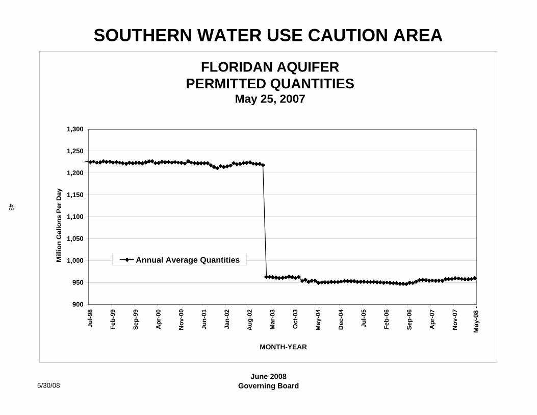
SOUTHERN WATER USE CAUTION AREA
5/30/08June 2008
Governing Board
FLORIDAN AQUIFERPERMITTED QUANTITIES
May 25, 2007
900
950
1,000
1,050
1,100
1,150
1,200
1,250
1,300
Jul-9
8
Feb-
99
Sep-
99
Apr
-00
Nov
-00
Jun-
01
Jan-
02
Aug
-02
Mar
-03
Oct
-03
May
-04
Dec
-04
Jul-0
5
Feb-
06
Sep-
06
Apr
-07
Nov
-07
MONTH-YEAR
Mill
ion
Gal
lons
Per
Day
Annual Average Quantities
May
-08
-
43
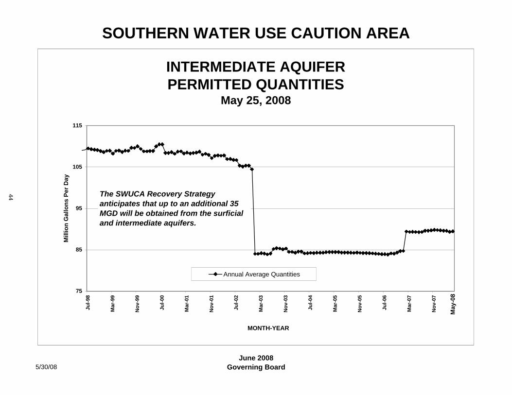
SOUTHERN WATER USE CAUTION AREA
5/30/08June 2008
Governing Board
INTERMEDIATE AQUIFERPERMITTED QUANTITIES
May 25, 2008
75
85
95
105
115
Jul-9
8
Mar
-99
Nov
-99
Jul-0
0
Mar
-01
Nov
-01
Jul-0
2
Mar
-03
Nov
-03
Jul-0
4
Mar
-05
Nov
-05
Jul-0
6
Mar
-07
Nov
-07
MONTH-YEAR
Mill
ion
Gal
lons
Per
Day
Annual Average Quantities
The SWUCA Recovery Strategy anticipates that up to an additional 35 MGD will be obtained from the surficial and intermediate aquifers.
May
-08
44
Item 49
Regulation Committee June 24, 2008
Routine Report
Water Production Summary
The Water Production Summary report shows production for major public supply permittees throughout the District, including Tampa Bay Water; the cities of Tampa, Plant City, Dunedin, Clearwater and Temple Terrace and Pasco County in the Tampa Bay area; the Peace River/Manasota Regional Water Supply Authority and its member governments; the cities of Sarasota, Punta Gorda, Bradenton, Venice and the Englewood Water District in the southern region of the District; Polk County and the cities of Lakeland, Winter Haven, Haines City, Sebring and Auburndale in the "Heartland" area of the District; and The Villages, Marion, Citrus and Hernando counties, and On Top of the World communities in the northern District area. Monthly pumpage data is presented from 2000 to present. The most recent information available is presented for each permittee.
Added to this report are summary graphics for Tampa Bay Water's Consolidated Permit. These graphics show monthly and annual average production for calendar year 2008 including the most current information on actual production, projections through September 2008 developed by Tampa Bay Water as a part of its annual budgeting process, and an estimate developed by the District on the maximum production for October through December 2008 that could be produced while still meeting the maximum 90 mgd annual average required as a part of the Consolidated permit and Partnership Agreement. There will be periodic changes in the District projections as the actual production produced by Tampa Bay Water may be more or less than the projections developed by Tampa Bay Water. These graphics will be provided through the remainder of 2008.
Staff Recommendation: See Exhibit (to be provided)
This item is provided for the Committee’s information, and no action is required.
Presenter: Richard S. Owen, Deputy Executive Director, Resource Regulation
45
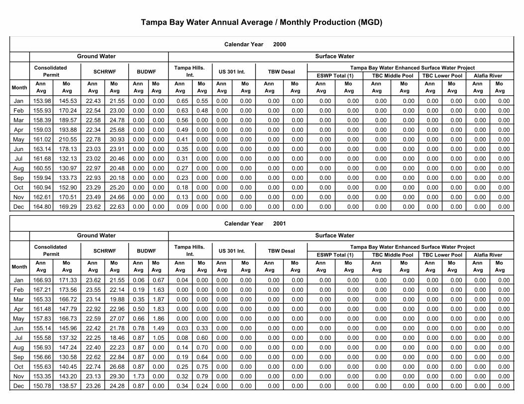
Tampa Bay Water Annual Average / Monthly Production (MGD)
2000
Tampa Bay Water Enhanced Surface Water Project
Alafia RiverTBC Lower PoolTBC Middle Pool
Mo
Avg
Mo
Avg
Mo
Avg
Ann
Avg
Ann
Avg
Ann
Avg
Mo
Avg
Mo
Avg
Mo
Avg
Mo
Avg
Mo
Avg
Mo
Avg
Ann
Avg
Ann
Avg
Ann
Avg
Ann
Avg
Ann
Avg
Ann
AvgMonth
Surface WaterGround Water
ESWP Total (1)TBW DesalUS 301 Int.
Calendar Year
Consolidated
PermitSCHRWF BUDWF
Tampa Hills.
Int.
Ann
Avg
Mo
Avg
Jan 0.00 0.00 153.98 145.53 22.43 21.55 0.00 0.00 0.65 0.55 0.00 0.00 0.00 0.00 0.00 0.00 0.00 0.00 0.00 0.00
Feb 0.00 0.00 155.93 170.24 22.54 23.00 0.00 0.00 0.63 0.48 0.00 0.00 0.00 0.00 0.00 0.00 0.00 0.00 0.00 0.00
Mar 0.00 0.00 158.39 189.57 22.58 24.78 0.00 0.00 0.56 0.00 0.00 0.00 0.00 0.00 0.00 0.00 0.00 0.00 0.00 0.00
Apr 0.00 0.00 159.03 193.88 22.34 25.68 0.00 0.00 0.49 0.00 0.00 0.00 0.00 0.00 0.00 0.00 0.00 0.00 0.00 0.00
May 0.00 0.00 161.02 210.55 22.78 30.93 0.00 0.00 0.41 0.00 0.00 0.00 0.00 0.00 0.00 0.00 0.00 0.00 0.00 0.00
Jun 0.00 0.00 163.14 178.13 23.03 23.91 0.00 0.00 0.35 0.00 0.00 0.00 0.00 0.00 0.00 0.00 0.00 0.00 0.00 0.00
Jul 0.00 0.00 161.68 132.13 23.02 20.46 0.00 0.00 0.31 0.00 0.00 0.00 0.00 0.00 0.00 0.00 0.00 0.00 0.00 0.00
Aug 0.00 0.00 160.55 130.97 22.97 20.48 0.00 0.00 0.27 0.00 0.00 0.00 0.00 0.00 0.00 0.00 0.00 0.00 0.00 0.00
Sep 0.00 0.00 159.94 133.73 22.93 20.18 0.00 0.00 0.23 0.00 0.00 0.00 0.00 0.00 0.00 0.00 0.00 0.00 0.00 0.00
Oct 0.00 0.00 160.94 152.90 23.29 25.20 0.00 0.00 0.18 0.00 0.00 0.00 0.00 0.00 0.00 0.00 0.00 0.00 0.00 0.00
Nov 0.00 0.00 162.61 170.51 23.49 24.66 0.00 0.00 0.13 0.00 0.00 0.00 0.00 0.00 0.00 0.00 0.00 0.00 0.00 0.00
Dec 0.00 0.00 164.80 169.29 23.62 22.63 0.00 0.00 0.09 0.00 0.00 0.00 0.00 0.00 0.00 0.00 0.00 0.00 0.00 0.00
2001
Tampa Bay Water Enhanced Surface Water Project
Alafia RiverTBC Lower PoolTBC Middle Pool
Mo
Avg
Mo
Avg
Mo
Avg
Ann
Avg
Ann
Avg
Ann
Avg
Mo
Avg
Mo
Avg
Mo
Avg
Mo
Avg
Mo
Avg
Mo
Avg
Ann
Avg
Ann
Avg
Ann
Avg
Ann
Avg
Ann
Avg
Ann
AvgMonth
Surface WaterGround Water
ESWP Total (1)TBW DesalUS 301 Int.
Calendar Year
Consolidated
PermitSCHRWF BUDWF
Tampa Hills.
Int.
Ann
Avg
Mo
Avg
Jan 0.00 0.00 166.93 171.33 23.62 21.55 0.06 0.67 0.04 0.00 0.00 0.00 0.00 0.00 0.00 0.00 0.00 0.00 0.00 0.00
Feb 0.00 0.00 167.21 173.56 23.55 22.14 0.19 1.63 0.00 0.00 0.00 0.00 0.00 0.00 0.00 0.00 0.00 0.00 0.00 0.00
Mar 0.00 0.00 165.33 166.72 23.14 19.88 0.35 1.87 0.00 0.00 0.00 0.00 0.00 0.00 0.00 0.00 0.00 0.00 0.00 0.00
Apr 0.00 0.00 161.48 147.79 22.92 22.96 0.50 1.83 0.00 0.00 0.00 0.00 0.00 0.00 0.00 0.00 0.00 0.00 0.00 0.00
May 0.00 0.00 157.83 166.73 22.59 27.07 0.66 1.86 0.00 0.00 0.00 0.00 0.00 0.00 0.00 0.00 0.00 0.00 0.00 0.00
Jun 0.00 0.00 155.14 145.96 22.42 21.78 0.78 1.49 0.03 0.33 0.00 0.00 0.00 0.00 0.00 0.00 0.00 0.00 0.00 0.00
Jul 0.00 0.00 155.58 137.32 22.25 18.46 0.87 1.05 0.08 0.60 0.00 0.00 0.00 0.00 0.00 0.00 0.00 0.00 0.00 0.00
Aug 0.00 0.00 156.93 147.24 22.40 22.23 0.87 0.00 0.14 0.70 0.00 0.00 0.00 0.00 0.00 0.00 0.00 0.00 0.00 0.00
Sep 0.00 0.00 156.66 130.58 22.62 22.84 0.87 0.00 0.19 0.64 0.00 0.00 0.00 0.00 0.00 0.00 0.00 0.00 0.00 0.00
Oct 0.00 0.00 155.63 140.45 22.74 26.68 0.87 0.00 0.25 0.75 0.00 0.00 0.00 0.00 0.00 0.00 0.00 0.00 0.00 0.00
Nov 0.00 0.00 153.35 143.20 23.13 29.30 1.73 0.00 0.32 0.79 0.00 0.00 0.00 0.00 0.00 0.00 0.00 0.00 0.00 0.00
Dec 0.00 0.00 150.78 138.57 23.26 24.28 0.87 0.00 0.34 0.24 0.00 0.00 0.00 0.00 0.00 0.00 0.00 0.00 0.00 0.00
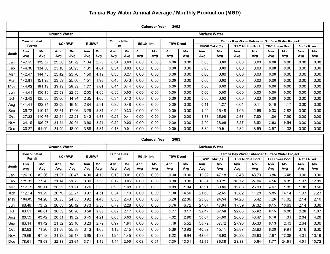
Tampa Bay Water Annual Average / Monthly Production (MGD)
2002
Tampa Bay Water Enhanced Surface Water Project
Alafia RiverTBC Lower PoolTBC Middle Pool
Mo
Avg
Mo
Avg
Mo
Avg
Ann
Avg
Ann
Avg
Ann
Avg
Mo
Avg
Mo
Avg
Mo
Avg
Mo
Avg
Mo
Avg
Mo
Avg
Ann
Avg
Ann
Avg
Ann
Avg
Ann
Avg
Ann
Avg
Ann
AvgMonth
Surface WaterGround Water
ESWP Total (1)TBW DesalUS 301 Int.
Calendar Year
Consolidated
PermitSCHRWF BUDWF
Tampa Hills.
Int.
Ann
Avg
Mo
Avg
Jan 0.00 0.00 147.55 132.37 23.20 20.72 1.04 2.76 0.34 0.00 0.00 0.00 0.00 0.00 0.00 0.00 0.00 0.00 0.00 0.00
Feb 0.00 0.00 144.30 134.50 23.10 20.95 1.31 4.84 0.34 0.00 0.00 0.00 0.00 0.00 0.00 0.00 0.00 0.00 0.00 0.00
Mar 0.00 0.00 142.47 144.75 23.42 23.76 1.50 4.12 0.36 0.27 0.00 0.00 0.00 0.00 0.00 0.00 0.00 0.00 0.00 0.00
Apr 0.00 0.00 142.81 151.98 23.59 25.00 1.51 1.98 0.40 0.43 0.00 0.00 0.00 0.00 0.00 0.00 0.00 0.00 0.00 0.00
May 0.00 0.00 144.02 181.43 23.83 29.93 1.77 5.01 0.41 0.14 0.00 0.00 0.00 0.00 0.00 0.00 0.00 0.00 0.00 0.00
Jun 0.00 0.00 144.41 150.45 23.89 22.53 2.05 4.86 0.38 0.00 0.00 0.00 0.00 0.00 0.00 0.00 0.00 0.00 0.00 0.00
Jul 0.00 0.00 143.43 125.55 23.60 14.94 2.35 4.60 0.34 0.10 0.00 0.00 0.00 0.00 0.00 0.00 0.00 0.00 0.00 0.00
Aug 0.01 0.11 141.41 122.84 23.09 16.15 2.84 5.91 0.32 0.48 0.00 0.00 0.00 0.00 0.11 1.27 0.10 1.17 0.00 0.00
Sep 1.06 12.66 139.72 110.44 22.61 17.06 3.29 5.34 0.29 0.33 0.00 0.00 0.00 0.00 1.40 15.48 0.33 2.82 0.00 0.00
Oct 2.56 17.99 137.23 110.75 22.24 22.21 3.42 1.58 0.27 0.41 0.00 0.00 0.00 0.00 3.56 25.98 1.00 7.99 0.00 0.00
Nov 3.27 8.52 134.15 106.07 21.54 20.94 3.60 2.24 0.20 0.00 0.00 0.00 0.00 0.00 5.90 28.06 2.63 19.54 0.00 0.00
Dec 4.82 18.59 130.27 91.99 21.09 18.90 3.88 3.34 0.18 0.01 0.00 0.00 0.00 0.00 8.39 29.91 3.57 11.33 0.00 0.00
2003
Tampa Bay Water Enhanced Surface Water Project
Alafia RiverTBC Lower PoolTBC Middle Pool
Mo
Avg
Mo
Avg
Mo
Avg
Ann
Avg
Ann
Avg
Ann
Avg
Mo
Avg
Mo
Avg
Mo
Avg
Mo
Avg
Mo
Avg
Mo
Avg
Ann
Avg
Ann
Avg
Ann
Avg
Ann
Avg
Ann
Avg
Ann
AvgMonth
Surface WaterGround Water
ESWP Total (1)TBW DesalUS 301 Int.
Calendar Year
Consolidated
PermitSCHRWF BUDWF
Tampa Hills.
Int.
Ann
Avg
Mo
Avg
Jan 8.46 43.70 126.10 82.36 21.07 20.47 4.00 4.19 0.18 0.01 0.00 0.00 0.00 0.00 12.32 47.18 3.86 3.48 0.00 0.00
Feb 10.72 27.04 121.32 77.26 21.14 21.73 3.89 3.55 0.19 0.06 0.00 0.00 0.00 0.00 16.34 48.21 4.56 8.35 1.07 12.81
Mar 12.88 25.99 117.19 95.11 20.92 21.21 3.76 2.52 0.28 1.38 0.00 0.00 0.09 1.04 18.91 30.86 4.67 1.32 1.36 3.56
Apr 13.82 11.28 112.14 91.29 20.70 22.27 3.97 4.51 0.34 1.10 0.00 0.00 1.30 14.50 21.63 32.65 5.85 14.14 1.97 7.23
May 14.28 5.42 104.85 94.20 20.23 24.35 3.92 4.43 0.53 2.43 0.00 0.00 3.20 22.86 23.68 24.54 7.26 17.02 2.14 2.10
Jun 17.39 37.32 98.46 73.52 20.03 20.12 3.73 2.56 0.72 2.28 0.00 0.00 3.76 6.72 27.67 47.94 8.15 10.63 2.14 0.00
Jul 22.05 55.92 93.51 66.01 20.53 20.90 3.59 2.88 0.89 2.17 0.00 0.00 3.77 0.17 32.47 57.58 8.15 0.00 2.28 1.67
Aug 26.08 48.47 88.55 63.42 20.81 19.52 3.45 4.21 0.85 0.00 0.00 0.00 4.02 2.96 36.87 54.06 8.16 1.31 2.64 4.28
Sep 27.96 35.30 86.14 81.42 21.32 23.16 3.23 2.72 0.97 1.84 0.00 0.00 4.48 5.52 38.72 37.72 8.13 2.43 2.64 0.00
Oct 28.87 28.90 82.83 71.26 21.58 25.38 3.43 4.00 1.12 2.15 0.00 0.00 5.39 10.93 40.32 45.11 8.29 9.91 3.16 6.30
Nov 30.38 26.63 79.66 67.98 21.93 25.17 3.65 4.83 1.24 1.45 0.00 0.00 6.22 9.94 42.06 48.90 7.67 12.08 4.01 10.19
Dec 28.88 0.64 78.51 78.03 22.33 23.64 3.71 4.12 1.41 2.09 0.08 0.91 7.30 13.01 42.55 35.88 8.77 24.51 4.91 10.72
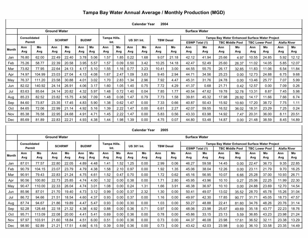
Tampa Bay Water Annual Average / Monthly Production (MGD)
Tampa Bay Water Enhanced Surface Water Project
Alafia RiverTBC Lower PoolTBC Middle Pool
Mo
Avg
Mo
Avg
Mo
Avg
Ann
Avg
Ann
Avg
Ann
Avg
Mo
Avg
Mo
Avg
Mo
Avg
Mo
Avg
Mo
Avg
Mo
Avg
Ann
Avg
Ann
Avg
Ann
Avg
Ann
Avg
Ann
Avg
Ann
Avg
2004
Month
Surface WaterGround Water
ESWP Total (1)TBW DesalUS 301 Int.
Calendar Year
Consolidated
PermitSCHRWF BUDWF
Tampa Hills.
Int.
Ann
Avg
Mo
Avg
Jan 76.80 22.49 22.40 3.78 5.06 1.57 1.85 9.07 21.18 0.22 1.68 42.12 41.94 62.00 5.92 12.12 10.55 24.85 25.66 4.97
Feb 75.26 22.39 20.58 3.95 5.57 1.57 0.09 10.25 14.18 0.50 3.42 42.47 52.49 58.77 5.85 12.07 11.02 14.05 25.60 26.37
Mar 73.82 22.64 24.13 4.17 5.10 1.55 1.16 10.41 3.00 0.77 3.23 44.55 55.75 77.95 6.54 11.84 11.83 11.06 26.17 32.85
Apr 74.97 23.03 27.04 4.13 4.08 1.67 2.47 9.45 2.94 1.09 3.83 44.71 34.56 104.99 6.75 9.68 12.73 24.88 25.23 0.00
May 76.37 23.58 30.88 4.01 3.02 1.70 2.83 7.92 4.47 1.34 2.96 45.31 31.76 111.20 7.07 5.99 13.46 25.77 24.78 0.00
Jun 82.02 24.14 26.91 4.06 3.17 1.60 1.05 7.72 4.29 1.40 0.75 41.37 0.68 140.92 7.09 0.26 12.57 0.00 21.71 0.42
Jul 83.63 24.14 20.82 4.32 5.97 1.48 0.72 7.85 1.77 1.40 0.04 40.54 47.62 85.64 7.45 5.98 13.31 8.87 19.78 32.78
Aug 85.23 23.82 15.75 4.56 7.09 1.48 0.08 7.73 1.58 1.47 0.79 39.81 45.32 82.52 7.66 6.74 14.17 11.66 17.98 26.92
Sep 84.60 23.35 17.45 4.83 5.90 1.38 0.62 7.33 0.66 1.47 0.00 40.87 50.43 73.87 7.75 1.11 17.20 38.72 15.92 10.60
Oct 84.65 22.99 21.14 4.92 5.16 1.39 2.22 6.61 2.27 1.47 0.00 42.07 59.55 72.06 7.25 0.24 18.31 23.29 16.52 36.02
Nov 85.38 22.95 24.68 4.91 4.71 1.45 2.22 5.83 0.56 1.47 0.00 43.33 63.98 76.58 8.11 20.51 20.31 36.00 14.92 7.47
Dec 85.69 22.83 22.21 4.93 4.38 1.44 1.98 4.75 0.07 1.39 0.00 44.80 53.48 81.89 8.45 14.89 21.48 38.59 14.87 0.00
Tampa Bay Water Enhanced Surface Water Project
Alafia RiverTBC Lower PoolTBC Middle Pool
Mo
Avg
Mo
Avg
Mo
Avg
Ann
Avg
Ann
Avg
Ann
Avg
Mo
Avg
Mo
Avg
Mo
Avg
Mo
Avg
Mo
Avg
Mo
Avg
Ann
Avg
Ann
Avg
Ann
Avg
Ann
Avg
Ann
Avg
Ann
Avg
2005
Month
Surface WaterGround Water
ESWP Total (1)TBW DesalUS 301 Int.
Calendar Year
Consolidated
PermitSCHRWF BUDWF
Tampa Hills.
Int.
Ann
Avg
Mo
Avg
Jan 87.01 22.80 22.05 4.89 4.48 1.41 1.52 2.99 0.06 1.25 0.00 46.27 59.58 77.57 9.35 22.85 22.47 36.73 14.45 0.00
Feb 90.79 23.07 23.79 4.79 4.38 1.58 2.10 1.92 1.35 0.97 0.00 45.06 38.04 104.15 9.70 16.25 23.11 21.79 12.26 0.00
Mar 90.91 22.83 21.24 4.75 4.61 1.52 0.47 1.72 0.62 0.70 0.00 45.16 56.95 79.43 10.93 26.71 25.28 37.00 10.07 6.66
Apr 90.56 22.73 25.85 4.74 4.00 1.32 0.00 1.71 2.80 0.38 0.00 45.95 43.96 100.80 11.99 22.30 25.06 22.25 10.10 0.27
May 90.47 22.33 26.04 4.74 3.01 1.08 0.00 1.66 3.91 0.24 1.31 46.38 36.97 110.00 12.70 14.54 24.88 23.69 10.10 0.00
Jun 85.96 21.70 19.40 4.73 3.12 0.99 0.00 1.30 0.00 0.37 2.32 50.41 49.07 87.01 15.26 31.04 28.70 45.78 13.02 35.52
Jul 86.72 21.51 18.54 4.60 4.37 0.93 0.00 1.16 0.00 0.37 0.00 49.97 42.30 94.66 18.73 47.57 31.71 45.05 17.85 90.77
Aug 87.74 21.86 19.89 4.47 5.47 0.93 0.00 1.03 0.00 0.30 0.00 50.27 48.88 94.67 20.76 31.14 34.76 48.26 22.41 81.60
Sep 92.28 22.18 21.32 4.38 4.92 0.88 0.00 0.97 0.00 0.36 0.71 48.06 23.98 128.48 22.23 18.76 35.18 43.77 25.67 49.69
Oct 95.71 22.08 20.00 4.41 5.41 0.69 0.00 0.78 0.00 0.36 0.00 45.86 33.15 113.09 23.98 21.24 36.85 43.23 23.13 5.59
Nov 97.97 21.60 18.84 4.51 6.00 0.51 0.00 0.73 0.00 0.36 0.00 44.37 46.08 103.91 23.38 13.29 36.52 32.11 23.98 17.61
Dec 98.90 21.21 17.51 4.66 6.15 0.39 0.59 0.73 0.00 0.36 0.00 43.42 42.03 92.89 23.35 14.49 36.10 33.58 23.98 0.00
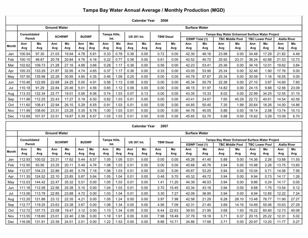
Tampa Bay Water Annual Average / Monthly Production (MGD)
2006
Tampa Bay Water Enhanced Surface Water Project
Alafia RiverTBC Lower PoolTBC Middle Pool
Mo
Avg
Mo
Avg
Mo
Avg
Ann
Avg
Ann
Avg
Ann
Avg
Mo
Avg
Mo
Avg
Mo
Avg
Mo
Avg
Mo
Avg
Mo
Avg
Ann
Avg
Ann
Avg
Ann
Avg
Ann
Avg
Ann
Avg
Ann
AvgMonth
Surface WaterGround Water
ESWP Total (1)TBW DesalUS 301 Int.
Calendar Year
Consolidated
PermitSCHRWF BUDWF
Tampa Hills.
Int.
Ann
Avg
Mo
Avg
Jan 23.98 0.00 100.54 97.30 21.03 19.94 4.78 5.91 0.33 0.78 0.36 0.00 0.72 0.00 42.30 46.16 34.48 17.29 21.82 4.49
Feb 25.92 23.31 100.10 98.87 20.78 20.84 4.76 4.16 0.22 0.77 0.36 0.00 0.61 0.00 42.52 40.72 36.24 42.88 21.53 12.73
Mar 25.36 0.00 102.62 109.73 21.28 27.16 4.68 3.66 0.28 1.17 0.36 0.00 0.56 0.00 42.23 53.41 34.16 12.01 19.62 3.84
Apr 25.34 0.00 105.33 133.29 21.87 32.95 4.74 4.65 0.37 1.17 0.36 0.00 0.33 0.00 43.05 53.90 32.46 1.90 17.76 0.00
May 25.34 0.00 107.50 135.98 22.28 30.95 4.85 4.35 0.46 1.09 0.25 0.00 0.00 0.00 44.78 57.67 30.59 1.16 16.55 0.00
Jun 22.38 0.00 110.46 122.69 22.68 24.25 5.00 4.91 0.56 1.13 0.06 0.00 0.00 0.00 45.34 55.79 27.10 3.97 14.60 7.60
Jul 14.82 0.00 110.18 91.29 22.84 20.46 5.01 4.56 0.65 1.12 0.06 0.00 0.00 0.00 46.15 51.97 24.15 9.68 12.56 23.09
Aug 8.02 0.00 113.33 132.34 22.77 19.01 5.06 6.06 0.74 1.03 0.07 0.13 0.00 0.00 43.35 15.33 22.99 34.25 12.55 31.10
Sep 7.65 45.29 111.98 112.25 22.43 17.27 5.19 6.50 0.82 1.03 0.01 0.00 0.00 0.00 43.41 24.67 22.72 40.61 14.54 42.56
Oct 7.35 1.99 111.60 108.41 22.94 26.10 5.29 6.55 0.91 1.03 0.01 0.00 0.00 0.00 44.85 50.45 20.64 18.26 14.00 14.86
Nov 5.88 0.00 111.99 108.60 23.31 23.28 5.35 6.78 1.00 1.03 0.01 0.00 0.00 0.00 44.76 45.05 18.14 2.08 13.74 10.13
Dec 5.88 0.00 112.69 101.57 23.51 19.87 5.39 6.57 1.03 1.03 0.01 0.00 0.00 0.00 45.65 52.70 15.62 3.29 13.09 6.70
2007
Tampa Bay Water Enhanced Surface Water Project
Alafia RiverTBC Lower PoolTBC Middle Pool
Mo
Avg
Mo
Avg
Mo
Avg
Ann
Avg
Ann
Avg
Ann
Avg
Mo
Avg
Mo
Avg
Mo
Avg
Mo
Avg
Mo
Avg
Mo
Avg
Ann
Avg
Ann
Avg
Ann
Avg
Ann
Avg
Ann
Avg
Ann
AvgMonth
Surface WaterGround Water
ESWP Total (1)TBW DesalUS 301 Int.
Calendar Year
Consolidated
PermitSCHRWF BUDWF
Tampa Hills.
Int.
Ann
Avg
Mo
Avg
Jan 5.88 0.00 112.93 100.02 23.31 17.62 5.44 6.57 1.05 1.05 0.01 0.00 0.00 0.00 45.26 41.45 14.36 2.26 13.68 11.55
Feb 3.94 0.00 112.50 93.95 23.25 20.11 5.49 4.76 1.08 1.03 0.01 0.00 0.00 0.00 45.68 45.76 10.98 2.26 13.75 13.60
Mar 3.94 0.00 112.07 104.23 22.86 22.46 5.79 7.16 1.06 1.03 0.01 0.00 0.00 0.00 45.67 53.25 10.04 0.71 14.06 7.56
Apr 3.94 0.00 111.35 124.52 22.10 23.85 5.87 5.64 1.05 1.04 0.01 0.00 0.48 5.70 45.32 49.72 9.94 0.73 14.17 1.26
May 3.94 0.00 112.03 144.42 22.47 35.32 5.51 0.00 1.05 1.03 0.01 0.00 1.41 11.20 44.39 46.53 9.86 0.24 14.17 0.00
Jun 3.94 0.00 111.18 112.58 22.56 25.38 5.10 0.00 1.04 1.03 0.01 0.00 2.70 15.45 43.34 43.16 9.68 1.75 13.54 0.12
Jul 3.94 0.00 113.06 113.78 22.85 23.88 4.72 0.00 1.03 1.04 0.01 0.00 3.30 7.27 42.09 36.95 9.94 12.85 12.22 7.24
Aug 6.28 28.10 112.20 121.88 23.12 22.35 4.21 0.00 1.05 1.24 0.00 0.00 3.97 7.98 42.58 21.29 13.48 76.77 11.90 27.27
Sep 3.69 14.16 112.77 119.25 23.63 23.38 3.67 0.00 1.08 1.34 0.00 0.00 4.56 7.09 42.31 21.40 14.69 55.06 10.63 27.29
Oct 3.68 1.93 112.72 107.73 23.08 19.47 3.12 0.00 1.10 1.34 0.00 0.00 6.44 22.63 39.93 21.95 18.22 60.60 12.73 40.08
Nov 3.71 0.37 113.55 118.60 23.01 22.40 2.56 0.00 1.18 1.91 0.00 0.00 7.98 18.49 37.78 19.18 20.15 25.22 12.31 5.02
Dec 3.71 0.00 116.08 131.91 23.39 24.51 2.01 0.00 1.22 1.53 0.00 0.00 8.88 10.71 34.86 17.68 20.97 13.20 11.77 0.27
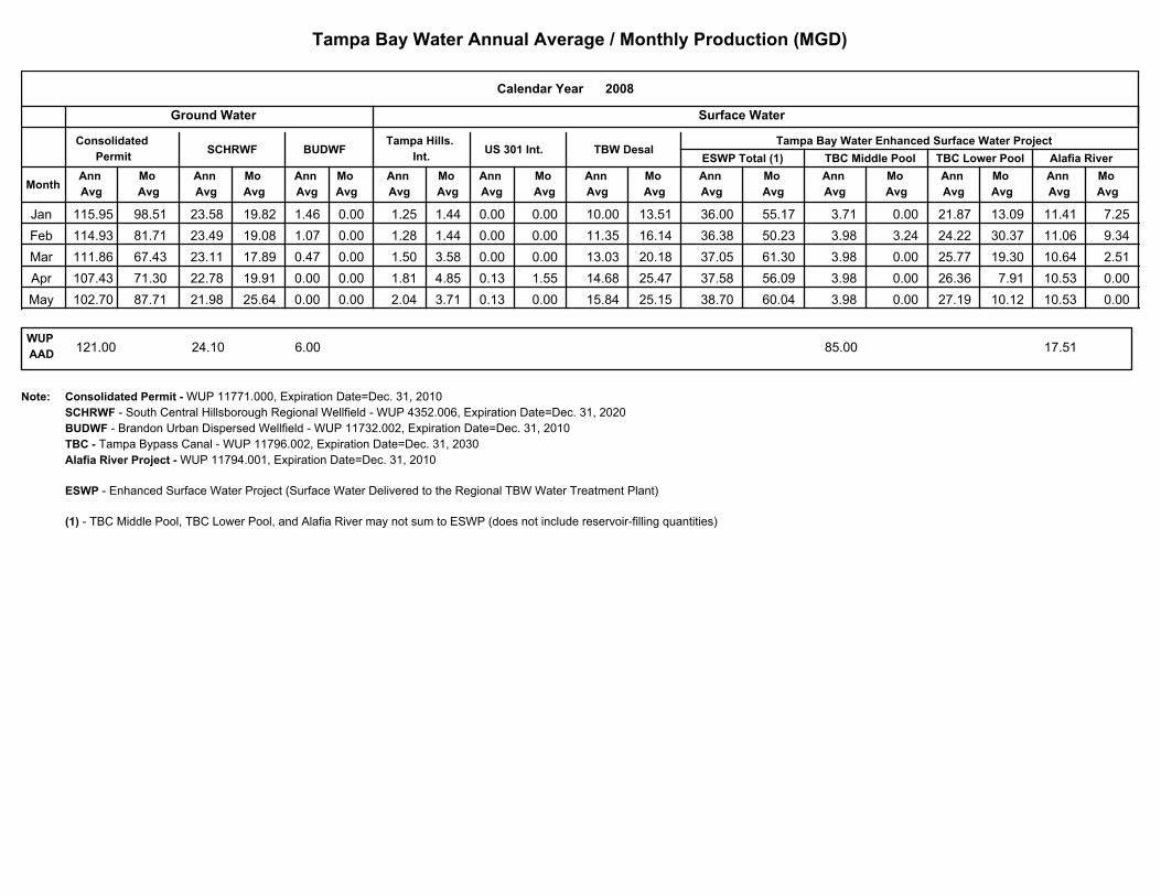
Tampa Bay Water Annual Average / Monthly Production (MGD)
2008
Tampa Bay Water Enhanced Surface Water Project
Alafia RiverTBC Lower PoolTBC Middle Pool
Mo
Avg
Mo
Avg
Mo
Avg
Ann
Avg
Ann
Avg
Ann
Avg
Mo
Avg
Mo
Avg
Mo
Avg
Mo
Avg
Mo
Avg
Mo
Avg
Ann
Avg
Ann
Avg
Ann
Avg
Ann
Avg
Ann
Avg
Ann
AvgMonth
Surface WaterGround Water
ESWP Total (1)TBW DesalUS 301 Int.
Calendar Year
Consolidated
PermitSCHRWF BUDWF
Tampa Hills.
Int.
Ann
Avg
Mo
Avg
Jan 3.71 0.00 115.95 98.51 23.58 19.82 1.46 0.00 1.25 1.44 0.00 0.00 10.00 13.51 36.00 55.17 21.87 13.09 11.41 7.25
Feb 3.98 3.24 114.93 81.71 23.49 19.08 1.07 0.00 1.28 1.44 0.00 0.00 11.35 16.14 36.38 50.23 24.22 30.37 11.06 9.34
Mar 3.98 0.00 111.86 67.43 23.11 17.89 0.47 0.00 1.50 3.58 0.00 0.00 13.03 20.18 37.05 61.30 25.77 19.30 10.64 2.51
Apr 3.98 0.00 107.43 71.30 22.78 19.91 0.00 0.00 1.81 4.85 0.13 1.55 14.68 25.47 37.58 56.09 26.36 7.91 10.53 0.00
May 3.98 0.00 102.70 87.71 21.98 25.64 0.00 0.00 2.04 3.71 0.13 0.00 15.84 25.15 38.70 60.04 27.19 10.12 10.53 0.00
WUP
AAD121.00 24.10 6.00 85.00 17.51
Consolidated Permit - WUP 11771.000, Expiration Date=Dec. 31, 2010
SCHRWF - South Central Hillsborough Regional Wellfield - WUP 4352.006, Expiration Date=Dec. 31, 2020
BUDWF - Brandon Urban Dispersed Wellfield - WUP 11732.002, Expiration Date=Dec. 31, 2010
TBC - Tampa Bypass Canal - WUP 11796.002, Expiration Date=Dec. 31, 2030
Alafia River Project - WUP 11794.001, Expiration Date=Dec. 31, 2010
ESWP - Enhanced Surface Water Project (Surface Water Delivered to the Regional TBW Water Treatment Plant)
(1) - TBC Middle Pool, TBC Lower Pool, and Alafia River may not sum to ESWP (does not include reservoir-filling quantities)
Note:
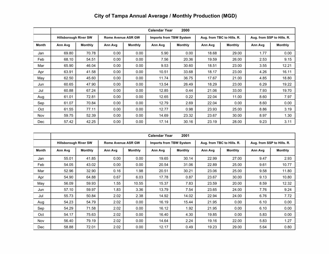
City of Tampa Annual Average / Monthly Production (MGD)
MonthlyAnn Avg MonthlyAnn Avg
Aug. from SSP to Hills. R.Aug. from TBC to Hills. R.
MonthlyAnn AvgMonthlyAnn Avg
2000
Imports from TBW System
Calendar Year
Month
Hillsborough River SW Rome Avenue ASR GW
Ann Avg Monthly
Jan 69.80 70.78 5.90 0.00 0.00 0.00 18.68 29.00 1.77 0.00
Feb 68.10 54.51 7.56 20.36 0.00 0.00 19.59 26.00 2.53 9.15
Mar 65.90 46.04 9.53 30.60 0.00 0.00 18.51 23.00 3.55 12.21
Apr 63.91 41.58 10.51 33.68 0.00 0.00 18.17 23.00 4.26 16.11
May 62.50 45.60 11.74 36.75 0.00 0.00 17.67 21.00 4.85 18.80
Jun 60.65 47.90 13.54 26.49 0.00 0.00 18.29 23.00 6.29 19.22
Jul 60.88 67.24 12.85 0.44 0.00 0.00 21.06 33.00 7.93 19.70
Aug 61.01 72.81 12.65 0.22 0.00 0.00 22.04 11.00 8.60 7.97
Sep 61.07 70.84 12.79 2.69 0.00 0.00 22.04 0.00 8.60 0.00
Oct 61.55 77.11 12.77 0.98 0.00 0.00 23.93 25.00 8.86 3.19
Nov 59.75 52.39 14.69 23.32 0.00 0.00 23.67 30.00 8.97 1.30
Dec 57.42 42.25 17.14 30.16 0.00 0.00 23.19 28.00 9.23 3.11
MonthlyAnn Avg MonthlyAnn Avg
Aug. from SSP to Hills. R.Aug. from TBC to Hills. R.
MonthlyAnn AvgMonthlyAnn Avg
2001
Imports from TBW System
Calendar Year
Month
Hillsborough River SW Rome Avenue ASR GW
Ann Avg Monthly
Jan 55.01 41.85 19.65 30.14 0.00 0.00 22.99 27.00 9.47 2.93
Feb 54.05 43.02 20.54 31.06 0.00 0.00 22.89 25.00 9.61 10.77
Mar 52.96 32.90 20.51 30.21 0.16 1.98 23.06 25.00 9.58 11.80
Apr 54.90 64.88 17.78 0.87 0.67 6.03 23.67 30.00 9.13 10.80
May 56.09 59.93 15.37 7.83 1.55 10.55 23.59 20.00 8.59 12.32
Jun 57.10 59.97 13.79 7.54 1.83 3.36 23.65 24.00 7.76 9.24
Jul 55.73 50.84 14.92 14.02 2.02 2.38 22.94 24.00 6.76 7.72
Aug 54.23 54.79 16.19 15.44 2.02 0.00 21.95 0.00 6.10 0.00
Sep 54.29 71.58 16.12 1.92 2.02 0.00 21.95 0.00 6.10 0.00
Oct 54.17 75.63 16.40 4.30 2.02 0.00 19.85 0.00 5.83 0.00
Nov 56.40 79.19 14.64 2.24 2.02 0.00 19.16 22.00 5.83 1.27
Dec 58.88 72.01 12.17 0.49 2.02 0.00 19.23 29.00 5.64 0.80
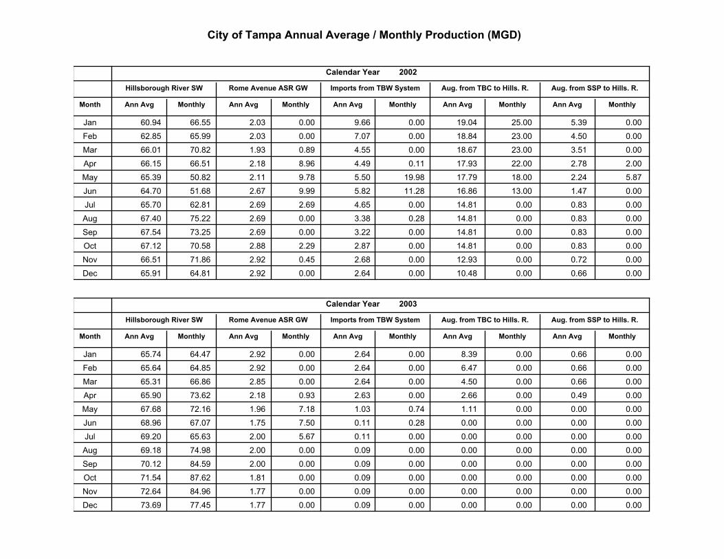
City of Tampa Annual Average / Monthly Production (MGD)
MonthlyAnn Avg MonthlyAnn Avg
Aug. from SSP to Hills. R.Aug. from TBC to Hills. R.
MonthlyAnn AvgMonthlyAnn Avg
2002
Imports from TBW System
Calendar Year
Month
Hillsborough River SW Rome Avenue ASR GW
Ann Avg Monthly
Jan 60.94 66.55 9.66 0.00 2.03 0.00 19.04 25.00 5.39 0.00
Feb 62.85 65.99 7.07 0.00 2.03 0.00 18.84 23.00 4.50 0.00
Mar 66.01 70.82 4.55 0.00 1.93 0.89 18.67 23.00 3.51 0.00
Apr 66.15 66.51 4.49 0.11 2.18 8.96 17.93 22.00 2.78 2.00
May 65.39 50.82 5.50 19.98 2.11 9.78 17.79 18.00 2.24 5.87
Jun 64.70 51.68 5.82 11.28 2.67 9.99 16.86 13.00 1.47 0.00
Jul 65.70 62.81 4.65 0.00 2.69 2.69 14.81 0.00 0.83 0.00
Aug 67.40 75.22 3.38 0.28 2.69 0.00 14.81 0.00 0.83 0.00
Sep 67.54 73.25 3.22 0.00 2.69 0.00 14.81 0.00 0.83 0.00
Oct 67.12 70.58 2.87 0.00 2.88 2.29 14.81 0.00 0.83 0.00
Nov 66.51 71.86 2.68 0.00 2.92 0.45 12.93 0.00 0.72 0.00
Dec 65.91 64.81 2.64 0.00 2.92 0.00 10.48 0.00 0.66 0.00
MonthlyAnn Avg MonthlyAnn Avg
Aug. from SSP to Hills. R.Aug. from TBC to Hills. R.
MonthlyAnn AvgMonthlyAnn Avg
2003
Imports from TBW System
Calendar Year
Month
Hillsborough River SW Rome Avenue ASR GW
Ann Avg Monthly
Jan 65.74 64.47 2.64 0.00 2.92 0.00 8.39 0.00 0.66 0.00
Feb 65.64 64.85 2.64 0.00 2.92 0.00 6.47 0.00 0.66 0.00
Mar 65.31 66.86 2.64 0.00 2.85 0.00 4.50 0.00 0.66 0.00
Apr 65.90 73.62 2.63 0.00 2.18 0.93 2.66 0.00 0.49 0.00
May 67.68 72.16 1.03 0.74 1.96 7.18 1.11 0.00 0.00 0.00
Jun 68.96 67.07 0.11 0.28 1.75 7.50 0.00 0.00 0.00 0.00
Jul 69.20 65.63 0.11 0.00 2.00 5.67 0.00 0.00 0.00 0.00
Aug 69.18 74.98 0.09 0.00 2.00 0.00 0.00 0.00 0.00 0.00
Sep 70.12 84.59 0.09 0.00 2.00 0.00 0.00 0.00 0.00 0.00
Oct 71.54 87.62 0.09 0.00 1.81 0.00 0.00 0.00 0.00 0.00
Nov 72.64 84.96 0.09 0.00 1.77 0.00 0.00 0.00 0.00 0.00
Dec 73.69 77.45 0.09 0.00 1.77 0.00 0.00 0.00 0.00 0.00
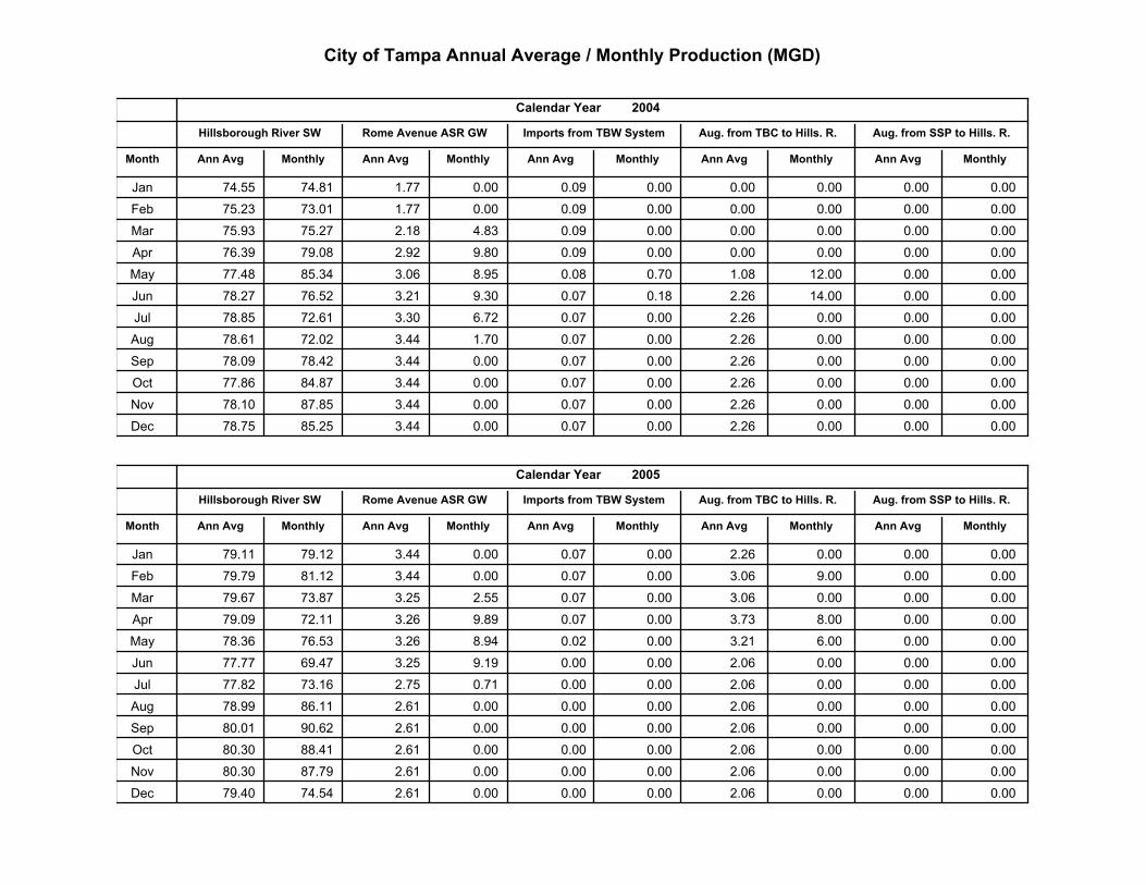
City of Tampa Annual Average / Monthly Production (MGD)
MonthlyAnn Avg MonthlyAnn Avg
Aug. from SSP to Hills. R.Aug. from TBC to Hills. R.
MonthlyAnn AvgMonthlyAnn Avg
2004
Imports from TBW System
Calendar Year
Month
Hillsborough River SW Rome Avenue ASR GW
Ann Avg Monthly
Jan 74.55 74.81 0.09 0.00 1.77 0.00 0.00 0.00 0.00 0.00
Feb 75.23 73.01 0.09 0.00 1.77 0.00 0.00 0.00 0.00 0.00
Mar 75.93 75.27 0.09 0.00 2.18 4.83 0.00 0.00 0.00 0.00
Apr 76.39 79.08 0.09 0.00 2.92 9.80 0.00 0.00 0.00 0.00
May 77.48 85.34 0.08 0.70 3.06 8.95 1.08 12.00 0.00 0.00
Jun 78.27 76.52 0.07 0.18 3.21 9.30 2.26 14.00 0.00 0.00
Jul 78.85 72.61 0.07 0.00 3.30 6.72 2.26 0.00 0.00 0.00
Aug 78.61 72.02 0.07 0.00 3.44 1.70 2.26 0.00 0.00 0.00
Sep 78.09 78.42 0.07 0.00 3.44 0.00 2.26 0.00 0.00 0.00
Oct 77.86 84.87 0.07 0.00 3.44 0.00 2.26 0.00 0.00 0.00
Nov 78.10 87.85 0.07 0.00 3.44 0.00 2.26 0.00 0.00 0.00
Dec 78.75 85.25 0.07 0.00 3.44 0.00 2.26 0.00 0.00 0.00
MonthlyAnn Avg MonthlyAnn Avg
Aug. from SSP to Hills. R.Aug. from TBC to Hills. R.
MonthlyAnn AvgMonthlyAnn Avg
2005
Imports from TBW System
Calendar Year
Month
Hillsborough River SW Rome Avenue ASR GW
Ann Avg Monthly
Jan 79.11 79.12 0.07 0.00 3.44 0.00 2.26 0.00 0.00 0.00
Feb 79.79 81.12 0.07 0.00 3.44 0.00 3.06 9.00 0.00 0.00
Mar 79.67 73.87 0.07 0.00 3.25 2.55 3.06 0.00 0.00 0.00
Apr 79.09 72.11 0.07 0.00 3.26 9.89 3.73 8.00 0.00 0.00
May 78.36 76.53 0.02 0.00 3.26 8.94 3.21 6.00 0.00 0.00
Jun 77.77 69.47 0.00 0.00 3.25 9.19 2.06 0.00 0.00 0.00
Jul 77.82 73.16 0.00 0.00 2.75 0.71 2.06 0.00 0.00 0.00
Aug 78.99 86.11 0.00 0.00 2.61 0.00 2.06 0.00 0.00 0.00
Sep 80.01 90.62 0.00 0.00 2.61 0.00 2.06 0.00 0.00 0.00
Oct 80.30 88.41 0.00 0.00 2.61 0.00 2.06 0.00 0.00 0.00
Nov 80.30 87.79 0.00 0.00 2.61 0.00 2.06 0.00 0.00 0.00
Dec 79.40 74.54 0.00 0.00 2.61 0.00 2.06 0.00 0.00 0.00
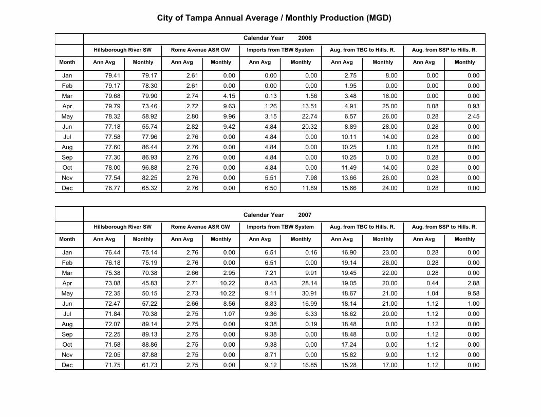
City of Tampa Annual Average / Monthly Production (MGD)
MonthlyAnn Avg MonthlyAnn Avg
Aug. from SSP to Hills. R.Aug. from TBC to Hills. R.
MonthlyAnn AvgMonthlyAnn Avg
2006
Imports from TBW System
Calendar Year
Month
Hillsborough River SW Rome Avenue ASR GW
Ann Avg Monthly
Jan 79.41 79.17 0.00 0.00 2.61 0.00 2.75 8.00 0.00 0.00
Feb 79.17 78.30 0.00 0.00 2.61 0.00 1.95 0.00 0.00 0.00
Mar 79.68 79.90 0.13 1.56 2.74 4.15 3.48 18.00 0.00 0.00
Apr 79.79 73.46 1.26 13.51 2.72 9.63 4.91 25.00 0.08 0.93
May 78.32 58.92 3.15 22.74 2.80 9.96 6.57 26.00 0.28 2.45
Jun 77.18 55.74 4.84 20.32 2.82 9.42 8.89 28.00 0.28 0.00
Jul 77.58 77.96 4.84 0.00 2.76 0.00 10.11 14.00 0.28 0.00
Aug 77.60 86.44 4.84 0.00 2.76 0.00 10.25 1.00 0.28 0.00
Sep 77.30 86.93 4.84 0.00 2.76 0.00 10.25 0.00 0.28 0.00
Oct 78.00 96.88 4.84 0.00 2.76 0.00 11.49 14.00 0.28 0.00
Nov 77.54 82.25 5.51 7.98 2.76 0.00 13.66 26.00 0.28 0.00
Dec 76.77 65.32 6.50 11.89 2.76 0.00 15.66 24.00 0.28 0.00
MonthlyAnn Avg MonthlyAnn Avg
Aug. from SSP to Hills. R.Aug. from TBC to Hills. R.
MonthlyAnn AvgMonthlyAnn Avg
2007
Imports from TBW System
Calendar Year
Month
Hillsborough River SW Rome Avenue ASR GW
Ann Avg Monthly
Jan 76.44 75.14 6.51 0.16 2.76 0.00 16.90 23.00 0.28 0.00
Feb 76.18 75.19 6.51 0.00 2.76 0.00 19.14 26.00 0.28 0.00
Mar 75.38 70.38 7.21 9.91 2.66 2.95 19.45 22.00 0.28 0.00
Apr 73.08 45.83 8.43 28.14 2.71 10.22 19.05 20.00 0.44 2.88
May 72.35 50.15 9.11 30.91 2.73 10.22 18.67 21.00 1.04 9.58
Jun 72.47 57.22 8.83 16.99 2.66 8.56 18.14 21.00 1.12 1.00
Jul 71.84 70.38 9.36 6.33 2.75 1.07 18.62 20.00 1.12 0.00
Aug 72.07 89.14 9.38 0.19 2.75 0.00 18.48 0.00 1.12 0.00
Sep 72.25 89.13 9.38 0.00 2.75 0.00 18.48 0.00 1.12 0.00
Oct 71.58 88.86 9.38 0.00 2.75 0.00 17.24 0.00 1.12 0.00
Nov 72.05 87.88 8.71 0.00 2.75 0.00 15.82 9.00 1.12 0.00
Dec 71.75 61.73 9.12 16.85 2.75 0.00 15.28 17.00 1.12 0.00
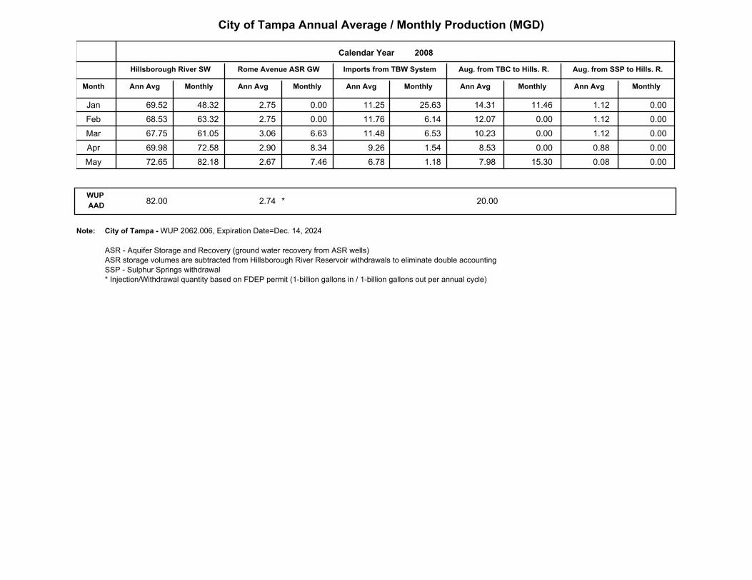
City of Tampa Annual Average / Monthly Production (MGD)
MonthlyAnn Avg MonthlyAnn Avg
Aug. from SSP to Hills. R.Aug. from TBC to Hills. R.
MonthlyAnn AvgMonthlyAnn Avg
2008
Imports from TBW System
Calendar Year
Month
Hillsborough River SW Rome Avenue ASR GW
Ann Avg Monthly
Jan 69.52 48.32 11.25 25.63 2.75 0.00 14.31 11.46 1.12 0.00
Feb 68.53 63.32 11.76 6.14 2.75 0.00 12.07 0.00 1.12 0.00
Mar 67.75 61.05 11.48 6.53 3.06 6.63 10.23 0.00 1.12 0.00
Apr 69.98 72.58 9.26 1.54 2.90 8.34 8.53 0.00 0.88 0.00
May 72.65 82.18 6.78 1.18 2.67 7.46 7.98 15.30 0.08 0.00
WUP
AAD82.00 2.74 20.00*
City of Tampa - WUP 2062.006, Expiration Date=Dec. 14, 2024
ASR - Aquifer Storage and Recovery (ground water recovery from ASR wells)
ASR storage volumes are subtracted from Hillsborough River Reservoir withdrawals to eliminate double accounting
SSP - Sulphur Springs withdrawal
* Injection/Withdrawal quantity based on FDEP permit (1-billion gallons in / 1-billion gallons out per annual cycle)
Note:
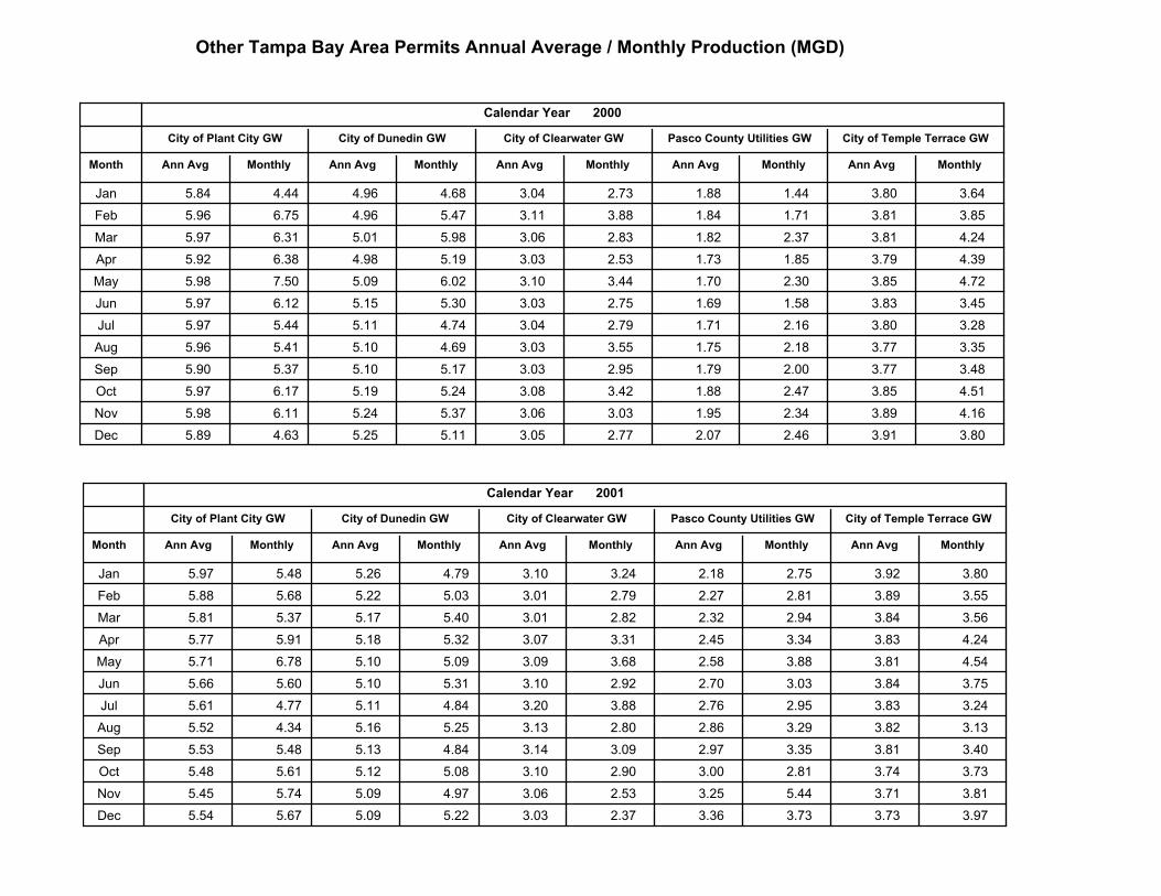
Other Tampa Bay Area Permits Annual Average / Monthly Production (MGD)
MonthlyAnn Avg
City of Temple Terrace GW
2000
MonthlyAnn Avg
Pasco County Utilities GW
MonthlyAnn AvgMonthlyAnn Avg
City of Clearwater GW
Calendar Year
Month
City of Plant City GW City of Dunedin GW
Ann Avg Monthly
Jan 5.84 4.44 4.96 4.68 3.04 2.73 3.80 3.64 1.88 1.44
Feb 5.96 6.75 4.96 5.47 3.11 3.88 3.81 3.85 1.84 1.71
Mar 5.97 6.31 5.01 5.98 3.06 2.83 3.81 4.24 1.82 2.37
Apr 5.92 6.38 4.98 5.19 3.03 2.53 3.79 4.39 1.73 1.85
May 5.98 7.50 5.09 6.02 3.10 3.44 3.85 4.72 1.70 2.30
Jun 5.97 6.12 5.15 5.30 3.03 2.75 3.83 3.45 1.69 1.58
Jul 5.97 5.44 5.11 4.74 3.04 2.79 3.80 3.28 1.71 2.16
Aug 5.96 5.41 5.10 4.69 3.03 3.55 3.77 3.35 1.75 2.18
Sep 5.90 5.37 5.10 5.17 3.03 2.95 3.77 3.48 1.79 2.00
Oct 5.97 6.17 5.19 5.24 3.08 3.42 3.85 4.51 1.88 2.47
Nov 5.98 6.11 5.24 5.37 3.06 3.03 3.89 4.16 1.95 2.34
Dec 5.89 4.63 5.25 5.11 3.05 2.77 3.91 3.80 2.07 2.46
MonthlyAnn Avg
City of Temple Terrace GW
2001
MonthlyAnn Avg
Pasco County Utilities GW
MonthlyAnn AvgMonthlyAnn Avg
City of Clearwater GW
Calendar Year
Month
City of Plant City GW City of Dunedin GW
Ann Avg Monthly
Jan 5.97 5.48 5.26 4.79 3.10 3.24 3.92 3.80 2.18 2.75
Feb 5.88 5.68 5.22 5.03 3.01 2.79 3.89 3.55 2.27 2.81
Mar 5.81 5.37 5.17 5.40 3.01 2.82 3.84 3.56 2.32 2.94
Apr 5.77 5.91 5.18 5.32 3.07 3.31 3.83 4.24 2.45 3.34
May 5.71 6.78 5.10 5.09 3.09 3.68 3.81 4.54 2.58 3.88
Jun 5.66 5.60 5.10 5.31 3.10 2.92 3.84 3.75 2.70 3.03
Jul 5.61 4.77 5.11 4.84 3.20 3.88 3.83 3.24 2.76 2.95
Aug 5.52 4.34 5.16 5.25 3.13 2.80 3.82 3.13 2.86 3.29
Sep 5.53 5.48 5.13 4.84 3.14 3.09 3.81 3.40 2.97 3.35
Oct 5.48 5.61 5.12 5.08 3.10 2.90 3.74 3.73 3.00 2.81
Nov 5.45 5.74 5.09 4.97 3.06 2.53 3.71 3.81 3.25 5.44
Dec 5.54 5.67 5.09 5.22 3.03 2.37 3.73 3.97 3.36 3.73
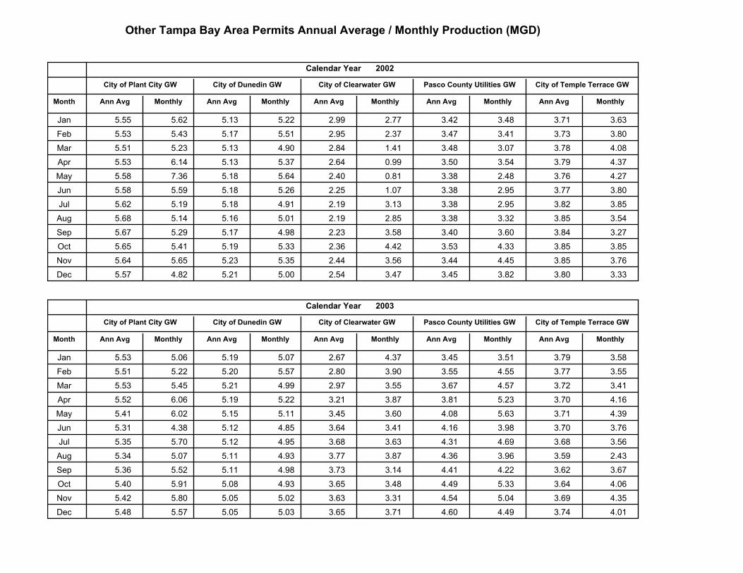
Other Tampa Bay Area Permits Annual Average / Monthly Production (MGD)
MonthlyAnn Avg
City of Temple Terrace GW
2002
MonthlyAnn Avg
Pasco County Utilities GW
MonthlyAnn AvgMonthlyAnn Avg
City of Clearwater GW
Calendar Year
Month
City of Plant City GW City of Dunedin GW
Ann Avg Monthly
Jan 5.55 5.62 5.13 5.22 2.99 2.77 3.71 3.63 3.42 3.48
Feb 5.53 5.43 5.17 5.51 2.95 2.37 3.73 3.80 3.47 3.41
Mar 5.51 5.23 5.13 4.90 2.84 1.41 3.78 4.08 3.48 3.07
Apr 5.53 6.14 5.13 5.37 2.64 0.99 3.79 4.37 3.50 3.54
May 5.58 7.36 5.18 5.64 2.40 0.81 3.76 4.27 3.38 2.48
Jun 5.58 5.59 5.18 5.26 2.25 1.07 3.77 3.80 3.38 2.95
Jul 5.62 5.19 5.18 4.91 2.19 3.13 3.82 3.85 3.38 2.95
Aug 5.68 5.14 5.16 5.01 2.19 2.85 3.85 3.54 3.38 3.32
Sep 5.67 5.29 5.17 4.98 2.23 3.58 3.84 3.27 3.40 3.60
Oct 5.65 5.41 5.19 5.33 2.36 4.42 3.85 3.85 3.53 4.33
Nov 5.64 5.65 5.23 5.35 2.44 3.56 3.85 3.76 3.44 4.45
Dec 5.57 4.82 5.21 5.00 2.54 3.47 3.80 3.33 3.45 3.82
MonthlyAnn Avg
City of Temple Terrace GW
2003
MonthlyAnn Avg
Pasco County Utilities GW
MonthlyAnn AvgMonthlyAnn Avg
City of Clearwater GW
Calendar Year
Month
City of Plant City GW City of Dunedin GW
Ann Avg Monthly
Jan 5.53 5.06 5.19 5.07 2.67 4.37 3.79 3.58 3.45 3.51
Feb 5.51 5.22 5.20 5.57 2.80 3.90 3.77 3.55 3.55 4.55
Mar 5.53 5.45 5.21 4.99 2.97 3.55 3.72 3.41 3.67 4.57
Apr 5.52 6.06 5.19 5.22 3.21 3.87 3.70 4.16 3.81 5.23
May 5.41 6.02 5.15 5.11 3.45 3.60 3.71 4.39 4.08 5.63
Jun 5.31 4.38 5.12 4.85 3.64 3.41 3.70 3.76 4.16 3.98
Jul 5.35 5.70 5.12 4.95 3.68 3.63 3.68 3.56 4.31 4.69
Aug 5.34 5.07 5.11 4.93 3.77 3.87 3.59 2.43 4.36 3.96
Sep 5.36 5.52 5.11 4.98 3.73 3.14 3.62 3.67 4.41 4.22
Oct 5.40 5.91 5.08 4.93 3.65 3.48 3.64 4.06 4.49 5.33
Nov 5.42 5.80 5.05 5.02 3.63 3.31 3.69 4.35 4.54 5.04
Dec 5.48 5.57 5.05 5.03 3.65 3.71 3.74 4.01 4.60 4.49
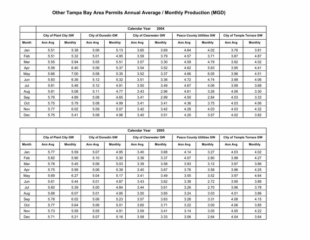
Other Tampa Bay Area Permits Annual Average / Monthly Production (MGD)
MonthlyAnn Avg
City of Temple Terrace GW
2004
MonthlyAnn Avg
Pasco County Utilities GW
MonthlyAnn AvgMonthlyAnn Avg
City of Clearwater GW
Calendar Year
Month
City of Plant City GW City of Dunedin GW
Ann Avg Monthly
Jan 5.51 5.38 5.06 5.13 3.60 3.69 3.76 3.81 4.64 4.02
Feb 5.51 5.32 5.01 4.95 3.59 3.79 3.87 4.87 4.57 3.71
Mar 5.55 5.94 5.05 5.51 3.57 3.30 3.92 4.02 4.59 4.79
Apr 5.58 6.40 5.06 5.37 3.54 3.52 3.95 4.41 4.62 5.63
May 5.66 7.00 5.08 5.35 3.52 3.37 3.96 4.51 4.66 6.05
Jun 5.83 6.36 5.12 5.32 3.51 3.36 3.98 4.06 4.72 4.74
Jul 5.81 5.46 5.12 4.91 3.50 3.49 3.99 3.68 4.67 4.06
Aug 5.81 5.08 5.11 4.77 3.43 2.96 4.06 3.30 4.61 3.26
Sep 5.76 4.89 5.08 4.65 3.41 2.99 4.03 3.33 4.50 2.84
Oct 5.75 5.79 5.08 4.99 3.41 3.41 4.03 4.06 4.36 3.75
Nov 5.77 6.02 5.09 5.07 3.42 3.42 4.03 4.32 4.28 4.03
Dec 5.75 5.41 5.08 4.96 3.40 3.51 4.02 3.82 4.20 3.57
MonthlyAnn Avg
City of Temple Terrace GW
2005
MonthlyAnn Avg
Pasco County Utilities GW
MonthlyAnn AvgMonthlyAnn Avg
City of Clearwater GW
Calendar Year
Month
City of Plant City GW City of Dunedin GW
Ann Avg Monthly
Jan 5.77 5.59 5.07 4.95 3.40 3.68 4.03 4.02 4.14 3.27
Feb 5.82 5.90 5.10 5.30 3.36 3.37 3.98 4.27 4.07 2.80
Mar 5.78 5.45 5.06 5.03 3.39 3.58 3.97 3.86 3.93 3.12
Apr 5.75 5.99 5.06 5.39 3.40 3.67 3.96 4.25 3.76 3.58
May 5.69 6.27 5.04 5.17 3.41 3.49 3.97 4.64 3.55 3.52
Jun 5.61 5.44 5.01 4.87 3.43 3.62 3.95 3.88 3.38 2.72
Jul 5.60 5.39 5.00 4.84 3.44 3.61 3.96 3.78 3.26 2.70
Aug 5.68 6.07 5.01 4.95 3.50 3.65 4.01 3.86 3.24 3.03
Sep 5.78 6.02 5.06 5.23 3.57 3.83 4.08 4.15 3.28 3.31
Oct 5.77 5.64 5.06 5.01 3.60 3.71 4.06 3.85 3.22 3.00
Nov 5.73 5.59 5.05 4.91 3.59 3.41 4.05 4.22 3.14 3.05
Dec 5.71 5.21 5.07 5.16 3.58 3.33 4.04 3.64 3.06 2.64
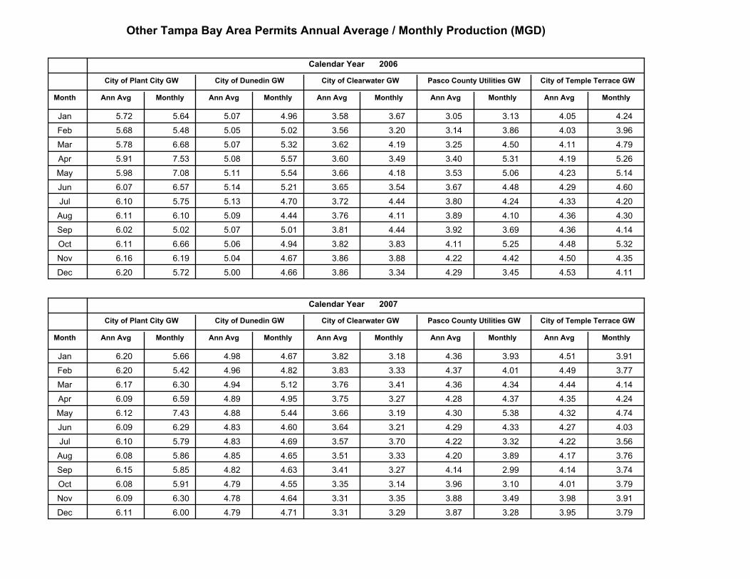
Other Tampa Bay Area Permits Annual Average / Monthly Production (MGD)
MonthlyAnn Avg
City of Temple Terrace GW
2006
MonthlyAnn Avg
Pasco County Utilities GW
MonthlyAnn AvgMonthlyAnn Avg
City of Clearwater GW
Calendar Year
Month
City of Plant City GW City of Dunedin GW
Ann Avg Monthly
Jan 5.72 5.64 5.07 4.96 3.58 3.67 4.05 4.24 3.05 3.13
Feb 5.68 5.48 5.05 5.02 3.56 3.20 4.03 3.96 3.14 3.86
Mar 5.78 6.68 5.07 5.32 3.62 4.19 4.11 4.79 3.25 4.50
Apr 5.91 7.53 5.08 5.57 3.60 3.49 4.19 5.26 3.40 5.31
May 5.98 7.08 5.11 5.54 3.66 4.18 4.23 5.14 3.53 5.06
Jun 6.07 6.57 5.14 5.21 3.65 3.54 4.29 4.60 3.67 4.48
Jul 6.10 5.75 5.13 4.70 3.72 4.44 4.33 4.20 3.80 4.24
Aug 6.11 6.10 5.09 4.44 3.76 4.11 4.36 4.30 3.89 4.10
Sep 6.02 5.02 5.07 5.01 3.81 4.44 4.36 4.14 3.92 3.69
Oct 6.11 6.66 5.06 4.94 3.82 3.83 4.48 5.32 4.11 5.25
Nov 6.16 6.19 5.04 4.67 3.86 3.88 4.50 4.35 4.22 4.42
Dec 6.20 5.72 5.00 4.66 3.86 3.34 4.53 4.11 4.29 3.45
MonthlyAnn Avg
City of Temple Terrace GW
2007
MonthlyAnn Avg
Pasco County Utilities GW
MonthlyAnn AvgMonthlyAnn Avg
City of Clearwater GW
Calendar Year
Month
City of Plant City GW City of Dunedin GW
Ann Avg Monthly
Jan 6.20 5.66 4.98 4.67 3.82 3.18 4.51 3.91 4.36 3.93
Feb 6.20 5.42 4.96 4.82 3.83 3.33 4.49 3.77 4.37 4.01
Mar 6.17 6.30 4.94 5.12 3.76 3.41 4.44 4.14 4.36 4.34
Apr 6.09 6.59 4.89 4.95 3.75 3.27 4.35 4.24 4.28 4.37
May 6.12 7.43 4.88 5.44 3.66 3.19 4.32 4.74 4.30 5.38
Jun 6.09 6.29 4.83 4.60 3.64 3.21 4.27 4.03 4.29 4.33
Jul 6.10 5.79 4.83 4.69 3.57 3.70 4.22 3.56 4.22 3.32
Aug 6.08 5.86 4.85 4.65 3.51 3.33 4.17 3.76 4.20 3.89
Sep 6.15 5.85 4.82 4.63 3.41 3.27 4.14 3.74 4.14 2.99
Oct 6.08 5.91 4.79 4.55 3.35 3.14 4.01 3.79 3.96 3.10
Nov 6.09 6.30 4.78 4.64 3.31 3.35 3.98 3.91 3.88 3.49
Dec 6.11 6.00 4.79 4.71 3.31 3.29 3.95 3.79 3.87 3.28
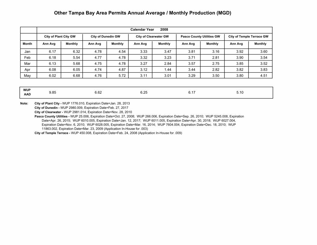
Other Tampa Bay Area Permits Annual Average / Monthly Production (MGD)
MonthlyAnn Avg
City of Temple Terrace GW
2008
MonthlyAnn Avg
Pasco County Utilities GW
MonthlyAnn AvgMonthlyAnn Avg
City of Clearwater GW
Calendar Year
Month
City of Plant City GW City of Dunedin GW
Ann Avg Monthly
Jan 6.17 6.32 4.78 4.54 3.33 3.47 3.92 3.60 3.81 3.16
Feb 6.18 5.54 4.77 4.78 3.32 3.23 3.90 3.54 3.71 2.81
Mar 6.13 5.68 4.75 4.78 3.27 2.84 3.85 3.52 3.57 2.75
Apr 6.08 6.05 4.74 4.87 3.12 1.44 3.82 3.83 3.44 2.82
May 6.02 6.68 4.76 5.72 3.11 3.01 3.80 4.51 3.29 3.50
WUP
AAD9.85 6.62 6.25 6.17 5.10
Note: City of Plant City - WUP 1776.010, Expiration Date=Jan. 28, 2013
City of Dunedin - WUP 2980.009, Expiration Date=Feb. 27, 2017
City of Clearwater - WUP 2981.014, Expiration Date=Nov. 28, 2010
Pasco County Utilities - WUP 25.006, Expiration Date=Oct. 27, 2008; WUP 266.006, Expiration Date=Sep. 26, 2010; WUP 5245.008, Expiration
Date=Apr. 26, 2015; WUP 6010.005, Expiration Date=Jan. 12, 2017; WUP 6011.005, Expiration Date=Apr. 30, 2018; WUP 6027.004,
Expiration Date=Nov. 6, 2010; WUP 6028.005, Expiration Date=Mar. 16, 2014; WUP 7604.004, Expiration Date=Dec. 18, 2010; WUP
11863.002, Expiration Date=Mar. 23, 2009 (Application In-House for .003)
City of Temple Terrace - WUP 450.008, Expiration Date=Feb. 24, 2008 (Application In-House for .009)
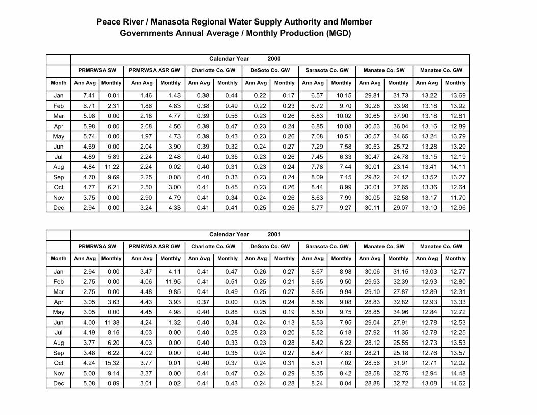
Peace River / Manasota Regional Water Supply Authority and Member
Governments Annual Average / Monthly Production (MGD)
MonthlyAnn AvgMonthlyAnn Avg
Manatee Co. GW
MonthlyAnn AvgMonthlyAnn Avg
Manatee Co. SWSarasota Co. GW
Calendar Year
Month
PRMRWSA SW PRMRWSA ASR GW Charlotte Co. GW DeSoto Co. GW
Ann Avg Monthly Ann Avg Monthly MonthlyAnn Avg
2000
0.44 0.38 0.17 0.22Jan 0.01 7.41 1.46 1.43 6.57 10.15 29.81 31.73 13.22 13.69
0.49 0.38 0.23 0.22Feb 2.31 6.71 1.86 4.83 6.72 9.70 30.28 33.98 13.18 13.92
0.56 0.39 0.26 0.23Mar 0.00 5.98 2.18 4.77 6.83 10.02 30.65 37.90 13.18 12.81
0.47 0.39 0.24 0.23Apr 0.00 5.98 2.08 4.56 6.85 10.08 30.53 36.04 13.16 12.89
0.43 0.39 0.26 0.23May 0.00 5.74 1.97 4.73 7.08 10.51 30.57 34.65 13.24 13.79
0.32 0.39 0.27 0.24Jun 0.00 4.69 2.04 3.90 7.29 7.58 30.53 25.72 13.28 13.29
0.35 0.40 0.26 0.23Jul 5.89 4.89 2.24 2.48 7.45 6.33 30.47 24.78 13.15 12.19
0.31 0.40 0.24 0.23Aug 11.22 4.84 2.24 0.02 7.78 7.44 30.01 23.14 13.41 14.11
0.33 0.40 0.24 0.23Sep 9.69 4.70 2.25 0.08 8.09 7.15 29.82 24.12 13.52 13.27
0.45 0.41 0.26 0.23Oct 6.21 4.77 2.50 3.00 8.44 8.99 30.01 27.65 13.36 12.64
0.34 0.41 0.26 0.24Nov 0.00 3.75 2.90 4.79 8.63 7.99 30.05 32.58 13.17 11.70
0.41 0.41 0.26 0.25Dec 0.00 2.94 3.24 4.33 8.77 9.27 30.11 29.07 13.10 12.96
MonthlyAnn AvgMonthlyAnn Avg
Manatee Co. GW
MonthlyAnn AvgMonthlyAnn Avg
Manatee Co. SWSarasota Co. GW
Calendar Year
Month
PRMRWSA SW PRMRWSA ASR GW Charlotte Co. GW DeSoto Co. GW
Ann Avg Monthly Ann Avg Monthly MonthlyAnn Avg
2001
0.47 0.41 0.27 0.26Jan 0.00 2.94 3.47 4.11 8.67 8.98 30.06 31.15 13.03 12.77
0.51 0.41 0.21 0.25Feb 0.00 2.75 4.06 11.95 8.65 9.50 29.93 32.39 12.93 12.80
0.49 0.41 0.27 0.25Mar 0.00 2.75 4.48 9.85 8.65 9.94 29.10 27.87 12.89 12.31
0.00 0.37 0.24 0.25Apr 3.63 3.05 4.43 3.93 8.56 9.08 28.83 32.82 12.93 13.33
0.88 0.40 0.19 0.25May 0.00 3.05 4.45 4.98 8.50 9.75 28.85 34.96 12.84 12.72
0.34 0.40 0.13 0.24Jun 11.38 4.00 4.24 1.32 8.53 7.95 29.04 27.91 12.78 12.53
0.28 0.40 0.20 0.23Jul 8.16 4.19 4.03 0.00 8.52 6.18 27.92 11.35 12.78 12.25
0.33 0.40 0.28 0.23Aug 6.20 3.77 4.03 0.00 8.42 6.22 28.12 25.55 12.73 13.53
0.35 0.40 0.27 0.24Sep 6.22 3.48 4.02 0.00 8.47 7.83 28.21 25.18 12.76 13.57
0.37 0.40 0.31 0.24Oct 15.32 4.24 3.77 0.01 8.31 7.02 28.56 31.91 12.71 12.02
0.47 0.41 0.29 0.24Nov 9.14 5.00 3.37 0.00 8.35 8.42 28.58 32.75 12.94 14.48
0.43 0.41 0.28 0.24Dec 0.89 5.08 3.01 0.02 8.24 8.04 28.88 32.72 13.08 14.62
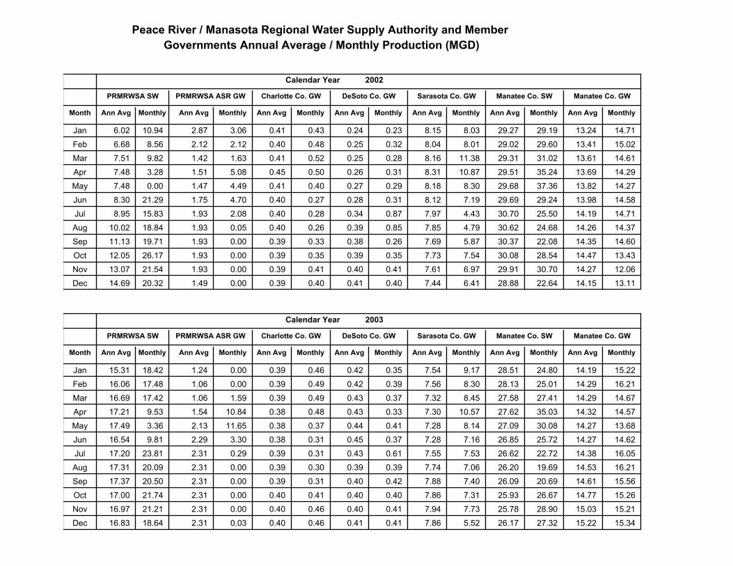
Peace River / Manasota Regional Water Supply Authority and Member
Governments Annual Average / Monthly Production (MGD)
MonthlyAnn AvgMonthlyAnn Avg
Manatee Co. GW
MonthlyAnn AvgMonthlyAnn Avg
Manatee Co. SWSarasota Co. GW
Calendar Year
Month
PRMRWSA SW PRMRWSA ASR GW Charlotte Co. GW DeSoto Co. GW
Ann Avg Monthly Ann Avg Monthly MonthlyAnn Avg
2002
0.43 0.41 0.23 0.24Jan 10.94 6.02 2.87 3.06 8.15 8.03 29.27 29.19 13.24 14.71
0.48 0.40 0.32 0.25Feb 8.56 6.68 2.12 2.12 8.04 8.01 29.02 29.60 13.41 15.02
0.52 0.41 0.28 0.25Mar 9.82 7.51 1.42 1.63 8.16 11.38 29.31 31.02 13.61 14.61
0.50 0.45 0.31 0.26Apr 3.28 7.48 1.51 5.08 8.31 10.87 29.51 35.24 13.69 14.29
0.40 0.41 0.29 0.27May 0.00 7.48 1.47 4.49 8.18 8.30 29.68 37.36 13.82 14.27
0.27 0.40 0.31 0.28Jun 21.29 8.30 1.75 4.70 8.12 7.19 29.69 29.24 13.98 14.58
0.28 0.40 0.87 0.34Jul 15.83 8.95 1.93 2.08 7.97 4.43 30.70 25.50 14.19 14.71
0.26 0.40 0.85 0.39Aug 18.84 10.02 1.93 0.05 7.85 4.79 30.62 24.68 14.26 14.37
0.33 0.39 0.26 0.38Sep 19.71 11.13 1.93 0.00 7.69 5.87 30.37 22.08 14.35 14.60
0.35 0.39 0.35 0.39Oct 26.17 12.05 1.93 0.00 7.73 7.54 30.08 28.54 14.47 13.43
0.41 0.39 0.41 0.40Nov 21.54 13.07 1.93 0.00 7.61 6.97 29.91 30.70 14.27 12.06
0.40 0.39 0.40 0.41Dec 20.32 14.69 1.49 0.00 7.44 6.41 28.88 22.64 14.15 13.11
MonthlyAnn AvgMonthlyAnn Avg
Manatee Co. GW
MonthlyAnn AvgMonthlyAnn Avg
Manatee Co. SWSarasota Co. GW
Calendar Year
Month
PRMRWSA SW PRMRWSA ASR GW Charlotte Co. GW DeSoto Co. GW
Ann Avg Monthly Ann Avg Monthly MonthlyAnn Avg
2003
0.46 0.39 0.35 0.42Jan 18.42 15.31 1.24 0.00 7.54 9.17 28.51 24.80 14.19 15.22
0.49 0.39 0.39 0.42Feb 17.48 16.06 1.06 0.00 7.56 8.30 28.13 25.01 14.29 16.21
0.49 0.39 0.37 0.43Mar 17.42 16.69 1.06 1.59 7.32 8.45 27.58 27.41 14.29 14.67
0.48 0.38 0.33 0.43Apr 9.53 17.21 1.54 10.84 7.30 10.57 27.62 35.03 14.32 14.57
0.37 0.38 0.41 0.44May 3.36 17.49 2.13 11.65 7.28 8.14 27.09 30.08 14.27 13.68
0.31 0.38 0.37 0.45Jun 9.81 16.54 2.29 3.30 7.28 7.16 26.85 25.72 14.27 14.62
0.31 0.39 0.61 0.43Jul 23.81 17.20 2.31 0.29 7.55 7.53 26.62 22.72 14.38 16.05
0.30 0.39 0.39 0.39Aug 20.09 17.31 2.31 0.00 7.74 7.06 26.20 19.69 14.53 16.21
0.31 0.39 0.42 0.40Sep 20.50 17.37 2.31 0.00 7.88 7.40 26.09 20.69 14.61 15.56
0.41 0.40 0.40 0.40Oct 21.74 17.00 2.31 0.00 7.86 7.31 25.93 26.67 14.77 15.26
0.46 0.40 0.41 0.40Nov 21.21 16.97 2.31 0.00 7.94 7.73 25.78 28.90 15.03 15.21
0.46 0.40 0.41 0.41Dec 18.64 16.83 2.31 0.03 7.86 5.52 26.17 27.32 15.22 15.34
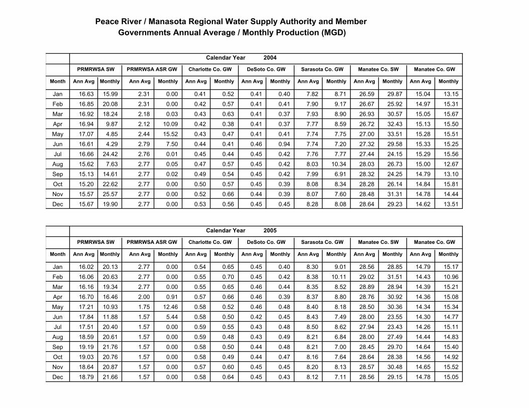
Peace River / Manasota Regional Water Supply Authority and Member
Governments Annual Average / Monthly Production (MGD)
MonthlyAnn AvgMonthlyAnn Avg
Manatee Co. GW
MonthlyAnn AvgMonthlyAnn Avg
Manatee Co. SWSarasota Co. GW
Calendar Year
Month
PRMRWSA SW PRMRWSA ASR GW Charlotte Co. GW DeSoto Co. GW
Ann Avg Monthly Ann Avg Monthly MonthlyAnn Avg
2004
0.52 0.41 0.40 0.41Jan 15.99 16.63 2.31 0.00 7.82 8.71 26.59 29.87 15.04 13.15
0.57 0.42 0.41 0.41Feb 20.08 16.85 2.31 0.00 7.90 9.17 26.67 25.92 14.97 15.31
0.63 0.43 0.37 0.41Mar 18.24 16.92 2.18 0.03 7.93 8.90 26.93 30.57 15.05 15.67
0.38 0.42 0.37 0.41Apr 9.87 16.94 2.12 10.09 7.77 8.59 26.72 32.43 15.13 15.50
0.47 0.43 0.41 0.41May 4.85 17.07 2.44 15.52 7.74 7.75 27.00 33.51 15.28 15.51
0.41 0.44 0.94 0.46Jun 4.29 16.61 2.79 7.50 7.74 7.20 27.32 29.58 15.33 15.25
0.44 0.45 0.42 0.45Jul 24.42 16.66 2.76 0.01 7.76 7.77 27.44 24.15 15.29 15.56
0.57 0.47 0.42 0.45Aug 7.63 15.62 2.77 0.05 8.03 10.34 28.03 26.73 15.00 12.67
0.54 0.49 0.42 0.45Sep 14.61 15.13 2.77 0.02 7.99 6.91 28.32 24.25 14.79 13.10
0.57 0.50 0.39 0.45Oct 22.62 15.20 2.77 0.00 8.08 8.34 28.28 26.14 14.84 15.81
0.66 0.52 0.39 0.44Nov 25.57 15.57 2.77 0.00 8.07 7.60 28.48 31.31 14.78 14.44
0.56 0.53 0.45 0.45Dec 19.90 15.67 2.77 0.00 8.28 8.08 28.64 29.23 14.62 13.51
MonthlyAnn AvgMonthlyAnn Avg
Manatee Co. GW
MonthlyAnn AvgMonthlyAnn Avg
Manatee Co. SWSarasota Co. GW
Calendar Year
Month
PRMRWSA SW PRMRWSA ASR GW Charlotte Co. GW DeSoto Co. GW
Ann Avg Monthly Ann Avg Monthly MonthlyAnn Avg
2005
0.65 0.54 0.40 0.45Jan 20.13 16.02 2.77 0.00 8.30 9.01 28.56 28.85 14.79 15.17
0.70 0.55 0.42 0.45Feb 20.63 16.06 2.77 0.00 8.38 10.11 29.02 31.51 14.43 10.96
0.65 0.55 0.44 0.46Mar 19.34 16.16 2.77 0.00 8.35 8.52 28.89 28.94 14.39 15.21
0.66 0.57 0.39 0.46Apr 16.46 16.70 2.00 0.91 8.37 8.80 28.76 30.92 14.36 15.08
0.52 0.58 0.48 0.46May 10.93 17.21 1.75 12.46 8.40 8.18 28.50 30.36 14.34 15.34
0.50 0.58 0.45 0.42Jun 11.88 17.84 1.57 5.44 8.43 7.49 28.00 23.55 14.30 14.77
0.55 0.59 0.48 0.43Jul 20.40 17.51 1.57 0.00 8.50 8.62 27.94 23.43 14.26 15.11
0.48 0.59 0.49 0.43Aug 20.61 18.59 1.57 0.00 8.21 6.84 28.00 27.49 14.44 14.83
0.50 0.58 0.48 0.44Sep 21.76 19.19 1.57 0.00 8.21 7.00 28.45 29.70 14.64 15.40
0.49 0.58 0.47 0.44Oct 20.76 19.03 1.57 0.00 8.16 7.64 28.64 28.38 14.56 14.92
0.60 0.57 0.45 0.45Nov 20.87 18.64 1.57 0.00 8.20 8.13 28.57 30.48 14.65 15.52
0.64 0.58 0.43 0.45Dec 21.66 18.79 1.57 0.00 8.12 7.11 28.56 29.15 14.78 15.05
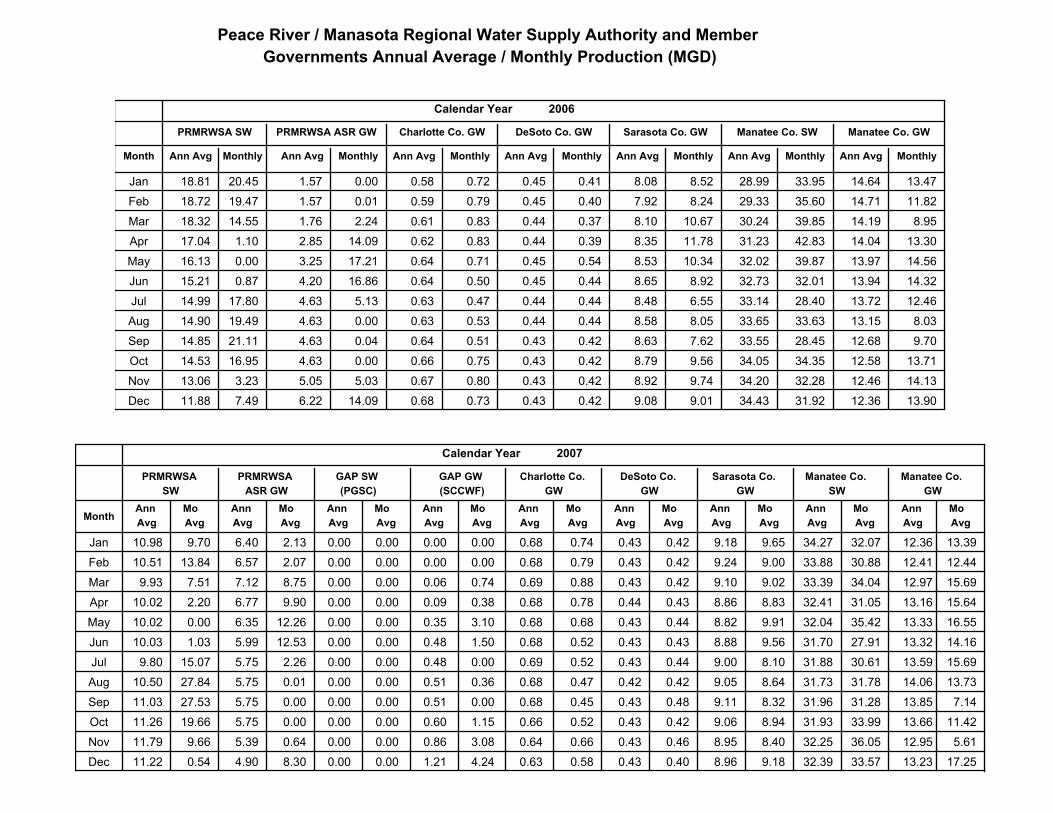
Peace River / Manasota Regional Water Supply Authority and Member
Governments Annual Average / Monthly Production (MGD)
MonthlyAnn AvgMonthlyAnn Avg
Manatee Co. GW
MonthlyAnn AvgMonthlyAnn Avg
Manatee Co. SWSarasota Co. GW
Calendar Year
Month
PRMRWSA SW PRMRWSA ASR GW Charlotte Co. GW DeSoto Co. GW
Ann Avg Monthly Ann Avg Monthly MonthlyAnn Avg
2006
0.72 0.58 0.41 0.45Jan 20.45 18.81 1.57 0.00 8.08 8.52 28.99 33.95 14.64 13.47
0.79 0.59 0.40 0.45Feb 19.47 18.72 1.57 0.01 7.92 8.24 29.33 35.60 14.71 11.82
0.83 0.61 0.37 0.44Mar 14.55 18.32 1.76 2.24 8.10 10.67 30.24 39.85 14.19 8.95
0.83 0.62 0.39 0.44Apr 1.10 17.04 2.85 14.09 8.35 11.78 31.23 42.83 14.04 13.30
0.71 0.64 0.54 0.45May 0.00 16.13 3.25 17.21 8.53 10.34 32.02 39.87 13.97 14.56
0.50 0.64 0.44 0.45Jun 0.87 15.21 4.20 16.86 8.65 8.92 32.73 32.01 13.94 14.32
0.47 0.63 0.44 0.44Jul 17.80 14.99 4.63 5.13 8.48 6.55 33.14 28.40 13.72 12.46
0.53 0.63 0.44 0.44Aug 19.49 14.90 4.63 0.00 8.58 8.05 33.65 33.63 13.15 8.03
0.51 0.64 0.42 0.43Sep 21.11 14.85 4.63 0.04 8.63 7.62 33.55 28.45 12.68 9.70
0.75 0.66 0.42 0.43Oct 16.95 14.53 4.63 0.00 8.79 9.56 34.05 34.35 12.58 13.71
0.80 0.67 0.42 0.43Nov 3.23 13.06 5.05 5.03 8.92 9.74 34.20 32.28 12.46 14.13
0.73 0.68 0.42 0.43Dec 7.49 11.88 6.22 14.09 9.08 9.01 34.43 31.92 12.36 13.90
Mo
Avg
Mo
Avg
Mo
Avg
Mo
Avg
Mo
Avg
Ann
Avg
Ann
Avg
Ann
Avg
Ann
Avg
Ann
Avg
Mo
Avg
Ann
Avg
Mo
Avg
Ann
Avg
GAP GW
(SCCWF)
GAP SW
(PGSC)
Mo
Avg
Ann
Avg
Manatee Co.
GW
Manatee Co.
SW
Sarasota Co.
GW
Calendar Year
Month
PRMRWSA
SW
PRMRWSA
ASR GW
Charlotte Co.
GW
DeSoto Co.
GW
Ann
Avg
Mo
Avg
2007
0.74 0.68 0.42 0.43Jan 9.70 10.98 6.40 2.13 9.18 9.65 34.27 32.07 12.36 13.39 0.00 0.00 0.00 0.00
0.79 0.68 0.42 0.43Feb 13.84 10.51 6.57 2.07 9.24 9.00 33.88 30.88 12.41 12.44 0.00 0.00 0.00 0.00
0.88 0.69 0.42 0.43Mar 7.51 9.93 7.12 8.75 9.10 9.02 33.39 34.04 12.97 15.69 0.06 0.74 0.00 0.00
0.78 0.68 0.43 0.44Apr 2.20 10.02 6.77 9.90 8.86 8.83 32.41 31.05 13.16 15.64 0.09 0.38 0.00 0.00
0.68 0.68 0.44 0.43May 0.00 10.02 6.35 12.26 8.82 9.91 32.04 35.42 13.33 16.55 0.35 3.10 0.00 0.00
0.52 0.68 0.43 0.43Jun 1.03 10.03 5.99 12.53 8.88 9.56 31.70 27.91 13.32 14.16 0.48 1.50 0.00 0.00
0.52 0.69 0.44 0.43Jul 15.07 9.80 5.75 2.26 9.00 8.10 31.88 30.61 13.59 15.69 0.48 0.00 0.00 0.00
0.47 0.68 0.42 0.42Aug 27.84 10.50 5.75 0.01 9.05 8.64 31.73 31.78 14.06 13.73 0.51 0.36 0.00 0.00
0.45 0.68 0.48 0.43Sep 27.53 11.03 5.75 0.00 9.11 8.32 31.96 31.28 13.85 7.14 0.51 0.00 0.00 0.00
0.52 0.66 0.42 0.43Oct 19.66 11.26 5.75 0.00 9.06 8.94 31.93 33.99 13.66 11.42 0.60 1.15 0.00 0.00
0.66 0.64 0.46 0.43Nov 9.66 11.79 5.39 0.64 8.95 8.40 32.25 36.05 12.95 5.61 0.86 3.08 0.00 0.00
0.58 0.63 0.40 0.43Dec 0.54 11.22 4.90 8.30 8.96 9.18 32.39 33.57 13.23 17.25 1.21 4.24 0.00 0.00
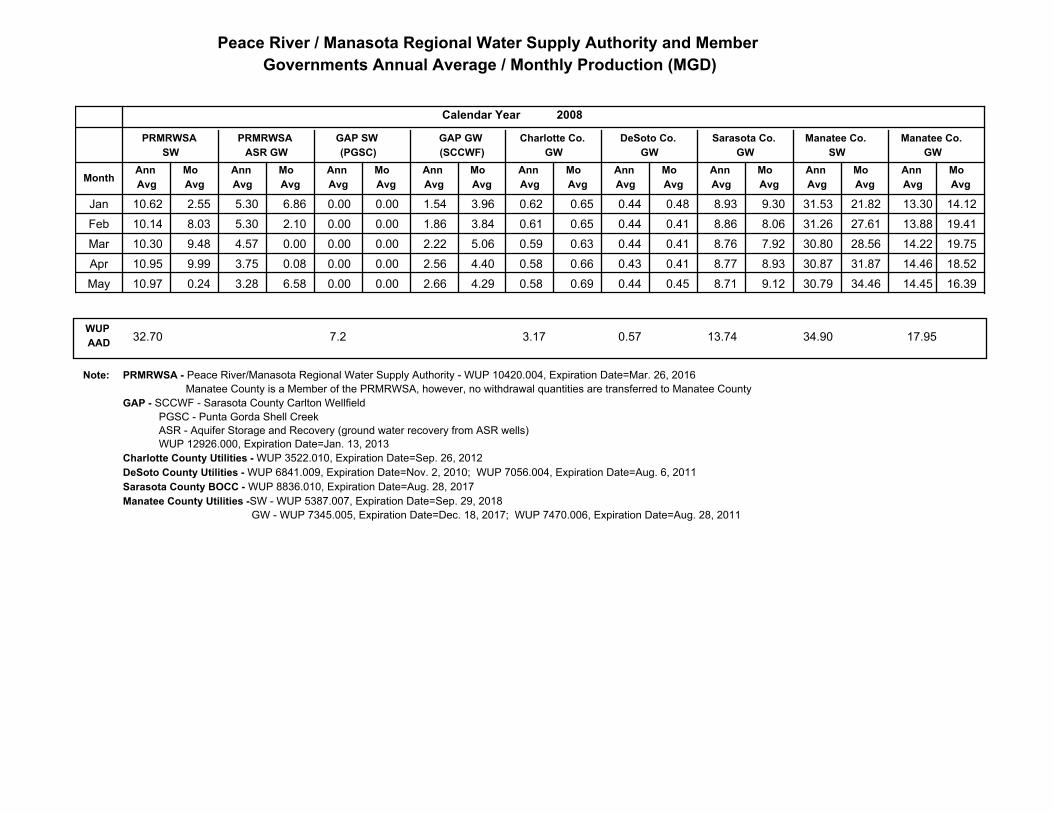
Peace River / Manasota Regional Water Supply Authority and Member
Governments Annual Average / Monthly Production (MGD)
Mo
Avg
Mo
Avg
Mo
Avg
Mo
Avg
Mo
Avg
Ann
Avg
Ann
Avg
Ann
Avg
Ann
Avg
Ann
Avg
Mo
Avg
Ann
Avg
Mo
Avg
Ann
Avg
GAP GW
(SCCWF)
GAP SW
(PGSC)
Mo
Avg
Ann
Avg
Manatee Co.
GW
Manatee Co.
SW
Sarasota Co.
GW
Calendar Year
Month
PRMRWSA
SW
PRMRWSA
ASR GW
Charlotte Co.
GW
DeSoto Co.
GW
Ann
Avg
Mo
Avg
2008
0.65 0.62 0.48 0.44Jan 2.55 10.62 5.30 6.86 8.93 9.30 31.53 21.82 13.30 14.12 1.54 3.96 0.00 0.00
0.65 0.61 0.41 0.44Feb 8.03 10.14 5.30 2.10 8.86 8.06 31.26 27.61 13.88 19.41 1.86 3.84 0.00 0.00
0.63 0.59 0.41 0.44Mar 9.48 10.30 4.57 0.00 8.76 7.92 30.80 28.56 14.22 19.75 2.22 5.06 0.00 0.00
0.66 0.58 0.41 0.43Apr 9.99 10.95 3.75 0.08 8.77 8.93 30.87 31.87 14.46 18.52 2.56 4.40 0.00 0.00
0.69 0.58 0.45 0.44May 0.24 10.97 3.28 6.58 8.71 9.12 30.79 34.46 14.45 16.39 2.66 4.29 0.00 0.00
17.95WUP
AAD32.70 7.2 3.17 0.57 13.74 34.90
Note: PRMRWSA - Peace River/Manasota Regional Water Supply Authority - WUP 10420.004, Expiration Date=Mar. 26, 2016
Manatee County is a Member of the PRMRWSA, however, no withdrawal quantities are transferred to Manatee County
GAP - SCCWF - Sarasota County Carlton Wellfield
PGSC - Punta Gorda Shell Creek
ASR - Aquifer Storage and Recovery (ground water recovery from ASR wells)
WUP 12926.000, Expiration Date=Jan. 13, 2013
Charlotte County Utilities - WUP 3522.010, Expiration Date=Sep. 26, 2012
DeSoto County Utilities - WUP 6841.009, Expiration Date=Nov. 2, 2010; WUP 7056.004, Expiration Date=Aug. 6, 2011
Sarasota County BOCC - WUP 8836.010, Expiration Date=Aug. 28, 2017
Manatee County Utilities -SW - WUP 5387.007, Expiration Date=Sep. 29, 2018
GW - WUP 7345.005, Expiration Date=Dec. 18, 2017; WUP 7470.006, Expiration Date=Aug. 28, 2011
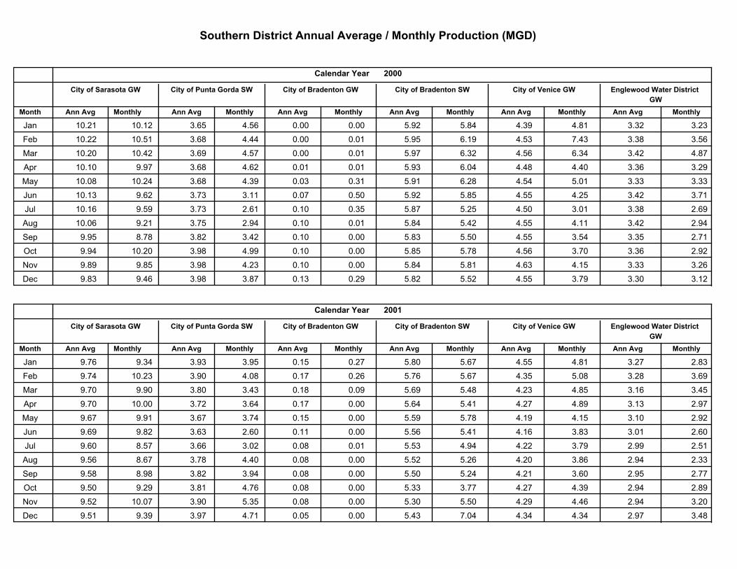
Southern District Annual Average / Monthly Production (MGD)
MonthlyAnn Avg
Englewood Water District
GW
2000
MonthlyAnn Avg
City of Venice GW
MonthlyAnn Avg
City of Bradenton SW
MonthlyAnn AvgMonthlyAnn Avg
City of Bradenton GW
Calendar Year
Month
City of Sarasota GW City of Punta Gorda SW
Ann Avg Monthly
Jan 10.21 10.12 3.32 3.23 3.65 4.56 0.00 0.00 5.92 5.84 4.39 4.81
Feb 10.22 10.51 3.38 3.56 3.68 4.44 0.00 0.01 5.95 6.19 4.53 7.43
Mar 10.20 10.42 3.42 4.87 3.69 4.57 0.00 0.01 5.97 6.32 4.56 6.34
Apr 10.10 9.97 3.36 3.29 3.68 4.62 0.01 0.01 5.93 6.04 4.48 4.40
May 10.08 10.24 3.33 3.33 3.68 4.39 0.03 0.31 5.91 6.28 4.54 5.01
Jun 10.13 9.62 3.42 3.71 3.73 3.11 0.07 0.50 5.92 5.85 4.55 4.25
Jul 10.16 9.59 3.38 2.69 3.73 2.61 0.10 0.35 5.87 5.25 4.50 3.01
Aug 10.06 9.21 3.42 2.94 3.75 2.94 0.10 0.01 5.84 5.42 4.55 4.11
Sep 9.95 8.78 3.35 2.71 3.82 3.42 0.10 0.00 5.83 5.50 4.55 3.54
Oct 9.94 10.20 3.36 2.92 3.98 4.99 0.10 0.00 5.85 5.78 4.56 3.70
Nov 9.89 9.85 3.33 3.26 3.98 4.23 0.10 0.00 5.84 5.81 4.63 4.15
Dec 9.83 9.46 3.30 3.12 3.98 3.87 0.13 0.29 5.82 5.52 4.55 3.79
MonthlyAnn Avg
Englewood Water District
GW
2001
MonthlyAnn Avg
City of Venice GW
MonthlyAnn Avg
City of Bradenton SW
MonthlyAnn AvgMonthlyAnn Avg
City of Bradenton GW
Calendar Year
Month
City of Sarasota GW City of Punta Gorda SW
Ann Avg Monthly
Jan 9.76 9.34 3.27 2.83 3.93 3.95 0.15 0.27 5.80 5.67 4.55 4.81
Feb 9.74 10.23 3.28 3.69 3.90 4.08 0.17 0.26 5.76 5.67 4.35 5.08
Mar 9.70 9.90 3.16 3.45 3.80 3.43 0.18 0.09 5.69 5.48 4.23 4.85
Apr 9.70 10.00 3.13 2.97 3.72 3.64 0.17 0.00 5.64 5.41 4.27 4.89
May 9.67 9.91 3.10 2.92 3.67 3.74 0.15 0.00 5.59 5.78 4.19 4.15
Jun 9.69 9.82 3.01 2.60 3.63 2.60 0.11 0.00 5.56 5.41 4.16 3.83
Jul 9.60 8.57 2.99 2.51 3.66 3.02 0.08 0.01 5.53 4.94 4.22 3.79
Aug 9.56 8.67 2.94 2.33 3.78 4.40 0.08 0.00 5.52 5.26 4.20 3.86
Sep 9.58 8.98 2.95 2.77 3.82 3.94 0.08 0.00 5.50 5.24 4.21 3.60
Oct 9.50 9.29 2.94 2.89 3.81 4.76 0.08 0.00 5.33 3.77 4.27 4.39
Nov 9.52 10.07 2.94 3.20 3.90 5.35 0.08 0.00 5.30 5.50 4.29 4.46
Dec 9.51 9.39 2.97 3.48 3.97 4.71 0.05 0.00 5.43 7.04 4.34 4.34
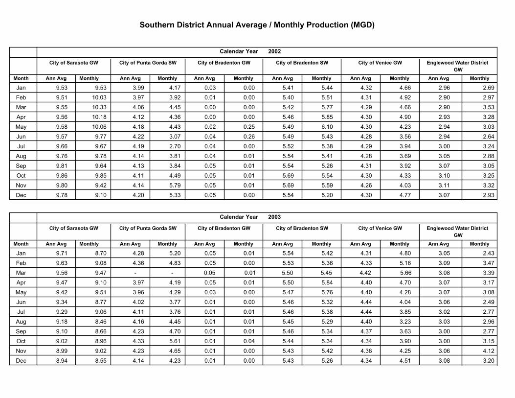
Southern District Annual Average / Monthly Production (MGD)
MonthlyAnn Avg
Englewood Water District
GW
2002
MonthlyAnn Avg
City of Venice GW
MonthlyAnn Avg
City of Bradenton SW
MonthlyAnn AvgMonthlyAnn Avg
City of Bradenton GW
Calendar Year
Month
City of Sarasota GW City of Punta Gorda SW
Ann Avg Monthly
Jan 9.53 9.53 2.96 2.69 3.99 4.17 0.03 0.00 5.41 5.44 4.32 4.66
Feb 9.51 10.03 2.90 2.97 3.97 3.92 0.01 0.00 5.40 5.51 4.31 4.92
Mar 9.55 10.33 2.90 3.53 4.06 4.45 0.00 0.00 5.42 5.77 4.29 4.66
Apr 9.56 10.18 2.93 3.28 4.12 4.36 0.00 0.00 5.46 5.85 4.30 4.90
May 9.58 10.06 2.94 3.03 4.18 4.43 0.02 0.25 5.49 6.10 4.30 4.23
Jun 9.57 9.77 2.94 2.64 4.22 3.07 0.04 0.26 5.49 5.43 4.28 3.56
Jul 9.66 9.67 3.00 3.24 4.19 2.70 0.04 0.00 5.52 5.38 4.29 3.94
Aug 9.76 9.78 3.05 2.88 4.14 3.81 0.04 0.01 5.54 5.41 4.28 3.69
Sep 9.81 9.64 3.07 3.05 4.13 3.84 0.05 0.01 5.54 5.26 4.31 3.92
Oct 9.86 9.85 3.10 3.25 4.11 4.49 0.05 0.01 5.69 5.54 4.30 4.33
Nov 9.80 9.42 3.11 3.32 4.14 5.79 0.05 0.01 5.69 5.59 4.26 4.03
Dec 9.78 9.10 3.07 2.93 4.20 5.33 0.05 0.00 5.54 5.20 4.30 4.77
MonthlyAnn Avg
Englewood Water District
GW
2003
MonthlyAnn Avg
City of Venice GW
MonthlyAnn Avg
City of Bradenton SW
MonthlyAnn AvgMonthlyAnn Avg
City of Bradenton GW
Calendar Year
Month
City of Sarasota GW City of Punta Gorda SW
Ann Avg Monthly
Jan 9.71 8.70 3.05 2.43 4.28 5.20 0.05 0.01 5.54 5.42 4.31 4.80
Feb 9.63 9.08 3.09 3.47 4.36 4.83 0.05 0.00 5.53 5.36 4.33 5.16
Mar 9.56 9.47 3.08 3.39 - - 0.05 0.01 5.50 5.45 4.42 5.66
Apr 9.47 9.10 3.07 3.17 3.97 4.19 0.05 0.01 5.50 5.84 4.40 4.70
May 9.42 9.51 3.07 3.08 3.96 4.29 0.03 0.00 5.47 5.76 4.40 4.28
Jun 9.34 8.77 3.06 2.49 4.02 3.77 0.01 0.00 5.46 5.32 4.44 4.04
Jul 9.29 9.06 3.02 2.77 4.11 3.76 0.01 0.01 5.46 5.38 4.44 3.85
Aug 9.18 8.46 3.03 2.96 4.16 4.45 0.01 0.01 5.45 5.29 4.40 3.23
Sep 9.10 8.66 3.00 2.77 4.23 4.70 0.01 0.01 5.46 5.34 4.37 3.63
Oct 9.02 8.96 3.00 3.15 4.33 5.61 0.01 0.04 5.44 5.34 4.34 3.90
Nov 8.99 9.02 3.06 4.12 4.23 4.65 0.01 0.00 5.43 5.42 4.36 4.25
Dec 8.94 8.55 3.08 3.20 4.14 4.23 0.01 0.00 5.43 5.26 4.34 4.51
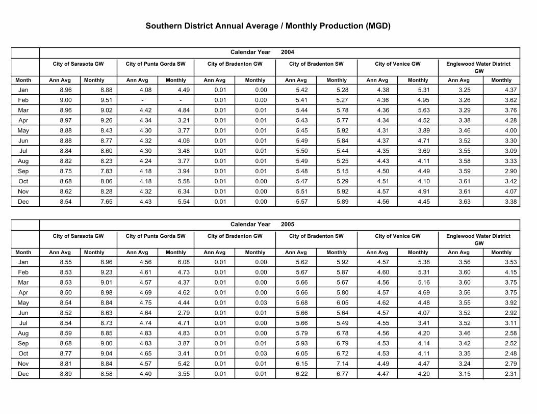
Southern District Annual Average / Monthly Production (MGD)
MonthlyAnn Avg
Englewood Water District
GW
2004
MonthlyAnn Avg
City of Venice GW
MonthlyAnn Avg
City of Bradenton SW
MonthlyAnn AvgMonthlyAnn Avg
City of Bradenton GW
Calendar Year
Month
City of Sarasota GW City of Punta Gorda SW
Ann Avg Monthly
Jan 8.96 8.88 3.25 4.37 4.08 4.49 0.01 0.00 5.42 5.28 4.38 5.31
Feb 9.00 9.51 3.26 3.62 - - 0.01 0.00 5.41 5.27 4.36 4.95
Mar 8.96 9.02 3.29 3.76 4.42 4.84 0.01 0.01 5.44 5.78 4.36 5.63
Apr 8.97 9.26 3.38 4.28 4.34 3.21 0.01 0.01 5.43 5.77 4.34 4.52
May 8.88 8.43 3.46 4.00 4.30 3.77 0.01 0.01 5.45 5.92 4.31 3.89
Jun 8.88 8.77 3.52 3.30 4.32 4.06 0.01 0.01 5.49 5.84 4.37 4.71
Jul 8.84 8.60 3.55 3.09 4.30 3.48 0.01 0.01 5.50 5.44 4.35 3.69
Aug 8.82 8.23 3.58 3.33 4.24 3.77 0.01 0.01 5.49 5.25 4.43 4.11
Sep 8.75 7.83 3.59 2.90 4.18 3.94 0.01 0.01 5.48 5.15 4.50 4.49
Oct 8.68 8.06 3.61 3.42 4.18 5.58 0.01 0.00 5.47 5.29 4.51 4.10
Nov 8.62 8.28 3.61 4.07 4.32 6.34 0.01 0.00 5.51 5.92 4.57 4.91
Dec 8.54 7.65 3.63 3.38 4.43 5.54 0.01 0.00 5.57 5.89 4.56 4.45
MonthlyAnn Avg
Englewood Water District
GW
2005
MonthlyAnn Avg
City of Venice GW
MonthlyAnn Avg
City of Bradenton SW
MonthlyAnn AvgMonthlyAnn Avg
City of Bradenton GW
Calendar Year
Month
City of Sarasota GW City of Punta Gorda SW
Ann Avg Monthly
Jan 8.55 8.96 3.56 3.53 4.56 6.08 0.01 0.00 5.62 5.92 4.57 5.38
Feb 8.53 9.23 3.60 4.15 4.61 4.73 0.01 0.00 5.67 5.87 4.60 5.31
Mar 8.53 9.01 3.60 3.75 4.57 4.37 0.01 0.00 5.66 5.67 4.56 5.16
Apr 8.50 8.98 3.56 3.75 4.69 4.62 0.01 0.00 5.66 5.80 4.57 4.69
May 8.54 8.84 3.55 3.92 4.75 4.44 0.01 0.03 5.68 6.05 4.62 4.48
Jun 8.52 8.63 3.52 2.92 4.64 2.79 0.01 0.01 5.66 5.64 4.57 4.07
Jul 8.54 8.73 3.52 3.11 4.74 4.71 0.01 0.00 5.66 5.49 4.55 3.41
Aug 8.59 8.85 3.46 2.58 4.83 4.83 0.01 0.00 5.79 6.78 4.56 4.20
Sep 8.68 9.00 3.42 2.52 4.83 3.87 0.01 0.01 5.93 6.79 4.53 4.14
Oct 8.77 9.04 3.35 2.48 4.65 3.41 0.01 0.03 6.05 6.72 4.53 4.11
Nov 8.81 8.84 3.24 2.79 4.57 5.42 0.01 0.01 6.15 7.14 4.49 4.47
Dec 8.89 8.58 3.15 2.31 4.40 3.55 0.01 0.01 6.22 6.77 4.47 4.20
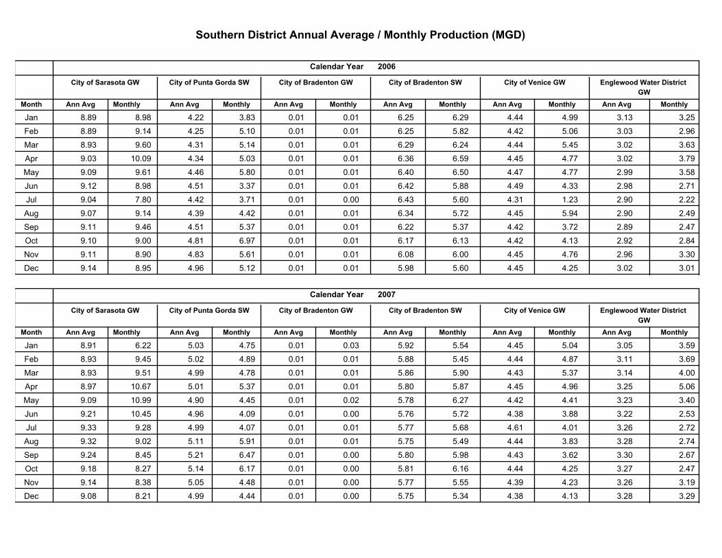
Southern District Annual Average / Monthly Production (MGD)
MonthlyAnn Avg
Englewood Water District
GW
2006
MonthlyAnn Avg
City of Venice GW
MonthlyAnn Avg
City of Bradenton SW
MonthlyAnn AvgMonthlyAnn Avg
City of Bradenton GW
Calendar Year
Month
City of Sarasota GW City of Punta Gorda SW
Ann Avg Monthly
Jan 8.89 8.98 3.13 3.25 4.22 3.83 0.01 0.01 6.25 6.29 4.44 4.99
Feb 8.89 9.14 3.03 2.96 4.25 5.10 0.01 0.01 6.25 5.82 4.42 5.06
Mar 8.93 9.60 3.02 3.63 4.31 5.14 0.01 0.01 6.29 6.24 4.44 5.45
Apr 9.03 10.09 3.02 3.79 4.34 5.03 0.01 0.01 6.36 6.59 4.45 4.77
May 9.09 9.61 2.99 3.58 4.46 5.80 0.01 0.01 6.40 6.50 4.47 4.77
Jun 9.12 8.98 2.98 2.71 4.51 3.37 0.01 0.01 6.42 5.88 4.49 4.33
Jul 9.04 7.80 2.90 2.22 4.42 3.71 0.01 0.00 6.43 5.60 4.31 1.23
Aug 9.07 9.14 2.90 2.49 4.39 4.42 0.01 0.01 6.34 5.72 4.45 5.94
Sep 9.11 9.46 2.89 2.47 4.51 5.37 0.01 0.01 6.22 5.37 4.42 3.72
Oct 9.10 9.00 2.92 2.84 4.81 6.97 0.01 0.01 6.17 6.13 4.42 4.13
Nov 9.11 8.90 2.96 3.30 4.83 5.61 0.01 0.01 6.08 6.00 4.45 4.76
Dec 9.14 8.95 3.02 3.01 4.96 5.12 0.01 0.01 5.98 5.60 4.45 4.25
MonthlyAnn Avg
Englewood Water District
GW
2007
MonthlyAnn Avg
City of Venice GW
MonthlyAnn Avg
City of Bradenton SW
MonthlyAnn AvgMonthlyAnn Avg
City of Bradenton GW
Calendar Year
Month
City of Sarasota GW City of Punta Gorda SW
Ann Avg Monthly
Jan 8.91 6.22 3.05 3.59 5.03 4.75 0.01 0.03 5.92 5.54 4.45 5.04
Feb 8.93 9.45 3.11 3.69 5.02 4.89 0.01 0.01 5.88 5.45 4.44 4.87
Mar 8.93 9.51 3.14 4.00 4.99 4.78 0.01 0.01 5.86 5.90 4.43 5.37
Apr 8.97 10.67 3.25 5.06 5.01 5.37 0.01 0.01 5.80 5.87 4.45 4.96
May 9.09 10.99 3.23 3.40 4.90 4.45 0.01 0.02 5.78 6.27 4.42 4.41
Jun 9.21 10.45 3.22 2.53 4.96 4.09 0.01 0.00 5.76 5.72 4.38 3.88
Jul 9.33 9.28 3.26 2.72 4.99 4.07 0.01 0.01 5.77 5.68 4.61 4.01
Aug 9.32 9.02 3.28 2.74 5.11 5.91 0.01 0.01 5.75 5.49 4.44 3.83
Sep 9.24 8.45 3.30 2.67 5.21 6.47 0.01 0.00 5.80 5.98 4.43 3.62
Oct 9.18 8.27 3.27 2.47 5.14 6.17 0.01 0.00 5.81 6.16 4.44 4.25
Nov 9.14 8.38 3.26 3.19 5.05 4.48 0.01 0.00 5.77 5.55 4.39 4.23
Dec 9.08 8.21 3.28 3.29 4.99 4.44 0.01 0.00 5.75 5.34 4.38 4.13
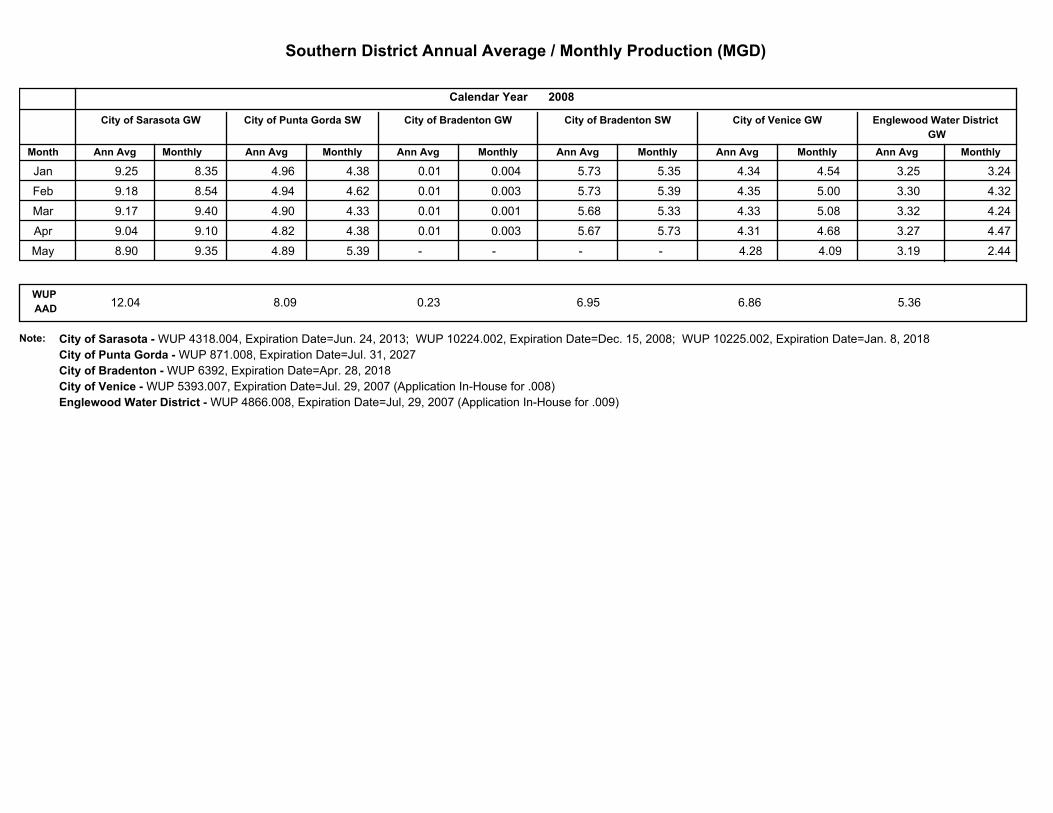
Southern District Annual Average / Monthly Production (MGD)
MonthlyAnn Avg
Englewood Water District
GW
2008
MonthlyAnn Avg
City of Venice GW
MonthlyAnn Avg
City of Bradenton SW
MonthlyAnn AvgMonthlyAnn Avg
City of Bradenton GW
Calendar Year
Month
City of Sarasota GW City of Punta Gorda SW
Ann Avg Monthly
Jan 9.25 8.35 3.25 3.24 4.96 4.38 0.01 0.004 5.73 5.35 4.34 4.54
Feb 9.18 8.54 3.30 4.32 4.94 4.62 0.01 0.003 5.73 5.39 4.35 5.00
Mar 9.17 9.40 3.32 4.24 4.90 4.33 0.01 0.001 5.68 5.33 4.33 5.08
Apr 9.04 9.10 3.27 4.47 4.82 4.38 0.01 0.003 5.67 5.73 4.31 4.68
May 8.90 9.35 3.19 2.44 4.89 5.39 - - - - 4.28 4.09
WUP
AAD6.860.2312.04 8.09 5.366.95
Note: City of Sarasota - WUP 4318.004, Expiration Date=Jun. 24, 2013; WUP 10224.002, Expiration Date=Dec. 15, 2008; WUP 10225.002, Expiration Date=Jan. 8, 2018
City of Punta Gorda - WUP 871.008, Expiration Date=Jul. 31, 2027
City of Bradenton - WUP 6392, Expiration Date=Apr. 28, 2018
City of Venice - WUP 5393.007, Expiration Date=Jul. 29, 2007 (Application In-House for .008)
Englewood Water District - WUP 4866.008, Expiration Date=Jul, 29, 2007 (Application In-House for .009)
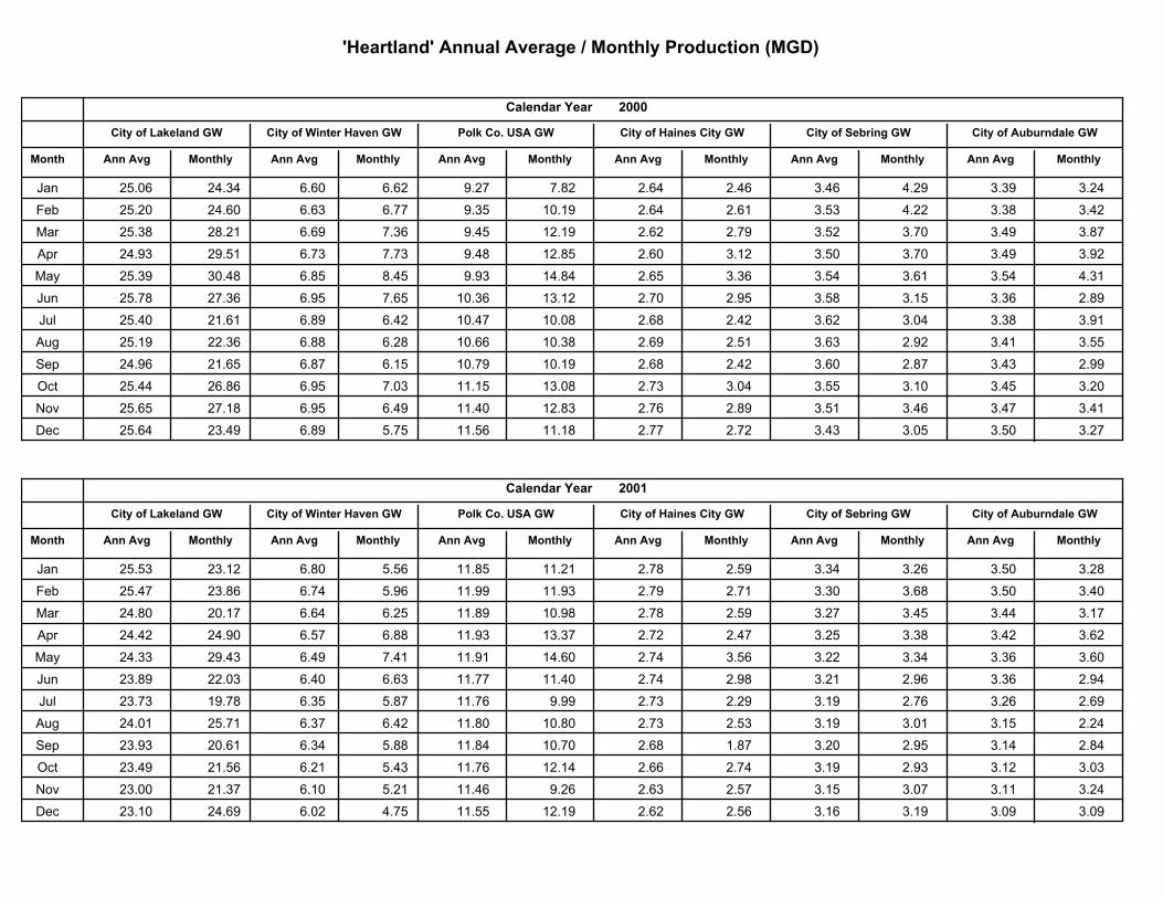
'Heartland' Annual Average / Monthly Production (MGD)
MonthlyMonthly Ann AvgAnn Avg
City of Auburndale GWCity of Sebring GW
2000
MonthlyAnn Avg
City of Haines City GW
MonthlyAnn AvgMonthlyAnn Avg
Polk Co. USA GW
Calendar Year
Month
City of Lakeland GW City of Winter Haven GW
Ann Avg Monthly
Jan 25.06 24.34 6.60 6.62 9.27 7.82 2.64 2.46 3.46 4.29 3.39 3.24
Feb 25.20 24.60 6.63 6.77 9.35 10.19 2.64 2.61 3.53 4.22 3.38 3.42
Mar 25.38 28.21 6.69 7.36 9.45 12.19 2.62 2.79 3.52 3.70 3.49 3.87
Apr 24.93 29.51 6.73 7.73 9.48 12.85 2.60 3.12 3.50 3.70 3.49 3.92
May 25.39 30.48 6.85 8.45 9.93 14.84 2.65 3.36 3.54 3.61 3.54 4.31
Jun 25.78 27.36 6.95 7.65 10.36 13.12 2.70 2.95 3.58 3.15 3.36 2.89
Jul 25.40 21.61 6.89 6.42 10.47 10.08 2.68 2.42 3.62 3.04 3.38 3.91
Aug 25.19 22.36 6.88 6.28 10.66 10.38 2.69 2.51 3.63 2.92 3.41 3.55
Sep 24.96 21.65 6.87 6.15 10.79 10.19 2.68 2.42 3.60 2.87 3.43 2.99
Oct 25.44 26.86 6.95 7.03 11.15 13.08 2.73 3.04 3.55 3.10 3.45 3.20
Nov 25.65 27.18 6.95 6.49 11.40 12.83 2.76 2.89 3.51 3.46 3.47 3.41
Dec 25.64 23.49 6.89 5.75 11.56 11.18 2.77 2.72 3.43 3.05 3.50 3.27
MonthlyMonthly Ann AvgAnn Avg
City of Auburndale GWCity of Sebring GW
2001
MonthlyAnn Avg
City of Haines City GW
MonthlyAnn AvgMonthlyAnn Avg
Polk Co. USA GW
Calendar Year
Month
City of Lakeland GW City of Winter Haven GW
Ann Avg Monthly
Jan 25.53 23.12 6.80 5.56 11.85 11.21 2.78 2.59 3.34 3.26 3.50 3.28
Feb 25.47 23.86 6.74 5.96 11.99 11.93 2.79 2.71 3.30 3.68 3.50 3.40
Mar 24.80 20.17 6.64 6.25 11.89 10.98 2.78 2.59 3.27 3.45 3.44 3.17
Apr 24.42 24.90 6.57 6.88 11.93 13.37 2.72 2.47 3.25 3.38 3.42 3.62
May 24.33 29.43 6.49 7.41 11.91 14.60 2.74 3.56 3.22 3.34 3.36 3.60
Jun 23.89 22.03 6.40 6.63 11.77 11.40 2.74 2.98 3.21 2.96 3.36 2.94
Jul 23.73 19.78 6.35 5.87 11.76 9.99 2.73 2.29 3.19 2.76 3.26 2.69
Aug 24.01 25.71 6.37 6.42 11.80 10.80 2.73 2.53 3.19 3.01 3.15 2.24
Sep 23.93 20.61 6.34 5.88 11.84 10.70 2.68 1.87 3.20 2.95 3.14 2.84
Oct 23.49 21.56 6.21 5.43 11.76 12.14 2.66 2.74 3.19 2.93 3.12 3.03
Nov 23.00 21.37 6.10 5.21 11.46 9.26 2.63 2.57 3.15 3.07 3.11 3.24
Dec 23.10 24.69 6.02 4.75 11.55 12.19 2.62 2.56 3.16 3.19 3.09 3.09
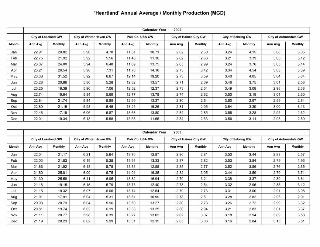
'Heartland' Annual Average / Monthly Production (MGD)
MonthlyMonthly Ann AvgAnn Avg
City of Auburndale GWCity of Sebring GW
2002
MonthlyAnn Avg
City of Haines City GW
MonthlyAnn AvgMonthlyAnn Avg
Polk Co. USA GW
Calendar Year
Month
City of Lakeland GW City of Winter Haven GW
Ann Avg Monthly
Jan 22.91 20.82 5.96 4.78 11.51 10.71 2.62 2.60 3.24 4.15 3.08 3.06
Feb 22.75 21.92 5.92 5.56 11.46 11.36 2.62 2.68 3.21 3.39 3.05 3.12
Mar 23.07 24.00 5.94 6.48 11.69 13.75 2.65 2.99 3.24 3.76 3.05 3.14
Apr 23.21 26.54 5.98 7.31 11.76 14.16 2.73 3.42 3.34 4.54 3.03 3.39
May 23.38 31.52 5.92 6.67 12.14 19.20 2.73 3.59 3.40 4.05 3.04 3.64
Jun 23.28 20.86 5.80 5.28 12.32 13.57 2.71 2.69 3.46 3.75 3.01 2.58
Jul 23.25 19.39 5.90 7.06 12.52 12.37 2.73 2.54 3.49 3.08 2.98 2.38
Aug 22.74 19.64 5.84 5.69 12.77 13.78 2.74 2.62 3.50 3.19 3.01 2.60
Sep 22.84 21.74 5.84 5.88 12.99 13.37 2.80 2.54 3.50 2.97 2.99 2.64
Oct 22.80 21.15 5.93 6.45 13.25 15.26 2.81 2.95 3.54 3.39 3.00 3.13
Nov 22.46 17.19 6.06 6.87 13.63 13.80 2.84 2.85 3.56 3.28 2.95 2.62
Dec 22.01 19.34 6.13 5.58 13.58 11.65 2.84 2.63 3.56 3.11 2.93 2.80
MonthlyMonthly Ann AvgAnn Avg
City of Auburndale GWCity of Sebring GW
2003
MonthlyAnn Avg
City of Haines City GW
MonthlyAnn AvgMonthlyAnn Avg
Polk Co. USA GW
Calendar Year
Month
City of Lakeland GW City of Winter Haven GW
Ann Avg Monthly
Jan 22.04 21.17 6.21 5.64 13.76 12.87 2.86 2.81 3.50 3.44 2.88 2.57
Feb 22.03 21.83 6.19 5.38 13.93 13.33 2.87 2.82 3.53 3.84 2.79 1.96
Mar 21.86 21.92 6.13 5.78 13.83 12.58 2.85 2.77 3.52 3.56 2.76 2.85
Apr 21.80 25.81 6.09 6.75 14.01 16.35 2.82 3.05 3.44 3.59 2.79 3.71
May 21.30 25.58 6.11 6.95 13.82 16.94 2.79 3.21 3.38 3.37 2.80 3.81
Jun 21.16 19.15 6.15 5.79 13.73 12.40 2.78 2.54 3.32 2.96 2.85 3.12
Jul 21.15 19.32 6.07 6.06 13.74 12.54 2.79 2.73 3.31 3.00 2.91 3.08
Aug 21.01 17.91 6.04 5.31 13.51 10.99 2.78 2.51 3.28 2.82 2.93 2.91
Sep 20.93 20.79 6.04 5.96 13.50 13.27 2.80 2.73 3.26 2.72 2.99 3.32
Oct 20.81 19.74 6.02 6.19 13.33 13.25 2.80 2.94 3.21 2.83 3.01 3.37
Nov 21.11 20.77 5.98 6.39 13.27 13.02 2.82 3.07 3.18 2.94 3.09 3.58
Dec 21.19 20.23 6.02 5.99 13.31 12.15 2.85 3.06 3.16 2.84 3.15 3.51
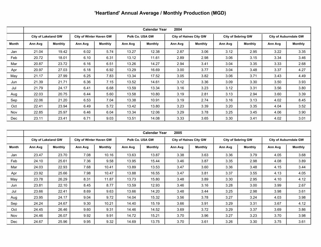
'Heartland' Annual Average / Monthly Production (MGD)
MonthlyMonthly Ann AvgAnn Avg
City of Auburndale GWCity of Sebring GW
2004
MonthlyAnn Avg
City of Haines City GW
MonthlyAnn AvgMonthlyAnn Avg
Polk Co. USA GW
Calendar Year
Month
City of Lakeland GW City of Winter Haven GW
Ann Avg Monthly
Jan 21.04 19.42 6.02 5.74 13.27 12.38 2.87 3.06 3.12 2.95 3.22 3.35
Feb 20.72 18.01 6.10 6.31 13.12 11.61 2.89 2.98 3.06 3.15 3.34 3.46
Mar 20.87 23.72 6.16 6.51 13.26 14.27 2.94 3.41 3.04 3.35 3.33 2.68
Apr 20.97 27.03 6.18 6.92 13.29 16.69 3.00 3.77 3.04 3.48 3.37 4.27
May 21.17 27.99 6.25 7.83 13.34 17.52 3.05 3.82 3.06 3.71 3.43 4.49
Jun 21.39 21.71 6.36 7.15 13.52 14.61 3.12 3.36 3.09 3.30 3.50 3.93
Jul 21.79 24.17 6.41 6.68 13.59 13.34 3.16 3.23 3.12 3.31 3.56 3.80
Aug 22.03 20.75 6.44 5.60 13.58 10.80 3.19 2.81 3.13 2.94 3.60 3.39
Sep 22.06 21.20 6.53 7.04 13.38 10.91 3.19 2.74 3.16 3.13 4.02 8.45
Oct 22.41 23.94 6.49 5.72 13.42 13.80 3.23 3.39 3.20 3.35 4.04 3.52
Nov 22.85 25.97 6.46 6.04 13.34 12.06 3.29 3.78 3.25 3.45 4.06 3.90
Dec 23.11 23.41 6.71 9.03 13.51 14.08 3.33 3.65 3.30 3.41 4.02 3.01
MonthlyMonthly Ann AvgAnn Avg
City of Auburndale GWCity of Sebring GW
2005
MonthlyAnn Avg
City of Haines City GW
MonthlyAnn AvgMonthlyAnn Avg
Polk Co. USA GW
Calendar Year
Month
City of Lakeland GW City of Winter Haven GW
Ann Avg Monthly
Jan 23.47 23.70 7.08 10.16 13.63 13.87 3.38 3.63 3.36 3.79 4.05 3.68
Feb 24.10 25.61 7.36 9.58 13.95 15.44 3.46 3.87 3.35 2.98 4.08 3.89
Mar 24.03 22.93 7.68 10.41 13.89 13.53 3.47 3.60 3.36 3.48 4.15 3.44
Apr 23.92 25.66 7.98 10.47 13.88 16.55 3.47 3.81 3.37 3.55 4.13 4.05
May 23.78 26.29 8.31 11.87 13.73 15.80 3.48 3.89 3.30 2.95 4.10 4.12
Jun 23.81 22.10 8.45 8.77 13.59 12.93 3.46 3.16 3.28 3.00 3.99 2.67
Jul 23.66 22.41 8.69 9.63 13.66 14.20 3.48 3.44 3.25 2.98 3.98 3.61
Aug 23.95 24.17 9.04 9.72 14.04 15.32 3.56 3.78 3.27 3.24 4.03 3.98
Sep 24.24 24.67 9.30 10.21 14.40 15.19 3.66 3.91 3.29 3.31 3.67 4.12
Oct 24.45 26.46 9.60 9.31 14.46 14.52 3.69 3.72 3.29 3.37 3.69 3.86
Nov 24.46 26.07 9.92 9.91 14.72 15.21 3.70 3.96 3.27 3.23 3.70 3.98
Dec 24.67 25.96 9.95 9.32 14.69 13.75 3.70 3.61 3.26 3.30 3.75 3.61
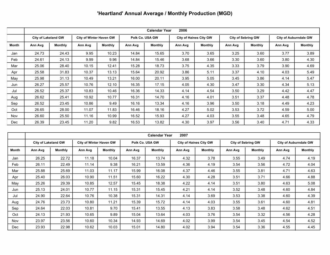
'Heartland' Annual Average / Monthly Production (MGD)
MonthlyMonthly Ann AvgAnn Avg
City of Auburndale GWCity of Sebring GW
2006
MonthlyAnn Avg
City of Haines City GW
MonthlyAnn AvgMonthlyAnn Avg
Polk Co. USA GW
Calendar Year
Month
City of Lakeland GW City of Winter Haven GW
Ann Avg Monthly
Jan 24.73 24.43 9.95 10.23 14.84 15.65 3.70 3.65 3.25 3.60 3.77 3.89
Feb 24.61 24.13 9.99 9.96 14.84 15.46 3.68 3.66 3.30 3.60 3.80 4.30
Mar 25.06 28.40 10.15 12.41 15.28 18.73 3.75 4.35 3.33 3.79 3.90 4.69
Apr 25.58 31.83 10.37 13.13 15.64 20.92 3.86 5.11 3.37 4.10 4.03 5.49
May 25.98 31.13 10.49 13.21 16.00 20.11 3.95 5.05 3.45 3.86 4.14 5.47
Jun 26.27 25.57 10.76 12.10 16.35 17.15 4.05 4.30 3.47 3.30 4.34 5.13
Jul 26.52 25.37 10.83 10.46 16.36 14.33 4.14 4.54 3.50 3.29 4.42 4.47
Aug 26.62 25.41 10.92 10.77 16.31 14.70 4.16 4.01 3.51 3.37 4.48 4.78
Sep 26.52 23.45 10.86 9.49 16.16 13.34 4.16 3.96 3.50 3.18 4.49 4.23
Oct 26.65 28.00 11.07 11.83 16.46 18.16 4.27 5.02 3.53 3.72 4.59 5.00
Nov 26.60 25.50 11.16 10.99 16.52 15.93 4.27 4.03 3.55 3.48 4.65 4.79
Dec 26.39 23.45 11.20 9.82 16.53 13.82 4.30 3.97 3.56 3.40 4.71 4.33
MonthlyMonthly Ann AvgAnn Avg
City of Auburndale GWCity of Sebring GW
2007
MonthlyAnn Avg
City of Haines City GW
MonthlyAnn AvgMonthlyAnn Avg
Polk Co. USA GW
Calendar Year
Month
City of Lakeland GW City of Winter Haven GW
Ann Avg Monthly
Jan 26.25 22.72 11.18 10.04 16.37 13.74 4.32 3.78 3.55 3.49 4.74 4.19
Feb 26.11 22.49 11.14 9.38 16.21 13.59 4.36 4.19 3.54 3.56 4.72 4.04
Mar 25.88 25.69 11.03 11.17 15.99 16.08 4.37 4.46 3.55 3.81 4.71 4.63
Apr 25.40 26.03 10.90 11.51 15.60 16.22 4.30 4.28 3.51 3.71 4.66 4.88
May 25.26 29.39 10.85 12.57 15.45 18.38 4.22 4.14 3.51 3.80 4.63 5.08
Jun 25.13 24.01 10.77 11.15 15.31 15.45 4.21 4.14 3.52 3.48 4.60 4.84
Jul 24.90 22.64 10.76 10.38 15.31 14.31 4.14 3.69 3.53 3.38 4.60 4.39
Aug 24.76 23.73 10.80 11.21 15.39 15.72 4.14 4.03 3.55 3.61 4.60 4.81
Sep 24.64 22.03 10.81 9.70 15.41 13.55 4.13 3.83 3.58 3.48 4.62 4.51
Oct 24.13 21.93 10.65 9.89 15.04 13.64 4.03 3.76 3.54 3.32 4.56 4.28
Nov 23.97 23.56 10.60 10.34 14.93 14.69 4.02 3.99 3.54 3.45 4.54 4.52
Dec 23.93 22.98 10.62 10.03 15.01 14.80 4.02 3.94 3.54 3.36 4.55 4.45
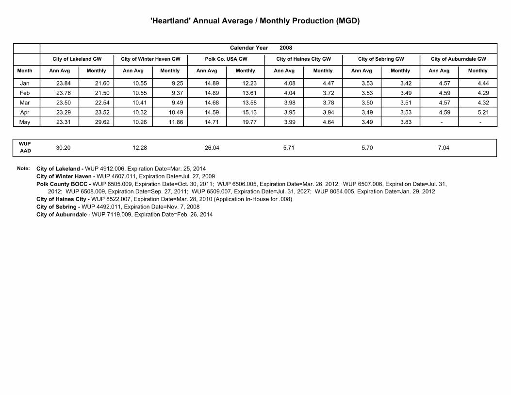
'Heartland' Annual Average / Monthly Production (MGD)
MonthlyMonthly Ann AvgAnn Avg
City of Auburndale GWCity of Sebring GW
2008
MonthlyAnn Avg
City of Haines City GW
MonthlyAnn AvgMonthlyAnn Avg
Polk Co. USA GW
Calendar Year
Month
City of Lakeland GW City of Winter Haven GW
Ann Avg Monthly
Jan 23.84 21.60 10.55 9.25 14.89 12.23 4.08 4.47 3.53 3.42 4.57 4.44
Feb 23.76 21.50 10.55 9.37 14.89 13.61 4.04 3.72 3.53 3.49 4.59 4.29
Mar 23.50 22.54 10.41 9.49 14.68 13.58 3.98 3.78 3.50 3.51 4.57 4.32
Apr 23.29 23.52 10.32 10.49 14.59 15.13 3.95 3.94 3.49 3.53 4.59 5.21
May 23.31 29.62 10.26 11.86 14.71 19.77 3.99 4.64 3.49 3.83 - -
WUP
AAD30.20 12.28 26.04 5.71 5.70 7.04
Note: City of Lakeland - WUP 4912.006, Expiration Date=Mar. 25, 2014
City of Winter Haven - WUP 4607.011, Expiration Date=Jul. 27, 2009
Polk County BOCC - WUP 6505.009, Expiration Date=Oct. 30, 2011; WUP 6506.005, Expiration Date=Mar. 26, 2012; WUP 6507.006, Expiration Date=Jul. 31,
2012; WUP 6508.009, Expiration Date=Sep. 27, 2011; WUP 6509.007, Expiration Date=Jul. 31, 2027; WUP 8054.005, Expiration Date=Jan. 29, 2012
City of Haines City - WUP 8522.007, Expiration Date=Mar. 28, 2010 (Application In-House for .008)
City of Sebring - WUP 4492.011, Expiration Date=Nov. 7, 2008
City of Auburndale - WUP 7119.009, Expiration Date=Feb. 26, 2014
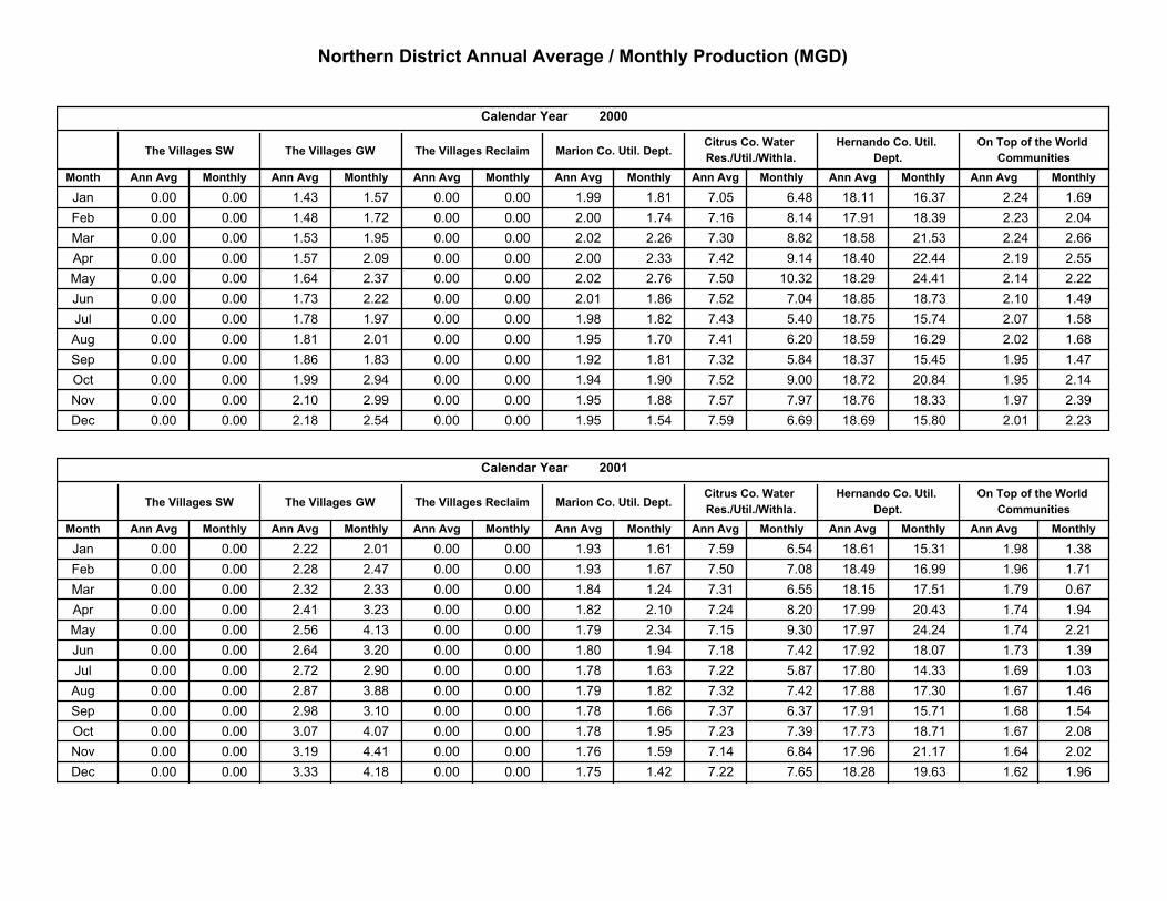
Northern District Annual Average / Monthly Production (MGD)
Ann Avg Monthly
On Top of the World
Communities
2000
MonthlyMonthlyMonthly Ann AvgAnn AvgAnn Avg
Hernando Co. Util.
Dept.
Citrus Co. Water
Res./Util./Withla.Marion Co. Util. Dept.
MonthlyAnn Avg
The Villages Reclaim
Calendar Year
Month
The Villages SW The Villages GW
Ann Avg Monthly MonthlyAnn Avg
Jan 0.00 0.00 1.43 1.57 0.00 0.00 1.99 1.81 7.05 6.48 18.11 16.37 2.24 1.69
Feb 0.00 0.00 1.48 1.72 0.00 0.00 2.00 1.74 7.16 8.14 17.91 18.39 2.23 2.04
Mar 0.00 0.00 1.53 1.95 0.00 0.00 2.02 2.26 7.30 8.82 18.58 21.53 2.24 2.66
Apr 0.00 0.00 1.57 2.09 0.00 0.00 2.00 2.33 7.42 9.14 18.40 22.44 2.19 2.55
May 0.00 0.00 1.64 2.37 0.00 0.00 2.02 2.76 7.50 10.32 18.29 24.41 2.14 2.22
Jun 0.00 0.00 1.73 2.22 0.00 0.00 2.01 1.86 7.52 7.04 18.85 18.73 2.10 1.49
Jul 0.00 0.00 1.78 1.97 0.00 0.00 1.98 1.82 7.43 5.40 18.75 15.74 2.07 1.58
Aug 0.00 0.00 1.81 2.01 0.00 0.00 1.95 1.70 7.41 6.20 18.59 16.29 2.02 1.68
Sep 0.00 0.00 1.86 1.83 0.00 0.00 1.92 1.81 7.32 5.84 18.37 15.45 1.95 1.47
Oct 0.00 0.00 1.99 2.94 0.00 0.00 1.94 1.90 7.52 9.00 18.72 20.84 1.95 2.14
Nov 0.00 0.00 2.10 2.99 0.00 0.00 1.95 1.88 7.57 7.97 18.76 18.33 1.97 2.39
Dec 0.00 0.00 2.18 2.54 0.00 0.00 1.95 1.54 7.59 6.69 18.69 15.80 2.01 2.23
Ann Avg Monthly
On Top of the World
Communities
2001
MonthlyMonthlyMonthly Ann AvgAnn AvgAnn Avg
Hernando Co. Util.
Dept.
Citrus Co. Water
Res./Util./Withla.Marion Co. Util. Dept.
MonthlyAnn Avg
The Villages Reclaim
Calendar Year
Month
The Villages SW The Villages GW
Ann Avg Monthly MonthlyAnn Avg
Jan 0.00 0.00 2.22 2.01 0.00 0.00 1.93 1.61 7.59 6.54 18.61 15.31 1.98 1.38
Feb 0.00 0.00 2.28 2.47 0.00 0.00 1.93 1.67 7.50 7.08 18.49 16.99 1.96 1.71
Mar 0.00 0.00 2.32 2.33 0.00 0.00 1.84 1.24 7.31 6.55 18.15 17.51 1.79 0.67
Apr 0.00 0.00 2.41 3.23 0.00 0.00 1.82 2.10 7.24 8.20 17.99 20.43 1.74 1.94
May 0.00 0.00 2.56 4.13 0.00 0.00 1.79 2.34 7.15 9.30 17.97 24.24 1.74 2.21
Jun 0.00 0.00 2.64 3.20 0.00 0.00 1.80 1.94 7.18 7.42 17.92 18.07 1.73 1.39
Jul 0.00 0.00 2.72 2.90 0.00 0.00 1.78 1.63 7.22 5.87 17.80 14.33 1.69 1.03
Aug 0.00 0.00 2.87 3.88 0.00 0.00 1.79 1.82 7.32 7.42 17.88 17.30 1.67 1.46
Sep 0.00 0.00 2.98 3.10 0.00 0.00 1.78 1.66 7.37 6.37 17.91 15.71 1.68 1.54
Oct 0.00 0.00 3.07 4.07 0.00 0.00 1.78 1.95 7.23 7.39 17.73 18.71 1.67 2.08
Nov 0.00 0.00 3.19 4.41 0.00 0.00 1.76 1.59 7.14 6.84 17.96 21.17 1.64 2.02
Dec 0.00 0.00 3.33 4.18 0.00 0.00 1.75 1.42 7.22 7.65 18.28 19.63 1.62 1.96
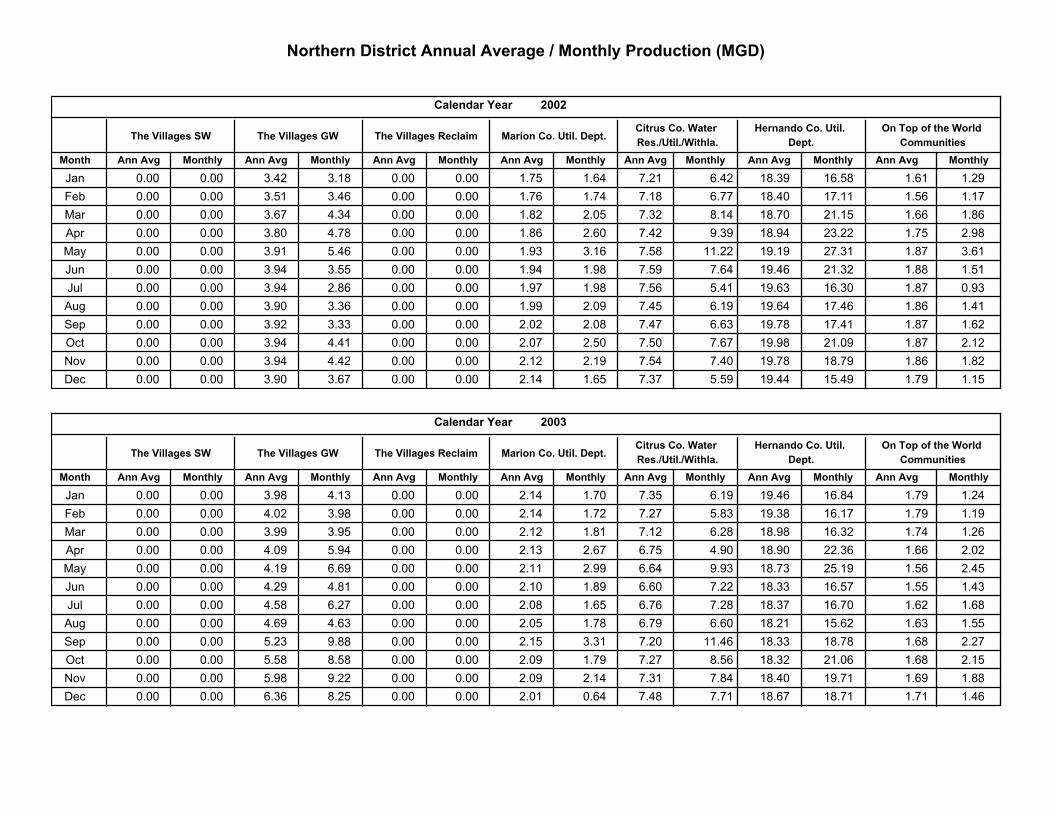
Northern District Annual Average / Monthly Production (MGD)
Ann Avg Monthly
On Top of the World
Communities
2002
MonthlyMonthlyMonthly Ann AvgAnn AvgAnn Avg
Hernando Co. Util.
Dept.
Citrus Co. Water
Res./Util./Withla.Marion Co. Util. Dept.
MonthlyAnn Avg
The Villages Reclaim
Calendar Year
Month
The Villages SW The Villages GW
Ann Avg Monthly MonthlyAnn Avg
Jan 0.00 0.00 3.42 3.18 0.00 0.00 1.75 1.64 7.21 6.42 18.39 16.58 1.61 1.29
Feb 0.00 0.00 3.51 3.46 0.00 0.00 1.76 1.74 7.18 6.77 18.40 17.11 1.56 1.17
Mar 0.00 0.00 3.67 4.34 0.00 0.00 1.82 2.05 7.32 8.14 18.70 21.15 1.66 1.86
Apr 0.00 0.00 3.80 4.78 0.00 0.00 1.86 2.60 7.42 9.39 18.94 23.22 1.75 2.98
May 0.00 0.00 3.91 5.46 0.00 0.00 1.93 3.16 7.58 11.22 19.19 27.31 1.87 3.61
Jun 0.00 0.00 3.94 3.55 0.00 0.00 1.94 1.98 7.59 7.64 19.46 21.32 1.88 1.51
Jul 0.00 0.00 3.94 2.86 0.00 0.00 1.97 1.98 7.56 5.41 19.63 16.30 1.87 0.93
Aug 0.00 0.00 3.90 3.36 0.00 0.00 1.99 2.09 7.45 6.19 19.64 17.46 1.86 1.41
Sep 0.00 0.00 3.92 3.33 0.00 0.00 2.02 2.08 7.47 6.63 19.78 17.41 1.87 1.62
Oct 0.00 0.00 3.94 4.41 0.00 0.00 2.07 2.50 7.50 7.67 19.98 21.09 1.87 2.12
Nov 0.00 0.00 3.94 4.42 0.00 0.00 2.12 2.19 7.54 7.40 19.78 18.79 1.86 1.82
Dec 0.00 0.00 3.90 3.67 0.00 0.00 2.14 1.65 7.37 5.59 19.44 15.49 1.79 1.15
Ann Avg Monthly
On Top of the World
Communities
2003
MonthlyMonthlyMonthly Ann AvgAnn AvgAnn Avg
Hernando Co. Util.
Dept.
Citrus Co. Water
Res./Util./Withla.Marion Co. Util. Dept.
MonthlyAnn Avg
The Villages Reclaim
Calendar Year
Month
The Villages SW The Villages GW
Ann Avg Monthly MonthlyAnn Avg
Jan 0.00 0.00 3.98 4.13 0.00 0.00 2.14 1.70 7.35 6.19 19.46 16.84 1.79 1.24
Feb 0.00 0.00 4.02 3.98 0.00 0.00 2.14 1.72 7.27 5.83 19.38 16.17 1.79 1.19
Mar 0.00 0.00 3.99 3.95 0.00 0.00 2.12 1.81 7.12 6.28 18.98 16.32 1.74 1.26
Apr 0.00 0.00 4.09 5.94 0.00 0.00 2.13 2.67 6.75 4.90 18.90 22.36 1.66 2.02
May 0.00 0.00 4.19 6.69 0.00 0.00 2.11 2.99 6.64 9.93 18.73 25.19 1.56 2.45
Jun 0.00 0.00 4.29 4.81 0.00 0.00 2.10 1.89 6.60 7.22 18.33 16.57 1.55 1.43
Jul 0.00 0.00 4.58 6.27 0.00 0.00 2.08 1.65 6.76 7.28 18.37 16.70 1.62 1.68
Aug 0.00 0.00 4.69 4.63 0.00 0.00 2.05 1.78 6.79 6.60 18.21 15.62 1.63 1.55
Sep 0.00 0.00 5.23 9.88 0.00 0.00 2.15 3.31 7.20 11.46 18.33 18.78 1.68 2.27
Oct 0.00 0.00 5.58 8.58 0.00 0.00 2.09 1.79 7.27 8.56 18.32 21.06 1.68 2.15
Nov 0.00 0.00 5.98 9.22 0.00 0.00 2.09 2.14 7.31 7.84 18.40 19.71 1.69 1.88
Dec 0.00 0.00 6.36 8.25 0.00 0.00 2.01 0.64 7.48 7.71 18.67 18.71 1.71 1.46
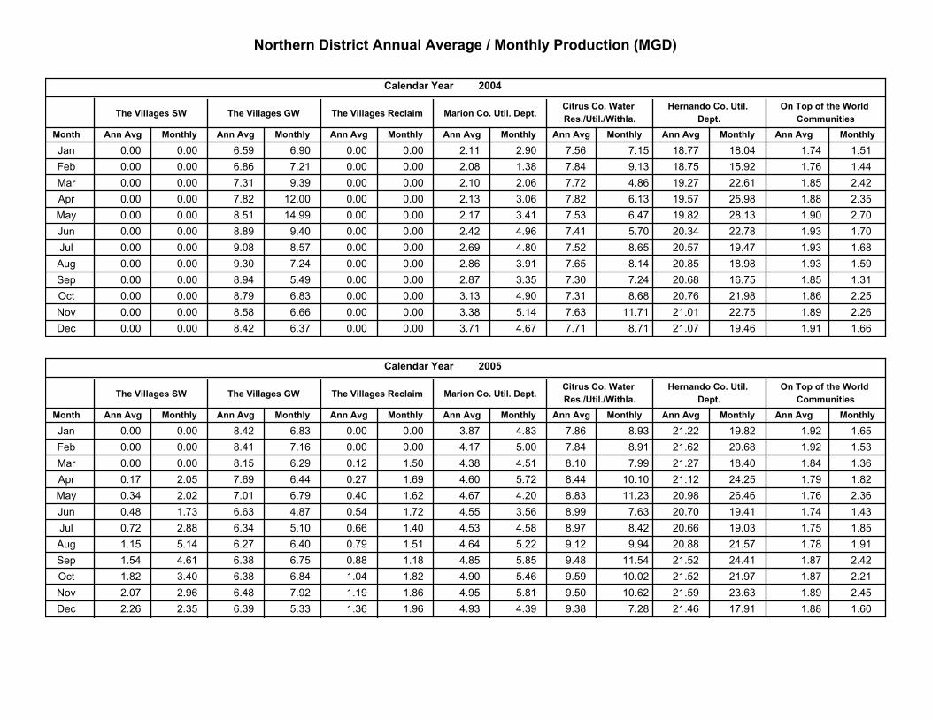
Northern District Annual Average / Monthly Production (MGD)
Ann Avg Monthly
On Top of the World
Communities
2004
MonthlyMonthlyMonthly Ann AvgAnn AvgAnn Avg
Hernando Co. Util.
Dept.
Citrus Co. Water
Res./Util./Withla.Marion Co. Util. Dept.
MonthlyAnn Avg
The Villages Reclaim
Calendar Year
Month
The Villages SW The Villages GW
Ann Avg Monthly MonthlyAnn Avg
Jan 0.00 0.00 6.59 6.90 0.00 0.00 2.11 2.90 7.56 7.15 18.77 18.04 1.74 1.51
Feb 0.00 0.00 6.86 7.21 0.00 0.00 2.08 1.38 7.84 9.13 18.75 15.92 1.76 1.44
Mar 0.00 0.00 7.31 9.39 0.00 0.00 2.10 2.06 7.72 4.86 19.27 22.61 1.85 2.42
Apr 0.00 0.00 7.82 12.00 0.00 0.00 2.13 3.06 7.82 6.13 19.57 25.98 1.88 2.35
May 0.00 0.00 8.51 14.99 0.00 0.00 2.17 3.41 7.53 6.47 19.82 28.13 1.90 2.70
Jun 0.00 0.00 8.89 9.40 0.00 0.00 2.42 4.96 7.41 5.70 20.34 22.78 1.93 1.70
Jul 0.00 0.00 9.08 8.57 0.00 0.00 2.69 4.80 7.52 8.65 20.57 19.47 1.93 1.68
Aug 0.00 0.00 9.30 7.24 0.00 0.00 2.86 3.91 7.65 8.14 20.85 18.98 1.93 1.59
Sep 0.00 0.00 8.94 5.49 0.00 0.00 2.87 3.35 7.30 7.24 20.68 16.75 1.85 1.31
Oct 0.00 0.00 8.79 6.83 0.00 0.00 3.13 4.90 7.31 8.68 20.76 21.98 1.86 2.25
Nov 0.00 0.00 8.58 6.66 0.00 0.00 3.38 5.14 7.63 11.71 21.01 22.75 1.89 2.26
Dec 0.00 0.00 8.42 6.37 0.00 0.00 3.71 4.67 7.71 8.71 21.07 19.46 1.91 1.66
Ann Avg Monthly
On Top of the World
Communities
2005
MonthlyMonthlyMonthly Ann AvgAnn AvgAnn Avg
Hernando Co. Util.
Dept.
Citrus Co. Water
Res./Util./Withla.Marion Co. Util. Dept.
MonthlyAnn Avg
The Villages Reclaim
Calendar Year
Month
The Villages SW The Villages GW
Ann Avg Monthly MonthlyAnn Avg
Jan 0.00 0.00 8.42 6.83 0.00 0.00 3.87 4.83 7.86 8.93 21.22 19.82 1.92 1.65
Feb 0.00 0.00 8.41 7.16 0.00 0.00 4.17 5.00 7.84 8.91 21.62 20.68 1.92 1.53
Mar 0.00 0.00 8.15 6.29 0.12 1.50 4.38 4.51 8.10 7.99 21.27 18.40 1.84 1.36
Apr 0.17 2.05 7.69 6.44 0.27 1.69 4.60 5.72 8.44 10.10 21.12 24.25 1.79 1.82
May 0.34 2.02 7.01 6.79 0.40 1.62 4.67 4.20 8.83 11.23 20.98 26.46 1.76 2.36
Jun 0.48 1.73 6.63 4.87 0.54 1.72 4.55 3.56 8.99 7.63 20.70 19.41 1.74 1.43
Jul 0.72 2.88 6.34 5.10 0.66 1.40 4.53 4.58 8.97 8.42 20.66 19.03 1.75 1.85
Aug 1.15 5.14 6.27 6.40 0.79 1.51 4.64 5.22 9.12 9.94 20.88 21.57 1.78 1.91
Sep 1.54 4.61 6.38 6.75 0.88 1.18 4.85 5.85 9.48 11.54 21.52 24.41 1.87 2.42
Oct 1.82 3.40 6.38 6.84 1.04 1.82 4.90 5.46 9.59 10.02 21.52 21.97 1.87 2.21
Nov 2.07 2.96 6.48 7.92 1.19 1.86 4.95 5.81 9.50 10.62 21.59 23.63 1.89 2.45
Dec 2.26 2.35 6.39 5.33 1.36 1.96 4.93 4.39 9.38 7.28 21.46 17.91 1.88 1.60
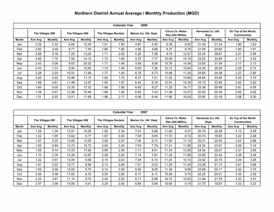
Northern District Annual Average / Monthly Production (MGD)
Ann Avg Monthly
On Top of the World
Communities
2006
MonthlyMonthlyMonthly Ann AvgAnn AvgAnn Avg
Hernando Co. Util.
Dept.
Citrus Co. Water
Res./Util./Withla.Marion Co. Util. Dept.
MonthlyAnn Avg
The Villages Reclaim
Calendar Year
Month
The Villages SW The Villages GW
Ann Avg Monthly MonthlyAnn Avg
Jan 2.29 0.32 6.68 10.30 1.51 1.90 4.97 5.40 9.38 8.92 21.59 21.34 1.90 1.83
Feb 2.50 2.49 6.71 7.45 1.66 1.80 4.96 4.86 9.37 8.76 21.58 20.60 1.90 1.61
Mar 2.68 2.16 7.29 13.25 1.71 2.03 5.20 7.36 9.75 12.57 22.45 28.81 2.01 2.59
Apr 2.60 1.10 7.92 14.12 1.72 1.85 5.37 7.77 10.09 14.19 23.22 33.49 2.11 3.02
May 2.43 0.06 9.03 20.02 1.71 1.48 5.69 8.06 10.35 14.36 23.65 31.59 2.17 3.13
Jun 2.43 1.74 9.94 15.85 1.72 1.94 6.00 7.26 10.72 12.04 24.20 26.05 2.28 2.73
Jul 2.38 2.23 10.51 11.94 1.77 1.93 6.18 6.73 10.96 11.24 24.64 24.38 2.37 2.90
Aug 2.20 2.92 10.96 11.75 1.80 1.75 6.37 7.51 11.02 10.66 24.84 23.94 2.52 3.70
Sep 1.88 0.81 11.48 12.97 1.85 1.87 6.45 6.76 10.91 10.29 24.72 22.89 2.62 3.62
Oct 1.60 0.00 12.35 17.32 1.86 1.90 6.68 8.27 11.25 14.11 25.36 29.68 2.81 4.56
Nov 1.39 0.47 12.98 15.49 1.86 1.92 6.82 7.43 11.39 12.27 25.50 25.30 2.94 4.02
Dec 1.21 0.22 13.51 11.68 1.88 2.17 6.99 6.44 11.65 10.43 25.85 22.16 3.08 3.30
Ann Avg Monthly
On Top of the World
Communities
2007
MonthlyMonthlyMonthly Ann AvgAnn AvgAnn Avg
Hernando Co. Util.
Dept.
Citrus Co. Water
Res./Util./Withla.Marion Co. Util. Dept.
MonthlyAnn Avg
The Villages Reclaim
Calendar Year
Month
The Villages SW The Villages GW
Ann Avg Monthly MonthlyAnn Avg
Jan 1.29 1.34 13.51 10.25 1.92 2.34 7.01 5.69 11.69 9.37 25.76 20.28 3.15 2.58
Feb 1.22 1.65 13.62 8.77 1.97 2.50 7.09 5.83 11.72 9.13 25.70 19.83 3.22 2.48
Mar 1.07 0.25 13.60 13.05 2.00 2.37 7.04 6.73 11.60 11.10 25.21 22.92 3.24 2.88
Apr 1.05 0.84 13.73 15.73 2.04 2.26 7.04 7.76 11.41 11.88 24.34 23.01 3.26 3.16
May 1.05 0.14 13.53 17.60 2.08 2.06 7.11 8.91 11.34 13.56 24.04 28.07 3.31 3.80
Jun 1.10 2.30 13.28 12.87 2.09 2.02 7.14 7.61 11.33 11.88 23.82 23.42 3.36 3.34
Jul 1.22 3.67 13.00 8.58 2.10 2.03 7.09 6.15 11.24 10.15 23.52 20.70 3.39 3.26
Aug 1.41 5.22 12.77 8.94 2.13 2.08 7.01 6.52 11.29 11.24 23.28 21.15 3.41 3.98
Sep 1.63 3.46 12.50 9.75 2.14 2.09 6.95 6.05 11.26 9.94 23.06 20.17 3.42 3.70
Oct 2.05 5.08 11.62 6.72 2.20 2.60 6.77 6.11 10.89 9.70 22.25 20.01 3.34 3.59
Nov 2.33 3.81 11.14 9.70 2.25 2.53 6.71 6.68 10.75 10.63 21.96 21.76 3.33 3.91
Dec 2.57 3.09 10.95 9.41 2.29 2.64 6.66 5.88 10.65 9.19 21.75 19.67 3.33 3.23
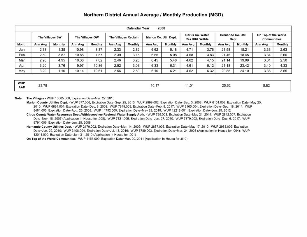
Northern District Annual Average / Monthly Production (MGD)
Ann Avg Monthly
On Top of the World
Communities
2008
MonthlyMonthlyMonthly Ann AvgAnn AvgAnn Avg
Hernando Co. Util.
Dept.
Citrus Co. Water
Res./Util./Withla.Marion Co. Util. Dept.
MonthlyAnn Avg
The Villages Reclaim
Calendar Year
Month
The Villages SW The Villages GW
Ann Avg Monthly MonthlyAnn Avg
Jan 2.38 1.38 10.98 8.37 2.33 2.82 6.62 5.18 4.71 3.76 21.58 18.21 3.33 2.63
Feb 2.59 3.87 10.88 7.57 2.39 3.15 6.55 5.08 4.68 3.83 21.46 18.45 3.34 2.60
Mar 2.96 4.95 10.38 7.02 2.46 3.25 6.45 5.48 4.62 4.15 21.14 19.09 3.31 2.50
Apr 3.20 3.76 9.97 10.86 2.52 3.03 6.33 6.31 4.61 5.12 21.18 23.42 3.40 4.33
May 3.29 1.16 10.14 19.61 2.56 2.50 6.10 6.21 4.62 6.32 20.85 24.10 3.38 3.55
WUP
AAD25.6210.17 11.0123.78 5.82
Note: The Villages - WUP 13005.000, Expiration Date=Mar. 27, 2013
Marion County Utilities Dept. - WUP 377.006, Expiration Date=Sep. 25, 2013; WUP 2999.002, Expiration Date=Sep. 3, 2008; WUP 6151.008, Expiration Date=May 25,
2010; WUP 6884.001, Expiration Date=Dec. 8, 2009; WUP 7849.003, Expiration Date=Feb. 8, 2017; WUP 8165.004, Expiration Date=Sep. 18, 2014; WUP
8481.003, Expiration Date=Aug. 25, 2008; WUP 11752.000, Expiration Date=May 29, 2018; WUP 12218.001, Expiration Date=Jun. 25, 2012
Citrus County Water Resources Dept./Withlacoochee Regional Water Supply Auth. - WUP 729.003, Expiration Date=May 21, 2014; WUP 2842.007, Expiration
Date=Nov. 18, 2007 (Application In-House for .008); WUP 7121.005, Expiration Date=Jan. 27, 2010; WUP 7879.003, Expiration Date=Dec. 6, 2017; WUP
9791.006, Expiration Date=Jun. 25, 2008
Hernando County Utilities Dept. - WUP 2179.002, Expiration Date=Mar. 14, 2009; WUP 2887.003, Expiration Date=May 17, 2010; WUP 2983.009, Expiration
Date=Jun. 29, 2010; WUP 3408.004, Expiration Date=Jul. 13, 2016; WUP 5789.003, Expiration Date=Mar. 24, 2008 (Application In-House for .004); WUP
12011.000, Expiration Date=Jan. 31, 2010 (Application In-House for .001)
On Top of the World Communities - WUP 1156.009, Expiration Date=Mar. 20, 2011 (Application In-House for .010)
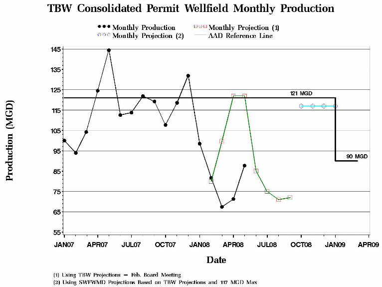
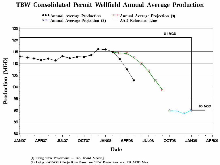
Item 50
Regulation Committee June 24, 2008 Routine Report
Public Supply Benchmarks
The Board has expressed an interest in having comparative information available for public supply water use. This chart includes information relating to both potable and reclaimed water usage from county and regional perspectives. Utility, population, per capita use, and water rate information is contained on the left side of the table. Wastewater flow and reclaimed water information is presented on the right side, including the amount of ground water offset by the reclaimed water. Sources and notes are displayed below the chart. The table was updated in November with provisional 2006 information in order to make available the most recent data on hand. Note, however, that the data are still being analyzed and are subject to refinement after further review.
Staff Recommendation: See Exhibit
This item is provided for the Committee’s information, and no action is required.
Presenter: Richard S. Owen, Deputy Executive Director, Resource Regulation
46
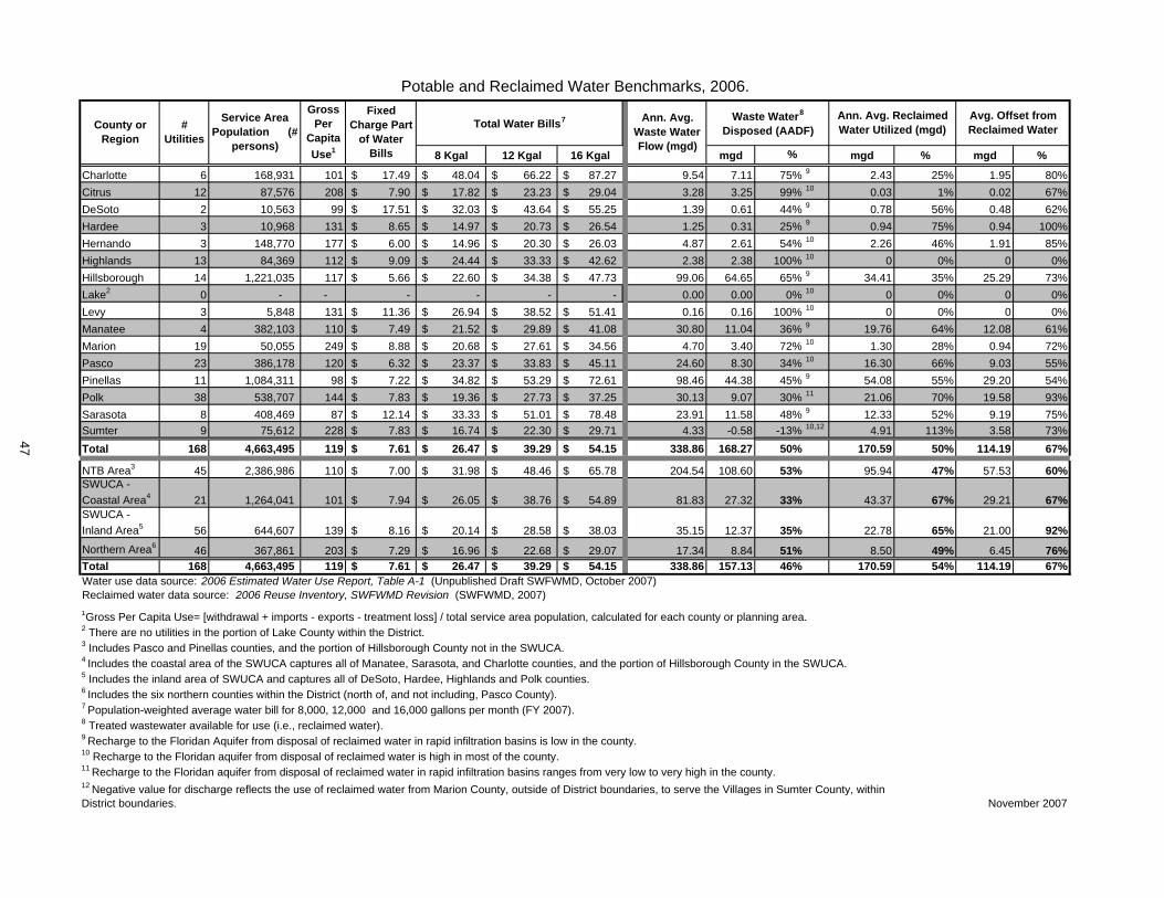
8 Kgal 12 Kgal 16 Kgal mgd mgd % mgd %
Charlotte 6 168,931 101 17.49$ 48.04$ 66.22$ 87.27$ 9.54 7.11 75% 9 2.43 25% 1.95 80%Citrus 12 87,576 208 7.90$ 17.82$ 23.23$ 29.04$ 3.28 3.25 99% 10 0.03 1% 0.02 67%DeSoto 2 10,563 99 17.51$ 32.03$ 43.64$ 55.25$ 1.39 0.61 44% 9 0.78 56% 0.48 62%Hardee 3 10,968 131 8.65$ 14.97$ 20.73$ 26.54$ 1.25 0.31 25% 9 0.94 75% 0.94 100%Hernando 3 148,770 177 6.00$ 14.96$ 20.30$ 26.03$ 4.87 2.61 54% 10 2.26 46% 1.91 85%Highlands 13 84,369 112 9.09$ 24.44$ 33.33$ 42.62$ 2.38 2.38 100% 10 0 0% 0 0%Hillsborough 14 1,221,035 117 5.66$ 22.60$ 34.38$ 47.73$ 99.06 64.65 65% 9 34.41 35% 25.29 73%Lake2 0 - - - - - - 0.00 0.00 0% 10 0 0% 0 0%Levy 3 5,848 131 11.36$ 26.94$ 38.52$ 51.41$ 0.16 0.16 100% 10 0 0% 0 0%Manatee 4 382,103 110 7.49$ 21.52$ 29.89$ 41.08$ 30.80 11.04 36% 9 19.76 64% 12.08 61%Marion 19 50,055 249 8.88$ 20.68$ 27.61$ 34.56$ 4.70 3.40 72% 10 1.30 28% 0.94 72%Pasco 23 386,178 120 6.32$ 23.37$ 33.83$ 45.11$ 24.60 8.30 34% 10 16.30 66% 9.03 55%Pinellas 11 1,084,311 98 7.22$ 34.82$ 53.29$ 72.61$ 98.46 44.38 45% 9 54.08 55% 29.20 54%Polk 38 538,707 144 7.83$ 19.36$ 27.73$ 37.25$ 30.13 9.07 30% 11 21.06 70% 19.58 93%Sarasota 8 408,469 87 12.14$ 33.33$ 51.01$ 78.48$ 23.91 11.58 48% 9 12.33 52% 9.19 75%Sumter 9 75,612 228 7.83$ 16.74$ 22.30$ 29.71$ 4.33 -0.58 -13% 10,12 4.91 113% 3.58 73%Total 168 4,663,495 119 7.61$ 26.47$ 39.29$ 54.15$ 338.86 168.27 50% 170.59 50% 114.19 67%
NTB Area3 45 2,386,986 110 7.00$ 31.98$ 48.46$ 65.78$ 204.54 108.60 53% 95.94 47% 57.53 60%SWUCA - Coastal Area4 21 1,264,041 101 7.94$ 26.05$ 38.76$ 54.89$ 81.83 27.32 33% 43.37 67% 29.21 67%SWUCA - Inland Area5 56 644,607 139 8.16$ 20.14$ 28.58$ 38.03$ 35.15 12.37 35% 22.78 65% 21.00 92%Northern Area6 46 367,861 203 7.29$ 16.96$ 22.68$ 29.07$ 17.34 8.84 51% 8.50 49% 6.45 76%Total 168 4,663,495 119 7.61$ 26.47$ 39.29$ 54.15$ 338.86 157.13 46% 170.59 54% 114.19 67%Water use data source: 2006 Estimated Water Use Report, Table A-1 (Unpublished Draft SWFWMD, October 2007)Reclaimed water data source: 2006 Reuse Inventory, SWFWMD Revision (SWFWMD, 2007)1Gross Per Capita Use= [withdrawal + imports - exports - treatment loss] / total service area population, calculated for each county or planning area.2 There are no utilities in the portion of Lake County within the District. 3 Includes Pasco and Pinellas counties, and the portion of Hillsborough County not in the SWUCA.4 Includes the coastal area of the SWUCA captures all of Manatee, Sarasota, and Charlotte counties, and the portion of Hillsborough County in the SWUCA.5 Includes the inland area of SWUCA and captures all of DeSoto, Hardee, Highlands and Polk counties. 6 Includes the six northern counties within the District (north of, and not including, Pasco County). 7 Population-weighted average water bill for 8,000, 12,000 and 16,000 gallons per month (FY 2007).8 Treated wastewater available for use (i.e., reclaimed water).9 Recharge to the Floridan Aquifer from disposal of reclaimed water in rapid infiltration basins is low in the county.10 Recharge to the Floridan aquifer from disposal of reclaimed water is high in most of the county.11 Recharge to the Floridan aquifer from disposal of reclaimed water in rapid infiltration basins ranges from very low to very high in the county.
November 2007
Fixed Charge Part
of Water Bills
Ann. Avg. Reclaimed Water Utilized (mgd)
Avg. Offset from Reclaimed Water
Waste Water8
Disposed (AADF)
%
12 Negative value for discharge reflects the use of reclaimed water from Marion County, outside of District boundaries, to serve the Villages in Sumter County, within District boundaries.
Potable and Reclaimed Water Benchmarks, 2006.
County or Region
Ann. Avg. Waste Water Flow (mgd)
Total Water Bills7Service Area Population (#
persons)
Gross Per
Capita Use1
# Utilities
47
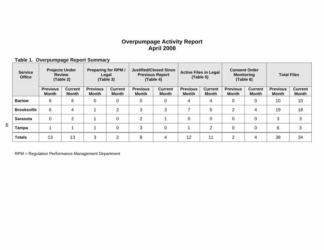
Overpumpage Activity Report April 2008
Table 1. Overpumpage Report Summary
Service Office
Projects Under Review
(Table 2)
Preparing for RPM / Legal
(Table 3)
Justified/Closed Since Previous Report
(Table 4) Active Files in Legal
(Table 5) Consent Order
Monitoring (Table 6)
Total Files
Previous Month
Current Month
Previous Month
Current Month
Previous Month
Current Month
Previous Month
Current Month
Previous Month
Current Month
Previous Month
Current Month
Bartow 6 6 0 0 0 0 4 4 0 0 10 10
Brooksville 6 4 1 2 3 3 7 5 2 4 19 18
Sarasota 0 2 1 0 2 1 0 0 0 0 3 3
Tampa 1 1 1 0 3 0 1 2 0 0 6 3
Totals 13 13 3 2 8 4 12 11 2 4 38 34
RPM = Regulation Performance Management Department
48
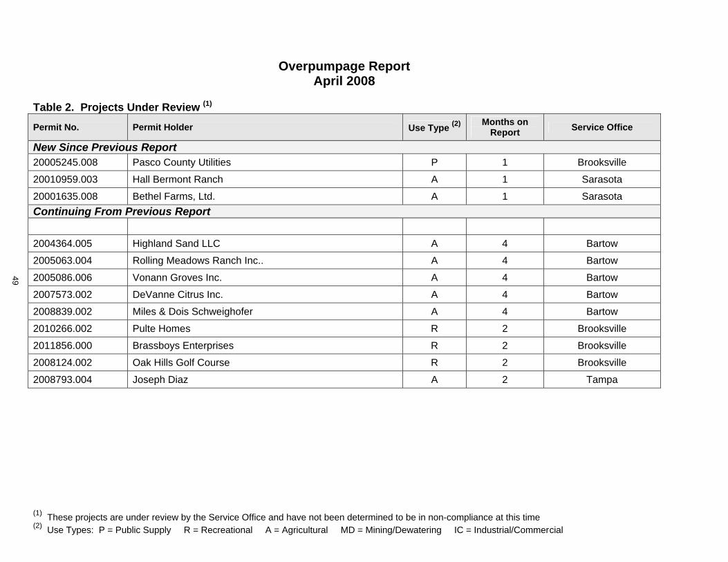
(1) These projects are under review by the Service Office and have not been determined to be in non-compliance at this time (2) Use Types: P = Public Supply R = Recreational A = Agricultural MD = Mining/Dewatering IC = Industrial/Commercial
Overpumpage Report April 2008
Table 2. Projects Under Review (1)
Permit No. Permit Holder Use Type (2) Months on Report Service Office
New Since Previous Report 20005245.008 Pasco County Utilities P 1 Brooksville
20010959.003 Hall Bermont Ranch A 1 Sarasota
20001635.008 Bethel Farms, Ltd. A 1 Sarasota Continuing From Previous Report
2004364.005 Highland Sand LLC A 4 Bartow
2005063.004 Rolling Meadows Ranch Inc.. A 4 Bartow
2005086.006 Vonann Groves Inc. A 4 Bartow
2007573.002 DeVanne Citrus Inc. A 4 Bartow
2008839.002 Miles & Dois Schweighofer A 4 Bartow
2010266.002 Pulte Homes R 2 Brooksville
2011856.000 Brassboys Enterprises R 2 Brooksville
2008124.002 Oak Hills Golf Course R 2 Brooksville
2008793.004 Joseph Diaz A 2 Tampa
49
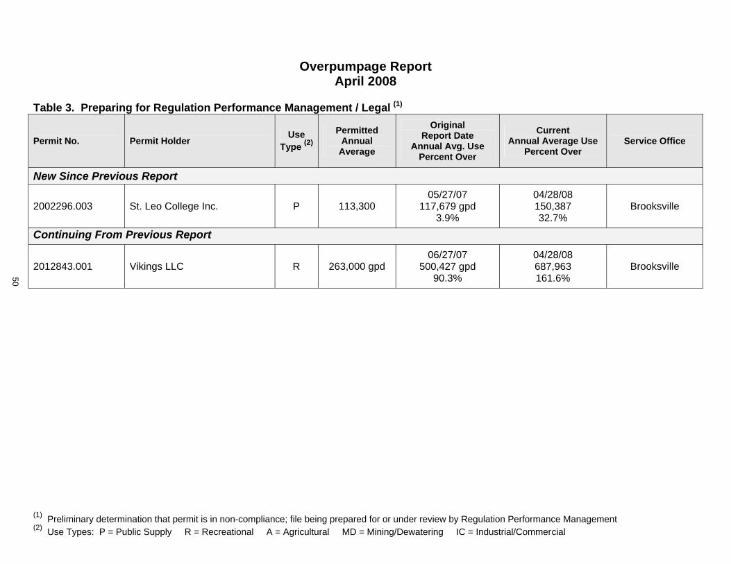
(1) Preliminary determination that permit is in non-compliance; file being prepared for or under review by Regulation Performance Management (2) Use Types: P = Public Supply R = Recreational A = Agricultural MD = Mining/Dewatering IC = Industrial/Commercial
Overpumpage Report April 2008
Table 3. Preparing for Regulation Performance Management / Legal (1)
Permit No. Permit Holder Use Type (2)
Permitted Annual
Average
Original Report Date
Annual Avg. Use Percent Over
Current Annual Average Use
Percent Over Service Office
New Since Previous Report
2002296.003 St. Leo College Inc. P 113,300 05/27/07
117,679 gpd 3.9%
04/28/08150,38732.7%
Brooksville
Continuing From Previous Report
2012843.001 Vikings LLC R 263,000 gpd06/27/07
500,427 gpd 90.3%
04/28/08687,963161.6%
Brooksville
50
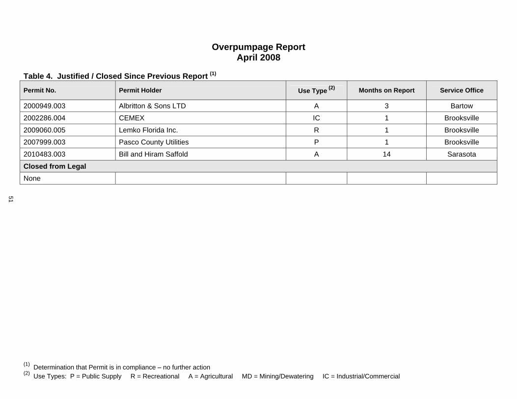
(1) Determination that Permit is in compliance – no further action (2) Use Types: P = Public Supply R = Recreational A = Agricultural MD = Mining/Dewatering IC = Industrial/Commercial
Overpumpage Report April 2008
Table 4. Justified / Closed Since Previous Report (1)
Permit No. Permit Holder Use Type (2) Months on Report Service Office
2000949.003 Albritton & Sons LTD A 3 Bartow
2002286.004 CEMEX IC 1 Brooksville
2009060.005 Lemko Florida Inc. R 1 Brooksville
2007999.003 Pasco County Utilities P 1 Brooksville
2010483.003 Bill and Hiram Saffold A 14 Sarasota
Closed from Legal None
51

(1) Regulation Performance Management concurs with non-compliance and file in Legal for enforcement (2) Use Types: P = Public Supply R = Recreational A = Agricultural MD = Mining/Dewatering IC = Industrial/Commercial
Overpumpage Report April 2008
Table 5. Active Files in Legal (1)
Permit Holder Use Type (2)
Permitted Annual Average
Original Report Date Annual Average Use
Percent Over
Current Annual Average Use
Percent Over Service Office
New Since Previous Report
Russell Weiss A 155,500 gpd 10/26/2007
162,355 gpd 4.4%
04/28/08158,287
1.7%Tampa
Continuing From Previous Report
Sun’ N Lakes of Sebring P 548,300 gpd07/26/06
1,054,200 gpd 4.8%
04/28/08896,941 gpd
63.6%Bartow
Sebring Land LP & Highlands P 223,700 gpd06/28/06
275,833 gpd 23.3%
04/28/08264,986 gpd
18.5%Bartow
John G Wood P, R 89,900 gpd05/26/06
109,485 gpd 21.8%
04/28/0865,604 gpd
(26.3)%Bartow
Country Club Utilities, Inc. P 183,000 gpd01/31/06
256,852 gpd 40.4%
04/28/08214,970 gpd
17.5%Bartow
Timber Pines Community R 363,400 gpd 04/27/07
376,487 gpd 3.6%
04/28/08395,612 gpd
8.9%Brooksville
Spruce Creek Development R 445,800 gpd06/28/06
462,416 gpd 3.7%
04/28/08531,267 gpd
19.2%Brooksville
52
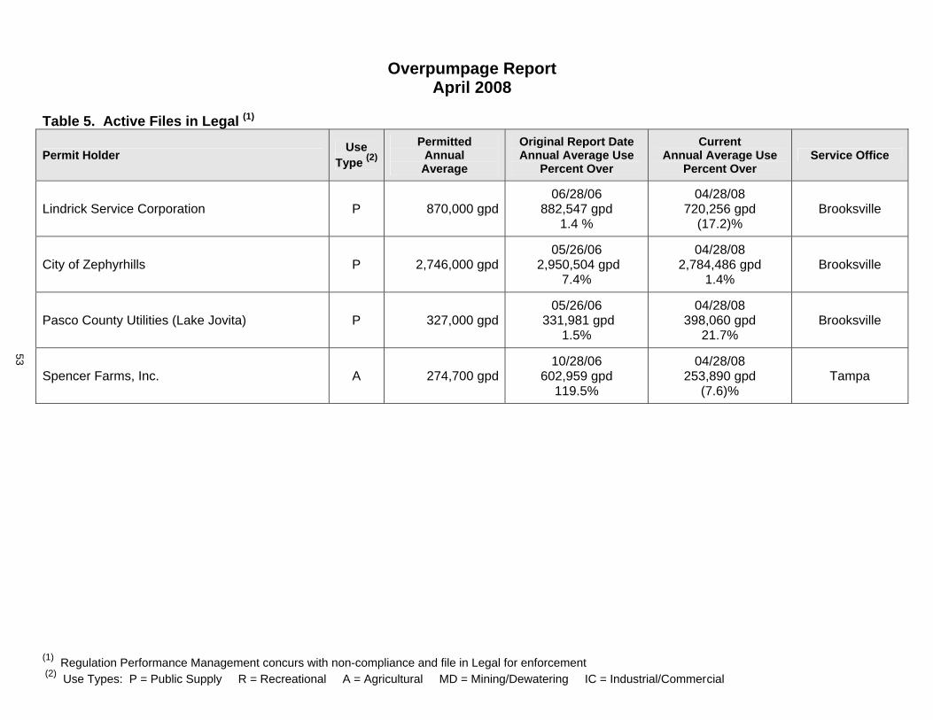
(1) Regulation Performance Management concurs with non-compliance and file in Legal for enforcement (2) Use Types: P = Public Supply R = Recreational A = Agricultural MD = Mining/Dewatering IC = Industrial/Commercial
Overpumpage Report April 2008
Table 5. Active Files in Legal (1)
Permit Holder Use Type (2)
Permitted Annual Average
Original Report Date Annual Average Use
Percent Over
Current Annual Average Use
Percent Over Service Office
Lindrick Service Corporation P 870,000 gpd06/28/06
882,547 gpd 1.4 %
04/28/08720,256 gpd
(17.2)%Brooksville
City of Zephyrhills P 2,746,000 gpd05/26/06
2,950,504 gpd 7.4%
04/28/082,784,486 gpd
1.4%Brooksville
Pasco County Utilities (Lake Jovita) P 327,000 gpd05/26/06
331,981 gpd 1.5%
04/28/08398,060 gpd
21.7%Brooksville
Spencer Farms, Inc. A 274,700 gpd10/28/06
602,959 gpd 119.5%
04/28/08253,890 gpd
(7.6)%Tampa
53
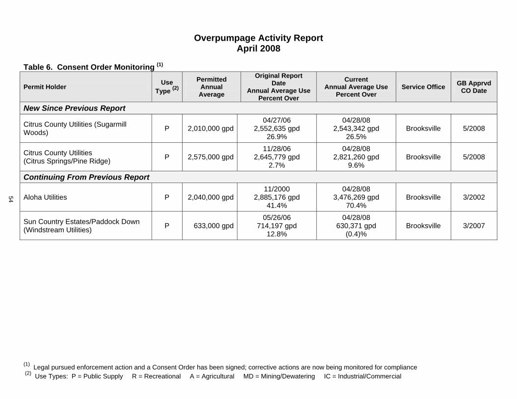
(1) Legal pursued enforcement action and a Consent Order has been signed; corrective actions are now being monitored for compliance (2) Use Types: P = Public Supply R = Recreational A = Agricultural MD = Mining/Dewatering IC = Industrial/Commercial
Overpumpage Activity Report April 2008
Table 6. Consent Order Monitoring (1)
Permit Holder Use Type (2)
Permitted Annual Average
Original Report Date
Annual Average Use Percent Over
Current Annual Average Use
Percent Over Service Office GB Apprvd
CO Date
New Since Previous Report
Citrus County Utilities (Sugarmill Woods) P 2,010,000 gpd
04/27/062,552,635 gpd
26.9%
04/28/082,543,342 gpd
26.5%Brooksville 5/2008
Citrus County Utilities (Citrus Springs/Pine Ridge) P 2,575,000 gpd
11/28/062,645,779 gpd
2.7%
04/28/082,821,260 gpd
9.6%Brooksville 5/2008
Continuing From Previous Report
Aloha Utilities P 2,040,000 gpd11/2000
2,885,176 gpd 41.4%
04/28/083,476,269 gpd
70.4%Brooksville 3/2002
Sun Country Estates/Paddock Down (Windstream Utilities) P 633,000 gpd
05/26/06714,197 gpd
12.8%
04/28/08630,371 gpd
(0.4)%Brooksville 3/2007
54
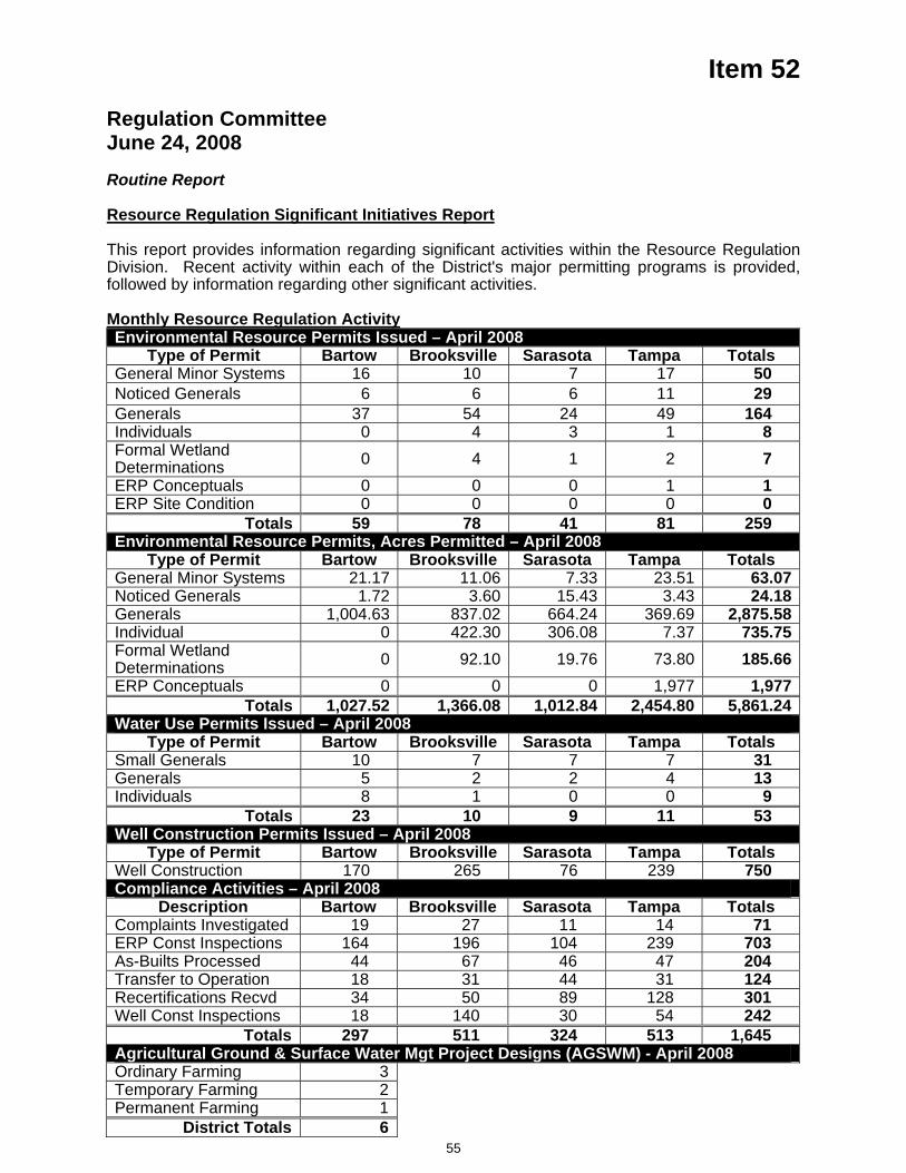
Item 52
Regulation Committee June 24, 2008 Routine Report
Resource Regulation Significant Initiatives Report This report provides information regarding significant activities within the Resource Regulation Division. Recent activity within each of the District's major permitting programs is provided, followed by information regarding other significant activities. Monthly Resource Regulation Activity Environmental Resource Permits Issued – April 2008
Type of Permit Bartow Brooksville Sarasota Tampa Totals General Minor Systems 16 10 7 17 50 Noticed Generals 6 6 6 11 29 Generals 37 54 24 49 164 Individuals 0 4 3 1 8 Formal Wetland Determinations 0 4 1 2 7 ERP Conceptuals 0 0 0 1 1 ERP Site Condition 0 0 0 0 0
Totals 59 78 41 81 259 Environmental Resource Permits, Acres Permitted – April 2008
Type of Permit Bartow Brooksville Sarasota Tampa Totals General Minor Systems 21.17 11.06 7.33 23.51 63.07Noticed Generals 1.72 3.60 15.43 3.43 24.18Generals 1,004.63 837.02 664.24 369.69 2,875.58Individual 0 422.30 306.08 7.37 735.75Formal Wetland Determinations 0 92.10 19.76 73.80 185.66ERP Conceptuals 0 0 0 1,977 1,977
Totals 1,027.52 1,366.08 1,012.84 2,454.80 5,861.24Water Use Permits Issued – April 2008
Type of Permit Bartow Brooksville Sarasota Tampa Totals Small Generals 10 7 7 7 31 Generals 5 2 2 4 13 Individuals 8 1 0 0 9
Totals 23 10 9 11 53 Well Construction Permits Issued – April 2008
Type of Permit Bartow Brooksville Sarasota Tampa Totals Well Construction 170 265 76 239 750 Compliance Activities – April 2008
Description Bartow Brooksville Sarasota Tampa Totals Complaints Investigated 19 27 11 14 71 ERP Const Inspections 164 196 104 239 703 As-Builts Processed 44 67 46 47 204 Transfer to Operation 18 31 44 31 124 Recertifications Recvd 34 50 89 128 301 Well Const Inspections 18 140 30 54 242
Totals 297 511 324 513 1,645 Agricultural Ground & Surface Water Mgt Project Designs (AGSWM) - April 2008 Ordinary Farming 3Temporary Farming 2Permanent Farming 1
District Totals 6
55
Item 52
Central Florida Coordination Area Rules Development and ImplementationRegulation and Legal staff continue to coordinate with St. John's River and South Florida district staff on the development of regulations for the Central Florida Coordination Area. The first phase of regulations was approved by all three Governing Boards at their December meetings. Resource Projects and Regulation staff are reviewing the South Florida Water Management District's (SFWMD) draft Kissimmee River yield study to determine the water supply implications. The original projected yield of this project was significantly reduced in the draft study, which, within this District, could affect water supply for Polk County. New activities since last meeting: Staffs of the three Districts continue to meet to collaboratively review the Kissimmee River yield report in detail. Additionally, staff is coordinating on a SFWMD study of the lower Floridan aquifer that could potentially supply Polk County. Staff of the three Districts has been meeting to develop a plan to evaluate the sustainability issues of the CFCA and chart a course for the next phase of regulations that will focus on longer-term solutions to the area's water resource issues. Meetings on this topic occurred throughout May, with additional meetings scheduled for June.
Statewide Stormwater RuleUnmanaged urban stormwater creates a wide variety of effects on Florida’s surface and ground waters. Urbanization leads to the compaction of soil; the addition of impervious surfaces such as roads and parking lots; alteration of natural landscape features such as natural depressional areas which hold water, floodplains and wetlands; construction of highly efficient drainage systems; and the addition of pollutants from everyday human activities. These alterations within a watershed decrease the amount of rainwater that can seep into the soil to recharge our aquifers, maintain water levels in lakes and wetlands, and maintain spring and stream flows. Consequently, the volume, speed, and pollutant loading in stormwater that runs off developed areas increases, leading to flooding, water quality problems and loss of habitat. To manage urban stormwater and minimize these impacts to our natural systems, Florida was the first state in the country to adopt a rule requiring the treatment of stormwater to a specified level of pollutant load reduction for all new development. Florida’s original stormwater rule was adopted in 1981 and went into effect in February 1982. The stormwater rule is a technology-based rule that relies upon four key components: A performance standard or goal for the minimum level of treatment Design criteria for best management practices (BMPs) that will achieve the performance standard
A rebuttable presumption that discharges from a stormwater management system designed in accordance with the BMP design criteria will not cause harm to water resources.
Periodic review and updating of BMP design criteria as more information becomes available to increase their effectiveness in removing pollutants.
Florida’s stormwater rules were developed to meet a performance standard of reducing the post-development stormwater pollutant loading of Total Suspended Solids by 80%, or by 95% for stormwater discharges directly into Outstanding Florida Waters. This level of treatment was selected for two reasons: To establish equitability in treatment requirements between point and nonpoint sources of pollution. The minimum level of treatment for domestic wastewater point sources was “secondary treatment” which equated to an 80% reduction in TSS.
The costs of stormwater treatment greatly increased as the level of treatment rose above 80%.
In 1990, in response to legislation, the Department developed and implemented the State Water resource Implementation Rule (originally known as the State Water Policy rule). This rule sets forth the broad guidelines for the implementation of Florida’s stormwater program and describes the roles of DEP, the water management districts, and local governments. The rule provides that one of the primary goals of the program is to maintain, to the degree possible, during and after construction and development, the predevelopment stormwater characteristics of a site. The rule also provides a specific minimum performance standard for stormwater treatment
56
Item 52 systems: to remove 80% of the post-development stormwater pollutant loading of pollutants “that cause or contribute to violations of water quality standards.” This performance standard is significantly different than the original one used in Florida’s stormwater treatment rules. However, for a variety of reasons, the BMP design criteria in the stormwater or environmental resource permitting rules of DEP or the WMDs were never updated to achieve this level of treatment.
In 1999, the Florida Watershed Restoration Act, Section 403.067, F.S., was enacted leading to the implementation of Florida’s water body restoration program and the establishment of Total Maximum Daily Loads (TMDLs). A TMDL is the maximum amount of a specific pollutant that can be discharged to a waterbody while maintaining water quality standards. A TMDL must be established and implemented for all impaired waters – water bodies or water body segments that are not currently meeting their applicable water quality standards. Since the program began over 2000 impairments have been verified in Florida’s surface waters with nutrients identified as the major cause of impairments. Additionally, nutrient enrichment of ground waters and springs has been recognized as a major concern in Florida. To address the growing problem of nutrient enrichment of Florida’s surface and ground waters, a number of initiatives have been undertaken by DEP, the WMDs, and the Florida Department of Agriculture and Consumer Services. One such initiative is the Statewide Stormwater Treatment Rule which will increase the level of nutrient removal required of stormwater treatment systems serving new development. This rule will be based upon a performance standard that the post-development nutrient load will not exceed the nutrient load from natural, undeveloped areas.
Staff continues to coordinate with the FDEP and other water management districts regarding potential changes to the water quality components of the ERP program. New activities since last meeting: The latest meeting was in Orlando on May 28 with the Technical Advisory Committee. Agency staff and members of the public also attended. Discussion focused primarily on groundwater protection in sensitive karst (sinkhole) areas. The next TAC meeting is scheduled for July 9 and will focus on wet detention systems and use of wetlands for stormwater treatment. Projected date for rule adoption by the DEP Secretary remains set for summer 2009.
Low Impact Development The District is meeting monthly with Sarasota County on the development of a Low Impact Development (LID) Manual. LID is a term used to describe a collection of innovative stormwater management practices that mimic a site's pre-development hydrology, maintain groundwater recharge and protect water quality. Initially, the manual will focus on four LID practices: pervious pavement, green roofs, swales, and stormwater reuse. The manual is intended for engineers and other professionals planning and designing development projects. It will provide LID design examples consistent with District and Sarasota County regulatory requirements. Sarasota County has contracted with Jones Edmunds and Associates, Inc. to produce the manual and a preliminary draft is expected at the end of September. Interest in the manual extends beyond Sarasota County and the monthly meeting is regularly attended by representatives of Pinellas County, Hillsborough County, the cities of Venice and North Port, the Sarasota National Estuary Program, the Charlotte Harbor National Estuary Program, the University of Florida, the University of South Florida, and Ringling College.
Executive Director Order No. SWF 08-003 This emergency authorization was issued on March 20, 2008 to further assist the Peace River / Manasota Regional Water Supply Authority. The Order allows temporary use of the Authority's existing ASR wells to withdraw groundwater, if needed, to meet regional demand. This groundwater withdrawal can only commence after remaining ASR storage of treated river water has been exhausted. New activities since last meeting: In addition to recent declines in river flows, reduced availability of other water sources have resulted in the resumption of withdrawals from the ASR wellfields on May 9 in order to meet the water needs of the Authority's customer governments. The Authority subsequently depleted the treated river previously stored in the ASR wellfields and is now withdrawing groundwater in accordance with provisions of the emergency authorization. As of June 2, 67 mg of groundwater has been withdrawn so far.
57
Item 52 Water Restriction Hotline Staff continues to maintain a toll-free hotline (1-800-423-1476, extension 4498 or 1-800-848-0499) and an e-mail address (water.restrictions@ watermatters.org) that citizens and local officials can use to ask questions, report possible violations, and request information about water shortage and year-round water conservation measures. New activities since last meeting: In the four week period ending May 23, the hotline answered 973 calls and 115 e-mails. Related follow-up activity included: sending 95 first-time violation letters, referring 6 multiple-time violation enforcement cases to local governments, resolving 6 petitions for variance (requests for permission to follow a special watering schedule that abides by the basic intent of current water shortage measures), advising the Hillsborough County Water Conservation Technical Advisory Committee at its most recent meeting, and addressing restriction-related questions and concerns from the Hillsborough River Interlocal Planning Technical Advisory Committee. Year-Round Water Conservation Measures - Statewide Consistency InitiativeThis is an interagency coordination effort involving Demand Management staff. The potential benefits of such an initiative were identified during a statewide drought coordination teleconference meeting in November 2007. Specifically, since year-round water conservation measures are the foundation upon which additional demand management actions are taken during a drought, it became clear that close coordination along water management district boundaries was challenging because the districts and the local governments charged with enforcing the districts' water shortage measures were starting from differing levels of water conservation effort. Currently, compared to Florida's four other water management districts, this District currently has the most stringent set of adopted year-round water conservation measures, including a maximum of twice-per-week lawn watering. Year-round measures for the St. Johns River Water Management District (St. Johns) also include a twice-per-week lawn watering schedule; however, St. Johns currently allows people to pick their own watering days unless their local government has an ordinance to the contrary, a provision which makes the rule difficult to enforce. Year-round measures for the South Florida Water Management District (South Florida) currently include a three-times-per-week lawn watering schedule and these measures are only in effect for three of its counties. Staffs from this District and St. Johns agreed to take the lead on the consistency effort because it was a natural extension of the coordination they were already engaged in to facilitate the goal of uniform measures in Marion County, and South Florida Water Management District (South Florida) staff joined the discussion in late February. Major consistency concepts were reviewed, modified as appropriate and agreed to by the executives of all three agencies. Each agency has initiated rule development so that the agreed-upon consistency concepts can be discussed with the regulated public, adjusted as necessary based on input received, and then used as the basis for amendments to applicable regulations. For this District, the regulation involved is Chapter 40D-22 (Year-Round Water Conservation Measures). New activities since last meeting: This District and South Florida have concluded their series of public workshops. This District has also sought input from its five standing advisory committees. St. Johns is still the process of conducting its public workshops. So far, there has been divergent input on three key issues. District staff is reviewing all input received and is consulting with the other districts in the process of preparing revised draft rule amendments reflecting the agreed-upon watering days and times and also addressing the need to improve the efficiency of use for reclaimed water blends. Conserve Florida - Statewide Public Supply Water Conservation Initiative Resource Regulation staff is actively engaged in Conserve Florida (the statewide initiative to develop a water conservation program for public supply) because there are many potential regulatory implications. Active engagement involves participation in a statewide workgroup and its various committees, plus internal coordination with Conservation Projects staff and other non-regulatory departments. The main product of this initiative, to date, is a web-based computer application called The Guide which a utility can use to develop or update its water conservation plan. The Guide identifies recommended and optional elements to include in the water conservation plan based on the utility's profile (size, mix of customers, existing efforts, etc). In late 2006 and early 2007, staff participated in a pilot project involving three utilities who tested the application and the interaction that it facilitates between utility representatives and
58
Item 52 regulatory staff. This pilot project resulted in the identification of needed fixes and recommended enhancements, and these changes were prioritized and are now in the process of being implemented. In addition to work directly related to The Guide, the Conserve Florida workgroup and its committees continue to contribute oversight and ideas to the Conserve Florida Clearinghouse (a website presence and initiative-related outreach by University of Florida staff and students, including technical support for The Guide and an on-line water conservation library that is under development). In addition to recruiting utilities to use Conserve Florida resources, so that utilities and water management district staff gain more experience with The Guide in regulatory settings, staff has provided input to the University of Florida staff updating the Clearinghouse's long-term work plan. Staff has also participated in a committee that is charged with drafting research agenda for the Clearinghouse to facilitate in future budget years. This agenda is essentially a list of questions to be answered to refine the Guide or enhance other Clearinghouse services, indicating ongoing investigations by the University of Florida and other researchers, so that unmet needs can be identified, prioritized, and pursued through an appropriate mix of national collaboration and Florida-specific partnerships. The District's financial contribution to the Clearinghouse in Fiscal Year 2008 is $75,000 and the same amount has been proposed for Fiscal Year 2009. Conserve Florida's workgroup also sometimes serves in an advisory capacity to FDEP on water conservation projects, and its meetings provide an excellent forum for all participants to receive information and solicit input on their conservation-related activities. New activities since last meeting: Acommittee has been formed to consider the possibility of a simplified version or different user interface designed for small utilities (in conjunction with a Florida Rural Water Association assistance effort funding by the District). The workgroup will next meet in July 18.
Inter-District CoordinationThe Southwest Florida Water Management District (SWFWMD) has an ongoing outreach effort to enhance the inter-district coordination that occurs between the permit review staff of the SWFWMD and the South Florida Water Management District (SFWMD) on projects that have the potential to affect the water resources located within the other district. This outreach effort is in addition to the efforts occurring in the northern portion of the SWFWMD such as establishing a uniform per capita rate and emergency water conservation measures. This coordination effort has been ongoing between the two agencies and includes participation from the SWFWMD Bartow, Sarasota, and Regulation Performance Management departments and the SFWMD Lower West Coast Service Center. Regularly scheduled coordination meetings are conducted between staff of both agencies to discuss projects of mutual concern. Concerns associated with Southern Water Use Caution Area (SWUCA) are appropriately addressed as well as any surface water related concerns such as flooding. A notification process has been initiated between the two water management districts to facilitate dialogue between permit review staff from both agencies during the initial review of a permit application that is of interest to the adjoining district. This allows the district staff of both water management districts to provide each other with the necessary local water resource expertise and insight into the nuisances of how specific rules are applied by each district. Coordination is currently occurring on several water use projects and the I-75 expansion project situated within Lee and Charlotte Counties.
Best Management Practices (BMP) Research & Education Coordination Meeting (5/20-21/08)District Staff attended the Florida BMP Research and Education Coordinating Committee (BRECC) interagency meeting on May 20 and May 21. This committee is comprised of representatives of the Florida Department of Agriculture and Consumer Services (FDACS), the Florida Department of Environmental Protection (FDEP), the University of Florida Institute of Food & Agricultural Sciences (IFAS), and Florida's five Water Management Districts. The main goals of the BRECC are to: establish priorities and coordinate funding across FDACS, FDEP, and the WMDs for BMP research and extension conducted by IFAS; and, (2) coordinate the communication and publication of research results and extension activities to the public and other constituents. The goal of this last workshop was to present current knowledge, identify knowledge gaps, and discuss future research efforts related to keeping water and nutrients in the root zone of Florida's crops to improve the overall quality of Florida's waters and help achieve Total Maximum Daily Load (TMDL) objectives.
59

Item 52 Staff Recommendation:
This item is provided for the Committee’s information, and no action is required.
Presenter: Richard S. Owen, AICP, Deputy Executive Director, Resource Regulation
60

D.R
esourceM
gt.C
omm
ittee
Governing Board Meeting June 24, 2008 Resource Management CommitteeDiscussion Items
53. Consent Item(s) Moved for Discussion
54. Cooperative Funding Initiative Project Status Report – Water Partners, Inc. Reclaimed Water Project ................................. (20 minutes) ....... 2
(Strategic Plan: Water Supply – Reclaimed Water)
55. District’s Watershed Management Program and Federal Emergency Management Agency (FEMA) Map Modernization ....... (30 minutes) ....... 3 (Strategic Plan: Flood Protection – Floodplain Management)
56. Overview of Activities and Advancements Related to Aquifer Recharge Using Reclaimed Water ................................................... (30 minutes) ....... 5 (Strategic Plan: Water Supply – Alternative Water Supplies/Reclaimed Water)
Submit & File Report
57. Staff Response to the Peer Review of "Scientific Peer Review of the Proposed Minimum Flows and Levels for the Lower Peace River and Shell Creek" ....................... 6
Routine Reports
58. Florida Forever Funding Status Report ............................................................................ 8
59. Minimum Flows and Levels Status Report ....................................................................... 12
60. Structure Operations Status Report ................................................................................. 16
61. Watershed Management Program and Federal Emergency Management Agency Map Modernization Status Report ................................................. 29
62. Significant Water Supply and Resource Development Projects ...................................... 32
Item 54
Resource Management Committee June 24, 2008
Discussion Item
Cooperative Funding Initiative Project Status Report – Water Partners, Inc. Reclaimed Water Project
The purpose of this presentation is to provide the Governing Board with an update on activities associated with the Water Partners, Inc. (WPI) Reclaimed Water Project that have occurred since the Governing Board's May 27, 2008 meeting.
The project team continues to meet regularly, with attendees representing WPI (Hillsborough County, Mosaic, and Tampa Electric Company), City of Tampa, City of Lakeland, Polk County, the Florida Department of Environmental Protection, Tampa Bay Water, and the District. Plant City and Temple Terrace have been added to the invitee list for all future meetings. The Infrastructure Sizing, Regulation and Recharge, and Governance subcommittees met on May 30, June 4, and June 9, respectively. The goal is to bring a concrete project proposal to the various Boards for consideration in late July and early August.
At the conclusion of the June 10 meeting, the project team discussed the schedule of team meetings over the next few months. The team has since met on June 23. The remaining project team meetings are scheduled for July 8, July 15 and July 22. The subcommittees will continue to meet as the project's scope and cost estimate are further refined.
Staff Recommendation:
This item is presented for the Committee's information, and no action is required.
Presenter: David L. Moore, P.G., Executive Director
2
Item 55
Resource Management Committee June 24, 2008
Discussion Item
District’s Watershed Management Program and Federal Emergency Management Agency Map Modernization
PurposeThis is an information item to provide the Board with an update on the status of the District’s Watershed Management Program and associated Federal Emergency Management Agency (FEMA) Map Modernization, including the District’s role in the FEMA process. Staff is providing this update in advance of public meetings that are anticipated to be held in late July or August 2008 for Hernando and Pasco Counties and September 2008 for Sarasota County. The presentation will provide a status report on activities to address issues identified by the public and through the District’s coordination with the development community consultants in 2007 and discussed at the August and October 2007 and March 2008 Governing Board meetings. Staff will continue to update the Board monthly either through the routine reports or as a committee discussion item.
Background/HistoryThe District initiated a partnership with the FEMA to modernize Flood Insurance Rate Maps (FIRMs) as part of our Watershed Management Program (WMP). Flood protection and floodplain information has been a priority at the District since the inception of the organization and that priority was renewed following the El Niño weather event in 1997-1998. In addition to studies conducted by the District (primarily through the Basin Boards) and others, information on floodplains (elevations) is available through the FEMA FIRMs. However, many of the existing maps do not accurately represent the flood prone areas either because the initial studies were technically limited or the maps are outdated due to significant land use changes since completion. To improve the floodplain information and improve local government's understanding of their flood protection level of service the District reached out to local governments, and initiated the WMP in the late nineties.
The District recognized a potential funding partner in FEMA as they had mutual goals to improve the existing FIRMs to better identify risks of flooding within the District. The District and the FEMA executed a Cooperating Technical Partners (CTP) Memorandum of Agreement on September 14, 2001 to formalize the relationship. As a CTP, the District is eligible for federal funds to act as FEMA's partner in modernization of the FIRMs. FEMA’s funds are primarily used for watershed modeling and floodplain analysis tasks and to prepare the FIRMs as not all elements of the District’s WMP are eligible for funding under FEMA’s mapping support. The District is implementing the map modernization program through the WMP and the federal funds have allowed the District and local governments to accomplish significantly more than would otherwise been possible. To date, the District has received approximately $11.2 million in federal funds from FEMA for countywide map modernization projects for Pasco, Sarasota, Hernando, Marion, Polk, Hardee, Desoto, Citrus, Sumter, Levy, and Highlands Counties. An additional $0.9 million is expected in future fiscal years for countywide map modernization projects for Manatee County. The Map Modernization program also includes federal funding for management support. For fiscal year (FY) 2004 through FY2007 the District received $713,240 and could receive an additional $500,000 through FY2012.
3
Item 55 District staff has been involved with several interested parties regarding the WMP and FEMA Map Modernization since January 2007 as a result of preliminary floodplain maps developed for Hernando, Pasco, and Sarasota Counties. Several issues were identified focusing on technical methodologies, quality control and public input. In October 2007, staff provided a status report to the Governing Board along with staff’s approach to address the issues. The issues were grouped into the following categories:
Rainfall Duration Quality Control/Peer Review Outreach Schedule
In March 2008, staff provided an update on the status of the District’s WMP and FEMA Map Modernization, including an update on the progress and activities associated with these issues.
The District’s consultants have been working on watershed models in Hernando, Pasco, and Sarasota Counties to update the watershed models to account for infiltration and incorporate the latest topographic and other watershed information (to the extent practicable) into the models. As of June 3, 2008 the District had received preliminary floodplain maps and information for nine of the 34 watersheds in Hernando and Pasco Counties; floodplain maps and information for the other 25 watersheds are to be received by the end of June 2008. Preliminary floodplain maps and information for the watersheds in Sarasota County are scheduled to be submitted to the District in July/August 2008. District staff will review the preliminary floodplain maps as they are received, coordinate the peer review activities, and schedule public meetings. Public meetings are anticipated to be held in late July or August 2008 for Hernando and Pasco Counties and September 2008 for Sarasota County. The floodplain maps will be presented to the Governing Board following the public meetings and prior to submitting the floodplain maps to FEMA.
Staff’s presentation will highlight the key areas associated with Rainfall Duration, Quality Control/Peer Review, Outreach, and Schedule for updating the watershed models and preliminary FIRMs.
Staff Recommendation:
This item is presented for the Committee's information, and no action is required.
Presenters: Mark A. Hammond, Director, Resource Projects Department
4
Item 56
Resource Management Committee June 24, 2008
Discussion Item
Overview of Activities and Advancements Related to Aquifer Recharge Using Reclaimed Water
PurposeThis item is presented for the Board's information only and no action is required. The information being provided is in response to a request from Governing Board following discussion of the proposed Water Partners Inc. (WPI) reclaimed water project at their May 2008 meeting. Staff will provide an overview of the District's experiences with Upper Floridan aquifer (UFA) recharge projects and update the Governing Board on advancements in technology that have been made over the past several years as it relates to aquifer recharge using reclaimed water at the local, state, and national levels.
Background/HistoryAt the May 2008 Governing Board meeting during the discussion of the proposed Water Partners Inc., (WPI) Reclaimed Water Project, it was noted that there are two opportunities for aquifer recharge. The first area that was identified is located in the inland portions of eastern Hillsborough and western Polk counties where the water quality in the UFA is generally considered to be potable. The second area is located along the coastal portions of Hillsborough County where saltwater intrusion has been a concern. Potential benefits of recharging the aquifer in the coastal area versus the inland area include reduced pipeline costs and fewer permitting restrictions. These potential benefits are because of the proximity of the coastal area to some of the major reclaimed water sources in Hillsborough County that are being considered for the project and the fact that the water quality in deep portions of the UFA is generally not considered potable.
Aquifer recharge is significant because of its water supply potential; therefore it is important to understand the issues associated with direct injection of reclaimed water in the aquifer. District staff will present an overview of recharge related activities and issues in the region, as well as throughout the state and nation. The presentation will include an overview of technological advancements that benefit reclaimed water recharge projects and discuss projects such as the proposed WPI project and the recent proposal that is being considered by the City of Clearwater.
Staff Recommendation:
This item is presented for the Committee's information, and no action is required.
Presenter: Mark D. Barcelo, Hydrologic Evaluation Program Director, Resource Projects Dept.
5
Item 57
Resource Management Committee June 24, 2008
Submit and File Report
Staff Response to the Peer Review of "Scientific Peer Review of the Proposed Minimum Flows and Levels for the Lower Peace River and Shell Creek"
PurposeTo present staff's response to the peer review report of the District's proposed Minimum Flows and Levels (MFL) for the Lower Peace River and Shell Creek.
Background/History Staff has completed a draft report concerning the adoption of minimum flows for the lower Peace River Estuary including the tidal portion of Shell Creek. This report was submitted to an independent, scientific review panel for voluntary peer review. The panel was comprised of three scientists who have extensive experience in estuarine hydrology, hydrodynamic modeling, ecology, and freshwater inflow management. The peer review panel concluded that, "Overall, the District is to be commended for preparing an excellent report that summarizes a large quantity of data and analyses, produced from many studies, into a document that is coherent and relatively easy to read. The supporting data and information used to develop the proposed MFL is technically sound. The data collection methods were appropriate, and used in an appropriate manner in all analyses."
The panel concluded that the data used for the development of the MFL was the best information available. Further, they noted that technical assumptions are inherent in data collection and analysis, and that the District made reasonable attempts to describe these assumptions. However the panel recognized that the approach "most laden with assumptions" is the hydrodynamic model, and expressed the need to conduct error analysis associated with the hydrodynamic model and the associated cumulative distribution function (CDF) curves. The panel raised five specific concerns related to validation and error analysis associated with the hydrodynamic model and the use of CDF curves. In response to this criticism, staff will perform the suggested assessments and incorporate these into the finalized MFL report that will be presented to the Board prior to proposed rule adoption.
The panel also noted that the "minimum flows for Shell Creek are determined first, and the maximum withdrawals allowed are included in determination of the minimum flows for the Lower Peace River . . . it is possible that different percentages may have been obtained within each block . . . had the Lower Peace River MFL determination been made prior to that for Shell Creek." Although no specific recommendation was made, staff proposes to reverse the procedure by conducting the model runs necessary to determine the minimum flow first for the Lower Peace River and then setting the minimum flow for Shell Creek. These results will be incorporated into the final MFL report.
Two specific recommendations/comments of the peer review panel are worth noting. The District's use of a 15% loss criterion as a measure of "significant harm" has received attention from various peer review panels and numerous stakeholders, and did not go unnoticed by this peer review panel. "A key assumption is that up to a 15% loss of estuarine habitat is a reasonable and protective management strategy . . . The review panel agrees with the stated reasons for this assumption." Another frequently raised question relates to whether the development of MFLs on tidal river reaches (e.g., Lower Peace River, Lower Alafia River, etc.) is protective of the harbors into which they feed (e.g., Charlotte Harbor, Tampa Bay). The panel
6
Item 57 stated, "We concur with the District's statement: 'The greatest changes in flow related habitat and associated biota are believed to occur in those reaches likely to see the greatest changes in salinity, which are tidal rivers . . . (A)ssessing freshwater inflows to the harbor is important, but the tidal rivers are more sensitive to potential impacts from freshwater flow reductions, and are the first places to look for significant harm.'"
Staff Recommendation:
This item is submitted for the Committee’s information, and no action is required.
Presenter: Martin H. Kelly, Ph.D., Minimum Flows and Levels Program Director, Resource Projects Department
7
Item 58
Resource Management Committee June 24, 2008
Routine Report
Florida Forever Funding Status Report
PurposeNo Board action is required. This item is submitted for information purposes only.
Background/HistoryAttached for the Board’s use and information is the monthly funding status report for the Florida Forever program. The projects have been categorized as acquisitions or projects for: restoration; capital improvements for restoration; water resource development; and preservation. In addition to Florida Forever funding, staff continues to explore all funding opportunities.
Staff Recommendation: See Exhibit
This item is provided for the Committee’s information, and no action is required.
Presenter: Eric Sutton, Assistant Director, Land Resources Department
8
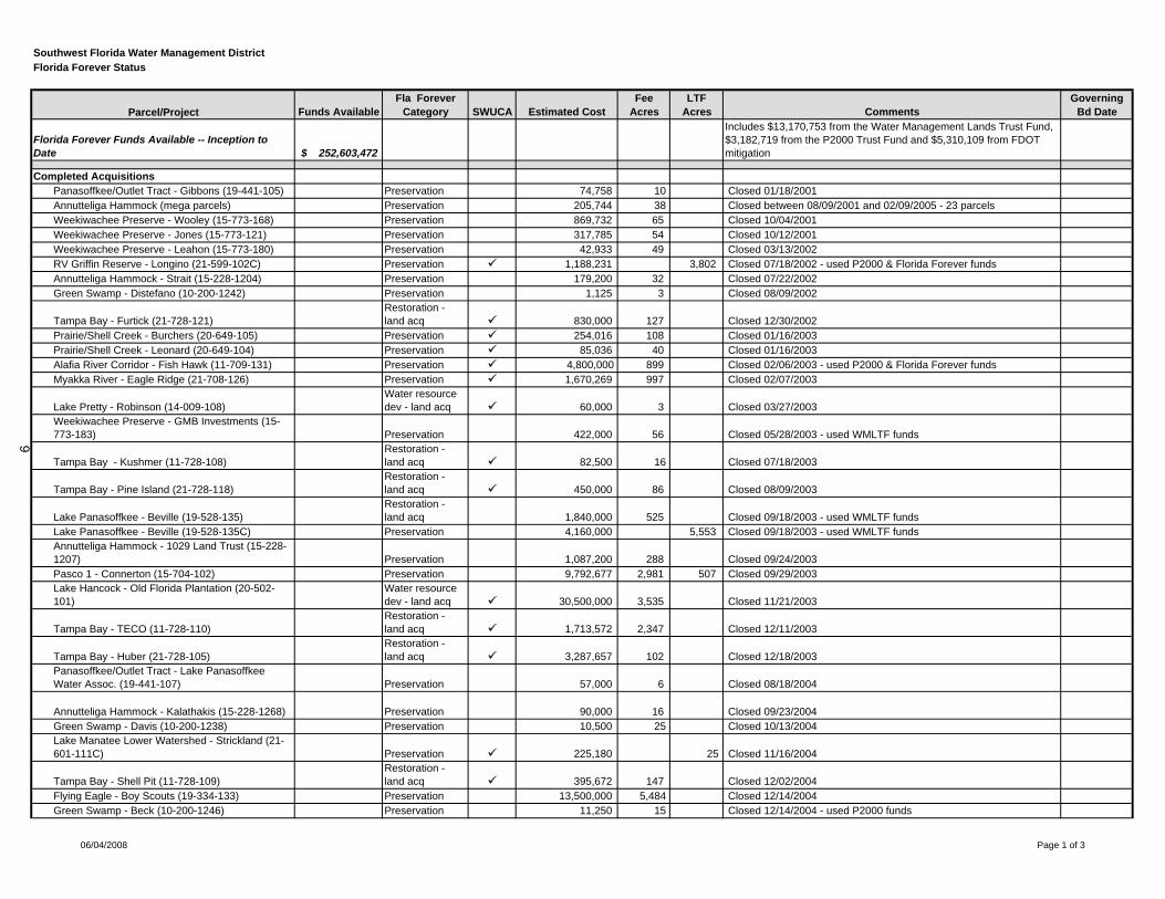
Southwest Florida Water Management DistrictFlorida Forever Status
Parcel/Project Funds AvailableFla Forever
Category SWUCA Estimated CostFee
AcresLTF
Acres CommentsGoverning
Bd Date
Florida Forever Funds Available -- Inception to Date $ 252,603,472
Includes $13,170,753 from the Water Management Lands Trust Fund, $3,182,719 from the P2000 Trust Fund and $5,310,109 from FDOT mitigation
Completed AcquisitionsPanasoffkee/Outlet Tract - Gibbons (19-441-105) Preservation 74,758 10 Closed 01/18/2001 Annutteliga Hammock (mega parcels) Preservation 205,744 38 Closed between 08/09/2001 and 02/09/2005 - 23 parcelsWeekiwachee Preserve - Wooley (15-773-168) Preservation 869,732 65 Closed 10/04/2001 Weekiwachee Preserve - Jones (15-773-121) Preservation 317,785 54 Closed 10/12/2001 Weekiwachee Preserve - Leahon (15-773-180) Preservation 42,933 49 Closed 03/13/2002 RV Griffin Reserve - Longino (21-599-102C) Preservation 1,188,231 3,802 Closed 07/18/2002 - used P2000 & Florida Forever funds Annutteliga Hammock - Strait (15-228-1204) Preservation 179,200 32 Closed 07/22/2002 Green Swamp - Distefano (10-200-1242) Preservation 1,125 3 Closed 08/09/2002
Tampa Bay - Furtick (21-728-121)Restoration - land acq 830,000 127 Closed 12/30/2002
Prairie/Shell Creek - Burchers (20-649-105) Preservation 254,016 108 Closed 01/16/2003 Prairie/Shell Creek - Leonard (20-649-104) Preservation 85,036 40 Closed 01/16/2003 Alafia River Corridor - Fish Hawk (11-709-131) Preservation 4,800,000 899 Closed 02/06/2003 - used P2000 & Florida Forever funds Myakka River - Eagle Ridge (21-708-126) Preservation 1,670,269 997 Closed 02/07/2003
Lake Pretty - Robinson (14-009-108)Water resource dev - land acq 60,000 3 Closed 03/27/2003
Weekiwachee Preserve - GMB Investments (15-773-183) Preservation 422,000 56 Closed 05/28/2003 - used WMLTF funds
Tampa Bay - Kushmer (11-728-108)Restoration - land acq 82,500 16 Closed 07/18/2003
Tampa Bay - Pine Island (21-728-118)Restoration - land acq 450,000 86 Closed 08/09/2003
Lake Panasoffkee - Beville (19-528-135)Restoration - land acq 1,840,000 525 Closed 09/18/2003 - used WMLTF funds
Lake Panasoffkee - Beville (19-528-135C) Preservation 4,160,000 5,553 Closed 09/18/2003 - used WMLTF fundsAnnutteliga Hammock - 1029 Land Trust (15-228-1207) Preservation 1,087,200 288 Closed 09/24/2003 Pasco 1 - Connerton (15-704-102) Preservation 9,792,677 2,981 507 Closed 09/29/2003 Lake Hancock - Old Florida Plantation (20-502-101)
Water resource dev - land acq 30,500,000 3,535 Closed 11/21/2003
Tampa Bay - TECO (11-728-110)Restoration - land acq 1,713,572 2,347 Closed 12/11/2003
Tampa Bay - Huber (21-728-105)Restoration - land acq 3,287,657 102 Closed 12/18/2003
Panasoffkee/Outlet Tract - Lake Panasoffkee Water Assoc. (19-441-107) Preservation 57,000 6 Closed 08/18/2004
Annutteliga Hammock - Kalathakis (15-228-1268) Preservation 90,000 16 Closed 09/23/2004 Green Swamp - Davis (10-200-1238) Preservation 10,500 25 Closed 10/13/2004 Lake Manatee Lower Watershed - Strickland (21-601-111C) Preservation 225,180 25 Closed 11/16/2004
Tampa Bay - Shell Pit (11-728-109)Restoration - land acq 395,672 147 Closed 12/02/2004
Flying Eagle - Boy Scouts (19-334-133) Preservation 13,500,000 5,484 Closed 12/14/2004 Green Swamp - Beck (10-200-1246) Preservation 11,250 15 Closed 12/14/2004 - used P2000 funds
06/04/2008 Page 1 of 3
9
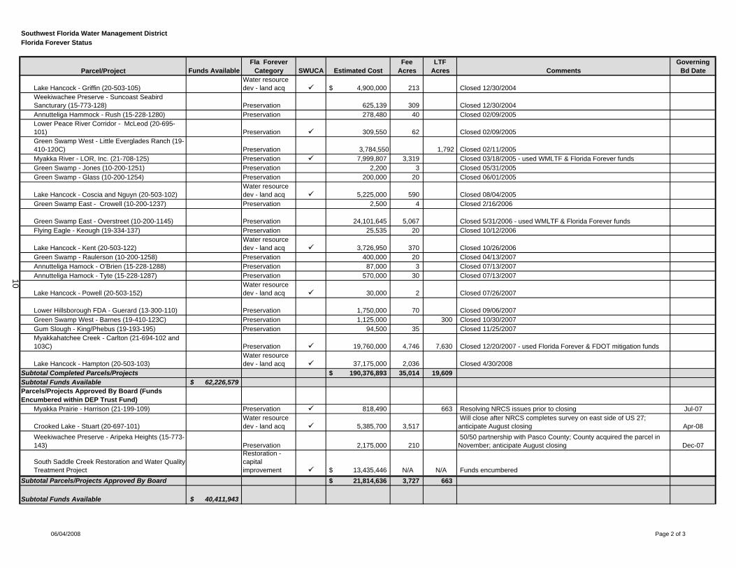
Southwest Florida Water Management DistrictFlorida Forever Status
Parcel/Project Funds AvailableFla Forever
Category SWUCA Estimated CostFee
AcresLTF
Acres CommentsGoverning
Bd Date
Lake Hancock - Griffin (20-503-105)Water resource dev - land acq $ 4,900,000 213 Closed 12/30/2004
Weekiwachee Preserve - Suncoast Seabird Sancturary (15-773-128) Preservation 625,139 309 Closed 12/30/2004 Annutteliga Hammock - Rush (15-228-1280) Preservation 278,480 40 Closed 02/09/2005 Lower Peace River Corridor - McLeod (20-695-101) Preservation 309,550 62 Closed 02/09/2005 Green Swamp West - Little Everglades Ranch (19-410-120C) Preservation 3,784,550 1,792 Closed 02/11/2005 Myakka River - LOR, Inc. (21-708-125) Preservation 7,999,807 3,319 Closed 03/18/2005 - used WMLTF & Florida Forever funds Green Swamp - Jones (10-200-1251) Preservation 2,200 3 Closed 05/31/2005 Green Swamp - Glass (10-200-1254) Preservation 200,000 20 Closed 06/01/2005
Lake Hancock - Coscia and Nguyn (20-503-102)Water resource dev - land acq 5,225,000 590 Closed 08/04/2005
Green Swamp East - Crowell (10-200-1237) Preservation 2,500 4 Closed 2/16/2006
Green Swamp East - Overstreet (10-200-1145) Preservation 24,101,645 5,067 Closed 5/31/2006 - used WMLTF & Florida Forever funds Flying Eagle - Keough (19-334-137) Preservation 25,535 20 Closed 10/12/2006
Lake Hancock - Kent (20-503-122)Water resource dev - land acq 3,726,950 370 Closed 10/26/2006
Green Swamp - Raulerson (10-200-1258) Preservation 400,000 20 Closed 04/13/2007 Annutteliga Hamock - O'Brien (15-228-1288) Preservation 87,000 3 Closed 07/13/2007 Annutteliga Hamock - Tyte (15-228-1287) Preservation 570,000 30 Closed 07/13/2007
Lake Hancock - Powell (20-503-152)Water resource dev - land acq 30,000 2 Closed 07/26/2007
Lower Hillsborough FDA - Guerard (13-300-110) Preservation 1,750,000 70 Closed 09/06/2007 Green Swamp West - Barnes (19-410-123C) Preservation 1,125,000 300 Closed 10/30/2007 Gum Slough - King/Phebus (19-193-195) Preservation 94,500 35 Closed 11/25/2007 Myakkahatchee Creek - Carlton (21-694-102 and 103C) Preservation 19,760,000 4,746 7,630 Closed 12/20/2007 - used Florida Forever & FDOT mitigation funds
Lake Hancock - Hampton (20-503-103)Water resource dev - land acq 37,175,000 2,036 Closed 4/30/2008
Subtotal Completed Parcels/Projects $ 190,376,893 35,014 19,609 Subtotal Funds Available $ 62,226,579 Parcels/Projects Approved By Board (Funds Encumbered within DEP Trust Fund)
Myakka Prairie - Harrison (21-199-109) Preservation 818,490 663 Resolving NRCS issues prior to closing Jul-07
Crooked Lake - Stuart (20-697-101)Water resource dev - land acq 5,385,700 3,517
Will close after NRCS completes survey on east side of US 27; anticipate August closing Apr-08
Weekiwachee Preserve - Aripeka Heights (15-773-143) Preservation 2,175,000 210
50/50 partnership with Pasco County; County acquired the parcel in November; anticipate August closing Dec-07
South Saddle Creek Restoration and Water Quality Treatment Project
Restoration - capitalimprovement $ 13,435,446 N/A N/A Funds encumbered
Subtotal Parcels/Projects Approved By Board $ 21,814,636 3,727 663
Subtotal Funds Available $ 40,411,943
06/04/2008 Page 2 of 3
10
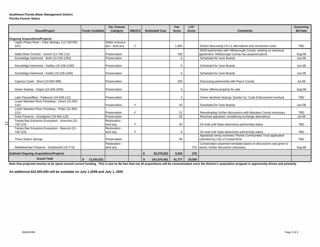
Southwest Florida Water Management DistrictFlorida Forever Status
Parcel/Project Funds AvailableFla Forever
Category SWUCA Estimated CostFee
AcresLTF
Acres CommentsGoverning
Bd Date
Ongoing Acquisitions/ProjectsUpper Peace River - Clear Springs, LLC (20-502-107)
Water resource dev - land acq 1,900 District discussing CS-11 alternatives and conversion costs TBD
Alafia River Corridor - Gooch (11-709-112) Preservation 750 50/50 partnership with Hillsborough County; working on interlocal agreement; Hillsborough County has acquired parcel Aug-08
Annutteliga Hammock - Both (15-228-1293) Preservation 6 Scheduled for June Boards Jun-08
Annutteliga Hammock - Hadley (15-228-1290) Preservation 5 Scheduled for June Boards Jun-08
Annutteliga Hammock - Koblis (15-228-1294) Preservation 5 Scheduled for June Boards Jun-08
Cypress Creek - Short (13-500-389) Preservation 200 Discussing partnership with Pasco County Jul-08
Green Swamp - Vegso (10-200-1005) Preservation 3 Owner offered property for sale Aug-08
Lake Panasoffkee - Patterson (19-528-112) Preservation 1 Owner declined cleanup; Sumter Co. Code Enforcement involved TBDLower Manatee River Floodway - Green (21-602-110) Preservation 43 Scheduled for June Boards Jun-08Lower Manatee River Floodway - Potter (21-602-111) Preservation 21 Reevaluating; further discussions with Manatee County necessary TBDPotts Preserve - Goodgame (19-484-123) Preservation 20 Received appraisal; considering exchange alternatives Jul-08Tampa Bay Estuarine Ecosystem - Amerson (21-728-124)
Restoration - land acq 20 On hold until State determines partnership status TBD
Tampa Bay Estuarine Ecosystem - Bascom (21-728-125)
Restoration - land acq 6 On hold until State determines partnership status TBD
Three Sisters Springs Preservation 56 Appraisals being reviewed; Florida Communities Trust application
submitted by City of Crystal River TBD
Weekiwachee Preserve - Southworth (15-773)Restoration - land acq 278
Conservation easement template based on discussions was given to owner; further discussion necessary Aug-08
Subtotal Ongoing Acquisitions/Projects $ 29,378,922 3,036 278
Grand Total 11,033,021$ 241,570,451$ 41,777 20,550
An additional $22,500,000 will be available on July 1,2008 and July 1, 2009
Note that projected monies to be spent exceed current funding. This is due to the fact that not all acquisitions will be consummated since the District’s acquisition program is opportunity-driven and primarily
06/04/2008 Page 3 of 3
11
Item 59
Resource Management Committee June 24, 2008
Routine Report
Minimum Flows and Levels Status Report
District staff continues to work on various phases of Minimum Flows and Levels (MFLs) development for waterbodies on the District's MFLs priority list. Attached for the Board's use and information is the current Minimum Flows and Levels Priority List and Schedule – Waterbody Timelines report that identifies the status of each waterbody in regard to our five phase process of MFL establishment.
Staff Recommendation: See Exhibit
This item is provided for the Committee's information, and no action is required.
Presenter: Martin H. Kelly, Ph.D., Minimum Flows and Levels Program Director Resource Projects Department
12
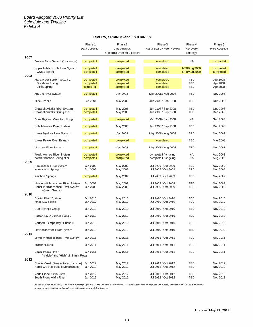
Board Adopted 2008 Priority List Schedule and Timeline Exhibit A
Updated May 21, 2008
RIVERS, SPRINGS and ESTUARIES
Phase 1 Phase 2 Phase 3 Phase 4 Phase 5Data Collection Data Analysis Rpt to Board / Peer Review Recovery Rule Adoption
& Internal Draft MFL Report Strategy2007
Braden River System (freshwater) completed completed completed NA completed
Upper Hillsborough River System completed completed completed NTB/Aug 2000 completed Crystal Spring completed completed completed NTB/Aug 2000 completed
2008Alafia River System (estuary) completed completed completed TBD Apr 2008 Buckhorn Spring completed completed completed TBD Apr 2008 Lithia Spring completed completed completed TBD Apr 2008
Anclote River System completed Apr 2008 May 2008 / Aug 2008 TBD Nov 2008
Blind Springs Feb 2008 May 2008 Jun 2008 / Sep 2008 TBD Dec 2008
Chassahowitzka River System completed May 2008 Jun 2008 / Sep 2008 TBD Dec 2008Chassahowitzka Spring et al. completed May 2008 Jun 2008 / Sep 2008 TBD Dec 2008
Dona Bay and Cow Pen Slough completed completed Mar 2008 / Jun 2008 NA Sep 2008
Little Manatee River System completed May 2008 Jun 2008 / Sep 2008 TBD Dec 2008
Lower Myakka River System completed Apr 2008 May 2008 / Aug 2008 TBD Nov 2008
Lower Peace River Estuary completed completed completed TBD May 2008
Manatee River System completed Apr 2008 May 2008 / Aug 2008 TBD Nov 2008
Weekiwachee River System completed completed completed / ongoing NA Aug 2008Weeki Wachee Spring et al. completed completed completed / ongoing NA Aug 2008
2009Homosassa River System Jan 2009 May 2009 Jul 2009 / Oct 2009 TBD Nov 2009Homosassa Spring Jan 2009 May 2009 Jul 2009 / Oct 2009 TBD Nov 2009
Rainbow Springs completed May 2009 Jul 2009 / Oct 2009 TBD Nov 2009
Middle Withlacoochee River System Jan 2009 May 2009 Jul 2009 / Oct 2009 TBD Nov 2009Upper Withlacoochee River System Jan 2009 May 2009 Jul 2009 / Oct 2009 TBD Nov 2009
(Green Swamp)2010
Crystal River System Jan 2010 May 2010 Jul 2010 / Oct 2010 TBD Nov 2010Kings Bay Spring Jan 2010 May 2010 Jul 2010 / Oct 2010 TBD Nov 2010
Gum Springs Group Jan 2010 May 2010 Jul 2010 / Oct 2010 TBD Nov 2010
Hidden River Springs 1 and 2 Jan 2010 May 2010 Jul 2010 / Oct 2010 TBD Nov 2010
Northern Tampa Bay - Phase II Jan 2010 May 2010 Jul 2010 / Oct 2010 TBD Nov 2010
Pithlachascotee River System Jan 2010 May 2010 Jul 2010 / Oct 2010 TBD Nov 20102011
Lower Withlacoochee River System Jan 2011 May 2011 Jul 2011 / Oct 2011 TBD Nov 2011
Brooker Creek Jan 2011 May 2011 Jul 2011 / Oct 2011 TBD Nov 2011
Upper Peace River Jan 2011 May 2011 Jul 2011 / Oct 2011 TBD Nov 2011"Middle" and "High" Minimum Flows
2012Charlie Creek (Peace River drainage) Jan 2012 May 2012 Jul 2012 / Oct 2012 TBD Nov 2012Horse Creek (Peace River drainage) Jan 2012 May 2012 Jul 2012 / Oct 2012 TBD Nov 2012
North Prong Alafia River Jan 2012 May 2012 Jul 2012 / Oct 2012 TBD Nov 2012South Prong Alafia River Jan 2012 May 2012 Jul 2012 / Oct 2012 TBD Nov 2012
At the Board's direction, staff have added projected dates on which: we expect to have internal draft reports complete, presentation of draft to Board, report of peer review to Board, and return for rule establishment.
13
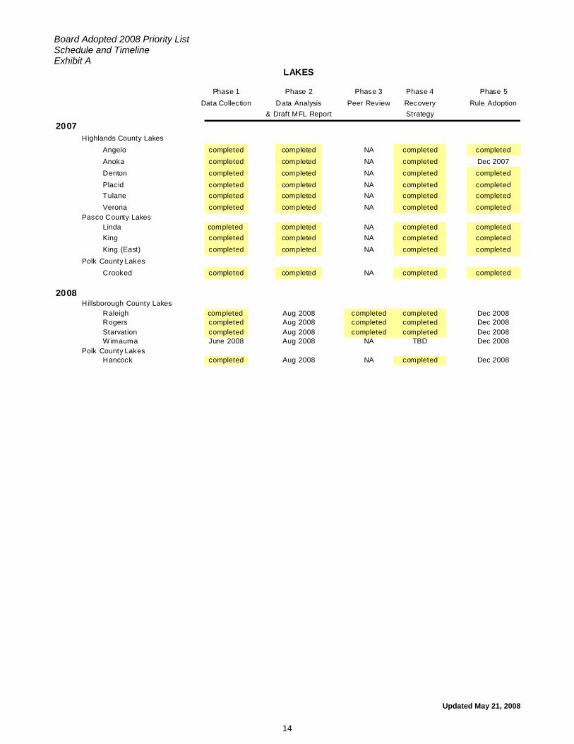
Board Adopted 2008 Priority List Schedule and Timeline Exhibit A
Updated May 21, 2008
LAKES
Phase 1 Phase 2 Phase 3 Phase 4 Phase 5Data Collection Data Analysis Peer Review Recovery Rule Adoption
& Draft MFL Report Strategy
2007Highlands County Lakes
Angelo completed completed NA completed completedAnoka completed completed NA completed Dec 2007Denton completed completed NA completed completedPlacid completed completed NA completed completedTulane completed completed NA completed completedVerona completed completed NA completed completed
Pasco County LakesLinda completed completed NA completed completedKing completed completed NA completed completedKing (East) completed completed NA completed completed
Polk County LakesCrooked completed completed NA completed completed
2008Hillsborough County Lakes
Raleigh completed Aug 2008 completed completed Dec 2008Rogers completed Aug 2008 completed completed Dec 2008Starvation completed Aug 2008 completed completed Dec 2008Wimauma June 2008 Aug 2008 NA TBD Dec 2008
Polk County LakesHancock completed Aug 2008 NA completed Dec 2008
14
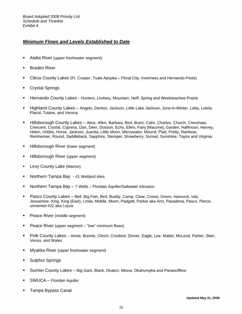
Board Adopted 2008 Priority List Schedule and Timeline Exhibit A
Updated May 21, 2008
Minimum Flows and Levels Established to Date Alafia River (upper freshwater segment)
Braden River
Citrus County Lakes (Ft. Cooper, Tsala Apopka – Floral City, Inverness and Hernando Pools)
Crystal Springs
Hernando County Lakes - Hunters, Lindsey, Mountain, Neff, Spring and Weekiwachee Prairie
Highland County Lakes – Angelo, Denton, Jackson, Little Lake Jackson, June-in-Winter, Letta, Lotela, Placid, Tulane, and Verona
Hillsborough County Lakes – Alice, Allen, Barbara, Bird, Brant, Calm, Charles, Church, Crenshaw, Crescent, Crystal, Cypress, Dan, Deer, Dosson, Echo, Ellen, Fairy [Maurine], Garden, Halfmoon, Harvey, Helen, Hobbs, Horse, Jackson, Juanita, Little Moon, Merrywater, Mound, Platt, Pretty, Rainbow, Reinheimer, Round, Saddleback, Sapphire, Stemper, Strawberry, Sunset, Sunshine, Taylor and Virginia.
Hillsborough River (lower segment)
Hillsborough River (upper segment)
Levy County Lake (Marion)
Northern Tampa Bay - 41 Wetland sites
Northern Tampa Bay – 7 Wells – Floridan Aquifer/Saltwater Intrusion
Pasco County Lakes – Bell, Big Fish, Bird, Buddy, Camp, Clear, Crews, Green, Hancock, Iola, Jessamine, King, King (East), Linda, Middle, Moon, Padgett, Parker aka Ann, Pasadena, Pasco, Pierce, unnamed #22 aka Loyce
Peace River (middle segment)
Peace River (upper segment – "low" minimum flows)
Polk County Lakes – Annie, Bonnie, Clinch, Crooked, Dinner, Eagle, Lee, Mabel, McLeod, Parker, Starr, Venus, and Wales
Myakka River (upper freshwater segment)
Sulphur Springs
Sumter County Lakes – Big Gant, Black, Deaton, Miona, Okahumpka and Panasoffkee
SWUCA – Floridan Aquifer
Tampa Bypass Canal
15
Item 60
Resource Management Committee June 24, 2008 Routine Report
Structure Operations Status Report
The month of May historically marks the last month of the annual dry season and rainfall for the month was well below normal in all regions of the District. The twelve-month District-wide rainfall deficit worsened slightly during May, ending the month approximately 6.2 inches below the long-term average. It has been below-average for 24 consecutive months. Rainfall accumulations for the month were regionally variable, mainly associated with the passage of a weak cold front in mid-May, and were not sufficient to improve hydrologic conditions in most areas. All regional hydrologic indicators throughout the District, including the Peace River basin area, declined during the month and long-term drought conditions intensified.
As of May 28, the US Drought Monitor indicates dry conditions have intensified throughout the District, with the majority of counties experiencing either "abnormally dry" or "moderate drought" conditions, with the exception of Hernando, Pasco, Pinellas and parts of Sumter and Citrus counties, which were experiencing normal moisture conditions. NOAA climate models and forecasts indicate uncertain (equal chance for normal or above/below-normal) rainfall conditions for June and above-normal rainfall for the three-month period of June/July/August 2008, due to diminishing (neutral) La Niña conditions in the Pacific Ocean and an active tropical weather season in the Gulf of Mexico and Atlantic Ocean. Below-normal rainfall would continue to worsen overall hydrologic conditions and increase resource-related impacts.
Updated weather forecasts will be available in mid-June. Staff will continue to closely monitor conditions in accordance with the District's updated Water Shortage Plan, including any necessary supplemental analysis of condition data.
RainfallProvisional regional rainfall totals during the month of May fell in the below-normal range for all regions of the District. The normal range is defined as rainfall totals that fall on or between the 25th to 75th percentiles derived from the historical data for each month The northern region received an average of 0.56 inch of rainfall, equivalent to the 1st percentile.
The central region received 0.58 inch of rainfall, equivalent to the 5th percentile. The southern region recorded an average of 1.28 inches of rain, equivalent to the 11th percentile.
District-wide, average rainfall was 0.82 inch, equivalent to the 5th percentile.
A summary of the operations made in May is as follows:
Inglis Water Control Structures: The Inglis Bypass Spillway was operated during the month of May in order to maintain water levels in Lake Rousseau and provide flow to the lower Withlacoochee River. The average monthly water level for Lake Rousseau was 27.57' NGVD. The recommended maintenance level for the reservoir is 27.5’ NGVD.
Withlacoochee River Basin: All structures on the Tsala Apopka chain of lakes are closed with the exception of the Leslie Heifner Structure, which is open allowing for flow (and navigation) from the Withlacoochee River into the Floral City Pool. The Wysong-Coogler Water Conservation Structure main gate is in the fully raised position (39.0' NGVD) to aid in
16
Item 60 increasing and maintaining Lake Panasoffkee's water level. The Wysong-Coogler Water Conservation Structure low flow gate was operated in order to maintain an average flow of 40 cfs downstream of the structure.
Alafia River Basin: The environmental gate at the Medard Reservoir Structure was operated during the month of May in order to maintain water levels in the reservoir and provide for flow into the Little Alafia River. The average monthly water level for the Medard Reservoir was 58.39' NGVD. The recommended maintenance level for the reservoir is 58.5’ NGVD.
Hillsborough River Basin: There were no structure operations within the basin during the month of May. The average monthly water level for Lake Thonotosassa was 35.76' NGVD compared to the recommended maintenance level of 36.5' NGVD.
Pinellas-Anclote River Basin: There were no structure operations within the basin during the month of May. Structure S-551 (Lake Tarpon) weir gates are set at elevation 3.2' NGVD, maintaining the recommended maintenance level of 3.2' NGVD. The average monthly water level for Lake Tarpon was 2.71' NGVD.
Northwest Hillsborough River Basin: There were no structure operations within the basin during the month of May. The average monthly water level for Lake Pretty was 43.87' NGVD compared to the recommended maintenance level of 44.5' NGVD.
Peace River Basin: The G-90 structure (Lake June-in-Winter) was not operated during the month of May. The average monthly water level for Lake June-in-Winter was 73.37' NGVD compared to the recommended maintenance level of 75.0’ NGVD.
Staff Recommendation: See Exhibit
This item is provided for the Committee's information, and no action is required.
Presenter: Tanase Bude, Manager, Structure Operations Section
17
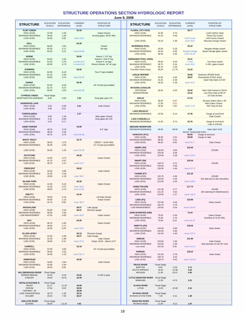
ELEVATION ELEVATION CURRENT POSITION OF ELEVATION ELEVATION CURRENT POSITION OFLEVELS DIFFERENCE LEVEL STRUCTURE LEVELS DIFFERENCE LEVEL STRUCTURE
FLINT CREEK 35.45 FLORAL CITY POOL 38.77HIGH LEVEL 37.00 -1.55 Gates Closed HIGH LEVEL 42.50 -3.73 Leslie Heifner Open
MAXIMUM DESIRABLE 36.50 -1.05 All drop gates: 36.00' MSL MAXIMUM DESIRABLE 42.25 -3.48 Floral City ClosedLOW LEVEL 34.50 0.95 invert 32.9' Golf Course Golf Course Closed
LOW LEVEL 40.25 -1.48 invert 38.0' Moccasin slough ClosedKELL 63.39
HIGH LEVEL 66.00 -2.61 Closed INVERNESS POOL 35.32MAXIMUM DESIRABLE 65.50 -2.11 No logs HIGH LEVEL 40.50 -5.18 Brogden Bridge closed
LOW LEVEL 63.50 -0.11 invert 64.66' MAXIMUM DESIRABLE 40.25 -4.93 Brogden Bridge Bryant Slough gates closedLOW LEVEL 38.25 -2.93 invert 34.25'
KEENE 59.80 Keene 1: 2-6" logHIGH LEVEL 63.00 -3.20 Keene 2: One 6" log HERNANDO POOL (S353) 33.41
MAXIMUM DESIRABLE 62.50 -2.70 1-invert 61.5' Keene 3: no logs HIGH LEVEL 39.00 -5.59 S-353 Van Ness closedLOW LEVEL 60.50 -0.70 2-invert 61.6' Sherry's Brook: 18" of Logs MAXIMUM DESIRABLE 38.75 -5.34 invert 36.5' S-353 gates closed
LOW LEVEL 36.75 -3.34STEMPER 55.80 Two Mile Prairie (max) 35.00 -11.75 23.25
HIGH LEVEL 62.00 -6.20 Two 4" logs installedMAXIMUM DESIRABLE 61.25 -5.45 LESLIE HEIFNER 38.86 Upstream (RIVER level)
LOW LEVEL 59.50 -3.70 invert 60.25' HIGH LEVEL 42.50 -3.64 38.87 Downstream (POOL level)MAXIMUM DESIRABLE 42.25 -3.39 Gate Fully Open to 9.00'
HANNA 56.48 LOW LEVEL 40.25 -1.39 invert 35.0'HIGH LEVEL 62.50 -6.02 18" of stop log installed
MAXIMUM DESIRABLE 61.75 -5.27 WYSONG-COOGLERLOW LEVEL 59.50 -3.02 invert 60.28' UPSTREAM 39.50 -0.50 39.00 Main Gate Raised to 39.00'
DOWNSTREAM 34.52 Low Flow Gate at 38.70'CYPRESS CREEK Flood Stage 19 Total cfs flow
WORTHINGTON GARDENS 8.00 -6.06 1.94 Drop gate open 3.0'. INGLIS 27.53HIGH LEVEL 28.00 -0.47 By-pass Gates Open 1.30'
SAWGRASS LAKE MAXIMUM DESIRABLE 27.50 0.03 Main Gates ClosedHIGH LEVEL 5.00 -0.59 4.41 Gate Closed LOW LEVEL 26.50 1.03 invert 11.3' 426 Total cfs flow LOW LEVEL 3.80 0.61
LAKE BRADLEYTARPON (S551) 2.37 MAXIMUM DESIRABLE 42.50 -5.14 37.36 Gauge at mud level
HIGH LEVEL 3.80 -1.43 Main gates Closed Gate ClosedMAXIMUM DESIRABLE 3.20 -0.83 Drop gates @ 3.20 LAKE CONSUELLA
LOW LEVEL 2.20 0.17 MAXIMUM DESIRABLE 41.50 -5.74 35.76 Gauge at mud levelLogs in (closed)
ANNE PARKER 44.99 MEDARD RESERVOIRHIGH LEVEL 48.75 -3.76 5-6" logs MAXIMUM DESIRABLE 60.00 -60.00 0.00 Gate Open 0.50'
MAXIMUM DESIRABLE 48.25 -3.26 Sensor Temporarily DownLOW LEVEL 45.75 -0.76 invert 46.40' HANCOCK (P11) 96.09 Gauge at structure
HIGH LEVEL 99.00 -2.91 95.99 Gauge on lakeWHITE TROUT 32.75 MAXIMUM DESIRABLE 98.50 -2.41 HIGH LEVEL 36.50 -3.75 CREST = 33.94' MSL LOW LEVEL 96.00 0.09 invert 91.7' Gate Closed
MAXIMUM DESIRABLE 36.00 -3.25 12" of stop log installedHENRY (P5) 122.94
LOW LEVEL 34.00 -1.25 invert 32.94' HIGH LEVEL 126.50 -3.56 LRLMDMAXIMUM DESIRABLE 126.00 -3.06
KEYSTONE 38.28 LOW LEVEL 124.00 -1.06 invert 122.0'HIGH LEVEL 42.00 -3.72 Gates Closed
MAXIMUM DESIRABLE 41.75 -3.47 SMART (P6) 125.04LOW LEVEL 39.75 -1.47 invert 37.2' HIGH LEVEL 128.75 -3.71 LRLMD
MAXIMUM DESIRABLE 128.50 -3.46 CRESCENT 38.82 LOW LEVEL 126.50 -1.46 invert 127.2'HIGH LEVEL 42.50 -3.68 Gate Closed
MAXIMUM DESIRABLE 42.00 -3.18 FANNIE (P7) 121.25LOW LEVEL 40.00 -1.18 invert 38.5' HIGH LEVEL 125.75 -4.50 LRLMD
MAXIMUM DESIRABLE 125.50 -4.25 (No data due to site relocation)ISLAND FORD 36.28 LOW LEVEL 123.50 -2.25 invert 119.5'HIGH LEVEL 41.50 -5.22 Gates Closed
MAXIMUM DESIRABLE 41.00 -4.72 invert 35.0' HAMILTON (P8) 117.73LOW LEVEL 39.00 -2.72 crest 41.25' HIGH LEVEL 121.50 -3.77 LRLMD
MAXIMUM DESIRABLE 121.25 -3.52 (De-watering for Maintenance)PRETTY 43.40 LOW LEVEL 119.00 -1.27 invert 110.5'
HIGH LEVEL 45.50 -2.10 Lift Gate ClosedMAXIMUM DESIRABLE 44.50 -1.10 Drops Closed LENA (P1) 133.96
LOW LEVEL 42.75 0.65 invert 38.0' HIGH LEVEL 137.00 -3.04 Gates closedMAXIMUM DESIRABLE 136.75 -2.79
MAGDALENE 46.57 Lake gauge LOW MANAGEMENT 134.50 -0.54 invert 134.47'HIGH LEVEL 50.00 -3.43 46.01 Structure gauge
MAXIMUM DESIRABLE 49.50 -2.93 JUNE-IN-WINTER (G90) 73.24LOW MANAGEMENT 47.50 -0.93 invert 45.6' Gates closed HIGH LEVEL 75.50 -2.26 Gates Closed
MAXIMUM DESIRABLE 75.00 -1.76 Overflow at 75.25' MSLBAY 44.29 LOW LEVEL 73.00 0.24 invert 65.37'
HIGH LEVEL 46.75 -2.46 Gates ClosedMAXIMUM DESIRABLE 46.00 -1.71 ARIETTA (P3) 139.04
LOW LEVEL 44.00 0.29 invert 44.0' HIGH LEVEL 144.00 -4.96 Gate closed MAXIMUM DESIRABLE 142.50 -3.46
ELLEN-LIPSEY 39.10 Structure Gauge LOW LEVEL 141.00 -1.96 invert 137.4'HIGH LEVEL 41.50 -2.40 39.27 Lake Gauge
MAXIMUM DESIRABLE 41.00 -1.90 Gate Closed GIBSON 141.95LOW LEVEL 39.00 0.10 invert 37.6' Drops: 40.62 - Stems 13.5" HIGH LEVEL 143.50 -1.55 Gate Closed
MAXIMUM DESIRABLE 143.00 -1.05 Stop log bays at 142.30' crestCARROLL 33.18 Low Level 141.50 0.45 invert 141.4'
HIGH LEVEL 37.00 -3.82 24" of stop log installedMAXIMUM DESIRABLE 36.50 -3.32 PARKER 128.22
LOW LEVEL 34.50 -1.32 invert 34.17' HIGH LEVEL 131.00 -2.78 Gate closedMAXIMUM DESIRABLE 130.75 -2.53
ARMISTEAD 40.56 LOW LEVEL 128.75 -0.53 invert 129.15'HIGH LEVEL 44.00 -3.44 Gate Closed
MAXIMUM DESIRABLE 43.00 -2.44 PEACE RIVER Flood StageLOW LEVEL 40.50 0.06 BARTOW 8.00 -5.29 2.71
ZOLFO SPRINGS 16.00 -12.38 3.62HILLSBOROUGH RIVER Flood Stage ARCADIA 11.00 -10.07 0.93
MORRIS BRIDGE 32.00 -8.18 23.82 S-155 is openFOWLER 29.00 -10.51 18.49 LITTLE MANATEE RIVER Flood Stage
WIMAUMA 11.00 -8.79 2.21WITHLACOOCHEE R. Flood Stage
TRILBY 61.27 -11.28 49.99 ALAFIA RIVER Flood StageCROOM 47.94 -8.02 39.92 LITHIA 13.00 -10.49 2.51
HIGHWAY. 48 38.99LAKE PANASOFFKEE 40.70 -1.60 39.10 MYAKKA RIVER Flood Stage
HOLDER 35.52 -7.45 28.07 MYAKKA STATE PARK 7.00 -5.31 1.69
ANCLOTE RIVER Flood Stage MANATEE RIVER Flood StageELFERS 20.00 -12.18 7.82 MYAKKA HEAD 11.00 -9.13 1.87
STRUCTURE OPERATIONS SECTION HYDROLOGIC REPORTJune 9, 2008
STRUCTURESTRUCTURE
18
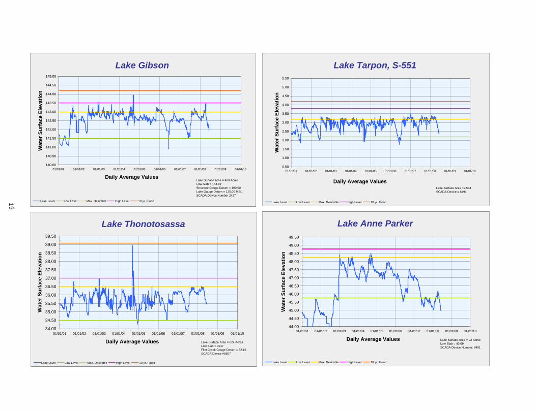
Lake Gibson
140.00
140.50
141.00
141.50
142.00
142.50
143.00
143.50
144.00
144.50
145.00
01/01/01 01/01/02 01/01/03 01/01/04 01/01/05 01/01/06 01/01/07 01/01/08 01/01/09 01/01/10
Daily Average Values
Wat
er S
urfa
ce E
leva
tion
Lake Level Low Level Max. Desirable High Level 10 yr. Flood
Lake Surface Area = 480 AcresLow Slab = 144.81'Structure Gauge Datum = 100.00'Lake Gauge Datum = 135.00 MSLSCADA Device Number 2427
Lake Tarpon, S-551
0.50
1.00
1.50
2.00
2.50
3.00
3.50
4.00
4.50
5.00
5.50
01/01/01 01/01/02 01/01/03 01/01/04 01/01/05 01/01/06 01/01/07 01/01/08 01/01/09 01/01/10
Daily Average Values
Wat
er S
urfa
ce E
leva
tion
Lake Level Low Level Max. Desirable High Level 10 yr. Flood
Lake Surface Area =2,534SCADA Device # 6491
Lake Thonotosassa
34.00
34.50
35.00
35.50
36.00
36.50
37.00
37.50
38.00
38.50
39.00
39.50
01/01/01 01/01/02 01/01/03 01/01/04 01/01/05 01/01/06 01/01/07 01/01/08 01/01/09 01/01/10
Daily Average Values
Wat
er S
urfa
ce E
leva
tion
Lake Level Low Level Max. Desirable High Level 10 yr. Flood
Lake Surface Area = 824 AcresLow Slab = 39.0'Flint Creek Gauge Datum = 32.16SCADA Device #6807
Lake Anne Parker
44.00
44.50
45.00
45.50
46.00
46.50
47.00
47.50
48.00
48.50
49.00
49.50
01/01/01 01/01/02 01/01/03 01/01/04 01/01/05 01/01/06 01/01/07 01/01/08 01/01/09 01/01/10
Daily Average Values
Wat
er S
urfa
ce E
leva
tion
Lake Level Low Level Max. Desirable High Level 10 yr. Flood
Lake Surface Area = 93 AcresLow Slab = 40.09'SCADA Device Number: 8491
19
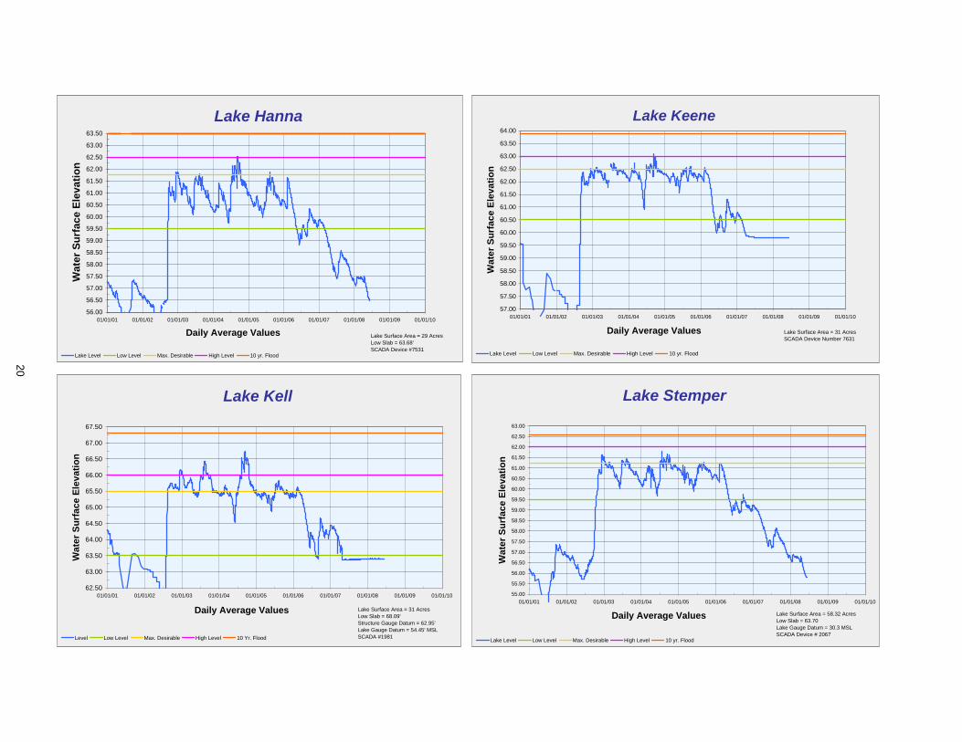
Lake Hanna
56.00
56.50
57.00
57.50
58.00
58.50
59.00
59.50
60.00
60.50
61.00
61.50
62.00
62.50
63.00
63.50
01/01/01 01/01/02 01/01/03 01/01/04 01/01/05 01/01/06 01/01/07 01/01/08 01/01/09 01/01/10
Daily Average Values
Wat
er S
urfa
ce E
leva
tion
Lake Level Low Level Max. Desirable High Level 10 yr. Flood
Lake Surface Area = 29 AcresLow Slab = 63.68'SCADA Device #7531
Lake Keene
57.00
57.50
58.00
58.50
59.00
59.50
60.00
60.50
61.00
61.50
62.00
62.50
63.00
63.50
64.00
01/01/01 01/01/02 01/01/03 01/01/04 01/01/05 01/01/06 01/01/07 01/01/08 01/01/09 01/01/10
Daily Average Values
Wat
er S
urfa
ce E
leva
tion
Lake Level Low Level Max. Desirable High Level 10 yr. Flood
Lake Surface Area = 31 AcresSCADA Device Number 7631
Lake Kell
62.50
63.00
63.50
64.00
64.50
65.00
65.50
66.00
66.50
67.00
67.50
01/01/01 01/01/02 01/01/03 01/01/04 01/01/05 01/01/06 01/01/07 01/01/08 01/01/09 01/01/10
Daily Average Values
Wat
er S
urfa
ce E
leva
tion
Level Low Level Max. Desirable High Level 10 Yr. Flood
Lake Surface Area = 31 AcresLow Slab = 68.09'Structure Gauge Datum = 62.95'Lake Gauge Datum = 54.45' MSLSCADA #1981
Lake Stemper
55.00
55.50
56.00
56.50
57.00
57.50
58.00
58.50
59.00
59.50
60.00
60.50
61.00
61.50
62.00
62.50
63.00
01/01/01 01/01/02 01/01/03 01/01/04 01/01/05 01/01/06 01/01/07 01/01/08 01/01/09 01/01/10
Daily Average Values
Wat
er S
urfa
ce E
leva
tion
Lake Level Low Level Max. Desirable High Level 10 yr. Flood
Lake Surface Area = 58.32 AcresLow Slab = 63.70Lake Gauge Datum = 30.3 MSLSCADA Device # 2067
20
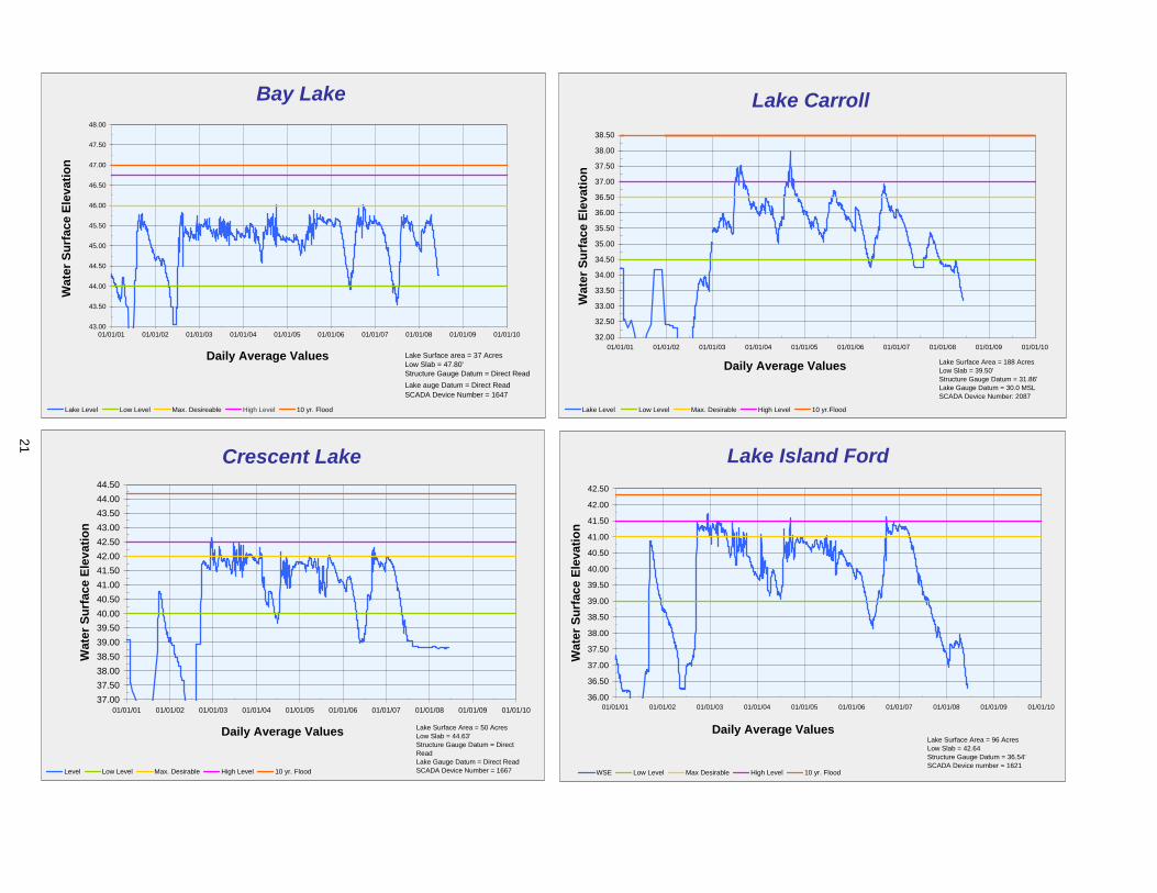
Bay Lake
43.00
43.50
44.00
44.50
45.00
45.50
46.00
46.50
47.00
47.50
48.00
01/01/01 01/01/02 01/01/03 01/01/04 01/01/05 01/01/06 01/01/07 01/01/08 01/01/09 01/01/10
Daily Average Values
Wat
er S
urfa
ce E
leva
tion
Lake Level Low Level Max. Desireable High Level 10 yr. Flood
Lake Surface area = 37 AcresLow Slab = 47.80'Structure Gauge Datum = Direct ReadLake auge Datum = Direct ReadSCADA Device Number = 1647
Lake Carroll
32.00
32.50
33.00
33.50
34.00
34.50
35.00
35.50
36.00
36.50
37.00
37.50
38.00
38.50
01/01/01 01/01/02 01/01/03 01/01/04 01/01/05 01/01/06 01/01/07 01/01/08 01/01/09 01/01/10
Daily Average Values
Wat
er S
urfa
ce E
leva
tion
Lake Level Low Level Max. Desirable High Level 10 yr.Flood
Lake Surface Area = 188 AcresLow Slab = 39.50'Structure Gauge Datum = 31.86'Lake Gauge Datum = 30.0 MSLSCADA Device Number: 2087
Crescent Lake
37.0037.5038.0038.5039.0039.5040.0040.5041.0041.5042.0042.5043.0043.5044.0044.50
01/01/01 01/01/02 01/01/03 01/01/04 01/01/05 01/01/06 01/01/07 01/01/08 01/01/09 01/01/10
Daily Average Values
Wat
er S
urfa
ce E
leva
tion
Level Low Level Max. Desirable High Level 10 yr. Flood
Lake Surface Area = 50 AcresLow Slab = 44.63'Structure Gauge Datum = Direct ReadLake Gauge Datum = Direct ReadSCADA Device Number = 1667
Lake Island Ford
36.00
36.50
37.00
37.50
38.00
38.50
39.00
39.50
40.00
40.50
41.00
41.50
42.00
42.50
01/01/01 01/01/02 01/01/03 01/01/04 01/01/05 01/01/06 01/01/07 01/01/08 01/01/09 01/01/10
Daily Average Values
Wat
er S
urfa
ce E
leva
tion
WSE Low Level Max Desirable High Level 10 yr. Flood
Lake Surface Area = 96 AcresLow Slab = 42.64Structure Gauge Datum = 36.54'SCADA Device number = 1621
21
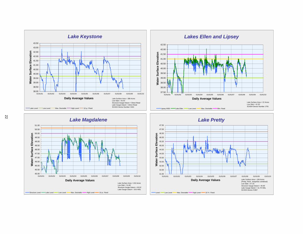
Lake Keystone
38.00
38.50
39.00
39.50
40.00
40.50
41.00
41.50
42.00
42.50
43.00
43.50
01/01/01 01/01/02 01/01/03 01/01/04 01/01/05 01/01/06 01/01/07 01/01/08 01/01/09 01/01/10
Daily Average Values
Wat
er S
urfa
ce E
leva
tion
Lake Level Low Level Max. Desirable High Level 10 yr. Flood
Lake Surface Area = 388 AcresLow Slab = 43.53'Structure Gauge Datum = Direct ReadLake Gauge Datum = Direct ReadSCADA Device Number: 6161
Lakes Ellen and Lipsey
37.50
38.00
38.50
39.00
39.50
40.00
40.50
41.00
41.50
42.00
42.50
01/01/01 01/01/02 01/01/03 01/01/04 01/01/05 01/01/06 01/01/07 01/01/08 01/01/09 01/01/10
Daily Average Values
Wat
er S
urfa
ce E
leva
tion
Lipsey WSE Lake Ellen Low Level Max. Desirable Min. Flood
Lake Surface Area = 22 AcresLow Slab = 42.35'SCADA Device Number 1791
Lake Magdalene
45.00
45.50
46.00
46.50
47.00
47.50
48.00
48.50
49.00
49.50
50.00
50.50
51.00
01/01/01 01/01/02 01/01/03 01/01/04 01/01/05 01/01/06 01/01/07 01/01/08 01/01/09 01/01/10
Daily Average Values
Wat
er S
urfa
ce E
leva
tion
Structure Level Lake Level Low Level Max. Desirable High Level 10 yr. Flood
Lake Surface Area = 232 AcresLow Slab = 51.80'Structure Gauge Datum = 45.52Lake Gauge Datum = 30.0 MSL
Lake Pretty
41.50
42.00
42.50
43.00
43.50
44.00
44.50
45.00
45.50
46.00
46.50
47.00
47.50
01/01/01 01/01/02 01/01/03 01/01/04 01/01/05 01/01/06 01/01/07 01/01/08 01/01/09 01/01/10
Daily Average Values
Wat
er S
urfa
ce E
leva
tion
Level Low Level Max. Desirable High Level 10 Yr. Flood
Lake Surface Area = 184 Acres(Pretty, Rock, Josephine combined)Low Slab = 47.10'Structure Gauge Datum = 40.00'Lake Gauge Datum = 31.74' MSLSCADA Device #1967
22
Lake White Trout
32.50
33.00
33.50
34.00
34.50
35.00
35.50
36.00
36.50
37.00
37.50
38.00
38.50
06/01/06 06/01/07 06/01/08 06/01/09
Daily Average Values
Wat
er S
urfa
ce E
leva
tion
Lake Level Low Level Max. Desirable High Level 10 yr. Flood
Lake Surface Area = 75 AcresLow Slab = 39.41'Structure Gauge Datum = 33.38'Lake Gauge Datum = 19.98' MSL
Lake Lowery
127.50
128.00
128.50
129.00
129.50
130.00
130.50
131.00
131.50
132.00
01/01/03 01/01/04 01/01/05 01/01/06 01/01/07 01/01/08 01/01/09 01/01/10
Daily Average Values
Wat
er S
urfa
ce E
leva
tion
Lake Level Low Level Max. Desirable High Level
Lake Surface Area = 903 AcresLow Slab = 131.61SCADA Device Number 6181
Lake Rousseau
24.50
25.00
25.50
26.00
26.50
27.00
27.50
28.00
28.50
29.00
29.50
01/01/01 01/01/02 01/01/03 01/01/04 01/01/05 01/01/06 01/01/07 01/01/08 01/01/09 01/01/10
Daily Average Values
Wat
er S
urfa
ce E
leva
tion
Lake Level Low Level Max. Desirable High Level
Lake Surface Area = 3657 AcresStructure Gauge Datum = 10.00SCADA Device Number 6137
Lake Arietta (P-3)
137.50
138.00
138.50
139.00
139.50
140.00
140.50
141.00
141.50
142.00
142.50
143.00
143.50
144.00
144.50
01/01/01 01/01/02 01/01/03 01/01/04 01/01/05 01/01/06 01/01/07 01/01/08 01/01/09 01/01/10
Daily Average Values
Wat
er S
urfa
ce E
leva
tion
Lake Level Low Level Max. Desirable High Level
Lake Surface Area = 758 AcresLake Gauge Datum = 100.00'SCADA Device Number 7431
23
Hernando Pool
32.0032.5033.0033.5034.0034.5035.0035.5036.0036.5037.0037.5038.0038.5039.0039.5040.0040.50
01/01/01 01/01/02 01/01/03 01/01/04 01/01/05 01/01/06 01/01/07 01/01/08 01/01/09 01/01/10
Daily Average Values
Wat
er S
urfa
ce E
leva
tion
Lake Level Low Level Max. Desirable High Level 10 yr. Flood
Lake Surface Area = 6200 AcresLow Slab = 40.47'Structure Gauge Datum = Direct ReadLake Gauge Datum = Direct ReadSCADA # 2047
Inverness Pool
31.5032.0032.5033.0033.5034.0034.5035.0035.5036.0036.5037.0037.5038.0038.5039.0039.5040.0040.5041.0041.5042.00
01/01/01 01/01/02 01/01/03 01/01/04 01/01/05 01/01/06 01/01/07 01/01/08 01/01/09 01/01/10
Daily Average Values
Wat
er S
urfa
ce E
leva
tion
Level Low Level Max. Desirable High Level 10 Yr. Flood
Lake Surface Area = 8000 AcresLow Slab = 42.54'Structure Gauge Datum = Direct ReadLake Gauge Datum = Direct ReadSCADA # 2027
Leslie Heifner
35.5036.0036.5037.0037.5038.0038.5039.0039.5040.0040.5041.0041.5042.0042.5043.00
01/01/01 01/01/02 01/01/03 01/01/04 01/01/05 01/01/06 01/01/07 01/01/08 01/01/09 01/01/10
Daily Average Values
Wat
er S
urfa
ce E
leva
tion
Upstream Level Downsream Level Low Level Max.Desirable High Level
Lake Surface Area = 37 AcresLow Slab = 47.80'SCADA Device #6767 & #6766
Floral City Pool
30.5031.0031.5032.0032.5033.0033.5034.0034.5035.0035.5036.0036.5037.0037.5038.0038.5039.0039.5040.0040.5041.0041.5042.0042.5043.0043.50
01/01/01 01/01/02 01/01/03 01/01/04 01/01/05 01/01/06 01/01/07 01/01/08 01/01/09 01/01/10
Daily Average Values
Wat
er S
urfa
ce E
leva
tion
Level Low Level Max. Desirable High Level 10 Yr. Flood
Lake Surface Area = 9100 AcresLow Slab = 44.10'Structure Gauge Datum = Direct ReadLake Gauge Datum = Direct ReadSCADA #2007
24
Lake Fannie (P-7)
120.00
120.50
121.00
121.50
122.00
122.50
123.00
123.50
124.00
124.50
125.00
125.50
126.00
126.50
127.00
127.50
01/01/01 01/01/02 01/01/03 01/01/04 01/01/05 01/01/06 01/01/07 01/01/08 01/01/09 01/01/10
Daily Average Values
Wat
er S
urfa
ce E
leva
tion
Lake Level Low Level Max. Desirable High Level 10 Yr. Flood
Lake Surface Area = 833 AcresLow Slab = 127.60'Lake Gauge Datum = 120.36 MSLSCADA Device #2187
Lake Hamilton (P-8)
117.50
118.00
118.50
119.00
119.50
120.00
120.50
121.00
121.50
122.00
122.50
123.00
01/01/01 01/01/02 01/01/03 01/01/04 01/01/05 01/01/06 01/01/07 01/01/08 01/01/09 01/01/10
Daily Average Values
Wat
er S
urfa
ce E
leva
tion
Lake Level Low Level Max. Desirable High Level 10 Yr. Flood
Lake Surface Area = 2,640 AcresLake Gauge Datum = 115.00'SCADA Device Number = 1747
Lake Hancock (P-11)
95.0095.5096.0096.5097.0097.5098.0098.5099.0099.50
100.00100.50101.00101.50102.00102.50103.00
01/01/01 01/01/02 01/01/03 01/01/04 01/01/05 01/01/06 01/01/07 01/01/08 01/01/09 01/01/10
Daily Average Values
Wat
er S
urfa
ce E
leva
tion
Gauge at Structure Lake Level Low Level Max Desirable High Level 10 yr. Flood
Lake Surface Area = 4,541 AcresLake Gauge Datum = 92.78' MSLStructure Gauge Datum = 84.08'SCADA Device Number = 1767 & 4087
Lake Henry (P-5)
121.50
122.00
122.50
123.00
123.50
124.00
124.50
125.00
125.50
126.00
126.50
127.00
127.50
128.00
01/01/01 01/01/02 01/01/03 01/01/04 01/01/05 01/01/06 01/01/07 01/01/08 01/01/09 01/01/10
Daily Average Values
Wat
er S
urfa
ce E
leva
tion
Lake Level Low Level Max. Desirable High Level 10 Yr. Flood
Lake Surface Area = 861 AcresStructure Gauge Datum = 100.00' MSLS.R. Gauge Datum = 120.00' MSLSCADA Device Number 1807
25
Lake Lena (P-1)
132.50
133.00
133.50
134.00
134.50
135.00
135.50
136.00
136.50
137.00
137.50
138.00
01/01/01 01/01/02 01/01/03 01/01/04 01/01/05 01/01/06 01/01/07 01/01/08 01/01/09 01/01/10
Daily Average Values
Wat
er S
urfa
ce E
leva
tion
Lake Level Low Level Max. Desirable High Level 10 yr. Flood
Lake Surface Area = 207 AcresLake Gauge Datum = 132.12SCADA Device Number 7451
Lake June-in-Winter (G-90)
72.00
72.50
73.00
73.50
74.00
74.50
75.00
75.50
76.00
76.50
77.00
01/01/01 01/01/02 01/01/03 01/01/04 01/01/05 01/01/06 01/01/07 01/01/08 01/01/09 01/01/10
Daily Average Values
Wat
er S
urfa
ce E
leva
tion
Lake Level Low Level Max. Desirable High Level 10 yr. Flood
Lake Surface Area = 3,504 AcresStructure Gauge Datum = Direct ReadLake Gauge Datum = 65.38 MSLSCADA Device Number=6136
Lake Parker
127.00127.50128.00128.50129.00129.50130.00130.50131.00131.50132.00132.50133.00
01/01/01 01/01/02 01/01/03 01/01/04 01/01/05 01/01/06 01/01/07 01/01/08 01/01/09 01/01/10
Daily Average Values
Wat
er S
urfa
ce E
leva
tion
Lake Level Low Level Max. Desirable High Level 10 yr. Flood
Lake Surface Area = 2,272 AcresLake Gauge Datum = 100.00'SCADA Device Number 7721
Lake Smart (P-6)
123.50
124.00
124.50
125.00
125.50
126.00
126.50
127.00
127.50
128.00
128.50
129.00
129.50
130.00
130.50
01/01/01 01/01/02 01/01/03 01/01/04 01/01/05 01/01/06 01/01/07 01/01/08 01/01/09 01/01/10
Daily Average Values
Wat
er S
urfa
ce E
leva
tion
Lake Level Low Level Max. Desirable High Level 10 Yr. Flood
Lake Surface Area = 1,820 AcresLow Slab = 131.43'Lake Gauge Datum = 120.00' MSLSCADA Device Number: 2167
26
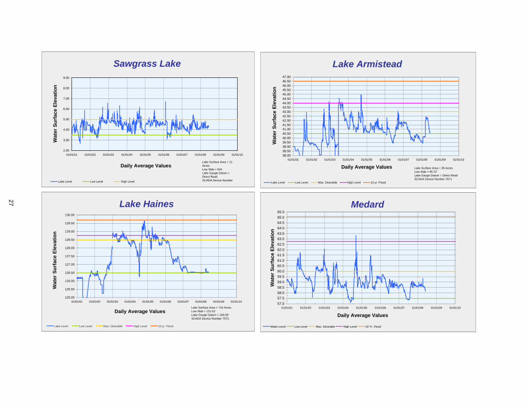
Sawgrass Lake
2.00
3.00
4.00
5.00
6.00
7.00
8.00
9.00
01/01/01 01/01/02 01/01/03 01/01/04 01/01/05 01/01/06 01/01/07 01/01/08 01/01/09 01/01/10
Daily Average Values
Wat
er S
urfa
ce E
leva
tion
Lake Level Low Level High Level
Lake Surface Area = 21 AcresLow Slab = N/ALake Gauge Datum = Direct ReadSCADA Device Number
Lake Armistead
38.0038.5039.0039.5040.0040.5041.0041.5042.0042.5043.0043.5044.0044.5045.0045.5046.0046.5047.00
01/01/01 01/01/02 01/01/03 01/01/04 01/01/05 01/01/06 01/01/07 01/01/08 01/01/09 01/01/10
Daily Average Values
Wat
er S
urfa
ce E
leva
tion
Lake Level Low Level Max. Desirable High Level 10 yr. Flood
Lake Surface Area = 35 AcresLow Slab = 45.72'Lake Gauge Datum = Direct ReadSCADA Device Number 7671
Lake Haines
125.00
125.50
126.00
126.50
127.00
127.50
128.00
128.50
129.00
129.50
130.00
01/01/01 01/01/02 01/01/03 01/01/04 01/01/05 01/01/06 01/01/07 01/01/08 01/01/09 01/01/10
Daily Average Values
Wat
er S
urfa
ce E
leva
tion
Lake Level Low Level Max. Desirable High Level 10 yr. Flood
Lake Surface Area = 716 AcresLow Slab = 131.61'Lake Gauge Datum = 100.00'SCADA Device Number 7571
Medard
57.057.558.058.559.059.560.060.561.061.562.062.563.063.564.064.565.065.5
01/01/01 01/01/02 01/01/03 01/01/04 01/01/05 01/01/06 01/01/07 01/01/08 01/01/09 01/01/10
Daily Average Values
Wat
er S
urfa
ce E
leva
tion
Water Level Low Level Max. Desirable High Level 10 Yr. Flood
27
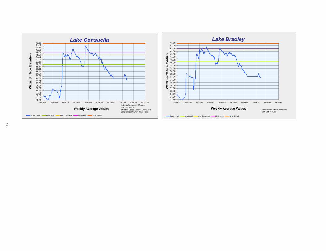
Lake Consuella
31.5032.0032.5033.0033.5034.0034.5035.0035.5036.0036.5037.0037.5038.0038.5039.0039.5040.0040.5041.0041.5042.0042.5043.0043.50
01/01/01 01/01/02 01/01/03 01/01/04 01/01/05 01/01/06 01/01/07 01/01/08 01/01/09 01/01/10
Weekly Average Values
Wat
er S
urfa
ce E
leva
tion
Water Level Low Level Max. Desirable High Level 10 yr. Flood
Lake Surface Area = 37 AcresLow Slab = 47.80'Structure Gauge Datum = Direct ReadLake Gauge Datum = Direct Read
Lake Bradley
33.5034.0034.5035.0035.5036.0036.5037.0037.5038.0038.5039.0039.5040.0040.5041.0041.5042.0042.5043.0043.50
01/01/01 01/01/02 01/01/03 01/01/04 01/01/05 01/01/06 01/01/07 01/01/08 01/01/09 01/01/10
Weekly Average Values
Wat
er S
urfa
ce E
leva
tion
Lake Level Low Level Max. Desirable High Level 10 yr. Flood
Lake Surface Area = 590 AcresLow Slab = 44.38'
28
Item 61
Resource Management Committee June 24, 2008
Routine Report
Watershed Management Program and Federal Emergency Management Agency Map Modernization Status Report District staff continues to work on various steps of the District’s Watershed Management Program and Federal Emergency Management Agency (FEMA) Map Modernization. Attached for the Board’s information is the current schedule that identifies the status of each watershed for the topographic information, watershed evaluation, watershed management plan, and Flood Insurance Rate Maps (FIRMs). The list also indicates whether the updated FIRMs will be a redelineation of the existing FIRMs or based on a detailed study.
Staff Recommendation: See Exhibit
This item is provided for the Committee's information, no action is required.
Presenter: Mark Hammond, Director, Resource Projects Department
29
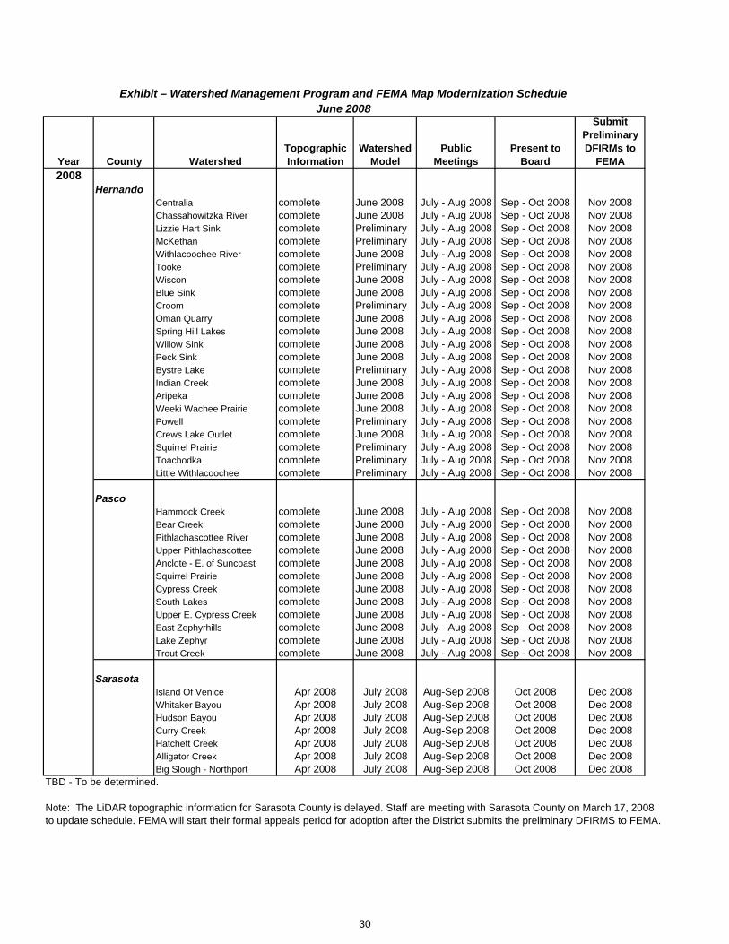
Year County WatershedTopographic Information
Watershed Model
Public Meetings
Present to Board
Submit Preliminary DFIRMs to
FEMA2008
HernandoCentralia complete June 2008 July - Aug 2008 Sep - Oct 2008 Nov 2008Chassahowitzka River complete June 2008 July - Aug 2008 Sep - Oct 2008 Nov 2008Lizzie Hart Sink complete Preliminary July - Aug 2008 Sep - Oct 2008 Nov 2008McKethan complete Preliminary July - Aug 2008 Sep - Oct 2008 Nov 2008Withlacoochee River complete June 2008 July - Aug 2008 Sep - Oct 2008 Nov 2008Tooke complete Preliminary July - Aug 2008 Sep - Oct 2008 Nov 2008Wiscon complete June 2008 July - Aug 2008 Sep - Oct 2008 Nov 2008Blue Sink complete June 2008 July - Aug 2008 Sep - Oct 2008 Nov 2008Croom complete Preliminary July - Aug 2008 Sep - Oct 2008 Nov 2008Oman Quarry complete June 2008 July - Aug 2008 Sep - Oct 2008 Nov 2008Spring Hill Lakes complete June 2008 July - Aug 2008 Sep - Oct 2008 Nov 2008Willow Sink complete June 2008 July - Aug 2008 Sep - Oct 2008 Nov 2008Peck Sink complete June 2008 July - Aug 2008 Sep - Oct 2008 Nov 2008Bystre Lake complete Preliminary July - Aug 2008 Sep - Oct 2008 Nov 2008Indian Creek complete June 2008 July - Aug 2008 Sep - Oct 2008 Nov 2008Aripeka complete June 2008 July - Aug 2008 Sep - Oct 2008 Nov 2008Weeki Wachee Prairie complete June 2008 July - Aug 2008 Sep - Oct 2008 Nov 2008Powell complete Preliminary July - Aug 2008 Sep - Oct 2008 Nov 2008Crews Lake Outlet complete June 2008 July - Aug 2008 Sep - Oct 2008 Nov 2008Squirrel Prairie complete Preliminary July - Aug 2008 Sep - Oct 2008 Nov 2008Toachodka complete Preliminary July - Aug 2008 Sep - Oct 2008 Nov 2008Little Withlacoochee complete Preliminary July - Aug 2008 Sep - Oct 2008 Nov 2008
PascoHammock Creek complete June 2008 July - Aug 2008 Sep - Oct 2008 Nov 2008Bear Creek complete June 2008 July - Aug 2008 Sep - Oct 2008 Nov 2008Pithlachascottee River complete June 2008 July - Aug 2008 Sep - Oct 2008 Nov 2008Upper Pithlachascottee complete June 2008 July - Aug 2008 Sep - Oct 2008 Nov 2008Anclote - E. of Suncoast complete June 2008 July - Aug 2008 Sep - Oct 2008 Nov 2008Squirrel Prairie complete June 2008 July - Aug 2008 Sep - Oct 2008 Nov 2008Cypress Creek complete June 2008 July - Aug 2008 Sep - Oct 2008 Nov 2008South Lakes complete June 2008 July - Aug 2008 Sep - Oct 2008 Nov 2008Upper E. Cypress Creek complete June 2008 July - Aug 2008 Sep - Oct 2008 Nov 2008East Zephyrhills complete June 2008 July - Aug 2008 Sep - Oct 2008 Nov 2008Lake Zephyr complete June 2008 July - Aug 2008 Sep - Oct 2008 Nov 2008Trout Creek complete June 2008 July - Aug 2008 Sep - Oct 2008 Nov 2008
SarasotaIsland Of Venice Apr 2008 July 2008 Aug-Sep 2008 Oct 2008 Dec 2008Whitaker Bayou Apr 2008 July 2008 Aug-Sep 2008 Oct 2008 Dec 2008Hudson Bayou Apr 2008 July 2008 Aug-Sep 2008 Oct 2008 Dec 2008Curry Creek Apr 2008 July 2008 Aug-Sep 2008 Oct 2008 Dec 2008Hatchett Creek Apr 2008 July 2008 Aug-Sep 2008 Oct 2008 Dec 2008Alligator Creek Apr 2008 July 2008 Aug-Sep 2008 Oct 2008 Dec 2008Big Slough - Northport Apr 2008 July 2008 Aug-Sep 2008 Oct 2008 Dec 2008
TBD - To be determined.
Note: The LiDAR topographic information for Sarasota County is delayed. Staff are meeting with Sarasota County on March 17, 2008to update schedule. FEMA will start their formal appeals period for adoption after the District submits the preliminary DFIRMS to FEMA.
June 2008Exhibit – Watershed Management Program and FEMA Map Modernization Schedule
30
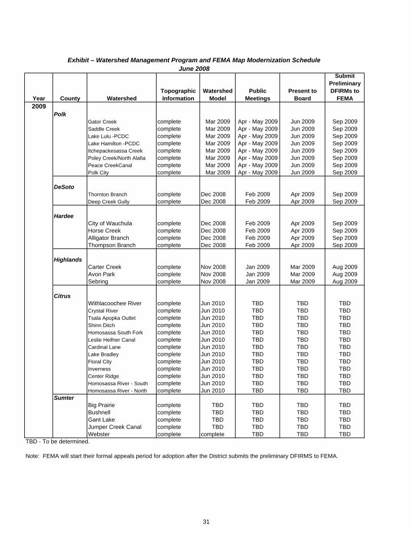
Year County WatershedTopographic Information
Watershed Model
Public Meetings
Present to Board
Submit Preliminary DFIRMs to
FEMA2009
PolkGator Creek complete Mar 2009 Apr - May 2009 Jun 2009 Sep 2009Saddle Creek complete Mar 2009 Apr - May 2009 Jun 2009 Sep 2009Lake Lulu -PCDC complete Mar 2009 Apr - May 2009 Jun 2009 Sep 2009Lake Hamilton -PCDC complete Mar 2009 Apr - May 2009 Jun 2009 Sep 2009Itchepackesassa Creek complete Mar 2009 Apr - May 2009 Jun 2009 Sep 2009Poley Creek/North Alafia complete Mar 2009 Apr - May 2009 Jun 2009 Sep 2009Peace CreekCanal complete Mar 2009 Apr - May 2009 Jun 2009 Sep 2009Polk City complete Mar 2009 Apr - May 2009 Jun 2009 Sep 2009
DeSotoThornton Branch complete Dec 2008 Feb 2009 Apr 2009 Sep 2009Deep Creek Gully complete Dec 2008 Feb 2009 Apr 2009 Sep 2009
HardeeCity of Wauchula complete Dec 2008 Feb 2009 Apr 2009 Sep 2009Horse Creek complete Dec 2008 Feb 2009 Apr 2009 Sep 2009Alligator Branch complete Dec 2008 Feb 2009 Apr 2009 Sep 2009Thompson Branch complete Dec 2008 Feb 2009 Apr 2009 Sep 2009
HighlandsCarter Creek complete Nov 2008 Jan 2009 Mar 2009 Aug 2009Avon Park complete Nov 2008 Jan 2009 Mar 2009 Aug 2009Sebring complete Nov 2008 Jan 2009 Mar 2009 Aug 2009
CitrusWithlacoochee River complete Jun 2010 TBD TBD TBDCrystal River complete Jun 2010 TBD TBD TBDTsala Apopka Outlet complete Jun 2010 TBD TBD TBDShinn Ditch complete Jun 2010 TBD TBD TBDHomosassa South Fork complete Jun 2010 TBD TBD TBDLeslie Heifner Canal complete Jun 2010 TBD TBD TBDCardinal Lane complete Jun 2010 TBD TBD TBDLake Bradley complete Jun 2010 TBD TBD TBDFloral City complete Jun 2010 TBD TBD TBDInverness complete Jun 2010 TBD TBD TBDCenter Ridge complete Jun 2010 TBD TBD TBDHomosassa River - South complete Jun 2010 TBD TBD TBDHomosassa River - North complete Jun 2010 TBD TBD TBD
SumterBig Prairie complete TBD TBD TBD TBDBushnell complete TBD TBD TBD TBDGant Lake complete TBD TBD TBD TBDJumper Creek Canal complete TBD TBD TBD TBDWebster complete complete TBD TBD TBD
TBD - To be determined.
Note: FEMA will start their formal appeals period for adoption after the District submits the preliminary DFIRMS to FEMA.
Exhibit – Watershed Management Program and FEMA Map Modernization ScheduleJune 2008
31
Item 62
Resource Management Committee June 24, 2008 Routine Report Significant Water Supply and Resource Development Projects
This report provides information on significant Resource Management projects and programs in which the Governing Board participates in funding. The report provides a short status of significant activities associated with the project that have recently occurred or are about to happen. For greater detail, refer to the Project Notes write-ups or request information directly from the project managers. Lake Hancock Lake Level Modification Project In October 2004, the Governing Board authorized staff to proceed with the preliminary design and engineering to prepare a conceptual Environmental Resource Permit (ERP) application for the Lake Hancock Lake Level Modification project with a target operating level of up to 100 feet. In January 2006, the Board authorized staff, upon reaching agreement through a Memorandum of Agreement (MOA) with Polk County, to submit the conceptual ERP application. The Governing Board approved the MOA in July 2006, and the County approved the MOA in August 2006. The District received the Conceptual ERP from the Florida Department of Environmental Protection (FDEP) on June 14, 2007. In September 2007, the Governing Board authorized staff to implement the Lake Hancock Lake Level Modification Project (final design, permitting, and construction) for a lake operating level of 100.0 feet National Geodetic Vertical Data (NGVD); adopted the Resolution Authorizing Proceedings in Eminent Domain, including a Declaration of Taking; amended the 2007 Update to the Florida Forever Work Plan to include all lands identified as necessary for the Project and designated $41 million in Florida Forever Trust Funds for the Project; and designated and encumbered $79 million in General Fund Water Supply and Resource Development Reserves for the Project. District staff continues to coordinate with affected property owners or their legal counsel. Staff has closed on five parcels approved by the Governing Board. New Activities Since Last Meeting: District staff provided the Polk County Board of County Commissioners with an update on the project on June 4, 2008. District staff has developed the necessary scopes of work, Requests for Proposals, and contracts to begin design and permitting for the replacement outfall structure and mitigation requirements necessary for the project. For example, conveyance and storage improvements are necessary on the District’s Old Florida Plantation property and along Highway 540. Additionally, some minor improvements will be needed in several areas around the lake. The District received two proposals from consulting firms to replace the outfall structure; the respondents gave a presentation of qualifications to District staff on May 29, 2008, as part of the selection process; District staff is finalizing the evaluation of the proposals. Project Managers: Scott Letasi/Steve Blaschka
Lake Hancock Outfall Treatment Project At the February 2006 Governing Board meeting, the Board approved the staff recommendation to adopt a 27 percent nitrogen load reduction goal and to utilize wetlands as the primary treatment component. The District's consultant (Parsons) has completed constructability and the initial geotechnical testing at the proposed location of the treatment wetlands and a Basis of Design Report. This report establishes the objectives, data, and assumptions that form the foundation of design (configuration of wetland cells and infrastructure). The current phase includes design, permitting, and additional geotechnical evaluation. The District initiated the plant establishment study in June 2007, which is scheduled to be completed in August 2008. The objectives of the study are to evaluate wetland construction methods, different types of wetland plants, exotic plant control techniques, and water quality trends. New Activities Since Last Meeting: The District's consultant continued design and permitting tasks as well as the plant establishment study. Additional geotechnical testing and survey tasks commenced.
32
Item 62 Monthly progress meetings between the design team and District Operations staff continued. Project Manager: Janie Hagberg
Pilot Testing Of Biological Treatment Systems At the February 2006 Governing Board meeting, following the vote on the Lake Hancock Outfall Treatment Project, the Board directed staff to initiate a project for pilot testing of biological water treatment systems. At the May 2006 Governing Board meeting, the Board authorized staff to proceed with the pilot testing of biological water treatment systems and to hire a consultant to assist the District in the pilot testing project. CH2M Hill, Inc. was hired as project Consultant and has completed a detailed literature review of periphyton-based biological water treatment systems, an evaluation of potential pilot test sites, project work plan, and project delivery method document. The Consultant also assisted in developing a Scope of Work for the RFP. The RFP included two alternatives that vendors bid on: 1) study an existing system and 2) construct a small pilot system. The District felt this approach provided the most cost efficient means of meeting project objectives, while also providing vendors some flexibility in the ways they can demonstrate the effectiveness of their systems. Proposals were received from two vendors (Genesis Group, LLC, and Hydromentia, Inc.) and were evaluated by the Consultant. At its February 26, 2008, meeting, the Governing Board 1) authorized staff to negotiate an agreement with Hydromentia, Inc., for an enhanced study of their full-scale Taylor Creek facility in the South Florida Water Management District (SFWMD) for an amount not to exceed $400,000; and authorized the Executive Director to sign the agreement; 2) authorized District staff to negotiate an amendment to the agreement with CH2M Hill, Inc., for an amount not to exceed $300,000 to provide an independent evaluation of Hydromentia's Taylor Creek facility; and 3) authorized the Executive Director to execute the amendment. A Notice of Award was posted on March 17, 2008, indicating the District's intention to award the contract to Hydromentia, Inc. On March 25, 2008, District staff and the consultant visited the Taylor Creek facility to discuss project goals, strategies, and logistical concerns with Hydromentia. NewActivities Since Last Meeting: Negotiations on the development of the agreement with Hydromentia and the amendment to the agreement with CH2M Hill are in progress. Hydromentia is evaluating treatment performance related issues associated with the Taylor Creek facility and has recommended that the District not proceed with the current proposed study until these issues are addressed in order to get an accurate assessment of the technology. District staff is working with Hydromentia to determine how the project schedule might be affected. Project Manager: Gary Williams
Peace Creek Watershed In 2005, the Governing Board and Peace River Basin Board agreed to take on the responsibility to maintain and, where possible, improve the water conveyance/storage capabilities of the Peace Creek Canal. One of the primary tasks includes identification of property ownership, so the District can obtain necessary easements over the system. The work directly related to the Peace Creek Canal is part of the larger District effort, which started years earlier with watershed modeling, expanded in 2005, and will develop a watershed management plan that evaluates approximately 13,000 acres of lakes and 13,000 acres of wetland areas for potential surface water storage systems within the Peace Creek Watershed. The District continues to provide aquatic plant maintenance in the canal. A permanent spraying schedule was implemented in FY2007. The District removed sediments in strategic reaches of the canal in 2007. Polk County began acquiring 18 residential properties along the canal that have repeatedly flooded. The District is providing up to $250,000 to the County, as matching funds for the Federal Emergency Management Agency (FEMA) grant, to assist in acquiring the properties. A draft Watershed Management Plan Alternatives Report was completed in December 2006. Staff is analyzing the technical aspects of the report and will prepare recommendations accordingly. Two temporary employees were hired for the Operations Department to help with the maintenance activities in the canal. New Activities Since Last Meeting: The Operations Department performed aquatic weed control activities within the central portion of the canal that involved mowing along the side banks, followed by chemical spraying. In some areas, the vegetation in the canal is being physically removed. Construction was completed on three of the eight identified sediment removal sites in May 2008. Construction is to commence on four
33
Item 62
ns along the canal based on ture maintenance activities. Project Manager: Shelley Thornton
Emergency
sediment removal sites in June 2008. The District’s Operations Department has completed the eighth sediment removal area as part of its work on the P-8 Structure. Staff continues to determine the proposed maintenance easement corridor dimensiofu
Watershed Management Program/Federal Management Agency Map Modernization The District initiated a partnership with the Federal Emergency Management Agency (FEMA) to modernize Flood Insurance Rate Maps (FIRMs) as part of its Watershed Management Program (WMP). Flood protection and floodplain information has been a priority at the District since the inception of the organization, and that priority was renewed following the El Niño weather event in 1997-1998. In addition to studies conducted by the District (primarily through the Basin Boards) and others, information on floodplains (elevations) is available through the FEMA FIRMs. However, many of the existing maps do not accurately represent the flood-prone areas, either because the initial studies were technically limited or the maps are outdated due to significant land use changes since completion. To improve the floodplain information, develop regional scale flood routing models for alternative analysis, and improve local government's understanding of their flood protection level of service, the District reached out to local governments and initiated the WMP in the late 90s. The District recognized a potential funding partner in FEMA since they have mutual goals to improve the existing FIRMs to better identify risks of flooding within the District. The District and FEMA executed a Cooperating Technical Partners (CTP) Memorandum of Agreement on September 14, 2001, to formalize the relationship. As a CTP, the District is eligible for federal funds to act as FEMA's partner in modernization of the FIRMs. The District is implementing the FEMA map modernization program as one element of the larger WMP. Federal funds have allowed the District and local governments to accomplish significantly more than would have otherwise been possible. To date, the District has received approximately $11.2 million in federal funds from FEMA for countywide map modernization projects for Pasco, Sarasota, Hernando, Marion, Polk, Hardee, Desoto, Citrus, Sumter, Levy, and Highlands counties. An additional $0.9 million is expected in future fiscal years for countywide map modernization projects for Manatee County. The Map Modernization Program also includes federal funding for management support. For FY2004 through FY2007, the District received $713,240 and could receive an additional $500,000 through FY2012. The District currently has completed or continues to work on 170 of the 419 watersheds identified within its boundaries. FEMA began Marion County FIRM updates before the District became a CTP. FEMA submitted preliminary FIRMS to Marion County in 2005 and revised preliminary maps in May 2006. FEMA has gone through the public comment and appeals period, and is currently addressing the appeals. After all appeals have been addressed, the FIRMs will be finalized for adoption by Marion County. The District's only involvement at this point is to provide FEMA with technical support of the submitted information to address appeals. Preliminary schedules for Hernando, Pasco, and Sarasota counties have been developed for the watershed models to be updated and preliminary FIRMS to be prepared by November 2008. New Activities Since Last Meeting: The District’s consultants are working on watershed models in Hernando, Pasco, and Sarasota counties to address all errors and omissions and to update the watershed models to account for infiltration and incorporate the latest topographic and other watershed information (to the extent practicable) into the models. District and local government staff met with the District’s consultants working on the Hernando, Pasco, and Sarasota watersheds in May to discuss schedules, budgets, data collection, infiltration, high water information, and coordination issues. The preliminary floodplains are being submitted by the consultants for initial review by District staff. Six watersheds were received by May 23. Additional Hernando and Pasco County watersheds will be submitted each week until all received by the end of June. Public meetings are being planned for mid-July through mid-August. The schedule for Peer Review is being developed according to the preliminary floodplain results. The 2007 LiDAR topographic information for Sarasota County was delayed; District staff is coordinating with the County and consultants to evaluate how this delay will affect the schedule for updating the watershed models. The District issued a Request for Qualifications and selected 15 qualified firms as peer review consultants for the watershed models and is negotiating contracts. Staff continues to gather high water
34
Item 62
cations of high water information in ese three counties. Project Manager: Gordon McClung
mark information at numerous locations in Hernando, Pasco, and Sarasota counties to use as verification of the model results, obtaining over 8,000 loth
Myakka River Watershed Initiative In February 2006, the Governing Board allocated $500,000 to hire a consultant team to perform elements of the Watershed Management Program and for the collection of topographic information in eastern Manatee County using Light Detection and Ranging (LiDAR) mapping technologies. On December 11, 2006, an agreement with the Singhofen & Associates consultant team was executed, and a kick-off meeting was held with District staff. The consultant team held the first outreach meeting on February 14, 2007, to discuss the project in detail and solicit stakeholder input on issues and available sources of data. Staff has since made several introductory presentations to various stakeholder groups (Myakka Conservancy, Environmental Advisory Committee, etc.). Work Order #2, covering the majority of the water budget tasks for the upper Myakka area, was executed in June 2007 and is now complete and under peer review. Using the water budget model developed in Work Order #2, the consultant compared existing and historic conditions to provide a clearer picture of the excess water in the Upper Myakka River Watershed. In addition, the model was used in conjunction with future land use maps to provide an estimated water budget for proposed future conditions. This information was provided to the Authority team for their use. Work Orders 3, 4 and 5 were executed in August 2007 for digital topographic mapping, geospatially referencing of existing survey data, developing content for a project web page, beginning survey in the upper Myakka Watershed, and completing historic land use mapping. The kick-off meeting for the peer review panel on the Upper Myakka Water Budget was held on March 20, 2008. Work Order #6, which involves updating existing watershed models, water quality loading model parameterization, and historic vegetation investigation in the Flatford Swamp, was executed on January 2, 2008. The historic land-use mapping (late 1940s to early 1950s) and the digital terrain information were approved by the District in February 2008. Work Order #9 is in development and will cover water quality, watershed evaluation tasks, and initiate the more detailed modeling effort for best management practices (BMP) alternative analysis in Flatford Swamp. Recent activities include coordination with Minimum Flows and Levels (MFL) staff to discuss further the excess flows in the Upper Myakka River and the consultant responded to the first set of comments from the Peer Review Panel, covering items such as methodology to determine evapotranspiration and documentation of irrigation. The Myakka River Watershed initiative project is up and running on the District website. Updates to the site will be provided monthly. New Activities Since Last Meeting: The initial alternative runs using the water budget model were completed. District staff and the consultant team visited Flatford Swamp on May 29, 2008, to strategize for restoration alternatives. The Project was presented at the Florida Association of Agricultural and Biological
ngineers conference on June 11, 2008. Project Manager: Lisann MorrisE Tampa Bay Water
System Configuration II Project: The Governing Board approved the agreement with Tampa Bay Water (TBW) for the System Configuration II Project at its February 2007 meeting. The project, when completed in 2011, is expected to provide up to 25 mgd of alternative water to the regional system. The estimated total project cost is $235,122,500, with the District committing to half of eligible costs of $232,000,000, or $116,000,000. The project seeks to increase TBW's overall system capacity by drawing more water from the Hillsborough River during high flows, via the Tampa Bypass Canal (TBC), in combination with increasing the allowable percentage of withdrawals from the TBC. The projects are primarily associated with the construction of improvements to the regional systems treatment, transmission, and storage infrastructure. The project agreement was executed in May 1, 2007, and TBW received approval of its Water Use Permit in June 2007. Nine of the ten basis of design reports were completed by November 2007. The remaining basis of design report is scheduled to be complete by December 2008. In January 2008, TBW submitted a Schedule of Project Costs on a cash basis as defined in the contract. TBW submitted four ERP applications to the District in January 2008, anticipating they would be issued by June 2008. Two of the four ERP applications have been issued. The South-Central Hillsborough
35
Item 62
The SWTP Expansion will increase the plant's
ers participated in a tour of the seawater desalination plant along with the surface water treatment plant and C.W. Bill Young Regional Reservoir on May
P
Infrastructure project - Phase IB construction is complete and final invoices are being prepared for the District. Both public information meetings and commencement of construction for Phase II of the South-Central Hillsborough Infrastructure project occurred in March 2008. Additionally, demolition at Well Site #7 is complete. New Activities Since Last Meeting: Construction continues on Phase II of the South-Central Hillsborough Infrastructure project. One point seven (1.7) miles of 4.7 total miles of pipe have been installed through open cut, horizontal directional drill or jack and bore methods. Recent activities include the installation of open cut piping along Oakwood Avenue, Dew Bloom Road, and Lithia Pinecrest Road; the jack and bores under SR 60, CSX Railroad, and Kings Way Drive; and the horizontal directional drill of various segments, totaling 2,950 feet of pipe. In addition to pipe installation, site preparation continues at Well Site #5. The purpose of Phase II of the South-Central Hillsborough Infrastructure project is to add disinfection facilities at wells and raw water collection pipelines at the Brandon wells, and to convert the Brandon and Brandon South-Central Connection pipelines to potable water supply. The Surface Water Treatment Plant (SWTP) Expansion project has reached final design and has an anticipated construction Notice to Proceed date of June 28, 2008.capacity from 66 mgd to 99 mgd. The remaining eight project components are in the design stage. Project Manager: Audrie Liszewski Tampa Bay Seawater Desalination Plant: As outlined in the agreement between the District and TBW for the seawater desalination facility, 25 percent of the $85 million being held by the District is payable upon acceptance of the facility by TBW. Of the remaining 75 percent, 25 percent will be provided to TBW when the plant is operated at a constant rate of 25 mgd for four months and the remaining 50 percent when the plant operates at an annual average of 12.5 mgd for 12 consecutive months. In addition, TBW will receive the interest accrued on the $85 million, since January 2006, when the plant operates at 20 mgd for 12 consecutive months after November 1, 2007. American Water Pridesa completed the required run-in period, an acceptance test, and submitted an acceptance test report to TBW on November 27, 2007. After certification of the test results, TBW accepted the facility on December 26, 2007. The District processed the first 25 percent payment in the amount of $21,250,000 on January 24, 2008. New Activities Since Last Meeting: TBW was able to run the plant at capacity (25 mgd) for the months of April and May and is scheduled to dispatch the plant at capacity (25 mgd) for the months of June and July. Should TBW achieve a minimum of 25 mgd capacity for these four consecutive months, TBW will be entitled to an additional $21.25 million of District co-funding. This would bring the total project co-funding to date from the District to $42.5 million, or 50 percent of the total allocated amount of $85 million. Please refer to the Water Production Supply Summary Routine Report, under the Regulation Committee tab, for historic pumpage information at the desalination facility. Additionally, District Governing and Basin Board memb
30. Project Manager: Ken Herd
eace River/Manasota Regional Water Supply Authority Reservoir: Final design for the Regional Reservoir Expansion has been completed and FDEP has issued the ERP for the reservoir construction. In June, the Authority received three bids for the reservoir expansion. The low bid of $64,910,500 was 21 percent higher than the engineer's estimate. The project kick-off meeting was held in late September. As with the Facility Expansion, the Authority has asked the District to provide additional funding as a result of the increased costs. Land Resources and Authority staffs have met several times to address the issues surrounding the Authority’s reservoir expansion project on the RV Griffin Reserve. The Authority defined areas and land interests required to complete expansion of its reservoir and to mitigate for wetland impacts. The Governing Board granted various easements to the Authority in November after receiving survey information and draft easements. Other issues being coordinated include public access, land management issues, relocation of recreational amenities, and reconfiguration of an existing cattle lease. The Authority Board approved the reservoir construction contract at its July 25 meeting and issued a limited notice to proceed to the contractor to begin initial work and permitting. FDEP approved construction to commence on December 8, 2007. In addition, the USACE
36
Item 62
servoir overflow to the Peace River. Currently, the embankment lifts have
mps will be operational by July 2008. At the reservoir
companion permit to the ERP was received on December 11, 2007. In preparation for the construction, District and Authority staff relocated all recreational amenities to accommodate the project. At their December meetings, the Peace River and Manasota Basin Boards, and the Governing Board approved an additional $3,703,704 in 2008 funding for the reservoir project. On-site accomplishments include the completion of wetland mitigation for the RV Griffin Reserve and the clearing of both the entire site and areas of future inlet and outlet pipes. As directed by the ERP, Gopher Tortoise relocation efforts will continue throughout the duration of the project. The 66-inch raw water steel pipe was delivered to the site and installed. During April/May 2008, inlet and outlet pipe were installed. In addition, a rim ditching system was completed to dewater the site during construction. New Activities Since Last Meeting: The reservoir construction is underway and considered 25 percent complete. The project appears to be on schedule for the March 2009 Final Completion of Construction deadline. Ongoing activities include the construction of the Bentonite Slurry wall of which 8,000 feet out of four miles is complete. The contractor is moving roughly 15,000 cubic feet per day of fill from the central areas to the perimeter of the reservoir boundary. Soil lifts or layers are currently being formed and compacted to prevent horizontal seepage and to construct the reservoir embankment. Completed activities include the 150 feet of jack and bore of 84 inch pipe casing and the installation of the 66 inch carrier pipe under King’s Highway. The emergency auxiliary spillway was completed with the purpose of safely conveying any rereached a height of 13 feet out of 35 feet, in certain areas. In addition to construction activities, ecological consultants are on site, as needed, for wildlife education, wildlife surveys, and inspections. Facility: In February, the Authority received one bid for Contract 2 for major components of the Facility Expansion. The bid was approximately $17 million over the original engineer's estimate of probable cost. Since receiving the bid, Authority staff and the contractor have negotiated a revised project cost $14 million below the original bid price. The Authority's Board approved the revised cost and authorized staff to enter into an agreement with the contractor in April. Even with the newly negotiated bid price, the overall revised project cost remains $19 million over the original project cost. Construction of the Facility Expansion Project will occur through three separate contracts. The first contract, completed in May, focused on site preparation. The second contract is for construction of a maintenance building, dewatering facility, filters, storage tanks, thickeners, and chemical feed and disinfection stations. The third contract is for construction of an operations center. Completed items from the second contract include Storm Water Pond #2, and the jack in bore of the 48 inch ductile iron pipe under Kings Highway. All the restoration required in the contractual agreement between the District and the Authority was completed and received final certification. The pouring of foundation slabs for all structures is complete except the Maintenance Building, which is not planned for completion until 2009. Concrete work for the walls of the new filter building, both chemical buildings, the Powdered Carbon Storage room, and the North Regional High Service Pump building are complete. In addition, leak testing of solids contact units is complete. New Activities Since Last Meeting: Construction continues on the facility and is considered to be 70 percent complete. The project appears to be on schedule for the March 2009 Final Completion of Construction deadline. Nine chemical tanks for the project have been installed, and the roof systems over the chemical buildings have been completed. The roof system for the new High Service Pump Building is complete and masonry block work for the facade is approximately 75 percent complete. The structural steel framework for the Dewatering Building has been erected, and two belt filter presses have arrived and been installed. The internal mechanisms for two of the four solid contact units are complete (except for drive motors), while the remaining two units are 75 percent complete. Two new pumps with a 45 mgd combined capacity have been installed at the river pump station. It is anticipated that the pupump station, two new pumps with a combined capacity of 30 mgd have been installed and are operational. Other ongoing construction activities include the installation of yard piping. Project Manager: Audrie LiszewskiRegional Integrated Loop System Project: Originally, the first phase of the Regional Integrated Loop System Project consisted of an interconnect between the Authority and Punta
37
Item 62 Gorda's water treatment plant on Shell Creek. Although the design for the first phase was completed and a guaranteed maximum price provided to the Board, a decision was made to postpone the project. Since cancellation of Phase 1, Charlotte County, Punta Gorda, and the Authority have approved an agreement for the Regional Integrated Loop System Phase 1A. Similar to Phase 1, this pipeline creates an interconnect between the Authority and Punta Gorda's Water Treatment Plant (WTP) on Shell Creek while providing Charlotte County with additional opportunities for interconnects into the regional distribution system. Total cost for Phase 1A is estimated at $19,015,000. The District anticipates providing $11,028,700 toward the project, assuming the State's Trust Funds remain available. The Authority Board approved work orders for Phases 2 and 3 of the Regional Loop System, while later issuing notices to proceed for preliminary engineering. As currently envisioned, the Phase 2 pipeline would provide an interconnect between the Authority's Peace River facility and the City of North Port's WTP; Phase 3 would be an extension of the Authority's regional transmission system currently terminating at the Carlton WTP. A workshop was held after the Authority's regularly scheduled meeting on July 25, 2007, to discuss future pipeline funding. The Authority at their May 7, 2008 meeting cancelled the Phase 2 Regional Loop System project to interconnect the Authority’s Peace River facility and the City of North Port’s water treatment plant. Instead the City of North Port has proposed a new point of connection on the Authority’s existing 42 inch transmission main that connects the Authority’s facility to the Sarasota County’s Carlton Water Treatment Plant. New Activities Since Last Meeting: It is
ly April to discuss their FY2009 Cooperative Funding application for preliminary design of the next source identified by this study. New Activities Since Last
anticipated that District and Authority staff will finalize the Cooperative Funding Agreement for Phase 1A by July 2008. District staff awaits the Authority's pipeline funding policy, also scheduled for July 2008, before moving forward with the design and construction agreement for Phase 3. Project Manager: Audrie Liszewski Regional Water Supply Source Feasibility Study: At its March 2006 meeting, the Authority's Board authorized staff to enter into an agreement with HDR Engineering to complete the Integrated Regional Water Supply Master Plan (IRWSMP) and Regional System Reliability Model (RSRM). The IRWSMP and RSRM provide for the phased development of six new water supply sources (Shell Creek, Myakkahatchee Creek, Peace River, Upper Myakka System, Cow Pen Slough/Dona Bay, and the Carlton Wellfield), integration of those sources within the Regional Loop System, and development of costs for the Authority's seven-year capital improvement program. The Regional Water Supply Source Feasibility Study will build upon the IRWSMP to focus on three of those alternative water supply sources: the Shell Creek, Cow Pen Slough/Dona Bay, and Upper Myakka River systems. The feasibility study contract was awarded to PBS&J in July 2007. A request for out-of-cycle funding to initiate the study was approved at the June 26, 2007 Governing Board meeting; the June 8, 2007 Peace River Basin Board meeting; and the July 25, 2007 Manasota Basin Board meeting. A cooperative funding agreement with the Authority for the feasibility study was executed on September 18, 2007. A kick-off meeting with the consultant was held on August 2, 2007, to begin the gathering and evaluation of existing data. The Consultant team submitted the first deliverable on October 25, 2007, which summarized and inventoried existing data, relevant technical reports, and models. A technical advisory committee (TAC) meeting was held November 16, 2007, to discuss the first deliverable and major supply opportunities for each source area. The Preliminary Alternatives Analysis was presented to the Authority Board at its December 2007 meeting. This presentation identified opportunities for water supply within the three major source areas. Additional water quality testing for parameters such as corrosiveness, Giardia, Cryptosporidium, and Total Organic Carbon took place to allow for a balanced comparison between the proposed sites. Work continues on the reservoir siting in the upper Myakka and Shell Creek watersheds and updates to Sarasota County’s work on Dona Bay. A joint meeting was held mid-March with the District’s Myakka Initiative team to present the results of the Upper Myakka Water Budget model historic model run. The last remaining work order (#3) covering preliminary water treatment processes, treatment facility locations, intake structures, transmission lines, final report, and stakeholder meetings was executed on May 7, 2008. The project is still on schedule looking to be completed in August 2008 with workshops for the preferred configuration in September 2008. A meeting was held with Authority staff in ear
38
Item 62 Meeting: The consultant is completing deliverables on reservoir siting, yields, and intake criteria. A TAC meeting is planned to refine demands, and discuss reservoir sites. Project Manager: Lisann Morris
Aquifer Storage and Recovery – Arsenic Research The District is coordinating an effort to investigate methods for controlling the mobilization of arsenic occurring during Aquifer Storage and Recovery (ASR) activities. This effort will help water suppliers meet the recently lowered drinking water standard for arsenic. The project consists of the design, permitting, and construction of a degasification system to remove dissolved oxygen (DO) from potable water prior to injection and storage in the aquifer. This project is being co-funded by the Southwest Florida Water Management District, South Florida Water Management District, St. Johns River Water Management District, the Peace River/Manasota Regional Water Supply Authority, and the City of Bradenton. The pilot degasification project will be performed at the City of Bradenton's ASR site, which is typical of most potable water ASR systems in the state. The degasification system will be capable of processing water at 700 gallons per minute (gpm) at 99.96 percent DO removal, but is capable of flow rates as high as 1,000 gpm with lower DO removal efficiency. A TAC has been formed to assist in the design of the testing program and provide an expert review of project results. The TAC consists of representatives from each of the co-funders, as well as Jon Arthur from the Florida Geological Survey; June Mirecki from the U.S. Army Corps of Engineers; and Jeff Greenwell, Richard Duerling, and Joe Haberfield from the FDEP. Testing will first consist of recovery of all prior injected water and any additional water necessary to achieve near ambient water quality conditions in the storage zone. This will be followed by an injection of 40 million gallons (mg) without degasification and recovery, to test the equipment upgrades to the control systems and establish a new baseline for future tests. This water will be recovered until ambient water quality conditions return. The 40 mg injection will then be repeated with de-oxygenated water, and the results will be compared to the prior cycle. Two large volume cycles, consisting of 300 mg of injection, will then be performed. A final report documenting the effectiveness of DO removal will be prepared at the end of cycle testing, which is expected in two years. New Activities Since Last Meeting. Construction of the degasification system is close to completion. The degasification system has been delivered to the site and the final installation steps are in progress. The original final completion date for the fully functional system was April 29, 2008; however, due to a delay in delivery of key degasification components, the new date is July 15, 2008. The FDEP finalized its consent order requirements for arsenic violations and provided the ASR construction and testing permit renewal forms to the City of Bradenton on February 19, 2008. The City of Bradenton is working on the consent order and permit renewal. It is anticipated that these two requirements will be finalized and issued in August 2008. The testing of the degasification equipment is contingent on issuance of these requirements. A second parallel effort has been initiated to see if a regulatory solution to the
rsenic mobilization issue is possible. The District is working closely with the South Florida trict, and the FDEP on
aWater Management District, the St. Johns River Water Management Disthis effort. A meeting among staff from the districts and FDEP is planned for June 11, 2008, to continue discussions regarding the development of a strategy and plan to have highly beneficial very low risk ASR projects accommodated in the UIC rules. Project Manager: Don Ellison Lower Hillsborough River MFL Recovery Strategy – Implementation At its August 28, 2007, meeting, the Governing Board established the minimum flow for the Lower Hillsborough River (LHR) by adoption of amendments to Rule 40D-8, Florida Administrative Code. As required by statute, if the actual flow of a water course is below the proposed minimum flow or is projected to fall below the proposed minimum flow over the next 20 years, a "recovery strategy" is developed as part of the minimum flow development process. In the case of the LHR, a recovery strategy was needed. The proposed recovery strategy was incorporated into Rule 40D-80 and approved by the Governing Board at its August 28, 2007, meeting. The recovery strategy includes a number of projects to divert water from various sources to help meet the minimum flow. Projects that are planned under the recovery strategy include diversions of water from Sulphur Springs, Blue Sink, the Tampa Bypass Canal (TBC), and Morris Bridge Sink. At its September 2007 meeting, the Board approved the transfer of
39
Item 62
potential yield of the system and to assess potential impacts associated with the project. The project manager is scheduled to provide an update to the Tampa Bay Water Board regarding the implementation of the recovery strategy at their June 16 meeting. Project Manager: Marty Kelly
$1,000,000 from reserves for installation of temporary pumping facilities on the TBC and at the dam on the LHR. Funds will go toward: 1) temporary pumping facilities, 2) consultant to provide more permanent pumping facilities, and 3) consultant to look at the costs and design for moving water from the Morris Bridge Sink to the TBC. Temporary pumps to transfer water from the TBC to the LHR have been in place since December 15, 2007. The District began pumping 11 cfs (7.1 mgd) to the reservoir from the TBC on December 31, 2007. Per the recovery strategy, 75 percent of the 11 cfs (8.2 cfs or 5.3 mgd) transferred to the reservoir is being pumped to the base of the dam. This amount of freshwater in combination with 10 cfs supplied from Sulphur Springs to the base of the dam by the City of Tampa means that an actual minimum flow of 18.2 cfs (11.8 mgd) or 70 to 80 percent of the proposed minimum flow is now being supplied to the LHR depending on season. New Activities Since Last Meeting: Despite drought conditions, the lower pool of the TBC has been able to consistently provide 11 cfs of flow to the reservoir without having to remove water from lower pool storage. The installation of the telemetry to operate the pumps remotely is scheduled to be complete and operational by June 1. A legal description for an easement to Tampa Electric Company (TECO) is being prepared by the District. Once final, City of Tampa staff will present the easement to the City Council for approval. Once approved, TECO will bring in commercial power for the pump at the city’s dam and the diesel generator will be demobilized. The pump stations at Structures S-162 and S-161 have been on commercial power since April. The District and City jointly approved the selection of the third member of the peer review panel for the Transmission Pipeline Project on May 16. The purpose of the peer review is to evaluate the potential water savings that would result from the construction of a pipeline versus surface transfers through the Tampa Bypass Canal and City of Tampa Reservoir. The peer review must be completed by October 1, 2008.
he Hydrologic Evaluation Section of the District began the Blue Sink pump test on May 7, and he purpose of the test is to determine the
Tit is projected to run for approximately 30 days. T
Polk County Comprehensive Water Supply Plan Based on the recent results from the Kissimmee River Water Supply Feasibility Study and limitation of future water sources from outside its boundaries, Polk County requested the District participate in a more detailed analysis of available ground water and alternative water supplies within Polk County. The Polk County request was approved by the Governing Board in January and the Alafia River and Peace River Basin Boards in February, during their regularly scheduled meetings. The Polk County Comprehensive Water Supply Plan (PCCWSP) will identify viable potable water supply sources and conservation alternatives to meet the future potable and non-potable water demands of various public utility systems within Polk County. This process will include investigation of multiple water resources including conservation, reclaimed water, storm water, surface water, and ground water. The Plan will address the technical, economic, environmental, jurisdictional, and regulatory factors associated with development of these potential new sources. The water supply planning effort will first include identification, quantification, and confirmation of the types and amounts of new water supply that can be developed, and then address aligning the sources with prospective water supply partners. Most importantly, the Plan will set forth immediate projects and strategies that materially provide new water supplies for targeted public utilities. The Plan will outline a set of real, attainable, affordable, and significant water supply projects, regional in nature, to begin the transition of water supplies from traditional ground water to alternative sources. Recommendations will include project definitions, specific actions, production rates, schedules, project costs, and unit water costs (operation, maintenance, and debt service). The total estimated cost to complete the PCCWSP is $955,318, via a consulting services contract between Polk County and Reiss Environmental. The SFWMD has agreed to provide 10 percent of the total project cost, reducing the District's share to 40 percent, or $382,127. The funding agreement between the District, Polk County, and SFWMD was approved by the Polk County Board of County Commissioners on April 23 and has been signed by all parties. On April 25, District staff attended a meeting with Tampa Bay Water and Polk County to discuss potential opportunities
40
Item 62
tinue between the Districts and the STOPR ssimmee River Basin. In addition,
FWMD and Polk County continue to move forward on investigating the Lower Floridan Aquifer s a potential source. Progress to date includes issuance of a request
EawP L
for water supply to Polk County from Tampa Bay Water. Additionally, the County is involved in several other initiatives to investigate water supply options. One option the County is evaluating is the potential for additional ground water in southeast Polk County. The County and SFWMD are coordinating to investigate this potential source as any withdrawals would be located within the SFWMD. The County is also coordinating with the STOPR group, which includes St. Cloud, Tohopekaliga Water Authority, Orange County, Osceola County, Polk County, and the Reedy Creek Improvement District. STOPR and SFWMD are currently investigating the potential for water supply from the Kissimmee River, which should be completed by the end of 2008. NewActivities Since Last Meeting: Discussions congroup regarding the availability of water from the Upper KiSin southeast Polk County afor bids from drillers to construct the exploratory wells. Bids are due on June 18. Reiss
nvironmental and SWFWMD staff met again in June to discuss the potential for developing an lternative supply source from the Peace River. It is anticipated that an assessment of available ater from these systems will be made in July. roject Manager: Audrie Liszewski
and Resources Events July 2007 – Land Resources and Communication staff held an event in support of one of the Districts strategic initiatives to increase diversity and youth education on conservation land. The Boys and Girls Club brought approximately 70 children to the Weekiwachee Preserve in Hernando County. Some of the older boys fished, while the remainder of the group was split in
ff held a volunteer work day at the Serenova tract in
s. The following day, staff attended a Suncoast Trail Riders
es were documented,
half. Land Resources staff led one group on a guided hike along one of the Preserve’s trails. Staff created an “I Spy” activity where the children had to find and identify plants, animals, and different species commonly found in a pine flatwoods ecosystem. Staff planted objects such as deer and raccoon skulls and tortoise shells along the trail to prompt discussion about the variety of wildlife that lives in the Preserve. Communications staff led the second group in a discussion about the importance of protecting the watershed and in a hands-on Project WET activity.October 2007 – Land Resources staff set up a display table at the 13th Annual National Wildlife Refuge celebration held at the Chassahowitzka National Wildlife Refuge Complex in Crystal River. It is estimated that over 300 people were in attendance. Land Resources staff also held a volunteer work day at Lake Panasoffkee. Six volunteers attended and accomplished tasks that included mowing, trimming, reposting of approximately five miles of trails, and removal of three fallen trees. Afterwards, lunch was served, and the volunteers hitched up the horses and enjoyed the cleared trails. November 2007 – Land Resources stathe Starkey Wilderness Preserve in Pasco County. For approximately eight hours, five volunteers worked on lifting the tree canopy in the day-use parking area, trimming trails, and cleaning up two campgroundmeeting to give a brief presentation and answer questions regarding recreation on District property. Another volunteer work day was held at the District’s Jack Creek property in Highlands County. Staff and four volunteers with the Ridge Rangers spent the day removing trash and debris that filled a dumpster. December 2007 – Land Resources staff and volunteers participated in the Audubon Society’s annual Christmas Bird Count at Weekiwachee Preserve. Over 60 speciincluding several rare birds. December 2007 and January 2008 – The District hosted “Outdoors without Limits,” hunts for persons with disabilities, at the District's Upper Hillsborough and Hampton tracts. A total of 24 hunters participated in modern gun hunts for deer and hogs on each property. District staff and volunteers assisted with all aspects of the hunts, including preparing and serving lunch, and assisting participants in getting to and from their hunting locations. Several deer and hogs were taken, and the hunts were a tremendous success for all involved. January 2008 – The Sumter County Humane Society held a fundraising event “Helping Hooves Benefit Ride/Drive” at Lake Panasoffkee, which brought horse lovers together to lend their support to equine rescue efforts, as the need is continuously increasing. Approximately
41
Item 62
ded veterinary care
a Department of
de
tunities to the disabled.
tes for the District's recreational areas. The South Creek Fox Hunters had approximately 17 members
trail clean-up work days at the Oak Ridge Equestrian Area – Washburn Site. All
113 people attended the event and raised more than $1,700. The revenue generated will be applied toward the group’s Animal Care Fund, which provides much neesuch as spaying/neutering, vaccinations, emergency care, animal food, and cruelty investigations. The event was a great success considering this was their first event and the weather was rainy and cold. Also, over 30 volunteers from across the state participated in a sparrow drive at Weekiwachee Preserve. A total of 20 birds, representing seven species, were banded. Three of these species that inhabit the Preserve are area-sensitive grassland birds that are declining throughout the eastern United States: the grasshopper sparrow, Henslow's sparrow, and savannah sparrow. Another drive is scheduled in February. February 2008 – Land Resources staff held a volunteer day at the Serenova tract within the Starkey Wilderness Preserve in Pasco County to help clear an area for a new restroom facility. Within about six hours the ten volunteers not only cleared the site, but helped trim the road in and out of the area. The Council on American-Islamic Relations (CAIR) performed a clean-up at the District’s Harney Canal in Tampa. Approximately 70 volunteers, including many students, removed trash from both the land and water. The FloridTransportation picked up the trash after the event, and the Temple Terrace Police and Marine Patrol provided the volunteers with safety tips and removed the trash collected from the water. Hillsborough County Public Works is donating paint to cover graffiti on the bridge. The Land Resources staff attended an "Ice Cream Social" at the Withlapopka Civic Association building near the Withlapopka Park at Flying Eagle in Citrus County. This event was sponsored by park volunteers to bring awareness to the park, raise money for park amenities, and solicit new park volunteers. More than 90 people attended the Ice Cream Social. March 2008 – Land Resources staff held a work day to hand-treat exotic plants at our Panasoffkee Outlet property in Sumter County. The tract supports good quality upland hardwood forest, some of which has intact limestone outcrops. The plant we targeted was an exotic vine called green wandering Jew, which is ranked a Category 1 plant by the Exotic Pest Plant Council (EPPC). The plant is difficult to treat due to unacceptable impacts of herbicion native plants; therefore, hand removal is one of the only treatment options. Seven volunteers worked an area approximately 10 acres in size and removed about 30 pounds of the exotic plant. Three rare ferns will benefit: hemlock spleenwort, abscised spleenwort, and Peter's filmy fern – all of which rely on limestone outcrops in good quality hammock. “Outdoors without Limits” hosted a disabled turkey hunt at Hampton Tract within the Green Swamp Wilderness Preserve. A total of 16 hunters and 20 volunteers participated. The South Creek Fox Hunters Club provided a nice barbeque lunch. Four turkeys were taken that weekend. April 2008 – This year's Volunteer Appreciation Day was held at Natures Classroom in Hillsborough County. The occasion was attended by nearly 150 volunteers, staff and board members. Attendees were able to enjoy a great barbeque luncheon, enjoy great music by the “Beagles,” see lots of native wildlife in their habitats and take a scenic boat ride on the Hillsborough River. There were 18 awards given out to worthy groups and individuals. Since its inception, the volunteer program has seen nearly 84,000 hours donated in services for the district. Mike Blanton was the keynote speaker and spoke to everyone about the “Outdoors without Limits” program, which provides hunting and fishing opporStudents from several government agencies and private entities attended the Natural Areas Training Academy Restoration Planning and Techniques for Forested Lands workshop conducted at Nature's Classroom. As part of the workshop, students visited restoration sites at Lower Hillsborough’s Flatwoods Park and the Green Swamp West. District staff participated as classroom and field instructors. On the last day, students utilized material learned in the course to explore different techniques for restoring the area adjacent to the river floodplain which was retired during recent renovations to Nature's Classroom. New Activities Since Last Meeting: Brooks Armstrong with the Florida Native Plant Society conducted a tour on the Edward W. Chance Reserve - Coker Prairie Tract with approximately 25 people. The group was attending an annual conference for the Society and signed up for the tour to identify various plants and birds on the property. Mr. Armstrong was given Recreational Guides, maps, schedules for past and future controlled burns, and Volunteer Brochures and applications. It was a successful morning with many new advoca
participate in
42
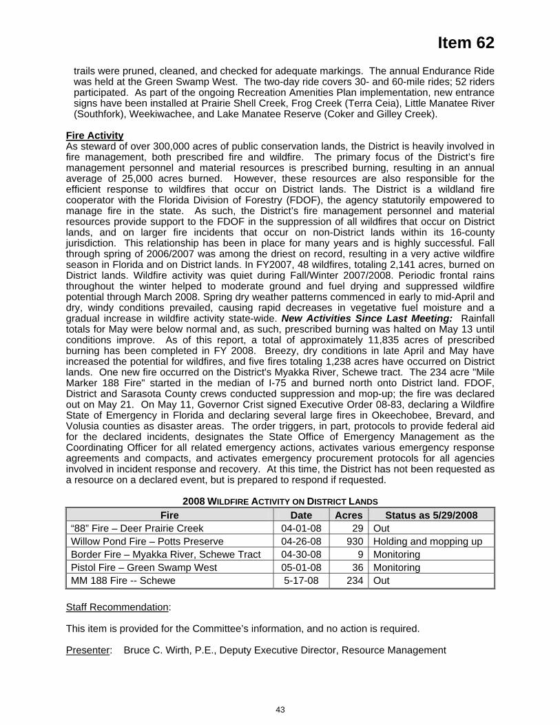
Item 62 trails were pruned, cleaned, and checked for adequate markings. The annual Endurance Ride was held at the Green Swamp West. The two-day ride covers 30- and 60-mile rides; 52 riders participated. As part of the ongoing Recreation Amenities Plan implementation, new entrance signs have been installed at Prairie Shell Creek, Frog Creek (Terra Ceia), Little Manatee River (Southfork), Weekiwachee, and Lake Manatee Reserve (Coker and Gilley Creek).
Fire Activity As steward of over 300,000 acres of public conservation lands, the District is heavily involved in fire management, both prescribed fire and wildfire. The primary focus of the District’s fire management personnel and material resources is prescribed burning, resulting in an annual average of 25,000 acres burned. However, these resources are also responsible for the efficient response to wildfires that occur on District lands. The District is a wildland fire cooperator with the Florida Division of Forestry (FDOF), the agency statutorily empowered to manage fire in the state. As such, the District’s fire management personnel and material resources provide support to the FDOF in the suppression of all wildfires that occur on District lands, and on larger fire incidents that occur on non-District lands within its 16-county jurisdiction. This relationship has been in place for many years and is highly successful. Fall through spring of 2006/2007 was among the driest on record, resulting in a very active wildfire season in Florida and on District lands. In FY2007, 48 wildfires, totaling 2,141 acres, burned on District lands. Wildfire activity was quiet during Fall/Winter 2007/2008. Periodic frontal rains throughout the winter helped to moderate ground and fuel drying and suppressed wildfire potential through March 2008. Spring dry weather patterns commenced in early to mid-April and dry, windy conditions prevailed, causing rapid decreases in vegetative fuel moisture and a gradual increase in wildfire activity state-wide. New Activities Since Last Meeting: Rainfall totals for May were below normal and, as such, prescribed burning was halted on May 13 until conditions improve. As of this report, a total of approximately 11,835 acres of prescribed burning has been completed in FY 2008. Breezy, dry conditions in late April and May have increased the potential for wildfires, and five fires totaling 1,238 acres have occurred on District lands. One new fire occurred on the District's Myakka River, Schewe tract. The 234 acre "Mile Marker 188 Fire" started in the median of I-75 and burned north onto District land. FDOF, District and Sarasota County crews conducted suppression and mop-up; the fire was declared out on May 21. On May 11, Governor Crist signed Executive Order 08-83, declaring a Wildfire
tate of Emergency in Florida and declaring several large fires in Okeechobee, Brevard, and Volusia counties as disas ols to provide federal aid for the declared inc , designates the State Office of Emergency Management as the C ed emergency tivates various emergency response agreements and compacts, and a tivates emergency procurement protocols for s i covery. At e D t sa ed if requ t
2008 WILDFIRE ACTIVIT RICT D
Ster areas. The order triggers, in part, protoc
identsoordinating Officer for all relat actions, ac
cnvolved in incident response and re
all agencie has not been requested athis time, th istric
resource on a declared event, but is prepar to respond es ed.
Y ON DIST LAN SFire Date Acres Status as 5/29/2008
“88” Fire – Deer Prairie Creek 04-01-08 29 Out Willow Pond Fire – Potts Preserve 04-26-08 930 Holding and mopping up Border Fire – Myakka River, Schewe Tract 04-30-08 9 Monitoring Pistol Fire – Green Swamp West 05-01-08 36 Monitoring MM 188 Fire -- Schewe 5-17-08 234 Out
Staff Recommendation:
This item is provided for the Committee’s information, and no action is required.
Presenter: Bruce C. Wirth, P.E., Deputy Executive Director, Resource Management
43


E.Outreach
&Planning
Com
te.
Governing Board Meeting June 24, 2008
Outreach and Planning Committee
Discussion Items – None
Submit & File Report
63. Fiscal Year 2008 Media Messaging Overview ................................................................. 3
Routine Reports
64. Comprehensive Plan Amendment and Related Reviews Report .................................... 5
65. Development of Regional Impact Activity Report ............................................................ 9
66. Speakers Bureau ............................................................................................................ 13
67. Significant Activities Report ............................................................................................. 16

2

Item 63
Outreach and Planning Committee June 24, 2008 Submit and File Report Fiscal Year 2008 Media Messaging Overview
PurposeTo raise public awareness about the current drought conditions and to encourage water conservation in the District.
Background/History Media messaging, or advertising, is one initiative the District uses to promote water resources awareness and conservation practices. The total media messaging budget in FY2008 is $900,000. The District spent $150,000 during an October–November radio and newspaper campaign that promoted skipping a week of watering during the cooler winter months to conserve water.
Prior to FY2006, the District focused on general water conservation. In recent years, recognizing that the typical single-family home uses up to 50 percent of its water on outdoor irrigation, District staff embarked on a five-year effort to increase awareness of Florida-friendly landscaping and educate the public about specific landscaping behaviors that benefit the water resources. These campaigns have featured the nine Florida-friendly landscaping principles and their benefits, as well as the consequences of overwatering.
This year's historic drought prompted the need to communicate the importance of water conservation and watering restrictions. While still following the five-year plan, staff reran previously aired Florida-friendly landscaping messaging to promote outdoor conservation. The tag line "Reduce Your Use" was added to encourage the audience to follow the watering restrictions.
The FY2008 "Reduce Your Use" campaign ran from late February through April to capture its target audience. This winter–spring campaign included television, radio, newspaper, magazine and billboard advertising. Three television ads were aired. The first promoted protecting the environment as a basis for practicing water conservation behaviors. The second ad featured a county Extension agent urging residents to check that their irrigation systems are working properly and not wasting water. The third ad was originally aired in 2006 and featured the benefits of practicing Florida-friendly landscaping. The radio ads included the efficient irrigation message, two Florida-friendly landscaping messages from the 2006 campaign, and an ad addressing the drought that featured the District's executive director asking the public to conserve during this extremely dry season. The tagline "Reduce Your Use" was used in print ads and billboards. All advertising directed residents to the District's web site for additional water conservation tips.
Radio advertising kicked off the campaign with more than 7,585 spots running from mid-February through April on a diverse array of stations to capture all demographics. The District's television ads aired during March and April. More than 4,683 spots aired on broadcast and cable channels. Areas outside the eight-county Tampa-St. Petersburg-Sarasota television market were reached by advertising on cable channels.
3
Item 63
Also during March and April, four newspaper ads were published in each of the major circulation newspapers in the District. In addition, ads were placed in two publications that serve the Hispanic audience, two publications that specialize in reaching the African-American community and one trilingual newspaper (English, Spanish and Italian).
The campaign once again used billboards to help raise water conservation awareness, but with an additional element. Seven of the fifteen billboards were the newer digital boards that allow for last-minute updates and time-sensitive messages. The digital boards displayed District messages over a six-week period, March through mid-April. The standard billboards were up for a minimum of four weeks in March.
The District also took advantage of another new cost-effective advertising opportunity that reached all subscribers of Time, Newsweek and U.S. News & World Report magazines in a six-county area. A full-page, color ad in each of the publications reached nearly 98,000 subscribers.
The success of the campaign is measured through reach, which is the number of people exposed to the messages, and frequency, which accounts for the number of times each person is exposed to the message. The goal of the District's media campaign is a reach of 80 and a frequency of 12. This year's spring campaign successfully passed the goal with a reach of 98and a frequency of 22.
All advertising was created by District staff, which substantially reduced development and production costs to less than $20,000. After the campaign in February–April was completed, approximately $110,000 remained in the budget for an emergency drought media buy, which was placed in the southern portion of the District in the month of May. The results of the May media buy will be reported on in July.
CostsThe winter–spring advertising campaign cost $605,905, with the following breakdown: television, $261,594; radio, $211,712; newspaper, $68,225; magazine, $21,502; billboards, $42,872.
Staff Recommendation:
This item is submitted for the Committee's information, and no action is required.
Presenter: Michael Molligan, Director, Communications Department
4
Item 64
Outreach and Planning Committee June 24, 2008 Routine Report Comprehensive Plan Amendment and Related Reviews Report Purpose This report is provided for the Committee’s information and shows District activity in the review of Local Government Comprehensive Plans and Amendments. Staff updates the report monthly, showing new or changed information in bold. Background/History The District provides technical and policy information on water resources and water resource management to local governments as they prepare amendments to their local government comprehensive plans. This information encompasses all aspects of water resource management, including water supply, flood protection, water quality and natural systems, and is intended to support sound land use decisions. A number of statutory provisions direct the District in the provision of this assistance, particularly Section 373.0391, Florida Statutes (F.S.), Technical Assistance to Local Governments. As a part of the District's efforts to ensure that appropriate water resource information and policy direction is reflected in local government comprehensive plans, the District conducts reviews of local government proposed plan amendments. The state land planning agency, the Department of Community Affairs (DCA), administers this review process. Comments submitted by the District typically become a part of DCA's "objections, recommendations, and comments" report to the local government. In addition, the District will often perform informal reviews of draft plan updates working directly with local governments. Benefits/Costs The benefits of the District's local government technical assistance program are to ensure local government elected officials have sound water resource technical and policy information as they amend their local government comprehensive plans. This helps to ensure local plans are compatible with the District's plans, programs and statutory direction. Costs for this program primarily include staff time and are budgeted in Fund 10 (Governing Board). Staff Recommendation: See Exhibit This item is presented for the Committee's information, and no action is required. Presenter: Roy A. Mazur, Director, Planning Department
5
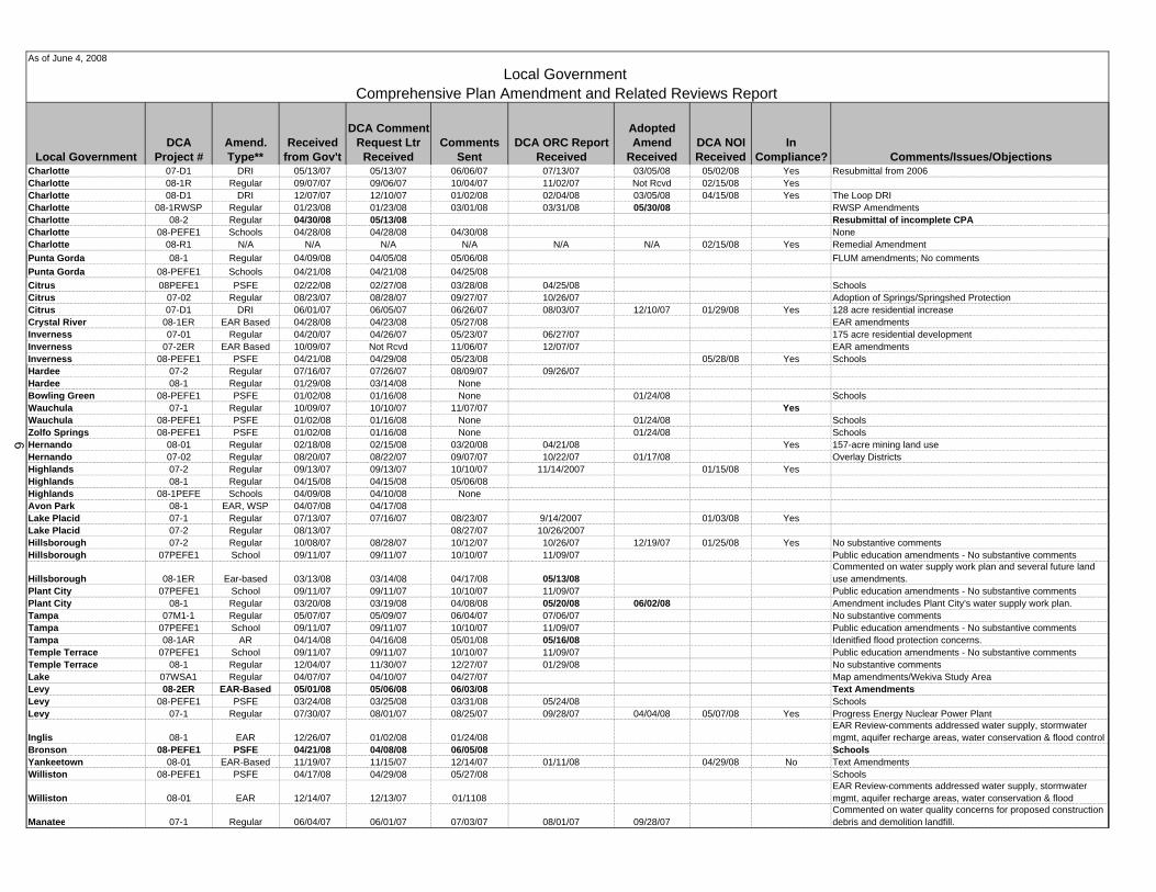
Local GovernmentDCA
Project #Amend. Type**
Received from Gov't
DCA Comment Request Ltr
ReceivedComments
SentDCA ORC Report
Received
Adopted Amend
ReceivedDCA NOI Received
In Compliance? Comments/Issues/Objections
Charlotte 07-D1 DRI 05/13/07 05/13/07 06/06/07 07/13/07 03/05/08 05/02/08 Yes Resubmittal from 2006Charlotte 08-1R Regular 09/07/07 09/06/07 10/04/07 11/02/07 Not Rcvd 02/15/08 YesCharlotte 08-D1 DRI 12/07/07 12/10/07 01/02/08 02/04/08 03/05/08 04/15/08 Yes The Loop DRICharlotte 08-1RWSP Regular 01/23/08 01/23/08 03/01/08 03/31/08 05/30/08 RWSP AmendmentsCharlotte 08-2 Regular 04/30/08 05/13/08 Resubmittal of incomplete CPACharlotte 08-PEFE1 Schools 04/28/08 04/28/08 04/30/08 NoneCharlotte 08-R1 N/A N/A N/A N/A N/A N/A 02/15/08 Yes Remedial AmendmentPunta Gorda 08-1 Regular 04/09/08 04/05/08 05/06/08 FLUM amendments; No commentsPunta Gorda 08-PEFE1 Schools 04/21/08 04/21/08 04/25/08Citrus 08PEFE1 PSFE 02/22/08 02/27/08 03/28/08 04/25/08 SchoolsCitrus 07-02 Regular 08/23/07 08/28/07 09/27/07 10/26/07 Adoption of Springs/Springshed ProtectionCitrus 07-D1 DRI 06/01/07 06/05/07 06/26/07 08/03/07 12/10/07 01/29/08 Yes 128 acre residential increaseCrystal River 08-1ER EAR Based 04/28/08 04/23/08 05/27/08 EAR amendmentsInverness 07-01 Regular 04/20/07 04/26/07 05/23/07 06/27/07 175 acre residential developmentInverness 07-2ER EAR Based 10/09/07 Not Rcvd 11/06/07 12/07/07 EAR amendmentsInverness 08-PEFE1 PSFE 04/21/08 04/29/08 05/23/08 05/28/08 Yes SchoolsHardee 07-2 Regular 07/16/07 07/26/07 08/09/07 09/26/07Hardee 08-1 Regular 01/29/08 03/14/08 NoneBowling Green 08-PEFE1 PSFE 01/02/08 01/16/08 None 01/24/08 SchoolsWauchula 07-1 Regular 10/09/07 10/10/07 11/07/07 YesWauchula 08-PEFE1 PSFE 01/02/08 01/16/08 None 01/24/08 SchoolsZolfo Springs 08-PEFE1 PSFE 01/02/08 01/16/08 None 01/24/08 SchoolsHernando 08-01 Regular 02/18/08 02/15/08 03/20/08 04/21/08 Yes 157-acre mining land useHernando 07-02 Regular 08/20/07 08/22/07 09/07/07 10/22/07 01/17/08 Overlay DistrictsHighlands 07-2 Regular 09/13/07 09/13/07 10/10/07 11/14/2007 01/15/08 YesHighlands 08-1 Regular 04/15/08 04/15/08 05/06/08Highlands 08-1PEFE Schools 04/09/08 04/10/08 NoneAvon Park 08-1 EAR, WSP 04/07/08 04/17/08Lake Placid 07-1 Regular 07/13/07 07/16/07 08/23/07 9/14/2007 01/03/08 YesLake Placid 07-2 Regular 08/13/07 08/27/07 10/26/2007Hillsborough 07-2 Regular 10/08/07 08/28/07 10/12/07 10/26/07 12/19/07 01/25/08 Yes No substantive commentsHillsborough 07PEFE1 School 09/11/07 09/11/07 10/10/07 11/09/07 Public education amendments - No substantive comments
Hillsborough 08-1ER Ear-based 03/13/08 03/14/08 04/17/08 05/13/08Commented on water supply work plan and several future land use amendments.
Plant City 07PEFE1 School 09/11/07 09/11/07 10/10/07 11/09/07 Public education amendments - No substantive commentsPlant City 08-1 Regular 03/20/08 03/19/08 04/08/08 05/20/08 06/02/08 Amendment includes Plant City's water supply work plan.Tampa 07M1-1 Regular 05/07/07 05/09/07 06/04/07 07/06/07 No substantive commentsTampa 07PEFE1 School 09/11/07 09/11/07 10/10/07 11/09/07 Public education amendments - No substantive commentsTampa 08-1AR AR 04/14/08 04/16/08 05/01/08 05/16/08 Idenitfied flood protection concerns. Temple Terrace 07PEFE1 School 09/11/07 09/11/07 10/10/07 11/09/07 Public education amendments - No substantive commentsTemple Terrace 08-1 Regular 12/04/07 11/30/07 12/27/07 01/29/08 No substantive commentsLake 07WSA1 Regular 04/07/07 04/10/07 04/27/07 Map amendments/Wekiva Study AreaLevy 08-2ER EAR-Based 05/01/08 05/06/08 06/03/08 Text AmendmentsLevy 08-PEFE1 PSFE 03/24/08 03/25/08 03/31/08 05/24/08 SchoolsLevy 07-1 Regular 07/30/07 08/01/07 08/25/07 09/28/07 04/04/08 05/07/08 Yes Progress Energy Nuclear Power Plant
Inglis 08-1 EAR 12/26/07 01/02/08 01/24/08EAR Review-comments addressed water supply, stormwater mgmt, aquifer recharge areas, water conservation & flood control
Bronson 08-PEFE1 PSFE 04/21/08 04/08/08 06/05/08 SchoolsYankeetown 08-01 EAR-Based 11/19/07 11/15/07 12/14/07 01/11/08 04/29/08 No Text AmendmentsWilliston 08-PEFE1 PSFE 04/17/08 04/29/08 05/27/08 Schools
Williston 08-01 EAR 12/14/07 12/13/07 01/1108EAR Review-comments addressed water supply, stormwater mgmt, aquifer recharge areas, water conservation & flood
Manatee 07-1 Regular 06/04/07 06/01/07 07/03/07 08/01/07 09/28/07Commented on water quality concerns for proposed construction debris and demolition landfill.
As of June 4, 2008
Local Government Comprehensive Plan Amendment and Related Reviews Report
6
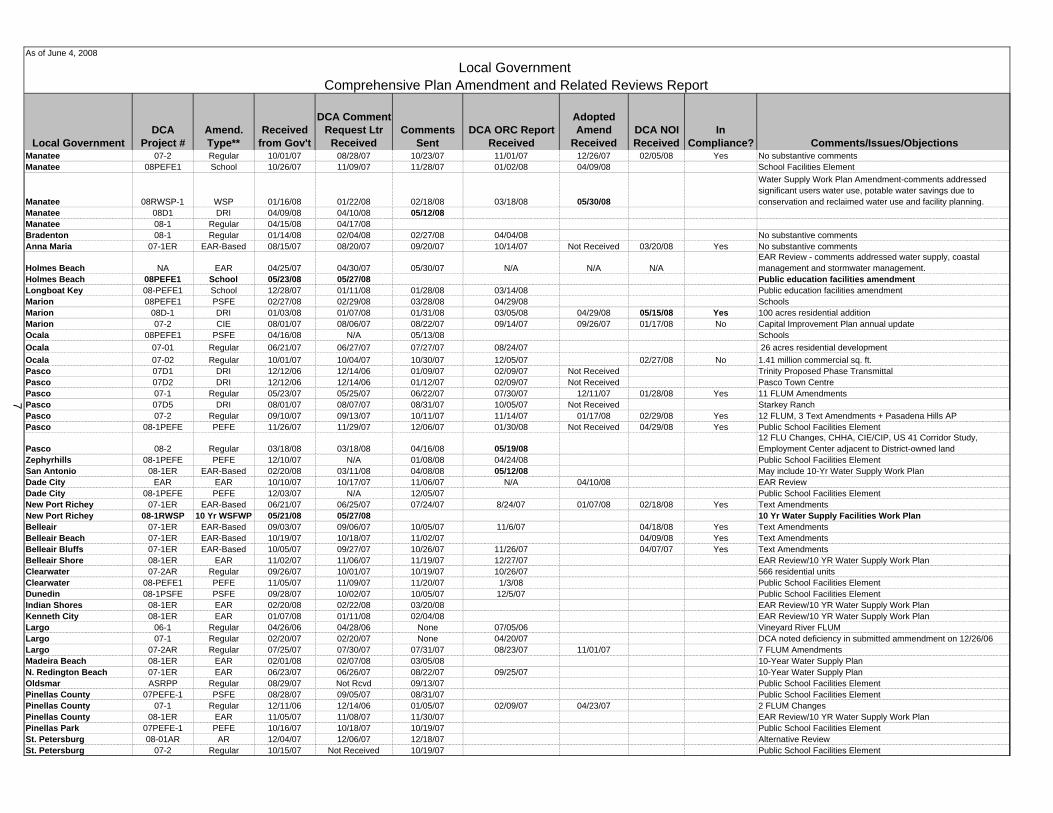
Local GovernmentDCA
Project #Amend. Type**
Received from Gov't
DCA Comment Request Ltr
ReceivedComments
SentDCA ORC Report
Received
Adopted Amend
ReceivedDCA NOI Received
In Compliance? Comments/Issues/Objections
As of June 4, 2008
Local Government Comprehensive Plan Amendment and Related Reviews Report
Manatee 07-2 Regular 10/01/07 08/28/07 10/23/07 11/01/07 12/26/07 02/05/08 Yes No substantive commentsManatee 08PEFE1 School 10/26/07 11/09/07 11/28/07 01/02/08 04/09/08 School Facilities Element
Manatee 08RWSP-1 WSP 01/16/08 01/22/08 02/18/08 03/18/08 05/30/08
Water Supply Work Plan Amendment-comments addressed significant users water use, potable water savings due to conservation and reclaimed water use and facility planning.
Manatee 08D1 DRI 04/09/08 04/10/08 05/12/08Manatee 08-1 Regular 04/15/08 04/17/08Bradenton 08-1 Regular 01/14/08 02/04/08 02/27/08 04/04/08 No substantive commentsAnna Maria 07-1ER EAR-Based 08/15/07 08/20/07 09/20/07 10/14/07 Not Received 03/20/08 Yes No substantive comments
Holmes Beach NA EAR 04/25/07 04/30/07 05/30/07 N/A N/A N/AEAR Review - comments addressed water supply, coastal management and stormwater management.
Holmes Beach 08PEFE1 School 05/23/08 05/27/08 Public education facilities amendmentLongboat Key 08-PEFE1 School 12/28/07 01/11/08 01/28/08 03/14/08 Public education facilities amendmentMarion 08PEFE1 PSFE 02/27/08 02/29/08 03/28/08 04/29/08 SchoolsMarion 08D-1 DRI 01/03/08 01/07/08 01/31/08 03/05/08 04/29/08 05/15/08 Yes 100 acres residential additionMarion 07-2 CIE 08/01/07 08/06/07 08/22/07 09/14/07 09/26/07 01/17/08 No Capital Improvement Plan annual updateOcala 08PEFE1 PSFE 04/16/08 N/A 05/13/08 SchoolsOcala 07-01 Regular 06/21/07 06/27/07 07/27/07 08/24/07 26 acres residential developmentOcala 07-02 Regular 10/01/07 10/04/07 10/30/07 12/05/07 02/27/08 No 1.41 million commercial sq. ft.Pasco 07D1 DRI 12/12/06 12/14/06 01/09/07 02/09/07 Not Received Trinity Proposed Phase TransmittalPasco 07D2 DRI 12/12/06 12/14/06 01/12/07 02/09/07 Not Received Pasco Town CentrePasco 07-1 Regular 05/23/07 05/25/07 06/22/07 07/30/07 12/11/07 01/28/08 Yes 11 FLUM AmendmentsPasco 07D5 DRI 08/01/07 08/07/07 08/31/07 10/05/07 Not Received Starkey RanchPasco 07-2 Regular 09/10/07 09/13/07 10/11/07 11/14/07 01/17/08 02/29/08 Yes 12 FLUM, 3 Text Amendments + Pasadena Hills APPasco 08-1PEFE PEFE 11/26/07 11/29/07 12/06/07 01/30/08 Not Received 04/29/08 Yes Public School Facilities Element
Pasco 08-2 Regular 03/18/08 03/18/08 04/16/08 05/19/0812 FLU Changes, CHHA, CIE/CIP, US 41 Corridor Study, Employment Center adjacent to District-owned land
Zephyrhills 08-1PEFE PEFE 12/10/07 N/A 01/08/08 04/24/08 Public School Facilities ElementSan Antonio 08-1ER EAR-Based 02/20/08 03/11/08 04/08/08 05/12/08 May include 10-Yr Water Supply Work PlanDade City EAR EAR 10/10/07 10/17/07 11/06/07 N/A 04/10/08 EAR ReviewDade City 08-1PEFE PEFE 12/03/07 N/A 12/05/07 Public School Facilities ElementNew Port Richey 07-1ER EAR-Based 06/21/07 06/25/07 07/24/07 8/24/07 01/07/08 02/18/08 Yes Text AmendmentsNew Port Richey 08-1RWSP 10 Yr WSFWP 05/21/08 05/27/08 10 Yr Water Supply Facilities Work PlanBelleair 07-1ER EAR-Based 09/03/07 09/06/07 10/05/07 11/6/07 04/18/08 Yes Text AmendmentsBelleair Beach 07-1ER EAR-Based 10/19/07 10/18/07 11/02/07 04/09/08 Yes Text AmendmentsBelleair Bluffs 07-1ER EAR-Based 10/05/07 09/27/07 10/26/07 11/26/07 04/07/07 Yes Text AmendmentsBelleair Shore 08-1ER EAR 11/02/07 11/06/07 11/19/07 12/27/07 EAR Review/10 YR Water Supply Work PlanClearwater 07-2AR Regular 09/26/07 10/01/07 10/19/07 10/26/07 566 residential unitsClearwater 08-PEFE1 PEFE 11/05/07 11/09/07 11/20/07 1/3/08 Public School Facilities ElementDunedin 08-1PSFE PSFE 09/28/07 10/02/07 10/05/07 12/5/07 Public School Facilities ElementIndian Shores 08-1ER EAR 02/20/08 02/22/08 03/20/08 EAR Review/10 YR Water Supply Work PlanKenneth City 08-1ER EAR 01/07/08 01/11/08 02/04/08 EAR Review/10 YR Water Supply Work PlanLargo 06-1 Regular 04/26/06 04/28/06 None 07/05/06 Vineyard River FLUMLargo 07-1 Regular 02/20/07 02/20/07 None 04/20/07 DCA noted deficiency in submitted ammendment on 12/26/06Largo 07-2AR Regular 07/25/07 07/30/07 07/31/07 08/23/07 11/01/07 7 FLUM AmendmentsMadeira Beach 08-1ER EAR 02/01/08 02/07/08 03/05/08 10-Year Water Supply PlanN. Redington Beach 07-1ER EAR 06/23/07 06/26/07 08/22/07 09/25/07 10-Year Water Supply PlanOldsmar ASRPP Regular 08/29/07 Not Rcvd 09/13/07 Public School Facilities ElementPinellas County 07PEFE-1 PSFE 08/28/07 09/05/07 08/31/07 Public School Facilities ElementPinellas County 07-1 Regular 12/11/06 12/14/06 01/05/07 02/09/07 04/23/07 2 FLUM ChangesPinellas County 08-1ER EAR 11/05/07 11/08/07 11/30/07 EAR Review/10 YR Water Supply Work PlanPinellas Park 07PEFE-1 PEFE 10/16/07 10/18/07 10/19/07 Public School Facilities ElementSt. Petersburg 08-01AR AR 12/04/07 12/06/07 12/18/07 Alternative ReviewSt. Petersburg 07-2 Regular 10/15/07 Not Received 10/19/07 Public School Facilities Element
7
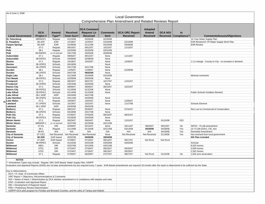
Local GovernmentDCA
Project #Amend. Type**
Received from Gov't
DCA Comment Request Ltr
ReceivedComments
SentDCA ORC Report
Received
Adopted Amend
ReceivedDCA NOI Received
In Compliance? Comments/Issues/Objections
As of June 4, 2008
Local Government Comprehensive Plan Amendment and Related Reviews Report
St. Petersburg 08RWSP1 Regular 01/23/08 02/05/08 02/26/08 10-Year Water Supply PlanS. Pasadena 08-1ER EAR 12/18/07 12/20/07 01/04/08 02/19/08 EAR Review/10 YR Water Supply Work PlanTarpon Springs 08-1ER EAR 01/09/08 01/11/08 02/20/08 03/06/08 EAR ReviewPolk 07-2 Regular 09/10/07 09/12/07 10/22/07 11/15/07Polk 08-1 Regular 02/20/08 02/25/08 03/31/08Polk 08-RWSP1 10 YR WSFWP 03/17/08 03/20/08 05/06/08Auburndale 07-1 Regular 09/06/07 09/12/07 None 11/13/07Auburndale 08-PEFE1 Schools 02/08/08 02/08/08 NoneBartow 07-1 Regular 10/18/07 10/23/07 None 12/06/07 1 LU change - County to City - no increase in demand Bartow 08-1PEFE Schools 04/18/08 NoneDavenport 08-1PEFE Schools 03/17/08 03/17/08 NoneDundee 08-1 Regular 11/05/07 11/08/07 None 01/09/08Dundee 08-1PEFE Schools 04/07/08 06/02/08 NoneEagle Lake 08-1 Regular 01/13/08 02/29/08 03/10/08 Minimal commentsFort Meade 08-PEFE1 Schools 02/28/08 03/03/08 NoneFrostproof 07-2 Regular 08/24/07 08/27/07 10/17/07 11/01/07Frostproof 08-1PEFE Schools 03/24/08 03/25/08 NoneHaines City 07-2 Regular 08/06/07 08/06/07 08/10/07 10/22/07Haiens City 08-PEFE1 Schools 01/18/08 01/22/08 NoneLake Alfred 08-PEFE1 Schools 01/14/08 01/15/08 None Public Schools Facilities ElementLake Alfred 08-1 WSP WSP 04/16/08 04/17/08Lake Hamilton 08-1PEFE Schools 04/11/08 04/28/08 NoneLake Wales 07-2 Regular 10/03/07 10/04/07 None 12/05/07Lakeland 07-1PEFE Schools 10/19/07 10/22/07 None 11/27/08 Schools ElementLakeland 08-1 WSP WSP 04/30/08 05/02/08Mulberry 07-1 Regular 06/01/07 05/30/07 None 07/31/07 Res Low to Commercial & ConservationMulberry 08-1PEFE Schools 03/18/08 03/17/08 NonePolk City 07-1 Regular 07/05/07 07/03/05 08/10/07 08/31/07Polk City 08-PEFE1 Schools 02/28/08 03/03/08 NoneWinter Haven 07-2 Regular 08/29/07 09/04/07 None 11/01/07 01/15/08 YESWinter Haven 08RWSP-1 10 YR WSFWP 02/27/08 02/29/08 04/11/08Sarasota 07-D1 DRI 02/08/07 02/12/07 None 04/11/07 08/03/07 09/13/07 No SIPOC - FLUM amendmentSarasota 08-1 Regular 01/14/08 01/16/08 02/11/08 03/14/08 05/30/08 04/28/08 Yes 10: FLUM (GSV), CIE, text Sarasota 08-R1 N/A N/A N/A N/A N/A N/A 04/18/08 Yes Remedial AmendmentCity of Sarasota 07-CIE1 Not Received Not Received Not Received None Not Received Not Received 01/18/08 Yes Not received from local governmentCity of Sarasota 08-1ER EAR based 05/02/08 05/06/08 06/04/08 WS Plan includedVenice 07-2ER EAR based 07/09/07 07/19/07 08/14/07 09/17/07 Not Rcvd Not RcvdSumter 08-PEFE1 Schools 01/22/08 02/01/08 03/03/08 04/03/08 SchoolsWildwood 08D1 DRI 02/07/08 02/13/08 03/21/08 8,025 homesWildwood 07D1 DRI 07/24/07 07/26/07 08/23/07 09/25/07 3,000 homesWildwood 07D2 DRI 07/24/07 07/26/07 08/23/07 09/25/07 2,262 homesWildwood 07-1 Regular 07/06/07 06/29/07 07/27/07 08/27/07 Not Rcvd 01/22/08 No 1,632 acre annexation
NOTES
Evaluation and Appraisal Reports (EARs) are not plan amendements but are required every 7 years. EAR-Based amendments are required 18 months after the report is determined to be sufficient by the State.
Key to Abbreviations:DCA = FL Dept. of Community AffairsORC Report = Objections, Recommendations & CommentsNOI = Notice of Intent = Determination by DCA whether amendment is in compliance with statutes and rulesEAR = Evaluation and Appraisal ReportDRI = Development of Regional ImpactPRD = Preliminary Review DeterminationASRPP=DCA pilot program for Pinellas and Broward Counties, and the cities of Tampa and Hialeah
** Amendment Types may include: Regular; DRI; EAR Based; Water Supply Plan; ASRPP
8
Item 65
Outreach and Planning Committee June 24, 2008 Routine Reports
Development of Regional Impact Activity Report
PurposeThis report is provided for the Committee's information and shows District activity in the review of Developments of Regional Impact (DRIs). Staff updates the report monthly, showing new or changed information in bold.
Background/HistoryThe District participates in the review of Developments of Regional Impact (DRIs) pursuant to Section 380.06, Florida Statutes. DRI's are large-scale development projects that exceed statutorily specified thresholds such that the project is assumed to have potential impacts that transcend multiple local government jurisdictions. The District is one of several agencies that are required to participate in the review process, which is administered by the regional planning councils. The District has also entered into memoranda of agreement with the Central Florida, Southwest Florida, Tampa Bay and Withlacoochee regional planning councils to more specifically outline the District's DRI review responsibilities. The District provides water resource management technical and policy information to the regional planning councils and local governments to assist them in making well-informed growth management decisions.
Benefits/CostsThe benefits of the District's DRI review program are to ensure regional planning councils and local government elected officials have sound water resource technical and policy information as they consider large scale development proposals. This helps to ensure these developments are compatible with the District's plans, programs and statutory directives. Costs for this program primarily include staff time and are budgeted in Fund 10 (Governing Board).
Staff Recommendation: See Exhibit
This item is presented for the Committee's information, and no action is required.
Presenter: Roy A. Mazur, Director, Planning Department
9
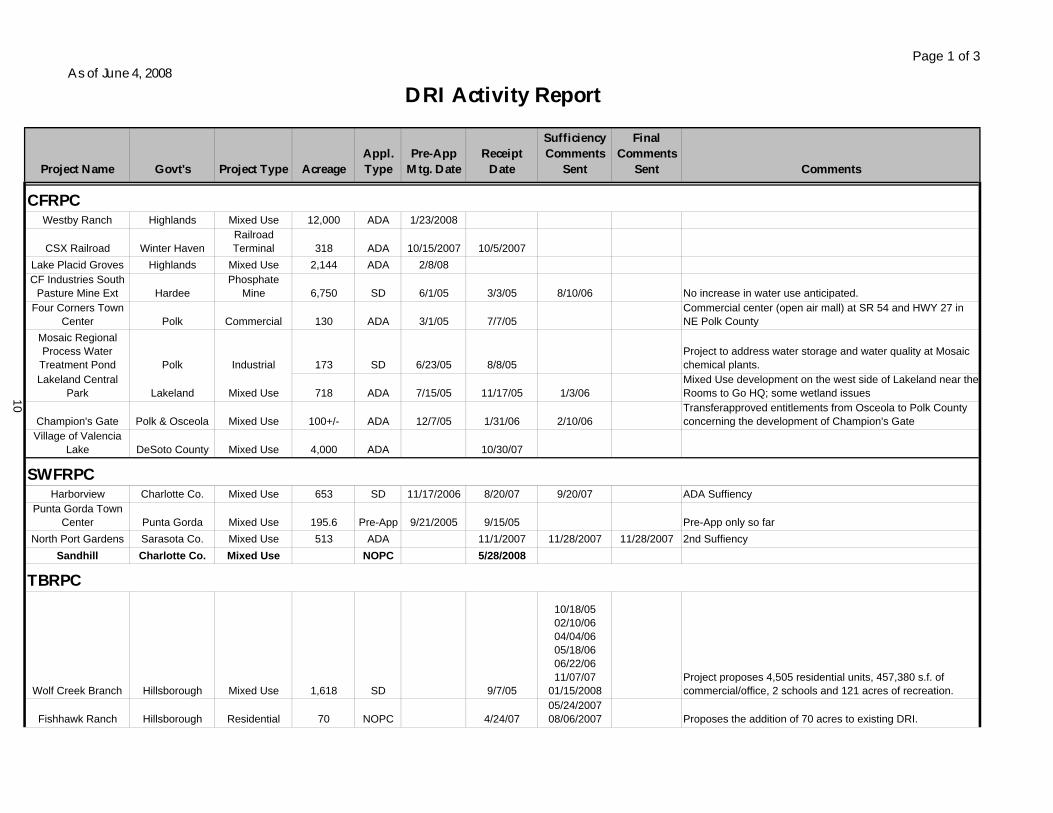
Page 1 of 3
Project Name Govt's Project Type AcreageAppl. Type
Pre-App Mtg. Date
Receipt Date
Sufficiency Comments
Sent
Final Comments
Sent Comments
Westby Ranch Highlands Mixed Use 12,000 ADA 1/23/2008
CSX Railroad Winter HavenRailroadTerminal 318 ADA 10/15/2007 10/5/2007
Lake Placid Groves Highlands Mixed Use 2,144 ADA 2/8/08CF Industries South
Pasture Mine Ext HardeePhosphate
Mine 6,750 SD 6/1/05 3/3/05 8/10/06 No increase in water use anticipated.Four Corners Town
Center Polk Commercial 130 ADA 3/1/05 7/7/05Commercial center (open air mall) at SR 54 and HWY 27 in NE Polk County
Mosaic Regional Process Water
Treatment Pond Polk Industrial 173 SD 6/23/05 8/8/05Project to address water storage and water quality at Mosaic chemical plants.
Lakeland Central Park Lakeland Mixed Use 718 ADA 7/15/05 11/17/05 1/3/06
Mixed Use development on the west side of Lakeland near the Rooms to Go HQ; some wetland issues
Champion's Gate Polk & Osceola Mixed Use 100+/- ADA 12/7/05 1/31/06 2/10/06Transferapproved entitlements from Osceola to Polk County concerning the development of Champion's Gate
Village of Valencia Lake DeSoto County Mixed Use 4,000 ADA 10/30/07
Harborview Charlotte Co. Mixed Use 653 SD 11/17/2006 8/20/07 9/20/07 ADA SuffiencyPunta Gorda Town
Center Punta Gorda Mixed Use 195.6 Pre-App 9/21/2005 9/15/05 Pre-App only so farNorth Port Gardens Sarasota Co. Mixed Use 513 ADA 11/1/2007 11/28/2007 11/28/2007 2nd Suffiency
Sandhill Charlotte Co. Mixed Use NOPC 5/28/2008
Wolf Creek Branch Hillsborough Mixed Use 1,618 SD 9/7/05
10/18/0502/10/0604/04/0605/18/0606/22/0611/07/07
01/15/2008Project proposes 4,505 residential units, 457,380 s.f. of commercial/office, 2 schools and 121 acres of recreation.
Fishhawk Ranch Hillsborough Residential 70 NOPC 4/24/0705/24/200708/06/2007 Proposes the addition of 70 acres to existing DRI.
As of June 4, 2008
DRI Activity Report
CFRPC
TBRPC
SWFRPC
10
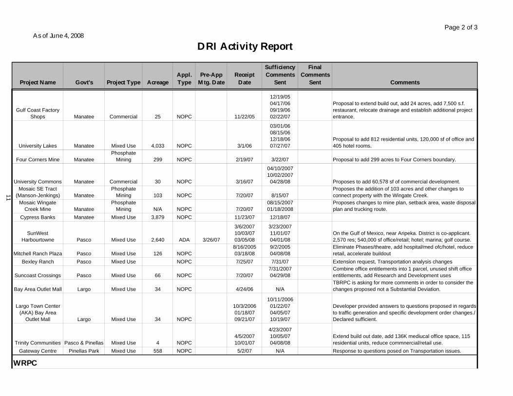
Page 2 of 3
Project Name Govt's Project Type AcreageAppl. Type
Pre-App Mtg. Date
Receipt Date
Sufficiency Comments
Sent
Final Comments
Sent Comments
As of June 4, 2008
DRI Activity Report
Gulf Coast Factory Shops Manatee Commercial 25 NOPC 11/22/05
12/19/0504/17/0609/19/0602/22/07
Proposal to extend build out, add 24 acres, add 7,500 s.f. restaurant, relocate drainage and establish additional project entrance.
University Lakes Manatee Mixed Use 4,033 NOPC 3/1/06
03/01/0608/15/0612/18/0607/27/07
Proposal to add 812 residential units, 120,000 sf of office and 405 hotel rooms.
Four Corners Mine ManateePhosphate
Mining 299 NOPC 2/19/07 3/22/07 Proposal to add 299 acres to Four Corners boundary.
University Commons Manatee Commercial 30 NOPC 3/16/07
04/10/200710/02/200704/28/08 Proposes to add 60,578 sf of commercial development.
Mosaic SE Tract (Manson-Jenkings) Manatee
PhosphateMining 103 NOPC 7/20/07 8/15/07
Proposes the addition of 103 acres and other changes to connect property with the Wingate Creek.
Mosaic Wingate Creek Mine Manatee
PhosphateMining N/A NOPC 7/20/07
08/15/200701/18/2008
Proposes changes to mine plan, setback area, waste disposal plan and trucking route.
Cypress Banks Manatee Mixed Use 3,879 NOPC 11/23/07 12/18/07
SunWestHarbourtowne Pasco Mixed Use 2,640 ADA 3/26/07
3/6/200710/03/0703/05/08
3/23/200711/01/0704/01/08
On the Gulf of Mexico, near Aripeka. District is co-applicant. 2,570 res; 540,000 sf office/retail; hotel; marina; golf course.
Mitchell Ranch Plaza Pasco Mixed Use 126 NOPC8/16/200503/18/08
9/2/200504/08/08
Eliminate Phases/theatre, add hospital/med ofc/hotel, reduce retail, accelerate buildout
Bexley Ranch Pasco Mixed Use NOPC 7/25/07 7/31/07 Extension request, Transportation analysis changes
Suncoast Crossings Pasco Mixed Use 66 NOPC 7/20/077/31/200704/29/08
Combine office entitlements into 1 parcel, unused shift office entitlements, add Research and Development uses
Bay Area Outlet Mall Largo Mixed Use 34 NOPC 4/24/06 N/ATBRPC is asking for more comments in order to consider the changes proposed not a Substantial Deviation.
Largo Town Center (AKA) Bay Area
Outlet Mall Largo Mixed Use 34 NOPC
10/3/200601/18/0709/21/07
10/11/200601/22/0704/05/0710/19/07
Developer provided answers to questions proposed in regards to traffic generation and specific development order changes./ Declared sufficient.
Trinity Communities Pasco & Pinellas Mixed Use 4 NOPC4/5/200710/01/07
4/23/200710/05/0704/08/08
Extend build out date, add 136K mediucal office space, 115 residential units, reduce commnercial/retail use.
Gateway Centre Pinellas Park Mixed Use 558 NOPC 5/2/07 N/A Response to questions posed on Transportation issues.
WRPC
11
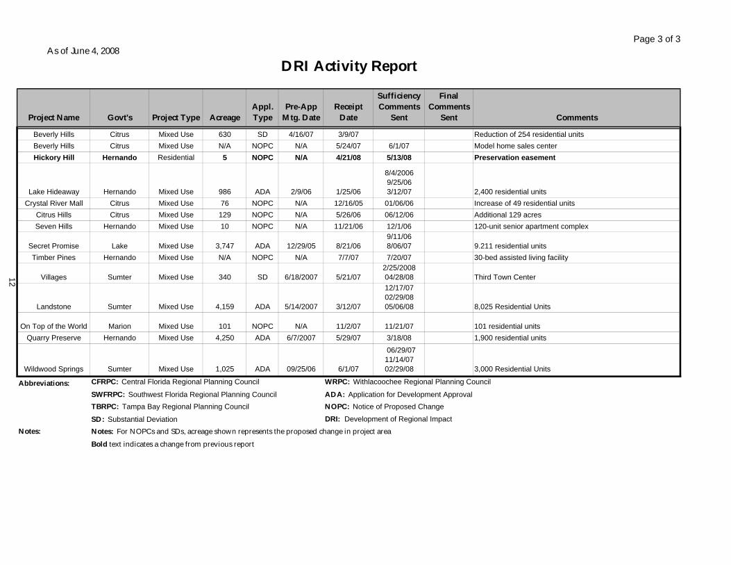
Page 3 of 3
Project Name Govt's Project Type AcreageAppl. Type
Pre-App Mtg. Date
Receipt Date
Sufficiency Comments
Sent
Final Comments
Sent Comments
As of June 4, 2008
DRI Activity Report
Beverly Hills Citrus Mixed Use 630 SD 4/16/07 3/9/07 Reduction of 254 residential unitsBeverly Hills Citrus Mixed Use N/A NOPC N/A 5/24/07 6/1/07 Model home sales centerHickory Hill Hernando Residential 5 NOPC N/A 4/21/08 5/13/08 Preservation easement
Lake Hideaway Hernando Mixed Use 986 ADA 2/9/06 1/25/06
8/4/20069/25/063/12/07 2,400 residential units
Crystal River Mall Citrus Mixed Use 76 NOPC N/A 12/16/05 01/06/06 Increase of 49 residential unitsCitrus Hills Citrus Mixed Use 129 NOPC N/A 5/26/06 06/12/06 Additional 129 acresSeven Hills Hernando Mixed Use 10 NOPC N/A 11/21/06 12/1/06 120-unit senior apartment complex
Secret Promise Lake Mixed Use 3,747 ADA 12/29/05 8/21/069/11/068/06/07 9.211 residential units
Timber Pines Hernando Mixed Use N/A NOPC N/A 7/7/07 7/20/07 30-bed assisted living facility
Villages Sumter Mixed Use 340 SD 6/18/2007 5/21/072/25/200804/28/08 Third Town Center
Landstone Sumter Mixed Use 4,159 ADA 5/14/2007 3/12/07
12/17/0702/29/0805/06/08 8,025 Residential Units
On Top of the World Marion Mixed Use 101 NOPC N/A 11/2/07 11/21/07 101 residential unitsQuarry Preserve Hernando Mixed Use 4,250 ADA 6/7/2007 5/29/07 3/18/08 1,900 residential units
Wildwood Springs Sumter Mixed Use 1,025 ADA 09/25/06 6/1/07
06/29/07 11/14/0702/29/08 3,000 Residential Units
Abbreviations: CFRPC: Central Florida Regional Planning Council WRPC: Withlacoochee Regional Planning Council
SWFRPC: Southwest Florida Regional Planning Council ADA: Application for Development ApprovalTBRPC: Tampa Bay Regional Planning Council NOPC: Notice of Proposed Change
SD: Substantial Deviation DRI: Development of Regional ImpactNotes: Notes: For NOPCs and SDs, acreage shown represents the proposed change in project area
Bold text indicates a change from previous report
12
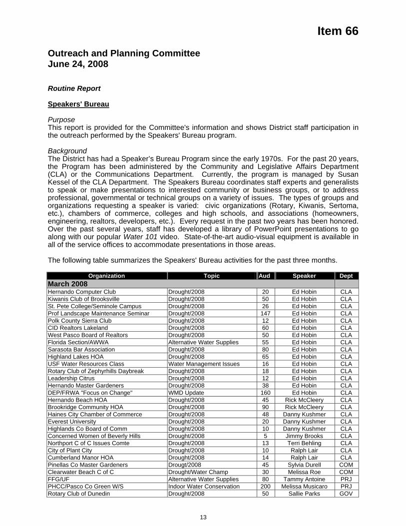
Item 66
Outreach and Planning Committee June 24, 2008
Routine Report Speakers' Bureau PurposeThis report is provided for the Committee's information and shows District staff participation in the outreach performed by the Speakers' Bureau program. Background The District has had a Speaker’s Bureau Program since the early 1970s. For the past 20 years, the Program has been administered by the Community and Legislative Affairs Department (CLA) or the Communications Department. Currently, the program is managed by Susan Kessel of the CLA Department. The Speakers Bureau coordinates staff experts and generalists to speak or make presentations to interested community or business groups, or to address professional, governmental or technical groups on a variety of issues. The types of groups and organizations requesting a speaker is varied: civic organizations (Rotary, Kiwanis, Sertoma, etc.), chambers of commerce, colleges and high schools, and associations (homeowners, engineering, realtors, developers, etc.). Every request in the past two years has been honored. Over the past several years, staff has developed a library of PowerPoint presentations to go along with our popular Water 101 video. State-of-the-art audio-visual equipment is available in all of the service offices to accommodate presentations in those areas.
The following table summarizes the Speakers' Bureau activities for the past three months.
Organization Topic Aud Speaker Dept March 2008 Hernando Computer Club Drought/2008 20 Ed Hobin CLAKiwanis Club of Brooksville Drought/2008 50 Ed Hobin CLASt. Pete College/Seminole Campus Drought/2008 26 Ed Hobin CLAProf Landscape Maintenance Seminar Drought/2008 147 Ed Hobin CLAPolk County Sierra Club Drought/2008 12 Ed Hobin CLACID Realtors Lakeland Drought/2008 60 Ed Hobin CLAWest Pasco Board of Realtors Drought/2008 50 Ed Hobin CLAFlorida Section/AWWA Alternative Water Supplies 55 Ed Hobin CLASarasota Bar Association Drought/2008 80 Ed Hobin CLAHighland Lakes HOA Drought/2008 65 Ed Hobin CLAUSF Water Resources Class Water Management Issues 16 Ed Hobin CLARotary Club of Zephyrhills Daybreak Drought/2008 18 Ed Hobin CLALeadership Citrus Drought/2008 12 Ed Hobin CLAHernando Master Gardeners Drought/2008 38 Ed Hobin CLADEP/FRWA "Focus on Change" WMD Update 160 Ed Hobin CLAHernando Beach HOA Drought/2008 45 Rick McCleery CLABrookridge Community HOA Drought/2008 90 Rick McCleery CLAHaines City Chamber of Commerce Drought/2008 48 Danny Kushmer CLAEverest University Drought/2008 20 Danny Kushmer CLAHighlands Co Board of Comm Drought/2008 10 Danny Kushmer CLAConcerned Women of Beverly Hills Drought/2008 5 Jimmy Brooks CLANorthport C of C Issues Comte Drought/2008 13 Terri Behling CLACity of Plant City Drought/2008 10 Ralph Lair CLACumberland Manor HOA Drought/2008 14 Ralph Lair CLAPinellas Co Master Gardeners Drougt/2008 45 Sylvia Durell COMClearwater Beach C of C Drought/Water Champ 30 Melissa Roe COMFFG/UF Alternative Water Supplies 80 Tammy Antoine PRJPHCC/Pasco Co Green W/S Indoor Water Conservation 200 Melissa Musicaro PRJRotary Club of Dunedin Drought/2008 50 Sallie Parks GOV
13
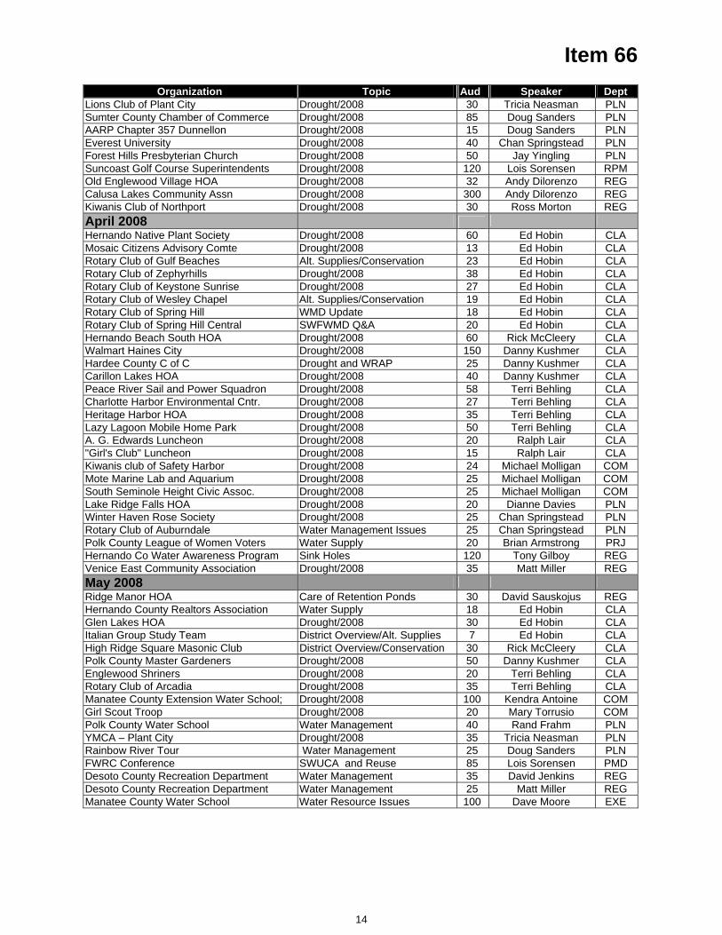
Item 66 Organization Topic Aud Speaker Dept
Lions Club of Plant City Drought/2008 30 Tricia Neasman PLNSumter County Chamber of Commerce Drought/2008 85 Doug Sanders PLNAARP Chapter 357 Dunnellon Drought/2008 15 Doug Sanders PLNEverest University Drought/2008 40 Chan Springstead PLNForest Hills Presbyterian Church Drought/2008 50 Jay Yingling PLNSuncoast Golf Course Superintendents Drought/2008 120 Lois Sorensen RPMOld Englewood Village HOA Drought/2008 32 Andy Dilorenzo REGCalusa Lakes Community Assn Drought/2008 300 Andy Dilorenzo REGKiwanis Club of Northport Drought/2008 30 Ross Morton REGApril 2008 Hernando Native Plant Society Drought/2008 60 Ed Hobin CLAMosaic Citizens Advisory Comte Drought/2008 13 Ed Hobin CLARotary Club of Gulf Beaches Alt. Supplies/Conservation 23 Ed Hobin CLARotary Club of Zephyrhills Drought/2008 38 Ed Hobin CLARotary Club of Keystone Sunrise Drought/2008 27 Ed Hobin CLARotary Club of Wesley Chapel Alt. Supplies/Conservation 19 Ed Hobin CLARotary Club of Spring Hill WMD Update 18 Ed Hobin CLARotary Club of Spring Hill Central SWFWMD Q&A 20 Ed Hobin CLAHernando Beach South HOA Drought/2008 60 Rick McCleery CLAWalmart Haines City Drought/2008 150 Danny Kushmer CLAHardee County C of C Drought and WRAP 25 Danny Kushmer CLACarillon Lakes HOA Drought/2008 40 Danny Kushmer CLAPeace River Sail and Power Squadron Drought/2008 58 Terri Behling CLACharlotte Harbor Environmental Cntr. Drought/2008 27 Terri Behling CLAHeritage Harbor HOA Drought/2008 35 Terri Behling CLALazy Lagoon Mobile Home Park Drought/2008 50 Terri Behling CLAA. G. Edwards Luncheon Drought/2008 20 Ralph Lair CLA"Girl's Club" Luncheon Drought/2008 15 Ralph Lair CLAKiwanis club of Safety Harbor Drought/2008 24 Michael Molligan COMMote Marine Lab and Aquarium Drought/2008 25 Michael Molligan COMSouth Seminole Height Civic Assoc. Drought/2008 25 Michael Molligan COMLake Ridge Falls HOA Drought/2008 20 Dianne Davies PLNWinter Haven Rose Society Drought/2008 25 Chan Springstead PLNRotary Club of Auburndale Water Management Issues 25 Chan Springstead PLNPolk County League of Women Voters Water Supply 20 Brian Armstrong PRJHernando Co Water Awareness Program Sink Holes 120 Tony Gilboy REGVenice East Community Association Drought/2008 35 Matt Miller REGMay 2008 Ridge Manor HOA Care of Retention Ponds 30 David Sauskojus REGHernando County Realtors Association Water Supply 18 Ed Hobin CLAGlen Lakes HOA Drought/2008 30 Ed Hobin CLAItalian Group Study Team District Overview/Alt. Supplies 7 Ed Hobin CLAHigh Ridge Square Masonic Club District Overview/Conservation 30 Rick McCleery CLAPolk County Master Gardeners Drought/2008 50 Danny Kushmer CLAEnglewood Shriners Drought/2008 20 Terri Behling CLARotary Club of Arcadia Drought/2008 35 Terri Behling CLAManatee County Extension Water School; Drought/2008 100 Kendra Antoine COMGirl Scout Troop Drought/2008 20 Mary Torrusio COMPolk County Water School Water Management 40 Rand Frahm PLNYMCA – Plant City Drought/2008 35 Tricia Neasman PLNRainbow River Tour Water Management 25 Doug Sanders PLNFWRC Conference SWUCA and Reuse 85 Lois Sorensen PMDDesoto County Recreation Department Water Management 35 David Jenkins REGDesoto County Recreation Department Water Management 25 Matt Miller REGManatee County Water School Water Resource Issues 100 Dave Moore EXE
14
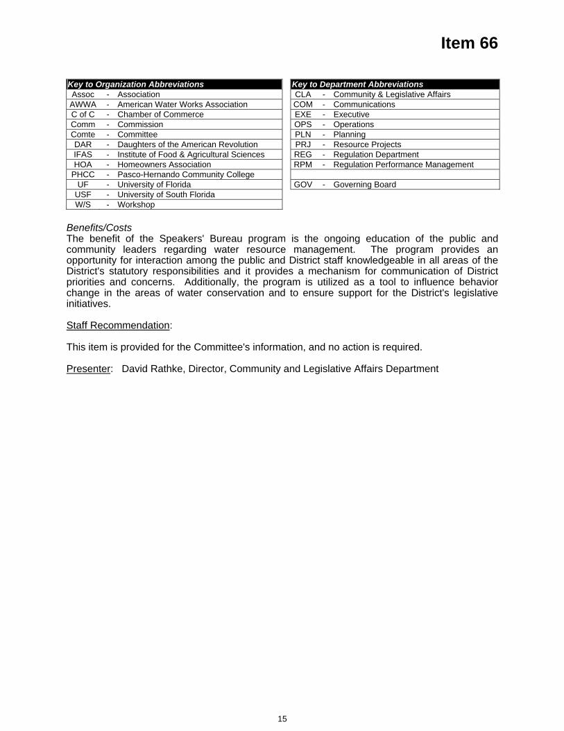
Item 66
Key to Organization Abbreviations Key to Department Abbreviations Assoc - Association CLA - Community & Legislative Affairs AWWA - American Water Works Association COM - CommunicationsC of C - Chamber of Commerce EXE - Executive Comm - Commission OPS - Operations Comte - Committee PLN - Planning DAR - Daughters of the American Revolution PRJ - Resource Projects IFAS - Institute of Food & Agricultural Sciences REG - Regulation Department HOA - Homeowners Association RPM - Regulation Performance Management
PHCC - Pasco-Hernando Community College UF - University of Florida GOV - Governing Board
USF - University of South Florida W/S - Workshop
Benefits/CostsThe benefit of the Speakers' Bureau program is the ongoing education of the public and community leaders regarding water resource management. The program provides an opportunity for interaction among the public and District staff knowledgeable in all areas of the District's statutory responsibilities and it provides a mechanism for communication of District priorities and concerns. Additionally, the program is utilized as a tool to influence behavior change in the areas of water conservation and to ensure support for the District's legislative initiatives.
Staff Recommendation:
This item is provided for the Committee's information, and no action is required.
Presenter: David Rathke, Director, Community and Legislative Affairs Department
15
Item 67
Outreach and Planning Committee June 24, 2008 Routine Report
Significant Activities Report Conservation and Drought CommunicationsDuring December and January, the District employed a grass-roots communications effort using existing tools such as the Speakers Bureau, news media outreach and public affairs programming, as well as outreach to homeowners associations (HOAs), landscape irrigation professionals, churches and others. The District also developed a web page at WaterMatters.org/drought to serve as a “one-stop-shopping” resource for the public to obtain information on the drought, water restrictions and conservation. Communications staff continued distributing a PowerPoint presentation, copy points and collateral materials to District staff to reach many of the key target audiences identified in the FY2008 Drought Communications Plan. Print ads and articles promoting "Skip a Week" were offered to 1,000 HOAs, 100 neighborhood associations and 30 organizations such as chambers of commerce, environmental organizations, community groups and religious denominations for use in their newsletters. In response to direction by the Governing Board, staff developed roadside signs that read: It’s a drought. Conserve! Learn how at WaterMatters.org. The District is offering the signs to local governments and utilities to be placed in their communities. The District’s drought web page has links to all the organizations who partner with the District on the road signs. Based on a District employee's suggestion, the staff also ordered 500 conservation car magnets that have been placed on more than 220 District vehicles. The District's traditional spring media "Reduce Your Use" campaign kicked off in mid-February. Television, radio, billboard and print ads featuring the District's drought and water conservation messages ran Districtwide through April 30. Free print ads and articles promoting "Reduce Your Use" were offered to more than 1,000 HOAs for use in their newsletters. New Activities Since Last Meeting — The FY2008 Media Messaging Campaign has been completed. The cost for the spring media buy in March and April was $612,425. The evaluation of the buy is included as a Submit and File Report in this month's Outreach and Planning Committee meeting materials. The emergency media buy in May has been completed and the results will be reported to the July Governing Board meeting. District staff conducted 121 speaking engagements from December through May, and 4 engagements have been scheduled for June through September. Staff has also participated in more than 10 community events. A total of 1,776 conservation signs have been received by 90 governments, utilities and organizations.
Water Conservation Hotel And Motel Program (Water CHAMP) and Water Program for Restaurant Outreach (Water PRO)Water CHAMP promotes water conservation in hotels and motels through a towel and linen reuse program that encourages guests to use their towels and linens more than once during their stay. Participating hotels and motels receive materials that explain Water CHAMP to staff members and guests. Materials include towel reuse cards, linen reuse cards, environmental table brochures, guest comment cards, staff training materials and an environmental self-audit checklist — all free of charge. Educational workshops on additional ways to save water are also provided to the participating hotels and motels. Surveys of guests staying in Water CHAMP properties indicate that guests like the program and believe conserving water makes a difference to the environment. From 2002–2003, Pinellas County Utilities and the City of Tampa Water Department conducted comparison studies of the water use of 71 hotels in their area before and after implementing Water CHAMP. The studies showed that in total the 71 participants saved a cumulative 100 million gallons of water in only one year after implementing Water CHAMP. The Water CHAMP coordinator will also coordinate the Water Program for Restaurant Outreach (Water PRO), which will extend water conservation achieved through the Water CHAMP program by promoting water conservation in restaurants. Staff will be educating both restaurateurs and guests with materials such as table tents, children's coloring sheets,
16
Item 67 coasters and self-audit checklists. "We only serve water on request" buttons are also available for wait staff. New Activities Since Last Meeting — Water CHAMP: There are currently 390 hotels participating in the program Districtwide. This brings the participation rate to 41 percent and accounts for more than 61 percent of the available hotel rooms in the District. Staff is conducting a Districtwide audit of Water CHAMP properties to monitor water and monetary savings. Staff is also working with a variety of partners to include the Water CHAMP logo next to participating properties in several visitor guides. Bill inserts promoting Water CHAMP properties and directing residents to the CHAMP web site are being designed in partnership with the following utilities: Pinellas County, City of Winter Haven, Polk County, City of Tampa and City of Lakeland. Staff sent more than 700 brochures to hotels and motels not currently involved in Water CHAMP. The Water CHAMP coordinator received a positive response from the mailing and is receiving calls daily requesting information and materials. Water CHAMP's partnership with Progress Energy resulted in the completion of an energy and water conservation poster. This poster will be placed at all Water CHAMP properties with public laundry facilities in Pinellas, Pasco, Hernando and Citrus counties. Water PRO: The District has kicked off its new Program for Restaurant Outreach (Water PRO). Water PRO will focus initially on restaurants located within CHAMP properties. Water PRO received publicity on Tampa Bay's 10 News CBS affiliate and in several newspapers. As a result of the Channel 10 news piece, a restaurant chain has expressed an interest in implementing Water PRO in its 500 restaurants statewide. Also, staff visits to restaurants and networking at industry meetings have resulted in a positive response from restaurant owners and management.
Florida Water Star SM
The Florida Water StarSM (FWS) program certifies new homes based on water conservation criteria developed by the St. Johns River Water Management District (SJRWMD) to encourage water efficiency in household appliances, plumbing fixtures, irrigation systems and landscapes. The certification program encourages builders/developers to save water indoors and outdoors and has some consistency with national green building programs such as LEED by the U.S. Green Building Council and Energy Star® from EPA. The resulting certification criteria were also integrated into the wider “green building umbrella” being developed at the time for the Florida Green Building Coalition. The program's objectives are to increase the knowledge level of the building industry about water-efficient building practices and to provide educational resources and incentives to make these practices common to the marketplace. FWS is currently being implemented successfully in the SJRWMD based on criteria it developed. Because builder/developer education has been ongoing within the SWFWMD for several years, a more advanced version of the outdoor water use criteria was developed to be more closely aligned to the University of Florida/Institute of Food and Agricultural Sciences' Florida Yards & Neighborhoods program's Florida-friendly landscaping principles and landscape best management practices. SWFWMD Resource Projects Department staff also participated in developing the indoor water use criteria. The resulting advanced version adds criteria that will result in even more water savings and fewer impacts to water quality. New Activities Since Last Meeting — Florida Water Star Gold will be the designation of the higher level of criteria that will be implemented in the SWFWMD. A beta test of the criteria was conducted in May on a home built by John Cannon Homes in Sarasota. The purpose of the beta test was to determine how well the checklist and points system worked in the field. A second test will be conducted at the On Top of the World community in Ocala. Staff submitted the "gold" criteria to the Florida Green Building Coalition to be considered for use in their certification program's water-use section. Community-Based Social Marketing Community-based social marketing (CBSM) programs use research to uncover what drives residents to either participate in or avoid specific behaviors. With the knowledge of what motivates people to behave the way that they do, the District can create programs that are tailored to the populations they are meant to target and will most likely result in desired behavior changes. The Communications Department has been using the theories of this social science to enhance program design. New Activities Since Last Meeting — Project manager is organizing a Community-Based Social Marketing Networking & Resource Committee of individuals throughout the 16 counties of the District who are actively working on — or would like to work on
17
Item 67 — social marketing, CBSM, research and/or evaluation projects. The committee will serve as a think tank for sharing ideas, networking and advising one another on lessons learned as social marketers. The first meeting of this group will take place at the District's Tampa Service Office on July 18. Staff is developing a CBSM page to be added to the District's web site. The CBSM site will serve as a resource for staff and cooperators who are using CBSM tools in their programs. It will include the steps of CBSM projects, examples of pilot programs, example research and evaluation tools, and a database of the qualitative and quantitative research data that has been collected by the District's social researcher. The District's project manager met with the webmaster and other staff on March 14 and again on May 16 to review and create plans for the site. Project manager is also working with social marketing consultants to develop a research training program to be offered to staff and cooperators in November 2008. Irrigation Pilot Program A community-based social marketing pilot program is under way in neighborhoods in Sumter, Polk and Charlotte counties. Residents will be asked to “take control of their irrigation systems” during the months of July, August and September, when rainfall can allow residents to turn off their systems for extended periods of time, and to “water only every other week” during the months of December, January and February. The specific education interventions will be determined by results of qualitative (focus groups) and quantitative (survey) research conducted to determine the best way to educate the residents to achieve the desired behaviors. NewActivities Since Last Meeting — The audio recordings from the focus groups and other related research were used to guide the creation of a telephone survey questionnaire. The survey was pilot-tested with small sample audiences to ensure its understandability and clarity of responses before data collection began. Two sample sets of survey data were collected. Research data from pilot neighborhoods was completed on April 21, and responses from the Districtwide sample were completed on May 28. The District's consultants are currently analyzing the data to prepare reports of findings for District staff to use in program development. District staff organized a social marketing training on April 16 for internal staff and project cooperators on how to use behavioral research to create strategic marketing programs that are more likely to facilitate behavioral changes. On April 23, the same group came together and reviewed the data from the pilot neighborhoods to begin brainstorming a strategic social marketing plan. The Center for Social Marketing at USF and the Florida Prevention Research Center led the training. In addition, staff is continuing to gather water-use reports from participating utilities to create historical water data reports that will be used to measure changes in water use throughout the course of the project. Water-use data will be reported and logged monthly throughout the entirety of the pilot project.
Barrier & Benefit SurveyIn 2007, white papers on nine specific behaviors related to watershed protection and water conservation were commissioned as the first step in creating multiple community-based social marketing pilot programs on priority issues. The white papers summarized the literature review and the perceived barriers and benefits that exist for each behavior. The next step is to collect quantitative information directly from District residents. New Activities Since Last Meeting —As a result of a request-for-proposal process, Marketing For Change (M4C) was selected as the vendor to provide the quantitative data. A scope of work for the vendor was awarded, and the first meeting with the consultant was held on March 28 at the Tampa Service Office. As a result of collaboration between M4C and District staff, on May 28 the first draft of one of three surveys was provided to the District's project manager for approval. Once approved, data collection will begin.
District Lands Communications Plan Communications staff is working with the Land Resources Department to create a comprehensive communications plan to promote the value of ecosystem protection through recreation on conservation lands using community-based social marketing tools. As the first step in identifying District residents' knowledge level and opinions about District lands, the Communications project manager worked closely with the Land Resources Department and a research consultant to create and execute a land-use public opinion survey. The findings of this effort, which were reported at the July 2007 joint meeting of the Basin Board Education and
18
Item 67 Land Resources committees, will be used to create strategic recreation plans, tailored pilot projects and defined levels of service for recreational amenities. Major research findings include: 63% of respondents said they do not get outdoors enough 43% said they were aware of District lands 33% have used District lands 93.7% have a favorable opinion of the District once they visited District lands More than 50% said they get their information about outdoor activities from word of mouth 24% cited time commitment as their biggest barrier to getting outdoors Respondents reported that the activities they would like to participate in outdoors include walking/hiking (25%), boating (20%) and fishing (17%)
People who are currently actively participating in activities on District lands reported that they most enjoy hiking/walking (56%) and camping (29%)
Staff from the Communications and Land Resources departments have met several times to develop and refine a communications plan of general goals, strategies and tactics. Three sites have been chosen to receive tailored social marketing plans based on the research findings — Edward W. Chance Reserve Gilley Creek Tract, Green Swamp East Tract and Starkey Wilderness Preserve Serenova Tract. New Activities Since Last Meeting — On April 14, Communications staff joined members from the Land staff on a tour of two of the pilot sites — Green Swamp East Tract and Starkey Wilderness Preserve Serenova Tract. Three other sites — Flatwoods Park at Lower Hillsborough Wilderness Park, Myakka River Deer Prairie Creek, Starkey Wilderness Preserve — will receive cooperative signage to identify District partnership. Staff is continuing to work on general tactics for the Land Resources Department, including messaging campaigns, signage, web site alterations, recreation programs and setting up stories for Central Florida News 13 and Bay News 9's "Florida on a Tankful" segment. The first interview with this travel reporter was held at the Green Swamp East Tract on April 16. The segment aired nearly 30 times on the two stations during April 17–20. Longer versions of the segment are available on both stations' On Demand channels and features are posted on the "Florida on a Tankful" section of both stations' web sites. The next meeting between Land staff and Communications staff will take place in July. Florida Yards & Neighborhoods (FYN)Recognizing the potential of water conservation and water quality protection through promotion of Florida-friendly landscaping practices, the District began partnering with the University of Florida in FY2001 to support Florida-friendly landscaping education. Currently, approximately 228,000 people are reached annually through homeowner programs in eight counties, builder and developer programs in five counties and community/homeowners association programs that reach four counties. With up to 50 percent of a typical household’s water use going to outdoor irrigation, outreach to builders, developers and irrigation specialists became available Districtwide in FY2007. New Activities Since Last Meeting — (1) Member governments, including FYN programs at Extension offices, can now use Tampa Bay Water's web-based GIS water consumption tool to track water-use reduction after education intervention. The program allows graphing of monthly or annual water consumption for the entire water-use history. (2) Pasco County's FYN coordinator made contact with Ecobrokers, a national real estate certification group with members in Florida. Among other activities, the organization educates real estate salespersons about the energy and resource conservation components of "green" homes to help the agents represent the houses better. The coordinator will begin attending the group's meetings to present information on the benefits of Florida-friendly landscaping. (3) District staff has been working with the staff at Highlands and Levy counties to begin outreach on Florida-friendly landscaping in those areas. (4) In addition, new or expanded outreach will be funded in Charlotte County to address ways landscaping best management practices (BMPs) can impact water use. (5) District staff recently met with representatives from DEP, UF and SJRWMD to plan Florida-friendly landscaping education materials. The districts will publish a landscape planning guide that will feature information on the BMPs involved in planning a Florida-friendly landscape and an overview of the nine principles. DEP and UF agreed to revise the current FYN handbook to provide a comprehensive learning manual for the public. (6) A District/FYN Sharing Day is planned for June 17. A training will be conducted on how to work
19
Item 67 with community association board members and condominium managers. Retrofitting conventional irrigation systems to micro-irrigation will be covered in a second presentation. Watershed Education The District's watershed education efforts encourage residents to protect their local water resources through education relating to water quality, stormwater runoff, water conservation and natural systems. Some examples of the District's watershed education efforts include decision-maker workshops, upriver and downriver educational bus tours, estuary wading trips, speaking engagements, pond adoptions, outreach at special events, educational kiosks and stormdrain marking activities. New Activities Since Last Meeting — (1) The Charlotte Harbor Environmental Center (CHEC) planned and implemented two Florida-Friendly Yards HomeScape Tours on Saturday, May 10, 2008, from 10 a.m. until 2 p.m. Twenty-seven participants learned about Florida-friendly landscaping techniques and the protection of water resources. (2) The opening day of the Manatee County Extension 2008 Water School took place on May 29, from 8 a.m. until 4:30 p.m., and included an all-day workshop with presentations focused on the protection of water resources. During the opening ceremony, Executive Director David Moore spoke about the state of the District. Governing Board member Pat Glass participated in a panel discussion to address questions regarding policymakers' perspectives. On Friday, May 30, participants went on a Manatee County Watersheds and Treatment Plant Bus Tour. Community Education Grant Program The Community Education Grant (CEG) Program is in its eleventh year, funded through Basin Initiatives for Public Education (P268). The CEG Program provides funding assistance up to $5,000 per project for individuals, service groups, community associations and other organizations to implement a water resources education project. This year the Communications Department received 75 applications requesting a combined total of $302,422 Districtwide. Staff recommended 38 projects totaling $136,598. The grant implementation period is from March 15 through June 30, 2008. New Activities Since Last Meeting — Several Community Education Grant-funded projects took place recently. (1) The DeSoto County Parks and Recreation Department held two "Picking Up the Pieces on the Peace River" cleanup events on May 3 and 10. Sixty-five volunteers collected nearly 1,500 pounds of trash. As part of the events, a presentation was given about how trash and pollution affects our water resources. (2) The Highlands Soil and Water Conservation District is continuing its series of low-flow showerhead demonstrations to area residents. Attendees are encouraged to trade in their old showerheads to receive free new low-flow showerheads. Follow-up surveys will be conducted to determine water savings. The most recent workshop occurred May 8 at the Agri-Civic Center in Sebring. To date, 1,100 low-flow showerheads have been distributed. (3) On May 22, the Landings South 2 Condo Association's workshop on pond ecology reached 20 community residents. This workshop featured information on ways to improve the water quality of local ponds and gave volunteers an opportunity to participate in a pond planting. (4) The City of Safety Harbor in Pinellas County hosted the "Discover Florida" event May 14 at Marshall Street Park. Approximately 500 participants learned about their watershed through presentations, maps and guided hikes through the park. Youth EducationThe District provides water resources education programs to county school districts, private schools, homeschool groups and nonformal educators through teacher training workshops, mini-grants, field trip programs and educational resources for students and educators. NewActivities Since Last Meeting — Outreach: Staff participated in the Kid's Nature Festival at the Tenoroc Fish Management Area in Lakeland on May 10. The estimated 400 visitors had the opportunity to learn about water resources through the District's exhibit. The Youth Education’s Outreach Specialist visited six schools during May, educating approximately 735 students and 24 teachers through 20 presentations. Mini-grants: Splash! Mini-Grant Sharing Days were completed in 13 counties, allowing teachers to discuss their mini-grant projects and share ideas with one another. Pinellas County's Sharing Day was May 1. District staff attended other Sharing Days as follows: Pasco (May 5), Hillsborough (May 12, 13, 14), Charlotte (May 14), Manatee (May 15), Hernando (May 20), Sarasota (May 20, 22, 23), Citrus (May 21), Polk (May
20
Item 66 21), Marion (May 22), Sumter (May 23, 30) and DeSoto (May 29). The Splash! Mini-Grant application for the 2008–2009 school year is now available at WaterMatters.org/mini-grants.Applications are due September 12, 2008. Teacher training: Seven Project WET workshops have trained 158 teachers so far this school year. Three Project WET workshops are currently scheduled: June 16 for Charlotte County teachers at the Charlotte Harbor Environmental Center; June 17 for Hillsborough County teachers at Nature's Classroom; and June 26 for Hernando County teachers at the Springs Coast Environmental Education Center. One Great Water Odyssey Third Grade Edition workshop was held May 27 in Citrus County at the Technology Resource Center. The workshop trained 12 elementary teachers how to use the program and provided strategies for curriculum integration. The Tampa Bay Ground Water Institute for Teachers was held May 15–17 in Thonotosassa at Nature's Classroom. Attendees included 21 local educators from Hillsborough, Pasco and Pinellas counties. Two more Ground Water Institutes are planned for June 12–14 at the Girl Scouts of Gulfcoast Florida Conference Center in Sarasota and June 19–21 at the Turner Agri-Center in Arcadia. To date, a total of 139 teachers have participated in the District's Ground Water Institutes. Publications: Approximately 660,000 pieces of youth publications and materials have been disseminated since the start of the school year.
One Bay – Regional Visioning One Bay is a partnership of public and private leaders spearheaded by five regional organizations: Tampa Bay Regional Planning Council, Tampa Bay Estuary Program, Southwest Florida Water Management District, Tampa Bay Partnership Regional Research & Education Foundation and the Urban Land Institute Tampa Bay District. The organization was formed in 2007 to follow through on the success of Reality Check, a day-long event at the Tampa Convention Center where citizens from across the region came together to vision for the future of Tampa Bay.
Based on data compiled at the Reality Check events, different priorities were identified in different communities. These priorities were translated into four growth pattern "scenarios" intended to illustrate the different alternatives and encourage input from as many stakeholders as possible. The four scenarios were presented at a series of five Town Hall meetings, held simultaneously, at locations throughout the region on June 2nd. The four scenarios are general concepts that will help further assess the priorities deemed most important by today’s citizens in looking ahead to the future. The opinions and data gathered will be analyzed and used to eventually develop a unified vision for the seven-county Tampa Bay region to help guide the region’s growth and expansion.
Meeting participants heard introductory remarks and a webcast presentation from the Tampa Bay Regional Planning Council. The presentation included discussion of the projected demographics for year 2050, initiative activities to date, and an introduction to the four growth scenarios. Participants were then asked to complete surveys identifying their preferred growth scenario. This was followed by a question and answer session. Questions ranged from the influence of gas prices on future growth to why we aren't planning for 100 years.
The meeting concluded with closing remarks from the Tampa Bay Partnership and Tomorrow Matters. The importance of public involvement was emphasized. Tomorrow Matters staff noted the effort's goal is to receive input on the growth scenarios from at least 10,000 people. There was mention of the initiative's interest in making presentations to local groups and organizations. Persons unable to attend a formal presentation can participate by completing the online survey on the One Bay website, myonebay.com. The public input process is slated to run until mid-July.
Annual Programmatic Budget The Planning Department has been assisting the Finance Department with the creation of the Annual Programmatic Budget. Given their broad exposure to the overall District operation, the Planning Department has coordinated the compilation of the text discussion of the "Program Description," "District Description," "Changes & Trends," "Major Budget Items," and "Budget Variances" sections within the Programmatic Budget.
21
Item 66
Local Government 10-Year Water Supply Facilities Work Plans (see Exhibit) Planning Department staff continues to review and comment on 10-year Water Supply Facilities Work Plans. The adoption deadline for these plans was May 30, 2008 for most local governments in 10-county area covered by the District's Regional Water Supply Plan. The deadline was June 14, 2008 for the two counties split between the SWFWMD and the SFWMD. At this point in time, approximately 10 percent of the communities within the District have met the deadline, with 35 percent in the submittal process, and 55 percent out of compliance.
Regional Planning Council Update Tampa Bay Regional Planning Council (May 12, 2008) – The meeting highlight was reports from Henrietta McBee, Florida Power and Light (FP&L), and Paula Dye, Tampa Bay Water (TBW). The FP&L presentation focused on investments in renewable energy sources – wind, solar and ocean current. Council members were particularly interested in a wind project planned for St. Lucie County, Florida. FP&L indicated the project would help define Florida's future in wind energy. TBW discussed their long term planning efforts, including the update of its water demand projections, Long-Term Water Master Plan, and the proposed second reservoir. TBW noted a feasibility study is underway for the new reservoir and identified the six locations under consideration. Council members were provided the criteria proposed for screening the sites and were asked to provide feedback. Southwest Florida Regional Planning Council (April 17, 2008) – The North Port Garden and Harborview DRI were granted sufficiency extension, and Council staff presented the Staff Assessment for the South LaBelle Village DRI. Council members Tom Babcock and Laura Holquist were appointed as primary and alternate members, respectively, on the Agency on Bay Management (Estero Bay). There was discussion regarding the Council's July 17th
retreat. It will be a workshop to develop the update for their Strategic Regional Policy Plan and will be facilitated by the Collins Center for Public Policy, Inc. An interview subcommittee was formed to coordinate with the Collins Center. Diane Davies from SWFWMD staff was chosen as a member of that subcommittee. Mayor Mick Denham (Sanibel) provided the LWC Watersheds Subcommittee Report. There was discussion on the resolution (#2008-02) for the Managed Care Model for Guidance for On-site Sewage Treatment and Disposal Systems. The resolution was approved by the Council and will be used to implement the program on a local government basis. During member comments, SFWMD staff brought up concerns regarding the disconnection between water supply and Future Land Use Maps Comprehensive Plan Amendments within development orders. Staff's concern is often times the utility will supply a letter stating it will supply the development, while in reality it does not have the permitted capacity and/or permitted quantities to do so. Upon further discussion a subcommittee was formed to address the issue. Withlacoochee Regional Planning Council (May 15, 2008) – The May 15, 2008 meeting was cancelled due to lack of agenda items. Central Florida Regional Planning Council May 14, 2008) – The meeting began with a brief business meeting immediately followed by the Council's Annual Retreat. Pat Steed, CFRPC Executive Director, led the retreat and provided a broad overview of Council operations. She discussed Heartland 2060 as the tool used to look at the future of the Central Florida Region and changes that may occur in the demographics that include population, education, jobs, growth, environment, natural resources, and land use. There was limited discussion on water supply outside of looking for ways to create sustainable communities through planning. Conservation and alternative water supplies were mentioned while discussing the future of Central Florida, but not as a separate discussion item.
Strategic Planning The Governing Board was provided the four Water Supply Strategic Initiatives at their May meeting. In June the respective Basin Boards will also receive the drafts for review and comment. The Water Quality Strategic Initiatives, Climate Change Initiative, and Emergency Response will be discussed in July, along with a detail review of all success indicators at the final Strategic Team meeting to be held July 15th. The June Strategic Team meeting was cancelled given the favorable position of the project relative to schedule deadlines.
22
Item 67 In addition to the internal staff meetings, presentations were made to the Green Industry and Agricultural Advisory Committees. The committee members will receive the rough drafts of the Natural Systems, Flood Protection, and Water Supply Strategic Initiatives for review and comment in mid-June when they are finalized. Staff Recommendation:
This item is provided for the Committee's information, and no action is required.
Presenter: Lou Kavouras, Deputy Executive Director, Outreach, Planning and Board Services
Special Events Calendar July 1 through July 31, 2008
Event Title: 7th Annual Lakes Volunteer Appreciation DinnerDate: July 26, 2008 Time: 5–8 p.m. Location: Bramble Ridge Community Room at Bramble Ridge Golf Course, 2505 Bramble Ridge Drive, Lakeland Sponsoring Organization(s): Lakes Education/Action Drive, City of Lakeland, Lakeland Clean & Beautiful, City of Winter Haven, Keep Winter Haven Clean & Beautiful, Keep Polk County Beautiful, The Ledger and the District Attendees: Approximately 150 volunteers are expected to participate Event Description: During the month of July, volunteers will clean up their favorite lake on the date of their choice. On July 26, 2008, LE/AD will host an appreciation dinner for all registered volunteers. This event will raise awareness of our natural resources. District Contact Information Name: Kendra Antoine Phone: (352) 796-7211, ext. 4753 Email: [email protected]
23
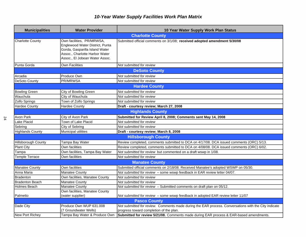
Municipalities Water Provider 10 Year Water Supply Work Plan Status
Charlotte County Own facilities, PR/MRWSA, Englewood Water District, Punta Gorda, Gasparilla Island Water Assoc., Charlotte Harbor Water Assoc., El Jobean Water Assoc.
Submitted official comments on 3/1/08; received adopted amendment 5/30/08
Punta Gorda Own Facilities Not submitted for review
Arcadia Produce Own Not submitted for reviewDeSoto County PR/MRWSA Not submitted for review
Bowling Green City of Bowling Green Not submitted for reviewWauchula City of Wauchula Not submitted for reviewZolfo Springs Town of Zolfo Springs Not submitted for reviewHardee County Hardee County Draft - courtesy review; March 27, 2008
Avon Park City of Avon Park Submitted for Review April 8, 2008; Comments sent May 14, 2008Lake Placid Town of Lake Placid Not submitted for reviewSebring City of Sebring Not submitted for reviewHighlands County Municipal utilities Draft - courtesy review; March 8, 2008
Hillsborough County Tampa Bay Water Review completed, comments submitted to DCA on 4/17/08. DCA issued comments (ORC) 5/13. Plant City Own facilities Review completed, comments submitted to DCA on 4/08/08. DCA issued comments (ORC) 6/02. Tampa Own facilities, Tampa Bay Water Not submitted for review but commented on a draft wswp in 1/08.Temple Terrace Own facilities Not submitted for review
Manatee County Own facilities Submitted official comments on 2/18/08. Received Manatee's adopted WSWP on 05/30. Anna Maria Manatee County Not submitted for review – some wswp feedback in EAR review letter 04/07.Bradenton Own facilities, Manatee County Not submitted for reviewBradenton Beach Manatee County Not submitted for reviewHolmes Beach Manatee County Not submitted for review – Submitted comments on draft plan on 05/12.
PalmettoOwn facilities, Manatee County (water supplier) Not submitted for review – some wswp feedback in adopted EAR review letter 11/07
Dade City Produce Own WUP 631.008 (7 Groundwater Wells)
Not submitted for review. Comments made during the EAR process. Conversations with the City indicate progress toward completion of the plan.
New Port Richey Tampa Bay Water & Produce Own Submitted for review 5/21/08. Comments made during EAR process & EAR-based amendments.
Hardee County
Highlands County
10-Year Water Supply Facilities Work Plan Matrix
Hillsborough County
Manatee County
Pasco County
Charlotte County
DeSoto County
24
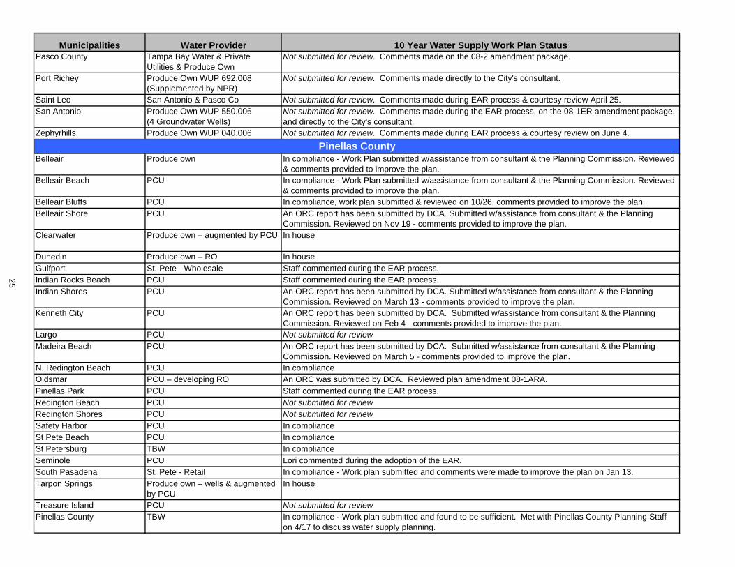
Municipalities Water Provider 10 Year Water Supply Work Plan StatusPasco County Tampa Bay Water & Private
Utilities & Produce OwnNot submitted for review. Comments made on the 08-2 amendment package.
Port Richey Produce Own WUP 692.008 (Supplemented by NPR)
Not submitted for review. Comments made directly to the City's consultant.
Saint Leo San Antonio & Pasco Co Not submitted for review. Comments made during EAR process & courtesy review April 25.San Antonio Produce Own WUP 550.006
(4 Groundwater Wells)Not submitted for review. Comments made during the EAR process, on the 08-1ER amendment package, and directly to the City's consultant.
Zephyrhills Produce Own WUP 040.006 Not submitted for review. Comments made during EAR process & courtesy review on June 4.
Belleair Produce own In compliance - Work Plan submitted w/assistance from consultant & the Planning Commission. Reviewed & comments provided to improve the plan.
Belleair Beach PCU In compliance - Work Plan submitted w/assistance from consultant & the Planning Commission. Reviewed & comments provided to improve the plan.
Belleair Bluffs PCU In compliance, work plan submitted & reviewed on 10/26, comments provided to improve the plan.Belleair Shore PCU An ORC report has been submitted by DCA. Submitted w/assistance from consultant & the Planning
Commission. Reviewed on Nov 19 - comments provided to improve the plan.Clearwater Produce own – augmented by PCU In house
Dunedin Produce own – RO In houseGulfport St. Pete - Wholesale Staff commented during the EAR process.Indian Rocks Beach PCU Staff commented during the EAR process.Indian Shores PCU An ORC report has been submitted by DCA. Submitted w/assistance from consultant & the Planning
Commission. Reviewed on March 13 - comments provided to improve the plan.Kenneth City PCU An ORC report has been submitted by DCA. Submitted w/assistance from consultant & the Planning
Commission. Reviewed on Feb 4 - comments provided to improve the plan. Largo PCU Not submitted for reviewMadeira Beach PCU An ORC report has been submitted by DCA. Submitted w/assistance from consultant & the Planning
Commission. Reviewed on March 5 - comments provided to improve the plan.N. Redington Beach PCU In complianceOldsmar PCU – developing RO An ORC was submitted by DCA. Reviewed plan amendment 08-1ARA.Pinellas Park PCU Staff commented during the EAR process.Redington Beach PCU Not submitted for reviewRedington Shores PCU Not submitted for reviewSafety Harbor PCU In complianceSt Pete Beach PCU In complianceSt Petersburg TBW In complianceSeminole PCU Lori commented during the adoption of the EAR.South Pasadena St. Pete - Retail In compliance - Work plan submitted and comments were made to improve the plan on Jan 13. Tarpon Springs Produce own – wells & augmented
by PCUIn house
Treasure Island PCU Not submitted for reviewPinellas County TBW In compliance - Work plan submitted and found to be sufficient. Met with Pinellas County Planning Staff
on 4/17 to discuss water supply planning.
Pinellas County
25
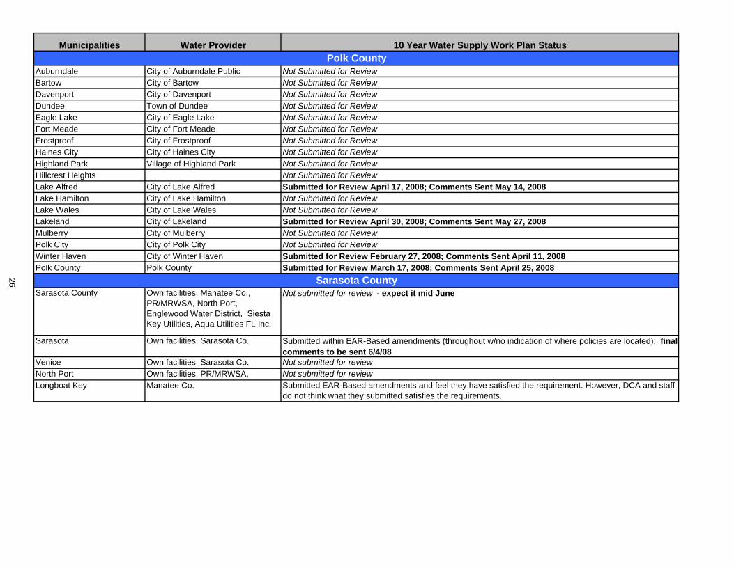
Municipalities Water Provider 10 Year Water Supply Work Plan Status
Auburndale City of Auburndale Public Not Submitted for ReviewBartow City of Bartow Not Submitted for ReviewDavenport City of Davenport Not Submitted for ReviewDundee Town of Dundee Not Submitted for ReviewEagle Lake City of Eagle Lake Not Submitted for ReviewFort Meade City of Fort Meade Not Submitted for ReviewFrostproof City of Frostproof Not Submitted for ReviewHaines City City of Haines City Not Submitted for ReviewHighland Park Village of Highland Park Not Submitted for ReviewHillcrest Heights Not Submitted for ReviewLake Alfred City of Lake Alfred Submitted for Review April 17, 2008; Comments Sent May 14, 2008Lake Hamilton City of Lake Hamilton Not Submitted for ReviewLake Wales City of Lake Wales Not Submitted for ReviewLakeland City of Lakeland Submitted for Review April 30, 2008; Comments Sent May 27, 2008Mulberry City of Mulberry Not Submitted for ReviewPolk City City of Polk City Not Submitted for ReviewWinter Haven City of Winter Haven Submitted for Review February 27, 2008; Comments Sent April 11, 2008Polk County Polk County Submitted for Review March 17, 2008; Comments Sent April 25, 2008
Sarasota County Own facilities, Manatee Co., PR/MRWSA, North Port,Englewood Water District, Siesta Key Utilities, Aqua Utilities FL Inc.
Not submitted for review - expect it mid June
Sarasota Own facilities, Sarasota Co. Submitted within EAR-Based amendments (throughout w/no indication of where policies are located); final comments to be sent 6/4/08
Venice Own facilities, Sarasota Co. Not submitted for reviewNorth Port Own facilities, PR/MRWSA, Not submitted for reviewLongboat Key Manatee Co. Submitted EAR-Based amendments and feel they have satisfied the requirement. However, DCA and staff
do not think what they submitted satisfies the requirements.
Polk County
Sarasota County26

F.Fin.&A
dmin.
Com
mittee
Governing Board Meeting June 24, 2008 Finance and Administration Committee
Discussion Items
68. Consent Item(s) Moved for Discussion
69. Fiscal Year 2009 Recommended Annual Service Budget ........... (45 minutes) ............ 3 (Strategic Plan: Mission Support)
Submit & File Reports
70. Treasurer's Report, Payment Register, and Contingency Reserves Report .................... 7
Routine Reports
71. April 2008 Interim Report on Workforce and Vendor Diversity ........................................ 12
72. Management Services Status Report .............................................................................. 15

2

Item 69
Finance and Administration Committee June 24, 2008
Discussion Item Fiscal Year 2009 Presentation of Recommended Annual Service Budget
PurposeProvide the Governing Board an overview of the fiscal year (FY) 2009 Recommended Annual Service Budget. The budget has been prepared with ad valorem revenue projections based on the assumption that the Governing and Basin Boards will maintain FY2009 millage rates at the rates adopted for FY2008, and with the initial June 1 estimates of taxable values from the 16-county Property Appraisers. Actual ad valorem revenue will be determined following receipt of the Certifications of Taxable Values due July 1, 2008. Background The FY2009 budget development process began in December 2007 with the Governing Board's acceptance of the budget development process memorandum, including the budget calendar, budget strategic priorities and general budget preparation assumptions. Staff has been preparing the FY2009 budgets since January 2008. The preliminary budgets were presented for the first time to the Basin Boards in April. On May 27, the Governing Board approved the Five-Year Technology Plan FY2009-FY2013 and the Five-Year Capital Improvements Plan FY2009-FY2013 for inclusion in the Recommended Annual Service Budget. At their June meetings, the Basin Boards are reviewing proposed budgets and adopting proposed FY2009 millage rates for recommendation to the Governing Board.
On June 24, the FY2009 Recommended Annual Service Budget will be presented to the Governing Board to be updated monthly through September. The delivery of the budget to the Governing Board was scheduled for June to allow for receipt of the initial June 1 estimates of taxable values from the 16-county Property Appraisers.
The Governing Board and the Basin Boards that have met as of the date this recap was prepared have indicated that they will maintain the FY2009 millage rates at the levels adopted for FY2008 to avoid any increase in the millage rates. Due to declining property values as initially reported by the county Property Appraisers, the Maximum Millage Rate would require an increase in the millage rates above the rates adopted for FY2008.
At the July 29 Governing Board meeting, staff will review the Certifications of Taxable Values and proposed FY2009 Districtwide General Fund and Watershed Basin millage rates, in compliance with Sections 200.065 and 200.185, Florida Statutes, as amended. Staff will request the Governing Board to adopt proposed FY2009 millage rates for the Districtwide General Fund and the eight Watershed Basins.
The Standard Format Tentative Budget Submission to the Executive Office of the Governor (due August 1, 2008) will reflect the budget as of July 15, 2008, updated to reflect ad valorem revenue based on the July 1 Certifications of Taxable Values.
The District's FY2009 budget will be adopted in September following two public Truth in Millage budget hearings. The first hearing is scheduled for 5:01 p.m. at the Tampa Service Office on September 16, 2008. The Governor's office will review and approve the budgets of all five water management districts before the second and final public hearing. The second and final hearing is scheduled for 5:01 p.m. at Brooksville Headquarters on September 30, 2008.
3

Item 69 The FY2009 Recommended Annual Service Budget notebooks will be sent to the Governing Board under separate cover prior to the meeting.
Staff Recommendation: See Exhibit
This item is presented for the Committee's information, and no action is required.
Presenters: Eugene A. Schiller, Deputy Executive Director, Division of Management Services Linda R. Pilcher, Assistant Director, Finance Department
4
GOVERNING BOARD FINANCE AND ADMINISTRATION COMMITTEE
Agenda
Fiscal Year 2009 Annual Budget Review
June 24, 2008
1. Opening Comments Ronald Oakley
a. Meeting Objectives
b. Overview of Agenda
2. Overview of Budget Development Gene Schiller
a. Budget Materials
b. District Funding and Budget Cycle
c. Preparation Assumptions and Highlights
d. Efficiency and Environmental Stewardship Elaine Kuligofski
3. Program Budget and Strategic Priorities Roy Mazur 4. Overview of FY2009 Recommended Budget – All Funds Linda Pilcher
a. Millage Rates
b. Revenues (Updated based on the June 1 Estimates of Taxable Values)
c. Expenditures
5. Funding Requests for Regional Water Supply and Water Resource Mark Hammond Development Projects and Proposed Allocation of Funding from
Water Protection and Sustainability Trust Fund
6. Open Discussion Ronald Oakley
7. Adjournment Ronald Oakley
5

6
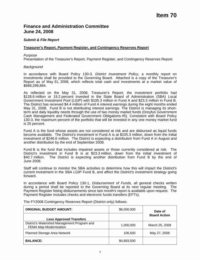
Item 70
Finance and Administration Committee June 24, 2008 Submit & File Report Treasurer's Report, Payment Register, and Contingency Reserves Report
PurposePresentation of the Treasurer's Report, Payment Register, and Contingency Reserves Report.
Background
In accordance with Board Policy 130-3, District Investment Policy, a monthly report on investments shall be provided to the Governing Board. Attached is a copy of the Treasurer's Report as of May 31, 2008, which reflects total cash and investments at a market value of $668,299,894.
As reflected on the May 31, 2008, Treasurer's Report, the investment portfolio had $128.6 million or 19.2 percent invested in the State Board of Administration (SBA) Local Government Investment Pool (LGIP) with $105.3 million in Fund A and $23.3 million in Fund B. The District has received $4.4 million of Fund A interest earnings during the eight months ended May 31, 2008. Fund B is not distributing interest earnings. The District is managing its short-term and daily liquidity needs through the use of two money market funds (Dreyfus Government Cash Management and Federated Government Obligations #5). Consistent with Board Policy 130-3, the maximum percent of the portfolio that will be invested in any one money market fund is 25 percent.
Fund A is the fund whose assets are not considered at risk and are disbursed as liquid funds become available. The District's investment in Fund A is at $105.3 million, down from the initial investment of $246.6 million. The District is expecting a distribution from Fund A in August and another distribution by the end of September 2008.
Fund B is the fund that includes impaired assets or those currently considered at risk. The District's investment in Fund B is at $23.3 million, down from the initial investment of $40.7 million. The District is expecting another distribution from Fund B by the end of June 2008.
Staff will continue to monitor the SBA activities to determine how this will impact the District's current investment in the SBA LGIP Fund B, and affect the District's investment strategy going forward.
In accordance with Board Policy 130-1, Disbursement of Funds, all general checks written during a period shall be reported to the Governing Board at its next regular meeting. The Payment Register listing disbursements since last month's report is available upon request. The Payment Register includes checks and electronic funds transfers (EFTs).
The FY2008 Contingency Reserves Report (District only) follows:
ORIGINAL BUDGET AMOUNT: $6,000,000
Less Approved Transfers
Date of Board Action
District's Watershed Management Program and FEMA Map Modernization 1,000,000 March 25, 2008
Planned Storage Area Network 106,500 May 27, 2008
BALANCE: $4,893,500
7

Item 70
Staff Recommendation: See Exhibit
These items are presented for the Committee's information, and no action is required.
Presenter: Daryl F. Pokrana, Director, Finance Department
8
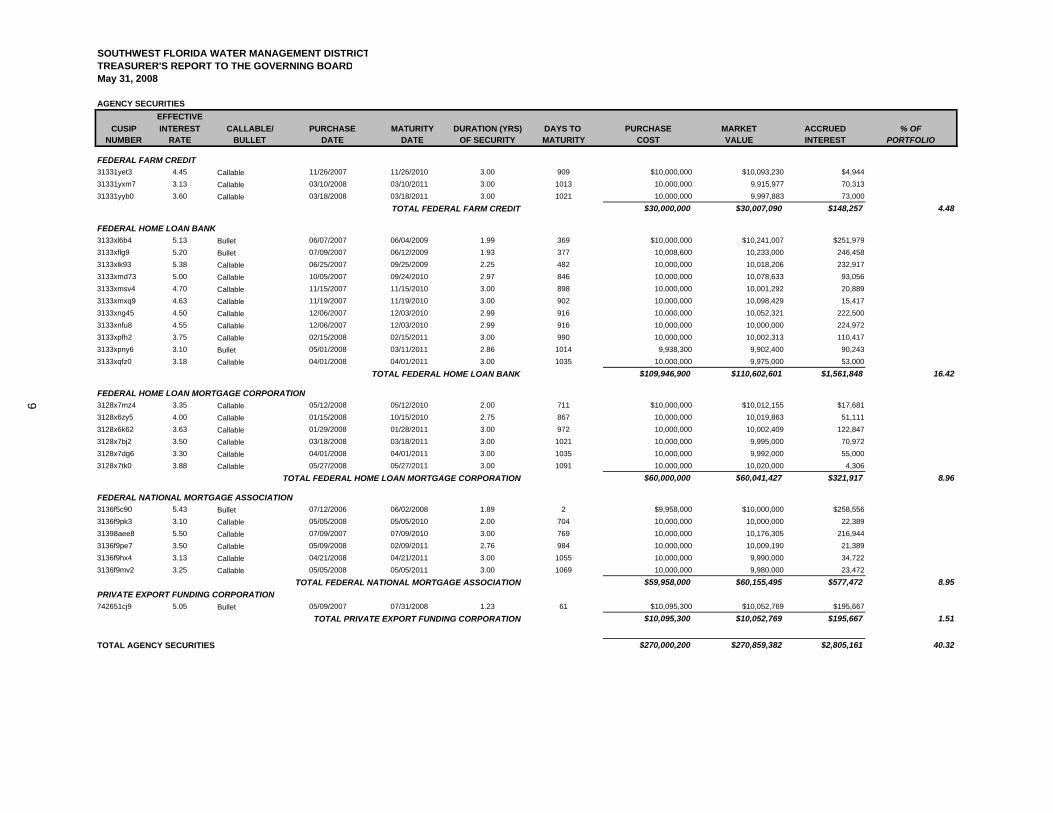
SOUTHWEST FLORIDA WATER MANAGEMENT DISTRICTTREASURER'S REPORT TO THE GOVERNING BOARD
AGENCY SECURITIESEFFECTIVE
CUSIP INTEREST CALLABLE/ PURCHASE MATURITY DURATION (YRS) DAYS TO PURCHASE MARKET ACCRUED % OFNUMBER RATE BULLET DATE DATE OF SECURITY MATURITY COST VALUE INTEREST PORTFOLIO
31331yet3 4.45 Callable 11/26/2007 11/26/2010 3.00 909 $10,000,000 $10,093,230 $4,944 31331yxm7 3.13 Callable 03/10/2008 03/10/2011 3.00 1013 10,000,000 9,915,977 70,313 31331yyb0 3.60 Callable 03/18/2008 03/18/2011 3.00 1021 10,000,000 9,997,883 73,000
$30,000,000 $30,007,090 $148,257 4.48
3133xl6b4 5.13 Bullet 06/07/2007 06/04/2009 1.99 369 $10,000,000 $10,241,007 $251,979 3133xflg9 5.20 Bullet 07/09/2007 06/12/2009 1.93 377 10,008,600 10,233,000 246,458 3133xlk93 5.38 Callable 06/25/2007 09/25/2009 2.25 482 10,000,000 10,018,206 232,917 3133xmd73 5.00 Callable 10/05/2007 09/24/2010 2.97 846 10,000,000 10,078,633 93,056 3133xmsv4 4.70 Callable 11/15/2007 11/15/2010 3.00 898 10,000,000 10,001,292 20,889 3133xmxq9 4.63 Callable 11/19/2007 11/19/2010 3.00 902 10,000,000 10,098,429 15,417 3133xng45 4.50 Callable 12/06/2007 12/03/2010 2.99 916 10,000,000 10,052,321 222,500 3133xnfu8 4.55 Callable 12/06/2007 12/03/2010 2.99 916 10,000,000 10,000,000 224,972 3133xpfh2 3.75 Callable 02/15/2008 02/15/2011 3.00 990 10,000,000 10,002,313 110,417 3133xpny6 3.10 Bullet 05/01/2008 03/11/2011 2.86 1014 9,938,300 9,902,400 90,243 3133xqfz0 3.18 Callable 04/01/2008 04/01/2011 3.00 1035 10,000,000 9,975,000 53,000
$109,946,900 $110,602,601 $1,561,848 16.42
3128x7mz4 3.35 Callable 05/12/2008 05/12/2010 2.00 711 $10,000,000 $10,012,155 $17,681 3128x6zy5 4.00 Callable 01/15/2008 10/15/2010 2.75 867 10,000,000 10,019,863 51,111 3128x6k62 3.63 Callable 01/29/2008 01/28/2011 3.00 972 10,000,000 10,002,409 122,847 3128x7bj2 3.50 Callable 03/18/2008 03/18/2011 3.00 1021 10,000,000 9,995,000 70,972 3128x7dg6 3.30 Callable 04/01/2008 04/01/2011 3.00 1035 10,000,000 9,992,000 55,000 3128x7tk0 3.88 Callable 05/27/2008 05/27/2011 3.00 1091 10,000,000 10,020,000 4,306
$60,000,000 $60,041,427 $321,917 8.96
3136f5c90 5.43 Bullet 07/12/2006 06/02/2008 1.89 2 $9,958,000 $10,000,000 $258,556 3136f9pk3 3.10 Callable 05/05/2008 05/05/2010 2.00 704 10,000,000 10,000,000 22,389 31398aee8 5.50 Callable 07/09/2007 07/09/2010 3.00 769 10,000,000 10,176,305 216,944 3136f9pe7 3.50 Callable 05/09/2008 02/09/2011 2.76 984 10,000,000 10,009,190 21,389 3136f9hx4 3.13 Callable 04/21/2008 04/21/2011 3.00 1055 10,000,000 9,990,000 34,722 3136f9mv2 3.25 Callable 05/05/2008 05/05/2011 3.00 1069 10,000,000 9,980,000 23,472
$59,958,000 $60,155,495 $577,472 8.95
742651cj9 5.05 Bullet 05/09/2007 07/31/2008 1.23 61 $10,095,300 $10,052,769 $195,667 $10,095,300 $10,052,769 $195,667 1.51
TOTAL AGENCY SECURITIES $270,000,200 $270,859,382 $2,805,161 40.32
PRIVATE EXPORT FUNDING CORPORATION
TOTAL PRIVATE EXPORT FUNDING CORPORATION
FEDERAL HOME LOAN MORTGAGE CORPORATION
TOTAL FEDERAL HOME LOAN MORTGAGE CORPORATION
FEDERAL NATIONAL MORTGAGE ASSOCIATION
TOTAL FEDERAL NATIONAL MORTGAGE ASSOCIATION
May 31, 2008
FEDERAL FARM CREDIT
FEDERAL HOME LOAN BANK
TOTAL FEDERAL HOME LOAN BANK
TOTAL FEDERAL FARM CREDIT
9
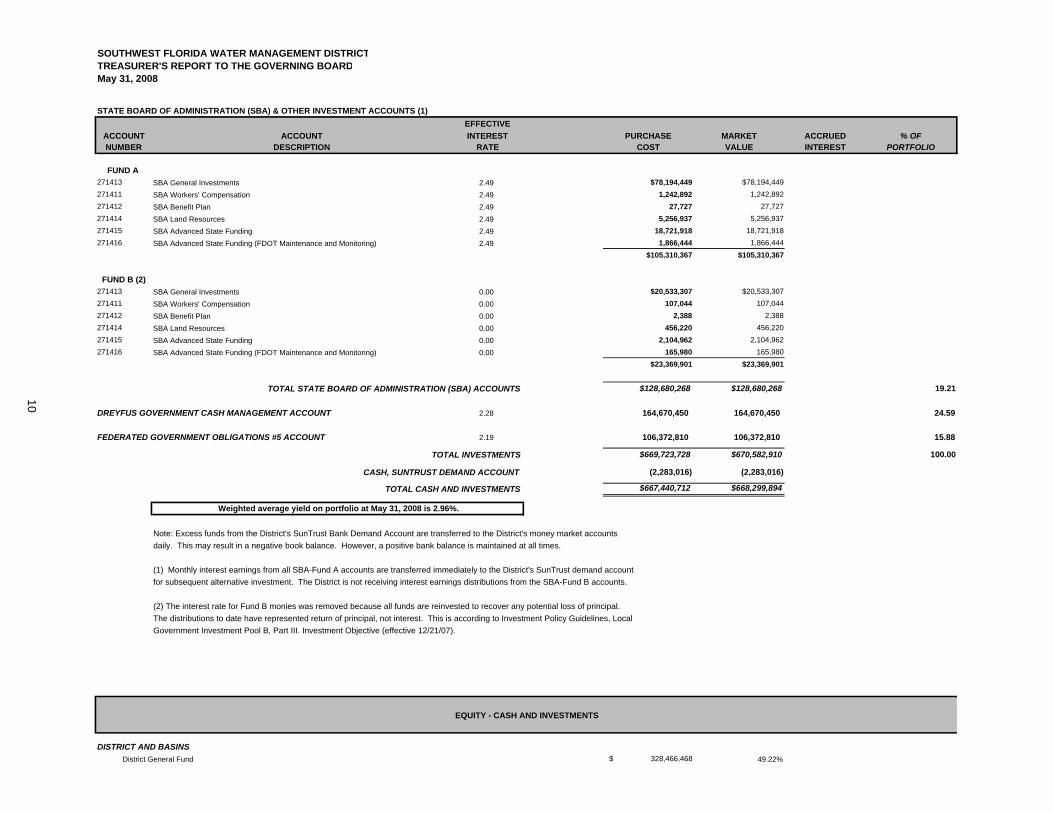
SOUTHWEST FLORIDA WATER MANAGEMENT DISTRICTTREASURER'S REPORT TO THE GOVERNING BOARDMay 31, 2008
STATE BOARD OF ADMINISTRATION (SBA) & OTHER INVESTMENT ACCOUNTS (1)EFFECTIVE
ACCOUNT INTEREST PURCHASE MARKET ACCRUED % OFNUMBER RATE COST VALUE INTEREST PORTFOLIO
FUND A 271413 2.49 $78,194,449 $78,194,449271411 2.49 1,242,892 1,242,892271412 2.49 27,727 27,727271414 2.49 5,256,937 5,256,937271415 2.49 18,721,918 18,721,918271416 2.49 1,866,444 1,866,444
$105,310,367 $105,310,367
FUND B (2)271413 0.00 $20,533,307 $20,533,307271411 0.00 107,044 107,044271412 0.00 2,388 2,388271414 0.00 456,220 456,220271415 0.00 2,104,962 2,104,962271416 0.00 165,980 165,980
$23,369,901 $23,369,901
$128,680,268 $128,680,268 19.21
DREYFUS GOVERNMENT CASH MANAGEMENT ACCOUNT 2.28 164,670,450 164,670,450 24.59
FEDERATED GOVERNMENT OBLIGATIONS #5 ACCOUNT 2.19 106,372,810 106,372,810 15.88
$669,723,728 $670,582,910 100.00
(2,283,016) (2,283,016)
$667,440,712 $668,299,894
Note: Excess funds from the District's SunTrust Bank Demand Account are transferred to the District's money market accountsdaily. This may result in a negative book balance. However, a positive bank balance is maintained at all times.
(1) Monthly interest earnings from all SBA-Fund A accounts are transferred immediately to the District's SunTrust demand accountfor subsequent alternative investment. The District is not receiving interest earnings distributions from the SBA-Fund B accounts.
(2) The interest rate for Fund B monies was removed because all funds are reinvested to recover any potential loss of principal.The distributions to date have represented return of principal, not interest. This is according to Investment Policy Guidelines, Local Government Investment Pool B, Part III. Investment Objective (effective 12/21/07).
DISTRICT AND BASINS District General Fund $ 328,466,468 49.22%
ACCOUNT
SBA Advanced State Funding (FDOT Maintenance and Monitoring)
SBA Land ResourcesSBA Advanced State Funding
DESCRIPTION
SBA Benefit Plan
SBA General InvestmentsSBA Workers' Compensation
Weighted average yield on portfolio at May 31, 2008 is 2.96%.
EQUITY - CASH AND INVESTMENTS
TOTAL CASH AND INVESTMENTS
SBA Benefit PlanSBA Land ResourcesSBA Advanced State FundingSBA Advanced State Funding (FDOT Maintenance and Monitoring)
TOTAL STATE BOARD OF ADMINISTRATION (SBA) ACCOUNTS
SBA General Investments
CASH, SUNTRUST DEMAND ACCOUNT
TOTAL INVESTMENTS
SBA Workers' Compensation
10
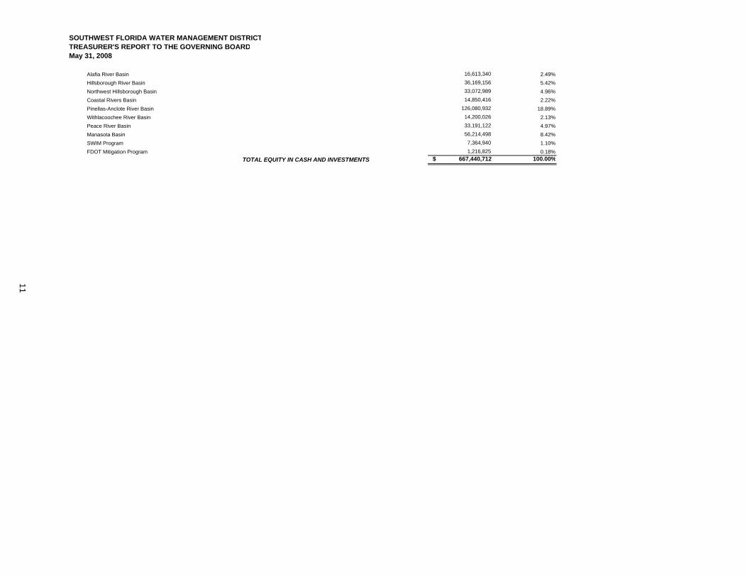
SOUTHWEST FLORIDA WATER MANAGEMENT DISTRICTTREASURER'S REPORT TO THE GOVERNING BOARDMay 31, 2008
Alafia River Basin 16,613,340 2.49% Hillsborough River Basin 36,169,156 5.42% Northwest Hillsborough Basin 33,072,989 4.96% Coastal Rivers Basin 14,850,416 2.22% Pinellas-Anclote River Basin 126,080,932 18.89% Withlacoochee River Basin 14,200,026 2.13% Peace River Basin 33,191,122 4.97% Manasota Basin 56,214,498 8.42% SWIM Program 7,364,940 1.10% FDOT Mitigation Program 1,216,825 0.18%
$ 667,440,712 100.00%TOTAL EQUITY IN CASH AND INVESTMENTS
11
Item 71
Finance and Administration Committee June 24, 2008
Routine Report
April 2008 Interim Report on Workforce and Vendor Diversity This quarterly newsletter, Ripples, updates the key statistics and information contained in the annual Workforce and Vendor Diversity Report for the Governing and Basin Board members.
During the period of October 1, 2007 – March 31, 2008, the District hired 22 regular, Board- authorized employees. For the first six months of the fiscal year, total employee turnover (regular, Board-authorized positions) was 3.2 percent compared to 3.1 percent for the same period one year ago.
In the “Advertising and Outreach” section, a total of $4,159 was directly targeted toward outreach to diverse applicants. Total advertising expenditures of $5,716 for this quarter includes all forms of advertising and outreach to students and potential employees through career fairs.
The District has spent approximately $28.4 million in competitive purchases during the first six months of FY2008. Of these total purchases, overall 20 percent ($5.6 million) was from diverse vendors and 8 percent ($2.1 million) was from small businesses. This is a four-percent increase in diverse spending and two-percent increase in small business spending over the first six months of FY2007.
Staff Recommendation: See Exhibit
This item is presented for the Committee’s information, and no action is required.
Presenter: Elaine M. Kuligofski, Director, Human Resources Department
12
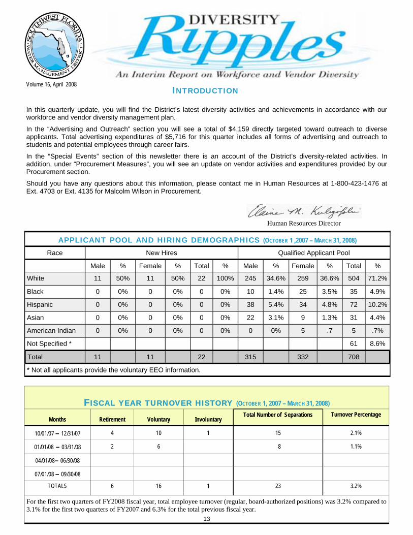
INTRODUCTION
In this quarterly update, you will find the District’s latest diversity activities and achievements in accordance with our workforce and vendor diversity management plan.
In the “Advertising and Outreach” section you will see a total of $4,159 directly targeted toward outreach to diverse applicants. Total advertising expenditures of $5,716 for this quarter includes all forms of advertising and outreach to students and potential employees through career fairs.
In the “Special Events” section of this newsletter there is an account of the District’s diversity-related activities. In addition, under “Procurement Measures”, you will see an update on vendor activities and expenditures provided by our Procurement section.
Should you have any questions about this information, please contact me in Human Resources at 1-800-423-1476 at Ext. 4703 or Ext. 4135 for Malcolm Wilson in Procurement.
Volume 16, April 2008
FISCAL YEAR TURNOVER HISTORY (OCTOBER 1, 2007 – MARCH 31, 2008)
Months Retirement Voluntary Involuntary Total Number of Separations Turnover Percentage
10/01/07 – 12/31/07 4 10 1 15 2.1%
01/01/08 – 03/31/08 2 6 8 1.1%
04/01/08– 06/30/08
07/01/08 – 09/30/08
TOTALS 6 16 1 23 3.2%
For the first two quarters of FY2008 fiscal year, total employee turnover (regular, board-authorized positions) was 3.2% compared to 3.1% for the first two quarters of FY2007 and 6.3% for the total previous fiscal year.
APPLICANT POOL AND HIRING DEMOGRAPHICS (OCTOBER 1 ,2007 – MARCH 31, 2008)
Race New Hires Qualified Applicant Pool
Male % Female % Total % Male % Female % Total %
White 11 50% 11 50% 22 100% 245 34.6% 259 36.6% 504 71.2%
Black 0 0% 0 0% 0 0% 10 1.4% 25 3.5% 35 4.9%
Hispanic 0 0% 0 0% 0 0% 38 5.4% 34 4.8% 72 10.2%
Asian 0 0% 0 0% 0 0% 22 3.1% 9 1.3% 31 4.4%
American Indian 0 0% 0 0% 0 0% 0 0% 5 .7 5 .7%
Not Specified * 61 8.6%
Total 11 11 22 315 332 708
* Not all applicants provide the voluntary EEO information.
Human Resources Director
13
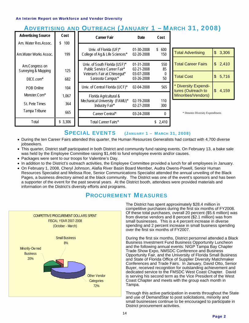
An Interim Report on Workforce and Vendor Diversity
Page 2
ADVERTISING AND OUTREACH (JANUARY 1 – MARCH 31, 2008)
SPECIAL EVENTS (JANUARY 1 – MARCH 31, 2008) During the ten Career Fairs attended this quarter, the Human Resources Generalists had contact with 4,700 diverse jobseekers. This quarter, District staff participated in both District and community fund raising events. On February 13, a bake sale was held by the Employee Committee raising $1,446 to fund employee events and/or causes. Packages were sent to our troops for Valentine’s Day. In addition to the District’s outreach activities, the Employee Committee provided a lunch for all employees in January. On February 1, 2008, Cheryl Johnson, Alafia River Basin Board Member, Audra Owens-Powell, Senior Human Resources Specialist and Melissa Roe, Senior Communications Specialist attended the annual unveiling of the Black Pages, a business directory aimed at the black community. The District was one of the event’s sponsors and has been a supporter of the event for the past several years. At the District booth, attendees were provided materials and information on the District’s diversity efforts and programs.
PROCUREMENT MEASURES
Advertising Source Cost
Am. Water Res.Assoc. $ 100
Am.Water Works Assoc. 199
Am.Congress onSurveying & Mapping 125
DICE.com* 682
POB Online 104 Monster.Com* 1,067
St. Pete Times 364 Tampa Tribune 665
Total $ 3,306
Career Fair Date Cost
Univ. of Florida (UF)* College of Ag.& Life Sciences*
01-30-200802-20-2008
$ 600 150
Univ. of South Florida (USF)* Public Service Career Fair* Veteran’s Fair at Chinsegut*
Sarasota Campus*
01-31-200802-21-200803-07-200803-26-2008
550 85 0 50
Univ. of Central Florida (UCF)* 02-04-2008 565
Florida Agricultural &Mechanical University (FAMU)*
Industry Fair* 02-19-200802-27-2008
110 300
Career Central* 03-24-2008 0
Total Career Fairs* $ 2,410
Total Advertising $ 3,306
Total Career Fairs $ 2,410
Total Cost $ 5,716
* Diversity Expendi-tures (Outreach to Minorities/Vendors)
$ 4,159
The District has spent approximately $28.4 million in competitive purchases during the first six months of FY2008. Of these total purchases, overall 20 percent ($5.6 million) was from diverse vendors and 8 percent ($2.1 million) was from small businesses. This is a 4 percent increase in diverse spending and 2 percent increase in small business spending over the first six months of FY2007.
During the first six months, District personnel attended a Black Business Investment Fund Business Opportunity Luncheon and the following annual events: NIGP Tampa Bay Chapter Trade Show Expo, NMSDC Conference and Business Opportunity Fair, and the University of Florida Small Business and State of Florida Office of Supplier Diversity Matchmaker Conferences and Trade Fairs. In January, David Otto, Senior Buyer, received recognition for outstanding achievement and dedicated service to the FMSDC West Coast Chapter. David is serving his second term as the Vice President of the West Coast Chapter and meets with the group each month in Tampa.
Through this active participation in events throughout the State and use of DemandStar to post solicitations, minority and small businesses continue to be encouraged to participate in District procurement activities.
* Denotes Diversity Expenditures
COMPETITIVE PROCUREMENT DOLLARS SPENTFISCAL YEAR 2007-2008
(October - March)
Other Vendor Categories
72%
Minority-Ow ned Business
20%
Small Business8%
14
Item 72
Finance and Administration Committee June 24, 2008 Routine Report Management Services Status Report
Brooksville Building 1 Feasibility Study Brooksville Building 1 is a one-story building constructed in 1964 as the first building on the Brooksville campus. There have been three additions to the building since that date. This building currently houses the Information Resources and Finance Departments and the Geographic Information Systems Section of the Operations Department. It is recommended that a condition assessment study be performed of the building to determine on a cost/benefit basis whether to replace the building's major systems (electrical, HVAC, and roof) and reprioritize space to better meet District requirements, or to demolish and replace the structure. Based on the results of the study, the recommended building rehabilitation, including evaluation of Leadership in Energy and Environmental Design (LEED) options, and new construction will be added for the Governing Board's consideration to the Capital Improvements Plan for future years. New Activities Since Last Meeting: District staff have negotiated an agreement within budget with the architectural and engineering firm of Long and Associates, Tampa. It is expected that the contract will be executed and the study will begin July 1, 2008 with an anticipated completion date of December 2008. Learning Management System Training and staff development represent a critical investment in the District's human capital. A Learning Management System (LMS) is a major component of the comprehensive Human Resources Information System (HRIS) which will be implemented beginning this year. To provide much of the needed functionality between now and the rollout of the new system, the District has undertaken some significant interim initiatives. First, the District currently has deployed an internally developed database, Training Central, which centralizes the administration of all internal, District-sponsored training. This database automates and standardizes many of the routine training functions: course and class creation, catalog publication, registration, notification, confirmation, managing prerequisites, budget and cost information and student training history.
Functionality has been added to Training Central to allow supervisors to view their employees' internal (District sponsored) training history. A new Training Central feature rolled out on September 4, 2007. 'My Education' allows an employee to add their academic degrees, professional certifications, licensures, and certificate programs to the Training Central database. Managers and supervisors have the ability to view education history for their employees, to capture and report on external training, and on licensure and certification requirements where applicable, and to store employee education (college degree) information. In addition, we will add more information, available to all employees regarding college and university offerings of all types.The external training and development function of Training Central was released to employees in late January 2008. 'My External Development' allows employees to enter all training and development events they attend, along with any applicable educational units (e.g. CEUs) that apply to their certification requirements. With this added feature, Training Central gives managers and supervisors the ability to view a complete history of employees' training and education with one tool.A new Training web page has been developed by IRD and HRD staff to provide employees with current information on the District's training initiatives. It gives staff the ability to link to all departments that offer training. External links are also included to educational and other relevant sites. The web page was released to all employees in December 2007 and will be updated and enhanced on a regular basis.
Current Status: The scheduled implementation of the LMS component of our new HRIS remains the same having been moved up from October 2009 to September 2008. Staff are
15
Item 72 learning the new system and reviewing current training data in preparation for the implementation.
Employee Turnover Employee turnover is widely viewed as a key indicator of an employer's ability to attract and retain the critical talent required to move the enterprise forward. As a public sector employer, the District has historically enjoyed turnover relatively low compared to the private sector and, generally, to other public sector organizations in its geographic area. This District began to experience an upturn in turnover in 2005 that continued in 2006. Specifically, total turnover increased from 7.62% in FY2004 to 9.35% in FY2005 and to 11.33% in FY2006. Early in 2006, with the full support of the Governing Board, the District undertook a major study of its compensation and benefit practices. This effort resulted in the adoption of significant improvements to our direct compensation program, several changes to our benefit plans and the adoption of a District matching contribution arrangement for participants in the deferred compensation plan. In FY2007, the District experienced a decrease of overall employee turnover to 6.33% versus the record high of 11.33% the prior fiscal year. Current Status:
For the first eight months of FY2008, employee turnover (regular, board-authorized positions) was 4.6%. For the same time period in FY2007, employee turnover was 3.9%. If current trends continue, annual turnover for FY2008 would be 6.9%. Voluntary turnover through the first eight months of the current fiscal year stands at 3.0%. There have been 10 retirements with at least seven more scheduled in this fiscal year; the total of 17 will exceed the totals of the past three years. Retirements account for one-third of all separations this year. The number of vacant positions as of June 1, 2008 was 27, the same as the previous month. Overall, vacancies are considerably lower than in FY2006 and FY2007. The District experienced a record high of 58 vacancies in February 2006 and an average of 34.9 vacancies per month for the past two Fiscal Years. Human Resources staff will continue to track and report to management on turnover trends to ensure that we are prepared to respond to any unusual upward trends that may occur in the future.
Water Management Information System (WMIS) The vision for the Water Management Information System (WMIS), as defined in the 2005 Vision Statement, is that it will support the District's activities related to Water Use Permitting, Environmental Resource Permitting, and Well Construction Permitting. In addition, the system will have the ability to store and retrieve Scientific and Regulatory data, as well as the ability to capture and track compliance activities. Specifically, it will: Facilitate and allow for comprehensive demonstration of the District’s accomplishment of its mission and accountability for its performance in meeting its areas of responsibility.
Provide for the entry, maintenance, analysis, and presentation of the District’s scientific and regulatory data.
Be easy to use, robust, nimble, and enable appropriate decision-making through the consistent application of the District’s scientific, regulatory, and business processes.
Be a component of the District’s Strategic Information Systems architecture. This project is scheduled for completion in FY 2010 with planned interim releases designed to continuously improve well-defined District regulatory and scientific functions. The next major interim releases include all Water Use Permits by October 2008, Environmental Resource Permitting and Sovereign Submerged Lands by October 2009, and any additional system integration by September 2010. The IBM Mainframe will be removed by the end of this project plan. Current Status: A major release was implemented in March 2008 that contained several improvements and new functionality. The new functionality allows the public to self-register and receive WUP permit noticing weekly through their e-mail, thus saving the District paper and mailing costs. A new Resource Data search option is now also available for public access through our web site to search for or download District collected water values. This information can be searched by site, date range and/or parameters, and it has map integration. Internal improvements for Water Use Permitting (WUP) include sending and receiving correspondence electronically, running the Agricultural Model (AGMOD) within the evaluation process, ability to
16

Item 72 modify an application on-line and a personal dashboard of up-to-date reports based on job function. A maintenance release is scheduled for mid-June. This release will provide for additional WCP payments with a new financial tab, enhanced well completion reporting and improved site and portfolio maintenance information, Next Major Milestones: The next major functional software release, scheduled for October 2008, will include expanded on-line permitting for all predominant uses with new application forms, user requested enhancements and additional reporting. A new stand-alone release of AGMOD is scheduled for early July. The project remains on time and within budget.
Enterprise Content Management (ECM) The District's critical information is currently located in multiple repositories including desktop computers, network file systems, CD-ROMS, USB drives and multiple electronic systems. The Information Resources Department (IRD) and Records Management share in this task of managing the District's critical information in this environment. Daily volumes of general correspondence, email, spreadsheets, digital images, video, audio, and web content, make it necessary to manage the totality of content at the District. Enterprise Content Management (ECM) provides for the centralized management of all content and allows quick access to the information in a structured manner. It is critical to the District's business continuity that this information is safe, secured and easily retrievable on demand. The ECM strategic project is a collaborative effort between IRD and Records Management. Records Management is working on procedural changes and documenting those procedures to support the ECM effort. IRD is working on the technical architecture and system interfaces required for implementation and operation. Due to requirements listed in FAC 1B-26.003, storage for the electronic records is also a major concern that will be addressed with an ECM infrastructure. The District has already implemented some components of content management such as imaging and workflow processing in the Water Management Information System (WMIS). South Florida and St. Johns Water Management Districts are in like stages of their ECM implementations. Current Status: In FY2007, funds were approved for consulting services to conduct requirements, return on investment and risk analyses on expanding the limited, existing content management efforts to other areas of the District. These include areas such as Communications, Finance, Human Resources, Land Resources, Office of the General Counsel, and Records Management. As identified in the April Governing Board approved IRD Five Year Technology Plan Fiscal Years 2008-2012, a multi-year Enterprise Content Management implementation plan is proposed. Funding for this project is projected over a five-year period. FY2008 is the initial year of implementation. The RFP for the analysis portion of the project was issued in December 2006 and awarded to HCL, America Inc. (HCL) in May 2007. The RFP structure and final requirements were reviewed and approved by the ARB. The Executive sponsor review was completed March 2008. A Request for Quotes (RFQ) was released in May to identify the most qualified vendor to assist the District in developing an enterprise-wide content taxonomy. A taxonomy provides a formal categorization of records needed to ensure the proper classification and retrieval of content. From these quotes, Dow Jones & Company was selected. This effort is anticipated to begin in early June and to be completed in a three-month period. An enterprise-wide taxonomy will support current Records Management efforts and is a key baseline required for a successful ECM implementation. Funding for this effort is from remaining FY2007 ECM funds. Next Major Milestones: A RFP to implement an ECM solution via the most qualified vendor has been submitted to the Contracts Administration Section. The release of the RFP is scheduled for June 20, 2008. Contract award is planned for October 2008. The next two major milestones are the implementation of basic content management by April 2009 and new records management capabilities by August 2009. Based on District requirements, additional ECM features identified by the HCL study would be completed by July 2012.
Land Resources Information System (LaRIS) In 1981, the Save Our Rivers program was established by the Florida Legislature for the acquisition of lands necessary for water management, water supply, protection and conservation of water resources. This program was broadened in 1990 with the Preservation 2000 Act and revised in 1999 with the Florida Forever Act. Utilizing these programs, the Southwest Florida Water Management District (District) has acquired fee simple interest in over
17
Item 72 330,000 acres and less than fee interest in over 67,000 acres for various water management requirements. The lands that are acquired by the District require management and maintenance to provide public access, recreational use and protection of the natural systems. Managing these resources requires that District staff have access to comprehensive information for each of the District's properties The Land Resources Information System (LaRIS) was envisioned to meet land acquisition and management requirements and significantly improve the business processes. The 2005 LaRIS vision statement states that the system will: Provide a common, centralized storage location for detailed Land Resources data. Have user-friendly applications for the input and maintenance of Land Resources data. Validate information is in proper format. Generate required documentation output such as detailed reports and map documents. Allow District staff to easily and efficiently access and utilize the necessary information pertaining to District-owned lands to perform the duties of their jobs.
Funding for this project is reimbursable through the Water Management Lands Trust Fund. Current Status: The Land Management burn components (Burn Planning, Burn Prescriptions, Burn Evaluations and Burn Coordination) are now complete and in production. Land has requested that we add some mapping functionality as an enhancement. This function is now in acceptance. The majority of Land Acquisition components were also moved to production. Next Major Milestones: The initial Acceptance release of Land Use Components is scheduled to begin testing in June 2008. These components include the Land Use screens and Land Use Agreements. Land Resources along with Information Resources will be reviewing all identified requirements and funding to ensure the best use of resources and that new requirements, based on system use, are fully integrated.
Project Information Management System (PIMS) The Project Information Management System (PIMS) project was started in FY 2006 as a replacement for a limited function project management system written in Domino/Lotus Notes. The earlier project management solution was a critical resource used by the Governing Board and Basin Boards to evaluate the progress of existing projects. This evaluation is used by the board to determine the direction of funding for projects on an annual basis. The previous system had no automated integration with the financial system, and required an extensive manual effort to achieve this integration. The previous application also failed to provide appropriate security and auditing to verify the source of the information. The proposed PIMS solution provides an easier to use process for project definition, automates the integration with the financial systems and provides integration with other district applications including the Water Management Information System (WMIS), the Surface Water Improvement Management (SWIM) program and document management. It is designed to reduce the administrative effort to maintain the information, improve the accuracy of the information and provide more flexibility in how the information is reported. It also includes Cooperative Funding Initiative (CFI) online access. Current Status: A CFI software release was implemented in March 2008. A major PIMS release is being tested with implementation planned for July 2008. This includes document management functionality, expanded search options, other user requested enhancements and data exports, along with a redesign to a look and feel more like WMIS. Next Major Milestones: The project's focus will change from PIMS to CFI. New requirements include updated CFI entry functions and incorporating the evaluation form. The first update to CFI is scheduled for late September 2008.
Human Resources Information System (HRIS) As identified in the Information Resources Department Five-Year Technology Plan, FY2008 to FY2012, the District requires greater functionality from its Human Resource and Payroll processes. The existing applications, Hewitt CYBORG Human Resource and Payroll, are not fully integrated or as robust as required for current demands. The data is currently on multiple hardware and software platforms and must be better integrated to meet current and future processing requirements and to significantly improve workflows. Replacing the currently disparate systems and processes with an integrated solution, will improve data integrity and data analysis. It will also reduce the staff impact caused by developing multiple interfaces to integrate the current systems. Additionally, replacing the current systems with a more current
18
Item 72 technology helps ensure the District's technical architecture standards are met and the orderly removal of legacy systems from the IBM Enterprise Server (Mainframe) continues on schedule. Current Status: A team from Finance, Human Resources and Information Resources developed and evaluated a Request for Proposal (RFP) to achieve the objectives stated above. The RFP was released in May 2007. Five vendors submitted responsive proposals. The three strongest vendors were invited to present live demonstrations of their products during the last week in August. Based on District staff evaluations, NuView Systems was chosen as the best system meeting the required functional, technical and cost criteria. As also indicated in the IRDFive Year Technology Plan, FY2008-FY2012, $794,000 is available for HRIS implementation in FY2008 and $400,000 and $150,000 are planned for FY2009 and FY2010, respectively. The FY2009 and FY2010 HRIS budgets will be significantly reduced to only the recurring software maintenance costs and any final conversion/implementation costs. Updated investment requirements are in the IRD Five-Year Technology Plan, FY2009-FY2013. After the NuView software is implemented, Hewitt software budgetary costs will be eliminated. Product installation took place during the week of January 28, 2008. NuView conducted the initial Project Kickoff and training in early February 2008. Payroll was set up during the month of April. Training on payroll has begun. Next Major Milestones: Estimated project completion is mid calendar year 2009. Other milestones include the initial HR/Benefits release in mid June followed by a go-live date for Payroll of June 23, 2008.
Unified Communication Process Improvement The District has identified the need for better and more refined governance and asset management regarding the interoperability of voice, data and radio communications. The principles of shared decision making, accountability, business applications and infrastructure for voice and radio communications must be part of the District's architecture. These principles become especially critical during emergency events where coordinated communications between the groups are essential. Interoperability needs to be addressed as a coordinated effort between all the departments key in implementing voice and radio communications including: Finance, Information Resources, Land Resources, Operations and General Services. This project includes implementing this decision-making structure for coordinating the interoperability of voice and radio communications throughout the District. The goals of this project are to: Create a common understanding of communications interoperability at the District Integrate existing and future communications systems Establish a process for the acquisition, support and maintenance of unified communications systems
Facilitate training to enhance the efforts of unified communications Current Status: A draft project charter was developed on March 21, 2008. The initial meeting was held on March 27, 2008. At that time, the Executive Sponsor, Deputy Executive Director for Management Services, and Project Sponsors from Information Resources, General Services, Operations and Land met to review the charter. Meeting was held on April 7, 2008. A baseline inventory of equipment and budget requirements was established for Information Resources, General Services, Operations and Land. Next Major Milestones: The next Sponsor's meeting is scheduled for June 30, 2008. An initial requirements analysis is planned for September 2008.
Staff Recommendation:
This item is provided for the Committee’s information, and no action is required.
Presenter: Gene Schiller, Deputy Executive Director, Management Services
19

20

G.G
eneralC
ounsel'sR
eport
Governing Board Meeting June 24, 2008 General Counsel’s Report
Discussion Items
73. Consent Item(s) Moved for Discussion
Submit & File Reports – None
Routine Reports
74. Litigation Report ............................................................................................................... 3
75. Rulemaking Update .......................................................................................................... 13

2
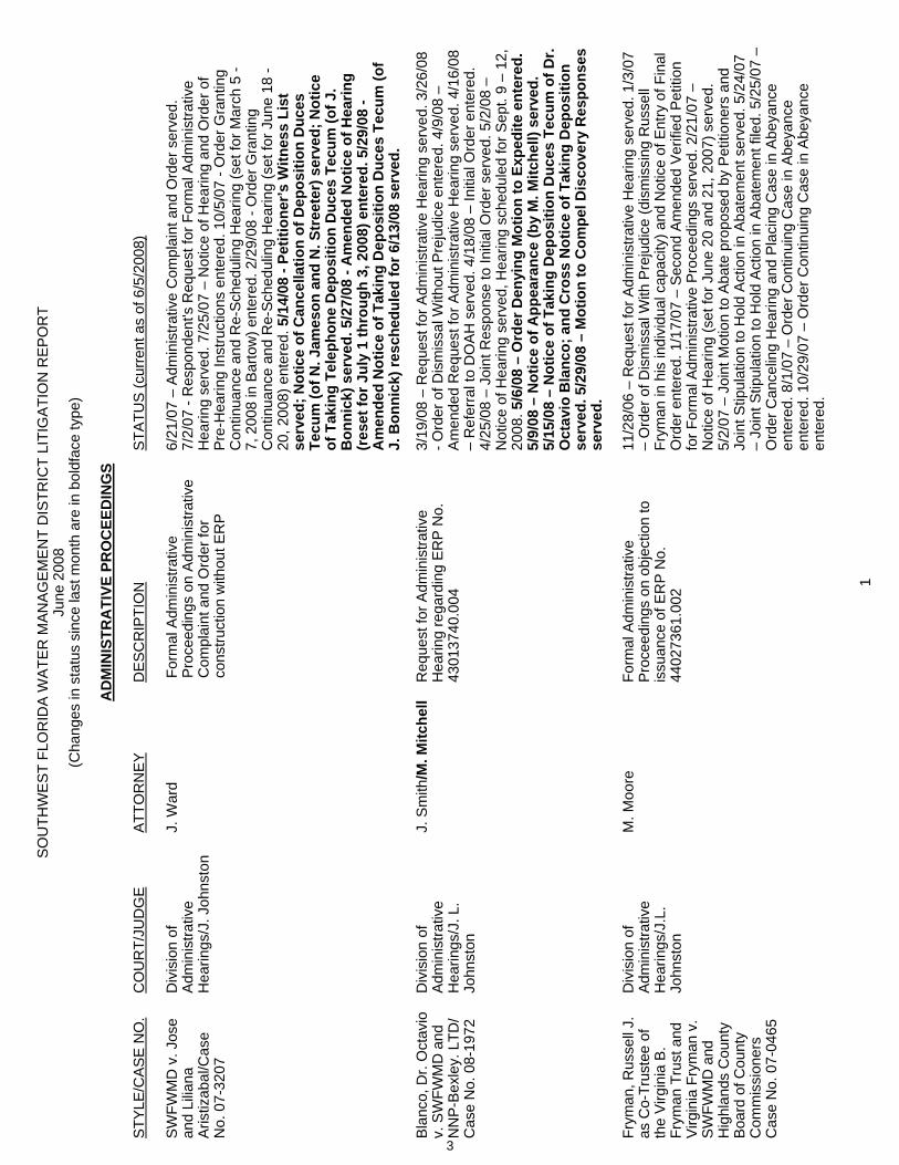
SO
UTH
WE
ST F
LOR
IDA
WA
TER
MAN
AG
EM
EN
T D
ISTR
ICT
LITI
GA
TIO
N R
EPO
RT
June
200
8 (C
hang
es in
sta
tus
sinc
e la
st m
onth
are
in b
oldf
ace
type
)
AD
MIN
ISTR
ATI
VE P
RO
CEE
DIN
GS
STY
LE/C
AS
E N
O.
CO
UR
T/JU
DG
EA
TTO
RN
EY
DE
SC
RIP
TIO
NS
TATU
S (c
urre
nt a
s of
6/5
/200
8)
SW
FWM
D v
. Jos
e an
d Li
liana
A
ristiz
abal
/Cas
e N
o. 0
7-32
07
Div
isio
n of
A
dmin
istra
tive
Hea
rings
/J. J
ohns
ton
J. W
ard
Form
al A
dmin
istra
tive
Pro
ceed
ings
on
Adm
inis
trativ
e C
ompl
aint
and
Ord
er fo
r co
nstru
ctio
n w
ithou
t ER
P
6/21
/07
– A
dmin
istra
tive
Com
plai
nt a
nd O
rder
ser
ved.
7/
2/07
- R
espo
nden
t's R
eque
st fo
r For
mal
Adm
inis
trativ
e H
earin
g se
rved
. 7/2
5/07
– N
otic
e of
Hea
ring
and
Ord
er o
f P
re-H
earin
g In
stru
ctio
ns e
nter
ed. 1
0/5/
07 -
Ord
er G
rant
ing
Con
tinua
nce
and
Re-
Sche
dulin
g H
earin
g (s
et fo
r Mar
ch 5
- 7,
200
8 in
Bar
tow
) ent
ered
. 2/2
9/08
- O
rder
Gra
ntin
g C
ontin
uanc
e an
d R
e-Sc
hedu
ling
Hea
ring
(set
for J
une
18 -
20, 2
008)
ent
ered
. 5/1
4/08
- Pe
titio
ner’s
Witn
ess
List
se
rved
; Not
ice
of C
ance
llatio
n of
Dep
ositi
on D
uces
Te
cum
(of N
. Jam
eson
and
N. S
tree
ter)
ser
ved;
Not
ice
of T
akin
g Te
leph
one
Dep
ositi
on D
uces
Tec
um (o
f J.
Bon
nick
) ser
ved.
5/2
7/08
- A
men
ded
Not
ice
of H
earin
g (r
eset
for J
uly
1 th
roug
h 3,
200
8) e
nter
ed. 5
/29/
08 -
Am
ende
d N
otic
e of
Tak
ing
Dep
ositi
on D
uces
Tec
um (o
f J.
Bon
nick
) res
ched
uled
for 6
/13/
08 s
erve
d.
Bla
nco,
Dr.
Oct
avio
v.
SW
FWM
D a
nd
NN
P-B
exle
y. L
TD/
Cas
e N
o. 0
8-19
72
Div
isio
n of
A
dmin
istra
tive
Hea
rings
/J. L
. Jo
hnst
on
J. S
mith
/M. M
itche
ll R
eque
st fo
r Adm
inis
trativ
e H
earin
g re
gard
ing
ER
P N
o.
4301
3740
.004
3/19
/08
– R
eque
st fo
r Adm
inis
trativ
e H
earin
g se
rved
. 3/2
6/08
- O
rder
of D
ism
issa
l With
out P
reju
dice
ent
ered
. 4/9
/08
– A
men
ded
Req
uest
for A
dmin
istra
tive
Hea
ring
serv
ed. 4
/16/
08
– R
efer
ral t
o D
OA
H s
erve
d. 4
/18/
08 –
Initi
al O
rder
ent
ered
. 4/
25/0
8 –
Join
t Res
pons
e to
Initi
al O
rder
ser
ved.
5/2
/08
– N
otic
e of
Hea
ring
serv
ed, H
earin
g sc
hedu
led
for S
ept.
9 –
12,
2008
.5/6
/08
– O
rder
Den
ying
Mot
ion
to E
xped
ite e
nter
ed.
5/9/
08 –
Not
ice
of A
ppea
ranc
e (b
y M
. Mitc
hell)
ser
ved.
5/
15/0
8 –
Not
ice
of T
akin
g D
epos
ition
Duc
es T
ecum
of D
r. O
ctav
io B
lanc
o; a
nd C
ross
Not
ice
of T
akin
g D
epos
ition
se
rved
. 5/2
9/08
– M
otio
n to
Com
pel D
isco
very
Res
pons
es
serv
ed.
Fr
yman
, Rus
sell
J.
as C
o-Tr
uste
e of
th
e V
irgin
ia B
. Fr
yman
Tru
st a
nd
Virg
inia
Fry
man
v.
SWFW
MD
and
H
ighl
ands
Cou
nty
Boa
rd o
f Cou
nty
Com
mis
sion
ers
Cas
e N
o. 0
7-04
65
Div
isio
n of
A
dmin
istra
tive
Hea
rings
/J.L
. Jo
hnst
on
M. M
oore
Fo
rmal
Adm
inis
trativ
e P
roce
edin
gs o
n ob
ject
ion
to
issu
ance
of E
RP
No.
44
0273
61.0
02
11/2
8/06
– R
eque
st fo
r Adm
inis
trativ
e H
earin
g se
rved
. 1/3
/07
– O
rder
of D
ism
issa
l With
Pre
judi
ce (d
ism
issi
ng R
usse
ll Fr
yman
in h
is in
divi
dual
cap
acity
) and
Not
ice
of E
ntry
of F
inal
O
rder
ent
ered
. 1/1
7/07
– S
econ
d A
men
ded
Ver
ified
Pet
ition
fo
r For
mal
Adm
inis
trativ
e P
roce
edin
gs s
erve
d. 2
/21/
07 –
N
otic
e of
Hea
ring
(set
for J
une
20 a
nd 2
1, 2
007)
ser
ved.
5/
2/07
– J
oint
Mot
ion
to A
bate
pro
pose
d by
Pet
ition
ers
and
Join
t Stip
ulat
ion
to H
old
Act
ion
in A
bate
men
t ser
ved.
5/2
4/07
– Jo
int S
tipul
atio
n to
Hol
d A
ctio
n in
Aba
tem
ent f
iled.
5/2
5/07
–
Ord
er C
ance
ling
Hea
ring
and
Pla
cing
Cas
e in
Abe
yanc
e en
tere
d. 8
/1/0
7 –
Ord
er C
ontin
uing
Cas
e in
Abe
yanc
e en
tere
d. 1
0/29
/07
– O
rder
Con
tinui
ng C
ase
in A
beya
nce
ente
red.
1
3
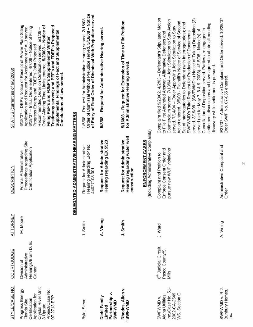
STY
LE/C
AS
E N
O.
CO
UR
T/JU
DG
E A
TTO
RN
EY
D
ES
CR
IPTI
ON
STA
TUS
(cur
rent
as
of 6
/5/2
008)
2
Pro
gres
s E
nerg
y Fl
orid
a S
ite
Cer
tific
atio
nA
pplic
atio
n fo
r C
ryst
al R
iver
Uni
t 3
Upr
ate
Pro
ject
/Cas
e N
o.
07-2
713
EP
P
Div
isio
n of
A
dmin
istra
tive
Hea
rings
/Bra
m D
. E.
Can
ter
M. M
oore
Fo
rmal
Adm
inis
trativ
e P
roce
edin
gs re
gard
ing
Site
C
ertif
icat
ion
App
licat
ion
6/18
/07
– D
EP's
Not
ice
of R
ecei
pt o
f Pow
er P
lant
Siti
ng
App
licat
ion
and
Req
uest
for A
ssig
nmen
t of A
LJ s
erve
d.
6/19
/07
– In
itial
Ord
er e
nter
ed. 4
/7/0
8 –
Not
ice
of F
iling
Pro
gres
s E
nerg
y an
d FD
EP
's J
oint
Pro
pose
d R
ecom
men
ded
Ord
er o
n C
ertif
icat
ion
serv
ed. 5
/1/0
8 –
Ord
er A
lterin
g Ti
me
Lim
its e
nter
ed. 5
/23/
08 –
Not
ice
of
Filin
g PE
F's
and
FDEP
's S
uppl
emen
tal W
ritte
n Te
stim
ony
serv
ed; a
nd P
EF's
and
FD
EP's
Pro
pose
d Su
pple
men
tal F
indi
ngs
of F
act a
nd S
uppl
emen
tal
Con
clus
ions
of L
aw s
erve
d.
D
ELEG
ATE
D A
DM
INIS
TRA
TIVE
HEA
RIN
G M
ATT
ERS
Byl
e, S
teve
J.
Sm
ith
Req
uest
for A
dmin
istra
tive
Hea
ring
rega
rdin
g E
RP
No.
44
0271
08.0
01
1/5/
08 –
Req
uest
for A
dmin
istra
tive
Hea
ring
serv
ed. 2
/15/
08 –
O
rder
of D
ism
issa
l With
out P
reju
dice
ser
ved.
5/1
6/08
– N
otic
e of
Ent
ry o
f Fin
al O
rder
of D
ism
issa
l With
Pre
judi
ce s
erve
d.
D
iehl
Fam
ily
Lim
ited
Part
ners
hip
v.
SWFW
MD
A. V
inin
g R
eque
st fo
r Adm
inis
trat
ive
Hea
ring
rega
rdin
g EX
552
3 5/
8/08
– R
eque
st fo
r Adm
inis
trat
ive
Hea
ring
serv
ed.
Rho
des,
Alle
n v.
SW
FWM
D
J. S
mith
R
eque
st fo
r Adm
inis
trat
ive
Hea
ring
rega
rdin
g w
ater
wel
l co
nstr
uctio
n
5/16
/08
– R
eque
st fo
r Ext
ensi
on o
f Tim
e to
File
Pet
ition
fo
r Adm
inis
trat
ive
Hea
ring
serv
ed.
EN
FOR
CEM
ENT
CA
SES
(Incl
udin
g A
dmin
istra
tive
Com
plai
nts)
SW
FWM
D v
. A
loha
Util
ities
, In
c./C
ase
No.
51-
2002
-CA-
2549
W
S, S
ectio
n G
6th J
udic
ial C
ircui
t, P
asco
Cou
nty/
S.
Mill
s
J. W
ard
Com
plai
nt a
nd P
etiti
on to
E
nfor
ce C
onse
nt O
rder
and
pu
rsue
new
WU
P v
iola
tions
Com
plai
nt fi
led
9/23
/02.
4/2
/03
– D
efen
dant
's S
tipul
ated
Mot
ion
to F
ile F
irst A
men
ded
Ans
wer
, Affi
rmat
ive
Def
ense
s an
d C
ount
ercl
aim
ser
ved.
7/1
3/04
– J
oint
Stip
ulat
ion
to S
tay
Act
ion
serv
ed. 7
/14/
04 –
Ord
er A
ppro
ving
Joi
nt S
tipul
atio
n to
Sta
y A
ctio
n en
tere
d. 3
/5/0
8 - P
lain
tiff’s
Not
ice
of S
ervi
ce o
f Sec
ond
Set
of I
nter
roga
torie
s to
Def
enda
nt (w
ith In
terro
gato
ries)
; and
S
WFW
MD
’s T
hird
Req
uest
for P
rodu
ctio
n of
Doc
umen
ts
serv
ed. 3
/19/
08 -
(SW
FWM
D’s
) Not
ice
of T
akin
g D
epos
ition
(3)
serv
ed (s
et fo
r May
7, 8
& 9
, 200
8). 4
/15/
08 -
Not
ice(
s) o
f C
ance
llatio
n of
Dep
ositi
on s
erve
d. P
artie
s ar
e en
gage
d in
se
ttlem
ent d
iscu
ssio
ns a
nd h
ave
agre
ed to
aba
te a
ll pe
ndin
g di
scov
ery
whi
le s
ettle
men
t is
purs
ued.
SW
FWM
D v
. R.J
. B
unbu
ry H
omes
, In
c.
A. V
inin
g A
dmin
istra
tive
Com
plai
nt a
nd
Ord
er
9/27
/07
– A
dmin
istra
tive
Com
plai
nt a
nd O
rder
ser
ved.
10/
25/0
7 O
rder
SW
F N
o. 0
7-05
5 en
tere
d.
4
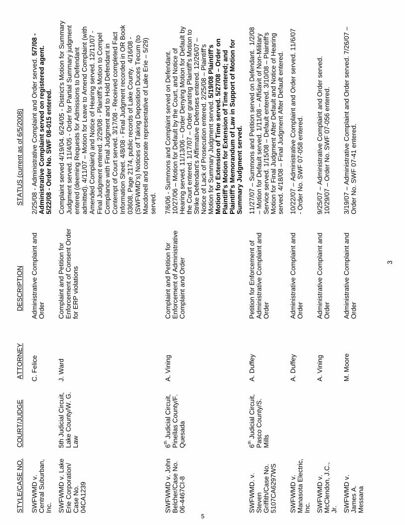
STY
LE/C
AS
E N
O.
CO
UR
T/JU
DG
E A
TTO
RN
EY
D
ES
CR
IPTI
ON
STA
TUS
(cur
rent
as
of 6
/5/2
008)
3
SW
FWM
D v
. C
entra
l Sub
urba
n,
Inc.
C. F
elic
e A
dmin
istra
tive
Com
plai
nt a
nd
Ord
er
2/25
/08
- Adm
inis
trativ
e C
ompl
aint
and
Ord
er s
erve
d. 5
/7/0
8 -
Adm
inis
trat
ive
Com
plai
nt s
erve
d on
regi
ster
ed a
gent
. 5/
22/0
8 - O
rder
No.
SW
F 08
-015
ent
ered
.
SW
FWM
D v
. Lak
e E
rie C
orpo
ratio
n/
Cas
e N
o.
04C
A12
39
5th
Judi
cial
Circ
uit,
Lake
Cou
nty/
W. G
. La
w
J. W
ard
Com
plai
nt a
nd P
etiti
on fo
r E
nfor
cem
ent o
f Con
sent
Ord
er
for E
RP
vio
latio
ns
Com
plai
nt s
erve
d 4/
19/0
4. 6
/24/
05 -
Dis
trict
's M
otio
n fo
r Sum
mar
y Ju
dgm
ent s
erve
d. 1
1/4/
05 -
Ord
er fo
r Par
tial S
umm
ary
judg
men
t en
tere
d (d
eem
ing
Req
uest
s fo
r Adm
issi
ons
to D
efen
dant
ad
mitt
ed).
4/11
/07
– M
otio
n fo
r Lea
ve to
Am
end
Com
plai
nt (w
ith
Am
ende
d C
ompl
aint
) and
Not
ice
of H
earin
g se
rved
. 12/
11/0
7 -
Fina
l Jud
gmen
t ent
ered
. 2/2
9/08
- P
lain
tiff’s
Mot
ion
to C
ompe
l C
ompl
ianc
e w
ith F
inal
Jud
gmen
t and
to H
old
Def
enda
nt in
C
onte
mpt
of C
ourt
serv
ed. 3
/17/
08 -
Rec
eive
d co
mpl
eted
Fac
t In
form
atio
n Sh
eet.
4/8/
08 -
Fina
l Jud
gmen
t rec
orde
d in
OR
Boo
k 03
608,
Pag
e 21
74, p
ublic
reco
rds
of L
ake
Cou
nty.
4/1
6/08
- (S
WFW
MD
’s) N
otic
es o
f Tak
ing
Dep
ositi
on D
uces
Tec
um (t
o M
acdo
nell
and
corp
orat
e re
pres
enta
tive
of L
ake
Erie
– 5
/29)
se
rved
.
SW
FWM
D v
. Joh
n B
elch
er/C
ase
No.
06
-446
7CI-8
6th J
udic
ial C
ircui
t, P
inel
las
Cou
nty/
F.
Que
sada
A. V
inin
g C
ompl
aint
and
Pet
ition
for
Enf
orce
men
t of A
dmin
istra
tive
Com
plai
nt a
nd O
rder
7/6/
06 -
Sum
mon
s an
d C
ompl
aint
ser
ved
on D
efen
dant
. 10
/27/
06 –
Mot
ion
for D
efau
lt by
the
Cou
rt, a
nd N
otic
e of
H
earin
g se
rved
. 11/
13/0
6 –
Ord
er D
enyi
ng M
otio
n fo
r Def
ault
by
the
Cou
rt en
tere
d. 1
/17/
07 –
Ord
er g
rant
ing
Pla
intif
f's M
otio
n to
S
trike
Def
enda
nt's
Affi
rmat
ive
Def
ense
s en
tere
d. 1
2/26
/07
– N
otic
e of
Lac
k of
Pro
secu
tion
ente
red.
2/2
5/08
– P
lain
tiff's
M
otio
n fo
r Sum
mar
y Ju
dgm
ent s
erve
d. 5
/19/
08 P
lain
tiff's
M
otio
n fo
r Ext
ensi
on o
f Tim
e se
rved
. 5/2
7/08
– O
rder
on
Plai
ntiff
's M
otio
n fo
r Ext
ensi
on o
f Tim
e en
tere
d; a
nd
Plai
ntiff
's M
emor
andu
m o
f Law
in S
uppo
rt o
f Mot
ion
for
Sum
mar
y Ju
dgm
ent s
erve
d.
SW
FWM
D. v
. S
teve
nG
riffit
h/C
ase
No.
51
07C
A62
97W
S
6th J
udic
ial C
ircui
t, P
asco
Cou
nty/
S.
Mill
s
A. D
uffe
y P
etiti
on fo
r Enf
orce
men
t of
Adm
inis
trativ
e C
ompl
aint
and
O
rder
11/2
7/07
– S
umm
ons
and
Pet
ition
ser
ved
on D
efen
dant
. 1/
2/08
–
Mot
ion
for D
efau
lt se
rved
. 1/1
1/08
– A
ffida
vit o
f Non
-Milit
ary
Ser
vice
ser
ved.
1/1
5/08
– D
efau
lt en
tere
d. 3
/10/
08 –
Pla
intif
f's
Mot
ion
for F
inal
Jud
gmen
t Afte
r Def
ault
and
Not
ice
of H
earin
g se
rved
. 4/1
8/08
– F
inal
Jud
gmen
t Afte
r Def
ault
ente
red.
SW
FWM
D v
. M
anas
ota
Elec
tric,
In
c.
A. D
uffe
y A
dmin
istra
tive
Com
plai
nt a
nd
Ord
er
10/2
2/07
– A
dmin
istra
tive
Com
plai
nt a
nd O
rder
ser
ved.
11/
6/07
- O
rder
No.
SW
F 07
-058
ent
ered
.
SW
FWM
D v
. M
cCle
ndon
, J.C
., Jr
.
A. V
inin
g A
dmin
istra
tive
Com
plai
nt a
nd
Ord
er
9/25
/07
– A
dmin
istra
tive
Com
plai
nt a
nd O
rder
ser
ved.
10
/29/
07 –
Ord
er N
o. S
WF
07-0
56 e
nter
ed.
SW
FWM
D v
. Ja
mes
A.
Mes
sana
M. M
oore
A
dmin
istra
tive
Com
plai
nt a
nd
Ord
er
3/19
/07
– A
dmin
istra
tive
Com
plai
nt a
nd O
rder
ser
ved.
7/2
6/07
–
Ord
er N
o. S
WF
07-4
1 en
tere
d.
5
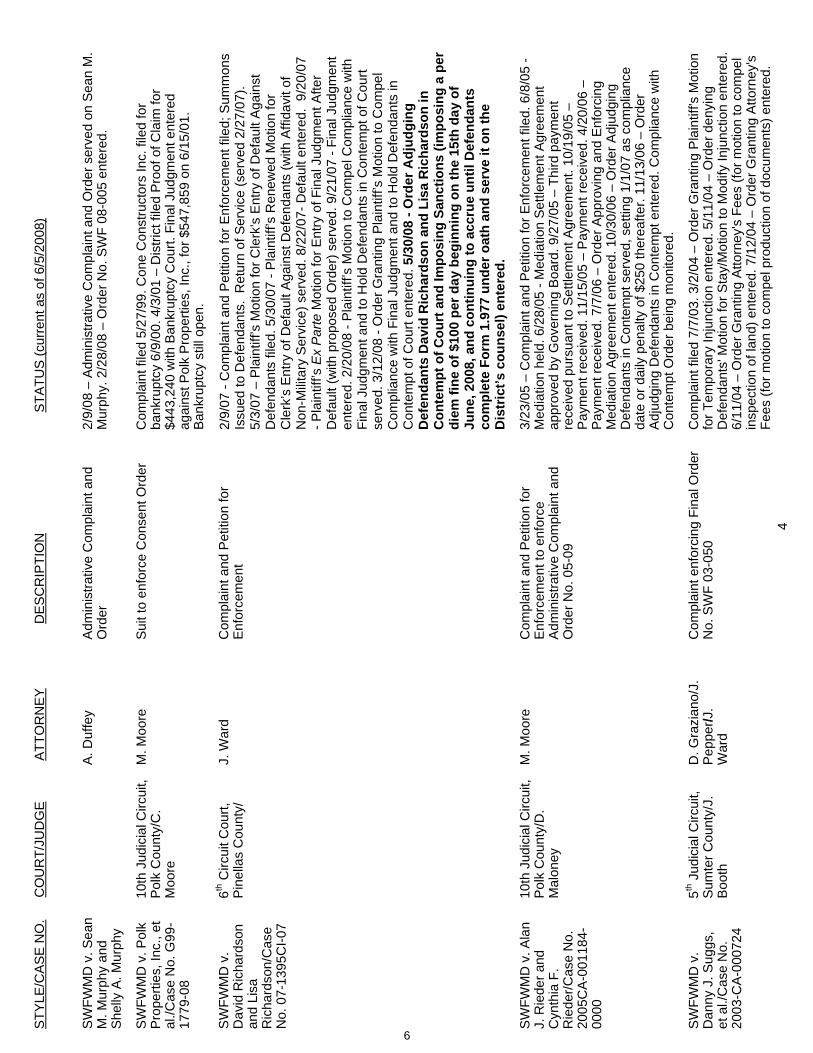
STY
LE/C
AS
E N
O.
CO
UR
T/JU
DG
E A
TTO
RN
EY
D
ES
CR
IPTI
ON
STA
TUS
(cur
rent
as
of 6
/5/2
008)
4
SW
FWM
D v
. Sea
n M
. Mur
phy
and
She
lly A
. Mur
phy
A. D
uffe
y A
dmin
istra
tive
Com
plai
nt a
nd
Ord
er
2/9/
08 –
Adm
inis
trativ
e C
ompl
aint
and
Ord
er s
erve
d on
Sea
n M
. M
urph
y. 2
/28/
08 –
Ord
er N
o. S
WF
08-0
05 e
nter
ed.
SW
FWM
D v
. Pol
k P
rope
rties
, Inc
., et
al
./Cas
e N
o. G
99-
1779
-08
10th
Jud
icia
l Circ
uit,
Pol
k C
ount
y/C
. M
oore
M. M
oore
S
uit t
o en
forc
e C
onse
nt O
rder
C
ompl
aint
file
d 5/
27/9
9. C
one
Con
stru
ctor
s In
c. fi
led
for
bank
rupt
cy 6
/9/0
0. 4
/3/0
1 –
Dis
trict
file
d P
roof
of C
laim
for
$443
,240
with
Ban
krup
tcy
Cou
rt. F
inal
Jud
gmen
t ent
ered
ag
ains
t Pol
k P
rope
rties
, Inc
., fo
r $54
7,85
9 on
6/1
5/01
. B
ankr
uptc
y st
ill op
en.
SW
FWM
D v
. D
avid
Ric
hard
son
and
Lisa
R
icha
rdso
n/C
ase
No.
07-
1395
CI-0
7
6th C
ircui
t Cou
rt,
Pin
ella
s C
ount
y/
J. W
ard
Com
plai
nt a
nd P
etiti
on fo
r E
nfor
cem
ent
2/9/
07 -
Com
plai
nt a
nd P
etiti
on fo
r Enf
orce
men
t file
d; S
umm
ons
Issu
ed to
Def
enda
nts.
Ret
urn
of S
ervi
ce (s
erve
d 2/
27/0
7).
5/3/
07 –
Pla
intif
f’s M
otio
n fo
r Cle
rk’s
Ent
ry o
f Def
ault
Aga
inst
D
efen
dant
s fil
ed. 5
/30/
07 -
Pla
intif
f’s R
enew
ed M
otio
n fo
r C
lerk
’s E
ntry
of D
efau
lt A
gain
st D
efen
dant
s (w
ith A
ffida
vit o
f N
on-M
ilitar
y S
ervi
ce) s
erve
d. 8
/22/
07- D
efau
lt en
tere
d. 9
/20/
07
- Pla
intif
f’s E
x P
arte
Mot
ion
for E
ntry
of F
inal
Jud
gmen
t Afte
r D
efau
lt (w
ith p
ropo
sed
Ord
er) s
erve
d. 9
/21/
07 -
Fina
l Jud
gmen
t en
tere
d. 2
/20/
08 -
Pla
intif
f’s M
otio
n to
Com
pel C
ompl
ianc
e w
ith
Fina
l Jud
gmen
t and
to H
old
Def
enda
nts
in C
onte
mpt
of C
ourt
serv
ed. 3
/12/
08 -
Ord
er G
rant
ing
Pla
intif
f’s M
otio
n to
Com
pel
Com
plia
nce
with
Fin
al J
udgm
ent a
nd to
Hol
d D
efen
dant
s in
C
onte
mpt
of C
ourt
ente
red.
5/3
0/08
- O
rder
Adj
udgi
ng
Def
enda
nts
Dav
id R
icha
rdso
n an
d Li
sa R
icha
rdso
n in
C
onte
mpt
of C
ourt
and
Impo
sing
San
ctio
ns (i
mpo
sing
a p
er
diem
fine
of $
100
per d
ay b
egin
ning
on
the
15th
day
of
June
, 200
8, a
nd c
ontin
uing
to a
ccru
e un
til D
efen
dant
s co
mpl
ete
Form
1.9
77 u
nder
oat
h an
d se
rve
it on
the
Dis
tric
t’s c
ouns
el) e
nter
ed.
SW
FWM
D v
. Ala
n J.
Rie
der a
nd
Cyn
thia
F.
Rie
der/C
ase
No.
20
05C
A-0
0118
4-00
00
10th
Jud
icia
l Circ
uit,
Pol
k C
ount
y/D
. M
alon
ey
M. M
oore
C
ompl
aint
and
Pet
ition
for
Enf
orce
men
t to
enfo
rce
Adm
inis
trativ
e C
ompl
aint
and
O
rder
No.
05-
09
3/23
/05
– C
ompl
aint
and
Pet
ition
for E
nfor
cem
ent f
iled.
6/8
/05
- M
edia
tion
held
. 6/2
8/05
- M
edia
tion
Set
tlem
ent A
gree
men
t ap
prov
ed b
y G
over
ning
Boa
rd. 9
/27/
05 –
Thi
rd p
aym
ent
rece
ived
pur
suan
t to
Set
tlem
ent A
gree
men
t. 10
/19/
05 –
P
aym
ent r
ecei
ved.
11/
15/0
5 –
Pay
men
t rec
eive
d. 4
/20/
06 –
P
aym
ent r
ecei
ved.
7/7
/06
– O
rder
App
rovi
ng a
nd E
nfor
cing
M
edia
tion
Agr
eem
ent e
nter
ed. 1
0/30
/06
– O
rder
Adj
udgi
ng
Def
enda
nts
in C
onte
mpt
ser
ved,
set
ting
1/1/
07 a
s co
mpl
ianc
e da
te o
r dai
ly p
enal
ty o
f $25
0 th
erea
fter.
11/1
3/06
– O
rder
A
djud
ging
Def
enda
nts
in C
onte
mpt
ent
ered
. Com
plia
nce
with
C
onte
mpt
Ord
er b
eing
mon
itore
d.
SW
FWM
D v
. D
anny
J. S
uggs
, et
al./
Cas
e N
o.
2003
-CA-
0007
24
5th J
udic
ial C
ircui
t, Su
mte
r Cou
nty/
J.
Boo
th
D. G
razi
ano/
J.
Pep
per/J
. W
ard
Com
plai
nt e
nfor
cing
Fin
al O
rder
N
o. S
WF
03-0
50
Com
plai
nt fi
led
7/7/
03. 3
/2/0
4 –
Ord
er G
rant
ing
Pla
intif
f's M
otio
n fo
r Tem
pora
ry In
junc
tion
ente
red.
5/1
1/04
– O
rder
den
ying
D
efen
dant
s' M
otio
n fo
r Sta
y/M
otio
n to
Mod
ify In
junc
tion
ente
red.
6/
11/0
4 –
Ord
er G
rant
ing
Atto
rney
's F
ees
(for m
otio
n to
com
pel
insp
ectio
n of
land
) ent
ered
. 7/1
2/04
– O
rder
Gra
ntin
g A
ttorn
ey's
Fe
es (f
or m
otio
n to
com
pel p
rodu
ctio
n of
doc
umen
ts) e
nter
ed.
6
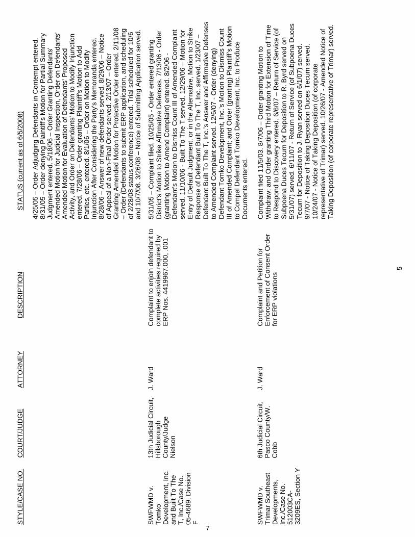
STY
LE/C
AS
E N
O.
CO
UR
T/JU
DG
E A
TTO
RN
EY
D
ES
CR
IPTI
ON
STA
TUS
(cur
rent
as
of 6
/5/2
008)
5
4/25
/05
– O
rder
Adj
udgi
ng D
efen
dant
s in
Con
tem
pt e
nter
ed.
8/31
/05
– O
rder
den
ying
Pla
intif
f's M
otio
n fo
r Par
tial S
umm
ary
Judg
men
t ent
ered
. 5/1
8/06
– O
rder
Gra
ntin
g D
efen
dant
s'
Am
ende
d M
otio
n fo
r Jud
icia
l Ins
pect
ion,
Ord
er o
n D
efen
dant
s'
Am
ende
d M
otio
n fo
r Eva
luat
ion
of D
efen
dant
s' P
ropo
sed
Act
ivity
, and
Ord
er o
n D
efen
dant
s' M
otio
n to
Mod
ify In
junc
tion
ente
red.
7/2
8/06
– O
rder
gra
ntin
g P
lain
tiff's
Mot
ion
to A
dd
Par
ties,
etc
. ent
ered
. 8/1
/06
– O
rder
on
Mot
ion
to M
odify
In
junc
tion
Afte
r Con
side
ring
the
Par
ty's
Mem
oran
da e
nter
ed.
8/28
/06
– A
nsw
er o
f new
def
enda
nts
serv
ed. 8
/29/
06 –
Not
ice
of A
ppea
l of a
Non
-Fin
al O
rder
ser
ved.
2/1
3/07
– O
rder
G
rant
ing
Am
ende
d M
otio
n fo
r Pro
tect
ive
Ord
er e
nter
ed. 2
/11/
08
– O
rder
(Def
enda
nts
to s
ubm
it E
RP
app
licat
ion,
and
sch
edul
ing
of 2
/28/
08 s
tatu
s co
nfer
ence
) ent
ered
. Tria
l sch
edul
ed fo
r 10/
6 an
d 10
/7/0
8. 3
/26/
08 –
Not
ice
of S
ubm
ittin
g A
pplic
atio
n se
rved
.
SW
FWM
D v
. To
mko
Dev
elop
men
t, In
c.
and
Bui
lt To
The
T,
Inc.
/Cas
e N
o.
05-4
689,
Div
isio
n F
13th
Jud
icia
l Circ
uit,
Hills
boro
ugh
Cou
nty/
Judg
e N
iels
on
J. W
ard
Com
plai
nt to
enj
oin
defe
ndan
t to
com
plet
e ac
tiviti
es re
quire
d by
E
RP
Nos
. 441
9967
.000
, .00
1
5/31
/05
– C
ompl
aint
file
d. 1
0/25
/05
- Ord
er e
nter
ed g
rant
ing
Dis
trict
's M
otio
n to
Stri
ke A
ffirm
ativ
e D
efen
ses.
7/1
3/06
- O
rder
(g
rant
ing
Mot
ion
to A
men
d C
ompl
aint
) ent
ered
. 8/2
/06
- D
efen
dant
's M
otio
n to
Dis
mis
s C
ount
III o
f Am
ende
d C
ompl
aint
se
rved
. 11/
10/0
6 - B
uilt
To T
he T
ser
ved.
12/
29/0
6 –
Mot
ion
for
Ent
ry o
f Def
ault
Judg
men
t, or
in th
e A
ltern
ativ
e, M
otio
n to
Stri
ke
Res
pons
e of
Def
enda
nt B
uilt
To T
he T
, Inc
. ser
ved.
1/2
3/07
–
Def
enda
nt B
uilt
To T
he T
, Inc
.’s A
nsw
er a
nd A
ffirm
ativ
e D
efen
ses
to A
men
ded
Com
plai
nt s
erve
d. 1
2/6/
07 -
Ord
er (d
enyi
ng)
Def
enda
nt T
omko
Dev
elop
men
t, In
c.’s
Mot
ion
to D
ism
iss
Cou
nt
III o
f Am
ende
d C
ompl
aint
; and
Ord
er (g
rant
ing)
Pla
intif
f’s M
otio
n to
Com
pel D
efen
dant
Tom
ko D
evel
opm
ent,
Inc.
to P
rodu
ce
Doc
umen
ts e
nter
ed.
SW
FWM
D v
. Tr
imar
Sou
thea
st
Dev
elop
men
ts,
Inc.
/Cas
e N
o.
5120
03C
A-
3209
ES
, Sec
tion
Y
6th
Judi
cial
Circ
uit,
Pas
co C
ount
y/W
. C
obb
J. W
ard
C
ompl
aint
and
Pet
ition
for
Enf
orce
men
t of C
onse
nt O
rder
fo
r ER
P v
iola
tions
Com
plai
nt fi
led
11/5
/03.
8/7
/06
– O
rder
gra
ntin
g M
otio
n to
W
ithdr
aw; a
nd O
rder
gra
ntin
g Th
ird M
otio
n fo
r Ext
ensi
on o
f Tim
e to
Res
pond
to D
isco
very
ent
ered
. 6/6
/07
– R
etur
n of
Ser
vice
(of
Sub
poen
a D
uces
Tec
um fo
r Dep
ositi
on to
R. B
yrd
serv
ed o
n 5/
31/0
7) s
erve
d. 6
/11/
07 -
Ret
urn
of S
ervi
ce (o
f Sub
poen
a D
uces
Te
cum
for D
epos
ition
to J
. Rya
n se
rved
on
6/1/
07) s
erve
d.
9/7/
07 -
Not
ice
of T
akin
g D
epos
ition
Duc
es T
ecum
ser
ved.
10
/24/
07 -
Not
ice
of T
akin
g D
epos
ition
(of c
orpo
rate
re
pres
enta
tive
of T
rimar
) ser
ved.
10/
26/0
7 - A
men
ded
Not
ice
of
Taki
ng D
epos
ition
(of c
orpo
rate
repr
esen
tativ
e of
Trim
ar) s
erve
d.
7
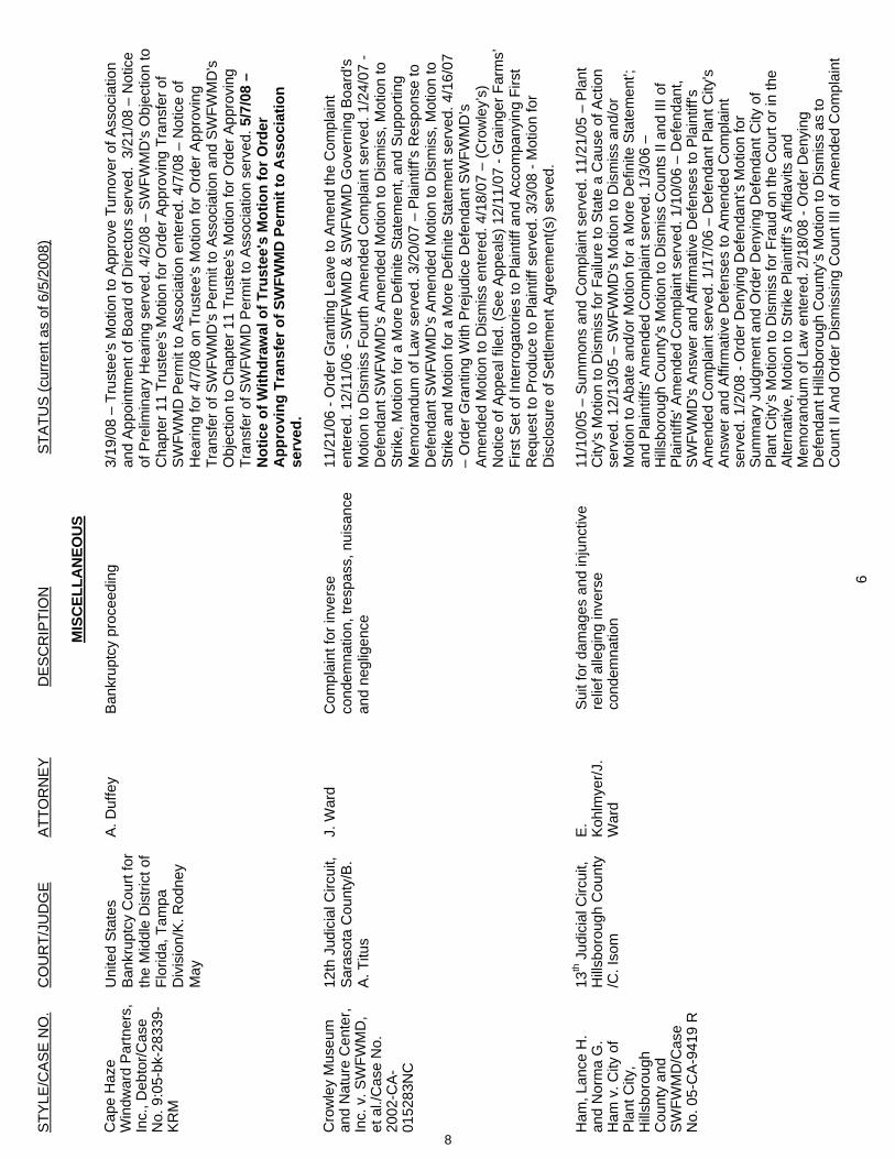
STY
LE/C
AS
E N
O.
CO
UR
T/JU
DG
E A
TTO
RN
EY
D
ES
CR
IPTI
ON
STA
TUS
(cur
rent
as
of 6
/5/2
008)
6
MIS
CEL
LAN
EOU
S
Cap
e H
aze
Win
dwar
d P
artn
ers,
In
c., D
ebto
r/Cas
e N
o. 9
:05-
bk-2
8339
-K
RM
Uni
ted
Sta
tes
Ban
krup
tcy
Cou
rt fo
r th
e M
iddl
e D
istri
ct o
f Fl
orid
a, T
ampa
D
ivis
ion/
K. R
odne
y M
ay
A. D
uffe
y B
ankr
uptc
y pr
ocee
ding
3/
19/0
8 –
Trus
tee'
s M
otio
n to
App
rove
Tur
nove
r of A
ssoc
iatio
n an
d A
ppoi
ntm
ent o
f Boa
rd o
f Dire
ctor
s se
rved
. 3/
21/0
8 –
Not
ice
of P
relim
inar
y H
earin
g se
rved
. 4/2
/08
– S
WFW
MD
's O
bjec
tion
to
Cha
pter
11
Trus
tee'
s M
otio
n fo
r Ord
er A
ppro
ving
Tra
nsfe
r of
SW
FWM
D P
erm
it to
Ass
ocia
tion
ente
red.
4/7
/08
– N
otic
e of
H
earin
g fo
r 4/7
/08
on T
rust
ee's
Mot
ion
for O
rder
App
rovi
ng
Tran
sfer
of S
WFW
MD
's P
erm
it to
Ass
ocia
tion
and
SW
FWM
D's
O
bjec
tion
to C
hapt
er 1
1 Tr
uste
e's
Mot
ion
for O
rder
App
rovi
ng
Tran
sfer
of S
WFW
MD
Per
mit
to A
ssoc
iatio
n se
rved
. 5/7
/08
– N
otic
e of
With
draw
al o
f Tru
stee
's M
otio
n fo
r Ord
er
App
rovi
ng T
rans
fer o
f SW
FWM
D P
erm
it to
Ass
ocia
tion
serv
ed.
Cro
wle
y M
useu
m
and
Nat
ure
Cen
ter,
Inc.
v. S
WFW
MD
, et
al./
Cas
e N
o.
2002
-CA-
0152
83N
C
12th
Jud
icia
l Circ
uit,
Sara
sota
Cou
nty/
B.
A. T
itus
J. W
ard
Com
plai
nt fo
r inv
erse
co
ndem
natio
n, tr
espa
ss, n
uisa
nce
and
negl
igen
ce
11/2
1/06
- O
rder
Gra
ntin
g Le
ave
to A
men
d th
e C
ompl
aint
en
tere
d. 1
2/11
/06
- SW
FWM
D &
SW
FWM
D G
over
ning
Boa
rd's
M
otio
n to
Dis
mis
s Fo
urth
Am
ende
d C
ompl
aint
ser
ved.
1/2
4/07
- D
efen
dant
SW
FWM
D’s
Am
ende
d M
otio
n to
Dis
mis
s, M
otio
n to
S
trike
, Mot
ion
for a
Mor
e D
efin
ite S
tate
men
t, an
d S
uppo
rting
M
emor
andu
m o
f Law
ser
ved.
3/2
0/07
– P
lain
tiff’s
Res
pons
e to
D
efen
dant
SW
FWM
D’s
Am
ende
d M
otio
n to
Dis
mis
s, M
otio
n to
S
trike
and
Mot
ion
for a
Mor
e D
efin
ite S
tate
men
t ser
ved.
4/1
6/07
–
Ord
er G
rant
ing
With
Pre
judi
ce D
efen
dant
SW
FWM
D’s
A
men
ded
Mot
ion
to D
ism
iss
ente
red.
4/1
8/07
– (C
row
ley’
s)
Not
ice
of A
ppea
l file
d. (S
ee A
ppea
ls) 1
2/11
/07
- Gra
inge
r Far
ms’
Fi
rst S
et o
f Int
erro
gato
ries
to P
lain
tiff a
nd A
ccom
pany
ing
Firs
t R
eque
st to
Pro
duce
to P
lain
tiff s
erve
d. 3
/3/0
8 - M
otio
n fo
r D
iscl
osur
e of
Set
tlem
ent A
gree
men
t(s) s
erve
d.
H
am, L
ance
H.
and
Nor
ma
G.
Ham
v. C
ity o
f P
lant
City
, H
illsbo
roug
hC
ount
y an
d S
WFW
MD
/Cas
e N
o. 0
5-C
A-9
419
R
13th J
udic
ial C
ircui
t, H
illsbo
roug
h C
ount
y /C
. Iso
m
E. Koh
lmye
r/J.
War
d
Sui
t for
dam
ages
and
inju
nctiv
e re
lief a
llegi
ng in
vers
e co
ndem
natio
n
11/1
0/05
– S
umm
ons
and
Com
plai
nt s
erve
d. 1
1/21
/05
– P
lant
C
ity's
Mot
ion
to D
ism
iss
for F
ailu
re to
Sta
te a
Cau
se o
f Act
ion
serv
ed. 1
2/13
/05
– S
WFW
MD
's M
otio
n to
Dis
mis
s an
d/or
M
otio
n to
Aba
te a
nd/o
r Mot
ion
for a
Mor
e D
efin
ite S
tate
men
t';
and
Pla
intif
fs' A
men
ded
Com
plai
nt s
erve
d. 1
/3/0
6 –
Hills
boro
ugh
Cou
nty'
s M
otio
n to
Dis
mis
s C
ount
s II
and
III o
f P
lain
tiffs
' Am
ende
d C
ompl
aint
ser
ved.
1/1
0/06
– D
efen
dant
, S
WFW
MD
's A
nsw
er a
nd A
ffirm
ativ
e D
efen
ses
to P
lain
tiff's
A
men
ded
Com
plai
nt s
erve
d. 1
/17/
06 –
Def
enda
nt P
lant
City
's
Ans
wer
and
Affi
rmat
ive
Def
ense
s to
Am
ende
d C
ompl
aint
se
rved
. 1/2
/08
- Ord
er D
enyi
ng D
efen
dant
’s M
otio
n fo
r S
umm
ary
Judg
men
t and
Ord
er D
enyi
ng D
efen
dant
City
of
Pla
nt C
ity’s
Mot
ion
to D
ism
iss
for F
raud
on
the
Cou
rt or
in th
e A
ltern
ativ
e, M
otio
n to
Stri
ke P
lain
tiff’s
Affi
davi
ts a
nd
Mem
oran
dum
of L
aw e
nter
ed. 2
/18/
08 -
Ord
er D
enyi
ng
Def
enda
nt H
illsbo
roug
h C
ount
y’s
Mot
ion
to D
ism
iss
as to
C
ount
II A
nd O
rder
Dis
mis
sing
Cou
nt II
I of A
men
ded
Com
plai
nt
8
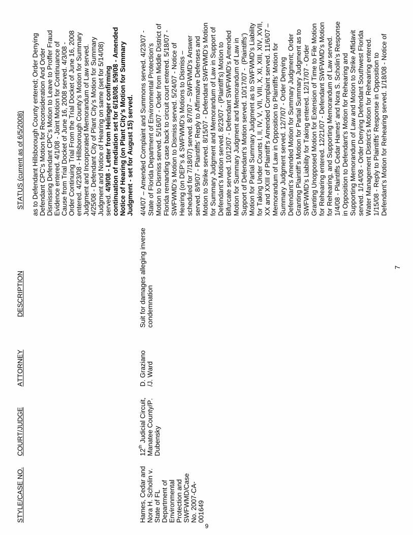
STY
LE/C
AS
E N
O.
CO
UR
T/JU
DG
E A
TTO
RN
EY
D
ES
CR
IPTI
ON
STA
TUS
(cur
rent
as
of 6
/5/2
008)
7
as to
Def
enda
nt H
illsbo
roug
h C
ount
y en
tere
d; O
rder
Den
ying
D
efen
dant
CP
C’s
Mot
ion
for R
econ
side
ratio
n A
nd O
rder
D
ism
issi
ng D
efen
dant
CPC
’s M
otio
n to
Lea
ve to
Pro
ffer F
raud
E
vide
nce
ente
red.
4/1
/08
- Joi
nt M
otio
n fo
r Con
tinua
nce
of
Cau
se fr
om T
rial D
ocke
t of J
une
16, 2
008
serv
ed. 4
/3/0
8 -
Ord
er C
ontin
uing
Tria
l Fro
m th
e Tr
ial D
ocke
t of J
une
16, 2
008
ente
red.
4/2
3/08
- H
illsbo
roug
h C
ount
y’s
Mot
ion
for S
umm
ary
Judg
men
t and
Inco
rpor
ated
Mem
oran
dum
of L
aw s
erve
d.
4/25
/08
- Def
enda
nt C
ity o
f Pla
nt C
ity’s
Mot
ion
for S
umm
ary
Judg
men
t and
Not
ice
of H
earin
g on
sam
e (s
et fo
r 5/1
4/08
) se
rved
. 4/9
/08
- Let
ter f
rom
Hel
inge
r con
firm
ing
cont
inua
tion
of m
edia
tion
set f
or 6
/18/
08. 5
/9/0
8 - A
men
ded
Not
ice
of H
earin
g (o
n Pl
ant C
ity’s
Mot
ion
for S
umm
ary
Judg
men
t - s
et fo
r Aug
ust 1
5) s
erve
d.
Ham
es, C
edar
and
N
ora
H. S
chol
in v
. S
tate
of F
L D
epar
tmen
t of
Env
ironm
enta
l P
rote
ctio
n an
d S
WFW
MD
/Cas
e N
o. 2
007-
CA
-00
1649
12th J
udic
ial C
ircui
t, M
anat
ee C
ount
y/P
. D
uben
sky
D. G
razi
ano
/J. W
ard
Sui
t for
dam
ages
alle
ging
inve
rse
cond
emna
tion
4/4/
07 –
Am
ende
d C
ompl
aint
and
Sum
mon
s se
rved
. 4/2
3/07
- S
tate
of F
lorid
a D
epar
tmen
t of E
nviro
nmen
tal P
rote
ctio
n’s
Mot
ion
to D
ism
iss
serv
ed. 5
/16/
07 -
Ord
er fr
om M
iddl
e D
istri
ct o
f Fl
orid
a re
man
ding
cas
e ba
ck to
circ
uit c
ourt
ente
red.
5/1
8/07
- S
WFW
MD
’s M
otio
n to
Dis
mis
s se
rved
. 5/2
4/07
- N
otic
e of
H
earin
g (o
n D
EP
’s &
SW
FWM
D’s
Mot
ions
to D
ism
iss
– sc
hedu
led
for 7
/18/
07) s
erve
d. 8
/7/0
7 –
SW
FWM
D's
Ans
wer
se
rved
. 8/9
/07
- Pla
intif
fs’ R
eply
to A
ffirm
ativ
e D
efen
ses
and
Mot
ion
to S
trike
ser
ved.
8/1
5/07
- D
efen
dant
SW
FWM
D’s
Mot
ion
for S
umm
ary
Judg
men
t and
Mem
oran
dum
of L
aw in
Sup
port
of
Def
enda
nt’s
Mot
ion
serv
ed. 8
/23/
07 -
(Pla
intif
f’s) M
otio
n to
B
ifurc
ate
serv
ed. 1
0/12
/07
- Def
enda
nt S
WFW
MD
’s A
men
ded
Mot
ion
for S
umm
ary
Judg
men
t and
Mem
oran
dum
of L
aw in
S
uppo
rt of
Def
enda
nt’s
Mot
ion
serv
ed. 1
0/17
/07
- (P
lain
tiffs
’) M
otio
n fo
r Par
tial S
umm
ary
Judg
men
t as
to S
WFW
MD
’s L
iabi
lity
for T
akin
g U
nder
Cou
nts
I, II,
IV, V
, VII,
VIII
, X, X
I, X
III, X
IV, X
VII,
X
X a
nd X
XIII
of P
lain
tiff’s
Am
ende
d C
ompl
aint
ser
ved.
11/
6/07
–
Mem
oran
dum
of L
aw in
Opp
ositi
on to
Pla
intif
fs’ M
otio
n fo
r S
umm
ary
Judg
men
t ser
ved.
12/
7/07
- O
rder
Den
ying
D
efen
dant
’s A
men
ded
Mot
ion
for S
umm
ary
Judg
men
t; O
rder
G
rant
ing
Pla
intif
f’s M
otio
n fo
r Par
tial S
umm
ary
Judg
men
t as
to
SW
FWM
D’s
Lia
bilit
y fo
r Tak
ing
ente
red.
12/
17/0
7 - O
rder
G
rant
ing
Uno
ppos
ed M
otio
n fo
r Ext
ensi
on o
f Tim
e to
File
Mot
ion
for R
ehea
ring
ente
red.
12/
21/0
7 - D
efen
dant
SW
FWM
D’s
Mot
ion
for R
ehea
ring,
and
Sup
porti
ng M
emor
andu
m o
f Law
ser
ved.
1/
4/08
- P
lain
tiffs
Ced
ar H
ames
’ and
Nor
a S
. Sch
olin
’s R
espo
nse
in O
ppos
ition
to D
efen
dant
’s M
otio
n fo
r Reh
earin
g an
d S
uppo
rting
Mem
oran
dum
of L
aw a
nd M
otio
n to
Stri
ke A
ffida
vit
serv
ed. 1
/14/
08 -
Ord
er D
enyi
ng D
efen
dant
Sou
thw
est F
lorid
a W
ater
Man
agem
ent D
istri
ct’s
Mot
ion
for R
ehea
ring
ente
red.
1/
15/0
8 - R
eply
to P
lain
tiffs
’ Res
pons
e in
Opp
ositi
on to
D
efen
dant
’s M
otio
n fo
r Reh
earin
g se
rved
. 1/1
8/08
- N
otic
e of
9
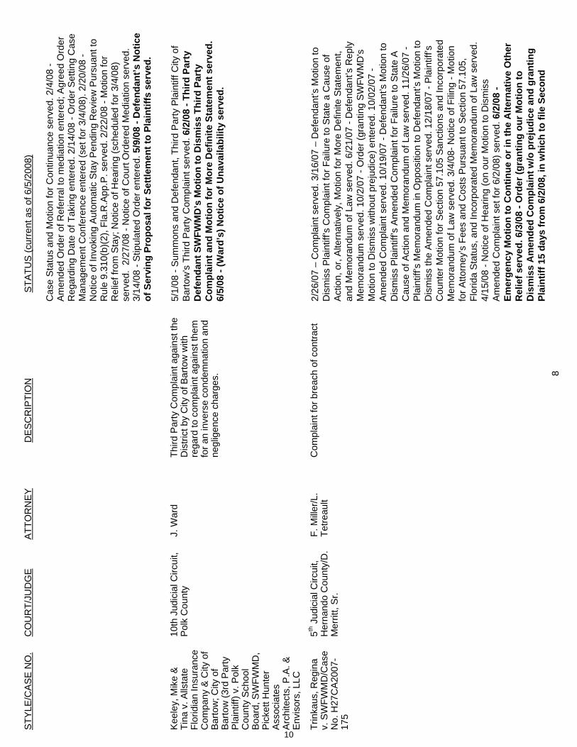
STY
LE/C
AS
E N
O.
CO
UR
T/JU
DG
E A
TTO
RN
EY
D
ES
CR
IPTI
ON
STA
TUS
(cur
rent
as
of 6
/5/2
008)
8
Cas
e S
tatu
s an
d M
otio
n fo
r Con
tinua
nce
serv
ed. 2
/4/0
8 -
Am
ende
d O
rder
of R
efer
ral t
o m
edia
tion
ente
red;
Agr
eed
Ord
er
Reg
ardi
ng D
ate
of T
akin
g en
tere
d. 2
/14/
08 -
Ord
er S
ettin
g C
ase
Man
agem
ent C
onfe
renc
e en
tere
d (s
et fo
r 3/4
/08)
. 2/2
0/08
- N
otic
e of
Invo
king
Aut
omat
ic S
tay
Pen
ding
Rev
iew
Pur
suan
t to
Rul
e 9.
310(
b)(2
), Fl
a.R
.App
.P. s
erve
d. 2
/22/
08 -
Mot
ion
for
Rel
ief f
rom
Sta
y; N
otic
e of
Hea
ring
(sch
edul
ed fo
r 3/4
/08)
se
rved
. 2/
27/0
8 - N
otic
e of
Cou
rt O
rder
ed M
edia
tion
serv
ed.
3/14
/08
- Stip
ulat
ed O
rder
ent
ered
. 5/9
/08
- Def
enda
nt’s
Not
ice
of S
ervi
ng P
ropo
sal f
or S
ettle
men
t to
Plai
ntiff
s se
rved
.
K
eele
y, M
ike
&
Tina
v. A
llsta
te
Flor
idia
n In
sura
nce
Com
pany
& C
ity o
f B
arto
w; C
ity o
f B
arto
w (3
rd P
arty
P
lain
tiff)
v. P
olk
Cou
nty
Sch
ool
Boa
rd, S
WFW
MD
, P
icke
tt H
unte
r A
ssoc
iate
s A
rchi
tect
s, P
.A. &
E
nvis
ors,
LLC
10th
Jud
icia
l Circ
uit,
Pol
k C
ount
y J.
War
d Th
ird P
arty
Com
plai
nt a
gain
st th
e D
istri
ct b
y C
ity o
f Bar
tow
with
re
gard
to c
ompl
aint
aga
inst
them
fo
r an
inve
rse
cond
emna
tion
and
negl
igen
ce c
harg
es.
5/1/
08 -
Sum
mon
s an
d D
efen
dant
, Thi
rd P
arty
Pla
intif
f City
of
Bar
tow
’s T
hird
Par
ty C
ompl
aint
ser
ved.
6/2
/08
- Thi
rd P
arty
D
efen
dant
SW
FWM
D’s
Mot
ion
to D
ism
iss
Third
Par
ty
Com
plai
nt a
nd M
otio
n fo
r Mor
e D
efin
ite S
tate
men
t ser
ved.
6/
5/08
- (W
ard’
s) N
otic
e of
Una
vaila
bilit
y se
rved
.
Trin
kaus
, Reg
ina
v. S
WFW
MD
/Cas
e N
o. H
27C
A20
07-
175
5th J
udic
ial C
ircui
t, H
erna
ndo
Cou
nty/
D.
Mer
ritt,
Sr.
F. M
iller/L
. Te
treau
lt C
ompl
aint
for b
reac
h of
con
tract
2/
26/0
7 –
Com
plai
nt s
erve
d. 3
/16/
07 –
Def
enda
nt’s
Mot
ion
to
Dis
mis
s P
lain
tiff’s
Com
plai
nt fo
r Fai
lure
to S
tate
a C
ause
of
Act
ion,
or,
Alte
rnat
ivel
y, M
otio
n fo
r Mor
e D
efin
ite S
tate
men
t, an
d M
emor
andu
m o
f Law
ser
ved.
6/2
1/07
- D
efen
dant
’s R
eply
M
emor
andu
m s
erve
d. 1
0/2/
07 -
Ord
er (g
rant
ing
SW
FWM
D's
M
otio
n to
Dis
mis
s w
ithou
t pre
judi
ce) e
nter
ed. 1
0/02
/07
- A
men
ded
Com
plai
nt s
erve
d. 1
0/19
/07
- Def
enda
nt’s
Mot
ion
to
Dis
mis
s P
lain
tiff’s
Am
ende
d C
ompl
aint
for F
ailu
re to
Sta
te A
C
ause
of A
ctio
n an
d M
emor
andu
m o
f Law
ser
ved.
11/
26/0
7 -
Pla
intif
f’s M
emor
andu
m in
Opp
ositi
on to
Def
enda
nt’s
Mot
ion
to
Dis
mis
s th
e A
men
ded
Com
plai
nt s
erve
d. 1
2/18
/07
- Pla
intif
f’s
Cou
nter
Mot
ion
for S
ectio
n 57
.105
San
ctio
ns a
nd In
corp
orat
ed
Mem
oran
dum
of L
aw s
erve
d. 3
/4/0
8- N
otic
e of
Filin
g - M
otio
n fo
r Atto
rney
’s F
ees
and
Cos
ts P
ursu
ant t
o S
ectio
n 57
.105
, Fl
orid
a S
tatu
s, a
nd In
corp
orat
ed M
emor
andu
m o
f Law
ser
ved.
4/
15/0
8 - N
otic
e of
Hea
ring
(on
our M
otio
n to
Dis
mis
s A
men
ded
Com
plai
nt s
et fo
r 6/2
/08)
ser
ved.
6/2
/08
- Em
erge
ncy
Mot
ion
to C
ontin
ue o
r in
the
Alte
rnat
ive
Oth
er
Rel
ief s
erve
d. 6
/3/0
8 - O
rder
(gra
ntin
g ou
r Mot
ion
to
Dis
mis
s A
men
ded
Com
plai
nt w
/o p
reju
dice
and
gra
ntin
g Pl
aint
iff 1
5 da
ys fr
om 6
/2/0
8, in
whi
ch to
file
Sec
ond
10
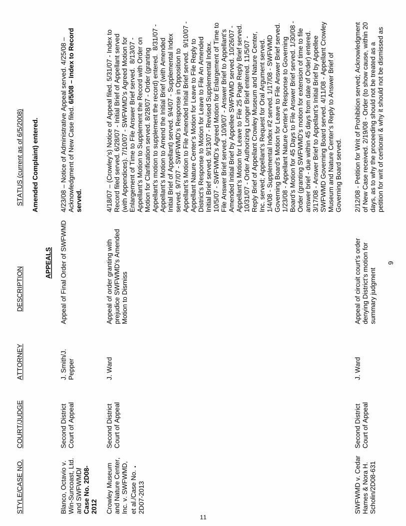
STY
LE/C
AS
E N
O.
CO
UR
T/JU
DG
E A
TTO
RN
EY
D
ES
CR
IPTI
ON
STA
TUS
(cur
rent
as
of 6
/5/2
008)
9
Am
ende
d C
ompl
aint
) ent
ered
.
APP
EALS
Bla
nco,
Oct
avio
v.
Win
-Sun
coas
t, Lt
d.
and
SW
FWM
D/
Cas
e N
o. 2
D08
-20
12
Sec
ond
Dis
trict
C
ourt
of A
ppea
l J.
Sm
ith/J
. P
eppe
r A
ppea
l of F
inal
Ord
er o
f SW
FWM
D
4/23
/08
– N
otic
e of
Adm
inis
trativ
e A
ppea
l ser
ved.
4/2
5/08
–
Ack
now
ledg
men
t of N
ew C
ase
filed
. 6/5
/08
– In
dex
to R
ecor
d se
rved
.
Cro
wle
y M
useu
m
and
Nat
ure
Cen
ter,
Inc.
v. S
WFW
MD
, et
al./
Cas
e N
o. .
2D07
-201
3
Sec
ond
Dis
trict
C
ourt
of A
ppea
l J.
War
d A
ppea
l of o
rder
gra
ntin
g w
ith
prej
udic
e S
WFW
MD
's A
men
ded
Mot
ion
to D
ism
iss
4/18
/07
– (C
row
ley’
s) N
otic
e of
App
eal f
iled.
5/3
1/07
- In
dex
to
Rec
ord
filed
ser
ved.
6/2
8/07
- In
itial
Brie
f of A
ppel
lant
ser
ved
(with
App
endi
ces)
. 7/1
0/07
- S
WFW
MD
’s A
gree
d M
otio
n fo
r E
nlar
gem
ent o
f Tim
e to
File
Ans
wer
Brie
f ser
ved.
8/1
3/07
- A
ppel
lant
’s M
otio
n to
Sup
plem
ent t
he R
ecor
d w
ith O
rder
on
Mot
ion
for C
larif
icat
ion
serv
ed. 8
/28/
07 -
Ord
er (g
rant
ing
App
ella
nt’s
mot
ion
to s
uppl
emen
t the
reco
rd) e
nter
ed.
8/31
/07
- A
ppel
lant
’s M
otio
n to
Am
end
the
Initi
al B
rief (
with
Am
ende
d In
itial
Brie
f of A
ppel
lant
) ser
ved.
9/4
/07
- Sup
plem
enta
l Ind
ex
serv
ed. 9
/7/0
7 - S
WFW
MD
’s R
espo
nse
in O
ppos
ition
to
App
ella
nt’s
Mot
ion
to F
ile A
men
ded
Initi
al B
rief s
erve
d. 9
/10/
07 -
App
ella
nt N
atur
e C
ente
r’s M
otio
n fo
r Lea
ve to
File
Rep
ly to
D
istri
ct’s
Res
pons
e to
Mot
ion
for L
eave
to F
ile A
n A
men
ded
Initi
al B
rief s
erve
d. 9
/13/
07 -
Rev
ised
Sup
plem
enta
l Ind
ex.
10/5
/07
- SW
FWM
D’s
Agr
eed
Mot
ion
for E
nlar
gem
ent o
f Tim
e to
Fi
le A
nsw
er B
rief s
erve
d. 1
0/9/
07 -
Ans
wer
Brie
f to
App
ella
nt’s
A
men
ded
Initi
al B
rief b
y A
ppel
lee
SW
FWM
D s
erve
d. 1
0/26
/07
- A
ppel
lant
’s M
otio
n fo
r Lea
ve to
File
25
Pag
e R
eply
Brie
f ser
ved.
10
/31/
07 -
Ord
er A
utho
rizin
g Lo
nger
Brie
f ent
ered
. 11/
5/07
- R
eply
Brie
f of A
ppel
lant
Cro
wle
y M
useu
m a
nd N
atur
e C
ente
r, In
c. s
erve
d; A
ppel
lant
’s R
eque
st fo
r Ora
l Arg
umen
t ser
ved.
1/
4/08
- S
uppl
emen
tal I
ndex
#2
serv
ed. 1
/17/
08 -
SW
FWM
D
Gov
erni
ng B
oard
’s M
otio
n fo
r Lea
ve to
File
Ans
wer
Brie
f ser
ved.
1/
23/0
8 - A
ppel
lant
Nat
ure
Cen
ter’s
Res
pons
e to
Gov
erni
ng
Boa
rd’s
Mot
ion
for 4
5 D
ays
to F
ile A
nsw
er B
rief s
erve
d. 1
/30/
08 -
Ord
er (g
rant
ing
SW
FWM
D’s
mot
ion
for e
xten
sion
of t
ime
to fi
le
answ
er b
rief -
due
with
in 4
5 da
ys fr
om d
ate
of O
rder
) ent
ered
. 3/
17/0
8 - A
nsw
er B
rief t
o A
ppel
lant
’s In
itial
Brie
f by
App
elle
e S
WFW
MD
Gov
erni
ng B
oard
ser
ved.
4/1
1/08
- A
ppel
lant
Cro
wle
y M
useu
m a
nd N
atur
e C
ente
r’s R
eply
to A
nsw
er B
rief o
f G
over
ning
Boa
rd s
erve
d.
S
WFW
MD
v. C
edar
H
ames
& N
ora
H.
Sch
olin
/2D
08-6
31
Sec
ond
Dis
trict
C
ourt
of A
ppea
l J.
War
d A
ppea
l of c
ircui
t cou
rt’s
orde
r de
nyin
g D
istri
ct’s
mot
ion
for
sum
mar
y ju
dgm
ent
2/12
/08
- Pet
ition
for W
rit o
f Pro
hibi
tion
serv
ed; A
ckno
wle
dgm
ent
of N
ew C
ase
rece
ived
. 2/1
9/08
- O
rder
(to
show
cau
se, w
ithin
20
days
, as
to w
hy th
e pr
ocee
ding
sho
uld
not b
e tre
ated
as
a pe
titio
n fo
r writ
of c
ertio
rari
& w
hy it
sho
uld
not b
e di
smis
sed
as
11
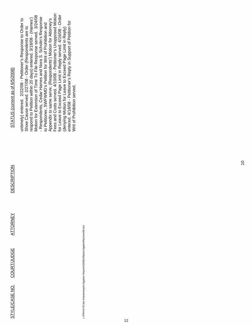
STY
LE/C
AS
E N
O.
CO
UR
T/JU
DG
E A
TTO
RN
EY
D
ES
CR
IPTI
ON
STA
TUS
(cur
rent
as
of 6
/5/2
008)
10
untim
ely)
ent
ered
. 2/
22/0
8 - P
etiti
oner
’s R
espo
nse
to O
rder
to
Sho
w C
ause
ser
ved.
2/2
7/08
- O
rder
(Res
pond
ents
are
to
resp
ond
to P
etiti
on w
ithin
20
days
) ent
ered
. 3/1
8/08
- (H
ames
’) M
otio
n fo
r Ext
ensi
on o
f Tim
e To
File
Res
pons
e se
rved
. 3/
24/0
8 - R
espo
nden
ts, C
edar
Ham
es a
nd N
ora
S. S
chol
in’s
Res
pons
e to
Pet
ition
er, S
WFW
MD
’s P
etiti
on fo
r Writ
of P
rohi
bitio
n an
d A
ppen
dix
to s
ame
serv
e; (R
espo
nden
ts’)
Mot
ion
for A
ttorn
ey’s
Fe
es a
nd C
osts
ser
ved.
4/1
0/08
- P
etiti
oner
’s U
nopp
osed
Mot
ion
for L
eave
to E
xcee
d P
age
Lim
it in
Rep
ly s
erve
d. 4
/16/
08 -
Ord
er
(den
ying
Mot
ion
for L
eave
to E
xcee
d P
age
Lim
it in
Rep
ly)
ente
red.
4/1
8/08
- P
etiti
oner
’s R
eply
in S
uppo
rt of
Pet
ition
for
Writ
of P
rohi
bitio
n se
rved
.
L:
\PR
IVAT
E\J
an K
aese
mey
er\L
itiga
tion
Rep
orts
\200
8LitR
pts\
Litig
atio
nRpt
June
08.d
oc
12
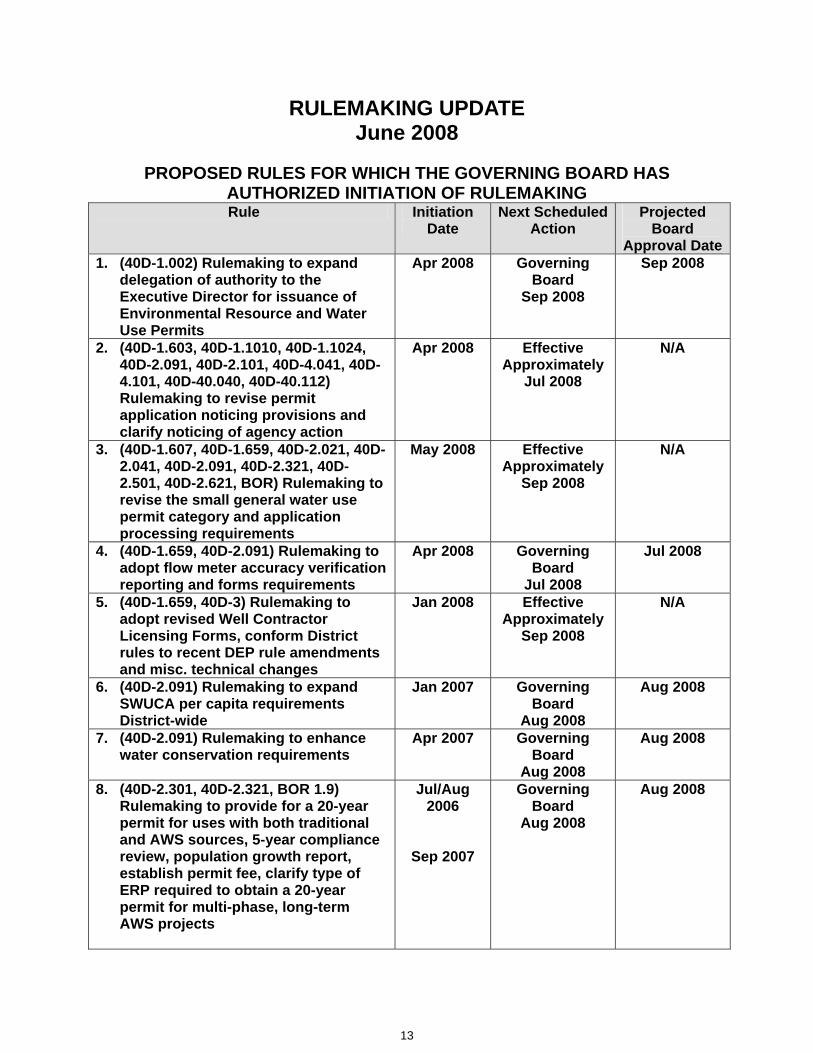
RULEMAKING UPDATE June 2008
PROPOSED RULES FOR WHICH THE GOVERNING BOARD HAS AUTHORIZED INITIATION OF RULEMAKING Rule Initiation
Date Next Scheduled
Action Projected
Board Approval Date
1. (40D-1.002) Rulemaking to expand delegation of authority to the Executive Director for issuance of Environmental Resource and Water Use Permits
Apr 2008 Governing Board
Sep 2008
Sep 2008
2. (40D-1.603, 40D-1.1010, 40D-1.1024, 40D-2.091, 40D-2.101, 40D-4.041, 40D-4.101, 40D-40.040, 40D-40.112) Rulemaking to revise permit application noticing provisions and clarify noticing of agency action
Apr 2008 Effective Approximately
Jul 2008
N/A
3. (40D-1.607, 40D-1.659, 40D-2.021, 40D-2.041, 40D-2.091, 40D-2.321, 40D-2.501, 40D-2.621, BOR) Rulemaking to revise the small general water use permit category and application processing requirements
May 2008 Effective Approximately
Sep 2008
N/A
4. (40D-1.659, 40D-2.091) Rulemaking to adopt flow meter accuracy verification reporting and forms requirements
Apr 2008 Governing Board
Jul 2008
Jul 2008
5. (40D-1.659, 40D-3) Rulemaking to adopt revised Well Contractor Licensing Forms, conform District rules to recent DEP rule amendments and misc. technical changes
Jan 2008 Effective Approximately
Sep 2008
N/A
6. (40D-2.091) Rulemaking to expand SWUCA per capita requirements District-wide
Jan 2007 Governing Board
Aug 2008
Aug 2008
7. (40D-2.091) Rulemaking to enhance water conservation requirements
Apr 2007 Governing Board
Aug 2008
Aug 2008
8. (40D-2.301, 40D-2.321, BOR 1.9) Rulemaking to provide for a 20-year permit for uses with both traditional and AWS sources, 5-year compliance review, population growth report, establish permit fee, clarify type of ERP required to obtain a 20-year permit for multi-phase, long-term AWS projects
Jul/Aug 2006
Sep 2007
Governing Board
Aug 2008
Aug 2008
13
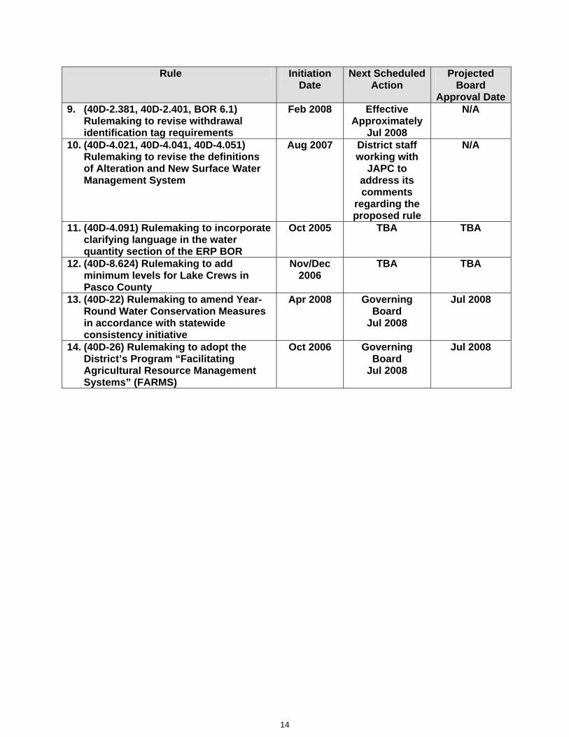
Rule Initiation Date
Next Scheduled Action
Projected Board
Approval Date9. (40D-2.381, 40D-2.401, BOR 6.1)
Rulemaking to revise withdrawal identification tag requirements
Feb 2008 Effective Approximately
Jul 2008
N/A
10. (40D-4.021, 40D-4.041, 40D-4.051) Rulemaking to revise the definitions of Alteration and New Surface Water Management System
Aug 2007 District staff working with
JAPC to address its comments
regarding the proposed rule
N/A
11. (40D-4.091) Rulemaking to incorporate clarifying language in the water quantity section of the ERP BOR
Oct 2005 TBA TBA
12. (40D-8.624) Rulemaking to add minimum levels for Lake Crews in Pasco County
Nov/Dec 2006
TBA TBA
13. (40D-22) Rulemaking to amend Year-Round Water Conservation Measures in accordance with statewide consistency initiative
Apr 2008 Governing Board
Jul 2008
Jul 2008
14. (40D-26) Rulemaking to adopt the District’s Program “Facilitating Agricultural Resource Management Systems” (FARMS)
Oct 2006 Governing Board
Jul 2008
Jul 2008
14

H.R
eports
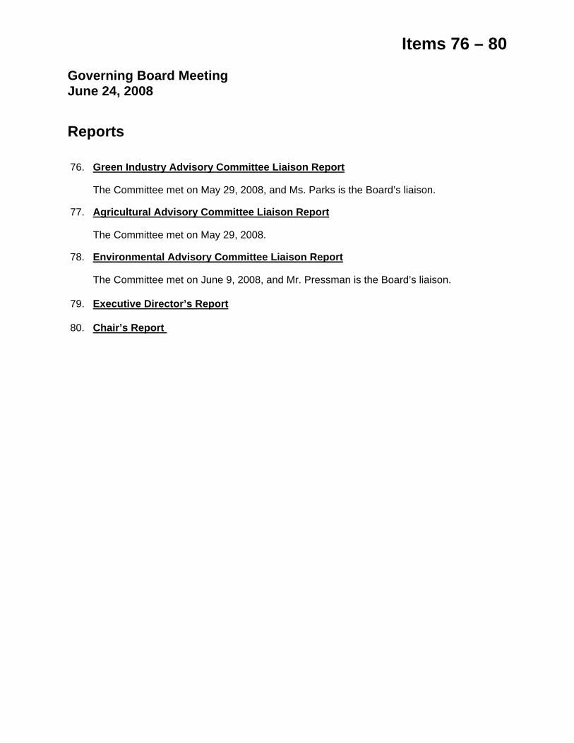
Items 76 – 80
Governing Board Meeting June 24, 2008 Reports
76. Green Industry Advisory Committee Liaison Report
The Committee met on May 29, 2008, and Ms. Parks is the Board’s liaison.
77. Agricultural Advisory Committee Liaison Report
The Committee met on May 29, 2008.
78. Environmental Advisory Committee Liaison Report
The Committee met on June 9, 2008, and Mr. Pressman is the Board’s liaison.
79. Executive Director’s Report
80. Chair’s Report

Related Documents