Sedimentary Geology, 56 (1988) 403-413 403 Elsevier Science Publishers BN., Amsterdam - Printed in The Netherlands Giant desiccation fissures filled with calcareous eolian sand, Hermosa Formation (Pennsylvanian), southeastern Utah DAVID B. LOOPE and ZSOLT E. HAVERLAND Department of Geology, Unioersityof Nebraska, Lincoln, NE 68588 (U.S.A.) (Received May 20, 1986; revised and accepted August 25, 1986) Abstract Loope, D.B. and Havedand, Z.E., 1988. Giant desiccation fissures filled with calcareous eolian sand, Hermosa Formation (Pennsylvanian), southeastern Utah. In: G. Kocurek (Editor), Late Paleozoic and Mesozoic Eolian Deposits of the Western Interior of the United States. Sediment. Geol., 56: 403-413. At two stratigraphic intervals within the upper member of the Upper Pennsylvanian Hermosa Formation, calcareous eolian sand fills downward-tapering fissures that are as much as 18 cm wide and 5.7 m deep. Fissure fillings define orthogonal polygons 10 m or more in diameter. One of the host beds is primarily composed of subtidally deposited limestone, the other is a thinly laminated, nonmarine red siltstone. Both systems of fissure fillings are directly overlain and underlain by large-scale cross-stratified, calcareous eolianites. The limestone host bed contains chert pseudomorphs after gypsum. Compaction of host rocks contorted fissure fillings and caused doming of eolian strata over each fissure. Platy mineral grains in fissure fillings are aligned subparallel to bedding in the host rocks, supporting the view that the fissures were passively filled rather than forcefully injected. These ancient fissure systems are similar in scale and pattern to those that define giant desiccation polygons in numerous Great Basin playas. The Pennsylvanian fissures, like their Holocene counterparts, probably formed when groundwater tables dropped from shallow levels within fine-grained, impermeable deposits into underlying aquifers, greatly decreasing the extent of the capillary fringe. Our study of the fissures and host rocks supports the hypothesis that carbonate grains within the eolianites were deflated from uncemented marine sediments that were broadly exposed during regressive intervals. Introduction Polygonally arranged fractures caused by the shrinkage of mud are perhaps the best and most common indicators of subaerial exposure in the rock record (Shinn, 1983; Miall, 1984, p. 41). Desiccation cracks are especially abundant in fine-grained strata associated with eolian sands. Typical mudcracks are about 1 cm wide, several centimeters in depth, and several decimeters apart (Neal, 1978). In contrast, giant desiccation fis- sures, such as those described from numerous Great Basin playas by Neal et al. (1968), can reach widths of 1 m, depths of 15 m, and spacings of 300 m. 0037-0738/88/$03.50 © 1988 Elsevier Science Publishers B.V. There are very few well-documented examples of giant desiccation polygons from the rock rec- ord. From the Henry Mountains of southern Utah, Gilbert (1877, p. 9) described and sketched "fossil suncracks" that extend 5 m into nonmarine silt- stone of the Triassic Chinle Formation and are filled by eolian sand from the overlying Wingate Sandstone (Loope, unpublished field notes). Neal (1978, fig. 1; and pers. commun., 1986) reported giant desiccation polygons within Miocene lacustrine siltstones of central Iran. Shales and fine-grained carbonates of marine origin may also bear large-scale shrinkage cracks (Fagerstrom, 1955; Fischer, 1964; White, 1964). Fischer (1964) noted that, because of structural displacements

Welcome message from author
This document is posted to help you gain knowledge. Please leave a comment to let me know what you think about it! Share it to your friends and learn new things together.
Transcript
Sedimentary Geology, 56 (1988) 403-413 403 Elsevier Science Publishers BN., Amsterdam - Printed in The Netherlands
Giant desiccation fissures filled with calcareous eolian sand, Hermosa Formation (Pennsylvanian), southeastern Utah
DAVID B. LOOPE and ZSOLT E. H A V E R L A N D
Department of Geology, Unioersity of Nebraska, Lincoln, NE 68588 (U.S.A.)
(Received May 20, 1986; revised and accepted August 25, 1986)
Abstract
Loope, D.B. and Havedand, Z.E., 1988. Giant desiccation fissures filled with calcareous eolian sand, Hermosa Formation (Pennsylvanian), southeastern Utah. In: G. Kocurek (Editor), Late Paleozoic and Mesozoic Eolian Deposits of the Western Interior of the United States. Sediment. Geol., 56: 403-413.
At two stratigraphic intervals within the upper member of the Upper Pennsylvanian Hermosa Formation, calcareous eolian sand fills downward-tapering fissures that are as much as 18 cm wide and 5.7 m deep. Fissure fillings define orthogonal polygons 10 m or more in diameter. One of the host beds is primarily composed of subtidally deposited limestone, the other is a thinly laminated, nonmarine red siltstone. Both systems of fissure fillings are directly overlain and underlain by large-scale cross-stratified, calcareous eolianites. The limestone host bed contains chert pseudomorphs after gypsum. Compaction of host rocks contorted fissure fillings and caused doming of eolian strata over each fissure. Platy mineral grains in fissure fillings are aligned subparallel to bedding in the host rocks, supporting the view that the fissures were passively filled rather than forcefully injected.
These ancient fissure systems are similar in scale and pattern to those that define giant desiccation polygons in numerous Great Basin playas. The Pennsylvanian fissures, like their Holocene counterparts, probably formed when groundwater tables dropped from shallow levels within fine-grained, impermeable deposits into underlying aquifers, greatly decreasing the extent of the capillary fringe. Our study of the fissures and host rocks supports the hypothesis that carbonate grains within the eolianites were deflated from uncemented marine sediments that were broadly exposed during regressive intervals.
Introduction
Polygonally arranged fractures caused by the shrinkage of mud are perhaps the best and most common indicators of subaerial exposure in the rock record (Shinn, 1983; Miall, 1984, p. 41). Desiccation cracks are especially abundant in fine-grained strata associated with eolian sands. Typical mudcracks are about 1 cm wide, several centimeters in depth, and several decimeters apart (Neal, 1978). In contrast, giant desiccation fis- sures, such as those described from numerous Great Basin playas by Neal et al. (1968), can reach widths of 1 m, depths of 15 m, and spacings of 300 m.
0037-0738/88/$03.50 © 1988 Elsevier Science Publishers B.V.
There are very few well-documented examples of giant desiccation polygons from the rock rec- ord. From the Henry Mountains of southern Utah, Gilbert (1877, p. 9) described and sketched "fossil suncracks" that extend 5 m into nonmarine silt- stone of the Triassic Chinle Formation and are filled by eolian sand from the overlying Wingate Sandstone (Loope, unpublished field notes). Neal (1978, fig. 1; and pers. commun., 1986) reported giant desiccation polygons within Miocene lacustrine siltstones of central Iran. Shales and fine-grained carbonates of marine origin may also bear large-scale shrinkage cracks (Fagerstrom, 1955; Fischer, 1964; White, 1964). Fischer (1964) noted that, because of structural displacements

404
and brecciation associated with fractures in Tri- assic Loferites of the Northern Limestone Alps, he could not rule out tectonism as an alternative to desiccation. White (1964) argued that fissures in the upper 5 m of a Pennsylvanian shale in east- central Illinois were formed by synaeresis.
This paper documents giant desiccation fissures from a well-exposed sequence of Upper Pennsyl- vanian rocks in southern Utah, and shows how recognition of these features aids understanding of deposition and diagenesis of the host strata.
Study area
Dark Canyon, located in southeastern Utah, is a deep tributary canyon that joins Cataract Canyon about 56 km below the confluence of the Green and Colorado Rivers (Fig. 1). The strati- graphic sequence described in this study forms
Fig. 1. Location of study area. Dashed line around Paradox Basin represents limit of halite facies in the Paradox Member of the Hermosa Formation (Hite and Buckner, 1981). Stippled pattern shows extent of fissures observed in unit 2 (Fig. 2). Southern limit of fissures is result of cover by younger strata. Control on northern limit is unknown (outcrop of units 2 continues to mouth of Dark Canyon). Topography from Mouth of Dark Canyon Quadrangle (15-minute series).
continuous outcrops along the floor and lower walls of Dark Canyon from its mouth to a water- fall 3 km upstream. The strata are flat-lying. Several east-west trending high-angle faults pass through the studied interval; maximum displace- ment is 8 m (Huntoon et al., 1982). Most joints within the studied strata are parallel to these faults.
Stratigraphic and sedimentologic setting
In the study area, the upper member of the Hermosa Formation is about 250 m thick and Middle Pennsylvanian to (possibly) very Early Permian in age (Lewis and Campbell, 1965, pp. B7-B8). It is composed of alternating thin, cross- stratified eolianites and fossiliferous marine time- stones (Loope, 1984, 1985; and Fig. 2). Contacts between eolian and marine strata are sharp (Fig. 2) (Loope, this volume, fig. 2A, B). Lewis and Campbell (1965, p. B8) noted that the limestone beds are lenticular and cannot be correlated over long distances.
The eolian rocks are highly calcareous and typi- cally have bimodal textures (Figs. 3 and 4) (Loope, this volume, fig. 2E). Cross-strata within the eolianites are dominantly composed of climbing translatent strata produced by the migration of wind ripples. Several of the eolian units contain more carbonate than siliciclastic grains (Fig. 3) and are thus, by definition, limestones. These are the first eolian limestones described from the Paleozoic. The term "eolianite" is used in this paper to avoid confusion of the calcareous eolian rocks with the interbedded marine limestones.
Large sand-filled fissures, the major focus of this paper, are present at the tops of units 2 and 9 (Fig. 2). Unit 2 is 5.7 m thick and is primarily composed of marine limestone; unit 9 is a 2.5 m thick red sfltstone, here interpreted as nonmarine (Fig. 2).
Unit 2 can be subdivided into five subunits (Figs. 2 and 5), only two of which (2b and 2c) are laterally continuous. Sand-filled fissures cut all subunits. At the base of the unit, a thin lag deposit (subunit 2a) composed of large shells and re- worked soil nodules and rhizoliths is in direct contact with an in situ paleosol at the top of the

405
marine strata ^ v megafossils * Rsebdomorphs gyP.)
-7,-v-~les ccation cracks rhizoliths
- ° chert nodules
Fig. 2. Stratigraphic sequence exposed in lower Dark Canyon. Arrows show location of fissured surfaces. Units 1, 2d, 3, 6, 8 and 10 are calcareous eolianites (Figs. 3, 4 and 9). Units 2a, 2b, 2c and 5 are micrite-rich subtidal carbonates (Figs. 5, 6, 7 and 12). Unit 4 is an ooid grainstone with crude cross-stratification and moldic porosity. Unit 7 is a bioclastic grainstone to packstone. Units 2e and 9 are red siltstones with abundant micrite pellets and dolomite rhombs (Fig. 10). Base of section is approximately 125 m above the uppermost evaporites of the Paradox Member of the Hermosa (see Loope, this volume, fig. 1).
>-
U Z LLI
C~ LLJ n,. IL
5.0 c 4.0 vf 3.0 | 2.0 LO (10 m c
GRAIN SIZE ((~)
UNIT 3 UNIT 2d
MICRITE PELOIDS 12 31
l MISC. SKELETAL 2 2
m']] BRYOZOAN S 7 13
~J~ ECHINODERMS 34 9
[ ~ MISC. CLASTICS S 2
QUARTZ 40 43
100% 100%
TOTAL CALCITE GRAINS S5% 55%
Fig. 3. Texture and composition of grains within eolianites. Size corresponds to length of long axes of grains seen in thin-section. Miscellaneous skeletal debris includes brachio- pod, fusulinid, and molluscan fragments. Miscellaneous elas- tics include feldspar, mica, rock fragments, and detrital chert. Note that both rocks are, by definition, limestone.
underlying eolianite. Marine trace fossils extend several decimeters downward into the eolian unit. Subunit 2b is a dense, structureless, sparsely fos- siliferous biomicrite containing subspherical chert nodules 6-10 cm in diameter. The bulk of unit 2 is a silty, horizontally bedded, sparsely fossiliferous biomicrite (subunit 2c). Three thin packstone beds containing crinoids, brachiopods, bryozoa and tri- lobites lie within the generally mud-supported strata and can be traced throughout the study
Fig. 4. Eolianite in thin-section. Fragments of crinoids (C) (several with silicified centers), brachiopods (B), bryozoa (Z), and fusulinids (F) , as well as quartz (white), are present.
406
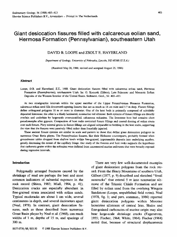
Fig. 5. Outcrop of lower units shown in Fig. 2. Photo taken slightly upstream of area mapped for Fig. 13.
area. These beds contain articulated brachiopods (Fig. 6) and crinoid brachioles with delicate pinn- ules attached. Micrite pellets and tubular to irreg- ular fenestrae are present within the fill of the articulated shells, but are lacking in the surround-
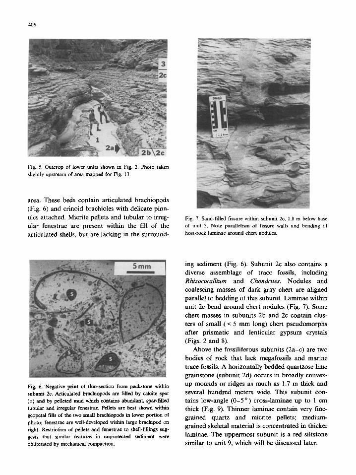
Fig. 7. Sand-filled fissure within subunit 2c, 1.8 m below base of unit 3. Note parallelism of fissure walls and bending of host-rock laminae around chert nodules.
Fig. 6, Negative print of thin-section from pack, stone within subunit 2c. Articulated braehiopods are filled by calcite spar (s) and by pelleted mud which contains abundant, spar-filled tubular and irregular fenestrae. Pellets are best shown within geopetal fills of the two small brachiopods in lower portion of photo; fenestrae are well-developed within large brachipod on right. Restriction of pellets and fenestrae to shell-fillings sug- gests that similar features in unprotected sediment were obliterated by mechanical compaction.
ing sediment (Fig. 6). Subunit 2c also contains a diverse assemblage of trace fossils, including Rhizocorallium and Chondrites. Nodules and coalescing masses of dark gray chert are aligned parallel to bedding of this subunit. Laminae within unit 2c bend around chert nodules (Fig. 7). Some chert masses in subunits 2b and 2c contain clus- ters of small (< 5 mm long) chert pseudomorphs after prismatic and lenticular gypsum crystals (Figs. 2 and 8).
Above the fossiliferous subunits (2a-c) are two bodies of rock that lack megafossils and marine trace fossils. A horizontally bedded quartzose lime grainstone (subunit 2d) occurs in broadly convex- up mounds or ridges as much as 1.7 m thick and several hundred meters wide. This subunit con- tains low-angle (0-5 o) cross-laminae up to 1 cm thick (Fig. 9). Thinner laminae contain very fine- grained quartz and micrite pellets; medium- grained skeletal material is concentrated in thicker laminae. The uppermost subunit is a red siltstone similar to unit 9, which will be discussed later.
4O7
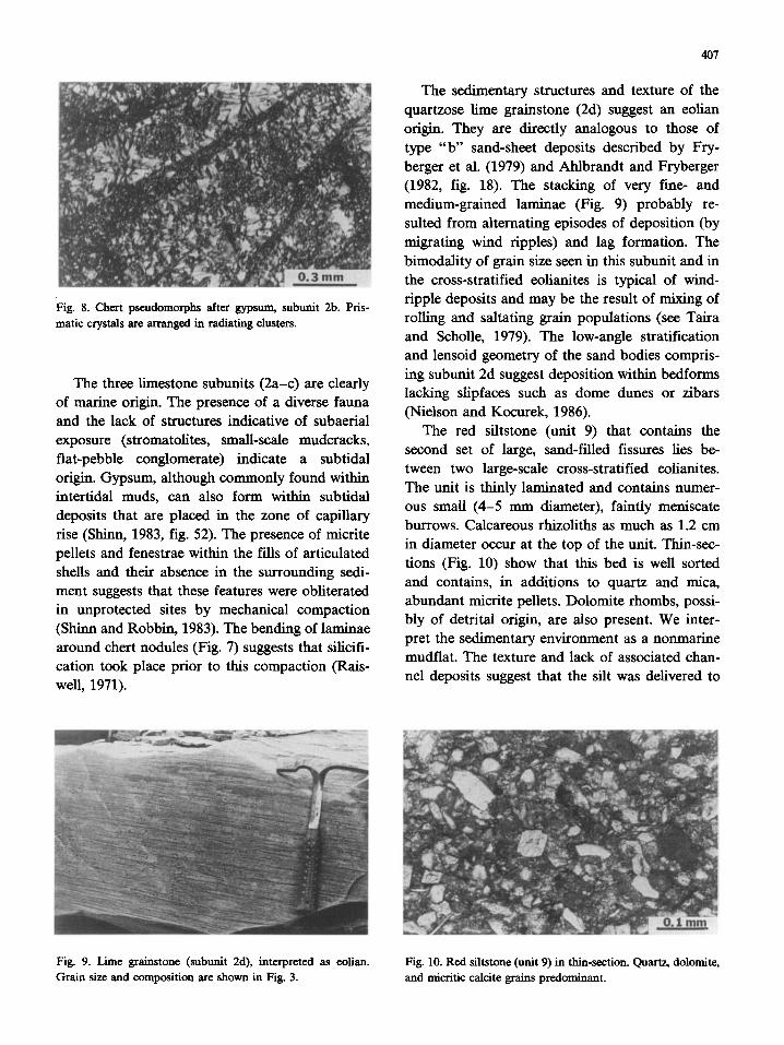
Fig. 8. Chert pseudomorphs after gypsum, subunit 2b. Pris- matic crystals are arranged in radiating clusters.
The three limestone subunits (2a-c) are clearly of marine origin. The presence of a diverse fauna and the lack of structures indicative of subaerial exposure (stromatolites, smaU-scale mudcracks, flat-pebble conglomerate) indicate a subtidal origin. Gypsum, although commonly found within intertidal muds, can also form within subtidal deposits that are placed in the zone of capillary rise (Shinn, 1983, fig. 52). The presence of micrite pellets and fenestrae within the fills of articulated shells and their absence in the surrounding sedi- ment suggests that these features were obliterated in unprotected sites by mechanical compaction (Shinn and Robbin, 1983). The bending of laminae around chert nodules (Fig. 7) suggests that silicifi- cation took place prior to this compaction (Rais- well, 1971).
The sedimentary structures and texture of the quartzose lime grainstone (2d) suggest an eolian origin. They are directly analogous to those of type "b" sand-sheet deposits described by Fry- berger et al. (1979) and Ahlbrandt and Fryberger (1982, fig. 18). The stacking of very fine- and medium-grained laminae (Fig. 9) probably re- suited from alternating episodes of deposition (by migrating wind ripples) and lag formation. The bimodality of grain size seen in this subunit and in the cross-stratified eolianites is typical of wind- tipple deposits and may be the result of mixing of rolling and saltating grain populations (see Taira and SchoUe, 1979). The low-angle stratification and lensoid geometry of the sand bodies compris- ing subunit 2d suggest deposition within bedforms lacking slipfaces such as dome dunes or zibars (Nielson and Kocurek, 1986).
The red siltstone (unit 9) that contains the second set of large, sand-filled fissures lies be- tween two large-scale cross-stratified eolianites. The unit is thinly laminated and contains numer- ous small (4-5 mm diameter), faintly meniscate burrows. Calcareous rhizoliths as much as 1.2 cm in diameter occur at the top of the unit. Thin-sec- tions (Fig. 10) show that this bed is well sorted and contains, in additions to quartz and mica, abundant mictite pellets. Dolomite rhombs, possi- bly of detrital origin, are also present. We inter- pret the sedimentary environment as a nonmarine mudflat. The texture and lack of associated chan- nel deposits suggest that the silt was delivered to
Fig. 9. Lime graiustone (subunit 2d), interpreted as eolian. Fig. 10. Red siltstone (unit 9) in thin-section. Quartz, dolomite, Grain size and composition are shown in Fig. 3. and micritic calcite grains predominant.
408
the area of deposition by dust storms. The pres- ence of abundant micrite pellets suggests that part of the material was derived from exposed marine carbonates.
Description of sand4illed fractures
Composition
Fissures in units 2 and 9 are filled with bi- modal, carbonate-rich sand identical in composi- tion and texture to that of the eolian units in the
sequence. Angular clasts of wall material ranging in size from a few millimeters to a decimeter or more make up a small percentage of some fissure
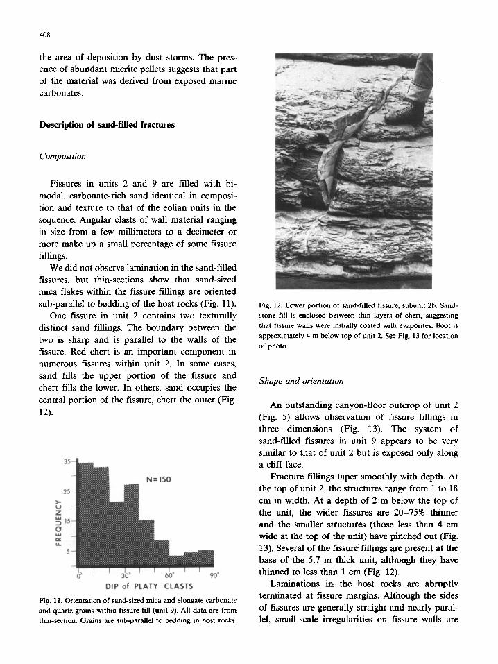
fillings. We did not observe lamination in the sand-filled
fissures, but thin-sections show that sand-sized mica flakes within the fissure fillings are oriented
sub-parallel to bedding of the host rocks (Fig. 11). One fissure in unit 2 contains two texturally
distinct sand fillings. The boundary between the two is sharp and is parallel to the walls of the
fissure. Red chert is an important component in numerous fissures within unit 2. In some cases, sand fills the upper portion of the fissure and
chert fills the lower. In others, sand occupies the central portion of the fissure, chert the outer (Fig.
12).
DIP of PLATY CLASTS
Fig. 11. Orientation of sand-sized mica and elongate carbonate and quartz grains within fissure-fiU (unit 9). All data are from thin-section. Grains are sub-parallel to bedding in host rocks.
Fig. 12. Lower portion of sand-filled fissure, subunit 2b. Sand- stone fill is enclosed between thin layers of chert, suggesting that fissure walls were initially coated with evaporites. Boot is approximately 4 m below top of unit 2. See Fig. 13 for location of photo.
Shape and orientation
An outstanding canyon-floor outcrop of unit 2 (Fig. 5) allows observation of fissure fillings in
three dimensions (Fig. 13). The system of sand-filled fissures in unit 9 appears to be very similar to that of unit 2 but is exposed only along a cliff face.
Fracture fillings taper smoothly with depth. At the top of unit 2, the structures range from 1 to 18
cm in width. At a depth of 2 m below the top of the unit, the wider fissures are 20-75% thinner and the smaller structures (those less than 4 cm wide at the top of the unit) have pinched out (Fig. 13). Several of the fissure fillings are present at the base of the 5.7 m thick unit, although they have thinned to less than 1 cm (Fig. 12).
Laminations in the host rocks are abruptly terminated at fissure margins. Although the sides of fissures are generally straight and nearly paral- lel, small-scale irregularities on fissure walls are

409
Fissure, max. width <4cm " ~
/ ~ Fissure, max. width (cm) N 3 fissure width, 2m below
top of Unit 2 20m
location of FIG. 12 I
Fig. 13. Map of fissures within unit 2. Map area located at tip of arrow in Fig. 1.
complementary, as if formed by a simple pull-apart mechanism (Fig. 7).
Most of the sand-filled fissures are slightly de- formed (Figs. 12, 14 and 15) but appear to have been originally vertical. Deformation is especially strong where the fissure fillings pass through the red siltstones of subunit 2e. Contacts between the
fissure fillings and the overlying eolianite (unit 3) are clearly depositional. The overlying sandstones are, however, smoothly deformed over fissure fill- ings, apparently because of differential compac- tion of the underlying materials (Fig. 15). Al- though deformed cross-stratification of the type described by Doe and Dott (1980) and Loope (1984) is present in both units 1 and 3, it is rare and is not found in direct association with sand-filled fissures.
Although chert nodules are abundant in sub- units 2c and 2d, sand-filled fissures do not inter- sect them, nor do the fissures bend to "avoid" the chert.
Fig. 14. Thick, slightly deformed sand-filled fissure at top of unit 2. Man's hand rests on base of unit 3.
Fig. 15. Deformation of unit 3 over sand-filled fissure resulting from differential compaction of tissue-fill and host beds (sub- unit 2e shown).

410
Unit 2 N =97
Ula
N--
Fig. 16. Azimuth data for sand-filled fissures. Data collected from extent of fissured units shown in Fig. 1. Observations for each sector are shown by numbers and by area of each sector.
In plan view, fissure fillings join at right angles to form " T " junctions (Fig. 13). Of the scores of intersections observed (including both units 2 and 9), none were " X " junctions. Chi-square tests show that the azimuths of fissure fillings in unit 9 are random (p = 0.82) and that those in unit 2 are non-random (p < 0.001), with the dominant mode oriented N55°E (Fig. 16). Fissure fillings define orthogonal polygons of variable size and shape (Fig. 13).
Interpretation of sand-filled fractures
We interpret the sand-filled fractures of units 2 and 9 as giant desiccation fissures, similar in scale and origin to Holocene features described by Neal et al. (1968) from 39 Great Basin playas. The evidence for this interpretation is: (1) the style of the fissure-filling process (passive, from above); (2) differential compaction of host rocks and fis- sure fillings; (3) the orthogonal configuration of the fissures (a distinctive result of lateral shrink- age); and (4) the association of the fissures with eolianites and evaporites.
Filled from above or below?
Although the sand that fills the fissures is simi- lar to sands both above and below the host sedi- ment, the downward taper and pinchout of sand-filled fissures (Fig. 13) is compelling evi- dence for filling from above.
Active or passive fill?
Sandstone sills and dikes actively intruded into fine-grained host rocks are commonly associated with slumps and contorted lamination in under- or overlying sandy beds. Clastic dikes are espe- cially common in rapidly deposited strata such as turbidites because these sands have high initial porosities (Hiscott, 1979). Avalanche or grainflow strata of eolian origin are typically deposited with high initial porosity, and are therefore commonly involved in liquefaction episodes after which they achieve a closer, more stable packing (Doe and Dott, 1980; Hunter, 1981). Apparently because the eolianites within the upper member of the Hermosa Formation contain only a small per- centage of grainflow strata, soft-sediment defor- mation within these rocks was not widespread. Because contorted strata that we have observed are not directly associated with sand-filled fis- sures, we do not believe liquefaction of eolian sands was important to either the creation or filling of the fissures.
Although the fabric of intruded sediments within clastic dikes may be massive (Hiscott, 1979), it is sometimes distinctive--bedding or prefer- ential grain alignment may be developed parallel to dike walls (Harms, 1965; Peterson, 1968). The alignment of mica flakes perpendicular to fissure walls (parallel to bedding in the host sediment) seen in unit 9 (Fig. 11), however, is consistent with a passive (gravity-driven) fissure-filling process.
Filled before or after lithification of host rocks?
Although the fissures superficially resemble solution-widened joints that develop after lithifi- cation, the hand-in-glove fit of fracture boundaries (Fig. 7) is incompatible with this interpretation.
The lack of intersections and common boundaries between sand-filled fissures and chert nodules in unit 2 suggests that fissures formed prior to silicification and created local micro-en- vironments unsuitable for nodule development.
Differential compaction of host rocks and fis- sure fillings (Fig. 15) suggests that the fissures were filled while the host sediments were still unconsolidated. Evidence of mechanical compac-

tion within subunit 2c (Fig. 6) and its timing relative to the formation of the chert nodules (Fig. 7) corroborate this interpretation. Shinn and Rob- bin (1983) found that although they do not com- pact as readily as water-saturated sediments, par- tially dewatered, mudcrack-bearing lime muds, if uncemented, can be compacted by approximately 30% by pressures equivalent to burial under 1 km of overburden.
Tectonism or contraction?
Several studies have shown that sand-filled fis- sures may be directly attributed to tectonism. The map patterns created by such fissuring typically can be related to nearby structural displacements.
Harms (1965) showed that en-echelon clastic dikes within Precambrian crystalline rocks of the Colorado Front Range were filled by overlying sedimentary material and are parallel to nearby major faults. He also demonstrated that these dikes are restricted to zones of tension in the hanging wall of convex-up reverse faults. Working with a swarm of about 150 sandstone dikes having remarkably uniform attitudes over a 200 mi 2 area, Peterson (1966) was able to demonstrate that the dikes were developed in an incompetent sedimen- tary sequence as a response to strike-slip faulting of the underlying competent basement complex.
Although clastic dikes in the Big Badlands of South Dakota had earlier been proposed as exam- ples of giant desiccation cracks, Smith (1952) con- vincingly dismissed this hypothesis by mapping them. The dikes are linear; dike intersections are of the "x" type; none are orthogonal. The acute bisectrices of major intersections are parallel to nearby normal faults. Smith (1952) argued that tension fractures opened and were filled by materials eroded from overlying strata.
Long, open earth fissures or tension cracks are forming by two mechanisms in the Sonoran and Mojave Deserts of southern Arizona and Cali- fornia (Holzer and Davis, 1981). Subsidence re- sulting from localized differential compaction over faults and bedrock irregularities creates linear arrays of fissures; desiccation of fine-gained playa deposits results in complex polygonal patterns similar to those reported by Neal et al. (1968).
411
The orthogonal polygons that dominate the map pattern of sand-filled fissures in the Hermosa For- mation (Fig. 13) are incompatible with a tectonic or subsidence origin of the fissures. Orthogonal polygons result from volume change in a largely uniform, horizontal mass with one surface ex- posed (Neal et al., 1968). Orthogonal ("T") inter- sections dominate because, when fissures propa- gate relatively slowly, the first fissures exploit zones of weakness and, because they do not re- lieve stresses acting parallel to their length, are later joined by secondary fissures oriented per- pendicular to those stresses. Polygons of this type can be seen in dried paint, improperly cured con- crete, crackle finish ceramic ware, permafrost, many lava flows and intrusions, as well as dried mud (Lachenbruch, 1962).
Desiccation or synaeresis?
Some evidence suggests that shrinkage cracks can form in water-saturated muds. Although such cracks have been produced in several laboratory experiments, Allen (1982) questions whether syn- aeresis takes place in natural sedimentary environ- ments. If it does occur, criteria to differentiate synaeresis and desiccation cracks must come from associated structures of facies--there is no me- chanical reason to expect any intrinsic difference between the two (Allen, 1982, p. 553). The low clay-mineral content of the host rocks, the pres- ence of eolian sand in and above the fissures, and evidence of evaporites within the host rocks sug- gest that desiccation, not synaeresis, was the cause of shrinkage.
The presence of chert along the walls of some fissures (Fig. 12) suggests that evaporites crystal- lized there prior to mechanical filling by sand and were later silicified. The two distinct sand fillings in one fissure suggest multiple episodes of fissure widening and filling. Such evidence is consistent with a desiccation origin. Tompkins (1965) experi- mentally reopened sand-filled fissures by rewet- ting and drying previously desiccated mud. Sec- ond-generation fissure openings in unit 2 that were open to the surface were probably filled with elastic materials, others may have filled with chemical precipitates or, possibly closed during mechanical compaction.

412
Modern analog
Modern desiccation fissures similar in scale and pattern to the ancient ones described here are widespread in playas of the Basin and Range Province of Oregon, Nevada, California, Arizona and New Mexico (Neal et al., 1968). The fissures there occur in lacustrine deposits rich in clays and carbonate minerals. These fissures, which range up to 1 m in width, are wedge-shaped in cross-section and are commonly filled by wind-blown sand. Individual fissures are commonly discontinuous and contain en-echelon segments. Such patterns are the result of subsurface shrinkage within the capillary zone; rupture apparently initiates at depth and fissures propagate to the surface (Neal et al., 1968).
Neal et al. (1968) report that in each Case where giant fissures have formed, the piezometric head has fallen considerably below the playa surface, commonly into sand that lies 3-20 m below the surface. When the groundwater table drops from surficial muds into underlying sandy aquifers, a drastic decrease in the thickness of the capillary zone takes place (see Price, 1985, fig. 4.3). As water evaporates from the shrinking capillary zone, tensile stresses accumulate and eventually rupture the mud layer.
Neal et al. (1968) interpret the giant fissures as indicators of rigorous desiccation over a period of years. Although falling groundwater tables in some playas have resulted from man's activities, Neal et al. (1968) suggest that relict fissures may aid in the study of past climates and environments.
Discussion
Evidence revealed in this study helps to explain the abundance of carbonate detritus in the eolian strata. The depth of penetration of the fissures and the evidence of mechanical compaction of subunit 2c indicate that, after regression, the groundwater table dropped at least several meters, placing uncemented carbonate sediments within a relatively thick vadose zone. The carbonate grains were thus made susceptible to entrainment by the wind.
If our interpretation of the upper part of unit 2 is correct, it indicates that fissuring of the marine strata was not coeval with withdrawal of the sea. The carbonate muds (subunits 2a-c) were not fissured until after they were buried by thin eolian sands and silts (subunits 2d and e). The smooth- ness and parallelism of the fissure walls and gen- eral lack of wall material within the fissures sug- gest that they were filled by wind-blown sand very quickly, before appreciable sloughing of the walls took place.
Although randomly oriented fissures are the most common type in the Great Basin, strongly oriented polygons are developed in areas such as playa margins where the stress field is anisotropic (Neal et al., 1968). Although the cause of prefer- ential orientation seen in some Pennsylvanian fis- sures (Figs. 13 and 16) is unknown, it may be related to a patchy distribution of eolian sand on the surface undergoing desiccation (top of unit 2). Some fissures within Rogers Playa, California con- form to the shape of "dune islands" (Neal et al., 1968, plate 1, fig. 2). Larger-scale sand accumula- tions could have produced moisture gradients within the underlying fine-grained sediments, thus producing preferential orientation of fissures.
The observation that the fissured playa muds of the Great Basin are directly underlain by perme- able sands suggests that ancient fissures might be most abundant in interbedded sequences of fine- and coarse-grained rocks. The interbedded micritic marine carbonates, eolian sands, and nonmarine siltstones within the upper member of the Hermosa Formation (Fig. 2) represent the perfect strati- graphic and environmental setting for develop- ment of these features.
Acknowledgments
Mike Felix, Greg Kuntz, Kathleen Murphy, Eric Page and Eric Silvers provided help and encouragement during field work. Critical reviews by Robert Evans, Ralph Hunter, Gary Kocurek, James Neal, Ed Simpson and David Watkins im- proved the paper significantly. Acknowledgment is made to the Donors of the Petroleum Research Fund, administered by the American Chemical Society, for the support of this research.

References
Ahlbrandt, T.S. and Fryberger, S.G., 1982. Introduction to eolian deposits. In: P.A. Scholle and D. Spearing (Editors), Sandstone Depositional Environments. Mere. Am. Assoc. Pet. Geol., 31: 11-47.
Allen, J.R.L, 1982. Sedimentary Structures, their Character and Physical Basis. (Developments in Sedimentology, 30B) Elsevier, Amsterdam, 662 pp.
Doe, T.W. and Dott Jr., R.H., 1980. Genetic significance of deformed cross bedding--with examples from the Navajo and Weber Sandstones of Utah. J. Sediment. Petrol., 50: 793-812.
Fagerstrom, J.A., 1955. Unusual desiccation cracks in the Benwood Limestone of eastern Ohio. Geol. Soc. Am. Bull., 66: 339-340.
Fischer, A.G., 1964. The Lofer cyclothems of the Alpine Tri- assic. Kans. Geol. Surv. Bull. 169; 107-149.
Fryberger, S.G., Altlbrandt, T.S. and Andrews, S., 1979. Origin, sedimentary features, and significance of low-angle eolian "sand sheet" deposits, Great Sand Dunes National Monu- ment and vicinity, Colorado. J. Sediment. Petrol., 49: 733-746.
Gilbert, G.K., 1877. Report on the Geology of the Henry Mountains. U.S. Geogr. Geol. Surv. Rocky Mount. Region, 170 pp.
Harms, J.C., 1965. Sandstone dikes in relation to Laramide faults and stress distribution,in the southern Front Range, Colorado. Geol. Soc. Am. Bull., 76: 981-1002.
Hiscott, R.N., 1979. Clastic sills and dikes associated with deep-water sandstones, Tourelle Formation, Ordovician, Quebec. J. Sediment. Petrol., 49: 1-9.
Hite, R.J. and Buckner, D.H., 1981. Stratigraphic correlations, facies concepts, and cyclicity in Pennsylvanian rocks of the Paradox Basin. In: D.L. Wiegand (Editor), Geology of the Paradox Basin. Rocky Mount. Assoc. Geol. Guideb., 1981 Field Conf., pp. 147-159.
Holzer, T.L. and Davis, S.N., 1981. Earth fissures caused by ground-water level declines, Sonoran and Mojave Deserts. Geol. Soc. Am., Abstr. with Programs, 13: 61-62.
Hunter, R.E., 1981. Stratification styles in eolian sandstones: some Pennsylvanian to Jurassic examples from the Western Interior, U.S.A. In: F.G. Ethridge and R.M. Flores (Edi- tors), Recent and Ancient Nonmarine Depositional En- vironments: Models for Exploration. Soc. Econ. Paleontol. Mineral., Spec. Publ., 31: 315-329.
Huntoon, P.W., Billingsley, G.H. and Breed, W.J., 1982. Geo- logic Map of Canyonlands National Park and Vicinity. Canyonlands Natural History Assoc., Moab, Utah.
Lachenbruch, A.H., 1962. Mechanics of thermal contraction cracks and ice-wedge polygons in permafrost. Geol. Soc. Am., Spec. Pap., 70:69 pp.
413
Lewis, R.Q. and Campbell, R.H., 1965. Geology and uranium deposits of Elk Ridge and vicinity, San Juan County, Utah. U.S. Geol. Surv., Prof. Pap. 474-B: 69 pp.
Loope, D.B., 1984. Eolian origin of upper Paleozoic sand- stones, southeastern Utah. J. Sediment. Petrol., 54: 563-580.
Loope, D.B., 1985. Episodic deposition and preservation of eolian sands: a late Paleozoic example from southeastern Utah. Geology, 13: 73-76.
Loope, D.B., 1988. Rhizoliths in ancient eolianites. In: G. Kocurek (Editor), Late Paleozoic and Mesozoic Eolian Deposits of the Western Interior of the United States. Sediment. Geol., 56:301-314 (this volume).
Miall, A.D., 1984. Principles of Sedimentary Basin Analysis. Springer, New York, N.Y., 490 pp.
Neal, J.T., 1978. Mudcracks (contraction polygons). In: R.W. Fairbridge and J. Bourgeois (Editors), Encyclopedia of Sexiimentology. Dowden, Hutchinson and Ross, Strouds- berg, Pa., pp. 486-488.
Neal, J.T., Langer, A.M. and Kerr, P.F., 1968. Giant desicca- tion polygons of Great Basin playas. Geol. Soc. Am. Bull., 79: 69-90.
Nielson, J. and Kocurek, G., 1986. Climbing zibars of the Algodones. Sediment. Geol., 48: 1-15.
Peterson, G.L., 1966. Structural interpretation of sandstone dikes, northwest Sacramento Valley, California. Geol. Soc. Am. Bull., 77: 833-842.
Peterson, G.L., 1968. Flow structures in sandstone dikes. Sedi- ment. Geol., 2: 177-190.
Price, M., 1985. Introducing Groundwater. Allen and Unwin, London, 195 pp.
Raiswell, R., 1971. The growth of Cambrian and Liassic concretions. Sedimentology, 17: 147-171.
Shinn, E.A., 1983. Tidal flat environment. In: P.A. Scholle, D.G. Bebout and C.H. Moore (Editor), Carbonate Deposi- tional Environments. Mere. Am. Assoc. Pet. Geol., 33; 171-210.
Shinn, E.A. and Robbin, D.M., 1983. Mechanical and chemical compaction in fine-grained shallow-water limestones. J. Sediment. Petrol., 53: 595-618.
Smith, K.G., 1952. Structure plan of clastic dikes. Trans. Am. Geophys. Union, T. 33: 889-892.
Taira, A. and Scholle, P.A., 1979. Origin of bimodal sands in some modern environments. J. Sediment. Petrol., 49: 777-786.
Tompkins, J.Q., 1965. Polygonal sandstone features in Boundary Butte Anticline area, San Juan County, Utah. Geol. Soc. Am. Bull., 76; 1075-1080.
White, W.A., 1964. Origin of fissure fillings in a Pennsylvanian shale in Vermillion County, Illinois. Trans. Ill. State Acad. Sci., 57: 208-215.
Related Documents