95 Lockley, M. G. & Lucas, S. G., eds., 2014, Fossil footprints of western North America: NMMNHS Bulletin 62 THE FIRST RECORD OF VERTEBRATE TRACKS FROM THE EOLIAN WEBER SANDSTONE (PENNSYLVANIAN-PERMIAN), NORTHEASTERN UTAH: A PRELIMINARY REPORT DANIEL J. CHURE 1 , GEORGE, F. ENGELMANN 2 , THOMAS ROGER GOOD 3 , GEOFFREY HAYMES 4 AND ROBIN HANSEN 5 1 Dinosaur National Monument, Box 128, Jensen UT 84035 [email protected]; 2 Department of Geography and Geology, University of Nebraska, Omaha, NE 68182 [email protected]; 3 Department of Geology and Geophysics, Frederick Albert Sutton Building, University of Utah, 115 S 1460 East, Salt Lake City, UT 84112 [email protected]; 4 BLM-Farmington Field Office, 6251 College Blvd. Suite A, Farmington, NM 87402 [email protected]; 5 Bureau of Land Management, 170 South, 500 East, Vernal, UT 84078 [email protected] INTRODUCTION The Weber Sandstone was deposited as an eolian sand sea on a coastal plain 100-150 km east of the paleoshoreline. Although the bulk of the sandstone is eolian in origin, there are limited interbedded marine sandstones and freshwater limestones (Driese, 1985). The eolian component of the Weber is poorly fossilifer- ous. In our study area Fryberger (1979) reported invertebrate burrows but noted that they are often isolated and widely spaced, and Driese (1985) reported possible burrows/root traces in carbonate lenses. No vertebrate fossils, neither body nor trace fossils, have been reported to date from the forma- tion. Here we give a preliminary report on the discovery of multiple horizons of vertebrate footprints, and associated in- vertebrate traces, which adds considerably to our knowledge of the life in that ancient sand sea. GEOLOGICAL SETTING The Weber Sandstone ranges from 200-470 m in thick- ness in northeastern Utah and northwestern Colorado, and thickens towards the west (Hansen et al., 1980, 1983; Rowley et al., 1979a ,b; Rowley and Hansen, 1979). The Weber has been intensively studied in this area because it is a major pro- ducing horizon in the Rangely Oil Field, one of the largest oil fields in the Rocky Mountain region (Bowker and Jackson, 1989), with a reserve of over two billion barrels (Fryberger, 1990). In the lower part of the Weber Sandstone, limestone beds contain Pennsylvanian marine fossils of Desmoinian or slightly younger age (Hansen, 1965). A limestone bed in the upper part of the Weber, 20 meters below the contact with the overlying Park City Formation, has yielded fusilinids of medial Wolfcampian age (Bissell, 1964; Bissell and Childs, 1958). However, Fryberger (1979) suggested that these latter fossils are not of the Weber but rather associated with the overlying Park City marine transgression and that the Weber is entirely eolian, at least in the area of Dinosaur National Monument in northeastern Utah and northwestern Colorado. LOCALITIES The exposures bearing the ichnofossils are scattered and limited in size, occurring as depressions in sagebrush flats (Fig. 1A). Exposures are not visible at a distance. Correla- tion between the sites is not possible. Stratigraphic position of the sites within the Weber Sandstone is difficult to assess, although they are likely in the upper half of the formation. The fossils occur on the preserved slip faces of dunes. Surfaces are heavily patinated, with desert varnish that is sometimes a deep gunmetal blue, sometimes so heavy that trace fossils are difficult to see. The outcrops at the sites are rounded and water eroded, and the patina extends both along and across bedding plane surfaces. Fossils occur at multiple stratigraphic levels at Bureau of Land Management localities BLM 5MF6828 and 5MF6829. Fossils at Dinosaur National Monument locality DNM 485 occur in a single loose sand- stone block. The only slab collected is DINO 43730. Details from this site for localities 5MF6828 and 5MF6829 are on file in the BLM office in Vernal, UT and for DNM 485 in the files of Dinosaur National Monument. DNM is the acronym for fossil localities at Dinosaur Na- tional Monument and DINO is acronym for museum catalog numbers for that institution. PALEONTOLOGY BLM Locality 5MF6828 Vertebrate traces (Fig. 1) A single, 200 cm x 30 cm, bedding surface preserves a number of short sections of moderately to poorly preserved, Abstract—The Weber Sandstone is a Pennsylvanian-Permian, primarily eolian formation in NE Utah and NW Colorado. Although invertebrate burrows and root casts are occasionally mentioned in passing in the literature, the Weber is thought to be relatively unfossiliferous. We report here on the first occurrence of vertebrate footprints from the Weber. These traces are found on dune slipfaces at multiple horizons at three separate localities. Fossils occur in both epirelief and hyporelief and are poorly to moderately well preserved. All are of quadrupedal tetrapods (?Varanopus, ?Chelichnus) and show manus/pes pairs, some with claw impressions. Individual tracks are up to 8 cm in length. One locality also has abundant invertebrate traces, including thin, branching burrows parallel and perpendicular to bedding, Octopodichnus, and a large horizontal burrow of unknown affinities. A cf. Diplichnites trail occurs with the ?Varanopus tracks. The tracks and traces are preserved on exposed surfaces by a heavy patina of rock varnish. Trackways and trails extending beyond this patina have been destroyed by weathering. We expect that future attention to such patinated surfaces in the Weber will show these types of fossils to be widespread and abundant.

Welcome message from author
This document is posted to help you gain knowledge. Please leave a comment to let me know what you think about it! Share it to your friends and learn new things together.
Transcript
95Lockley, M. G. & Lucas, S. G., eds., 2014, Fossil footprints of western North America: NMMNHS Bulletin 62
THE FIRST RECORD OF VERTEBRATE TRACKS FROM THE EOLIAN WEBER SANDSTONE (PENNSYLVANIAN-PERMIAN), NORTHEASTERN UTAH: A PRELIMINARY REPORT
DANIEL J. CHURE1, GEORGE, F. ENGELMANN2, THOMAS ROGER GOOD3, GEOFFREY HAYMES4 AND ROBIN HANSEN5
1Dinosaur National Monument, Box 128, Jensen UT 84035 [email protected]; 2Department of Geography and Geology, University of Nebraska, Omaha, NE 68182 [email protected]; 3Department of Geology and Geophysics, Frederick Albert Sutton Building, University of Utah, 115 S 1460 East, Salt Lake City, UT 84112 [email protected]; 4BLM-Farmington Field Office, 6251 College Blvd. Suite A, Farmington, NM 87402
[email protected]; 5Bureau of Land Management, 170 South, 500 East, Vernal, UT 84078 [email protected]
INTRODUCTION
The Weber Sandstone was deposited as an eolian sand sea on a coastal plain 100-150 km east of the paleoshoreline. Although the bulk of the sandstone is eolian in origin, there are limited interbedded marine sandstones and freshwater limestones (Driese, 1985).
The eolian component of the Weber is poorly fossilifer-ous. In our study area Fryberger (1979) reported invertebrate burrows but noted that they are often isolated and widely spaced, and Driese (1985) reported possible burrows/root traces in carbonate lenses. No vertebrate fossils, neither body nor trace fossils, have been reported to date from the forma-tion. Here we give a preliminary report on the discovery of multiple horizons of vertebrate footprints, and associated in-vertebrate traces, which adds considerably to our knowledge of the life in that ancient sand sea.
GEOLOGICAL SETTING
The Weber Sandstone ranges from 200-470 m in thick-ness in northeastern Utah and northwestern Colorado, and thickens towards the west (Hansen et al., 1980, 1983; Rowley et al., 1979a ,b; Rowley and Hansen, 1979). The Weber has been intensively studied in this area because it is a major pro-ducing horizon in the Rangely Oil Field, one of the largest oil fields in the Rocky Mountain region (Bowker and Jackson, 1989), with a reserve of over two billion barrels (Fryberger, 1990).
In the lower part of the Weber Sandstone, limestone beds contain Pennsylvanian marine fossils of Desmoinian or slightly younger age (Hansen, 1965). A limestone bed in the upper part of the Weber, 20 meters below the contact with the overlying Park City Formation, has yielded fusilinids of medial Wolfcampian age (Bissell, 1964; Bissell and Childs, 1958). However, Fryberger (1979) suggested that these latter
fossils are not of the Weber but rather associated with the overlying Park City marine transgression and that the Weber is entirely eolian, at least in the area of Dinosaur National Monument in northeastern Utah and northwestern Colorado.
LOCALITIES
The exposures bearing the ichnofossils are scattered and limited in size, occurring as depressions in sagebrush flats (Fig. 1A). Exposures are not visible at a distance. Correla-tion between the sites is not possible. Stratigraphic position of the sites within the Weber Sandstone is difficult to assess, although they are likely in the upper half of the formation.
The fossils occur on the preserved slip faces of dunes. Surfaces are heavily patinated, with desert varnish that is sometimes a deep gunmetal blue, sometimes so heavy that trace fossils are difficult to see. The outcrops at the sites are rounded and water eroded, and the patina extends both along and across bedding plane surfaces. Fossils occur at multiple stratigraphic levels at Bureau of Land Management localities BLM 5MF6828 and 5MF6829. Fossils at Dinosaur National Monument locality DNM 485 occur in a single loose sand-stone block. The only slab collected is DINO 43730.
Details from this site for localities 5MF6828 and 5MF6829 are on file in the BLM office in Vernal, UT and for DNM 485 in the files of Dinosaur National Monument. DNM is the acronym for fossil localities at Dinosaur Na-tional Monument and DINO is acronym for museum catalog numbers for that institution.
PALEONTOLOGY
BLM Locality 5MF6828Vertebrate traces (Fig. 1)
A single, 200 cm x 30 cm, bedding surface preserves a number of short sections of moderately to poorly preserved,
Abstract—The Weber Sandstone is a Pennsylvanian-Permian, primarily eolian formation in NE Utah and NW Colorado. Although invertebrate burrows and root casts are occasionally mentioned in passing in the literature, the Weber is thought to be relatively unfossiliferous. We report here on the first occurrence of vertebrate footprints from the Weber. These traces are found on dune slipfaces at multiple horizons at three separate localities. Fossils occur in both epirelief and hyporelief and are poorly to moderately well preserved. All are of quadrupedal tetrapods (?Varanopus, ?Chelichnus) and show manus/pes pairs, some with claw impressions. Individual tracks are up to 8 cm in length. One locality also has abundant invertebrate traces, including thin, branching burrows parallel and perpendicular to bedding, Octopodichnus, and a large horizontal burrow of unknown affinities. A cf. Diplichnites trail occurs with the ?Varanopus tracks. The tracks and traces are preserved on exposed surfaces by a heavy patina of rock varnish. Trackways and trails extending beyond this patina have been destroyed by weathering. We expect that future attention to such patinated surfaces in the Weber will show these types of fossils to be widespread and abundant.
96
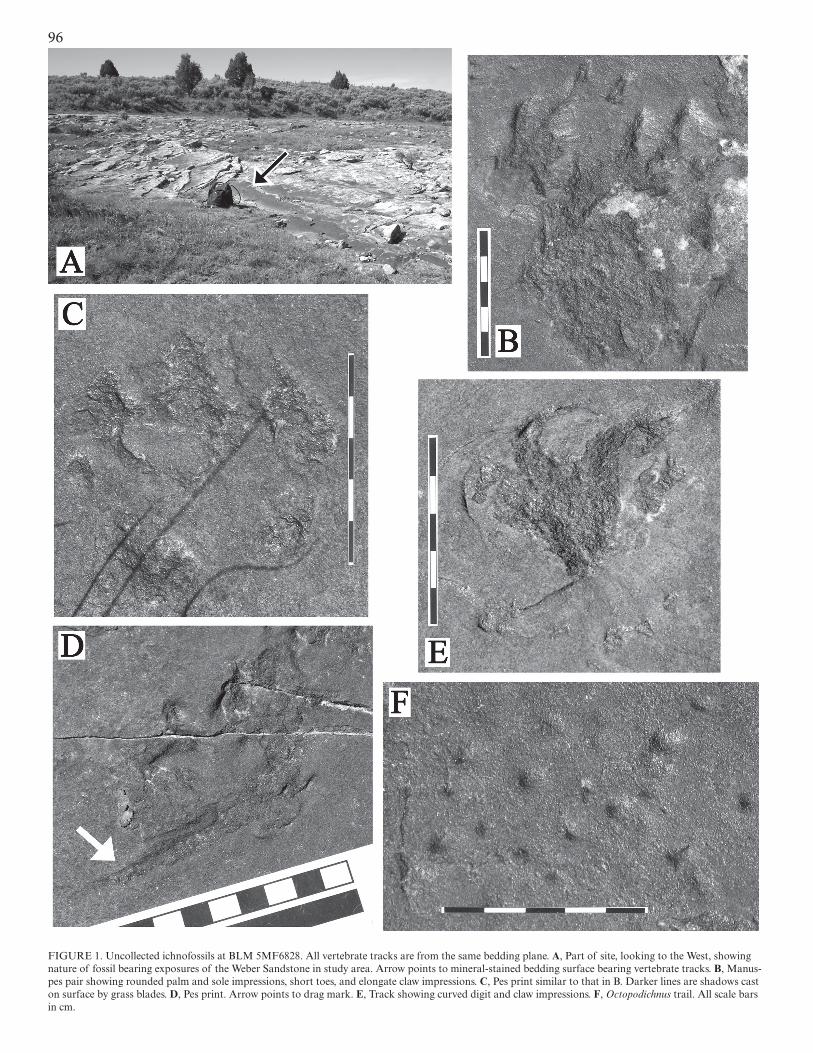
FIGURE 1. Uncollected ichnofossils at BLM 5MF6828. All vertebrate tracks are from the same bedding plane. A, Part of site, looking to the West, showing nature of fossil bearing exposures of the Weber Sandstone in study area. Arrow points to mineral-stained bedding surface bearing vertebrate tracks. B, Manus-pes pair showing rounded palm and sole impressions, short toes, and elongate claw impressions. C, Pes print similar to that in B. Darker lines are shadows cast on surface by grass blades. D, Pes print. Arrow points to drag mark. E, Track showing curved digit and claw impressions. F, Octopodichnus trail. All scale bars in cm.
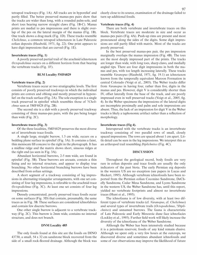
97tetrapod trackways (Fig. 1A). All tracks are in hyporelief and partly filled. The better preserved manus-pes pairs show that the tracks are wider than long, with a rounded palm-sole, and short toes bearing narrow straight claws (Fig. 1B-C). Manus prints are medial to pes impressions and there is slight over-lap of the pes on the lateral margin of the manus (Fig. 1B). One track shows a drag mark (Fig. 1D). These tracks resemble Chelichnus, a common tetrapod ichnotaxon in Late Paleozoic eolian deposits (Haubold, 1971, fig. 22). One print appears to have digit impressions that are curved (Fig. 1E).
Invertebrate traces (Fig. 1)A poorly preserved partial trail of the arachnid ichnotaxon
Octopodichnus occurs on a different horizon from that bearing the vertebrate tracks (Fig. 1F).
BLM Locality 5MF6829
Vertebrate traces (Fig. 2)Vertebrate traces occur at two stratigraphic levels. The first
consists of poorly preserved trackways in which the individual prints are convex and oblong and mostly preserved in hypore-lief on the track surface (Fig. 2A). The sole exception is a single track preserved in epirelief which resembles those of ?Cheli-chnus seen at 5MF6828 (Fig. 2B).
The second site is a slab with a poorly preserved trackway consisting of three manus-pes pairs, with the pes being longer than wide (Fig. 2C).
Invertebrate traces (Fig. 3)Of the three localities, 5MF6829 preserves the most diverse
set of invertebrate trace fossils. A single large, straight burrow, 1.5 cm wide, occurs on a
bedding plane surface in epirelief (Fig. 3A). It contains a faint, thin meniscate fill concave to the right in the photograph. It has a midline ridge and the matrix shows short, sinuous ridges at the right end (as seen in Fig. 3A).
Abundant horizontal burrows, 2-5 mm wide, are found in epirelief (Fig. 3B). These burrows are arcuate, contain a thin lining and no internal structure, and appear to display true branching. No other horizontal branching burrows have been described from eolian settings.
A short segment of a trackway consisting of leg impres-sions in alternating triangular arrangements, with one set con-sisting of four leg impressions, is referable to the arachnid trace Octopodichnus (Fig. 3C). At least one set consists of four leg impressions.
Densely concentrated, poorly preserved trace fossils occur on some surfaces (Fig. 3D) that contain, presumably, the same traces as in Fig. 3B. These surfaces are considered ichnofabrics and contain few discrete burrows.
One other single burrow is adjacent to a vertebrate track-way (Fig. 2C). This burrow is 2mm wide, contains no internal structure, and does not branch.
DNM Locality 485
The only fossils found at this site are the fossils on DINO 43730, a small, 54 x 32 cm sandstone block recovered from the side of a small rock-floored drainage. Although the block was
clearly close to its source, examination of the drainage failed to turn up additional fossils.
Vertebrate traces (Fig. 4)There are both vertebrate and invertebrate traces on this
block. Vertebrate traces are moderate in size and occur as manus-pes pairs (Fig. 4A). Push-up rims are present and most pronounced along the sides of the digits. Some digit impres-sions are still partly filled with matrix. Most of the tracks are poorly preserved.
In the best preserved manus-pes pair, the pes impression marginally overlaps the manus impression (Fig. 4B). The toes are the most deeply impressed part of the prints. The tracks are longer than wide, with long toes, sharp claws, and medially angled tips. There are four digit impressions in both the ma-nus and pes, with toe length increasing laterally. These tracks resemble Varanopus (Haubold, 1971, fig. 19.1) an ichnotaxon known from the temporally equivalent Maroon Formation in central Colorado (Voigt et al., 2005). The Weber tracks differ from Varanopus in having four, rather than five, digits in the manus and pes. However, digit V is considerably shorter than IV, offset laterally from the base of the track, and are poorly impressed even in well preserved tracks (Voigt et al., 2005, fig. 4). In the Weber specimens the impressions of the lateral digits are incomplete proximally and palm and sole impressions are absent. Thus, the lack of an impression for digit V in the Weber tracks is likely a taphonomic artifact rather than a reflection of morphology.
Invertebrate traces (Fig 4).Interspersed with the vertebrate tracks is an invertebrate
trackway consisting of two parallel rows of small, closely spaced impressions. The rows are spaced about 1 cm apart. Lit-tle detail can be seen in the leg impressions. We interpret this as an arthropod trail resembling Diplichnites (Fig. 4C).
DISCUSSION
Throughout the geological record, body fossils are very rare in eolian deposits and trace fossils are usually the only indicators of the past biota. The early Permian erg deposits in the western US are no exception (see papers in Lucas and Heckert, 1995). Although vertebrate ichnofossils have been re-ported from the Permian eolian Coconino Sandstone, DeCh-elly Sandstone, Cedar Mesa Sandstone, and Lyons Sandstone in the western US, the Weber Sandstone has, until this report, yielded no vertebrate footprints and almost no invertebrate traces (Hunt et al., 1995).
The ichnofauna is of low diversity, with at least two dif-ferent types of vertebrate tracks (cf. Varanopus, cf. Chelichnus) and several types of invertebrate trails (Octopodichnus, ?Dipli-chnites) and unnamed burrows. The fauna is characteristic of Late Paleozoic and Early Mesozoic dune face ichnofacies (Lockley et al., 1995). Further field work will likely increase the diversity of the ichnofauna of the Weber Sandstone.
Although the Weber has been intensively studied because it is a petroleum reservoir, fossils of any kind remain elusive. Although we spent only a very few hours at the outcrops, we discovered diverse and sometimes abundant ichnofossils and some of our observations may improve the likelihood of future
98
discoveries. The preservation of the ichnofossils once exposed on the surface is dependent on mineral staining of the bedding planes and the development of desert varnish. We observed that ichnofossils are destroyed by weathering at the edges of blocks and exposures where the varnish and staining is lost. In the study area the desert varnish is exceptionally well developed and is visible at a distance from the outcrop.
The eroded Weber Sandstone is extensively exposed in can-yon walls and anticlines in northeastern Utah and northwestern Colorado. The canyon wall exposures do not present bedding surfaces and large anticlinal structures formed of the Weber, such as Split Mountain in Dinosaur National Monument, are often weathered such that desert varnish is uncommon. How-ever, outcrops of the Weber Sandstone with desert varnish are relatively common in the floors of depressions throughout the study area. Although we did not have the opportunity to visit those outcrops, they may well contain additional ichnofossils. Future workers in the Weber should focus on mineral stained exposures when searching for trace fossils.
REFERENCES
Bissell, H.J., 1964, Lithology and petrography of the Weber Formation, in Utah and Colorado; in Sabatka, E.F., ed., Guidebook to the Geology and Mineral Resources of the Uinta Basin, Utah’s Hydrocarbon Storehouse: Inter-mountain Association of Petroleum Geologists , 13th Annual Field Con-ference Guidebook, p. 67-91.
Bissell, H.J., and Childs, O.E., 1958, The Weber Formation of Utah and Colo-rado; in Curtis, B., eds., Symposium on Pennsylvanian Rocks of Colo-rado: Rocky Mountain Association of Geologists Guidebook, p. 26-30.
Bowker, K.A., and Jackson, W.D., 1989, The Weber Sandstone at Rangely Field, Colorado; in Sandstone Reservoirs: Rocky Mountain Association of Geologists, p. 65-180 + 310-311.
Driese, S.G., 1985, Interdune pond carbonates, Weber Sandstone (Pennsylvanian-Permian), northern Utah and Colorado: Journal of Sedimentary Petrology, v. 55, p. 187-195.
Fryberger, S.G., 1979, Eolian-fluviatile (continental) origin of ancient strati-graphic trap for petroleum in Weber Sandstone, Rangely Oil Field, Colo-rado: Mountain Geologist, v. 16, p. 1-36.
Fryberger, S.G., 1990. Habitat of petroleum in wind laid rocks in Fryberger, S.G., Krystinik, L.F., and Schenk, C.J. eds., Modern and Ancient Eo-lian Deposits: Petroleum Exploration and Production: Rocky Mountain Section, Society of Economic Paleontologists and Mineralogists: p. 12-1 – 12-10.
Hansen, W.R., 1965, Geology of the Flaming Gorge Area, Utah-Colorado-Wyoming: U.S. Geological Survey, Professional Paper 490, 196 p. + 3
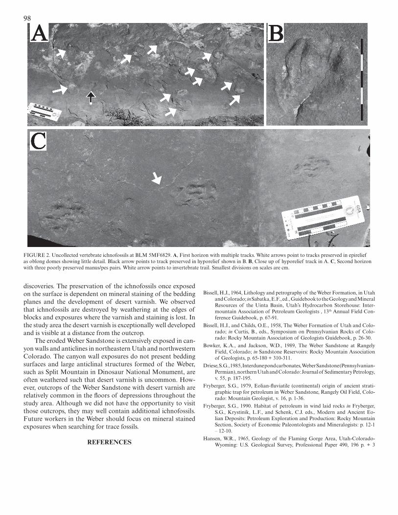
FIGURE 2. Uncollected vertebrate ichnofossils at BLM 5MF6829. A, First horizon with multiple tracks. White arrows point to tracks preserved in epirelief as oblong domes showing little detail. Black arrow points to track preserved in hyporelief shown in B. B, Close up of hyporelief track in A. C, Second horizon with three poorly preserved manus/pes pairs. White arrow points to invertebrate trail. Smallest divisions on scales are cm.
99
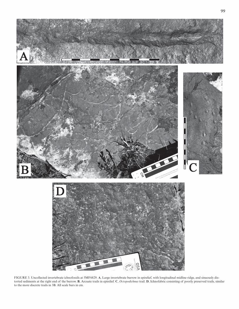
FIGURE 3. Uncollected invertebrate ichnofossils at 5MF6829. A, Large invertebrate burrow in epirelief, with longitudinal midline ridge, and sinuously dis-torted sediments at the right end of the burrow. B, Arcuate trails in epirelief. C, Octopodichnus trail. D, Ichnofabric consisting of poorly preserved trails, similar to the more discrete trails in 3B. All scale bars in cm.
100
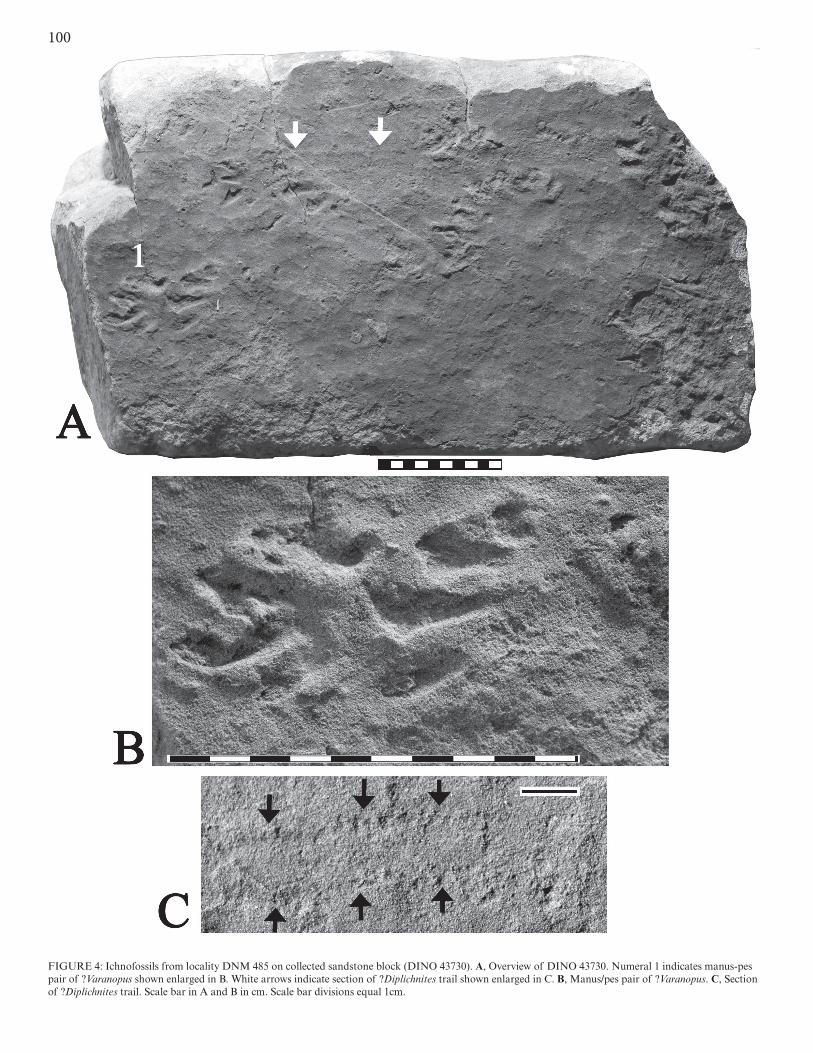
FIGURE 4: Ichnofossils from locality DNM 485 on collected sandstone block (DINO 43730). A, Overview of DINO 43730. Numeral 1 indicates manus-pes pair of ?Varanopus shown enlarged in B. White arrows indicate section of ?Diplichnites trail shown enlarged in C. B, Manus/pes pair of ?Varanopus. C, Section of ?Diplichnites trail. Scale bar in A and B in cm. Scale bar divisions equal 1cm.
101maps and 1 chart.
Hansen, W.R. and Rowley, P.D., 1980. Geologic map of the Stuntz Reservoir Quadrangle, Utah-Colorado: U.S. Geological Survey Map Series, Map GQ-1530, scale 1:24,000.
Hansen, W.R., Rowley, P.D., and Carrara, P.E., 1983, Geologic map of Dinosaur National Monument and Vicinity, Utah and Colorado: U.S. Geological Survey Map Series, Map I-1407, scale 1:24,000.
Haubold, H., 1971, Ichnia Amphibiorum et Reptiliorum fossilium: Handbuch der Palaeoherpetologie, Teil 18, 124 p.
Hunt, A.P., Lucas, S.G., and Lockley, M.G., 1995, Paleozoic tracksites of the western United States: New Mexico Museum of Natural History and Sci-ence, Bulletin, 6 p. 213-217.
Lockley, M.G., Hunt, A.P., Haubold, H., and Lucas, S.G., 1995, Fossil foot-prints in the DeChelly Sandstone of Arizona: With paleoecological ob-servations on the ichnology of dune facies: New Mexico Museum of Natural History and Science, Bulletin 6, p. 225-233.
Lucas, S.G, and Heckert, A.B., eds., 1995, Early Permian footprints and facies: New Mexico Museum of Natural History and Science, Bulletin 6, 301 p.
Rowley, P.R., Dyni, J.R., Hansen, W.R. and Pipiringos, G.N., 1979a, Geologic map of the Indian Water Canyon Quadrangle, Moffat County, Colorado: U.S. Geological Survey Map Series, Map GQ-1516, scale 1:24,000
Rowley, P.D. and Hansen, W.R., 1979, Geologic map of the Split Mountain Quad-rangle, Uintah County, Utah: U.S. Geological Survey Map Series, Map GQ-1515, scale 1:24,000.
Rowley, P.D., Kinney, D.M., and Hansen, W.R., 1979b, Geologic map of the Dinosaur Quarry Quadrangle, Uintah County, Utah: U.S. Geological Survey Map Series, Map GQ-1513, scale 1:24,000.
Voigt, S., Small, B.J., and Sanders, F., 2005, A diverse terrestrial ichnofauna from the Maroon Formation (Pennsylvanian-Permian), Colorado: bio-stratigraphic and paleoecological significance: New Mexico Museum of Natural History and Science, Bulletin 30, p. 342-351.
102
Related Documents