eksMîqy 4 fdukjh vkf.k leqæh lajf{kr {ks=s vkf.k ‘ kkÜor eRL;ks|ksx O;oLFkkiu fdukjh vkf.k leqnzh tSofofoèkrk vkf.k lajf{kr {ks= O;oLFkkiu ;kojhy vH;klØe {ks=h;&ikrGhojhy MPA O;oLFkkidkalkBh Module 4 Coastal and Marine Protected Areas and Sustainable Fisheries Management Curriculum on Coastal and Marine Biodiversity and Protected Area Management For Field-Level MPA Managers

Welcome message from author
This document is posted to help you gain knowledge. Please leave a comment to let me know what you think about it! Share it to your friends and learn new things together.
Transcript

eksMîqy 4fdukjh vkf.k leqæh lajfkr ks=s vkf.k ‘kkÜor
eRL;ks|ksx O;oLFkkiu
fdukjh vkf.k leqnzh tSofofoèkrk vkf.k lajfkr ks= O;oLFkkiu ;kojhy vH;klØe
ks=h;&ikrGhojhy MPA O;oLFkkidkalkBh
Module 4Coastal and Marine Protected
Areas and Sustainable Fisheries Management
Curriculum on
Coastal and Marine Biodiversity and Protected Area Management
For Field-Level MPA Managers

vksG[kfpUg
egkjk"Vªkrhy ks=&Lrjh; MPA O;oLFkkidkalkBh fdukjh vkf.k leqæhtSofofo/krk vkf.k lajfkr ks= O;oLFkkiu çf’kk.k lalk/ku lkfgR;
eksMîqy 1% fdukjh vkf.k leqnzhtSofofoèkrk vkf.k ifjfLFkrhd O;oLFkk lsospk ifjp;eksMîqy 2% ,dw.k i;kZoj.k vkf.k fodklkP;k lanHkkZr fdukjh vkf.k leqnzhtSofofoèkrk vkf.k ifjfLFkrhd O;oLFkk lsokeksMîqy 3% ,dw.k fodkl vkf.k i;kZoj.kh; fu;kstukeè;s fdukjh vkf.k leqnzhtSofofoèkrk laoèkZukckcrps fo”k; eq[; çokgkr vk.k.kseksMîqy 4% fdukjh vkf.k leqæh lajfkr ks=s vkf.k ‘kkÜor eRL;ks|ksx O;oLFkkiueksMîqy 5% fdukjh vkf.k leqæh ifjfLFkrhd O;oLFkk] tSofofoèkrk vkf.k lajfkr ks=kaps O;oLFkkiu dj.;klkBh ç’kklu] dk;nk o èkksj.kseksMîqy 6% fdukjh vkf.k leqnzhtSofofoèkrk vkf.k lacafèkr leL;kaps ewY;ekiu vkf.k lafu;a=.keksMîqy 7% fdukjh vkf.k leqæh lajfkr ks=kaps çHkkoh O;oLFkkiu fu;kstueksMîqy 8% fdukjh vkf.k leqnzhtSofofoèkrk laoèkZu vkf.k O;oLFkkiukP;k leL;k O;ä dj.ks
ISBN 978-81-933215-4-6
uksOgsacj 2016 ¼ifgyh vko`Ùkh½
kjs çdkf’kr%Deutsche Gesellschaft für Internationale Zusammenarbeit (GIZ) GmbHHkkjr&teZuh tSofofoèkrk dk;ZØe,&2@18] lQnjxat ,uDysOguoh fnYyh 110029, Hkkjr nw $ 91–11–4949 5353bZ [email protected] http://www.indo-germanbiodiversity.com
okÃYMykÃQ bfULVVîwV v‚Q bafM;k (WII)ih-vks- c‚Dl 18] paæcuh MsgjkMwu 248001 mÙkjk[kaM] Hkkjrnw $ 91&135&2640 910Ã [email protected] os www.wii.gov.in
[kkjQqVh lsy & egkjk”Vª ou foHkkx2 jk etyk] , foax] ,l-vkj-,- bekjr]vuar dk.ksdj ekxZ]okaæs iwoZ& 400051] eqacbZ-nw $22& 26476151bZ [email protected]
GIZ gk ,d teZu ‘kklukP;k ekydhpk fouk uQk m|ksx vkgs tks ‘kkÜor fodklkl vkèkkj nsrks-
gs çf’kk.k lkèkuL=ksr lkfgR; i;kZoj.k] ou vkf.k gokeku cny ea=ky; ¼MoEFCC½] Hkkjr ljdkjP;k Hkkxhnkjheè;s baMks&teZuh tSofofoèkrk dk;ZØekeè;s ^fo|eku fdukjh vkf.k leqæh lajfkr ks=kaP;k laoèkZu vkf.k ‘kkÜor O;oLFkkiu ¼CMPA½* çdYikP;k ekuoh kerk fodkl ?kVdkarxZr fodlhr dj.;kr vkys vkgs- CMPA çdYi teZu QsMjy i;kZoj.k] fulxZ laoèkZu] mHkkj.kh o v.kw lqjkk ea=ky; (BMUB) ;kaP;kkjs vkarjjk”Vªh; gokeku iq<kdkj (IKI) kjs çnku dsysY;k fuèkÈlg dk;kZfUor dj.;kr vkyk vkgs- CMPA çdYi gk Hkkjrkrhy fuoMd fdukjh jkT;kaeè;s vaeykr vk.kyk tkr vkgs vkf.k ou] eklsekjh vkf.k ekè;e ks=krhy çeq[k HkkxèkkjdkaP;k fodlhr dsysY;k kerkaoj yk dsafær djrks-
;kaP;k ekxZn’kZuklg%lapkyd] baMks&teZu tSofofoèkrk dk;ZØe] GIZ bafM;k] M‚- Ogh ch ekFkwj] lapkyd okÃYMykÃQ bfULVVîwV v‚Q bafM;kM‚- ts ek;dsy oWfdyh] la?k usrk] CMPA çdYi] baMks&teZu tSofofoèkrk dk;ZØe] GIZ bafM;k
ladyu o laiknu] kjs%M‚- uhjt [ksjk] ofj”B lYykxkj] baMks&teZu tSofofoèkrk dk;ZØe] GIZ bafM;kM‚- ds- flokdqekj] oSKkfud Ã] okÃYMykÃQ bfULVVîwV v‚Q bafM;kM‚- lkjax dqyd.kÊ] leqæh tho’kkL=K] bafM;u bfULVVîwV v‚Q Ldqck Mk;Çox v¡M ,WDosfVd LiksV~lZ (IISDA)Jh- ,u oklqnsou] [kkjQqVh lsy] egkjk”Vª
etdwj vkf.k laiknu ;ksxnku] kjs%M‚- ts-,- t‚Ulu] oSKkfud Mh] okÃYMykÃQ bfULVVîwV v‚Q bafM;k( M‚- jes’k fpUulkeh] oSKkfud lh] okÃYMykÃQ bfULVVîwV v‚Q bafM;k( M‚- Mh- vkèkou] çdYi lgdkjh] okÃYMykÃQ bfULVVîwV v‚Q bafM;k( M‚- çnhi esgrk] la’kksèku vkf.k dk;ZØe O;oLFkkid] vFkZo‚p bfULVVîwV v‚Q bafM;k( Jh- Y;qd esaMsl] ys[kd] fQYeesdj vkf.k fefM;k çf’kkd] eqacÃ( Jh- xksih—”.k o‚fjvj] çknsf’kd i;kZoj.kh; O;oLFkkid] iWuksl nfk.k vkf’k;k ¼eksMîqy 8½] Jh- Msjhy fM^ek¡Vs] psvjilZu] Qksje v‚Q ,UOgk;uZesaVy tukZfyLV~l v‚Q bafM;k (FEJI) ¼eksMîqy 8½( M‚- MdZ ,lsuMksQZ] i=dkj vkf.k fefM;k çf’kkd teZuh ¼eksMîqy 8½( dq- vfr;k ,ful] lapkj rK] baMks&teZu tSofofoèkrk dk;ZØe] GIZ bafM;k( Jh- lat; nos] pj[kk vkf.k Jh- Hkjr iVsy] MASS xqtjkr ¼dklo cpko vkf.k [kkjQqVhP;k leqnk; o`kkjksi.kkP;k dsl LVMht½( M‚- vkj- jes’k vkf.k la?k] NCSCM ¼bdksflfLVe lÆOglsl] Hkwçns’kh; vkf.k fdukjh ifjfLFkrhd O;oLFksrhy Qjd] thvk;,l½( dq- gsfyuk tksyh ¼vkÆFkd ewY;kadu i)rh vkf.k mnkgj.ks½( dq tkudh rsyh ¼Ogsy ‘kkdZP;k dsl LVMht½(
fM>kÃu kjs%,WLik;j fM>kÃu] uoh fnYyh
ejkBhe/;s vuqokn% dfVax,t VªkUlys’ku lfOgZlsl izk-fy- (Cuttingedge Translation Services Pvt. Ltd.)
Nk;kfp=s kjs%
uhjt [ksjk] tksi;±r vU;Fkk Js; fnys tkr ukgh-
vLoh—rh%gs çf’kk.k lkèkuL=ksr lkfgR; gs çxrhiFkkojhy dke vkgs- ák çdk’kukrhy lkfgR; dsoG ‘kSkf.kd mís’kkalkBh vkgs- ukekafdr ys[kd] ;ksxnkudrsZ vkf.k laikndkauh gs ladfyr] fodlhr vkf.k laikfnr dsys vkgs vkf.k R;keè;s GIZ Çdok R;kaP;k Hkkxhnkjkaps –”Vhdksu çfrÇcfcr gksrhyp vls ukgh- çeq[k etdwj gk etdwjkeè;s ekaMY;kuqlkj] nLr,sothr vkf.k çdkf’kr lanHkZ@lkèkuL=ksrkarwu fuekZ.k o ladfyr dsysyk vkgs- R;kuarj çeq[k etdwj ks= ikrGhojhy MPA O;oLFkkid] ofj”B MPA O;oLFkkid] fefM;k fo|kFkÊ vkf.k çf’kkdkalkBh çf’kk.k lkfgR; fodlhr dj.;klkBh laikfnr o lkuqdwy dsyk xsyk vkgs- gk nLr,sot r;kj djrkuk ;ksX; rh dkGth ?ksryh xsyh vlyh rjh] çdk’kd] laiknd vkf.k etdwj ;ksxnkudrsZ v’kk ekfgrh Çdok mnkgj.kkaP;k lR;rk] vpwdrk] iwjdrk Çdok iw.kZrsckcr dks.krhgh tckcnkjh x`ghr èkjr ukghr- dks.krsgh HkkSxksfyd udk’ks dsoG ekfgrhij mís’kkus vkgsr vkf.k vkarjjk”Vªh; lhek Çdok çns’kkaph vksG[k ukgh udk’kkaP;k vpqdrsckcr çdk’kd dks.krsgh nkos djr ukghr Çdok R;krhy ekfgrhP;k okijkrwu mn~Hko.kkjs dks.krsgh nkf;Ro x`ghr èkjr ukghr- ák çf’kk.k lkfgR;keè;s lqèkkj.kk dj.;klkBhP;k dks.kR;kgh vfHkçk; o lwpukaps ;sFks Lokxr vkgs [email protected]
Imprint
Training Resource Material on Coastal and Marine Biodiversity and Protected Area Management for field-level MPA managers of Maharashtra
Module 1: An Introduction to Coastal and Marine Biodiversity and Ecosystem ServicesModule 2: Coastal and Marine Biodiversity and Ecosystems Services in the Overall Environment and Development ContextModule 3: Mainstreaming Coastal and Marine Biodiversity Conservation Concerns into Overall Development and Environmental PlanningModule 4: Coastal and Marine Protected Areas and Sustainable Fisheries ManagementModule 5: Governance, Law and Policies for Managing Coastal and Marine Ecosystems, Biodiversity and Protected AreasModule 6: Assessment and Monitoring of Coastal and Marine Biodiversity and Relevant IssuesModule 7: Effective Management Planning of Coastal and Marine Protected AreasModule 8: Communicating Coastal and Marine Biodiversity Conservation and Management Issues
ISBN 978-81-933215-4-6
November 2016 (first edition)
Published by:
Deutsche Gesellschaft für Internationale Zusammenarbeit (GIZ) GmbHIndo-German Biodiversity ProgrammeA-2/18, Safdarjung EnclaveNew Delhi 110029, IndiaT +91-11-4949 5353E [email protected] http://www.indo-germanbiodiversity.com
Wildlife Institute of India (WII)P.O. Box 18, ChandrabaniDehradun 248001Uttarakhand, IndiaT +91-135-2640 910E [email protected] www.wii.gov.in
Mangrove Cell- Maharashtra Forest Department 2nd Floor, A Wing, S.R.A. Building, Anant Kanekar Marg, Bandra East- 400051, Mumbai. T +22- 26476151 E [email protected]
GIZ is a German government-owned not-for-profit enterprise supporting sustainable development.
This training resource material has been developed under the Human Capacity Development component of the project ‘Conservation and Sustainable Management of Existing and Potential Coastal and Marine Protected Areas (CMPA)’, under the Indo-German Biodiversity Programme, in partnership with the Ministry of Environment, Forest and Climate Change (MoEFCC), Government of India. The CMPA Project has been commissioned by the German Federal Ministry for Environment, Nature Conservation, Building and Nuclear Safety (BMUB) with the funds provided under the International Climate Initiative (IKI). The CMPA Project is being implemented in selected coastal states in India and focuses on capacity developed of the key stakeholders in the forest, fisheries and media sectors.
With Guidance from:Director, Indo-German Biodiversity Programme, GIZ IndiaDr. V B Mathur, Director, Wildlife Institute of IndiaDr. J. Michael Vakily, Team Leader, CMPA Project, Indo-German Biodiversity Programme, GIZ India
Compiled and edited by:Dr. Neeraj Khera, Senior Advisor, Indo-German Biodiversity Programme, GIZ IndiaDr. K. Sivakumar, Scientist E, Wildlife Institute of IndiaDr. Sarang Kulkarni, Marine Biologist, Indian Institute of Scuba Diving and Aquatic Sports (IISDA)Mr. N. Vasudevan, IFS, Mangrove Cell, Maharashtra Forest Department
Text and editing contributions from:Dr. J.A. Johnson, Scientist D, Wildlife Institute of India; Dr. Ramesh Chinnasamy, Scientist C, Wildlife Institute of India; Dr. D. Adhavan, Project Associate, Wildlife Institute of India; Dr. Pradeep Mehta, Research and Programme Manager, Earthwatch Institute India; Mr. Luke Mendes, Writer, Filmmaker and Media Trainer, Mumbai; Mr. S. Gopikrishna Warrier, Regional Environment Manager, PANOS South Asia [Module 8]; Mr. Darryl D’Monte, Chairperson, Forum of Environmental Journalists of India (FEJI) [Module 8]; Dr. Dirk Asendorpf, Journalist and Media Trainer, Germany [Module 8]; Ms Atiya Anis, Communications Expert, Indo-German Biodiversity Programme, GIZ India; Mr. Sanjay Dave, Charkha and Mr. Bharat Patel, MASS Gujarat [case studies of turtle rescue and community plantation of mangroves]; Dr. R. Ramesh and team, NCSCM [ecosystem services, differences between terrestrial and coastal ecosystems, GIS]; Ms Helina Jolly [economic valuation methods and examples]; Ms Janki Teli [case study of Whale Shark];
Designed by:Aspire Design, New Delhi
Translated from English to Marathi:Cuttingedge Translation Services Pvt. Ltd
Photos by:Neeraj Khera, unless credited otherwise.
Disclaimer:This training resource material is work in progress. The material in this publication is meant to be used for educational purposes only. It has been compiled, developed and edited by the named authors, contributors and editors and does not necessarily reflect the views of the GIZ or its partners. The master text has been created and compiled from documented and published references/resources, as cited in the text. The master text has subsequently been edited and customized to develop training material for field-level MPA managers, senior MPA managers, media students and trainers. While due care has been taken in preparing this document, the publisher, editors and text contributors assume no responsibility for the authenticity, correctness, sufficiency or completeness of such information or examples. Any geographical maps are for informational purposes only and do not constitute recognition of international boundaries or regions; publishers make no claims concerning the accuracy of the maps nor assumes any liability resulting from the use of the information therein. Any feedback and suggestions for improving this training material are welcomed at [email protected].

lkjka’k
gs eksMîqy eRL;ks|ksx O;oLFkkiuklkBh vko’;d vlysyh ekfgrh] rRos vkf.k leqæh lajfkr dsaækaeè;s o R;kHkksorh ‘kkÜor eRL;ks|ksx O;oLFkkiukP;k iènrÈckcr vR;ko’;d vlysyh loZ ekfgrh çnku djrs
¼MPAs½- gs eksMîqy vkf.k çknsf’kd lajfkr ks=s] Js.kh vkf.k MPAs ps çdkj] R;kaP;k O;oLFkkiu ç.kkyh vkf.k ‘kkÜor eRL;ks|ksx O;oLFkkiukps fogaxkoyksdu çnku djrs- gs eksMîqy eRL;ks|ksxkaP;k vkf.k LFkkfu;
lektkP;k MPAs P;k lanHkkZrhy çeq[k leL;k lekfo”V djrs- Hkkjrkrhy fofoèk MPAs ps çdkj vkf.k R;kaph LFkkus çnku dj.;kO;frfjä] eksMîqy MPAs ps Qk;ns vkf.k vkOgkusgh fo”kn djrs-
Summary
This module provides much needed information on the basics of fisheries management, principles
and practices of sustainable fisheries management in and around marine protected areas, and on
the marine protected areas (MPAs). The modules provides insights into the differences between
MPAs and terrestrial protected areas, the categories and types of MPAs, their management systems
and an overview of the elements of sustainable fisheries management. This module covers the
key issues of fisheries and indigenous communities in the context of MPAs. Apart from providing
information on different types of MPAs in India and their locations, the module elaborates benefits
of and challenges for MPAs.
Module 4Coastal and Marine Protected
Areas and Sustainable Fisheries Management
Curriculum on
Coastal and Marine Biodiversity and Protected Area Management
For Field-Level MPA Managers
eksMîqy 4fdukjh vkf.k leqæh lajfkr ks=s vkf.k ‘kkÜor
eRL;ks|ksx O;oLFkkiu
fdukjh vkf.k leqnzh tSofofoèkrk vkf.k lajfkr ks= O;oLFkkiu ;kojhy vH;klØe
ks=h;&ikrGhojhy MPA O;oLFkkidkalkBh
3

4

vuqØef.kdkTable of contents
vk|kkjs 7
4.1 lajfkr ks=s dk; vkgsr\ 11
4.2 fdukjh vkf.k leqæh lajfkr ks=s ¼MPAs½ 15
4.2.1 O;k[;k vkf.k fogaxkoyksdu% 15
4.2.2 lajfkr ks=kP;k O;k[;sps Li”Vhdj.k 17
4.2.3 txkrhy lokZr eksBs MPA 21
4.2.4 d/kh MPA uOgs rj leqæh ks=kyk lao/kZukph fu”iRrh d/kh feGw ‘kdrs\ 22
4.2.5 eklsekjhlkBh O;oLFkkfir ks=s 22
4.2.6 LFkkuh; yksd vkf.k leqnk;&laoÆèkr çns’k vkf.k ks=s (ICCAs) 24
4.3 Hkkjrke/;s MPAs dqBs fLFkr vkgsr\ 26
4.4 egklkxjkps lao/kZu dj.;klkBh vkiY;kyk MPAs ph xjt dk vkgs\ 28
4.4.1 MPAs P;k izeq[k ykHkkapk lkjka’k 28
4.4.2 eRL;ks|ksx O;oLFkkiuklkBh MPAs ps izeq[k ykHk 29
4.5 fdukjh vkf.k leqæh tSofofoèkrk vkf.k MPAs O;oLFkkiukrhy vkOgkus 30
4.5.1 leqæh ifjfLFkrhd O;oLFkkaph oSf’k”Vî 30
4.5.2 Hkkjrkrhy MPAsps O;oLFkkiu dj.ks & loZlkèkkj.k leL;k 31
4.5.3 lajfkr ks=kauk çHkkfor dj.kkj+~;k leqæh i;kZoj.kkph oSf’k”Vîs 33
4.6 Js.kh vkf.k fofoèk miØe ;kaeèkhy lacaèk 34
4.7 ‘kkÜor eRL;ks|ksx O;oLFkkiu 38
4.7.1 eRL;ks|ksx lk/kuL=ksr 38
4.7.2 eRL;ks|ksx O;oLFkkiu dk; vkgs\ 38
4.7.3 ikjaikfjd eRL;k|ksx O;oLFkkiu 38
4.7.4 lkBk vkf.k vf/kdre ‘kk’or mRiknukph ladYiuk (MSY) 39
4.7.4.1 lkBk 39
4.7.4.2 yksdla[;k pyu’kkL= 39
4.7.4.3 vf/kdre ‘kk’or mRiknu (MSY) 40
4.8 lajk.kkfHkeq[k fdukjh O;oLFkkiukP;k ckcrhrhy vkOgkus vkf.k VªsM&v‚Q 42
4.8.1 vfr eklsekjh 42
4.8.2 dykRed eklsekjh ¼ygku izek.k½ fo:/n vkS|ksfxd eklsekjh ¼eksBs izek.k½ 42
4.8.3 ‘kkÜor eRL;ks|ksxkph rRos vkf.k ekinaM ¼L=ksr% MSC, 2002½ vf/kokl 43
4.9 pkaxY;k i/nrh vkf.k dsl LVMht 45
4.9.1 eRL;ks|ksxkckcr ifjfLFkrhd O;oLFkk –”Vhdksu (EAF) 45
4.9.2 leqnk;&vkèkkfjr eRL;ks|ksx O;oLFkkiu (CBFM) 45
Acronyms 7
4.1 What are protected areas? 11
4.2 Coastal and Marine Protected Areas (MPAs) 15
4.2.1 Definition and overview: 15
4.2.2 Explanation of protected area definition. 17
4.2.3 World’s largest MPA 21
4.2.4 When is a marine area that may achieve conservation outcomes not an MPA? 22
4.2.5 Areas managed for fishing 22
4.2.6 Indigenous people and community-conserved territories and areas (ICCAs) 24
4.3 Where are the MPAs located in India? 26
4.4 Why do we need MPAs to conserve the oceans? 28
4.4.1 A Summary of major benefits of MPAs 28
4.4.2 Major Benefits of MPAs for Fisheries Management 29
4.5 Challenges in managing coastal and marine biodiversity and MPAs: 30
4.5.1 Characteristics of marine ecosystems 30
4.5.2 Managing MPAs in India: General issues 31
4.5.3 Characteristics of the marine environment that affect protected areas. 33
4.6 Relationship between the categories and different activities 34
4.7 Sustainable Fisheries Management 38
4.7.1 Fishery Resources 38
4.7.2 What is fisheries management? 38
4.7.3 Conventional fisheries management 38
4.7.4 Concept of Stock & Maximum Sustainable Yield (MSY) 39
4.7.4.1 Stock 39
4.7.4.2 Population dynamics 39
4.7.4.3 Maximum Sustainable Yield (MSY) 40
4.8 Challenges and trade-offs with the protection-oriented coastal management 42
4.8.1 Overfishing 42
4.8.2 Artisanal fishing (small-scale) Vs Industrial fisheries (large-scale) 42
4.8.3 Principles and Criteria for Sustainable Fisheries (Source: MSC, 2002) 43
4.9 Good practices and case studies 45
4.9.1 An ecosystem approach to fisheries (EAF) 45
4.9.2 Community-based fisheries management (CBFM) 45
5
4.10 Participatory planning of MPAs: 48
4.10.1 Why participatory planning? 48
4.10.2 What does it includes? 48
4.10.3 Constraints and Obstacles 49
4.11 Case studies 52
4.11.1 Case study: MPAs secure fish supply in the Philippines 52
4.11.2 Case study: Fishermen ride sustainability wave 53
4.12.3 Integrated Management Plan for the Gulf of Mannar Marine National Park and Biosphere Reserve
(2007-2016): Process and Methodology 55
4.12.4 Status report of coastal and marine protected areas in Maharashtra 64
The Way Forward 68
Main Sources 69
Further Resources: 70
4.10 MPAs: ps lgHkkxkRed fu;kstu% 48
4.10.1 lgHkkxkRed fu;kstu dk\ 48
4.10.2 R;ke/;s d’kkpk lekos’k gksrks\ 48
4.10.3 vMp.kh vkf.k vMFkGs 49
4.11 dsl LVMht 52
4.11.1 dsl LVMh% fQfyfiUle/;s MPAspk lqjfkr ekls iqjoBk 52
4.11.2 dsl LVMh% eklsekj ‘kk’orrsP;k ykVsoj Lokj 53
4.12.3 xYQ v‚Q eqUukj efju uW’kuy ikdZ v¡M ck;ksfLQvj fj>oZlkBh ,dkRed O;oLFkkiu ;kstuk
¼2007&2016½ çfØ;k o iènr 55
4.12.4 egkjk”Vªkrhy fdukjh vkf.k leqæh lajfkr ks=kapk fLFkrh vgoky 64
iq<hy ekxZ 68
izeq[k L=ksr 69
iq<hy lalk/kus 70
6
vk|kkjs
CBD dUOgsU’ku v‚u ck;‚y‚ftdy Mk;OgÆlVh ¼tSfod fofoèkrsojhy ifj”kn½
CMS dUOgsU’ku v‚u ek;xzsVjh fLiflt ¼LFkykarjhr iztkrhaojhy ifj”kn½
EIA ,uOgk;uZesaVy bEiWDV vlslesaV ¼i;kZoj.kh; izHkko ewY;kadu½
EMP ,uOgk;uZesaVy EkWustesaV IyWu ¼i;kZoj.kh; O;oLFkkiu ;kstuk½
FAO QwM vWUM vWfxzdYpj vkWxZuk;>s’ku ¼vUu vkf.k d`”kh la?kVuk½
GCBA tujs’kuy dkWLV csfufQV vWukfyfll ¼fi<îkeèkhy [kpZ ykHk fo’ys”k.k½
NBAP uW’kuy ck;ksMk;OgÆlVh vWD’ku IyWu ¼jk”Vªh; tSofofoèkrk —rh ;kstuk½
NEP uW’kuy ,uOgk;uZeasV /kksj.k ¼jk”Vªh; i;kZoj.k /kksj.k½
SEA LVªWVsftd ,uOgk;ZesaVy vlslesaV ¼èkksj.kkRed i;kZoj.kh; ewY;kadu½
SLEIAA LVsV ysOgy ,uOgk;ZesaVy bEiWDV vlslesaV vFk‚fjVh ¼jkT; ikrGhojhy i;kZoj.kh; çHkko ewY;kadu çkfèkdkjh½
Acronyms
CBD Convention on Biological Diversity
CMS Convention on Migratory Species
EIA Environmental Impact Assessment
EMP Environment Management Plan
FAO Food and Agriculture Organization
GCBA Generational cost benefit analysis
NBAP National Biodiversity Action Plan
NEP National Environment Policy
SEA Strategic Environmental Assessment
SLEIAA State Level Environmental Impact Assessment Authority
7


‘kSkf.kd fu”iÙkh
gs eksMîqy iw.kZ dsY;kuarj lgHkkxÈuk iq<hy xks”Vh djrk ;srhy%
• ^lajfkr ks=* gh laKk Li”V dj.ks vkf.k fofoèk çdkjP;k lajfkr ks=kaps R;kaP;k O;oLFkkiu vkf.k lkèkuL=ksrkapk okij ;koj vkèkkfjr o.kZu dj.ks
• Hkwçns’kh; lajfkr ks= vkf.k MPA ph O;oLFkk ikg.kkj+~;k çeq[k oSf’k”Vîs o ?kVdkeè;s Qjd dj.ks
• MPAslkBh fofoèk çdkjP;k O;oLFkkiu e‚MsYlps vkf.k çR;sdk’kh fuxMhr vkOgkukaps fo’ys”k.k dj.ks
• ‘kkÜor eRL;ks|ksx O;oLFkkiukP;k çeq[k rRokaph :ijs”kk ekaM.ks
• ygku çek.kkrhy vkf.k O;kolkf;d eRL;ks|ksxkrhy Qjd vkf.k fdukjh vkf.k leqæh tSofofoèkrs’kh R;kapk vuqØes lacaèk Li”V dj.ks
• eklsekjh vkf.k tSofofoèkrk laoèkZukrhy fDy”V lacaèkkaps jlxzg.k dj.ks
• fdukjh vkf.k leqæh tSofofoèkrsP;k çHkkoh laoèkZukeè;s ‘kkÜor eRL;ks|ksxkP;k Hkwfedsps jlxzg.k dj.ks
Learning outcomes
After completing this module, the participants are able to
• explain the term ‘Protected Area’ and describe different types of natural protected areas based on their man-
agement and resources uses
• differentiate between the key characteristics and factors governing a terrestrial protected area and an MPA
• describe different types of management models for MPAs and challenges associated with each
• outline the key principles of sustainable fisheries management
• explain the difference between small-scale and commercial fisheries and their respective relevance to coastal
and marine biodiversity
• appreciate the intricate relationship of fishing and biodiversity conservation
• appreciate the role of sustainable fisheries in ensuring effective conservation of coastal and marine biodiversity
çeq[k lans’k• lacafèkr ifjfLFkrhd O;oLFkk lsok vkf.k lkaL—frd ewY;kaps nh?kZdkyhu laoèkZu lkè; dj.;klkBh] dk;ns’khj Çdok brj
çHkkoh ekxk±uh ekU;rkçkIr] leÆir vkf.k O;oLFkkfir dsysys ,d Li”Vi.ks fo”kn dsysys HkkSxksfyd vodk’k vfuok;Z vkgs-
• leqæh vkf.k fdukjh tSofofoèkrsps lajk.k dj.;kP;k ekxk±iSdh lokZr çHkkoh ekxZ Eg.kts çLFkkiuk vkf.k leqæh lajfkr ks=kaP;k (MPAs) ;ksX; O;oLFkkiukkjs rs dj.ks- leqæh lajfkr ks=s vusd fofoèk çdkjps lajk.k lekfo”V djrkr- dkgh vkgsr Þuks&Vsd >ksUl Çdok lajfkr ks=sÞ th ek’kkapk lkBk ijr feGo.;klkBh vko’;d vkgsr rj brj R;kaP;k lkèkuL=ksrkapk ,dkfèkd okij d: nsrkr- MPAs çeq[k ifjfLFkrhd O;oLFkkaps lajk.k djrkr tls dh çokG csVs- rh ek’kkaP;k çtksRikuklkBh lqjfkr ks= Eg.kwu rj dke djrkrp i.k R;kaP;keqGs i;ZVukl pkyuk feGrs vkf.k uksdj+~;k miyCèk gksrkr- leqnk;kkjs O;oLFkkfir dsysys MPAs fuekZ.k dsY;keqGs LFkkfud yksdkauk gks.kkjs ykHk ok<rhy-
• Hkkjrkeè;s lajfkr ks=kaP;k pkj dk;ns’khj Js.kh vkgsr Eg.kts jk”Vªh; m|kus] vHk;kj.;s] laoèkZu fjtoZ vkf.k leqnk; fjtoZ- Hkkjrkus vkiys loZ 10 thoHkwoSKkfud çns’k lknj dj.kkj+~;k PAps tkGs r;kj dsys vkgs- ,dw.k 693 lajfkr ks=s çLFkkfir dsysyh vkgsr T;kaeè;s] 103 jk”Vªh; m|kus] 525 vHk;kj.;s] 61 laoèkZu fjtoZ vkf.k 4 leqnk; fjtoZ] rlsp jkelj lkÃV~loj fu;qä 26 nynyhps çns’k vkgsr
• Hkkjrkeè;s] mPp HkjrhP;k js”ksiklwu iw.kZi.ks fdaok vkaf’kd Lo:ikr 500 eh varjkP;k iV~Vîke/;ss vkf.k leqæh i;kZoj.kkeè;s ;s.kkjs PA leqæh lajfkr ks=kP;k usVodZeè;s lekfo”V dsys tkrkr- ák O;k[;soj vkèkkfjr 24 leqæh lajfkr ks=s lè;k hidYih; Hkkjrkeè;s vkf.k 100 gwu tkLr MPA R;kP;k csVkaeè;s vkgsr- fidYikrhy 24 MPA
iSdh] eqUukjph lkeqæèkquh leqæh jk”Vªh; m|ku] lqanjcu jk”Vªh; m|ku] dPNph lkeqæèkquh jk”Vªh; m|ku] fHk=dfudk jk”Vªh; m|ku] dksÇjxk vHk;kj.;] fpfydk vHk;kj.;keè;s oSf’k”Vîiw.kZ leqæh tSofofoèkrk vkgs vkf.k ák MPA Hkksorh LFkkfud leqnk;kauk fofoèk lsok çnku djrs-
• ‘kkldh; fuèkh vkf.k lg;ksxkP;k derjrsiklwu rs LFkkfud leqnk;kadMwu gks.kkj+~;k fojksèkki;±r lajfkr ks= O;oLFkkidkauk eksBîk çek.kkoj vkOgkukapk lkeuk djkok ykxrks- pkaxyk laokn vkf.k tkx#drk dk;ZØekaP;k enrhus gs çpyu myVork ;sÃy- leqæh lajfkr ks=kaP;k O;oLFkkiukeè;s LFkkfud leqnk;kauk lgHkkxh d:u ?ksrY;keqGs eklsekjh vkf.k i;ZVukkjs ‘kkÜor jkstxkj fuÆerh gksÅ ‘kdrs-
• tfeuhojhy tyh; lkèkuL=ksrkacjkscjp vkiY;k 8]000 fdehP;k foLr`r fdukjiêhpk fopkj djrk HkkjrkdMs eRL;ks|ksxkph O;kid kerk vkgs vkf.k Hkkjr gk txkeè;s nqlj+~;k Øekadkojhy eRL;ksn~iknd vkgs T;kpk tkxfrd eRL;ksn~iknukeè;s 5-43% okVk vkgs- gk Hkôe mRiknu fuÆerh dj.kkjk vkf.k LoLrkeè;s çfFkus ns.kkjk L=ksr ekuyk tkrks] rlsp R;keqGs ijns’kh pyukpsgh mRiUu feGrs-
Key messages• A clearly defined geographical space, recognised, dedicated and managed, through legal or other effective
means is mandatory to achieve the long-term conservation of nature with associated ecosystem services and
cultural values.
• One of the most effective means for protecting marine and coastal biodiversity is through the establishment
and proper management of Marine Protected Areas (MPAs) . Marine Protected Areas cover many different
types of protection. Some are “no-take zones or protected zones” that are essential to enable fish stocks to
recover while others allow multiple use of their resources. MPAs protect key ecosystems such as coral reefs.
Not only do they act as safe breeding ground for fish, they also generate tourism, which in turn bring jobs.
Creating more Community Managed MPAs would enhance the flow of benefits to local people.
• India has designated four legal categories of protected areas viz. National Parks, Wildlife Sanctuaries,
Conservation Reserves and Community Reserves. India has created a network of PAs representing all its 10
biogeographic regions. A total of 693 protected areas have been established comprising, 103 National Parks,
525 Wildlife Sanctuaries, 61 Conservation Reserves and 4 Community Reserves, besides designating 26
wetlands as Ramsar sites
• In India, PAs that fall in whole or in part within swath of 500 m from the high tide line and to marine
environment are included in the Marine Protected Area Network. Based on this definition, there are 24
Marine Protected Areas present in the Peninsular India and more than 100 MPAs in its islands. Of the 24
MPAs in the peninsula, Gulf of Mannar Marine National Park, Sundarbans National Park, Gulf of Kutchch
National Park, Bhitrakanika National Park, Coringa Wildlife Sanctuary, Chilika Wildlife Sanctuary have unique
marine biodiversity and provide a range of services to local communities around these MPAs.
• Protected Area managers face a wide range of challenges, from lack of governmental funding and support,
to antagonism from local communities. With good communication and awareness programmes, this trend
could be reversed. Involving the local communities in the management of marine protected areas would help
generate sustainable livelihoods through revenue from fishing and tourism
• India has vast potential for fisheries in view of our long coastline of about 8,000 kms apart from the inland
water resources and India is the second largest producer of fish in the world contributing to about 5.43%
of global fish production. It has been recognized as a powerful income generator and is a source of cheap
protein besides being a source of foreign exchange earner.

• Under an Ecosystem Approach to Fisheries, the usual concern
of fisheries managers – the sustainability of targeted species – is
extended to address the sustainability of ecosystems upon which
the fisheries depend, which include people and fish stocks.
Ecosystem Approach addresses both human and ecological
well-being and merges two paradigms: protecting and conserv-
ing ecosystem structure and functioning; and fisheries manage-
ment that focuses on providing food, income and livelihoods for
humans.
• The main challenges facing marine fisheries development in
the country include development of sustainable technologies for
capture fisheries, yield optimization, infrastructure for harvest
and post-harvest operations, landing and berthing facilities for
fishing vessels and uniform registration of fishing vessels.
• Artisanal fishing (or small-scale fisheries), uses small inshore
vessels and/or fixed gear (e.g., coastal traps, gill nets and cast
nets) and whose purpose is to catch fish and other organisms
for their won consumption and sale (Pauly 2013). Commer-
cial fishing is the activity of catching fish and other seafood for
commercial profit, mostly from wild fisheries. It provides a large
quantity of food to many countries around the world, but those
who practice it as an industry must often pursue fish far into the
ocean under adverse conditions. Large-scale commercial fishing
is also known as industrial fishing.
Key terms:• Marine Protected Areas, Fisheries Management, Participatory
Management, Stakeholders Consultation, Marine Biodiversity
• eRL;ks|ksxkackcr ifjfLFkrhd O;oLFkk –”VhdksukarxZr] eRL;ks|ksx O;oLFkkidkaP;k usgehP;k Çprk iq<hyçek.ks vkgsr & yf;r çtkrÈph ‘kkÜorrk & gh ifjfLFkrhd O;oLFkkaph ‘kkÜorrk lacksfèkr dj.;klkBh foLrkjysyh vkgs T;koj yksd vkf.k ek’kkapk lkBk lekfo”V vlysyk eRL;ks|ksx voyacwu vkgs- ifjfLFkrhd O;oLFksckcrpk –”Vhdksu ekuo vkf.k ifjfLFkrhd fgr nksUgÈoj ifj.kke djrks vkf.k nksu ;kstukaps fofyuhdj.k djrks% ifjfLFkrhd O;oLFkk jpusps vkf.k dk;Zfoèkhps vkf.k ekuokyk vUu] mRiUu o jkstxkj çnku dj.kkj+~;k eRL;ks|ksx O;oLFkkiukps lajk.k o laoèkZu dj.ks-
• ns’kkeè;s leqæh eRL;ks|ksx fodklkleksj vl.kkj+~;k çeq[k vkOgkukaeè;s ekls idM.;kP;k eRL;ks|ksxkeè;s ‘kkÜor ra=Kkukpk fodkl] iqjsiwj ihd ?ks.ks] lqxhlkBh ik;kHkwr lqfoèkk vkf.k lqxhuarj eklsekjh dj.kkj+~;k tgktkalkBh y¡ÇMx vkf.k cÉFkx lqfoèkk vkf.k eklsekjh Tkgktkaph uksan.kh dj.ks ;kapk lekos’k gksrks-
• dykRed eklsekjh ¼Çdok ygku çek.kkrhy eRL;ks|ksx½] ygku fdukj+~;k toGph Tkgkts vkf.k@Çdok fLFkj xhvj ¼mnk-] fdukjh lkiGs] fxy usV~l vkf.k dkLV usV~l½ okijrkr vkf.k R;kapk mís’k Lor%lkBh vkf.k foØhlkBh ekls vkf.k brj tho idM.ks gk vlrks ¼i‚yh 2013½- O;kolkf;d eklsekjh gh O;kolkf;d Qk;|klkBh ekls o brj leqæh vUu idM.;kps dke vkgs] gs cgqrsdnk oU; eRL;ks|ksxkarwu dsys tkrs- R;keqGs txHkjkrhy vusd ns’kkauk eksBîk çek.kkoj vUu iqjoys tkrs] ijarq ,d m|ksx Eg.kwu ts gs okijrkr R;kauk foijhr ifjfLFkrÈeè;s leqækr vkri;±r tkÅu ekls ‘kksèkkos ykxrkr- eksBîk çek.kkojhy eklsekjhyk vkS|ksfxd eklsekjh vlsgh Eg.krkr-
çeq[k laKk%•
leqæh lajfkr ks=s] eRL;ks|ksx O;oLFkkiu] lgHkkxkRed O;oLFkkiu] Hkkx/kkjdkaph lYyk elyr] leqæh tSofofoèkrk

4.1 lajfkr ks=s dk; vkgsr\
tSofofoèkrk laoèkZuklkBh vkf.k ák lkèkuL=ksrkaoj voyacwu vlysY;k yksdkaP;k fgrklkBh uSlÆxd lkèkuL=ksrkaps O;oLFkkiu dj.;klkBhps lkèku Eg.kwu lajfkr ks=s okijyh xsyh vkgsr- R;kauk tSofofo/krsps lao/kZu] ikjaikfjd vkf.k leqnk;&vk/kkfjr –”Vhdksu] ljdkjh jktoVh] oSKkfud vkf.k ikjaikfjd Kku vkf.k ‘kklu vkf.k lao/kZu laLFkkaP;k ledkyhu i/nrh ¼IUCN½ ;kaP;klkBh vaeyctko.kh dsY;k tk.kkj~;k lokZf/kd ;’kLoh mik;;kstuk Eg.kw O;kid Lrjkoj vksG[kys tkrs-
IUCN lajfkr ks=kph O;k[;k v’kh djrs% ifjfLFkrhd O;oLFkk lsok vkf.k lkaL—frd ewY;ka’kh fuxMhr fulxkZps nh?kZdkyhu laoèkZu lkè; dj.;klkBh ,d Li”Vi.ks fo”kn dsysys HkkSxksfyd vodk’k ts dk;ns’khj Çdok brj çHkkoh ekxk±uh ekU;rkçkIr] leÆir vlrs vkf.k O;oLFkkfir dsys tkrs-
4.1 What are protected areas?
Protected areas have been used as a tool to manage
natural resources for biodiversity conservation and
for the well-being of people dependent on these
resources. They are widely regarded as one of the
most successful measures implemented for the
conservation of biodiversity, drawing upon traditional
and community-based approaches, governance
regimes, scientific and traditional knowledge
and contemporary practices of governments and
conservation agencies (IUCN).
IUCN defines a protected area as: A clearly defined geographical space, recognised, dedicated and managed, through legal or other effective means, to achieve the long-term conservation of nature with associated ecosystem services and cultural values.

IUCN together with UNEP-WCMC jointly manages the World Database on Protected Areas. As per the
Aichi Biodiversity Targets, a total of 12% of the terrestrial part and 10% of the marine ecosystem need
to be protected globally to safeguard the biodiversity and its dependent communities in the future.
India has a very long tradition of setting aside areas for conservation of wild flora and fauna. After in-
dependence, several Protected Areas (PAs) were designated in the form of National Parks and Wildlife
Sanctuaries, but the approach was largely ad hoc. In 1983, the Government of India (GoI) decided
that rational planning and implementation of a comprehensive network of PAs would be the keystone
of the National Wildlife Action Plan and entrusted the Wildlife Institute of India (WII) to formulate plans
for such a network (Rodgers et. al., 2002). The WII prepared a biogeographic classification of India
designed to facilitate conservation planning, with a review of existing protected areas and recom-
mendation of new PAs to ensure an adequate network covering the range of biological diversity in the
country. Thus, from a network of 54 National Parks covering 21,003 km and 373 Sanctuaries covering
88,649 km , giving a combined coverage of 109,652 km or 3.34% of the country’s geographical area
in 1988, this network has grown steadily, and as of May 2015 there are 700 PAs (103 National Parks,
528 Wildlife Sanctuaries, 65 Conservation Reserves and 4 Community Reserves) covering 166,851 km
or 5.07% of the country’s geographical area. India has also established 24 MPAs in peninsular India
and 105 in the islands.
IUCN gs UNEP&WCMC lg la;qäi.ks lajfkr ks=kaojhy tkxfrd MsVkcslps O;oLFkkiu djrs- vkÃph tSofofoèkrk è;s¸;kauqlkj] tSofofoèkrk vkf.k R;koj voyacwu vlysY;k leqnk;kaP;k lajk.kklkBh Hkfo”;keè;s Hkwçns’kh; HkkxkiSdh ,dw.k 12% vkf.k leqæh ifjfLFkrhd O;oLFksiSdh 10% txHkjkeè;s lajfkr dj.ks vko’;d vkgs-
oU; ouLirh o çk.;kaP;k laoèkZuklkBh jk[kho ks=s Bso.;kph Hkkjrkeè;s [kwi eksBh ijaijk vkgs- Lokra«;kuarj vusd lajfkr ks=s ¼PA½ jk”Vªh; m|kus vkf.k vHk;kj.;kaP;k Lo:ikr vk[k.;kr vkyh] ijarq gk –”Vhdksu eksBîk çek.kkoj rkRdkfyd Bjyk- 1983 eè;s] Hkkjr ljdkjus ¼GoI½ Bjoys dh v’kk usVodZlkBhP;k ;kstuk vaeykr vk.k.;klkBh rdZlqlaxr fu;kstu o PAs P;k O;kid usVodZph vaeyctko.kh gs jk”Vªh; oU;thou —rh ;kstusps çeq[k eqís vlrhy vkf.k Hkkjrh; oU;tho laLFkkukl (WII) v’kk usVodZP;k ;kstuk vk[k.;kph tckcnkjh lksio.;kr vkyh ¼j‚tj ,V-vy-] 2002½- WII us ns’kkeè;s tSfod fofoèkrsP;k O;kIrhlkBh iqjs’kk usVodZph [kk=h dj.;kdfjrk fo|eku lajfkr ks=s vkf.k uohu PAs P;k f’kQkjlÈpk vk<kok ?ksÅu laoèkZu fu;kstuklkBh Hkkjrkps thoHkwoSKkfud oxÊdj.k dsys- v’kkçdkjs] 1988 eè;s 21]003 fdehps ks= O;ki.kkjh 54 jk”Vªh; m|kus vkf.k 88]649 fdeh O;ki.kkjh 373 vHk;kj.;s vls tkGs feGwu ,dw.k 109]652 fdehps ks= r;kj >kys Çdok ns’kkps 3-34% HkkSxksfyd ks= lkekoys xsys] gs tkGs fLFkji.ks ok<r vkgs vkf.k es 2015 jksth 700 PAs vkgsr ¼103 jk”Vªh; m|kus] 528 vHk;kj.;s] 65 laoèkZu fjtoZ vkf.k 4 leqnk; fjtoZ½ th 166]851 fdehps ks= Çdok ns’kkps 5-07% HkkSxksfyd ks= O;kirkr- Hkkjrkus fidYih; Hkkjrkeè;s 24 vkf.k csVkaoj 105 MPAs lqènk çLFkkfir dsys vkgsr-
Table 1: Definition and Primary Objectives of IUCN Protected Area Categories (Dudley, 2008).
IUCNCategory
Definition Primary ObjectiveDesignation inIndia
Ia Category Ia are strictly protected areas set aside to protect biodiversity and also possibly geological/ geomorphological features, where human visitation, use and impacts are strictly controlledand limited to ensure protection of the conservation values. Such protected areas can serve as indispensable reference areas for scientific research and monitoring.
To conserve regionally, nationally or globally outstanding ecosystems, species (occurrences or aggregations) and/ or geodiversity features: these attributes will have been formed mostly orentirely by non-human forces and will be degraded or destroyed when subjected to all but very light human impact.
National Parke.g. Gulf of Mannar Marine National Park
Ib Category Ib protected areas are usually large unmodified or slightly modified areas, retaining their natural character and influence, without permanent or significant human habitation, which are protected and managed so as to preserve their natural condition.
To protect the long-term ecological integrity of natural areas that are undisturbed by significant human activity, free of modern infrastructure and where natural forces and processes predominate, so that current and future generations have the opportunity to experience such areas.
Wildlife Sanctuary
e.g. Coringa Wildlife Sanctuary
II Category II protected areas are large natural or near natural areas set aside to protect large-scale ecological processes, along with the complement of species and ecosystems characteristic ofthe area, which also provide a foundation for environmentally and culturally compatible spiritual, scientific, educational, recreational and visitor opportunities.
To protect natural biodiversity along with its underlying ecological structure and supporting environmental processes, and to promote education and recreation.
Wildlife Sanctuarye.g. Malvan Wildlife Sanctuary
räk 1% IUCN lajfkr ks= Js.kÈph O;k[;k vkf.k çkFkfed mfí”Vs (Dudley, 2008).
IUCNJs.kh O;k[;k çkFkfed mfí”V Hkkjrkrhy uko
Ia Js.kh la gh tSofofoèkrk vkf.k laHkOkr% HkwxHkÊ;@ftvkse‚QksZy‚ftdy oSf’k”Vîkapsgh lajk.k dj.;klkBh dkVsdksji.ks lajfkr ks=s vkgsr] ftFks laoèkZu ewY;kaP;k lajk.kkph [kk=h dj.;klkBh ekuokps tk.ks] okij o çHkko dkVsdksji.ks fu;af=r vkf.k e;kZfnr Bsoyk tkrks- v’kh lajfkr ks=s oSKkfud la’kksèku o ns[kjs[khlkBh vifjgk;Z lanHkZ ks=s Eg.kwu dke d: ‘kdrkr-
vykSfdd ifjfLFkrhd O;oLFkk] çtkrh ¼?kVuk Çdok ,d=hdj.k½ vkf.k@Çdok HkkSxksfyd fofoèkrsP;k oSf’k”Vîkaps çknsf’kd] jk”Vªh; Çdok tkxfrd ikrGhoj tru dj.ks% gs xq.kèkeZ cgqrsdnk Çdok iw.kZi.ks ekuosrj ‘käÈuh r;kj >kysys vkgsr vkf.k tsOgk vfr’k; deh ekuoh çHkkokP;k vkfèku vlrkuk R;kapk j+~gkl gksÃy Çdok u”V gksÃy- jk”Vªh; m|ku
mnk- eqUukjph lkeqæèkquh leqæh jk”Vªh; m|ku
Ib Js.kh lb lajfkr ks=s gh lglk R;kaP;k uSlÆxd [kq.kk vkf.k çHkko fVdowu Bsowu eksBîk çek.kkoj lqèkkj.kk u dsysyh Çdok Çdfpr lqèkkj.kk dsysyh ks=s vlrkr] T;kaeè;s dk;eLo:ih Çdok BGd ekuoh vf/kokl ulrkr vkf.k rh R;kaph uSlÆxd voLFkk lqjfkr jk[kwu Bso.;klkBh O;oLFkkfir dsyh tkrkr-
th uSlÆxd ks=s BGd ekuoh gkypkyh] vkèkqfud ik;kHkwr lqfoèkkaiklwu vckfèkr vkgsr vkf.k ftFks uSlÆxd ‘käh o çfØ;k çcG vkgsr] T;keqGs pkyw o Hkfo”;krhy fi<îkauk v’kh ks=s vuqHko.;kph laèkh feGsy ;klkBh R;kaP;k nh?kZdkyhu ifjfLFkrhd ,dkRersps lajk.k dj.;klkBh-
vHk;kj.; mnk- dksÇjxk vHk;kj.;
II Js.kh ll ph lajfkr ks=s gh eksBh uSlÆxd Çdok uSlÆxdrsP;k toGph ks=s vlrkr th R;k Hkkxkrhy çtkrh vkf.k ifjfLFkrhd O;oLFkkaP;k oSf’k”Vîkalg eksBîk çek.kkoj ifjfLFkrhd çfØ;kaps lajk.k dj.;klkBh jk[kwu Bsoysyh vlrkr] th i;kZoj.kh;–”Vîk vkf.k lkaL—frd–”Vîk vè;kfRed] ‘kkL=h;] ‘kSkf.kd] euksjatukRed vkf.k HksV ns.;kP;k laèkÈlkBh ,d ik;k ns[khy miyC/kdjrkr-
uSlÆxd tSofofoèkrsps frP;kr vlysY;k ifjfLFkrhd jpuk vkf.k i;kZoj.kh; çfØ;kalg lajk.k dj.;klkBh vkf.k f’kk.k o euksjatukl pkyuk ns.;klkBh-
vHk;kj.; mnk- ekyo.k vHk;kj.;
12

IUCNJs.kh O;k[;k çkFkfed mfí”V Hkkjrkrhy uko
III Js.kh III lajfkr ks=s gh ,[kk|k fof’k”V uSlÆxd Lekjdkps lajk.k dj.;klkBh vlrkr] ts Hkw:i] leqæh ioZr] mileqæh xqgk] HkwxHkÊ; oSf’k”Vî tls dh xqgk Çdok vxnh çkphu miouklkj[ks lfto oSf’k”Vî vlw ‘kdrs- rh lglk cjhp ygku lajfkr ks=s vlrkr vkf.k cgqrsdnk R;kauk HksV ns.kkj+~;klkBh ewY; tkLr vlrs-
R;kaP;k fof’k”V vykSfdd uSlÆxd oSf’k”Vîkaps vkf.k R;kaP;k’kh lacafèkr tSofofoèkrk vkf.k vf/koklkaps lajk.k dj.ks-
vHk;kj.; mnk ekyo.k WLS
IV Js.kh IV lajfkr ks=kaps è;s; fof’k”V çtkrh Çdok vf/koklkaps lajk.k dj.;kps vlrs vkf.k ;kP;k O;oLFkkiukeè;s gs çkèkkU; çfrÇcfcr gksrs- vusd Js.kh IV lajfkr ks=kauk fof’k”V çtkrÈP;k vko’;drk lacksfèkr dj.;klkBh fu;fer vkf.k lfØ; gLrksikaph xjt vlsy] i.k gh Js.khph vko’;drk ukgh-
çtkrh vkf.k vf/koklakps O;oLFkkiu] laoèkZu vkf.k iqul±pf;r dj.ks-
laoèkZu fjtoZ@leqnk; fjtoZ
V Js.kh V lajfkr ks=s Eg.kts ftFks ek.kls o fulxkZP;k laoknkrwu BGd ifjfLFkrhd] tSfod] lkaL—frd vkf.k fulxZjE; ewY;kalg fof’k”V Lo:ikps ks= fuekZ.k >kys vkgs % vkf.k ftFks ák laokankP;k ,dkRersps lajk.k dj.ks gs R;k ks=kps lajk.k o laoèkZu dj.;klkBh egRokps vkf.k fulxkZP;k laoèkZu o brj ewY;ka’kh lacafèkr vkgs-
ekuoh laoknkarwu r;kj >kysY;k egRokP;k Hkq–’;s@leqæh–’;kaps vkf.k R;kP;k’kh lacafèkr fulxkZps o brj ewY;kaps ikjaikfjd O;oLFkkiu iènrÈuh lajk.k vkf.k laoèkZu dj.ks-
laoèkZu fjtoZ@leqnk; fjtoZ
VI Js.kh VI lajfkr ks=s ifjfLFkrhd O;oLFkk vkf.k vf/koklkaps R;kaP;k’kh lacafèkr lkaL—frd ewY;s vkf.k ikjaikfjd uSlÆxd lkèkuL=ksr O;oLFkkiu ç.kkyÈlg ,df=r tru djrkr- rh lglk eksBh vlrkr vkf.k R;kaps cgqrka’k ks= uSlÆxd voLFkseè;s vlrs ftFks ákps çek.k ‘kkÜor uSlÆxd lkèkuL=ksr O;oLFkkiukarxZr vlrs vkf.k fulxkZP;k laoèkZuklg uSlÆxd lkèkuL=ksrkapk deh ikrGhojhy fcxj m|ksx okij gk ;k ks=kps ,d çeq[k è;s; ekuys tkrs-
tsOgk laoèkZu vkf.k ‘kkÜor okij gk nks?kkaP;k Qk;|kpk vlrks rsOgk uSlÆxd ifjfLFkrhd O;oLFkkaps lajk.k dj.ks vkf.k uSlÆxd lkèkuL=ksr ‘kkÜori.ks okij.ks-
laoèkZu fjtoZ@leqnk; fjtoZ
IUCNCategory
Definition Primary ObjectiveDesignation inIndia
III Category III protected areas are set aside to protect a specific natural monument, which can be a landform, sea mount, submarine caverns, geological feature such as a caves or even a living feature such as an ancient grove. They are generally quite small protected areas and often have high visitor value.
To protect specific outstanding natural features andtheir associated biodiversity and habitats.
Wildlife Sanctuarye.g. Malvan WLS
IV Category IV protected areas aim to protect particular species or habitats and management reflects this priority. Many category IV protected areas will need regular, active interventions to address the requirements of particular species or to maintain habitats, but this is not a requirement of the category.
To maintain, conserve and restore species and habitats.
Conservation Reserve/Community Reserve
V Category V protected areas are where the interaction of people and nature over time has produced an area of distinct character with significant ecological, biological, cultural and scenic value: and where safeguarding the integrity of this interaction is vital to protecting and sustaining the area and its associated nature conservation and other values.
To protect and sustain important landscapes/ seascapes and the associated nature conservation and other values created by interactions with humans through traditional management practices.
Conservation Reserve/Community Reserve
VI Category VI protected areas conserve ecosystems and habitats together with associated cultural values and traditional natural resource management systems. They are generally large, with most of the area in natural condition, where a proportion is under sustainable natural resource management and where low-level non industrial use of natural resources compatible with nature conservation is seen as one of the main aims of the area.
To protect natural ecosystems and use natural resources sustainably, when conservation and sustainable use can be mutually beneficial.
Conservation Reserve/Community Reserve
13


4.2 fdukjh vkf.k leqæh lajfkr ks=s (MPAs)
4.2.1 O;k[;k vkf.k fogaxkoyksdu%
‘kkÜorrslkBh fo|eku tyh; lkèkuL=ksrkapk okij O;oLFkkfir dj.;kph vkf.k R;kaps i;kZoj.k vfèkd pkaxY;k çdkjs lqjfkr dj.;kph xjt txHkjkeè;s tkLrhr tkLr vksG[kyh tkr vkgs- ‘kkÜor eRL;ks|ksx O;oLFkkiukeè;s] vfèkd foLr`r ifjfLFkrhd O;oLFkkapk fopkj vkrk R;kyk vuql:u Lohdkjyk tkr vkgs vkf.k eRL;ks|ksxkackcr ifjfLFkrhd O;oLFkk –”Vhdksuklkj[;k ¼EAF½ iènrÈuk vkrk pkyuk fnyh tkr vkgs ¼FAO, 2011½- R;keqGs] leqæh lajfkr ks=kaP;k okijkl vkrk [kwi egRo çkIr >kys vkgs vkf.k tyh; vf/koklapk j+~gkl vkrk myVoyk tkr vkgs- MPAs ps lkekU;i.ks tSofofoèkrk laoèkZuklkBhps lkèku vkf.k ifjfLFkrhd O;oLFkspk Hkkx Eg.kwu o.kZu dsys tkrs- vodk’kh; kf.kd eklsekjh laokj.kgh eRL;ks|ksx O;oLFkkiukeè;s okijys tkr vkgs vkf.k MPAs o eRL;ks|ksxkaph vodk’kh; O;oLFkkiukP;k ák lkekU; ekxkZus vkf.k EAF kjs lkaxM ?kkryh tkr vkgs-
4.2 Coastal and Marine Protected Areas (MPAs)
4.2.1 Definition and overview:
The need to manage the use of existing aquatic
resources for sustainability and to safeguard their
environment better is increasingly being recognized
worldwide. In sustainable fisheries management, the
consideration of wider ecosystems, including the human
component, is now extensively accepted, and methods
such as the ecosystem approach to fisheries (EAF) are
being promoted (FAO, 2011). Therefore, the use of
marine protected areas has taken on greater importance
and reverse the degradation of aquatic habitats. MPAs
are commonly described as a tool for biodiversity
conservation and as part of the ecosystem. Spatial
temporal fishing closures are also used in fisheries
management, and MPAs and fisheries are linked through
this common avenue of spatial management and through
EAF.

As defined by the Convention on Biological Diversity ,
A ‘Marine and Coastal Protected Area’ means any defined area within or adjacent to the marine
environment, together with its overlying waters and associated flora, fauna, and historical and cultural
features, which has been reserved by legislation or other effective means, including custom, with the
effect that its marine or coastal biodiversity enjoys a higher level of protection than its surroundings
(CBD, 2004).
As defined by the IUCN, ‘... a marine protected area is any area of the intertidal or sub-tidal terrain,
together with its overlying water and associated flora, fauna, historical and cultural features, which
has been reserved by law or other effective means to protect part or all of the enclosed environment’
(Kelleher 1999).
However, in India, PAs that fall-in whole or in part-within swath of 500 m from the high tide line and
to marine environment are included in the Marine Protected Area Network. Based on this definition,
there are 24 Marine Protected Areas present in the Peninsular India and more than 100 MPAs
in its islands. Simply, any marine geographical area that is afforded with greater protection than
the surrounding waters for biodiversity conservation (or fisheries management) purposes will be
considered an MPA
The marine protected area network is still in its infancy. As of December 2014, 6594 MPAs were
established around the world which covers 2.09% of total marine areas available.
Spatial areas which may incidentally appear to deliver nature conservation but do not have stated nature conservation objectives should not automatically be classified as MPAs, as defined by IUCN.
These areas include the following:
• Fishery management areas with no wider stated conservation aims.
• Community areas managed primarily for sustainable extraction of marine products (e.g. fish,
shells, etc).
• Marine and coastal management systems managed primarily for tourism, which also include areas
of conservation interest.
• Wind farms and oil platforms that incidentally help to build up biodiversity around underwater
structures and by excluding fishing and other vessels.
• Marine and coastal areas set aside for other purposes but which also have conservation benefit:
military training areas or their buffer areas (e.g. exclusion zones); disaster mitigation (e.g. coastal
defences that also harbour significant biodiversity); communications cable or pipeline protection
areas; shipping lanes etc.
• Large areas (e.g., regions, provinces, countries) where certain species are protected by law across
the entire region.
Any of the above management approaches could be classified as an MPA if instead they had a
primary stated aim and are managed to deliver nature conservation.
dUOgsU’ku v‚u ck;‚y‚ftdy Mk;OgÆlVh ¼tSfod fofoèkrsojhy ifj”kn½ vuqlkj]
*fdukjh vkf.k leqæh lajfkr ks=* Eg.kts leqæh i;kZoj.kkrhy Çdok R;kyk ykxwu] R;kojhy ik.kh vkf.k lacafèkr ouLirh] tho vkf.k ,sfrgkfld vkf.k lkaL—frd oSf’k”Vîkalg vlysys vls dks.krsgh fofuÆn”V dsysys ks=] ts ijaijslg foèkhfoèkku Çdok brj çHkkoh ekxk±uh v’kk çdkjs jk[kho dsys vkgs dh R;krhy leqæh Çdok fdukjh tSofofoèkrsyk vkliklP;k ifjljkgwu vfèkd mPp ikrGhojhy lajk.k feGsy ¼CBD] 2004½-
IUCN P;k O;k[;suqlkj] ^---leqæh lajfkr ks= Eg.kts Hkjrh vksgksVhP;k eèkhy Çdok vksgksVhuarjP;k çns’kkrhy R;kojhy ik.kh vkf.k lacafèkr ouLirh] tho vkf.k ,sfrgkfld vkf.k lkaL—frd oSf’k”Vîkalg vlysys vls dks.krsgh ks=] ts vkaf’kd Çdok R;kyk tksMysY;k loZ i;kZoj.kkps lajk.k dj.;klkBh dk;|kus Çdok brj çHkkoh ekxk±uh jk[kho dsysys vkgs* ¼dsysgj 1999½-
rFkkfi] Hkkjrkeè;s] mPp Hkjrh js”ksiklwu 500 ehVjpk iêk vkf.k leqæh i;kZoj.kkeè;s iw.kZ Çdok vkaf’kd ;s.kkjh PAs leqæh lajfkr ks= usVodZeè;s lekfo”V dsyh tkrkr- ák O;k[;soj vkèkkfjr] fidYih; Hkkjrkeè;s 24 leqæh lajfkr ks=s vkf.k csVkaoj 100 MPAs vkgsr- dsoG] dks.krsgh leqæh HkkSxksfyd ks= T;kyk tSofofoèkrk laoèkZuklkBh ¼Çdok eRL;ks|ksx O;oLFkkiuklkBh½ vkliklP;k ik.;kgwu tkLr lajk.k fnys tkrs R;kyk MPA ekuys tkÃy-
leqæh lajfkr ks= usVodZ vtwugh ckY;koLFksr vkgsr- fMlsacj 2014 i;±r] txHkjkeè;s 6594 MPAs çLFkkfir dj.;kr vkyh T;kauh miyCèk vlysY;k ,dw.k leqæh ks=kapk 2-09% Hkkx lkekoyk vkgs-
varjkG ks=s th ;ksxk;ksxkus fulxkZps laoèkZu djr vlysyh vk<Grkr] ijarq T;kaph fuf’pr fulxZ laoèkZukph mfí”Vîs ukghr R;kaps vkilwdi.ks MPA Eg.kwu oxÊdj.k d: u;s vls IUCN us fo”kn dsys vkgs- ák ks=kaeè;s iq<hy ks=kapk lekos’k gksrks%
• eRL;ks|ksx O;oLFkkiu ks=s T;kaph foLr`ri.ks uewn dsysyh laoèkZu è;s¸;s ukghr-
• leqæh mRiknus ¼mnk- ekls] Ç’kiys] b-½ ‘kkÜori.ks dk<wu ?ks.;klkBh çkFkfedi.ks O;oLFkkfir dsysyh leqnk; ks=s-
• çkFkfedi.ks i;ZVuklkBh O;oLFkkfir dsysyh leqæh vkf.k fdukjh O;oLFkkiu ç.kkyh] T;keè;s laoèkZukps fgr vlysY;k ks=kapkgh lekos’k gksrks-
• ÇoM QkElZ vkf.k v‚Ãy QykV ts ;ksxk;ksxkus vkf.k eklsekjh o brj Tkgktkauk oxGwu ik.;k[kkyhy jpukauk tSofofoèkrsph ckaèk.kh dj.;kl enr djrkr-
• leqæh vkf.k fdukjh ks=s th brj mís’kkalkBh jk[kwu Bsoysyh vkgsr ijarq T;kaps laoèkZukps ykHkgh vkgsr% lSfudh çf’kk.k ks=s Çdok R;kaph mHk;jksèkd ks=s ¼mnk- otZu >ksu½( vkiÙkh fuokj.k ¼mnk-fdukjh lajk.k ts BGd tSofofoèkrsykgh vkJ; nsrs½( lapkj dscy Çdok ikÃiykÃu lajk.k ks=s( f’kfiaxps ekxZ b-
• eksBh ks=s ¼mnk-] çns’k] çkar] ns’k½ ftFks Bjkfod çtkrh laiw.kZ çns’kkr dk;|kus lajfkr vkgsr-
tj çkFkfedfjR;k uewn dsysys ,d /;s; vlsy vkf.k fulxZ lao/kZuklkBh O;oLFkkfir dsys tkr vlsy] rj vU;Fkk ojhyiSdh dks.kR;kgh O;oLFkkiu –”Vhdksukps MPA Eg.kwu oxhZdj.k dsys tkÅ ‘kdrs-
16

4.2.2 lajfkr ks=kaP;k O;k[;sps Li”Vhdj.k-
okDiz;ksx 2008 P;k ekxZn'kZdrRokae/;s iznku dsysys Li"Vhdj.k
leqnzh ks=kP;k ckcrhr ppkZ vkf.k mi;kstukps mnkgj.k
Li”Vi.ks ifjHkkf”kr
Li”Vi.ks ifjHkkf”kr ,d ekU; dsysY;k vkf.k fuf’pr lhekjs”kkalg vls vodkf’k;fjR;k ifjHkkf”kr ks= lqpors- ák lhek d/khd/kh HkkSfrd oSf’k”Vîkauh fofufnZ”V dsY;k tkrkr th dkykarjkus ¼mnk- unh fdukjs½ fdaok O;oLFkkidh; —rhauh iq<s tkrkr ¼mnk- ekU; uks&Vsd ks=s½
ákrwu vls lwfpr gksrs dh MPA ps udk’kkjs[ku dsys xsys ikfgts vkf.k dk;ns’khjfjR;k fofufnZ”V lhek vk[kY;k xsY;k ikfgtsr- rFkkfi] dkgh MPA Li”Vi.ks fofufnZ”V dsys tkr vlys rjh ¼mnk- map Hkw’khjkus lhekc/n dsysyh laiw.kZ [kkMh½] brjkalkBh lhek fuf’pr dj.ks vo?kM vlw ‘kdrs] [kkl d:u leqækP;k vkr- vxnh tfeuhP;k cktwus lq/nk ftFks HkjrhP;k ikrGh okijrk ;srkr ¼mnk- deh ik.kh vlrs rh [kw.k½ R;k lq/nk çLFkkfir dj.ks vo?kM vlw ‘kdrs- vf/kdka’k çek.kkr MPA fdaok ks=kP;k lhek ák mPp js>ksY;q’kuP;k vkka’k o js[kka’kkauh BjoY;k tkr vkgsr ts vk/kqfud GPS midj.kkauh Bjrkr-
mnkg.kkFkZ%• Hkkjrh; lajfkr ks= usVodZ ç.kkyh oU;thou ¼lajk.k½
vf/kfu;e] 1972 varxZr dk;|kus vksG[kyh xsysyh vHk;kj.;s] lacaf/kr udk’kkauh fofufnZ”V lhekauh Bjrkr-
HkkSxksfyd varjky
áke/;s tehu] tfeuhojhy ik.kh] leqæh vkf.k fdukjh ks=s fdaok ;kaiSdh ,d fdaok vf/kdP;k feJ.kkpk lekos’k gksrks- *varjky* yk rhu ifjek.ks vlrkr- mnk- tsOgk ,[kk|k lajfkr ks=kP;k ojhy gosps varjky deh mapho:u mM.kkj~;k foekukiklwu lajfkr vlrs fdaok leqæh lajfkr ks=ke/;s tsOgk ik.;kph Bjkfod [kksyh lajfkr vlrs fdaok leqækpk rG lajfkr vlrks ijarq R;kojhy ik.kh ulrs% myVikh mii`”BHkkxkojhy ks=s d/khd/kh lajfkr ulrkr ¼mnk- [kk.kdkeklkBh [kqyh vlrkr½-
loZ lajfkr ks=s rhu ifjek.kkae/;s vfLrRokr vlrkr] ijarq MPAs e/khy mH;k ifjek.kkpk cgqrsdnk Bksl Lo:ikr O;oLFkkiukr fopkj dsyk tkrks- MPAs e/;s] O;oLFkkiukyk leqækP;k i`”BHkkxkojhy gosps varjky] çR;k ik.;kpk i`”BHkkx] ik.;kpk LraHk ¼fdaok R;kpk dkgh Hkkx½] leqækpk rG vkf.k mirG fdaok ákaiSdh dsoG ,d fdaok ák ?kVdkaiSdh nksu fdaok vf/kduk lacksf/kr djkos ykxw ‘kdrkr- mnkgj.kkFkZ] dkgh MPAs dsoG leqækP;k rGkps@rsFkhy çk.kh o ouLirhaps lajk.k djrkr vkf.k R;kojhy ik.;kP;k LraHkkps djr ukghr- R;keqGs çR;kkr lajfkr vlysY;k ifjek.kkackcr MPA ph Li”V O;k[;k vl.ks egRokps vlrs
mnkgj.ks%• eqUukjP;k lkeqæ/kquhe/khy leqæh thokoj.k fjtoZ] rkfeGukMw]
jk”Vªh; m|ku vkf.k thokoj.k fjtoZP;k lhek Li”Vi.ks fufnZ”V dsysY;k vkgsr-
• jk”Vªh; m|kukps o.kZu ^okij ukgh ks=* vls dsys vkgs] rj ^thokoj.k fjtoZ*ps o.kZu ,dkf/kd okijkalg cQj >ksu Eg.kwu dsys vkgs-
ekU;rkçkIr lwfpr djrs dh lajk.kke/;s yksdkauh tkghj dsysY;k rlsp jkT;kus ekU; dsysY;k ‘kklukP;k fofo/k çdkjkapk lekos’k gksrks] ijarq v’kk lkbZV~l dks.kR;k uk dks.kR;k ekxkZus ekU;rkçkIr vlkO;kr ¼[kkl d:u lajfkr ks=kaojhy tkxfrd MsVkcsle/khy lwphkjs– WDPA).
mnkgj.k%• dWuMk ç’kklu vkf.k gSMk jk”Vª ifj”kn ,df=ri.ks XokbZ gkUul
jk”Vªh; m|ku fjtoZ vkf.k gSMk gsfjVst lkbZV vkf.k dWuMkP;k iWflfQd dksLVojhy XokbZ gkUul jk”Vªh; leqæh lao/kZu ks= fjtoZps O;oLFkkiu djrkr-
lefiZr nh?kZdkyhu lao/kZukckcr fof’k”V ca/kukph opuc/nrk lwfpr djrs] iq<hy ekxkaZuh%• vkarjjk”Vªh; ifj”knk vkf.k djkj• jk”Vªh;] çkarh; vkf.k LFkkfud dk;nk• #<hçkIr dk;nk• ,uthvksapk djkj• [kktxh VªLV vkf.k daiuhph /kksj.ks• çek.khdj.kkP;k ;kstuk
mnkgj.ks%• xkykikxksl efju fjtoZ jk”Vªh; dk;|karxZr lqfuf’pr vkgs vkf.k
xkykikxksl csVkaP;k tkxfrd gsfjVst lkbZVpk varxZr Hkkxgh vkgs-• fQthe/;s O;q,Vh ukokdkoq gs leqnk;kkjs çLFkkfir LFkkfudfjR;k
O;oLFkkfir leqæh ks= ¼LMMA½ vkgs vkf.k LFkkfud lkaL—frd çksVksd‚y ç.kkyhakjs tkghj dsysys vkgs-
4.2.2 Explanation of protected area definition.
Phrase Explanation provided in the 2008 Guidelines
Discussion and example of application in the marine realm
Clearlydefined
Clearly defined implies a spatially defined area with agreed and demarcated borders. These borders can sometimes be defined by physical features that move over time (e.g., river banks) or by management actions (e.g., agreed no-take zones).
This implies that MPAs must be mapped and have boundaries that are legally defined. However, while some MPAs can be clearly defined (e.g. an entire bay bounded by headlands), for others it may be difficult to mark the boundaries, especially if the MPA is offshore. Even boundaries on the landward side, where tide levels can be used (e.g. Low Water Mark), can be difficult to establish. Increasingly, MPA or zone boundaries are defined by high resolution latitude and longitude coordinates, as determined by modern GPS instruments.
Example:• Indian Protected Area Network system identifies
sanctuaries legislated under the Wildlife (Protection) Act, 1972, with boundaries defined in a series of associated maps.
Geographicalspace
Includes land, inland water, marine and coastal areas or a combination of two or more of these. “Space” has three dimensions, e.g., as when the airspace above a protected area is protected from low-flying aircraft or in marine protected areas when a certain water depth is protected or the seabed is protected but water above is not: conversely subsurface areas sometimes are not protected (e.g., are open for mining).
All protected areas exist in three dimensions, but the vertical dimension in MPAs is often a substantial management consideration. In MPAs, management may need to address the airspace above the sea surface, the actual water surface, the water column (or parts of it), the seabed and the sub-seabed, or just one or a combination of two or more of these elements. For example, some MPAs protect just the seabed/benthos and not the water column above. It is therefore important that an MPA has a clear description of the dimensions that are actually protected.
Examples:• In Gulf of Mannar Marine Biosphere Reserve, Tamil Nadu,
the boundaries of National Park and Biosphere Reserve is clearly defined.
• The National Park is described as ‘No use zone’ whereas the ‘Biosphere Reserve’ is described as buffer zone with multiple use.
Recognised Implies that protection can include a range of governance types declared by people as well as those identifiedby the state, but that such sites should be recognised in some way (in particular through listing on the World Database on Protected Areas – WDPA).
Example:• The Government of Canada and the Council of the Haida
Nation co-manage Gwaii Haanas National Park Reserve and Haida Heritage Site, and the Gwaii Haanas National Marine Conservation Area Reserve off the Pacific coast of Canada.
Dedicated Implies specific binding commitment to conservation in the long term, through e.g.:• International conventions and
agreements• National, provincial and local law• Customary law• Covenants of NGOs• Private trusts and company
policies• Certification schemes
Examples:• The Galápagos Marine Reserve is designated under national
law and is also an integral part of the Galápagos Islands World Heritage Site.
• Vueti Navakavu in Fiji is a locally managed marine area (LMMA) established by the community and declared through local cultural protocol systems.
17

Phrase Explanation provided in the 2008 Guidelines
Discussion and example of application in the marine realm
Managed Assumes some active steps to conserve the natural (and possibly other) values for which the protected area was established; note that “managed” can include a decision to leave the area untouched if this is the best conservation strategy.
The requirement that a site is managed applies to both marine and terrestrial situations. As on land, many types of MPA management are possible.
Example:• Bonaire National Marine Park in the Netherlands Antilles
has clearly defined regulations that apply to all users of the park.
Legal or other effective means
Means that protected areas must either be gazetted (that is, recognised under statutory civil law), recognised through an international convention or agreement, or else managed through other effective but non-gazetted, means, such as through recognised traditional rules under which community-conserved areas operate or the policies of established non-governmental organisations.
As for terrestrial protected areas, ‘effective means’ include agreements with indigenous groups;
Example:• Dhimurru Indigenous Protected Area, an area of land and
sea in the Northern Territory of Australia, on the Gulf of Carpentaria, is run by the Dhimurru Land Management Aboriginal Corporation which works with the Traditional Owners to manage the protected area.
… to achieve Implies some level of effectiveness – a new element that was not present in the 1994 definition but which has been strongly requested by many protected area managers and others. Although the category will still be determined by objective, management effectiveness will progressively be recorded on the WDPA and over time will become an important contributory criterion in identification and recognition of protected areas.
As for terrestrial protected areas, this implies some level of effectiveness and therefore requires that the MPA is subject to monitoring, evaluation and reporting.
Example:• The assessment of management effectiveness of the
Aldabra World Heritage Site in the Seychelles, undertaken as part of the Enhancing our Heritage project with the UNESCO World Heritage Centre, provides information on the extent to which the objectives of this MPA are being achieved.
Long term Protected areas should be managed in perpetuity and not as short term or a temporary management strategy.
As with terrestrial protected areas, long-term protection (over timescales of human generations) is necessary for effective marine conservation. Seasonal closures of an area for a specific purpose (such as fish spawning, whale breeding, etc), in the absence of any additional biodiversity protection and any primary nature conservation objective are not considered to be MPAs.Seasonal protection of certain species or habitats may be a useful component of management in an MPA.
Examples:• The Cockle Bay Shellfish Seasonal Closure area in New
Zealand is NOT an MPA as it is only in force for the months of October to April when collection of shellfish is banned.
• In the Marine Mammal Protection Zone of the Great Australian Bight Marine Park (Commonwealth Waters) the use of vessels is prohibited 1 May - 31 October each year to protect an important calving and breeding area for Southern Right Whales.
okDiz;ksx 2008 P;k ekxZn'kZdrRokae/;s iznku dsysys Li"Vhdj.k
leqnzh ks=kP;k ckcrhr ppkZ vkf.k mi;kstukps mnkgj.k
O;oLFkkfir lajfkr ks=s T;k uSlfxZd ewY;kalkBh ¼vkf.k laHkOkr% brj½ çLFkkfir dsyh xsyh R;kaps tru dj.;klkBh dkgh lfØ; ikoys mpy.ks x`ghr /kjys tkrs( uksan ?;k dh ks= vLi’kZ Bso.ks gs loksZÙke lao/kZu /kksj.k vlsy rj R;kckcrP;k fu.kZ;kpkgh *O;oLFkkfir* e/;s lekos’k gksrks-
,[kknh lkbZV O;oLFkkfir dsyh tkrs gh vko’;drk leqæh vkf.k Hkwçns’kh; nksUgh ifjfLFkrhae/;s ykxw gksrs- tfeuhoj vusd çdkjps MPA O;oLFkkiu ‘kD; vkgs-
mnkgj.ks%• usnjyWaUM ,aVkbYle/;s vlysY;k cksujs uW’kuy efju ikdZph Li”V
fofufnZ”V fu;eus vkgsr th ikdZP;k loZ okijdR;kZauk ykxw gksrkr-
dk;ns’khj fdaok brj çHkkoh ekxZ
Eg.kts lajfkr ks=s ,drj jktif=r vlkoh ¼Eg.kts oS/kkfud ukxjh dk;|karxZr ekU;rkçkIr½] vkarjjk”Vªh; ifj”kn fdaok djkjkkjs ekU;rkik= vlkoh fdaok brj çHkkoh ijarq v&jktif=r ekxkaZuh O;oLFkkfir vlkoh] tls dh ekU;rkçkIr ikjaikfjd fu;e T;kaP;k varxZr leqnk;& laof/kZr ks=kaps pkyu gksrs fdaok çLFkkfir fcxj&’kkldh; la?kVuk-
Hkwçns’kh; lajfkr ks=kalkBh] ^çHkkoh ekxkaZe/;s* LFkkuh; xVkalg djkjkpk lekos’k gksrks(
mnkgj.ks%• f/keq# ,rís’kh; lajfkr ks=] v‚LVªsfy;kP;k mÙkjh çns’kkr tehu
vkf.k leqækps ks=] dkisaZVsfj;kP;k lkeqæ/kquhe/;s] gs f/keq# y¡M eWustesaV ,cvksfjftuy d‚iksZjs’kukjs pkyoys tkrs ts lajfkr ks=s O;oLFkkfir dj.;klkBh ikjaikfjd ekydkalg dke djrs-
… lk/; dj.;klkBh
dkgh çek.kkr çHkkohi.kk lwfpr djrs & ,d uohu ?kVd tks 1994P;k O;k[;se/;s uOgrk] ijarq vusd lajfkr ks= O;oLFkkid vkf.k brjkauh R;kph tksjnkj ekx.kh dj.;kr vkyh vkgs- tjh mfí”Vkuqlkj Js.kh Bjoyh tk.kkj vlyh rjh] O;oLFkkiukryh çHkkfork mÙkjksÙkj WDPA oj uksanoyh tkbZy vkf.k dkykarjkus lajfkr ks=s vksG[k.ks vkf.k R;kauk ekU;rk ns.ks ;klkBh egRokpk va’knk;h fud”k cusy-
Hkwçns’kh; lajfkr ks=kalkBh] ;keqGs dkgh çek.kkr çHkkfork lwfpr gksrs vkf.k R;keqGs MPA gs ns[kjs[k] ewY;kadu vkf.k vgoky ns.;kP;k vk/khu vl.ks vko’;d vkgs-
mnkgj.ks%• ;qusLdkslg vkiyk oYMZ gsfjVst çdYi o`/nhaxr dj.;kpk Hkkx
Eg.kwu gkrh ?ks.;kr vkysys ls’ksYle/khy vYMkczk tkxfrd gsfjVst lkbZVojhy O;oLFkkiu çHkkforsps ewY;kadu ák MPA ph mfí”Vîs lk/; gks.;kP;k e;kZnsi;aZr ekfgrh çnku djrs-
nh?kZdkyhu lajfkr ks=s ‘kk’or jkgkoh v’kk çdkjs O;oLFkkiu dsys tkos vkf.k vYidkyhu fdaok rkRiqjrs O;oLFkkiu /kksj.k Eg.kwu uOgs-
Hkwçns’kh; lajfkr ks=kaP;k ckcrhr] çHkkoh leqæh lao/kZuklkBh nh?kZdkyhu lajk.k vko’;d vkgs ¼ekuoh fi<îkaP;k osGsP;k çek.kkoj½- dks.krsgh vfrfjä tSofofo/krk lajk.k vkf.k dks.krsgh çkFkfed uSlfxZd lao/kZu mfí”V ulrkuk ,[kk|k fof’k”V mís’kklkBh ,[kkns ks= gaxkeh can dj.ks ¼tls dh ek’kkaph mRiÙkh] Ogsyps çtuu b-½ ;kyk MPA letys tkr ukgh- Bjkfod çtkrh fdaok vf/koklkaps gaxkeh lajk.k gk MPA O;oLFkkiukrhy mi;qä ?kVd vlw ‘kdrks-
mnkgj.ks%• U;q>hyaMe/khy d‚dy cs ‘ksyfQ’k lh>uy Dykstj ,fj;k gs MPA
ukgh]s dkj.k rs dsoG v‚DVkscj rs ,fçyP;k efgU;kae/;s vaeykr vlrs tsOgk ‘ksyfQ’k ladyukl canh vlrs-
• xzsV v‚LVªsfy;u ckbV leqæh ikdZe/;s ¼d‚euosYFk o‚VlZ½ lh eWey çksVsD’ku >ksue/;s njo”khZ 1 es & 31 v‚DVkscj njE;ku nfk.kh jkbZV OgsYlP;k egRokP;k tuu o çtuu ks=kps lajk.k dj.;klkBh Ogslypk okij çfrcaf/kr vkgs-
18

okDiz;ksx 2008 P;k ekxZn'kZdrRokae/;s iznku dsysys Li"Vhdj.k
leqnzh ks=kP;k ckcrhr ppkZ vkf.k mi;kstukps mnkgj.k
lao/kZu ák O;k[;sP;k lanHkkZr lao/kZu gs uSlfxZd voLFkse/;s ifjfLFkrhd O;oLFkk vkf.k uSlfxZd o v/kZ&uSlfxZd oLrh LFkkukaph vkf.k fVdko /kjsy v’kk çtkrhaP;k yksdla[;sph R;kaP;k uSlfxZd ik’oZHkwehe/;s vkf.k ikGho fdaok ykxoM dsysY;k çtkrhaP;k ckcrhr R;kauh T;k ifjljke/;s R;kaps BGd xq.k/keZ fodflr dsys frFks R;kaph ns[kHkky dj.;kpk lanHkZ nsrs-
mnkgj.ks%• ;quk;VsM LVsV~le/khy ¶yksfjMk dht uW’kuy efju l¡Dpqjh
ifjfLFkrhd fjtoZ gs leqæh thou iqUgk Hk:u dk<.ks o R;kps vuqoaf’kd lajk.k dj.ks ;klkBh uSlfxZd tuu vkf.k ulZjh ks=s çnku dj.;klkBh vkf.k laiw.kZ vHk;kj.;ke/;s vk<G.kkj~;k vf/kokl vkf.k çtkrhaps lajk.k o tru dj.;klkBh r;kj dj.;kr vkys vkgs-
• v‚LVªsfy;kP;k xzsV cWjh;j jhQ efju ikdZe/khy loZ 70 tSfod çns’kkaiSdh fdeku 20% lekfo”V dj.ks gs loZ çtkrh vkf.k ifjfLFkrhd O;oLFkk çfØ;kaps uSlfxZd voLFkkae/;s lajk.k dj.;kps çfrfu/khd mnkgj.k ns.;klkBh vkgs-
fulxZ ák lanHkkZr fulxZ Eg.kts usgeh tSofofo/krk] tuqdh;] çtkrh vkf.k ifjfLFkrhd O;oLFkk ikrGhoj vkf.k cj~;kpnk HkkSxksfyd fofo/krk vkf.k Hkw:is rlsp vf/kd foLr`r uSlfxZd ewY;kapkgh lanHkZ fnyk tkrks-
loZ lajfkr ks=s] ex rh Hkwçns’kh; vlks fdaok leqæh R;kaps /;s; R;kaP;k lhekae/;s lao/kZukps egRo vlysY;k loZ oSf’k”Vîkaps lajk.k dj.ks gs vkgs-
mnkgj.ks%• xzsV cWfj;j jhQ efju ikdZps ,dw.k mfí”Vî Eg.kts xzsV cWfj;j
jhQP;k i;kZoj.kkrhy tSofofo/krk vkf.k okjlk ewY;kaps nh?kZdkyhu lajk.k vkf.k lao/kZu dj.;kps vkgs-
lacaf/kr ifjfLFkrhdh lsok
Eg.kts bFks ifjfLFkrhdh lsok T;k lacaf/kr vkgsr] ijarq fulxkZP;k lao/kZuke/;s gLrksi djr ukghr- áke/;s rjrwn lsokapk lekos’k vlw ‘kdrks tls dh vUu o ik.kh( fu;ked lsok vlw ‘kdrkr tls dh iwj] nq”dkG] tfeuhph /kwi vkf.k vktkjkaps fu;eu- lgk¸;d lsok vlw ‘kdrkr tls dh ekrhps ?kM.k vkf.k iks”kd ?kVdkaps pØ vkf.k lkaL—frd lsok vlw ‘kdrkr tls dh euksjatukRed] vk/;kfRed] /kkfeZd vkf.k brj vHkkSfrd ykHk-
MPAs ifjfLFkrhd O;oLFkk lsokaP;k foLrr Js.kh çnku djrkr%
mnkgj.ks%• ifjfLFkrhd O;oLFkk lsok% csfy>e/khy MPA usVodZ jhQ’kh
lacaf/kr fOgftVj [kpkZe/;s okf”kZd lqekjs 20 n’kyk vesfjdu M‚yjps ;ksxnku nsrs-
• ifjfLFkrhd O;oLFkk lsosps fu;eu dj.ks] mnkgj.kkFkZ leqæh xorkph dqj.ks] [kkjQqVhph ljksojs vkf.k dsYiph taxys ;kaps dkcZu flad Eg.kwu fu;eu dj.ks% ekYVkP;k iksflMksfu;k ¼leqæh xor½ iV~Vîkaps lajk.k dj.;klkBh ekYVk i;kZoj.k o fu;kstu çf/kdj.kkus fu;qä dsysyh pkj MPA ,df=ri.ks ekYVke/;s 80% gwu tkLr vf/koklkaps lajk.k djrkr-
ykVk@okj~;kP;k ‘kählkBh fuf’pr dsysyh ks=s lglk MPA ulrkr ¼foHkkx 2.3 ikgk½
lkaL—frd ewY;s
lao/kZukeqGs okjlk u feGkysY;kapk ;kae/;s lekos’k gksrks ¼lajfkr ks=kae/khy loZ lkaL—frd ewY;s ák ekinaMkaph iwrZrk djrkr½] [kkl d:u lekos’k gksrks%• lao/kZukP;k fu”iÙkhe/;s ts ;ksxnku
djrkr ¼mnk- ikjaikfjd O;oLFkkiu i/nrh T;kaoj çeq[k çtkrh voyacwu vlrkr½
• T;kauk Lor%ykp /kksdk vkgs-
lkaL—frd ewY;kalkBh jk[kwu Bsoysyh ks=sp dsoG IUCN O;k[;s varxZr lajfkr ks=s vlrkr] tj R;kaps çkFkfed /;s; gs fulxkZps lao/kZu vlsy- rFkkfi] vusd MPA e/;s ifo= LFkkus vlrkr fdaok BGd lkaL—frd vkf.k okjlk ewY; vlrs vkf.k gs letkowu ?ks.ks egRokps vlrs-
mnkgj.ks%• nfk.kh ekMkxkLdje/khy LFkkfud ^fnuk* djkjkarxZr lajfkr
vlysys ,d csV uksth os gs ifo= LFkku vkf.k çokGkalkBh vkf.k fo”kqoo`Ùkh; ikkaP;k ?kjVîkalkBh egRokps ks= vkgs-
• mÙkj if’pe gokbZ csVkaojhy ikikgkukSeksdqdh efju uW’kuy Lekjd gs LFkkfud gokbZalkBh oa’kkoG] lkaL—frd] vkf.k vk/;kfRed ikrG~;kaoj egRokps vkgs-
Phrase Explanation provided in the 2008 Guidelines
Discussion and example of application in the marine realm
Conservation In the context of this definition conservation refers to the in situ maintenance of ecosystems and natural and semi-natural habitats and of viable populations ofspecies in their natural surroundings and, in the case of domesticated or cultivated species, in the surroundings where they have developed their distinctive properties
Examples:• Ecological Reserves in the Florida Keys National Marine
Sanctuary in the United States are designed to provide natural spawning and nursery areas for the replenishment and genetic protection of marine life and aim to protect and preserve all habitats and species found throughout the Sanctuary.
• The inclusion of a minimum of 20% of all 70 bioregions within Australia’s Great Barrier Reef Marine Park is designed to provide in situ protection of representative examples of all species and ecosystem processes.
Nature In this context nature always refers to biodiversity, at genetic, species and ecosystem level, and often also refers to geodiversity, landform and broader natural values.
All protected areas, whether terrestrial or marine should aim to protect all the features of conservation importance within their boundaries.
Example:• The overall objective of the Great Barrier Reef Marine Park
is to provide for the long term protection and conservation of the environment, biodiversity and heritage values of the Great Barrier Reef Region.
Associated ecosystem services
Means here ecosystem services that are related to but do not interfere with the aim of nature conservation. These can include provisioning services such as food and water; regulating services such as regulation of floods, drought, land degradation, and disease; supporting servicessuch as soil formation and nutrient cycling; and cultural services such as recreational, spiritual, religious and other nonmaterial benefits.
MPAs provide a wide range of ecosystem services:
Examples:• Ecosystem services: The MPA network in Belize has been
estimated to contribute nearly US$20 million annually in reef-related visitor expenditure.
• Regulating ecosystem services, for example seagrass meadows, mangroves and kelp forests as carbon sinks: The four MPAs designated by the Malta Environment and Planning Authority to protect Malta’s Posidonia (seagrass) beds together protect over 80% of this habitat in Malta.
Areas set up for wave/wind power are generally NOT MPAs (see section 2.3).
Culturalvalues
Includes those that do not interfere with the conservation outcome (all cultural values in a protected area should meet this criterion), including in particular:• Those that contribute to
conservation outcomes (e.g., traditional management practices on which key species have become reliant)
• Those that are themselves under threat.
Areas set aside for cultural values are only protected areas under the IUCN definition, if they have nature conservation as a primary aim. However, many MPAs contain sacred sites or have significant cultural and heritage value and understanding of this is important.
Examples:• Nosy Ve, an island in southern Madagascar protected under
a local ‘dina’ agreement is both a sacred site and an area important for corals and as a tropic bird nesting colony.
• Papahanaumokuakea Marine National Monument in the North West Hawaiian Islands is important for Native Hawaiians at genealogical, cultural, and spiritual levels.
19

Boundaries of MPAs
There are a number of issues to consider when determining the boundaries of an MPA. On the landward side, it is im-portant to make it very clear as to exactly what boundary is being used and this must be explained; for example 'Mean Low Water' is a different boundary from that of `Lowest Astronomical Tide'. Wherever possible highest astronomical tide or high water mark should be used (highest astronomical tide generally suits areas with large tidal ranges, whereas high water mark suits small tidal ranges). Both low water and high water marks can result in boundaries that are difficult in legal and administrative terms because:
• Thelowwatermarkisusuallycoveredbywater.Itisthusdifficulttoinformthepublicofitspreciselocation,andtherefore to enforce; in addition, low water mark moves with erosion and accretion and is often not marked on charts or defined in any publically available way.
• Boundariesbasedonhighwatermarkmaycauseproblemsas,forexample,whatmayappeartoberelativelystable'lines' can also be influenced by erosion and accretion. Also established rights of use often reflect terrestrial owner-ship of the adjacent land.
• Inrivers,estuariesornarrowbays,therearenoclearprinciplesfordefiningloworhighwateranditmaybeunclearas to which bays and channels are part of a MPA, and which may be regarded as 'internal waters'.
MPAs P;k lhek
,[kk|k MPA P;k lhek Bjorkuk vusd leL;kapk fopkj djkok ykxrks- tfeuhP;k cktwyk] dks.krh lhek okijyh tkrs gs Li”V dj.ks vfr’k; egRokps vlrs vkf.k gs Li”V dsys xsys ikfgts( mnkgj.kkFkZ *ehu yks o‚Vj* gh *yks,LV ,WLVª‚fufedy VkbZM* iskk fHkUu lhek vkgs- ftFksgh ‘kD; vlsy frFks vfrHkO; Hkjrh fdaok mPp ik.;kph [kw.k okijkoh ¼loksZPp vfrHkO; Hkjrh lglk eksBîk Hkjrhph Js.kh vlysY;k ks=kauk vuq:i vlrs rj mPp ik.;kph [kw.k gh ygku HkjrhP;k Js.khl vuq:i vlrs½- deh ikrGhojhy vkf.k mPp ikrGhojhy nksUghgh ik.;kaP;k [kq.kkaeqGs dk;ns’khj vkf.k ç’kkldh; laKkae/;s vo?kM vlysY;k laKk cuw ‘kdrkr dkj.k%
• ik.;kP;k deh ikrGhojhy [kw.k gh lglk ik.;kus >kdysyh vlrs- R;keqGs R;kps fof’k”B LFkku lkekU; tursyk lwfpr dj.ks vkf.k R;keqGs vaeykr vk.k.ksgh vfr’k; vo?kM vlrs( ;kf’kok;] ik.;kP;k deh ikrGhojhy [kw.k gh /kwi vkf.k o`)heqGs gkyr vlrs vkf.k cgqrsdnk rä~;kaoj ;kph [kw.k ulrs fdaok dks.kR;kgh lkoZtfudfjR;k miyC/k ekxkaZuh fo”kn dsysyh ulrs-
• ik.;kP;k ojP;k ikrGhoj vk/kkfjr [kw.k dsysY;k lheklq/nk leL;k fuekZ.k d: ‘kdrkr] mnkgj.kkFkZ] T;k rqyusus fLFkj *js”kk* Hkklw ‘kdrkr R;kaoj lq/nk /kwi vkf.k o`)hus ifj.kke gksÅ ‘kdrks- rlsp okijkps çLFkkfir vf/kdkj cj~;kpnk yxrP;k tfeuhojhy Hkwçns’kh; ekydhe/;s çfrfcafcr gksrkr-
• u|k] unheq[ks fdaok v:an [kkMîkae/;s ik.;kph ojph o [kkyph ikrGh fuf’pr dj.;kckcr dks.krhgh Li”V rRos ukghr vkf.k dks.kR;k [kkMh vkf.k çokg gs MPA ps Hkkx vkgsr vkf.k dks.krs *varxZr ik.kh* Eg.kwu ekuys tkos-
Offshore waters within and beyond national jurisdiction
Offshore waters are generally considered to be those that lie beyond a country’s territorial seas, i.e.
beyond 12 nautical miles from shore in most cases. They include the major part of all Exclusive
Economic Zones (EEZs - waters under national jurisdiction out to a maximum of 200 nautical mile), as
well as the high seas and seabed beyond the limit of national jurisdiction. For MPAs in offshore waters,
designation should follow the 2008 Guidelines as for any protected area. Thus, a site may be con-
sidered as an MPA provided it: (a) has defined boundaries that can be mapped; (b) is recognised by
legal or other effective means; and (c) has distinct and unambiguous management aims that can be
assigned to a particular protected area category.
Example:
The South Orkney Islands Southern Shelf Marine Protected Area was the first fully high seas MPA to
be designated under the Convention on the Conservation of Antarctic Living Marine Resources with
specific management aims and a responsible body: the Commission on the Conservation of Antarctic
Marine Living Resources (CCAMLR).
Recently, CBD initiated the process of describing ‘Ecologically or Biologically Significant Marine Areas’
in the open-water or high seas to achieve Aichi Target 10. In this process, India has proposed to
describe the ‘Angria Bank’, the largest submerged coral reefs of India as the EBSA. Angria Bank is
located 105 km off coast of Malvan, Maharashtra, India.
jk”Vªh; vf/kdkj ks=krhy o R;kiyhdMhy leqækarxZr ik.kh
leqækarxZr ik.kh v’kk ik.;kyk Eg.kys tkrs ts lglk ns’kkP;k çknsf’kd leqækaP;k iq<s iljysys vlrs] vFkkZr cgqrka’k fBdk.kh fdukj~;kiklwu 12 ukfod eSy iq<s- R;kaP;ke/;s loZ fo’ks”k vkfFkZd ks=kapk ¼EEZs - tkLrhr tkLr 200 ukfod eSykai;aZr jk”Vªh; vf/kdkj ks=krhy ik.kh½ loZ çeq[k Hkkx lekfo”V gksrks] rlsp jk”Vªh; vf/kdkjks=kiyhdMhy mPp leqæ vkf.k leqæh rGkpk lekos’k gksrks- leqækarxZr ik.;krhy MPA lkBh] vf/kdkjkus dks.kR;kgh lajfkr ks=kckcr vlysY;k 2008 P;k ekxZn’kZdrRokaps ikyu djkos- v’kkçdkjs ,[kknh lkbZV iq<hy ifjfLFkrhae/;s MPA ekuyh tkÅ ‘kdrs-% ¼v½ fofufnZ”V lhek vkgsr T;kaps ekiu djrk ;srs( ¼c½ dk;ns’khj fdaok brj çHkkoh ekxkaZuh ekU;rkçkIr vkgs( vkf.k ¼d½ R;kr BGd vkf.k vlafnX/k O;oLFkkiu /;s¸;s vkgsr th Bjkfod lajfkr ks= Js.khyk userk ;srhy-
mnkgj.k%
nfk.kh vksdZuh csVkaps nfk.kh ‘ksYQ leqæh lajfkr ks= gs ifgys laiw.kZi.ks gk; lht MPA gksrs T;kph vaVkfVZdkP;k ltho leqæh lk/kuL=ksrkaP;k lao/kZukojhy ifj”ksne/;s fof’k”V O;oLFkkiu /;s;s vkf.k ,d tckcnkj eaMG ;kaP;klg use.;kr vkys% n dfe’ku v‚u n dU>osZ’ku v‚Q v¡VkfVZd efju fyfOgax fjlkslsZl ¼CCAMLR½-
vyhdMsp] CBD us ^vkbZph /;s¸; 10* lk/; dj.;klkBh [kqY;k ik.;kr fdaok HkjrhP;k leqækr ^ifjfLFkrhdfjR;k fdaok tSfodfjR;k BGd leqæh ks=kaps* o.kZu dj.;kP;k çfØ;spk çkjaHk dsyk- ák çfØ;se/;s] Hkkjrkus ^v¡tsfj;k c¡d* gh lokZr eksBh leqæk[kkyhy çokG csVs EBSA Eg.kwu js[kkV.;kpk çLrko ekaMyk vkgs- v¡tsfj;k c¡d gh ekyo.k] egkjk”Vª] HkkjrkP;k fdukj~;kiklwu 105 fdeh varjkoj fLFkr vkgs-
20

4.2.3 txkrhy lokZr eksBs MPA
iWflfQd nwjLFk csVs leqæh jk”Vªh; Lekjdkph LFkkiuk tkusokjh 2009 e/;s >kyh vkf.k jk”VªirhaP;k mn~?kks”k.kskjs 2014 e/;s foLrkfjr dj.;kr vkys- ;ke/;s osd] csdj] g‚yaM vkf.k tkfoZl csVkapk( rlsp t‚Ulu vVksy( fdaxeu jhQ( vkf.k ikehjk dad.khi ts gokbZP;k nfk.k o if’pesyk vkgs R;kapk lekos’k gksrks- iWflfQd nwjLFk csVs leqæh jk”Vªh; Lekjd gs txkrhy lokZr eksBs MPA vkf.k i`Fohoj ,dkp ns’kkP;k U;k;kf/kdkjks=k[kkyh vlysY;k leqæh thoukpk lokZr foLr`r iljysY;k laxzgkpk ,d egRokpk Hkkx vkgs-
ák Lekjdke/;s dsaæh; ç’kkar egklkxj ks=krhy lkr csVs vkf.k dad.khikpk lekos’k gksrks ts lqekjs 1.3 n’kyk fdeh oxkZoj iljysys vkgs & Eg.ktsp HkkjrkP;k vkdkjekukP;k 40 VDds vkdkjkleku- R;ke/;s çokG] ekls] ‘ksyfQ’k] leqæh lLru çk.kh] leqæh ikh] tfeuhojhy ikh] fdVd vkf.k txkr brj= dqBsgh u vk<G.kkj~;k ouLirhalg oSfo/;iw.kZ çtkrh vkgsr- xzhu vkf.k g‚dfcy dklos] iyZ v‚;LVj] tk;aV dkYEl] jhQ ‘kkdZ] dksdksuV ØWCt] xzwilZ] gaigsM vkf.k usiksfyvu jkl] caigsV iWjVfQ’k] M‚fYQUl vkf.k OgsYl ;kalg vusd /kksD;kr vlysY;k vkf.k u”V gksr pkyysY;k vusd çtkrh iWflfQd nwjLFk csVkaoj vkgsr- ikyek;jk dad.khi vkf.k fdaxeu jhQ iWflfQde/khy brj dks.kR;kgh dad.khi fdaok jhQ csVkaiskk lokZr tkLr çokGkaP;k oSfo/;kl ¼180&190 çtkrh½ lgk¸; djrkr-
csdj] g‚yaM vkf.k tkfoZl csVkaHkksorhP;k ik.;kae/;s fo”kqoo`Ùkk’kstk:u if’pesdMwu iwosZdMs okg.kkj~;k fo”kqoo`Ùkh; var%çokgkeqGs ek’kkapk foiwy ck;ksekl vkgs T;keqGs csVkayxrP;k mFkG ik.;kae/;s LFkkfud] iks”kd ?kVdkauh le`/n mlG.kh fuekZ.k gksrs- gokeku cnykckcr la’kks/ku] ;k csVkaoj yksdla[;sP;k dsaækaiklwu nwj fo”kqoo`Ùkkoj dj.ks ykHknk;d Bjrs-- rsFkhy çokGkP;k lkaxkMîkauh ;k ‘krdkrhy txkrhy gokekukpk bfrgkl uksanoyk vkgs- iWflfQd nwjLFk csVkaoj txkrhy dkgh vxnh çokG csVs vkgsr vkf.k Lekjd fLFkrheqGs gh [kkl ks=s laof/kZr jkgrhy ;kph [kk=h dsyh tkrs-
O;kolkf;d eklsekjh vkf.k brj lk/kuL=ksrkaps ‘kks”k.k dj.kkj~;k miØekauk] tls dh [kksy leqækrhy [kk.kdkekl MPA P;k lhese/;s eukbZ vkgs vkf.k v&O;kolkf;d eklsekjhoj fucaZ/k vkgsr- R;keqGs eklsekjh vkf.k dWfuax xVkauh ;kyk fojks/k dsyk vkgs] tls dh gokbZ yk¡xykbZu vlksfl,’ku] dkj.k gs ks= O;kolkf;dfjR;k egRokps gksrs] [kkl d:u Vquk eklsekjhlkBh-
txkrhy lokZr eksBs fujarj MPA xzsV fczVukjs fgan egklkxje/;s pkxksl hilewgkHkksorh tkghj dj.;kr vkys- rFkkfi gsxe/khy ;q,uP;k dk;e Lo:ih yokn U;k;ky;ke/;s R;kyk vkOgku ns.;kr vkys vkgs- 2015 e/;s fczVuus iWflfQde/;s nwjLFk fiVdsuZ csVkHkksorh nqlj~;k fujarj MPA LFkkiusph ?kks”k.kk dsyh-
4.2.3 World’s largest MPA
The Pacific Remote Islands Marine National Monument was established in January 2009 and ex-
panded in 2014 by Presidential Proclamation. It consists of Wake, Baker, Howland, and Jarvis islands;
Johnston Atoll; Kingman Reef; and Palmyra Atoll, which lie to the south and west of Hawaii. The
Pacific Remote Islands Monument is the largest MPA in the world and an important part of the most
widespread collection of marine life on the planet under a single country’s jurisdiction.
The monument encompasses seven islands and atolls in the central Pacific Ocean area, spreading
over approximately 1.3 million km2—equal to 40 per cent of the size of India. It sustains a diversity of
species including corals, fish, shellfish, marine mammals, sea birds, land birds, insects, and vegeta-
tion not found anywhere else in the world. Many threatened, endangered and depleted species thrive
in the Pacific Remote Islands, including the green and hawksbill turtle, pearl oyster, giant clams, reef
sharks, coconut crabs, groupers, humphead and Napoleon wrasse, bumphead parrotfish, dolphins
and whales. Both Palmyra Atoll and Kingman Reef support higher levels of coral diversity (180–190
species) than any other atoll or reef island in the central Pacific.
The waters surrounding Baker, Howland, and Jarvis Islands have abundant fish biomass due to the
equatorial undercurrent that moves from west to east along the equator, creating localized, nutrient-
rich upwelling in the shallows adjacent to the islands. The islands afford unique opportunities to
conduct climate change research at the equator, far from population centres. The coral skeletons there
have recorded the earth’s climatic history for millennia. The Pacific Remote Islands contain some of
the most pristine coral reefs in the world and monument status ensures these special areas are con-
served.
Commercial fishing and other resource extraction activities, such as deep sea mining, are banned
within the boundaries of the MPA and non-commercial fishing is restricted. This has led to protests
from fishing and canning groups, such as the Hawaii Longline Association, as the area used to be
commercially important, especially for tuna fishing.
The world largest continuous MPA was declared by Great Britain in the waters surrounding the Chagos
Archipelago in the Indian Ocean. It, however, is challenged in the UN’s permanent court of arbitration
in the Hague. In 2015 Britain announced the establishment of another large continuous MPA around
remote Pitcairn Island in the Pacific.
Figure: Map of the Pacific Remote Islands Marine National Monument – the world’s
vkd`rh% iWflfQd nwjLFk csVs leqæh jk”Vªh; Lekjdkpk udk’kk & txkrhy
;w-,l- esuyWUM
tiku
osd csV
tkWuLVu izokGh dad.khi
fdaxeu jhQ vkf.k ikehjk dad.khi
tkfoZl csV
NMFS iWflfQd csV izns’k
LekjdkP;k lhek
jks> izokGh dad.khi leqæh jk”Vªh; Lekjd
ikikgkukSeks-dqde leqæh jk”Vªh; Lekjd
iWflfQd nwjLFk csVs leqæh jk”Vªh;
Lekjd
efjvkuk leqæh jk”Vªh; Lekjd gokbZ
g‚yaM vkf.k csdj csV
lkeksvk
vkWLVªsfy;k
ikykm
xqvke
21

4.2.4 When is a marine area that may achieve conservation outcomes not an MPA?
A protected area as defined by CBD describes a precise set of management approaches with limits,
and must have nature conservation as a primary rather than a secondary aim, as explained above.
There are however many managed areas that protect biodiversity, either indirectly, incidentally or
fortuitously. Indeed, it is a principle of the Convention on Biological Diversity’s “ecosystem approach”
that all land and water management should contribute to conservation, and as a result the distinc-
tion between what is and what is not a protected area is sometimes unclear. However, such areas do
not necessarily fulfil the IUCN definition of a protected area.
This is particularly the case in the marine environment where there is a long history of spatial fisher-
ies management and a growing interest in spatial planning and spatial management of other
activities that often have no stated aim or interest in nature conservation – it is just an incidental or
apparent link. Understanding the IUCN protected area definition is thus critically important.
Areas subject to some form of management could be MPAs or parts of MPAs in some cases, but MPA
status should not be assumed and decisions must be made on a case-by-case basis, the essential
criterion being whether nature conservation is the primary objective.
The following types of management area are not necessarily MPAs:
• Fishery management areas with no wider stated conservation aims.
• Community areas managed primarily for sustainable extraction of marine products, e.g. fish.
• Marine and coastal management systems managed primarily for tourism, even where these also
include areas of conservation interest.
• Wind farms and oil platforms that incidentally help to build up biodiversity around underwater
structures by excluding fishing and other vessels.
• Marine and coastal areas set aside for other purposes but which have an indirect conservation
benefit: military training areas or their buffer areas (e.g. exclusion zones); disaster mitigation (e.g.
coastal defences that also harbour significant biodiversity); communications cable and pipeline
protection areas; shipping lanes, etc.
• Large areas (e.g., regions, provinces, countries) where certain species are protected by law across
the entire region.
4.2.5 Areas managed for fishing
Temporary or permanent fishing closures that are established primarily to help build up and maintain
reserve stocks for fishing in the future, and have no wider conservation aims or achievements are not
considered to be MPAs. For example, Norway, Iceland and the Faroe Islands close areas to fishing at
short notice if the percentage of juveniles or bycatch goes above a certain number. These areas do not
qualify as MPAs. IUCN’s advice is that areas set aside purely to maintain fishing stocks, particularly on
a temporary basis, should not be considered to be PAs even though they may well reflect good fishery
management. For such sites to meet IUCN’s definition of a PA, managers would need to address the
overall health and diversity of the ecosystem and have a stated primary aim to this effect.
Such areas, however, may be important components in the management of an MPA. For example,
seasonal closures of fish spawning aggregation areas or pelagic migratory routes, at specific and pre-
dictable times of the year for certain species when they are extremely vulnerable, may be essential to
the effective management of an MPA.
4.2.4 lao/kZukP;k fu”iÙkh lk/; d: ‘kd.kkjs leqæh ks= MPA d/kh ulrs\
CBD kjs fo”kn dsY;kuqlkj lajfkr ks= gs e;kZnkalg O;oLFkkiukpk ,d lap fo”kn djrs vkf.k oj Li”V dsY;kuqlkj R;ke/;s fulxkZps lao/kZu gs nq¸;e uOgs rj çkFkfed mfí”V vlk;yk gos-
rFkkfi v’kh vusd O;oLFkkfir ks=s vkgsr th vçR;ki.ks] çlaxksikr fdaok ;ksxk;ksxkus tSofofo/krsps lajk.k djrkr- tSofofo/krsojhy ifj”knsP;k ÞifjfLFkrhd O;oLFkk –”VhdksukpsÞ gs uDdhp ,d rRo vkgs dh tehu vkf.k ty O;oLFkkiukus lao/kZukr gkrHkkj ykokok vkf.k ifj.kkeh dks.krs ks= lajfkr ks= vkgs vkf.k dks.krs ukgh ;krhy Qjd vLi”V vkgs- rFkkfi] v’kh ks=s gh lajfkr ks=kckcrP;k IUCN O;k[;sph iwrZrk djrhyp vls ukgh-
leqæh i;kZoj.kkP;k ckcrhr gs [kkl d:u gksrs ftFks varjkGh; eRL;ks|ksx O;oLFkkiukpk nh?kZ bfrgkl vkgs vkf.k varjkG fu;kstukr vkf.k brj miØekaP;k varjkG O;oLFkkiukr ok<rs LokjL; vkgs T;kaps cgqrsdnk fuf’pr dsysys /;s¸; ulrs fdaok fulxZ lao/kZukr jl ulrks & rks dsoG ;ksxk;ksxkus fdaok ojdj.kh Hkkl.kkjk nqok cuysyk vlrks- R;keqGsp IUCN lajfkr ks=kph O;k[;k letwu ?ks.ks vfr’k; egRokps vkgs-
dks.kR;k uk dks.kR;k O;oLFkkiukP;k vk/khu vlysyh ks=s MPAs vlw ‘kdrkr fdaok dkgh çdj.kkae/;s MPAs pk Hkkx vlw ‘kdrkr] ijarq MPA fLFkrh x`ghr /k: u;s vkf.k çR;sd çdj.kkuqlkj fu.kZ; ?;kos] fulxkZP;k lao/kZukps vko’;d ekinaM gs çkFkfed mfí”Vî vkgs-
[kkyhy çdkjps O;oLFkkiu ks= gs MPAs vlsyp vls ukgh%
• foLr`rfjR;k lao/kZu /;s¸;s uewn u dsysyh eRL;ks|ksx O;oLFkkiu ks=s-
• leqæh mRiknukaP;k ‘kk’or fu%lkj.kklkBh O;oLFkkfir dsysyh leqnk; ks=s ] mnk- ekls-
• çkeq[;kus i;ZVuklkBh O;oLFkkfir dsysyh leqæh vkf.k fdukjh O;oLFkkiu ç.kkyh] ;kae/;s lao/kZukP;k fgrkP;k ks=kapkgh lekos’k gksrks-
• foaM QkElZ vkf.k v‚bZy QykV ts eklsekjh vkf.k brj Tkgktkauk oxGwu ik.;k[kkyhy jpusHkksorh tSofofo/krsph cka/k.kh dj.;kl çlaxksRikr enr djrkr-
• brj mís’kkalkBh cktwyk Bsoysyh ijarq T;kae/kwu vçR;k lao/kZu ykHk feGrkr v’kh leqæh vkf.k fdukjh ks=s% y”djh çf’kk.k ks=s fdaok R;kaph cQj ks=s ¼mnk- otZu ks=s½] vkiÙkh mi’keu ¼mnk- fdukjh cpko ts BGd tSofofo/krslgh vkJ; nsrs½] nG.koG.k dscy vkf.k ikbZiykbZups lajk.k dj.kkjh ks=s] f’kfiaxps ekxZ b-
• eksBh ks=s ¼mnk-] çns’k] çkar] ns’k½ ftFks Bjkfod çtkrh laiw.kZ çns’kkr dk;|kus lajfkr vlrkr-
4.2.5 eklsekjhlkBh O;oLFkkfir dsysyh ks=s
rkRiqjR;k fdaok dk;eLo#ih eklsekjh cafnLrh T;k çkeq[;kus Hkfo”;krhy eklsekjhlkBh fjtoZ lkBs r;kj dj.;klkBh vkf.k R;kaph ns[kHkky dj.;klkBh çLFkkfir dsY;k tkrkr vkf.k R;ke/;s foLrh.kZ lao/kZu /;s¸;s fdaok dkefxjh ulrkr R;kauk MPAs ekuys tkr ukgh- mnkgj.kkFkZ] u‚osZ] vkbZly¡M vkf.k Qkjks csVs vYi lwpusoj gh ks=s tj rsFkhy ygku ekls fdaok ck;dWp gs Bjkfod la[;sP;k iyhdMs xsyh] rj R;kauk eklsekjhlkBh can djrkr- gh ks=s MPAs Eg.kwu ik= gksr ukghr- IUCN lYyk nsrs dh [kkl d:u rkRiqjR;k Lo:ikr iw.kZi.ks eklsekjh lkBk jk[k.;klkBh cktwyk Bsoysyh ks=s tjh pkaxys eRL;ks|ksx O;oLFkkiu djr vlY;kps çfrfcafcr gksr vlys rjh R;kauk MPA ekuys tkÅ u;s- v’kk lkbZV~luh IUCN P;k PAsP;k O;k[;sph iwrZrk dj.;klkBh] O;oLFkkidkauh ifjfLFkrhd O;oLFksps ,dw.k vkjksX; o fofo/krsdMs yk |kos vkf.k R;klkBh fuf’pr çkFkfed /;s; vlkos-
rFkkfi] v’kh ks=s] MPA P;k O;oLFkkiukrhy egRokps ?kVd vlw ‘kdrkr- mnkgj.kkFkZ] ek’kkaP;k mRiÙkhlkBh fdaok Bjkfod çtkrhalkBh o”kkZrhy fof’k”V vkf.k Hkkdhr djrk ;s.kkj~;k osGh egklkxjh; LFkykarjhr ekxZ] tsOgk R;k vfr’k; vlqjfkr vlrkr rsOgk MPA P;k çHkkoh O;oLFkkiuklkBh leqPp;u ks=kaph gaxkeh cafnLrh t#jh vlw ‘kdrs-
22

gaxkeh cafnLrh ks=s vlysY;k MPAs ph mnkgj.ks%
• xzsV cWfj;j jhQ efju ikdZ] v‚LVªsfy;ke/;s] o”kkZrhy Bjkfod osGh loZ çokyh ek’kkaP;k eklsekjhlkBh gaxkeh cafnLrh vlrs-
• xkykikxksl leqæh fjtoZe/;s eklsekjhlkBh gaxkeh cafnLrh vlrs] mnkgj.kkFkZ] leqæh dkdMîk- laiw.kZ lkbZVoj fulxkZP;k lajk.kklkBh eklsekjhps O;oLFkkiu ftFks vko’;d vlrs R;kph mnkgj.ks%
•dWuMkrhy iwoZ canjkrhy leqæh lajfkr ks=ke/;s 400 fdeh oxkZP;k ks=kr nksu MPAs vkgsr ¼Md vk;yaM vkf.k jkmaM vk;yaM] gh nksUghgh uks&Vsd ks=s vkgsr½ iwoZ canjkP;k fidYi y‚cLVj O;oLFkkiu ks=ke/;s- eRL;ks|ksx O;oLFkkiu lÙkk tkxsoj vlY;keqGs vf/kd eksBs O;oLFkkiu ks= O;kolkf;dfjR;k y‚cLVj dk<.;klkBh [kqys vkgs vkf.k rs Lor% MPA ukgh vkf.k v’kh nksu uks&Vsd ks=s] th çR;sdh PA P;k O;k[;sph iwrZrk djrkr rh y‚cLVj O;oLFkkiukr egRokph Hkwfedk ctkorkr-
• csfy>e/;s 11 cgqçtkrh ek’kkaP;k mRiÙkhlkBh leqPp; lkbZV~l vkgsr T;k eklsekjhoj fucaZ/k ?kky.kkj~;k leqæh fjtoZkjs eklsekjhlkBh dk;eLo:ih can vkgsr-
Examples of MPAs with seasonally closed zones:
• WithintheGreatBarrierReefMarinePark,Australia,thereareseasonalclosurestoallreeffishfish-
ing for specific periods at certain times of the year.
• TheGalapagosMarineReservehasseasonalclosurestofishingof,forexample,seacucumbers.
Examples where management of fishing is essential to nature protection throughout the site:
• EastportMarineProtectedArea,inCanada,consistsoftwoMPAs(DuckIslandandRoundIsland,
both of which are no-take areas) within the 400 km2 Eastport Peninsula Lobster Management Area.
The larger management area is open to commercial exploitation of lobsters according to the fisher-
ies management regime in place and is not itself an MPA, and the two no-take areas, each of which
meets the definition of a PA, play a key role in the lobster’s management.
• Belizehas11multispeciesfishspawningaggregationsitesthatareclosedtofishingpermanently
through marine reserves that restrict all fishing.
LiWfu’k ePNhekjkapk MPAs lkBh y<k
vusd o”ksZ vrh eklsekjh] csdk;ns’khj eRL;ks|ksx dsY;kuarj vkf.k ,dk tgktkP;k vi?kkrkeqGs eksBîk çek.kkoj rsy lkaMY;kP;k ifj.kkeh] fyjk] ák xWfyf’k;kP;k ¼ok;O; Lisu½ fdukj~;kojhy ygku’kk ‘kgjkrhy ePNhekj la?kVusus ¼COFRADIA½ leqæh fjtoZP;k fufeZrhpk çLrko ekaMyk vlwu R;k çns’kke/;s lgO;oLFkkiukr iq<kdkj ?ksÅu R;kps ç.ksrs cuys vkgsr- tho’kkL=K] lkekftd ‘kkL=K] i;kZoj.koknh vkf.k xWfyf’k;kP;k Lok;Ùk ljdkjP;k lnL;kalg Hkkxhnkjhe/;s ák çLrkokph jpuk d:u vfr’k; lgHkkxkRed çfØ;srwu rks fodflr dsyk xsyk-
leqæh fjtoZlkBhP;k vaeyctko.kh çfØ;s’kh lacaf/kr fofo/k yksdkaP;k fopkjkaps v/kZjpukRed eqyk[krhaP;k dk;ZØekkjs ewY;kadu dsys xsys- vaeyctko.kh çfØ;s’kh fuxMhr leL;kaps fo’ys”k.k dj.;klkBhgh ‘kklu feekalk pkSdV oki:u gs fu”d”kZ okijys xsys- fu.kZ;&çfØ;se/;s ePNhekjkauk lkekowu ?ksrY;keqGs vkf.k fjtoZP;k jpuse/;s R;kaps ikjaikfjd ifjfLFkrhd Kku okijY;keqGs R;kP;k vf/kd pkaxY;k ykHkkauk pkyuk feGkyh vkf.k eklsekjhP;k fu;eukaps vf/kd pkaxys ikyu dsys xsys- ifgY;k o”kkZe/;s leqæh fjtoZph ifj.kkedkjdrk [kwip mPp gksrh] ijarq vyhdMs vls vk<Gwu vkys vkgs dh Lisue/khy l/;kP;k vkfFkZd eanhP;k dkGkr vaeyctko.khlkBh jkT;kadMwu vko’;d vlysys vkfFkZd lgk¸; deh >kys vkgs- tjh gs leqæh fjtoZ lacaf/krkadMwu pkyoys tkr vlys rjh] jkT;kP;k vaeyctko.khP;k iqjs’kk kersoj iqosZk.k voyacwu vkgs-
L=ksr% Mh v‚fyosfj;k] ,y-ih- 2013-
Spanish fishermen fight for MPAs
After years of overfishing, illegal fisheries and the consequences of a big oil spill caused by a ship accident,
the fishermen’s association (COFRADIA) of Lira, a small town in the coast of Galicia (northwestern Spain), has
pioneered a comanagement initiative in the region by proposing the creation of a marine reserve. The proposal
was designed and developed by the fishers in partnership with biologists, social scientists, environmentalists
and members of the autonomous government of Galicia in a highly participatory process.
The views of different stakeholders on the implementation process for the marine reserve were assessed
through a programme of semistructured interviews. These findings were also used to analyse issues related to
the implementation process, employing a governance analysis framework. It was observed that the inclusion of
fishers in the decision-making and the use of their traditional ecological knowledge in the design of the reserve
promoted a better understanding of its benefits and an improved compliance with the fishing regulations. The
effectiveness of the marine reserve was very high during the first years but it has been recently undermined
due to the reduction of State financial support for enforcement in the light of the current economic recession in
Spain. Though this marine reserve is driven by the stakeholders, the prospects depend on an adequate state
enforcement capacity.
Source: de Oliveira, L.P. 2013.
23

4.2.6 Indigenous people and community-conserved territories and areas (ICCAs)
Indigenous people and community conserved territories and areas (ICCA) are defined by IUCN as
‘natural and/or modified ecosystems containing significant biodiversity values, ecological functions and
benefits, and cultural values voluntarily conserved by indigenous peoples and local communities both
sedentary and mobile−through customary laws or other effective means.’
Determining when an ICCA is also a PA, and therefore eligible for listing on the WDPA, is more com-
plex than for some other PA governance types and has two stages:
• Agreement by the indigenous people or community involved: no community-managed site should
be identified as a PA or listed on the WDPA without express consent by the community. Recognition
and listing can bring benefits but also costs, such as increased exposure.
• Alignment with the IUCN definition of a PA: the 2008 definition of a PA stipulates that for a site
to be a PA, priority must be given to nature conservation; other values present may be of similar
importance, but in the event of conflict between values, nature conservation must be considered
the most important. As is the case with other governance types, community areas managed primar-
ily for sustainable extraction of marine products will not be considered PAs according to the IUCN
definition unless nature conservation is the primary stated objective of the management regime.
4.2.6 LFkkuh; yksd vkf.k leqnk;&laof/kZr çns’k vkf.k ks=s (ICCAs)
LFkkuh; yksd vkf.k leqnk; laof/kZr çns’k vkf.k ks=s ¼ICCA½ ;kaph O;k[;k IUCN kjs ^fLFkj o fQjR;k pkyhjhrhauk vuq#i fu;e fdaok brj çHkkoh ekxkaZuh BGd tSofofo/krk ewY;s] ifjfLFkrhd dk;sZ vkf.k ykHk vlysY;k uSlfxZd vkf.k@fdaok lq/kkfjr ifjfLFkrhd O;oLFkk vkf.k LFkkuh; yksdkauh vkf.k LFkkfud leqnk;kauh LosPNsus laof/kZr dsysyh lkaL—frd ewY;s*v’kh dsysyh vkgs-
ICCA gs PA lq/nk d/kh vlsy vkf.k R;keqGs WDPA oj lwphc/n gks.;kl ik= vlsy gs Bjo.ks dkgh brj PA ‘kklu çdkjkalkBh vf/kd xqarkxqarhps vkgs vkf.k R;kP;k nksu voLFkk vkgsr%
• LFkkuh; yksd fdaok leqnk;kakjs dsysY;k djkjke/;s iq<hy xks”Vhapk lekos’k vlrks% leqnk;&O;oLFkkfir dks.krhgh lkbZV leqnk;kkjs O;ä laerhfouk PA Eg.kwu vksG[kyh tkÅ u;s fdaok WDPA oj lwphc/n dsyh tkÅ u;s- ekU;rk vkf.k lwphc/nrseqGs ykHk feGw ‘kdrkr ijarq R;kph fdaergh ekstkoh ykxrs] tls dh ok<rs ,Dlikstj-
• PA P;k IUCN O;k[;syk ikfBack% PA ph 2008 ph O;k[;k uewn djrs dh ,[kknh lkbZV PA
vl.;klkBh] fulxZ lao/kZukl çk/kkU; fnys tkos( brj mifLFkr ewY;s lkj[khp egRokph vlw ‘kdrkr] ijarq ewY;kae/khy fooknkP;k ifjfLFkrhe/;s] fulxZ lao/kZu lokZf/kd egRokps ekukos- brj ‘kklu çdkjkackcr tls vlrs R;kçek.ks] O;oLFkkiukP;k dkjHkkjkps çkFkfed uewn dsysy mfí”Vî gs fulxZ lao/kZukps ulsy rj leqæh mRiknukaP;k ‘kk’or okijklkBh O;oLFkkfir dsyh tkr vlysY;k leqnk; ks=kauk IUCN P;k O;k[;suqlkj PAs ekuys tk.kkj ukgh-
Many ICCAs have been established by coastal communities in marine ecosystems. The ICCA Registry website is an online information portal and secure database, developed by UNEPWCMC with support from UNDP’s GEF Small Grants Programme, that documents indigenous and community conservation areas, including in the marine environment.
It aims to increase awareness of the biodiversity values of areas managed by communities and provide information on a wide range of aspects. As part of this process, it is hoped that further guidance on implementing the IUCN categories in terrestrial and marine ICCAs will be developed. Additional information is available through the ICCA Consortium, and the primary reference for determining whether a marine community conservation area is an MPA will be the 2008 Guidelines.
Source: http://www.iccaregistry.org/
leqæh ifjfLFkrhd O;oLFkkae/;s fdukjh leqnk;kauh vusd ICCAs çLFkkfir dsys vkgsr- ICCA uksan.khph osclkbZV gs ,d v‚uykbZu ekfgrh iksVZy vkf.k lqjfkr MsVkcsl vkgs tks] UNDP P;k GEF ygku vuqnku dk;ZØekaP;k lg;ksxkus UNEPWCMC us fodflr dsyk vkgs] rks leqæh i;kZoj.kklg LFkkuh; vkf.k leqnk; lao/kZu ks=kaps nLr,sothdj.k djrks-
leqnk;kauh O;oLFkkfir dsysY;k ks=karhy tSofofo/krk ewY;kackcr tkx:drk ok<fo.;kps vkf.k foLr`r ?kVdkackcr ekfgrh çnku dj.;kps R;kaps /;s¸; vkgs- ák çfØ;spk Hkkx Eg.kwu v’kh vk’kk dsyh tkr vkgs dh Hkwçns’kh; vkf.k leqæh ICCAs e/;s IUCN Js.khaph vaeyctko.kh dj.;kckcr vf/kd ekxZn’kZu fodflr dsys tkbZy- ICCA dUlksfVZ;ekjs vfrfjä ekfgrh miyC/k vkgs vkf.k leqæh leqnk; lao/kZu ks= gs MPA vkgs dk gs Bjo.;kckcr çkFkfed lanHkZ 2008 ekxZn’kZdrRos vlrhy-
L=ksr: http://www.iccaregistry.org/
Combination of indigenous and scientific knowledge for Fiji’s marine biodiversity
Fishworkers and scientists have worked hand in hand on an assessment of changes in the occurrence and abundance of over 1000 species that have occurred over the past 50 years within the fishing grounds of Vanua Navakavu in the Fiji Islands.
The assessment was based on a comparison of time−depth testimonies of surviving older male and female fishworkers with results from more recent surveys in an effort to record and correlate observed changes with factors such as intense overfishing, use of fish poisons, increased pollution, a 1953 tsunami and the establishment of locally managed marine areas in 1991.
At present, local vernacular names for over 1000 species have been recorded and the recovery status of almost 900 assessed. Results show that the successful restriction of fish poisons, dynamite fishing, and small-mesh gill netting, combined with the establishment of a successful MPA, seems to be largely responsible for the return and increasing abundance of many species not seen for decades.
The basis for this success was a partnership of local fishers and communities who had personally witnessed and been involved in the collapse of their fisheries, with the Fiji national and provincial government agencies, NGOs, private industry, the University of the South Pacific and international funders. More than 200 villages have entered the Fiji Lo-cally Managed Marine Areas Network. They can see impressive improvements in reef ecosystems and gains in marine biodiversity.
Source: UNESCO
fQftP;k leqæh tSofofo/krslkBh oSKkfud LFkkuh; vkf.k ekfgrhps feJ.k
fQth csVkae/khy okuqvk ukokdkÅP;k eklsekjh ks=kar xsY;k 50 o”kkaZe/;s ?kMysY;k 1000 gwu tkLr çtkrhaP;k ?kVuk o foiqyrse/khy cnykaP;k ewY;kadukckcr efPNekj vkf.k oSKkfudkauh gkrkr gkr ?kkywu dke dsys vkgs-
ftoar vlysY;k o`/n L=h o iq:”k ePNhekjkauh lkafxrysY;k l[kksy ekfgrhph vkf.k rhoz Lo:ikr vrheklsekjh] ek’kkaP;k fo”kkapk okij] ok<rh yksdla[;k] 1953 e/khy Rlqukeh vkf.k 1991 e/;s LFkkfudfjR;k O;oLFkkfir leqæh ks=s ;kaP;k fufjk.kkrwu fnlwu vkysys cny uksano.ks o R;kapk laca/k yko.ks ;kalkj[;k ?kVdka’kh vf/kd vyhdMhy losZk.kkar rqyuk dj.;kr vkyh vkf.k R;k rqykusoj vk/kkfjr eqY;kadu dj.;kr vkys--
l/;k 1000 çtkrhalkBh LFkkfud çknsf’kd ukos vkf.k toGtoG 900 ewY;kadukaph iquZçkIrh fLFkrh uksano.;kr vkyh vkgs- ek’kkaps fo”k] lq#axkkjs eklsekjh vkf.k ygku&tkGhps fxy usfVax ;kaoj çfrca/k ?kkywu R;kpcjkscj MPA ph ;’kLoh çLFkkiuk dsY;keqGs vusd n’kdkaiklwu u fnlysY;k çtkrh ijrr vlY;kps vkf.k Hkjiwj çek.kkr ok<r vlY;kps vk<Gys vkgs-
vkiyk eRL;ks|ksx dkslG.;kps lkkhnkj vlysY;k vkf.k R;ke/;s lgHkkxh vlysY;k LFkkfud ePNhekj vkf.k leqnk;kalg dsysyh Hkkxhnkjh gk ;k ;’kkpk ik;k gksrk- fQth jk”Vªh; o çkarh; ‘kkldh; laLFkk] ,uthvks] [kktxh m|ksx] nfk.k iWflfQd fo|kihB vkf.k vkarjjk”Vªh; fu/khdrsZ ;kaP;k lgHkkxkrwu gs loZ vkdkjkyk vkys- 200 gwu tkLr xkokauh fQthP;k LFkkfudfjR;k O;oLFkkfir leqæh ks=kaP;k usVodZe/;s Hkkx ?ksryk- R;kauk çokyh ifjfLFkrhd O;oLFkkae/;s vkf.k leqæh tSofofo/krkaP;k ok<he/;s vk’p;Zdkjd Qjd tk.koyk-
L=ksr% UNESCO
24
^lajfkr ks=* vkf.k O;oLFkkiu Js.khackcr IUCN O;k[;k ák ekydh fdaok O;oLFkkiu vf/kdkjkackcr rVLFk vkgsr- dks.kkdMs lajfkr ks=kackcr fu.kZ; ?ks.;kps vkf.k O;oLFkkiukps vf/kdkj vkf.k tckcnkjh vkgs R;kuqlkj IUCN pkj foLr`r ‘kklu çdkjkae/;s foHkkx.kh djrs& ç’kklukkjs ‘kklu] lkekf;d ‘kklu] [kktxh ‘kklu vkf.k LFkkuh; yksd vkf.k LFkkfud leqnk;kakjs ‘kklu- lajfkr ks=kaP;k Js.kh vkf.k ‘kklukps çdkj ;kaph loZ çdkjph feJ.ks MPA e/;s ‘kD; vkgsr- IUCN lqpors dh lajfkr ks=kpk ‘kklu çdkj gk R;kph jk”Vªh; i;kZoj.kh; vkdMsokjh vkf.k ys[kkadu ç.kkyhr Js.kh uksanoyh tkrs vkf.k lajfkr ks= MsVkcsle/;s tsOgk uksanoyk tkrks rsOgkp rks rlkp vksG[kyk tkok vkf.k uksanoyk tkok-
The IUCN definitions of ‘protected area’ and management categories are neutral about the type of ownership or management authority. With respect to who holds decision-making and management authority and responsibility for protected areas, IUCN distinguishes four broad governance types—governance by governments, shared governance, private governance and governance by indigenous people and local communities. All combinations of protected area categories and governance types are possible in an MPA. IUCN suggests that the governance type of a protected area be identified and recorded at the same time as its category in national environmental statistics and accounting systems and in protected area databases.

4.3 Where are the MPAs located in India?
India has a vast coastline of 7, 517 km, of which, 5, 423 km belong to Peninsular India and 2, 094
km to the Andaman, Nicobar, and Lakshadweep Islands, and with an EEZ of 2.02 million sq. km. This
coastline also supports a huge human population, which is dependent on the rich coastal and marine
resources.
It is estimated that nearly 250 million people live within the swath of 50 km from the coastline of India.
Therefore, the ecosystem services of marine and coastal ecosystems of India play a vital role in India’s
economic growth. India represents 2.5 percent of the world’s landmass and supports a population of
over one billion people. India is also one of 17 mega-biodiverse countries in the world, with 7.8% of
the recorded species of the world, including 45,500 recorded species of plants and 91,000 recorded
species of animals.
In India, PAs in whole or in part that falls within swath of 500 m from the high tide line and to marine
environment are considered in the Marine Protected Area Network. Based on this definition, India has
designated four legal categories of PAs, National Parks, Wildlife Sanctuaries, Conservation Reserves
and Community Reserves.
Figure: Marine Protected Area Network of India
India has designated four legal categories of protected areas viz. National Parks, Wildlife Sanctuaries,
Conservation Reserves and Community Reserves. India has created a network of PAs representing
all its 10 biogeographic regions. A total of 693 protected areas have been established comprising,
103 National Parks, 525 Wildlife Sanctuaries, 61 Conservation Reserves and 4 Community Reserves,
besides designating 26 wetlands as Ramsar sites.
There are 24 Marine Protected Areas present in the Peninsular India and more than 100 MPAs in its
islands. Of the 24 MPAs in the peninsula, Gulf of Mannar Marine National Park, Sundarbans National
Park, Gulf of Kutchch National Park, Bhitrakanika National Park, Coringa Wildlife Sanctuary, Chilika
4.3 Hkkjrke/;s MPAs dqBs fLFkr vkgsr\
Hkkjrkpk 7] 517 fdehpk foLr`r fdukjk vkgs] T;kiSdh 5]423 fdeh fidYih; Hkkjrkpk vkf.k 2]094 fdeh vaneku] fudksckj vkf.k ykfi csVkapk vkgs vkf.k 2-02 n’kyk pkS- fdehps EEZ vkgs- gk fdukjk le`/n fdukjh vkf.k leqæh lk/kuL=ksrkaoj voyacwu vlysY;k çpaM eksBîk ekuoh yksdla[;sykgh lg;ksx djrks-
HkkjrkP;k fdukjiêhiklwu 50 fdeh iV~Vîke/;ss toGtoG 250 n’kyk yksd jkgrkr vlk vankt cka/kyk tkrks- R;keqGs HkkjrkP;k leqæh vkf.k fdukjh ifjfLFkrhd O;oLFkkaP;k ifjfLFkrhd O;oLFkk lsok HkkjrkP;k vkfFkZd fodklke/;s egRokph Hkwfedk ikj ikMrkr- Hkkjr laiw.kZ txkP;k 2-5 VDds tfeuhps çfrfuf/kRo djrks vkf.k ,d vCtgwu tkLr yksdla[;sl vk/kkj nsrks- Hkkjr gk txkrhy 17 egk&tSofofo/k ns’kkaiSdh ,d ekuyk tkrks] T;kr txke/;s 7-8% uksanoysY;k çtkrh vkgsr- ;ke/;s ouLirhaP;k 45]500 uksanoysY;k çtkrh vkf.k çk.;kaP;k 91]000 uksanoysY;k çtkrh vkgsr-
Hkkjrke/;s] HkjrhP;k js”ksiklwu leqæh i;kZoj.kkP;k 500 eh iV~Vîke/;s ;s.kkjs laiw.kZ fdaok vkaf’kd PAs gs leqæh lajfkr ks= usVodZe/khy ekuys tkrs- ák O;k[;soj vk/kkfjr] Hkkjrke/;s PAs P;k pkj dk;ns’khj Js.kh vkgsr] jk”Vªh; m|kus] vHk;kj.;s] lao/kZu fjtoZ vkf.k leqnk; fjtoZ-
vk—rh% Hkkjrkps leqæh lajfkr ks= usVodZ
Hkkjrke/;s PAs P;k pkj dk;ns’khj Js.kh vkgsr] jk”Vªh; m|kus] vHk;kj.;s] lao/kZu fjtoZ vkf.k leqnk; fjtoZ- Hkkjrkus PA ps usVodZ r;kj dsysys vkgs ts 10 thoHkwoSKkfud çns’kkaps çfrfuf/kRo djrs- ,dw.k 693 lajfkr ks=s çLFkkfir dsysyh vkgsr T;ke/;s] 103 jk”Vªh; m|kus] 525 vHk;kj.;s] 61 lao/kZu fjtoZ vkf.k 4 leqnk; fjtoZ] rlsp jkelj lkbZV~l Eg.kwu 26 nynyhps çns’k fu;qä vkgsr-
fidYih; Hkkjrke/;s 24 leqæh lajfkr ks=s vkgsr vkf.k csVkaoj 100 gwu vf/kd MPAs vkgsr- fidYikrhy 24 MPAs iSdh] eqUukjph lkeqæ/kquh leqæh jk”Vªh; m|ku] lqanjcu jk”Vªh; m|ku] dPNph lkeqæ/kquh jk”Vªh; m|ku] fHk=dfudk jk”Vªh; m|ku] dksfjaxk vHk;kj.;] fpfydk vHk;kj.; ;kae/;s oSf’k”Vîiw.kZ leqæh tSofofo/krk vkgs vkf.k ák MPA Hkksorh LFkkfud leqnk;kauk foLr`r lsok çnku djrkr-
26

vHk;kj.;ke/;s vfrh; lkxjh tSofofo/krk vkgs vkf.k ;k MPAs HkksorhP;k lqekjs LFkkfud leqnk;kl lsokaph ,d Js.kh çnku djrkr-
vkbZph tSofofo/krk /;s¸;s lk/; dj.;klkBh Hkkjrkus vusd ikoys mpyyh vkgsr] [kkl d:u /;s¸; Ø- 11 ¼funku 10% fdukjh vkf.k leqæh ks=s usVodZ~lP;k lajfkr ks=kae/;s laof/kZr vkgsr½ vkf.k /;s¸; Ø-14 ¼ifjfLFkrhd O;oLFkk T;k ik.kh] vkjksX;] mnjfuokZgkph lk/kus vkf.k dY;k.k çnku djrkr R;k iqulaZpf;r dsY;k tkrkr vkf.k lajfkr dsY;k tkrkr½- gh nksu /;s¸;s lk/; dj.;klkBh] 106 fdukjh vkf.k leqæh lkbZV~l fdukjh vkf.k leqæh ks=s ¼ICMBA½ Eg.kwu vksG[kY;k xsY;k vkgsr vkf.k R;kauk çk/kkU; fnys xsys vkgs-
HkkjrkP;k iwoZ fdukj~;kyxr 62 ICMBAs vkf.k HkkjrkP;k if’pe fdukj~;kyxr 44 ICMBAs vksG[kys xsys vkgsr- ák LFkkfud leqnk;kaP;k lgHkkxkus lkbZV~l lao/kZu fdaok leqnk; fjtoZ Eg.kwu çLrkfor dj.;kr vkY;k vkgsr- l/;k Hkkjrkrhy leqæh lajfkr ks= usVodZP;k O;oLFkkiuke/;s leqnk;kpk lgHkkx lqjfkr dj.ks o cGdV dj.ks ;klkBh ç;Ru dsys tkr vkgsr-
IUCN lhekikj lajfkr ks= dk;ZØekP;k pkSdVhlkBh Hkkjrkus 12 lajfkr ks=s lhekikj lajfkr ks=s Eg.kwu vksG[kyh vkgsr- ák lkbZV~le/;s nksu MPAs vkgsr Eg.kts lqanjcu Vk;xj fjtoZ vkf.k eqUukjph lkeqæ/kquh thokoj.k fjtoZ- Hkkjrkph UNESCO P;k ikp tkxfrd okjlk uSlfxZd lkbZV~le/;sgh fu;qäh >kyh vkgs vkf.k lqanjcu jk”Vªh; m|ku gs R;kaiSdh ,d vkgs-
Wildlife Sanctuary have unique marine biodiversity and provide a range of services to local communi-
ties around these MPAs.
India has taken several steps for achieving Aichi Biodiversity Targets especially Target No. 11 (at least
10% of coastal and marine areas are conserved in networks of protected areas) and Target No.14
(Ecosystems that provide water, health, livelihoods and well-being are restored and safeguarded).
Towards achieving these two targets, 106 coastal and marine sites have been identified and prioritized
as Important Coastal and Marine Areas (ICMBA).
Along the west coast of India 62 ICMBAs and along the east coast of India 44 ICMBAs have been
identified. These sites have also been proposed as Conservation or Communities Reserves with partici-
pation of local communities. Efforts are currently underway in securing and strengthening community
participation in management of the marine protected area network in India.
India has also identified 12 protected areas as trans-boundary protected areas under the framework
for IUCN Transboundary Protected Area programme. Among these sites, two are MPAs viz. Sundar-
bans Tiger Reserve and Gulf of Mannar Biosphere Reserve. India has also designated five UNESCO-
World Heritage Natural sites and Sundarbans National Park is one among them.
eqUukjph lkeqæ/kquh jk”Vªh; m|ku ¼GOMNP½ gs nfk.k Hkkjrkrhy rkfeGukMwP;k fdukj~;kojhy 21 mtkM v’kk csVkaps cuysys vkgs- 1986 e/;s R;k Hkkxkrhy çokG csVs] [kkjQqVhph taxys vkf.k leqæh xorkP;k vf/koklkaps lao/kZu dj.;klkBh ;kph fufeZrh dj.;kr vkyh gksrh- 560 pkS- fdeh- ps gs jk”Vªh; m|ku] thokoj.k fjtoZ ¼GOMBR½ps xkHkk ks= r;kj djrs
;quk;VsM us’kUl ,T;qds’kuy] lk;fUVfQd v¡M dYpjy v‚xZuk;>s’ku eWu v¡M ck;ksLQhvj ¼UNESCO-MAB½ çksxzke varxZr gs thokoj.k fjtoZ 1989 e/;s r;kj dj.;kr vkys vkf.k rs 10]500 pkS- fdeh- ps ks= O;kirs ¼tehu vkf.k çknsf’kd leqæh ?kVdkalg½ T;keqGs rs Hkkjrkrhy lokZr eksBs leqæh vkf.k fdukjh lajfkr ks= ¼MCPA½ curs- <kscGekukus 125 eklsekjh xkos vkf.k 35]000 lØh; ePNhekj vkgsr ts eqUukjph lkeqæ/kquh ¼GOM½ ks=krhy lk/kuL=ksrkaoj voyacwu vkgsr] [kkl d:u eklsekjh vkf.k leqæhxor o brj leqæh lk/kuL=ksr ladfyr dj.;klkBh- 21 csVkaP;k vkliklP;k lqekjs 5]000 ePNhekj& efgyk leqæh xor ladyukoj vkf.k leqæh dkdMîk tek dj.;klkBh leqækr Mqcdh ekj.kkjs 25]000 ePNhekj iq#”k R;koj voyacwu vkgsr-
The Gulf of Mannar National Park (GOMNP) comprises a group of 21 uninhabited islands, located on the Tamil Nadu coast in south India. It was created in 1986 to conserve the coral reef, mangroves and seaweed habitat of the area. The national park, with an area of 560 sq km, forms the core area of the biosphere reserve (GOMBR).
The biosphere reserve was set up in 1989 under the United Nations Educational, Scientific and Cultural Organization Man and Biosphere (UNESCO-MAB) programme, and covers 10,500 sq km, making it India’s largest (including the land and territorial sea component) marine and coastal protected area (MCPA). Rough estimates suggest that there are 125 fishing villages and 35,000 active fishers who depend on the resources in the Gulf of Mannar (GOM) area, especially on fishing, and collection of seaweed and other marine resources. There are approximately 5,000 fisher-women who depend on seaweed collection in and around the 21 islands, and 25,000 fishermen who dive to collect sea cucumbers.
27
4.4 Why do we need MPAs to conserve the oceans?Clearly, conservation of the seas is vital, but why MPAs? This question is often asked, especially in the
light of what marine scientists term the inter-connectivity of the sea.
Fish, algae, nutrients, pollutants and much else besides move freely in the water column. There are
few natural boundaries in the oceans. Setting up an MPA will not stop fish moving out nor prevent
pollutants moving in.
4.4.1 A Summary of major benefits of MPAs• protecting ecosystem structure, functioning and beauty, allowing recovery from past damage, and
serving as stepping stones for migratory/dispersive species;
• protecting the genetic variability of exploited species;
• improving fishery yields, including through protecting spawning stocks, enhancing recruitment,
reducing over-fishing of vulnerable species;
• providing other direct and indirect social and economic benefits, such as attractions for tourists,
by providing benefits to traditional users of biodiversity, or preserving reefs which prevent wave
erosion of the shore or shelter moorings;
• providing opportunities for the public to enjoy natural or relatively natural marine environments,
and opportunities for public education and to allow the public to develop an understanding of the
effects of humans on the marine environment.
Marine and coastal biodiversity is under increasing stress from intense human pressures, including
rapid coastal population growth and development, over-exploitation of commercial and recreational
resources, loss of habitat, and land-based sources of pollution (IUCN-WCPA, 2012). Almost half of the
world’s fisheries are fully exploited, while about a fifth are over-fished. About 90% of large predatory
fish biomass has been lost since pre-industrial times. Approximately 35% of mangrove forests have
been lost over the past two decades.
At the same time, people around the world are increasingly dependent on these threatened resources
for food, tourism, shoreline protection, and numerous other ecological services.
Prevailing climate change is posing a major threat to humankind as well as biodiversity. More than
90% of the world’s carbon dioxide is stored in the oceans, and they remove 30% of the carbon dioxide
released to the atmosphere. MPAs, which often encompass ‘barrier or bioshield’ ecosystems such
as coral reefs or mangroves, can also reduce the impact of damage from natural disasters such as
hurricanes. Waves are slowed by the reefs while mangroves are effective windbreaks that reduce soil
erosion.
Close to 25% of fishing in developing countries is carried out near a coral reef and more than 70% of
the world’s fisheries are in danger. Studies have shown that the knock-on effect of “no take” marine
protected areas, not only doubles the amount of fish but also their size in a very short period of time.
The global MPA network, including in the High Seas, are key to replenishing biodiversity and nourish-
ing the growing human population. They also serve as nurseries for key threatened species includ-
ing whales and turtles whilst protecting a variety of marine ecosystems and the rich biodiversity they
sustain. Furthermore, global networks of MPAs provide “stepping stones” for migratory species.
4.4 lkxjkaP;k lao/kZuklkBh vkiY;kyk MPAs dk vko’;d vkgsr\gs ljG Li”V vkgs dh lkxjkaps lao/kZu egRokps vkgs] ijarq MPAs dk\ gk ç’u vusdnk [kkl d:u T;kyk leqæh oSKkfud leqækrhy vkarj&tksM Eg.krkr] R;klkBh fopkjyk tkrks -
ekls] ‘ksokG] iks”kd ?kVd] çnw”kd vkf.k cjsp dkgh ik.;ke/;s eqäi.ks okgkr vlrs- lkxjkae/;s dkgh ekstD;k uSlfxZd lhek vkgsr- MPA lsV dj.;keqGs ekls iksgk;ps Fkkac.kkj ukghr fdaok çnw”kds okg.;kps Fkkac.kkj ukgh-
4.4.1 MPAs P;k çeq[k Qk;|kapk lkjka’k• ifjfLFkrhd O;oLFkk jpuk] dk;Z vkf.k lkSan;kZps lajk.k dj.ks] iwohZ >kysys uqdlku Hk:u dk<.ks vkf.k
[email protected] çtkrhalkBh rkRiqjrk Fkkack Eg.kwu dk;Z dj.ks(
• ‘kks”k.k >kysY;k çtkrhaP;k vuqokaf’kd ifjorZu’khyrsps lajk.k dj.ks(
• mRiÙkhP;k lkBîkaps lajk.k dj.ks] use.kwd ok<o.ks] vlqjfkr çtkrhaph vrh eklsekjh deh dj.;klg eRL;ks|ksx mRiknu lq/kkj.ks(
• brj çR;k o vçR;k lkekftd vkf.k vkfFkZd ykHk çnku dj.ks] tls dh tSofofo/krsP;k ikjaikfjd okijdR;kZauk ykHk nsÅu fdaok ykVkaeqGs gks.kkj~;k fdukj~;kP;k j~gklkl çfrca/k dj.kkj~;k fdaok ukSca/kkalkBh vkJ; cu.kkj~;k çokyhaps lao/kZu d:u i;ZVdkalkBh vkd”kZ.k fuekZ.k dj.ks(
• uSlfxZd fdaok lkiskrsus uSlfxZd leqæh i;kZoj.kkapk vkuan ?ks.;kP;k la/kh vkf.k lkoZtfud f’kk.kkP;k la/kh tursyk miyC/k d:u ns.ks] rlsp leqæh i;kZoj.kkoj ekuokps gks.kkjs ifj.kke letwu ?ks.;kph let yksdkae/;s fuekZ.k dj.ks-
fdukj~;koj osxkus ok<.kkjh yksdla[;k vkf.k fodkl] O;kolkf;d vkf.k euksjatukRed lk/kuL=ksrkaeqGs vrh ‘kks”k.k] vf/kokl u”V gks.ks vkf.k yksdla[;sps tfeuhoj&vk/kkfjr L=ksr ;kalg ekuoh nckokeqGs leqæh vkf.k fdukjh tSofofo/krsojhy rk.k ok<r vkgs ¼IUCN-WCPA] 2012½- txkrhy toG toG v/;kZ eRL;ks|ksxkps iw.kZi.ks ‘kks”k.k gksr vkgs rj] ,d iapeka’k vrh eklsekjh gksr vkgs- m|ksxiwoZ dkGkiklwu vkÙkki;aZr eksBîk f’kdkjh ek’kkapk 90% ck;ksekl u”V >kysyk vkgs- lqekjs 35% [kkjQqVhph taxys xsY;k nksu n’kdkae/;s u”V >kyh vkgsr-
R;kposGh] txHkjkrhy yksd ák /kksD;kr vlysY;k lk/kuL=ksrkoj vUu] i;ZVu] fdukjh lajk.k vkf.k brj vla[; ifjfLFkrhd lsokalkBh tkLrhr tkLr voyacwu jkgkr vkgsr-
çpfyr gokeku cny ekuoklkBh rlsp tSofofo/krslkBhpk /kksdk ok<or vkgs- txkrhy 90% iskk tkLr dkcZu Mk;‚DlkbZM leqækae/;s lkBoyk tkrks vkf.k rs okrkoj.kkr 30% dkcZu Mk;‚DlkbZM eqä djrkr- T;k MPAs
uk ^vMFkGk fdaok tSodop* ifjfLFkrhd O;oLFksus os<ys vkgs] tls dh çokG csVs fdaok [kkjQqVhph taxys] rh pØhoknGklkj[;k uSlfxZd vkiÙkhaeqGs gks.kkj~;k uqdlkukl çfrca/k d: ‘kdrkr- çokyhaeqGs ykVkapk osx eankorks rj [kkjQqVhph taxys okoVGhapk çHkko deh djrkr T;keqGs tfeuhpk j~gkl deh gksrks-
fodlu’khy ns’kkarhy toGikl 25% eklsekjh çokG csVkatoG dsyh tkrs vkf.k txkrhy 70% gwu tkLr eRL;ks|ksx /kksD;kr vkgs- vH;klkarwu fnlwu vkys vkgs dh Þuks Vsd* leqæh lajfkr ks=kapk rMk[ksnkj çHkko] dsoG ek’kkaps çek.kp nqIiV djr ukgh rj vfr’k; deh dkyko/khe/;s R;kaP;k vkdkjkojgh ifj.kke djrks- HkjrhP;k leqæklg tSofofo/krk iqUgk Hk:u dk<.;kps vkf.k ok<R;k ekuoh yksdla[;sps iks”k.k dj.;klkBh tkxfrd MPA usVodZ gs çeq[k ?kVd vkgsr- fofo/k leqæh ifjfLFkrhd O;oLFkk vkf.k rh vk/kkj nsr vlysY;k le`/n tSofofo/krkaps lajk.k dj.;klg Ogsy vkf.k dklokalkj[;k /kksD;kr vlysY;k çeq[k çtkrhalkBh rh ulZjhapsgh dke djrkr- R;kpcjkscj] MPAs ps tkxfrd usVodZ LFkykarfjr çtkrhalkBh ÞfolkO;kps fBdk.k* r;kj djrs-
28

4.4.2 eRL;ks|ksx O;oLFkkiuklkBh MPA ps çeq[k ykHk
• iw.kZ Qk;nk ?ksrk ;s.kkj~;k vkdkjekukP;k ek’kkaps mRiknu dj.ks] ts uarj ePNhekjkauk miyC/k dj.;klkBh vkliklP;k ks=kae/khy ÞfLiy vksOgj* e/;s FksV lksMrk ;srhy-
• vf/kdkf/kd larrh mRikfnr dj.ks ¼MCPAs e/khy çtuu dj.kkj~;k eksBîk ek’kkaP;k vf/kd ?kurse/kwu½ T;k uarj çokgklg okgkr tkrhy vkf.k vkliklP;k eRL;ks|ksxklkBh mi;ksxh Bjrhy-
• fu;a=.kkackcr fu;ked fu.kZ; ?ks.;klkBh vko’;d vlysyh ekfgrh çnku dj.ks ¼mnk- uSlfxZd ftohrgkuh] iqu#Riknu ;kalkBhP;k mik; ;kstuk] tkLrhr tkLr vkdkjeku b-½
• ftokaP;k ladyuklkBh lqjfkr tkxk çnku d:u vkf.k eklsekjh o eklsekjh vf/kd vo?kM d:u MCPAs
ckgsjhy lk/kuL=ksr O;oLFkkiukrhy pqdkaiklwu foek çnku dj.ks ¼mnk-] çokG] Liat] eRL;ky;krhy ekls½-
• yksdla[;sps lao/kZu d:u foek çnku dj.ks
l/;k] tkxfrd egklkxjkiSdh dsoG 1% lajfkr vkgs- eRL;ks|ksx vkf.k vkuq”kafxd i;kZoj.kh; uqdlku txHkjke/;s dkslGys vkgs vkf.k ifjfLFkrhd O;oLFkk jpuk vkf.k dk;kZr O;R;; vkyk vkgs- vk.k[kh vusd leqæh lajfkr ks=s r;kj dj.;klkBh txkrwu vusd fBdk.kkagwu ekx.kh ;sr vkgs- ‘kk’or fodklkojhy tkxfrd f’k[kj ifj”kn] oYMZ ikDlZ dk¡xzsl vkf.k tSofofo/krsojhy ifj”kn ák lokaZuh 2012 i;aZr leqæh lajfkr ks=kaps tkxfrd usVodZ çLFkkfir dj.;kP;k /;s¸;kl lefiZr vkgsr] ;ke/;s HkjrhP;k leqækapkgh lekos’k vkgs-
lkxjkaps uqdlku Hk:u fu?kkos] R;kauh dkcZu Mk; v‚DlkbZM lkBo.k pkyw Bsokos] ek’kkaps lkBs iqUgk feGkos vkf.k lkxj fdukjs dBksj gokeku fLFkrhaiklwu lajfkr jkgkos ;klkBh ,d çHkkoh MPA ç.kkyh vko’;d vkgs- gk vkrk rkaf=d ç’u jkfgyk ulwu] i`Foh o ekuotkrhP;k ftforkpk ç’u cuyk vkgs- dkgh fo|eku vkf.k çLrkfor MPAs oj LFkkfud leqnk;kauh fVdsph >ksM mBoyh dh R;kaP;k tfeuhpk okij dj.;kP;k gDdkaoj R;keqGs vfrØe.k gksr vkgs- xjhc vkf.k fodlu’khy ns’kkae/;s gh Vhdk tkLr rhoz vkgs- R;keqGs leqæh lajfkr ks=kP;k O;oLFkkiuke/;s leqnk; lgHkkx ok<fo.ks o cGdV dj.ks gh dkGkph xjt vkgs-
gs ncko tltls rhoz gksr tkrkr r’kh] leqæh lajfkr ks=s ¼MPAs½ gh fdukjh vkf.k leqæh ik.;kae/;s uSlfxZd vkf.k lkaL—frd lk/kuL=ksrkaps lajk.k] ns[kHkky vkf.k iquLFkkZiu dj.;klkBh vf/kd eksBîk çek.kkoj egRokps O;oLFkkiu lk/ku Eg.kwu vksG[kyh tkrs vkgsr- leqæh lajfkr ks=kaps usVodZ] fo/oald eklsekjh i/nrhapk uk;ukV vkf.k ifjfLFkrhd O;oLFkk&vk/kkfjr O;oLFkkiukph vaeyctko.kh ;keqGs 2015 i;aZr tkLrhr tkLr ‘kk’or mRiknu gksbZy ;k tkxfrd /;s;kph iwrZrk dj.;klkBh eRL;ks|ksxkP;k lkBîkaph ns[kHkky dj.ks o rs iqufLFkZr dj.ks egRokps vkgs-
4.4.2 Major Benefits of MPAs for Fisheries Management
• producing fish of exploitable size, which then directly disperse “spill over” into the surrounding
area where they become available to fishers;
• producing more offspring (from a greater density of breeding adults within MCPAs) which are then
dispersed by currents to eventually recruit into surrounding fisheries;
• providing information that is necessary to make regulatory decisions about controls (e.g. Measures
of natural mortality, reproduction, maximum size, trophic interactions, etc.);
• providing insurance against resource management mistakes outside of MCPAs by providing a ref-
uge from the collection of organisms (e.g., corals, sponges, aquarium fish), and from fishing and
making overfishing more difficult;
• providing insurance by preserving populations
Presently, only about 1% of the global ocean is protected. There has been a worldwide collapse in fish-
eries and attendant environmental damage and disruption to ecosystem structure and function. There
have been many global calls to create many more marine protected areas. The World Summit on
Sustainable Development, the World Parks Congress, and the Convention on Biological Diversity have
all committed to a goal of establishing a global network of marine protected areas by 2012, including
on the high seas.
An effective MPA system is needed to ensure that the oceans recuperate, continue to store carbon
dioxide, that fish stocks recover and that coastlines are protected from harsh climatic conditions. It is
no longer a technical question but a matter of survival for the planet and humankind. Some existing
and proposed MPAs have been criticized by local communities as impinging on land usage rights. This
criticism is stronger in poor and developing countries. Therefore, securing and strengthening commu-
nity participation in management of the marine protected area is need of hour.
As these pressures intensify, Marine Protected Areas (MPAs) are increasingly recognized as a critical
management tool to protect, maintain, and restore natural and cultural resources in coastal and ma-
rine waters. A network of marine protected areas, elimination of destructive fishing practices, and the
implementation of ecosystem-based management could help meet the global goal of maintaining or
restoring fisheries stocks to levels that can produce the maximum sustainable yield no later than 2015.
29
4.5 Challenges in managing coastal and marine biodiversity and MPAs:FAO Guidelines of Fisheries Management within MPAs (2011) reiterate that MPAs relatively close
to the coast can either help or hurt the local people and communities. Diverse groups within a
community or within the fisheries sector may be affected in different ways. For example, resource
users that have relatively high economic mobility (such as large-scale fleets that can move their fishing
operations to other areas) are affected differently from smallscale fishers, who may be dependent on
nearby fishery resources. Subsistence or traditional fishers, depending on fishing for their livelihoods,
are more vulnerable to restrictions in resource access than recreational fishers. When certain fishing
activities continue to be allowed (e.g. with small-scale passive gear), while others are prohibited (e.g.
trawling), there may be a significant reallocation of benefits among diverse groups of fishers.
An important distributional issue for MPAs is that the benefits tend to be diffuse while costs are
concentrated. A potential cost to the fisher is that catch (and revenues) may be decreased, at least
in the short term, as a result of the implementation of a closure. Coastal communities adjacent to the
MPA, especially those with a high economic dependence on the fishery, may face a disproportionate
impact as a result of aggregate reduction in fishing revenue. On the other hand, they could also
potentially capture most of the benefits in the form of reduced variations in aggregate catch levels,
increased total catches or more valuable larger-sized fish catches owing to spillover effects. Such
benefits may not occur immediately, although there are cases in which the biological response – and
hence the socio-economic impact – is quite rapid. Examples include coral reef MPAs or where the
establishment of an MPA limits the use of destructive fishing methods.
The way costs and benefits are distributed will depend on the particular circumstances and the way
the MPA has been designed – including access and tenure arrangements. Resource reallocation
can be an explicit objective of the MPA. By prohibiting or limiting certain activities and regulating
access to a protected area, benefits and costs among diverse resource users are redistributed and the
interests of, for example, traditional or small-scale fishers can be protected. If the benefits are likely to
be generated only in the longer term for certain groups of fishers or other community members, it is
important to combine resource management with the promotion of livelihood opportunities that provide
economic benefits in the short run to address any economic disruptions to the individual or household.
However, the local context must be considered, as viable alternative livelihoods are not always feasible
or not socially and culturally desirable.
Protected Area managers face a wide range of challenges, from lack of governmental funding
and support, to antagonism from local communities. With good communication and awareness
programmes, this trend could be reversed. Involving the local population in the protection of marine
protected areas would help generate sustainable livelihoods through revenue from fishing and tourism.
4.5.1 Characteristics of marine ecosystems
Key aspects of the marine and coastal environment that are relevant to MPAs:
• Ocean and coastal environments cover most of the earth and contain all marine biodiversity. All
the 29 known phyla of free-living, multicellular animals are known to have occurred in the ocean
and 14 are known only from the oceans.
• Most marine organisms in offshore waters are very sensitive to ‘unknown’ disturbances and pol-
lution, especially as they are physiologically ‘open systems,’ not well protected against external
harmful agents.
4.5 fdukjh vkf.k leqæh tSofofo/krk vkf.k MPA ps O;oLFkkiu dj.;krhy vkOgkus%MPAs e/;s eRL;ks|ksx O;oLFkkiu dj.;kckcrph FAO ekxZn’kZdRokae/;s ¼2011½ rqyusus fdukj~;ktoG vlysyh MPAs LFkkfud yksd vkf.k leqnk;kauk ,drj enr d: ‘kdrkr fdaok nq[kkow ‘kdrkr ;kpk iqu#Ppkj dsyk vkgs- leqnk; fdaok eRL;ks|ksx ks=krhy foLr`r xVkaoj fofo/k çdkjs çHkko iMw ‘kdrks- mnkgj.kkFkZ] rqyusus mPp vkfFkZd eksfcfyVh ¼tls dh eksBîk çek.kkojhy rkaMs R;kaph eklsekjhph pkyus brj ks=kae/;s gyow ‘kdrkr½ vlysY;k lk/kuL=ksr okijdR;kZaoj toGiklP;k eRL;ks|ksxkoj voyacwu vlysY;k ygku çek.kkrhy ePNhekjkapk fHkUu çHkko iMrks- mnjfuokZgklkBh eklsekjhoj voyacwu vlrkr fdaok ikjaikfjd ePNhekj gs euksjatukRed ePNhekjkaiskk lk/kuL=ksrkaP;k ços’kkojhy fucaZ/kkaeqGs vf/kd vlqjfkr vkgsr- tsOgk Bjkfod eklsekjh miØekauk ijokuxh ns.ks pkyw jkgrs ¼mnk- ygku çek.kkrhy fu”Øh; xhvj½ rj brjkaoj çfrca/k dsyk tkrks ¼mnk- Vª‚ofyax½ rsOgk ePNhekjkaP;k oSfo/;iw.kZ lewgkae/;s ykHkkaps BGdi.ks iquokZVi gks.;kph ‘kD;rk vlrs-
MPAs lkBh forj.kkckcr vlysyh ,d egRokph leL;k Eg.kts fdukjs dsafær vlrkuk ykHk fo[kqjys tkÅ ‘kdrkr- cafnLrhP;k vaeyctko.kheqGs] funku vYi dkyko/khe/;s ePNhekjkauk laHkkO; fdaer ekstkoh ykxw ‘kdrs rh Eg.kts dWp deh ¼vkf.k eglwy½ gksÅ ‘kdrs- eklsekjhP;k eglwyke/;s eksBîk çek.kkoj ?kV >kY;keqGs] MPA
yxr vlysys fdukjh leqnk;] [kkl d:u ts eksBîk çek.kkoj eRL;ks|ksxkoj voyacwu vkgsr] R;kauk çek.kkckgsj çHkkokpk lkeuk djkok ykxw ‘kdrks- nqljhdMs] rs ,dw.k dWp ikrGhae/khy deh >kysY;k fofo/krsP;k Lo:ikr R;kauk cgqrka’k ykHk feGw ‘kdrkr fdaok vf/kd fLiy vksOgj çHkkokaeqGs ewY;oku eksBîk vkdkjkps ekls idMrkr- vls ykHk dnkfpr Rojhr ?kM.kkj ukghr] tjh v’kh çdj.ks vkgsr T;kae/;s tSfod çfrlkn vkf.k R;keqGs lkekftd&vkfFkZd çHkko [kwip osxoku vkgs- mnkgj.kkae/;s çokG csVkaP;k MPAs pk lekos’k gksrks fdaok ftFks ,[kk|k MPA ph çLFkkiuk eklsekjhP;k fo/oald i/nrhauk e;kZnk ?kkyrs-
[kpZ vkf.k ykHk T;k i/nrhus forjhr dsys tkrkr R;k i/nrh Bjkfod ifjfLFkrhaoj vkf.k MPA ph jpuk d’kh dsyh vkgs R;koj voyacwu vlsy & ;ke/;s ços’k o vo/khP;k ekaM.khapkgh lekos’k gksrks- lk/kuL=ksrkapk iquZokVi gk MPA pk Li”V mís’k vlw ‘kdrks- Bjkfod miØekauk çfrca/khr d:u fdaok ,[kk|k lajfkr ks=krhy çoklkl e;kZnk ?kkrY;keqGs foLr`r lk/kuL=ksr okijdrZ~;kae/khy ykHk o [kpZ gs iqufoZrjhr gksrkr vkf.k ikjaikfjd fdaok ygku&çek.kkrhy ePNhekjkaP;k fgrkps lajk.k gksÅ ‘kdrs- tj ykHk gs Bjkfod ePNhekj fdaok brj leqnk; lnL;kalkBh nh?kZdkyhup fuekZ.k gks.kkj vlrhy rj] lk/kuL=ksr O;oLFkkiu vkf.k vYidkyko/khlkBh vkfFkZd ykHk çnku dj.kkj~;k mnjfuokZgkP;k la/khuk ,df=r pkyuk ns.ks egRokps vkgs T;keqGs R;k O;äh fdaok dqVqackyk vkfFkZd vMFkGk ;s.kkj ukgh- rFkkfi] LFkkfud lanHkkZpk fopkj dsyk xsyk ikfgts] dkj.k O;ogk;Z miftfodk gh usgehp ‘kD; ulrs fdaok lkekftd o lkaL—frd–”Vîk b”V ulrs-
lajfkr ks= O;oLFkkidkyk foLr`r vkOgkukapk lkeuk djkok ykxrks] ‘kkldh; fu/kh vkf.k enrhP;k derjrsiklwu rs LFkkfud leqnk;kadMwu gks.kkj~;k fojks/kki;aZr- pkaxyk laokn vkf.k tkx#drk dk;ZØekakjs] gs çpyu fQjfoys tkÅ ‘kdrs- leqæh lajfkr ks=kaP;k lajk.kke/;s LFkkfud yksdla[;syk lkekowu ?ks.;keqGs eklsekjh vkf.k i;ZVukrwu feG.kkj~;k eglwykkjs ‘kk’or jkstxkj fufeZrh dj.;kl enr gksÅ ‘kdrs-
4.5.1 leqæh ifjfLFkrhd O;oLFkkaph oSf’k”Vîs
leqæh vkf.k fdukjh i;kZoj.kkps çeq[k ?kVd ts MPAs ‘kh lacaf/kr vkgsr%
• egklkxj vkf.k fdukjh i;kZoj.ks i`Fohpk cgqrka’k O;kirkr ?ksrkr vkf.k R;kaP;kr loZ leqæh tSofofo/krk vkgsr- eqä tx.kkj~;k] cgqis’kh; çk.;kaP;k loZ 29 Kkr Qk;ykaph mRiÙkh egklkxjkr >kY;kps Kkr vkgs vkf.k 14 dsoG egklkxjkarhy vkgsr-
• leqækarxZr ik.;krhy cgqrka’k leqæh tho gs ^vKkr^ vMFkGs vkf.k çnw”k.kkyk [kwi laosnu’khy vkgsr] [kkl d:u rs ‘kkjhfjdfjR;k ^[kqyh ç.kkyh^ vlY;keqGs rs ckgsjhy tksf[kenk;d ?kVdkaiklwu ;ksX;çdkjs lajfkr ukghr-
30

leqæh vkf.k fdukjh i;kZoj.ks gh f=ferh; vkf.k varjky o osGkP;k ckcrhr [kwip xrh’khy vkgsr- çkFkfed mRikndrk cgqrsdnk ygku] fQjR;k ftokauh lk/; dsyh tkrs- leqæh vUukph tkGh gh Hkwçns’kh; vUukP;k tkG~;kagwu loZlk/kkj.ki.ks tkLr xqarkxqarhph vlrkr- egklkxjh; vkf.k ik.;kP;k rGk’kh jkg.kkjs ?kVd] rlsp tehu vkf.k fdukj~;ktoGhy ik.kh ákaP;ke/;s HkDde nqok vkgs- gh loZ oSf’k”Vîs leqæh tSofofo/krk vkf.k R;kP;k O;oLFkkiukckcrps vkdyu vf/kd xqarkxqarhps vkf.k vo?kM cuorkr- cgqrka’k leqæh thokaP;k thoupØke/;s funku ,d eqä&iksgks.;kph fdaok rjax.;kph fLFkrh vlrs] T;keqGs foLr`r forj.k gksrs- MPAs ps leqæh Hkkx HkkSfrdfjR;k can dj.ks ‘kD; ukgh- ákeqGs MPAs e/kwu vkliklP;k ks=kae/;s tSofofo/krk ilj.;kpk Qk;nk vkgs ¼^folkO;kpk Fkkack* dk;Z½] ijarq R;keqGs ,d eksBk rksVk gksrks rks Eg.kts MPAoj ^çokgkP;k ojP;k fn’ksus*gks.kkj~;k ?kVdkapk ifj.kke gksrks] mnkgj.kkFkZ] ik.;kph xq.koÙkk vkf.k xkG tek gks.ks-
• gh ks=s ekuoklkBh m?kM gks.ks vo?kM vkgs vkf.k R;keqGs vki.k lgti.ks dk; ?kMr vkgs rs ikgw fdaok ekstw ‘kdr ukgh- leqæh tSofofo/krsckcrps vkiys Kku ¼mnk-] uohu çtkrh lkrR;kus ‘kks/kY;k tkr vkgsr½] R;kpçek.ks leqæh ifjfLFkrhd O;oLFkk vkf.k çfØ;kaps pkyu dls gksrs R;kckcrps vkiys Kkugh viqjs vkgs-
uohu ekfgrh feGo.ks gs lglk cjsp egkx vlrs vkf.k Hkwçns’kh; ifjek.kkaP;k rqyusr vf/kd vR;k/kqfud midj.k vko’;d vlrs- tfeuhiskk i;kZoj.kh; j~gkl gk oSKkfud vkf.k brjkaP;kgh deh ykkr ;srks T;keqGs ?kMysyk j~gkl ykkr ;sÅu lacksf/kr dsyk tkbZi;aZr rks vkiÙkhtud ikrGhi;aZr iksgkspysyk vlw ‘kdrks- R;keqGs MPAs lkj[;k mik;;kstukalkBh jktdh; o lkoZtfud lgdk;Z feGo.ks vo?kM curs-
4.5.2 Hkkjrkrhy MPAs ps O;oLFkkiu dj.ks% loZlk/kkj.k leL;k• Li”V fu;e o lhek vl.ks
• iqjs’kk vaeyctko.khph [kk=h dj.ks
• iwohZ >kysY;k uqdlkukph HkjikbZ dj.;klkBh ,[kk|k ks=kl enr dj.;kdfjrk lØh; iquLFkkZiu dk;Z gkrh ?ks.ks
• okijdR;kZalkBh oLrw vkf.k lsokaph rjrwn ¼mnk-] fOgftVj lqfo/kk½
• mfí”Vîs lk/; >kY;kps ewY;kadu dj.;kckcr ekfgrh xksGk dj.ks vkf.k O;oLFkkiukP;k fu.kZ;kauk leFkZu ns.ks
• Hkkx/kkjdkauk letkos o R;kaP;kdMwu leFkZu feGkos ;klkBh miØe gkrh ?ks.ks vkf.k R;ke/;s Hkkx/kkjdkauk lgHkkxh gksÅ ns.ks
• ;ksX; rs ykHk fuekZ.k gksrhy vkf.k lokaZuk leku okVk feGsy ;kph [kk=h dj.;klkBh miØe gkrh ?ks.ks ¼mnk-] lk/kuL=ksrkaP;k okijkps okVi½
• vk.k[kh uqdlku gks.;kl çfrca/k dj.;klkBh ks=karxZr miØe fu;af=r dj.ks
• ijns’kh çtkrhaP;k ços’kkl çfrca/k dj.ks fdaok R;kaps fuewZyu@fu;a=.k dj.ks-
leqæh O;oLFkkiu vkf.k MPAs lkBh ák oSf’k”Vîkaps dkgh egRokps ifj.kke vkgsr-
• leqæh tSofofo/krsP;k oSf’k”Vîiw.kZrseqGsp dks.kR;kgh fdukjh ns’kkpk CBD yk çfrlkn gk leqæh tSofofo/krsps O;oLFkkiukpk egRokpk Hkkx curks-
• leqæh i;kZoj.kkph xqarkxqar vkf.k leqæh tSofofo/krsckcr vkiyh let ;kaP;k feJ.kkrwu lq/kkjd mik;;kstuk dj.;klkBh dk; ?kMrs vkgs rs ‘kks/k.;ke/;s leL;k ;sr vkgsr] Eg.ktsp pkaxY;k O;oLFkkiuklkBh lk/;k vkf.k Bjkfod i/nrhaoj voyacwu jkgkos ykxsy] T;k lko/kfxjhP;k mik;;kstuk vlrhy- ekxs ppkZ dsY;kuqlkj] cgqrka’k ekuoh gLrksikal çfrca/k dj.kkjs PAs rks lk/ksi.kk o fuf’prrk çnku d: ‘kdrkr-
• tj vkiY;kyk leqæh tSofofo/krsps nh?kZdkyhu] çHkkoh vkf.k ‘kk’or O;oLFkkiu djk;ps vlsy rj] vkiY;kyk vkiys Kku vkf.k cnykaps fufjk.k dj.;kph kerk eksBîk çek.kkoj ok<okoh ykxsy- leqæh ifjfLFkrhd O;oLFkkaP;k uSlfxZd dk;kaZckcr ekfgrhps vfr’k; lajfkr vls MPAs gs egRokps L=ksr vkgsr vkf.k O;oLFkkiukP;k fu.kZ;kaps çHkko ‘kks/k.;klkBh vkiY;kyk BGd fu;a=.ksgh çnku djrkr- HkkSfrd e;kZnkaph rqyukRed vuqifLFkrh] eksckbZy iqu#Riknu voLFkkaph mifLFkrh vkf.k vusd O;kid&Js.khrhy
Marine and coastal environments are three-dimensional and highly dynamic in space and time. Primary productivity is often accomplished by small, mobile organisms. Marine food webs are in general more complex than terrestrial food webs. There are strong linkages between the pelagic and benthic components, as well as between the land and nearshore waters. All of these characteristics make the understanding of marine biodiversity, and its management, more complex and difficult. Most marine organisms have at least one free-swimming or fl oating stage in the life cycle, enabling wide dispersal. It is not possible to physically enclose the marine portion of MPAs. This has the advantage of allowing dispersal from the MPAs to enhance biodiversity in the surrounding areas (‘stepping stone’ function), but carries the substantial disadvantage that the MPA is strongly affected by‘upstream’ events, for example, water quality and sedimentation.
• Human exploration of these areas is difficult, and so we cannot easily observe and measure what
is happening. Our knowledge of marine biodiversity is poor (e.g., new species are constantly being
discovered), as is our knowledge of the way in which marine ecosystems and processes operate.
Acquisition of new information is generally a good deal more expensive and requires more sophisticated equipment than terrestrial equivalents. Environmental degradation is less easily observed by both scientists and others than on land, making it more likely that degradation will need to reach a catastrophic level before it is recognized and addressed. It also makes gaining political and public support for measures such as MPAs more difficult.
4.5.2 Managing MPAs in India: General issues• Having clear rules and boundaries
• Ensuring adequate enforcement
• Undertaking active restoration work where necessary to help an area recover from past damage
• Provision of goods and services for users (e.g., visitor facilities)
• Gathering information to assess the achievement of the objectives and support management deci-
sions
• Undertaking activities to facilitate stakeholder understanding and support and allow stakeholder
participation
• Undertaking activities to ensure appropriate benefits are generated and equitably shared (e.g.,
allocation of resource usage)
• Controlling activities within or affecting the area to prevent additional damage from occurring
• Preventing entry of or eradicating/controlling alien species.
These characteristics have some important implications for marine management and MPAs.
• The uniqueness of marine biodiversity makes marine biodiversity management a critical part of
any coastal country’s response to the CBD.
• The complexity of the marine environment, combined with our lack of understanding of marine
biodiversity and the problems of detecting what is happening to take corrective action in time,
means that good management will need to rely on simple and certain methods, which are precau-
tionary in nature. As discussed in the foregoing, PAs that exclude most human interventions can
provide that simplicity and certainty.
• If we are to have long-term, effective and sustainable management of marine biodiversity, we will
need to greatly increase our knowledge and our ability to observe changes. Highly protected MPAs
are important sources of information about the natural functioning of marine ecosystems and also
provide vital controls to allow us to better detect the effects of management decisions. The relative
absence of physical limits, the presence of mobile reproductive stages and strong interactions
across long distances for many wide-ranging species means that a network approach to MPAs will
31
• be essential. It also increases both the potential for detrimental impacts within MPAs from outside
activities, and conversely, the potential for recovery within MPAs to benefit areas outside their
boundaries
The marine environment has particular characteristics that are often absent or relatively uncommon
on land. As a result, MPAs present management challenges that may need different approaches from
those used for PAs in terrestrial environments. These are described in next section.
çtkrhapk ykacP;k varjkaojhy HkDde laokn Eg.ktsp MPAs lkBh usVodZ –”Vhdksu vko’;d vlsy- ckgsjhy gkypkyhaeqGs MPAs e/;s gks.kkj~;k gkfudkjd çHkkokaph kerkgh R;keqGs deh gksrs vkf.k ;kmyV lhekaP;k ckgsjhy ks=kauk ykHknk;d vlk MPAs P;k vkr iquykZHk gksrks-
leqæh i;kZoj.kke/;s dkgh Bjkfod oSf’k”Vîs vlrkr th tfeuhoj vuqifLFkr vlrkr fdaok rqyusus vlkekU; vlrkr- ifj.kkeh] MPAs P;k l/;kP;k O;oLFkkiukph vkOgkus isy.;klkBh Hkwçns’kh; i;kZoj.kkr okijysY;k PAs gwu fHkUu –”Vhdksu vko’;d vlw ‘kdrks- R;kaps iq<hy foHkkxkr o.kZu dsysys vkgs-
Integrated Marine and Coastal Area Management (IMCAM) Approaches for Implementing the Convention on Biological Diversity
Elements of the framework
A national framework that will deliver ICMAM should comprise the following three elements, representing, respectively, high, intermediate and low levels of resource protection for biodiversity:
• a representative network of highly protected areas where extractive uses are prevented, and other significant human pressures are removed (or at least minimised) to enable the integrity, structure, functioning and exchange processes of and between ecosystems to be maintained or recovered
• an ancillary network of areas that support the biodiversity objectives of the highly protected network, where specific perceived threats are managed in a sustainable manner for the purposes of biodiversity conservation and sustainable use
• sustainable management practices over the wider coastal and marine environment.
[Source: CBD 2004]
tSofofo/krsojhy ifj”knsph vaeyctko.kh dj.;klkBh ,dkfRed leqæh vkf.k fdukjh ks= O;oLFkkiu ¼IMCAM½ –”Vhdksu
jpusps ?kVd
,d jk”Vªh; jpuk th ICMAM iksgksposy R;ke/;s [kkyhy rhu ?kVd vlk;yk gos] ts tSofofo/krslkBh vuqØes] mPp] e/;e vkf.k deh ikrG~;kaojhy lk/kuL=ksr lajk.k çnku djrhy%
• vfr’k; lajfkr ks=kaps ,d çfrfu/khd usVodZ ftFks fu”d”kZd okijkal çfrca/k vkgs vkf.k ifjfLFkrhd O;oLFkkaph ,dkRerk] jpuk] dk;Z o çfØ;kaph nsok.k?ksok.k jk[k.ks o iquiZzkIr dj.ks lke dj.;klkBh brj BGd ekuoh ncko dk<ys tkrkr ¼fdaok funku fdeku dsys tkrkr½
• ks=kaps ,d iwjd usVodZ ts vfr’k; lajfkr usVodZP;k tSofofo/krk mfí”Vkaps leFkZu djrs] ftFks fof’k”V vksG[khps /kksds tSofofo/krk lao/kZu vkf.k ‘kk’or okijklkBh ‘kk’or i/nrhus O;oLFkkfir dsys tkrkr
• vf/kd foLr`r fdukjh vkf.k leqæh i;kZoj.kkckcr ‘kk’or O;oLFkkiu i/nrh-
[[L=ksr% CBD 2004]
In India, seven threatened marine species have been selected for preparation of
recovery plans, for the Dugong, the Whale Shark, marine turtles (two species),
giant clams, holothurians (sea cucumbers), the Horseshoe Crab and sea horses.
The MoEFCC has already chosen the threatened Dugong, marine turtles, coral
reefs and mangroves under its Integrated Development of Wildlife Habitats
programme as a priority. Conservation actions have already been initiated. Further,
the coastal ecosystem is more vulnerable to climate change than any other
ecosystem in the world. Therefore, it is of foremost importance to have a climate
change adaptation plan for the coastal and marine PAs in the country.
Hkkjrke/;s iquiZzkIrh ;kstuk r;kj dj.;klkBh] lkr ladVkr vlysY;k leqæh çtkrh
fuoMysY;k vkgsr] Mxk¡x] Ogsy ‘kkdZ] leqæh dklos ¼nksu çtkrh½] tk;aV DyWEl] gksyksFkqfjvUl
¼leqæh dkdMîk½] g‚lZ’kw ØWc vkf.k lh g‚lsZl- /kksD;kr vlysys Mxk¡x] leqæh dklos] çokG
csVs vkf.k [kkjQqVhph taxys ;kaph MoEFCC us vk/khp çk/kkU; Eg.kwu oU;tho vf/kokl
,dkfRed fodkl dk;ZØekarxZr fuoM dsysyh vkgs- lao/kZukP;k dkjokbZauk vk/khp çkjaHk
dj.;kr vkyk vkgs- iq<s] fdukjh ifjfLFkrhd O;oLFkk gh txkrhy brj dks.kR;kgh ifjfLFkrhd
O;oLFksgwu gokekukP;k cnykauk vf/kd vlqjfkr vlrs- R;keqGs] ns’kkrhy fdukjh vkf.k leqæh
PAs lkBh gokeku cny Lohdkj ;kstuk vl.ks lokZf/kd egRokps vkgs-
32

4.5.3 lajfkr ks=kaoj ifj.kke dj.kkjh leqæh i;kZoj.kkph oSf’k”Vîs-
oSf'k"Vîs gh oSf'k"Vîs MPAs oj dlk ifj.kke djrkr\
eYVh Mk;esU'kuy i;kZoj.k
MPAs gh æo:i efYVMk;esU’kuy i;kZoj.kkr ukfer vlrkr- ifj.kkeh] dkgh çdj.kkae/;s fHkUu [kksyhae/;s] fHkUu O;oLFkkiu vko’;d vlw ‘kdrs- dkgh MPAs e/;s gs lk/; dj.;klkBh mHks >ksfuax okijys tkrs- brjkae/;s] mHks >ksfuax dnkfpr ulsy ijarq] dsys tk.kkjs O;oLFkkiu [kksyhuqlkj uDdh cnyrsp- mHks >ksfuax okij.;kfo#/n loZlk/kkj.k rdZ vkgsr] dkj.k HkDde ifjfLFkrhd csUFkks&egklkxjh; difyaxpk ok<rk iqjkok vkgs vkf.k uarjps mH;k Lrjkarhy O;oLFkkiu vxnh v’kD; ulys rjh] [kkl d:u vo?kM vkgs] çHkkohi.ks yk Bso.;klkBh vkf.k vaeykr vk.k.;klkBh-mi&leqæh rGkps O;oLFkkiugh vko’;d vlw ‘kdrs tj leqæh rGk[kkyh [kk.kdke dj.;klkj[kk laHkkO; çHkko vlsy- gs v’kk Hkwçns’kh; lajfkr ks=ka’kh leku vkgs ftFks tfeuh[kkyhy [kk.kdkeklkj[;k miØekapk lajfkr ks=koj ifj.kke gksÅ ‘kdrks-
çokg vkf.k ykVk T;k ç[email protected] djrkr
MPAs gh vkliklpk ifjlj vkf.k ykVk vkf.k çokgkaP;k ^ojP;k çokgkaP;k* ifj.kkekaP;k vk/khu vlrkr- ák lglk O;oLFkkid fdaok O;oLFkkiu laLFksP;k fu;a=.kkckgsj vlrkr vkf.k R;kaps O;oLFkkiu dsys tkÅ ‘kdr ukgh- tjh Hkwçns’kh; lajfkr ks=kae/khy gose/;s fdaok okj~;kus fuekZ.k gks.kkj~;k çHkkokalkj[ksp vlys rjh] MPAs v’kk çHkkokapk tkLr lkrR;kus lkeuk djrkr-
Li”V vo/kh fdaok ekydhph derjrk
leqæh i;kZoj.kkrhy vo/kh o ekydh gh cgqrsdnk tfeuhiskk fHkUu vlrs] ftFks lglk lkoZtfud fdaok [kktxh ekydh Li”V vlrs-leqæh dk;|kckcr la;qä jk”VªkaP;k vf/kos’kukP;k varxZr ¼UNCLOS½] jk”Vªkauk fdukj~;kiklwu 200 ukfod eSy iljysyh R;kaph fo’ks”k vkfFkZd ks=s ¼EEZs½ okij.;kpk vkf.k MPAs lkj[;k O;oLFkkiu jktoVh çLFkkfir dj.;kpk vf/kdkj vkgs- rFkkfi] EEZ P;k vkr leqæh rG fdaok ik.;kP;k LraHkkckcr oS;fäd ekydh ulrs vkf.k lacaf/kr ns’kkrhy lokaZuk cgqrsdnk EEZ okijrk ;srs o R;ke/;s ços’k djrk ;srks- ;kyk viokn ukghr] lglk fdukj~;k toGph ks=s% v’kkçdkjs ;qdse/;s] Hkjrh vksgksVhP;k e/khy 50% Hkkx ¼ljkljh mPp ik.kh vkf.k ljkljh [kkyps ik.kh ;kae/khy Hkjrhph tehu½ rlsp ljkljh [kkyP;k ik.;kiklwu rs 12 ukfod eSykai;aZrpk cgqrka’k leqæh rG ¼vFkkZr çknsf’kd leqæ½ gk Økmu bLVsVP;k ekydhpk vkgs vkf.k vusd ns’kkae/;s fdukjh leqnk;kaph Bjkfod leqæh ks=s fdaok lk/kuL=ksrkaoj ekydh fdaok dkyko/kh vlrks] tls dh fQfte/;s LFkkfud leqnk;kaps ikjaikfjd eklsekjh tfeuhaoj vf/kdkj vkgsr T;kauk ^dksyhdksyh* Eg.krkr-EEZs P;k ckgsj] vFkkZr [kksy leqækr] egklkxj vFkkZrp ^lkekbZd* ekuys tkrkr ts loZ ns’kkauk okijrk ;srkr vkf.k frFks ços’k djrk ;srks- tSofofo/krsojhy ifj”kn ¼CBD½ fdaok çknsf’kd eRL;ks|ksx laLFkkaP;k rjrqnhauqlkj UNCLOS fdaok çknsf’kd leqæh djkjkarxZr MPAs v’kk vf/kdkjkaoj dk;ns’khj fucaZ/k ?kkyw ‘kdrkr-
,dkf/kd vf/kdkj ks=s
vusdnk ik.;kps LraHk] leqæh rG] leqæh thou vkf.k vksgksVh eSnku gs fHkUu vf/kdkj ks=s fdaok ç’kkldh; laLFkkakjs O;oLFkkfir dsys tkrkr] T;keqGs fu;qäh vkf.k O;oLFkkiukr vMp.kh fuekZ.k gksÅ ‘kdrkr-
vaeyctok.kh vkf.k O;oLFkkiukrhy vMp.kh
MPA e/;s ços’kkauk o gkypkyhauk çfrca/k dj.ks vusdnk Hkwçns’kh; lajfkr ks=kagwu tkLr vo?kM vlrs ¼vkf.k cgqrsdnk v’kD;½ dkj.k lglk vusd ços’k fcanw vlrkr] lkbZV cgqrsdnk nwj vlrs vkf.k R;keqGs ns[kjs[k dj.ks vo?kM vkf.k egkx vlrs vkf.k vkarjjk”Vªh; dk;|k[kkyh] ^bukslaV iWlst* ps vf/kdkj loZ Tkgktkauk ijoM.;klkj[ks vkgsr- leqæh i;kZoj.kkrhy gkypkyh fua;f=r dj.ks gs tfeuhiskk tjh tkLr vo?kM vlys rjh] vk/kqfud lWVsykbZV ra=Kkus gs lqyHk dsys vkgs
oSf’k”Vîs lajfkr gksr vlY;kps fnl.;kph derjrk
O;oLFkkiu vkf.k vaeyctko.khP;k ckcrhr mi&ykVk oSf’k”Vîs fof’k”V leL;k fuekZ.k djr vlY;kps ikgrk u ;s.ks- tksi;aZr ;ksX; ns[kjs[k fdaok ikGr Bsoyh tkr ukgh ¼vkf.k gs egkx vlw ‘kdrs dkj.k ;klkBh Ldqck Mk;foaxph xjt Hkklw ‘kdrs½ rksi;aZr csdk;ns’khj fdaok vfu;fer gkypkyhaeqGs dks.kkP;kgh udGr MPA e/khy oSf’k”Vîkauk uqdlku iksgkspw ‘kdrs-
lhesph vk[k.kh MPA ph e;kZnk leqækP;k fn’ksus ¼bysDVª‚fud pkVZ~l] Xykscy iksf>’kfuax flfLVe ¼GPS½ fdaok ;kalkj[ks ra=Kku vko’;d vlrs½ vkf.k tfeuhP;kgh fn’ksus dqBsi;aZr vkgs rs Bjo.ks cgqrsdnk vo?kM vlrs ftFks lhek ák Hkjrh o vksgksVhP;k ik.;kP;k [kq.kkaoj vk/kkfjr vlrkr fdaok dsoG vLi”Vi.ks fuf’pr djrk ;srkr- dkgh çdj.kkae/;s] mHks >ksfuax dj.;kpk vkf.k tj leqæh i”BHkkxki;aZr ¼tls dh leqækrhy VsdkMklkBhps lajfkr ks=½ fdaok leqækP;k rGk’kh nksUghgh fBdk.kkai;aZr MPA çLFkkfir >kysys ulsy rj vkMos >ksfuax dj.;kpk ç;Ru dsyk xsyk vkgs- rFkkfi] ák lhekauk [kw.k dj.ks v’kD; ulys rjh vo?kM vkgs vkf.k R;keqGs çHkkoh vkf.k O;kogkfjd vuqikyu v’kD; ulys rjh vfr’k; vo?kM vkgs-
ifjfLFkrhd O;oLFkk vkf.k vf/koklae/khy dusfDVfoVh
leqæh dusfDVfoVh T;k Ldsyoj ?kMrs rh [kwip eksBh vlw ‘kdrs- dusfDVfoVhph e;kZnk MPA P;k vkjksX;kl ?kkrd vlyh rjh] ifjfLFkrhd O;oLFkk ewY;kaP;k iqjs’kk lajk.kkph [kk=h dj.;klkBh cj~;kiSdh eksBîk ks=kapk fopkj dsyk ikfgts-
4.5.3 Characteristics of the marine environment that affect protected areas.
Characteristic How does this characteristic affect MPAs?
Multi-dimensional environment
MPAs are designated in a fluid multi-dimensional environment. As a result, in some cases different management may be needed at different depths. In some MPAs vertical zoning has been used to achieve this. In others, there may be no vertical zoning, but the management put in place may nevertheless vary with depth. There is a general presumption against the use of vertical zoning, as there is increasing evidence of strong ecological bentho-pelagic coupling and the subsequent vertically tiered management is particularly difficult, if not impossible, to effectively police and enforce.The sub-seafloor may also need management, if there is a potential impact such as mining below the seabed. This is similar to the situation in terrestrial protected areas where activities such as mining might potentially impact on the protected area below ground.
Currents and tides causing flows/ impacts
MPAs are subject to surrounding and ‘up-current’ influences from tides and currents. These are generally outside the control of the manager or management agency and cannot be managed. Although similar to the situation of airborne or wind-borne impacts on terrestrial protected areas, MPAs are perhaps more consistently subject to such influences.
Lack of clear tenureor ownership
Tenure and ownership in the marine environment is often different from on land, where there is usually clear public or private ownership.Under the United Nations Convention on the Law of the Sea (UNCLOS), nations have the right to use their Exclusive Economic Zones (EEZs), which extend from shore out to 200 nautical miles, and to establish management regimes such as MPAs. However, within an EEZ, there is generally no individual ownership of either the seabed or water column and the EEZ may often be used and accessed by all those belonging to the nation concerned. There are some exceptions, generally in inshore areas: thus in the UK, the Crown Estate owns about 50% of the foreshore (tidal land between Mean High Water and Mean Low Water as well as most of the seabed from Mean Low Water out to 12 nautical miles (i.e. the territorial sea); and in many countries, coastal communities may own or have tenure and rights over of certain marine areas or resources, as in Fiji where local communities have customary rights over traditional fishing grounds known as ‘qoliqoli’.Outside the EEZs, i.e. on the High Seas, the oceans are invariably considered to be ‘commons’ which may be used and accessed by all nations. MPAs can represent a legitimate restriction on such rights under the UNCLOS or Regional Sea Agreements, according to provisions of the Convention on Biological Diversity (CBD) or Regional Fisheries Agencies
Multiple jurisdictions
Often the water column, seabed, sea life and foreshore are managed by different jurisdictions or government agencies, which may create difficulties for designation and management.
Difficulties in enforcement and management
Restricting entry to, and activities in, an MPA is often more difficult than for terrestrial protected areas (and often impossible) as there are usually multiple access points, the site is often remote and thus difficult and expensive to patrol, and under international law, rights of ‘innocent passage’ are afforded to all vessels. While controlling activities in the marine environment is more difficult than on land, modern satellite technology is making it easier.
Lack of visibility of features being protected
Being unable to see sub-tidal features poses particular problems in terms of management and enforcement. Illegal or unregulated activities may damage features within an MPA without anyone knowing, unless appropriate monitoring or surveillance is undertaken (and this may be expensive, requiring SCUBA diving).
Boundary demarcation
It is often difficult to know where the boundary of an MPA is, both seawards (where electronic charts, a Global Positioning System (GPS) or similar technology are needed), and on the landward side where boundaries based on high and low water marks may be difficult to locate in the field or may be only loosely defined. In a few cases, vertical zoning has been attempted, and horizontal boundaries have been established at certain depths if an MPA does not extend to either the sea surface (such as a protected area for a seamounts) or to the seabed. However, such boundaries are difficult if not impossible to mark and thus effective and practical compliance is also extremely difficult, if not impossible.
Connectivity between ecosystems and habitats
The scale over which marine connectivity occurs can be very large. Since the extent of connectivity may be critical to the health of an MPA, sufficiently large areas must be considered to ensure adequate protection of ecosystem values.
33

4.6 Relationship between the categories and different activitiesFishing and extraction of wild living resources is still very widespread in the marine environment, and
more so than on land (marine fisheries are the last wild commercial ‘harvest’ in the world), though
hunting is obviously a significant issue for some terrestrial protected area. Many people thus still make
their living from the exploitation of wild marine resources. As a result, the conflict between fishing and
MPAs tends to be a much greater issue than that between extraction of living resources in terrestrial
protected areas.
This has implications for assignment of the IUCN protected area management categories to MPAs. In
the conservation community as a whole, there is a general understanding that the more highly pro-
tected areas (Categories I-III) should be closed to extraction, and as a result these categories have be-
come associated with no-take areas. However, there are many who feel that limited extraction (whether
for research or traditional use) carried out under appropriate management can still result in the objec-
tives of a highly protected MPA being achieved. As a result, those MPAs that have been assigned to
categories so far include no-take MPAs assigned to all six different categories, and conversely, open-
access MPAs also assigned to all categories.
Table provides a summary of the various activities that may be appropriate in MPAs (and marine
zones of predominately terrestrial protected areas) according to the different management categories.
However, this table should NOT be used as the basis for assigning categories, which MUST be based
on the stated nature conservation objectives for the MPA. The table provides some generic guidance
to illustrate the broad relationship and acceptability or otherwise between activities and the different
category types.
4.6 Js.kh vkf.k fofo/k miØekae/khy laca/ktjh dkgh Hkwçns’kh; lajfkr ks=kar f’kdkj BGdi.ks gksr vlyh rjh eklsekjh vkf.k foLr`r ltho lk/kuL=ksrkaps ‘kks”k.k vtwugh leqæh i;kZoj.kkr foLr`ri.ks iljysys vkgs vkf.k tfeuhiskk gs tkLr vkgs ¼leqæh eRL;ks|ksx gs txkrhy vafre oU; O;kolkf;d ^ihd* vkgs½- R;keqGs vusd yksd vtqugh foLr`r leqæh lk/kuL=ksrkaps ‘kks”k.k d:u mnjfuokZg djrkr- ifj.kkeh] eklsekjh vkf.k MPAs e/khy okn gk Hkwçns’kh; lajfkr ks=karwu gks.kkj~;k lk/kuL=ksrkaP;k ‘kks”k.kkiskk eksBh leL;k vkgs-
ákps IUCN lajfkr ks= O;oLFkkiu Js.khaP;k use.kwdhoj ifj.kke gksrkr- laiw.kZ lao/kZu leqnk;ke/;s] v’kh loZlk/kkj.k let vkgs dh vf/kd mPp lajfkr ks=s ¼Js.kh 1&3½ ‘kks”k.kklkBh can dsyh tkoh vkf.k ifj.kkeh ák Js.kh uks&Vsd ks=ka’kh fuxMhr cuY;k vkgsr- rFkkfi] vusdkauk okVrs dh ;ksX; O;oLFkkiuk[kkyh e;kZfnr ‘kks”k.k dsY;keqGs ¼la’kks/kuklkBh fdaok ikjaikfjd okijklkBh½ vfr’k; lajfkr MPAph mfí”Vîs lk/; gksrhy- ifj.kkeh T;k MPAs ph vkÙkki;aZr Js.khae/;s use.kwd dsyh xsyh vkgs R;kaP;ke/;s loZ lgk fHkUu Js.kh usewu fnysY;k uks&Vsd MPAs pk lekos’k gksrks vkf.k ;kmyV] [kqyk&ços’k vlysys MPAs lq/nk loZ Js.khauk use.;kr vkys vkgsr-
rDR;ke/;s fofo/k miØekapk lkjka’k fnysyk vkgs ts fofo/k O;oLFkkiu Js.khauqlkj MPAs ¼vkf.k çkeq[;kus Hkwçns’kh; lajfkr ks=s vlysys leqæh >ksu½ e/;s dnkfpr ;ksX; vlrhy- rFkkfi] Js.khaph use.kwd dj.;klkBh gk räk okijyk tkÅ u;s] T;k MPA P;k fofufnZ”V fulxZ lao/kZukP;k mfí”Vîkaoj vk/kkfjr vlk;yk gO;k- foLr`r laca/k o Lohdk;Zrk n’kZfo.;klkBh fdaok vU;Fkk miØe vkf.k fofo/k Js.kh çdkj n’kZfo.;klkBh gk räk dkgh loZlk/kkj.k ekxZn’kZu çnku djrks-
Features of MPAs that reduce risks to biodiversity loss in India
1. Participatory spatial planning to identify ‘Go’ and ‘No-Go’ areas
2. Community involvement that incorporates local knowledge
3. Management plan that reflects legal framework and includes goals specific to threatened species
4. Strong education and outreach programmes
5. PA network large enough to protect ecological processes and include a high proportion of the threatened
species population throughout the year
6. Co-management involving government, NGOs, local communities and researchers
7. Effective enforcement of management plan
8. Capacity building, including succession planning for all partners in the comanagement arrangement: gov-
ernment, NGOS, community, researchers
9. Management informed by active research programme
10. Alternative livelihoods for those community members affected by the implementation of the management
plan.
Hkkjrkrhy tSofofo/krsps uqdlku deh dj.kkjh MPAs ph oSf’k”Vîs
1. ^tk* vkf.k ^tkÅ&udk* ks=s vksG[k.;klkBh lgHkkxkRed varjkG fu;kstu
2. LFkkfud Kkukpk lekos’k dj.kkjk leqnk; lgHkkx
3- O;oLFkkiu ;kstuk T;ke/;s dk;ns’khj jpuk çfrfcafcr gksrs vkf.k /kksD;kr vlysY;k çtkrha’kh fuxMhr fof’k”V /;s¸;kapk lekos’k gksrks
4- cGdV f’kk.k vkf.k vkokD;krhy dk;ZØe
5- ifjfLFkrhd çfØ;kaps lajk.k dj.;kbrD;k eksBîk çek.kkrhy PA usVodZ vkf.k laiw.kZ o”kZHkj /kksD;kr vlysY;k çtkrhaph yksdla[;sps eksBs çek.k lekfo”V djrs
6- ç’kklu] ,uthvks] LFkkfud leqnk; o la’kks/kdkauk lgHkkxh dj.kkjs lg&O;oLFkkiu
7- O;oLFkkiu ;kstusph çHkkoh vaeyctko.kh
8- lgO;oLFkkiu ekaM.khrhy loZ HkkxhnkjkalkBh ijaijk fu;kstuklg kerk cka/k.kh% ç’kklu] ,uthvks] LFkkfud leqnk; o la’kks/kd
9- lØh; la’kks/ku dk;ZØekkjs lwfpr O;oLFkkiu
10- O;oLFkkiu ;kstusP;k vaeyctko.kheqGs çHkkfor >kysY;k leqnk; lnL;kalkBh i;kZ;h mnjfuokZgkps lk/ku-
34

räk% çR;sd IUCN O;oLFkkiu Js.khlkBh ;ksX; vlw ‘kdrhy v’kk leqæh miØekaps esfVªDl
miØe Ia Ib II III IV V VI
la’kks/ku% u‚u&,DLVªWfDVo Y* Y Y Y Y Y Y
u‚u&,DLVªWfDVo ikjaikfjd okij Y* Y Y Y Y Y Y
lao/kZuklkBh iquLFkkZiu@ok< ¼mnk-vkØed çtkrh fu;a=.k] çokGkapk iqu%ifjp;½
Y* * Y Y Y Y Y
lkaL—frd ijaijk o okijkuqlkj ikjaikfjd eklsekjh@ladyu N Y* Y Y Y Y Y
u‚u&,DLVªWfDVo euksjatu ¼mnk- Mk;foax½ N * Y Y Y Y Y
eksBîk çek.kkojhy deh rhozrsps i;ZVu N N Y Y Y Y Y
f'kfiax ¼vkarjjk"Vªh; leqæh dk;|karxZr VkGrk u ;s.;k O;frfjä½ N N Y* Y* Y Y Y
oU;thou O;oLFkkiukr leL;k ¼mnk- 'kkdZ fu;a=.k dk;ZØe½ N N Y* Y* Y* Y Y
la'kks/ku% ,DLVªWfDVo N* N* N* N* Y Y Y
vk; mtkZ fufeZrh N N N N Y Y Y
brj dkj.kkalkBh iquLFkkZiu@ok< ¼mnk- leqæ fdukj~;kpk j~gkl Hk:u N N N* N* Y Y Y
dk<.ks] ekls leqPp;] —f=e çokyh½ N N N N * Y Y
eklsekjh@ladyu% euksjatukRed N N N N * Y Y
eklsekjh@ladyu% nh?kZdkyhu vkf.k 'kk'or LFkkfud eklsekjh i/nrh N N N N * Y Y
tylaL—rh N N N N * Y Y
dkes ¼mnk- ukSdkLFkkus] canjs] Mªsftax½ N N N N N Y Y
mipkj u dsysyk dpj~;kpk L=ko N N N N N Y* Y*
[kk.kdke ¼leqæh rG rlsp mi leqæh rG½ N N* N* N* N* Y N*
vf/kokl
dh%
ukgh N
lglk ukgh] fo’ks”k ifjfLFkrh ykxw gksr vlY;kf’kok; N*
gks; Y
gks; dkj.k nqljk dks.krkgh i;kZ; vfLrRokr ukgh] ijarq fo’ks”k ekU;rk vko’;d vkgs Y*
* vfLFkj( gk miØe MPAs ‘kh vuq:i vlsy v’kkçdkjs O;oLFkkfir djrk ;srks dk ;koj voyacwu* *
Table: Matrix of marine activities that may be appropriate for each IUCN management category.
Activities Ia Ib II III IV V VI
Research: non-extractive Y* Y Y Y Y Y Y
Non-extractive traditional use Y* Y Y Y Y Y Y
Restoration/enhancement for conservation (e.g. invasive species control, coral reintroduction)
Y* * Y Y Y Y Y
Traditional fishing/collection in accordance with cultural tradition and use
N Y* Y Y Y Y Y
Non-extractive recreation (e.g. diving) N * Y Y Y Y Y
Large scale low intensity tourism N N Y Y Y Y Y
Shipping (except as may be unavoidable under international maritime law)
N N Y* Y* Y Y Y
Problem wildlife management (e.g. shark control programmes) N N Y* Y* Y* Y Y
Research: extractive N* N* N* N* Y Y Y
Renewable energy generation N N N N Y Y Y
Restoration/enhancement for other reasons (e.g. beach replenishment, fish aggregation, artificial reefs)
N N N* N* Y Y Y
Fishing/collection: recreational N N N N * Y Y
Fishing/collection: long term and sustainable local fishing practices N N N N * Y Y
Aquaculture N N N N * Y Y
Works (e.g. harbours, ports, dredging) N N N N * Y Y
Untreated waste discharge N N N N N Y Y
Mining (seafloor as well as sub-seafloor) N N N N N Y* Y*
Habitation N N* N* N* N* Y N*
Key:
No N
Generally no, unless special circumstances apply N*
Yes Y
Yes because no alternative exists, but special approval is essential Y*
* Variable; depends on whether this activity can be managed in such a way that it is compatible with the MPA’s objectives
*
35

Examples of MPA Objectives
Category Ia: South Orkney Islands Southern Shelf MPA
• The protection of representative examples of marine ecosystems, biodiversity and habitats at an appropriate
scale to maintain their viability and integrity in the long term.
• The protection of key ecosystem processes, habitats and species, including populations and life-history stages.
• The establishment of scientific reference areas for monitoring natural variability and long-term change or for
monitoring the effects of harvesting and other human activities on Antarctic marine living resources and on the
ecosystems of which they form part.
• The protection of areas vulnerable to impact by human activities, including unique, rare or highly biodiverse
habitats and features.
• The protection of features critical to the function of local ecosystems.
• The protection of areas to maintain resilience or the ability to adapt to the effects of climate change.
Category II: Mu Koh Surin Marine National Park, ThailandThe main objectives of the park are:
• Preserve and conserve natural resource and the environ- ment in a condition whereby they can provide sus-
tainable benefits to society.
• Provide opportunities to the public for education, research and recreation that is within the park’s carrying
capacity.
Category IV: Macquarie Island Commonwealth Marine Reserve (with a category Ia zone)Strategic Objectives for the Marine Reserve as a whole:1. To protect the conservation values of the south-eastern portion of the Macquarie Island Region including
protecting:• the migratory, feeding and breeding ranges of marine mammals and seabirds.• threatened species that depend on the area; and• the unique benthic habitat.
2. To provide an effective conservation framework, to contribute to the integrated and ecologically sustainable use and management of the Macquarie Island Region.
3. To provide a scientific reference area for the study of ecosystem function within the Macquarie Island Region.4. To manage the area as part of the National Representative System of Marine Protected Areas.
Management goals for the Highly Protected Zone of 58,000 km2 (Category Ia):• Provide a scientific reference area for further studies of natural ecosystems, including baseline areas.• Protect threatened species and migratory and foraging marine mammals and seabirds from direct
human disturbance.• Protect pelagic species and the benthic communities from direct human disturbance.
Management Goals for the two Habitat/Species Management Zones (IUCN category IV):• Minimise human impacts on the habitats of threatened species, migratory and foraging marine mammals
and seabirds, and benthic and pelagic fauna that depend on the area.• Promote scientific research and environmental monitoring as primary activities associated with sustainable
resource management and use.
MPA mfí”Vkaph mnkgj.ks
Js.kh Ia: nfk.k v‚dZuh csVs nfk.kh ‘ksYQ MPA
• leqæhd ifjfLFkrhd O;oLFkk] tSofofo/krk vkf.k vf/koklkaph O;ogk;Zrk vkf.k ,dkRerk nh?kZdkG jk[k.;klkBh R;kaP;k çfrfuf/kd mnkgj.kkaps lajk.k-
• çeq[k ifjfLFkrhd O;oLFkk çfØ;k] vf/kokl vkf.k çtkrhaps yksdla[;k vkf.k thou&bfrgkl voLFkkalg lajk.k-
• uSlfxZd oSfo/;rk vkf.k nh?kZdkyhu cnykaoj ns[kjs[k dj.;klkBh fdaok vaVkfVZd leqæhd ltho lk/kuL=ksr vkf.k rs T;k ifjfLFkrhd O;oLFkkapk Hkkx curkr rsFkhy ihd vkf.k brj ekuoh miØekaP;k çHkkokaoj ns[kjs[k dj.;klkBh oSKkfud lanHkZ ks=kaph çLFkkiuk-
• oSf’k”Vîiw.kZ] nqfeZG fdaok [kwi tSofofo/krk vlysY;k vf/kokl vkf.k oSf’k”Vîkalg ekuoh gkypkyhaP;k çHkkokeqGs vlqjfkr vlysY;k ks=kaps lajk.k-
• LFkkfud ifjfLFkrhd O;oLFkkalkBh egRokP;k vlysY;k oSf’k”Vîkaps lajk.k-
• gokeku cnykaP;k çHkkokapk vafxdkj dj.;kph yofpdrk fdaok kerk jk[k.;klkBh ks=kaps lajk.k-
Js.kh II: eq dksg lfju leqæhd jk”Vªh; m|ku] Fkk;yaMm|kukph çeq[k oSf’k”Vîs vkgsr%
• uSlfxZd lk/kuL=ksr vkf.k i;kZoj.kkps v’kk fLFkrhe/;s lajk.k o lao/kZu dj.ks T;kkjs rs lektkyk ‘kk’or ykHk nsÅ ‘kdrhy-
• f’kk.k] la’kks/ku vkf.k euksjatuklkBh m|kukP;k kerse/;s vlrhy v’kk la/kh tursyk çnku dj.ks-
Js.kh IV: eWDosjh vk;yaM d‚euosYFk efju fjtoZ ¼Js.kh Ia ks=klg½laiw.kZ leqæhd fjtoZlkBh /kksj.kkRed mfí”Vîs%1. eWDosjh çns’kkP;k vkXus; Hkkxkrhy lao/kZu ewY;kaps lajk.k dj.ks] ;ke/;s iq<hy ckchapkgh lekos’k gksrks%
• leqæhd lLru çk.kh vkf.k leqæh ikkaP;k LFkykarjhr] pj.kkj~;k o çtuu dj.kkj~;k Js.kh-• ks=koj voyacwu vlysY;k /kksD;kr vlysY;k çtkrh( vkf.k• ik.;kP;k rGk’kh vl.kkjs oSf’k”Vîiw.kZ vf/kokl-
2. eWDosjh csV çns’kkP;k ,dkfRed vkf.k ifjfLFkrhdfjR;k ‘kk’or okij vkf.k O;oLFkkiuke/;s ;ksxnku ns.;klkBh çHkkoh lao/kZu pkSdV çnku dj.ks-
3. eWDosjh csV çns’kke/;s ifjfLFkrhd O;oLFkk dk;kZP;k vH;klklkBh ‘kkL=h; lanHkZ ks= çnku dj.ks4. leqæhd lajfkr ks=kaP;k jk”Vªh; çfrfu/khd ;a=.kspk Hkkx Eg.kwu ks=kps O;oLFkkiu dj.ks-
58,000 fdeh oxkZP;k vR;ar lajfkr ks=klkBh O;oLFkkiu /;s¸;s ¼Js.kh Ia½%• uSlfxZd ifjfLFkrhd O;oLFkkaP;k iq<hy vH;klkalkBh] ik;kjs”kk ks=kalg ,d ‘kkL=h; lanHkZ ks= çnku dj.ks-• /kksD;kr vlysY;k çtkrh vkf.k LFkykarjhr vkf.k pj.kkjs leqæhd lLru çk.kh rlsp leqæh ikkaps FksV ekuoh
vMFkG~;kaiklwu lajk.k dj.ks-• egklkxjh; çtkrh vkf.k ik.;kP;k rGk’kh jkg.kkj~;k leqnk;kaps FksV ekuoh vMFkG~;kaiklwu lajk.k dj.ks-
vf/kokl@çtkrh O;oLFkkiu ks=klkBh O;oLFkkiu /;s¸;s ¼IUCN Js.kh IV½%• /kksD;kr vlysY;k çtkrh vkf.k LFkykarjhr vkf.k pj.kkjs leqæhd lLru çk.kh rlsp leqæh ikkaps vkf.k ik.;kP;k rGk’kh
jkg.kkjs vkf.k egklkxjh; ltho ts R;k ks=koj voyacwu vlrkr R;kaP;kojhy ekuoh çHkkokl deh dj.ks-• ‘kk’or lk/kuL=ksr O;oLFkkiu vkf.k okijk’kh lacaf/kr ‘kkL=h; la’kks/ku vkf.k i;kZoj.kh; ns[kjs[khl çkFkfed miØe Eg.kwu
pkyuk ns.ks-
36

vR;ar lajfkr Js.kh la ks=klkBh O;oLFkkiu /kksj.ks vkgsr%• O;kolkf;d fdaok euksjatukRed eklsekjh ukgh-• isVªksfy;e vkf.k@fdaok [kfuts m?kM dj.ks fdaok dk<wu ?ks.ks ;klg [kk.kdke ukgh-• O;kolkf;d i;ZVu miØe ukgh-• ijokuxh vlysY;k ks=krwu Tkgktkps fuf”Ø; laØe.k-• vukgwr ulysys ‘kkfL=; la’kks/ku ts ák ks=klkBh ijokuxh vlysY;k leqæhd m|ku vkf.k O;oLFkkiu /;s;kaP;k /kksj.kkRed mfí”Vka’kh
vuq:i vkgs• EPBC fu;eukaps ikyu dj.ks] dpjk fdaok ?kk.k u Vkd.ks-
vf/kokl@çtkrh O;oLFkkiu ks=klkBh O;oLFkkiu /kksj.ks ¼Js.kh IV½ vkgsr%• isVªksfy;e vkf.k@fdaok [kfuts m?kM dj.ks fdaok dk<wu ?ks.ks ;klg [kk.kdke ukgh-• AFMA kjs eklsekjhe/;s lwV eatwj dsY;kuqlkj O;kolkf;d eklsekjhyk leqæhd m|kuke/;s EPBC fu;eukarxZr lapkydkauh
dsysY;k fu/kkZj.ks fdaok ijokU;kaP;k vk/khu ijokuxh vlsy- • EPBC fu;eukarxZr lapkydkauh tkjh dsysY;k e;kZfnr O;kolkf;d i;ZVukl ijokuxh fnyh tkbZy-• leqæhd m|ku vkf.k O;oLFkkiu /;s ;kaP;k /kksj.kkRed /;s;ka’kh vuq:i vlysY;k ‘kkL=h; la’kks/kukl ijokuxh fnyh tkbZy-• EPBC fu;eukaps ikyu dj.ks] dpjk fdaok ?kk.k u Vkd.ks-
vfrfjä O;oLFkkiu /;s ;s vkf.k O;oLFkkiu /kksj.ks [kkl d:u ‘kkL=h; la’kks/ku vkf.k leqæhd m|kukaph ns[kjs[k ;kP;k’kh lacaf/kr vkgs-
Js.kh IV% lkmFk o‚Vj ds leqæhd fjtoZ] csfy> ¼okbZYMVªWd] 2009½19
,dw.k /;s¸;%lkmFk o‚Vj ds leqæhd fjtoZP;k uSlfxZd lk/kuL=ksrkaps ‘kk’or lajk.k] ;ksX; okij] let vkf.k euksjatu çnku dj.ks-
mfí”Vîs%• orZeku vkf.k Hkkoh fi<îkalkBh lkmFk o‚Vj ds leqæhd fjtoZP;k uSlfxZd lk/kuL=ksrkaps lajk.k o lao/kZu dj.ks-• ePNhekjkauk ‘kk’or eRL;ks|ksxkP;k O;oLFkkiuke/;s lgHkkxh d:u ?ks.ks-• loZ fOgftVlZuk euksjatu] nqHkk”;k] f’kk.k vkf.k jlxzg.kkP;k la/kh çnku dj.ks-• lkmFk o‚Vj ds leqæhd fjtoZ vkf.k çokG csVs ç.kkyhaP;k Mk;ukfeDle/;s R;kaP;koj ifj.kke dj.kkj~;k ekuoh çHkkokackcr dj.kkj~;k
okijdR;kZaps o laHkkO; okijdR;kZaps f’kk.k vkf.k let cGdV dj.ks-• çk/kkU; la’kks/ku vksG[k.ks] vaeyctko.kh dj.ks o etcwr dj.ks vkf.k v‚u&lkbZV miØe] lg;ksx o Hkkxhnkjhkjs ns[kjs[k dj.ks-
Js.kh V% vk;jksbZl ikdZ uWpjy efju] ÝkUl mfí”Vîs%• çtkrh] Hkq–’;kaP;k tSofofo/krk] vf/koklkapk uSlfxZd okjlk] lajk.k fLFkrh varxZr jk[k.ks] lao/kZu dj.ks o iquLFkkZfir dj.ks-• çeq[k ifjfLFkrhd dk;kaZph ns[kHkky dj.ks ¼mRiÙkhph ks=s] ulZjh] [kk| ks=] vkjkekph ks=s] mRikndrk ks=s] b-½-• lkaL—frd okj’kkps lajk.k] lao/kZu vkf.k iqulaZp;u dj.ks-• ‘kk’or O;oLFkkiu@lkekftd&vkfFkZd miØekauk pkyuk ns.ks-• uSlfxZd lk/kuL=ksrkaP;k ‘kks”k.kkps O;oLFkkiu dj.ks-• MPA çkarkr ‘kklu lq/kkj.ks-• ik.;kph xq.koÙkk lq/kkj.ks-• i;kZoj.kh; leL;kackcr f’kfkr dj.ks vkf.k lkoZtfud tkx:drk lq/kkj.ks-• ‘kkL=h; la’kks/ku ok<o.ks-• lkekftd vkfFkZd ewY;s r;kj dj.ks
[L=ksr% MîqMys vV vy 2012]
Management strategies for the Highly Protected Category Ia zone are:• No commercial or recreational fishing.• No mining operations, including petroleum and/or mineral exploration or extraction.• No commercial tourism activities.• Passive transit of vessels through the zone allowed.• Non-intrusive scientific research compatible with the strategic objectives of the Marine Park and
management goals for this zone allowed.• No dumping of waste or littering, in accordance with the EPBC Regulations.
Management strategies for the Habitat/Species Management Zones (Category IV) are:• No mining operations, including petroleum and/or mineral exploration or extraction.• Commercial fishing in accordance with a fishing concession granted by AFMA will be allowed in the Marine
Park, subject to determinations or permits made by the Director under EPBC Regulations.• Limited commercial tourism will be allowed under a permit issued by the Director under the EPBC Regulations.• Scientific research that is compatible with the strategic objectives of the Marine Park and management
goals for this zone will be allowed.• In accordance with the EPBC Regulations, no dumping of waste or littering.
Additional management goals and management strategies relate specifically to scientific research and monitoring in the Marine Park.
Category IV: South Water Caye Marine Reserve, Belize (Wildtrack, 2009)19
Overall goal:To provide for the protection, wise use, understanding, and enjoyment of the natural resources of South Water Caye Marine Reserve in perpetuity.
Objectives:• Maintain and conserve the natural resources of South Water Caye Marine Reserve for the benefit of current
and future generations.• Engage fishermen in the management of sustainable fisheries.• Provide opportunities for recreation, interpretation, education, and appreciation for all visitors.• Strengthen education and understanding of users and potential users of the dynamics of coral reef systems
within South Water Caye Marine Reserve and the human impacts affecting them.• Identify, implement and strengthen priority research and monitoring through on-site activities,
collaboration and partnerships.
Category V: Iroise Parc Naturel Marin, France Objectives:• To maintain, conserve, restore biodiversity, natural heritage of habitats, species, landscapes, under protection
status.• To maintain key ecological functions (spawning areas, nursery, feeding zone, rest areas, productivity areas,
etc.).• To protect, preserve and restore cultural heritage.• To promote sustainable management / development of socio-economic activities.• To manage natural resources exploitation.• To improve governance on the MPA territory.• To improve water quality.• To educate on environmental issues and improve public awareness.• To foster scientific research.• To create socio economic added values
[source: Dudley et al 2012]
37

4.7 Sustainable Fisheries Management4.7.1 Fishery Resources
India has a vast potential for fisheries in view of our long coastline of about 8,000 kms apart from
the inland water resources and India is the second largest producer of fish in the world contributing
to about 5.43% of global fish production. Fisheries sector contributes significantly to the national
economy while providing livelihood to about 14.5 million people in the country. The total fish
production during 2011-12 is at 8.67 million tonnes with a contribution of 3.37 million tonnes from
marine sector. It has been recognized as a powerful income generator and is a source of cheap
protein besides being a source of foreign exchange earner. The main challenges facing marine
fisheries development in the country include development of sustainable technologies for capture
fisheries, yield optimization, infrastructure for harvest and post-harvest operations, landing and
berthing facilities for fishing vessels and uniform registration of fishing vessels (Department of Animal
Husbandry, Dairying & Fisheries, Annual Report, 2013).
4.7.2 What is fisheries management?
Historically, fishing has been a major source of food for humanity and a provider of employment for
coastal population. As fish has been considered as renewable natural resources, the tendency of har-
vesting these resources has been intensified in recent days. As a results, over-exploitation of important
fish stocks, modifications of ecosystems, significant economic losses, and international conflicts on
management and fisheries economic trade threatened the long-term sustainability of fisheries. At the
same time, with increased knowledge and the dynamic development of fishing technology, it was real-
ized that living aquatic resources, although renewable, are not infinite and need to be properly man-
aged. Then the concept of fisheries management emerged.
According to the Food and Agricultural Organization (FAO), the definition of fishery management is:
The integrated process of data gathering, analysis, planning, consultation, decision-making, allocation of resources and formulation and implementation, with enforcement as necessary, of regulations or rules which govern fisheries activities in order to ensure the continued productivity of the resources and the accomplishment of other fisheries objectives - FAO, 1997.
4.7 ‘‘‘kk’or eRL;ks|ksx O;oLFkkiu4.7.1 eRL;ks|ksx lk/kuL=ksr
vkarnsZ’kh; ik.;kP;k lk/kuL=ksrkaO;frfjä vkiY;k ykacypd iljysY;k vkf.k 8]000 fdehP;k leqæ fdukj~;kpk fopkj djrk Hkkjrke/;s eRL;ks|ksxkl çpaM oko vkgs- Hkkjr gk txkrhy nqlj~;k Øekadkpk eRL; mRiknd vkgs T;kps tkxfrd eRL; mRiknukr lqekjs 5.43% ;ksxnku vkgs- eRL;ks|ksx ks=kpk jk”Vªh; vFkZO;oLFkse/;s egRokpk okVk vkgs vkf.k R;keqGs ns’kkrhy 14-5 n’kyk yksdkauk jkstxkj feGrks- 2011&12 ;k o”kkZrhy ,dw.k eRL;ksn~iknu 8-67 n’kyk Vu gksrk] T;ke/;s leqnzh ks=kpk 3-37 n’kyk Vu okVk vkgs- gk Hkôe mRiknu fuÆerh dj.kkjk vkf.k LoLrkeè;s çfFkus ns.kkjk L=ksr ekuyk tkrks] rlsp R;keqGs ijns’kh pyukpsgh mRiUu feGrs- ns’kkeè;s leqæh eRL;ks|ksx fodklkleksj vl.kkj+~;k çeq[k vkOgkukaeè;s ekls idM.;kP;k eRL;ks|ksxkeè;s ‘kkÜor ra=Kkukpk fodkl] iqjsiwj ihd ?ks.ks] lqxhlkBh ik;kHkwr lqfoèkk vkf.k lqxhuarj eklsekjh dj.kkj+~;k TkgktklkBh y¡ÇMx vkf.k cÉFkx lqfoèkk vkf.k eklsekjh Tkgktkph uksan.kh dj.ks ;kapk lekos’k gksrks- ¼i’kq lao/kZu] nqX/kO;olk; vkf.k eRL;O;olk; foHkkx okf”kZd vgoky] 2013½
4.7.2 eRL;ks|ksx O;oLFkkiu Eg.kts dk;\
,sfrgkfldfjR;k] eklsekjh gk ekuoklkBh vUukpk vkf.k fdukj~;koj jkg.kkj~;k yksdla[;syk jkstxkj çnku dj.kkjk çeq[k L=ksr jkfgyk vkgs- ekls gs vk; uSlfxZd lk/kuL=ksr ekuys tkr vlY;keqGs] ák lk/kuL=ksrkaps ihd ?ks.;kpk dy vyhdMs eksBîk çek.kkoj ok<r vkgs- ifj.kkeh egRokP;k ek’kkaP;k laxzgkps vrh ‘kks”k.k] ifjfLFkrhd O;oLFkkae/khy lq/kkj.kk] BGd vkfFkZd uqdlku vkf.k O;oLFkkiu vkf.k eRL;ks|ksxkrhy vkarjjk”Vªh; fooknkaeqGs eRL;ks|ksxkph nh?kZdkyhu ‘kk’orrk /kksD;kr vkyh vkgs- R;kp osGh] ok<ysyh ekfgrh vkf.k eklsekjh ra=Kkukrhy xrheku fodklkeqGs vls ykkr vkys dh ltho tyh; lk/kuL=ksr tjh vk; vlys rjh ve;kZn ukghr vkf.k R;kaps ;ksX;çdkjs O;oLFkkiu vko’;d vkgs- uarj eRL;ks|ksx O;oLFkkiukph ladYiuk mn;kl vkyh-
QqM v¡M ,WfxzdYpj v‚xZuk;>s’ku ¼FAO½ uqlkj] eRL;ks|ksx O;oLFkkiukph O;k[;k v’kh vkgs%
MsVk ladyu] fo’ys”k.k] fu;kstu] lYyk] fu.kZ; ?ks.ks] lk/kuL=ksrkaps okVi] ;kaP;k MsVk ladyukph ,dkfRed çfØ;k vkf.k lk/kuL=ksrkaP;k pkyw jkg.kkj~;k mRikndrsph [kk=h dj.;klkBh vkf.k brj eRL;ks|ksx mfí”Vîs lk/; dj.;klkBh eRL;ks|ksxkP;k gkypkyhaoj ‘kklu dj.kkj~;k fu;eus fdaok fu;ekaP;k vko’;drsuqlkj vaeyctko.khlg lw=hdj.k vkf.k vaeyctko.kh] & FAO, 1997-
Fisheries Management eRL;ks|ksx O;oLFkkiu
Data Collection
and AnalysisMsVk laxzg.k vkf.k fo’ys”k.k
Management
PlanningO;oLFkkiu fu;kstus
Legislation and
controlsfof/kfo/kku vkf.k fu;a=.ks
Surveillance
and
Enforcement
losZk.k vkf.k vaeyctko.kh
4.7.3 Conventional fisheries management
Conventional fisheries management in which stakeholders are those directly or indirectly involved in
fishing activities and the entire fisheries is managed by government fishery authorities. They gener-
ally operate through regulations and penalties for non-compliance. This approach is single species or
economically important resource targeted and fishery industry focussed. It pays less attention to small
scale fisheries.
(Source: FAO 2009)
4.7.3 ikjaikfjd eRL;ks|ksx O;oLFkkiu
ikjaikfjd eRL;ks|ksx O;oLFkkiu T;ke/;s lacaf/kr yksd çR;k fdaok vçR;ki.ks eklsekjhP;k miØekae/;s xqarysys vlrkr vkf.k laiw.kZ eRL;ks|ksx ‘kkldh; eRL;ks|ksx vf/kdkj~;kakjs O;oLFkkfir dsyk tkrks- vuqikyu u >kY;kl rs lglk fu;eus o naMkakjs dke djrkr- gk ,dy çtkrhP;k fdaok vkfFkZd–”Vîk egRokP;k lk/kuL=ksrkoj vkf.k eRL;ks|ksxkoj dsafær –”Vhdksu vlrks- ygku çek.kkrhy eRL;ks|ksxkdMs rs deh yk nsrs-
(L=ksr%: FAO 2009)
38

4.7.4 Concept of Stock & Maximum Sustainable Yield (MSY)
4.7.4.1 Stock
The concept of stock is very commonly used term in exploiting the aquatic resources and more specifi-
cally in fisheries management.
A stock is a sub-set of one species having the same growth and mortality parameters and inhabiting a particular geographic area (FAO, 1991).
In general, the growth and mortality parameters differ significantly in various part of the area of distri-
bution of species, which is called different stocks of a species, that case the stock assessment should
be made for each stock separately. The ‘growth parameters’ are numerical values by which we can
predict the body size of a fish when it reach a certain age. The mortality parameters reflect the rate at
which the animal die i.e., the number of death per unit time (death may be natural or by fishing). The
essential characteristic of a stock is that its growth and mortality parameters remain constant through-
out its area of distribution (FAO, 1991).
4.7.4.2 Population dynamics
Population dynamics describes the growth and decline of a given fishery stock over time, as controlled
by birth, death and migration. It is the basis for understanding the changing fishery patterns and is-
sues such as habitat destruction, predation and optimal harvesting rates. The population dynamics
of fisheries has been traditionally used by fisheries scientists to determine sustainable yields (Thamas
and Chang, 1999; Zabel et al., 2003).
The basic accounting relation for population dynamics is the BIDE model (Birth, Immigration, Death
and Emigration model, Caswell, 2001):
N1 = N0 + B − D + I − E
Where N1 - is the number of individuals at time 1
N0 - is the number of individuals at time 0
B - is the number of individuals born
D – is the number that died
I – is the number that immigrated and
E – is the number that emigrated between time 0 and time 1.
Learning
Inadequate
Management
Non-restriction Monitoring, Control & Surveillance
Excess fishing
effort/ facility
Declined
stock
Less catchMore effort
to catch
More
restrictions
4.7.4 lkBk vkf.k tkLrhr tkLr ‘kk’or mRiUukph ladYiuk (MSY)
4.7.4.1 lkBk
tyh; lk/kuL=ksrkapk iqjsiwj okij dj.ks vkf.k tkLr d:u eRL;ks|ksx O;oLFkkiuke/;s lkBk gh ladYiuk vf/kd lkekU;i.ks okijyh tkrs-
lkBk Eg.kts leku ok< o e`R;wps ekinaM vlysY;k vkf.k ,dk Bjkfod HkkSxksfyd ks=ke/;s fuokl djr vlysY;k ,dkp çtkrhpk mi&lap (FAO, 1991).
loZlk/kkj.ki.ks] ok< o e`R;wps ekinaM çtkrhaP;k forj.kkP;k fofo/k Hkkxkae/;s BGdi.ks fHkUu vlrkr] T;kyk çtkrhaps fofo/k lkBs] v’kk osGh çR;sd lkBîklkBhps lkBk ewY;kadu Lora=i.ks dsys tkos- ^ok<hps ekinaM^ gh lkaf[;dh; eqY;s vlrkr T;kauqlkj vki.k ekls Bjkfod o;kyk iksgksprkr rsOgk R;kaP;k ‘kjhjkP;k vkdkjekukpk vankt ykow ‘kdrks- e`R;wps ekinaM T;k njkoj çk.;kpk e`R;w gksrks] R;k njkyk n’kZforkr] vFkkZr] çR;sd ;qfuVyk gks.kkj~;k e`R;waph la[;k ¼e`R;w uSlfxZd fdaok eklsekjhus vlw ‘kdrks½- lkBîkps vko’;d xq.koSf’k”Vî Eg.kts R;kaps ok< vkf.k e`R;wps ekinaM R;kP;k laiw.kZ forj.k ks=ke/;s leku jkgrkr (FAO, 1991).
4.7.4.2 yksdla[;k pyu’kkL=
,[kk|k Bjkfod eRL;ks|ksxkP;k lkBîkr tUe] e`R;w vkf.k LFkykarjkus fu;af=r dsyh tk.kkjh dkykarjkus gks.kkjh ok< o ?kV yksdla[;k pyu’kkL= fo”kn djrs- cnyR;k eRL;ks|ksxkph jpuk vkf.k vf/koklkapk j~gkl] Hkk.k vkf.k pkaxys ihd nj lkj[;k leL;k letkowu ?ks.;kpk gk ik;k vkgs- eRL;ks|ksx ‘kkL=K ‘kk’or fids Bjfo.;klkBh ikjaikfjdfjR;k eRL;ks|ksxkps yksdla[;k pyu’kkL= okijr vkys vkgsr ¼FkWel vkf.k p¡x] 1999] >kcsy ,V vy-] 2003½-
yksdla[;k pyu’kkL=klkBh eqyHkwr ys[kk laca/k gk BIDE e‚Msy vkgs ¼cFkZ] bfexzs’ku] MsFk v¡M ,fexzs’ku e‚Msy] dslosy] 2001½%
N1 = N0 + B − D + I − E
ftFks N1 - gk osG 1 P;k yksdkalkBhpk vad vkgs
N0 - gk osG 0 P;k yksdkalkBhpk vad vkg
B - gk tUeysY;k yksdkalkBhpk vad vkgs
D – gk e`r ikoysY;k yksdkalkBhpk vad vkgs
I – gk LFkykarfjrkapk vad vkgs vkf.k
E – gk osG 0 vkf.k osG 1 njE;ku LFkykarfjrkapk vad vkgs-
f’kd.ks
viqjs O;oLFkkiu fucZa/k jfgr ns[kjs[k] fu;a=.k vkf.k losZk.k
vrh eklsekjhps ç;Ru@lqfo/kk
?kVysyk lkBk
deh feG.ksidM.;kl vf/kd ç;Ru
vf/kd fucaZ/k
39

While immigration and emigration can be present in wild fisheries, they are usually not measured.
Care is needed when applying population dynamics to real world fisheries. In the past, in many stock
assessment studies many aspects of population dynamics such as size, age and reproductive sta-
tus of the fish has been ignored. Similarly other factors such as targeted single species catch, by-
catch and physical damage to the ecosystem may accelerate the stock collapses (Walter and Maguire,
1996). The basic purpose of fish stock assessment is to provide advice on the optimum exploitation
of fishery resources. Fishery resources are limited but are renewable; and fish stock assessment is
described as the search for the exploitation level, which in the long run gives the maximum yield in
weight from the fishery.
Figure: Illustrates the population growth at different time interval [time 1 – slow growth stage (log phase); time 2 – growth acceleration phase (optimum sustainable yield); time 3 – Carrying capacity of the population (Maximum sustainable yield).
oU; eRL;ks|ksxke/;s ns’kkarxZr LFkykarj.k vkf.k ns’kkarj vlys rjh rs lglk ekstys tkr ukgh- okLro txkrhy eRL;ks|ksxkyk yksdla[;k pyu’kkL= ykxw djrkuk dkGth ?ksryh ikfgts- iwohZ] vusd lkBk ewY;kadu vH;klkae/;s yksdla[;k pyu’kkL=kps vusd ?kVd tls dh ek’kkaps vkdkjeku] o; vkf.k iqu#Riknu fLFkrh ;kdMs nqyZk dsys xsys- R;kpçdkjs brj ?kVd tls dh yf;r ,dy çtkrh dWp] ck;dWp vkf.k ifjfLFkrhd O;oLFksyk HkkSfrd btk ;keqGs lkBk dkslG.;kph xrh ok<w ‘kdrs ¼o‚YVj vkf.k eWXok;j] 1996½- ek’kkaP;k lkBîkps ewY;kadu çnku dj.;kpk eqyHkwr mís’k gk eRL;ks|ksx lk/kuL=ksrkP;k b”Vre ‘kks”k.kkckcr lYyk çnku dj.ks gk vkgs- eRL;ks|ksx lk/kuL=ksr e;kZfnr vkgsr] ijarq vk; vkgsr vkf.k ek’kkaP;k lkBîkps ewY;kadu ‘kks”k.k ikrGhlkBhpk ‘kks/k Eg.kwu o.kZu dsys tkrs] ts nh?kkZo/khe/;s eRL;ks|ksxkrwu otuke/;s lokZr tkLr mRiUu nsrs-
vk—rh% fofHkUu dkyko/khoj yksdla[;k ok<hl n’kZfors ¼osG 1 & laFk ok< fLFkrh ¼y‚x VIik½] osG 2 & fodklkl pkyuk ns.kkjk VIik ¼Hkjiwj ‘kk’or mRiUu½] osG 3 & yksdla[;sph okgwu us.;kph kerk ¼deky ‘kk’or mRiUu½-
4.7.4.3 Maximum Sustainable Yield (MSY)
In fisheries management, the maximum sustainable yield or MSY is, theoretically, the highest catch
that can be taken from a fishery stock over an indefinite period (Europa, 2006). Under the assump-
tion of logistic growth, the MSY will be exactly at half the carrying capacity of a species, as this is the
stage at when population growth is highest. The maximum sustainable yield is usually higher than
the optimum sustainable yield. Any small population at initial stage going through a slow growth at first
and some point the growth will accelerate and that will start to level off once the species approaches
carrying capacity. The idea of maximum sustained yield is to decrease population density to the point
of highest growth rate possible.
Figure : Illustrate the basic concept of Maximum Sustainable Yield
4.7.4.3 deky ‘kk’or mRiUu (MSY)
eRL;ks|ksx O;oLFkkiuke/;s] deky ‘kk’or mRiUu fdaok MSY gs] rkfRod–”Vîk] loksZPp dWp vkgs tks ,d ve;kZn dkyko/khlkBh eRL;ks|ksx lkBîkrwu ?ksrk ;srks ¼;qjksik] 2006½- çek.kc/n ok<hP;k x`ghrdkarxZr] MSY gs çtkrhP;k okgwu us.;kP;k kersP;k cjksCcj v/ksZ vlsy] dkj.k ák fLFkrhyk yksdla[;sph ok< loksZPp vlrs- deky ‘kk’or mRiUu gs b”Vre ‘kk’or mRiUukgwu tkLr vlrs- dks.kR;kgh ygku yksdla[;sph çkjafHkd fLFkrhyk ok< laFk gksr vlrs vkf.k ,dk fcanwyk R;k ok<hl pkyuk feGrs vkf.k ,dnk dk rh çtkrh tuu kersyk iksgkspyh dh frph ikrGh lery gksÅ ykxsy- deky ‘kk’or mRiUukph dYiuk gh ‘kD; frrD;k loksZPp ok<hP;k njkyk yksdla[;sph ?kurk deh dj.;kph vkgs-
vk—rh% deky ‘kk’or mRiUukph eqyHkwr ladYiuk Li”V djk
la[;k
osG
MSY
mRiUu%
eklsekjh ç;Ru%
40

vkMok vk gk eklsekjhP;k ç;Rukps ekiu vkgs] mnkgj.kkFkZ eklsekjhP;k fnolkaph la[;k- nqlj~;k vkkoj mRiUu vkgs vFkkZr yf;r çtkrhps ykach vkf.k otu- vkys[k nk[korks dh Bjkfod ikrGhi;aZr eklsekjhps ç;Ru ok<owu vkiyk Qk;nk gksrks] ijarq R;kuarj lk/kuL=ksrkaP;k uwruhdj.kkph ikrGh ¼iqu#Riknu vkf.k ‘kkjhfjd ok<½ eklsekjheqGs dk<Y;k tk.kkj~;k ek’kkaP;k osxk’kh tqGowu ?ksÅ ‘kdr ukgh vkf.k ‘kks”k.k ikrGhr gks.kkj~;k vf/kd ok<heqGs mRiUukr ?kV gksr (FAO 1991).
mi;kstu%
MSY oj vk/kkfjr] mRiUukP;k njkps ewY;kadu vkf.k Hkkdhr djrk ;srs- vkiY;kyk çtkrhapk Hkjrh nj letrks] [kkl d:u fiYykaph gks.kkjh ok<- yksdla[;k ok<hoj vk/kkfjr] R;kaP;k yksdla[;k ok<hP;k njkuqlkj rks ftFks loksZPp vlsy frFks lqxhpk nj Bjork ;srks ¼?kkrkafd; VIik½- fLFkj eklsekjh dksVk ,d lkrR;iw.kZ fidkpk nj mRiUu djsy ¼vFkkZr ,dk Bjkfod dkyko/khe/;s idMysY;k ek’kkaph fLFkj la[;k½-
The horizontal axis is the fishing effort measure, for example number of fishing days. On the other axis
is the yield i.e length and weight of target species. The graph shows that up to certain level we gain by
increasing the fishing effort., but after that level the renewal of the resource (the reproduction and the
body growth) cannot keep pace with the removal caused by fishing and a further increase in exploita-
tion level leads to a reduction in yield (FAO 1991).
Application:
Based on MSY, harvest rate can be assessed and predicted. We get to understand species recruit-
ment rate, especially predict the addition of young ones. Based on the population growth, harvest rate
can be decided at the point in their population growth rate where it is highest (the exponential phase).
Fixed fishing quotas will produce a constant harvesting rate (i.e. a constant number of individuals
fished in a given period of time).
41
4.8 Challenges and trade-offs with the protection-oriented coastal management• Major challenges in fisheries in worldwide is uncontrolled harvesting of targeted species– even if
catch quota systems are imposed they need to be monitored
• Unrealistic and inflexible quotas
• Insufficient data on fish population characters and poor understanding on species ecology
• Intensive fishing, improved fishing technology and fishing industry
4.8.1 Overfishing
The worldwide depletion of major fish stocks through intensive industrial fishing is thought to have pro-
foundly altered the trophic structure of marine ecosystems. Declining trophic levels in fisheries catches
have occurred, with fish catches progressively being replaced by invertebrates and non commercially
important fishes.
Overfishing is a form of overexploitation where fish stocks are reduced to below acceptable
levels. Overfishing can occur in water bodies of any size, and can result in resource deple-
tion, reduced biological growth rates and low biomass levels (http://en.wikipedia.org).
Overfishing has significantly affected many fisheries around the world. As much as 85% of the world’s
fisheries may be over-exploited, depleted, fully exploited or in recovery from exploitation. Significant
overfishing has been observed in pre-industrial times. In particular, the overfishing of the
western Atlantic Ocean from the earliest days of European colonisation of the Americas has been well
documented. Following World War Two, industrial fishing rapidly expanded with rapid increases in
worldwide fishing catches. However, many fisheries have either collapsed or degraded to a point where
increased catches are no longer possible (Jeffery 2012).
4.8.2 Artisanal fishing (small-scale) Vs Industrial fisheries (large-scale)
Artisanal fishing (often called small-scale fisheries), which uses small inshore vessels and/or fixed gear
(e.g., coastal traps, gill nets and cast nets) and whose purpose is to catch fish and other organisms for
their won consumption and sale (Pauly 2013).
Commercial fishing is the activity of catching fish and other seafood for commercial profit, mostly from
wild fisheries. It provides a large quantity of food to many countries around the world, but those who
practice it as an industry must often pursue fish far into the ocean under adverse conditions. Large-
scale commercial fishing is also known as industrial fishing. Commercial fishermen harvest a wide
variety of animals, ranging from tuna, cod, and salmon to shrimp, krill, lobster, clams, squid, and crab
in various fisheries for those species (http://en.wikipedia.org).
4.8 lajk.kkfHkeq[k fdukjh O;oLFkkiukrhy vkOgkus vkf.k VªsM&v‚¶l• txHkjkr eRL;ks|ksxkrhy çeq[k vkOgkus Eg.kts vfu;af=ri.ks yf;r çtkrh idM.ks & tj dWp dksVk
ç.kkyh ykxw gksr vlyh rjh R;koj ns[kjs[k Bsokoh ykxrs
• vokLrfod vkf.k vyofpd dksVk
• ekls yksdla[;sP;k o.kkaZckcr viqjk MsVk vkf.k çtkrhP;k i;kZoj.k’kkL=kckcr viqjh let
• l[kksy eklsekjh] lq/kkfjr eklsekjh ra=Kku vkf.k eklsekjh m|ksx
4.8.1 vrheklsekjh
rhoz vkS|ksfxd eklsekjheqGs txHkjkrhy çeq[k ek’kkaP;k lkBîke/;s gksr vlysyh ?kV leqæhd ifjfLFkrhd O;oLFksph iks”k.k jpuk cnyrs vkgs vlk fopkj ekaMyk tkrks- eRL;ks|ksx dWpsl e/khy ?kVR;k iks”k.kkeqGs] ek’kkaP;k dWpph tkxk vi`”Boa’kh vkf.k vO;kolkf;dfjR;k egRokps ekls ?ksr vkgsr-
vrheklsekjh gk vrh’kks”k.kkpk Hkkx vkgs T;ke/;s ek’kkapk lkBk Lohdk;Z ikrG~;kaP;k [kkyh tkrks- vrheklsekjh dks.kR;kgh vkdkjkP;k tyk’k;kae/;s ?kMw ‘kdrs vkf.k R;keqGs lk/kuL=ksrkae/;s ?kV gksrs] tSfod ok<hpk nj deh gksrks vkf.k ck;ksekl ikrG~;k ?kVrkr (http://en.wikipedia.org).
vrheklsekjhpk txHkjkrhy vusd eRL;ks|ksxkaoj ifj.kke >kyk vkgs- txkrhy 85 VDD;kai;aZr eRL;ks|ksx gk vrh ‘kks”k.k >kysyk] ?kVysyk] iw.kZi.ks ‘kks”k.k >kysyk fdaok ‘kks”k.kkrwu iwoZor gksr vlysyk vkgs- vkS|ksfxdiwoZ dkGke/;s vrheklsekjh vk<Gyh vkgs- [kkld:u] if’pe vVykafVd egklkxjkrhy vesfjdsP;k ;qjksfi;u olkgroknkP;k çkjafHkd fnolkarhy vrheklsekjhps ;ksX;çdkjs nLr,sothdj.k dsysys vkgs- nqlj~;k tkxfrd egk;q/nkuarj] tkxfrd eklsekjhP;k dWpsle/;s osxkus ok< gksÅu vkS|ksfxd eklsekjh foLrkjyh- rFkkfi] vusd eRL;ks|ksx ,d rj dkslGys vkgsr fdaok v’kk fcanwi;aZr ?kVysys vkgsr dh ftFks vkrk ok<ho dWp ‘kD; ukghr ¼tsÝh 2012½-
4.8.2 —f=e eklsekjh ¼ygku çek.kkrhy½ fo- vkSn~;ksfxd eRL;ks|ksx ¼eksB~;k çek.kkrhy½
—f=e eklsekjh ¼fgyk vusdnk ygku çek.kkrhy eRL;ks|ksxgh Eg.krkr½] T;ke/;s ygku fdukj+~;k toGph Tkgkt vkf.k@Çdok fLFkj xhvj ¼mnk-] fdukjh lkiGs] fxy usV~l vkf.k dkLV usV~l½ okijrkr vkf.k R;kapk mís’k Lor%lkBh vkf.k foØhlkBh ekls vkf.k brj tho idM.ks gk vlrks ¼i‚yh 2013½-
O;kolkf;d eklsekjh gh O;kolkf;d Qk;|klkBh ekls o brj leqæh vUu idM.;kps dke vkgs] cgqrsdnk oU; eRL;ks|ksxkarwu- R;keqGs txHkjkrhy vusd ns’kkauk eksBîk çek.kkoj vUu iqjoys tkrs] ijarq ,d m|ksx Eg.kwu ts gs okijrkr R;kauk foijhr ifjfLFkrÈeè;s leqækr vkri;±r tkÅu ekls ‘kksèkkos ykxrkr- eksBîk çek.kkojhy eklsekjhyk vkS|ksfxd eklsekjh vlsgh Eg.krkr- O;kolkf;d ePNhekjkauk R;k çtkrhlkBhP;k fofo/k eRL;ks|ksxklkBh fofo/k çk.kh idMkos ykxrkr Vîquk] d‚M vkf.k lWyeuiklwu rs fJEi] fØy] y‚cLVj] DyWEl] fLDoM~l vkf.k [ksdMîkai;aZr (http://en.wikipedia.org).
42
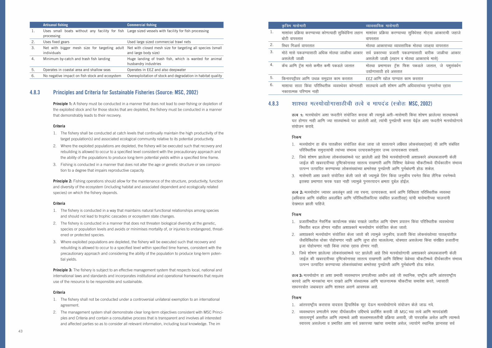
—f=e eklsekjh O;kolkf;d eklsekjh
1. ek’kkaoj çfØ;k dj.;kP;k dks.kR;kgh lqfo/ksfouk ygku cksVh okijrkr
ek’kkaoj çfØ;k dj.;kP;k lqfo/kslg eksB~;k vkdkjkph Tkgkts okijrkr
2. fLFkj fxvlZ okijrkr eksBîk vkdkjkP;k O;kolkf;d eksBîk tkG~;k okijrkr3. eksBs ekls idM.;klkBh vf/kd eksBîk tkGhpk vkdkj
vlysyh tkGhloZ çdkjP;k çtkrh idM.;klkBh ckjhd tkGhpk vkdkj vlysyh tkGh ¼ygku o eksBîk vkdkjkps ekls½
4. dWp vkf.k VªW’k ekls dehr deh idMys tkrkr eksBîk çek.kkoj VªW’k fQ’k idMys tkrkr] ts i’kqlao/kZu m|ksxklkBh gos vlrkr
5. fdukjiêhoj vkf.k mFkG leqækr dke djrkr EEZ vkf.k [kksy ik.;kr dke djrkr6. ek’kkpk lkBk fdaok ifjfLFkrhd O;oLFksoj dks.krkgh
udkjkRed ifj.kke ukghlkBîkps vrh ‘kks”k.k vkf.k vf/koklkaP;k xq.koÙkspk j~gkl
4.8.3 ‘kk’or eRL;ks|ksxklkBhph rRos o ekinaM (L=ksr% MSC, 2002)
rRo 1: eRL;ks|ksx v’kk i/nrhus la;ksftr djkok dh R;keqGs vrh&eklsekjh fdaok ‘kks”k.k >kysY;k lkBîke/;s ?kV gks.kkj ukgh vkf.k T;k lkBîkae/;s ?kV >kysyh vkgs] R;kaph iquiZzkIrh djrk ;sbZy v’kk i/nrhus eRL;ks|ksxkps la;kstu djkos-
fud”k
1. eRL;ks|ksx gk dWp ikrGhoj la;ksftr dsyk tkok tks lkrR;kus yf;r yksdla[;k¼[;ka½ ph vkf.k lacaf/kr ifjfLFkrhd leqnk;kaph R;kaP;k laHkkO; mRikndrsuqlkj mPp mRikndrk jk[krks-
2. ftFks ‘kks”k.k >kysY;k yksdla[;kae/;s ?kV >kysyh vkgs frFks eRL;ks|ksxkph v’kkçdkjs vaeyctko.kh dsyh tkbZy dh [kcjnkjhP;k –f”Vdksuklg lkrR; jk[k.kkjh vkf.k fof’k”V osGsP;k pkSdVhe/;s nh?kZdkyhu laHkkO; mRiUu mRikfnr dj.;kP;k yksdla[;kaP;k kerslg iquiZzkIrh vkf.k iquZcka/k.kh gksÅ ‘kdsy-
3. eklsekjh v’kk çdkjs la;ksftr dsyh tkrs dh T;keqGs fyax fdaok tuqdh; jpusr fdaok ySafxd jpuse/;s brD;k çek.kkr Qjd iMr ukgh T;keqGs iqu#Riknu kerk nqcZy gksbZy-
rRo 2: eRL;ks|ksx T;koj voyacwu vkgs R;k jpuk] mRikndrk] dk;Z vkf.k fofo/krk ifjfLFkrhd O;oLFkk ¼vf/kokl vkf.k lacaf/kr voyafcr vkf.k ifjfLFkrhdfjR;k lacaf/kr çtkrhalg½ ;kaph eklsekjhP;k pkyukauh ns[kHkky >kyh ikfgts-
fud”k
1. çtkrhae/khy uSlfxZd dk;kZRed laca/k jk[kys tkrhy vkf.k iks”k.k çikru fdaok ifjfLFkrhd O;oLFksP;k fLFkrhr cny gks.kkj ukghr v’kkçdkjs eRL;ks|ksx la;ksftr dsyk tkrks-
2. v’kkçdkjs eRL;ks|ksx la;ksftr dsyk tkrks dh R;keqGs tuqdh;] çtkrh fdaok yksdla[;sP;k ikrG~;karhy tSofofo/krsl /kksdk iksgksp.kkj ukgh vkf.k yqIr gksr pkyysY;k] /kksD;kr vlysY;k fdaok lajfkr çtkrhauk btk iksgksp.kkj ukgh fdaok R;kapk j~gkl gks.kkj ukgh-
3. ftFks ‘kks”k.k >kysY;k yksdla[;kae/;s ?kV >kysyh vkgs frFks eRL;ks|ksxkph v’kkçdkjs vaeyctko.kh dsyh tkbZy dh [kcjnkjhP;k –f”Vdksuklg lkrR; jk[k.kkjh vkf.k fof’k”V osGsP;k pkSdVhe/;s nh?kZdkyhu laHkkO; mRiUu mRikfnr dj.;kP;k yksdla[;kaP;k kerslg iquiZzkIrh vkf.k iquZcka/k.kh gksÅ ‘kdsy-
rRo 3: eRL;ks|ksx gk v’kk çHkkoh O;oLFkkiu ç.kkyhP;k vk/khu vkgs th LFkkfud] jk”Vªh; vkf.k vkarjjk”Vªh; dk;ns vkf.k ekudkapk eku jk[krs vkf.k laLFkkRed vkf.k pkyukRed pkSdVhapk lekos’k djrs] T;klkBh lk/kuL=ksr tckcnkj vkf.k ‘kk’or vl.ks vko’;d vkgs-
fud”k
1. vkarjjk”Vªh; djkjkl oknxzl fikf’oZd lwV nsÅu eRL;ks|ksxkps la;kstu dsys tkÅ u;s-
2. O;oLFkkiu ç.kkyhus Li”V nh?kZdkyhu mfí”Vîs çnf’kZr djkoh th MSC P;k rRos vkf.k ekinaMka’kh lkrR;iw.kZ vlrhy vkf.k R;ke/;s v’kh lYykelyrhph çfØ;k vlkoh] th ikjn’kZd vlsy vkf.k R;ke/;s LokjL; vlysY;k o çHkkfor v’kk loZ çdkjP;k ikkapk lekos’k vlsy] T;k;ksxs LFkkfud Kkuklg loZ
Artisanal fishing Commercial fishing
1. Uses small boats without any facility for fish processing
Large sized vessels with facility for fish processing
2. Uses fixed gears Used large sized commercial trawl nets
3. Net with bigger mesh size for targeting adult individuals
Net with closed mesh size for targeting all species (small and large body size)
4. Minimum by-catch and trash fish landing Huge landing of trash fish, which is wanted for animal husbandry industries
5. Operates in coastal area and shallow seas Operates in EEZ and also deepwater
6. No negative impact on fish stock and ecosystem Overexploitation of stock and degradation in habitat quality
4.8.3 Principles and Criteria for Sustainable Fisheries (Source: MSC, 2002)
Principle 1: A fishery must be conducted in a manner that does not lead to over-fishing or depletion of
the exploited stock and for those stocks that are depleted, the fishery must be conducted in a manner
that demonstrably leads to their recovery.
Criteria
1. The fishery shall be conducted at catch levels that continually maintain the high productivity of the
target population(s) and associated ecological community relative to its potential productivity.
2. Where the exploited populations are depleted, the fishery will be executed such that recovery and
rebuilding is allowed to occur to a specified level consistent with the precautionary approach and
the ability of the populations to produce long-term potential yields within a specified time frame.
3. Fishing is conducted in a manner that does not alter the age or genetic structure or sex composi-
tion to a degree that impairs reproductive capacity.
Principle 2: Fishing operations should allow for the maintenance of the structure, productivity, function
and diversity of the ecosystem (including habitat and associated dependent and ecologically related
species) on which the fishery depends.
Criteria
1. The fishery is conducted in a way that maintains natural functional relationships among species
and should not lead to trophic cascades or ecosystem state changes.
2. The fishery is conducted in a manner that does not threaten biological diversity at the genetic,
species or population levels and avoids or minimises mortality of, or injuries to endangered, threat-
ened or protected species.
3. Where exploited populations are depleted, the fishery will be executed such that recovery and
rebuilding is allowed to occur to a specified level within specified time frames, consistent with the
precautionary approach and considering the ability of the population to produce long-term poten-
tial yields.
Principle 3: The fishery is subject to an effective management system that respects local, national and
international laws and standards and incorporates institutional and operational frameworks that require
use of the resource to be responsible and sustainable.
Criteria
1. The fishery shall not be conducted under a controversial unilateral exemption to an international
agreement.
2. The management system shall demonstrate clear long-term objectives consistent with MSC Princi-
ples and Criteria and contain a consultative process that is transparent and involves all interested
and affected parties so as to consider all relevant information, including local knowledge. The im
43
1. pact of fishery management decisions on all those who depend on the fishery for their livelihoods,
including, but not confined to subsistence, artisanal, and fishing-dependent communities shall be
addressed as part of this process.
2. The management system shall be appropriate to the cultural context, scale and intensity of the
fishery – reflecting specific objectives, incorporating operational criteria, containing procedures for
implementation and a process for monitoring and evaluating performance and acting on findings.
3. The management system shall observe the legal and customary rights and long term interests
of people dependent on fishing for food and livelihood, in a manner consistent with ecological
sustainability.
1. lacaf/kr ekfgrhpk fopkj dsyk tkbZy- mnjfuokZgklkBh eRL;ks|ksxkoj voyacwu vlysY;kaoj eRL;ks|ksx O;oLFkkiukP;k fu.kZ;kapk çHkko iMrks] áke/;s fuokZgklkBh] —f=e eklsekjh dj.kkj~;kapk lekos’k vlrks ijarq rso<îklp gs e;kZfnr jkgkr ukgh vkf.k eklsekjhoj voyacwu vlysY;k leqnk;kauk ák çfØ;spk Hkkx Eg.kwu lacksf/kr djkos-
2. O;oLFkkiu ç.kkyh gh lkaL—frd lanHkZ] ekinaM vkf.k eRL;ks|ksxkP;k rhozrsl vuq:i vlkoh & T;ke/;s fof’k”V mfí”Vîs çfrfcafcr gksrhy] pkyukRed ekinaMkapk lekos’k gksbZy] vaeyctko.khlkBhP;k çfØ;k vlrhy vkf.k dkefxjhoj ns[kjs[k dj.kkjh vkf.k frps ewY;ekiu dj.kkjh o fu”d”kkaZoj —rh dj.kkjh çfØ;k vlsy-
3. O;oLFkkiu ç.kkyhus dk;ns’khj vkf.k usgehP;k vf/kdkjkapk vkf.k vUu o mnjfuokZgklkBh eklsekjhoj voyacwu vlysY;k yksdkaP;k nh?kZdkyhu fgrkps ifjfLFkrhd ‘kk’orrs’kh lkrR;iw.kZ ikyu djkos-
44

4.9 pkaxY;k i/nrh vkf.k dsl LVMht1
4.9.1 eRL;ks|ksxkdMs ikg.;kpk ifjfLFkrhd O;oLFkk –”Vhdksu (EAF)
ifjfLFkrhd O;oLFksph O;k[;k gh rqyusus Lo;aiw.kZ ç.kkyh Eg.kwu dsyh tkÅ ‘kdrs T;ke/;s ouLirh] çk.kh ¼ekuoklg½] lwetho vkf.k i;kZoj.kkps fuftZo ?kVd rlsp R;kaP;krhy laoknkpk lekos’k gksrks- ifjfLFkrhd O;oLFksiklwu osxGs d:u lk/kuL=ksr çtkrh fdaok ekls O;oLFkkfir dj.;keqGs ák oLrqfLFkrhdMs nqyZk gksrs dh ek’kkaph çtkrh v’kk ifjfLFkrhd O;oLFkkaoj voyacwu vlrs T;kaoj eklsekjheqGs rlsp brj ekuoh dkjokbZaeqGs ifj.kke gksr vlrks-- eklsekjheqGs ifjfLFkrhd O;oLFksP;k brj ?kVdkaoj iq<hyçek.ks ifj.kke gksrks% udks vlysY;k çtkrh idM.ks] vf/koklkauk HkkSfrd uqdlku iksgkspo.ks] vUulk[kGhe/;s vMFkGk ;s.ks vkf.k tSofofo/krse/;s cny gks.ks- eklsekjh’kh fuxMhr ulysY;k brj ekuoh gkypkyh] tls dh —”kh] ouhdj.k vkf.k fodkl lq/nk] R;kapk Hkkx vlysY;k çtkrhalg leqæhd ifjfLFkrhd O;oLFkkauk çHkkfor d: ‘kdrkr- ifjfLFkrhd O;oLFkkaojhy ekuoh çHkko gokekukrhy cnykeqGs vusdnk fodksikyk tkrkr- R;keqGs] vf/kd O;kid –”Vhdksukrwu vlysyk eRL;ks|ksx O;oLFkkiu ek’kkapk lkBk leqæhd ifjfLFkrhd O;oLFkkaps ?kVd Eg.kwu O;oLFkkfir dj.;kpk ç;Ru djrks-
eRL;ks|ksxkackcr ifjfLFkrhd O;oLFksP;k –”Vhdksukrwu] eRL;ks|ksx O;oLFkkidkaph usgehph fpark & yf;r çtkrhaph ‘kk’orrk & gh ifjfLFkrhd O;oLFkkaoj eRL;ks|ksx voyacwu vkgs R;kaP;k ‘kk’orrk lacksf/kr dj.;ki;aZr O;kid vkgsr T;ke/;s yksd vkf.k ek’kkaP;k lkBîkapk lekos’k gksrks- ifjfLFkrhd O;oLFkk –”Vhdksu ekuoh vkf.k ifjfLFkrhd nksUghaps fgr lacksf/kr djrks vkf.k nksu ekudkaps fofyuhdj.k djrks% ifjfLFkrhd O;oLFkk jpuk vkf.k dk;kZps lajk.k o lao/kZu dj.ks( vkf.k eRL;ks|ksx O;oLFkkiu T;kps y; ekuokyk vUu] mRiUu vkf.k mnjfuokZg çnku dj.;kps vkgs-
ifjfLFkrhd O;oLFkk –”Vhdksukpk eRL;ks|ksxkckcrpk mís’k gk laiw.kZ ifjfLFkrhd O;oLFkk rlsp yf;r çtkrhapk ‘kk’or okij vlY;keqGs] rks lqporks dh eRL;ks|ksxk O;frfjäps ts miØe leqæhd ifjfLFkrhd O;oLFkkaoj ifj.kke djrkr rs eRL;ks|ksx vf/kdkj~;kaP;k tckcnkj~;ka ckgsjhy vlys rjhgh R;kapsgh O;oLFkkiu dsys xsys ikfgts- yf;r lkBîkaoj gokekukrhy cny] fdukj~;kojhy fodkl] yksdla[;k vkf.k lewæ gVowu r;kj dsysY;k tfeuhlg eklsekjh O;frfjäP;k leL;kapk çHkko iMrks- ;ke/;s lekfo”V vlysY;k foLr`r leL;kaeqGs] EAF P;k laiw.kZ vaeyctko.khlkBh leqnk;kae/;s lg;ksx vkf.k lgdk;Z rlsp leqæhd ifjfLFkrhd O;oLFkkaoj gks.kkjk çHkko O;oLFkkfir dj.;kl tckcnkj vlysY;k ‘kkldh; laLFkkaph Js.kh vko’;d vkgs-
eRL;ks|ksxkP;k ckcrhr ifjfLFkrhd O;oLFkk –”Vhdksuke/;s mfí”Vîs lk/; dj.;klkBh ‘kkL=h; fdaok ikjaikfjd loksZÙke miyC/k ekfgrhoj vk/kkfjr fu.kZ; ?ks.;kpk lekos’k gksrks- vkrk rkrMhus dkjokbZ dj.ks vko’;d vkgs vkf.k O;kid ‘kkL=h; ekfgrh ladfyr dj.;kph okV ikgk;yk osG ukgh- dks.kR;kgh ifjfLFkrhae/;s] LFkkfud leqnk; gs LFkkfud ifjfLFkrhd O;oLFkkaojhy cj~;kp’kk ekfgrhlkBh HkkaMkj vkgsr-
4.9.2 leqnk;&vk/kkfjr eRL;ks|ksx O;oLFkkiu (CBFM)
leqnk; vk/kkfjr eRL;ks|ksx O;oLFkkiu v’kk O;oLFkkiu ç.kkyhpk lanHkZ nsrs T;k varxZr eRL;ks|ksx vkf.k yxrP;k fdukjh ks=kaP;k O;oLFkkiuke/;s leFkZd ,tUlhaP;k Hkkxhnkjhe/;s fdaok lg;ksxkus leqnk; çeq[k Hkwfedk ctkorks-
1 ¼iWflfQd leqnk; lfpoky;] 2010 dMwu½
4.9 Good practices and case studies1
4.9.1 An ecosystem approach to fisheries (EAF)
An ecosystem can be defined as a relatively self-contained system that contains plants, animals
(including humans), micro-organisms and non-living components of the environment as well as the
interactions between them. Managing a resource species or fish stock in isolation from its ecosystem
ignores the fact that fish species depend on ecosystems that are being affected by the fishing activ-
ity itself and by other human activities. Fishing can affect other components of the ecosystem by:
catching unwanted species, causing physical damage to habitats, disrupting food chains and causing
changes in biodiversity. Other human activities unrelated to fishing, such as agriculture, forestry and
development, can also affect marine ecosystems, including the species that are part of them. The
human impacts on ecosystems are often being exacerbated by the effects of climate change. Hence
fisheries management with a broader approach that attempts to manage fish stocks as components of
marine ecosystems.
Under an Ecosystem Approach to Fisheries, the usual concern of fisheries managers – the sustain-
ability of targeted species – is extended to address the sustainability of ecosystems upon which the
fisheries depend, which include people and fish stocks. Ecosystem Approach addresses both human
and ecological well-being and merges two paradigms: protecting and conserving ecosystem structure
and functioning; and fisheries management that focuses on providing food, income and livelihoods for
humans.
As the objective of Ecosystem Approach to Fisheries is the sustainable use of entire ecosystems as well
as targeted species, it implies that non-fisheries activities that impact marine ecosystems must also be
managed, even though these activities may be outside of the responsibilities of fisheries authorities. In
addition to fishing, target stocks are affected by non-fishing issues including climate change, coastal
development, pollution and the loss of critical habitats by reclamation. Because of the broad issues
involved, the full implementation of EAF requires collaboration and cooperation between communi-
ties and a range of government agencies responsible for managing activities that impact on marine
ecosystems.
Ecosystem Approach to Fisheries involves making decisions to achieve objectives based on the best
available knowledge, whether it is scientific or traditional. Urgent actions are required now and there is
no time to wait to collect extensive scientific information. In any case, local communities are reposito-
ries of much information on local ecosystems.
4.9.2 Community-based fisheries management (CBFM)
Community Based Fisheries Management
refers to a management system under
which communities take a leading role in
managing fisheries and adjacent coastal
areas in partnership with, or with support
from, a promoting agency.
1 (adoptedfromSecretariatofPacificCommunity,2010)
CBFM ph mnkgj.ks
ç’kkar egklkxjkrhy csVkaojhy leqnk; R;kaP;k fdukjh ifjfLFkrhd O;oLFkk vkf.k ek’kkapk lkBk O;oLFkkfir dj.ks vkf.k R;kaps lajk.k dj.ks ;ke/;s ‘ksdMks o”kkaZiklwu xqarysys vkgsr- vkf.k vkrk] vusd ‘kkldh; laLFkk vkf.k ,uthvks lØh;i.ks CBFM
çdYikarxZr O;oLFkkiukP;k tckcnkj~;k ?ks.;klkBh vf/kdkf/kd leqnk;kauk çksRlkgu nsr vkgsr- ç’kkar csVkaojhy vusd leqnk;kauk iWflfQd leqnk; lfpoky;kdMwu & U;w dWysMksfu;ke/;s fLFkr ,d çknsf’kd la?kVuk] rlsp vusd ,uthvks dMwu CBFM çLFkkfir dj.;kckcr enr dsyh tkr vkgs-
Example for CBFM
Communities in the Pacific Islands have been involved
in managing and protecting their coastal ecosystems
and fish stocks for many hundreds of years. And
now, many government and NGOs are actively
encouraging communities to take on more management
responsibilities under CBFM projects. Many Pacific Island
Communities have been assisted in establishing CBFM by
Secretariat of Pacific Community – a regional organisation
based in New Caledonia, as well as several NGOs.
45
Status of the Fisheries in India
The west coast of India is by far the most important area so far as fisheries production is concerned,
accounting for over 70 percent of national production.
Gujarat State in the northwest has, for some years, been the major fish producer in India, and, in
2001, accounted for around 37 percent of west coast production and 26 percent of national produc-
tion. Gujarat is closely followed by Kerala in the southwest which, in 2001, contributed around 30
percent of national production. The other west coast states of Maharashtra and Karnataka, in addition
to offshore Islands contribute the remaining 33 percent of west coast production.
The Saurashtra coast in the northwest experiences winter cooling of oceanic waters during November-
February with no significant upwelling and consequently the fisheries in this area are dominated by
demersal species (57.2 percent of landings) such as sciaenids, flatfish, ribbonfish etc.
The fisheries of the west coast of India can be conveniently divided into both artisanal and industrial
sectors as well as inshore (<50 meters) and offshore fisheries. Artisanal fisheries dominate the inshore
areas while industrial fishing dominates the offshore area, usually operating under the provisions of the
Deep Sea Fishing Policy.
Managing fisheries in accordance with sustainability guidelines is not required by legislation either at
the State or National/Union level. As a result, many stocks both in the inshore and offshore area are
either fully or overexploited although it is generally agreed that offshore areas are more lightly exploited
and may, for some species, be underexploited.
Offshore species which are considered to have the greatest potential for increases in exploitation rates
are various species of tuna, threadfin bream, carangids and deepwater shrimp (Vivekanandan, 2002).
Marine pollution and coastal degradation has impacted on resources in the coastal areas (including
estuaries) and has degraded the marine resource potential and marine biodiversity of these areas. As
a result, the issues of overexploitation of many coastal fisheries resources have been becoming more
important, even in areas where the number of fishermen and vessels has remained stable. However,
within the context of marine and coastal ecosystem destruction in the Indian Ocean area, overexploita-
tion of fisheries resources and coastal habitat destruction is not as much a problem in India as it is in
other countries of the region.
Total fish production from the west coast area of India in 2001 was 1.996 million tonnes with this
level of production having been maintained for some years. Table 2 provides data on the catches, by
species group, for the period 1998-2001 for the west coast area of India in addition to similar data for
1980.
First, most fisheries statistics in India are collected at landing places although species that are des-
tined for export are recorded at the point of sale or export. Hence aquaculture production is sometimes
incorporated into landings statistics, particularly for those species that are exported. In addition, con-
sumption at home, which may be significant, is often not included in statistics collection.
The reason for this increase in production is almost exclusively an increase in fishing effort, both in
inshore areas and offshore. For example, in Gujarat, the fishing fleet has increased to 29506 vessels in
2002, 19092 of which are mechanized.
Methods of exploitation of marine fisheries resources vary from simple traps to large trawlers and from
handlines to modern purseseiners.
Hkkjrke/;s eRL;ks|ksxkph fLFkrh
Hkkjrkpk if’pe fdukjk eRL;ks|ksx mRiknuklkBh lokZr egRokps ks= vkgs] ftFks jk”Vªh; mRiknukiSdh 70 VDds mRiknu gksrs-
ok;O;sdMhy xqtjkr jkT; gs dkgh o”kkaZlkBh Hkkjrkrhy çeq[k ekls mRiknd gksrs vkf.k 2001 e/;s if’pe fdukj~;kojhy mRiUukiSdh 37 VDds frFkwu gksrs- jk”Vªh; mRiknuke/;s R;kpk 26 VDds okVk gksrk- xqtjkruarj 2001 e/;s uS_R;sps dsjG nqlj~;k Øekadkoj gksrs T;kpk jk”Vªh; mRiknuke/;s R;kpk 30 VDds okVk gksrk- egkjk”Vª vkf.k dukZVdP;k brj if’pe fdukj~;kojhy jkT;kauh fdukj~;kiklwu nwj vlysY;k tyk’k;karwu ckdhP;k 33 VDds mRiknuke/;s okVk mpyyk-
ok;O;sdMhy lkSjk”Vª fdukj~;koj uksOgsacj&QsCkzqokjh njE;ku egklkxjkP;k xkjO;kpk vuqHko ;srks vkf.k ;k dkyko/khe/;s Qkj’kh ok< ulrs vkf.k ifj.kkeh ;k ks=krhy eRL;ks|ksxkoj [kksy ik.;krhy çtkrhaps opZLo vlrs ¼y¡fMaxP;k 57-2 VDds½ tls dh lkbZusM] piVsekls] fjcu ekls b-
HkkjrkP;k if’pe fdukj~;kojhy eRL;ks|ksx lksf;LdjfjR;k —f=e vkf.k vkS|ksfxd nksUgh ks=kae/;s rlsp fdukj~;ktoGpk ¼<50 ehVj½ vkf.k leqækarxZr eRL;ks|ksxke/;s foHkkxrk ;srks- —f=e eRL;ks|ksxkps fdukj~;ktoGP;k ks=kaoj opZLo vkgs rj vkS|ksfxd eklsekjhps leqækarxZr ks=ke/;s vkgs] ts lglk [kksy leqækrhy eklsekjh /kksj.kkarxZr dke djrkr-
‘kk’orrsP;k ekxZn’kZd rRokauqlkj eRL;ks|ksxkps O;oLFkkiu dj.ks gs jkT; fdaok jk”Vªh;@dsafæ; ikrGhoj dk;|kuqlkj vko’;d ukgh- ifj.kkeh] leqækarxZr ks=kaps deh ‘kks”k.k djkos vkf.k dkgh çtkrhaps deh ‘kks”k.k djkos vls lglk ekU; dsys vlys rjh fdukj~;ktoGps vkf.k leqækarxZr ks=karhy nksUghgh lkBs ,drj iw.kZi.ks fdaok vrh çek.kkr ‘kks”kwu ?ksrys xsys vkgsr-
leqækarxZr çtkrh T;kaP;ke/;s ‘kks”k.kkP;k njke/;s ok< gks.;kph lokZr tkLr laHkkouk vlrs R;k vkgsr Vîquk] FkzsMfQu czhe] dkjaftM~l vkf.k [kksy ik.;krhy fJEiP;k fofo/k çtkrh ¼foosdkuanu] 2002½-
leqæhd yksdla[;k vkf.k fdukj~;kpk j~gkl ;kapk fdukjh ks=kaojhy lk/kuL=ksrkaoj ifj.kke >kyk vkgs ¼[kkMîkalg½ vkf.k R;keqGs ák ks=kaP;k leqæhd lk/kuL=ksrkP;k kerspk vkf.k leqæhd tSofofo/krspk j~gkl >kyk vkgs- ifj.kkeh vusd fdukjh eRL;ks|ksx lk/kuL=ksrkaP;k vrh’kks”k.kkph leL;k vf/kd egRokph cur vkgs] vxnh T;k ks=kae/;s ePNhekj vkf.k Tkgkt fLFkjkoysys vkgsr frFksgh- rFkkfi] leqæhd vkf.k fdukjh ifjfLFkrhd O;oLFksP;k lanHkkZr Hkkjrh; egklkxj ks=krhy j~gkl] eRL;ks|ksx lk/kuL=ksrkps vrh’kks”k.k vkf.k fdukjh vf/koklkrhy ?kV gs çns’kkrhy brj ns’kkaP;k rqyusr Hkkjrke/;s brdh eksBh leL;k ukghr-
2001 e/;s HkkjrkP;k if’pe fdukjh ks=krhy ,dw.k ekls mRiknu 1-996 n’kyk Vu gksrs th mRiknukph ikrGh dkgh o”kZ fVdwu jkfgyh- räk 2 gk 1980 P;k leku MsVkf’kok; HkkjrkP;k if’pe fdukjh ks=krhy 1998&2001 lkBh çtkrh xVkuqlkj dWpslcíy MsVk çnku djrks-
loZçFke] Hkkjrkrhy lokZf/kd eRL;ks|ksx vkdMsokjh gh y¡fMaxP;k fBdk.kkagwu xksGk dsyh tkrs- tjh dkgh çtkrh ák fu;kZrhlkBhp vlY;k rjh foØhP;k fdaok fu;kZrhP;k fBdk.kh R;kaph uksan dsyh tkrs- R;keqGs eRL;’ksrhps mRiknu d/kh d/kh y¡fMaxP;k vkdMsokjhe/;s lekfo”V dsys tkrs] [kkl d:u T;k çtkrhaph fu;kZr dsyh tkrs- ;kf’kok;] ?kjh gksr vlysyk okij] tks cj~;kiSdh eksBk vlw ‘kdrks] rks vkdMsokjh ladfyr djrkuk lekfo”V dsyk tkr ukgh-
mRiknukrhy ;k ok<hekxhy dkj.k gs [kkld:u eklsekjhP;k ç;Rukae/;s >kysyh ok< gs vkgs] fdukj~;kyxrP;k ks=kar vkf.k leqækarxZr- mnkgj.kkFkZ] xqtjkre/khy eklsekjkapk rkaMk 2002 e/;s 29506 Tkgktkai;aZr ok<yk vkgs] T;kaiSdh 19092 ;kaf=d vkgsr-
leqæhd eRL;ks|ksx lk/kuL=ksrkaP;k ‘kks”k.kkP;k i/nrh lk/;k lkiG~;kaiklwu rs eksBîk Vª‚ylZi;aZr fHkUu vlrkr vkf.k g¡MykbZUliklwu rs vk/kqfud ilkZ;ulZi;aZr-
46

eklsekjh Tkgkts vkf.k xhvje/;s çknsf’kd oSfo/;gh vkgs- ikjaikfjd dWVkekjUl] ts iwoZ fdukj~;koj lkekU; vkgsr rs if’pe fdukj~;koj eksBîk çek.kkr okijys tkr ukghr] frFks >kMkpk cqa/kk dks:u r;kj dsysY;k ygku gksMîk ák tkLr ikjaikfjd eklsekjhps lk/ku vkgs-
;kaf=d Tkgktke/;s LVuZ vkf.k vkmfVªxj Vª‚ylZ] fxyusVlZ] ilkZ;ulZ] yk¡xyk;ulZ vkf.k M‚yusVlZpk lekos’k gksrks ¼fi’kohP;k tkG~;k] [kkl d:u cksafcylkBh½ rj ikjaikfjd v;kaf=d Øk¶V g¡MykbZUl] fxyusV~l vkf.k ek’kkaps lkiGs okijrkr- >kMkpk cqa/kk dks:u r;kj dsysY;k ygku gksMîkaP;k tkxh ygku eksVlZ vixzsM dj.;klkBh ,d dk;ZØe vkgs- 1977 iklwu] 50 922 eksVlZuk gs ikjaikfjd Øk¶V clo.;kr vkys vkgs ¼foosdkuanu] 2002½
2001 e/;s tks eRL;ks|ksx] if’pe fdukj~;koj 288 000 Vuyk iksgkspyk R;ke/;s —f=e@vkS|ksfxd eRL;ks|ksxkps feJ.k vkgs vkf.k R;ke/;s ekls us.;klkBh >kMkpk cqa/kk dks:u r;kj dsysY;k ygku gksMîk ¼dsjG fdukjk½] vkmfVªxj Tkgkts ¼egkjk”Vª vkf.k dukZVdpk fdukjk½ vkf.k ilkZ;ulZ ¼leqækarxZr ks=s½ vkgsr-
idMysys cgqrka’k ekls LFkkfudfjR;k lairkr rjhgh dWfuax] xksBo.ks] okGo.ks vkf.k lkMkZbZu rsy cuo.;klkBhgh okijys tkrkr- egklkxjkP;k fLFkrhuqlkj vkf.k [kkld:u Qk;VksIykaDVu CywEleqGs eRL;ks|ksxkr o”kkZuqo”ksZ p< mrkj gksr vkgsr ¼ÝWfxykfj;k vks’kfudk] d‚fLduks&fMLdl ,lihih vkf.k IyqjksflXek ,lihih½-
cksafcyP;k ¼gkiZMu usgsjl½ eRL;ks|ksxkpk ljkljh jk”Vªh; y¡fMaXte/;s ngk VDds okVk vkgs vkf.k 2001 e/;s] if’pe fdukj~;kojhy jkT;kae/;s 143 000 Vu idMys xsys-
iwoZ vkf.k if’pe fdukj~;kaoj çtkrhaps foLr`r vkf.k [kafMr forj.k vkgs- ijarq xqtjkr vkf.k egkjk”VªkP;k ok;O; fdukjh jkT;kae/kwu lokZf/kd ekls idMys tkrkr- [kafMr forj.k ikgrk] O;oLFkkiu vkf.k la’kks/kuklkBhps çk/kkU; gs ikg.;klkBh fnys tkr vkgs dh iwoZ o if’pe fdukj~;kaojhy lkBs Lora= vkgsr dk fdaok R;kapk lkBk ,d= vkgs- eklsekjhP;k i/nrhauqlkj osxosxG~;k çns’kkar cksafcy idM.;kps çek.k fHkUu gksrs- lkSjk”Vªke/;s lqekjs 400500 Tkgkts leqækarxZr 612 eSy fdukjh ik.;kae/;s ^Mksy^ usV~l okijrkr rj xqtjkre/;s fdukjh ik.;ke/;s fxyusV~luh idM.;kps çek.k tkLr vkgs ¼1 bapkP;k tkGhP;k vkdkjekuklg 30 QwV ykac½ ts tqu vkf.k lIVsacj njE;ku dsys tkrs- cgqrka’k lkBk mUgkr okGoyk tkrks ijarq R;kp cjkscj dkgh çek.kkr rktkgh fodyk tkrks fdaok nkcwu okGowu ^yWfeusV^ dsyk tkrks-
u‚uisukbZM dksGachP;k eRL;ks|ksxkps xqtjkr vkf.k egkjk”Vª jkT;karhy vf/kd mÙkjh ks=kaoj opZLo vkgs T;krwu 2001 e/;s okf”kZd lqekjs 125000 Vu ekls idMys xsys ¼301½ & ,lVsl ,lihihpk okVk lk/kkj.k 74 VDds vkgs rj usekVksikyheksu VsU;qIlpk ckdh 25 VDds- ckdhpk okVk ,fDgIiksyhLekVk ,ufljksfLVªlpk vkgs- ák y¡fMaXte/;s 1961 iklwu okf”kZd lqekjs 20 000 Vu ok< >kyh vkgs] 1990 P;k n’kdkrhy okf”kZd 80100 000 Vu iklwu rs l/;k lqekjs 120 000 Vui;aZr- if’pe fdukj~;kojhy cgqrka’k dksGach eRL;ks|ksx gk R;kaP;k laiw.kZ thoupØke/;s ‘kks”k.kkP;k vk/khu vkgs] ;ke/;s dsjG vkf.k brj jkT;kaP;k [kkMh vkf.k unheq[kkik’kh ikjaikfjd eRL;ks|ksxkr idMys tk.kkjs ygku ekls vkf.k leqækarxZr ik.;krhy ikjaikfjd vkf.k eksBs ;kaf=d Vª‚y oki:u dsysyk eRL;ks|ksx ;k nksUghapk lekos’k gksrks-
[kkMh vkf.k unheq[kkaik’khpk eRL;ks|ksx o”kZHkj pkyrks rj leqæhd fdukjh eRL;ks|ksx gk gaxkeh vlwu fu;fer dsysyk vlrks vkf.k ikolkG~;ke/;s can vlrks ¼dq#i] 2001½- if’pe fdukj~;kojhy dksGachaP;k çeq[k çtkrhaP;k lkBîkackcr eRL;ks|ksxkckcr ewY;kadus dsyh xsyh vlrk R;krwu loZlk/kkj.k fu”d”kZ fu?kkyk dh eklsekjhph kerk [kwi mPp vlY;kus lkBîkph lglk tkLr fiGo.kwd dsyh tkrs vkf.k dksGach b”Vre vkdkjekukP;k vk/khp idMyh tkrs] çkeq[;kus [kkMhe/;s ygku ek’kkalkBhP;k eRL;ks|ksxkeqGs- rFkkfi] [kkMhrhy eRL;ks|ksx LFkkfud cktkjkr dksGachpk iqjoBk djrkr dkj.k eksBîk vkdkjkrhy dksGach ¼th cgqrsdnk leqækarxZr Vª‚fyaxus feGrs½ iWd d:u fu;kZr dsyh tkrs- 1988 iklwu Vª‚fyaxlkBh dkgh dkG can Bso.;kpk gaxke lq: dj.;kr vkyk] T;kpk y¡fMax vkf.k dWp njkoj ykHknk;d çHkko iMY;kps dq#ius ¼2001½ n’kZoys-
L=ksr% e‚xZu] th ¼2015½- daVªh fjOáw% bafM;k ¼osLV dksLV½ fjOáw v‚Q n LVsV v‚Q oYMZ efju dWIpj fQ’kjht eWustesaV- FAO.
There are also regional variation in fishing vessels and gear. Traditional catamarans, common on the east
coast are not used on the west coast to any great extent, with dugout canoes being the more common
traditional fishing craft.
Mechanized vessels include stern and outrigger trawlers, gillnetters, purseseiners, longliners and dolnett-
ers (bag nets, mainly for Bombay duck) whereas traditional nonmechanized craft use handlines, gillnets
and fish traps. There is a program in place to upgrade dugout canoes in the area by the addition of small
outboard motors and, since 1977, 50 922 motors have been fitted to these traditional craft (Vivekanan-
dan, 2002)
The fishery, which in 2001 landed 288 000 t from the west coast is a mixed artisanal/industrial fishery and
utilizes dugout canoes (Kerala coast), outrigger vessels (Maharashtra and Karnataka coasts) and purse
seiners (offshore areas) to take the fish.
Most of the catch is locally consumed as fresh product although canning, freezing, drying, and production
of sardine oil is also undertaken. The fishery fluctuates significantly from year to year in response to oce-
anic conditions and particularly the abundance of phytoplankton blooms (Fragillaria oceanica, Coscino-discus spp and Pleurosigma spp).
The fishery for Bombay Duck (Harpodon nehereus) contributes around ten percent of the average na-
tional landings and, in 2001, 143 000 t were landed in the west coast States.
The species has a wide, and discontinuous, distribution along both east and west coasts of India although
the north west coastal States of Gujarat and Maharashtra contribute the greatest catches. Given the dis-
continuous distribution, a priority for management and research has been to determine whether the east
and west coasts stocks are separate or consist of a single stock. Fishing methods used to take Bombay
duck vary between regions. In Saurashtra, about 400500 vessels operate ‘dol’ nets in coastal waters 612
miles offshore whereas in Gujarat the majority of the catch is taken by gillnets (30 ft long with a mesh size
of 1 inch) operated in inshore coastal waters between June and September. Most of the catch is sundried
although a small quantity is sold fresh or is ‘laminated’ by pressing and drying.
Nonpenaeid prawn fisheries dominate the more northern areas of the west coast with Gujarat and Maha-
rashtra States accounting for the bulk of the annual landings of around 125000 t in 2001[301]. Acetes spp account for 74 percent of the landings; while Nematopalaemon tenuipes account for a further 25
percent. Exhippolysmata ensirostris made up the remainder of the landings. These landings have shown
a steady increase from about 1961, rising from approximately 20 000 t per annum at that time to 80100
000 t per annum during the 1990s to the current levels of around 120 000 t. Most prawn fisheries on the
west coast are subject to exploitation throughout their lifecycle, with large, traditional fisheries for juve-
niles occurring in the backwaters and estuaries of Kerala and other States and both traditional and large
mechanized trawl fisheries for adults in offshore waters.
Fisheries in the backwaters and estuaries tend to be undertaken throughout the year whereas the marine
coastal fishery is seasonal with a regulated, variable closed season during the monsoon period (Kurup,
2001). Assessments of the stocks of the major species comprising the prawn fisheries of the west coast
have been undertaken periodically with the general conclusion that stocks generally are overexploited
with fishing capacity being too high and prawns being taken at suboptimal sizes, mainly as a result of the
fishery for juveniles in the backwaters. However, the small prawns that are taken in the backwater fisheries
provide much of the local supply of prawns to the market since the larger sizes (often taken by offshore
trawling) are increasingly being packed and exported. Kurup (2001) showed the beneficial effect on land-
ings and catch rates of the closed season for trawling that was introduced in 1988.
Source: Morgan, G (2015). Country review: India (West coast) Review of the state of world marine capture
fisheries management. FAO.
47
4.10 Participatory planning of MPAs:4.10.1 Why participatory planning?
While it is generally acknowledged that stakeholder participation is an essential component of effective
management of natural resources, perceptions of what participation entails vary widely. In the context
of MPA planning and management, participation can be defined as a process that facilitates dialogue
among all actors, mobilizes and validates popular knowledge and skills, supports communities and
their institutions to manage and control resources, and seeks to achieve sustainability, economic eq-
uity, and social justice while maintaining cultural integrity.
Participation is relevant to all aspects of development and environmental management. The challenge
for policy-makers, planners and managers is to define the form of participation which is the most ap-
propriate to a given situation.
The arguments in favour of participation in planning and managing MPAs include the following:
• It contributes to improved management by incorporating popular knowledge and practices;
• It increases the likelihood of stakeholder compliance and support through participation in deci-
sion-making;
• It incorporates a wide range of perspectives and ideas, resulting in improved management deci-
sions and actions;
• It provides a forum for identifying conflicts between users and negotiating solutions to them;
• It can contribute to community empowerment and local institutional development, especially when
the sharing of management responsibility is involved.
4.10.2 What does it includes?
Planning processes can be described as participatory when they also include:
• The identification and involvement of all stakeholders, early in the process;
• The incorporation of the diverse views and opinions of the individuals within these groups;
• The sensitization of stakeholders to the issues being addressed;
• Provision of information needed to shape opinions and make decisions, in forms that are acces-
sible to all participants;
• The recognition of and accommodation for the inequities among stakeholder groups and among
individuals, in order to assure that those that are more powerful do not dominate or manipulate
processes;
• Respect for the process and the decisions that are reached: participatory planning cannot
manipulate participation to arrive at a predetermined conclusion or even to start from a predeter-
mined point.
Ideally, participation in the context of MPAs will start at the earliest planning stages for the protected
area. However, any stakeholder (management agency, non-governmental organization, community,
researcher, external agency) can take the initiative for a participatory planning exercise. The initiative
can come from the manifestation of a conflict or a crisis resulting from resource utilization, or from the
realization by the initiator that there are management issues requiring attention. It is at this early stage
that the initiator must decide that the planning process will be participatory and make arrangements
for the facilitation of the process.
4.10 MPAps lgHkkxkRed fu;kstu
4.10.1 lgHkkxkRed fu;kstu dk\
uSlfxZd lk/kuL=ksrkaP;k çHkkoh O;oLFkkiuklkBh Hkkx/kkjdkapk lgHkkx vko’;d vkgs gs tjh lglk Lohdkjys tkr vlys rjh] dks.kR;k çdkjpk lgHkkx vlkok ;kckcr [kwip fofo/k ifjek.ks vkgsr- ,d v’kh çfØ;k th loZ dykdkjkae/;s laokn lqyHk djrs] yksdfç; Kku o dkS’kY; xrh’khy djrs o R;kl cGdVh nsrs] leqnk; vkf.k R;kaP;k laLFkkauk lk/kuL=ksr O;oLFkkfir dj.;kl o fu;af=r dj.;kl lg;ksx nsrs vkf.k ‘kk’orrk] vkfFkZd lekurk vkf.k lkaL—frd ,dkRerk jk[kwu lkekftd U;k; lk/; dj.;kpk ç;Ru djrs v’kh MPA fu;kstu vkf.k O;oLFkkiukP;k lanHkkZr lgHkkxkph O;k[;k dsyh tkÅ ‘kdrs-
fodkl vkf.k i;kZoj.kh; O;oLFkkiukP;k loZ ?kVdkackcr lgHkkx çLrqr vkgs- l| ifjfLFkrhe/;s lokZr ;ksX; vls lgHkkxkps Lo:i fo”kn dj.;kps i‚fylhdrsZ] fu;kstd vkf.k O;oLFkkid ;kaP;kleksj vkOgku vkgs-
MPA ps fu;kstu vkf.k O;oLFkkiukrhy lgHkkxkl vuqdwy vlysY;k ;qfäoknke/;s iq<hy xks”Vhapk lekos’k gksrks%
• R;keqGs yksdfç; Kku o i/nrhapk lekos’k gksÅu lq/kkfjr O;oLFkkiukl gkrHkkj ykxrks(
• fu.kZ;&çfØ;srhy lgHkkxkeqGs Hkkx/kkjdkaP;k ekU;rk o leFkZukph ‘kD;rk ok<rs(
• R;ke/;s ifjek.ks o dYiukaph foLr`r Js.kh lekfo”V gksrs T;keqGs O;oLFkkiukps fu.kZ; vkf.k dkjokbZe/;s lq/kkj.kk gksrs(
• okijdR;kZarhy fookn vksG[k.;klkBh R;keqGs ,d eap vkf.k okVk?kkVhrwu mik; feGrkr(
• R;keqGs leqnk;kP;k lkerk vkf.k LFkkfud laLFkkRed fodklke/;s ;ksxnku feGw ‘kdrs] [kkld:u tsOgk O;oLFkkiukph tckcnkjh okVwu ?;k;ph vlrs rsOgk-
4.10.2 R;ke/;s d’kkpk lekos’k gksrks\
fu;kstu çfØ;se/;s tsOgk iq<hy xks”Vhapkgh lekos’k gksrks rsOgk fryk lgHkkxkRed Eg.kys tkrs%
• çfØ;sP;k çkjaHkhp loZ lacaf/kr vksG[k.ks o R;kapk lgHkkx gks.ks(
• ;k xVkarhy O;ähaP;k fHkUu –”Vhdksu vkf.k erkapk lekos’k(
• T;k leL;k lacksf/kr dsY;k tkr vkgsr R;kackcr lacaf/krkaph xzg.kkerk(
• erkauk vkdkj ns.;klkBh vkf.k fu.kZ; ?ks.;klkBh vko’;d ekfgrhph loZ lgHkkxhauk iksgksprk ;sbZy v’kk Lo:ikar rjrwn(
• ts tkLr rkdnhps vkgsr R;kauh opZLo xktow u;s fdaok çfØ;sph fiGo.kwd d: u;s ;kph [kk=h dj.;klkBh Hkkx/kkjd xVkae/;s o O;ähaph ekU;rk o vlekurk lkekowu ?ks.ks(
• çfØ;sckcr vknj vkf.k T;kai;aZr iksgkspys vkgsr vls fu.kZ;% lgHkkxkRed fu;kstukeqGs iwoZfu/kkZfjr fu”d”kkaZi;aZr iksgksp.ks fdaok iwoZfu/kkZfjr eqí~;kiklwu çkjaHk dj.ks dq’kyrsus gkrkGrk ;sr ukgh-
vkn’kZfjR;k] MPAs P;k lanHkkZr lgHkkx lajfkr ks=kaP;k lokZr çkjafHkd fu;kstu fLFkrhauk lq: gksbZy- rFkkfi] dks.krsgh Hkkx/kkjd ¼O;oLFkkiu ,tUlh] fcxj ‘kkldh; la?kVuk] leqnk;] la’kks/kudrsZ] cká ,tUlh½] lgHkkxkRed fu;kstukP;k vH;klke/;s iq<kdkj ?ksÅ ‘kdrkr- lk/kuL=ksrkaP;k okijkrwu fuekZ.k gks.kkj~;k fookn fdaok lejçlaxkP;k çdVhdj.kkrwu gk iq<kdkj ;sÅ ‘kdrks fdaok vkjaHkdrZ~;kyk tk.kho gks.;krwu gksÅ ‘kdrks dh O;oLFkkiukP;k leL;k vkgsr T;kadMs yk ns.ks vko’;d vkgs- ák çkjafHkd fLFkrhyk vkjaHkdrZ~;kus Bjoys ikfgts dh fu;kstu çfØ;k lgHkkxkRed vlsy vkf.k çfØ;sP;k lqyHkhdj.kkph rtoht dsyh ikfgts-
48
lgHkkxkRed fu;kstu çfØ;se/;s lekfo”V vlysY;k iq<hy ik;j~;k%
• lk/kuL=ksrke/;s okVk vlysY;k lewg] foHkkx] leqnk;] vkf.k O;äh fdaok fu;kstukP;k iq<kdkjkapk ?kVd vlysY;k leL;k vksG[k.ks- gk miØe lglk vlgHkkxkRed vlrks dkj.k ;kpk mís’k ;k çfØ;se/;s dks.kh lgHkkxh Ogkos rs vksG[k.;kpk vlrks-
• ák fofo/k lacaf/krkaP;k viskk] vf/kdkj o tckcnkj~;kaps fo’ys”k.k- gh ik;jh lglk lgHkkxkRed i/nrhus dsyh tkrs vkf.k fookn O;oLFkkiuklkBh mÙke ra= vlw ‘kdrs dkj.k rh çR;sd ikkyk brjkaps –”Vhdksu ,sd.;klkBh o letkowu ?ks.;klkBh vkf.k vkiyk –”Vhdksu ,sdyk tkok o letkowu ?ksryk tkok ;klkBh eap çnku djrs-
• xjtk] leL;k] dkj.ks o i;kZ;kaps fo’ys”k.k- mÙke fu;kstu çfØ;sph gh ifgyh ik;jh vkgs- lgHkkxkRed çfØ;se/;s] gh fo’ys”k.ks lacaf/krkP;k vksG[k o fo’ys”k.kkaps vuqlj.k djrkr vkf.k R;keqGs ;ke/;s ;k loZ lacaf/krkapk lekos’k vl.ks vko’;d vlrs- lk/kukaph foLr`r Js.kh miyC/k vkgs vkf.k fryk v’kh fo’ys”k.ks la;ksftr dj.;klkBh okijyh tkrs] T;ke/;s lgHkkxkRed xzkeh.k ewY;ekiu vkf.k osxoku xzkeh.k ewY;ekiu ra=] rlsp tSfod o lkekftd&vkfFkZd losZk.kkarhy ‘kkfL=; i/nrh] çHkko ewY;kadu vH;kl o lkfgR; iqujkoyksdus Eg.kwu ;kps lkfgR;ke/;s o.kZu dsys tkrs(
• i;kZ; vksG[k.ks- lgHkkxkRed çfØ;se/;s gh ,d egRokph ik;jh vkgs] dkj.k loZ lgHkkxh çR;sdk’kh lacaf/kr [kpZ o ykHkkaP;k vf/keqY;uklg bFks çk/kkU;s fo”kn dj.;klkBh vkf.k R;kauk miyC/k vlysys fofo/k i;kZ; vksG[k.;klkBh fudky okijrkr-
ák lgHkkxkRed ewY; fu/kkZj.ks vkf.k ewY;kadukaP;k vfrfjä ykHkkaiSdh ,d Eg.kts rh cj~;kiSdh nqcZy vlysY;k loZ lgHkkxhae/;s fu.kZ; çfØ;k vkf.k O;oLFkkiuke/;s lekfo”V gks.;kpk vkRefo’okl vkf.k kerk cka/k.kh djrkr- tek dsysY;k ekfgrhP;k vk/kkjs] fu;kstu çfØ;karhy Hkkxhnkjkauk mfí”Vîs Li”V dj.ks] —rh lqlw=i.ks ekaM.ks vkf.k O;oLFkkiu ;kstuk] fM>kbZuoj ns[kjs[k vkf.k ewY;ekiu çfØ;k djrk vkY;k ikfgtsr] rlsp R;kph vaeyctko.kh djrk vkyh ikfgts-
lgHkkxkRed fu;kstukP;k çfØ;spk mís’k gk cnykpk ¼–”Vhdksu] laca/k] i/nrh vkf.k fu”iÙkhe/;s½ vlY;keqGs] rks ,dk js”ksr ukgh rj ekxkZrhy çR;sd ik;jhoj cny fuekZ.k djrks- R;keqGs lgHkkxkRed fu;kstukP;k ladYiuse/;s gh dYiuk vaxHkwr vkgs dh cny gk fujarj vkgs vkf.k çfØ;sP;k dks.kR;kgh fLFkrhyk ?kMw ‘kdrks- lgHkkxkRed fu;kstu çfØ;slkBh ,[kknh ;kstuk tfeuhoj iw.kZ gks.ks xjtsps ulrs- R;kapk mís’k gk voLFkk cny.;kpk vkf.k R;kkjs —rh mRiUu dj.;kp vlrks- fu;kstukP;k lgHkkxkRed –”Vhdksuke/;s] fu;kstukuarj vaeyctko.kh ?kMr ukgh rj rks fu;kstu çfØ;spk Hkkx vkgs-
4.10.3 e;kZnk vkf.k vMFkGs• lgHkkxkRed fu;kstu çfØ;karhy ,d çeq[k vMp.k Eg.kts /kksj.ks lke dj.;krhy loZlk/kkj.k vHkko
vkf.k O;oLFkkiukP;k dsafæ; ç.kkyhaps çkcY;- çns’kkrhy dkgh ns’kkae/;s /kksj.k] dk;ns fdaok laLFkkRed laL—rhakjs lgHkkxkRed fu;kstukl çksRlkgu fnys tkr vlys rjh gs vtwu fu;e ukghr
• lgHkkxkRed –”VhdksukalkBh la?kVusP;k laL—rhe/;s ewyxkeh cny vko’;d vkgsr] fo’ks”k mYys[kuh;fjR;k jkT;klkBh- vaeyctko.kh vkf.k fu;a=.kkP;k laL—rhrwu] R;kauh uohu eukso`ÙkhdMs tk.;kph xjt vkgs th lqfo/kknkrs o leFkZdkauk vko’;d vlrs-
• T;kaP;kdMs vU; ekxkaZuh çHkko Vkd.;kps çkcY; vkgs] R;kaP;klkBh ;k çfØ;syk dk;ns’khj cufo.ks gs lgHkkxkRed ;kstusrhy lokZr eksBs vkOgku vkgs- ák lacaf/krkauk vls okVw ‘kdrs dh lgHkkxkRed fu;kstu çfØ;srhy lgHkkxkeqGs R;kauk Qkjls dkgh feG.kkj ukgh vkf.k R;ke/;s lgHkkxh gks.kkj ukghr fdaok R;kl cxy nsrhy- lgHkkxkRed çfØ;karhy vaxHkwr jktdh; Lo:i vkf.k jktdh; gLrksikph eksBh ‘kD;rk ;keqGs gh leL;k vf/kd xqarkxqarhph gksÅ ‘kdrs-
• vf/kdkj ks= fdaok ks=kph o vkliklph tckcnkjh vlysY;k loZ laLFkkauk lkekowu ?ks.ks [kwip vo?kM vlw ‘kdrs ijarq R;kaP;kiSdh dks.kkyk lkekowu u ?ksrY;kl] ts fu.kZ; ?ks.;kr vkys vkgsr R;kaph vaeyctko.kh dj.ks vfr’k; vo?kM cuw ‘kdrs-
The next steps in a participatory planning process involve the following:
• Identification of the groups, sectors, communities, and individuals who have a stake in the resource or issue which is the object of the planning initiative. This activity is generally not participatory, as
its purpose is to identify those who should participate in the process;
• Analysis of the expectations, rights and responsibilities of these various stakeholders. This step
is ideally conducted in a participatory manner, and can be an excellent mechanism for conflict
management, because it provides a forum for each party to hear and understand the perspectives
of others, and to make its own perspectives heard and understood;
• Analysis of needs, issues, causes and options. This is the first main step in a classical planning
process. In a participatory process, these analyses follow the identification and analysis of stake-
holders, and must therefore involve all these stakeholders. A wide range of tools is available and
used to conduct such analyses, including those described in the literature as participatory rural
appraisal and rapid rural appraisal techniques, as well as scientific methods such as biological
and socio-economic surveys, impact assessment studies, and literature reviews;
• The identification of options. This is a critical step in a participatory process, as this is where all
participants use the results of the various analyses to define priorities and to identify the various
options available to them, with an appreciation of the costs and benefits associated with each.
One of the added benefits of these participatory appraisals and assessments is that they build the con-
fidence and ability of all participants, notably the powerless, to become involved in decision-making
and management. On the basis of information gathered, partners in the planning process must be in a
position to define objectives, formulate action and management plans, design monitoring and evalua-
tion procedures, and begin implementation.
Because the purpose of a participatory planning process is change (in perceptions, relations, practices
and outcomes), it is not linear, but creates change at every step along the way. Inherent in the concept
of participatory planning, therefore, is the idea that change is constant and that action can take place
at any stage in the process. Participatory planning processes do not require the completion of a plan
to witness changes on the ground. Their purpose is to change conditions, and thus to provoke action.
In the participatory approach to planning, implementation does not follow planning. It is a part of the
planning process.
4.10.3 Constraints and Obstacles• A major constraint to participatory planning processes is the general lack of enabling policies
and the prevalence of centralized systems of management. While there are a few countries in
the region where participatory planning is encouraged through policy, legislation, or institutional
cultures, this is far from the norm.
• Participatory approaches require radical changes within the culture of organizations, notably those
of the state. From a culture of enforcement and control, they need to move to the new attitudes
that are required of facilitators and supporters.
• A great challenge to participatory planning is making the process legitimate to those who have the
power to influence decisions through other means. These stakeholders may feel they have little to
gain from their involvement in a participatory planning process and may seek to coopt or circum-
vent it. The issue is further complicated by the inherently political nature of participatory processes
and the high likelihood of political interference.
• Involving all the agencies that have jurisdiction or responsibility over the area and its surroundings
can be extremely difficult, but if any are not included, it may prove impossible to implement the
decisions that are reached.
49
• Effective participation requires that participants all have a good grounding in the issues being ad-
dressed. The process of awareness-building that is required to assure this can be time-consuming
and expensive.
• Facilitation is key to effective participation, and facilitators must be skilled and appear to be impar-
tial, while assuring that stakeholder participation is fair and equitable. Many participatory planning
processes are spoiled by poor or biased facilitation.
• Finally, participatory planning requires high investments of time as well as human and financial
resources. There are no cheap and easy shortcuts.
• çHkkoh lgHkkxklkBh T;k leL;k lacksf/kr dsY;k tkr vkgsr R;kckcr loZ lgHkkxhapk pkaxyk ik;k vlkok- ákph geh ns.;klkBh tkx#drk fufeZrhph çfØ;k osGdk<w vkf.k egkx vlw ‘kdrs-
• çHkkoh lgHkkxklkBh lqyHkhdj.k gh fdYyh vkgs vkf.k lqfo/kknkrs dq’ky vlkos vkf.k fu”ik Hkklkosr rlsp R;kauh Hkkx/kkjdkapk lgHkkx gk U;k¸; vkf.k ;ksX; vlsy ;kph [kk=h djkoh- vusd lgHkkxkRed fu;kstu çfØ;k ák okbZV fdaok ikikrh lqyHkhdj.kkeqGs [kjkc gksrkr-
• ‘ksoVh] lgHkkxkRed fu;kstuklkBh osGsph rlsp ekuoh o vkfFkZd lk/kuL=ksrkaph eksBh xqaro.kwd vko’;d vlrs- LoLr vkf.k lksI;k iGokVk ukghr-
50


4.11 Case studies4.11.1 Case study: MPAs secure fish supply in the Philippines
The current nationwide productivity of fishing grounds in the Philippines is only ten per cent of what
it used to be during the 1970s. This is mainly due to overfishing, but illegal practices such as cyanide
fishing have also caused damage to fish stocks and coral reefs, which are important breeding grounds
of fish species.
Some years ago, the coral reefs in the Visayas Region were in a pitiful condition. The local fisher folk
and administration recognized that they had to act if they wanted to secure food supply and income. In
2005, local authorities designated MPAs. People learned to manage and to protect these zones, focus-
ing not only on the ecological implications of destructive fishing methods but also on rights and law.
To better control the areas, volunteer patrols received equipment and watch towers were built in
selected areas. Neighbouring communities joined the programme, which now covers 93 MPAs, with a
total surface of more than
400 km2. Many of the PAs show positive trends in fish stocks in terms of abundance, biomass and
biodiversity.
Source: GIZ
52
4.11 dsl LVMht
4.11.1 dsl LVMh% fQfyfiUle/;s MPApk lqjfkr ekls iqjoBk
fQfyfiUlP;k eklsekjh ks=krhy laiw.kZ ns’kkrhy mRikndrk gh 1970 e/;s tso<h okijyh tkr gksrh frP;k vkrk dsoG ngk VDds jkfgyh vkgs- gs çkeq[;kus vrheklsekjheqGs vkgs] ijarq R;kpcjkscj lk;ukbZM eklsekjheqGs ek’kkaps lkBs vkf.k çokG csVkaukgh uqdlku iksgkspysys vkgs] ts ek’kkaP;k çtkrhlkBh tkLr egRokpk vk/kkj vlrkr-
dkgh o”kkaZiwohZ] folk;l çkarkrhy çokG csVs n;uh; voLFksr gksrh- LFkkfud ePNhekj vkf.k ç’kklukP;k ykkr vkys dh R;kauk lqjfkr vUu iqjoBk vkf.k mRiUu gos vlY;kl R;kauk gkypky djkoh ykxsy- 2005 e/;s] LFkkfud vf/kdkj~;kauh MPAs useys- yksd ák ks=kaps O;oLFkkiu o lajk.k dj.;kl f’kdys] ;klkBh eklsekjhP;k fo/oald i/nrhaP;k ifj.kkekaojp dsoG yk dsafær dsys xsys ukgh rj gDd o dk;|kaojgh dsys xsys-
ks=kaps vf/kd pkaxys fu;a=.k dj.;klkBh] Lo;alsod xLrhlkBh midj.ks ns.;kr vkyh rlsp fuoMd ks=kae/;s fujk.k euksjs mHkkj.;kr vkys- ‘kstkjhy leqnk;gh ;k dk;ZØeke/;s lgHkkxh >kys] ;ke/;s vkrk 93 MPAs
lekfo”V vlwu 400 fdeh oxZ ks= lekfo”V vkgs- vusd PAs foiqyrk] ck;ksekl vkf.k tSofofo/krsP;k ckcrhr ek’kkaP;k lkBîkae/;s ldkjkRed çpyu n’kZorkr-
L=ksr% GIZ

4.11.2 Case study: Fishermen ride sustainability wave
Colourful boats bob on the waves, children play their breathless games along the sandy tracks and
fishermen and their families chat in the village’s small pine-clad bar. But some here fear the future
is less than bright for the sea and the catches it brings; they fear the sun is about to go down on an
entire way of life. ‘Since the 1990s, there has been a big depletion of species in this area,’ says Juan
Manuel Gomez Leis, over a glass of brown beer. ‘In general, all of them have been depleted; here in
Lira, octopus, squid, brown crab and turbot have virtually disappeared. We think overexploitation and
overfishing is a large part of this, and we as fishermen have a responsibility.’ The Lira fishermen, led by
Mr. Gomez Leis, have embarked on a radical plan to safeguard their fishery−they are asking fishers to
catch less. They want to establish a marine reserve along their stretch of coast, which lies between La
Coruna and Vigo, two major ports in the province of Galicia. Within the reserve, fishing will be prohib-
ited at certain places and in certain seasons of the year. They hope this will allow the stocks of brown
crab, octopus and turbot to recover, so the grounds where they do fish will regain their former bounti-
ful condition. They hope that catching less now will enable them, at some point in the future, to catch
more.
Precautionary principle
The Lira marine reserve will by no means be the first in the world, of course, or even the first in Spain;
though it is a Spanish first in the sense that the fishermen themselves are demanding the restrictions.
And with global stocks in such stark decline that there may be no commercially viable marine fisheries
within half a century, the logic behind them appears irrefutable. ‘Marine reserves are a new, different
and additional idea to marine management generally,’ says Bill Ballantine, a New Zealand marine bi-
ologist who has spent three decades campaigning for the issue. ‘Ordinary marine management doesn’t
do anything until there’s some sort of problem. But marine reserves are precautionary, they say “we’re
going to leave some bits alone so they can and will continue in their natural state, or that they will
restore themselves, revert towards a more natural state.”’
The price of fish
Across the globe you can find various types of reserves, ranging from places where all fishing is
banned—the so-called no-take zones—to those where, like Lira, certain species can be caught at
certain times of the year. The key, usually, is to protect the grounds where creatures spawn and repro-
duce, and the nurseries which shelter and feed the young. ‘Reserves give incredible results,’ asserts
Ricardo Aguilar, Research Director of the campaign group Oceana. ‘In some areas they are multiplying
the catch by a factor of 25, because destructive fishing gear is not there. In an area of Sicily, for ex-
ample, they decided to ban trawling for mullet; and the catches by local fishermen using gillnets mul-
tiplied by 27, in only five years.’ Such tales are becoming more commonplace as coastal waters gain
protection. Britain has one no-take reserve, established in 2003 around the Isle of Lundy off the north
Devon coast, historically fertile ground for lobsters and other shellfish. ‘Initially we were somewhat
sceptical of the marine nature reserve, as we weren’t quite sure what was being asked of us,’ recalls
John Butterwith, head of the North Devon Fishermen’s Association. ‘The wardens and different people
such as the divers who look after the area report a huge increase in the stocks of shellfish and also the
sizes; so yes, an MPA is a very good thing.’ Evidence such as this was one of the factors persuading
the community in Lira to push for their own PA. They were helped by a local academic, Antonio Garcia
Allut, from the University of La Coruna, for whom making fisheries sustainable is a grail-like quest.
He believes that establishing the reserve is just one link in the chain. Another is to make sure that fish-
ermen are properly rewarded for their efforts. If they receive a higher price per fish, there is less pres-
sure to catch more. Currently, he says, a big slice of the final market price is commanded by middle
53
4.11.2 dsl LVMh% eklsekj ‘kk’orrsP;k ykVsoj Lokj
ykVkaoj Lokj vlysY;k jaxhr cksVh] okyqdke; fdukj~;kaoj ‘okl jks[kk;yk yko.kkjs [ksG [ksG.kkjh eqys vkf.k ePNhekj vkf.k R;kaph dqVqac xkokrhy ygku nsonkj o`kkauh vkPNknysY;k ckje/;s xIik ekjr vkgsr- ijarq dkghauk fHkrh vkgs dh leqæ vkf.k R;krwu feG.kkjs ekls ;kaP;klkBh Hkfo”; Qkjls mToy ukgh( R;kauh fHkrh vkgs dh thoukP;k laiw.kZ i/nrhpkp lw;kZLr gks.kkj vkgs- ^1990 iklwu] ák ks=krhy çtkrhae/;s eksBîk çek.kkoj ?kV >kyh vkgs] *tqvku eWU;qvy xkses> ysbZl] czkÅu fcvjpk vkLokn ?ksr Eg.krkr- ^loZlk/kkji.ks] lxG~;kae/;sp ?kV >kyh vkgs- bFks fyjke/;s v‚DVksil] fLDoM] rifdjh [ksdMs vkf.k VcksZ vkj’k% xk;c >kys vkgsr- vkEgkyk okVrs dh vrh ‘kks”k.k vkf.k vrheklsekjh ;klkBh eksBîk çek.kkoj dkj.khHkwr vkgs vkf.k gh vkEgk ePNhekjkaph tckcnkjh vkgs-* Jh- xkses> ysbZl ;kaP;k usr`Rok[kkyhy fyjk ePNhekjkauh vkiY;k eRL;ks|ksxkps lajk.k dj.;klkBh ,d laiw.kZ ;kstuk r;kj dsyh vkgs&rs ePNhekjkauk deh ekls idMk;yk lkaxr vkgsr- R;kauk R;kaP;k fdukj~;kyxr leqæhd fjtoZ çLFkkfir djk;ps vkgs] ts yk dks#uk vkf.k foxks njE;ku iljysys vkgs] xWfyf’k;k çkarkrhy nksu çeq[k canjs- fjtoZe/;s] Bjkfod fBdk.kh vkf.k o”kkZrhy Bjkfod gaxkaekae/;s eklsekjhyk çfrca/k vlsy- R;kauk okVrs dh ;keqGs rifdjh [ksdMs] v‚DVksil vkf.k VcksaZpk lkBk Hk:u ;sÅu] T;keqGs R;kauk ftFks ekls feGrkr R;k Hkkxkr iwoZor foiqy fLFkrh fuekZ.k gksbZy- R;kauk vk’kk vkgs dh vkÙkk deh idMY;keqGs Hkfo”;kr d/kh uk d/kh R;kauk tkLr idMrk ;srhy-
lko/kfxjhps mik;
fyjk leqæhd fjtoZ gs dks.kR;kgh çdkjs txkrhy fdaok vxnh Lisue/khygh ifgys ukgh- ijarq LiWfu’ke/khy rs ;k vFkkZus ifgys vkgs dh ePNhekj Lor%p fucaZ/kkaph ekx.kh djr vkgsr vkf.k tkxfrd lkBîke/; T;k i/nrhus ?kV gksr vkgs R;keqGs v/;kZ ‘krdke/;s O;kolkf;dfjR;k O;ogk;Z vlk leqæhd eRL;ks|ksx dnkfpr jkg.kkjp ukgh] R;kekxhy rdZ gs oknkrhr vkgsr- ^leqæhd fjtoZ gh leqæhd O;oLFkkiuklkBh loZlk/kkj.k vlysyh uohu o vfrfjä dYiuk vkgs]* U;q>hyaMe/;s leqæhd tho’kkL=K vlysys fcy cWyaVkbZu Eg.krkr] R;kauh ák leL;slkBhph eksghe jkcfo.;kr rhu n’kds ç;Ru dsys vkgsr- ^dkgh uk dkgh leL;k vlY;kf’kok; lkekU; leqæhd O;oLFkkiu dkghgh djr ukgh- ijarq leqæhd fjtoZ gs lko/kfxjhlkBh vlrkr] rs Eg.krkr ÞvkEgh dkgh Hkkx ,dVs lksM.kkj vkgksr T;keqGs rs R;kaP;k uSlfxZd fLFkrhr jkgw ‘kdrhy fdaok rs Lor%yk iwoZor d:u vf/kd uSlfxZd fLFkrhdMs ijrrhy-*
ek’kkaph fdaer
laiw.kZ txkr rqEgkyk fofo/k çdkjps fjtoZ vk<Grhy] ftFks eklsekjhyk laiw.kZ canh vkgs frFks iklwu rs T;kyk uks Vsd >ksu Eg.krkr& rsFkiklwu o”kkZrhy Bjkfod dkyko/khr Bjkfod çtkrh idMrk ;s.kkjs yk;jklkj[ks Hkkx- ;kekxhy fdYyh Eg.kts v’kk Hkkxkaps lajk.k dj.ks ftFks çk.kh r;kj gksrhy vkf.k iqu#Riknu djrhy vkf.k R;kauk vkJ; ns.kkj~;k vkf.k R;kaP;k fiYykauk [kkÅ ?kky.kkj~;k ulZjhaps lajk.k dj.ks- ^fjtoZ vfo’oluh; ifj.kke nsrkr]* d¡isu xzqi vks’kfu;kps la’kks/ku lapkyd fjdkMksZ vfXoykj ctkowu lkaxrkr- ^dkgh ks=kae/;s 25 P;k iVhr dWp ok<r vkgs dkj.k fo/oald eklsekjh xhvj frFks ukghr- mnkgj.kkFkZ] flflyhP;k dks.kR;kgh ks=kr] R;kauh E;qysVlkBh Vª‚fyaxyk fucaZ/k ?kky.;kps Bjoys(vkf.k fxyusV~l okij.kkj~;k LFkkfud ePNhekjkaps dWp dsoG ikp o”kkZr 27 iV ok<ys -* fdukjh ik.;kyk lajk.k feGkY;keqGs v’kk xks”Vh okjaokj dkukoj ;sr vkgsr- fczVue/;s 2003 e/;s çLFkkfir dsysyk ,d uks&Vsd fjtoZ vkgs] mÙkjh Msou fdukj~;kekxhy vkby v‚Q yaMh] th y‚cLVlZ vkf.k brj ‘ksyfQ’klkBh ,sfrgkfldfjR;k lqfid tehu vkgs- ^lq#okrhyk leqæhd uSlfxZd fjtoZckcr vkEgh tjk la’k;h gksrks] dkj.k vkEgkyk uDdh dk; djk;yk lkafxrys tkr vkgs R;kckcr vkEgkyk Qkj’kh [kk=h uOgrh]* mÙkj Msou ePNhekj la?kVusps çeq[k] t‚u cVfoFk vkBowu Eg.krkr- ^o‚MZUl vkf.k Mk;olZlkj[ks fHkUu yksd ts R;k ks=kph dkGth ?ksrkr rs ‘ksyfQ’kP;k lkBîkr vkf.k vkdkjekukrgh eksBh ok< >kY;kps lkaxrkr(R;keqGs gks;] MPA gh ,d vfr’k; pkaxyh xks”V vkgs-* ;k lkj[;k iqjkO;kus yk;jkrhy leqnk;kauk vkiys Lor%ps PA vlkos gs iVowu fnys- R;kauk yk dks#uk fo|kfiBkrhy LFkkfud fo|ky;hu] v¡Vksfu;ks xkflZ;k ,WY;wV ;kauh enr dsyh] T;kaP;k –”Vhus eRL;ks|ksx ‘kk’or cuo.ks gs egRç;klkps dke gksrs-
R;kauk okVrs dh fjtoZ çLFkkfir dj.ks gk lk[kGhrhy dsoG ,d nqok vkgs- nqljs Eg.kts ePNhekjkauk R;kaP;k ç;Rukackcr ;ksX;çdkjs iqjL—r dj.ks- tj R;kauk çR;sd ek’kklkBh tkLr fdaer feGkyh rj tkLr ekls idM.;kpk ncko deh vlsy- rs Eg.krkr] l/;k] cktkjkrhy vafre fdaerhoj nykykph idM vkgs T;kyk

men who may not care where the fish comes from or how it is caught. ‘I found that some products, for
example shrimp, you could buy firsthand from the fishermen at 15 euros, and then finally the product
would be sold in the market for 50 or 60 euros,’ he tells me. Hence the establishment of Lonxanet, a
cooperative venture which aims to change the paradigm and remove the financial reason to overfish.
Premium rates
The price of fish in the early morning markets where newly returned Galician skippers sell their catch
is set by the market. Lonxanet buyers pay a premium over that market price. Fish are transported to
the depot in La Coruna. A small sales team contacts potential buyers all over Spain, and products
are despatched the same afternoon. ‘In general, buyers want something that’s certified as authentic
Galician produce,’ says Javier Vitancourt, Lonxanet’s manager. ‘On top of that, they want to buy a good
fish caught by traditional means, and more and more restaurateurs favour the philosophy of protecting
artisanal fishermen; and there are ‘ecological’ restaurants which look for our products.’ By cutting out
the traditional network of middlemen, Lonxanet says it will return about 90 per cent of the final price to
the fisherman. On the face of it, it is a win−win situation. By certifying their wares, fishermen are able
to enter the relatively new and lucrative marketplace of the discerning gourmand who demands fish
produced to social and ecological standards. By making sustainability part of the certifying process,
Lonxanet ensures that if fishermen want to continue reaping the rewards, they must harvest the
shrimps, crab and hake with techniques that leave stocks healthy.
Open verdict
Combining the concepts of certification and marine reserves may be a model for the truly sustainable
fishery. But there are limits. Clearly, not every consumer is willing to spend time selecting the supplier,
or spend extra funds for the clean bill of ecological health that comes with these selected products. It
is also doubtful whether the Lonxanet approach could work on large-scale open-water fisheries, though
bodies such as the Marine Stewardship Council are doing their best to extend certification into these
areas. The notion of marine reserves is probably more generally accepted than certification, but out on
the water there is a long way to go. The CBD recommends that about 10 per cent of the oceans should
be protected from fishing; currently the total stands at about 0.5 per cent. There is some doubt, too,
whether protecting 10 per cent would be enough. ‘I’ve been recommending 10 per cent of everything
for a quarter of a century now,’ notes Bill Ballantine, ‘and that is what we’d need for science and recre-
ation and education. But if you wanted to be serious about conservation, keeping the options open for
our grandchildren, you’d need at least 20 per cent of everything. If your primary concern was fishing,
what you’d be recommending is 30 per cent.’ After four years of preparatory work, the Lira fishermen
hope to have their reserve established soon. They will regulate and police it themselves; and perhaps,
in time, add to the evidence that in fisheries, less can be more. ‘Many people who were against the
project are now in favour, and we hope others will join us,’ says Mr. Gomez Leis.
‘We think that with the project of a marine reserve we can earn a living while allowing the next genera-
tion to continue fishing.’
Source: BBC NEWS, http://news.bbc.co.uk/go/pr/fr/-/2/hi/science/nature/7067795.stm
54
ekls dqBwu vkys fdaok dls idMys xsys ;kP;k’kh dkghgh ns.ks ?ks.ks ulrs- ^eyk vls vk<Gys dh dkgh mRiknus] mnkgj.kkFkZ fJEi] tsOgk rqEgh FksV ePNhekjkdMwu ?ksrk rsOgk rs 15 ;qjksyk vlrkr vkf.k uarj cktkjkr vafre mRiknu gs 50 fdaok 60 ;qjksauk fodys tkrs-* R;keqGs yksDlkusV ák lgdkjh eksfgesP;k LFkkiusps /;s¸; gk uequk cny.;kps vkf.k vrh eklsekjhps vafre dkj.k dk<wu Vkd.;kps vkgs-
fçfe;e nj
uqdrsp ijrwu vkysys xWfyf’kvu fLdilZ R;kauh idMysys ekls fodrkr R;kosGh igkVs ek’kkaph fdaer cktkjkuqlkj Bjoyh tkrs- cktkjkrhy R;k fdaerhoj yksDlkusV [kjsnhnkj fçfe;e vnk djrkr- ekls yk dks#ukrhy Msikse/;s fu;kZr gksrkr- ,d ygkulk foØh la?k laiw.kZ Lisue/khy laHkkO; [kjsnhnkjka’kh laidZ djrks vkf.k R;kp nqikjh mRiknus ikBoyh tkrkr- ^lk/kkj.ki.ks [kjsnhnkjkauk vLly xWfyf’k;u mRiknu Eg.kwu çekf.kr ekls gos vlrkr]^ gkfovj foVsudksVZl y‚DlkusVps O;oLFkkid Eg.krkr- ^,o<sp ukgh rj R;kauk ikjaikfjd i/nrhus idMysys ekls gos vlrkr] vkf.k vf/kdkf/kd jsLV‚jaV~l —f=e ePNhekjhP;k lajk.kkP;k rRoKkukl vuqdwyrk n’kZorkr vkf.k vkeph mRiknus ‘kks/k.kkjh ^ifjfLFkrhd^ jsLV‚jaV~lgh vkgsr-^ nykykaps ikjaikfjd usVodZ dk<wu VkdY;kl efPNekjkauk vafre fdaerhiSdh 90 VDds feGrhy vls yksDlkusV Eg.krkr- rls ikgrk gh lokaZP;kp Qk;|kph ifjfLFkrh vkgs- vkiY;k ekykyk çekf.kr d:u ePNhekj gs foosdh [koS¸;kaP;k rqyusus uohu vkf.k fdQk;r’khj cktkjisBse/;s ços’k djr vkgsr ts lkekftd vkf.k ifjfLFkrhd ekudkauqlkj mRikfnr ek’kkaph ekx.kh djr vkgsr- çek.khdj.kkP;k çfØ;spk ‘kk’or Hkkx r;kj d:u yksDlkusV geh nsrs dh tj ePNhekjkauk R;kaps iqjLdkj mxokos vls okVr vlsy rj R;kauh fJEi] [ksdMs vkf.k gsdph ‘ksrh v’kk i/nrhus djk;yk goh dh lkBk lqjfkr jkghy-
[kqyk fu.kZ;
çekf.kdj.k vkf.k leqæhd fjtoZP;k ladYiukapk feykQ ?kkywu [kjks[kjp ‘kk’or eRL;ks|ksx ?kMw ‘kdrks- ijarq ;kyk dkgh e;kZnk vkgsr- Li”Vi.ks] çR;sd miHkksäk iqjoBknkj fuoM.;koj iSls [kpZ djk;yk fdaok ák fuoMysY;k mRiknukalg ;s.kkjs ifjfLFkrhd vkjksX;kps fcy lkQ djk;yk r;kj ukgh- efju LVqvMZf’ki dkmfUlylkj[kh eaMGs tjh ák ks=karhy çekf.kdj.k ok<fo.;kpk vkVksdkV ç;Ru djr vlyh rjh y‚DlkusV –”Vhdksu eksBîk çek.kkojhy [kqY;k ik.;krhy eRL;ks|ksxkr dke djsy dk ;kr ‘kadkp vkgs- leqæhd fjtoZph dYiuk çekf.kdj.kkiskk dnkfpr vf/kd loZlk/kkj.ki.ks Lohdkjyh tkrs] ijarw vtwugh cjkp iYyk xkBk;pk vkgs- CBD f’kQkjl djrs dh lqekjs 10 VDds egklkxjkps eklsekjh iklwu lajk.k dsys tkos( l/;k gh csjht lk/kkj.k 0-5 VDds vkgs- 10 VDds lajk.k dj.ks iqjsls vlsy dk ;kckcr ‘kadkgh vkgsr- ^eh toG toG iko ‘krdkiklwu lxG~;kP;k 10 VDdsph f’kQkjl djrks vkgs]* fcy cWysaVkbZu ;kauh uewn dsys] ^vkf.k foKku] euksjatu rlsp f’kk.kklkBh vkiY;kyk R;kph xjt vlsy- ijarq rqEgkyk rqeP;k ukroaMkalkBh i;kZ; [kqys Bsowu] lao/kZukckcr xaHkhj jkgk;ps vlsy] rj rqEgkyk lxG~;kP;k funku 20 VDds Bsok;yk gos- tj rqeph çkFkfed fpark gh eklsekjhph vlsy rj rqEgh 30 VDdsph f’kQkjl dsyh ikfgts-^ pkj o”kkaZP;k çkLrfod dkekuarj] fyjk ePNhekjkauk R;kaps fjtoZ yodjkr yodj LFkkfir gks.;kph vk’kk vkgs- rs Lor% R;kps fu;eu djrhy vkf.k R;koj yk Bsorhy( vkf.k dnkfpr dkykarjkus vlk iqjkokgh feGsy dh deh eRL;ks|ksx gkp [kjs rj tkLr vlrks- ^vusd yksd ts ák çdYikP;k fo#/n gksrs rs vkrk R;kP;k cktwus vkgsr vkf.k vkEgkyk vk’kk vkgs dh brjgh vkeP;klg lgHkkxh gksrhy]^ Jh- xkses> ykbZl Eg.kkys-
^vkEgkyk okVrs dh leqæhd fjtoZP;k çdYikeqGs vkrk iq<hy fi<îkalkBh eklsekjh miyC/k Bsowugh vkEgh vkepk jkstxkj feGow ‘kdrks-^
L=ksr% BBC ckrE;k], http://news.bbc.co.uk/go/pr/fr/-/2/hi/science/nature/7067795.stm

4.11.3 Integrated Management Plan for the Gulf of Mannar Marine National Park and Biosphere Reserve (2007-2016): Process and Methodology
The Wildlife Institute of India was given the responsibility by GOMBRT in July 2005 for developing a 10
year Management Plan for the Gulf of Mannar National Park and Biosphere Reserve. The Plan was to
specially address the issues of:
• Conservation of Biodiversity and ecological integrity of the National Park and Biosphere Reserve
through protection, restoration and management of the coral reef systems in the Gulf of Mannar
region.
• Sustainable development in the Biosphere region to ensure the wise use of common ecological
goods and services for the benefit of the local community.
• Develop a model plan and mechanism for multi-sectoral involvement in managing a globally im-
portant but fragile coastal and marine ecosystem in India.
Since the management plans of terrestrial PAs are different from the Marine Protected Areas, a modi-
fied management plan development guidelines was adopted using the IUCN-Marine PAs Management
Plan Guidelines and the WII’s Management Plan Preparation Guidelines. The Wildlife Institute of India
initiated the integrated management plan development exercise during January 2006 and through a
team of field researchers inventoried the ecological, socio-economic and developmental settings in
the region. Based on this information, a draft management plan was prepared and shared with the
GOMBRT and GOMMNP authorities. Analyzing the feedback from these two agencies, a Management
Plan sharing exercise was organized with the other stakeholders before finalizing the plan and submit-
ting to the Tamilnadu Government through the GOMBRT and the State Department of Environment &
Forest. The whole exercise was completed by March 2007 and the Management Plan was submitted
in September 2007.
The process adopted for the preparation of the Management plan, the methodology followed, the chal-
lenges encountered and the key recommendations are elaborated in the paper
Introduction
The Gulf of Mannar, the first Marine Biosphere Reserve in the South and South East Asia, running
down south from Rameswaram to Kanyakumari in Tamilnadu, India is situated between Longitudes
78008’E to 79030’E and along Latitudes from 8035’N to 9025’N with a total area of 10,500 Km2. This
marine Biosphere Reserve encompasses a chain of 19 islands and adjoining coral reefs off the coasts
of the Ramanathapuram and the Tuticorin districts forming the core zone; the Marine National Park.
The surrounding seascape of the Marine National Park and a 10 km strip of the coastal landscape
covering a total area 10,500 sq. km., in the Ramanathapuram, Tuticorin, Tirunelveli and Kanyakumari
Districts form the Gulf of Mannar Biosphere Reserve. The importance of the Gulf of Mannar region
dates back to the 2nd Century AD because of its highly productive pearl banks and other religious
significance.
The South and South-east Asia region in the southern hemisphere is one of the richest coastal and
marine biodiversity areas in the World with the maximum diversity of coral reef systems. In India, in
addition to the Gulf of Mannar region in Tamilnadu, the Gulf of Kutch in Gujarat, the Lakhsadweep
and Andaman & Nicobar Islands are the other important coral reef regions. With its rich biodiversity of
3600 species of various flora and fauna, part of the Gulf of Mannar was declared as a Marine National
Park in 1986 by the Government of Tamil Nadu and later as the first Marine Biosphere Reserve of
India in 1989 by the Government of India.
55
4.11.3 xYQ v‚Q eqUukj efju uW’kuy ikdZ v¡M ck;ksfLQvj fj>oZlkBh ,dkRed O;oLFkkiu ;kstuk ¼2007&2016½% çfØ;k o iènr
eqUukjph lkeqæ/kquh jk”Vªh; m|ku vkf.k thokoj.k fjtoZlkBh 10 o”kkaZph O;oLFkkiu ;kstuk fodflr dj.;klkBh Hkkjrh; oU;tho laLFkkukyk tqyS 2005 e/;s GOMBRT us tckcnkjh fnyh gksrh- [kkld:u [kkyhy leL;k lacksf/kr dj.;kph ;kstuk gksrh%
• eqUukjP;k lkeqæ/kquh çns’kkrhy çokG csVkaP;k ç.kkyhps lajk.k] lao/kZu o O;oLFkkiu dj.;kkjs jk”Vªh; m|ku vkf.k thokoj.k fjtoZkjs tSofofo/krk vkf.k ifjfLFkrhdP;k ,dkfRersps lao/kZu-
• LFkkfud leqnk;kP;k Qk;|klkBh lkekbZd ifjfLFkrhd oLrw vkf.k lsokaP;k foosdh okijkph [kk=h dj.;klkBh thokoj.k çns’kkr ‘kk’or fodkl-
• tkxfrdfjR;k egRokP;k ijarq fBlwG v’kk Hkkjrkrhy fdukjh vkf.k leqæhd ifjfLFkrhd O;oLFkk O;oLFkkfir dj.;klkBh cgq&ksf=; lgHkkxklkBh ,d e‚Msy ;kstuk o ra= fodflr dj.ks-
Hkwçns’kh; PAs lkBh O;oLFkkiu ;kstuk leqæhd lajfkr ks=kagwu fHkUu vlY;keqGs] lq/kkfjr O;oLFkkiu ;kstuk fodkl ekxZn’kZd rRokapk IUCN&leqæhd PAs P;k O;oLFkkiu ;kstuk ekxZn’kZd rRos vkf.k WII’s P;k ;kstuk r;kjh ekxZn’kZd rRokapk O;oLFkkiu oki:u vafxdkj dsyk xsyk- Hkkjrh; oU;tho laLFkkukus ,dkfRed O;oLFkkiu ;kstuk fodklkP;k tkusokjh 2006 e/;s vH;klkl çkjaHk dsyk vkf.k ks= la’kks/kukaP;k la?kkus çns’kkrhy ifjfLFkrhd] lkekftd&vkfFkZd vkf.k fodklkph lsfVaXt ‘kks/kwu dk<yh- ák ekfgrhoj vk/kkfjr] ,d elqnk O;oLFkkiu ;kstuk r;kj dj.;kr vkyh vkf.k GOMBRT vkf.k GOMMNP vf/kdkj~;kalg lkekf;d dsyh xsyh- ák nksu laLFkkadMwu vkysY;k vfHkçk;kps fo’ys”k.k d:u] ;kstuk vafre Bjowu rkfeGukMw ‘kklukdMs vkf.k i;kZoj.k vkf.k ou ea=ky; foHkkxkdMs GOMBRT kjs lknj dj.;kiwohZ ,dk O;oLFkkiu ;kstuk lkekf;d dj.;kP;k vH;klkps vk;kstu dj.;kr vkys- gk laiw.kZ vH;kl ekpZ 2007 i;aZr iw.kZ dj.;kr vkyk vkf.k O;oLFkkiu ;kstuk lIVsacj 2007 e/;s lknj dj.;kr vkyh-
O;oLFkkiu ;kstuk r;kj dj.;klkBh Lohdkjysyh çfØ;k] T;k i/nrhps ikyu dsys xsys rh i/nr] leksj vkysyh vkOgkus vkf.k çeq[k f’kQkjlh ;kaps R;k isije/;s o.kZu dsys xsys vkgs-
ifjp;
eqUukjph lkeqæ/kquh] nfk.k vkf.k vkXus; vkf’k;krhy ifgys leqæhd thokoj.k fjtoZ] ts HkkjrkP;k nfk.ksyk rkfeGukMwe/;s jkes’ojeiklwu rs dU;kdqekjhi;aZr 78º08^iw rs 79º30^ iw vkka’k vkf.k 8º35^m rs 9º25^m js[kka’k ;kanjE;ku iljysys vlwu R;kps ,dw.k ks= 10]500 fdeh oxZ vkgs- ák leqæhd thokoj.k fjtoZe/;s jkeukFkiwje vkf.k rqfrdksjhu ftYákarhy 19 csVs vkf.k yxrP;k çokG csVkaph lk[kGh lekfo”V vkgs T;keqGs ák ks=kpk xkHkk vlysys leqæhd jk”Vªh; m|ku curs- leqæhd jk”Vªh; m|kukHkksorhps leqæhd –’; vkf.k jkeukFkiqje] rqfrdksjhu] fr#usysoh vkf.k dU;kdqekjhe/khy fdukjh Hkq–’;kpk 10 fdehpk iêk tks ,dw.k 10]500 pkS- fdeh-ps ks= O;kirks] rks eqUukjph lkeqæ/kquh thokoj.k fjtoZ r;kj djrks- eqUukjP;k lkeqæ/kquh çns’kkrhy vfr’k; mRiknd v’kk eksR;kaP;k lkBîkauh vkf.k brj /kkfeZd egRokaeqGs ;kps egRo nqljs ‘krd ,Mhiklwu gksrs-
nfk.k xksyk/kkZrhy nfk.k vkf.k vkXus; vkf’k;krhy çns’k gk txkrhy lokZr le`/n fdukjh vkf.k leqæhd tSofofo/krk ks=s vlysyk çns’k vkgs T;ke/;s çokG csVkaP;k ç.kkyhps lokZf/kd oSfo/; vkgs- Hkkjrke/;s] rkfeGukMwrhy eqUukjph lkeqæ/kquh çns’kkf’kok;] xqtjkre/khy dPNps j.k] ykfi vkf.k vaneku o fudksckj csVs gs lokZr egRokps çokG csVkaps çns’k vkgsr- fofo/k çk.kh o ouLirhaP;k 3600 çtkrhaP;k le`/n tSofofo/krslg eqUukjP;k lkeqæ/kquhpk dkgh Hkkx 1986e/;s rkfeGukMw ljdkjus leqæhd jk”Vªh; m|ku Eg.kwu tkghj dsyk vkf.k uarj 1989 e/;s Hkkjr ljdkjus ifgys leqæhd thokoj.k fjtoZ Eg.kwu tkghj dsys-
Organizations like Central Marine Fisheries Research Institute (CMFRI), Zoological Survey of India
(ZSI), Tuticorin Fisheries and Research College, ICMAM project of Department of Ocean Development,
Government of India, Anna University, Madurai Kamaraj University, Annamalai University, Suganthi
Devadasan Marine Research Institute (SDMRI), Wildlife Institute of India (WII) and others have
conducted biodiversity assessment studies in the Gulf of Mannar Protected Areas and their studies
have confirmed the richness of the marine biodiversity in the Gulf of Mannar region with 104 species
of hard corals, more than 450 species of fishes, 4 species of sea turtles, 38 species of crabs, 2 species
of lobsters, 12 species of sea grasses, 147 species of marine algae, 160 species of birds, 79 species of
crustaceans, 108 species of sponges, 260 species of molluscs, 99 species of echinoderms, 5 species
of sea horses, 12 species of sea snakes besides the critically endangered Dugong (sea cow) and the
endemic balanoglosses. The Gulf of Mannar Marine National Park also supports 12 mangrove species.
For centuries, the exploitation of fishery resources in the in-shore waters has been the sole occupation
for several thousand families living along the coast of Mannar. They have been in such close intimacy
with the coastal and marine environment that their life-style, culture and social life all centre around
the sea. In this background, it was considered important to develop an adaptive management plan for
the Gulf of Mannar Marine National Park and Biosphere Reserve with community based participatory
approaches for sustainable use and management of coastal and marine resources of this region.
The Thrust Areas of the Management Plan
The primary objective of the Management plan is to safeguard and manage the biodiversity of the Gulf
regions in general and the declared Marine National Park in particular, so that the Protected Marine
Park will serve as a marine resource generation area and the renewable marine resources will spread
out in to the Biosphere Reserve Landscape, where controlled and sustainable utilization by coastal
communities can be worked out. If this plan is followed properly then this will serve as a model for
other marine parks in the country.
The key thrust Areas visualized in the Management Plan are:
A) Protection of the islands and the Associated Marine Environment.
B) Restoration of the Protected Ecosystem
C) Development of Protection and Restoration infrastructure.
D) Monitoring of the Protected and Restored Ecosystems health functions.
E) Development of Recovery Plans for the threatened Species
F) Development of an ‘Education and Awareness’ programme for Stakeholders on the function and role
of the Marine Protected Area as a resource generation base.
Methods
The Wildlife Institute of India (WII), after setting in place a process for Management Plan Development,
initiated the management plan development exercise during January 2006. A team of field research-
ers lead by experienced WII faculty inventoried the ecological, socio-economic, developmental and
threat assessment settings for the region. Based on this information, the management plan has been
developed through a consultative process. This has been shared with the GOMBRT, GOMMNP and
other stakeholder agencies. Analyzing the feed back from these agencies, the WII has finalized the
Integrated Management Plan and presented it to the Management Plan Development Steering/Advi-
sory Committee on 20th April 2007. After incorporating the final suggestions, the WII has submitted the
Plan to the Gulf of Mannar Biosphere Reserve Trust in the month of September 2007 for obtaining the
approval of the Concerned Competent Authority for its implementation.
56
lsaVªy efju fQ’kjht fjlpZ bufLVVîwV ¼CMFRI½] >wy‚ftdy lOgZs v‚Q bafM;k (ZSI) rqfrdksjhu fQ’kfjt v¡M fjlpZ d‚yst] ICMAM ç‚tsDV v‚Q fMikVZesaV v‚Q vks’ku MsOgyiesaV] Hkkjr ljdkj] vUuk fo|kihB] enqjkbZ dkejkt fo|kihB] vUukeykbZ fo|kihB] lqxaFkh nsokMlu efju fjlpZ bufLVVîwV (SDMRI½] Hkkjrh; oU;tho laLFkku (WII) vkf.k brjkauh eqUukjph lkeqæ/kquh lajfkr ks=kr tSofofo/krk ewY;kadus la;ksftr dsyh vkgsr vkf.k R;kaP;k vH;klkarwu eqUukjP;k lkeqæ/kquh çns’kkrhy leqæhd tSofofo/krsph iq”Vh >kyh vkgs- ;ke/;s dfB.k çokGkaP;k 104 çtkrh] ek’kkaP;k 450 çtkrh] leqæh dklokaP;k 4 çtkrh] [ksdMîkaP;k 38 çtkrh] y‚cLVlZP;k 2 çtkrh] leqæh xorkP;k 12 çtkrh] leqæh ‘ksokGkP;k 147 çtkrh] ikkaP;k 160 çtkrh] i”Boa’kh;kaP;k 79 çtkrh] LiatP;k 108 çtkrh] f’kaiY;kaP;k 260 çtkrh] daVdhpehaZP;k 99 çtkrh] leqæh ?kksMîkaP;k 5 çtkrh] leqæh lkikaP;k 12 çtkrh vlwu xaHkhjfjR;k /kksD;kr vlysY;k Mxk¡x ¼leqæh xk;h½ vkf.k uke’ks”k gksr pkyysY;k csykuksXy‚lsl ;kapk lekos’k gksrks- eqUukjph lkeqæ/kquh leqæhd jk”Vªh; m|ku 12 [kkjQqVhP;k çtkrhaukgh vkJ; nsrs-
vusd ‘krdkaiklwu fdukj~;kyxrP;k ik.;krhy eRL;ks|ksx lk/kuL=ksrkaps ‘kks”k.k gk eqUukjP;k fdukj~;ktoG jkg.kkj~;k gtkjks dqVqackapk ,deso O;olk; vkgs- gs yksd fdukjh vkf.k leqæhd i;kZoj.kkP;k brD;k toG vkgsr dh R;kaph thou’kSyh] laL—rh vkf.k lkekftd thou gs loZ leqækl dsafær Bsowup vkgs- ák ik’kZ~oHkwehoj eqUukjph lkeqæ/kquh leqæhd jk”Vªh; m|ku vkf.k thokoj.k fjtoZ ák çns’kkrhy fdukjh vkf.k leqæhd lk/kuL=ksrkaP;k ‘kk’or okij vkf.k O;oLFkkiuklkBh leqnk; vk/kkfjr lgHkkxkRed –”Vhdksukalg ,d vuqdwy O;oLFkkiu ;kstuk fodflr dj.;kl egRo ns.;kr vkys-
O;oLFkkiu ;kstusrhy ç.kksn ks=s
O;oLFkkiu ;kstusps çkFkfed mfí”Vî gs lkeqæ/kquhP;k çns’kkrhy vkf.k tkghj dsysY;k leqæhd jk”Vªh; m|kukrhy tSofofo/krsps loZlk/kkj.k lajk.k vkf.k O;oLFkkiu dj.ks gk vkgs] T;keqGs lajfkr leqæhd m|ku gs leqæhd lk/kuL=ksr fufeZrh ks= Eg.kwu dk;Z djsy vkf.k vk; leqæhd lk/kuL=ksr thokoj.k fjtoZ Hkq–’;kaoj iljrhy] ftFks fdukjh leqnk;kdMwu R;kapk fu;af=r vkf.k ‘kk’or okij dsyk tkbZy- tj ;k ;kstusps ;ksX;çdkjs ikyu dsys xsys rj rh ns’kkrhy brj leqæhd m|kukalkBh e‚Msy Eg.kwu dke djsy-
O;oLFkkiu ;kstuse/;s dYiuk dsysyh çeq[k ç.kksn ks=s vkgsr%
v½ csVkaps o lacaf/kr leqæhd i;kZoj.kkps lajk.k
c½ lajfkr ifjfLFkrhd O;oLFkk iqufLFkZr dj.ks
d½ lajk.k vkf.k iquLFkkZiu ik;kHkwr lqfo/kk fodflr dj.ks-
M½ lajfkr vkf.k iqufLFkZr ifjfLFkrhd O;oLFkkaP;k vkjksX; dk;kaZoj ns[kjs[k dj.ks-
b½ /kksD;kr vlysY;k çtkrhalkBh iquiZzkIrh ;kstuk fodflr dj.ks
Q½ lk/kuL=ksr fufeZrhpk ik;k Eg.kwu leqæhd lajfkr ks=kps dk;Z o Hkwfedk ;kckcr lacaf/krkalkBh ^f’kk.k vkf.k tkx#drk^ dk;ZØe-
i/nrh
O;oLFkkiu ;kstuk fodklklkBh ,d çfØ;k fuf’pr dsY;kuarj Hkkjrh; oU;tho laLFkkukus (WII) tkusokjh 2006 e/;s O;oLFkkiu ;kstuk fodklkP;k vH;klkl çkjaHk dsyk- vuqHkoh WII f’kkdkaP;k usrRok[kkyhy ks= la’kks/kdkaP;k ,dk la?kkus çns’kklkBh ifjfLFkrhd] lkekftd&vkfFkZd] fodlukRed vkf.k /kksdk ewY;kadu lsfVaXt ‘kks/kwu dk<yh- ák ekfgrhP;k vk/kkjs] lYykelyr çfØ;skjs O;oLFkkiu ;kstuk fodflr dj.;kr vkyh vkgs- gs GOMBRT, GOMMNP vkf.k brj Hkkx/kkjd laLFkkalg lkekf;d dj.;kr vkys vkgs- ák laLFkkaP;k vfHkçk;kps fo’ys”k.k d:u WII us ,dkfRed O;oLFkkiu ;kstuk fodflr dsyh vkf.k 20 ,fçy 2007 jksth fLVvfjax@lYykxkj lferhdMs lknj dsyh- vafre lwpukapk lekos’k dsY;kuarj] WII us eqUukjph lkeqæ/kquh thokoj.k fjtoZ VªLVP;k lacaf/kr lke vf/kdkj~;kadMs lIVascj 2007 e/;s vaeyctko.khP;k eatwjhlkBh ;kstuk lknj dsyh-

Management Plan Development Framework and Guidelines
The Wildlife Institute of India has followed the IUCN-WCPA, Marine Protected Area Planning Process
and Planning Guidelines for the broad general principles in developing the Marine Protected Area
Management Plan. The Management Plan Development Guidelines for Protected Areas (Sawarkar,
2005) developed by the Wildlife Institute of India provided the general guidelines for developing the
plan for the Marine National Park. The Biosphere Reserve Management Plan Development Guidelines
by the Man and Biosphere Programme of the UNESCO and the new guidelines for regulatory regimes
in the Biosphere Reserve by the Ministry of Environment and Forests, Government of India have also
been followed in developing the Integrated Management Plan for the Gulf of Mannar Biosphere Re-
serve and Marine National Park.
The Process of Management Plan Development
After having discussion with Park Authorities, the format and the process of the Management Plan of
GOMMNP were as under:
1. First formed a management plan development team with representatives of the GOMMNP, GOM-
BRT and WII as a Core Team.
2. Formed a GOMMNP&BR Management Plan development Steering/Advisory Body.
3. Set up of a GOMMNP Management Plan development cell by WII at the NICMB, Kanayakumari
with Project Personnel and logistic support.
4. Collected all available information through literature search and visited to several organizations
who have worked in the GOMMNP region and landscape.
5. Conducted a Management Plan development launch workshop with all stakeholders and organiza-
tions and found out gap areas in research.
6. Rapid fieldwork for collection of information for the identified gap areas was carried out for the
period of one year.
7. Meeting of the Advisory/Steering Committee to review the suggested thrust areas of the Manage-
ment Plan and adoption of guidelines were conducted.
8. Development of a Management Plan as per the guidelines of the a) IUCN-Marine Park Manage-
ment, b) GOI-MOEF wetland Division guidelines c) MAB Biosphere Reserve Guidelines and d) A
Guide for Planning wildlife management in Protected Areas and Managed landscape (Sawarkar,
2005) – keeping in mind the close linkages and relationship of the National Park and the Bio-
sphere Reserve.
Management Plan Development Core Team and Steering/Advisory Committee met several times during
the period of the Management Plan development exercise. Apart from the input provided by the com-
mittee, various stakeholders meetings also contributed a lot for preparation of this Integrated Manage-
ment Plan. We also consulted other well known organizations/Experts in India and abroad and also
reviewed global model case studies from Marine Protected Areas for this plan.
The present Management Plan has two important parts, one is addressing the need and importance
of the Management Plan and the second is management prescriptions for both the Gulf of Mannar
National Park and the Biosphere Reserve.
57
O;oLFkkiu ;kstuk fodkl pkSdV vkf.k ekxZn’kZdrRos
Hkkjrh; oU;tho laLFkkukus leqæhd lajfkr ks= O;oLFkkiu ;kstuk fodflr dj.;ke/;s foLr`r loZlk/kkj.k rRokalkBh IUCN-WCPA] leqæhd lajfkr ks= fu;kstu çfØ;k vkf.k fu;kstu ekxZn’kZd rRokaps vuqlj.k dsys vkgs- lajfkr ks=kalkBh Hkkjrh; oU;tho laLFkkukkjs fodflr dsysY;k O;oLFkkiu ;kstuk fodkl ekxZn’kZd rRokauh ¼lkojdj] 2005½ leqæhd jk”Vªh; m|kuklkBh ;kstuk fodflr dj.;klkBh loZlk/kkj.k ekxZn’kZd rRos çnku dsyh vkgsr- UNESCO P;k ek.kwl vkf.k thokoj.k dk;ZØekkjs vlysyh thokoj.k fjtoZ O;oLFkkiu ;kstuk fodkl ekxZn’kZd rRos vkf.k Hkkjr ljdkjP;k i;kZoj.k vkf.k ou ea=ky;kkjs fu;ked dkjHkkjklkBh fodflr dsysyh uohu ekxZn’kZd rRos ;kapsgh eqUukjph lkeqæ/kquh thokoj.k fjtoZ vkf.k leqæhd jk”Vªh; m|kuklkBh ,dkfRed O;oLFkkiu ;kstuk fodflr dj.;klkBh ikyu dsys xsys vkgs-
O;oLFkkiu ;kstuk fodklkph çfØ;k
m|ku vf/kdkj~;kalg ppkZ dsY;kuarj] GOMMNP P;k O;oLFkkiu ;kstusps Lo:i o çfØ;k [kkyhyçek.ks vkgsr%
1. GOMMNP, GOM- BRT vkf.k WII P;k çfrfu/khalg xkHkk la?k Eg.kwu çFke O;oLFkkiu ;kstuk fodkl la?k fodflr dsyk xsyk-
2. GOMMNP vkf.k BR O;oLFkkiu ;kstuk fodkl LVhvfjax@lYykxkj eaMG r;kj dsys-
3. çdYi deZpkjh vkf.k y‚ftfLVd lgk¸;klg WII kjs NICMB] dU;kdqekjh ;sFks GOMMNP O;oLFkkiu ;kstuk fodkl lsyph LFkkiuk dsyh-
4. ys[kh lkfgR;karwu ‘kks/kwu loZ miyC/k ekfgrh xksGk dsyh vkf.k GOMMNP çns’k vkf.k Hkq–’;kae/;s dke dsysY;k vusd la?kVukauk HksV fnyh-
5. loZ lacaf/kr vkf.k la?kVukalg ,d O;oLFkkiu ;kstuk fodkl çkjaHk dk;Z’kkGsps vk;kstu dsys vkf.k la’kks/kukrhy eksdG~;k tkxk ‘kks/kwu dk<Y;k-
6. leku eksdG~;k tkxkaph ekfgrh xksGk dj.;klkBh ,d o”kkZps osxoku fQYModZ dsys xsys-
7. O;oLFkkiu ;kstusrhy lqpoysY;k ç.kksn ks=kapk vk<kok ?ks.;klkBh LVhvfjax@lYykxkj lferhph cSBd >kyh vkf.k ekxZn’kZd rRos xzg.k dj.;kps la;kstu dj.;kr vkys-
8. v½ IUCN&leqæhd m|ku O;oLFkkiu] c½ GOI- MOEF nynyhpk çns’k foHkkx ekxZn’kZd rRos d½ MAB thokoj.k fjtoZ ekxZn’kZd rRos vkf.k M½ lajfkr ks=s vkf.k O;oLFkkfir Hkq–’;karhy fu;kstu oU;thou O;oLFkkiuklkBh ekxZn’kZd ¼lkojdj] 2005½ ;kaP;k ekxZn’kZd rRokauqlkj jk”Vªh; m|ku vkf.k thokoj.k fjtoZ ;karhy nqok o laca/k ykkr Bsowu O;oLFkkiu ;kstuk fodflr dsyh xsyh-
O;oLFkkiu ;kstuk fodkl vH;klknjE;ku O;oLFkkiu ;kstuk fodkl xkHkk la?k vkf.k LVhvfjax@lYykxkj lferh vusdnk HksVys- lferhus çnku dsysY;k buiqV~l O;frfjä] fofo/k lacaf/kr cSBdkauhgh ák ,dkfRed O;oLFkkiu ;kstusP;k r;kjhl gkrHkkj ykoyk- vkEgh Hkkjrkrhy o ijns’kkrhy brj ç[;kr la?kVuk@rKkapkgh lYyk ?ksryk vkf.k ák ;kstuslkBh leqæhd lajfkr ks=kaP;k tkxfrd e‚Msy dsl LVMhapsgh iqujkoyksdu dsys-
orZeku O;oLFkkiu ;kstusps nksu Hkkx vkgsr] ,d Eg.kts xjt vkf.k O;oLFkkiu ;kstusps egRo lacksf/kr dj.ks vkf.k nqljk Eg.kts eqUukjph lkeqæ/kquh jk”Vªh; m|ku vkf.k thokoj.k fjtoZ ;k nksUghalkBh O;oLFkkiu fu;e-

Geographic scope of the Management Plan
The geographic scope of the Management Plan encompasses the Gulf of Mannar Biosphere Reserve
(GOMBR) as buffer area and the Marine National Park as the core area within the GOMBR. The GOMBR
also encompasses terrestrial area up to 10 km from the coast line from Dhanuskodi Island on the north-
east (Ramanathapuram District) to Cape Comorin in South (Kanyakumari District) covering all along the
four coastal districts of Ramanathapuram, Tuticorin, Tirunelveli and Kanyakumari of Tamilnadu, India.
Administrative structure
The Management Plan prescribes that the GOMBRT to be made into Gulf of Mannar Biosphere Reserve
Management Authority’ (GOMBRA) not only for unified control and management of all activities of the
core area of the Biosphere Reserve i.e. the Marine National Park and the buffer and multiple use area
i.e. Biosphere Reserve but also for better coordination and synergy with all other stakeholders agencies
who will play an important role in the management of Reserve. The new Authority in such a situation will
have better co-ordination between the management of the Marine National Park as well as the Biosphere
Reserve through its own staff i.e. the Wildlife Warden, the Eco-development Officers and the suggested
sociologist, biologist, fisheries and tourism officials to deal with human dimensions, research and moni-
toring unit, fisheries and eco-tourism aspects as well as eco-compatible and sustainable marine resource
utilization activities.
Zonation
Selective control of activities at different zones is proposed here, including both strict protection and vari-
ous levels of use.
The Core zone (Gulf of Mannar Marine National Park)
All the 19 islands and 2 submerged island and the sea portions surrounding the islands up to 6.405 m
(3.5 fathoms) on the bayside and 9.5m (5 fathoms) depth toward the seaward side, which is the National
Park area is the Core Zone and the rest of the area of the seascape i.e. up to 20 m depth and the coastal
terrestrial areas (10 km from the high tide mark to landward side) will be the Biosphere Reserve and
forms the buffer zone for the Marine National Park.
It is observed that by hindsight, the boundary of the Tuticorin cluster of islands based on quadrates
mentioned in the Notification has omitted Karaichalli Island, which has been included into the Marine
National Park, accordingly the boundary line was redrawn. Except research, monitoring and restoration of
biodiversity, no other activities are proposed to be permitted in the core zone. The strict protection given
to the core zone will result in spillover and migration of the faunal wealth to the buffer zone and will be
available and can be harvested in sustainable manner by people who directly depend on these resources
for their livelihood especially those who live in the buffer zone. It will also help in the economic develop-
ment and a source of revenue to these coastal districts.
The Buffer zone - Gulf of Mannar Biosphere Reserve (The Utilization / Manipulation/ Experimental zone)
This zone is proposed to be permitted for local people’s use such as fishing and fisheries related activi-
ties. The seascape surroundings and the islands beyond the limits of the National Park will form the
buffer zone of the biosphere reserve i.e. up to 20 m depth in seascape around the National Park and
the coastal areas (10 km from the high tide mark to landward side). As per the Notification of the Gulf of
Mannar Biosphere Reserve, the total area of the Reserve is reported to be 10500 sq. km which extends
from Dhanuskodi Island to Cape Comorin. However, based on the 20 m depth south-eastern boundary of
the Biosphere Reserve the actual size of the Reserve is to be calculated.
58
O;oLFkkiu ;kstusph HkkSxksfyd O;kIrh
O;oLFkkiu ;kstusP;k HkkSxksfyd O;kIrhe/;s GOMBR e/;s cQj ks= Eg.kwu eqUukjph lkeqæ/kquh thokoj.k fjtoZ ¼GOMBR½ vkf.k xkHkk ks= Eg.kwu leqæhd jk”Vªh; m|kukpk lekos’k gksrks- GOMBR e/;s bZ’kkU;syk /kkuqLdksMh csVkP;k fdukj~;kiklwu ¼jkeukFkiwje ftYgk½ rs nfk.ksrhy dsi dkseksfju ¼dU;kdqekjh ftYgk½ i;aZr 10 fdeh i;aZrP;k Hkwçns’kh; ks=kpkgh lekos’k gksrks T;ke/;s Hkkjrkrhy rkfeGukMwP;k pkj fdukjh ftYákapk lekos’k gksrks jkeukFkiwje] rqfrdksjhu] frjusyosyh vkf.k dU;kdqekjh-
ç’kkldh; jpuk
O;oLFkkiu ;kstuk uewn djrs dh] thokoj.k fjtoZ vFkkZr leqæhd jk”Vªh; m|kukP;k xkHkk ks=kP;k loZ miØekalkBhP;k ,dh—r fu;a=.k vkf.k O;oLFkkiuklkBh cQj vkf.k vusd okijkP;k ks=kP;k vFkkZr thokoj.k fjtoZlkBhp uOgs] rj fjtoZP;k O;oLFkkiuke/;s egRokph Hkwfedk ikj ikM.kkj~;k brj loZ lacaf/kr laLFkkaP;k vf/kd pkaxY;k leUo; vkf.k lkgp;kZlkBhgh GOMBRT yk eqUukjph lkeqæ/kquh thokoj.k fjtoZ O;oLFkkiu çkf/kdj.k ¼GOMBRA½ cuokos- v’kk ifjfLFkrhr uO;k çkf/kdj.kkps R;kaps Lor%ps deZpkjh] Eg.ktsp oU;tho okMZu] ifjfLFkrhdh&fodkl vf/kdkjh vkf.k lqpfoysys lekt’kkL=K] tho’kkL=K] eklsekj vkf.k i;ZVu vf/kdkjh ;kaP;k kjk ekuoh ehfr] la’kks/ku vkf.k lafu;a=.k ,dd] eklsekjh vkf.k ifjfLFkrhdh&i;ZVu ckch vkf.k rlsp ifjfLFkrhdh&vuq:i vkf.k ‘kk’or leqæh lk/kulkexzh okijkph dk;sZ gkrkG.;klkBh leqæh jk”Vªh; m|ku vkf.k thokoj.k fjtoZnjE;ku vf/kd pkaxys leUo; vlsy-
foHkkxu
fofo/k ks=kae/khy miØekaP;k fuoMd fu;a=.kkpk bFks çLrko fnyk tkrks] ;ke/;s dBksj lajk.k vkf.k okijkP;k fofo/k ikrG~;k ;k nksUghapk lekos’k gksrks-
xkHkk ks= ¼eqUukjph lkeqæ/kquh leqæhd jk”Vªh; m|ku½
loZ 19 csVs vkf.k 2 cqMysyh csVs vkf.k csVkaHkksorh os<ysyk milkxjkP;k cktwpk leqækpk Hkkx 6-405 eh ¼3-5
QWFkEl½ vkf.k leqækP;k cktwus 9-5 eh ¼5 QWFkEl½ [kksyh] tks jk”Vªh; m|ku ks=kps xkHkk ks= vkgs vkf.k leqæhd –’;krhy ckdhps ks= vFkkZr 20 eh [kksyhi;aZr rlsp fdukjh Hkwçns’kh; ks=s ¼HkjrhP;k [kq.ksiklwu tfeuhP;k cktwyk 10 fdeh½ gs thokoj.k fjtoZ vlrs vkf.k leqæhd jk”Vªh; m|kuklkBh cQj ks= r;kj djrs-
i’pkrcq/nhus vls vk<Gys vkgs dh] uksfVfQds’kue/;s uewn dsysY;k foHkkarjkuqlkj rqfrdksjhu csVkaP;k leqgkP;k lhestoG dkjkbZpYyh csV oxG.;kr vkys vkgs] ts leqæhd jk”Vªh; m|kuke/;s lekfo”V gksrs] R;kuqlkj lhek js”kk iqUgk vk[k.;kr vkyh vkgs- tSofofo/krsoj la’kks/ku] ns[kjs[k vkf.k iquLFkkZius O;frfjä brj dks.kR;kgh çLrkfor miØekauk xkHkk ks=kr ijokuxh nsÅ u;s- xkHkk ks=kr fnysY;k dBksj lajk.kkeqGs çk.kht laiÙkhps vkf.k cQj foHkkxkr fLiyvksOgj vkf.k LFkykarj gksbZy vkf.k miyC/k vlsy vkf.k vkiY;k mnjfuokZgklkBh ák lk/kuL=ksrkaoj FksV voyacwu vlysY;k yksdkalkBh ‘kk’orrsus R;kph mit djrk ;sbZy [kkl d:u cQj ks=kr jkg.kkj~;kalkBh- ák fdukjh ftYákaP;k vkfFkZd fodkl o L=ksrkalkBhgh ;keqGs enr gksbZy-
cQj ks= & eqUukjph lkeqæ/kquh thokoj.k fjtoZ ¼okij@’kks”k.k@ç;ksxkRed ks=½
gs ks= LFkkfud yksdkaP;k okijklkBh ijokuxh ns.;klkBh çLrkfor vkgs tls dh eklsekjh vkf.k eRL;ks|ksxk’kh fuxMhr miØe- vkliklps leqæhd –’; vkf.k jk”Vªh; m|kukP;k iyhdMhy csVs thokoj.k fjtoZps cQj ks= r;kj djrhy vFkkZr jk”Vªh; m|kukHkksorh 20 eh [kksyhi;aZr leqæhd –’; vkf.k fdukjh ks=s ¼HkjrhP;k [kq.ksiklwu tfeuhP;k cktwyk 10 fdeh½- eqUukjph lkeqæ/kquh thokoj.k fjtoZP;k uksfVfQds’kuuqlkj] fjtoZps ,dw.k ks= 10500 pkS- fdeh ps vlY;kps dGoys xsys vkgs ts /kkuqLdksMh csVkiklwu dsi dkseksfji;aZr iljysys vkgs- rFkkfi] thokoj.k fjtoZP;k 20 eh [kksy vkXus; lhekaoj vk/kkfjr fjtoZps çR;k vkdkjeku ekstys tkos-

Eco-developmental Zone (Terrestrial)
10 km stretch of coastal land starts from sea shore all along the Biosphere Reserve are identified as
the Eco-developmental (terrestrial) zone. This zone is also utilised for multiple use like the Utilization
zone.
Restoration zone
Restoration zone will enable damaged areas to be set aside for recovery. Both core zone and buffer
zone can be used for restoration of habitat/species. All the islands are infested with invasive species.
These islands need to be restored to their original state by eradicating invasive species from these
islands. Northern group of islands such as Mandapam and Kilakarai groups are proposed to be used
for restortation of mangrove habitat during this Management Plan period. Coral reefs in the Southern
group of islands need to be restored. Detailed prescriptions are available in the concerned chapters.
Tourism zone
Tourism zone is proposed to be used for various recreational activities (bird watching, snorkeling,
coral watching etc) to increase the enjoyment and safety of each pursuit. Eco-tourism is proposed to
be allowed in the Biosphere Reserve. As a part of the value addition to the Eco-tourism in the Gulf
of Mannar Biosphere Reserve, around 50 km stretches of land and sea areas around the Biosphere
Reserve has also been identified and proposed as ‘Tourism Zone for Value Addition’ with community
participation. All the tourist centers in this area have been assessed and included as potential tourism
resources in the Eco-tourism sub plan in this Management Plan.
Delineation of boundaries
The boundary demarcation of the Biosphere Reserve, especially the seascape side needs to be
reviewed at five years intervals as the bathymetry of the sea tends to change. The boundaries of the
National Park and of the different zones will have to be suitably demarcated with different colour buoys
or markers so as to be easily visible to the users of the coastal waters as per the Notification. Coloured
buoys in every 250 m to 500 m distance for the National Park boundary and buoys with automatic illu-
mination system to alert the vessels along the boundary of Biosphere Reserve needs to be installed in
every five kilometers may be considered. Registered fishermen who use trawlers and are not supposed
to fish inside the Biosphere Reserve need to be assisted by the Government to install required equip-
ments such as GPS etc to receive the alarm signal if they approach the Biosphere Reserve boundary.
Protection measures
The core zone of the Biosphere Reserve i.e. the Marine National Park and its biodiversity need to be
protected strictly from any kind of anthropogenic activities except the activities related to habitat &
species restoration, and research & monitoring. Therefore, it is important to strengthen the protection
force of the Biosphere Authority by having ‘Forest Watchers Hut’ in each island, which is in addition
to existing protection force. A minimum of two forest watchers should be posted in each island with a
motorboat and communication systems. People who are posted on the island need to be paid special
incentives and their stay on the islands should not harm the biodiversity at any level. Minimum accom-
modation facilities (eco-friendly patrolling hut) may be created in each larger island. Responsibilities
of the proposed protection force under the control of the Wildlife Warden need to be extended to other
zones of the Biosphere Reserve too. Any violation of the Indian Wildlife (Protection) Act, 1972 and the
Management Plan of GOMBR, any where in the Biosphere Reserve should not be allowed and this
would be the responsibility of the protection force under the WLW and also of the other staff of the
Biosphere Authority.
59
i;kZoj.k fodkl ks= ¼Hkwçns’kh;½
lewæ fdukj~;kiklwu lq: gksÅu laiw.kZ thokoj.k fjtoZP;k yxrP;k fdukj~;kP;k tfeuhP;k 10 fdehP;k foLrkjkl i;kZoj.k fodkl ks= ¼Hkwçns’kh;½ Eg.kwu vksG[kys tkrs- gs ks=gh okij ks=kçek.ks fofo/k mi;ksxkalkBh okijys tkrs-
iquLFkkZiuk ks=
iquLFkkZiuk ks=keqGs [kjkc >kysyh ks=s Hk:u dk<.;klkBh jk[kwu Bsork ;srhy- xkHkk ks= vkf.k cQj ks= gs vf/kokl@çtkrhaP;k iquLFkkZiuslkBh okijrk ;srs- loZ csVkaoj vkØed çtkrh ektY;k vkgsr- ák csVkaojhy vkØed çtkrhaps fuewZyu d:u R;kauk R;kaP;k ewG fLFkrhe/;s iquLFkkZfir dj.ks vko’;d vkgs- eaMkie vkf.k fdydkjkbZ ;kalkj[;k csVkaP;k mÙkjh xVkapk O;oLFkkiu ;kstuk dkyko/kh njE;ku [kkjQqVhP;k iquLFkkZiuslkBh okij dj.;kps çLrkfor vkgs- nfk.kh csVkaP;k xVkrhy çokG csVs iquLFkkZfir dj.ks xjtsps vkgs- lacaf/kr çdj.kkae/;s ri’khyokj fu;e miyC/k vkgsr-
i;ZVu ks=
i;ZVu ks= gs euksjatu o çR;sd m|ksx/ka|kph lqjkk ok<fo.;klkBh fofo/k euksjatukRed miØekalkBh okij.;kpk çLrko vkgs ¼ikh fujhk.k] LuksdsZfyax] dksjy fujhk.k b½- i;kZoj.k&i;ZVukl thokoj.k fjtoZe/;s ijokuxh ns.;kpk çLrko vkgs- eqUukjph lkeqæ/kquh thokoj.k fjtoZe/;s i;kZoj.k&i;ZVukps ewY; ok<fo.;kpk Hkkx Eg.kwu] thokoj.k fjtoZ Hkksorhpk tehu vkf.k leqæh ks=kapk 50 fdehpk foLrkjgh vksG[kyk xsyk vlwu leqnk;kP;k lgHkkxkus ^ewY; ok<fo.;klkBhpk i;ZVu foHkkx^ Eg.kwu dj.;kpk çLrko vkgs- ák ks=krhy loZ i;ZVu dsaækaps ewY;kadu dsys xsys vkgs vkf.k ák O;oLFkkiu ;kstuse/;s i;kZoj.k&i;ZVu mi;kstuse/;s laHkkO; i;ZVu lk/kuL=ksr Eg.kwu lekfo”V dj.;kr vkys vkgs-
lhekaps vkys[ku
thokoj.k fjtoZP;k lhekaP;k vk[k.khpk ikp o”kkaZuh vk<kok ?ks.ks vko’;d vkgs] [kkl d:u leqæhd –’;kP;k cktwus] dkj.k leqækph xHkhjrkferh cnyr vlrs- jk”Vªh; m|ku vkf.k fofo/k ks=kaP;k lhek fofo/k jaxkaP;k cks;jk o ekdZlZuh ;ksX;çdkjs fuf’pr dj.ks vko’;d vkgs T;keqGs uksfVfQds’kuuqlkj fdukjh ik.;kP;k okijdrZ~;kauk R;k lgti.ks fnlrhy- jk”Vªh; m|ku lhesP;k nj 250 eh rs 500 eh varjkaoj jaxhr cks;jk vlkos vkf.k thokoj.k fjtoZP;k lhesyxrp nj ikp fdyksehVj varjkojps cks;jk gs Tkgktkauk lko/k dj.;klkBh Lo;apfyr çnhiu ç.kkyhalg vlkos- T;k uksan.kh—r ePNhekjkadMs Vª‚ylZ vkgsr vkf.k R;kauh thokoj.k fjtoZP;k vkr ekls idMk;ps ukgh vkgsr] rs thokoj.k fjtoZP;k lhesdMs ;sÅ ykxys rj R;kauk ‘kklukus GPS b- lkj[kh midj.ks LFkkfir d:u enr djkoh-
lqjksP;k mik;;kstuk
thokoj.k fjtoZps xkHkk ks= vFkkZr leqæhd jk”Vªh; m|ku vkf.k R;kP;k tSofofo/krsps vf/kokl o çtkrh iqulZ~Fkkiuk vkf.k la’kks/ku o ns[kjs[k ;kP;k’kh lacaf/kr miØeka O;frfjä dks.kR;kgh çdkjP;k ekuoh gkypkyhaiklwu dkVsdksj lajk.k dj.ks vko’;d vkgs- R;keqGs] çR;sd csVkoj fo|eku lajk.k nykf’kok; ^taxy fujhkdkaph >ksiMh^ r;kj d:u thokoj.k vf/kdkj~;kaps lajk.k cG vf/kd cGdV dj.ks egRokps vkgs- çR;sd csVkoj eksVjcksV o laokn ç.kkyhalg funku nksu taxy fujhkd fu;qä dsys tkos- csVkoj fu;qä dsysY;k yksdkauk [kkl HkÙks fnys tkos vkf.k csVkojhy R;kaP;k fuoklkeqGs tSofofo/krsyk dks.kR;kgh ikrGhoj uqdlku iksgkspw u;s- vf/kd eksBîk csVkaoj fdeku fuokl lqfo/kk ¼i;kZoj.k&iwjd ikGr >ksiMh½ r;kj dsY;k tkÅ ‘kdrkr- oU;thou o‚MZuP;k fu;a=.kk[kkyhy çLrkfor lajk.k nykP;k tckcnkj~;k thokoj.k fjtoZP;k brj foHkkxkai;aZr foLrkfjr vlkO;- Hkkjrh; oU;thou ¼lajk.k½ vf/kfu;e] 1972 vkf.k GOMBR P;k O;oLFkkiu ;kstusP;k dks.krsgh mYya?kukl] thokoj.k fjtoZe/;s dqBsgh ijokuxh ulkoh vkf.k gh WLW varxZr lajk.k nykph rlsp thokoj.k vf/kdkj~;kaP;k brj deZpkj~;kaph tckcnkjh vlsy-

Restoration of habitat and recovery of certain species
Gulf of Mannar harbours diverse life forms. If not all, most creatures still experience severe threats.
Illegal extraction, poaching, hunting were found as the culprits. Dugongs, Dolphins, Turtles, Hard Coral
species, and several other organisms require significant conservation measures. A list of fauna and
flora of Gulf of Mannar Marine Biosphere Reserve has been given in the Management Plan. This list in
detail depicts their scheduled status under the Indian Wildlife (Protection) Act 1972.. Their status as
per the IUCN Red Data Book and CITES Appendix is also given in the Plan.
Stock enhancement of certain commercially important marine fauna within the National Park is pre-
scribed in the Plan. Spill-over of the enhanced stock from core zone to the buffer zone of the Bio-
sphere Reserve will be harvested rationally and in a sustainable manner, which ultimately will improve
the livelihood of coastal fishermen and the economy of the coastal districts of the Gulf of Mannar
Biosphere Reserve. During current Management Plan period, the following species of conservation
importance and sustainable utilization are required to be given special management attention.
The two categories of species requiring conservation and management actions are:
A. Species recovery/restoration programme to improve their threat status.
Even though, several species of invertebrates and vertebrates within the Gulf of Mannar Biosphere
Reserve and Marine National Park are in the Red Data Book of the IUCN and schedules of the Indian
Wildlife (Protection) Act, 1972, it is proposed to initiate active species recovery and restoration of a
few prioritized species. It is important to realize that such species recovery programmes require highly
specialized and professional help. The small number of species recovery programme suggested below
will also provide opportunities for capacity building of GOMMNP and GOMBR staff, educated youth,
local NGOs and other institutions to formulate and initiate similar actions for range of other species,
a range of which has been listed here: (Dugong, Sea turtles, Sea horses & pipe fishes, Holothurians,
Balanoglossus, Reef fishes, Lobsters, Economically important crabs)
B. Stock enhancement of species important to dependent communities for subsistence and com-mercial reasons.
Commensurate with the traditional dietary spectrum of the local inhabitants and the increasing
evidence of a large number of marine fauna entering into the local, regional and global commercial
market, there has been an over exploitation of many such resources. The current status of many
marine resources is vulnerable and an increasing number of species are being considered to be taken
into the threatened and endangered category and provided strict protection. In a situation like this
there is drastic decline in the number of species that can be harvested without any legal hindrance. It
is, therefore, important that the ‘stock enhancement option’ for select group of harvestable resources
are initiated. Such programmes are proposed to be taken up in the National Park limits where no fish-
ing is permitted. This will provide the replenished stock to grow in a sheltered and protected situation
and spill over into the Biosphere Reserve limits where controlled and sustainable harvest by users is
permitted. The community at large will view this activity as a positive and supportive effort by the Bio-
sphere Reserve Authority rather than as a ban on resource use. Fortunately, for a range of economical-
ly important and subsistence level use resources, the technology has been developed with fair degree
of extension and technology transfer mechanisms in place. A few species suggested to be included
under this programme can be enhanced after the success of the pilot programmes. A range of species
for which such programmes can be initiated is appended in the plan. A similar approach of creating
livelihood opportunities involving propagation of indigenous marine flora and fauna that are not in the
threatened and endangered category have also been suggested in the Eco-development plan chapter.
60
vf/koklkph iquLFkkZiuk vkf.k Bjkfod çtkrhaph iquiZzkIrh
eqUukjP;k lkeqæ/kquh e/;s oSfo/;iw.kZ ltho vkgsr] vxnh lxG~;kauk ulyk rjh cgqrka’k thokauk vtqugh /kksdk vkgs] csdk;ns’khj ‘kks”k.k f’kdkj gs ;klkBh dkj.khHkwr vkgsr- Mxk¡Xl] M‚yfQUl] dklos] dMd çokG çtkrh vkf.k brj vusd ftokalkBh BGd lao/kZu mik;;kstuk vko’;d vkgsr] eqUukjP;k lkeqæ/kquh leqæhd thokoj.k fjtoZe/khy çk.kh o ouLirhaph ,d ;knh O;oLFkkiu ;kstuse/;s fnyh vkgs] gh ;knh Hkkjrh; oU;thou ¼lajk.k½ vf/kfu;e 1972 varxZr R;kaP;k vuqlwphr fLFkrhps ri’khyokj fp= js[kkV.k IUCN jsM MsVk cqd vkf.k CITES
ifjf’k”Bkuqlkj R;kaph fLFkrh ;kstuse/;s fnysyh vkgs-
jk”Vªh; m|kuke/;s Bjkfod O;kolkf;dfjR;k egRokP;k leqæhd çk.;kaP;k lkBîkrhy ok< ;k ;kstuse/;s fofgr dsysyh vkgs thokoj.k fjtoZP;k xkHkk ks=krwu cQj ks=ke/;s gks.kkj~;k ok<ho lkBîkph mit fLiy vksOgj rdZlqlaxr vkf.k ‘kk’or i/nrhus dsyh tkbZy] T;keqGs vafrer% fdukjh ePNhekjkapk jkstxkj vkf.k eqUukjP;k lkeqæ/kquh thokoj.k fjtoZP;k fdukjh ftYákarhy vFkZO;oLFkk lq/kkjsy- orZeku O;oLFkkiu ;kstuk dkyko/kh njE;ku, lao/kZukps egRo vkf.k ‘kk’or okij vlysY;k [kkyhy çtkrhaP;k O;oLFkkiukdMs fo’ks”k yk ns.ks vko’;d vkgs-
lao/kZu vkf.k O;oLFkkiu —rh vko’;d vlysY;k çtkrhaP;k nksu Js.kh vkgsr%
A. çtkrhalkBhph /kksdknk;d fLFkrh lq/kkj.;klkBh iquiZzkIrh@iquLFkkiuk dk;ZØe-
tjh eqUukjP;k lkeqæ/kquh thokoj.k fjtoZ vkf.k leqæhd jk”Vªh; m|kukrhy vusd vi`”Boa’kh vkf.k i`”Boa’khaP;k çtkrh ák IUCN jsM MsVk cqd vkf.k Hkkjrh; oU;thou ¼lajk.k½ vf/kfu;e 1972 varxZr vlysY;k vuqlwphr vlY;k rjh dkgh çk/kkfU;—r çtkrhackcr lØh; çtkrh iquiZzkIrh vkf.k iquLFkkiuse/;s iq<kdkj ?ks.;kpk çLrko vkgs- v’kk çtkrh iquiZzkIrh dk;ZØeklkBh vfr’k; rK vkf.k O;kolkf;d enr vko’;d vkgs gs ykkr Bso.ks vko’;d vkgs- [kkyh lqpoysyh çtkrh iquiZzkIrh dk;ZØekaph ygku’kh la[;k GOMMNP vkf.k GOMBR deZpkjh] lqf’kfkr r:.koxZ] LFkkfud NGOs vkf.k brj laLFkkauk brj çtkrhaP;k Js.khlkBh ;klkj[;kp —rh Li”Vi.ks ekaM.;klkBh vkf.k R;kackcr iq<kdkj ?ks.;klkBhph kerk cka/k.kh dj.;kP;k la/kh çnku djrhy] R;kaph Js.kh [kkyh lwphc/n dsyh vkgs% ¼Mxk¡x] leqæh dklos] leqæh ?kksMs vkf.k ikbZi ekls] gksyksFkqfjvUl] cWykuksXyksll] çokyh ekls,y‚cLVlZ] vkfFkZd–”Vîk egRokps [ksdMs½
B. lkrR;iw.kZ o O;kolkf;d dkj.kkalkBh voyacwu vlysY;k leqnk;kalkBh egRokP;k vlysY;k çtkrhaP;k lkBîkrhy ok<-
ikjaikfjd LFkkfud fuoklhaP;k ikjaikfjd vkgkjkP;k iaäh vkf.k LFkkfud] çknsf’kd vkf.k tkxfrd O;kolkf;d cktkjisBse/;s ços’k dj.kkj~;k eksBîk la[;sP;k leqfæd çk.;kaP;k ok<R;k iqjkO;kP;k ;ksX; çek.kkr] v’kk vusd lk/kuL=ksrkaps vrh’kks”k.k >kysys vkgs- vusd leqæhd lk/kuL=ksrkaph orZeku fLFkrh gh vlqjfkr vkgs vkf.k çtkrhaph ok<rh la[;k /kksD;kr vlysY;k vkf.k uke’ks”k gksr pkysY;k Js.khae/;s lekfo”V dj.;kpk vkf.k R;kauk dMd lajk.k ns.;kpk fopkj pkyw vkgs- ;klkj[;k ifjfLFkrhe/;s dks.kR;kgh dk;ns’khj vMFkG~;kfouk idMrk ;s.kkj~;k çtkrhaP;k la[;sr eksBîk çek.kkoj ?kV gksr vkgs- R;keqGs mit djrk ;s.kkj~;k lk/kuL=ksrkP;k fuoMd xVklkBh ^lkBk ok< i;kZ;^ çkjaHk dj.ks egRokps vkgs- vls dk;ZØe jk”Vªh; m|kukr ?ks.;kpk çLrko vkgs ftFks dks.kR;kgh çdkjP;k eklsekjhyk ijokuxh ulrs- ;keqGs iqUgk Hk:u dk<.;kpk lkBk fuokj~;kP;k vkf.k lajfkr ifjfLFkrh vkf.k thokoj.k fjtoZ e;kZnkarhy fLiy vksOgj ftFks okijdR;kZakjs fu;af=r vkf.k ‘kk’or mityk ijokuxh vkgs rs ok<w ‘kdsy- eksBîk çek.kkojhy leqnk; ák dkjokbZdMs lk/kuL=ksrkaojhy canh Eg.kwu ikg.;k,soth thokoj.k fjtoZ vf/kdkj~;kakjs dsys tk.kkjs ldkjkRed vkf.k lgk¸;d ç;Ru Eg.kwu ikghy- lqnSokus vkfFkZd–”Vîk egRokP;k vkf.k lkrR;iw.kZ ikrGhojhy okijY;k tk.kkj~;k lk/kuL=ksrkP;k Js.khlkBh] ra=Kku T;kçdkjs fodflr >kys vkgs rs foLrkjkP;k cj~;kiSdh Js.khlg vkf.k ra=Kku gLrkarj.kkP;k ra=klg vkgs- ák dk;ZØeke/;s lekfo”V djkO;k v’kk ekstD;k çtkrh ik;yV dk;ZØekuarj ok<ork ;sÅ ‘kdrkr- T;k çtkrhaP;k Js.khlkBh vlk dk;ZØe lq: djrk ;sÅ ‘kdrks R;k ;kstusr tksMysY;k vkgsr- /kksD;kr ulysY;k vkf.k uke’ks”k gks.kkj~;k Js.khae/;s ulysY;k LFkkuh; leqæhd ouLirh vkf.k çk.;kaP;k oa’ko`/nhpk lekos’k vlysY;k jkstxkjkP;k la/kh fuekZ.k dj.;kpk ;klkj[kkp –”Vhdksu i;kZoj.k fodkl ;kstuk çdj.kke/;sgh lqpoysyk vkgs-

Eco-tourism Plan
The coastal landscape and seascape in the Gulf of Mannar Biosphere Reserve historically has been a major
tourist destination in South India in general and in Tamilnadu in particular. Of the four coastal districts in
which the Biosphere Reserve is located, the northern district of Ramanathapuram and southern district of
Kanyakumari attract the largest number of tourists, the majority being religious tourist. Most of the tourists
visiting Kanyakumari are interested in the ‘tri-sea confluence’ at the Cape Comorin. And, the tourists who visit
Rameswaram are interested in the Ramanathaswamy Temple and nearby temples.
The coastal and marine habitats of the Gulf of Mannar and Palk Bay have also been favourite visiting sites
for academic purposes by students, researchers and scientists studying biology, marine sciences, ecology,
oceanography, geography and coastal geomorphology. After the creation of the GOMMNP which encompass-
es the offshore islands and surroundings coral reef systems, there has been a restriction on tourism. How-
ever, all eco-tourism prospect assessments have recommended reef based tourism as the highest opportunity
in the Gulf of Mannar (MSSRF-UNDP-GEF study, 1988).
It is in this context, that a World Class State of Art Aquarium is suggested to be established in the Ra-
meswaram Island perhaps in Pamban. This way the new aquarium will not pose any competition with the
Heritage Museum and aquarium of the CMFRI and the new small scale aquarium of the TNFDC. It is sug-
gested that the Tamilnadu Government through a Global Tender seek ‘Expression of Interest’ of interested and
experienced corporate sectors and or global consortium to invest and construct a world class aquarium on a
‘Build, Operate and Transfer (BOT)’ basis.
As a part of the value addition to the Eco-tourism in the Gulf of Mannar Biosphere Reserve, around 50 km
stretch of land and sea area around the Biosphere Reserve has been identified as ‘Value added tourism
zone’. All the tourist centers in this area have been assessed and included in the Management Plan for visi-
tors to benefit more. Visitors/Tourists need to be guided to all the available tourism resources in the Biosphere
Reserve as well as in the ‘Value added tourism zone’ of the Biosphere Reserve.
The proposed state of the art Marine Conservation Interpretation cum Education Center (MARCONI) and small
information centers are required to be established at important entry points as well as at urban sites that will
provide the visitors and other users a safe, visually coherent, appropriately sequenced and enjoyable experi-
ence with a focus on conservation education through exhibits and self guided activities
Eco-development Plan
The term „eco-development“ seeks to reflect the interdependency between environmental problems and
those connected with economic growth, demography and poverty. This leads to the principle of a trade-off
between development and ecology or „eco-swap“, according to which the project undertakes to support ac-
tivities meeting the community‘s immediate needs in exchange for the latter‘s commitment to environmental
restoration or conservation activities, in the spirit of a „social contract for long term concerted development“
(Michel & Lazarev, 1997). The notion of participation brings the human development dimension into the eco-
development concept, by introducing the idea of local control over decision-making (Michel & Lazarev, 1997).
With the setting up of Gulf of Mannar Marine National Park in Tamil Nadu, under the provisions of Wildlife
(Protection) Act 1972, covering the 21 offshore islands along the Ramanathapuram and Tuticorin Districts,
fisherfolks have lost livelihood access to the common property resources from the coral reef-based fisheries
operations. However, to seek out a subsistence of livelihood option, they still resort to some level of marine
resource harvesting from the protected area. By setting up the Gulf of Mannar Biosphere, a large buffer zone
of seascape surrounding the Marine National Park as well as a coastal terrestrial landscape have been ear-
marked as a multiple-user area where a diversity of alternate livelihood options are to be facilitated by the Gulf
of Mannar Biosphere Reserve management agencies in an attempt to wean away the dependency of coastal
communities from a multitude of marine resources. This major marine protected area management objec
61
i;kZoj.k&i;ZVu ;kstuk
eqUukjP;k lkeqæ/kquh thokoj.k fjtoZe/khy fdukjh Hkq–’; vkf.k leqæhd–’; nfk.k Hkkjrke/;s loZlk/kkj.ki.ks vkf.k [kkl d:u rkfeGukMwe/;s ,sfrgkfldfjR;k i;ZVu LFkG vkgsr- T;k pkj fdukjh ftYákae/;s thokoj.k fjtoZ fLFkr vkgs R;kaiSdh jkeukFkwijepk mÙkjh ftYgk vkf.k dU;kdqekjhpk nfk.kh ftYgk lokZf/kd la[;se/;s i;ZVd vkdf”kZr djrkr] T;ke/;s /kkfeZd i;ZVdkaph la[;k lokZr tkLr vkgs- dU;kdqekjhyk HksV ns.kkj~;k cgqrka’k i;ZVdkauk dsi dkseksfju ;sFkhy ^rhu leqækapk laxe^ ikgk;pk vlrks- vkf.k ts i;ZVd jkes’ojeyk HksV nsrkr R;kauk jkeukFkLokeh eanhj o vkliklph brj eafnjs ikg.;kr jl vlrks-
tho’kkL=] leqæhd foKku] i;kZoj.k’kkL=] egklkxj foKku] Hkwxksy vkf.k fdukjh Hkw#fidkapk vH;kl dj.kkj~;k fo|kFkhZ] la’kks/kd vkf.k oSKkfudkauk vH;klklkBh eqUukjph lkeqæ/kquh vkf.k ikYd milxkjkrhy fdukjh vkf.k leqæhd vf/kokl gh euilar fBdk.ks vkgsr- leqækarxZr csVs vkf.k R;kHkksorhph çokG csVs ç.kkyh lekfo”V dj.kkj~;k GOMMNP P;k fufeZrhuarj] i;ZVukoj fucaZ/k ?kky.;kr vkys vkgsr- rFkkfi] loZ i;kZoj.k&i;ZVu laHkkO; ewY;kadukauh eqUukjP;k lkeqæ/kquhe/khy loksZPp la/kh Eg.kwu çokyh vk/kkfjr i;ZVukph f’kQkjl dsyh vkgs ¼MSSRF-UNDP-GEF vH;kl] 1988½-
ák lanHkkZr] jkes’oje csVkaojhy ikacue/;s ,d tkxfrd ntkZps mÙke eRL;ky; çLFkkfir dj.;kps lqpoys xsys vkgs- v’kkçdkjs uohu eRL;ky;keqGs CMFRI P;k gsfjVst E;qf>;e o eRL;ky;kyk vkf.k TNFDC P;k uohu ygku çek.kkrhy eRL;ky;kl dks.krhgh Li/kkZ fuekZ.k gks.kkj ukgh- ^LokjL;kph vfHkO;äh^ ák tkxfrd fufonskjs tkxfrd ntkZps ^cka/kk] pkyok vkf.k gLrkarfjr djk ¼BOT½^ rRokoj rkfeGukMw ç’kklukus LokjL; vlysyh o vuqHkoh d‚iksZjsV ks=s vkf.k@fdaok tkxfrd ntkZP;k dUlksfVZ;e feGokoh vkf.k ,d tkxfrd ntkZps eRL;ky; çLFkkfir djkos vls lqpoys tkrs-
eqUukjP;k lkeqæ/kquh thokoj.k fjtoZe/;s i;kZoj.k i;ZVukps ewY; ok<fo.;kpk Hkkx Eg.kwu thokoj.k fjtoZ Hkksorhps lqekjs 50 fdeh i;aZr foLrkjysys tehu vkf.k leqæh ks= ^ewY; lekfof”Vr i;ZVu foHkkx^ Eg.kwu vksG[kys xsys vkgs- ák ks=krhy loZ i;ZVu ks=kaps ewY;kadu dsys xsys vkgs vkf.k vf/kd ykHkklkBh fOgftVlZP;k O;oLFkkiu ;kstusr lekfo”V dj.;kr vkys vkgs- fOgftVlZ@i;ZVdkauk thokoj.k fjtoZe/khy loZ miyC/k i;ZVu lk/kuL=ksrkackcr rlsp thokoj.k fjtoZP;k ^ewY; lekfof”Vr i;ZVu foHkkx^ ckcr ekxZn’kZu dsys xsys ikfgts-
egRokP;k ços’k fcanwaik’kh rlsp ‘kgjh lkbZV~loj çLrkfor HkO; efju dU>osZ’ku baVjfçVs’ku de ,T;qds’ku lsaVj ¼MARCONI½ vkf.k ygku ekfgrh dsaæs çLFkkfir dj.ks vko’;d vkgs th fOgftVlZ vkf.k brj okijdrZ~;kauk çn’kZu vkf.k Lo&ekxZn’kZu miØekakjs lao/kZu f’kk.kkoj dsafær vlk lqjfkr] utjsyk lqlac)] ;ksX; Øekpk vkf.k vkuannk;d vuqHko çnku djsy-
i;kZoj.k&fodkl ;kstuk
^^i;kZoj.k&fodkl^^ gh laKk i;kZoj.kh; leL;k vkf.k vkfFkZd fodkl] yksdla[;k o nkfj|kZ’kh lacaf/kr vlysY;kae/khy ijLijkoyafcRo çfrfcafcr dj.;klkBh vkgs- gs fodkl vkf.k i;kZoj.k ‘kkL= fdaok ^^bdks&LoWi^^e/khy VªsM&v‚QP;k rRokdMs tkrs] T;kuqlkj ^^nh?kZdkyhu fu;ksthr fodklklkBh lkekftd djkjkP;k^^ Hkkousrwu i;kZoj.kh; iquLFkkZiuk fdaok lao/kZu miØekackcr opuc/nrsP;k cnY;kr leqnk;kP;k rkrMhP;k xjtkaph iwrZrk dj.;klkBhps miØe çdYi gkrh ?ksrys tkrkr ¼ek;dy vkf.k yk>kjso] 1997½- fu.kZ; ?ks.;ke/;s LFkkfud fu;a=.kkpk çkjaHk d:u lgHkkxkph dYiuk ekuoh fodklkps ifjek.k i;kZoj.k fodkl ladYiuse/;s vk.krs ¼ek;dy vkf.k yk>kjso] 1997½-
rkfeGukMwe/;s eqUukjP;k lkeqæ/kquhps leqæhd jk”Vªh; m|ku r;kj >kY;koj oU;thou ¼lajk.k½ vf/kfu;e 1972 e/khy rjrwnhauqlkj] jkeukFkiwje yxrP;k 21 leqækarxZr csVkarhy vkf.k VqfVdksfju ftYákrhy] ePNhekjkauh çokG csVkaoj vk/kkfjr eRL;ks|ksx pkyukarwu lkekbZd ekyeÙksP;k lk/kuL=ksrkr mnjfuokZgklkBh feG.kkjk ços’k xekoyk vkgs- rFkkfi] mnjfuokZgkpk i;kZ; feGfo.;klkBh] rs vtwugh lajfkr ks=krhy leqæhd lk/kuL=ksrkarhy dkgh çek.kkrhy mit okijrkr- eqUukjps lkeqæ/kquh thokoj.k r;kj dj.;kkjs] leqæhd jk”Vªh; m|ku rlsp fdukjh Hkwçns’kh; Hkq–’;kHkksorhps leqæhd –’;kps eksBs cQj ks= ,dkf/kd&okijdrkZ ks= Eg.kwu vkjfkr dj.;kr vkys vkgs ftFks leqæhd lk/kuL=ksrkaoj voyacwu vlysY;k eksBîk çek.kkojhy fdukjh leqnk;kph vMp.k nwj dj.;kps ç;Ru Eg.kwu eqUukjP;k lkeqæ/kquh

tive has been met with only to some extent by initiating some “eco-development measures” by the
GOMBRT in the year 2002 following the India Eco-development Program (IEP) model. In this present
plan, it is proposed to enhance the eco-developmental activity in a planned manner within the GOMBR
limits following the guidelines set forth by Wildlife Institute of India (WII, 2004). This is proposed to be
achieved by a proper assessment of the socio-economic dependency levels of dependent communi-
ties on coastal and marine biodiversity, identifying alternate livelihood options, enhancing community
empowerment and setting in place proper inter-sectoral institutional mechanisms for the sustainability
of such eco-developmental initiatives. The plan therefore examines the cultural, socio-economic and
the socio-political situation to suggest a practical eco-development plan.
After a review of the existing eco-development programs implemented by the GOMBRT under the su-
pervision of the Eco-Development Officer (EDO), the present eco-development plan proposes the need
to continue and enhance the eco-developmental activities with certain modifications in all the identi-
fied villages during the 10 year plan period.
The objective of the eco-development plan is to combine guaranteed ecological balance with economic
and socio-political dynamism at local level. More specifically, the Eco-development plan of the Gulf of
Mannar Biosphere Reserve aims:
1. To ameliorate the hardships faced by the fishing villagers living in Biosphere Reserve, due to the
curtailment of their access to fishing in the National Park, with a view to reducing their depen-
dence on the protected area
2. Planning for resource substitution
3. Socio-economic upliftment of the target population especially fisherfolk
4. Involving local communities in conservation by adopting a “Community participatory” system of
management, so as to elicit public support for conservation
5. Creating organised community institutions at the village level, and assuring benefits and rights
to usufruct by developing viable partnerships with the village communities, subject to successful
protection and conditions laid by the park management
6. Developing micro-institutional and technical functions in the community management organisa-
tions, so as to make them self-sustaining in the long run with minimum dependence on the Park
Management
7. Formulation of utilisation rules and their enforcement, so that the contemplated welfare actions
are not nipped in their infancy
The planned activities of eco-development program forms an integral part of the Buffer Zone (Bio-
sphere Reserve) Management objectives, for it is this Zone that is expected to absorb the biotic pres-
sures and insulate the Core Zone (Marine National Park). Community activities of “Social buffering”
are expected to support “Extension buffering” that involves providing a habitat for the spillover popula-
tion of fish and other marine resources for sustainable use. The eco-development activities area not
restricted only to the presently prioritized 222 Buffer villages of the Gulf of Mannar Biosphere Reserve
region but are expected to be carried out in other coastal villages in Tirunelveli and Kanyakumari dis-
tricts during the plan period of 2007-2016.
Conclusion
The Integrated Management Plan of the Gulf of Mannar National Park and Biosphere Reserve is an
adaptive management plan, which will undergoes periodic review based on evaluation of management
activities and its outputs. This plan is also prescribed various policy level decisions which need to be
taken up by the Government of Tamilnadu. These policy level decisions are important for the success-
ful implementation of the Management Plan. This adaptive management plan for the Gulf of Mannar
Marine National Park and Biosphere Reserve strongly emphasizes the importance of community based
participatory approaches for sustainable use and management of coastal and marine resources of this
region.
62
thokoj.k fjtoZ O;oLFkkiu laLFkskjs i;kZ;h miftfodsph lk/kus ns.;kr vkyh vkgsr- 2002 ák o”kkZe/;s GOMBRT kjs dkgh Þi;ZVu&fodkl mik;;kstukapk^ çkjaHk d:u o R;kuarj bafM;k bdks&MsOgyiesaV çksxzke ¼IEP½ e‚Msy vk.k.;keqGs gs çeq[k leqæhd lajfkr ks= O;oLFkkiukps mfí”Vî dsoG dkgh çek.kkr lk/; >kys vkgs- ák orZeku ;kstuse/;s] Hkkjrh; oU;tho laLFkku (WII, 2004½ kjs fuf’pr dsysY;k ekxZn’kZd rRokaps vuqlj.k d:u GOMBR P;k e;kZnkae/;s fu;ksthr i/nrhus i;kZoj.k&fodklkps miØe ok<fo.;kpk çLrko vkgs- fdukjh vkf.k leqæhd tSofofo/krsoj voyacwu vlysY;k leqnk;kP;k lkekftd&vkfFkZd voyafcRo ikrG~;kaps ;ksX; ewY;kadu dj.ks] i;kZ;h jkstxkj fodYi vksG[k.ks] leqnk;kph lkerk ok<o.ks vkf.k v’kk vkfFkZd&fodlu’khy miØekalkBh ;ksX; vkarj&ksf=; laLFkkRed ra= ;ksX; çdkjs fuf’pr d:u gs lk/; dj.;kpk çLrko vkgs- R;keqGs gh ;kstuk O;kogkfjd i;kZoj.k fodkl ;kstuk lqpfo.;klkBh lkaL—frd] lkekftd&vkfFkZd vkf.k lkekftd&jktdh; ifjfLFkrh riklrs-
i;kZoj.k fodkl vf/kdkj~;kP;k ¼EDO½ ns[kjs[kh[kkyh GOMBRT us vaeykr vk.kysY;k fo|eku i;kZoj.k fodkl dk;ZØekaps iqujkoyksdu dsY;kuarj] orZeku i;kZoj.k fodkl ;kstuk 10 o”kkaZP;k ;kstuk dkykok/khe/;s vksG[kY;k xsysY;k loZ xkokar Bjkfod lq/kkj.kk d:u i;kZoj.k fodklkps miØe pkyw Bso.;kpk o ok<fo.;kpk çLrko nsrs-
i;kZoj.k fodkl ;kstusps mfí”Vî LFkkfud ikrGhoj vkfFkZd o lkekftd&jktdh; xrhekurslg gehik= ifjfLFkrhd larqyukpk esG ?kky.ks gs vkgs- eqUukjP;k lkeqæ/kquh thokoj.k fjtoZP;k i;kZoj.k fodkl ;kstusps vf/kd fof’k”Vi.ks /;s¸; iq<hyçek.ks vkgs%
1. thokoj.k fjtoZe/;s jkg.kkj~;k eklsekjh dj.kkj~;k xkodj~;kaP;k jk”Vªh; m|kukrhy eklsekjh ços’kkrhy dkVNkVheqGs] djkos ykx.kkjs d”V lajfkr ks=kojhy R;kaps voyafcRo deh d:u lqlá dj.ks
2. lk/kuL=ksr i;kZ;kalkBh fu;kstu
3. yf;r yksdla[;sps lkekftd&vkfFkZd mRFkku] [kkl d:u ePNhekjkaps
4. O;oLFkkiukph Þleqnk; lgHkkxkRed^^ ç.kkyh vafxdk:u lao/kZuke/;s LFkkfud leqnk; lekfo”V dj.ks] T;keqGs lao/kZukl lkoZtfud lg;ksx feGsy
5. xko ikrGhoj lqfu;ksftr leqnk; laLFkkaph fufeZrh dj.ks vkf.k m|ku O;oLFkkiukkjs fuf’pr dsysY;k ;’kLoh lajk.k o fLFkrhaP;k vk/khu xkokrhy leqnk;kalg O;ogk;Z Hkkxhnkjh fodflr d:u QyksiHkksxkps ykHk o vf/kdkjkaph geh ns.ks
6. leqnk; O;oLFkkiu la?kVukae/;s lwe&laLFkkRed o rkaf=d dk;sZ fodflr dj.ks] T;kkjs m|ku O;oLFkkiukojhy fdeku voyafcRoklg R;kauk nh?kZdkG Lo&’kk’or cuo.ks
7. okijkps fu;e o R;kaph vaeyctko.khps lqlw=hdj.k] T;keqGs Bjfo.;kr vkysY;k dY;k.k dkjokbZ ckY;koLFksrp ckjxG.kkj ukghr
i;kZoj.k&fodkl dk;ZØekps fu;ksthr miØe cQj ks= ¼thokoj.k fjtoZ½ O;oLFkkiu mfí”Vîkapk vfoHkkT; ?kVd r;kj djrkr] dkj.k ák ák ks=kus tSfod ncko ‘kks”kkok vkf.k xkHkk ks=kl ¼leqæhd jk”Vªh; m|ku½ bU’kqysV djkos gs visfkr vlrs- Þlkekftd cQfjax^^ P;k leqnk; miØekauh ekls vkf.k brj leqæhd lk/kuL=ksrkaP;k fLiyvksOgj yksdla[;syk ‘kk’or okijklkBh vf/kokl çnku dj.;ke/;s lekfo”V vlysY;k ÞfoLrkj cQfjax^^ yk lg;ksx ns.ks visfkr vlrs- i;kZoj.k&fodkl miØe ks= gs l/;k çk/kkU;hr vlysY;k eqUukjP;k lkeqæ/kquh thokoj.k fjtoZ çns’kkrhy 222 cQj xkokaiqjrsp dsoG e;kZfnr ukgh] rj fr#usYosyh vkf.k dU;kdqekjh ftYákrhy brj fdukjh xkokae/;sgh 2007–2016 P;k ;kstuk dkyko/khe/;s ikj ikM.ks visfkr vkgs-
fu”d”kZ
eqUukjP;k lkeqæ/kquh jk”Vªh; m|ku vkf.k thokoj.k fjtoZe/khy ,dkfRed O;oLFkkiu ;kstuk gh ,d vuqdwy O;oLFkkiu ;kstuk vkgs] ftps O;oLFkkiu miØe vkf.k R;kaP;k fu”iÙkhP;k ewY;ekiukuqlkj osGksosGh iqujkoyksdu gksbZy- ák ;kstusus fofo/k /kksj.k ikrGhojhy fu.kZ;gh foghr dsys vkgsr ts rkfeGukMw ç’kklukus ?ks.ks vko’;d vkgs- O;oLFkkiu ;kstusP;k ;’kLoh vaeyctko.khlkBh gs i‚fylh ikrGhojhy fu.kZ; egRokps vkgsr- eqUukjP;k lkeqæ/kquh leqæhd jk”Vªh; m|ku vkf.k thokoj.k fjtokZlkBhph gh vuqdwy O;oLFkkiu ;kstuk ;k çns’kkrhy fdukjh vkf.k leqæhd lk/kuL=ksrkapk ‘kk’or okij vkf.k O;oLFkkiukP;k leqnk; vk/kkfjr lgHkkxkRed –”VhdksukaP;k egRokoj Bkei.ks Hkj nsrs-


4.11.4 Status report of coastal and marine protected areas in Maharashtra
N. Vasudevan1* and Merwyn Fernandes2
1 The Chief Conservator of Forests, Mangrove Cell, IInd Floor, A-Wing, SRA Building, Anant Kanekar Marg, Bandra (East), Mumbai 400051
2 Conservation BiologistGoI-UNDP-GEF Sindhudurg Project, Malvan, Maharashtra
Correspondence: [email protected]
Summary
The state of Maharashtra, with an extent of nearly 10% of the total geographical area of India, is
among the top five states in overall species diversity and natural resources. The coastal region, having
an extent of approximately 720 km and popularly known as “Konkan”, is known for its rich diversity
and distinct culture. There are many important sites all along the coast, but broadly two main regions
can be distinguished on the basis of the biological diversity, namely the Mumbai–Thane–Navi Mum-
bai area and the Sindhudurg coastal and marine ecosystem (SCME), which includes Malvan Marine
Sanctuary (MMS) and mangrove reserved forests.
The Mumbai–Thane–Navi Mumbai area comprises the Mahul–Sewri mudflats, Elephanta Island and
the Thane Creek area. The mudflats are recognized as an Important Bird Area (IBA) due to their
congregations of wintering waders, Greater Flamingos and Lesser Flamingos. Apart from the large
stretches of mangroves, Thane Creek is known for the Indo-Pacific Humpback Dolphin, which has
been recorded in the area. This ecosystem is under threat from various infrastructural developmental
projects and disposal of untreated sewage, industrial effluents and oil slicks.
The Sindhudurg coastal and marine ecosystem encompasses three distinct sites: (1) Malvan Ma-
rine Sanctuary, (2) the archipelago at Vengurla Rocks and (3) Angria Bank. A total of 367 species of
marine plants and animals have been reported from Malvan Marine Sanctuary, including 10 or more
species of marine mammal. The archipelago at Vengurla Rocks, including Burnt Island, is an IBA
site and is known to have breeding colonies of eight tern species. Angria Bank, located 105 km from
the shores of Vijaydurg, is a submerged plateau. Sporadic surveys to the site suggest that the area is
rich in diversity of corals and reef ecosystems and a congregating site for breeding sharks and whale
species.
The forest department has established a special cell to look into matters of mangrove ecology and
conservation when restoring degraded parts. In order to increase the mangrove cover in the degraded
areas, the Mangrove Cell has initiated mangrove afforestation programmes at six sites along the coast
of Maharashtra since 2012–2013.
There is a need to improve the management and conservation of the rich and diverse marine and
coastal resources. However, it is important that this be undertaken in partnership with the traditional
communities and local stakeholders who are involved with the fisheries sector as it forms the back-
bone of the coastal and marine ecosystem.
Coastal Environment Settings of Maharashtra
The state has a coastline of 720 km from the River Tapi, in the north, to the River Terekhol, in the
south, and spreads across six districts, namely Thane, Greater Mumbai, Mumbai, Raigad, Ratnagiri
and Sindhudurg. The coast is indented with 15 rivers, 5 major estuaries, 30 backwater regions and
numerous beaches. The total area of all the coastal districts is 30,645.5 sq km comprising built-up
land (1.58%), agricultural land (44.14%), forests (19.48%), wasteland (28.72%), water bodies
4.11.4 egkjk”Vªkrhy fdukjh vkf.k leqæh lajfkr ks=kapk fLFkrh vgoky
,u- oklqnsou vkf.k eohZu1* QukaZfMl2
1 n fpQ da>osZVj v‚Q Q‚jsLV~l] e¡xzkso lsy] nqljk etyk] ,&foax] SRA fcfYMax] vuar dk.ksdj ekxZ] ckaæk ¼iwoZ½] eqacbZ 400051
2 lao/kZu tho’kkL=KGoI-UNDP-GEF fla/kwnqxZ çdYi] ekyo.k] egkjk”Vª
i=O;ogkj% [email protected]
lkjka’k
HkkjrkP;k ,dw.k HkkSxksfyd ks=kiSdh 10 VDds foLrkj vlysys egkjk”Vª jkT; gs ,dw.k] çtkrh oSfo/; vkf.k uSlfxZd lk/kuL=ksrkae/;s loksZPp ikp jkT;kaiSdh ,d vkgs- fdukjh çns’kkpk foLrkj lqekjs 720 fdeh vkgs vkf.k ;kP;k le`/n fofo/krk o BGd laL—rheqGs gk çns’k Þdksd.k^^ Eg.kwu yksdfç; vkgs- fdukj~;kyxr vusd egRokph LFkGs vkgsr] ijarq tSfod fofo/krsuqlkj <kscGekukus nksu eq[; çns’k BGdi.ks ekaMrk ;srkr rs Eg.kts eqacbZ&Bk.ks&uoh eqacbZ ks= vkf.k fla/kwnqxZ fdukjh vkf.k leqæhd ifjfLFkrhd O;oLFkk (SCME½] T;ke/;s ekyo.k leqæhd vHk;kj.; ¼MMS½ vkf.k [kkjQqVhph vkjfkr taxys ;kapk lekos’k gksrks-
eqacbZ&Bk.ks&uoh eqacbZ ks=ke/;s ekgqy lsojh eM¶yWV~l ¼nynyhps çns’k½] ,fyQaVk csV o Bk.;kP;k [kkMhps ks= ;kapk lekos’k gksrks- eM¶yWV~le/khy fgokGh oWMlZ xzsVj ¶ysfeaxks vkf.k yslj QvysfeaxksaP;k ifj”knkaeqGs ;kauk egRokps i;kaps ks= ¼IBA½ Eg.kwu vksG[kys tkrs- [kkjQqVhP;k taxykaP;k foLrh.kZ foLrkjkcjkscjp] ák ks=kr uksanoY;k xsysY;k Hkkjr&iWflfQd gaicWd M‚fYQulkBhgh Bk.;kph [kkMh vksG[kyh tkrs- ik;kHkwr lqfo/kkaP;k fofo/k çdYikaeqGs vkf.k çfØ;k u dsysys lkaMik.kh] vkS|ksfxd nwf”kr ?kVd vkf.k rsykph eGh lksMY;keqGs ák ifjfLFkrhd O;oLFksyk /kksdk fuekZ.k >kyk vkgs
fla/kqnqxZfdukjh vkf.k leqæhd ifjfLFkrhd O;oLFkk rhu BGd LFkGs lkekowu ?ksrs% ¼1½ ekyo.k leqæhd vHk;kj.;] ¼2½ osaxqY;kZP;k [kMdkarhy hilewg vkf.k ¼3½ vkafxz;k fdukjk- leqæhd ouLirh vkf.k çk.;kaP;k 367 çtkrh ekyo.k leqæhd vHk;kj.;kr uksanoY;k xsY;k vkgsr T;ke/;s 10 fdaok tkLr çtkrh ák leqæhd lLru çk.;kaP;k vkgsr- cUVZ csVklg osaxqY;kZP;k [kMdkarhy hilewg] gs ,d IBA LFkG vkgs vkf.k vkB VuZ çtkrhP;k çtuu d‚yuh vl.;kckcr Kkr vkgs- fot;nqxZiklwu 105 fdehoj fLFkr vkafxz;k fdukjk gs ,d ik.;k[kkyh cqMkysys iBkj vkgs- ák LFkGkoj >kysY;k rqjGd losZk.kkarwu vk<Gys vkgs dh gs ks= çokGkaP;k oSfo/;kus vkf.k çokyh ifjfLFkrhd O;oLFkkauh le`/n vlwu ‘kkdZ vkf.k OgsyP;k çtkrhaps çtuuklkBh ,d= te.;kps LFkku vkgs-
j~gkl >kysY;k Hkkxkaps iquLFkkZiu dj.;klkBh ou foHkkxkus [kkjQqVhP;k i;kZoj.k ‘kkL= vkf.k lao/kZukP;k fo”k;kaoj –”Vhksi Vkd.;klkBh ,d fo’ks”k lsy çLFkkfir dsysyk vkgs- j~gkl >kysY;k ks=karhy [kkjQqVhps N= ok<fo.;klkBh] 2012–2013 iklwu [kkjQqVhP;k lsyus egkjk”VªkP;k fdukjiêhyxr lgk LFkGkaoj [kkjQqVhpk ouhdj.k dk;ZØe gkrh ?ksryk vkgs-
le`/n o oSfo/;iw.kZ leqæhd vkf.k fdukjh lk/kuL=ksrkae/;s lq/kkj.kk dj.;klkBh O;oLFkkiu vkf.k lao/kZu lq/kkj.;kph xjt vkgs- rFkkfi] fdukjh vkf.k leqæhd ifjfLFkrhd O;oLFkspk d.kk Eg.kwu eRL;ks|ksx ks=ke/;s lgHkkxh vlysY;k ikjaikfjd leqnk; vkf.k LFkkfud lacaf/krkaP;k Hkkxhnkjhe/;s gs gkrh ?ks.ks vko’;d vkgs-
egkjk”Vªkrhy fdukjh i;kZoj.k la;kstu
mÙkjsyk rkih unhiklwu rs nfk.ksyk rsjs[kksy unhi;aZr 720 fdehpk fdukjk jkT;kyk ykHkysyk vkgs vkf.k Bk.ks] c`gUeqacbZ] eqacbZ] jk;xM] jRukfxjh vkf.k fla/kqnqxZ v’kk lgk ftYákar iljysys vkgs- 15 u|k] 5 çeq[k unheq[ks] 30 i’pty çns’k o vla[; leqæfdukjs ;k fdukjiêhe/;s lekfo”V vkgsr- loZ fdukjh ftYákaps ,dw.k ks= 30]645.5 pkS-fdeh- vkgs T;ke/;s vaxHkwr tehu ¼1-58%½] —”khph tehu ¼44-14%½] taxys ¼19-
48%½] iMhd tehu
(4.13%) and land under grasslands, mining areas and salt pans (1.95%). The coastal geo-morphology
is variegated due to indentation by a number of estuaries, creeks, bays with rocky cliffs and promonto-
ries, with sandy beaches in between. The soil is coarse and is made up of laterite. It is a rich source of
nitrogen and potassium, but it is devoid of lime and is poor in organic matter.
The area is generally warm and humid due to the proximity to the sea. It experiences three distinct
seasons: summer, monsoon and winter. The summer runs from March to May and is hot and humid.
The average temperature ranges from 30°C to 40°C, with the peak temperatures in April and May.
In 2010 the maximum temperature recorded was 46°C. The monsoon lasts from June to Septem-
ber. During this season the region receives an average rainfall of 300 mm to 900 mm. Winter is from
October to February are mild when the average temperature ranges from 20°C to 25°C, falling up to to
15°C at night.
Coastal and Marine Protected Areas
There are two distinct sites within the coastal and marine areas of Maharashtra that are recognized for
the diversity of their species assemblages, the Mumbai–Thane–New Mumbai area and the Sindhudurg
coastal and marine ecosystem (SCME), which includes Malvan Marine Sanctuary (MMS).
1. Mumbai–Thane–Navi Mumbai Bay
This unique complex, which includes a mix of habitats (mangrove patches and mudflats), is 26 km
long. This bay is juxtaposed between Mumbai city (west), Thane (north) and New Mumbai (east) dis-
tricts (Figure 1a). There are two sites within this region, the Mahul–Sewri mudflats and Thane Creek.
This area may be one of the few sites in the region in which high biodiversity has been recorded.
Within this complex lies Elephanta Island, which is an international tourist destination.
The Mahul–Sewri mudflats. The mudflats of Mahul and Sewri (19°01; N, 72°52; E) lies in the east-
ern part of Mumbai District. The mudflats are a stretch of intertidal areas located along the Arabian
Sea in an area approximately 10 km long and 3 km wide and dominated on the landward side by a
fringe of mangrove vegetation. The area has the jetty of Mumbai Port Trust (MbPT), Bhabha Atomic
Research Centre (BARC), Tata Electrical, refineries of the Oil and Natural Gas Commission (ONGC),
Bharat Petroleum Corporation Limited (BPCL) and Hindustan Petroleum Corporation Limited (HPCL),
and hence the general public is prohibited from entering it.
This area is recognized as an Important Bird Area (IBA) (Islam & Rahmani 2004) as it supports large
congregations of Greater Flamingo Phoenicopterus roseus and Lesser Flamingo P. minor, besides nu-
merous wintering waterfowl and wader species, including globally threatened species (Spotted Green-
shank Tringa guttifer, Greater Spotted Eagle Aquila clanga, Eastern Imperial Eagle Aquila heliaca and
Lesser Flamingo).
A total of 53 species of vascular plant, of which 10 species are mangroves and 13 are mangrove-as-
sociated species, have been reported from the area. The predominant mangrove species is Avicennia marina, while Avicennia officinalis, Sonneratia alba, Sonneratria apetala, Excoecaria agallocha and
Acanthus ilicifolius also occur within the area. Among the faunal entities are polychaetes (2 species)
of the genus Lycastis, 15 species of mollusc (8 species of gastropod, 5 species of bivalve, 2 species of
pulmonate), crustaceans including barnacles, crabs (5 species), prawns and shrimps (3 genera), 28
species of butterfly, 7 species of snake, 1 lizard species, 2 skink species, around 150 avifaunal species
and 9 species of mammal, including the Golden Jackal Canis aureus (Verma et al 2002).
Thane Creek. This creek (19°07°30° N, 72°57°30° E), situated between the east coast of Mumbai city
and the west coast of Navi Mumbai, is a mixture mangrove forest and salt pans. The salt pan lands
are potential areas for mangrove development and can be easily reverted to their original status, that of
mangroves.
¼28-72%½] tyk’k; ¼4-13%½ vkf.k dqj.kka[kkyhy tehu] [kk.k ks=s vkf.k ehBkxjs ¼1-95%½ ;kapk lekos’k gksrks- fdukjh Hkw#fidk vusd unheq[ks] [kkMîk] [kMdkG dikjhal milkxj vkf.k R;kaph Vksds ;kalg OgWfjxVsMs vlwu R;kaP;ke/;s okyqdke; fdukjs vkgsr- ekrh [kjcjhr vkf.k tkaH;kiklwu cuysyh vkgs- gk uk;Vªkstu vkf.k iksVWf’k;epk ,d le`/n L=ksr vkgs] ijarq rh pquk fojghr vlwu R;krhy tSfod ?kVd fu—”B vkgsr-
leqækP;k lkfu/;kr vlY;keqGs gs ks= loZlk/kkj.ki.ks m”.k o neV vlrs- ;ke/;s rhu BGd _rw vuqHkokl ;srkr% mUgkGk] ikolkGk vkf.k fgokGk- ekpZ rs ese/;s mUgkGk vlrks tks xje vkf.k neV vlrks- ljkljh rkieku 30°ls- rs 40° ls- vlrs vkf.k ,fçy o ese/;s rkieku loksZPp vlrs- 2010 e/;s deky rkieku 46°ls- uksanoys xsys- ikolkGk twu rs lIVsacj njE;ku vlrks- ák _rwe/;s ák çns’kkr ljkljh 300 feeh rs 900 feeh ikÅl iMrks- v‚DVkscj rs QsCkzqokjh njE;ku lkSE; fgokGk vlrks tsOgk ljkljh rkieku 20°ls- rs 25° ls- vlrs vkf.k jk=h 15°ls- i;aZr mrjrs-
fdukjh vkf.k leqæhd lajfkr ks=s
egkjk”VªkP;k fdukjh vkf.k leqæhd ks=kae/;s nksu BGd LFkGs vkgsr th R;kaP;k çtkrh tqGo.khP;k oSfo/;kalkBh vksG[kyh tkrkr] eqacbZ&Bk.ks&uoh eqacbZ ks= vkf.k fla/kqnqxZ fdukjh vkf.k leqæhd ifjfLFkrhd O;oLFkk ¼SCME½] T;ke/;s ekyo.k leqæhd vHk;kj.;kpk ¼MMS½ lekos’k gksrks-
1. eqacbZ&Bk.ks&uoh eqacbZ milkxj
vf/koklkaps ¼[kkjQqVhps iês vkf.k eM¶yWV~l½ feJ.k vlysys gs oSf’k”Vîiw.kZ ladqy] 26 fdeh ykac vkgs- eqacbZ ‘kgj ¼if’pe½] Bk.ks ¼mÙkj½ vkf.k uoh eqacbZ ¼iwoZ½ ftYákae/;s gk milkxj iljysyk vkgs ¼vk—rh 1v½- ák çns’kke/;s nksu LFkGs vkgsr] ekgqy&lsojh eM¶yWV~l vkf.k Bk.;kph [kkMh- gs ks= ák çns’kkrhy dkgh ekstD;k lkbZV~liSdh ,d vlkos T;ke/;s eksBîk çek.kkoj tSofofo/krk uksanoyh xsyh vkgs- ák ladqykrp ,fyQaVk csV vkgs] ts vkarjjk”Vªh; i;ZVu LFkku vkgs-
ekgqy&lsojh eM¶yWV~l- ekgqy vkf.k lsojhps eM¶yWV~l ¼19°01; N, 72°52; E½ eqacbZ ftYákP;k iwoZ Hkkxkr vkgsr- gs eM¶yWV~l Eg.kts vjch leqækyxrP;k ks=karhy Hkjrh njE;ku iljysys ks= vkgs ts lqekjs 10 fdeh ykac vkf.k 3 fdeh #an vlwu tfeuhP;k cktwyk [kkjQqVhP;k taxykps opZLo vkgs- ák ks=kr eqacbZ iksVZ VªLVph tsêh ¼MbPT½] HkkHkk v.kq la’kks/ku dsaæ ¼BARC½] VkVk bysfDVªdy] v‚bZy vkf.k uWpjy xWl dfe’kuph ‘kq/nhdj.k dsaæs ¼ONGC½] Hkkjr isVªksfy;e d‚iksZjs’ku fyfeVsM ¼BPCL½ vkf.k fganqLrku isVªksfy;e d‚iksZjs’ku fyfeVsM ¼HPCL½ vkgs vkf.k R;keqGs loZlk/kkj.k tursyk bFks ços’kkl çfrca/k vkgs-
gs ks= egRokps ikh ks= ¼IBA½ Eg.kwu vksG[kys tkrs ¼bLyke v¡M jgekuh 2004½ dkj.k rs tkxfrd /kksD;kr vlysY;k çtkrhalg ¼Li‚VsM xzhu&’k¡d fVªaxk xfVQsj] xzsVj Li‚VsM bxy ,WfDoyk Dykaxk] bLVuZ bfEifjvy bxy ,WfDoyk gsfyfy;k vkf.k yslj ¶ysfeaxks½ vla[; fgokGh o‚Vj¶yks vkf.k oWMj çtkrhacjkscjp xzsVj ¶ysfeaxks QksfudksIVsjl jkstl vkf.k yslj ¶ysfeaxks ih- ek;ujP;k eksBîk eaMGkl lg;ksx djrs-
okgd ouLirhaP;k ,dw.k 53 çtkrh] T;kaiSdh 10 çtkrh [kkjQqVhph taxys vkgsr vkf.k 13 [kkjQqVhP;k taxyka’kh lacaf/kr çtkrh vkgsr T;k ;k ks=krwu lwfpr dj.;kr vkY;k vkgsr- çcG [kkjQqVhph çtkrh ,folsfu;k ekfjuk vkgs rj ,folsfu;k v‚fQfluWfyl] lksusjkfVvk vYck] lksusjkfVvk vkisrkyk] ,Dlksdkfj;k vxkYykspk vkf.k vl¡Fkl bfyflQksfyvl ns[khy ;k ks=kr mxorkr- çk.;kaP;k vfLrRokae/;s tsul yhdkfLVlP;k i‚yhphVsl ¼2 çtkrh½] eksylP;k 15 çtkrh ¼xkLVªksi‚M 8 çtkrh] fco‚YoP;k 5 çtkrh] iYeksusVP;k 2 çtkrh½]ckukZdYl] [ksdMs ¼5 çtkrh½] dksGach vkf.k fJEIllg ¼3 tsusjk½ i`”Boa’kh] Qqyik[kjkaP;k 28 çtkrh] lkikaP;k 7 çtkrh] ikyhph 1 çtkrh] 2 lkaMk çtkrh] lqekjs 150 vfoQ‚uy çtkrh vkf.k lLru çk.;kaP;k 9 çtkrhapk lekos’k gksrks] T;ke/;s xksYMu pWdsy dWful v‚jslpk lekos’k gksrks ¼oekZ ,V vy 2002½-
Bk.;kph [kkMh- gh [kkMh ¼19°07°30° N, 72°57°30° E½] eqacbZ ‘kgjkP;k iwoZ fdukj~;kiklwu uoh eqacbZP;k if’pe fdukj~;ki;aZr iljysyh vkgs] gs [kkjQqVhps taxy vkf.k feBkxkjkps feJ.k vkgs] feBkxkjkP;k tfeuh [kkjQqVhP;k fodklklkBhph laHkkO; ks=s vlrkr vkf.k R;kaP;k ewG Lo:ike/;s Eg.kts ijr [kkjQqVhP;k taxykae/;s lgti.ks :ikarjhr djrk ;srkr-
65

About 90 species of plant have been recorded from this site. The vegetation is dominated by man-
groves and mangrove-associated species. Among the mangroves, Avicennia marina, A. officinalis,
Sonneratia alba, S. apetala, Aegiceras corniculatum and Ceriops tagal are the dominant species.
Among the mangrove associates and halophytes, Salvadora persica, Clerodendrum inerme, Aleuro-pus lagopoides and Sesuvium protulacastrum are dominant (Nitsure 2002).
About 27 species of phytoplankton, 33 species of reptile, 13 species of crab, 7 species of prawn, 23
species of butterfly, 21 species of fish, 205 species of avifauna (including Greater and Lesser Flamin-
goes, Osprey Pandion haliaetus, White-Bellied Sea-Eagle Haliaeetus leucogaster, Spotted Greenshank
Tringa guttifer, Lesser Sand Plover Charadrius mongolus and Little Stint Calidris minuta) and mam-
mals such as the Jungle Cat Felis chaus, Golden Jackal and Common Mongoose Herpestes edwardsi have been recorded here (Quadros 2001; Deshmukh 1990; Kulkarni 2009). There are sighting
records of the Indo-Pacific Humpback Dolphin Sousa chinensis from the area.
This ecosystem is under threat from various factors such as illegal reclamation and dumping. The
Navi Mumbai airport and the proposed six-lane Mumbai-Trans Harbour Link (MTHL) across the creek
are under consideration. The mangroves are used as fuel wood by the local slum dwellers. This is an
increasing burden on the limited resources of this ecosystem. Municipal sewage disposal, seepage
of industrial effluents and oil slicks are of concern as they affect mangroves and mudflats. There is a
need to understand the load of heavy metal pollutants on the fishery resources since fishing and man-
grove crab harvesting are being practiced in these waters. The effects of bio-magnification of heavy
metal pollutants on the health of the locals needs to be investigated.
2. Sindhudurg Coastal and Marine Ecosystem (SCME)
The coastal and marine diversity of Sindhudurg District is considered to be one of the highest in the
state. The Sindhudurg Coastal and Marine Ecosystem (henceforth SCME) encompasses three distinct
: (1) Malvan Marine Sanctuary (MMS) Malvan, (2) the archipelago at Vengurla Rocks and (3) Angria
Bank (Figure 1b). The area has been documented from 1947 onwards (MacDonald 1947). These
three sites are known for their critical habitats, including rocky shores, sandy shores, rocky islands,
estuaries, mudflats, marshy land, mangrove habitats, coral reefs and algal forests.
Malvan Marine Sanctuary: MMS was declared in 1987 and has an area of 29.12 km2, with a core area
of 3.18 km2. The core area include Sindhudurg fort, Padmagad Island and submerged rocky struc-
tures, while the rest of the areas are along the coast of Malvan town, with sandy beaches interspersed
by rock formations extending into the sea, thereby supporting the formation of corals.
A total of 367 marine species (flora and fauna) have been reported from the region, including 73
species of sea weed (CMFRI 1987), 18 species of mangrove and associated forms (Bhosale 2005),
9 species of coral (Qasim & Wafar 1979), 73 species of mollusc, 47 species each of polychaete and
arthropod, 18 species of sea anemone and 74 species of fish. Around 200 species of bird and 10 or
more species of marine mammal have been recorded from this area.
Although the area was declared a sanctuary in 1987, the local fishing communities felt that the initial
consultations with them were insufficient and that later efforts to compensate for this were weak. The
potential benefits of the sanctuary vis-à-vis livelihood options were not perceived as substantial by the
communities, resulting in widespread protests against its formation. Apart from this, the management
structure is further complicated by the fact that core parts of the MMS include the Sindhudurg Fort,
which is under the management of the Archaeological Survey of India (ASI). Further, the land within
the fort is privately owned. The process of demarcating the area after taking adequate measures to
protect the occupational interest of the local fishers and settlement of rights is yet to be completed.
Hence, till date there has been no implementation, and the regulations of the sanctuary remain non-
66
ák LFkkuko:u ouLirhaP;k lqekjs 90 çtkrh uksanoY;k xsY;k vkgsr- ák taxykae/;s [kkjQqVhph taxys vkf.k [kkjQqVh’kh lacaf/kr çtkrhaps çkcY; vkgs- [kkjQqVhP;k taxykae/;s] vfolsfUu;k ekfjuk] ,- v‚fQflukfyl] lksusjkfVvk vYck] ,l- vkisrkyk] ,fxlsjkl d‚fuZD;qykVe vkf.k lsfjvksi Vkxy ák çtkrhaps çkcY; vkgs- [kkjQqVh’kh lacaf/kr vkf.k gWyksQhfVl] lkYokMksjk iflZdk] DysjksMsMªe buseZ] ,sY;qjks& il yWxksi‚;Ml vkf.k lslqfove çksVîqykdkLVªeps çkcY; vkgs ¼fuRlqjs 2002½-
QkVksIykDVuP;k lqekjs 27 çtkrh] ljiV.kkj~;k çk.;kaP;k 33 çtkrh] [ksdMîkaP;k 13 çtkrh] dksGachaP;k 7 çtkrh] Qqyik[kjkaP;k 23 çtkrh] ek’kkaP;k 21 çtkrh] vfoQkSukP;k 205 çtkrh ¼xzsVj vkf.k yslj ¶ysfeax] v‚Lçs i¡fMvu gWyhVl] OgkbZV&csyhM lh bZxy gWyhVl Y;qdksxkLVj] Li‚VsM xzhu’k¡d fVªaxk xfVQj] yslj l¡M Iyksoj pkjkfMªvl eksaxksyl vkf.k fyVy fLêaV dWfyfMªl feuqVk ;kalg½ vkf.k taxyh ekatj Qsfyl pkml] xksYMu tWdsy vkf.k usgehps eqaxwl gisZVl ,MoMZ~lh ;kalkj[ks lLru çk.kh bFks uksanoys xsys vkgsr ¼DokMªksl 2001] ns’keq[k 1990] dqyd.khZ 2009½- ;k ks=ke/;s baMks&iWflfQd gaicWd M‚fYQu lkSlk fpusufll fnlY;kP;k uksanh vkgsr-
gh ifjfLFkrhd O;oLFkk lq/kkj.kk dj.ks o dpjk Vkd.ks ;kalkj[;k fofo/k csdk;ns’khj ?kVdkaeqGs /kksD;kr vkgs- uoh eqacbZ foekurG vkf.k laiw.kZ [kkMhyxr çLrkfor lgk injh eqacbZ&VªkUl gkcZj fyad ¼MTHL½ çLrkfor vkgs- [kkjQqVhP;k taxykapk okij LFkkfud >ksiMiêhoklh tGkÅ ykdMklkBh djrkr- ák ifjfLFkrhd O;oLFksP;k e;kZfnr lk/kuL=ksrkaoj gs vfrfjä vks>s vkgs- egkuxjikfydskjs lkaMik.;kph foYgsokV yko.ks] vkS|ksfxd nw”kdkaps çokg vkf.k rsykph eGh ák [kkjQqVhph taxys vkf.k eM¶yWV~luk çHkkfor dj.kkj~;k fpark vkgsr- tM /kkrw çnw”kdkapk Hkkj vlysY;k ik.;kae/;s eklsekjh vkf.k [kkjQqVhrhy [ksdMîkaph mit dsyh tkr vlY;keqGs eRL;ks|ksx lk/kuL=ksrkaoj gks.kkj~;k ifj.kke letkowu ?ks.;kph xjt vkgs- tM /kkrw çnw”kdkaP;k ck;kseWfXufQds’kupk LFkkfudkaP;k vkjksX;koj gksr vlysY;k ifj.kkekackcr rikl dj.ks vko’;d vkgs-
2. fla/kqnqxZfdukjh vkf.k leqæhd ifjfLFkrhd O;oLFkk (SCME)
fla/kqnqxZ ftYákrhy fdukjh vkf.k leqæhd fofo/krk gh jkT;krhy loksZPp ekuyh tkrs- fla/kqnqxZ fdukjh vkf.k leqæhd ifjfLFkrhd O;oLFkk ¼;kiq<s SCME½ rhu fHkUu ks=s lkekowu ?ksrs% ¼1½ ekyo.k leqæhd vHk;kj.; ¼MMS½ ekyo.k] ¼2½ osaxqykZP;k [kMdkatoGhy filewg vkf.k ¼3½ vkafxz;k cWUd ¼vk—rh 1c½- ;k ks=kps 1947 iklwu iq<s nLr,sothdj.k dsys xsys vkgs ¼eWdMksukYM 1947½- gh rhu LFkkus R;kaP;k xqarkxqarhP;k vf/koklklkBh vksG[kyh tkrkr] ;ke/;s [kMdkG fdukjs] okyqdke; fdukjs] [kMdkG csVs] unheq[ks] eM¶yWV~l] nynyhP;k tfeuh] [kkjQqVhps vf/kokl] çokG csVs vkf.k ‘ksokGkph taxys ;kapk lekos’k gksrks-
ekyo.k leqæhd vHk;kj.;% 1987 e/;s MMS tkghj >kys vkf.k 3-18 fdeh oxZ xkHkk ks= vlysys 29-12 fdeh oxkZps ks= vkgs- xkHkk ks=ke/;s fla/kqnqxZpk fdYyk] in~ekxM csV vkf.k ik.;k[kkyhy [kMdkG jpukapk lekos’k gksrks] rj ckdhph ks=s ekyo.k ‘kgjkP;k fdukj~;kyxr vkgsr] [kMdkaP;k jpuk vkf.k okyqdke; fdukjs vkyVwu ikyVwu leqæki;aZr iksgkspY;k vkgsr T;keqGs çokG r;kj gks.;kl vk/kkj feGrks-
,dw.k 367 leqæhd çtkrh ¼ouLirh o çk.kh½ ák çns’kkrwu uksanoys xsys vkgsr ;ke/;s leqæh xorkP;k 73 çtkrh ¼CMFRI 1987½] [kkjQqVhP;k o lacaf/kr Lo:ikaP;k 18 çtkrh ¼Hkkslys 2005½] çokGkP;k 9 çtkrh ¼dkfle v¡M okQj 1979½] dkyokP;k 73 çtkrh] i‚yhphV vkf.k laf/kiknkaP;k 47 çtkrh] leqæh ,WukeuhP;k 18 çtkrh vkf.k ek’kkaP;k 74 çtkrhapk lekos’k gksrks- ikkaP;k lqekjs 200 çtkrh leqæh lLru çk.;kaP;k 10 fdaok vf/kd çtkrh ;k ks=krwu uksanoY;k xsY;k vkgsr-
1987 e/;s gs ks= vHk;kj.; Eg.kwu tkghj dsys xsys vlys rjh] LFkkfud eklsekjh leqnk;kauk okVrs dh R;kaP;k’kh dsysyh çkjafHkd lYykelyr vkf.k ;kph HkjikbZ dj.;klkBh uarj dsys tkr vlysys ç;Ru viqjs gksrs- vHk;kj.;kP;k rqyusr miftfodslkBh feG.kkjs laHkkO; ykHk leqnk;kl iqjsls u okVY;keqGs] R;kP;k fufeZrhyk O;kid fojks/k dj.;kr vkyk- ;kf’kok; MMS P;k xkH;ke/;s fla/kqnqxZ fdYY;kpk lekos’k gksrks] tks Hkkjrh; iqjkrÙo losZk.kkP;k ¼ASI½ O;oLFkkiukarxZr vkgs ák oLrqfLFkrheqGs O;oLFkkiu jpuk vf/kd xqarkxqarhph cuyh vkgs- iq<s] fdYY;kP;k vkrhy tehu [kktxh ekydhph vkgs- LFkkfud ePNhekjkaP;k O;kolkf;d fgrkps lajk.k dj.;klkBh iqjs’kk mik;;kstuk dsY;kuarj ks=kps lhekadu dj.;kph çfØ;k vkf.k vf/kdkjkaps lek;kstu vtwu iw.kZ >kysys ukgh- R;keqGs] vkti;aZr vaeyctko.kh >kysyh ukgh vkf.k vHk;kj.;kph fu;eus vtwu pkyukr
operational. Though the communities are pro-conservation and their awareness level is high, the op-
portunities to bring them on board in conservation initiatives need concerted efforts.
Archipelago at Vengurla Rocks. This is an archipelago of 20 islands located around 14 km west to
northwest of Vengurla town, Burnt Island being the largest island. Grasses such as Cymbopogon spe-
cies, Celosia argentea and Mollugo sperbula have been recorded. These islands support a colony of
over 18,000 Indian Edible-Nest Swiftlets or Indian Swiftlets Collocalia unicolor and a breeding congre-
gation of eight tern species (Common Tern Sterna hirundo, Roseate Tern S. dougallii, White-Cheeked
Tern S. repressa, Bridled Tern S. anaethetus, Sooty Tern S. fuscata, Large Crested Tern S. bergii, Lesser Crested Tern S. bengalensis and Indian River Tern S. aurantia) (Pande 2002). This archipelago
is inhabited, but there are reports of large-scale poaching of the Indian Edible-Nest Swiftlets (Pande
2002).
Angria Bank: This is a submerged, sunken plateau at the edge of the continental shelf off India’s west
coast, located approximately 105 km west of Vijaydurg. Angria Bank has a depth of 20.1 m, and its
dimensions are around 40 km north to south and 15 km east to west. There has been no systematic
study of the area, but anecdotal evidence from the area suggests that the sunken plateau in rich in
diversity of corals and reef ecosystems and a congregating site for nursing sharks and whale spe-
cies. Initial surveys undertaken at Angria Bank have highlighted the richness of the area. Due to the
significant diversity present within the area, it has the potential to be declared one of India’s marine
protected sites.
The endangered and threatened fauna that have been recorded in SCME include the Whale Shark
Rhincodon typus, Black-Tip Reef Shark Carcharhinus melanopterus, rays, Sperm Whale Physeter macrocephalus, Finless Porpoise Neophocaena phocaenoides and Indo-Pacific Humpback Dolphin.
Nesting of the Olive Ridley Lepidochelys olivacea has been recorded from the coastal areas of SCME,
and the Green Turtle and Leatherback Dermochelys coriacea have been reported from the area (Giri &
Chaturvedi 2006). In addition, nesting tern colonies and Indian Swiftlet Aerodramus fuciphagus have
been recorded at Vengurla Rocks. Nests of the White-Bellied Fish-Eagle have been recorded all along
the coastal area.
The information regarding the diversity and richness of SCME has been obtained through sporadic
visits to the sites. Till date no systematic study has been undertaken in SCME. The increasing intensity
of marine resource exploitation, the unplanned, unregulated tourism industry and sewage disposal are
major concerns within the region. Also, infrastructural projects planned along the coast for facilitating
the fishing industry may have negative impacts on the marine and coastal biodiversity of the region.
Till date there has been no significant industrialization along the coast, but cascading effects of mining
operations undertaken along the Western Ghats and their effects on the connecting river ecosystem
are a concern. Increasing conversion of private forest lands to orchards and usage of insecticides and
pesticides on the marine and coastal biodiversity are other issues that need to be addressed. Keep-
ing all this in mind, the forest department is implementing a programme that aims to put in place an
enabling environment for progressive mainstreaming of biodiversity conservation considerations in the
activities of production sectors operating within SCME.
67
vkysyh ukghr- tjh leqnk; lao/kZukP;k cktwus vlys vkf.k R;kaph tkx#drk ikrGh mPp vlyh rjh] lao/kZukP;k miØekae/;s R;kauk eaMGkoj vk.k.;kP;k la/khalkBh HkDde ç;Rukaph xjt vkgs-
osaxqykZ [kMdkarhy hilewg- gk hilewg osaxqykZ ‘kgjkP;k ok;O;syk lk/kkj.k 14 fdeh varjkoj 20 csVkapk cuysyk vkgs] ;ke/;s cUVZ csV gs lokZr eksBs csV vkgs- flacksikstksu çtkrh] lsyksfl;k vtsaZfVvk vkf.k eksY;qxks LiC;Zqyk ;kalkj[kh xors uksanoyh xsyh vkgsr- gh csVs 18]000 bafM;u ,fMcy&usLV fLoQysV~l fdaok bafM;u fLoQysV~l dksyksdkfy;k ;qfudyj vkf.k vkB VuZ çtkrhaP;k çtuu çn’kZukl vk/kkj nsrkr ¼d‚eu VuZ LVukZ fgjaMks] jkstsV VuZ ,l- MkSxkYyh] OgkbZV phDM VuZ ,l- fjçslk] fczMYM VuZ ,l- ,WfuFksVl] LdwVh VuZ ,l- ¶;qLdkVk] yktZ ØsLVsM VuZ ,l- cxhZ] yslj ØsLVsM VuZ ,l- csaxkysufllkaM bafM;u fjOgj VuZ ,l- v‚jkafVvk½ ¼ikaMs 2002½- ák hilewgkoj okLrO; vkgs i.k bafM;u ,fMcy&usLV fLoQysV~lP;k eksBîk çek.kkojhy voS/k f’kdkjkph çdj.ks vk<Gwu vkyh vkgsr ¼ikaMs 2002½-
vkafxz;k c¡d% HkkjrkP;k if’pe fdukj~;kojhy [kaMh; ‘ksYQP;k dMsyk vlysys gs cqMysys iBkj vkgs ts fot;nqxZiklwu lqekjs 105 fdeh varjkoj if’pesyk vkgs- vkafxz;k c¡dph 20-1 eh ph [kksyh vkgs vkf.k R;kps ifjek.k mÙkj rs nfk.k lqekjs 40 fdeh vkf.k iwoZ rs if’pe 15 fdeh vkgs- ;k ks=kpk dks.krkgh i/nr’khj vH;kl >kysyk ukgh ijarq] ks=krhy xks”Vhapk iqjkok ;sFkhy çokGkaps le`/n oSfo/; vkf.k çokyh ifjfLFkrhd O;oLFkk vkf.k uflaZx ‘kkdZ~l vkf.k Ogsy çtkrhalkBh ,d= ;s.;kps LFkku n’kZorks- vkafxz;k c¡d ;sFks dsysY;k çkjafHkd losZk.kkae/;s ks=kph le`/nh BGd >kyh vkgs- ks=kr vlysY;k BGd oSfo/;keqGs R;ke/;s Hkkjrkph leqæhd lajfkr LFkGs Eg.kwu tkghj dj.;kph R;ke/;s kerk vkgs-
uke’ks”k gksr vlysY;k vkf.k /kksD;kr vlysys çk.kh SCME e/;s uksanoys xsys vkgsr- R;ke/;s Ogsy ‘kkdZ fjuksdksMksu Vk;il] CyWd&fVi çokyh ‘kkdZ dkpkZfj~gul esyuksisVjl] js] LieZ Ogsy QhLVj eWØkslsQkyl] fQuysl i‚ji‚bZl fuvksQkslhuk Qkslhuks;Msl¡M baMks&iWflfQd gEicWd M‚fYQupk lekos’k gksrks- v‚fyok fjMys ysfiMkspsysl v‚fyoklhvkps usfLVax SCME P;k fdukjh ks=kae/;s vkf.k xzhu VVZy vkf.k ysnjcWd MeksZpsyhl dksjhlhvk ;k ks=kr vk<Gysys vkgsr ¼fxfj vkf.k prqosZnh 2006½- ;kf’kok;] usfLVax VuZ d‚yuht vkf.k bafM;u fLo¶ysV ,jksMªkel QqflQkxl osaxqykZ [kMdkae/;s uksanoys vkgs- OgkbZV csyhM fQ’k bZxyph ?kjVhgh laiw.kZ fdukjh ks=kr uksanoyh xsyh vkgsr-
SCME P;k oSfo/; vkf.k le`/nrs’kh lacaf/kr ekfgrh R;k LFkGkauk rqjGd HksVh nsÅu feGoyh xsyh vkgs- vkti;aZr SCME varxZr dks.krkgh i/nr’khj vH;kl gkrh ?ksryk xsyk ukgh- leqæhd lk/kuL=ksr ‘kks”k.kkph ok<rh rhozrk] vfu;ksthr] i;ZVu m|ksx vkf.k lkaMik.;kph vfu;fer foYgsokV yko.ks v’kk ák çns’kkrhy fpark vkgsr- rlsp] eklsekjh m|ksx lqyHk dj.;klkBh ik;kHkwr lqfo/kkaps çdYi fdukj~;kyxr dj.;kps ;kstysys vkgs R;kpk R;k çns’kkrhy leqæhd vkf.k fdukjh tSofofo/krsoj udkjkRed ifj.kke gksrks-
vkti;aZr fdukj~;kyxr dks.krsgh BGd vkS|ksfxdj.k >kysys ukgh] ijarq if’pe ?kkVkae/;s gks.kkj~;k [kk.kdkekpk çikru ifj.kke vkf.k R;keqGs u|ktksM ifjfLFkrhd O;oLFksoj gks.kkjk ifj.kke gh fparsph ckc vkgs- taxykrhy [kktxh tfeuhaps QGckxkae/;s gksr vlysys :ikarj vkf.k leqæhd vkf.k fdukjh tSofofo/krsoj dhVduk’kdkapk okij ákgh brj leL;k vkgsr T;kaP;kdMs yk ns.ks vko’;d vkgs- gs loZ ykkr ?ksrk] ou foHkkx ,dk dk;ZØekph vaeyctko.kh djr vkgs T;kpk mís’k SCME e/;s pkyu dj.kkj~;k mRiknu ks=karhy miØekapk tSofofo/krk lao/kZukP;k ekscnY;kr iqjksxkeh eq[; çokgklkBh i;kZoj.kkl lke dj.;kpk vkgs-

The Way Forward
The Mangrove Cell initiated a mangrove afforestation programme in 2012–2013. Nurseries have been
established at six sites along the coast. Using the saplings from these nurseries, a large-scale affor-
estation programme is being carried out with the help of local communities. Apart from this, assisted
natural regeneration has been undertaken at three sites in Mumbai. There are other research projects
under way to study the diversity and distribution of species in Maharashtra and to map the mangrove
areas. The Mangrove Cell has presently initiated a programme with the Gesellschaft fur Internationale
Zusammenarbeit (GIZ), a branch of the government of Germany, in which Thane Creek and two other
sites in Ratnagiri District, namely Ansure Creek and the Dabhol–Velas coastal stretch, will be taken up
for marine and coastal conservation.
The state is also implementing a programme with the help of the MoEF and UNDP on the Sindhu-
durg coast. Despite the existence of MMS for over two decades, a congenial environment for effective
management of the marine protected area has yet to be evolved. In the absence of any headway in the
formation of MMS, conservation of the biological diversity outside the boundaries of MMS in SCME has
got very little attention. The main sectors (fishing, tourism, ports, maritime traffic, manufacturing units
and agriculture) operating within the wider land/seascape of SCME may impact the coastal and marine
diversity due to their development models and growth strategies. It is in this light that the project will
help build environmental safeguards and conservation considerations while taking into account the de-
velopmental and resource management models of these key sectors, which are necessary for sustain-
ing livelihoods within the region, and addressing retrogressive factors such as the anticipated impacts
of climate change.
68
iq<hy ekxZ
e¡xzkso lsyus 2012&2013 e/;s [kkjQqVhP;k ouhdj.k dk;ZØekl çkjaHk dsyk- fdukj~;kyxr lgk LFkkukaoj ulZjh çLFkkfir dj.;kr vkY;k vkgsr- ák ulZjhae/khy jksis oki:u LFkkfud leqnk;kP;k enrhus ,d eksBîk çek.kkoj ouhdj.k dk;ZØe ikj ikMyk tkr vkgs- ;k f’kok;] eqacbZrhy rhu LFkkukaoj lgk¸;d uSlfxZd iqufuZfeZrh gkrh ?ks.;kr vkyh vkgs- egkjk”Vªkrhy çtkrhaP;k oSfo/; o forj.kkpk vH;kl dj.;klkBh vkf.k [kkjQqVhph ks=s ekst.;klkBh brj la’kks/ku çdYigh gkrh ?ksrys tkr vkgsr- e¡xzkso lsyus l/;k teZu ‘kklukP;k Gesellschaft fur Internationale Zusammenarbeit ¼GIZ½] ák ‘kk[kslg ,dk dk;ZØekpk çkjaHk dsyk vkgs] T;ke/;s Bk.;kph [kkMh vkf.k jRukfxjh ftYákrhy brj nksu LFkkus] vUlqjs [kkMh vkf.k nkHkksG&osykl fdukjh foLrkj gh leqæhd vkf.k fdukjh lao/kZuklkBh gkrh ?ksryh tkrhy-
fla/kqnqxZP;k fdukj~;koj MoEF vkf.k UNDP P;k enrhus jkT;kusgh dk;ZØe gkrh ?ksrys vkgsr- nksu n’kdkaiklwu MMS vfLrRokr vlwugh leqæhd lajfkr ks=kP;k çHkkoh O;oLFkkiuklkBh fgrdj i;kZoj.k vtwugh mRØkar >kysys ukgh- MMS P;k fufeZrhe/;ss dks.kR;kgh çdkjpk BGd ekxZ ulY;keqGs] SCME e/;s MMS P;k lhekackgsjhy tSfod fofo/krsps lao/kZu gks.;kdMs [kwip deh yk fnys xsys vkgs- SCME P;k vf/kd foLr`r tehu@leqæhd –’;ke/;s pkyu dj.kkj~;k eq[; ks=kaoj ¼eklsekjh] i;ZVu] canjs] leqæhd okgrwd] mRiknd ;qfuV~l vkf.k —”kh½ R;kaP;k fodklkP;k e‚MsYleqGs o ok<hP;k /kksj.kkaeqGs fdukjh vkf.k leqæhd fofo/krspk ifj.kke gksÅ ‘kdrks- ák çdk’kkr gk çdYi ák çeq[k ks=kaP;k fodlu’khy vkf.k lk/kuL=ksr O;oLFkkiukph e‚MsYl fopkjkr ?ksÅu i;kZoj.kh; lqjkk vkf.k lao/kZukP;k fopkjkaph cka/k.kh dj.;kl enr djsy] th çns’kke/;s jkstxkj fVdowu Bso.;klkBh vkf.k gokeku cnykps visfkr ifj.kkekalkj[ks ijkxkeh ?kVd lacksf/kr dj.ks vko’;d vkgsr-

Main SourcesDay J., Dudley N., Hockings M., Holmes G., Laffoley D., Stolton S. & S. Wells, 2012. Guidelines for applying the IUCN Protected Area Management Categories to Marine Protected Areas. Gland,
Switzerland:IUCN. 36pp.
Secretariat of the Convention on Biological Diversity (2008). Synthesis and Review of the Best Available
Scientific Studies on Priority Areas for Biodiversity Conservation in Marine Areas beyond the Limits of
National Jurisdiction. Montreal, Technical Series No. 37, 63 pages available from http://www.cbd.int/
doc/publications/cbd-ts-37-en.pdf
Bolster, W. Jeffery (2012). The Mortal Sea: Fishing the Atlantic in the Age of Sail. Belknap Press. ISBN 978-0-674-04765-5.
Caswell, H. 2001. Matrix population models: Construction, analysis and interpretation, 2nd Edition. Sinauer Associates, Sunderland, Massachusetts. ISBN 0-87893-096-5.
Europa: European Union (2006) Management based on maximum sustainable yield
FAO (1997) Fisheries Management Section 1.2, Technical Guidelines for Responsible Fisheries. FAO,
Rome. ISBN 92-5-103962-3.
FAO 1991. Fisheries Technical Paper - T306/2Rev.1
http://www.bbc.com/future/story/20120920-are-we-running-out-of-fish
Kunzig, R (April 1995). “Twilight of the Cod”. Discover: 52. Retrieved 2012-05-01.
Pauly, D. 2013. What are ‘small –scale fisheries’? Oceana Magazine, Spring, p. 13.
Peruvian Anchovy Case: Anchovy Depletion and Trade”. Trade and Environment Database. 1999.
Retrieved 2012-01-05
Richard W Zabel, Chris J Harvey, Steven L Katz, Thomas P Good, Phillip S Levin (2003) Ecologically Sustainable Yield. American Scientist, March–April.
Walters C and Maguire J (1996) “Lessons for stock assessment from the northern cod collapse”, Re-views in Fish Biology and Fisheries, 6:125–137.
Wilderbuera, Thomas K and Zhang, Chang Ik (1999) Evaluation of the population dynamics and yield characteristics of Alaska plaice, Pleuronectes quadrituberculatus, in the eastern Bering Sea. Fisheries Research. Volume 41, Issue 2.
69
izeq[k L=ksrMs ts- MîwMys ,u- g‚fdaXt ,e- gksYEl th- yWQksyh Mh- LVksyV‚u ,l v¡.M ,l osYl] 2012- xkbMykbUl Q‚j vIykbax n IUCN çksVsDVsM ,fj;k eWustesaV dWVxjht Vw ejhu çksVsDVsVsM ,fj;kt- XyWaM fLo>Zy¡M% IUCN 36pp.
lsØsVsfjvV v‚Q n dUosa’ku v‚u ck;ksy‚ftdy Mk;OgjflVh ¼2008½ flaFksfll v¡.M fjOáw v‚Q n csLV ,Ogyscy lk;afVfQd LVMht v‚u çk;ksfjVh ,fj;kt Q‚j ck;ksMk;OgjflVh dU>jos’ku bu ejhu ,fj;kt fc;k¡M n fyfeV~l v‚Q uW’kuy T;qfjfMD’ku] e‚¡fVªfj;y] VsfDudy flfjt uacj 37] 63 istsl http://www.
cbd.int/ doc/publications/cbd-ts-37-en.pdf iklwu miyC/k
cksYLVj] MCY;w- tsÝh ¼2012½- n e‚VZy lh% fQf’kax n vWVy‚afVd bu n ,t v‚Q lsy- csyuWi çsl- ISBN 978&0&674&04765&5
dWlosy] ,p- 2001- eWfVªDl i‚I;qys’ku e‚MsYl% daLVªD’ku] ,ukfyfll v¡.M baVjfçVs’ku] lsdaM ,fM’ku- lk;uksj vlksfl,V~l] laMjyaM] eWlsP;qlsV~l] ISBN 0&87893&096&5
;qjksi% ;qjksfi;u ;qfu;u ¼2006½ eWustesaV csLM v‚u eWfD>ee lLVsusfcfyVscy ;hYM
FAO ¼1997½ fQ’kjht eWustesaV lsD’ku 1]2- VsfDudy xkbMykbUl Q‚j fjli‚uflcy fQ’kjht] FAO, jkse ISBN 92-5-103962-3
FAO 1991- fQ’kjht VsfDudy isij & Vh306@2 vkjbOgh-1
http://www.bbc.com/future/story/20120920-are-we-running-out-of-fish
D;qaf>x vkj ¼,fçy 1995½- ^fV~oykbV v‚Q n d‚M^- fMLdOgj% 52- iquZizkIr dsys 2012&05&01-
i‚yh] Mh] 2013- ^Og‚V vkj Le‚y Ldsy fQ’kjht^\ vksf’k;kuk eWxf>u] fLçax] ih- 13-
is:fOg;u v¡pksOgh dsl% v¡pksOgh fMfIy’ku v¡.M VªsM^^- VªsM v¡.M ,uZOgk;ZesaV MsVkcsl 1999-
iquZizkIr dsys 2012&01&05
fjpMZ MCY;w >scsy] f[kzl ts gkosZ] LVhou ,y dkV~>] Fk‚el ih xqM] fQfyi ,l ysohu ¼2003½ bdksy‚ftdyh lLVsuscy ;hYM] vesfjdu lk;ufVLV] ekpZ&,fçy
o‚YVlZ lh v¡.M eXok;j ts ¼1996½ ^yslUl Q‚j LV‚d ,lslesaV Ý‚e n u‚nZu d‚M dksyWIl^] fjOáwt bu fQ’k ck;ksy‚th v¡.M fQ’kjht] 6%125&137
okbYMC;q,jk] Fk‚el ds v¡.M >¡x] p¡x vk;ds ¼1999½ bOgWY;q,’ku v‚Q n i‚I;qys’ku Mk;uWfeDl v¡.M ;hYM dWjWfVfjDl v‚Q vykLdk Iykbl] IyqjksuWDVl DokMªk;VîqcjD;qyWVl] bu n bLVuZ csfjax lh- fQ’kjht fjlpZ] Og‚Y;qe 41] b’;q 2

Further ResourcesGovan, H. 2011. Good coastal management practices in the Pacific: experiences from the field. –
Apia, Samoa : SPREP, 2011. 42 p
iq<hy lalk/kusxksou] ,p 2011- xqM dksLVy eWustesaV çWfDVlsl bu n iWflfQd% ,DlfivjUlsl Ý‚e n QhYM& ,fi;k lkeksvk% ,lihvkjbih] 2011-42 ih

71

http://www.indo-germanbiodiversity.com/sub-project-details-human_capacity_development.html
Related Documents