ENVIRONMENTAL IMPACT ASSESSMENT REPORT (EIAR) STRATEGIC HOUSING DEVELOPMENT AT KNOCKBOY, WATERFORD ENVIRONMENTAL IMPACT ASSESSMENT REPORT (EIAR) FOR PROPOSED STRATEGIC HOUSING DEVELOPMENT AT KNOCKBOY, WATERFORD APPLICANT: JACKIE GREEN CONSTRUCTION LTD. PREPARED BY: MCGILL PLANNING IN ASSOCIATION WITH: FEWER HARRINGTON ARCHITECTS, MUIR CONSULTING ENGINEERS, KEVIN FITZPATRICK LANDSCAPE ARCHITECTS, TRAYNOR ENVIRONMENTAL, AEGIS ARCHAEOLOGISTS, CLUAIN ECOLOGY AND MANDE ENGINEERS MAY 2019

Welcome message from author
This document is posted to help you gain knowledge. Please leave a comment to let me know what you think about it! Share it to your friends and learn new things together.
Transcript
ENVIRONMENTAL IMPACT ASSESSMENT REPORT (EIAR) STRATEGIC HOUSING DEVELOPMENT AT KNOCKBOY, WATERFORD
ENVIRONMENTAL IMPACT ASSESSMENT REPORT (EIAR) FOR PROPOSED STRATEGIC HOUSING DEVELOPMENT AT KNOCKBOY, WATERFORD
APPLICANT: JACKIE GREEN CONSTRUCTION LTD.
PREPARED BY: MCGILL PLANNING
IN ASSOCIATION WITH: FEWER HARRINGTON ARCHITECTS, MUIR CONSULTING ENGINEERS, KEVIN FITZPATRICK LANDSCAPE ARCHITECTS, TRAYNOR ENVIRONMENTAL, AEGIS
ARCHAEOLOGISTS, CLUAIN ECOLOGY AND MANDE ENGINEERS
MAY 2019


KNOCKBOY WATERFORD - ENVIRONMENTAL IMPACT ASSESSMENT REPORT
TABLE OF CONTENTS
Chapter 1 – INTRODUCTION & METHODOLOGY Chapter/Page No. 1.1 PROPOSED DEVELOPMENT 1.1 1.2 LEGISALTIVE CONTEXT 1.1 1.3 DEFINITION OF EIA 1.1 1.4 EIA SCREENING 1.2 1.5 EIA SCOPING 1.3 1.6 EIAR OBJECTIVES 1.3 1.7 EIAR FORMAT & CONTENT 1.4 1.8 METHODOLOGY 1.4 1.9 COMPETENCY 1.5 1.10 DIFFICULTIES IN COMPILING THE SPECIFIED INFORMATION 1.5 1.11 AVAILABILITY OF THE EIAR 1.5 Chapter 2 – ALTERNATIVES Chapter/Page No.
2.1 INTRODUCTION 2.1 2.2 ALTERNATIVE LOCATIONS 2.1 2.3 ALTERNATIVE DESIGNS 2.1 2.4 ALTERNATIVE PROCESSES 2.2 Chapter 3 – Description of Development Chapter/Page No.
3.1 INTRODUCTION 3.1 3.2 CHARACTERISTICS OF THE SITE 3.1 3.3 PROPOSED DEVELOPMENT 3.1 3.4 CONSTRUCTION STAGE 3.2 3.5 OPERATIONAL STAGE 3.3 3.6 CHANGES, SECONDARY DEVELOPMENTS, CUMULATIVE IMPACTS 3.3 Chapter 4 – Population and Human Health Chapter/Page No.
4.1 INTRODUCTION 4.1 4.2 METHODOLOGY 4.1 4.3 RECEIVING ENVIRONMENT 4.1 4.4 CHARACTERISTICS OF THE PROPOSED DEVELOPMENT 4.10 4.5 IMPACT ASSESSMENT 4.10 4.6 POTENTIAL CUMULATIVE IMPACTS 4.11 4.7 MITIGATION MEASURES 4.11 4.8 PREDICTED IMPACTS 4.11 4.9 CONCLUSIONS 4.11 4.10 MONITORING & REINSTATEMENT 4.11 4.11 DIFFICULTIES IN COMPILING INFORMATION 4.12 4.12 REFERENCES 4.12 Chapter 5 – Biodiversity Chapter/Page No
5.1 INTRODUCTION 5.1 5.2 METHODOLOGY 5.1
5.3 RECEIVING ENVIRONMENT 5.6 5.4 CHARACTERISTICS OF THE PROPOSED DEVELOPMENT 5.21 5.5 POTENTIAL IMPACTS 5.21 5.6 POTENTIAL CUMULATIVE IMPACTS 5.28 5.7 MITIGATION MEASURES 5.29 5.8 ‘DO NOTHING’ SCENARIO 5.30 5.9 ‘WORST CASE’ SCENARIO 5.30 5.10 MONITORING & REINSTATEMENT 5.31 5.11 DIFFICULTIES IN COMPILING INFORMATION 5.31 5.12 RESIDUAL IMPACTS 5.31 5.13 REFERENCES 5.31 Chapter 6 – Soils & Geology…. Chapter/Page No.
6.1 INTRODUCTION 6.1 6.2 METHODOLOGY 6.1 6.3 RECEIVING ENVIRONMENT 6.1 6.4 CHARACTERISTICS OF THE PROPOSED DEVELOPMENT 6.1 6.5 POTENTIAL IMPACTS 6.1 6.6 POTENTIAL CUMULATIVE IMPACTS 6.2 6.7 MITIGATION MEASURES 6.2 6.8 PREDICTED IMPACTS 6.2 6.9 ‘DO NOTHING’ SCENARIO 6.2 6.10 WORST CASE SCENARIO 6.2 6.11 MONITORING & REINSTATEMENT 6.2 6.12 DIFFICULTIES IN COMPILING INFORMATION 6.2 6.13 REFERENCES 6.2 Chapter 7 – Water Service Chapter/Page No.
7.1 INTRODUCTION 7.1 7.2 METHODOLOGY 7.1 7.3 RECEIVING ENVIRONMENT 7.1 7.4 CHARACTERISTICS OF THE PROPOSED DEVELOPMENT 7.1 7.5 POTENTIAL IMPACTS 7.2 7.6 POTENTIAL CUMULATIVE IMPACTS 7.3 7.7 MITIGATION MEASURES 7.3 7.8 PREDICTED IMPACTS 7.3 7.9 ‘DO NOTHING’ SCENARIO 7.4 7.10 WORST CASE SCENARIO 7.4 7.11 MONITORING & REINSTATEMENT 7.4 7.12 DIFFICULTIES IN COMPILING INFORMATION 7.4 7.13 REFERENCES 7.4
KNOCKBOY WATERFORD - ENVIRONMENTAL IMPACT ASSESSMENT REPORT
Chapter 8 – Noise & Vibration Chapter/Page No. 8.1 INTRODUCTION 8.1 8.2 METHODOLOGY 8.1 8.3 RECEIVING ENVIRONMENT 8.3 8.4 CHARACTERISTICS OF THE PROPOSED DEVELOPMENT 8.11 8.5 POTENTIAL IMPACTS 8.11 8.6 POTENTIAL CUMULATIVE IMPACTS 8.13 8.7 MITIGATION MEASURES 8.15 8.8 ‘DO-NOTHING’ SCENARIO 8.16 8.9 ‘WORST-CASE’ SCENARIO 8.16 8.10 MONITORING AND REINSTATEMENT 8.16 8.11 DIFFICULTIES IN COMPILING INFORMATION 8.17 Chapter 9 – Air Quality & Climate Chapter/Page No.
9.1 INTRODUCTION 9.1 9.2 METHODOLOGY 9.1 9.3 RECEIVING ENVIRONMENT 9.4 9.4 CHARACTERISTICS OF THE PROPOSED DEVELOPMENT 9.7 9.5 POTENTIAL IMPACTS 9.7 9.6 MITIGATION MEASURES 9.9 9.7 WORST CASE SCENARIO 9.10 9.8 MONITORING & REINSTATEMENT 9.10 9.9 DIFFICULTIES IN COMPILING INFORMATION 9.11 9.10 REFERENCES 9.11 Chapter 10 – Landscape & Visual Chapter/Page No.
10.1 INTRODUCTION 10.1 10.2 METHODOLOGY 10.1 10.3 RECEIVING ENVIRONMENT 10.2 10.4 CHARACTERISTICS OF THE PROPOSED DEVELOPMENT 10.5 10.5 POTENTIAL IMPACTS 10.6 10.6 POTENTIAL CUMULATIVE IMPACTS 10.6 10.7 MITIGATION MEASURES 10.6 10.8 PREDICTED IMPACTS 10.7 10.9 CONCLUSIONS 10.19 10.9 MONITORING 10.19 10.10 REFERENCES 10.19 Chapter 11 – Traffic & Transportation Chapter/Page No.
11.1 INTRODUCTION 11.1 11.2 METHODOLOGY 11.1 11.3 RECEIVING ENVIRONMENT 11.1 11.4 CHARACTERISTICS OF THE PROPOSED DEVELOPMENT 11.1 11.5 POTENTIAL IMPACTS 11.2 11.6 POTENTIAL CUMULATIVE IMPACTS 11.2 11.7 MITIGATION MEASURES 11.2
11.8 PREDICTED IMPACTS 11.3 11.9 ‘DO NOTHING’ SCENARIO 11.3 11.10 WORST CASE SCENARIO 11.3 11.11 MONITORING & REINSTATEMENT 11.3 11.12 DIFFICULTIES IN COMPILING INFORMATION 11.3 11.13 REFERENCES 11.3 Chapter 12 – Material Assets Chapter/Page No.
12.1 INTRODUCTION 12.1 12.2 METHODOLOGY 12.1 12.3 RECEIVING ENVIRONMENT 12.1 12.4 CHARACTERISTICS OF THE PROPOSED DEVELOPMENT 12.3 12.5 POTENTIAL IMPACTS 12.3 12.6 POTENTIAL CUMULATIVE IMPACTS 12.5 12.7 MITIGATION MEASURES 12.5 12.8 PREDICTED IMPACTS 12.6 12.9 WORST CASE SCENARIO 12.6 12.10 MONITORING & REINSTATEMENT 12.6 12.11 DIFFICULTIES IN COMPILING INFORMATION 12.6 12.12 REFERENCES 12.6 Chapter 13 – Waste Management Chapter/Page No.
13.1 INTRODUCTION 13.1 13.2 METHODOLOGY 13.1 13.3 RECEIVING ENVIRONMENT 13.2 13.4 CHARACTERISTICS OF THE PROPOSED DEVELOPMENT 13.3 13.5 POTENTIAL IMPACTS OF THE PROPOSED DEVELOPMENT 13.3 13.6 POTENTIAL CUMULATIVE IMPACTS 13.4 13.7 MITIGATION MEASURES 13.4 13.8 PREDICTED IMPACTS 13.5 13.9 ‘DO NOTHING’ SCENARIO 13.5 13.10 WORST CASE SCENARIO 13.5 13.11 MONITORING & REINSTATEMENT 13.6 13.12 DIFFICULTIES IN COMPILING INFORMATION 13.6 Chapter 14 – Cultural Heritage Chapter/Page No.
14.1 INTRODUCTION 14.1 14.2 METHODOLOGY 14.1 14.3 RECEIVING ENVIRONMENT 14.4 14.4 CHARACTERISTICS OF THE PROPOSED DEVELOPMENT 14.10 14.5 POTENTIAL IMPACTS 14.10 14.6 POTENTIAL CUMULATIVE IMPACTS 14.11 14.7 MITIGATION MEASURES 14.11 14.8 PREDICTED IMPACTS 14.11 14.9 WORST CASE SCENARIO 14.12 14.10 MONITORING & REINSTATEMENT 14.12
KNOCKBOY WATERFORD - ENVIRONMENTAL IMPACT ASSESSMENT REPORT
14.11 DIFFICULTIES IN COMPILING INFORMATION 14.12 14.12 REFERENCES 14.12 Chapter 15 – Interactions Chapter/Page No.
15.1 INTRODUCTION 14.1 15.2 ASSESSMENT 14.1 Chapter 16 – SCHEDULE OF MITIGATION Chapter/Page No.
16.1 INTRODUCTION 16.1 16.2 CONSTRUCTION STAGE 16.1 16.3 OPERATIONAL STAGE 16.4

KNOCKBOY WATERFORD - ENVIRONMENTAL IMPACT ASSESSMENT REPORT

KNOCKBOY WATERFORD - ENVIRONMENTAL IMPACT ASSESSMENT REPORT
Environmental Impact Assessment Report Vol. I (Main Statement) STRATEGIC HOUSING DEVELOPMENT AT KNOCKBOY, WATERFORD
PREPARED BY
IN ASSOCIATION WITH:
FEWER HARRINGTON & PARTNERS ARCHITECTS, MUIR CONSULTING ENGINEERS,
KEVIN FITZPATRICK LANDSCAPE ARCHITECTS, TRAYNOR ENVIRONMENTAL,
AEGIS ARCHAEOLOGISTS, CLUAIN ECOLOGY AND
MANDE ENGINEERS
MAY 2019

KNOCKBOY WATERFORD - ENVIRONMENTAL IMPACT ASSESSMENT REPORT
KNOCKBOY WATERFORD - ENVIRONMENTAL IMPACT ASSESSMENT REPORT
1.1
1 INTRODUCTION & METHODOLOGY
1.1 PROPOSED DEVELOPMENT
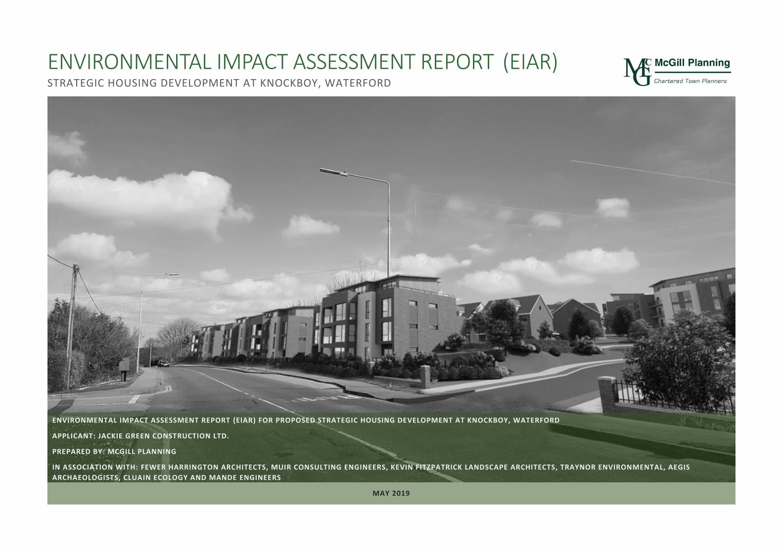
This Environmental Impact Assessment Report (EIAR) has been prepared on behalf of Jackie Green Construction Ltd. to accompany a Strategic Housing Development application to An Bord Pleanála for a new residential development on lands located at Knockboy, Waterford City. The subject site is a suburban site (currently in agricultural use) and situated on the eastern periphery of the City. The public road, St. Mary’s Place/Ballygunner Hill adjoins to the west of the site and connects to Dunmore Road to the north. The gross site area is c.9ha and is located north of St. Mary’s Church and Ballygunner Cemetery. There are areas of suburban housing to the west and southwest.
The proposed development will comprise a new residential development of 361 no. units comprising:
• 207 no. houses (13 no. 2-beds, 116 no. 3-beds, 78 no. 4-beds).
• 154 no. apartments within 15 no. 4 storey blocks (providing 53 no. 1-beds, 90 no. 2-beds and 11 no. 3-beds).
• A creche of c.574 sq.m.
• 7 no. internal/external communal waste storage facilities (total floor area c.214.3 sq.m).
• 638 car parking spaces and 390 no. bicycle parking spaces within 15 no storage facilities (total floor area c.232 sq.m). Additional visitor bicycle parking provided in the public realm.
• 2 no. ESB sub-stations/switchrooms (totalling c.10 sq.m)
• Vehicular/pedestrian/cyclist accesses to public road (Ballygunner Hill/St. Mary’s Place).
• The total gross floor area of the proposed development is c. c.51,226.1 sq.m
• All associated site development works, landscaping, open spaces, boundary treatments and services provision (including connection to public foul and surface water drainage at Dunmore Road
A detailed description of the development is provided in Chapter 3.
1.2 LEGISLATIVE CONTEXT Certain public and private projects that are likely to have significant effects on the environment are subject to EIA requirements derived from EIA Directive 85/337/EC (as amended by Council Directive 97/11/EC, Directive 2003/35/EC, Directive 2009/31/EC, Directive 2011/92/EU and Directive 2014/52/EU. The EIA Directives have been transposed into the Irish land use planning consent system by way of the Planning & Development Acts 2000 (as amended), and the Planning & Development Regulations 2001-18.
The most recent amendment to the Regulations - the European Union (Planning and Development)(Environmental Impact Assessment) Regulations 2018 (S.I. No. 296 of 2018) - transposed Directive 2014/52/EU into Irish law. Complementary to the legislation is a range of guidelines produced by the EU and government agencies to inform the carrying out of EIA:
• EU Guidance on EIA Screening (DG Environment 2001).
• Guidance on EIA Scoping (DG Environment 2001).
• EIA Review Checklist (DG Environment 2001).
• Guidelines on Information to be Contained in an Environmental Impact Statement (EPA 2002).
• Study on the Assessment of Indirect & Cumulative Impacts as well as Impact Interaction (DG Environment 2002).
• Environmental Impact Assessment (EIA), Guidance for Consent Authorities Regarding Sub-Threshold Development (DoEHLG 2003).
• Advice Notes on Current Practice (in preparation of Environmental Impact Statements) (EPA 2003).
• Development Management Guidelines (DoEHLG, 2007).
• Draft Guidelines on the information to be contained in Environmental Impact Assessment Reports (EPA 2017)
• Transposition of 2014 EIA Directive (2014/52/EU) in the Land Use Planning and EPA Licencing Systems - Key Issues Consultation Paper (Department of Environment, Community and Local Government, 2017).
• Circular letter PL 1/2017 - Advice on Administrative Provisions in Advance of Transposition (Department of Housing, Planning and Local Government, 2017).
• Environmental Impact Assessment of Projects – Guidance on the Preparation of the Environmental Impact Assessment Report (European Commission 2017)
• Environmental Impact Assessment of Projects – Guidance on Screening (European Commission 2017)
• Environmental Impact Assessment of Projects – Guidance on Scoping (European Commission 2017)
• Guidelines for Planning Authorities and An Bord Pleanála on carrying out Environmental Impact Assessment (Department of Housing, Planning and Local Government, 2018).
1.3 DEFINITION OF EIA Article 171A of the 2018 Regulations defines ‘environmental impact assessment’ as: “… a process (a) consisting of:
(i) the preparation of an environmental impact assessment report by the applicant in accordance with this Act and regulations made thereunder,
KNOCKBOY WATERFORD - ENVIRONMENTAL IMPACT ASSESSMENT REPORT
1.2
(ii) the carrying out of consultations in accordance with this Act and regulations made thereunder,
(iii) the examination by the planning authority or the Board, as the case may be, of-
I) the information contained in the environmental impact assessment report,
II) any supplementary information provided, where necessary, by the applicant in accordance with section 172(1D) and (1E), and
III) any relevant information received through the consultations carried out pursuant to subparagraph (ii),
(iv) the reasoned conclusion by the planning authority or the Board, as the case may be, on the significant effects on the environment of the proposed development, taking into account the results of the examination carried out pursuant to subparagraph (iii) and, where appropriate, its own supplementary examination, and
(v) the integration of the reasoned conclusion of the planning authority or the Board, as the case may be, into the decision on the proposed development, and
(b) which includes: (i) an examination, analysis and evaluation, carried out by the planning authority or the Board, as
the case may be, in accordance with this Part and regulations made thereunder, that identifies, describes and assesses, in an appropriate manner, in the light of each individual case, the direct and indirect significant effects of the proposed development on the following: (I) population and human health; (II) biodiversity, with particular attention to species and habitats protected under the
Habitats Directive and the Birds Directive; (III) land, soil, water, air and climate; (IV) material assets, cultural heritage and the landscape; (V) the interaction between the factors mentioned in clauses (I) to (IV), and
(ii) as regards the factors mentioned in subparagraph (i)(I) to (V), such examination, analysis and evaluation of the expected direct and indirect significant effects on the environment derived from the vulnerability of the proposed development to risks of major accidents or disasters, or both major accidents and disasters, that are relevant to that development;
1.4 EIA SCREENING Section 176(A) of the Act defines ‘screening for environmental impact assessment’ as
“.. a determination— (a) as to whether a proposed development would be likely to have significant effects on the environment, and (b) if the development would be likely to have such effects, that an environmental impact assessment is required.”
Section 172 of the Act states that an EIA shall be carried out respect of an application for consent for proposed development where either of the following are relevant:
• the proposed development would be of a class specified in Part 1 of Schedule 5 of the Planning and Development Regulations.
• the proposed development would be of a class specified in Part 2 of Schedule 5 of the Planning and Development Regulations.
• the proposed development would be of a class specified in Part 2 of Schedule 5 of the Planning and Development Regulations 2001 but does not equal or exceed the relevant quantity, area or other limit specified in that Part, but is concluded, determined or decided that proposed development is likely to have a significant effect on the environment.
The subject development does not fall within any development classes set out in Part 1 of Schedule 5. The following development classes set out in Part 2 of Schedule 5 are noted:
• 10(b)(i) Construction of more than 500 dwellings
• 10(b)(iv) Urban development which would involve an area greater than 2 hectares in the case of a business district, 10 hectares in the case of other parts of a built-up area and 20 hectares elsewhere. (In this paragraph, “business district” means a district within a city or town in which the predominant land use is retail or commercial use.)
The residential proposal in this instance is for 361 units which is under the 500 unit threshold. The application site is 9 ha which is less than 10ha. Development Class 15 in Part 2 of Schedule 5 is also noted:
• 15 Any project listed in this Part which does not exceed a quantity, area or other limit specified in this Part in respect of the relevant class of development, but which would be likely to have significant effects on the environment, having regard to the criteria set out in Schedule 7.
Schedule 7 of the Regulations lists the criteria for determining whether Development listed in Part 2 of Schedule 5 should be subject to an EIA. These are:
1. Characteristics of proposed development The characteristics of proposed development, in particular— (a) the size and design of the whole of the proposed development, (b) cumulation with other existing development and/or development the subject of a consent for proposed development for the purposes of section 172(1A) (b) of the Act and/or development the subject of any development consent for the purposes of the Environmental Impact Assessment Directive by or under any other enactment, (c) the nature of any associated demolition works, (d) the use of natural resources, in particular land, soil, water and biodiversity, (e) the production of waste, (f) pollution and nuisances, (g) the risk of major accidents, and/or disasters which are relevant to the project concerned, including those caused by climate change, in accordance with scientific knowledge, and (h) the risks to human health (for example, due to water contamination or air pollution).
KNOCKBOY WATERFORD - ENVIRONMENTAL IMPACT ASSESSMENT REPORT
1.3
2. Location of proposed development The environmental sensitivity of geographical areas likely to be affected by the proposed development, with particular regard to— (a) the existing and approved land use, (b) the relative abundance, availability, quality and regenerative capacity of natural resources (including soil, land, water and biodiversity) in the area and its underground, (c) the absorption capacity of the natural environment, paying particular attention to the following areas: (i) wetlands, riparian areas, river mouths; (ii) coastal zones and the marine environment; (iii) mountain and forest areas; (iv) nature reserves and parks; (v) areas classified or protected under legislation, including Natura 2000 areas designated pursuant to the Habitats Directive and the Birds Directive and; (vi) areas in which there has already been a failure to meet the environmental quality standards laid down in legislation of the European Union and relevant to the project, or in which it is considered that there is such a failure (vii) densely populated areas; (viii) landscapes and sites of historical, cultural or archaeological significance. 3. Types and characteristics of potential impacts The likely significant effects on the environment of proposed development in relation to criteria set out under paragraphs 1 and 2, with regard to the impact of the project on the factors specified in paragraph (b)(i)(I) to (V) of the definition of ‘environmental impact assessment report’ in section 171A of the Act, taking into account— (a) the magnitude and spatial extent of the impact (for example, geographical area and size of the population likely to be affected), (b) the nature of the impact, (c) the transboundary nature of the impact, (d) the intensity and complexity of the impact, (e) the probability of the impact, (f) the expected onset, duration, frequency and reversibility of the impact, (g) the cumulation of the impact with the impact of other existing and/or development the subject of a consent for proposed development for the purposes of section 172(1A) (b) of the Act and/or development the subject of any development consent for the purposes of the Environmental Impact Assessment Directive by or under any other enactment, and (h) the possibility of effectively reducing the impact.
Notwithstanding that the size of the site and proposed number of residential units are below the thresholds in Development Class 10 of Part 2 of Schedule 5, having regard to Development Class 15, Schedule 7 and Section 172 of the Act, and with regard to the size and scale of the proposed development, the proposed use of natural resources, the relative environmental sensitivity of the location, and the types of potential impacts, it was deemed prudent to prepare an EIAR for the proposed development to accompany the planning application in this instance.
Furthermore, it is noted that under Article 299A of the Regulations, where a planning application for a sub-threshold development is accompanied by an EIAR and a request for a determination under section 7(1)(a)(i)(I) of the Act of 2016 was not made, the application shall be dealt with as if the EIAR had been submitted in accordance with section 172(1) of the Act.
1.5 EIA SCOPING Section 173(2) (a) of the Planning and Development Act 2000 (as amended) provides that a formal request for scoping may be submitted to the planning authority. However, the ‘Draft Guidelines on the Information to be contained in Environmental Impact Assessment Reports’ (2017), confirm that this is not mandatory. The EIAR team carried out a scoping exercise to identify the key issues that may be considered likely to have a significant effect on the environment. Regard was also had to EIAR carried out for other developments in the Cherrywood SDZ. In accordance with the draft EPA Guidelines (2017), those issues that do not meet the threshold of significance have been ‘scoped out’. The following issues have been identified in the context of the proposed development:
• Population & Human Health
• Biodiversity
• Lands, Soils & Geology
• Hydrology & Water Services
• Noise & Vibration
• Air & Climate
• Landscape & Visual
• Traffic & Transportation
• Material Assets
• Waste Management
• Cultural Heritage
1.6 EIAR OBJECTIVES The EIA process is based on the following four principles:
• Pursuing Preventative Action An assessment of anticipated likely and significant impacts was undertaken during the screening and the considerations of alternatives stages of the EIA process. This involved forming a preliminary opinion with respect to the approximate magnitude and character of the likely environmental impacts. This assessment was based on the knowledge, experience and expertise of the EIA team with reference to EIA guidance material and local information.
KNOCKBOY WATERFORD - ENVIRONMENTAL IMPACT ASSESSMENT REPORT
1.4
• Maintaining Environmental Focus and Scope The EIA process has focussed on those issues where environmental impact is likely to occur and have significant effects.
• Informing the Decision The EIAR has been developed and is presented in such a way as to facilitate the authority decision on the acceptability of the proposed development in the full knowledge of the project’s likely significant impacts on the environment, if any.
• Public & Stakeholder Participation Participation is provided through the statutory planning process which allows for public participation and consultation while receiving advice from other key stakeholders and statutory authorities with specific environmental responsibilities.
1.7 EIAR FORMAT & CONTENT This EIAR is sub divided as follows: • Environmental Impact Assessment Report • Appendices to Environmental Impact Assessment Report • Non-Technical Summary. The EIAR has been prepared in the Grouped Format as set down in the EPA “Guidelines on Information to be contained in an EIS” (2002) and the ‘Draft Guidelines on the Information to be contained in Environmental Impact Assessment Reports’ (2017). In general, the EIAR follows the framework presented in the EPA “Advice Notes on Current Practice in the Preparation of Environmental Impact Statements” (September 2003). The structure and responsibility of the EIAR chapters is outlined below:
Chapter Title Consultant
1.0 Introduction & Methodology McGill Planning Ltd.
2.0 Alternatives McGill Planning Ltd.
3.0 Project Description McGill Planning Ltd.
4.0 Population & Human Health McGill Planning Ltd.
5.0 Biodiversity Cluain Ecology
6.0 Lands, Soils & Geology Muir Consulting Engineers
7.0 Hydrology & Water Services Muir Consulting Engineers
8.0 Noise & Vibration Traynor Environmental
9.0 Air & Climate Traynor Environmental
10.0 Landscape & Visual Harrington Fewer Architects & McGill Planning Ltd.
11.0 Traffic & Transportation Muir Consulting Engineers
12.0 Material Assets McGill Planning Ltd.
13.0 Waste Management Traynor Environmental
14.0 Cultural Heritage AEGIS Archaeologists
15.0 Interactions McGill Planning Ltd.
16.0 Summary of Mitigations Measure McGill Planning Ltd. Table 1.1 – List of EIAR Chapters
1.8 METHODOLOGY The preparation of this EIS requires the co-ordination and synthesis of associated yet diverse elements of the overall assessment. To facilitate this process, a schematic structure is proposed in order to provide a coherent documentation of the varied aspects of the environment considered. The grouped format structure of the Environmental Impact Statement is listed below with a brief outline of each specific stage.
Methodology The specific approach or techniques used to analyse impacts or describe environments. Receiving Environment (Baseline Situation) Dynamic description of the specific environment into which the proposal will fit, taking account of other developments likely to occur. The context, character, significance and sensitivity of the baseline is described. The likely evolution of baseline environmental characteristics without implementation of the proposed project.
Characteristics of the Proposed Development Description of the physical characteristics of a project having regard to
• the site location
• the size, design and appearance of the proposed project
• the cumulation with other proposed projects
• the use of natural resources
• the production of waste
• emissions and nuisances
• The potential risk of accidents.
The description of the development should take account of the full ‘life-cycle’ including construction, commissioning (if relevant), operation, changes to the project and potential decommission. Potential Impacts The potential impact of the proposal comprises a general description of the possible types of impacts which proposals of this kind would be likely to produce. Impact assessment addresses direct, indirect, secondary, cumulative, transboundary, short, medium and long term, permanent, temporary, positive and negative effects as well as impact interactions. This includes consideration of a ‘Do Nothing’ impact which describes the environment as it would be in the future if the development is not carried out. Mitigation Measures A description of any specific remedial or reductive measures considered necessary and practicable resulting from the assessment of potential impacts described above.
KNOCKBOY WATERFORD - ENVIRONMENTAL IMPACT ASSESSMENT REPORT
1.5
Predicted Impacts An assessment of the net specific impact of the proposal, noting the direct, indirect, secondary, cumulative, transboundary, short, medium and long term, permanent, temporary, positive and negative effects as well as impact interactions which the proposed development may have. The predicted impact assumes all mitigation measures are fully and successfully applied. A ‘Worst Case’ impact is also considered. A ‘Worst Case’ impact is an impact arising where a development or its mitigation measures substantially fail. Monitoring A description of any post development monitoring of effects of the environment which might be necessary. Reinstatement A description of any post development reinstatement measures which might be necessary.
1.9 COMPETENCY For the preparation of this EIAR, the applicant engaged McGill Planning Ltd. to project manage and coordinate the preparation of the EIAR with a team of qualified specialists engaged to prepare individual chapters, as listed in the table below. Details of the competency, qualifications and experience of the authors is also outlined:
Chapter Consultant Lead Consultant
Qualifications
Introduction & Methodology McGill Planning Ltd.
Trevor Sadler Master of Regional & Urban Planning
Alternatives
Project Description
Populations & Human Health
Landscape & Visual (Written)
Material Assets
Interactions
Summary of Mitigations Measure
Biodiversity Cluain Ecologists Michelle O’Neill Dr Katherine Kelleher
BSc in Zoology PhD in Ecology
Lands, Soils & Geology MUIR Consulting Engineers
Slaven Sose BEng, MIEI
Hydrology & Water Services
Traffic & Transportation
Noise & Vibration Traynor Environmental Nevin Traynor BSc. Env, H.Dip I.T, Cert SHWW
Air & Climate
Waste Management
Cultural Heritage AEGIS Archaeologists Frank Coyne BA H. Dip in Education
Table 1.2 – Qualifications of EIAR Authors
1.10 DIFFICULTIES IN COMPILING THE SPECIFIED INFORMATION There were no significant difficulties in completing the Environmental Impact Statement. (Any minor difficulties are presented in each of the respective chapters). While every effort has been made to ensure that the content of this EIAR is consistent there may be instances where typographical errors and/or minor inconsistencies do occur. These are unlikely to have any material impact on the overall findings and assessment contained in this EIAR.
1.11 AVAILABILITY OF THE EIAR A copy of this EIAR document and Non-Technical Summary of the EIAR document is available for purchase at the offices of Waterford City & County Council at a fee not exceeding the reasonable cost of reproducing the document. Additionally, prior to lodging this application, the required information has been issued for the Department of Housing, Planning and Local Government’s EIA Portal.

KNOCKBOY WATERFORD - ENVIRONMENTAL IMPACT ASSESSMENT REPORT
6
KNOCKBOY WATERFORD - ENVIRONMENTAL IMPACT ASSESSMENT REPORT
2.1
2 ALTERNATIVES CONSIDERED
2.1 INTRODUCTION
The Guidelines for Planning Authorities and An Bord Pleanála on Carrying out Environmental Impact Assessment (2018) state the following:
“The Directive requires that information provided by the developer in an EIAR shall include a description of the reasonable alternatives studied by the developer. These are reasonable alternatives which are relevant to the project and its specific characteristics. The developer must also indicate the main reasons for the option chosen taking into account the effects of the project on the environment. Reasonable alternatives may relate to matters such as project design, technology, location, size and scale.”
This section of the EIAR document provides an outline of the main alternatives examined throughout the design and consultation process under the following headings:
• Alternative Locations
• Alternative Designs
• Alternative Processes This serves to indicate the main reasons for choosing the development proposed, taking into account and providing a comparison of the environmental effects. The type of alternatives depends on the nature of the project proposed and the characteristics of the receiving environment. The 2018 Guidelines also note that it is generally sufficient for the developer to provide a broad description of each main alternative studied and the key environmental issues. Furthermore, a ‘mini- EIA’ is not required for each alternative studied.
2.2 ALTERNATIVE LOCATIONS
The 2018 Guidelines note that some projects may be “site specific” so the consideration of alternative sites may not be relevant. This point is also stated in the Draft Guidelines on the Information to be Contained in Environmental Impact Assessment Reports (EPA 2017), which states that in some instances alternative locations may not be applicable or available for a specific project which is identified for a specific location. With regard to locations, the considerations of alternatives in many cases will already have been addressed and decided at strategic planning level during the adoption of city/county/local developments plans. Furthermore, these plans will have been subject to Strategic Environmental Assessment which will have taken into account the environmental considerations associated with, for example, the cumulative impact of an area zoned for industry on a sensitive landscape.
The 2017 Guidelines further state:
Note also that plan-level/higher-level assessments may have set out project-level objectives or other mitigation that the project and its EIAR should be cognisant of.
In this regard we note that the proposed development is located in the eastern suburbs of Waterford City and is zoned for residential development under the City Development Plan 2013-2019. The proposed residential development with creche is consistent with the zoning and related objectives of the Development Plan. The location of new residential development at this site has therefore been pre-empted in the adopted City Development Plan which itself was Strategic Environment Assessment (SEA) and the consideration of alternatives for this site and area. As a result, the consideration of alternative site locations for the proposed development were not considered necessary or justified in this instance.
2.3 ALTERNATIVE DESIGNS
The layout, scale, quantum, density and design of the proposed development has had due regard to its setting in a suburban residential area east of the city. The proposed layout and design have also been influenced by the site’s specific topography and accessibility. A number of alternative residential layouts and designs have also been considered on the subject site previously:
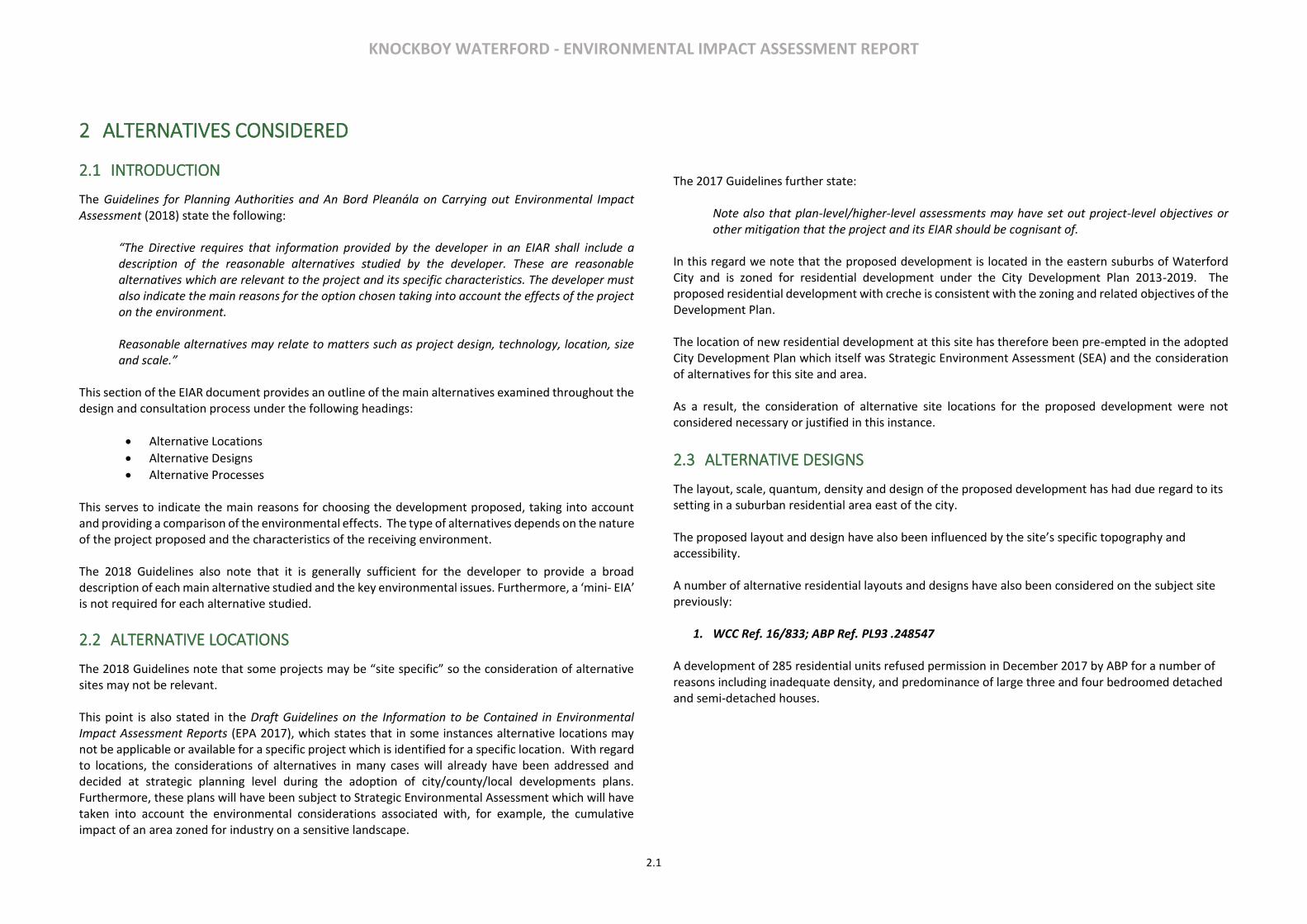
1. WCC Ref. 16/833; ABP Ref. PL93 .248547 A development of 285 residential units refused permission in December 2017 by ABP for a number of reasons including inadequate density, and predominance of large three and four bedroomed detached and semi-detached houses.
KNOCKBOY WATERFORD - ENVIRONMENTAL IMPACT ASSESSMENT REPORT
2.2
Figure 3.1 – Layout of Refused Scheme Ref. WCC 16/833
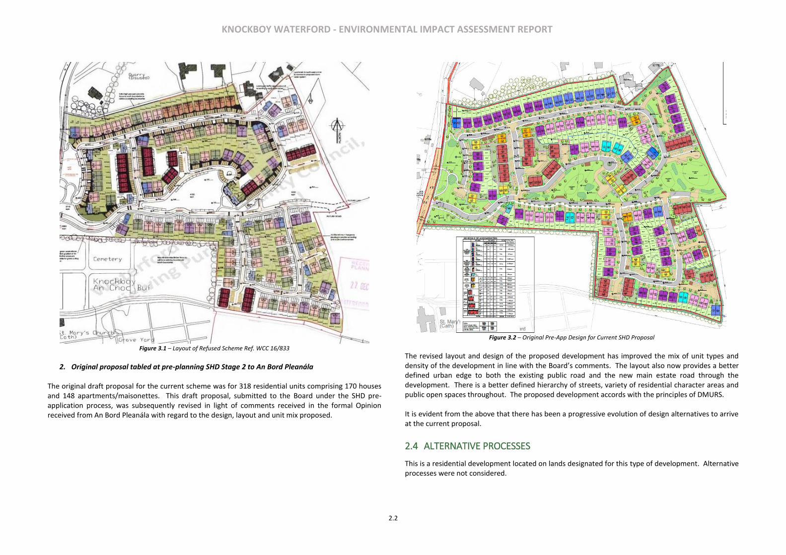
2. Original proposal tabled at pre-planning SHD Stage 2 to An Bord Pleanála
The original draft proposal for the current scheme was for 318 residential units comprising 170 houses and 148 apartments/maisonettes. This draft proposal, submitted to the Board under the SHD pre-application process, was subsequently revised in light of comments received in the formal Opinion received from An Bord Pleanála with regard to the design, layout and unit mix proposed.
Figure 3.2 – Original Pre-App Design for Current SHD Proposal
The revised layout and design of the proposed development has improved the mix of unit types and density of the development in line with the Board’s comments. The layout also now provides a better defined urban edge to both the existing public road and the new main estate road through the development. There is a better defined hierarchy of streets, variety of residential character areas and public open spaces throughout. The proposed development accords with the principles of DMURS. It is evident from the above that there has been a progressive evolution of design alternatives to arrive at the current proposal.
2.4 ALTERNATIVE PROCESSES
This is a residential development located on lands designated for this type of development. Alternative processes were not considered.

KNOCKBOY WATERFORD - ENVIRONMENTAL IMPACT ASSESSMENT REPORT
3.1
3 PROJECT DESCRIPTION
3.1 INTRODUCTION
This section of the EIAR has been prepared by McGill Planning Ltd. with input from the project team. The section describes the nature of the proposed development in accordance with the requirements of the relevant EIA legislation and guidance on preparation and content of EIAR.
3.2 CHARACTERISTICS OF THE SITE
The subject site is a suburban site (currently in agricultural use) and situated on the eastern periphery of Waterford City. The public road, Ballygunner Hill/St, Mary’s Place, adjoins to the west of the site and connects to Dunmore Road to the north. The site has an established agricultural entrance to the public road. The gross site area is c.9ha and is located north of St. Mary’s Church and Ballygunner Cemetery. There are large areas of suburban housing to the west and southwest. The public road rises steadily from its junction with the Dunmore Road and the site is elevated above same.
Figure 3.1 Site boundary
The gradient of the site generally falls in a south to north direction with the gradient rising steeply from the western boundary to the centre of the site. Two power lines traverse the site. The boundary along the southern perimeter of the site, adjoining the cemetery, comprises of mature evergreen trees. The western boundary comprises of fencing with established low rise hedgerows and mature trees. The remainder of the site boundaries comprise mature hedgerows.
3.3 PROPOSED DEVELOPMENT
The development will comprise a residential development 361 units broken down as follows:
• 207 no. houses consisting of: o 13 No. 4 bed detached dwelling house (house type A3) o 4 No. 4 bed detached dwelling house (house type B3) o 2 No. 3 bed detached dwelling house (house type C3) o 2 No. 3 bed detached dwelling house (house type D3) o 3 No. 4 bed detached dwelling house (house type A4) o 1 No. 3 bed detached dwelling house (house type C4) o 35 No. 4 bed semi-detached dwelling house (house type A1) o 17 No. 4 bed semi-detached dwelling house (house type B1) o 42 No. 3 bed semi-detached dwelling house (house type C1) o 50 No. 3 bed semi-detached dwelling house (house type D1) o 5 No. 4 bed semi-detached dwelling house (house type A2) o 1 No. 4 bed semi-detached dwelling house (house type B2) o 6 No. 3 bed semi-detached dwelling house (house type C2) o 2 No. 3 bed semi-detached dwelling house (house type D2) o 12 No. 2 bed terrace dwelling house (house type F1) o 5 No. 3 bed terrace dwelling house (house type E1) o 6 No. 3 bed terrace dwelling house (house type E2) o 1 No. 2 bed terrace dwelling house (house type F2)
• 154 no. apartments within 15 no. 4 storey blocks (providing 53 no. 1-beds, 90 no. 2-beds and 11 no. 3-beds).
• A creche of c574 sq.m.
• 7 no. internal/external communal waste storage facilities (total floor area c.214.3 sq.m).
• 638 car parking spaces and 390 no. bicycle parking spaces within 15 no storage facilities (total floor area c.232 sq.m). Additional visitor bicycle parking provided in the public realm.
• 2 no. ESB sub-stations/switchrooms (totalling c.10 sq.m)
• Vehicular/pedestrian/cyclist accesses to the public road (Ballygunner Hill/St. Mary’s Place).
• The total gross floor area of the proposed development is c. c.51,266.1 sq.m

KNOCKBOY WATERFORD - ENVIRONMENTAL IMPACT ASSESSMENT REPORT
3.2
• All associated site development works, landscaping, open spaces, boundary treatments and services provision (including connection to public foul and surface water drainage at Dunmore
Road & Island Drive).
3.4 CONSTRUCTION STAGE
This section of the EIAR summarises the construction of the proposed development. The Outline Construction & Environmental Management Plan submitted separately in the planning application, and the Outline Construction and Demolition Waste Management Plan (Appendix 13.1 of the EIAR) should also be consulted. Hoarding, Site Set-up and Formation of Site Access/Egress The site area will be enclosed with hoarding, details of which will be agreed with Waterford City & County Council. This will involve erecting hoarding around the proposed site perimeter in line with the finished development extents. Hoarding panels will be maintained and kept clean for the duration of the works. The available site footprint will enable the Contractor to set up the site compound within the site boundary. The Contractor will be responsible for the security of the site. The Contractor will be required to:
• Operate a Site Induction Process for all site staff;
• Ensure all site staff shall have current ‘Safe Pass’ cards and appropriate PPE;
• Install adequate site hoarding to the site boundary;
• Maintain site security at all times;
• Install access security in the form of turn-styles and gates for staff;
• Separate public pedestrian access from construction vehicular traffic;
The Main Contractor will be required to submit a site layout plan that will detail the proposed location of the site compound. The site compound will be used as the primary location for the storage of materials, plant and equipment, site offices and worker welfare facilities. As Project Supervisor Construction Stage (PSCS), the Contractor will be responsible for site security and they are to ensure that the site and site compound are adequately secured at all times. As with the other construction activities that are being carried out within the Waterford City & County Council local authority area, activities associated with the construction compounds will be subject to restrictions to the nature and timing of operations so that they do not cause undue disturbance to neighbouring areas and communities. The site layout plan will also include the site perimeter and the proposed detail with regards the hoarding and gate system. Site Clearance and Demolition The location is a greenfield site and will require topsoil removal and some tree/hedge removal. It is noted that the proposed development does not propose any basements.
Car Parking Arrangements Parking of construction workers vehicles will be limited to within the site extents. To minimise congestion, a traffic management plan will need to be developed by the Contractor to ensure that construction workers access the site using alternative means of transport (i.e. public transport) to negate/minimise any impacts on the local network. Working Hours & Staff The proposed hours of work on site will typically be 08:00 hrs to 19:00 hrs Monday to Saturday unless otherwise specified by planning conditions. Certain tasks may need to be undertaken outside of these hours. All outside of hours work will first be agreed in writing with the Local Authority. It is predicted that there may be up to 150 personnel on site during peak construction activity. Lighting There are no proposals to alter the existing lighting arrangements in the area. It is not envisaged that any existing public lighting will need to be disconnected as a result of the proposed works. Appropriate lighting will be provided as necessary at construction compounds. All lighting will be installed so as to minimise light spillage from the site. Delivery and Storage The Contractor will ensure that the delivery of materials is coordinated to minimise impacts to adjacent properties. The Contractor will ensure that all materials are adequately stored and secured in their site compound. The Contractor will ensure the roads adjacent to the site are kept clean and free of debris. Traffic Management Procedures / Generation The contractor will prepare a site-specific Traffic Management Plan (TMP) prior to the construction works commencing. The contractor will be responsible for the implementation of all agreements between the developer and County Council with the objective that the transportation needs for the proposed development will have a minimal impact on the road network and local communities. Adequate signage as per Chapter 8 of the Traffic Signs Manual shall be installed on approach to the proposed site entrance location advising of the presence of a ‘site access ahead’ and ‘construction traffic ahead’. The above signage shall be removed following completion of the construction phase. Roadside hedgerows under control of the owner shall be trimmed annually to maintain minimum sightline distances where required. Disposal of water, wastewater and sewage All site facilities during construction will be located entirely within the site. The facilities will include canteen, toilet block and drying room for all staff/workers. These facilities will be connected to the local authority sewage system with local authority approval. Throughout the works, all surface water (water from excavations etc.) will be pumped to a holding tank on site. From here the water will be pumped to a series of settlement tanks. These tanks will act as primary and secondary settlement. The settlement tanks will be of sufficient number and size to allow the necessary retention time for solids to settle. The discharge water from the final tank will be routed to the existing combined water system with approval from the local authority. Visual checks of the pumping and settlement system will be carried out on a routine basis.

KNOCKBOY WATERFORD - ENVIRONMENTAL IMPACT ASSESSMENT REPORT
3.3
Air Quality There is the potential for a number of emissions to the atmosphere during the construction stage of the project. In particular, activities may generate quantities of dust. Construction vehicles, generators etc., will also give rise to some exhaust emissions. Vehicular movements to and from the site will make use of existing roads. A dust minimization plan will be formulated for the demolition and construction phase of the project, as construction activities are likely to generate dust emissions. The potential for dust to be emitted depends on the type of activity being carried out in conjunction with environmental factors including levels of rainfall, wind speeds and wind direction. The potential for impact from dust depends on the distance to potentially sensitive locations and whether the wind can carry the dust to these locations. The majority of any dust produced will be deposited close to the potential source and any impacts from dust deposition will typically be within several hundred metres of the construction area. In order to ensure that no dust nuisance occurs, a series of measures will be implemented. Roads shall be regularly cleaned and maintained as appropriate. Hard surface roads shall be swept to remove mud and aggregate materials from their surface. Furthermore, any road that has the potential to give rise to fugitive dust must be regularly watered, as appropriate, during dry and/or windy conditions. Vehicles delivering material with dust potential both on and off the site shall be enclosed or covered with tarpaulin at all times to ensure no potential for dust emissions. All vehicles exiting the site shall make use of a wheel wash facility, if required, prior to entering onto public roads, to ensure mud and other wastes are not tracked onto public roads. Public roads outside the site shall be regularly inspected for cleanliness and cleaned as necessary. Material handling systems and site stockpiling of materials shall be designed and laid out to minimise exposure to wind. Water misting or sprays shall be used as required if particularly dusty activities are necessary during dry or windy periods. At all times, the procedures put in place will be strictly monitored and assessed. In the event of dust nuisance occurring outside the site boundary, satisfactory procedures will be implemented to rectify the problem. The dust minimisation plan shall be reviewed at regular intervals during the construction phase to ensure the effectiveness of the procedures in place and to maintain the goal of minimisation of dust through the use of best practise and procedures.
3.5 OPERATIONAL STAGE
The proposed development is a residential development on appropriately zoned lands at Knockboy, Waterford City. The development includes for associated infrastructural works, connections and open spaces. It is anticipated that the primary direct significant environmental effects will arise during the construction stage. Once the development is completed, and mitigation measures employed, it is expected to operate
without creating to any significant additional environmental impacts. The range of anticipated activities, materials/natural resources used, effects/emissions are not expected to result in a significant impact on the constituent environmental factors. The primary likely and significant environmental impacts of the operation of the proposed development are fully addressed in the EIAR document; and relate to Population and Human Health, Landscape and Visual Impact and Noise and Air impacts associated with the traffic generated. There is also the potential for cumulative, secondary and indirect impacts (for instance traffic) but are unlikely to be significant and have been addressed in the EIAR.
3.6 CHANGES, SECONDARY DEVELOPMENTS, CUMULATIVE IMPACTS
The potential for the specific proposed development as described to grow is considered to be limited and would be confined primarily to potential minor domestic extensions to the houses. Depending on scale these may individually require discrete planning permissions in the future. The potential for the apartments to expand or increase in scale is limited to the confines of the permission sought and new planning permission will be required for further extensions to the blocks. No significant secondary enabling development, other than as described in this EIAR, is deemed necessary to facilitate the proposed development. In relation to cumulative impacts these are individually assessed in the individual chapters of the EIAR.

KNOCKBOY WATERFORD - ENVIRONMENTAL IMPACT ASSESSMENT REPORT
3.4

KNOCKBOY WATERFORD - ENVIRONMENTAL IMPACT ASSESSMENT REPORT
4.1
4 POPULATION AND HUMAN HEALTH
4.1 INTRODUCTION
This chapter, prepared by McGill Planning Ltd., addresses the impacts of the proposed residential scheme at Knockboy, Waterford City on population and human health.
4.2 METHODOLOGY
To establish the existing receiving environment / baseline for the subject site, the methodology included site visits to evaluate the location and likely significant potential impact upon human sources in the area. Desk based study of Central Statistics Office Census data, the ESRI Quarterly Economic Commentary, and national, regional and local planning documents was also carried out.
4.3 RECEIVING ENVIRONMENT
LAND USE AND SETTLEMENT PATTERNS
The subject site, comprising c.9 ha, is located approximately 5km east of the city centre in a subruban locaiton proximate to a number of other residential estates, and local services. The site currently consists of arable farmland. The land is zoned for residential developemnt in the Waterford City Development Plan 2013-19. The surrounding context comprises residential estates suburban housing, as well as low-density detached housing. The site is immediately adjacent Ballygunner cemetery and St Mary’s Church. The locality also consists of Primary schools Gaelscoil Port Lairge and St. Mary’s National school. National monument and protected structure, Ballygunner castle, which is a detached four bay two storey house from 1640 possibly incorporating earlier structures from around 1200, is also situated within the locality south of Ballygunner village. St. Marys church is also a listed building in the National Inventory of Architectural Heritage.
Figure 4.1 Waterford city Development Plan Zoning Map 2019, Site outlined in double red boundary
KNOCKBOY WATERFORD - ENVIRONMENTAL IMPACT ASSESSMENT REPORT
4.2
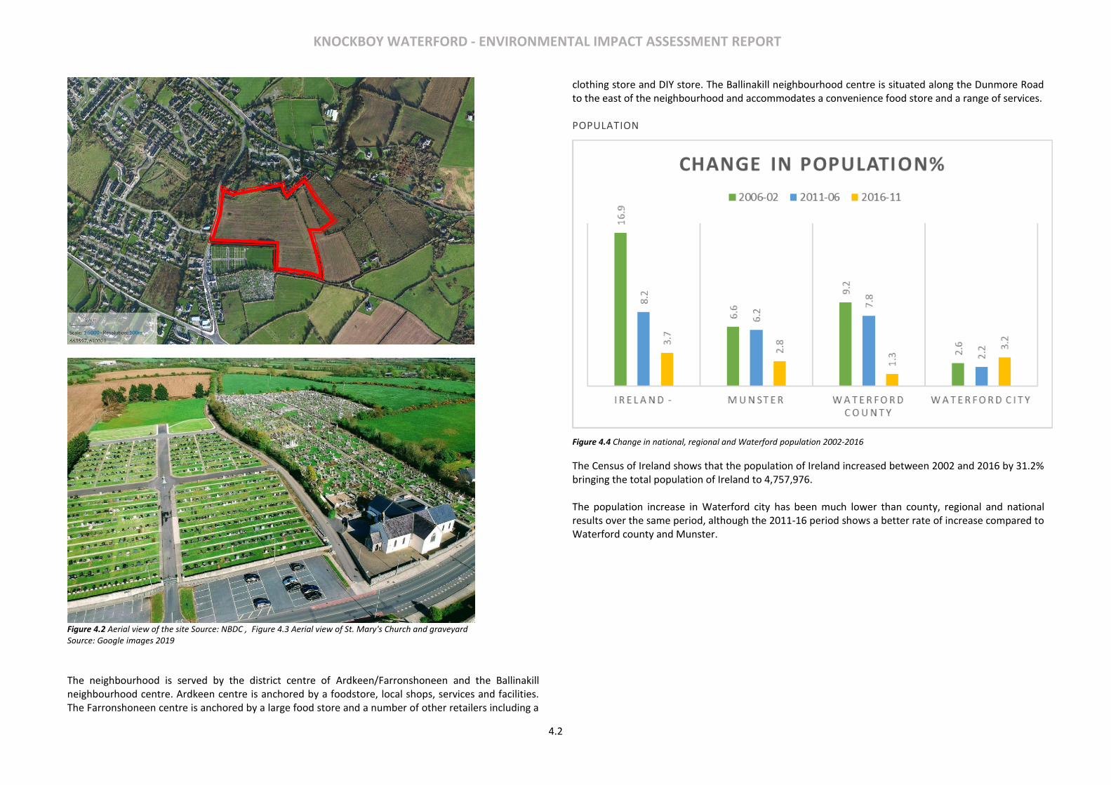
Figure 4.2 Aerial view of the site Source: NBDC , Figure 4.3 Aerial view of St. Mary's Church and graveyard Source: Google images 2019
The neighbourhood is served by the district centre of Ardkeen/Farronshoneen and the Ballinakill neighbourhood centre. Ardkeen centre is anchored by a foodstore, local shops, services and facilities. The Farronshoneen centre is anchored by a large food store and a number of other retailers including a
clothing store and DIY store. The Ballinakill neighbourhood centre is situated along the Dunmore Road to the east of the neighbourhood and accommodates a convenience food store and a range of services. POPULATION
Figure 4.4 Change in national, regional and Waterford population 2002-2016
The Census of Ireland shows that the population of Ireland increased between 2002 and 2016 by 31.2% bringing the total population of Ireland to 4,757,976. The population increase in Waterford city has been much lower than county, regional and national results over the same period, although the 2011-16 period shows a better rate of increase compared to Waterford county and Munster.

KNOCKBOY WATERFORD - ENVIRONMENTAL IMPACT ASSESSMENT REPORT
4.3
Figure 4.5 Catchment Area 3km radius consisting of 7 Electoral Divisions
Area 2006 2011 2016 % Change 2006-16
Ireland 4,239,848 4,588,252 4,757,976 12.22
Munster 1,173,340 1,246,088 1,280,394 9.12
Waterford County 62,213 67,063 67,960 9.24
Waterford City 45,748 46,732 48,216 5.39
Farranshoneen ED 5,370 5,465 5,607 4.41
Local Catchment Area 15603 16406 16685 6.93 Table 4.1 – Population change in the State, Waterford County, Waterford City, Small Area 2006-2011
For the purpose of this research a local catchment area of 3km radius, comprising of Electoral Divisions surrounding the subject site, was selected to assess the current demographic pattern of the site and its setting. The Local Catchment Area has shown promising growth at the rate of 6.9% over the past 10 years, which is greater than that of Waterford city (5.39%). The E.D.s include urban and rural sectors thus
reflecting the actual statistics to a great extent. The Electoral Divisions included within the Local catchment area are:
1. Farranshoneen (consisting of the subject site) 2. Grange upper 3. Ballynakil 4. Ballymaclode 5. Grange South 6. Ballynakil (Part Rural) 7. Faithlegg (Part Rural)
AGE PROFILE
The Local Catchment Area has a strong representation (53.4%) of working age group of people (25-65) living in the area. The Farranshoneen ED contains 56.2% in the working age group. This is greater than the state average of 53.4% and the average for Waterford city (52.8%) for the census year of 2016. There has been significant residential development in the locality within Dunmore road and Williamstown road over the past 10 years that have contributed to the increase in working age group.
Figure 4.6 Population by age group
The age sex ratio for Waterford city in 2016 is 1030 females for every 1000 males. There is a reduction of 27% in the number of children under 5 years in between 2011 and 2016. However, there is a visible increase in the number of children in the age group of 10-14 amounting to 9%. This is most likely due to a combined result of a carryover effect and the in-migration of people from within and outside Ireland. Another trend that is visible in the Age-Sex pyramid is the reduction of numbers in the 20-30 age group due to outmigration of people for higher education, jobs etc.
Site Boundary
Electoral Division Boundary
Waterford City Boundary
Local Catchment Area

KNOCKBOY WATERFORD - ENVIRONMENTAL IMPACT ASSESSMENT REPORT
4.4
Figure 4.7 Age Sex ratio for Waterford city 2011 to 2016
EMPLOYMENT
The CSO’s Quarterly Force Survey provide information in relation to national employment levels, unemployment levels and current labour force participation rates. Data for Q4 of 2018 shows an annual increase employment of 0.7% or 50,500 for the state during the 2017-18 period bringing the total employment to 2,281,300. This compares with an annual increase of 67,300 for the years 2016-17. Unemployment decreased by 15,200 (11%).
Table 4.2 ILO Economic Statistics CSO
The increase in employment by 2.93% saw an increase in 10 of the 14 economic sectors, with construction seeing the largest growth of 13.9% (or +17,900), followed by administration and support service activities with 13.5% growth (or +12,500). Wholesale and retail trade (including repair of motor vehicles and motorcycles) still remains the largest industry of employment with around 301,000, followed closely by Industry (285,000) and Human Health and Social Work Activities (282,000). Waterford city has also showed promising growth with the unemployment rates reducing by 5.2% in the 2011-16 period bringing the total number of people unemployed to 4398. There is an increase in labour force by a 342 people in the 2011-16 period.
Waterford city 2011 2016
Total Unemployed 5616 4398
Labour force 22396 22738
Unemployment rate 25% 19.3%
Table 4.3 Employment rates Waterford City
CHILDCARE
There are 11 childcare services available within 5min drive time catchment of the site. The details of their type of services and capacities are shown in Table 4.4 below Error! Reference source not found.. Among these facilities three (highlighted in green in Error! Reference source not found.) are available within 10-minute walking time catchment and of this Scallywags Playschool is available within 5-minute walking time catchment. Childcare facilities falling within 5min drive time are shown in Figure 4.8 Location of nearby
Childcare services (Source: ArcGIS analysis, www.pobal.ie)Figure 4.8.
No Name of Childcare facility
Type of facility
Capacities by age group Total No.s 0-1 1-3 3-5 5-7 7-15
1 Jigsaw Day nursery Full day care 18 39 80 25 15 177
2 Williamstown community childcare
Full day care 0 18 40 7 7 72
3 Home from home creche Full day care 3 7 14 8 8 40
4 Tiny tots’ corner
5 Woodlands play room Sessional 0 5 15 0 0 20
ILO Economic Status Ireland Q4 16 Q4 17 Q4 18 Annual change
All persons 2017-18 %
In labour force 2331100 2374800 2410100 35300 1.486441
In employment 2163500 2230800 2281300 50500 2.263762
Unemployed 167600 144000 128800 -15200 -10.5556
Not in labour force 1432900 1443400 1467000 23600 1.635028
Total persons aged 15 or over 3764000 3818200 3877200 59000 1.545231
Unemployment rate % 7.2 6.1 5.4

KNOCKBOY WATERFORD - ENVIRONMENTAL IMPACT ASSESSMENT REPORT
4.5
6 Park Montessori school Sessional 0 0 20 0 0 20
7 Little explorers Montessori
Full day care 0 5 33 38 0 76
8 Scallywags playschool Sessional 0 0 20 0 0 20
9 Blue bells Playschool Sessional 0 0 20 0 0 20
10 Little treasure Montessori and day-care
Full day care 3 13 12 0 0 28
11 Keen Kidz Montessori Part time 0 0 28 15 32 75
Total 24 87 282 93 62 548 Table 4.4 Capacities of Childcare facilities within 5 minute drive time (Source: Waterford Childcare Committee 2016)
The Childcare Facilities Guidelines for Planning Authorities, 2001 require one creche to be built for every 75 dwelling units catering for at least 20 children. The proposed development consists of 361 units which would require c.96 childcare spaces to be provided. A dedicated creche is provided as part of the development which can cater for 100 children. SCHOOLS
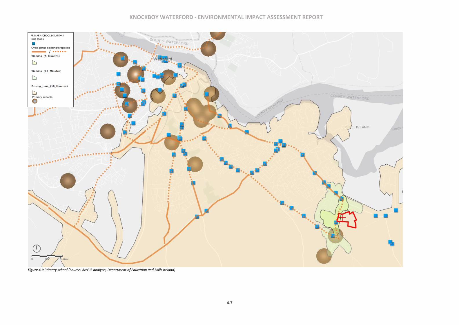
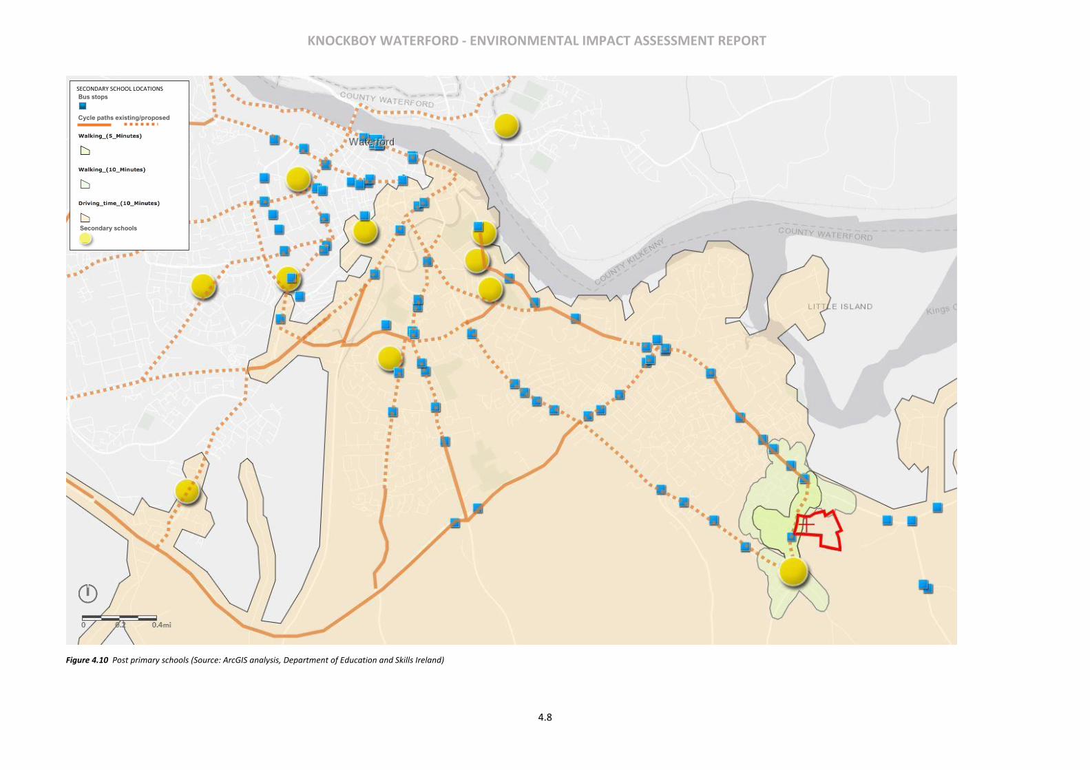
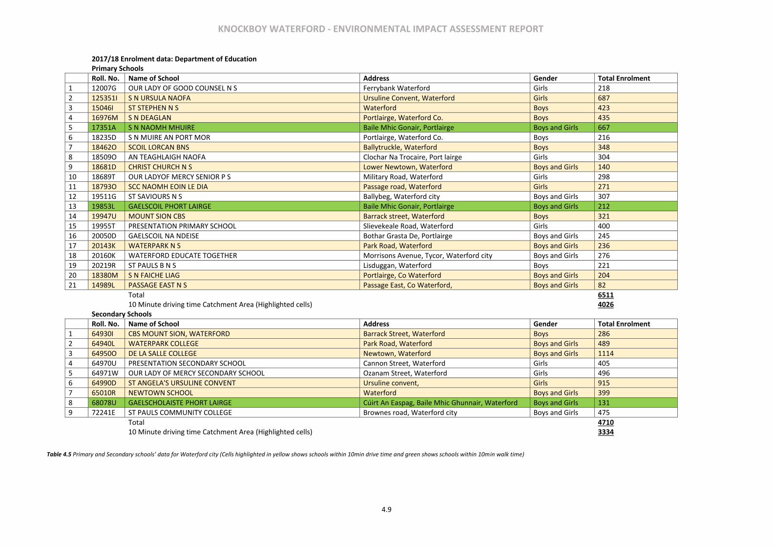
Existing Provision & Accessibility There are more than 20 Primary schools and 9 secondary schools within Waterford city catering to 11,000 students. These are listed in Table 4.5 below and mapped in Figure 4.9 and 4.10. As can be seen there is a good distribution of primary schools in the city. Furthermore, the development site is located within 5 mins walk of two local primary schools – Naoimh Mhuire & Gaescoil Phort Larige, which in total have c.880 students currently. For the purpose of analysing the accessibility of the schools outside the immediate walk-time catchment, a 10-minute bus journey/drivetime catchment area was assumed. There are two bus stops (Ballygunner & Knockboy) within a 5-minute walk of the site. The bus routes that serve the stops are the 607 (Ballygunner- Abbey Park), 617 (Ballygunner-Slieverue Ferrybank) and 627 (Ballygunner-Clock Tower). Buses run at half an hour interval during non-peak hours and at 15-minute intervals during peak hours. All services connect the site with the city centre which is approximately a 10 minute journey time. There are also public footpaths on both sides of St. Mary’s Place/Ballygunner Hill past the site which connects to Ballygunner village to the south and the wider city footpath network to the north. There are cycle lanes on St. Mary’s Lane south of the graveyard and on both sides of the Dunmore Road and Williamstown Road into the city centre. The City Development Plan proposes further expansion to the cycling network in the city. Of the 19 other primary schools located within the city 10 are located within a 10-minute drive time catchment of the site location. The total number of pupils accommodated as per the existing data for the
catchment is 4026. This catchment area is also well served by an existing system of bus service and cycle lanes. Whilst the Gaelsocil in Ballygunner, 5 minutes’ walk from the site, incudes a secondary school with current enrolment of 131, the remainder of the secondary schools are located within or adjacent the city centre. This historic trend is acknowledged in the Waterford City Development Plan 2013-19 (Chapter 9) which notes the following in relation to the geographic spread of primary and post-primary schools:
“In the overall context of schools’ development, it is the generally held policy of the Department of Education and Skills that primary schools should be centred in communities. This Development Plan concurs totally with that policy and sees primary schools as a vital component at the centre of communities and indeed at the heart of Waterford City Council’s neighbourhood policy. On the other hand, most of the City’s secondary schools are in the City Centre or quite close to it. It is not envisaged that there will be any demographic shifts large enough over the lifetime of this Plan to justify any variation in this pattern. At any rate, the high density of secondary schools adds a very important vibrancy to the City Centre as well as allowing students ready access to support services such as libraries and recreational facilities, but it is also a policy which needs to be supported by good quality public transport services.”
3 of the large city centre schools – De La Salle (1114 students), Waterpark (489) and Newtown (399) are located in the same area along Newtown Road to the south-east of the city centre and are served by the bus services that run to and from Ballygunner, noted above, with a c.10 minute journey time. It is also noted that both Newtown and Waterpark have extant permissions and Department funding in place to extend their schools over the coming years and increase enrolment to over 600 and 540 respectively (c.+300).

KNOCKBOY WATERFORD - ENVIRONMENTAL IMPACT ASSESSMENT REPORT
4.6
Figure 4.8 Location of nearby Childcare services (Source: ArcGIS analysis, www.pobal.ie)
CHILDCARE FACILITY LOCATIONS
Bus stops
Cycle paths existing/proposed
Childcare Facilities
KNOCKBOY WATERFORD - ENVIRONMENTAL IMPACT ASSESSMENT REPORT
4.7
Figure 4.9 Primary school (Source: ArcGIS analysis, Department of Education and Skills Ireland)
PRIMARY SCHOOL LOCATIONS
Bus stops
Cycle paths existing/proposed
/
Primary schools
KNOCKBOY WATERFORD - ENVIRONMENTAL IMPACT ASSESSMENT REPORT
4.8
Figure 4.10 Post primary schools (Source: ArcGIS analysis, Department of Education and Skills Ireland)
SECONDARY SCHOOL LOCATIONS
Bus stops
Cycle paths existing/proposed
Secondary schools
KNOCKBOY WATERFORD - ENVIRONMENTAL IMPACT ASSESSMENT REPORT
4.9
2017/18 Enrolment data: Department of Education
Primary Schools
Roll. No. Name of School Address Gender Total Enrolment
1 12007G OUR LADY OF GOOD COUNSEL N S Ferrybank Waterford Girls 218
2 125351I S N URSULA NAOFA Ursuline Convent, Waterford Girls 687
3 15046I ST STEPHEN N S Waterford Boys 423
4 16976M S N DEAGLAN Portlairge, Waterford Co. Boys 435
5 17351A S N NAOMH MHUIRE Baile Mhic Gonair, Portlairge Boys and Girls 667
6 18235D S N MUIRE AN PORT MOR Portlairge, Waterford Co. Boys 216
7 18462O SCOIL LORCAN BNS Ballytruckle, Waterford Boys 348
8 18509O AN TEAGHLAIGH NAOFA Clochar Na Trocaire, Port lairge Girls 304
9 18681D CHRIST CHURCH N S Lower Newtown, Waterford Boys and Girls 140
10 18689T OUR LADYOF MERCY SENIOR P S Military Road, Waterford Girls 298
11 18793O SCC NAOMH EOIN LE DIA Passage road, Waterford Girls 271
12 19511G ST SAVIOURS N S Ballybeg, Waterford city Boys and Girls 307
13 19853L GAELSCOIL PHORT LAIRGE Baile Mhic Gonair, Portlairge Boys and Girls 212
14 19947U MOUNT SION CBS Barrack street, Waterford Boys 321
15 19955T PRESENTATION PRIMARY SCHOOL Slievekeale Road, Waterford Girls 400
16 20050D GAELSCOIL NA NDEISE Bothar Grasta De, Portlairge Boys and Girls 245
17 20143K WATERPARK N S Park Road, Waterford Boys and Girls 236
18 20160K WATERFORD EDUCATE TOGETHER Morrisons Avenue, Tycor, Waterford city Boys and Girls 276
19 20219R ST PAULS B N S Lisduggan, Waterford Boys 221
20 18380M S N FAICHE LIAG Portlairge, Co Waterford Boys and Girls 204
21 14989L PASSAGE EAST N S Passage East, Co Waterford, Boys and Girls 82
Total 6511
10 Minute driving time Catchment Area (Highlighted cells) 4026
Secondary Schools
Roll. No. Name of School Address Gender Total Enrolment
1 64930I CBS MOUNT SION, WATERFORD Barrack Street, Waterford Boys 286
2 64940L WATERPARK COLLEGE Park Road, Waterford Boys and Girls 489
3 64950O DE LA SALLE COLLEGE Newtown, Waterford Boys and Girls 1114
4 64970U PRESENTATION SECONDARY SCHOOL Cannon Street, Waterford Girls 405
5 64971W OUR LADY OF MERCY SECONDARY SCHOOL Ozanam Street, Waterford Girls 496
6 64990D ST ANGELA'S URSULINE CONVENT Ursuline convent, Girls 915
7 65010R NEWTOWN SCHOOL Waterford Boys and Girls 399
8 68078U GAELSCHOLAISTE PHORT LAIRGE Cúirt An Easpag, Baile Mhic Ghunnair, Waterford Boys and Girls 131
9 72241E ST PAULS COMMUNITY COLLEGE Brownes road, Waterford city Boys and Girls 475
Total 4710
10 Minute driving time Catchment Area (Highlighted cells) 3334
Table 4.5 Primary and Secondary schools’ data for Waterford city (Cells highlighted in yellow shows schools within 10min drive time and green shows schools within 10min walk time)
KNOCKBOY WATERFORD - ENVIRONMENTAL IMPACT ASSESSMENT REPORT
4.10
HEALTH
The surrounding context of the site consists of a mix of residential, community and amenity related land uses. It does not include any man-made industrial sites or processes (including SEVESO II Directive sites) which would be likely to result in a risk to human health and safety.
4.4 CHARACTERISTICS OF THE PROPOSED DEVELOPMENT
The development will consist of a new residential development of 361 no. units comprising:
• 207 no. houses (13 no. 2-beds, 116 no. 3-beds, 78 no. 4-beds).
• 154 no. apartments within 15 no. 4 storey blocks (providing 53 no. 1-beds, 90 no. 2-beds and 11 no. 3-beds).
• A creche of c.574 sq.m.
• 7 no. internal/external communal waste storage facilities (total floor area c.214.3 sq.m).
• 638 car parking spaces and 390 no. bicycle parking spaces within 15 no storage facilities (total floor area c.232 sq.m). Additional visitor bicycle parking provided in the public realm.
• 2 no. ESB sub-stations/switchrooms (totalling c.10 sq.m)
• Vehicular/pedestrian/cyclist accesses to public road (Ballygunner Hill/St. Mary’s Place).
• The total gross floor area of the proposed development is c. c.51,226.1 sq.m
• All associated site development works, landscaping, open spaces, boundary treatments and services provision (including connection to public foul and surface water drainage at Dunmore Road & Island Drive.
4.5 IMPACT ASSESSMENT
IMPACTS ON LOCAL BUSINESSES AND RESIDENCES
The construction of the proposed development is likely to have a positive effect on the local employment and economic activity. The development in the short term (5 years maximum) will provide for construction related employment during the different phases of development. In the long term the project will provide additional spend in the local shops, restaurants etc and offers good quality residential units for existing and future residents of the city. Businesses directly involved in the construction phase of the development would generate value and secure direct employment which in turn will contribute to the overall GDP of the economy and tax revenues. The increase in residents to the area will also result in improving the vibrancy and vitality of the area and in the growth of the community. The development includes a good mix of residential units and public open space amounting to 15% of the overall site area.
IMPACTS ON HUMAN HEALTH
Construction Phase
The construction phase of the proposed development may give rise to short term (less than 5 years) impacts to the locality such as, construction traffic and surface contaminants, dust, exhaust emissions, noise and littering. Other impacts may include increased traffic due to hauling of building materials to and from the proposed development site which are likely to affect adjacent population. The construction impacts are dealt with in the relevant chapters of this EIAR document. Where possible potential risks will be avoided from design. Operational Phase
The operational stage of the development is unlikely to cause any adverse impacts on the existing and future residents of the locality in terms of human health. The design of the development has been formulated to provide for a safe environment for the future residents and visitors alike. The paths, roadways and public realm have been designed in accordance with the best practice and applicable guidelines. All open areas have been designed to be inviting, safe and conveniently located.
IMPACTS ON AIR QUALITY AND CLIMATE
Construction Phase
As a former greenfield agricultural land, the construction associated with the development will cause disturbances to the site and the locality to a certain extent. The likely impacts from the disturbance includes dust emissions from moving heavy machinery and construction traffic. If not properly mitigated this has the potential to impact the surrounding population and human health. This includes surrounding established residential areas such as Knockboy village, Kilcaragh village and Knockboy heights as well as road users along Ballygunner Hill. Due to the extent of works on the site the increase in exhaust emissions will be a short-term effect and will not have any significant detrimental impacts to the air quality. The potential of an increase in exhaust emissions and dust release into the atmosphere will be managed through a Construction Management Plan. Waste generated during and after the construction phase will be dealt with in a Waste Management Plan. Any impacts to the existing population and health will be adequately addressed and mitigated. Operational Phase
During the operational phase of the development it is susceptible that there will be a slight reduction in air quality with the growth of population on site and associated increase in the vehicular traffic. Emissions from living conditions such as heating, and kitchen may also contribute to the small increase in localised emissions. The completion and operation of the development will also see a growth in the landscaped areas within the site. Plants, trees and other landscaping elements will see to the absorption of Carbon Dioxide from the atmosphere and releasing oxygen back. These effects are discussed in detail in Chapter 9- Air Quality and Climate. Any effects due to the development during the operational phase is not anticipated to be of significant impact to the existing or expected population of the locality.
KNOCKBOY WATERFORD - ENVIRONMENTAL IMPACT ASSESSMENT REPORT
4.11
SCHOOLS
The 2016 census indicates the share of population in the Primary school (5-12) and Post primary school (13-19) years. This percentage share was used to estimate the number of primary and post-primary
school children, the proposed development would generate in time. Calculations are shown in Error! Reference source not found.6
Table 4.6 Projected population for the development at full occupancy *Estimated Population in the age group for the Development= Total Population estimate for the development X % Share of the age group
The estimated maximum primary school going population that would be generated by the proposed development is 106 students, and 81 students for post-primary (13-19 years). However, the proposed development will not generate this level of demand instantly given that the development will be constructed in phases and will initially be occupied by those predominantly in the early family cycle (e.g. young, singles, newlyweds). Initially the demand will be for childcare mainly and the development includes for a creche in this regard. Over the course of approximately 10 years primary school demand will increase and then secondary school demand incrementally. Given the level of existing and planned additional school facilities in the local area and within accessible distance within the city centre it is considered likely that the capacity will be sufficient to cater for the school place demand arising out of the proposed development over time. Given the existing and planned provision in the locality and within bus/cycling distance, then it is considered that there is/will be sufficient capacity.
4.6 POTENTIAL CUMULATIVE IMPACTS Overall the cumulative impacts of the proposed development on the population and human health are envisaged to be positive. The significant new population will contribute to the economic viability of the area, increasing in spending and a range of new services and facilities and new open spaces will add to the viability and vibrancy of the area. The existing services and facilities will tap into the expanding population and invest more. Schools, Buses, shops etc. will benefit from the increase in population.
4.7 MITIGATION MEASURES
Construction Phase
A Construction and Environmental Management Plan (CEMP) will be prepared by the contractor and implemented during the construction phase to reduce the detrimental effects of the construction phase on the environment and local population. The CEMP will be agreed in writing with the planning authority in writing prior to the commencement of the development (An outline CEMP is included with this application for reference). Other items to be mitigated during the construction phase are discussed further under various environmental topics discussed in the chapters following. These measures are put forward to avoid any significant negative environmental impacts on the population and human health.
Operational Phase
The proposed development has been designed to avoid negative impacts on population and human health through the provision of various physical and social infrastructure as part of the development as are outlined in Chapter 3 of this EIAR. No addition mitigations measures are considered necessary.
4.8 PREDICTED IMPACTS
Construction Phase Any adverse likely and significant environmental impacts will be avoided by the implementation of the remedial and mitigation measures proposed throughout this EIAR. Positive impacts are likely to arise due to an increase in employment and economic activity associated with the construction of the proposed development. The overall predicted likely and significant impact of the construction phase will be short-term, temporary and neutral. Operational Phase
The proposed development will contribute to further growth and expansion of the neighbourhood contributing to the existing and future populations. The predicted impacts of the Operational Phase are considered to be long term and positive to population and human health.
4.9 CONCLUSIONS
‘DO NOTHING’ SCENARIO A ‘do nothing scenario’ will result in the subject zoned lands remaining undeveloped and underutilised.
WORST CASE SCENARIO The worst-case scenario for the development will be a situation where only a portion of the residential element is built and the associated amenities such as ‘open space’ and services are not completed.
4.10 MONITORING & REINSTATEMENT
The monitoring measures required for the aspects of water, air quality and climate, noise, landscape and visual impact, etc provides an appropriate response in this instance. There are no reinstatement works proposed for the proposed site.
Local Catchment Area population in 2016 Estimated school going population for the Development. * Numbers % Share
Primary (5-12) 2067 12.4 106
Post Primary (13-19) 1591 9.5 81

KNOCKBOY WATERFORD - ENVIRONMENTAL IMPACT ASSESSMENT REPORT
4.12
4.11 DIFFICULTIES IN COMPILING INFORMATION
There were no difficulties experienced whilst compiling the Population and Human Health Chapter of the EIAR.
4.12 REFERENCES
CSO Labour Force Surveys- www.cso.ie.
Census 2016 Results - www.cso.ie.
Pobal Maps – www.pobal.ie
KNOCKBOY WATERFORD - ENVIRONMENTAL IMPACT ASSESSMENT REPORT
5.1
5 BIODIVERSITY
5.1 INTRODUCTION
Cluain Ecology Ltd. was commissioned by Jackie Green Construction Ltd., to undertake a biodiversity study and impact assessment for a proposed residential development; Knockboy Manor at Knockboy, Co. Waterford. Jackie Green Construction Ltd. are seeking permission from An Bord Pleanála (ABP) for a strategic housing development (SHD) on 9ha at the aforementioned address. A series of baseline field surveys including habitat and flora, hedgerow appraisal, birds, mammals (non-volant), bats and other taxa were completed at the study site, which were used in conjunction with a detailed desktop review to evaluate the current biodiversity value of the study site, assess potential impacts the proposed development may have on local biodiversity and consider appropriate mitigation measures to reduce potential negative impacts(s) identified to an acceptable level. In summary, the main objectives of this biodiversity study and impact assessment were to:
• undertake a detailed desktop review of available ecological data for the study area (i.e. study site and immediate locality), including a review of designated nature conservation sites within 15km of the study site
• complete a series of baseline biodiversity field assessments at the study site in order to describe the existing biodiversity
• evaluate the significance of the study site for biodiversity
• assess potential impact(s) on existing biodiversity that could arise as a result of the proposed development
• consider mitigation measures to reduce potential negative impact(s) on the existing biodiversity arising from the proposed development where possible
Proposed Development Site Location and Brief Description The proposed development will consist of the construction of 361 no. residential units at Knockboy, Waterford, together with all associated site works and services (e.g. vehicle and pedestrian access, landscaping etc.). While the study site is comprised primarily of the proposed residential area this development will include works to accommodate connections to an existing public effluent sewer associated with the nearby Island View pumping station and the construction of new surface water drainage infrastructure, that will ultimately connect to an existing public drainage network on Dunmore Road (R683) (Figure 5.2).
The study site, encompassing 9ha, is located in the environs of Waterford City, approximately 5km east of the city centre. The study site is situated on the edge of a predominately residential/suburban landscape with intensive mixed agricultural farmland extending to the east, south and south east (i.e. urban fabric, agricultural areas; arable and pasture (CORINE 2018; www.gis.epa.ie/). Statement of Competence Michelle O’Neill
Michelle has 10 years of experience working as an ecological consultant within the public and private sector on projects that include habitat and botanical surveys, breeding and winter bird surveys, mammal surveys, data analysis, assessment and report writing. To date, she has completed habitat and botanical surveys for a range of projects as part of National Surveys, Ecological Monitoring, Ecological Impacts Assessments (EcIA/EIAR) and Appropriate Assessment (AA/NIS). She has a particular interest in botany and habitats and has worked on an Irish semi-natural grassland survey and a habitat mapping project for the provision of a Teagasc pilot methodology for farmland habitat assessment of sustainability scheme. She has also contributed to ecological impact assessments for a range of developments including, Rossmore Quarry Extraction Works, Carrigtohill, Cork, Janssen Sciences Ireland Expansion Works, Ringaskiddy and Aughinish Alumina Burrow Pit Extension Works, Askeaton, Limerick. Dr Katherine Kelleher Katherine Kelleher is a graduate of University College Cork (UCC) with a BSc in Zoology and PhD in Ecology, and established Kelleher Ecology Services in 2011. She has over ten years of experience in ecological consultancy, acting as project manager on a range of ecological assessments & projects including solar/wind farm, road, gas pipeline, landfill, grid connection, industrial development, retail and housing. Katherine has significant experience of research, evaluative and analytical work in relation to planning applications, planning compliance, commitments, licensing, baseline assessments, scoping studies etc. Examples of similar scale projects that Katherine has contributed to the biodiversity aspect include a residential development at Grantstown Waterford, Shannonpark residential development at Carrigaline Cork, Dungourney Phase 2 maturation warehouse facility Co. Cork and Tullamore Dew Distillery Co. Offaly.
5.2 METHODOLOGY
This biodiversity study and impact assessment was completed through a combination of detailed desktop reviews and baseline field assessments which are described in the following sections. Baseline field surveys were undertaken between October 2018 and March 2019, during suitable weather conditions (see survey schedule Appendix 5.1) and with reference to standard ecology survey methodologies. As the field surveys were undertaken outside the optimal survey periods (e.g. bats, breeding birds, botanical growing season, other taxa), seasonal constraints were taken into consideration as part of this impact assessment. A desktop review of available data for the study site was completed by referring to relevant online databases such as; The National Parks and Wildlife Services (NPWS), The National Biodiversity Data Centre (NBDC) and The Environmental Protection Agency (EPA). Additional documents relevant to the study site and reviewed as part of this biodiversity study and impact assessment include the current Waterford City Development Plan (2013-2019) and associated SEA environmental report (WCC 2013 a & b).
KNOCKBOY WATERFORD - ENVIRONMENTAL IMPACT ASSESSMENT REPORT
5.2
The overall ecological evaluation of the study site follows amended criteria as set out by NRA (2009) and Nairn & Fossitt (2004) (see Appendix 5.2). The description and evaluation of potential, cumulative and residual impacts associated with the proposed development on the existing biodiversity of the study site and immediate locality follows guidelines published by the EPA (2017). Designated Nature Conservation Sites Designated nature conservation sites within 15km of the study site were identified through a desktop review of the NPWS online database. Designated nature conservation sites include; Natural Heritage Areas (NHAs), proposed Natural Heritage Areas (pNHAs), Special Areas of Conservation (SACs), Special Protection Areas (SPAs), Nature Reserves and other Refuges for Fauna. NHAs are legally protected by the Irish Wildlife Acts (1976 - 2012), however, pNHAs are not and as such are only given limited protection through acknowledgement by planning, licensing and/or forestry authorities and through Agri-environmental schemes. Nature Reserves and Refuges for Fauna are protected under the Irish Wildlife Acts (1976 - 2012). SACs and SPAs are European designated nature conservation sites that have been designated under the EU Habitats Directive (92/43/EEC) and the EU Birds Directive (2009/147/EC), respectively. SACs and SPAs are collectively known as Natura 2000 sites and are legally protected by Irish law. Many designated conservation sites overlap for example an area can be designated as both an NHA and as a SAC and/or SPA or both. In subsequent analysis and assessment of potential impact(s) on designated sites identified during the desktop review, attention was primarily focused on those designated conservation sites that may have a direct or indirect link or receptor-source-pathway with the study site through for example a potential hydrological pathway or link, a direct overlap or by being situated adjacent to/very near to the study site. A Natura Impact Statement (NIS) has also been completed to assess whether significant effects on any Natura 2000 sites are likely to arise as a result of the proposed residential development. The NIS is available as a separate standalone report with key relevant findings summarised in this EIAR. General Habitat and Flora A desktop review of available botanical data was undertaken by referring to online databases to identify botanical species of interest (e.g. rare, protected, invasive), previously recorded within the relevant national grid squares that overlap the residential area of the study site. In this instance, a review was undertaken of the S60 (10km) national grid square from the NPWS online database and of the S6409 (1km) national grid square from the NBDC online database. A general baseline habitat and flora site assessment was carried out with reference to current guidelines (Smith et al. 2011). This involved a walkover of the study site, where the dominant habitats present were classified according to Fossitt (2000) and recorded on a field map. The botanical survey was conducted in-parallel with the habitat survey, where botanical species were identified and recorded according to dominant habitat type. Any other records of interest (e.g. high impact invasive plant species) were also noted. The habitat and botanical survey at the study site was undertaken on the 11th and 28th of February 2019, which is outside the optimum period for botanical surveys (i.e. April to September inclusive). However,
where vegetative growth was present identification/confirmation was completed as far as possible with reference to Poland and Clement (2009). Where possible/as required further tree, shrub and woody climbers’ (xylophytes) identification and/or confirmation was completed using the field key to winter twigs (Poland, 2018). The conservation status of habitats and flora was considered with reference to the Irish Red Data Book for Vascular Plants (Wyse Jackson et al. 2016); the Red List of Bryophytes (Lockhart et al. 2012); the Flora Protection Order (1999 as amended 2015); the EU Habitats Directive (92/43/EEC). Evaluation of the habitats present in terms of their biodiversity value was assessed using amended criteria as set out in NRA (2009) and Nairn & Fossitt (2004) (see Appendix 5.2). Specific Hedgerow Appraisal Further appraisal of semi-natural hedgerows present within the study site was completed with reference to methodologies after the national Hedgerow Appraisal System (HAS) (Foulkes et al. 2013). This semi-natural hedgerow appraisal was undertaken to assess the significance and condition of the semi-natural hedgerow resource present at the study site. The HAS was initially developed for larger scale national and/or regional surveys, to allow survey’s to be comparable and repeatable, to identify hedgerows of historical, ecological and/or landscape significance, while also assessing the overall condition of the hedgerow (Foulkes et al. 2013). Taking this into account and based on the smaller scale of this study site, elements from the HAS used for this appraisal included recording qualitive hedgerow data in the field (see Appendix 5.3); including context, construction, structure and condition, management and floristic data (i.e. trees, shrubs and ground flora), which was used in conjunction with a desktop review to appraise each hedgerow present in terms of their historical significance (e.g. recently established or appearing on 1st edition O.S. maps), ecological significance (e.g. species diversity, habitat connectivity etc.) and current hedgerow condition (e.g. favourable, unfavourable, favourable), with reference to condition assessment criteria such as; structural variables and continuity, as presented in detail in Foulkes et al. (2013). To record floristic data (see Appendix 5.3) for subsequent hedgerow appraisal; two randomly selected, non-concurrent 30m strips along the hedgerow in question was surveyed. Randomly selected strips were pre-determined through a desktop review of the potential hedgerows present and based on existing knowledge of the study site obtained during previous site visits. To determine the 30m random strips to be surveyed in the field; 3 random numbers between 0 (m) and the total length (m) of hedgerow, minus 60m, was generated using the RANDBETWEEN random number function of MS Excel (see Foulkes et al 2013). The distances along each hedgerow where the 30m sampling strips were located, as generated by RANDBETWEEN are summarised in Table 5.1 below.
Hedgerow No. Start point on hedgerow
to first 30 m strip End of 1st 30m strip to start of 2nd 30m strip
End of 2nd 30m strip to end point of hedgerow
*Hedgerow 1 86m 147m 169m
Hedgerow 2 46m 26m 86m
Hedgerow 3 5m 56m 125m
*Part of this hedgerow which will be removed to accommodate the proposed development layout
KNOCKBOY WATERFORD - ENVIRONMENTAL IMPACT ASSESSMENT REPORT
5.3
Table 5.1 Distances (in metres (m)) along each hedgerow present at the study site where the 30m random floristic sampling strips were located, based on RANDBETWEEN random number function of MS Excel.
The data collected in the field was used, together with a desktop review, to assess the significance of each hedgerow present, using the following criteria (after Foulkes et al 2013);
• Historical significance
• Species diversity significance
• Ground flora significance
• Structure, condition and associated features
• Habitat connectivity
• Landscape significance For each of the above criteria the significance of the hedgerow in question is ranked on a scale of 0 to 4 where 0 is of low significance, 1 is slightly significant, 2 is moderately significant, 3 is significant and 4 is highly significant. A score of 4 in any of the criteria overall, a cumulative score of ≥6 in the historical, species diversity or structure criteria or a cumulative score of ≥16 across all criteria overall would indicate a highly significant hedgerow. However, hedgerows with lower scores can still be of value in a local context (Foulkes et al 2013). The field data collected was also used to assess the condition of each hedgerow based on the following criteria (after Foulkes et al. 2013):
• Structural variables
• Continuity
• Negative indicators/degradation/issues affecting long term viability etc. The condition of the hedgerow is ranked on a scale of 0 to 3, where 0 is unfavourable, 1 is adequate, 2 is favourable and 3 is highly favourable. The higher the score, the more favourable the condition of the hedgerow in question. A score of 0 in any category is indicative of a hedgerow that is in an unfavourable condition overall at present (Foulkes et al 2013). The hedgerow field survey was undertaken on the 8th of March 2019 (see appendix 1;survey schedule), which is just outside the optimum period for botanical surveys (i.e. April to September inclusive). However, the main shrub and tree species such as Hawthorn, Gorse, Bramble and Ivy, could be easily identified outside the main flowering season. Where possible/as required additional tree, shrub and woody climbers’ (xylophytes) identification and/or confirmation was undertaken with reference to the field key to winter twigs (Poland 2018) and where new vegetative growth was present ground flora identification/confirmation was completed with reference to Poland and Clement (2009). Additional fern confirmation was completed with reference to Webb (2012) and/or Rose (1989). Birds An initial desktop review of available data for bird species was completed through consulting relevant online databases, with the aim of identifying species of conservation interest (e.g. rare, protected), previously recorded for the relevant national grid squares overlapping the study site. In relation to the study site at Knockboy a review of the 10km grid square S60 from the NPWS database and the 1km grid square S6409 from the NBDC database was completed.
General bird usage at the study site was assessed on three separate occasions in late winter; including the 11th and 28th of February and early spring on the 8th of March 2019, using standard transect methodology (after Bibby et al 2000). A total of two, c.300m transects were walked on each occasion; transect 1 was situated close to the northern boundary of the study site (figure 5.1) and included habitats such as the open arable crop (BC1) field, a section of immature woodland (WS2) and hedgerow (WL1). Transect 2 was situated close to the southern boundary (figure 5.1) and included the open arable crop (BC1) field and a section of mature treeline (WL2) along the southern boundary. During each transect all birds seen and/or heard within 0-25m and 25-50m from the surveyor were recorded. A maximum distance band of 50m from the surveyor was used due to the size and shape of the study site and as such to reduce the risk of double counting birds present, particularly those species present/moving around the large, open arable field. Birds flying over the immediate study area were noted as part of each transect but were included as casuals in follow-on analysis. Bird species observed during other aspects of the biodiversity field studies but outside of the dedicated transects were also noted as casual species in subsequent analysis. The maximum abundance for each bird species recorded for each transect and each visit was collated for use in subsequent analysis. Due to the timing of the transect assessments, seasonal constraints for breeding bird species were considered as part of this impact assessment. The conservation status of bird species recorded during the transect surveys and as part of the online desktop review was assessed with reference to; the EU Birds Directive (2009/147/EC) Annex I list and Birds of Conservation Concern in Ireland; (BoCCI, Colhoun & Cummins, 2013). For the BoCCI list; red-listed species are of high conservation concern in Ireland, amber-listed species are considered of medium conservation concern, while green-listed species are not of conservation concern in Ireland at present. Bird species listed on Annex I of the EU Birds Directive are considered of high conservation concern across Europe. The overall biodiversity value of the study site for bird species was assessed using criteria amend after NRA (2009) and Nairn & Fossitt (2004) (see Appendix 5.2). Mammals (non-volant) An initial desktop review for available data on mammal (non-volant) species for the study site was completed through consulting online databases to identify species of conservation interest (e.g. rare, protected), previously recorded for the relevant national grid squares. In relation to the study site at Knockboy a review of the 10km grid square S60 from the NPWS database and the 1km grid square S6409 from the NBDC database was completed. The mammal (non-volant) assessment was undertaken on the 11th and 28th of February 2018. The field element of the assessment involved a walkover of the study site, where direct and/or indirect observations were noted (e.g. breeding sites, droppings, prints) in accordance with standard guidelines (e.g. Hundt 2012, JNCC 2004, Sutherland 1996). In addition to the walkover, a digital trail camera (Camera-trap) which takes photographs and/or video when triggered by heat or motion, was also deployed to record mammal activity within the study site. One trail camera was erected on the hedgerow crossing the study site towards the eastern boundary (figure 5.1) and was left in place between the 11th of February until the 28th of February 2019. The camera was subsequently moved on the 28th of February where it was placed within immature woodland habitat on the northern boundary of the study site (figure 5.1). The camera was left at this location from the 28th
KNOCKBOY WATERFORD - ENVIRONMENTAL IMPACT ASSESSMENT REPORT
5.4
of February to the 8th of March 2019. Evidence of mammal activity observed during other aspects of the biodiversity field studies but outside of the dedicated mammal walkover were also noted as casual species. The conservation status of mammals was assessed with reference to the following: the Irish Wildlife Acts (1976 - 2012); the Red List of Terrestrial Mammals (Marnell et al. 2009); the EU Habitats Directive. The biodiversity value of the study site for mammals (non-volant) was assessed using amended criteria after NRA (2009) and Nairn and Fossitt (2004) (see Appendix 5.2). Bats A desktop review of bat data available for the study site was undertaken by consulting online databases to identify bat species of interest (e.g. rare, of ecological concern) previously recorded within the relevant national grid squares that overlap the study site. In this case a review was undertaken of the S6409 (1km) national grid squares from the NBDC online database. The NBDC online database also hosts the Model of Bat Landscapes for Ireland, which has assessed the relative importance of landscape and habitat associations for bat species across Ireland (see Lundy et al. 2011); therefore, the landscape resource value for bats in the relevant national S60 (10km) square overlapping the study site was also included here.
A baseline bat assessment of the study site was achieved by undertaking a passive bat detector study in accordance with current best practice guidelines (Collins 2016, Kelleher & Marnell 2006). As the study site does not have any buildings/structures potentially relevant to roosting bats, no bat roosting emergence/return study was undertaken. A passive bat detector (Wildlife Acoustics SM4) was simultaneously deployed at three locations within the study site where bat call registrations were recorded from sunset to sunrise on each night (see Appendix 5.4 and Figure 5.1). All recorded bat registrations were analysed using Wildlife Acoustics Kaleidoscope Viewer sound analysis software to confirm bat species, times of activity and behaviour where possible. Sound analysis was undertaken for 17 consecutive nights per passive location (see Appendix 5.4)1. The timing of the study in late autumn 2018 was at time of year when bat activity is expected to have greatly reduced from its summer peak as bats will be moving from summer/breeding roosts to winter roosts. However, the 2018 summer bat
1 While all passive detector units were simultaneously deployed for 19 nights, Passive P2 failed for the last two
nights of deployment. Bat call analysis was therefore undertaken for 17 nights per passive. 2 See Autumn 2018 climatic statements at https://cli.fusio.net/cli/bulletin/data/2018/16/sum_162018.pdf.
season extended further into autumn due to drier and milder weather conditions typically experienced for the time of year2.
The conservation status of bats was considered in respect of the following: Irish Wildlife Acts (1976 - 2018); Red List of Terrestrial Mammals (Marnell et al. 2009); EU Habitats Directive. The biodiversity value of the site for bats was assessed using criteria amended after NRA 2009 and Nairn & Fossitt 2004 (see Appendix 5.2).
Other Taxa An initial review for available data for other taxa was completed through consulting online databases to identify other taxa species of conservation interest (e.g. rare, protected) previously recorded for the relevant national grid squares overlapping the proposed residential area of the study site. In relation to the study site at Knockboy a review of the 10km grid square S60 from the NPWS database and the 1km grid square S6409 from the NBDC database was completed. Other taxa encountered during the habitat and botanical, general bird transects and mammal walkovers were casually recorded. Due to the timing of the field assessments seasonal constraints for invertebrates have been considered as part of this impact assessment. The conservation status of fauna species recorded during the field surveys was assessed with reference to; The Irish Wildlife Acts (1976 - 2012), EU Habitats Directive (92/43/EEC); Irish Red List for Butterfly (Regan et al. 2010); Irish Red List for Damselflies & Dragonflies (Nelson et al. 2011); Irish Red List for Amphibians, Reptiles & Freshwater Fish (King et al. 2011) and Regional Red List of Irish Bees (Fitzpatrick et al. 2006). Biodiversity Site Evaluation and Impact Assessment An overall ecological evaluation of the study site was assessed using criteria amended after NRA (2009) and Nairn and Fossitt (2004) (see Appendix 5.2). The description and evaluation of potential, cumulative and residual impacts associated with the proposed development on the existing biodiversity of the study site and surrounding area follows guidelines published by the EPA (2017).
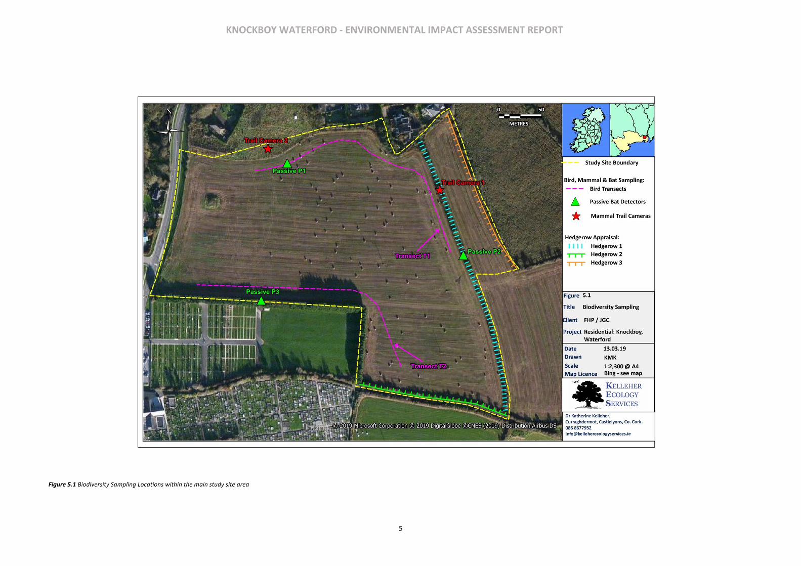
KNOCKBOY WATERFORD - ENVIRONMENTAL IMPACT ASSESSMENT REPORT
5
Figure 5.1 Biodiversity Sampling Locations within the main study site area
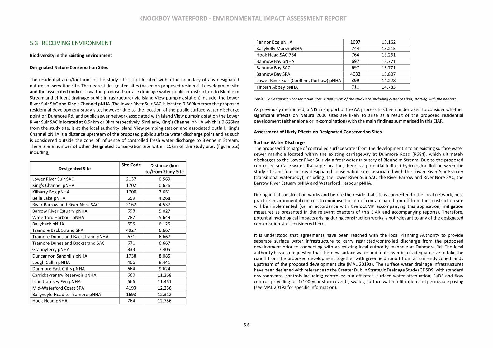
KNOCKBOY WATERFORD - ENVIRONMENTAL IMPACT ASSESSMENT REPORT
5.6
5.3 RECEIVING ENVIRONMENT
Biodiversity in the Existing Environment Designated Nature Conservation Sites The residential area/footprint of the study site is not located within the boundary of any designated nature conservation site. The nearest designated sites (based on proposed residential development site and the associated (indirect) via the proposed surface drainage water public infrastructure to Blenheim Stream and effluent drainage public infrastructure/ via Island View pumping station) include; the Lower River Suir SAC and King’s Channel pNHA. The lower River Suir SAC is located 0.569km from the proposed residential development study site, however due to the location of the public surface water discharge point on Dunmore Rd. and public sewer network associated with Island View pumping station the Lower River Suir SAC is located at 0.54km or 0km respectively. Similarly, King’s Channel pNHA which is 0.626km from the study site, is at the local authority Island View pumping station and associated outfall. King’s Channel pNHA is a distance upstream of the proposed public surface water discharge point and as such is considered outside the zone of influence of controlled fresh water discharge to Blenheim Stream. There are a number of other designated conservation site within 15km of the study site, (figure 5.2) including;
Designated Site Site Code Distance (km)
to/from Study Site
Lower River Suir SAC 2137 0.569
King's Channel pNHA 1702 0.626
Kilbarry Bog pNHA 1700 3.651
Belle Lake pNHA 659 4.268
River Barrow and River Nore SAC 2162 4.537
Barrow River Estuary pNHA 698 5.027
Waterford Harbour pNHA 787 5.649
Ballyhack pNHA 695 6.125
Tramore Back Strand SPA 4027 6.667
Tramore Dunes and Backstrand pNHA 671 6.667
Tramore Dunes and Backstrand SAC 671 6.667
Grannyferry pNHA 833 7.405
Duncannon Sandhills pNHA 1738 8.085
Lough Cullin pNHA 406 8.441
Dunmore East Cliffs pNHA 664 9.624
Carrickavrantry Reservoir pNHA 660 11.268
Islandtarnsey Fen pNHA 666 11.451
Mid-Waterford Coast SPA 4193 12.256
Ballyvoyle Head to Tramore pNHA 1693 12.312
Hook Head pNHA 764 12.756
Fennor Bog pNHA 1697 13.162
Ballykelly Marsh pNHA 744 13.215
Hook Head SAC 764 764 13.261
Bannow Bay pNHA 697 13.771
Bannow Bay SAC 697 13.771
Bannow Bay SPA 4033 13.807
Lower River Suir (Coolfinn, Portlaw) pNHA 399 14.228
Tintern Abbey pNHA 711 14.783
Table 5.2 Designation conservation sites within 15km of the study site, including distances (km) starting with the nearest.
As previously mentioned, a NIS in support of the AA process has been undertaken to consider whether significant effects on Natura 2000 sites are likely to arise as a result of the proposed residential development (either alone or in-combination) with the main findings summarised in this EIAR.
Assessment of Likely Effects on Designated Conservation Sites
Surface Water Discharge The proposed discharge of controlled surface water from the development is to an existing surface water sewer manhole located within the existing carriageway at Dunmore Road (R684), which ultimately discharges to the Lower River Suir via a freshwater tributary of Blenheim Stream. Due to the proposed controlled surface water discharge location, there is a potential indirect hydrological link between the study site and four nearby designated conservation sites associated with the Lower River Suir Estuary (transitional waterbody), including; the Lower River Suir SAC, the River Barrow and River Nore SAC, the Barrow River Estuary pNHA and Waterford Harbour pNHA. During initial construction works and before the residential site is connected to the local network, best practice environmental controls to minimise the risk of contaminated run-off from the construction site will be implemented (i.e. in accordance with the oCEMP accompanying this application, mitigation measures as presented in the relevant chapters of this EIAR and accompanying reports). Therefore, potential hydrological impacts arising during construction works is not relevant to any of the designated conservation sites considered here. It is understood that agreements have been reached with the local Planning Authority to provide separate surface water infrastructure to carry restricted/controlled discharge from the proposed development prior to connecting with an existing local authority manhole at Dunmore Rd. The local authority has also requested that this new surface water and foul sewer be of adequate size to take the runoff from the proposed development together with greenfield runoff from all currently zoned lands upstream of the proposed development site (MAL 2019a). The surface water drainage infrastructures have been designed with reference to the Greater Dublin Strategic Drainage Study (GDSDS) with standard environmental controls including; controlled run-off rates, surface water attenuation, SuDS and flow control; providing for 1/100-year storm events, swales, surface water infiltration and permeable paving (see MAL 2019a for specific information).
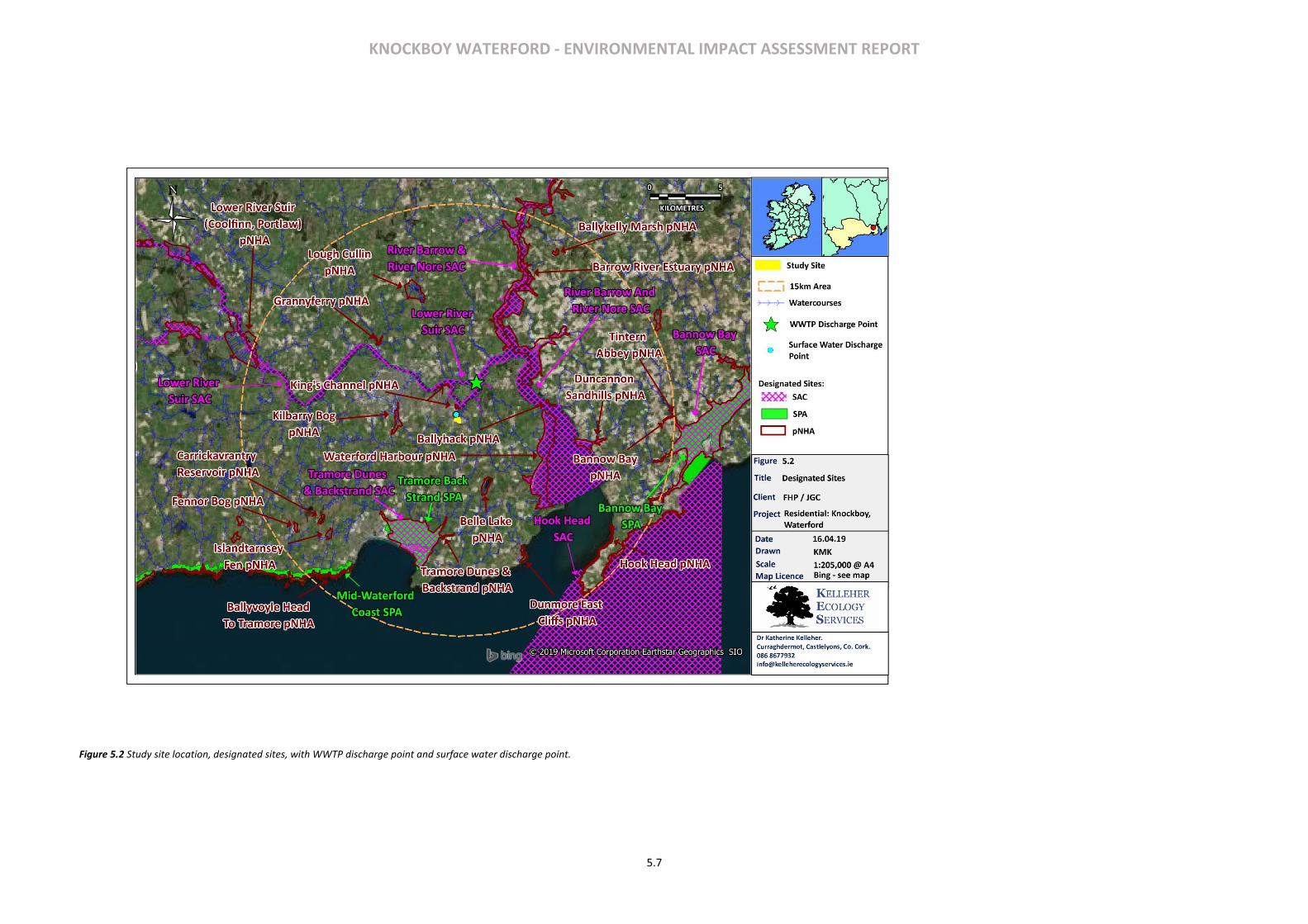
KNOCKBOY WATERFORD - ENVIRONMENTAL IMPACT ASSESSMENT REPORT
5.7
Figure 5.2 Study site location, designated sites, with WWTP discharge point and surface water discharge point.
KNOCKBOY WATERFORD - ENVIRONMENTAL IMPACT ASSESSMENT REPORT
5.8
While this surface water discharge point is ultimately to the River Suir and as such a hydrological link exists between the study site and the Lower River Suir SAC, the other designated sites; the River Barrow and Nore SAC, Barrow River Estuary pNHA and Waterford Harbour pNHA are all >5 km downstream of the discharge point near to Blenheim stream and as such no other designated sites are considered relevant due their location/distance in relation to the controlled surface water discharge point and as such a limited hydrological link, together with their locations within the estuary/harbour combined with the large flow volume for the River Suir transitional waterbody itself. The designated site King’s Channel pNHA is located upstream of the discharge point (>1km from discharge point via Blenheim Stream and upstream along King’s Channel) and as such, based on this designated sites upstream location, together with the large flow of the River Suir impacts on King’s Channel pNHA resulting for controlled surface water inputs via a tributary of Blenheim Stream are considered unlikely.
Waste-water/foul effluent discharge
A potential hydrological link also exists between waste water/effluent discharge from the study site and five designated conservation sites within the River Suir/Lower River Suir Estuary transitional waterbody, including The Lower River Suir SAC, King’s Channel pNHA, River Barrow and River Nore SAC, Barrow River Estuary pNHA and Waterford Harbour pNHA.
During initial construction works and before the residential site is connected to the public sewer network, construction phase waste-water/foul effluent will be managed at a temporary site compound (i.e. site portaloos and welfare units in accordance with the oCEMP), with all foul waste removed from site by licenced waste disposal contractors. Therefore, no potential hydrological link from waste-water/effluent during construction is relevant to any of the designated conservation sites under consideration.
When the study site connects to the existing public foul sewer network waste water/foul effluent drainage arising from the proposed development site will discharge to this network for transfer and treatment at Waterford City Wastewater Treatment (WWTP) at Gorteens, which ultimately discharges to the River Suir (WWTP Discharge Point; Figure 5.2) and as such The Lower River Suir SAC. Three other designated sites the River Barrow and River Nore SAC, the Barrow River Estuary pNHA and Waterford Harbour pNHA are located downstream of the discharge point in question (c. 3.1km downstream). King’s Channel pNHA is location upstream of the WWTP discharge point, however salt marsh habitat present here is subject to tidal influences associated with the Lower River Suir as at least part of this pNHA is within/overlaps the Lower River Suir SAC.
Prior to the transfer to the WWTP at Gorteens this local authority drainage infrastructure transfers waste water/effluent drainage to Island View pumping station, where it is subsequently pumped onwards to the WWTP. Island View pumping station has a combined sewer overflow (CSO) and emergency overflow (EO) system (collectively surface water overflows SWOs, after RPS 2018, see Appendix A of NIS), which when triggered occasionally (by excess surface water ingress), discharges to the Lower River Suir Estuary at Little Island/King’s Channel. Due to the location of this SWOs discharge point there is a potential for indirect hydrological impacts, which in turn could impact on water quality and on nearby wetland habitats (e.g. saltmarsh habitat; a subsite of Atlantic Salt Meadow ASM 1330 habitat located at the SWOs discharge point) associated with the Lower River Suir SAC and King’s Channel pNHA. None of the other designated sites (listed in table 5.3) are considered relevant here given their locations in the harbour/estuary area in relation to the SWOs discharge point (>5km downstream), combined with the significant water flow/volumes associated with the transitional estuary and harbour in general.
Flooding/floodplain impacts Flooding or Floodplain impacts are not considered relevant here as the study site is not at risk of fluvial flooding and the proposed surface water drainage system is designed such that it will not contribute to any possible flooding to downstream lands (MAL 2019b). Disturbance/Displacement of Key Fauna (i.e. listed as qualifying interests for designated sites) The potential for disturbance and or displacement impacts through noise and or visual cues as a result of the proposed development on key fauna listed as qualifying interests of relevant designated sites also exists. Such disturbance/displacement impacts may also occur ex-situ where mobile fauna species associated with the designated sites move outside the designated site boundaries to forage/commute etc. While the study site may provide some albeit limited forage habitat (i.e. fallow arable farmland), no key bird species (raptors, waterbirds) associated with the relevant designated sites were recorded during three dedicated bird transect surveys or as casual species during other field biodiversity assessments at the study site. Taking seasonal constraints into consideration no suitable breeding habitat for key bird species exists within the study site. Furthermore, the study site is not immediately adjacent to or as such directly overlooking the relevant designated sites due to distances/landscape characteristics (e.g. Barrow Estuary pNHA; 5.027km, Tramore Dune and Backstrand SPA c.6.667km, Mid-Waterford Coast SPA; 12.256km and Bannow Bay SPA c. 13.78km from study site). Therefore, disturbance/displacement impacts of key bird species associated with designated sites are not considered relevant here. In relation to The Lower River Suir SAC and River Barrow and River Nore SAC, faunal qualifying interests relate to aquatic species (e.g. Freshwater Pearl Mussel Margaritifera margaritifera etc.) and not terrestrial fauna species that may be vulnerable to disturbance or displacement impacts resulting from the proposed development. One potential exception to this is Otter, which uses for example river corridors, estuaries and associated nearby terrestrial habitats to commute, forage, rest and/or breed. Occasionally Otter can be found at a distance from the riparian/aquatic corridor (e.g. springtime abundance of prey such as frog in wetland habitats such as ponds). However, in general Otter are primarily associated with the narrow, c.10m buffer, corridor along the riparian/aquatic interface (after NPWS from 2009/O’Neill 2008 unpublished). Whilst there is a general perception that Otter can be negatively affected by poor water quality, there has been little published evidence demonstrating any consistent relationship with pollution and Otter displacement. Similarly, there has been little published evidence demonstrating and consistent relationship between human disturbance and Otter displacement (Bailey & Rochford, 2006). Otter surveys carried out as part of an INTERREG wildlife Project by Waterford City and County Council 2011-2015 found abundant evidence of a strong otter population along this section of the River Suir. Furthermore, a water quality assessment undertaken as part of this application (RPS 2018), show current/occasional discharge for island View pumping station is not impacting on water quality and any additional loadings associated with the proposed development will not adversely impact on the water quality status of the Lower River Suir and downstream designated sites (RPS 2018 see Appendix A of NIS accompanying this application). Therefore, given the habitat characteristics of the area included in the proposed development, its location regarding the aquatic habitat areas associated with Otter, any loss, disturbance/displacement or fragmentation impacts are considered negligible and as such are not considered relevant here.
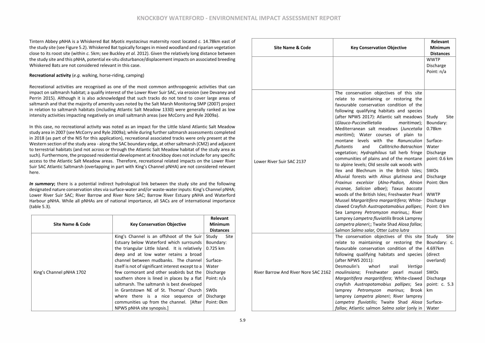
KNOCKBOY WATERFORD - ENVIRONMENTAL IMPACT ASSESSMENT REPORT
5.9
Tintern Abbey pNHA is a Whiskered Bat Myotis mystacinus maternity roost located c. 14.78km east of the study site (see Figure 5.2). Whiskered Bat typically forages in mixed woodland and riparian vegetation close to its roost site (within c. 5km; see Buckley et al. 2012). Given the relatively long distance between the study site and this pNHA, potential ex-situ disturbance/displacement impacts on associated breeding Whiskered Bats are not considered relevant in this case.
Recreational activity (e.g. walking, horse-riding, camping) Recreational activities are recognised as one of the most common anthropogenic activities that can impact on saltmarsh habitat; a qualify interest of the Lower River Suir SAC, via erosion (see Devaney and Perrin 2015). Although it is also acknowledged that such tracks do not tend to cover large areas of saltmarsh and that the majority of amenity uses noted by the Salt Marsh Monitoring SMP (2007) project in relation to saltmarsh habitats (including Atlantic Salt Meadow 1330) were generally ranked as low intensity activities impacting negatively on small saltmarsh areas (see McCorry and Ryle 2009a). In this case, no recreational activity was noted as an impact for the Little Island Atlantic Salt Meadow study area in 2007 (see McCorry and Ryle 2009a); while during further saltmarsh assessments completed in 2018 (as part of the NIS for this application), recreational associated tracks were only present at the Western section of the study area - along the SAC boundary edge, at other saltmarsh (CM2) and adjacent to terrestrial habitats (and not across or through the Atlantic Salt Meadow habitat of the study area as such). Furthermore, the proposed residential development at Knockboy does not include for any specific access to the Atlantic Salt Meadow areas. Therefore, recreational related impacts on the Lower River Suir SAC Atlantic Saltmarsh (overlapping in part with King’s Channel pNHA) are not considered relevant here. In summary; there is a potential indirect hydrological link between the study site and the following designated nature conservation sites via surface-water and/or waste-water inputs: King's Channel pNHA; Lower River Suir SAC; River Barrow and River Nore SAC; Barrow River Estuary pNHA and Waterford Harbour pNHA. While all pNHAs are of national importance, all SACs are of international importance (table 5.3).
Site Name & Code Key Conservation Objective Relevant Minimum Distances
King's Channel pNHA 1702
King's Channel is an offshoot of the Suir Estuary below Waterford which surrounds the triangular Little Island. It is relatively deep and at low water retains a broad channel between mudbanks. The channel itself is not of significant interest except to a few cormorant and other seabirds but the southern shore is lined in places by a flat saltmarsh. The saltmarsh is best developed in Grantstown NE of St. Thomas’ Church where there is a nice sequence of communities up from the channel. [After NPWS pNHA site synopsis.]
Study Site Boundary: 0.725 km Surface-Water Discharge Point: n/a SW0s Discharge Point: 0km
Site Name & Code Key Conservation Objective Relevant Minimum Distances
WWTP Discharge Point: n/a
Lower River Suir SAC 2137
The conservation objectives of this site relate to maintaining or restoring the favourable conservation condition of the following qualifying habitats and species (after NPWS 2017): Atlantic salt meadows (Glauco-Puccinellietalia maritimae); Mediterranean salt meadows (Juncetalia maritimi); Water courses of plain to montane levels with the Ranunculion fluitantis and Callitricho-Batrachion vegetation; Hydrophilous tall herb fringe communities of plains and of the montane to alpine levels; Old sessile oak woods with Ilex and Blechnum in the British Isles; Alluvial forests with Alnus glutinosa and Fraxinus excelsior (Alno-Padion, Alnion incanae, Salicion albae); Taxus baccata woods of the British Isles; Freshwater Pearl Mussel Margaritifera margaritifera; White-clawed Crayfish Austropotamobius pallipes; Sea Lamprey Petromyzon marinus,; River Lamprey Lampetra fluviatilis Brook Lamprey Lampetra planeri;; Twaite Shad Alosa fallax; Salmon Salmo salar, Otter Lutra lutra
Study Site Boundary: 0.78km Surface-Water Discharge point: 0.6 km SWOs Discharge Point: 0km WWTP Discharge Point: 0 km
River Barrow And River Nore SAC 2162
The conservation objectives of this site relate to maintaining or restoring the favourable conservation condition of the following qualifying habitats and species (after NPWS 2011): Desmoulin's whorl snail Vertigo moulinsiana; Freshwater pearl mussel Margaritifera margaritifera; White‐clawed crayfish Austropotamobius pallipes; Sea lamprey Petromyzon marinus; Brook lamprey Lampetra planeri; River lamprey Lampetra fluviatilis; Twaite Shad Alosa fallax; Atlantic salmon Salmo salar (only in
Study Site Boundary: c. 4.697km (direct overland) SWOs Discharge point: c. 5.3 km Surface-Water
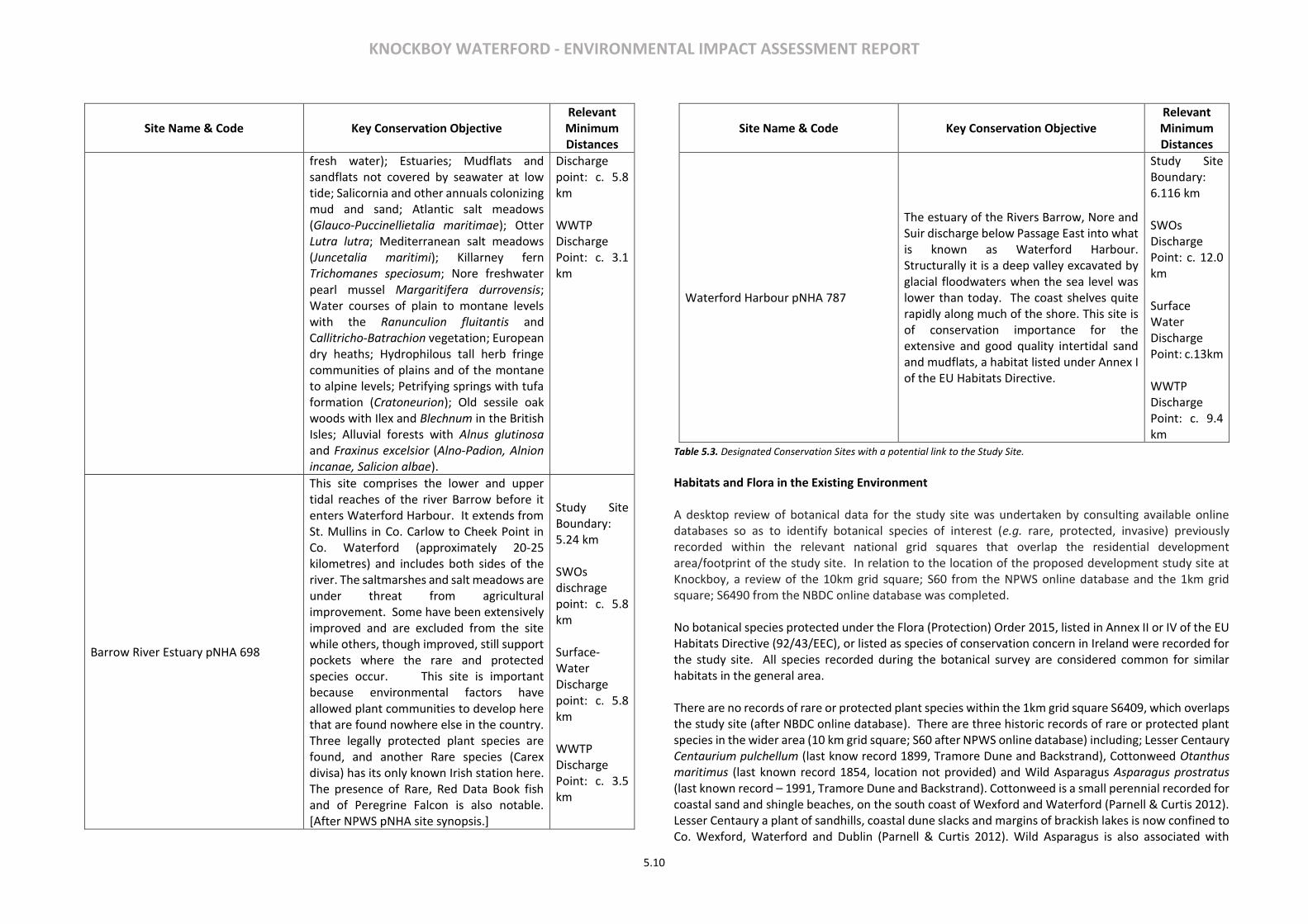
KNOCKBOY WATERFORD - ENVIRONMENTAL IMPACT ASSESSMENT REPORT
5.10
Site Name & Code Key Conservation Objective Relevant Minimum Distances
fresh water); Estuaries; Mudflats and sandflats not covered by seawater at low tide; Salicornia and other annuals colonizing mud and sand; Atlantic salt meadows (Glauco‐Puccinellietalia maritimae); Otter Lutra lutra; Mediterranean salt meadows (Juncetalia maritimi); Killarney fern Trichomanes speciosum; Nore freshwater pearl mussel Margaritifera durrovensis; Water courses of plain to montane levels with the Ranunculion fluitantis and Callitricho‐Batrachion vegetation; European dry heaths; Hydrophilous tall herb fringe communities of plains and of the montane to alpine levels; Petrifying springs with tufa formation (Cratoneurion); Old sessile oak woods with Ilex and Blechnum in the British Isles; Alluvial forests with Alnus glutinosa and Fraxinus excelsior (Alno‐Padion, Alnion incanae, Salicion albae).
Discharge point: c. 5.8 km WWTP Discharge Point: c. 3.1 km
Barrow River Estuary pNHA 698
This site comprises the lower and upper tidal reaches of the river Barrow before it enters Waterford Harbour. It extends from St. Mullins in Co. Carlow to Cheek Point in Co. Waterford (approximately 20-25 kilometres) and includes both sides of the river. The saltmarshes and salt meadows are under threat from agricultural improvement. Some have been extensively improved and are excluded from the site while others, though improved, still support pockets where the rare and protected species occur. This site is important because environmental factors have allowed plant communities to develop here that are found nowhere else in the country. Three legally protected plant species are found, and another Rare species (Carex divisa) has its only known Irish station here. The presence of Rare, Red Data Book fish and of Peregrine Falcon is also notable. [After NPWS pNHA site synopsis.]
Study Site Boundary: 5.24 km SWOs dischrage point: c. 5.8 km Surface-Water Discharge point: c. 5.8 km WWTP Discharge Point: c. 3.5 km
Site Name & Code Key Conservation Objective Relevant Minimum Distances
Waterford Harbour pNHA 787
The estuary of the Rivers Barrow, Nore and Suir discharge below Passage East into what is known as Waterford Harbour. Structurally it is a deep valley excavated by glacial floodwaters when the sea level was lower than today. The coast shelves quite rapidly along much of the shore. This site is of conservation importance for the extensive and good quality intertidal sand and mudflats, a habitat listed under Annex I of the EU Habitats Directive.
Study Site Boundary: 6.116 km SWOs Discharge Point: c. 12.0 km Surface Water Discharge Point: c.13km WWTP Discharge Point: c. 9.4 km
Table 5.3. Designated Conservation Sites with a potential link to the Study Site.
Habitats and Flora in the Existing Environment A desktop review of botanical data for the study site was undertaken by consulting available online databases so as to identify botanical species of interest (e.g. rare, protected, invasive) previously recorded within the relevant national grid squares that overlap the residential development area/footprint of the study site. In relation to the location of the proposed development study site at Knockboy, a review of the 10km grid square; S60 from the NPWS online database and the 1km grid square; S6490 from the NBDC online database was completed. No botanical species protected under the Flora (Protection) Order 2015, listed in Annex II or IV of the EU Habitats Directive (92/43/EEC), or listed as species of conservation concern in Ireland were recorded for the study site. All species recorded during the botanical survey are considered common for similar habitats in the general area. There are no records of rare or protected plant species within the 1km grid square S6409, which overlaps the study site (after NBDC online database). There are three historic records of rare or protected plant species in the wider area (10 km grid square; S60 after NPWS online database) including; Lesser Centaury Centaurium pulchellum (last know record 1899, Tramore Dune and Backstrand), Cottonweed Otanthus maritimus (last known record 1854, location not provided) and Wild Asparagus Asparagus prostratus (last known record – 1991, Tramore Dune and Backstrand). Cottonweed is a small perennial recorded for coastal sand and shingle beaches, on the south coast of Wexford and Waterford (Parnell & Curtis 2012). Lesser Centaury a plant of sandhills, coastal dune slacks and margins of brackish lakes is now confined to Co. Wexford, Waterford and Dublin (Parnell & Curtis 2012). Wild Asparagus is also associated with

KNOCKBOY WATERFORD - ENVIRONMENTAL IMPACT ASSESSMENT REPORT
5.11
sandhills on the south-east coast in Wexford and Waterford only, and is considered very rare (Parnell & Curtis 2012). While taking seasonal constraints into account, given the inland location of the study site at Knockboy, together with a lack of suitable habitat requirements and/or substrates, these protected flora species are unlikely to occur here. No invasive species considered at risk of having damaging effects on native species and habitats were recorded within the study site. No other species listed on the Third Schedule of the 2011 European Communities (Birds and Natural Habitats) Regulations (i.e. species of which it is an offense to disperse, spread or otherwise cause to grow in any place). Very occassional shrubs of the non-native species; Buddleia Buddleia davidii, was recorded along the western boundary of the study site. No Annex I habitats listed under the EU Habitats Directive are present within the study site. The dominant habitats directly impacted by the proposed development (i.e. residential development works footprint) include habitats of low local value including; arable crop (BC1), grassy verge (GS2) and scrub (WS1) or higher local value; semi-natural hedgerow (WL1) and planted/modified immature woodland (WS2). The following habitats (with Fossitt codes, as outlined in Section 5.2 above) were recorded within the study site (see Figure 5.3)
• Arable Crop (BC1)
• Hedgerow (WL1)
• Treeline (WL2)
• Immature Woodland (WS2)
• Scrub (WS1)
• Buildings and Artificial Surfaces (BL3)
• Dry Meadow and Grassy Verge (GS2)
Arable Crop (BC1)
Arable crop (BC1) is the dominant habitat present within the study site (i.e. main proposed residential footprint). At the time of the habitat and flora assessment the arable crop (BC1) had been harvested and the fields left fallow, with just occassional crop stubble and decaying crop litter remaining (Plate 5.1). Bare ground is also common, as are ruderal flora species, which are re-establishing across the fallow arable crop (BC1) fields. The re-establishing vegetation is comprised of a mixed assemblage of ruderal flora species such as; Field Pansy Viola arvensis, Red Dead Nettle Lamium purpureum, Spear Thistle Cirsium vulgare, Prickly Sow-thistle Sonchus asper, Germander Speedwell Veronica chamaedrys, Thyme-leaved Speedwell, V. serpyllifolia, Common Chickweed Stellaria media and Common Fumitory Fumaria officianalis and grasses such as Yorkshire Fog Holcus lanatus, Creeping Bent Agrostis stolonifera and Annual Meadow Grass Poa Annua. Regenerating crop relics (e.g. Barley Hordeum spp.), most likely associated with the previous arable crop (BC1) planting, are also common across the recolonising fallow substrate (Plate 5.2.).
Arable crop (BC1) is considered a modified habitat type which is subject to intensive management for agricultural purposes. While the arable crop (BC1) fields have been left fallow since last harvesting, and
limited recent disturbance has allowed for vegetation regeneration to such an extent that it is considered greater than 50% (after Fossitt 2000), it is still at the early stages of recolonisation with stubble, crop debris and bare ground common with low floral diversity and abundance and as such is considered of low local importance.
Plate 5.1. Overview of dominant habitat; fallow arable crop (BC1), present within the study site.
Plate 5.2. Overview/close-up of typical stubble, crop debris and recolonising vegetation present within the fallow arable crop (BC1) fields associated with the study site.
Hedgerows (WL1) (General hedgerow habitat description)
Semi-natural hedgerows (WL1) associated with the study site are primarily located along the site
boundaries to the south, east and north east, with just one hedgerow (WL1) crossing through the study
site (i.e. running north to south through the study site) towards the eastern boundary (Figure 5.3). A
short section (c. 24m in length). of remnant native hedgerow (WL1) is present/adjoining Leyland hedging
on part of the northern boundary of the study site. The semi-natural hedgerows (WL1) present are
comprised of typical native species such as abundant Bramble Rubus fruticosus agg., Gorse Ulex
europaeus, Hawthorn Crataegus monogyna with occassional Blackthorn Prunus spinosa, Elder Sambucus
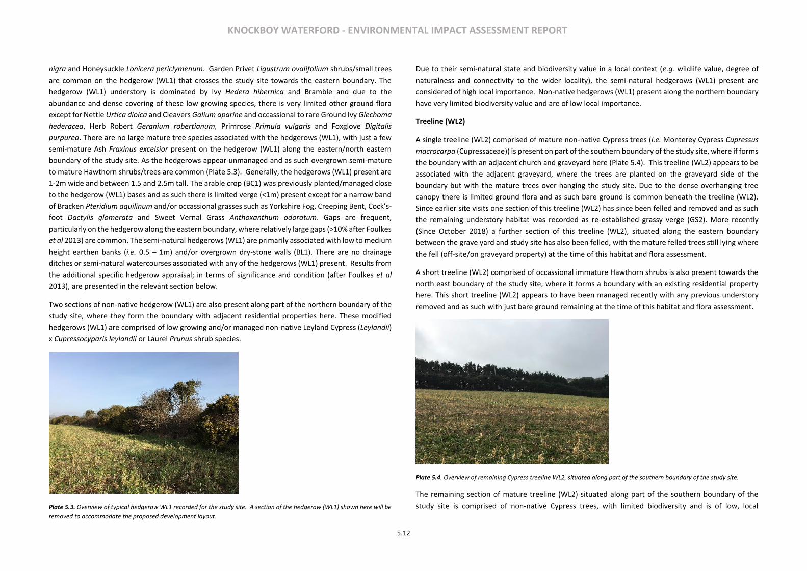
KNOCKBOY WATERFORD - ENVIRONMENTAL IMPACT ASSESSMENT REPORT
5.12
nigra and Honeysuckle Lonicera periclymenum. Garden Privet Ligustrum ovalifolium shrubs/small trees
are common on the hedgerow (WL1) that crosses the study site towards the eastern boundary. The
hedgerow (WL1) understory is dominated by Ivy Hedera hibernica and Bramble and due to the
abundance and dense covering of these low growing species, there is very limited other ground flora
except for Nettle Urtica dioica and Cleavers Galium aparine and occassional to rare Ground Ivy Glechoma
hederacea, Herb Robert Geranium robertianum, Primrose Primula vulgaris and Foxglove Digitalis
purpurea. There are no large mature tree species associated with the hedgerows (WL1), with just a few
semi-mature Ash Fraxinus excelsior present on the hedgerow (WL1) along the eastern/north eastern
boundary of the study site. As the hedgerows appear unmanaged and as such overgrown semi-mature
to mature Hawthorn shrubs/trees are common (Plate 5.3). Generally, the hedgerows (WL1) present are
1-2m wide and between 1.5 and 2.5m tall. The arable crop (BC1) was previously planted/managed close
to the hedgerow (WL1) bases and as such there is limited verge (<1m) present except for a narrow band
of Bracken Pteridium aquilinum and/or occassional grasses such as Yorkshire Fog, Creeping Bent, Cock’s-
foot Dactylis glomerata and Sweet Vernal Grass Anthoxanthum odoratum. Gaps are frequent,
particularly on the hedgerow along the eastern boundary, where relatively large gaps (>10% after Foulkes
et al 2013) are common. The semi-natural hedgerows (WL1) are primarily associated with low to medium
height earthen banks (i.e. 0.5 – 1m) and/or overgrown dry-stone walls (BL1). There are no drainage
ditches or semi-natural watercourses associated with any of the hedgerows (WL1) present. Results from
the additional specific hedgerow appraisal; in terms of significance and condition (after Foulkes et al
2013), are presented in the relevant section below.
Two sections of non-native hedgerow (WL1) are also present along part of the northern boundary of the
study site, where they form the boundary with adjacent residential properties here. These modified
hedgerows (WL1) are comprised of low growing and/or managed non-native Leyland Cypress (Leylandii)
x Cupressocyparis leylandii or Laurel Prunus shrub species.
Plate 5.3. Overview of typical hedgerow WL1 recorded for the study site. A section of the hedgerow (WL1) shown here will be
removed to accommodate the proposed development layout.
Due to their semi-natural state and biodiversity value in a local context (e.g. wildlife value, degree of
naturalness and connectivity to the wider locality), the semi-natural hedgerows (WL1) present are
considered of high local importance. Non-native hedgerows (WL1) present along the northern boundary
have very limited biodiversity value and are of low local importance.
Treeline (WL2)
A single treeline (WL2) comprised of mature non-native Cypress trees (i.e. Monterey Cypress Cupressus
macrocarpa (Cupressaceae)) is present on part of the southern boundary of the study site, where if forms
the boundary with an adjacent church and graveyard here (Plate 5.4). This treeline (WL2) appears to be
associated with the adjacent graveyard, where the trees are planted on the graveyard side of the
boundary but with the mature trees over hanging the study site. Due to the dense overhanging tree
canopy there is limited ground flora and as such bare ground is common beneath the treeline (WL2).
Since earlier site visits one section of this treeline (WL2) has since been felled and removed and as such
the remaining understory habitat was recorded as re-established grassy verge (GS2). More recently
(Since October 2018) a further section of this treeline (WL2), situated along the eastern boundary
between the grave yard and study site has also been felled, with the mature felled trees still lying where
the fell (off-site/on graveyard property) at the time of this habitat and flora assessment.
A short treeline (WL2) comprised of occassional immature Hawthorn shrubs is also present towards the
north east boundary of the study site, where it forms a boundary with an existing residential property
here. This short treeline (WL2) appears to have been managed recently with any previous understory
removed and as such with just bare ground remaining at the time of this habitat and flora assessment.
Plate 5.4. Overview of remaining Cypress treeline WL2, situated along part of the southern boundary of the study site.
The remaining section of mature treeline (WL2) situated along part of the southern boundary of the
study site is comprised of non-native Cypress trees, with limited biodiversity and is of low, local
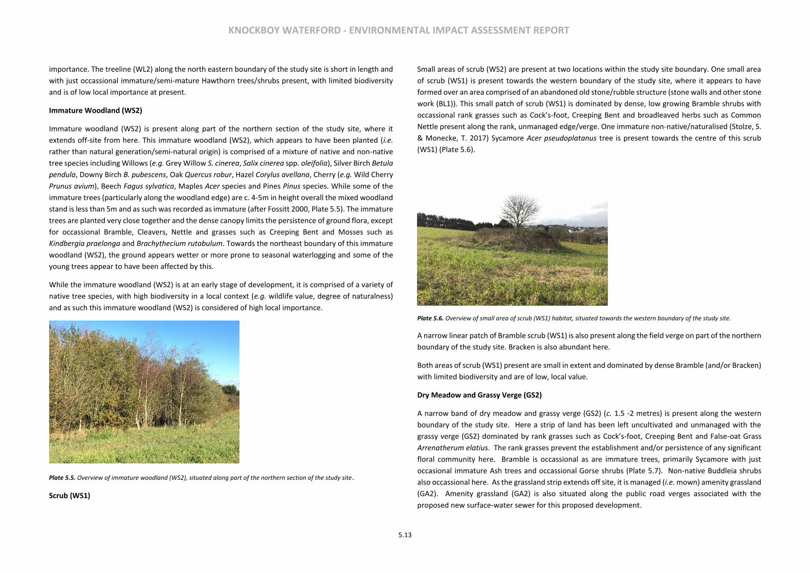
KNOCKBOY WATERFORD - ENVIRONMENTAL IMPACT ASSESSMENT REPORT
5.13
importance. The treeline (WL2) along the north eastern boundary of the study site is short in length and
with just occassional immature/semi-mature Hawthorn trees/shrubs present, with limited biodiversity
and is of low local importance at present.
Immature Woodland (WS2)
Immature woodland (WS2) is present along part of the northern section of the study site, where it
extends off-site from here. This immature woodland (WS2), which appears to have been planted (i.e.
rather than natural generation/semi-natural origin) is comprised of a mixture of native and non-native
tree species including Willows (e.g. Grey Willow S. cinerea, Salix cinerea spp. oleifolia), Silver Birch Betula
pendula, Downy Birch B. pubescens, Oak Quercus robur, Hazel Corylus avellana, Cherry (e.g. Wild Cherry
Prunus avium), Beech Fagus sylvatica, Maples Acer species and Pines Pinus species. While some of the
immature trees (particularly along the woodland edge) are c. 4-5m in height overall the mixed woodland
stand is less than 5m and as such was recorded as immature (after Fossitt 2000, Plate 5.5). The immature
trees are planted very close together and the dense canopy limits the persistence of ground flora, except
for occassional Bramble, Cleavers, Nettle and grasses such as Creeping Bent and Mosses such as
Kindbergia praelonga and Brachythecium rutabulum. Towards the northeast boundary of this immature
woodland (WS2), the ground appears wetter or more prone to seasonal waterlogging and some of the
young trees appear to have been affected by this.
While the immature woodland (WS2) is at an early stage of development, it is comprised of a variety of
native tree species, with high biodiversity in a local context (e.g. wildlife value, degree of naturalness)
and as such this immature woodland (WS2) is considered of high local importance.
Plate 5.5. Overview of immature woodland (WS2), situated along part of the northern section of the study site.
Scrub (WS1)
Small areas of scrub (WS2) are present at two locations within the study site boundary. One small area
of scrub (WS1) is present towards the western boundary of the study site, where it appears to have
formed over an area comprised of an abandoned old stone/rubble structure (stone walls and other stone
work (BL1)). This small patch of scrub (WS1) is dominated by dense, low growing Bramble shrubs with
occassional rank grasses such as Cock’s-foot, Creeping Bent and broadleaved herbs such as Common
Nettle present along the rank, unmanaged edge/verge. One immature non-native/naturalised (Stolze, S.
& Monecke, T. 2017) Sycamore Acer pseudoplatanus tree is present towards the centre of this scrub
(WS1) (Plate 5.6).
Plate 5.6. Overview of small area of scrub (WS1) habitat, situated towards the western boundary of the study site.
A narrow linear patch of Bramble scrub (WS1) is also present along the field verge on part of the northern
boundary of the study site. Bracken is also abundant here.
Both areas of scrub (WS1) present are small in extent and dominated by dense Bramble (and/or Bracken)
with limited biodiversity and are of low, local value.
Dry Meadow and Grassy Verge (GS2)
A narrow band of dry meadow and grassy verge (GS2) (c. 1.5 -2 metres) is present along the western
boundary of the study site. Here a strip of land has been left uncultivated and unmanaged with the
grassy verge (GS2) dominated by rank grasses such as Cock’s-foot, Creeping Bent and False-oat Grass
Arrenatherum elatius. The rank grasses prevent the establishment and/or persistence of any significant
floral community here. Bramble is occassional as are immature trees, primarily Sycamore with just
occasional immature Ash trees and occassional Gorse shrubs (Plate 5.7). Non-native Buddleia shrubs
also occassional here. As the grassland strip extends off site, it is managed (i.e. mown) amenity grassland
(GA2). Amenity grassland (GA2) is also situated along the public road verges associated with the
proposed new surface-water sewer for this proposed development.
KNOCKBOY WATERFORD - ENVIRONMENTAL IMPACT ASSESSMENT REPORT
5.14
A narrow band of grassy verge (GS2) is also present on part of the southern boundary, where as described
above a section of mature Cypress treeline (WL2) has been removed in the past, allowing the grassy
verge to regenerate within the open space remaining. This verge (GS2) is also unmanaged at present and
is comprised of typical species such as Cock’s-foot, Creeping Bent, Common Nettle, Cleavers,
Willowherbs Epilobium species, Ivy, Ragwort Senecio jacobaea and Spear Thistle.
Plate 5.7. Overview of dry meadow and grassy verge (GS2), with occassional immature trees and shrubs, situated towards the
western boundary of the study site. A concrete post and rail fence (i.e. buildings and artificial surfaces BL3) also forms the
proposed site boundary here.
The grasses verges (GS2) present are limited in extent, unmanaged and rank, with low flora diversity and
as such limited biodiversity and are of lower local value. The strip of amenity grassland (GA2) extending
from the western boundary and along the public road (associated with off-site works) is
managed/modified and of low local value.
Buildings and Artificial Surfaces (BL3)
Buildings and artificial surfaces (BL3) recorded for the study site, include a concrete post and wire fence along the southern boundary (associated with the adjacent graveyard) and a concrete post and rail fence forming the study site boundary with the public road to the west. These boundary fences (BL3) are comprised of man-made materials with no biodiversity value at present. Buildings and artificial surfaces (BL3) is also the dominant habitat within the proposed works footprint associated with the surface water and foul sewer which will be situated along the public road to the west of the study area. As this public road is dominated by man-made artificial surfaces (e.g. tarmacked road and concreted footpaths) it has no ecological value.
KNOCKBOY WATERFORD - ENVIRONMENTAL IMPACT ASSESSMENT REPORT
5.15
Figure 5.3 Habitats recorded for the residential area of the study site
KNOCKBOY WATERFORD - ENVIRONMENTAL IMPACT ASSESSMENT REPORT
5.16
Site Specific Hedgerow Appraisal
A total of three semi-natural hedgerows (WL1), present within the study site were assessed as part of a site-specific hedgerow appraisal (after Foulkes et al 2013, Appendix 5.3 field recording sheet, Figure 5.1 hedgerow locations). Other non-native Cypress Leyland and Laurel hedging present towards the north of the study site were excluded as was the short section (c. 24m in length) of remnant native hedgerow (WL1) present/adjoining the Leyland hedging here. The hedgerows were identified as hedgerow 1; which runs through the study site towards the eastern boundary, hedgerow 2 running along the southern boundary of the study site and hedgerow 3 which is situated along the eastern boundary of the study site (Figure 5.2). The hedgerows present were identified during pervious site visits and as part of a desktop review for the study site. Based on an assessment of significance (table 5.4) one of the hedgerows present; hedgerow 2, is considered highly significant due primarily to the fact that it appears on 1st Edition O.S. maps (map.geohive.ie), as a townland/parish boundary (i.e. historical significance/heritage hedgerow). Similarly, hedgerows 1 and 3 are of historically significance as they also appear as boundaries on the 1st Edition O.S. maps (map.geohive.ie). Based on an assessment of condition (after criteria presented in Faulke et al 2013), including; structural variables (e.g. height, width), continuity (e.g. gaps, size of gaps) and negative indicators/unfavourable species, and/or degradation (bank/wall, verge etc.) hedgerow 2 is in a favourable condition overall at present while hedgerow 1 and hedgerow 3 are both in an unfavourable condition (table 5.5). Hedgerow 1 As described earlier, hedgerow 1 runs across the study site from north to south, where it forms a now redundant (e.g. not in use as a farm/livestock barrier, after Foulkes et al 2013) internal field boundary between two arable crop (BC1) fields. This hedgerow (WL1) is unmanaged and there is no evidence of management in at least the last 5 years, and as such it is comprised of occassional Hawthorn and Garden Privet shrubs and/or small trees (4-5m), with abundant Gorse, Bramble and Ivy and occassional to rare Honeysuckle. The understory/ground layer is dominated by abundant Ivy and as such there is very limited other typical ground flora with just occassional, Nettle, Cleaver and Wall Pennywort Umbilicus rupestris (recorded within the 30m sampling strip). The base is primarily comprised of an overgrown dry-stone wall (BL1) and/or dry earthen bank. Overall hedgerow 1 is between 1.5 to 2m in height (bramble layer) and 1-2 m wide. Gaps are frequent (25-50%) and regularly greater than 5% (i.e. bramble layer with no woody shrubs, Plate 5.8). There is limited to no grassy verge present and the hedgerow is not associated with any drainage channel or semi-natural watercourse. The hedgerow forms a link with semi-natural hedgerow to the south, to the north it is linked to laurel hedging /residential properties and/or a line of Hawthorn shrubs/trees (see treeline WL2 for general habitat description) and as such overall semi-natural habitat connectivity is considered low.
Plate 5.8. Overview of Hedgerow 1, which crosses the study site toward the eastern boundary.
Hedgerow 2 Hedgerow 2 is situated along the southern boundary of the study site, where it forms the boundary along a public/farm access track, although the hedgerow is considered redundant as an active farm boundary. This hedgerow (WL1) is also unmanaged and there is no evidence of management in at least the last 5 years, and as such is comprised of abundant Hawthorn shrubs and/or small trees (4-5m), with abundant Bramble and Ivy. Gorse and Blackthorn shrubs are occassional here. The understory/ground layer is dominated by abundant Ivy and as such there is very limited other ground flora with just occassional, Nettle, Cleaver, Lords-and-Ladies Arum maculatum, Herb Robert Geranium robertianum and Nipplewort Lapsana communis (floristic data recorded for random 30m strips). The hedgerow base is primarily comprised of an overgrown earthen bank with occassional remnant dry-stone wall (BL1) which is over 1m in height. Overall hedgerow 2 is between 2.5 to 4m in height and 1-2 m wide. There is limited to no grassy verge present and the hedgerow is not associated with any drainage channel or semi-natural watercourse. Gaps are common; however, most gaps are less the 5m wide. The hedgerow forms a link with semi-natural hedgerow to the south and east and is linked with Hedgerow 1, and as such hedgerow/semi-natural habitat connectivity is moderately significant.

KNOCKBOY WATERFORD - ENVIRONMENTAL IMPACT ASSESSMENT REPORT
5.17
Plate 5.9. Overview of Hedgerow 2, which is situated along the southern boundary of the study site. Hedgerow 3
Plate 5.10. Overview of Hedgerow 3, which is situated along the eastern boundary of the study site. Hedgerow 3 is situated on the eastern boundary of the study site, where it forms a now redundant field boundary between two arable crop fields. This hedgerow (WL1) is also unmanaged and there is no evidence of management in at least the last 5 years. This hedgerow is somewhat degraded with gaps of >50% common, with abundant low growing Bramble and as such Hawthorn, Blackthorn and Gorse shrubs are just occasional in parts (Plate 5.10). The understory/ground layer is dominated by abundant Ivy and Bramble with very limited other ground flora except for occassional, Nettle, Cleaver and Bracken. The base is primarily comprised of an overgrown, earthen bank with occassional remnant dry-stone wall (BL1) which is over 1m in height. Overall hedgerow 3 is between 1.5-2m in height and 1-2 m wide. There is limited to no grassy verge present and the hedgerow is not associated with any drainage channel or semi-natural watercourse. The hedgerow forms a link with semi-natural hedgerow to the north and east and as such hedgerow connectivity is moderately significant.
Hedgerow Significance and Condition Summary Hedgerow 1 is in an unfavourable condition at present, where large gaps >10% are common along its length (dominated by Bramble with no woody shrubs). While Hedgerow 1 is considered of high significance, this is in relation to historical significance criterion (heritage hedgerow) only, as it is present as a boundary on the 1st edition O.S. maps. Based on the ecological assessment criteria this hedgerow is of lower significance overall at present (table 5.4). Hedgerow 2 is in a favourable condition and is also considered to be highly significant (Heritage hedgerow), due to its historical significance only, where it is present on the 1st Edition O.S. maps, as a townland/parish boundary (table 5.4). The overall structure (e.g. height, width etc.) and continuity (e.g. gaps, size of gaps) of hedgerow 2 is considered adequate as gaps are not as common and/or as large (table 5.5). Hedgerow 2 is also in adequate condition in terms of overall evidence of degradation and its long-term viability. Hedgerow 3 is in an unfavourable condition at present, with adequate structural variables, but unfavourable continuity and long-term viability. This hedgerow is also ranked as being of high significance, again due only to the fact that it appears as a boundary on the 1st Edition O.S. maps (table 5.4). Based on ecological assessment criteria this hedgerow is of relatively lower significance overall at present (table 5.5).
Significance Assessment Criteria *Hedgerow 1 Hedgerow 2 Hedgerow 3
Historical Significant (3) High (4) Significant (3)
Species Diversity Slightly (1) Slightly (1) Low (0)
Ground Flora Low (0) Slightly (1) low (0)
Structure/Construction/Associated Features Moderate (2) Moderate (2) Moderate (2)
Habitat Connectivity Slightly (1) Moderate (2) Moderate (2)
Landscape Low (0) Low (0) Low (0)
*This hedgerow will be removed to accommodate the proposed development layout After Foulkes et al. 2013: (0) = low significance; (1) = slightly significant;(2) = moderately significant; (3) = significant; (4) = highly significant.
Table 5.4 Results for the assessment of significance for hedgerow 1, hedgerow 2 and hedgerow 3
Condition Assessment Criteria *Hedgerow 1 Hedgerow 2 Hedgerow 3
Structural variables Adequate (1) Favourable (2) Adequate (1)
Continuity Unfavourable (0) Adequate (1) Unfavourable (0)
Negative indicators. Degradation, issues affecting long-term viability
Adequate (1) Adequate (1) Unfavourable (0)
*A section of this hedgerow will be removed to accommodate the proposed development layout After Foulkes et al. 2013: (0) = unfavourable; (1) = adequate; (2) = favourable; (3) = highly favourable.
Table 5.5 Results for the assessment of condition for hedgerow 1, hedgerow 2 and hedgerow 3
Birds in the Existing Environment

KNOCKBOY WATERFORD - ENVIRONMENTAL IMPACT ASSESSMENT REPORT
5.18
A total of 21 bird species were recorded during the baseline general bird transect surveys completed at the study site (Table 5.6). Other bird species; Common Gull Larus canus, Grey Heron Ardea cinerea and Pheasant Phasianus colchicus were recorded as additional species (i.e. flying over, recorded on the trail camera, or recorded outside the transect surveys). Common Gull were recorded flying over the study site on two separate occasions but was never recorded on site. Common Gull are amber- listed due to a short-term decline in the breeding population nationally (Colhoun & Cummins, 2013). Grey Heron were also recorded flying over the site on one occasion. Grey Heron are green-listed species and as such of no conservation concern nationally at present. Similarly, Pheasant, recorded on the trail cameras, is of no conservation concern in Ireland.
Species Max.
Abundance (1st Visit)
Max. Abundance (2nd Visit)
Max. Abundance
(3rd Visit)
Maximum Abundance
*BoCCI Status
Robin Erithacus rubecula 5 5 6 6 Amber
Song Thrush Turdus philomelos 3 2 2 3 Green
Blackbird Turdus merula 6 1 4 6 Green
Chaffinch Fringilla coelebs 14 11 14 14 Green
Dunnock Prunella modularis 2 5 0 5 Green
Great Tit Parus major 3 1 1 3 Green
Wood Pigeon Columba palumbus 4 1 2 4 Green
Rook Corvus frugilegus 2 N/A 0 2 Green
Blue Tit Cyanistes caeruleus 3 4 4 4 Green
Fieldfare Turdus pilaris 15 0 0 15 Green
Redwing Turdus iliacus 10 0 0 10 Green
Starling Sturnus vulgaris 9 N/A 0 9 Amber
Goldfinch Carduelis carduelis 5 0 2 5 Green
Linnet Carduelis chloris 10 8 10 10 Amber
Reedbunting Emberiza schoeniclus 1 2 4 4 Green
Yellowhammer Emberiza citrinella 3 1 8 8 Red
Buzzard Buteo buteo 1 0 0 1 Green
Hooded Crow Corvus cornis 4 3 3 4 Green
Magpie Pica pica 2 1 0 2 Green
Goldcrest Regulas regulus 2 2 0 2 Green
Wren Troglodytes troglodytes 3 3 3 3 Green
Total No. Species 21
N/A -not applicable i.e. flying over only assessed as casual species Table 5.6 Overall summary of bird species recorded for the study site. No bird species listed on Annex I species of the EU Birds Directive was recorded within the study site. Furthermore, no bird species associated with any of the designated conservation sites (SPAs, NHAs or pNHAs) within 15km of the study site were recorded using the site or locality immediately surrounding the study site. One red-Listed species; Yellowhammer Emberiza citrinella, of high conservation concern nationally, were recorded at the study site. Yellowhammer are of conservation concern here, due a declining breeding population at a national level. Yellowhammer have suffered longer term declines due primarily to changing farm practices (switch away from arable and mixed farming, timing of cereal
planting and or intensification of farming methods) and for that reason are considered of high conservation concern in Ireland. A loss of 38% of its former range, mostly form the north and west of the country may be attributed to a loss in cereal production, which the Yellowhammer is closely associated with (Balmer et al 2013). While the southeast and eastern counties of Ireland are the remaining stronghold for Yellowhammer, the remnant population may be declining here too. Yellowhammer forage in suitable open arable crop fields and breed in suitable nearby hedgerows and this species current distribution reflect the distribution range and extent of cereal farming (Crowe et al. 2010). Yellowhammer recorded for the study site were primarily associated with the arable crop (BC1) and hedgerows (WL1) to the north and south of the study site and the currently fallow arable fields (BC1) are likely to provide foraging for this species with the surrounding hedgerows may provide suitable breeding habitat (although overall hedgerow structure appears inadequate at present). Three amber-listed species of medium conservation concern in Ireland were recorded for the study site (Table 5.6). Robin Erithacus rubecula are amber-listed due to a short-term decline (at least 25%) in the breeding population nationally (Colhoun & Cummins, 2013), which is thought to result from an exceptionally cold winter in 2010. Linnet Carduelis chloris and Starling Sturnus vulgaris are species of European Conservation Concern, where Linnet are a SPEC 2 species; where the global population is concentrated in Europe and Starling are a SPEC 3 species; where the global population is concentrated outside Europe. Robin were recorded along the boundary hedgerows (WL1) and within the immature woodland (WS2) to the north of the study site. Starling were recorded on site on one occasion where they were perched on overhead wires that cross the study site. Linnet were recorded in small flocks (maximum abundance 10) foraging in the arable field or perched on the overhead wires crossing the study site. Redwing Turdus iliacus and Fieldfare T. pilaris, both winter visitors to Ireland, are not listed on the current BoCCi list, however both species are considered of no conservation concern in Ireland and the European population has been assessed as secure (birdwatch Ireland). The remaining species recorded at the study site are considered of no particular conservation concern in Ireland at present and are considered typical for the habitats such as; hedgerow, treeline, immature woodland, arable fields/agricultural lands and suburban gardens present at, and/or in the immediate vicinity of the study site. A mixed flock of wintering birds; Redwing and Fieldfare, had the maximum abundance overall, however, both species were only present during the first transect survey on the 11th of February, with none of either species recorded on the 28th of February or 8th of March 2019. This may reflect the time of year and as such onward movement towards their summer breeding grounds. Small wintering flocks of resident bird species such as Chaffinch Fringilla coelebs and Linnet attributed to their high maximum abundance within the study site. The mixed flock were recorded foraging in the arable field and/or taking refuge on adjacent hedgerows. Similarly, a flock of Yellowhammer (maximum abundance eight on the 8th of March) were recorded with the flock of Linnet and Chaffinch on the 8th of March, again in the arable field and on adjacent hedgerow/treeline along the southern boundary. The remaining bird species were recorded along the hedgerows, treelines and or immature woodland or within adjacent gardens to the north (off-site). Overall the bird species recorded are considered typical of the habitats present at the study site and in the immediate vicinity of the study site. The field hedgerow boundaries, scrub, grassy verge and immature woodland at the site provide cover and food for general bird species. Similarly, at present the unmanaged/fallow arable crop (BC1) provides additional foraging opportunities for general bird species. Similar habitats are also present in the wider landscape (e.g. field boundaries, arable crop, pastures, scrub/immature woodland and suburban gardens/amenity spaces). Two additional bird species of conservation interest are listed on the NBDC online database, with the last known records from Birds of Ireland (2005) (table 5.7). Black-headed Gull Larus ridibundus is red-listed and of high conservation concern in Ireland due to decline in breeding population size and range
KNOCKBOY WATERFORD - ENVIRONMENTAL IMPACT ASSESSMENT REPORT
5.19
nationally and a localised wintering population. House Sparrow Passer domesticus is amber-listed in Ireland as a SPEC 3 species (i.e. where the global population is concentrated outside Europe). The study site provides some albeit limited foraging opportunity and no breeding habitat for Black-headed Gull. Given the suburban nature of the surrounding area House Sparrow may occur near the study site.
Species No. of
Records
Last known Record
*BoCCI Conservation
Status
Black-headed Gull Larus ridibundus
1 2005 Red
House Sparrow Passer domesticus 1 2005 Amber
Table 5.7 Additional bird species of conservation concern, recorded for the relevant 1km grid square overlapping the study site
Most bird species are protected under the Irish Wildlife Acts (1976 - 2012), where it is an offence to hunt, interfere with or destroy their breeding or resting places (unless under statutory licence/permission). The residential area of the study site contains suitable foraging, commuting, breeding and resting habitats for the listed bird species in general and similar habitats are also present at a larger scale in the wider landscape particularly to the east and south east (e.g. field boundaries, scrub, arable land and other agricultural land and suburban gardens). The proposed new storm sewer works footprint (off-site works) along the public road is not of any ecological value for birds as it is dominated by modified habitats (i.e. artificial surfaces BL3 & amenity grassland GA2). Overall, the site study is of lower local importance for general bird species. However, at present the currently unmanaged/fallow arable fields (BC1) provide foraging habitat for Yellowhammer and as such the study site is considered of higher, local importance for this species. Mammals (non-volant) in the existing environment There were no direct sightings of any mammal species made during the baseline site surveys in 2019 (See survey schedule Appendix 5.1). Droppings and other field signs of Fox Vulpes vulpes were recorded. In addition, the remote trail camera provided further evidence of the presence of Fox and indicated the present of Rabbit Oryctolagus cuniculus (table 5.8). The study site contains suitable commuting, foraging, breeding and resting habitats for both species. Both Fox and Rabbit have also been recorded for the wider 1km grid square surrounding the study site (after NBDC database). Fox and Rabbit are of Least Concern in Ireland at present (Marnell et al. 2009) and are not afforded any legal protection here.
Species Records for Study Site/1km wider
area Conservation Status (after Marnell et al
2009)
Fox Vulpes vulpes
Recorded on a few occasions on the trail cameras. Some signs
during site surveys (e.g. musky smell, droppings, prints)
Least Concern (after Marnell et al 2009). No legal protection at present
European Rabbit Oryctolagus cuniculus
Recorded on a few occasions on the trail camera.
Least Concern. Introduced to Ireland in 12th Century and as such Ireland not
considered part of this species natural range (Global Assessment).
No legal protection at present.
Table 5.8 Overall summary of mammals (non-volant) recorded for the study site. No Badger Meles meles or signs of Badger were recorded during field assessments at the study site (e.g. setts, latrines, feeding signs etc.). Furthermore, there are no records of Badger for the immediate 1km grid square overlapping the study site. The arable nature of the proposed and adjacent farmland may provide some albeit limited foraging opportunities for Badger (e.g. earthworms and other invertebrates, see Byrne et al. 2012). Ongoing/regular human disturbance, as evident during the field assessments (regular tracks, dog prints and dogs and dog walkers present) may deter mammals such as Badger for using the site on a regular basis. The study site contains suitable foraging, commuting, breeding and resting habitats for the mammal species recorded in general and similar habitats are also present at a larger scale in the wider landscape particularly to the east and south east (e.g. field boundaries, scrub, arable land and other agricultural land). The mammal fauna recorded for the study site are terrestrial species listed of ‘Least Concern’ in the Irish Red Data Book of Mammals (Marnell et al., 2009). Overall, the proposed site is of low local importance for mammal (non-volant) species. The proposed new storm sewer works footprint along the public road (off-site) is not of any ecological value for fauna as it is dominated by modified habitats (i.e. artificial surfaces BL3 & amenity grassland GA2 verges). Bats in the existing environment A total of three bat species were confirmed using the study site during the passive detector study (see Table 5.9). There were also 41 registrations of an unknown bat species at passive detector P3 that could not be identified, as well as a few 50 kHz Pipistrelles that could not be discerned to pipistrelle species (see Table 5.9). Relative bat activity was highest at P2 followed quite closely by P3, and lowest at P1 (see Table 5.9). Passive detector P1 was located at immature woodland, while the other two passives (P2 & P3) were located at existing linear/edge woody features (hedgerow and treeline respectively; see Figure 5.1). This highlights the importance of linear/edge wood features for commuting/foraging bats at the study site here. While the overall number of bat registrations noted over the 17-night study period is not especially high, it is important to note that the timing of the study was at a time of year when bat activity has greatly reduced from its summer peak as bats move from summer/breeding roosts to winter roosts.
Soprano Pipistrelle Pipistrellus pygmaeus and Common Pipistrelle Pipistrellus pipistrellus dominated overall activity recorded during the passive study, with the former species dominant at P1, the latter dominant at P2 and both relatively equal at P3 (see Table 5.9). Leisler’s Bat Nyctalus leisleri was recorded in very low numbers at all three passive detectors (see Table 5.9). Recorded bat activity confirmed feeding and social behaviour for Common and Soprano Pipistrelle, where social calls from an unidentified bat species was also noted at P3.
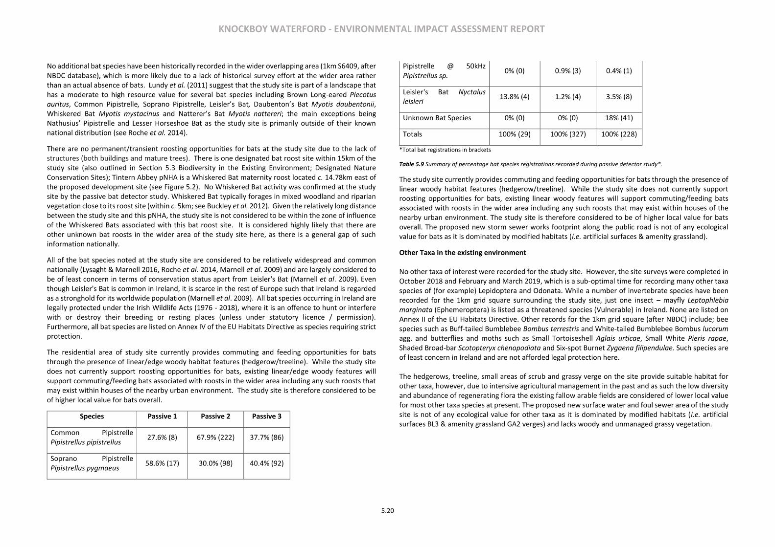
KNOCKBOY WATERFORD - ENVIRONMENTAL IMPACT ASSESSMENT REPORT
5.20
No additional bat species have been historically recorded in the wider overlapping area (1km S6409, after NBDC database), which is more likely due to a lack of historical survey effort at the wider area rather than an actual absence of bats. Lundy et al. (2011) suggest that the study site is part of a landscape that has a moderate to high resource value for several bat species including Brown Long-eared Plecotus auritus, Common Pipistrelle, Soprano Pipistrelle, Leisler’s Bat, Daubenton’s Bat Myotis daubentonii, Whiskered Bat Myotis mystacinus and Natterer’s Bat Myotis nattereri; the main exceptions being Nathusius’ Pipistrelle and Lesser Horseshoe Bat as the study site is primarily outside of their known national distribution (see Roche et al. 2014).
There are no permanent/transient roosting opportunities for bats at the study site due to the lack of structures (both buildings and mature trees). There is one designated bat roost site within 15km of the study site (also outlined in Section 5.3 Biodiversity in the Existing Environment; Designated Nature Conservation Sites); Tintern Abbey pNHA is a Whiskered Bat maternity roost located c. 14.78km east of the proposed development site (see Figure 5.2). No Whiskered Bat activity was confirmed at the study site by the passive bat detector study. Whiskered Bat typically forages in mixed woodland and riparian vegetation close to its roost site (within c. 5km; see Buckley et al. 2012). Given the relatively long distance between the study site and this pNHA, the study site is not considered to be within the zone of influence of the Whiskered Bats associated with this bat roost site. It is considered highly likely that there are other unknown bat roosts in the wider area of the study site here, as there is a general gap of such information nationally.
All of the bat species noted at the study site are considered to be relatively widespread and common nationally (Lysaght & Marnell 2016, Roche et al. 2014, Marnell et al. 2009) and are largely considered to be of least concern in terms of conservation status apart from Leisler's Bat (Marnell et al. 2009). Even though Leisler's Bat is common in Ireland, it is scarce in the rest of Europe such that Ireland is regarded as a stronghold for its worldwide population (Marnell et al. 2009). All bat species occurring in Ireland are legally protected under the Irish Wildlife Acts (1976 - 2018), where it is an offence to hunt or interfere with or destroy their breeding or resting places (unless under statutory licence / permission). Furthermore, all bat species are listed on Annex IV of the EU Habitats Directive as species requiring strict protection.
The residential area of study site currently provides commuting and feeding opportunities for bats through the presence of linear/edge woody habitat features (hedgerow/treeline). While the study site does not currently support roosting opportunities for bats, existing linear/edge woody features will support commuting/feeding bats associated with roosts in the wider area including any such roosts that may exist within houses of the nearby urban environment. The study site is therefore considered to be of higher local value for bats overall.
Species Passive 1 Passive 2 Passive 3
Common Pipistrelle Pipistrellus pipistrellus
27.6% (8) 67.9% (222) 37.7% (86)
Soprano Pipistrelle Pipistrellus pygmaeus
58.6% (17) 30.0% (98) 40.4% (92)
Pipistrelle @ 50kHz Pipistrellus sp.
0% (0) 0.9% (3) 0.4% (1)
Leisler's Bat Nyctalus leisleri
13.8% (4) 1.2% (4) 3.5% (8)
Unknown Bat Species 0% (0) 0% (0) 18% (41)
Totals 100% (29) 100% (327) 100% (228)
*Total bat registrations in brackets
Table 5.9 Summary of percentage bat species registrations recorded during passive detector study*.
The study site currently provides commuting and feeding opportunities for bats through the presence of linear woody habitat features (hedgerow/treeline). While the study site does not currently support roosting opportunities for bats, existing linear woody features will support commuting/feeding bats associated with roosts in the wider area including any such roosts that may exist within houses of the nearby urban environment. The study site is therefore considered to be of higher local value for bats overall. The proposed new storm sewer works footprint along the public road is not of any ecological value for bats as it is dominated by modified habitats (i.e. artificial surfaces & amenity grassland).
Other Taxa in the existing environment No other taxa of interest were recorded for the study site. However, the site surveys were completed in October 2018 and February and March 2019, which is a sub-optimal time for recording many other taxa species of (for example) Lepidoptera and Odonata. While a number of invertebrate species have been recorded for the 1km grid square surrounding the study site, just one insect – mayfly Leptophlebia marginata (Ephemeroptera) is listed as a threatened species (Vulnerable) in Ireland. None are listed on Annex II of the EU Habitats Directive. Other records for the 1km grid square (after NBDC) include; bee species such as Buff-tailed Bumblebee Bombus terrestris and White-tailed Bumblebee Bombus lucorum agg. and butterflies and moths such as Small Tortoiseshell Aglais urticae, Small White Pieris rapae, Shaded Broad-bar Scotopteryx chenopodiata and Six-spot Burnet Zygaena filipendulae. Such species are of least concern in Ireland and are not afforded legal protection here. The hedgerows, treeline, small areas of scrub and grassy verge on the site provide suitable habitat for other taxa, however, due to intensive agricultural management in the past and as such the low diversity and abundance of regenerating flora the existing fallow arable fields are considered of lower local value for most other taxa species at present. The proposed new surface water and foul sewer area of the study site is not of any ecological value for other taxa as it is dominated by modified habitats (i.e. artificial surfaces BL3 & amenity grassland GA2 verges) and lacks woody and unmanaged grassy vegetation.
KNOCKBOY WATERFORD - ENVIRONMENTAL IMPACT ASSESSMENT REPORT
5.21
5.4 CHARACTERISTICS OF THE PROPOSED DEVELOPMENT
The development will consist of a new residential development of 361 no. units comprising:
• 207 no. houses (13 no. 2-beds, 116 no. 3-beds, 78 no. 4-beds).
• 154 no. apartments within 15 no. 4 storey blocks (providing 53 no. 1-beds, 90 no. 2-beds and 11 no. 3-beds).
• A creche of c.574 sq.m.
• 7 no. internal/external communal waste storage facilities (total floor area c.214.3 sq.m).
• 638 car parking spaces and 390 no. bicycle parking spaces within 15 no storage facilities (total floor area c.232 sq.m). Additional visitor bicycle parking provided in the public realm.
• 2 no. ESB sub-stations/switchrooms (totalling c.10 sq.m)
• Vehicular/pedestrian/cyclist accesses to public road (Ballygunner Hill/St. Mary’s Place).
• The total gross floor area of the proposed development is c. c.51,226.1 sq.m
• All associated site development works, landscaping, open spaces, boundary treatments and services provision (including connection to public foul and surface water drainage at Dunmore Road & Island Drive.
5.5 POTENTIAL IMPACTS
Overall based on this current assessment, the study site is of local importance to biodiversity. One section of semi-natural hedgerow (WL1) and a section of planted/modified immature woodland (WS2), both habitats of higher local value, will be removed to accommodate the proposed development. Although considered a modified habitat of low, local importance, the loss of currently fallow arable crop (BC1) to facilitate the proposed development may affect local populations of wintering Yellowhammer, through a loss of suitable winter foraging habitat for this species. The study site boundary hedgerows/treeline/immature woodland are also of higher local importance for foraging and commuting bat species. Taking the above into consideration, the study site is currently considered to be of low to higher local importance (see Appendix 5.2), as it supports semi-natural habitats and modified habitats with local wildlife/biodiversity value. Potential impacts arising from the proposed residential development on existing biodiversity of the site and wider locality, which may arise during construction and/or operation, are considered further below. Do-nothing and cumulative scenarios are also considered. Designated Nature Conservation Sites Designated conservation sites occurring in the wider environment (within 15km of the study site) are of national or international importance. The study site is not part of any designated conservation site and does not require any resources from them; thereby ruling out any direct habitat loss from these designated conservation sites. As outlined in Section 5.3 above, there is a potential indirect hydrological link between the study site and the following designated nature conservation sites through surface water and/or waste-water/effluent drainage: The Lower River Suir SAC, King's Channel pNHA; the River Barrow and River Nore SAC; Barrow River Estuary pNHA and Waterford Harbour pNHA.
As previously mentioned, a NIS in support of the AA process has been undertaken to consider whether significant effects on any relevant Natura 2000 sites are likely to arise as a result of the proposed residential development at Knockboy with key findings summarised in this EIAR (See NIS accompanying this application). It is worth noting here that as part of this NIS assessment a dedicated field assessment was undertaken of saltmarsh or Atlantic Salt Meadow ASM 1330 habitat present at/near the existing outfall (SWOs) that discharges (when triggered from time to time by surface/storm water inputs) combined untreated sewage and storm water into the River Suir at King’s Channel. Atlantic Salt Meadow ASM 1330 is one of the qualifying interests of the Lower River Suir SAC. Occasional raw sewage overflow from the nearby Island View pumping station which discharges via the SWOs has been cited as a potentially relevant impact in relation to the nearby Atlantic Salt Marsh ASM 1330 (Cluainecology 2018, KES 2018). The Atlantic Salt Meadow ASM 1330 present in the vicinity of the aforementioned combined SWOs has previously been assessed in 2007 as part of a national based Saltmarsh Monitoring Project (SMP), where it partly overlapped with the relevant SMP site at Little Island (see McCorry and Ryle 2009a&b). This presented an opportunity to compare the existing situation regarding Atlantic Salt Meadow ASM 1330, with the historical situation from 2007 and thereby assess changes and/or impacts on Atlantic Salt Meadow ASM 1330 here, including raw sewage release via the combined SWOs potentially relevant (as discussed below). The results of this survey are presented and discussed in more detail in the NIS accompanying this application, with key relevant findings summarised here. Construction Impacts – Indirect Impacts via Surface Water Discharge Site Surface Water Drainage Standard best practice environmental controls (i.e. soil and water management) to protect the surrounding environment will be implemented during construction to minimise any potential risk of surface and/or groundwater pollution through, siltation, nutrient release and/or contamination (see outline oCEMP submitted as part of this application, Chapters 6 and 7 of this EIAR, Engineering Planning Report MAL 2019a and supporting documents). While primarily designed to address environmental risks associated with construction works at the residential development site only, these standard best practice environmental controls, will also serve to minimise potential construction phase run-off impacts into the wider environment including the River Suir (and Lower River Suir SAC and other associated designated sites), even if this is not the primary aim of these measures. As construction works progress, it is understood that the proposed controlled (i.e. restricted to 2 litres per second per hectare, MAL 2019a) surface water drainage will be directed into the existing public surface-water drainage system, which discharges to a tributary of Blenheim Stream (and as such ultimately the River Suir) at Dunmore Road. The surface water drainage infrastructure has been designed with reference to the GDSDS with standard environmental controls including; controlled run-off rates, surface water attenuation, SuDS and flow control; providing for 100-year storm events, swales, surface water infiltration and permeable paving (see MAL 2019a for specific information). Based on the appropriate surface water management design for the study site the risk of flooding in the wider environment, including downstream lands, from on-site sources is deemed to be ‘sufficiently low to be acceptable’ (MAL 2019b). As all surface water discharge (up to 1/100-year storm event) will be
KNOCKBOY WATERFORD - ENVIRONMENTAL IMPACT ASSESSMENT REPORT
5.22
adequately controlled on site, prior to controlled discharge to the tributary of the Lower River Suir, there is no potential for contaminated discharge entering the River as a result of surface water discharge and the risk of flooding from the proposed development (to the surrounding environment/downstream lands) is deemed to be ‘sufficiently low to be acceptable’ (MAL 2019b). While the proposed surface water management will be specific to the study site development and the River Suir, it will also minimise any potential run-off impacts to the wider environment, including the Lower River Suir SAC and other associated designated sites. Taking the above into consideration, potential construction phase impacts in relation to surface water drainage on designated sites are considered imperceptible neutral. Freshwater influence
As described above, once initiated surface-water drainage associated with the proposed development will be intercepted by an existing public sewer at Dunmore Road that will then discharge to a tributary of Blenheim Stream prior to discharging to the River Suir at King’s Channel. Additional freshwater inputs arising from the proposed development into Blenheim Stream and onwards towards King’s Channel may have a potential freshwater influence on existing Atlantic Salt Meadow of the relevant designated sites in terms of affecting vegetation structure/succession and/or habitat erosion. Existing Atlantic Salt Meadow habitat structure assessed in 2018 at and in the vicinity of the SWOs outfall to King’s Channel, did not show any evidence to indicate on-going influence from existing freshwater inputs (e.g. increase in brackish reed species like Common Reed and Sea Club Rush) associated with this SWOs located here, and which has been in place for a number of years now as part of the Waterford Main Drainage scheme that was commissioned from 2010; this includes Atlantic Salt Meadow areas along the lower sections of the tidal creeks and pans relevant to the section of King’s Channel/SWOs outfall in question. While taking this into consideration it is also important to note that the freshwater surface water discharge point for this development at Knockboy is to a small freshwater tributary of Blenheim stream associated with terrestrial vegetation (i.e. trees/scrub), c. 601m upstream (direct overland) of the brackish and saline saltmarsh habitats associated with the Lower River Suir SAC. Based on the surface water management proposed, together with the location of the surface water discharge point, controlled freshwater inputs from the proposed development (up to 1/100 year storm event) are unlikely to influence the brackish or saline concentrations of the large tidal water volume and as such promote a vegetative community shift (i.e. change in salt marsh habitat structure or succession to different plant communities less tolerant of current estuarine tidal conditions). While the proposed surface water management will be specific to the site development and the River Suir, it will also minimise any potential freshwater influences on saline/estuarine habitats in the wider environment, including the Lower River Suir SAC and other associated designated sites. Erosion is also a pressure that can negatively impact on saltmarsh extent within an estuarine system. Saltmarshes can go through cycles of erosion and accretion naturally, where such natural erosion should not be classified as a pressure (see McCorry and Ryle 2009a, Devaney and Perrin 2015). Erosion of a saltmarsh resulting in a loss in extent/area is only considered an irreparable impact if there is no opportunity for a landward retreat due to the impacts of coastal squeeze resulting from hard-coastal defences and/or other man-made barriers (see McCorry and Ryle 2009a, Boorman 2003). Natural erosion can be considered reparable if there is potential for landward retreat in the future, such as if an embankment is breached and/or if there is a change in land use. In this case, the only erosion documented at the Atlantic Salt Meadow study area in 2018 related to the narrow coastal band associated with the existing earthen embankment/flood defence section that is considered to be as a result of natural tidal actions; although, this embankment may influence Atlantic Salt Meadow erosion
through associated coastal squeeze impacts (see Boorman 2003). While some evidence of erosion was noted along the same narrow coastal band in 2007, it was not considered significant at the time (see McCorry and Ryle 2009a). No significant tidal erosion was evident in 2018 along the creeks and pans present within the Atlantic Salt Meadow study area overall. Furthermore, as described above, the design of the surface water drainage infrastructure for Knockboy is such that it will not discharge to Island View pumping station and as such will not add to or influence the current volume of surface water entering/triggering the SWOs at King’s Channel. Taking the above into consideration, potential construction phase impacts on designated sites in relation to freshwater influence are considered neutral. Construction Impacts - Indirect Impacts: Waste-Water/ Effluent:
Existing Combined Outfall SWOs at King’s Channel: Raw Sewage.
During initial construction works and before the residential site is connected to the public effluent sewer network, construction phase waste-water/foul effluent will be managed at a temporary site compound (e.g. site portaloos and welfare units, see oCEMP accompanying this application, MAL 2019a) with all waste removed from site by licenced waste disposal. Therefore, no potential hydrological link from waste-water/effluent is relevant to any of the designated conservation sites under consideration.
When the study site connects to the existing public foul/effluent sewer network waste water/foul effluent drainage arising from the proposed development site will discharge to this network for transfer and treatment at Waterford City WWTP, which ultimately discharges to the River Suir (WWTP Discharge Point; Figure 5.2) and as such The Lower River Suir SAC. Three other designated sites the Barrow and River Nore SAC, the Barrow River Estuary pNHA and Waterford Harbour pNHA are located downstream of the discharge point in question (c. 3.1km downstream). King’s Channel pNHA is location upstream of the WWTP discharge point, however this salt marsh habitat (Atlantic Salt Meadow ASM 1330) present here is subject to tidal inundations associated with the Lower River Suir as at least part of this pNHA is within/overlaps the Lower River Suir SAC. Prior to the transfer to the Waterford City WWTP this local authority drainage network transfers waste water/effluent drainage to Island View pumping station, where it is subsequently pumped onwards to the WWTP. As described earlier, Island View pumping station has a combined sewer overflow (CSO) and emergency overflow (EO) system (collectively surface water overflows SWOs, after RPS 2018), which when triggered (by excess surface water ingress), discharges to the Lower River Suir Estuary at Little Island/King’s Channel. Due to the location of this SWOs discharge point there is a potential for indirect hydrological impacts on water quality through point source pollution, which in turn could impact on water quality and associated key wetland habitats (e.g. a subsite of Atlantic Salt Meadows ASM 1330 habitat located at the SWOs discharge point) associated with the Lower River Suir SAC and King’s Channel pNHA. None of the other designated sites are considered relevant to the SWOs outfall location, given their locations within the large harbour area combined with relatively significant water volumes associated with the harbour flow in general. Raw sewage discharges on occasion as overflow from Island View pumping station via the SWOs at King’s Channel on the River Suir (and associated designated sites). As the waste-water/effluent associated with the proposed development at Knockboy is directed into the public sewer network, including Island View pumping station, there is the potential for raw sewage associated with the proposed development would
KNOCKBOY WATERFORD - ENVIRONMENTAL IMPACT ASSESSMENT REPORT
5.23
be part of the overflow at the SWOs. Of note here, is the fact that the design of the surface water drainage infrastructure is such that it will not discharge to Island View pumping station and as such will not add to or influence the current volume of surface water entering/triggering the SWOs. In other words, the frequency of raw sewage discharge through the existing SWOs at King’s Channel will not be triggered by surface water discharge from this proposed development. In 2007 part of the SMP Little Island Atlantic Salt Meadow site (that overlaps the Atlantic Salt Meadow study area included as part of the NIS for this application) was noted as likely to be affected by raw sewage flowing along a drainage channel that passed through a large stand of Common Reed before discharging into King’s Channel (see McCorry & Ryle 2009a & 2009b). While the ‘likely’ effect of nutrient enrichment arising from sewage discharge present in 2007 was the main reason that the structure and functions of Atlantic Salt Meadow here were assessed as unfavourable-inadequate at the time, it was also acknowledged that no significant negative impact from sewage discharge occurred in relation to the structure and function of the Atlantic Salt Meadow habitat in question (McCorry & Ryle 2009b). In terms of future prospects and recommendations in relation to Atlantic Salt Meadow habitat in 2007, the continuation of sewage discharge and investigation of such was highlighted (McCorry & Ryle 2009b). However, it is important to note that such historic management of sewage here has since been superseded by the Waterford Main Drainage scheme commissioned from 2010 (see WCC 2013a) where raw sewage locally now comprises of occasional overflow from the nearby Island View pumping station that currently discharges directly into King’s Channel (i.e. the River Suir channel) via the aforementioned SWOs and not via a drainage channel within associated saltmarsh habitat. In respect of the existing Atlantic Salt Marsh habitat structure at and in the vicinity of the outfall under consideration here, the 2018 assessment did not find any evidence to indicate on-going nutrient input influence related to occasional raw sewage releases (e.g. increase in brackish reed species like Common Reed and Sea Club Rush) associated with this outfall that has been in place for several years as part of the Waterford Main Drainage scheme (commissioned from 2010); this includes saltmarsh/Atlantic Salt Meadow areas along the lower sections of the tidal creeks and pans relevant to the section of King’s Channel/outfall in question here. Furthermore, a water quality assessment undertaken as part of this application (RPS 2018), show current/occasional discharge for island View pumping station is not impacting on water quality and any additional loadings associated with the proposed development will not adversely impact on the water quality status of the Lower River Suir and downstream designated sites (RPS 2018).
Taking the above into consideration, potential construction phase impacts on designated sites in relation to occasional raw sewage discharge from the existing SWOs are considered imperceptible neutral. Treated Sewage Discharge (via Waterford City WWTP) Waterford City WWTP is currently compliant with regard to its licensed emissions, where its discharge is not having an observable negative impact on water quality or Water Framework Directive (WFD) status of the receiving waters of the River Suir/associated designated sites (see Irish Water 2018). Furthermore, Waterford WWTP currently has significant capacity to accept the additional organic PE loading arising from this proposed development (see Irish Water 2018); where Irish Water has also verified that the foul connection to the public network and associated WWTP can be accommodated (please refer to Irish Water correspondence as submitted as part of this planning application pack). While the WWTP discharge location is within the Lower River Suir SAC, it is c. 2km downstream of the nearest confirmed Atlantic Salt Meadow at Little Island (after McCorry and Ryle 2009a and NPWS 2017). Confirmed Atlantic Salt Meadow areas associated with the River Barrow and River Nore SAC are located
upstream of its confluence with the Lower River Suir SAC (see NPWS 2011a) and therefore not relevant here. While there are other qualifying interests for relevant designated sites where water quality is a specific attribute/target (e.g. Freshwater Pearl Mussel Margaritifera margaritifera, White‐clawed Crayfish Austropotamobius pallipes, Twaite Shad Alosa fallax, Atlantic Salmon Salmo salar and Watercourses of plain to montane levels with the Ranunculion fluitantis and Callitricho‐Batrachion vegetation), such qualifying interests are more relevant to upstream locations than the transitional waterbody section of relevant designated sites downstream here (see NPWS 2011a and 2017). Taking the above into consideration, potential construction phase impacts on designated sites in relation to treated sewage from Waterford City’s WWTP are considered imperceptible neutral. Other Impacts. As outlined, potential construction phase impacts on designated sites via other impacts such as disturbance/displacement on relevant fauna, recreational activity and flooding/floodplain are not relevant here and are therefore considered neutral. Operational Impacts Indirect Impacts: Surface-Water Run-Off: Site Surface Water Drainage Infrastructure. The implementation of the proposed operational phase soils and water management will adequately reduce potential risks arising from hydrological or water quality impacts on the River Suir via the public surface water network and an existing SWOs outfall at King’s Channel (see Chapters 6 & 7 of this EIAR and MAL 2019). This includes the design of the surface water drainage infrastructure whereby it will not discharge to Island View pumping station and as such will not add to or influence the current volume of surface water entering/triggering the SWOs outfall to King’s Channel. As described, the surface water discharge point is to a small fresh water tributary of Blenheim stream associated with terrestrial vegetation (i.e. trees and scrub), c. 601m upstream (direct overland) of the brackish and saline saltmarsh habitats associated with the Lower River Suir SAC. While the proposed operational phase soils and water management will be specific to the study site, development and the River Suir, they will also serve to minimise potential operational phase run-off impacts into the wider environment including the Lower River Suir SAC and other associated designated sites even if not primarily designed to address any particular risks to the SAC/other designated sites as such. Taking the above into consideration, potential operational phase impacts in relation to surface water drainage on designated sites are considered imperceptible neutral. Freshwater Influence. Potential operational phase impacts on designated sites in relation to freshwater influence from the existing combined outfall at King’s Channel are not considered relevant here for the same reasons outlined in the construction phase above whereby firstly the design of the surface water drainage infrastructure is so that it will not discharge to Island View pumping station and as such will not add to or influence the current volume of surface water entering/triggering the SWOs outfall to King’s Channel, and secondly that the controlled freshwater input is to a freshwater tributary of the River Suir, whereby

KNOCKBOY WATERFORD - ENVIRONMENTAL IMPACT ASSESSMENT REPORT
5.24
its discharge to terrestrial habitats here will not lead to a change in habitat structure, habitat succession and/or erosion of downstream Atlantic Salt Meadow associated with the Lower River Suir SAC (overlapping in part with King’s Channel pNHA), such that potential operational impacts on the designated sites via freshwater influence are considered neutral. Indirect Impacts: Waste-Water/Foul Effluent: Existing Combined Outfall at King’s Channel: Raw Sewage. Potential operational phase impacts on designated sites in relation to occasional raw sewage overflow from the existing SWOs outfall at King’s Channel are not considered relevant here for the same reasons outlined in the construction phase impacts above, such that potential operational impacts on the designated sites via raw sewage overflow from the existing SWOs outfall for Island View pumping station are considered imperceptible neutral. Waterford WWTP: Treated Sewage. Potential operational phase impacts on designated sites in relation to treated sewage discharge from Waterford WWTP are not considered relevant here for the same reasons as outlined in the construction phase impacts above, such that potential operational impacts on the designated sites via treated sewage discharge from Waterford WWTP are considered imperceptible neutral. Other Impacts. As outlined above, potential operational phase impacts on designated sites via other impacts such as disturbance/displacement on relevant fauna, recreational activity and flooding/floodplain are not relevant here and are therefore considered imperceptible neutral. Habitat and Flora Construction Impacts No Annex I habitats listed under the EU Habitats Directive are present within the study site. Also, no botanical species protected under the Flora (Protection) Order 2015, listed in the EU Habitats Directive, or listed as flora of conservation concern in Ireland were recorded. The main habitats which will be directly impacted by the proposed residential development works footprint include habitats of lower local importance; arable crop (BC1), scrub (WS1) and grassy verge (GS2). One section of semi-natural hedgerow (WL1) and an area of planted/modified immature woodland (WS2), habitats of higher local importance will also be directly impacted by the proposed development. All remaining semi-natural (boundary) hedgerows (WL1) will remain in place, where they will form part of the final landscaping design for the study site and as such all remaining semi-natural habitat will be maintained, protected during construction works and enhanced as part of the proposed landscaping masterplan (see Landscape Masterplan Drawing Number L101 of this EIAR). The will be a permanent increase in modified habitat; buildings and artificial surfaces (BL3), as a result of the proposed development which will lead to a slight negative impact on semi-natural habitats and flora species at the site and surrounding locality. There will also be a permanent increase in other modified habitats; amenity grassland (GA2), ornamental/non-native shrubberies (WS3) and mixed native/non-native species woodland as a result of the proposed development. However, a landscape masterplan
proposed as part of this development includes mixed (native/non-native) woodland planting, new native hedgerow planting and enhancement (of existing hedgerows), ornamental shrubberies and the creation of small areas of new native wildflower grassland/verges (c. 780 sq. m) (see Landscape Masterplan Drawing Number L101 of this EIAR). These proposed landscaping measures will increase native tree, shrub and wildflower cover, diversity and species richness at the site as well as allow/maintain connectivity between habitats at the study site and in the surrounding locality. It is also worth noting that the planting species mixes proposed as part of the landscape masterplan have been completed with reference to the all-Ireland Pollinator Plan, and as such a mix of native and non-native pollinator friendly species will be used (see NBDC 2016). Taking the above into account this increase in modified habitats (mixed woodland, ornamental/non-native shrubberies and grassland) will have a neutral impact on semi-natural habitats and flora at the site and surrounding locality. The permanent loss of habitats of low local importance (i.e. arable crop (BC1), grassy verge (GS2) and scrub (WS1)) as a result of the proposed development will lead to a neutral impact on existing semi-natural habitats and flora species at the site and surrounding locality. The permanent loss of semi-natural habitat of higher local importance, will be limited to approximately 148m of native hedgerow (i.e. hedgerow 1 running across/through the site towards the eastern boundary), which will be removed to accommodate the proposed development; residential units and open amenity space. This permanent loss of hedgerow (WL1) will have a slight negative impact on semi-natural habitat and flora at the study site and surrounding locality. However, this loss of semi-natural hedgerow (WL1) has been considered as part of the landscaping masterplan and compensatory new native species hedgerow planting will be implemented, with c. 610m of new linear native hedgerow proposed overall (see Landscape Masterplan Drawing Number L101 of this EIAR). Proposed new native hedgerow planting will compensate for hedgerow removal and will result in a net gain of native hedgerow at the study site. The proposed landscape masterplan also includes for supplementary planting of retained/site boundary native hedgerows, where hedgerows which are in an unfavourable or adequate condition at present will benefit considerably. The feasibility to successfully retain hedgerow tree specimens (trees identified/present on eastern boundary only, see TMS 2019) has also been assessed as part of this project in respect of the proposed layout infrastructure and root protection areas (see Arboriculture Impact Assessment, Tree Root Protection Plan and Tree and Hedgerow Survey, TMS 2019, accompanying this application). Taken the above into account the permanent loss of one section of hedgerow (WL1) will have a neutral imperceptible impact on semi-natural habitats and flora at the site and the surrounding locality. One area (c.1,390 m2) of immature woodland (WS2), a modified/planted habitat, will also be removed to accommodate the development and as the woodland is comprised of a mix of native/non-native species with higher local importance, this loss will have a slight negative impact on habitats and flora at the site and surrounding locality. The remaining section of immature woodland situated along the northern boundary (extending off-site) will be maintained and as such there will be no impact on remaining immature woodland (WS2). Furthermore, the proposed landscape masterplan includes for additional new woodland planting on the northern and eastern boundaries of the study site, with clusters of trees/treelines situated across the study site (see Landscape Masterplan drawing number 101). The tree species mix for new woodland and tree clusters/treelines will be comprised of native species as far as possible, where the list of non-native tree species has been complied with reference to the all-Ireland Pollinator Plan and as such includes a mix of native and/or non-native pollinator friendly species (see
KNOCKBOY WATERFORD - ENVIRONMENTAL IMPACT ASSESSMENT REPORT
5.25
Landscape Masterplan drawing 101, accompanying the planning application). This new woodland/tree clusters/treeline planting will compensate for the loss of immature woodland at the study site and will increase the overall diversity of tree species and tree cover at the study site. The immature woodland trees were also included as part of the arboriculture impact assessment (TMS 2019, accompanying this application). which highlights those trees, which will be removed to accommodate the development and/or removed due to poor condition/long-term viability of the trees/shrubs or for ‘sound arboricultural management proposes’ (TMS 2019). Based on this assessment a tree root protection plan which will be implemented for retained trees/shrubs to minimise root damage during construction works is provided. Additional remedial works to improve the condition of retained trees are also presented. Therefore, the permanent loss of one section of immature woodland to accommodate the proposed development layout will have a neutral imperceptible impact on semi-natural habitats and flora at the site and in the surrounding locality. As described in section 5.3, there are occassional immature/semi-mature trees present within the grassy verge (GS2) on the western boundary; including frequent non-native/naturalised Sycamore (Stolze, S. & Monecke, T. 2017) and occassional native Ash. There is one non-native/naturalised immature Sycamore tree associated with the small area of scrub (WS1), towards the western boundary of the study site. These trees, situated in habitats of lower local importance (i.e. grassy verge (GS2) and scrub (WS1)), were also included as part of the arboriculture impact assessment which highlights those trees, which will be removed to accommodate the development and/or removed due to poor condition/long-term viability of the trees/shrubs or based on ‘sound arboricultural management’ practice (MTS 2019). Based on this assessment a tree root protection plan which will be implemented for retained trees/shrubs to minimise root damage during construction works is provided. Additional remedial works to improve the condition of those retained tree species are also presented (TMS 2019). Habitats and flora associated with aquatic habitats in the wider locality could be negatively affected by the proposed development through hydrological/water quality impacts such as nutrient release, siltation and/or contaminated run-off arising from the study site development works footprint. Potential hydrological or water quality impacts may apply to the River Suir where surface water associated with the study site will discharge to the public network on Dunmore Road which ultimately discharges to the River Suir, occasional discharge from the SWOs at Kings Channel and waste-water/effluent discharge via the public foul sewer network and Waterford City WWTP, when connection to these networks are initiated. Standard best practice environmental controls (soil and water management) to protect the surrounding environment will be implemented during construction to minimise any potential risk of surface and/or groundwater pollution through, siltation, nutrient release and/or contamination (see outline oCEMP submitted as part of this application, Chapters 6 and 7 of this EIAR and the engineering planning report; MAL 2019a). Such management proposals will adequately reduce any potential risks arising as a result of construction works on site and hydrological or water quality impacts on aquatic habitats and flora in the wider environment. While primarily designed to address environmental risks associated with construction works at the residential development site only, these standard best practice measures, will also serve to minimise potential construction phase run-off impacts on aquatic habitats and flora in the wider environment (River Suir and associated designated sites), even if this is not the primary aim of the protection measures.
As construction works progress and as such connections to the public surface water drainage (Dunmore Road) and public effluent sewers is initiated, implementation of the proposed site drainage design (see MAL 2019a), together with the soil and water management proposals (as presented in relevant chapters of this EIAR) will minimise and potential risk of surface water and or effluent drainage impacts through, siltation, nutrient release and/or contamination on the River Suir and associated aquatic habitats and flora from the public surface sewer network and waste-water/foul effluent via Island View Pumping Station and ultimately Waterford City WWTP. As described in respect of potential impacts on designated sites and as such existing aquatic habitats and flora (primarily saltmarsh habitat) in the vicinity of the SWOs outfall, a 2018 assessment did not find any evidence to indicate on-going nutrient input influence related to occasional raw sewage releases associated with this SWOs outfall location, that has been in place for several years as part of the Waterford Main Drainage scheme that was commissioned from 2010; this includes saltmarsh habitats along the lower sections of the tidal creeks and pans relevant to the section of King’s Channel/SWOs in question (Cluainecology 2018, KES 2018). A water quality assessment undertaken as part of this application (RPS 2018), show current/occasional discharge for island View pumping station is not impacting on water quality and any additional loadings associated with the proposed development will not adversely impact on the water quality status of the Lower River Suir and downstream designated sites (RPS 2018). Furthermore, Waterford City WWTP is currently compliant, where its discharge does not have an observable negative impact on the water quality or WFD status of the receiving waters of the River Suir and it is well within its hydraulic/organic capacity (see Irish Water 2018) to cater for the additional organic PE loading arising from the proposed development where Irish Water have also verified that the foul connection to the public network and associated WWTP can be accommodated (please refer to Irish Water correspondence as submitted as part of this planning application pack). Taking the above into consideration, potential impacts on habitats and flora at the site arising from the construction of the proposed development are considered neutral imperceptible, while potential construction phase effects on habitats and flora associated with aquatic habitats in the wider area are considered neutral with the implementation of soils and water management proposals, together with the site drainage design. Operational Impacts There will be no additional removal of habitat during the operational phase of the proposed development and as such there is no potential for impacts on semi-natural habitat and flora arising for the operational phase. Potential impacts arising from the operation of the residential estate on semi-natural habitats/flora are considered neutral. Overtime, as site landscaping matures the overall increase in native hedgerow, tree and shrub and/or pollinator friendly non-native shrubs and trees (compared with current large/open arable landscape characteristics), together with enhancement of existing native hedgerow boundaries, the effects on semi-natural habitats and flora may be slight positive. The operational phase of a development could impact on habitats and flora associated with aquatic habitats in the wider area through hydrological or water quality impacts. This potentially applies to the River Suir in this case, where surface-water run-off associated with the site will discharge via the public storm sewer network at Dunmore Rd and waste-water/foul effluent will discharge via the public foul sewer network, including Island View pumping station/SWOs and Waterford City WWTP. However,
KNOCKBOY WATERFORD - ENVIRONMENTAL IMPACT ASSESSMENT REPORT
5.26
potential operational phase impacts on aquatic habitats and flora in the wider environment as a result of surface water discharge, occasional raw sewage overflow from the existing SWOs outfall at King’s Channel and discharge of treated waste water for Waterford City WWTP are not considered relevant here for the same reasons as presented in the construction phase above, such that potential operational impacts on aquatic habitats and flora in the wider environment are considered neutral. Taking the above into consideration, potential effects on habitats and flora at the site arising from the operational phase of the proposed development are considered neutral and as new planting/landscaping matures the effects on semi-natural habitats and flora may be slight positive, while potential operational phase effects on habitats and flora associated with aquatic habitats in the wider area are also considered neutral with the implementation of the soils and water management proposals, together with the operational phase site drainage design (MAL 2019).
Fauna: Birds, Mammals (non-volant), Bats & Other Taxa Habitats such as hedgerow, non-native treeline and immature woodland, present at the residential area of the study site provide some commuting, resting/roosting, breeding and feeding opportunities for a range of fauna in general. While the large open fallow arable fields and small areas of grassy verge and scrub are of lower local importance for most fauna overall, the fallow arable crop it is considered of higher, local importance for one red-listed bird species; Yellowhammer. The study site is also considered of higher local importance for bats as the site hedgerows/treeline/immature woodland currently provides commuting and feeding opportunities for bat species in the context of a nearby urban environment where bat roosts may be present.
Construction Phase Impacts The study site is of lower local importance for most fauna overall, where just one bird species; Yellowhammer of high conservation concern in Ireland recorded. While there are no suitable mature trees for roosting bat species the study site boundary hedgerows, non-native treeline and immature woodland are of higher local importance for commuting/foraging bat species in general. Such woody habitats (i.e. hedgerow, treeline and immature woodland) present along the boundaries of the residential area of the study site also provide commuting, resting/roosting, breeding and feeding opportunities for fauna in general. Although, the extent of these habitats is relatively limited, given the overall size of the study site and the large expanse of open arable field which makes up most of the study site area (i.e. proposed development footprint) in question.
As approximately 8.8ha of fallow arable crop (BC1) (foraging habitat), will be permanently lost to accommodate the residential development, with c. 148m of hedgerow (WL1) (potential breeding habitat), construction of the proposed development will have a permanent significant negative effect on local populations of Yellowhammer. However, while c. 145m of hedgerow/potential breeding habitat will be removed, this hedgerow is in an unfavourable condition at present and as such the current hedgerow structure may not provide optimum breeding habitat for Yellowhammer (Copland 2014). Furthermore, proposed new native hedgerow planting will compensate for this hedgerow removal and will result in a net gain of native hedgerow at the study site. The proposed landscape masterplan also includes for supplementary planting of retained/site boundary native hedgerows, where hedgerows which are in an unfavourable or adequate condition at present will benefit considerably. Taking this into account the loss of c. 148m of hedgerow will have a neutral-imperceptible impact on potential breeding habitat for
Yellowhammer, while the permanent loss of currently suitable foraging habitat, which cannot be compensated for, will have a permanent significant negative effect on local populations of this species and a moderate negative effect, in line with existing baseline trends. Other fauna, particularly other seed eating bird species such as wintering flocks of Chaffinch, Goldfinch and Linnet will also be negatively affected by the permanent loss of fallow arable crop, although such species are not as closely tided to cereal farming as Yellowhammer and as such the permanent loss of arable crop will have a slight negative impact on other fauna through a loss of potential foraging habitat.
The permanent loss of one section of hedgerow (c.148 linear m), an area of immature woodland (c.1,390 m2) and small areas of scrub, grassy habitats together with arable crop arising from construction of the development will have a temporary slight negative impact on other general fauna and bats, through a reduction in commuting, feeding and/or resting/roosting opportunities. The permanent loss of structures/mature trees that can provide roosting opportunities for bats can potentially negatively affect bats through reduced permanent/transient roosting opportunities. In this case, there is a lack of such structures such that no significant impacts on roosting bat habitats are relevant here. In addition, similar hedgerows, woody habitats, grassland are also available in the surrounding suburban gardens and parkland habitats as well as an extensive rural/agricultural environment further afield such that affected fauna can move into the wider area. It is also acknowledged that the extent of habitat loss in question is relatively limited; as just one section of hedgerow (c. 148m) and one area of immature woodland (c. 1,390m2) will be removed to accommodate the development footprint, with all remaining semi-natural boundary hedgerows and immature woodland and non-native treeline maintained as is. Also, the landscape masterplan associated with the development propose new native hedgerow planting (c. 610m), together with enhancement of existing boundary hedgerows and the provision of new woodland, tree cluster/treelines, as well as creating new areas of wildflower meadow/verges, amenity grassland and garden habitats, that most general fauna species can use (see Landscape Masterplan Drawing Number L101 of this EIAR). The proposed species mix which includes native species and/or pollinator friendly non-native trees and shrubs, will maintain or enhance tree, shrub and wildflower/grasses diversity at the study site, as well as providing cover and food for a range of general fauna species (as it matures). Furthermore, current wildlife corridor/green infrastructure for other fauna is being retained, compensated for and/or enhanced along the southern, northern and eastern boundaries of the proposed development site, which will maintain and/or provide wildlife corridors within the operational development. Taking this into consideration potential impacts on other fauna species as a result of construction for the proposed development are considered imperceptible neutral. Works and associated activities arising from construction of the development will lead to a disturbance of fauna through displacement at and close to the study site in general. As previously mentioned, similar habitats are available in the surrounding landscape so that affected fauna including bats can move into the wider area as development progresses and move back to the site and adjoining area as the development is completed and landscaped areas are created. Also, as the construction phase will be temporary to short-term in duration affected fauna can move back to the site and adjoining suburban areas when construction works have finished, and new landscaped areas created. Taking this into account, temporary disturbance/displacement impacts on fauna as a result of construction for the proposed residential development is neutral-imperceptible. For some fauna (i.e. active at dusk/night/early dawn), in particular bats, disturbance displacement can also arise as a result of artificial lighting, used during the construction stage, where most bat species are
KNOCKBOY WATERFORD - ENVIRONMENTAL IMPACT ASSESSMENT REPORT
5.27
negatively affected by artificial light in general (see Bat Conservation Ireland 2010, Stone 2013). However, mitigation is provided to ensure there are no adverse impacts on fauna as a result of lighting disturbance. With the exception of health and safety lighting, during the construction phase of the proposed development the construction site will not be lit at night (with the exception of low-level switchable safety lighting). During the operation phase of the proposed development all additional lighting systems will be designed to minimise nuisance through light spillage. Shielded, downward directed lighting will be used, with no upward facing or omnidirectional lighting used and all non-essential lighting will be switched off during the hours of darkness. This will minimise potential lighting disturbance impacts on the faunal species that may occur at the study site or nearby to a neutral-imperceptible level. Fauna associated with aquatic habitats in the wider locality could be negatively affected by the proposed development through hydrological/water quality impacts such as nutrient release, siltation and/or contaminated run-off from the development works footprint. Potential hydrological or water quality impacts may apply to the River Suir where surface water associated with the site will discharge to the public network on Dunmore Road which ultimately discharges to the River Suir, occasional discharge from the SWOs at Kings Channel and waste-water/effluent discharge via the public foul sewer network and Waterford City WWTP, when connection to these networks are initiated. Standard best practice environmental controls (soil and water management plans/site drainage design, oCEMP) to protect the surrounding environment will be implemented during construction to minimise any potential risk of surface and/or groundwater pollution through, siltation, nutrient release and/or contamination (see outline oCEMP submitted as part of this application, together with relevant chapters of this EIAR; Chapters 6, 7 and the site engineering drainage report; MAL 2019a ). These soil and water management proposals will adequately reduce potential risks arising as a result of construction works on site and hydrological or water quality impacts on the River Suir and associated fauna. While primarily designed to address environmental risks associated with construction works at the residential development site only, these standard best practice measures, will also serve to minimise potential construction phase hydrological run-off impacts on fauna in the wider environment (River Suir and associated designated sites), even if this is not the primary aim of the protection measures. As construction works progress and as such connections to the public surface water drainage (Dunmore Road) and public effluent sewers is initiated, implementation of the proposed site drainage design (see MAL 2019a), together with soil and water management proposals (as presented in relevant chapters of this EIAR and accompanying documents/reports) will minimise any potential risk of surface water and or effluent drainage impacts through, siltation, nutrient release and/or contamination on the River Suir and associated aquatic habitats and fauna from the public surface sewer network and waste-water/foul effluent via Island View Pumping Station and ultimately Waterford City WWTP. While there are other qualifying interests (fauna) for relevant designated aquatic sites where water quality is a specific attribute/target (e.g. Freshwater Pearl Mussel, White‐clawed Crayfish, Twaite Shad, Atlantic Salmon, such qualifying interests are more relevant to upstream locations rather than the transitional waterbody section of the River Suir (see NPWS 2011a and 2017). Also, a water quality assessment undertaken as part of this application (RPS 2018), show current/occasional discharge for island View pumping station is not impacting on water quality and any additional loadings associated with the proposed development will not adversely impact on the water quality status of the Lower River Suir and downstream designated sites (RPS 2018). Furthermore, Waterford City WWTP is currently compliant, where its discharge does not have an observable negative impact on the water quality or WFD status of the receiving waters of the River Suir and it is well within its hydraulic/organic capacity (see Irish Water 2018, RPS 2018) to cater
for the additional organic PE loading arising from the proposed development where Irish Water have also verified that the foul connection to the public network and associated WWTP can be accommodated (please refer to Irish Water correspondence as submitted as part of this planning application pack). Taking the above into consideration, potential effects on local populations of Yellowhammer arising from construction of the proposed development are considered a permanent significant negative effect on local populations due to a loss of foraging habitat and a moderate negative effect on this species in line with existing baseline trends. Potential impacts on other fauna at the site arising from the construction of the proposed development are considered; temporary slight negative but imperceptible neutral in the long term, as the proposed landscaping masterplan and lighting mitigation are implemented in full. Potential construction phase impacts on fauna associated with aquatic habitats in the wider area are considered imperceptible neutral with the implementation of soils and water management proposals in conjunction with the proposed site drainage design (MAL 2019a). Operational Phase Impacts There will be no additional removal of habitat during the operational stage of the development and as such no impacts on fauna are considered likely. As the additional native and/or non-native pollinator friendly tree, shrubs, hedgerow planting and grassy areas within the study site matures they will enhance the quality of the foraging habitat on the site as well as providing additional cover for fauna while maintaining and/or providing wildlife corridors/green infrastructure across the study site. As per the construction phase, the landscape masterplan associated with the development will also be relevant to other fauna including bats during the operational phase by creating new woody linear/edge habitats (hedgerow and native woodland) for bats to use as the vegetation matures while also retaining existing boundary hedgerows (see Landscape Masterplan Drawing Number L101 of this EIAR). Operational stage disturbance effects also include disturbance fauna, particularly bats arising from artificial light spillage into the environment from the associated lighting scheme. Lighting types that emit a narrow spectrum with no UV (e.g. low pressure sodium) attract relatively less insects than broad spectrum types with high or low UV (e.g. high pressure sodium, Metal halide and mercury; see Bat Conservation Ireland 2010, Stone 2013). Therefore, the narrow spectrum types with no UV have a relatively lower impact on bats by not attracting their insect prey base away from the nearby habitats where bats will be searching for prey (see Bat Conservation Ireland 2010, Stone 2013). The use of directional lighting and luminaire accessories (shield, louvre) are also very successful approaches to reducing light spillage nuisance into the surrounding environment (see Bat Conservation Ireland 2010, Stone 2013, BCT & ILP 2018) in relation to bats. In this case, areas of the study site that are considered sensitive to artificial lighting in relation to bats coincide with existing/new wildlife corridors comprising of linear/edge woody habitats (i.e. hedgerow and woodland). This has been taken into account by the proposed public lighting design for the residential scheme (see MandE 2019). There will be additional human activity/vehicular disturbance during the operational phase of the proposed development which will lead to a slight increase in noise levels at the site. However, fauna species confirmed present at the site are likely to be already relatively tolerant of noise as the proposed development site is situated on the edge of an urban/suburban environment and as such there is no predicted significant effect on faunal species as a result of disturbance associated with the operational phase of the proposed development.

KNOCKBOY WATERFORD - ENVIRONMENTAL IMPACT ASSESSMENT REPORT
5.28
Taking the above into consideration, due to the permanent loss of suitable foraging habitat the operational phase of the proposed development will have a permanent significant negative effect on local populations of Yellowhammer (only) and an overall moderate negative effect on this species in line with existing baseline trends. Potential effects on other fauna, including bats at the study site arising from the operation of the proposed residential development are considered imperceptible neutral as new planting/ landscaping matures, and also imperceptible neutral where the lighting scheme ensures that artificial light spillage is kept to a minimum (see MandE 2019). Potential operational phase impacts on fauna associated with aquatic habitats in the wider area are considered imperceptible neutral with the implementation of soils and water management proposals in conjunction with the proposed site drainage design (MAL 2019a).
5.6 POTENTIAL CUMULATIVE IMPACTS
The proposed development will consist of the construction of 361 no. residential units at Knockboy, Waterford, together with all associated site works and services (e.g. vehicle and pedestrian access, landscaping, site drainage infrastructures etc.). The proposed development will include works to accommodate connections to an existing public effluent sewer (Island View pumping station/WWTP), public water mains and surface water drainage infrastructure that will ultimately connect to an existing public drainage network on Dunmore Road (R683).
The proposed residential site is not located within the boundaries of any designated nature conservation site and does not include any key habitats or species relating to the conservation objectives of designated sites; therefore, there will be no direct loss of key habitats, flora or fauna relating to the nearby designated conservation sites as a result of the proposed development (in combination with other known plans or projects). In order to assess the potential for cumulative impacts with other known and or permitted developments a desktop review of WCCC online planning database was completed – www.waterfordcitycouncil.ie/eplan). A list of the most relevant applications reviewed are presented below (table 5.10). Due to the volume of applications present in the locality this search concentrated on greenfield sites (identified by most recent aerial) within the potential catchment/local area, where a planning symbol is attached (i.e. red, orange and green dot). A subsequent random search of planning relating to already build structures nearby, such as private residential homes, was also completed which suggested these planning applications related to changes to the existing structure/layout, extensions etc., rather than a complete new project that would require additional inputs through loss of current greenfield sites, surface/storm water and waste/sewage drainage and as such it is considered that such projects are unlikely to have a cumulative/in combination impact with the proposed development. Of the applications examined at least four residential developments applications have been refused on appeal to APB, one has a decision pending, one has an extension of planning and eight have planning permission (including an overlap for same application site at Ballinakill - i.e. 2014 16 dwellings and 2018 a number of individual applications for the same site). A granting of planning permission for one residential development (Planning ref.: 08500096 (2008)) has since lapsed. One application to ABP (PL.93. 303630) for an SHD (324 no. residential units) located at Williamstown Rd, Grantstown, is accompanied by an EIAR and NIS (available at www. Williamstownroadplanning.ie). This application is with ABP and as such the decision is pending. Based on the biodiversity study and
impact assessment; the biodiversity value of the proposed development study site at Williamstown Rd. is largely of lower local importance and with the successful implementation of the mitigation measures presented in the EIAR a residual impact on biodiversity is considered imperceptible neutral overall. Similarly, potential cumulative impacts on biodiversity in respect of loss/change in habitat and associated flora and fauna is not considered of particular concern. The conclusion of the NIS (KES, 2018), which also assessed the cumulative applications as presented in table 5.10 below, present the objective conclusion that; “taking the surface-water management proposals incorporated into this development at Williamstown Road, which compliments the 2013-2019 Waterford City Development Plan policies through the inclusion of attenuated storm-water and separation of surface and foul water, and assuming that all other housing developments closely adhere to best practice regarding soil and water management during construction and operational phases, as proposed, then significant negative cumulative impacts with other permitted/proposed projects are considered unlikely” (KES, 2019).
WCCC/APB File No.:
Date Brief Description of the project
14600380 2014 16 no. residential homes and associated site services, Ballinakill
15724 2015
(a) Outline permission for 9 houses and (b) full planning permission for site development works for 9 sites including a new entrance and connection to existing services on adjoining link road together with all associated site works, Ballinakill
1816 2018 One new 2 storey dwelling, and all ancillary and associated site works, Ballinakill 1812 2018 One new 2 storey dwelling, and all ancillary and associated site works, Ballinakill 1815 2018 One new 2 storey dwelling, and all ancillary and associated site works, Ballinakill 1817 2018 One new 2 storey dwelling, and all ancillary and associated site works, Ballinakill 18350 2018 One new 2 storey dwelling, and all ancillary and associated site works, Ballinakill 18479 2018 One new 2 storey dwelling, and all ancillary and associated site works, Ballinakill 17877 2018 23 two storey dwellings and all ancillary and associated site works, Knockboy 1868 2018 20 detached two storey dwellings and all associated site works. Knockboy SHD Application to ABP. PL93. 303630
2019 Application to ABP for permission for a SHD at Williamstown Road, Grantstown, Co. Waterford (324no. residential units). An Environmental Impact Assessment Report EIAR and NIS have been prepared.
Table 5.10. Planning applications with a granting of planning permission, granting of extension to planning (17877) or decision pending (18479) considered as part of this cumulative assessment, with the application reference number (where applicable), date and brief description of the project.
Overall based on this biodiversity assessment, this study site at Knockboy is of local importance to biodiversity. One section of semi-natural hedgerow (WL1) and a section of planted/modified immature woodland (WS2), both habitats of higher local value, will be removed to accommodate the proposed development. Although considered a modified habitat of low, local importance, the permanent loss of currently fallow arable crop (BC1) to facilitate the proposed development will have a significant negative effect on local populations of Yellowhammer and a moderate negative effect overall, in line with existing trends. The permanent loss of arable crop (BC1) will have a slight negative effect (in the short term) on other fauna but a neutral effect overall. The study site boundary hedgerows/treeline/immature woodland are also of higher local importance for foraging and commuting bat species. Taking the above

KNOCKBOY WATERFORD - ENVIRONMENTAL IMPACT ASSESSMENT REPORT
5.29
into consideration, the study site is currently considered to be of low to higher local importance as it supports semi-natural habitats and modified habitats with local wildlife/biodiversity value. The proposed landscape masterplan associated with the development will retain the non-native treeline and retain and enhance the remaining semi-natural hedgerow features as well as create new hedgerows and woodland features with both native and non-native pollinator species mixes and new meadow verges/parkland/garden habitat. Based on the results of this impact assessment for the development at Knockboy potential operational effects on other habitats, flora and fauna, will be imperceptible neutral overall, as new planting/landscaping matures. Therefore, potential cumulative impacts in respect of loss/change in habitat and associated flora and other fauna is not of particular concern. While the potential effects on local populations of Yellowhammer remain negative due to a loss of foraging habitat (c. 8.8ha) at the study site, other developments examined/permitted are within the urban/suburban setting (west of the study site) and as such do not appear to be in use as arable farmland, such that there will be no cumulative effect on foraging habitat for local populations of Yellowhammer as a result of other known/permitted developments in the locality. Potential off-site/indirect cumulative impacts arising from the proposed development here includes surface-water and foul effluent inputs into the River Suir and associated SAC via the public networks (i.e. surface-water drainage intercepted at Dunmore Rd and waste-water effluent drainage to Waterford City WWTP via Island View pumping station), where biodiversity associated with these aquatic sites can be subject to cumulative impact through water quality impacts such as increased siltation, nutrient release, contaminated run-off arising from other housing development sites. The current Waterford City Development Plan (2013-2019) demonstrates compliance with other strategic and EU Directive requirements (WCC 2013a). In addition, a SEA of the Plan examined the potential impact(s) of the Development Plan and its objectives on the environment as a whole. Measures for protecting and enhancing water quality in the City, contained in the South East RBD Management Plan, were taken into account in compliance with the WFD (WCC 2013b). In addition, both the Development Plan and its associated SEA have been informed by a Strategic Flood Risk Assessment. It is understood that the resulting environmental management policies and objectives outlined within the Development Plan are consistent with the South East RBD Management Plan (2009-2015) policies and objectives and are therefore considered to be compliant in meeting the water quality objectives of the WFD (WWC 2013a). Furthermore, an assimilative capacity assessment of the River Suir examined the potential impacts that will arise from the additional sewage loading from the proposed development to the SWOs at Island View pumping station and ultimately to the Lower Suir Estuary which was examined in the context of key factors that could potentially affect the attainment of any of WFD Objectives (RPS 2018 see Appendix A of NIS accompanying this application). Based on this assessment, it is considered that the negligible increase in nutrient and BOD concentrations will not impact on the Lower Suir Estuary and as such nearby designated sites (RPS 2018). Overall, it is considered that the additional loading from the development will have an ‘undetectable impact’ on the receiving water and will not represent any risk to the achievement of the water body’s environmental objectives (under Article 4 of the WFD). As noted in this report, the negligible increases are due to a significant dilution effect due to the large flows associated with the River Suir (RPS 2018). This assimilative capacity assessment of the River Suir included an assessment of cumulative impacts with other developments within the locality which would utilise the same foul/effluent collection system. This mass balance assessment was based on an estimated population increase and resulting loadings for the proposed development at Knockboy with an additional PE of 2,662 for nearby proposed developments that are within the drainage catchment area of Island View pumping station (RPS 2018). Based on this cumulative assessment, the results show negligible
increases in concentrations in the Lower Suir Estuary and as such, it is concluded that additional cumulative loadings (i.e. this proposed development and other proposed/permitted developments in the associated catchment area (up to PE 2,662)), will not adversely impact on the water quality status of the Lower River Suir transitional waterbody. Assuming compliance with the objectives of the Waterford City Development Plan (2013 – 2019), in that all other housing developments also closely adhere to best practice regarding water protection/management during construction and operation, together water management proposals and site drainage design for Knockboy, significant negative cumulative impacts on biodiversity in combination with other permitted/proposed projects are considered imperceptible neutral. In conclusion, with regard to other known, pending and/or permitted housing developments reviewed, together with an evaluation of the biodiversity value of this study site, the surface-water and waste-water effluent design and assuming compliance with the water quality objectives of the Development Plan (2013 – 2019), there is no potential for cumulative significant effects on local biodiversity (including the River Suir and associated designated sites) as a result of land take and/or cumulative drainage impacts (sewage and/or surface/storm water inputs) from the proposed development site in combination with other known and/or permitted developments in the associated locality.
5.7 MITIGATION MEASURES
The following mitigation measures will be implemented as part of the proposed development in order to minimise potential impacts on existing biodiversity as assessed above. These measures are in addition to and/or complement those outlined elsewhere in this EIAR and associated application documents/reports provided with this application.
Construction Phase
Designated Nature Conservation Sites
• Implement soils and water management proposals as outlined in the oCEMP, Chapters 6 & 7 of this EIAR and the engineering drainage reports MAL 2019 a & b, to adequately reduce potential risks arising from site associated hydrological or water quality impacts on the River Suir and associated designated nature conservation sites; King's Channel pNHA; Lower River Suir SAC; River Barrow and River Nore SAC; Barrow River Estuary pNHA and Waterford Harbour pNHA.
Habitats & Flora
Construction Phase
• Soils and water management proposals will be implemented in relation to the construction and operation of the proposed development to ensure environmental protection of the site, the River Suir and wider environment (including associated designated sites) in accordance with best practices; this will also benefit associated site fauna.
• No removal of habitats or movement of construction machinery will occur outside of the development works area/footprint during the construction phase, where the works area/footprint will be clearly marked for associated site staff.
• As per landscaping proposals (see Landscape Masterplan Drawing Number L101 of this EIAR) existing boundary hedgerows will be retained and new enhancement planting will include native species mix of local provenance.
KNOCKBOY WATERFORD - ENVIRONMENTAL IMPACT ASSESSMENT REPORT
5.30
• New woodland, shrub, treeline cluster and or treeline planting will be undertaken as per the landscape masterplan where native species will be used as far as possible, and where non-native species are used such species will compliment the All-Ireland Pollinator Plan (see Landscape Masterplan Drawing Number L101 of this EIAR).
• Existing trees/hedgerows being retained at/near the site will be protected in line with measures provided by the Arboriculture Impact Assessment, Tree Root Protection Plan, TMS 2019, accompanying this application
• Existing habitat corridors at the study site will be maintained, enhanced and or provided for as part of the landscaping masterplan proposals (see Landscape Masterplan Drawing Number L101 of this EIAR).
• The spread of non-native Buddleia, which may impact on native flora and fauna, will not be accommodated during construction works and any occassional shrubs present at the study site will be managed in accordance with current standard best practice (NRA; Guidelines on the management of noxious weeds and non-native invasive plant species on national roads)
Operational Phase
• No particular mitigation measures are required in relation to habitats & flora during the
operational phase.
Fauna: Birds, Mammals (non-volant), Bats, Other Taxa
Construction Phase
• To minimise disturbance to fauna that are roosting/resting or active at night, construction
operations during the hours of darkness will be kept to a minimum.
• Subject to other environmental concerns (e.g. soil and water management), the removal of the
section of hedgerow, immature woodland and small areas of grassland/scrub, will not be
undertaken during the bird breeding season (currently defined by the Irish Wildlife Acts 1976 –
2012 as March 1st to August 31st inclusive); this will protect nesting birds and eggs/chicks from
disturbance.
• Where a fauna species is found actively using the development footprint for breeding/resting
(e.g. bird nest, bat roost, Badger sett) during site clearance/construction phase, relevant works
will cease immediately, and the area will be cordoned off until advice is sought from a suitably
qualified/experienced ecologist.
• Where open excavations must be left in-situ overnight, measures will be taken to ensure that
mammals do not become inadvertently trapped and potentially injured within such open
excavations. Such measures (covering, fencing off, allowing access/egress) will be decided under
the advice of an ecologist at construction stage.
• The study site will not be floodlit during the construction phase; instead all lighting systems will be designed to minimise light spillage nuisance by using shielded, downward directed lighting wherever possible and switching off all non-essential lighting during the hours of darkness. This will benefit bats as well as other fauna generally active at night (oCEMP accompanying this application and agreed with main contractor prior to construction works being initiated).
• As per landscaping proposals (see Landscape Master Plan), retained/additional planting will be
connected to existing/new habitats as much as possible to provide connectivity/wildlife corridors
that fauna can use to move about in the wider area.
Operational Phase
• As per the proposed lighting design plan (see MandE, 2019), the operational phase lighting scheme will be designed to minimise light spillage nuisance on retained/new wildlife corridors by using shielded, downward directed lighting wherever possible, switching off all non-essential lighting during the hours of darkness, using narrow spectrum lighting types with no UV and luminaire accessories (backlight shielding plates). This will benefit bats as well as other fauna active/resting at night.
5.8 ‘DO NOTHING’ SCENARIO
With regard to the ‘do-nothing’ scenario, it is assumed that, without permission, the arable farmland practice may resume and/or persist for the foreseeable future. Existing habitats at the site would therefore persist (e.g. arable crop (BC1), hedgerows (WL1), immature woodland (WS2), grassy verge (GS2) and scrub (WS1)). Similarly, flora and fauna species that are currently associated with the habitats of the study site would continue to persist for the foreseeable future. However, it is worth noting that the arable fields (BC1) are fallow at the moment and as such without permission, these arable fields may be returned to more intensive management which could include a change in timing of cereal planting/harvesting (i.e. autumn planting), which would have a negative effect on the availability and amount of foraging habitat available for wintering flocks of local birds, including local populations of Yellowhammer. Should the arable field be left fallow, overtime without any management this habitat is likely to become rank with a resulting loss in suitable seed and depending on the length of time is likely to begin to progress to scrub/woody habitat with a similar loss of foraging habitat. In a ‘do-nothing’ scenario, potential ongoing/permanent availability of arable crop/foraging habitat for Yellowhammer is not guaranteed, in line with existing baseline trends (i.e. changing farming practices nationally). Similarly, as the hedgerows at the study site are redundant (no longer managed/used as a farming livestock barrier), are unmanaged and/or are currently in an adequate (hedgerow 1) or unfavourable condition (hedgerow 1 and 3) and are likely to continue in this regard or may degrade further without intervention/remedial management; this habitat resource for local biodiversity is also likely to change in a ‘do-nothing’ scenario. Furthermore, current surface water run-off rates and potential nutrient/fertilisers and chemical inputs associated with intensive arable farming practices (should the study site go back to arable farming) may continue to discharge to aquatic habitats in the wide environment including the River Suir and associated designated conservation sites.
5.9 ‘WORST CASE’ SCENARIO
With regard to the ‘worst-case’ scenario, it is deemed relevant only to potential for hydrological or water quality impacts such as nutrient release, siltation and/or contaminated run-off from the development works footprint. Potential hydrological or water quality impacts may apply to the River Suir where surface water associated with the site will discharge to the public network on Dunmore Rd which ultimately

KNOCKBOY WATERFORD - ENVIRONMENTAL IMPACT ASSESSMENT REPORT
5.31
discharges to the River Suir, occasional discharge from the SWOs at Kings Channel and waste-water/effluent discharge via the public foul sewer network and Waterford City WWTP, when connection to these networks are initiated. It the event that the proposed development was to proceed, and the proposed mitigation measures in relation to soil and water management substantially fail then it is likely that there would be a significant water quality impacts on the River Suir (and associated designated sites) with the potential for an increase in flood risk of local watercourses (MAL 2019a).
5.10 MONITORING & REINSTATEMENT
No particular monitoring or reinstatement measures are required in relation to biodiversity.
5.11 DIFFICULTIES IN COMPILING INFORMATION
No particular difficulties in relation to compiling information for this biodiversity chapter were encountered. As noted earlier in this chapter as the biodiversity assessments were undertaken outside of the optimal period for flora and fauna (e.g. breeding birds, breeding bats, optimum growing season, other taxa), as far as possible these seasonal constraints were considered as part of the impact assessment. However, while every effort was made to take seasonal constraints into account due to the timing of surveys the presence for other taxa particularly taxa such as Lepidoptera and Odonata may be under recorded. However, low floral species diversity and vegetation cover (i.e. expanse of bare ground) of the expansive arable fields present may limit the study sites potential for other taxa overall. Furthermore the landscaping masterplan (see Landscape Masterplan Drawing Number L101 of this EIAR) has taken the all-Ireland Pollinator Plan into account and as such has provided a species mix which is comprised of pollinator friendly native and non-native tree and shrubs species as well as small areas of native meadow/grassy verge, which in time will provide new habitat areas and flora diversity which is likely to benefit other taxa in general in the longer term.
5.12 RESIDUAL IMPACTS
The study site under consideration is of low to higher local importance overall in relation to existing biodiversity. Some habitats of higher local importance are present, the removal of which will be confined to one section of hedgerow and one area of immature woodland to facilitate the development footprint. The landscape masterplan proposed as part of the development will retain and enhance the remaining hedgerows features with native planting, as well as create new woodland, tree cluster/treelines, small areas of wildflower meadow and parkland/garden habitat. Potential construction stage effects arising from the general loss and fragmentation of some habitats and reduction of associated opportunities for biodiversity are considered neutral to slight negative during the construction phase, while potential operational stage effects are considered imperceptible neutral as new planting/landscaping matures. Due to the permanent loss of arable farmland and as such the permanent loss of foraging habitat for Yellowhammer the residual negative impact on this local populations of this species are considered significant at a local level, but moderate in line with exiting baseline trends. Otherwise the successful implementation of the mitigation measures as outlined in this EIAR and accompanying documents, together with the landscape masterplan (Landscape Masterplan Drawing Number L101 of this EIAR) will
minimise the potential impacts of the proposed development on local biodiversity such that its residual impact on other habitats, flora and fauna will be imperceptible neutral overall. There is a potential link between the study site and local aquatic based designated nature conservation sites via surface-water and waste-water impacts in the wider area that are of national and international importance in relation to biodiversity evaluation. Surface-water and waste-water impacts apply to the River Suir (and associated designated sites) where surface-water run-off associated with the site will discharge via the public sewer network at Dunmore Road and waste-water/foul effluent will discharge via the public foul sewer network and associated Island View pumping station and Waterford City WWTP when connected to the network. The implementation of construction and operational phase soils and water management proposals, together with the site drainage design will adequately reduce such potential impacts arising from the development site on these aquatic habitats in the wider area. Potential construction and operational phase effects on biodiversity associated with aquatic habitats in the wider area are considered imperceptible neutral with the implementation of soils and water management proposals.
5.13 REFERENCES
Balmer, D.E., Gillings, S., Caffrey, B.J., Swann, R.L., Downie, I.S., and Fuller, R.J. 2013. Bird Atlas 2007-11: the breeding and wintering birds of Britain and Ireland, BTO Books, Thetford. Bang, P. & Dahlstrom, P. 2004. Animal Tracks and Signs. Oxford University Press, Oxford. Bat Conservation Ireland 2010. Bats and Lighting: Guidance Notes for Planners, Engineers, Architects and Developers. Bat Conservation Ireland (www.batconservationireland.org). BCT (Bat Conservation Trust) and ILP (Institution of Lighting Professionals). 2018. Bats and Artificial Lighting in the UK. Bats and the Built Environment Series. Guidance Note 08/18. England, UK. Buckley, D.J., Lundy, M. G., Boston, E.S.M., Scott, D.D., Gager Y., Prodöhl, P. Marnell, F., Montgomery, W.I., Teeling, E.C. 2012. The spatial ecology of the whiskered bat (Myotis mystacinus) at the western extreme of its range provides evidence of regional adaptation. Mammal. Biol. (2012), http://dx.doi.org/10.1016/j.mambio.2012.06.007. Bibby, C. J., Burgess, N. D., Hill, D. A. & Mustoe, S. H. 2000. Bird Census Techniques (2nd Edition). Academic Press, London. Boorman, L.A. 2003. Saltmarsh Review. An overview of coastal saltmarshes, their dynamic and sensitivity characteristics for conservation and management. Cluain Ecology Ltd. 2018. Natura Impact Statement for a Proposed Residential Development at Knockboy, Waterford City. CIEEM. 2018. Guidelines for Ecological Impact Assessment in the UK and Ireland: Terrestrial, Freshwater, Coastal and Marine. Chartered Institute of Ecology and Environmental Management, Winchester. Copland, A. 2014. WINGS Summer Edition. Birdwatch Ireland Unit 20, Block D, Bullford Business Campus, Kilcoole, Greystones, Co. Wicklow, Colhoun K. & Cummins S. 2013. Birds of Conservation Concern in Ireland 2014–2019. Irish Birds 9: 523-544. Collins J. (Ed.). 2016. Bat Surveys for Professional Ecologists: Good Practice Guidelines (3rd Edition). The Bat Conservation Trust, London. Councils: action to help pollinators. 2016. All-Ireland Pollinator Plan, Guidelines No. 4. National Biodiversity Date Centre Series No.12, Waterford.

KNOCKBOY WATERFORD - ENVIRONMENTAL IMPACT ASSESSMENT REPORT
5.32
Devaney F.M. and Perrin 2015. Saltmarsh Angiosperm Assessment Tool for Ireland (SMAATIE). EPA Research End of Project Report No.163. Environment Protection Agency PO Box 3000, Johnstown Castle, Co. Wexford, Ireland. EPA. 2017. Guidelines on the Information to be Contained in Environmental Impact Assessment Reports. Draft, August 2017. Environmental Protection Agency. Fitzpatrick, U., Murray, T.E., Byrne, A., Paxton, R.J. & Brown, M.J.F. 2006. The Regional Red List of Irish Bees. Queens University Belfast, Northern Ireland. Fossitt J.A. 2000. A Guide to Habitats in Ireland. Heritage Council, Kilkenny. Foulkes, N., Fuller, J., Little, D., McCourt, S. and Murphy, P. 2013. Hedgerow Appraisal System - Best Practise Guidance on Hedgerow Survey, Data Collation and Appraisal. Woodlands of Ireland, Dublin. Unpublished Report [pdf] Irish Water. 2018. Annual Environmental Report 2017. Agglomeration Name: Waterford City. Licence Register No. D0022-01. JNCC. 2004, Common Standards Monitoring Guidance for Terrestrial Mammals, Version August 2004, ISSN 1743-8160. Kelleher, C. & Marnell, F. 2006. Bat Mitigation Guidelines for Ireland. Irish Wildlife Manual No. 25. KES (Kelleher Ecology Services). 2018, Natura Impact Statement for a Proposed Residential Development at The Paddocks, Grantstown, Waterford City.
King, J.L., Marnell, F., Kingston, N., Rosell, R., Boylan, P., Caffrey, J.M., FitzPatrick, Ú., Gargan, P.G., Kelly, F.L., O’Grady, M.F., Poole, R., Roche, W.K. & Cassidy, D. 2011. Ireland Red List No. 5: Amphibians, Reptiles & Freshwater Fish. National Parks and Wildlife Service, Department of Arts, Heritage and the Gaeltacht, Dublin, Ireland. Lockhart, N., Hodgetts, N. & Holyoak, D. 2012. Ireland Red List No.8: Bryophytes. National Parks and Wildlife Service, Department of Arts, Heritage and the Gaeltacht, Dublin, Ireland. Lundy, M.G., Aughney, T., Montgomery, W.I. & Roche, N. 2011. Landscape Conservation for Irish Bats & Species-Specific Roosting Characteristics. Bat Conservation Ireland. Lysaght, L. & Marnell, F. 2016. Atlas of Mammals in Ireland 2010-2015. National Biodiversity Data Centre, Waterford. Marnell, F., Kingston, N. and Looney, D., 2009. Ireland Red List No. 3, Terrestrial Mammals. National parks and Wildlife Service, Department of the Environment, Heritage and Local Government, Dublin, Ireland. McCorry and Ryle 2009a. Saltmarsh Monitoring Project 2007 – 2008. Volume 1. Final Report. A Report of Research Branch, National Parks and Wildlife Service. Department of Arts, Heritage and the Gaeltacht. McCorry and Ryle 2009b. Saltmarsh Monitoring Project 2007 – 2008. Volume 5. Final Report. A Report of Research Branch, National Parks and Wildlife Service. Department of Arts, Heritage and the Gaeltacht. Muir and Associates Limited MAL 2019.
Proposed Residential Development at Knockboy, Waterford. Planning Submission. Engineering Design Report. Final Draft. Muir and Associated Limited MAL 2019. Proposed Residential development at Knockboy, Waterford. Planning Submission. Site Specific Flood Risk Assessment. Draft. Nairn, R. & Fossitt, J. 2004. The Ecological Impacts of Roads, and an Approach to their Assessment for National Roads Schemes. In: J. Davenport & J.L. Davenport (eds) The Effects of Human Transport on Ecosystems: Cars and Planes, Boats and Trains, 98-114. Royal Irish Academy, Dublin. Nelson, B., Ronayne, C. & Thompson, R. 2011. Ireland Red List No.6: Damselflies & Dragonflies (Odonata). National Parks and Wildlife Service, Department of the Environment, Heritage and Local Government, Dublin, Ireland. NPWS. 2011. Conservation Objectives: River Barrow and River Nore SAC 002162. Version 1.0. National Parks and Wildlife Service, Department of Arts, Heritage and the Gaeltacht. NPWS. 2017. Conservation Objectives: Lower River Suir SAC 002137. Version 1. National Parks and Wildlife Service, Department of Arts, Heritage, Regional, Rural and Gaeltacht Affairs. NRA (National Roads Authority; now TII). 2009. Guidelines for Assessment of Ecological Impacts of National Roads Schemes. Revision 2, 1st June 2009. NRA, Dublin. NRA (National Roads Authority; now TII). 2006. Guidelines for the Protection and Preservation of Trees, Hedgerows and Scrub Prior to, During and Post -Construction of National Road Schemes. National Roads Authority, Dublin. NRA (National Roads Authority; now TII). 2005. Guidelines for the Treatments of Bats During the Construction of National Road Schemes. Olivia Crowe, Richard H. Coombes, Liam Lysaght, Cliona O'Brien, Kingshuk Roy Choudhury, Alyn J. Walsh, John H. Wilson & John O'Halloran 2010. Population trends of widespread breeding birds in the Republic of Ireland 1998–2008, Bird Study, 57:3, 267-280. Parnell, J. and Curtis, T. 2012. 8th Edition. Webb’s An Irish Flora. Cork University Press, Youngline Industrial Estate, Pouladuff Road, Togher, Cork, Ireland. Poland, J. & Clement, E. 2009. The Vegetatve Key to the British Flora. John Poland in Association with the Botanical Society of the British Isles.
Poland, J. The Field Key to Winter Twigs. A guide to native and planted deciduous trees, shrubs and woody climbers (xylophytes) found in the British Isles. Published by John Poland, Southampton in association with the Botanical Society of Britain and Ireland. Regan, E.C., Nelson, B., Aldwell, B., Bertrand, C., Bond, K., Harding, J., Nash, D., Nixon, D., & Wilson, C.J. 2010. Ireland Red List No. 4 – Butterflies. National Parks and Wildlife Service, Department of the Environment, Heritage and Local Government, Ireland. RPS. 2018. Knockboy Residential Development. Assessment of SWO Discharge to River Suir Estuary. Roche, N., Aughney, T., Marnell, F. and Lundy M. 2014. Irish Bats in the 21st Century. Bat Conservation Ireland, Cavan. Rose, F. Colour Identification Guide to the Grasses, Sedges, Rushes and Ferns of the British Isles and north-western Europe. 1989. Penguin Books Ltd., Harmondsworth, Middlesex, England. Smith G.F., O'Donoghue P., O'Hora K. & Delaney E. 2011. Best Practice Guidance for Habitat Survey and Mapping. The Heritage Council. Stolze, S. & Monecke, T. 2017. Holocene History of ‘non-native’ trees in Ireland. Review of Palaeobotany and Palynology, volume 244, pages 347 – 355. Stone, E.L. 2013. Bats and lighting: Overview of Current Evidence and Mitigation. University of Bristol. Sutherland W.J (Ed.). 1996. Ecological Census Techniques, a Handbook. Cambridge, UK. WCC (Waterford City Council). 2013a. Waterford City Development Plan 2013 – 2019. WCC (Waterford City Council). 2013b. Strategic Environmental Assessment Environmental Report for Waterford City Development Plan 2013 – 2019. Wyse Jackson M., FitzPatrick Ú., Cole E., Jebb M., McFerran D., Sheehy Skeffington M. & Wright M. 2016. Ireland Red List No. 10: Vascular Plants. National Parks and Wildlife Service, Department of Arts, Heritage, Regional, Rural and Gaeltacht Affairs, Dublin, Ireland.

KNOCKBOY WATERFORD - ENVIRONMENTAL IMPACT ASSESSMENT REPORT
6.1
6 LAND, SOIL & GEOLOGY
6.1 INTRODUCTION
This Chapter of the Environmental Impact Assessment Report deals with the topic of Land, Soil and Geology and examines the potential impacts of the proposed development in the context of these topics.
6.2 METHODOLOGY
This chapter should be read in conjunction with the site layout plans and the project description sections of the Report. The expected soils and geology within the proposed development site are described below. The methodology used in assessing the Land, Soil and Geology impacts of the proposed development has primarily relied on information, available from the EPA Maps website (gis.epa.ie), contained in the geotechnical site investigations carried out for the proposed development and information available from the Geological Survey of Ireland (GSI).
6.3 RECEIVING ENVIRONMENT
The site of the proposed development is located at St. Mary’s Place & Ballygunner Hill, Knockboy, Co. Waterford. The land is currently in agricultural use. The site falls from south to north and the existing ground levels on the site vary from a high of about 52mAOD at the south eastern boundary to a low of about 28.0mAOD at the north western boundary. The overall site area is c 9ha. Reference to the GSI map for the area (refer to Figure 6.1, 1:100,000 Solid Geology series) shows that the site is underlain by the Ballynaclogh Formation (BI). This consists of green basaltic to andesitic lavas, tuffs and agglomerates interbedded with grey to black silty mudstones (Tietzsch-Tyler & Sleeman, 1994). The formation is one of the youngest members of the Ordovician-aged Duncannon Group. The Duncannon Group of rocks was produced by a period of magmatic intrusion, submarine volcanism and sporadic sedimentation within a volcanic island arc system. The other formation denoted ‘BLiv’ represents an intermediate volcanic-dominated formation within the Ballynaclogh formation (BI). The EPA Maps website classifies the site as being in an area of a Regionally Important Aquifer.
6.4 CHARACTERISTICS OF THE PROPOSED DEVELOPMENT
The proposed development will consist of a new residential development of 361 no. residential units comprising:
• 207 no. houses (13 no. 2-beds, 116 no. 3-beds, 78 no. 4-beds).
• 154 no. apartments within 15 no. 4 storey blocks (providing 53 no. 1-beds, 90 no. 2-beds and 11 no. 3-beds).
• A creche of c.574 sq.m.
• 7 no. internal/external communal waste storage facilities (total floor area c.214.3 sq.m).
• 638 car parking spaces and 390 no. bicycle parking spaces within 15 no storage facilities (total floor area c.232 sq.m). Additional visitor bicycle parking provided in the public realm.
• 2 no. ESB sub-stations/switchrooms (totalling c.10 sq.m)
• Vehicular/pedestrian/cyclist accesses to the public road (Ballygunner Hill/St. Mary’s Place).
• The total gross floor area of the proposed development is c. c.51,226.1 sq.m
• All associated site development works, landscaping, open spaces, boundary treatments and services provision (including connection to public foul and surface water drainage at Dunmore Road & Island Drive).
The proposed finished ground floor levels on the site will vary from 28.30mAOD at the north-western edge of the site to 52.43mAOD at the south-eastern edge of the site. Excavation will be required throughout the major portion of the site. Overburden material excavated is likely to consist of topsoil and clays. It is envisaged that conventional strip foundation excavations will penetrate the Clays and be founded on the weathered rock. The proposed development will also involve the construction of road carriageways, footpaths and piped and ducted underground services. It is estimated that approximately 65,000 m³ of material will be excavated during the construction phase of the proposed development. The soil generated will generally be topsoil, clay and rock. It is proposed that, where feasible, these excavated materials will be reused in the works for filling and landscape areas.
6.5 POTENTIAL IMPACTS
Construction Phase The proposed development is currently in agricultural use. Thus, there will be a loss of approximately c.9 ha of agricultural lands as a result of the proposed development. This loss is not deemed to be significant on a regional level or on a national level. It is anticipated that significant earthworks will be required during the construction of the proposed development. The potential impacts associated with the construction phase of the proposed development is the excavation, handling, storage, processing and transport of earthworks materials. The estimated volume of excavation anticipated during the construction phase is of order 65,000 m³. The potential risk to construction workers from contaminants during the earthworks is likely to be low. The impact to soils and geology are considered to be Minor and short term in nature. Construction activities may also involve noise, dust, odour and site traffic generation issues as well as potential contamination issues arising with the use of fuel storage tanks, vehicles and the use of paints and oils. Operational Phase There is the potential for contamination of the soils and geology during the operational phase of the proposed development from hydrocarbon leaks from vehicular traffic which could potentially leak into the ground via the surface water drainage network.

KNOCKBOY WATERFORD - ENVIRONMENTAL IMPACT ASSESSMENT REPORT
6.2
6.6 POTENTIAL CUMULATIVE IMPACTS
The potential for any further impact when considered in combination with other known projects in the immediate area, was found to have no potential for significant cumulative impacts on land, soils and geology.
6.7 MITIGATION MEASURES
Construction Phase Should soils become contaminated during the construction phase of the proposed development these soils will be stockpiled onsite, sampled, and tested against the waste acceptance criteria as set out in the appropriate National directives and such soils would be disposed of to a suitable receiving facility. During the construction phase of the proposed development all possible measures will be taken to protect the geology of the site. Where possible an area will be left intact until construction is ready to begin. Stripping of existing surfaces will not be undertaken until absolutely necessary to avoid any uncontrolled surface water runoff. The potential pollution of the ground during the construction phase will be mitigated by the provision of appropriate controls and working methods. These methods will include bunding around diesel/petrol storage tanks and vehicle maintenance areas and the related provisions will be addressed in the Construction Management Plan. Excavated subsoils will be reused as fill on site where possible. Any remaining volumes of unsuitable materials will be transported to the closest suitably licensed facility to be processed and reused in other construction projects in the vicinity, where possible. Operational Phase Oil interceptors will be installed within the surface water network to intercept any potential hydrocarbon spillages.
6.8 PREDICTED IMPACTS
Construction Phase The loss of agricultural lands will result in a permanent Imperceptible Negative Impact. Operational Phase It is likely that, with the implementation of the mitigation measures described above, the predicted impact of the operational phase of the proposed development will be Imperceptible.
6.9 ‘DO NOTHING’ SCENARIO
It the event that the proposed development does not proceed then the lands will likely continue in agricultural use.
6.10 WORST CASE SCENARIO
It the event that the proposed development was to proceed, and the proposed mitigation measures substantially fail then it is likely that there would be a significant impact on the soils and geology with the potential for contamination.
6.11 MONITORING & REINSTATEMENT
A Construction Environmental Management Plan (CEMP) will be prepared and implemented by the Contractor to detail the mitigation measures required during construction. The CEMP will provide details of procedures for monitoring and reporting the environmental effects of the proposed development during construction. No reinstatement is required.
6.12 DIFFICULTIES IN COMPILING INFORMATION
No difficulties were encountered in compiling this chapter of the report.
6.13 REFERENCES
Geological Survey of Ireland Bedrock Maps (1:100,000 Solid Geology Series) EPA Maps website (gis.epa.ie) (Land and Soil Series
Figure 6.1: Bedrock Geological Map for the Knockboy Site
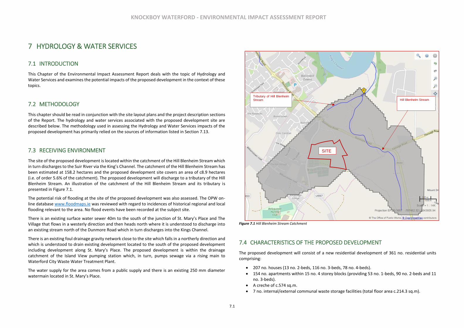
KNOCKBOY WATERFORD - ENVIRONMENTAL IMPACT ASSESSMENT REPORT
7.1
7 HYDROLOGY & WATER SERVICES
7.1 INTRODUCTION
This Chapter of the Environmental Impact Assessment Report deals with the topic of Hydrology and Water Services and examines the potential impacts of the proposed development in the context of these topics.
7.2 METHODOLOGY
This chapter should be read in conjunction with the site layout plans and the project description sections of the Report. The hydrology and water services associated with the proposed development site are described below. The methodology used in assessing the Hydrology and Water Services impacts of the proposed development has primarily relied on the sources of information listed in Section 7.13.
7.3 RECEIVING ENVIRONMENT
The site of the proposed development is located within the catchment of the Hill Blenheim Stream which in turn discharges to the Suir River via the King’s Channel. The catchment of the Hill Blenheim Stream has been estimated at 158.2 hectares and the proposed development site covers an area of c8.9 hectares (i.e. of order 5.6% of the catchment). The proposed development will discharge to a tributary of the Hill Blenheim Stream. An illustration of the catchment of the Hill Blenheim Stream and its tributary is presented in Figure 7.1.
The potential risk of flooding at the site of the proposed development was also assessed. The OPW on-line database www.floodmaps.ie was reviewed with regard to incidences of historical regional and local flooding relevant to the area. No flood events have been recorded at the subject site.
There is an existing surface water sewer 40m to the south of the junction of St. Mary’s Place and The Village that flows in a westerly direction and then heads north where it is understood to discharge into an existing stream north of the Dunmore Road which in turn discharges into the Kings Channel.
There is an existing foul drainage gravity network close to the site which falls in a northerly direction and which is understood to drain existing development located to the south of the proposed development including development along St. Mary’s Place. The proposed development is within the drainage catchment of the Island View pumping station which, in turn, pumps sewage via a rising main to Waterford City Waste Water Treatment Plant.
The water supply for the area comes from a public supply and there is an existing 250 mm diameter watermain located in St. Mary’s Place.
Figure 7.1 Hill Blenheim Stream Catchment
7.4 CHARACTERISTICS OF THE PROPOSED DEVELOPMENT
The proposed development will consist of a new residential development of 361 no. residential units comprising:
• 207 no. houses (13 no. 2-beds, 116 no. 3-beds, 78 no. 4-beds).
• 154 no. apartments within 15 no. 4 storey blocks (providing 53 no. 1-beds, 90 no. 2-beds and 11 no. 3-beds).
• A creche of c.574 sq.m.
• 7 no. internal/external communal waste storage facilities (total floor area c.214.3 sq.m).
SITE
Tributary of Hill Blenheim Stream Hill Blenheim Stream

KNOCKBOY WATERFORD - ENVIRONMENTAL IMPACT ASSESSMENT REPORT
7.2
• 638 car parking spaces and 390 no. bicycle parking spaces within 15 no storage facilities (total floor area c.232 sq.m). Additional visitor bicycle parking provided in the public realm.
• 2 no. ESB sub-stations/switchrooms (totalling c.10 sq.m)
• Vehicular/pedestrian/cyclist accesses to the public road (Ballygunner Hill/St. Mary’s Place).
• The total gross floor area of the proposed development is c. c.51,226.1 sq.m
• All associated site development works, landscaping, open spaces, boundary treatments and services provision (including connection to public foul and surface water drainage at Dunmore Road & Island Drive).
The design of the surface water drainage network for the proposed development consists of a piped gravity system. It is proposed to discharge the surface water runoff from the proposed development to an existing surface water sewer manhole which is located within the existing carriageway of the Dunmore Road. The surface water runoff from the proposed development will be restricted to 2 litres per second per hectare.
It is proposed to connect the foul drainage network to the existing foul sewer located in Island Drive. Irish Water have confirmed that the existing network has sufficient capacity to accommodate the discharge from the proposed development. The peak foul water discharge from the proposed development has been estimated at 10.1 litres per second based on 150 l/p/d and the average occupancy rate of 2.7 persons per dwelling.
It is proposed to provide a 150 mm diameter distribution watermain throughout the proposed development connected to the existing 250 mm diameter water main in St. Mary’s Place/ Ballygunner Hill road. Irish Water have confirmed there is sufficient capacity within the existing network to accommodate the proposed development. It is estimated that the daily peak water supply required by the proposed development following full occupancy will be 10.58 litres/second with a daily water demand of 183 m3/day.
Engineering Planning Report prepared by MAL and submitted with the planning application accompanying this EIAR provides more detailed information’s about the above mentioned water services.
7.5 POTENTIAL IMPACTS
Construction Phase
During the construction phase of the proposed development there are a number of potential impacts which could have a negative impact on the existing surface water network in the area, such as:
• Elevated silt load as a result of construction activities;
• Hydrocarbons entering the surface water system as a result of an accidental spillage;
During the construction phase of the proposed development the existing foul drainage network will experience an increase in demand due to the use of the facilities by construction staff. While such an
increase will have a negative impact on the foul water drainage network it will be imperceptible and will be short-term in nature.
During the construction phase of the proposed development the existing water supply network will experience an increase in demand due to the use of the facilities by construction staff. While such an increase will have a negative impact, it will be imperceptible and will be short-term in nature.
Operational Phase
As previously noted the proposed development will limit the surface water runoff discharge from the site to 2 litres per second per hectare by incorporation of SuDS measures, surface water attenuation storage units and flow control devices. Such discharge with the included design will not have any adverse impact on the flood risk of the proposed development or adjoining land users or properties especially downstream of the proposed development. The Site Specific Flood Risk Assessment prepared by MAL and submitted with the planning application accompanying this EIAR provides more detailed information’s about the flood risk associated with the proposed development. The conclusion of the Site Specific Flood Risk Assessment is presented below:
Based on all of the foregoing it has been concluded that the proposed development is appropriate in
terms of meeting the flood risk and stormwater impact policies and objectives of the Waterford City
Development Plan 2013-2019 and that the proposed development is:
• Considered to have the required level of flood protection;
• Does not increase the flood risk to other third parties or lands;
• Meets the various requirements of the OPW Guidelines in relation to flood risk.
It is reasonable therefore to conclude that the flood risk from off-site sources is not significant such
that there is no unacceptable risk of flooding arising from and no unacceptable residual flood risk to
the proposed development, its occupants or users and adjoining property from the following sources:
• Tidal
• Fluvial
• Pluvial
• Ground Water
• Human / Mechanical
Accordingly, the site has been evaluated as appropriate for residential development when assessed
in accordance with the requirements of The Planning System and Flood Risk Management Guidelines
KNOCKBOY WATERFORD - ENVIRONMENTAL IMPACT ASSESSMENT REPORT
7.3
for Planning Authorities (Department of Environment, Heritage and Local Government and the Office
of Public Works).
As previously noted the completion of the proposed development will result in an additional peak foul water discharge of 10.1 litres/second to the Island View pumping station. Such an increase will result in a minor negative impact on existing foul drainage network. RPS SWO Discharge Assessment Report and submitted with the planning application accompanying this EIAR provides detailed information on the impact of the additional foul water discharge from the proposed development on to the existing environment. The conclusion of the RPS SWO Discharge Assessment Report is presented below:
The likely impacts that will arise from the additional loading from the development to the SWOs and ultimately to the Lower Suir Estuary have been examined in the context of a number of factors that could potentially affect the attainment of any WFD Objectives. The main risk is associated with the water quality in the Lower River Suir, which is designated as an SAC.
The mass balance assessment indicates that the proposed development will not have an impact on the Lower Suir Estuary, and as such, given the negligible increase in nutrient and BOD concentrations will not impact other nearby Natura 2000 sites, such as the River Nore and River Barrow SAC immediately downstream of the Suir.
On this basis it is concluded that the proposed development will not have significant effects on the WFD environmental objectives associated with the Lower Suir Estuary, nor is it likely to impact on the qualifying habitats and species of the Lower River Suir SAC or the River Nore and River Barrow SAC.
As previously noted the proposed development will result in an increase in peak water demand of 10.58 litres/second. Such an increase will result in a minor negative impact on the existing water supply network.
7.6 POTENTIAL CUMULATIVE IMPACTS
The potential for any further impact when considered in combination with other known projects in the immediate area, was found to have no potential for significant cumulative impacts on hydrology and water services.
It is worth noting that the RPS SWO Discharge Assessment Report submitted with the planning application accompanying this EIAR includes sensitivity testing that simulated the cumulative impact of the additional foul drainage discharge for the proposed development as a standalone development and in combination with other proposed developments in the area that will also be serviced by the proposed sewerage collection system. The percentage loss of the additional load from the proposed development, and other developments in the area, from the SWOs was increased to 10% to determine the impact on the receiving waters in the Lower Suir Estuary. The results are presented in RPS SWO Discharge Assessment Report demonstrate that even with 10% of the loading from the Knockboy development and the cumulative loads from other
developments discharging via the SWOs the impact on the receiving water quality will not be significant with the increase in concentration still remaining below 1% with the headroom used also much less than the 25% recommended in the Guidance, Procedures and Training on the Licensing of Discharges to Surface Waters, Groundwater and to Sewer for Local Authorities.
7.7 MITIGATION MEASURES
Construction Phase
It will be necessary for the contractor to implement measures to mitigate potential impacts to the existing surface water network. Such measures would include:
• Obtaining all necessary discharge permits and licences
• Preparing a construction method statement
• Provision of settlement ponds
• Measures to prevent liquid materials entering the drainage system
These measures will be addressed in the Construction Management Plan.
Any necessary connections to the existing foul sewer network will be undertaken in agreement with and approval of Irish Water and appropriate procedures will be followed to ensure that there is no impact on the operation of the existing foul sewer system.
Operational Phase
The mitigation measures to be implemented during the operational phase of the proposed development will include the following:
• In the event of flooding during very extreme rainfall events (i.e. in excess of 1:100 year return period rainfall events) or in the event of pipe blockages the flood water will be channelled away from buildings and in particular entrances to buildings.
• A new 300 mm diameter piped foul water sewer will be constructed as part of the proposed development. This foul sewer will connect to the existing 600mm diameter foul sewer at Island Drive which in turn connects to the existing pumping station on Island Drive.
7.8 PREDICTED IMPACTS
Construction Phase
It is likely that, with the implementation of the mitigation measures described above, the predicted impact of the construction phase of the proposed development will be Imperceptible.
Operational Phase
KNOCKBOY WATERFORD - ENVIRONMENTAL IMPACT ASSESSMENT REPORT
7.4
It is likely that, with the implementation of the mitigation measures described above, the predicted impact of the operational phase of the proposed development will be Imperceptible.
7.9 ‘DO NOTHING’ SCENARIO
It the event that the proposed development does not proceed then the lands will likely continue in agricultural use.
7.10 WORST CASE SCENARIO
It the event that the proposed development was to proceed, and the proposed mitigation measures substantially fail then it is likely that there would be a significant impact on the hydrology and water services with the potential for an increase in flood risk and contamination of local watercourses.
7.11 MONITORING & REINSTATEMENT
Monitoring of the surface water discharge is not deemed necessary. An oil interceptor will be fitted with alarmed devices to indicate when their maximum storage capacity has been reached. This will reduce the likelihood of hydrocarbons being discharged into the surface water system. Maintenance of the proposed surface water drainage network will be carried out as part of the overall maintenance programme for the proposed development. Normal post construction reinstatement of trenches for drains and watermains will take place after pipe laying.
Monitoring of foul effluent discharges is not deemed necessary.
Monitoring of the water supply will be implemented via a bulk meter located at the connection point of the water supply to the proposed development.
7.12 DIFFICULTIES IN COMPILING INFORMATION
No difficulties were encountered in compiling this chapter of the report.
7.13 REFERENCES
• Engineering Planning Report prepared by MAL;
• Site Specific Flood Risk Assessment prepared by MAL;
• The Planning System and Flood Risk Management, Guidelines for Planning Authorities (Department of the Environment, Heritage and Local Government (DoEHLG) and the Office of Public Works (OPW));
• Flood points & Historical Floods – Office of Public Works (OPW) floods website www.floodmaps.ie
• Relevant Suir Catchment Flood Risk Assessment and Management Flood Reports and maps, available at: https://www.floodinfo.ie/
• Environmental Protection Agency http://gis.epa.ie
• RPS Report IBE1473 (Feb 2019) Knockboy Residential Development Assessment of SWO Discharge to Lower Suir Estuary
KNOCKBOY WATERFORD - ENVIRONMENTAL IMPACT ASSESSMENT REPORT
8.1
8 NOISE AND VIBRATION
8.1 INTRODUCTION
This section of the EIAR has been prepared by Traynor Environmental Ltd to identify and assess the potential
noise impacts associated with the proposed development of lands for residential use at Knockboy, Co.
Waterford, during both the Construction and Operational Phases of the development.
This chapter includes a comprehensive description of the receiving ambient noise climate in the vicinity of
the subject site; a description of how the construction and operational phases may impact the existing
ambient noise climate, the mitigation measures that shall be implemented to control and minimise the
impact that the development may have on ambient noise levels and the proposed acoustic design features
required to minimise the impact of external noise sources.
The mitigation measures designed for the development shall demonstrate how the development shall be
constructed and operated in an environmentally sustainable manner in order to ensure its minimal impact
on the receiving noise climate.
8.2 METHODOLOGY
The section has been prepared using the following methodology:
• A baseline Noise survey has been conducted in the vicinity of the development site to establish noise
climate and the main sources of noise contributing to the existing environment (See Appendix 8.1).
• A Review of the most relevant standards and guidelines has been undertaken for the project in order
to identify appropriate noise criteria for the site.
• (The Noise and vibration impact of the proposed development has been predicted for both the
construction and operational phases of the project). Noise calculations for construction activity have
been conducted in accordance with ISO 9613 (1996): Acoustics – Attenuation of sound during
propagation outdoors – Part 2@ General Method of calculation using noise source data from BS5228
(2009 +A1 2014): Code of Practice for Noise Control on construction and open sites – Part 1, Noise.
• Noise calculations for the operational phase have been assessed in general accordance with ISO 9613
Attenuation of Sound during Propagation Outdoors and the UK calculation of Road Traffic Noise
(CRTN), 1988.
• A series of recommended noise and vibration mitigation measures have been proposed, where
necessary, to ensure the proposed development does not result in any significant impact on its
surrounding environment
Impact Assessment Methodology
The impact of the proposed development has been determined through prediction of future noise levels
associated with the scheme using established calculation techniques.
Construction impacts have been assessed in accordance with Transport Infrastructure Irelands (TII) guidance
document Good Practice Guidance for the Treatment of Noise during the Planning of National Road
Schemes (March 2014). Indicative construction noise calculations have been undertaken using the
methodology set out in BS 5228 Code of Practice for noise and vibration control of construction and open
sites - Part 1: Noise 2009+A1 2014.
Impacts associated with road traffic movements on the development when operational have been assessed
with regard to the TII’s Good Practice Guidance for the Treatment of Noise during the Planning of National
Road Schemes (March 2014). UK Department of Transport (Welsh Office) - Calculation of Road Traffic Noise
[CRTN] and the Highways Agency Design Manual for Roads and Brides Part 7 HD 213/11 – Revision 1 Noise
and Vibration.
The operational phase of the development has been assessed with regard to the Department of the
Environment, Building Regulations 2014, Technical Guidance Document E – Sound. Acoustic design of
apartments is referred to in the Waterford City Development Plan 2013-2019 which refers to the Ministerial
Guidelines “Sustainable Urban Housing Design Standards for New Apartments. Paragraph 1.8 of the
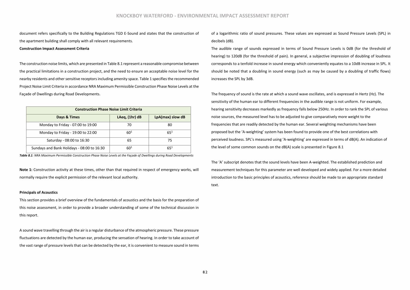
KNOCKBOY WATERFORD - ENVIRONMENTAL IMPACT ASSESSMENT REPORT
8.2
document refers specifically to the Building Regulations TGD E-Sound and states that the construction of
the apartment building shall comply with all relevant requirements.
Construction Impact Assessment Criteria
The construction noise limits, which are presented in Table 8.1 represent a reasonable compromise between
the practical limitations in a construction project, and the need to ensure an acceptable noise level for the
nearby residents and other sensitive receptors including amenity space. Table 1 specifies the recommended
Project Noise Limit Criteria in accordance NRA Maximum Permissible Construction Phase Noise Levels at the
Façade of Dwellings during Road Developments.
Construction Phase Noise Limit Criteria
Days & Times LAeq, (1hr) dB LpA(max) slow dB
Monday to Friday - 07:00 to 19:00 70 80
Monday to Friday - 19:00 to 22:00 601 651
Saturday - 08:00 to 16:30 65 75
Sundays and Bank Holidays - 08:00 to 16:30 601 651
Table 8.1: NRA Maximum Permissible Construction Phase Noise Levels at the Façade of Dwellings during Road Developments
Note 1: Construction activity at these times, other than that required in respect of emergency works, will
normally require the explicit permission of the relevant local authority.
Principals of Acoustics
This section provides a brief overview of the fundamentals of acoustics and the basis for the preparation of
this noise assessment, in order to provide a broader understanding of some of the technical discussion in
this report.
A sound wave travelling through the air is a regular disturbance of the atmospheric pressure. These pressure
fluctuations are detected by the human ear, producing the sensation of hearing. In order to take account of
the vast range of pressure levels that can be detected by the ear, it is convenient to measure sound in terms
of a logarithmic ratio of sound pressures. These values are expressed as Sound Pressure Levels (SPL) in
decibels (dB).
The audible range of sounds expressed in terms of Sound Pressure Levels is 0dB (for the threshold of
hearing) to 120dB (for the threshold of pain). In general, a subjective impression of doubling of loudness
corresponds to a tenfold increase in sound energy which conveniently equates to a 10dB increase in SPL. It
should be noted that a doubling in sound energy (such as may be caused by a doubling of traffic flows)
increases the SPL by 3dB.
The frequency of sound is the rate at which a sound wave oscillates, and is expressed in Hertz (Hz). The
sensitivity of the human ear to different frequencies in the audible range is not uniform. For example,
hearing sensitivity decreases markedly as frequency falls below 250Hz. In order to rank the SPL of various
noise sources, the measured level has to be adjusted to give comparatively more weight to the
frequencies that are readily detected by the human ear. Several weighting mechanisms have been
proposed but the ‘A-weighting’ system has been found to provide one of the best correlations with
perceived loudness. SPL’s measured using ‘A-weighting’ are expressed in terms of dB(A). An indication of
the level of some common sounds on the dB(A) scale is presented in Figure 8.1
The ‘A’ subscript denotes that the sound levels have been A-weighted. The established prediction and
measurement techniques for this parameter are well developed and widely applied. For a more detailed
introduction to the basic principles of acoustics, reference should be made to an appropriate standard
text.
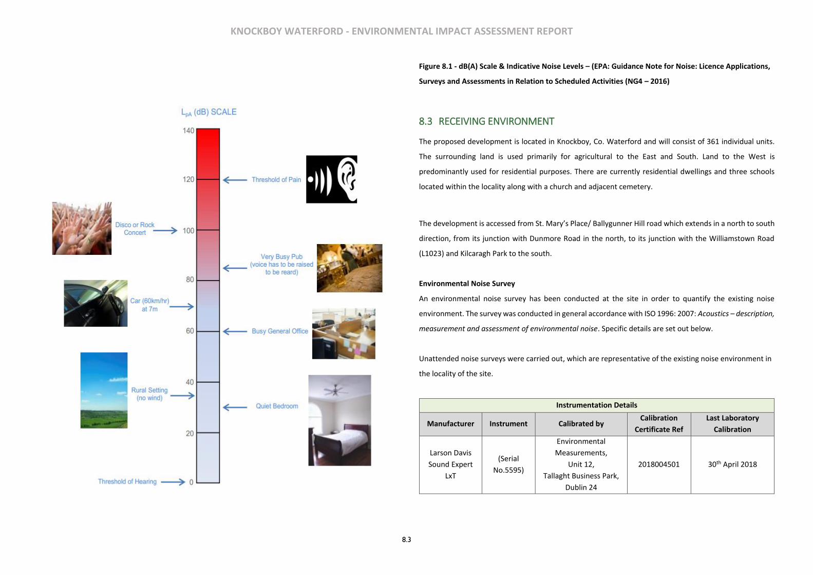
KNOCKBOY WATERFORD - ENVIRONMENTAL IMPACT ASSESSMENT REPORT
8.3
Figure 8.1 - dB(A) Scale & Indicative Noise Levels – (EPA: Guidance Note for Noise: Licence Applications,
Surveys and Assessments in Relation to Scheduled Activities (NG4 – 2016)
8.3 RECEIVING ENVIRONMENT
The proposed development is located in Knockboy, Co. Waterford and will consist of 361 individual units.
The surrounding land is used primarily for agricultural to the East and South. Land to the West is
predominantly used for residential purposes. There are currently residential dwellings and three schools
located within the locality along with a church and adjacent cemetery.
The development is accessed from St. Mary’s Place/ Ballygunner Hill road which extends in a north to south
direction, from its junction with Dunmore Road in the north, to its junction with the Williamstown Road
(L1023) and Kilcaragh Park to the south.
Environmental Noise Survey
An environmental noise survey has been conducted at the site in order to quantify the existing noise
environment. The survey was conducted in general accordance with ISO 1996: 2007: Acoustics – description,
measurement and assessment of environmental noise. Specific details are set out below.
Unattended noise surveys were carried out, which are representative of the existing noise environment in
the locality of the site.
Instrumentation Details
Manufacturer Instrument Calibrated by Calibration
Certificate Ref
Last Laboratory
Calibration
Larson Davis
Sound Expert
LxT
(Serial
No.5595)
Environmental
Measurements,
Unit 12,
Tallaght Business Park,
Dublin 24
2018004501 30th April 2018
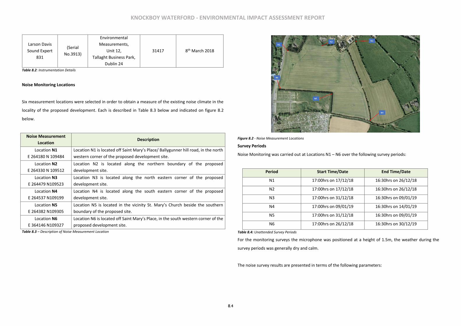
KNOCKBOY WATERFORD - ENVIRONMENTAL IMPACT ASSESSMENT REPORT
8.4
Larson Davis
Sound Expert
831
(Serial
No.3913)
Environmental
Measurements,
Unit 12,
Tallaght Business Park,
Dublin 24
31417 8th March 2018
Table 8.2: Instrumentation Details
Noise Monitoring Locations
Six measurement locations were selected in order to obtain a measure of the existing noise climate in the
locality of the proposed development. Each is described in Table 8.3 below and indicated on figure 8.2
below.
Noise Measurement
Location Description
Location N1
E 264180 N 109484
Location N1 is located off Saint Mary’s Place/ Ballygunner hill road, in the north
western corner of the proposed development site.
Location N2
E 264330 N 109512
Location N2 is located along the northern boundary of the proposed
development site.
Location N3
E 264479 N109523
Location N3 is located along the north eastern corner of the proposed
development site.
Location N4
E 264537 N109199
Location N4 is located along the south eastern corner of the proposed
development site.
Location N5
E 264382 N109305
Location N5 is located in the vicinity St. Mary’s Church beside the southern
boundary of the proposed site.
Location N6
E 364146 N109327
Location N6 is located off Saint Mary’s Place, in the south western corner of the
proposed development site.
Table 8.3 – Description of Noise Measurement Location
Figure 8.2 - Noise Measurement Locations
Survey Periods
Noise Monitoring was carried out at Locations N1 – N6 over the following survey periods:
Period Start Time/Date End Time/Date
N1 17:00hrs on 17/12/18 16:30hrs on 26/12/18
N2 17:00hrs on 17/12/18 16:30hrs on 26/12/18
N3 17:00hrs on 31/12/18 16:30hrs on 09/01/19
N4 17:00hrs on 09/01/19 16:30hrs on 14/01/19
N5 17:00hrs on 31/12/18 16:30hrs on 09/01/19
N6 17:00hrs on 26/12/18 16:30hrs on 30/12/19
Table 8.4: Unattended Survey Periods
For the monitoring surveys the microphone was positioned at a height of 1.5m, the weather during the
survey periods was generally dry and calm.
The noise survey results are presented in terms of the following parameters:

KNOCKBOY WATERFORD - ENVIRONMENTAL IMPACT ASSESSMENT REPORT
8.5
LAeq This is the equivalent continuous sound level. It is an average and is used to describe a fluctuating
noise in terms of a single noise level over the sample period. The closer the Laeq value is to either
the LA10 or LA90 value indicates the relative impact of the intermittent sources and their
contribution. The relative spread between the values determines the impact of intermittent sources
such as traffic on the background.
LA90 This is the sound that is exceeded for 90% of the sample period. It is typically used as a descriptor
for traffic noise.
LA10 This is the sound that is exceeded for 10% of the sample period. It is typically used as a descriptor
for traffic noise.
dB Decibel - The scale in which sound pressure level is expressed is defined as 20 times the logarithm of
the ratio between the RMS pressure of the sound field and the reference pressure of 20 micro-
pascals (20 μPa).
LAFma Is the instantaneous slow time weighted maximum sound level measured during the sample period
(usually referred to in relation to construction noise levels).
Tonal Noise One-third octave band tonal analysis involves the calculation of an averaged, unweighted
noise level to represent the frequencies within each third of an octave. These noise levels are then
compared with the noise levels calculated for the adjacent one-third octave bands. If a noise level is
at least 5dB higher than the noise levels representing the adjacent bands then it is considered tonal,
since it is significantly louder than noise levels at similar frequencies.
Results and Discussion
The results of the noise monitoring for each of the locations are summarised in Tables 8.5 – 8.22 below.
Location N1 – Location N1 is located off Saint Mary’s Place/ Ballygunner hill road, in the north western
corner of the proposed development site.
Tables No. 8.5 – 8.7 presents average daytime, evening time and night time noise levels measured at N1 for
noise monitoring conducted from Monday 17th December 2018 – Wednesday 26th December 2018 at N1.
Location - N1 (Unattended Monitoring)
Day (07.00- 17.00) Measured Noise Levels dBA
Date LAeq LAFmax LAF10 LAF90
18.12.18 59.2 71.3 63.1 48.1
19.12.18 60.2 73.4 63.8 48.7
20.12.18 59.5 72.9 63.2 48.7
21.12.18 59.5 71.3 63.1 48.7
22.12.18 57.4 71.1 61.2 45.3
23.12.18 55.2 68.7 59.4 43.4
24.12.18 54.9 67.2 58.9 43.6
25.12.18 53.9 68.9 57.7 39.3
26.12.18 54.2 69.9 58.1 39.6
Average 57.1 70.5 60.9 45.0
Table 8.5 Summary of Average Noise Measurements at N1 - Day
Location - N1 (Unattended Monitoring)
Evening (17.00-23.00) Measured Noise Levels dBA
Date LAeq LAFmax LAF10 LAF90
17.12.18 60.4 73.8 63.9 52.5
18.12.18 57.0 69.3 61.3 44.7
19.12.18 58.2 72.0 62.3 46.0
20.12.18 56.3 67.7 60.6 44.2
21.12.18 56.4 68.0 60.8 43.9
22.12.18 55.5 68.6 60.1 42.2
23.12.18 53.4 66.0 58.0 41.9
24.12.18 53.5 65.8 58.3 37.4
25.12.18 51.9 68.0 56.8 34.9
Average 55.8 68.8 60.2 43.1
Table 8.6 Summary of Average Noise Measurements at N1 - Evening
Location - N1 (Unattended Monitoring)
Night (23.00-07.00) Measured Noise Levels dBA
Date LAeq LAFmax LAF10 LAF90
17.12.18 60.0 75.5 63.1 53.0
18.12.18 44.1 64.6 44.3 31.3
19.12.18 45.7 66.7 45.1 33.1
20.12.18 46.2 64.7 47.8 35.4
KNOCKBOY WATERFORD - ENVIRONMENTAL IMPACT ASSESSMENT REPORT
8.6
21.12.18 47.8 65.4 49.7 34.5
22.12.18 48.0 66.7 48.7 36.9
23.12.18 44.8 63.7 44.7 32.0
24.12.18 40.2 59.5 41.1 26.3
25.12.18 42.3 63.1 42.6 28.9
Average 46.6 65.5 47.4 34.6
Table 8.7 Summary of Average Noise Measurements at N1 - Night
Ambient noise levels for day time at N1 measured 57.1 dB(A) LAeq and background noise levels measured
45.0 dB(A) LA90.
Evening time ambient noise level at N1 measured 55.8 dB(A) LAeq and background noise level was 43.1 dB(A)
LA90.
Night time ambient noise levels for at N1 measured 46.6 dB(A) LAeq while the measured background noise
level was 34.6 dB(A) LA90.
Location N1 is located off Saint Mary’s place/ Ballygunner hill Road, in the northwest corner of the proposed
development site. The lower background noise levels at N1 would indicate that the measured noise was
dominated by intensive short duration noise events which are characteristic of road traffic noise from Saint
Mary’s place/ Ballygunner hill Road and the R683 Dunmore Road.
Location N2 – Location N2 is located along the northern boundary of the proposed development site.
Table No. 8.8 – 8.10 presents average daytime, evening time and night time noise levels measured at N2 for
unattended noise monitoring conducted from Monday 17th December 2018 – Wednesday 26th December
2018.
Location – N2 (Unattended Monitoring)
Day (07.00- 17.00) Measured Noise Levels dBA
Date LAeq LAFmax LAF10 LAF90
18.12.18 49.3 63.1 51.8 44.8
19.12.18 50.9 65.4 52.6 45.4
20.12.18 49.5 63.2 51.5 45.9
21.12.18 50.0 66.9 51.7 45.4
22.12.18 48.7 69.3 49.7 43.3
23.12.18 48.9 68.4 50.8 41.8
24.12.18 46.6 67.1 47.9 38.5
25.12.18 47.2 66.6 49.5 36.7
26.12.18 47.0 65.4 49.8 37.6
Average 48.7 66.2 50.6 42.2
Table 8.8 Summary of Average Noise Measurements at N2 - Day
Location – N2 (Unattended Monitoring)
Evening (17.00-23.00) Measured Noise Levels dBA
Date LAeq LAFmax LAF10 LAF90
17.12.18 59.0 72.9 62.4 52.3
18.12.18 46.2 55.9 48.7 42.2
19.12.18 49.4 63.6 50.8 44.2
20.12.18 45.0 53.7 47.3 41.4
21.12.18 46.3 55.5 48.6 43.1
22.12.18 43.7 57.4 46.2 39.3
23.12.18 42.7 51.0 45.1 38.5
24.12.18 38.5 50.5 41.4 33.1
25.12.18 39.5 56.1 42.5 33.1
Average 45.6 57.4 48.1 40.8
Table 8.9 Summary of Average Noise Measurements at N2 - Evening
Location – N2 (Unattended Monitoring)
Night (23.00-07.00) Measured Noise Levels dBA
Date LAeq LAFmax LAF10 LAF90
17.12.18 61.5 72.2 65.0 53.5
18.12.18 36.1 52.5 38.8 29.5
19.12.18 38.2 55.5 40.8 32.1
20.12.18 40.5 56.3 43.7 33.4
21.12.18 40.0 54.4 43.1 34.0
22.12.18 40.6 54.5 43.5 34.5
23.12.18 35.5 49.6 39.3 27.3
24.12.18 31.8 47.7 35.0 23.9
25.12.18 33.8 49.7 36.8 26.8
Average 39.8 54.7 42.9 32.8
Table 8.10 Summary of Average Noise Measurements at N2 - Night
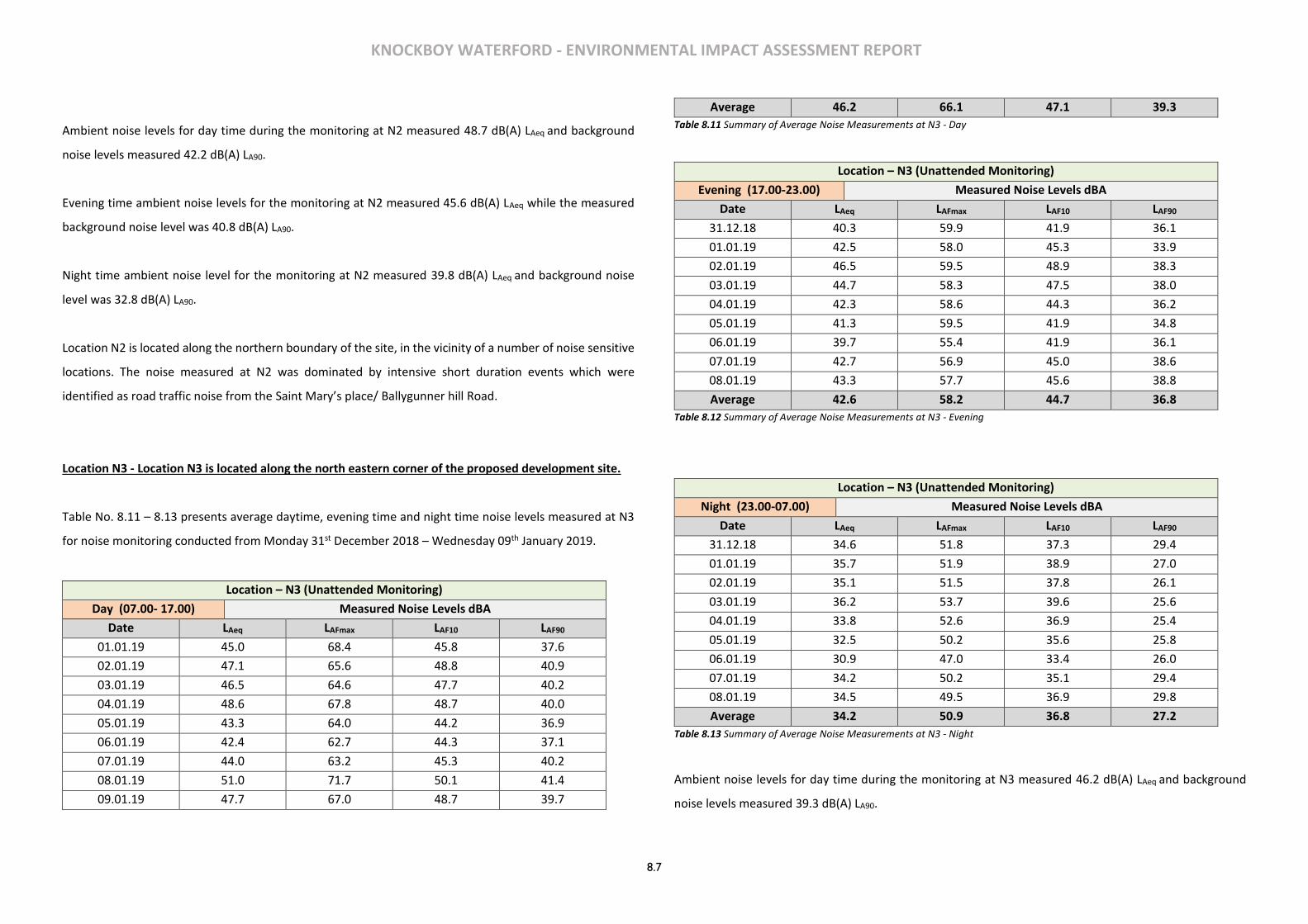
KNOCKBOY WATERFORD - ENVIRONMENTAL IMPACT ASSESSMENT REPORT
8.7
Ambient noise levels for day time during the monitoring at N2 measured 48.7 dB(A) LAeq and background
noise levels measured 42.2 dB(A) LA90.
Evening time ambient noise levels for the monitoring at N2 measured 45.6 dB(A) LAeq while the measured
background noise level was 40.8 dB(A) LA90.
Night time ambient noise level for the monitoring at N2 measured 39.8 dB(A) LAeq and background noise
level was 32.8 dB(A) LA90.
Location N2 is located along the northern boundary of the site, in the vicinity of a number of noise sensitive
locations. The noise measured at N2 was dominated by intensive short duration events which were
identified as road traffic noise from the Saint Mary’s place/ Ballygunner hill Road.
Location N3 - Location N3 is located along the north eastern corner of the proposed development site.
Table No. 8.11 – 8.13 presents average daytime, evening time and night time noise levels measured at N3
for noise monitoring conducted from Monday 31st December 2018 – Wednesday 09th January 2019.
Location – N3 (Unattended Monitoring)
Day (07.00- 17.00) Measured Noise Levels dBA
Date LAeq LAFmax LAF10 LAF90
01.01.19 45.0 68.4 45.8 37.6
02.01.19 47.1 65.6 48.8 40.9
03.01.19 46.5 64.6 47.7 40.2
04.01.19 48.6 67.8 48.7 40.0
05.01.19 43.3 64.0 44.2 36.9
06.01.19 42.4 62.7 44.3 37.1
07.01.19 44.0 63.2 45.3 40.2
08.01.19 51.0 71.7 50.1 41.4
09.01.19 47.7 67.0 48.7 39.7
Average 46.2 66.1 47.1 39.3
Table 8.11 Summary of Average Noise Measurements at N3 - Day
Location – N3 (Unattended Monitoring)
Evening (17.00-23.00) Measured Noise Levels dBA
Date LAeq LAFmax LAF10 LAF90
31.12.18 40.3 59.9 41.9 36.1
01.01.19 42.5 58.0 45.3 33.9
02.01.19 46.5 59.5 48.9 38.3
03.01.19 44.7 58.3 47.5 38.0
04.01.19 42.3 58.6 44.3 36.2
05.01.19 41.3 59.5 41.9 34.8
06.01.19 39.7 55.4 41.9 36.1
07.01.19 42.7 56.9 45.0 38.6
08.01.19 43.3 57.7 45.6 38.8
Average 42.6 58.2 44.7 36.8
Table 8.12 Summary of Average Noise Measurements at N3 - Evening
Location – N3 (Unattended Monitoring)
Night (23.00-07.00) Measured Noise Levels dBA
Date LAeq LAFmax LAF10 LAF90
31.12.18 34.6 51.8 37.3 29.4
01.01.19 35.7 51.9 38.9 27.0
02.01.19 35.1 51.5 37.8 26.1
03.01.19 36.2 53.7 39.6 25.6
04.01.19 33.8 52.6 36.9 25.4
05.01.19 32.5 50.2 35.6 25.8
06.01.19 30.9 47.0 33.4 26.0
07.01.19 34.2 50.2 35.1 29.4
08.01.19 34.5 49.5 36.9 29.8
Average 34.2 50.9 36.8 27.2
Table 8.13 Summary of Average Noise Measurements at N3 - Night
Ambient noise levels for day time during the monitoring at N3 measured 46.2 dB(A) LAeq and background
noise levels measured 39.3 dB(A) LA90.
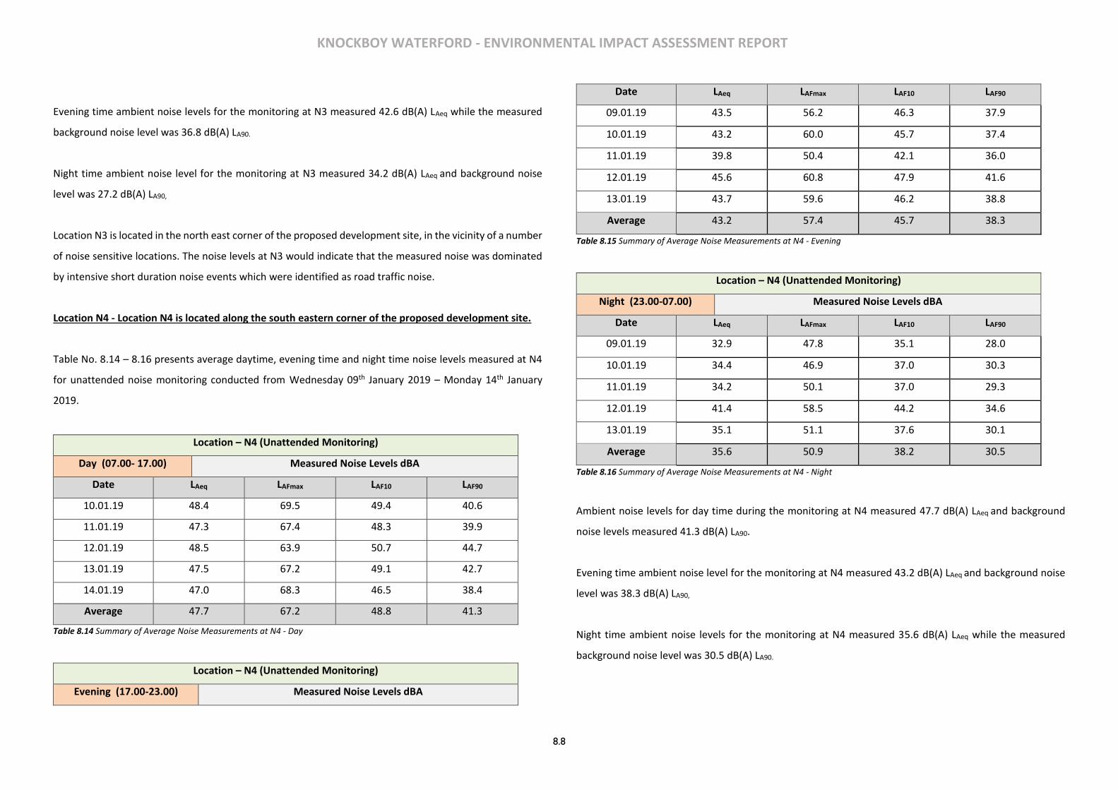
KNOCKBOY WATERFORD - ENVIRONMENTAL IMPACT ASSESSMENT REPORT
8.8
Evening time ambient noise levels for the monitoring at N3 measured 42.6 dB(A) LAeq while the measured
background noise level was 36.8 dB(A) LA90.
Night time ambient noise level for the monitoring at N3 measured 34.2 dB(A) LAeq and background noise
level was 27.2 dB(A) LA90,
Location N3 is located in the north east corner of the proposed development site, in the vicinity of a number
of noise sensitive locations. The noise levels at N3 would indicate that the measured noise was dominated
by intensive short duration noise events which were identified as road traffic noise.
Location N4 - Location N4 is located along the south eastern corner of the proposed development site.
Table No. 8.14 – 8.16 presents average daytime, evening time and night time noise levels measured at N4
for unattended noise monitoring conducted from Wednesday 09th January 2019 – Monday 14th January
2019.
Location – N4 (Unattended Monitoring)
Day (07.00- 17.00) Measured Noise Levels dBA
Date LAeq LAFmax LAF10 LAF90
10.01.19 48.4 69.5 49.4 40.6
11.01.19 47.3 67.4 48.3 39.9
12.01.19 48.5 63.9 50.7 44.7
13.01.19 47.5 67.2 49.1 42.7
14.01.19 47.0 68.3 46.5 38.4
Average 47.7 67.2 48.8 41.3
Table 8.14 Summary of Average Noise Measurements at N4 - Day
Location – N4 (Unattended Monitoring)
Evening (17.00-23.00) Measured Noise Levels dBA
Date LAeq LAFmax LAF10 LAF90
09.01.19 43.5 56.2 46.3 37.9
10.01.19 43.2 60.0 45.7 37.4
11.01.19 39.8 50.4 42.1 36.0
12.01.19 45.6 60.8 47.9 41.6
13.01.19 43.7 59.6 46.2 38.8
Average 43.2 57.4 45.7 38.3
Table 8.15 Summary of Average Noise Measurements at N4 - Evening
Location – N4 (Unattended Monitoring)
Night (23.00-07.00) Measured Noise Levels dBA
Date LAeq LAFmax LAF10 LAF90
09.01.19 32.9 47.8 35.1 28.0
10.01.19 34.4 46.9 37.0 30.3
11.01.19 34.2 50.1 37.0 29.3
12.01.19 41.4 58.5 44.2 34.6
13.01.19 35.1 51.1 37.6 30.1
Average 35.6 50.9 38.2 30.5
Table 8.16 Summary of Average Noise Measurements at N4 - Night
Ambient noise levels for day time during the monitoring at N4 measured 47.7 dB(A) LAeq and background
noise levels measured 41.3 dB(A) LA90.
Evening time ambient noise level for the monitoring at N4 measured 43.2 dB(A) LAeq and background noise
level was 38.3 dB(A) LA90,
Night time ambient noise levels for the monitoring at N4 measured 35.6 dB(A) LAeq while the measured
background noise level was 30.5 dB(A) LA90.
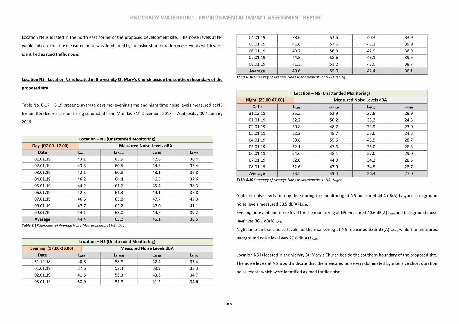
KNOCKBOY WATERFORD - ENVIRONMENTAL IMPACT ASSESSMENT REPORT
8.9
Location N4 is located in the north east corner of the proposed development site. The noise levels at N4
would indicate that the measured noise was dominated by intensive short duration noise events which were
identified as road traffic noise.
Location N5 - Location N5 is located in the vicinity St. Mary’s Church beside the southern boundary of the
proposed site.
Table No. 8-17 – 8.19 presents average daytime, evening time and night time noise levels measured at N5
for unattended noise monitoring conducted from Monday 31st December 2018 – Wednesday 09th January
2019.
Location – N5 (Unattended Monitoring)
Day (07.00- 17.00) Measured Noise Levels dBA
Date LAeq LAFmax LAF10 LAF90
01.01.19 43.1 65.9 42.8 36.4
02.01.19 43.3 60.5 44.5 37.4
03.01.19 42.1 60.8 43.1 36.8
04.01.19 46.2 64.4 46.5 37.6
05.01.19 44.2 61.6 45.4 38.3
06.01.19 42.5 61.3 44.1 37.8
07.01.19 46.5 65.8 47.7 42.3
08.01.19 47.7 65.2 47.0 41.1
09.01.19 44.1 63.0 44.7 39.2
Average 44.4 63.2 45.1 38.5
Table 8.17 Summary of Average Noise Measurements at N5 - Day
Location – N5 (Unattended Monitoring)
Evening (17.00-23.00) Measured Noise Levels dBA
Date LAeq LAFmax LAF10 LAF90
31.12.18 40.8 58.8 42.4 37.4
01.01.19 37.6 52.4 39.9 33.3
02.01.19 41.6 55.3 43.8 34.7
03.01.19 38.9 51.8 41.2 34.6
04.01.19 38.6 52.6 40.3 33.9
05.01.19 41.6 57.6 42.1 35.9
06.01.19 40.7 56.9 42.9 36.9
07.01.19 44.5 58.6 46.1 39.6
08.01.19 41.3 51.2 43.0 38.7
Average 40.6 55.0 42.4 36.1
Table 8.18 Summary of Average Noise Measurements at N5 - Evening
Location – N5 (Unattended Monitoring)
Night (23.00-07.00) Measured Noise Levels dBA
Date LAeq LAFmax LAF10 LAF90
31.12.18 35.2 52.9 37.6 29.9
01.01.19 32.2 50.2 35.2 24.5
02.01.19 30.8 48.7 33.9 23.0
03.01.19 32.2 48.7 35.6 24.3
04.01.19 39.6 55.5 43.5 28.7
05.01.19 32.1 47.6 35.0 26.3
06.01.19 34.6 48.1 37.6 29.0
07.01.19 32.0 44.9 34.2 28.5
08.01.19 32.6 47.9 34.9 28.7
Average 33.5 49.4 36.4 27.0
Table 8.19 Summary of Average Noise Measurements at N5 - Night
Ambient noise levels for day time during the monitoring at N5 measured 44.4 dB(A) LAeq and background
noise levels measured 38.5 dB(A) LA90.
Evening time ambient noise level for the monitoring at N5 measured 40.6 dB(A) LAeq and background noise
level was 36.1 dB(A) LA90,
Night time ambient noise levels for the monitoring at N5 measured 33.5 dB(A) LAeq while the measured
background noise level was 27.0 dB(A) LA90.
Location N5 is located in the vicinity St. Mary’s Church beside the southern boundary of the proposed site.
The noise levels at N5 would indicate that the measured noise was dominated by intensive short duration
noise events which were identified as road traffic noise.
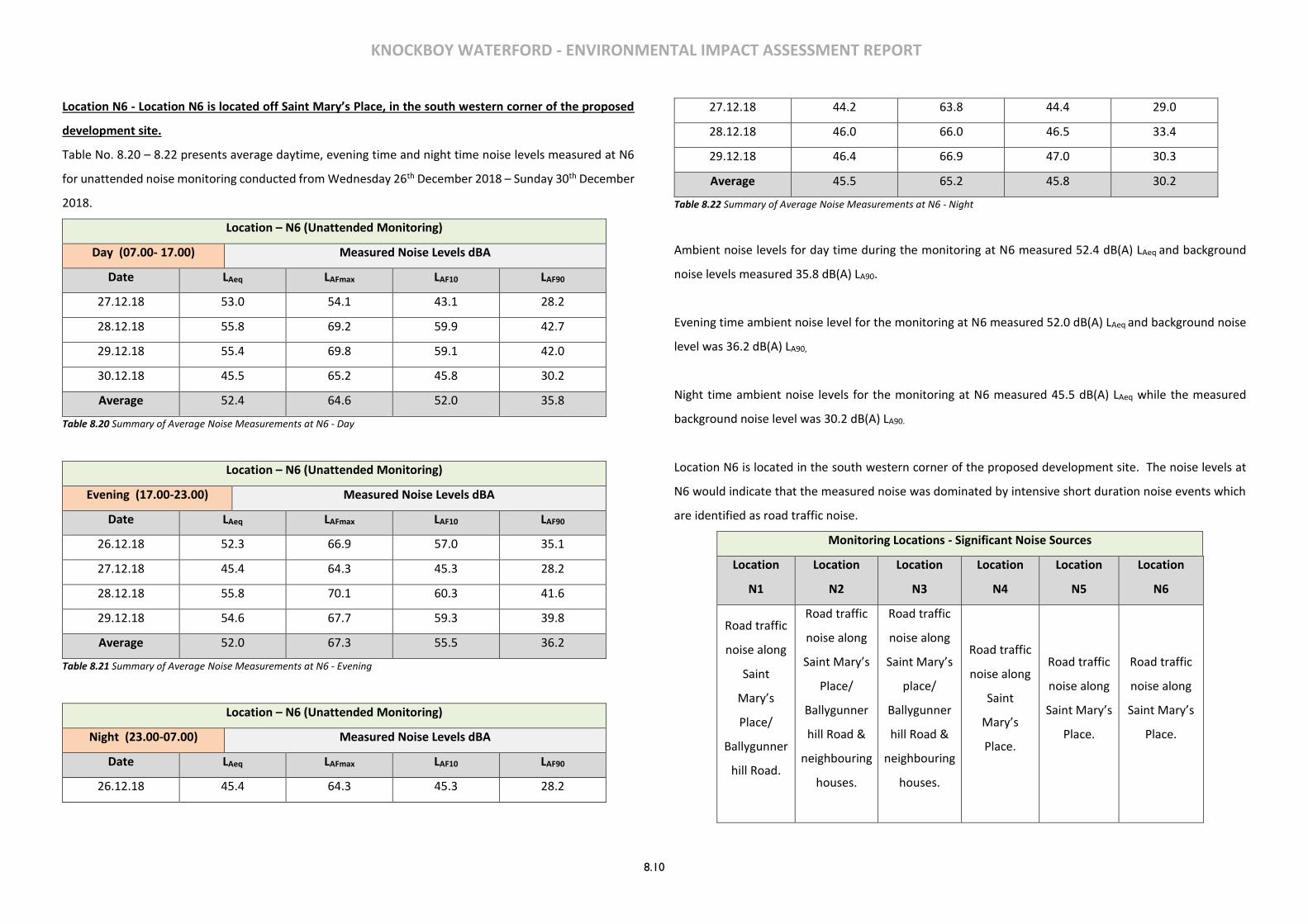
KNOCKBOY WATERFORD - ENVIRONMENTAL IMPACT ASSESSMENT REPORT
8.10
Location N6 - Location N6 is located off Saint Mary’s Place, in the south western corner of the proposed
development site.
Table No. 8.20 – 8.22 presents average daytime, evening time and night time noise levels measured at N6
for unattended noise monitoring conducted from Wednesday 26th December 2018 – Sunday 30th December
2018.
Location – N6 (Unattended Monitoring)
Day (07.00- 17.00) Measured Noise Levels dBA
Date LAeq LAFmax LAF10 LAF90
27.12.18 53.0 54.1 43.1 28.2
28.12.18 55.8 69.2 59.9 42.7
29.12.18 55.4 69.8 59.1 42.0
30.12.18 45.5 65.2 45.8 30.2
Average 52.4 64.6 52.0 35.8
Table 8.20 Summary of Average Noise Measurements at N6 - Day
Location – N6 (Unattended Monitoring)
Evening (17.00-23.00) Measured Noise Levels dBA
Date LAeq LAFmax LAF10 LAF90
26.12.18 52.3 66.9 57.0 35.1
27.12.18 45.4 64.3 45.3 28.2
28.12.18 55.8 70.1 60.3 41.6
29.12.18 54.6 67.7 59.3 39.8
Average 52.0 67.3 55.5 36.2
Table 8.21 Summary of Average Noise Measurements at N6 - Evening
Location – N6 (Unattended Monitoring)
Night (23.00-07.00) Measured Noise Levels dBA
Date LAeq LAFmax LAF10 LAF90
26.12.18 45.4 64.3 45.3 28.2
27.12.18 44.2 63.8 44.4 29.0
28.12.18 46.0 66.0 46.5 33.4
29.12.18 46.4 66.9 47.0 30.3
Average 45.5 65.2 45.8 30.2
Table 8.22 Summary of Average Noise Measurements at N6 - Night
Ambient noise levels for day time during the monitoring at N6 measured 52.4 dB(A) LAeq and background
noise levels measured 35.8 dB(A) LA90.
Evening time ambient noise level for the monitoring at N6 measured 52.0 dB(A) LAeq and background noise
level was 36.2 dB(A) LA90,
Night time ambient noise levels for the monitoring at N6 measured 45.5 dB(A) LAeq while the measured
background noise level was 30.2 dB(A) LA90.
Location N6 is located in the south western corner of the proposed development site. The noise levels at
N6 would indicate that the measured noise was dominated by intensive short duration noise events which
are identified as road traffic noise.
Monitoring Locations - Significant Noise Sources
Location
N1
Location
N2
Location
N3
Location
N4
Location
N5
Location
N6
Road traffic
noise along
Saint
Mary’s
Place/
Ballygunner
hill Road.
Road traffic
noise along
Saint Mary’s
Place/
Ballygunner
hill Road &
neighbouring
houses.
Road traffic
noise along
Saint Mary’s
place/
Ballygunner
hill Road &
neighbouring
houses.
Road traffic
noise along
Saint
Mary’s
Place.
Road traffic
noise along
Saint Mary’s
Place.
Road traffic
noise along
Saint Mary’s
Place.

KNOCKBOY WATERFORD - ENVIRONMENTAL IMPACT ASSESSMENT REPORT
8.11
Table 8.23 Significant Noise Sources
The overall noise levels at each location are influenced by a variety of sources in varying degrees. During
day time, evening time and night-tine hours the dominant source of noise at all monitoring locations was
traffic movements along Saint Mary’s Place / Ballygunner hill Road.
Results Summary
It is evident from the noise results outlined above the ambient and background noise levels were reasonably
consistent for the periods monitored. There was generally a gradual decrease in the noise levels as day
turned to evening and then to night time, this is primarily due to the decreased traffic levels on the local
road networks in the locality of the site such as Saint Mary’s Place / Ballygunner hill Road.
The lower background noise levels indicate that traffic movements were the dominant noise source at all
monitoring locations. Although subjectively discernible, in line with ISO 1996-2007 Annex D and based on
the full spectrum data it can be concluded that there is no tonal noise present.
8.4 CHARACTERISTICS OF THE PROPOSED DEVELOPMENT
The development will consist of a new residential development of 361 no. residential units comprising:
• 207 no. houses (13 no. 2-beds, 116 no. 3-beds, 78 no. 4-beds).
• 154 no. apartments within 15 no. 4 storey blocks (providing 53 no. 1-beds, 90 no. 2-beds and 11 no. 3-beds).
• A creche of c.574 sq.m.
• 7 no. internal/external communal waste storage facilities (total floor area c.214.3 sq.m).
• 638 car parking spaces and 390 no. bicycle parking spaces within 15 no storage facilities (total floor area c.232 sq.m). Additional visitor bicycle parking provided in the public realm.
• 2 no. ESB sub-stations/switchrooms (totalling c.10 sq.m)
• Vehicular/pedestrian/cyclist accesses to the public road (Ballygunner Hill/St. Mary’s Place).
• The total gross floor area of the proposed development is c. c.51,226.1 sq.m
• All associated site development works, landscaping, open spaces, boundary treatments and services provision (including connection to public foul and surface water drainage at Dunmore Road & Island Drive).
8.5 POTENTIAL IMPACTS
Construction Phase – Noise
There is no published statutory Irish guidance relating to the maximum permissible noise level that may be
generated during the construction phase of a project. Local authorities normally control construction
activities by imposing limits on the hours of operation and consider noise limits at their discretion.
In the absence of specific noise limits, appropriate criteria relating to permissible construction noise levels
for a development of this scale may be found in the British Standard BS 5228 – 1: 2009: Code of practice for
noise and vibration control on construction and open sites – Noise
The approach adopted here calls for the designation of a noise sensitive location into a specific category (A,
B or C) based on exiting ambient noise levels in the absence of construction noise. This then sets a threshold
noise value that, if exceeded at this location, indicates a significant noise impact is associated with the
construction activities. This document sets out guidance on permissible noise levels relative to the existing
noise environment. Table No. 8.24 sets out the values which, when exceeded, signify a significant effect at
the facades of residential receptors as recommended by BS 5228– 1. These are cumulative levels, i.e. the
sum of both ambient and construction noise levels.
Assessment category and
threshold value period (LAeq)
Threshold value, in decibels (dB)
Category A A Category B B Category C C
Night-time (23:00 to 07:00hrs) 45 50 55
Evenings and weekends D 55 60 65
Daytime (07:00 – 19:00) and Saturdays (07:00
– 13:00) 65 70 75
Table 8.24 Example threshold of significant effect at dwellings
Category A: threshold values to use when ambient noise levels (when rounded to the nearest 5dB) are less
than these values.
Category B threshold values to use when ambient noise levels (when rounded to the nearest 5dB) are the
same as category A values.

KNOCKBOY WATERFORD - ENVIRONMENTAL IMPACT ASSESSMENT REPORT
8.12
Category C: threshold values to use when ambient noise levels (when rounded to the nearest 5dB) are
higher than category A values. Category D) 19:00 – 23:00 weekdays , 13:00 – 23:00 Saturdays and 07:00 –
23:00 Sundays.
For the appropriate periods (i.e. daytime) the ambient noise level is determined and rounded to the nearest
5dB. Baseline monitoring carried out as part of this assessment would indicate that category B values are
appropriate in terms of the nearest noise sensitive locations being considered in this instance.
If the construction noise exceeds the appropriate category value, then significant effect is deemed to occur.
In this instance, the daytime noise level for construction noise is 70dB(A) (LAeq). It is assumed that
construction works will take place during normal working hours only. (8:00 – 18:00 Mon – Friday and 8:00-
14:00 Saturday)
Construction Phase – Vibration
The transmission of ground vibration is largely determined by site soil conditions, the particular nature of
any structures involved and the distances to nearby sensitive receptors. Given the distance from the
construction work to nearby sensitive receptors and the lack of significant vibration sources during
construction, it is considered very unlikely that vibration levels would exceed vibration limits normally set
for construction works.
Vibration standards come in two varieties: those dealing with human comfort and those dealing with
cosmetic or structural damage to buildings. In both instances, it is appropriate to consider the magnitude of
vibration in terms of Peak Particle Velocity (PPV).
It is acknowledged that humans are particularly sensitive to vibration stimuli and that any perception of
vibration may lead to concern. In the case of road traffic, vibration is perceptible at around 0.5mm/s and
may become disturbing or annoying at higher magnitudes. However, higher levels of vibration are typically
tolerated for single events or events of short duration. For example, rock breaking and piling, two of the
primary sources of vibration during construction, are typically tolerated at vibration levels up to 12mm/s
and 5mm/s respectively. This guidance is applicable to the daytime only; it is unreasonable to expect people
to be tolerant of such activities during the night.
Guidance relevant to acceptable vibration within buildings is contained in the following documents:
• British Standard BS 7385: 1993: Evaluation and measurement for vibration in buildings Part 2:
Guide to damage levels from ground borne vibration, and;
• British Standard BS 5228-2: 2009: Code of practice for noise and vibration control on construction
and open sites – Vibration.
BS 7385 states that there should typically be no cosmetic damage if transient vibration does not exceed
15mm/s at low frequencies rising to 20mm/s at 15Hz and 50mm/s at 40Hz and above. These guidelines
relate to relatively modern buildings and should be reduced to 50% or less for more critical buildings.
BS 5228 recommends that, for soundly constructed residential property and similar structures that are
generally in good repair, a threshold for minor or cosmetic (i.e. non-structural) damage should be taken as
a peak component particle velocity (in frequency range of predominant pulse) of 15mm/s at 4Hz increasing
to 20mm/s at 15Hz and 50mm/s at 40Hz and above. Below these values minor damage is unlikely. Where
continuous vibration is such as to give rise to dynamic magnification due to resonance, the guide values may
need to be reduced by up to 50%. Important buildings which are difficult to repair might require special
consideration on a case by case basis.
Operational Phase - Noise Impacts
In the case of this development, the key noise sources associated with the operational phase are as
follows:
• car parking;
• additional vehicular traffic on public roads;
• crèche activities, and;
• building services.
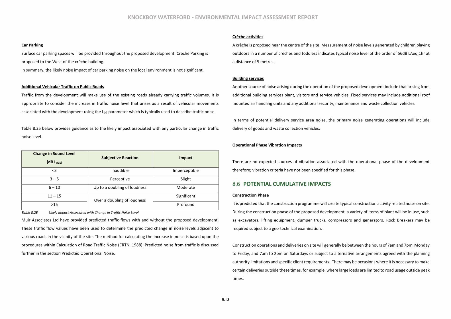
KNOCKBOY WATERFORD - ENVIRONMENTAL IMPACT ASSESSMENT REPORT
8.13
Car Parking
Surface car parking spaces will be provided throughout the proposed development. Creche Parking is
proposed to the West of the crèche building.
In summary, the likely noise impact of car parking noise on the local environment is not significant.
Additional Vehicular Traffic on Public Roads
Traffic from the development will make use of the existing roads already carrying traffic volumes. It is
appropriate to consider the increase in traffic noise level that arises as a result of vehicular movements
associated with the development using the L10 parameter which is typically used to describe traffic noise.
Table 8.25 below provides guidance as to the likely impact associated with any particular change in traffic
noise level.
Change in Sound Level
(dB LA10) Subjective Reaction Impact
<3 Inaudible Imperceptible
3 – 5 Perceptive Slight
6 – 10 Up to a doubling of loudness Moderate
11 – 15 Over a doubling of loudness
Significant
>15 Profound
Table 8.25 Likely Impact Associated with Change in Traffic Noise Level
Muir Associates Ltd have provided predicted traffic flows with and without the proposed development.
These traffic flow values have been used to determine the predicted change in noise levels adjacent to
various roads in the vicinity of the site. The method for calculating the increase in noise is based upon the
procedures within Calculation of Road Traffic Noise (CRTN, 1988). Predicted noise from traffic is discussed
further in the section Predicted Operational Noise.
Crèche activities
A crèche is proposed near the centre of the site. Measurement of noise levels generated by children playing
outdoors in a number of crèches and toddlers indicates typical noise level of the order of 56dB LAeq,1hr at
a distance of 5 metres.
Building services
Another source of noise arising during the operation of the proposed development include that arising from
additional building services plant, visitors and service vehicles. Fixed services may include additional roof
mounted air handling units and any additional security, maintenance and waste collection vehicles.
In terms of potential delivery service area noise, the primary noise generating operations will include
delivery of goods and waste collection vehicles.
Operational Phase Vibration Impacts
There are no expected sources of vibration associated with the operational phase of the development
therefore; vibration criteria have not been specified for this phase.
8.6 POTENTIAL CUMULATIVE IMPACTS
Construction Phase
It is predicted that the construction programme will create typical construction activity related noise on site.
During the construction phase of the proposed development, a variety of items of plant will be in use, such
as excavators, lifting equipment, dumper trucks, compressors and generators. Rock Breakers may be
required subject to a geo-technical examination.
Construction operations and deliveries on site will generally be between the hours of 7am and 7pm, Monday
to Friday, and 7am to 2pm on Saturdays or subject to alternative arrangements agreed with the planning
authority limitations and specific client requirements. There may be occasions where it is necessary to make
certain deliveries outside these times, for example, where large loads are limited to road usage outside peak
times.

KNOCKBOY WATERFORD - ENVIRONMENTAL IMPACT ASSESSMENT REPORT
8.14
Due to the nature of daytime activities undertaken on a construction site of this nature, there is potential
for generation of significant levels of noise. The flow of vehicular traffic to and from a construction site is
also a potential source of noise. The potential for vibration at neighbouring sensitive locations during
construction is typically limited to excavation works and lorry movements on uneven road surfaces.
Due to the fact that the construction programme has not been established, it is difficult to calculate the
actual magnitude of noise emissions to the local environment. However, it is possible to predict typical noise
levels using guidance set out in BS 5228 1: 2009. Table 8.26 below outlines typical plant items and associated
noise levels that are anticipated for various phases of the construction programme.
Construction Phase Item of Plant (BS 5228-1 Ref) Construction Noise LAeq at distance of
15m 30m 100m
Site Clearance /
Demolition
Tracked excavator (C2.21) x 2No 64 55 44
Dump Truck (C2.30) 69 63 52
Diesel Generator (C4.76) 51 45 36
Total General Construction 70 63 53
General
Construction
Dump Truck (C2.30) 69 63 52
Tracked excavator (C2.21) x 2No 64 55 44
Hand Held Circular Saw (C4.72) 69 63 52
Diesel Generator (C4.76) 51 45 36
Total General Construction 72 66 56
Road
Works/Landscaping
Asphalt Paver & Tipping Lorry (C5.40) 65 59 48
Electric Water Pump (C5.40) 58 52 41
Vibratory Roller (C5.20) 65 59 50
Total Landscaping and Road Works 68 62 53
Table 8.26 Noise levels associated with Construction Plant Items
The predicted noise levels detailed in the above table indicate that the likely range of the works,
construction activities can operate within the limits adopted from Waterford County Councils Noise Action
Plan. There is potential criteria to be exceeded when construction works are taking place immediately along
the closest works boundary (at a distance of 15m) during the general housing construction works, this
assumes, however that all items of equipment assessed are operating simultaneously along this boundary
and no screening is provided by boundary treatments, which is worst case.
Operational Phase
There are four primary sources of noise in the operational context as follows:
• car parking on site;
• Additional vehicular traffic on public roads & site access
• Crèche activities, and;
• Building services.
Car Parking on Site
The likely noise impact of car parking at the proposed development on the local environment is not expected
to be significant.
Additional Vehicular Traffic on Public Roads & Site Access
Muir Associates Ltd have provided predicted traffic flows with and without the proposed development.
These traffic flow values have been used to determine the predicted change in noise levels adjacent to
various roads in the vicinity of the site. The method for calculating the increase in noise is based upon the
procedures within Calculation of Road Traffic Noise (CRTN, 1988).
Location
Peak Hour Flows Change in
noise level (dBA) Year 2018 without
development
Year 2018 with
development
St. Mary’s Place/Ballygunner
hill Road 677 831 +0.9 dB

KNOCKBOY WATERFORD - ENVIRONMENTAL IMPACT ASSESSMENT REPORT
8.15
Table 8.27 Changes in Traffic Noise Levels for Weekday 2018 (AM Peak)
Location
Peak Hour Flows Change in
noise level (dBA) Year 2018 without
development
Year 2018 with
development
St. Mary’s Place/Ballygunner
hill Road 569 745 +1.1 dB
Table 8.28 Changes in Traffic Noise Levels for Weekday 2018 (PM Peak)
Location
Peak Hour Flows Change in
noise level (dBA) Year 2035 without
development
Year 2035 with
development
St. Mary’s Place/Ballygunner
hill Road 6186 7249 + 0.7 dB
Table 8.29 Changes in Combined Traffic Noise Levels for Weekday 2035
The increase in traffic noise levels in the vicinity of all roads and scenarios assessed is less than +3dB. This
increase is negligible and the resultant impact is therefore imperceptible.
In summary, the likely noise impact of additional vehicular traffic on existing roads on the local environment
is not significant.
Crèche Activities
A crèche is proposed near the centre of the site slight towards the eastern area of the site.
Taking into account attenuation due to distance, the predicted noise level at the nearest noise sensitive
residence is of the order of 44.4dB LAeq,1hr. This noise level is within the recommended daytime criterion of
50dB LAeq,1hr. The crèche facility will not operate during the night-time. In summary, the likely noise impact
of crèche activity noise on the surrounding environment is not significant.
Building Services
Other sources of noise arising during the operation of the proposed development may include those from
additional building services plant, visitors and delivery services. Fixed services may include additional roof
mounted air handling units and waste compactors while mobile services may include any additional security,
maintenance and waste collection vehicles.
A variety of electrical and mechanical plant will also be required to service the buildings associated with the
development however these are not expected to impact on the existing noise environment.
In summary, the likely noise impact of building service noise on the surrounding environment is not
significant.
8.7 MITIGATION MEASURES
In order to sufficiently ameliorate the likely noise impact, a schedule of noise control measures has been
formulated for both construction and operational phases associated with the proposed development.
Construction Phase
With regard to construction activities, reference will be made to BS5228: Noise control on construction and
open sites, which offers detailed guidance on the control of noise and vibration from demolition and
construction activities. Various mitigation measures will be considered and applied during the construction
of the proposed development. Specific examples of such measures are:
8.7.1 Limiting the hours during which site activities likely to create high levels of noise or vibration are
permitted;
8.7.2 Establishing channels of communication between the contractor/developer, Local Authority and
residents;
8.7.3 Appointing a site representative responsible for matters relating to noise and vibration;
8.7.4 Monitoring levels of noise and/or vibration during critical periods and at sensitive locations;
8.7.5 All site access roads will be kept even so as to mitigate the potential for vibration from lorries.
Furthermore, it is envisaged that a variety of practicable noise control measures will be employed. These
may include:
8.7.6 Selection of plant with low inherent potential for generation of noise and/ or vibration;
8.7.7 Whenever feasible, schedule different noisy activities (e.g., earthmoving) to occur at the same time,
since additional sources of noise generally do not add a significant amount of noise.
KNOCKBOY WATERFORD - ENVIRONMENTAL IMPACT ASSESSMENT REPORT
8.16
8.7.8 Erection of noise barriers or acoustic shield to protect noise sensitive locations if required. To
function well, the barrier must prevent the line-of-sight between the noise source and the
receiver. Effective noise barriers can reduce noise levels by as much as 20 dB(A).
Vibration
The vibration from construction activities will be limited to the values set out above in this report. It should
be noted that these limits are not absolute but provide guidance as to magnitudes of vibration that are very
unlikely to cause cosmetic damage. Magnitudes of vibration slightly greater than those in the table are
normally unlikely to cause cosmetic damage, but construction work creating such magnitudes should
proceed with caution. Where there is existing damage, these limits may need to be reduced by up to 50%.
8.7.9 Limiting the hours during which site activities are likely to create high levels of vibration, e.g. piling,
rock breaking & soil/rock excavations;
8.7.10 Establishing channels of communication between the contractor/developer, Local Authority and
residents;
8.7.11 Appointing a site representative responsible for matters relating to vibration, and;
8.7.12 Monitoring of levels of vibration at sensitive locations during critical periods where activities likely
to generate signification levels of vibration are in operation on site.
Operational Phase
During the operational phase of the development, noise mitigation measures with respect to the outward
impact of the development are not deemed necessary.
Car Parking on Site
The noise impact assessment outlined above has demonstrated that mitigation measures are not required
for car parking activities on site.
Additional Vehicular Traffic on Public Roads
The noise impact assessment outlined above has demonstrated that mitigation measures are not required.
Crèche Activities
The noise impact assessment outlined above has demonstrated that mitigation measures are not required.
Building Services
Proven noise control techniques will be employed to ensure that cumulative noise emissions from plant are
broadband in nature, do not contain any tonal element and do not exceed a level of 40dB LAeq,1hr daytime
and 30dB LAeq,5min night-time at 1 metre from the façade of the nearest noise sensitive locations. These
design goals will ensure that that the adopted criteria are achieved and that further mitigation measures
will not be required.
8.7.13 With regard to building services plant it is envisaged that the following will may be employed:
• A selection of inherently quiet plant items;
• Duct mounted attenuators on the atmosphere side of air moving plant;
• Solid barriers screening external plant, and;
• Anti-vibration mounts on reciprocating plant.
8.8 ‘DO-NOTHING’ SCENARIO
Should the project not proceed there would be no increase in noise emanating from the site.
8.9 ‘WORST-CASE’ SCENARIO
The ‘worst case’ scenario is that the development is not constructed as per the drawings and details
provided in the planning application. While one would expect the development is required to be
constructed in accordance with the planning documents which includes various mitigation measures
outlined above the ‘worst case’ scenario would be that the attributes and mitigation measures are not
carried out and subsequently not appropriately enforced by the contractor.
8.10 MONITORING AND REINSTATEMENT
It is recommended that noise monitoring surveys be carried along the boundary of the proposed site in
order to monitor the effectiveness of noise management for the duration of the construction phase. When
the subject site is operational it will not result in an increase in noise levels at any of the noise sensitive
locations beyond the site boundary therefore no monitoring is deemed necessary going forward.
8.11 DIFFICULTIES IN COMPILING INFORMATION
There were no difficulties encountered in compiling this section of the EIAR.
KNOCKBOY WATERFORD - ENVIRONMENTAL IMPACT ASSESSMENT REPORT
9.1
9 CLIMATE & AIR QUALITY
9.1 INTRODUCTION
This section of the Environmental Impact Assessment Report has been prepared to identify and assess the potential air quality and climatic impacts associated with the proposed development of residential housing at Knockboy, Co. Waterford during both the Construction and Operational Phases of the development. This document includes a comprehensive description of the existing air quality and climate at and in the vicinity of the subject site, a description of how the construction and operational phases of the development may impact existing air quality and finally; the mitigation measures that shall be implemented to control and minimise the impact that the development may have on local ambient air quality and reduce the impact on the local micro climate.
9.2 METHODOLOGY The general assessment methodology of the potential impact of the proposed development on air quality and climate has been devised in accordance with:
➢ Guidelines for Planning Authorities and An Bord Pleanála on carrying out Environmental Impact Assessment (DoHPLG, August 2018)
➢ 2017 EPA Guidelines on information to be contained in Environmental Impact Assessment Reports. ➢ Guidelines on Information to be Contained in an Environmental Impact Statement (EPA 2002). ➢ Advice Notes on Current Practice (in preparation of Environmental Impact Statements) (EPA 2003). ➢ Environmental Protection Agency, 2015. Revised Guidelines on the Information to be Contained in ➢ Environmental Impact Statements ➢ Environmental Protection Agency, 2015. Draft Advice Notes for Preparation of Environmental Impact ➢ Statements ➢ Environmental Impact Assessment (EIA), Guidance for Consent Authorities Regarding Sub-Threshold ➢ Development (DoEHLG 2003). ➢ Development Management Guidelines (DoEHLG, 2007). ➢ European Union (Planning & Development)(Environmental Impact Assessment0 Regulations 2018.
Baseline Environment The existing ambient air quality in the vicinity of the site has been characterised with information obtained from a number of sources as follows: ➢ EPA Annual Air Quality in Ireland Reports; ➢ Site specific air quality monitoring.
The ambient air quality data collected and reviewed for the purpose of this study focused on the principal
substances (dust, vehicle exhaust emissions and boiler emissions) which may be released from the site during the construction and operation phases and which may exert an influence on local air quality. Air Quality Standards and other Relevant Guidance Air quality standards and guidelines are available from a number of sources. The guidelines and standards referenced in this report include those from Ireland and the European Union. In order to reduce the risk to health from poor air quality, National and European statutory bodies have set limit values in ambient air for a range of air pollutants. These limit values or “Air Quality Standards” are health or environmental-based levels for which additional factors may be considered. For example, natural background levels, environmental conditions and socio-economic factors may all play a part in the limit value which is set (Ref Table 9.1). Air quality significance criteria are assessed on the basis of compliance with the appropriate standards or limit values. The applicable standards in Ireland include the National Air Quality Standards Regulations 2011 (S.I No. 180 of 2011), which incorporate European Commission Directive 2008/50/EC which has set limit values for the pollutants SO2, NO2, PM10, benzene and CO Council Directive 2008/50/EC combines the previous Air Quality Framework Directive (96/62/EC) and its subsequent daughter directives (including 1999/30/EC and 2000/69/EC). Provisions are also made for the inclusion of new ambient limit values relating to PM2.5. The European 2008/50/EC Clean Air for Europe (CAFÉ) Directive is the current air quality directive for Europe which supersedes the European Directives 1999/30/EC and 2000/69/EC. In order to assess a wider range of air pollutants in the development area it is necessary to review current air quality monitoring data from published sources such as the most recent EPA’s 2017 Annual report entitled Air Quality in Ireland. This EPA report provides detailed monitoring data collected from a number of monitoring locations throughout Ireland on an annual basis to assess national compliance with National Air Quality Regulations. Given the location of the site in Knockboy, outside Waterford city it is characterised as a Zone C area as defined by the EPA. EU legislation on air quality requires that Member States divide their territory into zones for the assessment and management of air quality. The zones in place in Ireland in 2016 are as follows:
➢ Zone A is the Dublin conurbation, ➢ Zone B is the Cork conurbation ➢ Zone C comprising 23 large towns in Ireland with a population >15,000. ➢ Zone D is the remaining area of Ireland.
The zones changed on 1 January 2013 to reflect the results of the 2011 census. The air quality in each zone is assessed and classified with respect to upper and lower assessment thresholds based on measurements over the previous five years. Upper and lower assessment thresholds are prescribed in the legislation for each pollutant. The number of monitoring locations required is dependent on population size and whether ambient air quality concentrations exceed the upper assessment threshold,
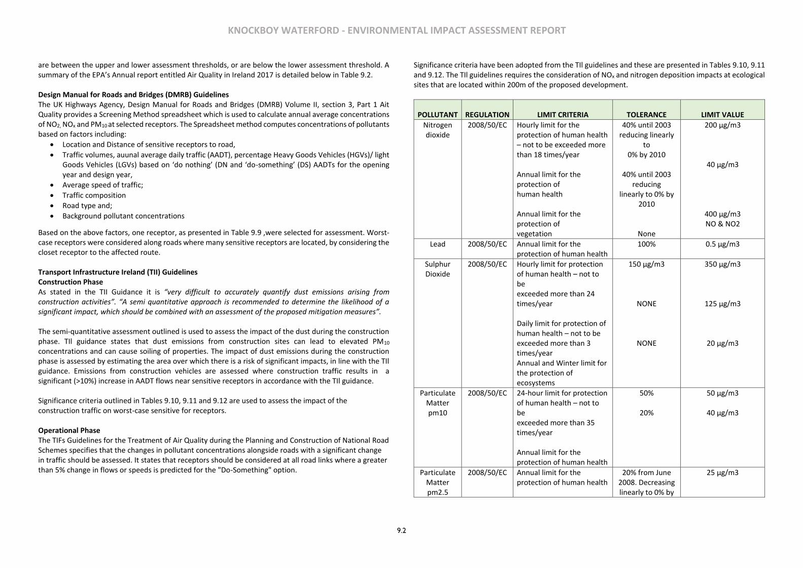
KNOCKBOY WATERFORD - ENVIRONMENTAL IMPACT ASSESSMENT REPORT
9.2
are between the upper and lower assessment thresholds, or are below the lower assessment threshold. A summary of the EPA’s Annual report entitled Air Quality in Ireland 2017 is detailed below in Table 9.2. Design Manual for Roads and Bridges (DMRB) Guidelines The UK Highways Agency, Design Manual for Roads and Bridges (DMRB) Volume II, section 3, Part 1 Ait Quality provides a Screening Method spreadsheet which is used to calculate annual average concentrations of NO2, NOx and PM10 at selected receptors. The Spreadsheet method computes concentrations of pollutants based on factors including:
• Location and Distance of sensitive receptors to road,
• Traffic volumes, auunal average daily traffic (AADT), percentage Heavy Goods Vehicles (HGVs)/ light Goods Vehicles (LGVs) based on ‘do nothing’ (DN and ‘do-something’ (DS) AADTs for the opening year and design year,
• Average speed of traffic;
• Traffic composition
• Road type and;
• Background pollutant concentrations
Based on the above factors, one receptor, as presented in Table 9.9 ,were selected for assessment. Worst-case receptors were considered along roads where many sensitive receptors are located, by considering the closet receptor to the affected route. Transport Infrastructure Ireland (TII) Guidelines Construction Phase As stated in the TII Guidance it is “very difficult to accurately quantify dust emissions arising from construction activities”. “A semi quantitative approach is recommended to determine the likelihood of a significant impact, which should be combined with an assessment of the proposed mitigation measures”. The semi-quantitative assessment outlined is used to assess the impact of the dust during the construction phase. TIl guidance states that dust emissions from construction sites can lead to elevated PM10 concentrations and can cause soiling of properties. The impact of dust emissions during the construction phase is assessed by estimating the area over which there is a risk of significant impacts, in line with the TIl guidance. Emissions from construction vehicles are assessed where construction traffic results in a significant (>10%) increase in AADT flows near sensitive receptors in accordance with the TIl guidance. Significance criteria outlined in Tables 9.10, 9.11 and 9.12 are used to assess the impact of the construction traffic on worst-case sensitive for receptors. Operational Phase The TIFs Guidelines for the Treatment of Air Quality during the Planning and Construction of National Road Schemes specifies that the changes in pollutant concentrations alongside roads with a significant change in traffic should be assessed. It states that receptors should be considered at all road links where a greater than 5% change in flows or speeds is predicted for the "Do-Something" option.
Significance criteria have been adopted from the TIl guidelines and these are presented in Tables 9.10, 9.11 and 9.12. The TIl guidelines requires the consideration of NOx and nitrogen deposition impacts at ecological sites that are located within 200m of the proposed development.
POLLUTANT
REGULATION
LIMIT CRITERIA
TOLERANCE
LIMIT VALUE
Nitrogen dioxide
2008/50/EC Hourly limit for the protection of human health – not to be exceeded more than 18 times/year Annual limit for the protection of human health Annual limit for the protection of vegetation
40% until 2003 reducing linearly
to 0% by 2010
40% until 2003
reducing linearly to 0% by
2010
None
200 μg/m3
40 μg/m3
400 μg/m3 NO & NO2
Lead 2008/50/EC Annual limit for the protection of human health
100% 0.5 μg/m3
Sulphur Dioxide
2008/50/EC Hourly limit for protection of human health – not to be exceeded more than 24 times/year Daily limit for protection of human health – not to be exceeded more than 3 times/year Annual and Winter limit for the protection of ecosystems
150 μg/m3
NONE
NONE
350 μg/m3
125 μg/m3
20 μg/m3
Particulate Matter pm10
2008/50/EC 24-hour limit for protection of human health – not to be exceeded more than 35 times/year Annual limit for the protection of human health
50%
20%
50 μg/m3
40 μg/m3
Particulate Matter pm2.5
2008/50/EC Annual limit for the protection of human health
20% from June 2008. Decreasing linearly to 0% by
25 μg/m3
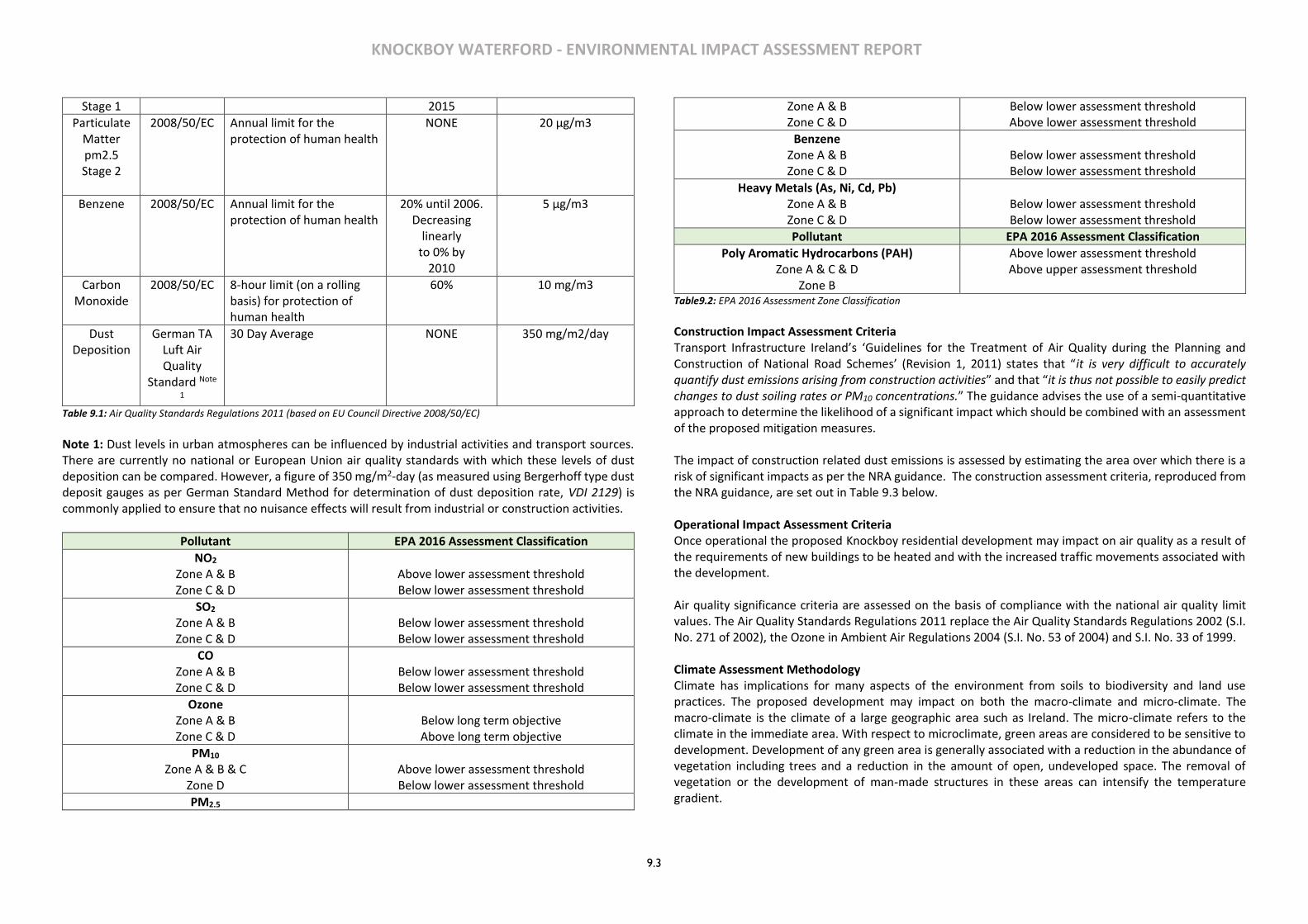
KNOCKBOY WATERFORD - ENVIRONMENTAL IMPACT ASSESSMENT REPORT
9.3
Stage 1 2015
Particulate Matter pm2.5 Stage 2
2008/50/EC Annual limit for the protection of human health
NONE 20 μg/m3
Benzene 2008/50/EC Annual limit for the protection of human health
20% until 2006. Decreasing
linearly to 0% by
2010
5 μg/m3
Carbon Monoxide
2008/50/EC 8-hour limit (on a rolling basis) for protection of human health
60% 10 mg/m3
Dust Deposition
German TA Luft Air Quality
Standard Note
1
30 Day Average NONE 350 mg/m2/day
Table 9.1: Air Quality Standards Regulations 2011 (based on EU Council Directive 2008/50/EC)
Note 1: Dust levels in urban atmospheres can be influenced by industrial activities and transport sources. There are currently no national or European Union air quality standards with which these levels of dust deposition can be compared. However, a figure of 350 mg/m2-day (as measured using Bergerhoff type dust deposit gauges as per German Standard Method for determination of dust deposition rate, VDI 2129) is commonly applied to ensure that no nuisance effects will result from industrial or construction activities.
Pollutant EPA 2016 Assessment Classification
NO2 Zone A & B Zone C & D
Above lower assessment threshold Below lower assessment threshold
SO2 Zone A & B Zone C & D
Below lower assessment threshold Below lower assessment threshold
CO Zone A & B Zone C & D
Below lower assessment threshold Below lower assessment threshold
Ozone Zone A & B Zone C & D
Below long term objective Above long term objective
PM10 Zone A & B & C
Zone D
Above lower assessment threshold Below lower assessment threshold
PM2.5
Zone A & B Zone C & D
Below lower assessment threshold Above lower assessment threshold
Benzene Zone A & B Zone C & D
Below lower assessment threshold Below lower assessment threshold
Heavy Metals (As, Ni, Cd, Pb) Zone A & B Zone C & D
Below lower assessment threshold Below lower assessment threshold
Pollutant EPA 2016 Assessment Classification
Poly Aromatic Hydrocarbons (PAH) Zone A & C & D
Zone B
Above lower assessment threshold Above upper assessment threshold
Table9.2: EPA 2016 Assessment Zone Classification
Construction Impact Assessment Criteria Transport Infrastructure Ireland’s ‘Guidelines for the Treatment of Air Quality during the Planning and Construction of National Road Schemes’ (Revision 1, 2011) states that “it is very difficult to accurately quantify dust emissions arising from construction activities” and that “it is thus not possible to easily predict changes to dust soiling rates or PM10 concentrations.” The guidance advises the use of a semi-quantitative approach to determine the likelihood of a significant impact which should be combined with an assessment of the proposed mitigation measures. The impact of construction related dust emissions is assessed by estimating the area over which there is a risk of significant impacts as per the NRA guidance. The construction assessment criteria, reproduced from the NRA guidance, are set out in Table 9.3 below. Operational Impact Assessment Criteria Once operational the proposed Knockboy residential development may impact on air quality as a result of the requirements of new buildings to be heated and with the increased traffic movements associated with the development. Air quality significance criteria are assessed on the basis of compliance with the national air quality limit values. The Air Quality Standards Regulations 2011 replace the Air Quality Standards Regulations 2002 (S.I. No. 271 of 2002), the Ozone in Ambient Air Regulations 2004 (S.I. No. 53 of 2004) and S.I. No. 33 of 1999. Climate Assessment Methodology Climate has implications for many aspects of the environment from soils to biodiversity and land use practices. The proposed development may impact on both the macro-climate and micro-climate. The macro-climate is the climate of a large geographic area such as Ireland. The micro-climate refers to the climate in the immediate area. With respect to microclimate, green areas are considered to be sensitive to development. Development of any green area is generally associated with a reduction in the abundance of vegetation including trees and a reduction in the amount of open, undeveloped space. The removal of vegetation or the development of man-made structures in these areas can intensify the temperature gradient.
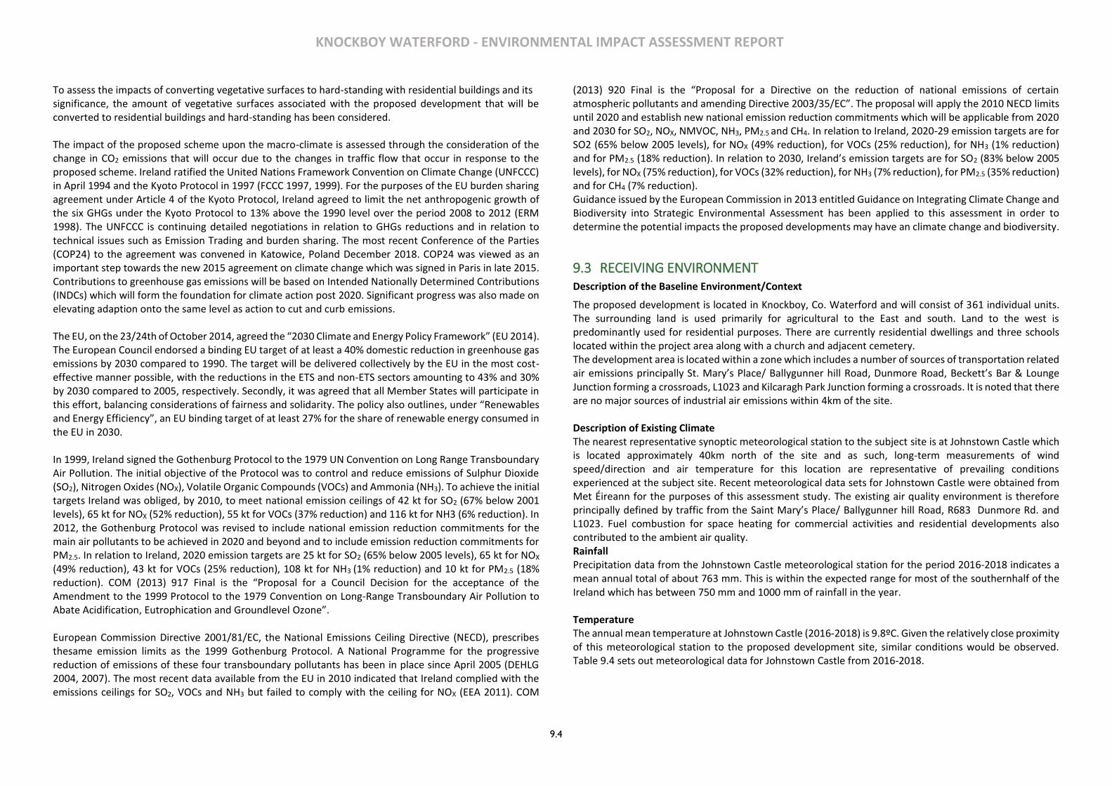
KNOCKBOY WATERFORD - ENVIRONMENTAL IMPACT ASSESSMENT REPORT
9.4
To assess the impacts of converting vegetative surfaces to hard-standing with residential buildings and its significance, the amount of vegetative surfaces associated with the proposed development that will be converted to residential buildings and hard-standing has been considered. The impact of the proposed scheme upon the macro-climate is assessed through the consideration of the change in CO2 emissions that will occur due to the changes in traffic flow that occur in response to the proposed scheme. Ireland ratified the United Nations Framework Convention on Climate Change (UNFCCC) in April 1994 and the Kyoto Protocol in 1997 (FCCC 1997, 1999). For the purposes of the EU burden sharing agreement under Article 4 of the Kyoto Protocol, Ireland agreed to limit the net anthropogenic growth of the six GHGs under the Kyoto Protocol to 13% above the 1990 level over the period 2008 to 2012 (ERM 1998). The UNFCCC is continuing detailed negotiations in relation to GHGs reductions and in relation to technical issues such as Emission Trading and burden sharing. The most recent Conference of the Parties (COP24) to the agreement was convened in Katowice, Poland December 2018. COP24 was viewed as an important step towards the new 2015 agreement on climate change which was signed in Paris in late 2015. Contributions to greenhouse gas emissions will be based on Intended Nationally Determined Contributions (INDCs) which will form the foundation for climate action post 2020. Significant progress was also made on elevating adaption onto the same level as action to cut and curb emissions. The EU, on the 23/24th of October 2014, agreed the “2030 Climate and Energy Policy Framework” (EU 2014). The European Council endorsed a binding EU target of at least a 40% domestic reduction in greenhouse gas emissions by 2030 compared to 1990. The target will be delivered collectively by the EU in the most cost-effective manner possible, with the reductions in the ETS and non-ETS sectors amounting to 43% and 30% by 2030 compared to 2005, respectively. Secondly, it was agreed that all Member States will participate in this effort, balancing considerations of fairness and solidarity. The policy also outlines, under “Renewables and Energy Efficiency”, an EU binding target of at least 27% for the share of renewable energy consumed in the EU in 2030. In 1999, Ireland signed the Gothenburg Protocol to the 1979 UN Convention on Long Range Transboundary Air Pollution. The initial objective of the Protocol was to control and reduce emissions of Sulphur Dioxide (SO2), Nitrogen Oxides (NOX), Volatile Organic Compounds (VOCs) and Ammonia (NH3). To achieve the initial targets Ireland was obliged, by 2010, to meet national emission ceilings of 42 kt for SO2 (67% below 2001 levels), 65 kt for NOX (52% reduction), 55 kt for VOCs (37% reduction) and 116 kt for NH3 (6% reduction). In 2012, the Gothenburg Protocol was revised to include national emission reduction commitments for the main air pollutants to be achieved in 2020 and beyond and to include emission reduction commitments for PM2.5. In relation to Ireland, 2020 emission targets are 25 kt for SO2 (65% below 2005 levels), 65 kt for NOX (49% reduction), 43 kt for VOCs (25% reduction), 108 kt for NH3 (1% reduction) and 10 kt for PM2.5 (18% reduction). COM (2013) 917 Final is the “Proposal for a Council Decision for the acceptance of the Amendment to the 1999 Protocol to the 1979 Convention on Long-Range Transboundary Air Pollution to Abate Acidification, Eutrophication and Groundlevel Ozone”. European Commission Directive 2001/81/EC, the National Emissions Ceiling Directive (NECD), prescribes thesame emission limits as the 1999 Gothenburg Protocol. A National Programme for the progressive reduction of emissions of these four transboundary pollutants has been in place since April 2005 (DEHLG 2004, 2007). The most recent data available from the EU in 2010 indicated that Ireland complied with the emissions ceilings for SO2, VOCs and NH3 but failed to comply with the ceiling for NOX (EEA 2011). COM
(2013) 920 Final is the “Proposal for a Directive on the reduction of national emissions of certain atmospheric pollutants and amending Directive 2003/35/EC”. The proposal will apply the 2010 NECD limits until 2020 and establish new national emission reduction commitments which will be applicable from 2020 and 2030 for SO2, NOX, NMVOC, NH3, PM2.5 and CH4. In relation to Ireland, 2020-29 emission targets are for SO2 (65% below 2005 levels), for NOX (49% reduction), for VOCs (25% reduction), for NH3 (1% reduction) and for PM2.5 (18% reduction). In relation to 2030, Ireland’s emission targets are for SO2 (83% below 2005 levels), for NOX (75% reduction), for VOCs (32% reduction), for NH3 (7% reduction), for PM2.5 (35% reduction) and for CH4 (7% reduction). Guidance issued by the European Commission in 2013 entitled Guidance on Integrating Climate Change and Biodiversity into Strategic Environmental Assessment has been applied to this assessment in order to determine the potential impacts the proposed developments may have an climate change and biodiversity.
9.3 RECEIVING ENVIRONMENT Description of the Baseline Environment/Context
The proposed development is located in Knockboy, Co. Waterford and will consist of 361 individual units. The surrounding land is used primarily for agricultural to the East and south. Land to the west is predominantly used for residential purposes. There are currently residential dwellings and three schools located within the project area along with a church and adjacent cemetery. The development area is located within a zone which includes a number of sources of transportation related air emissions principally St. Mary’s Place/ Ballygunner hill Road, Dunmore Road, Beckett’s Bar & Lounge Junction forming a crossroads, L1023 and Kilcaragh Park Junction forming a crossroads. It is noted that there are no major sources of industrial air emissions within 4km of the site. Description of Existing Climate The nearest representative synoptic meteorological station to the subject site is at Johnstown Castle which is located approximately 40km north of the site and as such, long-term measurements of wind speed/direction and air temperature for this location are representative of prevailing conditions experienced at the subject site. Recent meteorological data sets for Johnstown Castle were obtained from Met Éireann for the purposes of this assessment study. The existing air quality environment is therefore principally defined by traffic from the Saint Mary’s Place/ Ballygunner hill Road, R683 Dunmore Rd. and L1023. Fuel combustion for space heating for commercial activities and residential developments also contributed to the ambient air quality. Rainfall Precipitation data from the Johnstown Castle meteorological station for the period 2016-2018 indicates a mean annual total of about 763 mm. This is within the expected range for most of the southernhalf of the Ireland which has between 750 mm and 1000 mm of rainfall in the year. Temperature The annual mean temperature at Johnstown Castle (2016-2018) is 9.8ºC. Given the relatively close proximity of this meteorological station to the proposed development site, similar conditions would be observed. Table 9.4 sets out meteorological data for Johnstown Castle from 2016-2018.

KNOCKBOY WATERFORD - ENVIRONMENTAL IMPACT ASSESSMENT REPORT
9.5
Year Period Rainfall (mm) Mean Temperature(ºC)
2016 Annual Mean 995.7 10.3
2017 Annual Mean 962.9 10.4
2018 Annual Mean 1147.2 10.4
Mean 1035.2 10.3 Table 9.4: Meteorological Data for Johnstown Castle 2016-2018 Note 1: Data supplied by Met Eireann
Wind Wind is of key importance for both the generation and dispersal of air pollutants. The prevailing wind direction, in the Waterford area, is from the West and Southwest and blows Northeast across the proposed development. The mean annual wind speed in the south leinster area is approximately 3.0 m/s.
Description of Existing Air Quality The existing ambient air quality at and in the vicinity of the site is typical of an out of city urban location and as such, domestic and commercial heating sources and road traffic are identified as the dominant contributors of hydrocarbon, combustion gases and particulate emissions to ambient air quality. Trends in Air Quality Air quality monitoring programs have been undertaken in recent years by the EPA and Local Authorities. The most recent annual report on air quality “Air Quality in Ireland 2017 – Key Indicators of Ambient Air Quality” details the range and scope of monitoring undertaken throughout Ireland. EU legislation on air quality requires that Member States divide their territory into zones for the assessment and management of air quality. Four air quality zones have been defined in Ireland for air quality management and assessment purposes (EPA, 2016). Zone A is the Dublin conurbation, Zone B is the Cork conurbation with Zone C comprising 23 large towns in Ireland with a population >15,000. Zone D is the remaining area of Ireland. In terms of air quality monitoring, the proposed development is categorised as Zone C. The most recent EPA publication includes a monitoring location in the vicinity of Waterford City which would be broadly comparable to the expected air quality at the subject site. The various air quality monitoring stations within the Waterford area provides a comprehensive range of air quality monitoring data sets which have been selected as part of this assessment to describe the existing ambient air quality at the subject site. Nitrogen Dioxide The Air Quality Standards Regulations 2011 specify a limit value of 40 μg/m3, for the protection of human health, over a calendar year. The standard, taken from the 2008 CAFÉ Directive 2000/69/EC, came into force in 2011. Long term NO2 monitoring was carried out at in Zone C locations in 2017. The NO2 annual mean in 2017 for the nearert location to the site at knockboy was 5.2 μg/m3. Therefore, long term averages were below the annual average limit of 40 μg/m3. There was an hourly max of 57.5 μg/m3 which is within the limit value of 200 μg/m3. Sulphur Dioxide
The Air Quality Standards Regulations 2011 specify a daily limit value of 125 μg/m3 for the protection of human health. The standard, taken from the 2008 CAFÉ Directive 2000/69/EC, came into force in 2011. Long term SO2 monitoring was carried out at four Zone C locations in 2017. The annual mean for SO2 was 2.4 μg/m3 . Therefore, long term averages were significantly below the daily limit of 125 μg/m3. The daily max recorded was 7.6 μg/m3 and there was no exceedance of the hourly limit of 350 μg/m3. The annual mean SO2 concentrations in Ireland have being slightly declining since 2003. This trend is reflective in the shift in fuel choice across Ireland in both residential heating and the energy production sector. Carbon Monoxide The Air Quality Standards Regulations 2011 specify an 8-hour limit value (on a rolling basis) for the protection of human health of 10,000 μg/m3. The standard, taken from the 2008 CAFÉ Directive 2000/69/EC, came into force in 2011. Long term CO monitoring was carried out at two Zone C locations in 2017. The rolling 8-hour CO concentrations annual mean was 0.15mg/m3 in 2017. Therefore, long term average of 1.24 mg/m3 max were below the 8-hour limit value (on a rolling basis) of 10 μg/m3. Particulate Matter PM10 The Air Quality Standards Regulations 2011 specify a PM10 limit value of 40 μg/m3 over a calendar year. The standard, taken from the 2008 CAFÉ Directive 2000/69/EC, came into force in 2011. Long term PM10 monitoring was carried out at nine Zone C locations in 2017. The PM10 average in 2017 for the closest monitoring statio to the site was 9.5 μg/m3. Therefore, long term averages were below the annual average limit of 40 μg/m3. The daily max recorded as 25.5 was not in exceedance of the 40 μg/m3 limit Particulate Matter PM2.5 The Air Quality Standards Regulations 2011 specify a PM2.5 target value of 25 μg/m3 over a calendar year to be met by 1 January 2010. Long term PM2.5 monitoring was carried out in two Zone C locations in 2017. The PM2.5 average in 2017 for the site closest to the development site was 5.2 μg/m3. Therefore, long term averages were below the target value 25 μg/m3. Benzene The Air Quality Standards Regulations 2011 specify a benzene limit value of 5 μg/m3 over a calendar year. The standard, taken from the 2008 CAFÉ Directive 2000/69/EC, came into force in 2011. Long term benzene monitoring was carried out at one Zone C location in 2017. The benzene annual mean in 2017 for this site was 0.18 μg/m3. The hourly max of 1.04 μg/m3 was recorded. Therefore, long term averages were below the limit value 5 μg/m3. Table 9.5 below presents a summary of the 2017 Air Quality data obtained from the Dublin Zone C which may be considered to be broadly similar to that of the subject site in which the subject development site is located.
Pollutant Regulation Limit type Limit value EPA
data 2017 (annual mean)
Nitrogen dioxide
2008/50/EC Annual limit for protection of human health
40 μg/m3 5.2 μg/m3
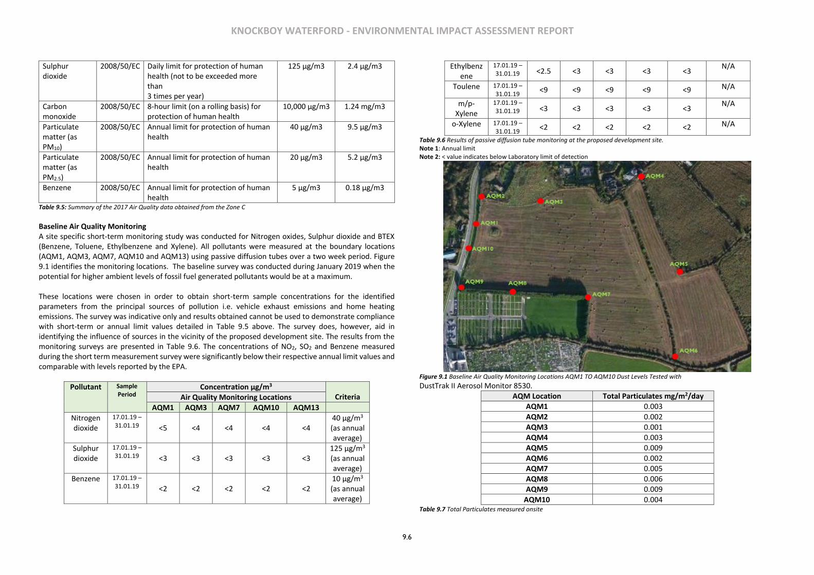
KNOCKBOY WATERFORD - ENVIRONMENTAL IMPACT ASSESSMENT REPORT
9.6
Sulphur dioxide
2008/50/EC Daily limit for protection of human health (not to be exceeded more than 3 times per year)
125 μg/m3 2.4 μg/m3
Carbon monoxide
2008/50/EC 8-hour limit (on a rolling basis) for protection of human health
10,000 μg/m3 1.24 mg/m3
Particulate matter (as PM10)
2008/50/EC Annual limit for protection of human health
40 μg/m3 9.5 μg/m3
Particulate matter (as PM2.5)
2008/50/EC Annual limit for protection of human health
20 μg/m3 5.2 μg/m3
Benzene 2008/50/EC Annual limit for protection of human health
5 μg/m3 0.18 μg/m3
Table 9.5: Summary of the 2017 Air Quality data obtained from the Zone C
Baseline Air Quality Monitoring A site specific short-term monitoring study was conducted for Nitrogen oxides, Sulphur dioxide and BTEX (Benzene, Toluene, Ethylbenzene and Xylene). All pollutants were measured at the boundary locations (AQM1, AQM3, AQM7, AQM10 and AQM13) using passive diffusion tubes over a two week period. Figure 9.1 identifies the monitoring locations. The baseline survey was conducted during January 2019 when the potential for higher ambient levels of fossil fuel generated pollutants would be at a maximum. These locations were chosen in order to obtain short-term sample concentrations for the identified parameters from the principal sources of pollution i.e. vehicle exhaust emissions and home heating emissions. The survey was indicative only and results obtained cannot be used to demonstrate compliance with short-term or annual limit values detailed in Table 9.5 above. The survey does, however, aid in identifying the influence of sources in the vicinity of the proposed development site. The results from the monitoring surveys are presented in Table 9.6. The concentrations of NO2, SO2 and Benzene measured during the short term measurement survey were significantly below their respective annual limit values and comparable with levels reported by the EPA.
Pollutant Sample Period
Concentration μg/m3 Criteria Air Quality Monitoring Locations
AQM1 AQM3 AQM7 AQM10 AQM13
Nitrogen dioxide
17.01.19 – 31.01.19 <5 <4 <4 <4 <4
40 μg/m3 (as annual average)
Sulphur dioxide
17.01.19 – 31.01.19 <3 <3 <3 <3 <3
125 μg/m3 (as annual average)
Benzene 17.01.19 – 31.01.19 <2 <2 <2 <2 <2
10 μg/m3 (as annual average)
Ethylbenzene
17.01.19 – 31.01.19 <2.5 <3 <3 <3 <3
N/A
Toulene 17.01.19 – 31.01.19
<9 <9 <9 <9 <9 N/A
m/p-Xylene
17.01.19 – 31.01.19 <3 <3 <3 <3 <3
N/A
o-Xylene 17.01.19 – 31.01.19
<2 <2 <2 <2 <2 N/A
Table 9.6 Results of passive diffusion tube monitoring at the proposed development site. Note 1: Annual limit Note 2: < value indicates below Laboratory limit of detection
Figure 9.1 Baseline Air Quality Monitoring Locations AQM1 TO AQM10 Dust Levels Tested with
DustTrak II Aerosol Monitor 8530.
AQM Location Total Particulates mg/m2/day
AQM1 0.003
AQM2 0.002
AQM3 0.001
AQM4 0.003
AQM5 0.009
AQM6 0.002
AQM7 0.005
AQM8 0.006
AQM9 0.009
AQM10 0.004 Table 9.7 Total Particulates measured onsite
KNOCKBOY WATERFORD - ENVIRONMENTAL IMPACT ASSESSMENT REPORT
9.7
Significance Based on published air quality data for Zone C area in the vicinity of the subject site together with site specific monitoring data, it may be concluded that the existing baseline air quality at the subject site may be characterised as being good with no exceedances of the Air Quality Regulations 2011 limit values of individual pollutants. The quality of existing air quality at the subject site must be maintained and improved where possible as a result of the proposed development to ensure that local human health and the ecological environment is not adversely affected. Sensitivity The subject site shall be developed by ground clearance and site preparation works and the subsequent construction of residential units, a creche, roads, open spaces and landscaped areas.
9.4 CHARACTERISTICS OF THE PROPOSED DEVELOPMENT The development will consist of a new residential development of 361 no. residential units comprising:
• 207 no. houses (13 no. 2-beds, 116 no. 3-beds, 78 no. 4-beds). • 154 no. apartments within 15 no. 4 storey blocks (providing 53 no. 1-beds, 90 no. 2-beds and 11 no.
3-beds). • A creche of c574 sq.m. • 7 no. internal/external communal waste storage facilities (total floor area c.214.3 sq.m). • 638 car parking spaces and 390 no. bicycle parking spaces within 15 no storage facilities (total floor
area c.232 sq.m). Additional visitor bicycle parking provided in the public realm. • 2 no. ESB sub-stations/switchrooms (totalling c.10 sq.m) • Vehicular/pedestrian/cyclist access from public road (Ballygunner Hill) • The total gross floor area of the proposed development is c. c.51,029.5 sq.m
• All associated site development works, landscaping, open spaces, boundary treatments and services provision.
When considering a development of this nature, the potential impact on air quality and climate must be considered for each distinct stage: the short (1-3 years) and medium term (3-5) impact of the construction phase and the longer term impact of the operational phase. The construction phase will be undertaken over a maximum 3 year period. It is important that there are no unacceptable decreases in ambient air quality levels predicted during the construction phases and during the operational phase.
9.5 POTENTIAL IMPACTS Predicted Impact Various elements of both the construction and operational phases of the proposed development have the potential to impact on the local receiving environment, on adjacent residential properties and on human health. The likely potential impacts for both construction and operation of the proposed scheme prior to mitigation are described in this section of the EIAR.
Construction Impacts The development of the site will be conducted in the following phased stages:
• Enabling works - Site set up and Site clearance
• Construction works including site infrastructure and landscaping
• Construction impacts associated with both of these phased stages are considered below.
Enabling Works – Site Set Up and Clearance Works activities associated with the ‘Site set up’ will be undertaken prior to construction works commencing in each sub-phase. The setting up of the site shall involve the construction of site security hoarding and site compounds, site offices, materials and waste storage areas and staff welfare facilities. These temporary activities will have a minimal potential to generate fugitive dust emissions or combustion gas emissions. Site clearance and ground excavation works will be undertaken in separate phases and these activities have the potential to generate fugitive windblown dust emissions rising from the operation of mechanical plant such as dozers, excavators and tipper trucks and the movement of these vehicles on exposed surfaces at the site. With regard to the phased development approach, only one phase at a time shall be developed with the remaining phased areas remaining generally undisturbed until such a time as they are developed. Infrastructural works will be required to facilitate site services but it is not predicted that there would be bulk excavations of stripped soils until such a time as the development of subsequent phases are commenced. With regard to the volume of waste material (top and sub soils) generated during site clearance, there will be a requirement for HGV trucks. Top soils shall be stockpiled and covered on site for re-use during final landscaping works. Trucks shall be loaded with material on-site by mechanical excavators and loading shovels which will generate fugitive dust emissions as a result of the transfer of the excavated materials comprised principally of soils and stones from stockpile to truck. The movements of construction vehicles on the site shall also generate windblown dust emissions. Where dusty waste material is loaded onto exposed open trucks, fine dusts may be released as the truck travels along public roads. It is estimated that there will be a maximum of 3 (No.) x 20 tonne tipper truck movements per hour or an average of 32 movements per day associated with site clearance works. This relatively small volume of truck movements will have a negligible impact on local ambient air quality. It is expected that soil will have to be imported into the site to raise the levels of the site. This will increase the number of trucks entering and exiting the site but this is not expected to be significant. The impact on local air quality during Site Set Up and Clearance will be temporary in nature and will result in a potentially minor impact on local air quality and sensitive receptors provided that all mitigation measures are implemented. Stockpiled topsoils shall be covered to prevent their erosion and shall eventually be re-used in landscaping works on the site. Building and Site Infrastructure Construction Works The development relates to the construction of residential units in a mix of houses and apartments, a crèche, community centre, retail/non retail units, car parking and landscaping. The proposal includes for internal roads and streets along with appropriate hard and soft landscaping treatments.

KNOCKBOY WATERFORD - ENVIRONMENTAL IMPACT ASSESSMENT REPORT
9.8
During the construction phase there will be extensive site works, involving construction machinery, construction activities on site which have the potential to generate fugitive windblown dust emissions. Construction equipment including generators and compressors will also give rise to some exhaust emissions. However, due to the size and nature of construction activities, exhaust emissions during construction will have a negligible impact on local air quality. Construction traffic to and from the site shall result in a short term increase in the volume of diesel fuelled HGV’s along the local road network which will generate additional hydrocarbon and particulate emissions from the vehicle exhausts. However, the activities detailed above will result in an imperceptible impact on local air quality and sensitive receptors. Climate During the construction phase, existing vegetated areas throughout the development site will be removed due to site clearance works and associated movement of construction traffic thus impacting the micro-climate. Whilst this will impact the evapotranspiration rates of vegetation, there will be no impact upon the moisture evaporation from the exposed soil. Therefore, there will be no significant impacts on microclimate. CO2 will be released into the atmosphere as a result of the movement of construction vehicles and use of plant. However emissions associated with such activities will occur over a short-term period (c. 3 years) which will not result in an adverse impact on the local micro or the broader macro climate. Operational Phase Air Quality The operational phase of the proposed development will result in a slight impact on local air quality primarily as a result of the requirements of new buildings to be heated and with the increased traffic movements associated with the development. Traffic movements associated with the development have been evaluated and assessed as part of the Traffic Impact Assessment for the development which will include parking for vehicles which will enter and exit the site. The split in am and pm peak traffic movements will not result in an adverse impact on local air quality at any of the junctions and it is predicted that the impact of car engine exhaust emissions will have a negligible impact on local ambient air quality. it is expected that a proportion of the commuting residents will avail of public transport e.g. local bus services. The availability of public transport will significantly reduce the number of vehicles exiting and entering the development during am and pm peak times. The design and construction of all buildings in accordance with National Building Regulations shall ensure that modern building materials are used and that they are designed to be thermally efficient resulting in a reduction in the volume of fossil fuels required to heat the buildings. It is predicted that fossil fuel combustion gas emissions including Carbon Dioxide, Sulphur Dioxide, Nitrogen Oxides, Carbon Monoxide and hydrocarbon particulate emissions will be slight and will not have an adverse significant impact on the existing ambient air quality in the vicinity of the proposed development site. Energy Efficiency - All proposals for development shall seek to meet the highest standards of sustainable design and construction with regard to the optimum use of sustainable building design criteria such as
passive solar principles and also green building materials. In order to reduce energy consumption, the following key design considerations have been considered in the design process and will be incorporated into the construction of the residential units, where feasible:
➢ Passive solar design including the orientation, location and sizing of windows ➢ The use of green building materials: low embodied energy & recycled materials ➢ Energy efficient window units and frames ➢ Building envelope air tightness ➢ Installation of Heat Recovery & Ventilation systems in all apartment units which operate by
extracting warm air from kitchens and bathrooms, cleaning it and distributing it to other rooms in the unit.
Climate The site area of the development lands is c.9 hectares which will include open space and landscaped areas. The overall development includes the construction of buildings and roadways will have the effect of marginally raising local air temperatures, especially in summer. Therefore, it is predicted that the proposed development will not have an adverse impact on micro-climate at the nearest residential properties or on the local receiving environment in the vicinity of the site boundaries. The proposed development includes structures which will have a minor impact on the local micro-climate by means of wind sheer effects. There will however be no unacceptable impact within or beyond the overall site. Greenhouse gases occur naturally in the atmosphere (e.g. carbon dioxide, water vapour, methane, nitrous oxide and ozone) and in the correct balance, are responsible for keeping the lower part of the atmosphere warmer than it would otherwise be. These gases permit incoming solar radiation to pass through the Earth’s atmosphere, but prevent most of the outgoing infrared radiation from escaping from the surface and lower atmosphere into the upper levels. However, human activities are now contributing to an upward trend in the levels of these gases, along with other pollutants with the net result of an increase in temperature near the surface. Motor vehicles are a major source of atmospheric emissions thought to contribute to climate change, however, vehicle exhaust emissions generated from site related vehicles will have a negligible impact on the macro-climate given modern technological developments in cleaner and more efficient vehicle engines. The scheme has been designed to provide thermally efficient buildings which will reduce the consumption of fossil fuels within each individual dwelling. This will reduce the impact the operational phase of the development will have on the micro and macro climate. In particular, there will be no “traditional” passive air vents in the apartments which are both thermally and acoustically inefficient and if possible, Mechanical Ventilation and Heat Recovery (MVHR) systems shall be incorporated into the design of the apartments. The MVHR systems together with thermally and acoustically rated window sets will reduce the potential future impacts that the external climate will have in terms of wind and changing temperatures on the internal environment within the residential units. These design features will ensure the units are thermally efficient thus reducing the use of fossil fuels leading to a reduction of the impact on climate.

KNOCKBOY WATERFORD - ENVIRONMENTAL IMPACT ASSESSMENT REPORT
9.9
The thermal efficiency of the buildings will ensure that the development will be sustainable and will be protected against the impacts of future climate change which can include high winds, storm events and prolonged colder periods during the winter season. The EPA’s Integrated Pollution Prevention and Control (IPPC) Licensing Application Guidance Notes, 2012 define the threshold of boiler emissions for the categorisation of major ot minor emissions. As a genreal rule, gas boilers over 5 MW are regarded to be significant and categorised as a major emission. There will be no gas boilers in excess of 5MW on this site. 9.6 Potential Cumulative Impacts In accordance with Schedule 6, Part 2(c) of the Planning and Development Regulations 2001, this section has considered the cumulative impact of the proposed development in conjunction with future development in the vicinity of the subject site. This section relates to the cumulative impact on the subject site itself and on surrounding sites. The European Commissions report of May 1999 ‘Guidelines for the Assessment of Indirect and Cumulative Impacts as well as Impact Interactions’ defines cumulative impact as follows: “Impacts that result from incremental changes caused by other past, present or reasonably foreseeable actions together with the project”. The cumulative air quality impact of the existing residential development and existing local transport infrastructure together with the proposed Knockboy development is assessed with regard to having established the baseline air quality and then predicting the impact that the proposed development will have on the baseline air quality. Together the combined impact can be assessed to determine if there is sufficient “atmospheric budget” to facilitate the proposed development. It is predicted that the cumulative impact of the construction and operational phases of both developments will not have an adverse long term impact on the receiving environment. It is considered that there will be the potential for a short term slight negative cumulative impact associated with the construction phase of the Knockboy development on ambient air quality and climate primarily as a result of the use of diesel to fuel construction plant and equipment. However, through the implementation of Construction Phase air quality mitigation measures and the integration into the design of the operational development of sustainable aspects and energy reduction features will ensure the receiving environment including off site residential receptors and existing habitats will not be adversely impacted.
9.6 MITIGATION MEASURES Construction phase In order to ensure that adverse air quality impacts are minimised during the construction phase and that the potential for soiling of property and amenity, local public roads is minimised, the following mitigation measures shall be implemented during the course of all construction activities: Mitigation Measures (Construction)
9.7.1 Avoid unnecessary vehicle movements and manoeuvring, and limit speeds on site so as to minimise the generation of airborne dust. 9.7.2 Use of rubble chutes and receptor skips during construction activities. 9.7.3 During dry periods, dust emissions from heavily trafficked locations (on and off site) will be controlled by spraying surfaces with water and wetting agents. 9.7.4 Hard surface roads will be swept to remove mud and aggregate materials from their surface while any unsurfaced roads will be restricted to essential site traffic only. 9.7.5 Re-suspension in the air of spillages material from trucks entering or leaving the site will be prevented by limiting the speed of vehicles within the site to 10kmh and by use of a mechanical road sweeper. 9.7.6 The overloading of tipper trucks exiting the site shall not be permitted. 9.7.7 Aggregates will be transported to and from the site in covered trucks. 9.7.8 Where the likelihood of windblown fugitive dust emissions is high and during dry weather conditions, dusty site surfaces will be sprayed by a mobile tanker bowser. 9.7.9 Wetting agents shall be utilised to provide a more effective surface wetting procedure. 9.7.10 Exhaust emissions from vehicles operating within the construction site, including trucks, excavators, diesel generators or other plant equipment, will be controlled by the contractor by ensuring that emissions from vehicles are minimised by routine servicing of vehicles and plant, rather than just following breakdowns; the positioning of exhausts at a height to ensure adequate local dispersal of emissions, the avoidance of engines running unnecessarily and the use of low emission fuels. 9.7.11 All plant not in operation shall be turned off and idling engines shall not be permitted for excessive periods. 9.7.12 Material handling systems and site stockpiling of materials will be designed and laid out to minimise exposure to wind. Water misting or sprays will be used as required if particularly dusty activities are necessary during dry or windy periods. 9.7.13 Material stockpiles containing fine or dusty elements including top soils shall be covered with tarpaulins. 9.7.14 Where drilling or pavement cutting, grinding or similar types of stone finishing operations are taking place, measures to control dust emissions will be used to prevent unnecessary dust emissions by the erection of wind breaks or barriers. All concrete cutting equipment shall be fitted with a water dampening system. 9.7.15 A programme of air quality monitoring shall be implemented at the site boundaries for the duration of construction phase activities to ensure that the air quality standards relating to dust deposition and PM10 are not exceeded. Where levels exceed specified air quality limit values, dust generating activities shall immediately cease and alternative working methods shall be implemented. 9.7.16 A complaints log shall be maintained by the construction site manager and in the event of a complaint relating to dust nuisance, an investigation shall be initiated.
Operational Phase The Operational Phase of the Knockboy residential development site will not generate air emissions that would have an adverse impact on local ambient air quality or local human health and as such there are no mitigation measures specified for the Operational Phase.
KNOCKBOY WATERFORD - ENVIRONMENTAL IMPACT ASSESSMENT REPORT
9.10
The operational phase mitigation by design measures to minimise the impact of the development on air quality and climate are as follows: Mitigation Measures (Operational)
9.7.18 Thermally efficient glazing systems on all units 9.7.19 Mechanical Ventilation and Heat Recovery (MVHR) systems or equivalent installed in all apartments 9.7.20 Thermal insulation of walls and roof voids of all units 9.7.21 Natural Gas heating in all units 9.7.22 Inclusion of electric car charging points to encourage electric vehicle ownership
9.8 Predicted Impacts Various elements associated with the construction phase of the proposed development have the potential to impact local ambient air quality, however the potential construction phase impacts shall be mitigated as detailed in Section 5.6.7 above to ensure there is a minimal impact on ambient air quality for the duration of all construction phase works. It is predicted that the operational phase of the development will not generate air emissions that would have an adverse impact on local ambient air quality or local human health. 9.9 ‘Do Nothing’ Scenario
The subject site is currently comprised of agricultural land. The lands are primarily used for agricultural use and as tillage. Based on the projected increase in traffic up to the reference year of 2037, the increase in traffic related emissions, based on projected Traffic Impact Assessment figures without the subject development would be insignificant. This increase above the existing situation would be minor and would not result in a perceptible change in the existing local air quality environment.
9.7 WORST CASE SCENARIO The main potential for adverse impact on local air quality will occur during the construction phase. The worst-case scenario therefore corresponds to the situation where the mitigation measures for construction activities fail or are not implemented. Should dust mitigation measures not be implemented during the construction phase, significant dust nuisance is likely in areas close to the construction site. Given the distance to sensitive receptors dust nuisance is not considered to be a significant issue providing mitigation measures are carried out.
9.8 MONITORING & REINSTATEMENT Monitoring This section describes the dust monitoring methodologies that shall be implemented at the site during the construction phases to ensure that dust generated by site activities does not cause nuisance or cause detrimental health effects to residential areas and sensitive receptors located in the vicinity of the site boundaries. In addition, the monitoring programme also provides for the assessment of dust along St.Marys Place/ Ballygunner hill Road and the site boundary’s. Dust Deposition Monitoring Methodology
Dust deposition levels will be monitored to assess the impact that site construction site activities may have on the local ambient air quality and to demonstrate that the environmental control measures in place at the site are effective in minimising the impact of construction site activities on the local receiving environment including the St Marys Place/ Ballygunner hill Road. The following procedure shall be implemented at the site on commencement of site activities: The dust deposition rate will be measured by positioning Bergerhoff Dust Deposit Gauges at strategic locations near the boundaries of the site for a period of 30 +-2 days. Monitoring shall be conducted on a monthly basis during periods when the highest levels of dust are expected to be generated i.e., during site preparation works and soil stripping activities and on a quarterly basis thereafter. The proposed monitoring locations (D1 – D15) are presented below in Figure 9.3 The selection of sampling point locations will be completed after consideration of the requirements of Method VDI 2119 with respect to the location of the samplers relative to obstructions, height above ground and sample collection and analysis procedures. The optimum locations will be determined by a suitably qualified air quality expert to ensure that the dust gauge locations are positioned in order to best determine potential dust deposition in the vicinity of the site boundaries and existing on-site buildings.
After each (30 +-2 days) exposure period, the gauges will be removed from the sampling location, sealed and the dust deposits in each gauge will be determined gravimetrically by an accredited laboratory and expressed as a dust deposition rate in mg/m2-day in accordance with the relevant standards. Technical monitoring reports detailing all measurement results, methodologies and assessment of results shall be subsequently prepared and maintained by the Site Manager. Monitoring reports shall be made available to the Local Authority as requested. A dust deposition limit value of 350 mg/m2-day (measured as per German Standard Method VDI 2119 – Measurement of Particulate Precipitations – Determination of Dust Precipitation with Collecting Pots Made of Glass (Bergerhoff Method) or Plastic. is commonly specified by Local Authorities and by the EPA to ensure that no nuisance effects will result from specified activities and it is to this Best Practice standard method that this programme of dust monitoring and control has been prepared. The German Federal Government Technical Instructions on Air Quality Control - TA Luft specifies an emission value for the protection against significant nuisances or significant disadvantages due to dustfall. This limit value is 350 mg/m2-day and it is to this limit value that all measured dust deposition levels shall be assessed. This limit value is commonly specified by Local Authorities at construction sites.

KNOCKBOY WATERFORD - ENVIRONMENTAL IMPACT ASSESSMENT REPORT
9.11
Figure 9.3: Construction Phase dust monitoring locations D1 – D10
Reinstatement Reinstatement issues are not relevant to this Section of the EIAR.
9.9 DIFFICULTIES IN COMPILING INFORMATION There were no difficulties encountered in compiling this section of the EIAR.
9.10 REFERENCES Air Quality Regulations 2011, SI 180 of 2011 European Standard EN12341 Ambient air. Standard gravimetric measurement method for the determination of the PM10 or PM2,5 mass concentration of suspended particulate matter European Union Directive (2008/50/EC). German Federal Government Technical Instructions on Air Quality Control - TA Luft 2002 German Standard Method for determination of dust deposition rate, VDI 2129.
Greater London Authority – The Control of dust emissions from construction and demolition – Best Practice Guidelines, Nov 2006. Department of Environment, Heritage and Local Government 2003 Environmental Impact Assessment (EIA), Guidance for Consent Authorities Regarding Sub-Threshold Development Department of Environment, Heritage and Local Government 2007 Development Management Guidelines
Department of Environment, Community and Local Government March 2013 Guidelines for Planning Authorities and An Bord Pleanála on carrying out Environmental Impact Assessment Environmental Protection Agency, 2017. Air Quality in Ireland 2016 – Key Indicators of Ambient Air Quality National Roads Authority (TII) 2014. Guidelines for the Treatment of Air Quality during the Planning and Construction of National Road Schemes Revision 1 Environmental Protection Agency, 2017 Guidelines on information to be contained in Environmental Impact Assessment Reports. Environmental Protection Agency, 2002, 2015. Guidelines on the Information to be Contained in Environmental Impact Statements

KNOCKBOY WATERFORD - ENVIRONMENTAL IMPACT ASSESSMENT REPORT
9.12
KNOCKBOY WATERFORD - ENVIRONMENTAL IMPACT ASSESSMENT REPORT
10.1
10 LANDSCAPE & VISUAL
10.1 INTRODUCTION
This chapter deals with landscape and visual impact assessment (LVIA) examining potential impacts of the proposed development on the landscape setting as well as on visual receptors in the landscape such as residents, visitors, people pursuing recreational activities etc. The assessment indicates the level of anticipated impact and outlines measures by which impacts can be mitigated. Photomontages have been prepared for the proposed scheme (refer to the proposed views for photomontages outlined in section 10.8 below (A3 of the photomontages also included with the SHD application pack).
10.2 METHODOLOGY
This assessment has been prepared based on the following guidelines and documents:
• Guidelines on the Information to be contained in and Environmental Impact Statement, by the Environmental Protection Agency, 2002
• Revised Guidelines on the information to be contained in Environmental Impact Statements- Draft, by the Environmental Protection Agency, 2015
• Advice Notes on Current Practice in the preparation of Environmental Impact Statements, by the Environmental Protection Agency, 2015.
• Guidelines on Environmental Impact Assessment, Draft, by the Environmental Protection Agency, 2017
• Guidelines for Landscape and Visual Assessment, 3rd Ed., Landscape Institute and Institute of Environmental Management and Assessment, 2013.
• National Landscape Strategy for Ireland, Department of Arts, Heritage and the Gaeltacht, 2015-25
• Waterford City Development Plan 2013-2019 The Landscape and Visual Assessment involved:
• Visiting the area;
• Undertaking a desk study of the subject site and its immediate environs in relation to its local and urban significance using the information gathered from site visits, studying aerial photography and Ordnance Survey mapping;
• Establishing and describing the receiving environment in terms of the existing landscape and its visual amenity;
• Assessing the nature, scale and quality of the proposed development through examination of the design team’s drawings, illustrations and descriptions of the proposed scheme;
Once the receiving environment has been established, the proposed development is then applied to allow the identification of potential positive, negative and neutral impacts, prediction of their magnitude
and the assessment of their significance on the environment. The definition of these impacts is defined are given in Table 10.1. The magnitude of these impacts is categorised as ‘slight’, ‘moderate’, ‘substantial’ or ‘no change’ and the criteria for each category is given in Table 10.2. Mitigation measures can then be identified, usually forming the main elements of the landscape masterplan, to reduce as far as possible any potential negative environmental impacts. The impacts of the proposal are considered during both the construction and operational phase of the proposed development.
Impact Description Definition
Positive Impact A change, which improves the quality of the existing landscape character.
Neutral Impact A change, which does not affect the quality of the landscape character.
Negative Impact A change, which reduces the quality of the existing landscape character.
Table 10.1 Impact Types
Substantial Impact Total loss or major alteration of key elements / features / characteristics of the baseline landscape character and / or introduction of features considered to be totally uncharacteristic when set within the receiving landscape and its level of sensitivity.
Moderate Impact Partial loss or alteration of key elements / features / characteristics of the baseline landscape character and / or introduction of features that may be prominent but not necessarily considered to be substantially uncharacteristic when set within the receiving landscape and its level of sensitivity.
Slight Impact Minor loss or alteration to one or more key elements / features / characteristics of the baseline landscape character and / or introduction of features that may not be uncharacteristic when set within the receiving landscape and its level of sensitivity.
No Perceived Change
Very minor loss or alteration to one or more key elements / features / characteristics / of the baseline landscapes approximating the no change situation.
Table 10.2 Impact Categories
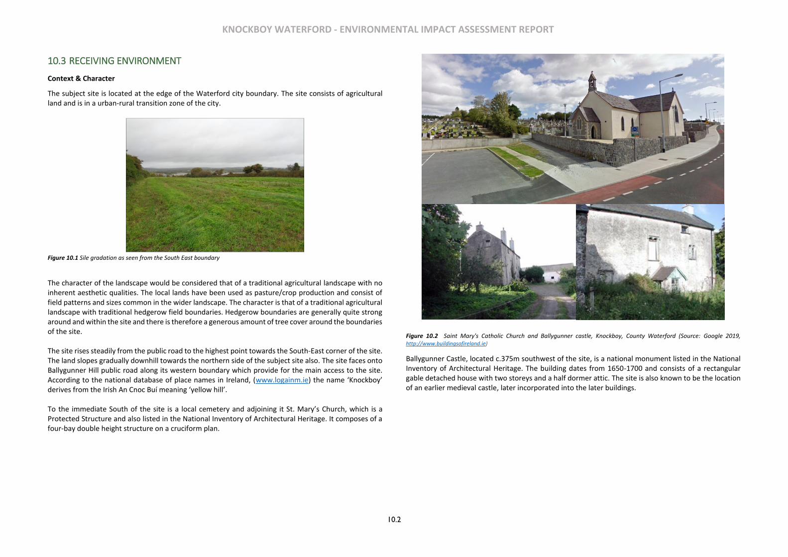
KNOCKBOY WATERFORD - ENVIRONMENTAL IMPACT ASSESSMENT REPORT
10.2
10.3 RECEIVING ENVIRONMENT
Context & Character
The subject site is located at the edge of the Waterford city boundary. The site consists of agricultural land and is in a urban-rural transition zone of the city.
Figure 10.1 Sile gradation as seen from the South East boundary
The character of the landscape would be considered that of a traditional agricultural landscape with no inherent aesthetic qualities. The local lands have been used as pasture/crop production and consist of field patterns and sizes common in the wider landscape. The character is that of a traditional agricultural landscape with traditional hedgerow field boundaries. Hedgerow boundaries are generally quite strong around and within the site and there is therefore a generous amount of tree cover around the boundaries of the site. The site rises steadily from the public road to the highest point towards the South-East corner of the site. The land slopes gradually downhill towards the northern side of the subject site also. The site faces onto Ballygunner Hill public road along its western boundary which provide for the main access to the site. According to the national database of place names in Ireland, (www.logainm.ie) the name ‘Knockboy’ derives from the Irish An Cnoc Buí meaning ‘yellow hill’. To the immediate South of the site is a local cemetery and adjoining it St. Mary’s Church, which is a Protected Structure and also listed in the National Inventory of Architectural Heritage. It composes of a four-bay double height structure on a cruciform plan.
Figure 10.2 Saint Mary's Catholic Church and Ballygunner castle, Knockboy, County Waterford (Source: Google 2019, http://www.buildingsofireland.ie)
Ballygunner Castle, located c.375m southwest of the site, is a national monument listed in the National Inventory of Architectural Heritage. The building dates from 1650-1700 and consists of a rectangular gable detached house with two storeys and a half dormer attic. The site is also known to be the location of an earlier medieval castle, later incorporated into the later buildings.

KNOCKBOY WATERFORD - ENVIRONMENTAL IMPACT ASSESSMENT REPORT
10.3
Figure 10.3 Designated Areas and structures in the vicinity of the Site (Source: www.map.geohive.ie)
Visibility Due to the site topography there are a range of views to and from the site at certain locations in the vicinity, particularly of the higher portion of site in the south-eastern corner. The open nature of the site comprising a large field with only boundary planting contributes to the general visibility of the site. The site is open to and highly visible from the public road to west on passing; however, the presence of mature planting to the north and south of the site largely screens the site on approach until the site is reached. There are views of the site at certain locations from within the residential estates to the west and southwest. Whilst the area in the vicinity of Dunmore Road to the north and northwest towards the River Suir/Kings Channel is much lower there are only limited views of the site due to the presence of development and mature vegetation along the public road.
Figure 10.4 Tree survey Map
To the north-east and east there are some partial views of the highest point of the site where there are breaks in hedgerows, such as in the vicinity of the junction of Dunmore and Dunmore East. There is significant tree coverage to the North boundary of the site that separates the subject site and Knockboy heights. To the south-east and south there are limited views of the site given the topography of the area.
DESIGNATED AREAS
Special Area of Conservation
Contours, OSI
National Inventory of Architectural
Heritage
National Monument
National Monument Zones, DAHG
National Survey of Native Woodland
Proposed Natural Heritage Areas
Site location
+
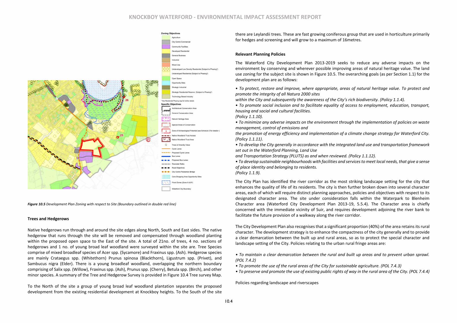
KNOCKBOY WATERFORD - ENVIRONMENTAL IMPACT ASSESSMENT REPORT
10.4
Figure 10.5 Development Plan Zoning with respect to Site (Boundary outlined in double red line)
Trees and Hedgerows Native hedgerows run through and around the site edges along North, South and East sides. The native hedgerow that runs through the site will be removed and compensated through woodland planting within the proposed open space to the East of the site. A total of 21no. of trees, 4 no. sections of hedgerows and 1 no. of young broad leaf woodland were surveyed within the site are. Tree Species comprise of mixed broadleaf species of Acer spp. (Sycamore) and Fraxinus spp. (Ash). Hedgerow species are mainly Crataegus spp. (Whitethorn) Prunus spinosa (Blackthorn), Ligustrum spp. (Privet), and Sambucus nigra (Elder). There is a young broadleaf woodland, overlapping the northern boundary comprising of Salix spp. (Willow), Fraxinus spp. (Ash), Prunus spp. (Cherry), Betula spp. (Birch), and other minor species. A summary of the Tree and Hedgerow Survey is provided in Figure 10.4 Tree survey Map. To the North of the site a group of young broad leaf woodland plantation separates the proposed development from the existing residential development at Knockboy heights. To the South of the site
there are Leylandii trees. These are fast growing coniferous group that are used in horticulture primarily for hedges and screening and will grow to a maximum of 16metres.
Relevant Planning Policies
The Waterford City Development Plan 2013-2019 seeks to reduce any adverse impacts on the environment by conserving and wherever possible improving areas of natural heritage value. The land use zoning for the subject site is shown in Figure 10.5. The overarching goals (as per Section 1.1) for the development plan are as follows:
• To protect, restore and improve, where appropriate, areas of natural heritage value. To protect and promote the integrity of all Natura 2000 sites within the City and subsequently the awareness of the City’s rich biodiversity. (Policy 1.1.4). • To promote social inclusion and to facilitate equality of access to employment, education, transport, housing and social and cultural facilities. (Policy 1.1.10). • To minimize any adverse impacts on the environment through the implementation of policies on waste management, control of emissions and the promotion of energy efficiency and implementation of a climate change strategy for Waterford City. (Policy 1.1.11). • To develop the City generally in accordance with the integrated land use and transportation framework set out in the Waterford Planning, Land Use and Transportation Strategy (PLUTS) as and when reviewed. (Policy 1.1.12). • To develop sustainable neighbourhoods with facilities and services to meet local needs, that give a sense of place identity and belonging to residents. (Policy 1.1.9).
The City Plan has identified the river corridor as the most striking landscape setting for the city that enhances the quality of life of its residents. The city is then further broken down into several character areas, each of which will require distinct planning approaches, policies and objectives with respect to its designated character area. The site under consideration falls within the Waterpark to Blenheim Character area (Waterford City Development Plan 2013-19, 5.5.4). The Character area is chiefly concerned with the immediate vicinity of Suir, and requires development adjoining the river bank to facilitate the future provision of a walkway along the river corridor. The City Development Plan also recognises that a significant proportion (40%) of the area retains its rural character. The development strategy is to enhance the compactness of the city generally and to provide a clear demarcation between the built up and rural areas, so as to protect the special character and landscape setting of the City. Policies relating to the urban rural fringe areas are: • To maintain a clear demarcation between the rural and built up areas and to prevent urban sprawl. (POL 7.4.2) • To promote the use of the rural areas of the City for sustainable agriculture. (POL 7.4.3) • To preserve and promote the use of existing public rights of way in the rural area of the City. (POL 7.4.4) Policies regarding landscape and riverscapes
KNOCKBOY WATERFORD - ENVIRONMENTAL IMPACT ASSESSMENT REPORT
10.5
• To protect and preserve, free from obstruction, views of the rural environs of the City considered to be of special amenity value. (POL 10.3.1) There are no protected views designated in the City Development Plan which the site forms part of. The subject site also does not lie within any area of special amenity value. The City Plan also recognises the value of trees in an urban environment and identifies their part in providing aesthetic and environmental benefits. • To promote the enhancement of the public realm and general amenity of the City through the
continued maintenance and provision of trees in the urban environment. (POL 10.5.3) • To provide continuity of tree cover throughout the City, promoting the use of native species where
possible, with varied species and age distribution. (POL 10.5.2) • To ensure when planning to undertake development or when considering the approval or
authorisation of development that the protection, preservation and management of existing trees of amenity value, and the implementation of a planned planting and management scheme, are provided for. (POL 10.5.5)
• To ensure when undertaking development or when permitting development that the loss of or damage to existing trees is minimised. (OBJ 10.5.5)
With regard to landscape design of open spaces within any development it is recommended in the City Development Plan that existing features of the site are retained or incorporated into the proposed design wherever feasible. Developments are required to incorporate a network of public open spaces and make provision for a range of recreational activities.
10.4 CHARACTERISTICS OF THE PROPOSED DEVELOPMENT
The proposed development will consist of a new residential development of 361 no. residential units comprising:
• 207 no. houses (13 no. 2-beds, 116 no. 3-beds, 78 no. 4-beds).
• 154 no. apartments within 15 no. 4 storey blocks (providing 53 no. 1-beds, 90 no. 2-beds and 11 no. 3-beds).
• A creche of c.574 sq.m.
• 7 no. internal/external communal waste storage facilities (total floor area c.214.3 sq.m).
• 638 car parking spaces and 390 no. bicycle parking spaces within 15 no storage facilities (total floor area c.232 sq.m). Additional visitor bicycle parking provided in the public realm.
• 2 no. ESB sub-stations/switchrooms (totalling c.10 sq.m)
• Vehicular/pedestrian/cyclist accesses to public road (Ballygunner Hill).
• The total gross floor area of the proposed development is c. c.51,226.1 sq.m
• All associated site development works, landscaping, open spaces, boundary treatments and services provision (including connection to public foul and surface water drainage at Dunmore Road & Island Drive.
Landscape Component The landscape strategy aims to integrate the proposed residential development with the existing landscape and create a network of attractive and useable open spaces while contributing to local
biodiversity. The public green areas are designed as landscape spaces that offer the opportunity for meeting, walking and formal and informal play. The protection and enhancement of existing landscape features, notably existing trees and native hedgerows is an important aspect of the overall strategy. The scheme will include three main open space areas connected by the proposed circulation routes. The largest of the three main open spaces will be located in the eastern part of the site which is also zoned open space in the City Development Plan. It will consist of a series of sub-spaces providing a range of amenity uses for the residents of the proposed development. The spatial design of this space is focused on a large flat central lawn that will function as a passive recreation space or an active kickabout space. Tree planting is designed in copses to maintain adequate open space within the area as well as to frame the seating area and overall space. The circulation has been designed to allow full pedestrian connectivity through the space, allowing easy access from private houses into the space, and connecting to other sub-spaces throughout the site. The existing native hedgerow which runs through the open space will be removed, however this will be compensated for through woodland planting within the open space which will improve green infrastructure links and increase local biodiversity. The loss of the hedgerow will also be compensated for throughout various other parts of the site through the use of wildflower, woodland planting and retaining other existing landscape features. A second public open space will be centrally located. It will provide a seating area defined by feature paving and bands of ornamental planting overlooks the central lawn, which is defined by a large, irregular-shaped planted bank. The bank will serve to create two sub-spaces within the open space, one at the upper level overlooking the space, and the kickabout space at the lower level, sitting into the bank. Copses of native trees and formal hedges will define open areas of lawn within the space which are provided for passive recreation and informal play. The third open space will provide a formal entrance into the development. An entrance feature will provide visual interest through the use of strips of contrasting feature paving, bands of ornamental planting and space for signage. Native hedgerow and wildflower meadow will run along the site boundary to the south, providing screening and enhancing local biodiversity and green infrastructure links. Large parkland trees will be planted throughout the open spaces which will eventually mature into large specimens and provide an interesting character to the open space. In addition, a range of semi-private landscape spaces throughout the scheme will provide residents with usable and attractive open space. Each space is bounded by a railing along with a formal hedge which clearly distinguishes between public and semi-private space while providing a visually attractive screen. In terms of planting strategy, the majority of native hedgerows, trees and woodland on site can be found along the site boundaries and have been retained wherever possible. Where vegetation that is contributing to wildlife corridors and green infrastructure has been removed or fragmented, replacement planting as specified above has been proposed to compensate for any loss. Woodland planting along site boundaries will create dense belts of native woodland spaces which act as native habitat and similarly to the native hedgerows, form ecological corridors which connect with other landscape elements throughout the site. The introduction of wildflower meadow through certain open
KNOCKBOY WATERFORD - ENVIRONMENTAL IMPACT ASSESSMENT REPORT
10.6
spaces within the site provides new habitats for local flora and fauna and helps to increase biodiversity in the local area.
10.5 POTENTIAL IMPACTS
Construction Phase
Any development on a large agricultural site would naturally result in significant visual impact and material change to the landscape character of the site. The construction phase of the development would be visually unappealing during the initial stages and as the development progresses the visual impacts would be lessened.
Major impacts during the construction phase will be:
• Changes to the landscape due to construction works, land excavations, temporary structures, machinery and scaffolding on the site.
• Removal of some vegetation and hedgerows.
• Dust and noise impacts to the surrounding
• Large machinery and work vehicles going to and from the site.
• Construction workers coming and going from the site
Mitigation measures to the construction phase will be dealt within the construction management plan.
Operational Phase
On completion the residential development will significantly alter the landscape from a vacant agricultural site to a large mixed residential estate. The character of the area will change from semi-rural to suburban and which will integrate with the adjoining suburban areas.
The scheme will be visible along the adjoining public road and from certain vantage points in the wider landscape.
The residential units and landscaping will create new vertical emphasis throughout the currently vacant site. The provision of streets and open spaces will create a variety of views into and across the development. New levels of planting and landscaping proposed will supersede the poor provision currently existing on this large field, although sections of hedgerow and some boundary planting will also be lost.
The layout has been carefully considered with a large open space located towards the highest part of the site, and with the higher apartment blocks located downhill of same.
The development of a high-quality residential development will accord with the requirements of Waterford City Development Plan 2013-19 and associated national policy.
10.6 POTENTIAL CUMULATIVE IMPACTS
The subject site is zoned for residential use and public open space lands and the proposed development will accord with same and with the quantitative and qualitative standards currently applied to residential development in local and national planning policy.
The design of the scheme will provide a distinctive and sustainable new residential development and extension to the existing suburban area in the east of the city.
Due to the topography of the site and surrounding landscape the proposed development, at certain vantage points, will result in a cumulative impact visually with other adjoining devleoped areas. These are considered in Section 10.8 below.
However, as is shown, the extent of impact on the wider landscape will not be widespread given that the views of the site in most locations are constrained by existing topography, vegetation and the existing built environment. Where visible the additional impact will not be excessive within the existing suburban context and given the sensitive design proposed.
The visual impact of the scheme in time will also decrease with the maturation of proposed landscaping and boundary planting.
10.7 MITIGATION MEASURES
Design Phase
Construction Phase
To reduce the potential negative impacts during the construction phase, good site management and housekeeping practices will be adhered to. The visual impact of the site compounds and scaffolding visible during the construction phase are of a temporary nature only and therefore require no remedial action. The areas set aside for open spaces will be fenced off with no compounds or storage of materials taking place in these areas, in accordance with an agreed Construction Management Plan. To ensure the successful retention of trees and hedgerows, an Arborist is recommended to be retained by the contractor or developer to monitor and advise any works within the Root Protection Zones of retained trees. Operational Phase
Mitigation measures have been incorporated into the design to minimise visual intrusion and adverse landscape impact whilst integrating the development into the surrounding landscape character.
Tree and other planting are proposed throughout the site and particularly within the main open spaces. An extensive landscape programme is proposed to create the optimum landscape solution for this new residential area.
The visual massing impact of the residential areas will be reduced through provision of open spaces and streetscape planting throughout the site. Existing boundary hedgerow and planting will be maintained and enhanced where possible to provide natural screening of the site as currently provided.
Streetscape design will incorporate planting and landscaping to reduce the visual impact on parking and to integrate with the building elevations to create a sylvan setting appropriate to its suburban context.
KNOCKBOY WATERFORD - ENVIRONMENTAL IMPACT ASSESSMENT REPORT
10.7
The extensive landscaping proposal will help soften the visual impact of the development and with future maturing of planting will lead to a very attractive residential layout that integrates well with the adjoining uses and with the rural hinterland.
10.8 PREDICTED IMPACTS
Landscape
The proposed development will constitute a significant alteration to the existing landscape character of the site and its immediate context.
However, this level of change has been pre-empted in the underlying planning context for the site with the large site zoned for significant residential development.
At the same the particular design and layout employed strikes an appropriate balance between establishing a new (sub)urban edge and streetscape, particularly in the immediate vicinity along the public road whilst at the same time not negatively impacting the landscape character of the wider area.
This is achieved through the careful siting of taller elements away from the highest point of the site, along with a good distribution of open spaces and landscaping which will break up the visual massing of the new buildings and soften the visual impact.
In light of the underlying planning objectives for the zoned lands, and the specific design employed, the predicted change on landscape character is expected to be Moderate-Neutral.
Visual
A series of 11 photomontages have been prepared to assess the visual amenity impact of the proposed development (including proposed landscaping) from a variety of locations in the wider landscape.

KNOCKBOY WATERFORD - ENVIRONMENTAL IMPACT ASSESSMENT REPORT
10.8
Figure 10.6 Visual envelope and viewpoints for photo montage
Location of viewpoints
1. View looking east from near The Paddocks & The Village residential estates
2. View from Williamstown Road looking north-east
3. View from Knockboy Road looking north
4. View from Knockboy Road looking south 5. View from junction of Knockboy Road & Dunmore
Road looking south
6. View from Dunmore road looking South
7. View from Dunmore Road looking West 8. View from Junction of Dunmore Road & Dunmore
East Road looking west 9. View along Dunmore road near Brasscock looking
South-East 10. View from south of Ballygunner Castle looking
North
11. View from near Blenhiem Heights looking South-West
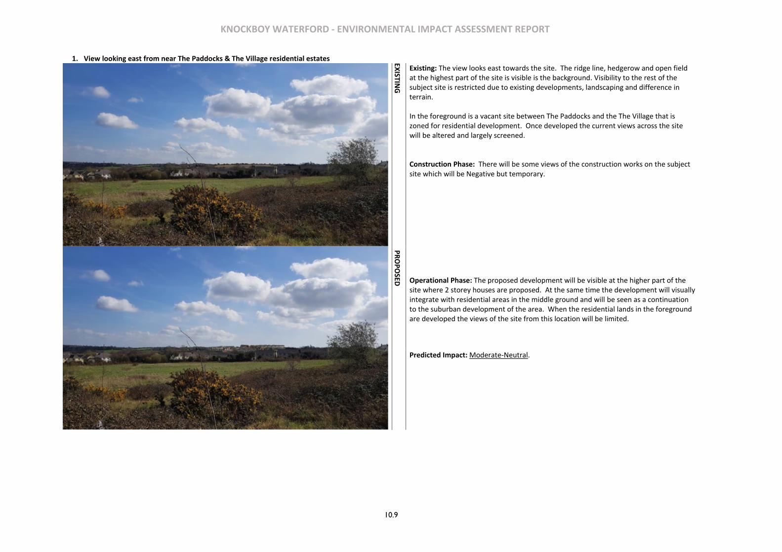
KNOCKBOY WATERFORD - ENVIRONMENTAL IMPACT ASSESSMENT REPORT
10.9
1. View looking east from near The Paddocks & The Village residential estates
EXISTIN
G
Existing: The view looks east towards the site. The ridge line, hedgerow and open field at the highest part of the site is visible is the background. Visibility to the rest of the subject site is restricted due to existing developments, landscaping and difference in terrain. In the foreground is a vacant site between The Paddocks and the The Village that is zoned for residential development. Once developed the current views across the site will be altered and largely screened.
Construction Phase: There will be some views of the construction works on the subject site which will be Negative but temporary.
PR
OP
OSED
Operational Phase: The proposed development will be visible at the higher part of the site where 2 storey houses are proposed. At the same time the development will visually integrate with residential areas in the middle ground and will be seen as a continuation to the suburban development of the area. When the residential lands in the foreground are developed the views of the site from this location will be limited.
Predicted Impact: Moderate-Neutral.

KNOCKBOY WATERFORD - ENVIRONMENTAL IMPACT ASSESSMENT REPORT
10.10
2. View from Williamstown Road looking north-east
EXISTIN
G
Existing: The view looks north-east towards the site. The foreground and middle-ground comprise existing suburban development. There are roads and services in place for a future residential development (with extant permission) in the immediate foreground which, when completed, will screen most views of the landscape beyond. The application site is located in the middle-ground and is partly screened by evergreen trees along the boundary with the graveyard. In the far background are views towards the River Suir/Kings Channel and distant hills in the vicinity of Faithlegg and Belview Port.
Construction Phase: There will be some views of the construction works on the subject site which will be Negative but temporary.
PR
OP
OSED
Operational Phase: The proposed development will be visible but will also visually integrate with residential areas in the middle ground and will be seen as a continuation to the suburban development of the area. Long distance views to the River Suir landscape are not blocked by the proposed development. When the residential lands in the foreground are developed the views of the site and the wider landscape from this location will be limited.
Predicted Impact: Moderate-Neutral.

KNOCKBOY WATERFORD - ENVIRONMENTAL IMPACT ASSESSMENT REPORT
10.11
3. View from Knockboy Road looking north
EXISTIN
G
Existing: The view looks north with the site highly visible to the right along the public road due to its elevated nature and limited boundary planting. To the left of the public road is boundary planting to the front of exiting residential properties. There are no long distance views of wider landscape.
Construction Phase: The construction works on the subject site will be highly visible from this location and will be Negative but temporary.
PR
OP
OSED
Operational Phase: The proposed development will dramatically alter this view replacing the agricultural field with a significant mixed residential development with strong urban frontage to the public road (as recommended in the formal opinion received from An Bord Pleanála). At the same time the landscaping strategy with boundary planting along the roadside and a public open space near the main entrance softens the built edge. Whilst the level of change is significant it has been anticipated given the wider suburban context and the zoning of the lands for significant residential development.
Predicted Impact: Moderate-Neutral.
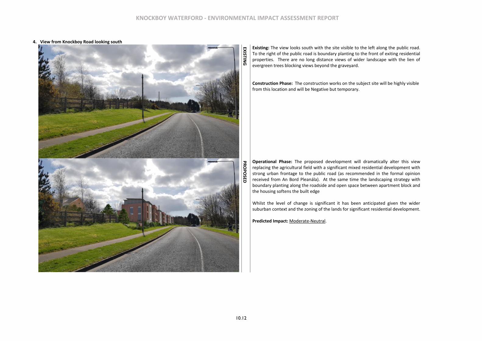
KNOCKBOY WATERFORD - ENVIRONMENTAL IMPACT ASSESSMENT REPORT
10.12
4. View from Knockboy Road looking south
EXISTIN
G
Existing: The view looks south with the site visible to the left along the public road. To the right of the public road is boundary planting to the front of exiting residential properties. There are no long distance views of wider landscape with the lien of evergreen trees blocking views beyond the graveyard.
Construction Phase: The construction works on the subject site will be highly visible from this location and will be Negative but temporary.
PR
OP
OSED
Operational Phase: The proposed development will dramatically alter this view replacing the agricultural field with a significant mixed residential development with strong urban frontage to the public road (as recommended in the formal opinion received from An Bord Pleanála). At the same time the landscaping strategy with boundary planting along the roadside and open space between apartment block and the housing softens the built edge Whilst the level of change is significant it has been anticipated given the wider suburban context and the zoning of the lands for significant residential development.
Predicted Impact: Moderate-Neutral.

KNOCKBOY WATERFORD - ENVIRONMENTAL IMPACT ASSESSMENT REPORT
10.13
5. View from junction of Knockboy Road & Dunmore Road looking south
PR
OP
OSED
Existing: The view looks south with the site not visible due to mature roadside planting. There residential properties in the foreground. There are no long distance views of wider landscape.
Construction Phase: The construction works will not be visible from this location.
Operational Phase: The development will not be visible.
Predicted Impact: No Perceived Change.
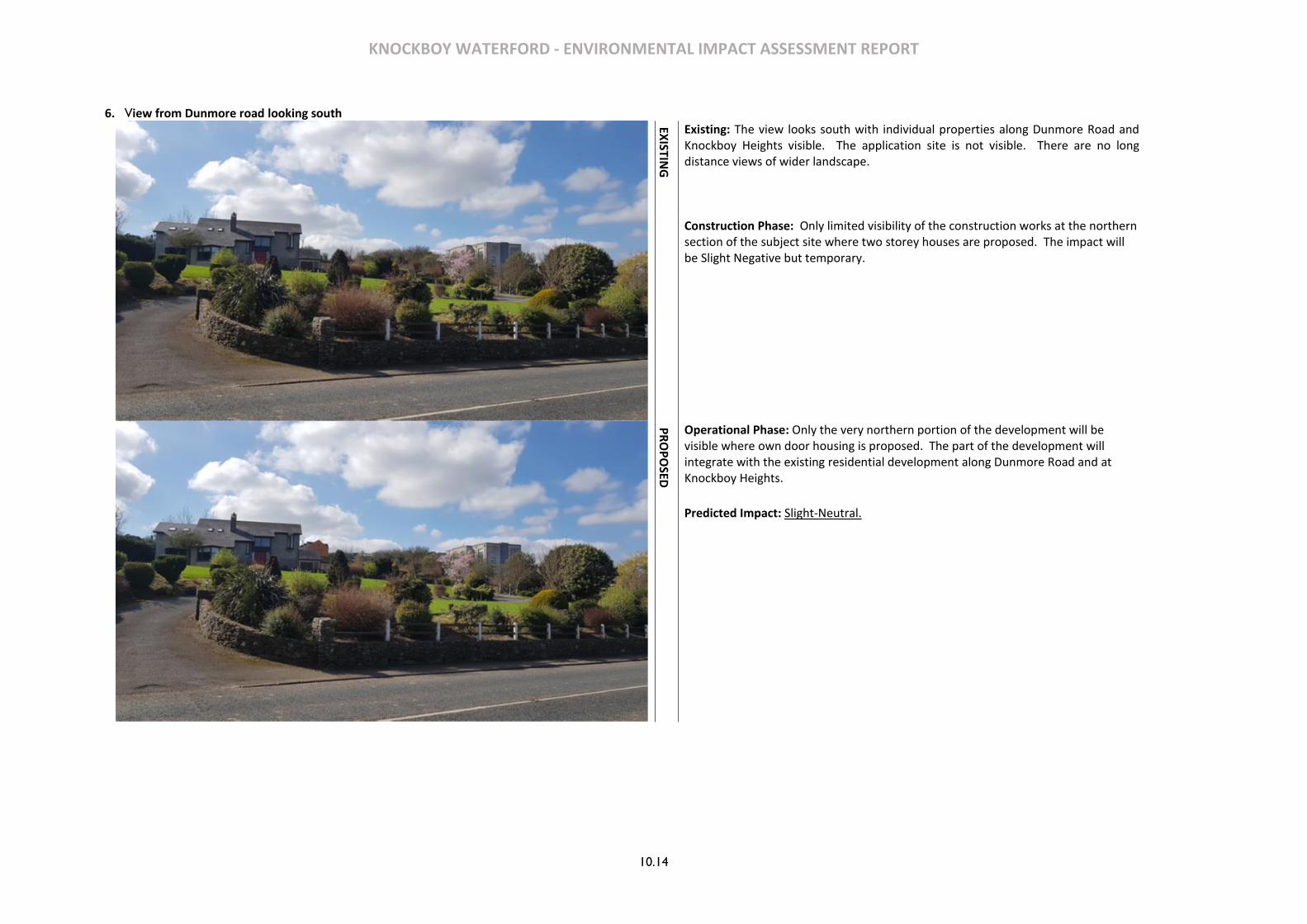
KNOCKBOY WATERFORD - ENVIRONMENTAL IMPACT ASSESSMENT REPORT
10.14
6. View from Dunmore road looking south
EXISTIN
G
Existing: The view looks south with individual properties along Dunmore Road and Knockboy Heights visible. The application site is not visible. There are no long distance views of wider landscape.
Construction Phase: Only limited visibility of the construction works at the northern section of the subject site where two storey houses are proposed. The impact will be Slight Negative but temporary.
PR
OP
OSED
Operational Phase: Only the very northern portion of the development will be visible where own door housing is proposed. The part of the development will integrate with the existing residential development along Dunmore Road and at Knockboy Heights.
Predicted Impact: Slight-Neutral.
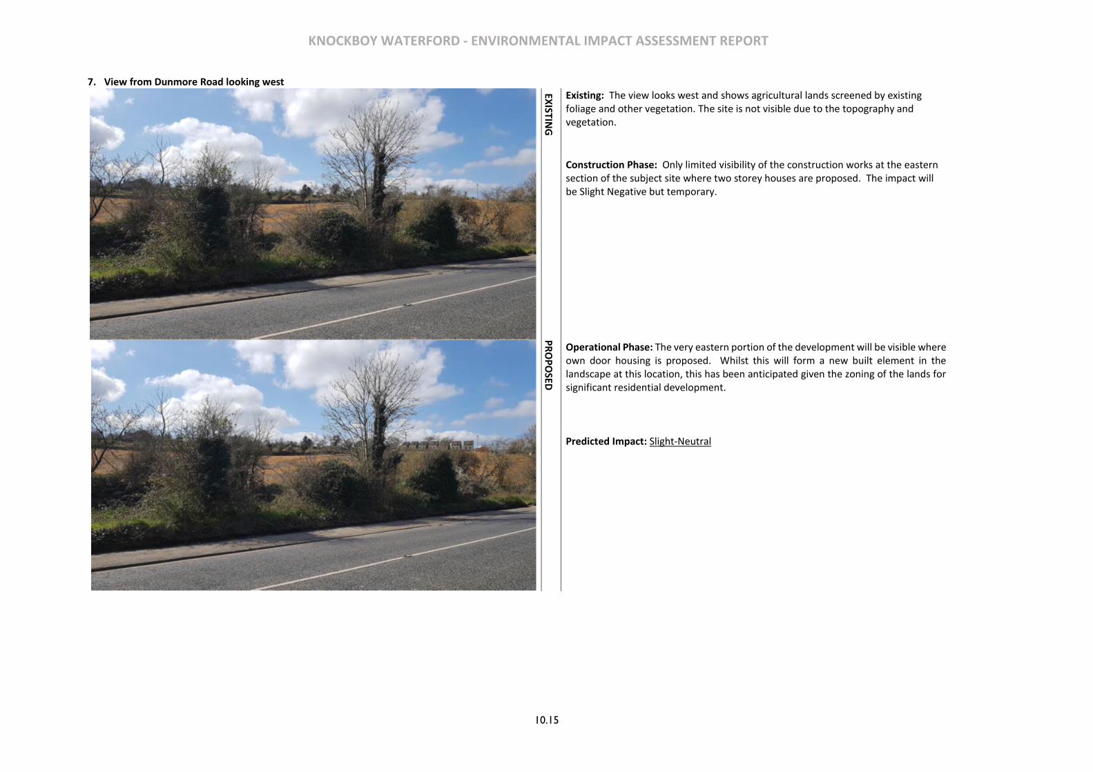
KNOCKBOY WATERFORD - ENVIRONMENTAL IMPACT ASSESSMENT REPORT
10.15
7. View from Dunmore Road looking west
EXISTIN
G
Existing: The view looks west and shows agricultural lands screened by existing foliage and other vegetation. The site is not visible due to the topography and vegetation.
Construction Phase: Only limited visibility of the construction works at the eastern section of the subject site where two storey houses are proposed. The impact will be Slight Negative but temporary.
PR
OP
OSED
Operational Phase: The very eastern portion of the development will be visible where own door housing is proposed. Whilst this will form a new built element in the landscape at this location, this has been anticipated given the zoning of the lands for significant residential development.
Predicted Impact: Slight-Neutral
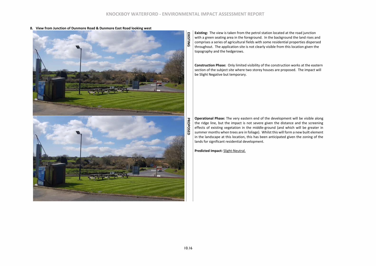
KNOCKBOY WATERFORD - ENVIRONMENTAL IMPACT ASSESSMENT REPORT
10.16
8. View from Junction of Dunmore Road & Dunmore East Road looking west
EXISTIN
G
Existing: The view is taken from the petrol station located at the road junction with a green seating area in the foreground. In the background the land rises and comprises a series of agricultural fields with some residential properties dispersed throughout. The application site is not clearly visible from this location given the topography and the hedgerows.
Construction Phase: Only limited visibility of the construction works at the eastern section of the subject site where two storey houses are proposed. The impact will be Slight Negative but temporary.
PR
OP
OSED
Operational Phase: The very eastern end of the development will be visible along the ridge line, but the impact is not severe given the distance and the screening effects of existing vegetation in the middle-ground (and which will be greater in summer months when trees are in foliage). Whilst this will form a new built element in the landscape at this location, this has been anticipated given the zoning of the lands for significant residential development.
Predicted Impact: Slight-Neutral.
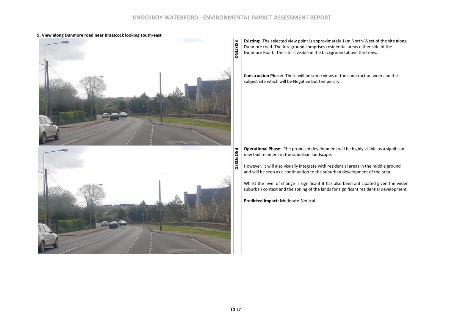
KNOCKBOY WATERFORD - ENVIRONMENTAL IMPACT ASSESSMENT REPORT
10.17
9. View along Dunmore road near Brasscock looking south-east
EXISTIN
G
Existing: The selected view point is approximately 1km North-West of the site along Dunmore road. The foreground comprises residential areas either side of the Dunmore Road. The site is visible in the background above the trees.
Construction Phase: There will be some views of the construction works on the subject site which will be Negative but temporary.
PR
OP
OSED
Operational Phase: The proposed development will be highly visible as a significant new built element in the suburban landscape. However, it will also visually integrate with residential areas in the middle ground and will be seen as a continuation to the suburban development of the area. Whilst the level of change is significant it has also been anticipated given the wider suburban context and the zoning of the lands for significant residential development. Predicted Impact: Moderate-Neutral.

KNOCKBOY WATERFORD - ENVIRONMENTAL IMPACT ASSESSMENT REPORT
10.18
10. View from south of Ballygunner Castle looking north
PR
OP
OSED
Existing: The view looks north across agricultural fields with the Ballygunner Castle property to the left middle ground surrounded by mature trees. A detached house is visible in the background with the hills in the landscape of the Lower Suir/Kings Channel discernible in the far distance. There are no views of the site due to the topography and existing vegetation.
Construction Phase: The construction works will not be visible from this location. Operational Phase: The development will not be visible. Predicted Impact: No Perceived Change.
11. View from near Blenhiem Heights looking south-west
PR
OP
OSED
Existing: The view looks south-west across an agricultural field with hedgerows near a farmstead. Due to the topography in the middle-ground there are no views of the site.
Construction Phase: The construction works will not be visible from this location. Operational Phase: The development will not be visible. Predicted Impact: No Perceived Change.

KNOCKBOY WATERFORD - ENVIRONMENTAL IMPACT ASSESSMENT REPORT
10.19
10.9 CONCLUSIONS
View View Location Predicted Impact (Operational Phase)
1. View looking east from near The Paddocks & The Village residential estates
Moderate-Neutral.
2. View from Williamstown Road looking north-east Moderate-Neutral.
3. View from Knockboy Road looking north Moderate-Neutral.
4. View from Knockboy Road looking south Moderate-Neutral.
5. View from junction of Knockboy Road & Dunmore Road looking south
No Perceived Change.
6. View from Dunmore road looking south Slight-Neutral.
7. View from Dunmore Road looking west Slight-Neutral
8. View from Junction of Dunmore Road & Dunmore East Road looking west
Slight-Neutral.
9. View along Dunmore road near Brasscock looking south-east
Moderate-Neutral.
10. View from south of Ballygunner Castle looking north No Perceived Change.
11. View from near Blenhiem Heights looking south-west No Perceived Change.
Table 10.1Summary of Visual Assessment
At local level the proposed residential development will constitute a significant intervention in the local setting replacing an existing agricultural field with a large residential development. The impact on local views is mitigated by existing/planned development and vegetation. Immediate to the site the visual change will be dramatic but ameliorated by the quality of the building design and landscaping. Within the wider landscape, views of the proposed development site are generally constrained by a combination of variation in topography, vegetation and existing buildings. Where views of the proposed development are significant the design qualities associated with the proposed development in terms of positioning and heights of buildings and landscape treatments, will serve to reduce the impact. In the long term the maturation of boundary planting will further screen the residential scheme at the small number of locations where the development will be visible in the wider landscape. Overall the
impact in considered acceptable in light of the site’s residential zoning, and designation for significant residential development. Do Nothing Scenario Without the proposed development, the site and the existing buildings will remain vacant and likely in agricultural use. Worst Case Scenario The worst case scenario from a visual impact would arise if construction of the proposed scheme had to cease, leaving an incomplete development or if the proposed landscaping was not fully/properly progressed.
10.9 MONITORING
The post development monitoring of the landscape and visual effects on the environment will take the form of management of the proposed landscaping and open spaces within the development and which will be detailed more specifically in the bills of quantities and specification for the landscape contractor at the implementation stage of the landscape proposal.
10.10 REFERENCES
-Guidelines on the Information to be contained in and Environmental Impact Statement, by the Environmental Protection Agency, 2002 -Revised Guidelines on the information to be contained in Environmental Impact Statements- Draft, by the Environmental Protection Agency, 2015 -Advice Notes on Current Practice in the preparation of Environmental Impact Statements, by the Environmental Protection Agency, 2015. - Guidelines on Environmental Impact Assessment, Draft, by the Environmental Protection Agency, 2017 -Guidelines for Landscape and Visual Assessment, 3rd Ed., Landscape Institute and Institute of Environmental Management and Assessment, 2013. - National Landscape Strategy for Ireland, Department of Arts, Heritage and the Gaeltacht, 2015-25 -Waterford City Development Plan 2013-2019

KNOCKBOY WATERFORD - ENVIRONMENTAL IMPACT ASSESSMENT REPORT
10.20
KNOCKBOY WATERFORD - ENVIRONMENTAL IMPACT ASSESSMENT REPORT
11.1
11 TRAFFIC & TRANSPORTATION
11.1 INTRODUCTION
This Chapter of the Environmental Impact Assessment Report deals with the topic of Traffic and
Transportation and examines the potential impacts of the proposed development in the context of
vehicular traffic, public transport together with pedestrian and cycle movements.
11.2 METHODOLOGY
This chapter should be read in conjunction with the site layout plans and the project description sections of the Report. The Traffic and Transportation topics associated with the proposed development site are described below. The methodology used in assessing the Traffic and Transportation impacts of the proposed development has primarily been based on a review of available modes of travel in the area and on the modelling of the potential impact of the proposed development on the surrounding road network.
11.3 RECEIVING ENVIRONMENT
The proposed development site is located off St. Mary’s Place which runs in a north/south direction. The surrounding land is used primarily for agricultural and residential purposes. There are currently residential dwellings and three schools located within the immediate vicinity together with a church and an adjacent cemetery.
St. Mary’s Place is a two-lane single carriageway road with a verge and footways on both sides. There are residential properties, a church and a school located along the road. Gaeilscoil Port Lairge is situated on St. Mary’s Place at its junction with the L1023. There are existing pedestrian and cyclist facilities on both sides of the road. There is an existing school situated on Kilcaragh Park, just south of the St. Mary’s Place/L1023/Kilcaragh Park junction.
To the north of the proposed development site access St. Mary’s Place intersects with Dunmore Road where it forms a priority junction. To the south of the proposed development site St. Mary’s Place forms a signalised crossroads junction with the L1023 and Kilcaragh Park.
St. Marys Place does not currently include cycle tracks/lanes immediately outside the development, however there are advisory cycle lanes from the Williamstown Road junction terminating at Ballygunner Cemetery just south of the proposed development.
The immediate area is well served by the local bus operator Kenneally’s Bus Service which provide a regular and frequent bus service between St. Mary’s Place and Waterford City, a journey which takes approximately 15 minutes.
Access to the national rail network is achieved a relatively short distance from the proposed development at Plunkett Station located in Waterford City providing direct links to Dublin and Limerick thus enabling
rail journeys to be continued directly to almost all locations in Ireland serviced by rail. It is worth noting that Plunkett Station is a short walk from Kenneally’s buses stop in Waterford City centre.
11.4 CHARACTERISTICS OF THE PROPOSED DEVELOPMENT
The proposed development will consist of a new residential development of 361 no. residential units comprising:
• 207 no. houses (13 no. 2-beds, 116 no. 3-beds, 78 no. 4-beds).
• 154 no. apartments within 15 no. 4 storey blocks (providing 53 no. 1-beds, 90 no. 2-beds and 11 no.
3-beds).
• A creche of c574 sq.m.
• 7 no. internal/external communal waste storage facilities (total floor area c.214.3 sq.m).
• 638 car parking spaces and 390 no. bicycle parking spaces within 15 no storage facilities (total floor
area c.232 sq.m). Additional visitor bicycle parking provided in the public realm.
• 2 no. ESB sub-stations/switchrooms (totalling c.10 sq.m)
• Vehicular/pedestrian/cyclist accesses to the public road (Ballygunner Hill/St. Mary’s Place).
• The total gross floor area of the proposed development is c. c.51,226.1 sq.m
• All associated site development works, landscaping, open spaces, boundary treatments and services provision (including connection to public foul and surface water drainage at Dunmore Road & Island Drive).
Vehicular Access to the proposed development will be from St. Mary’s Place which links Dunmore Road and Williamstown Road. The junction with St Mary’s Place connects to the Main Distributor Road which provides for the distribution of traffic within the proposed development. The proposed horizontal alignment of the Main Distributor Road has been determined to meet the objectives of the Local Authority to make provision for a potential future link to lands located to the east of the proposed development.
The Main Distributor Road within the proposed development provides a 6.0m wide carriageway with a 1.0m wide verge and 1.8m wide footpath on the southern side of the carriageway. The Main Distributor Road links with the internal roads which provide 5.0m – 6.0m wide carriageways. The road network will incorporate appropriate markings, signage, and lighting.
The existing bus stop which is located near the development on St. Mary’s place will be relocated to facilitate the proposed development access (by agreement with the related stakeholders)
All roads within the proposed development provide for cyclists to share the carriageway with vehicles in line with the “Wide Shared Street” cross section in the National Transport Authority’s Cycle Manual guidelines.
The proposed development generally includes for 1.8m wide footpaths to provide links throughout the scheme and to the external public footpath network.

KNOCKBOY WATERFORD - ENVIRONMENTAL IMPACT ASSESSMENT REPORT
11.2
11.5 POTENTIAL IMPACTS
Construction Phase
During the construction phase of the proposed development there will be increased vehicular movements associated with construction traffic. There may also be an increase in noise, and potentially dust, generated from construction related traffic which may cause disruption to people, groups or other activities located close to the proposed development. There will also be an increase in road traffic levels due to construction related activities supplying and accessing the site using the existing road network.
Operational Phase
A summary of the potential impacts of the proposed development on the adjacent junctions based on the traffic modelling undertaken is presented below:
• Dunmore Road/St. Mary’s Place: The junction of Dunmore Road/St. Mary’s Place is a priority
(uncontrolled) crossroads junction. The results of the assessment of this junction during the weekday
morning and evening peak periods indicate that the junction will operate within capacity for each of
the assessment years 2020, 2025 and 2035.
• St. Mary’s Place/Williamstown Road (L1023): The junction of L1023/Kilcaragh Park/St. Mary’s Place
is a signalised crossroad junction. Junction capacity analysis was undertaken using TRL’s software
package OSCADY. Using the existing signal data and cycle times the junction will exceed capacity
during the PM Peak during the future assessment year 2035. However, by increasing the cycle time
from 90 seconds to 95 seconds, the junction will operate within capacity for each of the assessment
years 2020, 2025 and 2035. The issue of vehicles queuing through this junction is not a capacity issue,
but rather a queuing issue resulting from the schools’ proximity to the junction.
• Proposed Development Junction with St. Marys Place and The Village: The proposed location of the
development access will create a new uncontrolled crossroads linking the development with St.
Mary’s Place and the existing Village development. The analysis indicates that the junction will
operate within capacity for each of the assessment years 2020, 2025 and 2035 for both the AM and
PM peak periods.
Traffic and Transportation Assessment prepared by PMCE and submitted as part of the application pack
accompanying this EIAR, together with the Engineering Planning Report also submitted as part of the
planning application, provide more detailed information in relation to the proposed developments traffic
and transportation impact on the receiving environment.
11.6 POTENTIAL CUMULATIVE IMPACTS
The potential for any further impact when considered in combination with other known projects in the immediate area, was found to have no potential for significant cumulative impacts on traffic and transportation.
11.7 MITIGATION MEASURES
Construction Phase
Prior to the commencement of the works on site the contractor will prepare a detailed Construction Traffic Management Plan and agree its proposals with the Planning Authority and An Garda Síochána.
Given the location and nature of access to the site, site parking or construction parking will be located on the site
Construction vehicle movements will be minimised by the adoption of measures including:
• Consolidation of delivery loads to/from the site and managing large deliveries on site to occur outside
of peak periods;
• Use of precast/prefabricated materials where possible;
• Provision of adequate storage space on the site;
• Development of a strategy to minimise construction material quantities insofar as possible;
• Construction staff vehicle movements will also be minimised by promoting, where feasible, the use
of public transport and car sharing;
Operational Phase
Mobility management will be a key part of the proposed development strategy to encourage occupiers to use sustainable means of transport. This will include the appointment of a Mobility Manager who will be involved in monitoring the modes of travel of the occupants of the proposed development and this ideally will be done on an annual basis. The mobility manager will at the outset of the occupation of the development implement a number of key measures. These will include:
• Providing new residents with a Travel Welcome Pack providing full details of transport options,
cycle/walking maps and information on local services;
• Induction sessions for new households and follow up visits;
• Instigate and regularly update a centrally located travel notice board providing travel information;
The Outline Mobility Management Plan prepared by MAL and submitted with the application accompanying this EIAR provides more detailed information in relation to the mobility management of the proposed development.

KNOCKBOY WATERFORD - ENVIRONMENTAL IMPACT ASSESSMENT REPORT
11.3
11.8 PREDICTED IMPACTS
Construction Phase
With the implementation of the mitigation measures proposed there should be a slight impact on the surrounding road network during the construction phase of the proposed development.
Operational Phase
There will be an increase in traffic on the surrounding road network following the completion of the proposed development, however the traffic analyses undertaken demonstrates that there is sufficient capacity within the existing road network to accommodate this increase.
11.9 ‘DO NOTHING’ SCENARIO
It the event that the proposed development does not proceed then the background traffic on the road network will continue to grow in accordance with predicted levels.
11.10 WORST CASE SCENARIO
It the event that the proposed development was to proceed, and the proposed mitigation measures substantially fail then it is likely that there would be a noticeable impact on the surrounding road network.
11.11 MONITORING & REINSTATEMENT
No transportation monitoring is required following the completion of the proposed development.
11.12 DIFFICULTIES IN COMPILING INFORMATION
No difficulties were encountered in compiling this chapter of the report.
11.13 REFERENCES
Traffic and Transportation Assessment prepared by PMCE;
Engineering Planning Report prepared by MAL;
Outline Mobility Management Plan prepared by MAL;

KNOCKBOY WATERFORD - ENVIRONMENTAL IMPACT ASSESSMENT REPORT
11.4

KNOCKBOY WATERFORD - ENVIRONMENTAL IMPACT ASSESSMENT REPORT
12.1
12 MATERIAL ASSETS
12.1 INTRODUCTION
This section evaluates the impacts of the proposed development on the existing services and material assets of the subject site and its surrounding. Material assets discussed here are in relation to the built services and infrastructure belonging to the subject site. Traffic and transportation are assessed separately in this EIAR.
12.2 METHODOLOGY
A desktop study was conducted in relation to the material assets associated with the proposed development and their capacities. Projections of the resources where made for the construction and operational phase of the development. The Guidelines on information to be contained in an Environment Impact Statement (EPA 2002), the advice notes on current practice and Draft EPA guidelines published in 2017 requires assessment of ‘economic assets of human origin’ to be included in the impact study as a desktop study of material assets associated with the development.
The impacts are assessed in terms of their scale, duration and significance to the site context. During the construction phase assessments are undertaken on the impact of the proposal likelihood in incurring loss or disturbance to material assets due to construction activities. It is unlikely that there will be any major impacts during the operation phase of the development. Economic assets of natural origin that includes biodiversity, soil and water are addressed specifically in the following chapters 5, 6 and 7.
12.3 RECEIVING ENVIRONMENT
The overall area of the site is c.9 Ha and is approximately 5 km from Waterford city centre. It is bound to the West by St. Mary’s Place/Ballygunner Hill and Ballygunner cemetery to the South. There are existing residential estates to the North of the site and vacant agricultural land to the East. The topography of the site is varied and ground surface rises to the East and South of the site.
BUILT ENVIRONMENT/LAND
The development site comprises agricultural land that is zoned for residential development. The site is located within the eastern outer suburbs of Waterford City which includes a number of residential estates to the west/south-west and social infrastructure to the south including schools, church, and graveyard.
ACCESS AND OWNERSHIP
The development site is in the private ownership of the applicant. This is no public access into or across the lands currently any no other parties have a Right of Way. There is an existing agricultural access to the site via St. Mary’s Place/Ballygunner Hill.
Some of the public road under the control of Waterford City & County Council is also included within the red application line to facilitate road improvements and connection to water services. A letter of consent from the local authority to include these lands in the application is included with the application.
TRANSPORT INFRASTRUCTURE
There are two bus stops (Ballygunner & Knockboy) within a 5-minute walk of the site. The bus routes that serve the stops are the 607 (Ballygunner- Abbey Park), 617 (Ballygunner-Slieverue Ferrybank) and 627 (Ballygunner-Clock Tower). Buses run at half an hour interval during non-peak hours and at 15-minute intervals during peak hours. All services connect the site with the city centre which is approximately a 10 minute journey time. Plunkett train station is located just outside the city centre core across the River Suir and runs a number of daily services to/from Dublin Heuston.
Figure 12-1 Bus service routes and bus stops (NTA)
There are public footpaths on both sides of St. Mary’s Place/Ballygunner Hill past the site which connects to Ballygunner village to the south and the wider city footpath network to the north. The proposed development has provisions for the construction of 1.8m wide pedestrian footpath throughout the scheme.

KNOCKBOY WATERFORD - ENVIRONMENTAL IMPACT ASSESSMENT REPORT
12.2
There are cycle lanes on St. Mary’s Lane south of the graveyard and on both sides of the Dunmore Road and Williamstown Road into the city centre. The City Development Plan proposes further expansion to the cycling network in the city.
Figure 12-2 Cycle lanes existing and proposed (Waterford City Development Plan 2016)
WATER SUPPLY
A pre connection enquiry with Irish Water confirmed that a connection to the existing network can be facilitated. It is proposed to provide a 150 mm diameter distribution watermain throughout the proposed development connected to the existing 250 mm diameter water main in St. Mary’s Place. FOUL DRAINAGE
There is an existing foul drainage gravity network close to the site which falls in a northerly direction and which is understood to drain existing development located to the south of the proposed development including development along St. Mary’s Place. The proposed development is within the drainage catchment of the Island View pumping station which, in turn, pumps sewage via a rising main to Waterford City Waste Water Treatment Plant.
A new 300 mm diameter piped foul water sewer will be constructed as part of the proposed development. This foul sewer will connect to the existing 600mm diameter foul sewer at Island Drive which in turn connects to the existing pumping station on Island Drive. SURFACE WATER DRAINAGE
There is an existing surface water sewer 40m to the south of the junction of St. Mary’s Place and The Village that flows in a westerly direction and then heads north where it is understood to discharge into an existing stream north of the Dunmore Road which in turn discharges into the Kings Channel.
Figure 12-3 Drainage catchment (OPW)
The proposed surface water drainage works for the scheme consists of a piped gravity system with a new/separate surface water pipeline provided along St. Mary’s Place/ Ballygunner Hill that will discharge the surface water runoff from the proposed development to an existing surface water sewer manhole which is located within the existing carriageway of the Dunmore Road to the north. The new pipeline is sized to take the proposed development together with the greenfield runoff from all currently zoned lands upstream of the proposed development site.
SITE
Tributary of Hill Blenheim Stream Hill Blenheim
Stream
KNOCKBOY WATERFORD - ENVIRONMENTAL IMPACT ASSESSMENT REPORT
12.3
From Dunmore Road the existing surface water drainage network flows in a northerly direction and discharges into an existing stream north of the Dunmore Road that in turn discharges into the Kings Channel and thereafter into the Suir River. TELECOMMUNICATIONS
There is an existing network of Telecommunication services within the vicinity of the area. The development is unlikely to have any impact on that infrastructure. NATURAL GAS
The area is serviced by existing gas infrastructure. Should the proposed development connect to the gas network in the future the developer will have due regard to the provisions set within ‘Safety advice for working in the vicinity of Natural Gas Pipes.’ ELECTRICITY SUPPLY
There are two 10kv power line running across the top of the site in a north-south direction. These will need to be relocated/undergrounded as part of the proposed development. In relation to working near overhead electric lines, the contractor will comply with ESB Networks Code of Practice for Avoiding Danger from Overhead Electricity Lines, 2008. The scheme also includes provisions for 2 no. ESB sub-stations/ switch rooms. WASTE MANAGEMENT
The existing agricultural site is in pasture and any animal manure generated on site is reconstituted into the soil on site. For the residential estates in the wider area a number of private household waste collectors operate across Waterford City – Mr. Binman, Greenstar, Oxigen, and Wastepal. EXTERNAL LIGHTING
Existing public lighting is provided along the public road past the site. Additional public lighting is proposed as per the lighting plan and report submitted with the application.
12.4 CHARACTERISTICS OF THE PROPOSED DEVELOPMENT
The scheme proposed by applicant Jackie Greene Construction Limited is for a strategic housing development at Knockboy, Waterford City. This proposal will consist of a new residential development of 361 no. residential units comprising:
• 207 no. houses (13 no. 2-beds, 116 no. 3-beds, 78 no. 4-beds).
• 154 no. apartments within 15 no. 4 storey blocks (providing 53 no. 1-beds, 90 no. 2-beds and 11 no. 3-beds).
• A creche of c.574 sq.m.
• 7 no. internal/external communal waste storage facilities (total floor area c.214.3 sq.m).
• 638 car parking spaces and 390 no. bicycle parking spaces within 15 no storage facilities (total floor area c.232 sq.m). Additional visitor bicycle parking provided in the public realm.
• 2 no. ESB sub-stations/switchrooms (totalling c.10 sq.m)
• Vehicular/pedestrian/cyclist accesses to the public road (Ballygunner Hill/St. Mary’s Place).
• The total gross floor area of the proposed development is c. c.51,226.1 sq.m
• All associated site development works, landscaping, open spaces, boundary treatments and services provision (including connection to public foul and surface water drainage at Dunmore Road & Island Drive).
12.5 POTENTIAL IMPACTS
The potential impacts of the proposed development are assessed below with respect to the impacts of the development during the construction and operational phase. The analysis takes into consideration the Characteristics of the receiving baseline environment and Characteristics of the proposed development. BUILT ENVIRONMENT/LAND
Construction Phase
Construction activities may cause some local impacts including increase in noise, traffic, dust etc. to the surrounding built environment. However, the site is not directly adjacent the main residential estates in the area. A number of individual houses to the north and on the opposite side of St. Mary’s Place/Ballygunner Hill are noted but the development, in the main, is sufficiently set back from same. The construction impacts will be localized and can be mitigated appropriately as per the measures outlined in chapters 8, 9, 11 and 17 of this EIAR. In constructing the development, the existing land will be subject to topsoil removal and associated land works as outlined and mitigated for in Chapter 6 of this EIAR. Where possible an area will be left intact until construction is ready to begin. Stripping of existing surfaces will not be undertaken until absolutely necessary to avoid any uncontrolled surface water runoff. Operational Phase
This agricultural site will be developed into a new residential scheme of 361 units, comprising 207 houses, 154 apartments, a creche, open spaces, car/cycle parking, and associated ancillary elements. The change from agricultural to residential use is in accordance with the zoning objectives pertaining to the site as per the Waterford City Development Plan. It is unlikely that the development in the operational phase will adversely affect the built environment in the local area. The development strikes an appropriate balance between respecting existing amenities/properties and providing a quantum and design quality that accords with local and national residential planning policy.
KNOCKBOY WATERFORD - ENVIRONMENTAL IMPACT ASSESSMENT REPORT
12.4
ACCESS AND OWNERSHIP
Construction Phase The development site will remain in the ownership of the applicant/developer during the construction phase. A road opening licence will be utilised to carry out the road works and connections to public water services. Construction access to the site will be via St. Mary’s Place/Ballygunner Hill utilising the existing agricultural access. This access will be managed in accordance with the Construction & Environmental Management Plan (oECMP) as submitted in outline with this application and will ensure minimal impact on access for the public along the public road and footpaths. Operational Phase The completed development will be accessed from St. Mary’s Place/Ballygunner Hill connecting to the existing public road and footpath network in the area and to the cycle network in the wider area. A main street running west to east is planned through the development with secondary residential streets and footpath network to the south and north designed in accordance with DMURS (Design Manual for Urban Roads and Streets, 2013). A number of shared surface/homezone areas are provided within individual character areas. The scheme also anticipates potential future connectivity to development lands to the north, east and south with a number of residential streets running to the site boundary.
As phases of the development are completed individual units will be sold to private purchasers who will form the future residential community. Some of the units may be purchased and rented to third parties. The local authority will assume a proportion of units for provision of social housing.
The internal roads and open spaces within the development will be completed to taking in charge standard and will come under the control of the local authority in time.
TRANSPORT INFRASTRUCTURE
Construction Phase The construction activities on the site will contribute to increased construction traffic impact along St. Mary’s Road/Ballygunner Hill. However, these impacts will be short-term, and a series of mitigations are outlined in Chapter 11 of the EIAR and the oECMP submitted with the application. The associated road works and connections to the water services network will also involve temporary impacts to traffic movements along the public road in the local area but which will be properly controlled and managed by Irish Water and WCC. The construction phase may also positively impact on public transport in the area with increased usage of same by some of the construction workers coming to the site each day. Operational Phase The operation of the development will result in additional levels of traffic coming into and out of the development via St. Mary’s Place/Ballygunner Road. The proposed design includes for improvements to
the public road to facilitate this additional traffic. The traffic impact on the road network has also been assessed in Chapter 11 of the EIAR and found to be acceptable. The future development will also create greater demand for and usage of public transport and the footpath and cyclepath network helping to sustain this infrastructure and promote further improvements by the local authority and other transport agent. WATER SUPPLY, FOUL AND SURFACE WATER
Construction Phase The proposed development will require connection to the public water services network. This will result in a temporary suspension of the network to facilitate the connection, but which will be controlled and managed by Irish Water and WCC. The associated road works to facilitate the connections will also be controlled by these agencies in accordance with standard protocols. Temporary water services on site to facilitate the construction of the development (i.e. water supply and toilets) will be provided separately by the contractor and will not impact the public network. These services will also be properly managed in accordance with the OEMCP. Operational Phase The demand on water services from the proposed residential development has been detailed and agreed with Irish Water and WCC in advance of the lodgement of the application. Connection to the public network is agreed in principle subject to the additional works required as included in this application. As a result, there is no anticipated negative impact on the established infrastructure network. The full implications and requirements for the water supply, foul and surface water infrastructure is outlined in Chapter 7 of the EIAR. NATURAL GAS
Construction Phase The proposed development may connect to the gas network in the wider area. Consultation with Gas Networks Ireland will occur post-planning to determine whether there is sufficient capacity in the area to serve the development. If the development is connected to the network, then this will be carried out by Gas Networks Ireland under its powers as a statutory undertaker. gas network in the area. Operation Phase The completed development will not result in any negative impact to the gas network in the area. ELECTRICAL SUPPLY
Construction Phase The existing powerlines that cross the site will be relocated/undergrounded as part of the construction phase which may result in a temporary suspension of the network locally to facilitate the works.
KNOCKBOY WATERFORD - ENVIRONMENTAL IMPACT ASSESSMENT REPORT
12.5
Additional temporary suspension will also occur when power is provided to the site. However, this will be controlled ESB Networks as the statutory undertaker and in accordance with standard protocols. Operational phase The Operation Phase of the development will see an increase in demand and usage of electricity supply, but this can be facilitated by the local network. WASTE MANAGEMENT
Construction Phase The proposed development will generate a range of hazardous and non-hazardous waste material during the construction phase. Any waste generated during the construction phase will be collected, separated at source and stored in dedicated receptacles within the temporary compounds. The following sourced segregated materials containers will be made available on site at a suitable location: Timber; Ferrous metals; Aluminium; Dry mixed recyclables; and Packaging waste. Wherever possible materials will be re-used onsite for other suitable purposes such as:
• Re-use of shuttering etc. where suitable and where it is safe to do so; and
• Re-use of excavated stone etc. as suitable fill elsewhere where suitable.
• Excavated soils not required for back filling or track construction will be utilised for landscaping at identified locations for ecological enhancement, screening and hedgerow construction as identified in the site layout plans.
Where waste disposal is unavoidable, the waste collected will be disposed responsibly minimising any adverse impacts to the environment. All waste materials will be stored in suitable locations and enclosed containers where suitable to avoid pollution and generation of wind-blown debris. All waste will be collected by a suitably competent and permitted waste collection contractor; and, no material be burned on site under any circumstances. The potential effect of construction waste generated from the proposed development is considered to be short-term, and not significant. Operational Phase Domestic waste generated on a daily basis will be stored in dedicated waste storage areas for the apartments and individually within the own door properties. Municipal waste collections will service the development on a regular basis to remove waste and in accordance with regional and national waste legislation.
12.6 POTENTIAL CUMULATIVE IMPACTS
The potential cumulative impacts from the development on the material assets of the subject site and its surroundings has been taken into consideration in the above assessment and those of related chapters of the EIAR and, subject to the range of mitigation measures proposed, are not considered significant.
12.7 MITIGATION MEASURES
Construction Phase
A range of construction related mitigation measures are outlined within other chapters of the EIAR with respect to various aspects of the built environment – chapters 6, 7, 11 and 13. As noted above, connections to the existing electricity, water services, gas and telecommunications networks will be coordinated with the relevant utility provider and carried out by approved contractors. Operational Phase
No additional mitigation measures to those outlined in other chapters are considered necessary during the operational phase of the development as it is considered to have a neutral to positive effect on material assets including services and infrastructure.
12.8 PREDICTED IMPACTS
Construction Phase
On the basis that the specified mitigation measures are incorporated during the construction of the proposed development, the predicted impact will be neutral. Operational Phase
Whilst the demand on water services, power, telecommunications and transport infrastructure will all increase
due to the development, on the basis that the specified mitigation measures are incorporated then the operation of the proposed development is predicted to have a neutral-long term impact on material assets.
12.9 ‘DO NOTHING’ SCENARIO
A ‘Do nothing’ scenario will result in the subject site remaining undeveloped and in green field state.
12.10 WORST CASE SCENARIO
Worst case scenarios for individual material assets are outlined in individual chapters of the EIAR. In relation to power and telecommunications a worst case scenario would be where the works involved during construction resulted in an extended outage for existing properties in the area due to unforeseen delays on site.
12.11 MONITORING & REINSTATEMENT
No monitoring is required in addition to those specifically noted in other chapters of the EIAR.

KNOCKBOY WATERFORD - ENVIRONMENTAL IMPACT ASSESSMENT REPORT
12.6
.
12.12 DIFFICULTIES IN COMPILING INFORMATION
There were no significant difficulties in compiling the information.
12.13 REFERENCES
Not applicable

KNOCKBOY WATERFORD - ENVIRONMENTAL IMPACT ASSESSMENT REPORT
13.1
13 WASTE MANAGEMENT
13.1 INTRODUCTION
This section addresses the subject of waste management for the proposed new development at Knockboy Co. Waterford. Waste management is addressed for both the construction and operational phases of the project. This site is located south east of Waterford city and will consist of a range of residential units including houses and apartments, a creche, and all associated works. A site specific Construction Waste Management Plan (C&D WMP) has been prepared for the construction phase of the development in advance of the commencement of the construction works. A separate Operational Waste Management Plan (OWMP) has also been prepared for the operational phase of the development. The C&D WMP has been prepared in accordance with the ‘Best Practice Guidelines for the Preparation of Waste Management Plans for Construction and Demolition Projects’ document produced by the National Construction and Demolition Waste Council (NCDWC) in conjunction with the Department of the Environment, Heritage and Local Government in July 2006. These documents will ensure the sustainable management of wastes arising at the development in accordance with legislative requirements and best practice standards.
13.2 METHODOLOGY The assessment of the impacts of the proposed development arising from the consumption of resources and the generation of waste materials, was carried out taking into account the methodology specified in relevant guidance documents, along with an extensive document review to assist in identifying current and future requirements for waste management including national and regional waste policy, waste strategies, management plans, legislative requirements and relevant reports. This Chapter is based on the proposed development and considers the following aspects:
• Legislative context;
• Construction phase (including site preparation, excavation and levelling); and,
• Operational phase. A desk study was carried out which included the following:
• Review of applicable policy and legislation which creates the legal framework for resource and waste management in Ireland;
• Description of the typical waste materials that will be generated during the construction and operational phases; and
• Identification of mitigation measures to prevent waste generation and promote management of waste in accordance with the waste hierarchy.
Estimates of waste generation during the construction and operational phases of the proposed development have been calculated. The waste types and estimated quantities are based on published data
by the EPA in National Waste Reports, data recorded from similar previous developments, Irish and EU EPA waste generation research, other available research sources and waste collection data from the current facilities on site. Mitigation measures are proposed to minimise the effect of the proposed development on the environment during the construction and operational phases, to promote efficient waste segregation and to reduce the quantity of waste requiring disposal. Legislation and Guidance The primary legislative instruments that govern waste management in Ireland and applicable to the project are:
• Waste Management Act 1996 (No. 10 of 1996) as amended. Sub-ordinate legislation includes: o European Communities (Waste Directive) Regulations 2011 (SI 126 of 2011) as amended o Waste Management (Collection Permit) Regulations (S.I No. 820 of 2007) as amended o Waste Management (Facility Permit and Registration) Regulations 2007, (S.I No. 821 of 2007)
as amended o Waste Management (Licensing) Regulations 2004 (S.I. No. 395 of 2004) as amended o Waste Management (Packaging) Regulations 2014 (S.I. 282 of 2014) as amended o Waste Management (Planning) Regulations 1997 (S.I. No. 137 of 1997) o Waste Management (Landfill Levy) Regulations 2015 (S.I. No. 189 of 2015) o European Union (Waste Electrical and Electronic Equipment) Regulations 2014 (S.I. No. 149 of
2014) o European Union(Batteries and Accumulators) Regulations 2014(S.I. No. 283 of 2014) as
amended o Waste Management (Food Waste) Regulations 2009 (S.I. 508 of 2009), as amended o European Union (Household Food Waste and Bio-waste) Regulation 2015 (S.I. No. 191 of2015) o Waste Management (Hazardous Waste) Regulations, 1998 (S.I. No. 163 of 1998) as amended o Waste Management (Shipments of Waste) Regulations, 2007 (S.I. No. 419 of 2007) as amended o Waste Management (Movement of Hazardous Waste) Regulations, 1998 (S.I. No. 147 of 1998) o European Communities (Transfrontier Shipment of Waste) Regulations 1994 (SI 121 of 1994) o European Union (Properties of Waste which Render it Hazardous) Regulations 2015 (S.I. No.
233 of 2015)
• Environmental Protection Act 1992 (No. 7 of 1992) as amended.
• Litter Pollution Act 1997 (No. 12 of 1997) as amended.
• Planning and Development Act 2000 (No. 30 of 2000) as amended11. Waste management in Ireland is subject to EU, national and regional waste legislation which defines how waste materials must be managed, transported and treated. The overarching EU legislation is the Waste Framework Directive (2008/98/EC) which is transposed into national legislation in Ireland. The cornerstone of Irish waste legislation is the Waste Management Act 1996 (as amended).

KNOCKBOY WATERFORD - ENVIRONMENTAL IMPACT ASSESSMENT REPORT
13.2
In addition, the Irish government issues policy documents which outline measures aimed to improve waste management practices in Ireland and help the country to achieve EU targets in respect of recycling and disposal of waste. The most recent policy document A Resource Opportunity – Waste Management Policy in Ireland was published in 2012 and stresses the environmental and economic benefits of better waste management, particularly in relation to waste prevention. The strategy for the management of waste from the construction phase is in line with the requirements of the Best Practice Guidelines for the Preparation of Waste Management Plans for Construction and Demolition Projects published in 2006. The guidance document Construction and Demolition Waste Management: A handbook for Contractors and Site Managers was also consulted in the preparation of this assessment. There are currently no Irish guidelines on the assessment of operational waste generation and guidance is taken from industry guidelines, plans and reports, British Standards and other relevant studies and reports including BS 5906:2005 Waste Management in Buildings – Code of Practice, the Southern Regopm Waste Management Plan 2015-2021, the EPA National Waste Database Reports 1998 – 2012 and the EPA National Waste Statistics Web Resource.
13.3 RECEIVING ENVIRONMENT The subject site is located at Knockboy, Co. Waterford. In terms of waste management, the receiving environment is largely defined by Waterford City and County Council who are responsible for setting and administering waste management activities in the area. This is governed by the requirements set out in the Southern Region Waste Management Plan 2015-2021. The waste management plan sets the following targets for waste management in the region:
• A 1% reduction per annum in the quantity of household waste generated per capita over the period of the plan;
• Achieve a recycling rate of 50% of managed municipal waste by 2020; and
• Reduce to 0% the direct disposal of unprocessed residual municipal waste to landfill (from 2016 onwards) in favour of higher value pre-treatment processes and indigenous recovery practices.
The Regional Plan sets out the strategic targets for waste management in the region and sets a specific target for C&D waste of “70% preparing for reuse, recycling and other recovery of construction and demolition waste” (excluding natural soils and stones and hazardous wastes) to be achieved by 2020. Waterford City & County Council (Segregation, Storage and Presentation of Household and Commercial Waste) Byelaws 2018, in accordance with the Local Government Act 2001 and the Waste Management Act 1996, to regulate and control the Segregation, Storage and Presentation of Household and Commercial Waste within its functional area. Provision is made in the bye-laws for the imposition of a fixed payment of €75 in respect of a contravention of a bye-law as an alternative to a prosecution, as provided for in Section 206 of the Local Government Act 2001. The National Waste Statistics update published by the EPA in December 2017 identifies that Ireland’s current progress against this C&D waste target is at 68% and our progress against ‘Preparing for reuse and recycling of 50% by weight of household derived paper, metal, plastic & glass (includes metal and plastic
estimates from household WEEE)’ is at 45%. Both of these targets are required to be met by 12 December 2020 in accordance with the requirements of the Waste Framework Directive. Waterford City and County Council no longer operates any municipal waste landfill in the area. There are numerous waste permitted and licensed facilities located in the Southern Region Waste Management area for the management of waste from the construction industry as well as municipal sources. These include soil recovery facilities, inert C&D waste facilities, hazardous waste treatment facilities, material recovery facilities and waste transfer stations. Construction Phase During the construction phase, waste will be produced from surplus materials such as broken or off-cuts of timber, plasterboard, concrete, tiles, bricks, etc. Waste from packaging (cardboard, plastic, timber) and oversupply of materials may also be generated. The construction contractor will be required to ensure that oversupply of materials is kept to a minimum and opportunities for reuse of suitable materials is maximised. In addition, excavations will be required to facilitate construction. The project engineers, MUIR Associates Ltd engineers, have estimated that the total volume of material to be excavated will be c. 65,000m3. The spoil generated will generally be topsoil, clay and rock. It is proposed that, where feasible, these excavated materials will be reused in the works for filling and landscape areas. However, in the unlikely event that there is surplus material that requires removal from site and it is deemed to be a waste, removal and reuse/recycling/recovery/disposal of the material will be carried out in accordance with the Waste Management Act 1996 (as amended), the Waste Management (Collection Permit) Regulations 2007 (as amended) and the Waste Management (Facility Permit & Registration) Regulations 2007 (as amended). The volume of waste requiring recovery/disposal will dictate whether a Certificate of Registration (COR), permit or license is required by the receiving facility. In order to establish the appropriate reuse, recovery and/or disposal route for the material to be removed off-site, it will first need to be classified. Waste material will initially need to be classified as hazardous or non-hazardous in accordance with the EPA publication Waste Classification – List of Waste & Determining if Waste is Hazardous or Non-Hazardous. Environmental soil analysis will be carried out prior to construction on a number of the soil samples in accordance with the requirements for acceptance of waste at landfills (Council Decision 2003/33/EC Waste Acceptance Criteria). This legislation sets limit values on landfills for acceptance of waste material based on properties of the waste including potential pollutant concentrations and leachability. In the unlikely event that surplus soils/stones are generated it may be suitable for acceptance at either inert or non-hazardous soil recovery facilities/landfills in Ireland, In the event of hazardous material being encountered, it will be transported for treatment/recovery or exported abroad for disposal in suitable facilities. Waste will be generated from construction workers e.g. organic/food waste, dry mixed recyclables (waste paper, newspaper, plastic bottles, packaging, aluminium cans, tins and Tetra Pak cartons), mixed non-recyclables and potentially sewage sludge from temporary welfare facilities provided onsite during the construction phase. Waste printer/toner cartridges, waste electrical and electronic equipment (WEEE) and waste batteries may also be generated infrequently from site offices.

KNOCKBOY WATERFORD - ENVIRONMENTAL IMPACT ASSESSMENT REPORT
13.3
Further detail on the waste materials likely to be generated during the excavation and construction works are presented in the project-specific C&D WMP. The C&D WMP provides an estimate of the main waste types likely to be generated during the construction phase of the proposed development and these are summarised in Table 13.1
Waste Types Tonnes Reuse Recycle/Recover Disposal
% Tonnes % Tonnes % Tonnes
Mixed C&D 1796.52 10 179.65 80 1437.22 10 179.65
Timber 1524.32 40 609.73 55 838.38 5 76.22
Plasterboard 544.4 30 163.32 60 326.64 10 54.44
Metals 435.52 5 21.78 90 391.97 5 21.78
Concrete 326.64 30 97.99 65 212.32 5 16.33
Other 816.6 20 163.32 60 489.96 20 163.32
Total 5444 1235.79 3696.48 511.74 Table 13.1: On and Off-Site Reuse, Recycle/Recovery and Disposal Rates for Construction Waste
It should be noted that until final materials and detailed construction methodologies have been confirmed it is difficult to predict with a high level of accuracy the construction waste that will be generated. The exact materials and quantities may be subject to some degree of change and variation during the construction process. However, the above estimates are considered to be the worst-case scenario. The site specific C&DWMP will be updated and submitted prior to commencement of the construction phase which may refine the above waste estimates. Operational Phase An Operational Waste Management Plan (OWMP) has been prepared for the development. The plan will seek to ensure the development contributes to the targets outlined in the Southern Region Waste Management Plan 2015 – 2021. Mitigation measures proposed to manage impacts arising from wastes generated during the operation of the proposed development are summarised below. All waste materials will be segregated into appropriate categories and will be stored in appropriate bins or other suitable receptacles in a designated, easily accessible areas of the site in accordance with the Waterford City and County Bye Laws 2018. All waste leaving the site will be recycled or recovered, with the exception of those waste streams where appropriate recycling/recovery facilities are currently not available. All waste leaving the site will be transported by suitable permitted contractors and taken to suitably permitted or licenced facilities. All waste leaving the site will be recorded and copies of relevant documentation maintained. Creche There is a Creche proposed for the site which will require three separate bins and its own waste storage area. Hazardous Waste Hazardous waste may be generated from WEEE, batteries, fluorescent tubes, and cleaning products. Any waste classed as hazardous will be required to be taken to a specialise waste company.
13.4 CHARACTERISTICS OF THE PROPOSED DEVELOPMENT The development will consist of a new residential development of 361 no. residential units comprising:
• 207 no. houses (13 no. 2-beds, 116 no. 3-beds, 78 no. 4-beds).
• 154 no. apartments within 15 no. 4 storey blocks (providing 53 no. 1-beds, 90 no. 2-beds and 11 no. 3-beds).
• A creche of c.574 sq.m.
• 7 no. internal/external communal waste storage facilities (total floor area c.214.3 sq.m).
• 638 car parking spaces and 390 no. bicycle parking spaces within 15 no storage facilities (total floor area c.232 sq.m). Additional visitor bicycle parking provided in the public realm.
• 2 no. ESB sub-stations/switchrooms (totalling c.10 sq.m)
• Vehicular/pedestrian/cyclist accesses to the public road (Ballygunner Hill/St. Mary’s Place).
• The total gross floor area of the proposed development is c. c.51,226.1 sq.m
• All associated site development works, landscaping, open spaces, boundary treatments and services provision (including connection to public foul and surface water drainage at Dunmore Road & Island Drive).
The project will involve the development of the proposed site over a construction period of a number of years. When considering a development of this nature, the potential waste management impact on the surroundings must be considered for each of two distinct stages:
• construction phase;
• operational phase.
As stated, the construction phase will involve extensive excavation over the development site and the erection of a new village centre and housing over a phased construction period. These issues are discussed in detailed in the following sections. Waste activities relating to the construction and operation of the development in terms of waste management are discussed.
13.5 POTENTIAL IMPACTS OF THE PROPOSED DEVELOPMENT This section details the potential waste impacts associated with the proposed development. Construction Phase The proposed development will generate a range of non-hazardous and hazardous waste materials during demolition and construction. General housekeeping and packaging will also generate waste materials as well as typical municipal wastes generated by construction employees including food waste. Waste materials will be required to be temporarily stored on site pending collection by a waste contractor. Dedicated areas for waste skips and bins will need to be identified across the site. These areas will need to be easily accessible to waste collection vehicles. If waste material is not managed and stored correctly, it is likely to lead to litter or pollution issues at the development and on adjacent developments. The knock-on effect of litter issues is the presence of vermin within the development and the surrounding areas.
KNOCKBOY WATERFORD - ENVIRONMENTAL IMPACT ASSESSMENT REPORT
13.4
The use of non-permitted waste contractors or unauthorised waste facilities could give rise to inappropriate management of waste and result in negative environmental impacts or pollution. It is essential that all waste materials are dealt with in accordance with regional and national legislation, as outlined previously, and that time and resources are dedicated to ensuring efficient waste management practices. Wastes arising will need to be taken to suitably registered/permitted/licenced waste facilities for processing and segregation, reuse, recycling, recovery and/or disposal as appropriate. There are numerous licensed waste facilities in the Eastern Midlands region which can accept hazardous and non-hazardous waste materials. Acceptance of waste from the proposed development would be in line with daily activities at these facilities. At present, there is sufficient capacity for the acceptance of the likely C&D waste arising at
facilities in the region. Where possible, waste will be segregated into reusable, recyclable and recoverable materials. The majority of demolition and construction materials are either recyclable or recoverable. Recovery and recycling of C&D waste has a positive impact on sustainable resource consumption, for example where waste timber is mulched into a landscaping product or waste asphalt is recycled for use in new pavements. The use of recycled materials, where suitable, reduces the consumption of natural resources. There is a quantity of top soil and sub soil which will need to be excavated to facilitate the proposed development. The project engineers MUIR Associates have advised that it is likely that all of this material will be suitable for reuse onsite. However, if there is surplus excavated material it will need to be removed off-site. Correct classification and segregation of the excavated material is required to ensure that any potentially contaminated materials are identified and handled in a way that will not impact negatively on workers as well as on water and soil environments, both on and off-site. The opportunities for waste materials to be reused off-site will provide positive impacts in the resourcing of materials for other developments and reduce the requirement for raw material extraction. The potential effect of construction waste generated from the proposed development is considered to be short-term, and not significant Operational Phase The potential impacts on the environment of improper, or a lack of, waste management during the operational phase would be a diversion from the priorities of the waste hierarchy. This would lead to volumes of waste being sent unnecessarily to landfill. The nature of the development means the generation of waste materials during the operational phase is unavoidable. Networks of waste collection, treatment, recovery and disposal infrastructure are in place in the region to manage waste efficiently from this type of development. Waste which is not suitable for recycling is typically sent for energy recovery. There are also facilities in the region for segregation of municipal recyclables which is typically exported for conversion in recycled products (e.g. paper mills and glass recycling). The waste materials generated on a daily basis will be stored in dedicated waste storage areas.
If waste material is not managed and stored correctly, it is likely to lead to litter or pollution issues at the development and on adjacent developments. The knock-on effect of litter issues is the presence of vermin within the development and the surrounding areas. Waste collection vehicles will be required to service the development on a regular basis to remove waste. The use of non-permitted waste contractors or unauthorised facilities could give rise to inappropriate management of waste and result in negative environmental impacts or pollution. It is essential that all waste materials are dealt with in accordance with regional and national legislation, as outlined previously. Time and resources should be dedicated to ensuring efficient waste management practices. An operational waste management plan has been included as an appendix. The potential impact of operational waste generation from the development is considered to be long-term and not significant.
13.6 POTENTIAL CUMULATIVE IMPACTS The cumulative impact of the additional wastes generated by the proposed development has been considered. The existing waste management infrastructure and procedures for management of waste are sufficient and as such there will be no significant cumulative impact in terms of waste from the proposed development.
13.7 MITIGATION MEASURES
This section outlines the measures that will be employed in order to reduce the amount of waste produced, manage the wastes generated responsibly and handle the waste in such a manner as to minimise the effects on the environment. Construction phase A project specific C&D WMP has been prepared in line with the requirements of the guidance document issued by the DoEHLG. Adherence to the high-level strategy presented in this C&D WMP will ensure effective waste management and minimisation, reuse, recycling, recovery and disposal of waste material generated during the construction phase of the proposed development. Muir engineers have estimated that c. 65000m3 of top soil and sub soil will be generated from the excavations required to facilitate construction. It is anticipated that all of this material will be reused onsite and it will not require removal for offsite. If excavated material is to be taken offsite the contractor(s) will endeavour to ensure that material is reused or recovered off-site or disposed of at authorized facility. In addition, the following mitigation measures will be implemented:
13.7.1Building materials will be chosen with an aim to ‘design out waste’;
KNOCKBOY WATERFORD - ENVIRONMENTAL IMPACT ASSESSMENT REPORT
13.5
13.7.2 On-site segregation of waste materials will be carried out to increase opportunities for off-site reuse, recycling and recovery – it is anticipated that the following waste types, at a minimum, will be segregated:
- Concrete rubble (including ceramics, tiles and bricks); - Plasterboard; - Metals; - Glass; and - Timber.
13.7.3 Left over materials (e.g. timber off-cuts, broken concrete blocks/bricks) and any suitable construction materials shall be re-used on-site, where possible; 13.7.4 All waste materials will be stored in skips or other suitable receptacles in designated areas of the site; 13.7.5 Any hazardous wastes generated (such as chemicals, solvents, glues, fuels, oils) will also be segregated and will be stored in appropriate receptacles (in suitably bunded areas, where required); 13.7.6 A waste manager will be appointed by the main contractor(s) to ensure effective management of waste during the excavation and construction works; 13.7.7 All construction staff will be provided with training regarding the waste management procedures; 13.7.8 All waste leaving site will be reused, recycled or recovered where possible to avoid material designated for disposal; 13.7.9 All waste leaving the site will be transported by suitable permitted contractors and taken to suitably registered, permitted or licenced facilities; and 13.7.10 All waste leaving the site will be recorded and copies of relevant documentation maintained.
These mitigation measures will ensure that the waste arising from the construction phase of the development is dealt with in compliance with the provisions of the Waste Management Act 1996, as amended, associated Regulations, the Litter Pollution Act 1997 and the SR Waste Management Plan (2015 - 2021). It will also ensure optimum levels of waste reduction, reuse, recycling and recovery are achieved and will encourage sustainable consumption of resources. Operational Phase All waste materials will be segregated into appropriate categories and will be stored in appropriate bins or other suitable receptacles in a designated, easily accessible areas of the site in accordance with the Waterford City Development Plan 2013 – 2019. In addition, the following mitigation measures will be implemented:
13.7.11 On-site segregation of all waste materials into appropriate categories including (but not limited to):
- Organic/catering waste (including garden waste from landscaping activities). - Dry Mixed Recyclables; - Mixed Non-Recyclable Waste; - Glass; - Waste electrical and electronic equipment (WEEE) including computers, printers and other ICT equipment; - Batteries (non-hazardous and hazardous)
- Fluorescent bulb tubes and other mercury containing waste (if arising). - Cleaning chemicals (pesticides, paints, adhesives, resins, detergents, etc.); and
13.7.12 All waste materials will be stored in colour coded bins or other suitable receptacles in designated, easily accessible locations. Bins will be clearly identified with the approved waste type to ensure there is no cross contamination of waste materials; 13.7.13 All waste collected from the development will be reused, recycled or recovered where possible, with the exception of those waste streams where appropriate facilities are currently not available; 13.7.14 All waste leaving the site will be transported by suitable permitted contractors and taken to suitably registered, permitted or licensed facilities; and
These mitigation measures will ensure the waste arising from the development is dealt with in compliance with the provisions of the Waste Management Act 1996, as amended, and all associated Regulations. It will also ensure optimum levels of waste reduction, reuse, recycling and recovery are achieved.
13.8 PREDICTED IMPACTS
The implementation of the mitigation measures outlined in Section 5.9.6 will ensure that a high rate of reuse, recovery and recycling is achieved at the development during the construction phases as well as during the operational phase. It will also ensure that European, National and Regional legislative waste requirements with regard to waste are met and that associated targets for the management of waste are achieved. Construction Phase A carefully planned approach to waste management as set out in Section 13.7 and adherence to the C&D WMP during the construction phase will ensure that the impact on the environment will be short-term, neutral and imperceptible. Operational Phase During the operational phase, a structured approach to waste management as set out in Section 13.7 will promote resource efficiency and waste minimisation. Provided the mitigation measures are implemented and a high rate of reuse, recycling and recovery is achieved, the predicted impact of the operational phase on the environment will be long-term, neutral and imperceptible.
13.9 ‘DO NOTHING’ SCENARIO
If the proposed development does not go ahead there will be no waste generated at this site.
13.10 WORST CASE SCENARIO
The ‘worst-case’ scenario, is that, should the C&D WMP not be implemented, the target recycling rates outlined in the Waste Management Plan for the Waterford City and County region and all relevant waste guidance targets will not be achieved. In addition, if waste is not managed and stored correctly on site, this
KNOCKBOY WATERFORD - ENVIRONMENTAL IMPACT ASSESSMENT REPORT
13.6
may lead to litter or pollution issues on the site or adjacent sites. However, this is thought to be unlikely having taken into consideration the mitigation measures outlined above.
13.11 MONITORING & REINSTATEMENT
Construction Phase The objective of setting targets for waste management is only achieved if the actual waste generation volumes are calculated and compared. This is particularly important during the construction phases where there is a potential for waste management to become secondary to progress and meeting construction schedule targets. The C&D WMP will specify the need for a waste manager to be appointed who will have responsibility to monitor the actual waste volumes being generated and to ensure that contractors and sub-contractors are segregating waste as required. Where targets are not being met, the waste manager should identify the reasons for targets not being achieved and work to resolve any issues. Recording of waste generation during the project will enable better management of waste contractor requirements and identify trends. The data should be maintained to advise on future projects. Operational Phase During the operational phase, waste generation volumes should be monitored against the predicted waste volumes outlined in the OWMP. There may be opportunities to reduce the number of bins required in the communal Waste Storage Areas (WSAs) where estimates have been too conservative. Reductions in bin requirements will improve efficiency and reduce waste contractor costs. Waste legislation should also be consulted on a regular basis in case of any changes which may impact on waste management procedures.
13.12 DIFFICULTIES IN COMPILING INFORMATION
There were no difficulties encountered during the production of this chapter of the EIAR.
KNOCKBOY WATERFORD - ENVIRONMENTAL IMPACT ASSESSMENT REPORT
14.1
14 CULTURAL HERITAGE
14.1 INTRODUCTION
This chapter provides an assessment of the proposed development and its impact on the receiving archaeological, architectural and cultural environment. Its primary aim is to assess the likely impact that the proposed development will have on this environment, and to provide suitable mitigation measures to safeguard any monuments, features, and finds which may be of cultural heritage merit within the subject site or in its immediate vicinity. For the purposes of this assessment the proposed development has been subdivided into fields numbered 1 and 2. The site inspection was carried out by Frank Coyne of Aegis Archaeology Limited on 8 October 2018.
14.2 METHODOLOGY
For the purpose of setting the proposed development within its wider archaeological and architecture and cultural heritage landscape, and to assess the potential impact arising from same, a desktop assessment of available archaeological, historical and cartographic sources was undertaken and supplemented by a field inspection. The desktop study employed a range of archival and documentary sources; the principal sources consulted being as follows:
The Site and Monuments files with the Department of Culture, Heritage, and the Gaeltacht (DCHG);
The Record of Monuments and Places (RMP);
Sites and Monuments Record (SMR);
Topographical files of the National Museum of Ireland;
Waterford City Development Plan 2013 - 2019;
The Record of Protected Structures for County Waterford;
The Architectural Conservation Areas for County Waterford;
The Archaeological Inventory of County Waterford;
National Inventory of Architectural Heritage;
Ordnance survey mapping, current and historic;
Ordnance survey aerial photography, current and historic;
Griffith’s Valuation; and
Other published and unpublished sources.
A detailed field inspection was undertaken in order to identify any unrecorded cultural heritage remains within the receiving environment. Licenced geophysical survey and targeted test trenching were
undertaken on the subject site (see Appendices 14.2 and 14.3). The methodology used in the geophysical survey was as follows (as per Leigh 2019): Interpreters of geophysical data tend to concentrate on anomalies, i.e. on appreciable differences between a constant or smoothly varying background and a very strong or 'anomalous' geophysical signature. Archaeo-geophysical anomalies take many forms. A detailed gradiometer survey detects subtle variations in the local magnetic field and measurements are recorded in nano-Tesla (nT). Some archaeological features such as ditches, large pits and fired features have an enhanced magnetic signal and can be detected through recorded survey. Data was collected with a Barrington Grad 601-2 instrument. This is a specifically designed gradiometer for use in archaeological prospection. The gradiometer operates with a dual sensor capacity making survey fast and effective. The instrument is calibrated in the field to ensure a constant high quality of data. Extremely sensitive, these instruments can detect variations in soil magnetism to 0.01nT, affording diverse application throughout a variety of archaeological, soil morphological and geological conditions. All data was collected in ‘zigzag’ traverses. Grid orientation remained constant throughout the survey to facilitate the data display and interpretation. Data was collected with a sample interval of 0.25m and a traverse interval of 1m, providing 6400 readings per 40m x 40m grid. The survey grid was set-out using a GPS VRS unit. The survey methodology, data presentation and report content adhere to the European Archaeological Council (EAC) (2015) Guidelines for the use of Geophysics in Archaeology. The test trenching part of the project used a methodology as set out by the Institute of Archaeologists of Ireland (IAI 2006).
Based on the desktop study, field inspections, and targeted geophysical survey and test trenching all of the identified features of archaeological, architectural and/or cultural heritage value were plotted and their context, character, significance and sensitivity assessed. If proven archaeological and/or of wider cultural heritage interest mitigation designed to ameliorate against the identified adverse impacts would be proposed. In this instance, two features of archaeological interest were identified in the geophysical survey. The remains of a vernacular structure were identified during the site walkover inspection. Mitigation measures to address these are proposed for the development project.
The entire study methodology is guided by a legislative framework that governs how aspects of archaeological, cultural and architectural heritage are protected. That legislation is summarised in the next section.
GUIDANCE AND LEGISLATION
Ireland is a signatory to, amongst others, two key international conventions that aim to protect cultural heritage. These are: The 1985 European Convention on the Protection of Architectural Heritage (the ‘Grenada Convention’), which aims to ‘make provision for the protection of monuments, groups of buildings and sites’ that are of ‘historical, archaeological, artistic, scientific, social or technical interest’ (Article 1 & 3); and the 1992 European Convention on the Protection of the Archaeological Heritage (the ‘Valletta Convention’), which aims to ‘protect the archaeological heritage as a source of the European collective memory and as an instrument for historical and scientific study’ (Article 1). Provisions made in these conventions have been transcribed into Irish law through the National Monuments (Amendments) Act 1930-2014, the Heritage Act 1995, the Cultural Institutions Act 1997, the Architectural Heritage

KNOCKBOY WATERFORD - ENVIRONMENTAL IMPACT ASSESSMENT REPORT
14.2
(National Inventory) and Historic Monuments (Miscellaneous Provisions) Act 1999 and the Planning and Development Acts and Regulations 2000-2013. Combined, these legal frameworks and associated national policies are the primary means of governing how cultural heritage in Ireland is protected and managed. Under Irish law archaeological monuments may include any humanly-made structures of whatever form or date except buildings that are habitually used for ecclesiastical purposes (for overview see Frameworks and Principles for the Protection of Archaeological Heritage Dúchas 1999).
National Monuments
Under Section 2, of the National Monuments Act 1930, a national monument is described as ‘a monument or the remains of a monument the preservation of which is a matter of national importance by reason of the historical, architectural, traditional, artistic or archaeological interest attaching thereto’. National monuments in the ownership or guardianship of the State or of the Local Authority cannot be interfered with without the written consent of the Minister for Culture, Heritage, and the Gaeltacht.
Preservation Orders/Temporary Preservation Orders
Under the original National Monuments Act 1930 any monument in danger of injury or destruction can be allocated Preservation Orders, making any work on or in the vicinity the monument illegal. Such works can only take place with the written consent, and at the discretion, of the Minister. These powers were extended under the National Monuments (Amendments) Act 1954, such that Temporary Preservation Orders, with a time limit of six months, can be allocated to monuments deemed to be in danger of injury or destruction.
Register of Historic Monuments
The National Monuments (Amendments) Act 1987, Section 5, provided for the creation of a Register of Historic Monuments. Monuments registered by this mechanism are protected by law against interference. Two months’ notice must be given to the Minister prior to any work being undertaken on or in the vicinity of a monument on the register.
The Record of Monuments and Places
Section 12(1) of the National Monuments (Amendments) Act 1994 provided for the establishment of a Record of Monuments and Places (RMP) to list, with accompanying mapping, where, in the opinion of the Minister, monuments are believed to exist. Two months’ notice must be given to the Minister in advance of any works being undertaken at or in the vicinity of a monument so recorded, save in the case of urgent necessity and with the consent of the Minister.
Protection under the Architectural Heritage (National Inventory) and Historic Monuments (Miscellaneous Provisions) Act 1999
This Act requires the Minister to establish a survey to identify, record, and assess the architectural heritage of the country. The National Inventory of Architectural Heritage (NIAH) was duly established in 1990. While the inclusion of a site in the inventory does not in itself provide statutory protection, the survey information is used in conjunction with the Architectural Heritage Protection: guidelines for planning authorities (published by the Department of Environment, Heritage and Local Government) to advise local authorities on the compilation of a Record of Protected Structures as required by the Part IV of the Planning and Development Act, 2000.
Record of Protected Structures (RPS) and Architectural Conservation Areas (ACA)
The Local Government (Planning and Development) Act 2000 provides for the creation of a Record of Protected Structures (RPS) and for the identification of Architectural Conservation Areas (ACAs) by local authorities for inclusion in the county development plans. The legislation stipulates that planning permission is required in cases of any works that would affect the character of a structure listed on the Record of Protected Structures. The Waterford City Development Plan 2013-2019 has a number of architectural and archaeological heritage policies and objectives outlined including to conserve and enhance the special character of the ACAs included in the plan (Waterford City Development Plan 2013-2019).
GUIDANCE DOCUMENTATION
This chapter was prepared having regard to the following guidance documents:
⎯ Dúchas (now NMS DCHG) Frameworks and Principles for the Protection of Archaeological
Heritage (1999);
⎯ Dúchas (now NMS DCHG) Policy and Guidelines on Archaeological Excavations (1999);
⎯ Environmental Protection Agency (EPA), Guidance on the Information to be Contained in
⎯ Environmental Impact Statements (2002);
⎯ Environmental Protection Agency (EPA), Advise notes on Current Practice (in the Preparation of
Environmental Impact Statements (2003);
⎯ National Roads Authority (NRA now TII), Guidelines for the Assessment of Architectural Heritage
Impacts on National Road Schemes, (2004);
⎯ National Roads Authority (NRA), Guidelines for the Assessment of Archaeological Heritage
Impacts on National Road Schemes (2005);
⎯ National Roads Authority (NRA now TII), Environmental Impact Assessment of National Road
Schemes – A Practical Guide (2005);
⎯ Institute of Archaeologists of Ireland, IAI code of conduct for archaeological assessment
excavation (2006);
KNOCKBOY WATERFORD - ENVIRONMENTAL IMPACT ASSESSMENT REPORT
14.3
⎯ Department of the Environment, Heritage and Local Government, Archaeology in the Planning
Process. Information Leaflet PL 13. Dublin: Government of Ireland (August 2006);
⎯ Department of Arts, Heritage and the Gaeltacht (now DCHG) Architectural Heritage Protection
Guidelines for Planning Authorities. Dublin: The Stationery Office Government of Ireland (2011);
⎯ Environmental Protection Agency (EPA), Revised Guidelines on the Information to be Contained
in Environmental Impact Statements. Draft (September 2015);
⎯ Environmental Protection Agency (EPA), Advice Notes for Preparing Environmental Impacts
Statements. Draft (September 2015);
⎯ Eirgird Cultural heritage guidelines for electricity transmission projects: a standard approach to
archaeological, architectural and cultural heritage impact assessment of high voltage
transmission projects (October 2015).
⎯ Sustainable Energy Authority of Ireland (SEAI) Planning and development guidance
recommendations for utility scale solar photovoltaic schemes in Ireland (October 2016).
⎯ Irish Solar Energy Association (ISEA) Planning considerations for the development of ground
mounted solar (no date).
⎯ Environmental Protection Agency (EPA) Draft guidelines on the information to be contained in
environmental impact assessment reports (2017);
⎯ Department of Housing, Planning and Local Government Guidelines for Planning Authorities and
An Bord Pleanála on carrying out Environmental Impact Assessment, (2018).
Paper Study
The paper study which forms part of the assessment was carried prior to the field inspection 8 October 2018. All available historical and archaeological documentation was consulted: the sites and monuments record; the record of monuments and places; early mapping for the subject site including heritage maps; a variety of published historical and archaeological accounts (listed in reference section); county development plan and record of protected structures; and other relevant sources. The description of the known history and archaeology of the subject site is provided below. The National Museum of Ireland Files were consulted for findspots and artefacts recorded in the townlands around the subject site. Nothing of relevance was returned during that consultation.
Field Inspection
The field inspection which forms part of the assessment was carried on 8 October 2018. The weather was dry and visibility was good. The description of the subject site recorded during the field inspection is provided below.
Consultations
Guidelines in relation to cultural heritage assessments (Eirgrid 2015, 91) list the following as statutory consultees in the environmental assessment process:
Heritage Officer, An Taisce, National Trust for Ireland, Tailors’ Hall, Dublin 8.
Manager Environment & Planning, Fáilte Ireland, 88-95 Amiens Street, Dublin 1
Planning and Development Officer, The Heritage Council HQ, Church Lane, Kilkenny
The Manager, Development Applications Unit, Dept of Culture, Heritage and the Gaeltacht, Newtown Road, Wexford
Planning Department Relevant Local Authority
Heritage Officer Relevant Local Authority

KNOCKBOY WATERFORD - ENVIRONMENTAL IMPACT ASSESSMENT REPORT
14.4
14.3 RECEIVING ENVIRONMENT
The subject site is located in the townland of Knockboy, which is in the barony of Gaultiere and the parish of Ballygunner. According to the national database of place names in Ireland, (www.logainm.ie) ‘Knockboy’ from the Irish An Cnoc Buí meaning ‘yellow hill’. The barony of Gaultiere is named from the Irish tír meaning land or territory, and ‘gall’ meaning foreigner (the foreigners in question being Vikings or ‘Ostmen’). However, in the Fiants (medieval state records) dated to 1368, a merchant by the name of Stephen Gaultier is noted (nor connected to Waterford though), so it is possible that the barony is actually named after a person’s name. Alternatively, it is equally possible that surname actually derives from the place name. John O’Donovan in his Ordnance Survey letters and name books translates it as ‘the English country’; or alternatively, that the area many have been once owned by a branch of the De Burgh family known as Gaul, who were based in Kilkenny. The parish name of Kilbarry (and also a townland of the same name in the parish) derives from the Irish Cill Bharra, or the church of Barra. In 1199 it was recorded as the ‘vill near Waterford called of St Barri’ and by 1295 was known as Kilbarry.
The site topography is tillage land which rises from lower ground at the western side of the subject site, towards a level hill top at the eastern side of the subject site. The land slopes downhill towards the northern side of the subject site also.
ARCHAEOLOGICAL AND HISTORICAL BACKGROUND
Human occupation on the island of Ireland can be currently traced back some ten thousand years. Archaeological sites survive today as upstanding structures, earthwork monuments or subsurface remains. Landscape change in Ireland has accelerated in the second half of the twentieth century and into the twenty-first century, and many archaeological sites have been levelled by activities associated with modern development, agriculture, industry, housing developments and infrastructural improvements. This has culminated in the current visible archaeological landscape, which is not fully representative of the full span of human activity. In the case of the subject site, the archaeological environment of the land has been considered. The archaeological timescale can be divided into the following broad periods. Some of the periods, especially those forming the prehistoric period, have significant overlap in reality:
Prehistoric Period: (c. 8000 – 700BC);
Mesolithic (c. 8000 - 3900BC);
Neolithic (c. 3900 - 2450BC);
Chalcolithic Age (c. 2450 - 2200BC);
Bronze Age (c. 2200 - 500BC);
Iron Age (c. 500BC - AD400);
Early Medieval Period (AD400 - 1169);
Later Medieval (c. AD1169 - 1534);
Post Medieval Period (c. AD1534 – 1700); and
Early Modern Period (c. AD1700-1900).
The prehistoric period spans a considerable period of time. The initial colonisation of the island of Ireland (c. 8000 BC) is thought to have occurred in the Mesolithic period. People at this time are thought to have been nomadic and used seasonal camps in coastal zones, lakeshore and riverine locations. They followed a hunter-gather lifestyle. The nature of the archaeological evidence relating to this period is ephemeral, difficult to identify and at the time of writing does not leave any above ground trace. Usually, the Mesolithic is identified in the archaeological record as stone tool scatters, small camps, middens, and in very rare cases, burials (Collins 2009; Woodman et al 2017). In county Waterford, the Ballylough Archaeological Survey commenced in 1983, to investigate this period. At that time only three flint pieces were recorded by the National Museum for the county but after one season of fieldwork, 287 fields had produced lithic scatters (Zvelebil et al 1987; Moore and Woodman 1992, 4). Investigations in advance of the N25 Waterford City Bypass yielded probable and possible Mesolithic evidence at Killoteran site 9, Woodstown site 2 and Woodstown site 6 (Eogan and Shee Twohig 2011, 5). Therefore, although relatively scarce evidence for Mesolithic activity in the county is growing and there is enough to state that Waterford was settled to some extent as early as 6,000BC if not before.
There is more evidence for established settlement dating to the Neolithic period (c. 4000–2450BC). This is a period characterised by the development of farming techniques, pottery production, and the construction of megalithic tombs for the dead. There are four main tomb types identified in Ireland: court tombs which are associated with the initial spread of farming in Ireland; portal tombs which are seen as a development of the court tomb; passage tombs which represent a later more advanced and distinct tradition of tomb building; and finally, the wedge tombs of the late Neolithic and early Bronze Age or Beaker Period, c. 2500BC (Moore and Woodman 1992, 5-11). All four types are represented in the county and there is a concentration in the east of the county. Other smaller forms of funerary monument dating to this period are also known: a henge and a Linkardstown cist. The tombs in Waterford generally appear to date to the later stages of the Neolithic with only one court tomb (Ballynamona) and ten portal tombs, including examples from Gaulstown, Knockeen, and Ballindud, all in the vicinity of Waterford City (Moore 1999, 1-4). There are five recorded passage tombs in the eastern part of Waterford and this represents the only programme of passage tomb building in the southern half of Ireland, a programme which was occurring around this time along most of the Western European Atlantic seaboard. Excavations along the N25 Waterford City Bypass found 8 sites that had evidence for definite or possible Neolithic activity (Eogan and Shee Twohig 2011, 5).
The monumentality of the Neolithic wanes in the Chalcolithic, c.2450 - 2200BC although wedge tombs continue to be used, some into the Bronze Age proper, and indeed the division between the two periods can be sometimes indistinct in the archaeological record. This period is probably best represented in the Irish archaeological landscape by stone monuments, burnt mounds and fulachta fiadh. The Bronze Age commenced in Ireland sometime around 2500BC with the introduction of metalworking; first using copper and later bronze. Although more than two thousand Early Bronze Age (c.2200–c.1200BC) axes are known in Ireland, less than ten of these come from County Waterford. This is surprising as several parts of the county (for example, Ballymacarbry and Bunmahon) are rich in copper ores, and one may
KNOCKBOY WATERFORD - ENVIRONMENTAL IMPACT ASSESSMENT REPORT
14.5
expect implements from the Bronze Age to be found in the vicinity of these natural resources. Moore and Woodman noted a single stray find recorded from this period in Waterford which was a hoard containing two bronze axes from Knockaun. The Ballylough Survey (mentioned above) recovered some barbed and tanged arrowheads which on typological grounds are considered Bronze Age. Of the several hundred Early Bronze Age cist burials known in Ireland, only eight are provenanced to County Waterford. A total of fourteen burials from this period have been located in the county with only four of these in eastern parts. There are six recorded tumuli, i.e. earthen burial mounds greater than 15m diameter which cannot be closely dated without excavation and could date from a Neolithic Linkardstown-type cist to an Iron Age inhumation. These tumuli are confined to the eastern portions of the county (Moore and Woodman 1992, 11-21).
Moore and Woodman concluded that Neolithic settlement in County Waterford was mainly limited to the east of the county being restricted on the west by the natural boundary of the Comeragh Mountains. It was not until the Bronze Age that this natural frontier was overcome, based on the seven barrows (circular burial monuments of the Bronze Age and Iron Age, with a central area defined by a ditch and an external bank) west of these mountains (Moore 1999, 15-17). The distribution of standing stones also indicates a spread of settlement westwards and in general, low-lying ground was still being avoided as locations for monuments. Settlement was still concentrated in the eastern and central regions of the county, however, and there seems to have been no significant activity as far as the southern foothills of the Knockmealdown Mountains. This is further indicated by the distribution of fulachta fiadh or Bronze Age cooking sites with troughs which have a similar distribution to the barrows and standing stones, that is mainly in eastern and central parts and generally on land over 800ft (240m). There is no doubt, however, that many more fulachta fiadh await discovery and during the construction of the Clogheen–Waterford gas pipeline, eighteen of these monuments were located (Moore and Woodman 1992, 18-19). Towards the close of the second millennium BC, the settlement sites to the west of the Comeragh Mountains appear to have been abandoned. Suggested reasons for this include soil erosion leading to the formation of peat and the Hekla eruption of 1,159BC which may have initiated climatic changes, forcing the people away from their upland settlements. Whatever the cause, the upland and riverine bias for settlement was abandoned in favour of low-lying areas, something which continued until the eighteenth and nineteenth centuries when overpopulation forced people upslope once more. The Copper and Bronze Age sites found along the N25 Waterford City Bypass project were the most numerous of all the periods found during this project, and some 26 sites produced evidence for the periods (Eogan and Shee Twohig 2011, 5).
When an area such as the Comeragh Valley was rendered unsuitable for agriculture, the monuments erected by the earlier settlers enjoyed a good rate of preservation (Moore and Woodman 1992, 21-23). Around 1,000BC, a time of transition from the late Bronze Age to the early Iron Age, it is believed that society was gradually becoming more organised and substantial hilltop defences and linear earthworks were constructed. The country as a whole displayed a significant increase in the number of metal objects produced leading to impressive hoards from places like Mooghaun in County Clare and Dowris in County Offaly which included swords, horns, crotals, and cauldrons. The large metal hoards, the majority of which display advanced metalworking techniques, that occur along the lower reaches of the Shannon are often associated with trade links between Ireland and Iberia. Moore and Woodman suggest,
therefore, that similar hoards could be expected to occur in the Waterford Harbour area because of likely trade with Iron Age Britain. However, only two hoards from the period have come to light in Waterford, specifically New Ross and Knockmaon, and of the more than six hundred Late Bronze Age swords from across the country, the Knockmaon fragment is the only example from County Waterford (Moore and Woodman 1992, 22). Nor is there any La Téne (Early Iron Age) material from the county, though this is not unusual and is characteristic of the entirety of Munster. This could again highlight preservation as Iron Age material tends to survive mainly in lowland bogs which are relatively rare in Waterford. Indications of Iron Age settlement do exist, however, in the form of two hilltop enclosures on the lower foothills of the Comeragh Mountains, which represent a continuity of settlement in the area from the Bronze Age. A number of linear earthworks are also known to have existed. Waterford has several promontory forts with twenty-two known examples, mainly along the rugged coastline which may date to the Iron Age. The Iron Age is considered to be somewhat elusive in the archaeological record though the N25 excavations revealed definite Iron Age evidence at two sites and possible further evidence at another two sites (Eogan and Shee Twohig 2011, 5).
The historic period spans the early medieval period, through the later medieval, post-medieval and early modern period, right up to the present day. Much of Ireland’s identity as a predominantly Roman Catholic nation stems from the arrival of Christianity into Ireland in the early medieval period. Equally, the strong cultural affinity to sovereignty and self-rule stems from the turbulent and protracted periods of struggle and conflict, beginning with the resistance to the Anglo-Norman conquest of Ireland in the late medieval period and continuing through the Tudor conquest and the War of Independence. The location and nature of the various sites and buildings of archaeological interest almost all reflect aspects of social control and resource exploitation. Early medieval Waterford, before the arrival of the Anglo-Normans in 1169, was controlled by a tribe known as the Decii who gave their name to the modern baronies of Decies. Around the third century AD, the Decies had been dispossessed of their lands at Tara, County Meath, and had settled in the Waterford area and westwards towards the Cork border. This area became known as Na Deise (the Decies) and in the twelfth century, the chieftains of the Decies adopted the name O’Faoláin.
In the fifth century AD, Aengus MacNafrach, King of Munster, enlarged the territory of the Decies by annexing lands formerly belonging to the Magh Femin tribe that included the modern barony of Middlethird in Co. Tipperary. Around AD402, approximately thirty years before the mission of St Patrick to Ireland, a large number of the Decies were converted to Christianity by St. Declan. He founded the monastery of Lismore while St Carthage (also of that tribe) established a monastery at Ardmore (Lewis 1837; Sanderlin 1992, 27-48).
In the ninth century AD, the Danes (Vikings) arrived and established themselves in the district around Waterford, forming the present barony of Gaultier or ‘the territory of the foreigners’. They also established Waterford City (Hurley 1992; Bradley and Halpin 1992; Hurley and Scully 1997). It is now likely that the Vikings initially established a longphort settlement at Woodstown and later founded the town of Waterford in about 914 (Russell and Hurley 2014). Lewis suggests that the ancient name for Waterford was Cuan na Grioth or Grian which he translated as ‘Haven of the Sun’. It is also supposed to
KNOCKBOY WATERFORD - ENVIRONMENTAL IMPACT ASSESSMENT REPORT
14.6
have been later known as Gleann na nGleodh or ‘Valley of Lamentation’ in memory of a bloody conflict between the Irish and the Danes in which the former burned the settlement to the ground. Today, the Irish name for Waterford is Port Lairge. The English word Waterford is based on the Danish Vader Fiord meaning ‘the ford of the father’, (Odin).
The settlement began as a fording point over St John’s River which enters the River Suir at this point and the Danish city is said to have been commenced by Sitric in AD853 (Lewis 1837). Waterford eventually became a city of great strength, surrounded by high walls, and its inhabitants enjoyed the independence of a city state. Having become Christianised, the inhabitants rejected the Irish see of Lismore and established their own diocese instead, and in 1015, they built Christ Church cathedral for their own use. The cathedral was enlarged in the later medieval period and replaced by the existing Protestant cathedral in 1770. The Danes of Waterford controlled much of the surrounding district and on occasion moved further afield. For example, in 937, the Danes of Waterford lay waste the kingdom of Meath and soon afterwards carried out a similar campaign against the kingdom of Kildare. In 1003, Reginald, son of Imar and king of Waterford, erected the tower which is reputed to be the oldest mortared stone tower in Europe. It was later used by Strongbow as a fortress during the early conquest; as a mint of Edward IV in 1463, and was rebuilt again in 1819 as a police barracks. In 1038, the city was burned by the king of Leinster and in 1087 was burned once again by the people of Dublin (Lewis 1837; Killanin and Duignan 1989).
Early medieval settlement evidence can be found in the many ringforts which dot the landscape of County Waterford. These represent the wealthier farmers of the period and their farmsteads. Some 80% of ringforts in Waterford are between 25m and 45m in diameter and the majority are located on upper slopes of low hills between 100 and 600ft OD. These are earthen banked and ditched enclosures. There are no definite stone-type ringforts, known as cashels, in the county (Moore 1999, 71) and it is likely that many monuments currently classified as ‘enclosure’ or ‘earthwork’ may be denuded ringforts (Moore 1999, 102-125; 126-147). Souterrains which are underground chambers, sometimes linked by passages some of which can be very elaborate are generally associated with ringforts and also date to the Early medieval period. Souterrains may also be associated with ecclesiastical sites and on occasion have no associated enclosure (Moore 1999, 148-153). They can be constructed of stone or may be earthcut. On occasion, both construction techniques can be seen in a single site. They functioned as places of refuge and for storage (Clinton 2001). Excavations along the N25 Waterford City Bypass uncovered two definite sites dating to the early medieval period and a third possible site dating to this period (Eogan and Shee Twohig 2011, 5).
The advent of Christianity is well represented in the archaeological record of the county. Ecclesiastical sites and features such as Ogham stones and Holy wells and trees (ritual sites) date to this period (Moore 1999, 161-192; 196-199). The introduction of Christianity is said to have come early to Waterford thanks to St Declan (Déaglán), a forerunner of St Patrick and so it may be suggested that Waterford had Christians prior to St Patrick’s arrival to Ireland (Moore and Woodman 1992; O’Riain 2011, 258-260). Waterford has two particularly prominent ecclesiastical centres which are important nationally at Ardmore (O’Keeffe 1992) and Lismore (Sanderlin 1992).
In the twelfth century, in 1170, the later medieval period, Raymond le Gros landed with a small force comprising ten knights and seventy archers, in Ireland. This contingent acted as an advance guard for Richard de Clare (Strongbow) who had spent the previous winter planning his attack on the kingdom of Leinster, in support of the deposed king, Dermot MacMurrough. Raymond established a temporary fortress outside Waterford but was soon attacked by 3,000 men comprising the Danes of the city and the Gaelic Irish under the command of the princes of Decies and Idrone. The Anglo- Normans immediately sought refuge within their stronghold but when Raymond succeeded in slaying several leaders of the attacking force, the latter began to make a disorderly retreat which allowed the invaders the opportunity to inflict a terrible slaughter (Lewis 1837). When Strongbow himself arrived with two hundred knights and 1,200 men, all of whom were handpicked for the expedition to Ireland, they joined with Raymond’s force and attacked the city on 25th August 1170. After much resistance by the Irish and Danes, the Anglo-Normans achieved a breach in the walls and began massacring the inhabitants. Both the king of Waterford and the prince of the Decies, Melaghlin O’Faoláin, were taken prisoner and were about to be put to death when Dermot MacMurrough arrived and intervened, saving their lives. Melaghlin, however, was the last of the Decies to enjoy the power of his ancient predecessors and the Danish inhabitants of the city would spend the next century complaining to the English that they were being treated in the same way as the mere Irish. The Danish inhabitants were supposed to have been receiving special treatment but their days as a separate people were clearly over (Lewis 1837).
After solemnising the marriage between MacMurrough’s daughter Aoife and Strongbow, the invaders turned towards Dublin and Raymond le Gros overran the ‘country’ of the Decies, ravaging the countryside and defeating the Danes of Cork before returning victorious to Waterford. In October 1171, Henry II arrived in Ireland with a fleet of 240 vessels, 400–500 knights and 4,000 soldiers as well as a papal bull from Pope Adrian giving his blessing to the invasion. The king toured the main cities and towns which had fallen and then returned to England, leaving Waterford in the hands of three barons and twenty knights. A garrison was installed and the city was enlarged and refortified. Throughout the remainder of the Anglo-Norman invasion and afterwards, Waterford acted as their southern headquarters because of its convenient location and remained one of the chief trading ports between the two islands until the sixteenth century (Lewis 1837).
When the Anglo-Normans had secured the Waterford region, they had the task of welding the Viking and Gaelic territories together into a single administrative unit using those earlier divisions. Waterford is one of the oldest Irish counties and a charter of King John suggests that it had been established as a county as early as 1206. Furthermore, the county has remained virtually unchanged since the thirteenth century. At first, the county boundaries corresponded to the dioceses of Lismore and Waterford though Lismore north of the River Suir was later detached, probably during the first half of the thirteenth century. The only other change of any significance to the early county was a small portion between the Blackwater and River Bride which was originally part of the medieval kingdom of Cork (Empey 1992, 131-146). The medieval cantreds which were created by the Anglo-Normans are of Gaelic derivation and correspond to the ancient territories of the O’Faoláins and their septs. Except for the area immediately around Waterford City (the cantred of Offath), Norse settlement and influence had not been extended into the interior of the county. By the early thirteenth century, the English shire system had been imposed on

KNOCKBOY WATERFORD - ENVIRONMENTAL IMPACT ASSESSMENT REPORT
14.7
Waterford. Much of the county (six of the eight cantreds) was reserved as royal demesne land and this area corresponded roughly to the barony of Decies. The remaining land, which was confined largely to the baronies of Offath and Tarmun, was then divided into fiefs and distributed amongst leading knights in return for military service. The lordship of Kilmeadan was granted to d’Ufford (and later le Paor) and de Weyland respectively (Empey 1992).
The feudal lords provided the political, social and economic climate which allowed for the development of towns and manors across the county. By providing military and legal security and plenty of available land, the lord was in a position to attract settlers from England. The manor over which the lord presided was comprised of all classes of people both free and unfree with obligations to the lord determined by their status. The manor was like a microcosm of the state and provided protection and a legal system which had much more of an immediate relevance than that of the central government through the crown. The military aspects of the manor are still evident in the motte and bailey castle sites, such as that in Pembrokestown, 4km east-northeast of Waterford City (Killanin and Duignan 1989). Much more common in Waterford are the moated sites (defended homesteads comprising a square or rectangular enclosure defined by a bank and a broad flat-bottomed ditch) which protected tenants who lived on the outskirts of the manor away from the immediate security of the castle. Tenants who owed military service were obliged to assist the lord in times of war and when instability became almost endemic in the fourteenth century, they were supplemented by professional soldiers known as kerns. It has been suggested that it was these local seigniorial armies rather than the king’s forces from England that preserved the colony in the face of the sustained Gaelic resurgence of the later Middle Ages (Empey 1992).
A lord could attract more settlers by setting up a borough divided into burgage plots where rent was due to the lord instead of labour or military service. Charters were granted which provided privileges such as self-government and trade protection. Some of these Anglo-Norman towns achieved considerable early success and their level of prosperity can be assessed from the amount donated by each to fund Edward I’s campaign in Scotland in 1300. Kilmeadan, for example, donated a respectable 100 shillings. Most lords throughout the process of early subinfeudation attempted to establish towns on their demesnes as a greater number of tenants would provide greater revenue. Although some of these boroughs prospered and continued to develop throughout the thirteenth century, many more failed and became deserted. The location of these today might only be established through a systematic examination of aerial photography from UAV or ‘drone’ surveys or LiDAR, as the rate of aboveground preservation for such sites is usually poor especially in rich agricultural land (Empey 1992).
In 1300, the Irish attacked Waterford City but were repulsed with terrible loss of life. In 1444, the government of the county was granted to James, Earl of Desmond, and in the following year, the crown granted it to John Talbot, Earl of Shrewsbury and Lord Lieutenant of Ireland, because it was laid waste and unprofitable due to the instability in the region. It was eventually taken back by Henry VIII in 1536–37 (Empey 1992). In 1487, the city withstood a six-week siege by the supporters of the pretender to the throne, Lambert Simnel, and in 1495, following a twelve-day siege, the inhabitants pursued the supporters of another pretender, Perkin Warbeck, as far as Cornwall, having already sunk most of his
ships in the harbour. This event was typical of the enduring loyalty of the city to the crown during this period and as a reward, Henry VII gave the city the motto Urbs Intacta Manet Waterfordia honouring its impregnability (Killanin and Duignan 1989).
The late medieval period is represented in the archaeological record of County Waterford by several monument types: historic towns for example Dungarvan, Newtown, Tallow and Waterford City itself (Moore 1999, 204-212). Most of the castles (keeps, tower houses and stronghouses) in County Waterford also date to this period and several would have continued in use in an altered form into the post-medieval period (Moore 1999, 213-230). Several religious houses were also established in the county in this period, for example, St Molana’s in the townland of Ballynatray Demesne (Moore 1999, 167-168).
Towards the end of the reign of Queen Elizabeth I in the late sixteenth / early seventeenth century, due to the recurring periods of unrest, post-medieval Waterford saw severe casualties and even famine conditions were continuing to cause suffering in Waterford and large portions of the land were confiscated. In addition, the traditional prominence and prosperity of the city was declining, mainly because of its citizens’ adherence to Catholicism during the reformation period. During the war of the 1640s and 1650s, the situation continued further. At the start of the war, the area was essentially in Catholic hands and many English settlers are said to have been put to the sword. The city of Waterford was one of the main Catholic strongholds during the war and on 24th November 1649, Cromwell approached its walls. After laying siege to it for eight days, he withdrew but returned the following May. The city managed to hold out until August 1650 when it was eventually surrendered to Cromwell's son-in-law, Henry Ireton, on honourable terms (Killanin and Duignan 1989). Although County Waterford largely managed to avoid trouble during the Jacobite war and the 1798 Rebellion, it was plagued during much of the eighteenth century by agrarian violence perpetrated by groups such as the Whiteboys. By the 1830s, Waterford was a city, seaport and the capital of County Waterford and contained almost 29,000 inhabitants. It was also a county in its own right comprising several surrounding parishes. During the eighteenth century, Waterford had been one of the leading centres of the Irish glass industry. This industry was revived in 1951 and up until recent years boasted the largest crystal factory of its kind in the world (Lewis 1837; Killanin and Duignan 1989; Hearne 1992).
The early part of this period is represented in the archaeological record by the historic towns which continued in use and fortified houses and later stone houses which architecturally had moved away from military concerns of the earlier castles to more comfortable domestic accommodation (Moore 1999, 231-233). As the post-medieval period developed into the early modern period archaeological features such as house sites, booley huts, structures such as tholsels (market houses), hospitals, military installations (for example barracks and star-shaped forts, pill boxes), windmills, tidal mills, and mines became more common and the archaeological richness of the county increased in complexity (Moore 1999, 234-247).
There are 8 archaeological monuments recorded within 1km of the subject site (Table 14.1; Fig. 14.1). The closest recorded monument (WA018-003---, fulacht fiadh) is 336m from the site boundary. None of the monuments within 1 km are predicted to be impacted by the proposed development.
KNOCKBOY WATERFORD - ENVIRONMENTAL IMPACT ASSESSMENT REPORT
14.8
SUMMARY OF PREVIOUS ARCHAEOLOGICAL FIELDWORK
Annual summary reports of excavations undertaken in Ireland have been published in various forms since 1969. Reports for the period 1970-2018 are available at www.excavations.ie and from 1970-2010 additionally in printed format. These are an invaluable resource in researching the results of past excavations and investigations in Ireland, and are a good indicator as to the likely potential archaeology of adjacent development. Experience shows that the actual amount of archaeological, cultural and architectural heritage in any given area, particularly in larger areas, can be considerably greater than that which might be gleaned from existing records. In many cases archaeological sites show no above ground register and no written record, and are only discovered in the course of more extensive archaeological investigations undertaken in advance of development. It is assumed, therefore, that as yet undiscovered archaeological remains may exist within the lands required for the proposed scheme. A search of the excavations database did not reveal any information on licenced archaeological investigations undertaken within the townland of Knockboy. A geophysical survey (Appendix 14.2) followed by targeted test trenching undertaken by Aegis Archaeology on the subject site (Coyne 2019; Appendix 14.3). Two archaeological features were identified during these investigations, namely a circular structure, probably a house of prehistoric date, and also an oval pit approximately 40m to the NW of the structure.
Cartographic Analysis
Cartographic sources were examined as these sources can provide information on activities that took place on the subject site and its vicinity which have long since disappeared. Figure 14.2 illustrates the subject site on mapping dating from 1840, and fig. 13.3 shows the 25-inch map, dating from 1922-3. Early mapping of the subject site Ordnance Survey 1st edition six-inch map c. 1840 (Fig. 14.2) show the site as being a series of fields, with a small structure (probably a house) in the NW side of the subject site (indicated by red box in Fig. 14.2). The 25-inch OS map c. 1922-23 Fig. 14.3) shows that the fields have been amalgamated into the pattern that is visible today. The structure noted on the O.S. 1st Edition map is still depicted.
Waterford City Development Plan 2013-2019
Pertinent guidance and legislation in regard to cultural heritage was set out above in general terms. This section now provides the detail on the local authority’s, (in this case Waterford City Council) objectives and policies in relation to cultural heritage, and notes their application to the subject site.
Section 10 of the Waterford City Development Plan 2013-2019 (WCDP) relates to heritage which includes archaeological and architectural heritage (WCC 2013, 136-140). It is the policy of the Development Plan to: -
Protect and conserve all relevant aspects of the national heritage, and their settings where appropriate. (POL 10.0.1);
Protect, conserve and where relevant, restore and enhance the environmental quality, character and distinctiveness of monuments, archaeological and heritage objects, architectural heritage, flora and fauna, wildlife habitats, parks and gardens, townscapes and riverscapes of national, regional and local importance. (POL 10.0.2);
Provide for the enhancement of opportunities for access to and enjoyment of the heritage. (POL 10.0.3);
Implement the Waterford City Heritage Plan in partnership with all relevant stakeholders. (POL 10.0.4);
To implement the Waterford City Biodiversity Action Plan, 2010 in partnership with all relevant stakeholders. (POL 10.0.5);
Promote environmental awareness campaigns, designed to enhance understanding and awareness of environmental and heritage issues. (POL 10.0.6).
Section 10.1 of the WCDP relates specifically to archaeological heritage. It recognises the high status and importance of Waterford City as Ireland’s oldest city which has a rich and significant archaeological heritage providing a unique window into the past, presenting evidence of earlier settlements and an understanding of how the City evolved and how societies and cultures developed. The archaeology of the City is a non-renewable resource which provides a valuable and valued cultural, educational, tourism and increasingly accessible resource. The following WCC policies and objectives apply to the archaeological heritage:
To protect and enhance archaeological monuments and their settings including city walls, embankments and ditches, gates, bastions or ancillary fortifications, church sites and associated graveyards and other monuments. (POL 10.1.1);
To protect and preserve the archaeological value of underwater archaeology. In considering development proposals the City Council will take account of rivers, inter-tidal and sub-tidal environments, and the potential to impact on previously unrecorded shipwreck, that may be over 100-years old and thus protected under the National Monuments (Amendment) Act 1987. (POL 10.1.2);
To protect the archaeological heritage of the City as a source and instrument for historical and scientific study. (POL 10.1.3);
To facilitate appropriate guidance in relation to the protection of the archaeological heritage of the City. (POL 10.1.4);
To promote pre-planning consultations in relation to the archaeological heritage with the Planning Authority and with the National Monuments Service, Department of Arts, Heritage & the Gaeltacht. (POL 10.1.5);
To promote best practice in archaeological excavation and endeavour to ensure the dissemination of the results of archaeological excavation in a timely and appropriate manner. (POL 10.1.6);

KNOCKBOY WATERFORD - ENVIRONMENTAL IMPACT ASSESSMENT REPORT
14.9
To promote the use of the archaeological heritage of the City as an educational, cultural and tourism resource and to promote public access and awareness of this rich archaeological heritage. (POL 10.1.7);
To secure the preservation (in-situ or by record) of all sites and features of historical and archaeological interest. (OBJ 10.1.1);
To preserve the integrity of existing archaeological monuments in their settings including the integrity of city defences and to ensure that development in the vicinity of a site of archaeological interest does not unduly affect the character of the archaeological site or its setting by reason of its location, scale, bulk or detailing. (OBJ 10.1.2);
In securing such preservation, and with regard to proposed development and/or works within or in the vicinity of archaeological monuments in Local Authority or State ownership or guardianship (i.e. National Monuments) to consult and to have regard to the advice and recommendations of the National Monuments Service, the Department of Arts, Heritage & the Gaeltacht, authorization/Ministerial Consent may be required to proceed under Section 14 of the National Monuments Acts. (OBJ 10.1.3);
To seek to retain the existing street layout, including laneways, historic building lines and traditional plot widths where these derive from medieval or earlier origins. (OBJ 10.1.4);
When considering development in the vicinity of upstanding archaeological/historical monuments, to aim to achieve a satisfactory buffer area between the development and the monument in order to ensure the preservation and enhancement of the amenity associated with the presence of upstanding monuments within the historic urban pattern. (OBJ 10.1.5);
In considering development in the vicinity of all upstanding monuments, including city defences, or development that may have implications for archaeological heritage, the Planning Authority will require the preparation and submission of an archaeological assessment report detailing the potential impact of the development on the archaeological heritage including upstanding, buried structures and deposits. The report will also include a visual impact assessment to ensure adequate consideration of any potential visual impact the proposed development may have on any upstanding remains. (OBJ 10.1.6);
To promote the incorporation of or reference to significant archaeological finds in a development, where appropriate, through layout, displays, signage, plaques, information panels or use of historic place names. (OBJ 10.1.7);
To provide guidance for developers, based on the experience of the archaeological environment in Waterford, and guidelines on development issued by the National Monuments Service, Department of Arts, Heritage & the Gaeltacht and the Department of the Environment, Community and Local Government, in order to ensure that the degree of commitment to a development in terms of finance and programme, may be planned in relation to the degree of uncertainty concerning the archaeology and the stages in its clarification and resolution. (OBJ 10.1.8);
To prepare guidance notes/brochures for Developers for key sites in the City Centre in relation to the treatment of archaeology within such sites and possible mitigation measures. (OBJ 10.1.9).
Section 10.2 of the WCDP pertains to the local authority’s policies and objectives on its architectural heritage (3 policies and 9 objectives, WCC 2013 141-142). Section 10.1.1 is concerned with the local authority’s Architectural Conservations Areas (2 policies and 5 objectives WCC 2013, 143-144). Schedule 1 of the WCDP 2013-2019 is the Record of Protected Structures. This was consulted as part of this assessment. There are no protected structures on, or in the vicinity of the subject site according to the schedule. The closest Protected structure is located 350m to the south of the subject site. This is Ballygunner castle/Fortified House (RPS 313). As no protected structures are recorded within or immediately adjacent to the subject site, the WCC policies and objectives relating to them have not been listed here.
Heritage Plan
The Waterford Heritage Plan 2017-2022 (Waterford City and County Council 2017) as mentioned in WCDP policy 10.0.4, has agreed actions. In relation to Archaeology and Built Heritage (section 3.2, page 13) these actions are as follows:
3.2.1 Support the promotion of heritage related tourism and the development of locally based heritage guides in the community;
3.2.2 Enhance and promote increased access to heritage sites and monuments;
3.2.3 Bring heritage to new and wider audiences by encouraging public and personal involvement in heritage mapping and recording via technological means;
3.2.4 Support and develop the Adopt a Monument Scheme and other community-based heritage projects;
3.2.5 Support the development, networking and event programming of local heritage groups in Waterford City and County;
3.2.6 Complete the inventory of stone depots in Waterford;
3.2.7 Commission and publish an historic ironwork study for the city and county;
3.2.8 Develop a Conservation Management Plan for Woodstown National Monument Site;
3.2.9 Develop a conservation programme for historic graveyards in Waterford City and County;
3.2.10 Support the work of Waterford Civic Trust including the blue plaque trail and other heritage trails;
3.2.11 Identify and audit heritage features along and within the environs of the River Blackwater (archaeological, built, cultural and natural);
3.2.12 Carry out update of the 2007 Survey of Thatch in Waterford and develop a publication on thatch in Co. Waterford;
3.2.13 Support research and promotion of sustainable uses for Waterford’s Built Heritage;
3.2.14 Organise seminars on conservation of built heritage;
3.2.15 Support public engagement with architecture initiatives such as ‘Behind Closed Doors’.
KNOCKBOY WATERFORD - ENVIRONMENTAL IMPACT ASSESSMENT REPORT
14.10
National Inventory of Architectural Heritage
According to the NIAH database (www.buildingsofireland.ie) there are no structures of interest in the subject site. St Mary’s Catholic Church is located approximately 100m to the S of the subject site. It appears on the National Inventory of Architectural Heritage (NIAH Reg 22901802). However, it is not a Protected Structure.
Townland Boundaries
Although not usually recorded as archaeological monuments in their own right, townland boundaries are important as cultural heritage features as they have indicated the extents of the smallest land division unit in the country—the townland—which have been mapped since the nineteenth century. It remains unclear how old these land units actually are, though it has been convincingly argued that they date to at least the medieval period and may be significantly older than this (McErlean 1983; MacCotter 2008). The townland boundary between the townland of Knockboy and Ballygunnercastle to the south is the centre of the trackway/former road which leads towards St Mary’s Catholic Church graveyard from the east (Fig. 14.4).
Field Inspection
The site was inspected by the writer on 8 October 2018 (Figs 14.5; 14.6). The weather was damp and overcast, but visibility was good. The subject site comprises two fields which have recently been tilled and harvested. The larger of the two fields (Field 1) is to the W, enclosed by a bank and hedgerows, rising to a level hilltop at E (Plate 14.1). It has recently been tilled and harvested. The townland boundary with Ballygunnercastle runs along the centre of the road on the immediate S side of this field. The field slopes gradually downhill to the W. No previously unrecorded archaeological features were noted. At the NW side of this field is a pile of stone rubble, now overgrown with scrub and topped with a young tree. This pile of overgrown rubble represents the remains of a vernacular structure marked on the ordnance Survey six-inch map, and also on the later 25-inch map. The SW gable of this structure is visible, approximately 1m high, constructed of roughly dressed stones, which appear to be bonded with earth. Traces of an external render are also visible. (Plate 14.2). The smaller of the two fields (Field 2) is to the E, and comprises long rectangular field, enclosed by a bank and hedgerow which slopes gently downhill towards the N (Plate 14.3).
Geophysical Survey
A geophysical survey was commissioned in 2019 (Fig.14.7). This was carried out by Joanna Leigh Surveys in February 2019 (licence number 19R0022). The geophysical survey identified potential archaeological features, mostly possible pits, of tentative archaeological nature (It also identified a circular feature (c. 5m diam.) which may be a ring-ditch, or circular house of prehistoric date (Appendix 14.2). On foot of these results, a licence was applied for to the national Monuments Service to carry out archaeological test trenching, to ascertain the nature of these geophysical anomalies. Twenty-seven trenches were excavated across the subject site.
Test Trenching
The archaeological testing established that there are features of archaeological interest within the subject site (Fig. 14.8; Appendix 14.3). A pit feature was identified in trench 6. This measured 1.8m E-W by 1.3m N-S. it appears to be steep sided, so may be up to 1m deep. A circular feature was identified in the geophysical survey in trench 7 (figure 12). The test trench shows that this is a probable house site, 2.7m E-W internal diameter. The feature has been severely impacted by ploughing, and only shallow slot trenches remain. The E slot trench is 0.65m wide, and 0.05m deep. The fill consists of a dark silt, with frequent charcoal flecking. The W slot trench has a maximum width of 0.9m, and the fill consists of a dark silt, with frequent charcoal flecking. A sub-circular pit (0.5m E-W by 0.45m N-S) is located 0.25m to the E of the eastern slot trench. While the date of the house structure is unknown, it is possible that it is the remains of a small Bronze Age round house.
14.4 CHARACTERISTICS OF THE PROPOSED DEVELOPMENT
The proposed project site is located approximately 3.5km south-south-west of Waterford City Centre on the periphery of the built-up area of the city. The subject lands are in the townland of Knockboy and currently form agricultural holdings made up of arable lands and pastures. The proposed site covers an area of approximately 8.5 hectares. The development will consist of a new residential development of 361 no. residential units comprising:
• 207 no. houses (13 no. 2-beds, 116 no. 3-beds, 78 no. 4-beds).
• 154 no. apartments within 15 no. 4 storey blocks (providing 53 no. 1-beds, 90 no. 2-beds and 11 no. 3-beds).
• A creche of c.574 sq.m.
• 7 no. internal/external communal waste storage facilities (total floor area c.214.3 sq.m).
• 638 car parking spaces and 390 no. bicycle parking spaces within 15 no storage facilities (total floor area c.232 sq.m). Additional visitor bicycle parking provided in the public realm.
• 2 no. ESB sub-stations/switchrooms (totalling c.10 sq.m)
• Vehicular/pedestrian/cyclist accesses to the public road (Ballygunner Hill/St. Mary’s Place).
• The total gross floor area of the proposed development is c. c.51,226.1 sq.m
• All associated site development works, landscaping, open spaces, boundary treatments and services provision (including connection to public foul and surface water drainage at Dunmore Road & Island Drive).
14.5 POTENTIAL IMPACTS
The impact assessment and significance of impacts during both construction and operational phase has been assessed within the proposed development. The potential impacts are outlined below under construction and operational phases and the taking account of the ‘do-nothing’ impact. All impacts unless otherwise stated within the assessment are considered to be permanent in duration, using the
KNOCKBOY WATERFORD - ENVIRONMENTAL IMPACT ASSESSMENT REPORT
14.11
NRA scale as outlined in their guidance documentation. Predicted impacts have been considered in turn. Mitigation measures are devised in order to avoid, reduce or remedy significant adverse effects. In general, mitigation by avoidance is the preferred method of mitigation (known as ‘preservation in situ’). Consideration must be given to all impacts, and alternatives must be considered at the earliest stage of the EIS/ EIAR process. This type of mitigation may include minor realignments of project development in order to avoid heritage assets. Where this is demonstrably not possible (Dúchas 1999a, 24) mitigation by reduction or design may be followed. This is a common strategy for dealing with effects that cannot be avoided and it seeks to limit the exposure to the heritage asset by record or excavation. For example, the recording of buildings of architectural heritage interest or where an archaeological site or monument cannot be avoided, the excavation of deposits and features will ensure that it is accurately recorded, archived and documented for public reference (known as ‘preservation by record’). Mitigation by remedy is a strategy used for dealing with residual impacts which cannot be prevented from entering the cultural heritage environment and causing adverse effects. Remedy serves to improve adverse conditions which exist by carrying out further works which seek to restore the environment to an approximation of its previous condition or to a new equilibrium. An example of mitigation by remedy would be reinstating buildings, walls or features and/or finding engineering and architectural design solutions that reduce the level of impact at any given heritage asset. Mitigation by remedy can include recording, repairing, restoring, or offsetting (Eirgrid 2015, 74-75).
Construction Phase
All impacts, unless otherwise stated are considered likely to be long term and of permanent duration. Overall the proposed development is predicted to have an impact on the archaeological, architectural or cultural heritage, as there are known features of cultural heritage interest within the development footprint, and previously unrecorded archaeological features. It is possible that all the construction phases on the subject site will impact (destroy or partially destroy) recently uncovered archaeological features, and also impact on the vernacular structure, which is of architectural and cultural heritage value. Please note that Statutory instrument (SI) 249 of 2012 (European Union (Environmental Impact Assessment of Proposed Demolition of National Monuments) Regulations 2012) has created an obligation for an EIA to be undertaken where the Minister’s approval is sought under the National Monuments Acts for works that would result in the demolition of a National Monument (Eirgrid 2015, 81). Cultural heritage features, including archaeological monuments that are known outside the entire development footprint have been deemed to be sufficiently distant and impacts are predicted to be insignificant or imperceptible.
Operational Phase
Not applicable in this instance.
14.6 POTENTIAL CUMULATIVE IMPACTS
Not applicable in this instance.
14.7 MITIGATION MEASURES
Construction Phase
Twenty-seven trenches were excavated across the area of the proposed development. The total area tested amounted to 1026 square metres, or 570 linear metres. Archaeological features were noted during the programme of test trenching. Therefore, further archaeological mitigation is suggested as follows:
Mitigation Measure 14.1. The rubble should be removed from the vernacular structure, and the exposed building should be archaeologically excavated (i.e. preserved by record) in advance of development. The structure should be fully recorded by written, drawn and photographic record, including a stone-by-stone elevation drawing of all elevations, both interior and exterior, in advance of its demolition.
Mitigation Measure 14.2. The oval pit identified in trench 6 should be archaeologically excavated (i.e. preserved by record).
Mitigation Measure 14.3. Due to the fragile nature of the circular structure identified in trench 7 this should be archaeologically excavated (i.e. preserved by record) in advance of development (even if located in a green area). A 5m by 5m area should be opened around the circular feature in order to ensure that its extent is fully ascertained and excavated.
Operational Phase
None suggested.
14.8 PREDICTED IMPACTS
Construction Phase
Construction phases are predicted to impact on the vernacular structure identified during desk-based and field inspection, and on the subsurface archaeological features (interpreted as a structure and pit) identified in the geophysical survey and ground truthed in the test trenching assessment.
Operational Phase
There are no operational cultural heritage impacts predicted for the residential phases.
14.9 ‘DO NOTHING’ SCENARIO
In the event that nothing is done on the site the cultural heritage features identified, i.e. the vernacular structure and the subsurface features of a structure and a pit, will continue to exist and be eroded due
KNOCKBOY WATERFORD - ENVIRONMENTAL IMPACT ASSESSMENT REPORT
14.12
to natural formation processes and passage of time. Monuments identified are well outside the area of proposed development and so of no development takes place will continue to be preserved in situ and left in place. Such sites will be subject to natural processes, unless otherwise maintained.
14.10 WORST CASE SCENARIO
In the event that the development proceeds without cultural heritage mitigation in place, it is certain that features of culture heritage value will be destroyed without proper record.
14.11 MONITORING & REINSTATEMENT
The type of assessment used in this project (i.e. desk-based assessment with field inspection; geophysical survey followed by testing) significantly reduces the risk of the potential of finding or negatively impacting cultural heritage assets. However, there remains a very low possibility for the discovery of isolated cultural heritage or archaeological artefacts in locations where trenches were not excavated. This risk can never be entirely eliminated. Therefore, attention is drawn to the developer’s responsibility under the National Monuments Acts 1994-2014 in regard to the discovery and reporting of archaeological features or objects.
Due to assessments already undertaken and should mitigation measures 14.1–14.3 be employed; then archaeological monitoring (i.e. a watching brief) will not be required.
14.12 DIFFICULTIES IN COMPILING INFORMATION
No difficulties were encountered in compiling information.
14.13 REFERENCES
1962 Geological Map of Ireland. Dublin: Geological Survey of Ireland.
1982 Index to the Townlands and Towns, Parishes and Baronies of Ireland, from the census of 1851. Baltimore: Genealogical Publishing Company.
Archaeological Survey of Ireland 1997 RMP constraint maps and Inventory for County Waterford. Dublin: The Stationery Office.
Bennett, I. Various dates Excavations. Bray: Wordwell. (see www.excavations.ie).
Bradley, J., A, Halpin and H. King 1989 Urban Archaeology Survey of Waterford City and County, 2 vols. Unpublished report commissioned by the Office of Public Works.
Brunicardi, J. 1914 The shore-dwellers of ancient Ireland, Journal of the Royal Society of Antiquaries of Ireland, 44, 200-201.
Coyne, F. 2019 19E0145 and 19R0048 Archaeological Test trenching and Impact Assessment at Knockboy. Aegis Archaeology Limited unpublished report for client.
Department of the Environment, Heritage and Local Government August 2006 Archaeology in the Planning Process. Information Leaflet PL 13. Dublin: Government of Ireland.
Department of Arts, Heritage and the Gaeltacht [now DCHG)] 2011 Architectural Heritage Protection Guidelines for Planning Authorities. Dublin: The Stationery Office Government of Ireland.
Department of Housing, Planning and Local Government 2018 Guidelines for Planning Authorities and An Bord Pleanála on carrying out Environmental Impact Assessment. Dublin: The Stationery Office.
Dúchas [now NMS DCHG] 1999 Frameworks and Principles for the Protection of Archaeological Heritage. Dublin: Government of Ireland.
Dúchas [now NMS DCHG] 1999 Policy and Guidelines on Archaeological Excavations. Dublin: Government of Ireland.
Dúchas [now NMS DCHG] 2001 Architectural Heritage Protection Guidelines for Planning Authorities. Dublin: Department of Arts, Heritage, Gaeltacht and the Islands.
Eirgird 2015 Cultural heritage guidelines for electricity transmission projects: a standard approach to archaeological, architectural and cultural heritage impact assessment of high voltage transmission projects. Dublin: Eirgrid.
Empey, C. 1992 County Waterford: 1200–1300, in W. Nolan, W. and T.P. Power (eds), Waterford History and Society: interdisciplinary essays on the history of an Irish county. Dublin: Geography Publications.
Environmental Protection Agency 2015 Draft Revised Guidelines on the Information to be Contained in Environmental Impact Statements. Wexford: EPA.
Environmental Protection Agency 2015 Draft Advice Notes for Preparing Environmental Impacts Statements. Wexford: EPA.
Environmental Protection Agency 2017 Draft guidelines on the information to be contained in environmental impact assessment reports. Wexford: EPA.
Eogan, J. and Shee Twohig, E. (eds) 2011 Cois tSiuire- nine thousand years of human activity in the Lower Suir Valley. NRA Scheme Monographs No. 8. Dublin: NRA.
Gwynn, A. and R.N. Hadcock, 1970 Medieval Religious Houses Ireland. Dublin: Irish Academic Press.
Hurley, M. and O. Scully (eds), 1997 Later Viking Age and Medieval Waterford. Waterford: Waterford Corporation.
Institute of Archaeologists of Ireland [IAI] 2006 IAI code of conduct for archaeological assessment excavation. Dublin: IAI.
Killanin, Lord & M.V. Duignan, 1967 The Shell Guide to Ireland. Dublin: Ebury Press.
Lahert, R. 1985 Some charitable institutions of old Waterford, Decies Journal of the Waterford and South East of Ireland Archaeological Society, 29, 24-31.

KNOCKBOY WATERFORD - ENVIRONMENTAL IMPACT ASSESSMENT REPORT
14.13
Leigh. J.M. 2019 19R022 Geophysical Survey at Knockboy, Co. Waterford. Unpublished report for Aegis Archaeology Ltd and client.
Lewis, S. 1837 A Topographical Dictionary of Ireland. Two volumes. London: Lewis & Co.
MacCotter, P. 2008 Medieval Ireland. Dublin: Four Courts Press.
McErlean, T. 1983 The Irish townland system of landscape settlement, in T. Reeves-Smyth and F. Hammond (eds), Landscape Archaeology in Ireland BAR British Series 116. Oxford: Archaeopress, 315-340.
Murphy, D. 2017 Archaeological assessment of the proposed Kilbarry distributor road, Waterford City. Unpublished report for client Waterford City and County Council.
Moore, M. 1999 Archaeological Inventory of County Waterford. Dublin: Government of Ireland.
Moore, M. and Woodman, P. 1992 The Prehistory of Waterford, in W. Nolan and T.P. Power (eds), Waterford History and Society: interdisciplinary essays on the history of an Irish county. Dublin: Geography Publications.
National Museum of Ireland (NMI) Unpublished Topographical Files and finds catalogue database. [Topographical files in NMI consulted July 20 2018].
National Roads Authority (NRA) 2004 Guidelines for the Assessment of Architectural Heritage Impacts on National Road Schemes. Dublin: NRA [now TII]
National Roads Authority (NRA) 2005 Environmental Impact Assessment of National Road Schemes—A Practical Guide. Dublin: NRA [now TII]
National Roads Authority (NRA) 2005 Guidelines for the Assessment of Archaeological Heritage Impacts on National Road Schemes. Dublin: NRA [now TII].
Ó Riain, P. 2011 A Dictionary of Irish Saints. Dublin: Four Court Press.
O'Connor, J. 1995 The Workhouses of Ireland. Dublin: Anvil Books.
O’Flanagan, M. (ed.) 1929 Letters Containing Information Relative to the Antiquities of the County of Waterford Collected During the Progress of the Ordnance Survey in 1836. Bray. [Typescript].
O'Keefe, P. and T. Simington, 1991 Irish Stone Bridges: history and heritage. Dublin: Irish Academic Press.
Power, P. 1906 The Ancient Ruined Churches of County Waterford, Decies, Journal of the Waterford and South East of Ireland Archaeological Society, 1, 171–72.
Russell, I. and M. Hurley (eds), 2014 Woodstown A Viking Age settlement in Co. Waterford. Dublin: Four Courts Press.
Sanderlin, S. 1992 The monastery of Lismore in W. Nolan and T. Power (eds), Waterford History and Society. Dublin: Geography Publications, 27-48.
Sustainable Energy Authority of Ireland 2016 Planning and development guidance recommendations for utility scale solar photovoltaic schemes in Ireland. Dublin: SEAI.
www.archaeology.ie
www.askaboutireland.ie
www.buildingsofireland.ie
www.downsurvey.tcd.ie
www.duchas.ie
www.excavations.ie
www.irishstatutebook.ie
www.logainm.ie
www.myplan.ie
www.osi.ie
http://www.waterfordcouncil.ie/media/plans-strategies/development-plan/city/index.htm
All accessed for the purposes of this report between 8 August 2018 and 17 October 2018 and checked 28 March 2019.
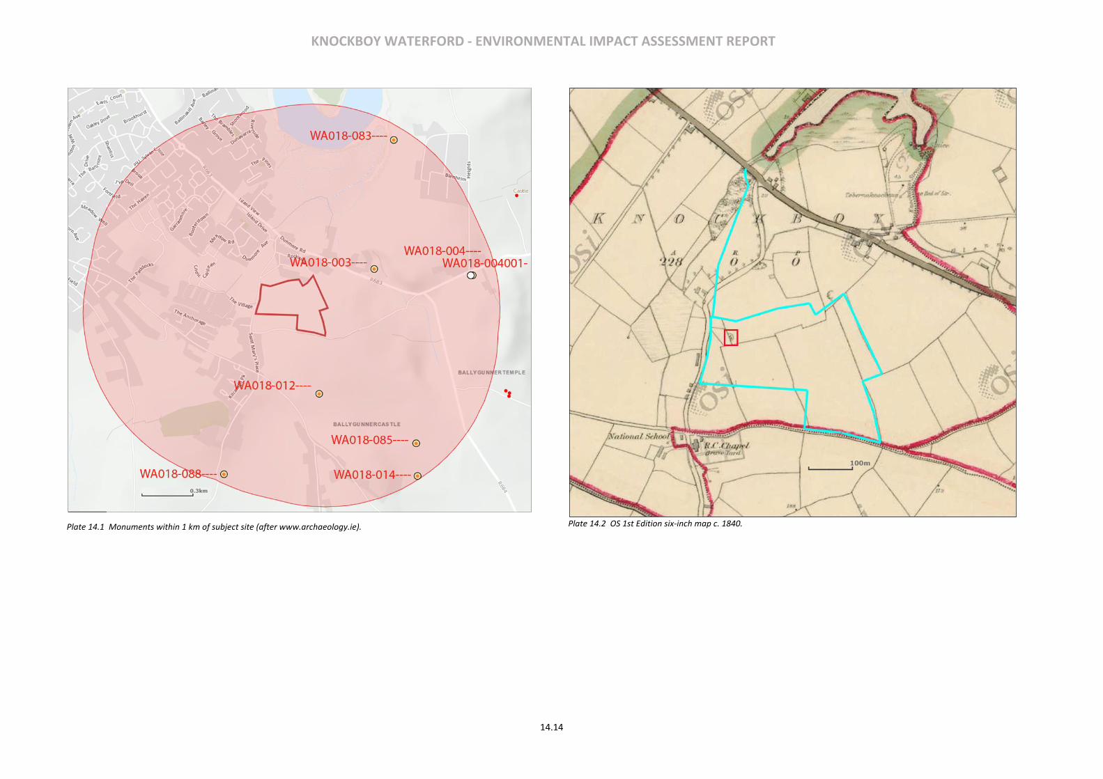
KNOCKBOY WATERFORD - ENVIRONMENTAL IMPACT ASSESSMENT REPORT
14.14
Plate 14.1 Monuments within 1 km of subject site (after www.archaeology.ie).
Plate 14.2 OS 1st Edition six-inch map c. 1840.
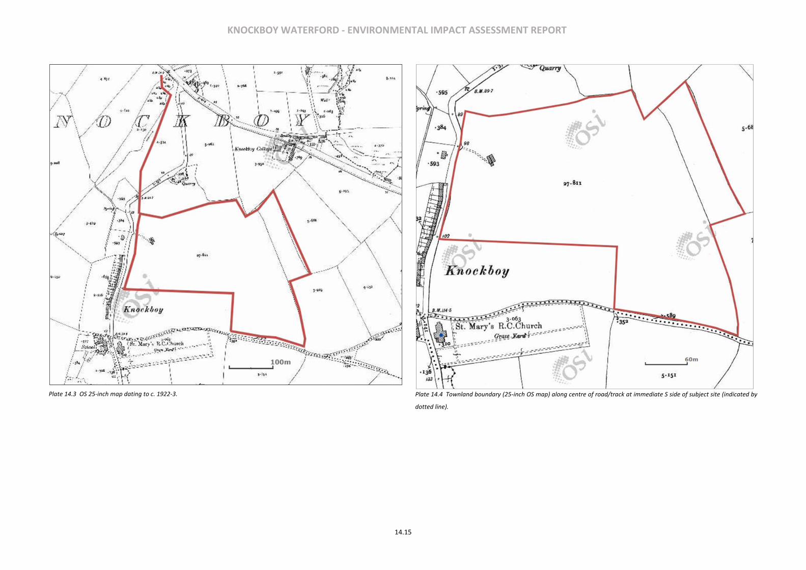
KNOCKBOY WATERFORD - ENVIRONMENTAL IMPACT ASSESSMENT REPORT
14.15
Plate 14.3 OS 25-inch map dating to c. 1922-3.
Plate 14.4 Townland boundary (25-inch OS map) along centre of road/track at immediate S side of subject site (indicated by
dotted line).

KNOCKBOY WATERFORD - ENVIRONMENTAL IMPACT ASSESSMENT REPORT
14.16
Plate 14.5 Location of subject site in relation to Waterford City (after OSi).
Plate 14.6 Image on which field inspection was based (after Digital Globe 2012, annotated by writer).
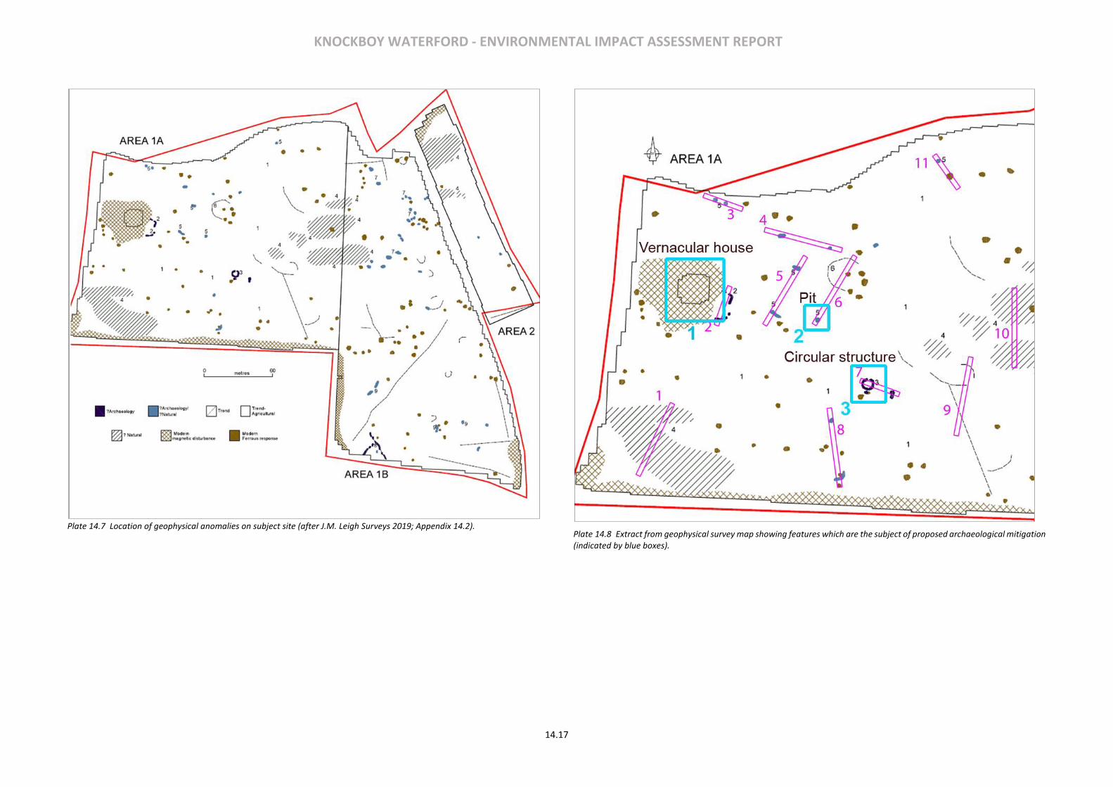
KNOCKBOY WATERFORD - ENVIRONMENTAL IMPACT ASSESSMENT REPORT
14.17
Plate 14.7 Location of geophysical anomalies on subject site (after J.M. Leigh Surveys 2019; Appendix 14.2).
Plate 14.8 Extract from geophysical survey map showing features which are the subject of proposed archaeological mitigation (indicated by blue boxes).
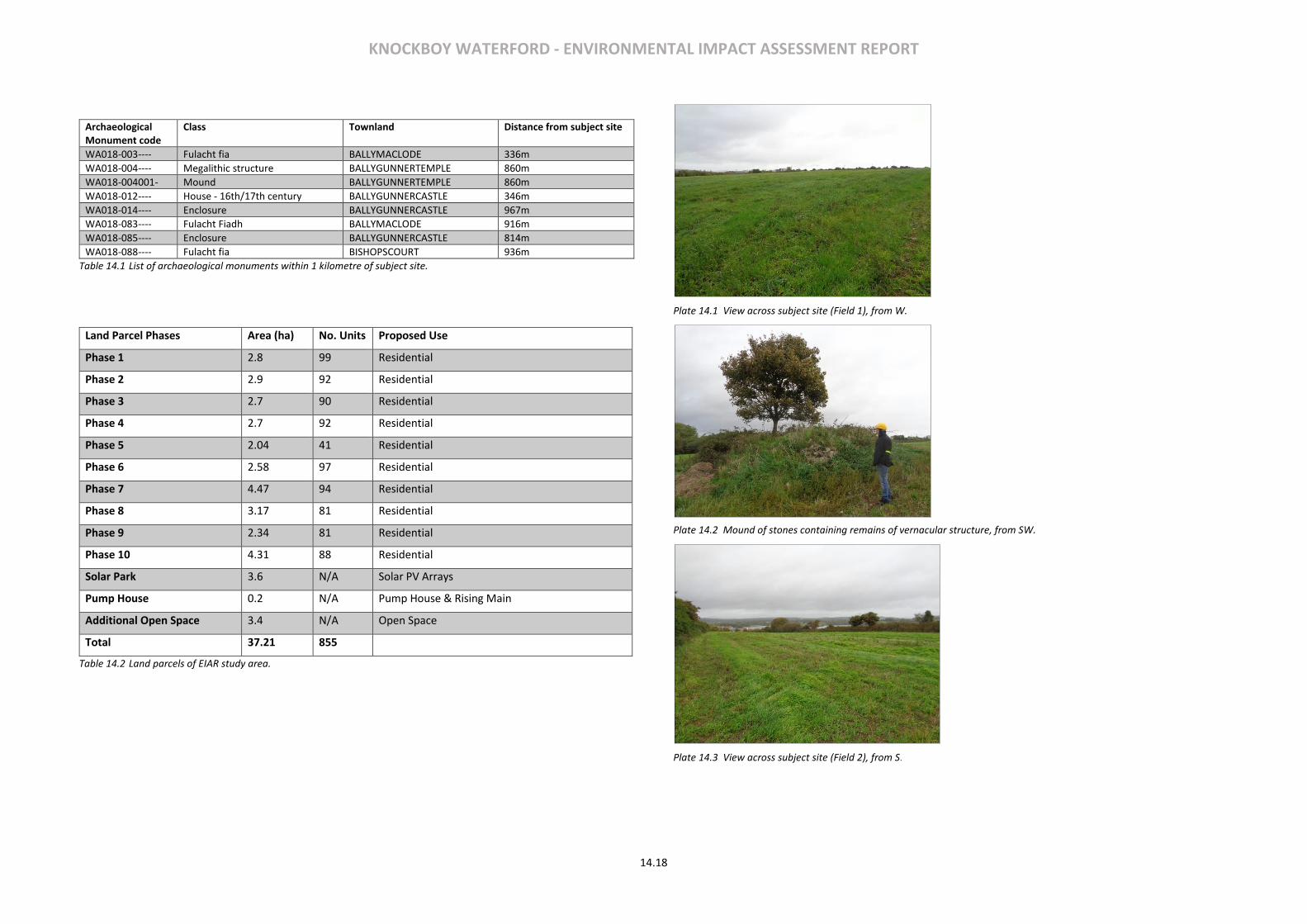
KNOCKBOY WATERFORD - ENVIRONMENTAL IMPACT ASSESSMENT REPORT
14.18
Archaeological Monument code
Class Townland Distance from subject site
WA018-003---- Fulacht fia BALLYMACLODE 336m
WA018-004---- Megalithic structure BALLYGUNNERTEMPLE 860m
WA018-004001- Mound BALLYGUNNERTEMPLE 860m
WA018-012---- House - 16th/17th century BALLYGUNNERCASTLE 346m
WA018-014---- Enclosure BALLYGUNNERCASTLE 967m
WA018-083---- Fulacht Fiadh BALLYMACLODE 916m
WA018-085---- Enclosure BALLYGUNNERCASTLE 814m
WA018-088---- Fulacht fia BISHOPSCOURT 936m
Table 14.1 List of archaeological monuments within 1 kilometre of subject site.
Land Parcel Phases Area (ha) No. Units Proposed Use
Phase 1 2.8 99 Residential
Phase 2 2.9 92 Residential
Phase 3 2.7 90 Residential
Phase 4 2.7 92 Residential
Phase 5 2.04 41 Residential
Phase 6 2.58 97 Residential
Phase 7 4.47 94 Residential
Phase 8 3.17 81 Residential
Phase 9 2.34 81 Residential
Phase 10 4.31 88 Residential
Solar Park 3.6 N/A Solar PV Arrays
Pump House 0.2 N/A Pump House & Rising Main
Additional Open Space 3.4 N/A Open Space
Total 37.21 855
Table 14.2 Land parcels of EIAR study area.
Plate 14.1 View across subject site (Field 1), from W.
Plate 14.2 Mound of stones containing remains of vernacular structure, from SW.
Plate 14.3 View across subject site (Field 2), from S.
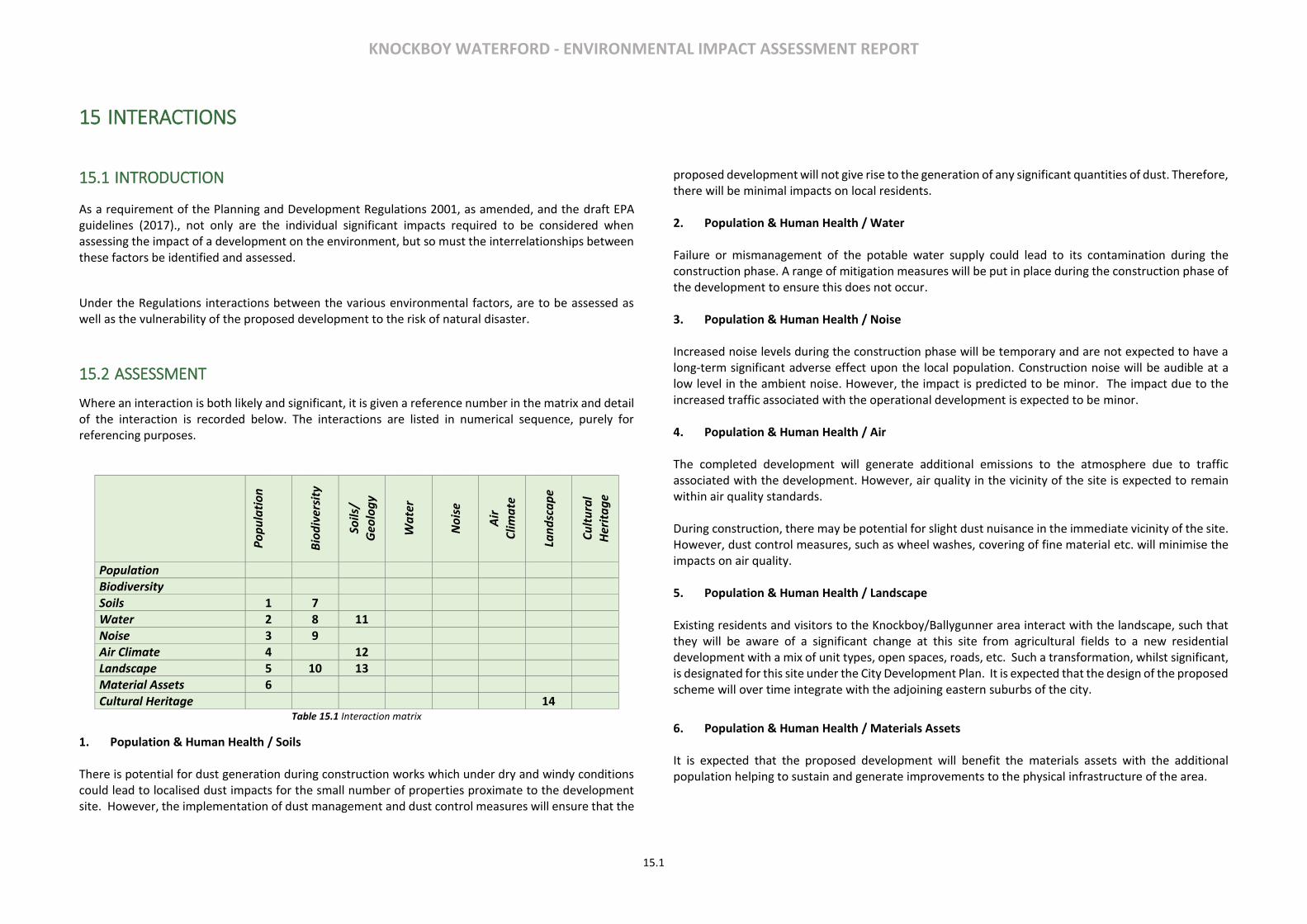
KNOCKBOY WATERFORD - ENVIRONMENTAL IMPACT ASSESSMENT REPORT
15.1
15 INTERACTIONS
15.1 INTRODUCTION
As a requirement of the Planning and Development Regulations 2001, as amended, and the draft EPA guidelines (2017)., not only are the individual significant impacts required to be considered when assessing the impact of a development on the environment, but so must the interrelationships between these factors be identified and assessed.
Under the Regulations interactions between the various environmental factors, are to be assessed as well as the vulnerability of the proposed development to the risk of natural disaster.
15.2 ASSESSMENT
Where an interaction is both likely and significant, it is given a reference number in the matrix and detail of the interaction is recorded below. The interactions are listed in numerical sequence, purely for referencing purposes.
Po
pu
lati
on
Bio
div
ersi
ty
Soils
/
Geo
log
y
Wa
ter
No
ise
Air
Clim
ate
Lan
dsc
ap
e
Cu
ltu
ral
Her
ita
ge
Population Biodiversity Soils 1 7 Water 2 8 11 Noise 3 9 Air Climate 4 12 Landscape 5 10 13 Material Assets 6 Cultural Heritage 14
Table 15.1 Interaction matrix
1. Population & Human Health / Soils There is potential for dust generation during construction works which under dry and windy conditions could lead to localised dust impacts for the small number of properties proximate to the development site. However, the implementation of dust management and dust control measures will ensure that the
proposed development will not give rise to the generation of any significant quantities of dust. Therefore, there will be minimal impacts on local residents. 2. Population & Human Health / Water Failure or mismanagement of the potable water supply could lead to its contamination during the construction phase. A range of mitigation measures will be put in place during the construction phase of the development to ensure this does not occur. 3. Population & Human Health / Noise Increased noise levels during the construction phase will be temporary and are not expected to have a long-term significant adverse effect upon the local population. Construction noise will be audible at a low level in the ambient noise. However, the impact is predicted to be minor. The impact due to the increased traffic associated with the operational development is expected to be minor. 4. Population & Human Health / Air The completed development will generate additional emissions to the atmosphere due to traffic associated with the development. However, air quality in the vicinity of the site is expected to remain within air quality standards.
During construction, there may be potential for slight dust nuisance in the immediate vicinity of the site. However, dust control measures, such as wheel washes, covering of fine material etc. will minimise the impacts on air quality. 5. Population & Human Health / Landscape Existing residents and visitors to the Knockboy/Ballygunner area interact with the landscape, such that they will be aware of a significant change at this site from agricultural fields to a new residential development with a mix of unit types, open spaces, roads, etc. Such a transformation, whilst significant, is designated for this site under the City Development Plan. It is expected that the design of the proposed scheme will over time integrate with the adjoining eastern suburbs of the city.
6. Population & Human Health / Materials Assets It is expected that the proposed development will benefit the materials assets with the additional population helping to sustain and generate improvements to the physical infrastructure of the area.

KNOCKBOY WATERFORD - ENVIRONMENTAL IMPACT ASSESSMENT REPORT
15.2
7. Biodiversity / Soils Potential construction stage effects arising from the general loss and fragmentation of some habitats and reduction of associated opportunities for biodiversity are considered neutral to slight negative during the construction phase, while potential operational stage effects are considered imperceptible neutral as new planting/landscaping matures. 8. Biodiversity / Water As concluded in the Natura Impact Statement submitted with the application there are no elements of the proposed development that are likely to give rise to significant effects on the local Natura 2000 sites. The implementation of construction and operational phase soils and water management proposals, together with the site drainage design will adequately reduce such potential impacts arising from the development site on these aquatic habitats in the wider area. Potential construction and operational phase effects on biodiversity associated with aquatic habitats in the wider area are considered imperceptible neutral with the implementation of soils and water management proposals. 9. Biodiversity / Noise Increased noise levels during the construction phase will only be temporary and are not expected to have a long-term significant adverse effect upon remaining fauna within the wider landscape. Operational noise will be audible at a low level in the ambient noise and the impact is predicted to be minor. 10. Biodiversity / Landscape The landscape masterplan proposed as part of the development will retain and enhance the remaining hedgerows features with native planting, as well as create new woodland, tree cluster/treelines, small areas of wildflower meadow and parkland/garden habitat. Potential construction stage effects arising from the general loss and fragmentation of some habitats and reduction of associated opportunities for biodiversity are considered neutral to slight negative during the construction phase, while potential operational stage effects are considered imperceptible neutral as new planting/landscaping matures. Due to the permanent loss of arable farmland and as such the permanent loss of foraging habitat for Yellowhammer the residual negative impact on this local populations of this species are considered significant at a local level, but moderate in line with exiting baseline trends. Otherwise the successful implementation of the mitigation measures as outlined in this EIAR and accompanying documents, together with the landscape masterplan will minimise the potential impacts of the proposed development on local biodiversity such that its residual impact on other habitats, flora and fauna will be imperceptible neutral overall.
11. Soils / Water When soil is exposed after vegetative clearance there will also be increased run-off and evaporation. Mitigation measures will be implemented during construction to prevent this run-off water from discharging directly to watercourses. 12. Soils / Air Exposed soil during the construction phase of the proposed scheme may give rise to increased dust emissions. However, the implementation of dust management and dust control measures will ensure that the proposed development will not give rise to the generation of any significant quantities of dust. 13. Soils/Landscape Residual soils arising as a result of excavation at the development site will be used in landscaping works in the proposed public open space as much as possible rather than transporting off-site. 14. Landscape/Cultural Heritage Careful consideration has been given to minimizing the visual impact of the proposed scheme on architectural heritage in the wider area, particularly St. Mary’s Church and Ballygunner House to the south.
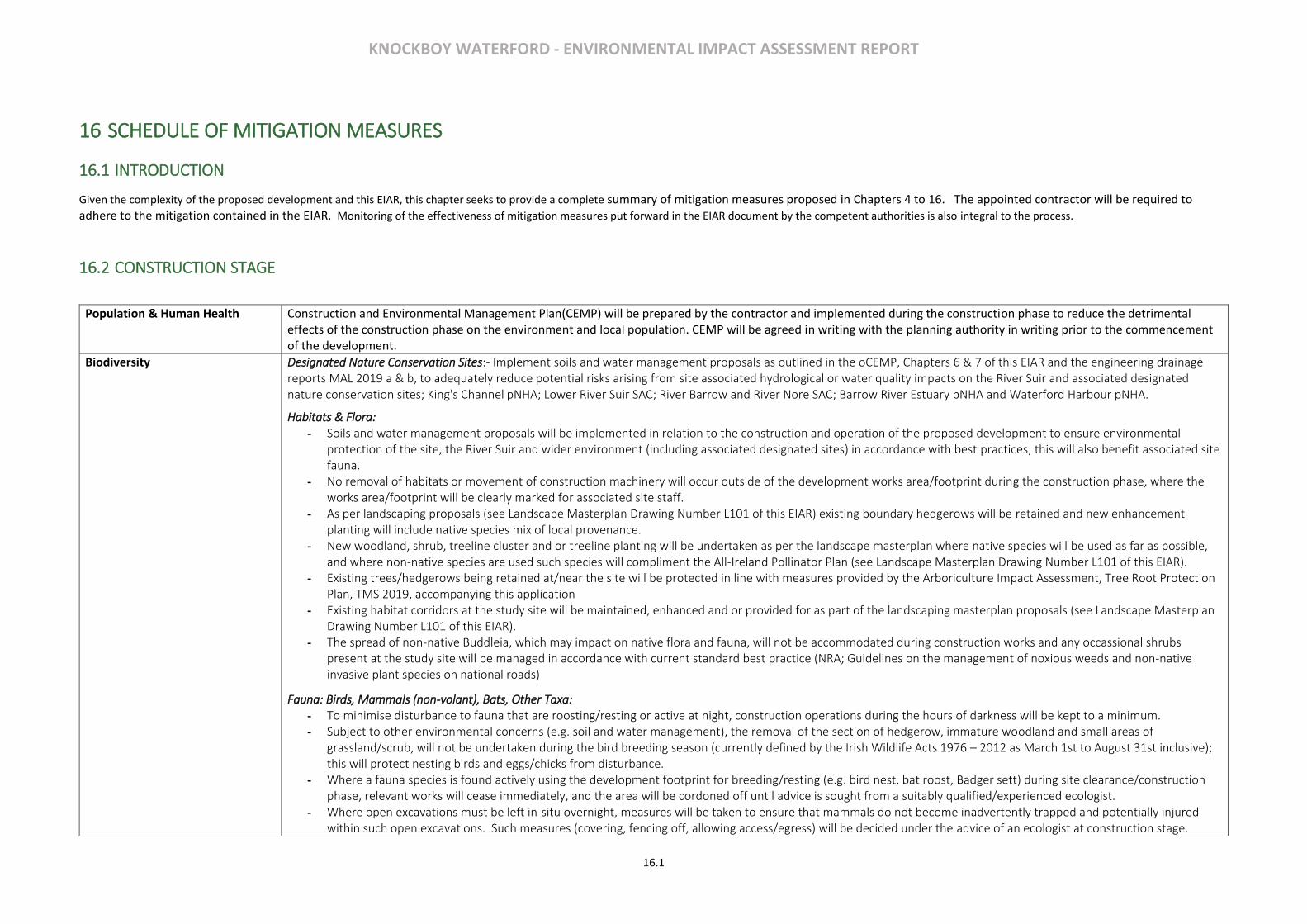
KNOCKBOY WATERFORD - ENVIRONMENTAL IMPACT ASSESSMENT REPORT
16.1
16 SCHEDULE OF MITIGATION MEASURES
16.1 INTRODUCTION
Given the complexity of the proposed development and this EIAR, this chapter seeks to provide a complete summary of mitigation measures proposed in Chapters 4 to 16. The appointed contractor will be required to adhere to the mitigation contained in the EIAR. Monitoring of the effectiveness of mitigation measures put forward in the EIAR document by the competent authorities is also integral to the process.
16.2 CONSTRUCTION STAGE
Population & Human Health Construction and Environmental Management Plan(CEMP) will be prepared by the contractor and implemented during the construction phase to reduce the detrimental effects of the construction phase on the environment and local population. CEMP will be agreed in writing with the planning authority in writing prior to the commencement of the development.
Biodiversity Designated Nature Conservation Sites:- Implement soils and water management proposals as outlined in the oCEMP, Chapters 6 & 7 of this EIAR and the engineering drainage reports MAL 2019 a & b, to adequately reduce potential risks arising from site associated hydrological or water quality impacts on the River Suir and associated designated nature conservation sites; King's Channel pNHA; Lower River Suir SAC; River Barrow and River Nore SAC; Barrow River Estuary pNHA and Waterford Harbour pNHA.
Habitats & Flora: - Soils and water management proposals will be implemented in relation to the construction and operation of the proposed development to ensure environmental
protection of the site, the River Suir and wider environment (including associated designated sites) in accordance with best practices; this will also benefit associated site fauna.
- No removal of habitats or movement of construction machinery will occur outside of the development works area/footprint during the construction phase, where the works area/footprint will be clearly marked for associated site staff.
- As per landscaping proposals (see Landscape Masterplan Drawing Number L101 of this EIAR) existing boundary hedgerows will be retained and new enhancement planting will include native species mix of local provenance.
- New woodland, shrub, treeline cluster and or treeline planting will be undertaken as per the landscape masterplan where native species will be used as far as possible, and where non-native species are used such species will compliment the All-Ireland Pollinator Plan (see Landscape Masterplan Drawing Number L101 of this EIAR).
- Existing trees/hedgerows being retained at/near the site will be protected in line with measures provided by the Arboriculture Impact Assessment, Tree Root Protection Plan, TMS 2019, accompanying this application
- Existing habitat corridors at the study site will be maintained, enhanced and or provided for as part of the landscaping masterplan proposals (see Landscape Masterplan Drawing Number L101 of this EIAR).
- The spread of non-native Buddleia, which may impact on native flora and fauna, will not be accommodated during construction works and any occassional shrubs present at the study site will be managed in accordance with current standard best practice (NRA; Guidelines on the management of noxious weeds and non-native invasive plant species on national roads)
Fauna: Birds, Mammals (non-volant), Bats, Other Taxa: - To minimise disturbance to fauna that are roosting/resting or active at night, construction operations during the hours of darkness will be kept to a minimum. - Subject to other environmental concerns (e.g. soil and water management), the removal of the section of hedgerow, immature woodland and small areas of
grassland/scrub, will not be undertaken during the bird breeding season (currently defined by the Irish Wildlife Acts 1976 – 2012 as March 1st to August 31st inclusive); this will protect nesting birds and eggs/chicks from disturbance.
- Where a fauna species is found actively using the development footprint for breeding/resting (e.g. bird nest, bat roost, Badger sett) during site clearance/construction phase, relevant works will cease immediately, and the area will be cordoned off until advice is sought from a suitably qualified/experienced ecologist.
- Where open excavations must be left in-situ overnight, measures will be taken to ensure that mammals do not become inadvertently trapped and potentially injured within such open excavations. Such measures (covering, fencing off, allowing access/egress) will be decided under the advice of an ecologist at construction stage.

KNOCKBOY WATERFORD - ENVIRONMENTAL IMPACT ASSESSMENT REPORT
16.2
- The study site will not be floodlit during the construction phase; instead all lighting systems will be designed to minimise light spillage nuisance by using shielded, downward directed lighting wherever possible and switching off all non-essential lighting during the hours of darkness. This will benefit bats as well as other fauna generally active at night (oCEMP accompanying this application and agreed with main contractor prior to construction works being initiated).
- As per landscaping proposals (see Landscape Master Plan), retained/additional planting will be connected to existing/new habitats as much as possible to provide connectivity/wildlife corridors that fauna can use to move about in the wider area.
Soils & Geology - Should soils become contaminated during the construction phase of the proposed development these soils will be stockpiled onsite, sampled, and tested against the waste acceptance criteria as set out in the appropriate National directives and such soils would be disposed of to a suitable receiving facility.
- During the construction phase of the proposed development all possible measures will be taken to protect the geology of the site. Where possible an area will be left intact until construction is ready to begin. Stripping of existing surfaces will not be undertaken until absolutely necessary to avoid any uncontrolled surface water runoff.
- The potential pollution of the ground during the construction phase will be mitigated by the provision of appropriate controls and working methods. These methods will include bunding around diesel/petrol storage tanks and vehicle maintenance areas and the related provisions will be addressed in the Construction Management Plan.
- Excavated subsoils will be reused as fill on site where possible. Any remaining volumes of unsuitable materials will be transported to the closest suitably licensed facility to be processed and reused in other construction projects in the vicinity, where possible.
Water Services It will be necessary for the contractor to implement measures to mitigate potential impacts to the existing surface water network. Such measures would include: -Obtaining all necessary discharge permits and licences -Preparing a construction method statement -Provision of settlement ponds -Measures to prevent liquid materials entering the drainage system
These measures will be addressed in the Construction Management Plan. Any necessary connections to the existing foul sewer network will be undertaken in agreement with and approval of Irish Water and appropriate procedures will be followed to ensure that there is no impact on the operation of the existing foul sewer system.
Noise & Vibration With regard to construction activities, reference will be made to BS5228: Noise control on construction and open sites, which offers detailed guidance on the control of noise and vibration from demolition and construction activities. Various mitigation measures will be considered and applied during the construction of the proposed development. Specific examples of such measures are: - Limiting the hours during which site activities likely to create high levels of noise or vibration are permitted; - Establishing channels of communication between the contractor/developer, Local Authority and residents; - Appointing a site representative responsible for matters relating to noise and vibration; - Monitoring levels of noise and/or vibration during critical periods and at sensitive locations; - All site access roads will be kept even so as to mitigate the potential for vibration from lorries. Furthermore, it is envisaged that a variety of practicable noise control measures will be employed. These may include: - Selection of plant with low inherent potential for generation of noise and/ or vibration; - Whenever feasible, schedule different noisy activities (e.g., earthmoving) to occur at the same time, since additional sources of noise generally do not add a significant amount of noise. - Erection of noise barriers or acoustic shield to protect noise sensitive locations if required. To function well, the barrier must prevent the line-of-sight between the noise source and the receiver. Effective noise barriers can reduce noise levels by as much as 20 dB(A).
Air Quality & Climate - Avoid unnecessary vehicle movements and manoeuvring, and limit speeds on site so as to minimise the generation of airborne dust. - Use of rubble chutes and receptor skips during construction activities. - During dry periods, dust emissions from heavily trafficked locations (on and off site) will be controlled by spraying surfaces with water and wetting agents. - Hard surface roads will be swept to remove mud and aggregate materials from their surface while any unsurfaced roads will be restricted to essential site traffic only. - Re-suspension in the air of spillages material from trucks entering or leaving the site will be prevented by limiting the speed of vehicles within the site to 10kmh and by use of a mechanical road sweeper.
KNOCKBOY WATERFORD - ENVIRONMENTAL IMPACT ASSESSMENT REPORT
16.3
- The overloading of tipper trucks exiting the site shall not be permitted. - Aggregates will be transported to and from the site in covered trucks. - Where the likelihood of windblown fugitive dust emissions is high and during dry weather conditions, dusty site surfaces will be sprayed by a mobile tanker bowser. - Wetting agents shall be utilised to provide a more effective surface wetting procedure. - Exhaust emissions from vehicles operating within the construction site, including trucks, excavators, diesel generators or other plant equipment, will be controlled by the contractor by ensuring that emissions from vehicles are minimised by routine servicing of vehicles and plant, rather than just following breakdowns; the positioning of exhausts at a height to ensure adequate local dispersal of emissions, the avoidance of engines running unnecessarily and the use of low emission fuels. - All plant not in operation shall be turned off and idling engines shall not be permitted for excessive periods. - Material handling systems and site stockpiling of materials will be designed and laid out to minimise exposure to wind. Water misting or sprays will be used as required if particularly dusty activities are necessary during dry or windy periods. - Material stockpiles containing fine or dusty elements including top soils shall be covered with tarpaulins. - Where drilling or pavement cutting, grinding or similar types of stone finishing operations are taking place, measures to control dust emissions will be used to prevent unnecessary dust emissions by the erection of wind breaks or barriers. All concrete cutting equipment shall be fitted with a water dampening system. - A programme of air quality monitoring shall be implemented at the site boundaries for the duration of construction phase activities to ensure that the air quality standards relating to dust deposition and PM10 are not exceeded. Where levels exceed specified air quality limit values, dust generating activities shall immediately cease and alternative working methods shall be implemented. - A complaints log shall be maintained by the construction site manager and in the event of a complaint relating to dust nuisance, an investigation shall be initiated.
Landscape & Visual Protection of the vegetation and hedgerows proposed to be retained in the landscape masterplan. Priority tee works, protective tree fencing should be erected in the positions and alignments indicated in the Tree protection plan (Dwg. No.) Fencing should be in accordance with BS 5837:2012 unless otherwise agreed with the planning authority. To ensure the successful retention of trees, an Arborist is recommended to be retained by the contractor or developer to monitor and advise any works within the Root Protection Zones of retained trees.
Traffic &Transportation - Prior to the commencement of the works on site the contractor will prepare a detailed Construction Traffic Management Plan and agree its proposals with the Planning Authority and An Garda Síochána.
- Given the location and nature of access to the site, site parking or construction parking will be located on the site - Construction vehicle movements will be minimised by the adoption of measures including: - Consolidation of delivery loads to/from the site and managing large deliveries on site to occur outside of peak periods; - Use of precast/prefabricated materials where possible; - Provision of adequate storage space on the site; - Development of a strategy to minimise construction material quantities insofar as possible; - Construction staff vehicle movements will also be minimised by promoting, where feasible, the use of public transport and car sharing;
Waste Management - Building materials will be chosen with an aim to ‘design out waste’; - On-site segregation of waste materials will be carried out to increase opportunities for off-site reuse, recycling and recovery – it is anticipated that the following waste types, at a minimum, will be segregated:
- Concrete rubble (including ceramics, tiles and bricks); - Plasterboard; - Metals; - Glass; and - Timber.
- Left over materials (e.g. timber off-cuts, broken concrete blocks/bricks) and any suitable construction materials shall be re-used on-site, where possible; - All waste materials will be stored in skips or other suitable receptacles in designated areas of the site; - Any hazardous wastes generated (such as chemicals, solvents, glues, fuels, oils) will also be segregated and will be stored in appropriate receptacles (in suitably bunded areas, where required); - A waste manager will be appointed by the main contractor(s) to ensure effective management of waste during the excavation and construction works; - All construction staff will be provided with training regarding the waste management procedures;

KNOCKBOY WATERFORD - ENVIRONMENTAL IMPACT ASSESSMENT REPORT
16.4
- All waste leaving site will be reused, recycled or recovered where possible to avoid material designated for disposal; - All waste leaving the site will be transported by suitable permitted contractors and taken to suitably registered, permitted or licenced facilities; and - All waste leaving the site will be recorded and copies of relevant documentation maintained.
Cultural Heritage - The rubble should be removed from the vernacular structure, and the exposed building should be archaeologically excavated (i.e. preserved by record) in advance of development. The structure should be fully recorded by written, drawn and photographic record, including a stone-by-stone elevation drawing of all elevations, both interior and exterior, in advance of its demolition.
- The oval pit identified in trench 6 should be archaeologically excavated (i.e. preserved by record). - Due to the fragile nature of the circular structure identified in trench 7 this should be archaeologically excavated (i.e. preserved by record) in advance of development
(even if located in a green area). A 5m by 5m area should be opened around the circular feature in order to ensure that its extent is fully ascertained and excavated.
Material Assets - The proposed development must comply with the provisions of the Construction Management and Operational Waste management plan with respect to the Construction waste generated from the development.
- A construction and environment management plan, including traffic management, will be implemented by the contractor for the construction stage to protect the local amenities and the integrity of the operation of the local road network.
- Provision of utilities will be carried out according to the recommendation of the relevant statutory body for example ESB, Gas Networks Ireland, Irish water, EIR, Waterford City and County Council Departments. Water metering measures will be included in each unit to record consumption levels.
16.3 OPERATION STAGE
Population & Human Health No addition mitigations measures are considered necessary.
Biodiversity Habitats & Flora: - No particular mitigation measures are required in relation to habitats & flora during the operational phase.
Fauna: Birds, Mammals (non-volant), Bats, Other Taxa: - As per the proposed lighting design plan (see MandE, 2019), the operational phase lighting scheme will be designed to minimise light spillage nuisance on retained/new wildlife corridors by using shielded, downward directed lighting wherever possible, switching off all non-essential lighting during the hours of darkness, using narrow spectrum lighting types with no UV and luminaire accessories (backlight shielding plates). This will benefit bats as well as other fauna active/resting at night.
Soils & Geology Oil interceptors will be installed within the surface water network to intercept any potential hydrocarbon spillages.
Water Services - In the event of flooding during very extreme rainfall events (i.e. in excess of 1:100 year return period rainfall events) or in the event of pipe blockages the flood water will be channelled away from buildings and in particular entrances to buildings.
- A new 300 mm diameter piped foul water sewer will be constructed as part of the proposed development. This foul sewer will connect to the existing 600mm diameter foul sewer at Island Drive which in turn connects to the existing pumping station on Island Drive.
Noise & Vibration During the operational phase of the development, noise mitigation measures with respect to the outward impact of the development are not deemed necessary.
Air Quality & Climate - Thermally efficient glazing systems on all units - Mechanical Ventilation and Heat Recovery (MVHR) systems or equivalent installed in all apartments - Thermal insulation of walls and roof voids of all units - Natural Gas heating in all units - Inclusion of electric car charging points to encourage electric vehicle ownership
Landscape & Visual The provision of architectural designed high-quality residential units to the area. The development of a network of public open spaces will create a positive impact to the neighbourhood as it is currently underserved with planned open spaces. The open spaces include play spaces and overlooked children’s play area.
Traffic &Transportation Mobility management will be a key part of the proposed development strategy to encourage occupiers to use sustainable means of transport. This will include the appointment of a Mobility Manager who will be involved in monitoring the modes of travel of the occupants of the proposed development and this ideally will be done on an annual basis. The mobility manager will at the outset of the occupation of the development implement a number of key measures. These will include:

KNOCKBOY WATERFORD - ENVIRONMENTAL IMPACT ASSESSMENT REPORT
16.5
- Providing new residents with a Travel Welcome Pack providing full details of transport options, cycle/walking maps and information on local services; - Induction sessions for new households and follow up visits; - Instigate and regularly update a centrally located travel notice board providing travel information;
Travel Plan prepared by MAL presented in Appendix 11.2 of this report provides more detailed information in relation to the mobility management of the proposed development.
Waste Management - On-site segregation of all waste materials into appropriate categories including (but not limited to): - Organic/catering waste (including garden waste from landscaping activities). - Dry Mixed Recyclables; - Mixed Non-Recyclable Waste; - Glass; - Waste electrical and electronic equipment (WEEE) including computers, printers and another ICT equipment; - Batteries (non-hazardous and hazardous) - Fluorescent bulb tubes and other mercury containing waste (if arising). - Cleaning chemicals (pesticides, paints, adhesives, resins, detergents, etc.); and
- All waste materials will be stored in colour coded bins or other suitable receptacles in designated, easily accessible locations. Bins will be clearly identified with the approved waste type to ensure there is no cross contamination of waste materials; - All waste collected from the development will be reused, recycled or recovered where possible, with the exception of those waste streams where appropriate facilities are currently not available; - All waste leaving the site will be transported by suitable permitted contractors and taken to suitably registered, permitted or licensed facilities; and These mitigation measures will ensure the waste arising from the development is dealt with in compliance with the provisions of the Waste Management Act 1996, as amended, and all associated Regulations. It will also ensure optimum levels of waste reduction, reuse, recycling and recovery are achieved.
Cultural Heritage None suggested.
Material Assets Mitigation measures will be in place to ensure that all surface water discharge is appropriately discharged in accordance with the standards and SUDS requirements that will form part of planning application. No other mitigation measure is deemed as necessary with respect to the material assets of the site as the development is considered to have a positive and beneficial effect on the material assets that include the services and infrastructure currently existing in the site

KNOCKBOY WATERFORD - ENVIRONMENTAL IMPACT ASSESSMENT REPORT
16.6
Environmental Impact Assessment Report Vol. II (Appendices) STRATEGIC HOUSING DEVELOPMENT AT KNOCKBOY, WATERFORD
PREPARED BY
IN ASSOCIATION WITH:
FEWER HARRINGTON & PARTNERS ARCHITECTS, MUIR CONSULTING ENGINEERS, KEVIN FITZPATRICK LANDSCAPE,
TRAYNOR ENVIRONMENTAL, AEGIS ARCHAEOLOGISTS,
CLUAIN ECOLOGY AND MANDE
MAY 2019

KNOCKBOY WATERFORD - ENVIRONMENTAL IMPACT ASSESSMENT REPORT

KNOCKBOY WATERFORD - ENVIRONMENTAL IMPACT ASSESSMENT REPORT
TABLE OF CONTENTS
Chapter 5 – Biodiversity Chapter/Page No.
SURVEY SCHEDULE 5.1 BIODIVERSITY EVALUATION SCHEME 5.2 HEDGEROW APPRAISAL 5.3 SUMMARY OF BAT SURVEY 5.4 Chapter 8 – Noise and Vibration Chapter/Page No.
NOISE BASELINE SURVEY 8.1 Chapter 13 – Waste & Management Chapter/Page No.
OPERATIONAL WASTE MANAGEMENT PLAN 13.1 CONSTRUCTION & DEMOLITION WASTE MANAGEMENT PLAN 13.2 Chapter 14 – Cultural Heritage Chapter/Page No.
CULTURAL HERITAGE AEGIS PLATES 14.1 GEOPHYSICAL SURVEY 14.2 ARCHAEOLOGICAL TEST TRENCHING & IMPACT ASSESSMENT 14.3

KNOCKBOY WATERFORD - ENVIRONMENTAL IMPACT ASSESSMENT REPORT

KNOCKBOY WATERFORD - ENVIRONMENTAL IMPACT ASSESSMENT REPORT
CHAPTER 5 BIODIVERSITY APPENDICES
APPENDIX 5.1 SURVEY SCHEDULE
Date Field Survey Times (24 hrs) Weather
Conditions Ecologist
27.11.18 Deployment of Passive Bat Detectors 1, 2, and 3.
c. 13.00 – 15.00 Wind; F3-4, Rain; 0-
Dry (cold), Cloud 3/8, Visibility Good
Michelle O'Neill
15.11.18 Collected Passive Bat Detectors, 1, 2, and 3
c. 10.00 – 11.00 Wind; F2, Rain),
Cloud;8/8, Visibility; Good.
11.02.19
Habitat and Botanical Walkover. Bird Survey (both transects Mammal Survey Walkover Deployment of Mammal Trail Camera 1
c. 09 – 13.00 Wind F1; Rain; 0,
Cloud; 1/8, Visibility; good
Michelle O’Neill
28.02.19
Habitat and Botanical Walkover. Bird Survey (both transects Deployment of Mammal Trail Camera 2
c.09.00 – 13.00 Wind F1; Rain; 0,
Cloud; 8/8, Visibility; Good
Michelle O Neill
08.03.19
Bird Survey (both Transects) Hedgerow Surveys Hedgerows 1, 2, and 3.
c. 9.00 – 13.00
Wind F3-4, Rain; Showers, Cloud 8/8, Visibility; Good-Medium
Michelle O’Neill
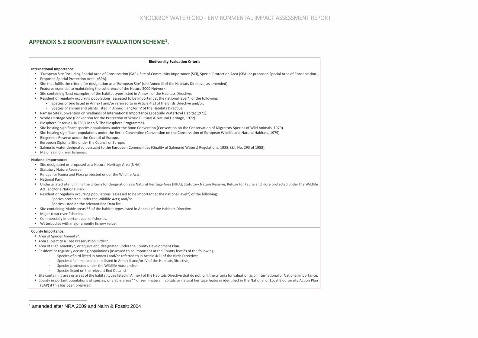
KNOCKBOY WATERFORD - ENVIRONMENTAL IMPACT ASSESSMENT REPORT
APPENDIX 5.2 BIODIVERSITY EVALUATION SCHEME1.
Biodiversity Evaluation Criteria
International Importance: ▪ ‘European Site ‘including Special Area of Conservation (SAC), Site of Community Importance (SCI), Special Protection Area (SPA) or proposed Special Area of Conservation. ▪ Proposed Special Protection Area (pSPA). ▪ Site that fulfils the criteria for designation as a ‘European Site’ (see Annex III of the Habitats Directive, as amended). ▪ Features essential to maintaining the coherence of the Natura 2000 Network. ▪ Site containing ‘best examples’ of the habitat types listed in Annex I of the Habitats Directive. ▪ Resident or regularly occurring populations (assessed to be important at the national level*) of the following:
- Species of bird listed in Annex I and/or referred to in Article 4(2) of the Birds Directive and/or; - Species of animal and plants listed in Annex II and/or IV of the Habitats Directive.
▪ Ramsar Site (Convention on Wetlands of International Importance Especially Waterfowl Habitat 1971). ▪ World Heritage Site (Convention for the Protection of World Cultural & Natural Heritage, 1972). ▪ Biosphere Reserve (UNESCO Man & The Biosphere Programme). ▪ Site hosting significant species populations under the Bonn Convention (Convention on the Conservation of Migratory Species of Wild Animals, 1979). ▪ Site hosting significant populations under the Berne Convention (Convention on the Conservation of European Wildlife and Natural Habitats, 1979). ▪ Biogenetic Reserve under the Council of Europe. ▪ European Diploma Site under the Council of Europe. ▪ Salmonid water designated pursuant to the European Communities (Quality of Salmonid Waters) Regulations, 1988, (S.I. No. 293 of 1988). ▪ Major salmon river fisheries.
National Importance: ▪ Site designated or proposed as a Natural Heritage Area (NHA). ▪ Statutory Nature Reserve. ▪ Refuge for Fauna and Flora protected under the Wildlife Acts. ▪ National Park. ▪ Undesignated site fulfilling the criteria for designation as a Natural Heritage Area (NHA); Statutory Nature Reserve; Refuge for Fauna and Flora protected under the Wildlife
Act; and/or a National Park. ▪ Resident or regularly occurring populations (assessed to be important at the national level*) of the following:
- Species protected under the Wildlife Acts; and/or - Species listed on the relevant Red Data list.
▪ Site containing ‘viable areas’** of the habitat types listed in Annex I of the Habitats Directive. ▪ Major trout river fisheries. ▪ Commercially important coarse fisheries. ▪ Waterbodies with major amenity fishery value.
County Importance: ▪ Area of Special Amenity^. ▪ Area subject to a Tree Preservation Order^. ▪ Area of High Amenity^, or equivalent, designated under the County Development Plan. ▪ Resident or regularly occurring populations (assessed to be important at the County level*) of the following:
- Species of bird listed in Annex I and/or referred to in Article 4(2) of the Birds Directive; - Species of animal and plants listed in Annex II and/or IV of the Habitats Directive; - Species protected under the Wildlife Acts; and/or - Species listed on the relevant Red Data list.
▪ Site containing area or areas of the habitat types listed in Annex I of the Habitats Directive that do not fulfil the criteria for valuation as of International or National importance. ▪ County important populations of species, or viable areas** of semi-natural habitats or natural heritage features identified in the National or Local Biodiversity Action Plan
(BAP) if this has been prepared.
1 amended after NRA 2009 and Nairn & Fossitt 2004
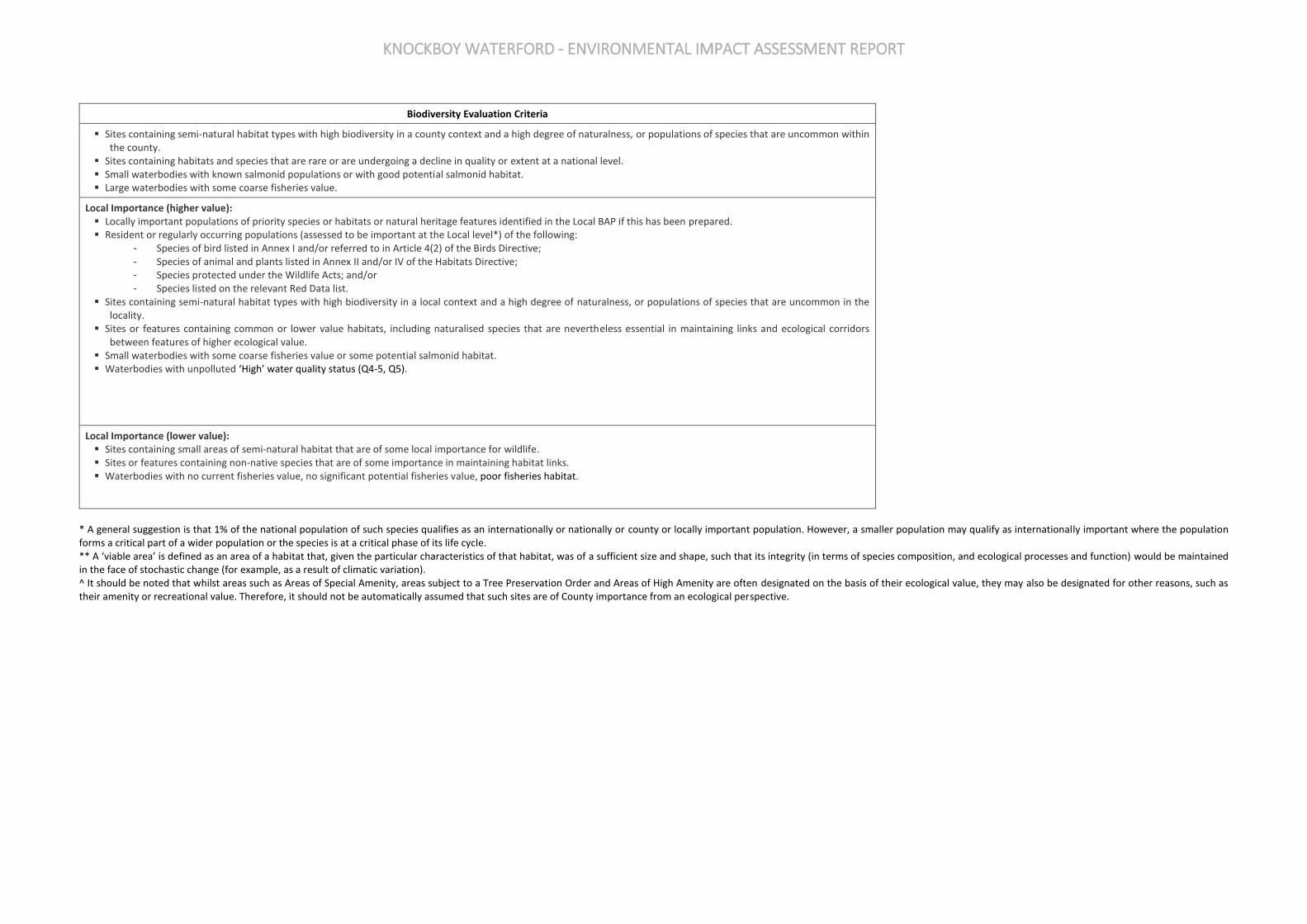
KNOCKBOY WATERFORD - ENVIRONMENTAL IMPACT ASSESSMENT REPORT
Biodiversity Evaluation Criteria
▪ Sites containing semi-natural habitat types with high biodiversity in a county context and a high degree of naturalness, or populations of species that are uncommon within the county.
▪ Sites containing habitats and species that are rare or are undergoing a decline in quality or extent at a national level. ▪ Small waterbodies with known salmonid populations or with good potential salmonid habitat. ▪ Large waterbodies with some coarse fisheries value.
Local Importance (higher value): ▪ Locally important populations of priority species or habitats or natural heritage features identified in the Local BAP if this has been prepared. ▪ Resident or regularly occurring populations (assessed to be important at the Local level*) of the following:
- Species of bird listed in Annex I and/or referred to in Article 4(2) of the Birds Directive; - Species of animal and plants listed in Annex II and/or IV of the Habitats Directive; - Species protected under the Wildlife Acts; and/or - Species listed on the relevant Red Data list.
▪ Sites containing semi-natural habitat types with high biodiversity in a local context and a high degree of naturalness, or populations of species that are uncommon in the locality.
▪ Sites or features containing common or lower value habitats, including naturalised species that are nevertheless essential in maintaining links and ecological corridors between features of higher ecological value.
▪ Small waterbodies with some coarse fisheries value or some potential salmonid habitat. ▪ Waterbodies with unpolluted ‘High’ water quality status (Q4-5, Q5).
Local Importance (lower value): ▪ Sites containing small areas of semi-natural habitat that are of some local importance for wildlife. ▪ Sites or features containing non-native species that are of some importance in maintaining habitat links. ▪ Waterbodies with no current fisheries value, no significant potential fisheries value, poor fisheries habitat.
* A general suggestion is that 1% of the national population of such species qualifies as an internationally or nationally or county or locally important population. However, a smaller population may qualify as internationally important where the population forms a critical part of a wider population or the species is at a critical phase of its life cycle. ** A ‘viable area’ is defined as an area of a habitat that, given the particular characteristics of that habitat, was of a sufficient size and shape, such that its integrity (in terms of species composition, and ecological processes and function) would be maintained in the face of stochastic change (for example, as a result of climatic variation). ^ It should be noted that whilst areas such as Areas of Special Amenity, areas subject to a Tree Preservation Order and Areas of High Amenity are often designated on the basis of their ecological value, they may also be designated for other reasons, such as their amenity or recreational value. Therefore, it should not be automatically assumed that such sites are of County importance from an ecological perspective.
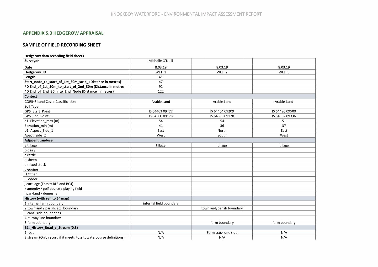
KNOCKBOY WATERFORD - ENVIRONMENTAL IMPACT ASSESSMENT REPORT
APPENDIX 5.3 HEDGEROW APPRAISAL
SAMPLE OF FIELD RECORDING SHEET
Hedgerow data recording field sheets
Surveyor Michelle O'Neill
Date 8.03.19 8.03.19 8.03.19
Hedgerow ID WL1_1 WL1_2 WL1_3
Length 321
Start_node_to_start_of_1st_30m_strip_ (Distance in metres) 47
*D End_of_1st_30m_to_start_of_2nd_30m (Distance in metres) 92
*D End_of_2nd_30m_to_End_Node (Distance in metres) 122
Context
CORINE Land Cover Classification Arable Land Arable Land Arable Land
Soil Type
GPS_Start_Point IS 64463 09477 IS 64404 09209 IS 64490 09500
GPS_End_Point IS 64560 09178 IS 64550 09178 IS 64562 09336
a1. Elevation_max.(m) 54 54 51
Elevation_min (m) 41 36 37
b1. Aspect_Side_1 East North East
Apect_Side_2 West South West
Adjacent Landuse
a tillage tillage tillage tillage
b dairy
c cattle
d sheep
e mixed stock
g equine
H Other
I Fodder
j curtilage (Fossitt BL3 and BC4)
k amenity / golf course / playing field
l parkland / demesne
History (with ref. to 6" map)
1 internal farm boundary internal field boundary
2 townland / parish, etc. boundary townland/parish boundary
3 canal side boundaries
4 railway line boundary
5 farm boundary farm boundary farm boundary
B1._History_Road_/_Stream (0,3)
1 road N/A Farm track one side N/A
2 stream (Only record if it meets Fossitt watercourse definitions) N/A N/A N/A

KNOCKBOY WATERFORD - ENVIRONMENTAL IMPACT ASSESSMENT REPORT
3 recently established (Hedgerow up to c.25 years old) N/A N/A N/A
B1a. Road Class (0,1) For roadside hedges only
NP – National Primary N/A
NS – National Secondary N/A
R – Regional N/A
L – Local N/A
U – Unclassified N/A
F – Farm Road or Track N/A Farm track one side
B2. History Ordnance Survey (0,2)
*D 1. Boundary present on 1st Edition OS Map 6 inch to one-mile yes yes yes
*D 2. Boundary present on 2nd Edition OS Map 6 inch to one-mile yes yes yes
B3. Sites and Monuments Record (0,1)
*D 3. Boundary connects to feature on SMR Sites and Monuments N/A N/A N/A
B4. Old Woodland Link (0,2)
a Boundary connects to woodland on 1st edition OS No No No
b Boundary shown as treeline on 1st edition OS No No No
Habitat Link Classification (1+)
a arable (BC) BC1 BC1 BC1
b improved grassland (GA)
b1 neglected pasture (GA)
c semi-natural grassland (GS)
d non-native woodland (WD)
e semi-natural woodland / scrub (WN)
f scrub/transitional woodland (WS)
g curtilage/built land (BL)
g3 curtilage/built land (BL3) BL3 Buildings and artificial surfaces
h peatlands (P)
i lake/pond (FL)
j watercourse (FW)
k other (target note)
m hedgerow (WL1 or WL2) WL1 WL1
n earthbank (BL2) BL2
o re-colonising bare ground (ED3)
D3._Designated Site (0,1) Record if hedgerow is within or immediately adjacent to any
1 Annex 1 habitat N/A N/A N/a
2 designated site NHA, SAC, SPA
3. Designated Woodland
E._Boundary Function (1)
1 hedge redundant Redundant Redundant Redundant
2 active boundary
Construction
F._Outline (1)
a linear Linear Linear Linear
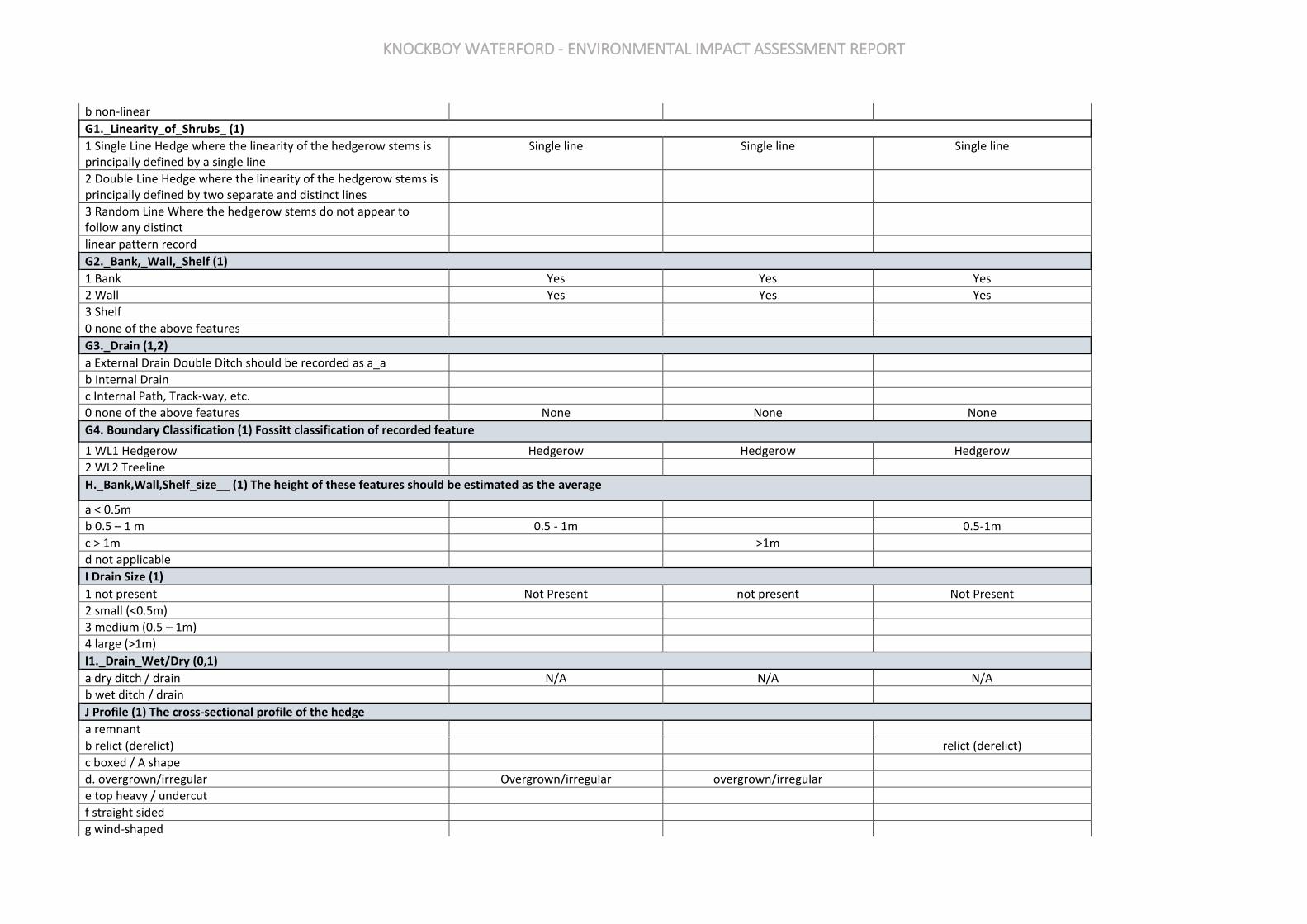
KNOCKBOY WATERFORD - ENVIRONMENTAL IMPACT ASSESSMENT REPORT
b non-linear
G1._Linearity_of_Shrubs_ (1)
1 Single Line Hedge where the linearity of the hedgerow stems is principally defined by a single line
Single line Single line Single line
2 Double Line Hedge where the linearity of the hedgerow stems is principally defined by two separate and distinct lines
3 Random Line Where the hedgerow stems do not appear to follow any distinct
linear pattern record
G2._Bank,_Wall,_Shelf (1)
1 Bank Yes Yes Yes
2 Wall Yes Yes Yes
3 Shelf
0 none of the above features
G3._Drain (1,2)
a External Drain Double Ditch should be recorded as a_a
b Internal Drain
c Internal Path, Track-way, etc.
0 none of the above features None None None
G4. Boundary Classification (1) Fossitt classification of recorded feature
1 WL1 Hedgerow Hedgerow Hedgerow Hedgerow
2 WL2 Treeline
H._Bank,Wall,Shelf_size__ (1) The height of these features should be estimated as the average
a < 0.5m
b 0.5 – 1 m 0.5 - 1m 0.5-1m
c > 1m >1m
d not applicable
I Drain Size (1)
1 not present Not Present not present Not Present
2 small (<0.5m)
3 medium (0.5 – 1m)
4 large (>1m)
I1._Drain_Wet/Dry (0,1)
a dry ditch / drain N/A N/A N/A
b wet ditch / drain
J Profile (1) The cross-sectional profile of the hedge
a remnant
b relict (derelict) relict (derelict)
c boxed / A shape
d. overgrown/irregular Overgrown/irregular overgrown/irregular
e top heavy / undercut
f straight sided
g wind-shaped

KNOCKBOY WATERFORD - ENVIRONMENTAL IMPACT ASSESSMENT REPORT
J1._Profile_base_suffix
a losing basal structure
b outgrowths at base outgrowth at base outgrowths at base losing basal structure
K Height (1)
1 <1.5m
2 1.5 – 2.5m 1.5-2.5 2.5-4 1.5-2.5
3 2.5 – 4m
4 4 - 5m
5 5m+
K1._Height_overhead_cables (0,1)
overhead wires/cables YES Yes No
L Width (1)
a < 1m
b 1– 2m 1-2 1-2 1-2
c 2 – 3m
d 3 m+
M.__%_of_Gaps_ (1)
1 complete
2 < 5 % gaps
3 5 – 10 % gaps
4 10 – 25 % 10-25%
5 25 – 50 % 25-50
6 > 50 % >50
M1._Gaps_Specific_or_general (0,1)
a general Individual gaps < 5m <5
b specific Any individual gap >5m <5 >5
N Base Structure (1)
a open / translucent
b scrawny, semi-translucent
c semi-opaque semi-opaque semi-opaque scrawny, semi-translucent
d dense / opaque
N1._Base_-_Vegetation (0,1)
a vegetation Ivy, Bramble Ivy, Bramble Bramble, Bracken
O._Bank_Degradation_Degree_ (1,2)
1 not applicable No bank, wall or shelf.
2 none
3 severe
4 minor Minor Minor minor
5 drain blocked/waterlogged
O1._Bank_Degradation__Extent (1)
a general
b isolated. Isolated Isolated General
P._Trees_Quantity (1)
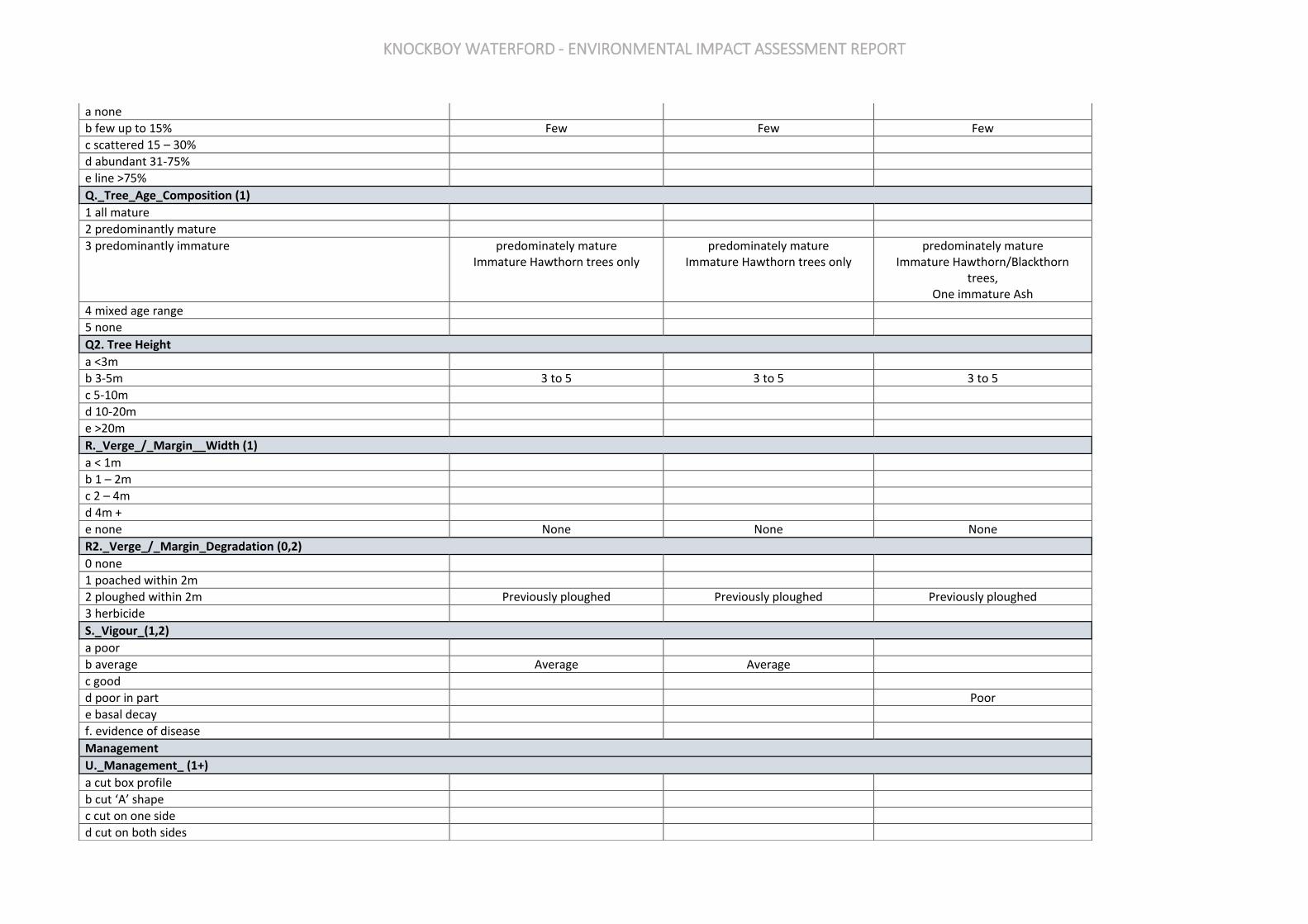
KNOCKBOY WATERFORD - ENVIRONMENTAL IMPACT ASSESSMENT REPORT
a none
b few up to 15% Few Few Few
c scattered 15 – 30%
d abundant 31-75%
e line >75%
Q._Tree_Age_Composition (1)
1 all mature
2 predominantly mature
3 predominantly immature predominately mature Immature Hawthorn trees only
predominately mature Immature Hawthorn trees only
predominately mature Immature Hawthorn/Blackthorn
trees, One immature Ash
4 mixed age range
5 none
Q2. Tree Height
a <3m
b 3-5m 3 to 5 3 to 5 3 to 5
c 5-10m
d 10-20m
e >20m
R._Verge_/_Margin__Width (1)
a < 1m
b 1 – 2m
c 2 – 4m
d 4m +
e none None None None
R2._Verge_/_Margin_Degradation (0,2)
0 none
1 poached within 2m
2 ploughed within 2m Previously ploughed Previously ploughed Previously ploughed
3 herbicide
S._Vigour_(1,2)
a poor
b average Average Average
c good
d poor in part Poor
e basal decay
f. evidence of disease
Management
U._Management_ (1+)
a cut box profile
b cut ‘A’ shape
c cut on one side
d cut on both sides
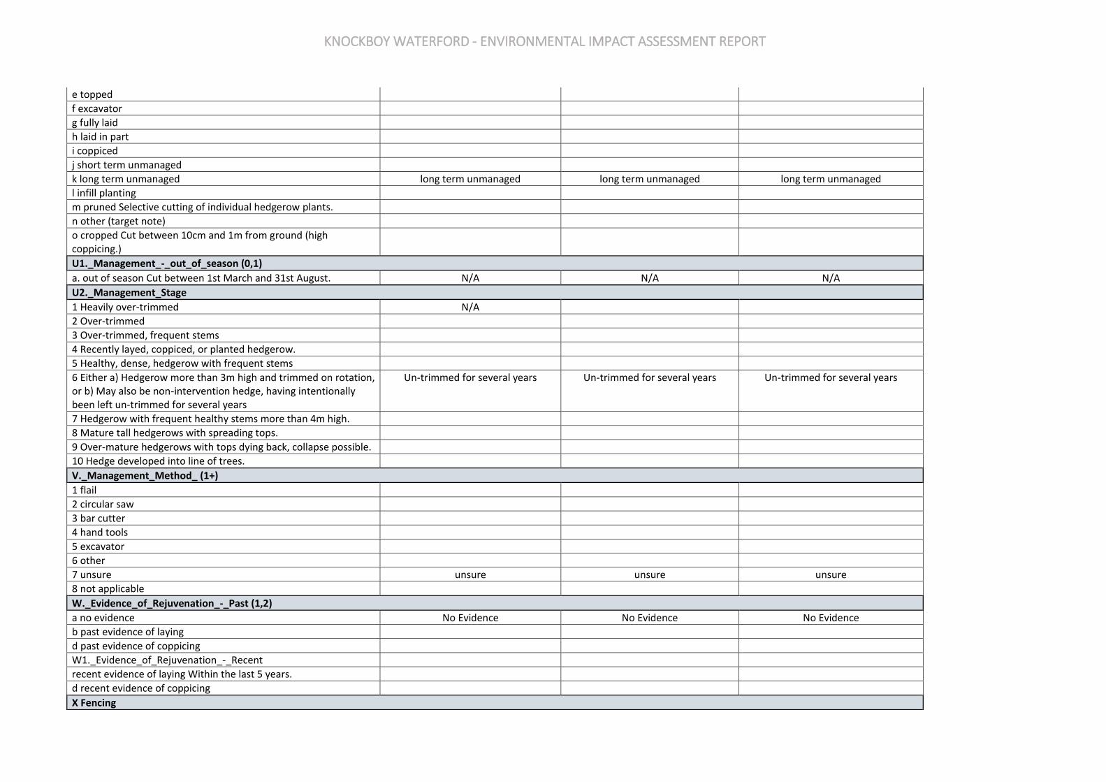
KNOCKBOY WATERFORD - ENVIRONMENTAL IMPACT ASSESSMENT REPORT
e topped
f excavator
g fully laid
h laid in part
i coppiced
j short term unmanaged
k long term unmanaged long term unmanaged long term unmanaged long term unmanaged
l infill planting
m pruned Selective cutting of individual hedgerow plants.
n other (target note)
o cropped Cut between 10cm and 1m from ground (high coppicing.)
U1._Management_-_out_of_season (0,1)
a. out of season Cut between 1st March and 31st August. N/A N/A N/A
U2._Management_Stage
1 Heavily over-trimmed N/A
2 Over-trimmed
3 Over-trimmed, frequent stems
4 Recently layed, coppiced, or planted hedgerow.
5 Healthy, dense, hedgerow with frequent stems
6 Either a) Hedgerow more than 3m high and trimmed on rotation, or b) May also be non-intervention hedge, having intentionally been left un-trimmed for several years
Un-trimmed for several years Un-trimmed for several years Un-trimmed for several years
7 Hedgerow with frequent healthy stems more than 4m high.
8 Mature tall hedgerows with spreading tops.
9 Over-mature hedgerows with tops dying back, collapse possible.
10 Hedge developed into line of trees.
V._Management_Method_ (1+)
1 flail
2 circular saw
3 bar cutter
4 hand tools
5 excavator
6 other
7 unsure unsure unsure unsure
8 not applicable
W._Evidence_of_Rejuvenation_-_Past (1,2)
a no evidence No Evidence No Evidence No Evidence
b past evidence of laying
d past evidence of coppicing
W1._Evidence_of_Rejuvenation_-_Recent
recent evidence of laying Within the last 5 years.
d recent evidence of coppicing
X Fencing
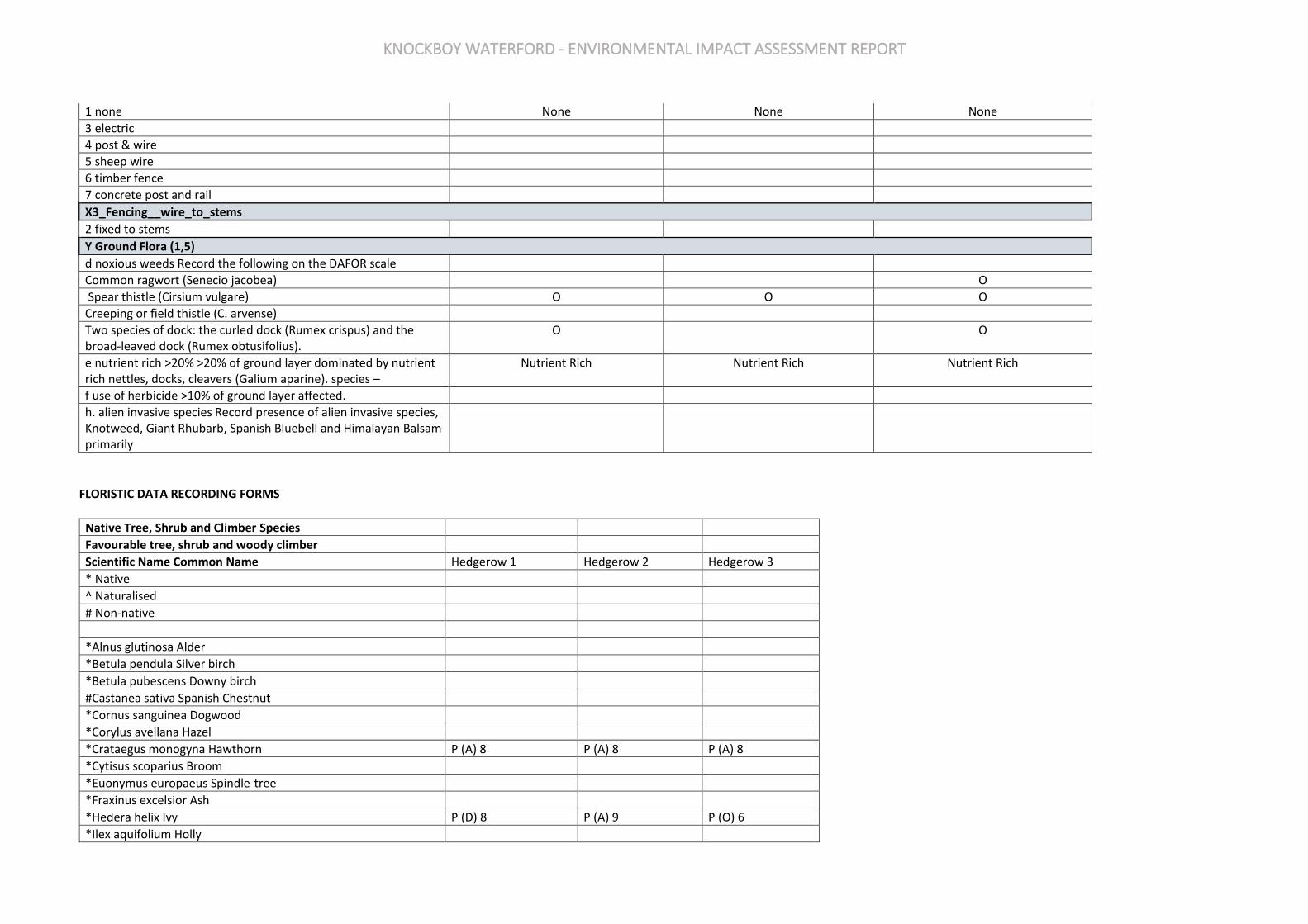
KNOCKBOY WATERFORD - ENVIRONMENTAL IMPACT ASSESSMENT REPORT
FLORISTIC DATA RECORDING FORMS
Native Tree, Shrub and Climber Species
Favourable tree, shrub and woody climber
Scientific Name Common Name Hedgerow 1 Hedgerow 2 Hedgerow 3
* Native
^ Naturalised
# Non-native
*Alnus glutinosa Alder
*Betula pendula Silver birch
*Betula pubescens Downy birch
#Castanea sativa Spanish Chestnut
*Cornus sanguinea Dogwood
*Corylus avellana Hazel
*Crataegus monogyna Hawthorn P (A) 8 P (A) 8 P (A) 8
*Cytisus scoparius Broom
*Euonymus europaeus Spindle-tree
*Fraxinus excelsior Ash
*Hedera helix Ivy P (D) 8 P (A) 9 P (O) 6
*Ilex aquifolium Holly
1 none None None None
3 electric
4 post & wire
5 sheep wire
6 timber fence
7 concrete post and rail
X3_Fencing__wire_to_stems
2 fixed to stems
Y Ground Flora (1,5)
d noxious weeds Record the following on the DAFOR scale
Common ragwort (Senecio jacobea) O
Spear thistle (Cirsium vulgare) O O O
Creeping or field thistle (C. arvense)
Two species of dock: the curled dock (Rumex crispus) and the broad-leaved dock (Rumex obtusifolius).
O O
e nutrient rich >20% >20% of ground layer dominated by nutrient rich nettles, docks, cleavers (Galium aparine). species –
Nutrient Rich Nutrient Rich Nutrient Rich
f use of herbicide >10% of ground layer affected.
h. alien invasive species Record presence of alien invasive species, Knotweed, Giant Rhubarb, Spanish Bluebell and Himalayan Balsam primarily

KNOCKBOY WATERFORD - ENVIRONMENTAL IMPACT ASSESSMENT REPORT
#Juglans regia English Walnut
^Ligustrum vulgare Wild Privet
*Lonicera periclymenum Honeysuckle P (O) P (O) P (O)
^Salix alba White willow
^Malus domestica Wild Apple
*Malus sylvestris Crab Apple
*Myrica gale Bog Myrtle
*Pinus sylvestris Scots pine
*Populus nigra Black poplar
*Populus tremula Aspen
*Prunus avium Wild cherry
^Prunus cerasus Sour Cherry
^Prunus domestica Wild Plum
*Prunus padus Bird Cherry
*Prunus spinosa Blackthorn, sloe
#Pyrus communis Wild Pear
*Quercus petraea Sessile oak
*Quercus robur Pedunculate oak
*Rhamnus cathartica Purging Buckthorn
*Rosa spp. Wild Rose
*Rubus idaeus Raspberry
*Salix aurita Eared willow
*Salix caprea Goat willow
*Salix cinerea subspp. Oleifolia Rusty Willow P R
*Salix pentandra Bay Willow
^Salix triandra Osier
*Sambucus nigra Elder
*Solanum dulcamara Bittersweet
*Sorbus aria, S. hibernica Whitebeam
*Sorbus aucuparia Rowan
*Taxus baccata Yew
*Ulex europaeus Gorse P (A) 8 P (A) 8
*Ulmus glabra Wych Elm
^Ulmus procera English Elm
*Viburnum opulus Guelder rose
Unfavourable tree, shrub and woody climber
* Native
^ Naturalised
# Non-native
All coniferous species (except Scots pine)
#Acer campestre Field Maple
^Acer pseduplatanus Sycamore
^Aesculus hippocastanum Horse Chestnut

KNOCKBOY WATERFORD - ENVIRONMENTAL IMPACT ASSESSMENT REPORT
^Carpinus betulus Hornbeam
^Clematis alba Clematis
^Fagus sylvatica Beech
#Fuchsia magellanica Fuchsia
#Laburnum anagyroides Laburnum
#Ligustrum ovalifolium Japanese Privet
^Lonicera nitida Dwarf Box
#Populus alba White Poplar
^Prunus laurocerasus Cherry laurel
^Rhododendron ponticum
^Salix fragilis Crack willow
^Symphoricarpos albus Snowberry
#Syringa vulgaris Lilac
#Tilia spp. Lime
^Viburnum lantana Wayfaring tree
Herbaceous Ground Flora Species
Scientific Name Common Name Hedgerow 1 Hedgerow 2 Hedgerow 3
Ajuga reptans Bugle
Alliaria petiolata Garlic Mustard
Allium ursinum Ramsons
Anemone nemorosa Wood Anemone
Anthriscus sylvestris Cow Parsley
Arum maculatum Lords-and-Ladies P
Chrysoplenium oppositifolium Opposite Leaved Golden Saxifrage
Conopodium majus Pignut
Digitalis purpurea Foxglove
Epipactus helleborine Broad-leaved Helleborine
Fragaria vesca Wild Strawberry
Galium odoratum Sweet Woodruff
Geranium robertianum Herb Robert P P
Geum urbanum Wood Avens
Glechoma hederacea Ground Ivy
Hyacinthoides non-scripta Bluebell
Hypericum androsaemum Tutsan
Lapsana communis Nipplewort P
Lathraea squamaria Toothwort
Luzula sylvatica Great Woodrush
Lysimachia nemorum Yellow Pimpernel
Neottia nidus-avis Birds-nest Orchid
Oxalis acetosella Wood Sorrel
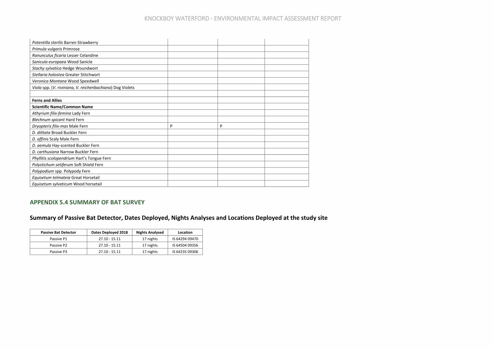
KNOCKBOY WATERFORD - ENVIRONMENTAL IMPACT ASSESSMENT REPORT
Potentilla sterilis Barren Strawberry
Primula vulgaris Primrose
Ranunculus ficaria Lesser Celandine
Sanicula europaea Wood Sanicle
Stachy sylvatica Hedge Woundwort
Stellaria holostea Greater Stitchwort
Veronica Montana Wood Speedwell
Viola spp. (V. riviniana, V. reichenbachiana) Dog Violets
Ferns and Allies
Scientific Name/Common Name
Athyrium filix-femina Lady Fern
Blechnum spicant Hard Fern
Dryopteris filix-mas Male Fern P P
D. dilitata Broad Buckler Fern
D. affinis Scaly Male Fern
D. aemula Hay-scented Buckler Fern
D. carthusiana Narrow Buckler Fern
Phyllitis scolopendrium Hart’s Tongue Fern
Polystichum setiferum Soft Shield Fern
Polypodium spp. Polypody Fern
Equisetum telmateia Great Horsetail
Equisetum sylvaticum Wood horsetail
APPENDIX 5.4 SUMMARY OF BAT SURVEY
Summary of Passive Bat Detector, Dates Deployed, Nights Analyses and Locations Deployed at the study site
Passive Bat Detector Dates Deployed 2018 Nights Analysed Location
Passive P1 27.10 - 15.11 17 nights IS 64294 09470
Passive P2 27.10 - 15.11 17 nights IS 64504 09356
Passive P3 27.10 - 15.11 17 nights IS 64235 09306

KNOCKBOY WATERFORD - ENVIRONMENTAL IMPACT ASSESSMENT REPORT
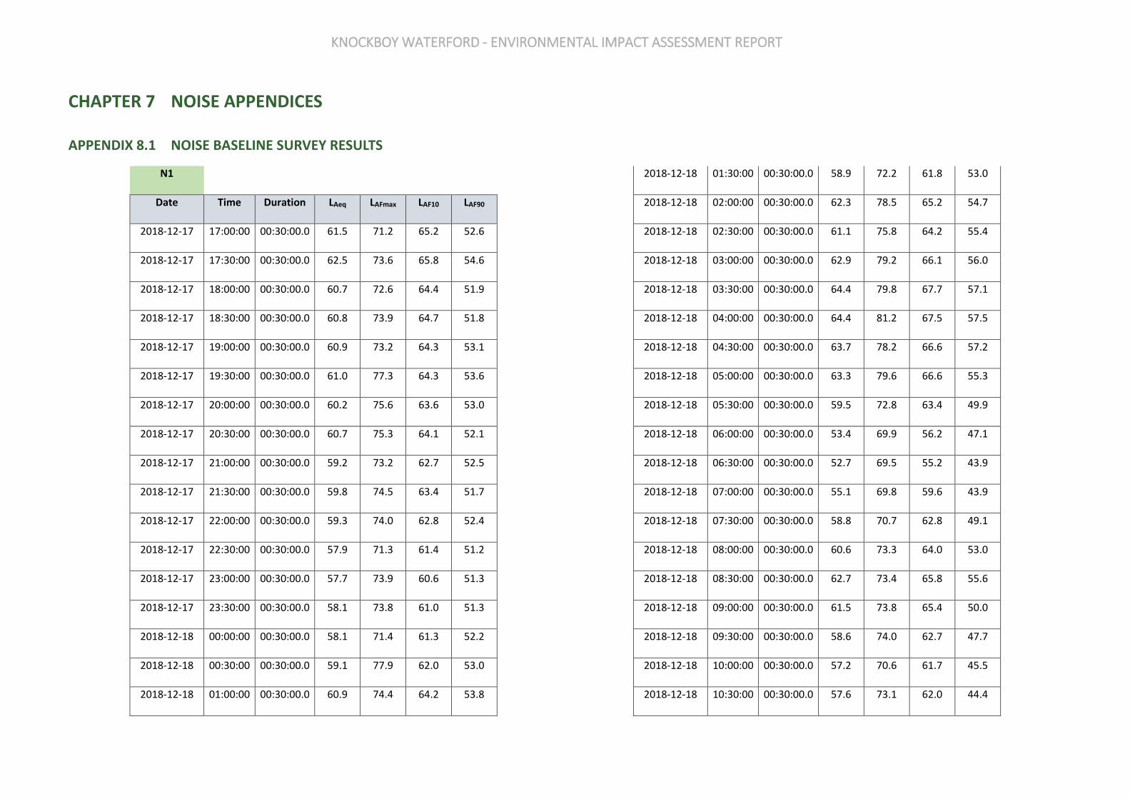
KNOCKBOY WATERFORD - ENVIRONMENTAL IMPACT ASSESSMENT REPORT
CHAPTER 7 NOISE APPENDICES
APPENDIX 8.1 NOISE BASELINE SURVEY RESULTS
N1
Date Time Duration LAeq LAFmax LAF10 LAF90
2018-12-17 17:00:00 00:30:00.0 61.5 71.2 65.2 52.6
2018-12-17 17:30:00 00:30:00.0 62.5 73.6 65.8 54.6
2018-12-17 18:00:00 00:30:00.0 60.7 72.6 64.4 51.9
2018-12-17 18:30:00 00:30:00.0 60.8 73.9 64.7 51.8
2018-12-17 19:00:00 00:30:00.0 60.9 73.2 64.3 53.1
2018-12-17 19:30:00 00:30:00.0 61.0 77.3 64.3 53.6
2018-12-17 20:00:00 00:30:00.0 60.2 75.6 63.6 53.0
2018-12-17 20:30:00 00:30:00.0 60.7 75.3 64.1 52.1
2018-12-17 21:00:00 00:30:00.0 59.2 73.2 62.7 52.5
2018-12-17 21:30:00 00:30:00.0 59.8 74.5 63.4 51.7
2018-12-17 22:00:00 00:30:00.0 59.3 74.0 62.8 52.4
2018-12-17 22:30:00 00:30:00.0 57.9 71.3 61.4 51.2
2018-12-17 23:00:00 00:30:00.0 57.7 73.9 60.6 51.3
2018-12-17 23:30:00 00:30:00.0 58.1 73.8 61.0 51.3
2018-12-18 00:00:00 00:30:00.0 58.1 71.4 61.3 52.2
2018-12-18 00:30:00 00:30:00.0 59.1 77.9 62.0 53.0
2018-12-18 01:00:00 00:30:00.0 60.9 74.4 64.2 53.8
2018-12-18 01:30:00 00:30:00.0 58.9 72.2 61.8 53.0
2018-12-18 02:00:00 00:30:00.0 62.3 78.5 65.2 54.7
2018-12-18 02:30:00 00:30:00.0 61.1 75.8 64.2 55.4
2018-12-18 03:00:00 00:30:00.0 62.9 79.2 66.1 56.0
2018-12-18 03:30:00 00:30:00.0 64.4 79.8 67.7 57.1
2018-12-18 04:00:00 00:30:00.0 64.4 81.2 67.5 57.5
2018-12-18 04:30:00 00:30:00.0 63.7 78.2 66.6 57.2
2018-12-18 05:00:00 00:30:00.0 63.3 79.6 66.6 55.3
2018-12-18 05:30:00 00:30:00.0 59.5 72.8 63.4 49.9
2018-12-18 06:00:00 00:30:00.0 53.4 69.9 56.2 47.1
2018-12-18 06:30:00 00:30:00.0 52.7 69.5 55.2 43.9
2018-12-18 07:00:00 00:30:00.0 55.1 69.8 59.6 43.9
2018-12-18 07:30:00 00:30:00.0 58.8 70.7 62.8 49.1
2018-12-18 08:00:00 00:30:00.0 60.6 73.3 64.0 53.0
2018-12-18 08:30:00 00:30:00.0 62.7 73.4 65.8 55.6
2018-12-18 09:00:00 00:30:00.0 61.5 73.8 65.4 50.0
2018-12-18 09:30:00 00:30:00.0 58.6 74.0 62.7 47.7
2018-12-18 10:00:00 00:30:00.0 57.2 70.6 61.7 45.5
2018-12-18 10:30:00 00:30:00.0 57.6 73.1 62.0 44.4

KNOCKBOY WATERFORD - ENVIRONMENTAL IMPACT ASSESSMENT REPORT
2018-12-18 11:00:00 00:30:00.0 57.5 71.4 61.9 46.4
2018-12-18 11:30:00 00:30:00.0 58.2 70.7 62.6 45.7
2018-12-18 12:00:00 00:30:00.0 59.3 70.4 63.3 47.6
2018-12-18 12:30:00 00:30:00.0 58.0 69.1 62.0 45.5
2018-12-18 13:00:00 00:30:00.0 57.8 69.1 61.7 45.8
2018-12-18 13:30:00 00:30:00.0 60.3 71.5 64.1 48.6
2018-12-18 14:00:00 00:30:00.0 59.5 70.1 63.3 47.7
2018-12-18 14:30:00 00:30:00.0 60.5 70.5 64.1 49.6
2018-12-18 15:00:00 00:30:00.0 59.8 70.0 63.5 48.2
2018-12-18 15:30:00 00:30:00.0 59.6 70.5 63.3 48.9
2018-12-18 16:00:00 00:30:00.0 60.2 70.4 63.9 48.3
2018-12-18 16:30:00 00:30:00.0 61.1 73.1 64.5 50.6
2018-12-18 17:00:00 00:30:00.0 61.4 71.5 64.8 53.1
2018-12-18 17:30:00 00:30:00.0 61.2 69.2 64.7 50.5
2018-12-18 18:00:00 00:30:00.0 60.8 69.8 64.6 49.6
2018-12-18 18:30:00 00:30:00.0 59.0 71.2 63.0 46.8
2018-12-18 19:00:00 00:30:00.0 58.5 69.8 62.8 45.4
2018-12-18 19:30:00 00:30:00.0 57.7 68.8 61.9 45.4
2018-12-18 20:00:00 00:30:00.0 56.8 69.9 61.2 44.1
2018-12-18 20:30:00 00:30:00.0 55.3 66.7 60.0 43.5
2018-12-18 21:00:00 00:30:00.0 54.7 66.9 60.0 41.6
2018-12-18 21:30:00 00:30:00.0 53.9 70.7 58.5 41.6
2018-12-18 22:00:00 00:30:00.0 52.2 68.2 57.1 37.0
2018-12-18 22:30:00 00:30:00.0 52.6 69.3 57.4 37.2
2018-12-18 23:00:00 00:30:00.0 52.1 70.3 56.6 36.5
2018-12-18 23:30:00 00:30:00.0 45.8 66.4 46.1 31.9
2018-12-19 00:00:00 00:30:00.0 48.5 67.7 49.8 33.0
2018-12-19 00:30:00 00:30:00.0 43.1 65.7 38.3 29.9
2018-12-19 01:00:00 00:30:00.0 44.0 63.9 36.8 28.1
2018-12-19 01:30:00 00:30:00.0 31.6 51.8 32.2 28.6
2018-12-19 02:00:00 00:30:00.0 42.5 64.1 38.6 28.1
2018-12-19 02:30:00 00:30:00.0 44.0 69.8 42.2 28.8
2018-12-19 03:00:00 00:30:00.0 41.4 60.9 43.0 28.7
2018-12-19 03:30:00 00:30:00.0 34.8 55.3 38.1 29.0
2018-12-19 04:00:00 00:30:00.0 37.3 58.5 39.3 28.3
2018-12-19 04:30:00 00:30:00.0 46.5 66.5 47.4 29.9
2018-12-19 05:00:00 00:30:00.0 46.2 66.5 45.2 32.1
2018-12-19 05:30:00 00:30:00.0 46.0 66.9 45.8 34.6
2018-12-19 06:00:00 00:30:00.0 49.0 69.5 52.1 35.4
2018-12-19 06:30:00 00:30:00.0 52.7 69.6 56.7 38.5
2018-12-19 07:00:00 00:30:00.0 54.3 68.7 59.2 40.9
2018-12-19 07:30:00 00:30:00.0 59.2 71.7 63.1 46.8
2018-12-19 08:00:00 00:30:00.0 60.7 70.2 64.1 52.8
2018-12-19 08:30:00 00:30:00.0 62.9 71.9 65.8 56.9
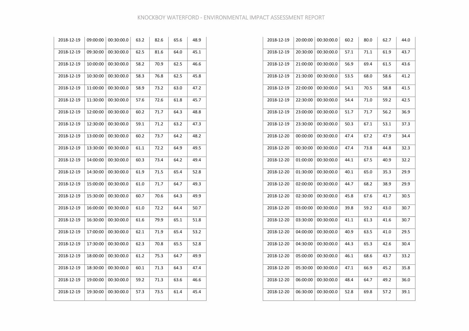
KNOCKBOY WATERFORD - ENVIRONMENTAL IMPACT ASSESSMENT REPORT
2018-12-19 09:00:00 00:30:00.0 63.2 82.6 65.6 48.9
2018-12-19 09:30:00 00:30:00.0 62.5 81.6 64.0 45.1
2018-12-19 10:00:00 00:30:00.0 58.2 70.9 62.5 46.6
2018-12-19 10:30:00 00:30:00.0 58.3 76.8 62.5 45.8
2018-12-19 11:00:00 00:30:00.0 58.9 73.2 63.0 47.2
2018-12-19 11:30:00 00:30:00.0 57.6 72.6 61.8 45.7
2018-12-19 12:00:00 00:30:00.0 60.2 71.7 64.3 48.8
2018-12-19 12:30:00 00:30:00.0 59.1 71.2 63.2 47.3
2018-12-19 13:00:00 00:30:00.0 60.2 73.7 64.2 48.2
2018-12-19 13:30:00 00:30:00.0 61.1 72.2 64.9 49.5
2018-12-19 14:00:00 00:30:00.0 60.3 73.4 64.2 49.4
2018-12-19 14:30:00 00:30:00.0 61.9 71.5 65.4 52.8
2018-12-19 15:00:00 00:30:00.0 61.0 71.7 64.7 49.3
2018-12-19 15:30:00 00:30:00.0 60.7 70.6 64.3 49.9
2018-12-19 16:00:00 00:30:00.0 61.0 72.2 64.4 50.7
2018-12-19 16:30:00 00:30:00.0 61.6 79.9 65.1 51.8
2018-12-19 17:00:00 00:30:00.0 62.1 71.9 65.4 53.2
2018-12-19 17:30:00 00:30:00.0 62.3 70.8 65.5 52.8
2018-12-19 18:00:00 00:30:00.0 61.2 75.3 64.7 49.9
2018-12-19 18:30:00 00:30:00.0 60.1 71.3 64.3 47.4
2018-12-19 19:00:00 00:30:00.0 59.2 71.3 63.6 46.6
2018-12-19 19:30:00 00:30:00.0 57.3 73.5 61.4 45.4
2018-12-19 20:00:00 00:30:00.0 60.2 80.0 62.7 44.0
2018-12-19 20:30:00 00:30:00.0 57.1 71.1 61.9 43.7
2018-12-19 21:00:00 00:30:00.0 56.9 69.4 61.5 43.6
2018-12-19 21:30:00 00:30:00.0 53.5 68.0 58.6 41.2
2018-12-19 22:00:00 00:30:00.0 54.1 70.5 58.8 41.5
2018-12-19 22:30:00 00:30:00.0 54.4 71.0 59.2 42.5
2018-12-19 23:00:00 00:30:00.0 51.7 71.7 56.2 36.9
2018-12-19 23:30:00 00:30:00.0 50.3 67.1 53.1 37.3
2018-12-20 00:00:00 00:30:00.0 47.4 67.2 47.9 34.4
2018-12-20 00:30:00 00:30:00.0 47.4 73.8 44.8 32.3
2018-12-20 01:00:00 00:30:00.0 44.1 67.5 40.9 32.2
2018-12-20 01:30:00 00:30:00.0 40.1 65.0 35.3 29.9
2018-12-20 02:00:00 00:30:00.0 44.7 68.2 38.9 29.9
2018-12-20 02:30:00 00:30:00.0 45.8 67.6 41.7 30.5
2018-12-20 03:00:00 00:30:00.0 39.8 59.2 43.0 30.7
2018-12-20 03:30:00 00:30:00.0 41.1 61.3 41.6 30.7
2018-12-20 04:00:00 00:30:00.0 40.9 63.5 41.0 29.5
2018-12-20 04:30:00 00:30:00.0 44.3 65.3 42.6 30.4
2018-12-20 05:00:00 00:30:00.0 46.1 68.6 43.7 33.2
2018-12-20 05:30:00 00:30:00.0 47.1 66.9 45.2 35.8
2018-12-20 06:00:00 00:30:00.0 48.4 64.7 49.2 36.0
2018-12-20 06:30:00 00:30:00.0 52.8 69.8 57.2 39.1
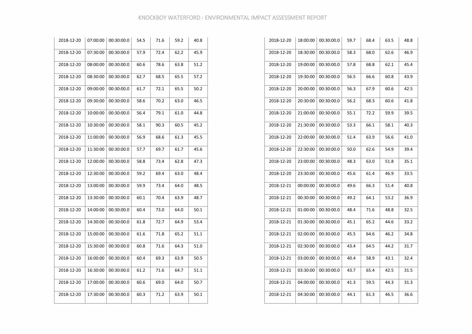
KNOCKBOY WATERFORD - ENVIRONMENTAL IMPACT ASSESSMENT REPORT
2018-12-20 07:00:00 00:30:00.0 54.5 71.6 59.2 40.8
2018-12-20 07:30:00 00:30:00.0 57.9 72.4 62.2 45.9
2018-12-20 08:00:00 00:30:00.0 60.6 78.6 63.8 51.2
2018-12-20 08:30:00 00:30:00.0 62.7 68.5 65.5 57.2
2018-12-20 09:00:00 00:30:00.0 61.7 72.1 65.5 50.2
2018-12-20 09:30:00 00:30:00.0 58.6 70.2 63.0 46.5
2018-12-20 10:00:00 00:30:00.0 56.4 79.1 61.0 44.8
2018-12-20 10:30:00 00:30:00.0 58.1 90.3 60.5 45.2
2018-12-20 11:00:00 00:30:00.0 56.9 68.6 61.3 45.5
2018-12-20 11:30:00 00:30:00.0 57.7 69.7 61.7 45.6
2018-12-20 12:00:00 00:30:00.0 58.8 73.4 62.8 47.3
2018-12-20 12:30:00 00:30:00.0 59.2 69.4 63.0 48.4
2018-12-20 13:00:00 00:30:00.0 59.9 73.4 64.0 48.5
2018-12-20 13:30:00 00:30:00.0 60.1 70.4 63.9 48.7
2018-12-20 14:00:00 00:30:00.0 60.4 73.0 64.0 50.1
2018-12-20 14:30:00 00:30:00.0 61.8 72.7 64.9 53.4
2018-12-20 15:00:00 00:30:00.0 61.6 71.8 65.2 51.1
2018-12-20 15:30:00 00:30:00.0 60.8 71.6 64.3 51.0
2018-12-20 16:00:00 00:30:00.0 60.4 69.3 63.9 50.5
2018-12-20 16:30:00 00:30:00.0 61.2 71.6 64.7 51.1
2018-12-20 17:00:00 00:30:00.0 60.6 69.0 64.0 50.7
2018-12-20 17:30:00 00:30:00.0 60.3 71.2 63.9 50.1
2018-12-20 18:00:00 00:30:00.0 59.7 68.4 63.5 48.8
2018-12-20 18:30:00 00:30:00.0 58.3 68.0 62.6 46.9
2018-12-20 19:00:00 00:30:00.0 57.8 68.8 62.1 45.4
2018-12-20 19:30:00 00:30:00.0 56.5 66.6 60.8 43.9
2018-12-20 20:00:00 00:30:00.0 56.3 67.9 60.6 42.5
2018-12-20 20:30:00 00:30:00.0 56.2 68.3 60.6 41.8
2018-12-20 21:00:00 00:30:00.0 55.1 72.2 59.9 39.5
2018-12-20 21:30:00 00:30:00.0 53.3 66.1 58.1 40.3
2018-12-20 22:00:00 00:30:00.0 51.4 63.9 56.6 41.0
2018-12-20 22:30:00 00:30:00.0 50.0 62.6 54.9 39.4
2018-12-20 23:00:00 00:30:00.0 48.3 63.0 51.8 35.1
2018-12-20 23:30:00 00:30:00.0 45.6 61.4 46.9 33.5
2018-12-21 00:00:00 00:30:00.0 49.6 66.3 51.4 40.8
2018-12-21 00:30:00 00:30:00.0 49.2 64.1 53.2 36.9
2018-12-21 01:00:00 00:30:00.0 48.4 71.6 48.8 32.5
2018-12-21 01:30:00 00:30:00.0 45.1 65.2 44.6 33.2
2018-12-21 02:00:00 00:30:00.0 45.5 64.6 46.2 34.8
2018-12-21 02:30:00 00:30:00.0 43.4 64.5 44.2 31.7
2018-12-21 03:00:00 00:30:00.0 40.4 58.9 43.1 32.4
2018-12-21 03:30:00 00:30:00.0 43.7 65.4 42.5 31.5
2018-12-21 04:00:00 00:30:00.0 41.3 59.5 44.3 31.3
2018-12-21 04:30:00 00:30:00.0 44.1 61.3 46.5 36.6
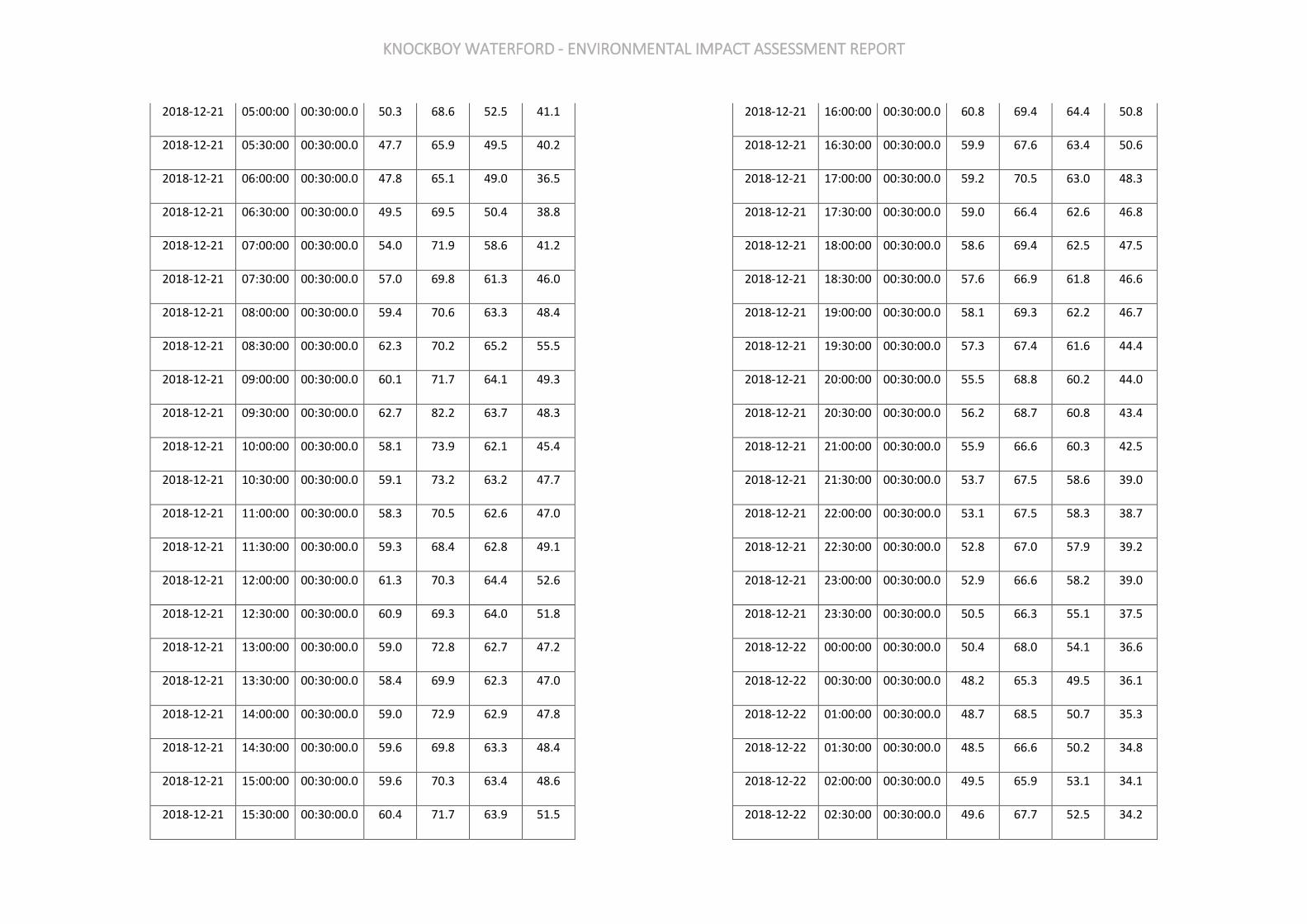
KNOCKBOY WATERFORD - ENVIRONMENTAL IMPACT ASSESSMENT REPORT
2018-12-21 05:00:00 00:30:00.0 50.3 68.6 52.5 41.1
2018-12-21 05:30:00 00:30:00.0 47.7 65.9 49.5 40.2
2018-12-21 06:00:00 00:30:00.0 47.8 65.1 49.0 36.5
2018-12-21 06:30:00 00:30:00.0 49.5 69.5 50.4 38.8
2018-12-21 07:00:00 00:30:00.0 54.0 71.9 58.6 41.2
2018-12-21 07:30:00 00:30:00.0 57.0 69.8 61.3 46.0
2018-12-21 08:00:00 00:30:00.0 59.4 70.6 63.3 48.4
2018-12-21 08:30:00 00:30:00.0 62.3 70.2 65.2 55.5
2018-12-21 09:00:00 00:30:00.0 60.1 71.7 64.1 49.3
2018-12-21 09:30:00 00:30:00.0 62.7 82.2 63.7 48.3
2018-12-21 10:00:00 00:30:00.0 58.1 73.9 62.1 45.4
2018-12-21 10:30:00 00:30:00.0 59.1 73.2 63.2 47.7
2018-12-21 11:00:00 00:30:00.0 58.3 70.5 62.6 47.0
2018-12-21 11:30:00 00:30:00.0 59.3 68.4 62.8 49.1
2018-12-21 12:00:00 00:30:00.0 61.3 70.3 64.4 52.6
2018-12-21 12:30:00 00:30:00.0 60.9 69.3 64.0 51.8
2018-12-21 13:00:00 00:30:00.0 59.0 72.8 62.7 47.2
2018-12-21 13:30:00 00:30:00.0 58.4 69.9 62.3 47.0
2018-12-21 14:00:00 00:30:00.0 59.0 72.9 62.9 47.8
2018-12-21 14:30:00 00:30:00.0 59.6 69.8 63.3 48.4
2018-12-21 15:00:00 00:30:00.0 59.6 70.3 63.4 48.6
2018-12-21 15:30:00 00:30:00.0 60.4 71.7 63.9 51.5
2018-12-21 16:00:00 00:30:00.0 60.8 69.4 64.4 50.8
2018-12-21 16:30:00 00:30:00.0 59.9 67.6 63.4 50.6
2018-12-21 17:00:00 00:30:00.0 59.2 70.5 63.0 48.3
2018-12-21 17:30:00 00:30:00.0 59.0 66.4 62.6 46.8
2018-12-21 18:00:00 00:30:00.0 58.6 69.4 62.5 47.5
2018-12-21 18:30:00 00:30:00.0 57.6 66.9 61.8 46.6
2018-12-21 19:00:00 00:30:00.0 58.1 69.3 62.2 46.7
2018-12-21 19:30:00 00:30:00.0 57.3 67.4 61.6 44.4
2018-12-21 20:00:00 00:30:00.0 55.5 68.8 60.2 44.0
2018-12-21 20:30:00 00:30:00.0 56.2 68.7 60.8 43.4
2018-12-21 21:00:00 00:30:00.0 55.9 66.6 60.3 42.5
2018-12-21 21:30:00 00:30:00.0 53.7 67.5 58.6 39.0
2018-12-21 22:00:00 00:30:00.0 53.1 67.5 58.3 38.7
2018-12-21 22:30:00 00:30:00.0 52.8 67.0 57.9 39.2
2018-12-21 23:00:00 00:30:00.0 52.9 66.6 58.2 39.0
2018-12-21 23:30:00 00:30:00.0 50.5 66.3 55.1 37.5
2018-12-22 00:00:00 00:30:00.0 50.4 68.0 54.1 36.6
2018-12-22 00:30:00 00:30:00.0 48.2 65.3 49.5 36.1
2018-12-22 01:00:00 00:30:00.0 48.7 68.5 50.7 35.3
2018-12-22 01:30:00 00:30:00.0 48.5 66.6 50.2 34.8
2018-12-22 02:00:00 00:30:00.0 49.5 65.9 53.1 34.1
2018-12-22 02:30:00 00:30:00.0 49.6 67.7 52.5 34.2

KNOCKBOY WATERFORD - ENVIRONMENTAL IMPACT ASSESSMENT REPORT
2018-12-22 03:00:00 00:30:00.0 49.8 69.7 51.3 34.6
2018-12-22 03:30:00 00:30:00.0 48.9 65.8 50.8 33.9
2018-12-22 04:00:00 00:30:00.0 46.8 65.9 44.5 32.2
2018-12-22 04:30:00 00:30:00.0 46.6 66.2 46.0 32.0
2018-12-22 05:00:00 00:30:00.0 34.1 46.5 36.6 30.3
2018-12-22 05:30:00 00:30:00.0 42.7 66.0 43.1 31.8
2018-12-22 06:00:00 00:30:00.0 48.5 64.7 50.1 33.8
2018-12-22 06:30:00 00:30:00.0 49.2 67.1 49.2 36.1
2018-12-22 07:00:00 00:30:00.0 49.2 66.1 52.2 36.6
2018-12-22 07:30:00 00:30:00.0 51.9 67.5 56.3 38.9
2018-12-22 08:00:00 00:30:00.0 52.6 68.9 57.4 40.4
2018-12-22 08:30:00 00:30:00.0 55.3 68.4 60.2 42.7
2018-12-22 09:00:00 00:30:00.0 56.1 67.6 60.6 45.0
2018-12-22 09:30:00 00:30:00.0 60.7 80.1 62.4 45.9
2018-12-22 10:00:00 00:30:00.0 56.8 69.3 61.3 45.2
2018-12-22 10:30:00 00:30:00.0 56.9 70.4 61.1 45.7
2018-12-22 11:00:00 00:30:00.0 60.6 80.2 62.6 46.0
2018-12-22 11:30:00 00:30:00.0 59.6 80.7 63.3 48.2
2018-12-22 12:00:00 00:30:00.0 58.8 73.4 62.7 47.4
2018-12-22 12:30:00 00:30:00.0 59.2 71.9 62.9 48.2
2018-12-22 13:00:00 00:30:00.0 59.2 77.1 62.8 46.0
2018-12-22 13:30:00 00:30:00.0 59.3 70.8 63.2 47.1
2018-12-22 14:00:00 00:30:00.0 58.6 70.6 62.2 47.2
2018-12-22 14:30:00 00:30:00.0 58.9 68.3 63.0 47.3
2018-12-22 15:00:00 00:30:00.0 58.8 67.9 62.4 47.2
2018-12-22 15:30:00 00:30:00.0 58.3 67.6 62.3 47.2
2018-12-22 16:00:00 00:30:00.0 58.7 67.5 62.6 46.8
2018-12-22 16:30:00 00:30:00.0 58.9 67.4 62.7 46.4
2018-12-22 17:00:00 00:30:00.0 59.5 69.5 63.6 46.8
2018-12-22 17:30:00 00:30:00.0 59.1 69.1 63.2 48.2
2018-12-22 18:00:00 00:30:00.0 58.8 69.2 63.2 47.1
2018-12-22 18:30:00 00:30:00.0 58.3 68.1 62.3 46.1
2018-12-22 19:00:00 00:30:00.0 56.3 67.8 61.0 41.5
2018-12-22 19:30:00 00:30:00.0 56.8 72.5 61.0 43.5
2018-12-22 20:00:00 00:30:00.0 55.3 68.6 60.2 39.7
2018-12-22 20:30:00 00:30:00.0 53.9 66.1 59.0 37.1
2018-12-22 21:00:00 00:30:00.0 53.5 66.7 58.8 37.9
2018-12-22 21:30:00 00:30:00.0 52.9 69.1 58.0 36.3
2018-12-22 22:00:00 00:30:00.0 51.1 72.6 55.5 40.3
2018-12-22 22:30:00 00:30:00.0 50.4 64.2 55.0 41.6
2018-12-22 23:00:00 00:30:00.0 51.3 64.5 53.6 43.9
2018-12-22 23:30:00 00:30:00.0 51.7 65.3 53.8 45.7
2018-12-23 00:00:00 00:30:00.0 53.0 67.4 57.8 38.9
2018-12-23 00:30:00 00:30:00.0 52.0 67.8 54.8 45.2
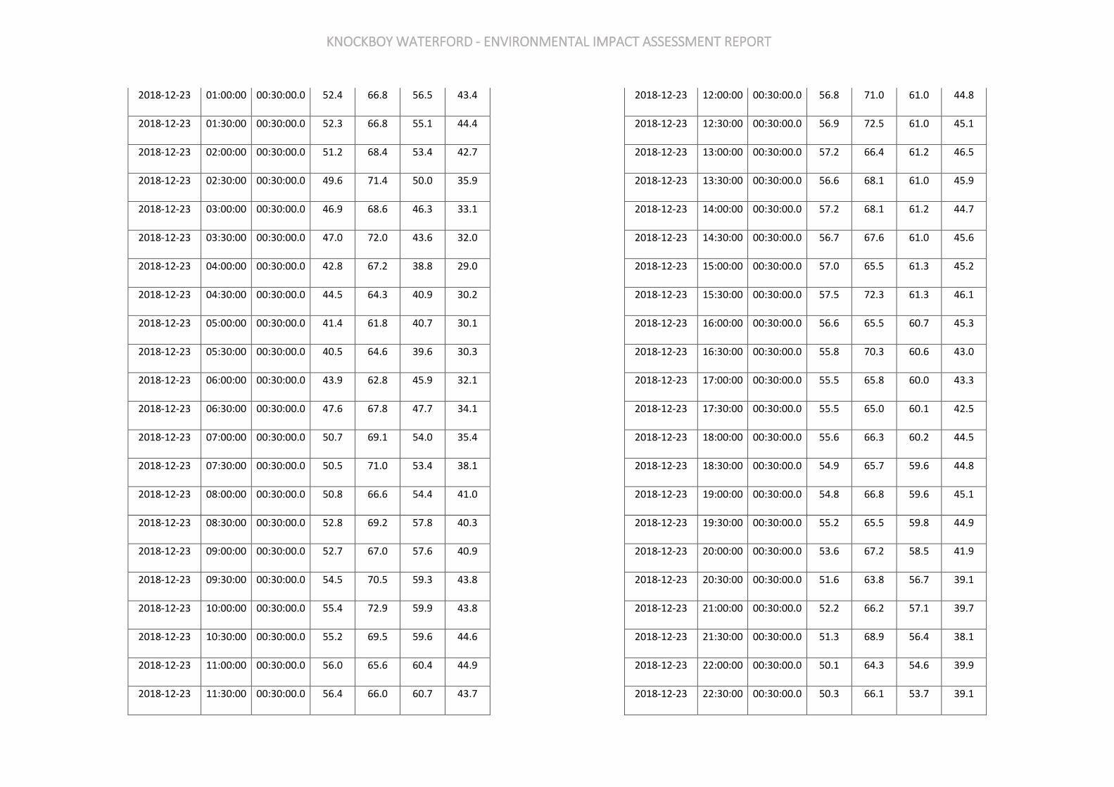
KNOCKBOY WATERFORD - ENVIRONMENTAL IMPACT ASSESSMENT REPORT
2018-12-23 01:00:00 00:30:00.0 52.4 66.8 56.5 43.4
2018-12-23 01:30:00 00:30:00.0 52.3 66.8 55.1 44.4
2018-12-23 02:00:00 00:30:00.0 51.2 68.4 53.4 42.7
2018-12-23 02:30:00 00:30:00.0 49.6 71.4 50.0 35.9
2018-12-23 03:00:00 00:30:00.0 46.9 68.6 46.3 33.1
2018-12-23 03:30:00 00:30:00.0 47.0 72.0 43.6 32.0
2018-12-23 04:00:00 00:30:00.0 42.8 67.2 38.8 29.0
2018-12-23 04:30:00 00:30:00.0 44.5 64.3 40.9 30.2
2018-12-23 05:00:00 00:30:00.0 41.4 61.8 40.7 30.1
2018-12-23 05:30:00 00:30:00.0 40.5 64.6 39.6 30.3
2018-12-23 06:00:00 00:30:00.0 43.9 62.8 45.9 32.1
2018-12-23 06:30:00 00:30:00.0 47.6 67.8 47.7 34.1
2018-12-23 07:00:00 00:30:00.0 50.7 69.1 54.0 35.4
2018-12-23 07:30:00 00:30:00.0 50.5 71.0 53.4 38.1
2018-12-23 08:00:00 00:30:00.0 50.8 66.6 54.4 41.0
2018-12-23 08:30:00 00:30:00.0 52.8 69.2 57.8 40.3
2018-12-23 09:00:00 00:30:00.0 52.7 67.0 57.6 40.9
2018-12-23 09:30:00 00:30:00.0 54.5 70.5 59.3 43.8
2018-12-23 10:00:00 00:30:00.0 55.4 72.9 59.9 43.8
2018-12-23 10:30:00 00:30:00.0 55.2 69.5 59.6 44.6
2018-12-23 11:00:00 00:30:00.0 56.0 65.6 60.4 44.9
2018-12-23 11:30:00 00:30:00.0 56.4 66.0 60.7 43.7
2018-12-23 12:00:00 00:30:00.0 56.8 71.0 61.0 44.8
2018-12-23 12:30:00 00:30:00.0 56.9 72.5 61.0 45.1
2018-12-23 13:00:00 00:30:00.0 57.2 66.4 61.2 46.5
2018-12-23 13:30:00 00:30:00.0 56.6 68.1 61.0 45.9
2018-12-23 14:00:00 00:30:00.0 57.2 68.1 61.2 44.7
2018-12-23 14:30:00 00:30:00.0 56.7 67.6 61.0 45.6
2018-12-23 15:00:00 00:30:00.0 57.0 65.5 61.3 45.2
2018-12-23 15:30:00 00:30:00.0 57.5 72.3 61.3 46.1
2018-12-23 16:00:00 00:30:00.0 56.6 65.5 60.7 45.3
2018-12-23 16:30:00 00:30:00.0 55.8 70.3 60.6 43.0
2018-12-23 17:00:00 00:30:00.0 55.5 65.8 60.0 43.3
2018-12-23 17:30:00 00:30:00.0 55.5 65.0 60.1 42.5
2018-12-23 18:00:00 00:30:00.0 55.6 66.3 60.2 44.5
2018-12-23 18:30:00 00:30:00.0 54.9 65.7 59.6 44.8
2018-12-23 19:00:00 00:30:00.0 54.8 66.8 59.6 45.1
2018-12-23 19:30:00 00:30:00.0 55.2 65.5 59.8 44.9
2018-12-23 20:00:00 00:30:00.0 53.6 67.2 58.5 41.9
2018-12-23 20:30:00 00:30:00.0 51.6 63.8 56.7 39.1
2018-12-23 21:00:00 00:30:00.0 52.2 66.2 57.1 39.7
2018-12-23 21:30:00 00:30:00.0 51.3 68.9 56.4 38.1
2018-12-23 22:00:00 00:30:00.0 50.1 64.3 54.6 39.9
2018-12-23 22:30:00 00:30:00.0 50.3 66.1 53.7 39.1
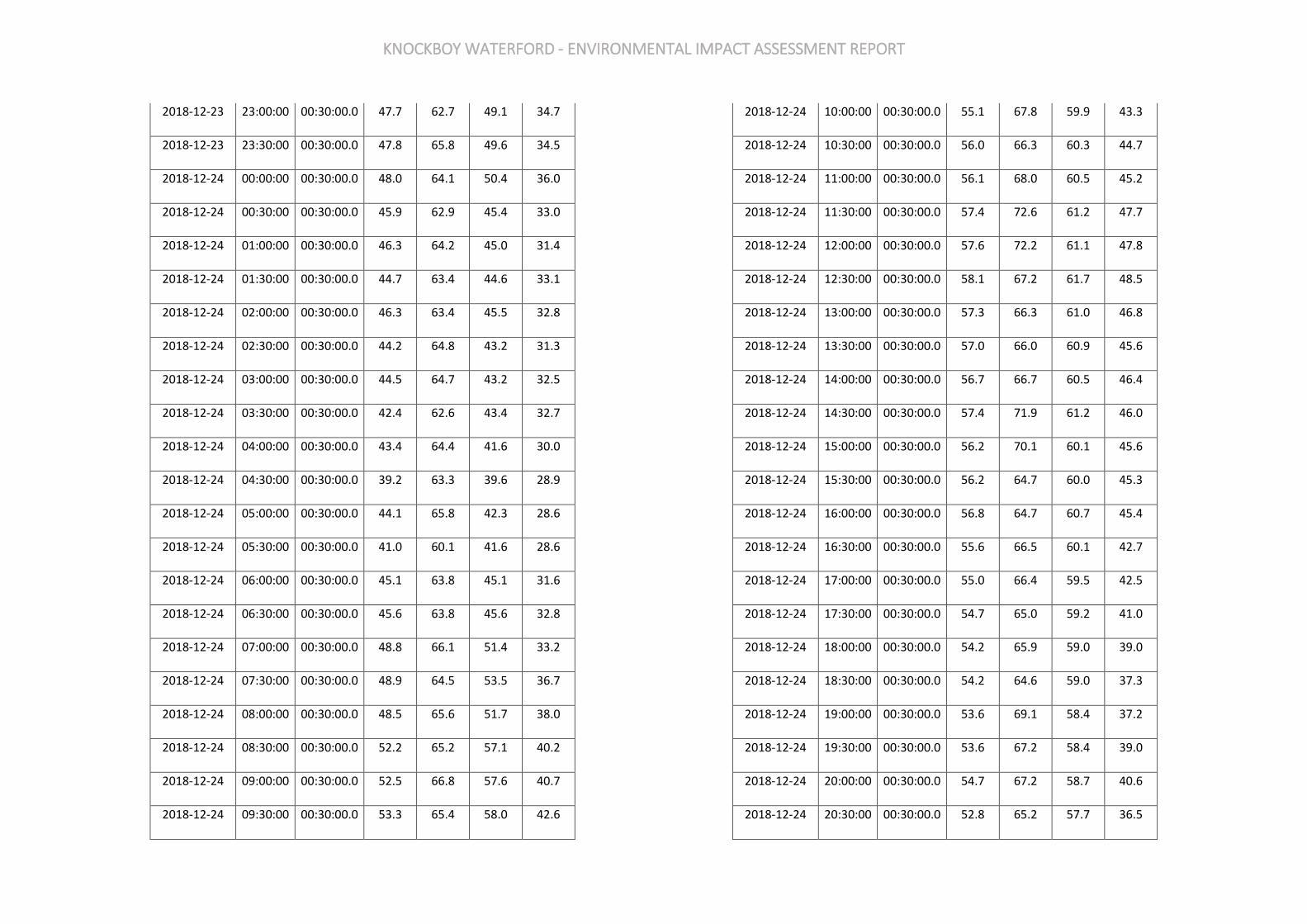
KNOCKBOY WATERFORD - ENVIRONMENTAL IMPACT ASSESSMENT REPORT
2018-12-23 23:00:00 00:30:00.0 47.7 62.7 49.1 34.7
2018-12-23 23:30:00 00:30:00.0 47.8 65.8 49.6 34.5
2018-12-24 00:00:00 00:30:00.0 48.0 64.1 50.4 36.0
2018-12-24 00:30:00 00:30:00.0 45.9 62.9 45.4 33.0
2018-12-24 01:00:00 00:30:00.0 46.3 64.2 45.0 31.4
2018-12-24 01:30:00 00:30:00.0 44.7 63.4 44.6 33.1
2018-12-24 02:00:00 00:30:00.0 46.3 63.4 45.5 32.8
2018-12-24 02:30:00 00:30:00.0 44.2 64.8 43.2 31.3
2018-12-24 03:00:00 00:30:00.0 44.5 64.7 43.2 32.5
2018-12-24 03:30:00 00:30:00.0 42.4 62.6 43.4 32.7
2018-12-24 04:00:00 00:30:00.0 43.4 64.4 41.6 30.0
2018-12-24 04:30:00 00:30:00.0 39.2 63.3 39.6 28.9
2018-12-24 05:00:00 00:30:00.0 44.1 65.8 42.3 28.6
2018-12-24 05:30:00 00:30:00.0 41.0 60.1 41.6 28.6
2018-12-24 06:00:00 00:30:00.0 45.1 63.8 45.1 31.6
2018-12-24 06:30:00 00:30:00.0 45.6 63.8 45.6 32.8
2018-12-24 07:00:00 00:30:00.0 48.8 66.1 51.4 33.2
2018-12-24 07:30:00 00:30:00.0 48.9 64.5 53.5 36.7
2018-12-24 08:00:00 00:30:00.0 48.5 65.6 51.7 38.0
2018-12-24 08:30:00 00:30:00.0 52.2 65.2 57.1 40.2
2018-12-24 09:00:00 00:30:00.0 52.5 66.8 57.6 40.7
2018-12-24 09:30:00 00:30:00.0 53.3 65.4 58.0 42.6
2018-12-24 10:00:00 00:30:00.0 55.1 67.8 59.9 43.3
2018-12-24 10:30:00 00:30:00.0 56.0 66.3 60.3 44.7
2018-12-24 11:00:00 00:30:00.0 56.1 68.0 60.5 45.2
2018-12-24 11:30:00 00:30:00.0 57.4 72.6 61.2 47.7
2018-12-24 12:00:00 00:30:00.0 57.6 72.2 61.1 47.8
2018-12-24 12:30:00 00:30:00.0 58.1 67.2 61.7 48.5
2018-12-24 13:00:00 00:30:00.0 57.3 66.3 61.0 46.8
2018-12-24 13:30:00 00:30:00.0 57.0 66.0 60.9 45.6
2018-12-24 14:00:00 00:30:00.0 56.7 66.7 60.5 46.4
2018-12-24 14:30:00 00:30:00.0 57.4 71.9 61.2 46.0
2018-12-24 15:00:00 00:30:00.0 56.2 70.1 60.1 45.6
2018-12-24 15:30:00 00:30:00.0 56.2 64.7 60.0 45.3
2018-12-24 16:00:00 00:30:00.0 56.8 64.7 60.7 45.4
2018-12-24 16:30:00 00:30:00.0 55.6 66.5 60.1 42.7
2018-12-24 17:00:00 00:30:00.0 55.0 66.4 59.5 42.5
2018-12-24 17:30:00 00:30:00.0 54.7 65.0 59.2 41.0
2018-12-24 18:00:00 00:30:00.0 54.2 65.9 59.0 39.0
2018-12-24 18:30:00 00:30:00.0 54.2 64.6 59.0 37.3
2018-12-24 19:00:00 00:30:00.0 53.6 69.1 58.4 37.2
2018-12-24 19:30:00 00:30:00.0 53.6 67.2 58.4 39.0
2018-12-24 20:00:00 00:30:00.0 54.7 67.2 58.7 40.6
2018-12-24 20:30:00 00:30:00.0 52.8 65.2 57.7 36.5
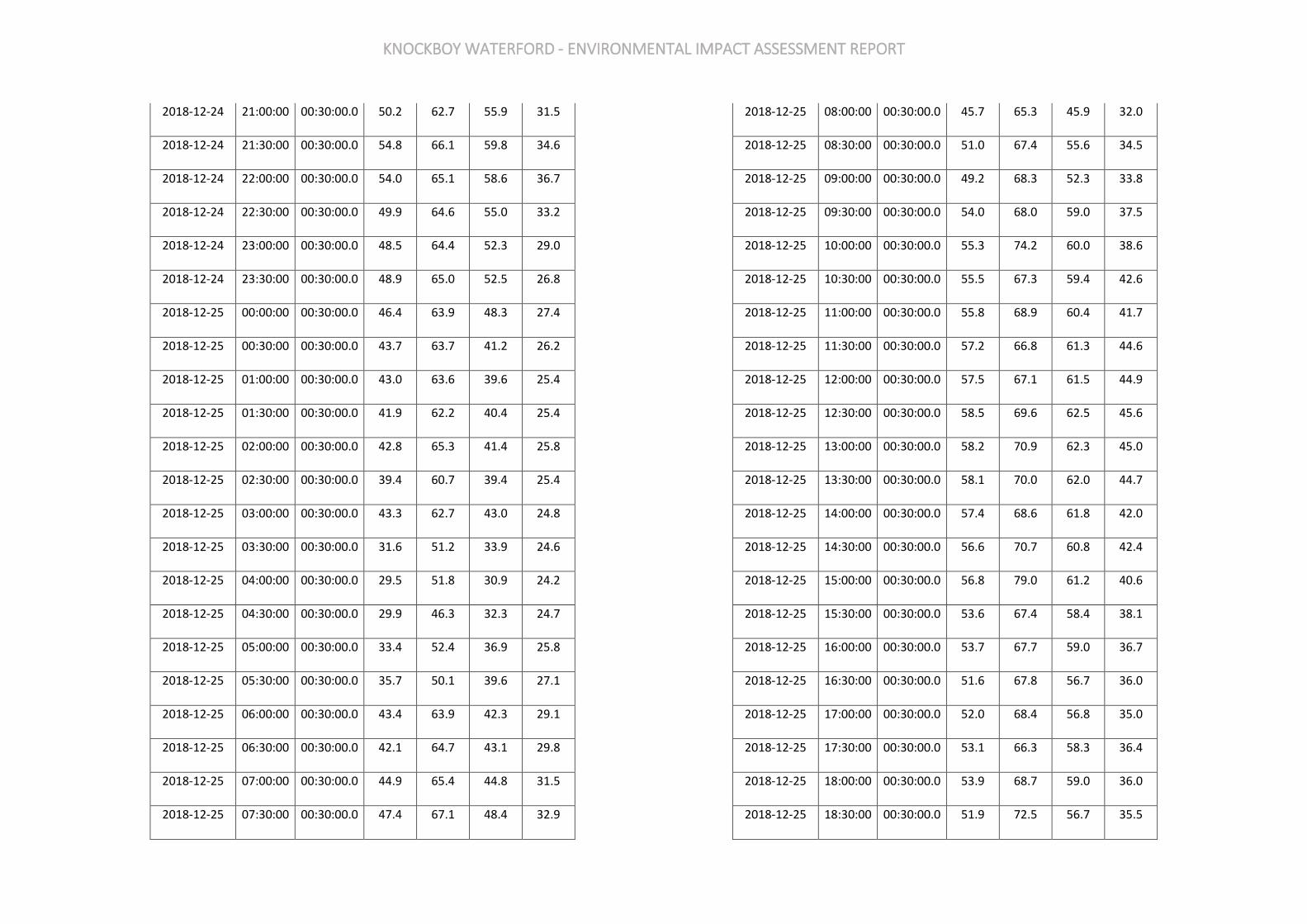
KNOCKBOY WATERFORD - ENVIRONMENTAL IMPACT ASSESSMENT REPORT
2018-12-24 21:00:00 00:30:00.0 50.2 62.7 55.9 31.5
2018-12-24 21:30:00 00:30:00.0 54.8 66.1 59.8 34.6
2018-12-24 22:00:00 00:30:00.0 54.0 65.1 58.6 36.7
2018-12-24 22:30:00 00:30:00.0 49.9 64.6 55.0 33.2
2018-12-24 23:00:00 00:30:00.0 48.5 64.4 52.3 29.0
2018-12-24 23:30:00 00:30:00.0 48.9 65.0 52.5 26.8
2018-12-25 00:00:00 00:30:00.0 46.4 63.9 48.3 27.4
2018-12-25 00:30:00 00:30:00.0 43.7 63.7 41.2 26.2
2018-12-25 01:00:00 00:30:00.0 43.0 63.6 39.6 25.4
2018-12-25 01:30:00 00:30:00.0 41.9 62.2 40.4 25.4
2018-12-25 02:00:00 00:30:00.0 42.8 65.3 41.4 25.8
2018-12-25 02:30:00 00:30:00.0 39.4 60.7 39.4 25.4
2018-12-25 03:00:00 00:30:00.0 43.3 62.7 43.0 24.8
2018-12-25 03:30:00 00:30:00.0 31.6 51.2 33.9 24.6
2018-12-25 04:00:00 00:30:00.0 29.5 51.8 30.9 24.2
2018-12-25 04:30:00 00:30:00.0 29.9 46.3 32.3 24.7
2018-12-25 05:00:00 00:30:00.0 33.4 52.4 36.9 25.8
2018-12-25 05:30:00 00:30:00.0 35.7 50.1 39.6 27.1
2018-12-25 06:00:00 00:30:00.0 43.4 63.9 42.3 29.1
2018-12-25 06:30:00 00:30:00.0 42.1 64.7 43.1 29.8
2018-12-25 07:00:00 00:30:00.0 44.9 65.4 44.8 31.5
2018-12-25 07:30:00 00:30:00.0 47.4 67.1 48.4 32.9
2018-12-25 08:00:00 00:30:00.0 45.7 65.3 45.9 32.0
2018-12-25 08:30:00 00:30:00.0 51.0 67.4 55.6 34.5
2018-12-25 09:00:00 00:30:00.0 49.2 68.3 52.3 33.8
2018-12-25 09:30:00 00:30:00.0 54.0 68.0 59.0 37.5
2018-12-25 10:00:00 00:30:00.0 55.3 74.2 60.0 38.6
2018-12-25 10:30:00 00:30:00.0 55.5 67.3 59.4 42.6
2018-12-25 11:00:00 00:30:00.0 55.8 68.9 60.4 41.7
2018-12-25 11:30:00 00:30:00.0 57.2 66.8 61.3 44.6
2018-12-25 12:00:00 00:30:00.0 57.5 67.1 61.5 44.9
2018-12-25 12:30:00 00:30:00.0 58.5 69.6 62.5 45.6
2018-12-25 13:00:00 00:30:00.0 58.2 70.9 62.3 45.0
2018-12-25 13:30:00 00:30:00.0 58.1 70.0 62.0 44.7
2018-12-25 14:00:00 00:30:00.0 57.4 68.6 61.8 42.0
2018-12-25 14:30:00 00:30:00.0 56.6 70.7 60.8 42.4
2018-12-25 15:00:00 00:30:00.0 56.8 79.0 61.2 40.6
2018-12-25 15:30:00 00:30:00.0 53.6 67.4 58.4 38.1
2018-12-25 16:00:00 00:30:00.0 53.7 67.7 59.0 36.7
2018-12-25 16:30:00 00:30:00.0 51.6 67.8 56.7 36.0
2018-12-25 17:00:00 00:30:00.0 52.0 68.4 56.8 35.0
2018-12-25 17:30:00 00:30:00.0 53.1 66.3 58.3 36.4
2018-12-25 18:00:00 00:30:00.0 53.9 68.7 59.0 36.0
2018-12-25 18:30:00 00:30:00.0 51.9 72.5 56.7 35.5

KNOCKBOY WATERFORD - ENVIRONMENTAL IMPACT ASSESSMENT REPORT
2018-12-25 19:00:00 00:30:00.0 52.9 69.0 57.9 37.2
2018-12-25 19:30:00 00:30:00.0 53.4 70.0 58.7 38.1
2018-12-25 20:00:00 00:30:00.0 51.7 65.7 56.8 34.0
2018-12-25 20:30:00 00:30:00.0 52.2 68.5 57.2 33.4
2018-12-25 21:00:00 00:30:00.0 51.1 67.5 56.0 34.7
2018-12-25 21:30:00 00:30:00.0 50.2 67.1 54.5 33.9
2018-12-25 22:00:00 00:30:00.0 49.6 66.2 54.0 32.3
2018-12-25 22:30:00 00:30:00.0 51.0 65.9 55.5 32.8
2018-12-25 23:00:00 00:30:00.0 50.0 68.5 53.7 30.5
2018-12-25 23:30:00 00:30:00.0 49.0 67.6 53.2 32.1
2018-12-26 00:00:00 00:30:00.0 45.7 64.5 44.1 30.2
2018-12-26 00:30:00 00:30:00.0 47.8 67.5 48.0 30.0
2018-12-26 01:00:00 00:30:00.0 43.0 62.6 40.6 28.0
2018-12-26 01:30:00 00:30:00.0 42.1 65.4 40.4 27.1
2018-12-26 02:00:00 00:30:00.0 38.3 56.4 40.8 28.0
2018-12-26 02:30:00 00:30:00.0 40.1 59.1 41.5 27.0
2018-12-26 03:00:00 00:30:00.0 41.7 63.4 43.2 27.5
2018-12-26 03:30:00 00:30:00.0 33.9 57.3 36.5 27.5
2018-12-26 04:00:00 00:30:00.0 41.6 63.3 39.1 27.0
2018-12-26 04:30:00 00:30:00.0 42.8 70.6 38.4 28.4
2018-12-26 05:00:00 00:30:00.0 36.8 56.1 38.0 28.9
2018-12-26 05:30:00 00:30:00.0 41.2 63.4 40.9 30.1
2018-12-26 06:00:00 00:30:00.0 39.5 60.2 41.4 30.2
2018-12-26 06:30:00 00:30:00.0 42.9 63.3 41.9 29.2
2018-12-26 07:00:00 00:30:00.0 47.0 66.5 47.8 33.9
2018-12-26 07:30:00 00:30:00.0 47.5 65.7 49.8 33.0
2018-12-26 08:00:00 00:30:00.0 45.3 63.7 46.5 32.5
2018-12-26 08:30:00 00:30:00.0 49.4 69.8 52.3 33.6
2018-12-26 09:00:00 00:30:00.0 51.8 71.4 56.7 35.0
2018-12-26 09:30:00 00:30:00.0 54.5 69.6 59.6 36.9
2018-12-26 10:00:00 00:30:00.0 53.4 71.5 58.3 36.9
2018-12-26 10:30:00 00:30:00.0 54.8 69.1 59.7 39.1
2018-12-26 11:00:00 00:30:00.0 56.0 71.0 60.6 41.2
2018-12-26 11:30:00 00:30:00.0 56.6 69.8 61.2 42.1
2018-12-26 12:00:00 00:30:00.0 57.2 69.6 61.6 42.9
2018-12-26 12:30:00 00:30:00.0 57.4 69.4 61.6 44.5
2018-12-26 13:00:00 00:30:00.0 55.3 68.4 60.0 40.9
2018-12-26 13:30:00 00:30:00.0 56.7 67.6 60.9 43.5
2018-12-26 14:00:00 00:30:00.0 58.8 81.1 62.1 43.6
2018-12-26 14:30:00 00:30:00.0 56.5 69.1 60.8 42.8
2018-12-26 15:00:00 00:30:00.0 56.9 69.0 61.3 43.6
2018-12-26 15:30:00 00:30:00.0 56.6 80.8 61.0 41.7
2018-12-26 16:00:00 00:30:00.0 57.1 69.5 61.4 43.4
2018-12-26 16:30:00 00:30:00.0 54.7 64.9 59.6 40.9
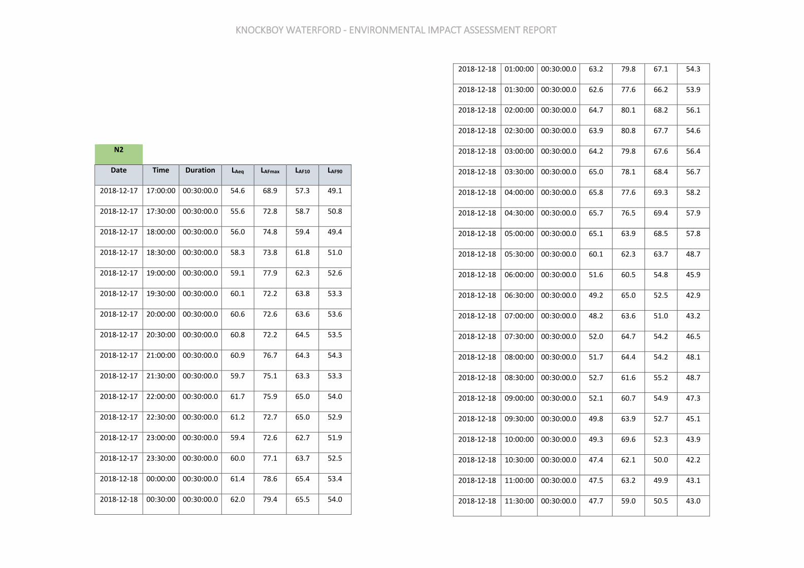
KNOCKBOY WATERFORD - ENVIRONMENTAL IMPACT ASSESSMENT REPORT
N2
Date Time Duration LAeq LAFmax LAF10 LAF90
2018-12-17 17:00:00 00:30:00.0 54.6 68.9 57.3 49.1
2018-12-17 17:30:00 00:30:00.0 55.6 72.8 58.7 50.8
2018-12-17 18:00:00 00:30:00.0 56.0 74.8 59.4 49.4
2018-12-17 18:30:00 00:30:00.0 58.3 73.8 61.8 51.0
2018-12-17 19:00:00 00:30:00.0 59.1 77.9 62.3 52.6
2018-12-17 19:30:00 00:30:00.0 60.1 72.2 63.8 53.3
2018-12-17 20:00:00 00:30:00.0 60.6 72.6 63.6 53.6
2018-12-17 20:30:00 00:30:00.0 60.8 72.2 64.5 53.5
2018-12-17 21:00:00 00:30:00.0 60.9 76.7 64.3 54.3
2018-12-17 21:30:00 00:30:00.0 59.7 75.1 63.3 53.3
2018-12-17 22:00:00 00:30:00.0 61.7 75.9 65.0 54.0
2018-12-17 22:30:00 00:30:00.0 61.2 72.7 65.0 52.9
2018-12-17 23:00:00 00:30:00.0 59.4 72.6 62.7 51.9
2018-12-17 23:30:00 00:30:00.0 60.0 77.1 63.7 52.5
2018-12-18 00:00:00 00:30:00.0 61.4 78.6 65.4 53.4
2018-12-18 00:30:00 00:30:00.0 62.0 79.4 65.5 54.0
2018-12-18 01:00:00 00:30:00.0 63.2 79.8 67.1 54.3
2018-12-18 01:30:00 00:30:00.0 62.6 77.6 66.2 53.9
2018-12-18 02:00:00 00:30:00.0 64.7 80.1 68.2 56.1
2018-12-18 02:30:00 00:30:00.0 63.9 80.8 67.7 54.6
2018-12-18 03:00:00 00:30:00.0 64.2 79.8 67.6 56.4
2018-12-18 03:30:00 00:30:00.0 65.0 78.1 68.4 56.7
2018-12-18 04:00:00 00:30:00.0 65.8 77.6 69.3 58.2
2018-12-18 04:30:00 00:30:00.0 65.7 76.5 69.4 57.9
2018-12-18 05:00:00 00:30:00.0 65.1 63.9 68.5 57.8
2018-12-18 05:30:00 00:30:00.0 60.1 62.3 63.7 48.7
2018-12-18 06:00:00 00:30:00.0 51.6 60.5 54.8 45.9
2018-12-18 06:30:00 00:30:00.0 49.2 65.0 52.5 42.9
2018-12-18 07:00:00 00:30:00.0 48.2 63.6 51.0 43.2
2018-12-18 07:30:00 00:30:00.0 52.0 64.7 54.2 46.5
2018-12-18 08:00:00 00:30:00.0 51.7 64.4 54.2 48.1
2018-12-18 08:30:00 00:30:00.0 52.7 61.6 55.2 48.7
2018-12-18 09:00:00 00:30:00.0 52.1 60.7 54.9 47.3
2018-12-18 09:30:00 00:30:00.0 49.8 63.9 52.7 45.1
2018-12-18 10:00:00 00:30:00.0 49.3 69.6 52.3 43.9
2018-12-18 10:30:00 00:30:00.0 47.4 62.1 50.0 42.2
2018-12-18 11:00:00 00:30:00.0 47.5 63.2 49.9 43.1
2018-12-18 11:30:00 00:30:00.0 47.7 59.0 50.5 43.0

KNOCKBOY WATERFORD - ENVIRONMENTAL IMPACT ASSESSMENT REPORT
2018-12-18 12:00:00 00:30:00.0 49.2 61.2 51.5 45.2
2018-12-18 12:30:00 00:30:00.0 48.3 61.9 50.9 43.0
2018-12-18 13:00:00 00:30:00.0 47.0 61.9 49.4 43.3
2018-12-18 13:30:00 00:30:00.0 48.2 68.5 50.7 43.9
2018-12-18 14:00:00 00:30:00.0 48.1 58.7 50.6 44.0
2018-12-18 14:30:00 00:30:00.0 49.1 58.7 51.3 44.9
2018-12-18 15:00:00 00:30:00.0 48.7 58.9 51.2 44.5
2018-12-18 15:30:00 00:30:00.0 48.7 73.4 51.1 45.0
2018-12-18 16:00:00 00:30:00.0 49.4 60.7 51.9 45.5
2018-12-18 16:30:00 00:30:00.0 50.9 61.9 52.5 46.4
2018-12-18 17:00:00 00:30:00.0 50.2 57.8 52.3 46.9
2018-12-18 17:30:00 00:30:00.0 49.6 57.3 51.5 46.5
2018-12-18 18:00:00 00:30:00.0 49.3 54.6 51.7 45.1
2018-12-18 18:30:00 00:30:00.0 47.6 55.4 50.1 44.0
2018-12-18 19:00:00 00:30:00.0 46.4 54.9 49.0 42.1
2018-12-18 19:30:00 00:30:00.0 47.0 52.9 49.5 42.6
2018-12-18 20:00:00 00:30:00.0 46.2 53.7 48.6 42.4
2018-12-18 20:30:00 00:30:00.0 45.1 57.0 47.4 42.1
2018-12-18 21:00:00 00:30:00.0 44.9 51.4 47.5 41.1
2018-12-18 21:30:00 00:30:00.0 45.5 52.9 48.5 41.0
2018-12-18 22:00:00 00:30:00.0 41.2 56.8 44.1 36.6
2018-12-18 22:30:00 00:30:00.0 41.6 52.9 44.5 36.0
2018-12-18 23:00:00 00:30:00.0 44.7 52.1 48.7 35.1
2018-12-18 23:30:00 00:30:00.0 36.5 49.1 39.2 30.5
2018-12-19 00:00:00 00:30:00.0 38.5 51.5 42.1 32.0
2018-12-19 00:30:00 00:30:00.0 34.1 40.0 36.0 28.8
2018-12-19 01:00:00 00:30:00.0 33.4 50.6 35.3 26.0
2018-12-19 01:30:00 00:30:00.0 29.5 55.2 31.9 26.5
2018-12-19 02:00:00 00:30:00.0 33.2 53.6 36.0 25.9
2018-12-19 02:30:00 00:30:00.0 33.7 46.8 34.8 26.4
2018-12-19 03:00:00 00:30:00.0 31.2 47.8 32.3 26.5
2018-12-19 03:30:00 00:30:00.0 29.6 55.5 31.5 26.6
2018-12-19 04:00:00 00:30:00.0 31.4 54.6 34.5 25.4
2018-12-19 04:30:00 00:30:00.0 39.0 55.4 42.6 27.9
2018-12-19 05:00:00 00:30:00.0 37.8 53.8 41.3 29.2
2018-12-19 05:30:00 00:30:00.0 39.7 63.6 42.3 32.9
2018-12-19 06:00:00 00:30:00.0 39.5 56.6 42.8 33.8
2018-12-19 06:30:00 00:30:00.0 46.6 58.5 49.6 38.1
2018-12-19 07:00:00 00:30:00.0 44.7 65.0 48.0 38.6
2018-12-19 07:30:00 00:30:00.0 48.3 58.5 50.7 44.2
2018-12-19 08:00:00 00:30:00.0 49.8 79.6 51.7 46.8
2018-12-19 08:30:00 00:30:00.0 51.3 80.5 53.3 48.7
2018-12-19 09:00:00 00:30:00.0 57.7 66.5 54.0 45.3
2018-12-19 09:30:00 00:30:00.0 60.8 71.4 58.2 43.6
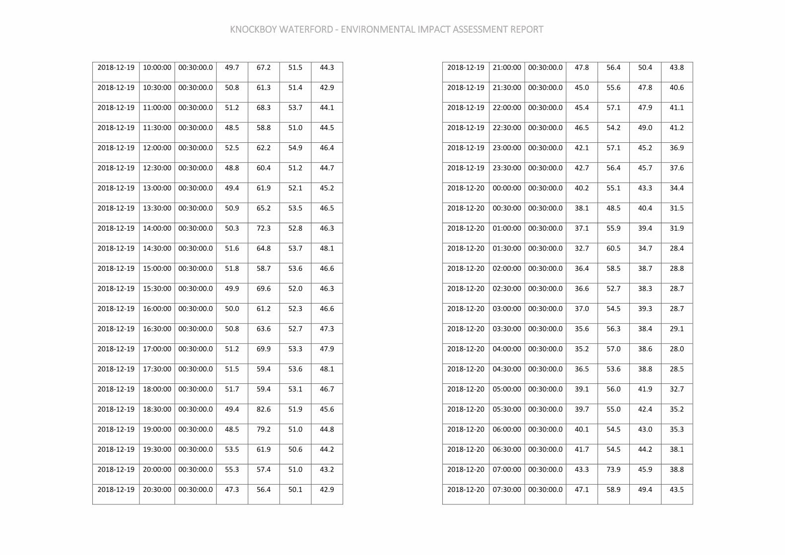
KNOCKBOY WATERFORD - ENVIRONMENTAL IMPACT ASSESSMENT REPORT
2018-12-19 10:00:00 00:30:00.0 49.7 67.2 51.5 44.3
2018-12-19 10:30:00 00:30:00.0 50.8 61.3 51.4 42.9
2018-12-19 11:00:00 00:30:00.0 51.2 68.3 53.7 44.1
2018-12-19 11:30:00 00:30:00.0 48.5 58.8 51.0 44.5
2018-12-19 12:00:00 00:30:00.0 52.5 62.2 54.9 46.4
2018-12-19 12:30:00 00:30:00.0 48.8 60.4 51.2 44.7
2018-12-19 13:00:00 00:30:00.0 49.4 61.9 52.1 45.2
2018-12-19 13:30:00 00:30:00.0 50.9 65.2 53.5 46.5
2018-12-19 14:00:00 00:30:00.0 50.3 72.3 52.8 46.3
2018-12-19 14:30:00 00:30:00.0 51.6 64.8 53.7 48.1
2018-12-19 15:00:00 00:30:00.0 51.8 58.7 53.6 46.6
2018-12-19 15:30:00 00:30:00.0 49.9 69.6 52.0 46.3
2018-12-19 16:00:00 00:30:00.0 50.0 61.2 52.3 46.6
2018-12-19 16:30:00 00:30:00.0 50.8 63.6 52.7 47.3
2018-12-19 17:00:00 00:30:00.0 51.2 69.9 53.3 47.9
2018-12-19 17:30:00 00:30:00.0 51.5 59.4 53.6 48.1
2018-12-19 18:00:00 00:30:00.0 51.7 59.4 53.1 46.7
2018-12-19 18:30:00 00:30:00.0 49.4 82.6 51.9 45.6
2018-12-19 19:00:00 00:30:00.0 48.5 79.2 51.0 44.8
2018-12-19 19:30:00 00:30:00.0 53.5 61.9 50.6 44.2
2018-12-19 20:00:00 00:30:00.0 55.3 57.4 51.0 43.2
2018-12-19 20:30:00 00:30:00.0 47.3 56.4 50.1 42.9
2018-12-19 21:00:00 00:30:00.0 47.8 56.4 50.4 43.8
2018-12-19 21:30:00 00:30:00.0 45.0 55.6 47.8 40.6
2018-12-19 22:00:00 00:30:00.0 45.4 57.1 47.9 41.1
2018-12-19 22:30:00 00:30:00.0 46.5 54.2 49.0 41.2
2018-12-19 23:00:00 00:30:00.0 42.1 57.1 45.2 36.9
2018-12-19 23:30:00 00:30:00.0 42.7 56.4 45.7 37.6
2018-12-20 00:00:00 00:30:00.0 40.2 55.1 43.3 34.4
2018-12-20 00:30:00 00:30:00.0 38.1 48.5 40.4 31.5
2018-12-20 01:00:00 00:30:00.0 37.1 55.9 39.4 31.9
2018-12-20 01:30:00 00:30:00.0 32.7 60.5 34.7 28.4
2018-12-20 02:00:00 00:30:00.0 36.4 58.5 38.7 28.8
2018-12-20 02:30:00 00:30:00.0 36.6 52.7 38.3 28.7
2018-12-20 03:00:00 00:30:00.0 37.0 54.5 39.3 28.7
2018-12-20 03:30:00 00:30:00.0 35.6 56.3 38.4 29.1
2018-12-20 04:00:00 00:30:00.0 35.2 57.0 38.6 28.0
2018-12-20 04:30:00 00:30:00.0 36.5 53.6 38.8 28.5
2018-12-20 05:00:00 00:30:00.0 39.1 56.0 41.9 32.7
2018-12-20 05:30:00 00:30:00.0 39.7 55.0 42.4 35.2
2018-12-20 06:00:00 00:30:00.0 40.1 54.5 43.0 35.3
2018-12-20 06:30:00 00:30:00.0 41.7 54.5 44.2 38.1
2018-12-20 07:00:00 00:30:00.0 43.3 73.9 45.9 38.8
2018-12-20 07:30:00 00:30:00.0 47.1 58.9 49.4 43.5

KNOCKBOY WATERFORD - ENVIRONMENTAL IMPACT ASSESSMENT REPORT
2018-12-20 08:00:00 00:30:00.0 49.8 63.1 51.0 46.9
2018-12-20 08:30:00 00:30:00.0 50.3 71.9 52.0 48.1
2018-12-20 09:00:00 00:30:00.0 50.2 61.4 53.1 45.8
2018-12-20 09:30:00 00:30:00.0 47.6 55.7 49.1 44.1
2018-12-20 10:00:00 00:30:00.0 45.9 59.2 47.8 43.4
2018-12-20 10:30:00 00:30:00.0 45.9 65.2 47.8 43.2
2018-12-20 11:00:00 00:30:00.0 47.4 59.2 49.7 44.3
2018-12-20 11:30:00 00:30:00.0 48.2 68.4 50.3 44.5
2018-12-20 12:00:00 00:30:00.0 49.5 65.9 51.7 46.1
2018-12-20 12:30:00 00:30:00.0 51.7 69.6 54.1 47.4
2018-12-20 13:00:00 00:30:00.0 51.7 72.2 54.1 47.5
2018-12-20 13:30:00 00:30:00.0 52.4 62.3 54.1 48.3
2018-12-20 14:00:00 00:30:00.0 53.0 62.4 53.8 47.8
2018-12-20 14:30:00 00:30:00.0 51.4 64.7 53.7 48.0
2018-12-20 15:00:00 00:30:00.0 51.7 58.2 54.2 47.6
2018-12-20 15:30:00 00:30:00.0 51.2 62.8 53.3 47.6
2018-12-20 16:00:00 00:30:00.0 50.4 56.7 52.6 47.3
2018-12-20 16:30:00 00:30:00.0 50.9 58.3 52.9 47.6
2018-12-20 17:00:00 00:30:00.0 49.7 55.1 51.9 46.6
2018-12-20 17:30:00 00:30:00.0 48.4 55.8 50.4 45.5
2018-12-20 18:00:00 00:30:00.0 47.9 54.2 50.1 44.8
2018-12-20 18:30:00 00:30:00.0 47.8 52.0 50.2 44.6
2018-12-20 19:00:00 00:30:00.0 46.6 51.9 49.2 43.3
2018-12-20 19:30:00 00:30:00.0 45.5 52.6 47.7 42.0
2018-12-20 20:00:00 00:30:00.0 44.7 58.3 47.2 40.6
2018-12-20 20:30:00 00:30:00.0 44.6 50.0 47.3 40.6
2018-12-20 21:00:00 00:30:00.0 44.0 49.3 46.7 39.1
2018-12-20 21:30:00 00:30:00.0 42.6 50.3 44.9 38.2
2018-12-20 22:00:00 00:30:00.0 40.0 48.8 42.2 36.4
2018-12-20 22:30:00 00:30:00.0 38.0 48.2 40.2 34.7
2018-12-20 23:00:00 00:30:00.0 35.6 50.4 38.2 31.7
2018-12-20 23:30:00 00:30:00.0 34.7 53.4 38.2 30.0
2018-12-21 00:00:00 00:30:00.0 42.0 50.8 46.1 36.0
2018-12-21 00:30:00 00:30:00.0 42.9 52.3 48.4 33.1
2018-12-21 01:00:00 00:30:00.0 37.7 57.1 41.2 31.1
2018-12-21 01:30:00 00:30:00.0 38.1 56.5 41.3 31.8
2018-12-21 02:00:00 00:30:00.0 40.8 52.0 43.8 33.7
2018-12-21 02:30:00 00:30:00.0 36.9 53.9 39.8 29.9
2018-12-21 03:00:00 00:30:00.0 37.2 59.8 40.8 30.3
2018-12-21 03:30:00 00:30:00.0 36.8 65.0 39.6 29.4
2018-12-21 04:00:00 00:30:00.0 40.2 65.8 41.7 29.3
2018-12-21 04:30:00 00:30:00.0 43.5 62.5 45.8 35.3
2018-12-21 05:00:00 00:30:00.0 48.4 59.5 51.8 39.3
2018-12-21 05:30:00 00:30:00.0 45.7 64.2 48.9 39.5

KNOCKBOY WATERFORD - ENVIRONMENTAL IMPACT ASSESSMENT REPORT
2018-12-21 06:00:00 00:30:00.0 43.3 59.8 46.7 35.4
2018-12-21 06:30:00 00:30:00.0 44.7 74.9 47.2 37.9
2018-12-21 07:00:00 00:30:00.0 47.7 63.4 50.9 40.4
2018-12-21 07:30:00 00:30:00.0 50.7 65.7 53.1 45.4
2018-12-21 08:00:00 00:30:00.0 51.7 68.0 54.1 47.8
2018-12-21 08:30:00 00:30:00.0 53.9 80.1 55.7 51.1
2018-12-21 09:00:00 00:30:00.0 53.1 62.9 55.3 48.4
2018-12-21 09:30:00 00:30:00.0 60.3 64.2 56.1 47.8
2018-12-21 10:00:00 00:30:00.0 48.5 65.7 51.3 43.6
2018-12-21 10:30:00 00:30:00.0 49.2 75.2 51.8 45.0
2018-12-21 11:00:00 00:30:00.0 49.1 67.5 51.3 44.8
2018-12-21 11:30:00 00:30:00.0 48.8 71.3 49.9 44.0
2018-12-21 12:00:00 00:30:00.0 50.4 64.2 51.7 45.7
2018-12-21 12:30:00 00:30:00.0 50.0 65.4 50.4 44.3
2018-12-21 13:00:00 00:30:00.0 47.3 63.4 49.2 43.7
2018-12-21 13:30:00 00:30:00.0 47.7 56.9 50.0 44.2
2018-12-21 14:00:00 00:30:00.0 47.9 68.7 50.2 44.1
2018-12-21 14:30:00 00:30:00.0 48.5 71.0 50.9 44.7
2018-12-21 15:00:00 00:30:00.0 49.0 60.7 51.0 45.0
2018-12-21 15:30:00 00:30:00.0 50.1 68.1 52.2 46.8
2018-12-21 16:00:00 00:30:00.0 48.8 56.2 50.7 46.3
2018-12-21 16:30:00 00:30:00.0 47.9 60.1 49.0 45.7
2018-12-21 17:00:00 00:30:00.0 48.1 56.0 50.1 45.4
2018-12-21 17:30:00 00:30:00.0 48.3 54.7 50.2 45.3
2018-12-21 18:00:00 00:30:00.0 48.5 54.9 50.4 46.0
2018-12-21 18:30:00 00:30:00.0 48.0 54.5 49.7 45.6
2018-12-21 19:00:00 00:30:00.0 49.1 53.7 51.1 46.4
2018-12-21 19:30:00 00:30:00.0 47.7 61.3 49.9 44.6
2018-12-21 20:00:00 00:30:00.0 45.9 52.7 48.0 42.8
2018-12-21 20:30:00 00:30:00.0 45.5 53.7 47.6 42.2
2018-12-21 21:00:00 00:30:00.0 45.0 52.8 47.4 41.7
2018-12-21 21:30:00 00:30:00.0 43.5 54.9 46.4 39.0
2018-12-21 22:00:00 00:30:00.0 43.2 58.9 46.1 38.6
2018-12-21 22:30:00 00:30:00.0 43.3 51.8 46.0 39.2
2018-12-21 23:00:00 00:30:00.0 43.6 56.2 46.5 39.1
2018-12-21 23:30:00 00:30:00.0 41.6 53.0 44.4 37.8
2018-12-22 00:00:00 00:30:00.0 41.7 55.4 44.9 36.8
2018-12-22 00:30:00 00:30:00.0 41.1 55.5 43.8 36.9
2018-12-22 01:00:00 00:30:00.0 41.9 52.3 44.7 36.1
2018-12-22 01:30:00 00:30:00.0 40.3 55.8 43.0 35.2
2018-12-22 02:00:00 00:30:00.0 39.9 55.1 43.2 33.8
2018-12-22 02:30:00 00:30:00.0 40.2 53.8 43.4 34.1
2018-12-22 03:00:00 00:30:00.0 40.1 56.6 43.4 34.5
2018-12-22 03:30:00 00:30:00.0 39.9 53.1 43.1 33.4

KNOCKBOY WATERFORD - ENVIRONMENTAL IMPACT ASSESSMENT REPORT
2018-12-22 04:00:00 00:30:00.0 38.1 48.4 41.0 31.1
2018-12-22 04:30:00 00:30:00.0 37.7 55.3 40.8 30.3
2018-12-22 05:00:00 00:30:00.0 33.8 53.7 36.8 28.5
2018-12-22 05:30:00 00:30:00.0 38.0 55.0 41.1 30.3
2018-12-22 06:00:00 00:30:00.0 40.6 56.2 44.5 32.2
2018-12-22 06:30:00 00:30:00.0 41.6 69.0 45.1 34.4
2018-12-22 07:00:00 00:30:00.0 41.7 63.2 45.0 35.5
2018-12-22 07:30:00 00:30:00.0 46.8 64.2 48.5 38.6
2018-12-22 08:00:00 00:30:00.0 45.2 73.6 47.8 40.9
2018-12-22 08:30:00 00:30:00.0 47.1 81.2 49.7 42.3
2018-12-22 09:00:00 00:30:00.0 46.9 84.6 48.4 43.6
2018-12-22 09:30:00 00:30:00.0 58.9 68.5 52.3 43.7
2018-12-22 10:00:00 00:30:00.0 49.4 78.2 48.7 43.8
2018-12-22 10:30:00 00:30:00.0 48.1 69.7 50.2 44.3
2018-12-22 11:00:00 00:30:00.0 56.6 68.2 50.3 44.2
2018-12-22 11:30:00 00:30:00.0 48.5 57.9 50.7 44.8
2018-12-22 12:00:00 00:30:00.0 49.3 71.2 51.0 45.8
2018-12-22 12:30:00 00:30:00.0 48.3 70.7 50.8 44.7
2018-12-22 13:00:00 00:30:00.0 47.1 66.3 49.6 42.6
2018-12-22 13:30:00 00:30:00.0 47.6 73.5 49.8 43.6
2018-12-22 14:00:00 00:30:00.0 47.5 63.6 49.5 44.0
2018-12-22 14:30:00 00:30:00.0 48.9 70.5 50.6 44.8
2018-12-22 15:00:00 00:30:00.0 49.2 69.8 50.8 45.1
2018-12-22 15:30:00 00:30:00.0 49.7 66.7 50.7 44.9
2018-12-22 16:00:00 00:30:00.0 49.2 58.1 50.5 45.1
2018-12-22 16:30:00 00:30:00.0 47.5 65.5 49.5 44.5
2018-12-22 17:00:00 00:30:00.0 47.8 55.8 50.1 44.3
2018-12-22 17:30:00 00:30:00.0 48.9 63.5 50.1 44.4
2018-12-22 18:00:00 00:30:00.0 46.7 54.1 49.3 43.5
2018-12-22 18:30:00 00:30:00.0 47.0 51.9 49.3 43.1
2018-12-22 19:00:00 00:30:00.0 44.7 51.3 47.4 40.0
2018-12-22 19:30:00 00:30:00.0 44.8 61.4 47.1 41.3
2018-12-22 20:00:00 00:30:00.0 43.4 54.8 46.6 37.9
2018-12-22 20:30:00 00:30:00.0 40.4 55.0 43.3 35.3
2018-12-22 21:00:00 00:30:00.0 40.3 60.9 43.3 35.1
2018-12-22 21:30:00 00:30:00.0 39.2 56.1 42.1 33.5
2018-12-22 22:00:00 00:30:00.0 40.6 54.5 42.6 35.9
2018-12-22 22:30:00 00:30:00.0 40.5 54.2 42.7 37.2
2018-12-22 23:00:00 00:30:00.0 44.2 55.7 46.4 39.3
2018-12-22 23:30:00 00:30:00.0 45.3 54.1 48.0 41.7
2018-12-23 00:00:00 00:30:00.0 43.7 55.7 46.6 36.4
2018-12-23 00:30:00 00:30:00.0 46.6 58.8 49.5 42.5
2018-12-23 01:00:00 00:30:00.0 44.2 62.4 46.8 39.6
2018-12-23 01:30:00 00:30:00.0 46.1 57.7 48.9 41.0

KNOCKBOY WATERFORD - ENVIRONMENTAL IMPACT ASSESSMENT REPORT
2018-12-23 02:00:00 00:30:00.0 43.5 52.5 46.2 39.1
2018-12-23 02:30:00 00:30:00.0 42.7 55.3 46.1 35.6
2018-12-23 03:00:00 00:30:00.0 37.8 52.4 41.1 31.4
2018-12-23 03:30:00 00:30:00.0 39.0 51.7 42.3 31.0
2018-12-23 04:00:00 00:30:00.0 34.3 51.9 36.2 27.3
2018-12-23 04:30:00 00:30:00.0 36.5 51.1 40.4 28.5
2018-12-23 05:00:00 00:30:00.0 36.2 53.3 39.3 28.6
2018-12-23 05:30:00 00:30:00.0 33.9 50.4 36.3 28.4
2018-12-23 06:00:00 00:30:00.0 38.1 50.7 41.7 30.1
2018-12-23 06:30:00 00:30:00.0 37.2 65.1 40.0 31.5
2018-12-23 07:00:00 00:30:00.0 38.9 74.3 42.3 33.1
2018-12-23 07:30:00 00:30:00.0 44.9 75.9 48.0 35.6
2018-12-23 08:00:00 00:30:00.0 48.0 75.8 49.2 40.7
2018-12-23 08:30:00 00:30:00.0 51.4 63.2 49.7 39.7
2018-12-23 09:00:00 00:30:00.0 45.9 73.3 46.7 39.7
2018-12-23 09:30:00 00:30:00.0 47.7 72.1 49.8 43.3
2018-12-23 10:00:00 00:30:00.0 51.9 68.8 53.4 42.7
2018-12-23 10:30:00 00:30:00.0 51.8 65.1 55.1 43.5
2018-12-23 11:00:00 00:30:00.0 52.8 66.2 56.0 45.4
2018-12-23 11:30:00 00:30:00.0 48.3 66.7 50.3 44.1
2018-12-23 12:00:00 00:30:00.0 48.0 64.1 50.0 44.0
2018-12-23 12:30:00 00:30:00.0 49.7 72.3 51.9 45.2
2018-12-23 13:00:00 00:30:00.0 49.4 63.4 51.1 45.1
2018-12-23 13:30:00 00:30:00.0 52.0 63.0 55.0 43.5
2018-12-23 14:00:00 00:30:00.0 47.5 73.7 50.0 42.0
2018-12-23 14:30:00 00:30:00.0 45.9 71.7 48.0 42.1
2018-12-23 15:00:00 00:30:00.0 53.3 62.9 56.3 41.8
2018-12-23 15:30:00 00:30:00.0 50.5 79.2 53.2 42.2
2018-12-23 16:00:00 00:30:00.0 46.0 51.0 47.9 42.8
2018-12-23 16:30:00 00:30:00.0 53.3 50.6 51.3 40.4
2018-12-23 17:00:00 00:30:00.0 43.4 51.1 45.7 39.8
2018-12-23 17:30:00 00:30:00.0 43.3 50.9 45.5 39.8
2018-12-23 18:00:00 00:30:00.0 44.5 50.7 46.6 41.2
2018-12-23 18:30:00 00:30:00.0 44.8 50.4 46.9 41.9
2018-12-23 19:00:00 00:30:00.0 44.3 51.4 46.3 41.6
2018-12-23 19:30:00 00:30:00.0 44.3 50.9 46.4 41.3
2018-12-23 20:00:00 00:30:00.0 42.2 49.7 44.6 38.5
2018-12-23 20:30:00 00:30:00.0 40.8 52.4 43.6 35.6
2018-12-23 21:00:00 00:30:00.0 41.2 50.9 43.7 36.6
2018-12-23 21:30:00 00:30:00.0 41.3 51.8 44.4 34.8
2018-12-23 22:00:00 00:30:00.0 41.3 52.6 43.9 36.7
2018-12-23 22:30:00 00:30:00.0 40.4 49.6 43.6 34.6
2018-12-23 23:00:00 00:30:00.0 38.3 50.0 41.7 30.3
2018-12-23 23:30:00 00:30:00.0 38.9 48.3 42.3 31.0
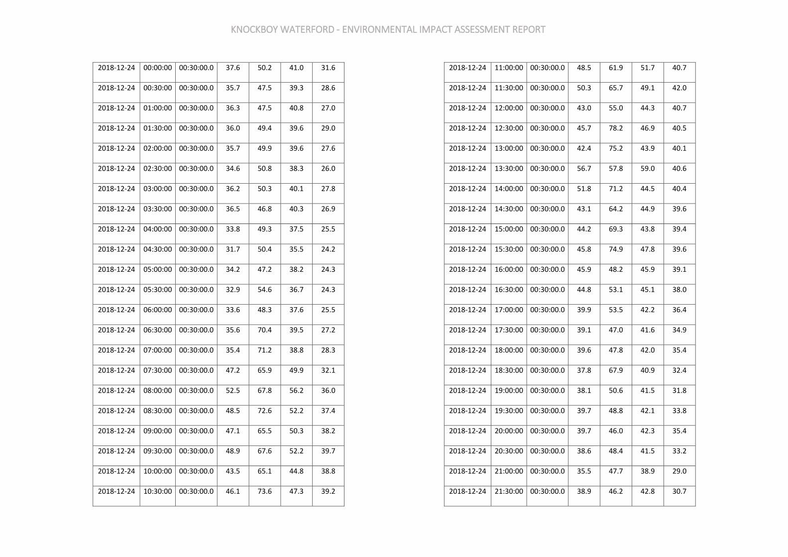
KNOCKBOY WATERFORD - ENVIRONMENTAL IMPACT ASSESSMENT REPORT
2018-12-24 00:00:00 00:30:00.0 37.6 50.2 41.0 31.6
2018-12-24 00:30:00 00:30:00.0 35.7 47.5 39.3 28.6
2018-12-24 01:00:00 00:30:00.0 36.3 47.5 40.8 27.0
2018-12-24 01:30:00 00:30:00.0 36.0 49.4 39.6 29.0
2018-12-24 02:00:00 00:30:00.0 35.7 49.9 39.6 27.6
2018-12-24 02:30:00 00:30:00.0 34.6 50.8 38.3 26.0
2018-12-24 03:00:00 00:30:00.0 36.2 50.3 40.1 27.8
2018-12-24 03:30:00 00:30:00.0 36.5 46.8 40.3 26.9
2018-12-24 04:00:00 00:30:00.0 33.8 49.3 37.5 25.5
2018-12-24 04:30:00 00:30:00.0 31.7 50.4 35.5 24.2
2018-12-24 05:00:00 00:30:00.0 34.2 47.2 38.2 24.3
2018-12-24 05:30:00 00:30:00.0 32.9 54.6 36.7 24.3
2018-12-24 06:00:00 00:30:00.0 33.6 48.3 37.6 25.5
2018-12-24 06:30:00 00:30:00.0 35.6 70.4 39.5 27.2
2018-12-24 07:00:00 00:30:00.0 35.4 71.2 38.8 28.3
2018-12-24 07:30:00 00:30:00.0 47.2 65.9 49.9 32.1
2018-12-24 08:00:00 00:30:00.0 52.5 67.8 56.2 36.0
2018-12-24 08:30:00 00:30:00.0 48.5 72.6 52.2 37.4
2018-12-24 09:00:00 00:30:00.0 47.1 65.5 50.3 38.2
2018-12-24 09:30:00 00:30:00.0 48.9 67.6 52.2 39.7
2018-12-24 10:00:00 00:30:00.0 43.5 65.1 44.8 38.8
2018-12-24 10:30:00 00:30:00.0 46.1 73.6 47.3 39.2
2018-12-24 11:00:00 00:30:00.0 48.5 61.9 51.7 40.7
2018-12-24 11:30:00 00:30:00.0 50.3 65.7 49.1 42.0
2018-12-24 12:00:00 00:30:00.0 43.0 55.0 44.3 40.7
2018-12-24 12:30:00 00:30:00.0 45.7 78.2 46.9 40.5
2018-12-24 13:00:00 00:30:00.0 42.4 75.2 43.9 40.1
2018-12-24 13:30:00 00:30:00.0 56.7 57.8 59.0 40.6
2018-12-24 14:00:00 00:30:00.0 51.8 71.2 44.5 40.4
2018-12-24 14:30:00 00:30:00.0 43.1 64.2 44.9 39.6
2018-12-24 15:00:00 00:30:00.0 44.2 69.3 43.8 39.4
2018-12-24 15:30:00 00:30:00.0 45.8 74.9 47.8 39.6
2018-12-24 16:00:00 00:30:00.0 45.9 48.2 45.9 39.1
2018-12-24 16:30:00 00:30:00.0 44.8 53.1 45.1 38.0
2018-12-24 17:00:00 00:30:00.0 39.9 53.5 42.2 36.4
2018-12-24 17:30:00 00:30:00.0 39.1 47.0 41.6 34.9
2018-12-24 18:00:00 00:30:00.0 39.6 47.8 42.0 35.4
2018-12-24 18:30:00 00:30:00.0 37.8 67.9 40.9 32.4
2018-12-24 19:00:00 00:30:00.0 38.1 50.6 41.5 31.8
2018-12-24 19:30:00 00:30:00.0 39.7 48.8 42.1 33.8
2018-12-24 20:00:00 00:30:00.0 39.7 46.0 42.3 35.4
2018-12-24 20:30:00 00:30:00.0 38.6 48.4 41.5 33.2
2018-12-24 21:00:00 00:30:00.0 35.5 47.7 38.9 29.0
2018-12-24 21:30:00 00:30:00.0 38.9 46.2 42.8 30.7
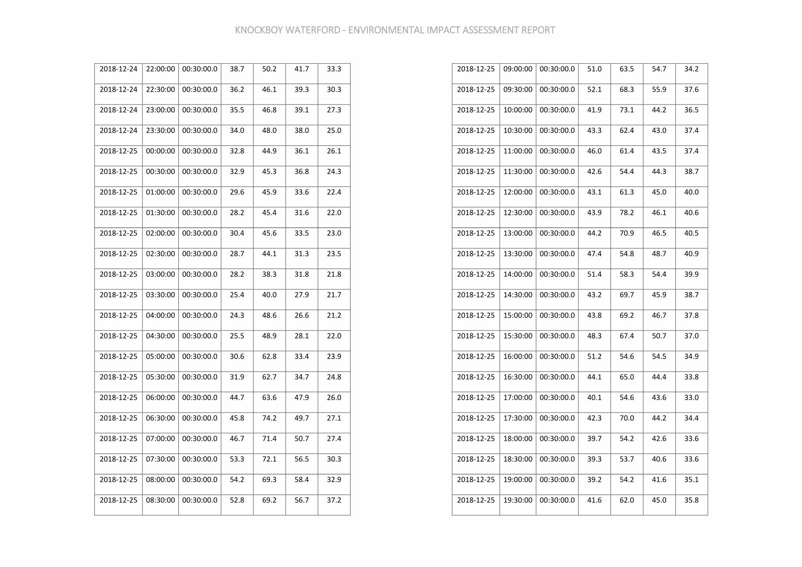
KNOCKBOY WATERFORD - ENVIRONMENTAL IMPACT ASSESSMENT REPORT
2018-12-24 22:00:00 00:30:00.0 38.7 50.2 41.7 33.3
2018-12-24 22:30:00 00:30:00.0 36.2 46.1 39.3 30.3
2018-12-24 23:00:00 00:30:00.0 35.5 46.8 39.1 27.3
2018-12-24 23:30:00 00:30:00.0 34.0 48.0 38.0 25.0
2018-12-25 00:00:00 00:30:00.0 32.8 44.9 36.1 26.1
2018-12-25 00:30:00 00:30:00.0 32.9 45.3 36.8 24.3
2018-12-25 01:00:00 00:30:00.0 29.6 45.9 33.6 22.4
2018-12-25 01:30:00 00:30:00.0 28.2 45.4 31.6 22.0
2018-12-25 02:00:00 00:30:00.0 30.4 45.6 33.5 23.0
2018-12-25 02:30:00 00:30:00.0 28.7 44.1 31.3 23.5
2018-12-25 03:00:00 00:30:00.0 28.2 38.3 31.8 21.8
2018-12-25 03:30:00 00:30:00.0 25.4 40.0 27.9 21.7
2018-12-25 04:00:00 00:30:00.0 24.3 48.6 26.6 21.2
2018-12-25 04:30:00 00:30:00.0 25.5 48.9 28.1 22.0
2018-12-25 05:00:00 00:30:00.0 30.6 62.8 33.4 23.9
2018-12-25 05:30:00 00:30:00.0 31.9 62.7 34.7 24.8
2018-12-25 06:00:00 00:30:00.0 44.7 63.6 47.9 26.0
2018-12-25 06:30:00 00:30:00.0 45.8 74.2 49.7 27.1
2018-12-25 07:00:00 00:30:00.0 46.7 71.4 50.7 27.4
2018-12-25 07:30:00 00:30:00.0 53.3 72.1 56.5 30.3
2018-12-25 08:00:00 00:30:00.0 54.2 69.3 58.4 32.9
2018-12-25 08:30:00 00:30:00.0 52.8 69.2 56.7 37.2
2018-12-25 09:00:00 00:30:00.0 51.0 63.5 54.7 34.2
2018-12-25 09:30:00 00:30:00.0 52.1 68.3 55.9 37.6
2018-12-25 10:00:00 00:30:00.0 41.9 73.1 44.2 36.5
2018-12-25 10:30:00 00:30:00.0 43.3 62.4 43.0 37.4
2018-12-25 11:00:00 00:30:00.0 46.0 61.4 43.5 37.4
2018-12-25 11:30:00 00:30:00.0 42.6 54.4 44.3 38.7
2018-12-25 12:00:00 00:30:00.0 43.1 61.3 45.0 40.0
2018-12-25 12:30:00 00:30:00.0 43.9 78.2 46.1 40.6
2018-12-25 13:00:00 00:30:00.0 44.2 70.9 46.5 40.5
2018-12-25 13:30:00 00:30:00.0 47.4 54.8 48.7 40.9
2018-12-25 14:00:00 00:30:00.0 51.4 58.3 54.4 39.9
2018-12-25 14:30:00 00:30:00.0 43.2 69.7 45.9 38.7
2018-12-25 15:00:00 00:30:00.0 43.8 69.2 46.7 37.8
2018-12-25 15:30:00 00:30:00.0 48.3 67.4 50.7 37.0
2018-12-25 16:00:00 00:30:00.0 51.2 54.6 54.5 34.9
2018-12-25 16:30:00 00:30:00.0 44.1 65.0 44.4 33.8
2018-12-25 17:00:00 00:30:00.0 40.1 54.6 43.6 33.0
2018-12-25 17:30:00 00:30:00.0 42.3 70.0 44.2 34.4
2018-12-25 18:00:00 00:30:00.0 39.7 54.2 42.6 33.6
2018-12-25 18:30:00 00:30:00.0 39.3 53.7 40.6 33.6
2018-12-25 19:00:00 00:30:00.0 39.2 54.2 41.6 35.1
2018-12-25 19:30:00 00:30:00.0 41.6 62.0 45.0 35.8
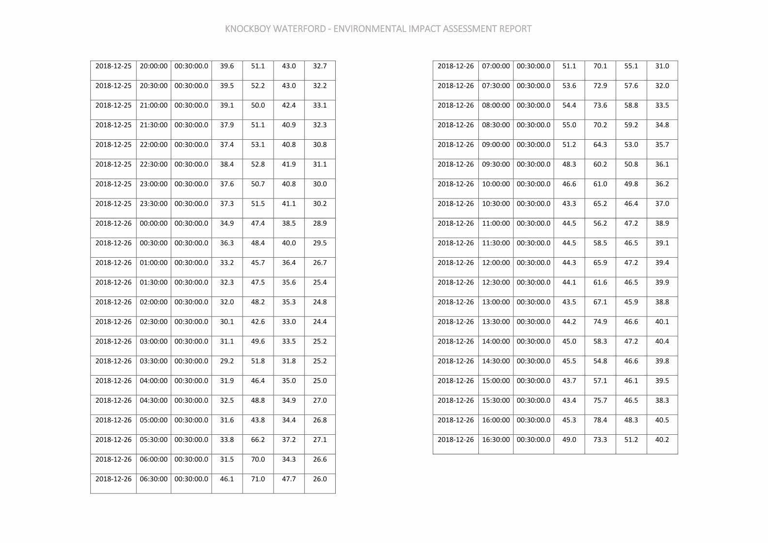
KNOCKBOY WATERFORD - ENVIRONMENTAL IMPACT ASSESSMENT REPORT
2018-12-25 20:00:00 00:30:00.0 39.6 51.1 43.0 32.7
2018-12-25 20:30:00 00:30:00.0 39.5 52.2 43.0 32.2
2018-12-25 21:00:00 00:30:00.0 39.1 50.0 42.4 33.1
2018-12-25 21:30:00 00:30:00.0 37.9 51.1 40.9 32.3
2018-12-25 22:00:00 00:30:00.0 37.4 53.1 40.8 30.8
2018-12-25 22:30:00 00:30:00.0 38.4 52.8 41.9 31.1
2018-12-25 23:00:00 00:30:00.0 37.6 50.7 40.8 30.0
2018-12-25 23:30:00 00:30:00.0 37.3 51.5 41.1 30.2
2018-12-26 00:00:00 00:30:00.0 34.9 47.4 38.5 28.9
2018-12-26 00:30:00 00:30:00.0 36.3 48.4 40.0 29.5
2018-12-26 01:00:00 00:30:00.0 33.2 45.7 36.4 26.7
2018-12-26 01:30:00 00:30:00.0 32.3 47.5 35.6 25.4
2018-12-26 02:00:00 00:30:00.0 32.0 48.2 35.3 24.8
2018-12-26 02:30:00 00:30:00.0 30.1 42.6 33.0 24.4
2018-12-26 03:00:00 00:30:00.0 31.1 49.6 33.5 25.2
2018-12-26 03:30:00 00:30:00.0 29.2 51.8 31.8 25.2
2018-12-26 04:00:00 00:30:00.0 31.9 46.4 35.0 25.0
2018-12-26 04:30:00 00:30:00.0 32.5 48.8 34.9 27.0
2018-12-26 05:00:00 00:30:00.0 31.6 43.8 34.4 26.8
2018-12-26 05:30:00 00:30:00.0 33.8 66.2 37.2 27.1
2018-12-26 06:00:00 00:30:00.0 31.5 70.0 34.3 26.6
2018-12-26 06:30:00 00:30:00.0 46.1 71.0 47.7 26.0
2018-12-26 07:00:00 00:30:00.0 51.1 70.1 55.1 31.0
2018-12-26 07:30:00 00:30:00.0 53.6 72.9 57.6 32.0
2018-12-26 08:00:00 00:30:00.0 54.4 73.6 58.8 33.5
2018-12-26 08:30:00 00:30:00.0 55.0 70.2 59.2 34.8
2018-12-26 09:00:00 00:30:00.0 51.2 64.3 53.0 35.7
2018-12-26 09:30:00 00:30:00.0 48.3 60.2 50.8 36.1
2018-12-26 10:00:00 00:30:00.0 46.6 61.0 49.8 36.2
2018-12-26 10:30:00 00:30:00.0 43.3 65.2 46.4 37.0
2018-12-26 11:00:00 00:30:00.0 44.5 56.2 47.2 38.9
2018-12-26 11:30:00 00:30:00.0 44.5 58.5 46.5 39.1
2018-12-26 12:00:00 00:30:00.0 44.3 65.9 47.2 39.4
2018-12-26 12:30:00 00:30:00.0 44.1 61.6 46.5 39.9
2018-12-26 13:00:00 00:30:00.0 43.5 67.1 45.9 38.8
2018-12-26 13:30:00 00:30:00.0 44.2 74.9 46.6 40.1
2018-12-26 14:00:00 00:30:00.0 45.0 58.3 47.2 40.4
2018-12-26 14:30:00 00:30:00.0 45.5 54.8 46.6 39.8
2018-12-26 15:00:00 00:30:00.0 43.7 57.1 46.1 39.5
2018-12-26 15:30:00 00:30:00.0 43.4 75.7 46.5 38.3
2018-12-26 16:00:00 00:30:00.0 45.3 78.4 48.3 40.5
2018-12-26 16:30:00 00:30:00.0 49.0 73.3 51.2 40.2
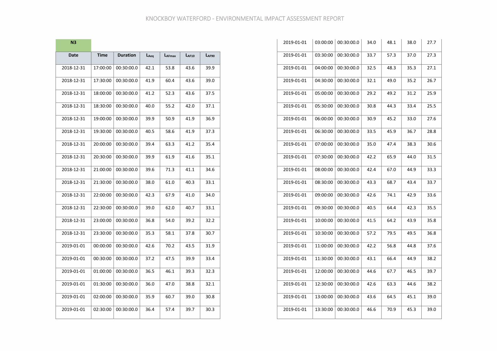
KNOCKBOY WATERFORD - ENVIRONMENTAL IMPACT ASSESSMENT REPORT
N3
Date Time Duration LAeq LAFmax LAF10 LAF90
2018-12-31 17:00:00 00:30:00.0 42.1 53.8 43.6 39.9
2018-12-31 17:30:00 00:30:00.0 41.9 60.4 43.6 39.0
2018-12-31 18:00:00 00:30:00.0 41.2 52.3 43.6 37.5
2018-12-31 18:30:00 00:30:00.0 40.0 55.2 42.0 37.1
2018-12-31 19:00:00 00:30:00.0 39.9 50.9 41.9 36.9
2018-12-31 19:30:00 00:30:00.0 40.5 58.6 41.9 37.3
2018-12-31 20:00:00 00:30:00.0 39.4 63.3 41.2 35.4
2018-12-31 20:30:00 00:30:00.0 39.9 61.9 41.6 35.1
2018-12-31 21:00:00 00:30:00.0 39.6 71.3 41.1 34.6
2018-12-31 21:30:00 00:30:00.0 38.0 61.0 40.3 33.1
2018-12-31 22:00:00 00:30:00.0 42.3 67.9 41.0 34.0
2018-12-31 22:30:00 00:30:00.0 39.0 62.0 40.7 33.1
2018-12-31 23:00:00 00:30:00.0 36.8 54.0 39.2 32.2
2018-12-31 23:30:00 00:30:00.0 35.3 58.1 37.8 30.7
2019-01-01 00:00:00 00:30:00.0 42.6 70.2 43.5 31.9
2019-01-01 00:30:00 00:30:00.0 37.2 47.5 39.9 33.4
2019-01-01 01:00:00 00:30:00.0 36.5 46.1 39.3 32.3
2019-01-01 01:30:00 00:30:00.0 36.0 47.0 38.8 32.1
2019-01-01 02:00:00 00:30:00.0 35.9 60.7 39.0 30.8
2019-01-01 02:30:00 00:30:00.0 36.4 57.4 39.7 30.3
2019-01-01 03:00:00 00:30:00.0 34.0 48.1 38.0 27.7
2019-01-01 03:30:00 00:30:00.0 33.7 57.3 37.0 27.3
2019-01-01 04:00:00 00:30:00.0 32.5 48.3 35.3 27.1
2019-01-01 04:30:00 00:30:00.0 32.1 49.0 35.2 26.7
2019-01-01 05:00:00 00:30:00.0 29.2 49.2 31.2 25.9
2019-01-01 05:30:00 00:30:00.0 30.8 44.3 33.4 25.5
2019-01-01 06:00:00 00:30:00.0 30.9 45.2 33.0 27.6
2019-01-01 06:30:00 00:30:00.0 33.5 45.9 36.7 28.8
2019-01-01 07:00:00 00:30:00.0 35.0 47.4 38.3 30.6
2019-01-01 07:30:00 00:30:00.0 42.2 65.9 44.0 31.5
2019-01-01 08:00:00 00:30:00.0 42.4 67.0 44.9 33.3
2019-01-01 08:30:00 00:30:00.0 43.3 68.7 43.4 33.7
2019-01-01 09:00:00 00:30:00.0 42.6 74.1 42.9 33.6
2019-01-01 09:30:00 00:30:00.0 40.5 64.4 42.3 35.5
2019-01-01 10:00:00 00:30:00.0 41.5 64.2 43.9 35.8
2019-01-01 10:30:00 00:30:00.0 57.2 79.5 49.5 36.8
2019-01-01 11:00:00 00:30:00.0 42.2 56.8 44.8 37.6
2019-01-01 11:30:00 00:30:00.0 43.1 66.4 44.9 38.2
2019-01-01 12:00:00 00:30:00.0 44.6 67.7 46.5 39.7
2019-01-01 12:30:00 00:30:00.0 42.6 63.3 44.6 38.2
2019-01-01 13:00:00 00:30:00.0 43.6 64.5 45.1 39.0
2019-01-01 13:30:00 00:30:00.0 46.6 70.9 45.3 39.0
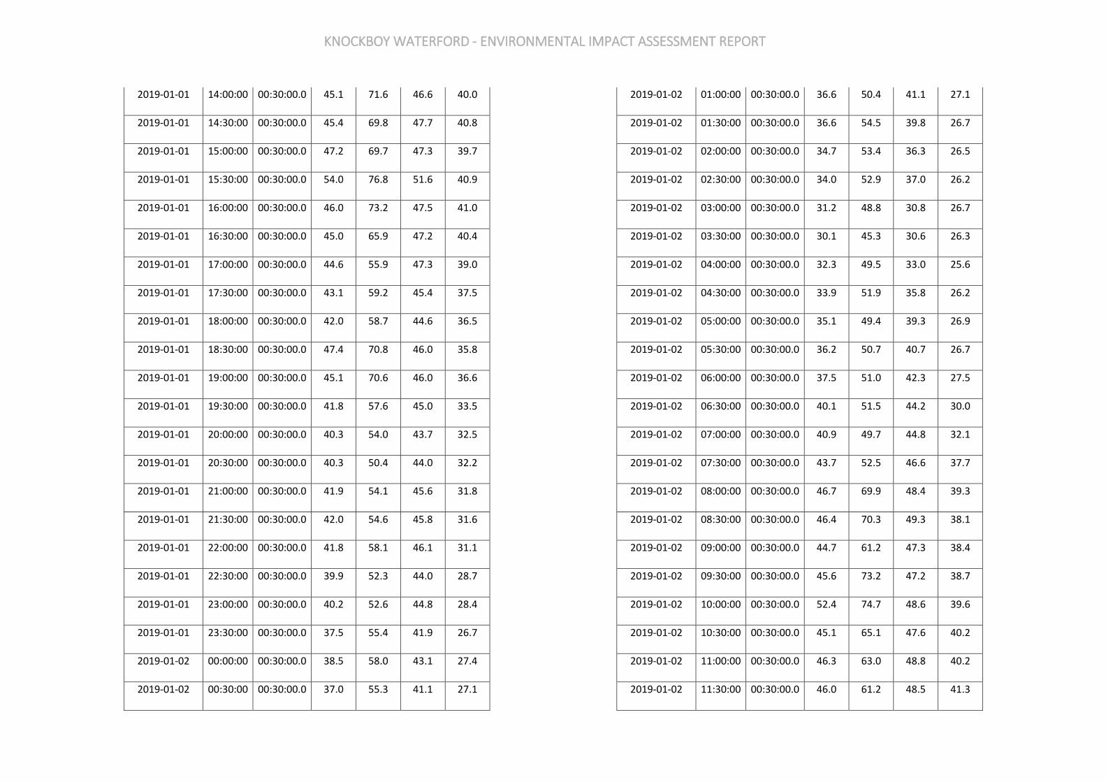
KNOCKBOY WATERFORD - ENVIRONMENTAL IMPACT ASSESSMENT REPORT
2019-01-01 14:00:00 00:30:00.0 45.1 71.6 46.6 40.0
2019-01-01 14:30:00 00:30:00.0 45.4 69.8 47.7 40.8
2019-01-01 15:00:00 00:30:00.0 47.2 69.7 47.3 39.7
2019-01-01 15:30:00 00:30:00.0 54.0 76.8 51.6 40.9
2019-01-01 16:00:00 00:30:00.0 46.0 73.2 47.5 41.0
2019-01-01 16:30:00 00:30:00.0 45.0 65.9 47.2 40.4
2019-01-01 17:00:00 00:30:00.0 44.6 55.9 47.3 39.0
2019-01-01 17:30:00 00:30:00.0 43.1 59.2 45.4 37.5
2019-01-01 18:00:00 00:30:00.0 42.0 58.7 44.6 36.5
2019-01-01 18:30:00 00:30:00.0 47.4 70.8 46.0 35.8
2019-01-01 19:00:00 00:30:00.0 45.1 70.6 46.0 36.6
2019-01-01 19:30:00 00:30:00.0 41.8 57.6 45.0 33.5
2019-01-01 20:00:00 00:30:00.0 40.3 54.0 43.7 32.5
2019-01-01 20:30:00 00:30:00.0 40.3 50.4 44.0 32.2
2019-01-01 21:00:00 00:30:00.0 41.9 54.1 45.6 31.8
2019-01-01 21:30:00 00:30:00.0 42.0 54.6 45.8 31.6
2019-01-01 22:00:00 00:30:00.0 41.8 58.1 46.1 31.1
2019-01-01 22:30:00 00:30:00.0 39.9 52.3 44.0 28.7
2019-01-01 23:00:00 00:30:00.0 40.2 52.6 44.8 28.4
2019-01-01 23:30:00 00:30:00.0 37.5 55.4 41.9 26.7
2019-01-02 00:00:00 00:30:00.0 38.5 58.0 43.1 27.4
2019-01-02 00:30:00 00:30:00.0 37.0 55.3 41.1 27.1
2019-01-02 01:00:00 00:30:00.0 36.6 50.4 41.1 27.1
2019-01-02 01:30:00 00:30:00.0 36.6 54.5 39.8 26.7
2019-01-02 02:00:00 00:30:00.0 34.7 53.4 36.3 26.5
2019-01-02 02:30:00 00:30:00.0 34.0 52.9 37.0 26.2
2019-01-02 03:00:00 00:30:00.0 31.2 48.8 30.8 26.7
2019-01-02 03:30:00 00:30:00.0 30.1 45.3 30.6 26.3
2019-01-02 04:00:00 00:30:00.0 32.3 49.5 33.0 25.6
2019-01-02 04:30:00 00:30:00.0 33.9 51.9 35.8 26.2
2019-01-02 05:00:00 00:30:00.0 35.1 49.4 39.3 26.9
2019-01-02 05:30:00 00:30:00.0 36.2 50.7 40.7 26.7
2019-01-02 06:00:00 00:30:00.0 37.5 51.0 42.3 27.5
2019-01-02 06:30:00 00:30:00.0 40.1 51.5 44.2 30.0
2019-01-02 07:00:00 00:30:00.0 40.9 49.7 44.8 32.1
2019-01-02 07:30:00 00:30:00.0 43.7 52.5 46.6 37.7
2019-01-02 08:00:00 00:30:00.0 46.7 69.9 48.4 39.3
2019-01-02 08:30:00 00:30:00.0 46.4 70.3 49.3 38.1
2019-01-02 09:00:00 00:30:00.0 44.7 61.2 47.3 38.4
2019-01-02 09:30:00 00:30:00.0 45.6 73.2 47.2 38.7
2019-01-02 10:00:00 00:30:00.0 52.4 74.7 48.6 39.6
2019-01-02 10:30:00 00:30:00.0 45.1 65.1 47.6 40.2
2019-01-02 11:00:00 00:30:00.0 46.3 63.0 48.8 40.2
2019-01-02 11:30:00 00:30:00.0 46.0 61.2 48.5 41.3
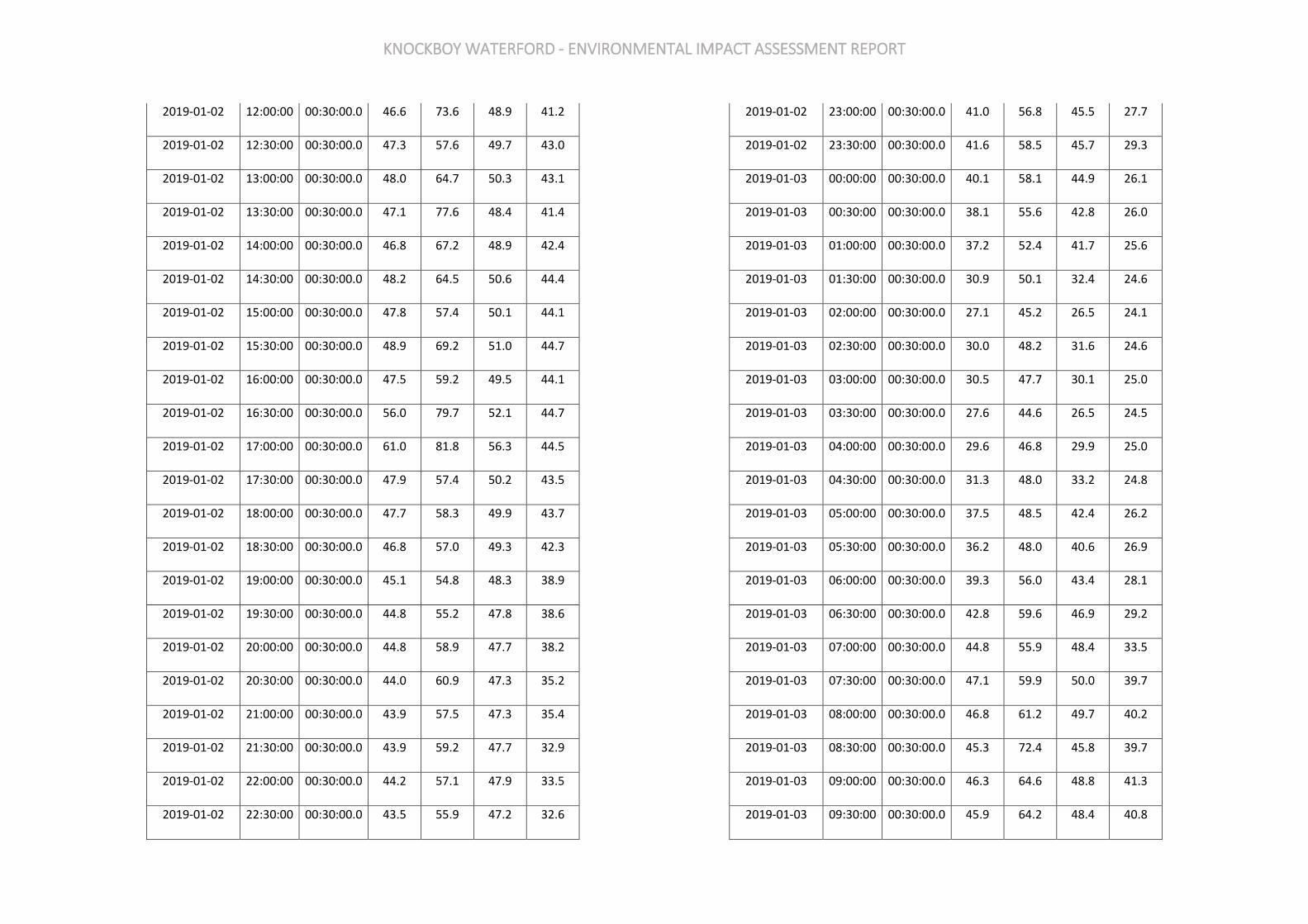
KNOCKBOY WATERFORD - ENVIRONMENTAL IMPACT ASSESSMENT REPORT
2019-01-02 12:00:00 00:30:00.0 46.6 73.6 48.9 41.2
2019-01-02 12:30:00 00:30:00.0 47.3 57.6 49.7 43.0
2019-01-02 13:00:00 00:30:00.0 48.0 64.7 50.3 43.1
2019-01-02 13:30:00 00:30:00.0 47.1 77.6 48.4 41.4
2019-01-02 14:00:00 00:30:00.0 46.8 67.2 48.9 42.4
2019-01-02 14:30:00 00:30:00.0 48.2 64.5 50.6 44.4
2019-01-02 15:00:00 00:30:00.0 47.8 57.4 50.1 44.1
2019-01-02 15:30:00 00:30:00.0 48.9 69.2 51.0 44.7
2019-01-02 16:00:00 00:30:00.0 47.5 59.2 49.5 44.1
2019-01-02 16:30:00 00:30:00.0 56.0 79.7 52.1 44.7
2019-01-02 17:00:00 00:30:00.0 61.0 81.8 56.3 44.5
2019-01-02 17:30:00 00:30:00.0 47.9 57.4 50.2 43.5
2019-01-02 18:00:00 00:30:00.0 47.7 58.3 49.9 43.7
2019-01-02 18:30:00 00:30:00.0 46.8 57.0 49.3 42.3
2019-01-02 19:00:00 00:30:00.0 45.1 54.8 48.3 38.9
2019-01-02 19:30:00 00:30:00.0 44.8 55.2 47.8 38.6
2019-01-02 20:00:00 00:30:00.0 44.8 58.9 47.7 38.2
2019-01-02 20:30:00 00:30:00.0 44.0 60.9 47.3 35.2
2019-01-02 21:00:00 00:30:00.0 43.9 57.5 47.3 35.4
2019-01-02 21:30:00 00:30:00.0 43.9 59.2 47.7 32.9
2019-01-02 22:00:00 00:30:00.0 44.2 57.1 47.9 33.5
2019-01-02 22:30:00 00:30:00.0 43.5 55.9 47.2 32.6
2019-01-02 23:00:00 00:30:00.0 41.0 56.8 45.5 27.7
2019-01-02 23:30:00 00:30:00.0 41.6 58.5 45.7 29.3
2019-01-03 00:00:00 00:30:00.0 40.1 58.1 44.9 26.1
2019-01-03 00:30:00 00:30:00.0 38.1 55.6 42.8 26.0
2019-01-03 01:00:00 00:30:00.0 37.2 52.4 41.7 25.6
2019-01-03 01:30:00 00:30:00.0 30.9 50.1 32.4 24.6
2019-01-03 02:00:00 00:30:00.0 27.1 45.2 26.5 24.1
2019-01-03 02:30:00 00:30:00.0 30.0 48.2 31.6 24.6
2019-01-03 03:00:00 00:30:00.0 30.5 47.7 30.1 25.0
2019-01-03 03:30:00 00:30:00.0 27.6 44.6 26.5 24.5
2019-01-03 04:00:00 00:30:00.0 29.6 46.8 29.9 25.0
2019-01-03 04:30:00 00:30:00.0 31.3 48.0 33.2 24.8
2019-01-03 05:00:00 00:30:00.0 37.5 48.5 42.4 26.2
2019-01-03 05:30:00 00:30:00.0 36.2 48.0 40.6 26.9
2019-01-03 06:00:00 00:30:00.0 39.3 56.0 43.4 28.1
2019-01-03 06:30:00 00:30:00.0 42.8 59.6 46.9 29.2
2019-01-03 07:00:00 00:30:00.0 44.8 55.9 48.4 33.5
2019-01-03 07:30:00 00:30:00.0 47.1 59.9 50.0 39.7
2019-01-03 08:00:00 00:30:00.0 46.8 61.2 49.7 40.2
2019-01-03 08:30:00 00:30:00.0 45.3 72.4 45.8 39.7
2019-01-03 09:00:00 00:30:00.0 46.3 64.6 48.8 41.3
2019-01-03 09:30:00 00:30:00.0 45.9 64.2 48.4 40.8
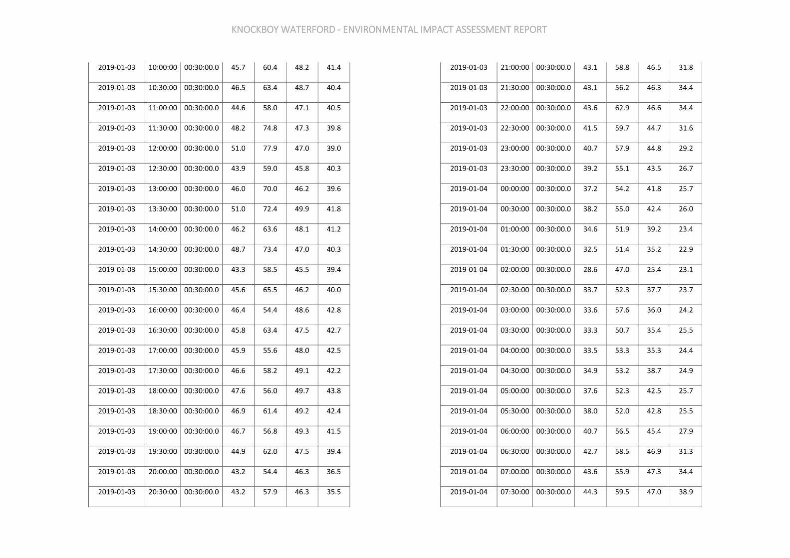
KNOCKBOY WATERFORD - ENVIRONMENTAL IMPACT ASSESSMENT REPORT
2019-01-03 10:00:00 00:30:00.0 45.7 60.4 48.2 41.4
2019-01-03 10:30:00 00:30:00.0 46.5 63.4 48.7 40.4
2019-01-03 11:00:00 00:30:00.0 44.6 58.0 47.1 40.5
2019-01-03 11:30:00 00:30:00.0 48.2 74.8 47.3 39.8
2019-01-03 12:00:00 00:30:00.0 51.0 77.9 47.0 39.0
2019-01-03 12:30:00 00:30:00.0 43.9 59.0 45.8 40.3
2019-01-03 13:00:00 00:30:00.0 46.0 70.0 46.2 39.6
2019-01-03 13:30:00 00:30:00.0 51.0 72.4 49.9 41.8
2019-01-03 14:00:00 00:30:00.0 46.2 63.6 48.1 41.2
2019-01-03 14:30:00 00:30:00.0 48.7 73.4 47.0 40.3
2019-01-03 15:00:00 00:30:00.0 43.3 58.5 45.5 39.4
2019-01-03 15:30:00 00:30:00.0 45.6 65.5 46.2 40.0
2019-01-03 16:00:00 00:30:00.0 46.4 54.4 48.6 42.8
2019-01-03 16:30:00 00:30:00.0 45.8 63.4 47.5 42.7
2019-01-03 17:00:00 00:30:00.0 45.9 55.6 48.0 42.5
2019-01-03 17:30:00 00:30:00.0 46.6 58.2 49.1 42.2
2019-01-03 18:00:00 00:30:00.0 47.6 56.0 49.7 43.8
2019-01-03 18:30:00 00:30:00.0 46.9 61.4 49.2 42.4
2019-01-03 19:00:00 00:30:00.0 46.7 56.8 49.3 41.5
2019-01-03 19:30:00 00:30:00.0 44.9 62.0 47.5 39.4
2019-01-03 20:00:00 00:30:00.0 43.2 54.4 46.3 36.5
2019-01-03 20:30:00 00:30:00.0 43.2 57.9 46.3 35.5
2019-01-03 21:00:00 00:30:00.0 43.1 58.8 46.5 31.8
2019-01-03 21:30:00 00:30:00.0 43.1 56.2 46.3 34.4
2019-01-03 22:00:00 00:30:00.0 43.6 62.9 46.6 34.4
2019-01-03 22:30:00 00:30:00.0 41.5 59.7 44.7 31.6
2019-01-03 23:00:00 00:30:00.0 40.7 57.9 44.8 29.2
2019-01-03 23:30:00 00:30:00.0 39.2 55.1 43.5 26.7
2019-01-04 00:00:00 00:30:00.0 37.2 54.2 41.8 25.7
2019-01-04 00:30:00 00:30:00.0 38.2 55.0 42.4 26.0
2019-01-04 01:00:00 00:30:00.0 34.6 51.9 39.2 23.4
2019-01-04 01:30:00 00:30:00.0 32.5 51.4 35.2 22.9
2019-01-04 02:00:00 00:30:00.0 28.6 47.0 25.4 23.1
2019-01-04 02:30:00 00:30:00.0 33.7 52.3 37.7 23.7
2019-01-04 03:00:00 00:30:00.0 33.6 57.6 36.0 24.2
2019-01-04 03:30:00 00:30:00.0 33.3 50.7 35.4 25.5
2019-01-04 04:00:00 00:30:00.0 33.5 53.3 35.3 24.4
2019-01-04 04:30:00 00:30:00.0 34.9 53.2 38.7 24.9
2019-01-04 05:00:00 00:30:00.0 37.6 52.3 42.5 25.7
2019-01-04 05:30:00 00:30:00.0 38.0 52.0 42.8 25.5
2019-01-04 06:00:00 00:30:00.0 40.7 56.5 45.4 27.9
2019-01-04 06:30:00 00:30:00.0 42.7 58.5 46.9 31.3
2019-01-04 07:00:00 00:30:00.0 43.6 55.9 47.3 34.4
2019-01-04 07:30:00 00:30:00.0 44.3 59.5 47.0 38.9
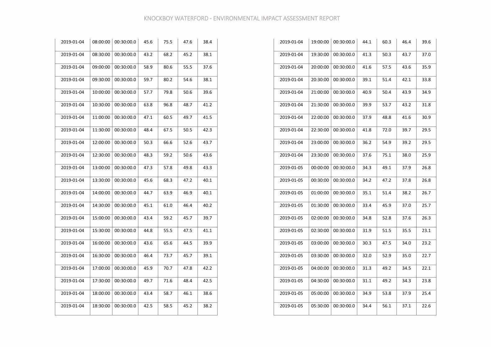
KNOCKBOY WATERFORD - ENVIRONMENTAL IMPACT ASSESSMENT REPORT
2019-01-04 08:00:00 00:30:00.0 45.6 75.5 47.6 38.4
2019-01-04 08:30:00 00:30:00.0 43.2 68.2 45.2 38.1
2019-01-04 09:00:00 00:30:00.0 58.9 80.6 55.5 37.6
2019-01-04 09:30:00 00:30:00.0 59.7 80.2 54.6 38.1
2019-01-04 10:00:00 00:30:00.0 57.7 79.8 50.6 39.6
2019-01-04 10:30:00 00:30:00.0 63.8 96.8 48.7 41.2
2019-01-04 11:00:00 00:30:00.0 47.1 60.5 49.7 41.5
2019-01-04 11:30:00 00:30:00.0 48.4 67.5 50.5 42.3
2019-01-04 12:00:00 00:30:00.0 50.3 66.6 52.6 43.7
2019-01-04 12:30:00 00:30:00.0 48.3 59.2 50.6 43.6
2019-01-04 13:00:00 00:30:00.0 47.3 57.8 49.8 43.3
2019-01-04 13:30:00 00:30:00.0 45.6 68.3 47.2 40.1
2019-01-04 14:00:00 00:30:00.0 44.7 63.9 46.9 40.1
2019-01-04 14:30:00 00:30:00.0 45.1 61.0 46.4 40.2
2019-01-04 15:00:00 00:30:00.0 43.4 59.2 45.7 39.7
2019-01-04 15:30:00 00:30:00.0 44.8 55.5 47.5 41.1
2019-01-04 16:00:00 00:30:00.0 43.6 65.6 44.5 39.9
2019-01-04 16:30:00 00:30:00.0 46.4 73.7 45.7 39.1
2019-01-04 17:00:00 00:30:00.0 45.9 70.7 47.8 42.2
2019-01-04 17:30:00 00:30:00.0 49.7 71.6 48.4 42.5
2019-01-04 18:00:00 00:30:00.0 43.4 58.7 46.1 38.6
2019-01-04 18:30:00 00:30:00.0 42.5 58.5 45.2 38.2
2019-01-04 19:00:00 00:30:00.0 44.1 60.3 46.4 39.6
2019-01-04 19:30:00 00:30:00.0 41.3 50.3 43.7 37.0
2019-01-04 20:00:00 00:30:00.0 41.6 57.5 43.6 35.9
2019-01-04 20:30:00 00:30:00.0 39.1 51.4 42.1 33.8
2019-01-04 21:00:00 00:30:00.0 40.9 50.4 43.9 34.9
2019-01-04 21:30:00 00:30:00.0 39.9 53.7 43.2 31.8
2019-01-04 22:00:00 00:30:00.0 37.9 48.8 41.6 30.9
2019-01-04 22:30:00 00:30:00.0 41.8 72.0 39.7 29.5
2019-01-04 23:00:00 00:30:00.0 36.2 54.9 39.2 29.5
2019-01-04 23:30:00 00:30:00.0 37.6 75.1 38.0 25.9
2019-01-05 00:00:00 00:30:00.0 34.3 49.1 37.9 26.8
2019-01-05 00:30:00 00:30:00.0 34.2 47.2 37.8 26.8
2019-01-05 01:00:00 00:30:00.0 35.1 51.4 38.2 26.7
2019-01-05 01:30:00 00:30:00.0 33.4 45.9 37.0 25.7
2019-01-05 02:00:00 00:30:00.0 34.8 52.8 37.6 26.3
2019-01-05 02:30:00 00:30:00.0 31.9 51.5 35.5 23.1
2019-01-05 03:00:00 00:30:00.0 30.3 47.5 34.0 23.2
2019-01-05 03:30:00 00:30:00.0 32.0 52.9 35.0 22.7
2019-01-05 04:00:00 00:30:00.0 31.3 49.2 34.5 22.1
2019-01-05 04:30:00 00:30:00.0 31.1 49.2 34.3 23.8
2019-01-05 05:00:00 00:30:00.0 34.9 53.8 37.9 25.4
2019-01-05 05:30:00 00:30:00.0 34.4 56.1 37.1 22.6
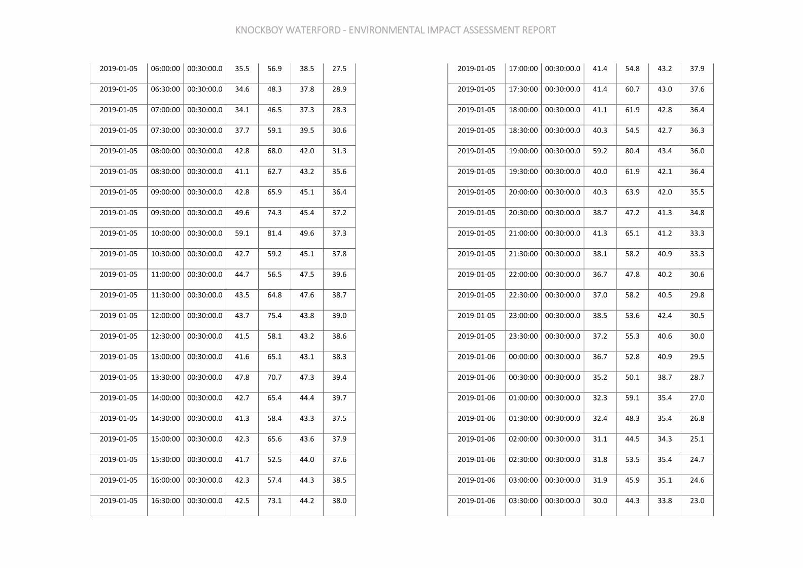
KNOCKBOY WATERFORD - ENVIRONMENTAL IMPACT ASSESSMENT REPORT
2019-01-05 06:00:00 00:30:00.0 35.5 56.9 38.5 27.5
2019-01-05 06:30:00 00:30:00.0 34.6 48.3 37.8 28.9
2019-01-05 07:00:00 00:30:00.0 34.1 46.5 37.3 28.3
2019-01-05 07:30:00 00:30:00.0 37.7 59.1 39.5 30.6
2019-01-05 08:00:00 00:30:00.0 42.8 68.0 42.0 31.3
2019-01-05 08:30:00 00:30:00.0 41.1 62.7 43.2 35.6
2019-01-05 09:00:00 00:30:00.0 42.8 65.9 45.1 36.4
2019-01-05 09:30:00 00:30:00.0 49.6 74.3 45.4 37.2
2019-01-05 10:00:00 00:30:00.0 59.1 81.4 49.6 37.3
2019-01-05 10:30:00 00:30:00.0 42.7 59.2 45.1 37.8
2019-01-05 11:00:00 00:30:00.0 44.7 56.5 47.5 39.6
2019-01-05 11:30:00 00:30:00.0 43.5 64.8 47.6 38.7
2019-01-05 12:00:00 00:30:00.0 43.7 75.4 43.8 39.0
2019-01-05 12:30:00 00:30:00.0 41.5 58.1 43.2 38.6
2019-01-05 13:00:00 00:30:00.0 41.6 65.1 43.1 38.3
2019-01-05 13:30:00 00:30:00.0 47.8 70.7 47.3 39.4
2019-01-05 14:00:00 00:30:00.0 42.7 65.4 44.4 39.7
2019-01-05 14:30:00 00:30:00.0 41.3 58.4 43.3 37.5
2019-01-05 15:00:00 00:30:00.0 42.3 65.6 43.6 37.9
2019-01-05 15:30:00 00:30:00.0 41.7 52.5 44.0 37.6
2019-01-05 16:00:00 00:30:00.0 42.3 57.4 44.3 38.5
2019-01-05 16:30:00 00:30:00.0 42.5 73.1 44.2 38.0
2019-01-05 17:00:00 00:30:00.0 41.4 54.8 43.2 37.9
2019-01-05 17:30:00 00:30:00.0 41.4 60.7 43.0 37.6
2019-01-05 18:00:00 00:30:00.0 41.1 61.9 42.8 36.4
2019-01-05 18:30:00 00:30:00.0 40.3 54.5 42.7 36.3
2019-01-05 19:00:00 00:30:00.0 59.2 80.4 43.4 36.0
2019-01-05 19:30:00 00:30:00.0 40.0 61.9 42.1 36.4
2019-01-05 20:00:00 00:30:00.0 40.3 63.9 42.0 35.5
2019-01-05 20:30:00 00:30:00.0 38.7 47.2 41.3 34.8
2019-01-05 21:00:00 00:30:00.0 41.3 65.1 41.2 33.3
2019-01-05 21:30:00 00:30:00.0 38.1 58.2 40.9 33.3
2019-01-05 22:00:00 00:30:00.0 36.7 47.8 40.2 30.6
2019-01-05 22:30:00 00:30:00.0 37.0 58.2 40.5 29.8
2019-01-05 23:00:00 00:30:00.0 38.5 53.6 42.4 30.5
2019-01-05 23:30:00 00:30:00.0 37.2 55.3 40.6 30.0
2019-01-06 00:00:00 00:30:00.0 36.7 52.8 40.9 29.5
2019-01-06 00:30:00 00:30:00.0 35.2 50.1 38.7 28.7
2019-01-06 01:00:00 00:30:00.0 32.3 59.1 35.4 27.0
2019-01-06 01:30:00 00:30:00.0 32.4 48.3 35.4 26.8
2019-01-06 02:00:00 00:30:00.0 31.1 44.5 34.3 25.1
2019-01-06 02:30:00 00:30:00.0 31.8 53.5 35.4 24.7
2019-01-06 03:00:00 00:30:00.0 31.9 45.9 35.1 24.6
2019-01-06 03:30:00 00:30:00.0 30.0 44.3 33.8 23.0
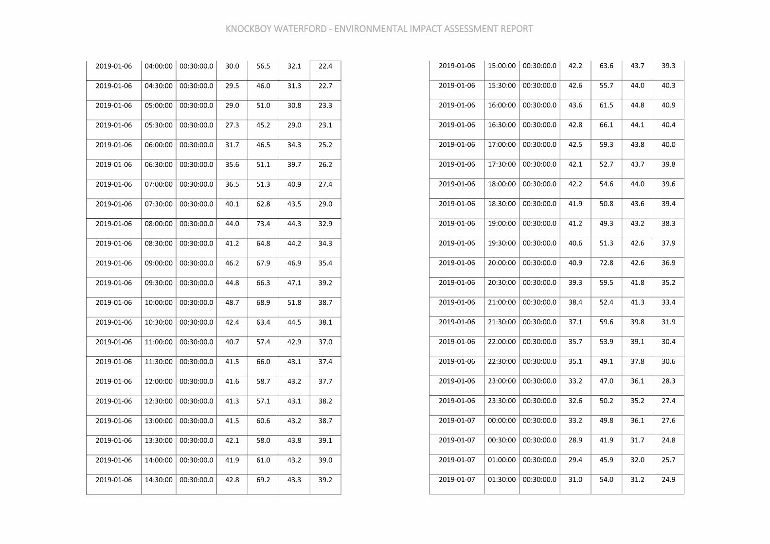
KNOCKBOY WATERFORD - ENVIRONMENTAL IMPACT ASSESSMENT REPORT
2019-01-06 04:00:00 00:30:00.0 30.0 56.5 32.1 22.4
2019-01-06 04:30:00 00:30:00.0 29.5 46.0 31.3 22.7
2019-01-06 05:00:00 00:30:00.0 29.0 51.0 30.8 23.3
2019-01-06 05:30:00 00:30:00.0 27.3 45.2 29.0 23.1
2019-01-06 06:00:00 00:30:00.0 31.7 46.5 34.3 25.2
2019-01-06 06:30:00 00:30:00.0 35.6 51.1 39.7 26.2
2019-01-06 07:00:00 00:30:00.0 36.5 51.3 40.9 27.4
2019-01-06 07:30:00 00:30:00.0 40.1 62.8 43.5 29.0
2019-01-06 08:00:00 00:30:00.0 44.0 73.4 44.3 32.9
2019-01-06 08:30:00 00:30:00.0 41.2 64.8 44.2 34.3
2019-01-06 09:00:00 00:30:00.0 46.2 67.9 46.9 35.4
2019-01-06 09:30:00 00:30:00.0 44.8 66.3 47.1 39.2
2019-01-06 10:00:00 00:30:00.0 48.7 68.9 51.8 38.7
2019-01-06 10:30:00 00:30:00.0 42.4 63.4 44.5 38.1
2019-01-06 11:00:00 00:30:00.0 40.7 57.4 42.9 37.0
2019-01-06 11:30:00 00:30:00.0 41.5 66.0 43.1 37.4
2019-01-06 12:00:00 00:30:00.0 41.6 58.7 43.2 37.7
2019-01-06 12:30:00 00:30:00.0 41.3 57.1 43.1 38.2
2019-01-06 13:00:00 00:30:00.0 41.5 60.6 43.2 38.7
2019-01-06 13:30:00 00:30:00.0 42.1 58.0 43.8 39.1
2019-01-06 14:00:00 00:30:00.0 41.9 61.0 43.2 39.0
2019-01-06 14:30:00 00:30:00.0 42.8 69.2 43.3 39.2
2019-01-06 15:00:00 00:30:00.0 42.2 63.6 43.7 39.3
2019-01-06 15:30:00 00:30:00.0 42.6 55.7 44.0 40.3
2019-01-06 16:00:00 00:30:00.0 43.6 61.5 44.8 40.9
2019-01-06 16:30:00 00:30:00.0 42.8 66.1 44.1 40.4
2019-01-06 17:00:00 00:30:00.0 42.5 59.3 43.8 40.0
2019-01-06 17:30:00 00:30:00.0 42.1 52.7 43.7 39.8
2019-01-06 18:00:00 00:30:00.0 42.2 54.6 44.0 39.6
2019-01-06 18:30:00 00:30:00.0 41.9 50.8 43.6 39.4
2019-01-06 19:00:00 00:30:00.0 41.2 49.3 43.2 38.3
2019-01-06 19:30:00 00:30:00.0 40.6 51.3 42.6 37.9
2019-01-06 20:00:00 00:30:00.0 40.9 72.8 42.6 36.9
2019-01-06 20:30:00 00:30:00.0 39.3 59.5 41.8 35.2
2019-01-06 21:00:00 00:30:00.0 38.4 52.4 41.3 33.4
2019-01-06 21:30:00 00:30:00.0 37.1 59.6 39.8 31.9
2019-01-06 22:00:00 00:30:00.0 35.7 53.9 39.1 30.4
2019-01-06 22:30:00 00:30:00.0 35.1 49.1 37.8 30.6
2019-01-06 23:00:00 00:30:00.0 33.2 47.0 36.1 28.3
2019-01-06 23:30:00 00:30:00.0 32.6 50.2 35.2 27.4
2019-01-07 00:00:00 00:30:00.0 33.2 49.8 36.1 27.6
2019-01-07 00:30:00 00:30:00.0 28.9 41.9 31.7 24.8
2019-01-07 01:00:00 00:30:00.0 29.4 45.9 32.0 25.7
2019-01-07 01:30:00 00:30:00.0 31.0 54.0 31.2 24.9
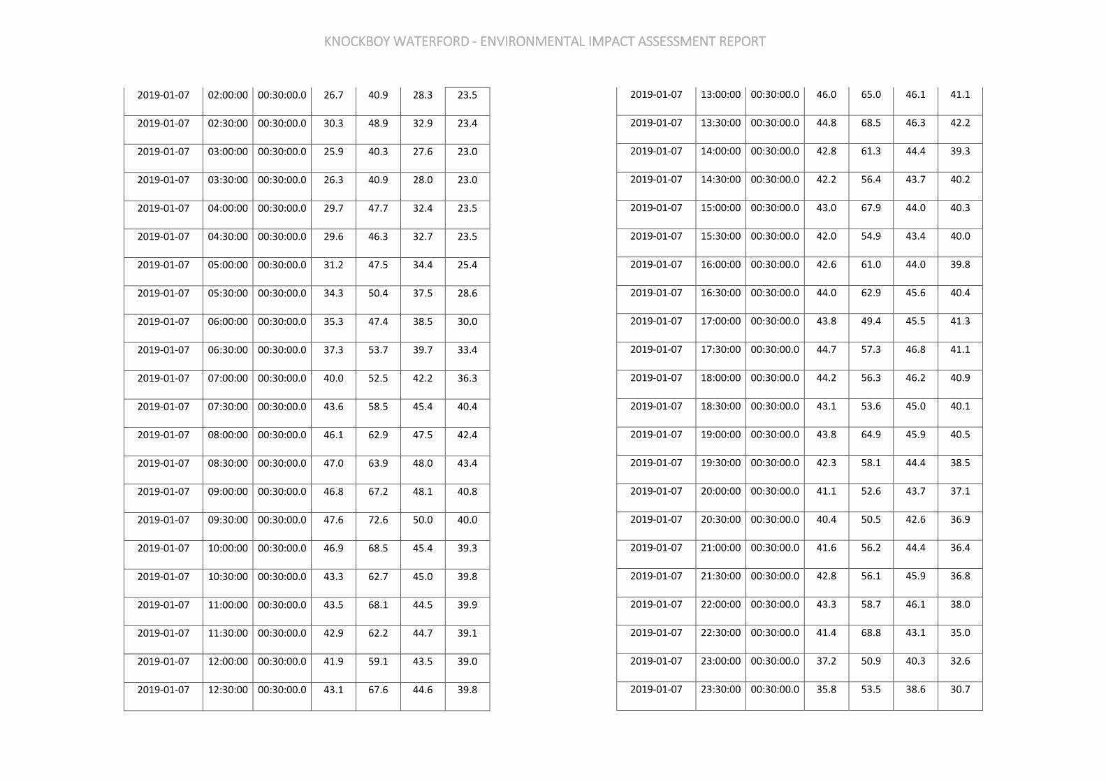
KNOCKBOY WATERFORD - ENVIRONMENTAL IMPACT ASSESSMENT REPORT
2019-01-07 02:00:00 00:30:00.0 26.7 40.9 28.3 23.5
2019-01-07 02:30:00 00:30:00.0 30.3 48.9 32.9 23.4
2019-01-07 03:00:00 00:30:00.0 25.9 40.3 27.6 23.0
2019-01-07 03:30:00 00:30:00.0 26.3 40.9 28.0 23.0
2019-01-07 04:00:00 00:30:00.0 29.7 47.7 32.4 23.5
2019-01-07 04:30:00 00:30:00.0 29.6 46.3 32.7 23.5
2019-01-07 05:00:00 00:30:00.0 31.2 47.5 34.4 25.4
2019-01-07 05:30:00 00:30:00.0 34.3 50.4 37.5 28.6
2019-01-07 06:00:00 00:30:00.0 35.3 47.4 38.5 30.0
2019-01-07 06:30:00 00:30:00.0 37.3 53.7 39.7 33.4
2019-01-07 07:00:00 00:30:00.0 40.0 52.5 42.2 36.3
2019-01-07 07:30:00 00:30:00.0 43.6 58.5 45.4 40.4
2019-01-07 08:00:00 00:30:00.0 46.1 62.9 47.5 42.4
2019-01-07 08:30:00 00:30:00.0 47.0 63.9 48.0 43.4
2019-01-07 09:00:00 00:30:00.0 46.8 67.2 48.1 40.8
2019-01-07 09:30:00 00:30:00.0 47.6 72.6 50.0 40.0
2019-01-07 10:00:00 00:30:00.0 46.9 68.5 45.4 39.3
2019-01-07 10:30:00 00:30:00.0 43.3 62.7 45.0 39.8
2019-01-07 11:00:00 00:30:00.0 43.5 68.1 44.5 39.9
2019-01-07 11:30:00 00:30:00.0 42.9 62.2 44.7 39.1
2019-01-07 12:00:00 00:30:00.0 41.9 59.1 43.5 39.0
2019-01-07 12:30:00 00:30:00.0 43.1 67.6 44.6 39.8
2019-01-07 13:00:00 00:30:00.0 46.0 65.0 46.1 41.1
2019-01-07 13:30:00 00:30:00.0 44.8 68.5 46.3 42.2
2019-01-07 14:00:00 00:30:00.0 42.8 61.3 44.4 39.3
2019-01-07 14:30:00 00:30:00.0 42.2 56.4 43.7 40.2
2019-01-07 15:00:00 00:30:00.0 43.0 67.9 44.0 40.3
2019-01-07 15:30:00 00:30:00.0 42.0 54.9 43.4 40.0
2019-01-07 16:00:00 00:30:00.0 42.6 61.0 44.0 39.8
2019-01-07 16:30:00 00:30:00.0 44.0 62.9 45.6 40.4
2019-01-07 17:00:00 00:30:00.0 43.8 49.4 45.5 41.3
2019-01-07 17:30:00 00:30:00.0 44.7 57.3 46.8 41.1
2019-01-07 18:00:00 00:30:00.0 44.2 56.3 46.2 40.9
2019-01-07 18:30:00 00:30:00.0 43.1 53.6 45.0 40.1
2019-01-07 19:00:00 00:30:00.0 43.8 64.9 45.9 40.5
2019-01-07 19:30:00 00:30:00.0 42.3 58.1 44.4 38.5
2019-01-07 20:00:00 00:30:00.0 41.1 52.6 43.7 37.1
2019-01-07 20:30:00 00:30:00.0 40.4 50.5 42.6 36.9
2019-01-07 21:00:00 00:30:00.0 41.6 56.2 44.4 36.4
2019-01-07 21:30:00 00:30:00.0 42.8 56.1 45.9 36.8
2019-01-07 22:00:00 00:30:00.0 43.3 58.7 46.1 38.0
2019-01-07 22:30:00 00:30:00.0 41.4 68.8 43.1 35.0
2019-01-07 23:00:00 00:30:00.0 37.2 50.9 40.3 32.6
2019-01-07 23:30:00 00:30:00.0 35.8 53.5 38.6 30.7

KNOCKBOY WATERFORD - ENVIRONMENTAL IMPACT ASSESSMENT REPORT
2019-01-08 00:00:00 00:30:00.0 34.1 48.7 37.0 28.6
2019-01-08 00:30:00 00:30:00.0 33.4 49.0 35.8 27.9
2019-01-08 01:00:00 00:30:00.0 33.2 46.8 34.9 27.8
2019-01-08 01:30:00 00:30:00.0 31.6 45.8 33.0 27.5
2019-01-08 02:00:00 00:30:00.0 29.8 48.4 30.4 27.4
2019-01-08 02:30:00 00:30:00.0 30.3 49.0 31.0 26.7
2019-01-08 03:00:00 00:30:00.0 45.1 73.7 31.5 28.1
2019-01-08 03:30:00 00:30:00.0 30.6 51.2 31.0 27.9
2019-01-08 04:00:00 00:30:00.0 30.6 44.5 31.8 28.3
2019-01-08 04:30:00 00:30:00.0 30.5 45.6 31.9 27.4
2019-01-08 05:00:00 00:30:00.0 33.2 50.7 35.8 29.0
2019-01-08 05:30:00 00:30:00.0 34.7 47.8 37.4 31.0
2019-01-08 06:00:00 00:30:00.0 36.8 50.0 39.7 32.5
2019-01-08 06:30:00 00:30:00.0 39.4 47.8 41.8 36.2
2019-01-08 07:00:00 00:30:00.0 41.8 53.0 44.1 38.1
2019-01-08 07:30:00 00:30:00.0 44.7 58.6 46.5 41.2
2019-01-08 08:00:00 00:30:00.0 47.0 70.9 47.3 42.5
2019-01-08 08:30:00 00:30:00.0 45.8 60.4 47.3 43.7
2019-01-08 09:00:00 00:30:00.0 46.2 66.2 47.7 42.6
2019-01-08 09:30:00 00:30:00.0 59.5 82.8 55.1 40.6
2019-01-08 10:00:00 00:30:00.0 58.1 80.1 55.8 40.9
2019-01-08 10:30:00 00:30:00.0 60.2 84.6 57.2 40.3
2019-01-08 11:00:00 00:30:00.0 60.3 86.7 47.0 39.4
2019-01-08 11:30:00 00:30:00.0 44.7 68.8 45.9 39.9
2019-01-08 12:00:00 00:30:00.0 47.3 66.6 48.1 40.7
2019-01-08 12:30:00 00:30:00.0 60.1 91.2 56.2 40.3
2019-01-08 13:00:00 00:30:00.0 51.3 71.8 48.5 40.6
2019-01-08 13:30:00 00:30:00.0 55.3 77.9 56.4 41.1
2019-01-08 14:00:00 00:30:00.0 57.9 81.6 53.5 41.7
2019-01-08 14:30:00 00:30:00.0 50.6 78.5 48.8 43.1
2019-01-08 15:00:00 00:30:00.0 45.6 62.3 47.5 42.1
2019-01-08 15:30:00 00:30:00.0 47.2 62.8 49.7 42.1
2019-01-08 16:00:00 00:30:00.0 50.4 69.0 50.5 44.1
2019-01-08 16:30:00 00:30:00.0 46.8 61.0 48.7 43.9
2019-01-08 17:00:00 00:30:00.0 45.8 60.5 47.6 42.9
2019-01-08 17:30:00 00:30:00.0 48.9 82.9 49.1 43.5
2019-01-08 18:00:00 00:30:00.0 47.1 63.0 48.7 43.3
2019-01-08 18:30:00 00:30:00.0 46.1 55.8 48.2 42.4
2019-01-08 19:00:00 00:30:00.0 45.8 60.8 48.0 42.0
2019-01-08 19:30:00 00:30:00.0 44.4 54.9 46.9 40.0
2019-01-08 20:00:00 00:30:00.0 42.7 50.8 44.9 38.9
2019-01-08 20:30:00 00:30:00.0 41.1 49.5 44.0 35.9
2019-01-08 21:00:00 00:30:00.0 40.7 50.4 43.5 35.5
2019-01-08 21:30:00 00:30:00.0 39.5 61.3 42.3 34.6
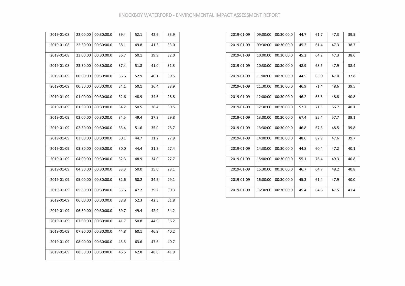
KNOCKBOY WATERFORD - ENVIRONMENTAL IMPACT ASSESSMENT REPORT
2019-01-08 22:00:00 00:30:00.0 39.4 52.1 42.6 33.9
2019-01-08 22:30:00 00:30:00.0 38.1 49.8 41.3 33.0
2019-01-08 23:00:00 00:30:00.0 36.7 50.1 39.9 32.0
2019-01-08 23:30:00 00:30:00.0 37.4 51.8 41.0 31.3
2019-01-09 00:00:00 00:30:00.0 36.6 52.9 40.1 30.5
2019-01-09 00:30:00 00:30:00.0 34.1 50.1 36.4 28.9
2019-01-09 01:00:00 00:30:00.0 32.6 48.9 34.6 28.8
2019-01-09 01:30:00 00:30:00.0 34.2 50.5 36.4 30.5
2019-01-09 02:00:00 00:30:00.0 34.5 49.4 37.3 29.8
2019-01-09 02:30:00 00:30:00.0 33.4 51.6 35.0 28.7
2019-01-09 03:00:00 00:30:00.0 30.1 44.7 31.2 27.9
2019-01-09 03:30:00 00:30:00.0 30.0 44.4 31.3 27.4
2019-01-09 04:00:00 00:30:00.0 32.3 48.9 34.0 27.7
2019-01-09 04:30:00 00:30:00.0 33.3 50.0 35.0 28.1
2019-01-09 05:00:00 00:30:00.0 32.6 50.2 34.5 29.1
2019-01-09 05:30:00 00:30:00.0 35.6 47.2 39.2 30.3
2019-01-09 06:00:00 00:30:00.0 38.8 52.3 42.3 31.8
2019-01-09 06:30:00 00:30:00.0 39.7 49.4 42.9 34.2
2019-01-09 07:00:00 00:30:00.0 41.7 50.8 44.9 36.2
2019-01-09 07:30:00 00:30:00.0 44.8 60.1 46.9 40.2
2019-01-09 08:00:00 00:30:00.0 45.5 63.6 47.6 40.7
2019-01-09 08:30:00 00:30:00.0 46.5 62.8 48.8 41.9
2019-01-09 09:00:00 00:30:00.0 44.7 61.7 47.3 39.5
2019-01-09 09:30:00 00:30:00.0 45.2 61.4 47.3 38.7
2019-01-09 10:00:00 00:30:00.0 45.2 64.2 47.3 38.6
2019-01-09 10:30:00 00:30:00.0 48.9 68.5 47.9 38.4
2019-01-09 11:00:00 00:30:00.0 44.5 65.0 47.0 37.8
2019-01-09 11:30:00 00:30:00.0 46.9 71.4 48.6 39.5
2019-01-09 12:00:00 00:30:00.0 46.2 65.6 48.8 40.8
2019-01-09 12:30:00 00:30:00.0 52.7 71.5 56.7 40.1
2019-01-09 13:00:00 00:30:00.0 67.4 95.4 57.7 39.1
2019-01-09 13:30:00 00:30:00.0 46.8 67.3 48.5 39.8
2019-01-09 14:00:00 00:30:00.0 48.6 82.9 47.6 39.7
2019-01-09 14:30:00 00:30:00.0 44.8 60.4 47.2 40.1
2019-01-09 15:00:00 00:30:00.0 55.1 76.4 49.3 40.8
2019-01-09 15:30:00 00:30:00.0 46.7 64.7 48.2 40.8
2019-01-09 16:00:00 00:30:00.0 45.3 61.4 47.9 40.0
2019-01-09 16:30:00 00:30:00.0 45.4 64.6 47.5 41.4
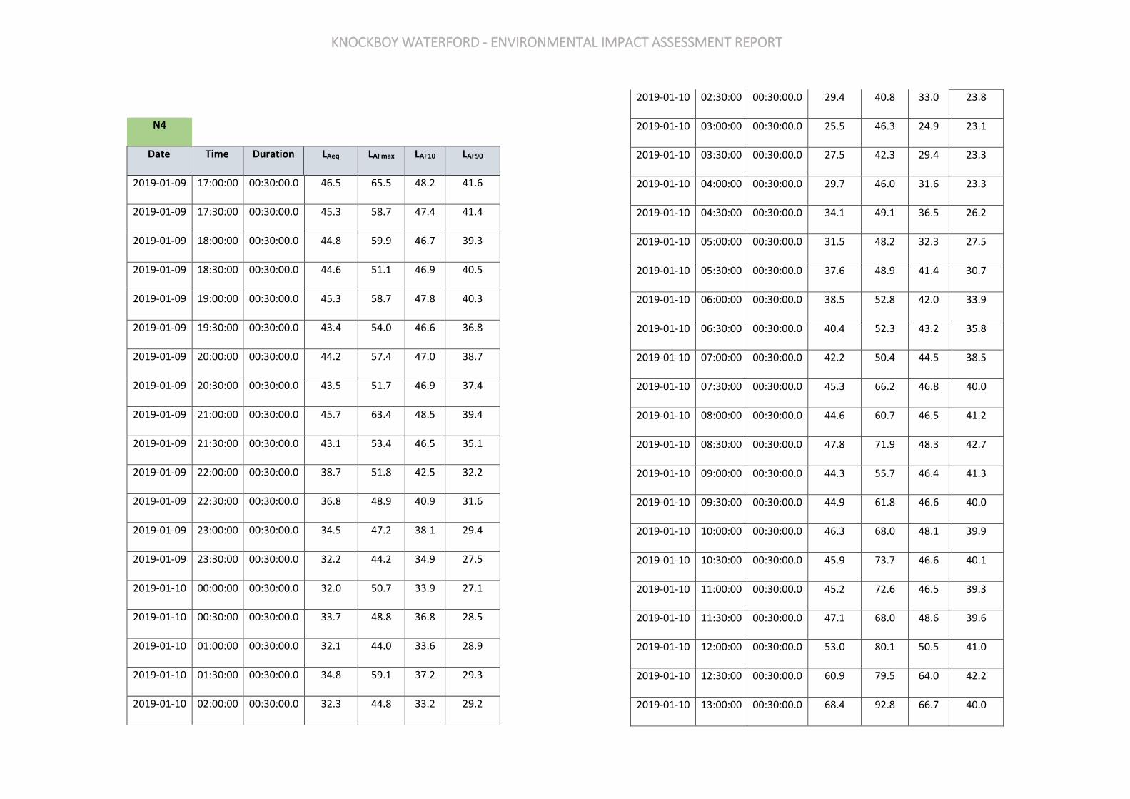
KNOCKBOY WATERFORD - ENVIRONMENTAL IMPACT ASSESSMENT REPORT
N4
Date Time Duration LAeq LAFmax LAF10 LAF90
2019-01-09 17:00:00 00:30:00.0 46.5 65.5 48.2 41.6
2019-01-09 17:30:00 00:30:00.0 45.3 58.7 47.4 41.4
2019-01-09 18:00:00 00:30:00.0 44.8 59.9 46.7 39.3
2019-01-09 18:30:00 00:30:00.0 44.6 51.1 46.9 40.5
2019-01-09 19:00:00 00:30:00.0 45.3 58.7 47.8 40.3
2019-01-09 19:30:00 00:30:00.0 43.4 54.0 46.6 36.8
2019-01-09 20:00:00 00:30:00.0 44.2 57.4 47.0 38.7
2019-01-09 20:30:00 00:30:00.0 43.5 51.7 46.9 37.4
2019-01-09 21:00:00 00:30:00.0 45.7 63.4 48.5 39.4
2019-01-09 21:30:00 00:30:00.0 43.1 53.4 46.5 35.1
2019-01-09 22:00:00 00:30:00.0 38.7 51.8 42.5 32.2
2019-01-09 22:30:00 00:30:00.0 36.8 48.9 40.9 31.6
2019-01-09 23:00:00 00:30:00.0 34.5 47.2 38.1 29.4
2019-01-09 23:30:00 00:30:00.0 32.2 44.2 34.9 27.5
2019-01-10 00:00:00 00:30:00.0 32.0 50.7 33.9 27.1
2019-01-10 00:30:00 00:30:00.0 33.7 48.8 36.8 28.5
2019-01-10 01:00:00 00:30:00.0 32.1 44.0 33.6 28.9
2019-01-10 01:30:00 00:30:00.0 34.8 59.1 37.2 29.3
2019-01-10 02:00:00 00:30:00.0 32.3 44.8 33.2 29.2
2019-01-10 02:30:00 00:30:00.0 29.4 40.8 33.0 23.8
2019-01-10 03:00:00 00:30:00.0 25.5 46.3 24.9 23.1
2019-01-10 03:30:00 00:30:00.0 27.5 42.3 29.4 23.3
2019-01-10 04:00:00 00:30:00.0 29.7 46.0 31.6 23.3
2019-01-10 04:30:00 00:30:00.0 34.1 49.1 36.5 26.2
2019-01-10 05:00:00 00:30:00.0 31.5 48.2 32.3 27.5
2019-01-10 05:30:00 00:30:00.0 37.6 48.9 41.4 30.7
2019-01-10 06:00:00 00:30:00.0 38.5 52.8 42.0 33.9
2019-01-10 06:30:00 00:30:00.0 40.4 52.3 43.2 35.8
2019-01-10 07:00:00 00:30:00.0 42.2 50.4 44.5 38.5
2019-01-10 07:30:00 00:30:00.0 45.3 66.2 46.8 40.0
2019-01-10 08:00:00 00:30:00.0 44.6 60.7 46.5 41.2
2019-01-10 08:30:00 00:30:00.0 47.8 71.9 48.3 42.7
2019-01-10 09:00:00 00:30:00.0 44.3 55.7 46.4 41.3
2019-01-10 09:30:00 00:30:00.0 44.9 61.8 46.6 40.0
2019-01-10 10:00:00 00:30:00.0 46.3 68.0 48.1 39.9
2019-01-10 10:30:00 00:30:00.0 45.9 73.7 46.6 40.1
2019-01-10 11:00:00 00:30:00.0 45.2 72.6 46.5 39.3
2019-01-10 11:30:00 00:30:00.0 47.1 68.0 48.6 39.6
2019-01-10 12:00:00 00:30:00.0 53.0 80.1 50.5 41.0
2019-01-10 12:30:00 00:30:00.0 60.9 79.5 64.0 42.2
2019-01-10 13:00:00 00:30:00.0 68.4 92.8 66.7 40.0
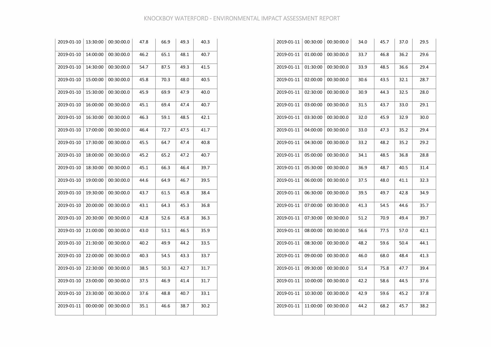
KNOCKBOY WATERFORD - ENVIRONMENTAL IMPACT ASSESSMENT REPORT
2019-01-10 13:30:00 00:30:00.0 47.8 66.9 49.3 40.3
2019-01-10 14:00:00 00:30:00.0 46.2 65.1 48.1 40.7
2019-01-10 14:30:00 00:30:00.0 54.7 87.5 49.3 41.5
2019-01-10 15:00:00 00:30:00.0 45.8 70.3 48.0 40.5
2019-01-10 15:30:00 00:30:00.0 45.9 69.9 47.9 40.0
2019-01-10 16:00:00 00:30:00.0 45.1 69.4 47.4 40.7
2019-01-10 16:30:00 00:30:00.0 46.3 59.1 48.5 42.1
2019-01-10 17:00:00 00:30:00.0 46.4 72.7 47.5 41.7
2019-01-10 17:30:00 00:30:00.0 45.5 64.7 47.4 40.8
2019-01-10 18:00:00 00:30:00.0 45.2 65.2 47.2 40.7
2019-01-10 18:30:00 00:30:00.0 45.1 66.3 46.4 39.7
2019-01-10 19:00:00 00:30:00.0 44.6 64.9 46.7 39.5
2019-01-10 19:30:00 00:30:00.0 43.7 61.5 45.8 38.4
2019-01-10 20:00:00 00:30:00.0 43.1 64.3 45.3 36.8
2019-01-10 20:30:00 00:30:00.0 42.8 52.6 45.8 36.3
2019-01-10 21:00:00 00:30:00.0 43.0 53.1 46.5 35.9
2019-01-10 21:30:00 00:30:00.0 40.2 49.9 44.2 33.5
2019-01-10 22:00:00 00:30:00.0 40.3 54.5 43.3 33.7
2019-01-10 22:30:00 00:30:00.0 38.5 50.3 42.7 31.7
2019-01-10 23:00:00 00:30:00.0 37.5 46.9 41.4 31.7
2019-01-10 23:30:00 00:30:00.0 37.6 48.8 40.7 33.1
2019-01-11 00:00:00 00:30:00.0 35.1 46.6 38.7 30.2
2019-01-11 00:30:00 00:30:00.0 34.0 45.7 37.0 29.5
2019-01-11 01:00:00 00:30:00.0 33.7 46.8 36.2 29.6
2019-01-11 01:30:00 00:30:00.0 33.9 48.5 36.6 29.4
2019-01-11 02:00:00 00:30:00.0 30.6 43.5 32.1 28.7
2019-01-11 02:30:00 00:30:00.0 30.9 44.3 32.5 28.0
2019-01-11 03:00:00 00:30:00.0 31.5 43.7 33.0 29.1
2019-01-11 03:30:00 00:30:00.0 32.0 45.9 32.9 30.0
2019-01-11 04:00:00 00:30:00.0 33.0 47.3 35.2 29.4
2019-01-11 04:30:00 00:30:00.0 33.2 48.2 35.2 29.2
2019-01-11 05:00:00 00:30:00.0 34.1 48.5 36.8 28.8
2019-01-11 05:30:00 00:30:00.0 36.9 48.7 40.5 31.4
2019-01-11 06:00:00 00:30:00.0 37.5 48.0 41.1 32.3
2019-01-11 06:30:00 00:30:00.0 39.5 49.7 42.8 34.9
2019-01-11 07:00:00 00:30:00.0 41.3 54.5 44.6 35.7
2019-01-11 07:30:00 00:30:00.0 51.2 70.9 49.4 39.7
2019-01-11 08:00:00 00:30:00.0 56.6 77.5 57.0 42.1
2019-01-11 08:30:00 00:30:00.0 48.2 59.6 50.4 44.1
2019-01-11 09:00:00 00:30:00.0 46.0 68.0 48.4 41.3
2019-01-11 09:30:00 00:30:00.0 51.4 75.8 47.7 39.4
2019-01-11 10:00:00 00:30:00.0 42.2 58.6 44.5 37.6
2019-01-11 10:30:00 00:30:00.0 42.9 59.6 45.2 37.8
2019-01-11 11:00:00 00:30:00.0 44.2 68.2 45.7 38.2
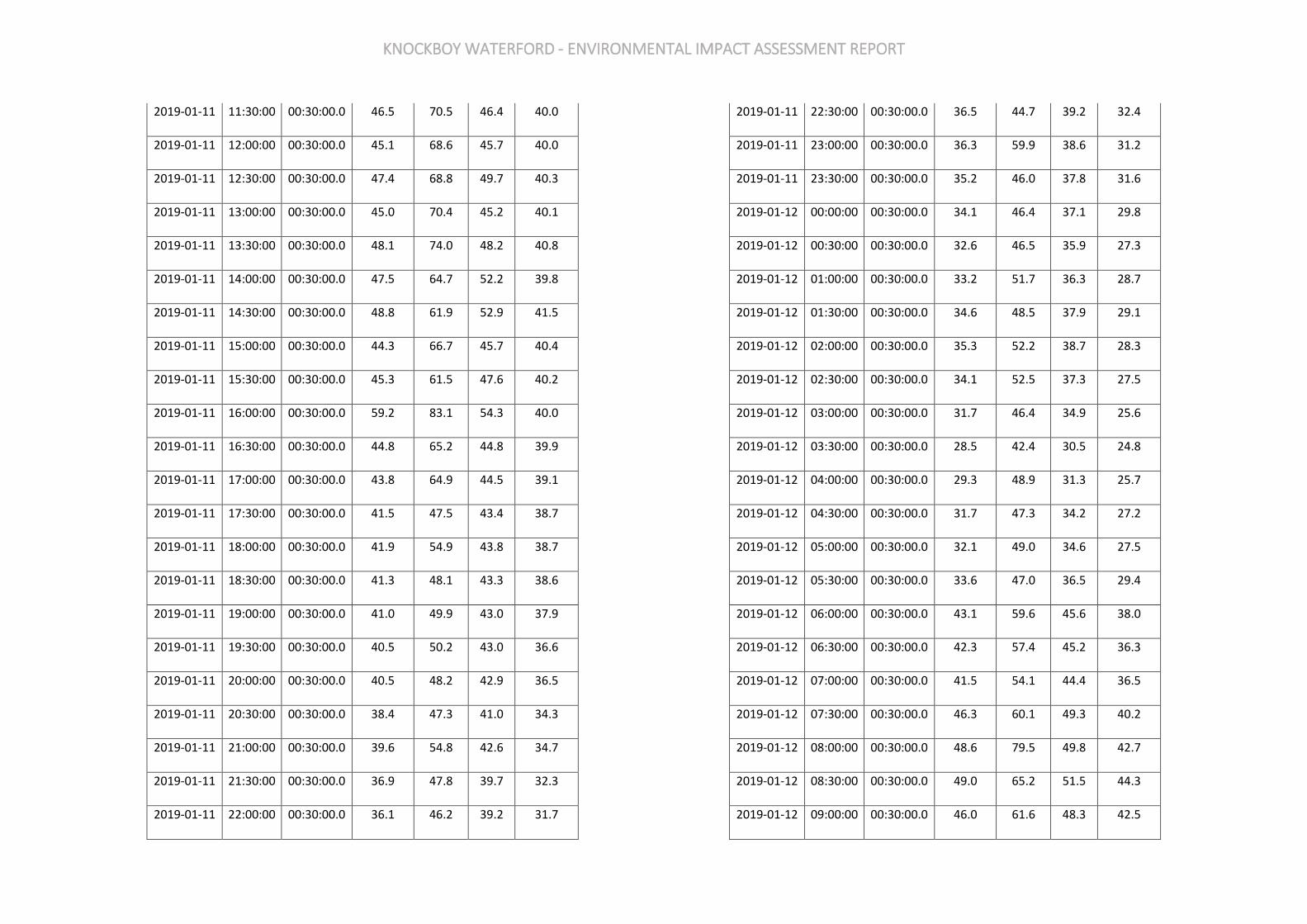
KNOCKBOY WATERFORD - ENVIRONMENTAL IMPACT ASSESSMENT REPORT
2019-01-11 11:30:00 00:30:00.0 46.5 70.5 46.4 40.0
2019-01-11 12:00:00 00:30:00.0 45.1 68.6 45.7 40.0
2019-01-11 12:30:00 00:30:00.0 47.4 68.8 49.7 40.3
2019-01-11 13:00:00 00:30:00.0 45.0 70.4 45.2 40.1
2019-01-11 13:30:00 00:30:00.0 48.1 74.0 48.2 40.8
2019-01-11 14:00:00 00:30:00.0 47.5 64.7 52.2 39.8
2019-01-11 14:30:00 00:30:00.0 48.8 61.9 52.9 41.5
2019-01-11 15:00:00 00:30:00.0 44.3 66.7 45.7 40.4
2019-01-11 15:30:00 00:30:00.0 45.3 61.5 47.6 40.2
2019-01-11 16:00:00 00:30:00.0 59.2 83.1 54.3 40.0
2019-01-11 16:30:00 00:30:00.0 44.8 65.2 44.8 39.9
2019-01-11 17:00:00 00:30:00.0 43.8 64.9 44.5 39.1
2019-01-11 17:30:00 00:30:00.0 41.5 47.5 43.4 38.7
2019-01-11 18:00:00 00:30:00.0 41.9 54.9 43.8 38.7
2019-01-11 18:30:00 00:30:00.0 41.3 48.1 43.3 38.6
2019-01-11 19:00:00 00:30:00.0 41.0 49.9 43.0 37.9
2019-01-11 19:30:00 00:30:00.0 40.5 50.2 43.0 36.6
2019-01-11 20:00:00 00:30:00.0 40.5 48.2 42.9 36.5
2019-01-11 20:30:00 00:30:00.0 38.4 47.3 41.0 34.3
2019-01-11 21:00:00 00:30:00.0 39.6 54.8 42.6 34.7
2019-01-11 21:30:00 00:30:00.0 36.9 47.8 39.7 32.3
2019-01-11 22:00:00 00:30:00.0 36.1 46.2 39.2 31.7
2019-01-11 22:30:00 00:30:00.0 36.5 44.7 39.2 32.4
2019-01-11 23:00:00 00:30:00.0 36.3 59.9 38.6 31.2
2019-01-11 23:30:00 00:30:00.0 35.2 46.0 37.8 31.6
2019-01-12 00:00:00 00:30:00.0 34.1 46.4 37.1 29.8
2019-01-12 00:30:00 00:30:00.0 32.6 46.5 35.9 27.3
2019-01-12 01:00:00 00:30:00.0 33.2 51.7 36.3 28.7
2019-01-12 01:30:00 00:30:00.0 34.6 48.5 37.9 29.1
2019-01-12 02:00:00 00:30:00.0 35.3 52.2 38.7 28.3
2019-01-12 02:30:00 00:30:00.0 34.1 52.5 37.3 27.5
2019-01-12 03:00:00 00:30:00.0 31.7 46.4 34.9 25.6
2019-01-12 03:30:00 00:30:00.0 28.5 42.4 30.5 24.8
2019-01-12 04:00:00 00:30:00.0 29.3 48.9 31.3 25.7
2019-01-12 04:30:00 00:30:00.0 31.7 47.3 34.2 27.2
2019-01-12 05:00:00 00:30:00.0 32.1 49.0 34.6 27.5
2019-01-12 05:30:00 00:30:00.0 33.6 47.0 36.5 29.4
2019-01-12 06:00:00 00:30:00.0 43.1 59.6 45.6 38.0
2019-01-12 06:30:00 00:30:00.0 42.3 57.4 45.2 36.3
2019-01-12 07:00:00 00:30:00.0 41.5 54.1 44.4 36.5
2019-01-12 07:30:00 00:30:00.0 46.3 60.1 49.3 40.2
2019-01-12 08:00:00 00:30:00.0 48.6 79.5 49.8 42.7
2019-01-12 08:30:00 00:30:00.0 49.0 65.2 51.5 44.3
2019-01-12 09:00:00 00:30:00.0 46.0 61.6 48.3 42.5
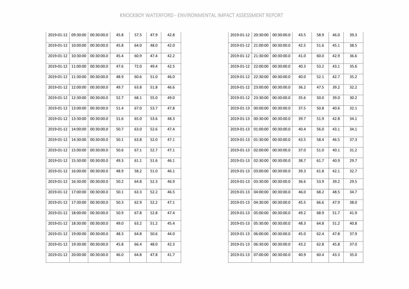
KNOCKBOY WATERFORD - ENVIRONMENTAL IMPACT ASSESSMENT REPORT
2019-01-12 09:30:00 00:30:00.0 45.8 57.5 47.9 42.8
2019-01-12 10:00:00 00:30:00.0 45.8 64.0 48.0 42.0
2019-01-12 10:30:00 00:30:00.0 45.4 60.9 47.4 42.2
2019-01-12 11:00:00 00:30:00.0 47.6 72.0 49.4 42.5
2019-01-12 11:30:00 00:30:00.0 48.9 60.6 51.0 46.0
2019-01-12 12:00:00 00:30:00.0 49.7 63.8 51.8 46.6
2019-01-12 12:30:00 00:30:00.0 52.7 68.1 55.0 49.0
2019-01-12 13:00:00 00:30:00.0 51.4 67.0 53.7 47.8
2019-01-12 13:30:00 00:30:00.0 51.6 65.0 53.6 48.3
2019-01-12 14:00:00 00:30:00.0 50.7 63.0 52.6 47.4
2019-01-12 14:30:00 00:30:00.0 50.1 63.8 52.0 47.1
2019-01-12 15:00:00 00:30:00.0 50.6 67.1 52.7 47.1
2019-01-12 15:30:00 00:30:00.0 49.3 61.1 51.6 46.1
2019-01-12 16:00:00 00:30:00.0 48.9 58.2 51.0 46.1
2019-01-12 16:30:00 00:30:00.0 50.2 64.8 52.3 46.9
2019-01-12 17:00:00 00:30:00.0 50.1 63.3 52.2 46.5
2019-01-12 17:30:00 00:30:00.0 50.3 62.9 52.2 47.1
2019-01-12 18:00:00 00:30:00.0 50.9 67.8 52.8 47.4
2019-01-12 18:30:00 00:30:00.0 49.0 63.2 51.2 45.4
2019-01-12 19:00:00 00:30:00.0 48.3 64.8 50.6 44.0
2019-01-12 19:30:00 00:30:00.0 45.8 66.4 48.0 42.3
2019-01-12 20:00:00 00:30:00.0 46.0 64.8 47.8 41.7
2019-01-12 20:30:00 00:30:00.0 43.5 58.9 46.0 39.3
2019-01-12 21:00:00 00:30:00.0 42.5 51.6 45.1 38.5
2019-01-12 21:30:00 00:30:00.0 41.0 60.0 42.9 36.6
2019-01-12 22:00:00 00:30:00.0 40.3 53.2 43.1 35.6
2019-01-12 22:30:00 00:30:00.0 40.0 52.1 42.7 35.2
2019-01-12 23:00:00 00:30:00.0 36.2 47.5 39.2 32.2
2019-01-12 23:30:00 00:30:00.0 35.6 50.0 39.0 30.2
2019-01-13 00:00:00 00:30:00.0 37.5 50.8 40.6 32.1
2019-01-13 00:30:00 00:30:00.0 39.7 51.9 42.8 34.1
2019-01-13 01:00:00 00:30:00.0 40.4 56.0 43.1 34.1
2019-01-13 01:30:00 00:30:00.0 43.5 58.4 46.5 37.3
2019-01-13 02:00:00 00:30:00.0 37.0 51.0 40.1 31.2
2019-01-13 02:30:00 00:30:00.0 38.7 61.7 40.9 29.7
2019-01-13 03:00:00 00:30:00.0 39.3 61.8 42.1 32.7
2019-01-13 03:30:00 00:30:00.0 36.6 53.9 39.2 29.5
2019-01-13 04:00:00 00:30:00.0 46.0 68.2 48.5 34.7
2019-01-13 04:30:00 00:30:00.0 45.5 66.6 47.9 38.0
2019-01-13 05:00:00 00:30:00.0 49.2 68.9 51.7 41.9
2019-01-13 05:30:00 00:30:00.0 48.3 64.8 51.2 40.8
2019-01-13 06:00:00 00:30:00.0 45.0 62.4 47.8 37.9
2019-01-13 06:30:00 00:30:00.0 43.2 62.8 45.8 37.0
2019-01-13 07:00:00 00:30:00.0 40.9 60.4 43.3 35.0
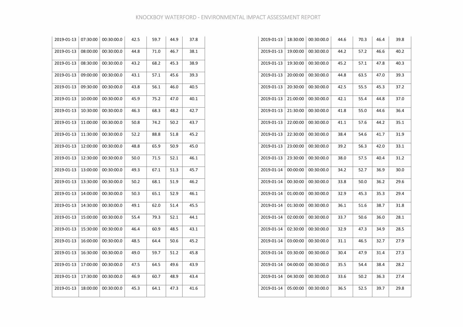
KNOCKBOY WATERFORD - ENVIRONMENTAL IMPACT ASSESSMENT REPORT
2019-01-13 07:30:00 00:30:00.0 42.5 59.7 44.9 37.8
2019-01-13 08:00:00 00:30:00.0 44.8 71.0 46.7 38.1
2019-01-13 08:30:00 00:30:00.0 43.2 68.2 45.3 38.9
2019-01-13 09:00:00 00:30:00.0 43.1 57.1 45.6 39.3
2019-01-13 09:30:00 00:30:00.0 43.8 56.1 46.0 40.5
2019-01-13 10:00:00 00:30:00.0 45.9 75.2 47.0 40.1
2019-01-13 10:30:00 00:30:00.0 46.3 68.3 48.2 42.7
2019-01-13 11:00:00 00:30:00.0 50.8 74.2 50.2 43.7
2019-01-13 11:30:00 00:30:00.0 52.2 88.8 51.8 45.2
2019-01-13 12:00:00 00:30:00.0 48.8 65.9 50.9 45.0
2019-01-13 12:30:00 00:30:00.0 50.0 71.5 52.1 46.1
2019-01-13 13:00:00 00:30:00.0 49.3 67.1 51.3 45.7
2019-01-13 13:30:00 00:30:00.0 50.2 68.1 51.9 46.2
2019-01-13 14:00:00 00:30:00.0 50.3 65.1 52.9 46.1
2019-01-13 14:30:00 00:30:00.0 49.1 62.0 51.4 45.5
2019-01-13 15:00:00 00:30:00.0 55.4 79.3 52.1 44.1
2019-01-13 15:30:00 00:30:00.0 46.4 60.9 48.5 43.1
2019-01-13 16:00:00 00:30:00.0 48.5 64.4 50.6 45.2
2019-01-13 16:30:00 00:30:00.0 49.0 59.7 51.2 45.8
2019-01-13 17:00:00 00:30:00.0 47.5 64.5 49.6 43.9
2019-01-13 17:30:00 00:30:00.0 46.9 60.7 48.9 43.4
2019-01-13 18:00:00 00:30:00.0 45.3 64.1 47.3 41.6
2019-01-13 18:30:00 00:30:00.0 44.6 70.3 46.4 39.8
2019-01-13 19:00:00 00:30:00.0 44.2 57.2 46.6 40.2
2019-01-13 19:30:00 00:30:00.0 45.2 57.1 47.8 40.3
2019-01-13 20:00:00 00:30:00.0 44.8 63.5 47.0 39.3
2019-01-13 20:30:00 00:30:00.0 42.5 55.5 45.3 37.2
2019-01-13 21:00:00 00:30:00.0 42.1 55.4 44.8 37.0
2019-01-13 21:30:00 00:30:00.0 41.8 55.0 44.6 36.4
2019-01-13 22:00:00 00:30:00.0 41.1 57.6 44.2 35.1
2019-01-13 22:30:00 00:30:00.0 38.4 54.6 41.7 31.9
2019-01-13 23:00:00 00:30:00.0 39.2 56.3 42.0 33.1
2019-01-13 23:30:00 00:30:00.0 38.0 57.5 40.4 31.2
2019-01-14 00:00:00 00:30:00.0 34.2 52.7 36.9 30.0
2019-01-14 00:30:00 00:30:00.0 33.8 50.0 36.2 29.6
2019-01-14 01:00:00 00:30:00.0 32.9 45.3 35.3 29.4
2019-01-14 01:30:00 00:30:00.0 36.1 51.6 38.7 31.8
2019-01-14 02:00:00 00:30:00.0 33.7 50.6 36.0 28.1
2019-01-14 02:30:00 00:30:00.0 32.9 47.3 34.9 28.5
2019-01-14 03:00:00 00:30:00.0 31.1 46.5 32.7 27.9
2019-01-14 03:30:00 00:30:00.0 30.4 47.9 31.4 27.3
2019-01-14 04:00:00 00:30:00.0 35.5 54.4 38.4 28.2
2019-01-14 04:30:00 00:30:00.0 33.6 50.2 36.3 27.4
2019-01-14 05:00:00 00:30:00.0 36.5 52.5 39.7 29.8
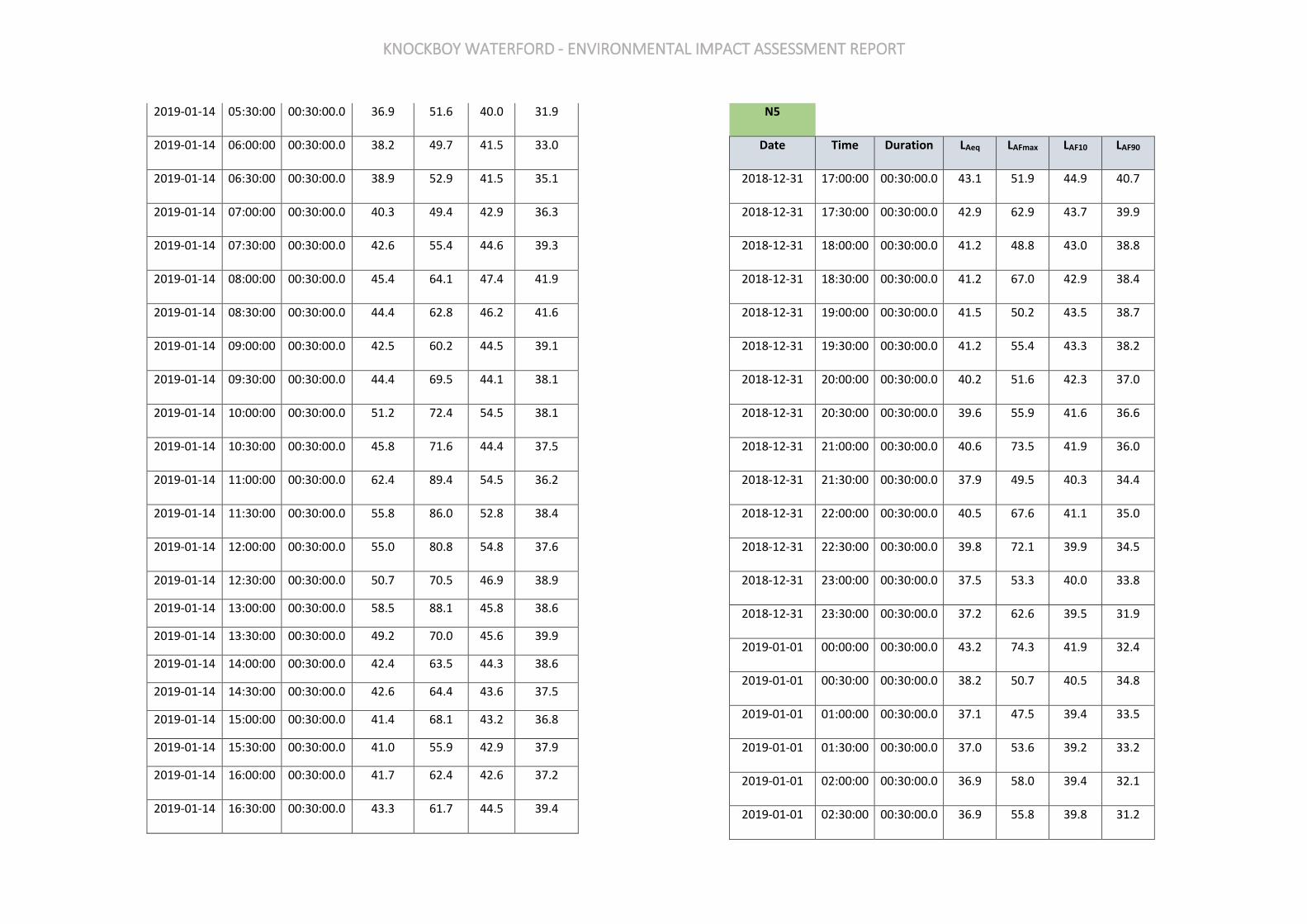
KNOCKBOY WATERFORD - ENVIRONMENTAL IMPACT ASSESSMENT REPORT
2019-01-14 05:30:00 00:30:00.0 36.9 51.6 40.0 31.9
2019-01-14 06:00:00 00:30:00.0 38.2 49.7 41.5 33.0
2019-01-14 06:30:00 00:30:00.0 38.9 52.9 41.5 35.1
2019-01-14 07:00:00 00:30:00.0 40.3 49.4 42.9 36.3
2019-01-14 07:30:00 00:30:00.0 42.6 55.4 44.6 39.3
2019-01-14 08:00:00 00:30:00.0 45.4 64.1 47.4 41.9
2019-01-14 08:30:00 00:30:00.0 44.4 62.8 46.2 41.6
2019-01-14 09:00:00 00:30:00.0 42.5 60.2 44.5 39.1
2019-01-14 09:30:00 00:30:00.0 44.4 69.5 44.1 38.1
2019-01-14 10:00:00 00:30:00.0 51.2 72.4 54.5 38.1
2019-01-14 10:30:00 00:30:00.0 45.8 71.6 44.4 37.5
2019-01-14 11:00:00 00:30:00.0 62.4 89.4 54.5 36.2
2019-01-14 11:30:00 00:30:00.0 55.8 86.0 52.8 38.4
2019-01-14 12:00:00 00:30:00.0 55.0 80.8 54.8 37.6
2019-01-14 12:30:00 00:30:00.0 50.7 70.5 46.9 38.9
2019-01-14 13:00:00 00:30:00.0 58.5 88.1 45.8 38.6
2019-01-14 13:30:00 00:30:00.0 49.2 70.0 45.6 39.9
2019-01-14 14:00:00 00:30:00.0 42.4 63.5 44.3 38.6
2019-01-14 14:30:00 00:30:00.0 42.6 64.4 43.6 37.5
2019-01-14 15:00:00 00:30:00.0 41.4 68.1 43.2 36.8
2019-01-14 15:30:00 00:30:00.0 41.0 55.9 42.9 37.9
2019-01-14 16:00:00 00:30:00.0 41.7 62.4 42.6 37.2
2019-01-14 16:30:00 00:30:00.0 43.3 61.7 44.5 39.4
N5
Date Time Duration LAeq LAFmax LAF10 LAF90
2018-12-31 17:00:00 00:30:00.0 43.1 51.9 44.9 40.7
2018-12-31 17:30:00 00:30:00.0 42.9 62.9 43.7 39.9
2018-12-31 18:00:00 00:30:00.0 41.2 48.8 43.0 38.8
2018-12-31 18:30:00 00:30:00.0 41.2 67.0 42.9 38.4
2018-12-31 19:00:00 00:30:00.0 41.5 50.2 43.5 38.7
2018-12-31 19:30:00 00:30:00.0 41.2 55.4 43.3 38.2
2018-12-31 20:00:00 00:30:00.0 40.2 51.6 42.3 37.0
2018-12-31 20:30:00 00:30:00.0 39.6 55.9 41.6 36.6
2018-12-31 21:00:00 00:30:00.0 40.6 73.5 41.9 36.0
2018-12-31 21:30:00 00:30:00.0 37.9 49.5 40.3 34.4
2018-12-31 22:00:00 00:30:00.0 40.5 67.6 41.1 35.0
2018-12-31 22:30:00 00:30:00.0 39.8 72.1 39.9 34.5
2018-12-31 23:00:00 00:30:00.0 37.5 53.3 40.0 33.8
2018-12-31 23:30:00 00:30:00.0 37.2 62.6 39.5 31.9
2019-01-01 00:00:00 00:30:00.0 43.2 74.3 41.9 32.4
2019-01-01 00:30:00 00:30:00.0 38.2 50.7 40.5 34.8
2019-01-01 01:00:00 00:30:00.0 37.1 47.5 39.4 33.5
2019-01-01 01:30:00 00:30:00.0 37.0 53.6 39.2 33.2
2019-01-01 02:00:00 00:30:00.0 36.9 58.0 39.4 32.1
2019-01-01 02:30:00 00:30:00.0 36.9 55.8 39.8 31.2
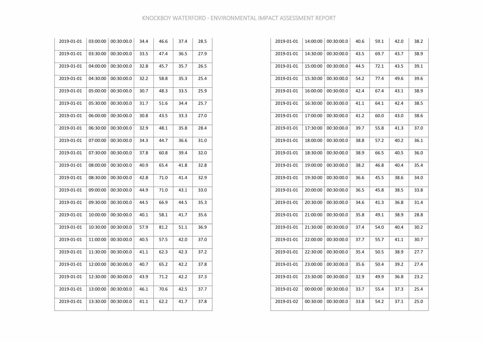
KNOCKBOY WATERFORD - ENVIRONMENTAL IMPACT ASSESSMENT REPORT
2019-01-01 03:00:00 00:30:00.0 34.4 46.6 37.4 28.5
2019-01-01 03:30:00 00:30:00.0 33.5 47.4 36.5 27.9
2019-01-01 04:00:00 00:30:00.0 32.8 45.7 35.7 26.5
2019-01-01 04:30:00 00:30:00.0 32.2 58.8 35.3 25.4
2019-01-01 05:00:00 00:30:00.0 30.7 48.3 33.5 25.9
2019-01-01 05:30:00 00:30:00.0 31.7 51.6 34.4 25.7
2019-01-01 06:00:00 00:30:00.0 30.8 43.5 33.3 27.0
2019-01-01 06:30:00 00:30:00.0 32.9 48.1 35.8 28.4
2019-01-01 07:00:00 00:30:00.0 34.3 44.7 36.6 31.0
2019-01-01 07:30:00 00:30:00.0 37.8 60.8 39.4 32.0
2019-01-01 08:00:00 00:30:00.0 40.9 65.4 41.8 32.8
2019-01-01 08:30:00 00:30:00.0 42.8 71.0 41.4 32.9
2019-01-01 09:00:00 00:30:00.0 44.9 71.0 43.1 33.0
2019-01-01 09:30:00 00:30:00.0 44.5 66.9 44.5 35.3
2019-01-01 10:00:00 00:30:00.0 40.1 58.1 41.7 35.6
2019-01-01 10:30:00 00:30:00.0 57.9 81.2 51.1 36.9
2019-01-01 11:00:00 00:30:00.0 40.5 57.5 42.0 37.0
2019-01-01 11:30:00 00:30:00.0 41.1 62.3 42.3 37.2
2019-01-01 12:00:00 00:30:00.0 40.7 65.2 42.2 37.8
2019-01-01 12:30:00 00:30:00.0 43.9 71.2 42.2 37.3
2019-01-01 13:00:00 00:30:00.0 46.1 70.6 42.5 37.7
2019-01-01 13:30:00 00:30:00.0 41.1 62.2 41.7 37.8
2019-01-01 14:00:00 00:30:00.0 40.6 59.1 42.0 38.2
2019-01-01 14:30:00 00:30:00.0 43.5 69.7 43.7 38.9
2019-01-01 15:00:00 00:30:00.0 44.5 72.1 43.5 39.1
2019-01-01 15:30:00 00:30:00.0 54.2 77.4 49.6 39.6
2019-01-01 16:00:00 00:30:00.0 42.4 67.4 43.1 38.9
2019-01-01 16:30:00 00:30:00.0 41.1 64.1 42.4 38.5
2019-01-01 17:00:00 00:30:00.0 41.2 60.0 43.0 38.6
2019-01-01 17:30:00 00:30:00.0 39.7 55.8 41.3 37.0
2019-01-01 18:00:00 00:30:00.0 38.8 57.2 40.2 36.1
2019-01-01 18:30:00 00:30:00.0 38.9 66.5 40.5 36.0
2019-01-01 19:00:00 00:30:00.0 38.2 46.8 40.4 35.4
2019-01-01 19:30:00 00:30:00.0 36.6 45.5 38.6 34.0
2019-01-01 20:00:00 00:30:00.0 36.5 45.8 38.5 33.8
2019-01-01 20:30:00 00:30:00.0 34.6 41.3 36.8 31.4
2019-01-01 21:00:00 00:30:00.0 35.8 49.1 38.9 28.8
2019-01-01 21:30:00 00:30:00.0 37.4 54.0 40.4 30.2
2019-01-01 22:00:00 00:30:00.0 37.7 55.7 41.1 30.7
2019-01-01 22:30:00 00:30:00.0 35.4 50.5 38.9 27.7
2019-01-01 23:00:00 00:30:00.0 35.6 50.4 39.2 27.4
2019-01-01 23:30:00 00:30:00.0 32.9 49.9 36.8 23.2
2019-01-02 00:00:00 00:30:00.0 33.7 55.4 37.3 25.4
2019-01-02 00:30:00 00:30:00.0 33.8 54.2 37.1 25.0
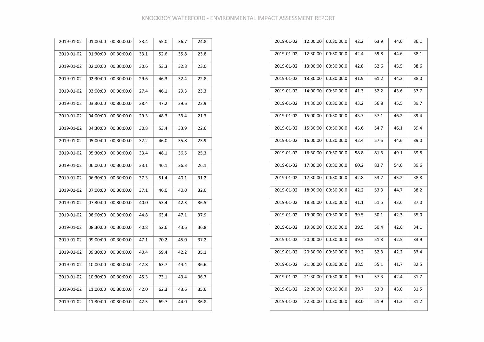
KNOCKBOY WATERFORD - ENVIRONMENTAL IMPACT ASSESSMENT REPORT
2019-01-02 01:00:00 00:30:00.0 33.4 55.0 36.7 24.8
2019-01-02 01:30:00 00:30:00.0 33.1 52.6 35.8 23.8
2019-01-02 02:00:00 00:30:00.0 30.6 53.3 32.8 23.0
2019-01-02 02:30:00 00:30:00.0 29.6 46.3 32.4 22.8
2019-01-02 03:00:00 00:30:00.0 27.4 46.1 29.3 23.3
2019-01-02 03:30:00 00:30:00.0 28.4 47.2 29.6 22.9
2019-01-02 04:00:00 00:30:00.0 29.3 48.3 33.4 21.3
2019-01-02 04:30:00 00:30:00.0 30.8 53.4 33.9 22.6
2019-01-02 05:00:00 00:30:00.0 32.2 46.0 35.8 23.9
2019-01-02 05:30:00 00:30:00.0 33.4 48.1 36.5 25.3
2019-01-02 06:00:00 00:30:00.0 33.1 46.1 36.3 26.1
2019-01-02 06:30:00 00:30:00.0 37.3 51.4 40.1 31.2
2019-01-02 07:00:00 00:30:00.0 37.1 46.0 40.0 32.0
2019-01-02 07:30:00 00:30:00.0 40.0 53.4 42.3 36.5
2019-01-02 08:00:00 00:30:00.0 44.8 63.4 47.1 37.9
2019-01-02 08:30:00 00:30:00.0 40.8 52.6 43.6 36.8
2019-01-02 09:00:00 00:30:00.0 47.1 70.2 45.0 37.2
2019-01-02 09:30:00 00:30:00.0 40.4 59.4 42.2 35.1
2019-01-02 10:00:00 00:30:00.0 42.8 63.7 44.4 36.6
2019-01-02 10:30:00 00:30:00.0 45.3 73.1 43.4 36.7
2019-01-02 11:00:00 00:30:00.0 42.0 62.3 43.6 35.6
2019-01-02 11:30:00 00:30:00.0 42.5 69.7 44.0 36.8
2019-01-02 12:00:00 00:30:00.0 42.2 63.9 44.0 36.1
2019-01-02 12:30:00 00:30:00.0 42.4 59.8 44.6 38.1
2019-01-02 13:00:00 00:30:00.0 42.8 52.6 45.5 38.6
2019-01-02 13:30:00 00:30:00.0 41.9 61.2 44.2 38.0
2019-01-02 14:00:00 00:30:00.0 41.3 52.2 43.6 37.7
2019-01-02 14:30:00 00:30:00.0 43.2 56.8 45.5 39.7
2019-01-02 15:00:00 00:30:00.0 43.7 57.1 46.2 39.4
2019-01-02 15:30:00 00:30:00.0 43.6 54.7 46.1 39.4
2019-01-02 16:00:00 00:30:00.0 42.4 57.5 44.6 39.0
2019-01-02 16:30:00 00:30:00.0 58.8 81.3 49.1 39.8
2019-01-02 17:00:00 00:30:00.0 60.2 83.7 54.0 39.6
2019-01-02 17:30:00 00:30:00.0 42.8 53.7 45.2 38.8
2019-01-02 18:00:00 00:30:00.0 42.2 53.3 44.7 38.2
2019-01-02 18:30:00 00:30:00.0 41.1 51.5 43.6 37.0
2019-01-02 19:00:00 00:30:00.0 39.5 50.1 42.3 35.0
2019-01-02 19:30:00 00:30:00.0 39.5 50.4 42.6 34.1
2019-01-02 20:00:00 00:30:00.0 39.5 51.3 42.5 33.9
2019-01-02 20:30:00 00:30:00.0 39.2 52.3 42.2 33.4
2019-01-02 21:00:00 00:30:00.0 38.5 55.1 41.7 32.5
2019-01-02 21:30:00 00:30:00.0 39.1 57.3 42.4 31.7
2019-01-02 22:00:00 00:30:00.0 39.7 53.0 43.0 31.5
2019-01-02 22:30:00 00:30:00.0 38.0 51.9 41.3 31.2
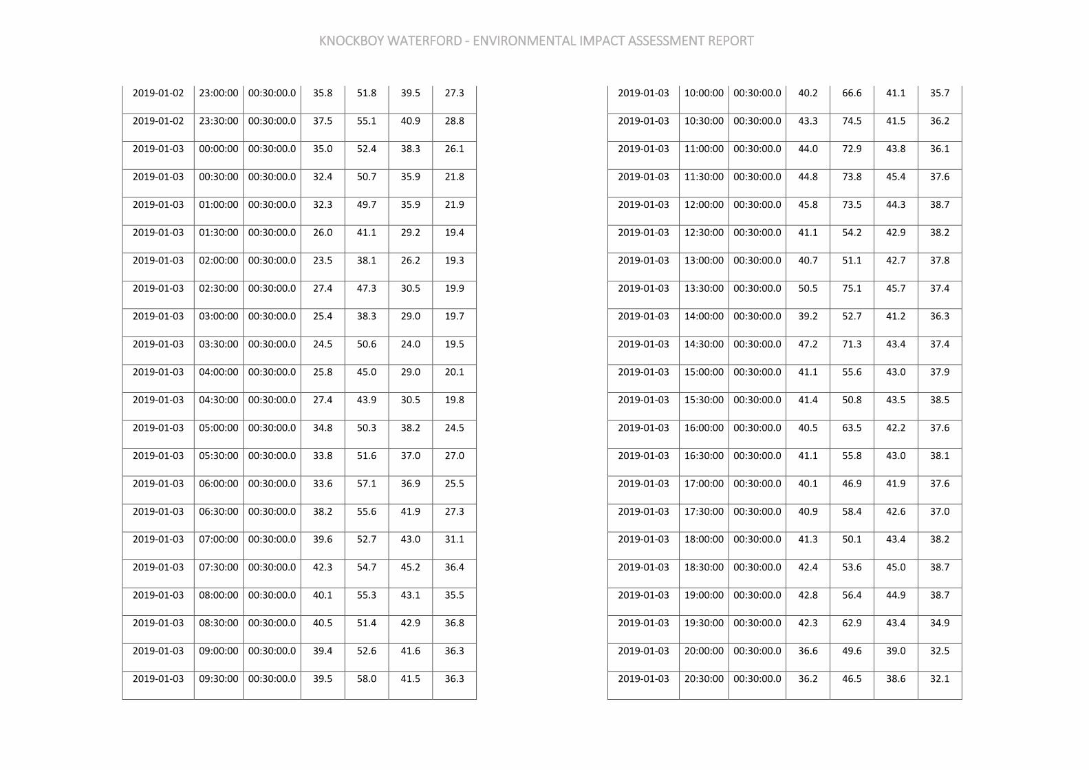
KNOCKBOY WATERFORD - ENVIRONMENTAL IMPACT ASSESSMENT REPORT
2019-01-02 23:00:00 00:30:00.0 35.8 51.8 39.5 27.3
2019-01-02 23:30:00 00:30:00.0 37.5 55.1 40.9 28.8
2019-01-03 00:00:00 00:30:00.0 35.0 52.4 38.3 26.1
2019-01-03 00:30:00 00:30:00.0 32.4 50.7 35.9 21.8
2019-01-03 01:00:00 00:30:00.0 32.3 49.7 35.9 21.9
2019-01-03 01:30:00 00:30:00.0 26.0 41.1 29.2 19.4
2019-01-03 02:00:00 00:30:00.0 23.5 38.1 26.2 19.3
2019-01-03 02:30:00 00:30:00.0 27.4 47.3 30.5 19.9
2019-01-03 03:00:00 00:30:00.0 25.4 38.3 29.0 19.7
2019-01-03 03:30:00 00:30:00.0 24.5 50.6 24.0 19.5
2019-01-03 04:00:00 00:30:00.0 25.8 45.0 29.0 20.1
2019-01-03 04:30:00 00:30:00.0 27.4 43.9 30.5 19.8
2019-01-03 05:00:00 00:30:00.0 34.8 50.3 38.2 24.5
2019-01-03 05:30:00 00:30:00.0 33.8 51.6 37.0 27.0
2019-01-03 06:00:00 00:30:00.0 33.6 57.1 36.9 25.5
2019-01-03 06:30:00 00:30:00.0 38.2 55.6 41.9 27.3
2019-01-03 07:00:00 00:30:00.0 39.6 52.7 43.0 31.1
2019-01-03 07:30:00 00:30:00.0 42.3 54.7 45.2 36.4
2019-01-03 08:00:00 00:30:00.0 40.1 55.3 43.1 35.5
2019-01-03 08:30:00 00:30:00.0 40.5 51.4 42.9 36.8
2019-01-03 09:00:00 00:30:00.0 39.4 52.6 41.6 36.3
2019-01-03 09:30:00 00:30:00.0 39.5 58.0 41.5 36.3
2019-01-03 10:00:00 00:30:00.0 40.2 66.6 41.1 35.7
2019-01-03 10:30:00 00:30:00.0 43.3 74.5 41.5 36.2
2019-01-03 11:00:00 00:30:00.0 44.0 72.9 43.8 36.1
2019-01-03 11:30:00 00:30:00.0 44.8 73.8 45.4 37.6
2019-01-03 12:00:00 00:30:00.0 45.8 73.5 44.3 38.7
2019-01-03 12:30:00 00:30:00.0 41.1 54.2 42.9 38.2
2019-01-03 13:00:00 00:30:00.0 40.7 51.1 42.7 37.8
2019-01-03 13:30:00 00:30:00.0 50.5 75.1 45.7 37.4
2019-01-03 14:00:00 00:30:00.0 39.2 52.7 41.2 36.3
2019-01-03 14:30:00 00:30:00.0 47.2 71.3 43.4 37.4
2019-01-03 15:00:00 00:30:00.0 41.1 55.6 43.0 37.9
2019-01-03 15:30:00 00:30:00.0 41.4 50.8 43.5 38.5
2019-01-03 16:00:00 00:30:00.0 40.5 63.5 42.2 37.6
2019-01-03 16:30:00 00:30:00.0 41.1 55.8 43.0 38.1
2019-01-03 17:00:00 00:30:00.0 40.1 46.9 41.9 37.6
2019-01-03 17:30:00 00:30:00.0 40.9 58.4 42.6 37.0
2019-01-03 18:00:00 00:30:00.0 41.3 50.1 43.4 38.2
2019-01-03 18:30:00 00:30:00.0 42.4 53.6 45.0 38.7
2019-01-03 19:00:00 00:30:00.0 42.8 56.4 44.9 38.7
2019-01-03 19:30:00 00:30:00.0 42.3 62.9 43.4 34.9
2019-01-03 20:00:00 00:30:00.0 36.6 49.6 39.0 32.5
2019-01-03 20:30:00 00:30:00.0 36.2 46.5 38.6 32.1

KNOCKBOY WATERFORD - ENVIRONMENTAL IMPACT ASSESSMENT REPORT
2019-01-03 21:00:00 00:30:00.0 35.7 45.6 38.6 30.4
2019-01-03 21:30:00 00:30:00.0 36.3 54.3 39.0 31.5
2019-01-03 22:00:00 00:30:00.0 37.0 49.2 39.5 32.4
2019-01-03 22:30:00 00:30:00.0 35.6 47.9 38.5 30.6
2019-01-03 23:00:00 00:30:00.0 36.0 49.6 39.2 30.4
2019-01-03 23:30:00 00:30:00.0 37.4 52.3 40.8 31.0
2019-01-04 00:00:00 00:30:00.0 36.5 49.6 40.2 28.2
2019-01-04 00:30:00 00:30:00.0 32.0 44.7 35.3 25.9
2019-01-04 01:00:00 00:30:00.0 29.0 44.3 32.9 20.6
2019-01-04 01:30:00 00:30:00.0 26.6 43.0 30.4 18.9
2019-01-04 02:00:00 00:30:00.0 22.4 38.5 24.2 18.5
2019-01-04 02:30:00 00:30:00.0 27.7 43.1 31.1 20.2
2019-01-04 03:00:00 00:30:00.0 30.0 47.8 33.6 20.7
2019-01-04 03:30:00 00:30:00.0 32.5 50.4 35.4 26.1
2019-01-04 04:00:00 00:30:00.0 30.0 50.3 33.0 20.5
2019-01-04 04:30:00 00:30:00.0 31.3 49.4 35.7 21.2
2019-01-04 05:00:00 00:30:00.0 34.6 55.0 38.1 23.8
2019-01-04 05:30:00 00:30:00.0 33.9 50.9 37.9 23.3
2019-01-04 06:00:00 00:30:00.0 36.6 53.7 40.4 27.1
2019-01-04 06:30:00 00:30:00.0 38.4 55.9 41.6 31.6
2019-01-04 07:00:00 00:30:00.0 38.4 51.7 41.4 32.5
2019-01-04 07:30:00 00:30:00.0 40.3 50.1 42.5 36.3
2019-01-04 08:00:00 00:30:00.0 49.9 77.5 41.5 35.0
2019-01-04 08:30:00 00:30:00.0 43.0 66.9 41.7 35.3
2019-01-04 09:00:00 00:30:00.0 59.3 81.5 50.4 36.4
2019-01-04 09:30:00 00:30:00.0 59.6 79.6 56.2 37.0
2019-01-04 10:00:00 00:30:00.0 58.6 81.2 56.7 36.5
2019-01-04 10:30:00 00:30:00.0 48.4 70.0 50.8 37.6
2019-01-04 11:00:00 00:30:00.0 49.5 70.1 51.2 41.0
2019-01-04 11:30:00 00:30:00.0 47.8 61.2 51.9 41.3
2019-01-04 12:00:00 00:30:00.0 49.4 65.5 51.9 42.2
2019-01-04 12:30:00 00:30:00.0 45.5 61.0 47.2 40.1
2019-01-04 13:00:00 00:30:00.0 41.7 54.3 44.1 38.3
2019-01-04 13:30:00 00:30:00.0 40.1 52.4 42.8 36.3
2019-01-04 14:00:00 00:30:00.0 42.4 67.9 43.9 38.0
2019-01-04 14:30:00 00:30:00.0 43.6 63.7 43.1 37.0
2019-01-04 15:00:00 00:30:00.0 40.0 53.9 41.8 36.9
2019-01-04 15:30:00 00:30:00.0 40.7 52.3 42.5 37.9
2019-01-04 16:00:00 00:30:00.0 43.3 71.5 44.0 38.5
2019-01-04 16:30:00 00:30:00.0 41.8 55.8 44.0 37.2
2019-01-04 17:00:00 00:30:00.0 39.9 49.5 41.8 37.2
2019-01-04 17:30:00 00:30:00.0 48.6 71.5 43.6 37.7
2019-01-04 18:00:00 00:30:00.0 41.1 53.9 42.8 37.9
2019-01-04 18:30:00 00:30:00.0 38.5 47.1 40.6 35.3

KNOCKBOY WATERFORD - ENVIRONMENTAL IMPACT ASSESSMENT REPORT
2019-01-04 19:00:00 00:30:00.0 37.1 48.2 39.1 34.2
2019-01-04 19:30:00 00:30:00.0 38.8 50.3 41.2 35.4
2019-01-04 20:00:00 00:30:00.0 39.4 59.5 40.6 34.1
2019-01-04 20:30:00 00:30:00.0 36.4 50.7 38.9 31.9
2019-01-04 21:00:00 00:30:00.0 35.9 45.1 38.5 31.6
2019-01-04 21:30:00 00:30:00.0 35.6 48.7 38.5 30.3
2019-01-04 22:00:00 00:30:00.0 35.9 55.5 39.0 30.6
2019-01-04 22:30:00 00:30:00.0 35.7 51.1 38.9 30.1
2019-01-04 23:00:00 00:30:00.0 38.6 61.0 41.6 29.8
2019-01-04 23:30:00 00:30:00.0 35.8 48.7 39.3 28.4
2019-01-05 00:00:00 00:30:00.0 38.4 57.2 41.9 29.6
2019-01-05 00:30:00 00:30:00.0 38.3 53.6 42.1 27.8
2019-01-05 01:00:00 00:30:00.0 42.1 61.8 46.3 30.0
2019-01-05 01:30:00 00:30:00.0 38.8 52.8 43.2 28.9
2019-01-05 02:00:00 00:30:00.0 41.4 53.2 44.9 33.4
2019-01-05 02:30:00 00:30:00.0 39.7 54.4 43.8 25.5
2019-01-05 03:00:00 00:30:00.0 35.1 51.0 38.9 26.2
2019-01-05 03:30:00 00:30:00.0 38.8 51.8 42.8 26.7
2019-01-05 04:00:00 00:30:00.0 38.1 52.9 42.6 25.4
2019-01-05 04:30:00 00:30:00.0 40.0 54.6 43.8 28.9
2019-01-05 05:00:00 00:30:00.0 43.2 61.0 47.1 32.9
2019-01-05 05:30:00 00:30:00.0 41.7 55.0 46.2 25.7
2019-01-05 06:00:00 00:30:00.0 43.3 62.8 47.5 30.9
2019-01-05 06:30:00 00:30:00.0 40.4 55.6 43.4 29.4
2019-01-05 07:00:00 00:30:00.0 37.7 50.2 41.0 31.0
2019-01-05 07:30:00 00:30:00.0 42.4 60.0 45.6 33.6
2019-01-05 08:00:00 00:30:00.0 39.7 52.6 43.0 33.8
2019-01-05 08:30:00 00:30:00.0 42.7 53.2 45.9 36.9
2019-01-05 09:00:00 00:30:00.0 41.1 53.0 43.7 36.2
2019-01-05 09:30:00 00:30:00.0 50.2 75.6 50.6 38.9
2019-01-05 10:00:00 00:30:00.0 59.0 82.7 49.7 38.4
2019-01-05 10:30:00 00:30:00.0 42.0 56.6 44.2 38.3
2019-01-05 11:00:00 00:30:00.0 43.7 54.1 46.1 40.4
2019-01-05 11:30:00 00:30:00.0 44.8 72.0 46.8 39.6
2019-01-05 12:00:00 00:30:00.0 47.1 83.1 46.4 40.4
2019-01-05 12:30:00 00:30:00.0 42.7 58.0 44.7 39.9
2019-01-05 13:00:00 00:30:00.0 43.1 54.2 45.2 39.8
2019-01-05 13:30:00 00:30:00.0 49.0 73.7 48.4 40.5
2019-01-05 14:00:00 00:30:00.0 45.4 70.5 45.8 40.9
2019-01-05 14:30:00 00:30:00.0 44.9 70.3 46.3 39.3
2019-01-05 15:00:00 00:30:00.0 42.0 49.7 43.8 39.7
2019-01-05 15:30:00 00:30:00.0 41.0 48.1 42.6 39.2
2019-01-05 16:00:00 00:30:00.0 42.2 54.6 43.6 39.3
2019-01-05 16:30:00 00:30:00.0 42.8 59.8 44.3 39.6

KNOCKBOY WATERFORD - ENVIRONMENTAL IMPACT ASSESSMENT REPORT
2019-01-05 17:00:00 00:30:00.0 42.6 56.7 44.3 38.7
2019-01-05 17:30:00 00:30:00.0 42.9 63.8 43.7 38.8
2019-01-05 18:00:00 00:30:00.0 41.0 57.3 42.8 37.6
2019-01-05 18:30:00 00:30:00.0 42.4 62.7 43.3 37.8
2019-01-05 19:00:00 00:30:00.0 58.9 80.3 43.9 37.6
2019-01-05 19:30:00 00:30:00.0 40.6 49.8 42.6 37.5
2019-01-05 20:00:00 00:30:00.0 40.4 49.8 42.6 36.6
2019-01-05 20:30:00 00:30:00.0 39.3 49.5 41.7 35.6
2019-01-05 21:00:00 00:30:00.0 37.9 51.7 40.7 33.6
2019-01-05 21:30:00 00:30:00.0 38.0 50.5 40.6 33.8
2019-01-05 22:00:00 00:30:00.0 37.0 54.1 39.7 31.6
2019-01-05 22:30:00 00:30:00.0 37.9 64.7 38.8 31.0
2019-01-05 23:00:00 00:30:00.0 35.0 47.3 37.1 31.6
2019-01-05 23:30:00 00:30:00.0 36.5 54.6 38.4 31.5
2019-01-06 00:00:00 00:30:00.0 35.6 45.3 38.1 32.3
2019-01-06 00:30:00 00:30:00.0 35.3 48.1 38.0 29.8
2019-01-06 01:00:00 00:30:00.0 33.4 52.9 36.2 28.3
2019-01-06 01:30:00 00:30:00.0 32.9 46.8 35.7 27.9
2019-01-06 02:00:00 00:30:00.0 32.8 50.3 35.9 26.5
2019-01-06 02:30:00 00:30:00.0 32.6 50.3 36.0 25.8
2019-01-06 03:00:00 00:30:00.0 33.4 48.7 36.8 25.8
2019-01-06 03:30:00 00:30:00.0 31.5 47.5 35.3 23.3
2019-01-06 04:00:00 00:30:00.0 30.1 45.2 33.6 22.1
2019-01-06 04:30:00 00:30:00.0 28.7 46.2 31.4 21.9
2019-01-06 05:00:00 00:30:00.0 26.1 41.0 29.0 21.2
2019-01-06 05:30:00 00:30:00.0 28.2 44.5 31.4 21.6
2019-01-06 06:00:00 00:30:00.0 29.6 46.4 32.2 24.2
2019-01-06 06:30:00 00:30:00.0 32.2 47.1 35.0 26.4
2019-01-06 07:00:00 00:30:00.0 32.9 46.1 35.4 28.6
2019-01-06 07:30:00 00:30:00.0 37.5 61.8 39.3 30.7
2019-01-06 08:00:00 00:30:00.0 39.2 59.1 42.1 32.5
2019-01-06 08:30:00 00:30:00.0 40.4 60.8 43.1 33.6
2019-01-06 09:00:00 00:30:00.0 47.6 71.7 47.4 35.5
2019-01-06 09:30:00 00:30:00.0 43.2 58.8 44.5 38.6
2019-01-06 10:00:00 00:30:00.0 43.4 70.4 44.0 37.8
2019-01-06 10:30:00 00:30:00.0 43.7 64.6 44.3 38.6
2019-01-06 11:00:00 00:30:00.0 40.7 60.2 42.4 37.7
2019-01-06 11:30:00 00:30:00.0 43.9 70.8 44.0 38.5
2019-01-06 12:00:00 00:30:00.0 42.0 65.1 43.7 38.5
2019-01-06 12:30:00 00:30:00.0 44.5 70.7 44.8 39.3
2019-01-06 13:00:00 00:30:00.0 43.8 62.6 46.0 40.2
2019-01-06 13:30:00 00:30:00.0 43.8 52.4 46.3 40.5
2019-01-06 14:00:00 00:30:00.0 43.3 54.8 45.7 39.7
2019-01-06 14:30:00 00:30:00.0 44.0 60.0 46.3 40.5
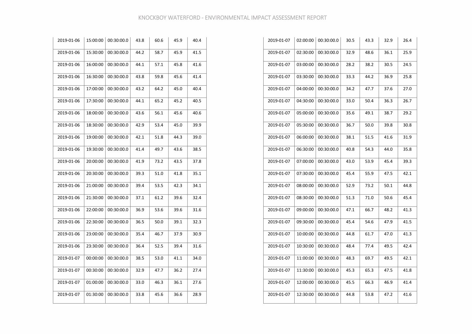
KNOCKBOY WATERFORD - ENVIRONMENTAL IMPACT ASSESSMENT REPORT
2019-01-06 15:00:00 00:30:00.0 43.8 60.6 45.9 40.4
2019-01-06 15:30:00 00:30:00.0 44.2 58.7 45.9 41.5
2019-01-06 16:00:00 00:30:00.0 44.1 57.1 45.8 41.6
2019-01-06 16:30:00 00:30:00.0 43.8 59.8 45.6 41.4
2019-01-06 17:00:00 00:30:00.0 43.2 64.2 45.0 40.4
2019-01-06 17:30:00 00:30:00.0 44.1 65.2 45.2 40.5
2019-01-06 18:00:00 00:30:00.0 43.6 56.1 45.6 40.6
2019-01-06 18:30:00 00:30:00.0 42.9 53.4 45.0 39.9
2019-01-06 19:00:00 00:30:00.0 42.1 51.8 44.3 39.0
2019-01-06 19:30:00 00:30:00.0 41.4 49.7 43.6 38.5
2019-01-06 20:00:00 00:30:00.0 41.9 73.2 43.5 37.8
2019-01-06 20:30:00 00:30:00.0 39.3 51.0 41.8 35.1
2019-01-06 21:00:00 00:30:00.0 39.4 53.5 42.3 34.1
2019-01-06 21:30:00 00:30:00.0 37.1 61.2 39.6 32.4
2019-01-06 22:00:00 00:30:00.0 36.9 53.6 39.6 31.6
2019-01-06 22:30:00 00:30:00.0 36.5 50.0 39.1 32.3
2019-01-06 23:00:00 00:30:00.0 35.4 46.7 37.9 30.9
2019-01-06 23:30:00 00:30:00.0 36.4 52.5 39.4 31.6
2019-01-07 00:00:00 00:30:00.0 38.5 53.0 41.1 34.0
2019-01-07 00:30:00 00:30:00.0 32.9 47.7 36.2 27.4
2019-01-07 01:00:00 00:30:00.0 33.0 46.3 36.1 27.6
2019-01-07 01:30:00 00:30:00.0 33.8 45.6 36.6 28.9
2019-01-07 02:00:00 00:30:00.0 30.5 43.3 32.9 26.4
2019-01-07 02:30:00 00:30:00.0 32.9 48.6 36.1 25.9
2019-01-07 03:00:00 00:30:00.0 28.2 38.2 30.5 24.5
2019-01-07 03:30:00 00:30:00.0 33.3 44.2 36.9 25.8
2019-01-07 04:00:00 00:30:00.0 34.2 47.7 37.6 27.0
2019-01-07 04:30:00 00:30:00.0 33.0 50.4 36.3 26.7
2019-01-07 05:00:00 00:30:00.0 35.6 49.1 38.7 29.2
2019-01-07 05:30:00 00:30:00.0 36.7 50.0 39.8 30.8
2019-01-07 06:00:00 00:30:00.0 38.1 51.5 41.6 31.9
2019-01-07 06:30:00 00:30:00.0 40.8 54.3 44.0 35.8
2019-01-07 07:00:00 00:30:00.0 43.0 53.9 45.4 39.3
2019-01-07 07:30:00 00:30:00.0 45.4 55.9 47.5 42.1
2019-01-07 08:00:00 00:30:00.0 52.9 73.2 50.1 44.8
2019-01-07 08:30:00 00:30:00.0 51.3 71.0 50.6 45.4
2019-01-07 09:00:00 00:30:00.0 47.1 66.7 48.2 41.3
2019-01-07 09:30:00 00:30:00.0 45.4 54.6 47.9 41.5
2019-01-07 10:00:00 00:30:00.0 44.8 61.7 47.0 41.3
2019-01-07 10:30:00 00:30:00.0 48.4 77.4 49.5 42.4
2019-01-07 11:00:00 00:30:00.0 48.3 69.7 49.5 42.1
2019-01-07 11:30:00 00:30:00.0 45.3 65.3 47.5 41.8
2019-01-07 12:00:00 00:30:00.0 45.5 66.3 46.9 41.4
2019-01-07 12:30:00 00:30:00.0 44.8 53.8 47.2 41.6
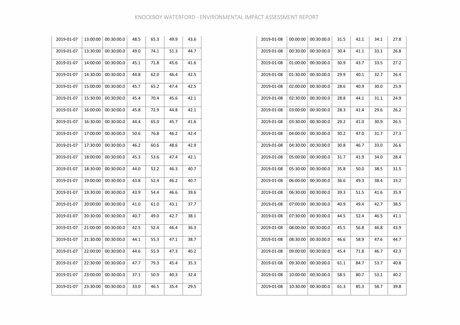
KNOCKBOY WATERFORD - ENVIRONMENTAL IMPACT ASSESSMENT REPORT
2019-01-07 13:00:00 00:30:00.0 48.5 65.3 49.9 43.6
2019-01-07 13:30:00 00:30:00.0 49.0 74.1 51.3 44.7
2019-01-07 14:00:00 00:30:00.0 45.1 71.8 45.6 41.6
2019-01-07 14:30:00 00:30:00.0 44.8 62.0 46.4 42.5
2019-01-07 15:00:00 00:30:00.0 45.7 65.2 47.4 42.5
2019-01-07 15:30:00 00:30:00.0 45.4 70.4 45.6 42.1
2019-01-07 16:00:00 00:30:00.0 45.8 72.9 44.8 42.1
2019-01-07 16:30:00 00:30:00.0 44.4 65.0 45.7 41.6
2019-01-07 17:00:00 00:30:00.0 50.6 76.8 46.2 42.4
2019-01-07 17:30:00 00:30:00.0 46.2 60.6 48.6 42.9
2019-01-07 18:00:00 00:30:00.0 45.3 53.6 47.4 42.1
2019-01-07 18:30:00 00:30:00.0 44.0 52.2 46.3 40.7
2019-01-07 19:00:00 00:30:00.0 43.8 52.4 46.2 40.7
2019-01-07 19:30:00 00:30:00.0 43.9 54.4 46.6 39.6
2019-01-07 20:00:00 00:30:00.0 41.0 61.0 43.1 37.7
2019-01-07 20:30:00 00:30:00.0 40.7 49.0 42.7 38.1
2019-01-07 21:00:00 00:30:00.0 42.5 52.4 46.4 36.3
2019-01-07 21:30:00 00:30:00.0 44.1 55.3 47.1 38.7
2019-01-07 22:00:00 00:30:00.0 44.6 55.9 47.3 40.2
2019-01-07 22:30:00 00:30:00.0 47.7 79.3 45.4 35.3
2019-01-07 23:00:00 00:30:00.0 37.1 50.9 40.3 32.4
2019-01-07 23:30:00 00:30:00.0 33.0 46.5 35.4 29.5
2019-01-08 00:00:00 00:30:00.0 31.5 42.1 34.1 27.8
2019-01-08 00:30:00 00:30:00.0 30.4 41.1 33.1 26.8
2019-01-08 01:00:00 00:30:00.0 30.9 43.7 33.5 27.2
2019-01-08 01:30:00 00:30:00.0 29.9 40.1 32.7 26.4
2019-01-08 02:00:00 00:30:00.0 28.6 40.9 30.0 25.9
2019-01-08 02:30:00 00:30:00.0 28.8 44.1 31.1 24.9
2019-01-08 03:00:00 00:30:00.0 28.3 41.4 29.6 26.2
2019-01-08 03:30:00 00:30:00.0 29.2 41.0 30.9 26.5
2019-01-08 04:00:00 00:30:00.0 30.2 47.0 31.7 27.3
2019-01-08 04:30:00 00:30:00.0 30.8 46.7 33.0 26.6
2019-01-08 05:00:00 00:30:00.0 31.7 41.9 34.0 28.4
2019-01-08 05:30:00 00:30:00.0 35.8 50.0 38.5 31.5
2019-01-08 06:00:00 00:30:00.0 36.6 49.3 38.4 33.2
2019-01-08 06:30:00 00:30:00.0 39.3 51.5 41.6 35.9
2019-01-08 07:00:00 00:30:00.0 40.9 49.4 42.7 38.5
2019-01-08 07:30:00 00:30:00.0 44.5 52.4 46.5 41.1
2019-01-08 08:00:00 00:30:00.0 45.5 56.8 46.8 43.9
2019-01-08 08:30:00 00:30:00.0 46.6 58.9 47.6 44.7
2019-01-08 09:00:00 00:30:00.0 45.4 71.8 46.7 42.3
2019-01-08 09:30:00 00:30:00.0 61.1 84.7 53.7 40.8
2019-01-08 10:00:00 00:30:00.0 58.5 80.7 53.1 40.2
2019-01-08 10:30:00 00:30:00.0 61.3 85.3 58.7 39.8

KNOCKBOY WATERFORD - ENVIRONMENTAL IMPACT ASSESSMENT REPORT
2019-01-08 11:00:00 00:30:00.0 61.0 85.5 44.7 38.9
2019-01-08 11:30:00 00:30:00.0 42.5 63.1 43.5 39.0
2019-01-08 12:00:00 00:30:00.0 45.8 64.4 44.9 40.6
2019-01-08 12:30:00 00:30:00.0 42.3 55.7 44.0 39.9
2019-01-08 13:00:00 00:30:00.0 42.5 62.1 43.9 40.0
2019-01-08 13:30:00 00:30:00.0 44.7 60.8 47.1 40.8
2019-01-08 14:00:00 00:30:00.0 44.3 58.6 46.1 41.6
2019-01-08 14:30:00 00:30:00.0 44.7 57.2 46.3 42.3
2019-01-08 15:00:00 00:30:00.0 43.4 53.7 45.3 41.1
2019-01-08 15:30:00 00:30:00.0 44.5 68.1 45.8 41.8
2019-01-08 16:00:00 00:30:00.0 49.0 67.5 47.4 42.9
2019-01-08 16:30:00 00:30:00.0 44.9 67.1 46.0 42.7
2019-01-08 17:00:00 00:30:00.0 44.8 52.7 46.1 43.1
2019-01-08 17:30:00 00:30:00.0 46.2 65.1 47.2 43.4
2019-01-08 18:00:00 00:30:00.0 44.6 52.4 46.1 42.8
2019-01-08 18:30:00 00:30:00.0 43.8 56.5 45.3 41.6
2019-01-08 19:00:00 00:30:00.0 43.2 50.5 44.8 41.0
2019-01-08 19:30:00 00:30:00.0 42.5 52.0 44.2 40.1
2019-01-08 20:00:00 00:30:00.0 40.9 48.3 42.6 38.6
2019-01-08 20:30:00 00:30:00.0 39.2 45.5 40.9 37.1
2019-01-08 21:00:00 00:30:00.0 38.7 47.4 40.8 35.4
2019-01-08 21:30:00 00:30:00.0 37.7 48.5 39.7 34.7
2019-01-08 22:00:00 00:30:00.0 37.6 46.5 39.9 34.3
2019-01-08 22:30:00 00:30:00.0 35.9 48.8 38.1 32.8
2019-01-08 23:00:00 00:30:00.0 35.0 49.2 37.3 31.4
2019-01-08 23:30:00 00:30:00.0 35.9 51.7 38.6 31.3
2019-01-09 00:00:00 00:30:00.0 35.5 56.4 37.7 31.4
2019-01-09 00:30:00 00:30:00.0 31.4 44.2 33.8 27.7
2019-01-09 01:00:00 00:30:00.0 31.0 43.6 33.5 27.5
2019-01-09 01:30:00 00:30:00.0 33.1 45.3 35.3 29.6
2019-01-09 02:00:00 00:30:00.0 31.8 47.8 34.2 28.3
2019-01-09 02:30:00 00:30:00.0 30.7 49.5 32.7 26.8
2019-01-09 03:00:00 00:30:00.0 28.3 43.1 30.1 25.8
2019-01-09 03:30:00 00:30:00.0 27.9 40.4 30.1 24.7
2019-01-09 04:00:00 00:30:00.0 29.9 43.2 32.4 25.7
2019-01-09 04:30:00 00:30:00.0 31.2 53.7 32.1 26.8
2019-01-09 05:00:00 00:30:00.0 31.0 43.7 33.8 27.1
2019-01-09 05:30:00 00:30:00.0 34.3 48.0 37.4 29.6
2019-01-09 06:00:00 00:30:00.0 36.9 52.6 40.1 31.3
2019-01-09 06:30:00 00:30:00.0 37.2 53.6 39.4 33.4
2019-01-09 07:00:00 00:30:00.0 39.7 50.5 42.2 35.7
2019-01-09 07:30:00 00:30:00.0 43.0 53.4 45.0 39.6
2019-01-09 08:00:00 00:30:00.0 51.3 78.7 45.9 41.6
2019-01-09 08:30:00 00:30:00.0 44.5 65.4 45.7 42.0
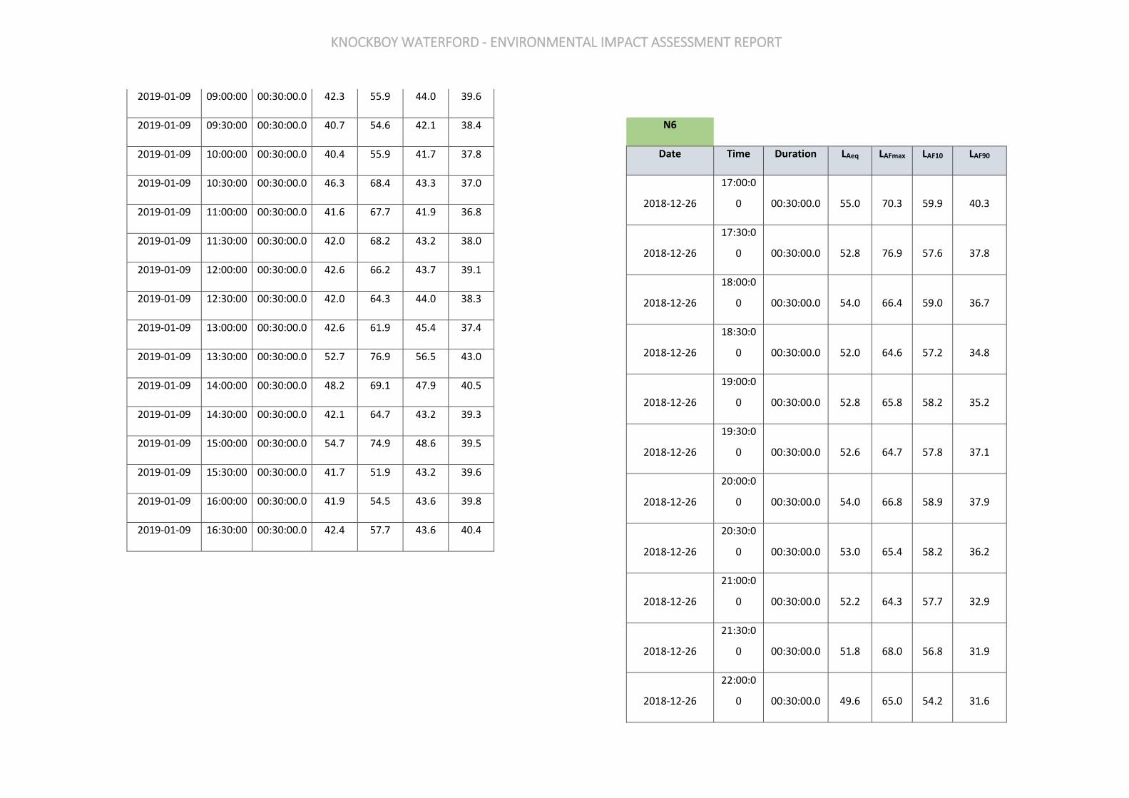
KNOCKBOY WATERFORD - ENVIRONMENTAL IMPACT ASSESSMENT REPORT
2019-01-09 09:00:00 00:30:00.0 42.3 55.9 44.0 39.6
2019-01-09 09:30:00 00:30:00.0 40.7 54.6 42.1 38.4
2019-01-09 10:00:00 00:30:00.0 40.4 55.9 41.7 37.8
2019-01-09 10:30:00 00:30:00.0 46.3 68.4 43.3 37.0
2019-01-09 11:00:00 00:30:00.0 41.6 67.7 41.9 36.8
2019-01-09 11:30:00 00:30:00.0 42.0 68.2 43.2 38.0
2019-01-09 12:00:00 00:30:00.0 42.6 66.2 43.7 39.1
2019-01-09 12:30:00 00:30:00.0 42.0 64.3 44.0 38.3
2019-01-09 13:00:00 00:30:00.0 42.6 61.9 45.4 37.4
2019-01-09 13:30:00 00:30:00.0 52.7 76.9 56.5 43.0
2019-01-09 14:00:00 00:30:00.0 48.2 69.1 47.9 40.5
2019-01-09 14:30:00 00:30:00.0 42.1 64.7 43.2 39.3
2019-01-09 15:00:00 00:30:00.0 54.7 74.9 48.6 39.5
2019-01-09 15:30:00 00:30:00.0 41.7 51.9 43.2 39.6
2019-01-09 16:00:00 00:30:00.0 41.9 54.5 43.6 39.8
2019-01-09 16:30:00 00:30:00.0 42.4 57.7 43.6 40.4
N6
Date Time Duration LAeq LAFmax LAF10 LAF90
2018-12-26
17:00:0
0 00:30:00.0 55.0 70.3 59.9 40.3
2018-12-26
17:30:0
0 00:30:00.0 52.8 76.9 57.6 37.8
2018-12-26
18:00:0
0 00:30:00.0 54.0 66.4 59.0 36.7
2018-12-26
18:30:0
0 00:30:00.0 52.0 64.6 57.2 34.8
2018-12-26
19:00:0
0 00:30:00.0 52.8 65.8 58.2 35.2
2018-12-26
19:30:0
0 00:30:00.0 52.6 64.7 57.8 37.1
2018-12-26
20:00:0
0 00:30:00.0 54.0 66.8 58.9 37.9
2018-12-26
20:30:0
0 00:30:00.0 53.0 65.4 58.2 36.2
2018-12-26
21:00:0
0 00:30:00.0 52.2 64.3 57.7 32.9
2018-12-26
21:30:0
0 00:30:00.0 51.8 68.0 56.8 31.9
2018-12-26
22:00:0
0 00:30:00.0 49.6 65.0 54.2 31.6

KNOCKBOY WATERFORD - ENVIRONMENTAL IMPACT ASSESSMENT REPORT
2018-12-26
22:30:0
0 00:30:00.0 47.2 64.9 48.8 28.9
2018-12-26
23:00:0
0 00:30:00.0 48.0 65.4 50.9 28.3
2018-12-26
23:30:0
0 00:30:00.0 47.0 63.5 49.4 27.1
2018-12-27
00:00:0
0 00:30:00.0 45.8 65.0 45.4 25.9
2018-12-27
00:30:0
0 00:30:00.0 47.8 65.1 48.9 26.7
2018-12-27
01:00:0
0 00:30:00.0 44.4 62.5 43.7 25.6
2018-12-27
01:30:0
0 00:30:00.0 44.8 62.8 44.3 28.4
2018-12-27
02:00:0
0 00:30:00.0 47.6 65.8 48.0 29.9
2018-12-27
02:30:0
0 00:30:00.0 45.8 64.8 46.2 28.6
2018-12-27
03:00:0
0 00:30:00.0 46.5 62.6 46.8 27.6
2018-12-27
03:30:0
0 00:30:00.0 44.8 63.5 43.6 29.4
2018-12-27
04:00:0
0 00:30:00.0 43.9 63.3 43.7 27.2
2018-12-27
04:30:0
0 00:30:00.0 43.5 62.2 42.5 27.7
2018-12-27
05:00:0
0 00:30:00.0 41.3 64.9 39.8 26.7
2018-12-27
05:30:0
0 00:30:00.0 42.3 64.6 40.4 28.7
2018-12-27
06:00:0
0 00:30:00.0 44.9 66.7 43.4 29.9
2018-12-27
06:30:0
0 00:30:00.0 47.2 65.9 48.0 33.6
2018-12-27
07:00:0
0 00:30:00.0 49.3 67.2 51.9 35.5
2018-12-27
07:30:0
0 00:30:00.0 52.1 69.8 55.9 36.8
2018-12-27
08:00:0
0 00:30:00.0 50.9 67.6 54.5 37.4
2018-12-27
08:30:0
0 00:30:00.0 52.2 70.2 57.2 39.2
2018-12-27
09:00:0
0 00:30:00.0 53.2 67.0 58.0 39.7
2018-12-27
09:30:0
0 00:30:00.0 58.2 77.5 58.5 37.9
2018-12-27
10:00:0
0 00:30:00.0 53.3 66.4 58.4 36.8

KNOCKBOY WATERFORD - ENVIRONMENTAL IMPACT ASSESSMENT REPORT
2018-12-27
10:30:0
0 00:30:00.0 52.6 65.4 57.9 36.9
2018-12-27
11:00:0
0 00:30:00.0 55.0 65.9 59.8 39.0
2018-12-27
11:30:0
0 00:30:00.0 55.0 66.3 59.8 38.9
2018-12-27
12:00:0
0 00:30:00.0 56.8 73.9 61.1 40.9
2018-12-27
12:30:0
0 00:30:00.0 56.4 75.2 60.7 40.8
2018-12-27
13:00:0
0 00:30:00.0 56.8 66.7 61.2 44.5
2018-12-27
13:30:0
0 00:30:00.0 56.2 75.3 60.8 41.3
2018-12-27
14:00:0
0 00:30:00.0 56.4 68.3 60.9 43.9
2018-12-27
14:30:0
0 00:30:00.0 56.5 66.6 60.7 43.9
2018-12-27
15:00:0
0 00:30:00.0 55.2 66.2 59.8 41.5
2018-12-27
15:30:0
0 00:30:00.0 56.1 66.1 60.4 42.7
2018-12-27
16:00:0
0 00:30:00.0 57.1 66.4 61.0 45.3
2018-12-27
16:30:0
0 00:30:00.0 60.0 78.1 61.5 43.6
2018-12-27
17:00:0
0 00:30:00.0 59.8 78.3 62.0 43.4
2018-12-27
17:30:0
0 00:30:00.0 54.2 65.9 59.1 39.0
2018-12-27
18:00:0
0 00:30:00.0 55.2 66.1 59.8 42.2
2018-12-27
18:30:0
0 00:30:00.0 55.0 66.8 59.7 40.1
2018-12-27
19:00:0
0 00:30:00.0 52.9 66.1 58.1 37.7
2018-12-27
19:30:0
0 00:30:00.0 54.6 66.4 59.4 38.7
2018-12-27
20:00:0
0 00:30:00.0 52.6 67.4 57.4 36.3
2018-12-27
20:30:0
0 00:30:00.0 52.4 65.0 57.7 35.6
2018-12-27
21:00:0
0 00:30:00.0 52.9 66.2 58.1 36.0
2018-12-27
21:30:0
0 00:30:00.0 51.5 65.2 56.5 35.5
2018-12-27
22:00:0
0 00:30:00.0 50.9 66.7 56.1 33.4

KNOCKBOY WATERFORD - ENVIRONMENTAL IMPACT ASSESSMENT REPORT
2018-12-27
22:30:0
0 00:30:00.0 46.4 62.1 49.4 29.4
2018-12-27
23:00:0
0 00:30:00.0 48.3 63.2 51.5 30.3
2018-12-27
23:30:0
0 00:30:00.0 47.7 64.7 50.6 30.1
2018-12-28
00:00:0
0 00:30:00.0 45.9 64.0 47.0 28.7
2018-12-28
00:30:0
0 00:30:00.0 47.7 65.8 49.2 27.5
2018-12-28
01:00:0
0 00:30:00.0 46.0 63.8 46.0 27.3
2018-12-28
01:30:0
0 00:30:00.0 45.1 65.2 43.9 26.8
2018-12-28
02:00:0
0 00:30:00.0 46.4 64.2 47.8 27.1
2018-12-28
02:30:0
0 00:30:00.0 42.5 66.8 40.9 26.8
2018-12-28
03:00:0
0 00:30:00.0 41.0 63.2 39.8 26.9
2018-12-28
03:30:0
0 00:30:00.0 39.3 59.8 40.6 26.5
2018-12-28
04:00:0
0 00:30:00.0 41.2 60.7 40.0 28.4
2018-12-28
04:30:0
0 00:30:00.0 36.8 57.1 38.8 28.7
2018-12-28
05:00:0
0 00:30:00.0 42.7 65.9 40.8 29.9
2018-12-28
05:30:0
0 00:30:00.0 42.2 66.0 39.6 30.4
2018-12-28
06:00:0
0 00:30:00.0 45.7 64.1 45.9 33.2
2018-12-28
06:30:0
0 00:30:00.0 48.4 66.0 48.5 35.0
2018-12-28
07:00:0
0 00:30:00.0 50.1 68.0 53.3 37.6
2018-12-28
07:30:0
0 00:30:00.0 50.3 70.5 53.9 38.5
2018-12-28
08:00:0
0 00:30:00.0 50.5 65.6 53.4 37.9
2018-12-28
08:30:0
0 00:30:00.0 52.1 66.1 57.2 38.7
2018-12-28
09:00:0
0 00:30:00.0 53.9 70.5 58.6 38.6
2018-12-28
09:30:0
0 00:30:00.0 54.1 67.4 59.0 40.3
2018-12-28
10:00:0
0 00:30:00.0 54.4 67.5 59.2 40.8
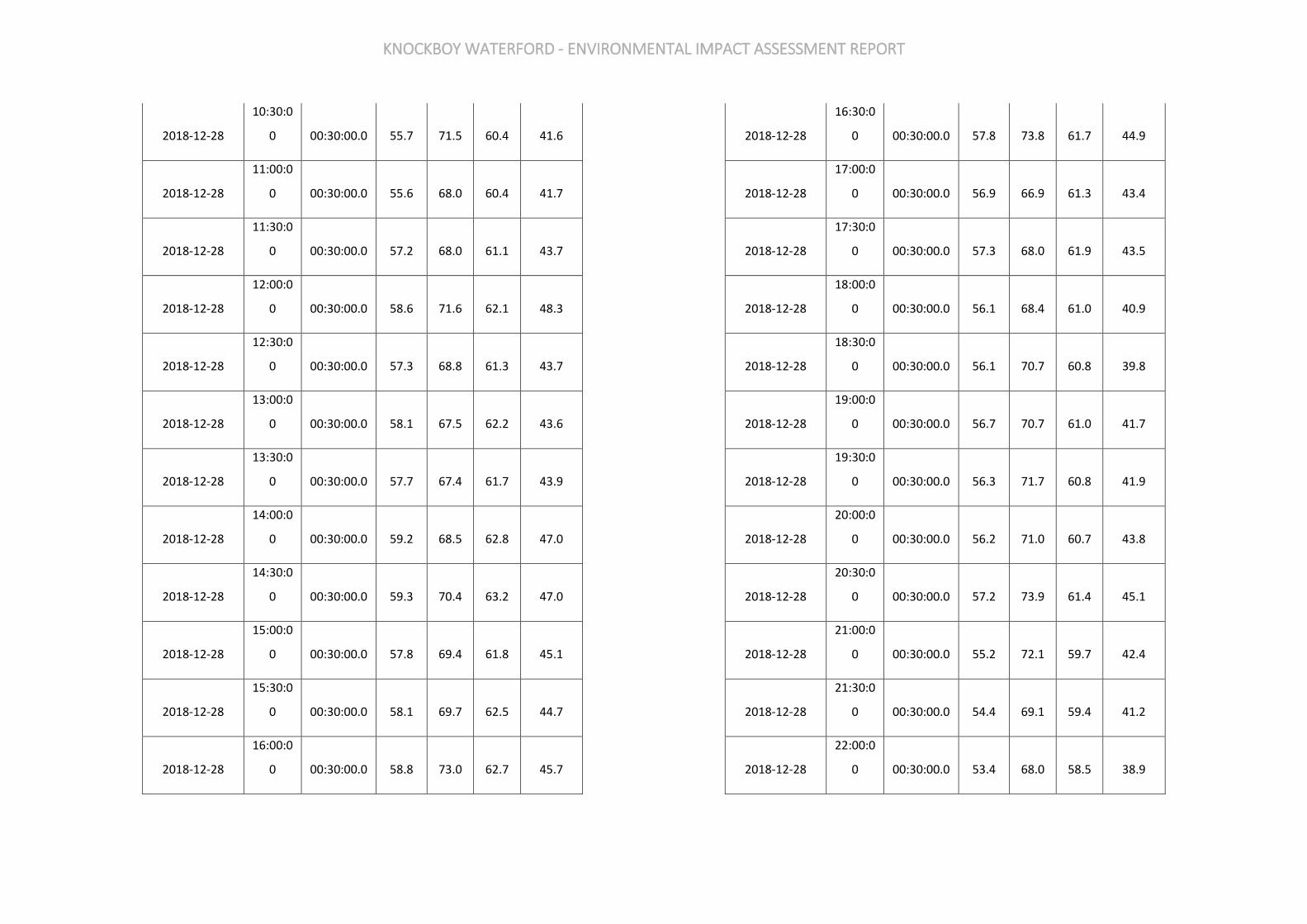
KNOCKBOY WATERFORD - ENVIRONMENTAL IMPACT ASSESSMENT REPORT
2018-12-28
10:30:0
0 00:30:00.0 55.7 71.5 60.4 41.6
2018-12-28
11:00:0
0 00:30:00.0 55.6 68.0 60.4 41.7
2018-12-28
11:30:0
0 00:30:00.0 57.2 68.0 61.1 43.7
2018-12-28
12:00:0
0 00:30:00.0 58.6 71.6 62.1 48.3
2018-12-28
12:30:0
0 00:30:00.0 57.3 68.8 61.3 43.7
2018-12-28
13:00:0
0 00:30:00.0 58.1 67.5 62.2 43.6
2018-12-28
13:30:0
0 00:30:00.0 57.7 67.4 61.7 43.9
2018-12-28
14:00:0
0 00:30:00.0 59.2 68.5 62.8 47.0
2018-12-28
14:30:0
0 00:30:00.0 59.3 70.4 63.2 47.0
2018-12-28
15:00:0
0 00:30:00.0 57.8 69.4 61.8 45.1
2018-12-28
15:30:0
0 00:30:00.0 58.1 69.7 62.5 44.7
2018-12-28
16:00:0
0 00:30:00.0 58.8 73.0 62.7 45.7
2018-12-28
16:30:0
0 00:30:00.0 57.8 73.8 61.7 44.9
2018-12-28
17:00:0
0 00:30:00.0 56.9 66.9 61.3 43.4
2018-12-28
17:30:0
0 00:30:00.0 57.3 68.0 61.9 43.5
2018-12-28
18:00:0
0 00:30:00.0 56.1 68.4 61.0 40.9
2018-12-28
18:30:0
0 00:30:00.0 56.1 70.7 60.8 39.8
2018-12-28
19:00:0
0 00:30:00.0 56.7 70.7 61.0 41.7
2018-12-28
19:30:0
0 00:30:00.0 56.3 71.7 60.8 41.9
2018-12-28
20:00:0
0 00:30:00.0 56.2 71.0 60.7 43.8
2018-12-28
20:30:0
0 00:30:00.0 57.2 73.9 61.4 45.1
2018-12-28
21:00:0
0 00:30:00.0 55.2 72.1 59.7 42.4
2018-12-28
21:30:0
0 00:30:00.0 54.4 69.1 59.4 41.2
2018-12-28
22:00:0
0 00:30:00.0 53.4 68.0 58.5 38.9
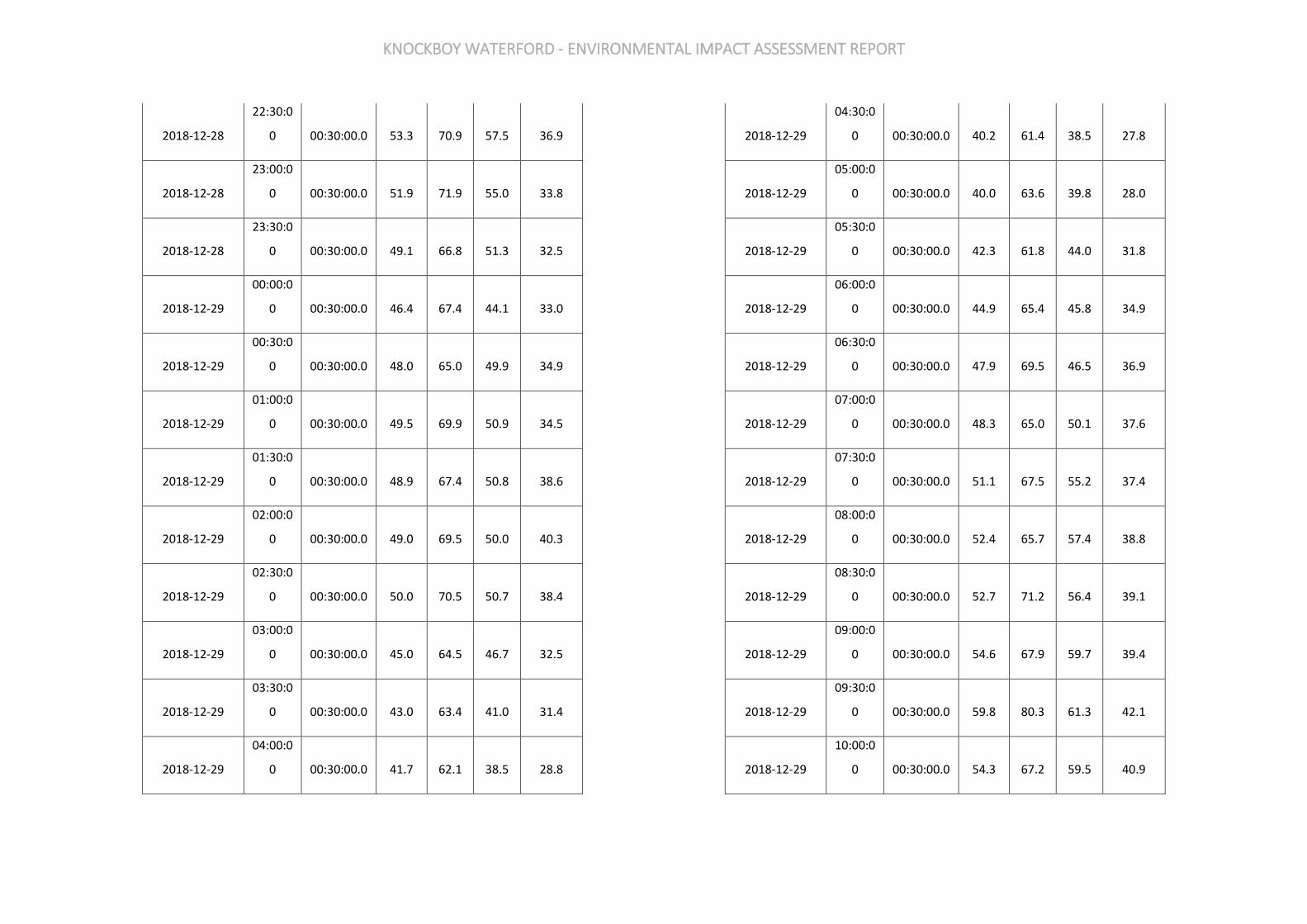
KNOCKBOY WATERFORD - ENVIRONMENTAL IMPACT ASSESSMENT REPORT
2018-12-28
22:30:0
0 00:30:00.0 53.3 70.9 57.5 36.9
2018-12-28
23:00:0
0 00:30:00.0 51.9 71.9 55.0 33.8
2018-12-28
23:30:0
0 00:30:00.0 49.1 66.8 51.3 32.5
2018-12-29
00:00:0
0 00:30:00.0 46.4 67.4 44.1 33.0
2018-12-29
00:30:0
0 00:30:00.0 48.0 65.0 49.9 34.9
2018-12-29
01:00:0
0 00:30:00.0 49.5 69.9 50.9 34.5
2018-12-29
01:30:0
0 00:30:00.0 48.9 67.4 50.8 38.6
2018-12-29
02:00:0
0 00:30:00.0 49.0 69.5 50.0 40.3
2018-12-29
02:30:0
0 00:30:00.0 50.0 70.5 50.7 38.4
2018-12-29
03:00:0
0 00:30:00.0 45.0 64.5 46.7 32.5
2018-12-29
03:30:0
0 00:30:00.0 43.0 63.4 41.0 31.4
2018-12-29
04:00:0
0 00:30:00.0 41.7 62.1 38.5 28.8
2018-12-29
04:30:0
0 00:30:00.0 40.2 61.4 38.5 27.8
2018-12-29
05:00:0
0 00:30:00.0 40.0 63.6 39.8 28.0
2018-12-29
05:30:0
0 00:30:00.0 42.3 61.8 44.0 31.8
2018-12-29
06:00:0
0 00:30:00.0 44.9 65.4 45.8 34.9
2018-12-29
06:30:0
0 00:30:00.0 47.9 69.5 46.5 36.9
2018-12-29
07:00:0
0 00:30:00.0 48.3 65.0 50.1 37.6
2018-12-29
07:30:0
0 00:30:00.0 51.1 67.5 55.2 37.4
2018-12-29
08:00:0
0 00:30:00.0 52.4 65.7 57.4 38.8
2018-12-29
08:30:0
0 00:30:00.0 52.7 71.2 56.4 39.1
2018-12-29
09:00:0
0 00:30:00.0 54.6 67.9 59.7 39.4
2018-12-29
09:30:0
0 00:30:00.0 59.8 80.3 61.3 42.1
2018-12-29
10:00:0
0 00:30:00.0 54.3 67.2 59.5 40.9

KNOCKBOY WATERFORD - ENVIRONMENTAL IMPACT ASSESSMENT REPORT
2018-12-29
10:30:0
0 00:30:00.0 54.3 70.3 59.4 41.8
2018-12-29
11:00:0
0 00:30:00.0 60.5 80.2 62.1 44.1
2018-12-29
11:30:0
0 00:30:00.0 57.0 71.6 61.2 44.2
2018-12-29
12:00:0
0 00:30:00.0 56.6 68.2 60.9 43.8
2018-12-29
12:30:0
0 00:30:00.0 56.4 70.5 61.0 42.9
2018-12-29
13:00:0
0 00:30:00.0 56.7 68.7 60.9 43.4
2018-12-29
13:30:0
0 00:30:00.0 57.1 70.4 61.5 42.3
2018-12-29
14:00:0
0 00:30:00.0 56.7 66.4 60.7 43.4
2018-12-29
14:30:0
0 00:30:00.0 57.1 67.7 61.3 44.1
2018-12-29
15:00:0
0 00:30:00.0 57.5 68.0 61.5 44.3
2018-12-29
15:30:0
0 00:30:00.0 56.8 66.9 61.1 44.5
2018-12-29
16:00:0
0 00:30:00.0 57.3 69.9 61.7 44.8
2018-12-29
16:30:0
0 00:30:00.0 57.4 73.5 61.5 45.8
2018-12-29
17:00:0
0 00:30:00.0 57.1 69.3 61.4 44.3
2018-12-29
17:30:0
0 00:30:00.0 56.8 67.2 61.2 44.1
2018-12-29
18:00:0
0 00:30:00.0 55.5 67.5 59.9 42.1
2018-12-29
18:30:0
0 00:30:00.0 55.2 65.7 59.6 41.8
2018-12-29
19:00:0
0 00:30:00.0 55.1 68.7 59.8 40.3
2018-12-29
19:30:0
0 00:30:00.0 55.4 67.9 59.9 41.0
2018-12-29
20:00:0
0 00:30:00.0 54.4 66.8 59.4 40.9
2018-12-29
20:30:0
0 00:30:00.0 53.9 68.2 59.0 38.2
2018-12-29
21:00:0
0 00:30:00.0 53.9 68.6 58.9 36.5
2018-12-29
21:30:0
0 00:30:00.0 53.3 67.7 57.9 36.1
2018-12-29
22:00:0
0 00:30:00.0 50.5 65.9 55.3 34.6
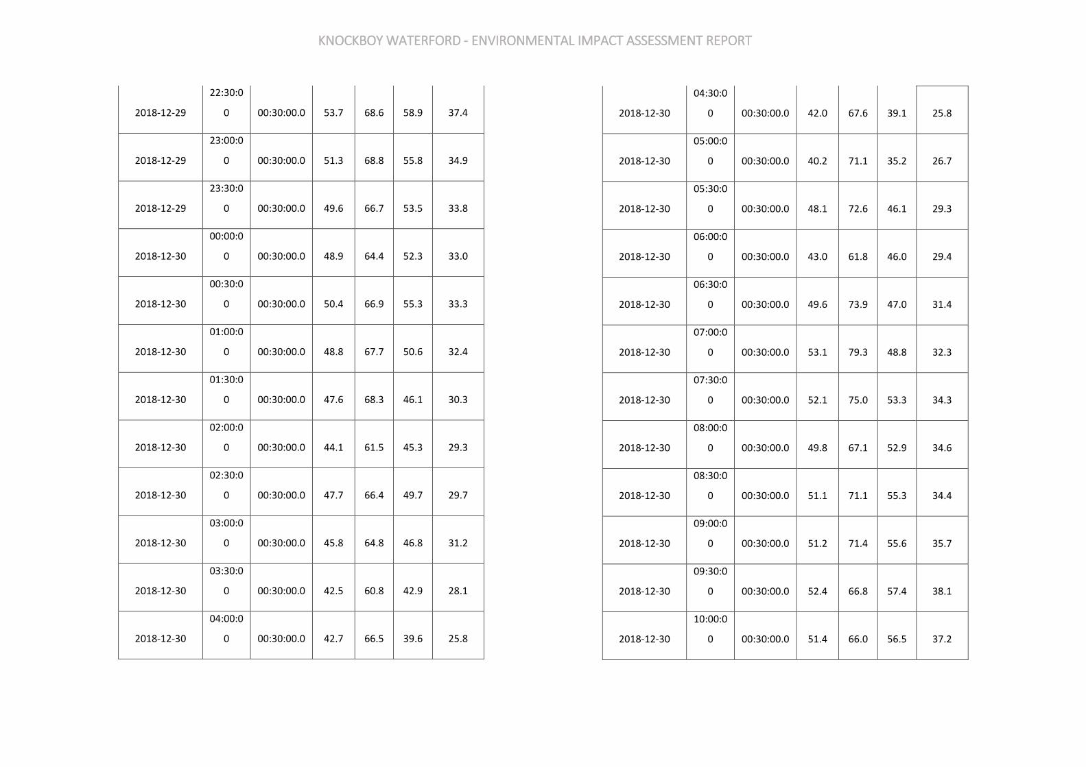
KNOCKBOY WATERFORD - ENVIRONMENTAL IMPACT ASSESSMENT REPORT
2018-12-29
22:30:0
0 00:30:00.0 53.7 68.6 58.9 37.4
2018-12-29
23:00:0
0 00:30:00.0 51.3 68.8 55.8 34.9
2018-12-29
23:30:0
0 00:30:00.0 49.6 66.7 53.5 33.8
2018-12-30
00:00:0
0 00:30:00.0 48.9 64.4 52.3 33.0
2018-12-30
00:30:0
0 00:30:00.0 50.4 66.9 55.3 33.3
2018-12-30
01:00:0
0 00:30:00.0 48.8 67.7 50.6 32.4
2018-12-30
01:30:0
0 00:30:00.0 47.6 68.3 46.1 30.3
2018-12-30
02:00:0
0 00:30:00.0 44.1 61.5 45.3 29.3
2018-12-30
02:30:0
0 00:30:00.0 47.7 66.4 49.7 29.7
2018-12-30
03:00:0
0 00:30:00.0 45.8 64.8 46.8 31.2
2018-12-30
03:30:0
0 00:30:00.0 42.5 60.8 42.9 28.1
2018-12-30
04:00:0
0 00:30:00.0 42.7 66.5 39.6 25.8
2018-12-30
04:30:0
0 00:30:00.0 42.0 67.6 39.1 25.8
2018-12-30
05:00:0
0 00:30:00.0 40.2 71.1 35.2 26.7
2018-12-30
05:30:0
0 00:30:00.0 48.1 72.6 46.1 29.3
2018-12-30
06:00:0
0 00:30:00.0 43.0 61.8 46.0 29.4
2018-12-30
06:30:0
0 00:30:00.0 49.6 73.9 47.0 31.4
2018-12-30
07:00:0
0 00:30:00.0 53.1 79.3 48.8 32.3
2018-12-30
07:30:0
0 00:30:00.0 52.1 75.0 53.3 34.3
2018-12-30
08:00:0
0 00:30:00.0 49.8 67.1 52.9 34.6
2018-12-30
08:30:0
0 00:30:00.0 51.1 71.1 55.3 34.4
2018-12-30
09:00:0
0 00:30:00.0 51.2 71.4 55.6 35.7
2018-12-30
09:30:0
0 00:30:00.0 52.4 66.8 57.4 38.1
2018-12-30
10:00:0
0 00:30:00.0 51.4 66.0 56.5 37.2
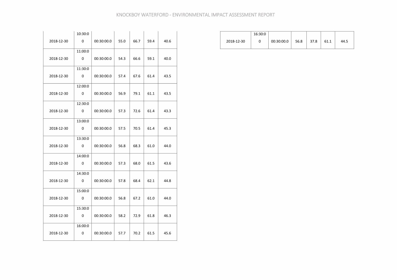
KNOCKBOY WATERFORD - ENVIRONMENTAL IMPACT ASSESSMENT REPORT
2018-12-30
10:30:0
0 00:30:00.0 55.0 66.7 59.4 40.6
2018-12-30
11:00:0
0 00:30:00.0 54.3 66.6 59.1 40.0
2018-12-30
11:30:0
0 00:30:00.0 57.4 67.6 61.4 43.5
2018-12-30
12:00:0
0 00:30:00.0 56.9 79.1 61.1 43.5
2018-12-30
12:30:0
0 00:30:00.0 57.3 72.6 61.4 43.3
2018-12-30
13:00:0
0 00:30:00.0 57.5 70.5 61.4 45.3
2018-12-30
13:30:0
0 00:30:00.0 56.8 68.3 61.0 44.0
2018-12-30
14:00:0
0 00:30:00.0 57.3 68.0 61.5 43.6
2018-12-30
14:30:0
0 00:30:00.0 57.8 68.4 62.1 44.8
2018-12-30
15:00:0
0 00:30:00.0 56.8 67.2 61.0 44.0
2018-12-30
15:30:0
0 00:30:00.0 58.2 72.9 61.8 46.3
2018-12-30
16:00:0
0 00:30:00.0 57.7 70.2 61.5 45.6
2018-12-30
16:30:0
0 00:30:00.0 56.8 37.8 61.1 44.5
KNOCKBOY WATERFORD - ENVIRONMENTAL IMPACT ASSESSMENT REPORT
CHAPTER 13 WASTE MANAGEMENT APPENDICES
APPENDIX 13.1 DRAFT OPERATIONAL WASTE MANAGEMENT PLAN
KNOCKBOY WATERFORD - ENVIRONMENTAL IMPACT ASSESSMENT REPORT
1.0 INTRODUCTION
This Operational Waste and Recycling Management Strategy (the ’Strategy ‘) has been prepared by Nevin Traynor BSc.Env, HDIP IT, Cert SHWW, IAH of Traynor Environmental Ltd on behalf of Jackie Greene Construction Ltd (‘The Applicant ‘) in support of the proposed Knockboy development (hereafter referred to as the ‘Proposed Development’) within the Waterford City and County Council Local Authority Area. The principal aim of this Strategy is to demonstrate how the Proposed Development has taken into account sustainable methods for waste and recycling management during its operation. Furthermore, with regards to waste and recycling management within the Proposed Development, this Strategy has the following aims:
• To contribute towards achieving current and long-term government and Waterford City and County Council targets for waste minimisation, recycling and re-use;
• To comply with all legal requirements for handling operational waste;
• To achieve high standards of waste management performance, through giving (and continuing to give) due consideration to the waste generated by the Proposed Development during its operation; and
• To provide the Proposed Development with a convenient, clean and efficient waste management strategy that enhances the operation of the Proposed Development and promotes recycling.
It is important to note that the Waterford City and County Council is part of the Southern Waste Region. The Southern Waste Region comprises the 10 local authority areas of Carlow, Clare, Cork County, Cork City, Limerick City & County, Kerry, Kilkenny, Tipperary, Waterford City & County and Wexford. The Region covers 42% of the land mass of the country, with a population of over 1.5 million people. The settlement patterns in the region are evenly split between urban and rural areas, with the four cities of Cork, Limerick, Kilkenny and Waterford having the highest population and strongest centres of economic activity.
Limerick City & County Council and Tipperary County Council are the lead authorities for the Region and manage the Southern Region Waste Management Office (SRWMO). The SRWMO coordinates the implementation of the Southern Region Waste Management Plan 2015 – 2021 and is a knowledge resource for all stakeholders with the capacity to promote higher order waste actions in the areas of prevention, reuse, resource efficiency and recycling.
This Strategy provides a review of the requirements placed upon the Proposed Development under national legislation and implemented policy at all levels of government (i.e. national (Ireland), regional (SWR), district and (local (Waterford City and County Council). Consideration has also been given to requirements included in local standards and guidance documents (i.e. DoEHLG, Sustainable Urban Housing: Design Standards for New Apartments, Guidelines for Planning Authorities (2018) in line with
the Regional Waste Management Plan and British Standard Waste Management in Buildings, Code of Practice (BS 5906:2005) so as to comply with relevant objectives and targets. The methodology used to identify and estimate volumes of waste generated during operation of the Proposed Development has been provided and is outlined in Section 4: Methodology of this Strategy. Following this, the approach taken towards waste management within the Proposed Development is discussed. This includes a breakdown of the waste management process, which details waste handling, storage area provision, and collection arrangements. All waste reduction measures are compliant with BS 5906:2005, Southern Waste Region (SWR) and Sustainable Urban Housing: Design Standards for New Apartments which are also discussed in this Strategy.
This Strategy has been written by Traynor Environmental Ltd, using information provided by Fewer Harrington & Partners(hereafter referred to as the ‘Architects’).
2.0 LEGISLATION/ PLANNING POLICY
A summary of national legislation and national, regional and local planning policy relevant to the Proposed Development is outlined in section 3.1 below. It should be noted that this summary identifies those elements of the policy or guidance applicable to waste management within the Proposed Development and does not provide a comprehensive summary of the identified legislation or policy.
2.1 National Legislation
The Government issued a policy statement in September 1998 titled as ‘Changing Our Ways’ which identified objectives for the prevention, minimisation, reuse, recycling, recovery and disposal of waste in Ireland. A heavy emphasis was placed on reducing reliance on landfill and finding alternative methods for managing waste. Amongst other things, Changing Our Ways stated a target of at least 35% recycling of municipal (i.e. household, commercial and non-process industrial) waste. A further policy document ‘Preventing and Recycling Waste – Delivering Change’ was published in 2002. This document proposed a number of programmes to increase recycling of waste and allow diversion from landfill. The need for waste minimisation at source was considered a priority.
This view was also supported by a review of sustainable development policy in Ireland and achievements to date, which was conducted in 2002, entitled ‘Making Irelands Development Sustainable – Review, Assessment and Future Action’ 8. This document also stressed the need to break the link between economic growth and waste generation, again through waste minimisation and reuse of discarded material In order to establish the progress of the Government policy document Changing Our Ways, a review document was published in April 2004 entitled ‘Taking Stock and Moving Forward’. Covering the period 1998 – 2003, the aim of this document was to assess progress to date with regard to waste management in Ireland, to consider developments since the policy framework and the local authority waste management plans were put in place, and to identify measures that could be undertaken to further support progress towards the objectives outlined in Changing Our Ways.

KNOCKBOY WATERFORD - ENVIRONMENTAL IMPACT ASSESSMENT REPORT
In particular, Taking Stock and Moving Forward noted a significant increase in the amount of waste being brought to local authority landfills. The report noted that one of the significant challenges in the coming years was the extension of the dry recyclable collection services. The most recent policy document was published in July 2012 titled ‘A Resource Opportunity. The policy document stresses the environmental and economic benefits of better waste management, particularly in relation to waste prevention. The document sets out a number of actions, including the following:
• A move away from landfill and replacement through prevention, reuse, recycling and recovery.
• A Brown Bin roll-out diverting ‘organic waste’ towards more productive uses.
• Introducing a new regulatory regime for the existing side-by-side competition model within the household waste collection market;
• New Service Standards to ensure that consumers receive higher customer service standards from their operator;
• Placing responsibility on householders to prove they use an authorised waste collection service.
• The establishment of a team of Waste Enforcement Officers for cases relating to serious criminal activity will be prioritised;
• Reducing red tape for industry to identify and reduce any unnecessary administrative burdens on the waste management industry;
• A review of the producer responsibility model will be initiated to assess and evaluate the operation of the model in Ireland;
• Significant reduction of Waste Management Planning Regions from ten to three. While a resource opportunity covers the period to 2020, it is subject to a mid-term review in 2016 to ensure that the measures are set out properly and to provide an opportunity for additional measures to be adopted in the event of inadequate performance. Since 1998, the Environmental Protection Agency (EPA) has produced periodic ‘National Waste (Database) Reports’ detailing among other things estimates for household and commercial (municipal) waste generation in Ireland and the level of recycling, recovery and disposal of these materials. The 2018 National Waste Statistics, which is the most recent study published, reported the following key statistics for 2016:
• 2,763 kilotons of municipal waste were managed in 2016 (6% increase compared to 2014).
• 74% of managed municipal waste was recovered (79% in 2014). Recovery includes treatment processes such as recycling, use as a fuel (incineration and co-incineration) and backfilling.
• 41% of managed municipal waste was recycled (41% in 2014). Recycling includes reprocessing of waste materials into products, composting and anaerobic digestion.
• 26% of managed municipal waste was landfilled in 2016.
2.2 Regional Level The proposed development is located in the Local Authority area of Waterford City and County Council. The SWR is involved in the implementation of the Southern Region Waste Management Plan 2015-2021. The regional plan sets out the following strategic targets for waste management in the region:
• A 1% reduction per annum in the quantity of household waste generated per capita over the period of the plan;
• Achieve a recycling rate of 50% of managed municipal waste by 2020; and
• Reduce to 0% the direct disposal of unprocessed residual municipal waste to landfill (from 2016 onwards) in favour of higher value pre-treatment processes and indigenous recovery practices.
Municipal landfill charges in Ireland are based on the weight of waste disposed. In the Leinster Region, charges are approximately €130 - €150 per tonne of waste which includes a €75 per tonne landfill levy introduced under the Waste Management (Landfill Levy) (Amendment) Regulations 2015. The Waterford City Development Plan 2013 – 2019 sets out a number of objectives and actions for the Waterford area in line with the objectives of the regional waste management plan. Waste objectives and actions with a particular relevance to this development are: Objectives:
• To continue and expand environmental awareness initiatives designed to create increased public awareness of waste prevention, minimisation and reuse. (OBJ 11.10.1)
• To identify and promote further waste prevention and recovery/recycling initiatives (OBJ 11.10.2)
• To provide for additional recycling, including composting facilities both on a city-wide basis and within the neighbourhoods and promote the recovery/recycling of all food waste. (OBJ 11.10.3)
• To consider when undertaking development or when authorising or permitting development, the provision of a waste minimisation, prevention and reuse programmes and facilities including: - - The provision of recycling facilities within developments. - The imposition of conditions requiring the implementation of waste management
programmes, including schemes for the management of construction and demolition waste, on development sites (OBJ 11.10.4)
2.3 Legislative Requirements The primary legislative instruments that govern waste management in Ireland and applicable to the project are: Waste Management Act 1996 (No. 10 of 1996) as amended 2001 (No. 36 of 2001), 2003 (No. 27 of 2003) and 2011 (No 20 of 2011) and associated legislation includes:
• Environmental Protection Act 1992 (S.I. No. 7 of 1992) as amended by the Protection of the Environment Act 2003 (S.I. No. 27 and S.I. No. 413 of 2003) and amended by the Planning and Development Act 2000 (S.I. No. 30 of 2000) as amended;
• Litter Pollution Act 1997 (Act No. 12 of 1997) as amended by the Litter Pollution Regulations 1999 (S.I. No. 359 of 1999) and Protection of the Environment Act 2003;
• European Communities (Transfrontier Shipment of Waste) Regulations, 1994 (S.I. No. 221 of 1994);
• European Union (Properties of Waste Which Render It Hazardous) Regulations 2015 (S.I. No. 233 of 2015);
• Waste Management (Licensing) Regulations 2000 (S.I No. 185 of 2000) as amended 2004 (S.I. No. 395 of 2004) and 2010 (S.I. No. 350 of 2010);
• European Union (Packaging) Regulations 2014 (S.I. No. 282 of 2014);
• Waste Management (Planning) Regulations 1997 (S.I. No. 137 of 1997);
• Waste Management (Landfill Levy) Regulations 2015 (S.I. No. 189 of 2015);

KNOCKBOY WATERFORD - ENVIRONMENTAL IMPACT ASSESSMENT REPORT
• European Communities (Waste Electrical and Electronic Equipment) Regulations 2014 (S.I. No. 149 of 2014);
• European Communities (Waste Directive) Regulations 2011 (S.I. No. 126 of 2011) as amended 2011 and 2016 (S.I. No. 323 of 2011);
• Waste Management (Collection Permit) Regulations 2007 (S.I. No. 820 of 2007) as amended 2008 (S.I No 87 of 2008) and 2016 (S.I. 24 of 2016);
• Waste Management (Facility Permit and Registration) Regulation 2007 (S.I No. 821 of 2007) as amended 2008 (S.I No. 86 of 2008), 2014 (S.I. No. 310 and S.I. No. 546 of 2014) and 2015 (S.I. No. 198 of 2015);
• Waste Management (Batteries and Accumulators) Regulations 2014 (S.I. No. 283 of 2014) as amended 2014 (S.I. No. 349 of 2014) and 2015 (S.I. No. 347 of 2015);
• Waste Management (Food Waste) Regulations 2009 (S.I. No. 508 of 2009) as amended 2015 (S.I. No. 190 of 2015);
• European Union (Household Food Waste and Bio-waste) Regulations 2015 (S.I. No. 191 of 2015);
• Waste Management (Hazardous Waste) Regulations 1998 (S.I. No. 163 of 1998) as amended 2000 (S.I. No. 73 of 2000); and
• Waste Management (Shipments of Waste) Regulations 2007 (S.I. No. 419 of 2007) as amended by European Communities (Shipments of Hazardous Waste exclusively within Ireland) Regulations 2011 (S.I. No. 324 of 2011)
2.4 Responsibilities of the Waste Producer.
The waste producer is responsible for waste from the time it is generated through until its legal disposal (including its method of disposal.) Waste contractors will be employed to physically transport waste to the final waste disposal / recovery site. It is therefore imperative that the residents, commercial tenants and the proposed facilities management company undertake on-site management of waste in accordance with all legal requirements and employ suitably permitted/licenced contractors to undertake off-site management of their waste in accordance with all legal requirements. This includes the requirement that a waste contactor handle, transport and reuse/recover/recycle/dispose of waste in a manner that ensures that no adverse environmental impacts occur as a result of any of these activities.
A collection permit to transport waste must be held by each waste contractor which is issued by the National Waste Collection Permit Office (NWCPO). Waste receiving facilities must also be appropriately permitted or licensed. Operators of such facilities cannot receive any waste, unless in possession of a Certificate of Registration (COR) or waste permit granted by the relevant Local Authority under the Waste Management (Facility Permit & Registration) Regulations 2007 as amended or a waste or IED (Industrial Emissions Directive) licence granted by the EPA. The COR/permit/licence held will specify the type and quantity of waste able to be received, stored, sorted, recycled, recovered and/or disposed of at the specified site.
2.5 Waterford City and County Council Bye-Laws
Waterford City & County Council has made the Waterford City & County Council (Segregation, Storage and Presentation of Household and Commercial Waste) Byelaws 2018, in accordance with the Local Government Act 2001 and the Waste Management Act 1996, to regulate and control the Segregation, Storage and Presentation of Household and Commercial Waste within its functional area. Provision is made in the bye-laws for the imposition of a fixed payment of €75 in respect of a contravention of a bye-law as an alternative to a prosecution, as provided for in Section 206 of the Local Government Act 2001.
• Provisions affecting Multi-user Buildings, Apartment Blocks, etc A management company, or an other person if there is no such company, who exercises control and supervision of residential and/or commercial activities in multi-unit developments, mixed-use developments, flats or apartment blocks, combined living/working spaces or other similar complexes shall ensure that:
(a) separate receptacles of adequate size and number are provided for the proper segregation, storage and collection of recyclable household kerbside waste and residual household kerbside waste.
(b) additional receptacles are provided for the segregation, storage and collection of food waste where this practice is a requirement of the national legislation on food waste,
(c) the receptacles referred to in paragraphs (a) and (b) are located both within any individual apartment and at the place where waste is stored prior to its collection,
(d) any place where waste is to be stored prior to collection is secure, accessible at all times by tenants and other occupiers and is not accessible by any other person other than an authorised waste collector,
(e) written information is provided to each tenant or other occupier about the arrangements for waste separation, segregation, storage and presentation prior to collection,
(f) an authorised waste collector is engaged to service the receptacles referred to in this section of these bye-laws, with documentary evidence, such as receipts, statements or other proof of payment, demonstrating the existence of this engagement being retained for a period of no less than two years. Such evidence shall be presented to an authorised person within a time specified in a written request from either that person or from another authorised person employed by Waterford City and County Council,
(g) receptacles for kerbside waste are presented for collection on the designated waste collection day,
(h) adequate access and egress onto and from the premises by waste collection vehicles is maintained.
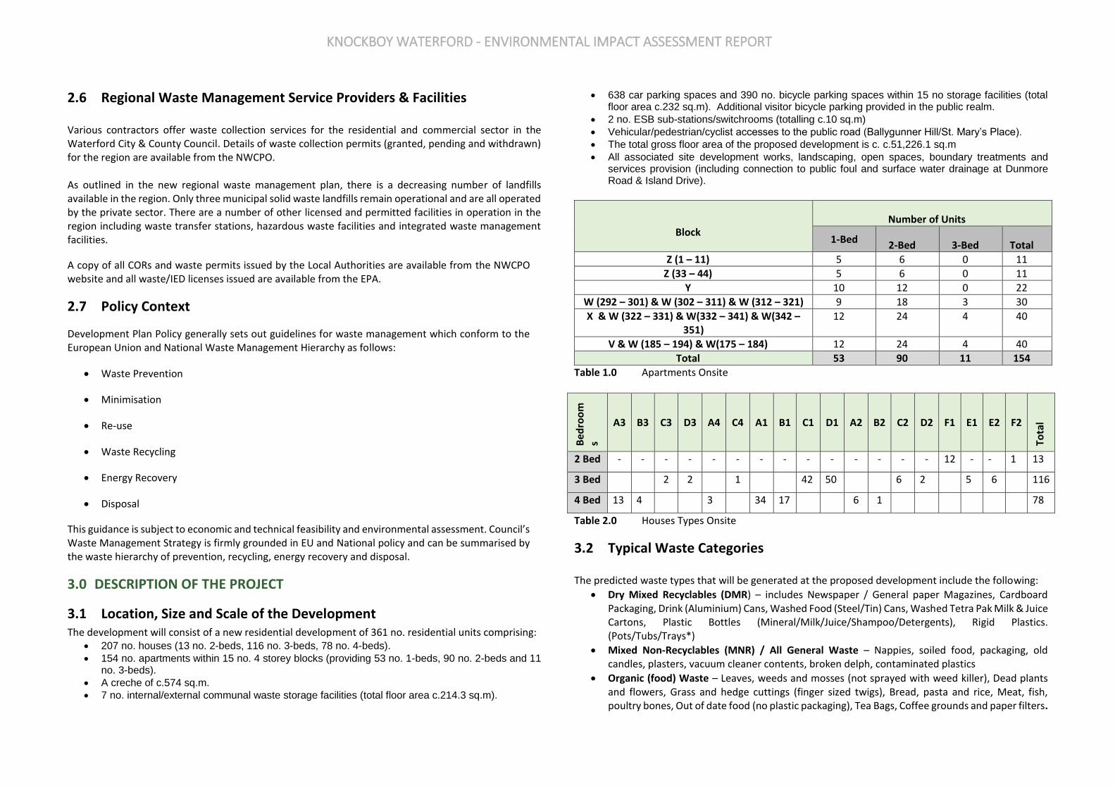
KNOCKBOY WATERFORD - ENVIRONMENTAL IMPACT ASSESSMENT REPORT
2.6 Regional Waste Management Service Providers & Facilities Various contractors offer waste collection services for the residential and commercial sector in the Waterford City & County Council. Details of waste collection permits (granted, pending and withdrawn) for the region are available from the NWCPO. As outlined in the new regional waste management plan, there is a decreasing number of landfills available in the region. Only three municipal solid waste landfills remain operational and are all operated by the private sector. There are a number of other licensed and permitted facilities in operation in the region including waste transfer stations, hazardous waste facilities and integrated waste management facilities.
A copy of all CORs and waste permits issued by the Local Authorities are available from the NWCPO website and all waste/IED licenses issued are available from the EPA.
2.7 Policy Context
Development Plan Policy generally sets out guidelines for waste management which conform to the European Union and National Waste Management Hierarchy as follows:
• Waste Prevention
• Minimisation
• Re-use
• Waste Recycling
• Energy Recovery
• Disposal
This guidance is subject to economic and technical feasibility and environmental assessment. Council’s Waste Management Strategy is firmly grounded in EU and National policy and can be summarised by the waste hierarchy of prevention, recycling, energy recovery and disposal.
3.0 DESCRIPTION OF THE PROJECT
3.1 Location, Size and Scale of the Development The development will consist of a new residential development of 361 no. residential units comprising:
• 207 no. houses (13 no. 2-beds, 116 no. 3-beds, 78 no. 4-beds).
• 154 no. apartments within 15 no. 4 storey blocks (providing 53 no. 1-beds, 90 no. 2-beds and 11 no. 3-beds).
• A creche of c.574 sq.m.
• 7 no. internal/external communal waste storage facilities (total floor area c.214.3 sq.m).
• 638 car parking spaces and 390 no. bicycle parking spaces within 15 no storage facilities (total floor area c.232 sq.m). Additional visitor bicycle parking provided in the public realm.
• 2 no. ESB sub-stations/switchrooms (totalling c.10 sq.m)
• Vehicular/pedestrian/cyclist accesses to the public road (Ballygunner Hill/St. Mary’s Place).
• The total gross floor area of the proposed development is c. c.51,226.1 sq.m
• All associated site development works, landscaping, open spaces, boundary treatments and services provision (including connection to public foul and surface water drainage at Dunmore Road & Island Drive).
Block Number of Units
1-Bed 2-Bed 3-Bed Total
Z (1 – 11) 5 6 0 11
Z (33 – 44) 5 6 0 11
Y 10 12 0 22
W (292 – 301) & W (302 – 311) & W (312 – 321) 9 18 3 30
X & W (322 – 331) & W(332 – 341) & W(342 – 351)
12 24 4 40
V & W (185 – 194) & W(175 – 184) 12 24 4 40
Total 53 90 11 154
Table 1.0 Apartments Onsite
Bed
roo
ms
A3 B3 C3 D3 A4 C4 A1 B1 C1 D1 A2 B2 C2 D2 F1 E1 E2 F2
Tota
l
2 Bed - - - - - - - - - - - - - - 12 - - 1 13
3 Bed 2 2 1 42 50 6 2 5 6 116
4 Bed 13 4 3 34 17 6 1 78
Table 2.0 Houses Types Onsite
3.2 Typical Waste Categories The predicted waste types that will be generated at the proposed development include the following:
• Dry Mixed Recyclables (DMR) – includes Newspaper / General paper Magazines, Cardboard Packaging, Drink (Aluminium) Cans, Washed Food (Steel/Tin) Cans, Washed Tetra Pak Milk & Juice Cartons, Plastic Bottles (Mineral/Milk/Juice/Shampoo/Detergents), Rigid Plastics. (Pots/Tubs/Trays*)
• Mixed Non-Recyclables (MNR) / All General Waste – Nappies, soiled food, packaging, old candles, plasters, vacuum cleaner contents, broken delph, contaminated plastics
• Organic (food) Waste – Leaves, weeds and mosses (not sprayed with weed killer), Dead plants and flowers, Grass and hedge cuttings (finger sized twigs), Bread, pasta and rice, Meat, fish, poultry bones, Out of date food (no plastic packaging), Tea Bags, Coffee grounds and paper filters.

KNOCKBOY WATERFORD - ENVIRONMENTAL IMPACT ASSESSMENT REPORT
Fruit and vegetables (cooked and uncooked). Food soiled cardboard or paper (no coated paper) Eggs and dairy products (no plastic packaging) Paper napkin and paper towels
• Glass In addition to the typical waste materials that will be generated on a daily basis, there will be some additional waste types generated in small quantities that will need to be managed separately including:
• Green/garden waste - may be generated from internal plants, gardens and external landscaping;
• Textiles
• Batteries
• Waste electrical and electronic equipment (WEEE)
• Chemicals (solvents, pesticides, paints, adhesives, resins, detergents, etc.)
• Fluorescent tubes and other mercury containing waste
• Furniture (and from time to time other bulky wastes) Wastes should be segregated into the above waste types to ensure compliance with waste legislation and guidance while maximising the re-use, recycling and recovery of waste with diversion from landfill wherever possible.
3.3 European Waste Codes In 1994, the European Waste Catalogue and Hazardous Waste List were published by the European Commission. In 2002, the EPA published a document titled the European Waste Catalogue and Hazardous Waste List, which was a condensed version of the original two documents and their subsequent amendments. This document has been replaced by the EPA ‘Waste Classification – List of Waste & Determining if Waste is Hazardous or Non-Hazardous’ which became valid from the 1st June 2015. This waste classification system applies across the EU and is the basis for all national and international waste reporting, such as those associated with waste collection permits, COR’s, permits and licences and EPA National Waste Database. Under the classification system, different types of wastes are fully defined by a code. The List of Waste (LoW) code (also referred to as European Waste Code or EWC) for typical waste materials expected to be generated during the operation of the proposed development are provided in the Table below.
Waste Material LoW Code
Paper and Cardboard 20 01 01
Plastic 20 01 39
Metals 20 01 40
Mixed Municipal Waste 20 03 01
Glass 20 01 02
Biodegradable Kitchen Waste 20 01 08
Oils and Fats 20 01 25/26*
Biodegradable garden and park waste 20 02 01
Textiles 20 01 11
Batteries and accumulators* 20 01 33*-34
Printer Toner / Cartridges* 20 01 27* -28
Green Waste 20 02 01
Waste electrical and electronic equipment* 20 01 35*-36
Chemicals (solvents, pesticides, paints & adhesives, detergents etc) * 20 01 13 / 19 /27 / 28 / 29* 30
Fluorescent tubes and other mercury containing waste* 20 01 21*
Bulky wastes 20 03 07
Table 3.0 LoW Codes
4.0 ESTIMATED WASTE ARISING A waste generation spreadsheet was developed by Traynor environmental Ltd and has been used to predict waste types, weights and volumes arising from operations within the proposed development. The spreadsheet incorporates building area and use and combines these with other data including Irish EPA Statistics/Reports and similar European Countries waste generation rates. The estimated quantum/volume of waste that will be generated from the residential units has been determined based on the predicted occupancy of the units. The estimated quantum/volume of waste that will be generated from the residential units has been determined based on the predicted occupancy of the units and is presented in table 4.0 below.
Waste Volume (m3/week)
Waste type Z
(1 – 11)
Z (33 – 44)
Y
W (292 – 301) & W (302 –
311) & W (312 – 321)
X & W(322 – 331) & W(332 – 341) &
W(342 – 351)
V & W (185 –
194) & W(175 –
184)
Totals
Organic Waste
0.07 0.07 0.13 0.20 0.26 0.26 0.99
Mixed Dry Recyclables
0.47 0.47 0.91 1.38 1.82 1.82 6.87
Glass 0.03 0.03 0.07 0.10 0.13 0.13 0.49
Mixed Municipal
Waste 0.23 0.23 0.46 0.69 0.91 0.91 3.43
Total 0.80 0.80 1.56 2.37 3.12 3.12 11.78
Table 4.0 Residential Waste Prediction (m3/per week)
4.1 Waste Storage and Collection This section provides information on how waste generated within the development will be stored and how the waste will be collected from the development. This has been prepared with due consideration of the proposed site layout as well as best practice standards, local and national waste management
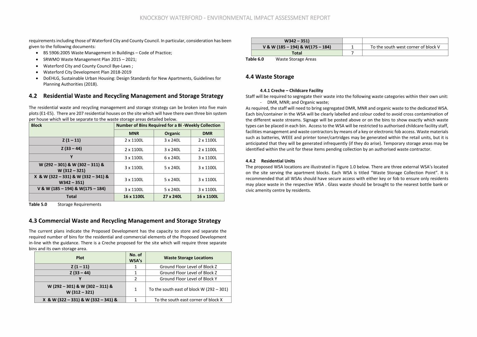
KNOCKBOY WATERFORD - ENVIRONMENTAL IMPACT ASSESSMENT REPORT
requirements including those of Waterford City and County Council. In particular, consideration has been given to the following documents:
• BS 5906:2005 Waste Management in Buildings – Code of Practice;
• SRWMO Waste Management Plan 2015 – 2021;
• Waterford City and County Council Bye-Laws ;
• Waterford City Development Plan 2018-2019
• DoEHLG, Sustainable Urban Housing: Design Standards for New Apartments, Guidelines for Planning Authorities (2018).
4.2 Residential Waste and Recycling Management and Storage Strategy
The residential waste and recycling management and storage strategy can be broken into five main plots (E1-E5). There are 207 residential houses on the site which will have there own three bin system per house which will be separate to the waste storage areas detailed below.
Block Number of Bins Required for a Bi -Weekly Collection
MNR Organic DMR
Z (1 – 11) 2 x 1100L 3 x 240L 2 x 1100L
Z (33 – 44) 2 x 1100L 3 x 240L 2 x 1100L
Y 3 x 1100L 6 x 240L 3 x 1100L
W (292 – 301) & W (302 – 311) & W (312 – 321)
3 x 1100L 5 x 240L 3 x 1100L
X & W (322 – 331) & W (332 – 341) & W342 – 351)
3 x 1100L 5 x 240L 3 x 1100L
V & W (185 – 194) & W(175 – 184) 3 x 1100L 5 x 240L 3 x 1100L
Total 16 x 1100L 27 x 240L 16 x 1100L
Table 5.0 Storage Requirements
4.3 Commercial Waste and Recycling Management and Storage Strategy
The current plans indicate the Proposed Development has the capacity to store and separate the required number of bins for the residential and commercial elements of the Proposed Development in-line with the guidance. There is a Creche proposed for the site which will require three separate bins and its own storage area.
Plot No. of WSA’s
Waste Storage Locations
Z (1 – 11) 1 Ground Floor Level of Block Z
Z (33 – 44) 1 Ground Floor Level of Block Z
Y 2 Ground Floor Level of Block Y
W (292 – 301) & W (302 – 311) & W (312 – 321)
1 To the south east of block W (292 – 301)
X & W (322 – 331) & W (332 – 341) & 1 To the south east corner of block X
W342 – 351)
V & W (185 – 194) & W(175 – 184) 1 To the south west corner of block V
Total 7
Table 6.0 Waste Storage Areas
4.4 Waste Storage 4.4.1 Creche – Childcare Facility
Staff will be required to segregate their waste into the following waste categories within their own unit: - DMR, MNR; and Organic waste;
As required, the staff will need to bring segregated DMR, MNR and organic waste to the dedicated WSA. Each bin/container in the WSA will be clearly labelled and colour coded to avoid cross contamination of the different waste streams. Signage will be posted above or on the bins to show exactly which waste types can be placed in each bin. Access to the WSA will be restricted to authorised childcare facility staff, facilities management and waste contractors by means of a key or electronic fob access. Waste materials such as batteries, WEEE and printer toner/cartridges may be generated within the retail units, but it is anticipated that they will be generated infrequently (if they do arise). Temporary storage areas may be identified within the unit for these items pending collection by an authorised waste contractor. 4.4.2 Residential Units The proposed WSA locations are illustrated in Figure 1.0 below. There are three external WSA’s located on the site serving the apartment blocks. Each WSA is titled “Waste Storage Collection Point”. It is recommended that all WSAs should have secure access with either key or fob to ensure only residents may place waste in the respective WSA . Glass waste should be brought to the nearest bottle bank or civic amenity centre by residents.

KNOCKBOY WATERFORD - ENVIRONMENTAL IMPACT ASSESSMENT REPORT
Figure 1.0 External Waste Storage Areas
Figure 2.0 This waste storage area covers Block X & Block W (322 – 331) & Block W (332 – 341) & BlockW342 – 351)
Figure 3.0 This waste storage area covers Block W (292 – 301) & Block W (302 – 311) & Block W (312 – 321)
Figure 4.0 This waste storage area covers Block V & Block W (185 – 194) & Block W(175 – 184) The proposed number of bins required for this WSA including Block X, Block W (322 – 331), Block W (332 – 341) & BlockW342 – 351) is 6No. (1100L split equally for DMR and MNR) and 5 no. (240L).
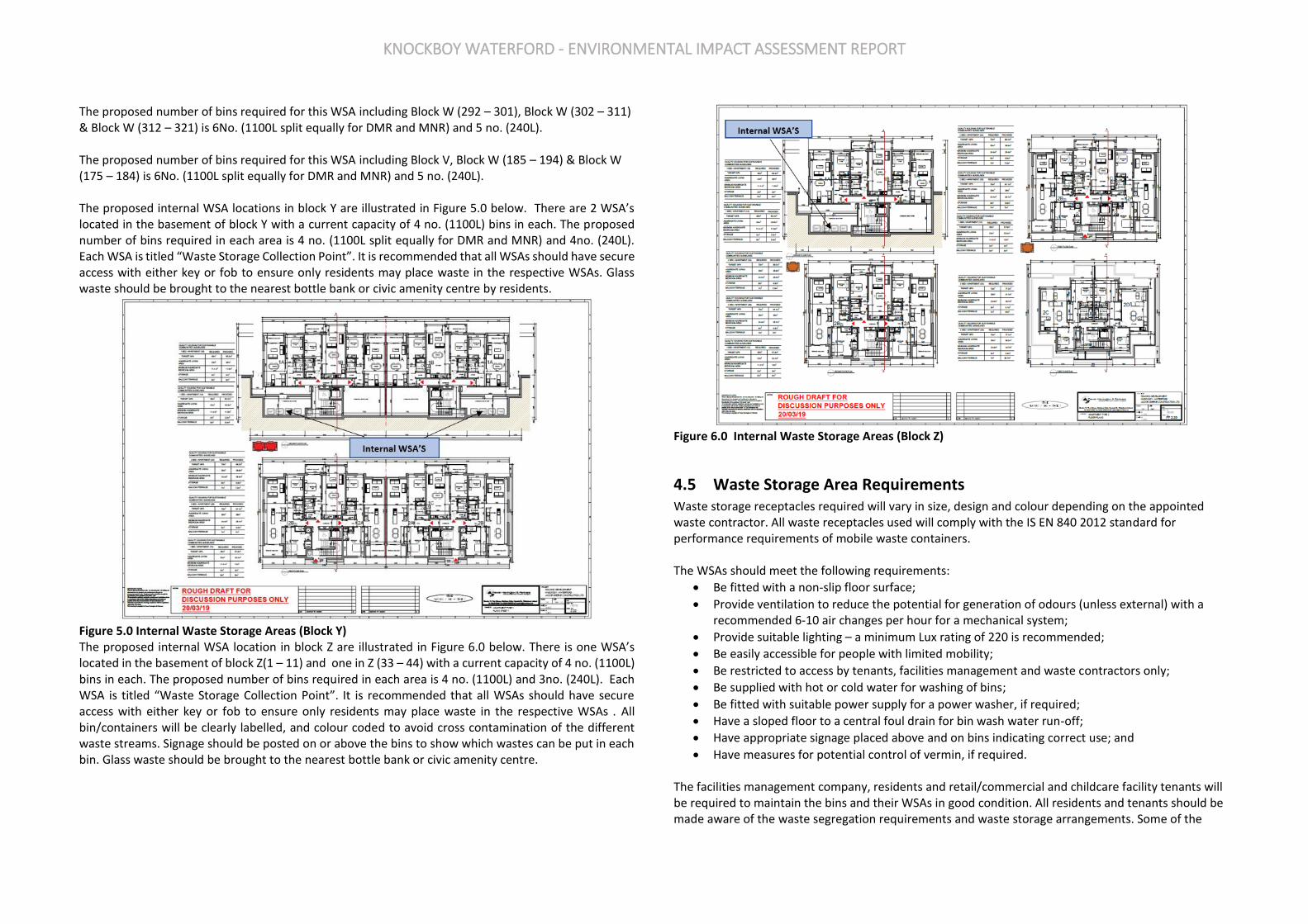
KNOCKBOY WATERFORD - ENVIRONMENTAL IMPACT ASSESSMENT REPORT
The proposed number of bins required for this WSA including Block W (292 – 301), Block W (302 – 311) & Block W (312 – 321) is 6No. (1100L split equally for DMR and MNR) and 5 no. (240L). The proposed number of bins required for this WSA including Block V, Block W (185 – 194) & Block W (175 – 184) is 6No. (1100L split equally for DMR and MNR) and 5 no. (240L). The proposed internal WSA locations in block Y are illustrated in Figure 5.0 below. There are 2 WSA’s located in the basement of block Y with a current capacity of 4 no. (1100L) bins in each. The proposed number of bins required in each area is 4 no. (1100L split equally for DMR and MNR) and 4no. (240L). Each WSA is titled “Waste Storage Collection Point”. It is recommended that all WSAs should have secure access with either key or fob to ensure only residents may place waste in the respective WSAs. Glass waste should be brought to the nearest bottle bank or civic amenity centre by residents.
Figure 5.0 Internal Waste Storage Areas (Block Y) The proposed internal WSA location in block Z are illustrated in Figure 6.0 below. There is one WSA’s located in the basement of block Z(1 – 11) and one in Z (33 – 44) with a current capacity of 4 no. (1100L) bins in each. The proposed number of bins required in each area is 4 no. (1100L) and 3no. (240L). Each WSA is titled “Waste Storage Collection Point”. It is recommended that all WSAs should have secure access with either key or fob to ensure only residents may place waste in the respective WSAs . All bin/containers will be clearly labelled, and colour coded to avoid cross contamination of the different waste streams. Signage should be posted on or above the bins to show which wastes can be put in each bin. Glass waste should be brought to the nearest bottle bank or civic amenity centre.
Figure 6.0 Internal Waste Storage Areas (Block Z)
4.5 Waste Storage Area Requirements Waste storage receptacles required will vary in size, design and colour depending on the appointed waste contractor. All waste receptacles used will comply with the IS EN 840 2012 standard for performance requirements of mobile waste containers. The WSAs should meet the following requirements:
• Be fitted with a non-slip floor surface;
• Provide ventilation to reduce the potential for generation of odours (unless external) with a recommended 6-10 air changes per hour for a mechanical system;
• Provide suitable lighting – a minimum Lux rating of 220 is recommended;
• Be easily accessible for people with limited mobility;
• Be restricted to access by tenants, facilities management and waste contractors only;
• Be supplied with hot or cold water for washing of bins;
• Be fitted with suitable power supply for a power washer, if required;
• Have a sloped floor to a central foul drain for bin wash water run-off;
• Have appropriate signage placed above and on bins indicating correct use; and
• Have measures for potential control of vermin, if required. The facilities management company, residents and retail/commercial and childcare facility tenants will be required to maintain the bins and their WSAs in good condition. All residents and tenants should be made aware of the waste segregation requirements and waste storage arrangements. Some of the
KNOCKBOY WATERFORD - ENVIRONMENTAL IMPACT ASSESSMENT REPORT
WSA areas shown on the drawing are undersized and should be increased to accommodate the number of bins required.
4.6 Waste Collection There are numerous private contractors that provide waste collection services in the Knockboy area. who hold a valid waste collection permit for the specific waste types collected. All waste collected must be transported to registered/permitted/licensed facilities only. All waste requiring collection by the appointed waste contractor will be collected from the WSAs by nominated waste contractors or facilities management depending on the agreement and will be brought to the temporary waste marshalling/collection areas. The empty bins will be promptly returned to the appropriate WSAs. Bins will be temporarily stored prior to collection in designated areas. All waste receptacles presented for collection will be clearly identified as required by waste legislation and the requirements of the Waterford City and County Council Bye-Laws. Also, waste will be presented for collection in a manner that will not endanger health, create a risk to traffic, harm the environment or create a nuisance through odours or litter.
4.7 Additional Waste Materials In addition to the typical waste materials that are generated on a daily basis, there will be some additional waste types generated from time to time that will need to be managed separately. A non-exhaustive list is presented below.
• Printer Cartridges/Toners Waste printer cartridge/toners generated by residents can usually be returned to the supplier free of charge or can be brought to a civic amenity centre.
• Light bulbs generated by residents should be taken to the nearest civic amenity centre for appropriate storage and recovery/disposal.
• Textiles Where possible, waste textiles should be recycled or donated to a charity organisation for reuse.
• Green waste Green waste generated from landscaping of external areas will be removed by external landscape contractors. Green waste generated from internal plants/flowers can be placed in the organic waste bins in the WSAs.
• Waste Cooking Oil If the residents generated waste cooking oil, this can be brought to a civic amenity centre.
• Furniture (and other bulky wastes)
Furniture and other bulky waste items may occasionally be generated. The collection of bulky waste will be arranged as required by the tenants. If residents wish to dispose of furniture, this can be brought a civic amenity centre.
• Abandoned Bicycles Abandoned bicycles should be donated to charity, where possible, if they arise or sent for scrap.
• Batteries In accordance with these regulations’ consumers are able to bring their waste batteries to their local civic amenity centre or can return them free of charge to retailers which supply the equivalent type of battery, regardless of whether or not the batteries were purchased at the retail outlet and regardless of whether or not the person depositing the waste battery purchases any product or products from the retail outlet.
• Waste Electrical and Electronic Equipment (WEEE) The WEEE Directive 2002/96/EC and associated Waste Management (WEEE) Regulations have been enacted to ensure a high level of recycling of electronic and electrical equipment. In accordance with the regulations, consumers can bring their waste electrical and electronic equipment to their local recycling centre.
• Glass It is the responsibility of the residents to bring their glass waste to a civic amenity centre for recycling.
5.0 SUMMARY AND CONCLUSIONS The Proposed Development will be sustainable with high standards of waste management performance. As such, due consideration has been given to waste generated by the Proposed Development during its operation. Waste management within the Proposed Development has the following aims:
• To contribute towards achieving current and long-term government, Waterford City and County Council and SWR targets for waste minimisation, recycling and reuse;
• To allow that all legal requirements for the handling and management of waste during the operation of the Proposed Development are complied with; and
• To provide tenants with convenient, clean and efficient waste management systems that enhance the operation of the buildings and promote high levels of recycling.
Separate storage will be provided for commercial MDR, food waste and residual waste within the curtilage of each unit. Residential units will be serviced by communal WSAs. The private residential units will be serviced by a 3-bin wheelie bin service. All waste arisings will be stored in bins proportionate to the volume of waste produced. Furthermore, the commercial waste management element of this Strategy has been developed to allow for a degree of flexibility to address any alterations in future waste arisings as a result of commercial land use changes or Environmental Management Systems (EMSs). In summary, this OWMP presents a waste strategy that complies with all legal requirements, waste policies and best practice guidelines and demonstrates that the required storage areas have been incorporated into the design of the development. Implementation of this OWMP will ensure a high level of recycling, reuse and recovery at the development. All recyclable materials will be segregated at source to reduce waste contractor costs and ensure maximum diversion of materials from landfill, thus achieving the targets set out in the swr Waste Management Plan.

KNOCKBOY WATERFORD - ENVIRONMENTAL IMPACT ASSESSMENT REPORT
APPENDIX 13.2 CONSTRUCTION & DEMOLITION WASTE MANAGEMENT PLAN
KNOCKBOY WATERFORD - ENVIRONMENTAL IMPACT ASSESSMENT REPORT
1.0 INTRODUCTION Traynor Environmental Ltd has prepared this Construction & Demolition Waste Management Plan (C&DWMP) on behalf of Jackie Greene Construction Ltd. The proposed development will comprise of a
mixed-use residential development including Houses and Apartments and creche facilities. Parking is provided at ground floor level. The project will also provide landscaping, services, roads, amenities and parking. It should be noted that the outline elements of the strategy will be updated post planning as the design evolves.
The purpose of this plan is to provide information necessary to ensure that the management of construction and demolition (C&D) waste at the site is undertaken in accordance with current legal and industry standards including the Waste Management Acts 1996 - 2011 and associated Regulations, Protection of the Environment Act 2003 as amended, Litter Pollution Act 1997 and the Southern Region Waste Management Plan 2015 – 2021. In particular, this Plan aims to ensure maximum recycling, reuse and recovery of waste with diversion from landfill, wherever possible. It also seeks to provide guidance on the appropriate collection and transport of waste from the site to prevent issues associated with litter or more serious environmental pollution (e.g. contamination of soil and/or water). This C&DWMP includes information on the legal and policy framework for C&D waste management in Ireland, estimates of the type and quantity of C&D waste to be generated by the proposed development and makes recommendations for management of different waste streams.
2.0 CONSTRUCTION & DEMOLITION WASTE MANAGEMENT IN IRELAND
2.1 National Level The Irish Government issued a policy statement in September 1998 known as ‘Changing Our Ways’, which identified objectives for the prevention, minimisation, reuse, recycling, recovery and disposal of waste in Ireland. The target for C&D waste in this report was to recycle at least 50% of C&D waste within a five-year period (by 2003), with a progressive increase to at least 85% over fifteen years (i.e. 2013). In response to the Changing Our Ways report, a task force (Task Force B4) representing the waste sector of the already established Forum for the Construction Industry, released a report entitled ‘Recycling of Construction and Demolition Waste’ concerning the development and implementation of a voluntary construction industry programme to meet the Government’s objectives for the recovery of C&D waste. The most recent national policy document was published in July 2012, entitled ‘A Resource Opportunity - Waste Management Policy in Ireland’. This document stresses the environmental and economic benefits of better waste management, particularly in relation to waste prevention. The document sets out a number of actions in relation to C&D waste and commits to undertake a review of specific producer responsibility requirements for C&D projects over a certain threshold. The National Construction and Demolition Waste Council (NCDWC) was launched in June 2002, as one of the recommendations of the Forum for the Construction Industry, in the Task Force B4 final report. The NCDWC subsequently produced ‘Best Practice Guidelines for the Preparation of Waste Management Plans for Construction and Demolition Projects’ in July 2006 in conjunction with the then Department of the Environment, Heritage and Local Government (DoEHLG). The guidelines outline the issues that need
to be addressed at the pre-planning stage of a development all the way through to its completion. These guidelines have been followed in the preparation of this document and include the following elements:
• Predicted C&D wastes and procedures to prevent, minimise, recycle and reuse wastes;
• Waste disposal/recycling of C&D wastes at the site;
• Provision of training for waste manager and site crew;
• Details of proposed record keeping system;
• Details of waste audit procedures and plan; and
• Details of consultation with relevant bodies i.e. waste recycling companies, Waterford City & County Council etc.
Section 3 of the Guidelines identifies thresholds above which there is a requirement for the preparation of a C&D Waste Management Plan for developments. This development requires a C&D WMP under the following criterion:
• New residential development of 10 houses or more; and
• Demolition/renovation/refurbishment projects generating in excess of 100m3 in volume, of waste.
Other guidelines followed in the preparation of this report include ‘Construction and Demolition Waste Management – a handbook for Contractors and Site Managers’ published by FÁS and the Construction Industry Federation in 2002. These guidance documents are considered to define best practice for C&D projects in Ireland and describe how C&D projects are to be undertaken such that environmental impacts and risks are minimised and maximum levels of waste recycling are achieved.
2.2 Regional Level The proposed development is located in the Local Authority area of Waterford City and County Council. The Southern Region Waste Management Plan 2015 – 2021 is the regional waste management plan for the Waterford city area published in May 2015. This Plan replaces the previous Waste Management Plan due to changing National policy as set out in A Resource Opportunity: Waste Management Policy in Ireland and changes being enacted by the Waste Framework Directive (WFD) (2008/98/EC). The Waste Framework Directive sets Member States a target of “70% preparing for reuse, recycling and other recovery of construction and demolition waste” (excluding natural soils and stones and hazardous wastes) to be achieved by 2020. The Waterford City Development Plan 2013 – 2019 sets out a number of policies for the Waterford area, in line with the objectives of the regional waste management plan. Waste objectives with a particular relevance to the proposed development are: Policies:
• Policy POL 11.10.1: It is the policy of the City Council to implement the Joint Regional Waste Management Plan policies and objectives for the region.
• Policy POL 11.10.2: It is the policy of the City Council to fully participate in the evaluation and potential review of the Joint Waste Management Plans in the region.

KNOCKBOY WATERFORD - ENVIRONMENTAL IMPACT ASSESSMENT REPORT
• Policy POL 11.10.3: It is the policy of the City council to enforce waste and litter legislation in the city and to impose fines and prosecute those who do not comply with the law in this regard.
• Policy POL 11.10.4: The City Council regulates all waste operators in its area of jurisdiction through a system of Permitting and Certification.
By-Laws Waterford City & County Council (Segregation, Storage and Presentation of Household and Commercial Waste) Byelaws 2018, in accordance with the Local Government Act 2001 and the Waste Management Act 1996, to regulate and control the Segregation, Storage and Presentation of Household and Commercial Waste within its functional area. Provision is made in the bye-laws for the imposition of a fixed payment of €75 in respect of a contravention of a bye-law as an alternative to a prosecution, as provided for in Section 206 of the Local Government Act 2001.
2.3 Legislative Requirements The primary legislative instruments that govern waste management in Ireland and applicable to the project are:
• Waste Management Act 1996 (No. 10 of 1996) as amended. Sub-ordinate legislation includes: o European Communities (Waste Directive) Regulations 2011 (SI 126 of 2011) as amended o Waste Management (Collection Permit) Regulations (S.I No. 820 of 2007) as amended o Waste Management (Facility Permit and Registration) Regulations 2007, (S.I No. 821 of 2007)
as amended o Waste Management (Licensing) Regulations 2004 (S.I. No. 395 of 2004) as amended o Waste Management (Packaging) Regulations 2014 (S.I. 282 of 2014) as amended o Waste Management (Planning) Regulations 1997 (S.I. No. 137 of 1997) o Waste Management (Landfill Levy) Regulations 2015 (S.I. No. 189 of 2015) o European Union (Waste Electrical and Electronic Equipment) Regulations 2014 (S.I. No. 149
of 2014) o European Union (Batteries and Accumulators) Regulations 2014 (S.I. No. 283 of 2014) as
amended o Waste Management (Food Waste) Regulations 2009 (S.I. 508 of 2009), as amended o European Union (Household Food Waste and Bio-waste) Regulation 2015 (S.I. No. 191 of
2015) o Waste Management (Hazardous Waste) Regulations, 1998 (S.I. No. 163 of 1998) as amended o Waste Management (Shipments of Waste) Regulations, 2007 (S.I. No. 419 of 2007) as
amended o Waste Management (Movement of Hazardous Waste) Regulations, 1998 (S.I. No. 147 of 1998) o European Communities (Transfrontier Shipment of Waste) Regulations 1994 (SI 121 of 1994) o European Union (Properties of Waste which Render it Hazardous) Regulations 2015 (S.I. No.
233 of 2015)
• Environmental Protection Act 1992 (No. 7 of 1992) as amended.
• Litter Pollution Act 1997 (No. 12 of 1997) as amended.
• Planning and Development Act 2000 (No. 30 of 2000) as amended.
One of the guiding principles of European waste legislation, which has in turn been incorporated into the Waste Management Act 1996 - 2001 and subsequent Irish legislation, is the principle of “Duty of Care”. This implies that the waste producer is responsible for waste from the time it is generated through until its legal recycling, recovery or disposal (including its method of disposal). As it is not practical in most cases for the waste producer to physically transfer all waste from where it is produced to the final destination, waste contractors will be employed to physically transport waste to the final destination. Following on from this is the concept of “Polluter Pays” whereby the waste producer is liable to be prosecuted for pollution incidents, which may arise from the incorrect management of waste produced, including the actions of any contractors engaged e.g. for transportation and disposal/recovery/recycling of waste. It is therefore imperative that the client ensures that the waste contractors engaged by construction contractors are legally compliant with respect to waste transportation, recycling, recovery and disposal. This includes the requirement that a contractor handle, transport and recycle/recover/dispose of waste in a manner that ensures that no adverse environmental impacts occur as a result of any of these activities. A collection permit to transport waste must be held by each waste contractor which is issued by the National Waste Collection Permit Office (NWCPO). Waste receiving facilities must also be appropriately permitted or licensed. Operators of such facilities cannot receive any waste, unless in possession of a Certificate of Registration (COR) or Waste Facility Permit granted by the relevant Local Authority under the Waste Management (Facility Permit & Registration) Regulations 2007 and Amendments or a waste or IED licence granted by the EPA. The COR/permit/licence held will specify the type and quantity of waste able to be received, stored, sorted, recycled, recovered and/or disposed of at the specified site.
3.0 DESCRIPTION OF THE PROJECT
3.1 Location, Size and Scale of the Development The development will consist of a new residential development of 361 no. residential units comprising:
• 207 no. houses (13 no. 2-beds, 116 no. 3-beds, 78 no. 4-beds).
• 154 no. apartments within 15 no. 4 storey blocks (providing 53 no. 1-beds, 90 no. 2-beds and 11 no. 3-beds).
• A creche of c.574 sq.m.
• 7 no. internal/external communal waste storage facilities (total floor area c.214.3 sq.m).
• 638 car parking spaces and 390 no. bicycle parking spaces within 15 no storage facilities (total floor area c.232 sq.m). Additional visitor bicycle parking provided in the public realm.
• 2 no. ESB sub-stations/switchrooms (totalling c.10 sq.m)
• Vehicular/pedestrian/cyclist accesses to the public road (Ballygunner Hill/St. Mary’s Place).
• The total gross floor area of the proposed development is c. c.51,226.1 sq.m
• All associated site development works, landscaping, open spaces, boundary treatments and services provision (including connection to public foul and surface water drainage at Dunmore Road & Island Drive).

KNOCKBOY WATERFORD - ENVIRONMENTAL IMPACT ASSESSMENT REPORT
3.2 Details of the Non-Hazardous Wastes to be produced There will be topsoil and subsoil excavated to facilitate construction of the building’s foundations, installation of services and site levelling. The project engineers, (Muir), have estimated that the total volume of material to be excavated will be c. 65000m3. It is expected a fill quantity of 18000m3 will be required. This surplus material will be reused wherever possible, primarily for the landscaping works. The removal and reuse/recycling/recovery/disposal of the material that requires removal from site and is deemed to be a waste will be carried out in accordance with the Waste Management Act 1996 (as amended), the Waste Management (Collection Permit) Regulations 2007 (as amended) and the Waste Management (Facility Permit & Registration) Regulations 2007 (as amended). The volume of waste requiring recovery/disposal will dictate whether a Certificate of Registration (COR), permit or license is required by the receiving facility. During the construction phase there may be a surplus of building materials, such as timber off-cuts, broken concrete blocks, cladding, plastics, metals and tiles generated. There may also be excess concrete during construction which will need to be disposed of. Plastic and cardboard waste from packaging and oversupply of materials will also be generated. Waste will also be generated from construction workers e.g. organic/food waste, dry mixed recyclables (waste paper, newspaper, plastic bottles, packaging, aluminium cans, tins and Tetra Pak cartons), mixed non-recyclables and potentially sewage sludge from temporary welfare facilities provided onsite during the construction phase. Waste printer/toner cartridges, waste electrical and electronic equipment (WEEE) and waste batteries may also be generated infrequently from site offices.
3.3 Potentially Hazardous Wastes to be Produced 3.3.1 Contaminated Soil In the event that any potentially contaminated material is encountered, it will need to be segregated from clean/inert material, tested and classified as either non-hazardous or hazardous in accordance with the EPA publication entitled ‘Waste Classification: List of Waste & Determining if Waste is Hazardous or Non-Hazardous’ using the HazWasteOnline application (or similar approved classification method). The material will then need to be classified as clean, inert, non-hazardous or hazardous in accordance with the EC Council Decision 2003/33/EC, which establishes the criteria for the acceptance of waste at landfills. 3.3.2 Fuel/Oils As fuels and oils are classed as hazardous materials, any on-site storage of fuel/oil, all storage tanks and all draw-off points will be bunded (or stored in double-skinned tanks) and located in a dedicated, secure area of the site. Provided that these requirements are adhered to and site crew are trained in the appropriate refuelling techniques, it is not expected that there will be any fuel/oil wastage at the site. 3.3.3 Other known Hazardous Substances Paints, glues, adhesives and other known hazardous substances will be stored in designated areas. They will generally be present in small volumes only and associated waste volumes generated will be kept to a minimum. Wastes will be stored in appropriate receptacles pending collection by an authorised waste contractor.
In addition, WEEE (containing hazardous components), printer toner/cartridges, batteries (Lead, Ni-Cd or Mercury) and/or fluorescent tubes and other mercury containing waste may be generated during C&D activities. These wastes (if encountered) will be stored in appropriate receptacles in designated areas of the site pending collection by an authorised waste contractor.
3.4 Main C&D Waste Categories The main non-hazardous and hazardous waste streams that could be generated by the construction and demolition activities at a typical site are shown in Table 3.1. The selected waste streams are suggested under “Best Practice Guidelines on the Preparation of Waste Management Plans for Construction and Demolition Projects – Appendix 3”. The List of Waste (LoW) code (as effected from 1 June 2015) (also referred to as the European Waste Code or EWC) for each waste stream is also shown.
Waste Material LoW Code
Concrete 17 01 01
bricks 17 01 02
Tiles and ceramics 17 01 03
Wood 17 02 01-03
Glass 17 02 02
Plastic 17 02 03
Bituminous mixtures, coal tar and tarred products 17 03 02
Copper, Bronze, Brass 17 04 01
Aluminium 17 04 02
Lead 17 04 03
zinc 17 04 04
Iron & steel 17 04 05
tin 17 04 06
Mixed metals 17 04 07
Soil and Stones 17 05 04
Gypsum-based construction material 17 08 02
Mixed C&D waste 17 09 04
Table 3.1 Typical waste types generated and EWCs (individual waste types may contain hazardous substances
4.0 WASTE MANAGEMENT
4.1 Demolition Waste Generation The proposed development site is a green field site, therefore no demolition works at the site will be required.
4.2 Construction Waste Generation Table 4.2 shows the breakdown of C&D waste types produced on a typical site based on data from the EPA National Waste Reports, the GMIT15 and research reports.
Waste Types %
Mixed C&D 33
Timber 28
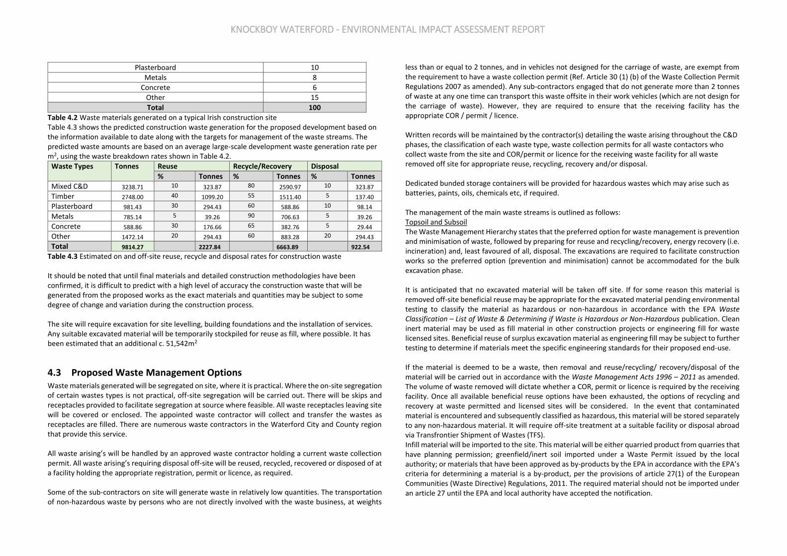
KNOCKBOY WATERFORD - ENVIRONMENTAL IMPACT ASSESSMENT REPORT
Plasterboard 10
Metals 8
Concrete 6
Other 15
Total 100
Table 4.2 Waste materials generated on a typical Irish construction site Table 4.3 shows the predicted construction waste generation for the proposed development based on the information available to date along with the targets for management of the waste streams. The predicted waste amounts are based on an average large-scale development waste generation rate per m2, using the waste breakdown rates shown in Table 4.2.
Waste Types Tonnes Reuse Recycle/Recovery Disposal
% Tonnes % Tonnes % Tonnes
Mixed C&D 3238.71 10 323.87 80 2590.97 10 323.87 Timber 2748.00 40 1099.20 55 1511.40 5 137.40 Plasterboard 981.43 30 294.43 60 588.86 10 98.14 Metals 785.14 5 39.26 90 706.63 5 39.26 Concrete 588.86 30 176.66 65 382.76 5 29.44 Other 1472.14 20 294.43 60 883.28 20 294.43 Total 9814.27 2227.84 6663.89 922.54
Table 4.3 Estimated on and off-site reuse, recycle and disposal rates for construction waste It should be noted that until final materials and detailed construction methodologies have been confirmed, it is difficult to predict with a high level of accuracy the construction waste that will be generated from the proposed works as the exact materials and quantities may be subject to some degree of change and variation during the construction process. The site will require excavation for site levelling, building foundations and the installation of services. Any suitable excavated material will be temporarily stockpiled for reuse as fill, where possible. It has been estimated that an additional c. 51,542m2
4.3 Proposed Waste Management Options Waste materials generated will be segregated on site, where it is practical. Where the on-site segregation of certain wastes types is not practical, off-site segregation will be carried out. There will be skips and receptacles provided to facilitate segregation at source where feasible. All waste receptacles leaving site will be covered or enclosed. The appointed waste contractor will collect and transfer the wastes as receptacles are filled. There are numerous waste contractors in the Waterford City and County region that provide this service. All waste arising’s will be handled by an approved waste contractor holding a current waste collection permit. All waste arising’s requiring disposal off-site will be reused, recycled, recovered or disposed of at a facility holding the appropriate registration, permit or licence, as required. Some of the sub-contractors on site will generate waste in relatively low quantities. The transportation of non-hazardous waste by persons who are not directly involved with the waste business, at weights
less than or equal to 2 tonnes, and in vehicles not designed for the carriage of waste, are exempt from the requirement to have a waste collection permit (Ref. Article 30 (1) (b) of the Waste Collection Permit Regulations 2007 as amended). Any sub-contractors engaged that do not generate more than 2 tonnes of waste at any one time can transport this waste offsite in their work vehicles (which are not design for the carriage of waste). However, they are required to ensure that the receiving facility has the appropriate COR / permit / licence. Written records will be maintained by the contractor(s) detailing the waste arising throughout the C&D phases, the classification of each waste type, waste collection permits for all waste contactors who collect waste from the site and COR/permit or licence for the receiving waste facility for all waste removed off site for appropriate reuse, recycling, recovery and/or disposal. Dedicated bunded storage containers will be provided for hazardous wastes which may arise such as batteries, paints, oils, chemicals etc, if required. The management of the main waste streams is outlined as follows: Topsoil and Subsoil The Waste Management Hierarchy states that the preferred option for waste management is prevention and minimisation of waste, followed by preparing for reuse and recycling/recovery, energy recovery (i.e. incineration) and, least favoured of all, disposal. The excavations are required to facilitate construction works so the preferred option (prevention and minimisation) cannot be accommodated for the bulk excavation phase. It is anticipated that no excavated material will be taken off site. If for some reason this material is removed off-site beneficial reuse may be appropriate for the excavated material pending environmental testing to classify the material as hazardous or non-hazardous in accordance with the EPA Waste Classification – List of Waste & Determining if Waste is Hazardous or Non-Hazardous publication. Clean inert material may be used as fill material in other construction projects or engineering fill for waste licensed sites. Beneficial reuse of surplus excavation material as engineering fill may be subject to further testing to determine if materials meet the specific engineering standards for their proposed end-use. If the material is deemed to be a waste, then removal and reuse/recycling/ recovery/disposal of the material will be carried out in accordance with the Waste Management Acts 1996 – 2011 as amended. The volume of waste removed will dictate whether a COR, permit or licence is required by the receiving facility. Once all available beneficial reuse options have been exhausted, the options of recycling and recovery at waste permitted and licensed sites will be considered. In the event that contaminated material is encountered and subsequently classified as hazardous, this material will be stored separately to any non-hazardous material. It will require off-site treatment at a suitable facility or disposal abroad via Transfrontier Shipment of Wastes (TFS). Infill material will be imported to the site. This material will be either quarried product from quarries that have planning permission; greenfield/inert soil imported under a Waste Permit issued by the local authority; or materials that have been approved as by-products by the EPA in accordance with the EPA’s criteria for determining a material is a by-product, per the provisions of article 27(1) of the European Communities (Waste Directive) Regulations, 2011. The required material should not be imported under an article 27 until the EPA and local authority have accepted the notification.
KNOCKBOY WATERFORD - ENVIRONMENTAL IMPACT ASSESSMENT REPORT
Bedrock It is not anticipated that bedrock will be encountered during the excavation phase of this development. Silt & Sludge During the construction phase, silt and petrochemical interception should be carried out on runoff and pumped water from site works, where required. Sludge and silt will then be collected by a suitably licensed contractor and removed offsite. Concrete Blocks, Bricks, Tiles & Ceramics The majority of concrete blocks, bricks, tiles and ceramics generated as part of the construction and demolition works are expected to be clean, inert material and should be recycled, where possible. Hard Plastic As hard plastic is a highly recyclable material, much of the plastic generated will be primarily from material off-cuts. All recyclable plastic will be segregated and recycled, where possible. Timber Timber that is uncontaminated, i.e. free from paints, preservatives, glues etc., will be disposed of in a separate skip and recycled off-site. Metal Metals will be segregated into mixed ferrous, aluminium cladding, high grade stainless steel, low grade stainless steel etc., where practical and stored in skips. Metal is highly recyclable and there are numerous companies that will accept these materials. Plasterboard There are currently a number of recycling services for plasterboard in Ireland. Plasterboard from the demolition and construction phases will be stored in a separate skip, pending collection for recycling. The site manager will ensure that oversupply of new plasterboard is carefully monitored to minimise waste. Glass Glass materials will be segregated for recycling, where possible. Waste Electrical and Electronic Equipment (WEEE) Any WEEE will be stored in dedicated covered cages/receptacles/pallets pending collection for recycling. Other Recyclables Where any other recyclable wastes such as cardboard and soft plastic are generated, these will be segregated at source into dedicated skips and removed off-site. Non-Recyclable Waste C&D waste which is not suitable for reuse or recovery, such as polystyrene, some plastics and some cardboards, will be placed in separate skips or other receptacles. Prior to removal from site, the non-recyclable waste skip/receptacle will be examined by a member of the waste team to determine if
recyclable materials have been placed in there by mistake. If this is the case, efforts will be made to determine the cause of the waste not being segregated correctly and recyclable waste will be removed and placed into the appropriate receptacle. Other Hazardous Wastes On-site storage of any hazardous wastes produced (i.e. contaminated soil if encountered and/or waste fuels) will be kept to a minimum, with removal off-site organised on a regular basis. Storage of all hazardous wastes on-site will be undertaken so as to minimise exposure to on-site personnel and the public and to also minimise potential for environmental impacts. Hazardous wastes will be recovered, wherever possible, and failing this, disposed of appropriately. It should be noted that until a construction contractor is appointed it is not possible to provide information on the specific destinations of each construction waste stream. Prior to commencement of construction and removal of any construction waste offsite, details of the proposed destination of each waste stream will be provided to WCC by the project team.
4.4 Tracking and Documentation Procedures for Off-Site Waste
All waste will be documented prior to leaving the site. Waste will be weighed by the contractor, either by weighing mechanism on the truck or at the receiving facility. These waste records will be maintained on site by the nominated project Waste Manager. All movement of waste and the use of waste contractors will be undertaken in accordance with the Waste Management Acts 1996 – 2011. This includes the requirement for all waste contractors to have a waste collection permit issued by the NWCPO. The nominated project waste manager will maintain a copy of all waste collection permits on-site. If the waste is being transported to another site, a copy of the Local Authority waste COR/permit or EPA Waste/IED Licence for that site will be provided to the nominated project waste manager. If the waste is being shipped abroad, a copy of the Transfrontier Shipping (TFS) notification document will be obtained from DCC (as the relevant authority on behalf of all local authorities in Ireland) and kept on-site along with details of the final destination (COR, permits, licences etc.). A receipt from the final destination of the material will be kept as part of the on-site waste management records. All information will be entered in a waste management recording system to be maintained on site.
5.0 ESTIMATED COST OF WASTE MANAGEMENT An outline of the costs associated with different aspects of waste management is provided below. The total cost of C&D waste management will be measured and will take into account handling costs, storage costs, transportation costs, revenue from rebates and disposal costs.
5.1 Reuse By reusing materials on site, there will be a reduction in the transport and recycle/recovery/disposal costs associated with the requirement for a waste contractor to take the material off-site. Clean and inert soils, gravel, stones etc. which cannot be reused on site may be used as capping material for landfill
KNOCKBOY WATERFORD - ENVIRONMENTAL IMPACT ASSESSMENT REPORT
sites, or for the reinstatement of quarries etc. This material is often taken free of charge or a reduced fee for such purposes, reducing final waste disposal costs.
5.2 Recycling Salvageable metals will earn a rebate which can be offset against the costs of collection and transportation of the skips. Clean uncontaminated cardboard and certain hard plastics can also be recycled. Waste contractors will charge considerably less to take segregated wastes, such as recyclable waste, from a site than mixed waste. Timber can be recycled as chipboard. Again, waste contractors will charge considerably less to take segregated wastes such as timber from a site than mixed waste.
5.3 Disposal Landfill charges in the Munster region are currently at around €120 per tonne which includes a €75 per tonne landfill levy specified in the Waste Management (Landfill Levy) Regulations 2015. In addition to disposal costs, waste contractors will also charge a collection fee for skips. Collection of segregated C&D waste usually costs less than municipal waste. Specific C&D waste contractors take the waste off-site to a licensed or permitted facility and, where possible, remove salvageable items from the waste stream before disposing of the remainder to landfill. Clean soil, rubble, etc. is also used as fill/capping material, wherever possible.
6.0 TRAINING PROVISIONS A member of the construction team will be appointed as the project waste manager to ensure commitment, operational efficiency and accountability during the C&D phases of the project.
6.1 Waste Manager Training and Responsibilities The nominated waste manager will be given responsibility and authority to select a waste team if required, i.e. members of the site crew that will aid them in the organisation, operation and recording of the waste management system implemented on site. The waste manager will have overall responsibility to oversee, record and provide feedback to the client on everyday waste management at the site. Authority will be given to the waste manager to delegate responsibility to sub-contractors, where necessary, and to coordinate with suppliers, service providers and sub-contractors to prioritise waste prevention and material salvage. The waste manager will be trained in how to set up and maintain a record keeping system, how to perform an audit and how to establish targets for waste management on site. The waste manager will also be trained in the best methods for segregation and storage of recyclable materials, have information on the materials that can be reused on site and be knowledgeable in how to implement this C&D WMP.
6.2 Site Crew Training Training of site crew is the responsibility of the waste manager and, as such, a waste training program should be organised. A basic awareness course will be held for all site crew to outline the C&D WMP and to detail the segregation of waste materials at source. This may be incorporated with other site training needs such as general site induction, health and safety awareness and manual handling. This basic course will describe the materials to be segregated, the storage methods and the location of the Waste Storage Areas (WSAs). A sub-section on hazardous wastes will be incorporated into the training program and the particular dangers of each hazardous waste will be explained
7.0 RECORD KEEPING Records will be kept for all waste material which leaves the site, either for reuse on another site, recycling or disposal. A recording system will be put in place to record the construction waste arising’s on site. A copy of the Waste Collection Permits, CORs, Waste Facility Permits and Waste Licences will be maintained on site at all times. The waste manager or delegate will record the following;
1) Waste taken for reuse off-site; 2) Waste taken for recycling; 3) Waste taken for recovery; 4) Waste taken for disposal; and 5) Reclaimed waste materials brought on-site for reuse.
For each movement of waste off-site, a signed docket will be obtained by the Waste Manager from the contractor, detailing the weight and type of the material and the source and destination of the material. This will be carried out for each material type. This system will also be linked with the delivery records. In this way, the percentage of C&D waste generated for each material can be determined. The system will allow the comparison of these figures with the targets established for the recovery, reuse and recycling of C&D waste presented earlier and to highlight the successes or failures against these targets
8.0 OUTLINE WASTE AUDIT PROCEDURE
8.1 Responsibility for Waste Audit The appointed waste manager will be responsible for conducting a waste audit at the site during the C&D phase of the development.
8.2 Review of Records and Identification of Corrective Actions A review of all the records for the waste generated and transported off-site should be undertaken mid-way through the project. If waste movements are not accounted for, the reasons for this should be

KNOCKBOY WATERFORD - ENVIRONMENTAL IMPACT ASSESSMENT REPORT
established in order to see if and why the record keeping system has not been maintained. The waste records will be compared with the established recovery/reuse/recycling targets for the site.
Each material type will be examined, in order to see where the largest percentage waste generation is occurring. The waste management methods for each material type will be reviewed in order to highlight how the targets can be achieved.
Waste management costs will also be reviewed. Upon completion of the C & D phase, a final report will be prepared, summarising the outcomes of waste management processes adopted and the total recycling/reuse/recovery figures for the development.
9.0 CONSULTATION WITH RELEVANT BODIES
9.1 Local Authority Once construction contractors have been appointed and prior to removal of any C&D waste materials offsite, details of the proposed destination of each waste stream will be provided to WCC. WCC will also be consulted, as required, throughout the excavation and construction phases in order to ensure that all available waste reduction, reuse and recycling opportunities are identified and utilised and that compliant waste management practices are carried out.
9.2 Recycling/Salvage Companies Companies that specialise in C&D waste management will be contacted to determine their suitability for engagement. Where a waste contractor is engaged, each company will be audited in order to ensure that relevant and up-to-date waste collection permits and facility COR/permits/licences are held. In addition, information regarding individual construction materials will be obtained, including the feasibility of recycling each material, the costs of recycling/reclamation and the means by which the wastes will be collected and transported off-site, and the recycling/reclamation process each material will undergo off site.

CHAPTER 14 CULTURAL HERITAGE APPENDICES
APPENDIX 14.1 ASSESSMENT OF IMPACT TYPE & MAGNITUDE
The EPA draft guidelines have been applied in this assessment which are the same as the earlier NRA
guidelines, which define various levels of predicted impact. The NRA guidelines are useful as they have
been specifically formulated for infrastructural projects from a specifically architectural and
archaeological perspective, and are actually the same as the more recent EPA guidelines. They are as
follows:
Profound Impact: An effect which obliterates sensitive characteristics and applies where
mitigation would be unlikely to remove adverse effect;
Significant or Very Significant Impact: An impact which, by its magnitude, duration or intensity,
alters an important or sensitive aspect of the environment. An impact like this would be where part of a
site would be permanently impacted upon, leading to a loss of character, integrity and data about an
archaeological or cultural heritage feature/site;
Moderate Impact: an effect that alters the character of the cultural heritage feature in a manner
that is consistent with existing and emerging trends. For example, where a change to the
monument/cultural heritage feature is proposed which though noticeable, is not such that the integrity
of the feature is compromised and which is reversible. This arises where an archaeological feature can be
incorporated into a modern-day development without damage and that all procedures used to facilitate
this are reversible;
Slight/Minor Impact: An impact which causes changes in the character of the environment which
are not significant or profound and do not directly impact or affect a monument or cultural heritage
feature;
Imperceptible Impact: An impact capable of measurement but without noticeable consequences.
The Guidelines also define the duration of impacts as follows:
Momentary: an effect lasting from seconds to minutes;
Brief: an effect lasting less than a day;
Temporary: an effect lasting for less than one year;
Short-term: an effect lasting one to seven years;
Medium-term: an effect lasting seven to fifteen years;
Long-term: an effect lasting fifteen to sixty years;
Permanent: an effect lasting over sixty years.

KNOCKBOY WATERFORD - ENVIRONMENTAL IMPACT ASSESSMENT REPORT
APPENDIX 14.2 GEOPHYSICAL SURVEY
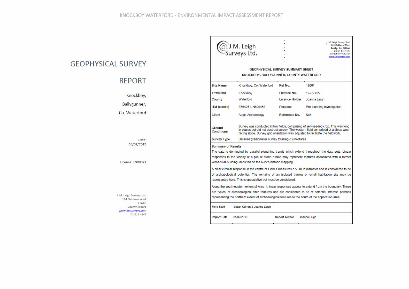
KNOCKBOY WATERFORD - ENVIRONMENTAL IMPACT ASSESSMENT REPORT

KNOCKBOY WATERFORD - ENVIRONMENTAL IMPACT ASSESSMENT REPORT
KNOCKBOY WATERFORD - ENVIRONMENTAL IMPACT ASSESSMENT REPORT

KNOCKBOY WATERFORD - ENVIRONMENTAL IMPACT ASSESSMENT REPORT
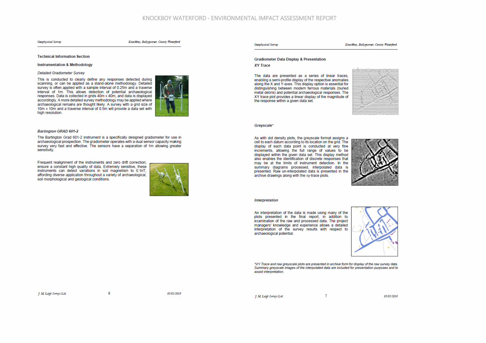
KNOCKBOY WATERFORD - ENVIRONMENTAL IMPACT ASSESSMENT REPORT

KNOCKBOY WATERFORD - ENVIRONMENTAL IMPACT ASSESSMENT REPORT
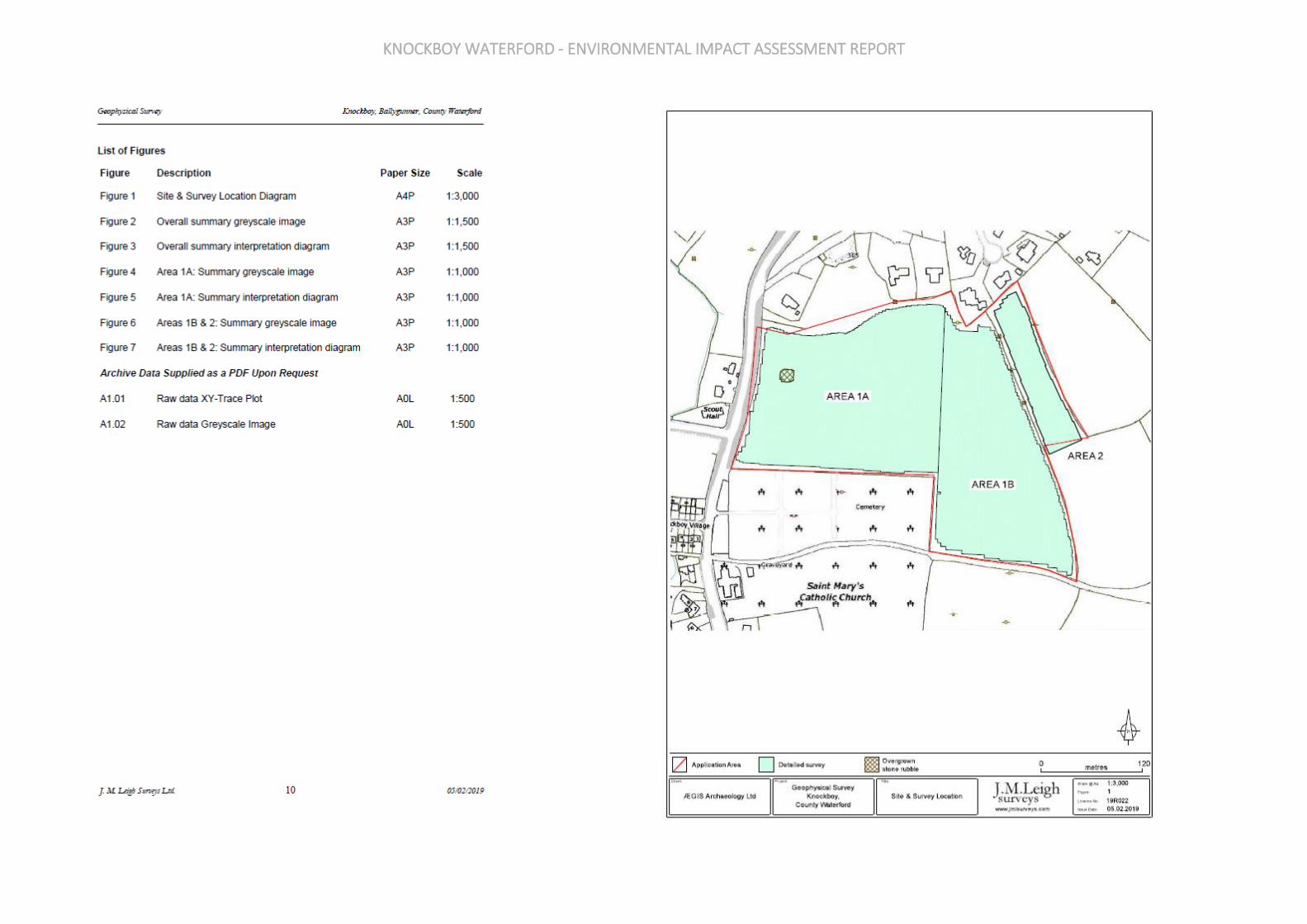
KNOCKBOY WATERFORD - ENVIRONMENTAL IMPACT ASSESSMENT REPORT
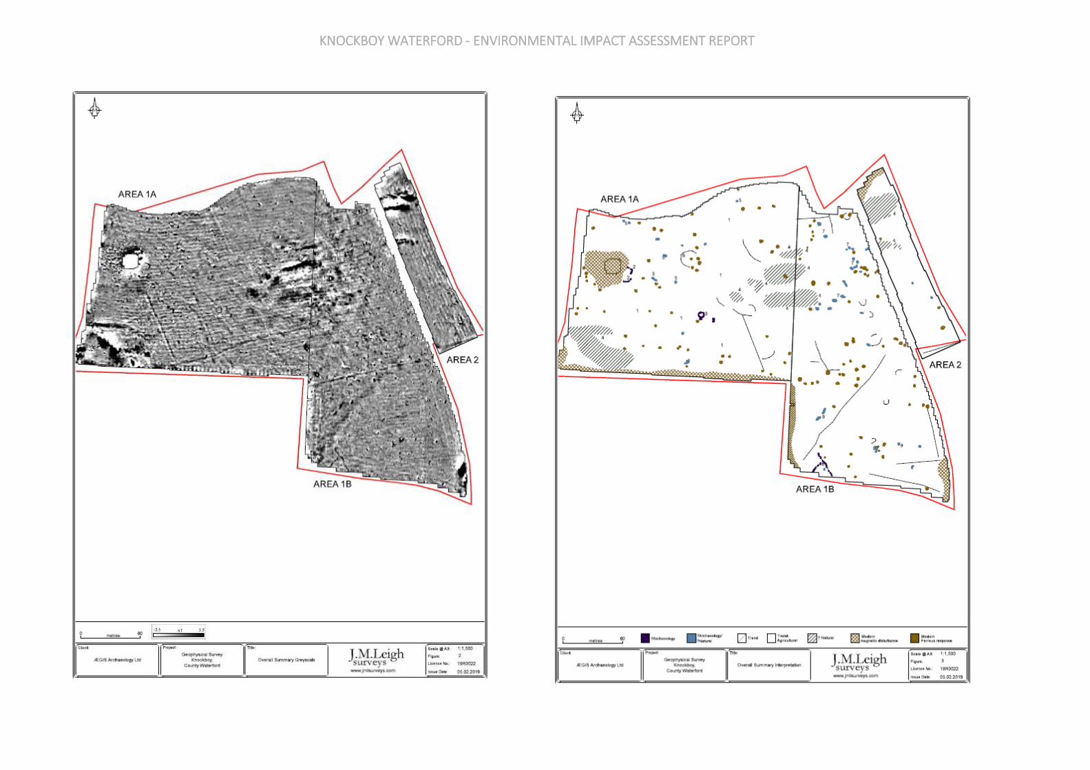
KNOCKBOY WATERFORD - ENVIRONMENTAL IMPACT ASSESSMENT REPORT

KNOCKBOY WATERFORD - ENVIRONMENTAL IMPACT ASSESSMENT REPORT

KNOCKBOY WATERFORD - ENVIRONMENTAL IMPACT ASSESSMENT REPORT

KNOCKBOY WATERFORD - ENVIRONMENTAL IMPACT ASSESSMENT REPORT
APPENDIX 14.3 ARCHAEOLOGICAL TEST TRENCHING AND IMPACT ASSESSMENT
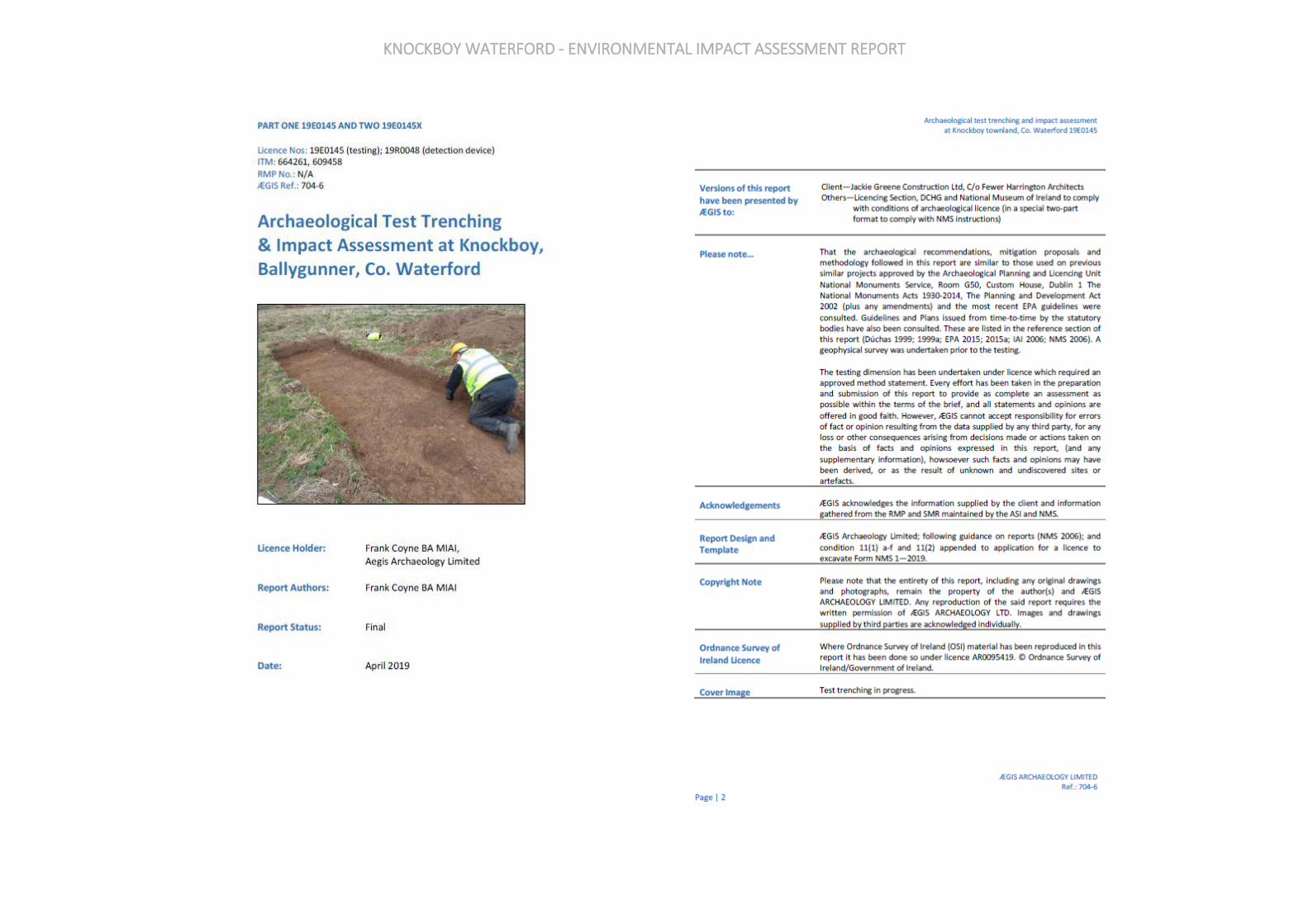
KNOCKBOY WATERFORD - ENVIRONMENTAL IMPACT ASSESSMENT REPORT
KNOCKBOY WATERFORD - ENVIRONMENTAL IMPACT ASSESSMENT REPORT
KNOCKBOY WATERFORD - ENVIRONMENTAL IMPACT ASSESSMENT REPORT
KNOCKBOY WATERFORD - ENVIRONMENTAL IMPACT ASSESSMENT REPORT

KNOCKBOY WATERFORD - ENVIRONMENTAL IMPACT ASSESSMENT REPORT
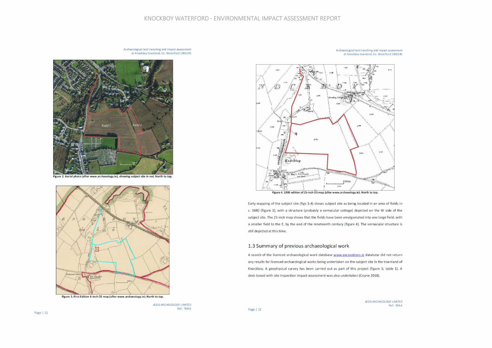
KNOCKBOY WATERFORD - ENVIRONMENTAL IMPACT ASSESSMENT REPORT

KNOCKBOY WATERFORD - ENVIRONMENTAL IMPACT ASSESSMENT REPORT
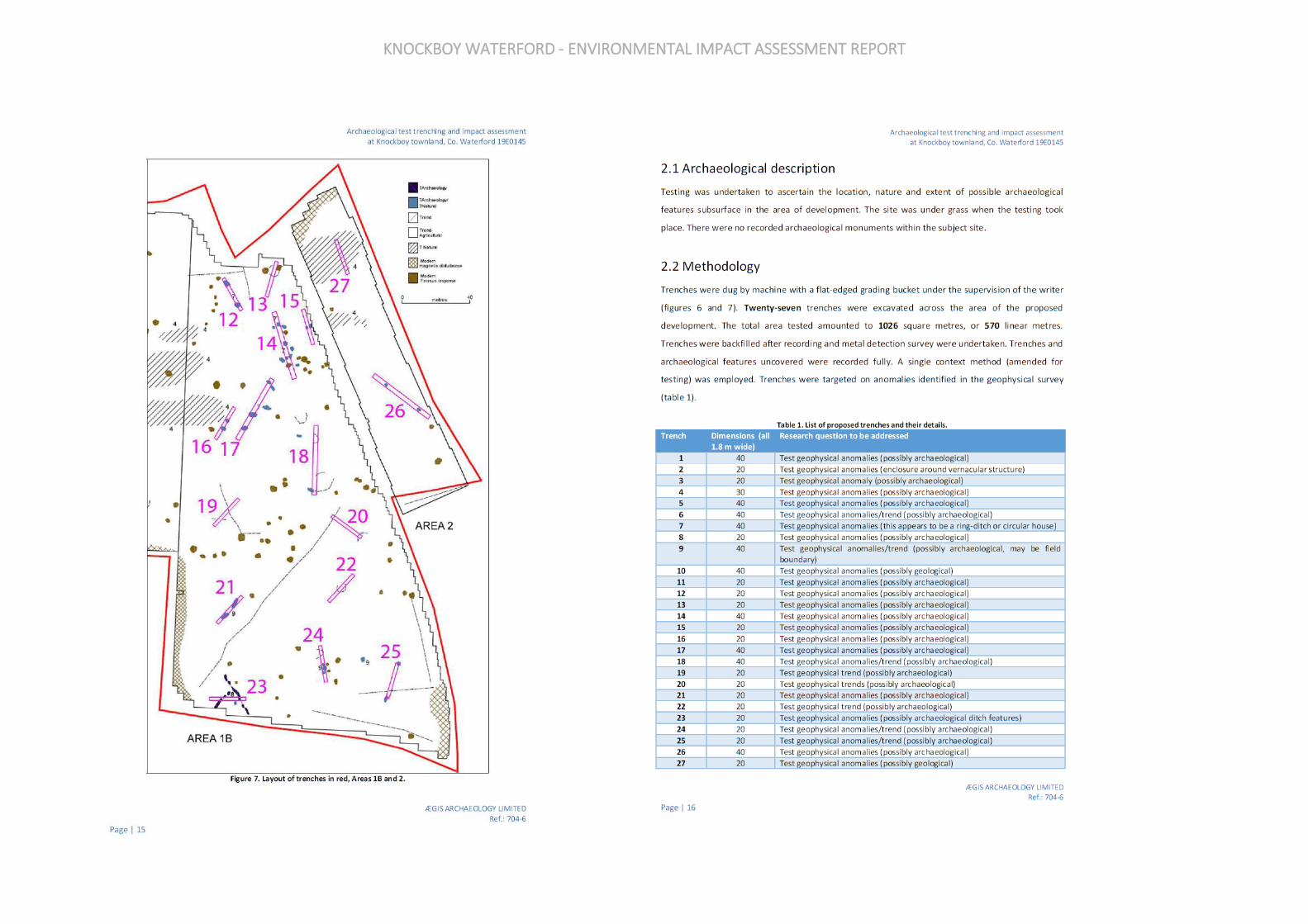
KNOCKBOY WATERFORD - ENVIRONMENTAL IMPACT ASSESSMENT REPORT
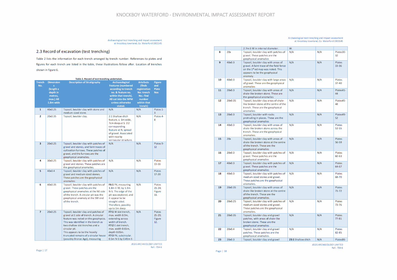
KNOCKBOY WATERFORD - ENVIRONMENTAL IMPACT ASSESSMENT REPORT

KNOCKBOY WATERFORD - ENVIRONMENTAL IMPACT ASSESSMENT REPORT
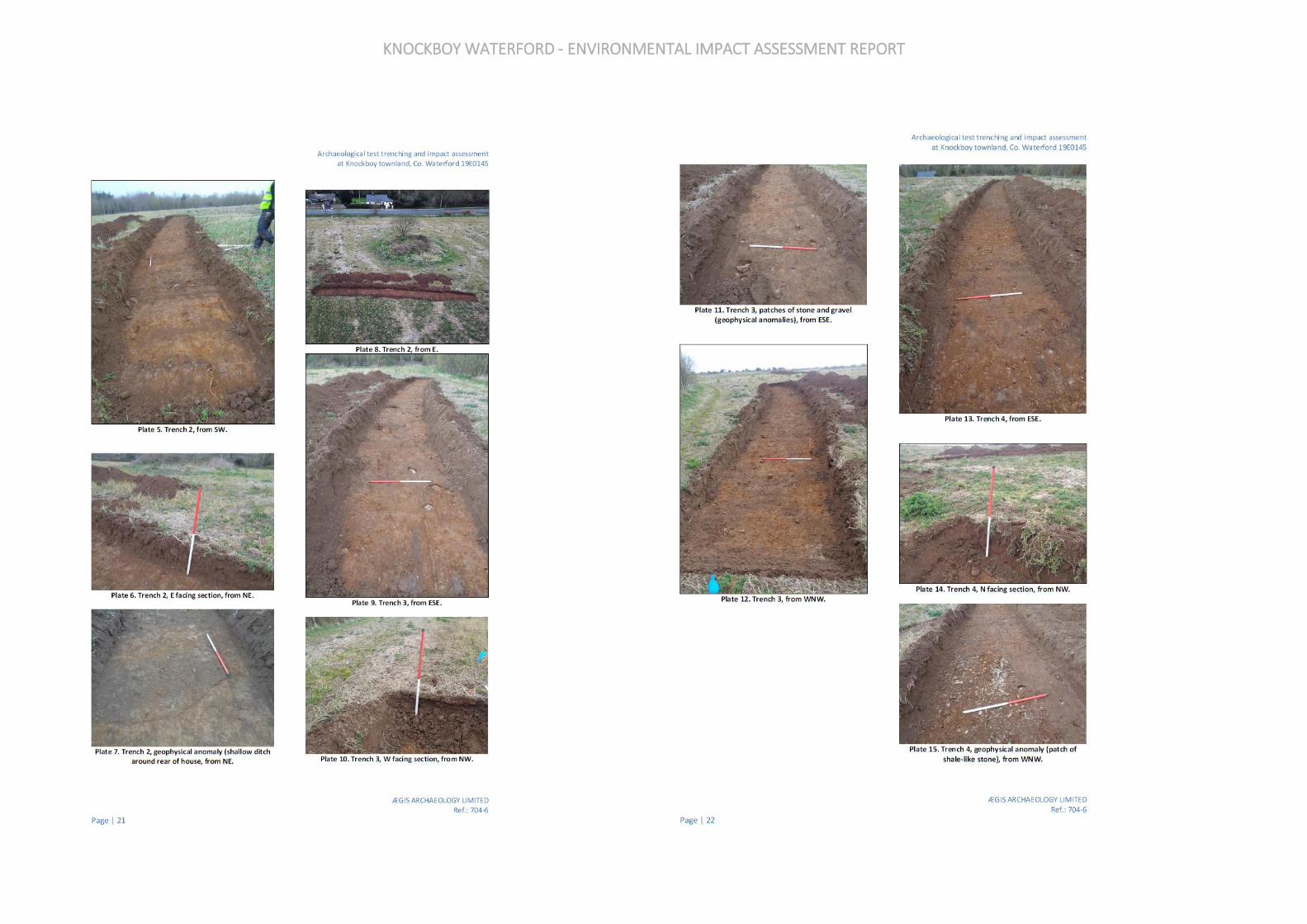
KNOCKBOY WATERFORD - ENVIRONMENTAL IMPACT ASSESSMENT REPORT
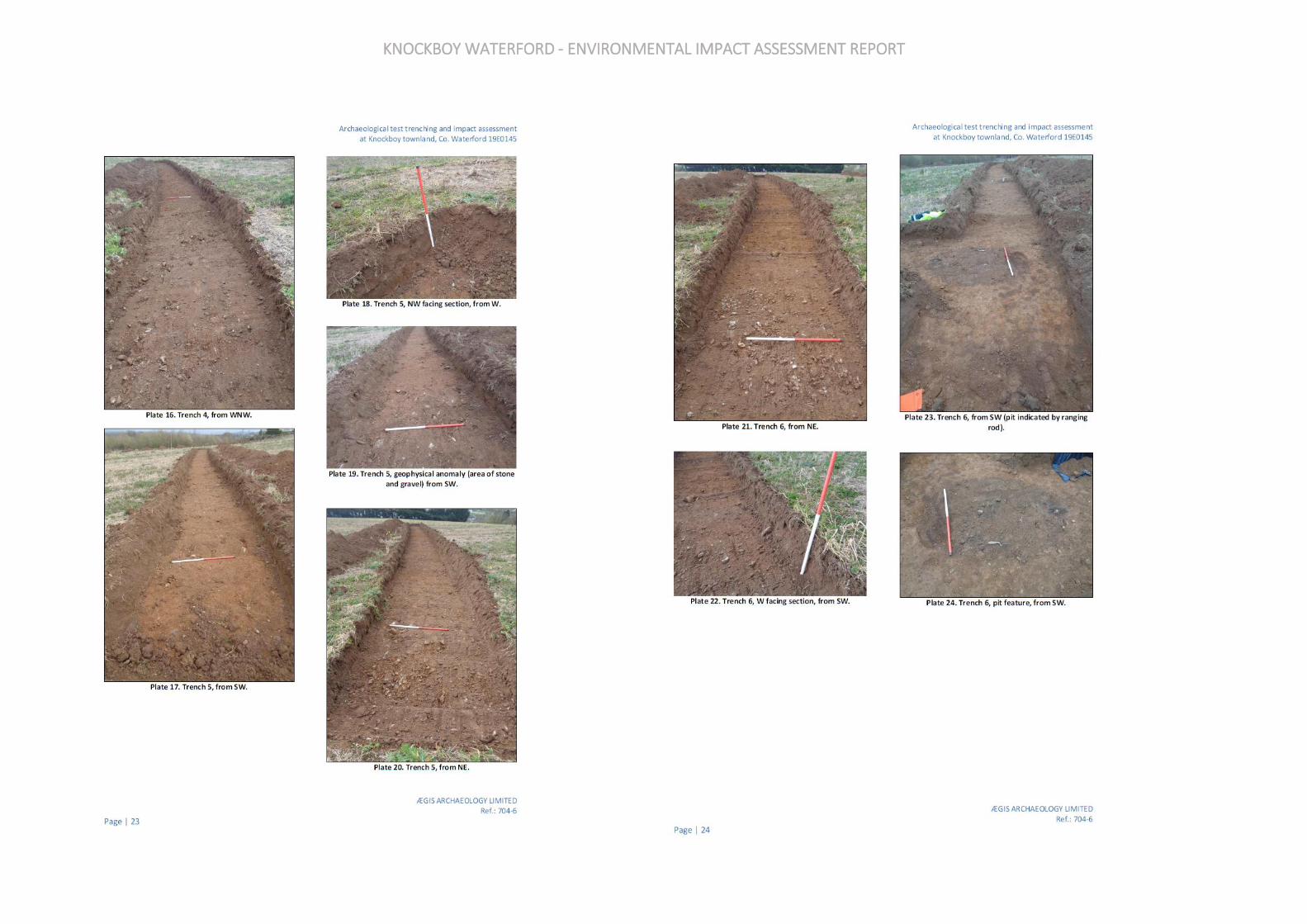
KNOCKBOY WATERFORD - ENVIRONMENTAL IMPACT ASSESSMENT REPORT

KNOCKBOY WATERFORD - ENVIRONMENTAL IMPACT ASSESSMENT REPORT

KNOCKBOY WATERFORD - ENVIRONMENTAL IMPACT ASSESSMENT REPORT
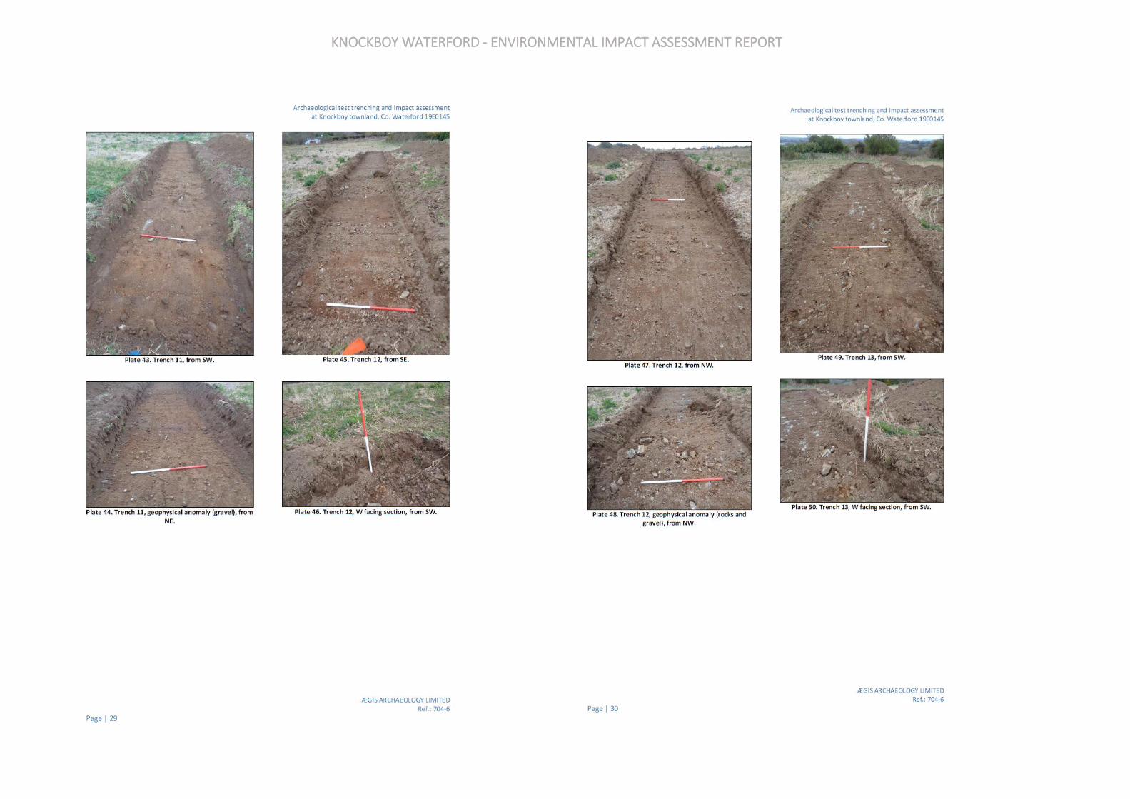
KNOCKBOY WATERFORD - ENVIRONMENTAL IMPACT ASSESSMENT REPORT

KNOCKBOY WATERFORD - ENVIRONMENTAL IMPACT ASSESSMENT REPORT

KNOCKBOY WATERFORD - ENVIRONMENTAL IMPACT ASSESSMENT REPORT

KNOCKBOY WATERFORD - ENVIRONMENTAL IMPACT ASSESSMENT REPORT
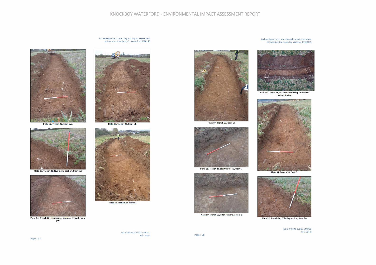
KNOCKBOY WATERFORD - ENVIRONMENTAL IMPACT ASSESSMENT REPORT
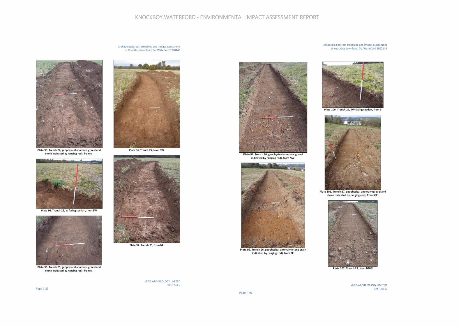
KNOCKBOY WATERFORD - ENVIRONMENTAL IMPACT ASSESSMENT REPORT
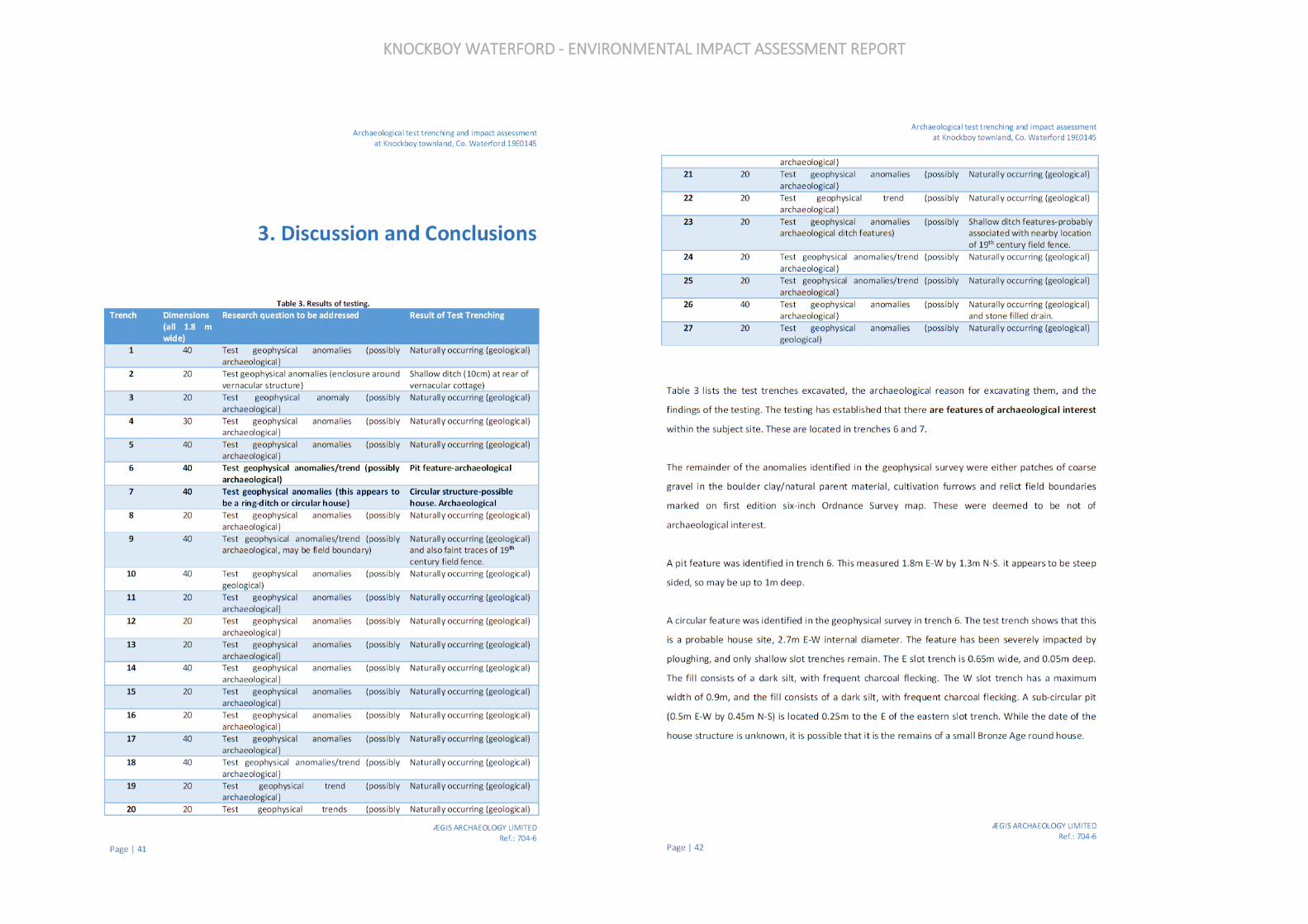
KNOCKBOY WATERFORD - ENVIRONMENTAL IMPACT ASSESSMENT REPORT
KNOCKBOY WATERFORD - ENVIRONMENTAL IMPACT ASSESSMENT REPORT
KNOCKBOY WATERFORD - ENVIRONMENTAL IMPACT ASSESSMENT REPORT
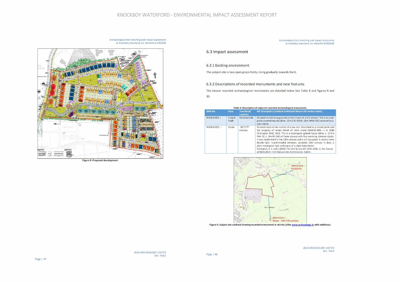
KNOCKBOY WATERFORD - ENVIRONMENTAL IMPACT ASSESSMENT REPORT
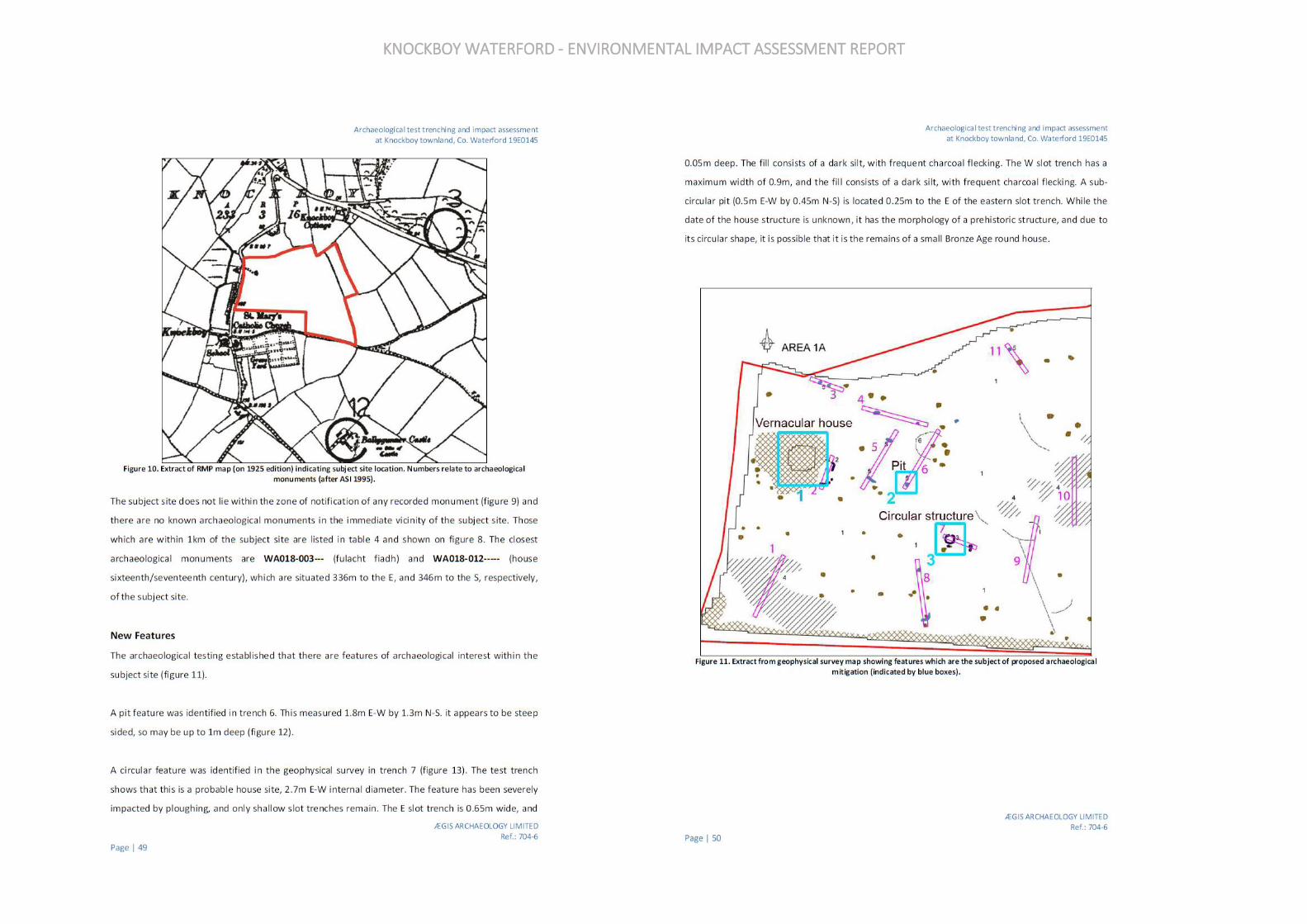
KNOCKBOY WATERFORD - ENVIRONMENTAL IMPACT ASSESSMENT REPORT
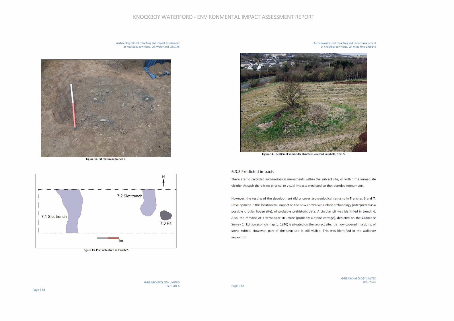
KNOCKBOY WATERFORD - ENVIRONMENTAL IMPACT ASSESSMENT REPORT
KNOCKBOY WATERFORD - ENVIRONMENTAL IMPACT ASSESSMENT REPORT

KNOCKBOY WATERFORD - ENVIRONMENTAL IMPACT ASSESSMENT REPORT

1
Environmental Impact Assessment Report Vol. III (Non-Technical Summary)
STRATEGIC HOUSING DEVELOPMENT AT
KNOCKBOY, WATERFORD
PREPARED BY
In Association with:
Fewer Harrington & Partners Architects, MUIR Consulting Engineers, Kevin Fitzpatrick Landscape,
TRAYNOR Environmental, AEGIS Archaeologists,
CLUAIN Ecology and MANDE
MAY 2019
2
1 INTRODUCTION This is the Non-Technical Summary (NTS) of the Environmental Impact Assessment Report (EIAR) relating to a Strategic Housing Development application to An Bord Pleanála for a new residential development on lands located at Knockboy, Waterford City. The purpose of the NTS is to summarise, and explain in non-technical language, the likely and significant environmental affects arising from this project. This EIAR has been prepared in accordance with the provisions of the Planning and Development Act (as amended) and the Planning & Development Regulations 2001 (as amended) which give effect in national planning legislation to the EU Directives on EIA. Notwithstanding that the size of the site and proposed number of residential units are below the thresholds in Development Class 10 of Part 2 of Schedule 5, having regard to Development Class 15, Schedule 7 and Section 172 of the Act, and with regard to the size and scale of the proposed development, the proposed use of natural resources, the relative environmental sensitivity of the location, and the types of potential impacts, it was deemed prudent to prepare an EIAR for the proposed development to accompany the planning application in this instance. Furthermore, it is noted that under Article 299A of the Regulations, where a planning application for a sub-threshold development is accompanied by an EIAR and a request for a determination under section 7(1)(a)(i)(I) of the Act of 2016 was not made, the application shall be dealt with as if the EIAR had been submitted in accordance with section 172(1) of the Act.
2 PROJECT DESCRIPTION The development will comprise a residential development 361 units broken down as follows:
• 207 no. houses consisting of: o 13 No. 4 bed detached dwelling house (house type A3) o 4 No. 4 bed detached dwelling house (house type B3) o 2 No. 3 bed detached dwelling house (house type C3) o 2 No. 3 bed detached dwelling house (house type D3) o 3 No. 4 bed detached dwelling house (house type A4) o 1 No. 3 bed detached dwelling house (house type C4) o 35 No. 4 bed semi-detached dwelling house (house type A1) o 17 No. 4 bed semi-detached dwelling house (house type B1) o 42 No. 3 bed semi-detached dwelling house (house type C1) o 50 No. 3 bed semi-detached dwelling house (house type D1) o 5 No. 4 bed semi-detached dwelling house (house type A2) o 1 No. 4 bed semi-detached dwelling house (house type B2) o 6 No. 3 bed semi-detached dwelling house (house type C2) o 2 No. 3 bed semi-detached dwelling house (house type D2) o 12 No. 2 bed terrace dwelling house (house type F1) o 5 No. 3 bed terrace dwelling house (house type E1) o 6 No. 3 bed terrace dwelling house (house type E2) o 1 No. 2 bed terrace dwelling house (house type F2)
• 154 no. apartments within 15 no. 4 storey blocks (providing 53 no. 1-beds, 90 no. 2-beds and 11 no. 3-beds).
3
• A creche of c574 sq.m.
• 7 no. internal/external communal waste storage facilities (total floor area c.214.3 sq.m).
• 638 car parking spaces and 390 no. bicycle parking spaces within 15 no storage facilities (total floor area c.232 sq.m). Additional visitor bicycle parking provided in the public realm.
• 2 no. ESB sub-stations/switchrooms (totalling c.10 sq.m)
• Vehicular/pedestrian/cyclist accesses to the public road (Ballygunner Hill/St. Mary’s Place).
• The total gross floor area of the proposed development is c. c.51,266.1 sq.m
• All associated site development works, landscaping, open spaces, boundary treatments and services provision (including connection to public foul and surface water drainage at Dunmore Road & Island Drive).
3 DATA REQUIRED TO IDENTIFY AND ASSESS THE MAIN EFFECTS WHICH THE PROPOSED DEVELOPMENT IS LIKELY TO HAVE ON THE ENVIRONMENT
Data is required in order to identify and assess the main impacts which the development is likely to have on the environment. The following is a synopsis of the data and information available for this Environmental Impact Assessment.
3.1 Population and Human Health To establish the existing receiving environment / baseline for the subject site, the methodology included site visits to evaluate the location and likely significant potential impact upon human sources in the area. Desk based study of Central Statistics Office Census data, the ESRI Quarterly Economic Commentary, and national, regional and local planning documents was also carried out.
3.2 Biodiversity Baseline field surveys were undertaken between October 2018 and March 2019, during suitable weather conditions and with reference to standard ecology survey methodologies. As the field surveys were undertaken outside the optimal survey periods (e.g. bats, breeding birds, botanical growing season, other taxa), seasonal constraints were taken into consideration as part of this impact assessment. A desktop review of available data for the study site was completed by referring to relevant online databases such as; The National Parks and Wildlife Services (NPWS), The National Biodiversity Data Centre (NBDC) and The Environmental Protection Agency (EPA). Additional documents relevant to the study site and reviewed as part of this biodiversity study and impact assessment include the current Waterford City Development Plan (2013-2019) and associated SEA environmental report (WCC 2013 a & b). The overall ecological evaluation of the study site follows amended criteria as set out by NRA (2009) and Nairn & Fossitt (2004). The description and evaluation of potential, cumulative and residual impacts associated with the proposed development on the existing biodiversity of the study site and immediate locality follows guidelines published by the EPA.

4
3.3 Land, Soil & Geology The methodology used has primarily relied on information, available from the EPA Maps website (gis.epa.ie), contained in the geotechnical site investigations carried out for the proposed development and information available from the Geological Survey of Ireland (GSI).
3.4 Hydrology & Water Services The methodology used has primarily relied on the following:
• Engineering Planning Report (submitted with the planning application);
• Site Specific Flood Risk Assessment (submitted with the planning application);
• The Planning System and Flood Risk Management, Guidelines for Planning Authorities (Department of the Environment, Heritage and Local Government (DoEHLG) and the Office of Public Works (OPW));
• Flood points & Historical Floods – Office of Public Works (OPW) floods website www.floodmaps.ie
• Relevant Suir Catchment Flood Risk Assessment and Management Flood Reports and maps, available at: https://www.floodinfo.ie/
• Environmental Protection Agency http://gis.epa.ie
• RPS Report IBE1473 (Feb 2019) Knockboy Residential Development Assessment of SWO Discharge to Lower Suir Estuary (submitted with the planning application)
3.5 Noise & Vibration The noise assessment was prepared using the following methodology:
• A baseline Noise survey has been conducted in the vicinity of the development site to establish noise climate and the main sources of noise contributing to the existing environment.
• A Review of the most relevant standards and guidelines has been undertaken for the project in order to identify appropriate noise criteria for the site.
• (The Noise and vibration impact of the proposed development has been predicted for both the construction and operational phases of the project). Noise calculations for construction activity have been conducted in accordance with ISO 9613 (1996): Acoustics – Attenuation of sound during propagation outdoors – Part 2@ General Method of calculation using noise source data from BS5228 (2009 +A1 2014): Code of Practice for Noise Control on construction and open sites – Part 1, Noise.
• Noise calculations for the operational phase have been assessed in general accordance with ISO 9613 Attenuation of Sound during Propagation Outdoors and the UK calculation of Road Traffic Noise (CRTN), 1988.
• A series of recommended noise and vibration mitigation measures have been proposed, where necessary, to ensure the proposed development does not result in any significant impact on its surrounding environment
3.6 Air & Climate The general assessment methodology of the potential impact of the proposed development on air quality and climate has been devised in accordance with:
• Guidelines for Planning Authorities and An Bord Pleanála on carrying out Environmental Impact Assessment (DoHPLG, August 2018)
• 2017 EPA Guidelines on information to be contained in Environmental Impact Assessment Reports.
• Guidelines on Information to be Contained in an Environmental Impact Statement (EPA 2002).
• Advice Notes on Current Practice (in preparation of Environmental Impact Statements) (EPA 2003).
5
• Environmental Protection Agency, 2015. Revised Guidelines on the Information to be Contained in
• Environmental Impact Statements
• Environmental Protection Agency, 2015. Draft Advice Notes for Preparation of Environmental Impact
• Statements
• Environmental Impact Assessment (EIA), Guidance for Consent Authorities Regarding Sub-Threshold
• Development (DoEHLG 2003).
• Development Management Guidelines (DoEHLG, 2007).
• European Union (Planning & Development)(Environmental Impact Assessment0 Regulations 2018.
The existing ambient air quality in the vicinity of the site has been characterised with information obtained from a number of sources as follows:
• EPA Annual Air Quality in Ireland Reports;
• Site specific air quality monitoring.
3.7 Landscape & Visual This assessment has been prepared based on the following guidelines and documents:
• Guidelines on the Information to be contained in and Environmental Impact Statement, by the Environmental Protection Agency, 2002
• Revised Guidelines on the information to be contained in Environmental Impact Statements- Draft, by the Environmental Protection Agency, 2015
• Advice Notes on Current Practice in the preparation of Environmental Impact Statements, by the Environmental Protection Agency, 2015.
• Guidelines on Environmental Impact Assessment, Draft, by the Environmental Protection Agency, 2017
• Guidelines for Landscape and Visual Assessment, 3rd Ed., Landscape Institute and Institute of Environmental Management and Assessment, 2013.
• National Landscape Strategy for Ireland, Department of Arts, Heritage and the Gaeltacht, 2015-25
• Waterford City Development Plan 2013-2019 The Landscape and Visual Assessment involved:
• Visiting the area;
• Undertaking a desk study of the subject site and its immediate environs in relation to its local and urban significance using the information gathered from site visits, studying aerial photography and Ordnance Survey mapping;
• Establishing and describing the receiving environment in terms of the existing landscape and its visual amenity;
• Assessing the nature, scale and quality of the proposed development through examination of the design team’s drawings, illustrations and descriptions of the proposed scheme.
3.8 Traffic & Transportation The methodology used in assessing the Traffic and Transportation impacts of the proposed development has primarily been based on a review of available modes of travel in the area and on the modelling of the potential impact of the proposed development on the surrounding road network. The methodology used has also relied on the following:
6
• Traffic and Transportation Assessment prepared by PMCE (submitted with the planning application);
• Engineering Planning Report prepared by Muir Associates (submitted with the planning application);
• Outline Mobility Management Plan prepared by Muir Associates (submitted with the planning application).
3.9 Material Assets A desktop study was conducted in relation to the material assets associated with the proposed development and their capacities. Projections of the resources where made for the construction and operational phase of the development. The Guidelines on information to be contained in an Environment Impact Statement (EPA 2002), the advice notes on current practice and Draft EPA guidelines published in 2017 requires assessment of ‘economic assets of human origin’ to be included in the impact study as a desktop study of material assets associated with the development.
3.10 Waste Management The assessment was carried out taking into account the methodology specified in relevant guidance documents, along with an extensive document review to assist in identifying current and future requirements for waste management including national and regional waste policy, waste strategies, management plans, legislative requirements and relevant reports. The primary legislative instruments that govern waste management in Ireland and applicable to the project are:
• Waste Management Act 1996 (No. 10 of 1996) as amended. Sub-ordinate legislation includes: o European Communities (Waste Directive) Regulations 2011 (SI 126 of 2011) as amended o Waste Management (Collection Permit) Regulations (S.I No. 820 of 2007) as amended o Waste Management (Facility Permit and Registration) Regulations 2007, (S.I No. 821 of 2007)
as amended o Waste Management (Licensing) Regulations 2004 (S.I. No. 395 of 2004) as amended o Waste Management (Packaging) Regulations 2014 (S.I. 282 of 2014) as amended o Waste Management (Planning) Regulations 1997 (S.I. No. 137 of 1997) o Waste Management (Landfill Levy) Regulations 2015 (S.I. No. 189 of 2015) o European Union (Waste Electrical and Electronic Equipment) Regulations 2014 (S.I. No. 149 of
2014) o European Union(Batteries and Accumulators) Regulations 2014(S.I. No. 283 of 2014) as
amended o Waste Management (Food Waste) Regulations 2009 (S.I. 508 of 2009), as amended o European Union (Household Food Waste and Bio-waste) Regulation 2015 (S.I. No. 191 of2015) o Waste Management (Hazardous Waste) Regulations, 1998 (S.I. No. 163 of 1998) as amended o Waste Management (Shipments of Waste) Regulations, 2007 (S.I. No. 419 of 2007) as
amended o Waste Management (Movement of Hazardous Waste) Regulations, 1998 (S.I. No. 147 of 1998) o European Communities (Transfrontier Shipment of Waste) Regulations 1994 (SI 121 of 1994) o European Union (Properties of Waste which Render it Hazardous) Regulations 2015 (S.I. No.
233 of 2015)
• Environmental Protection Act 1992 (No. 7 of 1992) as amended.
• Litter Pollution Act 1997 (No. 12 of 1997) as amended.
• Planning and Development Act 2000 (No. 30 of 2000) as amended.
7
3.11 Cultural Heritage A desktop assessment of available archaeological, historical and cartographic sources was undertaken and supplemented by a field inspection. The desktop study employed a range of archival and documentary sources; the principal sources consulted being as follows:
• The Site and Monuments files with the Department of Culture, Heritage, and the Gaeltacht (DCHG);
• The Record of Monuments and Places (RMP);
• Sites and Monuments Record (SMR);
• Topographical files of the National Museum of Ireland;
• Waterford City Development Plan 2013 - 2019;
• The Record of Protected Structures for County Waterford;
• The Architectural Conservation Areas for County Waterford;
• The Archaeological Inventory of County Waterford;
• National Inventory of Architectural Heritage;
• Ordnance survey mapping, current and historic;
• Ordnance survey aerial photography, current and historic;
• Griffith’s Valuation; and
• Other published and unpublished sources. A detailed field inspection was undertaken in order to identify any unrecorded cultural heritage remains within the receiving environment. Licenced geophysical survey and targeted test trenching were undertaken on the subject site. The methodology used in the geophysical survey. The test trenching part of the project used a methodology as set out by the Institute of Archaeologists of Ireland. Based on the desktop study, field inspections, and targeted geophysical survey and test trenching all of the identified features of archaeological, architectural and/or cultural heritage value were plotted and their context, character, significance and sensitivity assessed. The assessment also had regard to the following guidance documents:
• Dúchas (now NMS DCHG) Frameworks and Principles for the Protection of Archaeological Heritage (1999);
• Dúchas (now NMS DCHG) Policy and Guidelines on Archaeological Excavations (1999);
• Environmental Protection Agency (EPA), Guidance on the Information to be Contained in
• Environmental Impact Statements (2002);
• Environmental Protection Agency (EPA), Advise notes on Current Practice (in the Preparation of Environmental Impact Statements (2003);
• National Roads Authority (NRA now TII), Guidelines for the Assessment of Architectural Heritage Impacts on National Road Schemes, (2004);
• National Roads Authority (NRA), Guidelines for the Assessment of Archaeological Heritage Impacts on National Road Schemes (2005);
• National Roads Authority (NRA now TII), Environmental Impact Assessment of National Road Schemes – A Practical Guide (2005);
• Institute of Archaeologists of Ireland, IAI code of conduct for archaeological assessment excavation (2006);
• Department of the Environment, Heritage and Local Government, Archaeology in the Planning Process. Information Leaflet PL 13. Dublin: Government of Ireland (August 2006);
• Department of Arts, Heritage and the Gaeltacht (now DCHG) Architectural Heritage Protection Guidelines for Planning Authorities. Dublin: The Stationery Office Government of Ireland (2011);
• Environmental Protection Agency (EPA), Revised Guidelines on the Information to be Contained in Environmental Impact Statements. Draft (September 2015);
8
• Environmental Protection Agency (EPA), Advice Notes for Preparing Environmental Impacts Statements. Draft (September 2015);
• Eirgird Cultural heritage guidelines for electricity transmission projects: a standard approach to archaeological, architectural and cultural heritage impact assessment of high voltage transmission projects (October 2015).
• Sustainable Energy Authority of Ireland (SEAI) Planning and development guidance recommendations for utility scale solar photovoltaic schemes in Ireland (October 2016).
• Irish Solar Energy Association (ISEA) Planning considerations for the development of ground mounted solar (no date).
• Environmental Protection Agency (EPA) Draft guidelines on the information to be contained in environmental impact assessment reports (2017);
• Department of Housing, Planning and Local Government Guidelines for Planning Authorities and An Bord Pleanála on carrying out Environmental Impact Assessment, (2018).
4 PREDICTED IMPACTS OF THE PROPSOED DEVELOPMENT
4.1 Population and Human Health Construction Phase Any adverse likely and significant environmental impacts will be avoided by the implementation of the remedial and mitigation measures proposed throughout this EIAR. Positive impacts are likely to arise due to an increase in employment and economic activity associated with the construction of the proposed development. The overall predicted likely and significant impact of the construction phase will be short-term, temporary and neutral. Operational Phase The proposed development will contribute to further growth and expansion of the neighbourhood contributing to the existing and future populations. The predicted impacts of the Operational Phase are considered to be long term and positive to population and human health.
4.2 Biodiversity Construction Phase The study site is of lower local importance for most fauna overall, where just one bird species; Yellowhammer of high conservation concern in Ireland recorded. While there are no suitable mature trees for roosting bat species the study site boundary hedgerows, non-native treeline and immature woodland are of higher local importance for commuting/foraging bat species in general. Such woody habitats (i.e. hedgerow, treeline and immature woodland) present along the boundaries of the residential area of the study site also provide commuting, resting/roosting, breeding and feeding opportunities for fauna in general. Although, the extent of these habitats is relatively limited, given the overall size of the study site and the large expanse of open arable field which makes up most of the study site area (i.e. proposed development footprint) in question. As approximately 8.8ha of fallow arable crop (BC1) (foraging habitat), will be permanently lost to accommodate the residential development, with c. 148m of hedgerow (WL1) (potential breeding habitat), construction of the proposed development will have a permanent significant negative effect on local populations of Yellowhammer. However, while c. 145m of hedgerow/potential breeding

9
habitat will be removed, this hedgerow is in an unfavourable condition at present and as such the current hedgerow structure may not provide optimum breeding habitat for Yellowhammer. Furthermore, proposed new native hedgerow planting will compensate for this hedgerow removal and will result in a net gain of native hedgerow at the study site. The proposed landscape masterplan also includes for supplementary planting of retained/site boundary native hedgerows, where hedgerows which are in an unfavourable or adequate condition at present will benefit considerably. Taking this into account the loss of c. 148m of hedgerow will have a neutral-imperceptible impact on potential breeding habitat for Yellowhammer, while the permanent loss of currently suitable foraging habitat, which cannot be compensated for, will have a permanent significant negative effect on local populations of this species and a moderate negative effect, in line with existing baseline trends. Other fauna, particularly other seed eating bird species such as wintering flocks of Chaffinch, Goldfinch and Linnet will also be negatively affected by the permanent loss of fallow arable crop, although such species are not as closely tided to cereal farming as Yellowhammer and as such the permanent loss of arable crop will have a slight negative impact on other fauna through a loss of potential foraging habitat. The permanent loss of one section of hedgerow (c.148 linear m), an area of immature woodland (c.1,390 m2) and small areas of scrub, grassy habitats together with arable crop arising from construction of the development will have a temporary slight negative impact on other general fauna and bats, through a reduction in commuting, feeding and/or resting/roosting opportunities. The permanent loss of structures/mature trees that can provide roosting opportunities for bats can potentially negatively affect bats through reduced permanent/transient roosting opportunities. In this case, there is a lack of such structures such that no significant impacts on roosting bat habitats are relevant here. In addition, similar hedgerows, woody habitats, grassland are also available in the surrounding suburban gardens and parkland habitats as well as an extensive rural/agricultural environment further afield such that affected fauna can move into the wider area. It is also acknowledged that the extent of habitat loss in question is relatively limited; as just one section of hedgerow (c. 148m) and one area of immature woodland (c. 1,390m2) will be removed to accommodate the development footprint, with all remaining semi-natural boundary hedgerows and immature woodland and non-native treeline maintained as is. Also, the landscape masterplan associated with the development propose new native hedgerow planting (c. 610m), together with enhancement of existing boundary hedgerows and the provision of new woodland, tree cluster/treelines, as well as creating new areas of wildflower meadow/verges, amenity grassland and garden habitats, that most general fauna species can use. The proposed species mix which includes native species and/or pollinator friendly non-native trees and shrubs, will maintain or enhance tree, shrub and wildflower/grasses diversity at the study site, as well as providing cover and food for a range of general fauna species (as it matures). Furthermore, current wildlife corridor/green infrastructure for other fauna is being retained, compensated for and/or enhanced along the southern, northern and eastern boundaries of the proposed development site, which will maintain and/or provide wildlife corridors within the operational development. Taking this into consideration potential impacts on other fauna species as a result of construction for the proposed development are considered imperceptible neutral. Works and associated activities arising from construction of the development will lead to a disturbance of fauna through displacement at and close to the study site in general. As previously
10
mentioned, similar habitats are available in the surrounding landscape so that affected fauna including bats can move into the wider area as development progresses and move back to the site and adjoining area as the development is completed and landscaped areas are created. Also, as the construction phase will be temporary to short-term in duration affected fauna can move back to the site and adjoining suburban areas when construction works have finished, and new landscaped areas created. Taking this into account, temporary disturbance/displacement impacts on fauna as a result of construction for the proposed residential development is neutral-imperceptible. For some fauna (i.e. active at dusk/night/early dawn), in particular bats, disturbance displacement can also arise as a result of artificial lighting, used during the construction stage, where most bat species are negatively affected by artificial light in general. However, mitigation is provided to ensure there are no adverse impacts on fauna as a result of lighting disturbance. With the exception of health and safety lighting, during the construction phase of the proposed development the construction site will not be lit at night (with the exception of low-level switchable safety lighting). Fauna associated with aquatic habitats in the wider locality could be negatively affected by the proposed development through hydrological/water quality impacts such as nutrient release, siltation and/or contaminated run-off from the development works footprint. Potential hydrological or water quality impacts may apply to the River Suir where surface water associated with the site will discharge to the public network on Dunmore Road which ultimately discharges to the River Suir, occasional discharge from the SWOs at Kings Channel and waste-water/effluent discharge via the public foul sewer network and Waterford City WWTP, when connection to these networks are initiated. Standard best practice environmental controls (soil and water management plans/site drainage design, oCEMP (Outline Construction Environmental Management Plan) to protect the surrounding environment will be implemented during construction to minimise any potential risk of surface and/or groundwater pollution through, siltation, nutrient release and/or contamination. These soil and water management proposals will adequately reduce potential risks arising as a result of construction works on site and hydrological or water quality impacts on the River Suir and associated fauna. While primarily designed to address environmental risks associated with construction works at the residential development site only, these standard best practice measures, will also serve to minimise potential construction phase hydrological run-off impacts on fauna in the wider environment (River Suir and associated designated sites), even if this is not the primary aim of the protection measures. As construction works progress and as such connections to the public surface water drainage (Dunmore Road) and public effluent sewers is initiated, implementation of the proposed site drainage design, together with soil and water management proposals (as presented in relevant chapters of the EIAR and accompanying documents/reports) will minimise any potential risk of surface water and or effluent drainage impacts through, siltation, nutrient release and/or contamination on the River Suir and associated aquatic habitats and fauna from the public surface sewer network and waste-water/foul effluent via Island View Pumping Station and ultimately Waterford City WWTP. While there are other qualifying interests (fauna) for relevant designated aquatic sites where water quality is a specific attribute/target (e.g. Freshwater Pearl Mussel, White‐clawed Crayfish, Twaite Shad, Atlantic Salmon, such qualifying interests are more relevant to upstream locations rather than the transitional waterbody section of the River Suir. Also, a water quality assessment undertaken as part of this application show current/occasional discharge for island View pumping station is not impacting on water quality and any additional loadings associated with the proposed development will not adversely impact on the water quality status of the Lower River Suir and downstream designated sites. Furthermore, Waterford City WWTP is currently compliant, where its discharge does not have an observable negative impact on the water quality or WFD status of the receiving waters of the River Suir and it is well within its hydraulic/organic capacity to cater for the additional organic PE loading arising from the proposed development where Irish Water have also verified that the foul connection
11
to the public network and associated WWTP can be accommodated (please refer to Irish Water correspondence as submitted as part of this planning application pack). Operational Phase There will be no additional removal of habitat during the operational stage of the development and as such no impacts on fauna are considered likely. As the additional native and/or non-native pollinator friendly tree, shrubs, hedgerow planting and grassy areas within the study site matures they will enhance the quality of the foraging habitat on the site as well as providing additional cover for fauna while maintaining and/or providing wildlife corridors/green infrastructure across the study site. As per the construction phase, the landscape masterplan associated with the development will also be relevant to other fauna including bats during the operational phase by creating new woody linear/edge habitats (hedgerow and native woodland) for bats to use as the vegetation matures while also retaining existing boundary hedgerows. Operational stage disturbance effects also include disturbance fauna, particularly bats arising from artificial light spillage into the environment from the associated lighting scheme. Lighting types that emit a narrow spectrum with no UV (e.g. low pressure sodium) attract relatively less insects than broad spectrum types with high or low UV. Therefore, the narrow spectrum types with no UV have a relatively lower impact on bats by not attracting their insect prey base away from the nearby habitats where bats will be searching for prey. The use of directional lighting and luminaire accessories (shield, louvre) are also very successful approaches to reducing light spillage nuisance into the surrounding in relation to bats. In this case, areas of the study site that are considered sensitive to artificial lighting in relation to bats coincide with existing/new wildlife corridors comprising of linear/edge woody habitats (i.e. hedgerow and woodland). This has been taken into account by the proposed public lighting design for the residential scheme. There will be additional human activity/vehicular disturbance during the operational phase of the proposed development which will lead to a slight increase in noise levels at the site. However, fauna species confirmed present at the site are likely to be already relatively tolerant of noise as the proposed development site is situated on the edge of an urban/suburban environment and as such there is no predicted significant effect on faunal species as a result of disturbance associated with the operational phase of the proposed development.
4.3 Land, Soil & Geology Construction Phase The loss of agricultural lands will result in a permanent Imperceptible Negative Impact. Operational Phase It is likely that, with the implementation of the mitigation measures described above, the predicted impact of the operational phase of the proposed development will be Imperceptible.
4.4 Hydrology & Water Services Construction Phase It is likely that, with the implementation of the mitigation measures described in the EIAR, the predicted impact of the construction phase of the proposed development will be Imperceptible.

12
Operational Phase It is likely that, with the implementation of the mitigation measures described in the EIAR, the predicted impact of the operational phase of the proposed development will be Imperceptible.
4.5 Noise & Vibration Construction Phase It is predicted that the construction programme will create typical construction activity related noise on site. During the construction phase of the proposed development, a variety of items of plant will be in use, such as excavators, lifting equipment, dumper trucks, compressors and generators. Rock Breakers may be required subject to a geo-technical examination. Construction operations and deliveries on site will generally be between the hours of 7am and 7pm, Monday to Friday, and 7am to 2pm on Saturdays or subject to alternative arrangements agreed with the planning authority limitations and specific client requirements. There may be occasions where it is necessary to make certain deliveries outside these times, for example, where large loads are limited to road usage outside peak times. Due to the nature of daytime activities undertaken on a construction site of this nature, there is potential for generation of significant levels of noise. The flow of vehicular traffic to and from a construction site is also a potential source of noise. The potential for vibration at neighbouring sensitive locations during construction is typically limited to excavation works and lorry movements on uneven road surfaces. The predicted noise levels associated with construction work and machinery indicate that the likely range of the works, construction activities can operate within the limits adopted from Waterford County Councils Noise Action Plan. There is potential criteria to be exceeded when construction works are taking place immediately along the closest works boundary (at a distance of 15m) during the general housing construction works, this assumes, however that all items of equipment assessed are operating simultaneously along this boundary and no screening is provided by boundary treatments, which is worst case. Operational Phase In the case of this development, the key noise sources associated with the operational phase are as follows:
• car parking;
• additional vehicular traffic on public roads;
• crèche activities, and;
• building services. Surface car parking spaces will be provided throughout the proposed development. Creche Parking is proposed to the West of the crèche building. In summary, the likely noise impact of car parking noise on the local environment is not significant.
4.6 Air & Climate Construction Phase The impact on local air quality during Site Set Up and Clearance will be temporary in nature and will result in a potentially minor impact on local air quality and sensitive receptors provided that all
13
mitigation measures are implemented. Stockpiled topsoils shall be covered to prevent their erosion and shall eventually be re-used in landscaping works on the site. During the construction phase there will be extensive site works, involving construction machinery, construction activities on site which have the potential to generate fugitive windblown dust emissions. Construction equipment including generators and compressors will also give rise to some exhaust emissions. However, due to the size and nature of construction activities, exhaust emissions during construction will have a negligible impact on local air quality. Construction traffic to and from the site shall result in a short term increase in the volume of diesel fuelled HGV’s along the local road network which will generate additional hydrocarbon and particulate emissions from the vehicle exhausts. However, the activities detailed above will result in an imperceptible impact on local air quality and sensitive receptors. During the construction phase, existing vegetated areas throughout the development site will be removed due to site clearance works and associated movement of construction traffic thus impacting the micro-climate. Whilst this will impact the evapotranspiration rates of vegetation, there will be no impact upon the moisture evaporation from the exposed soil. Therefore, there will be no significant impacts on microclimate. CO2 will be released into the atmosphere as a result of the movement of construction vehicles and use of plant. However emissions associated with such activities will occur over a short-term period (c. 3 years) which will not result in an adverse impact on the local micro or the broader macro climate. Operational Phase The operational phase of the proposed development will result in a slight impact on local air quality primarily as a result of the requirements of new buildings to be heated and with the increased traffic movements associated with the development. Traffic movements associated with the development have been evaluated and assessed as part of the Traffic Impact Assessment for the development which will include parking for vehicles which will enter and exit the site. The split in am and pm peak traffic movements will not result in an adverse impact on local air quality at any of the junctions and it is predicted that the impact of car engine exhaust emissions will have a negligible impact on local ambient air quality. it is expected that a proportion of the commuting residents will avail of public transport e.g. local bus services. The availability of public transport will significantly reduce the number of vehicles exiting and entering the development during am and pm peak times. The design and construction of all buildings in accordance with National Building Regulations shall ensure that modern building materials are used and that they are designed to be thermally efficient resulting in a reduction in the volume of fossil fuels required to heat the buildings. It is predicted that fossil fuel combustion gas emissions including Carbon Dioxide, Sulphur Dioxide, Nitrogen Oxides, Carbon Monoxide and hydrocarbon particulate emissions will be slight and will not have an adverse significant impact on the existing ambient air quality in the vicinity of the proposed development site. The site area of the development lands is c.9 hectares which will include open space and landscaped areas. The overall development includes the construction of buildings and roadways will have the effect of marginally raising local air temperatures, especially in summer. Therefore, it is predicted that the proposed development will not have an adverse impact on micro-climate at the nearest residential properties or on the local receiving environment in the vicinity of the site boundaries.
14
The proposed development includes structures which will have a minor impact on the local micro-climate by means of wind sheer effects. There will however be no unacceptable impact within or beyond the overall site. Motor vehicles are a major source of atmospheric emissions thought to contribute to climate change, however, vehicle exhaust emissions generated from site related vehicles will have a negligible impact on the macro-climate given modern technological developments in cleaner and more efficient vehicle engines. The scheme has been designed to provide thermally efficient buildings which will reduce the consumption of fossil fuels within each individual dwelling. This will reduce the impact the operational phase of the development will have on the micro and macro climate. In particular, there will be no “traditional” passive air vents in the apartments which are both thermally and acoustically inefficient and if possible, Mechanical Ventilation and Heat Recovery (MVHR) systems shall be incorporated into the design of the apartments. The MVHR systems together with thermally and acoustically rated window sets will reduce the potential future impacts that the external climate will have in terms of wind and changing temperatures on the internal environment within the residential units. These design features will ensure the units are thermally efficient thus reducing the use of fossil fuels leading to a reduction of the impact on climate. The thermal efficiency of the buildings will ensure that the development will be sustainable and will be protected against the impacts of future climate change which can include high winds, storm events and prolonged colder periods during the winter season.
4.7 Landscape & Visual Landscape The proposed development will constitute a significant alteration to the existing landscape character of the site and its immediate context. However, this level of change has been pre-empted in the underlying planning context for the site with the large site zoned for significant residential development. At the same the particular design and layout employed strikes an appropriate balance between establishing a new (sub)urban edge and streetscape, particularly in the immediate vicinity along the public road whilst at the same time not negatively impacting the landscape character of the wider area. This is achieved through the careful siting of taller elements away from the highest point of the site, along with a good distribution of open spaces and landscaping which will break up the visual massing of the new buildings and soften the visual impact. In light of the underlying planning objectives for the zoned lands, and the specific design employed, the predicted change on landscape character is expected to be Moderate-Neutral.
Visual A series of 11 photomontages have been prepared to assess the visual amenity impact of the proposed development (including proposed landscaping) from a variety of locations in the wider landscape. The impact of the proposed development on these views is summarised below:
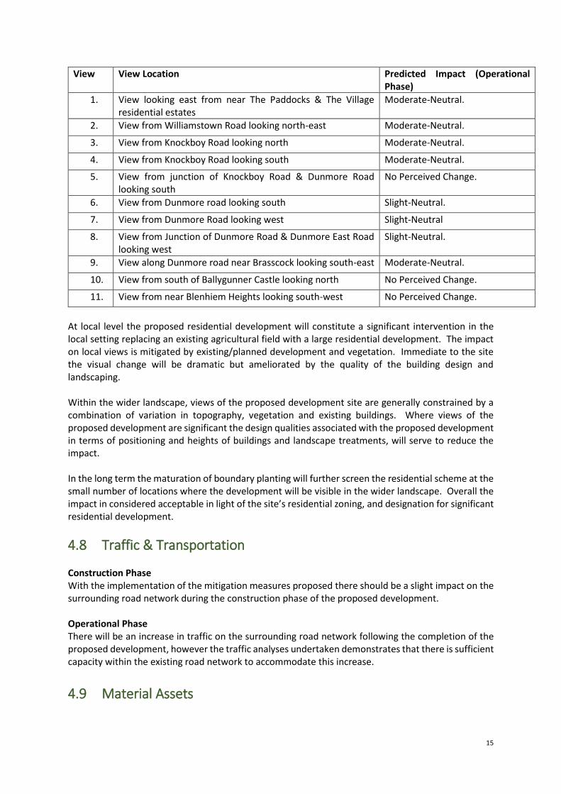
15
View View Location Predicted Impact (Operational Phase)
1. View looking east from near The Paddocks & The Village residential estates
Moderate-Neutral.
2. View from Williamstown Road looking north-east Moderate-Neutral.
3. View from Knockboy Road looking north Moderate-Neutral.
4. View from Knockboy Road looking south Moderate-Neutral.
5. View from junction of Knockboy Road & Dunmore Road looking south
No Perceived Change.
6. View from Dunmore road looking south Slight-Neutral.
7. View from Dunmore Road looking west Slight-Neutral
8. View from Junction of Dunmore Road & Dunmore East Road looking west
Slight-Neutral.
9. View along Dunmore road near Brasscock looking south-east Moderate-Neutral.
10. View from south of Ballygunner Castle looking north No Perceived Change.
11. View from near Blenhiem Heights looking south-west No Perceived Change.
At local level the proposed residential development will constitute a significant intervention in the local setting replacing an existing agricultural field with a large residential development. The impact on local views is mitigated by existing/planned development and vegetation. Immediate to the site the visual change will be dramatic but ameliorated by the quality of the building design and landscaping. Within the wider landscape, views of the proposed development site are generally constrained by a combination of variation in topography, vegetation and existing buildings. Where views of the proposed development are significant the design qualities associated with the proposed development in terms of positioning and heights of buildings and landscape treatments, will serve to reduce the impact. In the long term the maturation of boundary planting will further screen the residential scheme at the small number of locations where the development will be visible in the wider landscape. Overall the impact in considered acceptable in light of the site’s residential zoning, and designation for significant residential development.
4.8 Traffic & Transportation Construction Phase With the implementation of the mitigation measures proposed there should be a slight impact on the surrounding road network during the construction phase of the proposed development. Operational Phase There will be an increase in traffic on the surrounding road network following the completion of the proposed development, however the traffic analyses undertaken demonstrates that there is sufficient capacity within the existing road network to accommodate this increase.
4.9 Material Assets

16
Construction Phase On the basis that the specified mitigation measures are incorporated during the construction of the proposed development, the predicted impact will be neutral. Operational Phase Whilst the demand on water services, power, telecommunications and transport infrastructure will all increase due to the development, on the basis that the specified mitigation measures are incorporated then the operation of the proposed development is predicted to have a neutral-long term impact on material assets.
4.10 Waste Management The implementation of the mitigation measures outlined in Chapter 13 will ensure that a high rate of reuse, recovery and recycling is achieved at the development during the construction phases as well as during the operational phase. It will also ensure that European, National and Regional legislative waste requirements with regard to waste are met and that associated targets for the management of waste are achieved. Construction Phase A carefully planned approach to waste management as set out in Chapter 13 and adherence to the C&D WMP during the construction phase will ensure that the impact on the environment will be short-term, neutral and imperceptible. Operational Phase During the operational phase, a structured approach to waste management as set out in Chapter 13 will promote resource efficiency and waste minimisation. Provided the mitigation measures are implemented and a high rate of reuse, recycling and recovery is achieved, the predicted impact of the operational phase on the environment will be long-term, neutral and imperceptible.
4.11 Cultural Heritage Construction Phase Construction phases are predicted to impact on the vernacular structure identified during desk-based and field inspection, and on the subsurface archaeological features (interpreted as a structure and pit) identified in the geophysical survey and ground truthed in the test trenching assessment. However a range of specific mitigation measures are proposed to ensure that the impact is ameliorated, as follows:
• Mitigation Measure 14.1. The rubble should be removed from the vernacular structure, and the exposed building should be archaeologically excavated (i.e. preserved by record) in advance of development. The structure should be fully recorded by written, drawn and photographic record, including a stone-by-stone elevation drawing of all elevations, both interior and exterior, in advance of its demolition.
• Mitigation Measure 14.2. The oval pit identified in trench 6 should be archaeologically excavated (i.e. preserved by record).
• Mitigation Measure 14.3. Due to the fragile nature of the circular structure identified in trench 7 this should be archaeologically excavated (i.e. preserved by record) in advance of development (even if located in a green area). A 5m by 5m area should be opened around the circular feature in order to ensure that its extent is fully ascertained and excavated.
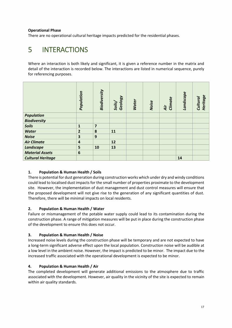
17
Operational Phase There are no operational cultural heritage impacts predicted for the residential phases.
5 INTERACTIONS Where an interaction is both likely and significant, it is given a reference number in the matrix and detail of the interaction is recorded below. The interactions are listed in numerical sequence, purely for referencing purposes.
Po
pu
lati
on
Bio
div
ersi
ty
Soils
/
Geo
log
y
Wa
ter
No
ise
Air
C
lima
te
Lan
dsc
ap
e
Cu
ltu
ral
Her
ita
ge
Population Biodiversity Soils 1 7 Water 2 8 11 Noise 3 9 Air Climate 4 12 Landscape 5 10 13 Material Assets 6 Cultural Heritage 14
1. Population & Human Health / Soils There is potential for dust generation during construction works which under dry and windy conditions could lead to localised dust impacts for the small number of properties proximate to the development site. However, the implementation of dust management and dust control measures will ensure that the proposed development will not give rise to the generation of any significant quantities of dust. Therefore, there will be minimal impacts on local residents. 2. Population & Human Health / Water Failure or mismanagement of the potable water supply could lead to its contamination during the construction phase. A range of mitigation measures will be put in place during the construction phase of the development to ensure this does not occur. 3. Population & Human Health / Noise Increased noise levels during the construction phase will be temporary and are not expected to have a long-term significant adverse effect upon the local population. Construction noise will be audible at a low level in the ambient noise. However, the impact is predicted to be minor. The impact due to the increased traffic associated with the operational development is expected to be minor. 4. Population & Human Health / Air The completed development will generate additional emissions to the atmosphere due to traffic associated with the development. However, air quality in the vicinity of the site is expected to remain within air quality standards.
18
During construction, there may be potential for slight dust nuisance in the immediate vicinity of the site. However, dust control measures, such as wheel washes, covering of fine material etc. will minimise the impacts on air quality. 5. Population & Human Health / Landscape Existing residents and visitors to the Knockboy/Ballygunner area interact with the landscape, such that they will be aware of a significant change at this site from agricultural fields to a new residential development with a mix of unit types, open spaces, roads, etc. Such a transformation, whilst significant, is designated for this site under the City Development Plan. It is expected that the design of the proposed scheme will over time integrate with the adjoining eastern suburbs of the city. 6. Population & Human Health / Materials Assets It is expected that the proposed development will benefit the materials assets with the additional population helping to sustain and generate improvements to the physical infrastructure of the area. 7. Biodiversity / Soils Potential construction stage effects arising from the general loss and fragmentation of some habitats and reduction of associated opportunities for biodiversity are considered neutral to slight negative during the construction phase, while potential operational stage effects are considered imperceptible neutral as new planting/landscaping matures. 8. Biodiversity / Water As concluded in the Natura Impact Statement submitted with the application there are no elements of the proposed development that are likely to give rise to significant effects on the local Natura 2000 sites. The implementation of construction and operational phase soils and water management proposals, together with the site drainage design will adequately reduce such potential impacts arising from the development site on these aquatic habitats in the wider area. Potential construction and operational phase effects on biodiversity associated with aquatic habitats in the wider area are considered imperceptible neutral with the implementation of soils and water management proposals. 9. Biodiversity / Noise Increased noise levels during the construction phase will only be temporary and are not expected to have a long-term significant adverse effect upon remaining fauna within the wider landscape. Operational noise will be audible at a low level in the ambient noise and the impact is predicted to be minor. 10. Biodiversity / Landscape The landscape masterplan proposed as part of the development will retain and enhance the remaining hedgerows features with native planting, as well as create new woodland, tree cluster/treelines, small areas of wildflower meadow and parkland/garden habitat. Potential construction stage effects arising from the general loss and fragmentation of some habitats and reduction of associated opportunities for biodiversity are considered neutral to slight negative during the construction phase, while potential operational stage effects are considered imperceptible neutral as new planting/landscaping matures. Due to the permanent loss of arable farmland and as such the permanent loss of foraging habitat for Yellowhammer the residual negative impact on this local populations of this species are considered significant at a local level, but moderate in line with exiting baseline trends.
19
Otherwise the successful implementation of the mitigation measures as outlined in this EIAR and accompanying documents, together with the landscape masterplan will minimise the potential impacts of the proposed development on local biodiversity such that its residual impact on other habitats, flora and fauna will be imperceptible neutral overall. 11. Soils / Water When soil is exposed after vegetative clearance there will also be increased run-off and evaporation. Mitigation measures will be implemented during construction to prevent this run-off water from discharging directly to watercourses. 12. Soils / Air Exposed soil during the construction phase of the proposed scheme may give rise to increased dust emissions. However, the implementation of dust management and dust control measures will ensure that the proposed development will not give rise to the generation of any significant quantities of dust. 13. Soils/Landscape Residual soils arising as a result of excavation at the development site will be used in landscaping works in the proposed public open space as much as possible rather than transporting off-site. 14. Landscape/Cultural Heritage Careful consideration has been given to minimizing the visual impact of the proposed scheme on architectural heritage in the wider area, particularly St. Mary’s Church and Ballygunner House to the south.
Related Documents