DOE/WIPP-99-2308 REV. 3 Delaware Basin Monitoring Annual Report September 2002 United States Department of Energy Waste Isolation Pilot Plant Carlsbad Field Office Carlsbad, New Mexico

Welcome message from author
This document is posted to help you gain knowledge. Please leave a comment to let me know what you think about it! Share it to your friends and learn new things together.
Transcript
DOE/WIPP-99-2308REV. 3
Delaware Basin Monitoring Annual Report
September 2002
United States Department of EnergyWaste Isolation Pilot Plant
Carlsbad Field OfficeCarlsbad, New Mexico
DOE/WIPP-99-2308, REV. 3 i September 30, 2002
DELAWARE BASIN DRILLING SURVEILLANCE PROGRAMANNUAL REPORT
WASTE ISOLATION PILOT PLANT
ENVIRONMENTAL COMPLIANCEEPA COMPLIANCE
September 2001 through August 2002
Prepared forthe Department of Energy by
Westinghouse TRU Solutions LLC
DOE/WIPP-99-2308, REV. 3 ii September 30, 2002
Table of Contents
1.0 Delaware Basin Drilling Surveillance Program 1
2.0 2002 Updates 4
2.1 Drilling Techniques 42.1.1 Drilling Fluids 52.1.2 Air Drilling 5
2.2 Shallow Drilling Events 72.3 Deep Drilling Events 72.4 Past Drilling Rates 82.5 Current Drilling Rate 8
2.5.1 Nine-Township Area Drilling Activities 92.6 Pressurized Brine Encounters 102.7 Borehole Permeability Assessment - Plugging Practices 122.8 Borehole Depths and Diameters 132.9 Secondary and Tertiary Recovery 14
2.9.1 Nine-Township Area Injection Wells 152.9.2 Nine-Township Area Salt Water Disposal Wells 15
2.10 Pipeline Activity 152.11 Mining 16
2.11.1 Potash Mining 162.11.2 Sulfur Extraction 172.11.3 Solution Mining 17
2.12 New Drilling Technology 18
3.0 Survey of Well Operators for Drilling Information 18
4.0 Summary - 2002 Delaware Basin Drilling Surveillance Program 18
5.0 References 19
DOE/WIPP-99-2308, REV. 3 iii September 30, 2002
List of Figures
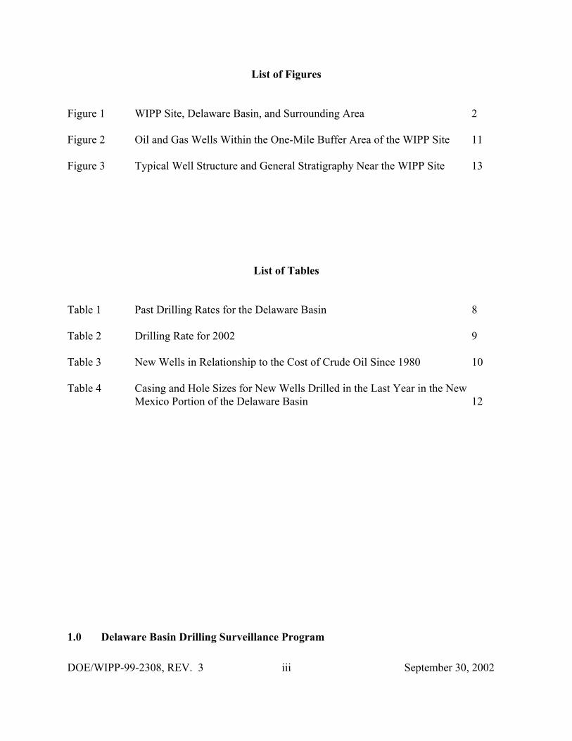
Figure 1 WIPP Site, Delaware Basin, and Surrounding Area 2
Figure 2 Oil and Gas Wells Within the One-Mile Buffer Area of the WIPP Site 11
Figure 3 Typical Well Structure and General Stratigraphy Near the WIPP Site 13
List of Tables
Table 1 Past Drilling Rates for the Delaware Basin 8
Table 2 Drilling Rate for 2002 9
Table 3 New Wells in Relationship to the Cost of Crude Oil Since 1980 10
Table 4 Casing and Hole Sizes for New Wells Drilled in the Last Year in the NewMexico Portion of the Delaware Basin 12
1.0 Delaware Basin Drilling Surveillance Program
DOE/WIPP-99-2308, REV. 3 1 September 30, 2002
The Delaware Basin Drilling Surveillance Program (DBDSP) is designed to monitor drillingactivities in the vicinity of the Waste Isolation Pilot Plant (WIPP). This program is based onEnvironmental Protection Agency (EPA) requirements. EPA requires the Department of Energy(DOE) to demonstrate the expected performance of the disposal system using a probabilistic riskassessment or performance assessment (PA). This PA must show that the expected repositoryperformance will not release radioactive material above limits set by the EPA’s standard andmust consider inadvertent drilling into the repository at some future time.
The EPA provided criteria in Title 40 Code of Federal Regulations (CFR) §194.33 to address theconsideration of future deep and shallow drilling in PA. These criteria led to the formulation ofconceptual models that incorporate the effects of these activities. These conceptual models useparameter values drawn from the databases in Appendix DEL of the Compliance CertificationApplication (CCA). Examples of information of interest include the drilling rate of deep andshallow boreholes and data relating to the physical properties of drill holes, such as diameter.
The EPA defined, in Title 40 CFR §194.2, the area to be used for the historical rate of drillingfor resources. It reads in part:
Delaware Basin means those surface and subsurface features which lie inside the boundary formedto the north, east and west of the [WIPP] disposal system, by the innermost edge of the CapitanReef, and formed, to the south, by a straight line drawn from the southeastern point of the DavisMountains to the most southwestern point of the Glass Mountains.
The Delaware Basin, depicted in Figure 1, includes all or part of Brewster, Culberson, JeffDavis, Loving, Pecos, Reeves, Ward, and Winkler Counties in West Texas, and portions of Eddyand Lea Counties in southeastern New Mexico.
In accordance with these criteria, the DOE used the historical rate of drilling for resources in theDelaware Basin to calculate a future drilling rate. In particular, in calculating the frequency offuture deep drilling, Title 40 CFR §194.33(b)(3)(i) (EPA 1996) provided the following criteria tothe DOE:
Identify deep drilling that has occurred for each resource in the Delaware Basin over the past 100years prior to the time at which a compliance application is prepared.
The DOE used the historical record of deep drilling for resources below 2,150 feet that hasoccurred over the past 100 years in the Delaware Basin. This was chosen because it is the depthof the repository, and the repository is not directly breached by boreholes less than this depth. Inthe past 100 years, deep drilling occurred for oil, gas, potash, and sulfur. These drilling eventswere used in calculating a rate for deep drilling for PA as discussed in Appendix DEL of the
CCA. Historical drilling for purposes other than resource exploration and recovery (such asWIPP Site investigation) were excluded from the calculation in accordance with criteria
DOE/WIPP-99-2308, REV. 3 2 September 30, 2002
Figure 1WIPP Site, Delaware Basin, and Surrounding Area
provided in §194.33.
In calculating the frequency of future shallow drilling, Title 40 CFR §194.33(b)(4)(i) states thatthe DOE should:
Identify shallowdrilling that hasoccurred for eachresource in theDelaware Basinover the past 100years prior to thetime at which acomplianceapplication isprepared.
An additional criterionfor calculation offuture shallow drillingrates is provided in§194.33(b)(4)(iii):
... in consideringthe historical rateof all shallowdrilling, theDepartment may,if justified,consider only thehistorical rate ofshallow drillingfor resources ofsimilar type andquality to those inthe controlledarea.
The only resourcespresent at shallowdepths (less than 2,150feet below the surface)within the controlledarea are water andpotash. Thus, consistent with §194.33(b)(4), the DOE used the historical record of shallowdrilling associated with water and potash extraction in the Delaware
Basin to calculate the rate of shallow drilling within the controlled area. The controlled area is
DOE/WIPP-99-2308, REV. 3 3 September 30, 2002
the 16 sections of land (16 square miles) within the WIPP Site boundary.
The EPA provides further criteria concerning the analysis of the consequences of future drillingevents in PAs in Title 40 CFR §194.33(c)(EPA 1996). Consistent with these criteria, thefollowing parameters regarding drilling were considered in the PA as documented in AppendixDEL of the CCA:
• types of drilling fluids
• amounts of drilling fluids
• borehole depths
• borehole diameters
• borehole plugs
• fraction of each borehole that is plugged
• natural processes that will degrade borehole plugs
• instances of encountering pressurized brine in the Castile Formation
The DOE continues to provide surveillance of the drilling activity in the Delaware Basin inaccordance with the criteria established in Title 40 CFR 194 during the operational phase, andwill continue until the DOE and the EPA agree no further benefit can be gained from continuedsurveillance. The results of this surveillance activity will be used to determine if a significantchange has occurred that would be detrimental to the performance of the disposal system.
The Delaware Basin Drilling Surveillance Plan (WP 02-PC.02) places specific emphasis on thenine-township area that includes the WIPP Site. This Plan is focused on gathering data andinformation to support future compliance applications. The DBDSP supports the ComplianceMonitoring Program, required by Title 40 CFR 191. Specifically, this program fulfills theMonitoring Assurance Requirement. The DBDSP is specifically defined in and authorized bythe DOE Monitoring Implementation Plan (DOE 1999b). The output of the program is used togenerate the Annual Compliance Monitoring Assessment Report, published by Sandia NationalLaboratories (SNL), and is reported annually to EPA in the Title 40 CFR §194.4(b)(4) Report.
Surveillance of drilling activities within the Delaware Basin will continue after closure for 100years or until the DOE can demonstrate to the EPA there are no significant concerns to beaddressed by further surveillance (Section 7.1.4, DOE 1996b).
2.0 2002 Updates
DOE/WIPP-99-2308, REV. 3 4 September 30, 2002
PA is required by regulation to consider disturbed case scenarios that include intrusions into therepository by inadvertent and intermittent drilling for resources. The probability of theseintrusions is based on a future drilling rate of 46.8 boreholes per square kilometer per 10,000years. This rate is based on consideration of the past record of drilling events in the DelawareBasin. The DOE models multiple types of human intrusion scenarios in the PA. These includeboth single intrusion events and combinations of multiple boreholes.
Two different types of boreholes are considered: (1) those that penetrate a pressurized brinereservoir in the underlying Castile Formation and (2) those that do not. While the presence ofpressurized brine under the repository is speculative, it cannot be completely ruled out based onavailable information. The primary consequence of contacting pressurized brine is theintroduction of an additional source of brine beyond that which is assumed to be released into therepository from the Salado Formation. The human intrusion scenario models are based onextensive field data sets collected by the DOE. The DBDSP collects the drilling related data tobe used for future PA calculations. The data have been collected from the time of the 1996submittal of the CCA to the present and include specific wells drilled during the last year in theNew Mexico portion of the Delaware Basin, specifically that of the nine-township areaimmediately surrounding the WIPP Site. These data are summarized in the following sections.
2.1 Drilling Techniques
The drilling techniques reported in Appendix DEL of the CCA are still being implemented byarea drillers. There were a total of 58 wells spudded, not necessarily completed, in the NewMexico portion of the Delaware Basin from September 1, 2001 through August 31, 2002. Thisnumber is derived from the databases maintained by the DBDSP. In reality, the number of newwells is higher but the paperwork on some of the wells has not been filed with the New MexicoOil Conservation Division (NMOCD) or is filed after the writing of this report; therefore, thosewells are not included in the count listed above. For example, during the last year 83 wells wereadded to the databases for New Mexico, meaning 25 wells were reported late.
Rotary drilling rigs were used to drill all 58 wells. Some have been completed as oil wells,others as gas wells, while the rest are still in the process of being completed. All wereconventionally drilled utilizing mud as a medium for circulation. Thirty-two of these wells werein the nine-township area. The depths of the completed wells in the nine-township area rangefrom 7,303 feet to 15,250 feet. Outside of the nine-township area the depths of the completedwells range from 5,700 feet to 13,850 feet.
A technique used by operators to increase production is to drill a well directionally orhorizontally, which allows for more area of the wellbore to be in the production zone. Asreported in Appendix DEL, this technique is not often used in this area because of the increasedcosts. The DBDSP monitors directional or horizontal drilled wells only in the nine-townshiparea. None off the 32 new wells spudded during the last year in the nine-township area weredirectional or horizontal drilled wells. One well, spudded in 2000 and reported in Rev. 1 of thisreport, was completed as a directionally drilled well. This well is located outside of the WIPP
DOE/WIPP-99-2308, REV. 3 5 September 30, 2002
Site, but is drilled into a lease located on Section 31 underneath the WIPP Site. There were ninemore wells slated to be drilled into the same lease, of which eight have been canceled since theinitial well was drilled.
2.1.1 Drilling Fluids
Employing a rotary rig for drilling involves the use of drilling fluids. Drilling fluid is commonlyknown as mud, which is the liquid circulated through the wellbore during rotary drilling andworkover operations. In addition to its function of bringing cuttings to the surface, drilling mudcools and lubricates the bit and drill stem, protects against blowouts by holding back subsurfacepressures, and deposits a mud cake on the wall of the borehole to prevent loss of fluids to theformation.
Typically, a driller will use fresh water and additives to drill the surface section of the holewhich ends at the top of the Salado Formation. A change in drilling practices would necessitatea change in the application of drilling fluids. Within the Known Potash Lease Area (KPLA) ofsoutheastern New Mexico, drillers are required under Title 19, Chapter 15, Order R-111-P of theNew Mexico Administrative Code (NMAC) to use a saturated brine to drill through the saltformation which is usually called the intermediate section. This requirement is to keep the saltfrom washing out and making the hole larger than necessary and to protect the potash reservesthat occur in this formation. Once this section has been drilled and cased, the driller againchanges to fresh water and additives to finish drilling the hole to depth.
All the operators of new wells completed in the New Mexico portion of the Delaware Basinduring the last year that reported information on mud weights, listed mud weights from 8.4 to10.0 pounds per gallon while drilling the intermediate portion of the wellbore. The operatorscompleting wells in the nine-township area that reported mud weights used a solution of 9.9 to10.2 pounds per gallon saturated brine for drilling the intermediate section of the well throughthe salt formation.
2.1.2 Air Drilling
A method of hydrocarbon drilling not emphasized in Appendix DEL is air drilling. As definedby the oil industry, air drilling is a method of rotary drilling using compressed air as thecirculation medium. The conventional method of removing cuttings from the wellbore is to usea flow of water or drilling mud. In some cases, compressed air removes the cuttings with equalor greater efficiency. The rate of penetration is usually increased considerably when air drillingis used; however, a fundamental problem in air drilling is the penetration of formationscontaining water, since the entry of water into the system reduces the ability of the air to removecuttings.
Critics noted the air drilling scenario was not included by DOE in the CCA and raised severalissues: (1) air drilling technology is currently successfully used in the Delaware Basin, (2) air
DOE/WIPP-99-2308, REV. 3 6 September 30, 2002
drilling is thought to be a viable drilling technology under the hydrological and geologicalconditions at the WIPP Site, and (3) air drilling could result in releases of radionuclides that aresubstantially greater than those considered by the DOE in the CCA. Much research on the issueof air drilling in the Delaware Basin has been done. It has been shown that although air drillingis a common method of drilling wells it is not practiced in the vicinity of the WIPP Site because(1) it is against R-111-P regulations to drill with anything but saturated brine through the saltformation in the KPLA, (2) it is not economical to drill with air when a driller has to usesaturated brine for the intermediate section, and (3) if water is encountered prior to or afterdrilling the salt formation the driller would have to convert to a conventional system of drilling.
Additional information was provided to EPA Air Docket No. A-93-02, IV-G-7. In thisinformation, the following was provided:
The well record search has continued and now includes information from the entire New Mexicoportion of the Delaware Basin. Within the nine-townships surrounding the WIPP, the recordsshowed no evidence of air drilling. One possible exception to this may be the Lincoln Federal #1. This well is said to have been air drilled due to a loss of circulation at a depth of 1290 feet, but thishas not been verified. The records associated with the Lincoln Federal #1 do not contain anyevidence of air drilling. Rather, this information is based on verbal communications with theoperating and drilling companies involved with the well. Nonetheless, the Lincoln Federal #1 mayhave been drilled with air, although it was not a systematic use of the technology. Air drilling atthis well was used from 2984' to 4725' merely as a mitigative attempt to continue drilling to thenext casing transition depth. After this casing transition, mud drilling was used for the remainderof the hole.
The area of the expanded search contains 3,756 boreholes. Of these, 407 well files wereunavailable for viewing (in process), therefore, 3,349 well files constitute the database. Amongthese wells, 11 instances of air drilling were found in which any portion of the borehole wasdrilled with air. Only 7 of these were drilled through the Salado Formation at the depth of therepository. This results in a frequency of 7/3349, or 0.0021. This value is conservative in that itincludes the Lincoln Federal #1, and four other wells which were proposed to be drilled with air,but no subsequent verification of actual drilling exists in the records.
During the summer of 1999, another search of these same records was conducted as a follow upto the original research. This search of the records was performed by an independent third partyand was used as a quality assurance check of the original search. The database consisted of3,810 boreholes with only 12 records unavailable for viewing. This search added five morewells with indications of some portion of the hole being drilled with air. None were air drilledthrough the Salado Formation or were located in the nine-township area. Of the five wells addedto the count, one (the Sheep Draw “28" Federal #13) had the first 358 feet air drilled while theother four had the conductor pipe drilled with air which consists of the first 40 feet of theborehole and is not usually reported in the drilling process. The conductor casing is typicallydrilled, set in place, and cemented prior to setting up the rotary drilling rig that will eventuallydrill the well.
The records on the new wells spudded during the last year (September 1, 2001 thru August 31,
DOE/WIPP-99-2308, REV. 3 7 September 30, 2002
2002) are being checked as they become available at the NMOCD for instances of air drilling. The records submitted to the NMOCD offices can be as late as two years after the well has beendrilled. The record review is an ongoing process that is conducted on a monthly basis. None ofthe records reviewed to date have indicated any instances of air drilling. As was presented in thetestimony (public hearings conducted by the EPA on WIPP certification) and continues to bevalidated by ongoing review, air drilling is not a common practice in the vicinity of the WIPPSite.
2.2 Shallow Drilling Events
One of the requirements of Title 40 CFR Part 194 is that the CCA must adequately andaccurately characterize the frequency of shallow drilling within the Delaware Basin, as well as,support the assumptions and determinations, particularly those that limit consideration ofshallow drilling events based on the presence of resources of similar type and quantity found inthe controlled area. The DOE concluded in Appendix SCR that shallow drilling could beremoved from PA consideration based on low consequence. As a result, the DOE did notinclude shallow drilling in its PA drilling rate calculations and did not include any reduction inshallow drilling rates during the active and passive institutional control periods. In ComplianceApplication Review Document (CARD) 32, the EPA accepted the DOE’s finding that shallowdrilling would not be of consequence to repository performance and need not be included in thePA.
Although the EPA has agreed shallow drilling can be eliminated from PA and need not betracked, the DBDSP collects data on all wells drilled within the boundaries of the DelawareBasin. The program makes no distinctions between shallow and deep drilling events exceptwhen calculating the intrusion rate for deep drilling. Information on all wells drilled is vital fortrending future activities.
2.3 Deep Drilling Events
In the Delaware Basin, deep drilling events are usually associated with oil and gas drilling.Commercial sources and visits to the NMOCD offices are used to identify these events. TheDBDSP collects data on all drilled wells within the Delaware Basin, making no distinctionbetween resources. Two separate databases are maintained on hydrocarbon wells, one for Texasand one for New Mexico. As information on wells is acquired, it is entered into the individualdatabases. The Texas database contains information only on the current status of the well, whenit was drilled, its location, who the operator is, and the total depth of the well. The Texas portionof the Delaware Basin is used only for calculating the drilling rate. The database for the NewMexico portion of the Delaware Basin contains the same basic information as Texas along withall the information required for PA related drilling events.
The DBDSP continues to monitor all hydrocarbon drilling activity and any new potash, sulfur,water, or monitoring wells for deep drilling events. Information from the drilling of these wellsis added to the databases maintained for these separate resources. During the last year, there
DOE/WIPP-99-2308, REV. 3 8 September 30, 2002
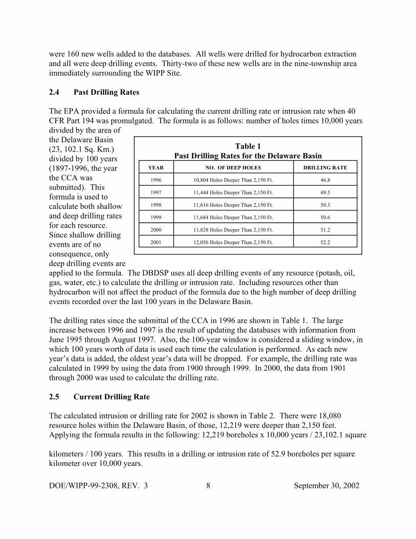
Table 1Past Drilling Rates for the Delaware Basin
YEAR NO. OF DEEP HOLES DRILLING RATE
1996 10,804 Holes Deeper Than 2,150 Ft. 46.8
1997 11,444 Holes Deeper Than 2,150 Ft. 49.5
1998 11,616 Holes Deeper Than 2,150 Ft. 50.3
1999 11,684 Holes Deeper Than 2,150 Ft. 50.6
2000 11,828 Holes Deeper Than 2,150 Ft. 51.2
2001 12,056 Holes Deeper Than 2,150 Ft. 52.2
were 160 new wells added to the databases. All wells were drilled for hydrocarbon extractionand all were deep drilling events. Thirty-two of these new wells are in the nine-township areaimmediately surrounding the WIPP Site.
2.4 Past Drilling Rates
The EPA provided a formula for calculating the current drilling rate or intrusion rate when 40CFR Part 194 was promulgated. The formula is as follows: number of holes times 10,000 yearsdivided by the area ofthe Delaware Basin(23, 102.1 Sq. Km.)divided by 100 years(1897-1996, the yearthe CCA wassubmitted). Thisformula is used tocalculate both shallowand deep drilling ratesfor each resource.Since shallow drillingevents are of noconsequence, onlydeep drilling events areapplied to the formula. The DBDSP uses all deep drilling events of any resource (potash, oil,gas, water, etc.) to calculate the drilling or intrusion rate. Including resources other thanhydrocarbon will not affect the product of the formula due to the high number of deep drillingevents recorded over the last 100 years in the Delaware Basin.
The drilling rates since the submittal of the CCA in 1996 are shown in Table 1. The largeincrease between 1996 and 1997 is the result of updating the databases with information fromJune 1995 through August 1997. Also, the 100-year window is considered a sliding window, inwhich 100 years worth of data is used each time the calculation is performed. As each newyear’s data is added, the oldest year’s data will be dropped. For example, the drilling rate wascalculated in 1999 by using the data from 1900 through 1999. In 2000, the data from 1901through 2000 was used to calculate the drilling rate.
2.5 Current Drilling Rate
The calculated intrusion or drilling rate for 2002 is shown in Table 2. There were 18,080resource holes within the Delaware Basin, of those, 12,219 were deeper than 2,150 feet. Applying the formula results in the following: 12,219 boreholes x 10,000 years / 23,102.1 square
kilometers / 100 years. This results in a drilling or intrusion rate of 52.9 boreholes per squarekilometer over 10,000 years.

DOE/WIPP-99-2308, REV. 3 9 September 30, 2002
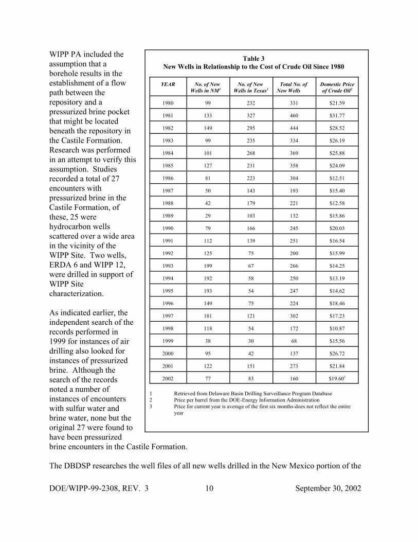
The intrusion rate has risen from46.8 holes per square kilometer to52.9 holes per square kilometersince 1996 and will continue toclimb because of the method ofcalculation. Since the first welldrilled in the area occurred in1911, it will be 2011 before onewell is dropped and 2014 before asecond well is dropped from thecount. In the meantime, numerouswells will have been added thusdriving up the count. The truestate of the drilling rate is depictedin Table 3. Petroleum explorationactivity is directly related to theprice of crude oil and gas. Thenumber of wells drilled per yearfor the last 23 years in theDelaware Basin and the averageprice per barrel of domestic crudeoil is shown in Table 3.
2.5.1 Nine-Township AreaDrilling Activities
From September 1, 2001, throughAugust 31, 2002, there were 32new wells spudded in the nine-township area immediatelysurrounding the WIPP Site. Nonew wells were drilled in the one-mile buffer area surrounding theWIPP Site. Figure 2 shows the status of all known hydrocarbon wells drilled within the one-mile buffer area of the WIPP Site, of the 32 new wells, 25 were drilled in Eddy County andseven in Lea County. Seventeen of the wells were to the northeast and east of the site while therest were all south of the site. Pogo Producing Company and Devon Energy ProductionCompany each drilled ten new wells in the nine-township area during the last year. These sametwo companies are the major producers in the area along with other companies such as YatesPetroleum, EOG Resources, Bass Enterprises Production Company, Chevron USA, HarvardPetroleum, Maralo Inc., and Matador Operating Company.2.6 Pressurized Brine Encounters
Table 2Drilling Rate for 2002
Hydrocarbon Holes
Well TypeDry HoleOil WellGas WellOil/Gas WellDrilling or Waiting on PaperworkInjection WellPlugged Oil WellPlugged Gas WellPlugged Injection WellPlugged Oil & Gas WellSalt Water Disposal WellPlugged Salt Water Disposal WellJunked & Abandoned HoleService Well
Texas2,4963,902
8389354
253522177
03650
114114
8,604
N.M.988
1,809609
54471
289128200
10510433
4,124
Totals3,4845,7111,447
9898
3248113052036
11010
157117
12,728
Other Resource Holes
Well TypeSulfur BoreholesPotash BoreholesWIPP BoreholesStratigraphic Test HolesWater WellsSalt WellsPlugged Salt WellCore Holes
Total Resource Holes in the Basin
Texas587
00
1,2131,706
80
363,550
12,154
N.M.0
1,005199
2590
222
1,802
5,926
Totals587
1,005199
1,2152,296
102
385,352
18,080
Additional Information
Well TypeHydrocarbon Holes >2,150 Feet DeepHydrocarbon Holes<2,150 Feet DeepSulfur Boreholes >2,150 Feet DeepPotash Boreholes > 2,150 Feet DeepWIPP Boreholes > 2,150 Feet DeepStratigraphic Test Holes > 2,150 Feet DeepWater Wells >2,150 Feet Deep
Total Resource Holes >2,150 Feet DeepTotal Resource Holes < 2,150 Feet DeepTotal Resource Holes Within the Delaware Basin
Totals12,045
683891910560
12,2195,861
18,080
Area Information
LocationDelaware Basin
Acres5,708,682.50
Sq. Miles8,919.76
Sq. Kilometers23,102.1
Intrusion RateThe intrusion rate is calculated as follows: (number of holes) x 10,000 years / area / 100 years. The intrusion rateis 52.9 boreholes per square kilometer over 10,000 years.
DOE/WIPP-99-2308, REV. 3 10 September 30, 2002
Table 3New Wells in Relationship to the Cost of Crude Oil Since 1980
YEAR No. of New Wells in NM1
No. of New Wells in Texas1
Total No. of New Wells
Domestic Priceof Crude Oil2
1980 99 232 331 $21.59
1981 133 327 460 $31.77
1982 149 295 444 $28.52
1983 99 235 334 $26.19
1984 101 268 369 $25.88
1985 127 231 358 $24.09
1986 81 223 304 $12.51
1987 50 143 193 $15.40
1988 42 179 221 $12.58
1989 29 103 132 $15.86
1990 79 166 245 $20.03
1991 112 139 251 $16.54
1992 125 75 200 $15.99
1993 199 67 266 $14.25
1994 192 58 250 $13.19
1995 193 54 247 $14.62
1996 149 75 224 $18.46
1997 181 121 302 $17.23
1998 118 54 172 $10.87
1999 38 30 68 $15.56
2000 95 42 137 $26.72
2001 122 151 273 $21.84
2002 77 83 160 $19.603
1 Retrieved from Delaware Basin Drilling Surveillance Program Database2 Price per barrel from the DOE-Energy Information Administration3 Price for current year is average of the first six months-does not reflect the entire
year
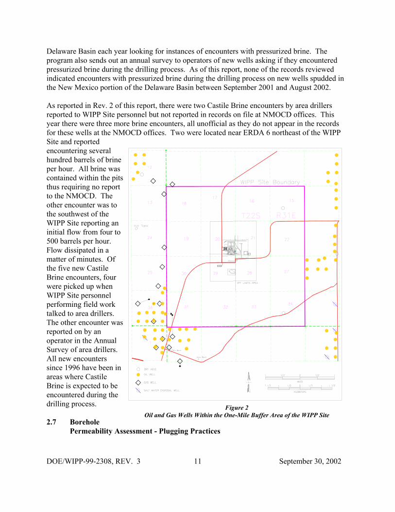
WIPP PA included theassumption that aborehole results in theestablishment of a flowpath between therepository and apressurized brine pocketthat might be locatedbeneath the repository inthe Castile Formation. Research was performedin an attempt to verify thisassumption. Studiesrecorded a total of 27encounters withpressurized brine in theCastile Formation, ofthese, 25 werehydrocarbon wellsscattered over a wide areain the vicinity of theWIPP Site. Two wells,ERDA 6 and WIPP 12,were drilled in support ofWIPP Sitecharacterization.
As indicated earlier, theindependent search of therecords performed in1999 for instances of airdrilling also looked forinstances of pressurizedbrine. Although thesearch of the recordsnoted a number ofinstances of encounterswith sulfur water andbrine water, none but theoriginal 27 were found tohave been pressurizedbrine encounters in the Castile Formation.
The DBDSP researches the well files of all new wells drilled in the New Mexico portion of the
DOE/WIPP-99-2308, REV. 3 11 September 30, 2002
Figure 2Oil and Gas Wells Within the One-Mile Buffer Area of the WIPP Site
Delaware Basin each year looking for instances of encounters with pressurized brine. Theprogram also sends out an annual survey to operators of new wells asking if they encounteredpressurized brine during the drilling process. As of this report, none of the records reviewedindicated encounters with pressurized brine during the drilling process on new wells spudded inthe New Mexico portion of the Delaware Basin between September 2001 and August 2002.
As reported in Rev. 2 of this report, there were two Castile Brine encounters by area drillersreported to WIPP Site personnel but not reported in records on file at NMOCD offices. Thisyear there were three more brine encounters, all unofficial as they do not appear in the recordsfor these wells at the NMOCD offices. Two were located near ERDA 6 northeast of the WIPPSite and reportedencountering severalhundred barrels of brineper hour. All brine wascontained within the pitsthus requiring no reportto the NMOCD. Theother encounter was tothe southwest of theWIPP Site reporting aninitial flow from four to500 barrels per hour. Flow dissipated in amatter of minutes. Ofthe five new CastileBrine encounters, fourwere picked up whenWIPP Site personnelperforming field worktalked to area drillers. The other encounter wasreported on by anoperator in the AnnualSurvey of area drillers. All new encounterssince 1996 have been inareas where CastileBrine is expected to beencountered during thedrilling process.
2.7 BoreholePermeability Assessment - Plugging Practices
DOE/WIPP-99-2308, REV. 3 12 September 30, 2002
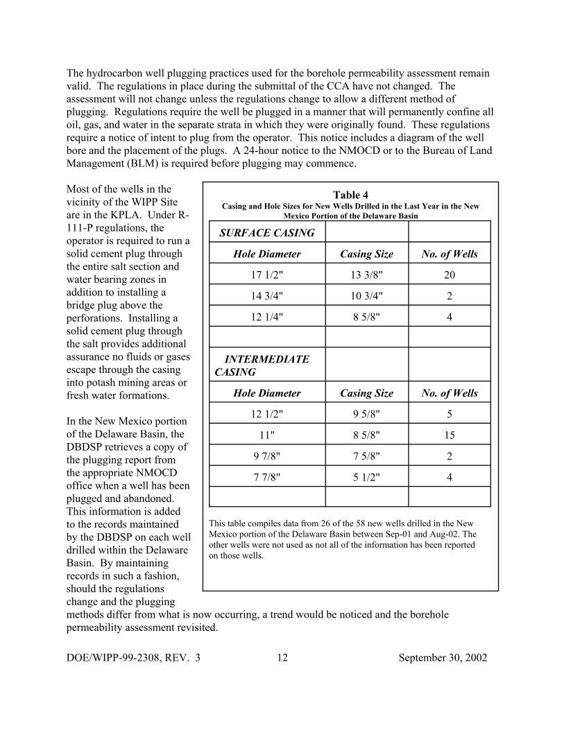
Table 4Casing and Hole Sizes for New Wells Drilled in the Last Year in the New
Mexico Portion of the Delaware Basin
SURFACE CASING
Hole Diameter Casing Size No. of Wells
17 1/2" 13 3/8" 20
14 3/4" 10 3/4" 2
12 1/4" 8 5/8" 4
INTERMEDIATECASING
Hole Diameter Casing Size No. of Wells
12 1/2" 9 5/8" 5
11" 8 5/8" 15
9 7/8" 7 5/8" 2
7 7/8" 5 1/2" 4
This table compiles data from 26 of the 58 new wells drilled in the NewMexico portion of the Delaware Basin between Sep-01 and Aug-02. Theother wells were not used as not all of the information has been reportedon those wells.
The hydrocarbon well plugging practices used for the borehole permeability assessment remainvalid. The regulations in place during the submittal of the CCA have not changed. Theassessment will not change unless the regulations change to allow a different method ofplugging. Regulations require the well be plugged in a manner that will permanently confine alloil, gas, and water in the separate strata in which they were originally found. These regulationsrequire a notice of intent to plug from the operator. This notice includes a diagram of the wellbore and the placement of the plugs. A 24-hour notice to the NMOCD or to the Bureau of LandManagement (BLM) is required before plugging may commence.
Most of the wells in thevicinity of the WIPP Siteare in the KPLA. Under R-111-P regulations, theoperator is required to run asolid cement plug throughthe entire salt section andwater bearing zones inaddition to installing abridge plug above theperforations. Installing asolid cement plug throughthe salt provides additionalassurance no fluids or gasesescape through the casinginto potash mining areas orfresh water formations.
In the New Mexico portionof the Delaware Basin, theDBDSP retrieves a copy ofthe plugging report fromthe appropriate NMOCDoffice when a well has beenplugged and abandoned. This information is addedto the records maintainedby the DBDSP on each welldrilled within the DelawareBasin. By maintainingrecords in such a fashion,should the regulationschange and the pluggingmethods differ from what is now occurring, a trend would be noticed and the boreholepermeability assessment revisited.
DOE/WIPP-99-2308, REV. 3 13 September 30, 2002
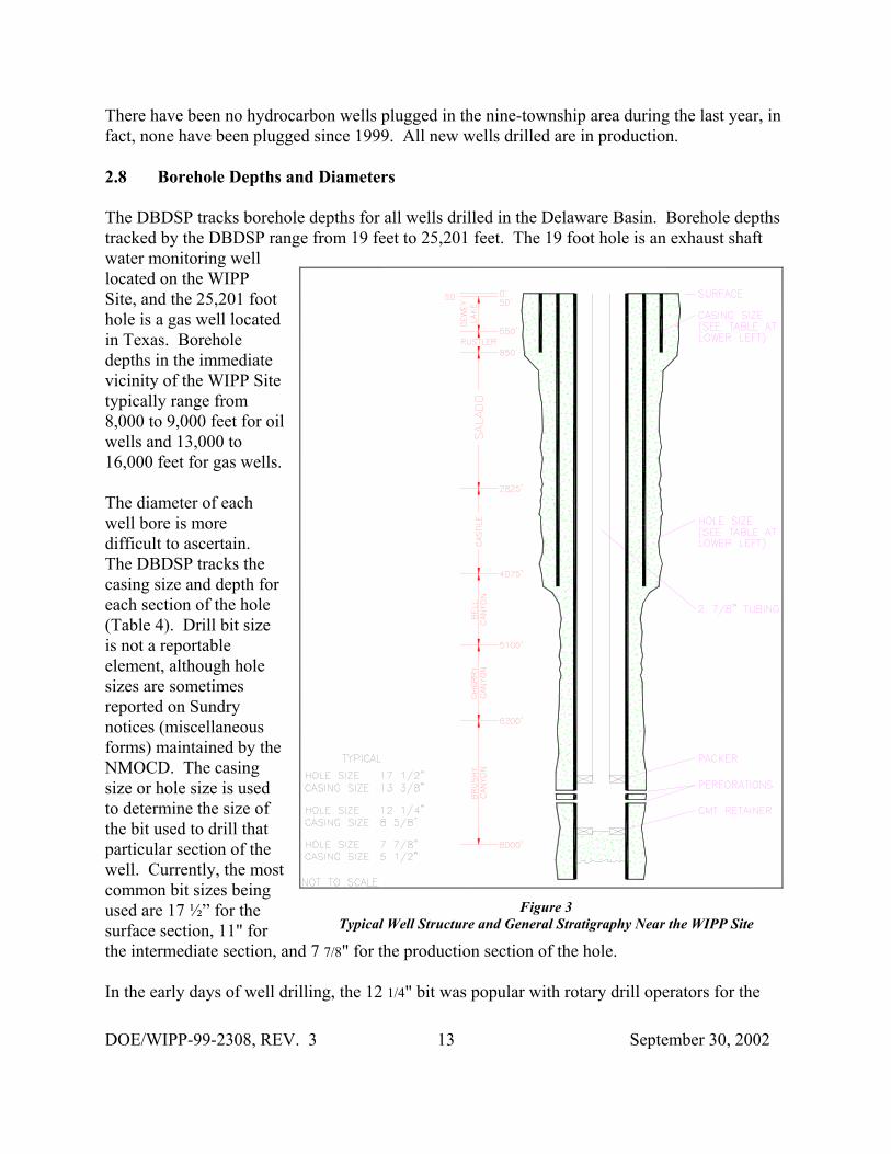
Figure 3Typical Well Structure and General Stratigraphy Near the WIPP Site
There have been no hydrocarbon wells plugged in the nine-township area during the last year, infact, none have been plugged since 1999. All new wells drilled are in production.
2.8 Borehole Depths and Diameters
The DBDSP tracks borehole depths for all wells drilled in the Delaware Basin. Borehole depthstracked by the DBDSP range from 19 feet to 25,201 feet. The 19 foot hole is an exhaust shaftwater monitoring welllocated on the WIPPSite, and the 25,201 foothole is a gas well locatedin Texas. Boreholedepths in the immediatevicinity of the WIPP Sitetypically range from8,000 to 9,000 feet for oilwells and 13,000 to16,000 feet for gas wells.
The diameter of eachwell bore is moredifficult to ascertain. The DBDSP tracks thecasing size and depth foreach section of the hole(Table 4). Drill bit sizeis not a reportableelement, although holesizes are sometimesreported on Sundrynotices (miscellaneousforms) maintained by theNMOCD. The casingsize or hole size is usedto determine the size ofthe bit used to drill thatparticular section of thewell. Currently, the mostcommon bit sizes beingused are 17 ½” for thesurface section, 11" forthe intermediate section, and 7 7/8" for the production section of the hole.
In the early days of well drilling, the 12 1/4" bit was popular with rotary drill operators for the
DOE/WIPP-99-2308, REV. 3 14 September 30, 2002
surface section of the hole. In those days, the wells were much shallower and did not require thelarger sections of casing. Most holes drilled at that time were a two-string (string refers to thedifferent size of casing in the wellbore) hole versus the three- and four-strings commonly usednow. In the area of the WIPP Site, regulations require a three-string hole making the larger bitsizes more popular. The typical hole and casing sizes for a three-string well in the vicinity of theWIPP Site are shown in Figure 3.
2.9 Secondary and Tertiary Recovery
Secondary recovery is defined by the oil industry as the first improved recovery method of anytype applied to a reservoir to produce oil not recoverable by primary recovery methods. Waterflooding is one such method. This method involves pumping water through the existingperforations in a well in which production has decreased sufficiently to merit stimulation. As thewater is pumped into a formation, it stimulates production of oil or gas in other nearby wells. This is a proven method of recovering hydrocarbons that otherwise would be economicallyunretrievable. Water flooding has been a popular form of secondary recovery for over 40 years.Water flooding can be accomplished by one injection well or several injection wells in theimmediate vicinity of other producing wells.
In the New Mexico portion of the Delaware Basin, there are three major water flood projects andseveral one and two injection well operations. One of the major waterflood projects in the areais the El Mar, located in T26S-R32E, on the Texas border. At one time, this project (currentlyoperated by Quay Valley Inc.) had 31 permitted injection wells. Currently, there are only twowells actively injecting water. The remaining wells are either shut-in (not being used) orplugged and abandoned. The operation for this facility has not changed since last year. ThePaduca water flood project, located in T25S-R32E, has 19 permitted injection wells with seven(down from eight this time last year) injecting water into the formation. The third major waterflood project in this area (Indian Draw), located in T22S-R28E, is currently not injecting into theten permitted wells.
Tertiary recovery is defined by the oil industry as the use of any improved recovery method toremove additional oil after secondary recovery. One method of tertiary recovery practiced in theindustry, where conditions permit, is the injection of carbon dioxide (CO2) into the formation. This consists of injecting a prescribed amount of CO2 into the reservoir followed by an injectionof water and a subsequent injection of CO2. Although CO2 can be injected continuously, it is notcost effective to implement this process. At the time of this report, there are no known CO2injection wells or tertiary recovery projects being operated in the vicinity of the WIPP Site,although several are being operated by oil companies in the Texas portion of the DelawareBasin.
2.9.1 Nine-Township Injection Wells
Secondary recovery projects occurring in the nine-township area are on a small scale. There arefive injection wells located in the nine-township area surrounding the WIPP Site. Phillips
DOE/WIPP-99-2308, REV. 3 15 September 30, 2002
Petroleum operates two injection wells, James “A” #3 and #12, located in section 2-T22S-R30E,northwest of the site. Both are active and injecting near the maximum permitted pressure of 945psi for #3 and 1,120 psi for #12. Both first injected water in the early 1990s. The other threeinjection wells are operated by Pogo Producing Company. The Neff Federal #3 is located insection 25-T22S-R31E. This well went on-line in 1995 and has injected approximately2,850,700 barrels (2,097,154 barrels this time last year) of water at a maximum permittedpressure of 1,410 psi. The Pure Gold “B” Federal #20 (23S-31E-20) has injected 244,642barrels to date. The other Pogo well (Prize Federal #4 located in 22S-32E-27) recently went on-line and no injection data has been reported at this time. All five wells are injecting into theBrushy Canyon Formation of the Delaware Mountain Group at approximately 7,200 feet.
2.9.2 Nine-Township Salt Water Disposal Wells
The most common type of injection well is for the disposal of brine water coming from theproducing formation in oil and gas wells. Most producing oil and gas wells produce water alongwith oil or gas. Salt Water Disposal (SWD) wells have become necessary as a result of theEPA’s ruling that formation water may no longer be disposed of on the surface. The oilcompanies now dispose of this water by injecting it into approved SWD wells.
There are currently 34 SWD wells, an increase of one over the last year, operated by 12companies (14 companies in 2000) located in the nine-township area surrounding the WIPP Site. Two operators, Devon Energy and Pogo Producing, operate the majority of the SWD wells. Injection depths range from 3,800 to 8,200 feet. During the last year, all operated within theirmaximum permitted injection pressure. The volume of disposed brine water depends on thenumber of producing wells maintained by the operator in the immediate vicinity of the SWDwell.
2.10 Pipeline Activity
Pipeline activity is monitored in the nine-township area, specifically within a five mile radius ofthe WIPP Site. Only pipelines of permanent construction, such as buried rigid metal pipelines,are of concern to the DBDSP. Many oil, gas, and SWD wells are connected to tank batteries bygathering systems constructed of poly flowlines (flexible plastic pipe) that may or may not beburied. These flowlines are semi-permanent. When they are no longer needed they are removedfor use elsewhere. This type of pipeline activity is not monitored by the DBDSP. Metal pipelineactivity is of interest because it will be around for a long time thus requiring the locations ofthese pipelines to be documented. Only natural gas and water pipelines are located within theimmediate vicinity of the WIPP Site. The natural gas pipelines are owned and operated by three
companies, El Paso Natural Gas Company, Natural Gas Pipeline Company of America, andTranswestern Pipeline Company.
One type of pipeline activity of major concern to the DBDSP is CO2 pipelines. A form oftertiary recovery of oil discussed previously involves the use of CO2. An indicator of this form
DOE/WIPP-99-2308, REV. 3 16 September 30, 2002
of recovery would be the construction of a CO2 pipeline in the area. Currently, there are no CO2pipelines within the New Mexico portion of the Delaware Basin. The nearest CO2 pipeline islocated south of the WIPP Site in the Texas portion of the Delaware Basin.
2.11 Mining
Resources found in the Delaware Basin that can be mined are potash, sulfur, caliche, gypsum,and halite. Potash and sulfur are present in quantities large enough to be mined profitably. Onlycaliche, of the other resources available, is economically extracted from the earth in conventionalmining methods. Caliche is mainly used in the construction of pads for oil and gas well drillingrigs.
2.11.1 Potash Mining
Potash mining in the immediate vicinity of the WIPP Site continues as reported in AppendixDEL of the CCA. There have been several changes to the companies that operate in the area,most notably, only two potash mining companies remain in operation. No plans have beenpromulgated by either company to sink new shafts or encroach upon the potash reservesidentified in Appendix DEL. Currently, these reserves are not economically recoverable.
In August 1996, Mississippi Potash (a subsidiary of Mississippi Chemical Corporation)purchased all the assets of New Mexico Potash Corporation and Eddy Potash, Inc. These plantswere renamed Mississippi East and Mississippi North, respectively. December 1997 saw theMississippi North plant shut down because it could no longer be economically operated. Mississippi Potash continues to produce potash fertilizer from both the east and west plant minesand refineries.
The other potash producer in the area, IMC Kalium Potash, is a wholly owned subsidiary of IMCGlobal. Western Ag-Minerals was purchased by IMC Global September 1997. This acquisitiondoubled the potash reserves for IMC Kalium and increased their other reserves by 30 percent. IMC Global merged with Freeport-McMoRan, a major world potash producer, December 1997with IMC Global as the surviving entity in the transaction.
2.11.2 Sulfur Extraction
The only viable sulfur mining activity within the Delaware Basin was being conducted byFreeport-McMoRan Sulphur Inc., a wholly owned subsidiary of McMoRan ExplorationCompany. The mine is located in Culberson County, Texas. The mine recovered sulfur utilizingthe Frasch process which consists of a hole drilled into the sulfur bearing formation and then
DOE/WIPP-99-2308, REV. 3 17 September 30, 2002
cased. The next step involves the placement of three concentric pipes within the protectivecasing to facilitate pumping superheated water down the hole, melting the sulfur, and recoveringthe molten sulfur to the surface. In June 1998, it was announced the mine would ceaseproduction September 1998 because it was no longer economically feasible to operate. Becauseof problems at other sulfur facilities, the Culberson mine was operated until it permanentlyceased production on June 30, 1999. Abandonment and salvage operations continued until theearly summer of 2000.
Recently, a number of sulfur exploration coreholes were found in the BLM records. Thesecoreholes were drilled in the late 1960s through the early 1980s in the Yeso Hills nearWashington Ranch in the far southwest corner of the New Mexico portion of the DelawareBasin. These coreholes have yet to be added to the databases. All were shallow (less than 2,150feet) drilling events that were conducted for various small-time operators. There have been noreports on whether any of the holes encountered sufficient quantities of mineable sulfur.
2.11.3 Solution Mining
Solution mining is the process by which water is injected into a mineral formation, circulated todissolve the mineral, and then the solution is pumped back to the surface where the minerals areprecipitated out of the water, usually by evaporation. There are several brine mines or wells inthe area (two in New Mexico and eight in Texas) that use this process to provide a brine solutionfor area drilling operators to use in the drilling process. These are all shallow wells usinginjected fresh water to dissolve the salt into a brine solution.
In early 1997, Mississippi Potash proposed to set up a pilot potash solution mining project at theformer Eddy Potash mine located north of the WIPP Site and outside of the Delaware Basin. BLM was provided with all of the necessary documentation to acquire a permit to operate thepilot project, and if it shows merit, be considered a full blown project later. This project was putoff until a later date. In March 2002, Mississippi Potash again applied for a permit to operate apilot potash solution mining project. In May 2002, the project was given approval to proceed bythe BLM though the project has not been started. If the project is initiated, it will beapproximately three acres in size. Although this project is outside of the Delaware Basin, it willbe closely followed because of its importance.
In the late 1960s, Conoco Minerals installed a pilot solution mining project on leases it held inthe former AMAX property north of the WIPP Site. The project was designed to test solution
mining of potassium minerals and consisted of one injection well and three withdrawal wells, butthe potash ore zone was deemed too thin to make this method economically viable.
2.12 New Drilling Technology
New drilling methods are being researched by the DBDSP for impacts to the drilling methodscurrently used in the area. To date, no new methods of drilling have been identified or
DOE/WIPP-99-2308, REV. 3 18 September 30, 2002
implemented in the vicinity of the WIPP Site.
3.0 Survey of Well Operators for Drilling Information
Periodically a survey of local well operators is performed to acquire information on drillingpractices normally not available on the Sundry notices supplied to the local state and federaloffices by the operator or through commercial sources maintained by the DBDSP. There are noregulatory requirements to provide the information. This survey requests information on otheritems of interest to the WIPP such as hydrogen sulfide (H2S) encounters, Castile Brineencounters, or if any section of the well was drilled with air. DBDSP personnel review therecords on all new wells drilled to look for the above data. The survey provides an additionalsource of information on drilling activities in the New Mexico portion of the Delaware Basin.
The first such survey of area operators was performed July 1999 to acquire information ondrilling practices not available from the state and federal offices or commercial sources. Drillinginformation was requested on the 16 wells drilled in the nine-township area of the New Mexicoportion of the Delaware Basin. In July 2000, 45 surveys were sent out to nine different operatorson wells their companies drilled in the nine-township area during that year (twelve surveys werereturned). In July 2001, 44 surveys were sent out to nine different operators and no responseswere received. This year, 27 surveys were mailed to three local operators. One operatorreturned five surveys on wells drilled by their company in the nine-township area. One of thesurveys reported on a Castile Brine encounter as discussed in Section 2.6 of this report. To date,no responses have been received from the other two operators.
4.0 Summary - 2002 Delaware Basin Drilling Surveillance Program
Very little has changed since 1996 when the CCA was submitted to the EPA. Drilling practicescontinue to be the same, as do the methods for mineral extraction. The 2002 drilling rate is in adecline from previous years although the price of oil is relatively high. The potash miningactivity has declined from five companies to two companies in recent years with several minesoperated by these two companies ceasing active production.
5.0 References
New Mexico Bureau of Mines and Mineral Resources, 1995, Evaluation of Mineral Resources atthe Waste Isolation Pilot Plant, Final Report, Vols. I-IV
New Mexico Junior College, 1995, Analytical Study of an Inadvertent Intrusion of the WIPPSite, Hobbs, New Mexico
DOE/WIPP-99-2308, REV. 3 19 September 30, 2002
New Mexico Oil & Gas Engineering Committee, Inc., Monthly Injection & Saltwater Report forSoutheast New Mexico, March 2002
Ross Kirkes, Current Drilling Practices Near WIPP, 1998. EPA Air Docket No. A-93-02, IV-G-7, January 22, 1998
The University of Texas, Petroleum Extension Service, Division of Continuing Education, 1986,Fundamentals of Petroleum, Third Edition
The University of Texas, Petroleum Extension Service, Division of Continuing Education, 1991,A Dictionary for the Petroleum Industry, First Edition
U.S. Department of Energy, DOE/WIPP 99-3119, Compliance Monitoring Implementation Plan,April 1999
U.S. Department of Energy, DOE/WIPP-99-2308, Rev. 2, Delaware Basin Monitoring AnnualReport, September 2001
U.S. Department of Energy, 1996, Inadvertent Intrusion Borehole Permeability, Prepared byT.W. Thompson, W.E. Coons, J.L. Krumhansl, and F.D. Hansen
U.S. Department of Energy, DOE/WIPP-97-2240, Injection Methods: Current Practices andFailure Rates in the Delaware Basin, June 1997
U.S. Department of Energy, DOE/CAO-1996-2184, Title 40 CFR Part 191 ComplianceCertification Application for the Waste Isolation Pilot Plant, October 1996
U.S. Environmental Protection Agency (EPA), 1996. Title 40 CFR Part 194, Criteria for theCertification and Re-Certification of the Waste Isolation Pilot Plant’s Compliance with the 40CFR Part 191 Disposal Regulations
Westinghouse TRU Solutions LLC, WP 02-PC.02, Delaware Basin Drilling Surveillance Plan,March 1997
Related Documents