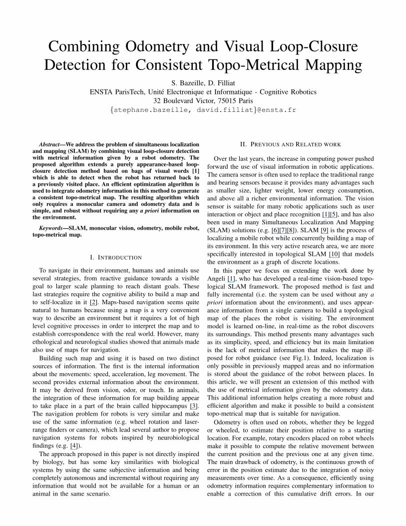
Combining Odometry and Visual Loop-Closure Detection for Consistent Topo-Metrical Mapping S. Bazeille, D. Filliat ENSTA ParisTech, Unit´ e Electronique et Informatique - Cognitive Robotics 32 Boulevard Victor, 75015 Paris {stephane.bazeille, david.filliat}@ensta.fr Abstract—We address the problem of simultaneous localization and mapping (SLAM) by combining visual loop-closure detection with metrical information given by a robot odometry. The proposed algorithm extends a purely appearance-based loop- closure detection method based on bags of visual words [1] which is able to detect when the robot has returned back to a previously visited place. An efficient optimization algorithm is used to integrate odometry information in this method to generate a consistent topo-metrical map. The resulting algorithm which only requires a monocular camera and odometry data and is simple, and robust without requiring any a priori information on the environment. Keywords—SLAM, monocular vision, odometry, mobile robot, topo-metrical map. I. I NTRODUCTION To navigate in their environment, humans and animals use several strategies, from reactive guidance towards a visible goal to larger scale planning to reach distant goals. These last strategies require the cognitive ability to build a map and to self-localize in it [2]. Maps-based navigation seems quite natural to humans because using a map is a very convenient way to describe an environment but it requires a lot of high level cognitive processes in order to interpret the map and to establish correspondence with the real world. However, many ethological and neurological studies showed that animals made also use of maps for navigation. Building such map and using it is based on two distinct sources of information. The first is the internal information about the movements: speed, acceleration, leg movement. The second provides external information about the environment. It may be derived from vision, odor, or touch. In animals, the integration of these information for map building appear to take place in a part of the brain called hippocampus [3]. The navigation problem for robots is very similar and make use of the same information (e.g. wheel rotation and laser- range finders or camera), which lead several author to propose navigation systems for robots inspired by neurobiological findings (e.g. [4]). The approach proposed in this paper is not directly inspired by biology, but has some key similarities with biological systems by using the same subjective information and being completely autonomous and incremental without requiring any information that would not be available for a human or an animal in the same scenario. II. PREVIOUS AND RELATED WORK Over the last years, the increase in computing power pushed forward the use of visual information in robotic applications. The camera sensor is often used to replace the traditional range and bearing sensors because it provides many advantages such as smaller size, lighter weight, lower energy consumption, and above all a richer environmental information. The vision sensor is suitable for many robotic applications such as user interaction or object and place recognition [1][5], and has also been used in many Simultaneous Localization And Mapping (SLAM) solutions (e.g. [6][7][8]). SLAM [9] is the process of localizing a mobile robot while concurrently building a map of its environment. In this very active research area, we are more specifically interested in topological SLAM [10] that models the environment as a graph of discrete locations. In this paper we focus on extending the work done by Angeli [1], who has developed a real-time vision-based topo- logical SLAM framework. The proposed method is fast and fully incremental (i.e. the system can be used without any a priori information about the environment), and uses appear- ance information from a single camera to build a topological map of the places the robot is visiting. The environment model is learned on-line, in real-time as the robot discovers its surroundings. This method presents many advantages such as its simplicity, speed, and efficiency but its main limitation is the lack of metrical information that makes the map ill- posed for robot guidance (see Fig.1). Indeed, localization is only possible in previously mapped areas and no information is stored about the guidance of the robot between places. In this article, we will present an extension of this method with the use of metrical information given by the odometry data. This additional information helps creating a more robust and efficient algorithm and make it possible to build a consistent topo-metrical map that is suitable for navigation. Odometry is often used on robots, whether they be legged or wheeled, to estimate their position relative to a starting location. For example, rotary encoders placed on robot wheels make it possible to compute the relative movement between the current position and the previous one at any given time. The main drawback of odometry, is the continuous growth of error in the position estimate due to the integration of noisy measurements over time. As a consequence, efficiently using odometry information requires complementary information to enable a correction of this cumulative drift errors. In our

Welcome message from author
This document is posted to help you gain knowledge. Please leave a comment to let me know what you think about it! Share it to your friends and learn new things together.
Transcript
Combining Odometry and Visual Loop-ClosureDetection for Consistent Topo-Metrical Mapping
S. Bazeille, D. FilliatENSTA ParisTech, Unite Electronique et Informatique - Cognitive Robotics
32 Boulevard Victor, 75015 Paris{stephane.bazeille, david.filliat}@ensta.fr
Abstract—We address the problem of simultaneous localizationand mapping (SLAM) by combining visual loop-closure detectionwith metrical information given by a robot odometry. Theproposed algorithm extends a purely appearance-based loop-closure detection method based on bags of visual words [1]which is able to detect when the robot has returned back toa previously visited place. An efficient optimization algorithm isused to integrate odometry information in this method to generatea consistent topo-metrical map. The resulting algorithm whichonly requires a monocular camera and odometry data and issimple, and robust without requiring any a priori information onthe environment.
Keywords—SLAM, monocular vision, odometry, mobile robot,topo-metrical map.
I. INTRODUCTION
To navigate in their environment, humans and animals useseveral strategies, from reactive guidance towards a visiblegoal to larger scale planning to reach distant goals. Theselast strategies require the cognitive ability to build a map andto self-localize in it [2]. Maps-based navigation seems quitenatural to humans because using a map is a very convenientway to describe an environment but it requires a lot of highlevel cognitive processes in order to interpret the map and toestablish correspondence with the real world. However, manyethological and neurological studies showed that animals madealso use of maps for navigation.
Building such map and using it is based on two distinctsources of information. The first is the internal informationabout the movements: speed, acceleration, leg movement. Thesecond provides external information about the environment.It may be derived from vision, odor, or touch. In animals,the integration of these information for map building appearto take place in a part of the brain called hippocampus [3].The navigation problem for robots is very similar and makeuse of the same information (e.g. wheel rotation and laser-range finders or camera), which lead several author to proposenavigation systems for robots inspired by neurobiologicalfindings (e.g. [4]).
The approach proposed in this paper is not directly inspiredby biology, but has some key similarities with biologicalsystems by using the same subjective information and beingcompletely autonomous and incremental without requiring anyinformation that would not be available for a human or ananimal in the same scenario.
II. PREVIOUS AND RELATED WORK
Over the last years, the increase in computing power pushedforward the use of visual information in robotic applications.The camera sensor is often used to replace the traditional rangeand bearing sensors because it provides many advantages suchas smaller size, lighter weight, lower energy consumption,and above all a richer environmental information. The visionsensor is suitable for many robotic applications such as userinteraction or object and place recognition [1][5], and has alsobeen used in many Simultaneous Localization And Mapping(SLAM) solutions (e.g. [6][7][8]). SLAM [9] is the process oflocalizing a mobile robot while concurrently building a map ofits environment. In this very active research area, we are morespecifically interested in topological SLAM [10] that modelsthe environment as a graph of discrete locations.
In this paper we focus on extending the work done byAngeli [1], who has developed a real-time vision-based topo-logical SLAM framework. The proposed method is fast andfully incremental (i.e. the system can be used without any apriori information about the environment), and uses appear-ance information from a single camera to build a topologicalmap of the places the robot is visiting. The environmentmodel is learned on-line, in real-time as the robot discoversits surroundings. This method presents many advantages suchas its simplicity, speed, and efficiency but its main limitationis the lack of metrical information that makes the map ill-posed for robot guidance (see Fig.1). Indeed, localization isonly possible in previously mapped areas and no informationis stored about the guidance of the robot between places. Inthis article, we will present an extension of this method withthe use of metrical information given by the odometry data.This additional information helps creating a more robust andefficient algorithm and make it possible to build a consistenttopo-metrical map that is suitable for navigation.
Odometry is often used on robots, whether they be leggedor wheeled, to estimate their position relative to a startinglocation. For example, rotary encoders placed on robot wheelsmake it possible to compute the relative movement betweenthe current position and the previous one at any given time.The main drawback of odometry, is the continuous growth oferror in the position estimate due to the integration of noisymeasurements over time. As a consequence, efficiently usingodometry information requires complementary information toenable a correction of this cumulative drift errors. In our
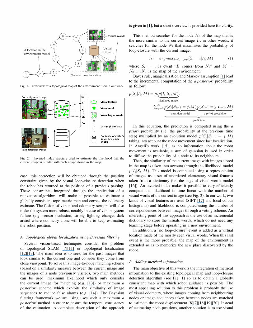
Fig. 1. Overview of a topological map of the environment used in our work.
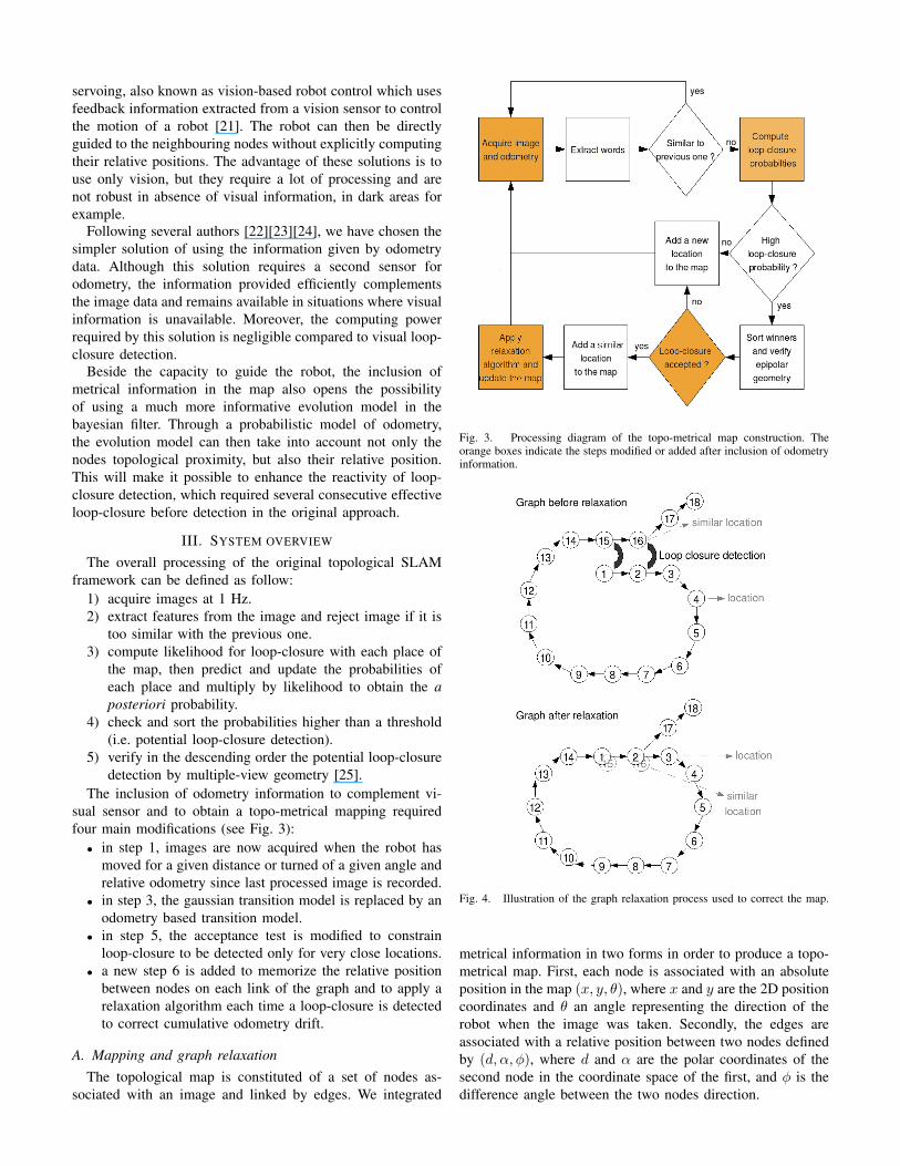
Fig. 2. Inverted index structure used to estimate the likelihood that thecurrent image is similar with each image stored in the map.
case, this correction will be obtained through the positionconstraint given by the visual loop-closure detection whenthe robot has returned at the position of a previous passing.These constraints, integrated through the application of arelaxation algorithm, will make it possible to estimate aglobally consistent topo-metric map and correct the odometryestimate. The fusion of vision and odometry sensors will alsomake the system more robust, notably in case of vision systemfailure (e.g. sensor occlusion, strong lighting change, darkareas) where odometry alone will be able to keep estimatingthe robot position.
A. Topological global localization using Bayesian filtering
Several vision-based techniques consider the problemof topological SLAM [7][11] or topological localization[12][13]. The main idea is to seek for the past images thatlook similar to the current one and consider they come fromclose viewpoint. To solve this image-to-node matching scheme(based on a similarity measure between the current image andthe images of a node previously visited), two main methodscan be used: maximum likelihood which only considerthe current image for matching (e.g. [13]) or maximum aposteriori scheme which exploits the similarity of imagesequences to reduce false alarms (e.g. [14]). The Bayesianfiltering framework we are using uses such a maximum aposteriori method in order to ensure the temporal consistencyof the estimation. A complete description of the approach
is given in [1], but a short overview is provided here for clarity.
This method searches for the node Ni of the map that isthe more similar to the current image It, in other words, itsearches for the node Ni that maximises the probability ofloop-closure with the current image:
Ni = argmaxi=0,...,np(St = i|It,M) (1)
where St = i is event “It comes from Ni” and M =N0, ..., Nn is the map of the environment.
Bayes rule, marginalization and Markov assumption [1] leadto the incremental computation of the a posteriori probabilityas follow:
p(St|It,M) = η. p(It|St,M)︸ ︷︷ ︸likelihood model
.
∑nj=0 p(St|St−1 = j,M)︸ ︷︷ ︸
transition model
p(St−1 = j|It−1,M)︸ ︷︷ ︸a priori probability︸ ︷︷ ︸
prediction
In this equation, the prediction is computed using the apriori probability (i.e. the probability at the previous timestep) multiplied by an evolution model p(St|St−1 = j,M)taking into account the robot movement since last localization.In Angeli’s work [15], as no information about the robotmovement is available, a sum of gaussian is used in orderto diffuse the probability of a node to its neighbours.
Then, the similarity of the current image with images storedin the map is taken into account through the likelihood modelp(It|St,M). This model is computed using a representationof images as a set of unordered elementary visual featurestaken from a dictionary (i.e. the bags of visual words model[16]). An inverted index makes it possible to very efficientlycompute this likelihood in time linear with the number ofvisual words of the current image (see Fig. 2). In our work, twokinds of visual features are used (SIFT [17] and local colourhistograms) and likelihood is computed using the number ofcorrespondences between images through a voting scheme. Aninteresting point of this approach is the use of an incrementaldictionary to store the visuals words, which do not need anylearning stage before operating in a new environment.
In addition, a ”no loop-closure” event is added as a virtuallocation made of the mostly seen visual words. When this lastevent is the more probable, the map of the environment isextended so as to memorize the new place discovered by therobot.
B. Adding metrical information
The main objective of this work is the integration of metricalinformation to the existing topological map and loop-closuredetection algorithm (see Fig. 1) so as to obtain a globallyconsistent map with which robot guidance is possible. Themost appealing solution to this problem is probably the useof visual odometry, where images coming from neighbouringnodes or image sequences taken between nodes are matchedto estimate the robot displacement [8][7][18][19][20]. Insteadof estimating node positions, another solution is to use visual
servoing, also known as vision-based robot control which usesfeedback information extracted from a vision sensor to controlthe motion of a robot [21]. The robot can then be directlyguided to the neighbouring nodes without explicitly computingtheir relative positions. The advantage of these solutions is touse only vision, but they require a lot of processing and arenot robust in absence of visual information, in dark areas forexample.
Following several authors [22][23][24], we have chosen thesimpler solution of using the information given by odometrydata. Although this solution requires a second sensor forodometry, the information provided efficiently complementsthe image data and remains available in situations where visualinformation is unavailable. Moreover, the computing powerrequired by this solution is negligible compared to visual loop-closure detection.
Beside the capacity to guide the robot, the inclusion ofmetrical information in the map also opens the possibilityof using a much more informative evolution model in thebayesian filter. Through a probabilistic model of odometry,the evolution model can then take into account not only thenodes topological proximity, but also their relative position.This will make it possible to enhance the reactivity of loop-closure detection, which required several consecutive effectiveloop-closure before detection in the original approach.
III. SYSTEM OVERVIEW
The overall processing of the original topological SLAMframework can be defined as follow:
1) acquire images at 1 Hz.2) extract features from the image and reject image if it is
too similar with the previous one.3) compute likelihood for loop-closure with each place of
the map, then predict and update the probabilities ofeach place and multiply by likelihood to obtain the aposteriori probability.
4) check and sort the probabilities higher than a threshold(i.e. potential loop-closure detection).
5) verify in the descending order the potential loop-closuredetection by multiple-view geometry [25].
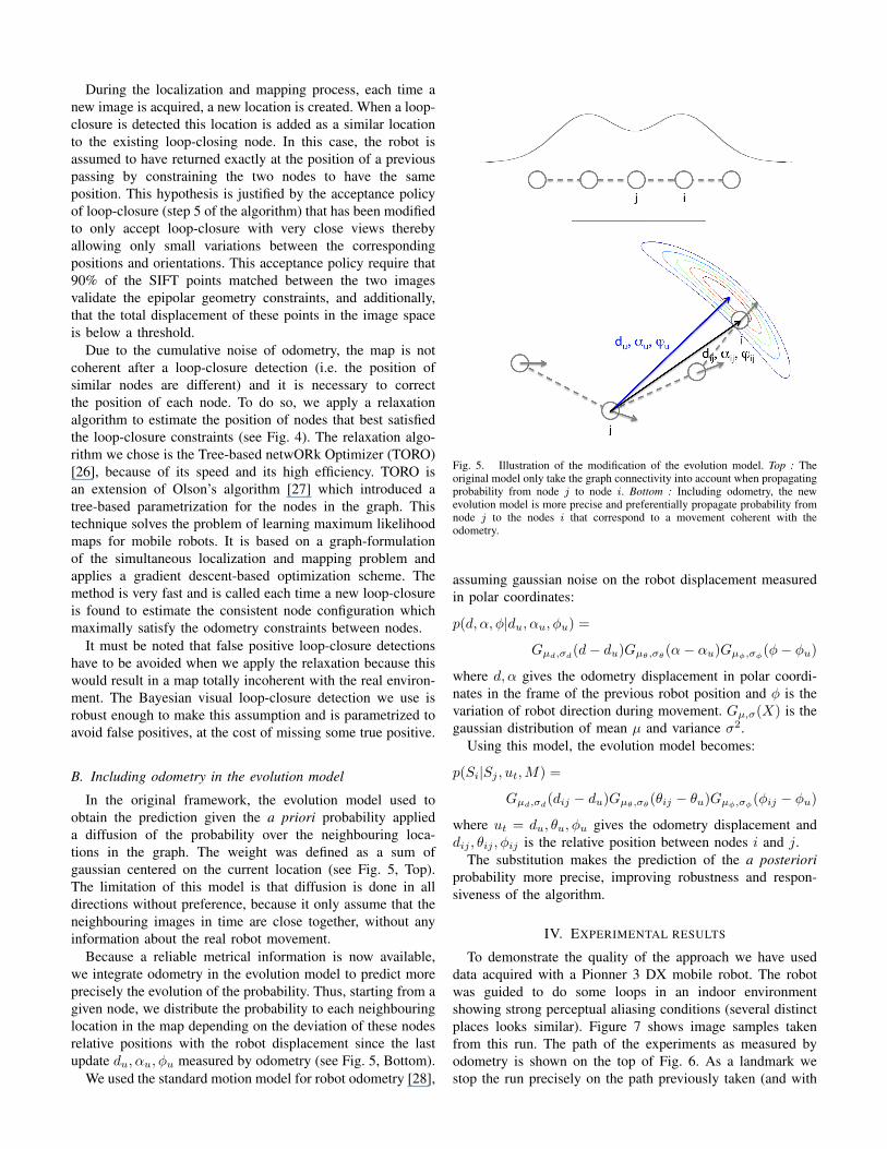
The inclusion of odometry information to complement vi-sual sensor and to obtain a topo-metrical mapping requiredfour main modifications (see Fig. 3):• in step 1, images are now acquired when the robot has
moved for a given distance or turned of a given angle andrelative odometry since last processed image is recorded.
• in step 3, the gaussian transition model is replaced by anodometry based transition model.
• in step 5, the acceptance test is modified to constrainloop-closure to be detected only for very close locations.
• a new step 6 is added to memorize the relative positionbetween nodes on each link of the graph and to apply arelaxation algorithm each time a loop-closure is detectedto correct cumulative odometry drift.
A. Mapping and graph relaxationThe topological map is constituted of a set of nodes as-
sociated with an image and linked by edges. We integrated
Fig. 3. Processing diagram of the topo-metrical map construction. Theorange boxes indicate the steps modified or added after inclusion of odometryinformation.
Fig. 4. Illustration of the graph relaxation process used to correct the map.
metrical information in two forms in order to produce a topo-metrical map. First, each node is associated with an absoluteposition in the map (x, y, θ), where x and y are the 2D positioncoordinates and θ an angle representing the direction of therobot when the image was taken. Secondly, the edges areassociated with a relative position between two nodes definedby (d, α, φ), where d and α are the polar coordinates of thesecond node in the coordinate space of the first, and φ is thedifference angle between the two nodes direction.
During the localization and mapping process, each time anew image is acquired, a new location is created. When a loop-closure is detected this location is added as a similar locationto the existing loop-closing node. In this case, the robot isassumed to have returned exactly at the position of a previouspassing by constraining the two nodes to have the sameposition. This hypothesis is justified by the acceptance policyof loop-closure (step 5 of the algorithm) that has been modifiedto only accept loop-closure with very close views therebyallowing only small variations between the correspondingpositions and orientations. This acceptance policy require that90% of the SIFT points matched between the two imagesvalidate the epipolar geometry constraints, and additionally,that the total displacement of these points in the image spaceis below a threshold.
Due to the cumulative noise of odometry, the map is notcoherent after a loop-closure detection (i.e. the position ofsimilar nodes are different) and it is necessary to correctthe position of each node. To do so, we apply a relaxationalgorithm to estimate the position of nodes that best satisfiedthe loop-closure constraints (see Fig. 4). The relaxation algo-rithm we chose is the Tree-based netwORk Optimizer (TORO)[26], because of its speed and its high efficiency. TORO isan extension of Olson’s algorithm [27] which introduced atree-based parametrization for the nodes in the graph. Thistechnique solves the problem of learning maximum likelihoodmaps for mobile robots. It is based on a graph-formulationof the simultaneous localization and mapping problem andapplies a gradient descent-based optimization scheme. Themethod is very fast and is called each time a new loop-closureis found to estimate the consistent node configuration whichmaximally satisfy the odometry constraints between nodes.
It must be noted that false positive loop-closure detectionshave to be avoided when we apply the relaxation because thiswould result in a map totally incoherent with the real environ-ment. The Bayesian visual loop-closure detection we use isrobust enough to make this assumption and is parametrized toavoid false positives, at the cost of missing some true positive.
B. Including odometry in the evolution model
In the original framework, the evolution model used toobtain the prediction given the a priori probability applieda diffusion of the probability over the neighbouring loca-tions in the graph. The weight was defined as a sum ofgaussian centered on the current location (see Fig. 5, Top).The limitation of this model is that diffusion is done in alldirections without preference, because it only assume that theneighbouring images in time are close together, without anyinformation about the real robot movement.
Because a reliable metrical information is now available,we integrate odometry in the evolution model to predict moreprecisely the evolution of the probability. Thus, starting from agiven node, we distribute the probability to each neighbouringlocation in the map depending on the deviation of these nodesrelative positions with the robot displacement since the lastupdate du, αu, φu measured by odometry (see Fig. 5, Bottom).
We used the standard motion model for robot odometry [28],
Fig. 5. Illustration of the modification of the evolution model. Top : Theoriginal model only take the graph connectivity into account when propagatingprobability from node j to node i. Bottom : Including odometry, the newevolution model is more precise and preferentially propagate probability fromnode j to the nodes i that correspond to a movement coherent with theodometry.
assuming gaussian noise on the robot displacement measuredin polar coordinates:
p(d, α, φ|du, αu, φu) =
Gµd,σd(d− du)Gµθ,σθ (α− αu)Gµφ,σφ(φ− φu)
where d, α gives the odometry displacement in polar coordi-nates in the frame of the previous robot position and φ is thevariation of robot direction during movement. Gµ,σ(X) is thegaussian distribution of mean µ and variance σ2.
Using this model, the evolution model becomes:
p(Si|Sj , ut,M) =
Gµd,σd(dij − du)Gµθ,σθ (θij − θu)Gµφ,σφ(φij − φu)
where ut = du, θu, φu gives the odometry displacement anddij , θij , φij is the relative position between nodes i and j.
The substitution makes the prediction of the a posterioriprobability more precise, improving robustness and respon-siveness of the algorithm.
IV. EXPERIMENTAL RESULTS
To demonstrate the quality of the approach we have useddata acquired with a Pionner 3 DX mobile robot. The robotwas guided to do some loops in an indoor environmentshowing strong perceptual aliasing conditions (several distinctplaces looks similar). Figure 7 shows image samples takenfrom this run. The path of the experiments as measured byodometry is shown on the top of Fig. 6. As a landmark westop the run precisely on the path previously taken (and with
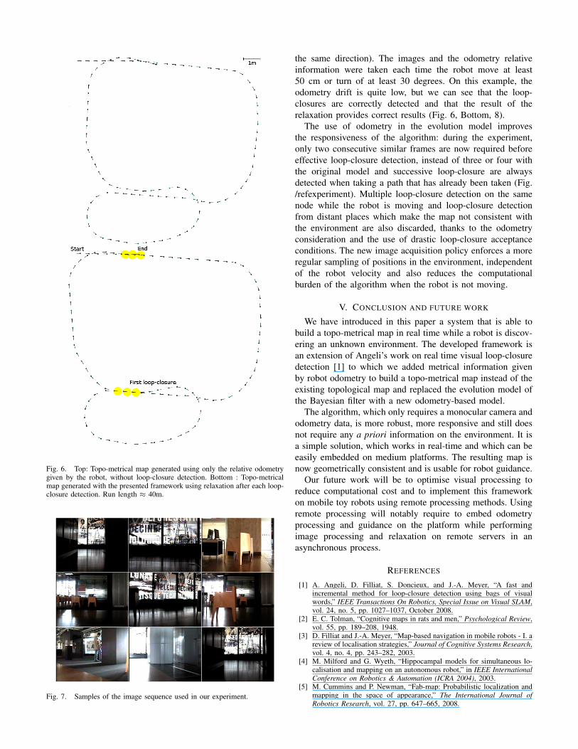
Fig. 6. Top: Topo-metrical map generated using only the relative odometrygiven by the robot, without loop-closure detection. Bottom : Topo-metricalmap generated with the presented framework using relaxation after each loop-closure detection. Run length ≈ 40m.
Fig. 7. Samples of the image sequence used in our experiment.
the same direction). The images and the odometry relativeinformation were taken each time the robot move at least50 cm or turn of at least 30 degrees. On this example, theodometry drift is quite low, but we can see that the loop-closures are correctly detected and that the result of therelaxation provides correct results (Fig. 6, Bottom, 8).
The use of odometry in the evolution model improvesthe responsiveness of the algorithm: during the experiment,only two consecutive similar frames are now required beforeeffective loop-closure detection, instead of three or four withthe original model and successive loop-closure are alwaysdetected when taking a path that has already been taken (Fig./refexperiment). Multiple loop-closure detection on the samenode while the robot is moving and loop-closure detectionfrom distant places which make the map not consistent withthe environment are also discarded, thanks to the odometryconsideration and the use of drastic loop-closure acceptanceconditions. The new image acquisition policy enforces a moreregular sampling of positions in the environment, independentof the robot velocity and also reduces the computationalburden of the algorithm when the robot is not moving.
V. CONCLUSION AND FUTURE WORK
We have introduced in this paper a system that is able tobuild a topo-metrical map in real time while a robot is discov-ering an unknown environment. The developed framework isan extension of Angeli’s work on real time visual loop-closuredetection [1] to which we added metrical information givenby robot odometry to build a topo-metrical map instead of theexisting topological map and replaced the evolution model ofthe Bayesian filter with a new odometry-based model.
The algorithm, which only requires a monocular camera andodometry data, is more robust, more responsive and still doesnot require any a priori information on the environment. It isa simple solution, which works in real-time and which can beeasily embedded on medium platforms. The resulting map isnow geometrically consistent and is usable for robot guidance.
Our future work will be to optimise visual processing toreduce computational cost and to implement this frameworkon mobile toy robots using remote processing methods. Usingremote processing will notably require to embed odometryprocessing and guidance on the platform while performingimage processing and relaxation on remote servers in anasynchronous process.
REFERENCES
[1] A. Angeli, D. Filliat, S. Doncieux, and J.-A. Meyer, “A fast andincremental method for loop-closure detection using bags of visualwords,” IEEE Transactions On Robotics, Special Issue on Visual SLAM,vol. 24, no. 5, pp. 1027–1037, October 2008.
[2] E. C. Tolman, “Cognitive maps in rats and men,” Psychological Review,vol. 55, pp. 189–208, 1948.
[3] D. Filliat and J.-A. Meyer, “Map-based navigation in mobile robots - I. areview of localisation strategies,” Journal of Cognitive Systems Research,vol. 4, no. 4, pp. 243–282, 2003.
[4] M. Milford and G. Wyeth, “Hippocampal models for simultaneous lo-calisation and mapping on an autonomous robot,” in IEEE InternationalConference on Robotics & Automation (ICRA 2004), 2003.
[5] M. Cummins and P. Newman, “Fab-map: Probabilistic localization andmapping in the space of appearance,” The International Journal ofRobotics Research, vol. 27, pp. 647–665, 2008.
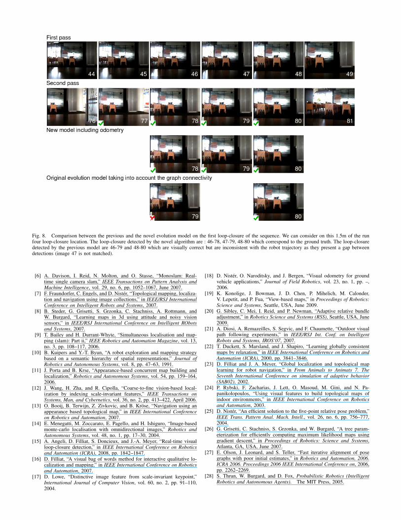
Fig. 8. Comparison between the previous and the novel evolution model on the first loop-closure of the sequence. We can consider on this 1.5m of the runfour loop-closure location. The loop-closure detected by the novel algorithm are : 46-78, 47-79, 48-80 which correspond to the ground truth. The loop-closuredetected by the previous model are 46-79 and 48-80 which are visually correct but are inconsistent with the robot trajectory as they present a gap betweendetections (image 47 is not matched).
[6] A. Davison, I. Reid, N. Molton, and O. Stasse, “Monoslam: Real-time single camera slam,” IEEE Transactions on Pattern Analysis andMachine Intelligence, vol. 29, no. 6, pp. 1052–1067, June 2007.
[7] F. Fraundorfer, C. Engels, and D. Nister, “Topological mapping, localiza-tion and navigation using image collections,” in IEEE/RSJ InternationalConference on Intelligent Robots and Systems, 2007.
[8] B. Steder, G. Grisetti, S. Grzonka, C. Stachniss, A. Rottmann, andW. Burgard, “Learning maps in 3d using attitude and noisy visionsensors,” in IEEE/RSJ International Conference on Intelligent RObotsand Systems, 2007.
[9] T. Bailey and H. Durrant-Whyte, “Simultaneous localisation and map-ping (slam): Part ii,” IEEE Robotics and Automation Magazine, vol. 13,no. 3, pp. 108–117, 2006.
[10] B. Kuipers and Y.-T. Byun, “A robot exploration and mapping strategybased on a semantic hierarchy of spatial representations,” Journal ofRobotics and Autonomous Systems, vol. 8, pp. 47–63, 1991.
[11] J. Porta and B. Krse, “Appearance-based concurrent map building andlocalization,” Robotics and Autonomous Systems, vol. 54, pp. 159–164,2006.
[12] J. Wang, H. Zha, and R. Cipolla, “Coarse-to-fine vision-based local-ization by indexing scale-invariant features,” IEEE Transactions onSystems, Man, and Cybernetics, vol. 36, no. 2, pp. 413–422, April 2006.
[13] O. Booij, B. Terwijn, Z. Zivkovic, and B. Krose, “Navigation using anappearance based topological map,” in IEEE International Conferenceon Robotics and Automation, 2007.
[14] E. Menegatti, M. Zoccarato, E. Pagello, and H. Ishiguro, “Image-basedmonte-carlo localisation with omnidirectional images,” Robotics andAutonomous Systems, vol. 48, no. 1, pp. 17–30, 2004.
[15] A. Angeli, D. Filliat, S. Doncieux, and J.-A. Meyer, “Real-time visualloop-closure detection,” in IEEE International Conference on Roboticsand Automation (ICRA), 2008, pp. 1842–1847.
[16] D. Filliat, “A visual bag of words method for interactive qualitative lo-calization and mapping,” in IEEE International Conference on Roboticsand Automation, 2007.
[17] D. Lowe, “Distinctive image feature from scale-invariant keypoint,”International Journal of Computer Vision, vol. 60, no. 2, pp. 91–110,2004.
[18] D. Nister, O. Naroditsky, and J. Bergen, “Visual odometry for groundvehicle applications,” Journal of Field Robotics, vol. 23, no. 1, pp. –,2006.
[19] K. Konolige, J. Bowman, J. D. Chen, P. Mihelich, M. Calonder,V. Lepetit, and P. Fua, “View-based maps,” in Proceedings of Robotics:Science and Systems, Seattle, USA, June 2009.
[20] G. Sibley, C. Mei, I. Reid, and P. Newman, “Adaptive relative bundleadjustment,” in Robotics Science and Systems (RSS), Seattle, USA, June2009.
[21] A. Diosi, A. Remazeilles, S. Segvic, and F. Chaumette, “Outdoor visualpath following experiments,” in IEEE/RSJ Int. Conf. on IntelligentRobots and Systems, IROS’07, 2007.
[22] T. Duckett, S. Marsland, and J. Shapiro, “Learning globally consistentmaps by relaxation,” in IEEE International Conference on Robotics andAutomation (ICRA), 2000, pp. 3841–3846.
[23] D. Filliat and J. A. Meyer, “Global localization and topological maplearning for robot navigation,” in From Animals to Animats 7. TheSeventh International Conference on simulation of adaptive behavior(SAB02), 2002.
[24] P. Rybski, F. Zacharias, J. Lett, O. Masoud, M. Gini, and N. Pa-panikolopoulos, “Using visual features to build topological maps ofindoor environments,” in IEEE International Conference on Roboticsand Automation, 2003.
[25] D. Nister, “An efficient solution to the five-point relative pose problem,”IEEE Trans. Pattern Anal. Mach. Intell., vol. 26, no. 6, pp. 756–777,2004.
[26] G. Grisetti, C. Stachniss, S. Grzonka, and W. Burgard, “A tree param-eterization for efficiently computing maximum likelihood maps usinggradient descent,” in Proceedings of Robotics: Science and Systems,Atlanta, GA, USA, June 2007.
[27] E. Olson, J. Leonard, and S. Teller, “Fast iterative alignment of posegraphs with poor initial estimates,” in Robotics and Automation, 2006.ICRA 2006. Proceedings 2006 IEEE International Conference on, 2006,pp. 2262–2269.
[28] S. Thrun, W. Burgard, and D. Fox, Probabilistic Robotics (IntelligentRobotics and Autonomous Agents). The MIT Press, 2005.
Related Documents