ATMS 350 Model Output Statistics Transforming model output into useful forecast parameters

CC Hennon ATMS 350 UNC Asheville Model Output Statistics Transforming model output into useful forecast parameters.
Dec 14, 2015
Welcome message from author
This document is posted to help you gain knowledge. Please leave a comment to let me know what you think about it! Share it to your friends and learn new things together.
Transcript

CC Hennon ATMS 350 UNC Asheville
Model Output Statistics
Transforming model output into useful forecast parameters

CC Hennon ATMS 350 UNC Asheville
Forecast Output United States (FOUS)
• Raw model output (e.g. from NGM, NAM, GFS)
• Only includes such parameters as– Mean relative humidity in certain layers– Vertical velocity at 700 mb– 1000-500 mb thickness– Temperature at a few model layers
• Not incredibly useful for surface forecasting applications
CC Hennon ATMS 350 UNC Asheville
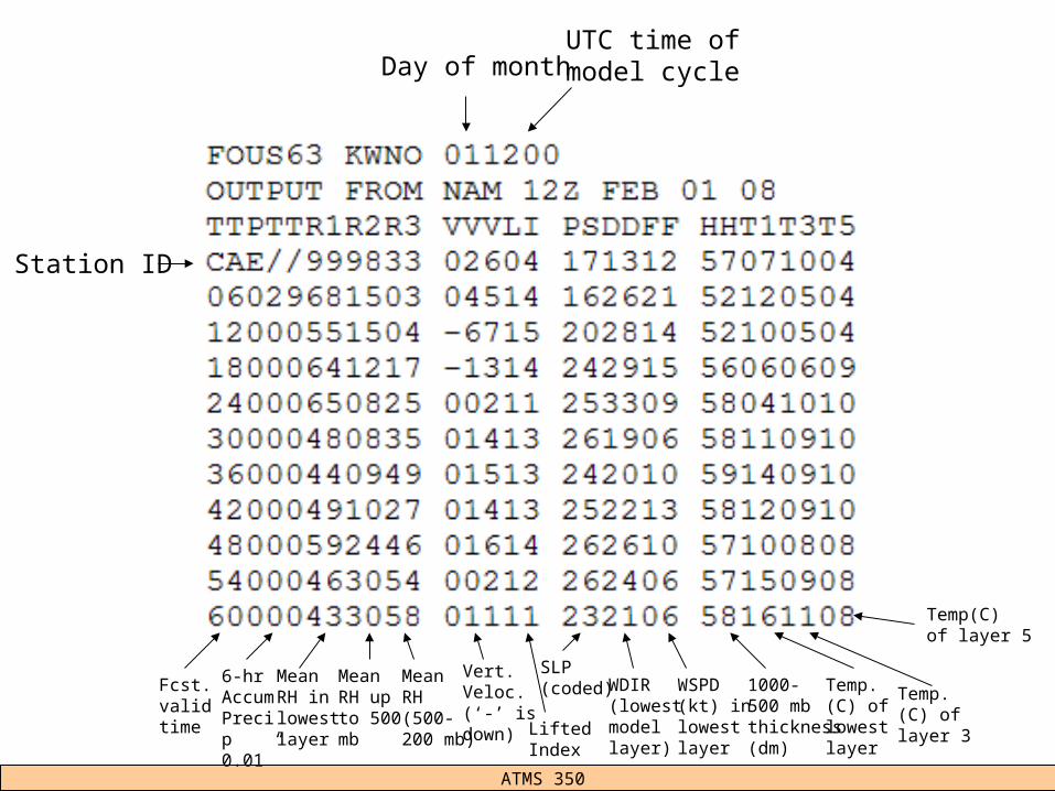
Station ID
Day of monthUTC time ofmodel cycle
Fcst. valid time
6-hr AccumPrecip0.01”
MeanRH inlowestlayer
MeanRH upto 500mb
MeanRH (500-200 mb)
LiftedIndex
SLP(coded) WDIR
(lowestmodellayer)
WSPD(kt) inlowestlayer
Vert.Veloc.(‘-’ isdown)
1000-500 mbthickness(dm)
Temp.(C) of lowestlayer
Temp.(C) of layer 3
Temp(C)of layer 5
CC Hennon ATMS 350 UNC Asheville
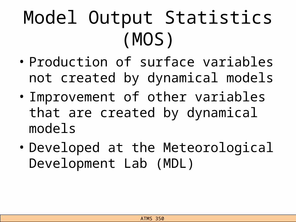
Model Output Statistics (MOS)
• Production of surface variables not created by dynamical models
• Improvement of other variables that are created by dynamical models
• Developed at the Meteorological Development Lab (MDL)

CC Hennon ATMS 350 UNC Asheville
How MOS Works
• Relates model output variables to common forecast variables (e.g. surface temperature, dew point, precipitation) through statistical techniques
• Analyze past correlations between model outputs and forecast variables– ‘Analog’ method of forecasting
• MOS is produced from NGM, NAM, and GFS models
CC Hennon ATMS 350 UNC Asheville
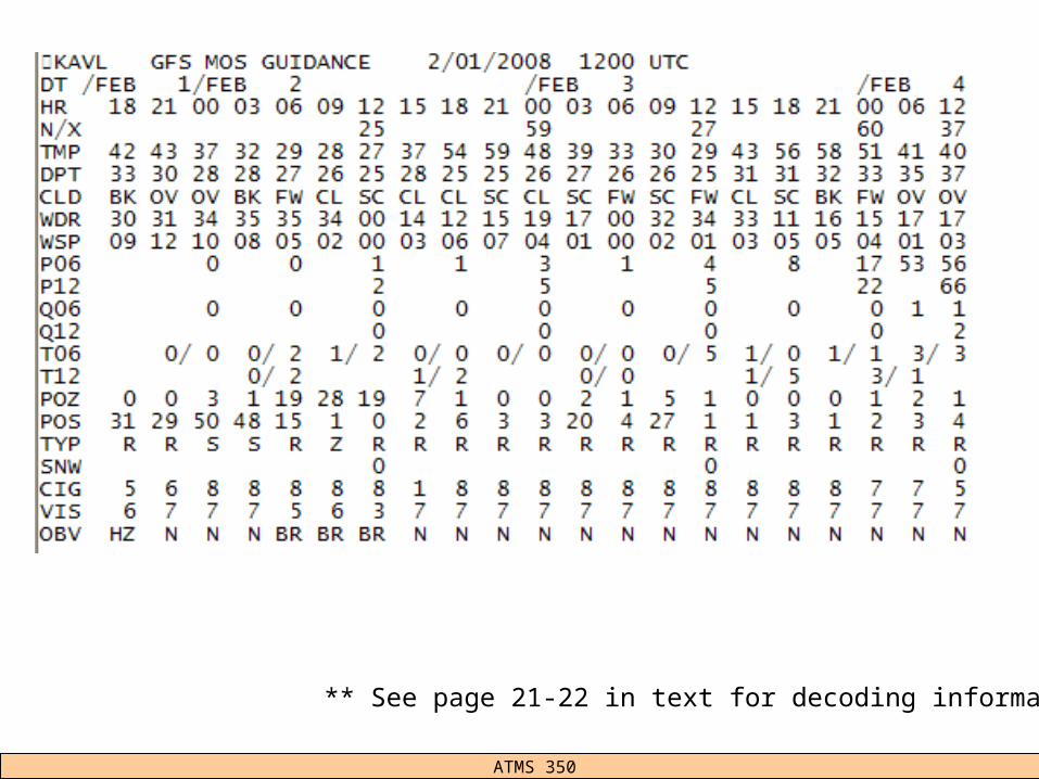
** See page 21-22 in text for decoding information
CC Hennon ATMS 350 UNC Asheville
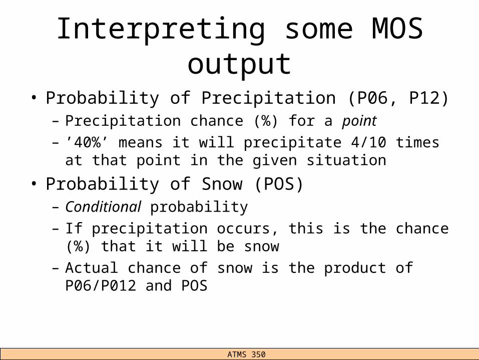
Interpreting some MOS output
• Probability of Precipitation (P06, P12)– Precipitation chance (%) for a point– ’40%’ means it will precipitate 4/10 times at that point
in the given situation
• Probability of Snow (POS)– Conditional probability– If precipitation occurs, this is the chance (%) that it will
be snow– Actual chance of snow is the product of P06/P012
and POS

CC Hennon ATMS 350 UNC Asheville
CC Hennon ATMS 350 UNC Asheville
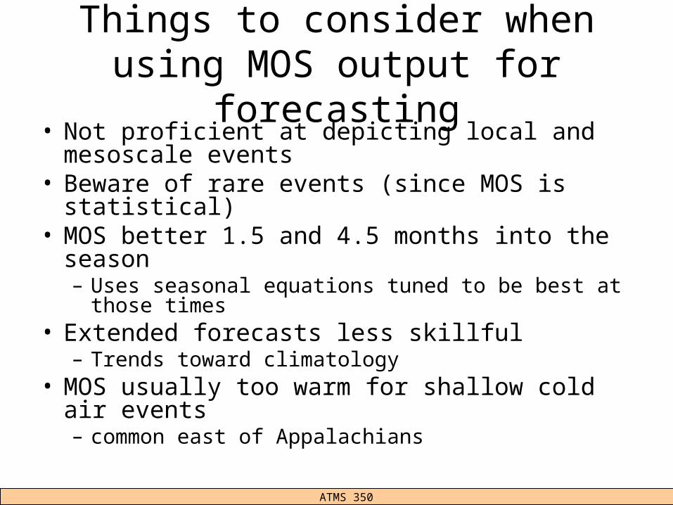
Things to consider when using MOS output for forecasting
• Not proficient at depicting local and mesoscale events
• Beware of rare events (since MOS is statistical)• MOS better 1.5 and 4.5 months into the season
– Uses seasonal equations tuned to be best at those times
• Extended forecasts less skillful– Trends toward climatology
• MOS usually too warm for shallow cold air events– common east of Appalachians
CC Hennon ATMS 350 UNC Asheville
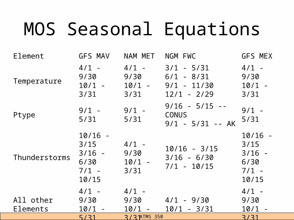
MOS Seasonal EquationsElement GFS MAV NAM MET NGM FWC GFS MEX
Temperature4/1 - 9/3010/1 - 3/31
4/1 - 9/3010/1 - 3/31
3/1 - 5/316/1 - 8/319/1 - 11/3012/1 - 2/29
4/1 - 9/3010/1 - 3/31
Ptype 9/1 - 5/31 9/1 - 5/319/16 - 5/15 -- CONUS9/1 - 5/31 -- AK
9/1 - 5/31
Thunderstorms10/16 - 3/153/16 - 6/307/1 - 10/15
4/1 - 9/3010/1 - 3/31
10/16 - 3/153/16 - 6/307/1 - 10/15
10/16 - 3/153/16 - 6/307/1 - 10/15
All other Elements4/1 - 9/3010/1 - 5/31
4/1 - 9/3010/1 - 3/31
4/1 - 9/3010/1 - 3/31
4/1 - 9/3010/1 - 3/31

CC Hennon ATMS 350 UNC Asheville
CC Hennon ATMS 350 UNC Asheville
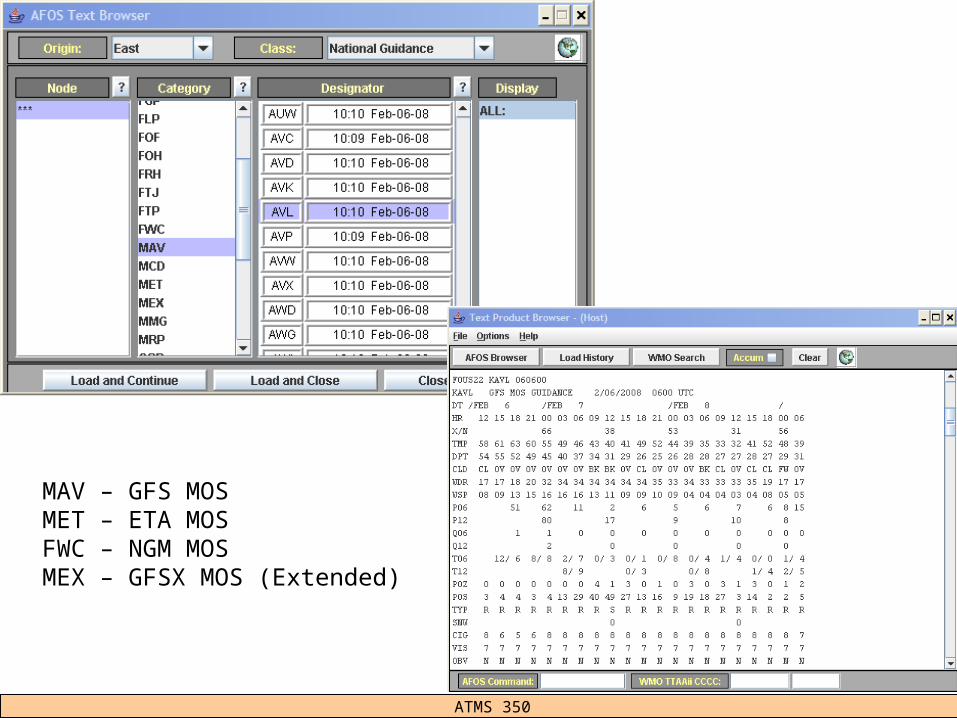
MAV – GFS MOSMET – ETA MOSFWC – NGM MOSMEX – GFSX MOS (Extended)

CC Hennon ATMS 350 UNC Asheville
MOS Links
• Changes/updates– http://www.nws.noaa.gov/mdl/synop/changes.php
• FAQ– http://www.nws.noaa.gov/mdl/synop/faq.php
• Definition of MOS elements/acronyms– http://www.nws.noaa.gov/mdl/synop/avnacronym.htm
• MOS performance (WRF vs. GFS vs. NAM)– http://www.nws.noaa.gov/mdl/synop/wrfmoseval.htm
• MDL– http://www.nws.noaa.gov/tdl/
Related Documents