Welcome message from author
This document is posted to help you gain knowledge. Please leave a comment to let me know what you think about it! Share it to your friends and learn new things together.
Transcript

CATAHOULA PARISH HAZARD MITIGATION PLAN i
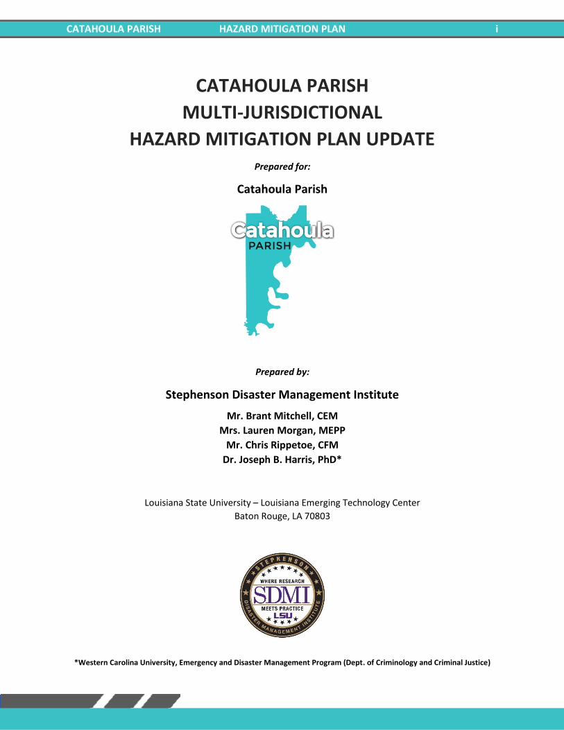
CATAHOULA PARISH
MULTI-JURISDICTIONAL
HAZARD MITIGATION PLAN UPDATE Prepared for:
Catahoula Parish
Prepared by:
Stephenson Disaster Management Institute
Mr. Brant Mitchell, CEM
Mrs. Lauren Morgan, MEPP
Mr. Chris Rippetoe, CFM
Dr. Joseph B. Harris, PhD*
Louisiana State University – Louisiana Emerging Technology Center
Baton Rouge, LA 70803
*Western Carolina University, Emergency and Disaster Management Program (Dept. of Criminology and Criminal Justice)

CATAHOULA PARISH HAZARD MITIGATION PLAN ii
***This Page Left Intentionally Blank***
CATAHOULA PARISH HAZARD MITIGATION PLAN iii
ACKNOWLEDGMENTS
This 2021 Catahoula Parish Hazard Mitigation Plan Update was coordinated by the Catahoula Parish
Hazard Mitigation Plan Update Steering Committee, in collaboration with community stakeholders and
the general public. The participating jurisdictions are made up of the following communities:
Catahoula Parish
Village of Harrisonburg
Town of Jonesville
Village of Sicily Island
Special thanks is directed to all of those who assisted in contributing their expertise and feedback on this
document, especially the Catahoula Parish Office of Homeland Security and Emergency Management.
These combined efforts have made this project possible. The Catahoula Parish Steering Committee
consists of the following individuals, who are credited in the creation of this document:
Ellis Boothe Catahoula Parish OHSEP
Patti Mizell Catahoula Parish Police Jury
Anlynne Gardner Town of Jonesville
Patricia Hefner Village of Harrisonburg
Walter Krause Village of Sicily Island
The 2021 Catahoula Parish Hazard Mitigation Plan Update was written by the Stephenson Disaster
Management Institute, Louisiana State University. Further comments should be directed to the Catahoula
Parish Office of Homeland Security and Emergency Preparedness: 301 Bushley St., Harrisonburg, LA
71340.
CATAHOULA PARISH HAZARD MITIGATION PLAN iv
Contents 1. Introduction ............................................................................................................................1-1
Geography, Population and Economy ................................................................................................... 1-2
Geography .......................................................................................................................................... 1-2
Population .......................................................................................................................................... 1-4
Economy ............................................................................................................................................. 1-4
Hazard Mitigation .................................................................................................................................. 1-5
General Strategy .................................................................................................................................... 1-6
2021 Plan Update ................................................................................................................................... 1-7
2. Hazard Identification and Parish-Wide Risk Assessment ...........................................................2-1
Prevalent Hazards to the Community .................................................................................................... 2-1
Previous Occurrences ............................................................................................................................ 2-2
Probability of Future Hazard Events ...................................................................................................... 2-3
Inventory of Assets for the Entire Parish ................................................................................................ 2-4
Essential Facilities of the Parish .............................................................................................................. 2-5
Future Development Trends ................................................................................................................ 2-10
Future Hazard Impacts ......................................................................................................................... 2-11
Assessing Vulnerability Overview ......................................................................................................... 2-11
Quantitative Methodology .............................................................................................................. 2-12
Qualitative Methodology ................................................................................................................. 2-12
Priority Risk Index and Hazard Risk .................................................................................................. 2-12
Land Use ............................................................................................................................................... 2-14
Hazard Identification ............................................................................................................................ 2-16
Drought ............................................................................................................................................ 2-16
Flooding ............................................................................................................................................ 2-19
Thunderstorms ................................................................................................................................. 2-34
Tornadoes ........................................................................................................................................ 2-45
Tropical Cyclones ............................................................................................................................. 2-52
Winter Weather ............................................................................................................................... 2-63
3. Capability Assessment .............................................................................................................3-1
Policies, Plans and Programs ................................................................................................................. 3-1
Building Codes, Permitting, Land Use Planning and Ordinances ....................................................... 3-2
Administration, Technical, and Financial ............................................................................................... 3-2
Education and Outreach ........................................................................................................................ 3-4
Flood Insurance and Community Rating System ................................................................................... 3-4
CATAHOULA PARISH HAZARD MITIGATION PLAN v
NFIP Worksheets .................................................................................................................................... 3-6
4. Mitigation Strategy ..................................................................................................................4-1
Introduction ........................................................................................................................................... 4-1
Goals ...................................................................................................................................................... 4-1
2021 Mitigation Actions and Update on Previous Plan Actions ............................................................ 4-2
Unincorporated Catahoula Parish Mitigation Actions ....................................................................... 4-3
Village of Harrisonburg Mitigation Actions ...................................................................................... 4-19
Town of Jonesville Mitigation Actions ............................................................................................. 4-35
Village of Sicily Island Mitigation Actions ........................................................................................ 4-51
Action Prioritization ............................................................................................................................. 4-67
Appendix A: Planning Process ......................................................................................................... A-1
Purpose ................................................................................................................................................. A-1
The Catahoula Parish Hazard Mitigation Plan Update .......................................................................... A-1
Planning ................................................................................................................................................ A-2
Coordination ......................................................................................................................................... A-2
Neighboring Community, Local and Regional Planning Process Involvement ..................................... A-2
Program Integration .............................................................................................................................. A-3
Meeting Documentation and Public Outreach Activities ..................................................................... A-4
Meeting #1: Hazard Mitigation Plan Update Kick-Off....................................................................... A-4
Meeting #2: Steering Committee Meeting (Planning Process) ......................................................... A-5
Meeting #3: Risk Assessment Review with Steering Committee ..................................................... A-5
Meeting #4: Public Meeting .............................................................................................................. A-5
Outreach Activity #1: Public Opinion Survey .................................................................................... A-6
Appendix B: Plan Maintenance ....................................................................................................... B-1
Purpose .................................................................................................................................................. B-1
Monitoring, Evaluating, and Updating the Plan ..................................................................................... B-1
Responsible Parties ................................................................................................................................ B-1
Methods for Monitoring and Evaluating the Plan and Plan Evaluation Criteria .................................... B-1
2021 Plan Version Plan Method and Schedule Evaluation .................................................................... B-3
Incorporation into Existing Planning Programs ..................................................................................... B-3
Continued Public Participation .............................................................................................................. B-5
Appendix C: Critical Facilities .......................................................................................................... C-1
Critical Facilities within the Catahoula Parish Planning Area................................................................. C-1
Appendix D: Plan Adoption ............................................................................................................ D-1
Catahoula Parish ................................................................................................................................... D-1
CATAHOULA PARISH HAZARD MITIGATION PLAN vi
Village of Harrisonburg ......................................................................................................................... D-2
Town of Jonesville ................................................................................................................................. D-3
Village of Sicily Island ............................................................................................................................ D-5
Appendix E: State Required Worksheets .......................................................................................... E-1
Mitigation Planning Team ...................................................................................................................... E-1
Capability Assessment ........................................................................................................................... E-2
Unincorporated Catahoula Parish ...................................................................................................... E-2
Village of Harrisonburg ...................................................................................................................... E-5
Town of Jonesville .............................................................................................................................. E-8
Village of Sicily Island ....................................................................................................................... E-11
Building Inventory ................................................................................................................................ E-14
Vulnerable Populations ........................................................................................................................ E-16
National Flood Insurance Program (NFIP) ........................................................................................... E-17
CATAHOULA PARISH HAZARD MITIGATION PLAN 1-1
1. Introduction
Hazard Mitigation is defined as sustained actions taken to reduce or eliminate long-term risk from hazards
and their effects. Hazard Mitigation Planning is the process through which natural hazards that threaten
communities are identified, likely impacts of those hazards are determined, mitigation goals are set, and
appropriate strategies that would lessen the impacts are determined, prioritized, and implemented.
In that regard, this plan (a) documents the Catahoula Parish Hazard Mitigation Plan Update (HMPU)
process; (b) identifies natural hazards and risks within the parish; and (c) identifies the parish’s hazard
mitigation strategy to make Catahoula Parish and its jurisdictions less vulnerable and more disaster
resilient. It also includes mitigation project scoping to further identify scopes of work, funding sources,
and implementation timing requirements of proposed selected mitigation projects. Information in the
plan will be used to help guide and coordinate mitigation and local policy decisions affecting future land
use.
The Catahoula Parish Hazard Mitigation Plan is a multi-jurisdictional plan that includes the following
jurisdictions which participated in the planning process:
• Catahoula Parish
• Village of Harrisonburg
• Town of Jonesville
• Village of Sicily Island
The Federal Emergency Management Agency (FEMA), now under the Department of Homeland Security,
has made reducing losses from natural disasters one of its primary goals. The Hazard Mitigation Plan
(HMP) and subsequent implementation of recommended projects, measures, and policies is the primary
means to achieving these goals. Mitigation planning and project implementation has become even more
significant in a post-Katrina/Rita, Gustav/Ike, and Laura/Delta environment in south Louisiana.
This Hazard Mitigation Plan is a comprehensive plan for disaster resiliency in Catahoula Parish. The parish
is subject to natural hazards that threaten life and health and have caused extensive property damage.
To better understand these hazards and their impacts on people and property, and to identify ways to
reduce those impacts, the parish’s Office of Homeland Security and Emergency Preparedness undertook
this Natural Hazards Mitigation Plan. “Hazard mitigation” does not mean that all hazards are stopped or
prevented. It does not suggest complete elimination of the damage or disruption caused by such
incidents. Natural forces are powerful and most natural hazards are well beyond our ability to control.
Mitigation does not mean quick fixes. It is a long-term approach to reduce hazard vulnerability. As
defined by FEMA, “hazard mitigation” means any sustained action taken to reduce or eliminate the long-
term risk to life and property from a hazard event.
Every community faces different hazards, and every community has different resources and interests to
bring to bear on its problems. Because there are many ways to deal with natural hazards and many
agencies that can help, there is no one solution for managing or mitigating their effects. Planning is one
of the best ways to correct these shortcomings and produce a program of activities that will best mitigate
the impact of local hazards and meet other local needs. A well-prepared plan will ensure that all possible
activities are reviewed and implemented so that the problem is addressed by the most appropriate and
CATAHOULA PARISH HAZARD MITIGATION PLAN 1-2
efficient solutions. It can also ensure that activities are coordinated with each other and with other goals
and programs, preventing conflicts and reducing the costs of implementing each individual activity.
Under the Disaster Mitigation Act of 2000 (42 USC 5165), a mitigation plan is a requirement for Federal
mitigation funds. Therefore, a mitigation plan will both guide the best use of mitigation funding and meet
the prerequisite for obtaining such funds from FEMA. FEMA also recognizes plans through its Community
Rating System (CRS), a program that reduces flood insurance premiums in participating communities. This
program is further described in Section Three: Capability Assessment.
This plan identifies activities that can be undertaken by both the public and the private sectors to reduce
safety hazards, health hazards, and property damage caused by natural hazards. It fulfills the Federal
mitigation planning requirements, qualifies for CRS credit, and provides Catahoula Parish and its
communities with a blueprint for reducing the impacts of these natural hazards on people and property.
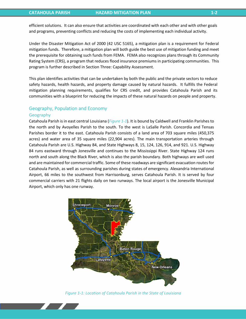
Geography, Population and Economy Geography Catahoula Parish is in east central Louisiana (Figure 1-1). It is bound by Caldwell and Franklin Parishes to
the north and by Avoyelles Parish to the south. To the west is LaSalle Parish. Concordia and Tensas
Parishes border it to the east. Catahoula Parish consists of a land area of 703 square miles (450,375
acres) and water area of 35 square miles (22,904 acres). The main transportation arteries through
Catahoula Parish are U.S. Highway 84, and State Highways 8, 15, 124, 126, 914, and 921. U.S. Highway
84 runs eastward through Jonesville and continues to the Mississippi River. State Highway 124 runs
north and south along the Black River, which is also the parish boundary. Both highways are well used
and are maintained for commercial traffic. Some of these roadways are significant evacuation routes for
Catahoula Parish, as well as surrounding parishes during states of emergency. Alexandria International
Airport, 66 miles to the southwest from Harrisonburg, serves Catahoula Parish. It is served by four
commercial carriers with 21 flights daily on two runways. The local airport is the Jonesville Municipal
Airport, which only has one runway.
Figure 1-1: Location of Catahoula Parish in the State of Louisiana
CATAHOULA PARISH HAZARD MITIGATION PLAN 1-3
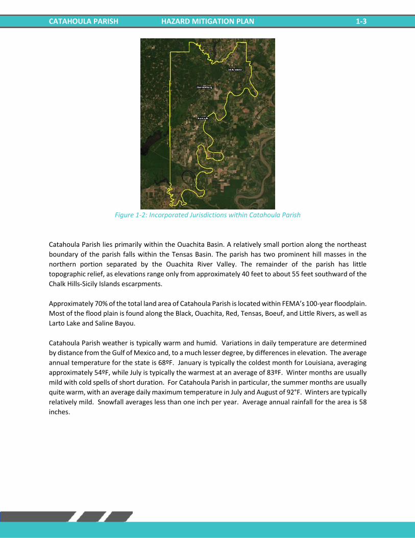
Figure 1-2: Incorporated Jurisdictions within Catahoula Parish
Catahoula Parish lies primarily within the Ouachita Basin. A relatively small portion along the northeast
boundary of the parish falls within the Tensas Basin. The parish has two prominent hill masses in the
northern portion separated by the Ouachita River Valley. The remainder of the parish has little
topographic relief, as elevations range only from approximately 40 feet to about 55 feet southward of the
Chalk Hills-Sicily Islands escarpments.
Approximately 70% of the total land area of Catahoula Parish is located within FEMA’s 100-year floodplain.
Most of the flood plain is found along the Black, Ouachita, Red, Tensas, Boeuf, and Little Rivers, as well as
Larto Lake and Saline Bayou.
Catahoula Parish weather is typically warm and humid. Variations in daily temperature are determined
by distance from the Gulf of Mexico and, to a much lesser degree, by differences in elevation. The average
annual temperature for the state is 68ºF. January is typically the coldest month for Louisiana, averaging
approximately 54ºF, while July is typically the warmest at an average of 83ºF. Winter months are usually
mild with cold spells of short duration. For Catahoula Parish in particular, the summer months are usually
quite warm, with an average daily maximum temperature in July and August of 92°F. Winters are typically
relatively mild. Snowfall averages less than one inch per year. Average annual rainfall for the area is 58
inches.
CATAHOULA PARISH HAZARD MITIGATION PLAN 1-4
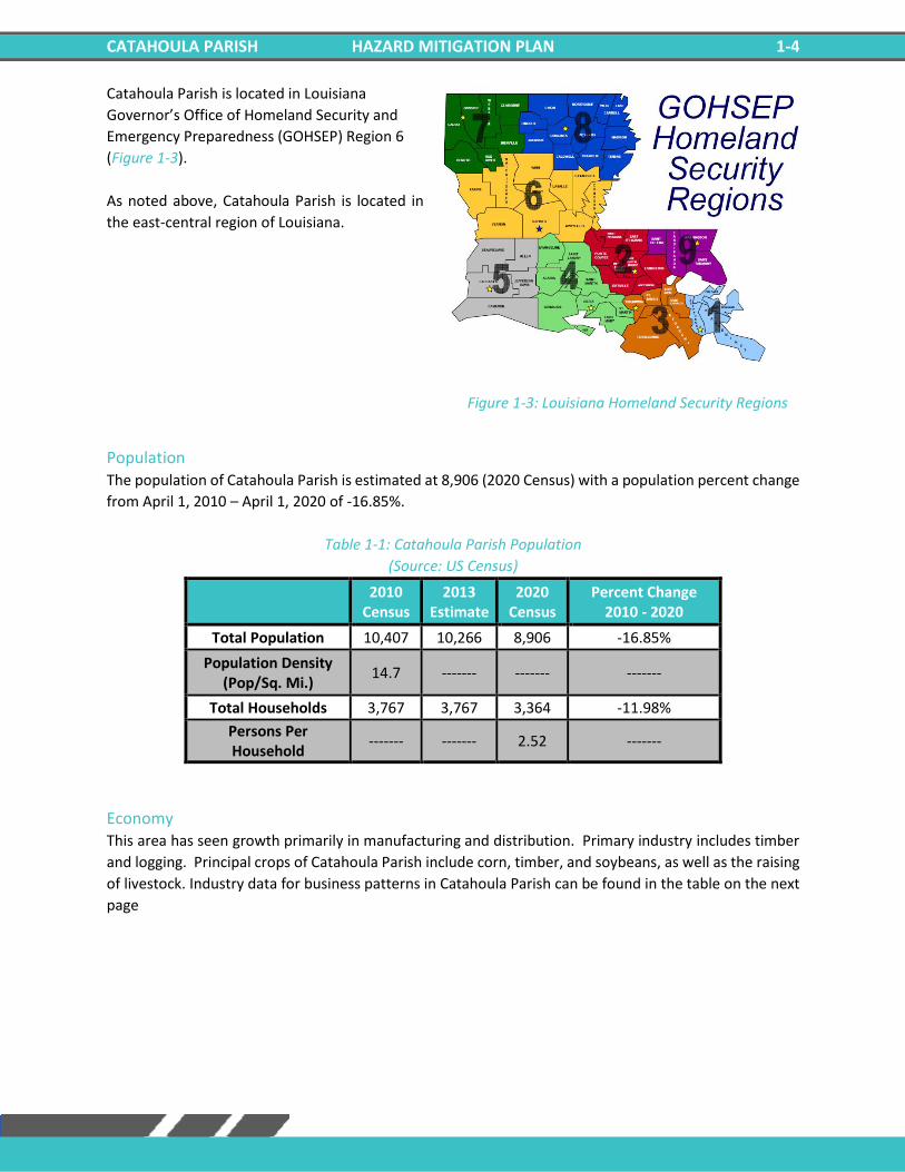
Catahoula Parish is located in Louisiana
Governor’s Office of Homeland Security and
Emergency Preparedness (GOHSEP) Region 6
(Figure 1-3).
As noted above, Catahoula Parish is located in
the east-central region of Louisiana.
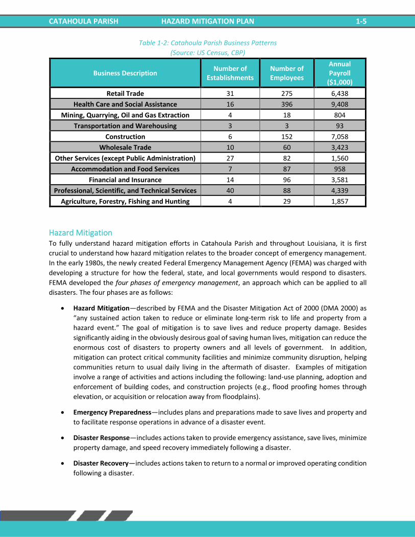
Population The population of Catahoula Parish is estimated at 8,906 (2020 Census) with a population percent change
from April 1, 2010 – April 1, 2020 of -16.85%.
Table 1-1: Catahoula Parish Population
(Source: US Census)
2010
Census 2013
Estimate 2020
Census Percent Change
2010 - 2020
Total Population 10,407 10,266 8,906 -16.85%
Population Density (Pop/Sq. Mi.)
14.7 ------- ------- -------
Total Households 3,767 3,767 3,364 -11.98%
Persons Per Household
------- ------- 2.52 -------
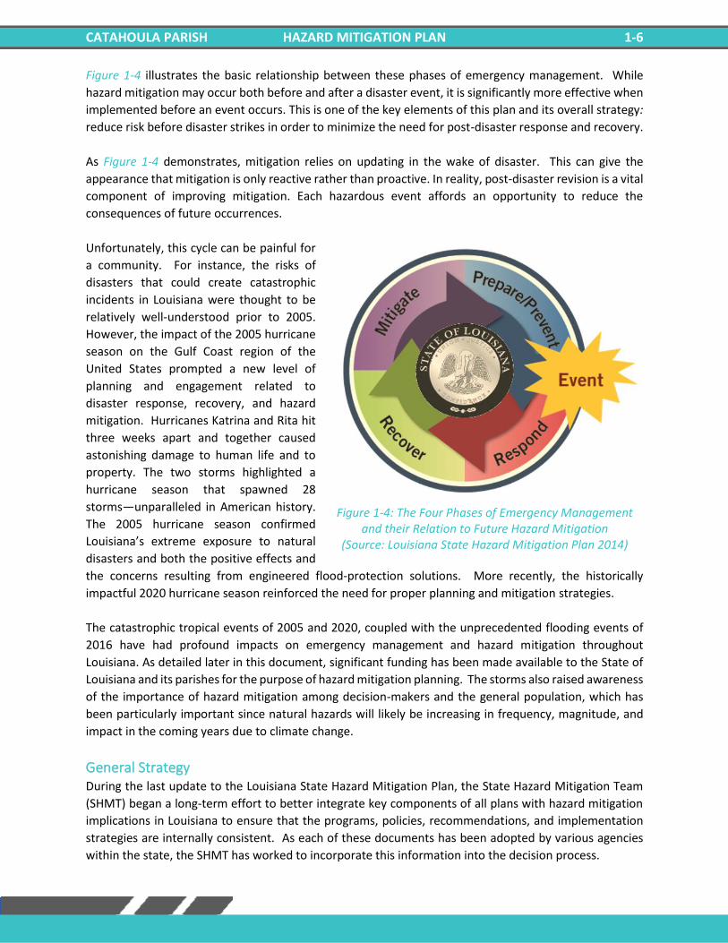
Economy This area has seen growth primarily in manufacturing and distribution. Primary industry includes timber
and logging. Principal crops of Catahoula Parish include corn, timber, and soybeans, as well as the raising
of livestock. Industry data for business patterns in Catahoula Parish can be found in the table on the next
page
Figure 1-3: Louisiana Homeland Security Regions
CATAHOULA PARISH HAZARD MITIGATION PLAN 1-5
Table 1-2: Catahoula Parish Business Patterns
(Source: US Census, CBP)
Business Description Number of
Establishments Number of Employees
Annual Payroll
($1,000)
Retail Trade 31 275 6,438
Health Care and Social Assistance 16 396 9,408
Mining, Quarrying, Oil and Gas Extraction 4 18 804
Transportation and Warehousing 3 3 93
Construction 6 152 7,058
Wholesale Trade 10 60 3,423
Other Services (except Public Administration) 27 82 1,560
Accommodation and Food Services 7 87 958
Financial and Insurance 14 96 3,581
Professional, Scientific, and Technical Services 40 88 4,339
Agriculture, Forestry, Fishing and Hunting 4 29 1,857
Hazard Mitigation To fully understand hazard mitigation efforts in Catahoula Parish and throughout Louisiana, it is first
crucial to understand how hazard mitigation relates to the broader concept of emergency management.
In the early 1980s, the newly created Federal Emergency Management Agency (FEMA) was charged with
developing a structure for how the federal, state, and local governments would respond to disasters.
FEMA developed the four phases of emergency management, an approach which can be applied to all
disasters. The four phases are as follows:
• Hazard Mitigation—described by FEMA and the Disaster Mitigation Act of 2000 (DMA 2000) as
“any sustained action taken to reduce or eliminate long-term risk to life and property from a
hazard event.” The goal of mitigation is to save lives and reduce property damage. Besides
significantly aiding in the obviously desirous goal of saving human lives, mitigation can reduce the
enormous cost of disasters to property owners and all levels of government. In addition,
mitigation can protect critical community facilities and minimize community disruption, helping
communities return to usual daily living in the aftermath of disaster. Examples of mitigation
involve a range of activities and actions including the following: land-use planning, adoption and
enforcement of building codes, and construction projects (e.g., flood proofing homes through
elevation, or acquisition or relocation away from floodplains).
• Emergency Preparedness—includes plans and preparations made to save lives and property and
to facilitate response operations in advance of a disaster event.
• Disaster Response—includes actions taken to provide emergency assistance, save lives, minimize
property damage, and speed recovery immediately following a disaster.
• Disaster Recovery—includes actions taken to return to a normal or improved operating condition
following a disaster.
CATAHOULA PARISH HAZARD MITIGATION PLAN 1-6
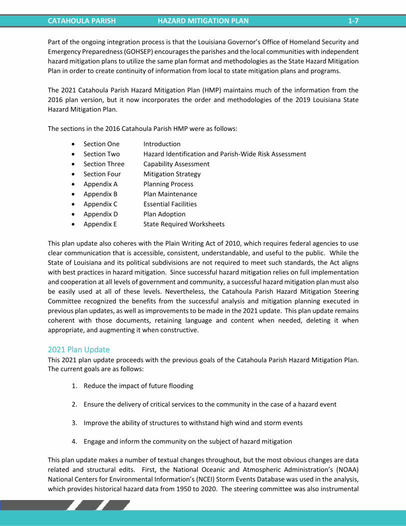
Figure 1-4 illustrates the basic relationship between these phases of emergency management. While
hazard mitigation may occur both before and after a disaster event, it is significantly more effective when
implemented before an event occurs. This is one of the key elements of this plan and its overall strategy:
reduce risk before disaster strikes in order to minimize the need for post-disaster response and recovery.
As Figure 1-4 demonstrates, mitigation relies on updating in the wake of disaster. This can give the
appearance that mitigation is only reactive rather than proactive. In reality, post-disaster revision is a vital
component of improving mitigation. Each hazardous event affords an opportunity to reduce the
consequences of future occurrences.
Unfortunately, this cycle can be painful for
a community. For instance, the risks of
disasters that could create catastrophic
incidents in Louisiana were thought to be
relatively well-understood prior to 2005.
However, the impact of the 2005 hurricane
season on the Gulf Coast region of the
United States prompted a new level of
planning and engagement related to
disaster response, recovery, and hazard
mitigation. Hurricanes Katrina and Rita hit
three weeks apart and together caused
astonishing damage to human life and to
property. The two storms highlighted a
hurricane season that spawned 28
storms—unparalleled in American history.
The 2005 hurricane season confirmed
Louisiana’s extreme exposure to natural
disasters and both the positive effects and
the concerns resulting from engineered flood-protection solutions. More recently, the historically
impactful 2020 hurricane season reinforced the need for proper planning and mitigation strategies.
The catastrophic tropical events of 2005 and 2020, coupled with the unprecedented flooding events of
2016 have had profound impacts on emergency management and hazard mitigation throughout
Louisiana. As detailed later in this document, significant funding has been made available to the State of
Louisiana and its parishes for the purpose of hazard mitigation planning. The storms also raised awareness
of the importance of hazard mitigation among decision-makers and the general population, which has
been particularly important since natural hazards will likely be increasing in frequency, magnitude, and
impact in the coming years due to climate change.
General Strategy During the last update to the Louisiana State Hazard Mitigation Plan, the State Hazard Mitigation Team
(SHMT) began a long-term effort to better integrate key components of all plans with hazard mitigation
implications in Louisiana to ensure that the programs, policies, recommendations, and implementation
strategies are internally consistent. As each of these documents has been adopted by various agencies
within the state, the SHMT has worked to incorporate this information into the decision process.
Figure 1-4: The Four Phases of Emergency Management and their Relation to Future Hazard Mitigation
(Source: Louisiana State Hazard Mitigation Plan 2014)
CATAHOULA PARISH HAZARD MITIGATION PLAN 1-7
Part of the ongoing integration process is that the Louisiana Governor’s Office of Homeland Security and
Emergency Preparedness (GOHSEP) encourages the parishes and the local communities with independent
hazard mitigation plans to utilize the same plan format and methodologies as the State Hazard Mitigation
Plan in order to create continuity of information from local to state mitigation plans and programs.
The 2021 Catahoula Parish Hazard Mitigation Plan (HMP) maintains much of the information from the
2016 plan version, but it now incorporates the order and methodologies of the 2019 Louisiana State
Hazard Mitigation Plan.
The sections in the 2016 Catahoula Parish HMP were as follows:
• Section One Introduction
• Section Two Hazard Identification and Parish-Wide Risk Assessment
• Section Three Capability Assessment
• Section Four Mitigation Strategy
• Appendix A Planning Process
• Appendix B Plan Maintenance
• Appendix C Essential Facilities
• Appendix D Plan Adoption
• Appendix E State Required Worksheets
This plan update also coheres with the Plain Writing Act of 2010, which requires federal agencies to use
clear communication that is accessible, consistent, understandable, and useful to the public. While the
State of Louisiana and its political subdivisions are not required to meet such standards, the Act aligns
with best practices in hazard mitigation. Since successful hazard mitigation relies on full implementation
and cooperation at all levels of government and community, a successful hazard mitigation plan must also
be easily used at all of these levels. Nevertheless, the Catahoula Parish Hazard Mitigation Steering
Committee recognized the benefits from the successful analysis and mitigation planning executed in
previous plan updates, as well as improvements to be made in the 2021 update. This plan update remains
coherent with those documents, retaining language and content when needed, deleting it when
appropriate, and augmenting it when constructive.
2021 Plan Update This 2021 plan update proceeds with the previous goals of the Catahoula Parish Hazard Mitigation Plan. The current goals are as follows:
1. Reduce the impact of future flooding
2. Ensure the delivery of critical services to the community in the case of a hazard event
3. Improve the ability of structures to withstand high wind and storm events
4. Engage and inform the community on the subject of hazard mitigation
This plan update makes a number of textual changes throughout, but the most obvious changes are data
related and structural edits. First, the National Oceanic and Atmospheric Administration’s (NOAA)
National Centers for Environmental Information’s (NCEI) Storm Events Database was used in the analysis,
which provides historical hazard data from 1950 to 2020. The steering committee was also instrumental
CATAHOULA PARISH HAZARD MITIGATION PLAN 1-8
in providing detailed data where appropriate to more accurately reflect hazard impacts on the parish and
jurisdictions. Furthermore, all of the sections were updated to reflect the most current information and
the most current vision of the plan update. The most significant changes are the newly developed hazard
profiles and risk assessments, as well as the removal of much repetition between sections from the
previous plan updates.
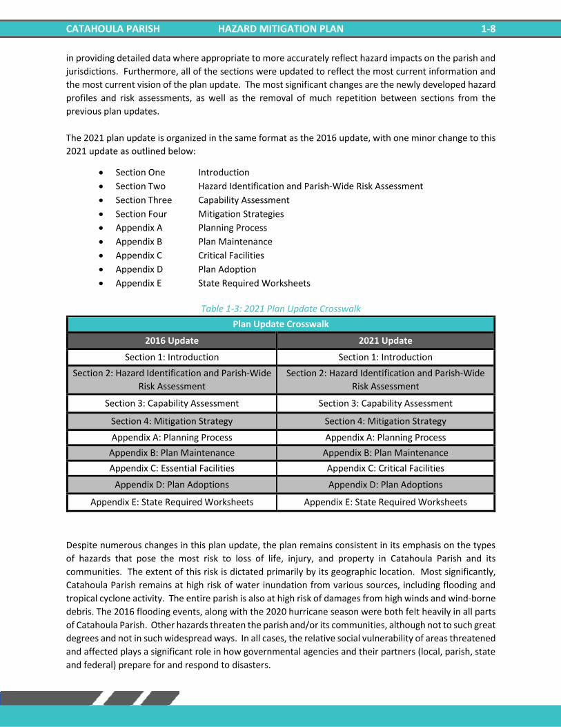
The 2021 plan update is organized in the same format as the 2016 update, with one minor change to this
2021 update as outlined below:
• Section One Introduction
• Section Two Hazard Identification and Parish-Wide Risk Assessment
• Section Three Capability Assessment
• Section Four Mitigation Strategies
• Appendix A Planning Process
• Appendix B Plan Maintenance
• Appendix C Critical Facilities
• Appendix D Plan Adoption
• Appendix E State Required Worksheets
Table 1-3: 2021 Plan Update Crosswalk
Plan Update Crosswalk
2016 Update 2021 Update
Section 1: Introduction Section 1: Introduction
Section 2: Hazard Identification and Parish-Wide
Risk Assessment
Section 2: Hazard Identification and Parish-Wide
Risk Assessment
Section 3: Capability Assessment Section 3: Capability Assessment
Section 4: Mitigation Strategy Section 4: Mitigation Strategy
Appendix A: Planning Process Appendix A: Planning Process
Appendix B: Plan Maintenance Appendix B: Plan Maintenance
Appendix C: Essential Facilities Appendix C: Critical Facilities
Appendix D: Plan Adoptions Appendix D: Plan Adoptions
Appendix E: State Required Worksheets Appendix E: State Required Worksheets
Despite numerous changes in this plan update, the plan remains consistent in its emphasis on the types
of hazards that pose the most risk to loss of life, injury, and property in Catahoula Parish and its
communities. The extent of this risk is dictated primarily by its geographic location. Most significantly,
Catahoula Parish remains at high risk of water inundation from various sources, including flooding and
tropical cyclone activity. The entire parish is also at high risk of damages from high winds and wind-borne
debris. The 2016 flooding events, along with the 2020 hurricane season were both felt heavily in all parts
of Catahoula Parish. Other hazards threaten the parish and/or its communities, although not to such great
degrees and not in such widespread ways. In all cases, the relative social vulnerability of areas threatened
and affected plays a significant role in how governmental agencies and their partners (local, parish, state
and federal) prepare for and respond to disasters.

CATAHOULA PARISH HAZARD MITIGATION PLAN 1-9
Mitigation efforts related to particular hazards are highly individualized by jurisdiction. Flexibility in
response and planning is essential. The most important step forward to improve hazard management
capability is to improve coordination and information sharing between the various levels of government
regarding hazards.

CATAHOULA PARISH HAZARD MITIGATION PLAN 1-10
***This Page Left Intentionally Blank***
CATAHOULA PARISH HAZARD MITIGATION PLAN 2-1
2. Hazard Identification and Parish-Wide Risk Assessment
This section assesses the various hazard risks that Catahoula Parish faces in order to identify a strategy for
mitigation. Having identified the categories of hazards, emergencies, disasters, and catastrophes, this
section details the major climatological and natural/human-influenced hazards by (1) defining them, (2)
explaining how they are measured, (3) describing their geographic extent, (4) surveying their previous
occurrences, and (5) evaluating their future likelihood of occurrences.
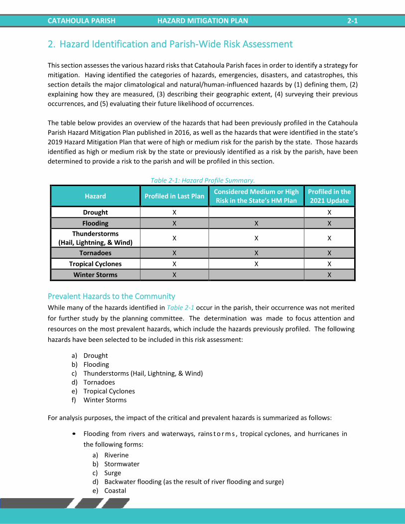
The table below provides an overview of the hazards that had been previously profiled in the Catahoula
Parish Hazard Mitigation Plan published in 2016, as well as the hazards that were identified in the state’s
2019 Hazard Mitigation Plan that were of high or medium risk for the parish by the state. Those hazards
identified as high or medium risk by the state or previously identified as a risk by the parish, have been
determined to provide a risk to the parish and will be profiled in this section.
Table 2-1: Hazard Profile Summary.
Hazard Profiled in Last Plan Considered Medium or High Risk in the State’s HM Plan
Profiled in the 2021 Update
Drought X X
Flooding X X X
Thunderstorms (Hail, Lightning, & Wind)
X X X
Tornadoes X X X
Tropical Cyclones X X X
Winter Storms X X
Prevalent Hazards to the Community
While many of the hazards identified in Table 2-1 occur in the parish, their occurrence was not merited
for further study by the planning committee. The determination was made to focus attention and
resources on the most prevalent hazards, which include the hazards previously profiled. The following
hazards have been selected to be included in this risk assessment:
a) Drought b) Flooding c) Thunderstorms (Hail, Lightning, & Wind) d) Tornadoes e) Tropical Cyclones f) Winter Storms
For analysis purposes, the impact of the critical and prevalent hazards is summarized as follows:
• Flooding from rivers and waterways, rains t o r m s , tropical cyclones, and hurricanes in
the following forms:
a) Riverine b) Stormwater c) Surge d) Backwater flooding (as the result of river flooding and surge) e) Coastal
CATAHOULA PARISH HAZARD MITIGATION PLAN 2-2
• High wind damage most commonly resulting from hurricanes, thunderstorms, and tornadoes
• Property damage resulting from all profiled natural hazards
The potential destructive power of tropical cyclones and floods were determined to be the most
prevalent hazard to the parish. Twenty-seven of the twenty-nine disaster declarations Catahoula Parish
has received resulted from either flooding (17) or tropical cyclones (10), which validates these as the
most significant hazards. Therefore, the issues of hurricanes and flooding will serve as the main focus
during the mitigation planning process. Hurricanes present risks from the potential for flooding, primarily
resulting from storm surge, and high wind speeds. While storm surge is considered the hazard with the
most destructive potential, the risk assessment will also assess non-storm surge flooding as well.
Flooding can also occur from non-hurricane events, as flash floods are a common occurrence due to
heavy rainfall.
Hurricanes, tropical storms, and heavy storms are common occurrences, and resultant wind damage is
of utmost concern. Damage from high winds can include roof damage, destruction of homes and
commercial buildings, downed trees and power lines, and damage and disruption to services caused by
heavy debris. A wind map for Catahoula Parish is included in the hurricane risk assessment.
Catahoula Parish is also susceptible to tornadoes. Tornadoes can spawn from tropical cyclones or severe
weather systems that pass-through Catahoula Parish. High winds produced by tornadoes have the
potential to destroy residential and commercial buildings, as well as create wind-borne objects from the
debris produced by the destruction of the natural and human environment, such as building materials
and trees.
Previous Occurrences
Table 2-2 summarizes federal disaster declarations for Catahoula Parish since 1965. Information
includes names, dates, and types of disaster.
Table 2-2: Catahoula Parish Major Disaster Declarations.
Disaster Number
Year Declaration
208 9/10/1965 Tropical Cyclone – Hurricane Betsy
374 4/27/1973 Severe Storms, Flooding
418 2/23/1974 Severe Storms, Flooding
3011 4/12/1975 Severe Storms, Flooding
470 6/6/1975 Tornadoes, Flooding
584 5/2/1979 Severe Storms, Flooding
675 1/11/1983 Severe Storms, Flooding
804 11/30/1987 Tornadoes and Flooding
902 4/23/1991 Severe Storm, Flooding
904 5/3/1991 Severe Storms, Tornadoes, and Flooding
1264 1/21/1999 Severe Ice Storm
1437 10/3/2002 Tropical Cyclone – Hurricane Lili
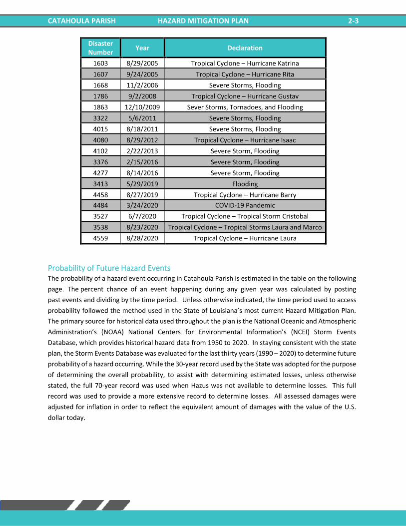
CATAHOULA PARISH HAZARD MITIGATION PLAN 2-3
Disaster Number
Year Declaration
1603 8/29/2005 Tropical Cyclone – Hurricane Katrina
1607 9/24/2005 Tropical Cyclone – Hurricane Rita
1668 11/2/2006 Severe Storms, Flooding
1786 9/2/2008 Tropical Cyclone – Hurricane Gustav
1863 12/10/2009 Sever Storms, Tornadoes, and Flooding
3322 5/6/2011 Severe Storms, Flooding
4015 8/18/2011 Severe Storms, Flooding
4080 8/29/2012 Tropical Cyclone – Hurricane Isaac
4102 2/22/2013 Severe Storm, Flooding
3376 2/15/2016 Severe Storm, Flooding
4277 8/14/2016 Severe Storm, Flooding
3413 5/29/2019 Flooding
4458 8/27/2019 Tropical Cyclone – Hurricane Barry
4484 3/24/2020 COVID-19 Pandemic
3527 6/7/2020 Tropical Cyclone – Tropical Storm Cristobal
3538 8/23/2020 Tropical Cyclone – Tropical Storms Laura and Marco
4559 8/28/2020 Tropical Cyclone – Hurricane Laura
Probability of Future Hazard Events
The probability of a hazard event occurring in Catahoula Parish is estimated in the table on the following
page. The percent chance of an event happening during any given year was calculated by posting
past events and dividing by the time period. Unless otherwise indicated, the time period used to access
probability followed the method used in the State of Louisiana’s most current Hazard Mitigation Plan.
The primary source for historical data used throughout the plan is the National Oceanic and Atmospheric
Administration’s (NOAA) National Centers for Environmental Information’s (NCEI) Storm Events
Database, which provides historical hazard data from 1950 to 2020. In staying consistent with the state
plan, the Storm Events Database was evaluated for the last thirty years (1990 – 2020) to determine future
probability of a hazard occurring. While the 30-year record used by the State was adopted for the purpose
of determining the overall probability, to assist with determining estimated losses, unless otherwise
stated, the full 70-year record was used when Hazus was not available to determine losses. This full
record was used to provide a more extensive record to determine losses. All assessed damages were
adjusted for inflation in order to reflect the equivalent amount of damages with the value of the U.S.
dollar today.
CATAHOULA PARISH HAZARD MITIGATION PLAN 2-4
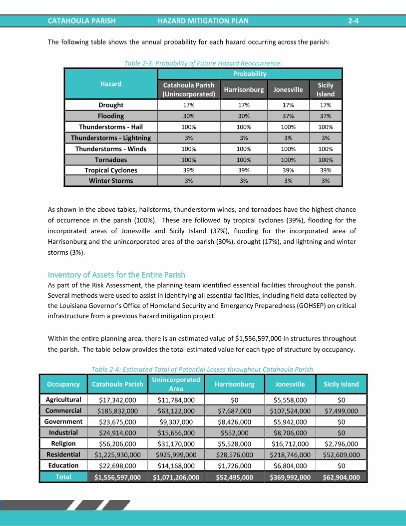
The following table shows the annual probability for each hazard occurring across the parish:
Table 2-3: Probability of Future Hazard Reoccurrence.
Hazard
Probability
Catahoula Parish (Unincorporated)
Harrisonburg Jonesville Sicily Island
Drought 17% 17% 17% 17%
Flooding 30% 30% 37% 37%
Thunderstorms - Hail 100% 100% 100% 100%
Thunderstorms - Lightning 3% 3% 3% 3%
Thunderstorms - Winds 100% 100% 100% 100%
Tornadoes 100% 100% 100% 100%
Tropical Cyclones 39% 39% 39% 39%
Winter Storms 3% 3% 3% 3%
As shown in the above tables, hailstorms, thunderstorm winds, and tornadoes have the highest chance
of occurrence in the parish (100%). These are followed by tropical cyclones (39%), flooding for the
incorporated areas of Jonesville and Sicily Island (37%), flooding for the incorporated area of
Harrisonburg and the unincorporated area of the parish (30%), drought (17%), and lightning and winter
storms (3%).
Inventory of Assets for the Entire Parish As part of the Risk Assessment, the planning team identified essential facilities throughout the parish.
Several methods were used to assist in identifying all essential facilities, including field data collected by
the Louisiana Governor’s Office of Homeland Security and Emergency Preparedness (GOHSEP) on critical
infrastructure from a previous hazard mitigation project.
Within the entire planning area, there is an estimated value of $1,556,597,000 in structures throughout
the parish. The table below provides the total estimated value for each type of structure by occupancy.
Table 2-4: Estimated Total of Potential Losses throughout Catahoula Parish.
Occupancy Catahoula Parish Unincorporated
Area Harrisonburg Jonesville Sicily Island
Agricultural $17,342,000 $11,784,000 $0 $5,558,000 $0
Commercial $185,832,000 $63,122,000 $7,687,000 $107,524,000 $7,499,000
Government $23,675,000 $9,307,000 $8,426,000 $5,942,000 $0
Industrial $24,914,000 $15,656,000 $552,000 $8,706,000 $0
Religion $56,206,000 $31,170,000 $5,528,000 $16,712,000 $2,796,000
Residential $1,225,930,000 $925,999,000 $28,576,000 $218,746,000 $52,609,000
Education $22,698,000 $14,168,000 $1,726,000 $6,804,000 $0
Total $1,556,597,000 $1,071,206,000 $52,495,000 $369,992,000 $62,904,000
CATAHOULA PARISH HAZARD MITIGATION PLAN 2-5
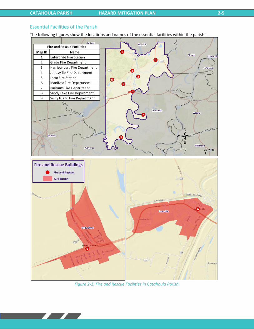
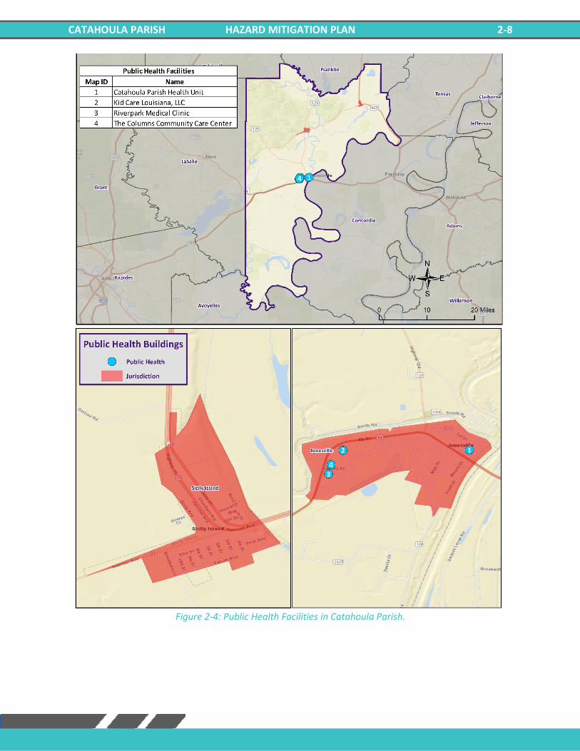
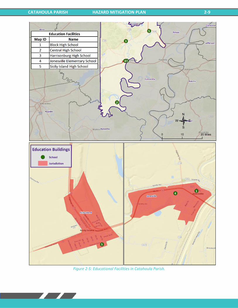
Essential Facilities of the Parish
The following figures show the locations and names of the essential facilities within the parish:
Figure 2-1: Fire and Rescue Facilities in Catahoula Parish.

CATAHOULA PARISH HAZARD MITIGATION PLAN 2-6
Figure 2-2: Government Buildings in Catahoula Parish.

CATAHOULA PARISH HAZARD MITIGATION PLAN 2-7
Figure 2-3: Law Enforcement in Catahoula Parish.
CATAHOULA PARISH HAZARD MITIGATION PLAN 2-8
Figure 2-4: Public Health Facilities in Catahoula Parish.
CATAHOULA PARISH HAZARD MITIGATION PLAN 2-9
Figure 2-5: Educational Facilities in Catahoula Parish.
CATAHOULA PARISH HAZARD MITIGATION PLAN 2-10
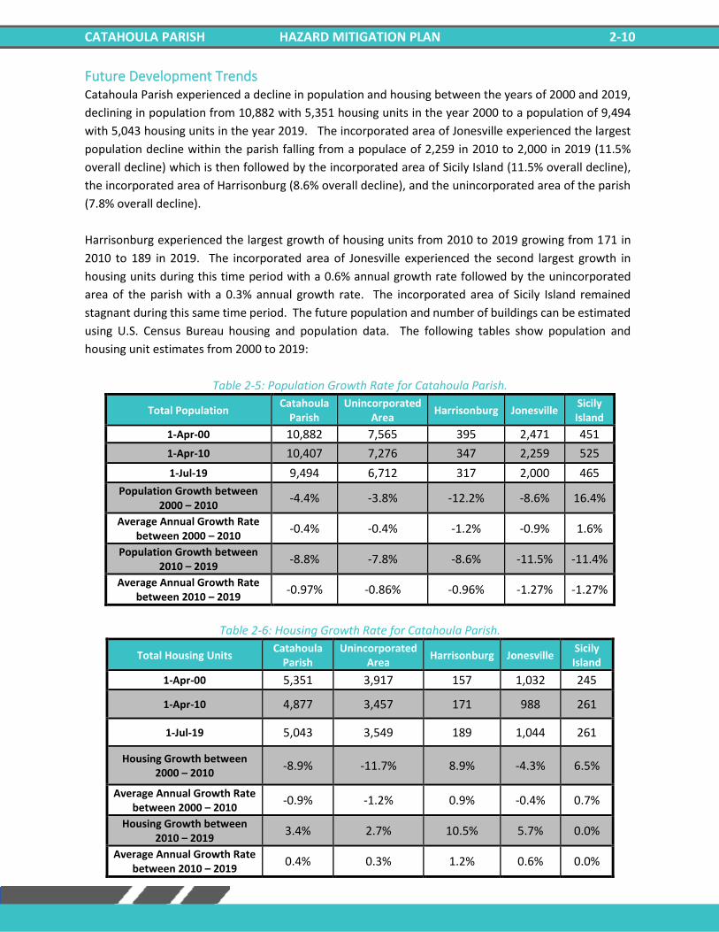
Future Development Trends Catahoula Parish experienced a decline in population and housing between the years of 2000 and 2019,
declining in population from 10,882 with 5,351 housing units in the year 2000 to a population of 9,494
with 5,043 housing units in the year 2019. The incorporated area of Jonesville experienced the largest
population decline within the parish falling from a populace of 2,259 in 2010 to 2,000 in 2019 (11.5%
overall decline) which is then followed by the incorporated area of Sicily Island (11.5% overall decline),
the incorporated area of Harrisonburg (8.6% overall decline), and the unincorporated area of the parish
(7.8% overall decline).
Harrisonburg experienced the largest growth of housing units from 2010 to 2019 growing from 171 in
2010 to 189 in 2019. The incorporated area of Jonesville experienced the second largest growth in
housing units during this time period with a 0.6% annual growth rate followed by the unincorporated
area of the parish with a 0.3% annual growth rate. The incorporated area of Sicily Island remained
stagnant during this same time period. The future population and number of buildings can be estimated
using U.S. Census Bureau housing and population data. The following tables show population and
housing unit estimates from 2000 to 2019:
Table 2-5: Population Growth Rate for Catahoula Parish.
Total Population Catahoula
Parish Unincorporated
Area Harrisonburg Jonesville
Sicily Island
1-Apr-00 10,882 7,565 395 2,471 451
1-Apr-10 10,407 7,276 347 2,259 525
1-Jul-19 9,494 6,712 317 2,000 465
Population Growth between 2000 – 2010
-4.4% -3.8% -12.2% -8.6% 16.4%
Average Annual Growth Rate between 2000 – 2010
-0.4% -0.4% -1.2% -0.9% 1.6%
Population Growth between 2010 – 2019
-8.8% -7.8% -8.6% -11.5% -11.4%
Average Annual Growth Rate between 2010 – 2019
-0.97% -0.86% -0.96% -1.27% -1.27%
Table 2-6: Housing Growth Rate for Catahoula Parish.
Total Housing Units Catahoula
Parish Unincorporated
Area Harrisonburg Jonesville
Sicily Island
1-Apr-00 5,351 3,917 157 1,032 245
1-Apr-10 4,877 3,457 171 988 261
1-Jul-19 5,043 3,549 189 1,044 261
Housing Growth between 2000 – 2010
-8.9% -11.7% 8.9% -4.3% 6.5%
Average Annual Growth Rate between 2000 – 2010
-0.9% -1.2% 0.9% -0.4% 0.7%
Housing Growth between 2010 – 2019
3.4% 2.7% 10.5% 5.7% 0.0%
Average Annual Growth Rate between 2010 – 2019
0.4% 0.3% 1.2% 0.6% 0.0%
CATAHOULA PARISH HAZARD MITIGATION PLAN 2-11
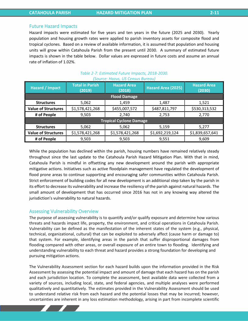
Future Hazard Impacts Hazard impacts were estimated for five years and ten years in the future (2025 and 2030). Yearly
population and housing growth rates were applied to parish inventory assets for composite flood and
tropical cyclones. Based on a review of available information, it is assumed that population and housing
units will grow within Catahoula Parish from the present until 2030. A summary of estimated future
impacts is shown in the table below. Dollar values are expressed in future costs and assume an annual
rate of inflation of 1.02%.
Table 2-7: Estimated Future Impacts, 2018-2030.
(Source: Hazus, US Census Bureau)
Hazard / Impact Total in Parish
(2019) Hazard Area
(2018) Hazard Area (2025)
Hazard Area (2030)
Flood Damage
Structures 5,062 1,459 1,487 1,521
Value of Structures $1,578,421,268 $455,007,572 $487,811,797 $530,313,532
# of People 9,503 2,740 2,753 2,770
Tropical Cyclone Damage
Structures 5,062 5,062 5,159 5,277
Value of Structures $1,578,421,268 $1,578,421,268 $1,692,219,124 $1,839,657,641
# of People 9,503 9,503 9,551 9,609
While the population has declined within the parish, housing numbers have remained relatively steady
throughout since the last update to the Catahoula Parish Hazard Mitigation Plan. With that in mind,
Catahoula Parish is mindful in offsetting any new development around the parish with appropriate
mitigative actions. Initiatives such as active floodplain management have regulated the development of
flood prone areas to continue supporting and encouraging safer communities within Catahoula Parish.
Strict enforcement of building codes for all new development is an additional step taken by the parish in
its effort to decrease its vulnerability and increase the resiliency of the parish against natural hazards. The
small amount of development that has occurred since 2016 has not in any knowing way altered the
jurisdiction’s vulnerability to natural hazards.
Assessing Vulnerability Overview The purpose of assessing vulnerability is to quantify and/or qualify exposure and determine how various threats and hazards impact life, property, the environment, and critical operations in Catahoula Parish. Vulnerability can be defined as the manifestation of the inherent states of the system (e.g., physical, technical, organizational, cultural) that can be exploited to adversely affect (cause harm or damage to) that system. For example, identifying areas in the parish that suffer disproportional damages from flooding compared with other areas, or overall exposure of an entire town to flooding. Identifying and understanding vulnerability to each threat and hazard provides a strong foundation for developing and pursuing mitigation actions. The Vulnerability Assessment section for each hazard builds upon the information provided in the Risk Assessment by assessing the potential impact and amount of damage that each hazard has on the parish and each jurisdiction location. To complete the assessment, best available data were collected from a variety of sources, including local, state, and federal agencies, and multiple analyses were performed qualitatively and quantitatively. The estimates provided in the Vulnerability Assessment should be used to understand relative risk from each hazard and the potential losses that may be incurred; however, uncertainties are inherent in any loss estimation methodology, arising in part from incomplete scientific
CATAHOULA PARISH HAZARD MITIGATION PLAN 2-12
knowledge concerning specific hazards and their effects on the built environment, as well as incomplete datasets from approximations and simplifications that are necessary to provide a meaningful and complete analysis. Further, most datasets used in this assessment contain relatively short periods of records, which increases the uncertainty of any statistically based analysis.
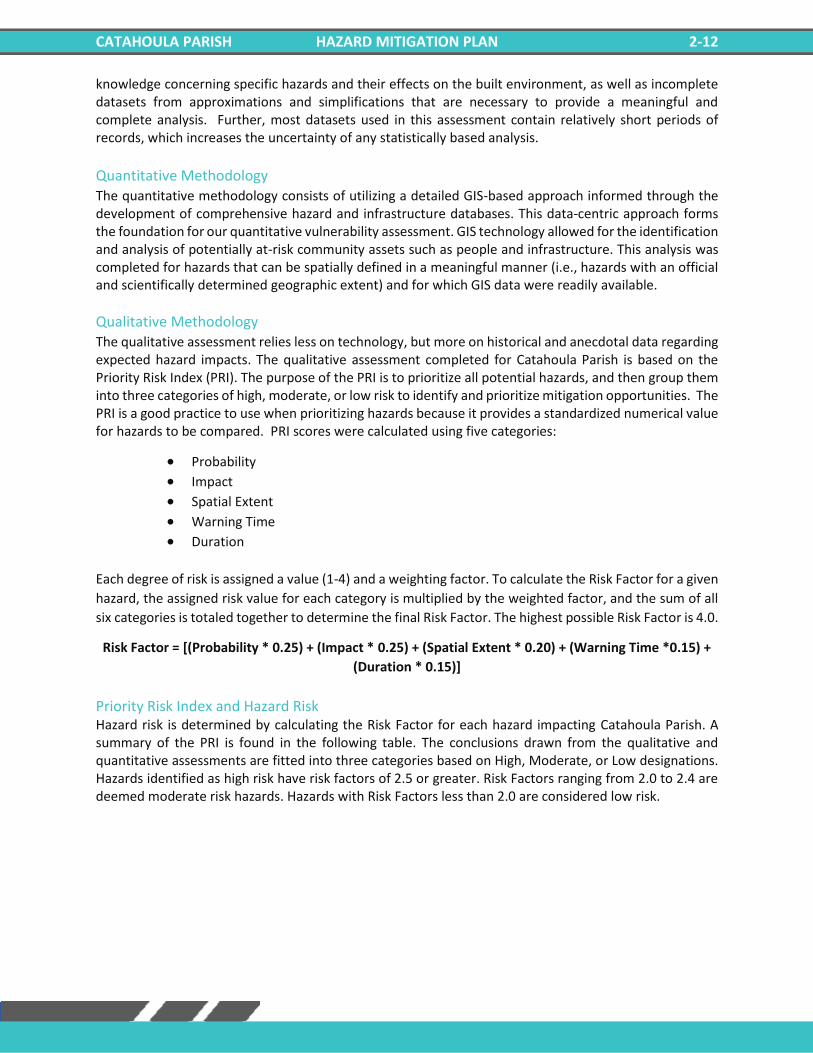
Quantitative Methodology The quantitative methodology consists of utilizing a detailed GIS-based approach informed through the development of comprehensive hazard and infrastructure databases. This data-centric approach forms the foundation for our quantitative vulnerability assessment. GIS technology allowed for the identification and analysis of potentially at-risk community assets such as people and infrastructure. This analysis was completed for hazards that can be spatially defined in a meaningful manner (i.e., hazards with an official and scientifically determined geographic extent) and for which GIS data were readily available.
Qualitative Methodology The qualitative assessment relies less on technology, but more on historical and anecdotal data regarding expected hazard impacts. The qualitative assessment completed for Catahoula Parish is based on the Priority Risk Index (PRI). The purpose of the PRI is to prioritize all potential hazards, and then group them into three categories of high, moderate, or low risk to identify and prioritize mitigation opportunities. The PRI is a good practice to use when prioritizing hazards because it provides a standardized numerical value for hazards to be compared. PRI scores were calculated using five categories:
• Probability • Impact
• Spatial Extent
• Warning Time • Duration
Each degree of risk is assigned a value (1-4) and a weighting factor. To calculate the Risk Factor for a given
hazard, the assigned risk value for each category is multiplied by the weighted factor, and the sum of all
six categories is totaled together to determine the final Risk Factor. The highest possible Risk Factor is 4.0.
Risk Factor = [(Probability * 0.25) + (Impact * 0.25) + (Spatial Extent * 0.20) + (Warning Time *0.15) +
(Duration * 0.15)]
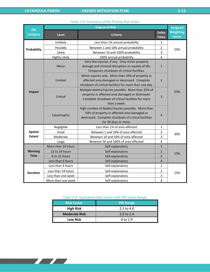
Priority Risk Index and Hazard Risk Hazard risk is determined by calculating the Risk Factor for each hazard impacting Catahoula Parish. A summary of the PRI is found in the following table. The conclusions drawn from the qualitative and quantitative assessments are fitted into three categories based on High, Moderate, or Low designations. Hazards identified as high risk have risk factors of 2.5 or greater. Risk Factors ranging from 2.0 to 2.4 are deemed moderate risk hazards. Hazards with Risk Factors less than 2.0 are considered low risk.
CATAHOULA PARISH HAZARD MITIGATION PLAN 2-13
Table 2-8: Summary of the Priority Risk Index.
Table 2-9: Associated Risk Factor with PRI Value Range.
Risk Factor PRI Range
High Risk 2.5 to 4.0
Moderate Risk 2.0 to 2.4
Low Risk 0 to 1.9
PRI
Category
Degree of Risk Assigned
Weighting
Factor Level Criteria
Index
Value
Probability
Unlikely Less than 1% annual probability 1
25% Possible Between 1 and 10% annual probability 2
Likely Between 10 and 100% probability 3
Highly Likely 100% annual probability 4
Impact
Minor
Very few injuries, if any. Only minor property
damage and minimal disruption on quality of life.
Temporary shutdown of critical facilities.
1
25%
Limited
Minor injuries only. More than 10% of property in
affected area damaged or destroyed. Complete
shutdown of critical facilities for more than one day.
2
Critical
Multiple deaths/injuries possible. More than 25% of
property in affected area damaged or destroyed.
Complete shutdown of critical facilities for more
than a week.
3
Catastrophic
High number of deaths/injuries possible. More than
50% of property in affected area damaged or
destroyed. Complete shutdown of critical facilities
for 30 days or more.
4
Spatial
Extent
Negligible Less than 1% of area affected 1
20% Small Between 1 and 10% of area affected 2
Moderate Between 10 and 50% of area affected 3
Large Between 50 and 100% of area affected 4
Warning
Time
More than 24 hours Self-explanatory 1
15% 12 to 24 hours Self-explanatory 2
6 to 12 hours Self-explanatory 3
Less than 6 hours Self-explanatory 4
Duration
Less than 6 hours Self-explanatory 1
15% Less than 24 hours Self-explanatory 2
Less than one week Self-explanatory 3
More than one week Self-explanatory 4
CATAHOULA PARISH HAZARD MITIGATION PLAN 2-14
Table 2-10: Risk Assessment for Catahoula Parish.
Land Use The Catahoula Parish Land Use table is provided below. Residential, commercial, and industrial areas
account for only 4% of the parish’s land use. Agricultural land at 242,233 acres is the largest category
accounting for 53% of land in the parish. The parish also consists of wetlands (21%), forested areas (18%),
and water areas (5%).
Table 2-11: Catahoula Parish Land Use. (Source: USGS Land Use Map)
Land Use Acres Percentage
Agricultural Land, Cropland, and Pasture 242,233 53%
Wetlands 94,756 21%
Forest Land (Not including forested wetlands)
84,228 18%
Urban/Development 17,880 4%
Water 20,984 5%
Hazard Probability Impact Spatial
Extent
Warning
Time Duration
Overall
Risk
Drought 3 2 4 2 3 2.8
Flooding 3 4 3 4 3 3.4
Thunderstorms – Hail 4 2 3 3 1 2.7
Thunderstorms – Lightning 2 2 2 3 1 2
Thunderstorms – Wind 4 2 3 3 1 2.7
Tornadoes 4 3 2 4 3 3.2
Tropical Cyclones 3 4 4 1 4 3.3
Winter Storms 2 2 2 4 2 2.3
CATAHOULA PARISH HAZARD MITIGATION PLAN 2-15
Figure 2-6: Catahoula Parish Land Use Map.
(Source: USGS Land Use Map)
CATAHOULA PARISH HAZARD MITIGATION PLAN 2-16
Hazard Identification Drought
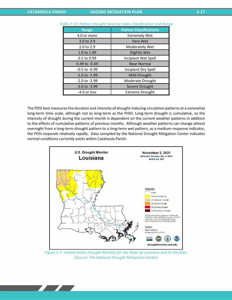
A drought is a deficiency in water availability over an extended period of time, caused by precipitation totals and soil water storages that do not satisfy the environmental demand for water, either by evaporation or transpiration through plant leaves. It is important to note that the lack of precipitation alone does not constitute drought; the season during which the precipitation is lacking has a major impact on whether drought occurs. For example, a week of no precipitation in July, when the solar energy to evaporate water and vegetation’s need for water to carry on photosynthesis are both high, may trigger a drought, while a week of no precipitation in January may not initiate a drought. Drought is a unique and insidious hazard. Unlike other natural hazards, no specific threshold of “dryness” exists for declaring a drought. In addition, the definition of drought depends on stakeholder needs. For instance, the onset (and demise) of agricultural drought is quick, as crops need water every few days; once they get rainfall, they improve. But hydrologic drought sets in (and is alleviated) only over longer time periods. A few dry days will not drain a reservoir, but a few rain showers cannot replenish it either. Moreover, different geographical regions define drought differently based on the deviation from local, normal precipitation. And drought can occur anywhere, triggered by changes in the local-to-regional-scale atmospheric circulation over an area, or by broader-scale circulation variations such as the expansion of semi-permanent oceanic high-pressure systems or the stalling of an upper-level atmospheric ridge in place over a region. The severity of a drought depends upon the degree and duration of moisture deficiency, as well as the size of the affected area. Periods of drought also tend to be associated with other hazards, such as wildfires and/or heat waves. Lastly, drought is a slow onset event, causing less direct—but tremendous indirect—damage. Depletion of aquifers, crop loss, and livestock and wildlife mortality rates are examples of direct impacts. Since the groundwater found in aquifers is the source of about 38% of all county and city water supplied to households (and comprises 97% of the water for all rural populations that are not already supplied by cities and counties), droughts can potentially have direct, disastrous effects on human populations. The indirect consequences of drought, such as unemployment, reduced tax revenues, increased food prices, reduced outdoor recreation opportunities, higher energy costs as water levels in reservoirs decrease and consumption increases, and water rationing, are not often fully known. This complex web of impacts causes drought to affect people and economies well beyond the area physically experiencing the drought. This hazard is often measured using the Palmer Drought Severity Index (PDSI, also known operationally as the Palmer Drought Index). The PDSI, first developed by Wayne Palmer in a 1965 paper for the U.S. Weather Bureau, measures drought through recent precipitation and temperature data with regard to a basic supply-and-demand model of soil moisture. It is most effective in long-term calculations. Three other indices used to measure drought are the Palmer Hydrologic Drought Index (PHDI), the Crop Moisture Index (CMI), which is derived from the PDSI, and the Keetch-Byram Drought Index (KBDI), created by John Keetch and George Byram in 1968 for the U.S. Forest Service. The KBDI is used mainly for predicting the likelihood of wildfire outbreaks. As a compromise, the PDSI is used most often for droughts since it is a medium-response drought indicator. The objective of the PDSI is to provide measurements of moisture conditions that are standardized so that comparisons using the index can be made between locations and between months. Table 2-12 displays the range and Palmer classifications of the PDSI index while Figure 2-7 displays the current drought monitor for the state of Louisiana and its parishes.
CATAHOULA PARISH HAZARD MITIGATION PLAN 2-17
Table 2-12: Palmer Drought Severity Index Classification and Range
Range Palmer Classifications
4.0 or more Extremely Wet
3.0 to 3.9 Very Wet
2.0 to 2.9 Moderately Wet
1.0 to 1.99 Slightly Wet
0.5 to 0.99 Incipient Wet Spell
0.49 to -0.49 Near Normal
-0.5 to -0.99 Incipient Dry Spell
-1.0 to -1.99 Mild Drought
-2.0 to -2.99 Moderate Drought
-3.0 to -3.99 Severe Drought
-4.0 or less Extreme Drought
The PDSI best measures the duration and intensity of drought-inducing circulation patterns at a somewhat long-term time scale, although not as long-term as the PHDI. Long-term drought is cumulative, so the intensity of drought during the current month is dependent on the current weather patterns in addition to the effects of cumulative patterns of previous months. Although weather patterns can change almost overnight from a long-term drought pattern to a long-term wet pattern, as a medium-response indicator, the PDSI responds relatively rapidly. Data compiled by the National Drought Mitigation Center indicates normal conditions currently exists within Catahoula Parish.
Figure 2-7: United States Drought Monitor for the State of Louisiana and its Parishes.
(Source: The National Drought Mitigation Center)
CATAHOULA PARISH HAZARD MITIGATION PLAN 2-18
Location Drought typically impacts a region and not one specific parish or jurisdiction. While the entire planning
area can experience drought, the major impact of a drought event in Catahoula Parish is on the agricultural
community. The worst-case drought scenario for Catahoula Parish would be an extreme drought (D3).
Previous Occurrences / Extent Historically, there have been five drought incidents in Catahoula Parish. Drought events have ranged from
Mild to Extreme per the National Climatic Data Center. Since the last update in 2016, there have been
two drought events within the boundaries of Catahoula Parish. Below is a brief synopsis of those events:
Table 2-13: Historical Droughts in Catahoula Parish since the 2016 Catahoula Parish HMP Update.
Date Extents Drought
Magnitude Estimated Damages
November to
December 2016
Very dry conditions continued into December, which resulted in an area of severe drought (D2). Crops were
put under more stress from the dry conditions. The drought eased by the middle of the month.
D2 $0
October 2019 Lack of rainfall across the region has led to a severe drought across portions of Louisiana. This includes
severe drought (D2) level in Catahoula Parish.
D2 $50,000
Frequency / Probability Based on five drought events since 1990, the annual chance of occurrence of a drought event occurring within a given year is calculated at 17% for Catahoula Parish. Estimated Potential Loses According to the NCEI Storm Events Database, there have been five drought events which have impacted Catahoula Parish which resulted in limited to no damage to crops in the parish. When examining the drought hazard, the main impact will primarily be on the crops. The following table presents an analysis of agricultural exposure which are susceptible to droughts by type for Catahoula Parish.
Table 2-14: Agricultural Exposure by Crop Type for Droughts in Catahoula Parish. (Source: LSU AG Center 2018 Parish Totals)
Agricultural Exposure by Type for Drought
Cotton Hay Rice Soybeans Wheat
$21,841,122 $423,544 $2,334,182 $59,711,490 $2,947,291
There have been no reported injuries or deaths as a direct result of drought in Catahoula Parish. Vulnerability See Appendix C: Critical Facilities for parish and municipality buildings that are susceptible to drought.
CATAHOULA PARISH HAZARD MITIGATION PLAN 2-19
Flooding A flood is the overflow of water onto land that is usually not inundated. The National Flood Insurance Program defines a flood as:
A general and temporary condition of partial or complete inundation of two or more acres of normally dry land area or of two or more properties from overflow of inland or tidal waves, unusual and rapid accumulation or runoff of surface waters from any source, mudflow, or collapse or subsidence of land along the shore of a lake or similar body of water as a result of erosion or undermining caused by waves or currents of water exceeding anticipated cyclical levels that result in a flood as defined above.
Factors influencing the type and severity of flooding include natural variables such as precipitation, topography, vegetation, soil texture, and seasonality, as well as anthropogenic factors such as urbanization (extent of impervious surfaces), land use (agricultural and forestry tend to remove native vegetation and accelerate soil erosion), and the presence of flood-control structures such as levees and dams. Excess precipitation, produced from thunderstorms or hurricanes, is often the major initiating condition for flooding, and Louisiana can have high rainfall totals at any time of day or year. During the cooler months, slow-moving frontal weather systems produce heavy rainfalls, while the summer and autumn seasons produce major precipitation in isolated thunderstorm events (often on warm afternoons) that may lead to localized flooding. During these warmer seasons, floods are overwhelmingly of the flash flood variety, as opposed to the slower-developing river floods caused by heavy stream flow during the cooler months. In cooler months, particularly in the spring, Louisiana is in peak season for severe thunderstorms. The fronts that cause these thunderstorms often stall while passing over the state, occasionally producing rainfall totals exceeding ten inches within a period of a few days. Since soil tends to be nearly saturated at this time (due to relatively low overall evaporation rates), spring typically becomes the period of maximum stream flow across the state. Together, these characteristics increase the potential for high water, with low-lying, poorly drained areas being particularly susceptible to flooding during these months. In Louisiana, six specific types of flooding are of main concern: riverine, flash, ponding, backwater, urban, and coastal.
• Riverine flooding occurs along a river or smaller stream. It is the result of runoff from heavy rainfall or intensive snow or ice melt. The speed with which riverine flood levels rise and fall depends not only on the amount of rainfall, but even more on the capacity of the river itself, as well as the shape and land cover of its drainage basin. The smaller the river, the faster that water levels rise and fall. Thus, the Mississippi River levels rise and fall slowly due to its large capacity. Generally, elongated and intensely developed drainage basins will reach faster peak discharges and faster falls than circular-shaped and forested basins of the same area.
• Flash flooding occurs when locally intense precipitation inundates an area in a short amount of time, resulting in local stream flow and drainage capacity being overwhelmed.
• Ponding occurs when concave areas (e.g., parking lots, roads, and clay-lined natural low areas) collect water and are unable to drain.
• Backwater flooding occurs when water slowly rises from a normally unexpected direction where protection has not been provided. A model example is the flooding that occurred in LaPlace during Hurricane Isaac in 2012. Although the town was protected by a levee on the side facing the Mississippi River, floodwaters from Lake Maurepas and Lake Pontchartrain crept into the community on the side of town opposite the Mississippi River.
CATAHOULA PARISH HAZARD MITIGATION PLAN 2-20
• Urban flooding is similar to flash flooding but is specific to urbanized areas. It takes place when storm water drainage systems cannot keep pace with heavy precipitation, and water accumulates on the surface. Most urban flooding is caused by slow-moving thunderstorms or torrential rainfall.
• Coastal flooding can appear similar to any of the other flood types, depending on its cause. It occurs when normally dry coastal land is flooded by seawater but may be caused by direct inundation (when the sea level exceeds the elevation of the land), overtopping of a natural or artificial barrier, or the breaching of a natural or artificial barrier (i.e., when the barrier is broken down by the sea water). Coastal flooding is typically caused by storm surge, tsunamis, or gradual sea level rise.
Historically, in Catahoula Parish, all types of flooding events have historically been observed except for coastal flooding. For purposes of this assessment, ponding, flash flood, and urban flooding are considered to be flooding as a result of storm water from heavy precipitation thunderstorms Based on stream gauge levels and precipitation forecasts, the National Weather Service (NWS) posts flood statements, watches, and warnings. The NWS issues the following weather statements with regard to flooding:
• Flood Categories o Minor Flooding: Minimal or no property damage, but possibly some public threat. o Moderate Flooding: Some inundation of structures and roads near streams. Some
evacuations of people and/or transfer of property to higher elevations. o Major Flooding: Extensive inundation of structures and roads. Significant evacuations of
people and/or transfer of property to higher elevations. o Record Flooding: Flooding which equals or exceeds the highest stage or discharge at a
given site during the period of record keeping.
• Flood Warning o Issued along larger streams when there is a serious threat to life or property.
• Flood Watch o Issued when current and developing hydrometeorological conditions are such that there
is a threat of flooding, but the occurrence is neither certain nor imminent. Floods are measured mainly by probability of occurrence. A 10-year flood event, for example, is an event of small magnitude (in terms of stream flow or precipitation) but with a relatively high annual probability of recurrence (10%). A 100-year flood event is larger in magnitude, but it has a smaller chance of recurrence (1%). A 500-year flood is significantly larger than both a 100-year event and a 10-year event, but it has a lower probability than both to occur in any given year (0.2%). It is important to understand that an X-year flood event does not mean an event of that magnitude occurs only once in X years. Instead, it means that on average, we can expect a flood event of that magnitude to occur once every X years. Given that such statistical probability terms are inherently difficult for the general population to understand, the Association of State Floodplain Managers (ASFPM) promotes the use of more tangible expressions of flood probability. As such, the ASFPM also expresses the 100-year flood event as having a 25% chance of occurring over the life of a 30-year mortgage. It is essential to understand that the magnitude of an X-year flood event for a particular area depends on the source of flooding and the area’s location. The size of a specific flood event is defined through historic data of precipitation, flow, and discharge rates. Consequently, different 100-year flood events can have
CATAHOULA PARISH HAZARD MITIGATION PLAN 2-21
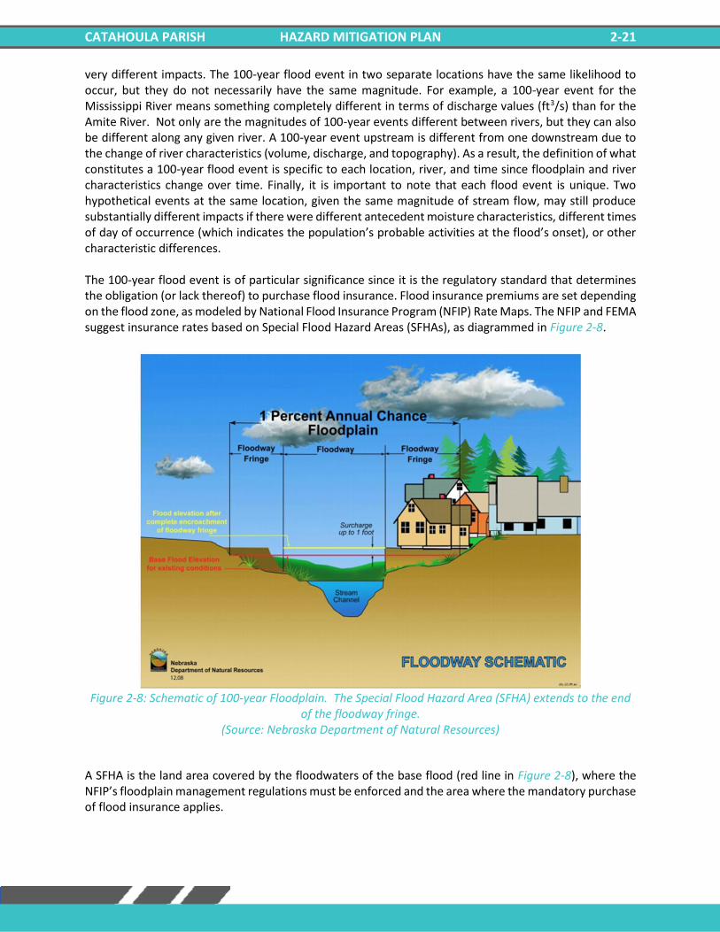
very different impacts. The 100-year flood event in two separate locations have the same likelihood to occur, but they do not necessarily have the same magnitude. For example, a 100-year event for the Mississippi River means something completely different in terms of discharge values (ft3/s) than for the Amite River. Not only are the magnitudes of 100-year events different between rivers, but they can also be different along any given river. A 100-year event upstream is different from one downstream due to the change of river characteristics (volume, discharge, and topography). As a result, the definition of what constitutes a 100-year flood event is specific to each location, river, and time since floodplain and river characteristics change over time. Finally, it is important to note that each flood event is unique. Two hypothetical events at the same location, given the same magnitude of stream flow, may still produce substantially different impacts if there were different antecedent moisture characteristics, different times of day of occurrence (which indicates the population’s probable activities at the flood’s onset), or other characteristic differences. The 100-year flood event is of particular significance since it is the regulatory standard that determines the obligation (or lack thereof) to purchase flood insurance. Flood insurance premiums are set depending on the flood zone, as modeled by National Flood Insurance Program (NFIP) Rate Maps. The NFIP and FEMA suggest insurance rates based on Special Flood Hazard Areas (SFHAs), as diagrammed in Figure 2-8.
Figure 2-8: Schematic of 100-year Floodplain. The Special Flood Hazard Area (SFHA) extends to the end
of the floodway fringe. (Source: Nebraska Department of Natural Resources)
A SFHA is the land area covered by the floodwaters of the base flood (red line in Figure 2-8), where the NFIP’s floodplain management regulations must be enforced and the area where the mandatory purchase of flood insurance applies.
CATAHOULA PARISH HAZARD MITIGATION PLAN 2-22
Property Damage
The depth and velocity of flood waters are the major variables in determining property damage. Flood velocity is important because the faster water moves, the more pressure it puts on a structure and the more it will erode stream banks and scour the earth around a building’s foundation. In some situations, deep and fast-moving waters can push a building off its foundation. Structural damage can also be caused by the weight of standing water (hydrostatic pressure). Another threat to property from a flood is called “soaking”. When soaked, many materials change their composition or shape. Wet wood will swell, and if dried too quickly, will crack, split, or warp. Plywood can come apart and gypsum wallboard can deteriorate if it is bumped before it has time to completely dry. The longer these materials are saturated, the more moisture, sediment, and pollutants they absorb. Soaking can also cause extensive damage to household goods. Wooden furniture may become warped, making it unusable, while other furnishings such as books, carpeting, mattresses, and upholstery usually are not salvageable. Electrical appliances and gasoline engines will flood, making them worthless until they are professionally dried and cleaned. Many buildings that have succumbed to flood waters may look sound and unharmed after a flood, but water has the potential to cause severe property damage. Any structure that experiences a flood should be stripped, cleaned, and allowed to dry before being reconstructed. This can be an extremely expensive and time-consuming effort.
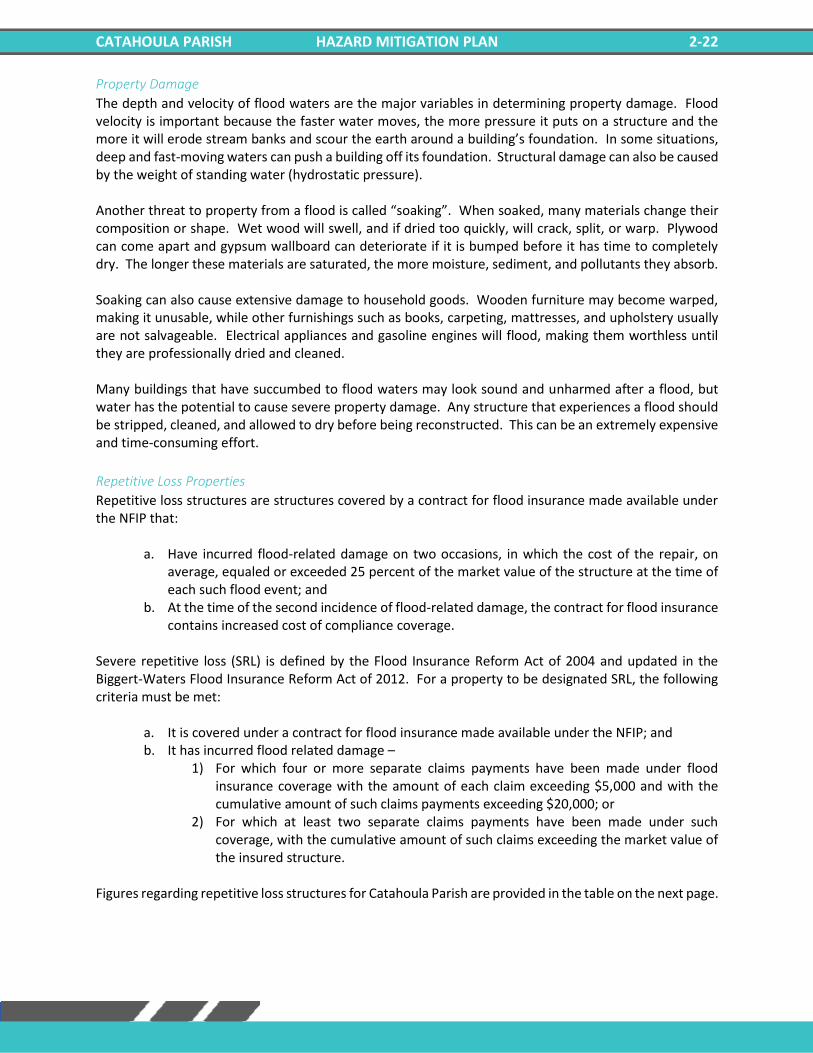
Repetitive Loss Properties
Repetitive loss structures are structures covered by a contract for flood insurance made available under the NFIP that:
a. Have incurred flood-related damage on two occasions, in which the cost of the repair, on average, equaled or exceeded 25 percent of the market value of the structure at the time of each such flood event; and
b. At the time of the second incidence of flood-related damage, the contract for flood insurance contains increased cost of compliance coverage.
Severe repetitive loss (SRL) is defined by the Flood Insurance Reform Act of 2004 and updated in the Biggert-Waters Flood Insurance Reform Act of 2012. For a property to be designated SRL, the following criteria must be met:
a. It is covered under a contract for flood insurance made available under the NFIP; and b. It has incurred flood related damage –
1) For which four or more separate claims payments have been made under flood insurance coverage with the amount of each claim exceeding $5,000 and with the cumulative amount of such claims payments exceeding $20,000; or
2) For which at least two separate claims payments have been made under such coverage, with the cumulative amount of such claims exceeding the market value of the insured structure.
Figures regarding repetitive loss structures for Catahoula Parish are provided in the table on the next page.
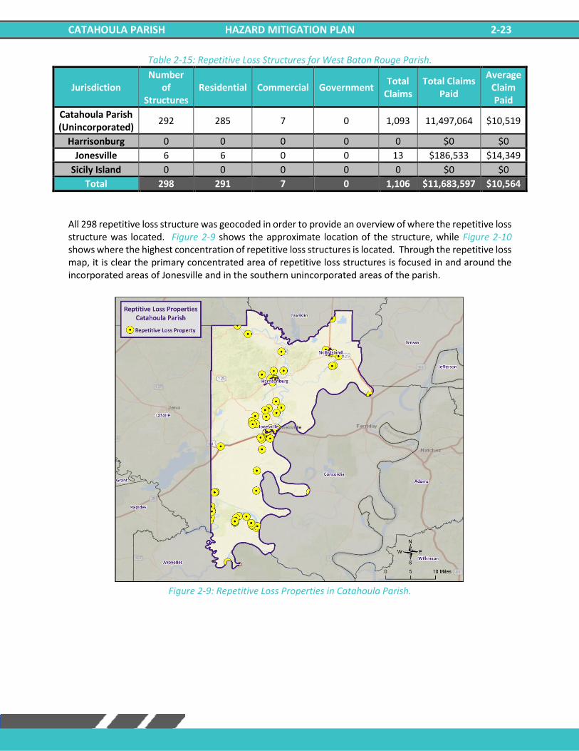
CATAHOULA PARISH HAZARD MITIGATION PLAN 2-23
Table 2-15: Repetitive Loss Structures for West Baton Rouge Parish.
Jurisdiction Number
of Structures
Residential Commercial Government Total
Claims Total Claims
Paid
Average Claim Paid
Catahoula Parish (Unincorporated)
292 285 7 0 1,093 11,497,064 $10,519
Harrisonburg 0 0 0 0 0 $0 $0
Jonesville 6 6 0 0 13 $186,533 $14,349
Sicily Island 0 0 0 0 0 $0 $0
Total 298 291 7 0 1,106 $11,683,597 $10,564
All 298 repetitive loss structure was geocoded in order to provide an overview of where the repetitive loss structure was located. Figure 2-9 shows the approximate location of the structure, while Figure 2-10 shows where the highest concentration of repetitive loss structures is located. Through the repetitive loss map, it is clear the primary concentrated area of repetitive loss structures is focused in and around the incorporated areas of Jonesville and in the southern unincorporated areas of the parish.
Figure 2-9: Repetitive Loss Properties in Catahoula Parish.
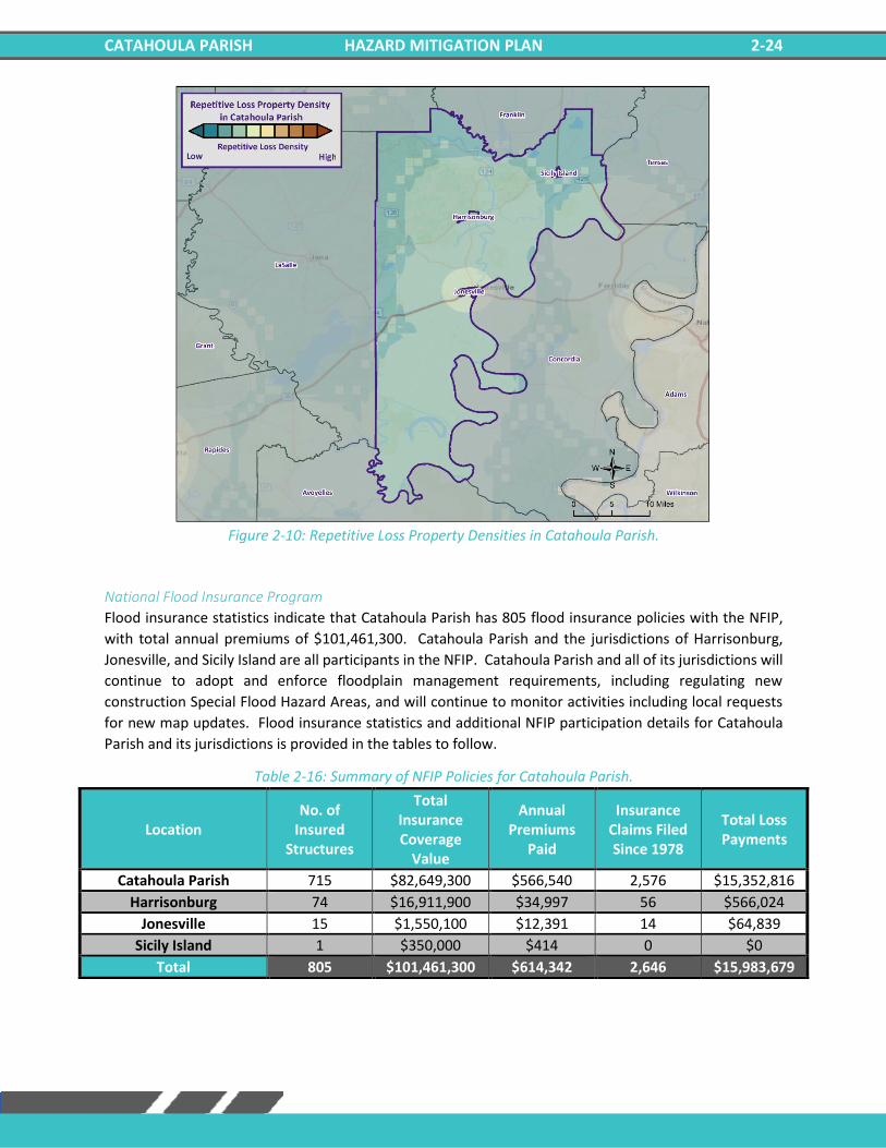
CATAHOULA PARISH HAZARD MITIGATION PLAN 2-24
Figure 2-10: Repetitive Loss Property Densities in Catahoula Parish.
National Flood Insurance Program
Flood insurance statistics indicate that Catahoula Parish has 805 flood insurance policies with the NFIP,
with total annual premiums of $101,461,300. Catahoula Parish and the jurisdictions of Harrisonburg,
Jonesville, and Sicily Island are all participants in the NFIP. Catahoula Parish and all of its jurisdictions will
continue to adopt and enforce floodplain management requirements, including regulating new
construction Special Flood Hazard Areas, and will continue to monitor activities including local requests
for new map updates. Flood insurance statistics and additional NFIP participation details for Catahoula
Parish and its jurisdictions is provided in the tables to follow.
Table 2-16: Summary of NFIP Policies for Catahoula Parish.
Location No. of
Insured Structures
Total Insurance Coverage
Value
Annual Premiums
Paid
Insurance Claims Filed Since 1978
Total Loss Payments
Catahoula Parish 715 $82,649,300 $566,540 2,576 $15,352,816
Harrisonburg 74 $16,911,900 $34,997 56 $566,024
Jonesville 15 $1,550,100 $12,391 14 $64,839
Sicily Island 1 $350,000 $414 0 $0
Total 805 $101,461,300 $614,342 2,646 $15,983,679
CATAHOULA PARISH HAZARD MITIGATION PLAN 2-25
Table 2-17: Summary of Community Flood Maps for Catahoula Parish.
According to the Community Rating System (CRS) list of eligible communities dated October 1, 2021,
Catahoula Parish and incorporated areas of Harrisonburg, Jonesville, and Sicily Island do not participate
in the CRS program.
Threat to People
Just as with property damage, depth and velocity are major factors in determining the threat posed to people by flooding. It takes very little depth or velocity for flood waters to become dangerous. A car will float in less than two feet of moving water, and can be swept downstream into deeper waters, trapping passengers within the vehicle. Victims of floods have often put themselves in perilous situations by entering flood waters that they believe to be safe, or by ignoring travel advisories. Major health concerns are also associated with floods. Flood waters can transport materials such as dirt, oil, animal waste, and chemicals (e.g., farm, lawn, and industrial) that may cause illnesses of various degrees when coming in contact with humans. Flood waters can also infiltrate sewer lines and inundate wastewater treatment plants, causing sewage to backup and creating a breeding ground for dangerous bacteria. This infiltration may also cause water supplies to become contaminated and undrinkable.
Flooding in Catahoula Parish
By definition, flooding is caused when an area receives more water than the drainage system can convey. The following is a synopsis of the types of flooding that Catahoula Parish experiences. Flash Floods: Flash floods are characterized by a rapid rise in water level, high velocity, and large amounts of debris. They are capable of uprooting trees, undermining buildings, and bridges, and scouring new channels. Major factors in flash flooding are the high intensity and short duration of rainfall, as well as the steepness of watershed and stream gradients. Local Drainage or High Groundwater Levels: Locally heavy precipitation may produce flooding in areas other than delineated floodplains or along recognizable drainage channels. If local conditions cannot accommodate intense precipitation through a combination of infiltration and surface runoff, water may accumulate and cause flooding problems. Backwater Flooding: Backwater flooding is normally associated with riverine flooding and connotes minimal velocity. All low-lying areas are at risk. A heavy rainfall event coupled with a swollen river, canal, bayou, or marsh hinders drainage outflow, causing backwater flooding to the same areas susceptible to storm surge. Riverine Flooding: Riverine flooding, by definition, is river-based. Most of the riverine flooding problems occur when rivers crests at flood stage levels, causing extensive flooding in low-lying areas.
CID Community Name Initial FHBM
Identified
Initial FIRM
Identified
Current
Effective Map
Date
Date Joined
the NFIP Tribal
220047 Catahoula Parish 11/29/1977 4/5/1988 4/19/2005 4/5/1998 No
220048 Harrisonburg 12/21/1973 4/5/1988 4/5/1988 4/5/1988 No
220049 Jonesville 12/17/1973 3/1/1978 4/19/2005 3/1/1978 No
220050 Sicily Island 12/28/1973 4/5/1988 NSFHA 1/20/2011 No
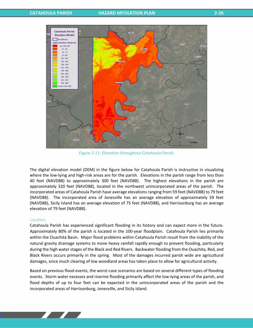
CATAHOULA PARISH HAZARD MITIGATION PLAN 2-26
Figure 2-11: Elevation throughout Catahoula Parish.
The digital elevation model (DEM) in the figure below for Catahoula Parish is instructive in visualizing where the low-lying and high-risk areas are for the parish. Elevations in the parish range from less than 40 feet (NAVD88) to approximately 300 feet (NAVD88). The highest elevations in the parish are approximately 320 feet (NAVD88), located in the northwest unincorporated areas of the parish. The incorporated areas of Catahoula Parish have average elevations ranging from 59 feet (NAVD88) to 79 feet (NAVD88). The incorporated area of Jonesville has an average elevation of approximately 59 feet (NAVD88), Sicily Island has an average elevation of 75 feet (NAVD88), and Harrisonburg has an average elevation of 79 feet (NAVD88). Location Catahoula Parish has experienced significant flooding in its history and can expect more in the future.
Approximately 80% of the parish is located in the 100-year floodplain. Catahoula Parish lies primarily
within the Ouachita Basin. Major flood problems within Catahoula Parish result from the inability of the
natural gravity drainage systems to move heavy rainfall rapidly enough to prevent flooding, particularly
during the high water stages of the Black and Red Rivers. Backwater flooding from the Ouachita, Red, and
Black Rivers occurs primarily in the spring. Most of the damages incurred parish wide are agricultural
damages, since much clearing of low woodland areas has taken place to allow for agricultural activity.
Based on previous flood events, the worst-case scenarios are based on several different types of flooding
events. Storm water excesses and riverine flooding primarily affect the low-lying areas of the parish, and
flood depths of up to four feet can be expected in the unincorporated areas of the parish and the
incorporated areas of Harrisonburg, Jonesville, and Sicily Island.
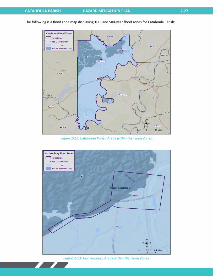
CATAHOULA PARISH HAZARD MITIGATION PLAN 2-27
The following is a flood zone map displaying 100- and 500-year flood zones for Catahoula Parish:
Figure 2-12: Catahoula Parish Areas within the Flood Zones.
Figure 2-13: Harrisonburg Areas within the Flood Zones.
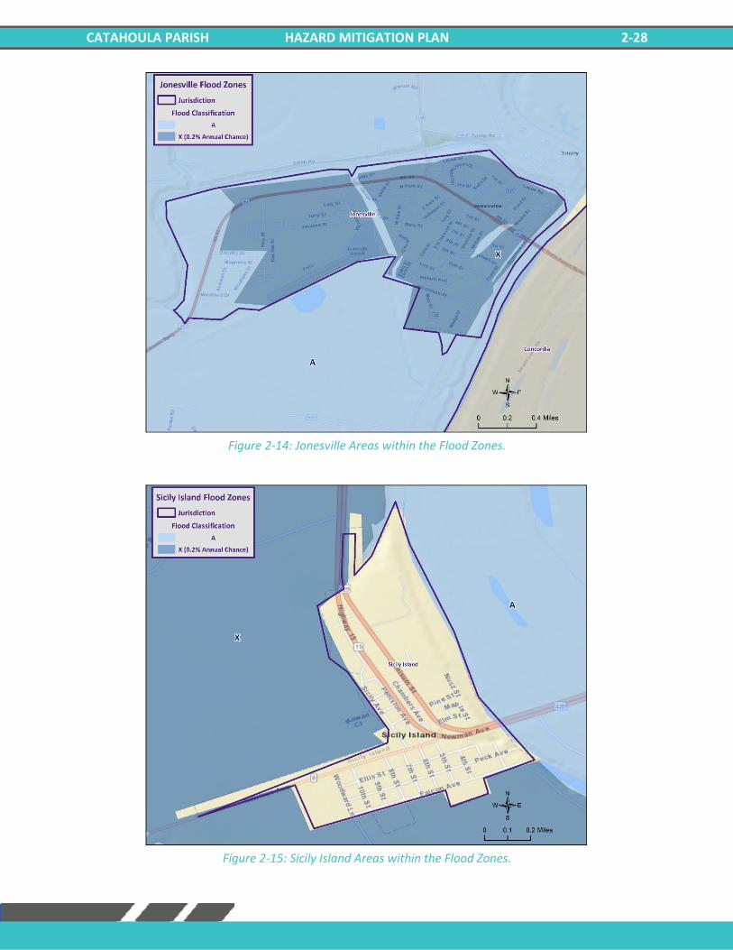
CATAHOULA PARISH HAZARD MITIGATION PLAN 2-28
Figure 2-14: Jonesville Areas within the Flood Zones.
Figure 2-15: Sicily Island Areas within the Flood Zones.
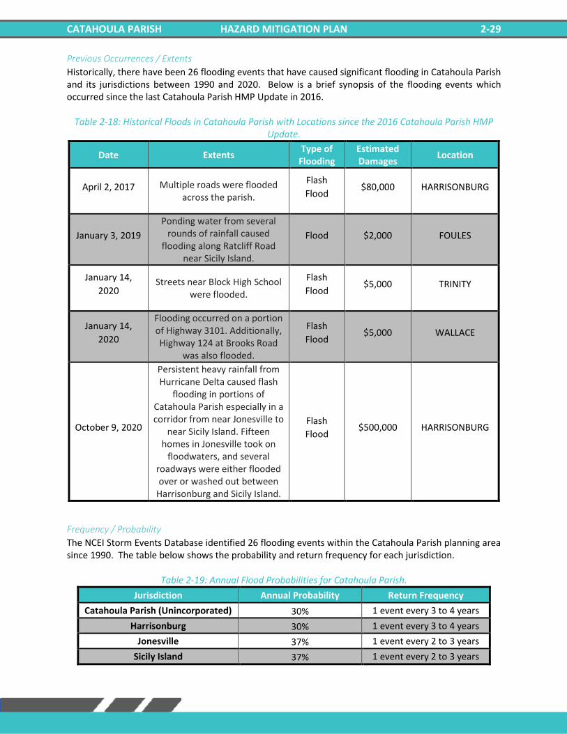
CATAHOULA PARISH HAZARD MITIGATION PLAN 2-29
Previous Occurrences / Extents
Historically, there have been 26 flooding events that have caused significant flooding in Catahoula Parish and its jurisdictions between 1990 and 2020. Below is a brief synopsis of the flooding events which occurred since the last Catahoula Parish HMP Update in 2016.
Table 2-18: Historical Floods in Catahoula Parish with Locations since the 2016 Catahoula Parish HMP Update.
Date Extents Type of
Flooding Estimated Damages
Location
April 2, 2017 Multiple roads were flooded across the parish.
Flash
Flood $80,000 HARRISONBURG
January 3, 2019
Ponding water from several rounds of rainfall caused
flooding along Ratcliff Road near Sicily Island.
Flood $2,000 FOULES
January 14,
2020 Streets near Block High School
were flooded.
Flash
Flood $5,000 TRINITY
January 14,
2020
Flooding occurred on a portion of Highway 3101. Additionally, Highway 124 at Brooks Road
was also flooded.
Flash
Flood $5,000 WALLACE
October 9, 2020
Persistent heavy rainfall from Hurricane Delta caused flash
flooding in portions of Catahoula Parish especially in a corridor from near Jonesville to
near Sicily Island. Fifteen homes in Jonesville took on
floodwaters, and several roadways were either flooded over or washed out between
Harrisonburg and Sicily Island.
Flash
Flood $500,000 HARRISONBURG
Frequency / Probability
The NCEI Storm Events Database identified 26 flooding events within the Catahoula Parish planning area since 1990. The table below shows the probability and return frequency for each jurisdiction.
Table 2-19: Annual Flood Probabilities for Catahoula Parish.
Jurisdiction Annual Probability Return Frequency
Catahoula Parish (Unincorporated) 30% 1 event every 3 to 4 years
Harrisonburg 30% 1 event every 3 to 4 years
Jonesville 37% 1 event every 2 to 3 years
Sicily Island 37% 1 event every 2 to 3 years
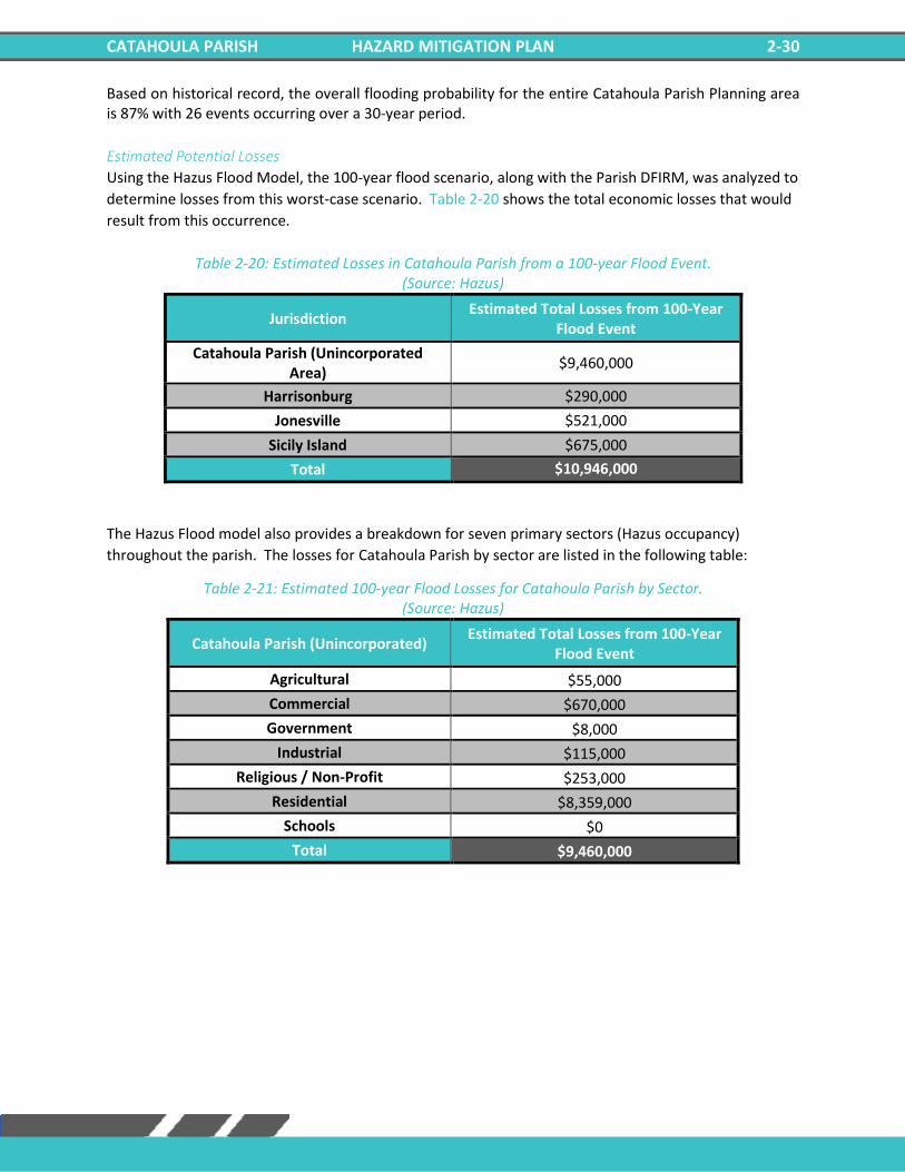
CATAHOULA PARISH HAZARD MITIGATION PLAN 2-30
Based on historical record, the overall flooding probability for the entire Catahoula Parish Planning area is 87% with 26 events occurring over a 30-year period.
Estimated Potential Losses
Using the Hazus Flood Model, the 100-year flood scenario, along with the Parish DFIRM, was analyzed to
determine losses from this worst-case scenario. Table 2-20 shows the total economic losses that would
result from this occurrence.
Table 2-20: Estimated Losses in Catahoula Parish from a 100-year Flood Event. (Source: Hazus)
Jurisdiction Estimated Total Losses from 100-Year
Flood Event
Catahoula Parish (Unincorporated Area)
$9,460,000
Harrisonburg $290,000
Jonesville $521,000
Sicily Island $675,000
Total $10,946,000
The Hazus Flood model also provides a breakdown for seven primary sectors (Hazus occupancy)
throughout the parish. The losses for Catahoula Parish by sector are listed in the following table:
Table 2-21: Estimated 100-year Flood Losses for Catahoula Parish by Sector. (Source: Hazus)
Catahoula Parish (Unincorporated) Estimated Total Losses from 100-Year
Flood Event
Agricultural $55,000
Commercial $670,000
Government $8,000
Industrial $115,000
Religious / Non-Profit $253,000
Residential $8,359,000
Schools $0
Total $9,460,000
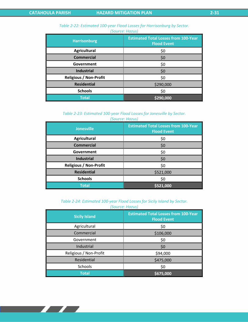
CATAHOULA PARISH HAZARD MITIGATION PLAN 2-31
Table 2-22: Estimated 100-year Flood Losses for Harrisonburg by Sector. (Source: Hazus)
Harrisonburg Estimated Total Losses from 100-Year
Flood Event
Agricultural $0
Commercial $0
Government $0
Industrial $0
Religious / Non-Profit $0
Residential $290,000
Schools $0
Total $290,000
Table 2-23: Estimated 100-year Flood Losses for Jonesville by Sector. (Source: Hazus)
Jonesville Estimated Total Losses from 100-Year
Flood Event
Agricultural $0
Commercial $0
Government $0
Industrial $0
Religious / Non-Profit $0
Residential $521,000
Schools $0
Total $521,000
Table 2-24: Estimated 100-year Flood Losses for Sicily Island by Sector. (Source: Hazus)
Sicily Island Estimated Total Losses from 100-Year
Flood Event
Agricultural $0
Commercial $106,000
Government $0
Industrial $0
Religious / Non-Profit $94,000
Residential $475,000
Schools $0
Total $675,000
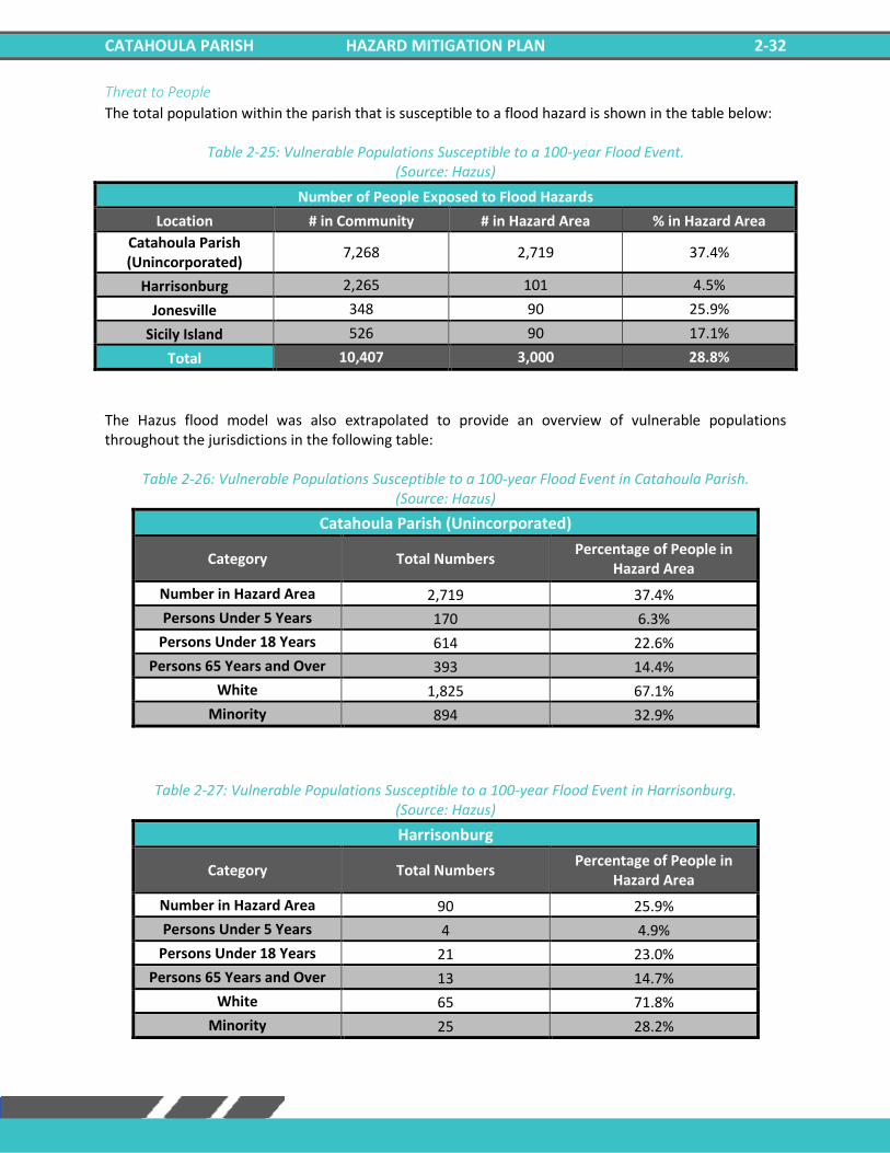
CATAHOULA PARISH HAZARD MITIGATION PLAN 2-32
Threat to People
The total population within the parish that is susceptible to a flood hazard is shown in the table below:
Table 2-25: Vulnerable Populations Susceptible to a 100-year Flood Event. (Source: Hazus)
Number of People Exposed to Flood Hazards
Location # in Community # in Hazard Area % in Hazard Area
Catahoula Parish (Unincorporated)
7,268 2,719 37.4%
Harrisonburg 2,265 101 4.5%
Jonesville 348 90 25.9%
Sicily Island 526 90 17.1%
Total 10,407 3,000 28.8%
The Hazus flood model was also extrapolated to provide an overview of vulnerable populations throughout the jurisdictions in the following table:
Table 2-26: Vulnerable Populations Susceptible to a 100-year Flood Event in Catahoula Parish. (Source: Hazus)
Catahoula Parish (Unincorporated)
Category Total Numbers Percentage of People in
Hazard Area
Number in Hazard Area 2,719 37.4%
Persons Under 5 Years 170 6.3%
Persons Under 18 Years 614 22.6%
Persons 65 Years and Over 393 14.4%
White 1,825 67.1%
Minority 894 32.9%
Table 2-27: Vulnerable Populations Susceptible to a 100-year Flood Event in Harrisonburg. (Source: Hazus)
Harrisonburg
Category Total Numbers Percentage of People in
Hazard Area
Number in Hazard Area 90 25.9%
Persons Under 5 Years 4 4.9%
Persons Under 18 Years 21 23.0%
Persons 65 Years and Over 13 14.7%
White 65 71.8%
Minority 25 28.2%
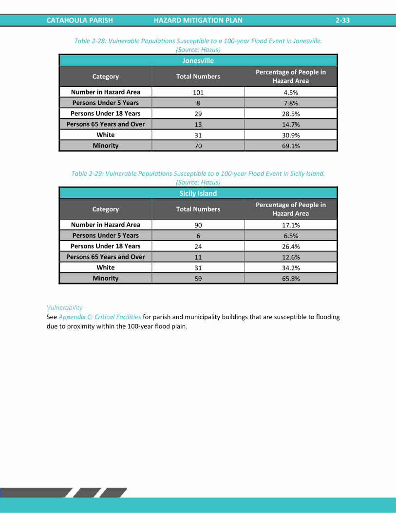
CATAHOULA PARISH HAZARD MITIGATION PLAN 2-33
Table 2-28: Vulnerable Populations Susceptible to a 100-year Flood Event in Jonesville. (Source: Hazus)
Jonesville
Category Total Numbers Percentage of People in
Hazard Area
Number in Hazard Area 101 4.5%
Persons Under 5 Years 8 7.8%
Persons Under 18 Years 29 28.5%
Persons 65 Years and Over 15 14.7%
White 31 30.9%
Minority 70 69.1%
Table 2-29: Vulnerable Populations Susceptible to a 100-year Flood Event in Sicily Island. (Source: Hazus)
Sicily Island
Category Total Numbers Percentage of People in
Hazard Area
Number in Hazard Area 90 17.1%
Persons Under 5 Years 6 6.5%
Persons Under 18 Years 24 26.4%
Persons 65 Years and Over 11 12.6%
White 31 34.2%
Minority 59 65.8%
Vulnerability
See Appendix C: Critical Facilities for parish and municipality buildings that are susceptible to flooding
due to proximity within the 100-year flood plain.
CATAHOULA PARISH HAZARD MITIGATION PLAN 2-34
Thunderstorms The term “thunderstorm” is usually used as a catch-all term for several kinds of storms. Here
“thunderstorm” is defined to include any precipitation event in which thunder is heard or lightning is seen.
Thunderstorms are often accompanied by heavy rain and strong winds and, depending on conditions,
occasionally by hail or snow. Thunderstorms form when humid air masses are heated, which causes them
to become convectively unstable and therefore rise. Upon rising, the air masses’ water vapor condenses
into liquid water and/or deposits directly into ice when they rise sufficiently to cool to the dew-point
temperature.
Thunderstorms are classified into four main types (single cell, multicell, squall line, and supercell),
depending on the degree of atmospheric instability, the change in wind speed with height (called wind
shear), and the degree to which the storm’s internal dynamics are coordinated with those of adjacent
storms. There is no such interaction for single-cell thunderstorms, but there is significant interaction with
clusters of adjacent thunderstorms in multicell thunderstorms and with a linear “chain” of adjacent storms
in squall line thunderstorms. Though supercell storms have no significant interactions with other storms,
they have very well-organized and self-sustaining internal dynamics, which allows them to be the longest-
lived and most severe of all thunderstorms.
The life of a thunderstorm proceeds through three stages: the developing (or cumulus) stage, the mature
stage, and the dissipation stage. During the developing stage, the unstable air mass is lifted as an updraft
into the atmosphere. This sudden lift rapidly cools the moisture in the air mass, releasing latent heat as
condensation and/or deposition occurs, and warming the surrounding environment, thus making it less
dense than the surrounding air. This process intensifies the updraft and creates a localized lateral rush of
air from all directions into the area beneath the thunderstorm to feed continued updrafts. At the mature
stage, the rising air is accompanied by downdrafts caused by the shear of falling rain (if melted
completely), or hail, freezing rain, sleet, or snow (if not melted completely). The dissipation stage is
characterized by the dominating presence of the downdraft as the hot surface that gave the updrafts their
buoyancy is cooled by precipitation. During the dissipation stage, the moisture in the air mass largely
empties out.
The Storm Prediction Center in conjunction with the National Weather Service (NWS) have the ability to
issue advisory messages based on forecasts and observations. The following are the advisory messages
that may be issued with definitions of each:
• Severe Thunderstorm Watch: Issued to alert people to the possibility of a severe
thunderstorm developing in the area. Expected time
frame for these storms is three to six hours.
• Severe Thunderstorm Warning: Issued when severe thunderstorms are imminent. This
warning is highly localized and covers parts of one to
several counties (parishes).
CATAHOULA PARISH HAZARD MITIGATION PLAN 2-35
A variety of hazards might be produced by thunderstorms, including lightning, hail, tornadoes or
waterspouts, flash floods, and high-speed winds called downbursts. Nevertheless, given all of these
criteria, the National Oceanic and Atmospheric Administration (NOAA) characterizes a thunderstorm as
severe when it produces one or more of the following:
• Hail of 1 inch in diameter or larger
• Wind gusts to 58 mph or greater
• One or more tornadoes
Tornadoes and flooding hazards have been profiled within this report; therefore, for the purpose of
thunderstorms, the sub hazards of hail, high winds, and lightning will be profiled.
Thunderstorms occur throughout Louisiana at all times of the year, although the types and severity of
those storms vary greatly, depending on a wide variety of atmospheric conditions. Thunderstorms
generally occur more frequently during the late spring and early summer when extreme variations exist
between ground surface temperatures and upper atmospheric temperatures.
Hazard Description
Hailstorms
Hailstorms are severe thunderstorms in which balls or chunks of ice fall along with rain. Hail develops in
the upper atmosphere initially as ice crystals that are bounced about by high-velocity updraft winds. The
ice crystals grow through deposition of water vapor onto their surface, fall partially to a level in the cloud
where the temperature exceeds the freezing point, melt partially, get caught in another updraft
whereupon re-freezing and deposition grows another concentric layer of ice, and fall after developing
enough weight, sometimes after several trips up and down the cloud. The size of hailstones varies
depending on the severity and size of the thunderstorm. Higher surface temperatures generally mean
stronger updrafts, which allows more massive hailstones to be supported by updrafts, leaving them
suspended longer. This longer time means larger hailstone sizes. The following tables display the TORRO
Hailstorm Intensity Scale along with a spectrum of hailstone diameters and their everyday equivalents.
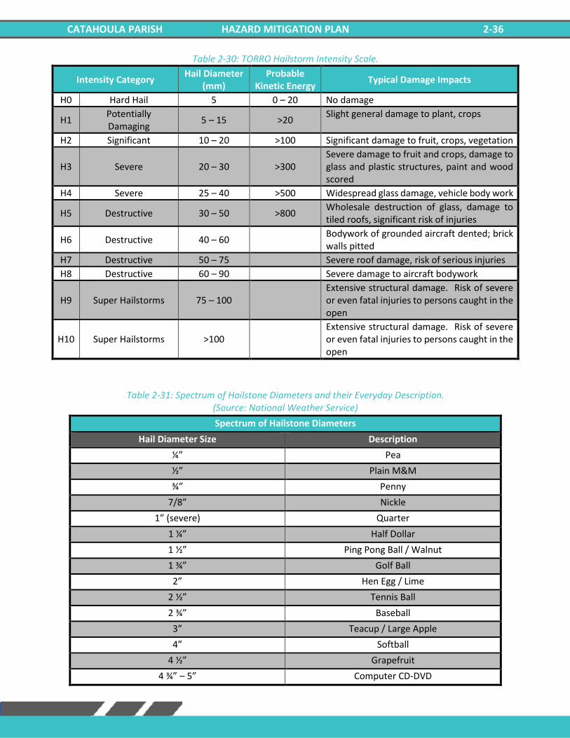
CATAHOULA PARISH HAZARD MITIGATION PLAN 2-36
Table 2-30: TORRO Hailstorm Intensity Scale.
Intensity Category Hail Diameter
(mm) Probable
Kinetic Energy Typical Damage Impacts
H0 Hard Hail 5 0 – 20 No damage
H1 Potentially Damaging
5 – 15 >20 Slight general damage to plant, crops
H2 Significant 10 – 20 >100 Significant damage to fruit, crops, vegetation
H3 Severe 20 – 30 >300 Severe damage to fruit and crops, damage to glass and plastic structures, paint and wood scored
H4 Severe 25 – 40 >500 Widespread glass damage, vehicle body work
H5 Destructive 30 – 50 >800 Wholesale destruction of glass, damage to tiled roofs, significant risk of injuries
H6 Destructive 40 – 60 Bodywork of grounded aircraft dented; brick walls pitted
H7 Destructive 50 – 75 Severe roof damage, risk of serious injuries
H8 Destructive 60 – 90 Severe damage to aircraft bodywork
H9 Super Hailstorms 75 – 100 Extensive structural damage. Risk of severe or even fatal injuries to persons caught in the open
H10 Super Hailstorms >100 Extensive structural damage. Risk of severe or even fatal injuries to persons caught in the open
Table 2-31: Spectrum of Hailstone Diameters and their Everyday Description. (Source: National Weather Service)
Spectrum of Hailstone Diameters
Hail Diameter Size Description
¼” Pea
½” Plain M&M
¾” Penny
7/8” Nickle
1” (severe) Quarter
1 ¼” Half Dollar
1 ½” Ping Pong Ball / Walnut
1 ¾” Golf Ball
2” Hen Egg / Lime
2 ½” Tennis Ball
2 ¾” Baseball
3” Teacup / Large Apple
4” Softball
4 ½” Grapefruit
4 ¾” – 5” Computer CD-DVD
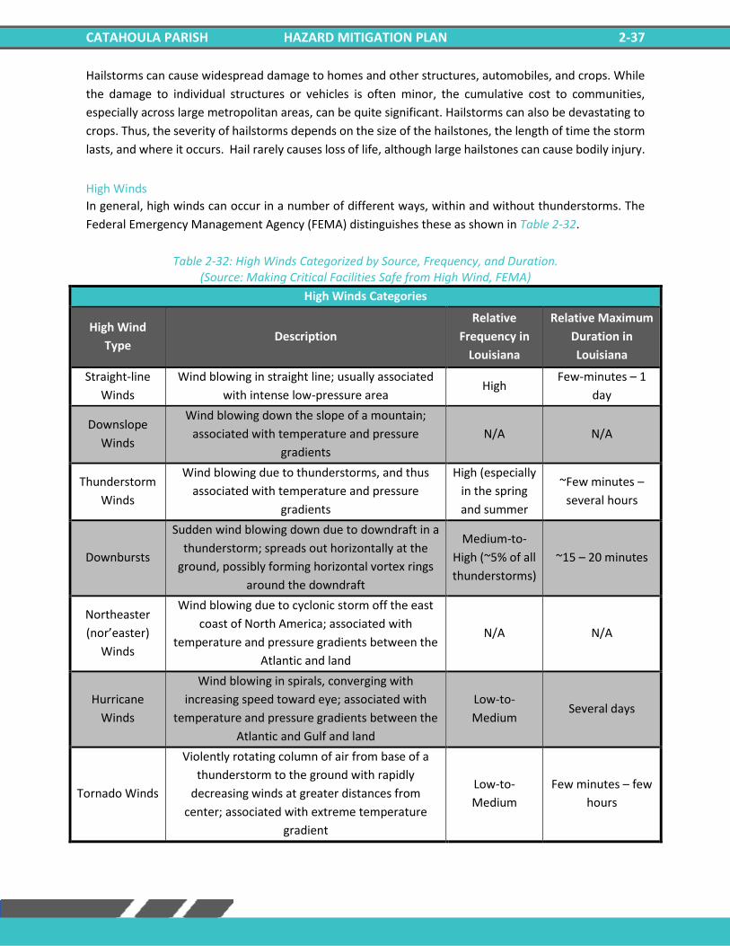
CATAHOULA PARISH HAZARD MITIGATION PLAN 2-37
Hailstorms can cause widespread damage to homes and other structures, automobiles, and crops. While
the damage to individual structures or vehicles is often minor, the cumulative cost to communities,
especially across large metropolitan areas, can be quite significant. Hailstorms can also be devastating to
crops. Thus, the severity of hailstorms depends on the size of the hailstones, the length of time the storm
lasts, and where it occurs. Hail rarely causes loss of life, although large hailstones can cause bodily injury.
High Winds
In general, high winds can occur in a number of different ways, within and without thunderstorms. The
Federal Emergency Management Agency (FEMA) distinguishes these as shown in Table 2-32.
Table 2-32: High Winds Categorized by Source, Frequency, and Duration. (Source: Making Critical Facilities Safe from High Wind, FEMA)
High Winds Categories
High Wind
Type Description
Relative
Frequency in
Louisiana
Relative Maximum
Duration in
Louisiana
Straight-line
Winds
Wind blowing in straight line; usually associated
with intense low-pressure area High
Few-minutes – 1
day
Downslope
Winds
Wind blowing down the slope of a mountain;
associated with temperature and pressure
gradients
N/A N/A
Thunderstorm
Winds
Wind blowing due to thunderstorms, and thus
associated with temperature and pressure
gradients
High (especially
in the spring
and summer
~Few minutes –
several hours
Downbursts
Sudden wind blowing down due to downdraft in a
thunderstorm; spreads out horizontally at the
ground, possibly forming horizontal vortex rings
around the downdraft
Medium-to-
High (~5% of all
thunderstorms)
~15 – 20 minutes
Northeaster
(nor’easter)
Winds
Wind blowing due to cyclonic storm off the east
coast of North America; associated with
temperature and pressure gradients between the
Atlantic and land
N/A N/A
Hurricane
Winds
Wind blowing in spirals, converging with
increasing speed toward eye; associated with
temperature and pressure gradients between the
Atlantic and Gulf and land
Low-to-
Medium Several days
Tornado Winds
Violently rotating column of air from base of a
thunderstorm to the ground with rapidly
decreasing winds at greater distances from
center; associated with extreme temperature
gradient
Low-to-
Medium
Few minutes – few
hours
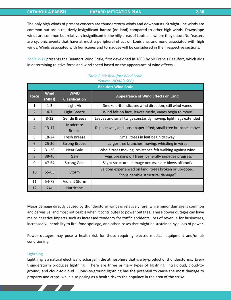
CATAHOULA PARISH HAZARD MITIGATION PLAN 2-38
The only high winds of present concern are thunderstorm winds and downbursts. Straight-line winds are
common but are a relatively insignificant hazard (on land) compared to other high winds. Downslope
winds are common but relatively insignificant in the hilly areas of Louisiana where they occur. Nor’easters
are cyclonic events that have at most a peripheral effect on Louisiana, and none associated with high
winds. Winds associated with hurricanes and tornadoes will be considered in their respective sections.
Table 2-33 presents the Beaufort Wind Scale, first developed in 1805 by Sir Francis Beaufort, which aids
in determining relative force and wind speed based on the appearance of wind effects.
Table 2-33: Beaufort Wind Scale.
(Source: NOAA’s SPC)
Beaufort Wind Scale
Force Wind
(MPH)
WMO
Classification Appearance of Wind Effects on Land
1 1-3 Light Air Smoke drift indicates wind direction, still wind vanes
2 4-7 Light Breeze Wind felt on face, leaves rustle, vanes begin to move
3 8-12 Gentle Breeze Leaves and small twigs constantly moving, light flags extended
4 13-17 Moderate
Breeze Dust, leaves, and loose paper lifted; small tree branches move
5 18-24 Fresh Breeze Small trees in leaf begin to sway
6 25-30 Strong Breeze Larger tree branches moving, whistling in wires
7 31-38 Near Gale Whole trees moving, resistance felt walking against wind
8 39-46 Gale Twigs breaking off trees, generally impedes progress
9 47-54 Strong Gale Slight structural damage occurs, slate blows off roofs
10 55-63 Storm Seldom experienced on land, trees broken or uprooted,
“considerable structural damage”
11 54-73 Violent Storm
12 74+ Hurricane
Major damage directly caused by thunderstorm winds is relatively rare, while minor damage is common
and pervasive, and most noticeable when it contributes to power outages. These power outages can have
major negative impacts such as increased tendency for traffic accidents, loss of revenue for businesses,
increased vulnerability to fire, food spoilage, and other losses that might be sustained by a loss of power.
Power outages may pose a health risk for those requiring electric medical equipment and/or air
conditioning.
Lightning
Lightning is a natural electrical discharge in the atmosphere that is a by-product of thunderstorms. Every
thunderstorm produces lightning. There are three primary types of lightning: intra-cloud, cloud-to-
ground, and cloud-to-cloud. Cloud-to-ground lightning has the potential to cause the most damage to
property and crops, while also posing as a health risk to the populace in the area of the strike.
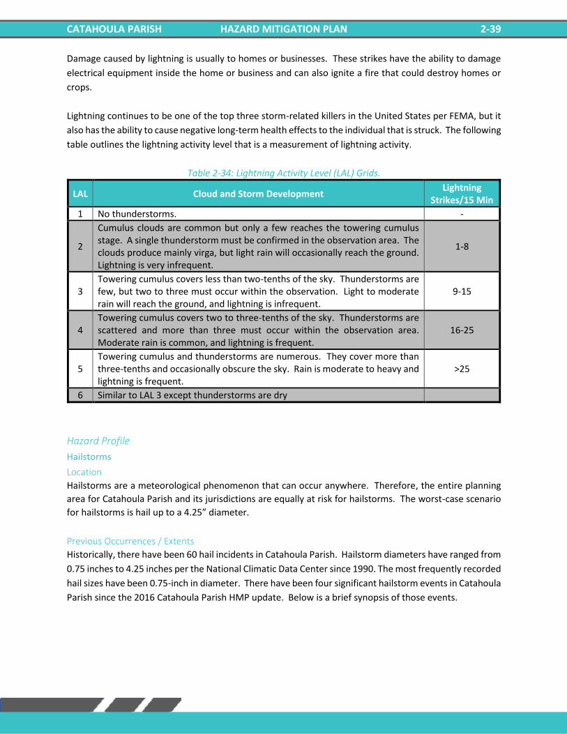
CATAHOULA PARISH HAZARD MITIGATION PLAN 2-39
Damage caused by lightning is usually to homes or businesses. These strikes have the ability to damage
electrical equipment inside the home or business and can also ignite a fire that could destroy homes or
crops.
Lightning continues to be one of the top three storm-related killers in the United States per FEMA, but it
also has the ability to cause negative long-term health effects to the individual that is struck. The following
table outlines the lightning activity level that is a measurement of lightning activity.
Table 2-34: Lightning Activity Level (LAL) Grids.
LAL Cloud and Storm Development Lightning
Strikes/15 Min
1 No thunderstorms. -
2
Cumulus clouds are common but only a few reaches the towering cumulus stage. A single thunderstorm must be confirmed in the observation area. The clouds produce mainly virga, but light rain will occasionally reach the ground. Lightning is very infrequent.
1-8
3 Towering cumulus covers less than two-tenths of the sky. Thunderstorms are few, but two to three must occur within the observation. Light to moderate rain will reach the ground, and lightning is infrequent.
9-15
4 Towering cumulus covers two to three-tenths of the sky. Thunderstorms are scattered and more than three must occur within the observation area. Moderate rain is common, and lightning is frequent.
16-25
5 Towering cumulus and thunderstorms are numerous. They cover more than three-tenths and occasionally obscure the sky. Rain is moderate to heavy and lightning is frequent.
>25
6 Similar to LAL 3 except thunderstorms are dry
Hazard Profile
Hailstorms
Location
Hailstorms are a meteorological phenomenon that can occur anywhere. Therefore, the entire planning
area for Catahoula Parish and its jurisdictions are equally at risk for hailstorms. The worst-case scenario
for hailstorms is hail up to a 4.25” diameter.
Previous Occurrences / Extents
Historically, there have been 60 hail incidents in Catahoula Parish. Hailstorm diameters have ranged from
0.75 inches to 4.25 inches per the National Climatic Data Center since 1990. The most frequently recorded
hail sizes have been 0.75-inch in diameter. There have been four significant hailstorm events in Catahoula
Parish since the 2016 Catahoula Parish HMP update. Below is a brief synopsis of those events.
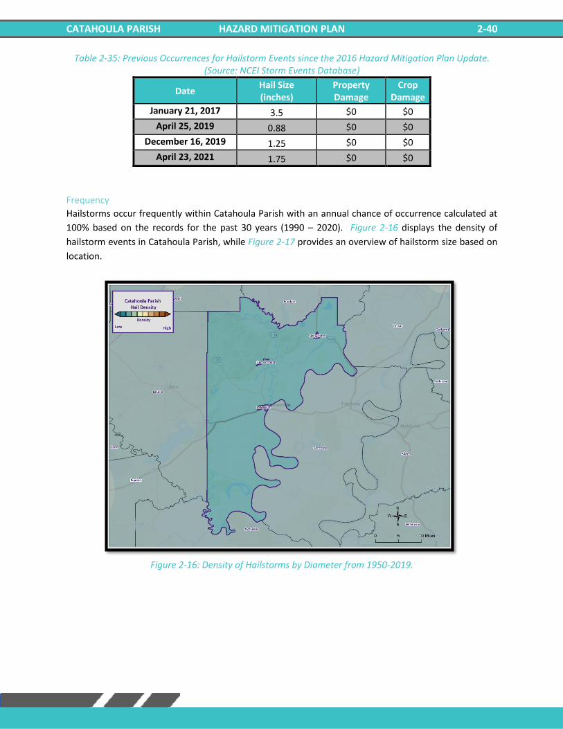
CATAHOULA PARISH HAZARD MITIGATION PLAN 2-40
Table 2-35: Previous Occurrences for Hailstorm Events since the 2016 Hazard Mitigation Plan Update. (Source: NCEI Storm Events Database)
Date Hail Size (inches)
Property Damage
Crop Damage
January 21, 2017 3.5 $0 $0
April 25, 2019 0.88 $0 $0
December 16, 2019 1.25 $0 $0
April 23, 2021 1.75 $0 $0
Frequency
Hailstorms occur frequently within Catahoula Parish with an annual chance of occurrence calculated at
100% based on the records for the past 30 years (1990 – 2020). Figure 2-16 displays the density of
hailstorm events in Catahoula Parish, while Figure 2-17 provides an overview of hailstorm size based on
location.
Figure 2-16: Density of Hailstorms by Diameter from 1950-2019.
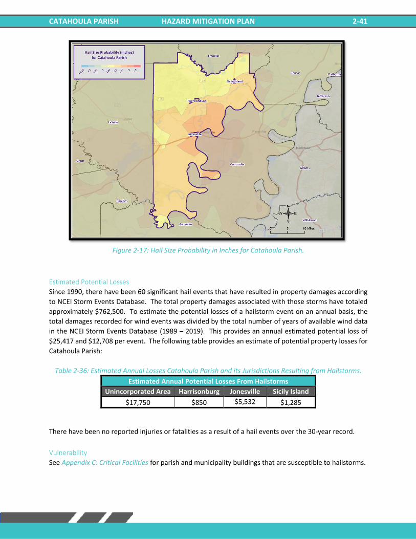
CATAHOULA PARISH HAZARD MITIGATION PLAN 2-41
Figure 2-17: Hail Size Probability in Inches for Catahoula Parish.
Estimated Potential Losses
Since 1990, there have been 60 significant hail events that have resulted in property damages according
to NCEI Storm Events Database. The total property damages associated with those storms have totaled
approximately $762,500. To estimate the potential losses of a hailstorm event on an annual basis, the
total damages recorded for wind events was divided by the total number of years of available wind data
in the NCEI Storm Events Database (1989 – 2019). This provides an annual estimated potential loss of
$25,417 and $12,708 per event. The following table provides an estimate of potential property losses for
Catahoula Parish:
Table 2-36: Estimated Annual Losses Catahoula Parish and its Jurisdictions Resulting from Hailstorms.
Estimated Annual Potential Losses From Hailstorms
Unincorporated Area Harrisonburg Jonesville Sicily Island
$17,750 $850 $5,532 $1,285
There have been no reported injuries or fatalities as a result of a hail events over the 30-year record.
Vulnerability
See Appendix C: Critical Facilities for parish and municipality buildings that are susceptible to hailstorms.
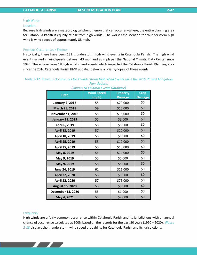
CATAHOULA PARISH HAZARD MITIGATION PLAN 2-42
High Winds
Location
Because high winds are a meteorological phenomenon that can occur anywhere, the entire planning area
for Catahoula Parish is equally at risk from high winds. The worst-case scenario for thunderstorm high
wind is wind speeds of approximately 88 mph.
Previous Occurrences / Extents
Historically, there have been 131 thunderstorm high wind events in Catahoula Parish. The high wind
events ranged in windspeeds between 43 mph and 88 mph per the National Climatic Data Center since
1990. There have been 18 high wind speed events which impacted the Catahoula Parish Planning area
since the 2016 Catahoula Parish HMP update. Below is a brief synopsis of those events.
Table 2-37: Previous Occurrences for Thunderstorm High Wind Events since the 2016 Hazard Mitigation Plan Update.
(Source: NCEI Storm Events Database)
Date Wind Speed
(mph) Property Damage
Crop Damage
January 2, 2017 55 $20,000 $0
March 28, 2018 59 $10,000 $0
November 1, 2018 55 $15,000 $0
January 19, 2019 55 $3,000 $0
April 6, 2019 55 $5,000 $0
April 13, 2019 57 $20,000 $0
April 18, 2019 55 $5,000 $0
April 25, 2019 55 $10,000 $0
April 25, 2019 55 $10,000 $0
May 8, 2019 55 $10,000 $0
May 9, 2019 55 $5,000 $0
May 9, 2019 55 $5,000 $0
June 24, 2019 61 $25,000 $0
April 22, 2020 55 $5,000 $0
April 22, 2020 57 $75,000 $0
August 15, 2020 55 $5,000 $0
December 13, 2020 55 $1,000 $0
May 4, 2021 55 $2,000 $0
Frequency
High winds are a fairly common occurrence within Catahoula Parish and its jurisdictions with an annual
chance of occurrence calculated at 100% based on the records for the past 30 years (1990 – 2020). Figure
2-18 displays the thunderstorm wind speed probability for Catahoula Parish and its jurisdictions.
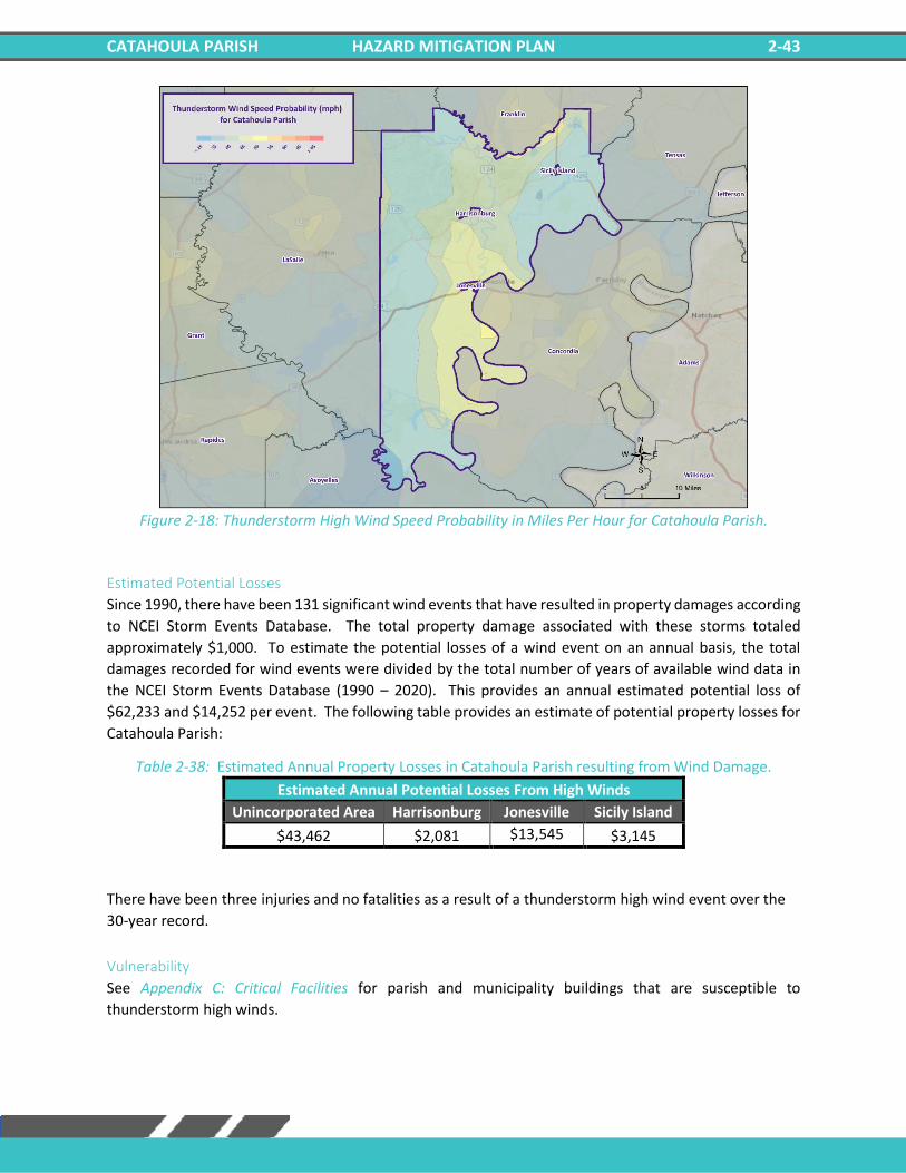
CATAHOULA PARISH HAZARD MITIGATION PLAN 2-43
Figure 2-18: Thunderstorm High Wind Speed Probability in Miles Per Hour for Catahoula Parish.
Estimated Potential Losses
Since 1990, there have been 131 significant wind events that have resulted in property damages according
to NCEI Storm Events Database. The total property damage associated with these storms totaled
approximately $1,000. To estimate the potential losses of a wind event on an annual basis, the total
damages recorded for wind events were divided by the total number of years of available wind data in
the NCEI Storm Events Database (1990 – 2020). This provides an annual estimated potential loss of
$62,233 and $14,252 per event. The following table provides an estimate of potential property losses for
Catahoula Parish:
Table 2-38: Estimated Annual Property Losses in Catahoula Parish resulting from Wind Damage.
Estimated Annual Potential Losses From High Winds
Unincorporated Area Harrisonburg Jonesville Sicily Island
$43,462 $2,081 $13,545 $3,145
There have been three injuries and no fatalities as a result of a thunderstorm high wind event over the
30-year record.
Vulnerability
See Appendix C: Critical Facilities for parish and municipality buildings that are susceptible to
thunderstorm high winds.
CATAHOULA PARISH HAZARD MITIGATION PLAN 2-44
Lightning
Location
Like hail and high winds, lightning is a meteorological phenomenon that can occur anywhere within the
Catahoula Parish planning area. The worst-case scenario for lightning events is a lightning activity level
of 4 which is approximately 16 to 25 lightning strikes every 15 minutes.
Previous Occurrences / Extent
Historically, there has been one lightning event in Catahoula Parish and its jurisdictions between the years
1990 and 2020. Since the last HMP update, there has been no significant lighting events within the
boundaries of Catahoula Parish.
Frequency
Lightning can strike anywhere and is produced by every thunderstorm, so the chance of lightning
occurring in Catahoula Parish is high. However, lightning that meets the definition that is used by the
NCEI Storm Events Database that results in damages to property and injury or death to people is a less
likely event. Catahoula Parish experienced one significant lightning event between the years 1990 and
2020 resulting in a 3% annual chance of occurrence.
Estimated Potential Losses
Since 1990, there has been one significant lightning event that has resulted in property damages according
to NCEI Storm Events Database. The total property damages associated with this storm has totaled
approximately $1,000. To estimate the potential losses of a lightning event on an annual basis, the total
damages recorded for lightning events was divided by the total number of years of available lightning data
in the NCEI Storm Events Database (1990 – 2020). This provides an annual estimated potential loss of $33
and $1,000 per event. The following tables provide an estimate of potential property losses for Catahoula
Parish:
Table 2-39: Estimated Annual Property Losses in Catahoula Parish resulting from Lightning Damage.
Estimated Annual Potential Losses From Lightning
Unincorporated Area Harrisonburg Jonesville Sicily Island
$23 $1 $7 $2
Per the NCEI Storm Events Database, there have been no fatalities or injuries as a result of lightning in
Catahoula Parish.
Vulnerability
See Appendix C: Critical Facilities for parish and municipality building exposure to lightning hazards.
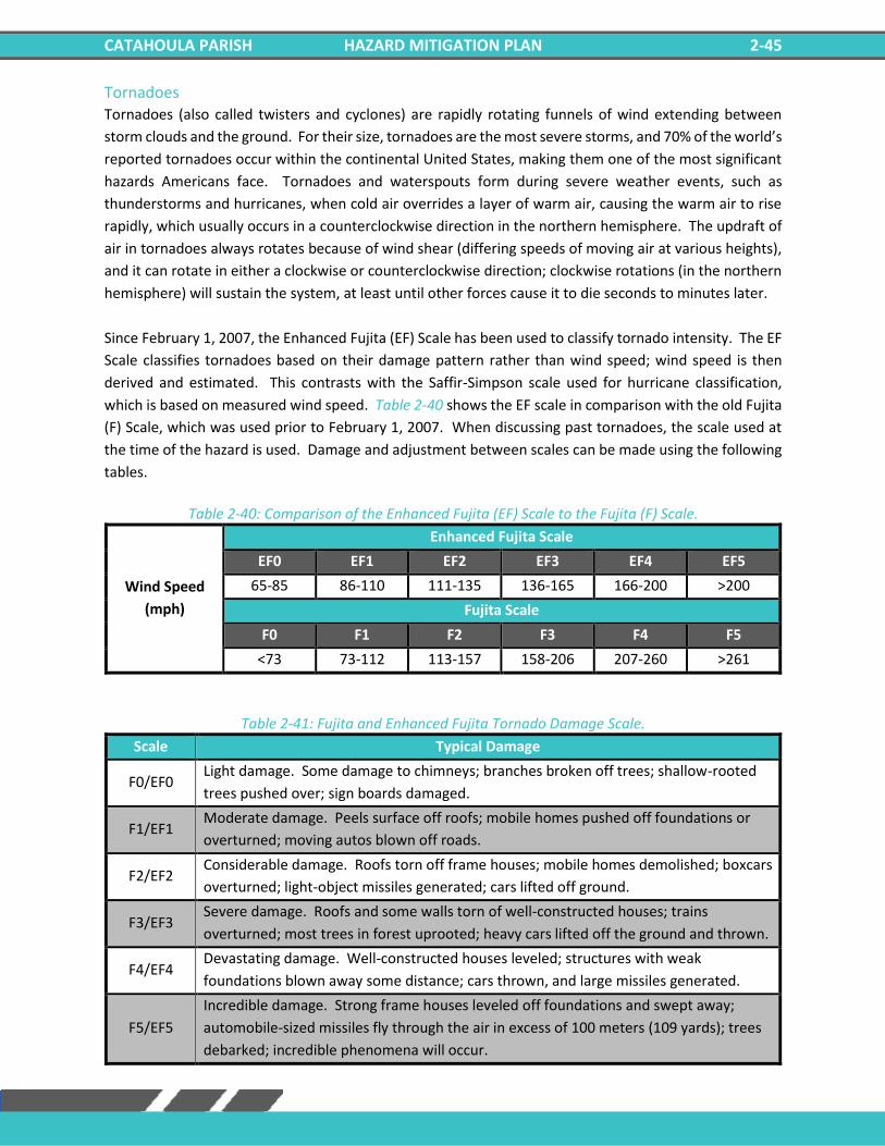
CATAHOULA PARISH HAZARD MITIGATION PLAN 2-45
Tornadoes Tornadoes (also called twisters and cyclones) are rapidly rotating funnels of wind extending between
storm clouds and the ground. For their size, tornadoes are the most severe storms, and 70% of the world’s
reported tornadoes occur within the continental United States, making them one of the most significant
hazards Americans face. Tornadoes and waterspouts form during severe weather events, such as
thunderstorms and hurricanes, when cold air overrides a layer of warm air, causing the warm air to rise
rapidly, which usually occurs in a counterclockwise direction in the northern hemisphere. The updraft of
air in tornadoes always rotates because of wind shear (differing speeds of moving air at various heights),
and it can rotate in either a clockwise or counterclockwise direction; clockwise rotations (in the northern
hemisphere) will sustain the system, at least until other forces cause it to die seconds to minutes later.
Since February 1, 2007, the Enhanced Fujita (EF) Scale has been used to classify tornado intensity. The EF
Scale classifies tornadoes based on their damage pattern rather than wind speed; wind speed is then
derived and estimated. This contrasts with the Saffir-Simpson scale used for hurricane classification,
which is based on measured wind speed. Table 2-40 shows the EF scale in comparison with the old Fujita
(F) Scale, which was used prior to February 1, 2007. When discussing past tornadoes, the scale used at
the time of the hazard is used. Damage and adjustment between scales can be made using the following
tables.
Table 2-40: Comparison of the Enhanced Fujita (EF) Scale to the Fujita (F) Scale.
Wind Speed
(mph)
Enhanced Fujita Scale
EF0 EF1 EF2 EF3 EF4 EF5
65-85 86-110 111-135 136-165 166-200 >200
Fujita Scale
F0 F1 F2 F3 F4 F5
<73 73-112 113-157 158-206 207-260 >261
Table 2-41: Fujita and Enhanced Fujita Tornado Damage Scale.
Scale Typical Damage
F0/EF0 Light damage. Some damage to chimneys; branches broken off trees; shallow-rooted
trees pushed over; sign boards damaged.
F1/EF1 Moderate damage. Peels surface off roofs; mobile homes pushed off foundations or
overturned; moving autos blown off roads.
F2/EF2 Considerable damage. Roofs torn off frame houses; mobile homes demolished; boxcars
overturned; light-object missiles generated; cars lifted off ground.
F3/EF3 Severe damage. Roofs and some walls torn of well-constructed houses; trains
overturned; most trees in forest uprooted; heavy cars lifted off the ground and thrown.
F4/EF4 Devastating damage. Well-constructed houses leveled; structures with weak
foundations blown away some distance; cars thrown, and large missiles generated.
F5/EF5
Incredible damage. Strong frame houses leveled off foundations and swept away;
automobile-sized missiles fly through the air in excess of 100 meters (109 yards); trees
debarked; incredible phenomena will occur.
CATAHOULA PARISH HAZARD MITIGATION PLAN 2-46
The National Weather Service (NWS) has the ability to issue advisory messages based on forecasts and
observations. The following are the advisory messages that may be issued with definitions of each:
• Tornado Watch: Issued to alert people to the possibility of a tornado developing
in the area. A tornado has not been spotted but the conditions
are favorable for tornadoes to occur.
• Tornado Warning: Issued when a tornado has been spotted or when Doppler radar
identifies a distinctive “hook-shaped” area within a
thunderstorm line.
Structures within the direct path of a tornado vortex are often reduced to rubble. Structures adjacent to
the tornado’s path are often severely damaged by high winds flowing into the tornado vortex, known as
inflow winds. It is here, adjacent to the tornado’s path, that the building type and construction techniques
are critical to the structure’s survival. Although tornadoes strike at random, making all buildings
vulnerable, mobile homes, homes on crawlspaces, and buildings with large spans are more likely to suffer
damage.
The major health hazard from tornadoes is physical injury from flying debris or being in a collapsed
building or mobile home. Within a building, flying debris or missiles are generally stopped by interior
walls. However, if a building has no partitions, any glass, brick, or other debris blown into the interior is
life threatening. Following a tornado, damaged buildings are a potential health hazard due to instability,
electrical system damage, and gas leaks. Sewage and water lines may also be damaged.
Peak tornado activity in Louisiana occurs during the spring, as it does in the rest of the United States.
Nearly one-third of observed tornadoes in the United States occur during April. About half of those in
Louisiana, including many of the strongest, occur between March and June. Fall and winter tornadoes are
less frequent, but the distribution of tornadoes throughout the year is more uniform in Louisiana than in
locations farther north.
Location
While there is a significant tornado record in Catahoula Parish with actual locations, tornadoes in general
are a climatological based hazard and have the same approximate probability of occurring in Catahoula
Parish as all of its jurisdictions. Because a tornado has a similar probability of striking anywhere within
the planning area for Catahoula Parish, all areas in the parish are equally at risk for tornadoes.
Previous Occurrences / Extent
The NCEI Storm Events Database reports a total of 30 tornadoes or waterspouts occurring within the
boundaries of Catahoula Parish since 1990 ranging in extent from F0 to F3 under the Fujita Scale and EF0
to EF2 on the Enhanced Fujita Scale. Catahoula Parish can expect future tornadoes up to an EF3 under
the Enhanced Fujita Scale as a worst-case scenario.
The most destructive tornado to impact Catahoula Parish was a F3 tornado which occurred on November
21, 1992. The tornado was responsible for over $2 million in damage and three injuries. There have been
no fatalities in Catahoula Parish as a result of tornadoes. Since the 2016 HMP Update, nine tornadoes
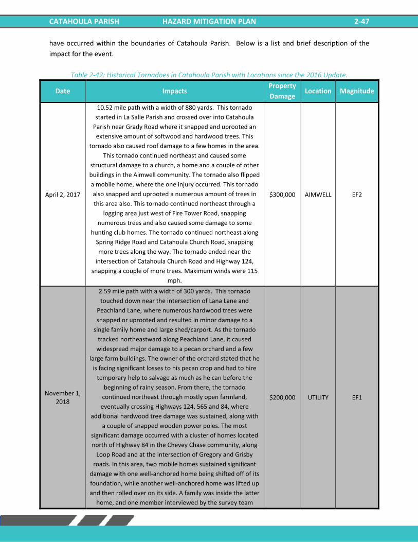
CATAHOULA PARISH HAZARD MITIGATION PLAN 2-47
have occurred within the boundaries of Catahoula Parish. Below is a list and brief description of the
impact for the event.
Table 2-42: Historical Tornadoes in Catahoula Parish with Locations since the 2016 Update.
Date Impacts Property
Damage Location Magnitude
April 2, 2017
10.52 mile path with a width of 880 yards. This tornado
started in La Salle Parish and crossed over into Catahoula
Parish near Grady Road where it snapped and uprooted an
extensive amount of softwood and hardwood trees. This
tornado also caused roof damage to a few homes in the area.
This tornado continued northeast and caused some
structural damage to a church, a home and a couple of other
buildings in the Aimwell community. The tornado also flipped
a mobile home, where the one injury occurred. This tornado
also snapped and uprooted a numerous amount of trees in
this area also. This tornado continued northeast through a
logging area just west of Fire Tower Road, snapping
numerous trees and also caused some damage to some
hunting club homes. The tornado continued northeast along
Spring Ridge Road and Catahoula Church Road, snapping
more trees along the way. The tornado ended near the
intersection of Catahoula Church Road and Highway 124,
snapping a couple of more trees. Maximum winds were 115
mph.
$300,000 AIMWELL EF2
November 1, 2018
2.59 mile path with a width of 300 yards. This tornado
touched down near the intersection of Lana Lane and
Peachland Lane, where numerous hardwood trees were
snapped or uprooted and resulted in minor damage to a
single family home and large shed/carport. As the tornado
tracked northeastward along Peachland Lane, it caused
widespread major damage to a pecan orchard and a few
large farm buildings. The owner of the orchard stated that he
is facing significant losses to his pecan crop and had to hire
temporary help to salvage as much as he can before the
beginning of rainy season. From there, the tornado
continued northeast through mostly open farmland,
eventually crossing Highways 124, 565 and 84, where
additional hardwood tree damage was sustained, along with
a couple of snapped wooden power poles. The most
significant damage occurred with a cluster of homes located
north of Highway 84 in the Chevey Chase community, along
Loop Road and at the intersection of Gregory and Grisby
roads. In this area, two mobile homes sustained significant
damage with one well-anchored home being shifted off of its
foundation, while another well-anchored home was lifted up
and then rolled over on its side. A family was inside the latter
home, and one member interviewed by the survey team
$200,000 UTILITY EF1
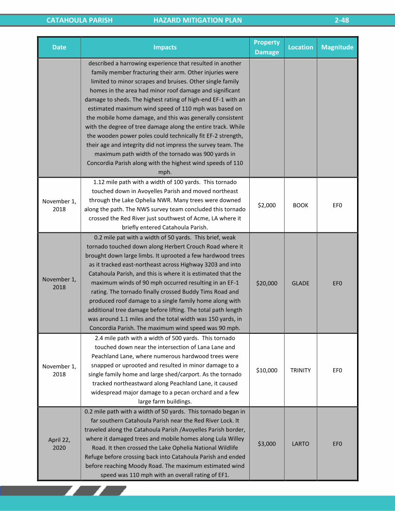
CATAHOULA PARISH HAZARD MITIGATION PLAN 2-48
Date Impacts Property
Damage Location Magnitude
described a harrowing experience that resulted in another
family member fracturing their arm. Other injuries were
limited to minor scrapes and bruises. Other single family
homes in the area had minor roof damage and significant
damage to sheds. The highest rating of high-end EF-1 with an
estimated maximum wind speed of 110 mph was based on
the mobile home damage, and this was generally consistent
with the degree of tree damage along the entire track. While
the wooden power poles could technically fit EF-2 strength,
their age and integrity did not impress the survey team. The
maximum path width of the tornado was 900 yards in
Concordia Parish along with the highest wind speeds of 110
mph.
November 1, 2018
1.12 mile path with a width of 100 yards. This tornado
touched down in Avoyelles Parish and moved northeast
through the Lake Ophelia NWR. Many trees were downed
along the path. The NWS survey team concluded this tornado
crossed the Red River just southwest of Acme, LA where it
briefly entered Catahoula Parish.
$2,000 BOOK EF0
November 1, 2018
0.2 mile pat with a width of 50 yards. This brief, weak
tornado touched down along Herbert Crouch Road where it
brought down large limbs. It uprooted a few hardwood trees
as it tracked east-northeast across Highway 3203 and into
Catahoula Parish, and this is where it is estimated that the
maximum winds of 90 mph occurred resulting in an EF-1
rating. The tornado finally crossed Buddy Tims Road and
produced roof damage to a single family home along with
additional tree damage before lifting. The total path length
was around 1.1 miles and the total width was 150 yards, in
Concordia Parish. The maximum wind speed was 90 mph.
$20,000 GLADE EF0
November 1, 2018
2.4 mile path with a width of 500 yards. This tornado
touched down near the intersection of Lana Lane and
Peachland Lane, where numerous hardwood trees were
snapped or uprooted and resulted in minor damage to a
single family home and large shed/carport. As the tornado
tracked northeastward along Peachland Lane, it caused
widespread major damage to a pecan orchard and a few
large farm buildings.
$10,000 TRINITY EF0
April 22, 2020
0.2 mile path with a width of 50 yards. This tornado began in
far southern Catahoula Parish near the Red River Lock. It
traveled along the Catahoula Parish /Avoyelles Parish border,
where it damaged trees and mobile homes along Lula Willey
Road. It then crossed the Lake Ophelia National Wildlife
Refuge before crossing back into Catahoula Parish and ended
before reaching Moody Road. The maximum estimated wind
speed was 110 mph with an overall rating of EF1.
$3,000 LARTO EF0
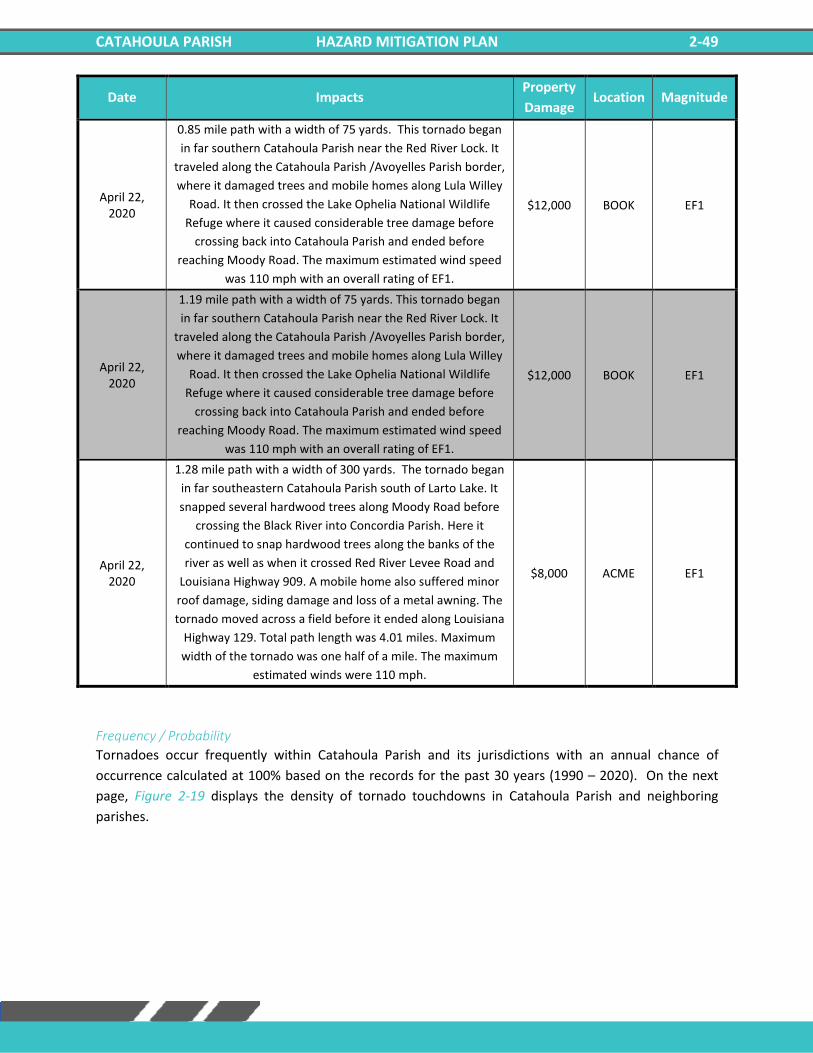
CATAHOULA PARISH HAZARD MITIGATION PLAN 2-49
Date Impacts Property
Damage Location Magnitude
April 22, 2020
0.85 mile path with a width of 75 yards. This tornado began
in far southern Catahoula Parish near the Red River Lock. It
traveled along the Catahoula Parish /Avoyelles Parish border,
where it damaged trees and mobile homes along Lula Willey
Road. It then crossed the Lake Ophelia National Wildlife
Refuge where it caused considerable tree damage before
crossing back into Catahoula Parish and ended before
reaching Moody Road. The maximum estimated wind speed
was 110 mph with an overall rating of EF1.
$12,000 BOOK EF1
April 22, 2020
1.19 mile path with a width of 75 yards. This tornado began
in far southern Catahoula Parish near the Red River Lock. It
traveled along the Catahoula Parish /Avoyelles Parish border,
where it damaged trees and mobile homes along Lula Willey
Road. It then crossed the Lake Ophelia National Wildlife
Refuge where it caused considerable tree damage before
crossing back into Catahoula Parish and ended before
reaching Moody Road. The maximum estimated wind speed
was 110 mph with an overall rating of EF1.
$12,000 BOOK EF1
April 22, 2020
1.28 mile path with a width of 300 yards. The tornado began
in far southeastern Catahoula Parish south of Larto Lake. It
snapped several hardwood trees along Moody Road before
crossing the Black River into Concordia Parish. Here it
continued to snap hardwood trees along the banks of the
river as well as when it crossed Red River Levee Road and
Louisiana Highway 909. A mobile home also suffered minor
roof damage, siding damage and loss of a metal awning. The
tornado moved across a field before it ended along Louisiana
Highway 129. Total path length was 4.01 miles. Maximum
width of the tornado was one half of a mile. The maximum
estimated winds were 110 mph.
$8,000 ACME EF1
Frequency / Probability
Tornadoes occur frequently within Catahoula Parish and its jurisdictions with an annual chance of
occurrence calculated at 100% based on the records for the past 30 years (1990 – 2020). On the next
page, Figure 2-19 displays the density of tornado touchdowns in Catahoula Parish and neighboring
parishes.
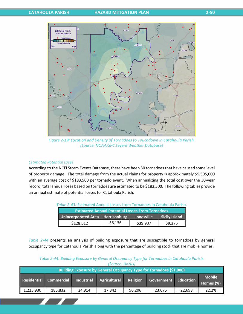
CATAHOULA PARISH HAZARD MITIGATION PLAN 2-50
Figure 2-19: Location and Density of Tornadoes to Touchdown in Catahoula Parish.
(Source: NOAA/SPC Severe Weather Database)
Estimated Potential Loses
According to the NCEI Storm Events Database, there have been 30 tornadoes that have caused some level
of property damage. The total damage from the actual claims for property is approximately $5,505,000
with an average cost of $183,500 per tornado event. When annualizing the total cost over the 30-year
record, total annual loses based on tornadoes are estimated to be $183,500. The following tables provide
an annual estimate of potential losses for Catahoula Parish.
Table 2-43: Estimated Annual Losses from Tornadoes in Catahoula Parish.
Estimated Annual Potential Losses From Tornadoes
Unincorporated Area Harrisonburg Jonesville Sicily Island
$128,512 $6,136 $39,937 $9,275
Table 2-44 presents an analysis of building exposure that are susceptible to tornadoes by general
occupancy type for Catahoula Parish along with the percentage of building stock that are mobile homes.
Table 2-44: Building Exposure by General Occupancy Type for Tornadoes in Catahoula Parish. (Source: Hazus)
Building Exposure by General Occupancy Type for Tornadoes ($1,000)
Residential Commercial Industrial Agricultural Religion Government Education Mobile
Homes (%)
1,225,930 185,832 24,914 17,342 56,206 23,675 22,698 22.2%
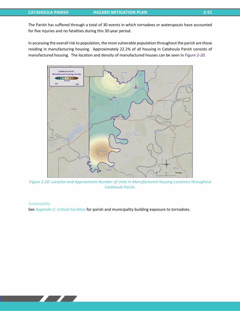
CATAHOULA PARISH HAZARD MITIGATION PLAN 2-51
The Parish has suffered through a total of 30 events in which tornadoes or waterspouts have accounted
for five injuries and no fatalities during this 30-year period.
In accessing the overall risk to population, the most vulnerable population throughout the parish are those
residing in manufacturing housing. Approximately 22.2% of all housing in Catahoula Parish consists of
manufactured housing. The location and density of manufactured houses can be seen in Figure 2-20.
Figure 2-20: Location and Approximate Number of Units in Manufactured Housing Locations throughout
Catahoula Parish.
Vulnerability
See Appendix C: Critical Facilities for parish and municipality building exposure to tornadoes.
CATAHOULA PARISH HAZARD MITIGATION PLAN 2-52
Tropical Cyclones Tropical cyclones are among the worst hazards Louisiana faces. These spinning, low-pressure air masses
draw surface air into their centers and attain strength ranging from weak tropical waves to the most
intense hurricanes. Usually, these storms begin as clusters of oceanic thunderstorms off the western
coast of Africa, moving westward in the trade wind flow. The spinning of these thunderstorm clusters
begins because of the formation of low pressure in a perturbation in the westerly motion of the storms
associated with differential impacts of the Earth’s rotation. The west-moving, counterclockwise-spinning
collection of storms, now called a tropical disturbance, may then gather strength as it draws humid air
toward its low-pressure center. This results in the formation of a tropical depression (defined when the
maximum sustained surface wind speed is 38 mph or less), then a Tropical Cyclone (when the maximum
sustained surface wind ranges from 39 mph to 73 mph), and finally a hurricane (when the maximum
sustained surface wind speeds exceed 73 mph). On the next page, the table presents the Saffir-Simpson
Hurricane Wind Scale, which categorizes tropical cyclones based on sustained winds.
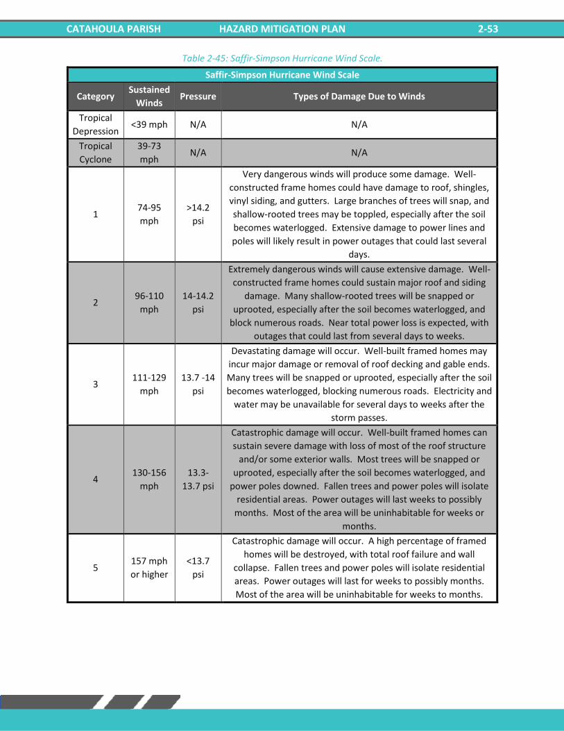
CATAHOULA PARISH HAZARD MITIGATION PLAN 2-53
Table 2-45: Saffir-Simpson Hurricane Wind Scale.
Saffir-Simpson Hurricane Wind Scale
Category Sustained
Winds Pressure Types of Damage Due to Winds
Tropical
Depression <39 mph N/A N/A
Tropical
Cyclone
39-73
mph N/A N/A
1 74-95
mph
>14.2
psi
Very dangerous winds will produce some damage. Well-
constructed frame homes could have damage to roof, shingles,
vinyl siding, and gutters. Large branches of trees will snap, and
shallow-rooted trees may be toppled, especially after the soil
becomes waterlogged. Extensive damage to power lines and
poles will likely result in power outages that could last several
days.
2 96-110
mph
14-14.2
psi
Extremely dangerous winds will cause extensive damage. Well-
constructed frame homes could sustain major roof and siding
damage. Many shallow-rooted trees will be snapped or
uprooted, especially after the soil becomes waterlogged, and
block numerous roads. Near total power loss is expected, with
outages that could last from several days to weeks.
3 111-129
mph
13.7 -14
psi
Devastating damage will occur. Well-built framed homes may
incur major damage or removal of roof decking and gable ends.
Many trees will be snapped or uprooted, especially after the soil
becomes waterlogged, blocking numerous roads. Electricity and
water may be unavailable for several days to weeks after the
storm passes.
4 130-156
mph
13.3-
13.7 psi
Catastrophic damage will occur. Well-built framed homes can
sustain severe damage with loss of most of the roof structure
and/or some exterior walls. Most trees will be snapped or
uprooted, especially after the soil becomes waterlogged, and
power poles downed. Fallen trees and power poles will isolate
residential areas. Power outages will last weeks to possibly
months. Most of the area will be uninhabitable for weeks or
months.
5 157 mph
or higher
<13.7
psi
Catastrophic damage will occur. A high percentage of framed
homes will be destroyed, with total roof failure and wall
collapse. Fallen trees and power poles will isolate residential
areas. Power outages will last for weeks to possibly months.
Most of the area will be uninhabitable for weeks to months.
CATAHOULA PARISH HAZARD MITIGATION PLAN 2-54
Many associated hazards can occur during a hurricane, including heavy rains, flooding, high winds, and
tornadoes. A general rule of thumb in coastal Louisiana is that the number of inches of rainfall to be
expected from a tropical cyclone is approximately 100 divided by the forward velocity of the storm in
mph; so, a fast-moving storm (20 mph) might be expected to drop five inches of rain while a slow-moving
(5 mph) storm could produce totals of around 20 inches. However, no two storms are alike, and such
generalizations have limited utility for planning purposes. Hurricane Beulah, which struck Texas in 1967,
spawned 115 confirmed tornadoes. In recent years, extensive coastal development has increased the
storm surge resulting from these storms so much that this has become the greatest natural hazard threat
to property and loss of life in the state. Storm surge is a temporary rise in sea level generally caused by
reduced air pressure and strong onshore winds associated with a storm system near the coast. Although
storm surge can technically occur at any time of the year in Louisiana, surges caused by hurricanes can be
particularly deadly and destructive. Such storm surge events are often accompanied by large, destructive
waves (exceeding ten meters in some places) that can inflict a high number of fatalities and economic
losses. In 2005, Hurricane Katrina clearly demonstrated the destructive potential of this hazard, as it
produced the highest modern-day storm surge levels in the State of Louisiana, reaching up to 18.7 feet
near Alluvial City in St. Bernard Parish.
Property can be damaged by the various forces that accompany a tropical cyclone. High winds can directly
impact structures in three ways: wind forces, flying debris, and pressure. By itself, the force of the wind
can knock over trees, break tree limbs, and destroy loose items, such as television antennas and power
lines. Many things can be moved by high winds. As winds increase, so does the pressure against stationary
objects. Pressure against a wall rises with the square of the wind speed. For some structures, this force is
enough to cause failure. The potential for damage to structures is increased when debris breaks the
building “envelope” and allows the wind pressure to impact all surfaces (the building envelope includes
all surfaces that make up the barrier between the indoors and the outdoors, such as the walls, foundation,
doors, windows, and roof). Mobile homes and buildings in need of maintenance are most subject to wind
damage. High winds mean bigger waves. Extended pounding by waves can demolish any poorly or
improperly designed structures. The waves also erode sand beaches, roads, and foundations. When
foundations are compromised, the building will collapse.
Nine out of ten deaths during hurricanes are caused by storm surge flooding. Falling tree limbs and flying
debris caused by high winds have the ability to cause injury or death. Downed trees and damaged
buildings are a potential health hazard due to instability, electrical system damage, broken pipelines,
chemical releases, and gas leaks. Sewage and water lines may also be damaged. Salt water and freshwater
intrusions from storm surge send animals, such as snakes, into areas occupied by humans.
Location
Hurricanes are the single biggest threat to all of South Louisiana. With any single tropical cyclone event
having the potential to devastate multiple parishes at once, tropical cyclones are a significant threat to
the entire Catahoula Parish planning area. The worst-case scenario for a tropical cyclone event in
Catahoula Parish is a Category 1 Hurricane.
Previous Occurrences / Extents
Catahoula Parish has experienced seven major tropical cyclone events since 2002. The table o the next
page provides a list of tropical cyclones which have impacted Catahoula Parish since 2002.
CATAHOULA PARISH HAZARD MITIGATION PLAN 2-55
Table 2-46: Historical Tropical Cyclone Events in Catahoula Parish from 2002 – 2020.
Date Name Storm Type at Time of Impact
2005 Katrina Hurricane
2005 Rita Hurricane
2007 Humberto Tropical Depression
2008 Gustav Tropical Storm
2012 Isaac Tropical Storm
2020 Laura Tropical Storm
2020 Delta Tropical Storm
Since the last Catahoula Parish HMP update in 2016, there have been two tropical cyclone events which
have impacted the parish. Below is a brief description of the events and the impact they had on Catahoula
Parish.
Tropical Storm Laura (2020)
Laura began as a large tropical wave that emerged off the west coast of Africa on August 16th. The wave
traversed the tropical Atlantic for the next several days with little additional organization. On August 19th,
the system became better organized, closed off a low-level circulation, and subsequently the National
Hurricane Center began issuing advisories on Tropical Depression Thirteen late that evening.
On the morning of August 21st, Tropical Depression Thirteen strengthened into Tropical Storm Laura, which
was the earliest twelfth named Atlantic storm, beating the previous record of Hurricane Luis of 1995 by
eight days. As Laura moved westward, little additional strengthening took place as the center moved over
the northern Lesser Antilles later that evening, and south of Puerto Rico on August 22nd. Early on August
23rd, Tropical Storm Laura made landfall across Hispaniola, traversed the entire island, and made landfall
across Eastern Cuba later that evening. Tropical Storm Laura continued west northwestward, traveling just
south of the island with a second landfall across Western Cuba late on August 24th.
On August 25th, Laura entered the Gulf of Mexico and became a Category 1 hurricane at 10 AM CDT. Laura
began to explosively intensify on August 26th, reaching category 2 by 1 AM CDT, category 3 by 7 AM CDT,
and category 4 by 1 PM CDT. Laura reached a peak intensity of 150 mph (130 knots) and a minimum central
pressure of 937 millibars (27.67 inches of mercury) by 8 PM CDT.
With little change in strength, Laura made landfall at Cameron, Louisiana around 1 AM CDT August 27th,
with sustained winds of 150 mph (130 knots) and a minimum central pressure of 938 millibars (27.70 inches
of mercury). Laura was the strongest hurricane to strike Southwest Louisiana since records began in 1851.
Laura slowly weakened after landfall but maintained major hurricane status throughout its passage across
Cameron, Calcasieu, and southern Beauregard Parishes, and category 2 status across northern Beauregard
and Vernon parishes as daybreak approached on August 27th. Laura finally weakened below hurricane
strength by Noon as it was crossing I-20 in North Louisiana. With this being the strongest hurricane to
affect Southwest Louisiana, wind damage to buildings and trees was major to catastrophic across Cameron
and Calcasieu parishes, with considerable damage across Beauregard and Vernon parishes where the core
of the hurricane passed.
The National Weather Service in Lake Charles, Louisiana recorded a station record highest peak wind gust
of 116 knots (133 mph) at 1:42 AM CDT before the Automated Surface Observing System (ASOS) wind
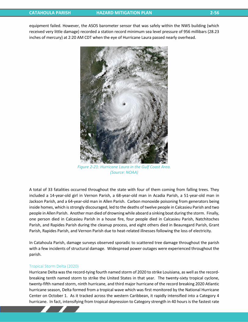
CATAHOULA PARISH HAZARD MITIGATION PLAN 2-56
equipment failed. However, the ASOS barometer sensor that was safely within the NWS building (which
received very little damage) recorded a station record minimum sea level pressure of 956 millibars (28.23
inches of mercury) at 2:20 AM CDT when the eye of Hurricane Laura passed nearly overhead.
Figure 2-21: Hurricane Laura in the Gulf Coast Area.
(Source: NOAA)
A total of 33 fatalities occurred throughout the state with four of them coming from falling trees. They
included a 14-year-old girl in Vernon Parish, a 68-year-old man in Acadia Parish, a 51-year-old man in
Jackson Parish, and a 64-year-old man in Allen Parish. Carbon monoxide poisoning from generators being
inside homes, which is strongly discouraged, led to the deaths of twelve people in Calcasieu Parish and two
people in Allen Parish. Another man died of drowning while aboard a sinking boat during the storm. Finally,
one person died in Calcasieu Parish in a house fire, four people died in Calcasieu Parish, Natchitoches
Parish, and Rapides Parish during the cleanup process, and eight others died in Beauregard Parish, Grant
Parish, Rapides Parish, and Vernon Parish due to heat-related illnesses following the loss of electricity.
In Catahoula Parish, damage surveys observed sporadic to scattered tree damage throughout the parish
with a few incidents of structural damage. Widespread power outages were experienced throughout the
parish.
Tropical Storm Delta (2020)
Hurricane Delta was the record-tying fourth named storm of 2020 to strike Louisiana, as well as the record-
breaking tenth named storm to strike the United States in that year. The twenty-sixty tropical cyclone,
twenty-fifth named storm, ninth hurricane, and third major hurricane of the record breaking 2020 Atlantic
hurricane season, Delta formed from a tropical wave which was first monitored by the National Hurricane
Center on October 1. As it tracked across the western Caribbean, it rapidly intensified into a Category 4
hurricane. In fact, intensifying from tropical depression to Category strength in 40 hours is the fastest rate
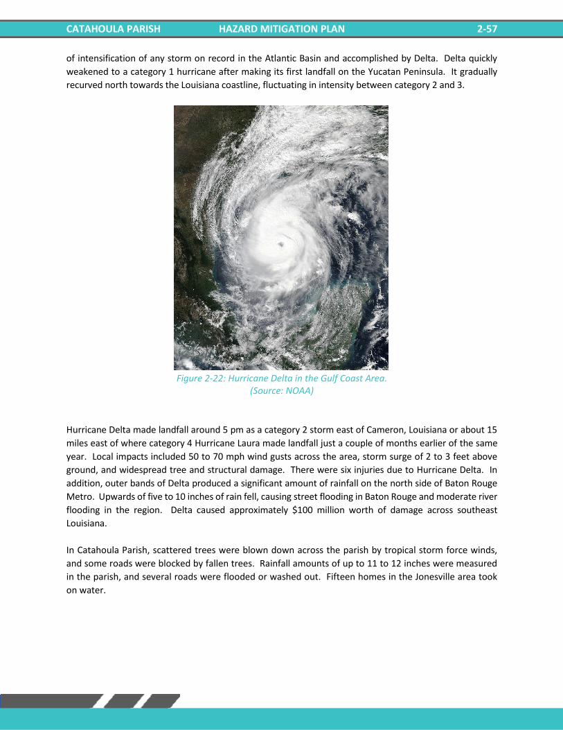
CATAHOULA PARISH HAZARD MITIGATION PLAN 2-57
of intensification of any storm on record in the Atlantic Basin and accomplished by Delta. Delta quickly
weakened to a category 1 hurricane after making its first landfall on the Yucatan Peninsula. It gradually
recurved north towards the Louisiana coastline, fluctuating in intensity between category 2 and 3.
Figure 2-22: Hurricane Delta in the Gulf Coast Area.
(Source: NOAA)
Hurricane Delta made landfall around 5 pm as a category 2 storm east of Cameron, Louisiana or about 15
miles east of where category 4 Hurricane Laura made landfall just a couple of months earlier of the same
year. Local impacts included 50 to 70 mph wind gusts across the area, storm surge of 2 to 3 feet above
ground, and widespread tree and structural damage. There were six injuries due to Hurricane Delta. In
addition, outer bands of Delta produced a significant amount of rainfall on the north side of Baton Rouge
Metro. Upwards of five to 10 inches of rain fell, causing street flooding in Baton Rouge and moderate river
flooding in the region. Delta caused approximately $100 million worth of damage across southeast
Louisiana.
In Catahoula Parish, scattered trees were blown down across the parish by tropical storm force winds,
and some roads were blocked by fallen trees. Rainfall amounts of up to 11 to 12 inches were measured
in the parish, and several roads were flooded or washed out. Fifteen homes in the Jonesville area took
on water.
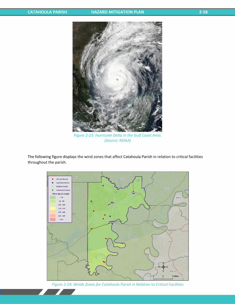
CATAHOULA PARISH HAZARD MITIGATION PLAN 2-58
Figure 2-23: Hurricane Delta in the Gulf Coast Area.
(Source: NOAA)
The following figure displays the wind zones that affect Catahoula Parish in relation to critical facilities
throughout the parish.
Figure 2-24: Winds Zones for Catahoula Parish in Relation to Critical Facilities
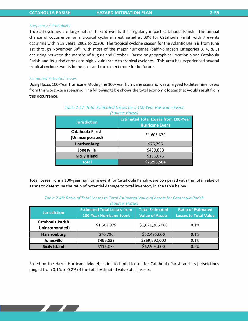
CATAHOULA PARISH HAZARD MITIGATION PLAN 2-59
Frequency / Probability
Tropical cyclones are large natural hazard events that regularly impact Catahoula Parish. The annual
chance of occurrence for a tropical cyclone is estimated at 39% for Catahoula Parish with 7 events
occurring within 18 years (2002 to 2020). The tropical cyclone season for the Atlantic Basin is from June
1st through November 30th, with most of the major hurricanes (Saffir-Simpson Categories 3, 4, & 5)
occurring between the months of August and October. Based on geographical location alone Catahoula
Parish and its jurisdictions are highly vulnerable to tropical cyclones. This area has experienced several
tropical cyclone events in the past and can expect more in the future.
Estimated Potential Losses
Using Hazus 100-Year Hurricane Model, the 100-year hurricane scenario was analyzed to determine losses
from this worst-case scenario. The following table shows the total economic losses that would result from
this occurrence.
Table 2-47: Total Estimated Losses for a 100-Year Hurricane Event
(Source: Hazus)
Jurisdiction Estimated Total Losses from 100-Year
Hurricane Event
Catahoula Parish
(Unincorporated) $1,603,879
Harrisonburg $76,796
Jonesville $499,833
Sicily Island $116,076
Total $2,296,584
Total losses from a 100-year hurricane event for Catahoula Parish were compared with the total value of
assets to determine the ratio of potential damage to total inventory in the table below.
Table 2-48: Ratio of Total Losses to Total Estimated Value of Assets for Catahoula Parish (Source: Hazus)
Jurisdiction Estimated Total Losses from
100-Year Hurricane Event
Total Estimated
Value of Assets
Ratio of Estimated
Losses to Total Value
Catahoula Parish
(Unincorporated) $1,603,879 $1,071,206,000 0.1%
Harrisonburg $76,796 $52,495,000 0.1%
Jonesville $499,833 $369,992,000 0.1%
Sicily Island $116,076 $62,904,000 0.2%
Based on the Hazus Hurricane Model, estimated total losses for Catahoula Parish and its jurisdictions
ranged from 0.1% to 0.2% of the total estimated value of all assets.
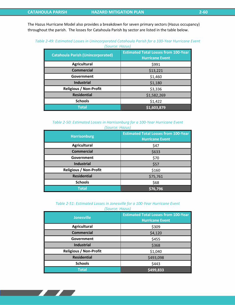
CATAHOULA PARISH HAZARD MITIGATION PLAN 2-60
The Hazus Hurricane Model also provides a breakdown for seven primary sectors (Hazus occupancy)
throughout the parish. The losses for Catahoula Parish by sector are listed in the table below.
Table 2-49: Estimated Losses in Unincorporated Catahoula Parish for a 100-Year Hurricane Event (Source: Hazus)
Catahoula Parish (Unincorporated) Estimated Total Losses from 100-Year
Hurricane Event
Agricultural $991
Commercial $13,221
Government $1,460
Industrial $1,180
Religious / Non-Profit $3,336
Residential $1,582,269
Schools $1,422
Total $1,603,879
Table 2-50: Estimated Losses in Harrisonburg for a 100-Year Hurricane Event (Source: Hazus)
Harrisonburg Estimated Total Losses from 100-Year
Hurricane Event
Agricultural $47
Commercial $633
Government $70
Industrial $57
Religious / Non-Profit $160
Residential $75,761
Schools $68
Total $76,796
Table 2-51: Estimated Losses in Jonesville for a 100-Year Hurricane Event (Source: Hazus)
Jonesville Estimated Total Losses from 100-Year
Hurricane Event
Agricultural $309
Commercial $4,120
Government $455
Industrial $368
Religious / Non-Profit $1,040
Residential $493,098
Schools $443
Total $499,833
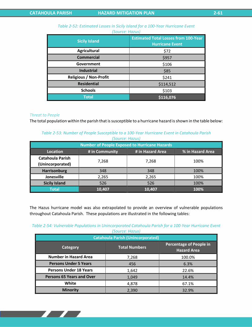
CATAHOULA PARISH HAZARD MITIGATION PLAN 2-61
Table 2-52: Estimated Losses in Sicily Island for a 100-Year Hurricane Event (Source: Hazus)
Sicily Island Estimated Total Losses from 100-Year
Hurricane Event
Agricultural $72
Commercial $957
Government $106
Industrial $85
Religious / Non-Profit $241
Residential $114,512
Schools $103
Total $116,076
Threat to People
The total population within the parish that is susceptible to a hurricane hazard is shown in the table below:
Table 2-53: Number of People Susceptible to a 100-Year Hurricane Event in Catahoula Parish (Source: Hazus)
Number of People Exposed to Hurricane Hazards
Location # in Community # in Hazard Area % in Hazard Area
Catahoula Parish
(Unincorporated) 7,268 7,268 100%
Harrisonburg 348 348 100%
Jonesville 2,265 2,265 100%
Sicily Island 526 526 100%
Total 10,407 10,407 100%
The Hazus hurricane model was also extrapolated to provide an overview of vulnerable populations
throughout Catahoula Parish. These populations are illustrated in the following tables:
Table 2-54: Vulnerable Populations in Unincorporated Catahoula Parish for a 100-Year Hurricane Event (Source: Hazus)
Catahoula Parish (Unincorporated)
Category Total Numbers Percentage of People in
Hazard Area
Number in Hazard Area 7,268 100.0%
Persons Under 5 Years 456 6.3%
Persons Under 18 Years 1,642 22.6%
Persons 65 Years and Over 1,049 14.4%
White 4,878 67.1%
Minority 2,390 32.9%
CATAHOULA PARISH HAZARD MITIGATION PLAN 2-62
Table 2-55: Vulnerable Populations in Harrisonburg for a 100-Year Hurricane Event (Source: Hazus)
Harrisonburg
Category Total Numbers Percentage of People in
Hazard Area
Number in Hazard Area 348 100.0%
Persons Under 5 Years 17 4.9%
Persons Under 18 Years 80 23.0%
Persons 65 Years and Over 51 14.7%
White 250 71.8%
Minority 98 28.2%
Table 2-56: Vulnerable Populations in Jonesville for a 100-Year Hurricane Event (Source: Hazus)
Jonesville
Category Total Numbers Percentage of People in
Hazard Area
Number in Hazard Area 2,265 100.0%
Persons Under 5 Years 176 7.8%
Persons Under 18 Years 645 28.5%
Persons 65 Years and Over 332 14.7%
White 699 30.9%
Minority 1,566 69.1%
Table 2-57: Vulnerable Populations in Sicily Island for a 100-Year Hurricane Event (Source: Hazus)
Sicily Island
Category Total Numbers Percentage of People in
Hazard Area
Number in Hazard Area 526 100.0%
Persons Under 5 Years 34 6.5%
Persons Under 18 Years 139 26.4%
Persons 65 Years and Over 66 12.6%
White 180 34.2%
Minority 346 65.8%
Vulnerability
See Appendix C: Critical Facilities for parish and municipality buildings that are susceptible to tropical
cyclones.
CATAHOULA PARISH HAZARD MITIGATION PLAN 2-63
Winter Weather For Louisiana and other parts of the southeastern United States, a severe winter storm occurs when humid air from the Gulf of Mexico meets a cold air mass from the north. Once the cold air mass crosses Louisiana, and the temperature drops, precipitation may fall in the form of snow or sleet. If the ground temperature is cold enough but air temperature is above freezing, rain can freeze instantly on contact with the surface, causing massive ice storms. The winter storm events that affect the state of Louisiana are ice storms, freezes, and snow events. Of the winter storm types listed above, ice storms are the most dangerous. Ice storms occur during a precipitation event when warm air aloft exceeds 32 °F, while the surface remains below the freezing point. Ice will form on all surfaces when precipitation originating as rain or drizzle contacts physical structures. These ice storms are usually accompanied by freezing temperatures and occasionally snow. Winter storms can be accompanied by strong winds, creating blizzard conditions with blinding, wind driven snow, severe drifting, and dangerous wind chill. These types of conditions are very rare in Louisiana, even in north Louisiana, but ice storms are more common. The climatic line between snow and rain often stalls over north Louisiana, creating ideal conditions for ice accumulation. In a typical winter storm event, homes and buildings are damaged by ice accumulation, either directly by the weight of the ice on the roofs or by trees and/or limbs falling on buildings. While it is not very prevalent, this type of damage can occur in Louisiana, particularly in north Louisiana. Effects of winter weather more likely to occur in Louisiana, especially southern Louisiana, include extreme temperatures which can cause waterlines to freeze and sewer lines to rupture. This is especially true with elevated or mobile homes since cold air is able to access more of the building’s infrastructure. Winter storms can also have a devastating effect on agriculture, particularly on crops (like citrus) that are dependent on warm weather. Long exposures to low temperatures can kill many kinds of crops, and ice storms can weigh down branches and fruit. Winter storms are not only a direct threat to human health through conditions like frostbite and hypothermia, but they are also an indirect threat to human health due to vehicle accidents and loss of power and heat, which can be disrupted for days. However, these impacts are rarely seen in Louisiana. As people use space heaters and fireplaces to stay warm, the risk of household fires and carbon monoxide poisoning increases. Winter storm events occur throughout Louisiana usually during the colder calendar months of December, January, and February. Severe weather events do not occur with the same frequency across all parts of Louisiana. The northern quarter of Louisiana has historically experienced the most severe winter events between 1987 and 2012. The central, and to an even greater extent the southern parts of the state, such as Ascension Parish, have experienced the fewest severe winter events. The table on the next page shows the Sperry-Piltz Ice Accumulation Index which is utilized to predict the potential damage to overhead utility systems from freezing rain and ice storms.
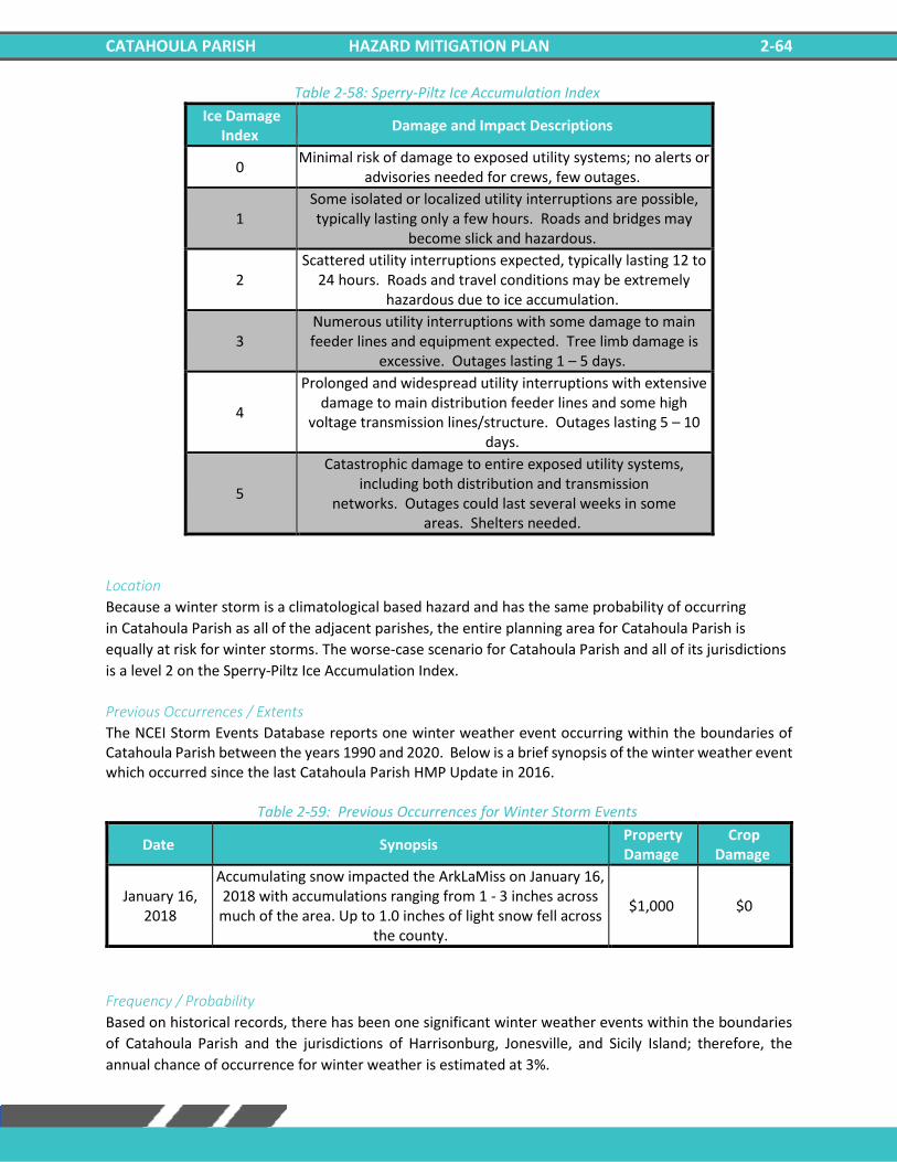
CATAHOULA PARISH HAZARD MITIGATION PLAN 2-64
Table 2-58: Sperry-Piltz Ice Accumulation Index
Ice Damage Index
Damage and Impact Descriptions
0 Minimal risk of damage to exposed utility systems; no alerts or
advisories needed for crews, few outages.
1 Some isolated or localized utility interruptions are possible, typically lasting only a few hours. Roads and bridges may
become slick and hazardous.
2 Scattered utility interruptions expected, typically lasting 12 to
24 hours. Roads and travel conditions may be extremely hazardous due to ice accumulation.
3 Numerous utility interruptions with some damage to main feeder lines and equipment expected. Tree limb damage is
excessive. Outages lasting 1 – 5 days.
4
Prolonged and widespread utility interruptions with extensive damage to main distribution feeder lines and some high
voltage transmission lines/structure. Outages lasting 5 – 10 days.
5
Catastrophic damage to entire exposed utility systems, including both distribution and transmission
networks. Outages could last several weeks in some areas. Shelters needed.
Location
Because a winter storm is a climatological based hazard and has the same probability of occurring
in Catahoula Parish as all of the adjacent parishes, the entire planning area for Catahoula Parish is
equally at risk for winter storms. The worse-case scenario for Catahoula Parish and all of its jurisdictions
is a level 2 on the Sperry-Piltz Ice Accumulation Index.
Previous Occurrences / Extents
The NCEI Storm Events Database reports one winter weather event occurring within the boundaries of Catahoula Parish between the years 1990 and 2020. Below is a brief synopsis of the winter weather event which occurred since the last Catahoula Parish HMP Update in 2016.
Table 2-59: Previous Occurrences for Winter Storm Events
Date Synopsis Property Damage
Crop Damage
January 16, 2018
Accumulating snow impacted the ArkLaMiss on January 16, 2018 with accumulations ranging from 1 - 3 inches across
much of the area. Up to 1.0 inches of light snow fell across the county.
$1,000 $0
Frequency / Probability
Based on historical records, there has been one significant winter weather events within the boundaries
of Catahoula Parish and the jurisdictions of Harrisonburg, Jonesville, and Sicily Island; therefore, the
annual chance of occurrence for winter weather is estimated at 3%.
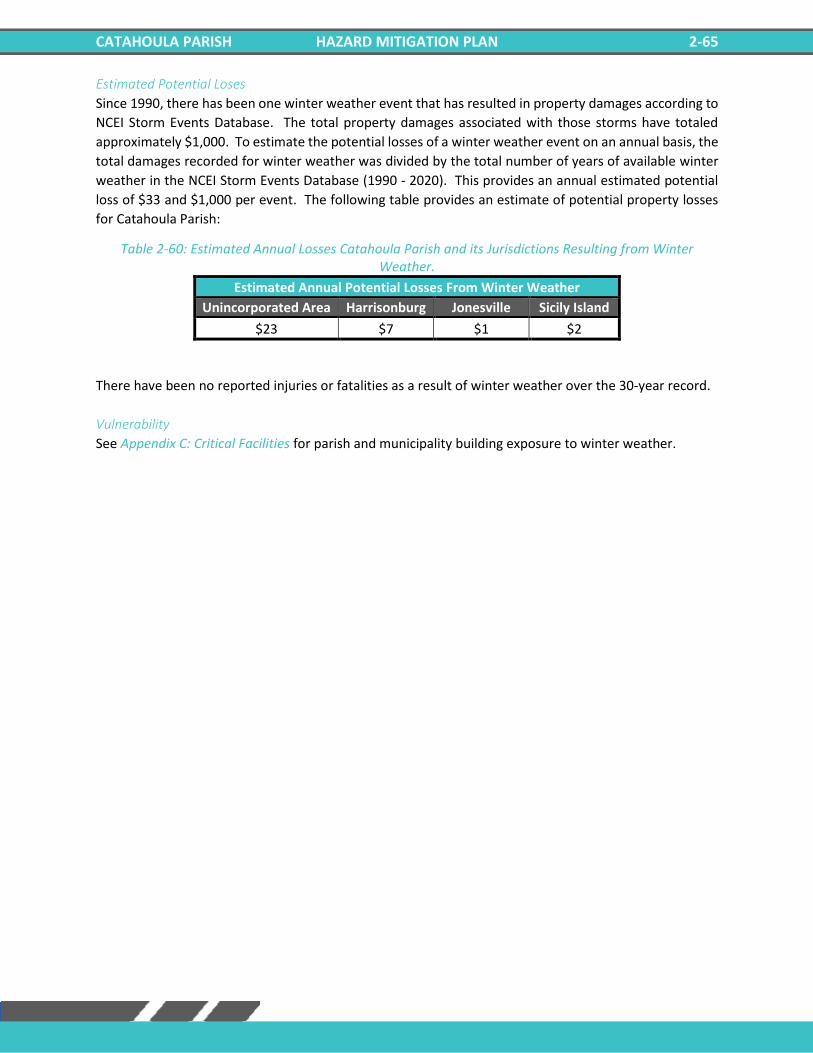
CATAHOULA PARISH HAZARD MITIGATION PLAN 2-65
Estimated Potential Loses
Since 1990, there has been one winter weather event that has resulted in property damages according to
NCEI Storm Events Database. The total property damages associated with those storms have totaled
approximately $1,000. To estimate the potential losses of a winter weather event on an annual basis, the
total damages recorded for winter weather was divided by the total number of years of available winter
weather in the NCEI Storm Events Database (1990 - 2020). This provides an annual estimated potential
loss of $33 and $1,000 per event. The following table provides an estimate of potential property losses
for Catahoula Parish:
Table 2-60: Estimated Annual Losses Catahoula Parish and its Jurisdictions Resulting from Winter Weather.
Estimated Annual Potential Losses From Winter Weather
Unincorporated Area Harrisonburg Jonesville Sicily Island
$23 $7 $1 $2
There have been no reported injuries or fatalities as a result of winter weather over the 30-year record.
Vulnerability
See Appendix C: Critical Facilities for parish and municipality building exposure to winter weather.

CATAHOULA PARISH HAZARD MITIGATION PLAN 2-66
***This Page Left Intentionally Blank***
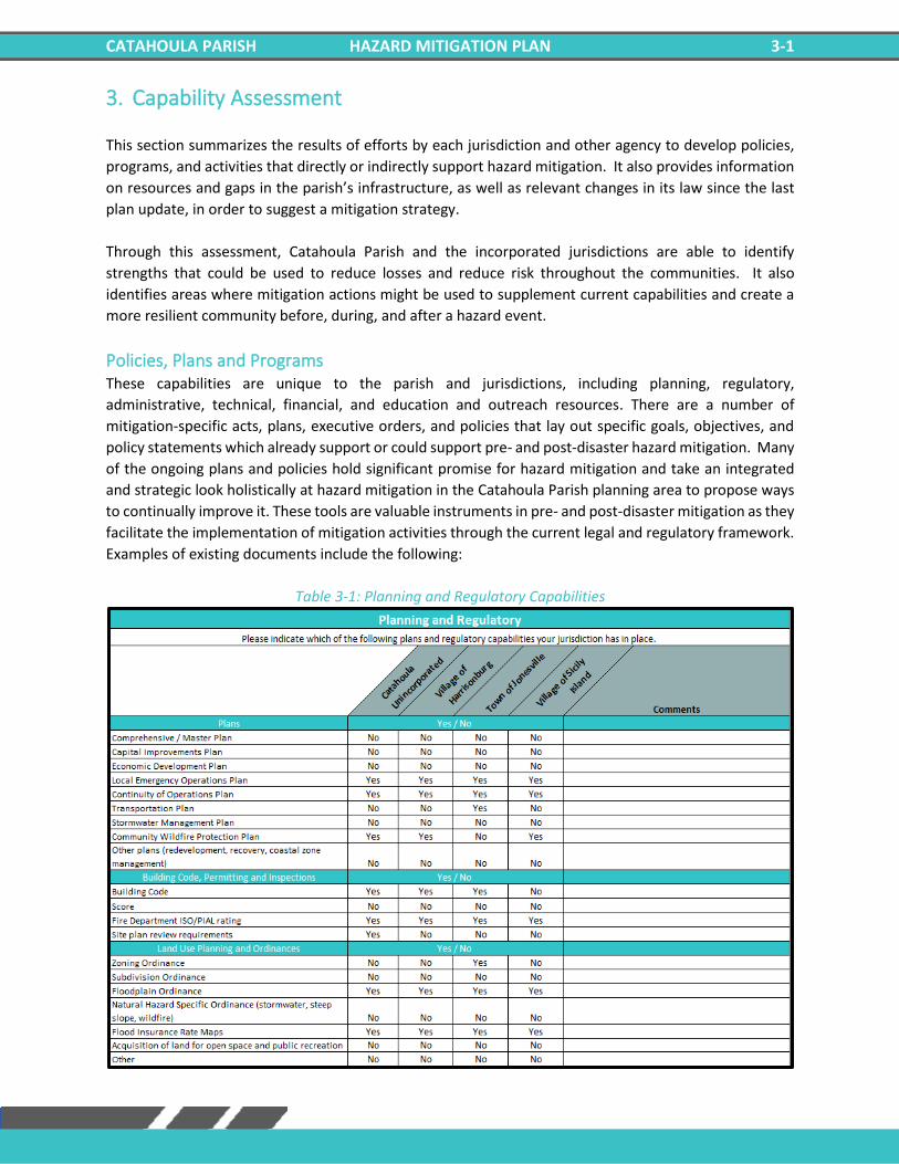
CATAHOULA PARISH HAZARD MITIGATION PLAN 3-1
3. Capability Assessment
This section summarizes the results of efforts by each jurisdiction and other agency to develop policies,
programs, and activities that directly or indirectly support hazard mitigation. It also provides information
on resources and gaps in the parish’s infrastructure, as well as relevant changes in its law since the last
plan update, in order to suggest a mitigation strategy.
Through this assessment, Catahoula Parish and the incorporated jurisdictions are able to identify
strengths that could be used to reduce losses and reduce risk throughout the communities. It also
identifies areas where mitigation actions might be used to supplement current capabilities and create a
more resilient community before, during, and after a hazard event.
Policies, Plans and Programs These capabilities are unique to the parish and jurisdictions, including planning, regulatory,
administrative, technical, financial, and education and outreach resources. There are a number of
mitigation-specific acts, plans, executive orders, and policies that lay out specific goals, objectives, and
policy statements which already support or could support pre- and post-disaster hazard mitigation. Many
of the ongoing plans and policies hold significant promise for hazard mitigation and take an integrated
and strategic look holistically at hazard mitigation in the Catahoula Parish planning area to propose ways
to continually improve it. These tools are valuable instruments in pre- and post-disaster mitigation as they
facilitate the implementation of mitigation activities through the current legal and regulatory framework.
Examples of existing documents include the following:
Table 3-1: Planning and Regulatory Capabilities
CATAHOULA PARISH HAZARD MITIGATION PLAN 3-2
All jurisdictions within the Catahoula Parish planning area will work to expand their capabilities by adding
to these plans, as well as work to create new plans that will address a long-term recovery and resiliency
framework. In instances where there are no existing plans, there will be a concerted effort to explore
opportunities to create new plans that will address long-term recovery and resiliency framework as parish
and local resources allow.
Building Codes, Permitting, Land Use Planning and Ordinances Catahoula Parish Police Jury provides oversight for building permits and codes, land use planning, and all
parish ordinances.
As of the 2021 update, Catahoula parish and the incorporated communities ensure that all adopted
building codes are enforced and in compliance relating to the construction of any structure within the
boundaries of the parish. Building permits are required prior to beginning any type of construction or
renovation projects, installation of electrical wiring, plumbing or gas piping, moving
manufactured/modular or portable buildings, and reroofing or demolitions.
Catahoula Parish is also responsible for enforcing the parish ordinances related to health and safety,
property maintenance standards, and condemnation of unsafe structures.
Catahoula Parish meets regularly to consider any proposed ordinance changes, and to take final actions
on proposed changes.
While local capabilities for mitigation can vary from community to community, the jurisdictions within the
Catahoula Parish planning area as a whole have a system in place to coordinate and share these
capabilities through the OHSEP and through this Parish Hazard Mitigation Plan.
Some programs and policies, such as the above described, might use complementary tools to achieve a
common end, but fail to coordinate with or support each other. Thus, coordination among local mitigation
policies and programs is essential to hazard mitigation.
Administration, Technical, and Financial The jurisdictions within the Catahoula Parish planning area have administrative and technical capabilities
in place that may be utilized in reducing hazard impacts or implementing hazard mitigation activities. Such
capabilities include staff, skillset, and tools available in the community that may be accessed to implement
mitigation activities and to effectively coordinate resources. The ability to access and coordinate these
resources is also important. The table on the following page shows examples of resources in place.
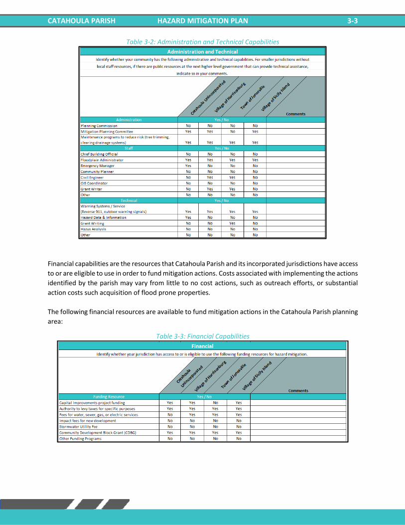
CATAHOULA PARISH HAZARD MITIGATION PLAN 3-3
Table 3-2: Administration and Technical Capabilities
Financial capabilities are the resources that Catahoula Parish and its incorporated jurisdictions have access
to or are eligible to use in order to fund mitigation actions. Costs associated with implementing the actions
identified by the parish may vary from little to no cost actions, such as outreach efforts, or substantial
action costs such acquisition of flood prone properties.
The following financial resources are available to fund mitigation actions in the Catahoula Parish planning
area:
Table 3-3: Financial Capabilities
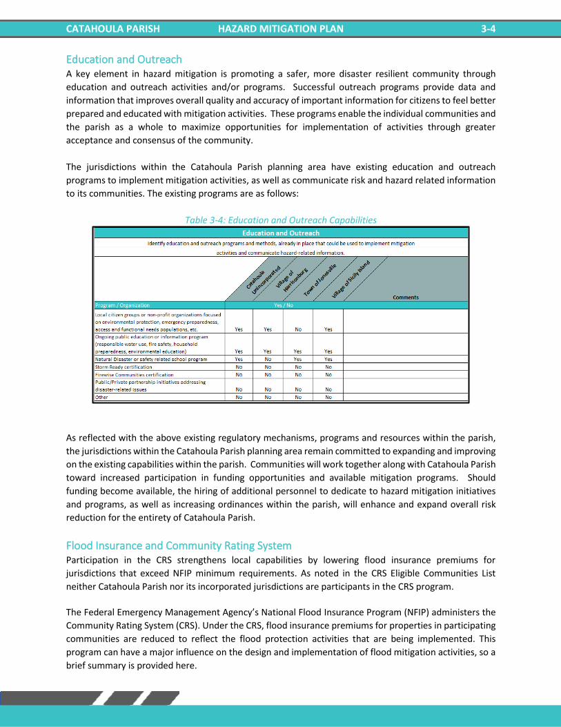
CATAHOULA PARISH HAZARD MITIGATION PLAN 3-4
Education and Outreach A key element in hazard mitigation is promoting a safer, more disaster resilient community through
education and outreach activities and/or programs. Successful outreach programs provide data and
information that improves overall quality and accuracy of important information for citizens to feel better
prepared and educated with mitigation activities. These programs enable the individual communities and
the parish as a whole to maximize opportunities for implementation of activities through greater
acceptance and consensus of the community.
The jurisdictions within the Catahoula Parish planning area have existing education and outreach
programs to implement mitigation activities, as well as communicate risk and hazard related information
to its communities. The existing programs are as follows:
Table 3-4: Education and Outreach Capabilities
As reflected with the above existing regulatory mechanisms, programs and resources within the parish,
the jurisdictions within the Catahoula Parish planning area remain committed to expanding and improving
on the existing capabilities within the parish. Communities will work together along with Catahoula Parish
toward increased participation in funding opportunities and available mitigation programs. Should
funding become available, the hiring of additional personnel to dedicate to hazard mitigation initiatives
and programs, as well as increasing ordinances within the parish, will enhance and expand overall risk
reduction for the entirety of Catahoula Parish.
Flood Insurance and Community Rating System Participation in the CRS strengthens local capabilities by lowering flood insurance premiums for
jurisdictions that exceed NFIP minimum requirements. As noted in the CRS Eligible Communities List
neither Catahoula Parish nor its incorporated jurisdictions are participants in the CRS program.
The Federal Emergency Management Agency’s National Flood Insurance Program (NFIP) administers the
Community Rating System (CRS). Under the CRS, flood insurance premiums for properties in participating
communities are reduced to reflect the flood protection activities that are being implemented. This
program can have a major influence on the design and implementation of flood mitigation activities, so a
brief summary is provided here.
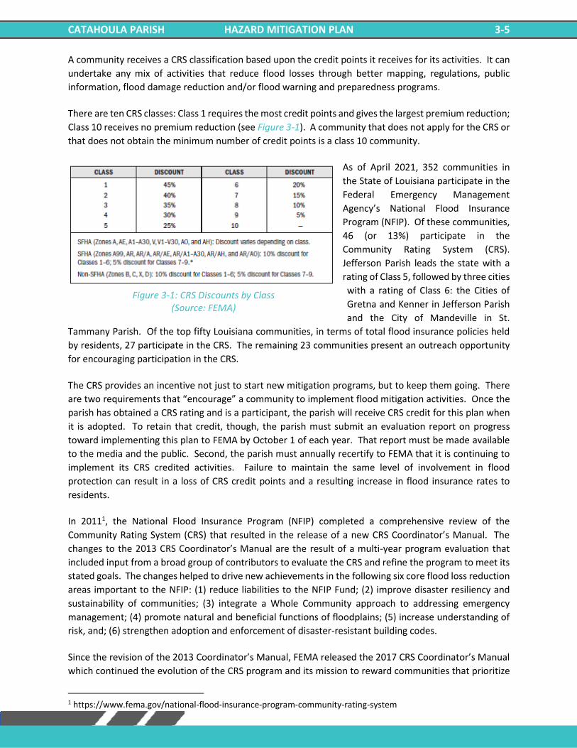
CATAHOULA PARISH HAZARD MITIGATION PLAN 3-5
A community receives a CRS classification based upon the credit points it receives for its activities. It can
undertake any mix of activities that reduce flood losses through better mapping, regulations, public
information, flood damage reduction and/or flood warning and preparedness programs.
There are ten CRS classes: Class 1 requires the most credit points and gives the largest premium reduction;
Class 10 receives no premium reduction (see Figure 3-1). A community that does not apply for the CRS or
that does not obtain the minimum number of credit points is a class 10 community.
As of April 2021, 352 communities in
the State of Louisiana participate in the
Federal Emergency Management
Agency’s National Flood Insurance
Program (NFIP). Of these communities,
46 (or 13%) participate in the
Community Rating System (CRS).
Jefferson Parish leads the state with a
rating of Class 5, followed by three cities
with a rating of Class 6: the Cities of
Gretna and Kenner in Jefferson Parish
and the City of Mandeville in St.
Tammany Parish. Of the top fifty Louisiana communities, in terms of total flood insurance policies held
by residents, 27 participate in the CRS. The remaining 23 communities present an outreach opportunity
for encouraging participation in the CRS.
The CRS provides an incentive not just to start new mitigation programs, but to keep them going. There
are two requirements that “encourage” a community to implement flood mitigation activities. Once the
parish has obtained a CRS rating and is a participant, the parish will receive CRS credit for this plan when
it is adopted. To retain that credit, though, the parish must submit an evaluation report on progress
toward implementing this plan to FEMA by October 1 of each year. That report must be made available
to the media and the public. Second, the parish must annually recertify to FEMA that it is continuing to
implement its CRS credited activities. Failure to maintain the same level of involvement in flood
protection can result in a loss of CRS credit points and a resulting increase in flood insurance rates to
residents.
In 20111, the National Flood Insurance Program (NFIP) completed a comprehensive review of the
Community Rating System (CRS) that resulted in the release of a new CRS Coordinator’s Manual. The
changes to the 2013 CRS Coordinator’s Manual are the result of a multi-year program evaluation that
included input from a broad group of contributors to evaluate the CRS and refine the program to meet its
stated goals. The changes helped to drive new achievements in the following six core flood loss reduction
areas important to the NFIP: (1) reduce liabilities to the NFIP Fund; (2) improve disaster resiliency and
sustainability of communities; (3) integrate a Whole Community approach to addressing emergency
management; (4) promote natural and beneficial functions of floodplains; (5) increase understanding of
risk, and; (6) strengthen adoption and enforcement of disaster-resistant building codes.
Since the revision of the 2013 Coordinator’s Manual, FEMA released the 2017 CRS Coordinator’s Manual
which continued the evolution of the CRS program and its mission to reward communities that prioritize
1 https://www.fema.gov/national-flood-insurance-program-community-rating-system
Figure 3-1: CRS Discounts by Class (Source: FEMA)
CATAHOULA PARISH HAZARD MITIGATION PLAN 3-6
mindful floodplain regulations. As with the 2013 manual, the changes made in the 2017 manual impact
each CRS community differently. Some communities see an increase in the points they receive since
points for certain activities have increased (e.g., Activity 420 Open Space Preservation). Other
communities receive fewer points for certain activities (e.g., Activity 320 Map Information Service). It is
likely that some communities with marginal CRS Class 9 programs have to identify new CRS credits in order
to remain in the CRS class. Most notably, as it relates to this hazard mitigation plan, more credit was made
available for Activity 410 Floodplain Mapping.
Typically, CRS communities do not request credit for all the activities they are currently implementing
unless it would earn enough credit to advance the community to a higher CRS Class. A community that
finds itself losing CRS credit with the 2017 manual could likely identify activities deserving credit they had
not previously received. Due to the changes in both activities and CRS points, community CRS
coordinators should speak with their ISO/CRS Specialist to understand how the 2017 manual will impact
their community and when.
In addition to the direct financial reward for participating in the Community Rating System, there are many
other reasons to participate in the CRS. As FEMA staff often say, “If you are only interested in saving
premium dollars, you’re in the CRS for the wrong reason.”
The other benefits that are more difficult to measure in dollars include:
1. The activities credited by the CRS provide direct benefits to residents, including:
– Enhanced public safety
– A reduction in damage to property and public infrastructure
– Avoidance of economic disruption and losses
– Reduction of human suffering
– Protection of the environment
2. A community’s flood programs will be better organized and more formal. Ad hoc activities, such as
responding to drainage complaints rather than an inspection program, will be conducted on a sounder,
more equitable basis.
3. A community can evaluate the effectiveness of its flood program against a nationally recognized
benchmark.
4. Technical assistance in designing and implementing a number of activities is available at no charge from
the Insurance Services Office.
5. The public information activities will build a knowledgeable constituency interested in supporting and
improving flood protection measures.
6. A community would have an added incentive to maintain its flood programs over the years. The fact
that its CRS status could be affected by the elimination of a flood related activity or a weakening of the
regulatory requirements for new developments would be taken into account by the governing board
when considering such actions.
7. Every time residents pay their insurance premiums, they are reminded that the community is working
to protect them from flood losses, even during dry years.
NFIP Worksheets Parish NFIP worksheets can be found in Appendix E: State Required Worksheets.
CATAHOULA PARISH HAZARD MITIGATION PLAN 4-1
4. Mitigation Strategy
Introduction The Hazard Mitigation Strategy for Catahoula Parish and its incorporated communities have a common
guiding principle and is the demonstration of the parish’s commitment to reduce risks from hazards.
The strategy also serves as a guide for parish and local decision makers as they commit resources to
reducing the effects of hazards.
Officials from all jurisdictions within the planning area confirmed the goals, objectives, actions and
projects over the period of the hazard mitigation plan update process. The mitigation actions and
projects in this 2021 HMP update are a product of analysis and review of the Catahoula Parish Hazard
Mitigation Plan Steering Committee under the coordination of the Catahoula Parish Office of
Homeland Security and Emergency Preparedness. The committee was presented a list of projects and
actions, new and from the 2016 plan, for review from June 2021 – November 2021.
An online public opinion survey of Catahoula Parish residents was conducted between March 2021 and
November 2021. The survey was designed to capture public perceptions and opinions regarding natural
hazards in the Catahoula Parish planning area. In addition, the survey collected information regarding the
methods and techniques preferred by the respondents for reducing the risks and losses associated with
local hazards.
This activity was created in an effort to confirm that the goals and action items developed by the
Catahoula Parish Hazard Mitigation Plan Steering Committee are representative of the outlook of the
community at large. However, because there were no responses to the survey, this public feedback
could not be incorporated into the plan. The full Catahoula Parish survey can be found at the following
link:
https://www.surveymonkey.com/results/SM-YJYYVN7C9/
Goals The goals represent the guidelines that the parish and its communities want to achieve with this plan
update. To help implement the strategy and adhere to the mission of the Hazard Mitigation Plan, the
preceding section of the plan update was focused on identifying and quantifying the risks faced by the
residents and property owners in Cat Parish from natural and manmade hazards. By articulating goals
and objectives based on the previous plans, the risk assessment results, and intending to address those
results, this section sets the stage for identifying, evaluating, and prioritizing feasible, cost effective, and
environmentally sound actions to be promoted at the parish and municipal level – and to be undertaken
by the state for its own property and assets. By doing so, Catahoula Parish can make progress toward
reducing identified risks.
For the purposes of this plan update, goals and action items are defined as follows:
• Goals are general guidelines that explain what the parish wants to achieve. Goals are expressed
as broad policy statements representing desired long-term results.
• Action Items are the specific steps (projects, policies, and programs) that advance a given goal.
They are highly focused, specific, and measurable.
CATAHOULA PARISH HAZARD MITIGATION PLAN 4-2
The current goals of the Catahoula Parish Hazard Mitigation Plan Update Steering Committee represent
long-term commitments by the parish. After assessing these goals, the committee decided that the
current remain valid.
The goals are as follows:
1. Reduce the impact of future flooding
2. Ensure the delivery of critical services to the community in the case of a hazard event
3. Improve the ability of structures to withstand high wind and storm events
4. Engage and inform the community on the subject of hazard mitigation
The Mitigation Action Plan focuses on actions to be taken by Catahoula Parish and its communities. All of
the activities in the Mitigation Action Plan will be focused on helping the parish and its communities in
developing and funding projects that are not only cost effective but also meet the other DMA 2000 criteria
of environmental compatibility and technical feasibility.
After the adoption of the 2016 Catahoula Parish Hazard Mitigation Plan, large portions of the state were
impacted by a flooding event whose ramifications are still being felt by the population. Because of this
event, Catahoula Parish and its jurisdictions reprioritized its efforts and became much more aggressive in
seeking funding for flood mitigation efforts, particularly related to drainage.
The Hazard Mitigation Plan Steering Committee reviewed and evaluated the potential action and project
lists in which consideration was given to a variety of factors. Such factors include determining a project’s
eligibility for federal mitigation grants as well as its ability to be funded. This process required evaluation
of each project’s engineering feasibility, cost effectiveness, and environmental and cultural factors.
2021 Mitigation Actions and Update on Previous Plan Actions The Catahoula Parish Hazard Mitigation Plan Steering Committee identified new actions that would
reduce and/or prevent future damage within the Catahoula Parish planning area. In that effort, the
committee focused on a comprehensive range of specific mitigation actions. These actions were
identified in thorough fashion by the consultant team and the committee by way of frequent and open
communications and meetings held throughout the planning process. The addition of these new actions,
coupled with any ongoing and/or carried over projects from their previous update, provide Catahoula
Parish with a solid mitigation strategy through which risk and losses will be reduced throughout the parish
and its communities.
As outlined in the Local Mitigation Planning Handbook the following are eligible types of mitigation
actions:
• Local Plans and Regulations – These actions include government authorities, policies, or
codes that influence the way land and buildings are developed and built.
• Structure and Infrastructure Projects – These actions involve modifying existing structures
and infrastructure to protect them from a hazard or remove them from a hazard area, and
also includes projects to construct manmade structures to reduce the impact of hazards.
CATAHOULA PARISH HAZARD MITIGATION PLAN 4-3
• Natural System Protection – These actions minimize the damage and losses and also preserve
or restore the functions of natural systems.
• Education and Awareness Programs – These actions inform and educate citizens, elected
officials, and property owners about hazards and potential ways to mitigate them.
Status updates for actions included in the previous plan can be found on the following pages. Additionally,
new mitigation actions agreed upon by the parish and its jurisdictions are included.
Unincorporated Catahoula Parish Mitigation Actions Previous Action Update
Unincorporated Catahoula Parish
Jurisdiction-Specific Action
Action Description Funding Source
Target Completion
Date
Responsible Party,
Agency, or Department
Hazard Goal Status
C1: Drainage Projects
Investigate and implement a localized interior
drainage project to reduce repetitive losses, increase
drainage capacity, and reduce flooding
CDBG, FMA Project Funds, HMGP Funds,
SBA, U.S. Army Corps of
Engineers - Section 205,
and State Capital Outlay, Local Drainage
Funds
As funding is available
Parish and City
Floodplain Managers/
Public Works Director
Flooding, Tropical Cyclones
1, 3, 4
Not Started/ Carried Over from 2016
Plan
C2: Flood Proofing Projects
Inform the public of elevation/ acquisition/
flood proofing projects to reduce repetitive flooding
properties.
Parish and/or City Budgets and Grants
As funding is available
Building Permit
Director/ Emergency Manager
Flooding, Tropical Cyclones
1, 3, 4
Not Started/ Carried Over from 2016
Plan
C3: Master Drainage Plan
Develop a master drainage plan to evaluate drainage
projects to increase drainage capacity and reduce flood losses.
Implement recommended projects resulting from
drainage plan.
Parish and/or City Budgets and Grants
As funding is available
Parish Engineer
Flooding, Tropical Cyclones
1, 3, 4
Not Started/ Carried Over from 2016
Plan
C4: Harden Critical
Facilities
Harden critical facilities to reduce damages from
hazard events. HMGP
As funding is available
Catahoula OHSEP
Flooding, Thunderstorms,
Tornadoes, Tropical
Cyclones, Winter Storms
1. 4
Not Started/ Carried Over from 2016
Plan
C5: Communication
Systems
Communication system upgrades and
improvements, including but not limited to
enhancing network capability and
management of information flow.
Grant As funding is
available Parish and Fire Rescue
Flooding, Thunderstorms,
Tornadoes, Tropical
Cyclones, Winter Storms
1, 2
Not Started/ Carried Over from 2016
Plan
C6: Road Elevation
Elevate roads in vulnerable locations prone to flooding
and drainage problems.
As funds become available
As funding is available
Parish, Parish Engineer/
Public Works Director
Flooding, Tropical Cyclones
1, 4
Not Started/ Carried Over from 2016
Plan
CATAHOULA PARISH HAZARD MITIGATION PLAN 4-4
C7: Generator Installation
Add back up power supply/generators at the
Parish shelters, critical facilities, and
governmental buildings.
Parish and /or City Budgets and Grants
As funding is available
Parish Department
of Public Works
Flooding, Thunderstorms,
Tornadoes, Tropical
Cyclones, Winter
Weather
1, 4
Not Started/ Carried Over from 2016
Plan
C8: Mitigation Outreach and
Education
Increase public awareness of hazards and hazardous
areas. Distribute public awareness information regarding all hazards as
well as information regarding potential
mitigation measures by using the following
methods and outlets local newspaper, utility bill inserts, inserts in the
phone book, and parish hazards awareness
website, and educational programs for school age
children. Integrate "Disaster Resistance
Education" into the public school curriculum.
Provide public education on the importance of
maintaining the ditches. Sponsor a "Multi-Hazard
Awareness Week", to educate the public on all
hazards. Promote the purchase of flood
insurance. Advertise the availability, cost, and
coverage of flood insurance through the
National Flood Insurance Program (NFIP).
Parish and /or City Budgets and Grants
As funding is available
Parish School Board and
Parish Emergency Manager
Drought, Flooding,
Thunderstorms, Tornadoes,
Tropical Cyclones,
Winter Weather
1, 2, 4
Not Started/ Carried Over from 2016
Plan
C9: Flood Mitigation of
Repetitive Loss Properties and
Other Flood Prone
Structures
Elevation, acquisition-demolition, acquisition-
relocations, and reconstruction of
repetitive loss or flood prone properties. Benefits: Relieves property owners of the continual flooding
Parish and /or City Budgets and Grants
As funding is available
Parish Engineer/
Public Works Director
Flooding, Tropical Cyclones
1, 4
Not Started/ Carried Over from 2016
Plan
C10: Lightning Mitigation
Procurement and Installation of lightning
rods and surge protectors for public buildings to
preserve life and property.
Parish and /or City Budgets and Grants
As funding is available
Parish Government
Thunderstorms 1, 4
Not Started/ Carried Over from 2016
Plan
C11: Construction of
Safe Rooms
Construction of Safe Rooms for First
Responders located in Catahoula Parish. Other
locations will be identified based on funding
availability.
Parish and /or City Budgets and Grants
As funding is available
Parish Engineer/
Public Works Director
Flooding, Thunderstorms,
Tornadoes, Tropical
Cyclones, Winter
Weather
1, 3, 4
Not Started/ Carried Over from 2016
Plan
CATAHOULA PARISH HAZARD MITIGATION PLAN 4-5
C12: Water Conservation
Measures
Adopt ordinance requiring water-saving measures in
time of drought.
Parish and /or City Budgets and Grants
As funding is available
Parish Engineer/
Public Works Director
Drought 1, 2, 4
Not Started/ Carried Over from 2016
Plan
C13: CRS
Review the existing floodplain ordinance and evaluate and implement
ways to improve the Parish's "Community Rating System" (CRS)
rating to reduce the flood insurance premium.
Parish and /or City Budgets and Grants
As funding is available
Parish Floodplain Manager
Drought, Flooding,
Thunderstorms, Tornadoes,
Tropical Cyclones,
Winter Weather
1,2,3,4 Ongoing
C14: Network Capability
Funding has been approved through a grant
to acquire a vendor to enhance the networks capability and better
manage information flow.
Parish and /or City Budgets and Grants
As funding is available
Catahoula OHSEP
Flooding, Thunderstorms,
Tropical Cyclones, Drought,
Tornadoes, Winter
Weather
1,3 Deleted
(Duplicate of Action C5)
C15: Commercial
Building Regulations
Adopt additional commercial building
regulations, which include stricter building standards and incorporate dry flood
proofing techniques.
Parish and /or City Budgets and Grants
As funding is available
Parish Permit Director
Flooding, Tropical Cyclones
1,3,4 Ongoing
C16: Subdivision Guidelines
Develop additional subdivision guidelines to reduce flooding, such as
requiring proper drainage with adequate sloping; storm water retention
ponds; dikes; levees and floodwalls if appropriate, and requiring freeboard
above the Base Flood Elevation (BFE) in flood prone areas. Encourage
new subdivision developments to install underground utilities,
which would help reduce the chances of power
outages.
Parish and /or City Budgets and Grants
As funding is available
Parish Permit Director
Flooding, Tropical Cyclones
1,3,4 Ongoing
C17: Public Awareness
Increase public awareness of hazards and hazardous
areas. Distribute public awareness information
regarding Flooding, Thunderstorms, Tropical
Cyclones, Drought, Tornadoes, Winter
Weather, SFHA's, and potential mitigation
measures using the local newspaper, utility bill inserts, inserts in the
phone book, and parish hazards awareness
website, and an educational program for
school age children or
Parish and /or City Budgets and Grants
As funding is available
Catahoula OHSEP
Flooding, Thunderstorms,
Tropical Cyclones, Drought,
Tornadoes, Winter
Weather
1,2 Deleted
(Duplicate of Action C8)

CATAHOULA PARISH HAZARD MITIGATION PLAN 4-6
"how to" classes in retrofitting by local
merchants. Integrate "Disaster Resistance
Education" into the public school curriculum. Provide
public education on the importance of maintaining
the ditches.
CATAHOULA PARISH HAZARD MITIGATION PLAN 4-7
New Mitigation Actions
IMPLEMENTATION KEY FOR POTENTIAL HAZARD MITIGATION ACTIONS CATAHOULA PARISH
DESCRIPTION
CATAHOULA PARISH MITGATION ACTION 1
Drainage Projects
LEAD AGENCY Catahoula Parish Public Works
SUPPORTING AGENCIES Catahoula Parish Police Jury
TIMELINE 1-5 Years
COST ESTIMATE TBD
POSSIBLE FUNDING SOURCE(S) CDBG, FMA Project Funds, HMGP Funds, SBA, U.S. Army Corps of Engineers - Section 205, and State Capital Outlay, Local Drainage Funds
ASSOCIATED GOALS
1. Reduce the impact of future flooding
3. Improve the ability of structures to withstand high wind and storm events
4. Engage and inform the community on the subject of hazard mitigation
PRIORITY High
Action Description Investigate and implement a localized interior drainage project to reduce repetitive losses, increase drainage capacity, and reduce flooding
Type of Mitigation Action Structure and Infrastructure Projects
How Action Aligns with Risk Reduction
Improving the drainage system in Catahoula Parish would reduce flood damage by allowing water to drain efficiently rather than rise and cause structure damage.
Current Status of Action New (Not Started – Carried over from 2016 Plan)
Hazard Addressed Flooding, Tropical Cyclones
Additional Supporting Information:

CATAHOULA PARISH HAZARD MITIGATION PLAN 4-8
IMPLEMENTATION KEY FOR POTENTIAL HAZARD MITIGATION ACTIONS CATAHOULA PARISH
DESCRIPTION
CATAHOULA PARISH MITGATION ACTION 2
Flood Proofing Projects
LEAD AGENCY Catahoula Parish Public Works
SUPPORTING AGENCIES Catahoula OHSEP
TIMELINE 1-5 Years
COST ESTIMATE TBD
POSSIBLE FUNDING SOURCE(S) Parish and/or City Budgets and Grants
ASSOCIATED GOALS
1. Reduce the impact of future flooding
3. Improve the ability of structures to withstand high wind and storm events
4. Engage and inform the community on the subject of hazard mitigation
PRIORITY High
Action Description Inform the public of elevation/ acquisition/ flood proofing projects to reduce repetitive flooding properties.
Type of Mitigation Action Structure and Infrastructure Projects Education and Awareness Programs
How Action Aligns with Risk Reduction
Performing flood proofing projects such as elevating structures would reduce flood damage by raising the level floodwaters would have to reach before causing damage.
Current Status of Action New (Not Started – Carried over from 2016 Plan)
Hazard Addressed Flooding, Tropical Cyclones
Additional Supporting Information:

CATAHOULA PARISH HAZARD MITIGATION PLAN 4-9
IMPLEMENTATION KEY FOR POTENTIAL HAZARD MITIGATION ACTIONS CATAHOULA PARISH
DESCRIPTION
CATAHOULA PARISH MITGATION ACTION 3
Master Drainage Plan
LEAD AGENCY Catahoula Parish Police Jury
SUPPORTING AGENCIES Catahoula Parish Public Works
TIMELINE 1-5 Years
COST ESTIMATE TBD
POSSIBLE FUNDING SOURCE(S) Parish and/or City Budgets and Grants
ASSOCIATED GOALS
1. Reduce the impact of future flooding
3. Improve the ability of structures to withstand high wind and storm events
4. Engage and inform the community on the subject of hazard mitigation
PRIORITY High
Action Description Develop a master drainage plan to evaluate drainage projects to increase drainage capacity and reduce flood losses. Implement recommended projects resulting from drainage plan.
Type of Mitigation Action Local Plans and Regulation Structure and Infrastructure Projects
How Action Aligns with Risk Reduction
Developing a plain for improving drainage will increase cooperation within the parish and incorporated jurisdictions. The plan would also minimize unnecessary spending when performing structural improvements.
Current Status of Action New (Not Started – Carried over from 2016 Plan)
Hazard Addressed Flooding, Tropical Cyclones
Additional Supporting Information:

CATAHOULA PARISH HAZARD MITIGATION PLAN 4-10
IMPLEMENTATION KEY FOR POTENTIAL HAZARD MITIGATION ACTIONS CATAHOULA PARISH
DESCRIPTION
CATAHOULA PARISH MITGATION ACTION 4
Harden Critical Facilities
LEAD AGENCY Catahoula OHSEP
SUPPORTING AGENCIES Catahoula Parish Police Jury
TIMELINE 1-5 Years
COST ESTIMATE TBD
POSSIBLE FUNDING SOURCE(S) HMGP
ASSOCIATED GOALS 1. Reduce the impact of future flooding
4. Engage and inform the community on the subject of hazard mitigation
PRIORITY Medium
Action Description Harden critical facilities to reduce damages from hazard events.
Type of Mitigation Action Structure and Infrastructure Projects
How Action Aligns with Risk Reduction
Hardening critical facilities would reduce the damage caused by major weather/hazardous events. Structures could be made to withstand debris, wind, and other hazards.
Current Status of Action New (Not Started – Carried over from 2016 Plan)
Hazard Addressed Flooding, Thunderstorms, Tornadoes, Tropical Cyclones, Winter Storms
Additional Supporting Information:
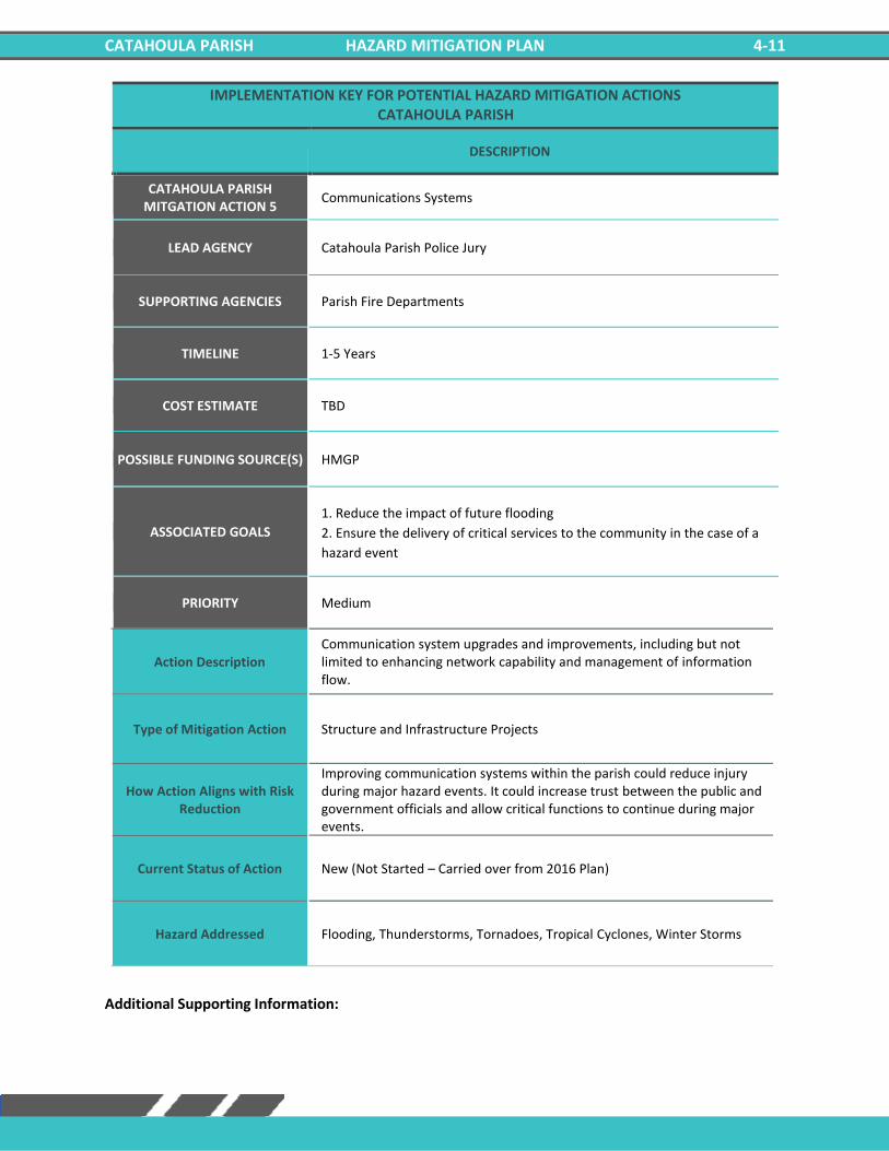
CATAHOULA PARISH HAZARD MITIGATION PLAN 4-11
IMPLEMENTATION KEY FOR POTENTIAL HAZARD MITIGATION ACTIONS CATAHOULA PARISH
DESCRIPTION
CATAHOULA PARISH MITGATION ACTION 5
Communications Systems
LEAD AGENCY Catahoula Parish Police Jury
SUPPORTING AGENCIES Parish Fire Departments
TIMELINE 1-5 Years
COST ESTIMATE TBD
POSSIBLE FUNDING SOURCE(S) HMGP
ASSOCIATED GOALS
1. Reduce the impact of future flooding
2. Ensure the delivery of critical services to the community in the case of a
hazard event
PRIORITY Medium
Action Description Communication system upgrades and improvements, including but not limited to enhancing network capability and management of information flow.
Type of Mitigation Action Structure and Infrastructure Projects
How Action Aligns with Risk Reduction
Improving communication systems within the parish could reduce injury during major hazard events. It could increase trust between the public and government officials and allow critical functions to continue during major events.
Current Status of Action New (Not Started – Carried over from 2016 Plan)
Hazard Addressed Flooding, Thunderstorms, Tornadoes, Tropical Cyclones, Winter Storms
Additional Supporting Information:

CATAHOULA PARISH HAZARD MITIGATION PLAN 4-12
IMPLEMENTATION KEY FOR POTENTIAL HAZARD MITIGATION ACTIONS CATAHOULA PARISH
DESCRIPTION
CATAHOULA PARISH MITGATION ACTION 6
Road Elevation
LEAD AGENCY Catahoula Parish Police Jury
SUPPORTING AGENCIES Catahoula Parish Public Works
TIMELINE 1-5 Years
COST ESTIMATE TBD
POSSIBLE FUNDING SOURCE(S) Federal Grants, Local
ASSOCIATED GOALS 1. Reduce the impact of future flooding
4. Engage and inform the community on the subject of hazard mitigation
PRIORITY Low
Action Description Elevate roads in vulnerable locations prone to flooding and drainage problems.
Type of Mitigation Action Structure and Infrastructure Projects
How Action Aligns with Risk Reduction
Elevating roads would allow emergency vehicles to travel freely within the parish during a flood event and allow for late evacuations during flooding.
Current Status of Action New (Not Started – Carried over from 2016 Plan)
Hazard Addressed Flooding, Tropical Cyclones
Additional Supporting Information:

CATAHOULA PARISH HAZARD MITIGATION PLAN 4-13
IMPLEMENTATION KEY FOR POTENTIAL HAZARD MITIGATION ACTIONS CATAHOULA PARISH
DESCRIPTION
CATAHOULA PARISH MITGATION ACTION 7
Generator Installation
LEAD AGENCY Catahoula Parish Police Jury
SUPPORTING AGENCIES Catahoula Parish Public Works
TIMELINE 1-5 Years
COST ESTIMATE TBD
POSSIBLE FUNDING SOURCE(S) HMGP, Parish and /or City Budgets and Grants
ASSOCIATED GOALS 1. Reduce the impact of future flooding
4. Engage and inform the community on the subject of hazard mitigation
PRIORITY Medium
Action Description Add back up power supply/generators at the Parish shelters, critical facilities, and governmental buildings.
Type of Mitigation Action Structure and Infrastructure Projects
How Action Aligns with Risk Reduction
Adding backup generators to critical facilities will ensure that essential practices remain operational during extreme hazardous events.
Current Status of Action New (Not Started – Carried over from 2016 Plan)
Hazard Addressed Flooding, Thunderstorms, Tornadoes, Tropical Cyclones, Winter Weather
Additional Supporting Information:

CATAHOULA PARISH HAZARD MITIGATION PLAN 4-14
IMPLEMENTATION KEY FOR POTENTIAL HAZARD MITIGATION ACTIONS CATAHOULA PARISH
DESCRIPTION
CATAHOULA PARISH MITGATION ACTION 8
Mitigation Outreach and Education
LEAD AGENCY Catahoula OHSEP
SUPPORTING AGENCIES Catahoula Parish Police Jury
TIMELINE 1-5 Years
COST ESTIMATE TBD
POSSIBLE FUNDING SOURCE(S) HMGP, Parish and /or City Budgets and Grants
ASSOCIATED GOALS
1. Reduce the impact of future flooding
2. Ensure the delivery of critical services to the community in the case of a
hazard event
4. Engage and inform the community on the subject of hazard mitigation
PRIORITY Medium
Action Description
Increase public awareness of hazards and hazardous areas. Distribute public awareness information regarding all hazards as well as information regarding potential mitigation measures by using the following methods and outlets local newspaper, utility bill inserts, inserts in the phone book, and parish hazards awareness website, and educational programs for school age children. Integrate "Disaster Resistance Education" into the public school curriculum. Provide public education on the importance of maintaining the ditches. Sponsor a "Multi-Hazard Awareness Week", to educate the public on all hazards. Promote the purchase of flood insurance. Advertise the availability, cost, and coverage of flood insurance through the National Flood Insurance Program (NFIP).
Type of Mitigation Action Structure and Infrastructure Projects
How Action Aligns with Risk Reduction
Increasing education and public awareness of hazards could decrease injuries during a major hazardous event because parish residents will know the necessary precautions to take prior to an event.
Current Status of Action New (Not Started – Carried over from 2016 Plan)
Hazard Addressed Drought, Flooding, Thunderstorms, Tornadoes, Tropical Cyclones, Winter Weather
Additional Supporting Information:

CATAHOULA PARISH HAZARD MITIGATION PLAN 4-15
IMPLEMENTATION KEY FOR POTENTIAL HAZARD MITIGATION ACTIONS CATAHOULA PARISH
DESCRIPTION
CATAHOULA PARISH MITGATION ACTION 9
Flood Mitigation of Repetitive Loss Properties and Other Flood Prone Structures
LEAD AGENCY Catahoula Parish Police Jury
SUPPORTING AGENCIES Catahoula Parish Public Works
TIMELINE 1-5 Years
COST ESTIMATE TBD
POSSIBLE FUNDING SOURCE(S) HMGP, Parish and /or City Budgets and Grants
ASSOCIATED GOALS 1. Reduce the impact of future flooding
4. Engage and inform the community on the subject of hazard mitigation
PRIORITY Medium
Action Description Elevation, acquisition-demolition, acquisition-relocations, and reconstruction of repetitive loss or flood prone properties. Benefits: Relieves property owners of the continual flooding
Type of Mitigation Action Structure and Infrastructure Projects
How Action Aligns with Risk Reduction
By relocating or reconstruction residences that are prone to flooding, residents could be relieved of continuous flood damage, and it would also reduce the likelihood of flood related injuries.
Current Status of Action New (Not Started – Carried over from 2016 Plan)
Hazard Addressed Flooding, Tropical Cyclones
Additional Supporting Information:

CATAHOULA PARISH HAZARD MITIGATION PLAN 4-16
IMPLEMENTATION KEY FOR POTENTIAL HAZARD MITIGATION ACTIONS CATAHOULA PARISH
DESCRIPTION
CATAHOULA PARISH MITGATION ACTION 10
Lightning Mitigation
LEAD AGENCY Catahoula Parish Police Jury
SUPPORTING AGENCIES Catahoula Parish Public Works
TIMELINE 1-5 Years
COST ESTIMATE TBD
POSSIBLE FUNDING SOURCE(S) HMGP, Parish and /or City Budgets and Grants
ASSOCIATED GOALS 1. Reduce the impact of future flooding
4. Engage and inform the community on the subject of hazard mitigation
PRIORITY Low
Action Description Procurement and Installation of lightning rods and surge protectors for public buildings to preserve life and property.
Type of Mitigation Action Structure and Infrastructure Projects
How Action Aligns with Risk Reduction
Installing lightning rods and surge protectors could reduce the likelihood of power outages for critical facilities during a hazard event.
Current Status of Action New (Not Started – Carried over from 2016 Plan)
Hazard Addressed Thunderstorms
Additional Supporting Information:

CATAHOULA PARISH HAZARD MITIGATION PLAN 4-17
IMPLEMENTATION KEY FOR POTENTIAL HAZARD MITIGATION ACTIONS CATAHOULA PARISH
DESCRIPTION
CATAHOULA PARISH MITGATION ACTION 11
Construction of Safe Rooms
LEAD AGENCY Catahoula Parish Police Jury
SUPPORTING AGENCIES Catahoula Parish Public Works
TIMELINE 1-5 Years
COST ESTIMATE TBD
POSSIBLE FUNDING SOURCE(S) HMGP, Parish and /or City Budgets and Grants
ASSOCIATED GOALS
1. Reduce the impact of future flooding
3. Improve the ability of structures to withstand high wind and storm events
4. Engage and inform the community on the subject of hazard mitigation
PRIORITY Medium
Action Description Construction of safe rooms for first responders located in Catahoula Parish. Other locations will be identified based on funding availability.
Type of Mitigation Action Structure and Infrastructure Projects
How Action Aligns with Risk Reduction
The construction of safe rooms would provide shelter and reduce the risk of injury during a hazard event.
Current Status of Action New (Not Started – Carried over from 2016 Plan)
Hazard Addressed Flooding, Thunderstorms, Tornadoes, Tropical Cyclones, Winter Weather
Additional Supporting Information:

CATAHOULA PARISH HAZARD MITIGATION PLAN 4-18
IMPLEMENTATION KEY FOR POTENTIAL HAZARD MITIGATION ACTIONS CATAHOULA PARISH
DESCRIPTION
CATAHOULA PARISH MITGATION ACTION 12
Water Conservation Measures
LEAD AGENCY Catahoula Parish Police Jury
SUPPORTING AGENCIES Catahoula Parish Public Works
TIMELINE 1-5 Years
COST ESTIMATE TBD
POSSIBLE FUNDING SOURCE(S) HMGP, Parish and /or City Budgets and Grants
ASSOCIATED GOALS
1. Reduce the impact of future flooding
2. Ensure the delivery of critical services to the community in the case of a
hazard event
4. Engage and inform the community on the subject of hazard mitigation
PRIORITY Low
Action Description Adopt ordinance requiring water-saving measures in time of drought.
Type of Mitigation Action Education and Awareness Programs
How Action Aligns with Risk Reduction
Water-saving measures in time of drought could protect essential crops and protect human life.
Current Status of Action New (Not Started – Carried over from 2016 Plan)
Hazard Addressed Drought
Additional Supporting Information:

CATAHOULA PARISH HAZARD MITIGATION PLAN 4-19
Village of Harrisonburg Mitigation Actions Previous Action Update
Village of Harrisonburg
Jurisdiction-Specific Action
Action Description Funding Source
Target Completion
Date
Responsible Party,
Agency, or Department
Hazard Goal Status
H1: Drainage Projects
Investigate and implement a localized interior
drainage project to reduce repetitive losses, increase
drainage capacity, and reduce flooding
CDBG, FMA Project Funds, HMGP Funds,
SBA, U.S. Army Corps of
Engineers - Section 205,
and State Capital
Outlay, Local Drainage
Funds
As funding is available
Parish and City Floodplain Managers/
Public Works Director
Flooding, Tropical Cyclones
1, 3, 4
Not Started/ Carried
Over from 2016 Plan
H2: Flood Proofing Projects
Inform the public of elevation/ acquisition/
flood proofing projects to reduce repetitive flooding
properties.
Parish and/or City Budgets and Grants
As funding is available
Building Permit
Director/ Emergency Manager
Flooding, Tropical Cyclones
1, 3, 4
Not Started/ Carried
Over from 2016 Plan
H3: Master Drainage Plan
Develop a master drainage plan to evaluate drainage
projects to increase drainage capacity and reduce flood losses.
Implement recommended projects resulting from
drainage plan.
Parish and/or City Budgets and Grants
As funding is available
Parish Engineer
Flooding, Tropical Cyclones
1, 3, 4
Not Started/ Carried
Over from 2016 Plan
H4: Harden Critical Facilities
Harden critical facilities to reduce damages from
hazard events. HMGP
As funding is available
Catahoula SEP
Flooding, Thunderstorms,
Tornadoes, Tropical
Cyclones, Winter Storms
1. 4
Not Started/ Carried
Over from 2016 Plan
H5: Communication
Systems
Communication system upgrades and
improvements, including but not limited to
enhancing network capability and
management of information flow.
Grant As funding is
available Parish and Fire
Rescue
Flooding, Thunderstorms,
Tornadoes, Tropical
Cyclones, Winter Storms
1, 2
Not Started/ Carried
Over from 2016 Plan
H6: Road Elevation
Elevate roads in vulnerable locations prone
to flooding and drainage problems.
As funds become available
As funding is available
Parish Engineer/
Public Works Director
Flooding, Tropical Cyclones
1, 4
Not Started/ Carried
Over from 2016 Plan
H7: Generator Installation
Add back up power supply/generators at
shelters, critical facilities, and governmental
buildings.
Parish and /or City Budgets and Grants
As funding is available
Parish Department of Public Works
Flooding, Thunderstorms,
Tornadoes, Tropical
Cyclones, Winter
Weather
1, 4
Not Started/ Carried
Over from 2016 Plan
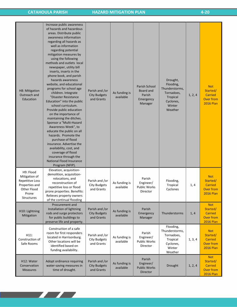
CATAHOULA PARISH HAZARD MITIGATION PLAN 4-20
H8: Mitigation Outreach and
Education
Increase public awareness of hazards and hazardous
areas. Distribute public awareness information regarding all hazards as
well as information regarding potential
mitigation measures by using the following
methods and outlets local newspaper, utility bill inserts, inserts in the
phone book, and parish hazards awareness
website, and educational programs for school age
children. Integrate "Disaster Resistance
Education" into the public school curriculum.
Provide public education on the importance of
maintaining the ditches. Sponsor a "Multi-Hazard
Awareness Week", to educate the public on all
hazards. Promote the purchase of flood
insurance. Advertise the availability, cost, and
coverage of flood insurance through the
National Flood Insurance Program (NFIP).
Parish and /or City Budgets and Grants
As funding is available
Parish School Board and
Parish Emergency Manager
Drought, Flooding,
Thunderstorms, Tornadoes,
Tropical Cyclones,
Winter Weather
1, 2, 4
Not Started/ Carried
Over from 2016 Plan
H9: Flood Mitigation of
Repetitive Loss Properties and
Other Flood Prone
Structures
Elevation, acquisition-demolition, acquisition-
relocations, and reconstruction of
repetitive loss or flood prone properties. Benefits: Relieves property owners of the continual flooding
Parish and /or City Budgets and Grants
As funding is available
Parish Engineer/
Public Works Director
Flooding, Tropical Cyclones
1, 4
Not Started/ Carried
Over from 2016 Plan
H10: Lightning Mitigation
Procurement and Installation of lightning
rods and surge protectors for public buildings to
preserve life and property.
Parish and /or City Budgets and Grants
As funding is available
Parish Emergency Manager
Thunderstorms 1, 4
Not Started/ Carried
Over from 2016 Plan
H11: Construction of
Safe Rooms
Construction of a safe room for first responders located in Harrisonburg. Other locations will be
identified based on funding availability.
Parish and /or City Budgets and Grants
As funding is available
Parish Engineer/
Public Works Director
Flooding, Thunderstorms,
Tornadoes, Tropical
Cyclones, Winter
Weather
1, 3, 4
Not Started/ Carried
Over from 2016 Plan
H12: Water Conservation
Measures
Adopt ordinance requiring water-saving measures in
time of drought.
Parish and /or City Budgets and Grants
As funding is available
Parish Engineer/
Public Works Director
Drought 1, 2, 4
Not Started/ Carried
Over from 2016 Plan
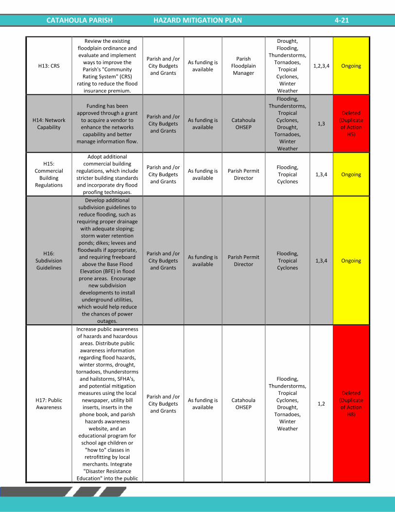
CATAHOULA PARISH HAZARD MITIGATION PLAN 4-21
H13: CRS
Review the existing floodplain ordinance and evaluate and implement
ways to improve the Parish's "Community Rating System" (CRS)
rating to reduce the flood insurance premium.
Parish and /or City Budgets and Grants
As funding is available
Parish Floodplain Manager
Drought, Flooding,
Thunderstorms, Tornadoes,
Tropical Cyclones,
Winter Weather
1,2,3,4 Ongoing
H14: Network Capability
Funding has been approved through a grant
to acquire a vendor to enhance the networks capability and better
manage information flow.
Parish and /or City Budgets and Grants
As funding is available
Catahoula OHSEP
Flooding, Thunderstorms,
Tropical Cyclones, Drought,
Tornadoes, Winter
Weather
1,3
Deleted (Duplicate of Action
H5)
H15: Commercial
Building Regulations
Adopt additional commercial building
regulations, which include stricter building standards and incorporate dry flood
proofing techniques.
Parish and /or City Budgets and Grants
As funding is available
Parish Permit Director
Flooding, Tropical Cyclones
1,3,4 Ongoing
H16: Subdivision Guidelines
Develop additional subdivision guidelines to reduce flooding, such as
requiring proper drainage with adequate sloping; storm water retention
ponds; dikes; levees and floodwalls if appropriate, and requiring freeboard
above the Base Flood Elevation (BFE) in flood prone areas. Encourage
new subdivision developments to install underground utilities,
which would help reduce the chances of power
outages.
Parish and /or City Budgets and Grants
As funding is available
Parish Permit Director
Flooding, Tropical Cyclones
1,3,4 Ongoing
H17: Public Awareness
Increase public awareness of hazards and hazardous
areas. Distribute public awareness information
regarding flood hazards, winter storms, drought,
tornadoes, thunderstorms and hailstorms, SFHA's, and potential mitigation measures using the local
newspaper, utility bill inserts, inserts in the
phone book, and parish hazards awareness
website, and an educational program for
school age children or "how to" classes in retrofitting by local
merchants. Integrate "Disaster Resistance
Education" into the public
Parish and /or City Budgets and Grants
As funding is available
Catahoula OHSEP
Flooding, Thunderstorms,
Tropical Cyclones, Drought,
Tornadoes, Winter
Weather
1,2
Deleted (Duplicate of Action
H8)

CATAHOULA PARISH HAZARD MITIGATION PLAN 4-22
school curriculum. Provide public education on the
importance of maintaining the ditches.

CATAHOULA PARISH HAZARD MITIGATION PLAN 4-23
New Mitigation Actions
IMPLEMENTATION KEY FOR POTENTIAL HAZARD MITIGATION ACTIONS VILLAGE OF HARRISONBURG
DESCRIPTION
VILLAGE OF HARRISONBURG MITGATION ACTION 1
Drainage Projects
LEAD AGENCY Harrisonburg Mayor’s Office
SUPPORTING AGENCIES Catahoula Parish Police Jury, Parish and City Floodplain Managers/ Public Works Director
TIMELINE 1-5 Years
COST ESTIMATE TBD
POSSIBLE FUNDING SOURCE(S) CDBG, FMA Project Funds, HMGP Funds, SBA, U.S. Army Corps of Engineers - Section 205, and State Capital Outlay, Local Drainage Funds
ASSOCIATED GOALS
1. Reduce the impact of future flooding
3. Improve the ability of structures to withstand high wind and storm events
4. Engage and inform the community on the subject of hazard mitigation
PRIORITY High
Action Description Investigate and implement a localized interior drainage project to reduce repetitive losses, increase drainage capacity, and reduce flooding
Type of Mitigation Action Structure and Infrastructure Projects
How Action Aligns with Risk Reduction
Improving the drainage system in Catahoula Parish would reduce flood damage by allowing water to drain efficiently rather than rise and cause structure damage.
Current Status of Action New (Not Started – Carried over from 2016 Plan)
Hazard Addressed Flooding, Tropical Cyclones
Additional Supporting Information:
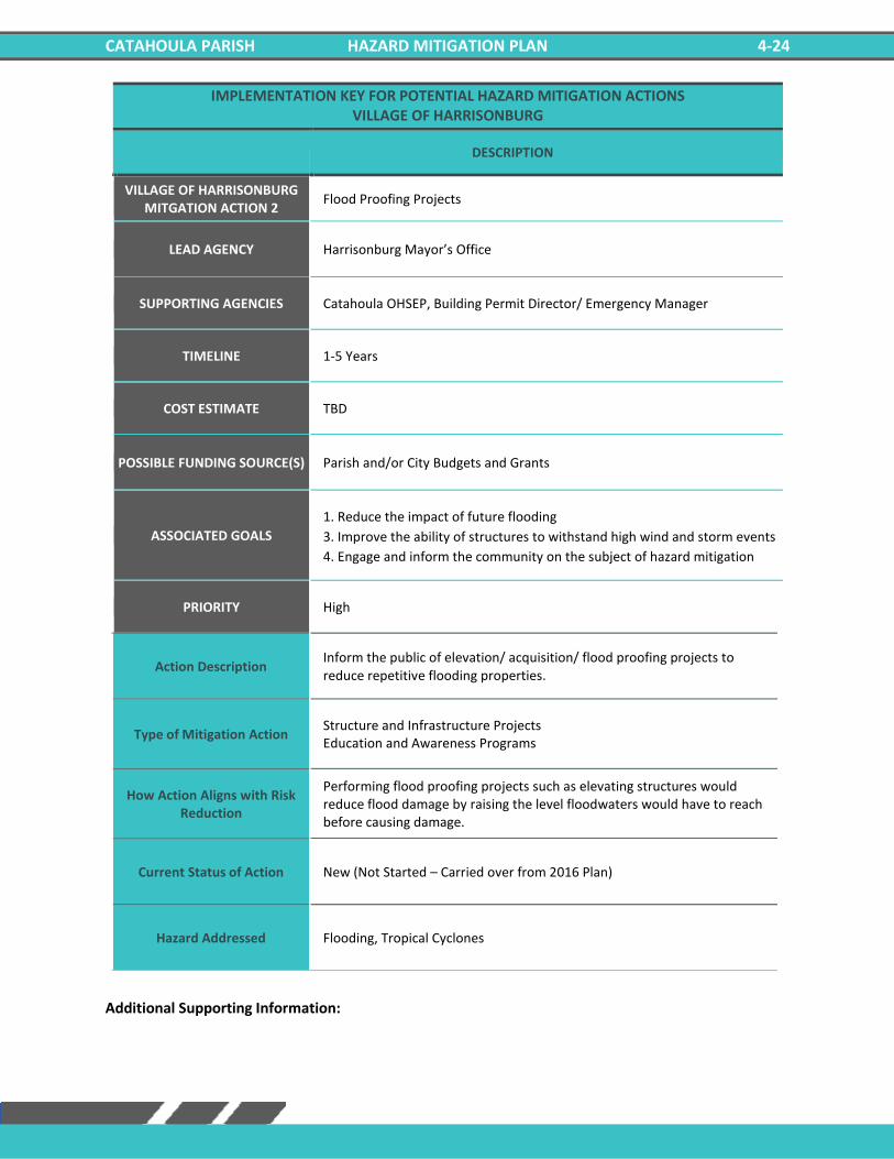
CATAHOULA PARISH HAZARD MITIGATION PLAN 4-24
IMPLEMENTATION KEY FOR POTENTIAL HAZARD MITIGATION ACTIONS VILLAGE OF HARRISONBURG
DESCRIPTION
VILLAGE OF HARRISONBURG MITGATION ACTION 2
Flood Proofing Projects
LEAD AGENCY Harrisonburg Mayor’s Office
SUPPORTING AGENCIES Catahoula OHSEP, Building Permit Director/ Emergency Manager
TIMELINE 1-5 Years
COST ESTIMATE TBD
POSSIBLE FUNDING SOURCE(S) Parish and/or City Budgets and Grants
ASSOCIATED GOALS
1. Reduce the impact of future flooding
3. Improve the ability of structures to withstand high wind and storm events
4. Engage and inform the community on the subject of hazard mitigation
PRIORITY High
Action Description Inform the public of elevation/ acquisition/ flood proofing projects to reduce repetitive flooding properties.
Type of Mitigation Action Structure and Infrastructure Projects Education and Awareness Programs
How Action Aligns with Risk Reduction
Performing flood proofing projects such as elevating structures would reduce flood damage by raising the level floodwaters would have to reach before causing damage.
Current Status of Action New (Not Started – Carried over from 2016 Plan)
Hazard Addressed Flooding, Tropical Cyclones
Additional Supporting Information:

CATAHOULA PARISH HAZARD MITIGATION PLAN 4-25
IMPLEMENTATION KEY FOR POTENTIAL HAZARD MITIGATION ACTIONS VILLAGE OF HARRISONBURG
DESCRIPTION
VILLAGE OF HARRISONBURG MITGATION ACTION 3
Master Drainage Plan
LEAD AGENCY Harrisonburg Mayor’s Office
SUPPORTING AGENCIES Catahoula Parish Public Works, Parish Engineer
TIMELINE 1-5 Years
COST ESTIMATE TBD
POSSIBLE FUNDING SOURCE(S) Parish and/or City Budgets and Grants
ASSOCIATED GOALS
1. Reduce the impact of future flooding
3. Improve the ability of structures to withstand high wind and storm events
4. Engage and inform the community on the subject of hazard mitigation
PRIORITY High
Action Description Develop a master drainage plan to evaluate drainage projects to increase drainage capacity and reduce flood losses. Implement recommended projects resulting from drainage plan.
Type of Mitigation Action Local Plans and Regulation Structure and Infrastructure Projects
How Action Aligns with Risk Reduction
Developing a plain for improving drainage will increase cooperation within the parish and incorporated jurisdictions. The plan would also minimize unnecessary spending when performing structural improvements.
Current Status of Action New (Not Started – Carried over from 2016 Plan)
Hazard Addressed Flooding, Tropical Cyclones
Additional Supporting Information:

CATAHOULA PARISH HAZARD MITIGATION PLAN 4-26
IMPLEMENTATION KEY FOR POTENTIAL HAZARD MITIGATION ACTIONS VILLAGE OF HARRISONBURG
DESCRIPTION
VILLAGE OF HARRISONBURG MITGATION ACTION 4
Harden Critical Facilities
LEAD AGENCY Harrisonburg Mayor’s Office
SUPPORTING AGENCIES Catahoula Parish Police Jury, Catahoula OHSEP
TIMELINE 1-5 Years
COST ESTIMATE TBD
POSSIBLE FUNDING SOURCE(S) HMGP
ASSOCIATED GOALS 1. Reduce the impact of future flooding
4. Engage and inform the community on the subject of hazard mitigation
PRIORITY Medium
Action Description Harden critical facilities to reduce damages from hazard events.
Type of Mitigation Action Structure and Infrastructure Projects
How Action Aligns with Risk Reduction
Hardening critical facilities would reduce the damage caused by major weather/hazardous events. Structures could be made to withstand debris, wind, and other hazards.
Current Status of Action New (Not Started – Carried over from 2016 Plan)
Hazard Addressed Flooding, Thunderstorms, Tornadoes, Tropical Cyclones, Winter Storms
Additional Supporting Information:
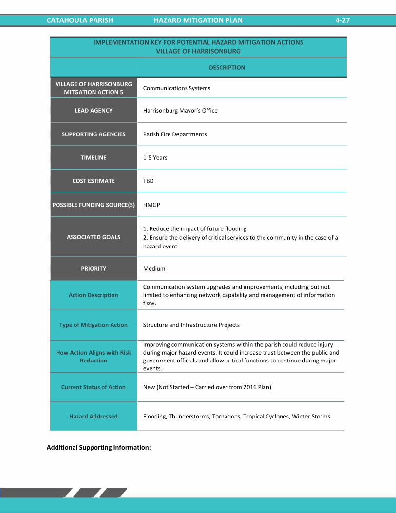
CATAHOULA PARISH HAZARD MITIGATION PLAN 4-27
IMPLEMENTATION KEY FOR POTENTIAL HAZARD MITIGATION ACTIONS VILLAGE OF HARRISONBURG
DESCRIPTION
VILLAGE OF HARRISONBURG MITGATION ACTION 5
Communications Systems
LEAD AGENCY Harrisonburg Mayor’s Office
SUPPORTING AGENCIES Parish Fire Departments
TIMELINE 1-5 Years
COST ESTIMATE TBD
POSSIBLE FUNDING SOURCE(S) HMGP
ASSOCIATED GOALS
1. Reduce the impact of future flooding
2. Ensure the delivery of critical services to the community in the case of a
hazard event
PRIORITY Medium
Action Description Communication system upgrades and improvements, including but not limited to enhancing network capability and management of information flow.
Type of Mitigation Action Structure and Infrastructure Projects
How Action Aligns with Risk Reduction
Improving communication systems within the parish could reduce injury during major hazard events. It could increase trust between the public and government officials and allow critical functions to continue during major events.
Current Status of Action New (Not Started – Carried over from 2016 Plan)
Hazard Addressed Flooding, Thunderstorms, Tornadoes, Tropical Cyclones, Winter Storms
Additional Supporting Information:

CATAHOULA PARISH HAZARD MITIGATION PLAN 4-28
IMPLEMENTATION KEY FOR POTENTIAL HAZARD MITIGATION ACTIONS VILLAGE OF HARRISONBURG
DESCRIPTION
VILLAGE OF HARRISONBURG MITGATION ACTION 6
Road Elevation
LEAD AGENCY Harrisonburg Mayor’s Office
SUPPORTING AGENCIES Catahoula Parish Public Works
TIMELINE 1-5 Years
COST ESTIMATE TBD
POSSIBLE FUNDING SOURCE(S) Federal Grants, Local
ASSOCIATED GOALS 1. Reduce the impact of future flooding
4. Engage and inform the community on the subject of hazard mitigation
PRIORITY Low
Action Description Elevate roads in vulnerable locations prone to flooding and drainage problems.
Type of Mitigation Action Structure and Infrastructure Projects
How Action Aligns with Risk Reduction
Elevating roads would allow emergency vehicles to travel freely within the parish during a flood event and allow for late evacuations during flooding.
Current Status of Action New (Not Started – Carried over from 2016 Plan)
Hazard Addressed Flooding, Tropical Cyclones
Additional Supporting Information:

CATAHOULA PARISH HAZARD MITIGATION PLAN 4-29
IMPLEMENTATION KEY FOR POTENTIAL HAZARD MITIGATION ACTIONS VILLAGE OF HARRISONBURG
DESCRIPTION
VILLAGE OF HARRISONBURG MITGATION ACTION 7
Generator Installation
LEAD AGENCY Harrisonburg Mayor’s Office
SUPPORTING AGENCIES Catahoula Parish Public Works
TIMELINE 1-5 Years
COST ESTIMATE TBD
POSSIBLE FUNDING SOURCE(S) HMGP, Parish and /or City Budgets and Grants
ASSOCIATED GOALS 1. Reduce the impact of future flooding
4. Engage and inform the community on the subject of hazard mitigation
PRIORITY Medium
Action Description Add back up power supply/generators at the Parish shelters, critical facilities, and governmental buildings.
Type of Mitigation Action Structure and Infrastructure Projects
How Action Aligns with Risk Reduction
Adding backup generators to critical facilities will ensure that essential practices remain operational during extreme hazardous events.
Current Status of Action New (Not Started – Carried over from 2016 Plan)
Hazard Addressed Flooding, Thunderstorms, Tornadoes, Tropical Cyclones, Winter Weather
Additional Supporting Information:
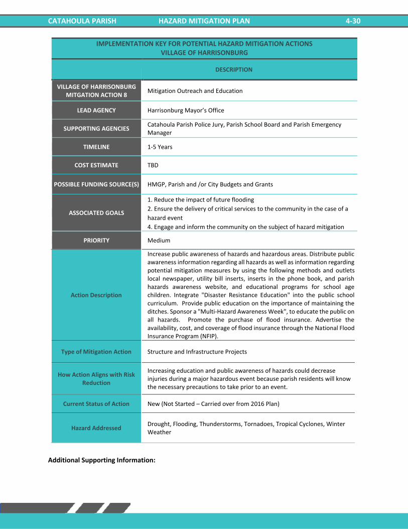
CATAHOULA PARISH HAZARD MITIGATION PLAN 4-30
IMPLEMENTATION KEY FOR POTENTIAL HAZARD MITIGATION ACTIONS VILLAGE OF HARRISONBURG
DESCRIPTION
VILLAGE OF HARRISONBURG MITGATION ACTION 8
Mitigation Outreach and Education
LEAD AGENCY Harrisonburg Mayor’s Office
SUPPORTING AGENCIES Catahoula Parish Police Jury, Parish School Board and Parish Emergency Manager
TIMELINE 1-5 Years
COST ESTIMATE TBD
POSSIBLE FUNDING SOURCE(S) HMGP, Parish and /or City Budgets and Grants
ASSOCIATED GOALS
1. Reduce the impact of future flooding
2. Ensure the delivery of critical services to the community in the case of a
hazard event
4. Engage and inform the community on the subject of hazard mitigation
PRIORITY Medium
Action Description
Increase public awareness of hazards and hazardous areas. Distribute public awareness information regarding all hazards as well as information regarding potential mitigation measures by using the following methods and outlets local newspaper, utility bill inserts, inserts in the phone book, and parish hazards awareness website, and educational programs for school age children. Integrate "Disaster Resistance Education" into the public school curriculum. Provide public education on the importance of maintaining the ditches. Sponsor a "Multi-Hazard Awareness Week", to educate the public on all hazards. Promote the purchase of flood insurance. Advertise the availability, cost, and coverage of flood insurance through the National Flood Insurance Program (NFIP).
Type of Mitigation Action Structure and Infrastructure Projects
How Action Aligns with Risk Reduction
Increasing education and public awareness of hazards could decrease injuries during a major hazardous event because parish residents will know the necessary precautions to take prior to an event.
Current Status of Action New (Not Started – Carried over from 2016 Plan)
Hazard Addressed Drought, Flooding, Thunderstorms, Tornadoes, Tropical Cyclones, Winter Weather
Additional Supporting Information:

CATAHOULA PARISH HAZARD MITIGATION PLAN 4-31
IMPLEMENTATION KEY FOR POTENTIAL HAZARD MITIGATION ACTIONS VILLAGE OF HARRISONBURG
DESCRIPTION
VILLAGE OF HARRISONBURG MITGATION ACTION 9
Flood Mitigation of Repetitive Loss Properties and Other Flood Prone Structures
LEAD AGENCY Harrisonburg Mayor’s Office
SUPPORTING AGENCIES Catahoula Parish Public Works, Parish Engineer/ Public Works Director
TIMELINE 1-5 Years
COST ESTIMATE TBD
POSSIBLE FUNDING SOURCE(S) HMGP, Parish and /or City Budgets and Grants
ASSOCIATED GOALS 1. Reduce the impact of future flooding
4. Engage and inform the community on the subject of hazard mitigation
PRIORITY Medium
Action Description Elevation, acquisition-demolition, acquisition-relocations, and reconstruction of repetitive loss or flood prone properties. Benefits: Relieves property owners of the continual flooding
Type of Mitigation Action Structure and Infrastructure Projects
How Action Aligns with Risk Reduction
By relocating or reconstruction residences that are prone to flooding, residents could be relieved of continuous flood damage, and it would also reduce the likelihood of flood related injuries.
Current Status of Action New (Not Started – Carried over from 2016 Plan)
Hazard Addressed Flooding, Tropical Cyclones
Additional Supporting Information:

CATAHOULA PARISH HAZARD MITIGATION PLAN 4-32
IMPLEMENTATION KEY FOR POTENTIAL HAZARD MITIGATION ACTIONS VILLAGE OF HARRISONBURG
DESCRIPTION
VILLAGE OF HARRISONBURG MITGATION ACTION 10
Lightning Mitigation
LEAD AGENCY Harrisonburg Mayor’s Office
SUPPORTING AGENCIES Catahoula Parish Public Works
TIMELINE 1-5 Years
COST ESTIMATE TBD
POSSIBLE FUNDING SOURCE(S) HMGP, Parish and /or City Budgets and Grants
ASSOCIATED GOALS 1. Reduce the impact of future flooding
4. Engage and inform the community on the subject of hazard mitigation
PRIORITY Low
Action Description Procurement and Installation of lightning rods and surge protectors for public buildings to preserve life and property.
Type of Mitigation Action Structure and Infrastructure Projects
How Action Aligns with Risk Reduction
Installing lightning rods and surge protectors could reduce the likelihood of power outages for critical facilities during a hazard event.
Current Status of Action New (Not Started – Carried over from 2016 Plan)
Hazard Addressed Thunderstorms
Additional Supporting Information:

CATAHOULA PARISH HAZARD MITIGATION PLAN 4-33
IMPLEMENTATION KEY FOR POTENTIAL HAZARD MITIGATION ACTIONS VILLAGE OF HARRISONBURG
DESCRIPTION
VILLAGE OF HARRISONBURG MITGATION ACTION 11
Construction of Safe Rooms
LEAD AGENCY Harrisonburg Mayor’s Office
SUPPORTING AGENCIES Catahoula Parish Public Works
TIMELINE 1-5 Years
COST ESTIMATE TBD
POSSIBLE FUNDING SOURCE(S) HMGP, Parish and /or City Budgets and Grants
ASSOCIATED GOALS
1. Reduce the impact of future flooding
3. Improve the ability of structures to withstand high wind and storm events
4. Engage and inform the community on the subject of hazard mitigation
PRIORITY Medium
Action Description Construction of safe rooms for first responders located in Catahoula Parish. Other locations will be identified based on funding availability.
Type of Mitigation Action Structure and Infrastructure Projects
How Action Aligns with Risk Reduction
The construction of safe rooms would provide shelter and reduce the risk of injury during a hazard event.
Current Status of Action New (Not Started – Carried over from 2016 Plan)
Hazard Addressed Flooding, Thunderstorms, Tornadoes, Tropical Cyclones, Winter Weather
Additional Supporting Information:

CATAHOULA PARISH HAZARD MITIGATION PLAN 4-34
IMPLEMENTATION KEY FOR POTENTIAL HAZARD MITIGATION ACTIONS VILLAGE OF HARRISONBURG
DESCRIPTION
VILLAGE OF HARRISONBURG MITGATION ACTION 12
Water Conservation Measures
LEAD AGENCY Harrisonburg Mayor’s Office
SUPPORTING AGENCIES Catahoula Parish Public Works
TIMELINE 1-5 Years
COST ESTIMATE TBD
POSSIBLE FUNDING SOURCE(S) HMGP, Parish and /or City Budgets and Grants
ASSOCIATED GOALS
1. Reduce the impact of future flooding
2. Ensure the delivery of critical services to the community in the case of a
hazard event
4. Engage and inform the community on the subject of hazard mitigation
PRIORITY Low
Action Description Adopt ordinance requiring water-saving measures in time of drought.
Type of Mitigation Action Education and Awareness Programs
How Action Aligns with Risk Reduction
Water-saving measures in time of drought could protect essential crops and protect human life.
Current Status of Action New (Not Started – Carried over from 2016 Plan)
Hazard Addressed Drought
Additional Supporting Information:
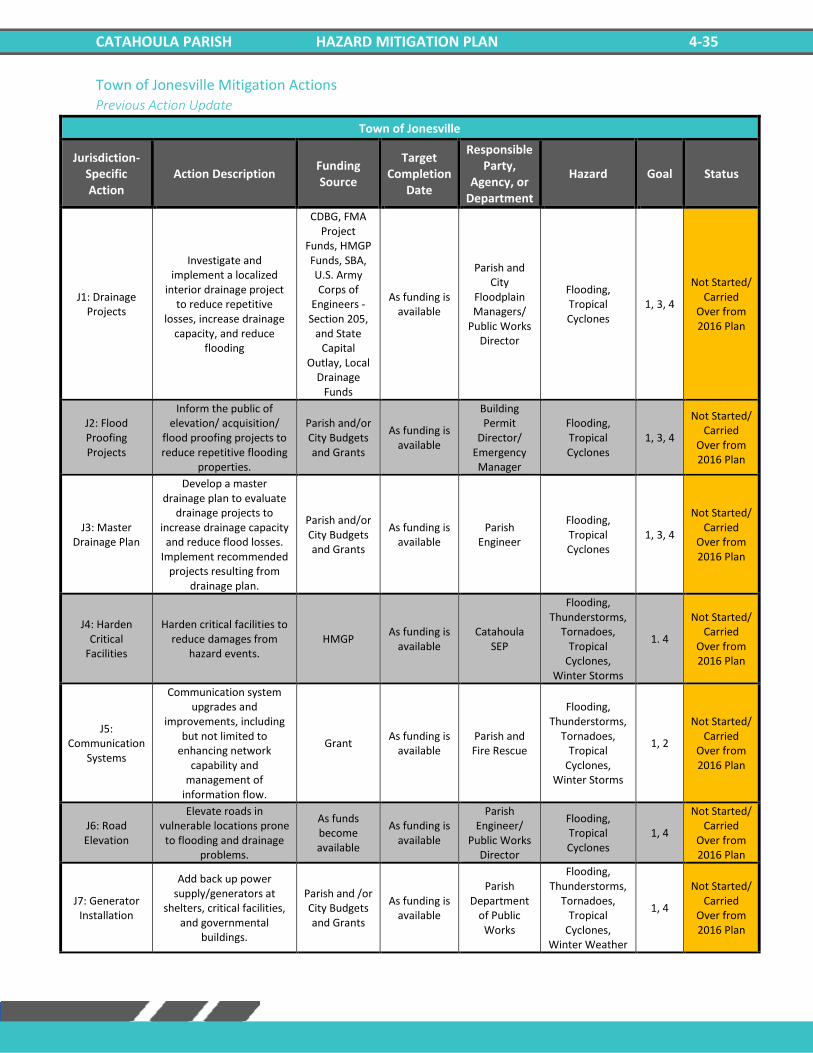
CATAHOULA PARISH HAZARD MITIGATION PLAN 4-35
Town of Jonesville Mitigation Actions Previous Action Update
Town of Jonesville
Jurisdiction-Specific Action
Action Description Funding Source
Target Completion
Date
Responsible Party,
Agency, or Department
Hazard Goal Status
J1: Drainage Projects
Investigate and implement a localized
interior drainage project to reduce repetitive
losses, increase drainage capacity, and reduce
flooding
CDBG, FMA Project
Funds, HMGP Funds, SBA, U.S. Army Corps of
Engineers - Section 205,
and State Capital
Outlay, Local Drainage
Funds
As funding is available
Parish and City
Floodplain Managers/
Public Works Director
Flooding, Tropical Cyclones
1, 3, 4
Not Started/ Carried
Over from 2016 Plan
J2: Flood Proofing Projects
Inform the public of elevation/ acquisition/
flood proofing projects to reduce repetitive flooding
properties.
Parish and/or City Budgets and Grants
As funding is available
Building Permit
Director/ Emergency Manager
Flooding, Tropical Cyclones
1, 3, 4
Not Started/ Carried
Over from 2016 Plan
J3: Master Drainage Plan
Develop a master drainage plan to evaluate
drainage projects to increase drainage capacity
and reduce flood losses. Implement recommended
projects resulting from drainage plan.
Parish and/or City Budgets and Grants
As funding is available
Parish Engineer
Flooding, Tropical Cyclones
1, 3, 4
Not Started/ Carried
Over from 2016 Plan
J4: Harden Critical
Facilities
Harden critical facilities to reduce damages from
hazard events. HMGP
As funding is available
Catahoula SEP
Flooding, Thunderstorms,
Tornadoes, Tropical
Cyclones, Winter Storms
1. 4
Not Started/ Carried
Over from 2016 Plan
J5: Communication
Systems
Communication system upgrades and
improvements, including but not limited to
enhancing network capability and
management of information flow.
Grant As funding is
available Parish and Fire Rescue
Flooding, Thunderstorms,
Tornadoes, Tropical
Cyclones, Winter Storms
1, 2
Not Started/ Carried
Over from 2016 Plan
J6: Road Elevation
Elevate roads in vulnerable locations prone
to flooding and drainage problems.
As funds become available
As funding is available
Parish Engineer/
Public Works Director
Flooding, Tropical Cyclones
1, 4
Not Started/ Carried
Over from 2016 Plan
J7: Generator Installation
Add back up power supply/generators at
shelters, critical facilities, and governmental
buildings.
Parish and /or City Budgets and Grants
As funding is available
Parish Department
of Public Works
Flooding, Thunderstorms,
Tornadoes, Tropical
Cyclones, Winter Weather
1, 4
Not Started/ Carried
Over from 2016 Plan
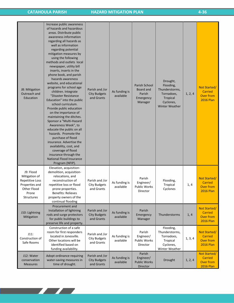
CATAHOULA PARISH HAZARD MITIGATION PLAN 4-36
J8: Mitigation Outreach and
Education
Increase public awareness of hazards and hazardous
areas. Distribute public awareness information regarding all hazards as
well as information regarding potential
mitigation measures by using the following
methods and outlets local newspaper, utility bill inserts, inserts in the
phone book, and parish hazards awareness
website, and educational programs for school age
children. Integrate "Disaster Resistance
Education" into the public school curriculum.
Provide public education on the importance of
maintaining the ditches. Sponsor a "Multi-Hazard
Awareness Week", to educate the public on all
hazards. Promote the purchase of flood
insurance. Advertise the availability, cost, and
coverage of flood insurance through the
National Flood Insurance Program (NFIP).
Parish and /or City Budgets and Grants
As funding is available
Parish School Board and
Parish Emergency Manager
Drought, Flooding,
Thunderstorms, Tornadoes,
Tropical Cyclones,
Winter Weather
1, 2, 4
Not Started/ Carried
Over from 2016 Plan
J9: Flood Mitigation of
Repetitive Loss Properties and
Other Flood Prone
Structures
Elevation, acquisition-demolition, acquisition-
relocations, and reconstruction of
repetitive loss or flood prone properties. Benefits: Relieves
property owners of the continual flooding
Parish and /or City Budgets and Grants
As funding is available
Parish Engineer/
Public Works Director
Flooding, Tropical Cyclones
1, 4
Not Started/ Carried
Over from 2016 Plan
J10: Lightning Mitigation
Procurement and Installation of lightning
rods and surge protectors for public buildings to
preserve life and property.
Parish and /or City Budgets and Grants
As funding is available
Parish Emergency Manager
Thunderstorms 1, 4
Not Started/ Carried
Over from 2016 Plan
J11: Construction of
Safe Rooms
Construction of a safe room for first responders
located in Jonesville. Other locations will be
identified based on funding availability.
Parish and /or City Budgets and Grants
As funding is available
Parish Engineer/
Public Works Director
Flooding, Thunderstorms,
Tornadoes, Tropical
Cyclones, Winter Weather
1, 3, 4
Not Started/ Carried
Over from 2016 Plan
J12: Water conservation
Measures
Adopt ordinance requiring water-saving measures in
time of drought.
Parish and /or City Budgets and Grants
As funding is available
Parish Engineer/
Public Works Director
Drought 1, 2, 4
Not Started/ Carried
Over from 2016 Plan
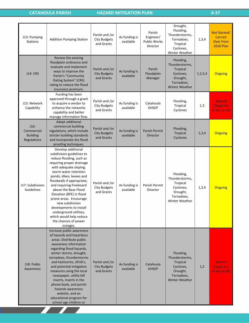
CATAHOULA PARISH HAZARD MITIGATION PLAN 4-37
J13: Pumping Stations
Addition Pumping Station Parish and /or City Budgets and Grants
As funding is available
Parish Engineer/
Public Works Director
Drought, Flooding,
Thunderstorms, Tornadoes,
Tropical Cyclones,
Winter Weather
1,3,4
Not Started/ Carried
Over from 2016 Plan
J14: CRS
Review the existing floodplain ordinance and evaluate and implement
ways to improve the Parish's "Community Rating System" (CRS)
rating to reduce the flood insurance premium.
Parish and /or City Budgets and Grants
As funding is available
Parish Floodplain Manager
Flooding, Thunderstorms,
Tropical Cyclones, Drought,
Tornadoes, Winter Weather
1,2,3,4 Ongoing
J15: Network Capability
Funding has been approved through a grant
to acquire a vendor to enhance the networks capability and better
manage information flow.
Parish and /or City Budgets and Grants
As funding is available
Catahoula OHSEP
Flooding, Tropical Cyclones
1,3 Deleted
(Duplicate of Action J5)
J16: Commercial
Building Regulations
Adopt additional commercial building
regulations, which include stricter building standards and incorporate dry flood
proofing techniques.
Parish and /or City Budgets and Grants
As funding is available
Parish Permit Director
Flooding, Tropical Cyclones
1,3,4 Ongoing
J17: Subdivision Guidelines
Develop additional subdivision guidelines to reduce flooding, such as
requiring proper drainage with adequate sloping; storm water retention
ponds; dikes; levees and floodwalls if appropriate, and requiring freeboard
above the Base Flood Elevation (BFE) in flood prone areas. Encourage
new subdivision developments to install underground utilities,
which would help reduce the chances of power
outages.
Parish and /or City Budgets and Grants
As funding is available
Parish Permit Director
Flooding, Thunderstorms,
Tropical Cyclones, Drought,
Tornadoes, Winter Weather
1,3,4 Ongoing
J18: Public Awareness
Increase public awareness of hazards and hazardous
areas. Distribute public awareness information
regarding flood hazards, winter storms, drought,
tornadoes, thunderstorms and hailstorms, SFHA's, and potential mitigation measures using the local
newspaper, utility bill inserts, inserts in the
phone book, and parish hazards awareness
website, and an educational program for
school age children or
Parish and /or City Budgets and Grants
As funding is available
Catahoula OHSEP
Flooding, Thunderstorms,
Tropical Cyclones, Drought,
Tornadoes, Winter Weather
1,2 Deleted
(Duplicate of Action J8)

CATAHOULA PARISH HAZARD MITIGATION PLAN 4-38
"how to" classes in retrofitting by local
merchants. Integrate "Disaster Resistance
Education" into the public school curriculum. Provide
public education on the importance of maintaining
the ditches.

CATAHOULA PARISH HAZARD MITIGATION PLAN 4-39
New Mitigation Actions
IMPLEMENTATION KEY FOR POTENTIAL HAZARD MITIGATION ACTIONS TOWN OF JONESVILLE
DESCRIPTION
TOWN OF JONESVILLE MITGATION ACTION 1
Drainage Projects
LEAD AGENCY Jonesville Mayor’s Office
SUPPORTING AGENCIES Catahoula Parish Police Jury, Parish and City Floodplain Managers/ Public Works Director
TIMELINE 1-5 Years
COST ESTIMATE TBD
POSSIBLE FUNDING SOURCE(S) CDBG, FMA Project Funds, HMGP Funds, SBA, U.S. Army Corps of Engineers - Section 205, and State Capital Outlay, Local Drainage Funds
ASSOCIATED GOALS
1. Reduce the impact of future flooding
3. Improve the ability of structures to withstand high wind and storm events
4. Engage and inform the community on the subject of hazard mitigation
PRIORITY High
Action Description Investigate and implement a localized interior drainage project to reduce repetitive losses, increase drainage capacity, and reduce flooding
Type of Mitigation Action Structure and Infrastructure Projects
How Action Aligns with Risk Reduction
Improving the drainage system in Catahoula Parish would reduce flood damage by allowing water to drain efficiently rather than rise and cause structure damage.
Current Status of Action New (Not Started – Carried over from 2016 Plan)
Hazard Addressed Flooding, Tropical Cyclones
Additional Supporting Information:

CATAHOULA PARISH HAZARD MITIGATION PLAN 4-40
IMPLEMENTATION KEY FOR POTENTIAL HAZARD MITIGATION ACTIONS TOWN OF JONESVILLE
DESCRIPTION
TOWN OF JONESVILLE MITGATION ACTION 2
Flood Proofing Projects
LEAD AGENCY Jonesville Mayor’s Office
SUPPORTING AGENCIES Catahoula OHSEP, Building Permit Director/ Emergency Manager
TIMELINE 1-5 Years
COST ESTIMATE TBD
POSSIBLE FUNDING SOURCE(S) Parish and/or City Budgets and Grants
ASSOCIATED GOALS
1. Reduce the impact of future flooding
3. Improve the ability of structures to withstand high wind and storm events
4. Engage and inform the community on the subject of hazard mitigation
PRIORITY High
Action Description Inform the public of elevation/ acquisition/ flood proofing projects to reduce repetitive flooding properties.
Type of Mitigation Action Structure and Infrastructure Projects Education and Awareness Programs
How Action Aligns with Risk Reduction
Performing flood proofing projects such as elevating structures would reduce flood damage by raising the level floodwaters would have to reach before causing damage.
Current Status of Action New (Not Started – Carried over from 2016 Plan)
Hazard Addressed Flooding, Tropical Cyclones
Additional Supporting Information:
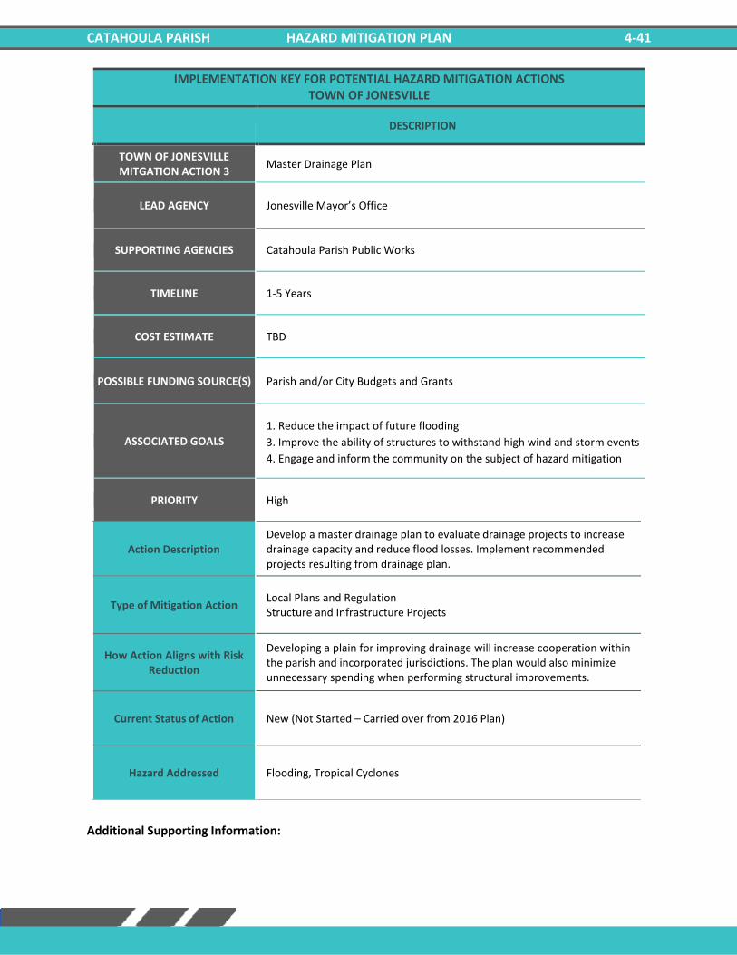
CATAHOULA PARISH HAZARD MITIGATION PLAN 4-41
IMPLEMENTATION KEY FOR POTENTIAL HAZARD MITIGATION ACTIONS TOWN OF JONESVILLE
DESCRIPTION
TOWN OF JONESVILLE MITGATION ACTION 3
Master Drainage Plan
LEAD AGENCY Jonesville Mayor’s Office
SUPPORTING AGENCIES Catahoula Parish Public Works
TIMELINE 1-5 Years
COST ESTIMATE TBD
POSSIBLE FUNDING SOURCE(S) Parish and/or City Budgets and Grants
ASSOCIATED GOALS
1. Reduce the impact of future flooding
3. Improve the ability of structures to withstand high wind and storm events
4. Engage and inform the community on the subject of hazard mitigation
PRIORITY High
Action Description Develop a master drainage plan to evaluate drainage projects to increase drainage capacity and reduce flood losses. Implement recommended projects resulting from drainage plan.
Type of Mitigation Action Local Plans and Regulation Structure and Infrastructure Projects
How Action Aligns with Risk Reduction
Developing a plain for improving drainage will increase cooperation within the parish and incorporated jurisdictions. The plan would also minimize unnecessary spending when performing structural improvements.
Current Status of Action New (Not Started – Carried over from 2016 Plan)
Hazard Addressed Flooding, Tropical Cyclones
Additional Supporting Information:

CATAHOULA PARISH HAZARD MITIGATION PLAN 4-42
IMPLEMENTATION KEY FOR POTENTIAL HAZARD MITIGATION ACTIONS TOWN OF JONESVILLE
DESCRIPTION
TOWN OF JONESVILLE MITGATION ACTION 4
Harden Critical Facilities
LEAD AGENCY Jonesville Mayor’s Office
SUPPORTING AGENCIES Catahoula Parish Police Jury, Catahoula SEP
TIMELINE 1-5 Years
COST ESTIMATE TBD
POSSIBLE FUNDING SOURCE(S) HMGP
ASSOCIATED GOALS 1. Reduce the impact of future flooding
4. Engage and inform the community on the subject of hazard mitigation
PRIORITY Medium
Action Description Harden critical facilities to reduce damages from hazard events.
Type of Mitigation Action Structure and Infrastructure Projects
How Action Aligns with Risk Reduction
Hardening critical facilities would reduce the damage caused by major weather/hazardous events. Structures could be made to withstand debris, wind, and other hazards.
Current Status of Action New (Not Started – Carried over from 2016 Plan)
Hazard Addressed Flooding, Thunderstorms, Tornadoes, Tropical Cyclones, Winter Storms
Additional Supporting Information:

CATAHOULA PARISH HAZARD MITIGATION PLAN 4-43
IMPLEMENTATION KEY FOR POTENTIAL HAZARD MITIGATION ACTIONS TOWN OF JONESVILLE
DESCRIPTION
TOWN OF JONESVILLE MITGATION ACTION 5
Communications Systems
LEAD AGENCY Jonesville Mayor’s Office
SUPPORTING AGENCIES Parish Fire Departments
TIMELINE 1-5 Years
COST ESTIMATE TBD
POSSIBLE FUNDING SOURCE(S) HMGP
ASSOCIATED GOALS
1. Reduce the impact of future flooding
2. Ensure the delivery of critical services to the community in the case of a
hazard event
PRIORITY Medium
Action Description Communication system upgrades and improvements, including but not limited to enhancing network capability and management of information flow.
Type of Mitigation Action Structure and Infrastructure Projects
How Action Aligns with Risk Reduction
Improving communication systems within the parish could reduce injury during major hazard events. It could increase trust between the public and government officials and allow critical functions to continue during major events.
Current Status of Action New (Not Started – Carried over from 2016 Plan)
Hazard Addressed Flooding, Thunderstorms, Tornadoes, Tropical Cyclones, Winter Storms
Additional Supporting Information:

CATAHOULA PARISH HAZARD MITIGATION PLAN 4-44
IMPLEMENTATION KEY FOR POTENTIAL HAZARD MITIGATION ACTIONS TOWN OF JONESVILLE
DESCRIPTION
TOWN OF JONESVILLE MITGATION ACTION 6
Road Elevation
LEAD AGENCY Jonesville Mayor’s Office
SUPPORTING AGENCIES Catahoula Parish Public Works
TIMELINE 1-5 Years
COST ESTIMATE TBD
POSSIBLE FUNDING SOURCE(S) Federal Grants, Local
ASSOCIATED GOALS 1. Reduce the impact of future flooding
4. Engage and inform the community on the subject of hazard mitigation
PRIORITY Low
Action Description Elevate roads in vulnerable locations prone to flooding and drainage problems.
Type of Mitigation Action Structure and Infrastructure Projects
How Action Aligns with Risk Reduction
Elevating roads would allow emergency vehicles to travel freely within the parish during a flood event and allow for late evacuations during flooding.
Current Status of Action New (Not Started – Carried over from 2016 Plan)
Hazard Addressed Flooding, Tropical Cyclones
Additional Supporting Information:
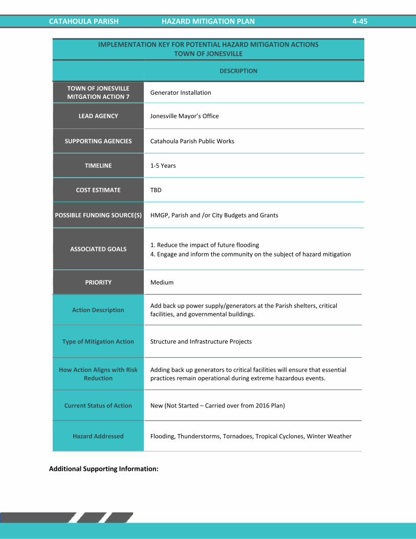
CATAHOULA PARISH HAZARD MITIGATION PLAN 4-45
IMPLEMENTATION KEY FOR POTENTIAL HAZARD MITIGATION ACTIONS TOWN OF JONESVILLE
DESCRIPTION
TOWN OF JONESVILLE MITGATION ACTION 7
Generator Installation
LEAD AGENCY Jonesville Mayor’s Office
SUPPORTING AGENCIES Catahoula Parish Public Works
TIMELINE 1-5 Years
COST ESTIMATE TBD
POSSIBLE FUNDING SOURCE(S) HMGP, Parish and /or City Budgets and Grants
ASSOCIATED GOALS 1. Reduce the impact of future flooding
4. Engage and inform the community on the subject of hazard mitigation
PRIORITY Medium
Action Description Add back up power supply/generators at the Parish shelters, critical facilities, and governmental buildings.
Type of Mitigation Action Structure and Infrastructure Projects
How Action Aligns with Risk Reduction
Adding back up generators to critical facilities will ensure that essential practices remain operational during extreme hazardous events.
Current Status of Action New (Not Started – Carried over from 2016 Plan)
Hazard Addressed Flooding, Thunderstorms, Tornadoes, Tropical Cyclones, Winter Weather
Additional Supporting Information:

CATAHOULA PARISH HAZARD MITIGATION PLAN 4-46
IMPLEMENTATION KEY FOR POTENTIAL HAZARD MITIGATION ACTIONS TOWN OF JONESVILLE
DESCRIPTION
TOWN OF JONESVILLE MITGATION ACTION 8
Mitigation Outreach and Education
LEAD AGENCY Jonesville Mayor’s Office
SUPPORTING AGENCIES Catahoula Parish Police Jury
TIMELINE 1-5 Years
COST ESTIMATE TBD
POSSIBLE FUNDING SOURCE(S) HMGP, Parish and /or City Budgets and Grants
ASSOCIATED GOALS
1. Reduce the impact of future flooding
2. Ensure the delivery of critical services to the community in the case of a
hazard event
4. Engage and inform the community on the subject of hazard mitigation
PRIORITY Medium
Action Description
Increase public awareness of hazards and hazardous areas. Distribute public awareness information regarding all hazards as well as information regarding potential mitigation measures by using the following methods and outlets local newspaper, utility bill inserts, inserts in the phone book, and parish hazards awareness website, and educational programs for school age children. Integrate "Disaster Resistance Education" into the public school curriculum. Provide public education on the importance of maintaining the ditches. Sponsor a "Multi-Hazard Awareness Week", to educate the public on all hazards. Promote the purchase of flood insurance. Advertise the availability, cost, and coverage of flood insurance through the National Flood Insurance Program (NFIP).
Type of Mitigation Action Structure and Infrastructure Projects
How Action Aligns with Risk Reduction
Increasing education and public awareness of hazards could decrease injuries during a major hazardous event because parish residents will know the necessary precautions to take prior to an event.
Current Status of Action New (Not Started – Carried over from 2016 Plan)
Hazard Addressed Drought, Flooding, Thunderstorms, Tornadoes, Tropical Cyclones, Winter Weather
Additional Supporting Information:

CATAHOULA PARISH HAZARD MITIGATION PLAN 4-47
IMPLEMENTATION KEY FOR POTENTIAL HAZARD MITIGATION ACTIONS TOWN OF JONESVILLE
DESCRIPTION
TOWN OF JONESVILLE MITGATION ACTION 9
Flood Mitigation of Repetitive Loss Properties and Other Flood Prone Structures
LEAD AGENCY Jonesville Mayor’s Office
SUPPORTING AGENCIES Catahoula Parish Public Works
TIMELINE 1-5 Years
COST ESTIMATE TBD
POSSIBLE FUNDING SOURCE(S) HMGP, Parish and /or City Budgets and Grants
ASSOCIATED GOALS 1. Reduce the impact of future flooding
4. Engage and inform the community on the subject of hazard mitigation
PRIORITY Medium
Action Description Elevation, acquisition-demolition, acquisition-relocations, and reconstruction of repetitive loss or flood prone properties. Benefits: Relieves property owners of the continual flooding
Type of Mitigation Action Structure and Infrastructure Projects
How Action Aligns with Risk Reduction
By relocating or reconstruction residences that are prone to flooding, residents could be relieved of continuous flood damage, and it would also reduce the likelihood of flood related injuries.
Current Status of Action New (Not Started – Carried over from 2016 Plan)
Hazard Addressed Flooding, Tropical Cyclones
Additional Supporting Information:

CATAHOULA PARISH HAZARD MITIGATION PLAN 4-48
IMPLEMENTATION KEY FOR POTENTIAL HAZARD MITIGATION ACTIONS TOWN OF JONESVILLE
DESCRIPTION
TOWN OF JONESVILLE MITGATION ACTION 10
Lightning Mitigation
LEAD AGENCY Jonesville Mayor’s Office
SUPPORTING AGENCIES Catahoula Parish Public Works
TIMELINE 1-5 Years
COST ESTIMATE TBD
POSSIBLE FUNDING SOURCE(S) HMGP, Parish and /or City Budgets and Grants
ASSOCIATED GOALS 1. Reduce the impact of future flooding
4. Engage and inform the community on the subject of hazard mitigation
PRIORITY Low
Action Description Procurement and Installation of lightning rods and surge protectors for public buildings to preserve life and property.
Type of Mitigation Action Structure and Infrastructure Projects
How Action Aligns with Risk Reduction
Installing lightning rods and surge protectors could reduce the likelihood of power outages for critical facilities during a hazard event.
Current Status of Action New (Not Started – Carried over from 2016 Plan)
Hazard Addressed Thunderstorms
Additional Supporting Information:
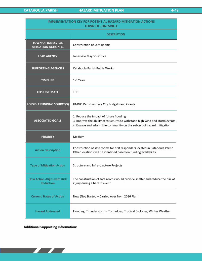
CATAHOULA PARISH HAZARD MITIGATION PLAN 4-49
IMPLEMENTATION KEY FOR POTENTIAL HAZARD MITIGATION ACTIONS TOWN OF JONESVILLE
DESCRIPTION
TOWN OF JONESVILLE MITGATION ACTION 11
Construction of Safe Rooms
LEAD AGENCY Jonesville Mayor’s Office
SUPPORTING AGENCIES Catahoula Parish Public Works
TIMELINE 1-5 Years
COST ESTIMATE TBD
POSSIBLE FUNDING SOURCE(S) HMGP, Parish and /or City Budgets and Grants
ASSOCIATED GOALS
1. Reduce the impact of future flooding
3. Improve the ability of structures to withstand high wind and storm events
4. Engage and inform the community on the subject of hazard mitigation
PRIORITY Medium
Action Description Construction of safe rooms for first responders located in Catahoula Parish. Other locations will be identified based on funding availability.
Type of Mitigation Action Structure and Infrastructure Projects
How Action Aligns with Risk Reduction
The construction of safe rooms would provide shelter and reduce the risk of injury during a hazard event.
Current Status of Action New (Not Started – Carried over from 2016 Plan)
Hazard Addressed Flooding, Thunderstorms, Tornadoes, Tropical Cyclones, Winter Weather
Additional Supporting Information:

CATAHOULA PARISH HAZARD MITIGATION PLAN 4-50
IMPLEMENTATION KEY FOR POTENTIAL HAZARD MITIGATION ACTIONS TOWN OF JONESVILLE
DESCRIPTION
TOWN OF JONESVILLE MITGATION ACTION 12
Water Conservation Measures
LEAD AGENCY Jonesville Mayor’s Office
SUPPORTING AGENCIES Catahoula Parish Public Works
TIMELINE 1-5 Years
COST ESTIMATE TBD
POSSIBLE FUNDING SOURCE(S) HMGP, Parish and /or City Budgets and Grants
ASSOCIATED GOALS
1. Reduce the impact of future flooding
2. Ensure the delivery of critical services to the community in the case of a
hazard event
4. Engage and inform the community on the subject of hazard mitigation
PRIORITY Low
Action Description Adopt ordinance requiring water-saving measures in time of drought.
Type of Mitigation Action Education and Awareness Programs
How Action Aligns with Risk Reduction
Water-saving measures in time of drought could protect essential crops and protect human life.
Current Status of Action New (Not Started – Carried over from 2016 Plan)
Hazard Addressed Drought
Additional Supporting Information:
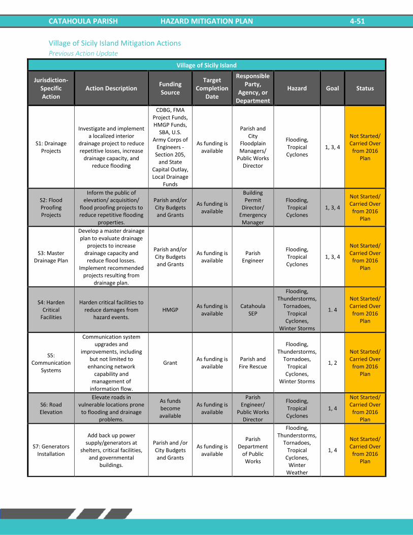
CATAHOULA PARISH HAZARD MITIGATION PLAN 4-51
Village of Sicily Island Mitigation Actions Previous Action Update
Village of Sicily Island
Jurisdiction-Specific Action
Action Description Funding Source
Target Completion
Date
Responsible Party,
Agency, or Department
Hazard Goal Status
S1: Drainage Projects
Investigate and implement a localized interior
drainage project to reduce repetitive losses, increase
drainage capacity, and reduce flooding
CDBG, FMA Project Funds, HMGP Funds,
SBA, U.S. Army Corps of
Engineers - Section 205,
and State Capital Outlay, Local Drainage
Funds
As funding is available
Parish and City
Floodplain Managers/
Public Works Director
Flooding, Tropical Cyclones
1, 3, 4
Not Started/ Carried Over
from 2016 Plan
S2: Flood Proofing Projects
Inform the public of elevation/ acquisition/
flood proofing projects to reduce repetitive flooding
properties.
Parish and/or City Budgets and Grants
As funding is available
Building Permit
Director/ Emergency Manager
Flooding, Tropical Cyclones
1, 3, 4
Not Started/ Carried Over
from 2016 Plan
S3: Master Drainage Plan
Develop a master drainage plan to evaluate drainage
projects to increase drainage capacity and reduce flood losses.
Implement recommended projects resulting from
drainage plan.
Parish and/or City Budgets and Grants
As funding is available
Parish Engineer
Flooding, Tropical Cyclones
1, 3, 4
Not Started/ Carried Over
from 2016 Plan
S4: Harden Critical
Facilities
Harden critical facilities to reduce damages from
hazard events. HMGP
As funding is available
Catahoula SEP
Flooding, Thunderstorms,
Tornadoes, Tropical
Cyclones, Winter Storms
1. 4
Not Started/ Carried Over
from 2016 Plan
S5: Communication
Systems
Communication system upgrades and
improvements, including but not limited to
enhancing network capability and
management of information flow.
Grant As funding is
available Parish and Fire Rescue
Flooding, Thunderstorms,
Tornadoes, Tropical
Cyclones, Winter Storms
1, 2
Not Started/ Carried Over
from 2016 Plan
S6: Road Elevation
Elevate roads in vulnerable locations prone
to flooding and drainage problems.
As funds become available
As funding is available
Parish Engineer/
Public Works Director
Flooding, Tropical Cyclones
1, 4
Not Started/ Carried Over
from 2016 Plan
S7: Generators Installation
Add back up power supply/generators at
shelters, critical facilities, and governmental
buildings.
Parish and /or City Budgets and Grants
As funding is available
Parish Department
of Public Works
Flooding, Thunderstorms,
Tornadoes, Tropical
Cyclones, Winter
Weather
1, 4
Not Started/ Carried Over
from 2016 Plan
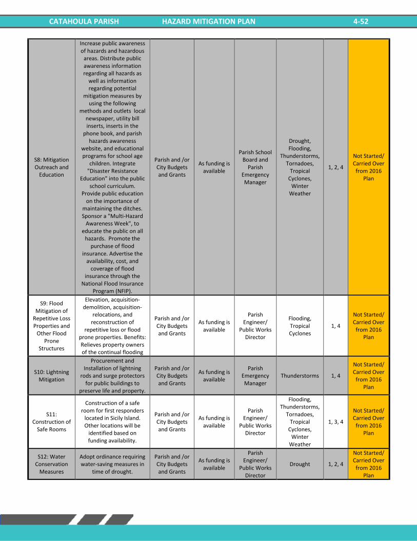
CATAHOULA PARISH HAZARD MITIGATION PLAN 4-52
S8: Mitigation Outreach and
Education
Increase public awareness of hazards and hazardous
areas. Distribute public awareness information regarding all hazards as
well as information regarding potential
mitigation measures by using the following
methods and outlets local newspaper, utility bill inserts, inserts in the
phone book, and parish hazards awareness
website, and educational programs for school age
children. Integrate "Disaster Resistance
Education" into the public school curriculum.
Provide public education on the importance of
maintaining the ditches. Sponsor a "Multi-Hazard
Awareness Week", to educate the public on all
hazards. Promote the purchase of flood
insurance. Advertise the availability, cost, and
coverage of flood insurance through the
National Flood Insurance Program (NFIP).
Parish and /or City Budgets and Grants
As funding is available
Parish School Board and
Parish Emergency Manager
Drought, Flooding,
Thunderstorms, Tornadoes,
Tropical Cyclones,
Winter Weather
1, 2, 4
Not Started/ Carried Over
from 2016 Plan
S9: Flood Mitigation of
Repetitive Loss Properties and
Other Flood Prone
Structures
Elevation, acquisition-demolition, acquisition-
relocations, and reconstruction of
repetitive loss or flood prone properties. Benefits: Relieves property owners of the continual flooding
Parish and /or City Budgets and Grants
As funding is available
Parish Engineer/
Public Works Director
Flooding, Tropical Cyclones
1, 4
Not Started/ Carried Over
from 2016 Plan
S10: Lightning Mitigation
Procurement and Installation of lightning
rods and surge protectors for public buildings to
preserve life and property.
Parish and /or City Budgets and Grants
As funding is available
Parish Emergency Manager
Thunderstorms 1, 4
Not Started/ Carried Over
from 2016 Plan
S11: Construction of
Safe Rooms
Construction of a safe room for first responders
located in Sicily Island. Other locations will be
identified based on funding availability.
Parish and /or City Budgets and Grants
As funding is available
Parish Engineer/
Public Works Director
Flooding, Thunderstorms,
Tornadoes, Tropical
Cyclones, Winter
Weather
1, 3, 4
Not Started/ Carried Over
from 2016 Plan
S12: Water Conservation
Measures
Adopt ordinance requiring water-saving measures in
time of drought.
Parish and /or City Budgets and Grants
As funding is available
Parish Engineer/
Public Works Director
Drought 1, 2, 4
Not Started/ Carried Over
from 2016 Plan
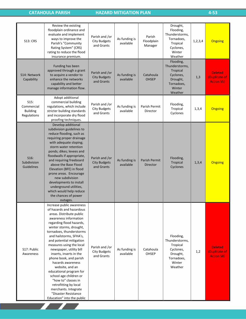
CATAHOULA PARISH HAZARD MITIGATION PLAN 4-53
S13: CRS
Review the existing floodplain ordinance and evaluate and implement
ways to improve the Parish's "Community Rating System" (CRS)
rating to reduce the flood insurance premium.
Parish and /or City Budgets and Grants
As funding is available
Parish Floodplain Manager
Drought, Flooding,
Thunderstorms, Tornadoes,
Tropical Cyclones,
Winter Weather
1,2,3,4 Ongoing
S14: Network Capability
Funding has been approved through a grant
to acquire a vendor to enhance the networks capability and better
manage information flow.
Parish and /or City Budgets and Grants
As funding is available
Catahoula OHSEP
Flooding, Thunderstorms,
Tropical Cyclones, Drought,
Tornadoes, Winter
Weather
1,3 Deleted
(Duplicate of Action S5)
S15: Commercial
Building Regulations
Adopt additional commercial building
regulations, which include stricter building standards and incorporate dry flood
proofing techniques.
Parish and /or City Budgets and Grants
As funding is available
Parish Permit Director
Flooding, Tropical Cyclones
1,3,4 Ongoing
S16: Subdivision Guidelines
Develop additional subdivision guidelines to reduce flooding, such as
requiring proper drainage with adequate sloping; storm water retention
ponds; dikes; levees and floodwalls if appropriate, and requiring freeboard
above the Base Flood Elevation (BFE) in flood prone areas. Encourage
new subdivision developments to install underground utilities,
which would help reduce the chances of power
outages.
Parish and /or City Budgets and Grants
As funding is available
Parish Permit Director
Flooding, Tropical Cyclones
1,3,4 Ongoing
S17: Public Awareness
Increase public awareness of hazards and hazardous
areas. Distribute public awareness information
regarding flood hazards, winter storms, drought,
tornadoes, thunderstorms and hailstorms, SFHA's, and potential mitigation measures using the local
newspaper, utility bill inserts, inserts in the
phone book, and parish hazards awareness
website, and an educational program for
school age children or "how to" classes in retrofitting by local
merchants. Integrate "Disaster Resistance
Education" into the public
Parish and /or City Budgets and Grants
As funding is available
Catahoula OHSEP
Flooding, Thunderstorms,
Tropical Cyclones, Drought,
Tornadoes, Winter
Weather
1,2 Deleted
(Duplicate of Action S8)

CATAHOULA PARISH HAZARD MITIGATION PLAN 4-54
school curriculum. Provide public education on the
importance of maintaining the ditches.
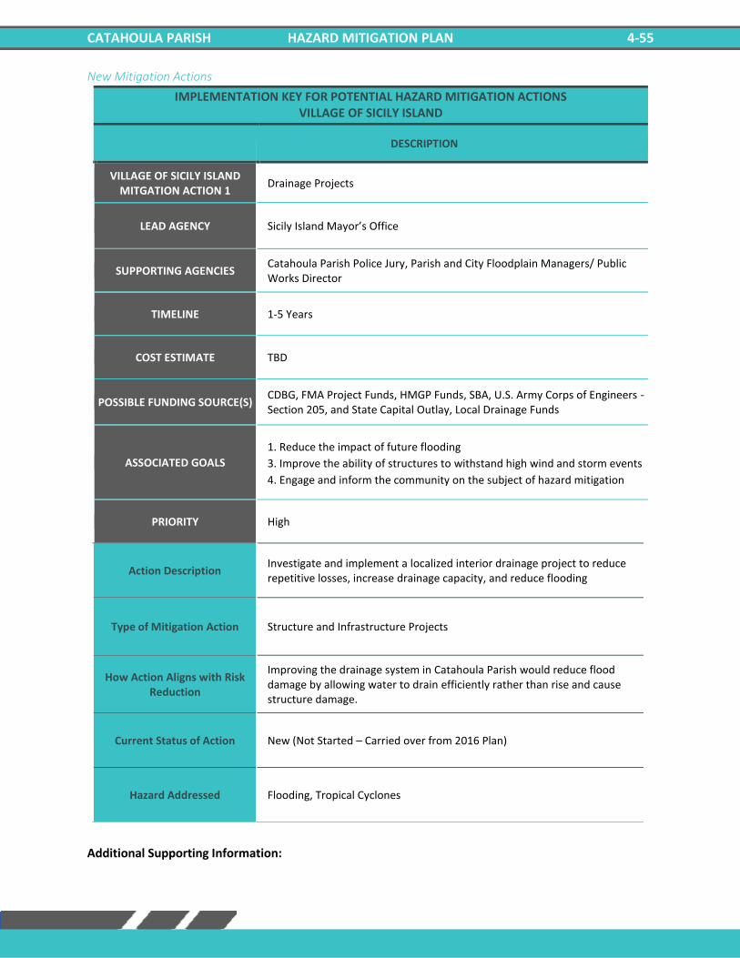
CATAHOULA PARISH HAZARD MITIGATION PLAN 4-55
New Mitigation Actions
IMPLEMENTATION KEY FOR POTENTIAL HAZARD MITIGATION ACTIONS VILLAGE OF SICILY ISLAND
DESCRIPTION
VILLAGE OF SICILY ISLAND MITGATION ACTION 1
Drainage Projects
LEAD AGENCY Sicily Island Mayor’s Office
SUPPORTING AGENCIES Catahoula Parish Police Jury, Parish and City Floodplain Managers/ Public Works Director
TIMELINE 1-5 Years
COST ESTIMATE TBD
POSSIBLE FUNDING SOURCE(S) CDBG, FMA Project Funds, HMGP Funds, SBA, U.S. Army Corps of Engineers - Section 205, and State Capital Outlay, Local Drainage Funds
ASSOCIATED GOALS
1. Reduce the impact of future flooding
3. Improve the ability of structures to withstand high wind and storm events
4. Engage and inform the community on the subject of hazard mitigation
PRIORITY High
Action Description Investigate and implement a localized interior drainage project to reduce repetitive losses, increase drainage capacity, and reduce flooding
Type of Mitigation Action Structure and Infrastructure Projects
How Action Aligns with Risk Reduction
Improving the drainage system in Catahoula Parish would reduce flood damage by allowing water to drain efficiently rather than rise and cause structure damage.
Current Status of Action New (Not Started – Carried over from 2016 Plan)
Hazard Addressed Flooding, Tropical Cyclones
Additional Supporting Information:

CATAHOULA PARISH HAZARD MITIGATION PLAN 4-56
IMPLEMENTATION KEY FOR POTENTIAL HAZARD MITIGATION ACTIONS VILLAGE OF SICILY ISLAND
DESCRIPTION
VILLAGE OF SICILY ISLAND MITGATION ACTION 2
Flood Proofing Projects
LEAD AGENCY Sicily Island Mayor’s Office
SUPPORTING AGENCIES Catahoula OHSEP, Building Permit Director/ Emergency Manager
TIMELINE 1-5 Years
COST ESTIMATE TBD
POSSIBLE FUNDING SOURCE(S) Parish and/or City Budgets and Grants
ASSOCIATED GOALS
1. Reduce the impact of future flooding
3. Improve the ability of structures to withstand high wind and storm events
4. Engage and inform the community on the subject of hazard mitigation
PRIORITY High
Action Description Inform the public of elevation/ acquisition/ flood proofing projects to reduce repetitive flooding properties.
Type of Mitigation Action Structure and Infrastructure Projects Education and Awareness Programs
How Action Aligns with Risk Reduction
Performing flood proofing projects such as elevating structures would reduce flood damage by raising the level floodwaters would have to reach before causing damage.
Current Status of Action New (Not Started – Carried over from 2016 Plan)
Hazard Addressed Flooding, Tropical Cyclones
Additional Supporting Information:

CATAHOULA PARISH HAZARD MITIGATION PLAN 4-57
IMPLEMENTATION KEY FOR POTENTIAL HAZARD MITIGATION ACTIONS VILLAGE OF SICILY ISLAND
DESCRIPTION
VILLAGE OF SICILY ISLAND MITGATION ACTION 3
Master Drainage Plan
LEAD AGENCY Sicily Island Mayor’s Office
SUPPORTING AGENCIES Catahoula Parish Public Works
TIMELINE 1-5 Years
COST ESTIMATE TBD
POSSIBLE FUNDING SOURCE(S) Parish and/or City Budgets and Grants
ASSOCIATED GOALS
1. Reduce the impact of future flooding
3. Improve the ability of structures to withstand high wind and storm events
4. Engage and inform the community on the subject of hazard mitigation
PRIORITY High
Action Description Develop a master drainage plan to evaluate drainage projects to increase drainage capacity and reduce flood losses. Implement recommended projects resulting from drainage plan.
Type of Mitigation Action Local Plans and Regulation Structure and Infrastructure Projects
How Action Aligns with Risk Reduction
Developing a plain for improving drainage will increase cooperation within the parish and incorporated jurisdictions. The plan would also minimize unnecessary spending when performing structural improvements.
Current Status of Action New (Not Started – Carried over from 2016 Plan)
Hazard Addressed Flooding, Tropical Cyclones
Additional Supporting Information:

CATAHOULA PARISH HAZARD MITIGATION PLAN 4-58
IMPLEMENTATION KEY FOR POTENTIAL HAZARD MITIGATION ACTIONS VILLAGE OF SICILY ISLAND
DESCRIPTION
VILLAGE OF SICILY ISLAND MITGATION ACTION 4
Harden Critical Facilities
LEAD AGENCY Sicily Island Mayor’s Office
SUPPORTING AGENCIES Catahoula Parish Police Jury
TIMELINE 1-5 Years
COST ESTIMATE TBD
POSSIBLE FUNDING SOURCE(S) HMGP
ASSOCIATED GOALS 1. Reduce the impact of future flooding
4. Engage and inform the community on the subject of hazard mitigation
PRIORITY Medium
Action Description Harden critical facilities to reduce damages from hazard events.
Type of Mitigation Action Structure and Infrastructure Projects
How Action Aligns with Risk Reduction
Hardening critical facilities would reduce the damage caused by major weather/hazardous events. Structures could be made to withstand debris, wind, and other hazards.
Current Status of Action New (Not Started – Carried over from 2016 Plan)
Hazard Addressed Flooding, Thunderstorms, Tornadoes, Tropical Cyclones, Winter Storms
Additional Supporting Information:

CATAHOULA PARISH HAZARD MITIGATION PLAN 4-59
IMPLEMENTATION KEY FOR POTENTIAL HAZARD MITIGATION ACTIONS VILLAGE OF SICILY ISLAND
DESCRIPTION
VILLAGE OF SICILY ISLAND MITGATION ACTION 5
Communications Systems
LEAD AGENCY Sicily Island Mayor’s Office
SUPPORTING AGENCIES Parish Fire Departments
TIMELINE 1-5 Years
COST ESTIMATE TBD
POSSIBLE FUNDING SOURCE(S) HMGP
ASSOCIATED GOALS
1. Reduce the impact of future flooding
2. Ensure the delivery of critical services to the community in the case of a
hazard event
PRIORITY Medium
Action Description Communication system upgrades and improvements, including but not limited to enhancing network capability and management of information flow.
Type of Mitigation Action Structure and Infrastructure Projects
How Action Aligns with Risk Reduction
Improving communication systems within the parish could reduce injury during major hazard events. It could increase trust between the public and government officials and allow critical functions to continue during major events.
Current Status of Action New (Not Started – Carried over from 2016 Plan)
Hazard Addressed Flooding, Thunderstorms, Tornadoes, Tropical Cyclones, Winter Storms
Additional Supporting Information:

CATAHOULA PARISH HAZARD MITIGATION PLAN 4-60
IMPLEMENTATION KEY FOR POTENTIAL HAZARD MITIGATION ACTIONS VILLAGE OF SICILY ISLAND
DESCRIPTION
VILLAGE OF SICILY ISLAND MITGATION ACTION 6
Road Elevation
LEAD AGENCY Sicily Island Mayor’s Office
SUPPORTING AGENCIES Catahoula Parish Public Works
TIMELINE 1-5 Years
COST ESTIMATE TBD
POSSIBLE FUNDING SOURCE(S) Federal Grants, Local
ASSOCIATED GOALS 1. Reduce the impact of future flooding
4. Engage and inform the community on the subject of hazard mitigation
PRIORITY Low
Action Description Elevate roads in vulnerable locations prone to flooding and drainage problems.
Type of Mitigation Action Structure and Infrastructure Projects
How Action Aligns with Risk Reduction
Elevating roads would allow emergency vehicles to travel freely within the parish during a flood event and allow for late evacuations during flooding.
Current Status of Action New (Not Started – Carried over from 2016 Plan)
Hazard Addressed Flooding, Tropical Cyclones
Additional Supporting Information:

CATAHOULA PARISH HAZARD MITIGATION PLAN 4-61
IMPLEMENTATION KEY FOR POTENTIAL HAZARD MITIGATION ACTIONS VILLAGE OF SICILY ISLAND
DESCRIPTION
VILLAGE OF SICILY ISLAND MITGATION ACTION 7
Generator Installation
LEAD AGENCY Sicily Island Mayor’s Office
SUPPORTING AGENCIES Catahoula Parish Public Works
TIMELINE 1-5 Years
COST ESTIMATE TBD
POSSIBLE FUNDING SOURCE(S) HMGP, Parish and /or City Budgets and Grants
ASSOCIATED GOALS 1. Reduce the impact of future flooding
4. Engage and inform the community on the subject of hazard mitigation
PRIORITY Medium
Action Description Add back up power supply/generators at the Parish shelters, critical facilities, and governmental buildings.
Type of Mitigation Action Structure and Infrastructure Projects
How Action Aligns with Risk Reduction
Adding backup generators to critical facilities will ensure that essential practices remain operational during extreme hazardous events.
Current Status of Action New (Not Started – Carried over from 2016 Plan)
Hazard Addressed Flooding, Thunderstorms, Tornadoes, Tropical Cyclones, Winter Weather
Additional Supporting Information:
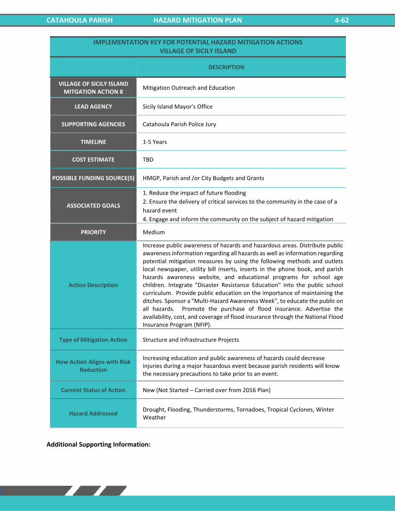
CATAHOULA PARISH HAZARD MITIGATION PLAN 4-62
IMPLEMENTATION KEY FOR POTENTIAL HAZARD MITIGATION ACTIONS VILLAGE OF SICILY ISLAND
DESCRIPTION
VILLAGE OF SICILY ISLAND MITGATION ACTION 8
Mitigation Outreach and Education
LEAD AGENCY Sicily Island Mayor’s Office
SUPPORTING AGENCIES Catahoula Parish Police Jury
TIMELINE 1-5 Years
COST ESTIMATE TBD
POSSIBLE FUNDING SOURCE(S) HMGP, Parish and /or City Budgets and Grants
ASSOCIATED GOALS
1. Reduce the impact of future flooding
2. Ensure the delivery of critical services to the community in the case of a
hazard event
4. Engage and inform the community on the subject of hazard mitigation
PRIORITY Medium
Action Description
Increase public awareness of hazards and hazardous areas. Distribute public awareness information regarding all hazards as well as information regarding potential mitigation measures by using the following methods and outlets local newspaper, utility bill inserts, inserts in the phone book, and parish hazards awareness website, and educational programs for school age children. Integrate "Disaster Resistance Education" into the public school curriculum. Provide public education on the importance of maintaining the ditches. Sponsor a "Multi-Hazard Awareness Week", to educate the public on all hazards. Promote the purchase of flood insurance. Advertise the availability, cost, and coverage of flood insurance through the National Flood Insurance Program (NFIP).
Type of Mitigation Action Structure and Infrastructure Projects
How Action Aligns with Risk Reduction
Increasing education and public awareness of hazards could decrease injuries during a major hazardous event because parish residents will know the necessary precautions to take prior to an event.
Current Status of Action New (Not Started – Carried over from 2016 Plan)
Hazard Addressed Drought, Flooding, Thunderstorms, Tornadoes, Tropical Cyclones, Winter Weather
Additional Supporting Information:

CATAHOULA PARISH HAZARD MITIGATION PLAN 4-63
IMPLEMENTATION KEY FOR POTENTIAL HAZARD MITIGATION ACTIONS VILLAGE OF SICILY ISLAND
DESCRIPTION
VILLAGE OF SICILY ISLAND MITGATION ACTION 9
Flood Mitigation of Repetitive Loss Properties and Other Flood Prone Structures
LEAD AGENCY Sicily Island Mayor’s Office
SUPPORTING AGENCIES Catahoula Parish Public Works
TIMELINE 1-5 Years
COST ESTIMATE TBD
POSSIBLE FUNDING SOURCE(S) HMGP, Parish and /or City Budgets and Grants
ASSOCIATED GOALS 1. Reduce the impact of future flooding
4. Engage and inform the community on the subject of hazard mitigation
PRIORITY Medium
Action Description Elevation, acquisition-demolition, acquisition-relocations, and reconstruction of repetitive loss or flood prone properties. Benefits: Relieves property owners of the continual flooding
Type of Mitigation Action Structure and Infrastructure Projects
How Action Aligns with Risk Reduction
By relocating or reconstruction residences that are prone to flooding, residents could be relieved of continuous flood damage, and it would also reduce the likelihood of flood related injuries.
Current Status of Action New (Not Started – Carried over from 2016 Plan)
Hazard Addressed Flooding, Tropical Cyclones
Additional Supporting Information:

CATAHOULA PARISH HAZARD MITIGATION PLAN 4-64
IMPLEMENTATION KEY FOR POTENTIAL HAZARD MITIGATION ACTIONS VILLAGE OF SICILY ISLAND
DESCRIPTION
VILLAGE OF SICILY ISLAND MITGATION ACTION 10
Lightning Mitigation
LEAD AGENCY Sicily Island Mayor’s Office
SUPPORTING AGENCIES Catahoula Parish Public Works
TIMELINE 1-5 Years
COST ESTIMATE TBD
POSSIBLE FUNDING SOURCE(S) HMGP, Parish and /or City Budgets and Grants
ASSOCIATED GOALS 1. Reduce the impact of future flooding
4. Engage and inform the community on the subject of hazard mitigation
PRIORITY Low
Action Description Procurement and Installation of lightning rods and surge protectors for public buildings to preserve life and property.
Type of Mitigation Action Structure and Infrastructure Projects
How Action Aligns with Risk Reduction
Installing lightning rods and surge protectors could reduce the likelihood of power outages for critical facilities during a hazard event.
Current Status of Action New (Not Started – Carried over from 2016 Plan)
Hazard Addressed Thunderstorms
Additional Supporting Information:

CATAHOULA PARISH HAZARD MITIGATION PLAN 4-65
IMPLEMENTATION KEY FOR POTENTIAL HAZARD MITIGATION ACTIONS VILLAGE OF SICILY ISLAND
DESCRIPTION
VILLAGE OF SICILY ISLAND MITGATION ACTION 11
Construction of Safe Rooms
LEAD AGENCY Sicily Island Mayor’s Office
SUPPORTING AGENCIES Catahoula Parish Public Works
TIMELINE 1-5 Years
COST ESTIMATE TBD
POSSIBLE FUNDING SOURCE(S) HMGP, Parish and /or City Budgets and Grants
ASSOCIATED GOALS
1. Reduce the impact of future flooding
3. Improve the ability of structures to withstand high wind and storm events
4. Engage and inform the community on the subject of hazard mitigation
PRIORITY Medium
Action Description Construction of safe rooms for first responders located in Catahoula Parish. Other locations will be identified based on funding availability.
Type of Mitigation Action Structure and Infrastructure Projects
How Action Aligns with Risk Reduction
The construction of safe rooms would provide shelter and reduce the risk of injury during a hazard event.
Current Status of Action New (Not Started – Carried over from 2016 Plan)
Hazard Addressed Flooding, Thunderstorms, Tornadoes, Tropical Cyclones, Winter Weather
Additional Supporting Information:
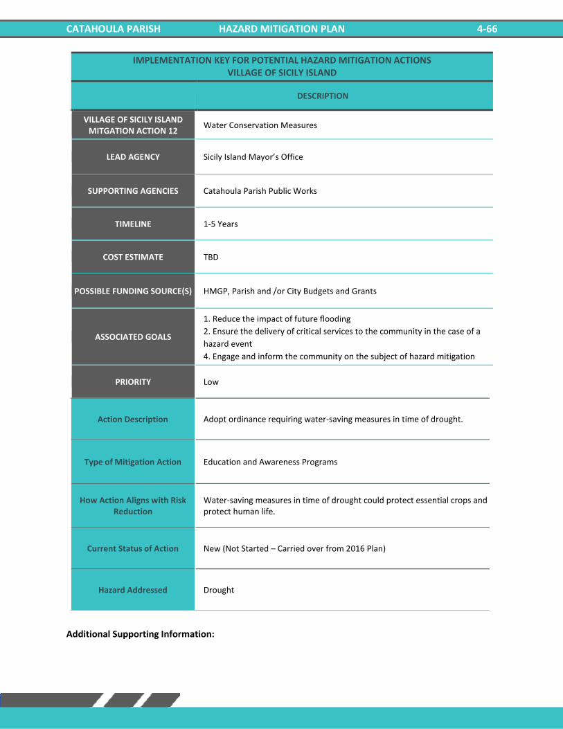
CATAHOULA PARISH HAZARD MITIGATION PLAN 4-66
IMPLEMENTATION KEY FOR POTENTIAL HAZARD MITIGATION ACTIONS VILLAGE OF SICILY ISLAND
DESCRIPTION
VILLAGE OF SICILY ISLAND MITGATION ACTION 12
Water Conservation Measures
LEAD AGENCY Sicily Island Mayor’s Office
SUPPORTING AGENCIES Catahoula Parish Public Works
TIMELINE 1-5 Years
COST ESTIMATE TBD
POSSIBLE FUNDING SOURCE(S) HMGP, Parish and /or City Budgets and Grants
ASSOCIATED GOALS
1. Reduce the impact of future flooding
2. Ensure the delivery of critical services to the community in the case of a
hazard event
4. Engage and inform the community on the subject of hazard mitigation
PRIORITY Low
Action Description Adopt ordinance requiring water-saving measures in time of drought.
Type of Mitigation Action Education and Awareness Programs
How Action Aligns with Risk Reduction
Water-saving measures in time of drought could protect essential crops and protect human life.
Current Status of Action New (Not Started – Carried over from 2016 Plan)
Hazard Addressed Drought
Additional Supporting Information:
CATAHOULA PARISH HAZARD MITIGATION PLAN 4-67
Action Prioritization During the prioritization process, the steering committee considered the costs and relative benefits of
each new action. Costs can usually be listed in terms of dollars, although at times it involves staff time
rather than the purchase of equipment or services that can be readily measured in dollars. In most cases,
benefits, such as lives saved or future damage prevented, are hard to measure in dollars. Therefore, many
projects were prioritized with these factors in mind. In addition, prioritization of the mitigation actions
was performed based on the following economic criteria: i) whether the action can be performed with
the existing parish resources; ii) whether the action requires additional funding from external sources;
and iii) relative costs of the mitigation actions.
In all cases, the committee concluded that the benefits (in terms of reduced property damage, lives saved,
health problems averted and/or economic harm prevented) outweighed the costs for the recommended
action items.
The steering committee prioritized the possible activities that could be pursued. Steering committee
members consulted appropriate agencies in order to assist with the prioritizations. The results were items
that address the major hazards, are appropriate for those hazards, are cost-effective, and are affordable.
On-going actions, as well as actions which will provide maximum benefit that can be undertaken by
existing parish staff with or without additional external funding were given high priority. The actions with
medium benefit and relatively low cost, political support, and public support but require additional
funding from parish or external sources were given medium priority. The actions that require substantial
funding from external sources and would result in limited benefit to the community were given low
priority.
Catahoula Parish and the incorporated jurisdictions will implement and administer the identified actions
based off the proposed timeframes and priorities for each reflected in the portions of this section where
actions are summarized. The inclusion of any specific action item in this document does not commit the
parish to implementation. Each action item will be subject to availability of staff and funding. Certain
items may require regulatory changes or other decisions that must be implemented through standard
processes. This plan is intended to offer priorities based on an examination of hazards.

CATAHOULA PARISH HAZARD MITIGATION PLAN 4-68
***This Page Intentionally Left Blank***
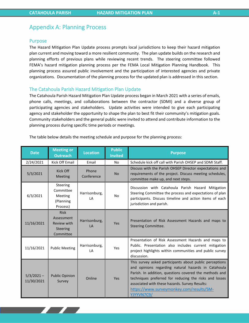
CATAHOULA PARISH HAZARD MITIGATION PLAN A-1
Appendix A: Planning Process
Purpose The Hazard Mitigation Plan Update process prompts local jurisdictions to keep their hazard mitigation
plan current and moving toward a more resilient community. The plan update builds on the research and
planning efforts of previous plans while reviewing recent trends. The steering committee followed
FEMA’s hazard mitigation planning process per the FEMA Local Mitigation Planning Handbook. This
planning process assured public involvement and the participation of interested agencies and private
organizations. Documentation of the planning process for the updated plan is addressed in this section.
The Catahoula Parish Hazard Mitigation Plan Update The Catahoula Parish Hazard Mitigation Plan Update process began in March 2021 with a series of emails,
phone calls, meetings, and collaborations between the contractor (SDMI) and a diverse group of
participating agencies and stakeholders. Update activities were intended to give each participating
agency and stakeholder the opportunity to shape the plan to best fit their community’s mitigation goals.
Community stakeholders and the general public were invited to attend and contribute information to the
planning process during specific time periods or meetings.
The table below details the meeting schedule and purpose for the planning process:
Date Meeting or
Outreach Location
Public
Invited Purpose
2/24/2021 Kick Off Email Email No Schedule kick off call with Parish OHSEP and SDMI Staff.
5/3/2021 Kick Off
Meeting
Phone
Conference No
Discuss with the Parish OHSEP Director expectations and
requirements of the project. Discuss meeting schedules,
committee make up, and next steps.
6/3/2021
Steering
Committee
Meeting
(Planning
Process)
Harrisonburg,
LA No
Discussion with Catahoula Parish Hazard Mitigation
Steering Committee the process and expectations of plan
participants. Discuss timeline and action items of each
jurisdiction and parish.
11/16/2021
Risk
Assessment
Review with
Steering
Committee
Harrisonburg,
LA Yes
Presentation of Risk Assessment Hazards and maps to
Steering Committee.
11/16/2021 Public Meeting Harrisonburg,
LA Yes
Presentation of Risk Assessment Hazards and maps to
Public. Presentation also includes current mitigation
project highlights within communities and public survey
discussion.
5/3/2021 –
11/30/2021
Public Opinion
Survey Online Yes
This survey asked participants about public perceptions
and opinions regarding natural hazards in Catahoula
Parish. In addition, questions covered the methods and
techniques preferred for reducing the risks and losses
associated with these hazards. Survey Results:
https://www.surveymonkey.com/results/SM-YJYYVN7C9/
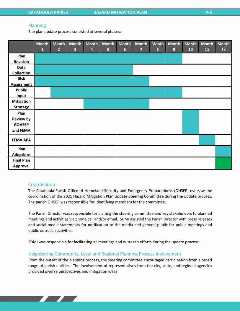
CATAHOULA PARISH HAZARD MITIGATION PLAN A-2
Planning The plan update process consisted of several phases:
Month
1
Month
2
Month
3
Month
4
Month
5
Month
6
Month
7
Month
8
Month
9
Month
10
Month
11
Month 12
Plan
Revision
Data
Collection
Risk
Assessment
Public
Input
Mitigation
Strategy
Plan
Review by
GOHSEP
and FEMA
FEMA APA
Plan
Adoptions
Start
Final Plan
Approval
Coordination The Catahoula Parish Office of Homeland Security and Emergency Preparedness (OHSEP) oversaw the
coordination of the 2021 Hazard Mitigation Plan Update Steering Committee during the update process.
The parish OHSEP was responsible for identifying members for the committee.
The Parish Director was responsible for inviting the steering committee and key stakeholders to planned
meetings and activities via phone call and/or email. SDMI assisted the Parish Director with press releases
and social media statements for notification to the media and general public for public meetings and
public outreach activities.
SDMI was responsible for facilitating all meetings and outreach efforts during the update process.
Neighboring Community, Local and Regional Planning Process Involvement From the outset of the planning process, the steering committee encouraged participation from a broad
range of parish entities. The involvement of representatives from the city, state, and regional agencies
provided diverse perspectives and mitigation ideas.
CATAHOULA PARISH HAZARD MITIGATION PLAN A-3
Formal participation in this plan includes but is not limited to the following activities:
• Participation in Hazard Mitigation planning meetings at the local and parish level
• Sharing local data and information with jurisdictions
• Incorporation of other planning documents, studies and efforts
• Action item development and action progress from 2016 update
• Risk Assessment review
• Plan document draft review
• Formal adoption of the Hazard Mitigation Plan
The LaSalle Parish OHSEP Director was invited to the Kick Off, Initial Planning, and Risk Assessment
Meetings for Catahoula Parish in an effort to coordinate mitigation efforts where possible as neighboring
communities. The LaSalle OHSEP Director was invited via email and phone call to participate in an effort
to collaborate with neighboring communities. SDMI assisted Catahoula Parish with encouraging the
collaboration with these neighboring communities via email by extending an invitation to the Catahoula
Hazard Mitigation Plan Update Meetings.
As part of the coordination and planning process, the parish was provided the State Required Hazard
Mitigation Plan Update Worksheet. The completed worksheets can be found in Appendix E – State
Required Plan Update Worksheets.
The 2021 Hazard Mitigation Plan Update Steering Committee consisted of representatives from the
following parish, municipal or community stakeholders. Below is a detailed list of the 2021 HMPU Steering
Committee:
Catahoula Parish Hazard Mitigation Planning Committee Name Title Agency Email
Ellis Boothe Parish Director Catahoula Parish OHSEP [email protected]
Patti Mizell Sec./Treasurer Catahoula Parish Police Jury [email protected]
Anlynne Gardner Town Clerk Town of Jonesville [email protected]
Patricia Hefner Town Clerk Village of Harrisonburg [email protected]
Walter Krause Mayor Village of Sicily Island [email protected]
Program Integration Local governments are required to describe how their mitigation planning process is integrated with other
ongoing local and area planning efforts. This subsection describes Catahoula Parish programs and
planning.
A measure of integration and coordination is achieved through the HMPU participation of Steering
Committee members and community stakeholders who administer programs such as: floodplain
management under the National Flood Insurance Program (NFIP), Community Rating System, parish
planning and zoning and building code enforcement.
Catahoula Parish will continue to integrate the requirements of this Hazard Mitigation Plan into other
local planning mechanisms that are to be identified through future meetings of the parish, and through
the five-year review process described in Appendix B: Plan Maintenance. The primary means for
integrating mitigation strategies into other local planning mechanisms will be through the revision, update
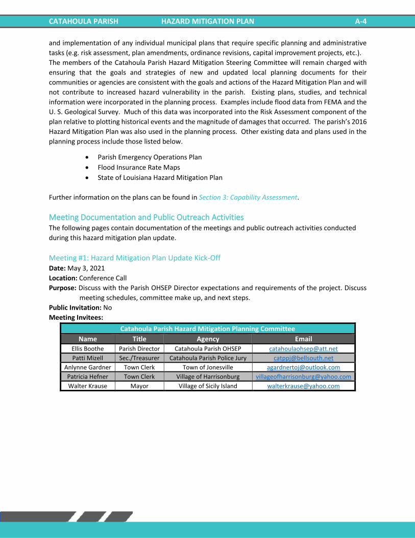
CATAHOULA PARISH HAZARD MITIGATION PLAN A-4
and implementation of any individual municipal plans that require specific planning and administrative
tasks (e.g. risk assessment, plan amendments, ordinance revisions, capital improvement projects, etc.).
The members of the Catahoula Parish Hazard Mitigation Steering Committee will remain charged with
ensuring that the goals and strategies of new and updated local planning documents for their
communities or agencies are consistent with the goals and actions of the Hazard Mitigation Plan and will
not contribute to increased hazard vulnerability in the parish. Existing plans, studies, and technical
information were incorporated in the planning process. Examples include flood data from FEMA and the
U. S. Geological Survey. Much of this data was incorporated into the Risk Assessment component of the
plan relative to plotting historical events and the magnitude of damages that occurred. The parish’s 2016
Hazard Mitigation Plan was also used in the planning process. Other existing data and plans used in the
planning process include those listed below.
• Parish Emergency Operations Plan
• Flood Insurance Rate Maps
• State of Louisiana Hazard Mitigation Plan
Further information on the plans can be found in Section 3: Capability Assessment.
Meeting Documentation and Public Outreach Activities The following pages contain documentation of the meetings and public outreach activities conducted
during this hazard mitigation plan update.
Meeting #1: Hazard Mitigation Plan Update Kick-Off Date: May 3, 2021
Location: Conference Call
Purpose: Discuss with the Parish OHSEP Director expectations and requirements of the project. Discuss
meeting schedules, committee make up, and next steps.
Public Invitation: No
Meeting Invitees:
Catahoula Parish Hazard Mitigation Planning Committee
Name Title Agency Email
Ellis Boothe Parish Director Catahoula Parish OHSEP [email protected]
Patti Mizell Sec./Treasurer Catahoula Parish Police Jury [email protected]
Anlynne Gardner Town Clerk Town of Jonesville [email protected]
Patricia Hefner Town Clerk Village of Harrisonburg [email protected]
Walter Krause Mayor Village of Sicily Island [email protected]
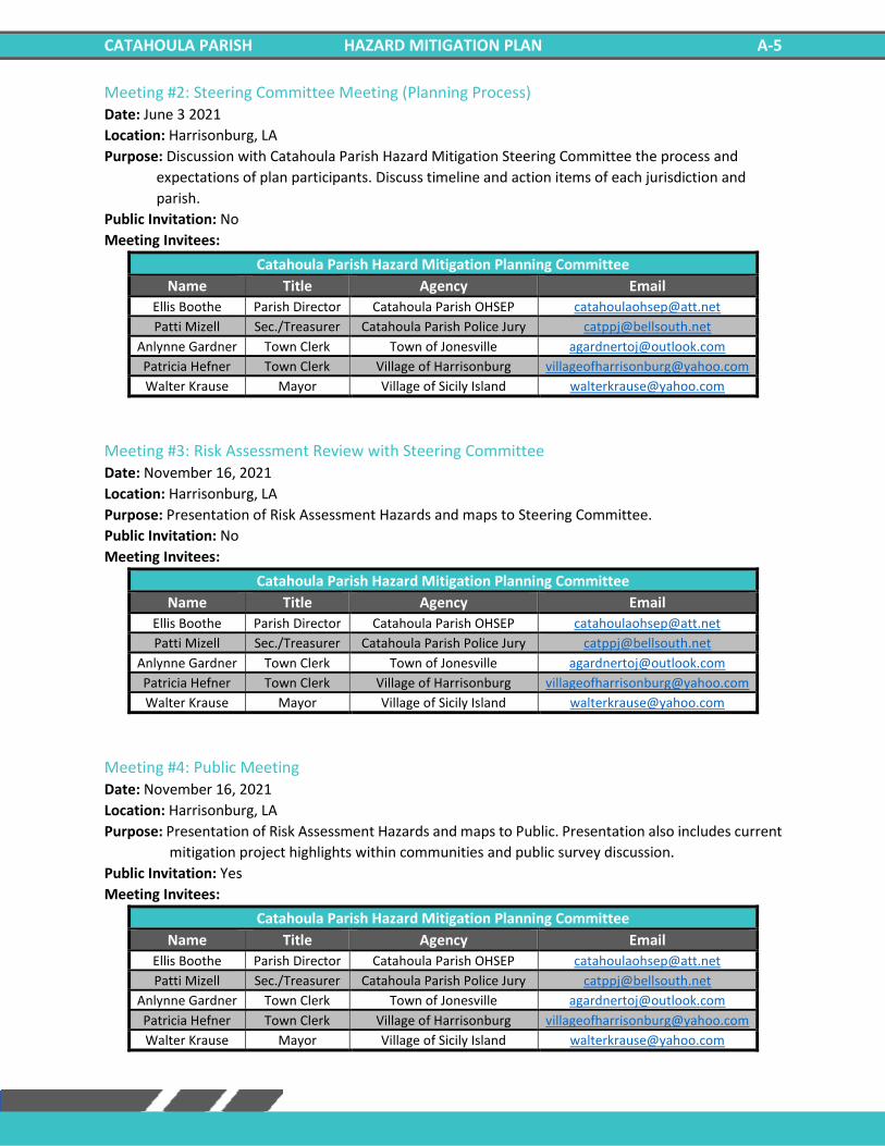
CATAHOULA PARISH HAZARD MITIGATION PLAN A-5
Meeting #2: Steering Committee Meeting (Planning Process) Date: June 3 2021
Location: Harrisonburg, LA
Purpose: Discussion with Catahoula Parish Hazard Mitigation Steering Committee the process and
expectations of plan participants. Discuss timeline and action items of each jurisdiction and
parish.
Public Invitation: No
Meeting Invitees:
Catahoula Parish Hazard Mitigation Planning Committee
Name Title Agency Email
Ellis Boothe Parish Director Catahoula Parish OHSEP [email protected]
Patti Mizell Sec./Treasurer Catahoula Parish Police Jury [email protected]
Anlynne Gardner Town Clerk Town of Jonesville [email protected]
Patricia Hefner Town Clerk Village of Harrisonburg [email protected]
Walter Krause Mayor Village of Sicily Island [email protected]
Meeting #3: Risk Assessment Review with Steering Committee Date: November 16, 2021
Location: Harrisonburg, LA
Purpose: Presentation of Risk Assessment Hazards and maps to Steering Committee.
Public Invitation: No
Meeting Invitees:
Catahoula Parish Hazard Mitigation Planning Committee
Name Title Agency Email
Ellis Boothe Parish Director Catahoula Parish OHSEP [email protected]
Patti Mizell Sec./Treasurer Catahoula Parish Police Jury [email protected]
Anlynne Gardner Town Clerk Town of Jonesville [email protected]
Patricia Hefner Town Clerk Village of Harrisonburg [email protected]
Walter Krause Mayor Village of Sicily Island [email protected]
Meeting #4: Public Meeting Date: November 16, 2021
Location: Harrisonburg, LA
Purpose: Presentation of Risk Assessment Hazards and maps to Public. Presentation also includes current
mitigation project highlights within communities and public survey discussion.
Public Invitation: Yes
Meeting Invitees:
Catahoula Parish Hazard Mitigation Planning Committee
Name Title Agency Email
Ellis Boothe Parish Director Catahoula Parish OHSEP [email protected]
Patti Mizell Sec./Treasurer Catahoula Parish Police Jury [email protected]
Anlynne Gardner Town Clerk Town of Jonesville [email protected]
Patricia Hefner Town Clerk Village of Harrisonburg [email protected]
Walter Krause Mayor Village of Sicily Island [email protected]

CATAHOULA PARISH HAZARD MITIGATION PLAN A-6
Outreach Activity #1: Public Opinion Survey Date: Ongoing throughout planning process
Location: Web Survey
Public Invitation: Yes
As referenced in the Mitigation Strategy section of this document, an online public opinion survey of
Catahoula Parish residents was conducted between March and November 2021. This survey asked
participants about public perceptions and opinions regarding natural hazards in Catahoula Parish. In
addition, questions covered the methods and techniques preferred for reducing the risks and losses
associated with these hazards. However, because there were no responses to the survey, this public
feedback could not be incorporated into the plan. Survey Results:
https://www.surveymonkey.com/results/SM-YJYYVN7C9/
CATAHOULA PARISH HAZARD MITIGATION PLAN B-1
Appendix B: Plan Maintenance
Purpose The section of the Code of Federal Regulations (CFR) pertaining to Local Mitigation Plans lists five required
components for each plan: a description of the planning process; risk assessments; mitigation strategies;
a method and system for plan maintenance; and documentation of plan adoption. This section details the
method and system for plan maintenance, following the CFR’s guidelines that the Plan Update must
include (1) “a section describing the method and schedule of monitoring, evaluating, and updating the
mitigation plan within a five-year cycle,” (2) “a process by which local governments incorporated the
requirements of the mitigation plan into other planning mechanisms such as comprehensive or capital
improvement plans”, and (3) “discussion on how the community will continue public participation in the
plan maintenance process.”
Monitoring, Evaluating, and Updating the Plan The Catahoula Parish Hazard Mitigation Steering Committee will be responsible for monitoring,
evaluating, and documenting the plan’s progress throughout the year. Part of the plan maintenance
process should include a system by which local governing bodies incorporate the HMP into the parish’s
other applicable plans. This process provides for continued public participation through the diverse
resources of the parish to help in achieving the goals and objectives of the plan. Public participation will
be achieved through availability of copies of HMP in parish public buildings. This section describes the
whole update process which includes the following:
• Responsible parties
• Methods to be used
• Evaluation criteria to be applied
• Scheduling for monitoring and evaluating the plan
Responsible Parties Catahoula Parish has developed a method to ensure that a regular review and update of the Hazard
Mitigation Plan occurs. This will be the responsibility of the Steering Committee, which consists of
representatives from governmental organizations, local businesses, and private citizens, who will be
involved in the process of monitoring, evaluating and updating the plan. All committee members in this
plan will remain active in the Steering Committee.
Although the people filling the positions may change from year to year, the parish and its stakeholders
will have representatives on the steering committee. The future Steering Committee will continue to be
comprised of the same job functions as currently evident in the Steering Committee. However, the
decision of specific job duties will be left to the Parish OHSEP Director to be assigned as deemed
appropriate.
Methods for Monitoring and Evaluating the Plan and Plan Evaluation Criteria Catahoula Parish has developed a method to ensure monitoring, evaluating, and updating of the HMP
occurs during the five-year cycle of the plan. The steering committee will become a permanent body and
will be responsible for monitoring, evaluating, and updating of the plan. The steering committee meeting
will be held annually in order to monitor, evaluate, and update the plan. The Catahoula Parish OHSEP
Director will be responsible for conducting the annual Steering Committee meetings.
CATAHOULA PARISH HAZARD MITIGATION PLAN B-2
The lead person of the agency responsible for the implementation of a specific mitigation action will
submit a progress report to the Director at least thirty days prior to the planning committee meeting. The
progress report will provide project status monitoring to include the following: whether the project has
started; if not started, reason for not starting; if started, status of the project; if the project is completed,
whether it has eliminated the problem; and any changes recommended to improve the implementation
of the project etc. In addition, the progress report will provide status monitoring on the plan evaluation,
changes to the hazard profile, changes to the risk assessment, and public input on the Hazard Mitigation
Plan updates and reviews.
Progress on the mitigation action items and projects will be reviewed during the annual planning
committee meeting. The criteria that would be utilized in the project review will include the following:
1) Whether the action was implemented and reasons, if the action was not implemented
2) What were the results of the implemented action
3) Were the outcomes as expected, and reasons if the outcomes were not as expected
4) Did the results achieve the stated goals and objectives
5) Was the action cost-effective
6) What were the losses avoided after completion of the project
7) In case of a structural project, did it change the hazard profile
In addition to monitoring and evaluating the progress of the mitigation plan actions and projects, the
mitigation plan is required to be maintained and monitored annually, and fully updated every five years.
The annual maintenance, monitoring and evaluation of the plan will be conducted in the annual Steering
Committee meeting. The Steering Committee will review each goal to determine their relevance to
changing situations in the parish, as well as changes to state or federal policy, and to ensure that they are
addressing current and expected conditions. The Steering Committee will evaluate if any change in hazard
profile and risk in the parish occurred during the past year. In addition, the evaluation will include the
following criteria in respect of plan implementation:
1) Any local staffing changes that would warrant inviting different members to the planning
committee
2) Any new organizations that would be valuable in the planning process or project
implementation need to be included in the planning committee
3) Any new or existing procedures that can be done more efficiently
4) Any additional ways to gain more diverse and widespread cooperation
5) Any different or additional funding sources available for mitigation planning and
implementation
The HMP will be updated every five years to remain eligible for continued HMGP funding. The Steering
Committee will be responsible for updating the HMP. The OHSEP Director will be the lead person for the
HMP update. The HMP update process will commence at least one year prior to the expiration of the
plan. The HMP will be updated after a major disaster if an annual evaluation of the plan indicates a
substantial change in hazard profile and risk assessment in the parish.
CATAHOULA PARISH HAZARD MITIGATION PLAN B-3
Additionally, the public will be canvassed to solicit public input to continue Catahoula Parish’s dedication
to involving the public directly in review and updates of the Hazard Mitigation Plan. Meetings will be
scheduled as needed by the plan administrator to provide a forum for which the public can express their
concerns, opinions, and/or ideas about the plan. The plan administrator will be responsible for using
parish resources to publicize the annual public meetings and maintain public involvement through the
newspapers, radio, and public access television channels. Copies of the plan will be catalogued and kept
at all appropriate agencies in the city government.
The review by the Steering Committee and input from the public will determine whether a plan update is
needed prior to the required five-year update.
Annual reports on the progress of actions, plan maintenance, monitoring, evaluation, incorporation into
existing planning programs, and continued public involvement will be documented at each annual
meeting of the committee and kept by the Parish OHSEP Director. The Steering Committee will work
together as a team, with each member sharing responsibility for completing the monitoring, evaluation
and updates. It is the responsibility of the Parish OHSEP Director for contacting committee members,
organizing the meeting and providing public noticing for the meeting to solicit public input.
2021 Plan Version Plan Method and Schedule Evaluation For the current plan update, the previously approved plan’s method and schedule were evaluated to
determine if the elements and processes involved in the required 2021 update. Based on this analysis, the
method and schedule were deemed to be acceptable, and nothing was changed for this update.
Incorporation into Existing Planning Programs It is and has been the responsibility of the Catahoula Parish Hazard Mitigation Plan Steering Committee
and participating jurisdictions to determine additional implementation procedures when appropriate.
This may include integrating the requirements of the Catahoula Parish Hazard Mitigation Plan into each
jurisdiction’s planning documents, processes, or mechanisms as follows:
• Ordinances, Resolutions, Regulations
• Floodplain Ordinances
• Emergency Operations Plans
• Continuity of Operations Plans
• Transportation Plan
• Community Wildfire Protection Plan
Opportunities to integrate the requirements of this plan into other local planning mechanisms will
continue to be identified through future meetings of the Catahoula Parish Hazard Mitigation Steering
Committee and through the five-year review process described herein. The primary means for integrating
mitigation strategies into other local planning mechanisms will be through the revision, update and
implementation of each jurisdiction’s individual plans that require specific planning and administrative
tasks (e.g. risk assessment, plan amendments, ordinance revisions, capital improvement projects, etc.).
While there have been no instances of the mitigation strategy being incorporated into other planning
documents since the adoption of the 2016 Catahoula Hazard Mitigation Plan, the committee members
recognize the importance of a holistic approach across all planning efforts and will use their standing to
integrate the mitigation strategy outlined in the 2021 Catahoula Hazard Mitigation Plan into other
planning documents when appropriate.
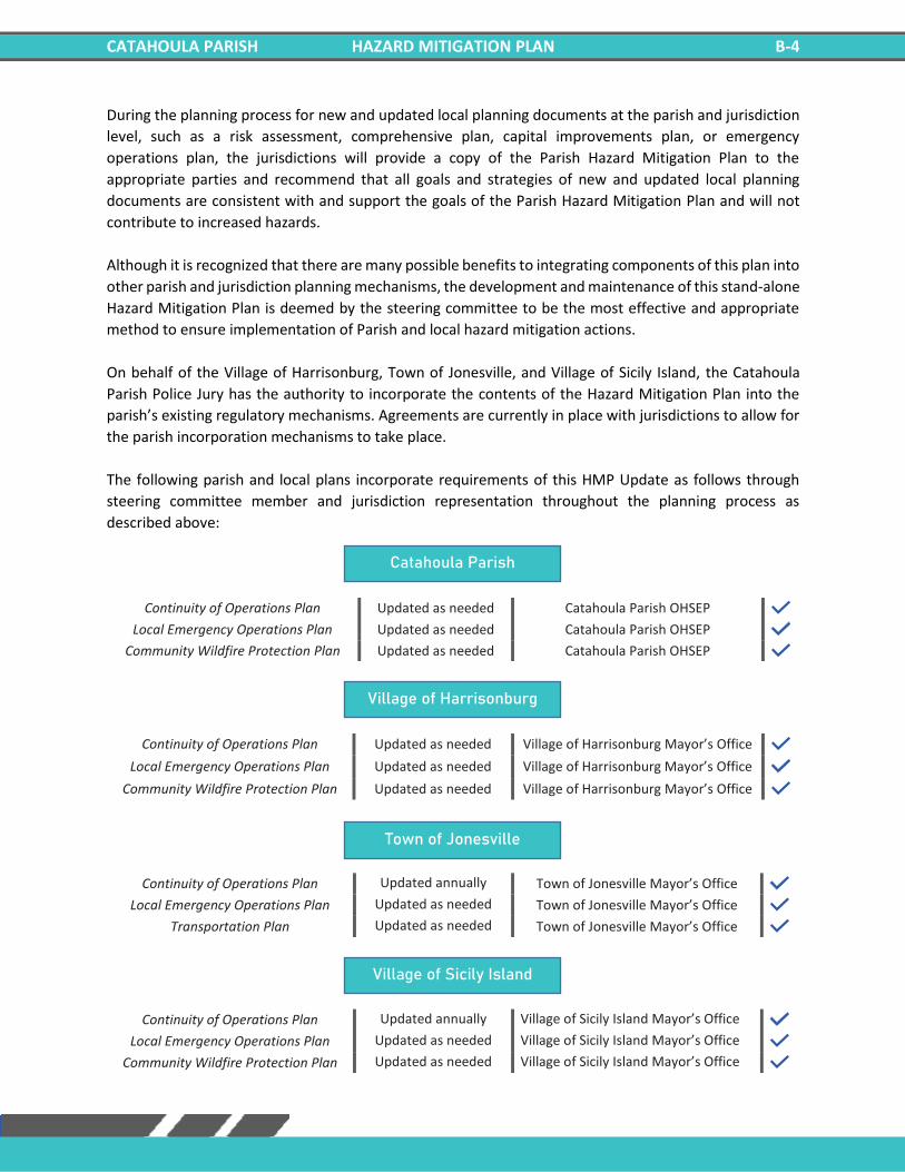
CATAHOULA PARISH HAZARD MITIGATION PLAN B-4
During the planning process for new and updated local planning documents at the parish and jurisdiction
level, such as a risk assessment, comprehensive plan, capital improvements plan, or emergency
operations plan, the jurisdictions will provide a copy of the Parish Hazard Mitigation Plan to the
appropriate parties and recommend that all goals and strategies of new and updated local planning
documents are consistent with and support the goals of the Parish Hazard Mitigation Plan and will not
contribute to increased hazards.
Although it is recognized that there are many possible benefits to integrating components of this plan into
other parish and jurisdiction planning mechanisms, the development and maintenance of this stand-alone
Hazard Mitigation Plan is deemed by the steering committee to be the most effective and appropriate
method to ensure implementation of Parish and local hazard mitigation actions.
On behalf of the Village of Harrisonburg, Town of Jonesville, and Village of Sicily Island, the Catahoula
Parish Police Jury has the authority to incorporate the contents of the Hazard Mitigation Plan into the
parish’s existing regulatory mechanisms. Agreements are currently in place with jurisdictions to allow for
the parish incorporation mechanisms to take place.
The following parish and local plans incorporate requirements of this HMP Update as follows through
steering committee member and jurisdiction representation throughout the planning process as
described above:
Continuity of Operations Plan Updated as needed Catahoula Parish OHSEP Local Emergency Operations Plan Updated as needed Catahoula Parish OHSEP
Community Wildfire Protection Plan Updated as needed Catahoula Parish OHSEP
Continuity of Operations Plan Updated as needed Village of Harrisonburg Mayor’s Office Local Emergency Operations Plan Updated as needed Village of Harrisonburg Mayor’s Office
Community Wildfire Protection Plan Updated as needed Village of Harrisonburg Mayor’s Office
Continuity of Operations Plan Updated annually Town of Jonesville Mayor’s Office Local Emergency Operations Plan Updated as needed Town of Jonesville Mayor’s Office
Transportation Plan Updated as needed Town of Jonesville Mayor’s Office
Continuity of Operations Plan Updated annually Village of Sicily Island Mayor’s Office Local Emergency Operations Plan Updated as needed Village of Sicily Island Mayor’s Office
Community Wildfire Protection Plan Updated as needed Village of Sicily Island Mayor’s Office
Town of Jonesville
Village of Sicily Island
Catahoula Parish
Village of Harrisonburg
CATAHOULA PARISH HAZARD MITIGATION PLAN B-5
Continued Public Participation Public participation is an integral component of the mitigation planning process and will continue to be
essential as this plan evolves over time. Significant changes or amendments to the plan require a public
hearing prior to any adoption procedures. Other efforts to involve the public in the maintenance,
evaluation, and revision process will be made as necessary. These efforts may include:
• Advertising meetings of the Mitigation Committee in the local newspaper, public bulletin boards,
and/or city and county office buildings
• Designating willing and voluntary citizens and private sector representatives as official members
of the Mitigation Committee
• Utilizing local media to update the public of any maintenance and/or periodic review activities
taking place
• Utilizing city and Parish web sites to advertise any maintenance and/or periodic review activities
taking place
• Keeping copies of the plan in appropriate public locations.

CATAHOULA PARISH HAZARD MITIGATION PLAN B-6
***This Page Left Intentionally Blank***
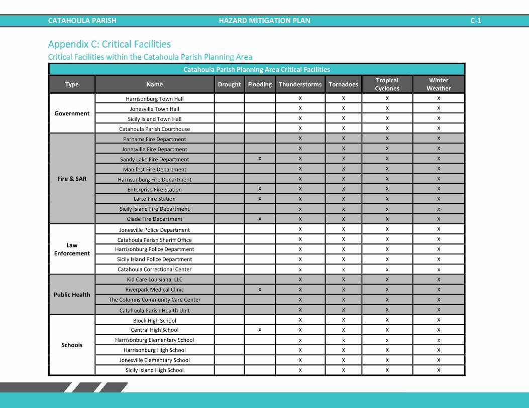
CATAHOULA PARISH HAZARD MITIGATION PLAN C-1
Appendix C: Critical Facilities Critical Facilities within the Catahoula Parish Planning Area
Catahoula Parish Planning Area Critical Facilities
Type Name Drought Flooding Thunderstorms Tornadoes Tropical Cyclones
Winter Weather
Government
Harrisonburg Town Hall X X X X
Jonesville Town Hall X X X X
Sicily Island Town Hall X X X X
Catahoula Parish Courthouse X X X X
Fire & SAR
Parhams Fire Department X X X X
Jonesville Fire Department X X X X
Sandy Lake Fire Department X X X X X
Manifest Fire Department X X X X
Harrisonburg Fire Department X X X X
Enterprise Fire Station X X X X X
Larto Fire Station X X X X X
Sicily Island Fire Department x x x x
Glade Fire Department X X X X X
Law Enforcement
Jonesville Police Department X X X X
Catahoula Parish Sheriff Office X X X X
Harrisonburg Police Department X X X X
Sicily Island Police Department X X X X
Catahoula Correctional Center x x x x
Public Health
Kid Care Louisiana, LLC X X X X
Riverpark Medical Clinic X X X X X
The Columns Community Care Center X X X X
Catahoula Parish Health Unit X X X X
Schools
Block High School X X X X
Central High School X X X X X
Harrisonburg Elementary School x x x x
Harrisonburg High School X X X X
Jonesville Elementary School X X X X
Sicily Island High School X X X X
CATAHOULA PARISH HAZARD MITIGATION PLAN C-2
***This Page Left Intentionally Blank***
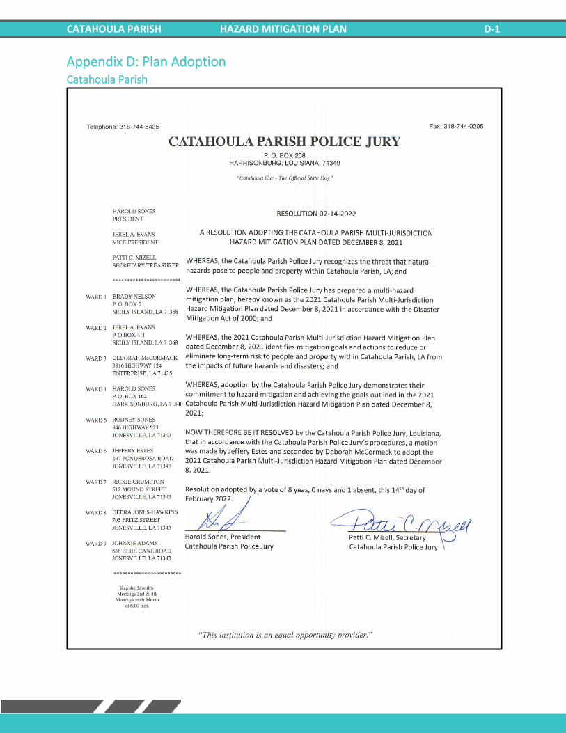
CATAHOULA PARISH HAZARD MITIGATION PLAN D-1
Appendix D: Plan Adoption Catahoula Parish
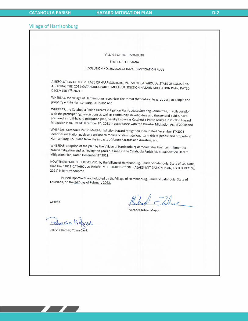
CATAHOULA PARISH HAZARD MITIGATION PLAN D-2
Village of Harrisonburg
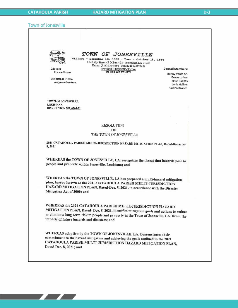
CATAHOULA PARISH HAZARD MITIGATION PLAN D-3
Town of Jonesville
CATAHOULA PARISH HAZARD MITIGATION PLAN D-4
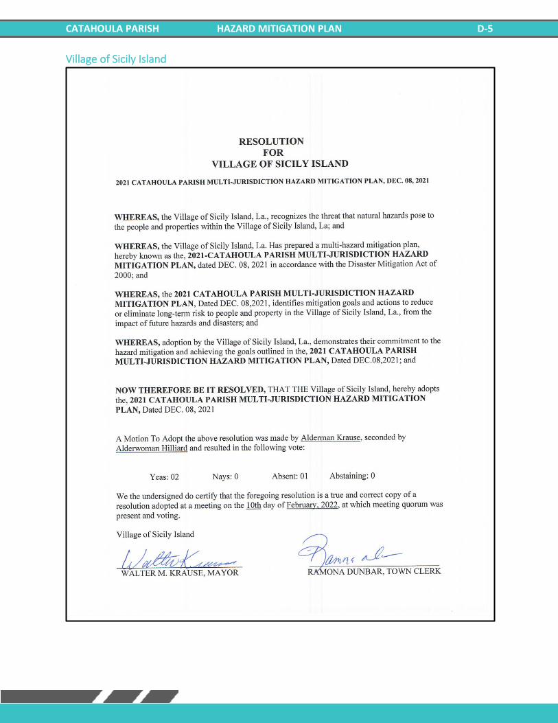
CATAHOULA PARISH HAZARD MITIGATION PLAN D-5
Village of Sicily Island

CATAHOULA PARISH HAZARD MITIGATION PLAN D-6
***This Page Left Intentionally Blank***
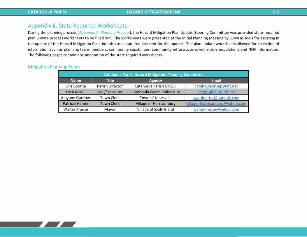
CATAHOULA PARISH HAZARD MITIGATION PLAN E-1
Appendix E: State Required Worksheets During the planning process (Appendix A: Planning Process), the Hazard Mitigation Plan Update Steering Committee was provided state-required
plan update process worksheets to be filled out. The worksheets were presented at the Initial Planning Meeting by SDMI as tools for assisting in
the update of the Hazard Mitigation Plan, but also as a state requirement for the update. The plan update worksheets allowed for collection of
information such as planning team members, community capabilities, community infrastructure, vulnerable populations and NFIP information.
The following pages contain documentation of the state required worksheets.
Mitigation Planning Team
Catahoula Parish Hazard Mitigation Planning Committee
Name Title Agency Email
Ellis Boothe Parish Director Catahoula Parish OHSEP [email protected]
Patti Mizell Sec./Treasurer Catahoula Parish Police Jury [email protected]
Anlynne Gardner Town Clerk Town of Jonesville [email protected]
Patricia Hefner Town Clerk Village of Harrisonburg [email protected]
Walter Krause Mayor Village of Sicily Island [email protected]
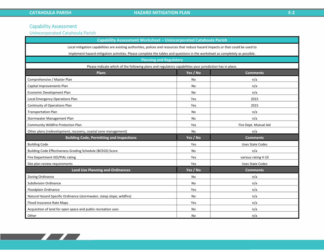
CATAHOULA PARISH HAZARD MITIGATION PLAN E-2
Capability Assessment Unincorporated Catahoula Parish
Capability Assessment Worksheet – Unincorporated Catahoula Parish
Local mitigation capabilities are existing authorities, polices and resources that reduce hazard impacts or that could be used to
implement hazard mitigation activities. Please complete the tables and questions in the worksheet as completely as possible.
Planning and Regulatory
Please indicate which of the following plans and regulatory capabilities your jurisdiction has in place.
Plans Yes / No Comments
Comprehensive / Master Plan No n/a
Capital Improvements Plan No n/a
Economic Development Plan No n/a
Local Emergency Operations Plan Yes 2015
Continuity of Operations Plan Yes 2015
Transportation Plan No n/a
Stormwater Management Plan No n/a
Community Wildfire Protection Plan Yes Fire Dept. Mutual Aid
Other plans (redevelopment, recovery, coastal zone management) No n/a
Building Code, Permitting and Inspections Yes / No Comments
Building Code Yes Uses State Codes
Building Code Effectiveness Grading Schedule (BCEGS) Score No n/a
Fire Department ISO/PIAL rating Yes various rating 4-10
Site plan review requirements Yes Uses State Codes
Land Use Planning and Ordinances Yes / No Comments
Zoning Ordinance No n/a
Subdivision Ordinance No n/a
Floodplain Ordinance Yes n/a
Natural Hazard Specific Ordinance (stormwater, steep slope, wildfire) No n/a
Flood Insurance Rate Maps Yes n/a
Acquisition of land for open space and public recreation uses No n/a
Other No n/a
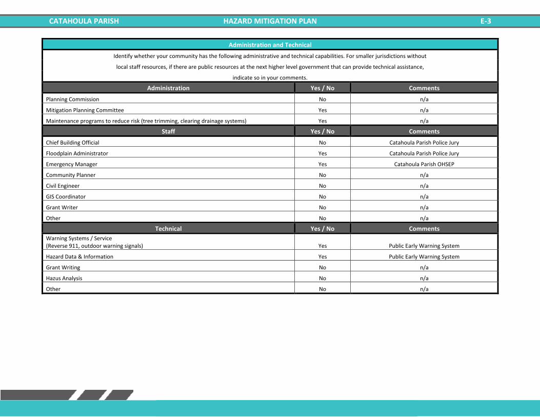
CATAHOULA PARISH HAZARD MITIGATION PLAN E-3
Administration and Technical
Identify whether your community has the following administrative and technical capabilities. For smaller jurisdictions without
local staff resources, if there are public resources at the next higher level government that can provide technical assistance,
indicate so in your comments.
Administration Yes / No Comments
Planning Commission No n/a
Mitigation Planning Committee Yes n/a
Maintenance programs to reduce risk (tree trimming, clearing drainage systems) Yes n/a
Staff Yes / No Comments
Chief Building Official No Catahoula Parish Police Jury
Floodplain Administrator Yes Catahoula Parish Police Jury
Emergency Manager Yes Catahoula Parish OHSEP
Community Planner No n/a
Civil Engineer No n/a
GIS Coordinator No n/a
Grant Writer No n/a
Other No n/a
Technical Yes / No Comments
Warning Systems / Service (Reverse 911, outdoor warning signals) Yes Public Early Warning System
Hazard Data & Information Yes Public Early Warning System
Grant Writing No n/a
Hazus Analysis No n/a
Other No n/a
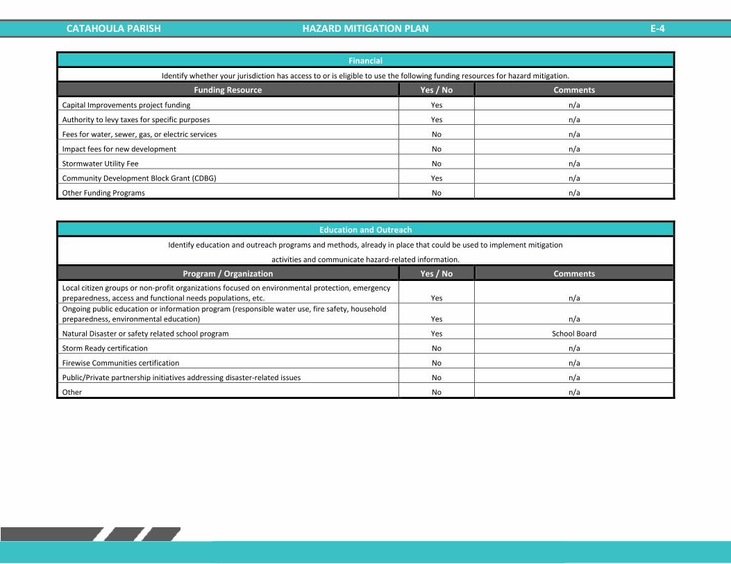
CATAHOULA PARISH HAZARD MITIGATION PLAN E-4
Financial
Identify whether your jurisdiction has access to or is eligible to use the following funding resources for hazard mitigation.
Funding Resource Yes / No Comments
Capital Improvements project funding Yes n/a
Authority to levy taxes for specific purposes Yes n/a
Fees for water, sewer, gas, or electric services No n/a
Impact fees for new development No n/a
Stormwater Utility Fee No n/a
Community Development Block Grant (CDBG) Yes n/a
Other Funding Programs No n/a
Education and Outreach
Identify education and outreach programs and methods, already in place that could be used to implement mitigation
activities and communicate hazard-related information.
Program / Organization Yes / No Comments
Local citizen groups or non-profit organizations focused on environmental protection, emergency preparedness, access and functional needs populations, etc. Yes n/a
Ongoing public education or information program (responsible water use, fire safety, household preparedness, environmental education) Yes n/a
Natural Disaster or safety related school program Yes School Board
Storm Ready certification No n/a
Firewise Communities certification No n/a
Public/Private partnership initiatives addressing disaster-related issues No n/a
Other No n/a

CATAHOULA PARISH HAZARD MITIGATION PLAN E-5
Village of Harrisonburg
Capability Assessment Worksheet – Village of Harrisonburg
Local mitigation capabilities are existing authorities, polices and resources that reduce hazard impacts or that could be used to
implement hazard mitigation activities. Please complete the tables and questions in the worksheet as completely as possible.
Planning and Regulatory
Please indicate which of the following plans and regulatory capabilities your jurisdiction has in place.
Plans Yes / No Comments
Comprehensive / Master Plan No n/a
Capital Improvements Plan No n/a
Economic Development Plan No n/a
Local Emergency Operations Plan Yes Use Parish Plan
Continuity of Operations Plan Yes Use Parish Plan
Transportation Plan No n/a
Stormwater Management Plan No n/a
Community Wildfire Protection Plan Yes Mutual Aid Agreements
Other plans (redevelopment, recovery, coastal zone management) No n/a
Building Code, Permitting and Inspections Yes / No Comments
Building Code Yes n/a
Building Code Effectiveness Grading Schedule (BCEGS) Score No n/a
Fire Department ISO/PIAL rating Yes 10
Site plan review requirements No n/a
Land Use Planning and Ordinances Yes / No Comments
Zoning Ordinance No n/a
Subdivision Ordinance No n/a
Floodplain Ordinance Yes n/a
Natural Hazard Specific Ordinance (stormwater, steep slope, wildfire) No n/a
Flood Insurance Rate Maps Yes n/a
Acquisition of land for open space and public recreation uses No n/a
Other No n/a
CATAHOULA PARISH HAZARD MITIGATION PLAN E-6
Administration and Technical
Identify whether your community has the following administrative and technical capabilities. For smaller jurisdictions without
local staff resources, if there are public resources at the next higher level government that can provide technical assistance,
indicate so in your comments.
Administration Yes / No Comments
Planning Commission No n/a
Mitigation Planning Committee Yes Uses Parish Plan
Maintenance programs to reduce risk (tree trimming, clearing drainage systems) Yes when funding is available
Staff Yes / No Comments
Chief Building Official No n/a
Floodplain Administrator Yes n/a
Emergency Manager No n/a
Community Planner No n/a
Civil Engineer Yes n/a
GIS Coordinator No n/a
Grant Writer Yes n/a
Other No n/a
Technical Yes / No Comments
Warning Systems / Service (Reverse 911, outdoor warning signals) Yes Parish Provided
Hazard Data & Information No n/a
Grant Writing No n/a
Hazus Analysis No n/a
Other No n/a

CATAHOULA PARISH HAZARD MITIGATION PLAN E-7
Financial
Identify whether your jurisdiction has access to or is eligible to use the following funding resources for hazard mitigation.
Funding Resource Yes / No Comments
Capital Improvements project funding Yes n/a
Authority to levy taxes for specific purposes Yes n/a
Fees for water, sewer, gas, or electric services Yes n/a
Impact fees for new development No n/a
Stormwater Utility Fee No n/a
Community Development Block Grant (CDBG) Yes n/a
Other Funding Programs No n/a
Education and Outreach
Identify education and outreach programs and methods, already in place that could be used to implement mitigation
activities and communicate hazard-related information.
Program / Organization Yes / No Comments
Local citizen groups or non-profit organizations focused on environmental protection, emergency preparedness, access and functional needs populations, etc. Yes n/a
Ongoing public education or information program (responsible water use, fire safety, household preparedness, environmental education) Yes Fire Dept. Town Officials
Natural Disaster or safety related school program No n/a
Storm Ready certification No n/a
Firewise Communities certification No n/a
Public/Private partnership initiatives addressing disaster-related issues No n/a
Other No n/a
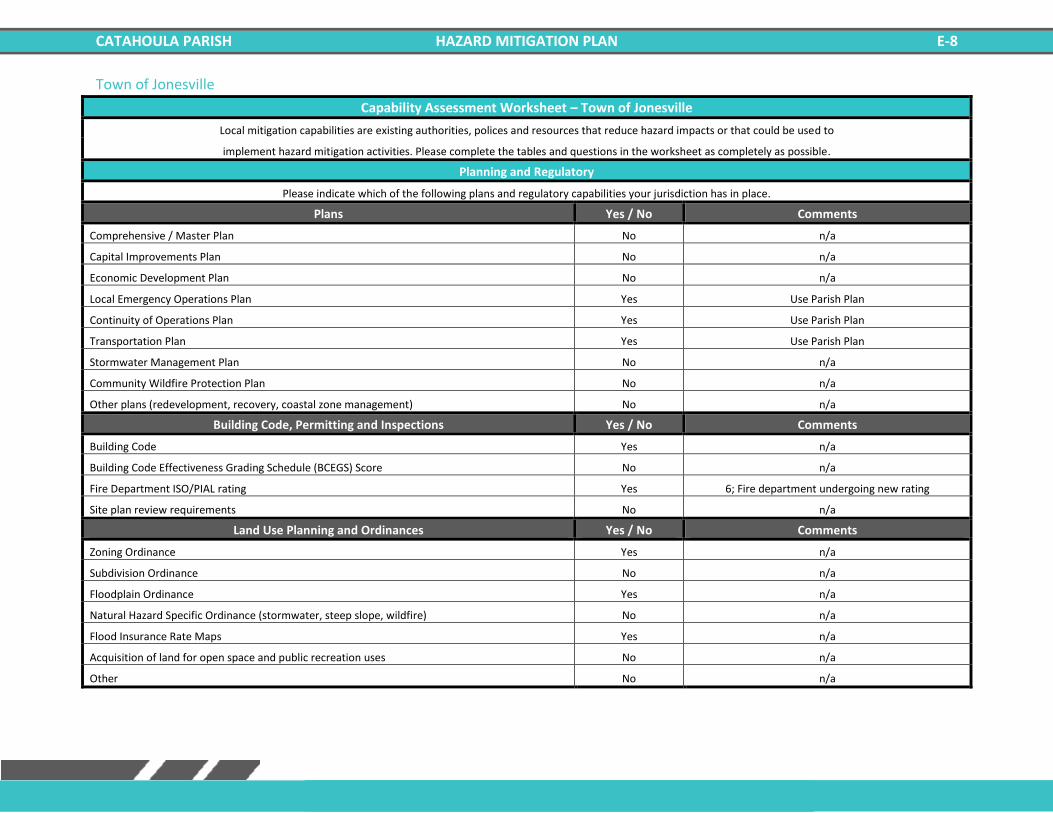
CATAHOULA PARISH HAZARD MITIGATION PLAN E-8
Town of Jonesville
Capability Assessment Worksheet – Town of Jonesville
Local mitigation capabilities are existing authorities, polices and resources that reduce hazard impacts or that could be used to
implement hazard mitigation activities. Please complete the tables and questions in the worksheet as completely as possible.
Planning and Regulatory
Please indicate which of the following plans and regulatory capabilities your jurisdiction has in place.
Plans Yes / No Comments
Comprehensive / Master Plan No n/a
Capital Improvements Plan No n/a
Economic Development Plan No n/a
Local Emergency Operations Plan Yes Use Parish Plan
Continuity of Operations Plan Yes Use Parish Plan
Transportation Plan Yes Use Parish Plan
Stormwater Management Plan No n/a
Community Wildfire Protection Plan No n/a
Other plans (redevelopment, recovery, coastal zone management) No n/a
Building Code, Permitting and Inspections Yes / No Comments
Building Code Yes n/a
Building Code Effectiveness Grading Schedule (BCEGS) Score No n/a
Fire Department ISO/PIAL rating Yes 6; Fire department undergoing new rating
Site plan review requirements No n/a
Land Use Planning and Ordinances Yes / No Comments
Zoning Ordinance Yes n/a
Subdivision Ordinance No n/a
Floodplain Ordinance Yes n/a
Natural Hazard Specific Ordinance (stormwater, steep slope, wildfire) No n/a
Flood Insurance Rate Maps Yes n/a
Acquisition of land for open space and public recreation uses No n/a
Other No n/a

CATAHOULA PARISH HAZARD MITIGATION PLAN E-9
Administration and Technical
Identify whether your community has the following administrative and technical capabilities. For smaller jurisdictions without
local staff resources, if there are public resources at the next higher level government that can provide technical assistance,
indicate so in your comments.
Administration Yes / No Comments
Planning Commission No n/a
Mitigation Planning Committee No n/a
Maintenance programs to reduce risk (tree trimming, clearing drainage systems) Yes When Funding is available
Staff Yes / No Comments
Chief Building Official No n/a
Floodplain Administrator Yes n/a
Emergency Manager No n/a
Community Planner No n/a
Civil Engineer Yes n/a
GIS Coordinator No n/a
Grant Writer Yes n/a
Other No n/a
Technical Yes / No Comments
Warning Systems / Service (Reverse 911, outdoor warning signals) Yes Uses Parish's Warning System
Hazard Data & Information No n/a
Grant Writing Yes n/a
Hazus Analysis No n/a
Other No n/a
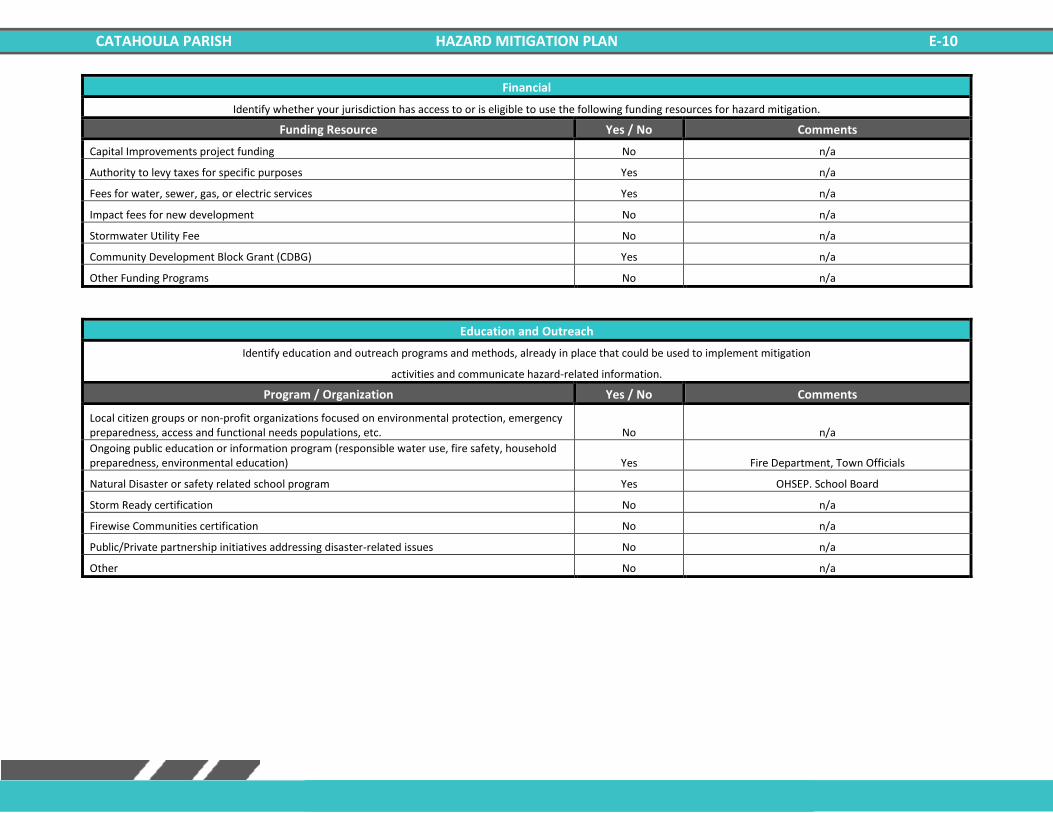
CATAHOULA PARISH HAZARD MITIGATION PLAN E-10
Financial
Identify whether your jurisdiction has access to or is eligible to use the following funding resources for hazard mitigation.
Funding Resource Yes / No Comments
Capital Improvements project funding No n/a
Authority to levy taxes for specific purposes Yes n/a
Fees for water, sewer, gas, or electric services Yes n/a
Impact fees for new development No n/a
Stormwater Utility Fee No n/a
Community Development Block Grant (CDBG) Yes n/a
Other Funding Programs No n/a
Education and Outreach
Identify education and outreach programs and methods, already in place that could be used to implement mitigation
activities and communicate hazard-related information.
Program / Organization Yes / No Comments
Local citizen groups or non-profit organizations focused on environmental protection, emergency preparedness, access and functional needs populations, etc. No n/a
Ongoing public education or information program (responsible water use, fire safety, household preparedness, environmental education) Yes Fire Department, Town Officials
Natural Disaster or safety related school program Yes OHSEP. School Board
Storm Ready certification No n/a
Firewise Communities certification No n/a
Public/Private partnership initiatives addressing disaster-related issues No n/a
Other No n/a
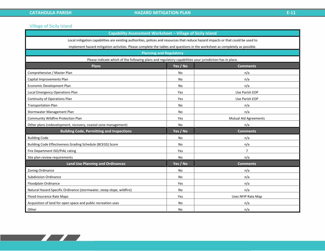
CATAHOULA PARISH HAZARD MITIGATION PLAN E-11
Village of Sicily Island
Capability Assessment Worksheet – Village of Sicily Island
Local mitigation capabilities are existing authorities, polices and resources that reduce hazard impacts or that could be used to
implement hazard mitigation activities. Please complete the tables and questions in the worksheet as completely as possible.
Planning and Regulatory
Please indicate which of the following plans and regulatory capabilities your jurisdiction has in place.
Plans Yes / No Comments
Comprehensive / Master Plan No n/a
Capital Improvements Plan No n/a
Economic Development Plan No n/a
Local Emergency Operations Plan Yes Use Parish EOP
Continuity of Operations Plan Yes Use Parish EOP
Transportation Plan No n/a
Stormwater Management Plan No n/a
Community Wildfire Protection Plan Yes Mutual Aid Agreements
Other plans (redevelopment, recovery, coastal zone management) No n/a
Building Code, Permitting and Inspections Yes / No Comments
Building Code No n/a
Building Code Effectiveness Grading Schedule (BCEGS) Score No n/a
Fire Department ISO/PIAL rating Yes 7
Site plan review requirements No n/a
Land Use Planning and Ordinances Yes / No Comments
Zoning Ordinance No n/a
Subdivision Ordinance No n/a
Floodplain Ordinance Yes n/a
Natural Hazard Specific Ordinance (stormwater, steep slope, wildfire) No n/a
Flood Insurance Rate Maps Yes Uses NFIP Rate Map
Acquisition of land for open space and public recreation uses No n/a
Other No n/a
CATAHOULA PARISH HAZARD MITIGATION PLAN E-12
Administration and Technical
Identify whether your community has the following administrative and technical capabilities. For smaller jurisdictions without
local staff resources, if there are public resources at the next higher level government that can provide technical assistance,
indicate so in your comments.
Administration Yes / No Comments
Planning Commission No n/a
Mitigation Planning Committee Yes Uses Parish Plan
Maintenance programs to reduce risk (tree trimming, clearing drainage systems) Yes n/a
Staff Yes / No Comments
Chief Building Official No n/a
Floodplain Administrator Yes n/a
Emergency Manager No n/a
Community Planner No n/a
Civil Engineer No n/a
GIS Coordinator No n/a
Grant Writer No n/a
Other No n/a
Technical Yes / No Comments
Warning Systems / Service (Reverse 911, outdoor warning signals) Yes Provide by Parish OHSEP
Hazard Data & Information No n/a
Grant Writing No n/a
Hazus Analysis No n/a
Other No n/a

CATAHOULA PARISH HAZARD MITIGATION PLAN E-13
Financial
Identify whether your jurisdiction has access to or is eligible to use the following funding resources for hazard mitigation.
Funding Resource Yes / No Comments
Capital Improvements project funding Yes n/a
Authority to levy taxes for specific purposes Yes n/a
Fees for water, sewer, gas, or electric services Yes n/a
Impact fees for new development No n/a
Stormwater Utility Fee No n/a
Community Development Block Grant (CDBG) Yes n/a
Other Funding Programs No n/a
Education and Outreach
Identify education and outreach programs and methods, already in place that could be used to implement mitigation
activities and communicate hazard-related information.
Program / Organization Yes / No Comments
Local citizen groups or non-profit organizations focused on environmental protection, emergency preparedness, access and functional needs populations, etc. Yes Volunteer Fire Dept.
Ongoing public education or information program (responsible water use, fire safety, household preparedness, environmental education) Yes City Hall, Volunteer Fire Dept., Police Dept.
Natural Disaster or safety related school program Yes n/a
Storm Ready certification No n/a
Firewise Communities certification No n/a
Public/Private partnership initiatives addressing disaster-related issues No n/a
Other No n/a
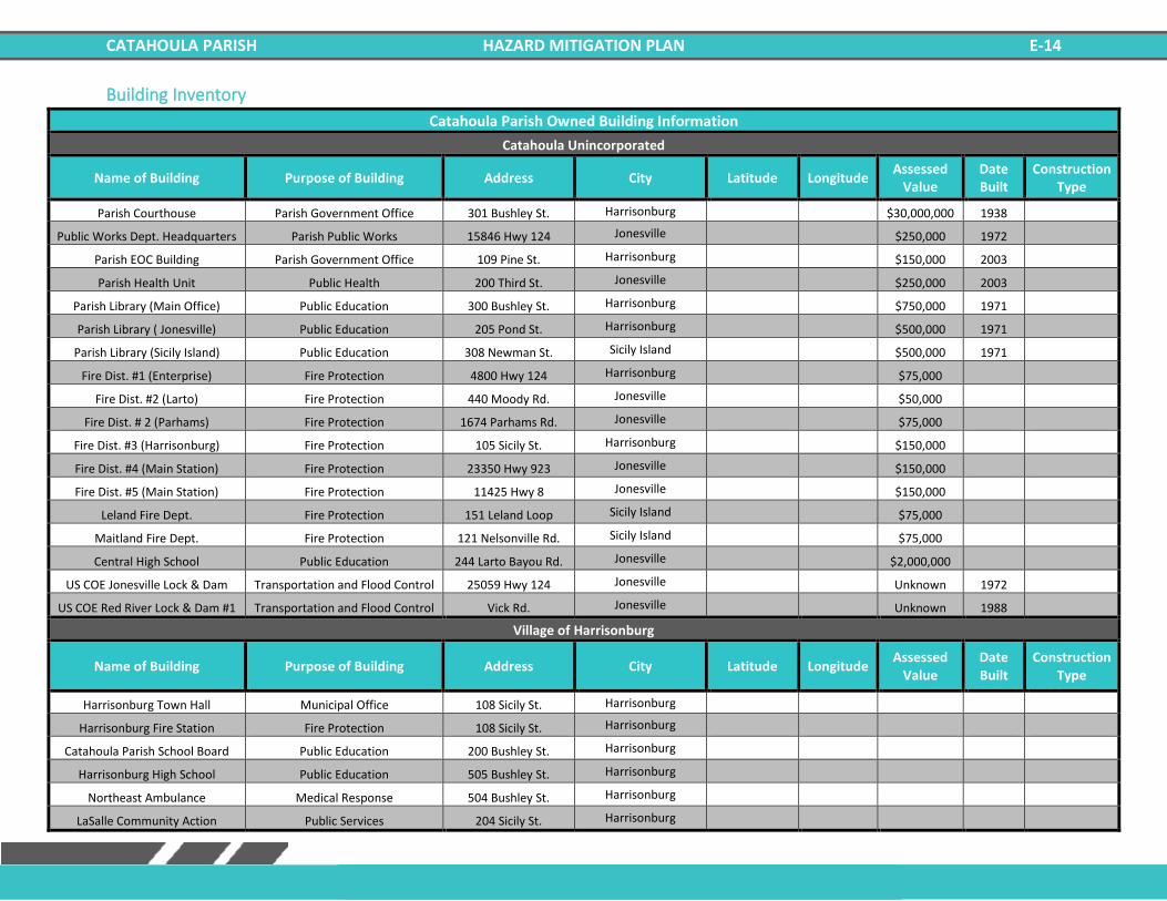
CATAHOULA PARISH HAZARD MITIGATION PLAN E-14
Building Inventory
Catahoula Parish Owned Building Information
Catahoula Unincorporated
Name of Building Purpose of Building Address City Latitude Longitude Assessed
Value Date Built
Construction Type
Parish Courthouse Parish Government Office 301 Bushley St. Harrisonburg $30,000,000 1938
Public Works Dept. Headquarters Parish Public Works 15846 Hwy 124 Jonesville $250,000 1972
Parish EOC Building Parish Government Office 109 Pine St. Harrisonburg $150,000 2003
Parish Health Unit Public Health 200 Third St. Jonesville $250,000 2003
Parish Library (Main Office) Public Education 300 Bushley St. Harrisonburg $750,000 1971
Parish Library ( Jonesville) Public Education 205 Pond St. Harrisonburg $500,000 1971
Parish Library (Sicily Island) Public Education 308 Newman St. Sicily Island $500,000 1971
Fire Dist. #1 (Enterprise) Fire Protection 4800 Hwy 124 Harrisonburg $75,000
Fire Dist. #2 (Larto) Fire Protection 440 Moody Rd. Jonesville $50,000
Fire Dist. # 2 (Parhams) Fire Protection 1674 Parhams Rd. Jonesville $75,000
Fire Dist. #3 (Harrisonburg) Fire Protection 105 Sicily St. Harrisonburg $150,000
Fire Dist. #4 (Main Station) Fire Protection 23350 Hwy 923 Jonesville $150,000
Fire Dist. #5 (Main Station) Fire Protection 11425 Hwy 8 Jonesville $150,000
Leland Fire Dept. Fire Protection 151 Leland Loop Sicily Island $75,000
Maitland Fire Dept. Fire Protection 121 Nelsonville Rd. Sicily Island $75,000
Central High School Public Education 244 Larto Bayou Rd. Jonesville $2,000,000
US COE Jonesville Lock & Dam Transportation and Flood Control 25059 Hwy 124 Jonesville Unknown 1972
US COE Red River Lock & Dam #1 Transportation and Flood Control Vick Rd. Jonesville Unknown 1988
Village of Harrisonburg
Name of Building Purpose of Building Address City Latitude Longitude Assessed
Value Date Built
Construction Type
Harrisonburg Town Hall Municipal Office 108 Sicily St. Harrisonburg
Harrisonburg Fire Station Fire Protection 108 Sicily St. Harrisonburg
Catahoula Parish School Board Public Education 200 Bushley St. Harrisonburg
Harrisonburg High School Public Education 505 Bushley St. Harrisonburg
Northeast Ambulance Medical Response 504 Bushley St. Harrisonburg
LaSalle Community Action Public Services 204 Sicily St. Harrisonburg
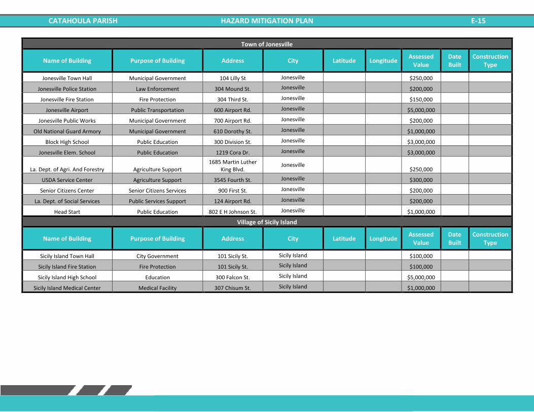
CATAHOULA PARISH HAZARD MITIGATION PLAN E-15
Town of Jonesville
Name of Building Purpose of Building Address City Latitude Longitude Assessed
Value Date Built
Construction Type
Jonesville Town Hall Municipal Government 104 Lilly St Jonesville $250,000
Jonesville Police Station Law Enforcement 304 Mound St. Jonesville $200,000
Jonesville Fire Station Fire Protection 304 Third St. Jonesville $150,000
Jonesville Airport Public Transportation 600 Airport Rd. Jonesville $5,000,000
Jonesville Public Works Municipal Government 700 Airport Rd. Jonesville $200,000
Old National Guard Armory Municipal Government 610 Dorothy St. Jonesville $1,000,000
Block High School Public Education 300 Division St. Jonesville $3,000,000
Jonesville Elem. School Public Education 1219 Cora Dr. Jonesville $3,000,000
La. Dept. of Agri. And Forestry Agriculture Support 1685 Martin Luther
King Blvd. Jonesville
$250,000
USDA Service Center Agriculture Support 3545 Fourth St. Jonesville $300,000
Senior Citizens Center Senior Citizens Services 900 First St. Jonesville $200,000
La. Dept. of Social Services Public Services Support 124 Airport Rd. Jonesville $200,000
Head Start Public Education 802 E H Johnson St. Jonesville $1,000,000
Village of Sicily Island
Name of Building Purpose of Building Address City Latitude Longitude Assessed
Value Date Built
Construction Type
Sicily Island Town Hall City Government 101 Sicily St. Sicily Island $100,000
Sicily Island Fire Station Fire Protection 101 Sicily St. Sicily Island $100,000
Sicily Island High School Education 300 Falcon St. Sicily Island $5,000,000
Sicily Island Medical Center Medical Facility 307 Chisum St. Sicily Island $1,000,000
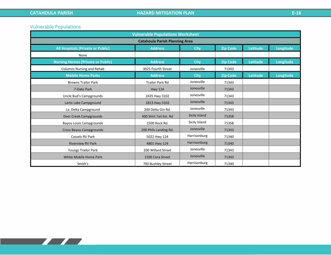
CATAHOULA PARISH HAZARD MITIGATION PLAN E-16
Vulnerable Populations
Vulnerable Populations Worksheet
Catahoula Parish Planning Area
All Hospitals (Private or Public) Address City Zip Code Latitude Longitude
None
Nursing Homes (Private or Public) Address City Zip Code Latitude Longitude
Columns Nursing and Rehab 3025 Fourth Street Jonesville 71343
Mobile Home Parks Address City Zip Code Latitude Longitude
Browns Trailor Park Trailor Park Rd Jonesville 71343
7-Oaks Park Hwy 124 Jonesville 71343
Uncle Bud's Campgrounds 2435 Hwy 3102 Jonesville 71343
Larto Lake Campground 1813 Hwy 3102 Jonesville 71343
La. Delta Campground 200 Delta Gin Rd. Jonesville 71343
Deer Creek Campgrounds 400 Shirt Tail Est. Rd Sicily Island 71358
Bayou Louis Campgrounds 1500 Rock Rd. Sicily Island 71358
Cross Bayou Campgrounds 200 Phils Landing Rd. Jonesville 71343
Cassels RV Park 5022 Hwy 124 Harrisonburg 71340
Riverview RV Park 4801 Hwy 124 Harrisonburg 71340
Youngs Trailor Park 200 Willard Street Jonesville 71343
White Mobile Home Park 1500 Cora Street Jonesville 71343
Smith's 700 Bushley Street Harrisonburg 71340
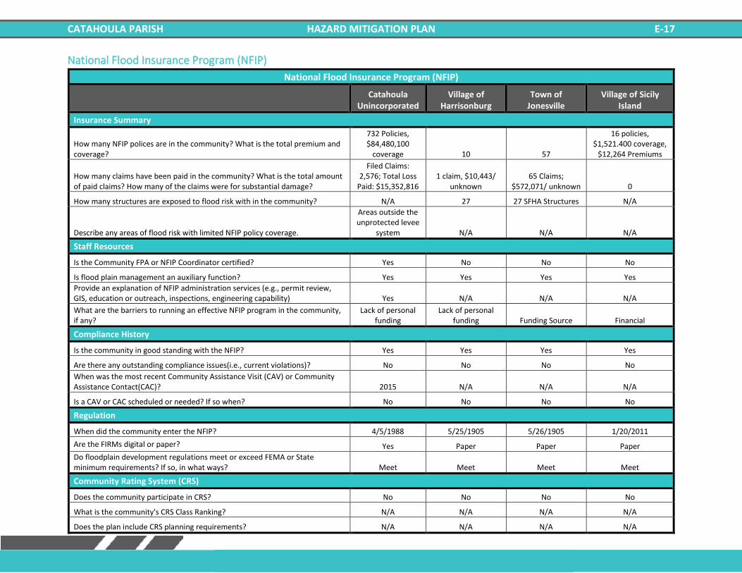
CATAHOULA PARISH HAZARD MITIGATION PLAN E-17
National Flood Insurance Program (NFIP)
National Flood Insurance Program (NFIP)
Catahoula
Unincorporated Village of
Harrisonburg Town of
Jonesville Village of Sicily
Island
Insurance Summary
How many NFIP polices are in the community? What is the total premium and coverage?
732 Policies, $84,480,100
coverage 10 57
16 policies, $1,521.400 coverage,
$12,264 Premiums
How many claims have been paid in the community? What is the total amount of paid claims? How many of the claims were for substantial damage?
Filed Claims: 2,576; Total Loss
Paid: $15,352,816 1 claim, $10,443/
unknown 65 Claims;
$572,071/ unknown 0
How many structures are exposed to flood risk with in the community? N/A 27 27 SFHA Structures N/A
Describe any areas of flood risk with limited NFIP policy coverage.
Areas outside the unprotected levee
system N/A N/A N/A
Staff Resources
Is the Community FPA or NFIP Coordinator certified? Yes No No No
Is flood plain management an auxiliary function? Yes Yes Yes Yes
Provide an explanation of NFIP administration services (e.g., permit review, GIS, education or outreach, inspections, engineering capability) Yes N/A N/A N/A
What are the barriers to running an effective NFIP program in the community, if any?
Lack of personal funding
Lack of personal funding Funding Source Financial
Compliance History
Is the community in good standing with the NFIP? Yes Yes Yes Yes
Are there any outstanding compliance issues(i.e., current violations)? No No No No
When was the most recent Community Assistance Visit (CAV) or Community Assistance Contact(CAC)? 2015 N/A N/A N/A
Is a CAV or CAC scheduled or needed? If so when? No No No No
Regulation
When did the community enter the NFIP? 4/5/1988 5/25/1905 5/26/1905 1/20/2011
Are the FIRMs digital or paper? Yes Paper Paper Paper
Do floodplain development regulations meet or exceed FEMA or State minimum requirements? If so, in what ways? Meet Meet Meet Meet
Community Rating System (CRS)
Does the community participate in CRS? No No No No
What is the community's CRS Class Ranking? N/A N/A N/A N/A
Does the plan include CRS planning requirements? N/A N/A N/A N/A

CATAHOULA PARISH HAZARD MITIGATION PLAN E-18
Related Documents