Oil Shale, 2008, Vol. 25, No. 2 Special, pp. 135–144 ISSN 0208-189X doi: 10.3176/oil.2008.2S.05 © 2008 Estonian Academy Publishers APPLICATION OF MODELLING TOOLS IN ESTONIAN OIL SHALE MINING AREA V. KARU * , A. VÄSTRIK, I. VALGMA Department of Mining, Tallinn University of Technology 5 Ehitajate Rd., 19086 Tallinn, Estonia The research needed for sustainable mining should be performed in nature, but large-scale tests are complicated. These studies are performed by computer modelling. The main task for modelling is to find suitable criteria and demonstration ways. Modelling is a relatively new approach for planning new mines and analysing abandoned ones. Modelling itself is a convenient way for choosing, selecting and visualising the results, but deciding about optimal modelling methods and software is a complicated task. There are three main tasks of modelling to solve: mining technology, planning and development of mining and impact of mining. Introduction There are problems in composing development plans for industrial extraction of minerals (oil shale and building minerals, limestone, sand, gravel, clay, peat) at the level of both local authorities and country. There is no suitable methodology convenient for all parties as for criteria and skills for using natural resources – minerals, water, ground and forest. The reserves of mineral resources have been analysed and calculated by Mining Department of Tallinn University of Technology [1]. Although we have worked out the best available technologies (BAT) and established proper mining conditions, limitations, infrastructure and economic background, the solutions which could satisfy all parties have still not been found. Economy needs mineral resources and groundwater. Mining of mineral resources affects the environment, earth crust and landscape. The ownership of properties and claims can be changed during this process. All this will raise opposition of the society. The changed earth crust and landscape could be even more valuable than the original one. It has been proved that the skilled operations may improve * Corresponding author: e-mail [email protected]

Welcome message from author
This document is posted to help you gain knowledge. Please leave a comment to let me know what you think about it! Share it to your friends and learn new things together.
Transcript
Oil Shale, 2008, Vol. 25, No. 2 Special, pp. 135–144 ISSN 0208-189X doi: 10.3176/oil.2008.2S.05 © 2008 Estonian Academy Publishers
APPLICATION OF MODELLING TOOLS IN ESTONIAN OIL SHALE MINING AREA
V. KARU*, A. VÄSTRIK, I. VALGMA Department of Mining, Tallinn University of Technology 5 Ehitajate Rd., 19086 Tallinn, Estonia
The research needed for sustainable mining should be performed in nature, but large-scale tests are complicated. These studies are performed by computer modelling. The main task for modelling is to find suitable criteria and demonstration ways. Modelling is a relatively new approach for planning new mines and analysing abandoned ones. Modelling itself is a convenient way for choosing, selecting and visualising the results, but deciding about optimal modelling methods and software is a complicated task. There are three main tasks of modelling to solve: mining technology, planning and development of mining and impact of mining.
Introduction
There are problems in composing development plans for industrial extraction of minerals (oil shale and building minerals, limestone, sand, gravel, clay, peat) at the level of both local authorities and country. There is no suitable methodology convenient for all parties as for criteria and skills for using natural resources – minerals, water, ground and forest.
The reserves of mineral resources have been analysed and calculated by Mining Department of Tallinn University of Technology [1]. Although we have worked out the best available technologies (BAT) and established proper mining conditions, limitations, infrastructure and economic background, the solutions which could satisfy all parties have still not been found.
Economy needs mineral resources and groundwater. Mining of mineral resources affects the environment, earth crust and landscape. The ownership of properties and claims can be changed during this process. All this will raise opposition of the society.
The changed earth crust and landscape could be even more valuable than the original one. It has been proved that the skilled operations may improve
* Corresponding author: e-mail [email protected]
V. Karu, A. Västrik, I. Valgma 136
the state of the forest, water body and agricultural land in the mined area. Such an approach forms the basis for sustainable, environmentally friendly mining. The research needed for sustainable mining should be performed in nature, but performing large-scale tests is complicated. It is the world standard that these studies are performed by computer modelling. The main task at modelling is to find suitable criteria and demonstration ways.
Planning offices use different software for that purpose, but the following remarks have to be taken into account:
• the databases from different periods and of different structure are difficult to operate;
• the software to model ore and coal mining is complicated and expensive for flat-laying deposits like in Estonia;
• most of mining software programs are not suitable for solving environmental problems like those in Estonian deposits;
• software concerning mining problems in conservative industry is being developed everywhere. Estonian experience (shallow bedding, abundance of water, environmentally sensitive conditions) based on industrial tests and corresponding software applications will help to develop these systems for other regions.
Methods
There are several mining software programs. They are either freeware (different viewers), independent (GEMCOM Surpac and Minex, MapInfo, AutoCAD, ESRI, etc.) or additional (Discover, Map X, etc.) programs. Besides, it is possible to use online software programs (EduMine etc.). There are problems with the compatibility of the projects, because there are so many different software programs, and institutions use different software systems. Development of co-operation brings about difficulties in connection and transition of data. A problem like this poses an economical problem – the designers have to have as much different software as possible for the co-operation to work [2].
A method and a computer program have been developed to assess the underground-mined area of the oil shale deposit and to describe the range of the impact influence of mining operations. The program enables to evaluate the condition of the ground and, considering possible risks, to plan the usage of the ground and corresponding constructional actions. Using the geological dataset, the plan of mining operations and subsidences which are affected by mine work, it is possible to calculate the types of mine impact: formation of quasistable land, subsided land [3]. Binding the datasets enables to get a more detailed information than ever before about a certain territory.
A more environmentally friendly excavation is possible by using a continuous miner. There is no need for drilling and blasting operations,
Application of Modelling Tools in Estonian Oil Shale Mining Area
137
which cause a lot of vibrations in the ground and emission of dust. Excavat-ing with a continuous miner produces less dust and vibrations.
Optimal mining software package for oil shale
The staff of the laboratory of mining design and planning applies mining software systems, tests and develops them in both research and teaching processes. The laboratory possesses software, databases, methods, hardware with necessary equipment (scanners, printers, plotters, savers, presenters, servers) all listed in Website http://mi.ttu.ee/mgislabor.
The following software used worldwide to model mining operations has been set up in the laboratory:
1. Gemcom Minex – modelling of stratified deposits; 2. Gemcom Surpac – modelling of mining processing and workings; 3. Visual ModFlow; AquaChem – modelling of groundwater flow and
quality; 4. MapInfo Professional, Discovery, MapBasic – GIS; 5. Vertical Mapper – spatial modelling; 6. Encom Discover – spatial modelling for mining environment; 7. AutoCAD Civil 3D – planning; 8. FLAC – rock massive modelling; 9. PLAXIS – geotechnical spatial modelling;
10. Specific mining software (parameters of pillars, productivity, mining equipment cooperation and fleet calculations, Caterpillar and Mining Department of TUT).
Purpose
The main purpose of the research is elaboration of a productive system of digital modelling of mining problems and development plans related to minerals' industry, to analyse usage of BAT and criteria for selecting, plan-ning and design of technological planning.
The research had to prove, by application of digital maps, the possibilities of using BAT at mining of Estonian and other similar resources to decrease the impact of mining on the environment and therefore also the opposition of the society to the use of minerals for Estonian economy.
Particular attention was paid to selection of criteria and basis for BAT, aiming at a decrease in losses of minerals and the impact on the environment in the case of underground oil shale mining. The future purpose is to restrict mining regions by finding out the optimum criteria for resource usage and evaluation of mining impact. The general purpose of the research is optimisation of the usage of mineral resources in Estonia, sustainable development of mining, land usage, resource and subsurface usage.
V. Karu, A. Västrik, I. Valgma 138
Hypothesis
Environmental restrictions can be taken into account in digital mining modelling. The general mining modelling software can be improved with options for shallow flat-laying deposits. The created methodology can be used elsewhere where mining conditions are similar, and it offers the possibility to extract minerals in populated areas using a suitable technology with adequate cost.
The expected results of digital planning performed in the study are: effective usage of information, increase in database functionality, new out-comes (designs, theme maps, queries, restrictions), long-term scenarios of oil shale and limestone mining, technological solutions of mining with respect to environmental and social needs. Elaboration of the method of creating sustainable mining conditions and environment is a basic research with practical application for sustainable mining.
The currently existing mining modelling software is not applied in Estonia. Our experience enables to develop and implement it. Mining Department of TUT owns a good but not absolute database for Estonian mining technology and geotechnics [4, 5]. The research creates a new level for solving environmental problems in shallow, flat-laying mineral deposits. Evaluation of mineral resources will be performed in a multifaceted technical-ecological way.
Case 1. Modelling of distribution of mining technology
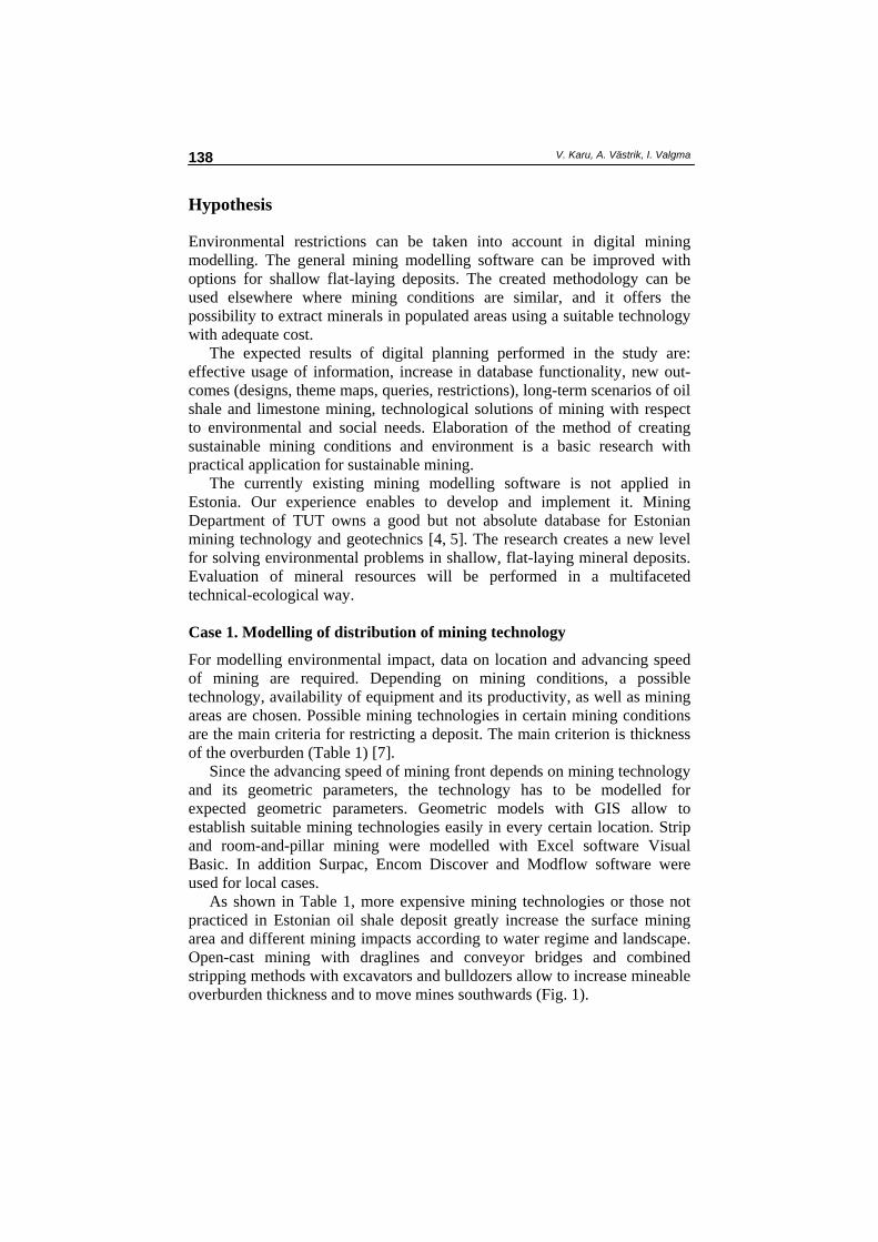
For modelling environmental impact, data on location and advancing speed of mining are required. Depending on mining conditions, a possible technology, availability of equipment and its productivity, as well as mining areas are chosen. Possible mining technologies in certain mining conditions are the main criteria for restricting a deposit. The main criterion is thickness of the overburden (Table 1) [7].
Since the advancing speed of mining front depends on mining technology and its geometric parameters, the technology has to be modelled for expected geometric parameters. Geometric models with GIS allow to establish suitable mining technologies easily in every certain location. Strip and room-and-pillar mining were modelled with Excel software Visual Basic. In addition Surpac, Encom Discover and Modflow software were used for local cases.
As shown in Table 1, more expensive mining technologies or those not practiced in Estonian oil shale deposit greatly increase the surface mining area and different mining impacts according to water regime and landscape. Open-cast mining with draglines and conveyor bridges and combined stripping methods with excavators and bulldozers allow to increase mineable overburden thickness and to move mines southwards (Fig. 1).
Application of Modelling Tools in Estonian Oil Shale Mining Area
139
Table 1. Criteria for mining technology. Respective areas are shown in Fig. 1
No. Technology Hmin, m Hmax, m
1 Traditional surface mining 0 30 2 Opencast mining with draglines 10 27 3 Opencast mining with draglines with re-excavating 23 27 4 Opencast mining with draglines with re-excavating and/or
bulldozing 25 33
5 Opencast mining with draglines with re-excavating and/or bulldozing plus excavator-truck stripping
25 35
6 Opencast mining with draglines and conveyor bridges or longwall mining with shearers
30 60
7 Excavator-truck stripping 0 30
Fig. 1. Possible technologies in mining fields depending on the given criteria. Raster
shows technologies according to Table 1.
Case 2. Spatial modelling
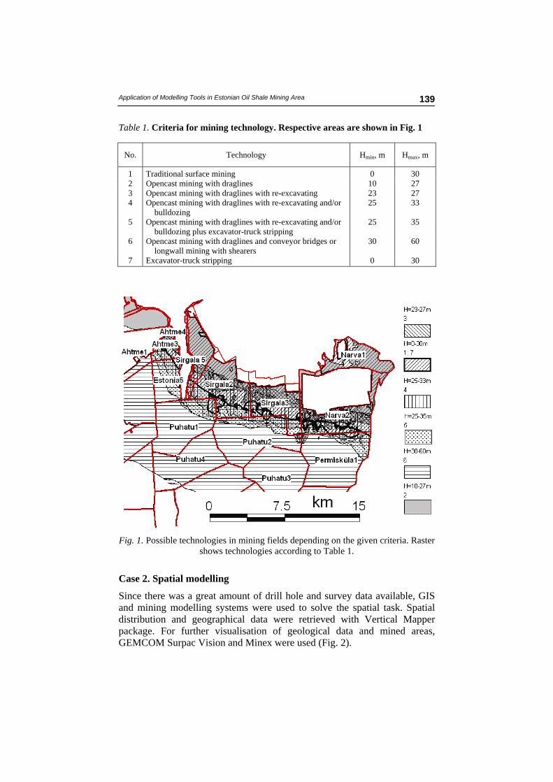
Since there was a great amount of drill hole and survey data available, GIS and mining modelling systems were used to solve the spatial task. Spatial distribution and geographical data were retrieved with Vertical Mapper package. For further visualisation of geological data and mined areas, GEMCOM Surpac Vision and Minex were used (Fig. 2).
V. Karu, A. Västrik, I. Valgma 140
Fig. 2. Modelling software allows to model stripping productivity and sequences.
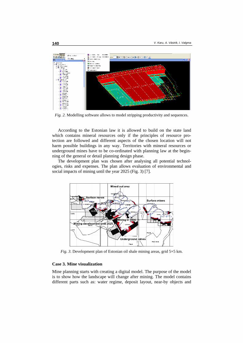
According to the Estonian law it is allowed to build on the state land which contains mineral resources only if the principles of resource pro-tection are followed and different aspects of the chosen location will not harm possible buildings in any way. Territories with mineral resources or underground mines have to be co-ordinated with planning law at the begin-ning of the general or detail planning design phase.
The development plan was chosen after analysing all potential technol-ogies, risks and expenses. The plan allows evaluation of environmental and social impacts of mining until the year 2025 (Fig. 3) [7].
Fig. 3. Development plan of Estonian oil shale mining areas, grid 5×5 km.
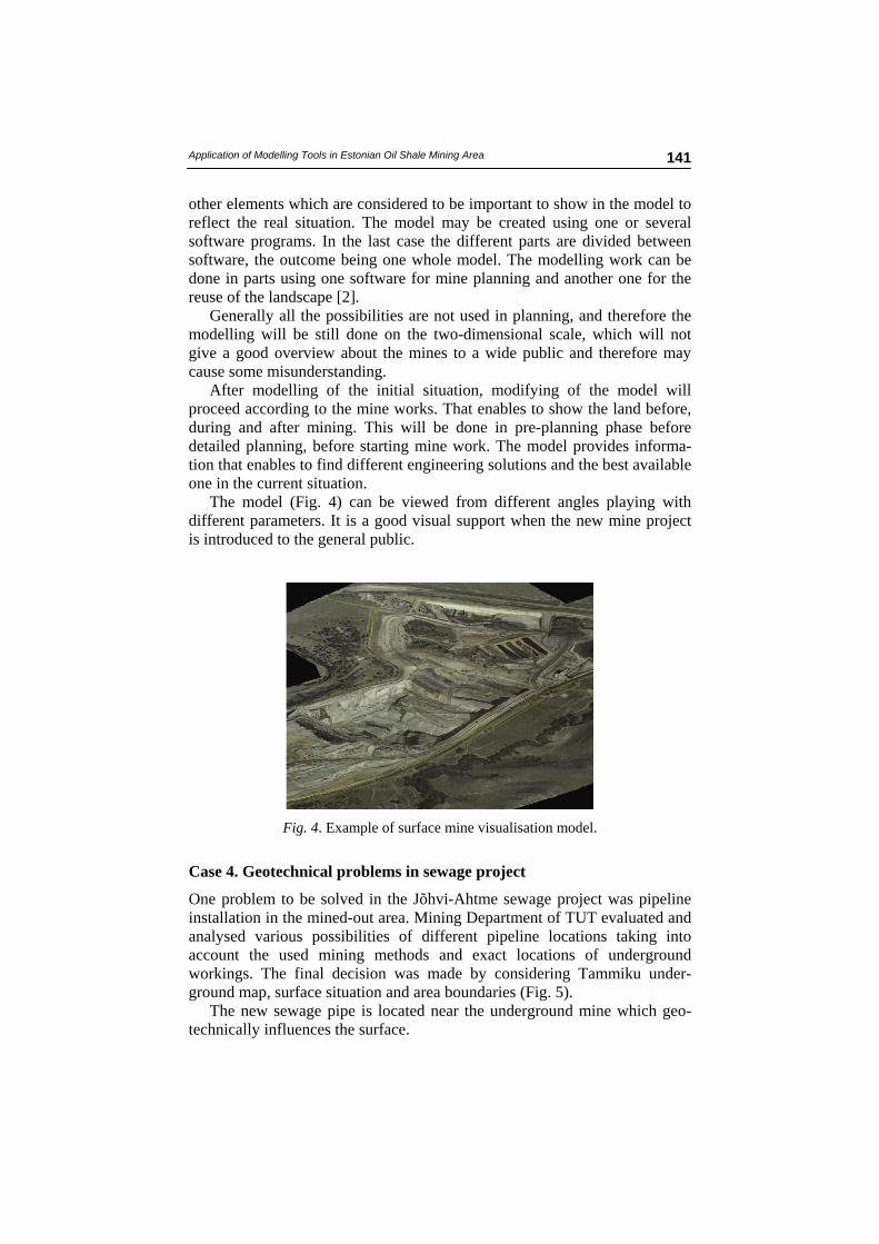
Case 3. Mine visualization
Mine planning starts with creating a digital model. The purpose of the model is to show how the landscape will change after mining. The model contains different parts such as: water regime, deposit layout, near-by objects and
Application of Modelling Tools in Estonian Oil Shale Mining Area
141
other elements which are considered to be important to show in the model to reflect the real situation. The model may be created using one or several software programs. In the last case the different parts are divided between software, the outcome being one whole model. The modelling work can be done in parts using one software for mine planning and another one for the reuse of the landscape [2].
Generally all the possibilities are not used in planning, and therefore the modelling will be still done on the two-dimensional scale, which will not give a good overview about the mines to a wide public and therefore may cause some misunderstanding.
After modelling of the initial situation, modifying of the model will proceed according to the mine works. That enables to show the land before, during and after mining. This will be done in pre-planning phase before detailed planning, before starting mine work. The model provides informa-tion that enables to find different engineering solutions and the best available one in the current situation.
The model (Fig. 4) can be viewed from different angles playing with different parameters. It is a good visual support when the new mine project is introduced to the general public.
Fig. 4. Example of surface mine visualisation model.
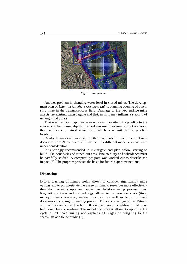
Case 4. Geotechnical problems in sewage project
One problem to be solved in the Jõhvi-Ahtme sewage project was pipeline installation in the mined-out area. Mining Department of TUT evaluated and analysed various possibilities of different pipeline locations taking into account the used mining methods and exact locations of underground workings. The final decision was made by considering Tammiku under-ground map, surface situation and area boundaries (Fig. 5).
The new sewage pipe is located near the underground mine which geo-technically influences the surface.
V. Karu, A. Västrik, I. Valgma 142
Fig. 5. Sewage area.
Another problem is changing water level in closed mines. The develop-
ment plan of Estonian Oil Shale Company Ltd. is planning opening of a new strip mine in the Tammiku-Kose field. Drainage of the new surface mine affects the existing water regime and that, in turn, may influence stability of underground pillars.
That was the most important reason to avoid location of a pipeline in the area where the room-and-pillar method was used. Because of the karst zone, there are some unmined areas there which were suitable for pipeline location.
Relatively important was the fact that overburden in the mined-out area decreases from 20 meters to 7–10 meters. Six different model versions were under consideration.
It is strongly recommended to investigate and plan before starting to build. The boundaries of mined-out area, land stability and subsidence must be carefully studied. A computer program was worked out to describe the impact [6]. The program presents the basis for future expert estimations.
Discussion
Digital planning of mining fields allows to consider significantly more options and to prognosticate the usage of mineral resources more effectively than the current simple and subjective decision-making process does. Regulating criteria and methodology allows to decrease the costs (time, money, human resource, mineral resource) as well as helps to make decisions concerning the mining process. The experience gained in Estonia will give examples and offer a theoretical basis for utilisation of non-traditional fuels elsewhere. The modelling process allows to optimize the cycle of oil shale mining and explains all stages of designing to the specialists and to the public [2].
Application of Modelling Tools in Estonian Oil Shale Mining Area
143
Designing the developmental plans for excavating mineral resources (oil shale and mineral resources) has brought up problems at the level of state and local governments. For example, at planning the usage of natural resources – mineral resources, water, land and forest – there are no methods, criteria, equipment or skills that satisfy all the parties.
In addition to the problems of development plans of excavating mineral resources, it gets more and more difficult to find construction fields on the underground-mined area of the Estonian oil shale deposit.
There is enough research on the geotechnical side of the problem, published in [3]. The developed method and a computer program describe the range of influence of the underground-mined area and help to find suit-able construction fields on the mined area [6].
To achieve better planning results that would meet the needs of all the parties, it is reasonable to use special geological mining software, because the experience shows that the use of traditional theories and methods will not give detailed results. It is economically more useful to forecast dangerous situations through models than to deal with the consequences later on. Realization of the plans for mined areas with the help of mining software helps to evaluate dangerous situations during engineering already and to eliminate the faults. In addition, it is possible to get information about environmental impact and to make adequate political and strategical decisions.
Conclusions
The results of the research are important for institutions who are working with earth crust. The research raises mining science onto a higher level – digital planning of stratified deposits, based on the long-term Estonian experience, tests and digital planning.
The results will be used for composing country’s development plans, in mining planning and in teaching and scientific work.
The work offers better understanding and arguments for public discussion and for mining industry to develop Estonian economy.
During the recent years the research on sustainable mining and creating corresponding indicators has become an urgent issue. Networks such as MMSD (Mining Minerals and Sustainable Development) and SDIMI (Sustainable Development Indicators for the Minerals Industry) stress the importance of working out conceptions based on local professional research. At the same time development of modelling systems for mining and the environment has only begun. The present research enables Estonia to be in the forefront as for modelling and utilising non-traditional fuels.
Department of Mining of TUT has started development research whose various aspects can offer solutions for projects in teaching, science and development. Mining software is applicable in both student exercises for
V. Karu, A. Västrik, I. Valgma 144
solving different problems and complex use of software – as inputs and out-puts for different software types.
Assuming that development research will be useful first of all to the Estonian mining industry and mine companies, it is possible to give recom-mendations for all Estonian mine planning companies to use one certain software solution and direction and to create criteria necessary for mine studies and for deposit research.
Acknowledgements
This study is a part of Estonian Science Foundation Grant No. 7499 Con-ditions of sustainable mining, and a part of the project No SF0140093s08 of the Estonian Ministry of Education and Research. REFERENCES
1. Basic studies of Estonian oil shale resource estimation up to the year 2020 [in Estonian]: http://www.mkm.ee/doc.php?10366 [11.09.2007]
2. http://www.mkm.ee/doc.php?11050 [11.09.2007] http://www.mkm.ee/doc.php?11051 [11.09.2007] http://www.mkm.ee/doc.php?11052 [11.09.2007].
3. Karu, V. Digital planning for surface and underground mines in Estonia // Talveakadeemia 2007 kogumik: Talveakadeemia 2007, Roosta puhkeküla, Estonia, 23.–25.02.2007. Talveakadeemia, 2007. P. 22–29. [in Estonian].
4. Reinsalu, E., Valgma, I. Geotechnical processes in closed oil shale mines // Oil Shale. 2003. Vol. 20, No. 3. P. 398–403.
5. Valgma, I. Estonian oil shale resources calculated by GIS method // Oil Shale. 2003. Vol. 20, No. 3. P. 404–411.
6. Västrik, A. Estonian Mining Database. – Bachelor thesis. Tallinn University of Technology, 2005.
7. Karu, V. Stability calculations for underground mined areas // Keskkonna-tehnika. 2005. No. 4. P. 34–35 [in Estonian].
8. Valgma, I., Västrik, A., Lind, H. The Modelling of Oil Shale Mining Develop-ment and its Influence to the Environment // EU legislation as it affects mining. Proceedings of TAIEX Workshop in Tallinn: INFRA 22944 TAIEX Workshop, Tallinn, 30.11. – 02.12.2006 / I. Valgma, Chr. Buhrow (eds.). Tallinn: Tallinna Tehnikaülikool, 2006. P. 126–130.
Received September 20, 2007
Related Documents