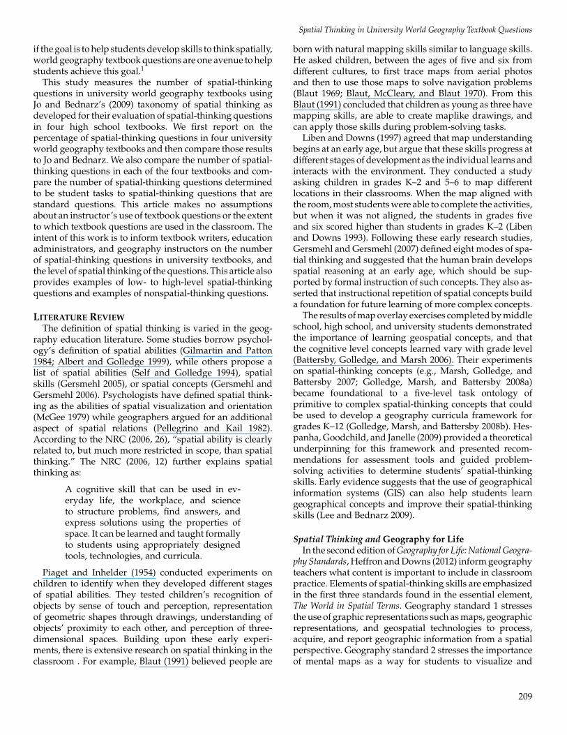
An Evaluation of University World Geography Textbook Questions for Components of Spatial Thinking Michael A. Scholz, Niem Tu Huynh, Carmen P. Brysch, and Ruojing Wang Scholz ABSTRACT Geography textbooks contain chapter or review questions that may engage students in spatial thinking. This research used Jo and Bednarz’s (2009) Taxonomy of Spatial Thinking to evaluate the percentage of spatial thinking questions in four university-level world geography course textbooks. The results from this study were then compared to the findings in Jo and Bednarz’s (2009) analysis of high school geography textbooks. Thirty-five percent of university level textbook questions are related to spatial thinking compared to twenty-four percent in high school geography textbooks. The results provide information useful to stakeholders, such as teachers, administrators, and textbook writers and may help these stakeholders to consciously incorporate the three components of spatial thinking as defined by the National Research Council (2006). A simplified taxonomy for identifying spatial- thinking concepts in textbook review questions is also suggested. Key Words: spatial thinking, geography textbooks, concepts of space, tools of representation, processes of reasoning Michael A. Scholz is a visiting instructor of geog- raphy at Winona State University, Winona, Min- nesota, USA. He teaches multiple sections of world and cultural geography courses. Michael’s research interests are the AP Human Geography course, spatial thinking, curriculum and instruction, and international education. Niem Tu Huynh is a senior researcher at the Association of American Geographers, Washington, D.C., USA. She was the research coordinator on The Road Map for 21st Century Geography Edu- cation Research Committee report. She is currently involved with learning progressions research that brings together geography, math, and science edu- cators. She also supports evaluation for MyCOE, SERVIR, and GCE projects, manages the Visiting Geographic Scientist Program, and supports the World Geography Bowl organization. Carmen P. Brysch is a geography education doctoral candidate in the Department of Geography at Texas State University, San Marcos, Texas, USA. She is currently serving a one-year appointment as the Grosvenor Scholar at National Geographic Soci- ety’s Education Program. Her dissertation research focuses on the efficacy of the online professional development system, Geography: Teaching with the Stars (www.geoteach.org). Ruojing Wang Scholz is a Ph.D. student in the geography department at Texas State University, San Marcos, Texas, USA. Her research interests are in space-time modeling, GPS data analysis for human mobility, GIS for urban analysis, and GIS for geography education. INTRODUCTION Spatial thinking is an essential problem-solving skill (Golledge, Marsh, and Battersby 2008a) and includes three components: concepts of space, tools of representation, and processes of reasoning (National Research Council [NRC] 2006). Concepts of space concern how spatial properties (e.g., distance between objects, distribution of objects, and exact location of objects) provide a basis to frame and answer questions. Tools of representation (e.g., map, graph, GIS, or other graphic) enhance the visualization of relationships between spatial objects. The processes of reasoning encompass different ways to think about a spatial scenario, or the ability to project future spatial relationships (NRC 2006). Spatial thinking, reading, and mathematics are among the most important thinking skills in human intelligence (Gardener 1999; Brody 2000; NRC 2006; Hunt 2011). Some studies suggest that spatial tasks improve students’ overall intelligence, and improvements in spatial thinking can be accomplished through explicit instruction (Niesser 1997; Newcombe 2010; Uttal et al. 2013). We use spatial thinking every day to get to school or work, organize objects in our home or office, or to visually solve problems (Mathewson 1999; Newcombe 2010). Spatial thinking includes everyday activities (e.g., navigation, assembling equipment) and extends to scientific discoveries (e.g., visualizing of seafloor geology, predicting spatial-temporal spread of a disease). According to the National Research Council (NRC 2006, 27), “spatial thinking uses representations to help us remember, understand, reason, and communicate about the properties of and relations between objects in space, whether or not those objects themselves are inherently spatial.” Spatial-thinking skills are identified as essential in geography education (Heffron and Downs 2012) precisely because the study of place makes geography distinct from other disciplines. Further, the organization of place is conceptualized and stored in different parts of the brain (Golledge, Dougherty, and Bell 1995; Gersmehl and Gersmehl 2007). Spatial-thinking skills are necessary for students to understand the spatial aspects of energy production and dependence, globalization, cultural diversity, business location, transportation, homeland security, climate change, natural and technological hazards, and the many uses for geo-technology (global position systems, geographic information systems, and remote sensing) (Why Geography Is Important 2012). As the ever changing global economy demands the spatial-thinking skills that geography instruction can provide, the teaching of geography should reach beyond reciting place names and rote memorization (NRC 2006; Golledge, Marsh, and Battersby 2008a, 2008b). World geography courses offer an important opportunity to introduce spatial- thinking concepts to students. Generally, the course is the only geography course required in the general course curriculum for university students. Further, the course is often the first geography course that geography majors complete and is the only geography course that many social studies teachers take in preparation to teach geography (Boehm, Brierley, and Sharma 1994; Bednarz, Stoltman, and Lee 2004). While the geography education literature reports on emerging findings about how students think spatially in the classroom, little research exists that examines spatial-thinking components in textbooks (Jo and Bednarz 2009). The instructional value of textbook questions can assist students in gaining a comprehensive understanding of subject matter (Peverly and Wood 2001) and can encourage students’ critical thinking (Wilen 2001; Myers and Savage 2005; Vogler 2005). Thus, Journal of Geography 113: 208–219 C 2014 National Council for Geographic Education

Welcome message from author
This document is posted to help you gain knowledge. Please leave a comment to let me know what you think about it! Share it to your friends and learn new things together.
Transcript
An Evaluation of University World Geography Textbook Questions forComponents of Spatial Thinking
Michael A. Scholz, Niem Tu Huynh, Carmen P. Brysch, and Ruojing Wang Scholz
ABSTRACTGeography textbooks contain chapter or reviewquestions that may engage students in spatialthinking. This research used Jo and Bednarz’s(2009) Taxonomy of Spatial Thinking to evaluatethe percentage of spatial thinking questions infour university-level world geography coursetextbooks. The results from this study werethen compared to the findings in Jo andBednarz’s (2009) analysis of high schoolgeography textbooks. Thirty-five percent ofuniversity level textbook questions are relatedto spatial thinking compared to twenty-fourpercent in high school geography textbooks.The results provide information useful tostakeholders, such as teachers, administrators,and textbook writers and may help thesestakeholders to consciously incorporate thethree components of spatial thinking as definedby the National Research Council (2006). Asimplified taxonomy for identifying spatial-thinking concepts in textbook review questionsis also suggested.
Key Words: spatial thinking, geographytextbooks, concepts of space, tools ofrepresentation, processes of reasoning
Michael A. Scholz is a visiting instructor of geog-raphy at Winona State University, Winona, Min-nesota, USA. He teaches multiple sections of worldand cultural geography courses. Michael’s researchinterests are the AP Human Geography course,spatial thinking, curriculum and instruction, andinternational education.
Niem Tu Huynh is a senior researcher at theAssociation of American Geographers, Washington,D.C., USA. She was the research coordinator onThe Road Map for 21st Century Geography Edu-cation Research Committee report. She is currentlyinvolved with learning progressions research thatbrings together geography, math, and science edu-cators. She also supports evaluation for MyCOE,SERVIR, and GCE projects, manages the VisitingGeographic Scientist Program, and supports theWorld Geography Bowl organization.
Carmen P. Brysch is a geography education doctoralcandidate in the Department of Geography at TexasState University, San Marcos, Texas, USA. She iscurrently serving a one-year appointment as theGrosvenor Scholar at National Geographic Soci-ety’s Education Program. Her dissertation researchfocuses on the efficacy of the online professionaldevelopment system, Geography: Teaching with theStars (www.geoteach.org).
Ruojing Wang Scholz is a Ph.D. student in thegeography department at Texas State University,San Marcos, Texas, USA. Her research interestsare in space-time modeling, GPS data analysis forhuman mobility, GIS for urban analysis, and GISfor geography education.
INTRODUCTIONSpatial thinking is an essential problem-solving skill (Golledge, Marsh, and
Battersby 2008a) and includes three components: concepts of space, tools ofrepresentation, and processes of reasoning (National Research Council [NRC] 2006).Concepts of space concern how spatial properties (e.g., distance between objects,distribution of objects, and exact location of objects) provide a basis to frame andanswer questions. Tools of representation (e.g., map, graph, GIS, or other graphic)enhance the visualization of relationships between spatial objects. The processes ofreasoning encompass different ways to think about a spatial scenario, or the abilityto project future spatial relationships (NRC 2006). Spatial thinking, reading, andmathematics are among the most important thinking skills in human intelligence(Gardener 1999; Brody 2000; NRC 2006; Hunt 2011). Some studies suggestthat spatial tasks improve students’ overall intelligence, and improvements inspatial thinking can be accomplished through explicit instruction (Niesser 1997;Newcombe 2010; Uttal et al. 2013).
We use spatial thinking every day to get to school or work, organize objects inour home or office, or to visually solve problems (Mathewson 1999; Newcombe2010). Spatial thinking includes everyday activities (e.g., navigation, assemblingequipment) and extends to scientific discoveries (e.g., visualizing of seafloorgeology, predicting spatial-temporal spread of a disease). According to theNational Research Council (NRC 2006, 27), “spatial thinking uses representationsto help us remember, understand, reason, and communicate about the propertiesof and relations between objects in space, whether or not those objects themselvesare inherently spatial.”
Spatial-thinking skills are identified as essential in geography education(Heffron and Downs 2012) precisely because the study of place makes geographydistinct from other disciplines. Further, the organization of place is conceptualizedand stored in different parts of the brain (Golledge, Dougherty, and Bell1995; Gersmehl and Gersmehl 2007). Spatial-thinking skills are necessary forstudents to understand the spatial aspects of energy production and dependence,globalization, cultural diversity, business location, transportation, homelandsecurity, climate change, natural and technological hazards, and the many usesfor geo-technology (global position systems, geographic information systems,and remote sensing) (Why Geography Is Important 2012). As the ever changingglobal economy demands the spatial-thinking skills that geography instructioncan provide, the teaching of geography should reach beyond reciting place namesand rote memorization (NRC 2006; Golledge, Marsh, and Battersby 2008a, 2008b).World geography courses offer an important opportunity to introduce spatial-thinking concepts to students. Generally, the course is the only geography courserequired in the general course curriculum for university students. Further, thecourse is often the first geography course that geography majors complete and isthe only geography course that many social studies teachers take in preparationto teach geography (Boehm, Brierley, and Sharma 1994; Bednarz, Stoltman, andLee 2004).
While the geography education literature reports on emerging findings abouthow students think spatially in the classroom, little research exists that examinesspatial-thinking components in textbooks (Jo and Bednarz 2009). The instructionalvalue of textbook questions can assist students in gaining a comprehensiveunderstanding of subject matter (Peverly and Wood 2001) and can encouragestudents’ critical thinking (Wilen 2001; Myers and Savage 2005; Vogler 2005). Thus,
Journal of Geography 113: 208–219C©2014 National Council for Geographic Education
Spatial Thinking in University World Geography Textbook Questions
if the goal is to help students develop skills to think spatially,world geography textbook questions are one avenue to helpstudents achieve this goal.1
This study measures the number of spatial-thinkingquestions in university world geography textbooks usingJo and Bednarz’s (2009) taxonomy of spatial thinking asdeveloped for their evaluation of spatial-thinking questionsin four high school textbooks. We first report on thepercentage of spatial-thinking questions in four universityworld geography textbooks and then compare those resultsto Jo and Bednarz. We also compare the number of spatial-thinking questions in each of the four textbooks and com-pare the number of spatial-thinking questions determinedto be student tasks to spatial-thinking questions that arestandard questions. This article makes no assumptionsabout an instructor’s use of textbook questions or the extentto which textbook questions are used in the classroom. Theintent of this work is to inform textbook writers, educationadministrators, and geography instructors on the numberof spatial-thinking questions in university textbooks, andthe level of spatial thinking of the questions. This article alsoprovides examples of low- to high-level spatial-thinkingquestions and examples of nonspatial-thinking questions.
LITERATURE REVIEWThe definition of spatial thinking is varied in the geog-
raphy education literature. Some studies borrow psychol-ogy’s definition of spatial abilities (Gilmartin and Patton1984; Albert and Golledge 1999), while others propose alist of spatial abilities (Self and Golledge 1994), spatialskills (Gersmehl 2005), or spatial concepts (Gersmehl andGersmehl 2006). Psychologists have defined spatial think-ing as the abilities of spatial visualization and orientation(McGee 1979) while geographers argued for an additionalaspect of spatial relations (Pellegrino and Kail 1982).According to the NRC (2006, 26), “spatial ability is clearlyrelated to, but much more restricted in scope, than spatialthinking.” The NRC (2006, 12) further explains spatialthinking as:
A cognitive skill that can be used in ev-eryday life, the workplace, and scienceto structure problems, find answers, andexpress solutions using the properties ofspace. It can be learned and taught formallyto students using appropriately designedtools, technologies, and curricula.
Piaget and Inhelder (1954) conducted experiments onchildren to identify when they developed different stagesof spatial abilities. They tested children’s recognition ofobjects by sense of touch and perception, representationof geometric shapes through drawings, understanding ofobjects’ proximity to each other, and perception of three-dimensional spaces. Building upon these early experi-ments, there is extensive research on spatial thinking in theclassroom . For example, Blaut (1991) believed people are
born with natural mapping skills similar to language skills.He asked children, between the ages of five and six fromdifferent cultures, to first trace maps from aerial photosand then to use those maps to solve navigation problems(Blaut 1969; Blaut, McCleary, and Blaut 1970). From thisBlaut (1991) concluded that children as young as three havemapping skills, are able to create maplike drawings, andcan apply those skills during problem-solving tasks.
Liben and Downs (1997) agreed that map understandingbegins at an early age, but argue that these skills progress atdifferent stages of development as the individual learns andinteracts with the environment. They conducted a studyasking children in grades K–2 and 5–6 to map differentlocations in their classrooms. When the map aligned withthe room, most students were able to complete the activities,but when it was not aligned, the students in grades fiveand six scored higher than students in grades K–2 (Libenand Downs 1993). Following these early research studies,Gersmehl and Gersmehl (2007) defined eight modes of spa-tial thinking and suggested that the human brain developsspatial reasoning at an early age, which should be sup-ported by formal instruction of such concepts. They also as-serted that instructional repetition of spatial concepts builda foundation for future learning of more complex concepts.
The results of map overlay exercises completed by middleschool, high school, and university students demonstratedthe importance of learning geospatial concepts, and thatthe cognitive level concepts learned vary with grade level(Battersby, Golledge, and Marsh 2006). Their experimentson spatial-thinking concepts (e.g., Marsh, Golledge, andBattersby 2007; Golledge, Marsh, and Battersby 2008a)became foundational to a five-level task ontology ofprimitive to complex spatial-thinking concepts that couldbe used to develop a geography curricula framework forgrades K–12 (Golledge, Marsh, and Battersby 2008b). Hes-panha, Goodchild, and Janelle (2009) provided a theoreticalunderpinning for this framework and presented recom-mendations for assessment tools and guided problem-solving activities to determine students’ spatial-thinkingskills. Early evidence suggests that the use of geographicalinformation systems (GIS) can also help students learngeographical concepts and improve their spatial-thinkingskills (Lee and Bednarz 2009).
Spatial Thinking and Geography for LifeIn the second edition of Geography for Life: National Geogra-
phy Standards, Heffron and Downs (2012) inform geographyteachers what content is important to include in classroompractice. Elements of spatial-thinking skills are emphasizedin the first three standards found in the essential element,The World in Spatial Terms. Geography standard 1 stressesthe use of graphic representations such as maps, geographicrepresentations, and geospatial technologies to process,acquire, and report geographic information from a spatialperspective. Geography standard 2 stresses the importanceof mental maps as a way for students to visualize and
209
Michael A. Scholz et al.
interpret spatial phenomena in their local community andbeyond. Geography standard 3 stresses the importance ofanalyzing the spatial organization of people, places, andenvironments on the earth’s surface.
Spatial Thinking in World GeographySpatial thinking is used in disciplines other than geog-
raphy such as mathematics (Battista 1990; Delgado andPrieto 2004), physics (Lih-Juan 2000), chemistry (Barke1993), medical surgical training (Anastakis, Hamstra, andMatsumoto 2000), engineering (Hsi, Linn, and Bell 1997),and art and architecture (Humphreys, Lubinski, and Yao1993; Chan 2008). The spatial-thinking skills studentslearn in geography courses are useful in other coursesubjects and beneficial in a multitude of professions. Worldgeography is often an elective course in universities thatsatisfies degree requirements for nongeography majors(e.g., natural science credit, social studies credit). Whilethe high school educational system is generally guidedby state and national standards, university-level coursecontent is outlined in the course catalog and generallydetermined by individual instructors. New instructors ofthis course rely heavily on the textbook, and textbookshave traditionally been the primary tools used for teachinggeography (Bednarz 2004).
Textbook AnalysisGeography textbook evaluation includes content com-
parisons (Jennings 2006), comparing textbook assessments(Yang 2013), implementation of the standards in textbooks(Bednarz 2004), curricular change expressed in textbooks(Marton 2006), the ways in which regions and specificplaces are depicted (Myers 2001; Hamann 2007; Cole 2008;Bogoly-Simo 2013; Lee and Ryu 2013), changes in thesubject matter through history (Zhong and Foskett 2003),comparisons of geographical references between textbooksand newspapers (Gregg, Staintoon, and Leinhardt 1998),and the effectiveness of textbook illustrations in explaininggeographical content (Yasar and Seremet 2007). Analyzingtextbooks for spatial-thinking skills is relatively new ingeography education. The only studies prior to Jo andBednarz (2009, 2011) assess evidence of spatial thinkingthrough map reading and qualitative analysis (Martin 1996;Bednarz 2004). Thus, a gap in the literature exists on how tomeasure the extent to which spatial thinking is integratedinto textbooks.
Spatial-Thinking TaxonomiesA number of taxonomies have been developed to
measure spatial thinking. Gersmehl and Gersmehl (2006)created a spatial-thinking concept taxonomy consisting oftwelve different spatial-thinking concepts of space whileAnthamatten (2010) used ten of the twelve concepts ofspace plus location to analyze the extent of spatial-thinkingskills in Geography for Life: The National Geography Standards(Geography Education Standards Project 1994) as well as
state geography standards. Both taxonomies were focusedon concepts of space and used processes of reasoning, butdid not evaluate tools of representation. The Jo and Bednarz(2009) taxonomy of spatial thinking was used in this studybecause it includes all three components of spatial thinkingincluding tools of representation.
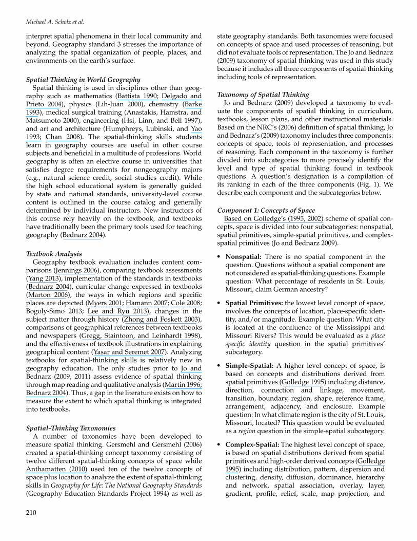
Taxonomy of Spatial ThinkingJo and Bednarz (2009) developed a taxonomy to eval-
uate the components of spatial thinking in curriculum,textbooks, lesson plans, and other instructional materials.Based on the NRC’s (2006) definition of spatial thinking, Joand Bednarz’s (2009) taxonomy includes three components:concepts of space, tools of representation, and processesof reasoning. Each component in the taxonomy is furtherdivided into subcategories to more precisely identify thelevel and type of spatial thinking found in textbookquestions. A question’s designation is a compilation ofits ranking in each of the three components (Fig. 1). Wedescribe each component and the subcategories below.
Component 1: Concepts of SpaceBased on Golledge’s (1995, 2002) scheme of spatial con-
cepts, space is divided into four subcategories: nonspatial,spatial primitives, simple-spatial primitives, and complex-spatial primitives (Jo and Bednarz 2009).
� Nonspatial: There is no spatial component in thequestion. Questions without a spatial component arenot considered as spatial-thinking questions. Examplequestion: What percentage of residents in St. Louis,Missouri, claim German ancestry?
� Spatial Primitives: the lowest level concept of space,involves the concepts of location, place-specific iden-tity, and/or magnitude. Example question: What cityis located at the confluence of the Mississippi andMissouri Rivers? This would be evaluated as a placespecific identity question in the spatial primitives’subcategory.
� Simple-Spatial: A higher level concept of space, isbased on concepts and distributions derived fromspatial primitives (Golledge 1995) including distance,direction, connection and linkage, movement,transition, boundary, region, shape, reference frame,arrangement, adjacency, and enclosure. Examplequestion: In what climate region is the city of St. Louis,Missouri, located? This question would be evaluatedas a region question in the simple-spatial subcategory.
� Complex-Spatial: The highest level concept of space,is based on spatial distributions derived from spatialprimitives and high-order derived concepts (Golledge1995) including distribution, pattern, dispersion andclustering, density, diffusion, dominance, hierarchyand network, spatial association, overlay, layer,gradient, profile, relief, scale, map projection, and
210
Spatial Thinking in University World Geography Textbook Questions
Figure 1. Jo and Bednarz taxonomy of spatial thinking. (Reproduced with permission from Taylor and Francis.)
buffer. Example question: Where would be the bestplace in St. Louis, Missouri, to locate a new out-door stadium for the St. Louis Rams consideringpopulation distribution and available land on a cityplanning map? This question uses distribution andspatial association concepts. It would be evaluated ascomplex-spatial.
Component 2: Tools of RepresentationTools of representation refer to the use of maps, graphics,
and other representations to answer a question. Thiscomponent is divided into two subcategories, use andnonuse of a representation.
� Use: If a question involves a tool of representation toanswer the question it is evaluated as a use question.Example question: Where is the suburb of Belleville,Illinois, in relation to downtown as represented on themetro area map of St. Louis, Missouri?
� Nonuse: If a question is categorized as nonuse, thenthe question is not considered a spatial-thinking ques-tion. Example question: What does the monument inSt. Louis, Missouri, The Arch, represent? This question
does not require the use of a map, graphic, or otherrepresentation to answer the question.
Component 3: Processes of ReasoningThe processes of reasoning component evaluates the
cognitive level of the question by fitting it into one of threesubcategories: input, processing, and output.
� Input: The lowest level of processes of reasoning,is the receiving of information and includes name,define, list, identify, recognize, recite, recall, observe,describe, select, complete, count, and match. Examplequestion: What are the five most densely populatedcities in the United States? This question asks studentsto name the five cities and is evaluated as an inputquestion in the taxonomy.
� Processing: A higher level of processes of reasoning,is the act of analyzing the information receivedand includes: explaining, analyzing, stating causality,comparing, contrasting, distinguishing, classifying,categorizing, organizing, summarizing, synthesizing,inferring, analogies, exemplifying, experimenting,and sequence. Example question: Is there a correlation
211
Michael A. Scholz et al.
between the five most densely populated cities and thefive cities with the highest crime rates in the UnitedStates? This question asks the student to analyze arelationship between population density and crime,so it is evaluated as processing.
� Output: The highest level of processes of reasoning,uses the analysis of information received to evaluate,judge, predict, forecast, hypothesize, speculate, plan,create, design, invent, imagine, generalize, build amodel, or apply a principle. Example question: Basedon crime data plotted on a map of Detroit, Michigan,neighborhoods for the last three months, what areasdo you predict would be most prone to crime in thenext three months? This question asks the reader topredict and is evaluated as output.
METHODS
Data CollectionThe four textbooks selected were textbook A (Global-
ization and Diversity: Geography of a Changing World, 3rded., published by Pearson Higher Education (Rowntreeet al. 2011)); textbook B (Geography: Regions, Realms, andConcepts, 14th ed., published by Wiley and Sons (de Blijand O’Mueller 2010)); textbook C (Fundamentals of WorldRegional Geography, 2nd ed., published by Cengage (Hobbs2010)); and textbook D (Contemporary World Regional Ge-ography: Global Connections, Local Voices, 3rd ed., publishedby McGraw Hill (Bradshawet al. 2009). The four textbooksselected were four of the five in most demand on thefacultycenter.net (2013) Web site in June 2013. Faculty Center,a resource used by university bookstores to locate usedbooks for upcoming semesters, rates books based on highestdemand. All four books had a very high rating compared toall other world geography textbooks with the exception ofWorld Regional Geography published by Macmillan, whichhad a comparable rating. In addition, although manyworld geography course textbooks are available to choosefrom, a handful of publishers are the market leaders interms of revenue and circulation in the university textbookmarket. The four largest publishers of textbooks at theuniversity level are Pearson Higher Education, Wiley andSons, Cengage, and McGraw Hill (K. Sanchez, personalcommunication, December 13, 2012). Four textbooks wereselected from these publishers in an attempt to selecttextbooks that are the most widely used and in demand.McGraw-Hill and Cengage only have one world geographytextbook, so those were selected. The world geographytextbooks selected from Wiley and Pearson were the two inhighest demand according to the Faculty Center Web site.
This study evaluated 720 questions from the four text-books. Of those, 128 were from textbook A, 82 from textbookB, 321 from textbook C, and 189 from textbook D. The720 questions are at the end of each chapter and sectionof the four textbooks; questions that had multiple partswere treated as individual questions. Forty-two questions
evaluated were student tasks as opposed to standardquestions; these questions did not have the syntactic formof a question. An example of a student task from textbookD is, “Suggest ways in which East Asian countries haveresponded to Western global trends.” Student tasks wereincluded in the evaluation since they were a part of thequestions and could be another option to incorporatespatial thinking. They were also separated and comparedto standard questions for spatial thinking.
Evaluation of University Textbook Questionsfor Spatial Thinking
This study used the taxonomy of spatial thinking (Jo andBednarz 2009) to evaluate questions from the four textbooksfor components of spatial thinking. Questions identified asnonuse (tools of representation component) or nonspatial(concepts of space component) were not considered asspatial-thinking questions. The spatial-thinking questionstabulated used a tool of representation and exhibited aconcept of space. Spatial-thinking questions were classifiedas low level (use and spatial primitive), medium level(use and simple-spatial), and high level (use and complex-spatial).
To succinctly replicate the Jo and Bednarz study, thisresearch calculated the percentage of each component. Thepercentage of questions integrating all three componentswas then calculated. The data from the university-leveltextbooks were then compared to the data collected byJo and Bednarz from their analysis of four high schoolworld geography course textbooks adopted by the TexasEducation Agency (Jo and Bednarz 2009).
Two textbook question examples (examples A and B)are shown in Table 1. Example A is considered as anonspatial-thinking question. The question does not usea concept of space, does not require the use of a tool ofrepresentation, and the information required to answerthe question is at the input level in the processes ofreasoning component. Therefore, this question is evaluatedas a nonuse, nonspatial, and input question for processesof reasoning. Example B is considered a spatial-thinkingquestion because it uses distribution and pattern-seekingthat is evaluated as complex-spatial in the concepts ofspace component. It also requires the use of a map,satisfying the use of tools of representation component.Students are asked to forecast and predict the future, so thisquestion is an output question in the processes of reasoningcomponent. Therefore, this question is evaluated at thehighest level in the taxonomy of spatial thinking because itis a complex-spatial, use, and output question.
Although many questions were not evaluated as spatial-thinking questions in this study, they do have some com-ponents of spatial thinking. For instance, some questionswere considered nonuse in tools of representation butdemonstrated a concept of space. For example, in textbookC, chapter 5, review question 12, part 1 asks: “Where outsideRussia are Russian military troops stationed?” Althoughno tool of representation was provided that could answer
212
Spatial Thinking in University World Geography Textbook Questions
Table 1. Sample spatial and nonspatial thinking questions from select university worldgeography textbooks.
Example A. Nonspatial-thinking questionTextbook B, Chapter on Europe, Question 12, part 1:What are the main goals of the European Union?Assessment:Concepts of space NonspatialTools of representation NonuseProcesses of reasoning InputCell #1 bottom left hand corner in taxonomy
Example B. Spatial-thinking questionTextbook C, Chapter on Europe, Question 2:Map the different rates of natural increase in Europe, noting which countries will grow and
which ones will decline in the next 20 years. Then link this map to a discussion ofmigration in Europe. Given these two factors how might a population map change in 20years?
AssessmentConcepts of space Complex spatialTools of representation UseProcesses of reasoning OutputCell #24 upper right hand corner in taxonomy
this question, the question would be evaluated as a spatialprimitive (place-specific identity) in the concept of spacecomponent.
Inter-Rater ReliabilityTwo of the authors evaluated the same set of textbook
questions to test inter-rater reliability. The agreements anddisagreements of each spatial-thinking component were
recorded. This data was then usedto calculate Cohen’s Kappa for re-liability. Kappa values and theirsignificance are as follows: Con-cepts of Space Kappa = 0.894 (p <
0.001), Tools of Representation Kappa= 0.951 (p < 0.001), Processes of Rea-soning Kappa = 0.892 (p < 0.001).According to Landis and Koch(1977), a Kappa value between 0.81and 1.00 has almost perfect agree-ment. The two authors had thislevel of agreement, so their ratingof the components was consistent.
RESULTS
University-Level TextbooksOf the 720 questions analyzed
in the four university-level worldgeography textbooks, the majorityof questions did not use a toolof representation and almost halfdid not include a concept of space,but most of the ones that did usea concept of space were eithersimple-spatial or complex-spatial(Table 2). In the processes of rea-soning component, the majority ofthe questions were input questionsthat involve simple recall, and fewquestions were output questions,
Table 2. Spatial-thinking questions in university versus high school world geography textbooks.
University textbooks compared to high school textbooks University textbooks High school textbooks
Number of Questions 720 3010Components of spatial thinking
Tools of representation Nonuse 419 (58%) 2086 (69%)Use 302 (42%) 924 (31%)
Concepts of space Nonspatial 346 (48%) 1317 (43%)Primitives 71 (10%) 680 (23%)Simple-spatial 200 (28%) 749 (25%)Complex-spatial 103 (14%) 264 (9%)
Processes of reasoning Input 368 (51%) 1746 (58%)Processing 288 (40%) 869 (29%)Output 64 (9%) 395 (13%)
Spatial thinking questions Low Level 63 (9%) (24%)* 454 (15%) (62%)*Medium Level 111 (15%) (43%)* 146 (5%) (20%)*High Level 86 (12%) (33%)* 129 (4%) (18%)*Total 260 (36%) 729 (24%)
Nonspatial-thinking questions 460 (64%) 2281 (76%)
*Percentage of the total number of spatial-thinking questions
213
Michael A. Scholz et al.
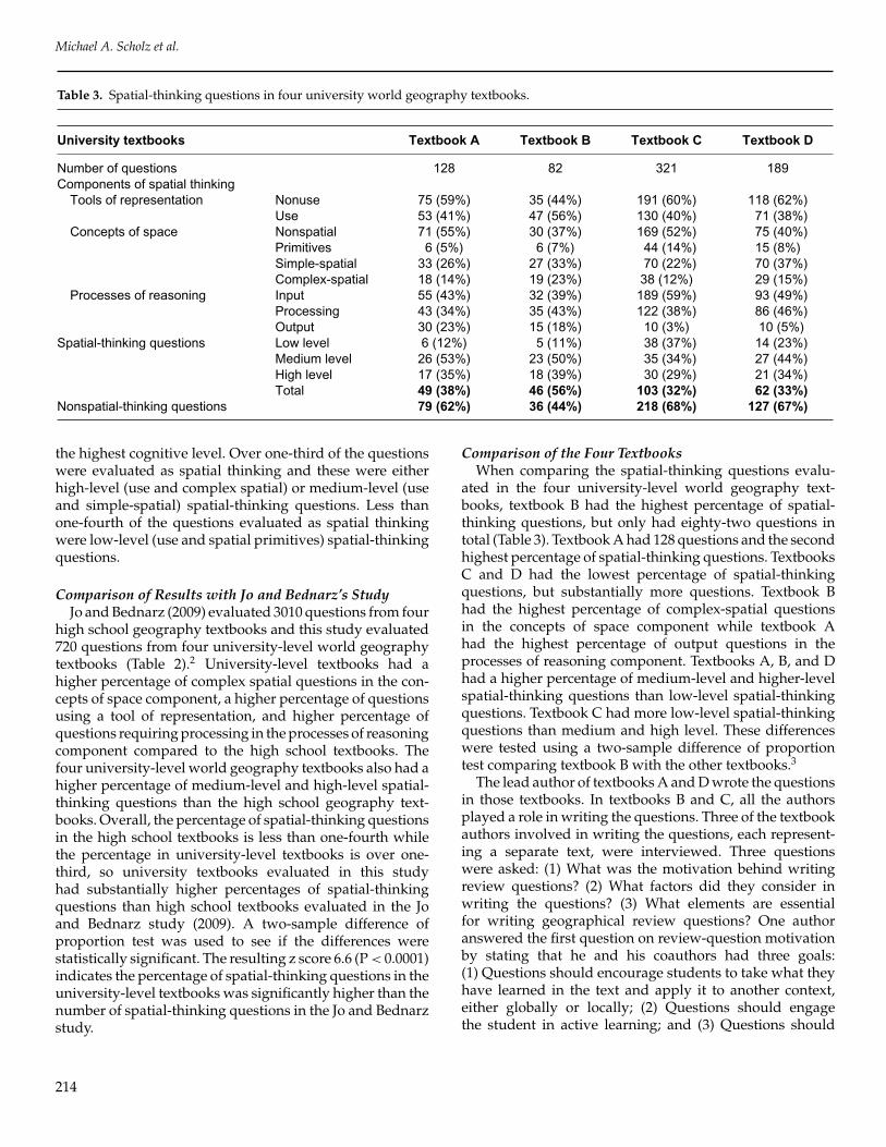
Table 3. Spatial-thinking questions in four university world geography textbooks.
University textbooks Textbook A Textbook B Textbook C Textbook D
Number of questions 128 82 321 189Components of spatial thinking
Tools of representation Nonuse 75 (59%) 35 (44%) 191 (60%) 118 (62%)Use 53 (41%) 47 (56%) 130 (40%) 71 (38%)
Concepts of space Nonspatial 71 (55%) 30 (37%) 169 (52%) 75 (40%)Primitives 6 (5%) 6 (7%) 44 (14%) 15 (8%)Simple-spatial 33 (26%) 27 (33%) 70 (22%) 70 (37%)Complex-spatial 18 (14%) 19 (23%) 38 (12%) 29 (15%)
Processes of reasoning Input 55 (43%) 32 (39%) 189 (59%) 93 (49%)Processing 43 (34%) 35 (43%) 122 (38%) 86 (46%)Output 30 (23%) 15 (18%) 10 (3%) 10 (5%)
Spatial-thinking questions Low level 6 (12%) 5 (11%) 38 (37%) 14 (23%)Medium level 26 (53%) 23 (50%) 35 (34%) 27 (44%)High level 17 (35%) 18 (39%) 30 (29%) 21 (34%)Total 49 (38%) 46 (56%) 103 (32%) 62 (33%)
Nonspatial-thinking questions 79 (62%) 36 (44%) 218 (68%) 127 (67%)
the highest cognitive level. Over one-third of the questionswere evaluated as spatial thinking and these were eitherhigh-level (use and complex spatial) or medium-level (useand simple-spatial) spatial-thinking questions. Less thanone-fourth of the questions evaluated as spatial thinkingwere low-level (use and spatial primitives) spatial-thinkingquestions.
Comparison of Results with Jo and Bednarz’s StudyJo and Bednarz (2009) evaluated 3010 questions from four
high school geography textbooks and this study evaluated720 questions from four university-level world geographytextbooks (Table 2).2 University-level textbooks had ahigher percentage of complex spatial questions in the con-cepts of space component, a higher percentage of questionsusing a tool of representation, and higher percentage ofquestions requiring processing in the processes of reasoningcomponent compared to the high school textbooks. Thefour university-level world geography textbooks also had ahigher percentage of medium-level and high-level spatial-thinking questions than the high school geography text-books. Overall, the percentage of spatial-thinking questionsin the high school textbooks is less than one-fourth whilethe percentage in university-level textbooks is over one-third, so university textbooks evaluated in this studyhad substantially higher percentages of spatial-thinkingquestions than high school textbooks evaluated in the Joand Bednarz study (2009). A two-sample difference ofproportion test was used to see if the differences werestatistically significant. The resulting z score 6.6 (P < 0.0001)indicates the percentage of spatial-thinking questions in theuniversity-level textbooks was significantly higher than thenumber of spatial-thinking questions in the Jo and Bednarzstudy.
Comparison of the Four TextbooksWhen comparing the spatial-thinking questions evalu-
ated in the four university-level world geography text-books, textbook B had the highest percentage of spatial-thinking questions, but only had eighty-two questions intotal (Table 3). Textbook A had 128 questions and the secondhighest percentage of spatial-thinking questions. TextbooksC and D had the lowest percentage of spatial-thinkingquestions, but substantially more questions. Textbook Bhad the highest percentage of complex-spatial questionsin the concepts of space component while textbook Ahad the highest percentage of output questions in theprocesses of reasoning component. Textbooks A, B, and Dhad a higher percentage of medium-level and higher-levelspatial-thinking questions than low-level spatial-thinkingquestions. Textbook C had more low-level spatial-thinkingquestions than medium and high level. These differenceswere tested using a two-sample difference of proportiontest comparing textbook B with the other textbooks.3
The lead author of textbooks A and D wrote the questionsin those textbooks. In textbooks B and C, all the authorsplayed a role in writing the questions. Three of the textbookauthors involved in writing the questions, each represent-ing a separate text, were interviewed. Three questionswere asked: (1) What was the motivation behind writingreview questions? (2) What factors did they consider inwriting the questions? (3) What elements are essentialfor writing geographical review questions? One authoranswered the first question on review-question motivationby stating that he and his coauthors had three goals:(1) Questions should encourage students to take what theyhave learned in the text and apply it to another context,either globally or locally; (2) Questions should engagethe student in active learning; and (3) Questions should
214
Spatial Thinking in University World Geography Textbook Questions
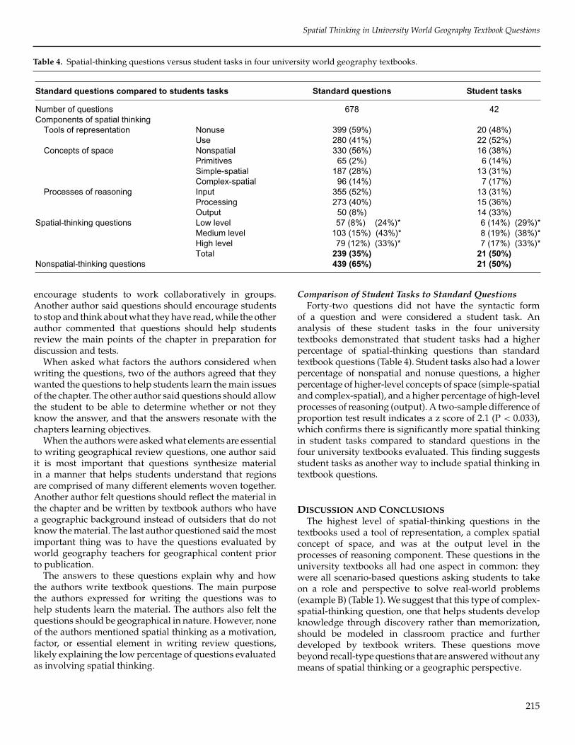
Table 4. Spatial-thinking questions versus student tasks in four university world geography textbooks.
Standard questions compared to students tasks Standard questions Student tasks
Number of questions 678 42Components of spatial thinking
Tools of representation Nonuse 399 (59%) 20 (48%)Use 280 (41%) 22 (52%)
Concepts of space Nonspatial 330 (56%) 16 (38%)Primitives 65 (2%) 6 (14%)Simple-spatial 187 (28%) 13 (31%)Complex-spatial 96 (14%) 7 (17%)
Processes of reasoning Input 355 (52%) 13 (31%)Processing 273 (40%) 15 (36%)Output 50 (8%) 14 (33%)
Spatial-thinking questions Low level 57 (8%) (24%)* 6 (14%) (29%)*Medium level 103 (15%) (43%)* 8 (19%) (38%)*High level 79 (12%) (33%)* 7 (17%) (33%)*Total 239 (35%) 21 (50%)
Nonspatial-thinking questions 439 (65%) 21 (50%)
encourage students to work collaboratively in groups.Another author said questions should encourage studentsto stop and think about what they have read, while the otherauthor commented that questions should help studentsreview the main points of the chapter in preparation fordiscussion and tests.
When asked what factors the authors considered whenwriting the questions, two of the authors agreed that theywanted the questions to help students learn the main issuesof the chapter. The other author said questions should allowthe student to be able to determine whether or not theyknow the answer, and that the answers resonate with thechapters learning objectives.
When the authors were asked what elements are essentialto writing geographical review questions, one author saidit is most important that questions synthesize materialin a manner that helps students understand that regionsare comprised of many different elements woven together.Another author felt questions should reflect the material inthe chapter and be written by textbook authors who havea geographic background instead of outsiders that do notknow the material. The last author questioned said the mostimportant thing was to have the questions evaluated byworld geography teachers for geographical content priorto publication.
The answers to these questions explain why and howthe authors write textbook questions. The main purposethe authors expressed for writing the questions was tohelp students learn the material. The authors also felt thequestions should be geographical in nature. However, noneof the authors mentioned spatial thinking as a motivation,factor, or essential element in writing review questions,likely explaining the low percentage of questions evaluatedas involving spatial thinking.
Comparison of Student Tasks to Standard QuestionsForty-two questions did not have the syntactic form
of a question and were considered a student task. Ananalysis of these student tasks in the four universitytextbooks demonstrated that student tasks had a higherpercentage of spatial-thinking questions than standardtextbook questions (Table 4). Student tasks also had a lowerpercentage of nonspatial and nonuse questions, a higherpercentage of higher-level concepts of space (simple-spatialand complex-spatial), and a higher percentage of high-levelprocesses of reasoning (output). A two-sample difference ofproportion test result indicates a z score of 2.1 (P < 0.033),which confirms there is significantly more spatial thinkingin student tasks compared to standard questions in thefour university textbooks evaluated. This finding suggestsstudent tasks as another way to include spatial thinking intextbook questions.
DISCUSSION AND CONCLUSIONSThe highest level of spatial-thinking questions in the
textbooks used a tool of representation, a complex spatialconcept of space, and was at the output level in theprocesses of reasoning component. These questions in theuniversity textbooks all had one aspect in common: theywere all scenario-based questions asking students to takeon a role and perspective to solve real-world problems(example B) (Table 1). We suggest that this type of complex-spatial-thinking question, one that helps students developknowledge through discovery rather than memorization,should be modeled in classroom practice and furtherdeveloped by textbook writers. These questions movebeyond recall-type questions that are answered without anymeans of spatial thinking or a geographic perspective.
215
Michael A. Scholz et al.
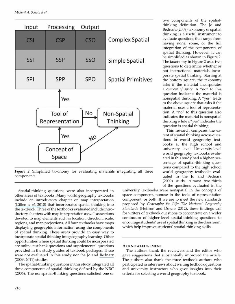
Figure 2. Simplified taxonomy for evaluating materials integrating all threecomponents.
Spatial-thinking questions were also incorporated inother areas of textbooks. Many world geography textbooksinclude an introductory chapter on map interpretation(Gillen et al. 2010) that incorporates spatial thinking intothe textbook. Three of the textbooks evaluated include intro-ductory chapters with map interpretation as well as sectionsdevoted to map elements such as location, direction, scale,regions, and map projections. All four textbooks have mapsdisplaying geographic information using the componentsof spatial thinking. These areas provide an easy way toincorporate spatial thinking into geography learning. Otheropportunities where spatial thinking could be incorporatedare online test bank questions and supplemental questionsprovided in the study guides of textbook packages. Thesewere not evaluated in this study nor the Jo and Bednarz(2009, 2011) studies.
The spatial-thinking questions in this study integrated allthree components of spatial thinking defined by the NRC(2006). The nonspatial-thinking questions satisfied one or
two components of the spatial-thinking definition. The Jo andBednarz (2009) taxonomy of spatialthinking is a useful instrument toevaluate questions that range fromhaving none, some, or the fullintegration of the components ofspatial thinking. However, it canbe simplified as shown in Figure 2.The taxonomy in Figure 2 uses twoquestions to determine whether ornot instructional materials incor-porate spatial thinking. Starting atthe bottom square, the taxonomyasks if the material incorporatesa concept of space. A “no” to thisquestion indicates the material isnonspatial thinking. A “yes” leadsto the above square that asks if thematerial uses a tool of representa-tion. A “no” to this question alsoindicates the material is nonspatialthinking while a “yes” indicates thequestion is spatial thinking.
This research compares the ex-tent of spatial thinking across ques-tions in world geography text-books at the high school anduniversity level. University-levelworld geography textbooks evalu-ated in this study had a higher per-centage of spatial-thinking ques-tions compared to the high schoolworld geography textbooks eval-uated in the Jo and Bednarz(2009) study. Almost two-thirdsof the questions evaluated in the
university textbooks were nonspatial in the concepts ofspace component, nonuse in the tools of representationcomponent, or both. If we are to meet the new standardsproposed by Geography for Life: The National GeographyStandards (Heffron and Downs 2012), these findings callfor writers of textbook questions to concentrate on a widercontinuum of higher-level spatial-thinking questions toencourage students’ use of spatial thinking in the classroom,which help improve students’ spatial-thinking skills.
ACKNOWLEDGEMENTThe authors thank the reviewers and the editor who
gave suggestions that substantially improved the article.The authors also thank the three textbook authors whoparticipated in interviews about writing textbook questionsand university instructors who gave insights into theircriteria for selecting a world geography textbook.
216
Spatial Thinking in University World Geography Textbook Questions
NOTES1. This study is a first step in that process. University
faculty does not regularly consider spatial thinkingwhen selecting textbooks. Our own anecdotal evi-dence provides some support on this point. We askedseven world geography professors what elementsthey considered before choosing a textbook for theirclass. One responded, “What I most took into ac-count honestly was what instructors had used in thepast and were they happy with the text, how currentwas the text, and what instructional resources wereavailable to support the text.” Another respondentselected the textbook that emphasized globalizationwhile others made their choice based on the pro-portion of human and physical geography content.Current events were an important element to anotherrespondent, who stated, “I wanted to tie recentstories in media to the text.” When we asked therespondents about the importance of spatial thinkingin the review questions of textbooks, most said theynever considered spatial thinking, although goodgraphics and detailed maps were a considerationfor some instructors. One said, “Spatial-thinkingquestions are important,” but he did not considerthis in choosing a textbook.
2. In addition to questions at the end of chapters or sec-tions, questions located in the supplemental sections,in page margins next to maps and illustrations, orinterspersed in the text under a title called “readingcheck” were also evaluated in the four high schooltextbooks (Jo and Bednarz 2011). Of the 3,010 ques-tions evaluated in their study, 2,207 were from theend of sections or chapters. In this study, textbooksA and B have very few questions within the text,in page margins, or in supplemental sections, soquestions in these areas were not evaluated. Thetotal number of questions from the end of sectionsor chapters in the four university textbooks is 720.Therefore, the high school textbooks evaluated in Joand Bednarz’s (2011) study had substantially morequestions than the university textbooks evaluated inthis study.
3. The significance when comparing the four textbooksusing a two-sample difference of proportion test areas follows: textbook B to textbook A, z = 2.6(P <
0.0105); textbook B to textbook C, z = 4(P < 0.0001);textbook B to textbook D, z = 3.6(P < 0.0004)
REFERENCESAlbert, W. S., and R. Golledge. 1999. The use of spatial cog-
nitive abilities in Geographical Information Systems:The map overlay operation. Transactions in GIS 3 (1):7–21.
Anastakis, D., S. Hamstra, and E. Matsumoto. 2000. Visualspatial abilities in surgical training. American Journal ofSurgeons 179 (6): 469–471.
Anthamatten, P. 2010. Spatial thinking concepts in earlygrade-level geography standards. Journal of Geography109 (5): 169–180.
Bagoly-Simo, P. 2013. Still red and in war or just poor? Euro-pean transformation societies in geography textbooks.Journal of Geography 112 (3): 108–119.
Barke, H. D. 1993. Chemical education and spatial ability.Journal of Chemical Education 70 (12): 968–971.
Battersby, S. E., R. G. Golledge, and M. J. Marsh. 2006.Incidental learning of geospatial concepts across gradelevels: Map overlay. Journal of Geography 105 (4): 139–146.
Battista, M. T. 1990. Spatial visualization and genderdifferences in high-school geometry. Journal for Researchin Mathematics Education 21 (1): 47–60.
Bednarz, S. W. 2004. US world geography textbooks:Their role in education reform. International Research inGeographical & Environmental Education 13 (3): 223–238.
Bednarz, S. W., J. P. Stoltman, and J. Lee. 2004. Preparinggeography teachers in the United States. InternationalResearch in Geographical and Environmental Education 13(2): 176–183.
Blaut, J. 1991. Natural mapping. Transactions of the BritishInstitute of Geographers 16 (1): 55–74.
———. 1969. Studies in Developmental Geography. Place per-ception research report no. 1. Worcester, Massachusetts:Clarke University.
Blaut, J., G. McCleary, and A. Blaut. 1970. Environmentalmapping in young children. Environment and Behavior 2(3): 335–349.
Boehm, R. G., J. Brierley, and M. Sharma. 1994. The bete noirof geographic education: Teacher training programs.Journal of Geography 93 (1): 21–25.
Bradshaw M., G. W. White, J. P. Dymond, and E. Chacko.2009. Contemporary World Regional Geography: GlobalConnections, Local Voices, 3rd ed. New York: McGraw-Hill Publishing.
Brody, N. 2000. History of theories and measurements of in-telligence. In Handbook of Intelligence, ed. R. J. Sternberg,pp. 423–444. New York: Cambridge University Press.
Chan, D. W. 2008. Assessing visual-spatial talents: Theuse of the impossible figures task with Chinese stu-dents in Hong Kong. High Ability Studies 19 (2): 173–187.
Cole, R. 2008. The regionalization of Africa in undergrad-uate geography of Africa textbooks, 1953–2004. Journalof Geography 107 (2): 61–74.
217
Michael A. Scholz et al.
de Blij, H. J., and P. O’Mueller. 2010. Geography: Regions,Realms, and Concepts, 14th ed. Indianapolis, Indiana:Wiley Publishers.
Delgado, A., and G. Prieto. 2004. Cognitive mediators andsex-related differences in mathematics. Intelligence 32(1): 25–32.
Facultycenter.net. 2013. World geography book search.http://www.facultycenter.net/cgi-fc/fcBookBrowse.mac/top (accessed June 11, 2013).
Gardner, H. 1999. Intelligence Reframed: Multiple Intelligencesfor the 21st Century. New York: Basic Books.
Geography Education Standards Project. 1994. Geographyfor Life: The National Geography Standards. Washington,D.C.: National Geographic Society Committee on Re-search and Exploration.
Gersmehl, P. J. 2005. Teaching Geography. New York: GuilfordPress.
Gersmehl, P. J., and C. A. Gersmehl. 2007. Spatial thinkingby young children: Neurologic evidence for earlydevelopment and ‘educability.’ Journal of Geography 106(5): 181–191.
———. 2006. Wanted: A concise list of neurologically de-fensible and assessable spatial thinking skills. Researchin Geographic Education 8:5–38.
Gillen, J., L. Skryzhevska, M. C. Henry, and J. Green.2010. Map interpretation in introductory textbooks: Apreliminary investigation. Journal of Geography 109 (5):181–189.
Gilmartin, P. P., and J. C. Patton. 1984. Comparing thesexes on spatial abilities: Map-use skills. Annals of theAssociation of American Geographers 74 (4): 605–619.
Golledge, R. G. 2002. The nature of geographic knowledge.Annals of the Association of American Geographers 92 (1):1–14.
———. 1995. Primitives of spatial knowledge. In CognitiveAspects of Human-Computer Interaction for GeographicInformation Systems, ed. T. L. Nyerges and M. J. Egen-hofer, pp. 29–44. Dordrecht, The Netherlands: KluwerAcademic Publishers.
Golledge, R. G., V. Dougherty, and S. Bell. 1995. Acquiringspatial knowledge: Survey vs route-based knowledgein unfamiliar environments. Annals of the Association ofAmerican Geographers 85 (1): 134–158.
Golledge, R. G., M. J. Marsh, and S. E. Battersby. 2008a. Aconceptual framework for facilitating geospatial think-ing. Annals of the Association of American Geographers 98(2): 285–308.
———. 2008b. Matching geospatial concepts with geo-graphic educational needs. Geographical Research 46 (1):85–98.
Gregg, M., C. Staintoon, and G. Leinhardt. 1998. Whereis geography? Analyzing geography in newspapersand social studies textbooks. International Research inGeographical and Environmental Education 7 (3): 219–237.
Hamann, B. 2007. Australia in German geography text-books for middle schools. International Research inGeographical & Environmental Education 16 (2): 135–146.
Heffron, S. G., and R. M. Downs, eds. 2012. Geography forLife: National Geography Standards, 2nd ed. Washington,D.C.: National Council for Geographic Education.
Hespanha, S. R., F. Goodchild, and Donald G. Janelle. 2009.Spatial thinking and technologies in the undergraduatesocial science classroom. Journal of Geography in HigherEducation 33 (S1): 17–27.
Hobbs, J. J. 2010. Fundamentals of World Regional Geography,2nd ed. Belmont, California: Books/Cole Publishing.
Hsi, S., M. Linn, and J. Bell. 1997. The role of spatialreasoning in engineering and the design of spatialinstruction. Journal of Engineering Education 86 (2): 151–158.
Humphreys, L., D. Lubinski, and G. Yao. 1993. Utility ofpredicting group membership and the role of spatialvisualization in becoming an engineer, physical scien-tist, or artist. Journal of Applied Psychology 78 (2): 250–261.
Hunt, E. 2011. Human Intelligence. New York: CambridgeUniversity Press.
Jennings, S. A. 2006. A content comparison of six physicalgeography textbooks spanning a century. InternationalResearch in Geographical & Environmental Education 15(1): 1–14.
Jo, I., and S. W. Bednarz. 2011. Textbook questions tosupport spatial thinking: Differences in spatiality byquestion location. Journal of Geography 110 (2): 70–80.
———. 2009. Evaluating geography textbook questionsfrom a spatial perspective: Using concepts of space,tools of representation, and cognitive processes toevaluate spatiality. Journal of Geography 108 (1): 4–13.
Landis, J. R., and G. G. Koch. 1977. The measurement ofobserver agreement for categorical data. Biometrics 33(1): 159–174.
Lee, J., and R. Bednarz. 2009. Effect of GIS learning on spatialthinking. Journal of Geography in Higher Education 33 (2):183–198.
Lee, M., and J. Ryu. 2013. How to design and present textsto cultivate balanced regional images in geographyeducation. Journal of Geography 112 (4): 143–155.
Liben, L. S., and R. M. Downs. 1997. Can-ism andcan’tianism: A straw child. Annals of the Association ofAmerican Geographers 87 (1): 159.
218
Spatial Thinking in University World Geography Textbook Questions
———. 1993. Understanding person-space-map relations:Cartographic and developmental perspectives. Devel-opmental Psychology 29 (4): 739–752.
Lih-Juan, C. 2000. Attributes of animation for learningscientific knowledge. Journal of Instructional Psychology27 (4): 228–238.
Marsh, M. J., R. G. Golledge, and S. E. Battersby. 2007.Geospatial concept understanding and recognition ing6–college students: A preliminary argument for mini-mal GIS. Annals of the Association of American Geographers97 (4): 696–712.
Martin, C. M. 1996. Geography Textbook Assessment for Middleand High School Educators. Washington, D.C.: Geogra-phy Education National Implementation Project.
Marton, A. M. 2006. The cultural politics of curricular re-form in China: A case study of geographical educationin Shanghai. Journal of Contemporary China 15 (47): 233–254.
Mathewson, J. H. 1999. Visual-spatial thinking: An aspectof science overlooked by educators. Science Education83 (1): 33–54.
McGee, M. G. 1979. Human Spatial Abilities: Sources of SexDifferences. New York: Praeger Press.
Myers, G. A. 2001. Introductory human geography textbookrepresentations of Africa. The Professional Geographer 53(4): 522–532.
Myers, M. P., and T. Savage. 2005. Enhancing studentcomprehension of social studies material. The SocialStudies 96 (1): 18–23.
National Research Council (NRC). 2006. Learning to ThinkSpatially. Washington, D.C.: National Academy Press.
Newcombe, N. 2010. Picture this: Increasing math and sci-ence learning by improving spatial thinking. AmericanEducator 34 (2): 29–43.
Niesser, U. 1997. Rising scores on intelligence tests: Testsare certainly going up all over the world, but whetherintelligence itself has risen is controversial. AmericanScientist 85 (5): 440–447.
Pellegrino, J. W., and R. J. Kail. 1982. Process analyses ofspatial aptitude. In Advances in the Psychology of HumanIntelligence, ed. R. J. Sternrnberg, pp. 311–365. Hillsdale,New Jersey: Lawrence Erlbaum Associates Publishers.
Peverly, S. T., and R. Wood. 2001. The effects of ad-junct questions and feedback on improving the read-ing comprehension skills of learning-disabled ado-lescents. Contemporary Educational Psychology 26 (1):25–43.
Piaget, J., and B. Inhelder. 1954. The Child’s Conception ofSpace. New York: Norton.
Rowntree, L., M. Lewis, M. Price, and W. Wyckoff. 2011.Globalization and Diversity: Geography of a ChangingWorld, 3rd ed. Upper Saddle River, New Jersey: PearsonPrentice Hall Publishing.
Self, C. M., and R. G. Golledge. 1994. Sex-related dif-ferences in spatial ability: What every geographyeducator should know. Journal of Geography 93 (5): 234–243.
Uttal, D. H., N. G. Meadow, E. Tipton, L. L. Hand,A. R. Alden, C. Warren, and N. S. Newcombe. 2013.The malleability of spatial skills: A meta-analysis oftraining studies. Psychological Bulletin 139 (2): 352–402.
Vogler, K. E. 2005. Improve your verbal questioning. TheClearing House 79 (2): 98–103.
Why Geography Is Important. 2012. Revised ed. Collabo-ration between the Grosvenor Center for GeographicEducation and EDGE Project of the Association ofAmerican Geographers. San Marco, Texas: GrosvenorCenter for Geographic Education.
Wilen, W. W. 2001. Exploring myths about teacher ques-tioning in the social studies. The Social Studies 92 (1):26–32.
Yang, D. 2013. Comparing assessments within junior ge-ography textbooks used in mainland China. Journal ofGeography 112 (2): 58–67.
Yasar, O., and M. Seremet. 2007. A comparative analysisregarding pictures included in secondary school geog-raphy textbooks taught in Turkey. International Researchin Geographical & Environmental Education 16 (2): 157–187.
Zhong, H., and N. Foskett. 2003. Changes in the subjectmatter of geography textbooks: 1907–1993. InternationalResearch in Geographical & Environmental Education12 (4): 312–329.
219
Related Documents