Pertemuan Ilmiah Tahunan MAPIN XIV ”Pemanfaatan Efektif Penginderaan Jauh Untuk Peningkatan Kesejahteraan Bangsa” IMPROVEMENT OF LAND AND FOREST FIRE HAZARD MAPPING METHOD FOR SUMATERA AND KALIMANTAN BASED ON REMOTE SENSING DATA Erna S. Adiningsih 1 , P. A. Winarso 1 , Z.L. Dupe 1 , dan A. Buono 1 1 Pusat Pengembangan Pemanfaatan dan Teknologi Penginderaan Jauh – LAPAN Jl. LAPAN no. 70, Pekayon, Pasar Rebo, Jakarta 13710 email: [email protected] Abstract Improvement of land and forest fire hazard mapping method for sumatera and kalimantan based on remote sensing data. Fire hazard prediction model has been developed using spatial and satellite data for Sumatra and Kalimantan since these areas are very prone to land and forest fires. The model could predict fire hazard for several months ahead based on predicted rainfall and predicted vegetation indices. The previous method used four parameters as inputs, which were rainfall, vegetation index, land cover, and land type. The objectives of this research are to improve the method of fire hazard determination using spatial and satellite data and to compare the results of previous and last methods for Sumatra and Kalimantan. An improved method has been developed by using topographic map as additional input of the method. Improvement has been also made by using raster format data instead of vector format data as used in previous method of overlaying by geographic information system software. The results show that the use of raster data format could produce more detailed land/forest fire hazard maps for Sumatra and Kalimantan compared with the use of vector data. Further more, the use of slope p arameter based on topographic map derived from SRTM data could generate better fire hazard maps in terms of vulnerability indication and spatial inf ormation. Keywords: fire hazard, raster data, vector data, slope 1. INTRODUCTION Since 1980s land and forest fires in Indonesia have been attracted world attention particularly in Southeast Asia. In most occurrences, the fires set by the ranchers and subsistence farmers often get out of hand or uncontrolled, inadvertently burning forests, pastures, and plantations. Each year, fires in Sumatra and Kalimantan burn a large area of shrubs, logged forests, croplands, and plantations. Wetlands and peat lands would cause the fires spread out fast and produce a large number of smoke and haze. The haze will increase air pollution even become transboundary haze over the Southeast Asia and has various impacts (Murdiyarso, 1998; Mudiyarso and Lebel, 1998; Suyanto et al., 2001, 2003). According to Saharjo (2000) the sources of land and forest fires come from illegal shifting cultivation, forest concession, plantation, logging, and spreading. Tacconi (2003) suggests that land cover and its changes are major influencing factors on fires in Indonesia. Based on fires in 1997/1998 it has been calculated that the largest amount of burned areas in Indonesia consists of crop land and followed by brackish forest, peat forest, lowland forest, shrubs, grassland, forest plantations and plantations. Furthermore the results of Murdiyarso et al. (2002) reveal that forest fire risks are related to accessibility and vegetation type or fuel type. Highest fire frequency (as indicated by cumulative hotspot frequency) is usually found at the areas having high accessibility by secondary roads. Various studies on fires are therefore becoming higher interests of many scientists in Indonesia as well as in other countries. Research on land and forest fire hazard has been done by modeling the impact of climate anomaly on fire hazard prediction for Sumatra and Gedung Rektorat lt. 3 Kampus Institut Teknologi Sepuluh Nopember Surabaya, 14 – 15 September 2005 MBA - 96

Welcome message from author
This document is posted to help you gain knowledge. Please leave a comment to let me know what you think about it! Share it to your friends and learn new things together.
Transcript

8/6/2019 14 Erna Improvement
http://slidepdf.com/reader/full/14-erna-improvement 1/6
Pertemuan Ilmiah Tahunan MAPIN XIV
”Pemanfaatan Efektif Penginderaan Jauh Untuk Peningkatan Kesejahteraan Bangsa”
IMPROVEMENT OF LAND AND FOREST FIRE HAZARD MAPPING
METHOD FOR SUMATERA AND KALIMANTAN BASED ON REMOTE
SENSING DATA
Erna S. Adiningsih1, P. A. Winarso
1, Z.L. Dupe
1, dan A. Buono
1
1Pusat Pengembangan Pemanfaatan dan Teknologi Penginderaan Jauh – LAPAN
Jl. LAPAN no. 70, Pekayon, Pasar Rebo, Jakarta 13710
email: [email protected]
Abstract
Improvement of land and forest fire hazard mapping method for sumatera and kalimantan based on remote sensing data.
Fire hazard prediction model has been developed using spatial and satellite data for Sumatra and Kalimantan since theseareas are very prone to land and forest fires. The model could predict fire hazard for several months ahead based on
predicted rainfall and predicted vegetation indices. The previous method used four parameters as inputs, which were
rainfall, vegetation index, land cover, and land type. The objectives of this research are to improve the method of fire
hazard determination using spatial and satellite data and to compare the results of previous and last methods for
Sumatra and Kalimantan. An improved method has been developed by using topographic map as additional input of the
method. Improvement has been also made by using raster format data instead of vector format data as used in previous
method of overlaying by geographic information system software. The results show that the use of raster data format
could produce more detailed land/forest fire hazard maps for Sumatra and Kalimantan compared with the use of vector
data. Further more, the use of slope parameter based on topographic map derived from SRTM data could generate better
fire hazard maps in terms of vulnerability indication and spatial information.
Keywords: fire hazard, raster data, vector data, slope
1. INTRODUCTION
Since 1980s land and forest fires in Indonesia
have been attracted world attention particularly in
Southeast Asia. In most occurrences, the fires set
by the ranchers and subsistence farmers often get
out of hand or uncontrolled, inadvertently burning
forests, pastures, and plantations. Each year, firesin Sumatra and Kalimantan burn a large area of
shrubs, logged forests, croplands, and plantations.
Wetlands and peat lands would cause the fires
spread out fast and produce a large number of
smoke and haze. The haze will increase air
pollution even become transboundary haze over
the Southeast Asia and has various impacts
(Murdiyarso, 1998; Mudiyarso and Lebel, 1998;
Suyanto et al., 2001, 2003).
According to Saharjo (2000) the sources of land
and forest fires come from illegal shiftingcultivation, forest concession, plantation, logging,
and spreading. Tacconi (2003) suggests that land
cover and its changes are major influencing
factors on fires in Indonesia. Based on fires in
1997/1998 it has been calculated that the largest
amount of burned areas in Indonesia consists of
crop land and followed by brackish forest, peat
forest, lowland forest, shrubs, grassland, forest
plantations and plantations. Furthermore theresults of Murdiyarso et al. (2002) reveal that
forest fire risks are related to accessibility and
vegetation type or fuel type. Highest fire
frequency (as indicated by cumulative hotspot
frequency) is usually found at the areas having
high accessibility by secondary roads. Various
studies on fires are therefore becoming higher
interests of many scientists in Indonesia as well as
in other countries.
Research on land and forest fire hazard has been
done by modeling the impact of climate anomalyon fire hazard prediction for Sumatra and
Gedung Rektorat lt. 3 Kampus Institut Teknologi Sepuluh Nopember
Surabaya, 14 – 15 September 2005
MBA - 96

8/6/2019 14 Erna Improvement
http://slidepdf.com/reader/full/14-erna-improvement 2/6
Pertemuan Ilmiah Tahunan MAPIN XIV
”Pemanfaatan Efektif Penginderaan Jauh Untuk Peningkatan Kesejahteraan Bangsa”
Kalimantan (Adiningsih et al., 2003, 2004). The
results show that four factors i.e. rainfall,
vegetation index, land cover, and land type, could
be used for fire hazard mapping. Fire hazardscould also be predicted for several months ahead
based on predicted rainfall and predicted
vegetation index. However, the results still need
improvement since spatial accuracy of resulted
maps was less than expected. The objectives of
this research are to improve the method of fire
hazard determination using spatial and satellite
data and to compare the results of previous and
last methods for Sumatra and Kalimantan.
2. MATERIAL AND METHOD
Data Collection
Data used in this research consist of monthly
rainfall, monthly vegetation index (NDVI), land
cover map, land type map, and topographic map.
Monthly rainfall data were collected from 21
stations in Sumatra and 10 stations in Kalimantan.
Monthly NDVI and hotspot locations are derived
from NOAA-AVHRR data. Land cover maps are
derived from Landsat imageries of 2002, while
land type from soil map is obtained from existing
maps published by Soil Research Center. Hotspotlocation and number of all provinces in Sumatra
for the period of 1996-2002 are derived from
NOAA-AVHRR satellite data. Field data include
land use condition, vegetation and fuel conditions
in Riau and South Sumatra.
This research used a set of PC with Sea Scan
software and ErMapper to process NOAA-
AVHRR data, ArcView for geographical
information processing and mapping, and
statistical software for statistical processing and
analyses. For field survey we used GPS (Global
Positioning Satellite) to determine geographical
location and camera for documentation.
Data Processing and Analysis
Monthly vegetation index or NDVI are obtained
from daily AVHRR data by maximizing the
values of one month data to minimize the effect of
cloud cover. In the previous study, maps of
NDVI are generated by extracting the values of
selected pixels and then making contour of NDVIto generate map in vector format. Similar
technique is also applied on rainfall data. Some
improvements have been made in this study.
Firstly, original format of raster NDVI data are
used. Secondly, rainfall contour map is converted
into raster format data as well as land cover mapand land type map. The two are aimed to enhance
spatial resolution of generated maps. Thirdly,
parameter of slope is also as additional parameter
of the model since a few works have suggested
the effect of topography on the spread of fires. To
ensure digital image processing for all parameters
having different spatial resolution, pixels of
rainfall, land cover, land type, and slope layers are
re-sampled into NOAA AVHRR pixel size.
Land and forest fire hazard is determined using a
set of criteria and scores of five parameters asshown in Table 1. The parameters are rainfall,
NDVI, land cover, land type, and slope. The first
four parameters are used for method 1 which is
similar to previous study and the fifth parameter
(slope) is used as additional parameter of method
2. Calculation of parameter score is as follows:
Parameter score = weight * score
Since there have been several previous works on
forest fire factors, scoring method was based on
previous related works. Total score was obtainedby summing all parameter scores. Forest fire risk
classification could be established by dividing
total score range into 5 intervals or classes which
describe fuel availability and flammability. The
five classes of forest fire risks are very low, low,
moderate, high, and very high fire hazard. The
weight of each parameter in the two methods is
presented in Table 2.
Data processing is established for generating
actual hazard and predicted hazard. The predicted
hazard uses predicted rainfall and NDVI values as
prediction model has been obtained in the
previous study. Since our previous study has
analyzed several months of fire hazard maps for
normal and anomalous years, in this study we
analyze hazard maps of June 2002, 2003, and
2004 as case study.
3. RESULT AND DISCUSSION
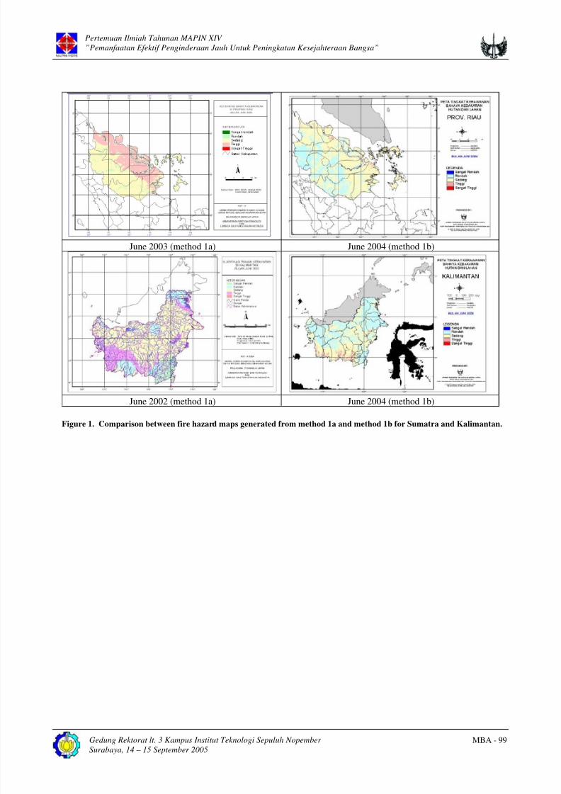
The results of fire hazard mapping for all methods
both for Sumatra and Kalimantan are shown inFigure 1, 2, and 3. From Figure 1 we might see
that improvement in spatial data format, i.e. from
Gedung Rektorat lt. 3 Kampus Institut Teknologi Sepuluh Nopember
Surabaya, 14 – 15 September 2005
MBA - 97

8/6/2019 14 Erna Improvement
http://slidepdf.com/reader/full/14-erna-improvement 3/6
Pertemuan Ilmiah Tahunan MAPIN XIV
”Pemanfaatan Efektif Penginderaan Jauh Untuk Peningkatan Kesejahteraan Bangsa”
vector to raster formats, could provide better
spatial resolution of fire hazard information. From
Figure 1 we might also see that the patterns of fire
hazard for all classes from method 2a are moredetailed than from method 1, both for Sumatra
and Kalimantan. This is due to the use of original
resolution of satellite data. However, fire hazard
level of method 2a seems to be lower than of
method 1. As the hazard level of method 1 tends
to be overestimated, the hazard level of method 2a
tends to be appropriate or at least not too much
underestimated. As an example, the eastern coast
of Riau in Sumatra indicates high fire hazard
although only few hotspots are found at the area.
Similar condition is found in western part of
Kalimantan. Meanwhile the hazard level of method 2a seems to coincide with hotspot
occurrence, meaning that the method is relatively
appropriate to provide information on potential
fire occurrence. In other words the use of raster
data format could produce more detailed
land/forest fire hazard maps for Sumatra and
Kalimantan compared with the use of vector data.
However the accuracy still needs to be proven by
verification and validation.
From Figure 2 we can see that fire hazard level in
Sumatra generated from method 1b (without slope
parameter) tends to be a little bit higher than the
one generated from method 2a and 2b (with slope
parameter). As the location of hotspots coincide
with indicated moderate fire hazard level of method 1b rather than of method 2a and 2b, this
result indicate that method 1b is relatively more
accurate than method 2a and 2b. Similar situation
is also found in Kalimantan as shown in Figure 3.
However since the number of hotspots is only a
few during June 2004, the result does not prove
any indication of accuracy. It is a must that the
result needs a statistical test. Besides, the weight
factor still needs to be validated and improved for
method 2b.
Based on those results we might summarize thatthe use of slope parameter based on topographic
map derived from SRTM data could generate
better fire hazard maps in terms of vulnerability
indication and spatial information. Nevertheless
the spatial accuracy has not been sufficient as the
vulnerability depicted from the maps tends to be
lower than resulted by the previous study.
However improved method needs to be verified
and validated in order to obtain proper constants
of all parameters.
Table 1. Improved score and criteria for forest fire hazard
Score Monthly NDVIMonthly Rainfall
(mm)Land use Type Land type Slope (*)
1 > 0.55 > 250 Settlement Mineral Soils <20%
2 0.46 - 0.55 200 - 250 Paddy Field - 20-40%
3 0.36 - 0.45 151 - 200 Cropland - 40-60%
4 0.26 - 0.35 101 - 150 Plantation - 60-80%
5 0.16 - 0.25 51 - 100 Forest - 80-100%
6 0.06 - 0.15 0 - 50 Swamp, Bush Peat soils >100%
Note: (*) Slope parameter is used as additional parameter of method 2a and 2b.
Table 2. Weighing method for fire hazard parameters.
Method Monthly
NDVI
Monthly Rainfall
(mm)
Land Cover
Type
Land type Slope Data
Format
1a 0.35 0.35 0.15 0.15 Not used Vector
1b 0.35 0.35 0.15 0.15 Not used Raster
2a 0.25 0.25 0.25 0.25 0.25 Raster
2b 0.30 0.25 0.15 0.15 0.15 Raster
Gedung Rektorat lt. 3 Kampus Institut Teknologi Sepuluh Nopember
Surabaya, 14 – 15 September 2005
MBA - 98
8/6/2019 14 Erna Improvement
http://slidepdf.com/reader/full/14-erna-improvement 4/6
Pertemuan Ilmiah Tahunan MAPIN XIV
”Pemanfaatan Efektif Penginderaan Jauh Untuk Peningkatan Kesejahteraan Bangsa”
June 2003 (method 1a) June 2004 (method 1b)
June 2002 (method 1a) June 2004 (method 1b)
Figure 1. Comparison between fire hazard maps generated from method 1a and method 1b for Sumatra and Kalimantan.
Gedung Rektorat lt. 3 Kampus Institut Teknologi Sepuluh Nopember
Surabaya, 14 – 15 September 2005
MBA - 99

8/6/2019 14 Erna Improvement
http://slidepdf.com/reader/full/14-erna-improvement 5/6
Pertemuan Ilmiah Tahunan MAPIN XIV
”Pemanfaatan Efektif Penginderaan Jauh Untuk Peningkatan Kesejahteraan Bangsa”
(a)
(b)
(c)
Figure 2. Fire hazard maps of Sumatra of June 2004
based on method 1b, method 2a, and method 2b.
(a)
(b)
(c)
Figure 3. Fire hazard maps of Kalimantan based on
method 1b, method 2a and method 2b.
Gedung Rektorat lt. 3 Kampus Institut Teknologi Sepuluh Nopember
Surabaya, 14 – 15 September 2005
MBA - 100

8/6/2019 14 Erna Improvement
http://slidepdf.com/reader/full/14-erna-improvement 6/6
Pertemuan Ilmiah Tahunan MAPIN XIV
”Pemanfaatan Efektif Penginderaan Jauh Untuk Peningkatan Kesejahteraan Bangsa”
4. CONCLUSION
This study has revealed an improved method of
land/forest fire hazard mapping and the result hasshown better spatial resolution of generated maps
than in the previous study. The use of raster data
format could produce more detailed land/forest
fire hazard maps for Sumatra and Kalimantan
compared with the use of vector data. Further
more, the use of slope parameter based on
topographic map derived from SRTM data could
generate better fire hazard maps in terms of
vulnerability indication and spatial information.
Nevertheless the spatial accuracy has not been
sufficient as the vulnerability depicted from the
maps tends to be lower than resulted by theprevious study. However improved method needs
to be verified and validated in order to obtain
proper constants of all parameters.
ACKNOWLEDGEMENT
This research was funded by RUT-X under the
research program of the Ministry of Research and
Technology. We would like to thank M. Rokhis
Khomarudin and Sudarman for their works in data
processing.
REFERENCES
Adiningsih, E.S., P.A. Winarso, Z.L. Dupe,
Kustiyo, M. Rokhis K., A. Budiyana. 2003.
Model Prediksi Dampak El Nino/La Nina untuk
Mitigasi Bencana Kebakaran Hutan. Laporan
RUT-X Tahun I. Jakarta: Kementerian Riset dan
Teknologi.
Adiningsih, E.S., D. Murdiyarso, M. Kartasasmita
dan M. R. Khomarudin, 2004. Modelling the
Prediction of Forest Fire Risks in Sumatera.
Pertemuan Ilmiah Tahunan ke-13, MAPIN, 22-23
Desember 2004 di Jakarta.
Dimitrakopoulos, A.P. and A.M. Bemmerzouk,
1996. Evaluation of the Canadian Forest Fire
Danger Rating System in the Mediterranean-type
Environment of Greece. Proceedings of
International Symposium on Applied
Agrometeorology and Agroclimatology. Volos,
Greece, 24-26 April 1996.
Murdiyarso, D. 1998. Transboundary haze
pollution in Southeast Asia. Impacts, 2(2) : 1-4.
____________. and L. Lebel, 1998. Land-use
management and the impacts transboundary
pollution from fires in Southeast Asia a Synthesis.Presented in the Workshop on Fire Hazards,
Transboundary Haze and Sustainable Forestry in
East Asia and the Pacific. Surabaya.
____________, Widodo M. and Suyamto, D,
2002. Fire risks in forest carbon project in
Indonesia. J. Science in China 5, 65-74.
Saharjo, B.H, 2000. Fire research and society
interest as limiting factors in minimizing large
forest fires in Indonesia.
Suyanto, U. Chokkalingam, dan P. Wibowo (ed),
2003. Kebakaran di Lahan Rawa/gambut di
Sumatera: Masalah dan Solusi. Prosiding
Semiloka, Palembang, 10-11 Desember 2003.
_______., R.P. Permana, D. Setijono, dan G.
Applegate, 2001. Akar penyebab dan dampak
kebakaran hutan dan lahan di Sumatera:
Ringkasan hasil penelitian ICRAF/CIFOR.
Prosiding Seminar Sehari. Bandar Lampung, 11
Oktober 2001.
Tacconi, L, 2003. Fires in Indonesia: Causes,
costs and policy implications. Occasional Paper
No. 38. Bogor: Center for International Forestry
Research
Gedung Rektorat lt. 3 Kampus Institut Teknologi Sepuluh Nopember
Surabaya, 14 – 15 September 2005
MBA - 101
Related Documents