17th Esri India User Conference 2017
Page 1 of 8
“Role of Geospatial Technology in Ushering Digital Revolution in India”
Yestha Bhatt 1, Nagesh Nangi 2
And Sh. Yogesh Dhomkar 1 Business Analyst, Reliance Jio Infocomm Limited
2 Development Lead, Reliance Jio Infocomm Limited
Word Limit of the Paper should not be more than 3000 Words = 7/8 Pages)
Abstract:
Reliance Jio is shaping the future of India by
providing end-to-end digital solutions for
businesses, institutions and households,
seamlessly bridging the rural-urban divide,
through cutting-edge voice & broadband
network on which a range of rich digital
services are enabled.
Focus on broadband networks, affordable
smartphones, availability of rich content and
applications has enabled Jio to offer a unique
combination of telecom, high speed data,
and digital commerce, media and payment
services. This has propelled Jio to a 140
million customer telco in just one year.
With our extensive, future-proof, full-IP
network, we plan to serve 20 million FTTx
customers. Jio's FTTx network will enable
customers to enjoy the rich content,
applications and solutions with up to 100
Mbps bandwidth at every home and
business! This will involve expanding our
current fiber optic network of 2.5 lakh kM by
another 1 lakh kM.
Functional workgroups involved in this
rollout include Business Planning, Network
Design, Engineering, Construction, QA / QC,
O&M and PMO.
About the Author:
Mrs. Yestha Bhatt
Yestha Bhatt, an electronics engineering professional with 10+ years
of experience, is a Senior Manager at Reliance Jio Infocomm Ltd.,
Mumbai. She has handled product management and business
requirement analysis for a major Indian telecom provider in the
past. Her paper presented in ESRI India User Conference at Delhi has
received First prize in 2008 and second prize in 2013. Her paper
presented in ESRI International User Conference at San Diego 2014
was well appreciated.
E mail ID: [email protected]
Contact No: +91 – 8451800485
Mr. Nagesh Nangi
Nagesh Nangi, an engineering professional with 18 + years of
experience, is a Deputy General Manager at Reliance Jio Infocomm
Ltd., Mumbai. He has handled product management and solution
architecture for a major Indian telecom provider in the past.
He has led IT & GIS solution development teams for several utility
projects in the past for companies in Middle East and East Asia.
17th Esri India User Conference 2017
Page 2 of 8
Jio has released integrated, end-to-end
workflow based business process automation
on the Geospatial Platform to efficiently
deliver this huge incremental network for
providing affordable services across India.
After roll-out, Business Analytics, Marketing,
Sales, Service Fulfillment & Service Assurance
will also leverage the same data and
geospatial applications.
This paper presents our solution consisting of
BPM engine for end-to-end Business
Workflow & Dashboard, Desktop & web GIS
applications, mobile GIS applications and
web-service interfaces tightly integrating
other systems like SAP, OSS, BSS etc. Esri
geodatabase, ArcGIS platform and Ericsson’s
NetworkEngineer are fundamental in this
end-to-end automation where the functional
end users never see a GIS UI.
Presently he is delivery manager for ArcGIS web solution
development for RJIL.
E mail ID: [email protected]
Contact No: +91 - 9004388169
17th Esri India User Conference 2017
Page 3 of 8
Introduction
Reliance Jio Infocomm Limited (RJIL) is shaping future of India by providing end-to-end digital solutions for businesses,
institutions and households, bridging the rural-urban divide, through cutting-edge voice & broadband network and
rich digital services. On-boarding 140 million mobile customers in a year is testimony of Jio’s success!
The wireless and Wireline services will be provided to customers through LTE, WiFi, and FTTx (Fibre to the
Home/Building/Premise). With availability of numerous internet-based applications, India is witnessing a tremendous
increase in data usage and heavy demand for high speed internet – both in consumer and commercial segments.
Focus on broadband networks, affordable smartphones, availability of rich content and applications has enabled Jio
to offer a unique combination of telecom, high speed data, digital commerce, media and payment services. This has
propelled Jio to a 140 million customer telco in just one year.
With our extensive, future-proof full-IP network we plan to serve 20 million FTTx customers. Jio's FTTx network will
enable customers to enjoy the rich content, applications and solutions over 100 Mbps bandwidth at every home and
business. This will involve expanding our current fiber optic network of 2.5 lakh kM by another 1 lakh kms.
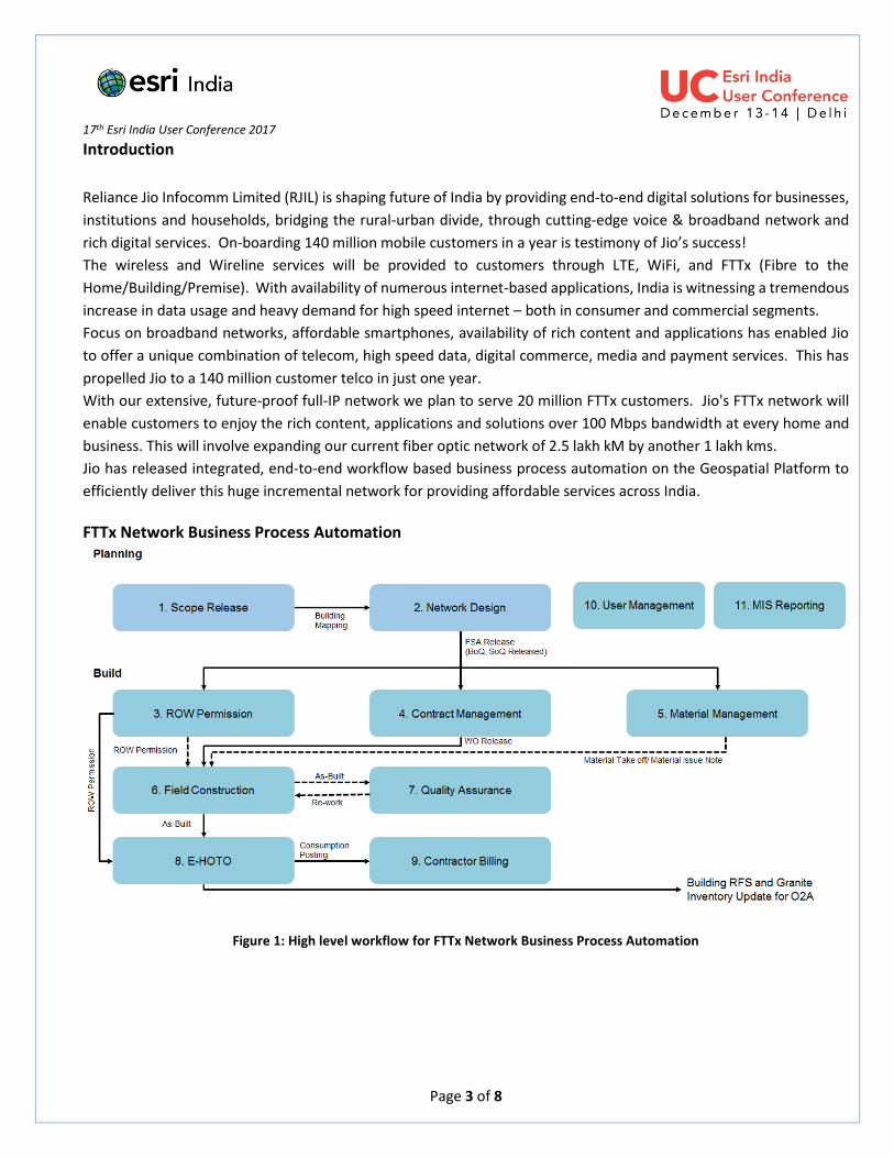
Jio has released integrated, end-to-end workflow based business process automation on the Geospatial Platform to
efficiently deliver this huge incremental network for providing affordable services across India.
FTTx Network Business Process Automation
Figure 1: High level workflow for FTTx Network Business Process Automation

17th Esri India User Conference 2017
Page 4 of 8
User Groups There are seven major user groups consisting of more than 2000 users located across India. This solution is accessible
to both employees and contractors. Users are centrally handled through user management system created on basis of
functionality, geography and hierarchy.
Figure 2: User Groups
Milestones FTTx application suit consist of a BPM engine for Business Workflow & Dashboard, Desktop & web GIS applications,
mobile GIS Apps (build on top of ArcGIS for Mobile on Android Platform) and GIS-based web-service interfaces covering
the major milestones of network roll-out as shown
Figure 3: Network Roll-out Milestones
Scope Release
Network Design
ROW Permission
BOQ & SOQ
Field Construction
Quality Assurance
eHOTO
Input from BPM
O2A
17th Esri India User Conference 2017
Page 5 of 8
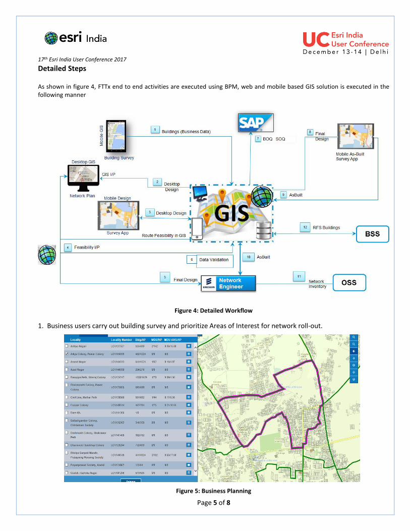
Detailed Steps As shown in figure 4, FTTx end to end activities are executed using BPM, web and mobile based GIS solution is executed in the following manner
Figure 4: Detailed Workflow
1. Business users carry out building survey and prioritize Areas of Interest for network roll-out.
Figure 5: Business Planning
17th Esri India User Conference 2017
Page 6 of 8
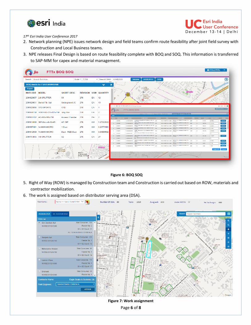
2. Network planning (NPE) issues network design and field teams confirm route feasibility after joint field survey with
Construction and Local Business teams.
3. NPE releases Final Design is based on route feasibility complete with BOQ and SOQ. This information is transferred
to SAP-MM for capex and material management.
4. Procurement & Contracting completed by NPE & Construction based on BOQ and SOQ.
5. Right of Way (ROW) is managed by Construction team and Construction is carried out based on ROW, materials and
contractor mobilization.
6. The work is assigned based on distributor serving area (DSA).
Figure 7: Work assignment
Figure 6: BOQ SOQ
17th Esri India User Conference 2017
Page 7 of 8
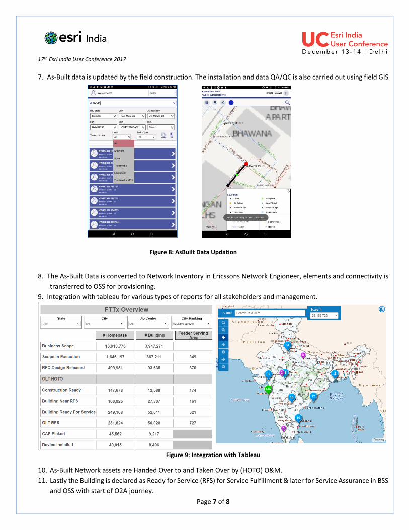
7. As-Built data is updated by the field construction. The installation and data QA/QC is also carried out using field GIS
8. The As-Built Data is converted to Network Inventory in Ericssons Network Engioneer, elements and connectivity is
transferred to OSS for provisioning.
9. Integration with tableau for various types of reports for all stakeholders and management.
Figure 9: Integration with Tableau
10. As-Built Network assets are Handed Over to and Taken Over by (HOTO) O&M.
11. Lastly the Building is declared as Ready for Service (RFS) for Service Fulfillment & later for Service Assurance in BSS
and OSS with start of O2A journey.
Figure 8: AsBuilt Data Updation
17th Esri India User Conference 2017
Page 8 of 8
Conclusion 1. In-depth understanding of geo-spatial technology and its benefits resulted in implementing FTTx Business Process
Automation Solution on ESRIs ArcGIS platform, benefiting large user base of 2,000 users across India.
2. Vision of RJIL Apex Management in implementing ESRIs ArcGIS platform as foundation is due to in-depth
understanding of technology and its wide spread potential benefits resulting in complete commitment to ensure
appropriate usage across all functions and geographies.
3. End-to-end Business Process implementation instead of GIS as a point solution.
4. Substantial automation reducing hundreds of thousands of man-hours in Network Plan and Build process.
5. Quality records for life-time maintenance
6. Instantaneous communication between project teams and individuals results in zero idle time.