YOU ARE DOWNLOADING DOCUMENT

Please tick the box to continue:

Transcript
Page 1: Vector Analysis - University of Washingtoncourses.washington.edu/gis250/lessons/vector_analysis1/Vector_analysis.pdf · Soil classes were digitised from a 1:100,000 soil map Geological

Vector Analysis

Page 2: Vector Analysis - University of Washingtoncourses.washington.edu/gis250/lessons/vector_analysis1/Vector_analysis.pdf · Soil classes were digitised from a 1:100,000 soil map Geological

Where have we come so far?

•  By now, you should be familiar with: – What GIS is – How GIS works – Some of what GIS can do – GIS data formats

•  Spatial data •  Tabular data

– Modifying display of data

Page 3: Vector Analysis - University of Washingtoncourses.washington.edu/gis250/lessons/vector_analysis1/Vector_analysis.pdf · Soil classes were digitised from a 1:100,000 soil map Geological

What comes next?

Spatial Analysis

Page 4: Vector Analysis - University of Washingtoncourses.washington.edu/gis250/lessons/vector_analysis1/Vector_analysis.pdf · Soil classes were digitised from a 1:100,000 soil map Geological

Overview

•  Selection •  Topological Overlays •  Buffering

Page 5: Vector Analysis - University of Washingtoncourses.washington.edu/gis250/lessons/vector_analysis1/Vector_analysis.pdf · Soil classes were digitised from a 1:100,000 soil map Geological

Selection

•  Examples:

– Which census blocks are within 10 km of a superfund site?

– Which ecoregions are projected to experience the greatest changes in climate?

– Which building sites are on parcels with some old growth forest?

Page 6: Vector Analysis - University of Washingtoncourses.washington.edu/gis250/lessons/vector_analysis1/Vector_analysis.pdf · Soil classes were digitised from a 1:100,000 soil map Geological

Selection

•  Examples:

– What is the age-class distribution of stands adjacent to stands younger than 10 years?

– What is the average slope of stands within 50 m of a stream?

– Where are vacant properties close to Interstate 5?

Page 7: Vector Analysis - University of Washingtoncourses.washington.edu/gis250/lessons/vector_analysis1/Vector_analysis.pdf · Soil classes were digitised from a 1:100,000 soil map Geological

Selection is based on spatial relationships

• Relationships between features – Proximity – Containment – Overlap

• All based on feature geometry

Page 8: Vector Analysis - University of Washingtoncourses.washington.edu/gis250/lessons/vector_analysis1/Vector_analysis.pdf · Soil classes were digitised from a 1:100,000 soil map Geological

Selection

–  Selecting points near a line (proximity) –  Selecting adjacent features (proximity) –  Selecting lines within polygons (containment) –  Selecting polygons that contain lines (overlap) –  Selecting points within polygons (containment) –  Selecting polygons that contain points (overlap) –  Selecting polygons that overlap polygons (overlap)

Page 9: Vector Analysis - University of Washingtoncourses.washington.edu/gis250/lessons/vector_analysis1/Vector_analysis.pdf · Soil classes were digitised from a 1:100,000 soil map Geological

Selection

Selecting points near a line

Page 10: Vector Analysis - University of Washingtoncourses.washington.edu/gis250/lessons/vector_analysis1/Vector_analysis.pdf · Soil classes were digitised from a 1:100,000 soil map Geological

Selection

Selecting adjacent polygons in the same layer

Page 11: Vector Analysis - University of Washingtoncourses.washington.edu/gis250/lessons/vector_analysis1/Vector_analysis.pdf · Soil classes were digitised from a 1:100,000 soil map Geological

Selection

Lines within polygons

Page 12: Vector Analysis - University of Washingtoncourses.washington.edu/gis250/lessons/vector_analysis1/Vector_analysis.pdf · Soil classes were digitised from a 1:100,000 soil map Geological

Selection

Polygons that contain lines

Page 13: Vector Analysis - University of Washingtoncourses.washington.edu/gis250/lessons/vector_analysis1/Vector_analysis.pdf · Soil classes were digitised from a 1:100,000 soil map Geological

Selection

Points within polygons

Page 14: Vector Analysis - University of Washingtoncourses.washington.edu/gis250/lessons/vector_analysis1/Vector_analysis.pdf · Soil classes were digitised from a 1:100,000 soil map Geological

Selection

Polygons that contain points

Page 15: Vector Analysis - University of Washingtoncourses.washington.edu/gis250/lessons/vector_analysis1/Vector_analysis.pdf · Soil classes were digitised from a 1:100,000 soil map Geological

Selection

Polygons that overlap other polygons

Page 16: Vector Analysis - University of Washingtoncourses.washington.edu/gis250/lessons/vector_analysis1/Vector_analysis.pdf · Soil classes were digitised from a 1:100,000 soil map Geological

Selection

• Definitions – Target layer:

the layer we want to know something about – Selector layer:

the layer we are spatially referencing to

• Which streams cross stands > 200 ha?

Page 17: Vector Analysis - University of Washingtoncourses.washington.edu/gis250/lessons/vector_analysis1/Vector_analysis.pdf · Soil classes were digitised from a 1:100,000 soil map Geological

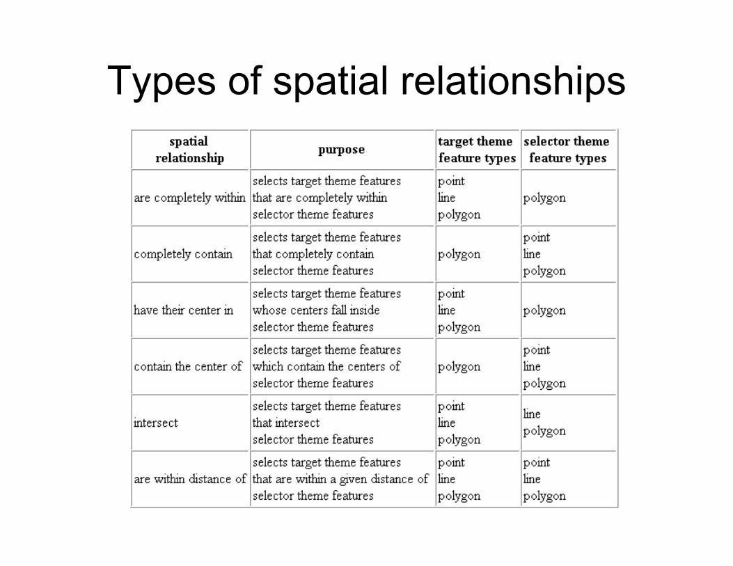
Types of spatial relationships

Page 18: Vector Analysis - University of Washingtoncourses.washington.edu/gis250/lessons/vector_analysis1/Vector_analysis.pdf · Soil classes were digitised from a 1:100,000 soil map Geological

Topological overlay:

•  Combine multiple layers to create new layers

•  Different types of overlays

•  Quantify length/area of overlap

•  All functions are accessed with ArcToolbox tools

Page 19: Vector Analysis - University of Washingtoncourses.washington.edu/gis250/lessons/vector_analysis1/Vector_analysis.pdf · Soil classes were digitised from a 1:100,000 soil map Geological

Input and overlay layers

•  Input layer is the “bottom” layer •  Overlay is the “top” layer •  For some types of overlays it matters

which of the two layers are on top.

Page 20: Vector Analysis - University of Washingtoncourses.washington.edu/gis250/lessons/vector_analysis1/Vector_analysis.pdf · Soil classes were digitised from a 1:100,000 soil map Geological

Topological overlay:

•  Always uses polygon as the overlay layer •  Output is the same as the input

Page 21: Vector Analysis - University of Washingtoncourses.washington.edu/gis250/lessons/vector_analysis1/Vector_analysis.pdf · Soil classes were digitised from a 1:100,000 soil map Geological

Topological overlay: How it works

• Features from different layers are combined to create a layer with new features

Page 22: Vector Analysis - University of Washingtoncourses.washington.edu/gis250/lessons/vector_analysis1/Vector_analysis.pdf · Soil classes were digitised from a 1:100,000 soil map Geological

Topological overlay: How it works

•  New nodes are created •  New lines and polygons are built

Page 23: Vector Analysis - University of Washingtoncourses.washington.edu/gis250/lessons/vector_analysis1/Vector_analysis.pdf · Soil classes were digitised from a 1:100,000 soil map Geological

Topological overlay: How it works

Alfisol

•  Lines are split at polygon boundaries •  Lines take on attributes of overlapping polygons

Page 24: Vector Analysis - University of Washingtoncourses.washington.edu/gis250/lessons/vector_analysis1/Vector_analysis.pdf · Soil classes were digitised from a 1:100,000 soil map Geological

ArcGIS does NOT automatically update geometry fields for

shapefiles

Page 25: Vector Analysis - University of Washingtoncourses.washington.edu/gis250/lessons/vector_analysis1/Vector_analysis.pdf · Soil classes were digitised from a 1:100,000 soil map Geological

Topological overlay: Types

•  Union •  Clip •  Identity •  Intersect •  Update •  Erase

Page 26: Vector Analysis - University of Washingtoncourses.washington.edu/gis250/lessons/vector_analysis1/Vector_analysis.pdf · Soil classes were digitised from a 1:100,000 soil map Geological

Union null value =

""

null value =

0

• Combines layers • All features from both

input and overlay layers remain

• Attribute values are assigned by containment

• Attribute inheritance • Polygon & polygon only

Page 27: Vector Analysis - University of Washingtoncourses.washington.edu/gis250/lessons/vector_analysis1/Vector_analysis.pdf · Soil classes were digitised from a 1:100,000 soil map Geological

Union: Example

Page 28: Vector Analysis - University of Washingtoncourses.washington.edu/gis250/lessons/vector_analysis1/Vector_analysis.pdf · Soil classes were digitised from a 1:100,000 soil map Geological

Identity

polygon on polygon, line, or point

1

•  Input layer takes on “identities” (attributes) of overlay •  All features from input layer are retained •  Attributes from both layers exist

where there is overlap •  Order of input and overlay matters

Page 29: Vector Analysis - University of Washingtoncourses.washington.edu/gis250/lessons/vector_analysis1/Vector_analysis.pdf · Soil classes were digitised from a 1:100,000 soil map Geological

Identity: Example

input overlay

Page 30: Vector Analysis - University of Washingtoncourses.washington.edu/gis250/lessons/vector_analysis1/Vector_analysis.pdf · Soil classes were digitised from a 1:100,000 soil map Geological

Intersect

• Only features from area of intersection exist in output • Attributes from both layers exist • Order of input and overlay does not matter • Polygon on polygon, line, or point

Page 31: Vector Analysis - University of Washingtoncourses.washington.edu/gis250/lessons/vector_analysis1/Vector_analysis.pdf · Soil classes were digitised from a 1:100,000 soil map Geological

Clip

•  “Cookie cutter” • Only features and attributes of the input layer are

retained • Polygon on polygon, line, or point

Page 32: Vector Analysis - University of Washingtoncourses.washington.edu/gis250/lessons/vector_analysis1/Vector_analysis.pdf · Soil classes were digitised from a 1:100,000 soil map Geological

Clipping… an example

Page 33: Vector Analysis - University of Washingtoncourses.washington.edu/gis250/lessons/vector_analysis1/Vector_analysis.pdf · Soil classes were digitised from a 1:100,000 soil map Geological

Clipping… an example

Page 34: Vector Analysis - University of Washingtoncourses.washington.edu/gis250/lessons/vector_analysis1/Vector_analysis.pdf · Soil classes were digitised from a 1:100,000 soil map Geological

Buffering

Page 35: Vector Analysis - University of Washingtoncourses.washington.edu/gis250/lessons/vector_analysis1/Vector_analysis.pdf · Soil classes were digitised from a 1:100,000 soil map Geological

Buffering • Define a constant or variable width from input

features • Creates a whole new data layer

Page 36: Vector Analysis - University of Washingtoncourses.washington.edu/gis250/lessons/vector_analysis1/Vector_analysis.pdf · Soil classes were digitised from a 1:100,000 soil map Geological

Ecological Applications: Vol. 17, No. 1, pp. 140–153.

A META-BACI APPROACH FOR EVALUATING MANAGEMENT INTERVENTION ON CHRONIC

WASTING DISEASE IN MULE DEER

Mary M. Conner, Michael W. Miller, Michael R. Ebinger, and Kenneth P. Burnham

Page 37: Vector Analysis - University of Washingtoncourses.washington.edu/gis250/lessons/vector_analysis1/Vector_analysis.pdf · Soil classes were digitised from a 1:100,000 soil map Geological

ArcGIS does NOT automatically update geometry fields for

shapefiles

Page 38: Vector Analysis - University of Washingtoncourses.washington.edu/gis250/lessons/vector_analysis1/Vector_analysis.pdf · Soil classes were digitised from a 1:100,000 soil map Geological

Dissolve (not really an overlay method)

• Works on a single layer • Removes boundaries between polygons or

nodes between arcs • Features with same attributes are dissolved

Page 39: Vector Analysis - University of Washingtoncourses.washington.edu/gis250/lessons/vector_analysis1/Vector_analysis.pdf · Soil classes were digitised from a 1:100,000 soil map Geological

Landscape Ecology © Springer Science+Business Media, Inc. 2006 10.1007/s10980-006-9049-3

Research Article

Spatial patterns of Mediterranean land abandonment and related land cover transitions

Raymond Sluiter and Steven M. de Jong

Page 40: Vector Analysis - University of Washingtoncourses.washington.edu/gis250/lessons/vector_analysis1/Vector_analysis.pdf · Soil classes were digitised from a 1:100,000 soil map Geological
Page 41: Vector Analysis - University of Washingtoncourses.washington.edu/gis250/lessons/vector_analysis1/Vector_analysis.pdf · Soil classes were digitised from a 1:100,000 soil map Geological
Page 42: Vector Analysis - University of Washingtoncourses.washington.edu/gis250/lessons/vector_analysis1/Vector_analysis.pdf · Soil classes were digitised from a 1:100,000 soil map Geological
Page 43: Vector Analysis - University of Washingtoncourses.washington.edu/gis250/lessons/vector_analysis1/Vector_analysis.pdf · Soil classes were digitised from a 1:100,000 soil map Geological

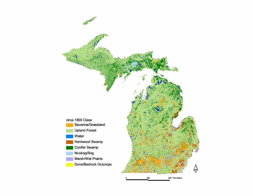
Digital map data Major and minor roads, trails, walking paths, land use, streams and lakes (1:25,000 ) Soil classes were digitised from a 1:100,000 soil map Geological units were digitised from geological maps (1:50,000)

Aerial photographs Black and white aerial photographs from 1946, 1954, 1970, 1971, 1983 and 1988 Colour aerial photographs in 1996 and 2001. Scales were ranging from 1:17,000 to 1:25,000. After scanning and processing of the images the resulting cell size was 1 m to detect small individual trees and detailed vegetation patterns.

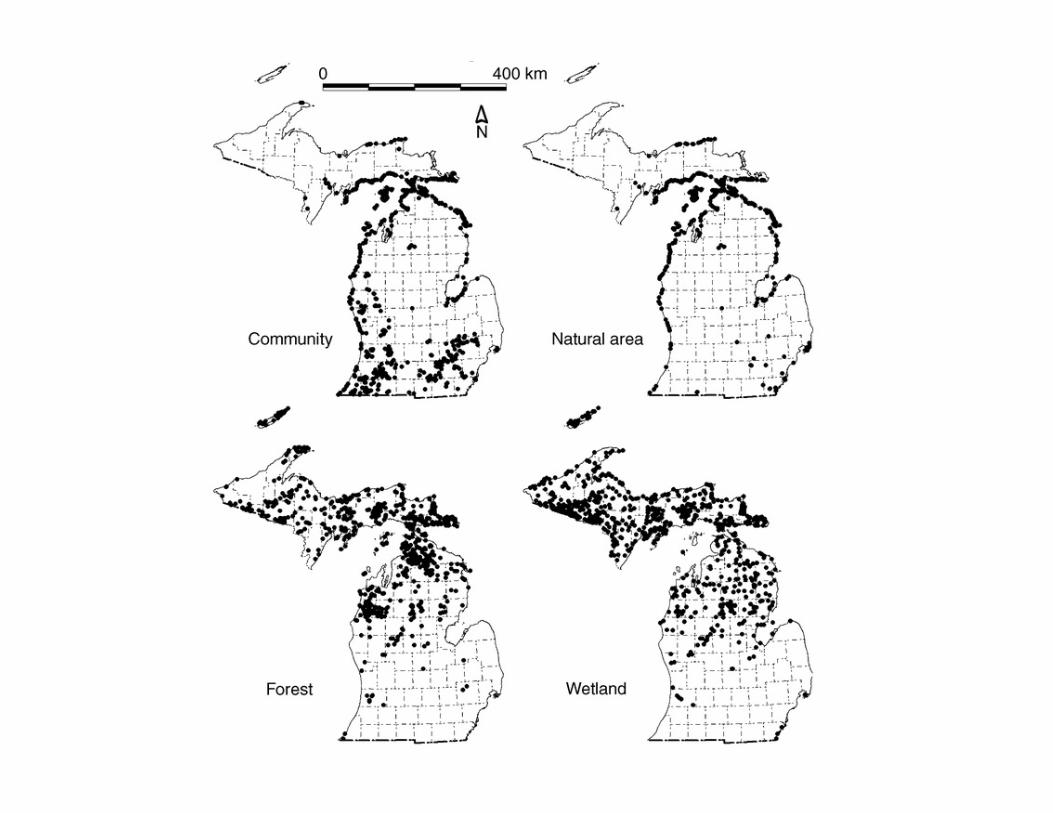
Aerial photograph interpretation and change detection

Page 44: Vector Analysis - University of Washingtoncourses.washington.edu/gis250/lessons/vector_analysis1/Vector_analysis.pdf · Soil classes were digitised from a 1:100,000 soil map Geological
Page 45: Vector Analysis - University of Washingtoncourses.washington.edu/gis250/lessons/vector_analysis1/Vector_analysis.pdf · Soil classes were digitised from a 1:100,000 soil map Geological
Page 46: Vector Analysis - University of Washingtoncourses.washington.edu/gis250/lessons/vector_analysis1/Vector_analysis.pdf · Soil classes were digitised from a 1:100,000 soil map Geological

recently abandoned

recently abandoned

older abandoned natural succession

natural succession & older succession

natural to tilled & natural to urban

Page 47: Vector Analysis - University of Washingtoncourses.washington.edu/gis250/lessons/vector_analysis1/Vector_analysis.pdf · Soil classes were digitised from a 1:100,000 soil map Geological
Page 48: Vector Analysis - University of Washingtoncourses.washington.edu/gis250/lessons/vector_analysis1/Vector_analysis.pdf · Soil classes were digitised from a 1:100,000 soil map Geological

Homework

•  For next week, read “Vector Analysis 2” “Help Topics”

• 

•  Assignment 5 (due May 2nd)

Page 49: Vector Analysis - University of Washingtoncourses.washington.edu/gis250/lessons/vector_analysis1/Vector_analysis.pdf · Soil classes were digitised from a 1:100,000 soil map Geological

Ecological Applications: Vol. 16, No. 1, pp. 186–201.

Identifying Potential Indicators Of Conservation Value Using Natural Heritage

Occurrence Data Peter B. Pearman, Michael R. Penskar, Edward H. Schools, and

Helen D. Enander

Page 50: Vector Analysis - University of Washingtoncourses.washington.edu/gis250/lessons/vector_analysis1/Vector_analysis.pdf · Soil classes were digitised from a 1:100,000 soil map Geological
Page 51: Vector Analysis - University of Washingtoncourses.washington.edu/gis250/lessons/vector_analysis1/Vector_analysis.pdf · Soil classes were digitised from a 1:100,000 soil map Geological
Page 52: Vector Analysis - University of Washingtoncourses.washington.edu/gis250/lessons/vector_analysis1/Vector_analysis.pdf · Soil classes were digitised from a 1:100,000 soil map Geological
Page 53: Vector Analysis - University of Washingtoncourses.washington.edu/gis250/lessons/vector_analysis1/Vector_analysis.pdf · Soil classes were digitised from a 1:100,000 soil map Geological
Page 54: Vector Analysis - University of Washingtoncourses.washington.edu/gis250/lessons/vector_analysis1/Vector_analysis.pdf · Soil classes were digitised from a 1:100,000 soil map Geological
Page 55: Vector Analysis - University of Washingtoncourses.washington.edu/gis250/lessons/vector_analysis1/Vector_analysis.pdf · Soil classes were digitised from a 1:100,000 soil map Geological
Page 56: Vector Analysis - University of Washingtoncourses.washington.edu/gis250/lessons/vector_analysis1/Vector_analysis.pdf · Soil classes were digitised from a 1:100,000 soil map Geological

Related Documents