Update on Hazus AAL Study and Data
Eric Berman - FEMATom Schweitzer– STARR PTS

2
Contributors
Tom SchweitzerPTS – STARR
Dan DeeganPTS – BakerAECOM
Shane ParsonPTS – RAMPP
3
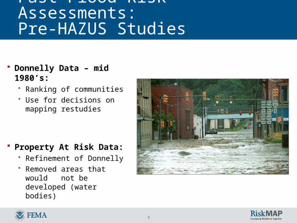
Donnelly Data – mid 1980’s:• Ranking of communities• Use for decisions on
mapping restudies
Property At Risk Data:• Refinement of Donnelly• Removed areas that would
not be developed (water bodies)
Past Flood Risk Assessments: Pre-HAZUS Studies

4
Average Annualized Loss (AAL)
FEMA initiated the AAL Study in 2009 to provide a Nationwide Loss Dataset
Level 1 conducted on every county in the contiguous United States using Hazus-MH for both Riverine and Coastal analysis
Used national data sets for consistency within the analysis
Losses based on building and contents

5
Summary of Average Annualized Loss (AAL) Study Hazus AAL Study
• Completed March 2010
• Used Hazus-MH MR4
• Losses for 48 states and the District of Columbia
• Included 3,109 counties
• Calculated losses for five return periods: 10-year / 50-year / 100-year / 200-year / 500-year
• Calculated average annualized losses (AAL)
• AAL losses extracted from HPR files at the Census block
• AAL losses complied by county, state, and watershed (HUC-8, April 2010 WBD)
• Usability analysis performed

6
Summary of AAL Study 2009-10 Hazus-MH Flood Average Annualized Loss
Estimation (AAL) was performed for continental U.S. Level 1 Analysis
Inputs:• County-wide regions• 10 sq mile drainage area• 30M USGS DEM• Default Census data (GBS)
Final Output included:• Return period losses• Total exposure• Average Annualized Loss• Annualized Loss Ratio Relative Average Annualized Losses by State

7
AAL Results Total Annualized Losses Estimated at 55
Billion:• Includes both riverine and coastal
Using NFIP program average annual losses and other source of annual flood loss data, sets a lower bound of the annualized flood
loss at minimum of 10 billion annually.
Relative Average Annualized Losses by State Annualized Loss Ratio by State
8
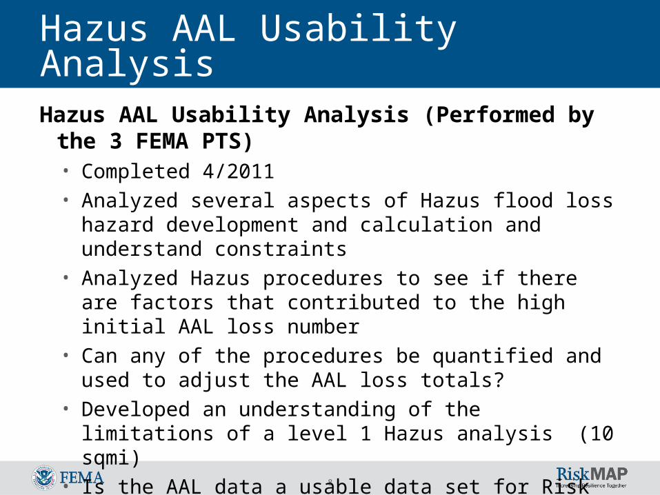
Hazus AAL Usability AnalysisHazus AAL Usability Analysis (Performed by
the 3 FEMA PTS)• Completed 4/2011• Analyzed several aspects of Hazus flood loss hazard
development and calculation and understand constraints
• Analyzed Hazus procedures to see if there are factors that contributed to the high initial AAL loss number
• Can any of the procedures be quantified and used to adjust the AAL loss totals?
• Developed an understanding of the limitations of a level 1 Hazus analysis (10 sqmi)
• Is the AAL data a usable data set for Risk MAP?

9
Hazus AAL Usability Analysis SUMMARY
• Use of 30 M DEM - some issues in developing an accurate flood hazard, (only national topography data set)
• Use of the Census data is appropriate for this level of analysis (planning level)
• The weighted area method for losses can overstate losses
• 10 sqmi drainage area - though limiting, use of smaller threshold requires significantly more resources (processing time)
• Possible double counting of losses in coastal areas

10
SUMMARY• AAL losses were overstated with 2 and 5 year
return periods losses included in the AAL calculation (removed from final AAL estimate)
• AAL losses were recalculated outside of Hazus using the 5 return periods (10, 50, 100, 200, 500-year) losses
• AAL losses were calculated using Log normal* • Should use only one cross-section for all return
periods• Data is appropriate for use in Discovery meetings,
sequencing and general comparison of relative risk between areas
* Hazus 2.1 uses a linear AAL calculation
Hazus AAL Usability Analysis
11
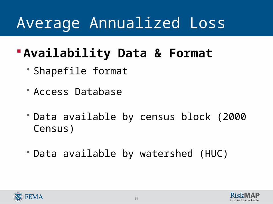
Average Annualized Loss
Availability Data & Format• Shapefile format
• Access Database
• Data available by census block (2000 Census)
• Data available by watershed (HUC)

12
GIS Format Intended Uses:
• Identify flood prone areas and• Communicate relative flood risk (building and content losses)

13
Use of AAL Values
Loss values need to be shown as relative rather than absolute dollar amounts.

14
Discovery Meeting
Discovery Map

15
Current AAL Data Availability Annualized Losses by Census Block (2000
Census)
1. Availability Data & Format
Can be used to satisfy Discovery meeting requirements

16
Flood Risk Assessment Purpose and Intended Uses Identify Areas and Communicate Relative
Flood Risk:• Flood prone areas• Vulnerable people and property
Provide Flood Risk $:• Potential damage severity for different flood frequencies • Identify locations with possible cost effective mitigation
options
Improve Estimates for Flood Risk $:• Losses from Average Annualized Loss (AAL) Study • Refined losses from new flood study depth grids• Refined general building stock data from local sources

17
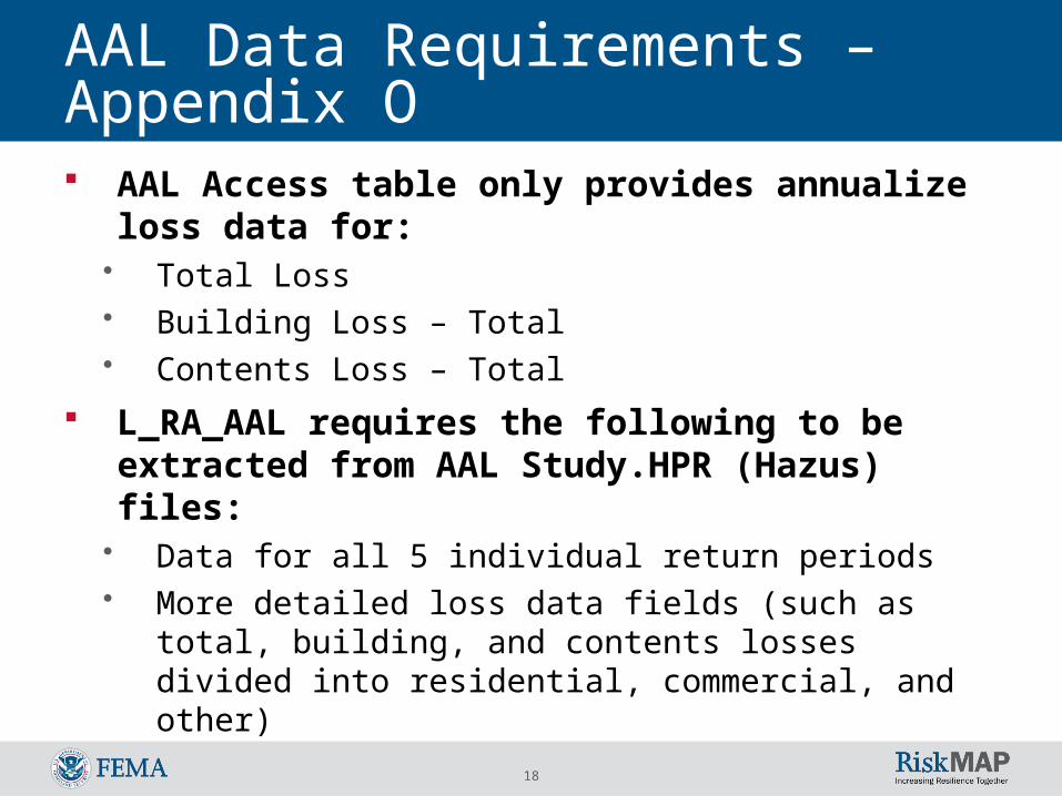
AAL Data Requirements – Appendix O
Appendix O for Risk MAP
Requires other data from the Hazus AAL data set
18
AAL Data Requirements – Appendix O AAL Access table only provides annualize
loss data for:• Total Loss• Building Loss – Total• Contents Loss – Total
L_RA_AAL requires the following to be extracted from AAL Study.HPR (Hazus) files:
• Data for all 5 individual return periods• More detailed loss data fields (such as total,
building, and contents losses divided into residential, commercial, and other)

19
Flood Risk Data
AAL data has been compiled into a single database for use in extracting the required data in Appendix O format
We have develop a tool that performs this extraction into MS Access Databases
This is the initial assessment data that is required to populate the Risk Database for use in producing Risk MAP non-regulatory products

20
Flood Risk Data
Currently we are finalizing the data. It can be requested from the PTS contractor for your Region.

21
Flood Risk Assessment Delivered

22
Flood Risk Map Elements

23
Flood Risk Report Elements

24
Moving Forward The process for compiling the new data into a
national data sets has not yet been determined Additionally the process to stored and distributed
this data nationally as yet been determined Currently we are looking at storing the data
associated with Flood Risk Databases in the MIP until other means can be developed to house the information.