TMS SOFTWARE
TMS IntraWeb WebGMaps
DEVELOPERS GUIDE
1
TMS IntraWeb WebGMaps
DEVELOPERS GUIDE
April 2017
Copyright © 2017 by tmssoftware.com bvba
Web: http://www.tmssoftware.com
Email: [email protected]

TMS SOFTWARE
TMS IntraWeb WebGMaps
DEVELOPERS GUIDE
2
Table of contents
Introduction .............................................................................................................................................4
Availability ................................................................................................................................................4
Terms of use .............................................................................................................................................5
List of included components ....................................................................................................................6
Online references .....................................................................................................................................6
TTIWWebGMaps description .............................................................................................................. 7
TTIWWebGMaps features ................................................................................................................... 7
TTIWWebGMaps architecture ............................................................................................................. 9
TTIWWebGMaps use ........................................................................................................................... 9
Getting started ................................................................................................................................ 9
View Types ..................................................................................................................................... 13
General map settings ........................................................................................................................ 17
TTIWWebGMaps.MapOptions properties .................................................................................... 17
TTIWWebGMaps.StreetViewOptions properties .......................................................................... 20
TTIWWebGMaps.WeatherViewOptions properties ...................................................................... 20
Map markers ..................................................................................................................................... 21
Adding markers ............................................................................................................................. 21
TTIWWebGMaps.Markers properties ........................................................................................... 22
Map directions .................................................................................................................................. 24
Retrieving directions ..................................................................................................................... 24
TTIWWebGMaps.Directions properties ........................................................................................ 25
Map polygons .................................................................................................................................... 27
Adding polygons ............................................................................................................................ 27
TTIWWebGMaps.Polygons properties .......................................................................................... 29
Map polylines .................................................................................................................................... 31
Adding polylines ............................................................................................................................ 31
TTIWWebGMaps.Polylines properties .......................................................................................... 33
Maps ControlsOptions ....................................................................................................................... 35

TMS SOFTWARE
TMS IntraWeb WebGMaps
DEVELOPERS GUIDE
3
TTIWWebGMaps.ControlsOptions properties .............................................................................. 35
Maps methods ................................................................................................................................... 39
TTIWWebGMaps events .................................................................................................................... 41
Panning the map ........................................................................................................................... 49
Zooming the map .......................................................................................................................... 49
TTIWWebGMapsGeocoding component .......................................................................................... 52
TTIWWebGMapsReverseGeocoding component.............................................................................. 53
TTIWWebGMaps demo ..................................................................................................................... 55

TMS SOFTWARE
TMS IntraWeb WebGMaps
DEVELOPERS GUIDE
4
Introduction
The TMS IntraWeb WebGMaps is a component that allows integration of the Google Maps road map
control. The TTIWWebGMaps component renders maps of different types: default roadmap view,
satellite view, hybrid view (a mix of satellite view with roadmap information), and terrain
(topographic style map). TTIWWebGMaps offers pan, zoom and scale control.
In this document you will find an overview of the TTIWWebGMaps component and its features, code
snippets to quickly start using the component and overviews of properties, methods and events.
Availability
TTIWWebGMaps and its helper components are available as IntraWeb components for Delphi and
C++Builder.
TTIWWebGMaps can be used for Win32 and Win64 application development *and is available for
Delphi XE, XE2, XE3, XE4, XE5, XE6, XE7, XE8, 10 Seattle, 10.1 Berlin, 10.2 Tokyo
C++Builder XE, XE2, XE3, XE4, XE5, XE6, XE7, XE8, 10 Seattle 10.1 Berlin, 10.2 Tokyo
TTIWWebGMaps is compatible with IntraWeb 11, 12, 14.
TTIWWebGMaps has been designed for and tested with: Windows Vista, Windows 2008, Windows 7,
Windows 8 and Windows 10.
*Win64 development requires RAD Studio XE2 or newer versions.

TMS SOFTWARE
TMS IntraWeb WebGMaps
DEVELOPERS GUIDE
5
Terms of use
With the purchase of TTIWWebGMaps, you are entitled to our consulting and support services to
integrate the Google Maps service in IntraWeb applications and with this consulting and support
comes the full source code needed to do this integration. As TTIWWebGMaps uses the Google Maps
service, you're bound to the terms of this Google service that can be found at:
http://code.google.com/apis/maps/terms.html
http://maps.google.com/help/terms_maps.html TMS software is not responsible for the use of TTIWWebGMaps. The purchase of TTIWWebGMaps
does not include any license fee that you might possibly be required to pay to Google. It will depend
on your type of usage of the Google Maps service whether a license fee needs to be paid to Google.
It is the sole responsibility of the user or company providing the application that integrates the
Google maps service to respect the Google terms and conditions . TMS software does not take any
responsibility nor indemnifies any party violating the Google maps service terms & conditions.
Limited warranty
TMS software cannot guarantee the current or future operation & uptime of the Google maps
service. TMS software offers the consulting and support for TTIWWebGMaps in good faith that the
Google maps service is a reliable and future-proof service. In no case, TMS software shall offer
refunds or any other compensations in case the Google maps service terms/operation changes or
stops.
TMS SOFTWARE
TMS IntraWeb WebGMaps
DEVELOPERS GUIDE
6
List of included components
TTIWWebGMaps is the core map component.
TTIWWebGMapsGeocoding is the component to convert an address to longitude & latitude.
TTIWWebGMapsReverseGeocoding is the component to convert a longitude & latitude to an
address.
Online references
TMS software website: http://www.tmssoftware.com
TMS TTIWWebGMaps page: http://www.tmssoftware.com/site/iwwebgmaps.asp
TMS SOFTWARE
TMS IntraWeb WebGMaps
DEVELOPERS GUIDE
7
TTIWWebGMaps
TTIWWebGMaps description
The TMS IntraWeb WebGMaps is a mapping comment to integrate for display & control Google Maps
in a VCL Windows application. It supports the default roadmap view, satellite view, hybrid view, and
terrain view. The TTIWWebGMaps component offers pan, zoom and scale control. An overview-map
is integrated for faster panning. Street view offers a life-like 3D experience (where available).
Markers can be added to the map via the longitude/latitude coordinates or via an address. Various
marker types exist: default balloon marker, image marker, text marker, marker with hint. Markers
can also be displayed with a custom HTML label.
Polylines can be added to the map via a Path, which is a collection of longitude/latitude coordinates.
Polygons can be added to the map via longitude/latitude coordinates. Various polygon types exist:
custom polygon, circle or rectangle.
Directions can be retrieved via start and destination address. Directions can also be displayed on the
map.
A separate component IWWebGMapsGeocoding is available to perform address to longitude/latitude
conversions.
A separate component IWWebGMapsReverseGeocoding is available to perform longitude/latitude to
address conversions.
TTIWWebGMaps features
- Different map modes are available: default road map, satellite view, hybrid view (mixed
satellite/roadmap view), terrain (topographic style map) or Google streetview (where
available).
- Extra map information can be displayed: Bicycle View, Panoramio (pictures-) information,
Traffic information.
- Position markers can be added to the maps. Markers are displaying additional information on
the marker position when clicked. Markers can be default balloons or custom images.
- Markers is a collection of positions that are indicated on the map. Markers are based on
longitude and latitude coordinates.
- Moving over a marker can optionally display a hint with the marker title information.
TMS SOFTWARE
TMS IntraWeb WebGMaps
DEVELOPERS GUIDE
8
- A custom HTML label can optionally be displayed on top of a Marker.
- Polylines is a collection of lines that are displayed on the map. Polylines are based on a list of
longitude and latitude coordinates.
- Polygons is a collection of closed lines with a filled region that are displayed on the map.
Polygons are based on a list of longitude and latitude coordinates (for Polygons of type
ptPath), a center point and radius (for Polygons of type ptCircle) or two longitude and
latitude coordinates (for Polygons of type ptRectangle).
- Directions is a collection of routes between a start location and a destination address.
- Different controls are available and can be turned on or off. MapType control, OverViewMap
control, Pan control, Scale control, StreetView control and Zoom control. The position on the
screen of the control as well as the visibility and in some cases the style can be defined.
- Different mouse and keyboard options are available: dragging of the map, enabling/disabling
all controls, enabling/disabling zoom on double clicking the mouse, enabling/disabling the
mouse scroll wheel and enabling/disabling the keyboard.
- IWWebGMapsGeocoding is a separate component that takes an address as input and
converts this to longitude and latitude.
- IWWebGMapsReverseGeocoding is a separate component that takes a longitude and
latitude as input and converts this to an address.
TMS SOFTWARE
TMS IntraWeb WebGMaps
DEVELOPERS GUIDE
9
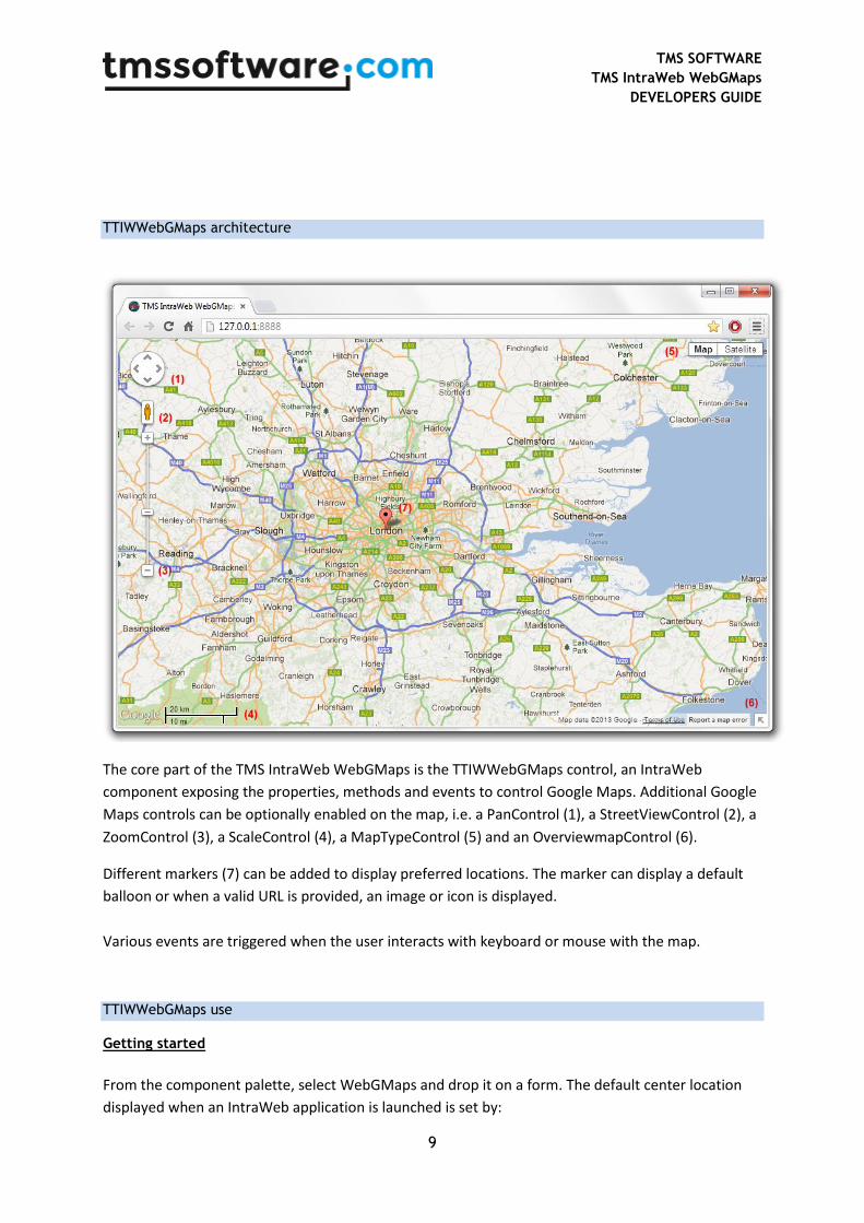
TTIWWebGMaps architecture
The core part of the TMS IntraWeb WebGMaps is the TTIWWebGMaps control, an IntraWeb
component exposing the properties, methods and events to control Google Maps. Additional Google
Maps controls can be optionally enabled on the map, i.e. a PanControl (1), a StreetViewControl (2), a
ZoomControl (3), a ScaleControl (4), a MapTypeControl (5) and an OverviewmapControl (6).
Different markers (7) can be added to display preferred locations. The marker can display a default
balloon or when a valid URL is provided, an image or icon is displayed.
Various events are triggered when the user interacts with keyboard or mouse with the map.
TTIWWebGMaps use
Getting started
From the component palette, select WebGMaps and drop it on a form. The default center location
displayed when an IntraWeb application is launched is set by:

TMS SOFTWARE
TMS IntraWeb WebGMaps
DEVELOPERS GUIDE
10
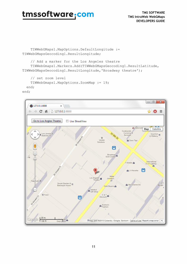
TIWWebGMaps.MapOptions.DefaultLongitude, TIWWebGMaps.MapOptions.DefaultLatitude.
Markers can be added to the map by adding a new entry to the collection TIWWebGMaps.Markers
and setting the Marker’s properties Longitude & Latitude.
This code snippet sets up the default view of the TTIWWebGMaps to show the Los Angeles Theatre
on Broadway at zoom level 19 with coordinates retrieved from the IWWebGMapsGeocoding
component:
begin
TIWWebGMapsGeocoding1.Address := 'Broadway 615, LOS ANGELES, USA';
if TIWWebGMapsGeocoding1.LaunchGeocoding = erOk then
begin
// center the map at the coordinate
TIWWebGMaps1.MapOptions.DefaultLatitude :=
TIWWebGMapsGeocoding1.ResultLatitude;
TMS SOFTWARE
TMS IntraWeb WebGMaps
DEVELOPERS GUIDE
11
TIWWebGMaps1.MapOptions.DefaultLongitude :=
TIWWebGMapsGeocoding1.ResultLongitude;
// Add a marker for the Los Angeles theatre
TIWWebGmaps1.Markers.Add(TIWWebGMapsGeocoding1.ResultLatitude,
TIWWebGMapsGeocoding1.ResultLongitude,'Broadway theatre');
// set zoom level
TIWWebGmaps1.MapOptions.ZoomMap := 19;
end;
end;
TMS SOFTWARE
TMS IntraWeb WebGMaps
DEVELOPERS GUIDE
12
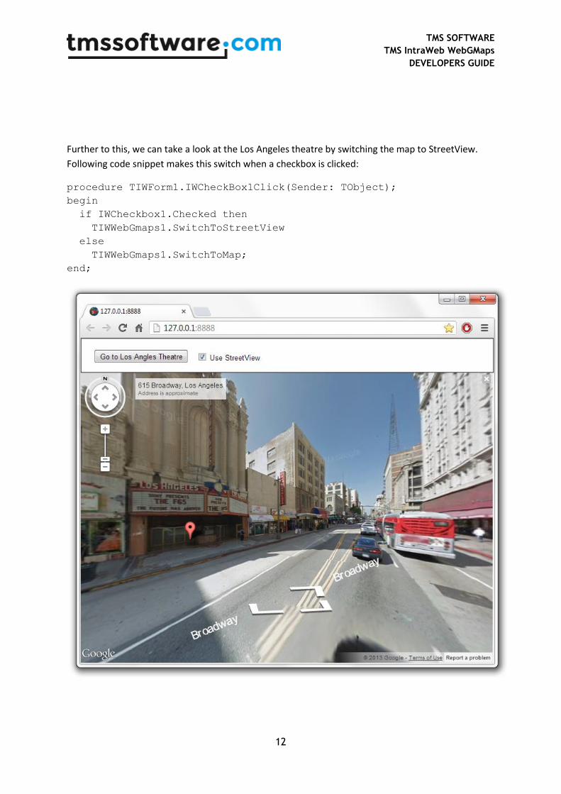
Further to this, we can take a look at the Los Angeles theatre by switching the map to StreetView.
Following code snippet makes this switch when a checkbox is clicked:
procedure TIWForm1.IWCheckBox1Click(Sender: TObject);
begin
if IWCheckbox1.Checked then
TIWWebGmaps1.SwitchToStreetView
else
TIWWebGmaps1.SwitchToMap;
end;
TMS SOFTWARE
TMS IntraWeb WebGMaps
DEVELOPERS GUIDE
13
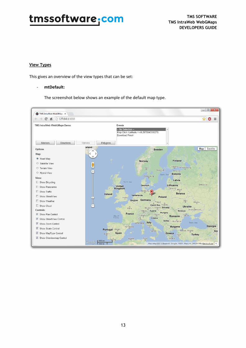
View Types
This gives an overview of the view types that can be set:
- mtDefault:
The screenshot below shows an example of the default map type.
TMS SOFTWARE
TMS IntraWeb WebGMaps
DEVELOPERS GUIDE
14
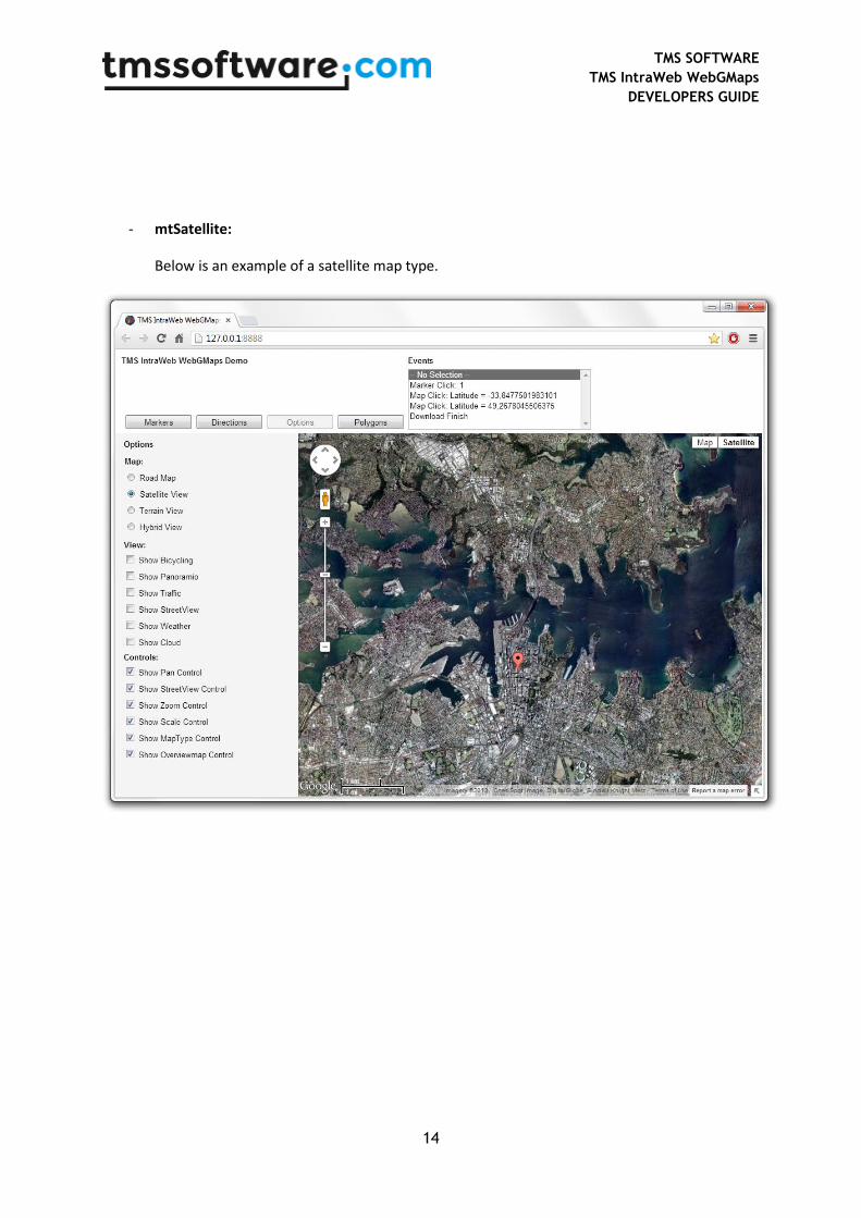
- mtSatellite:
Below is an example of a satellite map type.

TMS SOFTWARE
TMS IntraWeb WebGMaps
DEVELOPERS GUIDE
15
- mtHybrid:
This example shows the mix of a satellite view with added roadmap information.
TMS SOFTWARE
TMS IntraWeb WebGMaps
DEVELOPERS GUIDE
16
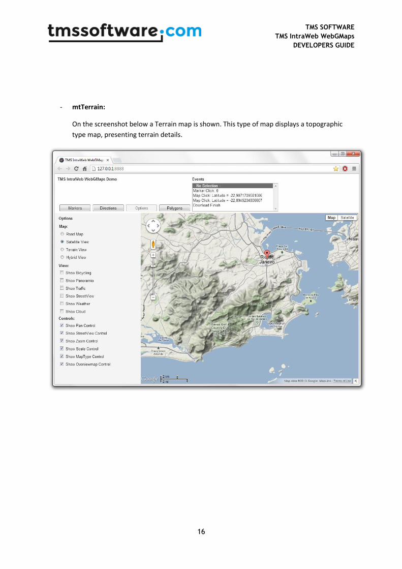
- mtTerrain:
On the screenshot below a Terrain map is shown. This type of map displays a topographic
type map, presenting terrain details.
TMS SOFTWARE
TMS IntraWeb WebGMaps
DEVELOPERS GUIDE
17
General map settings
TTIWWebGMaps.MapOptions properties
- DefaultLatitude: Sets the latitude value for the default position when the map is displayed.
- DefaultLongitude: Sets the longitude value for the default position when the map is displayed.
- DisableControls: Disables all map controls.
- DisableDoubleClickZoom: When set to true, disables zoom functions when double-clicking.
- DisablePOI: When set to true, disable display of the points of interest on the map.
- Draggable: When set to true, the entire map can be moved around in the control.
- EnableKeyboard: When set to true, enables the use of the keyboard for controlling panning in the map (or in street view mode).
- Language: Defines the language of the Copyright message, and the TWebGMaps.ControlsOptions.MapTypeControl displayed text.
- MapType: Sets the type of map. Following values are defined:
mtDefault: A roadmap is displayed. mtSatellite: A satellite view map is displayed. mtHybrid: A satellite view map is displayed, along with roadmap information. mtTerrain: A topographic map is displayed.
- PreloaderVisible: When set to true, an animation while loading the map is displayed.
- ShowCloud: When true, shows a cloud layer on top of the map
- ScrollWheel: When set to true, enables the use of the scroll wheel. The scroll wheel can be used to zoom in and out on the map.
- ShowBicycle: When set to true, and if available in your country, bicycle trail information can be displayed on the map.
TMS SOFTWARE
TMS IntraWeb WebGMaps
DEVELOPERS GUIDE
18
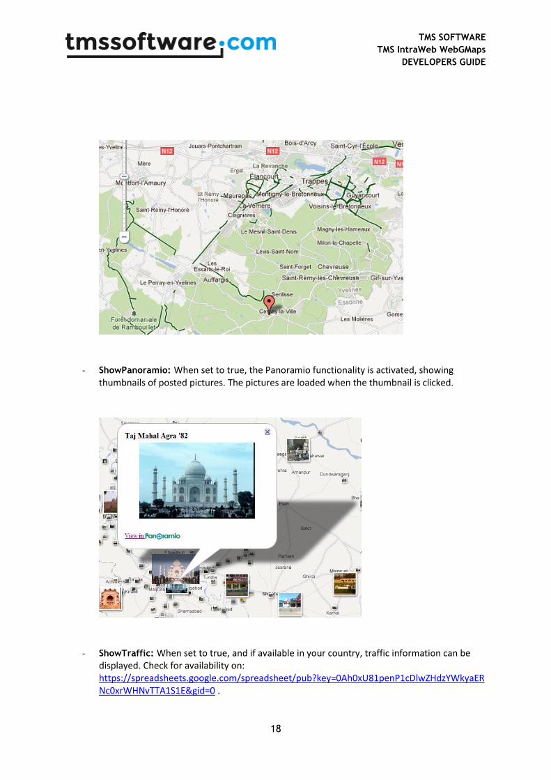
- ShowPanoramio: When set to true, the Panoramio functionality is activated, showing thumbnails of posted pictures. The pictures are loaded when the thumbnail is clicked.
- ShowTraffic: When set to true, and if available in your country, traffic information can be displayed. Check for availability on: https://spreadsheets.google.com/spreadsheet/pub?key=0Ah0xU81penP1cDlwZHdzYWkyaERNc0xrWHNvTTA1S1E&gid=0 .
TMS SOFTWARE
TMS IntraWeb WebGMaps
DEVELOPERS GUIDE
19
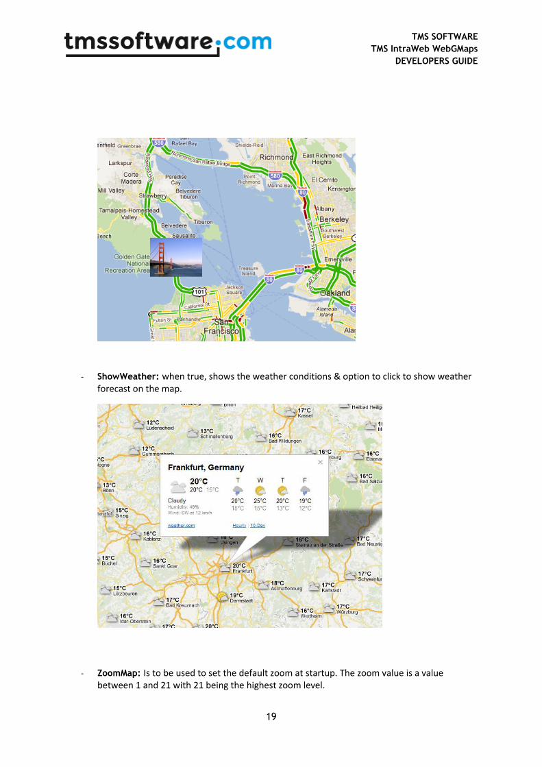
- ShowWeather: when true, shows the weather conditions & option to click to show weather forecast on the map.
- ZoomMap: Is to be used to set the default zoom at startup. The zoom value is a value between 1 and 21 with 21 being the highest zoom level.

TMS SOFTWARE
TMS IntraWeb WebGMaps
DEVELOPERS GUIDE
20
TTIWWebGMaps.StreetViewOptions properties
- DefaultLatitude: Sets the latitude value for the default street view position when StreetView is launched.
- DefaultLongitude: Sets the longitude value for the default street view position when StreetView is launched.
- Heading: Defines the heading at the street view position. Valid values are between 0 and 360 degrees.
- Pitch: Defines the pitch (view angle) for the street view. Valid values are between -90 and 90 degrees.
- Visible: When set to true, the street view is displayed.
- Zoom: Sets the zoom factor for the street view. Valid values are between 0 and 5.
TTIWWebGMaps.WeatherViewOptions properties
- LabelColor: Sets the background color of the weather info balloons as either white or black.
- ShowInfoWindows: Enables to show balloons with weather info/forecast when clicked.
- TemperatureUnit: Sets the unit of temperature to Celcius or Fahrenheit.
- WindspeedUnit: Sets the unit of wind speed to kilomters per hour or miles per hour or metres per second.
TMS SOFTWARE
TMS IntraWeb WebGMaps
DEVELOPERS GUIDE
21
Map markers
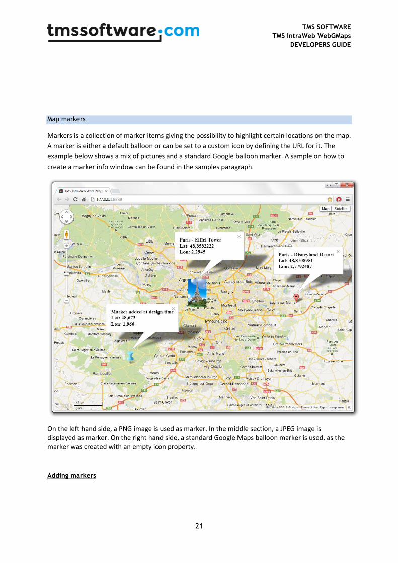
Markers is a collection of marker items giving the possibility to highlight certain locations on the map.
A marker is either a default balloon or can be set to a custom icon by defining the URL for it. The
example below shows a mix of pictures and a standard Google balloon marker. A sample on how to
create a marker info window can be found in the samples paragraph.
On the left hand side, a PNG image is used as marker. In the middle section, a JPEG image is displayed as marker. On the right hand side, a standard Google Maps balloon marker is used, as the marker was created with an empty icon property.
Adding markers
TMS SOFTWARE
TMS IntraWeb WebGMaps
DEVELOPERS GUIDE
22
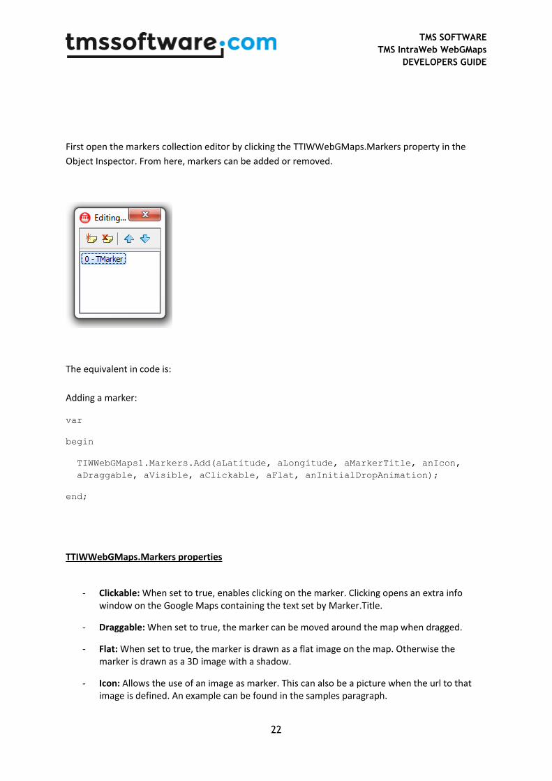
First open the markers collection editor by clicking the TTIWWebGMaps.Markers property in the
Object Inspector. From here, markers can be added or removed.
The equivalent in code is:
Adding a marker:
var
begin
TIWWebGMaps1.Markers.Add(aLatitude, aLongitude, aMarkerTitle, anIcon,
aDraggable, aVisible, aClickable, aFlat, anInitialDropAnimation);
end;
TTIWWebGMaps.Markers properties
- Clickable: When set to true, enables clicking on the marker. Clicking opens an extra info window on the Google Maps containing the text set by Marker.Title.
- Draggable: When set to true, the marker can be moved around the map when dragged.
- Flat: When set to true, the marker is drawn as a flat image on the map. Otherwise the marker is drawn as a 3D image with a shadow.
- Icon: Allows the use of an image as marker. This can also be a picture when the url to that image is defined. An example can be found in the samples paragraph.
TMS SOFTWARE
TMS IntraWeb WebGMaps
DEVELOPERS GUIDE
23
- InitialDropAnimation: When set to True, the marker is dropped with an animation effect on the map when displayed.
- Latitude: Sets the latitude value of the marker on the map.
- Longitude: Sets the longitude value of the marker on the map.
- MapLabel: Allows the use of a HTML label displayed on top of the marker. The label is automatically resized based on the Text value. A sample on how to create a custom label for a marker can be found in the samples paragraph.
o BorderColor: The border color of the label.
o Color: The color of the label.
o Font.Name: The font name for the label text.
o Font.Size: The font size for the label text.
o Font.Color: The font color for the label text.
o Margin: The margin in pixels between the label border and the label text.
o Text: The text displayed in the label. If this value is empty, no label is displayed.
- Title: Sets the title for the marker. This marker title will be displayed in the hint, when hovering over the marker and in the info window when the marker is clicked.
- Visible: When set to true, the marker is shown on the map.
TMS SOFTWARE
TMS IntraWeb WebGMaps
DEVELOPERS GUIDE
24
Map directions
TDirections is a collection of routes based on a start location and destination.
Retrieving directions
TIWWebGMaps1.GetDirections(aOrigin, aDestination, aAlternatives,
aTravelMode, aUnits, aLanguage, aAvoidHighways, aAvoidTolls, aWaypoints,
aOptimizeWaypoints);
The Directions collection will automatically be filled with all available routes for the given
parameters.
- aOrigin: (String) The start location.
- aDestination: (String) The destination location.
- aAlternatives: (Boolean) When set to true all available routes will be added to the Directions
collection. When set to false only the default route will be added to the Directions collection.
- aTravelMode: (TTravelMode) Sets which travel mode should be used to calculate the
directions.
o tmBicycling
o tmDriving
o tmWalking
- aUnits: (TUnits) Sets which unit system to use for the DistanceText values.
o usMetric: DistanceText values are returned using kilometers and meters.
o usImperial: DistanceText values are returned using miles and feet.
- aLanguage: (TLanguageName) Sets the language to use for the
Directions[].Legs[].Steps[].Instructions text values.
- aAvoidHighways: Restrict results to routes without highways
- aAvoidTolls: Restrict results to routes without tolls
- aWayPoints: List of additional locations. Waypoints allow you to calculate routes through
additional locations, in which case the returned route passes through the given waypoints.
TMS SOFTWARE
TMS IntraWeb WebGMaps
DEVELOPERS GUIDE
25
- aOptimizeWaypoints: Allow the Directions service to optimize the provided route by
rearranging the waypoints in a more efficient order
TTIWWebGMaps.Directions properties
- Bounds: Sets the bounds of a route.
o NorthEast: Sets the latitude/longitude of the north east corner of the route.
Latitude
Longitude
o SouthWest: Sets the latitude/longitude of the south west corner of the route.
Latitude
Longitude
- Copyrights: (readonly) Copyrights text to be displayed for this route.
- Legs: Contains information about this route and the steps of which it is composed.
o Distance: The total distance of the leg in meters.
o DistanceText: The text value of the total distance of the leg. If the usMetric parameter value is used in the GetDirections call then this value is specified in kilometers/meters. If the usImperial parameter value is used, the value is specified in miles/feet.
o Duration: The typical required time for this leg in seconds.
o DurationText: The typical required time for this leg specified in hours/minutes.
o EndAddress: The address of the destination of this leg.
o EndLocation: The geocoded destination of this leg.
Latitude
Longitude
o StartAddress: The address of the origin of this leg.
o StartLocation: The geocoded origin of this leg.
Latitude

TMS SOFTWARE
TMS IntraWeb WebGMaps
DEVELOPERS GUIDE
26
Longitude
o Steps:
Distance: The distance covered by this step in meters.
DistanceText: The text value of the distance covered by this step. If the usMetric parameter value is used in the GetDirections call then this value is specified in kilometers/meters. If the usImperial parameter value is used, the value is specified in miles/feet.
Duration: The typical required time to perform this step in seconds.
DurationText: The typical required time to perform this step specified in hours/minutes.
EndLocation: The ending location of this step.
Latitude
Longitude
Instructions: Instructions text for this step.
Polyline: A polyline describing the course for this step.
See Map Polylines for details.
StartLocation: The starting location of this step.
Latitude
Longitude
TravelMode: The mode of travel used in this step.
tmBicycling
tmDriving
tmWalking
- Polyline: A polyline that represents the entire course of this route. The path is simplified in order to make it suitable in contexts where a small number of vertices is required.
o See Map Polylines for details.
- Summary: Descriptive text for this route.
TMS SOFTWARE
TMS IntraWeb WebGMaps
DEVELOPERS GUIDE
27
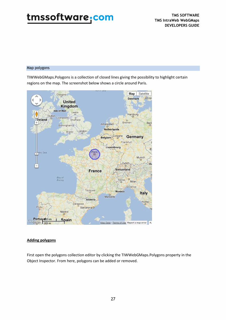
Map polygons
TIWWebGMaps.Polygons is a collection of closed lines giving the possibility to highlight certain
regions on the map. The screenshot below shows a circle around Paris.
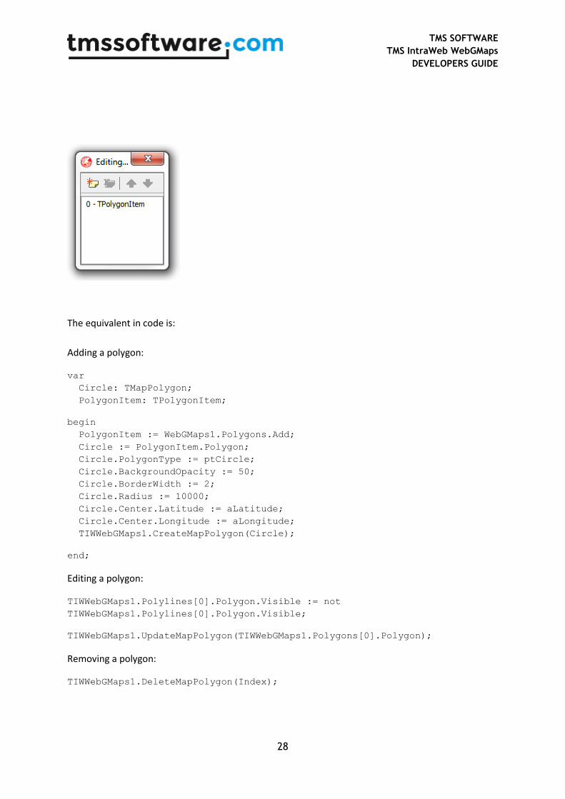
Adding polygons
First open the polygons collection editor by clicking the TIWWebGMaps.Polygons property in the
Object Inspector. From here, polygons can be added or removed.
TMS SOFTWARE
TMS IntraWeb WebGMaps
DEVELOPERS GUIDE
28
The equivalent in code is:
Adding a polygon:
var
Circle: TMapPolygon;
PolygonItem: TPolygonItem;
begin
PolygonItem := WebGMaps1.Polygons.Add;
Circle := PolygonItem.Polygon;
Circle.PolygonType := ptCircle;
Circle.BackgroundOpacity := 50;
Circle.BorderWidth := 2;
Circle.Radius := 10000;
Circle.Center.Latitude := aLatitude;
Circle.Center.Longitude := aLongitude;
TIWWebGMaps1.CreateMapPolygon(Circle);
end;
Editing a polygon:
TIWWebGMaps1.Polylines[0].Polygon.Visible := not
TIWWebGMaps1.Polylines[0].Polygon.Visible;
TIWWebGMaps1.UpdateMapPolygon(TIWWebGMaps1.Polygons[0].Polygon);
Removing a polygon:
TIWWebGMaps1.DeleteMapPolygon(Index);

TMS SOFTWARE
TMS IntraWeb WebGMaps
DEVELOPERS GUIDE
29
TTIWWebGMaps.Polygons properties
- BackgroundColor: The color of the polygon.
- BackgroundOpacity: The opacity of the polygon.
- BorderColor: The border color of the polygon.
- BorderOpacity: The border opacity of the polygon.
- BorderWidth: The width of the polygon border in pixels.
- Bounds: Sets the bounds of a polygon when PolygonType is set to ptRectangle.
o NorthEast: Sets the latitude/longitude of the north east corner of the rectangle
Latitude
Longitude
o SouthWest: Sets the latitude/longitude of the south west corner of the rectangle
Latitude
Longitude
- Center: Sets the latitude/longitude of the center point of the circle when PolygonType is set to ptCircle.
o Latitude
o Longitude
- Clickable: When set to true, enables clicking on the polygon.
- Editable: When set to true, the polyline can be edited.
- Geodesic: When set to true, each edge is rendered as a geodesic. When set to false, render each edge as a straight line.
- Path: The ordered sequence of coordinates of the polygon that forms a closed loop (when PolygonType is set to ptPath). Paths are closed automatically.
o Latitude: Sets the latitude value of the polygon path item on the map.
o Longitude: Sets the longitude value of the polygon path item on the map.
- PolygonType: Sets the type of polygon to be rendered.
o ptCircle: Renders a circle based on the Radius and Center property values.
TMS SOFTWARE
TMS IntraWeb WebGMaps
DEVELOPERS GUIDE
30
o ptPath: Renders a polygon based on the list of Path coordinates.
o ptRectangle: Renders a rectangle based on the Bounds property values.
- Radius: The radius of the polygon in meters. (When PolygonType is set to ptCircle)
- Visible: When set to true, the polygon is shown on the map.
- Zindex: The zIndex compared to other elements on the map.
TMS SOFTWARE
TMS IntraWeb WebGMaps
DEVELOPERS GUIDE
31
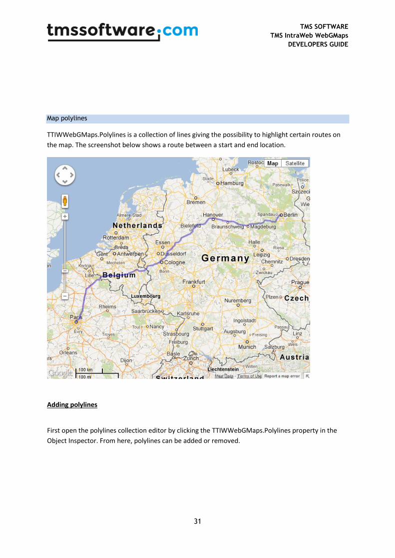
Map polylines
TTIWWebGMaps.Polylines is a collection of lines giving the possibility to highlight certain routes on
the map. The screenshot below shows a route between a start and end location.
Adding polylines
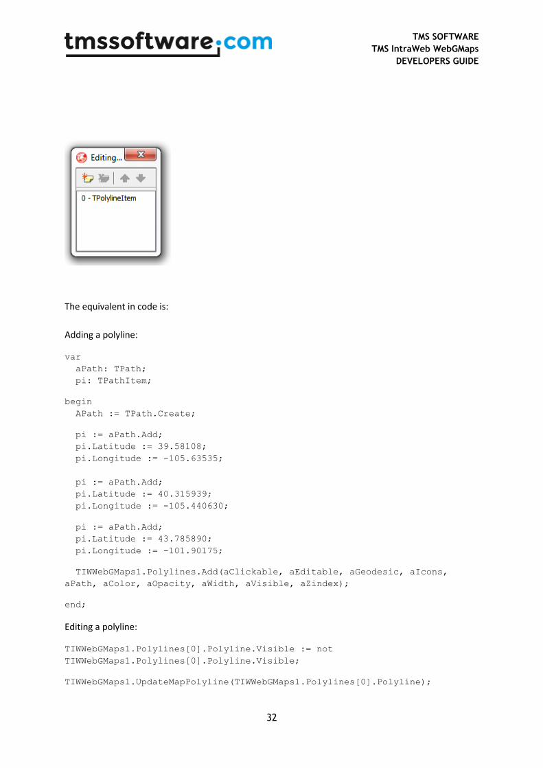
First open the polylines collection editor by clicking the TTIWWebGMaps.Polylines property in the
Object Inspector. From here, polylines can be added or removed.
TMS SOFTWARE
TMS IntraWeb WebGMaps
DEVELOPERS GUIDE
32
The equivalent in code is:
Adding a polyline:
var
aPath: TPath;
pi: TPathItem;
begin
APath := TPath.Create;
pi := aPath.Add;
pi.Latitude := 39.58108;
pi.Longitude := -105.63535;
pi := aPath.Add;
pi.Latitude := 40.315939;
pi.Longitude := -105.440630;
pi := aPath.Add;
pi.Latitude := 43.785890;
pi.Longitude := -101.90175;
TIWWebGMaps1.Polylines.Add(aClickable, aEditable, aGeodesic, aIcons,
aPath, aColor, aOpacity, aWidth, aVisible, aZindex);
end;
Editing a polyline:
TIWWebGMaps1.Polylines[0].Polyline.Visible := not
TIWWebGMaps1.Polylines[0].Polyline.Visible;
TIWWebGMaps1.UpdateMapPolyline(TIWWebGMaps1.Polylines[0].Polyline);
TMS SOFTWARE
TMS IntraWeb WebGMaps
DEVELOPERS GUIDE
33
Removing a polyline:
TIWWebGMaps1.DeleteMapPolyline(Index);
TTIWWebGMaps.Polylines properties
- Clickable: When set to true, enables clicking on the polyline.
- Color: The color of the polyline.
- Editable: When set to true, the polyline can be edited.
- Geodesic: When set to true, each edge is rendered as a geodesic. When set to false, render each edge as a straight line.
- Icons: The list of icons to be rendered along the polyline.
o SymbolType: The type of icon that is displayed on the polyline.
o Offset: The distance from the start of the line at which an icon is to be rendered. Can be set as a percentage (OffsetType set to dtPixels) or in pixels (OffsetType set to dtPercentage).
o OffsetType: Defines the way the Offset value is used.
ctPercentate: The Offset is handled as a percentage value.
ctPixel: The Offset is handled as a pixel value.
o RepeatValue: The distance between consecutive icons on the line. Can be set as a percentage (RepeatType set to dtPixels) or in pixels (RepeatType set to dtPercentage).
o RepeatType:
ctPercentate: The RepeatValue is handled as a percentage value.
ctPixel: The RepeatValue is handled as a pixel value.
o FixedRotation: If set to true, each icon in the sequence has the same fixed rotation regardless of the angle of the edge on which it lies. If set to false, each icon in the sequence is rotated to align with its edge.
- Opacity: The opacity of the polyline.
- Path: The ordered sequence of coordinates of the polyline.

TMS SOFTWARE
TMS IntraWeb WebGMaps
DEVELOPERS GUIDE
34
o Latitude: Sets the latitude value of the polyline path item on the map.
o Longitude: Sets the longitude value of the polyline path item on the map.
- Visible: When set to true, the polyline is shown on the map.
- Width: The width of the polyline in pixels.
- Zindex: The zIndex compared to other elements on the map.

TMS SOFTWARE
TMS IntraWeb WebGMaps
DEVELOPERS GUIDE
35
Maps ControlsOptions
The ControlsOptions class property bundles various settings for controlling the appearance and
behaviour of various controls in the map.
TTIWWebGMaps.ControlsOptions properties
- ControlsType: Sets the control to one of the defined types: ctAndroid, ctDefault, ctSmall or ctZomPan.
o ctAndroid: Changes the zoom control to Android style.
o ctDefault: Sets all controls to Google style controls. Please check ZoomControl zsLarge for an image.
o ctSmall: Sets the zoom control to a small format control. Please check ZoomControl zsSmall for an image.
o ctZoomPan: Sets the zoom control to the standard Google Maps zoom control.
- MapTypeControl: Defines the settings for the MapType control that allows choosing another map view from within the actual map.

TMS SOFTWARE
TMS IntraWeb WebGMaps
DEVELOPERS GUIDE
36
o Position: Sets the TWebGMaps.ControlsOptions.MapTypeControl.Position to one of these predefined choices: cpBottomLeft, cpBottomCenter, cpBottomRight, cpLeftBottom, cpLeftCenter, cpLeftTop, cpRightBottom, cpRightCenter, cpRightTop, cpTopCenter, CpTopLeft, cpTopRight.
o Style: Sets the TWebGMaps.ControlsOptions.MapTypeControl.Style to one of these predefined choices: mtsDefault, mtsDropDownMenu or mtsHorizontalBar.
mtsDefault: For more info, check mtsHorizontalBar.
mtsDropDownMenu: Displays the maptype control as a drop down menu. When choosing Map, the possibility is offered to draw the map in Terrain mode. When Satellite is chosen, the possibility is offered to show map details (Hybrid mode).
mtsHorizontalBar: Displays the maptype control as a horizontal bar. When Map is clicked, the possibility is offered to draw the map in Terrain mode. When Satellite is chosen, the possibility is offered to show map details (Hybrid mode).
o Visible: When set to true, the MapType control is drawn on the map.
- OverviewMapControl: Defines the settings for the overview map control that shows a larger area, with the actual view displayed in transparent blue. When holding the mouse down in this blue area, and moving within the overviewmap control, the map can be panned to another location.
o Open: When set to true, the overview map is shown is displayed in the right bottom corner of the map. When set to false, an arrow control is drawn that opens the overview map control when clicked.
o Visible: When set to true, the OverviewMap control is drawn on the map.
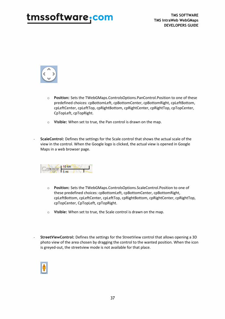
- PanControl: Sets the pan control that allows panning the actual view of the map within the control, by clicking the arrow keys (up, down, left, right).
TMS SOFTWARE
TMS IntraWeb WebGMaps
DEVELOPERS GUIDE
37
o Position: Sets the TWebGMaps.ControlsOptions.PanControl.Position to one of these predefined choices: cpBottomLeft, cpBottomCenter, cpBottomRight, cpLeftBottom, cpLeftCenter, cpLeftTop, cpRightBottom, cpRightCenter, cpRightTop, cpTopCenter, CpTopLeft, cpTopRight.
o Visible: When set to true, the Pan control is drawn on the map.
- ScaleControl: Defines the settings for the Scale control that shows the actual scale of the view in the control. When the Google logo is clicked, the actual view is opened in Google Maps in a web browser page.
o Position: Sets the TWebGMaps.ControlsOptions.ScaleControl.Position to one of these predefined choices: cpBottomLeft, cpBottomCenter, cpBottomRight, cpLeftBottom, cpLeftCenter, cpLeftTop, cpRightBottom, cpRightCenter, cpRightTop, cpTopCenter, CpTopLeft, cpTopRight.
o Visible: When set to true, the Scale control is drawn on the map.
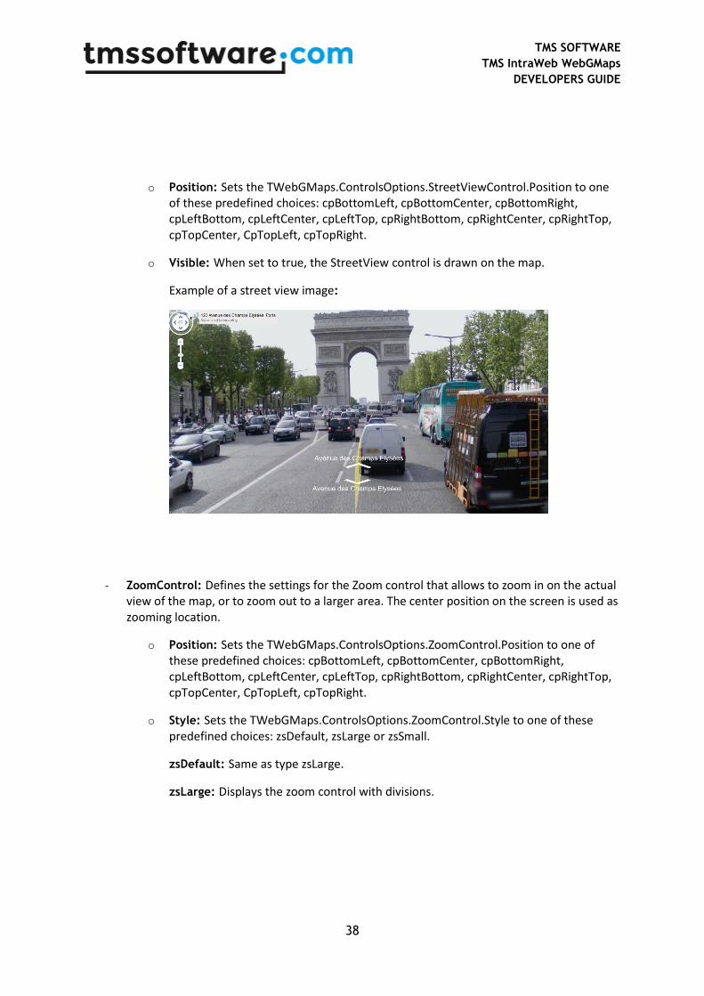
- StreetViewControl: Defines the settings for the StreetView control that allows opening a 3D photo view of the area chosen by dragging the control to the wanted position. When the icon is greyed-out, the streetview mode is not available for that place.
TMS SOFTWARE
TMS IntraWeb WebGMaps
DEVELOPERS GUIDE
38
o Position: Sets the TWebGMaps.ControlsOptions.StreetViewControl.Position to one of these predefined choices: cpBottomLeft, cpBottomCenter, cpBottomRight, cpLeftBottom, cpLeftCenter, cpLeftTop, cpRightBottom, cpRightCenter, cpRightTop, cpTopCenter, CpTopLeft, cpTopRight.
o Visible: When set to true, the StreetView control is drawn on the map.
Example of a street view image:
- ZoomControl: Defines the settings for the Zoom control that allows to zoom in on the actual view of the map, or to zoom out to a larger area. The center position on the screen is used as zooming location.
o Position: Sets the TWebGMaps.ControlsOptions.ZoomControl.Position to one of these predefined choices: cpBottomLeft, cpBottomCenter, cpBottomRight, cpLeftBottom, cpLeftCenter, cpLeftTop, cpRightBottom, cpRightCenter, cpRightTop, cpTopCenter, CpTopLeft, cpTopRight.
o Style: Sets the TWebGMaps.ControlsOptions.ZoomControl.Style to one of these predefined choices: zsDefault, zsLarge or zsSmall.
zsDefault: Same as type zsLarge.
zsLarge: Displays the zoom control with divisions.
TMS SOFTWARE
TMS IntraWeb WebGMaps
DEVELOPERS GUIDE
39
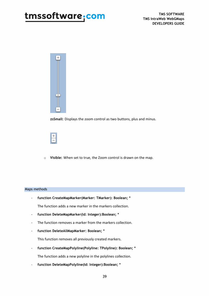
zsSmall: Displays the zoom control as two buttons, plus and minus.
o Visible: When set to true, the Zoom control is drawn on the map.
Maps methods
- function CreateMapMarker(Marker: TMarker): Boolean; *
The function adds a new marker in the markers collection.
- function DeleteMapMarker(Id: Integer):Boolean; *
- The function removes a marker from the markers collection.
- function DeleteAllMapMarker: Boolean; *
This function removes all previously created markers.
- function CreateMapPolyline(Polyline: TPolyline): Boolean; *
The function adds a new polyline in the polylines collection.
- function DeleteMapPolyline(Id: Integer):Boolean; *
TMS SOFTWARE
TMS IntraWeb WebGMaps
DEVELOPERS GUIDE
40
- The function removes a polyline from the polyline collection.
- function DeleteAllMapPolyline: Boolean; *
This function removes all previously created polylines.
- function CreateMapPolygon(Polygon: TMapPolygon): Boolean; *
The function adds a new polygon in the polygons collection.
- function DeleteMapPolygon(Id: Integer):Boolean; *
- The function removes a polygon from the polygons collection.
- function DeleteAllMapPolygon: Boolean; *
This function removes all previously created polygons.
- function OpenMarkerInfoWindowHtml(Id: Integer; HtmlText: String):Boolean; *
The function opens the marker info window for the marker with selected marker-id (Marker.Index). Extra information can be passed via the HtmlText string. A sample can be found in the samples paragraph.
- function CloseMarkerInfoWindowHtml(Id: Integer):Boolean; *
The function closes the marker with the given marker-id (Marker.Index).
- function GetMapBounds: Boolean; * This function retrieves the bounds coordinates of the currently displayed map. The bounds are returned via the OnAsyncBoundsRetrieved event.
- function MapPanTo(Latitude, Longitude: Double):Boolean; *
This function performs a pan to a location set by latitude and longitude coordinates. This is useful to set a certain position in the center of the control canvas.
- function MapZoomTo(Bounds: TBounds): Boolean; *
This function performs a zoom to fit the map inside the given bounds coordinates.
- function MapPanBy(X, Y: Integer):Boolean; *
The function moves the map horizontally (x) and vertical (y) pixels.
- function RenderDirections(Origin, Destination: string; TravelMode: TTravelMode = tmDriving; AvoidHighways: Boolean = false; AvoidTolls: Boolean = false; WayPoints: TStringList = nil; OptimizeWayPoints: Boolean = false): Boolean; *
TMS SOFTWARE
TMS IntraWeb WebGMaps
DEVELOPERS GUIDE
41
The function renders the directions on the map based on the provided parameters.
- function RemoveDirections(): Boolean; * The function removes directions that where placed on the map using the RenderDirections function.
- function DegreesToLonLat(StrLon, StrLat: string; var Lon,Lat: double): boolean; This function converts degrees to longitude / latitude coordinates.
- function AddMapKMLLayer(Url: string; ZoomToBounds: boolean): boolean; * This function displays a KML file on the map as defined by the Url parameter. If the ZoomToBounds is true the map is zoomed to the bounding box of the contents of the layer.
- function DeleteMapKMLLayer(Id: Integer):Boolean; *
The function removes a single KML layer from the map.
- function DeleteAllKMLLayer: Boolean; *
This function removes all KML layers from the map.
* Note: These methods can only be called from an asynchronous event. The necessary JavaScript code gets executed immediately in the browser.
TTIWWebGMaps events
The TTIWWebGMaps control contains three types of events:
- Normal events: Cause a full page refresh when fired.
- Asynchronous events: Cause an asynchronous page refresh when fired.
- Client events: Cause no page refresh when fired. Provide the possibility to execute custom JavaScript in the browser. These events are grouped under the ClientEvents class.
Events
TMS SOFTWARE
TMS IntraWeb WebGMaps
DEVELOPERS GUIDE
42
- OnAsyncBoundsRetrieved(Sender: TObject; EventParams: TStringList; Bounds: TBounds): ClientEvents.BoundsRetrieved(nelat, nelon, swlat, swlon): Event triggered after the GetBounds function has been called. This event returns the bounds coordinates of the currently displayed map.
- OnAsyncDownloadFinish(Sender: TObject; EventParams: TStringList;): ClientEvents.MapDownloadFinish():
Event triggered when the map download is finished.
- OnMapClick(Sender: TObject; Latitude, Longitude: Double; X, Y: Integer; Button: TMouseButton): OnAsyncMapClick(Sender: TObject; EventParams: TStringList; Latitude, Longitude: Double; X, Y: Integer; Button: TMouseButton): ClientEvents.MapClick (lat, lon, x, y):
Event triggered when the map is clicked. Returns the latitude and longitude coordinates of that position, the X and Y values indicate the pixel coordinates in the control window, button parameter returns what button was clicked on the mouse.
- OnMapDblClick(Sender: TObject; Latitude, Longitude: Double; X, Y: Integer): OnAsyncMapDblClick(Sender: TObject; EventParams: TStringList; Latitude, Longitude: Double; X, Y: Integer): ClientEvents.MapDblClick (lat, lon, x, y):
Event triggered when the map is double-clicked. Returns the latitude and longitude coordinates of that position, the X and Y values indicate the pixel position in the control window.
- OnAsyncMapIdle(Sender: TObject; EventParams: TStringList;): ClientEvents.MapIdle():
Event triggered when the map is idle.
- OnAsyncMapMouseEnter(Sender: TObject; EventParams: TStringList; Latitude, Longitude: Double; X, Y: Integer): ClientEvents.MapMouseEnter(lat, lon):
TMS SOFTWARE
TMS IntraWeb WebGMaps
DEVELOPERS GUIDE
43
Event triggered when the mouse cursor enters the control. Returns the latitude and longitude coordinates of that position, the X and Y values indicate the pixel position in the control window.
- OnAsyncMapMouseExit(Sender: TObject; EventParams: TStringList; Latitude, Longitude: Double; X, Y: Integer): ClientEvents.MapMouseExit(lat, lon):
Event triggered when the mouse cursor exits the control. Returns the latitude and longitude coordinates of that position, the X and Y values indicate the pixel position in the control window.
- OnAsyncMapMouseMove(Sender: TObject; EventParams: TStringList; Latitude, Longitude: Double; X, Y: Integer): ClientEvents.MapMouseMove(lat, lon, x, y):
Event triggered when the mouse is moved within the control. Returns the latitude and longitude coordinates of that position, the X and Y values indicate the pixel position in the control window.
- OnAsyncMapMove(Sender: TObject; EventParams: TStringList; Latitude, Longitude: Double; X, Y: Integer): ClientEvents.MapMove(lat, lon):
Event triggered when the entire map is moved (left mouse and drag) within the control. Returns the latitude and longitude coordinates of the mouse cursor position, the X and Y values indicate the pixel position of the mouse cursor in the control window.
- OnAsyncMapMoveEnd(Sender: TObject; EventParams: TStringList; Latitude, Longitude: Double; X, Y: Integer): ClientEvents.MapMoveEnd(lat, lon):
Event triggered at the end of an entire map move (left mouse and drag) within the control. Returns the latitude and longitude coordinates of that position, the X and Y values indicate the pixel position in the control window.
- OnAsyncMapMoveStart(Sender: TObject; EventParams: TStringList; Latitude, Longitude: Double; X, Y: Integer): ClientEvents.MapMoveStart(lat, lon):
Event triggered at the start of an entire map move (left mouse and drag) within the control. Returns the latitude and longitude coordinates of that position, the X and Y values indicate the pixel position in the control window.

TMS SOFTWARE
TMS IntraWeb WebGMaps
DEVELOPERS GUIDE
44
- OnAsyncMapTypeChange(Sender: TObject; EventParams: TStringList; NewMapType: TMapType): ClientEvents.MapTypeChange(MapType):
Event triggered when the map type is changed. This event returns the selected map type.
- OnAsyncMapCenterChange(Sender: TObject; EventParams: TStringList; Latitude, Longitude: Double): ClientEvents.MapCenterChange(lat, lon): Event triggered when the map center position is changed. The event returns the new latitude and longitude coordinates.
- OnAsyncMapZoomChange(Sender: TObject; EventParams: TStringList; NewLevel: Integer): ClientEvents.MapZoomChange(zoomlevel):
Event triggered when the zoom level is changed via any type of the zoom control. The event returns the selected zoom level.
- OnMarkerClick(Sender: TObject; MarkerTitle: string; IdMarker: Integer; Latitude, Longitude: Double; Button: TMouseButton): OnAsyncMarkerClick(Sender: TObject; EventParams: TStringList; MarkerTitle: string; IdMarker: Integer; Latitude, Longitude: Double; Button: TMouseButton): ClientEvents.MarkerClick(title, IdMarker, lat, lon, Button):
Event triggered when a marker is clicked. Returns the marker title, the marker id, latitude and longitude coordinates defined for the marker, and what button has been clicked on the mouse.
- OnMarkerDblClick(Sender: TObject; MarkerTitle: string; IdMarker: Integer; Latitude, Longitude: Double): OnAsyncMarkerDblClick(Sender: TObject; EventParams: TStringList; MarkerTitle: string; IdMarker: Integer; Latitude, Longitude: Double): ClientEvents.MarkerDblClick(IdMarker):
Event triggered when a marker is double-clicked. The event returns the marker title, the marker id, latitude and longitude coordinates of the selected marker.
- OnAsyncMarkerDrag(Sender: TObject; EventParams: TStringList; MarkerTitle: string; IdMarker: Integer; Latitude, Longitude: Double):
TMS SOFTWARE
TMS IntraWeb WebGMaps
DEVELOPERS GUIDE
45
ClientEvents.MarkerDrag(title, IdMarker, lat, lon):
Event triggered when a marker is dragged around the control. The event returns the marker title, the marker id, latitude and longitude coordinates of the selected marker.
- OnAsyncMarkerDragEnd(Sender: TObject; EventParams: TStringList; MarkerTitle: string; IdMarker: Integer; Latitude, Longitude: Double): ClientEvents.MarkerDragEnd(title, IdMarker, lat, lon):
Event triggered at the end of when a marker is dragged in the control. The event returns the marker title, the marker id, latitude and longitude coordinates of the selected marker.
- OnAsyncMarkerDragStart(Sender: TObject; EventParams: TStringList; MarkerTitle: string; IdMarker: Integer; Latitude, Longitude: Double): ClientEvents.MarkerDragStart(title, IdMarker, lat, lon):
Event triggered at the start of when a marker is dragged in the control. The event returns the marker title, marker id, latitude and longitude coordinates of the selected marker.
- OnAsyncMarkerInfoWindowCloseClick(Sender: TObject; EventParams: TStringList; IdMarker: Integer): ClientEvents.MarkerInfoWindowCloseClick(IdMarker):
Event triggered when the info window is closed. The event returns the marker id.
- OnAsyncMarkerMouseDown(Sender: TObject; EventParams: TStringList; MarkerTitle: string; IdMarker: Integer; Latitude, Longitude: Double): ClientEvents.MarkerMouseDown(title, IdMarker, lat, lon):
Event triggered when the mouse cursor is over a marker and a mouse button is pressed. The event returns the marker title, marker id, latitude and longitude coordinates of the selected marker.
- OnAsyncMarkerMouseEnter(Sender: TObject; EventParams: TStringList; MarkerTitle: string; IdMarker: Integer; Latitude, Longitude: Double): ClientEvents.MarkerMouseEnter(title, IdMarker, lat, lon):
Event triggered when the mouse cursor enters a marker. The event returns the marker title, marker id, latitude and longitude coordinates for that position.
- OnAsyncMarkerMouseExit(Sender: TObject; EventParams: TStringList; MarkerTitle: string; IdMarker: Integer; Latitude, Longitude: Double):

TMS SOFTWARE
TMS IntraWeb WebGMaps
DEVELOPERS GUIDE
46
ClientEvents.MarkerMouseExit(title, IdMarker, lat, lon):
Event triggered when the mouse cursor leaves the marker. The event returns the latitude and longitude coordinates of that position the X and Y values indicate the pixel position in the control window.
- OnAsyncMarkerMouseUp(Sender: TObject; EventParams: TStringList; MarkerTitle: string; IdMarker: Integer; Latitude, Longitude: Double): ClientEvents.MarkerMouseUp(title, IdMarker, lat, lon):
Event triggered when the mouse cursor is over a marker and a mouse button is released. The event returns the marker title, marker id, latitude and longitude coordinates of the selected marker.
- OnPolylineClick(Sender: TObject; IdPolyline: Integer; Button: TMouseButton): OnAsyncPolylineClick(Sender: TObject; EventParams: TStringList; IdPolyline: Integer; Button: TMouseButton): ClientEvents.PolylineClick(IdMarker, MouseButton):
Event triggered when a polyline is clicked. Returns the polyline id and what button has been clicked on the mouse.
- OnPolylineDblClick(Sender: TObject; IdPolyline: Integer): OnAsyncPolylineDblClick(Sender: TObject; EventParams: TStringList; IdPolyline: Integer): ClientEvents.PolylineDblClick(IdPolyline):
Event triggered when a polyline is double-clicked. The event returns the polyline id.
- OnAsyncPolylineMouseDown(Sender: TObject; EventParams: TStringList; IdPolyline: Integer): ClientEvents.PolylineMouseDown(IdPolyline):
Event triggered when the mouse cursor is over a polyline and a mouse button is pressed. The event returns the polyline id.
- OnAsyncPolylineMouseEnter(Sender: TObject; EventParams: TStringList; IdPolyline: Integer): ClientEvents.PolylineMouseEnter(IdMarker):
Event triggered when the mouse cursor enters a polyline. The event returns the polyline id.
TMS SOFTWARE
TMS IntraWeb WebGMaps
DEVELOPERS GUIDE
47
- OnAsyncPolylineMouseExit(Sender: TObject; EventParams: TStringList; IdPolyline: Integer): ClientEvents.PolylineMouseExit(IdMarker):
Event triggered when the mouse cursor leaves a polyline. The event returns polyline id.
- OnAsyncPolylineMouseUp(Sender: TObject; EventParams: TStringList; IdPolyline: Integer): ClientEvents.PolylineMouseUp(IdPolyline):
Event triggered when the mouse cursor is over a polyline and a mouse button is released. The event returns the polyline id.
- OnPolygonClick(Sender: TObject; IdPolygon: Integer; Button: TMouseButton): OnAsyncPolygonClick(Sender: TObject; EventParams: TStringList; IdPolygon: Integer; Button: TMouseButton): ClientEvents.PolygonClick(IdPolygon, MouseButton):
Event triggered when a polygon is clicked. Returns the polygon id and what button has been clicked on the mouse.
- OnPolygonDblClick(Sender: TObject; IdPolygon: Integer): OnAsyncPolygonDblClick(Sender: TObject; EventParams: TStringList; IdPolygon: Integer): ClientEvents.PolygonDblClick(IdPolygon):
Event triggered when a polygon is double-clicked. The event returns the polygon id.
- OnAsyncPolygonMouseDown(Sender: TObject; EventParams: TStringList; IdPolygon: Integer): ClientEvents.PolygonMouseDown(IdPolygon):
Event triggered when the mouse cursor is over a polygon and a mouse button is pressed. The event returns the polygon id.
- OnAsyncPolygonMouseEnter(Sender: TObject; EventParams: TStringList; IdPolygon: Integer): ClientEvents.PolygonMouseEnter(IdPolygon):
Event triggered when the mouse cursor enters a polygon. The event returns the polygon id.
- OnAsyncPolygonMouseExit(Sender: TObject; EventParams: TStringList; IdPolygon: Integer): ClientEvents.PolygonMouseExit(IdPolygon):

TMS SOFTWARE
TMS IntraWeb WebGMaps
DEVELOPERS GUIDE
48
Event triggered when the mouse cursor leaves a polygon. The event returns polygon id.
- OnAsyncPolygonMouseUp(Sender: TObject; EventParams: TStringList; IdPolygon: Integer): ClientEvents.PolygonMouseUp(IdPolygon): Event triggered when the mouse cursor is over a polygon and a mouse button is released. The event returns the polygon id.
- OnAsyncWebGMapsError(Sender: TObject; EventParams: TStringList; ErrorType: TErrorType): ClientEvents.WebGMapsError(ErrorType):
Event triggered when an error is received. This event returns the error type.
- OnKMLLayerClick(Sender: TObject; ObjectName: string; IdLayer: Integer; Latitude, Longitude: Double): OnAsyncKMLLayerClick(Sender: TObject; EventParams: TStringList; ObjectName: string; IdLayer: Integer; Latitude, Longitude: Double):
ClientEvents.KMLLayerClick(title, IdLayer, lat, lon):
Event triggered when an object inside a KML layer is clicked. Returns the object name, the layer id and latitude and longitude coordinates defined for the object.
TMS SOFTWARE
TMS IntraWeb WebGMaps
DEVELOPERS GUIDE
49
TTIWWebGMaps Keyboard
When TTIWWebGMaps.MapOptions.EnableKeyboard is set to true, keyboard support is enabled.
Below is a list of keys that will allow you to navigate through the map without using the mouse.
Panning the map
Arrow key up, Arrow key down, Arrow key left, Arrow key right, move the map in the corresponding
directions a pixel at a time.
Page up key, Page down key, Home key and End key move the map up, down, left and right within
the control a page at a time.
Zooming the map
The Plus (+) key functions as a click on the plus button of the zoom control, and performs a zoom in
the map with one step.
The Minus (-) key performs the same as a click of the minus button in the zoom control, and
performs a zoom out in the map with one step.
TMS SOFTWARE
TMS IntraWeb WebGMaps
DEVELOPERS GUIDE
50
TTIWWebGMaps Sample code
Sample 1
This sample shows how to load the info Window with text in when the marker is clicked.
procedure TFrmMain.TIWWebGMaps1MarkerClick(MarkerTitle: string; IdMarker:
Integer; Latitude, Longitude: Double; Button:TMouseButton);
begin
if Button = mbLeft then
begin
TIWWebGMaps1.OpenMarkerInfoWindowHtml(IdMarker,'<b>'+ MarkerTitle +
'<br />' + 'Lat : ' + floattostr(latitude)+ '<br />' + 'Lon : ' +
floattostr(longitude) + '</b><br />')
End;
end;
Sample 3
This example shows how to format an icon URL string for proper image loading.
Var
MarkerIcon: string;
begin
MarkerIcon := StringReplace('File://' + GlobalPath +
'Files\Thumbnails\EiffelTower.png', '\', '/',[rfReplaceAll, rfIgnoreCase]);
end;
Sample 4
This example shows how to add a Marker with a custom label to the map.
TMS SOFTWARE
TMS IntraWeb WebGMaps
DEVELOPERS GUIDE
51
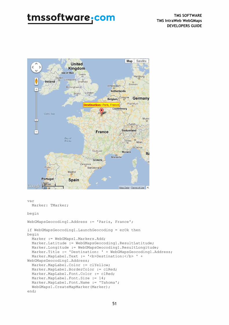
var
Marker: TMarker;
begin
WebGMapsGeocoding1.Address := 'Paris, France';
if WebGMapsGeocoding1.LaunchGeocoding = erOk then
begin
Marker := WebGMaps1.Markers.Add;
Marker.Latitude := WebGMapsGeocoding1.ResultLatitude;
Marker.Longitude := WebGMapsGeocoding1.ResultLongitude;
Marker.Title := 'Destination: ' + WebGMapsGeocoding1.Address;
Marker.MapLabel.Text := '<b>Destination:</b> ' +
WebGMapsGeocoding1.Address;
Marker.MapLabel.Color := clYellow;
Marker.MapLabel.BorderColor := clRed;
Marker.MapLabel.Font.Color := clRed;
Marker.MapLabel.Font.Size := 14;
Marker.MapLabel.Font.Name := 'Tahoma';
WebGMaps1.CreateMapMarker(Marker);
end;
TMS SOFTWARE
TMS IntraWeb WebGMaps
DEVELOPERS GUIDE
52
TTIWWebGMapsGeocoding component
The TTIWWebGMapsGeocoding component is a helper component to enable using the Google
geocoding service to convert an address to a longitude, latitude coordinate. The
TTIWWebGMapsGeocoding component is simple to use. Just set the address for which a lookup to
longitude & latitude is needed and call the function TIWWebGMapsGeocoding.LaunchGeocoding.
When the result of this call is erOK, the geocoding was successful and the longitude & latitude for the
address can be read from:
TIWWebGMapsGeocoding.ResultLatitude
TIWWebGMapsGeocoding.ResultLongitude
Note that the recommended formatting for the address is:
STREET (NUMBER), (ZIPCODE) CITY, COUNTRY
Example:
TIWWebGMapsGeocoding1.Address := 'Broadway 615, LOS ANGELES, USA';
if TIWWebGMapsGeocoding1.LaunchGeocoding = erOk then
begin
ShowMessage(‘Result:’+
FloatToStr(TIWWebGMapsGeocoding1.ResultLongitude)+’:’+
FloatToStr(TIWWebGMapsGeocoding1.ResultLatitude));
end;
Possible error codes are:
erZeroResults: address not found
erOverQueryLimit : number of allowed geocoding queries per day exceeded
erRequestDenied: Google blocked request from your IP address
erInvalidRequest: address not correctly formatted
erOtherProblem: unknown problem
TMS SOFTWARE
TMS IntraWeb WebGMaps
DEVELOPERS GUIDE
53
TTIWWebGMapsReverseGeocoding component
The TTIWWebGMapsReverseGeocoding component is a helper component to enable using the
Google geocoding service to convert a longitude, latitude coordinate into an address. Using
TTIWWebGMapsReverseGeocoding is straightforward. Set the longitude and latitude values for
which to lookup the address via the properties:
TIWWebGMapsReverseGeocoding.Latitude
TIWWebGMapsReverseGeocoding.Longitude
and call:
TIWWebGMapsReverseGeocoding.LaunchReverseGeocoding: TGeocodingResult;
For a successful reverse lookup, the result address is returned via:
TIWWebGMapsReverseGeocoding.ResultAddress: TWebGMapsAddress;
In this class property, the address is returned in a formatted way
(TIWWebGMapsReverseGeocoding.ResultAddress.FormattedAddress) and in the specific parts of the
address:
property Street: string;
property StreetNumber: string;
property City: string;
property State: string;
property Region: string;
property Country: string;
property CountryCode: string;
property PostalCode: string;
Example:
In this example, we get the address of the Big Ben in London via Geocoding and use the resulting
geocoordinates to obtain the address via reverse geocoding:
// first retrieve geocoordinates from Big Ben
TIWWebGMapsGeocoding1.Address := 'Big Ben, London';
TIWWebGMapsGeocoding1.LaunchGeocoding;
TMS SOFTWARE
TMS IntraWeb WebGMaps
DEVELOPERS GUIDE
54
// show Big Ben with marker on the WebGMaps control
TIWWebGMaps1.MapOptions.DefaultLatitude :=
TIWWebGMapsGeocoding1.ResultLatitude;
TIWWebGMaps1.MapOptions.DefaultLongitude :=
TIWWebGMapsGeocoding1.ResultLongitude;
TIWWebGMaps1.Markers.Add(WebGMapsGeocoding1.ResultLatitude,
TIWWebGMapsGeocoding1.ResultLongitude, 'Big Ben');
// retrieve the address via reverse geocoding
TIWWebGMapsReverseGeocoding1.Latitude :=
TIWWebGMapsGeocoding1.ResultLatitude;
TIWWebGMapsReverseGeocoding1.Longitude :=
TIWWebGMapsGeocoding1.ResultLongitude;
TIWWebGMapsReverseGeocoding1.LaunchReverseGeocoding;
Memo1.Lines.Add(TIWWebGMapsReverseGeocoding1.ResultAddress.Formatted
Address);
Note that TIWWebGMapsReverseGeocoding.LaunchReverseGeocoding function can return following
results:
Possible error codes are:
erOK: reverse geocoding successful
erZeroResults : address not found
erOverQueryLimit : number of allowed geocoding queries per day exceeded
erRequestDenied: Google blocked request from your IP address
erInvalidRequest: address not correctly formatted
erOtherProblem: unknown problem

TMS SOFTWARE
TMS IntraWeb WebGMaps
DEVELOPERS GUIDE
55
TTIWWebGMaps demo
The TMS IntraWeb WebGMaps Demo program shows the various configuration possibilities of the
TTIWWebGMaps component. It allows to interactively set various properties and the changes will be
immediately reflected in the map.
Main screen:
Note that a selection of asynchronous events that occur are displayed in the top right of the browser
screen.
Markers menu
From here a marker can be set at a specific address or a marker can be added based on coordinates.
All markers can be deleted.
TMS SOFTWARE
TMS IntraWeb WebGMaps
DEVELOPERS GUIDE
56
Directions menu
From here directions can be displayed on the Google map based on a start and end location.
Switching between different suggested routes is also possible, for each route the route details are
displayed.
Options menu
From here the different map types can be selected: satellite, map, hybrid, terrain. In addition, on the
displayed map type, the bicycle roads, panoramio pictures, traffic (where available), streetview
(where available) can be displayed.
The visibility of the various controls on the Google map can be set.
Polygons menu
From here a Line, Circle or Square polygon can be added at a latitude/longitude coordinate. All
polygons can be deleted.