State Office for Water ManagementMunich
The Isar -Plan Project in Munich Great (Un) expectations.
European River Restoration Conference
Session 5- Enhancement of Multi-Use Landscapes
11-13 September 2013

State Office for Water ManagementMunich
N. Mahida27.06.2012
2
The Isar-Plan Project: Basic Facts
Approximate length of the project= 8 km Planning start 1995 Construction start 2000 Project completed 2011 Successful cooperation between the Free State of Bavaria and the
City of Munich Approximate costs= 35 Mio. € High public acceptance and (ab)use

State Office for Water ManagementMunich
N. Mahida27.06.2012
3
Content of this Presentation
Highlights of the Isar-Plan Project Diversity of land use Multiple uses of the Isar through the Isar-Plan Unexpected issues encountered during the project

State Office for Water ManagementMunich
N. Mahida27.06.2012
4
The River Isar in Munich
The project area= 8km.
Total area of the river in the city=
14Km

State Office for Water ManagementMunich
N. Mahida27.06.2012
5
Catchment area 9000 km²
Length 270 km
Medium Low Discharge 40 m³/s
Medium discharge 90 m³/s
Medium high discharge 420 m³/s
High discharge (100 a) 1.100 m³/s
Isar River Sections
1 Upper Isar (alpine Character)
2 Isar in Munich (urban character)
3 Middle Isar (alluvial forest)
4 Lower Isar
5 Danube

State Office for Water ManagementMunich
N. Mahida27.06.2012
6
Highlights of the Project
Improving dyke security without affecting tree stands Modelling of a river section in a 1:20 model scale Landscape architecture competition UV treatment of water from sewage treatment plants Special method (hydrosaat) for planting saplings Removal of barriers for fish (weir replacement) Follow-up monitoring of ecological revitalistion Stakeholder Involvement and consultation Information system for the public

State Office for Water ManagementMunich
N. Mahida27.06.2012
7
Multiple uses of the Isar through the Isar- Plan
Ecological protection zones & monitoring
Recreation & tourist attraction Hydropower Cooling of power plant Improvement of micro-climate Stormwater drainage Canalisation Flood retention Social impacts

State Office for Water ManagementMunich
N. Mahida27.06.2012
8
Issues with diversity of land-use
Adaptation of land-use to land demand (for example for recreation, ecological value, public needs)
Historical and cultural value preservation
Urban use versus ecological protection
Management of different interest groups

State Office for Water ManagementMunich
N. Mahida27.06.2012
9
Unexpected Issues with the Isar-Plan Project
Conflicting objectives of various stakeholders Contractual deals Timing of public participation Liability issues in case of standing surf wave and potential accidents Land and water ownership Free and public goods are not valued Rule enforcement Awareness is lacking (eg. waste management) Cultural and commercial activities are becoming more popular which
potentially affect biodiversity

State Office for Water ManagementMunich
N. Mahida27.06.2012
10
Thank you for your attention !
Website: http://www.wwa-m.bayern.de/index.htm
State Office for Water ManagementMunich
N. Mahida27.06.2012
11
Extra Slides- if needed

State Office for Water ManagementMunich
N. Mahida27.06.2012
12
Historical Floods in Munich
HQ 1940 = 1.440 m³/s
HQ 1999 = 854 m³/s
HQ 2005 = 1050 m³/s
Historical Events
(above) - Destruction of the Ludwigsbrücke in 1813
(right)- Floods of August 2005

State Office for Water ManagementMunich
N. Mahida27.06.2012
13
The Isar in Munich in 1905- an Artists Impression

State Office for Water ManagementMunich
N. Mahida27.06.2012
14
The Isar at the same location in 1930

State Office for Water ManagementMunich
N. Mahida27.06.2012
15
The Isar in November 2001

State Office for Water ManagementMunich
N. Mahida27.06.2012
16
A Balancing Act of the 3 Main Project Goals
Flood protection Near-natural ecological
restoration Recreation & leisure
The baseline reference
situation at the Flaucher

State Office for Water ManagementMunich
N. Mahida27.06.2012
17
The Isar-Plan Project
The baseline situation (Flaucher)
Accessible banks
New island
Gravel banks
Species-rich flowering meadows
Stone-blocks for seating
Rock ramps replace sill beams
Dyke reinforcement
Start- Großhesselohe Bridge
End- Cornelius Bridge
Widened river bank
State Office for Water ManagementMunich
N. Mahida27.06.2012
18
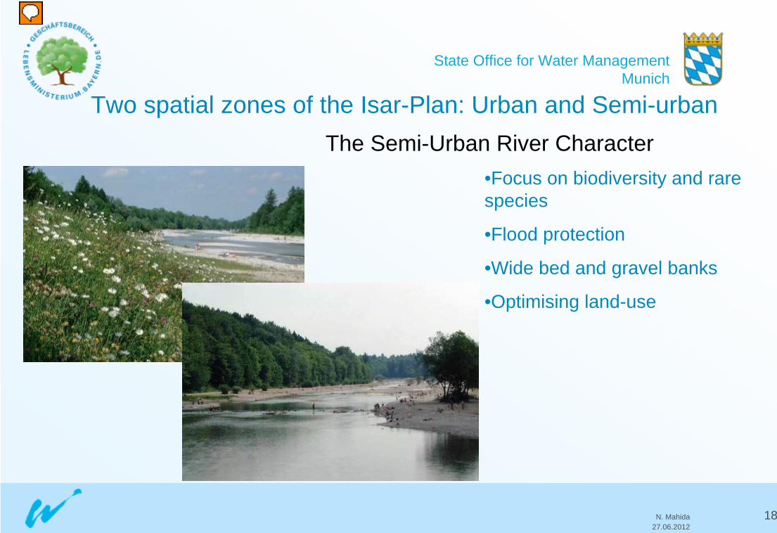
Two spatial zones of the Isar-Plan: Urban and Semi-urbanThe Semi-Urban River Character
•Focus on biodiversity and rare species
•Flood protection
•Wide bed and gravel banks
•Optimising land-use

State Office for Water ManagementMunich
N. Mahida27.06.2012
19
Two spatial zones of the Isar-Plan: Urban and Semi-urban
The Urban River Character•Optimising land-use for recreation purposes
•Flood protection for densely urbanised areas
•Improving attractiveness for visitors

State Office for Water ManagementMunich
N. Mahida27.06.2012
20
Dyke Reinforcement
State Office for Water ManagementMunich
N. Mahida27.06.2012
21
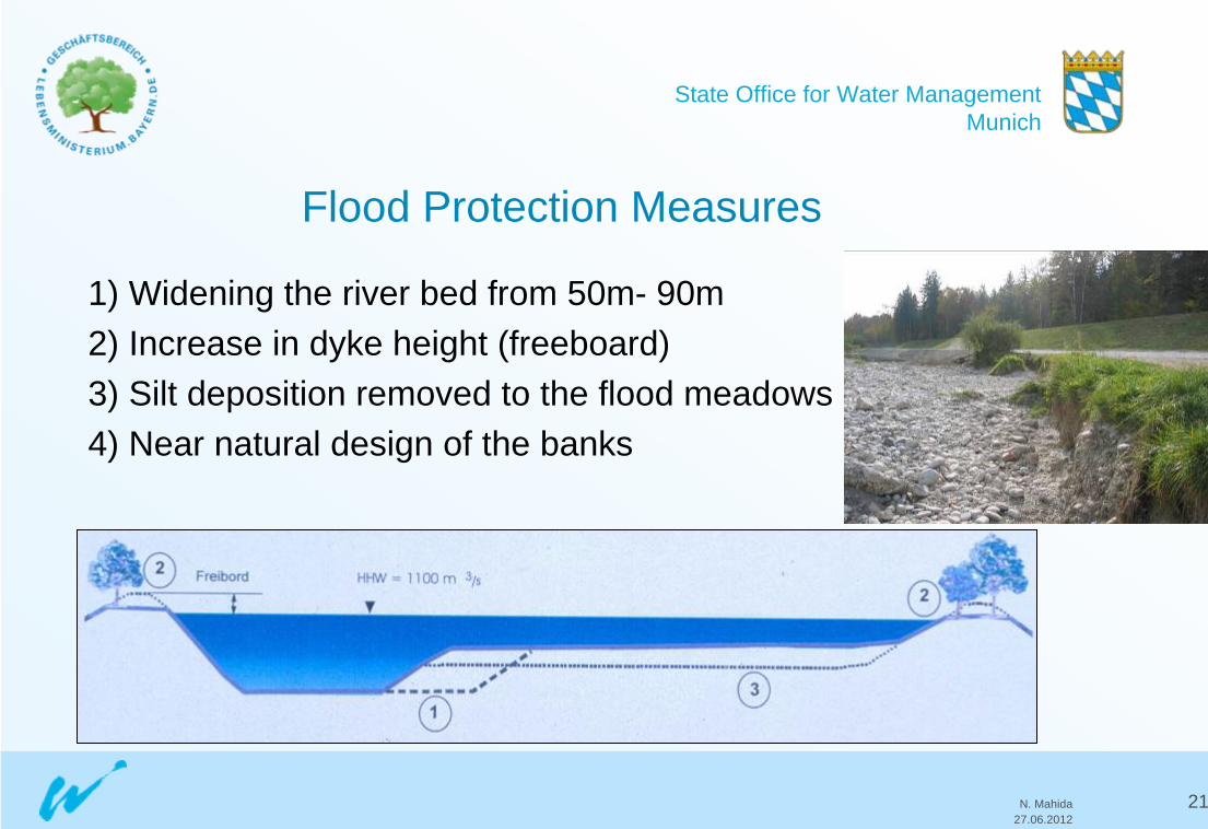
Flood Protection Measures
1) Widening the river bed from 50m- 90m2) Increase in dyke height (freeboard)3) Silt deposition removed to the flood meadows4) Near natural design of the banks

State Office for Water ManagementMunich
N. Mahida27.06.2012
22
Model Simulation at the TU

State Office for Water ManagementMunich
N. Mahida27.06.2012
23
Stakeholder Involvement
Prior to 1990 Isar restoration planning was largely isolated;
Interesting cooperation between government and city/municipal planners and NGO‘s and public groups;
Mediation process to assist identification of the optimal solution for the last 1.5 km of the urban Isar

State Office for Water ManagementMunich
N. Mahida27.06.2012
24
AfterBefore
Sill beams on the river bed pose a barrier for fish

State Office for Water ManagementMunich
N. Mahida27.06.2012
25
Before
After
Sloping concrete river banks
Flattened stony river banks
State Office for Water ManagementMunich
N. Mahida27.06.2012
26
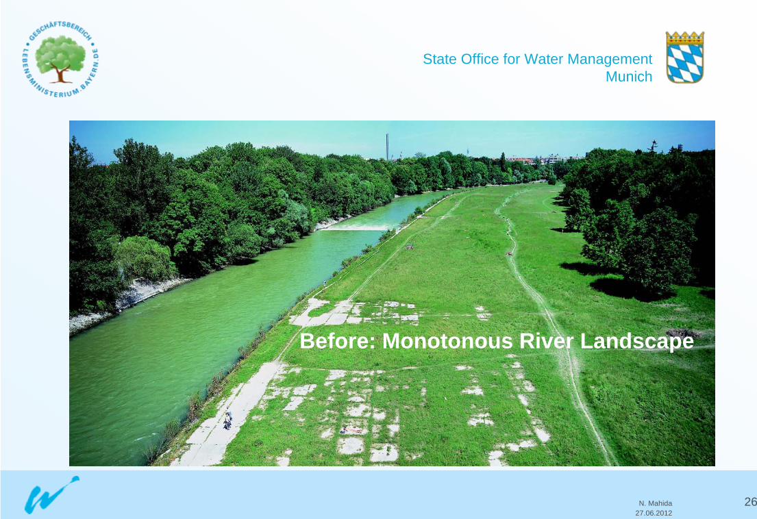
Before: Monotonous River Landscape

State Office for Water ManagementMunich
N. Mahida27.06.2012
27
After : Diversified Bank Structures

State Office for Water ManagementMunich
N. Mahida27.06.2012
28
Before- A concrete
channelized water course

State Office for Water ManagementMunich
N. Mahida27.06.2012
29
After- more structural
variety and diversity

State Office for Water ManagementMunich
N. Mahida27.06.2012
30
Recreation and Leisure at the Isar River