960900
850800750
700640
600
550520
500480
450440
430420
400
920880840
760720
650
560540530
510490
470460
410390
810780740680630
380
360
950930910
890870
86082077
0
690660
580
710670
760
700680
630620
610
600580
560550
520500
450400
360350
530
510
490
480 460 440
420
410
390
370
340
750
720
690
560550530520500480450
380320
570
54051047046044042040037
0
360
350330300
250
220
340
310
320 310 300 280 230 200 160
330
240210
180 150
130
290
270
250
650
580
570
550
530
670640
600560
590
540
630
520
870
850
780
760
520500
480
510490
580550520500
540510
670650630
600
640620
610560
570550
500
460
470450
430400350
730
700
580570560550540
710660 650 63
0
640610
630600
29028026
025
0
640630
610
650640
620
610600630
620
600
590580570
570
560550
320310
300
260240
990970
380360
59057
0
430410
830
790730
620610
590
570
370
980
670 660
650
570
540
470
430380
490
390
280
270
260
240
230
260
190
660
620 510
860
590
580
390
370
270
690680
640
630
590
600
340
270
600450
350
340
330
1010
890 840700
690
650
620
600
370
380
360
370
350
300
240
890
770
690680
670
610
590
590
590
590
580580
570
570
560
540
530
490
410
380340
340
290
290
280
290
230
660
Claude Road
Cethana Road
Stave
rton R
oad
Lori n
naRo
ad
Wootton Road
Jubbs Road
Crad
leMo
untai
n Roa
d
Richards Farm Road
Bullocks Road
Masons
Road
Spillane Link
Olive
rsRo
ad
Dolcoath Road
DoesRoad
DaysR
oad
Johnsons Road
Washing ton Road
Cockatoo Road
Das her R iver
Kellys Creek
J arm ans Creek
Davies Creek
C h ee k s C reek
Bel lana Cr eek
J ac k son s Creek
L in c oln Cre ek
River Forth
Tin Spur Cre ek
Narrawa Creek
Dolcoath
Creek
M ach inery C reek
W eek s Creek
Cupron Creek
Carlson Cree k
Mount RolandRegionalReserve
StavertonRegionalReserve
426,000
426,000
427,000
427,000
428,000
428,000
429,000
429,000
430,000
430,000
431,000
431,000
432,000
432,000
433,000
433,000
5,406
,000
5,406
,000
5,407
,000
5,407
,000
5,408
,000
5,408
,000
5,409
,000
5,409
,000
5,410
,000
5,410
,000
5,411
,000
5,411
,000
5,412
,000
5,412
,000
Docum
ent P
ath: \\
Abtfa
rcv01
\data$
\GIS\
2158
78_M
ELEN_
TasNe
twork
s_Proj
ectMa
rinus\
TasNe
twork
sProje
ctMari
nusG
IS\MX
D\21
5878
_LA\21
5878
_LA_G
IS013
_v0.m
xd
500 0 500250m
1:25,000Scale:
© TasNetworks 2018
TasNetworks has made every effort to ensure thisproduct is free of errors but does not warrant the mapor its features are either spatially or temporally accurateor fit for a particular use.TasNetworks provides this map without any warranty ofany kind whatsoever, either express or implied.
N
Coordinate System: GDA 1994 MGA Zone 55Projection: Transverse Mercator
Datum: GDA 1994
Southern RouteMap 1 of 8Legend
Proposed easementExisting overhead transmissionline
220kVWatercourseRoadTrackElevation contour (10m intervals)CadastreRegional ReserveOther Private ReserveInformal Reserve on PermanentTimber Production Zone Land orForestry Tas. managed land
Date: 6/12/2019 1:44:40 PMPrepared by: Helen Unkovich
Staverton
Hampshire
Source:Proposed route from Coffey.Existing overhead transmission lines from TasNetworks.Roads, watercourses, contours, parks/reserves and cadastre from DPIPWE.Imagery from ESRI Online. CONCEPTUAL ROUTE AND TOWER LOCATIONS ONLY - SUBJECT TO REVIEW
780
750 700 650
620
600 52
0
570 550
540 510
500480 46
0
580560
530
490470
440
790760
720690
680 590
450
770
740
750720
700
600
550520
500
680650
660640
610
690670630
850800780750720700680670
810760740730710690
840820
790
400
390
380
350
320
300
360330280
420
340
520510500480
49047046
0
430
420410
450
400
540520500480470460
580
560
550
490450
680660650640
630620
610
550
540
530
520
580
560
900880870
910
860
900860
980960
610600580
590
560
640630600 620610
620600580
610600580
580570
560
580 570 560
540
480460
410
400390
380
710
690
680660
650
640
610600
590
560550 460
450
650
640
630620
610
600
600590
60059
0
540530520
490480
390380
750
740
600
590
600
590
550
540
530 520
370 360
730
710
660
640
630
610
710
620
830
770
430
370
310
290
530
440
530
510
570
890
850
940
930
600
590
570
570
610
530
780
700
630
500
480
470 270
840
810
720710
700
640
620
620
570
550
510
500
500
460
390
990 970
950
880840
830
790
770
740
660
650
650
640
630
620
620
610
610
600
590
590
570
570
540
540
540
510
520
500
410
Loon
gana
Road
Mostyn Road
Murfe
ts Roa
d
Crad
leMo
untai
n Roa
d
Washington Road
Ling R
oad
Smith
s Pla i
nsRo
ad
Spillane Link
Johnsons Road
W i lm ot River
W in t e rB ro
o k
Jean Bro ok
Forth Fal ls C reek
Bel l Creek
418,000
418,000
419,000
419,000
420,000
420,000
421,000
421,000
422,000
422,000
423,000
423,000
424,000
424,000
425,000
425,000
5,409
,000
5,409
,000
5,410
,000
5,410
,000
5,411
,000
5,411
,000
5,412
,000
5,412
,000
5,413
,000
5,413
,000
5,414
,000
5,414
,000
5,415
,000
5,415
,000
Docum
ent P
ath: \\
Abtfa
rcv01
\data$
\GIS\
2158
78_M
ELEN_
TasNe
twork
s_Proj
ectMa
rinus\
TasNe
twork
sProje
ctMari
nusG
IS\MX
D\21
5878
_LA\21
5878
_LA_G
IS013
_v0.m
xd
500 0 500250m
1:25,000Scale:
© TasNetworks 2018
TasNetworks has made every effort to ensure thisproduct is free of errors but does not warrant the mapor its features are either spatially or temporally accurateor fit for a particular use.TasNetworks provides this map without any warranty ofany kind whatsoever, either express or implied.
N
Coordinate System: GDA 1994 MGA Zone 55Projection: Transverse Mercator
Datum: GDA 1994
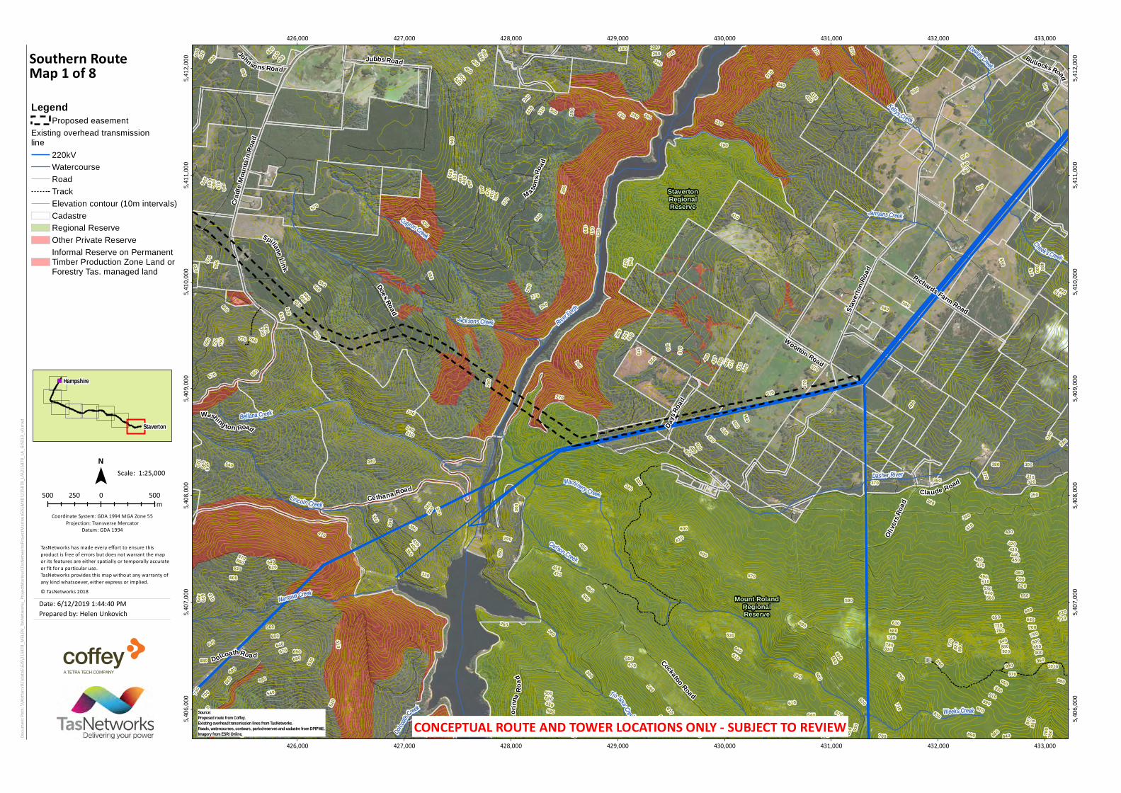
Southern RouteMap 2 of 8Legend
Proposed easementWatercourseRoadTrackElevation contour (10m intervals)CadastreNature RecreationOther Private ReserveInformal Reserve on PermanentTimber Production Zone Land orForestry Tas. managed land
Date: 6/12/2019 1:44:40 PMPrepared by: Helen Unkovich
Staverton
Hampshire
Source:Proposed route from Coffey.Existing overhead transmission lines from TasNetworks.Roads, watercourses, contours, parks/reserves and cadastre from DPIPWE.Imagery from ESRI Online. CONCEPTUAL ROUTE AND TOWER LOCATIONS ONLY - SUBJECT TO REVIEW
870850
800750
720700
680650
630610
600
530
490
450
420400
390
900840
810780
710690
660640620
550500
380
740
670
560
520
480460
430
820790760730
570
510
470
440
540
370
860850
800780
720700680660
640630
620610
600590
580560
540 530 520
510 480
450
420
400
750710690670650
570
810770
830820790760740
880850800780750720700680
810
790
760
740
710
690
890870 84
0 770
730670
340300
250
200
320280240
330270
290 260
310
220
550
500
620
560
650600
660640
620610
810790
630620
610600
590
580570
490480470460
500450
990950
650640630620
610600
640630620
600
850
810
780760
700670
650640610
620600580
610
590
580
560550
510
430420
620600580
490480
490
460
620
600
600590
590580
490460
630620
490480
460450
430420
460450
450
440
230210
770
590
360
730
550
500
490
470
460
440
430
410
390
380
860
660
650
640
500
630
610
940
860
850
840 690
680
570
590590
520
630
590
500
930
610
570
460
390400
880880
840
650
610
610600
520
540
530
490
450
420
350
960
930
890
860
870
870
830
820 680
640
610620
610
610
610
600
600
590
590
590
580
570
560
520
480
480
480
460
430
410
190
Loongana Road
Leve
n Can
yon R
oad
Griffith
sRoad
Gatehouse Road
Maxwells Road
W in ter Broo k
Jean B roo k
River Leven
L oong ana M il l C reek
T ulip -T ree Creek
Patricks Creek
Nichols Creek
MountainValley Private
Nature Reserve
Leven CanyonRegionalReserve
411,000
411,000
412,000
412,000
413,000
413,000
414,000
414,000
415,000
415,000
416,000
416,000
417,000
417,000
418,000
418,000
419,000
419,000
5,413
,000
5,413
,000
5,414
,000
5,414
,000
5,415
,000
5,415
,000
5,416
,000
5,416
,000
5,417
,000
5,417
,000
5,418
,000
5,418
,000
Docum
ent P
ath: \\
Abtfa
rcv01
\data$
\GIS\
2158
78_M
ELEN_
TasNe
twork
s_Proj
ectMa
rinus\
TasNe
twork
sProje
ctMari
nusG
IS\MX
D\21
5878
_LA\21
5878
_LA_G
IS013
_v0.m
xd
500 0 500250m
1:25,000Scale:
© TasNetworks 2018
TasNetworks has made every effort to ensure thisproduct is free of errors but does not warrant the mapor its features are either spatially or temporally accurateor fit for a particular use.TasNetworks provides this map without any warranty ofany kind whatsoever, either express or implied.
N
Coordinate System: GDA 1994 MGA Zone 55Projection: Transverse Mercator
Datum: GDA 1994
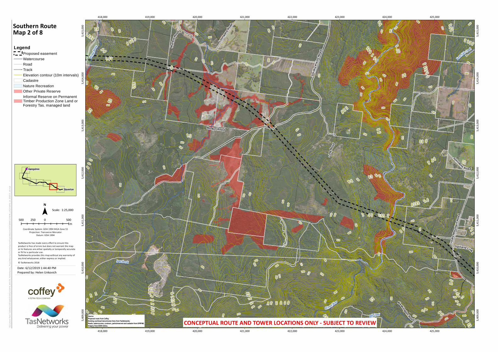
Southern RouteMap 3 of 8Legend
Proposed easementWatercourseRoadTrackElevation contour (10m intervals)CadastreConservation Covenant (NCA)Private Nature Reserve andConservation Covenant (NCA)Nature Recreation AreaRegional ReserveOther Private ReserveInformal Reserve on PermanentTimber Production Zone Land orForestry Tas. managed landInformal Reserve on other publicland
Date: 6/12/2019 1:44:40 PMPrepared by: Helen Unkovich
Staverton
Hampshire
Source:Proposed route from Coffey.Existing overhead transmission lines from TasNetworks.Roads, watercourses, contours, parks/reserves and cadastre from DPIPWE.Imagery from ESRI Online. CONCEPTUAL ROUTE AND TOWER LOCATIONS ONLY - SUBJECT TO REVIEW
1000
980
970960
950920
900880
850800
750700
650
620610
600580570
560550
540530
510500 49
0
450
930910
890870
840810
780760
710
680
590
820
770740
720690
660640
520
480
860830790
730
670630
780750720700680660
630600580560550540530520510500
760740
670650620
590
770
730710690640610
570
810780750720700680650
600580
710690660640
620590
850
760
740
610570
660650640630600
550530
620610590
700680650640630620
600580
570560
550
540530
650
640
620
600
660650640630
600
610
580
620
590
10901080
1050
630
620
590
580
640
600
850820
690680670660
630
610
610600
590 580
590
570
560550540
630 620 610
490480470
410400
390
670
660
630620
630
620
590
580
580570
530520
460450
640630
610600
380
370
1030
1020
101094
0
470
420
670
630
670
570 560
540
670
590
520
6101040
610
650
570
660
410
390
400
840
670
640
620
590
530
440
430
670
670
670
650
660
640640650
650
620
630
620
590
590
580
570
540
540
520
520
510480
460
Leven Road
Loongana Road
Maxfields Road
Crane Road
Alps Road
Alsterg
ren Road
De m pster Creek
Nielsens CreekO liv ers Creek
River Lev e n
Lo o n g ana M il lCreek
Tor Creek
404,000
404,000
405,000
405,000
406,000
406,000
407,000
407,000
408,000
408,000
409,000
409,000
410,000
410,000
411,000
411,000
5,413
,000
5,413
,000
5,414
,000
5,414
,000
5,415
,000
5,415
,000
5,416
,000
5,416
,000
5,417
,000
5,417
,000
5,418
,000
5,418
,000
5,419
,000
5,419
,000
Docum
ent P
ath: \\
Abtfa
rcv01
\data$
\GIS\
2158
78_M
ELEN_
TasNe
twork
s_Proj
ectMa
rinus\
TasNe
twork
sProje
ctMari
nusG
IS\MX
D\21
5878
_LA\21
5878
_LA_G
IS013
_v0.m
xd
500 0 500250m
1:25,000Scale:
© TasNetworks 2018
TasNetworks has made every effort to ensure thisproduct is free of errors but does not warrant the mapor its features are either spatially or temporally accurateor fit for a particular use.TasNetworks provides this map without any warranty ofany kind whatsoever, either express or implied.
N
Coordinate System: GDA 1994 MGA Zone 55Projection: Transverse Mercator
Datum: GDA 1994
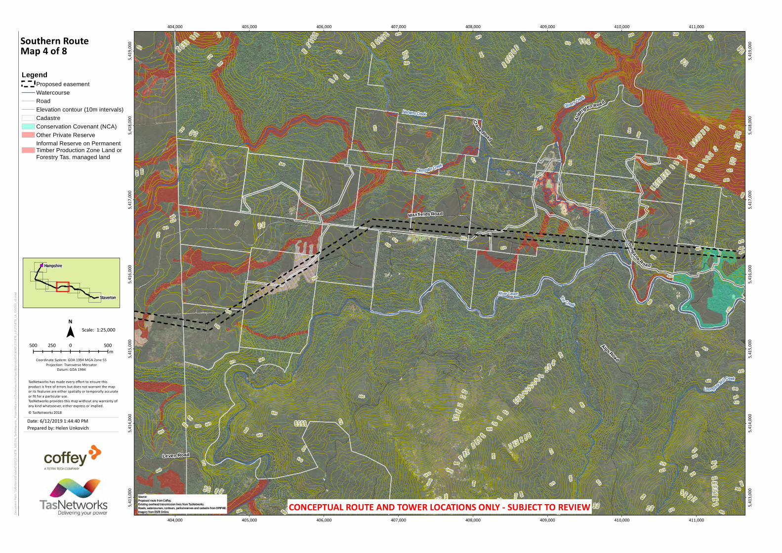
Southern RouteMap 4 of 8Legend
Proposed easementWatercourseRoadElevation contour (10m intervals)CadastreConservation Covenant (NCA)Other Private ReserveInformal Reserve on PermanentTimber Production Zone Land orForestry Tas. managed land
Date: 6/12/2019 1:44:40 PMPrepared by: Helen Unkovich
Staverton
Hampshire
Source:Proposed route from Coffey.Existing overhead transmission lines from TasNetworks.Roads, watercourses, contours, parks/reserves and cadastre from DPIPWE.Imagery from ESRI Online. CONCEPTUAL ROUTE AND TOWER LOCATIONS ONLY - SUBJECT TO REVIEW
790750720
700680670660
730710690
650640
630
700680
650640630620610600590580
730720710690670
640
600580
570
620610
630
590
640600580570560
650
630
620610
590
62061060
0
590
570560
68067
0
660
650
700680690
660
660650
640
630 620
690680670
680
670660
660650
640
610
600
590
690680
690
680
670 660
650640
630 620
610
660650
650640
650
640
640
630
59058
0
740
620
580
670
770
730
660
650
650 620
600
770
680
680
670670
670
660
650
650
650
650
650
640
640
630
640
640
640
640
640
640
630
640
640
620
630
630
620
620
620
620
620
600
590
640
640
630
Leven Road
Peak Plain Road
Blythe Road
Dempster Creek Road
Maxfields Road
Old Park Road
Rabbit Plain Road
Grasstree
Road
BlackM ar sh Road
Dem pster Creek
Blythe R ive r
Black M arsh
Creek
Old Park River
397,000
397,000
398,000
398,000
399,000
399,000
400,000
400,000
401,000
401,000
402,000
402,000
403,000
403,000
404,000
404,000
5,414
,000
5,414
,000
5,415
,000
5,415
,000
5,416
,000
5,416
,000
5,417
,000
5,417
,000
5,418
,000
5,418
,000
5,419
,000
5,419
,000
Docum
ent P
ath: \\
Abtfa
rcv01
\data$
\GIS\
2158
78_M
ELEN_
TasNe
twork
s_Proj
ectMa
rinus\
TasNe
twork
sProje
ctMari
nusG
IS\MX
D\21
5878
_LA\21
5878
_LA_G
IS013
_v0.m
xd
500 0 500250m
1:25,000Scale:
© TasNetworks 2018
TasNetworks has made every effort to ensure thisproduct is free of errors but does not warrant the mapor its features are either spatially or temporally accurateor fit for a particular use.TasNetworks provides this map without any warranty ofany kind whatsoever, either express or implied.
N
Coordinate System: GDA 1994 MGA Zone 55Projection: Transverse Mercator
Datum: GDA 1994
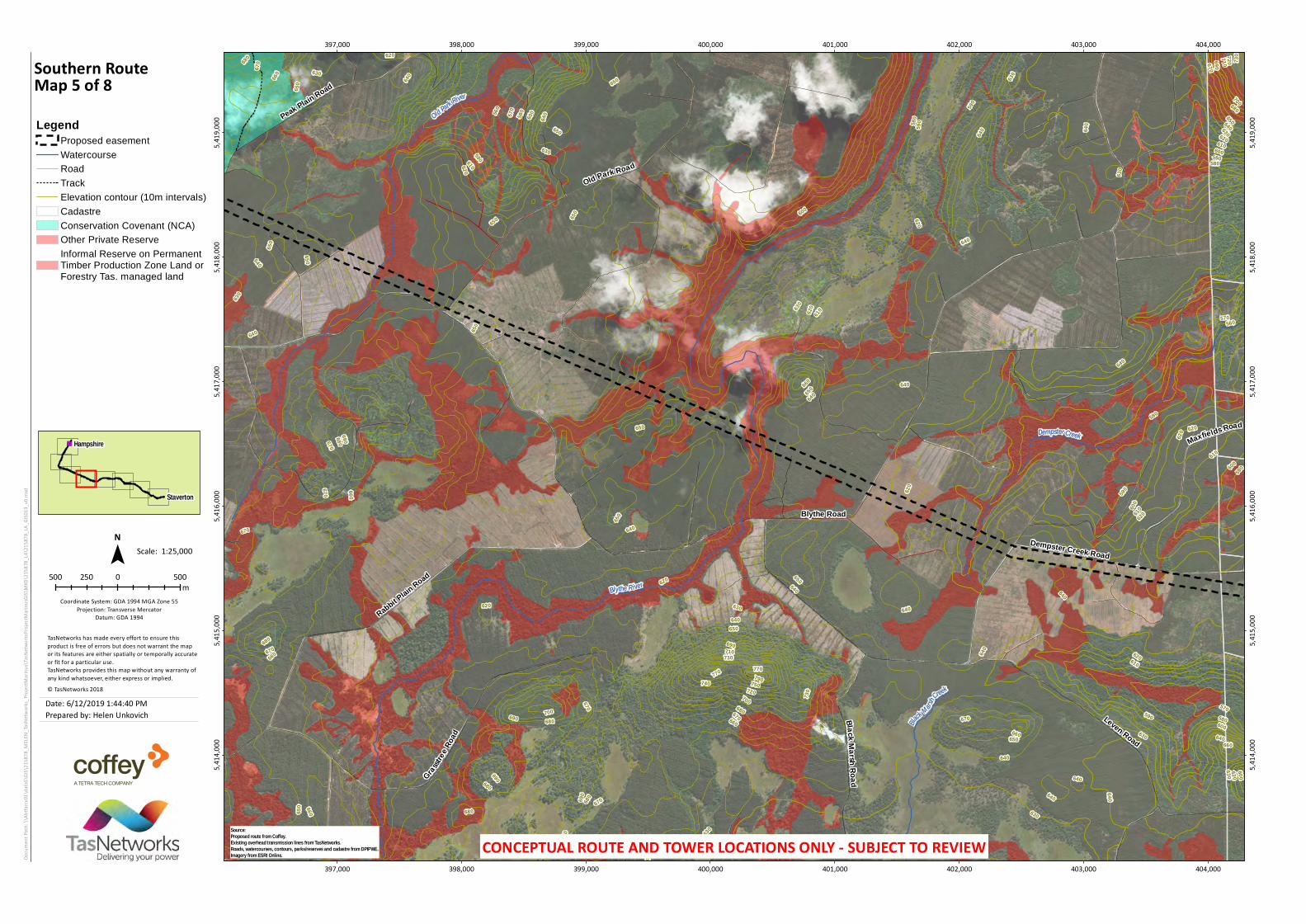
Southern RouteMap 5 of 8Legend
Proposed easementWatercourseRoadTrackElevation contour (10m intervals)CadastreConservation Covenant (NCA)Other Private ReserveInformal Reserve on PermanentTimber Production Zone Land orForestry Tas. managed land
Date: 6/12/2019 1:44:40 PMPrepared by: Helen Unkovich
Staverton
Hampshire
Source:Proposed route from Coffey.Existing overhead transmission lines from TasNetworks.Roads, watercourses, contours, parks/reserves and cadastre from DPIPWE.Imagery from ESRI Online. CONCEPTUAL ROUTE AND TOWER LOCATIONS ONLY - SUBJECT TO REVIEW

100095092090085080078
0750
1040 990
96088084081
079
076
074
0
930 890
620610600
580
59058057
0
560550540
590580
570560
550
560550540
520
530510
680
670
660
650
640
570560
540
690660
650
640630
650
640
570
560 550 540
690680
660
640
630 620
620
610
620
610
600
610
580
680
670660
660640
640
630
640
630
610600
600590
600
590
600
580
600
590
530520
510
10301010
650640
640630
630620
610600
940
830
770
730
720
710
700
690
680
670
660
650
590
530
540
630
680
590
580
670
650
630
590
590
1090
1060
650
630
620
1090
1070
970
860
870
670
650
660
660
660
650
650
650
650
650
640
640
640
630
630
630630
620
620
620
620
620
610
610
590
600
600
590
570
530
530
520
510
660
650
620
600
580
Wey Road
Ridgley Hig hwa y
North Bunkers Road
GuildfordRoad
Darry
ls Ro
ad
Amazon Road
Blythe Road
Peak Plain Road
Bunkers Hill Road
South Bunkers Road
Rabbit Plain Road
Rawlings Road
Emu R iver
Hel lyer R iver
Gin Cre e k
W ey River
Sh eppard Creek
Old Par k Ri ver
390,000
390,000
391,000
391,000
392,000
392,000
393,000
393,000
394,000
394,000
395,000
395,000
396,000
396,000
397,000
397,000
5,415
,000
5,415
,000
5,416
,000
5,416
,000
5,417
,000
5,417
,000
5,418
,000
5,418
,000
5,419
,000
5,419
,000
5,420
,000
5,420
,000
5,421
,000
5,421
,000
Docum
ent P
ath: \\
Abtfa
rcv01
\data$
\GIS\
2158
78_M
ELEN_
TasNe
twork
s_Proj
ectMa
rinus\
TasNe
twork
sProje
ctMari
nusG
IS\MX
D\21
5878
_LA\21
5878
_LA_G
IS013
_v0.m
xd
500 0 500250m
1:25,000Scale:
© TasNetworks 2018
TasNetworks has made every effort to ensure thisproduct is free of errors but does not warrant the mapor its features are either spatially or temporally accurateor fit for a particular use.TasNetworks provides this map without any warranty ofany kind whatsoever, either express or implied.
N
Coordinate System: GDA 1994 MGA Zone 55Projection: Transverse Mercator
Datum: GDA 1994
Southern RouteMap 6 of 8Legend
Proposed easementWatercourseRoadTrackElevation contour (10m intervals)CadastreConservation Covenant (NCA)Other Private Reserve
Date: 6/12/2019 1:44:40 PMPrepared by: Helen Unkovich
Staverton
Hampshire
Source:Proposed route from Coffey.Existing overhead transmission lines from TasNetworks.Roads, watercourses, contours, parks/reserves and cadastre from DPIPWE.Imagery from ESRI Online. CONCEPTUAL ROUTE AND TOWER LOCATIONS ONLY - SUBJECT TO REVIEW
80075072070
068066
0
620
58057056055
0
740710
690670
650640
630
610
760730
780
600
540
560
550540530
510500480470
490
46045043
0
540520500
480
450
510
470
440
530
490
58057
055053
052051
0
560
500
540
490
570560
550540
530520
590 580
520510500490
480460
620
610
570560
630
610
630620610
620
610
600590
61060
0
590
580
59058
0570
590 570
580570560
540530510
500
670660
630620
610
600
590
580
600590
590
580
570
560
560
550
560 550
540530
540530
520510
610
600
600
590
590580
560
550
560550
540
530
770
590
520
440
480
530
550
450
81080
0
620
600
600
520
600
590 600
600
570
540
420410
840
630
610
620
620
620
600
600
600
600
600
590
590
580
580
580
580
570
570
570
570
550
540
550
550
540
550
550
530
520
520
530
530
510
510
480
400
390
620
620
620
600
600
590
580
Ridgle
y High
way
Twenty Nine Mile Road
North Bunkers Road
Thirt
y One
Mile
Roa d
Basils Road
Walters Road
Wey Road
North
Goder
i chRoad
Dar ry
lsRo
ad
Toronna Creek
W ey R iverLou
dwa te
r Rive
r
Hel lyer River
E m u River
L ockwood C reek
386,000
386,000
387,000
387,000
388,000
388,000
389,000
389,000
390,000
390,000
391,000
391,000
392,000
392,000
393,000
393,000
394,000
394,000
5,420
,000
5,420
,000
5,421
,000
5,421
,000
5,422
,000
5,422
,000
5,423
,000
5,423
,000
5,424
,000
5,424
,000
5,425
,000
5,425
,000
5,426
,000
5,426
,000
Docum
ent P
ath: \\
Abtfa
rcv01
\data$
\GIS\
2158
78_M
ELEN_
TasNe
twork
s_Proj
ectMa
rinus\
TasNe
twork
sProje
ctMari
nusG
IS\MX
D\21
5878
_LA\21
5878
_LA_G
IS013
_v0.m
xd
500 0 500250m
1:25,000Scale:
© TasNetworks 2018
TasNetworks has made every effort to ensure thisproduct is free of errors but does not warrant the mapor its features are either spatially or temporally accurateor fit for a particular use.TasNetworks provides this map without any warranty ofany kind whatsoever, either express or implied.
N
Coordinate System: GDA 1994 MGA Zone 55Projection: Transverse Mercator
Datum: GDA 1994
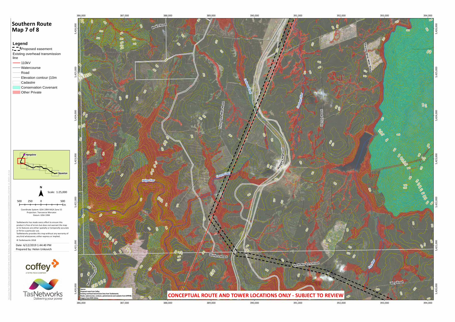
Southern RouteMap 7 of 8Legend
Proposed easementExisting overhead transmissionline
110kVWatercourseRoadElevation contour (10mCadastreConservation CovenantOther Private
Date: 6/12/2019 1:44:40 PMPrepared by: Helen Unkovich
Staverton
Hampshire
Source:Proposed route from Coffey.Existing overhead transmission lines from TasNetworks.Roads, watercourses, contours, parks/reserves and cadastre from DPIPWE.Imagery from ESRI Online. CONCEPTUAL ROUTE AND TOWER LOCATIONS ONLY - SUBJECT TO REVIEW

530
520
420400
540
510
500
490
480
460
470450
430 41
0
540520
500
510480
560550540530
490
510 500
550540520
450440420
470460
540530520
460450
510500
490470
460450
460450
440430
560550
540
560
550
570
560
550
540
560
550
550
530
530
520
520
510
490
480
47046
0
560
550
560
550
540
530
540530
530520510520510
510500
510
500
500
490
550
540
540530
530 520
530
520
52051
0
480470
550
440
470
460
510
440
480
420
570
540
510
530
510
500
470
530
500
490
450
560
560
560
560
560
550
540
540
540
540
540
540
540
540
530
530
520520
520
520
510 510
510
510510
510
510
510
510
500
490
490
490
480
480
470
460
430
420
390
480Talunah Road
Guild
ford R
oad
Ridgley H
ighway
Basils Road
Tea T
reeRoad
Upper GuideR oad
Dunhams Road
Robothams Road
Cliff Road
Deacons Road
Loudwater Road
Ringwood Road
LockwoodCreek Road Mo
relan
d Roa
d
Benn
etts Roa
d
Lohreys Road
Batze
k Roa
d
Fishe
rsRo
ad
Jacksons Road
Dudfield Road
Guide River
Loudw ater River
Emu River
St M arys River
S t J o sephs River
East Cam R iver
L o ck wood Creek
Hampshire
389,000
389,000
390,000
390,000
391,000
391,000
392,000
392,000
393,000
393,000
394,000
394,000
395,000
395,000
396,000
396,000
5,427
,000
5,427
,000
5,428
,000
5,428
,000
5,429
,000
5,429
,000
5,430
,000
5,430
,000
5,431
,000
5,431
,000
5,432
,000
5,432
,000
Docum
ent P
ath: \\
Abtfa
rcv01
\data$
\GIS\
2158
78_M
ELEN_
TasNe
twork
s_Proj
ectMa
rinus\
TasNe
twork
sProje
ctMari
nusG
IS\MX
D\21
5878
_LA\21
5878
_LA_G
IS013
_v0.m
xd
500 0 500250m
1:25,000Scale:
© TasNetworks 2018
TasNetworks has made every effort to ensure thisproduct is free of errors but does not warrant the mapor its features are either spatially or temporally accurateor fit for a particular use.TasNetworks provides this map without any warranty ofany kind whatsoever, either express or implied.
N
Coordinate System: GDA 1994 MGA Zone 55Projection: Transverse Mercator
Datum: GDA 1994
Southern RouteMap 8 of 8Legend
Existing substationProposed easement
Existing overhead transmissionline
110kVWatercourseRoadElevation contour (10m intervals)CadastreConservation Covenant (NCA)Other Private ReserveInformal Reserve on PermanentTimber Production Zone Land orForestry Tas. managed land
Date: 6/12/2019 1:44:40 PMPrepared by: Helen Unkovich
Staverton
Hampshire
Source:Proposed route from Coffey.Existing overhead transmission lines from TasNetworks.Roads, watercourses, contours, parks/reserves and cadastre from DPIPWE.Imagery from ESRI Online. CONCEPTUAL ROUTE AND TOWER LOCATIONS ONLY - SUBJECT TO REVIEW