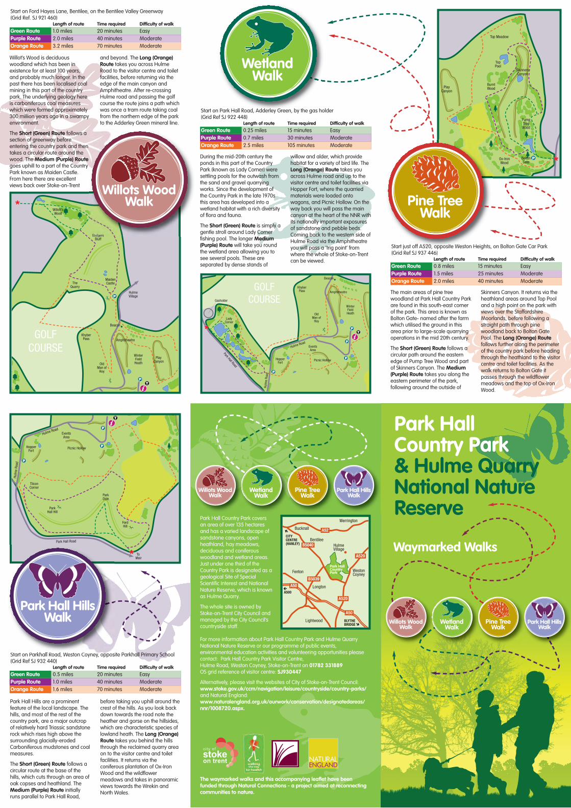
During the mid-20th century theponds in this part of the CountryPark (known as Lady Corner) weresettling pools for the outwash fromthe sand and gravel quarryingworks. Since the development ofthe Country Park in the late 1970sthis area has developed into awetland habitat with a rich diversityof flora and fauna.
The Short (Green) Route is simply agentle stroll around Lady Cornerfishing pool. The longer Medium(Purple) Route will take you roundthe wetland area allowing you tosee several pools. These areseparated by dense stands of
willow and alder, which providehabitat for a variety of bird life. TheLong (Orange) Route takes youacross Hulme road and up to thevisitor centre and toilet facilities viaHopper Fort, where the quarriedmaterials were loaded ontowagons, and Picnic Hollow. On theway back you will pass the maincanyon at the heart of the NNR withits nationally important exposuresof sandstone and pebble beds.Coming back to the western side ofHulme Road via the Amphitheatreyou will pass a ‘trig point’ fromwhere the whole of Stoke-on-Trentcan be viewed.
Park HallCountry Park& Hulme QuarryNational NatureReserve
Waymarked Walks
Willot’s Wood is deciduouswoodland which has been inexistence for at least 100 years,and probably much longer. In thepast there has been localised coalmining in this part of the countrypark. The underlying geology hereis carboniferous coal measureswhich were formed approximately300 million years ago in a swampyenvironment.
The Short (Green) Route follows asection of greenway beforeentering the country park and thentakes a circular route around thewood. The Medium (Purple) Routegoes uphill to a part of the CountryPark known as Maiden Castle.From here there are excellentviews back over Stoke-on-Trent
and beyond. The Long (Orange)Route takes you across HulmeRoad to the visitor centre and toiletfacilities, before returning via theedge of the main canyon andAmphitheatre. After re-crossingHulme road and passing the golfcourse the route joins a path whichwas once a tram route taking coalfrom the northern edge of the parkto the Adderley Green mineral line.
Park Hall Hills are a prominentfeature of the local landscape. Thehills, and most of the rest of thecountry park, are a major outcropof relatively hard Triassic sandstonerock which rises high above thesurrounding glacially-erodedCarboniferous mudstones and coalmeasures.
The Short (Green) Route follows acircular route at the base of thehills, which cuts through an area ofoak copses and heathland. TheMedium (Purple) Route initiallyruns parallel to Park Hall Road,
before taking you uphill around thecrest of the hills. As you look backdown towards the road note theheather and gorse on the hillsides,which are characteristic species oflowland heath. The Long (Orange)Route takes you behind the hillsthrough the reclaimed quarry areaon to the visitor centre and toiletfacilities. It returns via theconiferous plantation of Ox-IronWood and the wildflowermeadows and takes in panoramicviews towards the Wrekin andNorth Wales.
The main areas of pine treewoodland at Park Hall Country Parkare found in this south-east cornerof the park. This area is known asBolton Gate- named after the farmwhich utilised the ground in thisarea prior to large-scale quarryingoperations in the mid 20th century.
The Short (Green) Route follows acircular path around the easternedge of Pump Tree Wood and partof Skinners Canyon. The Medium(Purple) Route takes you along theeastern perimeter of the park,following around the outside of
Skinners Canyon. It returns via theheathland areas around Top Pooland a high point on the park withviews over the StaffordshireMoorlands, before following astraight path through pinewoodland back to Bolton GatePool. The Long (Orange) Routefollows further along the perimeterof the country park before headingthrough the heathland to the visitorcentre and toilet facilities. As thewalk returns to Bolton Gate itpasses through the wildflowermeadows and the top of Ox-IronWood.
Ox-IronWood
BoltonGate
PumpTree
Wood
TopPool
Top Meadow
BurntWood
SkinnersCanyon
PlayCanyon
P
GOLFCOURSE
Park Hall Road
Hulm
e Ro
ad
Hulme RoadEventsArea
Picnic HollowHopperFort
LadyCorner
Gasholder
KhyberPass
Beacon
Amphitheatre
WinterFieldHeathOld
Man ofHoy
TP
P
P
P
GOLFCOURSE
r
HulmeVillage
TheQuarry
KhyberPass
Beacon
Amphitheatre
WinterFieldHeath
PlayCanyon
OldMan of
Hoy
Willott’sWood
BadgersBluff
MaidenCastle
TP
P
Park Hall Road
Hulm
e Ro
ad
Hulme RoadEventsArea
Picnic HollowHopperFort
ParkHall Hill
ParkDale
FordHill
TilconCorner
To Meir
T
P
P
P
Park Hall Country Park coversan area of over 135 hectaresand has a varied landscape ofsandstone canyons, openheathland, hay meadows,deciduous and coniferouswoodland and wetland areas.Just under one third of theCountry Park is designated as ageological Site of SpecialScientific Interest and NationalNature Reserve, which is knownas Hulme Quarry.
The whole site is owned byStoke-on-Trent City Council andmanaged by the City Council’scountryside staff.
A520
B5040
B5039
A520
A52
A50
A50
HulmeVillage
WestonCoyney
Longton
Lightwood
Werrington
Fenton
Bentilee
Bucknall
A500
BLYTHEBRIDGE
CITYCENTRE(HANLEY)
Park HallCountryPark
For more information about Park Hall Country Park and Hulme QuarryNational Nature Reserve or our programme of public events,environmental education activities and volunteering opportunities pleasecontact: Park Hall Country Park Visitor Centre,Hulme Road, Weston Coyney, Stoke-on-Trent on 01782 331889OS grid reference of visitor centre: SJ930447
Alternatively, please visit the websites of City of Stoke-on-Trent Council:www.stoke.gov.uk/ccm/navigation/leisure/countryside/country-parks/and Natural England: www.naturalengland.org.uk/ourwork/conservation/designatedareas/nnr/1008720.aspx.
The waymarked walks and this accompanying leaflet have beenfunded through Natural Connections - a project aimed at reconnectingcommunities to nature.
Start on Parkhall Road, Weston Coyney, opposite Parkhall Primary School(Grid Ref SJ 932 440)
Length of route Time required Difficulty of walkGreen Route 0.5 miles 20 minutes EasyPurple Route 1.0 miles 40 minutes ModerateOrange Route 1.6 miles 70 minutes Moderate
Start on Ford Hayes Lane, Bentilee, on the Bentilee Valley Greenway (Grid Ref. SJ 921 460)
Length of route Time required Difficulty of walkGreen Route 1.0 miles 20 minutes EasyPurple Route 2.0 miles 40 minutes ModerateOrange Route 3.2 miles 70 minutes Moderate
Start on Park Hall Road, Adderley Green, by the gas holder (Grid Ref SJ 922 448)
Length of route Time required Difficulty of walkGreen Route 0.25 miles 15 minutes EasyPurple Route 0.7 miles 30 minutes ModerateOrange Route 2.5 miles 105 minutes Moderate
Start just off A520, opposite Weston Heights, on Bolton Gate Car Park (Grid Ref SJ 937 446)
Length of route Time required Difficulty of walkGreen Route 0.8 miles 15 minutes EasyPurple Route 1.5 miles 25 minutes ModerateOrange Route 2.0 miles 40 minutes Moderate

GOLFCOURSE
Park Hall Road
Leek
Roa
d
Park Hall Road
Hulm
e Ro
ad
Hulme Road
Dividy Road
EventsArea
Picnic HollowHopperFort
LadyCorner
ParkHall Hill
ParkDale
FordHill
Ox-IronWood
BoltonGate
PumpTree
Wood
TilconCorner
TopPool
Top Meadow
BurntWood
SkinnersCanyon
ToHanley
Gasholder
HulmeVillage
To Longton
To Meir
TheQuarry
KhyberPass
Beacon
Amphitheatre
WinterFieldHeath
PlayCanyon
OldMan of
Hoy
Willott’sWood
BadgersBluff
MaidenCastle
TP
P
P
P
P
P
T
P
Short Routes
Medium Routes
Long Routes
Start Points for Walks
Visitor Centre
Toilet Facilities
Car park
Viewpoints
Wildflower Meadows
Deciduous Woodland
Coniferous Woodland
Ponds/Pools
Canyons
Hillsides
KEY
Conserving lowland heathlandCommon heather, also known as ling, is the main plant species foundwithin the country park’s heathland areas. During early autumn thelandscape is given a vibrant flash of colour when the heather is coveredin tiny pale purple flowers. In the late 1700s large tracts of Staffordshirewere covered with this type of lowland heathland vegetation, but morethan 90% of this was lost in the following 200 years. There are a numberof plants and animals which are specially adapted to live on lowlandheathlands and are dependant on this habitat for their survival. It is,therefore, extremely important that we protect and enhance ourremaining heathlands, such as those at Park Hall. Careful managementis required, including cutting the heather periodically to promote freshvigorous growth and removing some self-set trees which wouldotherwise shade-out the heather plants.
The pools at Lady CornerThere are a variety of different aquatic habitats atLady Corner. The largest is a fishing pool whichsupports fish such as carp and tench and waterfowlsuch as swans, mallard ducks and moorhens. Theshallower pools support large populations of smallinsects such as water scorpion, great diving beetle,and numerous species of dragonfly and damselflynymph. The pools are also an excellent breedinghabitat for amphibians, including common frog,common toad and smooth newt.
Wildflower meadow inbloom
Behind the hills are the wildflower meadows, which canbe seen at their most colourful during June and July.
These contain a rich diversity of plant species includingyellow rattle, pignut, orchids, clover, birds-foot trefoil, common
sorrel and numerous grass species. These flowers provide a valuablenectar source for species such as butterflies, moths and bees. In highsummer butterfly species that can be spotted in and around the haymeadows include meadow brown, small copper, small heath,gatekeeper, common blue and small skipper. The meadows are alsoan excellent habitat for small mammals, which, in turn, provide a foodsource for the owls that roost in the coniferous woodlands.
View of the main canyonThis canyon, sometimes known as the ‘Play Canyon’, is the focal point of Hulme Quarry NationalNature Reserve. The National Nature Reserve, which covers a total area of approximately 40 hectaresand is located entirely within the country park boundary, consists of a series of canyons that werecreated by quarrying activities in the mid-20th century. The canyons contain nationally important
exposures of red sandstone and pebble beds, which weredeposited between 250 and 215 million years ago. At this
time, during the Triassic period, Great Britain was situatedjust north of the equator in hot desert latitudes. The
visible geology is the product of flash flood deposits ina desert environment. In addition to the geologicalinterest the quarry is also host to a variety of bird life,including little owls and kestrels, which can regularlybe seen on the rock faces.
Please note: As a result of the country park’s terrain there are sections of steep inclines and rough tracks on all of the purple and orange routes. Consequently users of manual wheelchairs and child buggies may have difficulty with these tracks. However, the shorter green routes aregenerally level with few, if any, substantial inclines. Despite the site topography every effort is made to encourage all-ability access. Please do not hesitate to call the visitor centre prior to your visit if you wish to discuss any particular aspect of these routes or other paths on the country park.
Children from a number of local schools took part in the development ofthese waymarked routes. St. Maria Goretti and Maple Court Primaryboth worked on the Willot’s Wood Walk, Gladstone Primary ‘adopted’the Wetland Walk and Weston Coyney Junior School were involved withboth the Pine Tree Walk and Park Hall Hills Walk.
View of Stoke-on-Trent fromviewpoint above golf courseFrom the viewpoint above the golf course you have an excellentview of Stoke-on-Trent and the surrounding area. Note the waythat the towns of Hanley, Burslem, Tunstall and Kidsgrove lie in
an almost straight line, south tonorth, in the valley bottom.
Their locations follow theline of the underlying coal
measures, the miningof which was a majorreason for the towns’development. Park Hall Hill
Take a moment to enjoy the panoramic views from the top of thehills. Noteworthy features include Park Hall Lake, which was once
the fishing lake to the hall near by, and St James’ Church inNormacott, a grade 2 listed building dating from 1834. Further
in the distance look over the Trentham estate to the Wrekin,a large hill near to Telford, which is a prominent point oftenvisible on the horizon.
Ox-Iron and Pump Tree WoodsPlantations of pine trees were planted during the 1960s asscreens to mask the sand and gravel quarrying activitiesthat took place at that time. Since then the original treeshave matured and set seed, resulting in colonisation of thesandy ground within the previously quarried areas. Themature pine woods offerroosts for both long-earedowls and tawny owls,which can often beheard calling onsummer eveningsjust beforenightfall. The owlsare able to flysilently over thesurroundingmeadows in searchof small mammals,such as voles, which aretheir main source of food.
Willot's woodThe deciduous woodland of Willot’s Wood contains a wide variety ofnative British trees. Common oak, silver birch and, in the wetter areas,alder are the dominant large trees, whilst the understory iscomposed of species such as hazel, hawthorn, rowan and holly. Inspringtime much of the woodland floor is carpeted in the deep violet-blue, sweet-scented flowers of the bluebell. In the past the wood’stimber has been a valuable resource for the local community, beingused to make hurdles and charcoal, and also collected for firewood.
This canyon, sometimes known as the ‘Play Canyon’, is the focal point of Hulme Quarry National
native British trees. Common oak, silver birch and, in the wetter areas,
Conserving lowland heathland
sandy ground within the previously quarried areas. Themature pine woods offerroosts for both long-earedowls and tawny owls,which can often be
meadows in searchof small mammals,such as voles, which aretheir main source of food.
Wildflower meadow inbloom
Behind the hills are the wildflower meadows, which canbe seen at their most colourful during June and July.
These contain a rich diversity of plant species includingyellow rattle, pignut, orchids, clover, birds-foot trefoil, common
sorrel and numerous grass species. These flowers provide a valuable
Take a moment to enjoy the panoramic views from the top of theTake a moment to enjoy the panoramic views from the top of thehills. Noteworthy features include Park Hall Lake, which was oncehills. Noteworthy features include Park Hall Lake, which was once
the fishing lake to the hall near by, and St James’ Church inthe fishing lake to the hall near by, and St James’ Church inNormacott, a grade 2 listed building dating from 1834. Further
in the distance look over the Trentham estate to the Wrekin,a large hill near to Telford, which is a prominent point oftenvisible on the horizon.
an almost straight line, south tonorth, in the valley bottom.
Their locations follow theline of the underlying coal
measures, the miningof which was a majorreason for the towns’development.