ENST 698—Environmental Capstone
Spring 2013
New Bern Stormwater Management:
An Integrated Low-Impact Design Approach
Travis Courtney
Ethan Miller
Juliette Rousseau
Katie Lemay
Karan Pandya
Joshua Hancock
ENST Capstone Class Spring 2013
This paper represents work done by a UNC-Chapel Hill undergraduate student team. It is not a formal
report of the Institute for the Environment, nor is the work of UNC-Chapel Hill faculty.

UNC-CH, Environmental Capstone 2 ENVR 698, Spring 2013
Executive Summary
New Bern Stormwater Management:
An Integrated Low-Impact Design Approach
ENST 698—Environmental Capstone Spring 2013
Introduction and background The city of New Bern, North Carolina is currently facing daily flooding problems
with worsening long-term predictions resulting from the sea level rise and storm
activity associated with global climate change. The problem is particularly
troublesome in several low-income communities where existing structures for
mitigating stormwater are generally lacking and ineffective. The city government
has formulated multiple projects that aim to improve the aesthetic value and
functionality of several of the city’s low-income communities. They hope to
incorporate structures and practices into these plans that could help to alleviate
some of the flooding issues associated with stormwater management. This research
is funded by a grant the city recently received from the United States
Environmental Protection Agency, which is aimed towards using local planning to
address the consequences of climate change, including sea level rise and increased
storm frequency and intensity.
Methods The project detailed in this report aims to assess the problems associated with
stagnant water left behind after higher-frequency, smaller storm events, and
addresses methods that could be used to mitigate these problems. The report is
focused on two particular lower-income communities that are highlighted for
future development plans made by the city of New Bern. We evaluated the
geologic conditions of the area, including soil types, elevation, slope of the land,
and water table height, as well as the frequency and intensity of storm events in
order to calculate the amount of water left behind by what would be considered a
“typical” rainfall event. Using those calculations, the geologic data collected, and
personal observations and conversations with community members, we looked at
UNC-CH, Environmental Capstone 3 ENVR 698, Spring 2013
all of the potential practices that could be implemented in an effort to mitigate
stormwater issues.
Findings The focus areas were found to have differential risks associated with stormwater
flooding based on the slope and elevation of the land. The Third Avenue
neighborhood, where storm drain infrastructure was minimal and ineffective, was
especially affected by flooding from typical storm events.
Based on the information we collected and the data we acquired from other
agencies, we compiled a list of suggested practices that would be best suited for
each of the two sites. These suggestions include practices that are more focused on
community involvement, such as gutters and rain barrels, as well as more effective
stormwater removal practices, such as wetlands and bioswales. These practices
can easily be incorporated into the plans that the city has already proposed. We
also designed an educational pamphlet that provides information on each of the
suggested practices, as well as a list of maintenance procedures in order to ensure
that the stormwater mitigation practices are as effective as possible.
Recommendations The following is a list of BMPs suggested for the two sites: stormwater wetlands,
bioswales, roofwater management (gutters), rain barrels/cisterns, alternate pavers,
and alternative surfaces

UNC-CH, Environmental Capstone 4 ENVR 698, Spring 2013
Table of Contents
I. Introduction
a. The Area
i. New Bern
ii. Third Avenue and K Street Neighborhoods
iii. Sediment Characteristics of Third Avenue and K
Street
b. The Flooding
i. New Bern Rainfall Data and Susceptibility
ii. K Street and Third Avenue Flooding
c. Stormwater Estimates
i. Calculating Rainfall in Target Neighborhoods
ii. K Street Rainfall Summary
iii. Third Avenue Rainfall Summary
d. Existing Plans for the Future
i. New Bern Gateway Renaissance Plan
ii. City of New Bern Pedestrian Plan
II. Best Management Practices
a. Introduction
b. Types of BMPs
i. Bioswales
ii. Rain Gardens
iii. Wetlands
iv. Roofwater Management
1. Gutters
2. Rain Cisterns
3. Rain Barrels
v. Infiltration Trenches

UNC-CH, Environmental Capstone 5 ENVR 698, Spring 2013
vi. Permeable Pavements
1. Pervious Concrete
2. Porous Asphalt
3. Permeable Interlocking Concrete Pavements
4. Plastic Grids
5. Alternate Pavers
6. Alternative Surfaces
vii. Level Spreaders
viii. Sand Filters
III. BMP Plan
a. BMPs Not Suitable for Area
b. Optimal Plan for the Area
i. Optimal BMPs for Third Avenue
ii. Optimal BMPs for K Street
IV. Implementation
a. Management of BMPs
i. Maintaining Current Stormwater Systems
ii. Additional Maintenance for BMPs
b. Educational Component of BMPs
V. Implications of Rising Sealevel
VI. Conclusions
UNC-CH, Environmental Capstone 6 ENVR 698, Spring 2013
I. INTRODUCTION
a. Introduction to the area
i. New Bern
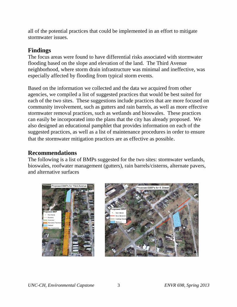
Founded in 1710, New Bern holds the title of North Carolina’s second oldest town (City, 2013).
Home to the first state capital of North Carolina, Tryon Palace, as well as the birthplace of Pepsi,
New Bern has a strong history of culture and tradition (New Bern, 2013). The municipality is
located within Craven County at the confluence of the Neuse and Trent Rivers with most of the
city’s infrastructure located along the waterways (City, 2013; Fig 1).
Figure 1: Map of North Carolina, indicating the geographical location of New Bern.
New Bern occupies approximately 28 sq. miles, and the majority of this land is flat;
approximately 88% of Craven County is level, 11% is gently sloping, and 1% is steeply sloped
(Holland, 2010; US Census, 2013). New Bern also has a very high water table, 0 to 1 foot in
many places, according to personal contact with Kate Marshal at SRA International. These

UNC-CH, Environmental Capstone 7 ENVR 698, Spring 2013
factors, combined with New Bern’s proximity to the Neuse and Trent Rivers, make New Bern
especially susceptible to flooding and storm surges.
ii. Third Avenue and K Street Neighborhoods
This report focuses on the K Street and Third Avenue neighborhoods. The main roads of these
neighborhoods are located two blocks from one another, and less than 750 m from the nearest
river. Figure 2 shows the locations of these areas within the New Bern city limits and displays
their proximity to the water.
Figure 2: Road map of New Bern, indicating locations of K Street and 3rd
Avenue
neighborhoods.
Personal records and accounts demonstrate that the areas of K Street and Third Avenue are at an
exceptionally high risk of flooding. These lower income neighborhoods have little to no
740 m
635 m
740 m
K Street
3rd Avenue

UNC-CH, Environmental Capstone 8 ENVR 698, Spring 2013
stormwater infrastructure and often have standing water present after rainfall. Communication
with Kate Marshall from SRA International suggests that the water table in the Third Street and
K Street neighborhoods is approximately 12 inches. Data and figures from the Craven County
GIS Online Database concur with estimations given by Kate Marshall of SRA.
iii. Sediment Characteristics of Third Avenue and K Street
The area in and around New Bern contains many different sediment and soil types, all of which
are documented and described in the Soil Survey of Craven County manuscript published by the
United States Department of Agriculture. According to this survey, the sediment of 3rd Avenue
is composed of Altavista - Urban Land Complex soil type. This type of soil is moderately well-
drained and has a fine sandy loam surface layer that is seven inches thick. On average, it has
moderate permeability and has a seasonal high water table of 1.5 to 2 feet. K Street, on the other
hand, overlies three different soil types. This area is composed of Altavista - Urban Land
Complex, Arapahoe soil, and Seabrook-Urban Land Complex. The Arapahoe soil notoriously
has a high water table of less than 1 foot while Seabrook Soil has a high water table of 2-4
feet. Permeability is very rapid in Seabrook Soil and thus the available water capacity is low in
these areas. Although it was found that these three different soil types are found under the two
study sites, there is little spatial difference between the recorded locations of these soil types, so
there is a high possibility of crossover and intermixing of sediments (USDA, 1989).

UNC-CH, Environmental Capstone 9 ENVR 698, Spring 2013
Figure 3: Soil map for Third Avenue and surrounding area.
(Retrieved from: http://gis.cravencountync.gov/maps/map.htm)
Figure 4: Soil profile map for K Street and surrounding area
(Retrieved from: http://gis.cravencountync.gov/maps/map.htm)

UNC-CH, Environmental Capstone 10 ENVR 698, Spring 2013
b. Flooding details
i. New Bern rainfall data and susceptibility
As the location, geology, and topography of the region would suggest, New Bern is especially
susceptible to flooding. According to data obtained by the SRA, New Bern receives an average
of 54.68 inches of rain per year, with the majority of that rainfall occurring in July, August, and
September (Vulnerability, 2013). Looking beyond average precipitation data, New Bern is also
located along the track of many hurricanes and storm systems that move up the East Coast
(Vulnerability, 2013). Hurricane Irene produced 11.13” of rain in just 24 hours and effectively
flooded the entire city (Vulnerability, 2013). Rainfall events such as these have been classified
by NOAA based on probability of occurrence, duration of storm, and total precipitation
produced. Table 1 shows that New Bern regularly receives rainfall events of 1.31 inches during
30-minute storms.
PDS-based precipitation frequency estimates with 90% confidence intervals (in inches)1
Duration Average recurrence interval(years)
1 2 5 10 25 50 100 200 500 1000
5-min 0.479
(0.440-0.523) 0.561
(0.516-0.610) 0.643
(0.591-0.699) 0.728
(0.668-0.791) 0.822
(0.749-0.892) 0.900
(0.818-0.978) 0.974
(0.881-1.06) 1.05
(0.941-1.14) 1.14
(1.02-1.25) 1.23
(1.08-1.34)
10-min 0.765
(0.702-0.836) 0.896
(0.825-0.976) 1.03
(0.947-1.12) 1.16
(1.07-1.27) 1.31
(1.19-1.42) 1.43
(1.30-1.56) 1.55
(1.40-1.68) 1.66
(1.49-1.81) 1.81
(1.61-1.97) 1.93
(1.70-2.11)
15-min 0.956
(0.878-1.05) 1.13
(1.04-1.23) 1.30
(1.20-1.42) 1.47
(1.35-1.60) 1.66
(1.51-1.80) 1.81
(1.65-1.97) 1.96
(1.77-2.13) 2.10
(1.88-2.28) 2.27
(2.02-2.48) 2.43
(2.14-2.65)
30-min 1.31
(1.20-1.43) 1.56
(1.43-1.70) 1.85
(1.70-2.01) 2.13
(1.96-2.32) 2.46
(2.24-2.67) 2.73
(2.48-2.97) 3.00
(2.71-3.26) 3.27
(2.93-3.55) 3.62
(3.22-3.94) 3.93
(3.46-4.29)
60-min 1.64
(1.50-1.79) 1.95
(1.80-2.13) 2.37
(2.18-2.58) 2.78
(2.55-3.02) 3.27
(2.98-3.55) 3.70
(3.37-4.02) 4.13
(3.73-4.49) 4.58
(4.11-4.98) 5.19
(4.62-5.66) 5.73
(5.06-6.27)
2-hr 1.96
(1.78-2.16) 2.36
(2.16-2.59) 2.93
(2.68-3.21) 3.50
(3.19-3.83) 4.24
(3.84-4.63) 4.91
(4.42-5.36) 5.59
(5.01-6.11) 6.34
(5.64-6.92) 7.39
(6.50-8.07) 8.34
(7.27-9.14)
3-hr 2.11
(1.92-2.36) 2.55
(2.32-2.82) 3.18
(2.89-3.52) 3.83
(3.46-4.23) 4.68
(4.21-5.16) 5.48
(4.90-6.04) 6.32
(5.61-6.95) 7.25
(6.38-7.97) 8.58
(7.47-9.46) 9.82
(8.44-10.9)
6-hr 2.55
(2.30-2.87) 3.07
(2.78-3.44) 3.84
(3.47-4.30) 4.63
(4.17-5.18) 5.69
(5.09-6.34) 6.67
(5.93-7.44) 7.72
(6.81-8.59) 8.89
(7.76-9.87) 10.6
(9.11-11.7) 12.1
(10.3-13.5)
12-hr 3.00
(2.70-3.39) 3.62
(3.26-4.07) 4.54
(4.08-5.12) 5.51
(4.93-6.20) 6.81
(6.05-7.64) 8.05
(7.09-9.00) 9.37
(8.17-10.5) 10.9
(9.37-12.1) 13.0
(11.1-14.6) 15.1
(12.6-16.9)
24-hr 3.49 (3.19-3.86)
4.25 (3.88-4.70)
5.50 (5.01-6.06)
6.55 (5.94-7.21)
8.11 (7.30-8.92)
9.45 (8.44-10.4)
10.9 (9.67-12.0)
12.6 (11.0-13.8)
15.0 (12.9-16.6)
17.1 (14.5-19.
Table 1: NOAA Atlas 14 Rainfall Return Frequencies in Inches (Retrieved from: Vulnerability, 2013)

UNC-CH, Environmental Capstone 11 ENVR 698, Spring 2013
ii. K Street and Third Avenue Flooding
Although New Bern is greatly affected by these large-scale storms, the areas studied in this
report, K Street and Third Avenue, are severely impacted by even minimal-volume storms. The
average rainfall for a typical summer storm has been calculated to be roughly 1.5” (Table 1,
Figure 4.5).
Figure 4.5: Daily rainfall amounts recorded in New Bern for the year 2012. Rainfall intensity is
highest during summer months and typical summer storms do not exceed 1.5”.
A trip to the site on February 17, 2013 highlighted the stormwater problems these areas face after
small storm events. After just 0.26” of precipitation the day before, substantial expanses of
Third Avenue and K Street were inundated (Figure 5a-b; Figure 7a-b). The flooding was located
largely along the north end of 3rd Avenue on either side of the street (Figures 6 & 8).
UNC-CH, Environmental Capstone 12 ENVR 698, Spring 2013
a) b)
Figure 5: a) Photograph showing flooding on northern end of 3rd
Avenue b) Photograph of
southern end of 3rd
Avenue, illustrating lack of flooding as well as lack of gutters on houses.
Figure 6: Map of water accumulation and drainage sites on 3
rd Avenue (February 17, 2013)
a) b)
Figure 7: a) Ditch currently used to mitigate floodwaters on K Street. B) Flooding near northeast
end of K Street.

UNC-CH, Environmental Capstone 13 ENVR 698, Spring 2013
Figure 8: Map of water accumulation and drainage sites on 3rd Avenue (February 17, 2013)
From personal contact with homeowners, it was determined that the south end of Third Avenue
receives very little accumulation of stormwater, even in heavy storms. This focus on the north
end of Third Avenue is due to the fact that there is a slight elevation decline in the road as one
travels northward. Assessment of this northern section of 3rd Avenue has yielded the following
details on flooding mechanisms:
1. The edge of the road is lower than the field, causing poor runoff and accumulation of
water
2. Parking areas have been eroded away and depressions have formed that collect water
3. Storm drains are higher than the road and are clogged
4. There are no ditches/swales on the sides of the roads
The primary factors affecting both neighborhoods include the absence of any effective
stormwater management infrastructure coupled with a flat topography and shallow water table in
an area that has been developed with impermeable surfaces.
UNC-CH, Environmental Capstone 14 ENVR 698, Spring 2013
c. Stormwater estimates
i. Calculating rainfall in target neighborhoods
In order to calculate the relative abundances of pervious and impervious surfaces along the Third
Avenue and K Street neighborhoods, Google Earth was used. The measurement tool with meter
scale increments was used to determine the area values necessary for these calculations. A
rectangular approximation was drawn around the street and surrounding properties in each
neighborhood to estimate the total area. Estimates of the proportions of area occupied by
pavement and houses were then made in order to direct the stormwater management initiative. A
standard of 1.5 inches per rain event was used based on information suggesting that this value
was a valid approximation of most rain events during the summer, when rain events have been
shown to be more intense. These calculations were then used to target stormwater management
strategies for each neighborhood. It is important to note that projected land use changes under the
redevelopment plan (New Bern, 2013) will alter the estimations presented below.
ii. K Street Rainfall Summary
According to our calculations with Google Earth, the lots of land immediately adjacent to K
Street encompass an area of approximately 28,000 square meters. Of this total surface area,
approximately 5,900 square meters consists of impermeable pavement and approximately 700
square meters consists of impermeable roofs. This roughly translates to 24% of the neighborhood
consisting of impermeable surfaces. Current research suggests this amount of impermeable
surface equates to a 100% increase in surface runoff compared to natural terrain (Chester &
Gibbons, 1996). During a typical rainfall event (as defined above), the total surface of this

UNC-CH, Environmental Capstone 15 ENVR 698, Spring 2013
neighborhood receives roughly 174,000 gallons of water collecting in the neighborhood that
must be managed in order to mitigate temporary flooding events.
iii. Third Avenue Rainfall Summary
Using Google Earth, the area comprising the lots surrounding Third Avenue was calculated to be
17,000 square meters. The total surface area of the road and buildings comprises approximately
2,100 square meters and 2,400 square meters, respectively. The sum of impervious surfaces in
the Third Street neighborhood equate to approximately 26% of the total surface area in the
neighborhood. The surfaces of this neighborhood receive approximately 283,000 gallons of
stormwater that must be managed to prevent flooding during a typical 1.5” summer rain event.
d. Existing Plans for the Future
i. New Bern Gateway Renaissance Plan
The New Bern Gateway Renaissance Plan consists of a series of projects focused on
redevelopment and sustainable infrastructure that are designed to revitalize and beautify New
Bern (New Bern, 2013). This plan includes a trajectory for the Third Avenue neighborhood,
where abandoned homes currently occupy much of the property. Under the infill-housing plan,
New Bern plans to engage current residents in a discussion that facilitates how new housing can
benefit both the neighborhood and the planned greenway (New Bern, 2013). The first stages of
this plan include the clearing of abandoned houses along the west side of Third Avenue to allow
for the redevelopment of the lots into functional and affordable townhomes targeted for a wide
range of citizens, with specific availability for senior citizens (New Bern, 2013). The plan
UNC-CH, Environmental Capstone 16 ENVR 698, Spring 2013
further details a greenway plan to connect the Stanley White Recreation Center to Broad Street
along Third Avenue (New Bern, 2013). This renaissance plan will transform currently vacant
spaces into mixed-use housing that will aim to foster a stronger sense of community and
facilitate access to community services.
ii. City of New Bern Pedestrian Plan
According to the City of New Bern’s Pedestrian Plan, the city hopes to build a series of
greenways and sidewalks in an effort to increase connectivity for pedestrians in the city and
develop an enjoyable walking environment. Under this plan, sidewalks will be a minimum of 5
ft. wide and should be constructed with permeable materials (City, 2009). The Director of Public
Works, Mark Stephens, has pushed for the implementation of more environmentally amenable
materials such as porous pavers in the construction of these sidewalks as a means of reducing
stormwater runoff (City, 2009). A sidewalk extending the length of Third Avenue from Broad
Street to Cedar Street is part of the current short-term recommendations for the city of New Bern
(City, 2009). According to the plan, greenways will be designed to be a minimum of 10 ft. wide
with 2 ft. graded shoulders on either side of the trails (City, 2009). Further constraints on
greenways require a minimum of 8 ft. vertical clearance above the trail surface (City, 2009). In a
further effort to mitigate the effects of stormwater, the plan suggests that paving options could
consist of either standard or permeable asphalts and concretes, pea gravel, or granite screenings
(City, 2009). These plans provide an overall focus on increasing pedestrian activity in the city of
New Bern in an environmentally-conscious manner that helps to reduce further impacts on the
area with a specific focus on stormwater mitigation.

UNC-CH, Environmental Capstone 17 ENVR 698, Spring 2013
II. BEST MANAGEMENT PRACTICES
a. Introduction to BMPs considered
Stormwater management BMPs are control measures taken to mitigate changes to both quantity
and quality of urban runoff caused through changes to land use (Debo & Reese, 2003). For the
consideration of flooding in the K Street and 3rd Avenue neighborhoods, this investigation
studied a variety of management practices. These included biotic approaches to stormwater
management including bioswales, rain gardens, and wetlands as well as abiotic management via
diversion of roof water, infiltration trenches, permeable pavements, alternate pavers, alternative
surfaces, level spreaders, and sand filters. These management practices are described below to
evaluate their function as well as advantages and disadvantages.
b. Types of BMPs
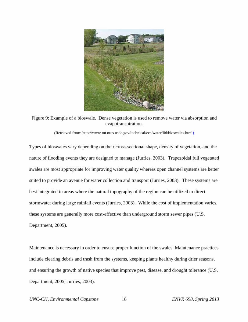
i. Bioswales
Bioswales are vegetated trenches that serve as an alternative to storm sewers by collecting and
relocating storm water runoff (U.S. Department, 2005; see Figure 9). When planted with water-
intensive, deep-rooted vegetation, bioswales can collect water and undergo evapotranspiration,
allowing for water to be removed from the system without having to relocate it elsewhere.
Bioswales can also direct water elsewhere during large storm events, when vegetation is unable
to compensate for the increased water influx (U.S. Department, 2005). Additionally, bioswales
can remove pollutants from stormwater, thereby improving water quality (Jurries, 2003).
UNC-CH, Environmental Capstone 18 ENVR 698, Spring 2013
Figure 9: Example of a bioswale. Dense vegetation is used to remove water via absorption and
evapotranspiration.
(Retrieved from: http://www.mt.nrcs.usda.gov/technical/ecs/water/lid/bioswales.html)
Types of bioswales vary depending on their cross-sectional shape, density of vegetation, and the
nature of flooding events they are designed to manage (Jurries, 2003). Trapezoidal full vegetated
swales are most appropriate for improving water quality whereas open channel systems are better
suited to provide an avenue for water collection and transport (Jurries, 2003). These systems are
best integrated in areas where the natural topography of the region can be utilized to direct
stormwater during large rainfall events (Jurries, 2003). While the cost of implementation varies,
these systems are generally more cost-effective than underground storm sewer pipes (U.S.
Department, 2005).
Maintenance is necessary in order to ensure proper function of the swales. Maintenance practices
include clearing debris and trash from the systems, keeping plants healthy during drier seasons,
and ensuring the growth of native species that improve pest, disease, and drought tolerance (U.S.
Department, 2005; Jurries, 2003).
UNC-CH, Environmental Capstone 19 ENVR 698, Spring 2013
ii. Rain Gardens
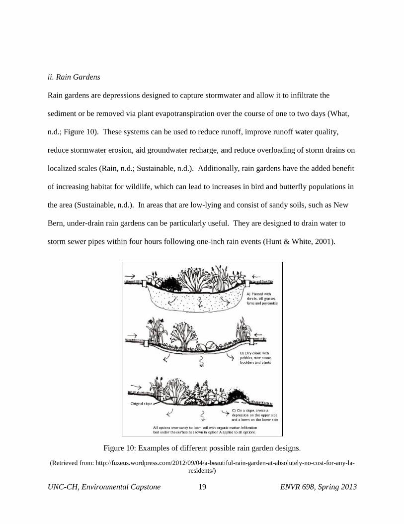
Rain gardens are depressions designed to capture stormwater and allow it to infiltrate the
sediment or be removed via plant evapotranspiration over the course of one to two days (What,
n.d.; Figure 10). These systems can be used to reduce runoff, improve runoff water quality,
reduce stormwater erosion, aid groundwater recharge, and reduce overloading of storm drains on
localized scales (Rain, n.d.; Sustainable, n.d.). Additionally, rain gardens have the added benefit
of increasing habitat for wildlife, which can lead to increases in bird and butterfly populations in
the area (Sustainable, n.d.). In areas that are low-lying and consist of sandy soils, such as New
Bern, under-drain rain gardens can be particularly useful. They are designed to drain water to
storm sewer pipes within four hours following one-inch rain events (Hunt & White, 2001).
Figure 10: Examples of different possible rain garden designs.
(Retrieved from: http://fuzeus.wordpress.com/2012/09/04/a-beautiful-rain-garden-at-absolutely-no-cost-for-any-la-
residents/)
UNC-CH, Environmental Capstone 20 ENVR 698, Spring 2013
Costs for rain gardens vary depending on plants utilized, soil type, size of the rain garden, and
any required labor or tools to install the system (Rain, n.d.). It is highly recommended that
native vegetation be planted in the rain garden because it has an increased ability to survive
conditions typically experienced in the area. A list of recommended plant species for
southeastern North Carolina can be found here: http://www.bae.ncsu.edu/topic/raingarden/plants.htm.
Two of the issues associated with rain gardens are that they can become clogged with
sedimentation over time and may need to be watered during periods of drought (Maintaining,
n.d.). Additional maintenance consists of annual mulching to keep soil moist and pervious,
upkeep of young plants to ensure their survival, and weeding or pruning away dead plants
(Maintaining, n.d.).
iii. Wetlands
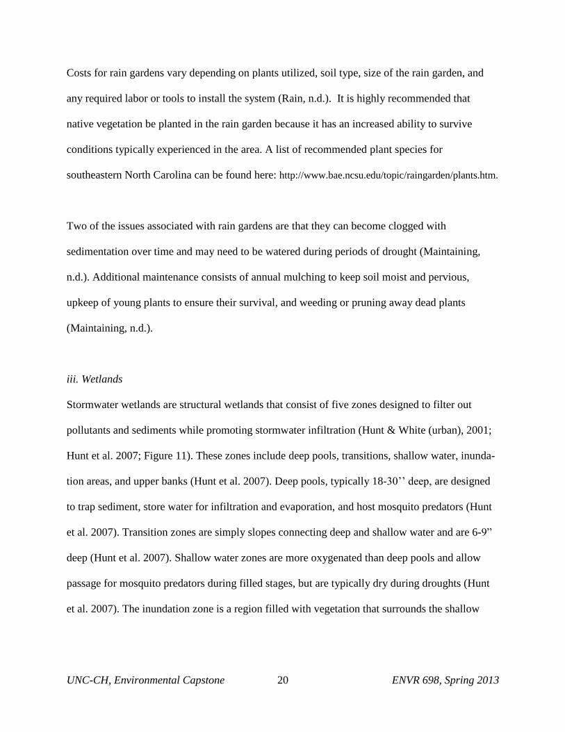
Stormwater wetlands are structural wetlands that consist of five zones designed to filter out
pollutants and sediments while promoting stormwater infiltration (Hunt & White (urban), 2001;
Hunt et al. 2007; Figure 11). These zones include deep pools, transitions, shallow water, inunda-
tion areas, and upper banks (Hunt et al. 2007). Deep pools, typically 18-30’’ deep, are designed
to trap sediment, store water for infiltration and evaporation, and host mosquito predators (Hunt
et al. 2007). Transition zones are simply slopes connecting deep and shallow water and are 6-9”
deep (Hunt et al. 2007). Shallow water zones are more oxygenated than deep pools and allow
passage for mosquito predators during filled stages, but are typically dry during droughts (Hunt
et al. 2007). The inundation zone is a region filled with vegetation that surrounds the shallow
UNC-CH, Environmental Capstone 21 ENVR 698, Spring 2013
water zone and is designed to flood during larger storms (Hunt et al. 2007). The upland bank
surrounds the wetland and slopes into the wetland to avoid erosion (Hunt et al. 2007).
Figure 11: Design schematics for a stormwater wetland, illustrating the different sections of the
wetland and their relative sizes/depths.
(Retrieved from:
http://www.stormwatercenter.net/Assorted%20Fact%20Sheets/Tool6_Stormwater_Practices/Wetland/Wetland.htm)
These systems improve downstream water quality, reduce particulates, decrease peak discharge,
require little maintenance, and enhance wildlife and vegetation (Constructed, n.d.). However,
these systems have large land requirements with high construction costs with some difficulties
maintaining vegetation on slopes in variable water flows (Constructed, n.d.).

UNC-CH, Environmental Capstone 22 ENVR 698, Spring 2013
iv. Roof Water Management
This grouping focuses on a suite of BMPs that can be utilized by households specifically in order
to mitigate stormwater accumulation in the vicinity of individual houses. These BMPs include
gutters, rain cisterns, and rain barrels.
1. Gutters
Gutters are narrow channels, or troughs, forming the component of a roof system that collects
and diverts rainwater shed by the roof (see Figure 12). Gutters can be effective tools for
directing flow from roofs and into other management strategies and are integral components for
water collection systems like rain barrels and cisterns (Jones & Hunt 2008; Hut & Szpir, 2008).
A gutter system can be installed for approximately $1050 to $2400 per house depending on
materials used, contractor fees, permits, and taxes (Cost, 2013). These systems require routine
maintenance every 3 to 4 months to prevent clogging or debris buildup (Cost, 2013).
Figure 12: Example of a gutter system. The gutters hang over the edge of the roof, collect
stormwater, and guide it to an outflow.
(Retrieved from: http://www.gwiltsiding.com/gutters.html)
UNC-CH, Environmental Capstone 23 ENVR 698, Spring 2013
2. Rain Cisterns
Rain cisterns are large-scale water collection systems made up of collection tanks ranging from
less than 100 to over 10,000 gallon capacities, gutters that collect runoff from an adjoining
rooftop, and a pump that can distribute the captured water to the home or landscape (Jones &
Hunt, 2008; Hunt & Szpir, 2008; see Figure 13). Most cisterns also utilize a first-flush diverter,
which is a mechanism that allows the initial run off of particulates and pollen to bypass the
cistern (Hunt & Szpir, 2008). Rain cistern systems help to dampen the effects of roof top runoff,
capture rain borne nutrients and pollutants from the atmosphere, reduce channel erosion, and can
produce significant amounts of potable water for use in a home (Hunt & Szpir, 2008).
Figure 13: An above-ground metal rain cistern system, implemented at a business building. The
gutter system connects directly to the cistern.
(Retrieved from: http://ucgroupthree.wordpress.com/)
Cisterns can either be installed above or below ground. Above ground systems offer easier, more
cost-effective installation and repairs and often do not require pumps for low-pressure
applications (Jones & Hunt, 2008). Below ground systems offer the benefits of relaxed location

UNC-CH, Environmental Capstone 24 ENVR 698, Spring 2013
requirements and do not take up yard space; however, they cannot be installed below ground in
regions with shallow water tables like New Bern (Jones & Hunt, 2008).
Cisterns can be more expensive to install, with pumping systems’ cost of operation ranging from
$0.75 per gallon to $2.00 per gallon depending on the total size of the cistern and the cisterns
themselves costing upwards of several thousand dollars, depending on materials used (Jones &
Hunt, 2008; Clark & Acomb, 2008). Cisterns are typically made from plastic, metal, or concrete
depending on intended use and budget constraints. While plastic cisterns are less aesthetically
pleasing, they are more cost-effective, do not require assembly, and are easily moveable and
modifiable (Jones & Hunt, 2008). Metal cisterns can be made from modified grain bins but
require a plastic interior liner to prevent leaks and protect the cistern’s structural integrity (Jones
& Hunt, 2008). Concrete tanks can be poured in place or prefabricated either above or below
ground and can be very attractive and easily integrated into new construction (Pushard, 2013).
Existing gutter systems can easily be adapted to direct rainwater into a cistern with screens or
filters to further inhibit the influx of particulates into the cistern. Aside from the maintenance
required for gutter systems, rain cistern systems require very little maintenance; only occasional
cleaning of the cisterns for aboveground systems.
3. Rain Barrels
Rain barrels are smaller-scale, more cost-effective alternatives to large rainwater harvesting
systems that can be used to meet small outdoor water demands (Jones & Hunt, 2008; Hunt &
Szpir, 2008; see Figure 14). Rain barrel systems are generally constructed from 55-gallon
containers and consist of a gutter connection, overflow mechanism, and an outlet valve or faucet

UNC-CH, Environmental Capstone 25 ENVR 698, Spring 2013
(Hunt & Szpir, 2008). Due to their smaller sizes, they generally do not require a mechanical
pump and can simply rely on gravity to adequately fill a hand watering can (Jones & Hunt, 2008;
Hunt & Szpir, 2008).
Figure 14: Example of a rain barrel system. Water collected in the rain barrel can be used for
household tasks, such as watering a garden.
(Retrieved from: http://bnriverkeeper.org/projects/green-infrastructure/)
These barrels are typically very affordable and can be installed for $50 if self-assembled or can
be professionally installed for roughly $200 (Clark & Acomb, 2008). Although rain barrels are
excellent for raising awareness and demonstrating water conservation, their small size prevents
them from significantly contributing to stormwater runoff reduction.
In addition to maintenance associated with the gutter system, special cleaning may be required to
remove any potentially harmful residues, depending on the previous use of the barrels. Clear
barrels should be painted to prevent algae from growing inside of the barrel (Jones & Hunt,
2008).

UNC-CH, Environmental Capstone 26 ENVR 698, Spring 2013
v. Infiltration trenches
Infiltration trenches are 3 to 12 foot excavations filled with 1.5-2.5” diameter stones to create
underwater reservoirs for stormwater runoff (Infiltration, n.d.; see Figure 15). These systems
reduce volume of runoff, aid in the removal of pollutants, provide underground discharge, and
are appropriate for small areas (Infiltration, n.d.; Stormwater Infiltration, n.d.).
Figure 15: Design sketch for an infiltration trench.
(Retrieved from: http://keneulie.files.wordpress.com/2010/02/feb-infiltratintrench.jpg?w=450&h=307)
These systems require relatively flat land, sediment infiltration rates ranging from 0.5 to 3 inches
per hour, and at least 3 feet of separation from the seasonal high water table (Infiltration, n.d.;
Stormwater Infiltration, n.d.).
One issue with infiltration trenches is that they are extremely susceptible to clogging
(Infiltration, n.d.; Stormwater Infiltration, n.d.). They also require inspections after every major
storm and at least twice a year in order to ensure that they are stable and fully functional
(Infiltration, n.d.).
UNC-CH, Environmental Capstone 27 ENVR 698, Spring 2013
vi. Permeable pavements
Permeable pavements are pavements with a base and sub-base that allow the movement of
stormwater through the surface. Permeable pavements excel in their ability to allow for quick
infiltration of water into the storage basin and surrounding soil, reductions of stormwater runoff,
removal of pollutants, recharging of groundwater, while also providing hard structures for
driving and parking (Permeable Fact, 2011; Permeable, 2011; Best, n.d.; Stormwater Porous,
n.d.). Permeable pavements can also be more effective at melting snow and ice than impervious
pavements due to increased functionality as heat sinks (North, 2007). These pavements are
currently being considered for reducing nutrient runoff by the Neuse Nutrient Loading Models
for New Development (North, 2007).
While permeable pavements serve a broad range of benefits, they are limited by the height of an
area’s water table, maintenance to prevent clogging, and soil permeability. It is generally
recommended that there is at least a 2 to 5 foot gap between the permeable pavement surface and
the seasonally high water table (Stormwater Porous, n.d.). Otherwise, the pavement may not
allow water to exfiltrate and associated soils may become less effective in reducing pollutants
from stormwater prior to infiltration into the shallow groundwater (North, 2007). Maintenance
must be performed at least four times a year via vacuum sweeping to prevent clogging by sands
and other debris (North, 2007). The threat of clogging is especially elevated during periods of
winter salting and sanding prior to winter storm events (Permeable Fact, 2011; Stormwater
Porous, n.d.). In general, runoff from pervious surfaces should not drain onto permeable
pavements as this would exacerbate any clogging (North, 2007). Additionally, soil permeability
must be at least 0.5 to 3 inches per hour to ensure proper infiltration after permeating through the

UNC-CH, Environmental Capstone 28 ENVR 698, Spring 2013
pavement surface (Permeable, 2011; Stormwater Porous, n.d.). These represent general
limitations for all permeable pavements. The cost-benefit for each of the primary permeable
pavement methods differs slightly.
1. Pervious Concrete
Pervious concrete is a specialty concrete primarily comprises large aggregates coated with
concrete paste (Stormwater Porous, n.d.; see Figure 16). Pervious concrete has a wide range of
applications including parking areas, residential streets, and pedestrian sidewalks (Permeable
Fact, 2011). This method is particularly good at reducing pollutant loads and increasing soil
surface-air gas and water exchange for trees and is widely available (Permeable Fact, 2011).
However, this method requires a non-traditional installation that requires 7 days to cure before
use, has potential risks for cracking over time, and costs two to four times as much as porous
asphalt (Permeable Fact, 2011; Permeable, 2011; United Environmental, 2009). This method
lasts at least 20-30 years if properly maintained and is capable of reducing up to 10 feet/day of
rainwater (Permeable Fact, 2011; Permeable, 2011). The cost of pervious concrete ranges from
$2.00 to $6.50 per square foot (Permeable Fact, 2011; Permeable, 2011).

UNC-CH, Environmental Capstone 29 ENVR 698, Spring 2013
Figure 16: Demonstration of the permeability of pervious concrete.
(Retrieved from: http://www.uri.edu/cve/ritrc/wpe2.jpg)
2. Porous Asphalt
Porous asphalt is fundamentally the same as conventional asphalt, but lacks the fine particles,
thereby creating a more porous structure (Permeable Fact, 2011; Stormwater Porous, n.d.; see
Figure 17). It has successfully been used in parking areas, driveways, bike paths, playgrounds,
and sidewalks (Permeable Fact, 2011; Best, n.d.). Porous asphalt is considered to be ideal due to
its cost-effective, fast, easy, and widely available installation as well as its capacity to reduce
pollutant loads (Permeable, 2011; United Environmental, 2009).

UNC-CH, Environmental Capstone 30 ENVR 698, Spring 2013
Figure 17: Illustration of porous asphalt being implemented in a parking lot.
(Retrieved from: http://www.mytorontohomeimprovement.com/wp-content/uploads/2008/08/permeable-
pavement.JPG)
Curing times range from 24 to 48 hours (Permeable Fact, 2011; United Environmental, 2009).
Porous asphalt surfaces can last at least 15-20 years if properly maintained although potholes and
cracks may develop over time (United Environmental, 2009; Permeable Fact, 2011; Permeable,
2011). Porous asphalt must be installed at least four feet about the seasonally high groundwater
table to avoid contamination (Best, n.d.). This method costs $0.50 to $1 per square foot and is
capable of reducing up to 6 feet per day of rainwater (Permeable Fact, 2011; Permeable, 2011).
3. Permeable Interlocking Concrete Pavements
Permeable interlocking concrete pavements consist of a special dry-mix precast piece of concrete
stabilized by sand (Permeable Fact, 2011; see Figure 18). It is best used for driveways, parking
areas, embankment stabilization, roadway medians, and sidewalks (Permeable Fact, 2011).
These pavements are flexible, capable of absorbing stress, do not easily deform, have a pleasant
appearance, are easily installed, come in a wide range of styles, and do not require a curing

UNC-CH, Environmental Capstone 31 ENVR 698, Spring 2013
period following installation (Permeable Fact, 2011; Permeable, 2011). Unfortunately, these
pavement pieces are not always widely available as they must be manufactured by factory
machinery, yielding prices that vary from $5 to $10 per square foot (Permeable Fact, 2011;
Permeable, 2011). These pavements last 20-30 years if properly maintained and can reduce up
to 2 feet per day of rainwater (Permeable Fact, 2011; Permeable, 2011).
Figure 18: Illustration of the structure of permeable interlocking concrete pavement.
(Retrieved from: http://www.icpi.org/sites/default/files/images/PICP-XC_label-1.img_assist_custom-365x265.jpg)
4. Plastic grids
Plastic grids consist of a series of plastic pieces that stabilize either gravel or turf (Permeable
Fact, 2011; see Figure 19). They are commonly used in parking lots, pathways, sidewalks, or
residential driveways (Permeable Fact, 2011). Because they are flexible, they can be used on
uneven sites with a simple installation that produces a pleasant appearance popular with
homeowners. These grid systems, however, require lots of maintenance and are primarily suited
for low traffic areas (Permeable Fact, 2011). Maintenance differs from other methods and
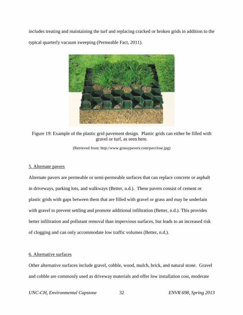
UNC-CH, Environmental Capstone 32 ENVR 698, Spring 2013
includes treating and maintaining the turf and replacing cracked or broken grids in addition to the
typical quarterly vacuum sweeping (Permeable Fact, 2011).
Figure 19: Example of the plastic grid pavement design. Plastic grids can either be filled with
gravel or turf, as seen here.
(Retrieved from: http://www.grassypavers.com/pavclose.jpg)
5. Alternate pavers
Alternate pavers are permeable or semi-permeable surfaces that can replace concrete or asphalt
in driveways, parking lots, and walkways (Better, n.d.). These pavers consist of cement or
plastic grids with gaps between them that are filled with gravel or grass and may be underlain
with gravel to prevent settling and promote additional infiltration (Better, n.d.). This provides
better infiltration and pollutant removal than impervious surfaces, but leads to an increased risk
of clogging and can only accommodate low traffic volumes (Better, n.d.).
6. Alternative surfaces
Other alternative surfaces include gravel, cobble, wood, mulch, brick, and natural stone. Gravel
and cobble are commonly used as driveway materials and offer low installation cost, moderate

UNC-CH, Environmental Capstone 33 ENVR 698, Spring 2013
maintenance costs, and medium to high water quality improvements (Better, n.d.). Wood and
mulch are primarily used for walking trails with relatively low installation costs and moderate
maintenance costs (Better, n.d.). Brick and natural stone utilize a loose configuration to allow
for infiltration, but have high installation costs and medium maintenance costs (Better, n.d.).
These measures of effectiveness compare to concrete and asphalt, which have medium
installation costs, low maintenance costs, and low water quality effectiveness (Better, n.d.).
vii. Level Spreaders
Level spreaders are structural devices utilized to diffuse flow requirements under buffer and
stormwater programs, reduce particulate pollutants, and reduces water flow rate to promote
infiltration (North, 2007). These systems are not capable of storing large volumes of stormwater
during peak flow events and typically serve as a component of a stormwater management system
that diverts flow to a nearby body of water (North, 2007).
Figure 20: Example of a level spreader. (Retrieved from: http://www.iconeng.com/wordpress/wp-content/gallery/projects/level-spreader-eagle.jpg)

UNC-CH, Environmental Capstone 34 ENVR 698, Spring 2013
In practice, the entire level spreader must be located outside of riparian buffers and stormwater
setbacks and may not exceed the allowable slope of 5 to 8% depending on vegetation (North,
2007). There are five major components to a level spreader system; a high flow bypass system, a
forebay, a blind swale, a level spreader, and a vegetated filter strip. The high flow bypass system
can divert high flows from a slow splitter into a nearby drainage ditch, swale, or stream (North,
2007). The forebay is designed to prevent rapid overflow into blind swales and is not needed
when water is flowing from previously managed regions as the flow has already been controlled
in these cases (North, 2007). Blind swales are built parallel to and upslope of a level spreader to
promote infiltration even distribution into the level spreader (North, 2007). A traditional
concrete level spreader consists of a concrete weir of horizontal slope approximately 3 inches
higher than the existing ground and three feet wide to dissipate flow downslope of the level
spreader onto a geotextile fabric overlain with a 3 to 4 inch layer of aggregate stone (North,
2007). A vegetated filter strip can be an existing riparian buffer, herbaceous or wooded setback,
or an engineered filter strip (North, 2007).
viii. Sand Filters
Sand filters consist of porous media designed to allow stormwater to infiltrate into the subsurface
and filter out pollutants (North, 2007). These filters require less space than other BMPs and can
be placed underground or in small sites where space may otherwise be limited (North, 2007).
These filters are generally expensive, may be unattractive if not vegetated, and are not effective
in controlling peak discharges (North, 2007). Additionally, sand filters cannot be used if the
seasonal high water table is less than 2 feet for open basin designs, although that restriction can
be relaxed to 1 foot if concrete bottoms are utilized (North, 2007).

UNC-CH, Environmental Capstone 35 ENVR 698, Spring 2013
Figure 21: Illustration of a typical surface sand filter.
(Retrieved from: http://stormwatercenter.net/Assorted%20Fact%20Sheets/ Tool6_Stormwater_Practices/
Filtering%20 Practice/Sand%20and%20Organic%20Filter%20Strip.htm)

UNC-CH, Environmental Capstone 36 ENVR 698, Spring 2013
III. BMP PLAN
a. BMPs Not Suitable for Area
Several factors limited the best management practices suitable for K Street and Third Avenue.
One of the most important factors is an extremely high water table that varies from 0 to 12 inches
below the surface. As permeable pavements, infiltration trenches, and rain gardens each require
a minimum of 3 feet between the ground and the seasonally high water table, these three best
management practices are unsuitable for the area. Additionally, in order for level spreaders to be
an effective best management practice, they require sloped land; as the land in these areas is
relatively flat, level spreaders too are unsuitable.
Sand filters work similarly to infiltration trenches, but require less minimum distance between
the ground and seasonally high water table. However, they still require a minimum distance
larger than the 0 to 12 inches provided by New Bern’s seasonally high water table. Sand filters
also clog easier than other best management practices, and are comparatively more expensive.
As a result of these factors, they too are not suitable for the area.
b. Optimal Plan for the Area
Due to the shallow water table, flat-lying terrain, and current plans for the area, our report
concludes that gutters, bioswales, wetlands, rain barrels, rain cisterns, alternate pavers, and
alternative surfaces are the optimal best management practices for this area. Gutters provide the
benefit of diverting stormwater away from homes and into other management practices. Heavily
vegetated bioswales will be integral components of water infiltration and removal via
evapotranspiration near roadsides. Wetlands can also be a good option for storing and

UNC-CH, Environmental Capstone 37 ENVR 698, Spring 2013
controlling larger amounts of floodwater; however, a reliable outflow is necessary to prevent
flooding during large rain events. Rain barrels and cisterns can provide effective means for
recycling stormwater falling on homes and provide a strong community involvement component.
While permeable pavements are not suitable due to the high water table, alternate pavers can
effectively be used for smaller scale, lower traffic areas such as driveways and parking along the
side of the road. Finally, alternate surfaces such as gravels or mulches can be effective pathways
for greenways designated under the Renaissance Plan.
i. Optimal BMPs for Third Avenue
Rain barrels on each of the existing houses are highly recommended, as well as installing rain
gutters on any existing and future buildings. A stormwater wetland should be installed at the
north end of the street, where most of the flooding occurs. This space is currently public land so
land acquisition would not be an issue. However, it will be difficult to determine an appropriate
outflow for the wetland. According to the Renaissance plan, a greenway will be implemented
along the west side of Third Avenue, providing a connection between Broad Street and the
Stanley White Recreation Center, which is located approximately one block north of the northern
end of Third Avenue. This greenway can be designed to provide a path around the wetlands,
offering an opportunity for an outdoor educational center for the residents.

UNC-CH, Environmental Capstone 38 ENVR 698, Spring 2013
Figure 22: Map of proposed BMP implementation on Third Avenue.

UNC-CH, Environmental Capstone 39 ENVR 698, Spring 2013
On the east side of the northern end of 3rd
Avenue, there is usually a large mud puddle that
discourages residents from parking in front of their houses. To circumvent this, permeable
parking will be placed along the length of the right side of the road in front of the existing
houses.
Following the left length of Third Avenue is a proposed bioswale to discourage water from
settling on the road or on the alternative parking, which is currently an issue because the road is
lower than the adjacent field. The bioswale will allow the road to be higher than the surrounding
ground.
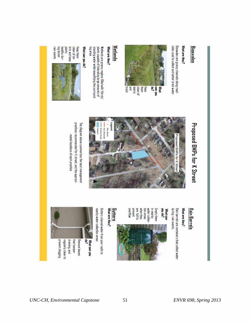
ii. Optimal BMPs for K Street
As stated for Third Avenue, K Street should have rain barrels added to each of the existing
houses. While this will not reduce a significant amount of the storm flooding, it will provide a
water source for the community to water their own gardens or lawns. In addition, it helps to build
a community involvement in the area. All of the houses should be equipped with rain gutters if
they are not already. This street did not have many problem areas regarding the flooding based
on our site visit following the 0.26” rainfall in February.
There is currently a location that appears to be consistently flooding near the northeast end of the
street. One recommendation is to turn this area into a stormwater wetland. This will provide a
means of stormwater mitigation while also improving the aesthetic appeal of the area.

UNC-CH, Environmental Capstone 40 ENVR 698, Spring 2013
The existing ditch on the side of the street where the community garden is located should be
extended to run the length of the street and converted into more effective bioswales by planting
them with native plants. Bioswales are suggested along the length of the roads to divert
stormwater away from the roads and to allow any collecting water to be infiltrated or absorbed
by plants.
Figure 23: Map of proposed BMP implementation on K Street
UNC-CH, Environmental Capstone 41 ENVR 698, Spring 2013
IV. IMPLEMENTATION
a. Maintenance of BMPs chosen
i. Maintaining Current Stormwater Systems
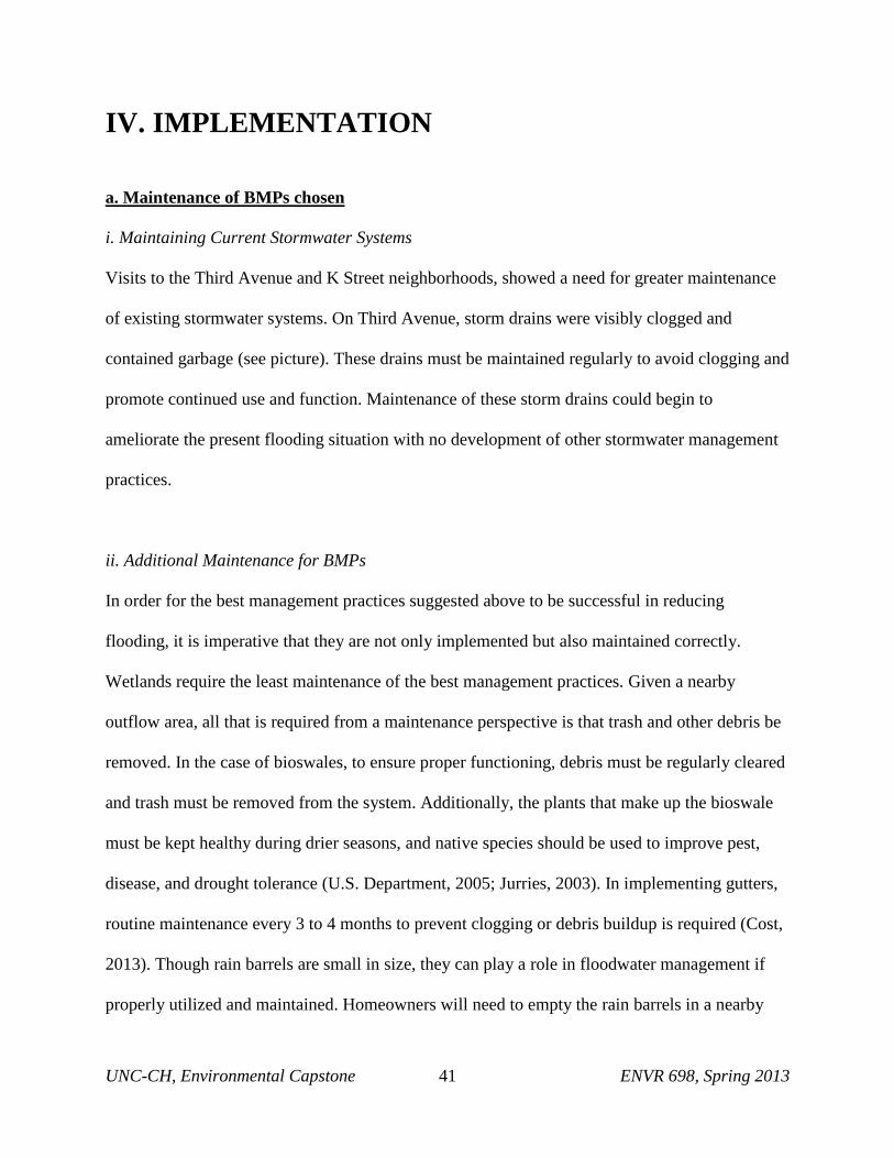
Visits to the Third Avenue and K Street neighborhoods, showed a need for greater maintenance
of existing stormwater systems. On Third Avenue, storm drains were visibly clogged and
contained garbage (see picture). These drains must be maintained regularly to avoid clogging and
promote continued use and function. Maintenance of these storm drains could begin to
ameliorate the present flooding situation with no development of other stormwater management
practices.
ii. Additional Maintenance for BMPs
In order for the best management practices suggested above to be successful in reducing
flooding, it is imperative that they are not only implemented but also maintained correctly.
Wetlands require the least maintenance of the best management practices. Given a nearby
outflow area, all that is required from a maintenance perspective is that trash and other debris be
removed. In the case of bioswales, to ensure proper functioning, debris must be regularly cleared
and trash must be removed from the system. Additionally, the plants that make up the bioswale
must be kept healthy during drier seasons, and native species should be used to improve pest,
disease, and drought tolerance (U.S. Department, 2005; Jurries, 2003). In implementing gutters,
routine maintenance every 3 to 4 months to prevent clogging or debris buildup is required (Cost,
2013). Though rain barrels are small in size, they can play a role in floodwater management if
properly utilized and maintained. Homeowners will need to empty the rain barrels in a nearby

UNC-CH, Environmental Capstone 42 ENVR 698, Spring 2013
outflow area when they fill up. Additionally, the rain barrels may require special cleaning to
remove any potentially harmful residues from prior use (Jones & Hunt, 2008). Alternative
surfaces such as gravel, cobble, wood, mulch, brick, and natural stone should be regularly
monitored, and replaced in the event of cracks or to improve aesthetic beauty. Alternate pavers
require regular monitoring to prevent clogging. Additionally, in the event that the cement or
plastic grids cracks or breaks off, it should be replaced as soon as possible. If these grids are
filled with gravel, they should be refilled when gravel gets displaced. If the grids are instead
filled with grass, mowing and/or watering the grass is recommended to improve aesthetics.
b. Educational Component of BMPs
Proper maintenance is essential to the success of the best management practices suggested for the
two New Bern neighborhoods. The upkeeping of these newly implemented best management
practices will require the efforts and cooperation of the nearby community. In order to get help
from neighborhood residents, it is important to inform them of the function, benefits, and
maintenance requirements of each suggested practice. Through education, community members
can better understand the scope of the flooding problem existent in their neighborhood, and
potential measures that can be instituted to help mitigate this problem. Educational brochures
have thus been created to outline to residents the function of each best management practice
suggested as well as what can be done, on an individual level, to maintain each practice and
promote its long term existence (Appendix I). In particular, gutters must be recognized as an
important means of diverting flood water, and must be regularly cleaned to ensure proper
operation. These devices should be installed on a per-household basis to maximize stormwater
mitigation. Vegetated bioswales are much more sophisticated than roadside ditches and must

UNC-CH, Environmental Capstone 43 ENVR 698, Spring 2013
remain cleared of trash and material waste to prevent clogging and ensure better infiltration rates
over the long term. Wetlands must also be kept clean of trash and material wastes to maintain
their function and appearance. Rain barrels and cisterns are fantastic ways to engage the
community in roof-top stormwater management, but must be installed and appropriately emptied
individually. Alternate pavers and alternative surfaces are typically maintained by city officials;
however, keeping them clean of trash and other debris can help assure long term improved
filtration of stormwater. In all, by educating the neighborhood residents as to why these
management practices have been implemented and how they are helping resolve the flooding
problem, they will have good reasons to listen to and act on our maintenance requirements,
which will help contribute to improved stormwater management. The education brochure created
(Appendix I) will help in facilitating this discussion, and improving the rates of use of floodwater
mitigation practices.

UNC-CH, Environmental Capstone 44 ENVR 698, Spring 2013
V. Implications of Rising Sealevel
While this report is not intended to propose management and development strategies to mitigate
the effects of sea-level rise in New Bern, it is important to recognize that as a low-lying coastal
area, New Bern will be subject to the effects of sea level rise over the next century. Global
estimates suggest that the rate at which sea level is rising is approximately 2 mm (0.08 inches)
per year (N.C., 2010). While 2 mm may seem insignificant, the effects that this increase can
have when coupled with storm surges and coastal erosion are dramatic (Riggs & Ames, 2003).
Over the next century, as sea-level continues to rise, any stormwater mitigation BMPs
implemented in the New Bern area, whether they coincide with our suggestions or not, could
potentially be rendered ineffective during intense storm surge and flooding events coupled with
this associated rise in the water table. The effects of sea-level rise should therefore be
considered in the future plans for new development within coastal communities such as New
Bern. As the city of New Bern continues to develop under its Renaissance plan, measures should
be taken to ensure that newly developed buildings and stormwater management structures will be
resistant to the rising water table and increased threat of storm surges.

UNC-CH, Environmental Capstone 45 ENVR 698, Spring 2013
VI. CONCLUSION
The issues associated with flooding in the target community and New Bern as a whole are
numerous and complex. In an effort to mitigate flooding that results from short-term events,
many potential BMPs have been considered. However, each of the options that have been
suggested needs to be analyzed not just simply from a stormwater mitigation perspective, but
also through the lenses of economic and social concerns. Those who live in these communities
are going to be the ones that will not only fund any stormwater mitigation projects, but will also
be charged with managing them and living with them as well. To this end, this report provides a
starting point, allowing for an informed dialogue between the parties involved with the situation
based on an initial analysis of the benefits, risks, and environmental feasibility of the different
management options available.
Although there have been numerous technologies and practices highlighted in this report that aim
to alleviate problems associate with regular flooding in the target areas, these are only short-term
fixes that mask a more serious long-term threat: sea-level rise and increased storm intensity
associated with climate change. As sea level rises and the climate changes, the city of New Bern
will inevitably face issues of long-term storm surge flooding due to its proximity to the Neuse
River Estuary system, low altitude, and flat-lying terrain. The potential for increased storm
frequency and intensity resulting from climate change also poses major threats to the people of
New Bern. As suggested by the sea level rise section, sea level rise, even at its seemingly
minimal levels, should be seen as a significant risk.

UNC-CH, Environmental Capstone 46 ENVR 698, Spring 2013
The suggestions that have been made provide a stopgap for the issues that currently affect the
target communities of the report. If these suggestions are accepted and acted upon, it will then
be the responsibility of the communities and the local government to take advantage of the time
that has been bought by these efforts and develop a more long-term solution to the risks that have
been discussed above. We commend the city of New Bern for the plans that are being developed
and the willingness to be receptive to solutions for their short-term problems, but more effort
needs to be made in order to provide solutions that best solve the issues that citizens currently
face and protect those citizens from the issues that lie ahead.

UNC-CH, Environmental Capstone 47 ENVR 698, Spring 2013
Works Cited
Arnold, C. L., & Gibbons, C. J. (1996). Impervious surface coverage: The emergence of a key
environmental indicator. Journal of the American Planning Association, 62(2), 243. Retrieved
from http://www.esf.edu/cue/documents/Arnold-Gibbons_ImperviousSurfaceCoverage_1996.pdf.
Best Management Practices (BMPs) for Graduate Programs. Graduate College at Illinois. University of
Illinois at Urbana-Champaign. Web. 14 Apr 2013. <http://www.grad.illinois.edu/bmp>.Best
management practices fact sheet: Porous asphalt. (n.d.). Retrieved from
http://www.dauphincd.org/swm/BMPfactsheets/Porous Asphalt fact sheet.pdf.
Better site design fact sheet: Alternative pavers. (n.d.). Retrieved from
http://www.stormwatercenter.net/Assorted Fact
Sheets/Tool4_Site_Design/AlternativePavers.htm.
City of New Bern North Carolina. (2013). Retrieved from http://www.newbern-nc.org/.
City of New Bern Pedestrian Plan. (2009). Division of bicycle and pedestrian transportation, & The Louis
Berger group Inc.
Clark, M., & Acomb, G. (2008). Florida field guide to low impact development: Cisterns/rain barrels.
Retrieved from http://buildgreen.ufl.edu/Fact_ sheet_Cisterns_Rain_Barrels.pdf.
Constructed Wetlands: Stormwater Wetlands. (n.d.). Metropolitan Council / Barr Engineering Co.
Retrieved from http://www.rose-hulman.edu/csd/ESL/reports/CH3_STConstWLSwWetland.pdf.
Cost to install gutters. (2013). Retrieved from
http://www.homewyse.com/services/cost_to_install_gutters.html.
Debo, T.N., & Reese, A.J. (2003). Municipal Stormwater Management (2nd ed.). Boca Raton, FL: CRC
Press. ISBN 1-56670-584-3.
Floodplain/Stormwater/Wetlands Regulations. Lake County. Lake County. Web. 14 Apr 2013.
<http://www.lakecountyil.gov/STORMWATER/FLOODPLAINSTORMWATERREGULATIO
NS/Pages/Default.asp&xgt;.
Holland Consulting Planners Inc. (2010). Craven county multi-jurisdictional hazard mitigation report.
Retrieved from Craven County Government website:
http://www.cravencounty.com/departments/pln/hmp.cfm.
Hunt, W. F., Burchell, M. R., Wright, J. D., & Bass, K. L. (2007). Stormwater wetland design update:
zones, vegetation, soil, and outlet guidance. Informally published manuscript, College of
Agriculture and Life Sciences, North Carolina State University, Raleigh, NC, Retrieved from
http://www.bae.ncsu.edu/stormwater/PublicationFiles/WetlandDesignUpdate2007.pdf.
Hunt, W. F., & Szpir, L. L. (2006). Permeable pavements, green roofs, and cisterns stormwater treatment
practices for low-impact development. Informally published manuscript, Biological and

UNC-CH, Environmental Capstone 48 ENVR 698, Spring 2013
Agricultural Engineering, North Carolina State University, Raleigh, NC, Retrieved from
http://www.bae.ncsu.edu/stormwater/PublicationFiles/BMPs4LID.pdf.
Hunt, W. F., & White, N. (2001). Designing rain gardens (bio-retention areas). Informally published
manuscript, Department of Biological And Agricultural Engineering, North Carolina State
University, Raleigh, NC. Available from North Carolina Cooperative Extension Services.
Retrieved from
http://www.bae.ncsu.edu/stormwater/PublicationFiles/DesigningRainGardens2001.pdf.
Hunt, W. F., & White, N. (2001). Urban stormwater structural best management practices. Informally
published manuscript, Department of Biological and Agricultural Engineering, North Carolina
State University, Raleigh, NC, Available from North Carolina Cooperative Extension Services.
Retrieved from
http://www.bae.ncsu.edu/stormwater/PublicationFiles/DesigningRainGardens2001.pdf.
Infiltration Trenches. Infiltration Systems. Metropolitan Council / Barr Engineering Co. Retrieved from
http://your.kingcounty.gov/kcdot/roads/wcms/environment/stormwater/treatmenttechnologies/Me
tropolitanCouncilBarrEngineeringCoUrbanBMPInfiltrationTrenches.pdf.
Jones, M. P., & Hunt, W. (2008). Rainwater harvesting: Guidance for homeowners. Informally published
manuscript, College of Agriculture and Life Sciences, North Carolina State University, Raleigh,
NC, Available from North Carolina Cooperative Extension Services. Retrieved from
http://www.bae.ncsu.edu/stormwater/PublicationFiles/WaterHarvestHome2008.pdf.
Jurries, D. (2003). Biofilters (bioswales, vegetative buffers, & constructed wetlands) for stormwater
discharge and pollution removal. Department of Environmental Quality (DEQ) Northwest Region
Document, Retrieved from http://www.deq.state.or.us/wq/stormwater/docs/nwr/biofilters.pdf.
Maintaining your rain garden. (n.d.) In North Carolina Cooperative Extension. Retrieved from
http://www.bae.ncsu.edu/topic/raingarden/maintenance.htm.
New Bern Department of Planning and Inspections, (2013). New Bern gateway renaissance plan.
Retrieved from website: http://www.newbernrenaissance.com/?page_id=14.
N.C. Coastal Resources Commission, Science Panel on Coastal Hazards. (2010). North carolina sea-level
rise assessment report. Retrieved from website: http://dcm2.enr.state.nc.us/slr/NC Sea-Level Rise
Assessment Report 2010 - CRC Science Panel.pdf.
North Carolina Department of Energy and Natural Resources, (2007). Ncdenr stormwater bmp plan.
Retrieved from website: http://portal.ncdenr.org/c/document_library/get_file?uuid=5d698f00-
caaa-4f64-ac1f-d1561b4fd53d&groupId=38364.
Permeable Pavement Fact Sheet Information for Howard County, Maryland Homeowners. (2011).
Informally published manuscript, Howard County Master Gardeners, University of Maryland,
College Park, MD, Available from University of Maryland Extention. Retrieved from
http://mastergardener.umd.edu/local/howard/files/baywise
files/PermeablePavingHowardCountyMasterGardeners10_5_11 Final.pdf.
UNC-CH, Environmental Capstone 49 ENVR 698, Spring 2013
Permeable Pavement. (2011). Virginia DCR Storm Water Design, Retrieved from
http://vwrrc.vt.edu/swc/NonPBMPSpecsMarch11/VASWMBMPSpec7PERMEABLEPAVEME
NT.html.
Pushard, D. (2013). Rainwater harvesting: Comparing storage solutions. Retrieved from
http://www.harvesth2o.com/rainwaterstorage.shtml.
Rain garden design templates: Low impact development center. (n.d.). Retrieved from
http://www.lowimpactdevelopment.org/raingarden_design/whatisaraingarden.htm.
Riggs, S. R., & Ames, D. V. North Carolina Department of Environment and Natural Resources, Division
of Coastal Management. (2003). Drowning the north carolina coast: Sea-level rise and estuarine
dynamics. Retrieved from North Carolina Sea Grant website:
http://core.ecu.edu/geology/riggs/DROWNING The NC Coast.pdf.
Stormwater management fact sheet: Infiltration trench. (n.d.). Retrieved from
http://www.stormwatercenter.net/Assorted Fact Sheets/Tool6_Stormwater_Practices/Infiltration
Practice/Infiltration Trench.htm.
Stormwater management fact sheet: Porous pavement. (n.d.). Retrieved from
http://www.stormwatercenter.net/Assorted Fact Sheets/Tool6_Stormwater_Practices/Infiltration
Practice/Porous Pavement.htm.
Sustainable landscaping: Rain gardens. (n.d.). In Healthy Landscapes. The University of Rhode Island.
Retrieved from http://www.uri.edu/ce/healthylandscapes/raingarden.htm.
United States Census Bureau. (2013). Retrieved from http://www.census.gov/.
United States Department of Agriculture. Bioswales, (2005). Natural Resources Conservation Services,
Retrieved from ftp://ftp-fc.sc.egov.usda.gov/IA/news/BioswalesFS.pdf.
United States Department of Agriculture. Soil Survey of Craven County, North Carolina, (1989). National
Cooperative Soil Survey. Retrieved from
http://soildatamart.nrcs.usda.gov/manuscripts/NC049/0/craven.pdf.
United States Environmental Protection Agency, Office of Water. (2009). National pollutant discharge
elimination system (npdes):porous asphalt pavement . Retrieved from website:
http://cfpub.epa.gov/npdes/stormwater/menuofbmps/index.cfm?action=browse&Rbutton=detail&
bmp=135.
Vulnerability assessment. (2013). EPA Environmental Innovations Technical Assistance to New Bern, NC
Resiliency Pilot. SRA consulting.
What Is a Raingarden? Metro Blooms. (n.d.). Retrieved from
http://www.metroblooms.org/what-is-a-raingarden.php.

UNC-CH, Environmental Capstone 50 ENVR 698, Spring 2013
Appendix I. Educational Pamphlets for K Street and 3rd
Avenue Residents
UNC-CH, Environmental Capstone 51 ENVR 698, Spring 2013

UNC-CH, Environmental Capstone 52 ENVR 698, Spring 2013

UNC-CH, Environmental Capstone 53 ENVR 698, Spring 2013