1
NCOIC-NGA Demonstration of Demonstrations
Dr. Brand NiemannDirector and Senior Enterprise Architect – Data Scientist
Semantic Communityhttp://semanticommunity.info/
AOL Government Bloggerhttp://gov.aol.com/bloggers/brand-niemann/
May 7, 2012
2
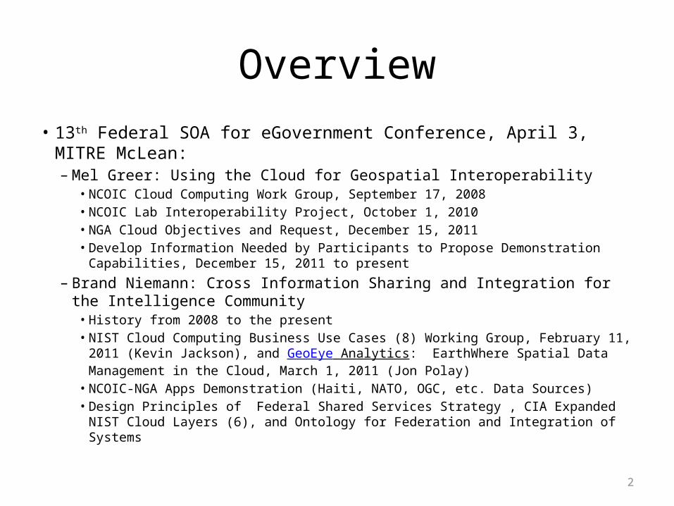
Overview• 13th Federal SOA for eGovernment Conference, April 3, MITRE McLean:
– Mel Greer: Using the Cloud for Geospatial Interoperability• NCOIC Cloud Computing Work Group, September 17, 2008• NCOIC Lab Interoperability Project, October 1, 2010• NGA Cloud Objectives and Request, December 15, 2011• Develop Information Needed by Participants to Propose Demonstration Capabilities,
December 15, 2011 to present
– Brand Niemann: Cross Information Sharing and Integration for the Intelligence Community• History from 2008 to the present• NIST Cloud Computing Business Use Cases (8) Working Group, February 11, 2011
(Kevin Jackson), and GeoEye Analytics: EarthWhere Spatial Data Management in the Cloud, March 1, 2011 (Jon Polay)
• NCOIC-NGA Apps Demonstration (Haiti, NATO, OGC, etc. Data Sources)• Design Principles of Federal Shared Services Strategy , CIA Expanded NIST Cloud
Layers (6), and Ontology for Federation and Integration of Systems

3
Design Principles of Federal Shared Services Strategy
• Benefits:– 1 Standardization
• Uses Sitemap and Schema Protocols and a Web Oriented Architecture
– 2 Visibility• Puts GEOINT in hands of users
– 3 Reusability• Reuses content provides reusable
content
– 4 Platform Independence• Exports standard data formats
– 5 Extensibility• Amazon Cloud is elastic
– 6 Location Transparency• Amazon Cloud with SLAs
– 7 Reliability• Amazon Cloud with SLAs
• Components:– 1 Requirements
• Director Long’s statements
– 2 Workflow• Steps for Building An App
– 3 Data Exchange• Federate with WOA and
Dynamic Case Management
– 4 Applications• More functionality and data
exchange than current systems
– 5 Hosting• Amazon Cloud’s SLAs
– 6 Security and Privacy• Amazon Cloud’s SLAsGoal: Built Shared Services App That Meets or Exceeds These Benefits and Components
http://semanticommunity.info/AOL_Government/Shared_IT_Services_From_Concept_through_Implementation_Conference#White_House_CIO_Office_Issues_Shared_IT_Strategy
4
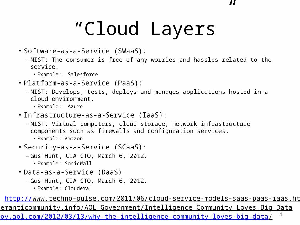
“Cloud Layers”• Software-as-a-Service (SWaaS):
– NIST: The consumer is free of any worries and hassles related to the service. • Example: Salesforce
• Platform-as-a-Service (PaaS):– NIST: Develops, tests, deploys and manages applications hosted in a cloud environment.
• Example: Azure
• Infrastructure-as-a-Service (IaaS):– NIST: Virtual computers, cloud storage, network infrastructure components such as
firewalls and configuration services.• Example: Amazon
• Security-as-a-Service (SCaaS):– Gus Hunt, CIA CTO, March 6, 2012.
• Example: SonicWall
• Data-as-a-Service (DaaS):– Gus Hunt, CIA CTO, March 6, 2012.
• Example: Cloudera
Sources: http://www.techno-pulse.com/2011/06/cloud-service-models-saas-paas-iaas.html andhttp://semanticommunity.info/AOL_Government/Intelligence_Community_Loves_Big_Data http://gov.aol.com/2012/03/13/why-the-intelligence-community-loves-big-data/
5
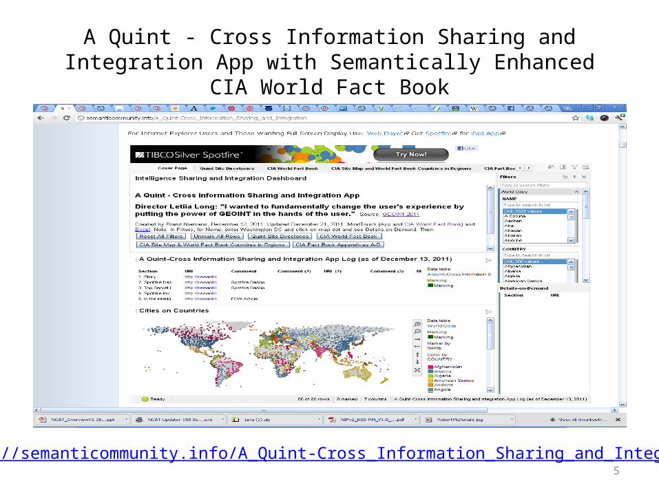
A Quint - Cross Information Sharing and Integration App with Semantically Enhanced CIA World Fact Book
http://semanticommunity.info/A_Quint-Cross_Information_Sharing_and_Integration

6
May 4, Chat Log• Brand Niemann: Are we building something from scratch here or using existing cloud platform services and making them
interoperable?• Josh Lieberman: These are the specific geospatial data services which promote interoperability when deployed (using existing
software) in a cloud environment.• Brand Niemann: Yes, but I am still looking for how this demonstrates producing a set of maps for disaster relief within 24 hours
and freeing up analysts time to do deeper analytics to support better decisions for disaster response.• Roger Bernhardt: The problem is deeper than that, I propose. It is integrating disparate existing data and software environments,
no?– My Comment: The general problem is and NGA has many software tools and projects doing that – our demonstration is to take those results
and deliver a set of maps for disaster relief and free up the analysts time to do deeper analytics.• Rex Brooks: Correct Roger, the point being that we have a wealth of interoperability features, provided the vendors we use
implement standards, especially in emergency management situations.• Josh Lieberman: We could have a compute cloud for this demonstration stood up tomorrow, but spend 6 months trying to
extract good and relevant data from certain organizations.– My Comment: See my response below.
• Brand Niemann: It did not take me nearly that long to extract good and relevant data.• Brand Niemann: We are way beyond web services now.• Raj Singh: I'd like to hear more about the beyond web services idea Brand. Maybe next week.
– My Comments: See next slides• Rex Brooks: We should show them how much more quickly we can call up complex SPARQL queries and get high quality results
back for use while the folks stuck in single message syndrome SQL fall behind.– My Comments: See next slides
• Brand Niemann: We are actually working on a Cray Graph Computer demo - stay tunned!• Brand Niemann: We could easily do a demonstration of the demonstrations that already exist and how they could be made more
interoperable!– My Comments: See next slides
7
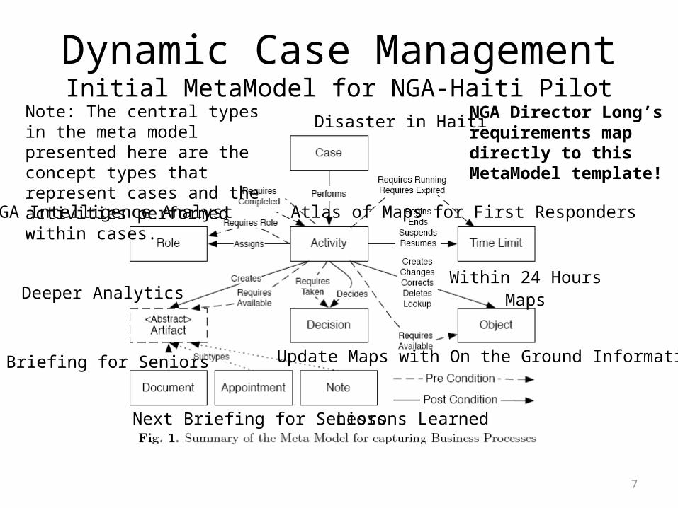
Dynamic Case ManagementInitial MetaModel for NGA-Haiti Pilot
Disaster in Haiti
Atlas of Maps for First RespondersNGA Intelligence Analyst
Within 24 Hours
Update Maps with On the Ground Information
MapsDeeper Analytics
Briefing for Seniors
Next Briefing for Seniors Lessons Learned
Note: The central types in the meta model presented here are the concept types that represent cases and the activities performed within cases.
NGA Director Long’srequirements mapdirectly to thisMetaModel template!

8
Use a Systems of Systems Approach to Federate Content with a WOA Platform & Case Management
http://www.mindtouch.com/blog/tag/woa/

9
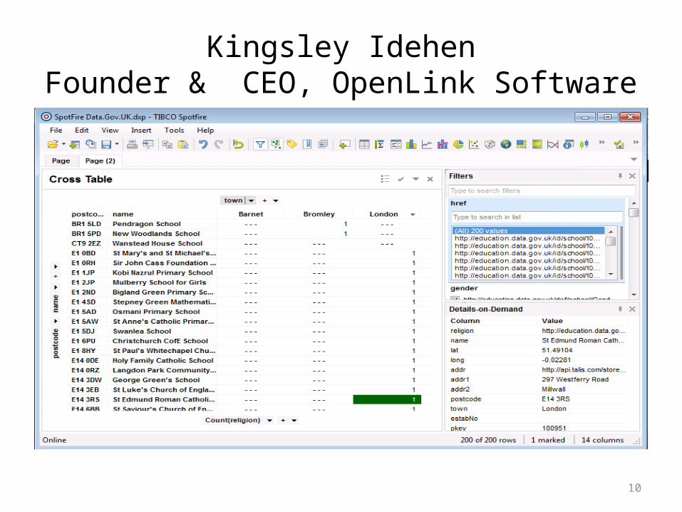
Kingsley IdehenFounder & CEO, OpenLink Software
• Do-It-Yourself Linked Data for the Data Scientist:– Linked Data and LOD Cloud integration via the likes
of ODBC is now my prime focus.– See screenshot of a simple Spotfire file that's the
result of a SPARQL Query over ODBC (via Virtuoso's ODBC Driver) that hits the Data.Gov.UK data space.
– The SpotFire file holds the Table and Report that I derived from Data.Gov.UK data.
– I'll be doing more demos in the coming days using Health.Data.Gov and others.
10
Kingsley IdehenFounder & CEO, OpenLink Software
11
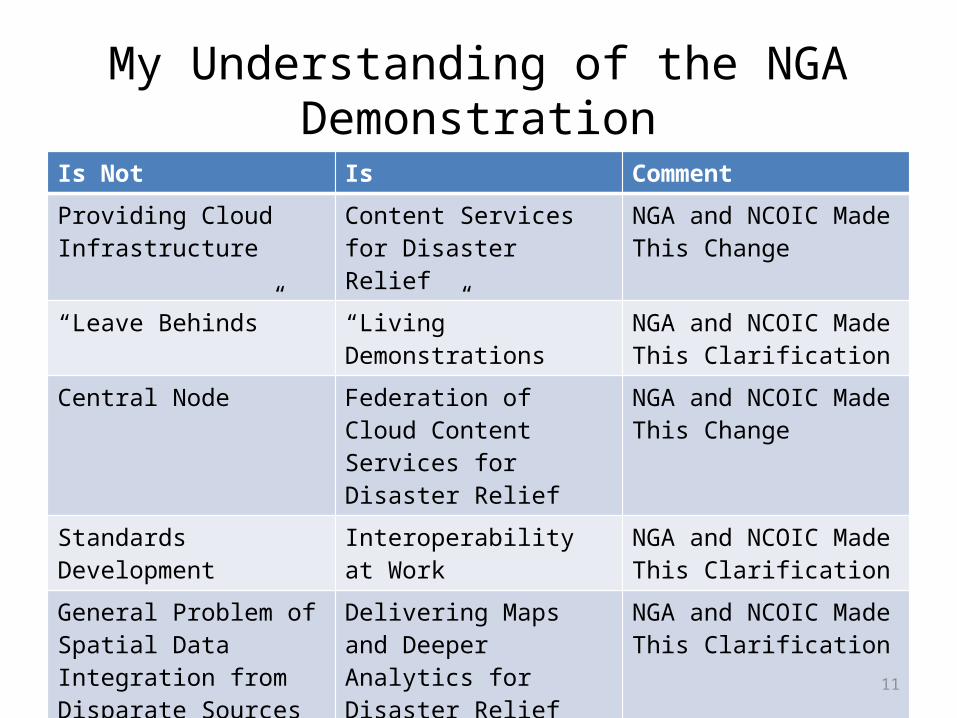
My Understanding of the NGA Demonstration
Is Not Is Comment
Providing Cloud Infrastructure
Content Services for Disaster Relief
NGA and NCOIC Made This Change
“Leave Behinds” “Living” Demonstrations NGA and NCOIC Made This Clarification
Central Node Federation of Cloud Content Services for Disaster Relief
NGA and NCOIC Made This Change
Standards Development Interoperability at Work NGA and NCOIC Made This Clarification
General Problem of Spatial Data Integration from Disparate Sources
Delivering Maps and Deeper Analytics for Disaster Relief
NGA and NCOIC Made This Clarification
Development of New Tools and Content
Use of Existing Tools and Content
NGA and NCOIC Made This Clarification

12
Demonstration of Demonstrations
• Patterned after what I did:– Inventory of Cloud Tools that NGA and NCOIC
Members Use:• My example: Spotfire
– Survey of Disaster Response Data Sources and Selection of a Representative Cross-Section for Past Disasters (e.g. Shape, KML, and Image):• My example: Haiti and NATO
– Delivery of Multiple Apps in a Cloud Library Using the Above Tools and Data Sources:• My example: Seven Spotfire dashboards.