中国石油天然气集团公司 科技管理部
2011年
山地地震勘探技术
China national Petroleum CorPoration
2011Science & Technology Management Department
Mountainous Seismic Exploration Technology
山地地震勘探技术让山地勘探如履平地!Mountainous Seismic Exploration
Technology will make oil and gas
exploration in mountainous areas easy and
perfect!
Contents
Introduction 4
Unique Technologies 6
Typical Cases 14
R&D Equipment 16
Qualification and Standard 18
Expert Team 22

2
China National Petroleum Corporation (CNPC) is a state-authorized investment agency and a state holding company. As an integrated oil company of cross-regions, cross-industries and cross-countries, it adopts modern enterprise system to realize the integration of upstream and downstream operations, internal and external trade and production and marketing. CNPC has 17 upstream companies, 33 downstream companies and 36 large-scale marketing companies. It is China’s largest producer and supplier of oil and gas, and also one of the largest refined oil products and petrochemicals. In 2010 CNPC produced 105 million tons of crude oil and 72.5 billion cubic meters of natural gas, while crude processing volume reached 135 million tons. The total revenue of RMB1,720 billion with a profit of RMB172.7 billion had been achieved the same year. Its profit is among the highest of the domestic enterprises in China.
CNPC was ranked 10th in Fortune Global 500 in 2010 and 5th among global top 50 oil companies.
CNPC strictly follows by the combined strategies of increasing resource capacity, expanding market shares and consolidating the international role, and persists in regarding technical innovation as a key framework to advance technological progress. To develop its core businesses, focuses will be placed on the solutions of key bottleneck technologies and key proprietary technologies. Thanks to continuously improving of the technical innovation system, optimizing the configuration of technological resources and strengthening the construction of strong talent teams, CNPC’s technological creativity has been considerably upgraded. Consequently, a large number of technologies have been developed independently, with its own intellectual property.
Mountainous Seismic Exploration Technology is one of representatives for major innovations of CNPC.
CLEAN ENERGY SUPPLY FOR BETTER ENVIRONMENT

1
3
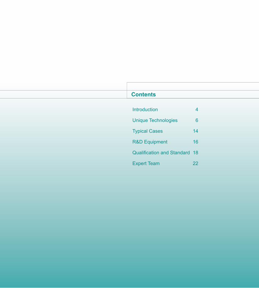
Geophysical exploration is the most effective prospecting method to discover oi l and gas resources and the seismic exploration is applied the most widely. The seismic exploration workflow consists of the three steps as follows: seismic data acquisition, processing and interpretation. At present, the complex mountainous areas with low S/N ratio are the most important strategic succeeding area for oil and gas exploration.
The mountainous seismic exploration is facing so many problems as complex surface, the strong variation in subsurface structure, and the exploration targets with the feature of “low permeability and porosity, concealed”, etc. CNPC has devoted itself to the research on the seismic exploration in complex mountainous areas and fully developed 21 unique technologies of four series including
seismic data acquisition, complex structure imaging, integrated interpretation of complex structure and special technologies for mountainous seismic exploration. Facing many kinds of tough problems in the exploration in complex mountainous areas, CNPC has also developed three suits of software called “acquisition engineer, processing engineer, interpretation engineer” as GeoMountain®, which can perform the integration of seismic data acquisition, processing and interpretation.
Depending on the precedent seismic exploration technology for mountainous areas, CNPC has provided the excellent services in six large basins in homeland (e.g. Sichuan, Xinjiang, Tarimu, etc.) and many foreign oil companies respectively, and has discovered a lot of uncovered structures, traps and huge, medium-sized oil and gas fields.
Introduction
44
Mountainous S
eismic E
xploration Technology
Seismic Data Acquisition Technologies for Complex Mountainous Areas
Complex Structure Imaging Technologies for Mountainous Areas
Integrated Interpreta-tion Technologies of Complex Structure in Mountainous Areas
Unique Seismic Technologies for Mountainous Areas
Line Selection and Station Attribution Technology of Seismic and Remote Sensing Information Engineering
Seismic Drilling Technology for Mountainous Areas
Surface Structure Investigation and Model Building Technology for Complex Mountainous Areas
Geometry Design Technology for Complex Mountainous Areas
Noise Investigation Technology of Seismic Exploration in Complex Mountainous Areas
Static Correction Technology of Constrained Tomography Inversion
Combined Noise Attenuation Technology
3D-3C Velocity Analytic Technology
Anisotropic NMO Correction Technology
Combined Migration Technology of Complex Structure
Pre-stack Time Migration Technology of Rugged Topography
Pre-stack Depth Migration Technology of Rugged Topography
Complex Structure Model Building Technology for Mountainous Areas
Shift Restitution Technology of Complex Structure in Mountainous Areas
Seismic Identification Technology of Sedimentary Facies
Pre-stack Inversion and Fluid Detection Technology
Prediction Technology of Fracture-developed Zone
Prediction Technology of Formation Pressure
VSP Seismic Exploration Technology for Mountainous Areas
Processing Technology of Multi-component Seismic Data
Multi-wave Joint Inversion and Interpretation Technology
Introduction
5
Mountainous Seismic Exploration Technology
5
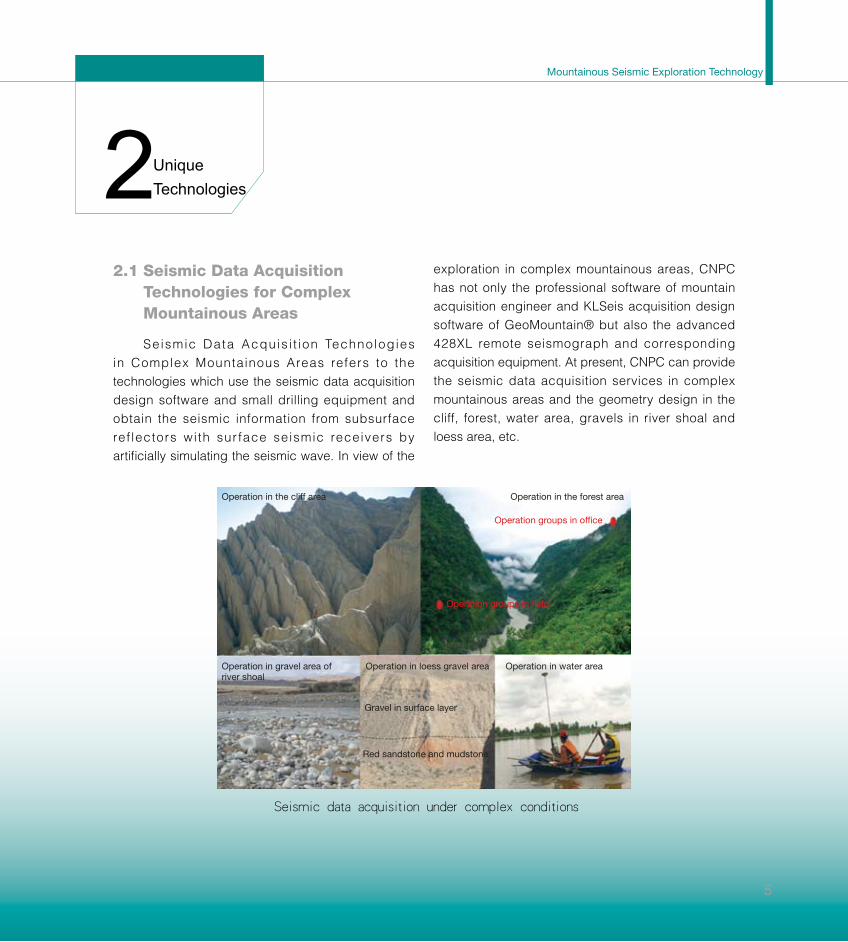
22.1 Seismic Data Acquisition
Technologies for Complex Mountainous Areas
Seismic Data Acquis i t ion Technologies in Complex Mountainous Areas refers to the technologies which use the seismic data acquisition design software and small drilling equipment and obtain the seismic information from subsurface ref lectors with sur face seismic receivers by artificially simulating the seismic wave. In view of the
exploration in complex mountainous areas, CNPC has not only the professional software of mountain acquisition engineer and KLSeis acquisition design software of GeoMountain® but also the advanced 428XL remote seismograph and corresponding acquisition equipment. At present, CNPC can provide the seismic data acquisition services in complex mountainous areas and the geometry design in the cliff, forest, water area, gravels in river shoal and loess area, etc.
Seismic data acquisition under complex conditions
Operation in the cliff area
Operation in gravel area of river shoal
Operation in loess gravel area
Gravel in surface layer
Red sandstone and mudstone
Operation groups in office
Operation groups in field
Operation in water area
Operation in the forest area
Unique Technologies

66
• Line Selection and Station Attribution Technology of
Seismic and Remote Sensing Information Engineering
The technology can optimize the geometry design
and obtain high-quality data while ensuring safety and
environmental protection, which is one of the 10 major technical
progresses of CNPC in 2008.
• Seismic Drilling Technology for Mountainous Areas
The technology can realize deep well drilling (10-15m)
in easily collapsed areas (e.g. gravel area of overbank, loess
gravel area).
• Surface Structure Investigation and Model Building
Technology in Complex Mountainous Areas
The geophysical methods, such as mini refraction, micro
well logging, VSP and the geological cropping investigations,
are combined to build the structure model of surface layer
velocity, which greatly improves the accuracy and reliability of
near-surface model.
Here are four patents for invention:
1 A microlog method applying the cascade downhole
geophones in the well;
2 Decentralizing equipment for downhole geophone
strings;
3 Geophone string downhole;
4 Downhole geophone with decentralizing equipment for
3D seismic exploration deployment of complex surface
Unique Technologies

Mountainous Seismic Exploration Technology
• Geometry Design Technology in Complex Mountainous Areas
The technology can realize sufficient utilization of information about fast model building, geometry test and surface structure
investigation of complex mountainous areas, with lower design cost and good effects.
• Noise Investigation Technology of Seismic Exploration in Complex Mountainous Areas
The technology can help users systematically to understand the characteristics of interference wave under complex surface
conditions of rugged topography and limestone outcropping, etc., and can also analyze noise properties by radar analysis,
signal and noise quantitative and qualitative analysis, to select the proper field acquisition parameters and improve S/N ratio and
resolution of target reflector.
Downhole geophone strings developed independently
7
Unique Technologies

2.2 Complex Structure Imaging Technologies for Mountainous Areas
Steep Dip Complex Structure Imaging Technologies are used for seismic data processing, which depends on the advanced computer hardware and seismic data processing software, applies methods such as the corresponding static correction, velocity analysis and migration imaging and can make the seismic wave-field converge correctly under the conditions of complex surface and subsurface with steep dip structures. CNPC, equipped with Mountain Processing Engineer Software of GeoMountain® and advanced parallel PC-clusters, can provide a solution for the imaging of steep dip complex structures.
• Static Correction Technology of Constrained Tomography Inversion
The technology can build more accurate initial velocity, whose iterate convergence is steady, and can improve inversion
accuracy of the surface velocity model greatly.
• Combined Noise Attenuation Technology
The technology can combine all kinds of noise attenuation method at random, with good adaptability, high efficiency and
better result.
• 3D-3C Velocity Analytic Technology
The technology can pick up velocity with high accuracy in the velocity analysis, especially suitable for 3D seismic data
processing of the area with steep dip complex structure.
Complex geologic structures in Sichuan Basin
8
Unique Technologies

Mountainous Seismic Exploration Technology
• Anisotropic NMO Correction Technology
The technology can decrease NMO correction stretch distortion of long offset caused by anisotropy, acquire apparent
anisotropic parameters of layered formations in VTI medium and remove imaging location error in the depth-spatial direction.
• Combined Migration Technology of Complex Structure
In pre-stack migration, the relatively better imaging result can be produced, without fine velocity model, and then the residual
post-migration is applied again to realize the imaging of steep dip complex structures.
• Pre-stack Time Migration Technology of Rugged Topography
The pre-stack time migration from the rugged surface can avoid the ray-path truncation and acquire more accurate travel
time, resolve the problems that the routine Kirchhoff pre-stack time migration cannot image better for the steep dip structures or the
seismic data with long offsets, and greatly reduce the processing period of seismic data.
起伏地表叠前时间偏移结果
Imaging effect of rugged surface with pre-stack time migration
9
Unique Technologies

2.3 Integrated Interpretation Technologies of Complex Structure in Mountainous Areas
CNPC has devoted itself to the seismic data interpretation for mountainous areas under complex seismic and geologic conditions and developed the operation mode of structural interpretation—well location tracing—structures around well—structural interpretation. Applying technologies involving shift restitution and forward modeling based on wave equation, CNPC efficiently decreases the exploration risks caused by the seismic interpretation ambiguity for steep dip complex structures, improves the drilling success ratio and gas recovery. CNPC, equipped with the engineer software for mountain interpretation GeoMountain® developed dependently and many kinds of foreign professional interpretation software, can provide technical services concerning the structural interpretation in mountainous areas, reservoir prediction and oil and gas reservoir description.
• Complex Structure Model Building Technology for Mountainous Areas
The interpretation result and structure pattern for this technology are constrained by the geological
10
Major fault
TjZSZ
Tj1Z TT3
X1
TT1f4Tp
Zl
To3l T
内
Tp1l
Seismic reflection section of LS-JL-L-T-DC-FD structures in Sichuan Basin
Zone of nappes in Longmen Mountain front
Low and flat fold area in Northern Sichuan
Smooth fold area in Central Sichuan
Steep dip tectonic belt in Eastern Sichuan
A typical structure in Western Sichuan mode
Epidermal structure patternWell Z11
Imbricated structure pattern
2000
1000
0
-1000
-2000
-3000
-4000
-5000
-6000
海拔(m)
2000
1000
0
-1000
-2000
-3000
-4000
-5000
-6000
海拔(m)
J3P
J3S
J1S
J1S
J17
Passive fold pattern
Faulting-buckling fold pattern
Backthrust-type thrust pattern
Unique Technologies

Mountainous Seismic Exploration Technology
outcroppings, drilling and logging data. The technology can greatly reduce the risks caused by the ambiguity of structural interpretation, and directly and objectively guide seismic interpretation.
• Shift Restitution Technology of Complex Structure in Mountainous Areas
The technology can effectively reduce the time-depth transformation error caused by the velocity trap in areas with complex structures, improve the interpretation accuracy and decrease the risks of drilling prospect.
• Seismic Identification Technology of Sedimentary Facies
The technology is beneficial for completely knowing about the spatial structure and geometrical relation of the stratum unit, finding the available sedimentary facies zones with enriched reservoirs and improving the accuracy of reservoir prediction.
• Pre-stack Inversion and Fluid Detection Technology
The technology can be applied to acquire more effective and sensitive parameters of reservoirs and fluid properties than post-migration data, which expands the fluid testing area.
11
Interpretation section of horizontal stacking for Line 02LHS014A of
a certain structure in Western Sichuan
Epidermal structure pattern
Well LH1
Imbricated structure pattern
Backthrust-type thrust pattern
TJ3p
TJ2s
TT3x3
TT3x1
Unique Technologies

• Prediction Technology of Fracture-developed Zone
To make a comprehensive prediction of the fracture-developed zones of different sizes via combining post-stack with pre-stack seismic data, it can decrease the risk of fracture detection and perform semi-quantitative prediction of density and orientation for fracture-developed zones.
• Prediction Technology of Formation Pressure
The pressure prediction method does not depend on the routine compacted trend curve. Regional pressure analysis can be made by fully colligating the parameters such as formation compaction, seismic velocity and restoration of pressure background.
12
Prediction of special distribution of fracture-developed zone
with pre-stack seismic data in L area of Western Sichuan
(Background is the folding seismic amplitude attribution of
structure model in the bottom of Mem.2 of Xujiahe Formation)
干井
气井
裂缝密度
裂缝发育带
L000-X3
L101L1-1
N 2.302.242.172.112.041.981.911.851.781.721.651.591.521.461.391.331.261.201.131.071.00
Unique Technologies

Mountainous Seismic Exploration Technology
2.4 Unique Seismic Technologies for Mountainous Areas
Unique Seismic Technologies for Mountainous Areas include: VSP Seismic Exploration Technology for Mountainous Areas, Processing Technology of Multi-component Seismic Data, and Multi-wave Joint Inversion and Interpretation Technology.
• VSP Seismic Exploration Technology for Mountainous Areas
With the advanced acquisition equipment, perfect software system and combined VSP imaging data with forward modeling, the mature seismic interpretation technology can provide services of whole acquisition, processing and interpretation combining seismic with well logging. Its imaging quality is better than the surface seismic data, and the technology can be used to accurately calibrate geologic horizon and finely describe the structures around well and details of reservoirs, all of which are available to define the sidetrack drilling targets in complex structures.
• Processing Technology of Multi-component Seismic Data
Combining many kinds of seismic wave information such as P-wave, S-wave and conver ted wave, the mult i -component seismic exploration can greatly improve structure and reservoir imaging, identify l i tho logy and f lu id , detect reservoir fractures and even directly predict oil and gas resources. The technology may synthetically utilize the static
correction of model, primary wave and reflector. Meanwhile, the multi-component seismic exploration, combined with the comparative interpretation of multi-wave event, resolves the problem of static correction of S-wave and effectively improves the imaging accuracy of converted wave. The use of azimuthally anisotropic correction of converted wave enables the acquisition of anisotropic parameters of formation or fracture parameters of reservoir.
• Multi-wave Joint Inversion and Interpretation Technology
CNPC has developed independently the multi-wave processing and interpretation software called GeoMountain®, and created a series of technologies involving multi-wave joint interpretation of seismic data, identification of lithology and fluid, and multi-wave joint inversion, etc. Multi-wave Joint Inversion and Interpretation Technology can obtain more reasonable and abundant petrophysical parameters such as P-wave impedance, S-wave impedance, Poisson’s ratio, velocity ratio of P-wave and S-wave. The use of joint interpretation of P-wave and converted wave sections enables the direct identification of lithology and fluid.
13
Cooperative Inversion Section of Velocity Ratio for PP-wave and
PS-wave from a Seismic Line of Guangan Structure
Gas reservoir (low) Mudstone (high)
Well Guangan 2
Unique Technologies

33.1 Exploration Breakthrough
of Carbonate Reef Flat Gas
Reservoirs in Mountainous Areas
By means o f the Mounta inous Se ismic Exploration Technology, CNPC has discovered a batch of large and medium-sized reef flat gas reservoirs at both sides of Kaijiang-Liangping ocean trough in Sichuan Basin, confirmed the distribution rule of favorable facies belts of reef flats and distribution of reservoirs, demonstrated gas pools of Feixianguan Formation in Tieshanpo, Dukouhe, and Luojiazhai areas, etc., realized great breakthrough for reef flat gas reservoirs in Longgang area, demonstrated the reserves scale and distribution regularity of gas reservoirs for the primary reef flats in Longgang and adopted 41 suggested well positions. Moreover, the proven gas reserves of oolitic beach gas reservoirs in Feixianguan Formation reached 179.3 billion m3, and the drilling success ratio reached 100% and 93% respectively in reef reservoirs and oolitic beach reservoirs of platform marginal belt.
3.2 Result of Exploration and Development for Clasolite Gas Reservoir
By using the Seismic Exploration Technology for Mountainous Areas, CNPC has effectively improved the reservoir prediction accuracy in Guang’an Region of Sichuan Basin, and improved the industrial drilling success ratio for the gas well from 40% to 72%,
14
which greatly backed the proven reserves (125.21 billion m3) of Xujiahe Formation in the area. In the Hechuan and Tongnan surveys, with the technology, 46 well positions were suggested, 39 wells were drilled, the coincidence rate of prediction for the effective thickness of reservoir reached 87.18%, the drilling success ratio got to 84.6%, the newly increased proven gas reserves are 118.3 billion m3, and the newly increased probable gas reserves are 116.6 billion m3.
Many gas-enriched areas are discovered in blocks of Su 5, Tao 7 of Sulige gas field in Ordos Basin. By the end of Oct. 2009, CNPC has finished drilling 406 wells, among which the amount of I+II type wells is 349 and the I+II type of drilling success ratio is improved from 62% to 86%, all of which has greatly improved the development benefits of Sulige gas field.
Distribution map of organic reef in LG
Organic reef
Typical Cases
Mountainous Seismic Exploration Technology
15
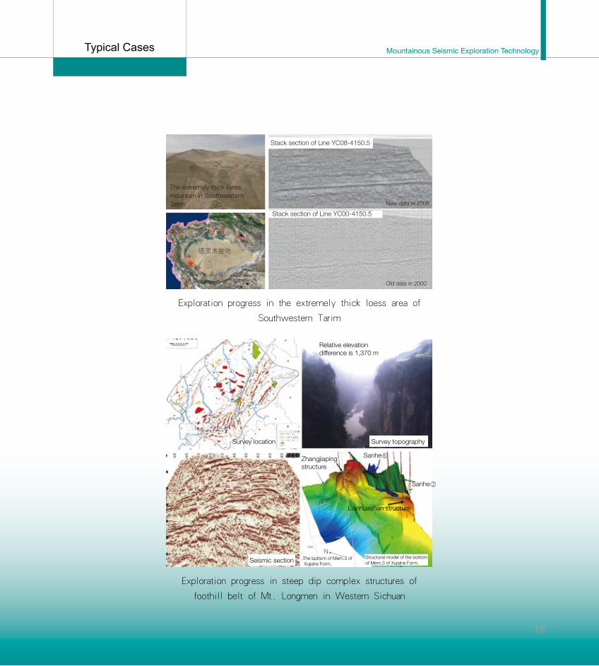
Exploration progress in steep dip complex structures of
foothill belt of Mt. Longmen in Western Sichuan
Relative elevation difference is 1,370 m
Survey location
Seismic section
Survey topography
Zhangjiaping structure
Sanhe⑥
Sanhe②
Lianhuashan structureLINE
780
The bottom of Mem.3 of Xujiahe Form.
NStructural model of the bottom of Mem.3 of Xujiahe Form.
Exploration progress in the extremely thick loess area of
Southwestern Tarim
Stack section of Line YC08-4150.5
塔里木盆地
Stack section of Line YC00-4150.5
New data in 2008
Old data in 2000
The extremely thick loess mountain in Southwestern Tarim
Typical Cases

4R&D Equipment
In the field of oil and gas exploration in complex mountainous areas, CNPC has been occupied in the engineering services of seismic exploration for oil and gas for more than 50 years and also has excellent strength to provide engineering services related to the mountainous seismic exploration. CNPC has many professional operation teams and equipment, including 30 mountain operation teams, 1 VSP team, 1 surveying team; seismic instruments like 408 XL and 428UL, 28 suits of acquisition systems, all kinds of acquisition equipment with 56,280 channels in total; 6 suits of vibrators, 367 suits of GPS and total stations, 1,774 sets of various seismic drillers; 790 various engineering motor vehicles.
In the southwestern area, CNPC has the largest-scale computer centre, providing the support for the seismic data processing and interpretation, and PC-cluster has 4290 CPUs and the storage capacity has reached 1505TB. In the gas reservoir engineering domain, CNPC has independently developed the software called GeoMountain® with such functions as mountain seismic data acquisition engineer, processing engineer and interpretation engineer. The
16

Mountainous Seismic Exploration Technology
software, easy to be applied to the field operation and available for fine processing and interpretation in laboratory, supports the current workstation and large-scale calculation environment such as PC-cluster. Also, CNPC has introduced various analysis software.
CNPC has the unique technological and service advantages in the mountainous seismic exploration, steep dip complex structures and for complex carbonate reservoirs, and can also provide the
17
integrated engineering technical services for users at home and abroad, including geophysical prospecting acquisition, processing and interpretation and integrated research on 2D, 3D, VSP and multi-components and multi-waves, etc. CNPC’s seismic data acquisition capability has reached 20,000km for 2D and 6,000km2 for 3D, and processing capability has reached 100,000km for 2D and 10,000km2 for 3D and 20 VSP wells per year, which is highly accepted and confirmed by the professional peers.
R&D Equipment

5Qualificationand Standard
Chuanqing Geophysical Exploration Company of CNPC Chuanqing Drilling Engineering Company (SCGC) is professionally engaged in the engineering services of mountainous seismic exploration, and a member institute of the International Association of Geophysical Contractors (IAGC) and Society of American Exploration Geophysics (SEG). SCGC has the qualification of “Chinese First-grade Surveying and Mapping Organization”, passed the ISO—9001:2000 certification, Environment Management System certification and CNPC Management System certification, and established perfect occupational safety and health management system; SCGC provides the national petroleum and gas companies and international users (SOC, TOTAL, TEXACO) with premium seismic exploration engineering services. SCGC has finished seismic data acquisition of 2D data for 313,100 km and 3D data for 17,095 km2; 2D and 3D seismic data processing and interpretation of 1.469 million km and 98,444 km2 respectively.
18

Mountainous Seismic Exploration Technology
No Standard number Standard name
1 ST/T5775-95 Technical specification for seismic exploration surveys in mountainous areas
2 ST/T6291-97 Technical specification for GPS kinematic surveys in oil geophysical exploration
3 ST/T6051-2000 Technical specification for 2D seismic exploration data acquisition in mountainous areas
4 ST/T6247-2003 Technical specification for 3D seismic exploration data acquisition in mountainous areas
5 ST/Y5723-95 Seismic driller used in mountainous areas
6 SY/T6248-96 Technical specification for total station usage and maintenance
7 SY/T5937-94 Petroleum geophysical exploration professional quality manual redacted instruction
8 SY/T5934-2008 Coincidence testing of seismic structure with well data
9 ST/Y5499-2003 Seismic exploration labour quantity of drilling by hand
10 SY/T6643-206 Technical specification for multi-wave and multi-component seismic exploration data acquisition on land
11 SY/T6732-2008 Technical specification for multi-wave and multi-component seismic exploration data processing on land
19
Qualification and Standard

6
Wen Zhongping(Expert in seismic exploration acquisition technique on land)He has long been engaged in the research of seismic exploration acquisition technology and method. For the steep dip complex structures in Kuche Depression,he has proposed a set of technical projects and acquired the high-quality seismic sections, which is significant to the analysis of the oil and gas reservoirs in Kuche Depression as a whole. Besides, he has combined the micro-refractor and deep micro-well logging with the tomography refraction for small trace interval in field operation to resolve the complex surface problems of loess and gravel areas. Email: [email protected]: 13980763859
20
Li Yalin(Expert in gas exploration, SEG member)He has been engaged in the steep dip complex structure imaging and integrated interpretation, complex oil and gas reservoir prediction, oil and gas reservoir description, research of multi-component seismic exploration technology and field practice for more than 20 years. He has taken charge of many important scientific projects, such as the research of multi-wave exploration method and its application to fractured oil and gas reservoir, and issued 27 academic papers. Email: [email protected]: 13608089513
Li Zhirong(Expert in seismic exploration)He has long been engaged in the research of seismic exploration method. He introduces the new techniques and methods (e.g. wavelet theory) to seismic exploration, thus providing the seismic data processing and reservoir interpretation with the new ideas and measures. He was awarded “Sun Yueqi Excellent Youth Science and Technology Award”. Email: [email protected]: 13708024769
Expert Team
Mountainous Seismic Exploration Technology
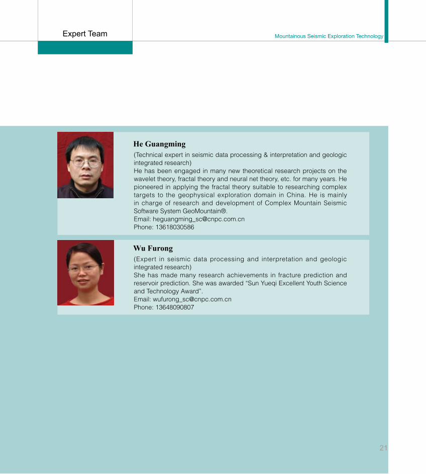
(Technical expert in seismic data processing & interpretation and geologic integrated research)He has been engaged in many new theoretical research projects on the wavelet theory, fractal theory and neural net theory, etc. for many years. He pioneered in applying the fractal theory suitable to researching complex targets to the geophysical exploration domain in China. He is mainly in charge of research and development of Complex Mountain Seismic Software System GeoMountain®. Email: [email protected]: 13618030586
21
He Guangming
(Expert in seismic data processing and interpretation and geologic integrated research)She has made many research achievements in fracture prediction and reservoir prediction. She was awarded “Sun Yueqi Excellent Youth Science and Technology Award”. Email: [email protected]: 13648090807
Wu Furong
Expert Team

22
联系人:刁顺 先生
电 话:59986059Email: [email protected]
Contact: Mr. Diao ShunTel: 59986059Email: [email protected]

23
山 地 地 震 勘 探 技 术