MAKING TRANSITIONAL SPACE IN THE CONTEMPORARY CITY
Master Thesis Explanatory Document
Janki Sharma
ID: 1470766
Research Project submitted in partial fulfillment of the requirements for the degree of Master of Architecture (By Project)
Unitec Institute of Technology, 2017
ABSTRACT
The following research is an explorative study on “Transitional
spaces” as a means of designing and enhancing urban
architecture. To start with, transitional spaces are the
intermediate areas that acts as an in-between spaces.
Traditionally, spaces were defined as indoor or outdoor spaces
and the presence of transitional space was not experienced so
this research will be focusing on these transitional spaces and
the journey from one place to another marking these spaces as
a destination. It also focuses on identifying what defines a
transitional space that enhances the pedestrian experience in an
urban environment. Also, providing a commercial building
with mixed-use areas enhances the overall space and helps it
merge into its urban context.
Thus, the research will be an implementation of design by
intertwining the publications of architects within Western and
Indian urban contexts and traditional transitional space case
studies on macro and micro scales, that are related to the topic.
It is an attempt to understand the traditional elements of
transitional space and then implementing them in today’s urban
context.
The potential site for this project is “The Aotea Quarter
framework” identified by Auckland Council as the core and
cultural heart of Auckland. It includes adjoining mixed-use
neighbourhoods and physical interventions revealing
opportunities to improve the public realm.

ACKNOWLEDGEMENT

1.0 INTRODUCTION

2
1.1 Outline of the Project
Transition in Architecture is defined as the connecting in-between
spaces. It is a change of space from one state to another, and
architectural spaces are incomplete without transition spaces.
Transitional spaces are defined as spaces located in between
outdoor and indoor environments acting as both buffer spaces and
physical links (Deshmukh, 2009). The basic idea is to design a
transitional space on a city scale with recreational urban facilities.
This transitional space will be a connection between both macro
and micro level structures. In general, spatial continuity and the
consequent interaction between public and private, people and
environment, open and closed, inside and outside, are established
by means of certain transitional spaces. (Examples: atriums,
plazas, urban corridors, gathering spaces, passage, courtyards,
stairwells etc.)
1.2 Research Question
How can traditional urban space elements be used to enhance the design
of transitional space in the contemporary city?

3
1.3 Aims and Objectives of the Project
The aim of the project is to design an important transitional space
within the city context and provide a vision as to how a non-place
could be transformed and developed into providing quality
experiential values to the users, thus creating a dialogue between
people, space and events, as a threshold between ‘Space’ and
‘Time’. The typology and nature of the transitional spaces have
been changing with time. They vary in scale, usage and
connection.
The insertions of urban functions in transitional space should
increase the activities in city spaces, building a sense of a
connection between horizontal and verticals interfaces, minimising
the gap between proportion and scale of buildings and human. The
transitional space should be seen as an interaction between life and
form, that is, the built form should be interacting and connecting
with the community, creating a greater sense of journey and place
within the urban environment.

4
1.4 Methodology
Research by literature review (by Theories)
Stage one, the literature review, is through the relevant
publications of architects within Western and Indian urban
contexts as per the research topic, which focuses on the
cityscape, people and their activities that which makes the
transitional pockets important within a city and the local
context.
Research by literature review (by Case Studies)
Stage two, focuses on an analysis of both case studies of
traditional transitional spaces. These case studies will provide
understanding of space vocabulary and important elements
which make transition interesting from one space to other
marking each space as a destination, with its traditional and
cultural importance. Research will then be conducted on
Auckland’s Aotea Square using the philosophy and specific
design characteristics from this research background.
Research by Design
Stage three, focuses on taking the understanding from theories
and case studies further by setting a few elements as guidelines
and making a matrix out of these to start the designing process.
With this research background, site analysis will be then
conducted to determine what context is required to successfully
achieve the design strategies, choosing a site matching those
criteria. Analysis of the surrounding urban context of the site
will be conducted, taking several aspects like voids,
circulations – sidewalks and stairs, relationship of façade and
urban space, edge and entries/threshold. This research will be
based on sketches, diagrams to show different transitional
space elements and 3D modelling with respect to existing
contours which respond to the previous design strategies to
provide a solution for traditional transitional space in the
contemporary city.

5
2.0 RESEARCH CONTEXTUALISATION

6
This research focuses on thresholds and transitions of public realm. The nature of the research literature review consists of a few books by selected
authors, which deals with the same line of thought. This review consists of architects within the Western urban context and also architects within
the Indian urban context. The scope of the review may be limited to a published selection of the books and authors, from a particular time period
and location. This review will not explore each part of the book, but is the selective analysis of highlighted work related to this research. Most of
the sources include city planning, open spaces, public spaces, pedestrian movement, social aspects, city life and other architectural and human
factors.
2.1 Architects within the Western Urban Context
2.1.1 “Cities for People”, Jan Gehl
“Cities for People” by Jan Gehl (2010), represents recreating
cityscapes on a human scale. He illustrates the techniques to
reshape the unusable cityscapes into livable terrain for the people.
He also explains the relationship between the large buildings and
human scales, and how to develop cities that are lively, safe,
sustainable and healthy. He focuses on what a public space should
be like, a more inviting space for people.
Figure 1: City Planning: a combination of life, space and buildings

7
2.1.2 “Life Between Buildings”, Jan Gehl
“Life Between Buildings” by Jan Gehl (2011), investigates the quality of
public spaces. Throughout his book, he looks at understanding the life of
cities on a larger scale with the daily human activities of people in public
spaces - the necessary, the optional and the social types of behaviour. He
also talks about lively and healthy public spaces, urban recreation, social
interaction and perception, and how human senses relates to the city life
taking place. Through his book he tries to convey that architecture needs
more careful attention. He suggests these all to be crucial areas of
understanding for planning processes for spaces between buildings.
Figure 3: Human senses and tall buildings Figure 2: Inhibiting and Promoting contact
8
2.1.3 “The Death and Life of Great American Cities”,
Jane Jacobs
“The Death and Life of Great American Cities” by Jane Jacobs
(1961), is a critique of 1950s urban planning policy, which it
holds responsible for the decline of many city neighbourhoods
in the United States. This book talks about the current city
planning and rebuilding it. The author also talks about the four
generators of diversity:
• Mixed primary uses, activating streets at different times of
the day;
• Short blocks, allowing high pedestrian permeability;
• Buildings of various ages and states of repair;
• Density.
She also talks about sidewalks – as a central mechanism in
maintaining the order of the city. Parks and sidewalks are
lively and successful because of the functional physical
diversity among users and their schedules. She also mentions
the four beliefs of good park design:
• Intricacy: which means variety of uses and repeat
users;
• Centering: which means main crossroads, pausing
points;
• Access to sunlight;
• Enclosure: presence of buildings and diversity of
surroundings.
Figure 4: The Death and Life of Great American Cities

9
2.1.4 “The Image of the City”, Kevin Lynch
“The Image of the City” by Kevin Lynch (1960), explains the
people perception towards the city and experiential values through
space and time. He describes a city with its surroundings and
elements. He mentions the relationship of the complexity of every
structural element like nodes, paths, districts, edges, landmarks that
combine, which makes a city. He also analyses the forms and
public areas and, adding to this, he also tells us that in order to
design a city, one needs to understand the problems and
opportunities related to it.
• Paths: the streets, sidewalks, trails, and other channels in
which people travel. He noted that paths were the main
elements surrounded with the other elements for people;
• Edges: a connecting element to join two regions together;
It can be more or less perforated;
• Districts: Areas which have common in the characteristics
on a larger scale. Characteristics include sequential
experience within the space, through texture, space, form,
detail, symbol and building;
• Nodes: the important junctions in a city into which one can
go.
Figure 5: Order to design a city

10
2.1.5 “The Concise Townscape”, Gordon Cullen
“The Concise Townscape” by Gordon Cullen (1961), is the art of
giving visual coherence and organisation to the jumble of
buildings, streets and spaces that make up the urban environment.
He describes the components that make cities and towns work. He
also talks about different spaces like serial visions, narrow,
punctuation, deflection, enclave, enclosure, closed vista and
closure.
Figure 6: Serial visual experience through the space

11
2.1.6 Analysis of Square by Camillo Sitte
Camillo Sitte’s analysis of square was selected after the site
selection, which was Aotea Square, to understand the square
workings. His work was a showcase of urban patterns and treated
urban spaces as aesthetic arrangements of building masses,
facades, spatial structures of cities and street spaces. He believed
that the points of the entry are placed eccentrically which gives
extreme spatial enclosure which is called as turbine square. His
analysis on square was based on five elements like:
• Enclosure: square should be closed entities
• Positive Shape: buildings should be joined to one another
in a way that the façade defines the space;
• Shape: proportional to the surrounding buildings;
• Monuments: elements in a free space on which one may
focus, placed along the edge of the space;
• Streets: enter at angles.
Figure 7: Turbine square with spatial enclosure

12
2.2 ARCHITECTS WITHIN AN INDIAN CONTEXT
2.2.1 CHARLES CORREA
Charles Correa’s work is a fusion of applying Indian traditional principles into a modern environment, that is, adapting modernism to
a non-western culture with local materials and according to the climatic conditions. His early works are the reflection of local
vernacular architecture, with providing long corridors and wide arches in order to provide shades and ventilation, thus, taking India’s
climatic conditions into consideration. He worked taking a few principles like disaggregation, processional unfolding of spaces and
“open to sky spaces” being the most important one.
Charles Correa also planned the New Bombay as a “Bazaar” city, with taking into consideration the basic needs for new sustainable
urbanization. He believes that living in an Asian city involves much more than just a room. The four elements which makes the whole
system livable for people are divided in hierarchy. They are:
• Courtyards as a semi-private activity space between
different group of houses;
• Doorstep acting as a threshold and a frontage where
children play or there is interaction with
neighbourhoods;
• Neighbourhood places like the area near city water tap
which acts as a community space.
• The main urban area called maidan (open space) used
by everyone, acting as a big community space.
Figure 8: Hierarchy of spaces depicting different activities

13
In one of his projects, “Mahatma Gandhi Ashram at Sabarmati,
Ahmedabad, Gujarat”, it can be seen that he designed the Gandhi
Ashram’s structure in modules. The museum displays the
memories of Mahatma Gandhi. The design is the showcase of the
matrix of covered and open spaces which creates a feeling of
lightness and transparency throughout the museum. He gives the
opportunity for a moment of pause for the people moving in that
space with making courtyards or gardens. He also gives
importance to the pathways in his building; for example, through
pathways he is giving a sense of people actually walking through
the village and not in the museum to create the sense of the origin
of place, thus making pathways as a journey connecting different
spaces of the building.
Figure 9: Modular plan of Mahatma Gandhi Ashram
Figure 11: Section-elevation, modular units
Figure 10: Open courtyard
14
2.2.2 BALKRISHNA DOSHI
Balkrishna Doshi believes that in India architecture is a celebration
of life – the interaction of life with buildings. His work considers
with climate, lifestyle, local material and technology, and
characteristics of Indian culture. In India the buildings are
multifunctional and from ground level to the terrace everything is
used. Hence, there is no wastage of space, material and form.
Doshi’s work has a strong influence from “form givers” Le
Corbusier and Louis Kahn. His learning from Le Corbusier was to
have no distinction between object and living as they should be
merged – building, life and environment goes together as one
entity. Thus, making architecture an extension of life. His work is a
compelling mixture of modern and traditional, containing
fundamental aspects of each. He believes festivals, gatherings,
meetings, rituals/temples and streets/bazaars influence spaces in
India a lot. He also talks about:
• Interrelationship of indoor and outdoor space;
• Appropriate and honest approach to materials;
• Proper climatic response;
• Observation of hierarchy and order that have been always
present.

15
One of the finest example of his early works is the Centre for
Environment and Planning Technology (CEPT), Ahmedabad. It
was one of Doshi’s early projects which showed the influence of
Le Corbusier and Louis Kahn in the building design. The free plan
concept of Corbusier’s Villa Savoye of lifting the building above
was adopted in here, keeping the space underneath active and
multifunctional with sun protection and cross ventilation from the
breeze. The design emphasis was on giving more open, flexible
spaces to all with hardly any doors in the building. And the
building’s arrangement is such that it has several combinations of
paths throughout the space, giving a sense of continuity and
openness. The design also incorporates for different activities like
a central courtyard, canteen, plazas and the basement.
Figure 12: Every design tells a story
Figure 13: Passages with gradual transition
Figure 14: Open spaces

16
2.3 Overview from Architects within the Western
and Indian Urban Context
These selected publications within western urban context
helped in making a base to start interpretation of the cityscape
with a human scale and helped in setting the parameters for
increasing the efficiency for public realms and understanding
the life of cities on a larger scale in consideration with daily
human activities. In addition to this there is a developing
understanding of people’s perception towards the city and its
experiential values through space and time with knowing the
components that makes cities work. Camillo Sitte’s analysis
helped in deriving the elements to do a site analysis of Aotea
Square to understand the workings of a perfect square.
These two architects, Charles Correa and Balkrishna Doshi,
helped in understanding the architecture on an urban level in
context with cultural and traditional values of India. This
helped in understanding the traditional transitional city spaces
and superimposing those ideas into modern architecture,
keeping context and climatic condition in mind. This also gave
an idea about, how to analyze the case study of the Indian Pol
community cluster on a macro urban scale and micro scale and
then take those elements further onto site, which is Aotea
Square, in regard to Auckland’s urban context. This will help
in recreating those traditional transitional spaces in the heart of
Auckland CBD and enhancing the public realm.

17
2.4 CASE STUDIES
2.4.1 POL –Indian Community Cluster
A pol is an Indian community cluster in the walled city of
Ahmedabad, Gujarat. The form of the city was developed over a
time with different factors affecting it. The structure of the walled
city can be differentiated at two levels: one being the macro scale
of the city, and the second being the micro scale of the
neighbourhood. Thus, the walled city is the formation of hierarchy
of different spaces in layers.
Looking at the macro scale of the city, it can be seen that the
walled city is the cluster of multifunctional units including
different retail outlets, eatery shops, offices, residential blocks,
community spaces and house of worship (i.e. temple/mosque). The
hierarchy of the streets depicts the transit within the city which
leads to these different spaces. The main street is generally the
combination of retail outlets and eatery shops on the ground level
and residential units at the upper level.
Figure 15: Aerial view of walled city, Ahmedabad
Figure 16: Typical city street, Ahmedabad
18
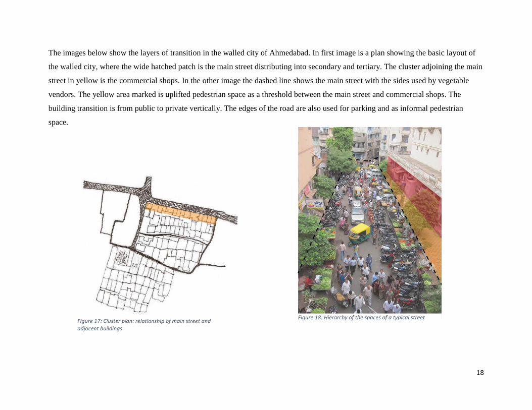
The images below show the layers of transition in the walled city of Ahmedabad. In first image is a plan showing the basic layout of
the walled city, where the wide hatched patch is the main street distributing into secondary and tertiary. The cluster adjoining the main
street in yellow is the commercial shops. In the other image the dashed line shows the main street with the sides used by vegetable
vendors. The yellow area marked is uplifted pedestrian space as a threshold between the main street and commercial shops. The
building transition is from public to private vertically. The edges of the road are also used for parking and as informal pedestrian
space.
Figure 18: Hierarchy of the spaces of a typical street Figure 17: Cluster plan: relationship of main street and adjacent buildings
19
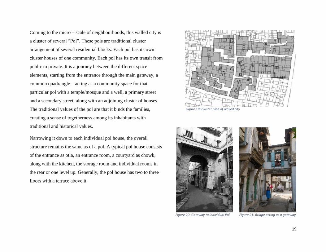
Coming to the micro – scale of neighbourhoods, this walled city is
a cluster of several “Pol”. These pols are traditional cluster
arrangement of several residential blocks. Each pol has its own
cluster houses of one community. Each pol has its own transit from
public to private. It is a journey between the different space
elements, starting from the entrance through the main gateway, a
common quadrangle – acting as a community space for that
particular pol with a temple/mosque and a well, a primary street
and a secondary street, along with an adjoining cluster of houses.
The traditional values of the pol are that it binds the families,
creating a sense of togetherness among its inhabitants with
traditional and historical values.
Narrowing it down to each individual pol house, the overall
structure remains the same as of a pol. A typical pol house consists
of the entrance as otla, an entrance room, a courtyard as chowk,
along with the kitchen, the storage room and individual rooms in
the rear or one level up. Generally, the pol house has two to three
floors with a terrace above it.
Figure 19: Cluster plan of walled city
Figure 20: Gateway to individual Pol Figure 21: Bridge acting as a gateway
20
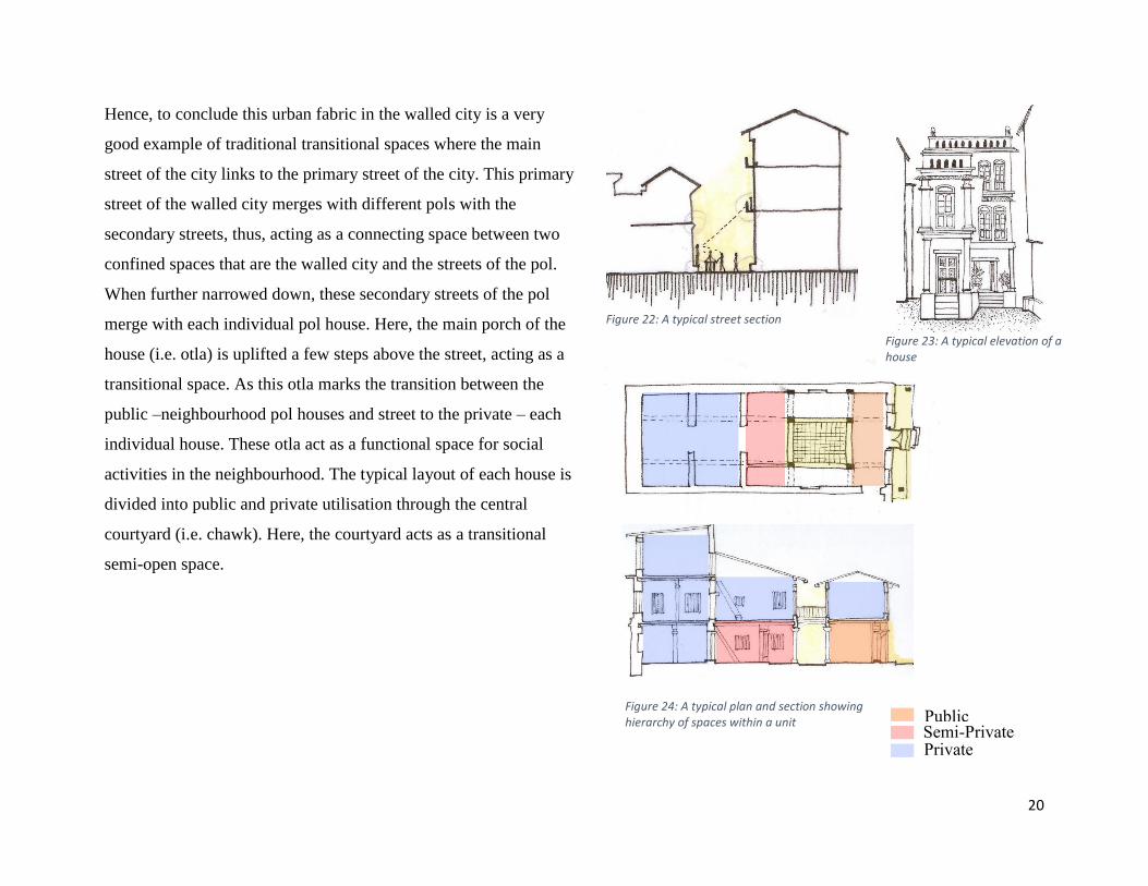
Hence, to conclude this urban fabric in the walled city is a very
good example of traditional transitional spaces where the main
street of the city links to the primary street of the city. This primary
street of the walled city merges with different pols with the
secondary streets, thus, acting as a connecting space between two
confined spaces that are the walled city and the streets of the pol.
When further narrowed down, these secondary streets of the pol
merge with each individual pol house. Here, the main porch of the
house (i.e. otla) is uplifted a few steps above the street, acting as a
transitional space. As this otla marks the transition between the
public –neighbourhood pol houses and street to the private – each
individual house. These otla act as a functional space for social
activities in the neighbourhood. The typical layout of each house is
divided into public and private utilisation through the central
courtyard (i.e. chawk). Here, the courtyard acts as a transitional
semi-open space.
Semi-Private
Public
Private
Figure 22: A typical street section
Figure 23: A typical elevation of a house
Figure 24: A typical plan and section showing hierarchy of spaces within a unit

21
2.4.2 MARAE –Maori Meeting Place
A marae is a communal house of the Maori people of New
Zealand. It is a fenced-in complex of carved buildings and grounds
that belongs to a particular tribe, sub-tribe or a family. A marae is
generally used for meetings, celebration, funerals, educational
workshops and other important tribal events. A marae consists of a
meeting house with an open courtyard in front, a dining hall and
kitchen, and a toilet and shower block. The most important space
of a marae is the meeting place, which is called “Wharenui”. Each
structural element of the wharenui is related to with the human
body and usually it also represents a particular ancestor of the
tribe.
Marae and meeting house symbolized the distinction between war
and peace. The marae is often referred to as being the domain of
the god of war, where the locals challenge their visitors and where
people engage in debates, whereas the meeting house interior is the
realm of the god of peaceful activities where people debate in
favour of learning, conversing or sleeping. Between these two
worlds is the threshold between life and death, mythological past
and living present. The change between realms is marked by
paepae.
Figure 25: Typical Marae
Figure 26: Different elements of Wharenui

22
Spatial Arrangement in Marae:
The whole space in a marae has layers of enclosure of transitional space. It is the journey which begins from welcoming through the
main entrance which gives the sense of place; this leads to the open courtyard where the host group welcomes the guest group, and the
open spaces faces the main meeting place “Wharenui”. The meeting place is generally a little uplifted from the ground and which
leads to a porch of the wharenui called “Paepae” which acts as a threshold between the exterior and interior space.
Figure 27: Gateway to a Marae Figure 28: Marae Atea (open courtyard) Figure 29: Marae entrance

23
2.4.3 HAMO TE RANGI: Design for A
Contemporary Urban Marae
The “Design for a Contemporary Urban Marae” by Steven
Hutana is about how urban marae fulfil contemporary Maori
needs. His main question is how to use traditional Maori forms
within contemporary urban design, that is, to design a proposal
for an urban Maori community through traditional Maori
architecture (Hutana, 2011). After a brief understanding of the
about the history of the traditional marae and urban marae he
made design strategies for urban marae based on concepts like:
• Kotahitanga: bringing communities together;
• Wairuatanga: spiritual connection with the
environment that links people;
• Manaakitanga: giving acceptance and hospitality to
visitors and security of community;
• Rangatiratanga: making mixed use density living
environment of clustered buildings;
• Orangatanga: wellbeing of the community by
providing open spaces with mixed use purpose, open
and covered walkways encouraging more people to
walk through;
• Mauritanga: focusing on sustainable architecture
possible in design;
• Whanaungatanga: providing social setting through
membership in community to create a local identity;
• Kaitiakitanga: protection of local landscape features
which are important to local community;
• Matauranga: respecting and understanding the
community history, character and identity. (Hutana,
2011, p. 25, 26).
Hamo Te Rangi Marae;s basic functions includes physical,
spiritual and symbolic communal spaces. The main master plan
of the design is based on four primary zones:
• Cultural: traditional spaces which includes Marae Atea,
Wharenui, Wharekui and Wharepaku;
• Community: business, education and performance;
• Circulation routes: walkways, car parking and
Waharoa;
• Cultivation spaces: weekend markets, dedicated links
to residential area near Marae. (Hutana, 2011, p. 33).

24
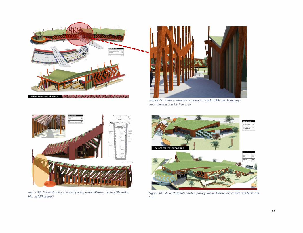
Interpretation of his design
Overall, Steve Hutana’s contemporary design of Urban Marae is a collaboration of all the building functions which are required for
good community space. The design merges well with the neighbourhood streets in respect to its urban context. The main idea is to
make it a contemporary design, with keeping values, culture and tradition in mind. Thus, he made the design by abstracting the
organic symbolic forms of Maori art and using sustainable local materials.
His design is also a reflection of a journey throughout the urban marae connecting different areas of the building that are office space,
residential apartments, theatre and even cultural hub “wharenui” with open courtyard. He made all the in between transitions with a
play of covered and uncovered pathways. Hence, his design is the best example of representing traditional Marae into contemporary
Urban Marae.
Figure 30: Steve Hutana’s contemporary urban Marae: showing the circulation Figure 31: Steve Hutana’s contemporary urban Marae: entrance to the Marae
25
Figure 32: Steve Hutana’s contemporary urban Marae: Laneways near dinning and kitchen area
Figure 33: Steve Hutana’s contemporary urban Marae: Te Pua Ote Roku Marae (Wharenui)
Figure 34: Steve Hutana’s contemporary urban Marae: art centre and business hub

26
3.0 SITE SELECTION
27
3.1 Aotea Square: Past
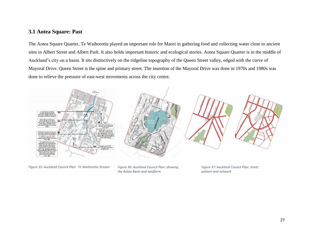
The Aotea Square Quarter, Te Waihorotiu played an important role for Maori in gathering food and collecting water close to ancient
sites in Albert Street and Albert Park. It also holds important historic and ecological stories. Aotea Square Quarter is in the middle of
Auckland’s city on a basin. It sits distinctively on the ridgeline topography of the Queen Street valley, edged with the curve of
Mayoral Drive. Queen Street is the spine and primary street. The insertion of the Mayoral Drive was done in 1970s and 1980s was
done to relieve the pressure of east-west movements across the city centre.
Figure 35: Auckland Council Plan: Te Waihorotiu Stream Figure 36: Auckland Council Plan: showing the Aotea Basin and landform
Figure 37: Auckland Council Plan: street pattern and network

28
Aotea Square was created in 1979, with a large part of it being the former end of Grey’s Avenue, which used to connect directly to
Queen Street – a large underground carpark with 930 spaces had been erected underneath in 1975.
The initial plan for the Aotea Centre comprised an auditorium with a sitting capacity of 5,000 and a 1,200-seat theatre. However, due
to the cost of construction, the building was reduced to a 2,300-seat auditorium and an 800-seat theatre. The final design by Ewen
Wainscott was unveiled to the public in 1980. Eventually, “a generation overdue” because of financial struggle, the controversial
Aotea Centre, described as “a tragic and expensive mistake” by opponents, broke ground in August, 1985, a day which some called “a
momentous day for Auckland”.
Year: 1940 Year: 2013
Year :1974-89

29
Figure 38: Aotea Square before Figure 39: Aotea Square at present
30
3.2 Aotea Square: Present
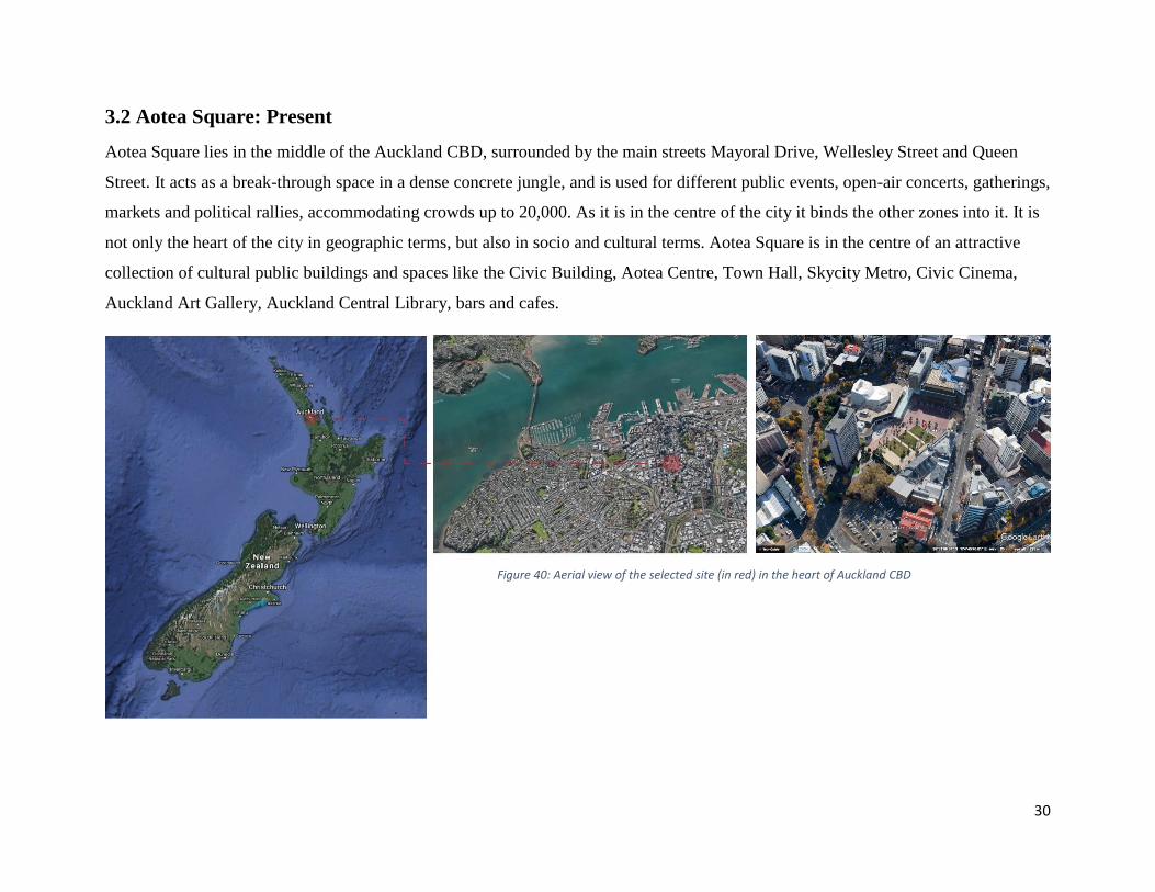
Aotea Square lies in the middle of the Auckland CBD, surrounded by the main streets Mayoral Drive, Wellesley Street and Queen
Street. It acts as a break-through space in a dense concrete jungle, and is used for different public events, open-air concerts, gatherings,
markets and political rallies, accommodating crowds up to 20,000. As it is in the centre of the city it binds the other zones into it. It is
not only the heart of the city in geographic terms, but also in socio and cultural terms. Aotea Square is in the centre of an attractive
collection of cultural public buildings and spaces like the Civic Building, Aotea Centre, Town Hall, Skycity Metro, Civic Cinema,
Auckland Art Gallery, Auckland Central Library, bars and cafes.
Figure 40: Aerial view of the selected site (in red) in the heart of Auckland CBD

31
Aotea Centre
Aotea Centre is a 25-year-old building. It was the product of post-
war urban intentions to create a new civic centre and square for
Auckland. It includes facilities like a foyer, gallery spaces and
function rooms. The recent redesign gives the lower terrace
fronting Aotea Square an extended canopy with steps and a Box
café. This has improved the edge of the square immensely, making
it more active.
Town Hall
It is a civic landmark in Neo-Baroque style. It is a historical
building place on the Queen Street with alignment to Greys
Avenue. It is currently used for several events such as showcasing
art and culture, concerts by Orchestra and other different
international shows and performances.
The Civic Administration Building
The Civic Administration Building is on the edge of Aucklands’s
Aotea Square. It was the city’s first skyscraper and became an icon
of local government. It was designed in mid 1950s and completed
in 1966 by Tibor Karl Donner.
Figure 41: Aotea Centre at night
Figure 42: Town Hall
Figure 43: Civic Administration Building

32
3.3 Aotea Square: Future
Auckland City Council is certainly familiar with Aotea
Square’s limitations. The square has been gradually upgraded
since 2000 with constant debates amongst architects, urban
designers and critics. The aim was to transform it into a strong
destination as an open public space; a comfortable and familiar
place for people to relax and socialize.
The Aotea Quarter Framework seeks to update and advance the
strategic direction set down in the Aotea Quarter Plan 2007 and
the more recent City Centre Masterplan 2012. Reflecting the
change already happening and transformation yet to occur, the
framework provides a strategic vision for next 20 years. The
framework identifies four outcomes to deliver the vision:
• Outcome 1: A Civic and Cultural Heart – The quarter
core as the enduring home for the arts, culture,
entertainment and civic life, creating a unique
destination.
• Outcome 2: Transport-Enabled Development – A
public transport node that improves accessibility,
supports growth and enables high-quality development.
• Outcome 3: Supporting Neighborhoods – Livable,
vibrant and diverse inner-city neighbourhoods engaging
and supporting the quarter core.
• Outcome 4: Sustainable and Cultural Showcase –
Spaces and buildings that lead and showcase
Auckland’s drive for sustainability and celebrate its
unique cultural identity through the Te Aranga Maori
design principles.

33
Also, the Auckland Council Proposal is for the restoration of The Civic Administration Building in Aotea Square with development of
the surrounding area, to the breathing space of Auckland’s city centre. The proposal consists of the residential apartments on the upper
floors, with food and beverages on the ground floor of the existing building. The site also holds potential for mixed-use building with
facilities like office space, hotel, hospitality, retail outlets, and residential.
Thus, the restoration of The Civic Administration Building creates 104 apartments from 1BHK of 56m2 to 3BHK of 115m2 and pent
house, a new apartment building on the Mayoral Drive corner, with a boutique hotel and featuring a Whare Tapere performance space
fronting Aotea Square.
Figure 44: Auckland Council Proposal: The Aotea Quarter Framework
34
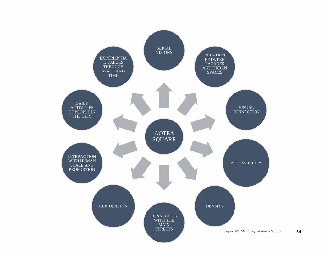
AOTEA SQUARE
SERIAL VISIONS
RELATION BETWEEN FACADES
AND URBAN SPACES
VISUAL CONNECTION
ACCESSIBILITY
DENSITY
CONNECTION WITH THE
MAIN STREETS
CIRCULATION
INTERACTION WITH HUMAN
SCALE AND PROPORTION
DAILY ACTIVITIES
OF PEOPLE IN THE CITY
EXPERIENTIAL VALUES THROUGH
SPACE AND TIME
Figure 45: Mind map of Aotea Square

35
3.4 Advantages of Aotea Square
Aotea Square is located in the city centre with its three edges
linking with Auckland Town Hall, the Aotea Centre, bars and
cafes. Aotea Square encourages the public not only to pass
through the space, but also retains them for interaction in
activities. In his book “Cities for People”, Jan Gehl discusses
the relationship between facades and urban space and how they
can affect the way the space is used. The physical arrangement
of the bars and cafes on the ground level of the square invites
people to spend some leisure time – coffee in the office hours
and drinks at the bars. Hence, Gehl calls it a ‘staying square’,
as opposed to a ‘walk-through’ square as it keeps people in the
square.
Another factor which adds up is the balance between the greens
and the concrete sections, which allows mixed crowds to come
in for different small and large events. The proper seating
opportunities of benches arranged throughout the square and a
green canopy providing sufficient shelter invites people to sit
and enjoy the life in the square. Some arrangements of the
benches also create the cluster groups for private interaction.
Thus, the arrangement of the benches in the square creates a
place for public interaction, relaxation and observation.
Then, the connection of the Aotea Square with the main streets
which makes the circulation easy. There are multiple access
entries from these streets as well as from the underground
parking, excluding the individual building entries which keeps
the square transition constant. These building entries add to the
space for functions and small gatherings into the square. These
makes the façade and the square interact with each other.
36
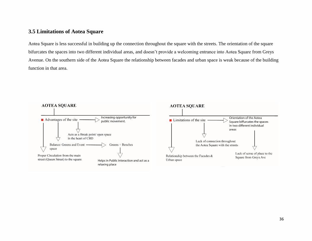
3.5 Limitations of Aotea Square
Aotea Square is less successful in building up the connection throughout the square with the streets. The orientation of the square
bifurcates the spaces into two different individual areas, and doesn’t provide a welcoming entrance into Aotea Square from Greys
Avenue. On the southern side of the Aotea Square the relationship between facades and urban space is weak because of the building
function in that area.

37
3.6 Chosen Site
Thus, the chosen site is not the whole of Aotea Square but the part of the square with the most potential, which is the southern side,
which is a car park at present. The site is across the edge of Mayoral Drive and Greys Avenue with the path to Myers Park under the
bridge of Mayoral Drive.
Figure 46: Aerial view of Aotea Square showing the selected site (in red) and main streets

38
4.0 SITE ANALYSIS

39
4.1 Void
From the ground figure shown below, it is difficult to identify Aotea Square. The placement of Aotea Centre in the middle of a
massive void makes the square’s boundaries difficult to be identify. This is mainly due to a lack of mass or defined edges on the
southern side of the Aotea Square.
Figure 47: Aotea Square: figure diagram Figure 47: Aotea Square: ground diagram Figure 48: Aotea Square: Aerial view
40
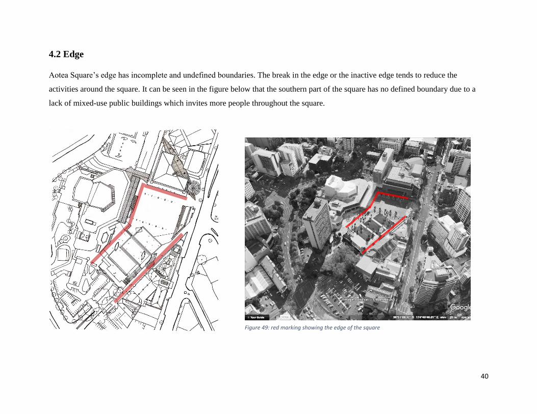
4.2 Edge
Aotea Square’s edge has incomplete and undefined boundaries. The break in the edge or the inactive edge tends to reduce the
activities around the square. It can be seen in the figure below that the southern part of the square has no defined boundary due to a
lack of mixed-use public buildings which invites more people throughout the square.
Figure 49: red marking showing the edge of the square
41
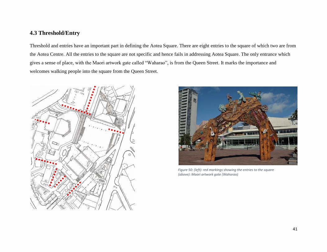
4.3 Threshold/Entry
Threshold and entries have an important part in defining the Aotea Square. There are eight entries to the square of which two are from
the Aotea Centre. All the entries to the square are not specific and hence fails in addressing Aotea Square. The only entrance which
gives a sense of place, with the Maori artwork gate called “Waharao”, is from the Queen Street. It marks the importance and
welcomes walking people into the square from the Queen Street.
Figure 50: (left): red markings showing the entries to the square (above): Maori artwork gate (Waharao)
42
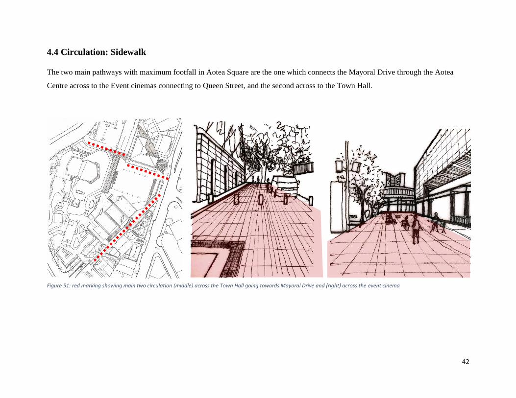
4.4 Circulation: Sidewalk
The two main pathways with maximum footfall in Aotea Square are the one which connects the Mayoral Drive through the Aotea
Centre across to the Event cinemas connecting to Queen Street, and the second across to the Town Hall.
Figure 51: red marking showing main two circulation (middle) across the Town Hall going towards Mayoral Drive and (right) across the event cinema
43
4.5 Circulation: Stairs
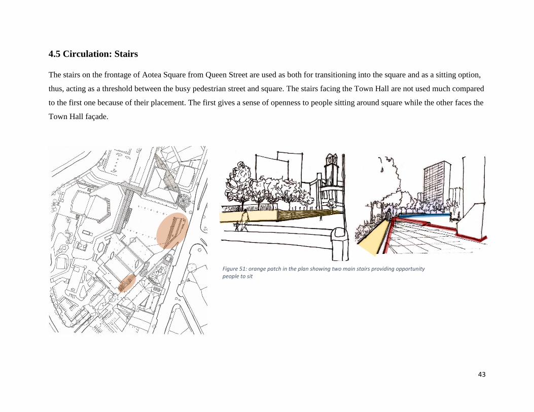
The stairs on the frontage of Aotea Square from Queen Street are used as both for transitioning into the square and as a sitting option,
thus, acting as a threshold between the busy pedestrian street and square. The stairs facing the Town Hall are not used much compared
to the first one because of their placement. The first gives a sense of openness to people sitting around square while the other faces the
Town Hall façade.
Figure 51: orange patch in the plan showing two main stairs providing opportunity people to sit
44
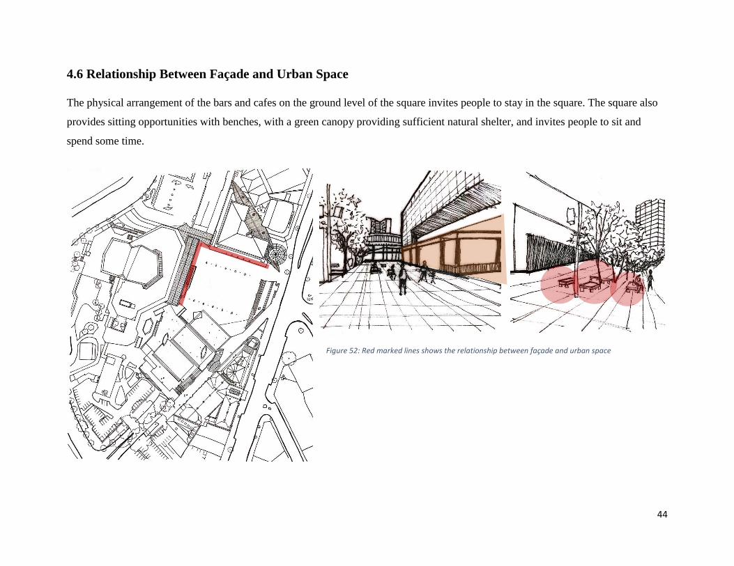
4.6 Relationship Between Façade and Urban Space
The physical arrangement of the bars and cafes on the ground level of the square invites people to stay in the square. The square also
provides sitting opportunities with benches, with a green canopy providing sufficient natural shelter, and invites people to sit and
spend some time.
Figure 52: Red marked lines shows the relationship between façade and urban space

45
5.0 INITIAL DESIGN
46
5.1 Brief
The initial design focuses on three major aspects to start with the final design. The three major aspects are:
• Positive and drawbacks of the future proposed development plan from Auckland Council
• Site potential
• Seven components/elements derived from literature review which are different theories and case studies of traditional
transitional space.
The initial step in the design was to analyze positives and drawbacks with the future development of the area surrounding the
Civic Administration Building as per the Auckland Council Proposal. The proposed design incorporates mixed-use building
functions in that area which will increase the number of people walking through Mayoral Drive to Aotea Square. The drawbacks
of the proposed design are:
• The mass of the building which makes it look bulky and heavy.
• The design does not in respect to the existing contours.
• It surrounds the whole periphery of the Civic Administration Building.
• There are no building connections on upper floors, other than the ground-level corridors in-between.

47
The site holds the potential to increase transition on the
southern side of Aotea Square with the insertion of building
blocks with mixed-use functions that interact with the urban
space. It is important to make a strong connection by merging
Mayoral Drive and Myers Park to Aotea Square. The idea for
designing is to fragment the building functions in different
units and then connect them through bridges, laneways, stairs
and courtyards.
This will lead to interesting pockets of spaces and will create a
journey within different spaces. With these transitional spaces
forming within the site, it is necessary to provide a setback to
each space which acts as a threshold, and to give a sense of
welcome to the place through placement of the buildings
blocks. The design will incorporate mixed-use functions like:
residential apartments, offices, retail outlets, restaurants/ cafes
and on the exhibition gallery facing the Aotea Square.
With this research background of theories, case studies and
site, the next step was to set up the guidelines for designing, to
get the best of transitional spaces reflecting the traditional
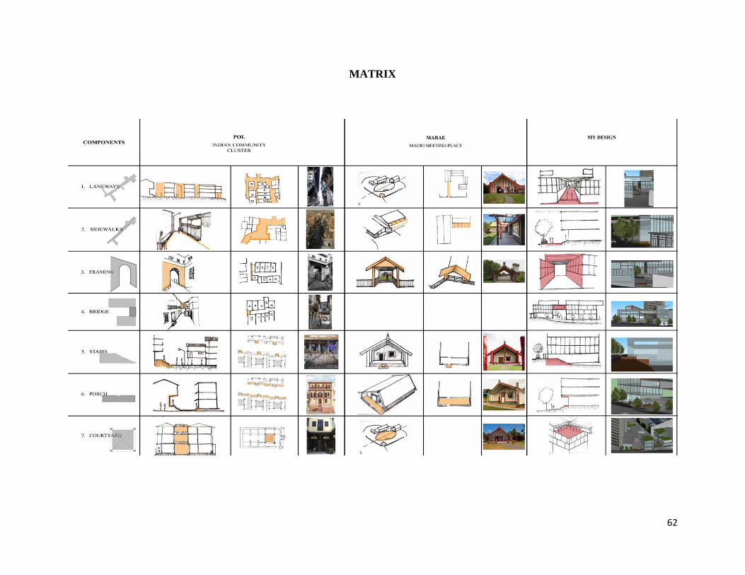
transitional space elements. The seven components/elements
derived from this research background are:
• Laneways: as vibrant and informal urban spaces with
incorporating green space, cultural/art and making an
active physical link.
• Sidewalks: promoting pedestrian-friendly streetscapes
to encourage people to walk.
• Framing: to create a gateway and perspective to give a
“sense of welcoming” to a place.
• Bridge: to increase the connectivity and transition
within the buildings on upper levels.
• Stairs: as a functional transitional space providing
connectivity to different levels. If the stairs are in an
urban context, then they can provide sitting
opportunities to increase the efficiency of that space.
• Porch: a covered canopy extended or a setback of the
upper floor acting as a “threshold”
• Courtyard: an open space creating an opportunity for
small gatherings and events, acting more like a
community space.

48
MATRIX

49
6.0 DESIGN MASTER PLAN

50
6.1 Masterplan
The connection of spaces within and around the Aotea Quarter
is weak currently. The integration of mixed-use built forms will
help in creating an active street edge along the frontage of
Mayoral Drive and Greys Avenue. Also, this will improve the
Mayoral Drive underpass which leads to Myers Park. The
design respects the existing contours. Hence, it provides two
main accesses through stairs from the Mayoral Drive pedestrian
area. This will make transition from Mayoral Drive to Aotea
Square easy and accessible. Circulation here will allow people
either to go through the laneways or pass through the buildings
which leads to Aotea Square. The design incorporates journey
through different transitional spaces, each being marked as a
destination.
The building functions go from public to private. The ground
floor consists of retail and food outlets, upper floors as office
space and the top floors as residential apartments. The building
in the front of Aotea Square is gallery space with its own café and
library.
Aotea Square
Myers Park
51
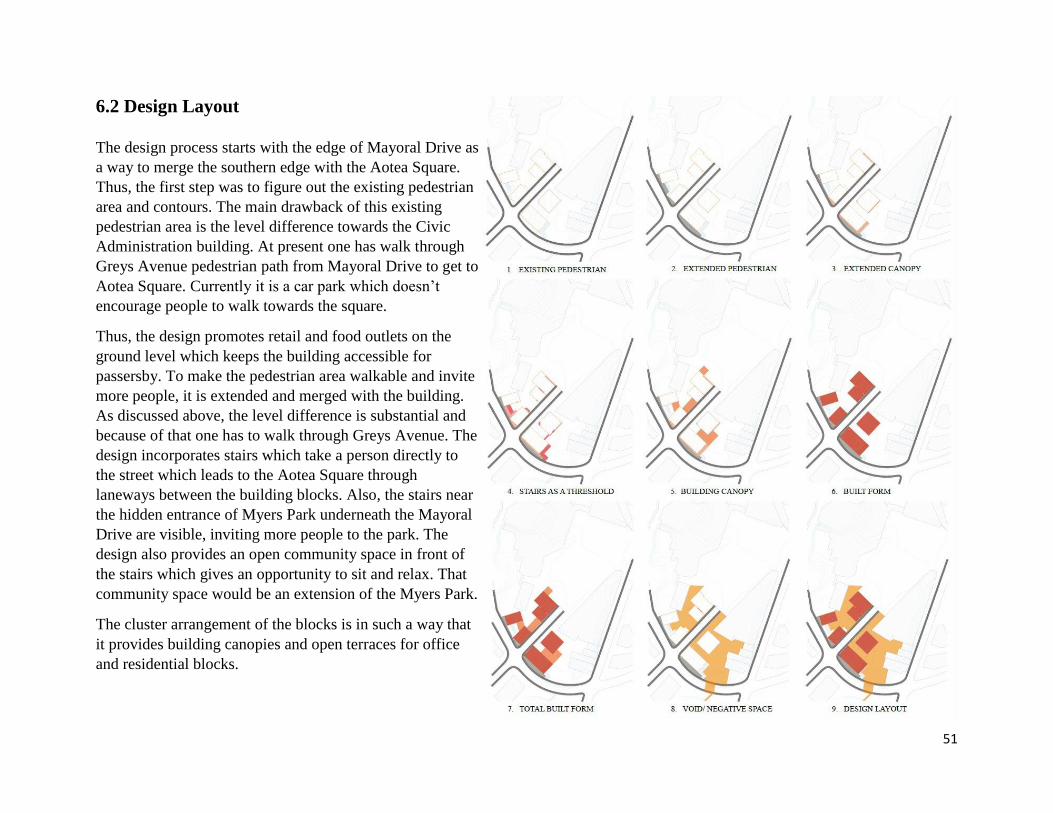
6.2 Design Layout
The design process starts with the edge of Mayoral Drive as
a way to merge the southern edge with the Aotea Square.
Thus, the first step was to figure out the existing pedestrian
area and contours. The main drawback of this existing
pedestrian area is the level difference towards the Civic
Administration building. At present one has walk through
Greys Avenue pedestrian path from Mayoral Drive to get to
Aotea Square. Currently it is a car park which doesn’t
encourage people to walk towards the square.
Thus, the design promotes retail and food outlets on the
ground level which keeps the building accessible for
passersby. To make the pedestrian area walkable and invite
more people, it is extended and merged with the building.
As discussed above, the level difference is substantial and
because of that one has to walk through Greys Avenue. The
design incorporates stairs which take a person directly to
the street which leads to the Aotea Square through
laneways between the building blocks. Also, the stairs near
the hidden entrance of Myers Park underneath the Mayoral
Drive are visible, inviting more people to the park. The
design also provides an open community space in front of
the stairs which gives an opportunity to sit and relax. That
community space would be an extension of the Myers Park.
The cluster arrangement of the blocks is in such a way that
it provides building canopies and open terraces for office
and residential blocks.

52
The figure below shows the extension to the existing pedestrian area which merges with the building leading towards Aotea Square
either through the laneways, sidewalks of the Greys Avenue or from within the buildings. The extended canopies give a spacious and
welcoming entrance to the building. This also forms a sheltered walk and gives an opportunity for outside seating for the cafes and
restaurants.

53
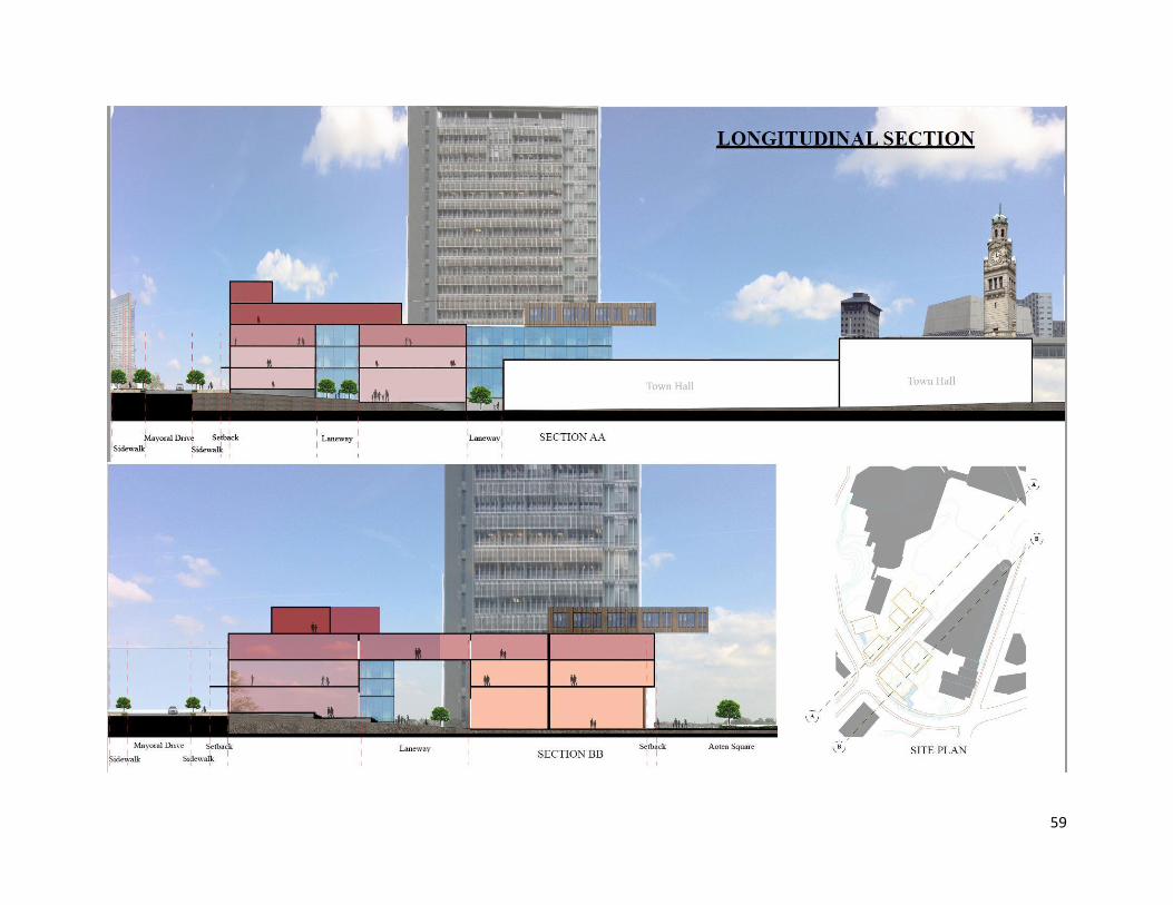
There are two main stairs from Mayoral Drive’s pedestrian area which lead a person to Aotea Square from laneways through the
buildings. These stairs act as a threshold between the main pedestrian area of the Mayoral Drive and the open courtyards, and the
buildings. The stairs near the Myers Park also acts as an amphitheatre, giving people an opportunity to sit and relax. The open space in
front of it acts as an open community space. The building canopy is designed in such a way that it is functional as well as having
aesthetic value to it. Functionally, it is the bridge between upper floors, and aesthetically, it creates sheltered laneways.
54
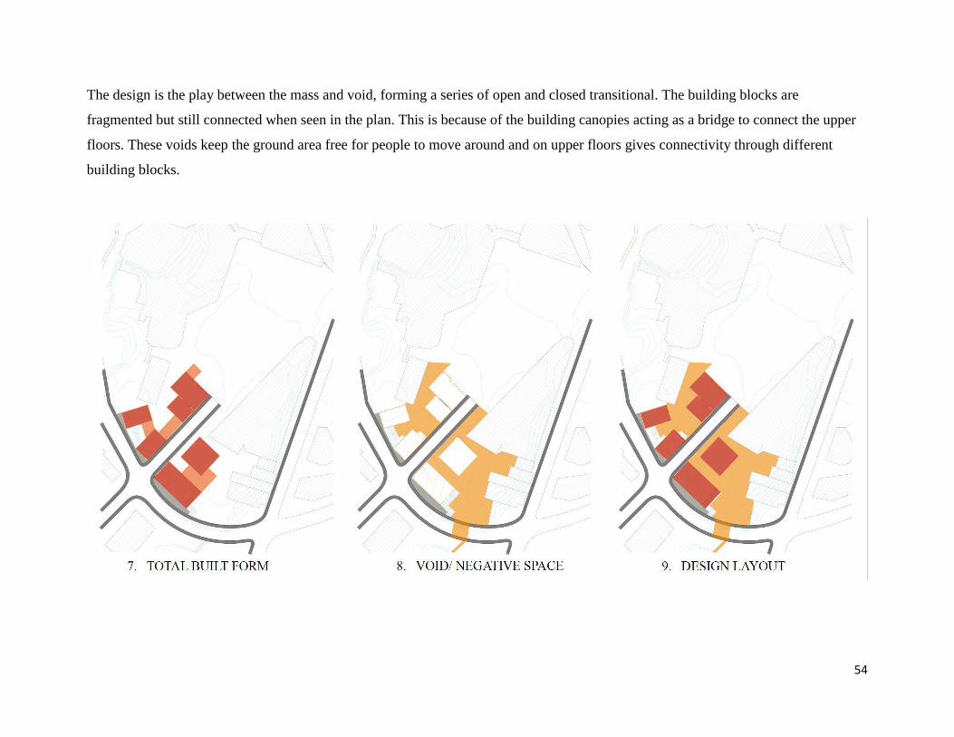
The design is the play between the mass and void, forming a series of open and closed transitional. The building blocks are
fragmented but still connected when seen in the plan. This is because of the building canopies acting as a bridge to connect the upper
floors. These voids keep the ground area free for people to move around and on upper floors gives connectivity through different
building blocks.

55
6.3 Series of Transitional Spaces
There are a series of transitional spaces forming throughout the
design. This series of visual experiences develops a journey
from Mayoral Drive through different buildings and laneways
to Aotea Square. Hence, with the insertion of these elements as
discussed in the matrix above, the transitional spaces can make
the southern edge of Aotea Square more active. The series of
transitional spaces could be seen in three different levels. They
are:
• Edge of the Mayoral Drive
• Different Building Entries
• Framing and Laneways
6.3.1 Edge of the Mayoral Drive
The main idea in the design was to make an active edge of the
Mayoral Drive which leads walkers towards the square in
interesting way. Here in the figure below the orange part
shows the extended pedestrian area which merges with the
building and stairs which leads to Aotea Square. This makes
the relationship between the building façade and urban space
stronger. The second stairs connect Mayoral Drive to Myers
Park entrance which is underneath Mayoral Drive and the
same stairs are also one of the entrance to that building. The
risers and treads of these stairs are wider than the usual, giving
an opportunity for people and children to sit and play. Hence,
this open courtyard space could be an extension of the Myers
Park, forming a small community space.

56
Myers Park

57
6.3.2 Different Building Entries
All the entries into the building are either within the extended building canopy or with a setback of a few steps going up or down as
per the contours. As discussed earlier in the case study of the pol, where the uplifted otla acts as a threshold between the street and the
house, in the same way here the entries act as a threshold but the context is changed. The building facing the Aotea Square is on the
same level. To make the main entrance of the gallery more interesting the ground floor façade is kept porous. The porosity could be
seen with pivoted doors which makes the flow from Aotea Square to the gallery more flexible.

58
6.3.3 Framing and Laneways
The design recreates the framing and laneways in respect to Gordon Cullen’s series of visual experiences and the respective case
studies which showcases the entrance, giving a sense of place to a particular space. The scale over here is a bit larger in respect to the
site context and needs. The arrangement of the building canopies is such that it solves its purpose of connecting the upper levels but
also forms framing that acts as a gateway. The laneways here are the linkage between different small activity spaces. Thus, the
laneways are not narrow throughout.
59

60
7.0 CONCLUSION
61
The aim of the project is to answer the question “How can traditional urban space elements be used to enhance the design of
transitional space in the contemporary city?”. By the understandings of literature review from theories and case studies seven
traditional urban space elements were derived and then were superimposed onto the chosen site to get the best workable design.
Analyzing the Aotea Quarter Framework helped in selecting the site, which was the southern edge of Aotea Square linked with main
streets of Mayoral Drive and Grey’s Avenue. After the successful analysis of the site, the main aim was to develop a strong connection
from the Mayoral Drive to Aotea Square and making the Myers Park entrance visible by merging it towards Aotea Square.
This was possible by adding several building functions to the site like retail outlets, cafes and bars, restaurants, office spaces, gallery
and residential apartments on upper level. Thus, to make the space interesting it was necessary to make series of transitional space
which makes a journey from start of Mayoral Drive to Aotea Square or from Mayoral Drive to Myers Park marking each as a
destination. The best way of superimposing the traditional urban space elements was with developing a matrix on the seven main
elements, which were, laneways, sidewalks, framing (gateways), bridges, stairs, porch and courtyards according to the urban context
of the site. The matrix shows the connection from both the case studies of Pol and Marae which reflects in the design.
62
MATRIX

63
8.0 REFRENCES

64
References from Websites and Books
SDA. (2009, october 24). Transition Spaces. Retrieved from https://dezinebox.blog/2009/10/14/transition-spaces/
So What Exactly is Transitional Space? (2012, January 23). Retrieved from https://changets.wordpress.com/2012/01/23/so-what-
exactly-is-transitional-space/
Classic Turf Equipment. (n.d.). Retrieved from http://classicturfequipment.com/component/k2/itemlist/user/6033
Gehl, J. (2010). Cities for People. Washington DC: Island Press.
Gehl, J., & Koch, J. (2011). Life between buildings: Using public space. Washington: Island Press.
Jacobs, J. (2011). The death and life of great American cities. New York: Modern Library
Lynch, K. (1990). The image of the city. Cambridge, Mass.: MIT.
Cullen, G. (2015). Concise townscape. Place of publication not identified: Routledge.
Andrea Gibbons. (2016, October 04). Camillo Sitte: The Art of Building Cities. Retrieved from
http://writingcities.com/2016/10/01/camillo-sitte-art-building-cities/
Murray, I. Z., & Correa, C. (2013). Charles Correa: Indias greatest architect. London: RIBA Publishing.
The blessings of the sky. (1995). Tokyo: Gallery Ma.
Steele, J., & Doshi, B. V. (1998). The complete architecture of Balkrishna Doshi: Rethinking modernism for the developing world.
Mumbai: Super Book House.
Sejpal, S. (1987). Theory and city form: The case of Ahmedabad.
Marae - Māori meeting grounds | New Zealand. (n.d.). Retrieved from https://www.newzealand.com/int/feature/marae-maori-
meeting-grounds/
Marae. (2018, July 08). Retrieved from https://en.wikipedia.org/wiki/Marae

65
Hutana, S. J. (2011). Hamo Te Rangi: Design for a contemporary urban Maori marae. Master thesis explanatory document. An
explanatory document submitted in partial fulfilment of the requirements for the degree of Master of Architecture (Professional),
Unitec New Zealand.
Aotea Square. (2018, July 03). Retrieved from https://en.wikipedia.org/wiki/Aotea_Square
Auckland Council. (n.d.). Aotea Quarter Framework. Retrieved from https://www.aucklandcouncil.govt.nz/plans-projects-policies-
reports-bylaws/our-plans-strategies/place-based-plans/Pages/aotea-quarter-framework.aspx
Welcome. (n.d.). Retrieved from http://www.aucklanddesignmanual.co.nz/resources/case-studies#/resources/case-studies/aotea-
square

66
List of Figures
(n.d.). SomervillebyDesign – Somerville || Neighborhood || Planning || Urban Design. Public Space – Public Life –
SomervillebyDesign. Retrieved from http://www.somervillebydesign.com/planning/public-space-planning/public-space-public-life/
(n.d.). UrbDeZine San Francisco - Urban Planning + Design + Architecture + Historic Preservation. Happy 50th Anniversary to The
Death and Life of Great American Cities: Revisiting a classic - UrbDeZine San Francisco. Retrieved from
http://sanfrancisco.urbdezine.com/2011/11/19/happy-50th-anniversary-to-the-death-and-life-of-great-american-cities-revisiting-a-
classic/
(n.d.). DAB525- Architecture in the City | A blog about architecture and the city.. Lynch, Landmarks and Other Things. | DAB525-
Architecture in the City. Retrieved from http://ahmidarchi525.wordpress.com/2013/03/04/lynch-landmarks-and-other-things/
(n.d.). Urban Design | Just another WordPress.com weblog. Lecture 1 : Week 1 | Urban Design. Retrieved from
http://rekabentukbandar.wordpress.com/2008/07/08/lecture-1-week-1/
(n.d.). Pinterest. Camillo sitte der stadtbau - Szukaj w Google | Camillo Sitte | Pinterest | Google, Urban planning and Urban
design. Retrieved from http://www.pinterest.nz/pin/10836855329987259/
(n.d.). ArchDaily | Broadcasting Architecture Worldwide. Architecture as an Agent of Change: Remembering Charles Correa,
. Retrieved from http://www.archdaily.com/789384/architecture-as-agent-of-change-remembering-charles-correa-india
(n.d.). Pictures to Pin on Pinterest - PinsDaddy. Doshi Architect Pictures to Pin on Pinterest - PinsDaddy. Retrieved from
http://www.pinsdaddy.com/doshi-architect_ptvBDqRmh8eUP8zBDblUSQnqD4iF3PRLdUAcr6mTdDU/
(n.d.). Discover Wellington » WellingtonNZ.com. Waiwhetu Marae » WellingtonNZ.com. Retrieved from
http://www.wellingtonnz.com/discover/sights-activities/waiwhetu-marae/
67
(n.d.). Home | National Library of New Zealand. Marae:The Heart of Māori Culture by Malcom Mulholland and Robyn Bargh | Blog |
National Library of New Zealand. Retrieved from http://natlib.govt.nz/blog/posts/marae-the-heart-of-maori-culture-by-malcom-
mulholland-and-robyn-bargh
(n.d.). Retrieved from http://www.aucklandcouncil.govt.nz/plans-projects-policies-reports-bylaws/our-plans-strategies/place-based-
plans/docsaoteaquarterframeworkchapter/aotea-quarter-framework-chapter-1b.pdf
(n.d.). Auckland News and Events | OurAuckland. Iconic CBD building to be transformed into homes | OurAuckland. Retrieved from
http://ourauckland.aucklandcouncil.govt.nz/articles/news/2016/09/iconic-cbd-building-to-be-transformed-into-homes/
Sca
nn
ed w
ith
Cam
Sca
nn
er
Matthew Bradbury