Volume 18, Issue 1 Spring 2015
Lincoln NWS 20th Anniversary Retrospective
By: Chris Geelhart, Meteorologist
Editor’s Note: This is Part 1 of a 3-part series on the history of the National Weather
Service in Lincoln, which marks its 20th year of operation in 2015.
Preparing for the Move
Plans to modernize the National Weather Service began in the 1980’s. Public Law 102-567, known as the Weather Service Modernization Act, was passed by Congress in the fall of 1992 and signed by President George H.W. Bush. It implemented the NWS Modernization and Associ-ated Restructuring, which would reconfigure the office network from 52 Weather Service Fore-cast Offices (WSFO’s, which pro-vided forecast responsibility for roughly a state-size area) and 204 Weather Service Offices (WSO’s, which were primarily responsible for local observations and severe weather warnings), to a network of 116 (now 122) Weather Forecast Offices which generally provide similar services to each other (forecasts and warnings). In central Illinois, the NWS operated WSO’s at Peoria and Springfield, and the WSFO at Chicago provided forecasts for the state of Illinois.
The analysis for the Modernization concluded that Lincoln was the best location for a new Weather Forecast Office (WFO) that would serve central Illinois. Locating the new Doppler radar in Lincoln would provide the best low-level coverage of several major population centers (Peoria, Bloomington, Decatur, and Springfield), each of which are roughly the same distance from Lincoln. Operating the radar and office in separate locations, while more feasible with today’s technology, was a significant expense, so most offices built during the modernization were co-located
(cont. on page 2)
Inside this issue:
20th Anniversary of the
Lincoln NWS (Part 1)
1
Visualizing Tornado
Safety Rules
3
Severe Weather Pop Quiz 4
Lincoln NWS Receives
Bronze Medal
5
Winter Weather Statistics 5
Summer Outlook 6
Weather Phobias 7
Northern Lights 8
A mapping of Weather Service Forecast Offices and
associated coverage areas, before the start of the NWS
modernization.

Volume 18, Issue 1 Page 2
with their associated radar. Thus, operations of the Peoria and Springfield offices would be merged into the Lincoln WFO, at which time the former offices would close. It was determined to con-struct the office on property along Highway 10, adjacent to the south edge of the Logan County Airport.
Construction of the WFO began in December 1993, and the office was completed in October 1994. At this time, the Meteorologist in Charge (Ernie Goetsch, who is still in the same position) reported for duty. Additional staffing was soon added, which included elec-tronics technicians and an administrative support assistant. Mete-orological technicians reported in early 1995 in preparation for upper-air (weather balloon) responsibility, which began in
mid-February. Five meteorologists reported in mid-May and began training on use and interpretation of the new Doppler radar system. Additional staffing also included a Science Operations Officer and a Warning Coordination Meteorologist, making a total of 8 meteorologists on station.
Construction of the Doppler radar began in April, and testing soon began. Due to the testing, the radar was not in operation when a tornado passed about 2 miles south of the office on May 9. There were fears the radar would be destroyed before we even had a chance to use it, but luckily the tornado missed the office. Actual commissioning of the radar would occur January 3 of the following year.
Aside from the balloon launches, the spring and summer of 1995 saw mainly administrative operations, as the forecasters trained on the Doppler radar. Training included 4 weeks at a training facility in Norman, OK. The staff would also help cover shifts at the Peoria and Springfield offices, as some of its staff was lost by personnel transferring to Lincoln and other new WFO’s.
Meanwhile, preparations were made at the Peoria and Springfield offices for the new office’s responsibili-ties. On March 1, warning responsibility for 6 counties in west central Illinois was transferred from Peoria to the new WFO in Davenport, IA, leaving them with 10 counties in their coverage area. The Springfield office transferred two of their 20 counties to the St. Louis office soon afterward. As the NWS would no longer be taking hourly weather observations at those two offices, testing and evaluation of the new Automated Surface Observing System was ongoing to prepare for the planned departure date of October 1. Several pieces of equipment and furniture would be relocated to Lincoln, requiring movers to be hired. The actual move was scheduled for September 27th.
(continued in next issue)
Lincoln NWS 20th Anniversary Retrospective (cont.)
Construction of the Doppler radar dur-
ing the spring of 1995.
Tornado passing southeast of the Doppler radar,
May 9, 1995. Photo courtesy Jeff Hedges.
Construction of the new Weather Forecast
Office in Lincoln during 1994.
Volume 18, Issue 1 Page 3
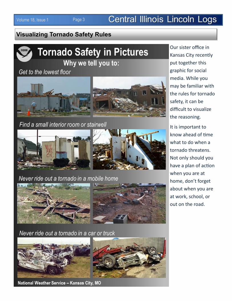
Visualizing Tornado Safety Rules
Our sister office in
Kansas City recently
put together this
graphic for social
media. While you
may be familiar with
the rules for tornado
safety, it can be
difficult to visualize
the reasoning.
It is important to
know ahead of time
what to do when a
tornado threatens.
Not only should you
have a plan of action
when you are at
home, don’t forget
about when you are
at work, school, or
out on the road.

Volume 18, Issue 1 Page 4
Severe weather season has arrived. To mark the occasion, we’ve put together a short quiz on severe
weather related trivia. How many of these do you know?
1) Approximately how many tornado fatalities occur in mobile homes?
A) 15%
B) 30%
C) 50%
2) True or False: Hail can cause fatalities.
3) When a tornado threatens, where should you go if you
are at home and you have a basement available?
A) In the corner of the basement opposite of the
approaching tornado.
B) Underneath the stairwell.
C) Outside; how else am I going to get video of the
tornado?
4) Which month has seen the highest number of tornadoes
in Illinois (from 1950 to 2014)?
A) March
B) April
C) May
5) If you had hail of 2-1/2 inches denting the roof of your
car, about what size object would be a good comparison?
A) Tennis ball
B) Baseball
C) Golf ball
6) True or False: If you are in a high-rise building when a tornado is approaching, any interior window-
less hallway will provide good shelter, regardless of floor.
7) How far down to the ground does a funnel cloud have to extend for it to be considered a “tornado”?
A) 50%
B) 75%
C) It must be in contact with the ground
Severe Weather Trivia: A Pop Quiz
Did You Know?
The minimum wind speed for a thunder-
storm to be considered severe is 58 mph.
This dates back to the 1950s and 1960s,
when Severe Thunderstorm Watches were
first issued. There were two types of these
watches; one issued for the public used a
wind speed threshold of 75 mph, while one
for aviation purposes used 50 mph. After
discussions with the Air Force, the aviation
watch was set to 50 knots (58 mph). When
the two watch types were merged in 1970,
the 58 mph speed was retained.
Source: National Severe Storms Laboratory
Answers: 1=C; 2=True; 3=B; 4=B; 5=A; 6=False; 7=C
Volume 18, Issue 1 Page 5
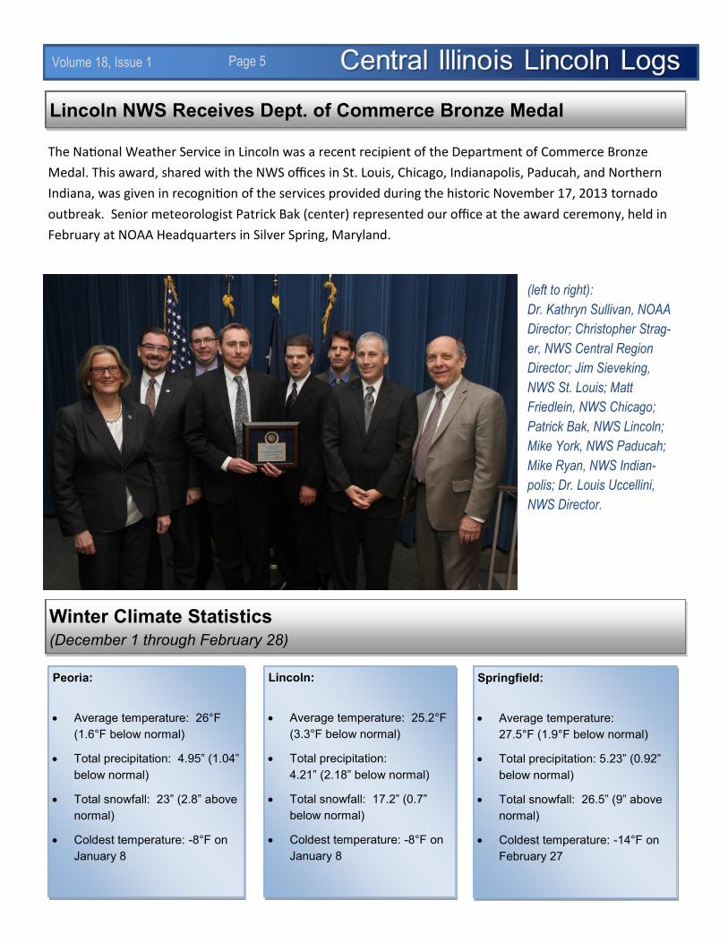
Lincoln NWS Receives Dept. of Commerce Bronze Medal
The National Weather Service in Lincoln was a recent recipient of the Department of Commerce Bronze
Medal. This award, shared with the NWS offices in St. Louis, Chicago, Indianapolis, Paducah, and Northern
Indiana, was given in recognition of the services provided during the historic November 17, 2013 tornado
outbreak. Senior meteorologist Patrick Bak (center) represented our office at the award ceremony, held in
February at NOAA Headquarters in Silver Spring, Maryland.
Winter Climate Statistics
(December 1 through February 28)
Peoria:
Average temperature: 26°F
(1.6°F below normal)
Total precipitation: 4.95” (1.04”
below normal)
Total snowfall: 23” (2.8” above
normal)
Coldest temperature: -8°F on
January 8
Lincoln:
Average temperature: 25.2°F
(3.3°F below normal)
Total precipitation:
4.21” (2.18” below normal)
Total snowfall: 17.2” (0.7”
below normal)
Coldest temperature: -8°F on
January 8
Springfield:
Average temperature:
27.5°F (1.9°F below normal)
Total precipitation: 5.23” (0.92”
below normal)
Total snowfall: 26.5” (9” above
normal)
Coldest temperature: -14°F on
February 27
(left to right):
Dr. Kathryn Sullivan, NOAA
Director; Christopher Strag-
er, NWS Central Region
Director; Jim Sieveking,
NWS St. Louis; Matt
Friedlein, NWS Chicago;
Patrick Bak, NWS Lincoln;
Mike York, NWS Paducah;
Mike Ryan, NWS Indian-
polis; Dr. Louis Uccellini,
NWS Director.

Volume 18, Issue 1 Page 6
No Major Trends Expected for Summer
The latest summer outlooks, issued April 16th by the NWS’s Climate Prediction Center, are below. The
temperature outlook is on the left, and the precipitation outlook is on the right. No significant trends are
shown over the Midwest, with equal chances of above normal, near normal, or below normal tempera-
tures and rainfall. The West Coast and the far southeast U.S. are most likely to be warmer than normal,
while much of the Rockies and the far southeast U.S. are most likely to be wetter than normal.
The long-advertised development of El Niño, which was originally expected several months prior, finally
occurred by early March. A weak El Niño is expected to persist into the summer. However, this does not
necessarily mean there will be a significant impact in our area. In the images below, courtesy of the
Climate.gov web site, the 10
most recent occurrences of El
Niño (dating back to 1953)
were analyzed. In central
Illinois, a trend toward wetter
conditions was detected
(green shades on the left
map), but the chance of this
occurring was only around
40% (light blue shades on the
right map).
Volume 18, Issue 1 Page 7
Weather Phobias By: Chris Geelhart, Meteorologist
New research indicates that 1 in 10 Americans suffer from severe weather phobia.
A 1996 article in the Journal of Clinical Psychology defined “severe weather phobia” as “persons with an
intense, debilitating, and unreasonable fear of severe weather.” Physiological responses to such phobia
include sleeplessness, panic, nausea, dizziness, heart pounding, rise in blood pressure, and a sense of
helplessness. Behavioral responses may include confinement to a person’s home, loss of appetite,
excessive monitoring of weather reports via TV, radio or the Internet, or even moving to a different region
to avoid the weather in question.
Research into these phobias was published in 2006. Recently, researchers from Ball State University and
the University of Kansas have taken this a step further, using a larger and more demographically and geo-
graphically diverse sample to determine the extent of weather phobias. The findings were published in the
August 2014 edition of the Bulletin of the American Meteorological Society.1
A survey was conducted of 300 people as part of this research. They were questioned on several items:
Overall fear of severe weather
Frequency of physical and psychological responses to
severe weather
Personal experience with various weather
phenomena
Whether treatment was sought for their phobias
Whether they knew someone who had such phobias
Knowledge of meteorology and severe weather
definitions
As one might expect, the responses corresponded to the
weather phenomenon more common to a given region
(for example, feature of hurricanes along the East Coast
or Gulf Coast). Also, people with more weather
knowledge were more likely to experience anxiety
symptoms and behaviors.
(cont. on page 8)
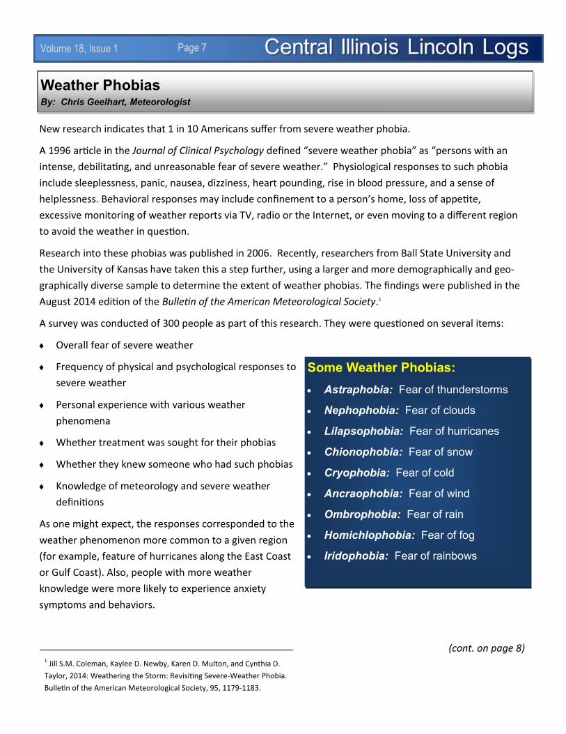
Some Weather Phobias:
Astraphobia: Fear of thunderstorms
Nephophobia: Fear of clouds
Lilapsophobia: Fear of hurricanes
Chionophobia: Fear of snow
Cryophobia: Fear of cold
Ancraophobia: Fear of wind
Ombrophobia: Fear of rain
Homichlophobia: Fear of fog
Iridophobia: Fear of rainbows
1 Jill S.M. Coleman, Kaylee D. Newby, Karen D. Multon, and Cynthia D.
Taylor, 2014: Weathering the Storm: Revisiting Severe-Weather Phobia.
Bulletin of the American Meteorological Society, 95, 1179-1183.

Volume 18, Issue 1 Page 8
Weather Phobias (cont.)
Results of the researchers’ survey are shown below:
One of our weather observers, Shae Cohan, took this photo near Pana of the Northern
Lights on St. Patrick’s Day. A geomagnetic storm the previous day caused the lights to
form.
Central Illinois
Lincoln Logs
National Weather Service 1362 State Route 10 Lincoln, IL 62656
Phone: (217) 732-3089 (8:30 am to 4 pm)
The Central Illinois Lincoln Logs is a quarterly publica-tion of the National Weath-er Service office in Lincoln, Illinois. It is available on our Internet page at
www.weather.gov/lincoln
Facebook Page: www.facebook.com/NWSLincoln
Twitter Handle: @NWSLincolnIL
Newsletter Editor: Chris Geelhart, Meteorologist [email protected]
St. Patrick’s Day Northern Lights