M 59/425
M 59/387
496000 497000 498000 49900067
7000
067
7100
067
7200
067
7300
067
7400
067
7500
0
Acacia ramulosa woodlandAllocasuarina dielsiana openwoodland
Eucalyptus woodlandMixed shrublandTenements
Document Name: 20170202_Fig4-4_ Biol Report
O
\\MAINSERVER-PC\server storage\APM GIS and Mapping\03_Client\TUN\02_GIS Maps\20170202_Fig4-4_ Biol Report.mxd
1:15,000 [email protected] / (08) 6296 5155
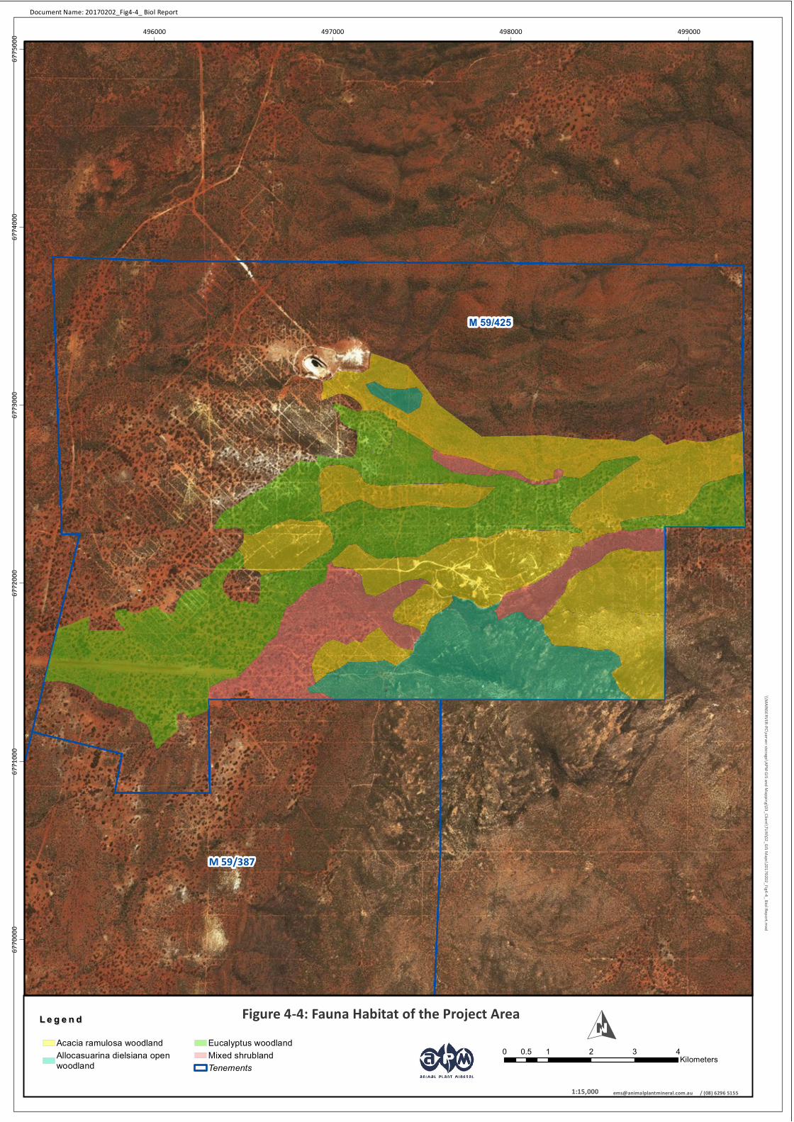
Figure 4-4: Fauna Habitat of the Project AreaL e g e n dL e g e n d
0 1 2 3 40.5Kilometers

LEVEL 2 BIOLOGICAL ASSESSMENT OF MT MULGINE PROJECT, WESTERN AUSTRALIA Page | 46
TUNGSTEN MINING NL
5 DISCUSSION AND CONCLUSION
The Mt Mulgine Project is located within, and adjacent to, an area of the mid-west that has been subjected to
extensive disturbance over the last 100 years from both mining and exploration. The Project area has been
disturbed by diamond drilling for resource definition, historic drilling for exploration and more extensive
clearing for ore extraction. In recent years Minjar Gold has mined extensively at Highland Chief, Bobby McGee,
Camp and Southern Ocean; all of which surround Mt Mulgine to the north and west.
Past disturbance has had a concomitant impact on the flora, vegetation, fauna and fauna habitat values of the
area and the local ecology is highly modified from its natural state. Nevertheless, there are still valuable
habitats remaining and a number of these can be preserved by a well-considered mine design and layout. TGN
provided Animal Plant Mineral with three site layout options prior to the undertaking of the biological survey
and the final locations of infrastructure have since been selected following the current surveys, with
consideration to those ecological values reducing the overall net environmental impact of the Project.
Database searches identified the potential for four PECs and one TEC listed under the WC Act to occur within
30 km of the Project area, however, no evidence of landforms or vegetation assemblages representing
communities of conservation significance were found to be located in the project area during the field survey
work.
The vegetation surveyed and mapped comprised 5 alliances and 10 communities which were described as
follows:
Alliance A - Eucalyptus sp. A1 open woodland on mixed Acacia shrubland, dominated by Austrostipa
scabra and Ptilotus obovatus
Alliance B - Eucalyptus sp. A woodland over mixed Acacia spp. including dominating A. ramulosa and
Eremophila shrublands with Eremophila clarkei, E. decipiens and E. oldfieldi.
Alliance C - Acacia shrublands dominated by A. assimilis and A. ramulosa, interspersed with
combination of myrtaceous shrubs including Melaleuca eleuterostachya and M. stereophloia, and
Allocasuarina dielsiana.
Alliance D - Acacia acuminata, Allocasuarina dielsiana and Melaleuca stereophloia dominated
woodlands over mixed Acacia spp.
Alliance E - Acacia latior & Allocasuarina campestris dominated woodlands over Gastrolobium
laytonii, Melaleuca nematophylla and M. scalena shrubs over Eriachne grasses.
Vegetation in the Project area has been disturbed historically through mining and exploration activities,
however, where regrowth has occurred or remnant vegetation persists their condition is considered Very
Good. No Threatened flora was found, but two Priority taxa listed under the WC Act were recorded within the
quadrats sampled: Drummondita fulva (P1) and Grevillea scabrida (P3). D. fulva was found within the proposed
development footprint but is a commonly recorded priority species in the area detected in a number of
searches undertaken by Minjar in recent years. Further survey work to be undertaken following significant
rainfall in Spring 2017 will comprise grid pattern foot transect surveys for conservation significant flora in areas
that are proposed for clearing and infrastructure construction. Four weed species were recorded in the Project
area and two invasive plant taxa listed as MNES were identified as likely to occur in the vicinity. However the
latter two species and no Declared Pests or Weed of National Significance were found.
The broad fauna assemblages of the Project area are expected to be moderately diverse based on the quality
of the vegetation and the diversity of habitats available. However, the focus of the present survey was on
species of conservation significance.

LEVEL 2 BIOLOGICAL ASSESSMENT OF MT MULGINE PROJECT, WESTERN AUSTRALIA Page | 47
TUNGSTEN MINING NL
Targeted saturation trapping of habitat likely to support the Western Spiny-tailed Skink failed to result in the
capture of this species and no secondary evidence, such as latrines, were observed. Extensive foot transects
across the site failed to reveal any active malleefowl mounds within the Project area and mounds previously
reported as active in 2012 were inactive (no evidence of use in previous breeding seasons and mound has no
structural integrity) when re-visited in 2016. The only evidence of the presence of malleefowl was the
observation of one track near the abandoned air strip where the majority of the infrastructure is to be located.
Intensive searching around the track failed to reveal any evidence of foraging or nesting.
Searches recorded a total of 24 active SBTS burrows in the Project area which calculates out to a density of
6.25 burrows per hectare in marginal habitat. In suitable habitat that has been identified on the current
Project layout as a ‘no disturbance area’, burrow density was 14.3 burrows per hectare.
Fauna assemblages are closely aligned with available habitats. Soil types, as they relate to fauna, were highly
variable due to, not only natural processes, but also historical disturbance where drilling and benching had
resulted in large amount of overland accretion of loose soil as it moves downslope. A total of four fauna
habitats were identified during the survey with variation at the highest level arising from the dichotomy of the
overstory vegetation: tall shrubland vs Eucalyptus woodland. The four fauna habitat types recorded were as
follows:
Eucalyptus open woodland on mixed shrubland over Austrostipa variabilis and/or Austrostipa
elegantissima grassland over sandy loam soil;
Mixed shrubland over Austrostipa scabra grassland over sandy loam soil;
Acacia ramulosa and or Acacia latiora woodland over mixed shrubland over sandy loam soils and/or
Eriachne benthamii grass with exposed aggregate; and
Allocasuarina dielsiana and/or Allocasuarina acutivalvis subsp. prinsepiana open woodland over
mixed shrubland, and in some cases Eriachne pulchella low open grassland over sandy loam soils with
large coarse fragments.
The Mt Mulgine Project in the Murchison region of Western Australia comprises a relatively small Project
impact footprint in an area of the mid-west that has been significantly disturbed over the last 100 years.
Though the proposed new Project will result in the clearing of approximately 146.21 ha, this disturbance will
not compromise regional flora, vegetation, fauna and fauna habitat values. Impacts to local fauna of
conservation significance have been mitigated to a large extent via the designation of ‘no disturbance’ areas in
habitats that are of specific value to the Shield-backed Trapdoor Spider and the Western Spiny-tailed Skink.
Priority flora that have been located in the Project area will be mapped within and outside the proposed
disturbance footprint in the Spring of 2017 and this mapping will make a significant contribution to the local
knowledge of flora of conservation significance in the area. Fundamental environmental management
practices such as fire, weed and feral fauna control that forms an integral part of the commencement of
mining operations should improve habitat values and increase the integrity of the native flora and fauna
populations on site.
LEVEL 2 BIOLOGICAL ASSESSMENT OF MT MULGINE PROJECT, WESTERN AUSTRALIA Page | 48
TUNGSTEN MINING NL
6 REFERENCES
Atlas of Living Australia. (2016). Available: http://www.ala.org.au/. (Accessed December 2016). Bureau of Meteorology. (2016a). Climate Statistics for Australian Locations. Summary Statistics Paynes Find.
Available from: http://www.bom.gov.au/climate/averages/tables/cw_007139.shtml. (Accessed November 2016).
Bureau of Meteorology. (2016b). Daily Weather Observations, Paynes Find. Available from:
http://www.bom.gov.au/climate/dwo/201610/html/IDCJDW6107.201610.shtml. (Accessed November 2016).
Department of the Environment. (2016a). Protected Matters Search Tool. Available:
http://www.environment.gov.au/webgis-framework/apps/pmst/pmst.jsf (Accessed November 2016). Department of the Environment. (2016b). Species Profile and Threats Database. Available:
http://www.environment.gov.au/cgi-bin/sprat/public/sprat.pl. (Accessed November 2016). Department of Parks and Wildlife (2016). NatureMap. Available https://naturemap.dpaw.wa.gov.au/
(Accessed November 2016). Desmond, A., and Chant, A. (2001). A Biodiversity Audit of Western Australia's 53 Biogeographic Subregions in
2002. Yalgoo. Available from: https://www.dpaw.wa.gov.au/about-us/science-and-research/biological-surveys/117-a-biodiversity-audit-of-wa. (Accessed November 2016).
Environmental Protection Authority. (2004a). Guidance for the Assessment of Environmental Factors.
Terrestrial Flora and Vegetation Surveys for Environmental Impact Assessment in Western Australia, No. 51.
Environmental Protection Authority. (2004b). Guidance for the Assessment of Environmental Factors.
Terrestrail Fauna Surveys for Environmental Impact Assessment in Western Australia, No. 56. Perth, Western Australia.
Environmental Protection Authority. (2002). Terrestrial Biological Surveys as an Element of Biodiversity
Protection. Position Statement No. 3. Perth, Western Australia. Freeman, K., Stack, G., Thomas, S., and Woolfrey, N. (2015). Technical Guidelines for Flora and Vegetation
Surveys for Environmental Impact Assessment. Available from: http://www.epa.wa.gov.au/Policies_guidelines/reports/Pages/TechnicalGuide-FloraandVegetationSurveys-EIA.aspx. (Accessed November 2016).
Holbeche, G. (2008). Measuring soil texture in the laboratory. Healthy Soils for Sustainable Farms programme.
2. The University of Western Australia, Perth.
Keighery, B.J. (1994). Bushland Plant Survey. A Guide to Plant Community Survey for the Community. Wildflower Society (Inc.), Western Australia.
Landgate. (2016). WA Atlas. Available from: https://www2.landgate.wa.gov.au/web/guest/wa-atlas (Accessed
November 2016). Leps, J., and Smilauer, P. (2003). Multivariate Analysis of Ecological Data using CANOCO. Cambridge University
Press, New York. Main, B.Y. (1987). Persistence of Invertebrates in Small Areas: Case Studies of Trapdoor Spiders in Western
Australia. In: Nature Conservation: The Role of Remnants of Native Vegetation. Surrey Beatty & Sons: Chiping Norton, Australia.

LEVEL 2 BIOLOGICAL ASSESSMENT OF MT MULGINE PROJECT, WESTERN AUSTRALIA Page | 49
TUNGSTEN MINING NL
McCune and Mefford (2006). PC-ORD. Multivariate Analysis of Ecological Data, Version 6. MjM Software,
Oregon. Minasny, B., McBratney, A.B. (2001). The Australian soil texture boomerang: a comparison of the Australian
and usda/fao soil particle-size classification systems. Australian Journal of Soil Research, (39), 1443–
1451.
Morcombe, M. (2003). Field Guide to Australian Birds. Steve Parish Publishing. Archerfield, Queensland. Payne, A.L., Van Vreeswyk, A.M.E., Pringle, H.J.R., Leighton, K.A., and Hennig, P. (1998). An Inventory and
Condition Survey of the Sandstone-Yalgoo-Paynes Find Area, Western Australia. Technical Bulletin No. 90. Department of Agriculture Western Australia, South Perth.
Pizzey, G., and Knight, F. (2012). The Field Guide to the Birds of Australia. Harper Collins Publishers, Sydney. Soil Water Consultants. (2012). Minjar Gold Project – Surface Water Assessment. Unpublished report prepared
for Minjar Gold Pty Ltd. Ter Braak, C. J. (1986). Canonical correspondence analysis: a new eigenvector technique for multivariate direct
gradient analysis. Ecology, 67(5), 1167-1179.
Thackway, R and Cresswell, I. (1995). An Interim Biogeographic Regionalisation for Australia: A Framework for Setting Priorities in the National Reserves System (as amended). Australian Nature Conservation Agency, Canberra.
Tichý, L., Chytrý, M., Hájek, M., Talbot, S. S., & Botta‐Dukát, Z. (2010). OptimClass: Using species‐to‐cluster
fidelity to determine the optimal partition in classification of ecological communities. Journal of
Vegetation Science, 21(2), 287-299.
Tichý, L. (2002). JUICE, software for vegetation classification. Journal of vegetation science, 13(3), 451-453.
Wildi, O. (2013). Data Analysis in Vegetation Ecology 2nd ed. Wiley-Blackwell, Chichester.
Woodman Environmental Consulting Pty Ltd. (2003). Vegetation Survey of the Highland Chief and Monaco Areas. Minjar Gold Project. Unpublished report prepared for Gindalbie Gold NL.

LEVEL 2 BIOLOGICAL ASSESSMENT OF MT MULGINE PROJECT, WESTERN AUSTRALIA Page | 50
TUNGSTEN MINING NL
7 APPENDICES

LEVEL 2 BIOLOGICAL ASSESSMENT OF MT MULGINE PROJECT, WESTERN AUSTRALIA Page | 51
TUNGSTEN MINING NL
Appendix 1: Conservation Codes for Western Australian Flora and Fauna

CONSERVATION CODES FOR WESTERN AUSTRALIAN FLORA AND FAUNA
(DEC, 2012E)
Threatened fauna and flora (Schedule 1) are further ranked by the Department according to their level of threat using IUCN Red List criteria: CR: Critically Endangered - considered to be facing an extremely high risk of extinction in the wild. EN: Endangered - considered to be facing a very high risk of extinction in the wild. VU: Vulnerable - considered to be facing a high risk of extinction in the wild.
1: Priority One: Poorly-known taxa Taxa that are known from one or a few collections or sight records (generally less than five), all on lands not managed for conservation, e.g. agricultural or pastoral lands, urban areas, Shire, Westrail and Main Roads WA road, gravel and soil reserves, and active mineral leases and under threat of habitat destruction or degradation. Taxa may be included if they are comparatively well known from one or more localities but do not meet adequacy of survey requirements and appear to be under immediate threat from known threatening processes. 2: Priority Two: Poorly-known taxa Taxa that are known from one or a few collections or sight records, some of which are on lands not under imminent threat
of habitat destruction or degradation, e.g. national parks, conservation parks, nature reserves, State forest, vacant Crown
land, water reserves, etc. Taxa may be included if they are comparatively well known from one or more localities but do
not meet adequacy of survey requirements and appear to be under threat from known threatening processes.
3: Priority Three: Poorly-known taxa Taxa that are known from collections or sight records from several localities not under imminent threat, or from few but widespread localities with either large population size or significant remaining areas of apparently suitable habitat, much of it not under imminent threat. Taxa may be included if they are comparatively well known from several localities but do not meet adequacy of survey requirements and known threatening processes exist that could affect them.
Schedule 1 - Threatened (T) Schedule 1 of the Wildlife Conservation (Specially Protected Fauna) Notice and Wildlife Conservation (Rare Flora) Notice under the Wildlife Conservation Act 1950.
Threatened Fauna (Fauna that is rare or is likely to become extinct)
Threatened Flora (Declared Rare Flora - Extant ) Taxa that have been adequately searched for and are deemed to be in the wild either rare, in danger of extinction, or otherwise in need of special protection, and have been gazetted as such.
Schedule 2 – Extinct (X) Schedule 2 of the Wildlife Conservation (Specially Protected Fauna) Notice and Wildlife Conservation (Rare Flora) Notice under the Wildlife Conservation Act 1950.
Presumed Extinct Fauna
Presumed Extinct Flora (Declared Rare Flora – Extinct) Taxa which have been adequately searched for and there is no reasonable doubt that the last individual has died, and have been gazetted as such.
Schedule 3 – International Agreement (IA) Schedule 3 of the Wildlife Conservation (Specially Protected Fauna) Notice under the Wildlife Conservation Act 1950.
Birds protected under an international agreement Birds that are subject to an agreement between governments of Australia and Japan relating to the protection of migratory birds and birds in danger of extinction.
Schedule 4 – Other specially protected Fauna (S) Schedule 4 of the Wildlife Conservation (Specially Protected Fauna) Notice under the Wildlife Conservation Act 1950.
Other specially protected fauna Fauna that is in need of special protection, otherwise than for the reasons mentioned in the above schedules.

4: Priority Four: Rare, Near Threatened and other taxa in need of monitoring (a) Rare. Taxa that are considered to have been adequately surveyed, or for which sufficient knowledge is available, and that are considered not currently threatened or in need of special protection, but could be if present circumstances change. These taxa are usually represented on conservation lands. (b) Near Threatened. Taxa that are considered to have been adequately surveyed and that do not qualify for Conservation Dependent, but that are close to qualifying for Vulnerable. (c) Taxa that have been removed from the list of threatened species during the past five years for reasons other than taxonomy. 5: Priority Five: Conservation Dependent taxa Taxa that are not threatened but are subject to a specific conservation program, the cessation of which would result in the taxa becoming threatened within five years.

LEVEL 2 BIOLOGICAL ASSESSMENT OF MT MULGINE PROJECT, WESTERN AUSTRALIA Page | 52
TUNGSTEN MINING NL
Appendix 2: EPBC Act Protected Matters Search

EPBC Act Protected Matters Report
This report provides general guidance on matters of national environmental significance and other mattersprotected by the EPBC Act in the area you have selected.
Information on the coverage of this report and qualifications on data supporting this report are contained in thecaveat at the end of the report.
Information is available about Environment Assessments and the EPBC Act including significance guidelines,forms and application process details.
Other Matters Protected by the EPBC Act
Acknowledgements
Buffer: 10.0Km
Matters of NES
Report created: 22/11/16 15:07:00
Coordinates
This map may contain data which are©Commonwealth of Australia(Geoscience Australia), ©PSMA 2010
CaveatExtra Information
DetailsSummary

Summary
This part of the report summarises the matters of national environmental significance that may occur in, or mayrelate to, the area you nominated. Further information is available in the detail part of the report, which can beaccessed by scrolling or following the links below. If you are proposing to undertake an activity that may have asignificant impact on one or more matters of national environmental significance then you should consider theAdministrative Guidelines on Significance.
Matters of National Environmental Significance
Listed Threatened Ecological Communities:
Listed Migratory Species:
None
Great Barrier Reef Marine Park:
Wetlands of International Importance:
Listed Threatened Species:
None
7
None
None
National Heritage Places:
Commonwealth Marine Area:
World Heritage Properties:
None
None
3
The EPBC Act protects the environment on Commonwealth land, the environment from the actions taken onCommonwealth land, and the environment from actions taken by Commonwealth agencies. As heritage values of aplace are part of the 'environment', these aspects of the EPBC Act protect the Commonwealth Heritage values of aCommonwealth Heritage place. Information on the new heritage laws can be found athttp://www.environment.gov.au/heritage
This part of the report summarises other matters protected under the Act that may relate to the area you nominated.Approval may be required for a proposed activity that significantly affects the environment on Commonwealth land,when the action is outside the Commonwealth land, or the environment anywhere when the action is taken onCommonwealth land. Approval may also be required for the Commonwealth or Commonwealth agencies proposing totake an action that is likely to have a significant impact on the environment anywhere.
A permit may be required for activities in or on a Commonwealth area that may affect a member of a listed threatenedspecies or ecological community, a member of a listed migratory species, whales and other cetaceans, or a member ofa listed marine species.
Other Matters Protected by the EPBC Act
None
None
None
Listed Marine Species:
Whales and Other Cetaceans:
7
Commonwealth Heritage Places:
None
None
Critical Habitats:
Commonwealth Land:
Commonwealth Reserves Terrestrial:
NoneCommonwealth Reserves Marine:
Extra Information
This part of the report provides information that may also be relevant to the area you have nominated.
None
2State and Territory Reserves:
Nationally Important Wetlands:
NoneRegional Forest Agreements:
Invasive Species: 7
NoneKey Ecological Features (Marine)

Details
Listed Threatened Species [ Resource Information ]Name Status Type of PresenceBirds
Curlew Sandpiper [856] Critically Endangered Species or species habitatmay occur within area
Calidris ferruginea
Malleefowl [934] Vulnerable Species or species habitatlikely to occur within area
Leipoa ocellata
Australian Painted Snipe [77037] Endangered Species or species habitatmay occur within area
Rostratula australis
Other
Shield-backed Trapdoor Spider, Black RugoseTrapdoor Spider [66798]
Vulnerable Species or species habitatknown to occur within area
Idiosoma nigrum
Plants
Varnish Bush [2394] Endangered Species or species habitatmay occur within area
Eremophila viscida
Ninghan Violet [2803] Critically Endangered Species or species habitatlikely to occur within area
Hybanthus cymulosus
Reptiles
Western Spiny-tailed Skink, Baudin Island Spiny-tailedSkink [64483]
Endangered Species or species habitatlikely to occur within area
Egernia stokesii badia
Listed Migratory Species [ Resource Information ]* Species is listed under a different scientific name on the EPBC Act - Threatened Species list.Name Threatened Type of PresenceMigratory Marine Birds
Fork-tailed Swift [678] Species or species habitatlikely to occur within area
Apus pacificus
Migratory Terrestrial Species
Grey Wagtail [642] Species or species habitatmay occur within area
Motacilla cinerea
Migratory Wetlands Species
Curlew Sandpiper [856] Critically Endangered Species or species habitatmay occur within
Calidris ferruginea
Matters of National Environmental Significance

Name Threatened Type of Presencearea
Listed Marine Species [ Resource Information ]* Species is listed under a different scientific name on the EPBC Act - Threatened Species list.Name Threatened Type of PresenceBirds
Fork-tailed Swift [678] Species or species habitatlikely to occur within area
Apus pacificus
Great Egret, White Egret [59541] Species or species habitatlikely to occur within area
Ardea alba
Cattle Egret [59542] Species or species habitatmay occur within area
Ardea ibis
Curlew Sandpiper [856] Critically Endangered Species or species habitatmay occur within area
Calidris ferruginea
Rainbow Bee-eater [670] Species or species habitatmay occur within area
Merops ornatus
Grey Wagtail [642] Species or species habitatmay occur within area
Motacilla cinerea
Painted Snipe [889] Endangered* Species or species habitatmay occur within area
Rostratula benghalensis (sensu lato)
Other Matters Protected by the EPBC Act

State and Territory Reserves [ Resource Information ]Name StateKarara WAWarriedar Station Nature Reserve WA
Extra Information
Invasive Species [ Resource Information ]Weeds reported here are the 20 species of national significance (WoNS), along with other introduced plantsthat are considered by the States and Territories to pose a particularly significant threat to biodiversity. Thefollowing feral animals are reported: Goat, Red Fox, Cat, Rabbit, Pig, Water Buffalo and Cane Toad. Maps fromLandscape Health Project, National Land and Water Resouces Audit, 2001.
Name Status Type of PresenceMammals
Goat [2] Species or species habitatlikely to occur within area
Capra hircus
Cat, House Cat, Domestic Cat [19] Species or species habitatlikely to occur within area
Felis catus
House Mouse [120] Species or species habitatlikely to occur within area
Mus musculus
Rabbit, European Rabbit [128] Species or species habitatlikely to occur within area
Oryctolagus cuniculus
Red Fox, Fox [18] Species or species habitatlikely to occur within area
Vulpes vulpes
Plants
Buffel-grass, Black Buffel-grass [20213] Species or species habitatmay occur within area
Cenchrus ciliaris
Water Hyacinth, Water Orchid, Nile Lily [13466] Species or species habitatlikely to occur within area
Eichhornia crassipes
- non-threatened seabirds which have only been mapped for recorded breeding sites
- migratory species that are very widespread, vagrant, or only occur in small numbers
- some species and ecological communities that have only recently been listed
Not all species listed under the EPBC Act have been mapped (see below) and therefore a report is a general guide only. Where available datasupports mapping, the type of presence that can be determined from the data is indicated in general terms. People using this information in makinga referral may need to consider the qualifications below and may need to seek and consider other information sources.
For threatened ecological communities where the distribution is well known, maps are derived from recovery plans, State vegetation maps, remotesensing imagery and other sources. Where threatened ecological community distributions are less well known, existing vegetation maps and pointlocation data are used to produce indicative distribution maps.
- seals which have only been mapped for breeding sites near the Australian continent
Such breeding sites may be important for the protection of the Commonwealth Marine environment.
Threatened, migratory and marine species distributions have been derived through a variety of methods. Where distributions are well known and iftime permits, maps are derived using either thematic spatial data (i.e. vegetation, soils, geology, elevation, aspect, terrain, etc) together with pointlocations and described habitat; or environmental modelling (MAXENT or BIOCLIM habitat modelling) using point locations and environmental datalayers.
The information presented in this report has been provided by a range of data sources as acknowledged at the end of the report.Caveat
- migratory and
The following species and ecological communities have not been mapped and do not appear in reports produced from this database:
- marine
This report is designed to assist in identifying the locations of places which may be relevant in determining obligations under the EnvironmentProtection and Biodiversity Conservation Act 1999. It holds mapped locations of World and National Heritage properties, Wetlands of Internationaland National Importance, Commonwealth and State/Territory reserves, listed threatened, migratory and marine species and listed threatenedecological communities. Mapping of Commonwealth land is not complete at this stage. Maps have been collated from a range of sources at variousresolutions.
- threatened species listed as extinct or considered as vagrants
- some terrestrial species that overfly the Commonwealth marine area
The following groups have been mapped, but may not cover the complete distribution of the species:
Only selected species covered by the following provisions of the EPBC Act have been mapped:
Where very little information is available for species or large number of maps are required in a short time-frame, maps are derived either from 0.04or 0.02 decimal degree cells; by an automated process using polygon capture techniques (static two kilometre grid cells, alpha-hull and convex hull);or captured manually or by using topographic features (national park boundaries, islands, etc). In the early stages of the distribution mappingprocess (1999-early 2000s) distributions were defined by degree blocks, 100K or 250K map sheets to rapidly create distribution maps. More reliabledistribution mapping methods are used to update these distributions as time permits.
-29.17574 116.96848
Coordinates

-Environment and Planning Directorate, ACT-Birdlife Australia-Australian Bird and Bat Banding Scheme
-Department of Parks and Wildlife, Western Australia
Acknowledgements
-Office of Environment and Heritage, New South Wales
-Department of Primary Industries, Parks, Water and Environment, Tasmania
-Department of Land and Resource Management, Northern Territory-Department of Environmental and Heritage Protection, Queensland
-Department of Environment and Primary Industries, Victoria
-Australian National Wildlife Collection
-Department of Environment, Water and Natural Resources, South Australia
This database has been compiled from a range of data sources. The department acknowledges the followingcustodians who have contributed valuable data and advice:
-Australian Museum
-National Herbarium of NSW
Forestry Corporation, NSW-Australian Government, Department of Defence
-State Herbarium of South Australia
The Department is extremely grateful to the many organisations and individuals who provided expert adviceand information on numerous draft distributions.
-Natural history museums of Australia
-Queensland Museum
-Australian National Herbarium, Canberra
-Royal Botanic Gardens and National Herbarium of Victoria
-Geoscience Australia
-Ocean Biogeographic Information System
-Online Zoological Collections of Australian Museums-Queensland Herbarium
-Western Australian Herbarium
-Tasmanian Herbarium
-Northern Territory Herbarium
-South Australian Museum
-Museum Victoria
-University of New England
-CSIRO
-Other groups and individuals-Tasmanian Museum and Art Gallery, Hobart, Tasmania
-Museum and Art Gallery of the Northern Territory
-Reef Life Survey Australia-Australian Institute of Marine Science-Australian Government National Environmental Science Program
-Australian Tropical Herbarium, Cairns
-Australian Government – Australian Antarctic Data Centre
-Queen Victoria Museum and Art Gallery, Inveresk, Tasmania
-eBird Australia
-American Museum of Natural History
© Commonwealth of Australia
+61 2 6274 1111
Canberra ACT 2601 Australia
GPO Box 787
Department of the Environment
Please feel free to provide feedback via the Contact Us page.

LEVEL 2 BIOLOGICAL ASSESSMENT OF MT MULGINE PROJECT, WESTERN AUSTRALIA Page | 53
TUNGSTEN MINING NL
Appendix 3: Naturemap Search

NATUREMAP SEARCH
Species Name Naturalised Conservation
Code Endemic To Query Area
Birds
Acanthagenys rufogularis (Spiny-cheeked Honeyeater)
Acanthiza apicalis (Broad-tailed Thornbill
Acanthiza chrysorrhoa (Yellow-rumped Thornbill)
Acanthiza uropygialis (Chestnut-rumped Thornbill)
Anthochaera carunculata (Red Wattlebird)
Aphelocephala leucopsis (Southern Whiteface)
Aquila audax (Wedge-tailed Eagle)
Artamus cinereus (Black-faced Woodswallow)
Artamus personatus (Masked Woodswallow)
Barnardius zonarius
Cacomantis pallidus (Pallid Cuckoo)
Calyptorhynchus banksii (Red-tailed Black-Cockatoo)
Certhionyx variegatus (Pied Honeyeater)
Cinclosoma castanotus (Chestnut Quail-thrush)
Colluricincla harmonica (Grey Shrike-thrush)
Coracina novaehollandiae (Black-faced Cuckoo-shrike)
Corvus bennetti (Little Crow)
Corvus coronoides (Australian Raven)
Corvus orru (Torresian Crow)
Cracticus nigrogularis (Pied Butcherbird)
Cracticus tibicen (Australian Magpie)
Cracticus torquatus (Grey Butcherbird)
Dromaius novaehollandiae (Emu)
Eolophus roseicapillus
Eurostopodus argus (Spotted Nightjar)
Falco berigora (Brown Falcon)
Falco cenchroides (Australian Kestrel)
Falco peregrinus (Peregrine Falcon) S
Gallus gallus
Gerygone fusca (Western Gerygone)
Glossopsitta porphyrocephala (Purple-crowned Lorikeet)
Hirundo neoxena (Welcome Swallow)
Hirundo nigricans (Tree Martin)
Lalage tricolor (White-winged Triller)
Leipoa ocellata (Malleefowl) T
Lichmera indistincta (Brown Honeyeater)
Malurus splendens (Splendid Fairy-wren)
Manorina flavigula (Yellow-throated Miner)

Species Name Naturalised Conservation
Code Endemic To Query Area
Merops ornatus (Rainbow Bee-eater) IA
Oreoica gutturalis (Crested Bellbird)
Pachycephala pectoralis (Golden Whistler)
Pachycephala rufiventris (Rufous Whistler)
Petroica goodenovii (Red-capped Robin)
Phaps chalcoptera (Common Bronzewing)
Platycercus varius (Mulga Parrot)
Platycercus zonarius (Australian Ringneck
Pomatostomus superciliosus (White-browed Babbler)
Purnella albifrons (White-fronted Honeyeater)
Pyrrholaemus brunneus (Redthroat)
Rhipidura leucophrys (Willie Wagtail)
Smicrornis brevirostris (Weebill)
Strepera versicolor (Grey Currawong)
Taeniopygia guttata (Zebra Finch)
Invertebrates
Aname tepperi
Anidiops villosus
Cercophonius michaelseni
Idiosoma nigrum (Shield-backed Trapdoor Spider) T
Indolpium sp.
Pilbarascutigera incola
Wugigarra kalamai
Mammals
Capra hircus (Goat) Y
Macropus robustus (Euro)
Macropus rufus (Red Kangaroo
Oryctolagus cuniculus (Rabbit) Y
Pseudantechinus woolleyae (Woolley's Pseudantechinus)
Tachyglossus aculeatus (Short-beaked Echidna)
Vulpes vulpes (Red Fox) Y
Reptiles
Brachyurophis semifasciatus (Southern Shovel-nosed Snake)
Ctenophorus reticulatus (Western Netted Dragon)
Ctenophorus scutulatus (Lozenge-marked Dragon)
Ctenotus uber (Spotted Ctenotus)
Ctenotus uber subsp. uber (Spotted Ctenotus)
Egernia depressa (Southern Pygmy Spiny-tailed Skink)
Heteronotia binoei (Bynoe's Gecko)
Lerista gerrardii
Lerista kingi

Species Name Naturalised Conservation
Code Endemic To Query Area
Menetia greyii
Morethia butleri
Pseudechis butleri (Spotted Mulga Snake)
Simoselaps bertholdi (Jan's Banded Snake)
LEVEL 2 BIOLOGICAL ASSESSMENT OF MT MULGINE PROJECT, WESTERN AUSTRALIA Page | 54
TUNGSTEN MINING NL
Appendix 4: Atlas of Living Australia Database Search

ATLAS OF LIVING AUSTRALIA DATABASE SEARCH
Species Name Common Name
Birds
Acanthagenys rufogularis Spiny-cheeked Honeyeater
Acanthiza apicalis
Acanthiza chrysorrhoa Yellow-rumped Thornbill
Acanthiza uropygialis Chestnut-rumped Thornbill
Anthochaera carunculata Red Wattlebird
Aphelocephala leucopsis Southern Whiteface
Aquila audax Eaglehawk
Barnardius zonarius Australian Ringneck
Cacomantis pallidus Pallid Cuckoo
Calyptorhynchus banksii Red-tailed Black Cockatoo
Certhionyx variegatus Pied Honeyeater
Chalcites osculans Black-eared Cuckoo
Cinclosoma marginatum
Colluricincla harmonica Grey Shrike-thrush
Coracina novaehollandiae Black-faced Cuckoo-shrike
Corvus bennetti Little Crow
Corvus coronoides
Cracticus nigrogularis Pied Butcherbird
Cracticus tibicen Australian Magpie
Cracticus torquatus Grey Butcherbird
Dicaeum hirundinaceum Mistletoebird
Dromaius novaehollandiae Emu
Eolophus roseicapillus Galah
Eopsaltria griseogularis
Gavicalis virescens Singing Honeyeater
Gerygone fusca Western Gerygone
Glossopsitta porphyrocephala Purple-crowned Lorikeet
Hirundo neoxena Welcome Swallow
Hirundo neoxena Welcome Swallow
Lichenostomus virescens Singing Honeyeater
Lichmera indistincta Brown Honeyeater
Malurus lamberti
Malurus splendens Splendid Fairy-wren
Manorina flavigula Yellow-throated Miner
Melanodryas cucullata Hooded Robin
Oreoica gutturalis Crested Bellbird
Pachycephala pectoralis Golden Whistler
Pachycephala rufiventris Rufous Whistler
Pardalotus striatus Striated Pardalote
Petroica goodenovii Red-capped Robin
Phaps chalcoptera Common Bronzewing

Species Name Common Name
Phaps chalcoptera Common Bronzewing
Pomatostomus superciliosus White-browed Babbler
Psephotus varius Mulga Parrot
Purnella albifrons White-fronted Honeyeater
Pyrrholaemus brunneus Redthroat
Rhipidura albiscapa
Rhipidura leucophrys Willie Wagtail
Smicrornis brevirostris Weebill
Sugomel nigrum
Taeniopygia guttata Zebra Finch
Invertebrates
Aganippe
Aganippe castellum Tree-stem Trapdoor Spider
Aname
Aname tepperi
Antichiropus
Austrochthonius
Austrohorus
Beierolpium
Chernetidae
Chthoniidae
Cormocephalus
Gaius villosus
Gastrocopta bannertonensis Bannerton Pupasnail
Gastrocopta bannertonensis cf. Pupasnails
Gastrocopta sp. Pupasnails
Idiosoma
Indolpium
Lychas splendens
Mecistocephalidae
Miturgidae Racing Stripe Spiders
Nostera
Notsodipus
Olpiidae
Pilbarascutigera incola
Pupoides Pupasnails
Salticidae Jumping Spiders
Segestriidae
Sinumelon sp.
Steatoda
Synsphyronus
Tyrannochthonius
Urodacidae
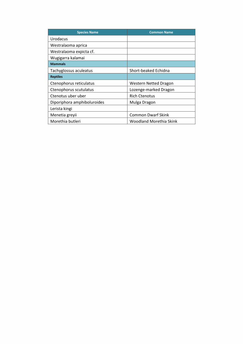
Species Name Common Name
Urodacus
Westralaoma aprica
Westralaoma expicta cf.
Wugigarra kalamai
Mammals
Tachyglossus aculeatus Short-beaked Echidna
Reptiles
Ctenophorus reticulatus Western Netted Dragon
Ctenophorus scutulatus Lozenge-marked Dragon
Ctenotus uber uber Rich Ctenotus
Diporiphora amphiboluroides Mulga Dragon
Lerista kingi
Menetia greyii Common Dwarf Skink
Morethia butleri Woodland Morethia Skink

LEVEL 2 BIOLOGICAL ASSESSMENT OF MT MULGINE PROJECT, WESTERN AUSTRALIA Page | 55
TUNGSTEN MINING NL
Appendix 5: Department of Parks and Wildlife Threatened and Priority Flora Database Search

DEPARTMENT OF PARKS AND WILDLIFE THREATENED (DECLARED RARE) AND PRIORITY FLORA
DATABASE SEARCH
Table 1: Threatened (Declared Rare) and Priority Flora Database
Taxon Conservation
Status Gda94 Lat Gda94 Long Count Date
Acacia karina 1 -29.1942 116.9667 24/04/2007
Acacia karina 1 -29.1942 116.9723 17/07/2008
Acacia karina 1 -29.1943 116.9658 18/08/2013
Acacia karina 1 -29.1644 116.9631 19/09/2012
Acacia karina 1 -29.1929 117.018 18/08/2013
Acacia karina 1 -29.141 116.8879 20/06/2014
Acacia karina 1 -29.138 116.9012 29/06/2015
Acacia sulcaticaulis 1 -29.1778 116.9659 24/04/2007
Acacia sulcaticaulis 1 -29.1702 116.9657 11/12/2007
Acacia sulcaticaulis 1 -29.1799 116.9721 2/10/2007
Acacia woodmaniorum T -29.1369 116.9066 24/06/2004
Acacia woodmaniorum T -29.1408 116.8831 16/07/2004
Allocasuarina tessellata 1 -29.1138 116.9979 16/12/2010
Austrostipa blackii 3 -29.1534 116.9105 16/09/2005
Bossiaea sp. Jackson Range (G. Cockerton & S. McNee LCS 13614) 3 -29.1111 116.9996 13/07/2009
Calandrinia kalanniensis 2 -29.1876 116.944 14/11/2005
Chamelaucium sp. Warriedar (A.P. Brown & S. Patrick APB 1100) 1 -29.1304 116.9987 17/07/1994
Chamelaucium sp. Warriedar (A.P. Brown & S. Patrick APB 1100) 1 -29.1484 116.9687 17/03/2004
Chamelaucium sp. Warriedar (A.P. Brown & S. Patrick APB 1100) 1 -29.1352 116.9849 1/10/2004
Chamelaucium sp. Warriedar (A.P. Brown & S. Patrick APB 1100) 1 -29.204 116.8714 24/09/2007
Chamelaucium sp. Warriedar (A.P. Brown & S. Patrick APB 1100) 1 -29.1709 116.9709 29/07/2008
Chamelaucium sp. Yalgoo (Y. Chadwick 1816) 1 -29.164 116.9619 2/09/2003
Chamelaucium sp. Yalgoo (Y. Chadwick 1816) 1 -29.1039 117.0022 15/01/2004
Chamelaucium sp. Yalgoo (Y. Chadwick 1816) 1 -29.1498 116.9672 21/01/2004
Chamelaucium sp. Yalgoo (Y. Chadwick 1816) 1 -29.1644 116.9631 24/10/2012
Grevillea scabrida 1 -29.2018 116.9456 17/07/1994
Grevillea scabrida 1 -29.2055 116.9432 15/08/2013
Grevillea scabrida 1 -29.1312 116.9985 14/08/2013
Grevillea scabrida 1 -29.1312 116.9985 14/08/2013

Taxon Conservation
Status Gda94 Lat Gda94 Long Count Date
Grevillea scabrida 1 -29.1644 116.9631 24/09/2012
Grevillea scabrida 1 -29.1609 116.962 13/08/2013
Grevillea scabrida 1 -29.1552 116.9763 18/08/2013
Grevillea scabrida 1 -29.1609 116.9795 18/08/2013
Grevillea scabrida 1 -29.2121 116.9408 15/08/2013
Grevillea scabrida 1 -29.2055 116.9432 15/08/2013
Grevillea scabrida 1 -29.195 116.9466 15/08/2013
Grevillea subtiliflora 3 -29.1641 116.9724 2/09/2003
Grevillea subtiliflora 3 -29.1699 116.9605 27/09/2004
Grevillea subtiliflora 3 -29.1419 116.969 28/09/2004
Grevillea subtiliflora 3 -29.1942 116.9667 24/04/2007
Gunniopsis divisa 3 -29.1379 116.8777 27/10/2005
Hydrocotyle sp. Warriedar (P.G. Wilson 12267) 1 -29.1699 116.9605 27/09/2004
Hydrocotyle sp. Warriedar (P.G. Wilson 12267) 1 -29.1609 116.9595 29/09/2004
Micromyrtus acuta 3 -29.1298 116.9057 17/09/2005
Micromyrtus acuta 3 -29.1809 116.9619 24/04/2007
Micromyrtus acuta 3 -29.2307 116.9867 29/07/2008
Rhodanthe collina 3 -29.1615 116.9586 2/09/2003
Rhodanthe collina 3 -29.1697 116.9578 27/09/2004
Rhodanthe collina 3 -29.1771 116.9722 28/09/2004
Rhodanthe collina 3 -29.1521 117.0203 1/10/2004
Rhodanthe collina 3 -29.1407 116.8834 27/10/2005
Rhodanthe collina 3 -29.1298 116.9057 17/09/2005
Stenanthemum poicilum 3 -29.1986 116.8761 16/11/2005
Stenanthemum poicilum 3 -29.1333 117.0167 22/11/1992
Stenanthemum poicilum 3 -29.1389 116.8992 21/10/2003
Stenanthemum poicilum 3 -29.1927 117.0072 25/04/2007
Stenanthemum poicilum 3 -29.1262 117.0096 31/08/2008
Stylidium scintillans T -29.1296 116.8849 7/09/2009
Stylidium scintillans T -29.13 116.9026 9/09/2009
Stylidium scintillans T -29.1284 116.9142 9/09/2009
Stylidium scintillans T -29.1198 116.9399 9/09/2009
Stylidium scintillans T -29.1084 116.97 9/09/2009
Stylidium scintillans T -29.1118 116.9905 10/09/2009
Stylidium scintillans T -29.1499 116.9388 11/09/2009
Stylidium scintillans T -29.1536 116.9413 9/09/2009
Stylidium scintillans T -29.1776 116.94 9/09/2009

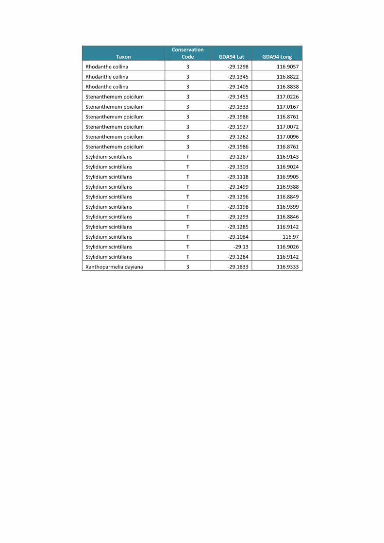
Table 2: Western Australian Herbarium Specimen Database
Taxon Conservation
Code GDA94 Lat GDA94 Long
Acacia diallaga 1 -29.1566 117.0199
Acacia diallaga 1 -29.1746 117.0193
Acacia diallaga 1 -29.1445 117.0203
Acacia diallaga 1 -29.1043 117.0046
Acacia diallaga 1 -29.204 116.8717
Acacia diallaga 1 -29.1497 116.9689
Acacia diallaga 1 -29.204 116.8715
Acacia diallaga 1 -29.1551 116.9765
Acacia diallaga 1 -29.1057 116.9946
Acacia diallaga 1 -29.1438 116.9685
Acacia diallaga 1 -29.204 116.8715
Acacia diallaga 1 -29.204 116.8716
Acacia diallaga 1 -29.1793 117.0072
Acacia karina 1 -29.1578 117.0217
Acacia karina 1 -29.1578 117.0217
Acacia karina 1 -29.1566 117.0199
Acacia karina 1 -29.1438 117.0178
Acacia karina 1 -29.1746 117.0193
Acacia karina 1 -29.1441 116.9709
Acacia karina 1 -29.1942 116.9723
Acacia karina 1 -29.1986 116.8761
Acacia karina 1 -29.1375 116.8983
Acacia karina 1 -29.1396 116.9073
Acacia karina 1 -29.1927 116.973
Acacia karina 1 -29.1897 116.9015
Acacia karina 1 -29.1942 116.9667
Acacia karina 1 -29.2036 116.9442
Acacia sulcaticaulis 1 -29.18 116.9661
Acacia sulcaticaulis 1 -29.1702 116.9657
Acacia sulcaticaulis 1 -29.1701 116.966
Acacia sulcaticaulis 1 -29.1702 116.9657
Acacia sulcaticaulis 1 -29.1778 116.9659
Acacia sulcaticaulis 1 -29.1816 116.9757
Acacia sulcaticaulis 1 -29.1786 116.9736
Acacia sulcaticaulis 1 -29.1702 116.9657
Acacia sulcaticaulis 1 -29.184 116.9738
Acacia sulcaticaulis 1 -29.1829 116.9953
Acacia woodmaniorum T -29.1363 116.8958
Acacia woodmaniorum T -29.1365 116.9044
Acacia woodmaniorum T -29.1331 116.9091
Acacia woodmaniorum T -29.1369 116.9066

Taxon Conservation
Code GDA94 Lat GDA94 Long
Acacia woodmaniorum T -29.1405 116.8838
Acacia woodmaniorum T -29.1402 116.9093
Acacia woodmaniorum T -29.1392 116.9089
Acacia woodmaniorum T -29.1356 116.9015
Acacia woodmaniorum T -29.1392 116.9089
Acacia woodmaniorum T -29.1408 116.8831
Acacia woodmaniorum T -29.1363 116.9057
Allocasuarina tessellata 1 -29.1664 116.9699
Allocasuarina tessellata 1 -29.1578 117.0217
Allocasuarina tessellata 1 -29.1441 116.9709
Allocasuarina tessellata 1 -29.1438 117.0178
Allocasuarina tessellata 1 -29.1566 117.0199
Allocasuarina tessellata 1 -29.1445 117.0203
Allocasuarina tessellata 1 -29.1138 116.9979
Austrostipa blackii 3 -29.1877 116.9271
Austrostipa blackii 3 -29.1445 117.0203
Austrostipa blackii 3 -29.1664 116.9699
Austrostipa blackii 3 -29.1566 117.0199
Austrostipa blackii 3 -29.1746 117.0193
Austrostipa blackii 3 -29.1651 117.0027
Austrostipa blackii 3 -29.1534 116.9105
Bossiaea sp. Jackson Range (G. Cockerton & S. McNee LCS 13614) 3 -29.1111 116.9996
Calandrinia kalanniensis 2 -29.1876 116.944
Calandrinia sp. Warriedar (F. Obbens 04/09) 2 -29.1193 116.9401
Calotis sp. Perrinvale Station (R.J. Cranfield 7096) 3 -29.1769 116.9403
Calotis sp. Perrinvale Station (R.J. Cranfield 7096) 3 -29.1516 116.9086
Calotis sp. Perrinvale Station (R.J. Cranfield 7096) 3 -29.1516 116.9123
Calotis sp. Perrinvale Station (R.J. Cranfield 7096) 3 -29.1397 116.8789
Calotis sp. Perrinvale Station (R.J. Cranfield 7096) 3 -29.135 116.8999
Chamelaucium sp. Warriedar (A.P. Brown & S. Patrick APB 1100) 1 -29.161 116.962
Chamelaucium sp. Warriedar (A.P. Brown & S. Patrick APB 1100) 1 -29.1316 116.9987
Chamelaucium sp. Warriedar (A.P. Brown & S. Patrick APB 1100) 1 -29.1056 116.9943
Chamelaucium sp. Warriedar (A.P. Brown & S. Patrick APB 1100) 1 -29.1566 117.0199
Chamelaucium sp. Warriedar (A.P. Brown & S. Patrick APB 1 -29.1441 116.9709

Taxon Conservation
Code GDA94 Lat GDA94 Long
1100)
Chamelaucium sp. Warriedar (A.P. Brown & S. Patrick APB 1100) 1 -29.1317 116.9972
Chamelaucium sp. Warriedar (A.P. Brown & S. Patrick APB 1100) 1 -29.1304 116.9987
Chamelaucium sp. Warriedar (A.P. Brown & S. Patrick APB 1100) 1 -29.1352 116.9849
Chamelaucium sp. Warriedar (A.P. Brown & S. Patrick APB 1100) 1 -29.1833 116.9333
Chamelaucium sp. Warriedar (A.P. Brown & S. Patrick APB 1100) 1 -29.204 116.8714
Chamelaucium sp. Warriedar (A.P. Brown & S. Patrick APB 1100) 1 -29.1709 116.9709
Chamelaucium sp. Yalgoo (Y. Chadwick 1816) 1 -29.164 116.9619
Cyanicula fragrans 3 -29.1445 117.0203
Cyanicula fragrans 3 -29.1056 116.9943
Dicrastylis linearifolia 3 -29.2334 116.98
Dodonaea amplisemina 4 -29.1438 117.0178
Drummondita fulva 3 -29.1516 116.9123
Drummondita fulva 3 -29.1516 116.9086
Drummondita fulva 3 -29.1408 116.8831
Drummondita fulva 3 -29.1405 116.8838
Drummondita fulva 3 -29.1405 116.8838
Drummondita fulva 3 -29.1405 116.8838
Drummondita fulva 3 -29.1534 116.9105
Drummondita fulva 3 -29.1378 116.8786
Eremophila oldfieldii subsp. Karara (D. Coultas s.n. PERTH 07341717) 1 -29.2069 116.8844
Eremophila sp. Rothsay (D. Coultas & J. Kelt s.n. PERTH 08200440) 1 -29.2129 116.8759
Eremophila sp. Rothsay (D. Coultas & J. Kelt s.n. PERTH 08200440) 1 -29.2129 116.8759
Eremophila sp. Rothsay (D. Coultas & J. Kelt s.n. PERTH 08200440) 1 -29.2128 116.8758
Grevillea globosa 3 -29.158 116.903
Grevillea scabrida 1 -29.2056 116.8766
Grevillea scabrida 1 -29.1068 116.9943
Grevillea scabrida 1 -29.1056 116.9943
Grevillea scabrida 1 -29.1438 117.0178
Grevillea scabrida 1 -29.1626 117.0196
Grevillea scabrida 1 -29.1651 116.9717

Taxon Conservation
Code GDA94 Lat GDA94 Long
Grevillea scabrida 1 -29.1566 117.0199
Grevillea scabrida 1 -29.1879 116.9219
Grevillea scabrida 1 -29.1664 116.9699
Grevillea scabrida 1 -29.1899 116.9525
Grevillea scabrida 1 -29.1874 116.8758
Grevillea scabrida 1 -29.1532 116.9667
Grevillea scabrida 1 -29.1317 116.9972
Grevillea scabrida 1 -29.2018 116.9456
Grevillea subtiliflora 3 -29.1458 116.9679
Grevillea subtiliflora 3 -29.1441 116.9709
Grevillea subtiliflora 3 -29.1651 116.9717
Grevillea subtiliflora 3 -29.1651 116.9717
Grevillea subtiliflora 3 -29.1664 116.9699
Grevillea subtiliflora 3 -29.1651 116.9717
Grevillea subtiliflora 3 -29.1438 117.0178
Grevillea subtiliflora 3 -29.1068 116.9943
Grevillea subtiliflora 3 -29.17 116.9605
Grevillea subtiliflora 3 -29.17 116.9606
Grevillea subtiliflora 3 -29.1419 116.969
Grevillea subtiliflora 3 -29.1942 116.9667
Gunniopsis divisa 3 -29.1379 116.8777
Gunniopsis divisa 3 -29.1646 116.8897
Gunniopsis divisa 3 -29.1661 116.8778
Hydrocotyle sp. Warriedar (P.G. Wilson 12267) 1 -29.1068 116.9943
Hydrocotyle sp. Warriedar (P.G. Wilson 12267) 1 -29.1664 116.9699
Hydrocotyle sp. Warriedar (P.G. Wilson 12267) 1 -29.1566 117.0199
Hydrocotyle sp. Warriedar (P.G. Wilson 12267) 1 -29.1056 116.9943
Hydrocotyle sp. Warriedar (P.G. Wilson 12267) 1 -29.1445 117.0203
Hydrocotyle sp. Warriedar (P.G. Wilson 12267) 1 -29.161 116.9595
Hydrocotyle sp. Warriedar (P.G. Wilson 12267) 1 -29.17 116.9605
Hydrocotyle sp. Warriedar (P.G. Wilson 12267) 1 -29.17 116.9606
Hydrocotyle sp. Warriedar (P.G. Wilson 12267) 1 -29.1267 117.0114
Hydrocotyle sp. Warriedar (P.G. Wilson 12267) 1 -29.15 116.9833
Lepidosperma sp. Blue Hills (A. Markey & S. Dillon 3468) 1 -29.1691 117.0192
Lepidosperma sp. Blue Hills (A. Markey & S. Dillon 3468) 1 -29.1365 116.9011
Lepidosperma sp. Blue Hills (A. Markey & S. Dillon 3468) 1 -29.1361 116.8964
Micromyrtus acuta 3 -29.1877 116.9271

Taxon Conservation
Code GDA94 Lat GDA94 Long
Micromyrtus acuta 3 -29.1298 116.9057
Micromyrtus acuta 3 -29.1809 116.9619
Micromyrtus acuta 3 -29.2307 116.9867
Micromyrtus trudgenii 3 -29.1566 117.0199
Micromyrtus trudgenii 3 -29.1445 117.0203
Micromyrtus trudgenii 3 -29.1441 116.9709
Micromyrtus trudgenii 3 -29.1438 117.0178
Micromyrtus trudgenii 3 -29.1578 117.0217
Micromyrtus trudgenii 3 -29.1667 116.9833
Micromyrtus trudgenii 3 -29.1419 116.969
Micromyrtus trudgenii 3 -29.1087 116.9706
Micromyrtus trudgenii 3 -29.1833 116.9333
Micromyrtus trudgenii 3 -29.1534 116.9105
Micromyrtus trudgenii 3 -29.1392 116.9087
Micromyrtus trudgenii 3 -29.1685 117.016
Micromyrtus trudgenii 3 -29.1447 116.9583
Micromyrtus trudgenii 3 -29.1413 116.8836
Micromyrtus trudgenii 3 -29.108 116.9753
Millotia dimorpha 1 -29.204 116.8734
Persoonia pentasticha 3 -29.1879 116.9219
Persoonia pentasticha 3 -29.17 116.9605
Persoonia pentasticha 3 -29.1619 116.9087
Persoonia pentasticha 3 -29.189 116.9426
Persoonia pentasticha 3 -29.1404 116.8896
Polianthion collinum 3 -29.1391 116.8993
Polianthion collinum 3 -29.1297 116.9022
Polianthion collinum 3 -29.1331 116.9059
Polianthion collinum 3 -29.1611 116.9123
Polianthion collinum 3 -29.1534 116.9105
Polianthion collinum 3 -29.1517 116.914
Polianthion collinum 3 -29.1298 116.9057
Polianthion collinum 3 -29.1386 116.9038
Prostanthera sp. Karara (D. Coultas & K. Greenacre Opp 8) 1 -29.1878 116.9396
Prostanthera sp. Karara (D. Coultas & K. Greenacre Opp 8) 1 -29.1892 116.9332
Rhodanthe collina 3 -29.1068 116.9943
Rhodanthe collina 3 -29.1877 116.9271
Rhodanthe collina 3 -29.1879 116.9219
Rhodanthe collina 3 -29.1771 116.9722
Rhodanthe collina 3 -29.152 117.0203
Rhodanthe collina 3 -29.1407 116.8834
Rhodanthe collina 3 -29.1697 116.9578
Rhodanthe collina 3 -29.1615 116.9586
Taxon Conservation
Code GDA94 Lat GDA94 Long
Rhodanthe collina 3 -29.1298 116.9057
Rhodanthe collina 3 -29.1345 116.8822
Rhodanthe collina 3 -29.1405 116.8838
Stenanthemum poicilum 3 -29.1455 117.0226
Stenanthemum poicilum 3 -29.1333 117.0167
Stenanthemum poicilum 3 -29.1986 116.8761
Stenanthemum poicilum 3 -29.1927 117.0072
Stenanthemum poicilum 3 -29.1262 117.0096
Stenanthemum poicilum 3 -29.1986 116.8761
Stylidium scintillans T -29.1287 116.9143
Stylidium scintillans T -29.1303 116.9024
Stylidium scintillans T -29.1118 116.9905
Stylidium scintillans T -29.1499 116.9388
Stylidium scintillans T -29.1296 116.8849
Stylidium scintillans T -29.1198 116.9399
Stylidium scintillans T -29.1293 116.8846
Stylidium scintillans T -29.1285 116.9142
Stylidium scintillans T -29.1084 116.97
Stylidium scintillans T -29.13 116.9026
Stylidium scintillans T -29.1284 116.9142
Xanthoparmelia dayiana 3 -29.1833 116.9333

LEVEL 2 BIOLOGICAL ASSESSMENT OF MT MULGINE PROJECT, WESTERN AUSTRALIA Page | 56
TUNGSTEN MINING NL
Appendix 6: Department of Parks and Wildlife Threatened and Priority Fauna Database Search

DEPARTMENT OF PARKS AND WILDLIFE FAUNA DATABASE SEARCH
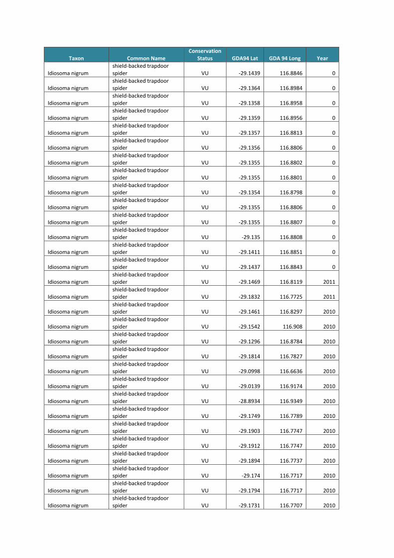
Taxon Common Name Conservation
Status GDA94 Lat GDA 94 Long Year
Merops ornatus rainbow bee-eater IA -29.4217 116.7739 2004
Merops ornatus rainbow bee-eater IA -29.3383 116.7461 2004
Merops ornatus rainbow bee-eater IA -29.1833 116.7 2004
Leipoa ocellata malleefowl VU -29.1267 117.1331 2005
Leipoa ocellata malleefowl VU -29.1833 116.7 2004
Leipoa ocellata malleefowl VU -29.1733 116.7667 2004
Leipoa ocellata malleefowl VU -29.1833 116.675 2004
Leipoa ocellata malleefowl VU -29.0654 116.7209 2001
Egernia stokesii badia western spiny-tailed skink VU -28.9591 116.9625 2013
Egernia stokesii badia western spiny-tailed skink VU -29.12 116.879 2013
Egernia stokesii badia western spiny-tailed skink VU -29.12 116.8799 2013
Egernia stokesii badia western spiny-tailed skink VU -29.0333 116.8624 2012
Egernia stokesii badia western spiny-tailed skink VU -29.0331 116.8626 2012
Merops ornatus rainbow bee-eater IA -29.1444 116.9542 2012
Leipoa ocellata malleefowl VU -29.1562 116.8333 2014
Leipoa ocellata malleefowl VU -29.1969 116.7709 2014
Leipoa ocellata malleefowl VU -29.099 116.9345 2014
Leipoa ocellata malleefowl VU -28.9337 116.9178 2014
Leipoa ocellata malleefowl VU -28.9591 116.9625 2013
Leipoa ocellata malleefowl VU -28.8637 116.9386 2012
Leipoa ocellata malleefowl VU -29.1444 116.9573 2012
Leipoa ocellata malleefowl VU -29.0286 116.8676 2012
Leipoa ocellata malleefowl VU -29.0532 116.8746 2012
Leipoa ocellata malleefowl VU -29.1852 116.7685 2010
Idiosoma nigrum shield-backed trapdoor spider VU -29.1485 116.8321 2015
Idiosoma nigrum shield-backed trapdoor spider VU -28.8864 116.9467 2015
Idiosoma nigrum shield-backed trapdoor spider VU -28.9151 116.9262 2015
Idiosoma nigrum shield-backed trapdoor spider VU -28.9902 116.8894 2015
Idiosoma nigrum shield-backed trapdoor spider VU -29.135 116.9261 2015
Idiosoma nigrum shield-backed trapdoor spider VU -29.0302 116.8718 2015
Idiosoma nigrum shield-backed trapdoor spider VU -29.1522 116.816 2015
Idiosoma nigrum shield-backed trapdoor spider VU -29.1849 116.7778 2015
Idiosoma nigrum shield-backed trapdoor spider VU -29.1387 116.8646 2014
Idiosoma nigrum shield-backed trapdoor spider VU -29.1485 116.8321 2014
Idiosoma nigrum shield-backed trapdoor spider VU -29.1236 116.8848 2014
Idiosoma nigrum shield-backed trapdoor spider VU -29.1326 116.8336 2014

Taxon Common Name Conservation
Status GDA94 Lat GDA 94 Long Year
Idiosoma nigrum shield-backed trapdoor spider VU -29.1076 116.9007 2014
Idiosoma nigrum shield-backed trapdoor spider VU -28.9902 116.8894 2014
Idiosoma nigrum shield-backed trapdoor spider VU -29.1522 116.816 2014
Idiosoma nigrum shield-backed trapdoor spider VU -29.1849 116.7778 2014
Idiosoma nigrum shield-backed trapdoor spider VU -29.1447 116.8262 2014
Idiosoma nigrum shield-backed trapdoor spider VU -29.1417 116.8344 2014
Idiosoma nigrum shield-backed trapdoor spider VU -29.13 116.8502 2014
Idiosoma nigrum shield-backed trapdoor spider VU -29.1304 116.8487 2014
Idiosoma nigrum shield-backed trapdoor spider VU -29.1181 116.8669 2014
Idiosoma nigrum shield-backed trapdoor spider VU -29.1183 116.8659 2014
Idiosoma nigrum shield-backed trapdoor spider VU -29.0743 116.8379 2014
Idiosoma nigrum shield-backed trapdoor spider VU -29.0748 116.8364 2014
Idiosoma nigrum shield-backed trapdoor spider VU -29.0977 116.9334 2014
Idiosoma nigrum shield-backed trapdoor spider VU -29.0971 116.9324 2014
Idiosoma nigrum shield-backed trapdoor spider VU -28.9374 116.9169 2014
Idiosoma nigrum shield-backed trapdoor spider VU -29.0734 116.8381 2014
Idiosoma nigrum shield-backed trapdoor spider VU -29.0748 116.8365 2014
Idiosoma nigrum shield-backed trapdoor spider VU -29.0971 116.9328 2014
Idiosoma nigrum shield-backed trapdoor spider VU -28.9357 116.9173 2014
Idiosoma nigrum shield-backed trapdoor spider VU -29.1768 116.9716 2013
Idiosoma nigrum shield-backed trapdoor spider VU -28.9941 116.9646 2013
Idiosoma nigrum shield-backed trapdoor spider VU -28.8665 116.9402 2013
Idiosoma nigrum shield-backed trapdoor spider VU -29.1942 116.9652 2013
Idiosoma nigrum shield-backed trapdoor spider VU -29.1727 116.9734 2013
Idiosoma nigrum shield-backed trapdoor spider VU -28.8829 116.9383 2013
Idiosoma nigrum shield-backed trapdoor spider VU -28.8638 116.9402 2013
Idiosoma nigrum shield-backed trapdoor spider VU -29.1738 116.9751 2013
Idiosoma nigrum shield-backed trapdoor spider VU -28.8843 116.9441 2013
Idiosoma nigrum shield-backed trapdoor spider VU -29.1882 116.9518 2013
Idiosoma nigrum shield-backed trapdoor spider VU -29.177 116.9737 2013

Taxon Common Name Conservation
Status GDA94 Lat GDA 94 Long Year
Idiosoma nigrum shield-backed trapdoor spider VU -28.8845 116.942 2013
Idiosoma nigrum shield-backed trapdoor spider VU -28.8656 116.9403 2013
Idiosoma nigrum shield-backed trapdoor spider VU -29.1725 116.9736 2013
Idiosoma nigrum shield-backed trapdoor spider VU -29.1768 116.9705 2013
Idiosoma nigrum shield-backed trapdoor spider VU -28.9923 116.9642 2013
Idiosoma nigrum shield-backed trapdoor spider VU -28.9932 116.9644 2013
Idiosoma nigrum shield-backed trapdoor spider VU -29.1891 116.9515 2013
Idiosoma nigrum shield-backed trapdoor spider VU -29.1732 116.9743 2013
Idiosoma nigrum shield-backed trapdoor spider VU -28.8829 116.9353 2013
Idiosoma nigrum shield-backed trapdoor spider VU -29.1916 116.9702 2013
Idiosoma nigrum shield-backed trapdoor spider VU -28.995 116.9649 2013
Idiosoma nigrum shield-backed trapdoor spider VU -28.8829 116.9363 2013
Idiosoma nigrum shield-backed trapdoor spider VU -28.8862 116.9368 2013
Idiosoma nigrum shield-backed trapdoor spider VU -28.8676 116.9403 2013
Idiosoma nigrum shield-backed trapdoor spider VU -28.8685 116.9403 2013
Idiosoma nigrum shield-backed trapdoor spider VU -29.1132 116.9518 2013
Idiosoma nigrum shield-backed trapdoor spider VU -29.1257 116.8816 2012
Idiosoma nigrum shield-backed trapdoor spider VU -29.1832 116.7725 2012
Idiosoma nigrum shield-backed trapdoor spider VU -29.1756 116.7939 2012
Idiosoma nigrum shield-backed trapdoor spider VU -29.033 116.8707 2013
Idiosoma nigrum shield-backed trapdoor spider VU -29.1295 116.9824 2013
Idiosoma nigrum shield-backed trapdoor spider VU -29.1373 116.9579 2013
Idiosoma nigrum shield-backed trapdoor spider VU -28.9159 116.9498 2013
Idiosoma nigrum shield-backed trapdoor spider VU -28.9088 116.9278 2013
Idiosoma nigrum shield-backed trapdoor spider VU -29.0248 116.8708 2013
Idiosoma nigrum shield-backed trapdoor spider VU -29.1289 116.8986 2013
Idiosoma nigrum shield-backed trapdoor spider VU -28.9546 116.9272 2013
Idiosoma nigrum shield-backed trapdoor spider VU -28.8637 116.9386 2012
Idiosoma nigrum shield-backed trapdoor spider VU -28.8987 116.9339 2012
Idiosoma nigrum shield-backed trapdoor spider VU -29.0427 116.8651 2012

Taxon Common Name Conservation
Status GDA94 Lat GDA 94 Long Year
Idiosoma nigrum shield-backed trapdoor spider VU -29.1444 116.9573 2012
Idiosoma nigrum shield-backed trapdoor spider VU -29.0286 116.8676 2012
Idiosoma nigrum shield-backed trapdoor spider VU -29.0456 116.8695 2012
Idiosoma nigrum shield-backed trapdoor spider VU -29.0359 116.8686 2012
Idiosoma nigrum shield-backed trapdoor spider VU -29.0456 116.8775 2012
Idiosoma nigrum shield-backed trapdoor spider VU -29.0466 116.8789 2012
Idiosoma nigrum shield-backed trapdoor spider VU -29.0457 116.862 2012
Idiosoma nigrum shield-backed trapdoor spider VU -29.0388 116.8666 2012
Idiosoma nigrum shield-backed trapdoor spider VU -29.0444 116.8679 2012
Idiosoma nigrum shield-backed trapdoor spider VU -29.0323 116.8707 2012
Idiosoma nigrum shield-backed trapdoor spider VU -29.0434 116.8831 2012
Idiosoma nigrum shield-backed trapdoor spider VU -29.045 116.8687 2012
Idiosoma nigrum shield-backed trapdoor spider VU -29.0264 116.8759 2012
Idiosoma nigrum shield-backed trapdoor spider VU -29.0347 116.8657 2012
Idiosoma nigrum shield-backed trapdoor spider VU -29.0429 116.8654 2012
Idiosoma nigrum shield-backed trapdoor spider VU -29.0465 116.8626 2012
Idiosoma nigrum shield-backed trapdoor spider VU -29.0312 116.8679 2012
Idiosoma nigrum shield-backed trapdoor spider VU -29.032 116.8698 2012
Idiosoma nigrum shield-backed trapdoor spider VU -29.0427 116.8824 2012
Idiosoma nigrum shield-backed trapdoor spider VU -29.0402 116.8692 2012
Idiosoma nigrum shield-backed trapdoor spider VU -29.0273 116.8755 2012
Idiosoma nigrum shield-backed trapdoor spider VU -29.0275 116.8749 2012
Idiosoma nigrum shield-backed trapdoor spider VU -29.0313 116.8726 2012
Idiosoma nigrum shield-backed trapdoor spider VU -29.0506 116.8623 2012
Idiosoma nigrum shield-backed trapdoor spider VU -29.0436 116.8668 2012
Idiosoma nigrum shield-backed trapdoor spider VU -29.0313 116.8726 2012
Idiosoma nigrum shield-backed trapdoor spider VU -29.0302 116.8662 2012
Idiosoma nigrum shield-backed trapdoor spider VU -29.0316 116.8688 2012
Idiosoma nigrum shield-backed trapdoor spider VU -29.035 116.8668 2012
Idiosoma nigrum shield-backed trapdoor spider VU -29.0355 116.8676 2012

Taxon Common Name Conservation
Status GDA94 Lat GDA 94 Long Year
Idiosoma nigrum shield-backed trapdoor spider VU -29.0361 116.8695 2012
Idiosoma nigrum shield-backed trapdoor spider VU -29.0372 116.8648 2012
Idiosoma nigrum shield-backed trapdoor spider VU -29.0461 116.878 2012
Idiosoma nigrum shield-backed trapdoor spider VU -29.0395 116.8681 2012
Idiosoma nigrum shield-backed trapdoor spider VU -29.0383 116.8657 2012
Idiosoma nigrum shield-backed trapdoor spider VU -29.1444 116.9542 2012
Idiosoma nigrum shield-backed trapdoor spider VU -28.9954 116.8941 2012
Idiosoma nigrum shield-backed trapdoor spider VU -28.9632 116.9088 2012
Idiosoma nigrum shield-backed trapdoor spider VU -28.9173 116.928 2012
Idiosoma nigrum shield-backed trapdoor spider VU -28.9039 116.9308 2012
Idiosoma nigrum shield-backed trapdoor spider VU -29.138 116.8863 2012
Idiosoma nigrum shield-backed trapdoor spider VU -29.1419 116.8643 2012
Idiosoma nigrum shield-backed trapdoor spider VU -29.1439 116.8793 2012
Idiosoma nigrum shield-backed trapdoor spider VU -29.1257 116.8816 2012
Idiosoma nigrum shield-backed trapdoor spider VU -29.1832 116.7725 2012
Idiosoma nigrum shield-backed trapdoor spider VU -28.9039 116.9273 2012
Idiosoma nigrum shield-backed trapdoor spider VU -29.1946 116.9571 2012
Idiosoma nigrum shield-backed trapdoor spider VU -29.0048 116.9366 2012
Idiosoma nigrum shield-backed trapdoor spider VU -29.1274 116.9235 2012
Idiosoma nigrum shield-backed trapdoor spider VU -28.9903 116.9005 2012
Idiosoma nigrum shield-backed trapdoor spider VU -29.1355 116.8804 0
Idiosoma nigrum shield-backed trapdoor spider VU -29.1354 116.8807 0
Idiosoma nigrum shield-backed trapdoor spider VU -29.1351 116.8809 0
Idiosoma nigrum shield-backed trapdoor spider VU -29.1352 116.8808 0
Idiosoma nigrum shield-backed trapdoor spider VU -29.1353 116.8802 0
Idiosoma nigrum shield-backed trapdoor spider VU -29.1352 116.8802 0
Idiosoma nigrum shield-backed trapdoor spider VU -29.1352 116.8801 0
Idiosoma nigrum shield-backed trapdoor spider VU -29.1352 116.88 0
Idiosoma nigrum shield-backed trapdoor spider VU -29.1409 116.8849 0
Idiosoma nigrum shield-backed trapdoor spider VU -29.1433 116.8841 0
Taxon Common Name Conservation
Status GDA94 Lat GDA 94 Long Year
Idiosoma nigrum shield-backed trapdoor spider VU -29.1439 116.8846 0
Idiosoma nigrum shield-backed trapdoor spider VU -29.1364 116.8984 0
Idiosoma nigrum shield-backed trapdoor spider VU -29.1358 116.8958 0
Idiosoma nigrum shield-backed trapdoor spider VU -29.1359 116.8956 0
Idiosoma nigrum shield-backed trapdoor spider VU -29.1357 116.8813 0
Idiosoma nigrum shield-backed trapdoor spider VU -29.1356 116.8806 0
Idiosoma nigrum shield-backed trapdoor spider VU -29.1355 116.8802 0
Idiosoma nigrum shield-backed trapdoor spider VU -29.1355 116.8801 0
Idiosoma nigrum shield-backed trapdoor spider VU -29.1354 116.8798 0
Idiosoma nigrum shield-backed trapdoor spider VU -29.1355 116.8806 0
Idiosoma nigrum shield-backed trapdoor spider VU -29.1355 116.8807 0
Idiosoma nigrum shield-backed trapdoor spider VU -29.135 116.8808 0
Idiosoma nigrum shield-backed trapdoor spider VU -29.1411 116.8851 0
Idiosoma nigrum shield-backed trapdoor spider VU -29.1437 116.8843 0
Idiosoma nigrum shield-backed trapdoor spider VU -29.1469 116.8119 2011
Idiosoma nigrum shield-backed trapdoor spider VU -29.1832 116.7725 2011
Idiosoma nigrum shield-backed trapdoor spider VU -29.1461 116.8297 2010
Idiosoma nigrum shield-backed trapdoor spider VU -29.1542 116.908 2010
Idiosoma nigrum shield-backed trapdoor spider VU -29.1296 116.8784 2010
Idiosoma nigrum shield-backed trapdoor spider VU -29.1814 116.7827 2010
Idiosoma nigrum shield-backed trapdoor spider VU -29.0998 116.6636 2010
Idiosoma nigrum shield-backed trapdoor spider VU -29.0139 116.9174 2010
Idiosoma nigrum shield-backed trapdoor spider VU -28.8934 116.9349 2010
Idiosoma nigrum shield-backed trapdoor spider VU -29.1749 116.7789 2010
Idiosoma nigrum shield-backed trapdoor spider VU -29.1903 116.7747 2010
Idiosoma nigrum shield-backed trapdoor spider VU -29.1912 116.7747 2010
Idiosoma nigrum shield-backed trapdoor spider VU -29.1894 116.7737 2010
Idiosoma nigrum shield-backed trapdoor spider VU -29.174 116.7717 2010
Idiosoma nigrum shield-backed trapdoor spider VU -29.1794 116.7717 2010
Idiosoma nigrum shield-backed trapdoor spider VU -29.1731 116.7707 2010

Taxon Common Name Conservation
Status GDA94 Lat GDA 94 Long Year
Idiosoma nigrum shield-backed trapdoor spider VU -29.1758 116.7707 2010
Idiosoma nigrum shield-backed trapdoor spider VU -29.1731 116.7696 2010
Idiosoma nigrum shield-backed trapdoor spider VU -29.174 116.7696 2010
Idiosoma nigrum shield-backed trapdoor spider VU -29.1767 116.7696 2010
Idiosoma nigrum shield-backed trapdoor spider VU -29.1758 116.7686 2010
Idiosoma nigrum shield-backed trapdoor spider VU -29.1767 116.7686 2010
Idiosoma nigrum shield-backed trapdoor spider VU -29.1776 116.7686 2010
Idiosoma nigrum shield-backed trapdoor spider VU -29.1803 116.7686 2010
Idiosoma nigrum shield-backed trapdoor spider VU -29.1812 116.7686 2010
Idiosoma nigrum shield-backed trapdoor spider VU -29.1822 116.7686 2010
Idiosoma nigrum shield-backed trapdoor spider VU -29.1831 116.7686 2010
Idiosoma nigrum shield-backed trapdoor spider VU -29.184 116.7686 2010
Idiosoma nigrum shield-backed trapdoor spider VU -29.1758 116.7676 2010
Idiosoma nigrum shield-backed trapdoor spider VU -29.1767 116.7676 2010
Idiosoma nigrum shield-backed trapdoor spider VU -29.1776 116.7676 2010
Idiosoma nigrum shield-backed trapdoor spider VU -29.1912 116.7675 2010
Idiosoma nigrum shield-backed trapdoor spider VU -29.1921 116.7675 2010
Idiosoma nigrum shield-backed trapdoor spider VU -29.1776 116.7665 2010
Idiosoma nigrum shield-backed trapdoor spider VU -29.1785 116.7665 2010
Idiosoma nigrum shield-backed trapdoor spider VU -29.1794 116.7665 2010
Idiosoma nigrum shield-backed trapdoor spider VU -29.1803 116.7665 2010
Idiosoma nigrum shield-backed trapdoor spider VU -29.1812 116.7665 2010
Idiosoma nigrum shield-backed trapdoor spider VU -29.1821 116.7665 2010
Idiosoma nigrum shield-backed trapdoor spider VU -29.1831 116.7665 2010
Idiosoma nigrum shield-backed trapdoor spider VU -29.184 116.7665 2010
Idiosoma nigrum shield-backed trapdoor spider VU -29.1849 116.7665 2010
Idiosoma nigrum shield-backed trapdoor spider VU -29.1912 116.7665 2010
Idiosoma nigrum shield-backed trapdoor spider VU -29.1921 116.7665 2010
Idiosoma nigrum shield-backed trapdoor spider VU -29.1803 116.7655 2010
Idiosoma nigrum shield-backed trapdoor spider VU -29.1812 116.7655 2010

Taxon Common Name Conservation
Status GDA94 Lat GDA 94 Long Year
Idiosoma nigrum shield-backed trapdoor spider VU -29.1821 116.7655 2010
Idiosoma nigrum shield-backed trapdoor spider VU -29.183 116.7655 2010
Idiosoma nigrum shield-backed trapdoor spider VU -29.184 116.7655 2010
Idiosoma nigrum shield-backed trapdoor spider VU -29.1849 116.7655 2010
Idiosoma nigrum shield-backed trapdoor spider VU -29.1912 116.7655 2010
Idiosoma nigrum shield-backed trapdoor spider VU -29.1921 116.7655 2010
Idiosoma nigrum shield-backed trapdoor spider VU -29.1812 116.7645 2010
Idiosoma nigrum shield-backed trapdoor spider VU -29.1821 116.7645 2010
Idiosoma nigrum shield-backed trapdoor spider VU -29.1867 116.7645 2010
Idiosoma nigrum shield-backed trapdoor spider VU -29.1876 116.7645 2010
Idiosoma nigrum shield-backed trapdoor spider VU -29.1912 116.7645 2010
Idiosoma nigrum shield-backed trapdoor spider VU -29.1921 116.7645 2010
Idiosoma nigrum shield-backed trapdoor spider VU -29.193 116.7644 2010
Idiosoma nigrum shield-backed trapdoor spider VU -29.1939 116.7644 2010
Idiosoma nigrum shield-backed trapdoor spider VU -29.1867 116.7634 2010
Idiosoma nigrum shield-backed trapdoor spider VU -29.1876 116.7634 2010
Idiosoma nigrum shield-backed trapdoor spider VU -29.1885 116.7634 2010
Idiosoma nigrum shield-backed trapdoor spider VU -29.1894 116.7634 2010
Idiosoma nigrum shield-backed trapdoor spider VU -29.1903 116.7634 2010
Idiosoma nigrum shield-backed trapdoor spider VU -29.1912 116.7634 2010
Idiosoma nigrum shield-backed trapdoor spider VU -29.1921 116.7634 2010
Idiosoma nigrum shield-backed trapdoor spider VU -29.193 116.7634 2010
Idiosoma nigrum shield-backed trapdoor spider VU -29.1876 116.7624 2010
Idiosoma nigrum shield-backed trapdoor spider VU -29.1885 116.7624 2010
Idiosoma nigrum shield-backed trapdoor spider VU -29.1894 116.7624 2010
Idiosoma nigrum shield-backed trapdoor spider VU -29.1903 116.7624 2010
Idiosoma nigrum shield-backed trapdoor spider VU -29.1903 116.7624 2010
Idiosoma nigrum shield-backed trapdoor spider VU -29.1912 116.7624 2010
Falco peregrinus peregrine falcon OS -28.9173 116.928 2012
Idiosoma nigrum shield-backed trapdoor spider VU -29.1806 116.7789 2008

Taxon Common Name Conservation
Status GDA94 Lat GDA 94 Long Year
Idiosoma nigrum shield-backed trapdoor spider VU -29.1353 116.88 2011
Idiosoma nigrum shield-backed trapdoor spider VU -29.1439 116.8844 2011
Idiosoma nigrum shield-backed trapdoor spider VU -29.1439 116.8844 2011
Idiosoma nigrum shield-backed trapdoor spider VU -29.1783 116.6922 2010
Leipoa ocellata malleefowl VU -29.1 117 0
Cyclodomorphus branchialis VU -29.3833 116.7667 1900
Egernia stokesii badia western spiny-tailed skink VU -29.3 116.9 1900
Egernia stokesii badia western spiny-tailed skink VU -29.3 116.9 1900
Egernia stokesii badia western spiny-tailed skink VU -29.3622 116.89 1998
Idiosoma nigrum shield-backed trapdoor spider VU -29.0364 116.8689 2016
Idiosoma nigrum shield-backed trapdoor spider VU -29.1763 116.7859 2016
Cyclodomorphus branchialis VU -29.3833 116.7667 2003
Egernia stokesii badia western spiny-tailed skink VU -29.126 116.8154 2009
Egernia stokesii badia western spiny-tailed skink VU -29.1314 116.8138 2009
Egernia stokesii badia western spiny-tailed skink VU -29.1639 116.7841 2009
Egernia stokesii badia western spiny-tailed skink VU -29.1743 116.7503 2009
Egernia stokesii badia western spiny-tailed skink VU -29.1755 116.751 2009
Egernia stokesii badia western spiny-tailed skink VU -29.1765 116.7506 2009
Egernia stokesii badia western spiny-tailed skink VU -29.1768 116.7506 2009
Egernia stokesii badia western spiny-tailed skink VU -29.1772 116.7501 2009
Egernia stokesii badia western spiny-tailed skink VU -29.181 116.8373 2009
Egernia stokesii badia western spiny-tailed skink VU -29.209 116.837 2009
Egernia stokesii badia western spiny-tailed skink VU -29.2136 116.7711 2009
Egernia stokesii badia western spiny-tailed skink VU -29.22 116.78 2009
Egernia stokesii badia western spiny-tailed skink VU -29.2205 116.7802 2009
Egernia stokesii badia western spiny-tailed skink VU -29.2241 116.7832 2009
Egernia stokesii badia western spiny-tailed skink VU -29.2988 116.8681 1998
Egernia stokesii badia western spiny-tailed skink VU -29.2988 116.9014 1967
Egernia stokesii badia western spiny-tailed skink VU -29.2988 116.9014 1967
Egernia stokesii badia western spiny-tailed skink VU -29.3621 116.7872 1998
Egernia stokesii badia western spiny-tailed skink VU -29.4331 116.9737 1999
Idiosoma nigrum shield-backed trapdoor spider VU -29.1723 116.7792 2008
Idiosoma nigrum shield-backed trapdoor spider VU -29.1724 116.7769 2008
Idiosoma nigrum shield-backed trapdoor spider VU -29.1724 116.7746 2008
Idiosoma nigrum shield-backed trapdoor spider VU -29.1725 116.7762 2008
Idiosoma nigrum shield-backed trapdoor spider VU -29.173 116.7822 2008
Idiosoma nigrum shield-backed trapdoor spider VU -29.1733 116.7828 2008

Taxon Common Name Conservation
Status GDA94 Lat GDA 94 Long Year
Idiosoma nigrum shield-backed trapdoor spider VU -29.1736 116.7834 2008
Idiosoma nigrum shield-backed trapdoor spider VU -29.174 116.7844 2008
Idiosoma nigrum shield-backed trapdoor spider VU -29.1742 116.7849 2008
Idiosoma nigrum shield-backed trapdoor spider VU -29.1748 116.7861 2008
Idiosoma nigrum shield-backed trapdoor spider VU -29.1753 116.7865 2008
Idiosoma nigrum shield-backed trapdoor spider VU -29.1758 116.7751 2008
Idiosoma nigrum shield-backed trapdoor spider VU -29.1769 116.7763 2008
Idiosoma nigrum shield-backed trapdoor spider VU -29.1773 116.7768 2008
Idiosoma nigrum shield-backed trapdoor spider VU -29.1777 116.7772 2008
Idiosoma nigrum shield-backed trapdoor spider VU -29.1779 116.7777 2008
Idiosoma nigrum shield-backed trapdoor spider VU -29.1788 116.7808 2008
Idiosoma nigrum shield-backed trapdoor spider VU -29.1791 116.7811 2008
Idiosoma nigrum shield-backed trapdoor spider VU -29.1796 116.7815 2008
Idiosoma nigrum shield-backed trapdoor spider VU -29.1802 116.7813 2008
Idiosoma nigrum shield-backed trapdoor spider VU -29.181 116.7717 2008
Idiosoma nigrum shield-backed trapdoor spider VU -29.1823 116.7731 2008
Idiosoma nigrum shield-backed trapdoor spider VU -29.1826 116.7733 2008
Idiosoma nigrum shield-backed trapdoor spider VU -29.1831 116.7741 2008
Idiosoma nigrum shield-backed trapdoor spider VU -29.1836 116.7765 2008
Idiosoma nigrum shield-backed trapdoor spider VU -29.1837 116.7782 2008
Idiosoma nigrum shield-backed trapdoor spider VU -29.1837 116.7759 2008
Idiosoma nigrum shield-backed trapdoor spider VU -29.1837 116.7788 2008
Idiosoma nigrum shield-backed trapdoor spider VU -29.1839 116.777 2008
Idiosoma nigrum shield-backed trapdoor spider VU -29.1884 116.7715 2008
Idiosoma nigrum shield-backed trapdoor spider VU -29.1887 116.7711 2008
Idiosoma nigrum shield-backed trapdoor spider VU -29.1887 116.7688 2008
Idiosoma nigrum shield-backed trapdoor spider VU -29.1888 116.7694 2008
Idiosoma nigrum shield-backed trapdoor spider VU -29.1888 116.7683 2008
Idiosoma nigrum shield-backed trapdoor spider VU -29.1889 116.7707 2008
Idiosoma nigrum shield-backed trapdoor spider VU -29.19 116.7724 2008

Taxon Common Name Conservation
Status GDA94 Lat GDA 94 Long Year
Idiosoma nigrum shield-backed trapdoor spider VU -29.1901 116.772 2008
Idiosoma nigrum shield-backed trapdoor spider VU -29.1903 116.7715 2008
Idiosoma nigrum shield-backed trapdoor spider VU -29.1905 116.7711 2008
Idiosoma nigrum shield-backed trapdoor spider VU -29.1907 116.7707 2008
Idiosoma nigrum shield-backed trapdoor spider VU -29.1911 116.7703 2008
Idiosoma nigrum shield-backed trapdoor spider VU -29.1913 116.7698 2008
Idiosoma nigrum shield-backed trapdoor spider VU -29.192 116.7744 2008
Idiosoma nigrum shield-backed trapdoor spider VU -29.1924 116.7741 2008
Idiosoma nigrum shield-backed trapdoor spider VU -29.193 116.7739 2008
Idiosoma nigrum shield-backed trapdoor spider VU -29.1935 116.7738 2008
Idiosoma nigrum shield-backed trapdoor spider VU -29.1987 116.7055 2006
Idiosoma nigrum shield-backed trapdoor spider VU -29.2 116.7 2007
Leipoa ocellata malleefowl VU -29.148 116.8353 2013
Leipoa ocellata malleefowl VU -29.1593 116.7913 2013
Leipoa ocellata malleefowl VU -29.1625 116.7814 2012
Leipoa ocellata malleefowl VU -29.1682 116.7942 2008
Leipoa ocellata malleefowl VU -29.1686 116.757 2008
Leipoa ocellata malleefowl VU -29.169 116.7565 2008
Leipoa ocellata malleefowl VU -29.169 116.7916 2008
Leipoa ocellata malleefowl VU -29.1691 116.7987 2008
Leipoa ocellata malleefowl VU -29.1692 116.7957 2008
Leipoa ocellata malleefowl VU -29.1695 116.7632 2008
Leipoa ocellata malleefowl VU -29.1695 116.7633 2008
Leipoa ocellata malleefowl VU -29.1696 116.7719 2008
Leipoa ocellata malleefowl VU -29.1697 116.7934 2008
Leipoa ocellata malleefowl VU -29.1697 116.7448 2008
Leipoa ocellata malleefowl VU -29.17 116.7706 2008
Leipoa ocellata malleefowl VU -29.1701 116.7798 2008
Leipoa ocellata malleefowl VU -29.1702 116.772 2008
Leipoa ocellata malleefowl VU -29.1703 116.786 2008
Leipoa ocellata malleefowl VU -29.1704 116.7846 2008
Leipoa ocellata malleefowl VU -29.1709 116.7436 2008
Leipoa ocellata malleefowl VU -29.1711 116.7898 2008
Leipoa ocellata malleefowl VU -29.1711 116.7916 2008
Leipoa ocellata malleefowl VU -29.1711 116.7596 2008
Leipoa ocellata malleefowl VU -29.179 116.7725 2008
Leipoa ocellata malleefowl VU -29.1792 116.7713 2008
Leipoa ocellata malleefowl VU -29.1801 116.7561 2008

Taxon Common Name Conservation
Status GDA94 Lat GDA 94 Long Year
Leipoa ocellata malleefowl VU -29.1801 116.7478 2008
Leipoa ocellata malleefowl VU -29.1804 116.8271 2008
Leipoa ocellata malleefowl VU -29.1864 116.7831 2008
Leipoa ocellata malleefowl VU -29.1868 116.7773 2008
Leipoa ocellata malleefowl VU -29.1881 116.7619 2008
Leipoa ocellata malleefowl VU -29.1885 116.773 2008
Leipoa ocellata malleefowl VU -29.1886 116.7644 2008
Leipoa ocellata malleefowl VU -29.1987 116.746 2008
Leipoa ocellata malleefowl VU -29.1987 116.7419 2008
Leipoa ocellata malleefowl VU -29.1996 116.7428 2008
Leipoa ocellata malleefowl VU -29.1996 116.7419 2008
Leipoa ocellata malleefowl VU -29.2 116.7506 2008
Leipoa ocellata malleefowl VU -29.2004 116.7443 2008
Leipoa ocellata malleefowl VU -29.238 116.712 1984
Leipoa ocellata malleefowl VU -29.054 117.0759 2005
Leipoa ocellata malleefowl VU -29.25 117.2333 2001
Macropus irma Western Brush Wallaby P4 -29.1958 116.7777 2002
Pezoporus occidentalis night parrot CR -29.2821 116.8848 1961

MT MULGINE PROJECT EPA REFERRAL SUPPORTING DOCUMENT
TUNGSTEN MINING NL
APPENDIX 5: ABORIGINAL HERITAGE INQUIRY SYSTEM SEARCH OF THE MT MULGINE PROJECT
AREA (2017)

Search Criteria
No Registered Aboriginal Sites in Mining Tenement - M 59/387
The Aboriginal Heritage Act 1972 preserves all Aboriginal sites in Western Australia whether or not they are registered. Aboriginal sites exist that are not recorded on the Register of Aboriginal Sites, and some registered sites may no longer exist.
The information provided is made available in good faith and is predominately based on the information provided to the Department of Aboriginal Affairs by third parties. The information is provided solely on the basis that readers will be responsible for making their own assessment as to the accuracy of the information. If you find any errors or omissions in our records, including our maps, it would be appreciated if you email the details to the Department at [email protected] and we will make every effort to rectify it as soon as possible.
Disclaimer
© Government of Western Australia Report created: 24/01/2017 11:17:02 by: Public User Identifier: 268978 Page: 1
Aboriginal Heritage Inquiry System
Aboriginal Sites Database

CopyrightCopyright in the information contained herein is and shall remain the property of the State of Western Australia. All rights reserved.
Coordinate AccuracyAccuracy is shown as a code in brackets following the coordinates. Map coordinates (Latitude/Longitude and Easting/Northing) are based on the GDA 94 Datum.The Easting/Northing map grid can be across one or more zones. The zone is indicated for each Easting on the map, i.e. '500000mE:Z50' means Easting=500000, Zone=50.
Terminology (NB that some terminology has varied over the life of the legislation)Place ID/Site ID: This a unique ID assigned by the Department of Aboriginal Affairs to the placeStatus:
o Registered Site: The place has been assessed as meeting Section 5 of the Aboriginal Heritage Act 1972o Other Heritage Place which includes:
- Stored Data / Not a Site: The place has been assessed as not meeting Section 5 of the Aboriginal Heritage Act 1972- Lodged: Information has been received in relation to the place, but an assessment has not been completed at this stage to determine if it meets
Section 5 of the Aboriginal Heritage Act 1972Status Reason: e.g. Exclusion - Relates to a portion of an Aboriginal site or heritage place as assessed by the Aboriginal Cultural Material Committee (ACMC). e.g.
such as the land subject to a section 18 notice.Origin Place ID: Used in conjuction with Status Reason to indicate which Registered Site this Place originates from. Access and Restrictions:
o File Restricted = No: Availability of information (other than boundary) that the Department of Aboriginal Affairs holds in relation to the place is not restricted in any way.
o File Restricted = Yes: Some of the information that the Department of Aboriginal Affairs holds in relation to the place is restricted if it is considered culturally sensitive. This information will only be made available if the Department of Aboriginal Affairs receives written approval from the informants who provided the information. Download the Request to Access Restricted Information letter and form.
o Boundary Restricted = No: place location is shown as accurately as the information lodged with the Registrar allows. o Boundary Restricted = Yes: To preserve confidentiality the exact location and extent of the place is not displayed on the map. However, the shaded region
(generally with an area of at least 4km²) provides a general indication of where the place is located. If you are a landowner and wish to find out more about the exact location of the place, please contact DAA.
o Restrictions: - No Restrictions: Anyone can view the information.- Male Access Only: Only males can view restricted information.- Female Access Only: Only females can view restricted information
Legacy ID: This is the former unique number that the former Department of Aboriginal Sites assigned to the place. This has been replaced by the Place ID / Site ID.
© Government of Western Australia Report created: 24/01/2017 11:17:02 by: Public User Identifier: 268978 Page: 2
Aboriginal Heritage Inquiry System
Aboriginal Sites Database

No Results
List of Registered Aboriginal Sites with Map
© Government of Western Australia Report created: 24/01/2017 11:17:02 by: Public User Identifier: 268978 Page: 3
Aboriginal Heritage Inquiry System
Aboriginal Sites Database

Copyright for topographic base map information shall at all times remain the property of the Commonwealth of Australia, Geoscience Australia - National Mapping Division. All rights reserved.
Aerial Photos, Cadastre, Local Government Authority, Native Title boundary, Roads data copyright © Western Australian Land Information Authority trading as Landgate (2017).
Geothermal Application, Geothermal Title, Mining Tenement, Petroleum Application, Petroleum Title boundary data copyright © the State of Western Australia (DMP) (2017.1)
For further important information on using this information please see the Department of Aboriginal Affairs' Terms of Use statement at http://www.daa.wa.gov.au/Terms-Of-Use/
Legend
Selected Heritage Sites
Registered Sites
Aboriginal Community Occupied
Aboriginal Community Unoccupied
Town
Search Area
© Government of Western Australia Report created: 24/01/2017 11:17:02 by: Public User Identifier: 268978 Page: 4
Aboriginal Heritage Inquiry System
Aboriginal Sites Database

Search Criteria
2 Other Heritage Places in Mining Tenement - M 59/387
The Aboriginal Heritage Act 1972 preserves all Aboriginal sites in Western Australia whether or not they are registered. Aboriginal sites exist that are not recorded on the Register of Aboriginal Sites, and some registered sites may no longer exist.
The information provided is made available in good faith and is predominately based on the information provided to the Department of Aboriginal Affairs by third parties. The information is provided solely on the basis that readers will be responsible for making their own assessment as to the accuracy of the information. If you find any errors or omissions in our records, including our maps, it would be appreciated if you email the details to the Department at [email protected] and we will make every effort to rectify it as soon as possible.
Disclaimer
© Government of Western Australia Report created: 24/01/2017 11:18:30 by: Public User Identifier: 268980 Page: 1
Aboriginal Heritage Inquiry System
Aboriginal Sites Database

CopyrightCopyright in the information contained herein is and shall remain the property of the State of Western Australia. All rights reserved.
Coordinate AccuracyAccuracy is shown as a code in brackets following the coordinates. Map coordinates (Latitude/Longitude and Easting/Northing) are based on the GDA 94 Datum.The Easting/Northing map grid can be across one or more zones. The zone is indicated for each Easting on the map, i.e. '500000mE:Z50' means Easting=500000, Zone=50.
Terminology (NB that some terminology has varied over the life of the legislation)Place ID/Site ID: This a unique ID assigned by the Department of Aboriginal Affairs to the placeStatus:
o Registered Site: The place has been assessed as meeting Section 5 of the Aboriginal Heritage Act 1972o Other Heritage Place which includes:
- Stored Data / Not a Site: The place has been assessed as not meeting Section 5 of the Aboriginal Heritage Act 1972- Lodged: Information has been received in relation to the place, but an assessment has not been completed at this stage to determine if it meets
Section 5 of the Aboriginal Heritage Act 1972Status Reason: e.g. Exclusion - Relates to a portion of an Aboriginal site or heritage place as assessed by the Aboriginal Cultural Material Committee (ACMC). e.g.
such as the land subject to a section 18 notice.Origin Place ID: Used in conjuction with Status Reason to indicate which Registered Site this Place originates from. Access and Restrictions:
o File Restricted = No: Availability of information (other than boundary) that the Department of Aboriginal Affairs holds in relation to the place is not restricted in any way.
o File Restricted = Yes: Some of the information that the Department of Aboriginal Affairs holds in relation to the place is restricted if it is considered culturally sensitive. This information will only be made available if the Department of Aboriginal Affairs receives written approval from the informants who provided the information. Download the Request to Access Restricted Information letter and form.
o Boundary Restricted = No: place location is shown as accurately as the information lodged with the Registrar allows. o Boundary Restricted = Yes: To preserve confidentiality the exact location and extent of the place is not displayed on the map. However, the shaded region
(generally with an area of at least 4km²) provides a general indication of where the place is located. If you are a landowner and wish to find out more about the exact location of the place, please contact DAA.
o Restrictions: - No Restrictions: Anyone can view the information.- Male Access Only: Only males can view restricted information.- Female Access Only: Only females can view restricted information
Legacy ID: This is the former unique number that the former Department of Aboriginal Sites assigned to the place. This has been replaced by the Place ID / Site ID.
© Government of Western Australia Report created: 24/01/2017 11:18:30 by: Public User Identifier: 268980 Page: 2
Aboriginal Heritage Inquiry System
Aboriginal Sites Database
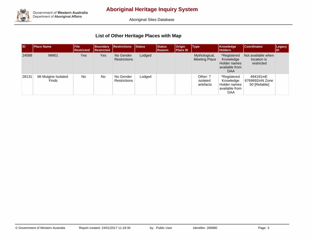
ID Place Name File Restricted
Boundary Restricted
Restrictions Status Status Reason
Origin Place ID
Type Knowledge Holders
Coordinates Legacy ID
24588 MM01 Yes Yes No Gender Restrictions
Lodged Mythological, Meeting Place
*Registered Knowledge
Holder names available from
DAA
Not available when location is restricted
28131 Mt Mulgine Isolated Finds
No No No Gender Restrictions
Lodged Other: 7 isolated artefacts
*Registered Knowledge
Holder names available from
DAA
494191mE 6769692mN Zone
50 [Reliable]
List of Other Heritage Places with Map
© Government of Western Australia Report created: 24/01/2017 11:18:30 by: Public User Identifier: 268980 Page: 3
Aboriginal Heritage Inquiry System
Aboriginal Sites Database
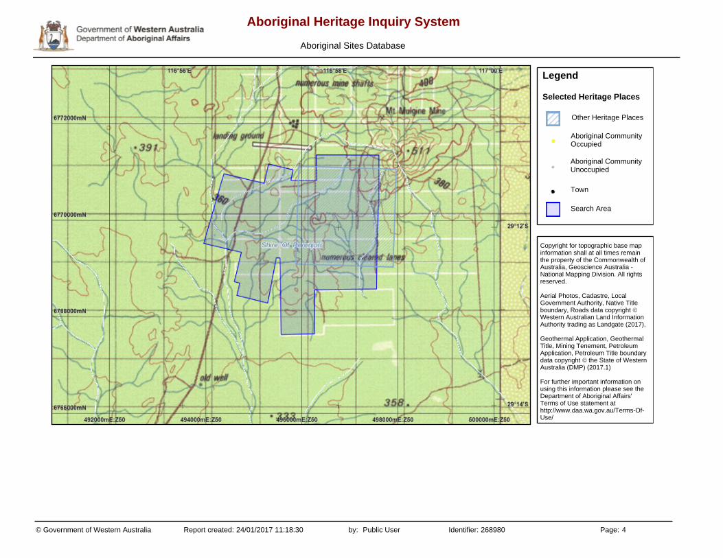
Copyright for topographic base map information shall at all times remain the property of the Commonwealth of Australia, Geoscience Australia - National Mapping Division. All rights reserved.
Aerial Photos, Cadastre, Local Government Authority, Native Title boundary, Roads data copyright © Western Australian Land Information Authority trading as Landgate (2017).
Geothermal Application, Geothermal Title, Mining Tenement, Petroleum Application, Petroleum Title boundary data copyright © the State of Western Australia (DMP) (2017.1)
For further important information on using this information please see the Department of Aboriginal Affairs' Terms of Use statement at http://www.daa.wa.gov.au/Terms-Of-Use/
Legend
Selected Heritage Places
Other Heritage Places
Aboriginal Community Occupied
Aboriginal Community Unoccupied
Town
Search Area
© Government of Western Australia Report created: 24/01/2017 11:18:30 by: Public User Identifier: 268980 Page: 4
Aboriginal Heritage Inquiry System
Aboriginal Sites Database

Search Criteria
No Registered Aboriginal Sites in Mining Tenement - M 59/425
The Aboriginal Heritage Act 1972 preserves all Aboriginal sites in Western Australia whether or not they are registered. Aboriginal sites exist that are not recorded on the Register of Aboriginal Sites, and some registered sites may no longer exist.
The information provided is made available in good faith and is predominately based on the information provided to the Department of Aboriginal Affairs by third parties. The information is provided solely on the basis that readers will be responsible for making their own assessment as to the accuracy of the information. If you find any errors or omissions in our records, including our maps, it would be appreciated if you email the details to the Department at [email protected] and we will make every effort to rectify it as soon as possible.
Disclaimer
© Government of Western Australia Report created: 15/12/2016 11:33:07 by: Public User Identifier: 264872 Page: 1
Aboriginal Heritage Inquiry System
Aboriginal Sites Database
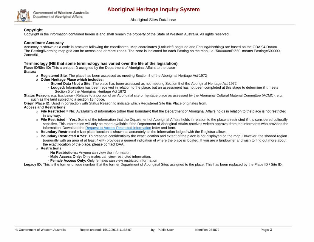
CopyrightCopyright in the information contained herein is and shall remain the property of the State of Western Australia. All rights reserved.
Coordinate AccuracyAccuracy is shown as a code in brackets following the coordinates. Map coordinates (Latitude/Longitude and Easting/Northing) are based on the GDA 94 Datum.The Easting/Northing map grid can be across one or more zones. The zone is indicated for each Easting on the map, i.e. '500000mE:Z50' means Easting=500000, Zone=50.
Terminology (NB that some terminology has varied over the life of the legislation)Place ID/Site ID: This a unique ID assigned by the Department of Aboriginal Affairs to the placeStatus:
o Registered Site: The place has been assessed as meeting Section 5 of the Aboriginal Heritage Act 1972o Other Heritage Place which includes:
- Stored Data / Not a Site: The place has been assessed as not meeting Section 5 of the Aboriginal Heritage Act 1972- Lodged: Information has been received in relation to the place, but an assessment has not been completed at this stage to determine if it meets
Section 5 of the Aboriginal Heritage Act 1972Status Reason: e.g. Exclusion - Relates to a portion of an Aboriginal site or heritage place as assessed by the Aboriginal Cultural Material Committee (ACMC). e.g.
such as the land subject to a section 18 notice.Origin Place ID: Used in conjuction with Status Reason to indicate which Registered Site this Place originates from. Access and Restrictions:
o File Restricted = No: Availability of information (other than boundary) that the Department of Aboriginal Affairs holds in relation to the place is not restricted in any way.
o File Restricted = Yes: Some of the information that the Department of Aboriginal Affairs holds in relation to the place is restricted if it is considered culturally sensitive. This information will only be made available if the Department of Aboriginal Affairs receives written approval from the informants who provided the information. Download the Request to Access Restricted Information letter and form.
o Boundary Restricted = No: place location is shown as accurately as the information lodged with the Registrar allows. o Boundary Restricted = Yes: To preserve confidentiality the exact location and extent of the place is not displayed on the map. However, the shaded region
(generally with an area of at least 4km²) provides a general indication of where the place is located. If you are a landowner and wish to find out more about the exact location of the place, please contact DAA.
o Restrictions: - No Restrictions: Anyone can view the information.- Male Access Only: Only males can view restricted information.- Female Access Only: Only females can view restricted information
Legacy ID: This is the former unique number that the former Department of Aboriginal Sites assigned to the place. This has been replaced by the Place ID / Site ID.
© Government of Western Australia Report created: 15/12/2016 11:33:07 by: Public User Identifier: 264872 Page: 2
Aboriginal Heritage Inquiry System
Aboriginal Sites Database

No Results
List of Registered Aboriginal Sites with Map
© Government of Western Australia Report created: 15/12/2016 11:33:07 by: Public User Identifier: 264872 Page: 3
Aboriginal Heritage Inquiry System
Aboriginal Sites Database

Copyright for topographic base map information shall at all times remain the property of the Commonwealth of Australia, Geoscience Australia - National Mapping Division. All rights reserved.
Aerial Photos, Cadastre, Local Government Authority, Native Title boundary, Roads data copyright © Western Australian Land Information Authority trading as Landgate (2016).
Geothermal Application, Geothermal Title, Mining Tenement, Petroleum Application, Petroleum Title boundary data copyright © the State of Western Australia (DMP) (2016.12)
For further important information on using this information please see the Department of Aboriginal Affairs' Terms of Use statement at http://www.daa.wa.gov.au/Terms-Of-Use/
Legend
Selected Heritage Sites
Registered Sites
Aboriginal Community Occupied
Aboriginal Community Unoccupied
Town
Search Area
© Government of Western Australia Report created: 15/12/2016 11:33:07 by: Public User Identifier: 264872 Page: 4
Aboriginal Heritage Inquiry System
Aboriginal Sites Database
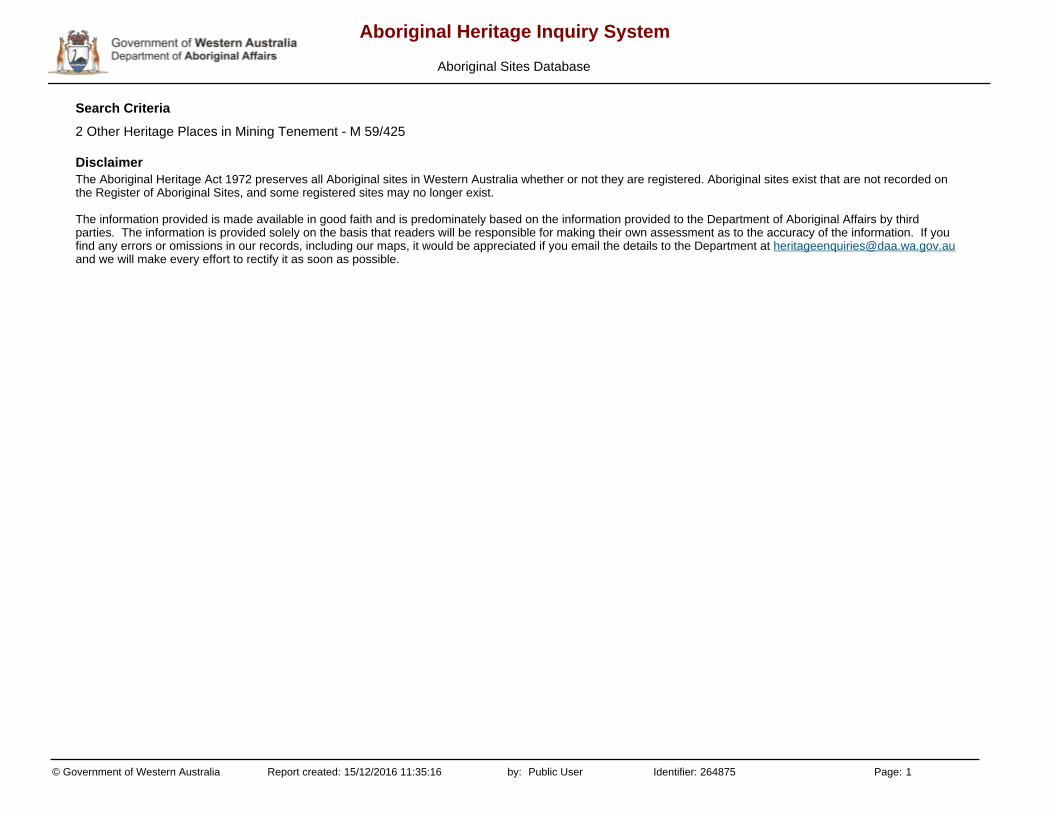
Search Criteria
2 Other Heritage Places in Mining Tenement - M 59/425
The Aboriginal Heritage Act 1972 preserves all Aboriginal sites in Western Australia whether or not they are registered. Aboriginal sites exist that are not recorded on the Register of Aboriginal Sites, and some registered sites may no longer exist.
The information provided is made available in good faith and is predominately based on the information provided to the Department of Aboriginal Affairs by third parties. The information is provided solely on the basis that readers will be responsible for making their own assessment as to the accuracy of the information. If you find any errors or omissions in our records, including our maps, it would be appreciated if you email the details to the Department at [email protected] and we will make every effort to rectify it as soon as possible.
Disclaimer
© Government of Western Australia Report created: 15/12/2016 11:35:16 by: Public User Identifier: 264875 Page: 1
Aboriginal Heritage Inquiry System
Aboriginal Sites Database
CopyrightCopyright in the information contained herein is and shall remain the property of the State of Western Australia. All rights reserved.
Coordinate AccuracyAccuracy is shown as a code in brackets following the coordinates. Map coordinates (Latitude/Longitude and Easting/Northing) are based on the GDA 94 Datum.The Easting/Northing map grid can be across one or more zones. The zone is indicated for each Easting on the map, i.e. '500000mE:Z50' means Easting=500000, Zone=50.
Terminology (NB that some terminology has varied over the life of the legislation)Place ID/Site ID: This a unique ID assigned by the Department of Aboriginal Affairs to the placeStatus:
o Registered Site: The place has been assessed as meeting Section 5 of the Aboriginal Heritage Act 1972o Other Heritage Place which includes:
- Stored Data / Not a Site: The place has been assessed as not meeting Section 5 of the Aboriginal Heritage Act 1972- Lodged: Information has been received in relation to the place, but an assessment has not been completed at this stage to determine if it meets
Section 5 of the Aboriginal Heritage Act 1972Status Reason: e.g. Exclusion - Relates to a portion of an Aboriginal site or heritage place as assessed by the Aboriginal Cultural Material Committee (ACMC). e.g.
such as the land subject to a section 18 notice.Origin Place ID: Used in conjuction with Status Reason to indicate which Registered Site this Place originates from. Access and Restrictions:
o File Restricted = No: Availability of information (other than boundary) that the Department of Aboriginal Affairs holds in relation to the place is not restricted in any way.
o File Restricted = Yes: Some of the information that the Department of Aboriginal Affairs holds in relation to the place is restricted if it is considered culturally sensitive. This information will only be made available if the Department of Aboriginal Affairs receives written approval from the informants who provided the information. Download the Request to Access Restricted Information letter and form.
o Boundary Restricted = No: place location is shown as accurately as the information lodged with the Registrar allows. o Boundary Restricted = Yes: To preserve confidentiality the exact location and extent of the place is not displayed on the map. However, the shaded region
(generally with an area of at least 4km²) provides a general indication of where the place is located. If you are a landowner and wish to find out more about the exact location of the place, please contact DAA.
o Restrictions: - No Restrictions: Anyone can view the information.- Male Access Only: Only males can view restricted information.- Female Access Only: Only females can view restricted information
Legacy ID: This is the former unique number that the former Department of Aboriginal Sites assigned to the place. This has been replaced by the Place ID / Site ID.
© Government of Western Australia Report created: 15/12/2016 11:35:16 by: Public User Identifier: 264875 Page: 2
Aboriginal Heritage Inquiry System
Aboriginal Sites Database
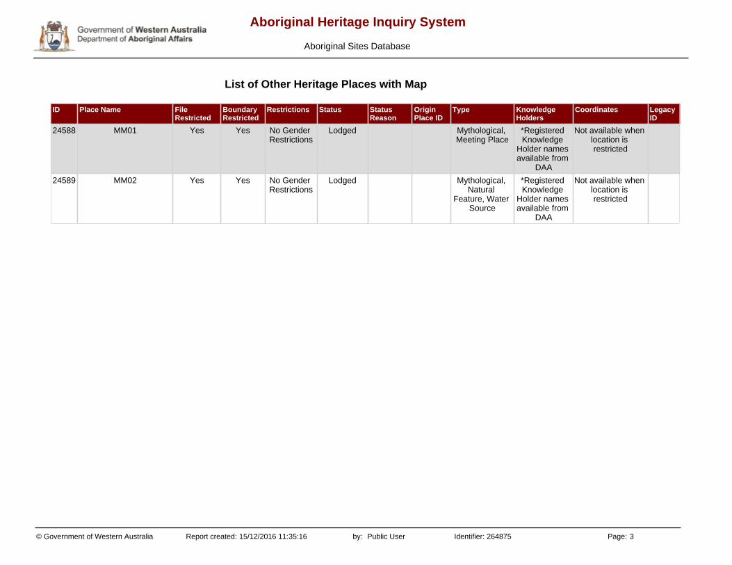
ID Place Name File Restricted
Boundary Restricted
Restrictions Status Status Reason
Origin Place ID
Type Knowledge Holders
Coordinates Legacy ID
24588 MM01 Yes Yes No Gender Restrictions
Lodged Mythological, Meeting Place
*Registered Knowledge
Holder names available from
DAA
Not available when location is restricted
24589 MM02 Yes Yes No Gender Restrictions
Lodged Mythological, Natural
Feature, Water Source
*Registered Knowledge
Holder names available from
DAA
Not available when location is restricted
List of Other Heritage Places with Map
© Government of Western Australia Report created: 15/12/2016 11:35:16 by: Public User Identifier: 264875 Page: 3
Aboriginal Heritage Inquiry System
Aboriginal Sites Database

Copyright for topographic base map information shall at all times remain the property of the Commonwealth of Australia, Geoscience Australia - National Mapping Division. All rights reserved.
Aerial Photos, Cadastre, Local Government Authority, Native Title boundary, Roads data copyright © Western Australian Land Information Authority trading as Landgate (2016).
Geothermal Application, Geothermal Title, Mining Tenement, Petroleum Application, Petroleum Title boundary data copyright © the State of Western Australia (DMP) (2016.12)
For further important information on using this information please see the Department of Aboriginal Affairs' Terms of Use statement at http://www.daa.wa.gov.au/Terms-Of-Use/
Legend
Selected Heritage Places
Other Heritage Places
Aboriginal Community Occupied
Aboriginal Community Unoccupied
Town
Search Area
© Government of Western Australia Report created: 15/12/2016 11:35:16 by: Public User Identifier: 264875 Page: 4
Aboriginal Heritage Inquiry System
Aboriginal Sites Database

MT MULGINE PROJECT EPA REFERRAL SUPPORTING DOCUMENT
TUNGSTEN MINING NL
APPENDIX 6: PROPOSED DISTURBANCE TO VEGETATION COMMUNITIES OF THE MT MULGINE
PROJECT AREA
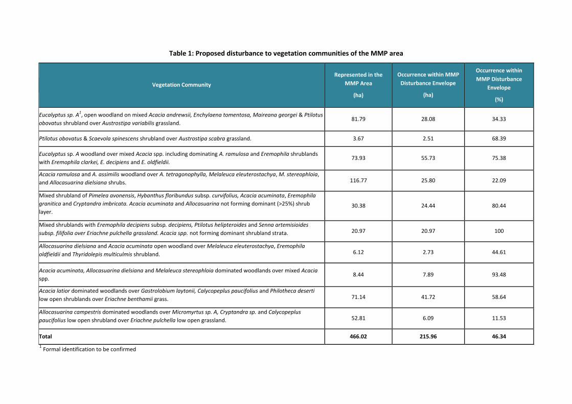
Table 1: Proposed disturbance to vegetation communities of the MMP area
Vegetation Community
Represented in the
MMP Area
(ha)
Occurrence within MMP
Disturbance Envelope
(ha)
Occurrence within
MMP Disturbance
Envelope
(%)
Eucalyptus sp. A1, open woodland on mixed Acacia andrewsii, Enchylaena tomentosa, Maireana georgei & Ptilotus
obovatus shrubland over Austrostipa variabilis grassland. 81.79 28.08 34.33
Ptilotus obovatus & Scaevola spinescens shrubland over Austrostipa scabra grassland. 3.67 2.51 68.39
Eucalyptus sp. A woodland over mixed Acacia spp. including dominating A. ramulosa and Eremophila shrublands
with Eremophila clarkei, E. decipiens and E. oldfieldii. 73.93 55.73 75.38
Acacia ramulosa and A. assimilis woodland over A. tetragonophylla, Melaleuca eleuterostachya, M. stereophloia,
and Allocasuarina dielsiana shrubs. 116.77 25.80 22.09
Mixed shrubland of Pimelea avonensis, Hybanthus floribundus subsp. curvifolius, Acacia acuminata, Eremophila
granitica and Cryptandra imbricata. Acacia acuminata and Allocasuarina not forming dominant (>25%) shrub
layer. 30.38 24.44 80.44
Mixed shrublands with Eremophila decipiens subsp. decipiens, Ptilotus helipteroides and Senna artemisioides
subsp. filifolia over Eriachne pulchella grassland. Acacia spp. not forming dominant shrubland strata. 20.97 20.97 100
Allocasuarina dielsiana and Acacia acuminata open woodland over Melaleuca eleuterostachya, Eremophila
oldfieldii and Thyridolepis multiculmis shrubland. 6.12 2.73 44.61
Acacia acuminata, Allocasuarina dielsiana and Melaleuca stereophloia dominated woodlands over mixed Acacia
spp. 8.44 7.89 93.48
Acacia latior dominated woodlands over Gastrolobium laytonii, Calycopeplus paucifolius and Philotheca deserti
low open shrublands over Eriachne benthamii grass. 71.14 41.72 58.64
Allocasuarina campestris dominated woodlands over Micromyrtus sp. A, Cryptandra sp. and Calycopeplus
paucifolius low open shrubland over Eriachne pulchella low open grassland. 52.81 6.09 11.53
Total 466.02 215.96 46.34
1 Formal identification to be confirmed