Dep
artm
ent
of C
ivil
, En
viro
nm
enta
l an
d N
atu
ral R
esou
rces
En
gin
eeri
ng
HYDROGEOLOGICAL OF MOSUL
DAM SITE
By
Issa Elias Issa
A report submitted as partial fulfilment of requirements for
geology of Iraq course
Department of Civil, Environmental and Natural Resources
Engineering
Luleå University of Technology
September 2011
i
Contents Figures and Tables
1- Introduction………………………………………………………. 1
2- Description of Mosul dam …………………………………... 3
3- Hydrological Mosul dam ……………………………………. 5
1- Climate …………………………………………………………… 6
Precipitation ………………………………………………….. 6
Temperatures ………………………………………………… 8
Relative humidity …………………………………………… 10
Winds …………………………………………………………. 11
Evaporation …………………………………………………... 13
2- Main characteristics for Tigris river basin ………………. 14
3- Sedimentation …………………………………………………... 17
4- Geological Mosul dam ……………………………………….. 19
5- Summary …………………………………………………………. 26
ii
Figures and Tables
Figures
Figure 1. Map of Iraq …………………………………………………………………. 2
Figure 2. Mosul dam …………………………………………………………………... 3
Figure 3. Schematic diagram of Mosul dam cross ………………………………….. 4
Figure 4. Spillway, Radial gate and stilling basin …………………………………... 5
Figure 5. The percentage of rainy and dry days in year at the Mosul dam station . 6
Figure 6. The percentage of effective and not effective rain in the year at Mosul dam
station ………………………………………………………………………………….. 7
Figure 7. Maximum daily rain depth in year ……………………………………….. 7
Figure 8. The relative distribution for Max. temperatures in the year at Mosul dam
site ……………………………………………………………………………………... 9
Figure 9. The relative distribution for Min. temperatures in the year at Mosul dam
site …………………………………………………………………………………….. 9
Figure 10. Relative distribution for Max. humidity ………………………………. 10
Figure 11. Relative distribution for Min. Humidity in the year …………………. 11
Figure 12. Percentage distribution for winds direction in year ………………….. 12
Figure 13. Percentage distribution for winds velocities in year ………………...... 12
Figure 14. Relative distribution of daily evaporation depth in the dam site …..... 13
Figure 15. Discharge elevation curve at paish-khabure ………………………….. 15
Figure 16. Reservoir area and volume at indicated elevation ……………………. 16
Figure 17. variation of the Suspended load with flow rate in Tigris river ……… 18
Figure 18. Geological map of Mosul city ………………………………………….. 20
Figure 19. Geological map of Mosul reservoir ………………………………….… 21
Figure 20. Geological map of Mosul dam site …………………………………….. 22
Figure 21. Small cave was found in March 2002 within a gypsum / anhydrite
layer …………………………………………………………………………………... 24
Figure 22. Karst phenomenon cause spring in bedrock ………………………...… 25
iii
iv
Figure 23. Collapse in the top layer ………………………………………………… 26
Tables Table 1: Max. Rain depth for years (1994-2008) at Mosul dam meteorological station ………………………………………………………………………………… 8 Table 2: Lithostratigraphic table of Mosul dam area ……………………………. 23
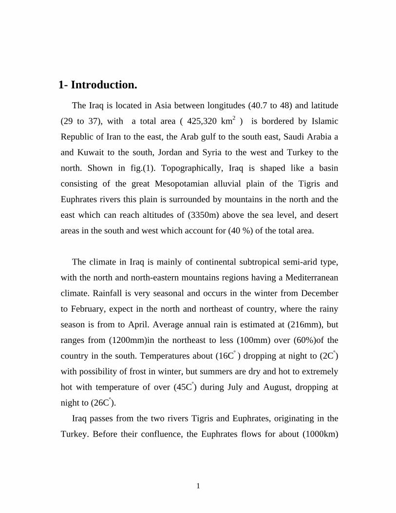
1- Introduction. The Iraq is located in Asia between longitudes (40.7 to 48) and latitude
(29 to 37), with a total area ( 425,320 km2 ) is bordered by Islamic
Republic of Iran to the east, the Arab gulf to the south east, Saudi Arabia a
and Kuwait to the south, Jordan and Syria to the west and Turkey to the
north. Shown in fig.(1). Topographically, Iraq is shaped like a basin
consisting of the great Mesopotamian alluvial plain of the Tigris and
Euphrates rivers this plain is surrounded by mountains in the north and the
east which can reach altitudes of (3350m) above the sea level, and desert
areas in the south and west which account for (40 %) of the total area.
The climate in Iraq is mainly of continental subtropical semi-arid type,
with the north and north-eastern mountains regions having a Mediterranean
climate. Rainfall is very seasonal and occurs in the winter from December
to February, expect in the north and northeast of country, where the rainy
season is from to April. Average annual rain is estimated at (216mm), but
ranges from (1200mm)in the northeast to less (100mm) over (60%)of the
country in the south. Temperatures about (16Cº ) dropping at night to (2Cº)
with possibility of frost in winter, but summers are dry and hot to extremely
hot with temperature of over (45Cº) during July and August, dropping at
night to (26Cº).
Iraq passes from the two rivers Tigris and Euphrates, originating in the
Turkey. Before their confluence, the Euphrates flows for about (1000km)
1
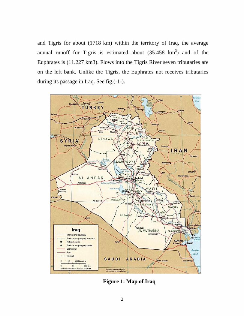
and Tigris for about (1718 km) within the territory of Iraq, the average
annual runoff for Tigris is estimated about (35.458 km3) and of the
Euphrates is (11.227 km3). Flows into the Tigris River seven tributaries are
on the left bank. Unlike the Tigris, the Euphrates not receives tributaries
during its passage in Iraq. See fig.(-1-).
Figure 1: Map of Iraq
2
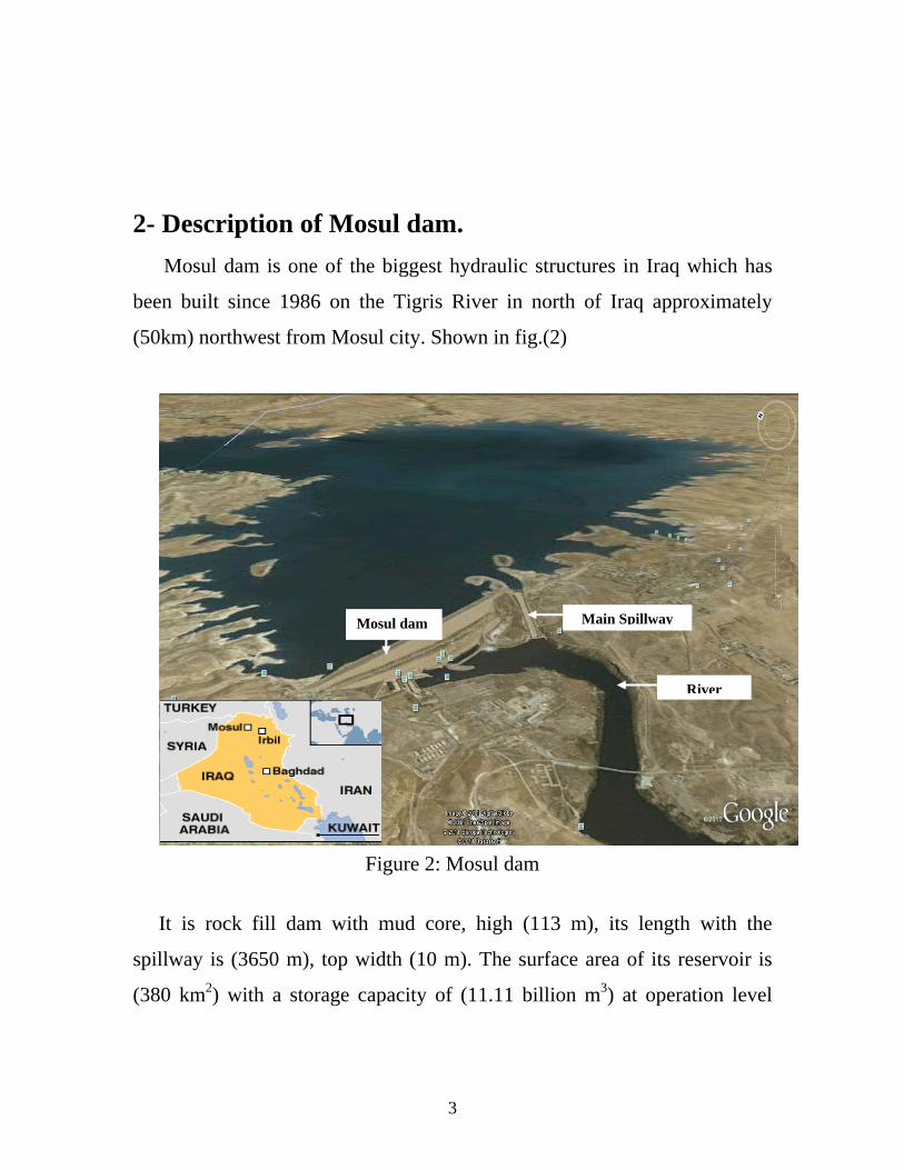
2- Description of Mosul dam.
Mosul dam is one of the biggest hydraulic structures in Iraq which has
been built since 1986 on the Tigris River in north of Iraq approximately
(50km) northwest from Mosul city. Shown in fig.(2)
River
Mosul dam Main Spillway
Figure 2: Mosul dam
It is rock fill dam with mud core, high (113 m), its length with the
spillway is (3650 m), top width (10 m). The surface area of its reservoir is
(380 km2) with a storage capacity of (11.11 billion m3) at operation level
3
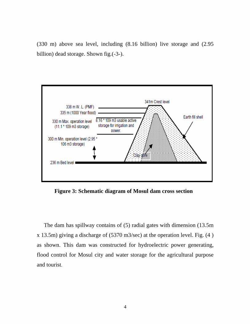
(330 m) above sea level, including (8.16 billion) live storage and (2.95
billion) dead storage. Shown fig.(-3-).
Figure 3: Schematic diagram of Mosul dam cross section
The dam has spillway contains of (5) radial gates with dimension (13.5m
x 13.5m) giving a discharge of (5370 m3/sec) at the operation level. Fig. (4 )
as shown. This dam was constructed for hydroelectric power generating,
flood control for Mosul city and water storage for the agricultural purpose
and tourist.
4
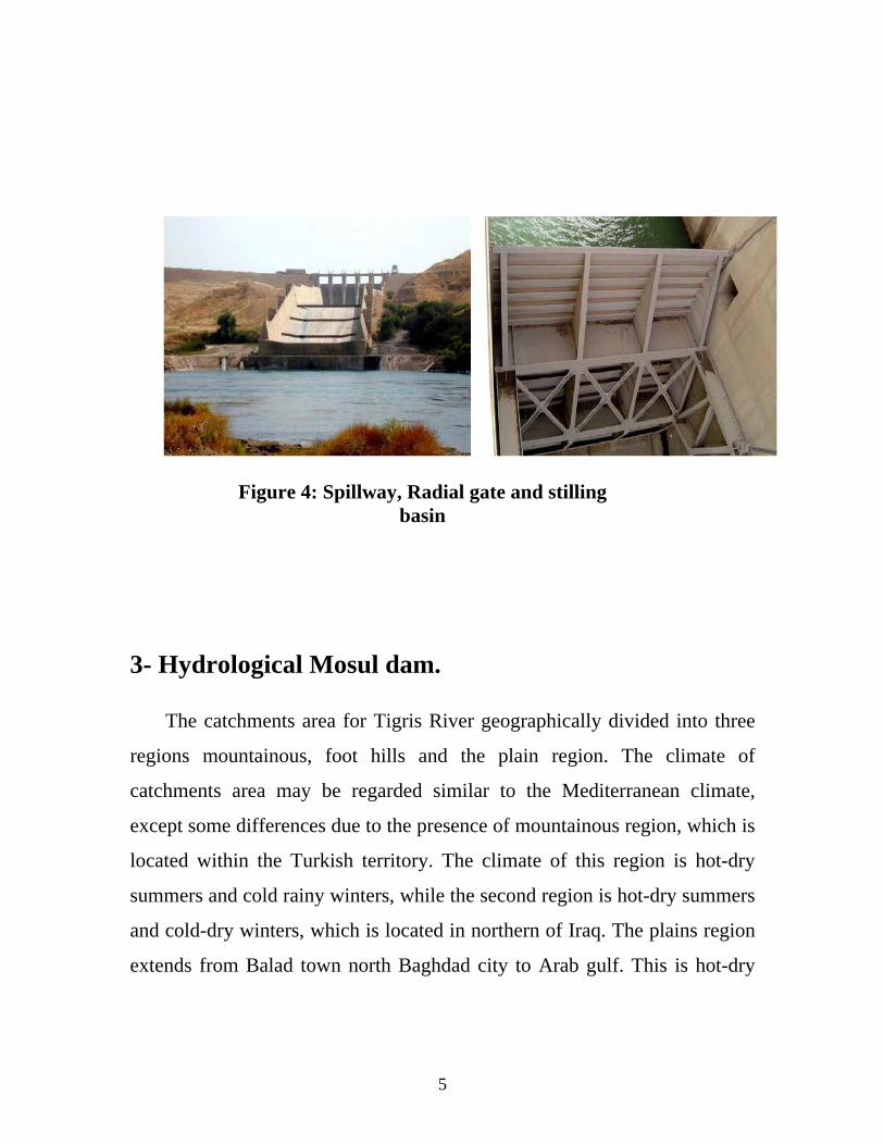
Figure 4: Spillway, Radial gate and stilling basin
3- Hydrological Mosul dam. The catchments area for Tigris River geographically divided into three
regions mountainous, foot hills and the plain region. The climate of
catchments area may be regarded similar to the Mediterranean climate,
except some differences due to the presence of mountainous region, which is
located within the Turkish territory. The climate of this region is hot-dry
summers and cold rainy winters, while the second region is hot-dry summers
and cold-dry winters, which is located in northern of Iraq. The plains region
extends from Balad town north Baghdad city to Arab gulf. This is hot-dry
5
summers but semi-cold and became relatively wet. In this case can regarded
the climate of Mosul and Mosul dam region are similar.
3.1- Climate.
- Precipitation.
The Precipitation in the Tigris river basin occurs between (Octobers –
May). In the mountainous region most precipitation is snow, but in the foot-
hills and plains is usually rain. The annual rate of precipitation over the
Tigris basin ranges between ranges (450-1500mm) annually in the Turkey
site, while is ranging between (200-600mm) annually in Mosul city. The
biggest depth of the rain is recorded in 24 hour is (71.6mm) at the dam site.
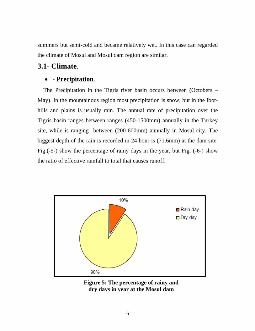
Fig.(-5-) show the percentage of rainy days in the year, but Fig. (-6-) show
the ratio of effective rainfall to total that causes runoff.
Figure 5: The percentage of rainy and dry days in year at the Mosul dam
6
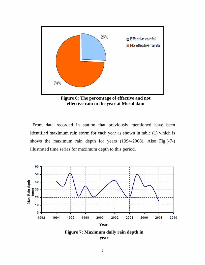
Figure 6: The percentage of effective and not effective rain in the year at Mosul dam
From data recorded in station that previously mentioned have been
identified maximum rain storm for each year as shown in table (1) which is
shows the maximum rain depth for years (1994-2008). Also Fig.(-7-)
illustrated time series for maximum depth to this period.
Max
. Rai
n d
epth
(mm
)
Year
Figure 7: Maximum daily rain depth in year
7
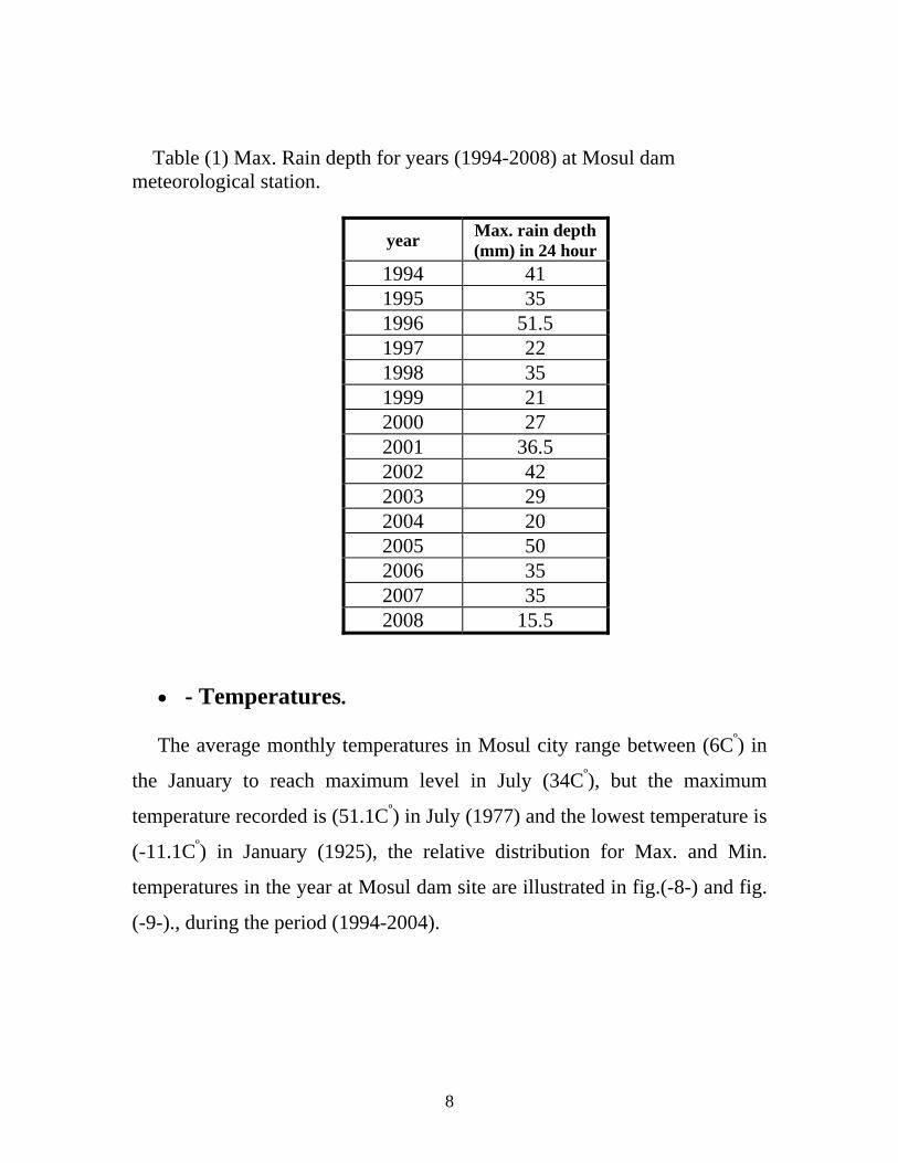
Table (1) Max. Rain depth for years (1994-2008) at Mosul dam meteorological station.
year Max. rain depth (mm) in 24 hour
1994 41 1995 35 1996 51.5 1997 22 1998 35 1999 21 2000 27 2001 36.5 2002 42 2003 29 2004 20 2005 50 2006 35 2007 35 2008 15.5
- Temperatures. The average monthly temperatures in Mosul city range between (6Cº) in
the January to reach maximum level in July (34Cº), but the maximum
temperature recorded is (51.1Cº) in July (1977) and the lowest temperature is
(-11.1Cº) in January (1925), the relative distribution for Max. and Min.
temperatures in the year at Mosul dam site are illustrated in fig.(-8-) and fig.
(-9-)., during the period (1994-2004).
8
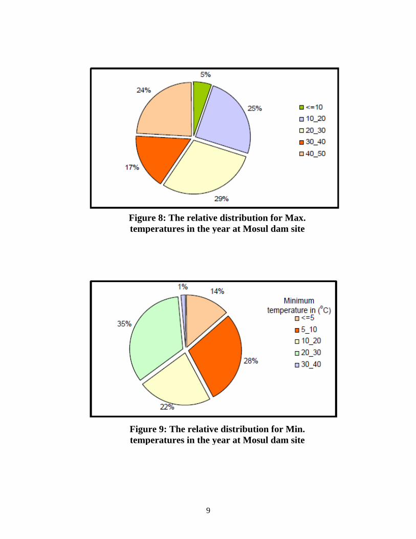
Figure 8: The relative distribution for Max. temperatures in the year at Mosul dam site
Figure 9: The relative distribution for Min. temperatures in the year at Mosul dam site
9
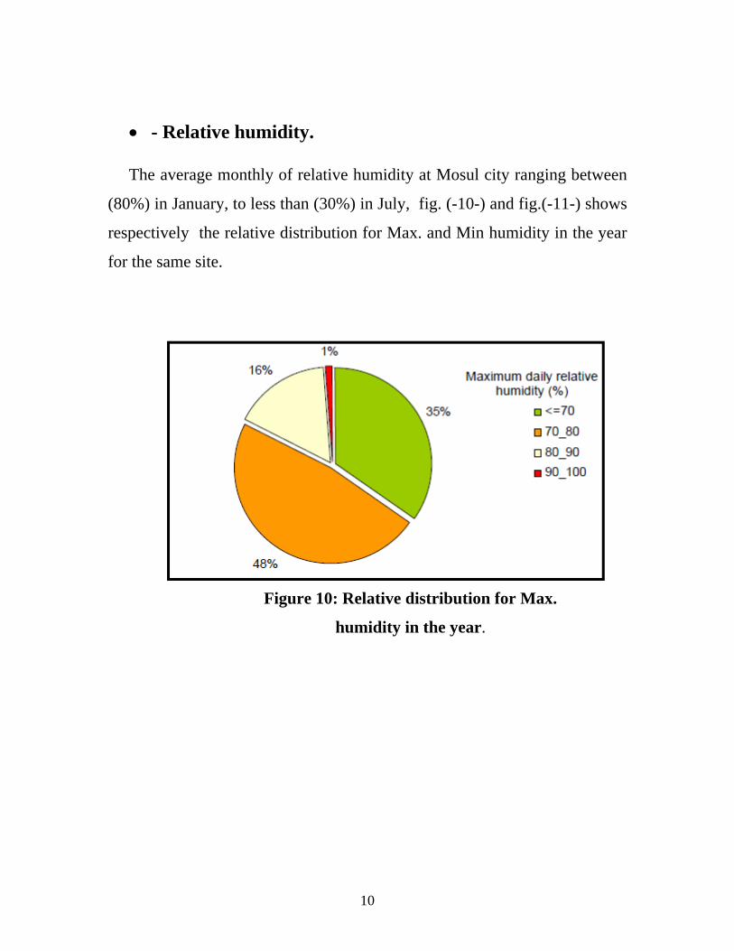
- Relative humidity. The average monthly of relative humidity at Mosul city ranging between
(80%) in January, to less than (30%) in July, fig. (-10-) and fig.(-11-) shows
respectively the relative distribution for Max. and Min humidity in the year
for the same site.
Figure 10: Relative distribution for Max.
humidity in the year.
10
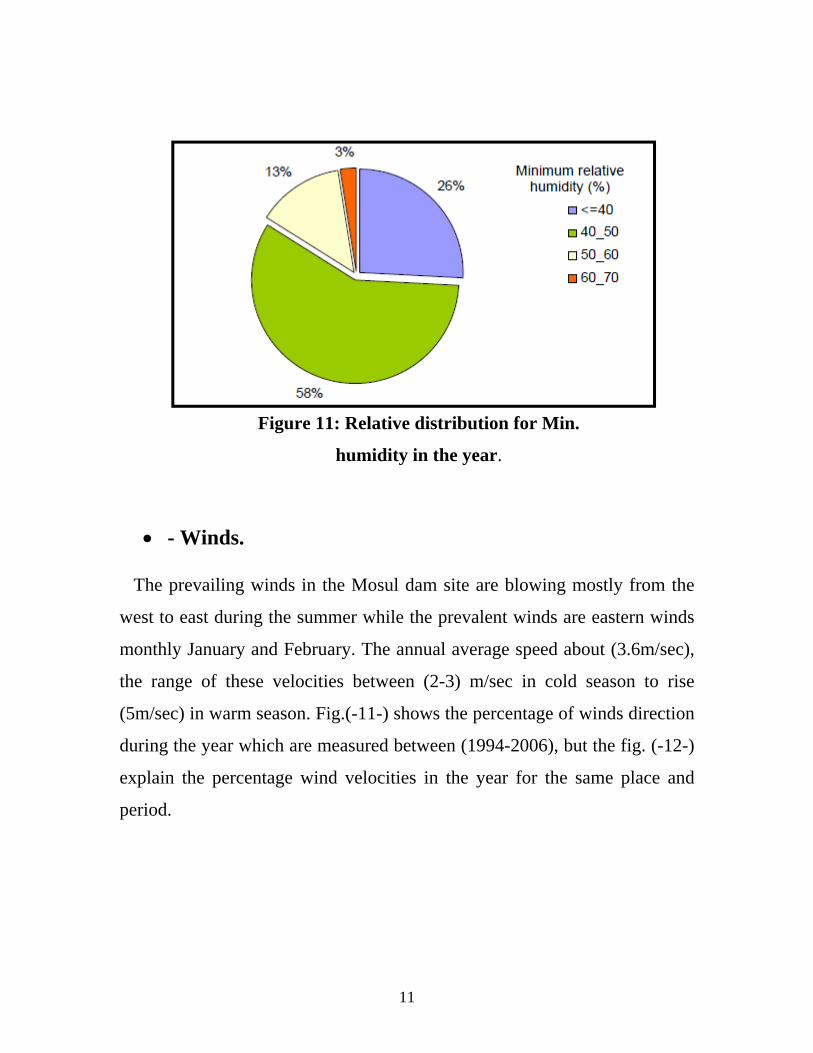
Figure 11: Relative distribution for Min.
humidity in the year.
- Winds. The prevailing winds in the Mosul dam site are blowing mostly from the
west to east during the summer while the prevalent winds are eastern winds
monthly January and February. The annual average speed about (3.6m/sec),
the range of these velocities between (2-3) m/sec in cold season to rise
(5m/sec) in warm season. Fig.(-11-) shows the percentage of winds direction
during the year which are measured between (1994-2006), but the fig. (-12-)
explain the percentage wind velocities in the year for the same place and
period.
11
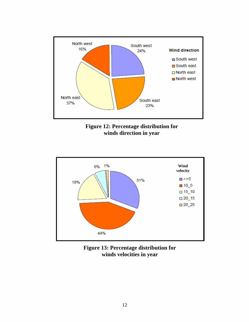
Figure 12: Percentage distribution for winds direction in year
Wind velocity
Figure 13: Percentage distribution for
winds velocities in year
12
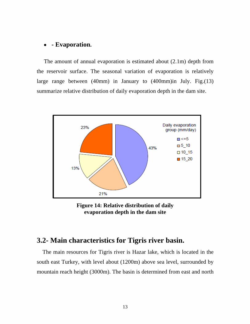
- Evaporation.
The amount of annual evaporation is estimated about (2.1m) depth from
the reservoir surface. The seasonal variation of evaporation is relatively
large range between (40mm) in January to (400mm)in July. Fig.(13)
summarize relative distribution of daily evaporation depth in the dam site.
Figure 14: Relative distribution of daily evaporation depth in the dam site
3.2- Main characteristics for Tigris river basin.
The main resources for Tigris river is Hazar lake, which is located in the
south east Turkey, with level about (1200m) above sea level, surrounded by
mountain reach height (3000m). The basin is determined from east and north
13
sides by mountain chains common to both Turkey, Iraq and Iran. Flows into
the river north Mosul city many tributaries Batman, Kazan, Botan and
Alkhabur, that sources of these is the same mountain region all these
converge with Tigris river from left bank. The river is shallow wide in the
Diyarbakir but after reach with Batman become Narrow deep river with
height velocity and entirely within Iraqi borders in paish-khabur. The wide
river valley (flood plain) range between (2-10) km north Mosul city to paish-
khabur. The slop river in this reach is (0.65m/km). The catchments area
estimated up Mosul city is (52200 km2 ) including (23500 km2 ) in Iraq. The
rain in the basin concentrated between January to February but the snow is
melting in April and May therefore the flood period is between February to
May, after this the flow rate reduce where the lower rates occur during the
August to October.
From data of flow rate for (76) year for Mosul station we get.
Minimum annual discharge (280 m3/sec).
Annual discharge (653 m3/sec).
Maximum annual discharge (1395 m3/sec).
The peak highest daily discharge is registered up to (9200 m3/sec), which
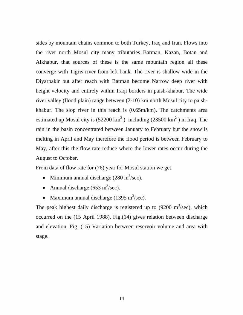
occurred on the (15 April 1988). Fig.(14) gives relation between discharge
and elevation, Fig. (15) Variation between reservoir volume and area with
stage.
14
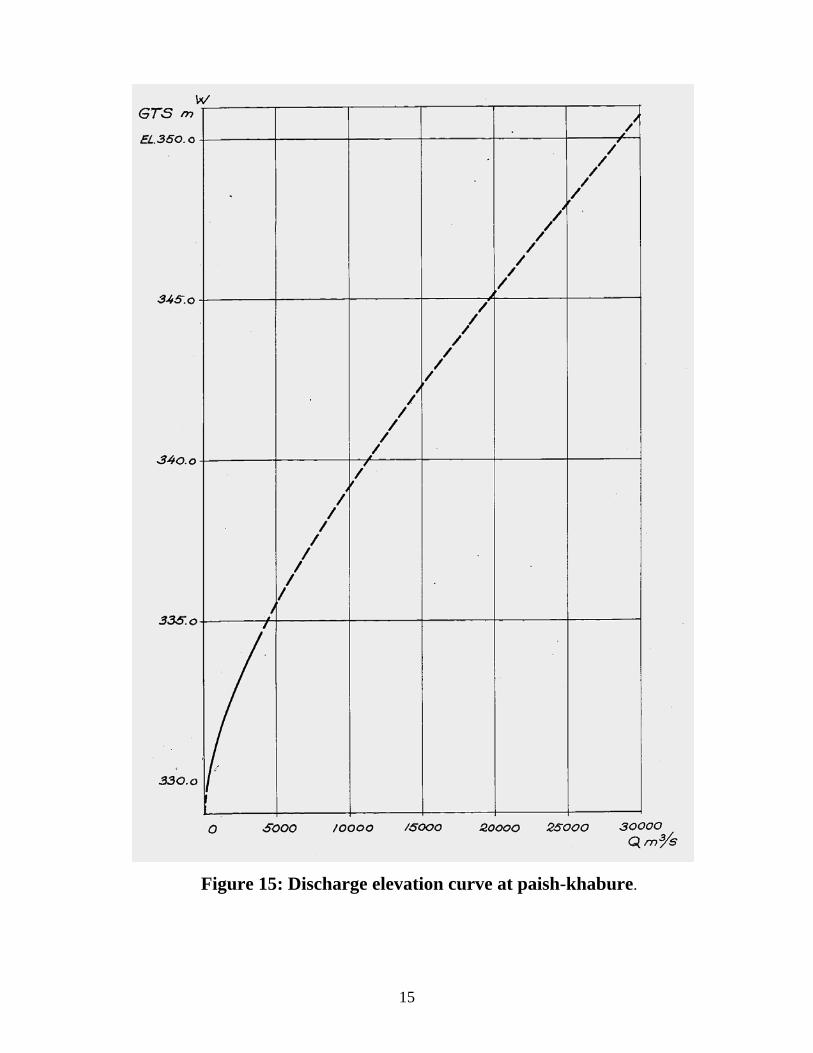
Figure 15: Discharge elevation curve at paish-khabure.
15
Figure 16: Reservoir area and volume at indicated elevation
16
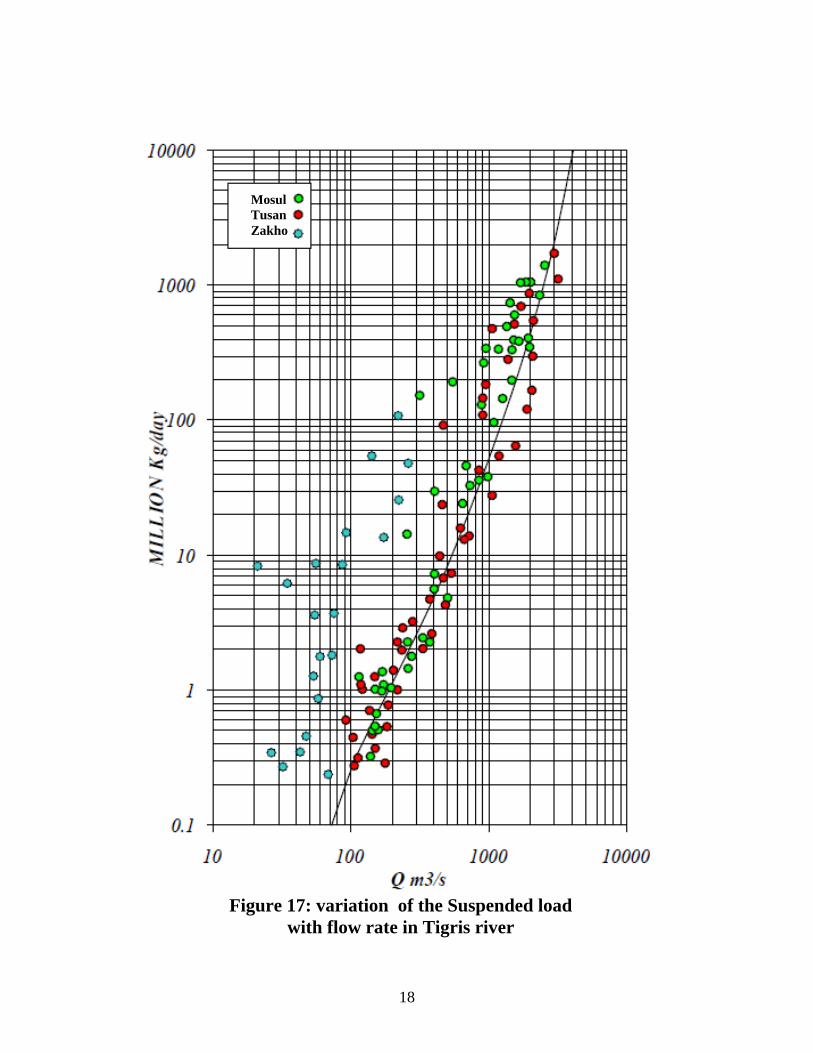
3.3- Sedimentation.
Rate of sedimentation in the Tigris River especially in Mosul dam site
has been estimated from many group Iraqi and foreign companies, since the
fifties of the last century. In (1951) Irrigation development commission
provided under supervision F.F.Huag study entitled “ Control of the Iraqi
rivers and use of waters” as estimated the annual rate of sediment in the
Tigris river up the Mosul dam site about (356m3/year per Km2 from
catchments area). Also Advisory committee under the supervision of Sir
Alexender in (1953) estimated the Sediment amount (400m3/year per Km2
from catchments area).
Then provided Harza engineering company, Binnie and Partners in (1963)
report volume II about “Hydrological survey of Iraq” investigated the
amount of suspended load during period (8 October 1958 to 28 June 1962),
when the discharge ranged (97- 1321) m3/sec. The samples were taken from
the region expected Mosul dam lake covered. Fig (16) shows the relation
between discharge and suspended sediment rate for (Mosul, Tusan and
Zakho stations).
17
Mosul Tusan Zakho
Figure 17: variation of the Suspended load
with flow rate in Tigris river
18
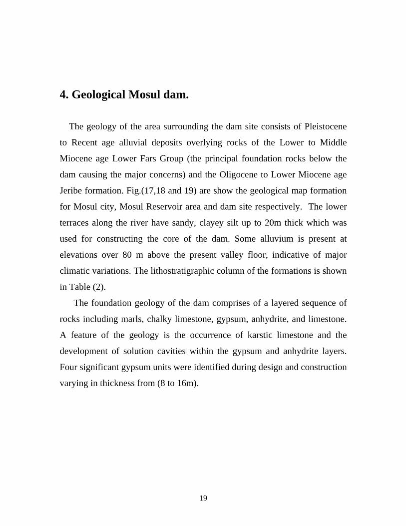
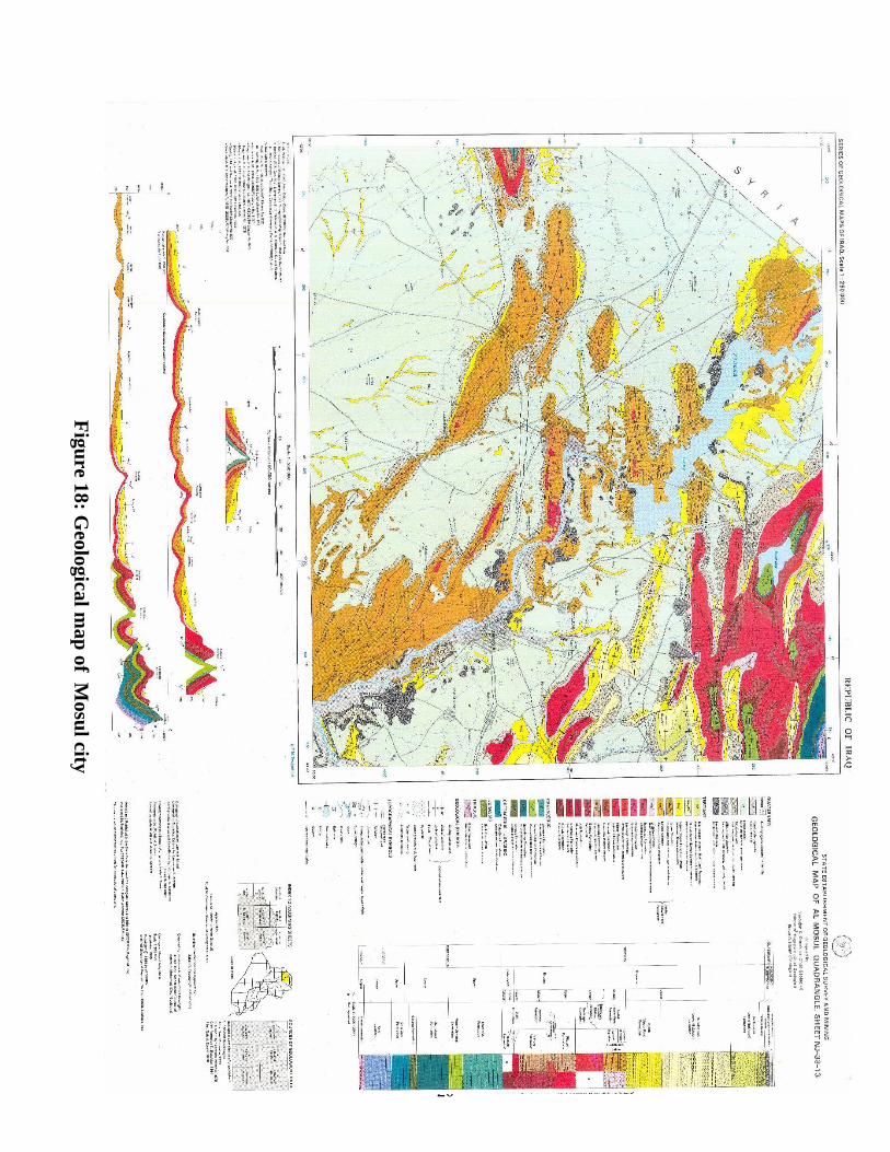
4. Geological Mosul dam. The geology of the area surrounding the dam site consists of Pleistocene
to Recent age alluvial deposits overlying rocks of the Lower to Middle
Miocene age Lower Fars Group (the principal foundation rocks below the
dam causing the major concerns) and the Oligocene to Lower Miocene age
Jeribe formation. Fig.(17,18 and 19) are show the geological map formation
for Mosul city, Mosul Reservoir area and dam site respectively. The lower
terraces along the river have sandy, clayey silt up to 20m thick which was
used for constructing the core of the dam. Some alluvium is present at
elevations over 80 m above the present valley floor, indicative of major
climatic variations. The lithostratigraphic column of the formations is shown
in Table (2).
The foundation geology of the dam comprises of a layered sequence of
rocks including marls, chalky limestone, gypsum, anhydrite, and limestone.
A feature of the geology is the occurrence of karstic limestone and the
development of solution cavities within the gypsum and anhydrite layers.
Four significant gypsum units were identified during design and construction
varying in thickness from (8 to 16m).
19
20
Figu
re 18: Geological m
ap of M
osul city
Figu
re 19: Geological m
ap of M
osul reservoir
21
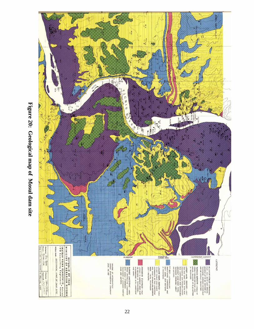
22
Figu
re 20: Geological m
ap of M
osul d
am site
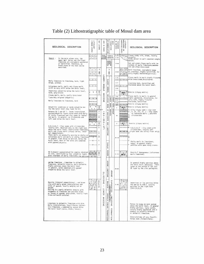
Table (2) Lithostratigraphic table of Mosul dam area
23
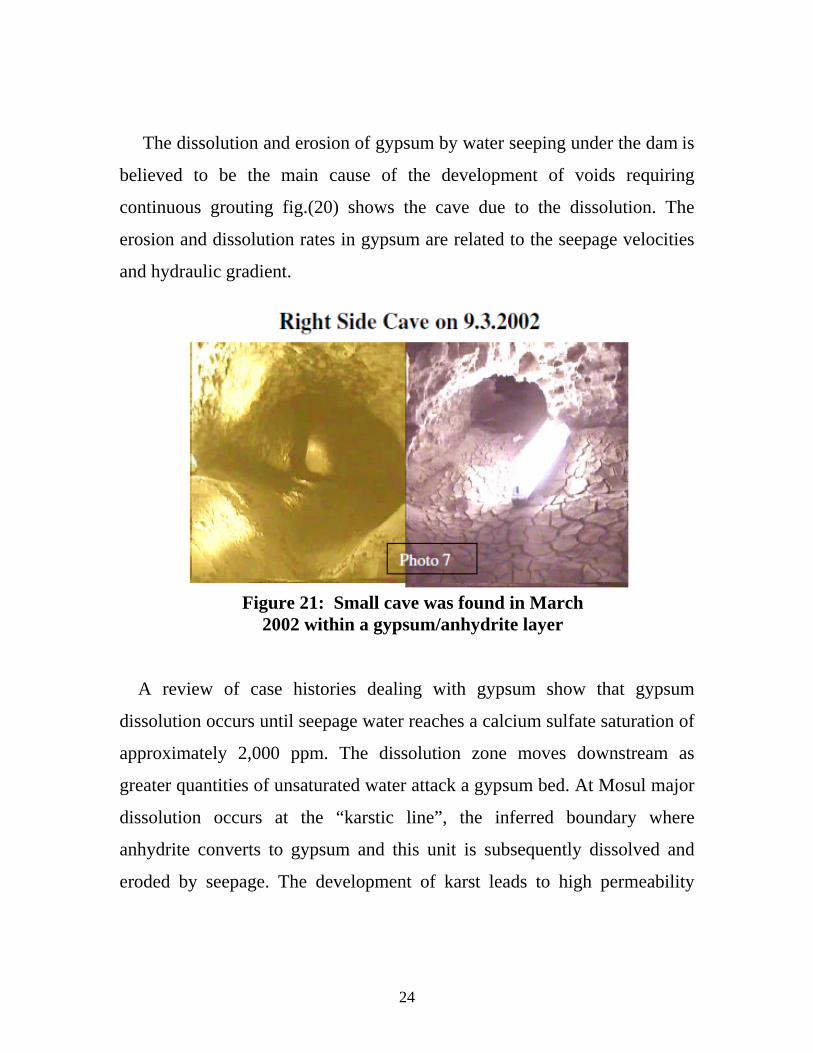
The dissolution and erosion of gypsum by water seeping under the dam is
believed to be the main cause of the development of voids requiring
continuous grouting fig.(20) shows the cave due to the dissolution. The
erosion and dissolution rates in gypsum are related to the seepage velocities
and hydraulic gradient.
Figure 21: Small cave was found in March 2002 within a gypsum/anhydrite layer
A review of case histories dealing with gypsum show that gypsum
dissolution occurs until seepage water reaches a calcium sulfate saturation of
approximately 2,000 ppm. The dissolution zone moves downstream as
greater quantities of unsaturated water attack a gypsum bed. At Mosul major
dissolution occurs at the “karstic line”, the inferred boundary where
anhydrite converts to gypsum and this unit is subsequently dissolved and
eroded by seepage. The development of karst leads to high permeability
24
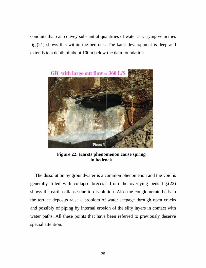
conduits that can convey substantial quantities of water at varying velocities
fig.(21) shows this within the bedrock. The karst development is deep and
extends to a depth of about 100m below the dam foundation.
Figure 22: Karsts phenomenon cause spring
in bedrock
The dissolution by groundwater is a common phenomenon and the void is
generally filled with collapse breccias from the overlying beds fig.(22)
shows the earth collapse due to dissolution. Also the conglomerate beds in
the terrace deposits raise a problem of water seepage through open cracks
and possibly of piping by internal erosion of the silty layers in contact with
water paths. All these points that have been referred to previously deserve
special attention.
25
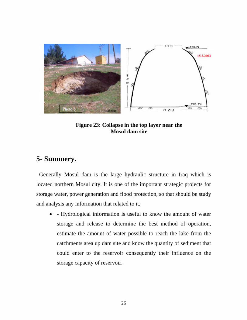
Figure 23: Collapse in the top layer near the
Mosul dam site
5- Summery. Generally Mosul dam is the large hydraulic structure in Iraq which is
located northern Mosul city. It is one of the important strategic projects for
storage water, power generation and flood protection, so that should be study
and analysis any information that related to it.
- Hydrological information is useful to know the amount of water
storage and release to determine the best method of operation,
estimate the amount of water possible to reach the lake from the
catchments area up dam site and know the quantity of sediment that
could enter to the reservoir consequently their influence on the
storage capacity of reservoir.
26
- Geological structure for dam site and surrounding area is essential
to know the dam state and know the main problems that may be
occurs before or after construction. The geology of the Mosul dam
site area is superficial deposits overlying rocks of the Upper and
Lower Fars Groups above the Jeribe formation. The Jeribe
formation rocks are of Oligocene to Lower Miocene age, while the
rocks of the overlying Fars groups are of Lower to Middle Miocene
age. The foundation geology of the dam comprises a layered
sequence of rocks including marls, chalky limestones, gypsum,
anhydrite, clays and limestones. A feature of the geology is the
development of karst or solution weathering within the limestones
and the anhydrite and gypsum layers. The presence of gypsum and
anhydrite in the marl would be particularly detrimental in zones
where high seepage flows could develop, i.e mainly at the contact
with the cavernous limestone. This will require a special attention
in avoiding high velocities, induced by high hydraulic gradients.
27

28
References
College of Engineering, 2011, Sediment Study Upstream Pump
Station Al-Jezera Project, Final Report, Consultancy Bureau,
College Engineering, Mosul University, 103p.
Imatran Voima Osakeyhtio, 1968,Geologe Map Reservoir Are,
Scale 1:100 000, Republic of Iraq, Ministry of Agrarian Reform.
Imatran Voima Osakeyhtio, 1968,Geologe Map of Dam Site,
Scale 1:100 000, Republic of Iraq, Ministry of Agrarian Reform.
Harza Engineering Company, Binnie and Parteners, 1963,
Hydrological Survy of Iraq, Final Report, Vol. III, Government of
Iraq, Ministry of Agriculture, 146p.
Kelley, J.R.,Wakeley, L.D., Broadfoot, S.W., Pearson, M.L.,
McGrath, C.J., McGill, T.E., Jorgeson, J.D., and Talbot, C.A.,
Geologic Setting of Mosul Dam and Its Engineering Implications,
U. S. Army Crops of Engineers, Engineer Research and
Development Center, 50p.