Journal of Coastal Research 26-39 Royal Palm Beach, Florida Winter 2000
Holocene Depositional Patterns, Neotectonics andSundarban Mangroves in the WesternGanges-Brahmaputra Delta
Daniel Jean Stanley] and Arghya K. Haitj
tDeltas-Global ChangeProgram
Paleobiology E-206 NMNHSmithsonian InstitutionWashington, D.C. 20560,
U.S.A.
.: ..
:j:Center for Study of Man andEnvironment
CK-11, Sector 2Salt Lake CityCalcutta 700091, India
.tflllllll:.~~.~ ~ ~
a..;; b-Lt
STANLEY, D.J. and HAlT, A.K., 2000. Holocene Depositional Patterns, Neotectonics and Sundarban Mangroves in theWestern Ganges-Brahmaputra Delta. Journal of Coastal Research, 16(1), 26-39. Royal Palm Beach (Florida), ISSN0749-0208.
Litho- and chronostratigraphic analyses of radiocarbon-dated cores are utilized herein to distinguish Holocene deltaicand underlying transgressive units and late Pleistocene alluvial deposits in the western Ganges-Brahmaputra delta.Regional distribution of these facies indicates that neotectonic displacement, including differential land subsidence,of delta plain sectors is one of the major controls of late Quaternary depositional patterns in this depocenter. Thespatial and temporal configuration of Holocene deltaic sediment thickness, mud and sand layers, peats interstratifiedin Holocene sequences, and modern mangrove forests that form the Sundarbans are attributed to NE-SW, and to alesser extent NW-SE, neotectonic trends. Holocene sedimentary and stratigraphic configurations closely parallel geological structures, some of them deep seated, that affected this region during most of the Tertiary and have continuedto the present.
Extensive mangrove forests developed along the NE-SW zone of thickened Holocene deltaic deposits. Their presentconfiguration is related to natural factors, such as eastward tilting of the delta, rapid sediment accumulation (to 0.7cm/yr) , marked land subsidence (to 0.5 cm/yr), and increasing anthropogenic influences, including large-scale landreclamation and decreased river flow influx. The diverse and extensive mangrove tracts of the delta have significantenvironmental and economic implications for the rapidly growing population, including serving as a buffer zone thathelps to reduce the impact of landward-driven tides, storms and cyclones. Interpretation of Holocene facies in thesubsurface by means of radiocarbon-dated cores provides a mean to more precisely define the interaction betweencontemporary Holocene depositional patterns and neotectonics. This information, in turn, can be utilized to developrealistic measures needed to minimize further degradation of this biologically unique ecosystem.
ADDITIONAL INDEX WORDS: Bengal basin, borings, estuaries, Ganges-Brahmaputra delta, Holocene facies, mangroves, neotectonics, Pleistocene facies, population pressure, radiocarbon dating, salinity, sea level, sedimentation rate,subsidence rate, Sundarbans.
INTRODUCTION
The Ganges-Brahmaputra delta, one of the world's largestand most populated, is a low-lying and highly vulnerablecoastal environment (DELFT HYDRAULICS, 1989; ALAM, 1996;KUEHL et al., 1997). This delta, with a tidal range of about3.5 to 5.0 m in the estuaries (CHAUDHURI and CHOUDHURY,1994) and complex network of estuaries, creeks and islands(Figure 1), is a classic example of a tide-dominated coastaldepocenter (GALLOWAY, 1975). The depocenter is positionedat the mouth of the large Ganges-Brahmaputra-Meghna riversystem (MILLIMAN and MEADE, 1983; SUBRAMANIAN andRAMANATHAN, 1996; KUEHL et al; 1997; ALLISON, 1998a;MICHELS et al., 1998), with an estimated seaward-directedsuspended sediment load of 1060 X 106 t/year (MILLIMAN andSYVITSKI, 1992).
This delta harbours the largest single continuous tract of
99001 received and accepted in revision 15 May 1999.
diverse mangrove forest (Figure 2), a part of which has beenset aside as the world's only mangrove tiger preserve (CHANDA, 1977; NASKAR and GUHA BARSHI, 1987; HUSSAIN andACHARYA, 1994). Imbalances in the mangrove ecosystem notonly causes serious ecological and socio-economic problems,but also further exposes the rapidly growing population(>110 million persons in the deltaic area of Bangladesh andIndia) in the vulnerable low-lying depocenter to the dangersof storms and cyclonic surges (CHAUDHURI and CHOUDHURY,1994). In one storm alone, in 1970, nearly 300,000 personsperished (MILLIMAN et al., 1989) and, at the end of 1998, overhalf of the lower delta plain surface was submerged by rainsand floods.
The late Holocene balance between fresh and salt water inthe delta is presently being altered by natural factors (suchas tilting of the delta towards east and rising sea level) andincreased anthropogenic influences (including withdrawal ofriver water in the upstream region by dams on the Ganges).
Western Ganges-Brahmaputra Delta Sedimentation 27
o 40 80 100km.- --'1t'\E.
OfMOU,.HS
BAY OF BENGAL
o92
o23
~ INDIAN SUNDAR8ANS
~ BANGLADESH SUNDARBANS
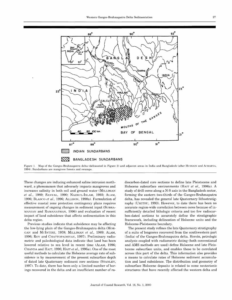
Figure 1. Map of the Ganges-Brahmaputra delta (delineated in Figure 2) and adjacent areas in India and Bangladesh (after HUSSAIN and ACHARYA,
1994 L Sundarbans are mangrove forests and swamps.
These changes are inducing enhanced saline intrusion northward, a phenomenon that adversely impacts mangroves andincreases salinity in both soil and ground water (MILLIMANet al., 1989; SANYAL, 1990; NAZRUL-IsLAM, 1993; ALAM,1996; BLASCO et al., 1996; ALLISON, 1998a). Formulation ofeffective coastal zone protection contingency plans requiresmeasurement of ongoing changes in sediment input (SUBRAMANIAN and RAMANATHAN, 1996) and evaluation of recentimpact of land subsidence that affects sedimentation in thisdelta region.
Previous studies indicate that subsidence may be affectingthe low-lying plain of the Ganges-Brahmaputra delta (MORGAN and McINTIRE, 1959; MILLIMAN et al., 1989; ALAM,1996; Roy and CHATTOPADHYAY, 1997). Preliminary radiometric and paleobiological data indicate that land has beenlowered relative to sea level in recent time (ALAM, 1996;CHANDA and HAlT, 1996; HAlT et al., 1996a). One of the mostuseful methods to calculate the Holocene average rate of subsidence is by measurement of the present subsurface depthof dated late Quaternary sediment core sections (STANLEY,1997). To date, there has been only a limited number of borings recovered in the delta and an insufficient number of ra-
diocarbon-dated core sections to define late Pleistocene andHolocene subsurface environments (HAlT et al., 1996a). Astudy of drill cores along a N-S axis in the Bangladesh sector,forming the eastern two-thirds of the Ganges-Brahmaputradelta, has revealed the general late Quaternary lithostratigraphy (UMITSU, 1993). However, to date there has been noaccurate region-wide correlation between cores because of insufficiently detailed lithologic criteria and too few radiocarbon-dated sections to accurately define the stratigraphicframework, including delineation of Holocene units and theHolocene-Pleistocene boundary.
The present study refines the late Quaternary stratigraphyof a suite of longcores recovered from the southwestern part(India) of the Ganges-Brahmaputra delta. Herein, petrologicanalysis coupled with radiometric dating (both conventionaland AMS methods are used) define Holocene and late Pleistocene subsurface units, and enables these to be correlatedacross this part of the delta. This information also providesa means to calculate rates of Holocene sediment accumulation and land subsidence. The distribution and geometry ofsubsurface Holocene deposits is related to some neotectonicstructures that have recently affected the western delta and
Journal of Coastal Research, Vol. 16, No.1, 2000
28 Stanley and Hait
I~ IBeach ridge complex~
I~ ~ iil Delta-front platform
~ Prodelta slope
~ Open sea
Upper ]flood plain Subaerial deltaLowerflood plain
Mangroveswamp
Marine
TransitionalEstuary
"""""",','""""
~
Precambrian rock
Lateriticterrace
Alluvial uplanddry land wi swamp
Pleistoceneterrace
Lake
Paleo sub-delta
T T'T T'..I...J:2.
~L L L
L LL L
[{Z]+ ++ +
+ + ..
~~
IID
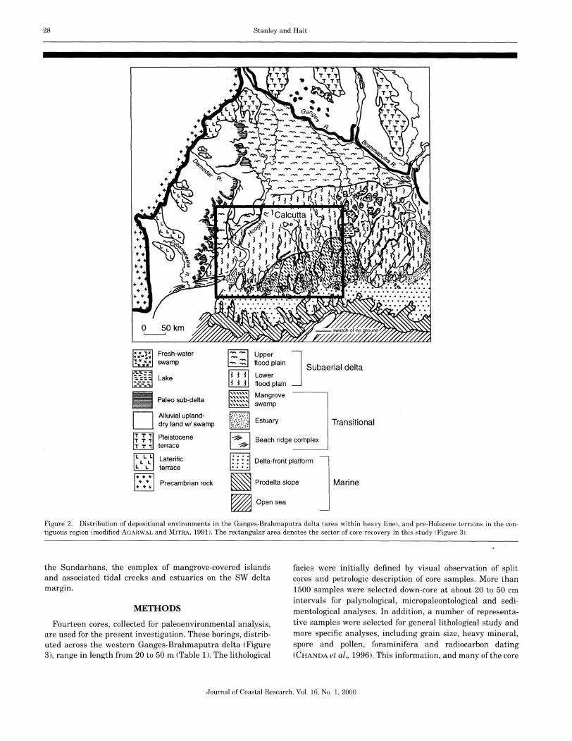
Figure 2. Distribution of depositional environments in the Ganges-Brahmaputra delta (area within heavy line), and pre-Holocene terrains in the contiguous region (modified AGARWAL and MITRA, 1991). The rectangular area denotes the sector of core recovery in this study (Figure 3).
the Sundarbans, the complex of mangrove-covered islandsand associated tidal creeks and estuaries on the SW deltamargin.
METHODS
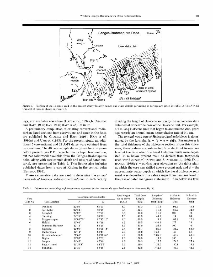
Fourteen cores, collected for paleoenvironmental analysis,are used for the present investigation. These borings, distributed across the western Ganges-Brahmaputra delta (Figure3), range in length from 20 to 50 m (Table 1). The lithological
facies were initially defined by visual observation of splitcores and petrologic description of core samples. More than1500 samples were selected down-core at about 20 to 50 cmintervals for palynological, micropaleontological and sedimentological analyses. In addition, a number of representative samples were selected for general lithological study andmore specific analyses, including grain size, heavy mineral,spore and pollen, foraminifera and radiocarbon dating(CHANDA et al., 1996). This information, and many of the core
Journal of Coastal Research, Vol. 16, No.1, 2000
Western Ganges-Brahmaputra Delta Sedimentation 29
deltamargin
Ganges-Brahmaputra Delta
lower delta plain
. )~(Flg.S
Bay of Bengal
Khulna15•
Figure 3. Position of the 15 cores used in the present study (locality names and other details pertaining to borings are given in Table 1). The NW-SEtransect of cores is shown in Figure 5.
logs, are available elsewhere (HAlT et al., 1994a,b; CHANDAand HAlT, 1996; DAS, 1996; HAlT et a!., 1996a,b).
A preliminary compilation of existing conventional radiocarbon dated sections from excavations and cores in the deltaare published by CHANDA and HAlT (1996), HAlT et al.(1996a) and UMITSU (1993). For the present study, an additional 5 conventional and 21 AMS dates were obtained fromcore sections. The 48 core sample dates (given here in yearsbefore present, yrs B.P.; corrected for isotopic fractionation,but not calibrated) available from the Ganges-Brahmaputradelta, along with core sample depth and nature of dated material, are presented in Table 2. This listing also includespublished dates from a core at Khulna in the central delta(UMITSU, 1993).
These radiometric data are used to determine the annualmean rate of Holocene sediment accumulation in each core by
dividing the length of Holocene section by the radiometric dataobtained at or near the base of the Holocene unit. For example,a 7 m-long Holocene unit that began to accumulate 7000 yearsago records an annual mean accumulation rate of 0.1 em.
The annual mean rate ofHolocene land subsidence is determined by the formula, [a - (b + c + d)]/e. Parameter a isthe total thickness of the Holocene section. From this thickness, three values are subtracted: b = depth of former sealevel at the time when the basal Holocene muds were deposited (in m below present msl), as derived from frequentlyused world curves (CHAPPEL and SHACKLETON, 1986; FAIRBANKS, 1989); c = surface spot elevation on the delta plainat which the core was drilled above present msl; and d = theapproximate water depth at which the basal Holocene sediment was deposited (this value ranges from near sea level inthe case of dated mangrove material to - 5 m below sea level
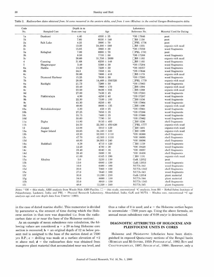
Table 1. Information pertaining to fourteen cores recovered in the western Ganges-Brahmaputra delta (see Fig. 1).
Geographical CoordinatesSpot Height Total Core Length of % Mud in % Sand in
Core (in m above Length Holocene Holocene HoloceneCode No. Core Location N E m.s.l.) (in m) Unit (in m) Unit Unit
1 Dankuni 22°05' 88°01' 6.0 30.0 11.5 91.7 8.32 Salt Lake 22°34' 88°28' 5.8 32.5 11.3 87.2 12.83 Kolaghat 22°27' 87°55' 5.5 30.0 11.0 100 04 Canning 22°10' 88°38' 1.6 48.0 43.5 14 865 Bhagawanpur 22°05'55" 87°45'10" 2.0 20.0 3.9 87.9 12.16 Haldia 22°03' 87°59' 4.3 30.5 >30.5 77 237 Diamond Harbour 22°13' 88°10' 6.5 33.0 26.5 100 08 Raidighi 22°00' 88°26'14" 2.4 48.1 25.0 31.2 68.89 Pakhirayala 22°14' 88°47' 2.0 50.0 >50 43 57
10 Bishalakshmipur 21°50' 88°13'52" 2.7 35.8 >35.8 43.2 56.811 Digha 21°37' 87°32' 1.0 30.5 13.2 100 012 Junput 21°43' 87°49' 1.0 39.3 16.5 74.6 25.413 Sagar Island 21°39'8" 88°5'5" 3.1 49.4 23.0 80.8 19.214 Bakkhali 21°37' 88°18' 2.6 42.5 >42.5 55.7 44.3
Journal of Coastal Research, Vol. 16, No.1, 2000
30 Stanley and Hait
Table 2. Radiocarbon dates obtained from 14 cores recovered in the western delta, and from 1 core (Khulna) in the central Ganges-Brahmaputra delta.
Code Depth in m LaboratoryNo. Sampled Core from core top Age Reference No. Material Used for Dating
1a Dankuni 4.40 4500 =!:: 35 *OS 17646 peat1b 7.60 6030 =!:: 140 DB81158 peat2a Salt Lake 4.25 3990 =!:: 70 DPRL 1776 peat2b 13.20 24,200 =!:: 580 DB81235 organic-rich mud2c 15.85 3860 =!:: 30 *08 17059 wood fragments3a Kolaghat 7.00 6900 =!:: 70 DPRL 1781 peat3b 8.50 7710 =!:: 50 *OS 17288 wood fragments3c 26.60 31,750 =!:: 2030 DB81192 organic-rich mud4 Canning 31.68 6250 =!:: 140 DB81160 wood fragments5 Bhagwanpur 3.40 5360 =!:: 30 *08 17284 wood fragments6a Haldia 13.30 7220 =!:: 50 *08 16357 wood fragments6b 24.3 7350 =!:: 55 *08 17644 wood fragments6c 30.00 7800 =!:: 410 DB81179 organic-rich mud7a Diamond Harbour 15.25 7030 =!:: 30 *08 17285 wood fragments7b 28.00 14,460 =!:: 350/320 DPRL 1779 organic-rich mud8a Raidighi 21.73 7260 =!:: 50 *08 17063 wood fragments8b 23.40 7960 =!:: 170 DB81394 organic-rich mud8c 23.50 9420 =!:: 235 DB81389 organic-rich mud8d 27.00 7430 =!:: 45 *08 17283 wood fragments9a Pakhiralaya 4.90 4250 =!:: 40 *08 17287 wood fragments9b 22.30 7530 =!:: 100 DB81156 wood fragments9c 41.30 8250 =!:: 60 *08 17064 wood fragments9d 49.80 8800 =!:: 135 DB81190 organic-rich mud
lOa Bishalakshmipur 3.20 450 =!:: 25 *08 17061 wood fragmentslOb 27.25 7650 =!:: 35 *08 17286 wood fragments10c 31.75 7460 =!:: 35 *08 17060 wood fragments10d 35.60 7790 =!:: 50 *08 17062 wood fragments11a Digha 11.80 9150 =!:: 400 DB81236 shell fragmentslIb 24.50 22,360 =!:: 450/420 DPRL 1777 organic-rich mud12 Junput 13.88 5910 =!:: 129 DB81401 organic-rich mud13a Sagar Island 23.65 24,160 =!:: 520 DB81399 organic-rich mud13b 42.20 52,000 =!:: 1110 *08 16360 shell fragments13c 47.70 42,300 =!:: 1110 *08 16695 shell fragments13d 48.80 38,900 =!:: 240 *08 16696 shell fragments14a Bakkhali 8.38 4710 =!:: 120 DB81159 wood fragments14b 12.20 4790 =!:: 30 *08 19420 wood fragments14c 23.40 6040 =!:: 35 *08 16697 shell fragments14d 28.40 5690 =!:: 35 *08 16408 shell fragments14e 41.00 6165 =!:: 190 DB81191 organic-rich mud15a Khulna 5.0 3230 =!:: 110 GaK 12952 peat15b 13.0 6880 =!:: 130 GaK-12953 wood fragments15c 16.0 6490 =!:: 100 NUTA-342 wood fragments15d 20.0 7060 =!:: 120 NUTA-1342 shell fragments15e 27.0 7640 =!:: 100 NUTA-343 wood fragments15f 30.0 10,190 =!:: 210 GaK-12954 plant material15g 34.0 8890 =!:: 150 NUTA-344 plant material15h 35.0 8910 =!:: 150 NUTA-1345 shell fragments15i 48.0 12,320 =!:: 240 NUTA-345 plant fragments
Notes: * 08 = this study, AM8 analysis from Woods Hole AM8 Facility. D = this study, conventional l,tC analysis, from B8 = Birbal Sahni Institute ofPalaeobotany, Lucknow, India and PRL = Physical Research Laboratory, Ahmedabad, India; GaK and NUTA = Khulna core, conventional llC ageanalysis age and core depth data from UMITSU (1993).
in the case of dated marine shells). This numerator is dividedby parameter e, the amount of time during which the Holocene section in that core was deposited (i.e. from the radiocarbon date at or near the base of the Holocene section).
As an example of mean subsidence rate calculation, the following values are considered: a = a 20 m-long Holocene coresection is recovered; b = an original depth of 12 m below present msl is assigned to the base of the section dated at 7500yrs B.P.; c = drilling was made at a surface elevation of +2m above msl; d = the radiocarbon date was obtained frommangrove plant material that accumulated near sea level, and
thus a value of 0 is used; and e = the Holocene section beganto accumulate ~7500 years ago. Using the above formula, anannual mean subsidence rate of 0.08 cmlyr is determined.
DIAGNOSTIC ATTRIBUTES OF HOLOCENE ANDPLEISTOCENE UNITS IN CORES
Holocene and Pleistocene lithofacies have been distinguished in exposed Quaternary sections of the Bengal basin(MORGAN and McINTIRE, 1959; PODDAR et al., 1992; Roy andCHATTOPADHYAY, 1997; SINGH et al., 1998). However, only a
Journal of Coastal Research, Vol. 16, No.1, 2000
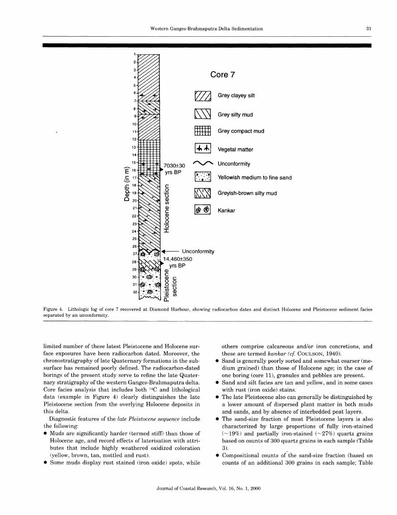
2
3
4
Western Ganges-Brahmaputra Delta Sedimentation
Core 7
31
5
6
8
9
10
11
12r+--F-t'-t~-t
13 +t-t-+-tl-t-t-t
14..1+-f-t--,t--t-1H
15~~.~..-+-,,:j~
E 16~....t-.p.f-t-,~
§, 17
..c 18
C. 19Q)
o 20
21
22
23
24
25
26
28
29
30
31
32
WJ Grey clayey silt
~ Grey silty mud
mm Grey compact mud
1~~1 Vegetal matter
7030±30 ~ Unconformity
yrs BP m. , . Yellowish medium to fine sand. .•.. ,
c::0 m Greyish-brown silty mud:.;::::o l. IQ)CJ)
Q)
I~~I Kankarc::Q)o0(5I
Figure 4. Lithologic log of core 7 recovered at Diamond Harbour, showing radiocarbon dates and distinct Holocene and Pleistocene sediment faciesseparated by an unconformity.
limited number of these latest Pleistocene and Holocene surface exposures have been radiocarbon dated. Moreover, thechronostratigraphy of late Quaternary formations in the subsurface has remained poorly defined. The radiocarbon-datedborings of the present study serve to refine the late Quaternary stratigraphy of the western Ganges-Brahmaputra delta.Core facies analysis that includes both 14C and lithologicaldata (example in Figure 4) clearly distinguishes the latePleistocene section from the overlying Holocene deposits inthis delta.
Diagnostic features of the late Pleistocene sequence includethe following:• Muds are significantly harder (termed stiff) than those of
Holocene age, and record effects of laterisation with attributes that include highly weathered oxidized coloration(yellow, brown, tan, mottled and rust).
• Some muds display rust stained (iron oxide) spots, while
others comprise calcareous and/or iron concretions, andthese are termed kankar (c]. COULSON, 1940).
• Sand is generally poorly sorted and somewhat coarser (medium grained) than those of Holocene age; in the case ofone boring (core 11), granules and pebbles are present.
• Sand and silt facies are tan and yellow, and in some caseswith rust (iron oxide) stains.
• The late Pleistocene also can generally be distinguished bya lower amount of dispersed plant matter in both mudsand sands, and by absence of interbedded peat layers.
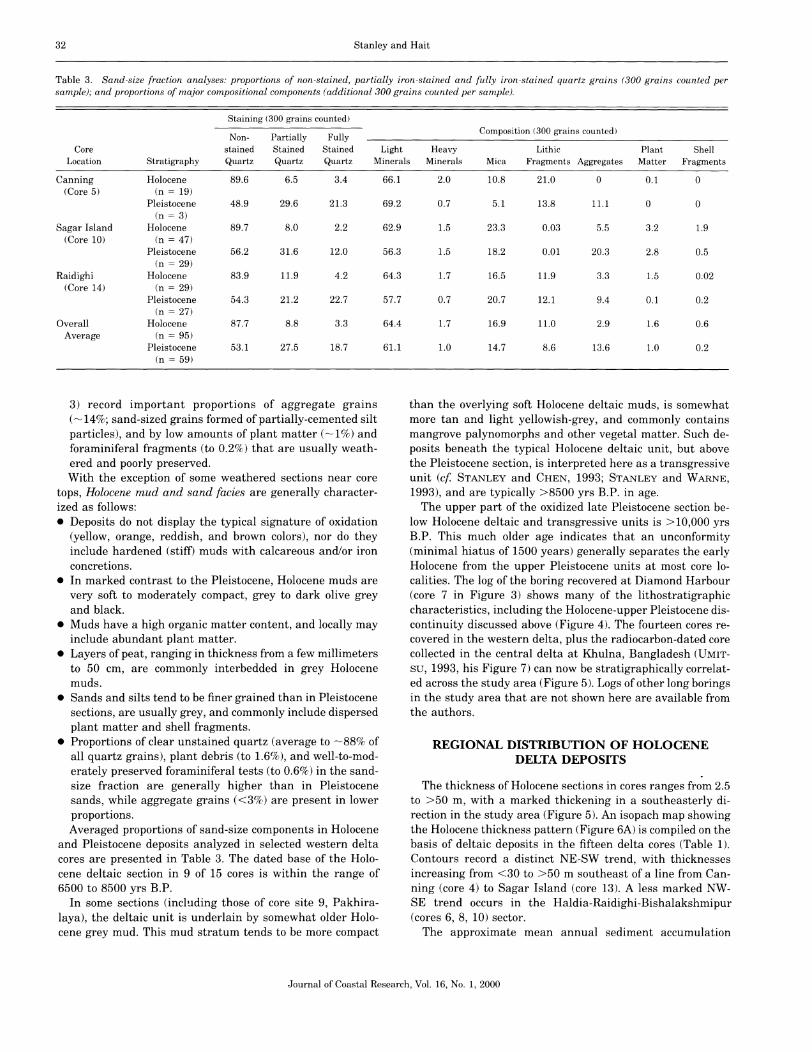
• The sand-size fraction of most Pleistocene layers is alsocharacterized by large proportions of fully iron-stained('"'-'19%) and partially iron-stained ('"'-'27%) quartz grainsbased on counts of 300 quartz grains in each sample (Table3). .
• Compositional counts of the sand-size fraction (based oncounts of an additional 300 grains in each sample; Table
Journal of Coastal Research, Vol. 16, No.1, 2000
32 Stanley and Hait
Table 3. Sand-size fraction analyses: proportions of non-stained, partially iron-stained and fully iron-stained quartz grains (300 grains counted persample); and proportions of major compositional components (additional 300 grains counted per sample).
Staining (300 grains counted)
Non- Partially FullyComposition (300 grains counted)
Core stained Stained Stained Light Heavy Lithic Plant ShellLocation Stratigraphy Quartz Quartz Quartz Minerals Minerals Mica Fragments Aggregates Matter Fragments
Canning Holocene 89.6 6.5 3.4 66.1 2.0 10.8 21.0 0 0.1 0(Core 5) (n = 19)
Pleistocene 48.9 29.6 21.3 69.2 0.7 5.1 13.8 11.1 0 0(n = 3)
Sagar Island Holocene 89.7 8.0 2.2 62.9 1.5 23.3 0.03 5.5 3.2 1.9(Core 10) (n = 47)
Pleistocene 56.2 31.6 12.0 56.3 1.5 18.2 0.01 20.3 2.8 0.5(n = 29)
Raidighi Holocene 83.9 11.9 4.2 64.3 1.7 16.5 11.9 3.3 1.5 0.02(Core 14) (n = 29)
Pleistocene 54.3 21.2 22.7 57.7 0.7 20.7 12.1 9.4 0.1 0.2(n = 27)
Overall Holocene 87.7 8.8 3.3 64.4 1.7 16.9 11.0 2.9 1.6 0.6Average (n = 95)
Pleistocene 53.1 27.5 18.7 61.1 1.0 14.7 8.6 13.6 1.0 0.2(n = 59)
3) record important proportions of aggregate grains(.-..., 14%; sand-sized grains formed of partially-cemented siltparticles), and by low amounts of plant matter (.-..., 1%) andforaminiferal fragments (to 0.2%) that are usually weathered and poorly preserved.With the exception of some weathered sections near core
tops, Holocene mud and sand facies are generally characterized as follows:• Deposits do not display the typical signature of oxidation
(yellow, orange, reddish, and brown colors), nor do theyinclude hardened (stiff) muds with calcareous and/or ironconcretions.
• In marked contrast to the Pleistocene, Holocene muds arevery soft to moderately compact, grey to dark olive greyand black.
• Muds have a high organic matter content, and locally mayinclude abundant plant matter.
• Layers of peat, ranging in thickness from a few millimetersto 50 cm, are commonly interbedded in grey Holocenemuds.
• Sands and silts tend to be finer grained than in Pleistocenesections, are usually grey, and commonly include dispersedplant matter and shell fragments.
• Proportions of clear unstained quartz (average to '-""88% ofall quartz grains), plant debris (to 1.6%), and well-to-moderately preserved foraminiferal tests (to 0.6%) in the sandsize fraction are generally higher than in Pleistocenesands, while aggregate grains «3%) are present in lowerproportions.Averaged proportions of sand-size components in Holocene
and Pleistocene deposits analyzed in selected western deltacores are presented in Table 3. The dated base of the Holocene deltaic section in 9 of 15 cores is within the range of6500 to 8500 yrs B.P.
In some sections (including those of core site 9, Pakhiralaya), the deltaic unit is underlain by somewhat older Holocene grey mud. This mud stratum tends to be more compact
than the overlying soft Holocene deltaic muds, is somewhatmore tan and light yellowish-grey, and commonly containsmangrove palynomorphs and other vegetal matter. Such deposits beneath the typical Holocene deltaic unit, but abovethe Pleistocene section, is interpreted here as a transgressiveunit (cf STANLEY and CHEN, 1993; STANLEY and WARNE,1993), and are typically >8500 yrs B.P. in age.
The upper part of the oxidized late Pleistocene section below Holocene deltaic and transgressive units is > 10,000 yrsB.P. This much older age indicates that an unconformity(minimal hiatus of 1500 years) generally separates the earlyHolocene from the upper Pleistocene units at most core localities. The log of the boring recovered at Diamond Harbour(core 7 in Figure 3) shows many of the lithostratigraphiccharacteristics, including the Holocene-upper Pleistocene discontinuity discussed above (Figure 4). The fourteen cores recovered in the western delta, plus the radiocarbon-dated corecollected in the central delta at Khulna, Bangladesh (UMITSU, 1993, his Figure 7) can now be stratigraphically correlated across the study area (Figure 5). Logs of other long boringsin the study area that are not shown here are available fromthe authors.
REGIONAL DISTRIBUTION OF HOLOCENEDELTA DEPOSITS
The thickness of Holocene sections in cores ranges from 2.5to >50 m, with a marked thickening in a southeasterly direction in the study area (Figure 5). An isopach map showingthe Holocene thickness pattern (Figure 6A) is compiled on thebasis of deltaic deposits in the fifteen delta cores (Table 1).Contours record a distinct NE-SW trend, with thicknessesincreasing from <30 to >50 m southeast of a line from Canning (core 4) to Sagar Island (core 13). A less marked NWSE trend occurs in the Haldia-Raidighi-Bishalakshmipur(cores 6, 8, 10) sector.
The approximate mean annual sediment accumulation
Journal of Coastal Research, Vol. 16, No.1, 2000

Western Ganges-Brahmaputra Delta Sedimentation 33
~.~.] Olive-grey soft mud
8 Peat
SE
.....,-------,- msl
-.. Increased Holocene thicknessand sand accumulation -..
T -- -<, -- Core 4Hoi --
+\~~..':-J....LJL.L..L..L............,..I \3C'l
I \~\
\
\
\
\
\Hoi - HolocenePI - Pleistocene
Core 1
Sand
~l Kankar
[[[]]] Tan to brown stiff mud
NW
-35
-5
-45
-40
+5
-10
-50
E -15c~ -20o
~ -25Q)
W-30
msl-O
?
Figure 5. Stratigraphic correlation of 4 cores along a NW to SE transect in the western delta (actual spacing between the cores is shown in Figure 3).This diagram reveals substantial thickening of the Holocene section toward the coast, and the marked increase in proportion of sand in core 4.
rates are calculated using a base-of-core Holocene date of7500 yrs B.P. (derived from the recorded 6500 to 8500 yrsB.P. dates): for a 10 m-long section, the rate is 0.13 cm/yr.;for a 20 m section, the rate is 0.27 cm/yr.; for a 30 m section,the rate is 0.4 cm/yr.; for a 40 m section, the rate is 0.53 em/yr.; and for 50 m section, the rate is 0.67 ern/yr. Mean sediment accumulation rates increase toward the south andsoutheast. The rates of mean vertical motion are lowest inthe NW sector of the cored study area (slight uplift to <0.2cm/yr), while subsidence increases substantially toward theSE. The highest subsidence rate (to -----0.5 cm/yr) is recordedat Pakhiralaya (core 9).
The total proportions of mud (clay and mixed silt and clay)and of sandy facies (clean coarse silt, mixed silt and sand,mixed sand and coarser-grain sediment) that form the Holocene section are measured for each core (Table 1). These dataprovide general information on sediment dispersal. The mapdepicting the regional distribution of total sand percentage(range from 0 to 860/0) indicates that sand is preferentiallydistributed along the NE-SW trend, i.e. parallel to Holocenethickening (Figure 6B), from Canning (core 4) toward Bishalakshmipur (core 10). A less distinct trend is also noted fromBhagwanpur (core 5) in the NW to Bishalakshmipur (core 10)in the SE. The linear area covered by high (>60%) sand proportions is narrow, with values decreasing from 80% in a direction to the SW of Canning (core 4). A tighter net of coresis needed to further refine dispersal patterns.
The map showing the total proportion of mud (14 to 100%)in Holocene core sections reveals that highest values are concentrated in the broad NW sector of the study area (Figure6C), in marked contrast to the NE-SW trending sand-richbelt. A secondary, less obvious, zone comprising high proportions of mud occurs in the Sagar Island-Junput-Haldia sector(cores 13, 12,6). It is of note that peat layers most commonly
occur in the NW delta sector where the Holocene section isgenerally thin and proportions of mud layers are highest (Figure 6C).
NEOTECTONICS AS ONE OF THE CONTROLS OFDELTA DEPOSITION
The natural factors that resulted in formation of the Holocene Ganges-Brahmaputra delta is, in a number of respects,similar to those that develop other geologically recent worlddeltas. The modern depocenter began to accumulate in theearly Holocene (cf BANERJEE and SEN, 1987; STANLEY andWARNE, 1994) and, as in other deltas, there are marked petrologic distinctions between Holocene and underlying Pleistocene lithofacies (cf COLEMAN and ROBERTS, 1988; CHENand STANLEY, 1993; STANLEY et al., 1996a, b). Moreover,mean rates of sediment accumulation (ranging from 0.1 to0.7 cm/yr) and mean rates of subsidence (ranging to 0.5 em/yr) are similar to those recorded for deltas forming in quitedifferent tectonic settings, such as the Yangtze (STANLEY andCHEN, 1993), Nile (STANLEY and WARNE, 1993) and otherMediterranean deltas (STANLEY, 1997).
Coring and high-resolution subbottom profiling in manyworld deltas show that late Quaternary deposits thickengradually from delta axes towards lower delta plains, andthen rapidly become thicker at, or close to, the land-sea interface of such depocenters (COLEMAN, 1982; CHEN andSTANLEY, 1993; STANLEY and WARNE, 1993; TORNQVIST,1993). Most often, Holocene thickness isopachs tend to parallel delta coasts (COLEMAN, 1982; ZHENGet al., 1994). However, temporal and spatial variations of both Holocene sediment thickness and lithology. in the study area are not coastparallel (E-W), but rather trend diagonally (NE-SW) acrossthe southwestern and central delta plain (Figure 6A-C). This
Journal of Coastal Research, Vol. 16, No.1, 2000

34 Stanley and Hai t
Figure 6. A, Holocene thickness variability in the delta study area. B,proportion of sand in the Holocene sequence. C, preferential distributionof Holocene peat layers in mud-rich sections of reduced thickness.
finding reveals that, some controlling factors in addition tosea-level rise, seaward-directed sediment input and progradation of the delta margin have dominated sedimentationprocesses.
A 20 ............ - --
Khulna.
30 ---------
Khulna.
Sand(relative 0/0)
*Khulna s
Mud(relative 0/0)
Depositional patterns indicate that enhanced subsidence,which created accommodation space along a NE-SW trend,had to develop in this area in order to receive >50 m of sediment during the past ----7500 years (Figure 5). A zone of subsidence oriented diagonally across the depocenter, has beena key factor controlling the regional pattern of Holocene deposition. Information on this particular evolution is providedby tectonic, stratigraphic, and morphologic criteria in the delta, all of which show predominant NE-SW trends and arediscussed below.
A deep-lying NE-SW hinge zone, defined on tectonic andstratigraphic criteria, extends from the Bay of Bengal to beneath the delta proper (Figure 7A), i.e. from at least Mahanadi, offshore India to Mymensingh, Bangladesh. This feature has been identified by deep drilling and geophysical surveys for hydrocarbon exploration (ROYBARMAN, 1983, 1992;LINDSAY et al., 1991; ALAM, 1996; MUKHERJEA and HAZRA,1997). Development of the hinge zone, the boundary betweentwo separate tectonic blocks, is related to isostatic adjustment of the crust and differential movement of structuralblocks that underlie the delta, phenomena related to rise ofthe Himalayas and sediment loading on the lower Bengal basin. The hinge zone dates back at least to the Eocene, anddisplacement along the structure continued through Tertiarytime. Although the trend of this structure is well defined indeep geophysical surveys, seismic profiles across this featureare insufficiently defined at shallow depths to clearly showthe latest Quaternary depositional and neotectonic trendsnear the delta plain surface (LINDSAY et al., 1991).
In a separate study, morphologic lineaments on the lowerGanges-Brahmaputra delta plain are identified on the basisof tonal change in satellite images. The prominent NE-SWoriented Kakdwip-Khulna-Dacca lineament (AGARWAL andMITRA, 1991), is of interest here. This feature is subparallelwith and trends to SE of the deep Tertiary hinge zone described above (Figure 7B), and is partially superposed abovethe hinge zone in the western delta. This suggests that displacement has continued to offset the delta plain near theboundary between the two separate tectonic blocks describedabove.
A third observation pertains to surface elevation contours(1.0 to 5.0 m above m.s.l.) in the low-lying southwestern andcentral delta (Figure 7C). Contours trend from ENE to WSW(DELFT HYDRAULICS, 1989; MILLIMAN et al., 1989; JELGERSMA, 1994; BROADUS, 1996). The 1-m contour line, proximalto and subparallel with the prominent surface lineament feature described above, appears to delineate ongoing offsets oriented diagonally across the delta plain.
We propose that displacement which formed the accommodation space during the Holocene was focused along thehinge zone and the Kakdwip-Khulna-Dacca lineament, bothconverging in the western delta (Figure 8). Our core analysisindicates that structural activity has continued to present,maintaining the NE to SW trend that crosses the delta diagonally. It is likely that this mobility produced the distinctspatial and temporal Holocene depositional patterns recordedin the present study, especially the well-defined linear sectorof subsurface Holocene thickening (Figure 5), distribution ofa thin mud section (Figure 6C), and dominant sand dispersal
Journal of Coastal Research, Vol. 16, No.1, 2000

Western Ganges-Brahmaputra Delta Sedimentation 35
Figure 7. Structural features discussed in text: (A) deep-seated tectonichinge zone (modified from ROYBARMAN, 1992); (B) delta surface lineaments(l = Kakdwip-Dacca; 2 = NW-SE structure) and two rose diagrams showing orientation of other delta plain lineaments (modified after AGARWAL
and MITRA, 1991); and (C) surface contours in meters above m.s.l.
100 km
Bay of Bengal
1 Hinge zone2 Lineament3 1m contour
JC" Sand dispersal
....~ SE tilt through time
~ Accommodation zone
III Mangrove
Attention is also called here to the somewhat less prominent NW-SE trend indicated by some Holocene isopachs (Figure 6A) and regional sand and mud distribution patterns(Figure 6B, C). These are parallel to a group of less welldefined NW-SE trending surface lineaments shown in Figure7B.
Holocene depositional trends, especially those that extendupward all the way to the present delta plain surface, arecompatible with the postulate that this western delta studyarea has been affected by recent fault reactivation (MUKHERJEA and HAZRA, 1997; Roy and CHATTOPADHYAY, 1997;SINGH et al., 1998). Moreover, late Quaternary tectonic displacement that induced tilting of the delta region to the eastand altered the course of the Ganges-Brahmaputra-Meghnariver system resulted in an eastward shift in delta progradation (SANYAL, 1990; CHAUDHURI and CHOUDHURY, 1994;BLASCO et al.,1996). Indirect evidence of tilting is shown bytrend changes through time, i.e. progressive shifts to the SE,from the hinge zone direction to that of the lineaments anddelta plain surface contours that are not parallel to the coastline (Figures 7,8). As a consequence, the western part of thedelta in the late Holocene has experienced a reduction offresh water flow, decreased progradation rate, increased saltwater incursion and some net erosion (ALLISON, 1998b).
Radiocarbon-dated core sections record an incongruouschronostratigraphic sequence of ages upward above the moreconsistently dated base of cores (Table 2): there appears tobe a decreased rate of sediment accumulation from early (to'"'--'1.0 cm/yr) to late Holocene (r-Oc lcm/yrl time. This may bedue to sediment reworking in the delta and to sediment thatbypassed the delta and accumulated on the shelf and beyond,a phenomenon substantiated by investigation of the shelf seaward of the delta by other workers (KUEHL et al., 1997; ALLISON, 1998b; MICHELS et [LI., 1998). Those studies indicatethat only about 1/3rd of the sediment load of the GangesBrahmaputra river system accumulates in the delta proper
Figure 8. Study of area showing relation among Holocene depositionalpatterns, distribution of mangroves and neotectonics. Noted is the areaunderlain by important accommodation space, easterly shift of the deltasurface through Holocene time, and SW-directed sand dispersal.
B
100 km Ao
Bay of Bengal
~ Eocene shelf/slope break(hinge zone)
5m
.•.•~01J. :
'i-.\0\O~ :
~1J.\s •••• 1«0~\~S :.......... t_" ~
i··..·................!
tj·~~:.....:: ...........:..
~{01J. ~~~\0\O :"
• r:,.s.1J.{ •••• ~r-.\~ •••••~ :....... t_,"
i··..................
ti:~) 2.....:
.:".......:.
trends (Figure 6B) between the late Pleistocene units and thedelta plain surface. Differential displacement along the NESW trend would explain why Holocene depositional patternsso closely parallel the major delta surface lineament and surface elevation contour lines.
Journal of Coastal Research, Vol. 16, No.1, 2000
36 Stanley and Hait
(GOODBRED and KUEHL, 1998) while 2/3rds of the load bypasses the delta and is deposited on the continental shelf anddeeper environments beyond the shelf-break.
Evidence of ongoing seaward transport of suspended sediment via the delta estuaries is visible on satellite images(AGARWAL and MITRA, 1991; ALLISON, 1998a). This bypassedmaterial is derived from fluvial input and also erosion of thedelta, its coast and nearshore shelf areas. Holocene meansedimentation rates we measure in the delta proper «0.7cm/yr) are comparable to modern depositional rates seawardof the coast, on two parts of the modern shelf: in the subaqueous delta topset, at water depths of <20 m; and in thesubaqueous bottomset, at >80 m. However, mean sedimentaccumulation rates in the delta proper are for the most partlower than those presently recorded along a coast-parallelbelt at shelf depths between 20 to 80 m, where depositionrates range from 1 to >6 cm/yr (KUEHLet al., 1997; MICHELSet al., 1998). These data, supplemented by high-resolutionseismic profiles made on the shelf south of the delta proper,confirm that there has been active seaward progradation ofthe subaqueous delta in recent time (ALLISON, 1998b).
NATURAL AND ANTHROPOGENIC INFLUENCESON MODERN SUNDERBANS
Development of the Ganges-Brahmaputra delta resultingfrom the natural controlling factors described above prevailedprior to the population explosion in this region. Until the lastcentury, there was a direct relationship among Holocene depositional patterns, continued differential structural displacement of this sequence, sediment accumulation rates andregional evolution of peat layers and mangroves. Especiallyimportant factors in the regional distribution of both peat andmangrove were sea level, vertical motion of land (subsidence)and creation of accommodation space needed to receive Holocene deposits that thicken toward the SE (Figures 5, 6A).
Peat layers in the subsurface Holocene section (Figure 6C),rich in mangrove and other organic matter and commonlyinterbedded in dark grey to olive muds, accumulated primarily in the central (UMITSU, 1993) and northwestern delta(CHANDA and MUKHERJEE, 1969; VISHNU-MITRE and GuPTA, 1970; GUPTA, 1981; BARUI et al., 1986; BANERJEE andSEN, 1987, 1988; SEN and BANERJEE, 1990; CHANDA andHAlT, 1996; HAlT et al., 1996b). These are sectors characterized by modest to relatively low subsidence rates (mostly<0.2 cm/yr). In contrast, the reduced proportion of peat inthe south and south-central delta may be a function of moremobile substrate conditions that resulted in deeper waterconditions, precluding such deposits from forming during theearly to mid-Holocene. This resulted from the interplay ofrelatively high subsidence rate (>0.2 cm/yr) that lowered thedelta surface and induced the relatively high rate of relativesea-level rise at that time (CHANDA and HAlT, 1996).
With regards to mangrove forests, most of the Sundarbans(Figures 1,2) are positioned on the low-lying southern deltaplain and situated at elevations within 1 m of present m.s.I.(DELFT HYDRAULICS, 1989; MILLIMAN et al., 1989; JELGERSMA, 1994; BROADUS, 1996). The close relationship among
mangrove, sea level and specific intertidal (brackish to saline)habitat requirements results in mangrove ecosystem development that is particularly vulnerable to changes of sea level(ELLISON and STODDART, 1991; ELLISON, 1994). Paleobiological study, including palynological analyses, of core sedimentsequences indicates that rapid land subsidence coupled withrapid sea-level rise during the early to mid-Holocene limitedmangrove ecosystems on the southernmost plain of the Ganges-Brahmaputra delta (CHANDA and HAlT, 1996; HAlTet al.,1996a). Extensive mangrove forests at that time developed inmore stable sectors, positioned to about 80 to 120 km northof the present coastline (CHANDA and MUKHERJEE, 1969;VISHNU-MITRE and GUPTA, 1970; GUPTA, 1981; BARUI et al.,1986; BARUI and CHANDA, 1992; BANERJEE and SEN, 1987,1988; SEN and BANERJEE, 1990; CHANDA and HAlT, 1996;HAlT et al., 1996b).
From the mid-Holocene onward, mangrove forests spreadsoutheastward. Climatic fluctuation is not viewed as a directfactor of the southward growth trend, since the warm andwet regime has remained fairly constant in this region sincethe early Holocene (GUPTA, 1981; SEN and BANERJEE, 1988;CHANDA and HAlT, 1996). Rather, this forest developmenthas been a response to altered sedimentation rates as sealevel rise decelerated and increased rate of sediment accumulation came into balance with the rate of subsidence. Asa result of these factors, along with high fresh water influxafter the mid-Holocene, progressively more luxuriant growthof mangroves began to inhabit the southern and southeasternSundarban region to along what is now the present coast.Through time, mangroves evolved as a wide NE-SW zone onthe lower delta plain (Figure 1), and their northern extensionto at least 120 km from the present coast (BANERJEE andSEN, 1987; CHANDA and HAlT, 1996) became generally parallel to the earlier discussed neotectonic trends and zone ofHolocene sediment thickening (Figure 8). This broad growthof mangrove is a function of fluvial discharge mixing withmarine water across a wide zone by high tide flow throughthe extensive, primarily N-S oriented estuaries. Until the1800s, conditions needed for mangrove growth in the deltawere maintained, including a balance between sediment accretion and erosion and between fresh and salt water input.
During this century, however, markedly increased growthof human activity has caused significant reduction of themangrove ecosystem and consequent rapid loss of biologicalproductivity in the Sundarbans. At present, the northern limit of the mangrove is reduced to ~50-60 km from the coast(Figure 2). Anthropogenic influences include reduced fluvialinflux to the delta, increased level of pollutants, and physicalremoval of mangroves for wood and as part of reclamationfor settlement, agriculture and aquaculture (NASKAR, 1985;CHANDA and DATTA, 1986; CHAUDHURI and CHOUDHURY,1994; GUHA BAKSHI and NASKAR, 1994; HUSSAIN andAcHARYA, 1994; SANTRA, 1994; SANYAL, 1996; SIKDAR andHAlT, 1997; ALAM, 1998). Mapping of specific mangrove vegetation patterns by ground-surface measurement and satellite observation indicates that, in late Holocene, the southwestern and central sectors of the delta have become moresaline than the eastern delta. This shift may have resultedin part from natural factors, such as eastward tilting of the
Journal of Coastal Research, Vol. 16, No.1, 2000

Western Ganges-Brahmaputra Delta Sedimentation 37
delta (SANYAL, 1990; BLASCO et al., 1996), a phenomenonsupported by findings in this study, and also from increasedhuman pressures that include reduced fresh water influx tothe west and central sectors.
CONCLUSIONS
Analysis of radiocarbon-dated cores recovered in the western Ganges-Brahmaputra delta, provides the basis for preliminary subsurface mapping of Holocene deltaic sequencesand underlying transgressive units and late Pleistocene alluvial deposits. This investigation reveals that neotectonicsand subsidence have been among the major controls of lateQuaternary depositional patterns. Distribution of peat layersinterbedded in Holocene sequences of the western delta andof extensive mangrove forests that form the Sundarbans inthe southern and southeastern delta are directly related toHolocene depositional and neotectonic patterns (Figure 7),particularly differential land subsidence and change in relative sea level.
The rapidly growing rural population in Ganges-Brahmaputra delta regions of both India and Bangladesh is heavilydependent on mangrove forests (NASKAR, 1988; CHAUDHURIand CHOUDHURY, 1994; HUSSAIN and ACHARYA, 1994). Oneeffect of intensified human pressure has been increased salinity in both soil and water that is now resulting in decreased agricultural, aquacultural and forest productivity(MILLIMAN et al., 1989; NAZRUL-IsLAM, 1993; ALAM, 1996;ALLISON, 1998a). The present study reveals that increasedsalinity levels are the result of natural factors, such as deltasurface tilting and subsidence, as well as of growing anthropogenic influences, including substantial decrease in riverflow.
The mangrove forest acts as a buffer zone which helps reduce the impact of landward-driven tides, storms and cyclones, and protects the hinterland from environmental andeconomic hazards (CHAUDHURI and CHOUDHURY, 1994). It isevident that anthropogenic activities which directly increasesalinity and aggravate the natural effects of subsidence mustnow be regulated to protect this biologically unique ecosystem. Recovery and multi-disciplinary study of a larger, moreevenly distributed suite of radiocarbon-dated cores in the central and eastern Bangladesh sectors of the delta are neededto advance our understanding of the interplay between contemporary Holocene neotectonics, sea level and depositionalpatterns across the entire depocenter.
ACKNOWLEDGMENTS
Appreciation is expressed to Profs. S. Chanda and A.B. Biswas, and the Center for Study of Man and Environment, Calcutta, for encouragement to undertake this study. The Department of Science and Technology, Government of India,provided funding for coring and the initial study in India. Wethank the Smithsonian Institution's National Museum ofNatural History Walcott Fund (DJS) and Office of Fellowships and Grants (AKH) for support needed to expand andcomplete this delta study in Washington. Mr. T. Jorstad andMs. M. Parrish helped us prepare the illustrations, and Ms.T. Diaz provided technical assistance in the preparation of
the manuscript. This contribution, part of the Smithsonian'sDeltas-Global Change Program (NMNH), was improved bythe helpful reviewers, Drs. J.-L. Loizeau and A.G. WARNE.
liTERATURE CITED
AGARWAL, R.P. and MITRA, D.S., 1991. Paleogeographic reconstruction of Bengal delta during Quaternary period. In: VAIDYANADRAN, R., (ed.), Quaternary Deltas of India. Bangalore, India: Geological Society of India, 13-24.
ALAM, M., 1996. Subsidence of the Ganges-Brahmaputra Delta ofBangladesh and associated drainage, sedimentation and salinity.In: MILLIMAN, J.D. and HAQ, B.U., (eds.), Sea-Level Rise andCoastal Subsidence. Dordrecht, Netherlands: Kluwer AcademicPublishers, 169-192.
ALLISON, M.A., 1998a. Geologic framework and environmental status of the Ganges-Brahmaputra delta. Journal of Coastal Research, 14(3), 826-836.
ALLISON, M.A., 1998b. Historical changes in the Ganges-Brahmaputra delta front. Journal of Coastal Research, 14, 1269-1275.
BANERJEE, M. and SEN, P.K., 1987. Palaeobiology in understandingthe change of sea level and coast line in Bengal basin during Holocene period. Indian Journal ofEarth Sciences, 14(3-4), 307-320.
BANERJEE, M. and SEN, P.K., 1988. Palaeobiology and environmentof deposition of Holocene sediments of Bengal Basin, India. In:AIGNER, J.S., JABLONSKI, N.G., TAYLOR, G., WALKER, D., andPINXIAN, W., (eds.), The Palaeoenvironment of East Asia from theMid-Tertiary. Hong Kong: Centre for Asian Studies, University ofHong Kong, I, 703-731.
BARUI, N.C.; CHANDA, S., and BHATTACHARYA, K.N., 1986. LateQuaternary vegetational history of the Bengal Basin. Journal ofMineralogical and Metallurgical Society of India, 54, 197-201.
BARUI, N.C. and CHANDA, S., 1992. Late Quaternary pollen analysisin relation to palaeoecology, biostratigraphy and dating of Calcutta peat. Proceeding of the Indian National Science Academy,B58(4), 191-200.
BLASCO, F.; SAENGER, P., and JANODET, E., 1996. Mangroves asindicators of coastal change. Catena, 27,167-178.
BROADUS, J.M., 1996. Economizing human responses to subsidenceand rising sea level. In: MILLIMAN, J.D. and HAQ, B.U., (eds.),Sea-level Rise and Coastal Subsidence: Causes, Consequences andStrategies. Dordrecht, The Netherlands: Kluwer Academic Publishers, 313-325.
CHANDA, S., 1977. An eco-floristic survey of the mangroves of Sundarbans, west Bengal, India. Transactions of the Bose ResearchInstitute, 40(1), 5-14.
CHANDA, S. and DATTA, S.C., 1986. Prospects and problems of amangrove ecosystem in western Sundarbans (India). Transactionsof the Bose Research Institute, 49(3), 47-57.
CHANDA, S. and HAlT, A.K., 1996. Aspects and appraisal of late Quaternary vegetation and lower Bengal basin. Palaeobotanist, 45,117-124.
CHANDA, S. and MUKHERJEE, B. B., 1969. Radiocarbon dating of twofossiliferous Quaternary deposits in and around Calcutta. Scienceand Culture, 35, 275-276.
CHANDA., S.; SARA, A.K.; Roy, A., HAlT, A.K., DAS, H., GHOSH, S.,and CHAKRABORTI, S., 1996. Paleoclimate and Paleoenvironmentof the Bengal Basin during the Holocene. Calcutta, India: Centerfor Study of Man and Environment (Unpublished Report), 62p.
CHAPPEL, J. and SCRACKLETON, N.J., 1986. Oxygen isotope and sealevel. Nature, 324, 137-140.
CHAUDHURI, A.B. and CHOUDHURY, A., 1994. Mangroves of the Sundarbans. Volume One: India. Bangkok, Thailand: IUCN- TheWorld Conservation Union, 247p.
CHEN, Z. and STANLEY, D.J., 1993. Alluvial stiff muds (Late Pleistocene) underlying the lower Nile Delta plain, Egypt: Petrology,stratigraphy and origin. Journal of Coastal Research, 9(2), 539576.
COLEMAN, J.M., 1982. Deltas: Processes ofDeposition and Models forExploration. Boston, Massachusetts: International Human Resources Development Corporation, 124p.
Journal of Coastal Research, Vol. 16, No.1, 2000
38 Stanley and Hait
COLEMAN, J.M. and ROBERTS, H.H., 1988. Sedimentary development of the Louisiana continental shelf related to sea-level cycles:Part I-Sedimentary sequences. Geo-Marine Letters, 8, 63-108.
COULSON, A. L., 1940. The geology and under ground water supplyof Calcutta, Bengal, with special reference to tubewells. Memoir ofthe Geological Survey of India, 76, 1-150.
DAS, H.K., 1996. Foraminifera from late Pleistocene-Holocene sediments of southwest Bengal, India. Indian Journal of Earth Sciences, 23 (1-2), 48-55.
DELFT HYDRAULICS, 1989. Criteria for Assessing Vulnerability toSea-level Rise. A Global Inventory to High Risk Areas. Delft, TheNetherlands: United Nations Environment Programme, 52p.
ELLISON, J.C., 1994. Climate change and sea level rise impacts onmangrove ecosystems. In: PERNETTA,J.; LEEMANS,R., ELDER, D.and HUMPHREY, S., (eds.), Impacts of Climate Change on Ecosystems and Species: Marine and Coastal Ecosystems. Gland, Switzerland: International Union for Conservation of Nature and Natural Resources, 45-57.
ELLISON, J.C. and STODDART, D.R., 1991. Mangrove ecosystem collapse during predicted sea-level rise: Holocene analogues and implications. Journal of Coastal Research, 7 (1), 151-165.
FAIRBANKS, R.G., 1989. A 17,000 year glacio-eustatic sea-level record: Influence of glacial melting rates on the younger Dryas eventand deep ocean circulation. Nature, 342,637-642.
GALLOWAY, W.E., 1975. Process framework for describing the morphologic and stratigraphic evolution of deltaic depositional systems. In: BROUSSARD, M.L., (ed.), Deltas, Models for Exploration.Houston, Texas: Houston Geological Society, 87-98.
GOODBRED, S. L. Jr. and KUEHL, S. A., 1998. Floodplain processesin the Bengal Basin and storage of Ganges-Brahmaputra riversediment: an accretion study using 137Cs and 210Pb geochronology.Sedimentary Geology, 121, 239-258.
GUHA BAKSHI, D.N. and NASKAR, K., 1994. Studies of the anthropogenic effects on mangrove ecology of the Sundarbans in WestBengal. In: RAY, M., (ed.), Recent Research in Ecology, Environment and Pollution. New Delhi, India: Today and Tomorrow'sPrinters and Publishers, 9, 85-90.
GUPTA, H.P., 1981. Paleoenvironments during Holocene time in Bengal Basin as reflected by palynostratigraphy. The Palaeobotanist,27 (2), 138-160.
HAlT, A.K.; DAS, H.K.; CHAKRABORTI, S., RAY, A.K., and CHANDA,S., 1994a. On the Holocene paleoecological changes in coastal Digha-a note based on floral and faunal record. Indian Journal ofEarth Science, 21,192-198.
HAlT, A.K.; DAS, H.K.; RAY, A.K., and CHANDA, S., 1994b. On theoccurrence of mangrove biota and some faunal remains from thesediments of Haldia, W.B. in relation to its past environment.Journal of Palynology, 30, 73-78.
HAlT, A.K.; DAS, H.K.; GHOSH, S., RAY,A.K., SAHA,A.K., and CHANDA,S., 1996a. New dates of PIe isto-Holocene subcrop samples fromSouth Bengal, India. Indian Journal ofEarth Sciences, 23(1-2),7982.
HAlT, A.K.; DAS, H.K.; GHOSH, S., RAY, A.K., and CHANDA, S.,1996b. Evidence of paleoenvironmental variations during lateQuaternary of Kolaghat, Midnapur District, West Bengal. CurrentScience, 70, 1089-1093.
HUSSAIN, Z. and ACHARYA, G., 1994, (eds.), Mangroves of the Sundarbans. Volume Two: Bangladesh. Bangkok, Thailand: IUCNThe World Conservation Union, 257p.
JELGERSMA, S., 1994. Examples of the geological past: evolution ofcoastal sedimentation sequences during Holocene sea-level rise.In: PERNETTA, J., LEEMANS, R., ELDER, D. and HUMPHREY, S.,(eds.), Impacts of Climate Change on Ecosystems and Species: Marine and Coastal Ecosystems. Gland, Switzerland: InternationalUnion for Conservation of Nature and Natural Resources, 45-57.
KUEHL, S.A.; LEVY, B.M.; MOORE, S.W., and ALLISON, M.A., 1997.Subaqueous delta of the Ganges-Brahmaputra river system. Marine Geology, 144, 81-96.
LINDSAY, J.F.; HOLLIDAY, D.W., and HULBERT, A.G., 1991. Sequence stratigraphy and the evolution of the Ganges-Brahmaputra delta complex. The American Association of Petroleum Geologists Bulletin, 75 (7), 1233-1254.
MICHELS, K.H.; KUDRASS, H.R.; HUBSCHER, C., SUCKOW, A., andWIEDICKE, M., 1998. The submarine delta of the Ganges-Brahmaputra: cyclone-dominated sedimentation patterns. Marine Geology, 149, 133-154.
MILLIMAN, J.D.; BROADUS, J.M., and GABLE, F., 1989. Environmental and economic implications of rising sea level and subsidingdeltas: The Nile and Bengal examples. Ambio, 18(6),340-345.
MILLIMAN, J.D. and MEADE, R.H., 1983. World-wide delivery of riversediments to the oceans. Journal of Geology, 91, 1-22.
MILLIMAN, J.D. and SYVITSKI, P.M., 1992. Geomorphic/tectonic control of sediment discharge to the ocean: The importance of smallmountainous rivers. Journal of Geology, 100,524-544.
MORGAN, J.P. and McINTIRE, W.G.,1959. Quaternary geology of theBengal basin, East Pakistan and India. Bulletin of the GeologicalSociety ofAmerica, 70, 319-342.
MUKHERJEA, A. and HAZRA, S., 1997. Changing paradigm of petroleum exploration in Bengal basin. Indian Journal of Geology, 69(1),41-64.
NASKAR, K. R., 1985. Population pressure on the tidal mangroveswamps of Sundarbans in India-its causes and problems. Population Mapping, National Atlas and Thematic Mapping Organization, Calcutta, Monograph 4, 159-161.
NASKAR, K. R., 1988. Economic potentialities of the tidal mangroveforests of Sundarbans in India. Journal of Indian Society ofCoastal Agricultural Research, 6(2), 149-157.
NASKAR, K. R. and GUHA BAKSHI, D. N., 1987. Mangrove Swampsof the Sundarbans -An Ecological Perspective. Calcutta, India:NayaProkash, 264p.
NAZRUL-IsLAM, A.K.M., 1993. Environment and vegetation of mangroves. In: LIETH, H. and AL MASOOM, A., (eds.), Towards the Rational Use of High Salinity Tolerant Plants. Dordrecht, The Netherlands: Kluwer Academic Publishers, 1,81-88.
PODDAR, B.C.; CHAKRABORTI, C.; BANERJEE, S.N., CHAKRABORTI,A., and NIYOGI, D., 1992. Changing geography and climate of WestBengal since 18,000 Y.B.P. Records of the Geological Survey of India, 121, 47-53.
Roy, R.K. and CHATTOPADHYAY, G.S., 1997. Quaternary geology ofthe environs of Ganga Delta, West Bengal and Bihar. Indian Journal of Geology, 69(2), 177-209.
ROYBARMAN, A., 1983. Geology and hydrocarbon prospects of WestBengal. Petroleum Asia Journal, 6, 51-56.
ROYBARMAN A., 1992. Geological history and hydrocarbon explorations in Bengal basin. Indian Journal of Geology, 64 (3), 235-258.
SANTRA, S.C., 1994. Ecology of Hooghly estuary, West Bengal (India). In: KARGUPTA, A.N. and SIDDIQUI,E.N., (eds.),Algal Ecology.Dehradun, India: International Book Distribution, 293-318.
SANYAL, P., 1990. Ecological problems of Sundarbans mangrove. In:Proceeding of the Workshop on Wasteland Development Programme,Calcutta, India: Jadavpur University, 1-6.
SANYAL, P., 1996. Sundarbans, the largest mangrove diversity onglobe. In: Proceeding of the William Roxburgh Memorial Seminaron Sundarbans Mangals. Calcutta, India: Calcutta Wildlife Society, 11-15.
SEN, P.K. and BANERJEE, M., 1988. Palaeoenvironment of BengalBasin during the Holocene period. Geographical Review of India,50(4), 21-39.
SEN, P.K. and BANERJEE, M., 1990. Palyno-plankton stratigraphyand environment changes during the Holocene in the Bengal Basin, India. Review of Palaeobotany and Palynology, 65, 25-35.
SIKDAR, P.K. and HAlT, A.K., 1997. Environmental risk analysis ofindustrialisation in the coastal zone of West Bengal. Sea Explorer,4, 18-29.
SINGH, L.P.; PARKASH, B., and SINGHVI, A.K., 1998. Evolution ofthe lower Gangetic plain landforms and soils in West Bengal, India. Catena, 33, 75-104.
STANLEY, D. J., 1997. Mediterranean deltas: subsidence as a majorcontrol of relative sea-level rise. In: BRIAND, F. and MALDONADO,A., (eds.), Transformations and Evolution of the MediterraneanCoastline. Bulletin de l'Institut Oceanographique, Monaco, ScienceSeries 3, 35-62.
STANLEY, D.J. and CHEN, Z., 1993. Yangtze delta, eastern China: 1.
Journal of Coastal Research, Vol. 16, No.1, 2000
Western Ganges-Brahmaputra Delta Sedimentation 39
Geometry and subsidence of Holocene depocenter. Marine Geology,112, 1-11.
STANLEY, D. J.; McREA, J.E. Jr., and WALDRON, J.e., 1996a. NileDelta drill core and sample database for 1985-1994: Mediterranean Basin (MEDIBA) Program. Smithsonian Contributions to theMarine Sciences, 37, 1-428.
STANLEY, D.J. and WARNE, A.G., 1993. Nile delta: recent geologicalevolution and human impact. Science, 260, 628-634.
STANLEY, D.J. and WARNE, A.G., 1994. Worldwide initiation ofHolocene marine deltas by deceleration of sea level rise. Science, 265,228-231.
STANLEY, D.J.; WARNE, A.G., and DUNBAR, J.B., 1996b. EasternMississippi delta: late Wisconsin unconformity, overlying transgressive facies, sea level and subsidence. Engineering Geology, 45,359-381.
SUBRAMANIAN, V. and RAMANATHAN, A.L., 1996. Nature of sediment load in the Ganges-Brahmaputra river systems in India. In:MILLIMAN, J.D. and HAQ, B.U., (eds.), Sea-Level Rise and CoastalSubsidence. Dordrecht, Netherlands: Kluwer Academic Publishers,151-168.
TORNQVIST, T.E., 1993. Fluvial Sedimentary Geology and Chronology of the Holocene Rhine-Meuse Delta, The Netherlands. Utrecht,Netherlands: Nederlands Geografische Studies, 169p.
UMITSU, M., 1993. Late Quaternary sedimentary environments andlandforms in the Ganges delta. Sedimentary Geology, 83, 177-186.
VISHNU-MITRE and GUPTA, H.P., 1970. Pollen analytical study ofQuaternary deposits in Bengal Basin. Palaeobotanist, 19, 297-306.
ZHENG,X.; WEIGUO, Z.; LIZHONG, Y., and ENDO, K., 1994. Paleoenvironmental changes in southern Yangtze delta over the last20,000 years. The Quaternary Research, 33(5), 379-384.
Journal of Coastal Research, Vol. 16, No.1, 2000