HISTORICAL AND CULTURAL GEOGRAPHY OF
KAṈYĀKUMARI REGION
A Thesis submitted to the Pondicherry University in partial fulfilment
of the requirement for the award of the degree of
DOCTOR OF PHILOSOPHY
IN
HISTORY
By
A. PERUMAL
Under the Guidance of
Dr. K. RAJAN
Professor
DEPARTMENT OF HISTORY
SCHOOL OF SOCIAL SCIENCES AND INTERNATIONAL STUDIES
PONDICHERRY UNIVERSITY
PUDUCHERRY - 605 014
INDIA
MARCH 2014
Dr. K. RAJAN, M.A., Ph.D., PGDA.
Professor
Department of History
Pondicherry University
Puducherry -605 014
CERTIFICATE
This is to certify that the thesis entitled, “Historical and Cultural Geography
of Kaṉyākumari Region” submitted to the Department of History, Pondicherry
University for the award of Doctor of Philosophy in History is a record of original work
done by A. PERUMAL during the period of his study (2008-2014) under my supervision
and guidance. It is further certified that the thesis has not formed the basis for the award
of any Degree, Diploma, Associateship, Fellowship or similar title.
This is also to certify that the thesis represents the independent work of the candidate.
Place: Puducherry
Date:
(K. RAJAN)
Research Supervisor

A. PERUMAL
Ph.D., Scholar
Department of History
Pondicherry University
Puducherry - 605 014
DECLARATION
I hereby declare that the thesis entitled “Historical and Cultural Geography
of Kaṉyākumari Region” being submitted to the Pondicherry University, in partial
fulfilment of the requirement for the award of the degree of Doctor of Philosophy in
History in the Department of History, Pondicherry University is a bonafide work done by
me under the guidance of Dr. K. RAJAN, Professor, Department of History, Pondicherry
University and that it has not previously formed the basis for the award of any Degree,
Diploma, Associateship, Fellowship or any other similar title of any candidate of any
University or Institution.
Place: Puducherry
Date:
(A.PERUMAL)
Research Scholar

ACKNOWLEDGEMENTS
It is with a profound sense of gratitude that I remember those people who
have been of great help to me in the completion of my thesis on the “Historical
and Cultural Geography of Kaṉyākumari Region”. I take this opportunity to
thank each and every one of them for having inspired and helped me throughout
my work. First and foremost, I express my sincere thanks and obligation to my
research guide Dr.K.Rajan, Professor, Department of History, Pondicherry
University, for giving me a chance to pursue research under his supervision and
guidance. Working under his supervision has always been inspiring and
insightful. I thank him for all his valuable suggestions and constructive criticisms.
I would like to place on record my indebtedness to Prof. G. Chandhrika, Head,
Department of History and to my teachers Prof. Venkata Raghotham, Dr. N.
Chandramouli, Dr. K. Venugopal Reddy, Dr. Muhamed Mustafa, Dr. Paokholal
Haokip and Dr.B.Krishnamurthy for their constant encouragement.
I would also like to express my sincere gratitude to Professor. Y.
Subbarayalu, Head, Department of Indology, French Institute of Puducherry and
Prof. G.Vijayavenugobal for their constant support and encouragement. I also
wish to express my sincere thanks to Mr.K.Kaliyaperumal, Office Manager,
Department of History, Mr. E.Baskar, Office Assistant, Department of History,
Mr. R.Jegajevanram, Office Assistant, Department of Women Studies and other
staff members of the History Department. My grateful thanks are extended to Mr.
Cyril Antony, Editor, Gazetteer-Union Territory of Pondicherry, being a native of
Kaṉyākumari region for providing me valuable information and suggestions at the
various stages during the preparation of my thesis and also for making available
books from his personal library. I also express my heartfelt thanks to
Dr.S.Pathmanabhan, Dr.M.Immanuel, Prof.A.K.Perumal, Sri.Senthee Natarajan
and Mr.Sundaram for providing primary and secondary data related to my study

area and guiding me in the my field work in Kaṉyākumari District. My special
thanks are due to Dr.V.Vedhachalam and Dr.C.Santhalingam, Tamil Nadu State
Archaeology, Dr.N.Athiyaman, Dr.P.Jayakumar, Dr.S.Rajavelu and
Dr.V.Selvakumar, Tamil University of Thanjavur and Dr.L.Thyagarajan,
Principal, Govt. Arts College, Ariyalur for the support rendered during my
research in archaeology and epigraphical Studies. I also express my sincere
gratitude to Dr.A.Murugaiyan, Professor, Department of Linguistics, University
of Sorbonne, Paris for providing data related to my study area. I express my
heartfelt thanks to Dr.A.Purushothaman, Mr.A.Sudharsanan, Prof.M.Ramadass,
Head, Department of Economics and Prof.T.Subramanya Naidu, former Dean,
School of Social Science and International Studies.
I express my sincere gratitude to Dr.G.Muthushankar, GIS Engineer,
French Institute, Pondicherry and Dr.V.P.Yatheeskumar, Assistant Archaeologist,
Archaeological Survey of India for providing the necessary inputs for the
preparation of maps. I feel honoured to remember my teachers in the field of
history, Dr.K.Balasundaram, Dr.K.Kannaiya, Dr.B.Rama Chandra Reddy,
Dr.S.Babu and Dr.Aruljothi who influenced me with their scholarly guidance. My
special thanks are due to Mr.Murugesan, Mr.M.S.Kaliyaperumal,
Smt.Hemabhujam, Mr.Giridhar, Smt.S.Harini, Mr.R.Ramaiya, Mr.S.Balaraman,
Mr.A.Rajendhiran, Mr.R.Jaganathan, Mr.Muthulingam, Mr.A.Sekar, Mr.S.K.
Ramalingam, Mr.Ramanujam, Mr.Durai, Mr.V.Bakthavachalam,
Mr.U.Pannirselvam, Mr.M.Verappan, Mr.R.Paramaguru, Mr.M.Munisamy,
Mr.E.Thanigavel, Mr.S.Arun, Mr.S.Namasthu, Mr.K.Danaselan, Mr.R.Tamizhan
for their help and moral support.
I extend my sincere thanks to the staff of Ananda Ranga Pillai Library,
Pondicherry University, the French Institute, Ecole Francais D Extreme- Orient,
Romain Rolland Public Library Pondicherry, Connemara Public Library Chennai,
Libraries of Madras University, Tamil University and Tamil Nadu Archives for
helping me in the process of data collection.
I also extend my sincere thanks to the Finance Department, Pondicherry
University for providing me regularly the UGC fellowship for three years from
the date of my joining. Further, I am also thankful to the ICHR, New Delhi which
provided me a Travel and Contingency grant.
I would also like to place on record my sincere thanks to my senior and
fellow mates Dr.Bithin Thakur, Mr.R.Ezhilraman, Mr.S.Manikandan,
Mr.S.Selvakumar, Mr.K.Rajinikanth, Mr.A.Shankar, Mr.R.Ramesh,
Mr.M.Prasanna, Smt.V.D.N.Sharmalee Gunawardana (Sri Lanka), Ms.Wiankun
Choun-u-Dom (Thailand), Mr.S.Santhanakumar, Mr.P.Jayapradaban,
Mr.P.T.Nagarajan, Mr.P.Balamurugan, Mr.Bilal Ahmad Parry and
Mr.G.Pauldurai for their warm support.
My profound thanks are due to my parents Sri. K.Arumugam (father),
Smt.A.Muruvayi (mother), Smt.M.Jayalakshmi (sister), Mr.A.Pathmanaban and
Mr.A.Sivakumar (brothers) who showered love and affection during the period of
my research work.
Place: Puducherry
Date:
A.Perumal

Note on Diacritical Marks
The scheme of transliteration used in this book is given below. All the vernacular
village/personal/place names are phonemically transcribed. While writing those names
the present familiar forms of pronunciation is generally adopted to overcome the regional
variations. The familiar terms like taluk and district names are used without any
diacritical marks. The following is the system of phonemic transcription.
ā ஆ
ī ஈ
ū ஊ
ē ஏ
ō ஓ
k/g க்
ṅ ங்
c/ch/s ச்
ñ ஞ்
ḍ/ṭ ட்
ṇ ண்
t/th/d த்
p/b ப்
i/y ய்
ḷ ள்
ḻ ழ்
ṟ ற்
ṉ ன்
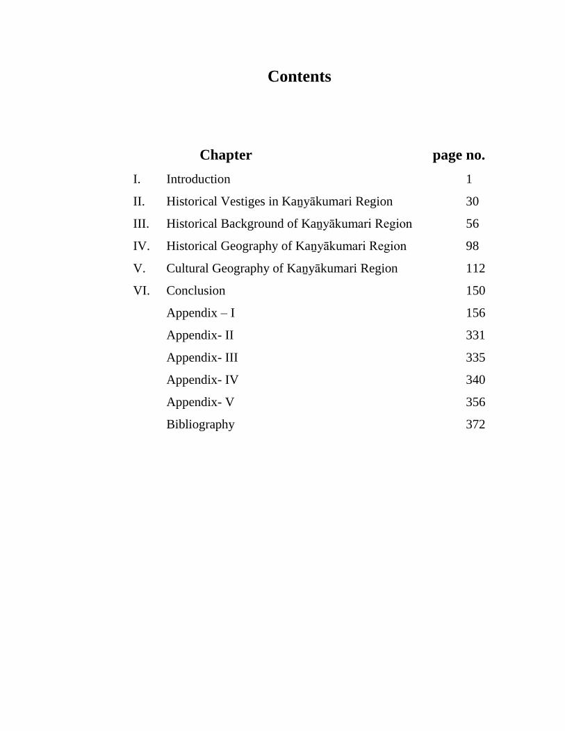
Contents
Chapter page no.
I. Introduction 1
II. Historical Vestiges in Kaṉyākumari Region 30
III. Historical Background of Kaṉyākumari Region 56
IV. Historical Geography of Kaṉyākumari Region 98
V. Cultural Geography of Kaṉyākumari Region 112
VI. Conclusion 150
Appendix – I 156
Appendix- II 331
Appendix- III 335
Appendix- IV 340
Appendix- V 356
Bibliography 372
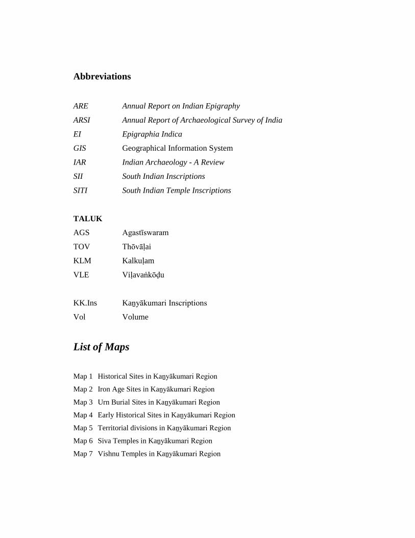
Abbreviations
ARE Annual Report on Indian Epigraphy
ARSI Annual Report of Archaeological Survey of India
EI Epigraphia Indica
GIS Geographical Information System
IAR Indian Archaeology - A Review
SII South Indian Inscriptions
SITI South Indian Temple Inscriptions
TALUK
AGS Agastīswaram
TOV Thōvāḷai
KLM Kalkuḷam
VLE Viḷavaṅkōḍu
KK.Ins Kaṉyākumari Inscriptions
Vol Volume
List of Maps
Map 1 Historical Sites in Kaṉyākumari Region
Map 2 Iron Age Sites in Kaṉyākumari Region
Map 3 Urn Burial Sites in Kaṉyākumari Region
Map 4 Early Historical Sites in Kaṉyākumari Region
Map 5 Territorial divisions in Kaṉyākumari Region
Map 6 Siva Temples in Kaṉyākumari Region
Map 7 Vishnu Temples in Kaṉyākumari Region

1
CHAPTER –I
INTRODUCTION
The present study ‘Historical and Cultural Geography of Kaṉyākumari
Region’, is an attempt to understand the various dimensions of the history of the
Kaṉyākumari region from end of the 8th century CE (792 CE) to the beginning of the
20th century CE (1906 CE) on the basis of historical, cultural and geographical
peculiarities. The Kaṉyākumari region located on the southern tip of the peninsular
India, otherwise known as Nāñchilnāḍu, was ruled over by the various dynasties and
clan groups like Āys, Pānḍyas, Chōḷas, Chēras and Vēnaḍu sovereigns and later by
the Vijayanagar generals and Nāyak chieftains of Madurai and Travancore
Samasthānam.1 This comparatively smaller geographical zone played a significant
role in shaping the cultural history of the region.
Geography has an important role in shaping the history of a region. Here an
attempt is made to unveil how human beings interacted with their ecosystem to
sustain their settlement pattern, modes of production and their distribution, their social
and cultural life and institutions of power and such other factors. The historical and
cultural significance of a region depends mostly on the nature of topography,
landscape, natural resources and productive patterns of the terrain.2 Historical
geography is the study of spatial variation encountered in these forces within the
stipulated period. The study period has a distinctive political and administrative unit
formed out of a certain cultural entity. Here the changes that happened in the
administrative and political units, viz., nāḍu / kūṟṟam and vaḷanāḍu form the main
theme. The political geography deals with the administrative set up as related to the
territorial divisions. The study of place names through the centuries with reference to
their historical significance in the ambit of cultural arena and cultural aspects forms
part of the cultural geography. Moreover the settlement patterns as influenced by
various historical, political, economic and demographic factors of the Kaṉyākumari
1 K.K.Pillay, Studies in Indian History (With special reference to Tamil Nadu), Madras,1979, p. 474.2 A.P. Greeshmalatha, Historical Geography of Vaḷḷuvanāḍ, Ph.D. dissertation, University of Calicut,Calicut, 2008, p.1.
2
region have been analysed.3 There are several studies on the historical, political and
cultural geography relating to other areas.4
The work Political Geography of the Chōḻa Country (1973) by
Y.Subbarayalu is the first major attempt in this direction and he paid special attention
to the problem by studying the historical geography of the Kāvēri delta during the
time of the Chōḻa rule. He made an important contribution in understanding the
formation of various territorial divisions in Kāvēri delta. The origin, growth and
formation of territorial divisions like ūr, nāḍus / kūṟṟam, vaḷanāḍu and maṇḍalam
were well established through a series of maps which helped immensely in
understanding the Chōḻa administrative structure.5 His treatment of the epigraphical
sources is well received and it becomes a model for others to follow. The present
work attempts to understand the formation of such territorial divisions formed in the
Kaṉyākumari region i.e. Nāñchilnāḍu from 792 to 1906 CE based on the epigraphical
material. There are nearly 707 inscriptions available in the study area and summaries
of the content of those 707 lithic records and copper plates are analysed to understand
their historical significance. Each inscription provides information like village names
and its location, ruler's name, dynasty and the regnal year, territorial divisions like
vaḷanāḍu and nāḍu and additional noteworthy information with regard to political,
social and cultural activities (Appendix-I). The earliest Tamil grammatical work
Tolkāppiyam states that the boundaries of Tamil Nadu lie between vaḍaveṅkaḍam
3 S.Rajavelu, The Historical and Cultural Geography and Ethnography of Pudukkōṭṭai Region UptoA.D.1800, Ph.D. dissertation, Tamil University, Thanjavur, 2003, p . 2.4 Y. Subbarayalu, Political Geography of Chōḻa Country, The State Department of Archaeology,Government of Tamil Nadu, Madras, 1973; S.Vaithyanathan, The Ancient Geography of the KoṅguCountry, Kalaimahal Kalvi Nilayam, Erode, 1983; V. Vedachalam, Tamil ilakkiyaṅgal kalveṭṭukaḷkāṭṭum pāṉḍya nātṭu samuthāyam paṇpāḍum (c.1000-1300CE ), Ph.D. dissertation, Madurai KamarajarUniversity, Madurai, 1993; M.Nalini, Historical and Cultural Geography of the Tiruchirapalli District,Tamil Nadu, from the 6th century to the 17th century with reference to Malanāḍu and VaḷḷuvapāḍiNadu, Ph.D. dissertation, Bharathidasan University, Trichirapalli, 1998; L.Thyagarajan, HistoricalArchaeology of the Ariyalur Region Upto A.D.1817, Ph.D. dissertation, Bharadhidasan University,Trichirapalli, 1999; S. Nilavathi, Tañjāvūr vaṭṭāra varalaṟṟu nilaviyalum samuthāyamum, Ph.D.dissertation, Tamil University, Thanjavur, 2001; C. Santhalingam, Thoṇḍai maṇḍalam nāḍum ūrum,Ph.D. dissertation, Madurai Kamaraj University, Madurai, 2003; S. Rajavelu, The Historical andCultural Geography and Ethnography of Pudukkottai Region Upto A.D.1800, Ph.D. dissertation(2003), Tamil University, Thanjavur; A.P. Greeshmalatha, Historical Geography of Vaḷḷuvanāḍ, Ph.D.dissertation (2008), University of Calicut, Calicut; K.P..Rajesh, Historical Geography of Kolathunāḍu-A Study of Regional Formation in Medieval North Kerala, Ph.D. dissertation, University of Calicut,Calicut, 2011.5 Y.Subbarayalu, Political Geography of Chōḻa Country, The State Department of Archaeology,Government of Tamil Nadu, 1973, p.30.

3
and theṉkumari meaning Vēṅkaṭa hills on the north and Kaṉyākumari in the south.6
The area of Kaṉyākumari region once known as “the granary of Travancore” lies at
the southern tip of Indian Peninsula. It was in Travancore State for a long time and
then merged with Tamil Nadu in 1956 under the State Linguistic Reorganization Act.7
The predominantly Tamil speaking area of the Travancore State was transferred to the
Madras State to form into a new district called Kaṉyākumari.8 The district has been
named after the Goddess Kaṉyākumari amman who is the popular deity of the area.9
The Agasthīswaram, Thōvālai, Kalkuḷam and Viḷavaṅkōḍu taluks are the main
constituents of this district. Kaṉyākumari district is the smallest district of the state
having an area of 1684.00 sq.km. The district lies between 77o 05’ and 77 o 36’ of the
eastern longitude and 8o 03’ and 8o 35’ of the northern latitude.10 At present (2011)
this district holds the population of 1863174 and density of population is 1106 per sq.
km.11 The district is bounded by the Tirunelvēli district in the north and northeast; by
Kēraḷa state in the north-west and at the confluence of the Arabian sea, the Bay of
Bengal and the Indian Ocean in the west, east and south. The coastline of this district
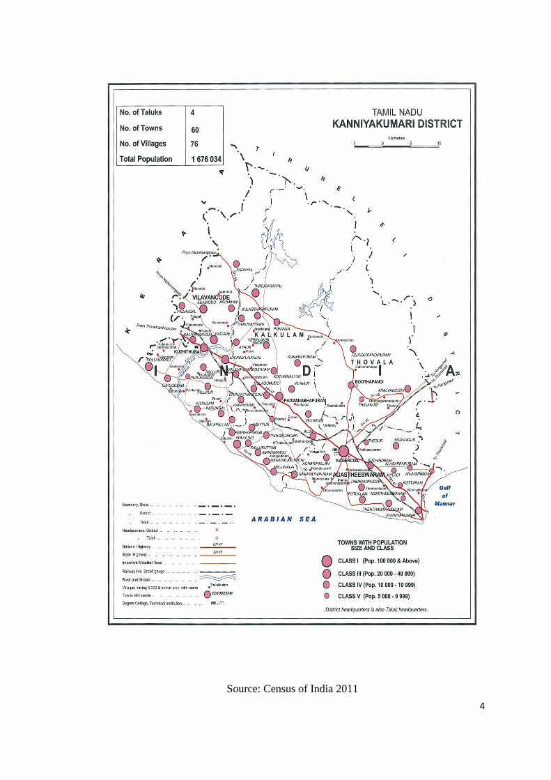
extends over 68 kilometres. Headquarters of this district is Nāgarkōil.12 The following
map shows the boundaries of Kaṉyākumari district. The details regarding number of
taluks, towns, villages, population and their classification are best illustrated in this
map.
6 C. Balasubramanian, A Study of the Literature of the Chēra Country (Upto 11th century A.D.),University of Madras, Madras, 1980, p. 3.7 S.C.Bhatt (ed.), The Encyclopaedic District Gazetteers of India, southern zone, vol.2, GyanPublishing House, New Delhi, 1997, p.1079.8 P.K.Nambiar (ed.), Census of India-1961, vol-IX, (Madras), part, xi-D, The Manager of Publication,New Delhi, 1968, p.3.9 S.C.Bhatt (ed.), The Encyclopaedic District Gazetteers of India, southern zone, vol.2, 1997, GyanPublishing House, New Delhi, p.1079.10 M.Gopalakrishnan (ed.), Gazetteers of India, Tamil Nadu State –Kanyakumari District, Governmentof Tamil Nadu, Commissioner of Archives and Historical Research, Chennai, 1995, pp. 1-2.11 S.Gopalakrishnan, Census of India, Provisional Population Totals (Tamil Nadu), Registrar Generaland Census Commissioner, India, 2011, p. 116.12 M.Gopalakrishnan (ed.),Gazetteers of India, Tamil Nadu State –Kanyakumari District, Governmentof Tamil Nadu, Commissioner of Archives and Historical Research, Chennai, 1995 pp. 1-2.
4
Source: Census of India 2011

5
Historical importance of Nāñchilnāḍu
Nāñchilnāḍu was once the southernmost administrative unit of the State of
Travancore holding the present taluks of Agastīswaram and Thōvāḷai in
Kaṉyākumari district and has an area of about 2010 square miles. It was the granary
of south Travancore and held considerable areas of paddy fields.13 Nāñchilnāḍu is
demarcated with the tract bounded on the north by the Kaḍukarai hills, on the south
by the Maṉaṛkuḍi lake, on the east by the Āralvāimoḻi pass and on the west by the
Paṉṟivāykkāl. The records of Mudaliyār confirm the area of Kaṉyākumari region.14
The Department of Archaeology, Government of Tamil Nadu took the
initiative in copying the inscriptions found in the district, particularly in
Agastīsvaram, Thōvālai, Kalkuḷam and Viḷavaṅkōḍu taluks. These were published
under the title Kaṉyākumari Kalveṭṭukaḷ (Kaṉyākumari Inscriptions) in six volumes.
These inscriptions serve as primary sources to understand and reconstruct the
political, social, economic and cultural histories of this region.15 In total, 707
inscriptions were recorded (Appendix –I). The following table shows the taluk wise
distribution of inscriptions.
Table 1: 1
Sl. No. Taluk No. of Inscriptions %
1. Agastīswaram 382 54.03
2. Thōvāḷai 91 12.88
3. Kalkuḷam 181 25.60
4. Viḷavaṅkōḍu 53 7.49
Gross Value 707 100%
Sources : Kaṉyākumari District Inscriptions, vols.I to VI
13 T.Ponnambalam Pillai, “The Antiquity of Nāñjilnāḍ and Shenkōṭṭai, the two tamil districts ofTravancore”, in D. Sawariroyan (ed.), The Tamilan Antiquary, vol-2, Asian Educational Services,New Delhi, 1986, pp.17-18.14 A.K. Perumal, Theṉkumariyiṉ Kathai (History of Kaṉyākumari District), United Writers, Chennai,2003, p. 46.15 Seetharam Gurumurthi (ed.), Kaṉyākumari Māvaṭṭa Kalveṭṭukkaḷ, vol-vi, Tamil Nadu StateDepartment of Archaeology, Chennai, 2008, p.1.
6
Selection of the topic
An attempt to identify the historical and cultural geography of Tamil Nadu in
chronological order based on information encountered in the inscriptions made by
historians and epigraphists in the past has helped to delineate the political boundaries
of this region under various rulers. Recent studies made by scholars such as
V. Vedachalam, C. Santhalingam, S. Rajavelu, S. Pathmanathan and M.S.S. Pandian
are noteworthy. For instance, V. Vedachalam’s Kalveṭṭu Maṟṟum Ilakiyam Kāṭṭum
Pāṇḍiya Nāṭṭu Samuthāyam (Society of Pāṇḍiya-nāḍu as gleaned from literature and
inscriptions), C. Santhalingam’s Thoṇdai Maṇḍalam: Nāḍum Ūrum (Nāḍu and Ūrs of
Thoṇdai Maṇḍalam), S. Rajavelu’s Historical Geography of Pudukōṭṭai Region, S.
Pathmanathan’s The Contribution of Kaṉyākumari to the Tamil World (1981) and The
Forgotten History of the Land’s End (1971), M.S.S. Pandiyan’s Agrarian Change in
Nāñchilnāḍu 1830 – 1930 (1990), K.A. Nilakanta Sastri’s A History of South India:
From Prehistoric Times to the Fall of Vijayanagar (1958), Burton Stein’s Peasant
State and Society in Medieval South India (1994) and Y. Subbarayalu’s monumental
work namely Political Geography of Chola Country (1973) provided an overview on
political geography of Tamil Nadu and also on Nāñchilnāḍu, the ancient name of
Kaṉyākumari region. In these works, they have analysed the major political divisions
of the country like maṇḍalam, nāḍu, kūṟṟam, vaḷanāḍu and ūr. Besides, other
components like the revenue system, trade and commerce and cultural life were also
studied. Noboru Karashima has provided a brief introduction to the historical
geography of the region in his work on South Indian History and Society: Studies
from Inscription, CE. 850–1800 (1984), A Concordance of Nayakas: The
Vijayanagara inscriptions in South India (2002) and Towards a New formation south
Indian Society under Vijayanagara rule (1992), Kesavan Veluthat’s The Political
Structure of Early Medieval South India (1993), M.G.S.Narayanan’s Perumal of
Kerala: Political and Social conditions of Kerala under the Chera Perumals of
Makotai, CE 800–1124 (1996), R.Champakalakshmi’s Trade, Ideology and
Urbanization – South India 300 BCE to CE 1300 (1996), James Heitzman’s Gifts of
Power: Lordship in an Early Indian State (1997), Kenneth R. Hall’s Structure and
Society in Early South India (2001), etc., are some of the important works could be
cited. Only selective works related to our topic are given. There are several such

7
articles dealing with specific areas. The works of these scholars provided a good
overview to understand various intricacies involved in studying the historical and
cultural geography of a region. The study area experienced continuous changes in a
socio – economic sphere. These changes could be seen in two phases, one before 14th
century CE and another afterwards.
After the 14th century CE, Tamil Nadu witnessed significant changes in the
political, social and cultural realms. For instance, the major geographical or territorial
divisions like kūṟṟam, nāḍu and vaḷanāḍu lost their relevance and the new
administrative divisions like paṟṟu, cīrmai, nāyakkatāṉam and chāvaḍi are emerging
during the Vijayanagara rule.16 An attempt is made to understand these changes at the
micro level for which Kaṉyākumari region selected for the present study. Thus, Tamil
Nadu witnessed significant socio- cultural changes due to various administrative
effects of various rulers. The society responded well to the changing needs of the
time. The impact of Pāṉḍya and local rulers evidenced while studying the inscriptions.
Through, several inscriptions pertaining to the study area are documented, but, there
is hardly any attempt to understand the social changes that undergone in this region.
The fertile and unexplored area induced to have a comprehensive study of
Kaṉyākumari region in line with the studies made by the scholars like K.A.Nilakanda
Sastri, Y.Subbarayalu, Noboru Karashima, Burton Stein, Kenneth R. Hall and others.
A preview of works
The present day Tamil Nadu and Kerala states formed an integral part of
ancient Tamiḻakam. The stretch of land lying between the Western Ghats and Arabian
Sea had natural cultural interactions with the Tamil Nadu upland region. The rulers of
Tamil Nadu and the rulers of Kerala made calculated attempts to control the rich
resources on either side of the Western Ghats. Thus, Kaṉyākumari was under the
control of the rulers of Kerala state for a major part of its history.
Historically, the present Kaṉyākumari district was part of a southern
Travancore. There was a close affinity between the land on this side of the Western
Ghats and on the other side of the Tamil Nadu in terms of language, customs and
16 Burton Stein, Peasant State and Society in Medieval South India, Oxford University Press, NewDelhi, 1980, p.397.
8
religious observations. Nagam Aiya’s Travancore State Manual (1906) consisted of
four volumes, probably the first one that brought to light the political and social
history of Travancore kingdom. Subsequently, the Government of Travancore took
the initiative and published seven volumes of Travancore Archaeological Series
(1910-1938) containing texts of ancient inscriptions. T.A.Gopinatha Rao, the veteran
epigraphist and indologist who worked as the Superintendent of Archaeology in
Travancore, edited the first two volumes. K.V. Subramanya Aiyar (1924) is the editor
of the next two volumes and A.S. Ramanatha Aiyar edited the remaining three
volumes (1999 – 2004). These volumes of high standard form the primary source for
the study.
A large number of later Chēra inscriptions both in copper and stone from
different centres of Travancore were published in these volumes and the scholarly
editors made every effort to bring out their historical importance. However, no
chronological or geographical order was followed in these publications. Early and late
records of Chēra, Chōḻa, Pāṇḍya and Āyi kings and the kings of medieval Vēṇāḍu and
Travancore were collected and published.17 These pioneering works recorded temple
inscriptions of Southern Travancore especially in Kaṉyākumari region such as
Sucīndram, Kaṉyākumari, Thirunandhikarai, Chōḻapuram, Kēraḷapuram, Tirunaiṉār
Kuṟichi, Thōvālai, Pākōḍu, Krishṇaṉkōil, Tiruppadisāram, Agastīsvaram, Pudūr,
Kuḻithuṟai, Pārthivapuram, Ῑsāṉamaṅgaḷam and a few other temples. These are
important centres of Saivism and Vaishnavisham.
In continuation of Nagam Aiya’s works, T.K. Velu Pillay revised and
published four volumes of Travancore State Manual (1938-1940). The state manual
carries numerous ancient documents of great historical value. It deals with the History
of Travancore and Nāñchilnāḍu. Travancore Administrative Reports (1939-1940)
provide an outline on the history of Travancore Kingdoms. K.K. Pillay’s work on the
Sucīndram Temple (1953) is the remarkable one. He is one of the most important
native historians who had studied elaborately Kaṉyākumari region. A striking feature
of the early history of Nāñchilnāḍu, of which Sucīndram formed the spiritual capital,
is that it became the cockpit of South India. Exposed to frequent attacks from outside,
17 M.G.S.Narayanan, Perumals of Kerala:Political and Social Conditions Kerala under the ChēraPerumal of Makotai (800 A.D.-1124 A.D.), Xavier Press, Calicut, 1996, p. 4.
9
Nāñchilnāḍu fell successively under the sway of the Āyi, Pāṇḍya, Chōḻa, Vēnāḍu
rulers, Vijayanagar and Nāyak chieftains18.
K.M. Panikkar, a famous historian of Kerala in his work on the History of
Kerala (1960) dealt with the political history of the period between 1498 and 1801
CE. He vividly explains the social and political history of Travancore State with more
attention on Cochin, North Malabar, Goa, Kannanur and Calicut principalities. But, he
has not paid much attention to Southern Travancore or the present Kaṉyākumari
region. P.K. Nambiar editor of the Census of India-1961, vol. IX (Madras) Part, XI-
D, (1968), provides a broad view on histroy, administration and the functions of
temples located in Agasthīswaram, Thōvālai, Kalkuḷam and Vilavaṅcōḍe taluks. This
information helps to reconstruct the religious and cultural life of the people as the
temple played an important role in these segments of the society.
Two of the 108 Vaishnavite Divyasthalams (Tirupathy) in South India, viz.,
Tiruvaṭṭār and Thiruppathisāram are found in this district. The most famous temple
dedicated to the worship of the Lord at Nāgarkōil is also located in this region. It has
twelve Saivite shrines in each of which the presiding deity is a Swayambu liṅgam.
They are: 1) Thirumala, 2) Thirupparappu, 3) Thirunandhikarai, 4) Thiru Poṉmaṉa, 5)
Paṉṉipākkam, 6) Nīlakaṇtaswāmi Kōil, 7) Thikkursi, 8) Mēlaṅkōḍu, 9)
Thiruvithāmkōḍu 10) Thiruviḍarkkōḍu 11) Thiruppaṉiyōḍe and 12) Thrunaṭṭālam.
Nine of the twelve temples are in Kalkuḷam taluk and remaining three in Vilavaṅkōḍu
taluk. P.K.Nambiar has considered the Hindu temples and its functions for his
documentation and not other monuments having religious affinities like Christianity,
Islam and Jainism except Nāgarāja temple and Chitharāl Sri Bhagavathi Ammaṉ
temple19 .
Natana. Kasinathan, an eminent epigraphist, edited the first three volumes of
Kaṉyākumari Kalveṭṭukaḷ (1972). He has listed the village name, dynasty, ruler, date
and text of the inscriptions. Natana. Kasinathan has also provided descriptive analysis
of the inscriptional data rather than making any analytical approach to the data.
However, inscriptions form the basis for the present study. The first volume contains
18 K.K.Pillay, The Sucīnḍram Temple, Kalakshetra publication, Madras, 1953, p. 94.19 P.K.Nambiar (ed.), Census of India-1961, vol-IX, (Madras), part, xi-D, The Manager of Publication,New Delhi, 1968, p.11.
10
132 inscriptions recorded from different places in Agastīswaram taluk. They are
Āchiramam, Iḍalāikuḍi, Eīthāmoḻi, Kariyamāṇikkapuram, Karuppukkōṭṭai,
Kaṉyākumari, Krishṇaṉ Kōil, Kochapidāram, Koṭṭāram, Kōṭṭāṟu and Sāmithōppu.20
The second volume contains 125 inscriptions collected at Thānumālaya Perumāḷ
temple at Sucīndram and Tuvārakai Krishṇaṉ temple in Agastīswaram taluk. The third
volume contains 80 inscriptions copied from Chōḻapuram, Dēvakuḷam, Thērūr,
Nallūr, Nāgarcōil, Paṟakkai, Pudukirāmam, Puravachērry, Vaḍachērry and
Vaḍivīswaram. R.Nagasamy, an expert in epigraphy, edited the fourth and fifth
volumes of Kaṉyākumari Māvaṭṭa Kalveṭṭukaḷ. In the fourth volume, more than 139
inscriptions of Kalkuḷam taluk have been traced out. The fifth volume recorded nearly
85 inscriptions from important villages viz., Aṉanthapuram, Arumanallūr,
Aḻakiyapāṅḍiyapuram, Ādhichaṉputhūr, Āralvāimoḻi, Iraichakuḷam, Iyaṉkuḷam,
Kaḍukkarai, Kāṭṭuputhūr, Kuṟathiyarai, Thāḻaikuḍi and Therisaṇaṅkōppu of Thōvālai
Taluk21.
More than 140 inscriptions from Agasthīswaram, Thōvālai, Kalkuḷam and
Vilavaṅcōḍe taluks find their place in the sixth volume. This volume provides
information on the territorial divisions like vaḷanāḍu and nāḍu, their boundaries and a
small outline on the history of Kaṉyākumari region.22
P. Shangoony Menon in his work on History of Travancore from the earliest
times (1978) criticized the legendary Purānic texts, but utilized the same source for
giving the story of the Travancore dynasty. The theories and concepts advanced in his
work have been criticized by many scholars but still continue to influence the
people.23
K.P. Padmanabha Menon (1958-1919), son of P. Shangoony Menon, has
written the History of Cochin (1912-1914) in two volumes. His magnum opus
History of Kerala (1924-1937) was published posthumously in four volumes by his
20 Natana. Kasinathan, Kaṉyākumari Kalveṭṭukkaḷ, Tamil Nadu State Department of Archaeology,Chennai, vol-III, 1972, pp.1-2.21 R.Nagasamy, Kaṉyākumari Māvaṭṭa Kalveṭṭukkaḷ, (Vols. IV to V), Tamil Nadu State Department ofArchaeology, Chennai, vol-III,1979, p.1.22 Seetharam Gurumurthi (ed.), Kaṉyākumari Māvaṭṭa Kalveṭṭukkaḷ , vol.-vi, Tamil State Departmentof Archaeology, Chennai, 2008, pp.1-2.23 M.G.S.Narayanan, Perumal of Kerala-Political and Social Conditions Kerala under the ChēraPerumal of Makotai (800 A.D.-1124 A.D.), Calicut, 1996, p.2.
11
literary executor T.K. Krishnan Menon. It provides complete history of Ancient
Kerala. It also contains much valuable information throwing light on many sides of
the polity, customs, life and material conditions of Kēraḷa. K.K. Pillay was another
brilliant scholar of South Indian History. He was born in Vilavaṅgkōḍu taluk of
Kaṉyākumari district. He is the author of Studies in Indian History with special
reference to Tamil Nadu (1979). In this monumental work, he clearly illustrates the
History of Nāñchilnāḍu and its boundaries. He also describes the socio, economic
and political conditions of Nāñchilnāḍu from the earliest period upto the modern
period. V. Sathiyanesan’s thesis Social Changes in Kanniyakumari district (1900-
1975 CE) – (1988) highlights the settlement pattern, land holding system, society,
economic activity and social changes in Kaṉyākumari region.
S. Padmanabhan’s work provides the basic information on Kaṉyākumari
region. His field-based study helped to identify several places of historical
significance. He is a well known scholar in Kaṉyākumari district. His works include
Nāgarājā Temple (Tamil & English - 1969), Temples of Kaṉyākumari (1970), The
Forgotten History of the Land’s End (1971), Untold Stories about Kaṉyākumari
(1974), In and around Kaṉyākumari (1976), Historic Churches in Kaṉyākumari
(1978), Kumari Māvaṭṭa Kōṭṭaikal (1978), The contribution of Kaṉyākumari to the
Tamil World (1981), Ancient Jain Centres in Kaṉyākumari (1998), Special features
of Art and Architecture in Kaṉyākumari (1998) and Buddhism in Kaṉyākumari
District (2003). T.V. Mahalingam’s fifth volume Topographical list of Inscriptions in
the Tamil Nadu and Kerala states upto CE. 1300 (1989), contains 999 inscriptions, of
which, nearly 282 inscriptions come from the district of Kaṉyākumari. He also wrote
an article on Kumari Kaṇḍam, In Origin of Humanity and Origin of Language (1997).
T.V. Mahalingam has also touched upon the Lemuriya continent. The Tectonic Plate
theory of the geologists interwoven with the submergence of Kumari Kaṇḍam found
mentioned in the later Tamil classical work of Silapathikāram.24
R. Vasudeva Poduval’s Travancore inscriptions - A Topographical list (1990)
provides information on the place of inscription, contents, date, dynasty, king,
24 N.Mahalingam, Kumari Kaṇḍam, In Origin of Humanity and Origin of Language, InternationalLinguistic Centre, Chennai, 1997, pp. 11-12.
12
language and remarks. It is like a registration of inscriptional record and there is
hardly any critical study on these inscriptions.
M. Gopalakrishnan has edited the Gazetteers of Kanniyakumari District
(1995). It gives general information on history, people, economic trends, revenue
administration, etc. M.G.S. Narayanan in his work on Perumal of Keralas – Political
and Social Condition of Kerala under the Chera Perumals of Makotai (800 CE. 1124
CE.), (1996) provided information on the nature of historiography of Kerala and its
significance but does not elaborate on Travancore region. D. Velappan wrote on
Nāñchilnāḍu (History, Economy, Tradition), (2000). According to him Nāñchilnāḍu
is a fertile region covering 403.9 sq.kms. in area25 with a high level of revenue
collections which constitutes the main source of income for the Travancore rulers.
Kodumudi Shanmugam is the author of Kumari Kaṇḍam Mūḻgavillai (2001) and he
has given more emphasis on the continental drift theory rather than history.
R.Mathivanan’s work Kaḍalkoṇḍa Theṉnādumuthal Sinthuveḷi
Nāgarigamvarai (2001) explains the continent Kumari and other features of it. It is
mostly based on secondary sources like literature. J.S.Murali is the author of
Tamiḻaka Sivathalaṅgaḷ (2001). In this important work he has highlighted the
importance of Siva and Vishnu temples. He has focused history on Saivism and
Vaishnavism centered in this district. Eleven inscriptions of Rāja Rāja –I (985-1014
CE) period were found at Nandhīsvarer temple of Tirunandhi Karai.26 He attempts to
draw religious history of this region. A.K.Perumal’s Theṉkumariyiṉ Kathai –
(History of South Kaṉyākumari) (2003), traces the history from Āyi dynasty upto
Travancore kingdom.
Sumathi Ramasamy in her book Fabulous Geographics, Castarstrophic
Histories ‘The Lost land of Lemuriya’ (2005) analysed Lemuriya or Kumarikaṇḍam
with the help of map, geographical data, classical literature, etc.
K. Appadurai holds the view that the Lemuria continent is the birth place of all
civilizations. His book Kumarikaṇḍam Kaḍal Koṇḍa Theṉnāḍu (2005) explains the
nature of the land and life of its people. M. Gopalakrishnan, the editor of Tamil Nadu
25 D. Velappan, Nāñchilnāḍu (History, Economy And Tradition), Rohini Publications, Nagarcoil, 2000,p.2.26 J.S.Murali, Tamiḻaga Sivathalaṅgaḷ, Chadura Publications, Chennai, 2001, p.626.
13
māvaṭṭa vivarachuvaḍi – Kaṉyākumrai Māvaṭṭam (2006) provides a brief history of
the region. M. Immanuvel, a native scholar, in his work on Kaṉyākumari Aspects and
Architects, Historical Research (2007) describes stories and events from 9th century
BCE to the present day and reflects the character and culture of this region.
S.C. Jayakaran, a geologist and historian, has written Kumari Nila Nītchi
(2007). He emphasises that Lemuria continent is the birth place of ancient civilization.
It is based on geographical and ancient literary sources. He strongly believes that the
references found in the literature are true and reliable.27
M.C. Victor has said in his book Kumarikaṇḍam (2007) that this region is
situated in the equator area. Therefore, we assume that this is origin of living beings –
because of the meditation climatic. The foreign scholars like Hekee, Paul Masson
Oursel, Scalter, Graeme Williams, E. Thurston, H.G. Wells, Scot Elliot and Tamil
scholars like P.T. Srinivasa Iyangar K.N. Nilakanda Sastri, T.V. Mahalingam,
Devaneyapavanar, Raghava Iyangar and many others had also spoken about this
Lemuria or Kumarikaṇḍam elaborately in their dictions. 28
Seetharam Gurumurthi’s edited volume Kaṉyākumari Māvaṭṭa Kaiyēḍu
(2008) outlines the history of this district. Jainism played an important role in the
Kaṉyākumari region from the 7th century CE. 16th century CE.29 Siva Vivekananthan
tries to consolidate those data in his work on Kumari Nāṭṭil Samaṉam – Tholliyal
Pārvai (2009). Some of the important Jain centres of this district are Tiruchāranathu
Malai, Nāgarcōil, Tirukkurandi, Āḻvārkōil, Malaiyaḍi, Kuṟathiyarai, Kōṭṭaivilai,
Veḷḷimalai and Tirunanthi Karai. At present, a considerable number of Jain temples
were converted into Hindu temples. His work only considered raise and fall of
Jainism in Kaṉyākumari region.
Irrespective of the close attention received by geologists, historians,
epigraphists, folklorists and literary people, the comprehensive history of this region
still eludes the scholars. Most of the scholars relied on literary sources and
particularly to the study of lost of Lemuria. The focus on continental drift theory
27 S.C.Jayakaran, Kumari Nila Nītchi, Kālachuvaḍu Publications, Chennai, 2007, p.24.28 M.S.Victor, Kumari Kaṇḍam Nallor Publication, Chennai, 2007, p.251.29 Siva Vivekananthan, Kumari Nāṭṭil Samaṇam-Tholliyal Pārvai, Kavya Publications, Chennai, 2009,p.37.
14
pushed back the remaining studies in the dark. Irrespective of these studies, the
inscriptions copied by the Tamil Nadu State Archaeology Department remain as one
of the reliable sources for the study of political and cultural geographies of
Kaṉyākumari region.
TABLE 1: 2
The following data is taken from Inscriptions of Kaṉyākumari Districts vols. I – VI
Periodisation: Based on Earliest Inscriptions
Per
iod Dynasty Years
EarliestInscriptionRefernce
TaluksNo.
of
Ins.
%
AGS TOV KLM VLE
I EARLY PĀṆḌYĀ CE.792-976CE.792(K.K.vol. VI:p.543/2004)
3 1 - - 4 0.57
II ĀYI CE.869-913CE.869(K.K. vol. IV:p.1969/97)
- - 2 3 5 0.71
III CHŌḺA CE.941-1300CE.941(K.K. vol.II:p.1968/178)
48 1 6 1 56 7.92
IV CHĒRA CE.1000-1700CE.1000(K.K.vol.VI: p.512/2004
- - 2 - 2 0.28
V CHŌḺA-PĀṆḌYA CE.1100CE.1100(K.K.vol.III: p.1968/260)
4 - - 1 5 0.71
VI LATER PĀṆḌYĀ CE.1123-1450CE.1123(K.K. vol.I:p.1968/13)
42 - - - 42 5.94
VII VĒNĀḌU CE.1126-1810CE.1126(K.K.vol.III: p.1968/271)
29 5 16 3 52 7.36
VIII VIJAYANAGAR CE.1500-1600CE.1500(K.K. vol.I:p.1968/84)
2 - - - 2 0.28
IXNĀYAKS OFMADURAI
CE.1606-1800CE.1606(K.K.vol.VI:p.474 /2004)
3 - - - 3 0.42
X TIRUVIDAN CORE CE.1730-1906CE.1730(K.K.vol.VI:p.521 /2004)
1 - 3 - 4 0.57
Other Inscriptions Without Reference Of Ruler's Regnal Year 251 85 150 45 532 75.24
Gross Value707 100
Scope and Sources
The scope of the present work is entirely based on archaeological, epigraphical
and literary sources supported by the field studies. Nearly 707 inscriptions are
available in six volumes of Kaṉyākumari Māvaṭṭa Kalveṭṭukkaḷ (Appendix- I), South
15
Indian Inscriptions, Annual Report on Epigraphy, Epigraphia Indica, Kalveṭṭiyal-
Journal of Tamil Nadu State Department of Archaeology, Ᾱvaṇam, Journal of Tamil
Nadu Archaeological Society and Varalāṟu, Journal of Raja Manickanar Historical
Research Centre. The inscriptions found in Kaṉyākumari region are significant in
revealing the political, economic, social and religious history of this southernmost tip
of the Indian peninsular. The study of these primary sources could provide a firm
basis for carrying out further research about the region. In addition, The Travancore
State Manual, The Travancore Archaeological Series and The Gazetteer of
Kaṉyākumari District provided the basic data for the present study.
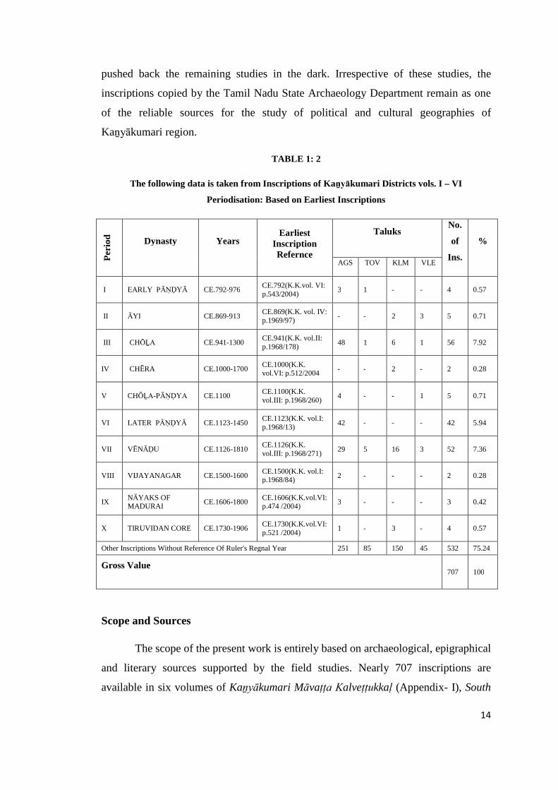
This periodisation is based on some cumulative historical events as well as the
king’s accession date. Present study is divided into periods of Early Pāṇḍya, Āyi,
Chōḻa, Chēra, Chōḻa-Pāṇḍya, later Pāṇḍya, Vēnāḍu chiefs, Vijayanagar, Nāyaks and
Travancore Samasthāṉam based on information retrieved from 707 inscriptions. In
Kaṉyākumari district, the earliest inscription records a hero stone installed in memory
of Raṇakīrti, a lieutenant of the early Pāṇḍya ruler Māṟaṉ Chaḍayaṉ ( c.765 – 815 CE)
who fought with the Chēra forces and lost his life in CE. 792. It was found at
Āralvāimoḻi village in Thōvālai taluk.30 The latest lithic record is of the grant
extended by S. Muthaiyapillai of Mulaikārapaṭṭi village, A. Arunasalam Pillai and
Nagalingam in CE 1906 for the construction of a mandapa in a temple at Sivagiri
located in Kalkuḷam taluk.31
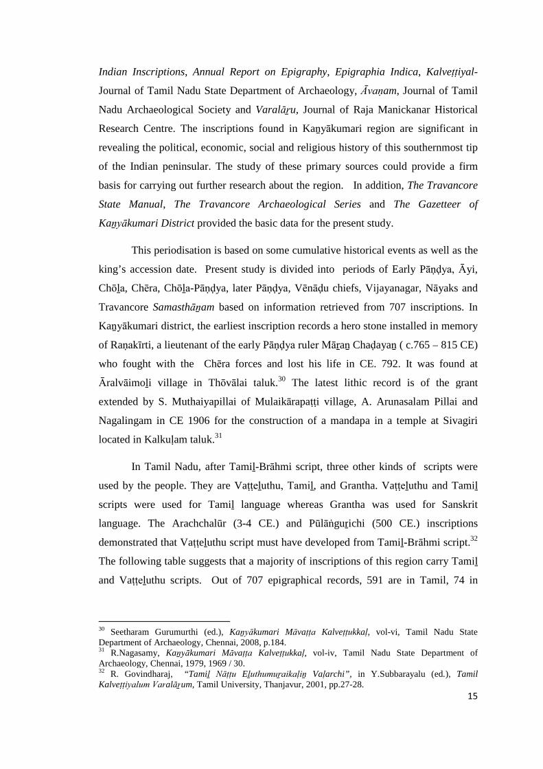
In Tamil Nadu, after Tamiḻ-Brāhmi script, three other kinds of scripts were
used by the people. They are Vaṭṭeḻuthu, Tamiḻ, and Grantha. Vaṭṭeḻuthu and Tamiḻ
scripts were used for Tamiḻ language whereas Grantha was used for Sanskrit
language. The Arachchalūr (3-4 CE.) and Pūlāṅguṟichi (500 CE.) inscriptions
demonstrated that Vaṭṭeḻuthu script must have developed from Tamiḻ-Brāhmi script.32
The following table suggests that a majority of inscriptions of this region carry Tamiḻ
and Vaṭṭeḻuthu scripts. Out of 707 epigraphical records, 591 are in Tamil, 74 in
30 Seetharam Gurumurthi (ed.), Kaṉyākumari Māvaṭṭa Kalveṭṭukkaḷ, vol-vi, Tamil Nadu StateDepartment of Archaeology, Chennai, 2008, p.184.31 R.Nagasamy, Kaṉyākumari Māvaṭṭa Kalveṭṭukkaḷ, vol-iv, Tamil Nadu State Department ofArchaeology, Chennai, 1979, 1969 / 30.32 R. Govindharaj, “Tamiḻ Nāṭṭu Eḻuthumuṟaikaḷiṉ Vaḷarchi”, in Y.Subbarayalu (ed.), TamilKalveṭṭiyalum Varalāṟum, Tamil University, Thanjavur, 2001, pp.27-28.
16
Vaṭṭeḻuthu, 21 in Grantha, 10 in English, 5 in Latin, 3 in Danish, 2 in Sanskrit and 1 in
Malayalam script.
TABLE 1: 3
Script Wise Classification in Kaṉyākumari Region (From vols. I to VI)
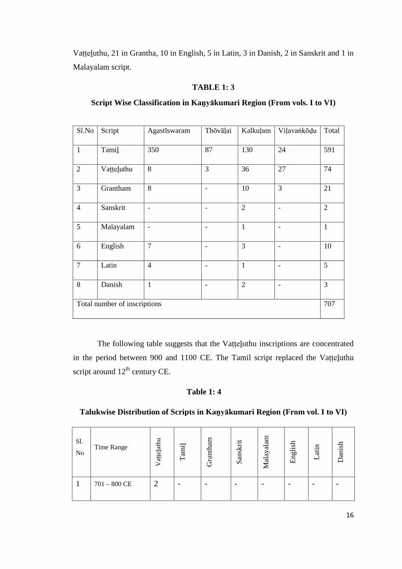
The following table suggests that the Vaṭṭeḻuthu inscriptions are concentrated
in the period between 900 and 1100 CE. The Tamil script replaced the Vaṭṭeḻuthu
script around 12th century CE.
Table 1: 4
Talukwise Distribution of Scripts in Kaṉyākumari Region (From vol. I to VI)
Sl.
NoTime Range
Vaṭ
ṭeḻu
thu
Tam
iḻ
Gra
nth
am
San
skri
t
Mal
ayal
am
En
gli
sh
Lat
in
Dan
ish
1 701 – 800 CE 2 - - - - - - -
Sl.No Script Agastīswaram Thōvāḷai Kalkuḷam Viḷavaṅkōḍu Total
1 Tamiḻ 350 87 130 24 591
2 Vaṭṭeḻuthu 8 3 36 27 74
3 Grantham 8 - 10 3 21
4 Sanskrit - - 2 - 2
5 Malayalam - - 1 - 1
6 English 7 - 3 - 10
7 Latin 4 - 1 - 5
8 Danish 1 - 2 - 3
Total number of inscriptions 707
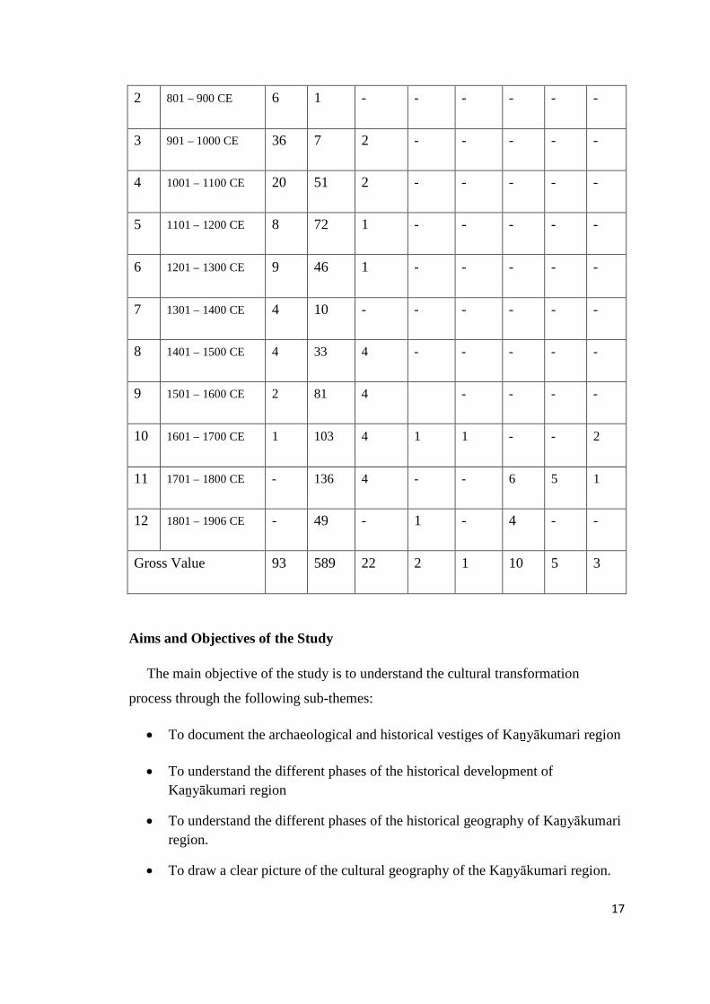
17
2 801 – 900 CE 6 1 - - - - - -
3 901 – 1000 CE 36 7 2 - - - - -
4 1001 – 1100 CE 20 51 2 - - - - -
5 1101 – 1200 CE 8 72 1 - - - - -
6 1201 – 1300 CE 9 46 1 - - - - -
7 1301 – 1400 CE 4 10 - - - - - -
8 1401 – 1500 CE 4 33 4 - - - - -
9 1501 – 1600 CE 2 81 4 - - - -
10 1601 – 1700 CE 1 103 4 1 1 - - 2
11 1701 – 1800 CE - 136 4 - - 6 5 1
12 1801 – 1906 CE - 49 - 1 - 4 - -
Gross Value 93 589 22 2 1 10 5 3
Aims and Objectives of the Study
The main objective of the study is to understand the cultural transformation
process through the following sub-themes:
To document the archaeological and historical vestiges of Kaṉyākumari region
To understand the different phases of the historical development of
Kaṉyākumari region
To understand the different phases of the historical geography of Kaṉyākumari
region.
To draw a clear picture of the cultural geography of the Kaṉyākumari region.
18
Methodology
The main focus of the present study is to understand the socio-cultural changes
that had undergone in different historical phases through the inscriptional sources
supported by literary and field studies. The major territorial divisions and smaller
administrative units were initially ethnic units and were later integrated to form major
administrative units in the back drop of given geographical entity. The inscriptional
data are compiled, analysed and interpreted on a chronological scale. The basic
geographical points like villages, rivers and tanks and other geographical indicators
mentioned in the epigraphical sources are ground checked through intensive field
studies. The archaeological and historical vestiges of this region are documented
through field studies. The field study also helped to identify the exact location of the
villages and also eco-environment of the region in which specific ethnic group
emerged. The different eco-zones like dry, wet, fertile, non-fertile, wooded forest,
coastal, etc., played a significant role in the formation of society and its character. The
basic units that encountered in epigraphical and literary sources are documented to
understand their transformations at political, cultural and social sphere.
The major part of the history of Kaṉyākumari region comes under the Pāṇḍiya
rule. Pāṇḍiyanāḍu was divided into a number of territorial sub-divisions. Each
division has a nuclear village called ūr. It was believed that these divisions were made
specifically for administrative purposes by the ruling power. But, recent researches
suggest that these were initially ethnic units rather than administrative units as widely
believed. The territorial divisions of this region had suffixes such as kūṟṟam, muṭṭam,
kuḷakīḻ and nāḍu. For example, the territorial divisions like puṟathaya nāḍu, nāñchil
nāḍu, vaḷḷuva nāḍu, guru nāḍu, theṅgā nāḍu and cheṅgalunīr vaḷanāḍu could be
cited. The above nāḍus were under the major territorial divisions of Pāṇḍiyanāḍu
which is otherwise known as Pāṇḍiya maṇḍalam. During the reign of Rājarāja I (985-
1014 CE), Pāṇḍiyanāḍu was known as Rājarāja Pāṇḍiya Nāḍu. It was divided into
four major divisions namely Rājēndra chōḻa vaḷanāḍu, Madurāndaka vaḷanāḍu, Muḍi
koṇḍa chōḻa vaḷanāḍu and Uthama chōḻa vaḷanāḍu.
All the 707 inscriptions were analysed to extract the basic information like
village name, minor territorial division, major territorial division, date of issue,
king/ruler, purpose, administrative/revenue terms, ethnic data, etc.
19
The historical geography of the region is drawn by placing all the villages on
the map with proper geo-coordination collected in the field. In case of cultural
geography, the data related to cultural activities, like construction of temples, Jaina
paḷḷis and establishment of Saiva and Vaishnava centres, the ritual, festivals and other
related matters were collected and were placed in chronological order.
Geography and Physical Features
According to Tamil tradition, the habitable part of the earth's surface was
divisible into five natural eco-zones, popularly called as tinai.33 The five eco-zones
are kuṛiñci (mountainous tracts) muḷḷai (pastoral tracts), marutam (riverine tracts)
neytal (the coastal / litoral tracts) and pālai (arid waste tracts). Pālai was not treated
as a separate tinai as pālai is a seasonal ecological zone created at times on account of
scarcity of rains or hot summer conditions. There are examples in the texts which
show the transformation of muḷḷai and kuṛiñci in a particular part of the year
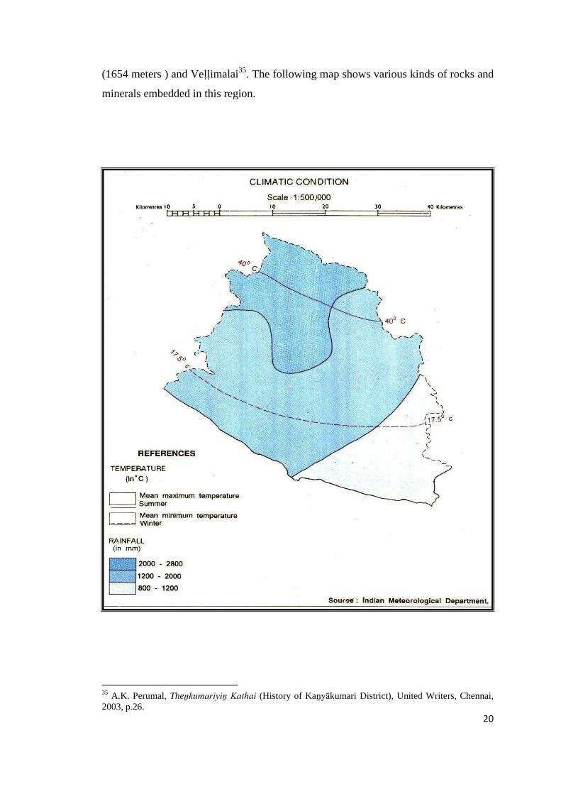
(seasonal) into a pālai lands. 34 The following map shows the climatic conditions of
Kaṉyākumari region with details of temperature and rainfall level.
Kaṉyākumari region, being a fertile zone, only four divisions of landscapes
and ecosystems are available. They are the kuṛiñci (hilly tracts), muḷḷai (pastoral
tracts), marutam (riverine or wet land) and neytal (the coastal/litoral tracts) except
pālai (arid/waste tracts). This district benefited with the rainfall from both the
southwest and the northeast monsoons. Both monsoons led to a better environment,
suitable climatic conditions and abundance of natural resources.
The geographical factors which influence natural vegetation include climate,
soil, and topography. This district consists of thick forests and mountains. The
Kāthāḍi mountain is high above 808 meters. The other mountains are Maruthuvaḻ
malai (370 meters), Kalmalai (990 meters), Thadāgai (960 meters) Mahendharagiri
33 P.T.Srinivas Iyenger, History of the Tamils-From the earliest times to 600A.D., Asian EducationalServices. New Delhi, 1982, p.3.34 Radhika Rajamani, Society in Early Historic Tamiḻagam, Ph.D. thesis, Jawaharlal Nehru University,New Delhi, 1993, p.66.
20
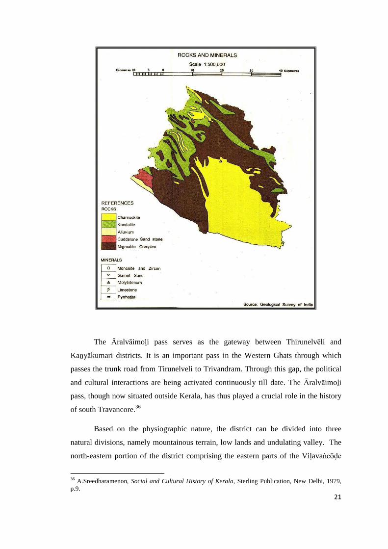
(1654 meters ) and Veḷḷimalai35. The following map shows various kinds of rocks and
minerals embedded in this region.
35 A.K. Perumal, Theṉkumariyiṉ Kathai (History of Kaṉyākumari District), United Writers, Chennai,2003, p.26.
21
The Āralvāimoḻi pass serves as the gateway between Thirunelvēli and
Kaṉyākumari districts. It is an important pass in the Western Ghats through which
passes the trunk road from Tirunelveli to Trivandram. Through this gap, the political
and cultural interactions are being activated continuously till date. The Āralvāimoḻi
pass, though now situated outside Kerala, has thus played a crucial role in the history
of south Travancore.36
Based on the physiographic nature, the district can be divided into three
natural divisions, namely mountainous terrain, low lands and undulating valley. The
north-eastern portion of the district comprising the eastern parts of the Viḷavaṅcōḍe
36 A.Sreedharamenon, Social and Cultural History of Kerala, Sterling Publication, New Delhi, 1979,p.9.
22
and Kalkuḷam taluks and the north-eastern portion of Thōvālai taluk constitutes a
mountainous terrain. The sea coast on the west and south-west of the district is flat
and fairly fertile (Agastīswaram).
Soils of the district is mostly of the red loam variety. In the sea coasts,
however, the sandy type of soils prevails and near the mountain ranges gravelly soil is
generally seen. In the lowlands, there is neither white sand nor sandy loam, while in
the midlands and highlands there prevails fairly fertile soil of fine type, particularly in
the valley. In the midlands, in general, the soil is clay loam of laterite origin with an
admixture of gravel and sand. In parts of Vilavaṅcōḍe and Kalkuḷam taluks the gravel
content is low.37 The map shows various kinds of soil formed in this region.
37 S.C.Bhatt (ed.), The Encyclopaedic District Gazetteers of India, southern zone, vol.2, 1997, GyanPublishing House, New Delhi, pp.1080-81.
23
Geological formation
The rock formation of Archaean Age fall under two groups viz., the
khondalites represented by garnetiferous sillimanite–graphite gneisses and garnet
biotite gneisses which occupy a major part of the district, and the charnockites which
are exposed in the areas around Rādhāpuram, Āralvāimoḻi, Kulasēkaram, Thuckalai
and Rājākkamaṅgalam. Robert Bruce Foote noted that the shelly line stones found at
Kaṉyākumari strengthen the theory of uplift of land mass in this area.38 Ilmenite,
rutile, zircon, garnet, monazite, sillimanite, leucoxene and magnetite are the important
minerals found at Vaḷḷiyāru, Kuḷachal and Maṇavālakuṟichi in this district.39 The sand
on the sea coast is rich in mineral wealth, while the coast as such provides an
enchanting natural environment. The sea shore sands found at Kaṉyākumari is
different coloured like bright scarlet, black, purple, yellow, red and white sands. It is
glittering on the sea shore like gold. The sea sands are also full of titaniferous iron
grains. The finer sort of sand is used by goldsmiths in polishing gold and there is an
ever increasing demand for it. 40
Flora
The cycle of variations in the climate and seasons around the year have had
their impact on vegetation and the development of agriculture. Kaṉyākumari region is
also rich in a variety of animals and birds. Kaṉyākumari region has been considered
through the ages as a storehouse of valuable medicinal plants, timber trees and spices.
It is endowed with an exceptionally rich variety of natural habitats which are nurtured
by climatic and topographical features.
The flora of Kaṉyākumari district can still fit in this description well. There
are valuable timber trees, trees yielding gums, palms, bamboos and reeds, fibrous
plants, medicinal plants and flowering and ornamental plants in the district making it
the botanical garden of Tamil Nadu. In the lowlands, in the valleys sheltered by the
hill ridges, paddy, the main food-crop is grown extensively. Topioca is the second
38 M.Gopalakrishnan (ed.), Gazetteers of India, Tamil Nadu State – Kanyakumari District, Governmentof Tamil Nadu, Chennai, 1995, p.11.39 Seetharam Gurumurthi (ed.), Kaṉyākumari Māvaṭṭa Kaiyēḍu, Tamil Nadu State Department ofArchaeology, Chennai, 2008, p.2.40 K.P.Padmanabha Menon, “A History of Kerala written in the form of notes on Visscher’s lettersfrom Malabar”, vol-I; T.K.Krishnan Menon,(ed.), Asian Educational Services, New Delhi, 1982, p.117.
24
important food crop and is cultivated mostly in Kalkuḷam and Viḷavaṅkōḍu taluks.
Beautiful coconut gardens are found in the narrow stretches of the sandy seaboard and
along the banks of rivers, tanks, the Maṇakuḍi lake and along the estuary at
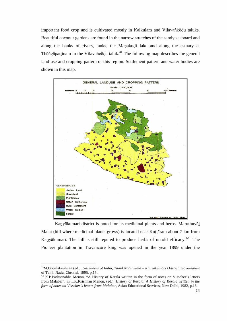
Thēṅgāpaṭṭinam in the Vilavaṅcōḍe taluk.41 The following map describes the general
land use and cropping pattern of this region. Settlement pattern and water bodies are
shown in this map.
Kaṉyākumari district is noted for its medicinal plants and herbs. Maruthuvāḻ
Malai (hill where medicinal plants grows) is located near Koṭṭāram about 7 km from
Kaṉyākumari. The hill is still reputed to produce herbs of untold efficacy.42 The
Pioneer plantation in Travancore king was opened in the year 1899 under the
41M.Gopalakrishnan (ed.), Gazetteers of India, Tamil Nadu State – Kanyakumari District, Governmentof Tamil Nadu, Chennai, 1995, p.15 .42 K.P.Padmanabha Menon, “A History of Kerala written in the form of notes on Visscher’s lettersfrom Malabar”, in T.K.Krishnan Menon, (ed.), History of Kerala: A History of Kerala written in theform of notes on Visscher’s letters from Malabar, Asian Educational Services, New Delhi, 1982, p.13.
25
Command of His Highness Shri Mūlam Thirunāḷ. A very large quantity of rubber, tea,
pepper, ginger, turmeric and cardamom are cultivated.43
Fauna
Ten orders of mammals are found in this district. They are: i) Order primates
(Old world monkey) ii) Order Lemuroidea (monkeys having fox – like faces) like the
slander lories, iii) Order carmvore (cats & dogs) iv) Order insectivore (hedgehog) v)
Order chiroptera, (bats) vi) Order Rodentia (Smirrels – rates, mice hares, etc., vii)
Order Proboscidea (elephants) viii) Order ungulate (the mammals such as Cissus
quadrangularies) ix) Cartacea (Whales, Porpoises, Dolphins) and x) Edantata Indian
(Indian Pangolioan).44 About 250 species of birds have been recorded in the district
around at Sucinḍram, Thērūr and Vēmbānūr wetlands.45
Rivers
Kaṉyākumari district is predominantly an agricultural area depending mainly
on both the north-east and south-west monsoons. It receives a fairly good amount of
rainfall in both the seasons. The major river in the district is Tāmbaraparani river
locally known as Kuḻithurai. This river has got two major tributaries, namely Kōdayār
and Paraliyār with the Pēchipārai Dam and Perunchāṇi Dam respectively built across
them. There are many tributaries of the Kodayar river of which Chiṭṭār–I and Chiṭṭār-
II and their dams are major ones. The origin of Tāmbaraparani river originates in the
Western Ghats and confluences with the Arabian sea near Thēṅgāpaṭṭiaṇam, about 56
km west of Kaṉyākumari.46 Even during the times of the Pāṇḍyas, the Paraliyār has
been used for irrigation in Nāñchilnāḍu. The Pāṇḍyaṉ dam is built across the
Paraliyar in Kalkuḷam taluk. About a km lower down the Pāṇḍyaṉ dam, the Puthaṉ
dam, the Padmanābhapuram and Puthaṉ channels were built in 1750 CE by
Mārthāṇḍa Varma. The Vaḍasēri river is also called as Paḻayār or Kōṭṭār (Old river).
This is the southern most river in the Indian Peninsula. Many small streams combine
43 T.K.Velu Pillai, Travancore State Manual, vol-I, Government of Travancore, Travandrum, 1938,p.6.44 M.Gopalakrishnan (ed.), Gazetteers of India, Tamil Nadu State – Kanyakumari District, Governmentof Tamil Nadu, Chennai, 1995, pp.27-28 .45 A.R.Rahmani, Important bird area in India-priority sites for Conservation, Bombay Nature HistorySociety, 2004, Mumbai, p.985.46 T.K.Velu Pillai, Travancore State Manual, vol-I, Government of Travancore, Travandrum, 1938,p.63.
26
and form this river. One of these rivers south of the Mahēndragiri Peak and passing
down a steep gorge reaches the low country a little to the west of Aṉandapuram. The
Paḻayār flows through the taluks of Thōvālai and Agastīswaram in a southeasterly
direction and fills into the Maṇakkuḍi lake after a course of twenty three miles,
passing the town of Būdhapāṇḍi, Kōṭṭār, Nāgarcōil, Thāḻakuḍi and Sucīndram. 47
The Muḷḷaiyār in Viḷavaṅkōḍu taluk is a stream flowing for about 11 km,
through Kaliel, Eḍaikōḍu and Pākkōḍu. It joins the western Tāmbraparaṇi near
Thikkuṟichi. The Vaḷḷiyār is a small river, 16 km long. It rises in the Veḷḷimalai hills,
passes through Kōthanallūr, Kalkuḷam, Eraṇiel, Thalakuḷam, Maṇavālakuṟichi and
Kaḍiyapaṭṭiaṇam and falls into the Arabian sea. There are in all as many as 2593
tanks in the district, both rain fed and channel fed.48 The map bellow illustrates to
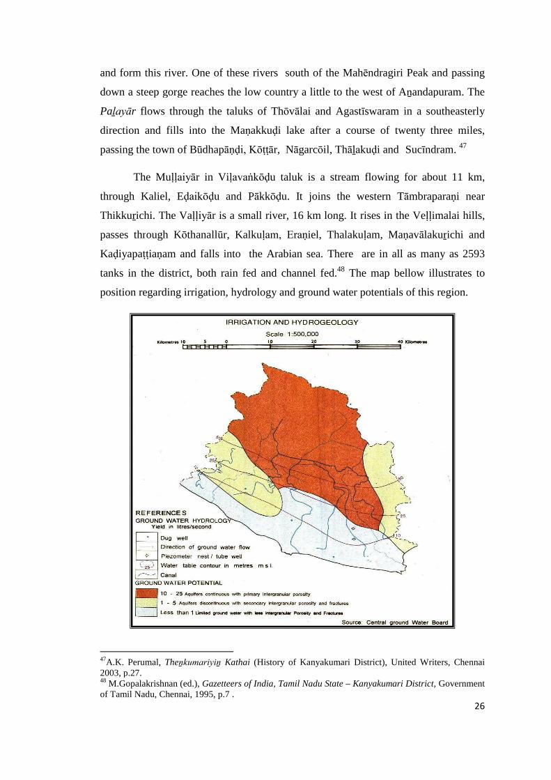
position regarding irrigation, hydrology and ground water potentials of this region.
47A.K. Perumal, Theṉkumariyiṉ Kathai (History of Kanyakumari District), United Writers, Chennai2003, p.27.48 M.Gopalakrishnan (ed.), Gazetteers of India, Tamil Nadu State – Kanyakumari District, Governmentof Tamil Nadu, Chennai, 1995, p.7 .
27
The history of natural tanks is age old, but it is known that kings contributed a
great deal to the irrigation facilities. The copper plate inscriptions from 9th century CE
mention several tanks like Pasuṅkuḷam, Veñchikuḷam, Neḍumaruthukuḷam,
Perumkuḷam, Elemchikuḷam and Koṇaduṅkuḷam. The Pāṇḍya king Vīranārayaṇaṉ
was known to have constructed some of the tanks. Vīranārayaṇa Maṅgaḷam is named
after king Vīranārāyaṇa who built the Thēṟakāl canal to take water from river Paḻayār
to the tanks Thāthiarkuḷam, Puthukirāmamkuḷam and Thērūr kuḷam.49
The landscape of the Kaṉyākumari regions studded with forests, natural tanks,
perennial ponds, rich soil content, mineral wealth and variety of flora and fauna
facilitated the growth of population, creation of new settlements, irrigation pattern and
finally distinct historical and cultural geography.
Chapterization
The thesis entitled Historical and Cultural Geography of Kaṉyākumari
Region is dealt with in six chapters based on available data.
I. Introduction
II. Historical vestiges in Kaṉyākumari Region
III Historical Background of Kaṉyākumari Region
IV. Historical Geography of Kaṉyākumari Region
V. Cultural Geography of Kaṉyākumari Region
VI. Conclusion
The first chapter by way of introduction, provides glimpses of the
geographical features of Kaṉyākumari region and general introduction on the
historical significance of Nāñchilnāḍu. Besides, this chapter provides scope of the
work, nature of source material, previous work, periodization and structure of the
thesis.
49 A.R.Rahmani, Important bird area in India-priority sites for Conservation, Bombay Nature HistorySociety, 2004, Mumbai, p.985 .

28
The second chapter deals with historical vestiges of Kaṉyākumari region. The
field studies carried out in several villages of Kaṉyākumari region throw much light
on the history of this region. An intensive field study, both archaeological and
ethnographical, was undertaken to understand the area and to collect and document
archaeological, historical and epigraphical data. These ground surveys helped to trace
the pre-historic and historic remains such as Iron Age monuments, temple
inscriptions, antiquities, location of the ancient villages and the chief villages of nāḍu
units. The preliminary ethnographic survey helped to understand the present social
structure of each eco-zones. This information indirectly helped to understand the
epigraphical data that get reflected in this chapter (Map 1).
The third chapter deals with the historical backround of Kaṉyākumari region.
The rulers like Āyi (Sangam period), Early Pānḍiyas, Later Chōḻas, Later Pāṇḍiyas,
Vēynāḍu chieftains, Nāyakas of Madurai and Thiruvithancore samasthāṉam, held
sway over their region. The different dynasties, both major and minor, ruled in this
region introduced different administrative units and modified some of the existing
ones. The significant features of these geographies are dealt in this chapter.
The fourth chapter deals on the historical geography of Kaṉyākumari region.
In this chapter an attempt is made to study the territorial and administrative units viz.,
Maṇḍalam, Vaḷanāḍu, Nāḍu/Kūṟṟam, Ūr, Brahmadēyam, Maṅgaḷam, Nagaram and
other small units. The division of the country into Maṇḍalam, Vaḷanāḍu, Nāḍu, Ūr
and other administrative units formed the backbone of the imperial Chōḻas
administration and which mainly contributed to the economic, social and cultural
dominance of the Chōḻas over other dynasties. This region also encountered formation
of such units during Chōḻa rule. These territorial divisions undergone minor changes
in the following years, particularly during later Pāṇḍyas, Vijayanagar and Vēṇḍu
rulers. Some fine aspects of these administrative units are discussed in detail with the
help of epigraphs and maps.
The fifth chapter deals on the cultural geography of the region. The cultural
peculiarities and similarities of the region is highlighted in the backdrop of the
geographical factors, settlement pattern and place name studies. The continuity of the
cultural ethos is also highlighted.
29
The final chapter sums up the findings. A resume of the early chapters and the
findings that emerged from the study as a whole are given in the concluding chapter.
It also explains the advantages and limitation of the study. Appendix, charts, tables,
maps, glossary and bibliography are provided at the end of the thesis.


30
CHAPTER – II
HISTORICAL VESTIGES IN KAṈYĀKUMARI REGION
Kaṉyākumari is one of the richest districts in Tamil Nadu having historical
vestiges ranging from prehistoric times to the recent centuries. Among the prehistoric
sites, the Iron Age sites dominate the scene. The cultural vestiges prior to Iron Age
are very scanty and only a negligible amount of microlithic tools was recovered. The
identification of palaeolithic tools still eludes the scholars. The non-occurrence of
certain cultural traits is probably due to its geological settings. The geological and
environmental factors played a greater role in the formation of archaeological sites.
Based on the available sources, encountered in the northern part of Tamil Nadu, it
becomes evident that the cultural sequences in this district occur in the order of
Palaeolithic, Mesolithic, Neolithic, Iron Age (megalithic), Early Historic and Historic
periods.1 Such cultural order is not witnessed homogeneously though out Tamil Nadu
and probably future discoveries may alter the present scenario.
Archaeological exploration
The present intensive field survey conducted in the entire Kaṉyākumari region
provided a good scope to understand the settlement pattern that existed during the
Iron Age and Early Historic times and its cultural transformation. It also helped to test
the existing hypothesis and provided better information to understand the nature of the
settlement. The present exploration yielded Mesolithic, Neolithic, Iron Age and Early
Historic sites besides several medieval temples, sites and inscriptions.
Previous Explorations and Excavations
The integration of archaeological, epigraphical and numismatic data
compounded with intensive micro regional study helped to enrich our understanding
on the cultural pattern that emerged in the region during the Iron Age and Early
1 K.Rajan, “Situating the beginning of early historic times in Tamil Nadu: Some issues andreflections”, Social Scientist, vol.36, New Delhi, 2008, p.60.
31
Historic times. Understanding the cultural wealth is a prerequisite to write the history
of any region as it provides first hand information on the nature of the data. The
observations of tangible evidence in its micro system help to widen our perspectives.
Therefore, field survey was given much importance and the entire region was
surveyed. The previous explorations and excavations form the basis for the present
field survey. The region failed to receive adequate attention of archaeologists and
hardly any excavations worthy of mention have been undertaken in this region. This
deficiency was tackled by undertaking an intensive village to village survey. This
region was explored to the maximum extent possible and as many as 59
archaeological sites have been newly brought to light (Appendix –II).
In this chapter an attempt is made to study the material culture of Iron Age
and Early Historic period with the following objectives:
1. To identify the Iron Age, Early Historic and Medieval sites on the
ground.
2. To study the settlement pattern and their distribution.
3. To estimate the cultural transformation process that had taken place
from the Iron Age to Early Historic period.
4. To locate trade centres and trade routes.
This study area serves as a connecting link between Tamil Nadu and Kēraḷa
regions as the Kaṉyākumari region is ideally located on the southern tip of peninsular
India. This is one of the regions where one could observe a continuous history from
the Prehistoric to the Historical period. Irrespective of the hiatus, the systematic
explorations and excavation carried out in the pre and post Independent era provided a
good basis to reconstruct the cultural process that had undergone in this region. As
many as 59 sites were discovered during the present exploration alone. Potential
resource zones, religious centres, trade centres, industrial production centres and trade
routes have been identified. However, the observations made on these surface
indicators had their own limitations. The hidden nature of the archaeological material
prevents us getting a complete picture of the society.
32
The archaeological fieldwork done so far in Kaṉyākumari region is mostly
sporadic in nature and most of them were accidental findings. The evidence of the
earliest human occupation in this region is encountered with microlithic tools.
Microlithic tools (BCE.4000) are found in and around the region of Muṭṭam,
Sukkupāṟai Thēriviḷai and Marunthuvāḻ malai.2 These microlithic tools were collected
in the coastal areas like Muṭṭam (Fig. 2. 01) and also in the interior region in the sites
like at Sukkupāṟai Thēriviḷai (Fig. 2. 02). Fixing the date to these tools is a problem
but still one could conceive that these tools would have been produced prior to
Neolithic times. In Tamil Nadu context, the microlithic tools were encountered in two
cultural contexts. In the excavations conducted at Mayilāḍumpāṟai near Krishṇagiri,
these tools were noticed below the Neolithic phase. At Māṇguḍi, these tools were
encountered below the Iron Age cultural deposit.3 Therefore, fixing the cultural
context of these tools is still a complex one. A proper excavation and indisputable
stratigraphical context can alone solve this problem. The occurrence of microlithic
tools in Kaṉyākumari region is needed to be recognised under this background.
The cultural transformation from food gathering to food production is
considered as a revolution in human history that happened during the Neolithic times.
Neolithic tools represent the beginning of agricultural production that took place
about 5,000 years ago in South India. However, it is very difficult to discern the
existence of Neolithic phase based on Neolithic tools alone. The associated cultural
material like handmade pottery, rock art, settlements, domestication of animal and
others are prerequisites to confirm its existence. According to H.D. Sankalia, the
earliest cultural phase of Southern Tamil Nadu was represented by Microliths and was
followed by Megaliths were mostly of semiprecious stone like chert and jasper.4 In
Kaṉyākumari region, Neolithic settlements were hardly identified on the ground. The
occurrence of Neolithic tools only suggests the possibilities of its existence. Such
Neolithic tools were reported at Mayilāḍi in Agastīswaram taluk, Thūthūr and
2 Seetharam Gurumurthi (ed.), Kaṉyākumari Māvaṭṭa Kaiyēḍu, Tamil Nadu State Department ofArchaeology, Chennai, 2008, p.4.3 K.Rajan, Excavations at Mayilāḍumpāṟai – A Preliminary Report, Manoo Pathippakam, Thanjavur,2004, p.8.4 K. Ashok Vardhan Shetty (ed.), Excavations at Māṅguḍi, Tamil Nadu State Department ofArchaeology, Chennai, 2003, p.17.
33
Poromkōḍu near Kaliyakkāviḷai in Viḷavaṅkōḍu taluk.5 Besides, a solitary example on
the river bank of Kuḻithuṟai is collected by the researcher during the exploration (Fig.
2. 03). These tools only reflect the existence of agricultural production but it is very
difficult to discern any concrete evidence on the pattern of Neolithic survival.
Iron Age
Unlike Mesolithic and Neolithic vestiges, Iron Age provided considerable
evidences to understand the basic nature of the settlement. Like any other region, this
region also witnessed a limited number of habitation mounds. The vast and intensive
agricultural and industrial activities supplemented by urbanization might have played
a major causative role in its destruction. The available Iron Age finds are mostly urn
burials. Placing these urn burials in a definite chronological frame is also a difficult
task. The lack of systematic excavation has further aggravated the problem. A
comparative study with the neighbouring region of Tirunelvēli helped to some extent
to understand the nature of urn burial sites. Urn burials are found at Veḷḷimalai,
Nēsarpuram, Kōṇam, Chiṉnaviḷai, Poromkōḍu and Karuppukkōṭṭai.6
In 1945, the Travancore State Department of Archaeology had conducted an
excavation at Veḷḷimalai in Kalkuḷam taluk, during which they came up with ancient
urns used for burying the dead. Similar urns were also unearthed at Ādhichanallūr of
Tirunelvēli district, containing broken pieces of pottery and rusty iron pieces.
According to the local tradition, these skeletal remains are called as “kūṉ” which
means “bent – backs”. It is believed that people lived up to a ripe age and as a result
their backs became bent and after death their mortal remains were placed in the urns
along with some of their personal belongings such as pots, grains and iron weapons.
The available evidence suggests that these were post cremation burial. In Saṅgam
works like Puranānūṟu mention has also been made about muthu makkaḷ thāḻi which
means the urns of elderly people.7
5 M.Gopalakrishnan, (ed.), Gazetteer of India, Tamil Nadu State-Kanyakumari District, Government ofTamil Nadu, Archives and Historical Research, Chennai,1995, p.51.6 Seetharam Gurumurthi (ed.), Kaṉyākumari Māvaṭṭa Kaiyēḍu, Tamil Nadu State Department ofArchaeology, Chennai, 2008, p.4.7 M.Gopalakrishnan, (ed.), Gazetteer of India, Tamil Nadu State-Kanyakumari District, Government ofTamil Nadu, Archives and Historical Research, Chennai,1995, p.51.
34
Observations made in different parts of the area revealed the existence of huge
megalithic monuments of different categories. This largely throws light on the early
inhabitants and the nature of their settlements. It also sheds light on the different types
of occupations followed by the contemporary people. The megalithic monuments and
tangible evidences like beads of semi-precious stones, objects, weapons and
ornaments made of iron, copper and gold, ceramics of different varieties suggest their
craftsmanship, internal and external trade contacts, social hierarchy, social values, the
significance of rituals and many other such social values. However, the lack of
controlled excavations and well determined radio carbon dates place us in a very
uncomfortable situation. Based on circumstantial evidences, it is quite probable and
acceptable to fix the date of Iron Age culture of Kaṉyākumari region around first
millennium BCE. The large scale discovery of megalithic remains from this region
helps us to trace back the evidences of human occupation.8 A handmade coarse
earthen jar and other relics were found near Thūthūr village in this district. The shape,
fabric and the decorations indicate that they are probably of the megalithic or early
historic period.9 The excavation at Karuppukkōṭṭai near Nāgarkōil brought to light
burial urns containing iron objects, pottery, shell bangles and bones. Diggings at
Veḷḷimalai in Kalpaṭṭidēsam, Kaḍiyapaṭṭiaṇam and Pākuḍi in Kalkuḷam taluk in South
Travancore, southwest of Iraṇiel Muṭṭam road, revealed altogether 23 burial urns,
however, most of them are damaged. One of them yielded rusted iron pieces.10 The
early literary evidences provide a clue on the existence of some settlements. For
instance, one of the celebrated poets of Sangam Age is Āthaṅkōṭṭu Āsāṉ. He is
considered as the author of the famous grammar work Tolkāppiyam. The preliminary
survey conducted at Āthaṅkōḍu (77˚ 10’ 45.3”E; 8˚ 18’09.5”N) yielded a rouletted
ware and a conical jar. These two pieces of evidences suggest that the site has
survived with external contacts since Early Historic times.11 The habitation mound
called Sūryamēḍu yielded such evidences but unfortunately this mound is being
destroyed due to the establishment of large scale brick industries (Fig. 2. 04).
8 A.P. Greeshmalatha, Historical Geography of Vaḷḷuvanāḍ, Ph.D. dissertation, University of Calicut,Calicut, 2008, pp.168-9.9 M.Gopalakrishnan, (ed.), Gazetteer of India, Tamil Nadu State-Kanyakumari District, Government ofTamil Nadu, Archives and Historical Research, Chennai,1995, p.51.10 B.K.Gururaja Rao, Megalithic Culture in South India, Prasaranga University of Mysore, Mysore,1972, pp.47-48.11 Seetharam Gurumurthi (ed.), Kaṉyākumari Māvaṭṭa Kaiyēḍu, Tamil Nadu State Department ofArchaeology, Chennai, 2008, p.38.
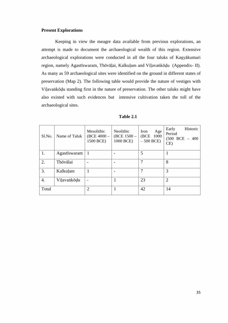
35
Present Explorations
Keeping in view the meagre data available from previous explorations, an
attempt is made to document the archaeological wealth of this region. Extensive
archaeological explorations were conducted in all the four taluks of Kaṉyākumari
region, namely Agastīswaram, Thōvāḷai, Kalkuḷam and Viḷavaṅkōḍu (Appendix- II).
As many as 59 archaeological sites were identified on the ground in different states of
preservation (Map 2). The following table would provide the nature of vestiges with
Viḷavaṅkōḍu standing first in the nature of preservation. The other taluks might have
also existed with such evidences but intensive cultivation taken the toll of the
archaeological sites.
Table 2.1
Sl.No. Name of TalukMesolithic(BCE 4000 –1500 BCE)
Neolithic(BCE 1500 –1000 BCE)
Iron Age(BCE 1000– 500 BCE)
Early HistoricPeriod(500 BCE – 400CE)
1. Agastīswaram 1 - 5 1
2. Thōvālai - - 7 8
3. Kalkuḷam 1 - 7 3
4. Viḷavaṅkōḍu - 1 23 2
Total 2 1 42 14
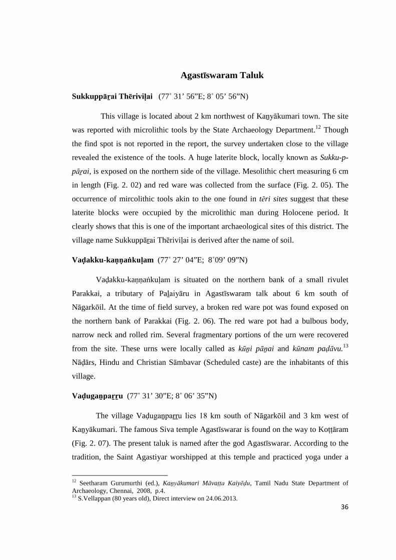
36
Agastīswaram Taluk
Sukkuppāṟai Thēriviḷai (77˚ 31’ 56”E; 8˚ 05’ 56”N)
This village is located about 2 km northwest of Kaṉyākumari town. The site
was reported with microlithic tools by the State Archaeology Department.12 Though
the find spot is not reported in the report, the survey undertaken close to the village
revealed the existence of the tools. A huge laterite block, locally known as Sukku-p-
pāṟai, is exposed on the northern side of the village. Mesolithic chert measuring 6 cm
in length (Fig. 2. 02) and red ware was collected from the surface (Fig. 2. 05). The
occurrence of mircolithic tools akin to the one found in tēri sites suggest that these
laterite blocks were occupied by the microlithic man during Holocene period. It
clearly shows that this is one of the important archaeological sites of this district. The
village name Sukkuppāṟai Thēriviḷai is derived after the name of soil.
Vaḍakku-kaṇṇaṅkuḷam (77˚ 27’ 04”E; 8˚09’ 09”N)
Vaḍakku-kaṇṇaṅkuḷam is situated on the northern bank of a small rivulet
Parakkai, a tributary of Paḻaiyāru in Agastīswaram talk about 6 km south of
Nāgarkōil. At the time of field survey, a broken red ware pot was found exposed on
the northern bank of Parakkai (Fig. 2. 06). The red ware pot had a bulbous body,
narrow neck and rolled rim. Several fragmentary portions of the urn were recovered
from the site. These urns were locally called as kūṉi pāṉai and kūnam paḍāvu.13
Nāḍārs, Hindu and Christian Sāmbavar (Scheduled caste) are the inhabitants of this
village.
Vaḍugaṉpaṟṟu (77˚ 31’ 30”E; 8˚ 06’ 35”N)
The village Vaḍugaṉpaṟṟu lies 18 km south of Nāgarkōil and 3 km west of
Kaṉyākumari. The famous Siva temple Agastīswarar is found on the way to Koṭṭāram
(Fig. 2. 07). The present taluk is named after the god Agastīswarar. According to the
tradition, the Saint Agastiyar worshipped at this temple and practiced yoga under a
12 Seetharam Gurumurthi (ed.), Kaṉyākumari Māvaṭṭa Kaiyēḍu, Tamil Nadu State Department ofArchaeology, Chennai, 2008, p.4.13 S.Vellappan (80 years old), Direct interview on 24.06.2013.
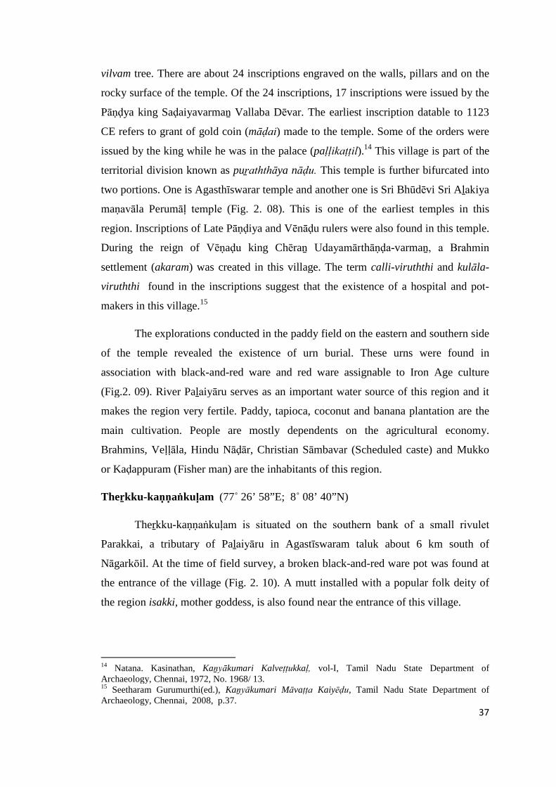
37
vilvam tree. There are about 24 inscriptions engraved on the walls, pillars and on the
rocky surface of the temple. Of the 24 inscriptions, 17 inscriptions were issued by the
Pāṇḍya king Saḍaiyavarmaṉ Vallaba Dēvar. The earliest inscription datable to 1123
CE refers to grant of gold coin (māḍai) made to the temple. Some of the orders were
issued by the king while he was in the palace (paḷḷikaṭṭil).14 This village is part of the
territorial division known as puṟaththāya nāḍu. This temple is further bifurcated into
two portions. One is Agasthīswarar temple and another one is Sri Bhūdēvi Sri Aḻakiya
maṇavāla Perumāḷ temple (Fig. 2. 08). This is one of the earliest temples in this
region. Inscriptions of Late Pāṇḍiya and Vēnāḍu rulers were also found in this temple.
During the reign of Vēṇaḍu king Chēraṉ Udayamārthāṇḍa-varmaṉ, a Brahmin
settlement (akaram) was created in this village. The term calli-viruththi and kulāla-
viruththi found in the inscriptions suggest that the existence of a hospital and pot-
makers in this village.15
The explorations conducted in the paddy field on the eastern and southern side
of the temple revealed the existence of urn burial. These urns were found in
association with black-and-red ware and red ware assignable to Iron Age culture
(Fig.2. 09). River Paḻaiyāru serves as an important water source of this region and it
makes the region very fertile. Paddy, tapioca, coconut and banana plantation are the
main cultivation. People are mostly dependents on the agricultural economy.
Brahmins, Veḷḷāla, Hindu Nāḍār, Christian Sāmbavar (Scheduled caste) and Mukko
or Kaḍappuram (Fisher man) are the inhabitants of this region.
Theṟkku-kaṇṇaṅkuḷam (77˚ 26’ 58”E; 8˚ 08’ 40”N)
Theṟkku-kaṇṇaṅkuḷam is situated on the southern bank of a small rivulet
Parakkai, a tributary of Paḻaiyāru in Agastīswaram taluk about 6 km south of
Nāgarkōil. At the time of field survey, a broken black-and-red ware pot was found at
the entrance of the village (Fig. 2. 10). A mutt installed with a popular folk deity of
the region isakki, mother goddess, is also found near the entrance of this village.
14 Natana. Kasinathan, Kaṉyākumari Kalveṭṭukkaḷ, vol-I, Tamil Nadu State Department ofArchaeology, Chennai, 1972, No. 1968/ 13.15 Seetharam Gurumurthi(ed.), Kaṉyākumari Māvaṭṭa Kaiyēḍu, Tamil Nadu State Department ofArchaeology, Chennai, 2008, p.37.
38
Oḻukiṉachērry (77˚ 26’ 15”E; 8˚ 11’ 21”N)
Oḻukiṉachērry lies on the northern bank of the river Paḻaiyāṟu river on the
outskirt of Nāgarkōil town about a km. north of the town. The existence of the early
settlement is discerned with the collection of black-and-red ware and a few pieces of
urn.
Kariyamāṇikkapuram (77˚ 27’ 04”E; 8˚ 09’ 48”N)
This village lies on the eastern bank of the river Paḻaiyāṟu at about 2 km
before Sucīndram on the Nāgarkōil-Kaṉyākumari road. A highly disturbed habitation
with material like red ware is noticed close to the Vishnu temple. There are four
temples namely Āḻvār temple, Kailāsanāthar temple, Muthārammaṉ temple and
Bhagavathiammaṉ temple. There are about six inscriptions on the walls of the temple.
The earliest inscription datable to 1163 CE is found engraved on the walls of Siva
temple. This inscription referred to the existence of a Brahmin settlement
rājanārāyaṇa-caturvēdi-maṅgalam.16
Kuṟaṇḍi (77˚ 28’ 24”E; 8˚ 10’ 50”N)
The village Kuṟaṇḍi lies on the left bank of river Paḻaiyāru close to a
large village called Thāḻakuḍi, which lies about 7 kms north of Nāgarkōil.
Kōrakthanāthar temple lies on the southern side of the village probably the earliest
temple noticed in this village. The temple is devoid of any inscription, but, on stylistic
grounds one may assign it to 11-12th century CE. (Fig. 2. 11). An inscription found
engraved on a loose slab noticed in front of the Piḷḷaiyār temple referred to the
erection of a piḷḷaiyār (Ganesha) and digging a well by Udhaya Mārthāṇḍaṉ, a
Vēṇāḍu king, in the year 538 of Kollam era (1363 CE). This village is considered as a
subdivision of Aḻakiya-chōḻa-nallūr, a temple village of Nāñchil nāḍu. The village
also named after the king as Udhaya-Mārthāṇḍam.17 Besides, black-and-red ware and
16 Naṭaṉa. Kasinathan, Kaṉākumari Kalveṭṭukkaḷ, vol-I, Tamil Nadu State Department of Archaeology,Chennai, 1972, No;1968/ 32.17 Seetharam Gurumurthi (ed.), Kaṉyākumari Māvaṭṭa Kaiyēḍu, Tamil Nadu State Department ofArchaeology, Chennai, 2008, p.47.
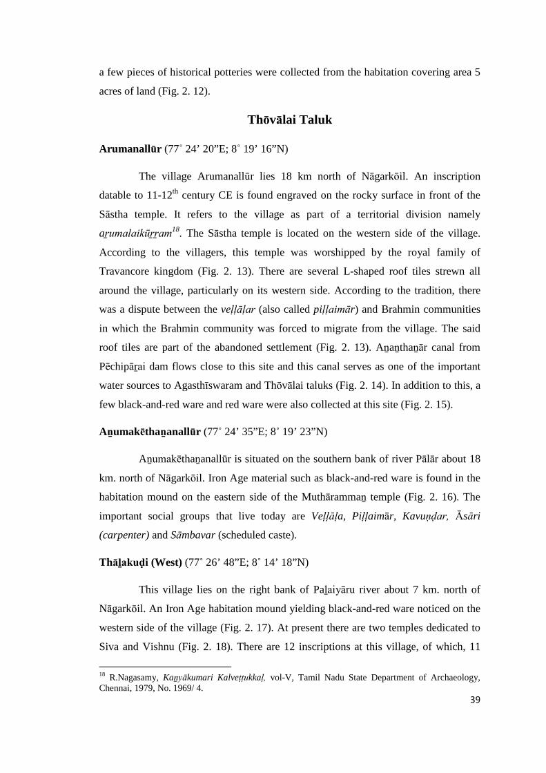
39
a few pieces of historical potteries were collected from the habitation covering area 5
acres of land (Fig. 2. 12).
Thōvālai Taluk
Arumanallūr (77˚ 24’ 20”E; 8˚ 19’ 16”N)
The village Arumanallūr lies 18 km north of Nāgarkōil. An inscription
datable to 11-12th century CE is found engraved on the rocky surface in front of the
Sāstha temple. It refers to the village as part of a territorial division namely
aṟumalaikūṟṟam18. The Sāstha temple is located on the western side of the village.
According to the villagers, this temple was worshipped by the royal family of
Travancore kingdom (Fig. 2. 13). There are several L-shaped roof tiles strewn all
around the village, particularly on its western side. According to the tradition, there
was a dispute between the veḷḷāḷar (also called piḷḷaimār) and Brahmin communities
in which the Brahmin community was forced to migrate from the village. The said
roof tiles are part of the abandoned settlement (Fig. 2. 13). Aṉaṉthaṉār canal from
Pēchipāṟai dam flows close to this site and this canal serves as one of the important
water sources to Agasthīswaram and Thōvālai taluks (Fig. 2. 14). In addition to this, a
few black-and-red ware and red ware were also collected at this site (Fig. 2. 15).
Aṉumakēthaṉanallūr (77˚ 24’ 35”E; 8˚ 19’ 23”N)
Aṉumakēthaṉanallūr is situated on the southern bank of river Pālār about 18
km. north of Nāgarkōil. Iron Age material such as black-and-red ware is found in the
habitation mound on the eastern side of the Muthārammaṉ temple (Fig. 2. 16). The
important social groups that live today are Veḷḷāḷa, Piḷḷaimār, Kavuṇḍar, Āsāri
(carpenter) and Sāmbavar (scheduled caste).
Thāḻakuḍi (West) (77˚ 26’ 48”E; 8˚ 14’ 18”N)
This village lies on the right bank of Paḻaiyāru river about 7 km. north of
Nāgarkōil. An Iron Age habitation mound yielding black-and-red ware noticed on the
western side of the village (Fig. 2. 17). At present there are two temples dedicated to
Siva and Vishnu (Fig. 2. 18). There are 12 inscriptions at this village, of which, 11
18 R.Nagasamy, Kaṉyākumari Kalveṭṭukkaḷ, vol-V, Tamil Nadu State Department of Archaeology,Chennai, 1979, No. 1969/ 4.
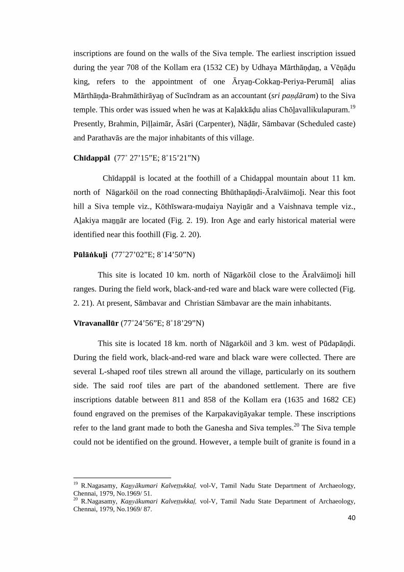
40
inscriptions are found on the walls of the Siva temple. The earliest inscription issued
during the year 708 of the Kollam era (1532 CE) by Udhaya Mārthāṇḍaṉ, a Vēṇāḍu
king, refers to the appointment of one Āryaṉ-Cokkaṉ-Periya-Perumāḷ alias
Mārthāṇḍa-Brahmāthirāyaṉ of Sucīndram as an accountant (sri paṇḍāram) to the Siva
temple. This order was issued when he was at Kaḷakkāḍu alias Chōḻavallikulapuram.19
Presently, Brahmin, Piḷḷaimār, Āsāri (Carpenter), Nāḍār, Sāmbavar (Scheduled caste)
and Parathavās are the major inhabitants of this village.
Chīdappāl (77˚ 27’15”E; 8˚15’21”N)
Chīdappāl is located at the foothill of a Chidappal mountain about 11 km.
north of Nāgarkōil on the road connecting Bhūthapāṇḍi-Āralvāimoḻi. Near this foot
hill a Siva temple viz., Kōthīswara-muḍaiya Nayiṉār and a Vaishnava temple viz.,
Aḻakiya maṉṉār are located (Fig. 2. 19). Iron Age and early historical material were
identified near this foothill (Fig. 2. 20).
Pūlāṅkuḻi (77˚27’02”E; 8˚14’50”N)
This site is located 10 km. north of Nāgarkōil close to the Āralvāimoḻi hill
ranges. During the field work, black-and-red ware and black ware were collected (Fig.
2. 21). At present, Sāmbavar and Christian Sāmbavar are the main inhabitants.
Vīravanallūr (77˚24’56”E; 8˚18’29”N)
This site is located 18 km. north of Nāgarkōil and 3 km. west of Pūdapāṇḍi.
During the field work, black-and-red ware and black ware were collected. There are
several L-shaped roof tiles strewn all around the village, particularly on its southern
side. The said roof tiles are part of the abandoned settlement. There are five
inscriptions datable between 811 and 858 of the Kollam era (1635 and 1682 CE)
found engraved on the premises of the Karpakaviṉāyakar temple. These inscriptions
refer to the land grant made to both the Ganesha and Siva temples.20 The Siva temple
could not be identified on the ground. However, a temple built of granite is found in a
19 R.Nagasamy, Kaṉyākumari Kalveṭṭukkaḷ, vol-V, Tamil Nadu State Department of Archaeology,Chennai, 1979, No.1969/ 51.20 R.Nagasamy, Kaṉyākumari Kalveṭṭukkaḷ, vol-V, Tamil Nadu State Department of Archaeology,Chennai, 1979, No.1969/ 87.
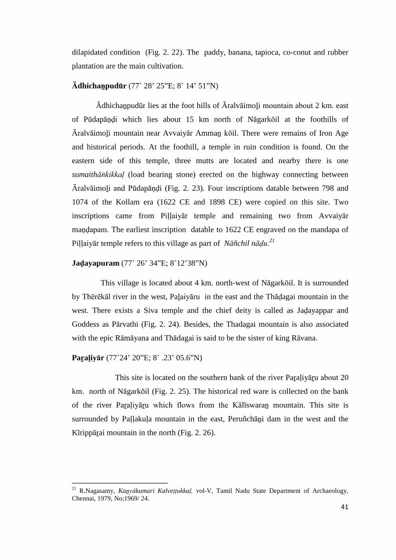
41
dilapidated condition (Fig. 2. 22). The paddy, banana, tapioca, co-conut and rubber
plantation are the main cultivation.
Ādhichaṉpudūr (77˚ 28’ 25”E; 8˚ 14’ 51”N)
Ādhichaṉpudūr lies at the foot hills of Āralvāimoḻi mountain about 2 km. east
of Pūdapāṇḍi which lies about 15 km north of Nāgarkōil at the foothills of
Āralvāimoḻi mountain near Avvaiyār Ammaṉ kōil. There were remains of Iron Age
and historical periods. At the foothill, a temple in ruin condition is found. On the
eastern side of this temple, three mutts are located and nearby there is one
sumaithāṅkikkaḷ (load bearing stone) erected on the highway connecting between
Āralvāimoḻi and Pūdapāṇḍi (Fig. 2. 23). Four inscriptions datable between 798 and
1074 of the Kollam era (1622 CE and 1898 CE) were copied on this site. Two
inscriptions came from Piḷḷaiyār temple and remaining two from Avvaiyār
maṇḍapam. The earliest inscription datable to 1622 CE engraved on the mandapa of
Piḷḷaiyār temple refers to this village as part of Nāñchil nāḍu.21
Jaḍayapuram (77˚ 26’ 34”E; 8˚12’38”N)
This village is located about 4 km. north-west of Nāgarkōil. It is surrounded
by Thērēkāl river in the west, Paḻaiyāru in the east and the Thāḍagai mountain in the
west. There exists a Siva temple and the chief deity is called as Jaḍayappar and
Goddess as Pārvathi (Fig. 2. 24). Besides, the Thadagai mountain is also associated
with the epic Rāmāyana and Thādagai is said to be the sister of king Rāvana.
Paṟaḷiyār (77˚24’ 20”E; 8˚ .23’ 05.6”N)
This site is located on the southern bank of the river Paṟaḷiyāṟu about 20
km. north of Nāgarkōil (Fig. 2. 25). The historical red ware is collected on the bank
of the river Paṟaḷiyāṟu which flows from the Kālīswaraṉ mountain. This site is
surrounded by Paḷḷakuḷa mountain in the east, Peruñchāṉi dam in the west and the
Kīrippāṟai mountain in the north (Fig. 2. 26).
21 R.Nagasamy, Kaṉyākumari Kalveṭṭukkaḷ, vol-V, Tamil Nadu State Department of Archaeology,Chennai, 1979, No;1969/ 24.
42
Pāṟaiyaḍi (77˚ 25’41” E; 8˚13’08”N)
This site lies 4 km. north of Nāgarkōil near Āṉaipothai on the way to
Pūthapāṇḍi. A mutt (Fig. 2. 27) is located on the northern side of this village. Early
historical remains are found close to this mutt. This mutt is locally called, Pāṇḍiyar
maḍam (traveller shelters). A fish symbol found on the ceiling of this mutt. Another
mutt is found at Erachakuḷam 2 km. east of this site. It was one of the ancient trade
routes in Nañchilnāḍu. They were put up to provide refreshment and respite to
travelers more than a century ago, but they have been ravaged by time and neglected
by the local people. According to A.K. Perumal , who has penned a detailed history of
the district, the maṇḍapam could have been constructed during the period of Dharma
Rāja, the ruler of Travancore. Once he under took a pilgrimage to Rameshwaram and
was impressed by the travellers maṇḍabam on either side of the road heading towards
the holy town. According to one inscription engraved on a stone pillar found in front
of the maṇḍabam, the family of one Mādhavaṉ from Puthēri village near Nāgarkōil,
had taken the responsibility of providing buttermilk, pickle, fire wood and blankets to
the travellers during festival days. The pillar was erected in 1867 CE. Another
inscription belonging to 1878 CE speaks of similar contribution made by Saṅgu Piḷḷai
and Rāmalakshmi family of Erachakuḷam.22 Veḷḷālas, Nāḍārs, Hindu Sāmbavar and
Christian Sāmbavar are the inhabitants of this village.
Kēsavaṉēri (77˚ 27’ 09”E; 8˚17’28”N)
The village Kēsavaṉēri lies 9 km. north of Nāgarkōil. Its old name is
Kaḍukkarai. The present village name of Kēsavanēri is derived from a name of
Kēsavaṉ. Lake irrigation is the most important water source to this taluk.
Kuṟathiyarai (77˚ 26’ 55”E; 8˚ 17’ 53”N)
Kuṟathiyarai lies near Aḻakiya Pāṇḍiyapuram about 19 km. north of
Nāgarkōil on the road connecting Āralvaimoḻi and Pūthapāṇḍi. Kuṟathiyarai is
situated on the southern fringes of the foothills. The cave temple known as
Kuṟathiyarai Avvaiyārammaṉ is located on the northern side of the mountain locally
22 The Hindu, October 17, 2013.
43
called Kuṟavaṉthaṭṭupāṟai (Fig. 2. 28). It is located on the top of the hill. An image of
Piḷḷaiyār is found in front of the cave temple. Here found heaps of red ware, which
belong to the Early Historic period. This place is now known as Munūṟṟu Ravi
Niyamam. But the Mudaliyār palm leaf record of 18th century CE refers this place as
Kusathiarai. Besides, a standing statute of Perumāḷ is noticed near the cave which
serves as proofs for the ancient nature of this place. Like the Chithrāl and
Tirunandikarai cave temples, this cave might have also been dedicated to Jains during
8th century CE. This must have later converted into a Vaishnava temple during the
early Pāṇḍya times. There are two inscriptions in Vaṭṭeḻuthu script found engraved on
a rock about 600 feet away from the temple. The inscription of the 10th century CE
issued during the reign of Chōḻa king Parāntaka I refers to a donation of gold given by
one Kavisiyaṉ Sāttaṉ Sirāvaṇaṉ of Kuṉḍra-paḷḷi to Lord Perumāḷ of Muṇūṟiravi
Niyamam. This also refers to the additional tax of 7 gold paid to Sri Vaishravaṇaṉ.
Perumāḷ sculpture is found inside of Cave temple. This cave temple is founded in 8th
century C.E i.e. period of Early Pāṇḍiyas.23
Āralvāimoḻi (77˚ 31’ 32” E; 8˚ 15’ 03”N)
Āralvāimoḻi is located about 25 km. north-east of Nāgarkōil on the way to
Tirunelveli. It lies between the ancient Nāñchilnāḍu and Pāṇḍiya nāḍu. The earliest
hero stone datable to 792 CE raised for the hero Raṇakīrthi, an army general of
Pāṇḍiya king Māṟaṉcaḍaiyaṉ, who fought against the Chēra force. This hero stone
erected during the 27th regnal year of the king is presently housed in the
Padmaṉābapuram Palace Museum.24 There we found a mountain range popularly
known as ‘Podigai’ hills. The southern side of Āralvāimoḻi is Kāṭṭrāḍimalai (Fig. 2.
29) and on its west is Thāḍagaimalai. During the field study, traces of a fortification
wall is observed that runs between the foot hills of Āralvāimoḻi to Kaṉyākumari (Fig.
2. 30). This boundary wall was built by one Vēṇāḍu king Mārthāṇḍavarmaṉ and it
served as a boundary between the Pāṇḍiya and Chēra territories.25 A mutt is also
observed near the ruined great boundary wall (Fig. 2. 31). The mutt suggests that this
23 Seetharam Gurumurthi (ed.), Kaṉyākumari Māvaṭṭa Kaiyēḍu, Tamil Nadu State Department ofArchaeology, Chennai, 2008, pp.49-50.24 Seetharam Gurumurthi (ed.), Kaṉyākumari Māvaṭṭa Kalveṭṭukkaḷ, vol-VI, Tamil Nadu StateDepartment of Archaeology, Chennai, 2008, No;543/ 2004.25 Seetharam Gurumurthi (ed.), Kaṉyākumari Māvaṭṭa Kaiyēḍu, Tamil Nadu State Department ofArchaeology, Chennai, 2008, p.41.
44
road served as trade/pilgrimage route in ancient times. There were about ten
inscriptions found at this site covering the period between 8th century CE down to the
19th century CE.
Mūvāṭṭrumukku near Paṟaḷiyāṟ (77˚ 23’ 46”E; 8˚ 23 09” N)
Mūvaṭṭrumukku is located around 20 km. north of Nāgarkōil near Paṟaḷiyār.
To the west of this village is Kāḷikēsaṉ mountain and on its south-west is Peruñchāṇi
dam and its north is Kīrippāṟai mountain and to its east is Paḷḷakuḷam. On the northern
bank of this river one can frequently find the red ware.
Kalkuḷam Taluk
Muṭṭam (77˚ 99’.2”E; 8˚07’28”N)
Muṭṭam lies at a distance of 17 km. away from Nāgarkōil on the Nāgarkōil–
Rājākkamaṅgaḷam road. This place could also be approached from Coḷachel or
Maṇḍaikāḍu. Several microlithic tools made of chert and quartz were collected
previously from this site and are presently housed in the Kaṉyākumari museum (Fig.
2. 01). Another site that yielded such microlithic tools is Sukkuppāṟai Thēriviḷai of
Agastīswaram taluk.26
Puliyūrkuṟichi (west) (77˚ 19’ 52”E; 8˚ 14’ 45”N)
Puliyūrkuṟichi is located at a distance of 3 km. from Thuckkalai on the
eastern side of the Tiruvaṇanthapuram-Nāgarkōil highway. Black-and-red ware
sherds have been found in the plantain farms, a little way to the north of this village.
This could have been placed of habitation, however the mound was totally levelled
down for the purpose of cultivation. At the time of field survey, Iron Age material
was found on the eastern side of Pathmaṉābapuram which was a capital of Travancore
kingdom. The Pathmaṉābapuram and Udhayagiri forts are strategically located
about 2 km. southwest of Puliyūrkuṟichi (Fig. 2. 32). Sri Vīra Ravivaṟma (c.1595-
1607CE), a ruler of Vēnāḍu kingdom, had built a mud fort of Udhayagiri in 1600 CE.
In 1741, Mārthāṇḍa Varmā (c.1729-1758 CE), a ruler of Travancore kingdom,
26 Seetharam Gurumurthi (ed.), Kaṉyākumari Māvaṭṭa Kaiyēḍu, Tamil Nadu State Department ofArchaeology, Chennai, 2008, p.4.
45
defeated Dutch forces in Kuḷachal war. Delonoy, a lieutenant of Dutch army and the
prisoners of war, were unconditionally surrendered to Travancore kingdom. Delonoy
served in the Travancore army until his death (Fig. 2. 33). During this period,
Delonoy modernized Udhayagiri fort between c.1741 and 1744 CE.27
Udhayagiri fort near Puliyūrkuṟichi (77˚ 20’ 05”E; 8˚10’12”N)
Uthayagiri kōṭṭai (the fort of Uthayagiri) is located at the height of 250 feet
above the ground close to the village of Puliyūrkuṟichi in Kalkuḷam taluk. It is located
on the left side of Nāgarkōil – Tiruvaṇanthapuram highway at a distance of 15 km
northwest of Nāgarkōil and at a distance of 2.5 km southwest of the
Pathmaṉābapuram palace. This fort covering an area of 85 acres of land served as
one of the important strategically located forts of Kaṉyākumari region. It lies between
Nañcilnāḍu and Pāṇḍya Nāḍu. Iron Age remains were found inside of the fort.
Mūṅgilviḷai (77˚ 19’ 17”E; 8˚10’12”N
Mūṅgilviḷai is located at a distance of 13 km. south of Nāgarkōil. The
Iron Age site Veḷḷimalai is located about a km southwest of the village. The river
Vaḷḷiyār flows on its western side (Fig. 2. 34) of the village. Here, black-and-red ware
and red ware were found at the southern side of a tank. Veḷḷimalai is one of the
important urn burial sites of this region. The material remains like black-and-red ware
unearthed at Mūṅgilviḷai suggest that, this site might have been the habitation site of
Veḷḷimalai. Red and lateritic type of soil formed in this village. Coconut, banana
plantation and tapioca are important cultivation of this region.
Akkarai Thalakuḷam (77˚ 19’ 07”E; 8˚10’23”N)
Akkarai Thalakuḷam is located a little south of Thalakuḷam on the right bank
of Vaḷḷiyār at a distance of 18 km. southwest of Nāgarkōil. Vēlu Thambi, a Diwān of
Travancore kingdom, is a native of Thalakuḷam. Palace of Vēlu Thambi is one of the
historical monuments of this district (Fig. 2. 35). Recent archaeological explorations
have identified Iron Age remains near Kaḍuṅgōpathu Mahādēvar temple in Akkarai
Thalakuḷam (Fig. 2. 36). The site also yielded historical period material remains like
27 Seetharam Gurumurthi (ed.), Kaṉyākumari Māvaṭṭa Kaiyēḍu, Tamil Nadu State Department ofArchaeology, Chennai, 2008, p.79.
46
red ware and roof tiles near this temple. The site lies in a very fertile zone and
cultivated to paddy, banana plantation and coconut grooves.
Veḷḷimalai (77˚ 19’ 18”E; 8˚ 10’ 23”N)
Veḷḷimalai is located at a distance of 14 km southwest of Nāgarkōil . This pre-
historic site is located on the north – western side of Veḷḷimalai. The river Vaḷḷiyār
(Fig. 2. 37) flows on the western side of Veḷḷimalai. The major villages Iraṇiyal and
Tirunayiṉārkuṟichi are located towards the north. It is one of the important Iron Age
sites of this district. It was excavated by the Travancore State Department of
Archaeology in the year 1945. The excavation yielded urn, black-and-red ware, red
ware and iron tools (Fig. 2. 38).28
Chemmaṇtēri (77˚ 18’56”E; 8˚ 08’ 09”N)
Chemmaṇtēri is located at a distance of 18 km southwest of Nāgarkōil. The
entire area is made up of ferruginous soil. The Muṭṭam port is located about 3 km
southeast of the village. Ammaṇḍiviḷai is located on the north and Veḷḷamaḍai is
located on the east while Maṇavāḷakuṟichi is located on the west. The site yielded red
ware.
Tirunayiṉārkuṟichi (77˚ 18’ 51”E; 8˚ 09’ 38”N)
Tirunayiṉārkuṟichi is located at a distance of 12 km. west of Nāgarkōil. A
little north of this black-and-red ware shreds were collected (Fig. 2. 39) close to the
temple called Karaikaṇḍīswara Mahādēvar kōil (Fig. 2. 40). This Siva temple may be
built in the 12th century CE. Inscriptions reveal the name as ‘Rāja Rāja Theṉṇāṭṭu
Kuṟunāṭṭu Kaḍigai Paṭṭiṇam”. The God is referred to as “Karaikaṇḍīswara
Mahādēvar”. Inscription of 12-13th century CE refers to a grant made by one Ādichaṉ
Kōthai for gardening, lightening the perpetual lamp and for daily worships.29 The
inscription issued during 1163 CE refers to a grant of paddy given by Sivaṉukiṉiyāṉ
of Perumpaṟṟa Puliyūr for holy bathing, holy procession and also enacting dramas
28 A.K. Perumal, Theṉkumariyiṉ Kathai (History of Kanyakumari District), United Writers, Chennai,2003, p. 22.29 R.Nagasamy, Kaṉyākumari Kalveṭṭukkaḷ, vol-IV, Tamil Nadu State Department of Archaeology,Chennai, 1979, No;1969/ 38.

47
during the Chithirai festival. The Perumpaṟṟa Puliyūr is the famous holy town
Chiḍambaram, which suggests that the donor extended this grant from Chidambaram.
In 1500 CE, Kēralaṉ Kuṉḍraṉ constructed the altar and has donated two nāḻi
of paddy to the God Kūttāḍun-tēvar. In 1432, Vetai-aṟaicaṭaiyāṉ-tivākaraṉ alias
Chōla–Kērala Paḷḷavarāiyaṉ renovated this temple and performed kumbābishēgam. In
1706, Sivanukiṉiyar of Perumpaṭṭra Puliyūr mentioned above built a sōbāṉa-
maṇḍapam in this temple and purified the kalasa by holy water and donated land at
Sāthuviḷai and Malayām-viḷai for daily worship. Another inscription of 1755 CE
refers to the land donation given by Perumāḷ of Paḷḷichal for Tirunayinār-kuṟichi
Arasaraḍi Piḷḷaiyār temple. Another inscription issued during 986 of Kollam era (1811
CE) refers to a land grant given to one Pirāṭṭi-Muttukaruppaṉ by Aṇañcaperumāḷ-
Nilamappiḷḷai to carry out the dharma of providing fire, lime (cuṇṇāmpu) and hot
water.30
Puliyūrkuṟichi (North) (77˚ 19’ 51”E; 8˚ 14’ 35”N)
Puliyūrkuṟichi (north) is located at a distance of 14 km away from Nāgarkōil
and about 2 km southeast of Pathmaṉābapuram on the Nāgarkōil -
Tiruvaṉanthapuram high way. A cattiram lies on the main road close to Aḻagar
ammaṉ temple which is in a dilapidated condition.
Pāṟaikkāviḷai (77˚ 19’20” E; 8˚ 11’35”N)
Pāṟaikkāviḷai near Paḷḷampālam is located at a distance of 13 km west of
Nāgarkōil. Veḷḷimalai lies about 7 km. on its north. During the field work carried out
in this village red ware sherds were collected a little east of Paḷḷampālam.
Kēraḷapuram (77˚ 18’ 32”E; 8˚ 14’ 43”N)
Kēraḷapuram is situated in Kalkuḷam taluk 2 km. west of Padmaṉābhapuram.
Red ware is collected on the eastern side of Siva temple in a cultivated land. An
inscription issued in 1192 CE refers to the establishment of this village and also
construction of a Siva temple by one Vīrakēraḷa Varmaṉ of Vēṇāḍu chieftain. Another
inscription of 1315 CE issued during the reign of Sri-Vīra-Uthayamārthaṇḍaṉ of
30 Seetharam Gurumurthi (ed.), Kaṉyākumari Māvaṭṭa Kaiyēḍu, Tamil Nadu State Department ofArchaeology, Chennai, 2008, pp.62-63.
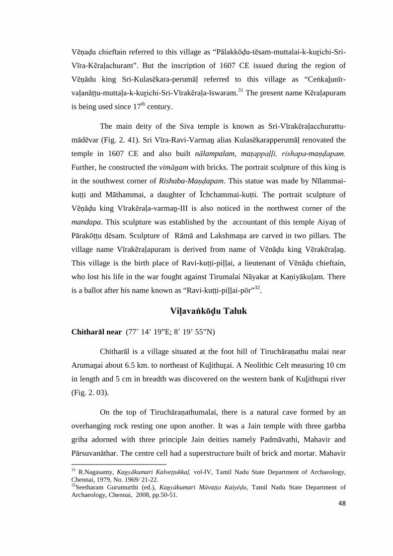
48
Vēṇaḍu chieftain referred to this village as “Pālakkōḍu-tēsam-muttalai-k-kuṟichi-Sri-
Vīra-Kēraḷachuram”. But the inscription of 1607 CE issued during the region of
Vēṇādu king Sri-Kulasēkara-perumāḷ referred to this village as “Ceṅkaḻunīr-
vaḷanāṭṭu-muttaḷa-k-kuṟichi-Sri-Vīrakēraḷa-īswaram.31 The present name Kēraḷapuram
is being used since 17th century.
The main deity of the Siva temple is known as Sri-Vīrakēraḷacchurattu-
mādēvar (Fig. 2. 41). Sri Vīra-Ravi-Varmaṉ alias Kulasēkarapperumāḷ renovated the
temple in 1607 CE and also built nālampalam, maṭappaḷḷi, rishapa-maṇḍapam.
Further, he constructed the vimāṉam with bricks. The portrait sculpture of this king is
in the southwest corner of Rishaba-Maṇḍapam. This statue was made by Nīlammai-
kuṭṭi and Māthammai, a daughter of Īchchammai-kuṭti. The portrait sculpture of
Vēṇāḍu king Vīrakēraḷa-varmaṉ-III is also noticed in the northwest corner of the
mandapa. This sculpture was established by the accountant of this temple Aiyaṉ of
Pārakōṭṭu dēsam. Sculpture of Rāmā and Lakshmaṇa are carved in two pillars. The
village name Vīrakēraḷapuram is derived from name of Vēnāḍu king Vērakēraḷaṉ.
This village is the birth place of Ravi-kuṭṭi-piḷḷai, a lieutenant of Vēnāḍu chieftain,
who lost his life in the war fought against Tirumalai Nāyakar at Kaṇiyākuḷam. There
is a ballot after his name known as “Ravi-kuṭṭi-piḷḷai-pōr”32.
Viḷavaṅkōḍu Taluk
Chitharāl near (77˚ 14’ 19”E; 8˚ 19’ 55”N)
Chitharāl is a village situated at the foot hill of Tiruchāraṇathu malai near
Arumaṉai about 6.5 km. to northeast of Kuḻithuṟai. A Neolithic Celt measuring 10 cm
in length and 5 cm in breadth was discovered on the western bank of Kuḻithuṟai river
(Fig. 2. 03).
On the top of Tiruchāraṇathumalai, there is a natural cave formed by an
overhanging rock resting one upon another. It was a Jain temple with three garbha
griha adorned with three principle Jain deities namely Padmāvathi, Mahavir and
Pārsuvanāthar. The centre cell had a superstructure built of brick and mortar. Mahavir
31 R.Nagasamy, Kaṉyākumari Kalveṭṭukkaḷ, vol-IV, Tamil Nadu State Department of Archaeology,Chennai, 1979, No. 1969/ 21-22.32Seetharam Gurumurthi (ed.), Kaṉyākumari Māvaṭṭa Kaiyēḍu, Tamil Nadu State Department ofArchaeology, Chennai, 2008, pp.50-51.
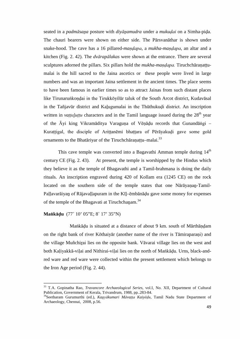
49
seated in a padmāsaṉa posture with diyāṉamudra under a mukuḍai on a Simha-piḍa.
The chauri bearers were shown on either side. The Pārsvanāthar is shown under
snake-hood. The cave has a 16 pillared-maṇḍapa, a mukha-maṇḍapa, an altar and a
kitchen (Fig. 2. 42). The dvārapālakas were shown at the entrance. There are several
sculptures adorned the pillars. Six pillars hold the mukha-maṇḍapa. Tiruchchāraṇaṭṭu-
malai is the hill sacred to the Jaina ascetics or these people were lived in large
numbers and was an important Jaina settlement in the ancient times. The place seems
to have been famous in earlier times so as to attract Jainas from such distant places
like Tirunaruṅkoṇḍai in the Tirukkōyilūr taluk of the South Arcot district, Kudavāsal
in the Tañjavūr district and Kaḻugumalai in the Thūthukuḍi district. An inscription
written in vaṭṭeḻuṭṭu characters and in the Tamil language issued during the 28th year
of the Āyi king Vikramāditya Varaguṇa of Vēṇāḍu records that Gunandāṅgi –
Kuraṭṭigal, the disciple of Ariṭṭanēmi bhaṭṭara of Pērāyakuḍi gave some gold
ornaments to the Bhatāriyar of the Tiruchchāraṇaṭṭu–malai.33
This cave temple was converted into a Bagavathi Amman temple during 14th
century CE (Fig. 2. 43). At present, the temple is worshipped by the Hindus which
they believe it as the temple of Bhagavathi and a Tamil-brahmana is doing the daily
rituals. An inscription engraved during 420 of Kollam era (1245 CE) on the rock
located on the southern side of the temple states that one Nārāyaṇaṉ-Tamil-
Paḷḷavarāiyaṉ of Rājavaḷḷapuram in the Kīḻ–ēmbānāḍu gave some money for expenses
of the temple of the Bhagavati at Tiruchchaṉam.34
Maṅkāḍu (77˚ 10’ 05”E; 8˚ 17’ 35”N)
Maṅkāḍu is situated at a distance of about 9 km. south of Mārthāṇḍam
on the right bank of river Kōthaiyār (another name of the river is Tāmiraparaṇi) and
the village Muñchiṟai lies on the opposite bank. Vāvarai village lies on the west and
both Kaḷiyakkā-viḷai and Nithirai-viḷai lies on the north of Maṅkāḍu. Urns, black-and-
red ware and red ware were collected within the present settlement which belongs to
the Iron Age period (Fig. 2. 44).
33 T.A. Gopinatha Rao, Travancore Archaeological Series, vol.I, No. XII, Department of CulturalPublication, Government of Kerala, Trivandrum, 1988, pp..283-84.34Seetharam Gurumurthi (ed.), Kaṉyākumari Māvaṭṭa Kaiyēḍu, Tamil Nadu State Department ofArchaeology, Chennai, 2008, p.56.
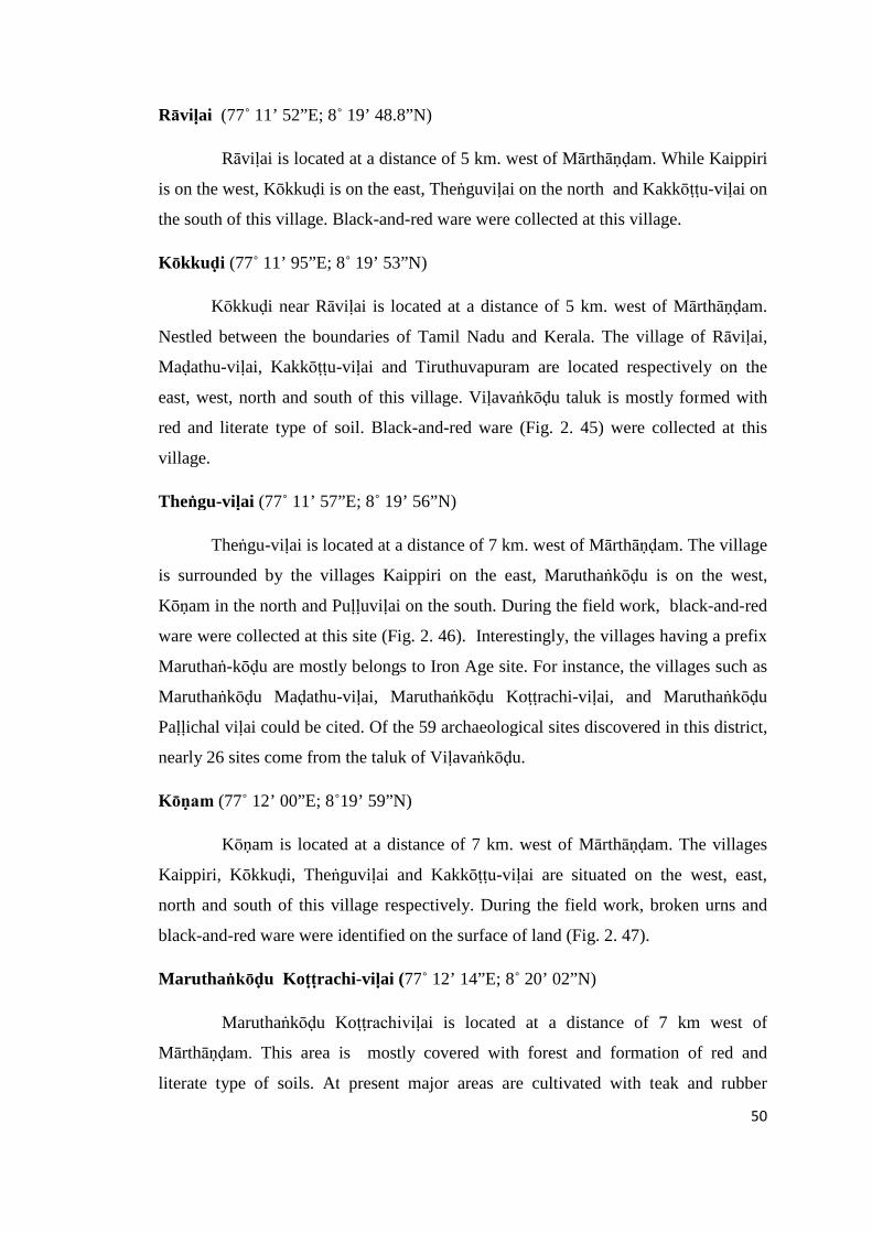
50
Rāviḷai (77˚ 11’ 52”E; 8˚ 19’ 48.8”N)
Rāviḷai is located at a distance of 5 km. west of Mārthāṇḍam. While Kaippiri
is on the west, Kōkkuḍi is on the east, Theṅguviḷai on the north and Kakkōṭṭu-viḷai on
the south of this village. Black-and-red ware were collected at this village.
Kōkkuḍi (77˚ 11’ 95”E; 8˚ 19’ 53”N)
Kōkkuḍi near Rāviḷai is located at a distance of 5 km. west of Mārthāṇḍam.
Nestled between the boundaries of Tamil Nadu and Kerala. The village of Rāviḷai,
Maḍathu-viḷai, Kakkōṭṭu-viḷai and Tiruthuvapuram are located respectively on the
east, west, north and south of this village. Viḷavaṅkōḍu taluk is mostly formed with
red and literate type of soil. Black-and-red ware (Fig. 2. 45) were collected at this
village.
Theṅgu-viḷai (77˚ 11’ 57”E; 8˚ 19’ 56”N)
Theṅgu-viḷai is located at a distance of 7 km. west of Mārthāṇḍam. The village
is surrounded by the villages Kaippiri on the east, Maruthaṅkōḍu is on the west,
Kōṇam in the north and Puḷḷuviḷai on the south. During the field work, black-and-red
ware were collected at this site (Fig. 2. 46). Interestingly, the villages having a prefix
Maruthaṅ-kōḍu are mostly belongs to Iron Age site. For instance, the villages such as
Maruthaṅkōḍu Maḍathu-viḷai, Maruthaṅkōḍu Koṭṭrachi-viḷai, and Maruthaṅkōḍu
Paḷḷichal viḷai could be cited. Of the 59 archaeological sites discovered in this district,
nearly 26 sites come from the taluk of Viḷavaṅkōḍu.
Kōṇam (77˚ 12’ 00”E; 8˚19’ 59”N)
Kōṇam is located at a distance of 7 km. west of Mārthāṇḍam. The villages
Kaippiri, Kōkkuḍi, Theṅguviḷai and Kakkōṭṭu-viḷai are situated on the west, east,
north and south of this village respectively. During the field work, broken urns and
black-and-red ware were identified on the surface of land (Fig. 2. 47).
Maruthaṅkōḍu Koṭṭrachi-viḷai (77˚ 12’ 14”E; 8˚ 20’ 02”N)
Maruthaṅkōḍu Koṭṭrachiviḷai is located at a distance of 7 km west of
Mārthāṇḍam. This area is mostly covered with forest and formation of red and
literate type of soils. At present major areas are cultivated with teak and rubber
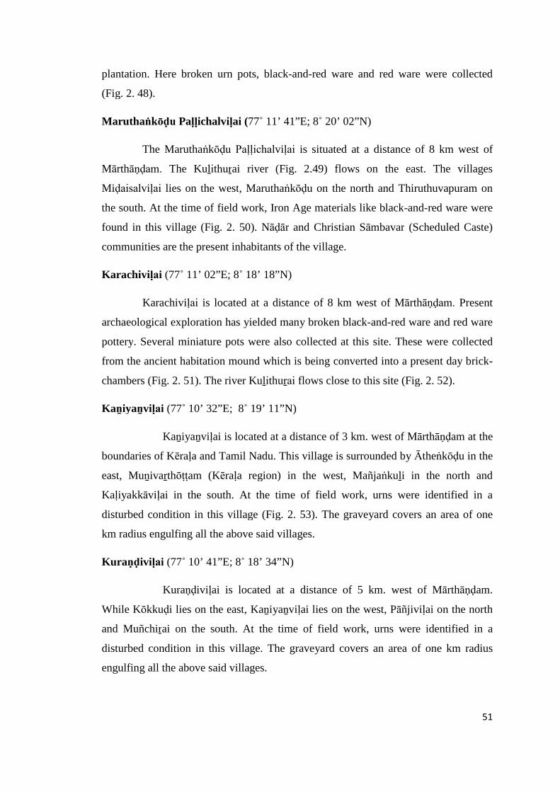
51
plantation. Here broken urn pots, black-and-red ware and red ware were collected
(Fig. 2. 48).
Maruthaṅkōḍu Paḷḷichalviḷai (77˚ 11’ 41”E; 8˚ 20’ 02”N)
The Maruthaṅkōḍu Paḷḷichalviḷai is situated at a distance of 8 km west of
Mārthāṇḍam. The Kuḻithuṟai river (Fig. 2.49) flows on the east. The villages
Miḍaisalviḷai lies on the west, Maruthaṅkōḍu on the north and Thiruthuvapuram on
the south. At the time of field work, Iron Age materials like black-and-red ware were
found in this village (Fig. 2. 50). Nāḍār and Christian Sāmbavar (Scheduled Caste)
communities are the present inhabitants of the village.
Karachiviḷai (77˚ 11’ 02”E; 8˚ 18’ 18”N)
Karachiviḷai is located at a distance of 8 km west of Mārthāṇḍam. Present
archaeological exploration has yielded many broken black-and-red ware and red ware
pottery. Several miniature pots were also collected at this site. These were collected
from the ancient habitation mound which is being converted into a present day brick-
chambers (Fig. 2. 51). The river Kuḻithuṟai flows close to this site (Fig. 2. 52).
Kaṉiyaṉviḷai (77˚ 10’ 32”E; 8˚ 19’ 11”N)
Kaṉiyaṉviḷai is located at a distance of 3 km. west of Mārthāṇḍam at the
boundaries of Kēraḷa and Tamil Nadu. This village is surrounded by Ātheṅkōḍu in the
east, Muṉivaṟthōṭṭam (Kēraḷa region) in the west, Mañjaṅkuḻi in the north and
Kaḷiyakkāviḷai in the south. At the time of field work, urns were identified in a
disturbed condition in this village (Fig. 2. 53). The graveyard covers an area of one
km radius engulfing all the above said villages.
Kuraṇḍiviḷai (77˚ 10’ 41”E; 8˚ 18’ 34”N)
Kuraṇḍiviḷai is located at a distance of 5 km. west of Mārthāṇḍam.
While Kōkkuḍi lies on the east, Kaṉiyaṉviḷai lies on the west, Pāñjiviḷai on the north
and Muñchiṟai on the south. At the time of field work, urns were identified in a
disturbed condition in this village. The graveyard covers an area of one km radius
engulfing all the above said villages.
52
Viṇṉūr Paḻañji (77˚ 10’41”E; 8˚19’11”N)
Viṇṉūr Paḻañji is situated at a distance of 5 km. north-west of Mārthāṇḍam. It
is one of the Iron Age sites of this taluk yielding broken urns, black-and-red ware and
red ware.
Maruthaṅkōḍu Maḍathuviḷai (77˚12’07”E; 8˚20’08”N)
Maruthaṅkōḍu Maḍathuviḷai is located at a distance of 6 km. west of
Mārthāṇḍam. The villages of Ālam-pāṟai, Illuppaviḷai, Paṉaiviḷai and Kaḻuvaṉthiṭṭu
lies on the east, west, north and south of this village respectively. It is one of the Iron
Age sites of this region and several broken pieces of urns were collected during the
survey (Fig. 2. 54).
Kaḻuvaṉthiṭṭu (77˚12’22”E; 8˚19’31”N)
Kaḻuvaṉthiṭṭu is situated at a distance of 6 km. west of Mārthāṇḍam.
Kaḻuvaṉthiṭṭu is located on the eastern river bank of Kuḻithuṟai. During the field work,
broken urns and red ware were found (Fig. 2. 55). Christian Sāmbavar are the main
inhabitants of this village.
Kaipiri (77˚19’ 49”E; 8˚ 19’ 49”N)
Kipper is situated at a distance of 6 km. west of Mārthāṇḍam. It is one of the
Iron Age sites of this region and several broken pieces of urns were collected during
the survey. This area is mostly formed with red and laterite soil.
Thūthūr (77˚08’30”E; 8˚15’43”N)
Thūthūr is located near the sea coast at a distance of 20 km. west of
Mārthāṇḍam. While the villages of Puthaṉthuṟai and Chiṉṉathuṟai are located towards
the south of Thūthūr whereas the Nithiraviḷai is located on the north. A handmade
coarse earthen jar and other relics were found near Thūthūr village in the district. The
shape, fabric and the decoration indicate that they are probably of the megalithic or
53
early historic period.35 It is one of the Iron Age sites of this region and several broken
pieces of urns were collected during the survey.
Paḍanthālumōḍu (77˚10’43”E; 8˚19’15”N)
Paḍanthālumōḍu is located at a distance of 8 km northwest of Mārthāṇḍam. It
is one of the Iron Age sites of this region and several broken pieces of urns were
collected during the survey.
Theṅgam Vilañji (77˚ 10’ 41”E; 8˚18’50”N)
Theṅgam Vilañji is situated at a distance of 7 km. north of Mārthāṇḍam. The
village of Pāñjiviḷai, Āthuviḷai, Mañjaṅkuḻi and Paḻañjiviḷai are located on the east,
west, north and south of this village respectively. It is one of the Iron Age sites of this
region and several broken pieces of urns were collected during the survey.
Kōkkuḍiviḷai (77”11’05”E; 8˚18’34.5”N)
Kōkkuḍiviḷai near Ātheṅkōḍu is located at a distance of 5 km. north-west of
Mārthāṇḍam. The Kuḻithuṟai river otherwise known as Thāmirabaraṉi flows on the
east, Viḷavaṅkōḍu (the taluk head quarter) lies on the west, Paḍanthālumōḍu on the
north and Ātheṅkōḍu on the south. It is one of the urn burial sites of this region.
Presently, the site is used as a burial ground of this village. Black-and-red ware,
broken urns and red ware were identified (Fig. 2. 56).
Sūḻāl (77˚07’44”E; 8˚18’56”N)
Sūḻāl is located at a distance of 15 km. south-west of Mārthāṇḍam.
Kuḻithuṟai, Saṅguriṭṭi, Kollaṅkōḍu and Viriyakuḷam are located on the east, west,
south and north of this village respectively. Here, broken pieces of urns and red ware
were identified (Fig. 2. 57).
Vāvarai (77˚09’44”E; 8˚17’31”N)
Vāvarai is situated at a distance of 12 km west of Mārthāṇḍam. Maṅkāḍu lies
on its south and Kaḷiyakkāviḷai on its north. It is one of the Iron Age sites of this
region and several broken pieces of urns were collected during the survey.
35 M.Gopalakrishnan (ed.),Gazetteers of India, Tamil Nadu State –Kanyakumari District, Governmentof Tamil Nadu, Commissioner of Archives and Historical Research, Chennai, 1995, p.50.
54
Muñchiṟai (77˚10’15”E; 8˚17’16”N)
Muñchiṟai is located at a distance of 7 km south of Mārthāṇḍam. Kuḻithuṟai
river flows on its east. It is an Iron Age site where broken pieces of urn and red ware
were found (Fig. 2. 58). The copper plates issued by the Āyi king
Kōkkarunandhaḍakkaṉ (864-865 CE) refers to construction of Perumāḷ temple after
the creation of Pārtivakēsavapuram close to Muñciṟai. The Siva temple located on the
top of the hill probably is built in 11th century CE during the reign of Chōḻas. An
inscription of 11th century CE refers this village as Muñciṟai and the God as
Tirumāmalai Mēlpaṭṭārar. Another inscription engraved in the inner prakāra wall
refers to the grant made by one Vīrakēraḷa-Marthāṇḍavarmaṉ of Kīḻa-p-pērūr in the
year 610 of Kollam era (1434 CE).36
Kāppukkāḍu (77˚12’ 03”E; 8˚17’44”N)
Kāppukkāḍu is located at a distance of 4 km. south of Mārthāṇḍam. While
Piṉpāthiri viḷai lies on the east and Veṭṭumaṇi is on the west. It is one of the Iron Age
sites of this region and several broken pieces of the urns were collected on southern
side of the village during the survey.
Maruthaṅkōḍu Illuppaviḷai (77˚12’2”E; 8˚20’08”N)
Maruthaṅkōḍu Illuppaviḷai is located at a distance of 6 km. west of
Mārthāṇḍam. The village of Kōkkuḍi lies on its east, Viḷavaṅkōḍu on its west,
Chemmaṇkalai on the south and Arumaṉai on its north. Red ware belongs to early
historical period were collected at this village.
Summary
As a result of field study carried out in the past and during my own field work,
the material remains of Microlithic, Neolithic and Iron Age have been found in all the
four taluks of Kaṉyākumari district (Map 3). The geo-coordinates of each site are
marked using Global Positioning System. The remnants of the historical vestiges have
been located at 59 sites in all the four taluks such as Viḷavaṅkōḍu (26), Thōvālai (16),
Kalkuḷam (11) and Agastīswaram (6). These Iron Age sites are being occupied by the
36Seetharam Gurumurthi (ed.), Kaṉyākumari Māvaṭṭa Kaiyēḍu, Tamil Nadu State Department ofArchaeology, Chennai, 2008, p.83.
55
subsequent periods till date. Several inscriptions were copied from the temple walls,
rock surfaces and on loose slabs. The following are the list of villages where the
inscriptions are being copied and identified:
Agastīswaram Taluks
1. Vaḍugaṉpaṟṟu
2. Kariyamāṇikkapuram
Thōvālai Taluk
1. Arumanallūr
2. Aṉumakēthaṉanallūr
3. Kuṟaṇḍi
4. Thāḻakuḍi (West)
5. Vīravanallūr
6. Ādhichaṉpudūr (Near Avvaiyār Ammaṉ Kōiḷ )
7. Kuṟathiyarai
8. Āralvāimoḻi
Kalkuḷam Taluk
1. Akkarai Thalakuḷam
2. Tirunayiṉārkuṟichi
3. Kēraḷapuram
ViḷavaṅkōḍuTaluk
1. Chitharāl near Tiruchāranathu Malai
2. Muñchiṟai
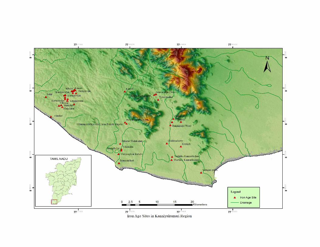

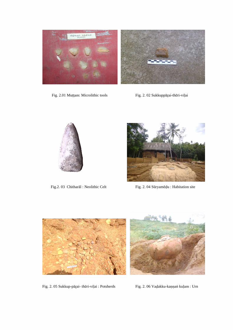
Fig. 2.01 Muṭṭam: Microlithic tools Fig. 2. 02 Sukkuppāṟai-thēri-viḷai
Fig.2. 03 Chitharāl : Neolithic Celt Fig. 2. 04 Sūryamēḍu : Habitation site
Fig. 2. 05 Sukkup-pāṟai- thēri-viḷai : Potsherds Fig. 2. 06 Vaḍakku-kaṇṇaṅ kuḷam : Urn
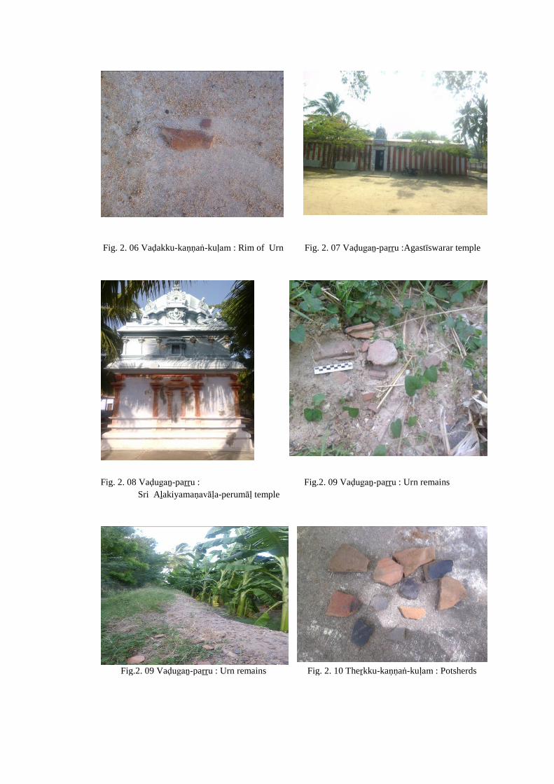
Fig. 2. 06 Vaḍakku-kaṇṇaṅ-kuḷam : Rim of Urn Fig. 2. 07 Vaḍugaṉ-paṟṟu :Agastīswarar temple
Fig. 2. 08 Vaḍugaṉ-paṟṟu : Fig.2. 09 Vaḍugaṉ-paṟṟu : Urn remains
Sri Aḻakiyamaṇavāḷa-perumāḷ temple
Fig.2. 09 Vaḍugaṉ-paṟṟu : Urn remains Fig. 2. 10 Theṟkku-kaṇṇaṅ-kuḷam : Potsherds
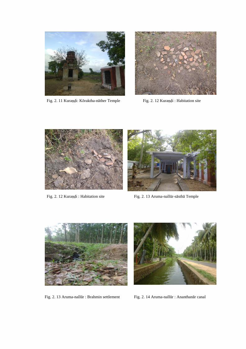
Fig. 2. 11 Kuraṇḍi: Kōraktha-nāther Temple Fig. 2. 12 Kuraṇḍi : Habitation site
Fig. 2. 12 Kuraṇḍi : Habitation site Fig. 2. 13 Aruma-nallūr-sāsthā Temple
Fig. 2. 13 Aruma-nallūr : Brahmin settlement Fig. 2. 14 Aruma-nallūr : Ananthanār canal
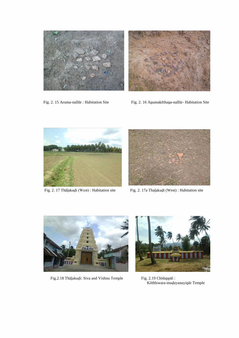
Fig. 2. 15 Aruma-nallūr : Habitation Site Fig. 2. 16 Aṉumakēthaṉa-nallūr- Habitation Site
Fig. 2. 17 Thāḻakuḍi (West) : Habitation site Fig. 2. 17a Thaḻakuḍi (West) : Habitation site
Fig.2.18 Thāḻakuḍi: Siva and Vishnu Temple Fig. 2.19 Chīdappāl :Kōthīswara-muḍayanayiṉār Temple
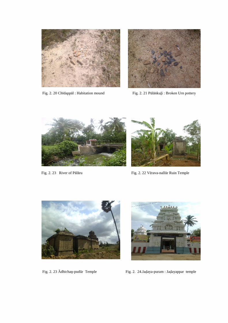
Fig. 2. 20 Chīdappāl : Habitation mound Fig. 2. 21 Pūlāṅkuḻi : Broken Urn pottery
Fig. 2. 23 River of Pālāru Fig. 2. 22 Vērava-nallūr Ruin Temple
Fig. 2. 23 Ādhichaṉ-pudūr Temple Fig. 2. 24.Jaḍaya-puram : Jaḍayappar temple
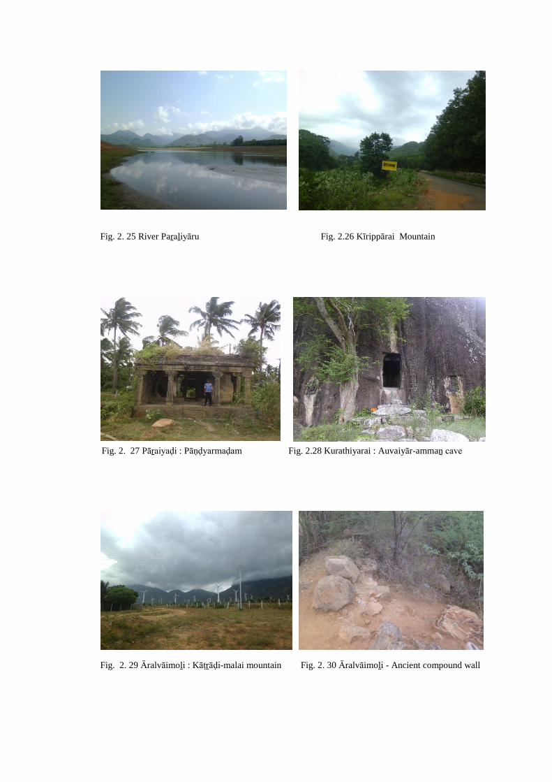
Fig. 2. 25 River Paṟaḻiyāru Fig. 2.26 Kīrippārai Mountain
Fig. 2. 27 Pāṟaiyaḍi : Pāṇḍyarmaḍam Fig. 2.28 Kurathiyarai : Auvaiyār-ammaṉ cave
Fig. 2. 29 Āralvāimoḻi : Kāṭṟāḍi-malai mountain Fig. 2. 30 Āralvāimoḻi - Ancient compound wall
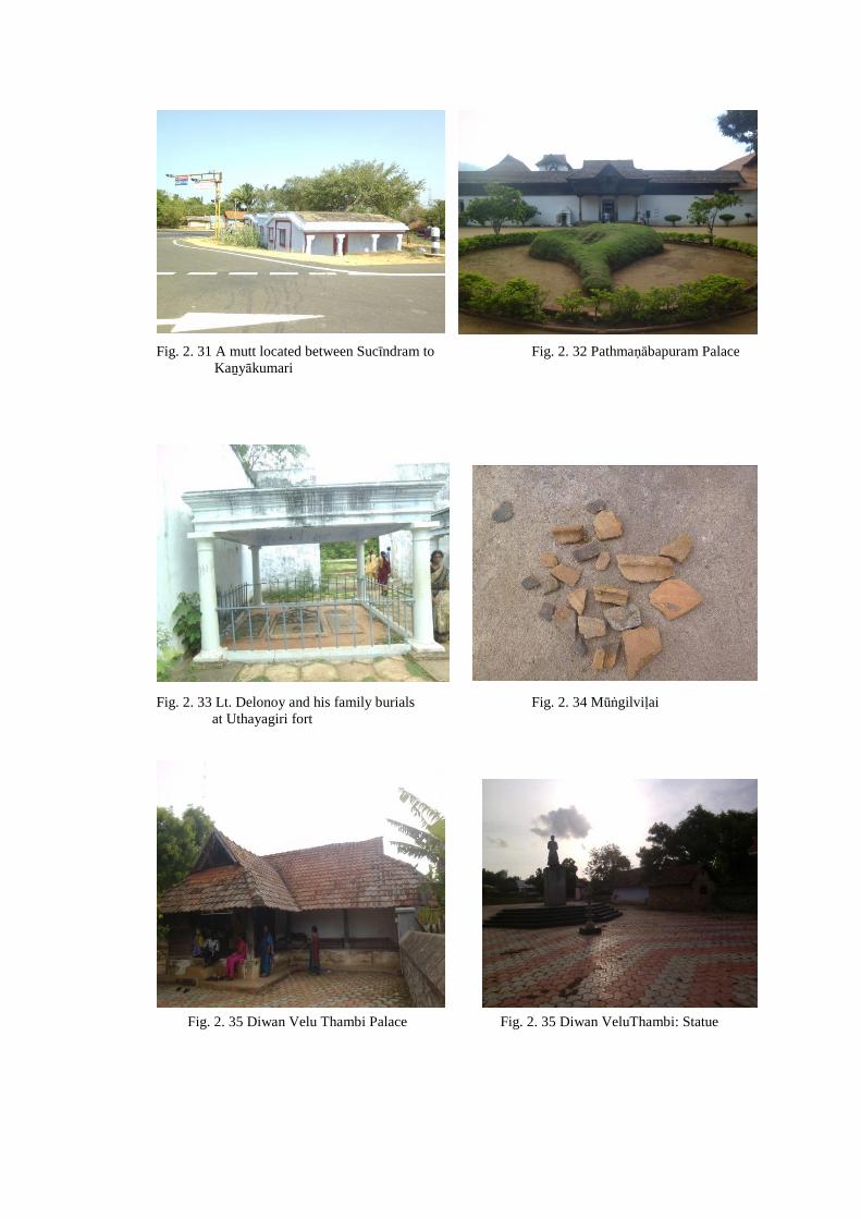
Fig. 2. 31 A mutt located between Sucīndram to Fig. 2. 32 Pathmaṇābapuram PalaceKaṉyākumari
Fig. 2. 33 Lt. Delonoy and his family burials Fig. 2. 34 Mūṅgilviḷaiat Uthayagiri fort
Fig. 2. 35 Diwan Velu Thambi Palace Fig. 2. 35 Diwan VeluThambi: Statue
Fig. 2. 36 Akkarai-thalakuḷam : Kaḍuṅgōpathu Fig. 2. 37 River VaḷḷiyāruMahādēvar Temple
Fig. 2. 38 Veḷḷimalai : Black and Red ware Fig. 2. 38 Veḷḷimalai : Broken urn
Fig. 2. 38 Veḷḷimalai : Black ware Fig. 2. 38 Veḷḷimalai : Iron age site
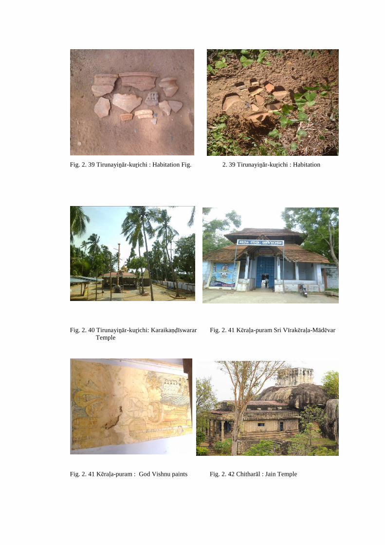
Fig. 2. 39 Tirunayiṉār-kuṟichi : Habitation Fig. 2. 39 Tirunayiṉār-kuṟichi : Habitation
Fig. 2. 40 Tirunayiṉār-kuṟichi: Karaikaṇḍīswarar Fig. 2. 41 Kēraḷa-puram Sri Vīrakēraḷa-MādēvarTemple
Fig. 2. 41 Kēraḷa-puram : God Vishnu paints Fig. 2. 42 Chitharāl : Jain Temple

Fig. 2. 43 Chitharāl : Jain Tirthaṅkarās and Fig. 2. 44 Maṅkāḍu : Iron Age SiteGoddess Padmāvadi
Fig. 2. 45 Kōkkuḍi (Near Rāviḷai) : Urn burial site Fig. 2. 46 Theṅguviḷai : Broken Urn
Fig. 2. 47 Kōṇam : Broken Urn Fig. 2. 48 Maruthaṅkōḍu: Koṭṭrachiviḷai

Fig. 2. 49 River Kuḻithuṟai Fig. 2.50 Maruthaṅkōḍu-Paḷḷichalviḷai: Broken Urn
Fig. 2. 51 Karachiviḷai - Habitation Fig. 2. 52 Karachiviḷai : Habitation
Fig. 2. 53 Kaṉiyaṉ-viḷai - Broken Urn Fig.2.54 Maruthaṅkōḍu-Maḍathu-viḷai : Broken Urn
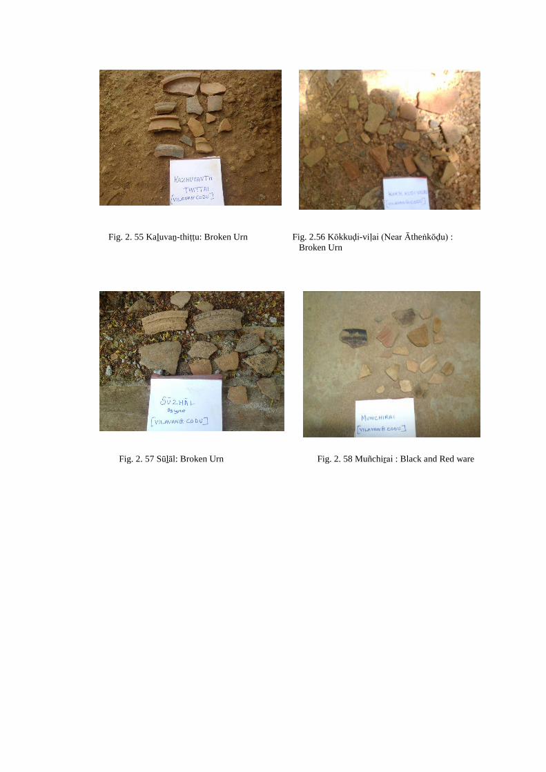
Fig. 2. 55 Kaḻuvaṉ-thiṭṭu: Broken Urn Fig. 2.56 Kōkkuḍi-viḷai (Near Ātheṅkōḍu) :Broken Urn
Fig. 2. 57 Sūḻāl: Broken Urn Fig. 2. 58 Muñchiṟai : Black and Red ware
56
CHAPTER – III
HISTORICAL BACKGROUND OF KAṈYĀKUMARI REGION
Understanding the historical background of a region is important as it provides
several clues to understand the transformation that had taken place in different social
and economic spheres. The efforts of individual rulers and collective initiation of
different social groups or communities played a crucial role in this process. The ruler
or a state took various welfare measures like digging canals and tanks and
administrative reforms like the reorganization of territorial divisions, tax reforms, etc.,
to meet the demand of the people or to meet the requirement of the state. One has to
study these initiations in a chronological order by taking the experience of the past.
Therefore, it is imperative to understand the basic political structure of the region.
Unlike other regions, this region did not provide any inscription of Early Historic
times. Most of the inscriptions belong to the medieval period. However, the available
literary source, particularly the Saṅgam literature, helps some extent to reconstruct the
political line of the Early Historic times (Map 4).
Historically, this region has constituted as a distinctly separate unit and it is
socially and culturally different from the rest of Travancore, though in major part of
history, it was under the control of the rulers of Travancore. The region with greater
amount of agricultural production is popularly known as Nāñchilnāḍu and it played an
important role in the history of south India, for almost all the leading dynasties of
South India have been associated with Nāñcilnāḍu.
As early as the period of the Saṅgam Age and for several centuries succeeding
it, Nāñcilnāḍu formed the cockpit of South India. Historically, this region was ruled
by powerful kingdoms and chieftains of Āyi, Pāṇḍya, Chōḻas, Chēras and Vēṇāḍu
dynasties, later under the Vijayanagar generals, Nāyak chieftains of Madurai and
Travancore samasthāṉam. All the rulers paid a greater attention to this region due its
fertility. Thus, Nāñcilnāḍu can be rightly described as the „cockpit of the South‟.1
1 K.K.Pillai, Studies in Indian History (With special reference to Tamil Nadu), Chennai, 1979, p.474.

57
Travancore rulers continued as a Princely state even during the British period and the
ancient customs and manners, social and cultural practices, the agrarian economy and
land holding pattern have survived distinctly in the Travancore samasthāṇam till
recently.
Āyi Chieftains
The earliest known rulers of this region belonged to the Āyi dynasty. They
were considered as one of the vēḷir clans. There are claims that the term „Hida Raja‟
mentioned in the Asokan rock edicts II and XIV refers to these clan groups. They
consider that the term „Hida‟ is the variation of „iḍa‟ or „iḍaia‟ a synonym of
„āyar‟which takes its singular form as „Āyi‟. Thus, this interpretation takes the
antiquity of the „Āyi‟ back to 250 BCE and possibly still earlier.2 However, this
identification is yet to be confirmed with material evidences. The rulers of Āyi
dynasty are generally associated with a region in and around Pothiyil. The early
historians and Greek geographers make reference to this region particularly the Cape
Comari (Kaṉyākumari). The Periplus of the Erythrean Sea refers to the region
extending from Nelcynda to Kaṉyākumari being ruled by the Pāṇḍyas. The Greek
geographer Ptolemy (140 CE) says that one „Aioi‟ was ruling in the country which
included Cape Comorin and mount Bettigo. Āyi seems to have been a dynastic name
borne by all the kings of the line as a prefix to their personal names.3 Āyis were the
vassals to the Pāṇḍyas during the period of Periplus and only later, they would have
asserted their independence. During the period of Ptolemy Nāñcilnāḍu as was seen
remained as a buffer state between the Chēras and the Pāṇḍyas.4 The Āyi rulers had
come into prominence even before the Chēras established themselves as the dominant
political power in Kēraḷa. The Saṅgam works refer to three important Āyi rulers, viz.,
Āyi Aṇṭiraṉ, Tiṭiyaṉ, and Atiyaṉ. They had their capital at Āyikuḍi in the Podiyil
mountain.5 Āyi rulers were agrarian based chieftains and considered as the chief of
2 M.Gopalakrishnan (ed.), Gazetteers of India, Tamil Nadu State, Kanyakumari District, Tamil Nadu
Archives, Chennai, 1995, p.54. 3 K.A.Nilakanda Sastri, A History of South India – From Prehistoric Times to the Fall of Vijayanagar,
Oxford University press, New Delhi,1975, pp.109-10. 4 M.Gopalakrishnan (ed.), Gazetteers of India, Tamil Nadu State, Kanyakumari District, Tamil Nadu
Archives, Chennai, 1995, p.54. 5 A.Sreedharan Menon, A Survey of Kēraḷa History, S.Viswanathan Publishers, Chennai, 2006, pp.70-
71.
58
the Podiyil hills. Āyi was also one of the seven philanthropists of Sangam Age like
Pāri, Añji, Kāri, Ōri, Nalli and Pēkaṉ6 and there were celebrated for their generosity.
I. Āyi Aṇḍiraṉ
The Saṅgam Age poets like Muḍamōsiyar of Enessēri, Uṟiayūr (Puṟanāṉūṟu
374), Kuṭṭuvaṉ Kīraṉār (Puṟanāṉūṟu 240), Oḍaikiḻar of Tuṟaiyūr (Puṟanāṉūṟu 136)
and Karikaṇṇar (Naṟṟiṇai 237) refer this ruler.7 The discovery of the Huzur office
Plates and the stone inscription at Kaḻugumalai issued during the reign of
Mārañjaḍaiyaṉ (765-815 CE) mentions a king of this dynasty, and the Pāliyam plates
yield some names of the kings of the Āyi–Kula. Probably, the earliest known Āyi
ruler was the one Āyi–Aṇḍiraṉ. He was a subordinate chieftain ruling over the
mountain tracts of Southern Travancore with Āyikuḍi as his capital. He was also
considered as the lord of the Podiyil mountain. The Āyis were basically an agrarian
community (veḷḷāḷas) occupying the higher social order, that of the over lords of the
farmers of the soil. Aṇḍiraṉ was one of the seven great philanthropists praised in the
later Tamil literature. He is said to enrich poets and other learned men with money
and other valuables and elephants. He is also described as having won a victory over
the king of the Koṅgu country.8
According to Puranāṉūṟu, Aṇṭiraṉ was a Saivite by faith and he worshipped
Siva “seated underneath the banyan tree” (Dakshiṇāmūrthi). He practiced polygamy
and all his wives committed sati (Puṟanāṉūṟu 240). The influx of greater tradition or
brahminical rituals suggests that he might have ruled this in the later part of the Early
Historic period. The Chēras became a prominent power in Kēraḷa only after the period
of Aṇḍiraṉ and hence the latter was probably even more powerful than the Chēras.9
Irrespective of the identification, there is a another Āyi dynasty ruled close to
Paḻaṉi hills, in the southeastern part of Koṅgu country. Some of the descriptions
found in Saṅgam literature allude to the ruler of Paḻaṉi hills.
6 K.S.Ramasamy Sastri, The Tamils, The People, Their History and Culture, vol-I, (An Introduction to
Tamil History and Society), Cosmo publication, New Delhi, 2002, p.48. 7 K.N.Sivaraja Pillai, the Chronology of the Early Tamils, Asian Educational Services, New Delhi,
1984, see Synchronistic table. 8 T.A.Gopinatha Rao (ed.), Travancore Archaeological Series, vol-I, Department of Cultural
Publications Government of Kerala, Trivandrum, 1988, p.17. 9 A.Sreedharan Menon, A Survey of Kerala History, S.Viswanathan publishers, Chennai, 2006, p.114.
59
Titiyaṉ – I
Titiyaṉ – I described in the Akanāṉūru as „Podiyil selvaṉ” was the next
important Āyi king. K.N. Sivaraja Pillai considers Titiyaṉ-I as the successor to Āyi
Aṇḍiraṉ.10
The great poets Kapiḷar and Paraṇar and the poet king Bhūtapāṇḍyaṉ of the
Pāṇḍya kingdom were his contemporaries. We have no reliable evidence of any
conflict between the Pāṇḍyas and the Āyi rulers during this period, but an
understanding seems to have been reached between the two kings, fixing Bhūtapāṇḍi
as the southern limit of the Pāṇḍyaṉ kingdom.11
Bhūtapāṇḍi is located in Thōvāḷai
taluk and it lies 12 km west of Nāgarkōil. According to the tradition, this village was
founded by Ollaiyūrthantha Bhūtapāṇḍyaṉ. An inscription datable to 16-17th
century
found on the walls of the Bhūtaliṅga Swāmy temple refers this village as Nāñchil-
nāṭṭu Bhūtapāṇḍi. The sanctum sanctorum of a Bhūḍaliṅga Swāmy temple dedicated
to Shiva looks like a cave temple, probably constructed by the early Pāṇḍya king in 8-
9th
century CE.12
Āyi Atiyaṉ
Atiyaṉ is the next important Āyi ruler and successor of Titiyaṉ-I. Under him
the Āyi kingdom began to disintegrate. The Pāṇḍiyaṉ warrior-king Pasumpuṉ
Pāṇḍyaṉ (Aḻakiya Pāṇḍyaṉ) is said to have invaded the Āyi kingdom and subjugated
Atiyaṉ. Paraṇar has described this fight in the Akanāṉūṟu.13
An epigraphical record
of Veṅgaṭachalapathi temple in Aḻakiya Pāṇḍyapuram mentions this village was once
called as Nāñchil-nāṭṭu Atiyaṉūr otherwise known as Aḻakiya Pāṇḍiyapuram in CE.
1076. It seems the older name Atiyaṉūr was transformed later into Aḻakiya
Pāṇḍiyapuram,14
a flourishing village in Thōvāḷai taluk.
10
M.Gopalakrishnan (ed.), Gazetteers of India, Tamil Nadu State, Kanyakumari District, Tamil Nadu
Archives, Chennai, 1995, p.55. 11
V.Gurunathan, Saṅgakāla Arasa Varalāṟu, Tamil University, Thanjavur, 2001, p.269. 12
Seetharam Gurumurthi, Kaṉyākumari Mavatta Kaiyedu, Tamil Nadu State Department of
Archaeology, Chennai, 2008, p.80. 13
M.Gopalakrishnan (ed.), Tamiḻ Nāḍu Māvaṭṭa Vivara Chuvaḍgaḷ- Kaṉyākumari Mavattam, Tamil
Nadu Archives, Chennai, 2006, p.66. 14
R, Nagasamy (ed.), Kaṉyākumari Kalveṭṭukkaḷ, vol-V, Department of Archaeology, Chennai, 1979,
serial no;1969/12.
60
Āyi Titiyaṉ-II
Titiyaṉ-II, the successors of Atiyaṉ, fought heroically against the Pāṇḍyas to
regain their lost territory and supremacy. During this period, the Āyi king took part in
the battle of Talaiyālaṅkāṉam, in which the Pāṇḍya king Neḍuñcheḻiyaṉ-III defeated
seven contemporary south Indian rulers. Nakkīrar has described this fight in the
Akanānūṟu . It seems, the Āyi kings were able to recover their lost territory of central
and southern Travancore from the Pāṇḍyas but they never regained their old position
of prominence.15
As a result of this battle, the fertile zone of Pothiyil was fragmented
into petty chieftaincies. Eḻiṉi Ātaṉ of Vaṭṭāṟu and Vaḷḷuvaṉ Kandaṉ of Nāñchilnāḍu
emerged in this scenario.
K.K. Piḷḷai is of the view that there is a gap in the history of Āyis after Titiyaṉ-
I (Pothyil Selvaṉ). After they were subjugated by the Pāṉḍiyas, the Āyi dynasty was
reemerged only in the 8th century CE. It is likely that during the intervening period,
the Āyis had been reduced to the position of local chieftains by the Chēras in the
north. The fact, that the Āyis of the 8th
century CE were referred as the rulers of the
Kuṟu Nāḍu (the area surrounding Tiruviḍaikkōḍu), indicating that they had no place
in the Pothiyil hills.16
Nāñchil Porunaṉ (150- 175 CE)
Nāñchil Porunaṉ, also called as Nāñchil Vaḷḷuvaṉ-kandaṉ, ruled over the
Nāñchil hills and the adjoining region. He was a chieftain in the Pāṇḍiya army. The
Saṅgam Age poets like Ciraipperiyaṉār (Puranāṉūṟu 137), Marutaṉ Iḷanākaṉār
(Puranāṉūṟu 138, 139), Avvaiyār (Puranāṉūṟu 140) and Karuvūr-k-katappiḷḷai
(Puranāṉūṟu 380)17
composed poems in honour of this ruler.
The date of Nāñchil Porunaṉ is fixed as the 3rd
century CE and more
particularly the later half. But, according to the synchronistic tables of K.N. Sivaraja
Piḷḷai, the period of Nāñchil Porunaṉ is dated between 150 and 175 CE. He belonged
to the Vaḷḷuva caste, generally identified with the priestly class of the Paṟaiāh
15
A.Sreedharan Menon, A Survey of Kerala History, S.Viswanathan publishers, Chennai, 2006, p.115. 16
M.Gopalakrishnan (ed.), Gazetteers of India, Tamil Nadu State, Kanyakumari District, Tamil Nadu
Archives, Chennai, 1995, p.57. 17
C. Balasubramanian, A Study of the Literature of the Chera country (Upto 11th
century CE),
University of Madras, Madras, 1980, p.287.
61
community and that the designation „Maṟava‟ signified only a military distinction.18
The name of Nāñchilnāḍu derived from Nāñchil hill where the chief of the area had
his headquarters. The chief was known as Nāñchil Vaḷḷuvaṉ (Puranāṉūṟu 137, 139,
140; 380).19
Nāñchilnāḍu is in Thōvāḷai and Agasthīswaram taluks of present
Kaṉyākumari district and it had never been a part of Malaināḍu. It was part of
Pāṇḍiyaṉ kingdom till its annexation to Vēṇāḍu in CE. 1120.20
This region has an area
of about 210 square miles. It is the granary of south Travancore and the leading ryots
south of the capital own considerable areas of paddy lands.21
Apparently irrigation
facilities were provided by Pāṇḍyaṉ rulers like Aḻakiya Pāṇḍyaṉ and Bhūthapāṇḍyaṉ.
A dam was built across the Paṟaḷiār, a branch of Kuḻithuṟa river. Water was diverted
from the dam through a canal which was known as Pāṇḍyaṉ-kāl till recently.
Nāñchil Vaḷḷuvaṉ who formerly a vassal of the Chēra prince of Thiruvaṭṭār,
later became a vassal of Pāṇḍyas who converted Nāñchilnāḍu into the prosperous
agricultural country. However, Nāñchil Vaḷḷuvaṉ continued to pay tribute to the Chēra
ruler because Paṟaḷiār from which water was supplied to irrigate Nāñchilnāḍu
belonged to them. As Nāñchilnāḍu was part of Pāṇḍya country it was never
considered part of Malaināḍu. The principal commercial centre was Kōṭṭār which
Ptolemy mentions in his geography.22
Thus, the available literary evidences are very scanty to reconstruct the
complete history of early Āyi rulers. The available data suggest that they were the
rulers of Pothiyil hills and were subjugated by the Chēras and later by Pāṇḍyas and
remain as the vassals of Pāṇḍyas for a longer part of their history. The availability of
early historic habitation mounds and associated urn burials suggest the existence of
considerable number of settlements.
18
K.K.Pillai, Studies in Indian History (With special reference Tamil Nadu), Chennai, 1979, p.483. 19
V.Gurunathan, Saṅgakāla Arasa Varalāṟu, Tamil University, Thanjavur, 2001, p.333. 20
K.Sivasankaran Nair, Early History of Kerala Upto CE. 1500, International Centre for Kerala
Studies, University of Kerala, Kariyavattam, 2010, pp.3-4. 21
T.Ponnambalam Pillai, “The Antiquity of Nanji Nadu and Shenkottah”, In D.SavarirAyan (ed.),The
Tamilian Antiquity, vol-II, Asian Educational Services, New Delhi, 1986, pp.17-18. 22
K.Sivasankaran Nair, Early History of Kerala Upto CE. 1500, International Centre for Kerala
Studies, University of Kerala, Kariyavattam, 2010, p.90.
62
Āyi Dynasty in Medieval Times
In the post-Saṅgam, there is hardly any lithic evidence in support of their
existence. However, the availability of five inscriptions belongs to the Āyi dynasty
inscriptions suggest their survival during the hiatus too. The immediate post–Saṅgam
Age is a dark period in the history of the Āyis as well, but from the 7th
century
onwards we get information about the Āyis from the Pāṇḍyaṉ inscriptions. The
Pāṇḍyas had by this time developed themselves into a great power on the eastern
borders of the Āyi kingdom. The Chēra Empire lay on its northern boundary, but
Viḻiñjam, Trivandrum and several other places in the south formed part of the Āyi
kingdom. The Āyi kingdom functioned for long as an effective buffer state between
the Pāṇḍya and Chēra dominions, but with its decline the Chēra Empire was exposed
to the direct attack of the Pāṇḍyas and later of the Chōḻas from across the erstwhile
Āyi territories.23
During this period, Pāṇḍyaṉ kings annex the Āyi territories to their kingdom
and they carried on successive raids in the Nāñchilnāḍu region. The Pāṇḍyaṉ king
Jayantavarmaṉ (645-670 CE) is credited with some success over his contemporary
king in Kēraḷa. His successor Arikēsari Māṟavaramaṉ (670-700 CE) is also said to
have won a great battle at Seṉṉilam and defeated the Chēra king. These Pāṇḍiya
victories might have been won over the Āyi kings because the Chēra power had not
extended to south Tranvancore during this period. Nakkīrar, the commentator of the
Iṟainār Akaporuḷ, also mentions the attack on Kōṭṭār by Arikēsari Māravarmaṉ.
Kōchaḍiaṉ Raṇadhīraṉ (700-730 CE), the son of Arikēsari Māṟavarmaṉ, also inflicted
a severe defeat on the Āyi king in the battle of Maruthūr and forced him to
acknowledge Pāṇḍya supremacy. The Āyi rulers became subordinates of Pāṇḍya king.
Saḍayaṉ, Karunanḍaṉ, Karunandaḍakkaṉ and Vikramāḍitya Varaguṇaṉ were some of
the important rulers of Āyi kingdom in the 8th century CE.24
The present study is
based on 707 inscriptions found at different places in Kaṉyākumari district.
23
A.Sreedharan Menon, A Survey of Kerala History, S.Viswanathan Publishers, Chennai, 2006, p.115. 24
A.K.Perumal, Theṉ Kumariyiṉ Kathai (History of Kanyakumari District), United Writers, Chennai,
2003, p.37.

63
Saḍayaṉ and Karunandaṉ
In the latter half of the 8th
century CE, the Āyi kingdom was ruled by Saḍayaṉ
and his son Karunandaṉ. During this period the Pāṇḍyaṉ ruler Mārañjadayaṉ or
Jaṭilavarmaṉ Parānṭakaṉ (765-815) invaded Āyi Kingdom (south Kēraḷa) and won
victories. The Kaḻugumalai inscription records that Mārañjaḍayaṉ led a successful
expedition in the 23rd
year of his reign against the king of Malaināḍu and destroyed
Ariviyūr (present Aruvikkarai kōṭṭai).25
The Madras Museum copper plates also show that Mārañjaḍayaṉ expedition
over Āyi capital of Viḻiñjam. This copper plate mentions that horse, elephants and
other wealth of Āyi were looted by Pāṇḍya army and Saḍayaṉ ruler of Āyi kingdom
died in this war. In Kaṉyākumari district, the earliest inscription records to a hero
stone installed in memory of Raṇakīrti, a lieutenant of the early Pāṇḍya ruler
Mārañchaḍayaṉ (765-815 CE) who fought with the Chēra forces and lost his life in
CE. 792. It was found in Āralvāimoḻi village in Thōvāḷai taluk.26
From 8th
century to 10th
century, Kaṉyākumari region was ruled by early
Pāṇḍya rulers. However, the available inscriptions and copper plates suggest that
there were two Āyi kings namely Kokarunandhadakkaṉ (857-885 CE) and
Vikramāditya Varaguṇaṉ (855-925 CE) seems to have established an independent rule
for a short period of time.27
The earliest inscription of Āyi dynasty assigned to 869 CE
found at Saḍayappa Mahādēvar temple at Tiruviḍaikōḍu (Kalkuḷam taluk) refers to
the gift of twenty five cows donated by a merchant called Murugaṉ of Mudukuḷathūr
for lighting a perpetual lamp in Sadayappa Mahādēvar temple during the reign of
Kokarunandhadakkaṉ alias Sri Vallabaṉ (857-885 CE), a ruler of Āyi.28
However, the
title suggests that he was a subordinate ruler of contemporary Pāṇḍya king Varaguṇa
Pāṇḍyaṉ (862 CE).29
According to P.N. Kunjaṉ Pillai, Kokkarunandakkaṉ ascended
the Āyi throne in 857 CE and his kingdom extending from Tiruppāpūr in the north up
25
A.Sreedharan Menon, A Survey of Kerala History, S.Viswanathan publishers, Chennai, 2006, p.116. 26
Seetharam Gurumurthi, Kaṉyākumari Māvaṭa Kalvettukkal, Vol. – VI, Tamil Nadu State Department
of Archaeology, Chennai, 2008, No. 543/2004. 27
Seetharam Gurumurthi (ed.), Kanyakumari Mavaṭṭa Kaiyēḍu, Tamil Nadu State Department of
Archaeology, Chennai, 2008, p.8. 28
R.Nagasamy, Kaṉyākumari Kalveṭṭukkaḷ, Vol.– IV, Tamilnadu State Department of Archaeology,
Chennai, 1979, No.1969/97. 29
Pāṇḍyar Chepēḍugaḷ patthu (Pāṇḍya copper plates ten), International Tamil Research Centre,
Chennai, 1999, p.8.
64
to Nāgarkōil in the south. While Kaṉyākumari, Sucīndram, Kōṭṭāṟu and Nāgarkōil
were under the Pāṇḍyas, Colachel, Muñchiṟai and Tiruvaṭṭar, formed the Āyi
kingdom. Viḻiñjam served as the capital of the Āyi kingdom. Some of the inscriptions
of this ruler datable to 877 CE have been unearthed in the Mahādēvar temple at
Thiruvidaikkōḍu, a village located in Kalkuḷam taluk. K.K. Pillai says that
Thiruvidaikkōḍu was once the seat of the Āyis who were considered to have built the
Vishṇu temple at Pārthivapuram in Viḷavaṅkōḍu taluk.30
The copper plates of
Pārthivasēkarapuram were issued by Kokkarunanthadakkaṉ, a ruler of Āyi Kingdom
in Vēṇāḍu. It recorded that a Vishnu temple Pārthivasēkarapuram and
Pārthivasēkarapuram sālai (Education Centre) was promoted by Kokkarunandakkaṉ
in 864 CE. In Kaṉyākumari region, the suffix sālai generally means education centre.
The meikīrthi of Rājarāja-I, (985-1014 CE) recorded in Brahadīswara temple
inscription of Tañjāvūr refers to Kāndaḷūr sālai (989 CE). The Kāndaḷūr sālai is also
mentioned in the Pārthivasēkarapuram copper plates of 864 CE31
The Pārthivasēkarapuram was established in a model of Kāndaḷūr Sālai. Here,
they taught Vedic recitation and ceremony of temples. In this education centre, nearly
95 Brahmin students were studied.32
Pārthivasēkarapuram sālai was formed for
landless students of Brahmin community for their study of Vedas. Students, who
studied here, also participated in Ūr sabhai (village assembly) and rendered their
service to the society. Though there are different views on the nature of sālai, but the
nearest meaning seems to be the educational centre. Therefore, it comes under the
educational institution. The Pārthivasēkarapuram copper plates also support this
view.33
Vikramāditya Varaguṇa (885-925 CE)
He was a successor of Kokkarunandadakkaṉ. His region marked a critical
phase of the struggle for political supremacy between the Pāṇḍyas and the Chōḻas in
south India. Parāntaka Chōḻa-I (907-955 CE) defeated the Pāṇḍyaṉ king Māṟavarmaṉ
30
M.Gopalakrishnan (ed.), Gazetteers of India, Tamil Nadu State, Kanyakumari District, Tamil Nadu
Archives, Chennai, 1995, p.62. 31
C.Govindarajan, Kalveṭṭu Kalaichol Agarāthi (From CE. 7th
century to 12th
Century), Madurai
Kamaraj University, Madurai, 1987, pp.120-22. 32
Pāṇḍyar Chepēḍugaḷ patthu (Pāṇḍya copper plates ten), International Tamil Research Centre,
Chennai, 1999, pp.6-7. 33
T.S.Srithar, Kalveṭṭu, Tamil Nadu State Department of Archaeology, Chennai, pp.32-34.
65
Rājasimha-II (905 – 920 CE) and annexed the Pāṇḍyaṉ kingdom to the Chōḻa empire.
Nāñchilnāḍu also came under the Chōḻa rule. Vikramāditya Varaguṇa seems to have
helped the Pāṇḍyas in their fight against the Chōḻas.34
The Tirunandhikarai copper
plates of Vikramāditya Varaguṇa issued during the eighth regnal year and dated in
the month of Paṅguṉi when the king visited Tirunandikarai. It mentions the name of
the Murugaṉseṇḍi, the daughter of the Teṅga Nāḍu Kiḻavaṉ. She was given in
marriage to the king and she seems to have gone by the name Āyikula-mahādēvi. The
inscription records that the king granted some lands for the enjoyment. Saṭṭaṉ
Murugaṉ alias Teṅganāḍu – Kiḻvaṉ seems to be an officer who controls Teṅga Nāḍu
under the Āyi ruler of Vikramāditya Varaguṇa.35
Pārthivasēkarapuram copper plates
mention the village Muñchiṟai and the territorial divisions like Vaḷḷuva Nāḍu and
Teṅga Nāḍu. The surrounding areas of Theṅgapaṭṭaṇam in Viḷavaṅkōḍu taluk is
considered as Teṅga Nāḍu and the present name of Theṅgapaṭṭaṇam derived from
Teṅga Nāḍu.36
The inscription found at Chitral (Viḷavaṅkōḍu taluk) records the gifts to a Jain
temple at Thiruchāraṇathumalai in Kaṉyākumari district. A record of the 28th
regnal
year of the Āyi king Vikramāditya Varaguṇa says that Kuṇantāṅgi Kuṟathikaḷ, the
disciple of Araṭṭanēmi bhaṭāra of Pērāyakuḍi, Uṭṭanandi Aṭikaḷ of Kāṭṭāmpaḷḷi,
Varaguṇa the disciple of Tiruchāraṇathu Paṭṭini Bhaṭārar and Vīranandi Aṭikaḷ of
Mēlaipaḷḷi are among the other donors of the temple.37
Chitarāl is one of the principal Jain settlements of southern India. It evidenced
by a large number of early epigraphs engraved on the pedestals of images found on
the Kaḻugumalai hill of Koilpaṭṭi taluk, Tuticorin district. From these names, we learn
the names of many Jain teachers and disciples who caused the images to be made.
They were mostly natives of Tiruchāraṇam and Kuṟaṇḍi both of which are villages in
South Travancore.38
34
A.Sreedharan Menon, A Survey of Kerala History, S.Viswanathan Publishers, Chennai, 2006, p.117. 35
T.A.Gopinatha Rao (ed.), Travancore Archaeological Series, vol-I, Department of Cultural
Publications, Government of Kerala, Trivandrum, 1988, p.41. 36
Pāṇḍyar Chepēḍukaḷ Pathu (Pāṇḍyar copper plates ten), International Tamil Research Centre,
Chennai, 1999, pp.9-10. 37
M.G.S.Narayanan, Perumals of Kerala – Political and Social Condition of Kerala under the Chera
Perumals of Makotai, Xavier Press, Calicut, 1996, p.185. 38
K.V.Subramanya Aiyar, Travancore Archaeological Series, vol-IV; part.II; Cultural Publication
Department, Thiruvananthapuram, 1999, p.146.

66
Vikramāditya Varaguṇa also made extensive land grants granted to the
celebrated Buddhist temple of Tirumūlapādam (Sri Mūlavāsam) which was situated in
the Chēra empire. During this period, Kōdai Ravi Varma (917 – 944 CE) was a ruler
of Chēra empire. Varaguṇa‟s gift to the Buddhist temple at Thirumūlapādam might
not have been an isolated act of charity, but part of a general policy of giving
donations of land to the worshiping places of other religions too.39
Early Pāṇḍyas in Kaṉyākumari Region
The Pāṇḍyas were always tried to control the region up to Kaṉyākumari and
remain part of Pāṇḍyaṉ Empire for a longer period of time. There are several
instances to show that the whole of Nāñchilnāḍu at times, and certain regions of it
during other periods, remained under Pāṇḍyaṉ rule. The literary and epigraphical
evidences support the traditional association of the Pāṇḍyas with this region.
Divākaram, a nikaṇḍu, describes the Pāṇḍya sovereign as lord of Kumari.
Puṟanāṉūṟu speaks of the Pāṇḍyas as the lord of the Pahruḷi river which emptied itself
into the ocean at the Cape. Indeed, it states that the course of the river Pahruḷi it was
directed by the engineering skill of the Pāṇḍyaṉ king Vaḍivambalam Niṉṟa Nediyōṉ
Pāṇḍyaṉ. Maduraikkāñchi (190-205) referred to the Kumari as their family deity
(Theṉṉavartham kuladeivam Theṉkumari) and also supports the fact that the land near
Kumari was under the proud possession of the Pāṇḍyas.
The early inscriptions again, refer to the place as included in Puṟathāya Nāḍu,
which, undoubtedly formed a part of Pāṇḍya Empire. The Goddess Kumari was, in
fact, revered as the family deity of the Pāṇḍya kings.40
Nāñchilnāḍu was practically
divided into halves of which the southern portion was known as Puṟanthāya Nāḍu.
However, the political boundaries were shifted from time to time. The tract was in the
possession of the Pāṇḍyas until the 10th
century CE when it was seized by Chōḻas.
Pāṇḍya inscriptions are found in large numbers in Kaṉyākumari region and the
adjoining tract.41
39
A.Sreedharan Menon, A Survey of Kerala History, S.Viswanathan Publishers, Chennai, 2006, pp.117-
18. 40
K.K.Pillai, The Sucindram Temple, Kalakshetra Publication, Madras, 1953, p.19. 41
T.K.Velu Pillai, Travancore State Manual, vol-II, Government of Travancore, Travandrum, 1938,
pp.60-61.
67
The early Pāṇḍya inscriptions datable between 792 CE and 976 CE are found
at Agastīswaram and a solitary example also noted in Thōvāḷai taluk. Such early
inscriptions are absent in Kalkuḷam and Viḷavaṅkōḍu taluks. The occurrence of
inscriptions of Āyi rulers from 869 to 913 CE found at Kalkuḷam (2) and Viḷavaṅkōḍu
(3) taluks suggests that these regions were under the control of Āyi rulers, probably as
subordinates of Pāṇḍya empire. Therefore, early period Pāṇḍyamandalam annexed
up to the southern portion of Kaṉyākumari region otherwise called Nāñchilnāḍu. The
Āralvāymoḻi hero stone inscription written in vaṭṭeluthu characters (792 CE) found in
Thōvāḷai taluk is the oldest one so far found in this region. It records the death of
Raṇakīrti, a lieutenant of early Pāṇḍya ruler Mārañchaḍaiyaṉ (765–815 CE), fought
bravely with the Chēra forces and lost his life. Now, this hero stone inscription is
being exhibited in the palace museum of Padmanābhapuram.42
Early Pāṇḍyas
The Vēlvikkuḍi copper plates refers to the military expedition of Pāṇḍya king
Cheḻiyaṉ Sēṉdaṉ or Jayantavarmaṉ (625–650 CE) against the Chēra ruler of Kēraḷa
during which he passed through the Nāñchilnāḍu. The Shiva temple dedicated to
Sēnda-īswara-muḍaiyār at Talakuḍi near Sucīndram and another temple known as
Jayandaṉār near Aḻakiyapāṇḍiyapuram and a village called Sēndaṉpudūr near
Sucīndram indicate the historical connection with the name of the Pāṇḍya rulers.43
Arikēsari Māṟavarmaṉ (650- 700 CE)
Arikēsari Māṟavarmaṉ was identified with Kūṉpāṇḍiyaṉ or Sundarapāṇḍyaṉ
who was otherwise as per Tamil literature known as Niṉṟasir Neḍumāraṉ. He was said
to have been converted by saint Sambandar from a Jainisim to Saivisim. The
Vēḷvikkuḍi and Siṉṉamaṉūr copper plates have credited him with victories at Pāḻi,
Nelvēli (Viḷavaṅkōḍu taluk), Seṉṉilam and Puliyūr (Kalkuḷam taluk) and also with
triumphs over the Paravās and Kurunāḍu (Kalkuḷam taluk). The commentary on
Iṟaiyaṉār Akapporuḷ adds that Viḻiñjam and Kōṭṭāṟu (Agastīswaram taluk) besides
42
Seetharam Gurumurthi (ed.), Kaṉyākumari Māvaṭṭa Kalveṭṭukkaḷ, vol- VI, Tamil Nadu State
Department of Archaeology, Chennai, 2008,p.184. 43
M.Gopalakrishnan (ed.), Gazetteers of India, Tamil Nadu State, Kanyakumari District, Tamil Nadu
Archives, Chennai, 1995, p.59.

68
several other places were also captured by him.44
Thus, every Pāṇḍya ruler attempts to
extend their sway over the region under study.
Kōchaḍayaṉ Raṇathīraṉ (700 – 730 CE)
The son and successor of Arikēsarimāravarmaṉ was the famous warrior
known as Raṇadhīra. Among his exploits, a victory against an Āyi-Vēḷ at Marudūr is
mentioned in the Vēḷvikkuḍi grant. The vanquished king must have been the
contemporary Āyi ruler, ancestor of Kokkarunandadakkaṉ.45
The reference to the
aggressions against the southern part of the Pāṇḍya country by the successive Pāṇḍya
rulers suggest that after every calculated expedition, the local rulers attempted to
regain the lost territories.
Rājasimha (730 – 765 CE)
The son and successor of Kōchchaḍaiyaṉ on the Pāṇḍya throne was Arikēsari
Parāṅkusa and also known as Māṟavarmaṉ Rājasimha who ruled about the middle of
the 8th
century CE. Information about his exploits is almost exclusively derived from
the Vēḷvikkuḍi grant and Siṉṉamaṉūr plates which mention the Nāñchilnāḍu as the
part of Rājasimha regime.46
Mārañchaḍaiyaṉ or Jaṭila Parāntaka (765 – 815 CE)
He was Rājasimha‟s son, the famous Mārañchaḍaiyaṉ. For the first time we
come across a lithic record of Pāṇḍya dynasty in Kaṉyākumari region. Till the reign
of Mārañchaḍaiyaṉ, all the information about their control over Kaṉiyākumari region
comes from their copper plate grants like Vēḷvikuḍi and Siṉṉamaṉūr copper plates. A
hero stone inscription erected in memory of Raṇakīrti, a lieutenant of Mārañchaḍaiyaṉ
who fought with the Chēra forces and lost his life. This inscription engraved in the
27th
regnal year of Mārañchaḍaiyaṉ (792 CE). This hero stone inscription is found in
Āralvāimōḻi village in Thōvāḷai taluk.47
To get the ancient port Viḻiñjam, the Pāṇḍyaṉ
44
K.K.Pillai, The Sucindram Temple, Kalakshetra publication, Madras, 1953, p.21. 45
K.K.Pillai, Studies in Indian History (With special reference Tamil Nadu), Chennai, 1979, p.491. 46
Seetharam Gurumurthi (ed.), Kaṉyākumari Māvaṭṭa Kaiyēḍu, Tamil Nadu State Department of
Archaeology, Chennai, 2008, p.11. 47
Seetharam Gurumurthi (ed.), Kaṉyākumari Māvaṭṭa Kalveṭṭukkaḷ, vol. VI, Tamil Nadu State
Department of Archaeology, Chennai, 2008,p.184.
69
rulers must have preceded through Nāñchilnāḍu, because Viḻiñjam was located to the
north of Nāñchilnāḍu.
Sri Māṟa Sri Vallabha (815 – 862 CE)
Mārañchaḍaiyaṉ‟s successor, Sri Māṟa Sri Vallabha entered on an aggressive
warfare against the Chēra ruler. The gloving account of his conquest recorded in the
Siṉṉamaṉūr plates.48
The accounts of Vēḷvikuḍi and Siṉṉamaṉūr copper plates and
the hero stone inscription of Āralvāimōḻi indirectly suggest that Nāñchilnāḍu was
under the control of Pāṇḍyas at the time of Mārañchaḍaiyaṉ and Sri Māṟa Sri
Vallabha.
Decline of the Pāṇḍya power in Kaṉyākumari region
Varakuṇaṉ –II (862 – 880 CE) @ Vīranārayaṇachaḍaiyaṉ
Some of the very early inscriptions of Sucīndram temple belong to the ruler
Varakuṇaṉ–II, the successor Sri Māra Srivallabha. The Siṉṉamaṉūr plates state that
this monarch endowed many agrahāras and numberless dēvasthānam. It is likely that
Sucīndram was one of the sacred places patronized by him. The two villages
Vīranārayaṇasēri and Vīranārayaṇa maṅgalam (Thōvāḷai taluk) not far away from
Sucīndram, perhaps owe their names to this Pāṇḍya sovereign.49
The reference to Sri
Vāṉavaṉ Mahādēvi, evidently a Chēra princess as his queen, suggests his close
contact with Kēraḷa.50
Vaṭṭakōṭṭai, a granite fort six kilometers northeast of
Kaṉyākumari forms the terminal of a line of ramparts known as the south Travancore
line built by Mārthāṇḍavarma to serve as defense for Nāñchilnāḍu. Around 12th
and
13th
century CE., it was under the Pāṇḍya rule. In order to safeguard the sea trade, the
Pāṇḍya rulers constructed this fort, a fact confirmed by the fish emblem found in the
fort.51
48
K.K.Pillai, The Sucindram Temple, Kalakshetra, Madras, 1953, p.23. 49
A.K.Perumal, Theṉkumariyiṉ Kathai, United Writers, Chennai, 2003, p.44. 50
K.K.Pillai, The Sucindram Temple, Kalakshetra, Madras, 1953, p.24. 51
G.Sethuraman (ed.), South Indian History Congress, XXXII, Session proceedings, Chennai, 2012,
p.602.
70
Vīrapāṇdyaṉ (946 – 966 CE)
He was succeeded Rājasimha otherwise called Mārañchaḍaiyaṉ. There are 6
lithic records found at Sucīndram temple and 1 inscription found in Parakkai
Madusūdaṉapērumāḷ temple (Appendix–III) are assigned to him. The early inscription
of Vīrapāṇdya found at Sthānumālaya pērumāḷ temple of Sucīndram. It dated in 956
CE. This inscription records a fifty goats to Sucīndram temple to burn a perpetual
lamp by one Sāthansiṅgaṉ, a resident of Thirukōlūr.52
Vīrapāṇdya defeated and killed
a Chōḻa ruler Uṭṭamachili, son of Parāntaka-I and acclaim himself as Chōḻaṉ
thalaikoṇḍa Vīrapāṇdya meaning one who had taken the head of the Chōḻa.53
. After
that, he re-established the Pāṇḍya supremacy in the south. However, the Chōḻa king
Parāntaka–I (907-953 CE), the son of Āditya-I (871-907 CE), captured Vīrapāṇdya
and executed him.54
This act crushed the supremacy of the early Pāṇḍyas over
Nāñchilnāḍu and it remains under the control of the Chōḻas for a longer period of
time.
The later Chōḻas and Nāñchilnāḍu
Parāntaka Chōḻa (907 – 953 CE)
The Imperial Chōḻas rose to prominence under Vijayālaya, under whom the
Chōḻa power extended further south. The first foundation stone for the Chōḻa empire
was laid during the reign of Parāntaka-I (907 955 CE). The Chōḻa army went up to
Nellore in the north and the Kaṉyākumari in the south, and much territory was added
to the Chōḻa kingdom.55
From the time of Parāntaka Chōḻa, the major part of Tamil
Nāḍu came under the control of Chōḻas. The inscriptions of Parāntaka Chōḻa at
Sucīndram temple mentions about the gift of goats to the temple for lighting a
perpetual lamp and daily rituals (Appendix – III). Kaṉyākumari region was ruled by
the Chōḻa empire from 10th
century to the 13th century.
52
Natana Kasinathan (ed.), Kaṉyākumari Kalveṭṭukkaḷ, vol. II, Tamil Nadu State Department of
Archaeology, Chennai, 1972, No;1968/210. 53
Seetharam Gurumurthi (ed.), Kaṉyākumari Māvaṭṭa Kaiyēḍu, Tamil Nadu State Department of
Archaeology, Chennai, 2008, p.12. 54
M.Gopalakrishnan (ed.), Gazetteers of India, Tamil Nadu State, Kanyakumari District, Tamil Nadu
Archives, Chennai, 1995, p.64. 55
Y.Subbarayalu, Political Geography of the Chola Country, The State Department of Archaeology,
Government of Tamilnadu, 1973, pp.11-12.
71
Rājarāja – I (985–1014 CE).
There are hardly any inscription between the times of Parāntaka I and Rājarāja
I. It seems, the Chōḻas concentrated much on consolidating their territory in the north
and in Pāṇḍya maṇḍalam. Rājarāja-I had asserted his supremacy over Nāñchilnāḍu.56
Chōḻa Empire reached its largest extent under Rājarāja-I from the Veṅgi country in
the north to Kaṉyākumari in the south, including south Mysore and a good part of
Kēraḷa.57
The Darasanamkoppe inscription recorded in Kaṉyākumari issued during
the eighth regnal of the Rājarāja I suggest that he overcome Nāñchilnāḍu before he
destroyed the famous Kāndaḷūr sālai in the Chēra Country.58
The inscription issued
10th
regnal year found on the walls of Sucīndram temple also suggests that occupation
of the Pāṇḍya country seemed to have been completed by this time. His inscriptions
issued during the eleventh year of his rule are found at Ambāsamudram and
Sucīndram. Another inscription at Sucīndram shows that Rājarāja I was camping at
this place with his army in 999 CE. Hence it may be inferred from these inscriptions
that the Chōḻas made frequent visits to this place during their expeditions to Kēraḷa as
this land provided resting place for the Chōḻa army. By passage of time, this tract,
particularly the eastern part of the Kaṉyākumari region, was annexed by the Chōḻas.
The Pillar inscription (1003 CE) found in Kōmmāṇḍi Ammaṉ temple at Vaḍassērry
refers about Kōṭṭāṟu. The Chōḻa rulers Parāntaka-I and Rājarāja-I carried out
invasions into the southern extremity of the Indian peninsula is testified by records
which had been discovered in Kaṉyākumari region in the places like at
Darasanankoppe, Sucīndram and Pudugrāmam alias Rāja Nārayaṇa
Chaturvēdimaṅgalam. All these again clearly indicate that the eastern part of this
region was effectively under the grip of the Chōḻa rule since the tenth century CE.59
However, the re-organization of Nāñchilnāḍu as part of the Chōḻa Empire
took place only by the 14th
regnal year of Rājarāja‟s rule. During his period
Kaṉyākumari region was divided into many administrative units like, Puṟathāyanāḍu
56
K.K.Pillai, Studies in Indian History (With special reference Tamil Nadu), Chennai, 1979, p.519. 57
Y.Subbarayalu, Political Geography of the Chola Country, The State Department of Archaeology,
Government of Tamilnadu, 1973, p. 12. 58
N.Gunabalan, Studies in the History of the Kanyakumari Region, Unpublished Ph.D., Thesis,
University of Madras, Madras, 1989, p.23. 59
N.Gunabalan, Studies in the History of the Kanyakumari Region, Unpublished Ph.D., Thesis,
University of Madras, Madras, 1989, pp. 23 – 24.

72
(Agastīswaram taluk), Kurunāḍu (Thōvāḷai and Agatīswaram taluk), Vaḷḷuvanāḍu
(Kalkuḷam taluk) and Nāñchilnāḍu (Agastīswaram and Thōvāḷai taluks). This is
inferred from the fact that his inscription of the 14th
regional year speaks of
Sucīndram as Rājarāja-Valanāṭṭu-Tiruchchivindram. Kaṉyākumari was renamed as
Rājarāja cholisvaram and Kōṭṭār as Mummuḍi-Chōḻanallur. Moreover, Rājarāja I, the
great lover of temples, added embellishments to the temple at Sucīndram. Perhaps the
introduction of the dēvadāsi system, of the practice of singing the Tiruppadigam
devotional hymns and the regularization of religious ceremonies and festivals in the
temple was undertaken by him.60
His epigraphical record refers to Kaṉyākumari, as Rājarāja-valanāṭṭu-
puṟathāya-nāṭṭu-kumari-maṅgalam.61
The area in between Tāmiraparaṇi and Cape
Comorin was known as Uṭṭama-cholavalaNāḍu. The Chōḻa inscriptions impart that all
the Nāḍus to the east of Kaṉyākumari brought under Uttama-Chōḻa-vaḷa Nāḍu.62
After Rājarāja-I, the Chōḻa-Pāṇḍya viceroys had been looking after the tract for a
period of sixty five years until the practice was discontinued by Kulōthuṅga-I.63
Rājēnḍra–I (1012-1044 CE)
Rājēnḍra-I, the son and successor of Rājarāja-I, strengthened the Chōḻa hold
over Nāñchilnāḍu. Some of his inscriptions are found in Sucīndram, Tērūr and
Kaṉyākumari temples. A Siva temple was constructed during his time at Chōḻapuram
about 4 km northeast of Sucīndram and it was named as Rājēndirachōḻisvaram. The
control of vast territory necessitated Rājēnḍra–I to introduce an innovative
administrative system called Chōḻa-Pāṇḍya viceroyalty system for the effective
control of Pāṇdināḍu and Nāñchilnāḍu.64
For nearly half a century, the southern part
of the old Pāṇḍya kingdom including Nāñchilnāḍu, was governed by the Chōḻa-
Pāṇḍya viceroys, concerning four of whom, epigraphic records are available.
60
K.K.Pillai, Studies in Indian History:With special reference Tamil Nadu, Chennai, 1979, pp. 519- 20. 61
Seetharam Gurumurthi (ed.), Kaṉyākumari Māvaṭṭa Kaiyēḍu, Tamil Nadu State Department of
Archaeology, Chennai, 2008, p.13. 62
Seetharam Gurumurthi (ed.), Kaṉyākumari Māvaṭṭa Kalveṭṭukkaḷ, vol- VI, Tamil Nadu State
Department of Archaeology, Chennai, 2008, p.2. 63
T.K.Velu Pillai, Travancore State Manual, vol.II, Government of Kerala, Trivandrum, 1940, p.59. 64
K.K.Pillai, Studies in Indian History:With special reference Tamil Nadu, Chennai, 1979, p.520.
73
Jaṭāvarmaṉ Sundara Chōḻa-Pāṇḍya
The earliest of these viceroys was Rājēnḍra‟s son Jaṭāvarmaṉ Sundara Chōḻa-
Pāṇḍya. He was appointed as viceroy of the extreme south in 1019 CE. Epigraphs
bearing his name are found at Tiruvitāṅkōḍu Chōḻapuram and Sucīndram, besides a
considerable number of them in the Tirunelvēli district. The Tiruvitāṅkōḍu inscription
shows that his authority extended up to Kurunāḍu. The Sucīndram record is
particularly interesting since the village also described as Sundara Chōḻa–
Caturvēdimaṅgalam, obviously after the viceroy himself.65
Jatāvarmaṉ Uḍaiyār Sri Chōḻa Pāṇḍya
Jaṭāvarmaṉ Uḍaiyar Sri Chōḻa Pāṇḍya was another viceroy in the south
representing the Chōḻa empire. He is probably identical with the prince Gaṅgaikoṇḍa
Chōḻa appointed as viceroy by Vīrarājēndira. There are two stone inscriptions of this
ruler in Sucīndram temple, of which the latest relates to his 25th
regional year which is
ultimate evidence for his long period of viceroyalty.
Māṟavarmaṉ Uḍaiyār Sri Vikrama
Māṟavarmaṉ Uḍaiyār Sri Vikrama was a later Chōḻa-Pāṇḍya viceroy in the
south. Two of his inscriptions are found in Kaṉyākumari region. It is most likely the
village Āḷūr located 11 km northwest of Sucīndram took its name as Vikrama Chōḻa
Pāṇḍyapuram after this viceroy. However, Nāñchilnāḍu was under the Chōḻa-Pāṇḍya
viceroys between 1019 and 1070 CE. The system of appointing the Chōḻa-Pāṇḍya
viceroy in the south came to an end, with the ascent of Kulōthuṅga–I to the throne.66
Rājathirāja – I (1018 – 1054 CE)
The Kaṉyākumari inscription of Vīrarājēndra states expressly that Rājadhirāja
was the eldest of the three sons of Rājēndra.67
His two epigraphical records found at
65
K.K.Pillai, The Sucindram Temple, Kalakshetra, Madras, 1953, p.27. 66
M.Gopalakrishnan (ed.), Gazetteers of India, Tamil Nadu State, Kanyakumari District, Tamil Nadu
Archives, Chennai, 1995, pp. 67 – 68. 67
K.A.Nilakanda Sastri, The Cōḻas, University of Madras, Chennai, 2000, p.245.

74
Kōnērīswarar temple near Kaṉyākumari registers the gift made to Rājarāja sālai
(Education centre).68
Rājēndira – II (1051 – 1063 CE)
Rājēndhra–II was a son of Rājathirāja–I. His early period inscription found in
Kaṉyābhagavathi temple dated 1055 CE. It refers to Kaṉyākumrai as Gaṅgaikōṇda
Chōḻapuram. It further refers to the collection of land tax collected from dēvadāṉam
village for the maintenance of Rājarājaṉ sālai, Kaṉyā Bhagavathi and
Kuganāthīswarar temples in Kaṉyākumari .69
Vīrarājēndhira (1063 – 1070 CE)
A lithic record of Bhagavathiammaṉ temple issued during the reign of
Vīrarājēndhira refers to the grant of land in Naṭriakuḍi and Peruṅkuḍi Kiḻkompu
villages around Kaṉyākumari region to Bhagavathiammaṉ temple for its daily rituals
in 1070 CE.70
Kulōṭṭuṅga– I (1070 – 1120 CE)
Vīrarājēndra died early in 1070 CE. He was succeeded on the throne by
Parakēsari Adhirājēndra who had a very short region of some weeks‟ duration and
was followed Rājakēsari Kulōṭṭuṅga Chōḻa-I in 1070.71
He was the next Chōḻa ruler to
figure prominently in the history of Kaṉyākumari district after Rājēnḍra-I. There are
sources, both epigraphic and literary, which furnish details about his campaign in the
south. For example, the inscriptions at Tirukkaḻukkuṉḍram describes how he defeated
the „five Pāṇḍyas‟ seized the „pearl fisheries‟ and the Pothyil regions and reduced
Kōṭṭāṟu to ashes. The “Vikrama Chōḻakula” corroborates the events. The
Kaliṅgathuparaṇi elaborates on the destruction of the port Viḻiñjam and Kāndaḷūr
sālai. He garrisoned the strategic points of his domain of which Kōṭṭāṟu was one,
which he himself burnt down, during the conquest. But, the garrisons functioned with
a difference (i.e) it was set up for the collection of the tribute due to him, but not to
68
Natana Kasinathan (ed.), Kaṉyākumari Kalveṭṭukkaḷ, vol. I, Tamil Nadu State Department of
Archaeology, Chennai, 1972, No; 1968/114-15. 69
Natana Kasinathan (ed.), Kaṉyākumari Kalveṭṭukkaḷ, vol. I, Tamil Nadu State Department of
Archaeology, Chennai, 1972, No; 1968/56. 70
Natana Kasinathan (ed.), Kaṉyākumari Kalveṭṭukkaḷ, vol. I, Tamil Nadu State Department of
Archaeology, Chennai, 1972, No; 1968/79. 71
K.A.Nilakanta Sastri, The Cōḻas, University of Madras, Chennai, 2000, p.285.
75
interfere in the affairs of the local administration. Inscription belonging to his period
are found at Chōḻapuram, Agastīswaram, Vāriyūr, Kaṉyākumari and Kōṭṭāṟu. The
end of Kulōthuṅga reign witnessed the beginning of the disintegration of the mighty
Chōḻa Empire, due to the infringement of the Western Chaḷukyas and the Hoysalas.72
Vikrama Chōḻa (1118 – 1136 CE)
He was a son of Kulōthuṅga Chōḻa–I. His epigraphical records were found at
Sucīndram and Kaṉyā Bhagavathiammaṉ temples. These lithic records refer to the
donation of a perpetual lamp and goats to the deity Kumari Kaṉyāpidāri located in
Rājarāja Pāṇḍyanāṭṭu Uthama Chōḻa Vaḷanāṭṭu Puṟathāya Nāḍu.73
Kulōthuṅgaṉ – III (1178 – 1216 CE)
The reign of Kulōthuṅgaṉ–III, also called Vīrarājēnḍradēva is a remarkable
example of the triumph of the personal ability of the monarch against the forces of
disruption that were steadily increasing in their number.74
During this period, the
Pāṇḍya kingdom with the support of Vēṇāḍu chieftain of Tiruvidancore made an
attempt to regain the past glory. Finally, Chōḻa suzerainty over the Pāṇḍyaṉ and
Vēṇāḍu kingdom came to an end. The end of Kulōthuṅgaṉ III‟s (1178-1216 CE) reign
witnessed the disintegration of the mighty Chōḻa empire. After Kulōthuṅgaṉ III
(1178-1216 CE) period, the Vēṇāḍu emerged as an important power centre in
Kaṉyākumari region.75
Vēṇāḍu Chieftains
Rāmavarma Kulasēkara (1090 – 1102 CE)
He was a founder of Vēṇāḍu chieftain. The oldest male member, the king of
Vēṇāḍu had his headquarters at Kollam. After annexation of Nāñchilnāḍu to Vēṇāḍu,
the problem of administration becomes more acute. In order to afford protection to the
farmers of Nāñchilnāḍu the headquarters of the junior Prince of Vēṇāḍu was shifted
72
M.Gopalakrishnan (ed.), Gazetteers of India, Tamil Nadu State, Kanyakumari District, Tamil Nadu
Archives, Chennai, 1995, pp. 68 – 69. 73
Seetharam Gurumurthi (ed.), Kaṉyākumari Māvaṭṭa Kaiyēḍu, Tamil Nadu State Department of
Archaeology, Chennai, 2008, p.15. 74
K.A.Nilakanta Sastri, The Cōḻas, University of Madras, Chennai, 2000, p.377. 75
Seetharam Gurumurthi (ed.), Kaṉyākumari Māvaṭṭa Kaiyēḍu, Tamil Nadu State Department of
Archaeology, Chennai, 2008, p.15.

76
from Viḻiñjam to Tiruvaṭṭar (Kalkuḷam taluk) which was nearer to Nāñchilnāḍu.
Kōtakēraḷan (1125- 1155 CE), son of Kōtavarmaṉ (1102 – 1125 CE) renovated Sri
Padmanābhaswāmi temple and made Sri Padmanābha as the family deity of Vēṇāḍu.
Paddy growing fertile lands in Nāñchilnāḍu were donated to the Sri Padmanābha
temple and which made the temple very rich. This relation between Nāñchilnāḍu and
Vēṇāḍu chieftains were maintained from 12th
century to 18th
century in Kaṉyākumari
region.76
The kingdom of Travancore is the lineal descendant of the great Chēra kings
of antiquity who shared the sovereignty of South India with the Chōḻas and the
Pāṇḍyas. The claim is not only warranted by traditions and beliefs, but is also
supported by the indisputable evidence of inscriptions, chronicles and literary
monuments.
Ravivarma Kulasēkara (1299-1313 CE)
He is one of the early kings of Travancore. Ravivarma Kulasēkara, the
Travancore king, is described in several lithic records and other documents as the lord
of Kupaka and Quilon, the suzerain of Kēraḷa, the shining light of the lunar dynasty
and above all, the devotee of Sri Padmanābha. Tiruvati is admittedly a title used by
the rulers of Travancore through many centuries. Thiruvati Dēsam, Travancore and
Vēṇāḍu denote the same country.77
While the eastern part of the Kaṉyākumari region
was frequently subjected to Chōḻa and Pāṇḍya hegemony, the western parts of the
region were governed by the Chieftains of Vēṇāḍu. In the beginning, Vēṇāḍu included
Kalkuḷam and Viḷavaṅkōḍu taluks of the Kaṉyākumari region. These taluks were the
nucleus of the Vēṇāḍu territory. Vēṇāḍu later came to know as Travancore, anglicized
form of Tiruvidankōḍu or Srivaḻumkōḍu. After the decline of the Chōḻa power a fresh
spirit was infused in the Vēṇāḍu chieftains who gradually established areas in
Nāñchilnāḍu. Twenty three years after the Rājarāja I, Vēṇāḍu slowly began to grow in
power. According to the traditions, after the decline of the ancient Chēra family, one
serving branch migrated to the south settled in Padmanābhapuram and established
Vēṇāḍu. This branch ruled Vēṇāḍu as independent chieftains.78
Around 52
76
K.Sivasankaran Nair, Early History of Kerala Upto AD 1500, International Centre for Kerala State,
University of Kerala, Kariyavattom, 2010, pp.173 – 74. 77
T.K.Velu Pillai, Travancore State Manual, vol.II, Government of Kerala, Trivandrum, 1940, p.41 –
42. 78
N.Gunabalan, Studies in the History of the Kanyakumari Region, Unpublished Ph.D., Thesis,
University of Madras, Madras, 1989, pp. 26 – 27.
77
inscriptions of Vēṇāḍu chieftains are found in the district. Out of 52 epigraphical
records, 29 in Agastīswaram taluk, 5 in Thōvāḷai, 16 in Kalkuḷam and 3 in
Viḷavaṅkōḍu are noticed. These evidences show influence of Vēṇāḍu chieftain in
Kaṉyākumari region. An early inscription of Vēṇāḍu datable to 1116 CE refers that a
Kupaka king conquered Kōṭṭāṟu and the whole of Nāñchilnāḍu was regained from the
Pāṇḍya king Rājasimha. From about this time, Nāñchilnāḍu comprised mainly of
Agastīswaram and Thōvāḷai taluks in the west up to Tiruvitāṅkōḍu.79
Another
epigraphical record of Kōthaivarma, a ruler of Vēṇāḍu, found at Chōḻapuram in
Agastīswaram taluk refers to a grant of land to Rājēnḍra Chōḻīswarar temple of
Chōḻapuram in 1126 CE by Danañchēyakaṇḍaṉ, Sri Thoṅgapallavarāyaṉ and
Kaṇṇan.80
Kōthaivarma (1102 – 1125 CE)
The immediate successor of Rāmavarma Kulasēkara on the throne of Vēṇāḍu
was Kothaivarma (1102 – 1125 CE) most probably his son. Kōthaivarma was perhaps
the Vēṇāḍu ruler who conquered Kōṭṭāṟu and the neighboring portion of Nāñchilnāḍu
from Pāṇḍyas and incorporated them into Vēṇāḍu. He had four sons, viz.,
Kothakēraḷavarma, Vīraravivarma, Ādityavarma and Udhaya Mārthānḍavarma. All
these sons ascended the throne of Vēṇāḍu one after the other.81
Kothakēraḷavarma
also called Vīrakēraḷavarma annexed Cape Comorin, Sucīndram and adjoining areas
from a local chieftain who stayed himself as Nāñchilkuṟavan. During the thirteenth
and fourteenth centuries Vēṇāḍu was ruled by powerful rulers.82
During this period,
Periyavīṭṭu Mudaliyār of Aḻakiyapāṇdyapuram had become the powerful leaders in
Nāñchilnāḍu. It is likely that his power was curbed by the Vēṇāḍu ruler Vīrakēraḷa
who conquered Nāñchilnāḍu. We find from an inscription in Sucīndram that the place
was called Vīrakēraḷa chaturvēdimaṅgalam.83
There are records to prove that the
Vaṇigarmaṉ Mudaliyār as representing the people of Nāñchilnāḍu was consulted by
the Vēṇāḍu king on many important state affairs. It was this Mudaliyār assisted by a
79
K.K.Pillai, Studies in Indian History (With special reference Tamil Nadu), Chennai, 1979, p.524. 80
Natana. Kasinathan (ed.), Kaṉyākumari Kalveṭṭukkaḷ, vol. III, Tamilnadu State Department of
Archaeology, Chennai, 1972, No. 1968/271. 81
A.Sreedhara Menon, A Survey of Kerala History, S.Viswanathan Publishers, Chennai, 2006, pp. 170
– 71. 82
N.Gunabalan, Studies in the History of the Kanyakumari Region, Unpublished Ph.D., Thesis,
University of Madras, Madras, 1989, p.27. 83
K.K.Pillai, Studies in Indian History (With special reference Tamil Nadu), Chennai, 1979, p.526.
78
number of Ambalakkārars (officials) who collected the revenue from the peasant of
Nāñchilnāḍu and paid the same into the royal treasury for a long time.84
Periyavīṭṭu
Mudaliyār of Aḻakiyapāṇdyapuram migrated from Chōḻa kingdom and established his
influence in certain villages of Nāñchilnāḍu.85
Vīraravivarma (1150-1161CE)
His inscription issued in 1161 CE found at Pērumāl temple in Puravachērry
mentions a donation of land to Perumāḷ temple for its rituals and lighting a perpetual
lamp.86
Vīrakēraḷavarma II (1160– 170 CE) was a successor of Vīraravivarma. His
minister Siṅgaṉ Araṅgaṉ made donation to Perumāḷ temple in Puravachērry.
Kaliṅguṉdrapolaṉ and Nayṉaṉkuṉdrapolaṉ were the local administrators of
Nāñchilnāḍu.87
Sri Vīraudhaya Mārthānḍavarma (1171 – 1191CE)
Sri Vīraudhaya Mārthānḍavarma donated land to Ādhikēsava Perumāḷ temple
of Tiruvaṭṭāṟu for its daily worship in 1172 CE.88
Another inscription records a gift of
land to Pratīswaramuḍaiya Mahādēvar for conducting daily pūjas when the Vēṇāḍu
king Sri Vīra Udaya Mārtāṇḍa Tiruvadi was residing in the palace in the garden to the
east of Tiruvaṭṭar. It was entrusted with Sēkaraṉ Kumaraṉ of Vayakkālūr. It is dated
to Kollam 354 corresponding to 1178 CE.89
Kēraḷavarma- III (1192 – 1195 CE)
Kēraḷavarma-III, a contemporary ruler of Jatāvarmaṉ Kulasēkara Pāṇḍya,
created a new village called Vīrakēraḷapuram and constructed a new temple called
84
P.Pushparaj,‟ Periyavīṭṭu Muḍaliār Aḻakiapāṇḍipuram‟, In G.Sethuraman (ed.), South Indian History
Congress, XXXII, Annual Session, Chennai, 2012, p.327. 85
Personal interview with Periyavīṭṭu Kowsikaṉ son of Chidambara Dhāṇu Muḍaliyār, aged 60,
residing at Aḻagiyapāṇḍyapuram, dated on 18.05.2013. 86
Natana. Kasinathan (ed.), Kaṉyākumari Kalveṭṭukkaḷ, vol. III, Tamil Nadu State Department of
Archaeology, Chennai, 1972, No. 1968/306. 87
Seetharam Gurumurthi (ed.), Kaṉyākumari Māvaṭṭa Kaiyēḍu, Tamil Nadu State Department of
Archaeology, Chennai, 2008, p.18. 88
R.Nagasamy (ed.), Kaṉyākumari Kalveṭṭukkaḷ, v – IV, Tamil Nadu State Department of
Archaeology, Chennai, 1979, No. 1969/49. 89
Seetharam Gurumurthi (ed.), Kaṉyākumari Māvaṭṭa Kalveṭṭukkaḷ, vol- VI, Tamil Nadu State
Department of Archaeology, Chennai, 2008, p.185.
79
Vīrakēraḷachuram. This lithic record called this village as cheṅgaḷunīr vaḷanāṭṭu
Palakkoṭṭu dēsathu muthalakuṟichi.90
Sri Vīrarama Kēraḷavarma (1195 – 1205 CE)
The successor of Udaya Mārthāṇḍa was Vīrarama varmar. He donated land to
teachers for teaching Rig and Yajūr Veda in Perumāḷ temple of Puravachērry in
Agasthīswaram taluk. It was dated in 1196 CE.91
The Vellayani inscription of Vēṇāḍu
refers to the working of the Aṟūnuṭṭṟuvar (six hundred) of Vēṇāḍu.92
Vīraravi Kēraḷavarma (1215 – 1240 CE)
Vīrarama Kēraḷavarma was succeeded by Ravikēraḷavarma (1215-1240 CE).
The Maṇalikara (Kalkuḷam taluk) inscription records the great interest evinced by the
ruler in the welfare of the common people. The purport of the record is to fix the rates
of taxes in case of failure of crops by village assembly. Vīraravikēraḷa Varma
bestowed special attention on the Sucīndram and Padmanābha swāmi temples. Since
the days of Vīraravikēraḷa Varma the Nambūthiris were appointed to perform pūjas in
the temple of Nāñchilnāḍu.93
Padmanābha Mārthāṇḍa (1240 – 1253 CE)
The next Vēṇāḍu ruler was Padmanābha Mārthāṇḍa varma. He was
contemporary of Jaṭāvaramaṉ Sundara Pāṇḍya (1251 – 1268 CE). However, we
hardly get record of his time.
Vīrakēraḷavarma Tiruvadi (1254 – 1256 CE)
A few records of Vīrakēraḷavarma Tiruvadi, the successor of Padmanābha
Mārthāṇḍa are found in Kaṉyākumari region. During this period later, Pāṇḍya
Empire was established at Madurai.94
It seems the Pāṇḍya rulers invaded
Kaṉyākumari region. We have come across Māṟavarmaṉ Sundara Pāṇḍya (1216 -
90
Seetharam Gurumurthi (ed.), Kaṉyākumari Māvaṭṭa Kaiyēḍu, Tamil Nadu State Department of
Archaeology, Chennai, 2008, p.18. 91
Natana. Kasinathan (ed.), Kaṉyākumari Kalveṭṭukkḷ, vol. III, Tamil Nadu State Department of
Archaeology, Chennai, 1972, No. 1968/321. 92
A.Sreedhara Menon, A Survey of Kerala History, S.Viswanathan Publishers, Chennai, 2006, p.172. 93
R.Nagasamy (ed.), Kaṉyākumari Kalveṭṭukkaḷ, v – IV, Tamil Nadu State Department of
Archaeology, Chennai, 1979, No. 1969/123. 94
Seetharam Gurumurthi (ed.), Kaṉyākumari Māvaṭṭa Kaiyēḍu, Tamil Nadu State Department of
Archaeology, Chennai, 2008, p.19.
80
1244 CE) inscription at Sucīndram temple. Ulagamuḻuthudaiyāḷ Chokathāṇḍāḷ, wife
of Vīrapandiya, presented money to Sucīndram temple and food is offered to
Brahmins. It was registered by village assembly and executives of Sucīndram temple
in 1256 CE.95
Sri Vīrauthaya Mārthānḍavarma (1314 – 1344 CE)
The successor of Ravivarma Kulasēkara was the first Vēṇāḍu king to ascent
the throne according to the matrilineal system of succession.96
An inscription of Sri
Vīrauthaya Mārthāṇḍa Varma issued in 1315 CE found at Mahādēvar temple in
Kēraḷapura records the grant for performing certain rituals at Muthalakuṟichi Sri
Vīrakēraḷīswarar Mahādēvar temple.97
During this period, Sūryabaṭṭan also built a
Piḷḷayār temple and dug a well in Kuṟaṇḍi. Srivīrakēraḷavarma Tiruvadi (1344-
1361CE) also donated land to Sri Padmanābha temple and it was recorded in Archives
of Sri Padmanābha temple.98
Parākrama Pāṇḍyaṉ (1357 -1363 CE)
His reign commenced about in 1357 CE and he had secured possession of
Nāñchilnāḍu and ruled over it. The Chōḻapuram inscription records that the temple of
Rājēnḍra Choḻēswaram was reconstructed by Parākrama in the 15th
regnal year of his
reign. In the latter half of the 14th
century, the Pāṇḍya lost their hold on the Madurai
country and found their authority restricted to the extreme south.99
Sri Vīra Mārthānḍavarma III (1364 – 1372 CE)
His epigraphical record found at Uthayamārthāṇḍa-viṇṇava-empērumāl temple
in Pudugrāmam of Rājarāja-nārayan-cadurvēdimaṅgalam. During his period, many
neighbouring states made expatiation to Kaṉyākumari region.100
95
Natana. Kasinathan (ed.), Kaṉyākumari Kalveṭṭukkaḷ, vol. II, Tamil Nadu State Department of
Archaeology, Chennai, 1972, No. 1968/194. 96
A.Sreedhara Menon, A Survey of Kerala History, S.Viswanathan Publishers, Chennai, 2006, p.243. 97
R.Nagasamy (ed.), Kaṉyākumari Kalveṭṭugaḷ, v – IV, Tamil Nadu State Department of Archaeology,
Chennai, 1979, No. 1969/22. 98
Seetharam Gurumurthi (ed.), Kaṉyākumari Māvaṭṭa Kaiyēḍu, Tamil Nadu State Department of
Archaeology, Chennai, 2008, pp.19 – 20. 99
K.K.Pillai, The Sucindram Temple, Kalakshetra, Madras, 1953, pp.36 – 37. 100
Seetharam Gurumurthi (ed.), Kaṉyākumari Māvaṭṭa Kaiyēḍu, Tamil Nadu State Department of
Archaeology, Chennai, 2008, p.20.
81
Sarvaṅganātha Āditya Varma (1376- 1383 CE)
Sarvaṅganātha Āditya Varma, who succeeded Ravi Ravivarmaṉ was a highly
accomplished ruler. He was a poet, scholar and musician of considerable merit. He
was equally famous as a fighter. An inscription in the Krishṇaṉkoil temple at Vaḍasēri
furnishes an impressive catalogue of Sarvaṅganātha‟s intellectual attainments such as
his proficiently in grammar, music, smrithis, arthasāstra, purānas, ātmasāstra and
tarka. Ādityavarma was a staunch Vaishṇavite and he composed devotional hymns in
praise of the deities of Trivandram and Tiruvaṭṭar. His reign was on the whole a
significant landmark in the history of Vēṇāḍu.101
Chēra Udaya Mārthāṇḍavarmar (1383 – 1444 CE)
Sarvaṅganātha Āditya varma was succeeded by Chēra Udaya
Mārthāṇḍavarma. He had the longest region in Travancore history. He ruled over
territories on either side of the Western Ghats – Chēramāṉdēvi was the favourite
residence of this ruler. From the time of Chēra Mārthāṇḍa, Vēṇāḍu gradually
extended its sway into the interior of the Tirunelvēli region.102
Chēra Udhaya
Mārthāṇḍa was the patron of the Sucīndram temple and he built its sabhā maṇdapa in
1440 CE.103
Ādityavarma (1444–1448CE)
Chēraudaya Mārthānḍavarma was succeeded by Ādityavarma. Cheṇbaga
Ādhithavarmarana-chiraivai-muthavar (1460 – 1469 CE) was dug a well at Krishṇaṉ
temple in Agasthīiswaram taluk. It was dated in 1460 CE.104
He composed devotional
hymns in praise of the deities of Tiruvaṭṭar.
Sri Vīra Rāmavarmarāna Tirupapūr Muṭṭatiruvadi (1470-1478 CE)
His epighraphical records were found at Sucīndram temple. He donated land
and money to Kēsavan for conducting daily rituals, food offer to Brahmin and lighting
101
A.Sreedhara Menon, A Survey of Kerala History, S.Viswanathan Publishers, Chennai, 2006, p.244. 102
K.K.Pillai, The Sucindram Temple, Kalakshetra, Madras, 1953, p.37. 103
Natana. Kasinathan (ed.), Kaṉyākumari Kalveṭṭukkaḷ, vol. II, Tamil Nadu State Department of
Archaeology, Chennai, 1972, No. 1968/223. 104
Natana. Kasinathan (ed.), Kaṉyākumari Kalveṭṭukkaḷ, vol. I, Tamil Nadu State Department of
Archaeology, Chennai, 1972, No. 1968/125.
82
the perpetual lamp in Sucīndram temple.105
In 1478 CE, he also built
Chembagarāmaṉ maṇdapam in Sucīndram temple.106
Vīramārthāṇḍa Kulasēkara
Perumāḷ a contemporary Vēṇāḍu ruler of Sri Vīra Rāmavarmarāṉ Tirupapūr
mūthatiruvadi constructed a tank and dug a well at Sucīndram temple in 1471 CE.107
Kōthai Ādithavarma (1479-1483 CE) ā
His epighraphical record found at Sucīndram temple describes the abolition of
taxes during his ruling over of eighteen Nāḍu.108
Bhūtala Vīra Sri Ravivarma (1484 –
1512 CE), the next Vēṇāḍu ruler, established a sound system of administration.
During his reign the empire of Vijayanagar had risen to power in South India and it
embarked on its aggressive activities on the borders of the Vēṇāḍu kingdom. In 1498
CE, Vascoda Gama a Portuguese sailor arrived in Vēṇāḍu. Finally, the Portuguese has
given facilities for trade in pepper at the port of Quilon.109
His lithic record mentioned
the gift of land and paṇam (money) to an Islamic Paḷḷi in Chiṉṉa Muṭṭam near
Kaṉyākumari. It also mentions various taxes collected from fisherman. It is dated to
Kollam 669 corresponding to 1494 CE.110
Bhūtala Vīra Sri Udaya Mārthāṇḍavarma (1516 – 1535 CE)
He was the next Vēṇāḍu ruler. A brilliant warrior and extended his conquest
further into Tirunelvēli and conquered the major port of that district from Pāṇḍyas. A
new palace was built by him at Vīramārthāṇḍa Chaturvēdimaṅgalam in Kalakkāḍu
and it became the headquarter of Bhūtala Vīra Sri Udayamārthāṇḍa varma. This
Vēṇāḍu ruler probably married to Chōḻa princes and called himself Pulimārthāṇḍa
after the family emblem of his wife. He also built a dam named Vīrappuli dam.
Bhūtala Vīra Sri Udaya Mārthāṇḍavarma made handsome donations to temples in the
Nāñchilnāḍu and in Tirunelvēli region, e.g. the temples at Ambāsamudram,
105
Natana. Kasinathan (ed.), Kaṉyākumari Kalveṭṭukkaḷ , vol. II, Tamil Nadu State Department of
Archaeology, Chennai, 1972, No. 1968/153. 106
Natana. Kasinathan (ed.), Kaṉyākumari Kalveṭṭukkaḷ, vol. II, Tamil Nadu State Department of
Archaeology, Chennai, 1972, No. 1968/198. 107
Natana. Kasinathan (ed.), Kaṉyākumari Kalveṭṭukkaḷ, vol. II, Tamil Nadu State Department of
Archaeology, Chennai, 1972, No. 1968/153. 108
Natana. Kasinathan (ed.), Kaṉyākumari Kalveṭṭukkaḷ, vol. II, Tamil Nadu State Department of
Archaeology, Chennai, 1972, No. 1968/162. 109
A.Sreedhara Menon, A Survey of Kerala History, S.Viswanathan Publishers, Chennai, 2006, p.245. 110
Seetharam Gurumurthi (ed.), Kaṉyākumari Māvaṭṭa Kalveṭṭukkaḷ, vol- VI, Tamil Nadu State
Department of Archaeology, Chennai, 2008, No; 487/2004.
83
Maṉṉarkōvil, Kalakkāḍu and Sucīndram. A highly tolerant monarch, he also gifted
land called Paḷḷichantam to the Jain temple at Nāgarkōil in 1520 CE and exempted
the harassed Christian paravas of Kaṉyākumari from the payment of certain taxes
which were being extracted from them by the local village community.111
He
appointed a temple accountant in Thōvālai Krishṇa temple and fixed his payment.112
In 1534 CE, he gifted land of Thaḻakuḍi to Sucīndram temple.113
During the reign
Udaya Mārthāṇḍavarma, the Vēṇāḍu kingdom extended territory up to southern
portion of the Pāṇḍyaṉ kingdom.114
Bhūtala Vīra Udhaya Mārthāṇḍavarmar
constructed Chōḻaṉthiṭṭu Dam, Vīrappuli dam and Maṇakkuḍi dam which accelerated
the agricultural development in Nāñchilnāḍu.115
Ravivarma (1536 – 1539 CE)
Ravivarma also called Cheyaṭṭuṅganāṭṭu Saṅgkaranārayaṇa Veṉṟumaṉkōṇḍa
Bhūtala Vīra Sri Ravivarma. His epigraphical records found at Vaḍivīswaram temple
in Agasthīswaram taluk registered donation of land to Vaḍivanāthaṉ temple in 1536
CE.116
The inscription issued in 1540 CE found on the walls of Sucīndram temple
records the provision of irrigation facilities in the land of dēvadāṉa village by his
successor Sakalakalai Mārthānḍavarma (1540-1544 CE).117
His successor
BhūtalaVīra Sri Vīrakerlavarma‟s (1544-1545 CE) period is known for the famous
Jesuit missionary. St. Francis Xavier carried out the missionary activities in
Nāñchilnāḍu. The Vēṇāḍu king is said to have given him all facilities to carry out his
evangelizing mission activities in Nāñchilnāḍu. During his rule, a notable clash of
arms took place between Vēṇāḍu and Vijayanagar. The Vijayanagar army under
Rāmarāyavithala won a victory. St. Francis Xavier is believed to have played an
important role in arranging the settlement of the conflict between Vijayanagar and
111
A.Sreedhara Menon, A Survey of Kerala History, S.Viswanathan Publishers, Chennai, 2006, p.246. 112
R.Nagasamy (ed.), Kaṉyākumari Kalveṭṭukkaḷ, Vol.– V, Tamil Nadu State Department of
Archaeology, Chennai, 1979, No. 1969/64. 113
Natana. Kasinathan (ed.), Kaṉyākumari Kalveṭṭukkaḷ, vol. II, Tamil Nadu State Department of
Archaeology, Chennai, 1972, No. 1968/228. 114
A.Sreedhara Menon, A Survey of Kerala History, S.Viswanathan Publishers, Chennai, 2006, p.246. 115
D.Velappan, Nāñchilnāḍu (History, Economy, Tradition), Roghini Publication, Nagarkoil, 2000,
p.8. 116
Natana. Kasinathan (ed.), Kaṉyākumari Kalveṭṭukkaḷ, vol. III, Tamil Nadu State Department of
Archaeology, Chennai, 1972, No. 1968/325. 117
Natana. Kasinathan (ed.), Kaṉyākumari Kalveṭṭukkaḷ, vol. II, Tamil Nadu State Department of
Archaeology, Chennai, 1972, No. 1968/164.

84
Vēṇāḍu.118
In 1544 CE, Vijayanagar ruler Rāmarāyaviṭṭalēsar and his younger brother
Chiṉṉathambithimmaṉaṉ built a Gopuram (Tower) in Sucīndram temple.119
During
this period, Telugu Brahmins, Deccan Idaiyars, Kambaḷathu nāyakars and Tulu
Cheṭṭiars were settled in Kaṉyākumari region.120
Bhūtala Vīra Rāmavarma (1546 – 1558 CE)
The immediate successor of BhūtalaVīra Sri Vīrakēraḷavarma is Bhūtala Vīra
Rāmavarma. He concluded the peace with Viṭṭaladēva Mahārāyar and also made gifts
to Sucīndram temple for daily worship in 1546 CE.121
His successor Sri Vīra
Ādityavarma (1559-1564 CE) donated land to Rāgavēswara swāmy temple of
Therisanankoppu in 1558 CE.122
He also made donation to Kariyamāṇikkapuram
viṇṇāḻvār temple near Sucīndram.123
Sri Vīra Udhaya Mārthānḍavarma (CE 1564 – 1587)
Bhūtala Vīra Rāmavarmarchiravai Mūthatiruvadi, a representative Vēṇāḍu
chieftain, was donated land to Mathusūthaṉa pērumāḷ temple in 1586 CE.124
During
this period, Kariyamāṇika Āḻvār temple of Kariyamāṇikkapuram was renovated by
Vēṇāḍu Queen. Sri Vīra Ravivarma (1595- 1607 CE) was mainly concerned with the
renovation of temples and performance of religious ceremonies. His inscriptions are
found at Tiruvaṭṭāṟu and Kēraḷapuram temples. In 1600 CE, a document of Sri
Ravivarma mentioned that people of Nāñchilnāḍu made donation to
Pathmanābapuram and also extended their help to build a mud fort at Uthayagiri.
Palm leaf record of Periyavīṭṭu mudaliyār also mentions the rule of Sri
Vīraravivarma.125
In 1604 CE, he renovated and built a prakāra, madappaḷḷi and
118
A.Sreedhara Menon, A Survey of Kerala History, S.Viswanathan Publishers, Chennai, 2006, p.247. 119
Nadana. Kasinathan (ed.), Kaṉyākumari Kalveṭṭukkaḷ, vol. II, Tamil Nadu State Department of
Archaeology, Chennai, 1972, No. 1968/240. 120
A.K.Perumal, Theṉkumariyiṉ Kathai, United Writers, Chennai, 2003, p.77. 121
Natana. Kasinathan (ed.), Kaṉyākumari Kalveṭṭukkaḷ, vol. II, Tamil Nadu State Department of
Archaeology, Chennai, 1972, No. 1968/241. 122
R.Nagasamy (ed.), Kaṉyākumari Kalveṭṭukkaḷ , v – V, Tamil Nadu State Department of
Archaeology, Chennai, 1979, No; 1969/60. 123
Seetharam Gurumurthi (ed.), Kaṉyākumari Māvaṭṭa Kaiyēḍu, Tamil Nadu State Department of
Archaeology, Chennai, 2008, p.23. 124
Nadana. Kasinathan (ed.), Kaṉyākumari Kalveṭṭukkaḷ, vol. III, Tamil Nadu State Department of
Archaeology, Chennai, 1972, No. 1968/298. 125
Seetharam Gurumurthi (ed.), Kaṉyākumari Māvaṭṭa Kaiyēḍu, Tamil Nadu State Department of
Archaeology, Chennai, 2008, p.23.

85
maṇdapam in Ādhikēsavapērumāl temple of Tiruvaṭṭāṟu.126
Sri Vīraravivarma also
constructed gopuram, maḍappaḷḷi, rishabha maṇdapam in Mahādēvar temple of
Kēraḷapuram in 1607 CE.127
Ramavarma Kulasēkara Perumāḷ (1607 – 1609 CE)
His epigraphical record found at Sucīndram temple records the construction of
a Kulasēkara Viṉāyaka temple at Sucīndram. Ravivarma–I (1610 – 1619 CE) was a
next Vēṇāḍu chieftain but his lithic records were not encountered in this district.
Sri Vīraravivarma – II (1620 – 1659 CE)
The Nāñchilnāḍu came under the control of Nāyakas of Madurai. Tirumalai
Nāyaka forces entered Vēṇāḍu in 1634 CE during rule and made the Vēṇāḍu rulers
pay the tribute to them. After Nāyaka invasion, Vēṇāḍu rulers gradually lost the
power.128
In 1622 CE, Tiruvikkiramaṉ of Mūlamaṅgalam constructed the
mukamaṇdapa of the Bhagavati Temple at Valvaiṭṭakoṭṭam.129
Sri Vīraravivarma–II
was succeeded by Ādithavarma (1660 – 1678 CE). During this period, Yogakkar, the
temple trustees, were appointed in Sri Padmanābha swamy temple. In those days,
Yogakkar and Eṭṭuvīṭṭil Piḷḷamār‟s were influenced in administration. Eṭṭuviṭṭil
Piḷḷamār got the right to collect land revenue of temple in Vēṇāḍu. This provision
make each member of the Yogakkar and Eṭṭuvīṭṭu Piḷḷaimār to become practically an
independent landlord, with an establishment of clerks, tenants and servants all
working under him. Ādithavarma was assassinated in 1678 CE.130
The power struggle
that erupted within Eṭṭuvīṭṭil Piḷḷamārs and Madepimar led to the murder of
Ādithavarma.131
126
R.Nagasamy (ed.), Kaṉyākumari Kalveṭṭukkaḷ, v – IV, Tamil Nadu State Department of
Archaeology, Chennai, 1979, No. 1969/39. 127
R.Nagasamy (ed.), Kaṉyākumari Kalveṭṭukkaḷ, v – IV, Tamil Nadu State Department of
Archaeology, Chennai, 1979, No. 1969/21. 128
Seetharam Gurumurthi (ed.), Kaṉyākumari Māvaṭṭa Kaiyēḍu, Tamil Nadu State Department of
Archaeology, Chennai, 2008, p.24. 129
R.Vasudeva Poduval, Travancore Inscriptions – A Topographical List, Asian Educational Services,
New Delhi, 1990, p.290. 130
K.K.Pillai, The Sucindram Temple, Kalakshetra, Madras, 1953, p.156. 131
P.Shungoony Menon, History of Travancore from the Earliest Times, Asian Educational Services,
New Delhi, 1985, p.101.
86
Umayamma Rāṇi (1679 – 1684 CE)
Umayamma Rāṇi became Queen Regent in 1679 CE. During this period,
Mughal invaded the southern part of Travancore. Her highness Umayammai Rāṇi,
finding it difficult to recover her kingdom from the hands of the Mughal. So, she
invited one Kēraḷavarma, a member of the northern Koṭṭayam king, a branch of the
sovereign of Kolathunāḍu and related to the Travancore royal house. Finally,
Kēraḷavarma, a brave warrior, controlled the aggression of Mughal forces in Vēṇāḍu.
This act made the Yōkakkar and the Eṭṭuvīṭil-piḷḷamār to become obedient to her
highness, the Umayamma Rāṇi. Kēraḷavarma was assassinated in 1697 CE.
Ravivarma (1684 -1718 CE)
In 1684 CE, Umayamma Rāṇi installed her son Ravivarma on attaining the
age of sixteen on the throne and in accordance with the custom of the country.
Ravivarma was died in CE. 1718.132
Umayamma Rāṇi‟s adopted son
Unnykēraḷavarma and his brother Rāmavarma took the control of the Kulathu Nāḍu.
Unnykēraḷavarma was formally adopted into the Vēṇāḍu royal family and conferred
with the title of Prince of Hiranyasimhanallūr (Eranial).133
In 1689 CE, Sucīndram
was otherwise called as Vīrakēraḷa-cadūrvedi-maṅgalam.134
Vīrakēraḷaṉ (1689 – 1697 CE)
He issued an inscription in 1696 CE abolishing the custom of pulappeti and
mannappeti while he was camping at Thividakōḍu in Kalkuḷam taluk.135
In 1697 CE,
the Nāyak army under Daḷavāi Narasappayya won a decisive victory over the Vēṇāḍu
forces and compelled the Vēṇāḍu ruler to accept the terms dictated by him. A
significant development of this period was the revolt of the people of Nāñchilnāḍu
against the tyranny of the tax – collecting officials and the oppression of the Piḷḷamār.
In 1702 CE, they held a series of meeting at different places and passed resolution
132
P.Shungoony Menon, History of Travancore From the Earliest Times, Asian Educational Services,
New Delhi, 1985, pp.104 – 6. 133
A.Sreedhara Menon, A Survey of Kerala History, S.Viswanathan Publishers, Chennai, 2006, p.252. 134
Nadana. Kasinathan (ed.), , Kaṉyākumari Kalveṭṭukkaḷ, vol. II, Tamil Nadu State Department of
Archaeology, Chennai, 1972, No; 1968/242. 135
R.Vasudeva Poduval, Travancore Inscriptions – A Topographical List, Asian Educational Services,
New Delhi, 1990, p.269.
87
protesting against the indifference of the Government and proclaiming their
determination to migrate to a place on the borders of Travancore.
Rāmavarma (1696 – 1697 CE)
During this period the Yogakkar divided the temple lands into eight districts
and placed each under the charge of Nair noblemen who was to collect and administer
the revenues. These noblemen came to be known as the Eṭṭuvīṭṭil Piḷḷamār (Lords of
eight houses). While all religions authority continued to be exercised by the Yogakkar,
political power was concentrated in the hands of the Piḷḷamār. The combination of the
Yogakkar and Piḷḷamār posed a serious menace to the authority of the king. There
were frequent clashes between the royal forces on the one side and the temple
servants and the tenants of Dēvaswam lands on the other.136
Rāmavarma (1724 – 1728 CE)
After Unnikēraḷavarmaṉ‟s death, Nāñchilnāḍu divided into three
administrative units as Pūdappāṇḍi, Chōḻapuram and Chēramaṅgalam. During this
period, Kunda Piḷḷai, a resident of Tirunelveli was appointed as a revenue collector of
Nāñchilnāḍu. But, Yogagkkar and Piḷḷamār resisted the rule of Vēṇāḍu chieftain.137
His reign saw the breakdown of royal authority and the outbreak of several skirmishes
between the royal officers and the tenants of temple lands in Nāñchilnāḍu. It was
under him that his first formal treaty between the English East India Company and the
Vēṇāḍu ruler was signed in 1723 CE. According to the terms of the treaty, the Vēṇāḍu
chieftain built a fort at Colachal for the British. After securing the help of the British,
the Vēṇāḍu ruler was motivated by the desire to strengthen his position in his fight
against the yogakkar, Piḷḷamār and other hostile elements in the kingdom.
Rāmavarma also sought the help of the Nāyaks of Madurai in his efforts to crush the
power of the local nobles. The king entered into a treaty with Nāyaks in 1726 CE.
According to the provisions of the treaty, Rāmavarma acknowledged the suzerainty of
the Nāyaks and agreed to pay a sum of Rs. 3000 annually as tributes. The Nāyaks in
their turn offered to supply a contingent of troops to help the Vēṇāḍu king in his fight
against the Piḷḷamār and other nobles. Rāmavarma was died in 1728 CE and
136
A.Sreedhara Menon, A Survey of Kerala History, S.Viswanathan Publishers, Chennai, 2006, p.249. 137
Seetharam Gurumurthi (ed.), Kaṉyākumari Māvaṭṭa Kaiyēḍu, Tamil Nadu State Department of
Archaeology, Chennai, 2008, p.26.

88
Mārthānḍavarma (1729 – 1758 CE) became a ruler and founder of Travancore
samasthāṉam in 1729 CE.138
Vijayanagar and Nāyaka supremacy in Kaṉyākumari region
The direct or indirect political influence of Vijayanagar empire and Nāyaka
rulers in Kaṉyākumari region could be observed from 16th
century to 17th
century CE.
Tamil Nāḍu came under the sovereignty of Vijayanagar emperors ruling from Hampi
in lower Deccan. After the battle of Talikoṭṭa war, the Nāyakas or provincial
governors of the Vijayanagar empire were liberated from the central authority and
founded their Nāyakdom.139
According to some historians, Vijayanagar is the last
glorious chapter in the history of independent Hindu state of south India.140
Visvanatha Nāyakas, son of Nāgama Nāyaka, is regarded by his descendants in later
times as the founder of the celebrated Nāyaka dynasty of Madurai.141
Struggle between Vijayanagar Emperor and Travancore Kingdom
The Karnaṭaka Rājakkal Savisthara Charitham states that the Pāṇḍyas,
Chōḻas and Chēras received the Vijayanagar generals sent by Krishṇa Dēva Rāya
respectfully and paid tribute. In 1520 CE, Krishṇa Dēva Rāya had sent Nāgama
Nāyak to help Pāṇḍya against Chōḻa who appears to have seized the Pāṇḍyaṉ
territories. But Nāgama, once the trusted general, was suspected of his loyalty
towards his sovereign, and had to be called to order, by sending his own son
Visvanātha against him. Visvanātha was subsequently appointed as viceroy of the
South with the title, „chief of the Pāṇḍya Country and Lord of the southern throne‟.
During this period Travancore was ruled by Ravikēraḷavarma (1512 – 1514
CE.). Vijayanagar emperor made grants to Sucīndram temple for its daily rituals.142
Pēriya Rāmappa Nāyakar made donations to Dānumālya Pērumāl temple in
138
A.Sreedhara Menon, A Survey of Kerala History, S.Viswanathan Publishers, Chennai, 2006, pp.
253-4. 139
Ramanarayanan, „Popular Gods as seen from sculpture in the Temple of Tamil Nadu’, In
S.V.Subramanian, Heritage of the Tamils-Temple Arts, International Institute of Tamil Studies,
Chennai, 1985, pp.351-352. 140
K.A.Nilakanta Sastri, A History of South India from Pre Historic Times to the Fall of Vijayanagar,
New Delhi, 2009, p.239. 141
K.A.Nilakanta Sastri, A History of South India from Pre Historic Times to the Fall of Vijayanagar,
New Delhi, 2009, p.261. 142
Seetharam Gurumurthi (ed.), Kaṉyākumari Māvaṭṭa Kaiyēḍu, Tamil Nadu State Department of
Archaeology, Chennai, 2008, pp.90-91.
89
Sucīndram for his Kothiram (clan) prosperity.143
In 1544, Viṭṭalasar and his younger
brother build a new gopuram (tower) at Sucīndram Temple.144
The names of
Vijayanagar kings such as Vīra Narashimha, Achutarāya, Rengarāya and Rāmarāya
are mentioned in the inscription of the flag mast of the Kaṉyākumari temple. The
inscription of Muthu Vīrappa Nāyaka describes his endowment of land to the
temple towards the expenditure of the kāla santi pūja. From this inscription, it is
inferred that Kaṉyākumari and its nearby areas were under the control of Nāyaka
kings during 1607 CE.145
During this period, Telugu Brahmins, Deccan Idaiyars,
Kambaḷathu Nāyakas and Cheṭṭiyars were settled in Kaṉyākumari region.146
The Battle of Tāmiraparaṇi - 1532 CE.
The next important development that took place in the region was the
Travancore army advancing to the bank of the Tāmiraparaṇi to meet the forces of
Vijayanagar. This was in the year 1532 CE. A great battle was fought, on one side
were ranged the resources of the Empire (Vijayanagar) and of its Pāṇḍyaṉ vassal,
and on the other gallants of Travancore. The Nāyars in those days were a celebrated
military race, trained in the exercise of war from their earliest youth and taking
continued delight in their weapons, persuading themselves that no nation youth
beyond them in skill and dexterity. Vijayanagar was not able to gain any victory.
Soon after the battle of the Tāmiraparaṇi, Achyutha Rāya married the daughter of
the Pāṇḍya king.147
The Kōṭṭāṟu Struggle - 1544 CE.
In 1544 CE, there was another collision between Travancore and
Vijayanagar. The reasons were two fold. The Paravās inhabiting the tracts of the
fishery coast were being converted to Christianity by the Portuguese. This
proselytism involved a change of allegiance from the king of Vijayanagar to the
king of Portugal. Rāma Rāya, Thimma Rāya, Vithala Dēva, brother-in-law and
143
Natana. Kasinathan (ed.), Kaṉyākumari Kalveṭṭukkaḷ, vol. II, Tamil Nadu State Department of
Archaeology, Chennai, 1972, No. 1968/236. 144
Natana. Kasinathan (ed.), Kaṉyākumari Kalveṭṭukkaḷ, vol. II, Tamil Nadu State Department of
Archaeology, Chennai, 1972, No. 1968/240. 145
S.Prathap Singh, „Kanyākumari Temple‟ , In S.V.Subramanian, Heritage of the Tamils-Temple Arts,
International Institute of Tamil Studies, Chennai, 1985, pp.105-6. 146
A.K.Perumal, Theṉkumariyiṉ Kathai, United Writers, Chennai, 2003, p.77. 147
V.Nagam Aiya, The Travancore State Manual, vol.II, pp.162-65.
90
Chief Minister of Achyutha, was deputed to the south in 1543 CE. The resources of
Vijayanagar were availed of to their maximum capacity. Vithala as viceroy and
general of the army led to the hosts himself. Under his command were the Chiṉṉa
Thimma, the Mahāmaṇdalēswarā, Krishṇappa, the gallant son of Viswanātha
Nāyak of Madurai, and Sadāsiva, the chief of Kēladi. The Vijayanagar army entered
Travancore through the Āralvāimoḻi pass and began to advance towards the capital.
But, the Vijayanagar forces were defeated at Kōṭṭāṟu in 1544 CE. Portuguese
supported the Travancore kingdom and fought against the invasion of Vijayanagar
in Travancore.148
The Last Vijayanagar Expedition - 1558 CE.
The Vijayanagar army under Vithala attacked Travancore again in 1558 CE
for the third time probably for the remission in the payment of tribute by the
Thiruvaḍi. This battle, it needless to say, was brought to an end.149
Travancore
became a feudatory of Vijayanagar and that the suzerainty passed to Madurai when
the Nāyaka become independent of their former master.150
Nāñchilnāḍu and Nāyakas of Madurai
The 17th
century witnessed a period of trial and tribulation to the people of
Nāñchilnāḍu. Viswanatha Nāyaka, the founder of the Madurai Nāyakdom,
subjected the Pāṇḍyas in 1553 CE. His contemporary in Vēṇāḍu was Ravivarma
(1611-63) during whose period Pathmanābhapuram became the capital of the
Vēṇāḍu rulers. Kaṉyākumari was captured by the Nāyaks in 1609 CE, as evidenced
from the letter of Fr.A.Laerzier dated 20th
November 1609, which describes the
Paravās of Kumari as tributaries of Madurai Nāyak. Thirumalai Nāyak organised
an invasion against Nāñchilnāḍu in 1634 CE. The pretext of the invasion was said
to be the refusal of the Vēṇāḍu ruler to pay tributes to the Nāyaks, the heirs of
Vijayanagar empire, who were authorized to collect tributes from Travancore.
148
V.Nagam Aiya, The Travancore State Manual, vol.II, pp.175-76. 149
M.Gopalakrishnan (ed.), Gazetteers of India, Tamil Nadu State, Kanyakumari District, Tamil Nadu
Archives, Chennai, 1995, p.81. 150
V.Nagam Aiya, The Travancore State Manual, vol.II, p.190.
91
Invasion of Rāṇi Maṅgammāḷ – 1697 CE.
In the year 1697 CE, Maṅgammāḷ, the queen regent at Madurai, invaded
Nāñchilnāḍu. The cause and course of the invasion are referred to in Nelson‟s
„Madurai Manual‟ and in Taylor‟s manuscript collections. K.K. Piḷḷai points out the
inscription engraved on a stone near a well in Vaḍasēry (Nāgarkōil), which bears
the name of Maṅgammāḷ.151
The well is locally called as “Maṅgammāl Dharma
kiṇaṟu”. Rāṇi Maṅgammāl was a popular administrator, and is widely known as a
maker of roads and avenues, and as a builder of choultries.152
Vijayanagar period
inscription mostly mention donation of land and gift of perpetual lamp to temple by
king and villagers.
Mārthāṇḍavarma (1729-1758 CE)
The modern history of the Kaṉyākumari region begins with the rule of Bala
Mārthānḍavarma who ascended the throne in the year 1729 CE. During the time of his
accession, the political conditions were instable due to rebellions and the incessant
inroads made by the Nāyak forces. This instability of the Government gave free hand
to the feudal barons such as „Yokakkars and Eṭṭuvīṭṭu Piḷḷamārs‟ to take advantage
and assert their independence. Mārthāṇḍavarma put a check by his determined action
to subdue the rebels, by seeking the assistance of the English East India Company and
Nāyak of Madurai. Finally, Yokakkars and Eṭṭuvīṭṭu Piḷḷamār‟s were captured at
Nāgarkōil and were executed by Mārthānḍavarma.153
In 1748 CE, Mārthānḍavarma
constructed Puthaṉ dam near old Pāṇḍiyaṉ dam and many irrigation canals and tanks
were dug for agricultural development in Nāñchilnāḍu.
Thus, Thōvālai and
Agastīswaram region of Nāñchilnāḍu became “Granary of Travancore region”.154
Mārthāṇḍavarma was a great ruler and founder of Travancore Samasthāṉam in
1729 CE.155
As an able administrator, he prepared to ignore traditional methods of
151
M.Gopalakrishnan (ed.), Gazetteers of India, Tamil Nadu State, Kanyakumari District, Tamil Nadu
Archives, Chennai, 1995, pp.82-83. 152
R.Vasudeva Poduval, Travancore Inscriptions – A Topographical List, Asian Educational Services,
New Delhi, 1990, p.109. 153
M. Gopalakrishnan (ed.), Gazetteers of India – Kanniyakumari District, Commissioner of Archives
& Historical Research, Madras, 1995, p.84. 154
D. Velappan, Nāñchilnāḍu, (History, Economy, Tradition), Roghini Publication, Nagarkoil, 2000,
pp.43-44. 155
A.K. Perumal, Theṉkumariyiṉ Kathai, United Writers, Chennai, 2003, p.84.

92
warfare and governance, he sought to create a new type of centralized state. He
employed a Belgian soldier, Eustace de lanoy, to recognize his military into a salaried,
drilled and dependent army composed of diverse groups including Deccani and
Pathan Muslims, Tamil Hindu warriors and local Syrian Christians.156
He also
brought Maratta Brahmans to administer these newly conquered territories and
displaced the local chiefs. He tried to create a centralized administration.
Colachel war between Travancore and Dutch forces on August 10th
1741 CE
The Dutch being irked by the aggressions of Mārthānḍavarma, deputed its
Governor at Sri Lanka, Van Imhoof, to emulate against Mārthānḍavarma. As a result,
a battle ensued in which the Dutch met with defeat. However, the Dutch were
relentless in the pursuit and attacked Travancore from the south and captured the
region extending from Colachel to Kōṭṭāṟu. This conquest posed a threat to Kalkuḷam,
the southern head quarters of Mārthāṇḍavarma. But Mārthānḍavarma once again
proved his ability by meeting the Dutch on the battlefield at Colochel on August 10th
,
1741 CE., which proved to be a death knell to the Dutch and also made them revert to
their original position as traders, and allowed them to retain the territory. During this
period, Mārthānḍavarma conquered up to Kayankuḷam and States of Malabar. After
Colachel war, Dutch captain, Delanoy served in Travancore army and he
reconstructed and modernised administrative machinery, military forces and forts in
Travancore kingdom.157
Chandasāhib‟s Invasion of Travancore in CE.1740
Meanwhile, in 1740 CE, there occurred an invasion of Nāñchilnāḍu by
Chandasāhib. Nelson, the author of the Madura Manual states that in 1740 CE, the
Nawāb of Ārcot placed Safdar Ali Khān and Chandasāhib both relatives of the Nawāb
of Ārcot, at the head of a large army and entrusted them with the invasion of
Travancore. The invasion of Travancore was part of a general scheme of plunder.
However, Mārthānḍavarma was managed to settle the issue with Chandasāhib by
paying him a large sum of money. Mārthāṇḍavarma was assisted in this delicate
156
Barbara N. Ramusack, The New Cambridge History of India, (III.6), The Indian Princes and their
States, Cambridge University, New York, 2004, p.33. 157
M. Gopalakrishnan (ed.), Gazetteers of India – Kanniyakumari District, Commissioner of Archieves
& Historical Research, Madras, 1995, p.85.
93
matter by his astute minister Rāmayaṉ Daḷavāi. But before the settlement was
effected, Chandasāhib had done much harm to Nāñcilnāḍu. Soon after passing
through the Āralvāimōḻi pass the rapacious host rushed in and attacked Kōṭṭāṟam,
revenging the places on the way. The invaders reached Sucīndram. During this period,
Chandasāhib‟s forces damaged many sculptures and looted temple treasures in
Sucīndram, Kōṭṭāṟu, Vaḍasēri, Tiruppathisāram, etc. By this time the negotiation
between Mārthāṇḍavarma and Chandasāhib were completed and thereafter the party
withdrew.158
The French Intervention of Travancore in CE.1750
In 1750 CE, the French attempted to form a settlement at Colachel. It does not
appear that they were successful. In the next year Mārthāṇḍavarma wrote to the king
of Colastria “advising him not to put any confidence in the French, but to assist the
English as much as he could”.159
Mārthāṇḍavarma was followed by many rulers like Dharma Rāja (1758-1798
CE), Balarāma Varma (1798-1810), Gauri Parvathibāi (1815-1829 CE), Swāthi
Tirunāḷ (1829-1847 CE), Uṭṭiram Tirunāḷ (1847-1860 CE ), Āyilyam Tirunāḷ (1860-
1880 CE), Visāgam Tirunāḷ (1880-1885 CE ), Sri Mūlam Tirunāḷ (1885-1924 CE)
Sēthu Lakshmi Bāi (1924-1931 CE ) and Chithirai Tirunāḷ (1931-1949 CE ).
Tipu Sultan Invasion of Travancore in CE.1789
During this period Kārthigai Tirunāl Rāmavarma (1758-1798 CE) was a ruler
of Travancore kingdom and Kēsavadoss alias Rājakēsavadoss was a Diwān of
Travancore. During his time, Tiruvaṇthapuram became a capital of Travancore in
1790 CE.160
In 1789 CE, Tipu Sultan provoked the king of Travancore to a war. To
effect this, the Sultan suggested to his Vassal that he should claim the districts of
Paravūr and Alangād, and that a refusal, he should commence hostilities in which he
would be strongly assisted by the Mysore army. This proposal embarrassed the
Cochin chief, who said that those districts were ceded to Travancore for important
158
K.K.Pillai, Studies in Indian History (With special reference Tamil Nadu), Chennai, 1979, pp.550-
52. 159
V.Nagam Aiya, The Travancore State Manual, vol.I (In three volumes), Asian Educational
Services, Madras, 1989, p.350. 160
Seetharam Gurumurthi (ed.), Kaṉyākumari Māvaṭṭa Kaiyēḍu, Tamil Nadu State Department of
Archaeology, Chennai, 2008, p.29.

94
assistance given in the defense of his country and that they were ever since in the
possession of Travancore. Kārthigai Tirunāḷ Rāmavarma forwarded a polite answer to
Tipu Sultan, conveying his Highness‟ thanks for the Sultan‟s consideration and his
proposal for an alliance but intimating at the same time, his total inability to form an
alliance, without the knowledge and consent of his Highness‟s ally, The East India
company under whose support and protection the Mahārāja had placed himself for
several years past.161
In 1795 CE, the Travancore ruler expediently concluded as
Treaty of Subsidiary Alliance with the company to secure additional protection from
Tipu Sultan‟s aggression. In 1800 CE, Travancore had to accept its first British
resident and reconfirmed its commitment to the British with another treaty in 1805
CE.162
Diwāṉ Vēlu Thampi‟s Revolt of 1809 CE
Half a century before the First War of Indian Independence (1857 CE),
Kēraḷa Varma Pazhassi Rāja of Koṭṭayam in North Malabar and Vēlāyuthaṉ
Chēmpakarāmaṉ Thambi, popularly known as Vēlu Thambi, Diwāṉ of the Princely
State of Travancore rose in revolt against the British. Diwāṉ Vēlu Thambi was a
fearless fighter and was a patriot first and foremost. He was born as a nature of
Nāgarkōil in Kaṉyākumari region on the 6th
of May 1765 CE. The military training in
the Kalari made him a striking personality, physically hardly and well built. He also
studied logic, āyurveda, astrology, mathematics, etc. Thampi‟s uncommon intellect
and inquisitiveness enabled him to be appointed as a Kariakar in a taluk of South
Travancore (1798 CE). He became the Diwāṉ of Travancore in 1801.163
During this
period, Balarāmavarma (1798-1810 CE) was a ruler of Travancore. At this period,
Diwān Vēlu Thambi, and Twelve Pitāgai members of Nāñchilnāḍu revolted against
corrupt ministers of Travancore kingdom.164
The treaty signed at Anjengo on the 17th
November 1795 CE, did not contain any clause enabling the company to interfere in
the internal affairs of Travancore. Governor General Wellesly believed that the
161
P.Shungoonny Menon, History of Travancore from the Earliest Times, Asian Educational Services,
New Delhi, 1985, pp.213-15. 162
Barbara N. Ramusack, The New Cambridge History of India, (III.6), The Indian Princes and their
States, Cambridge University, New York, 2004, p.34. 163
T.P. Sankaran Kutty Nair, „Pre-1857 Upheavals in Travancore‟, In, S.Gopalakrishnan (ed.), The
South Indian Rebellions, (Before and after 1800), Palaniyappa brothers, Chennai, 2008, pp.72-73. 164
A.K. Perumal, Theṉkumariyiṉ Kathai, United Writers, Chennai, 2003, p.99.
95
avowed object of the rising of 1804 was the supervision of British influence in the
Council‟s of the king. The revised treaty settled on 12th
January, 1805 CE, between
the Mahārāja of Travancore and the Marquess of Wellesly, clearly laid down as its
objects the inclusion of additional provisions for the purpose of supplying the defects
in the treaty of 1795 CE. The company undertook to defend and protect the territories
of the Rāja against all enemies whatsoever, thereby assuring protection of Travancore
against internal as well as external enemies. In return, the Rāja paid tribute worth Rs.
8 lakhs annually in six equal installments.
The treaty of 1805 was the outcome of the imperial policy of Lord Wellesly. It
made Travancore completely subservient to the company in foreign affairs and
crippled her freedom even in internal affairs. It reduced Travancore, hitherto an equal
ally to the position of a subordinate power. The state became a completely dependent
on the British.165
During this period, Diwāṉ Vēluthambi not paid tribute of Rs. 8
lakhs to British East Indian Company. The reorganization of the administrative
structure on a sound footing proved his mettle as an administrator of conspicuous
ability.166
On 15
th January, Thambi with a huge host ranging from twenty to thirty
thousand men and with eighteen guns advanced to Quilon. The British forces at
Quilon was commanded by Cal. Chalmers and assisted by Col. Picton. The British
forces occupied the fort of Udayagiri and Pathmanābhapuram on 19th
February, 1809.
The army under their commander–in-chief, Col. Calmers fought several battles and
advanced to the capital.167
Col. Macaulay ordered for a statewide search for Vēlu Thampi who was found
missing. A reward of Rs. 50,000 was offered for his apprehension. After his visit to
the Rāja, Vēlu Thampi preceded further north with his brother Pathmanābaṉ Thambi
later they went to the palace at Kilimāṉūr and kept his gold covered sword there and
left for Kuṉṉathūr. By that time the army party of British and nature troops sent in
pursuit of Vēlu Thambi arrived. Vēlu Thampi had only three options to take (a)
surrender to the British forces (b) to take asylum in any of the alien shackles (c) to
leave this world forever. He preferred the third course and took asylum in the
165
M. Gopalakrishnan (ed.), Gazetteers of India – Kanniyakumari District, Commissioner of Archieves
& Historical Research, Madras, 1995, pp.74-75. 166
A.K. Perumal, Theṉkumariyiṉ Kathai, United Writers, Chennai, 2003, p.99. 167
M. Gopalakrishnan (ed.), Gazetteers of India – Kanniyakumari District, Commissioner of Archieves
& Historical Research, Madras, 1995, p.80.
96
Bhagavathi temple at Maṉṉaḍi on 28th
March 1809 CE, he committed suicide. He
plunged his dagger into his bosom to prevent his capture by the British. The deceased
Daḷavāi‟s brother Pathamanābhaṉ Thampi was also hanged on the 10th
April, 1809.
Several of the promoters of the insurrection like Vaikam Pathmanābha Piḷḷai were
punished by being publicly hanged at Quilon, Poracaud, and Paḷḷathuruthi, the spots
where the Europeans were massacred. All these inhuman acts were done under the
orders of Resident Col.Macaulay and Travancore Diwāṉ Ummini Thampi. Vēlu
Thampi died as a Matyr on the altar of Travancore Independence, although his target
was never fulfilled. His indomitable courage, fierce independence and patriotism
continued to inspire generations.168
Travancore kingdom and important Social Reformations
In 1812 CE, Gowry Lakshmibāi (1811-1815 CE) abolished
“Slavery system” in Travancore Kingdom. Reddy Rao, a Diwān of Parvathibāi
(1815-1829 CE), implemented many social reforms. In 1817, Reddy Rao issued an
order allowing the depressive class people to wear all precious jewels like, gold, silver
etc. Uṭṭiram Tirunāḷ Mārtāṇḍavarma (1847-1860 CE) passed a royal order in 1845 in
prohibiting the women of outcaste people wearing upper garments. During this
period, all depressive class people protested against the Travancore rulers. Finally, the
depressive class was allowed to wear upper garments by Uṭṭiram Tirunāḷ
Mārthānḍavarma in 1859 CE. In 1861, postal system was introduced by Āyilya
Tirunāḷ Rāmavarma (1860-1880 CE) in Kaṉyākumari region. In 1875 CE, population
census was conducted. In 1883, Sri Visākam Tirunāḷ Rāmavarma (1880-1885 CE)
enacted Land Revenue Reforms Act and introduced plantation cultivation in
Kaṉyākumari region.169
Sri Mūlam Tirunāḷ Rāmavarma (1885-1924 CE) was one of the prominent
rulers of recent times. Several administrative reforms were introduced. The various
departments of the state like those of Finance, Land Revenue, Judiciary, Education,
Irrigation, and Public were all reorganized and placed on a stable footing. In respect
of Nāñchilnāḍu, the greatest piece of service was the construction of the Kōḍayār dam
168
M. Gopalakrishnan (ed.), Gazetteers of India – Kanniyakumari District, Commissioner of Archieves
& Historical Research, Madras, 1995, pp.82-83. 169
Seetharam Gurumurthi (ed.), Kaṉyākumari Māvaṭṭa Kaiyēḍu, Tamil Nadu State Department of
Archaeology, Chennai, 2008, pp.30-31.
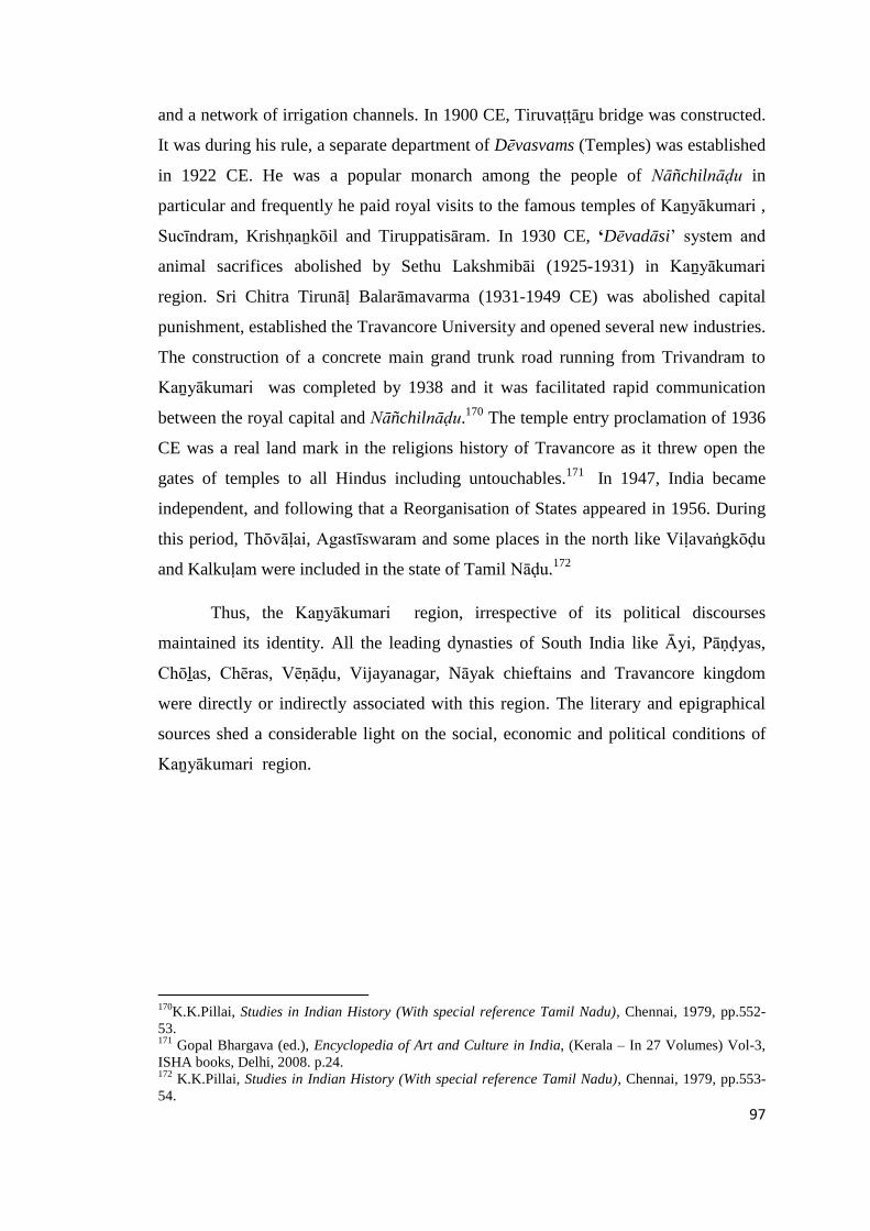
97
and a network of irrigation channels. In 1900 CE, Tiruvaṭṭāṟu bridge was constructed.
It was during his rule, a separate department of Dēvasvams (Temples) was established
in 1922 CE. He was a popular monarch among the people of Nāñchilnāḍu in
particular and frequently he paid royal visits to the famous temples of Kaṉyākumari ,
Sucīndram, Krishṇaṉkōil and Tiruppatisāram. In 1930 CE, „Dēvadāsi‟ system and
animal sacrifices abolished by Sethu Lakshmibāi (1925-1931) in Kaṉyākumari
region. Sri Chitra Tirunāḷ Balarāmavarma (1931-1949 CE) was abolished capital
punishment, established the Travancore University and opened several new industries.
The construction of a concrete main grand trunk road running from Trivandram to
Kaṉyākumari was completed by 1938 and it was facilitated rapid communication
between the royal capital and Nāñchilnāḍu.170
The temple entry proclamation of 1936
CE was a real land mark in the religions history of Travancore as it threw open the
gates of temples to all Hindus including untouchables.171
In 1947, India became
independent, and following that a Reorganisation of States appeared in 1956. During
this period, Thōvāḷai, Agastīswaram and some places in the north like Viḷavaṅgkōḍu
and Kalkuḷam were included in the state of Tamil Nāḍu.172
Thus, the Kaṉyākumari region, irrespective of its political discourses
maintained its identity. All the leading dynasties of South India like Āyi, Pāṇḍyas,
Chōḻas, Chēras, Vēṇāḍu, Vijayanagar, Nāyak chieftains and Travancore kingdom
were directly or indirectly associated with this region. The literary and epigraphical
sources shed a considerable light on the social, economic and political conditions of
Kaṉyākumari region.
170
K.K.Pillai, Studies in Indian History (With special reference Tamil Nadu), Chennai, 1979, pp.552-
53. 171
Gopal Bhargava (ed.), Encyclopedia of Art and Culture in India, (Kerala – In 27 Volumes) Vol-3,
ISHA books, Delhi, 2008. p.24. 172
K.K.Pillai, Studies in Indian History (With special reference Tamil Nadu), Chennai, 1979, pp.553-
54.
98
CHAPTER – IV
HISTORICAL GEOGRAPHY OF KAṈYĀKUMARI REGION
Historical Geography is a part of human geography concerned with the study
of man’s interaction with his environment; in other words, it is the relation between
habit (or culture) and habitat, according to a senior geographer Sauer (1941). The
same scholar emphasizes the historical nature of the study: ‘If the object is to define
and understand human association as a real growth, we must find out how they and
their distributions (settlements) and their activities (land use) came to be what they
are. Modes of living and winning a livelihood from their land involves knowing both
the ways (culture traits) they discovered for themselves, and those they acquired from
other groups. Such study of culture areas is historical geography’.1 Historical
Geography is the study of spatial variation within the period. Here the changes that
happened in the administrative and political units, viz, nāḍu, kūṟṟam and vaḷanāḍu
formed the main theme.
The first foundation stone for the Chōḻa Empire was laid during the reign of
Parāntaka-I (907-955 CE). The Chōḻa army went up to Nellūr in the north and to
Kaṉyākumari in the south and much territory was added to the Chōḻa kingdom. The
Chōḻa power, crippled for some years, gained new vigour under Sunḍara Chōḻa (956 -
69 CE) and Uthama Chōḻa (970-85 CE). The Chōḻa Empire reached its largest extent
under Rājarāja, the Great (985-1014 CE) from the Vēṅgi country in the north to
Kaṉyākumari in the south, including south Mysore and a good part of Kēraḷa. The
administrative organization of the country was perfected by the creation of a well-
equipped central staff. The whole country was surveyed and settled. The reign of
1 Y.Subbarayalu, Historical Geography of South India, Indian History Congress 73rd Session, Mumbai,2012, p.1.
99
Rājēnḍra I (1012 – 44 CE) is remarkable for the establishment of the Chōḻa–Pāṇḍya
viceroyalty in the Pāṇḍya country.2
The aim of the present work is to study the territorial and administrative units
viz., Maṇḍalam, Vaḷanāḍu, Nāḍu / Kūṟṟam, Brahmadēyam, Maṅgaḷam, function of
Nagaram and local government that existed in Kaṉyākumari region during the Chōḻa
rule from c.800 to 1300 CE. The division of the country into Maṇḍalam, Vaḷanāḍu,
Nāḍu, village and other administrative units formed the backbone of imperial Chōḻa
administration and which mainly contributed to the economic, social and cultural
dominance of the Chōḻas over other dynasties. Some fine aspects of these
administrative units are discussed in detail with the help of epigraphs and maps.
Vaḷanāḍu
Territorial division of Pāṇḍyanāḍu was divided into a number of territorial sub
divisions. Each division was created having an ūr at its centre. It was believed that
these divisions were made for administrative purpose by the ruling Government. But,
the recent discoveries in the field of research prove that these were basically ethnic
units. The territorial divisions had the suffix such as Kūṟṟam, Muṭṭam, Kuḷakīḻ and
Nāḍu. In Kaṉyākumari region, all the territorial divisions had the major suffix Nāḍu.
As gleaned from the inscriptions, the following territorial divisions existed at different
period right from the 8th century to 18th century CE.3 Nearly seven major Vaḷanāḍu
and Nāḍu divisions were identified. The following table shows territorial divisions
such as Vaḷanāḍu and Nāḍu identified in Kaṉyākumari region.
Table 4: 1 Vaḷanāḍu and Nāḍu in Kaṉyākumari region
Sl.No.Name of the Vaḷanāḍuand Nāḍu
Taluk
Date(inCE)
Reference
1. Uthama Chōḻa Vaḷanāḍu AGS 1038 K.K. vol. I : 1968/107
2. Nāñchilnāḍu TOV 860 K.K.vol. V: 1969/33
3. Puṟathāyanāḍu AGS 1000 K.K.vol. I : 1968/47
2 Y. Subbarayalu, Political Geography of Chola Country, The State Department of Archaeology,Government of Tamil Nadu, Chennai, 1973, pp.11-12.
3 Seetharam Gurumurthi, Kaṉyākumari Māvaṭṭa Kalveṭṭukkaḷ, vol. VI, State Department ofArchaeology, Chennai, 2008, p. 1.

100
4. Vaḷḷuvanāḍu KLM 1003 K.K. vol. IV : 1969/38-I
5. Kurunāḍu KLM 1139 K.K. vol.IV : 1969/38
6 Muthalanāḍu(Theṅganāḍu)
VLA Historical Atlas of South India –2008
7 Cheṅgaḻunīrnāḍu KLM 1607 K.K. vol. IV; 1969/21: HistoricalAtlas of South India – 2008
Sl.No. Name of Nāḍus Present name of the Unit
1. Puṟathāyanāḍu Agasthīswaram taluk
2. Nāñchilnāḍu Thōvāḷai and Agastīswaram taluks
3. Vaḷḷuvanāḍu Kalkuḷam taluk
4. Kuṟunāḍu Kalkuḷam taluk
5. Theṅganāḍu(Muthalanāḍu) Viḷavaṅkōḍu taluk
6. Cheṅgaḻunīr Vaḷanāḍu In and around Thuckalay ( Kalkuḷam taluk )
The above Nāḍu were under the major territorial division of Pāṇḍināḍu which
is otherwise known as Pāṇḍi Maṇḍalam. During the region of Rājarāja –I (985 -1014
CE) the Pāṇḍināḍu was known as ‘Rājarāja Pāṇḍināḍu’. It was divided into four major
divisions and all other smaller units were brought under this. They were as follows.
1. Rājēnḍra Chōḻa Vaḷanāḍu
2. Maḍurānṭaka Vaḷanāḍu
3. Muḍi Koṇḍa Chōḻa Vaḷanāḍu
4. Uthama Chōḻa Vaḷanāḍu
The area in between Veḷḷār and Vaigai river was called Rājēnḍra Chōḻa
Vaḷanāḍu. The region in between Vaigai and Vaippār was called as Maḍurānṭaka
Vaḷanāḍu. Muḍi koṇḍa Chōḻa Vaḷanāḍu comprised of the area in between Vaippār
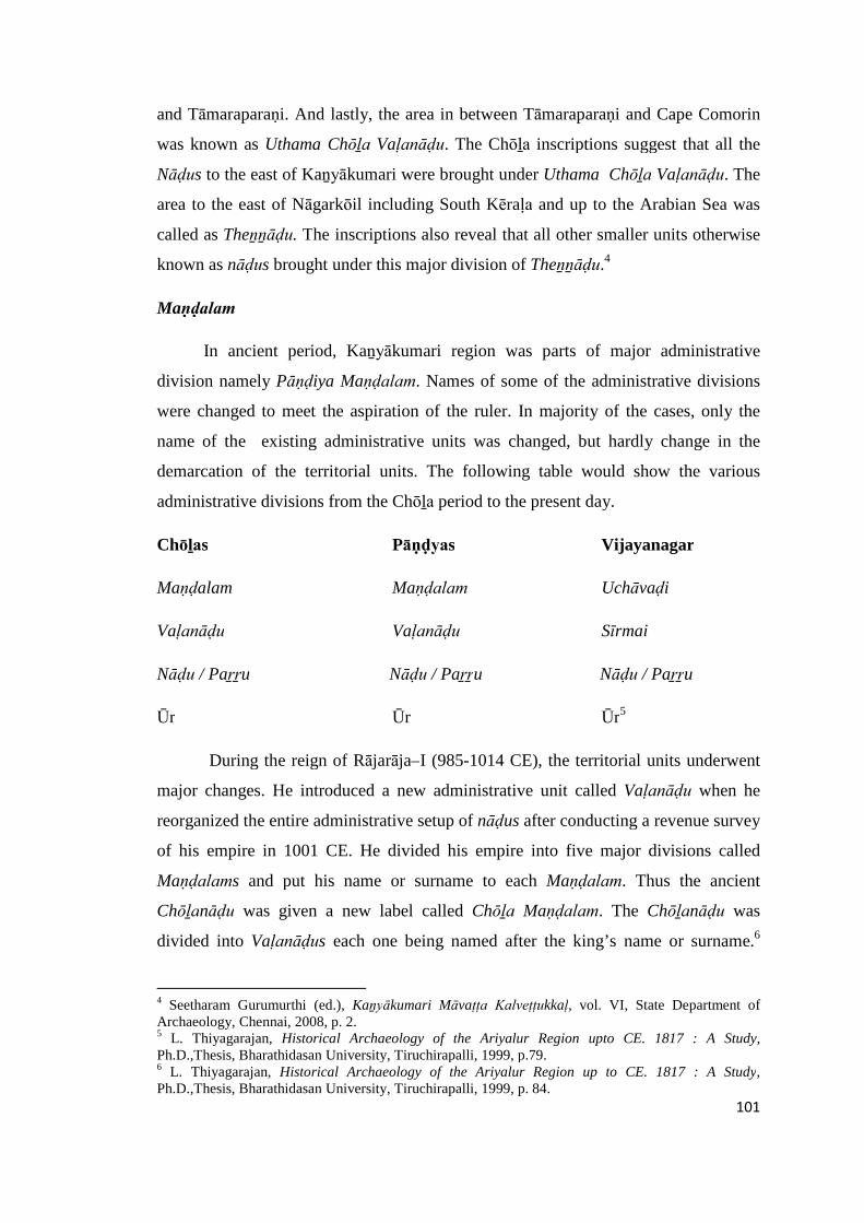
101
and Tāmaraparaṇi. And lastly, the area in between Tāmaraparaṇi and Cape Comorin
was known as Uthama Chōḻa Vaḷanāḍu. The Chōḻa inscriptions suggest that all the
Nāḍus to the east of Kaṉyākumari were brought under Uthama Chōḻa Vaḷanāḍu. The
area to the east of Nāgarkōil including South Kēraḷa and up to the Arabian Sea was
called as Theṉṉāḍu. The inscriptions also reveal that all other smaller units otherwise
known as nāḍus brought under this major division of Theṉṉāḍu.4
Maṇḍalam
In ancient period, Kaṉyākumari region was parts of major administrative
division namely Pāṇḍiya Maṇḍalam. Names of some of the administrative divisions
were changed to meet the aspiration of the ruler. In majority of the cases, only the
name of the existing administrative units was changed, but hardly change in the
demarcation of the territorial units. The following table would show the various
administrative divisions from the Chōḻa period to the present day.
Chōḻas Pāṇḍyas Vijayanagar
Maṇḍalam Maṇḍalam Uchāvaḍi
Vaḷanāḍu Vaḷanāḍu Sīrmai
Nāḍu / Paṟṟu Nāḍu / Paṟṟu Nāḍu / Paṟṟu
Ūr Ūr Ūr5
During the reign of Rājarāja–I (985-1014 CE), the territorial units underwent
major changes. He introduced a new administrative unit called Vaḷanāḍu when he
reorganized the entire administrative setup of nāḍus after conducting a revenue survey
of his empire in 1001 CE. He divided his empire into five major divisions called
Maṇḍalams and put his name or surname to each Maṇḍalam. Thus the ancient
Chōḻanāḍu was given a new label called Chōḻa Maṇḍalam. The Chōḻanāḍu was
divided into Vaḷanāḍus each one being named after the king’s name or surname.6
4 Seetharam Gurumurthi (ed.), Kaṉyākumari Māvaṭṭa Kalveṭṭukkaḷ, vol. VI, State Department ofArchaeology, Chennai, 2008, p. 2.5 L. Thiyagarajan, Historical Archaeology of the Ariyalur Region upto CE. 1817 : A Study,Ph.D.,Thesis, Bharathidasan University, Tiruchirapalli, 1999, p.79.6 L. Thiyagarajan, Historical Archaeology of the Ariyalur Region up to CE. 1817 : A Study,Ph.D.,Thesis, Bharathidasan University, Tiruchirapalli, 1999, p. 84.
102
Vaḷanāḍu means literally a fertile country. The Vaḷanāḍu, as a territorial element, was
peculiar and confined to Chōḻa times and Chōḻa territory.7
The area in between Tāmaraparaṇi and Cape Comorin was known as Uthama
Chōḻa Vaḷanāḍu. The Chōḻa inscriptions impart that all the nāḍus to the east of
Kaṉyākumari brought under this Uthama Chōḻa Vaḷanāḍu. The area to the east of
Nāgarkōil including south Kēraḷa and up to the Arabian Sea was called as Teṇṉāḍu.8
Kaṉyākumari region is naturally very fertile land. Place names prefixing and suffixing
the Tiṇai-s are also seen in the area under study (Appendix-IV). The early Tamils
classified their land into five ecological zones or tiṇais, popularly called as aintiṇai as
a whole (Tolkāppiyam-Porulatikāram-Akattiṇai Iyal 2:5). The five tiṇais mentioned
in early Tamil literature are the kuṟiñchi (mountain tracts), mullai (pastures),
marutham (riverine tracts), neytal (the coastal/littoral tracts) and pālai (arid waste
tracts). Pālai was not treated as a separated tiṇai, as pālai was a seasonal ecological
zone created at a time on account of scarcity of rains or hot summer conditions. Such
pālai eco-zones could not be witnessed much in the study area as the Kaṉyākumari
region as it received a three-fourth of its annual rainfall during the southwest and
northeast monsoons. While the period of southwest monsoon was from June to
September, the northeast monsoon covered the period from the beginning of October
to December.9 These two mansoons bring bounty to the region and makes the region
one of the nuclear zones of the state.
In Kaṉyākumari region, two Vaḷanāḍus were identified. They were Uthama
Chōḻa Vaḷanāḍu and Cheṅgaḻunīr Vaḷanāḍu. The recent monumental work of
Historical Atlas of South India only refers to Uthama Chōḻa Vaḷanāḍu. The earliest
occurrence of this Vaḷanāḍu found in an inscription of Rājēnḍira-I (1012-1044 CE)
dated in 1038 CE found in Koneriswarar temples at Kaṉyākumari.10
7 Y. Subbarayalu, Political Geography of Chola Country, The State Department of Archaeology,Government of Tamil Nadu, Chennai, 1973, p.56.8 Seetharam Gurumurthi (ed.,), Kaṉyākumari Māvaṭṭa Kalveṭṭukkaḷ, vol. VI, Tamil Nadu StateDepartment of Archaeology, Chennai, 2008, p.2.9 MSS. Pandian, The Political Economy of Agrarian Change Nāñchilnāḍu 1880-1939, SAGEPublications, New Delhi, 1990, p.22.10 Natana Kasinathan ( ed., ) Kaṉyākumari Māvaṭṭa Kalveṭṭukkaḷ, vol. I, Tamil Nadu State Departmentof Archaeology, Chennai, 1972, No. 1968/107.

103
Another inscription of Kēraḷapuram dated 1607 CE issued during the reign of
Vēnāḍu in the context of one chieftain Vīraravivarmaṉ Sri Kulasēkara Perumaḷ built
four ambalam of Thirumaḍapaḷḷi, Rishabha Maṇḍapam and Gōpuram to Mahādēvar
Temple refers to Cheṅgalunīr vaḷanāḍu.11
The following map shows various territorial Nāḍu divisions in Kaṉyākumari
region pertaining to the period between c 800 to 1300 CE (Map 5).
Nāḍu
The ‘Nāḍu’ is the very key to the political geography of the Chōḻa country. It
was very important limb of the administrative system of the period under study and it
was the basic unit of the agrarian society. The kūṟṟam is another name of nāḍu.
Y.Subarayalu and S.Rajavelu felt that kuṟṟam probably an earlier subdivion to nāḍu
formation. The area of the nāḍus ranged from about 10 square miles to about 300
square miles.12 A number of villages included in each nāḍu were mainly based on the
physical feature of that area; land fertility, irrigation facility, etc. The growth of new
urban centres, trade centres and marketing places accelerated the formation of new
villages. The creation of new irrgational facilities like construction dams, creation of
irrigation canals and digging irrigation tanks brought the baron land into a fertile land.
This also necessitated the creation of new settlements. Kaṉyākumari region had
several religions centers and many temples. The trade activities in this region also
influence the growth of settlement and consequently the increase in the number of
villages in Nāḍu.13 For instance, the creation of Pārthivasēkharapuram could be cited.
Pārthivasēkharapuram copper plates issued on 8th July, 866 CE by
Kōkarunandaḍakkaṇ (857-885 CE), a ruler of Ᾱyi dynasty refers to the creation of
temple town. The king created a temple city by purchasing the land from the Sabhā of
Muñchiṟai through payment known as Uḻukkuḍiviḷai. After purchase, he fixed its
boundaries and erected a temple on it; set up the image of Vishṇu in the temple and
named the village and associated land as Pārthivasēkharapuram. He also established a
Pārthivasēkharapuram Sālai (a boarding school) in which arrangements were made to
11 R.Nagasamy ( ed. ) Kaṉyākumari Māvaṭṭa Kalveṭṭukkaḷ, vol. IV, Tamil Nadu State Department ofArchaeology, Chennai, 1979, No;1969/21.12 Y. Subbarayalu, Political Geography of Chola Country, The State Department of Archaeology,Government of Tamil Nadu, Chennai, 1973. p.21.13 S.Rajavelu, The Historical and Cultural Geography and Ethnography of Pudukkōṭṭai region up to A.D.1800, Ph.D., Thesis, Tamil University, Thanjavur, 2003, p.26.

104
feed ninty-five Saṭṭars (Brahmins). This copper plate also further mentions that
Pārthivasēkharapuram Sālai is established in the model of Kānḍaḷūr Sālai. Then, the
record describes the type of land grant made to the temple services and mention
important places and nāḍus in Kayakumari region. The second plate prescribes the
duties of the temple servants and of the person employed to supply flowers to the
temple. Then comes an enumeration of the land grant for maintaining the perpetual
lamb in the temple. The third plate contains the list of lands granted to meet the salary
of the temple servants. The fourth plate explains on the people of the various nāḍus
and the duty of protecting the charitable institutions.14 The following are the names of
places that occur in the copper plates. Muḍāla-nāḍu, Pasuṅguḷam, Minchirai, Poḻisūḻ-
nāḍu, Kurāthūr, Sengaḻunāḍu, Kuṇrathūr, Vaḷḷuvanāḍu, Teṅganāḍu,Viḷappil,
Iḷavēṇāṭṭunallūr, Paṉaiyūr, ōmāyanāḍu, Sirumaṇṇūr, Miṉachchi, Siruguṇdūr,
Arumunaiāṇūr, Mathūr, Paḍaippanāḍu, Pākkōḍu, and Yāppigaikōḍu. Of these
Muḍālanāḍu takes its name from Miḍālam; Pasuṅguḷam is the modern Paiṅguḷam, a
mile south of Pārthivapuram. Poḻisūḻ-nāḍu seems to derive its name from the ancient
form of the modern Poḻiyūr. One of the inscriptions at Tirunanḍikkarai mentions the
territorial unit Rājarāja-teṉ-Vaḷḷuvanāḍu; this is perhaps the Vaḷḷuvanāḍu that is
mentioned in the inscription. The inscription referred to above states that Muṭṭam, a
coastal village (modern Eraṇiyal), which is not far from Pārthivapuram was in the
Vaḷḷuvanāḍu. A village named Teṅgāpaṭṭaṇam is identified close to Pārthivapuram
and the administrative unit Teṅganāḍu probably emerged out of this nucleus village.
Miṉachchi is perhaps the modern Minachchi. An inscription in the Vishṇu temple at
Talaikuḷam mentions Paḍaippanāḍu, which seems to be somewhere near Eraṇiyal.
Viḷappil seems to be, like all the places, identified with a village in South
Travancore.15 A monumental work of Historical Atlas of South India identified six
Nāḍu territorial divistions in Kaṉyākumari region for the period between c.900 to
1300 CE. They are Nāñchilnāḍu, Puṟathāyanāḍu, Vaḷḷuvanāḍu, Muthalanāḍu,
Cheṅgalunīrnāḍu and Kurunāḍu. Among the major six nāḍu divisions, Nāñchilnāḍu
is the major territorial division of this region. The major river Tāmbaraparaṇi flowing
north to south in a fertile zone fashioned between two major hillocks form the basis
for the formation of this nāḍu. More than 50 historical sites were identified on either
14 T.A.Gopinatha Rao (ed.), Travancore Archaeological Series, Department of Cultural Publications,Government of Kerala, vol.-I, Trivandrum, 1988, p.16.15 Pāṇḍiar Cheppēḍugaḷ Paththu, International Institute of Tamil Studies, Chennai, 1999, pp.A. 9-10.
105
side of the river. The nadu is extended north to south covering major part of the
Kalkuḷam, Thōvālai and Agatīswaram taluks. The Vaḷḷuvanāḍu lies on the northern
part of the region and located on an elevated area. The remaning four nāḍu divisions
namely Muthalanāḍu (also called Theṅganāḍu), Cheṅgaḻunīr nāḍu, Kurunāḍu and
Puṟathāyanāḍu occupies the deltaic zones along the coast from west to east. Thus, all
the five nāḍus except Vaḷḷuvanāḍu occupies a fertile zone major rivers.
The extensive study made by the scholars like Burton Stein, Noburu
Karashima, Y.Subbarayalu, James Heitzman and Kenneth R. Hall helped to
understand the formation of nāḍu units in Chōḻa country. Keeping in view of their
illustrious work an attempt is made to understand the nāḍu formation in Kaṉyākumari
region.
Nāñchilnāḍu
Nāñchilnāḍu was one of the biggest nāḍu divisons of this region. It is one of
the best eco-zones of Kaṉyākumari region covering the present two taluks of
Agastīswaram and Thōvāḷai. This region has a rich tradition of irrigated paddy
cultivation. The etymology of the word Nāñchilnāḍu itself bears evidence to the long
history of paddy cultivation.16 In the Chōḻa inscriptions, the Nāñchilnāḍu was
described as a subdivision of Uthama-Chōḻa-Vaḷanāḍu, a major division created by
the Chōḻa king Rājarāja–I. Rājēnḍra Chōḻa, the illustrious son of Rājarāja Chōḻa–I
continued his father’s efficient rule in this region. He collected taxes from Dēvaḍāṉa
villages (villages gifted to temples) of the Goddess Kaṉyākumari and utilized them
for the celebration of festivals and performing religious rituals in the temples. During
the period of Rājēnḍra Chōḻa, Kaṉyākumari town (Cape Comorin) was also called as
Gangaikoṇḍa-Chōḻapuram. The town Kōṭṭār was renamed into Mummuḍi Chōḻanallūr
and all towns were well administrated by the later Chōḻa rulers. The Chōḻa Empire
began to disintegrate in the 12th century CE.17 Of the Nāḍus of Kaṉyākumari region,
Nāñchilnāḍu is the earliest one mention in Ᾱralvāimoḻi inscription found at
Mīṉāchiammaṉ temple and dated to 860 CE. This inscription refers to the
construction of a Mahāmaṇḍapum in Mīnāchi temple by one Subramaṇiyaṉ Piḷḷai, son
16 MSS.Pandian, The Political Economy of Agrarian Change Nāñchilnāḍu 1880-1939, SAGE-Publications, New Delhi, 1990, p.16.17 N.Gunabalan, Studies in the History of the Kaṉyākumari Region, Ph.D., Thesis, University ofMadras, Madras, 1989, p.25
106
of Sāthāṅkuṭṭi Piḷḷai. It also records various communities and artisans like āchāri,
thachar, cheṭṭiyār, kaikōḷar, īḻavā, cāṇār, vāṇiyar, sāliyar and muḍaliyār.18
Puṟathāyanāḍu
The bigger administrative unit Nāñchilnāḍu was divided into two halves of
which the southern portion was known as Puṟathāyanāḍu. The available evidence
suggest that political boundary between the Nāñchilnāḍu and Puṟathāyanāḍu was
shifted from time to time. This fertile tract was in the possession of Pāṇḍyas until the
10th century CE, when it was seized by the Chōḻas.19 Presently, Puṟathāyanāḍu is
located in Agastīswaram Taluk. Bhagavathiammaṉ temple is one of the famous
temples in Kaṉyākumari. The temple stands near where three oceans meet viz., the
Indian Ocean, the Bay of Bengal, and the Arabian Sea. According to the inscription
dated to 1000 CE found on the walls of the temple, this temple was located in
Rājarāja-vaḷanāṭṭu-Puṟathāyanāḍu, thereby indicating that Puṟathāyanāḍu was part a
Rājarāja-vaḷanāḍu. It registers a gift of goat made to the temple for lighting a
perpetual lamp by one Rājamārthāṇḍapēraiyaṉāyiṉ chūraisāthaṉ. During this period,
Kaṉyākumari also called Kumarimaṅgaḷam.20 It is a very fertile zone and river
Paḻayāru formed an important water source of this region. Agriculture is the main
occupation and important products are paddy, banana plantation, coconut grooves etc.
Other Nāḍus viz., Vaḷḷuvanāḍu, Cheṅgaḻunīrnāḍu, Kurunāḍu and Muthalanāḍu alias
Theṅganāḍu are located in Kalkuḷam and Viḷavaṅkōḍu taluks.
Vaḷḷuvanāḍu
The present Kalkuḷam taluk could be considered as the ancient Vaḷḷuvanāḍu.
The Chōḻa inscription of Tirunanḍhikarai cave temple dated to 1003 CE refers the
villages of this unit as Rājarājanāṭṭu-Vaḷḷuvanāḍu in the context of the donation made
to Tirunanḍhikarai Mahādēvar temple for lighting a perpetual camp. It seems during
Chōḻa times, this unit is also known as Rājaranāḍu, a name assigned after a great
18 R.Nagasamy ( ed.) Kaṉyākumari Māvaṭṭa Kalveṭṭukkaḷ, vol. V, Tamil Nadu State Department ofArchaeology, Chennai, 1979, No;1969/3319 T.K.Velu Pillai, Travancore State Manual, vol-II, Government of Kerala, Trivandrum, 1940, p.p.60-61.20 Natana Kasinathan ( ed., ) Kaṉyākumari Māvaṭṭa Kalveṭṭukkaḷ, vol. I, Tamil Nadu State Departmentof Archaeology, Chennai, 1972, No.1968/48.
107
Chōḻa emperor Rājarāja-I (985 to 1014 CE).21 Vaḷḷuvanāḍu and Muthalanāḍu served
as the western boundary of Ᾱynāḍu.
Muthalanāḍu alias Theṅganāḍu
Presently, Muthalanāḍu is lying in Viḷavaṅkōḍu taluk. The ancient
Muthalanāḍu was fed by the river Kuḻithuṟai and this geographical zone is mainly
formed by mountain and hills region. Several Iron Age and historical sites brought to
light in Viḷavaṅkōḍu taluk and is one of the richest archaeological zones of
Kaṉyākumari region.
Cheṅgaḻunīrnāḍu
Mahādēvar temple inscription of Kēraḷapuram (1607 CE) refers to
Cheṅgalunīrnāḍu. It also records the construction of ambalam, maḍappaḷḷi,
rishabamaṇḍabam at Maghādēvar temple in Kēraḷapuram by a Vēṇāḍu ruler
Vīraravivaṉmarāṉ Sri Kulasēkaraperumaḷ.22 Pathmaṇābapuram is one of the
important places falls in this region. It was once the capital of Travancore kingdom.
Pathmaṇābapuram fort was strategically located and was reconstructed by
Mārthāṇḍavarma (1729 – 1758 CE), a great ruler of Travancore kingdom. Kalkuḷam
was an old name of Pathmaṇābapuram.23
Kurunāḍu
Kurunāḍu was a smallest nāḍu unit in Kaṉyākumari region. This nāḍu firstly
refered to in Karaikaṇḍīswarar temple of Thirunayinārkuṟichi in 1139 CE.
Kaḍiyapaṭṭiṇam is one of the important ports located in Kurunāḍu near Muṭṭam port.
This epigraphical record refers to the donation of temple garden and a perpetual lamp
to Karaikaṇdīswarer mahādēvar temple by Ᾱdhichaṉkōthai.24
21 R.Nagasamy ( ed. ) Kaṉyākumari Māvaṭṭa Kalveṭṭukkaḷ, vol. IV, Tamil Nadu State Department ofArchaeology, Chennai, 1979, No.1969/30 – I.22 R.Nagasamy ( ed. ) Kaṉyākumari Māvaṭṭa Kalveṭṭukkaḷ, vol. IV, Tamil Nadu State Department ofArchaeology, Chennai, 1979, No.1969/21.23 A.K.Perumal, Theṉkumariyiṉ Kathai, United Writers, Chennai, 2003, p.92.24 R.Nagasamy ( ed. ) Kaṉyākumari Māvaṭṭa Kalveṭṭukkaḷ, vol. IV, Tamil Nadu State Department ofArchaeology, Chennai, 1979, No;1969/38.
108
Administration and local self – government
From the eigth and ninth centuries CE, three types of village assemblies are
traceable in the inscriptions, namely ūr, the sabhā and the nagaram. The ūr was the
common type which included all classes of people who held the land in the village.
Y.Subbarayalu, who worked on Political Geography of Chōḻa Country, calculated
that, a village (ūr) was located within distance of every 2 miles. It is obvious that, the
people were densely populated where resources are found abundantly and they are not
lived largely in the places where the water resources were not available sufficiently. A
village is consists of habitation of people, along with temples, drinking water,
irrigation facilities and graveyards. The settlement where, the land lords,
agriculturalists and tillers were lived are commonly known as ūr, irrukkai, natham
and so on.25 The sabhā was an exclusive Brahmin assembly of villages given as gift to
Brahmin where all the land belonged to them. The nagaram was quite another type
pertaining to localities where traders and merchants occupy a dominant position.26
Function of Nāḍus
Nāḍus were made up of hamlets, villages, cities, towns etc. that came under
any class or type called brahmadēyas, dēvadāṉas, nagara, paṭṭiṇam, ūr, irukkai, etc.
These were subject to the respective jurisdictions of the administrative assemblies
(nāṭṭār) called by the territorial names of the nāḍu in which they were.27 The
members of the assemblies were known as the ūrār, nāṭṭār, sabhaiyār and nagaraṭṭār,
the people of the ūr, nāḍu, sabhā and Nagaram. The fourth administrative unit was
the urban marketing centre or nagaram, which also had its own assembly. Though the
nagarams were essentially concerned with managing local trade and merchants, they
also had jurisdiction over agricultural lands in the neighborhood of towns, indicating
that the distinction between urban and rural was quite unclear during the medieval
period.28
25C.Nilavathi, Tañjāvūr Vaṭṭāra Niḷaviyalum Samudhāyamum (c.900 - -1400), Tamil University,Thanjavur, 2001, pp.97 - 98.26 K.A.Nilakanta Sastri, A History of South India – From Pre historic times to the fall of Vijayanagar,Oxford University Press, New Delhi, 1975, p.149.27 K.S.Vaithyanathan, The Ancient Geography of the Kongu Country, Kalaimagal Kalvi Nilayam,Erode, 1983, p.4.28 Gurcharan Das, The study of Indian Business, Merchants of Tamilagam, Penguin books, New Delhi,2012, pp. 73 – 74
109
The nagaram is a much more specific organization of merchants found in
every market centres, collection centres and distribution centres where local and
itinerant traders met and exchanged items of trade. Nagaram is being a mercantile
organization involving local groups in organizing and controlling local trade.
Nagaraṭṭār became a generic term for all the traders and the trading community,
particularly in Tamil Nadu and hence the term is still being used even today by the
Nāṭṭukkōṭṭai Cheṭṭiārs.29 The merchant community gradually acquired a position of
great social and economic importance. This is attested by the reference to Kaikkōḷās
and Sāliya Nagaraṭṭār, who not only controlled production and marketing of cloth but
also participated in temple services, e.g., donations, conduct of festivals,
administration and management. There is also a noticeable change in the pattern of
land ownership both weavers and merchants becoming land owning communities and
wielding considerable influence in their localities.30 In most settlements of that time,
peasants, merchants and artisans along with others lived in close association, sharing
not only inter-dependent economic relationships, but also a common involvement in
the cultural life of the locality.31 For instance, Nagaraṭṭār donated three mā of land to
a priest of Veṅkaḍāchalapathi temple at Aḻagiyapāṇḍiyapuram in Thōvāḷaii taluk for
conducting daily worship.32
Administration of Vēnāḍu
During the 12th and 13th centuries and still later, in Nāñchilnāḍu as well as in
the rest of Vēṇāḍu, the local assemblies and temple sabhās were served as imporatant
institutions. They managed the day-to-day affairs of the area. Several inscriptions of
Vēnāḍu, beyond the limits of Nāñchilnāḍu, indicate that the local affairs were under
the control of the assemblies.33 During this period, Nāñchilnāḍu is made up of two
sectors, known as, vaḍamīthi, (i.e. northern sector) and theṉmīthi (southern sector).
The Paḻayāṟu river flows through the river bed area forms the region of Theṉmīthi.
29 R.Champakalakshmi, ‘The Medieval South Indian Guilds: Their Role in Trade and Urbanization’, InRanabir Chakravarti, Trade in Early India, Oxford University press, New Delhi, 2001, p.329.30 R.Champakalakshmi, ‘The Medieval South Indian Guilds: Their Role in Trade and Urbanization’, InRanabir Chakravarti, Trade in Early India, Oxford University press, New Delhi, 2001, p.340.31 Burton Stein, Peasant State and Society in Medieval South India, Oxford University Press, NewDelhi, p.242.32 R.Nagasamy (ed.), Kaṉyākumari Kalveṭṭukkaḷ, vol-V, Tamil Nadu State Department of Archaeology,Chennai, 1979, No.1969/14.33K.K.Pillay, Studies in Indian History (With special reference to Tamil Nadu), Madras, 1979, p.529.

110
Prior to the 13th century, the Nāñchilnāḍu was divided into 12 piḍāgais. They were
known as 1) Mēle-piḍāgai 2) Nāḍuvu-piḍāgai 3) Kīḻ-piḍāgai 4)
Aḻagiyapāṇḍiyapuram-piḍāgai 5) Thāḻaikuḍi-piḍāgai 6) Thōvāḷaii-piḍāgai 7)
Paḍappāṭṭru-piḍāgai 8) Koṭṭraṟṟu-piḍāgai 9) Paṟakkai-piḍāgai 10) Thērūr-piḍāgai
11) Sucīndram-piḍāgai and 12) Agastīswaram-piḍāgai. Each of these piḍāgai were
under the leadership of a head of the nāḍu.
After 13th century CE, this situation seems to have changed. Muḍaliyār palm
leaves records the Maṅgaḷam to Maṇakkuḍi as the north-south boundary of
Nāñchilnāḍu. In the 18th century, its boundary extended from Kaḍukkarai mountain in
the north up to Maṇakuḍi in the south and Ᾱralvāimoḻi mountain in the east to
Paṉḍrivāikāl in the west. Between the 12th century and 18th century CE, there was a
close contact between the rulers of Vēṇāḍu and Nāñchilnāḍu. The Periyavīṭṭu
muḍaliyār served as the tax collecting agents of Vēṇāḍu rulers. Aḻagiyapāṇḍiyapuram
served as their headquarters. A group of persons who broke away from this traditional
body held Ᾱḷūr as their headquarters.34
During the reign of Dharmarājā alias Rāmavarmā (1758-1798 CE), there were
three revenue divisions in Travancore State, viz., Veḍakkēmukkom, Patinjaremukkom
and Tekkēmukkom and the present Kaṉyākumari district area formed part of
Tekkēmukkom.35 In the 18th century, Travancore region divided into many dēsams
(a settlement unit) for the purpose of administration. They are Vaṉṉiyūr dēsam,
Parakkōṭṭu dēsam, Viḷavūr dēsam, Naṭṭālam dēsam, Kuḻithuṟai dēsam and Pālakkōṭṭu
dēsam.36 The village was taken as a unit and put under the charge of an officer called
Pārvathiyakkārar. His primary duties were a collection of revenues and management
of the village irrigation system. He also acted as a Magistrate with jurisdiction to try
petty cases in the village. A group of villages constituted an administrative division
called ‘Maṇḍapathunvathukkal’. It was headed by ‘kāriyakkār’ whose functions were
more or less identified that of the present day Tashildar (revenue collector). In the
field of financial administration, a system of preparing budgets, ‘Pathivukaṇakku’ was
34 Seetharam Gurumurthi (ed.), Kaṉyākumari Māvaṭṭa Tholliyal Kaiyēḍu, State Department ofArchaeology, Chennai, 2008, p.16.35 M.Gopalakrishnan (ed.), Gazetteers of India Tamil Nadu State Kaṉyākumari District, Government ofTamil Nadu, Commissioner of Archives & Historical Research, Chennai, 1995, p.8.36 Seetharam Gurumurthi (ed.), Kaṉyākumari Māvaṭṭa Tholliyal Kaiyēḍu, State Department ofArchaeology, Chennai, 2008, p.35.
111
prevailed. The allocation of funds for different departments was formulated. Survey
and settlement of land were introduced and reorganization of the army on the model
of the British army was taken up.37
Thus, the Kaṉyākumari region has undergone a several changes in the terms of
their units due to the occupation of various dynasties. Each dynasty attempted to
implement in the line of their administrative procedures. Irrespective of these
inadequacies, the inscriptions dated between 8th century and 18th century CE suggest
that all the territorial divisions had the suffix Nāḍu. During the reign of Rājarāja–I
(985-1014 CE), the Pāṇḍināḍu was known as Rājarāja Pāṇḍināḍu. It was divided into
four major divisions and all the smaller units were brought under these four divisions.
The area between Tāmaraparaṉi and Cape Comorin was known as Uthama-Chōḻa-
Vaḷanāḍu and major part of the Kaṉyākumari virtually falls in this territorial division.
The area to the east of Nāgarkōil including South Kēraḷa and up to the Arabian Sea
was called as Teṉṉāḍu. During the Chōḻa period, the Vaḷanāḍu had some
administrative significance. It helped the integration of society beyond nāḍus.
According to Subbarayalu, basically the nāḍu was not an administrative division as it
is usually conceived; rather it should have originated as a cluster or grouping of
peasant or agricultural settlements formed about the nucleus of a common irrigation
source like a channel or tank and bound together by kinship ties between the people of
an individual nāḍu. The administrative aspect is only a secondary one. The number of
villages that were included in the nāḍus shows much variation, according to the
locality. Obviously they were themselves not of any uniform size and the size must
have been decided by the local topographical and ecological factors added to the
human factors.38 Thus, understanding the formation of certain geographical units and
their continued existence or change requires deep knowledge on its historical
development.
37 M.Gopalakrishnan (ed.), Gazetteers of India Tamil Nadu State Kaṉyākumari District, Commissionerof Archives and Historical Research, Madras, p.86.38 Y.Subbarayalu, Historical Geography of South India, Indian History Congress 73rd Session,Mumbai, 2012, pp.7-8.
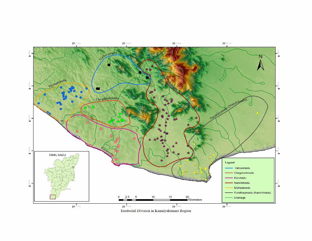

112
CHAPTER- V
CULTURAL GEOGRAPHY OF KAṈYĀKUMARI REGION
Geography is conventionally divided into physical and human. The former
relates to the physical configuration of the earth’s surface, its climatic conditions, and
the way it is occupied by water, land, vegetation and animal life. The latter relates to
the demographic distribution of natural resources, land utilization, production centres,
trade and transportation. Thus, almost every aspect of human existence and their
endeavours come under the umbrella of human geography, also called cultural
geography.1
The formation of a region depends on the nature of topography, distribution of
commercially exploitable natural resources, availability of water, fertility of the soil,
suitable environmental condition and other productive patterns. As a regional entity,2
Kaṉyākumari region emerged largely due to the growth of agrarian economy and the
development of coastal exchange centres. Both these created more surplus to support
human existence in the region and that resulted in the formation of region as a
separate entity. Nāñchilnāḍu has all the time constituted a distinctly separate unit,
socially and culturally different from the rest of Travancore.
Assigning a name to a particular settlement/place had social, cultural, political,
religious, economic and ethnic significance. The transformation of a place name or
reassigning a new name had its own ramification. The cultural attachment to a
particular place still holds well, irrespective of its chronological frame. Therefore,
naming a place marks an important turning point in the history of human civilization.
As is well known, in the remote past, man was nomadic and had no permanent
dwelling places as such. It is only with the appearance of settled life supported with a
rudimentary form of agriculture as the economic basis of subsistence; one can really
start to think of settlement. The transition from hunting to domestication of animals
1 G.S.Grewal, Historical Geography of the Punjab, Guru Nanak Dev University, Amritsar, 1974, p.1.2 K.P.Rajesh, Historical Geography of Koḷathunāḍu- A Study of the Regional Formation in MedievalNorth Kerala, Ph.D.Thesis, University of Calicut, Calicut, 2011, p.6.
113
and from food gathering to food production was indeed a remarkable change in the
process of civilization.
Pre-historic Culture
Detailed explorations and excavations are yet to be commissioned in
Kaṉyākumari region to shed light on the pre-historic culture. In 1945, the State
Department of Archaeology, Travancore State, experimented an excavation at
Veḷḷimalai in Kalkuḷam taluk during which they came up with ancient urns used for
burying the dead. Similar urns were also unearthed at Ādhichchanallūr of Tirunelvēli
district, containing several black-and-red ware pots and rusty iron pieces. Both
primary and secondary burials were exposed at Ādichanallūr and all datable to
millennium BCE or still earlier. In Saṅgam works like Puṟanāṉūru, mention has also
been made about muthu makkaḷ thāḻi which means the urns of the forefather. A hand
made coarse earthen jar and other relics were found near the Thuthūr village in this
district. The shape, fabric and the decorations indicate that they are probably of the
megalithic or the early historic period.3
A close study of the place names of any given country helps us in tracing out
the cultural, commercial, social, political, religious and economic history, and
otherwise unknown linguistic features of the language of that country. It also guides
us in tracing the migration of the people and the topographical features of the
country.4 The continuation of secondary life, or pastoral life combined with
agricultural expansion, probably due to demographic pressure stemmed out of surplus
production necessitated the society to have a demarcated territorial hold to sustain
their life.
In this process, the land holding pattern started emerging with varied degrees
of power. The terms like kuḍi, ūr, nāḍu, vaḷanāḍu and maṇḍalam are the reflection of
land holding pattern. Each of this territorial demarcation generally met with a new
name. Land was classified into two different methods. One division is named as
kōṭṭam, nāḍu/kūṛṛam, vaḷanāḍu and maṇḍalam created by the state for revenue
3 M.Gopalakrishnan (ed.), Gazetteers of India: Tamil Nadu State-Kanyakumari, Govt of Tamil Nadu,Commissioner of Archives and Historical Research, Madras, 1995, p.51.4 S.S.Ramachandra Murthi, A Study of Telugu Place Names, [Based on Inscriptions from the Earliestto the 13thcentury], Agam Kala Prakashan, Delhi, 1985, pp.1-2.

114
purpose. The other type of divisions like paḷḷi, brahmadēyam, nallūr, dēvadāṉam,
etc., expresses other social aspects too.
The meaning of place names would be useful for understanding the cultural
characters. Due to the cultural and linguistic changes, the identification of ancient
place names with modern ones becomes somewhat difficult. In this connection, the
lexicons may help us to understand the meaning of a particular usage through
etymological analysis. However, these lexicographic studies are sometimes not as
reliable as they repeat some stereotyped information without proper contextual
evidence. So, the interpretation of the old names of the places remains provisional in
several cases and they need further corroboration from a first hand knowledge of the
place itself.5
The earliest literary source available to trace back the possible origin of a
particular name is the ancient Tamiḻ anthologies popularly called Saṅgam literature
that constitutes the central category of our source material. It provides plenty of
knowledge about the landscapes and ecosystems of ancient Tamiḻakam. The phrase
Vaṭavēṅkaṭam teṉ kumari āyiḍait tamiḻ kūṟum nalulakam expounded in Tolkāppiyam
and in Saṅgam literature demarcated the ancient Tamiḻagam as the land between the
Vēṅkaṭa hills on the north and Kumari (Kaṉyākumari) in the south which comprises
the present Kēraḷa and Tamiḻ Nāḍu states. The region beyond Vēṅkaṭa hills (Tirupati
hills) are considered as moḻipeyar tēyam meaning other language speaking area. In
accordance with this statement, the inscriptional records found within the Tamiḻ akam
carry Tamiḻ language whereas the region north of Vēṅkaṭam hills carries the language
of Prakrit during Early Historic times. The region under study is divided into five
ecosystems namely tiṉai. The tiṉai concept is peculiar to Tamiḻ Nāḍu and it is rarely
found in any Sanskrit /Prakrit tradition.
The tiṉai (land) concept and its constituent elements are described in the form
of rules in Tolkāppiyam, the earliest of extent Tamiḻ grammatical treatise.6
5 S.Rajavelu, The Historical and Cultural Geography and Ethnography of Pudukkōṭṭai Region Upto 1800 A.D., Ph.D.Thesis, Tamil University, Thanjavur, 2003, p.48.6 Rajan Gurukkal and M.R.Raghava Varier (ed.), Cultural History of Kerala, (From the earliest to thespread of Wet rice), vol-I, Department of Cultural Publication, Government of Kerala, 1999, pp. 161-162.

115
They are referred to following geographical features of Tamiḻ land and its
main deity,
“Māyōṉ mēya kāḍu uṟai ulakamum
Chēyōṉ mēya maivarai ulakamum
Vēnḍaṉ mēya thīmbuṉal ulakamum
Mullai, kuṟiñji, marutham neithal eṉach
Cholliya muraiyāṉ sollavum paḍumēy”
(Tholkāppiyam 1 Agaṭṭiṇai 5)
The earliest Tamiḻ grammar of Tolkāppiyam only referred to four divisions of
landscapes and ecosystems of Tamiḻ akam.7 The tiṉai mentioned in early Tamiḻ
literature are the kuṟiñci (mountainous tracts), Malawi (pastoral tracts), maruṭam
(riverine or wetland tracts), neytal (coastal/ littoral tracts) and pālai (arid waste
tracts). Pālai land not recorded in earliest Tamiḻ grammatical of Tolkāppiyam.8 It was
referred to in post classical period epic Cilappatikāram. Ilaṅkō Aṯigal, the author of
Cilappatikāram, referred to pālai tiṉai in the following ways,
“Mullai kuṟiñjiyum muṟaimayil thirindu
Nalliyal piḻanthu naḍuṅg thuyaṟuthup pālai
Eṉpathōr paḍivam koḷḷum”
(Cilappatikāram -11 Kāḍukāṇkāthai-64-66)
Here, pālai (arid waste tracts) was not treated as a separate tiṉai. It considered
pālai as a seasonal ecological zone created at times on account of scarcity of rains or
hot summer conditions. There are examples in the text which show the transformation
of mullai and kuṟiñchi in a particular part of the year (seasonal) into a pālai lands.9
According to Rajan Gurukkal, each ecological zone developed particular professional
groups due to nature of subsistence pattern. For instance, the tiller / uḻavar are
specifically goes to wet land.
7 K.Chitha Kesavan, Kēraḷam- Ūrum Pērum, Pālakkād District, Tirukkural Publication, Chennai,2009, p.88 Radhika Rajamani, Society in Early Historic Tamilagam, Ph.d.Thesis, Jawaharlal Nehru University,New Delhi, 1993, p.66.9K.Chitha Kesavan, Kēraḷam-Ūrum Pērum, Pālakkād District, Tirukkural Publication, Chennai, 2009,p.13.
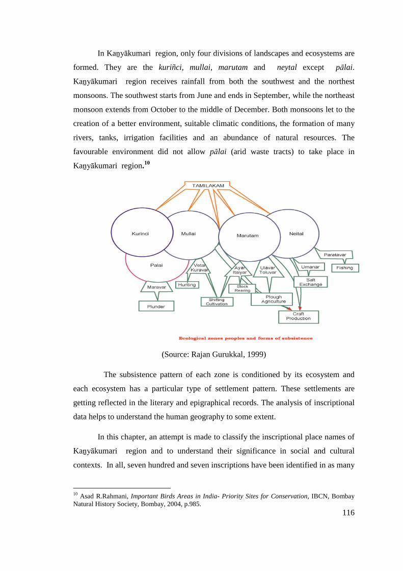
116
In Kaṉyākumari region, only four divisions of landscapes and ecosystems are
formed. They are the kuriñci, mullai, marutam and neytal except pālai.
Kaṉyākumari region receives rainfall from both the southwest and the northest
monsoons. The southwest starts from June and ends in September, while the northeast
monsoon extends from October to the middle of December. Both monsoons let to the
creation of a better environment, suitable climatic conditions, the formation of many
rivers, tanks, irrigation facilities and an abundance of natural resources. The
favourable environment did not allow pālai (arid waste tracts) to take place in
Kaṉyākumari region.10
(Source: Rajan Gurukkal, 1999)
The subsistence pattern of each zone is conditioned by its ecosystem and
each ecosystem has a particular type of settlement pattern. These settlements are
getting reflected in the literary and epigraphical records. The analysis of inscriptional
data helps to understand the human geography to some extent.
In this chapter, an attempt is made to classify the inscriptional place names of
Kaṉyākumari region and to understand their significance in social and cultural
contexts. In all, seven hundred and seven inscriptions have been identified in as many
10 Asad R.Rahmani, Important Birds Areas in India- Priority Sites for Conservation, IBCN, BombayNatural History Society, Bombay, 2004, p.985.
117
as three hundred and twenty locations in all the four taluks of Kaṉyākumari district
(Appendix-I). Thus, a total of 320 place names are available for study (Appendix -
IV). Besides, the seven hundred and seven inscriptions also carry several place names.
The above mentioned data are collected from six volumes of the Kaṉyākumari
district inscriptions. These inscriptional sources are collected and tabulated according
to village names, their provenance, territorial division, tenure, chronological position,
dynastic affinity, kings’ name and his regnal year, present revenue details like taluk,
district, etc. It also recorded dynasties, king, period, script, language, place of the
inscriptions, geographical division like, vaḷanāḍu, nāḍu, tenure, commerce,
society. The abstract of inscriptions are also given (Appendix-I). Name of the each
village is also segmented as stem, prefix and suffix depend upon the nature of the
data. The majority of the data was collected from the six volumes of the epigraphical
records published by the Tamiḻ Nāḍu State Archaeology Department. However, there
are other sources, mostly published in pre-Independence era.
At present, the inscriptions found in Kaṉyākumari district belong to different
periods of different dynasties. The southern Tranvancore government was the pioneer
in publishing the inscriptions of this region through Travancore Archaeological
Series. Afterwards, the State Department of Archaeology, Government of Tamiḻ
Nāḍu took initiative of copying the inscriptions in the district particularly in
Agastīswaram, Thōvāḷai, Kalkuḷam and Viḷavaṅkōḍu taluks and published the same
as Kaṉyākumari Māvaṭṭa Kalveṭṭukaḷ (Kaṉyākumari District Inscriptions) in six
volumes. These inscriptions form a valuable primary source to understand the
political, social, economical and cultural history of Kaṉyākumari region.11
All these inscriptions have been found in the four taluks of which nearly 382
inscriptions are found in Agastīswaram, 181 inscriptions in Kalkuḷam, 91 inscriptions
in Thōvāḷai and remaining 53 inscriptions in Viḷavaṅkōḍu.
11 Seetharam Gurumurthi (ed.), Kaṉyākumari Māvaṭta Kalveṭṭukkaḷ, vol.VI; Tamil Nadu StateDepartment of Archaeology, Chennai, 2008, p.1.

118
Classification of Place Names
Regarding the classification of place names, different scholars have adopted
different criteria. For example H.D. Sankalia classifies the place names in the
following groups:
1. Place-names after a person (hero, saint, tribal leader, etc).
2. Place-names after an event (auspicious occasion / inauspicious occasion).
3. Place-names after customs and superstitions.
4. Place-names after geographical and physical features with following subclasses.
(i) Place-names after hills, mountains, mounds or any elevated place.
(ii) Place-names after rivers, streams, lakes and ponds.
(iii) Place-names after forest, deserts, steppes etc.
5. Place-names after flowers, fruits, trees and crops.
6. Place-names after animals, birds and reptiles.
7. Place-names after names of existing places.
(i) Place-names from tribes or castes living there originally.
(ii) Place-names from names of natural features.
(iii) Place-names of a religions character.
(iv) Place - names after names of persons or events.
(v) Place-names copied from other place-names.
However, keeping in view of the vastness of the data available for the present work
and also based on the nature of the data, the following patterns of classification are
adopted:
1. Place-names pertaining to geographical and physical features
(i) Places named after mountains, hills, mounds, rocky sorrounding, etc.
119
(ii) Places named after all types of water bodies like, river, lake, pond and canal.
(iii) Different types of lands.
(iv) Location of the places.
2. Places denoting flora
(i) Trees and plants
3. Places denoting fauna.
(i) Wild and domestic animals
4. Religious place-names
(i) Names of Vedic gods.
(ii) Goddesses, both Saivite and Vaishnavite
(iii) Jain
(iv) Epic heroes.
5. Ethnographical names
(i) Castes and service groups.
6. Place-names of historical significance
(i) Royal dynasty (ii) Kings (iii) Subordinate chiefs and royal officials etc.
7. Place-names of commercial character
i) Trade centres ii) Industrial centres.
8. Place-names after famous cities.12
Segmentation of place names
A place-name normally consists of three units namely prefix, stem and suffix.
The prefix stands for the proper name of the place while the suffix may be taken, in a
12 S.S.Ramachandra Murthi, A Study of Telugu Place Names, (Based on Inscriptions from the Earliestto the 13thcentury), Agam Kala Prakashan, Delhi, 1985, pp. 162-63

120
very loose way, to suggest the type of settlement which the place referred to happens
to be.13 The stem portion in the place name seems to denote the origin of the place as
well as the physical or human features of the particular region. Fauna and flora,
topographical features, persons and titles, legendary and puranic names are found as
the basis of the stem portions and are rich in variety.14
Salient features of suffix portion
The suffix portion is generally based on the following features, (i) city, or
town, or village, (ii) some kind of rudimentary settlement, (iii) fields, plains and type
of soil, (iv) water resources and (v) physical features such as hills and mountains,
forts, rock or stone.15
Place names denoting flora and fauna:
Flora names are very common. The following place names contain the names
of trees and plants as stems.
Table 5: 1 Village Named After Flora
Name of the VillagesNamed After(Flora Names)
Reference
Mullai (maṅgaḷam) Jasminum Auriculatum K.K.vol. II : 151
Thāmarai ( kuḷam) Lotus K.K.vol. II:155
Kēraḷa Chērry Coconut K.K.vol. II:163
Marudath(ūr)Queen's-terminaliaFlower Tree Arjuna
Chōḻa-PāṇḍiyarK.K.vol.II:166
Thāḻai ( kuḍi) Screw Pine Tree K.K.vol. II:176
Maruthanāṭṭu Paṉakuḍi Palmyra-PalmTiruvitāṅcoreK.K.vol.II :189
Perumaruth (ūr)Queen's-TerminaliaFlower Tree Arjuna
Pāṇḍiyar K.K.vol.II:211
13 S.S.Ramachandra Murthi, A Study of Telugu Place Names, [Based on Inscriptions from the Earliestto the 13thcentury], Agam Kala Prakashan, Delhi, 1985, p.37114 S.Rajavelu, “Place Names of Pudukkōṭṭai Region in Tamil Nāḍu”, In Studies in Indian PlaceNames, Vol.xxix, The Place Names Society of India, Mysore, 2010,p.7215S.Rajavelu, “Place Names of Pudukkōṭṭai Region in Tamil Nāḍu”, In Studies in Indian Place Names,Vol.xxix, The Place Names Society of India, Mysore, 2010, p.81.

121
Paṉaiy (arai) Palmyra-Palm K.K. vol. III:327
MaruthakachērryQueen's-TerminaliaFlower Tree Arjuna
K.K.vol. IV:123
Tirupaṉai (kuḷam) Palmyra-Palm K.K. vol. IV:128
Pāla(kōḍu)Tree [MimnsopsHexandra]
TiruvitāṅcoreK.K.vol.IV:21
Kēraḷa –pūram Coconut K.K. vol. IV:25
Maruthath(ūr)Queen's-TerminaliaFlower Tree Arjuna
K.K. vol. IV:82
Vēm (pāḍi) Margosa, Neem K.K. vol. IV:9
Puliyaṉ (Viḷai ) Tamarind K.K. vol. V:32
Maruthaṅ (kōḍu)Queen's-TerminaliaFlower Tree Arjuna
K.K. vol. VI:546
Paṇaṅ (kuḷam) Palmyra-Palm K.K. vol. VI:585
The following place names have animal names:
Table 5: 2 Villages Named After Fauna
Name of the villages Named after Reference
Puli-ūr Tiger K.K. vol. I:107
Āṉai (Kuḷam) Elephant K.K.vol.III:270
Perumpaṭṭra puliy(ūr) Tiger K.K. vol. IV:38-E
Tirupā-puliy(ūr) Tiger K.K.vol.IV :39
Pulithalai (mēḍu) Tiger K.K. vol. V:50
Siṅganall(ūr) Lion K.K. vol. VI:576
Tirunandhi (karai)Nandhi (sacred
bull)K.K. vol. VI:588
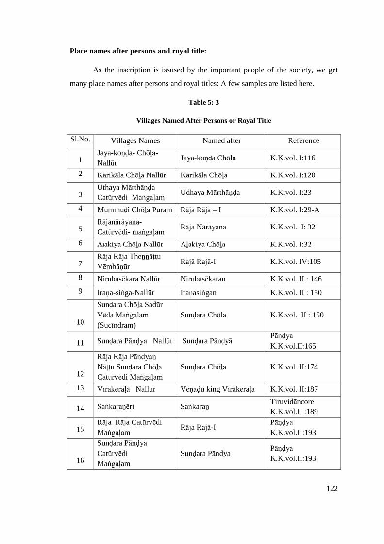
122
Place names after persons and royal title:
As the inscription is issused by the important people of the society, we get
many place names after persons and royal titles: A few samples are listed here.
Table 5: 3
Villages Named After Persons or Royal Title
Sl.No. Villages Names Named after Reference
1Jaya-koṇḍa- Chōḻa-
NallūrJaya-koṇḍa Chōḻa K.K.vol. I:116
2 Karikāla Chōḻa Nallūr Karikāla Chōḻa K.K.vol. I:120
3Uthaya Mārthāṇḍa
Catūrvēdi MaṅgaḷamUdhaya Mārthāṇḍa K.K.vol. I:23
4 Mummuḍi Chōḻa Puram Rāja Rāja – I K.K.vol. I:29-A
5Rājanārāyana-
Catūrvēdi- maṅgaḷamRāja Nārāyana K.K.vol. I: 32
6 Aḻakiya Chōḻa Nallūr Aḻakiya Chōḻa K.K.vol. I:32
7Rāja Rāja Theṉṉāṭṭu
VēmbāṇūrRajā Rajā-I K.K.vol. IV:105
8 Nirubasēkara Nallūr Nirubasēkaran K.K.vol. II : 146
9 Iraṇa-siṅga-Nallūr Iraṇasiṅgan K.K.vol. II : 150
10
Sunḍara Chōḻa Sadūr
Vēda Maṅgaḷam
(Sucīndram)
Sunḍara Chōḻa K.K.vol. II : 150
11 Sunḍara Pāṇḍya Nallūr Sunḍara PānḍyāPāṇḍya
K.K.vol.II:165
12
Rāja Rāja Pāṇḍyaṉ
Nāṭṭu Sunḍara Chōḻa
Catūrvēdi Maṅgaḷam
Sunḍara Chōḻa K.K.vol. II:174
13 Vīrakēraḷa Nallūr Vēṇāḍu king Vīrakēraḷa K.K.vol. II:187
14 Saṅkaraṉēri SaṅkaraṉTiruvidāncore
K.K.vol.II :189
15Rāja Rāja Catūrvēdi
MaṅgaḷamRāja Rajā-I
Pāṇḍya
K.K.vol.II:193
16
Sunḍara Pāṇḍya
Catūrvēdi
Maṅgaḷam
Sunḍara PāndyaPāṇḍya
K.K.vol.II:193
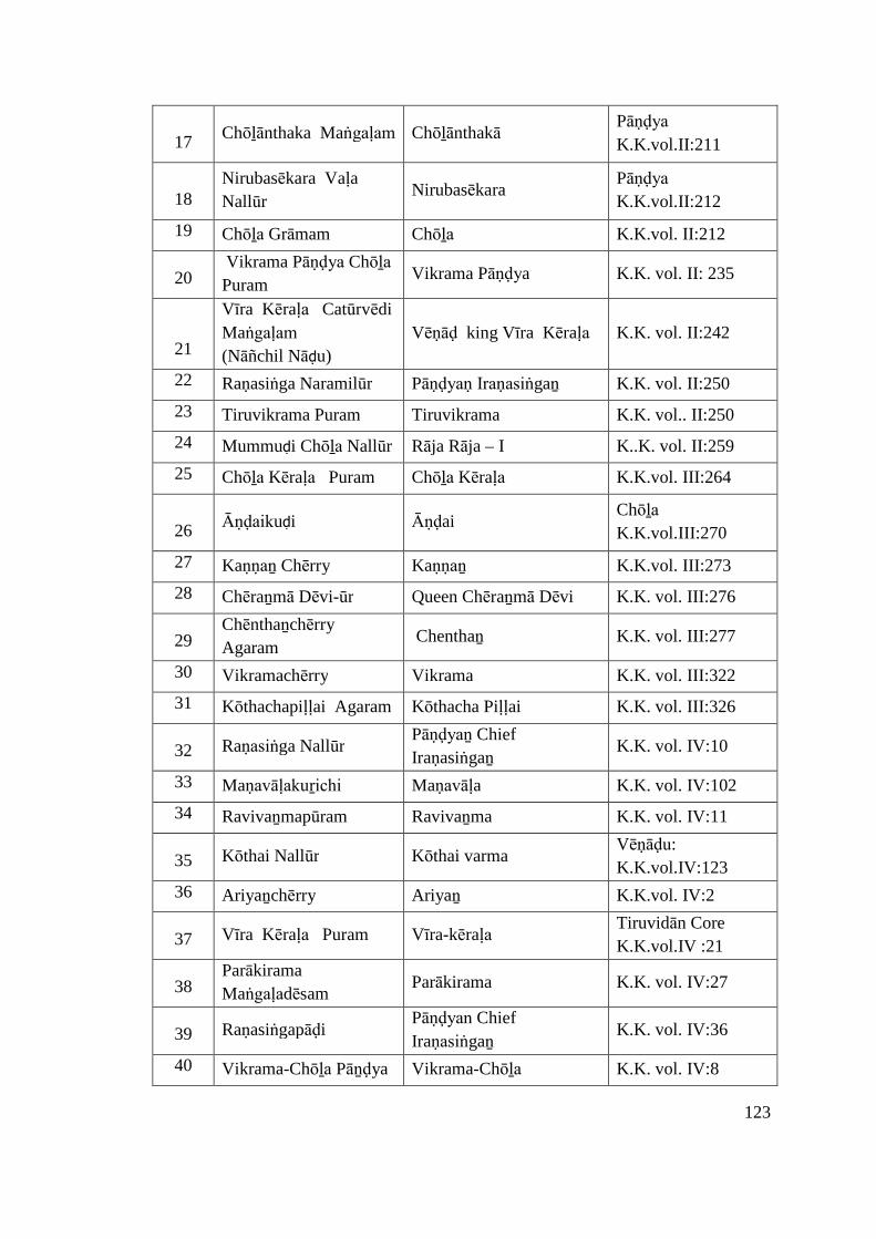
123
17Chōḻānthaka Maṅgaḷam Chōḻānthakā
Pāṇḍya
K.K.vol.II:211
18Nirubasēkara Vaḷa
NallūrNirubasēkara
Pāṇḍya
K.K.vol.II:212
19 Chōḻa Grāmam Chōḻa K.K.vol. II:212
20Vikrama Pāṇḍya Chōḻa
PuramVikrama Pāṇḍya K.K. vol. II: 235
21
Vīra Kēraḷa Catūrvēdi
Maṅgaḷam
(Nāñchil Nāḍu)
Vēṇāḍ king Vīra Kēraḷa K.K. vol. II:242
22 Raṇasiṅga Naramilūr Pāṇḍyaṇ Iraṇasiṅgaṉ K.K. vol. II:250
23 Tiruvikrama Puram Tiruvikrama K.K. vol.. II:250
24 Mummuḍi Chōḻa Nallūr Rāja Rāja – I K..K. vol. II:259
25 Chōḻa Kēraḷa Puram Chōḻa Kēraḷa K.K.vol. III:264
26Āṇḍaikuḍi Āṇḍai
Chōḻa
K.K.vol.III:270
27 Kaṇṇaṉ Chērry Kaṇṇaṉ K.K.vol. III:273
28 Chēraṉmā Dēvi-ūr Queen Chēraṉmā Dēvi K.K. vol. III:276
29Chēnthaṉchērry
AgaramChenthaṉ K.K. vol. III:277
30 Vikramachērry Vikrama K.K. vol. III:322
31 Kōthachapiḷḷai Agaram Kōthacha Piḷḷai K.K. vol. III:326
32 Raṇasiṅga NallūrPāṇḍyaṉ Chief
IraṇasiṅgaṉK.K. vol. IV:10
33 Maṇavāḷakuṟichi Maṇavāḷa K.K. vol. IV:102
34 Ravivaṉmapūram Ravivaṉma K.K. vol. IV:11
35 Kōthai Nallūr Kōthai varmaVēṇāḍu:
K.K.vol.IV:123
36 Ariyaṉchērry Ariyaṉ K.K.vol. IV:2
37 Vīra Kēraḷa Puram Vīra-kēraḷa Tiruvidān Core
K.K.vol.IV :21
38Parākirama
MaṅgaḷadēsamParākirama K.K. vol. IV:27
39 RaṇasiṅgapāḍiPāṇḍyan Chief
IraṇasiṅgaṉK.K. vol. IV:36
40 Vikrama-Chōḻa Pāṉḍya Vikrama-Chōḻa K.K. vol. IV:8
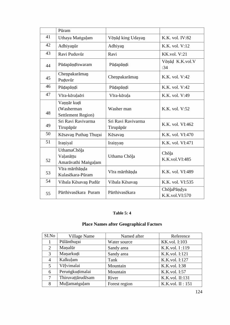
124
Pūram
41 Uthaya Maṅgaḷam Vēṇāḍ king Udayaṉ K.K. vol. IV:82
42 Adhiyaṉūr Adhiyaṉ K.K. vol. V:12
43 Ravi Puduvūr Ravi KK.vol. V:21
44 Pūdapāṇḍīswaram PūḍapāṇḍiVēṇāḍ K.K.vol.V
:34
45Cheṇpakarāmaṉ
PuḍuvūrCheṇpakarāmaṉ K.K. vol. V:42
46 Pūḍapāṇḍi Pūḍapāṇḍi K.K. vol. V:42
47 Vīra-kēraḷaēri Vīra-kēraḷa K.K. vol. V:49
48
Vaṇṇār kuḍi
(Washerman
Settlement Region)
Washer man K.K. vol. V:52
49Sri Ravi Ravivarma
Tirupāpūr
Sri Ravi Ravivarma
TirupāpūrK.K. vol. VI:462
50 Kēsavaṉ Puthaṉ Thuṟai Kēsavaṉ K.K. vol. VI:470
51 Iraṇiyal Iraiṇyaṇ K.K. vol. VI:471
52
UthamaChōḻa
Vaḷanāṭṭu
Amarāvathi Maṅgaḷam
Uthama ChōḻaChōḻa
K.K.vol.VI:485
53Vīra mārthāṇḍa
Kulasēkara-PūramVīra mārthāṇḍa K.K. vol. VI:489
54 Vibala Kēsavaṉ Pudūr Vibala Kēsavaṉ K.K. vol. VI:535
55 Pārthivasēkara Puram PārthivasēkaraChōḻaPāṇḍya
K.K.vol.VI:570
Table 5: 4
Place Names after Geographical Factors
SI.No Village Name Named after Reference1 Pūlānthuṟai Water source KK.vol. I:103
2 Maṇalūr Sandy area K.K.vol. I :119
3 Maṇarkuḍi Sandy area K.K.vol. I:121
4 Kalkuḷam Tank K.K.vol. I:127
5 Vēḷvimalai Mountain K.K.vol. I:38
6 Peruṅgkuḍimalai Mountain K.K.vol. I:57
7 Thiruvaṭṭārudēsam River K.K.vol. II:131
8 Muḷḷamaṅgaḷam Forest region K.K.vol. II : 151
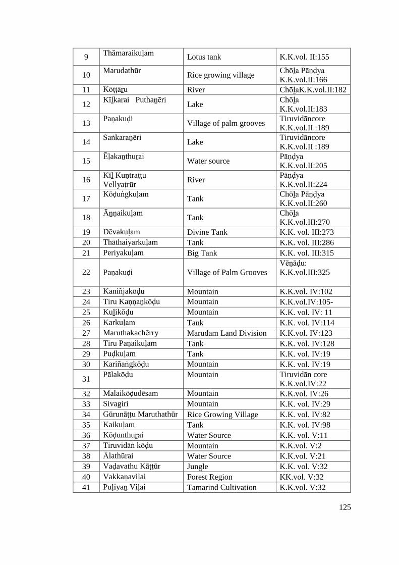
125
9 Thāmaraikuḷam Lotus tank K.K.vol. II:155
10Marudathūr
Rice growing villageChōḻa Pāṇḍya K.K.vol.II:166
11 Kōṭṭāṟu River ChōḻaK.K.vol.II:182
12Kīḻkarai Puthaṉēri
LakeChōḻa K.K.vol.II:183
13Paṇakuḍi
Village of palm groovesTiruvidāncoreK.K.vol.II :189
14Saṅkaraṉēri
LakeTiruvidāncoreK.K.vol.II :189
15Ēḷakaṉthuṟai
Water sourcePāṇḍya K.K.vol.II:205
16Kīḻ KuṇtraṭṭuVellyaṭrūr
RiverPāṇḍya K.K.vol.II:224
17Kōḍuṅgkuḷam
TankChōḻa Pāṇḍya K.K.vol.II:260
18Āṉṇaikuḷam
TankChōḻa K.K.vol.III:270
19 Dēvakuḷam Divine Tank K.K. vol. III:273
20 Thāthaiyarkuḷam Tank K.K. vol. III:286
21 Periyakuḷam Big Tank K.K. vol. III:315
22 Paṇakuḍi Village of Palm GroovesVēṇāḍu:K.K.vol.III:325
23 Kaniñjakōḍu Mountain K.K.vol. IV:102
24 Tiru Kaṇṇaṉkōḍu Mountain K.K.vol.IV:105-
25 Kuḻikōḍu Mountain K.K. vol. IV: 11
26 Karkuḷam Tank K.K. vol. IV:114
27 Maruthakachērry Marudam Land Division K.K.vol. IV:123
28 Tiru Paṇaikuḷam Tank K.K. vol. IV:128
29 Puḍkuḷam Tank K.K. vol. IV:19
30 Kariñaṅgkōḍu Mountain K.K. vol. IV:19
31Pālakōḍu Mountain Tiruvidān core
K.K.vol.IV:2232 Malaikōḍudēsam Mountain K.K.vol. IV:26
33 Sivagiri Mountain K.K. vol. IV:29
34 Gūrunāṭṭu Maruthathūr Rice Growing Village K.K. vol. IV:82
35 Kaikuḷam Tank K.K. vol. IV:98
36 Kōḍunthuṟai Water Source K.K. vol. V:11
37 Tiruvidāṅ kōḍu Mountain K.K.vol. V:2
38 Ālathūrai Water Source K.K.vol. V:21
39 Vaḍavathu Kāṭṭūr Jungle K.K. vol. V:32
40 Vakkaṇaviḷai Forest Region KK.vol. V:32
41 Puḷiyaṉ Viḷai Tamarind Cultivation K.K.vol. V:32
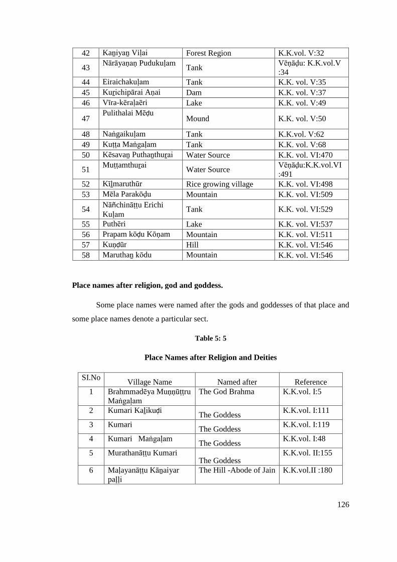
126
42 Kaṉiyaṉ Viḷai Forest Region K.K.vol. V:32
43Nārāyaṇaṇ Pudukuḷam
TankVēṇāḍu: K.K.vol.V:34
44 Eiraichakuḷam Tank K.K. vol. V:35
45 Kuṟichipārai Aṇai Dam K.K. vol. V:37
46 Vīra-kēraḷaēri Lake K.K. vol. V:49
47Pulithalai Mēḍu
Mound K.K. vol. V:50
48 Naṅgaikuḷam Tank K.K.vol. V:62
49 Kuṭṭa Maṅgaḷam Tank K.K. vol. V:68
50 Kēsavaṉ Puthaṉthuṟai Water Source K.K. vol. VI:470
51Muṭṭamthuṟai
Water SourceVēṇāḍu:K.K.vol.VI:491
52 Kīḻmaruthūr Rice growing village K.K. vol. VI:498
53 Mēla Parakōḍu Mountain K.K. vol. VI:509
54Nāñchināṭṭu ErichiKuḷam
Tank K.K. vol. VI:529
55 Puthēri Lake K.K. vol. VI:537
56 Prapam kōḍu Kōṇam Mountain K.K. vol. VI:511
57 Kuṇḍūr Hill K.K. vol. VI:546
58 Maruthaṉ kōdu Mountain K.K. vol. VI:546
Place names after religion, god and goddess.
Some place names were named after the gods and goddesses of that place and
some place names denote a particular sect.
Table 5: 5
Place Names after Religion and Deities
SI.NoVillage Name Named after Reference
1 Brahmmadēya MuṇṇūṭṭruMaṅgaḷam
The God Brahma K.K.vol. I:5
2 Kumari KaḻikuḍiThe Goddess
K.K.vol. I:111
3 KumariThe Goddess
K.K.vol. I:119
4 Kumari MaṅgaḷamThe Goddess
K.K.vol. I:48
5 Murathanāṭṭu KumariThe Goddess
K.K.vol. II:155
6 Maḷayanāṭṭu Kāṉaiyarpaḷḷi
The Hill -Abode of Jain K.K.vol.II :180
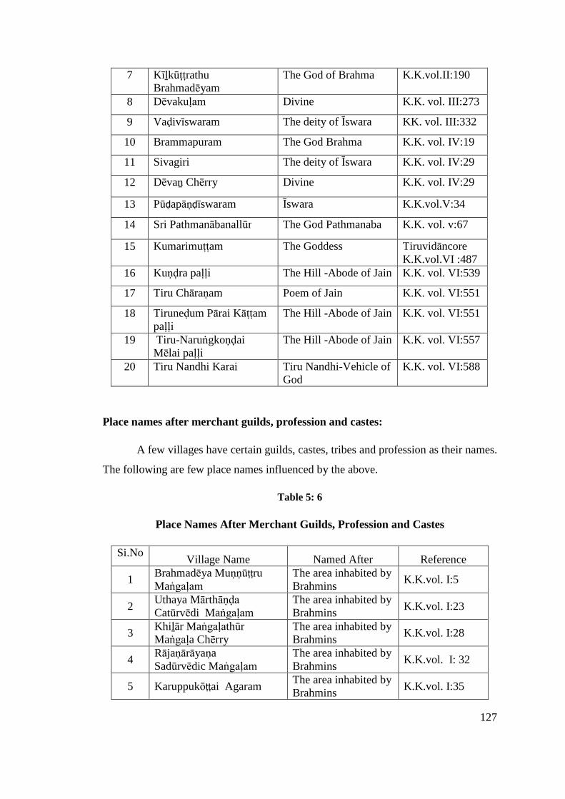
127
7 KīḻkūṭṭrathuBrahmadēyam
The God of Brahma K.K.vol.II:190
8 Dēvakuḷam Divine K.K. vol. III:273
9 Vaḍivīswaram The deity of Īswara KK. vol. III:332
10 Brammapuram The God Brahma K.K. vol. IV:19
11 Sivagiri The deity of Īswara K.K. vol. IV:29
12 Dēvaṉ Chērry Divine K.K. vol. IV:29
13 Pūḍapāṇḍīswaram Īswara K.K.vol.V:34
14 Sri Pathmanābanallūr The God Pathmanaba K.K. vol. v:67
15 Kumarimuṭṭam The Goddess TiruvidāncoreK.K.vol.VI :487
16 Kuṇḍra paḷḷi The Hill -Abode of Jain K.K. vol. VI:539
17 Tiru Chāraṇam Poem of Jain K.K. vol. VI:551
18 Tiruneḍum Pārai Kāṭṭampaḷḷi
The Hill -Abode of Jain K.K. vol. VI:551
19 Tiru-NaruṅgkoṇḍaiMēlai paḷḷi
The Hill -Abode of Jain K.K. vol. VI:557
20 Tiru Nandhi Karai Tiru Nandhi-Vehicle ofGod
K.K. vol. VI:588
Place names after merchant guilds, profession and castes:
A few villages have certain guilds, castes, tribes and profession as their names.
The following are few place names influenced by the above.
Table 5: 6
Place Names After Merchant Guilds, Profession and Castes
Si.NoVillage Name Named After Reference
1Brahmadēya MuṇṇūṭṭruMaṅgaḷam
The area inhabited byBrahmins
K.K.vol. I:5
2Uthaya Mārthāṇḍa Catūrvēdi Maṅgaḷam
The area inhabited byBrahmins
K.K.vol. I:23
3Khiḻār MaṅgaḷathūrMaṅgaḷa Chērry
The area inhabited byBrahmins
K.K.vol. I:28
4RājaṇārāyaṇaSadūrvēdic Maṅgaḷam
The area inhabited byBrahmins
K.K.vol. I: 32
5 Karuppukōṭṭai AgaramThe area inhabited byBrahmins
K.K.vol. I:35
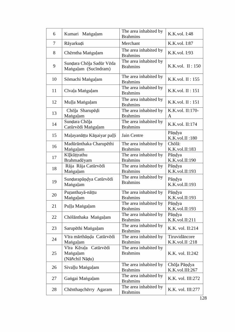
128
6 Kumari MaṅgaḷamThe area inhabited byBrahmins
K.K.vol. I:48
7 Rāyarkuḍi Merchant K.K.vol. I:87
8 Chērntha MaṅgaḷamThe area inhabited byBrahmins
K.K.vol. I:93
9Sunḍara Chōḻa Sadūr VēdaMaṅgaḷam (Sucīndram)
The area inhabited byBrahmins K.K.vol. II : 150
10 Sōmachi MaṅgaḷamThe area inhabited byBrahmins
K.K.vol. II : 155
11 Cīvaḷa MaṅgaḷamThe area inhabited byBrahmins K.K.vol. II : 151
12 Muḷḷa MaṅgaḷamThe area inhabited byBrahmins
K.K.vol. II : 151
13Chōḻa Sharupēḍi
MaṅgaḷamThe area inhabited byBrahmins
K.K.vol. II:170-A
14Sunḍara ChōḻaCatūrvēdi Maṅgaḷam
The area inhabited byBrahmins
K.K.vol. II:174
15 Maḷayanāṭṭu Kāṉaiyar paḷḷi Jain CentrePāṇḍya K.K.vol.II :180
16Madūrānthaka CharupēthiMaṅgaḷam
The area inhabited byBrahmins
Chōlā:K.K.vol.II:183
17KīḻkūṭṭrathuBrahmadēyam
The area inhabited byBrahmins
Pāṇḍya K.K.vol.II:190
18Rāja Rāja CatūrvēdiMaṅgaḷam
The area inhabited byBrahmins
Pāṇḍya K.K.vol.II:193
19Sunḍarapāṇḍya CatūrvēdiMaṅgaḷam
The area inhabited byBrahmins
Pāṇḍya K.K.vol.II:193
20Puṟanthayā-nāṭṭuMaṅgaḷam
The area inhabited byBrahmins
Pāṇḍya K.K.vol.II:193
21 Puḷḷa MaṅgaḷamThe area inhabited byBrahmins
Pāṇḍya K.K.vol.II:193
22 Chōlānthaka MaṅgaḷamThe area inhabited byBrahmins
Pāṇḍya K.K.vol.II:211
23 Sarupēthi MaṅgaḷamThe area inhabited byBrahmins
K.K. vol. II:214
24Vīra mārthāṇḍa CatūrvēdiMaṅgaḷam
The area inhabited byBrahmins
TiruvidāncoreK.K.vol.II :218
25Vīra Kēraḷa CatūrvēdiMaṅgaḷam(Nāñchil Nāḍu)
The area inhabited byBrahmins K.K. vol. II:242
26 Sivaḷḷu MaṅgaḷamThe area inhabited byBrahmins
Chōḻa Pāṇḍya K.K.vol.III:267
27 Gaṅgai MaṅgaḷamThe area inhabited byBrahmins
K.K. vol. III:272
28 Chēnthaṉchērry AgaramThe area inhabited byBrahmins
K.K. vol. III:277
129
29Chōḻa Kuḷathu VaḷḷipuramCatūrvēdi Maṅgaḷam
The area inhabited byBrahmins
K.K. vol. III:284
30 Kiḻār MaṅgaḷamThe area inhabited byBrahmins
K. K. vol.III:292
31 Sānthi MaṅgaḷamThe area inhabited byBrahmins
TIruvidancoreK.K.vol.III:298
32Pūravari CatūrvēdiMaṅgaḷam
The area inhabited byBrahmins
Vēṇāḍu: K.K.vol. III:306
33 Kōthacha Piḷḷai AgaramThe area inhabited byBrahmins
K.K. vol. III:326
34 MaruthakachērryThe area inhabited byBrahmins
K.K.vol. IV:123
35 BrammapuramThe area inhabited byBrahmins
K.K. vol. IV:19
36 AriyaṉchērryThe area inhabited byBrahmins
K.K.vol. IV:2
37 Parākirama MaṅgaḷadēsamThe area inhabited byBrahmins
K.K. vol. IV:27
38 Chēra MaṅgaḷamThe area inhabited byBrahmins
K.K. vol. IV:33
39 Kaḍiya PaṭṭaṇamCommercial and portcenter
K.K. vol. IV:37
40 Kaḍigai PaṭṭaṇamCommercials andPort Center
K.K. vol. IV:38
41 Pākka MaṅgaḷamThe area inhabited byBrahmins
K.K. vol. IV:38-F
42 Sri Nagaram Divine town K.K. vol. IV:8
43 Uthaya MaṅgaḷamThe area inhabited byBrahmins
K.K. vol. IV:82
44 Kuṭṭa Maṅgaḷam DēsamThe area inhabited byBrahmins
K.K .vol. IV:88
45 Kuṟichipārai Aṇai (Dam) Dam K.K. vol. V:37
46 Vīra-kēraḷaēri Lake K.K. vol. V:49
47Vaṇṇārkuḍi (WashermanSettlement Region)
Washer mancommunity
K.K. vol. V:52
48Gūrunāṭṭu KaikaṭṭiyaPaṭṭaṇam
Commercials andport center
K.K. vol. V:59
49 KuṭṭamaṅgaḷamThe area inhabited byBrahmins
K.K. vol. V:68
50 MaṅgaḷachērryThe area inhabited byBrahmins
K.K. vol. VI:465
51Tiruṇārāyaṇa CatūrvēdiMaṅgaḷam
The area inhabited byBrahmins
K.K. vol. VI:465
52Uthama Chōḻa VaḷanāṭṭuAmarāvathi Maṅgalam
The area inhabited byBrahmins
K.K.vol.VI:485
53 Sri Kalāchēya PaṭṭaṇamCommercials andport centre
K.K.vol. VI:501
130
54 Sātha MaṅgaḷamThe area inhabited byBrahmins
K.K.vol.VI :526
55 Puthēri Lake irrigation K.K.vol. VI:537
56 Chivaḷavaṇ MaṅgaḷamThe area inhabited byBrahmins
K.K.vol. VI:538
57 Kuṇḍra paḷḷi Jain Centre K.K.vol. VI:539
58 Tiru Chāraṇam Jain Centre K.K. vol. VI:551
59Tiruneḍum Pārai Kāṭṭampaḷḷi
Jain Centre K.K. vol. VI:551
60Tirunaruṅg koṇḍai mēlaipaḷḷi
Jain Centre K.K. vol. VI:557
61 Chithakūru MaṅgaḷamThe area inhabited byBrahmins
K.K. vol. VI:582
Suffix:
The suffixes of the place names usually refer to the type of settlements. Three
elements like ecological diversity, cultural perceptions, and dialectical wealth
interacting together produced a variety of place names. Obviously, the place names
reflect all the five components of the cultural geography, i.e., culture, cultural area,
cultural landscape, cultural history and cultural ecology.16 According to one of the
Saṅgam Classical works, social groups were divided into five situational types on the
basis of natural sub-region and related occupational patterns.
The Pattupāṭṭu enumerates these territorial segments (or tiṉai) as follows:
i) Maruṭa-makkaḷ or ploughmen (uḷavar) are the people inhabiting fertile zones.
ii) Kuṛavar-makkaḷ or hill people are foresters.
iii) Mullai-makkaḷ or pastoralists, also called āyar (cowman), kōvaḷar (sheperds),
and iḍaiyar (cowherd or shepherd).
iv) Neyta- makkaḷ or fishing community is the people living in large coastal villages
called paṭṭiṇam or small ones called pākkam.
16 R.Y.Singh, Geography of Settlements, Rawat publications, New Delhi, 1994, p.73.
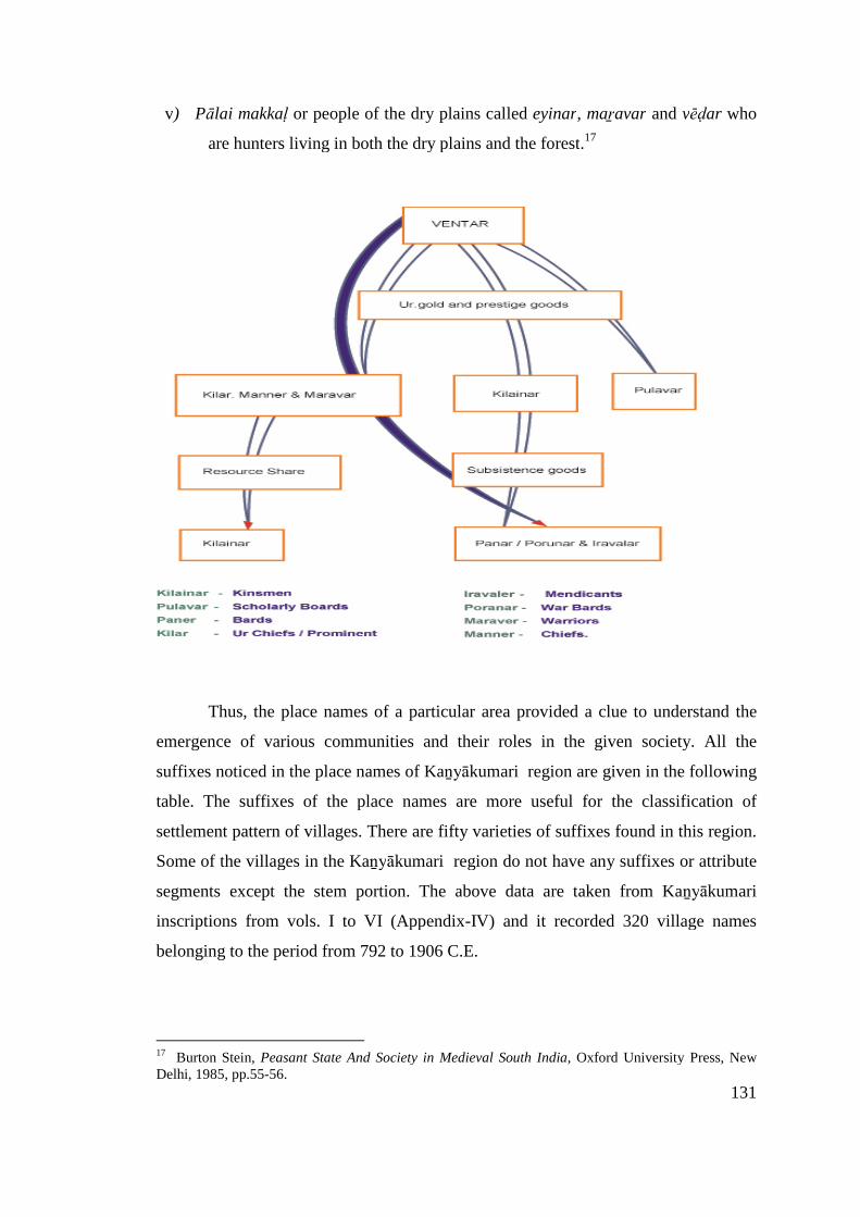
131
v) Pālai makkaḷ or people of the dry plains called eyinar, maṟavar and vēḍar who
are hunters living in both the dry plains and the forest.17
Thus, the place names of a particular area provided a clue to understand the
emergence of various communities and their roles in the given society. All the
suffixes noticed in the place names of Kaṉyākumari region are given in the following
table. The suffixes of the place names are more useful for the classification of
settlement pattern of villages. There are fifty varieties of suffixes found in this region.
Some of the villages in the Kaṉyākumari region do not have any suffixes or attribute
segments except the stem portion. The above data are taken from Kaṉyākumari
inscriptions from vols. I to VI (Appendix-IV) and it recorded 320 village names
belonging to the period from 792 to 1906 C.E.
17 Burton Stein, Peasant State And Society in Medieval South India, Oxford University Press, NewDelhi, 1985, pp.55-56.
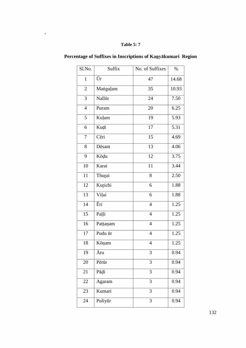
132
.
Table 5: 7
Percentage of Suffixes in Inscriptions of Kaṉyākumari Region
Sl.No. Suffix No. of Suffixes %
1 Ūr 47 14.68
2 Maṅgaḷam 35 10.93
3 Nallūr 24 7.50
4 Puram 20 6.25
5 Kuḷam 19 5.93
6 Kuḍi 17 5.31
7 Cēri 15 4.69
8 Dēsam 13 4.06
9 Kōḍu 12 3.75
10 Karai 11 3.44
11 Thuṟai 8 2.50
12 Kuṟichi 6 1.88
13 Viḷai 6 1.88
14 Ēri 4 1.25
15 Paḷḷi 4 1.25
16 Paṭṭaṇam 4 1.25
17 Pudu ūr 4 1.25
18 Kōṇam 4 1.25
19 Āru 3 0.94
20 Pērūr 3 0.94
21 Pāḍi 3 0.94
22 Agaram 3 0.94
23 Kumari 3 0.94
24 Puliyūr 3 0.94
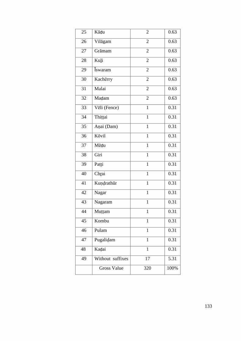
133
25 Kāḍu 2 0.63
26 Vilāgam 2 0.63
27 Grāmam 2 0.63
28 Kuḻi 2 0.63
29 Īswaram 2 0.63
30 Kachērry 2 0.63
31 Malai 2 0.63
32 Maḍam 2 0.63
33 Vēli (Fence) 1 0.31
34 Thiṭṭai 1 0.31
35 Aṇai (Dam) 1 0.31
36 Kōvil 1 0.31
37 Mēḍu 1 0.31
38 Giri 1 0.31
39 Paṭṭi 1 0.31
40 Chṟai 1 0.31
41 Kuṇḍrathūr 1 0.31
42 Nagar 1 0.31
43 Nagaram 1 0.31
44 Muṭṭam 1 0.31
45 Kombu 1 0.31
46 Pulam 1 0.31
47 Pugaliḍam 1 0.31
48 Kaḍai 1 0.31
49 Without suffixes 17 5.31
Gross Value 320 100%
134
Settlement (Geographical significance of the Suffix)
a) Ūr
The suffix ūr is the common suffix (for all types of settlements). Mostly these
are found to be very old agricultural settlements. As stated above the ūr generally
referred to settlement of marutham land.18 The marutam land is known for extensive
agricultural activities. It is generally believed that surplus production paved a way for
the creation of settlements, finally leading to an urban growth. The distinctive cultural
pattern is emerged well before the other ecosystems. Due to revenue; the rulers paid
greater attention to enhance the production and also they try to keep their tracts under
their control through various government machineries. The available inscriptions also
support that all types of religious and cultural activities are centred on these fertile
tracts.
Y.Subbarayalu demonstrated in his pioneering work on Political Geography of
the Chōḻa Country, that a village was located at a distance of every 2 miles in Kāvēri
delta.19 The Kāvēri delta is considered as a rice bowl of Tamiḻ Nāḍu and having a
village at a radius of two miles is not a surprise one. The density of the settlements
indirectly suggests that the village is supported the larger communities through its
resources mainly the water resources.
The village (ūr) generally represents a spatial distribution of the habitation and
the adjoining exploitable resources pertaining to the particular inhabitants. All the
human activities related to their political, administrative, social, cultural, economic,
and religious and many other such activities are interacted with this landscape. One
should not see the cultural items of a settlement as physical properties, but it is a
mental representation of the inhabitants. Thus, ūr is the basic unit of the human
geography and analysis of ūr could provide many dimensions of the society.
The suffix ūr finds in two contexts. In the first context, the ūr merely
represents a settlement. In the second context, it is a village assembly, an
administrative unit of the village.
18 R.P.Sethupillai, Tamiḷagam Ūrum Pērum, Pazhaniyappa Brothers, Chennai, 1968, p.29.19 C.Nilavathi, Tañjāvūr Vaṭṭāra Varalāṟṟu Nilaviyalum Samudāyamum (c.900-1400 CE), Ph.D.Thesis, Tamil University, Thanjavur, 2001, p.97.
135
From the eight and ninth centuries CE onwards, three types of village
assemblies are traceable in the inscriptions, namely the ūr, the sabhā, and the
nagaram. The ūr was the common assembly which included all classes of people who
held the land in the village. The sabhā was an exclusively Brahmin assembly of
villages given as gift to Brahmins where all the land belonged to them. The nagaram
was quite another type pertaining to localities where traders and merchants had a
dominant position.20
Place names ending with Ūr
Out of 320 villages, ūr suffix represents 14.68%, the highest percentage in
Kaṉyākumari region.
In Tamiḻ Nāḍu, and in major part of South India too, generally villages were
known by the term ūr. The ūr was enjoying just customary rights and privileges and
these villages were subject to normal governmental revenue assessment and were
known by the designation vēḷḷāṇvagai (literally the agricultural kind). A general
village, in the Chōḻa area, normally consists of habitation quarters, cremation grounds,
drinking water ponds, irrigation channels and cultivation lands, besides the pastures
and forest cover. The habitation quarters of the landholders /cultivators of the ūr
were sometimes denoted with the term ūr-irukkai.21
Pudūr (new habitation)
Pudūr was mostly referred to a new settlement and this term pudūr generally
appears in the inscriptions in the later part of the history. Therefore, this may be a new
settlement in which people of this place started to inhabit here.
Puliyūr
Villages having the attribute puli are found in Agastīswaram taluk and other
villages like Tirupāpuliyūr and Perumpaṭṭrapuliyūr in Kalkuḷam taluk of this district.
20 K.A. Nilakanta Sastri, A History Of South India – From Pre historic Times to the Fall ofVijayanagar, Oxford University Press, New Delhi, 1975, p. 149.21 Y.Subbarayalu, South India Under the Cholas, Oxford University Press, New Delhi, 2012, pp.124-25.

136
The literal meaning of the puliyūr is a tiger village (puli > tiger). Whether it indicates
the ancient eco-system or something else yet to be assessed.22
Kuṇḍrathūr
Kuṇḍru refers to the hills. Villages situated adjacent to the hills or at the
foothills are referred to as Kuṇḍrathūr.23
Pērūr
The attribute pēr is found in association with the place name suffix ūr. Pērūr
stands for a big village (per>big; ūr>village). Such big settlements are noticed in the
study areas. The two adjoining villages or part of the settlement are represented with
additional attribute like kīḻ/kīḻam meaning east/down. For example, Pērūr and
Kiḻampērūr in Kalkuḷam taluk and Kiḻpērūr in Agastīswaram talk could be cited.
Ūr is also called as grāmam, a Sanskrit version, basically representing a small
settlement and its associated agricultural field containg paddy cultivation.24
Maṅgaḷam
Brahmin villages of this period were referred to by a variety of terms like
brahmadēyam, catūrvēdimaṅgaḷam, maṅgaḷam, agaram, agrahāram, agra-
brahmadēya, agra-brahmadēsa, brahmadēsam, brahmapuri and brahma-
maṅgaḷam.25
Suffixes like maṅgaḷam and nallūr denote the settlements of Brahmins and the
villages connected with the temples respectively. There are several such instances like
Brahmadēya Muṇṇūṭru maṅgaḷam, Uthayamārthāṇḍa cadurvēdimaṅgaḷam,
Rājaṇārāyaṇa maṅgaḷam, Kumari maṅgaḷam, etc., referred to in the medieval
inscriptions.26
22 R.P.Sethupillai, Tamiḻagam Ūrum Pērum, Pazhaniyappa Brothers, Chennai,1968, p.29.23 Karu.Nagarajan, Cheṅgai Māvaṭṭa Ūrpeyargaḷ, International Institute of Tamil Studies, Madras,1985, p.144.24 C. Govindarajan, Kalveṭṭu Kalaichol Agaramudali , (From A.D. 7th century to 12th century), MaduraiKamaraj University, Madurai, 1987, p.135.25 Burton Stein, Peasant State and Society in Medieval South India, Oxford University Press, NewDelhi, 1985, p.145.26 Burton Stein, Peasant State And Society in Medieval South India, Oxford University Press, NewDelhi, 1985,, p.153.
137
Nallūr
The village having suffix called Nallūr were gifted to the temple and in the
case of Kaṉyākumari region, mostly these lands were gifted to the Siva temple. These
villages were also known as dēvadāṉa villages. The village names like Jayakoṇḍa
Chōḻa Nallūr, Nirubasēkara Nallūr, Iraṇasiṅganallūr and so on could be cited as an
example.27 The brahmin settlement brahmadēya and temple village nallūr generally
found in a fertile zone.
Cēri or Chērry
The suffix cēri represents of 4.69 percentages in Kaṉyākumari inscriptions.
Generally cēri means the suburb of a town or a village.28 In other words, a group of
working class/service class/ professional class living together in a particular area is
also known as cēri. The settlement where paḷḷars lived together was called as paḷḷa-
cēri, the settlement where paṟaiyar lived together was called as paṟai-cēri, the
settlement where āyar lived together was called as āyar-cēri, the settlement where
the brahmin lived was called as pārppaṉ-cēri. Inscriptions noticed with the suffix cēri
are Kīḻār Maṅgaḷathu Maṅgaḷacēri, Kīḻceri, Kēraḷacēri, Kaṇṇaṇcēri, etc.29
Dēsam
The villages ending with the suffix dēsam represent 4.06 percentages in
Kaṉyākumari inscription. It is noted that dēsam is a settlement unit or a territory
comprissing of different clans.30 The places ending with dēsam in Kaṉyākumari
region are Tiruvaṭṭāru dēsam, Nayinār dēsam, Akkarai dēsam, etc. In general, the
dēya is the corrupt form of dēsam denoting an area and in some occasions it denotes
Brahmin settlement.
27 Y. Subbarayalu, Political Geography of the Chola Country, The State Department of Archaeology,Government of Tamilnadu, Chennai, 1973, p.90.28 N. Subramaniyan, Sangam Polity-Administration and Social Life of the Tamils, Ennes Publication,Madurai, 1980, p.121.29 R.P.Sethupillai, Tamiḻagam Ūrum Pērum , Pazhaniyappa Brothers, Chennai, 1968, p.61.30A.P. Greeshmalatha, Historical Geography of Valluvanād, Ph.D. Thesis, Calicut University, Calicut,2008, p.62.

138
Agaram (Brahmin village)
The suffix Agaram stands for the tax free land/settlements allotted to
brahmins.31 In general, the Vedic brahmins were the residents of such villages.
Therefore, agaram is otherwise called as pārpaṉachērry (settlement of brahmins).
The following villages are found with the suffix agaram. They are Karuppukōṭṭai
agaram, Chēnthaṉchērry agaram and Kōthachapiḷḷai agaram. It is found in
Agastīswaram taluk of Kaṉyākumari district.32
Puram
The commercial centres were called by different names which had the suffix
of puram, pēṭṭai, paṭṭaṇam, kaḍai and pāḷayam. Puram ending villages represents
nearly 6.25 percentages. Mummuḍi Chōḻapuram, Karavanthapuram,
Chōḻakulavaḷḷipuram, etc. could be cited as an example.
Kachērry
The word kachērry is found in association with place names in town or uban
centres. Inscription mentions Arippukkilai kachērry and Marutha kachērry.33
Kachērry probably means a court or administrative office.
Nagar/Nagaram
Nagar probably refers to an urbanized area. Poḻigainagar is one which is found
in Agastīswaram taluk. The suffix nagaram generally stands for a city and the
administration was generally controlled by an assembly of mercantile community.
Initially, these nagarams were confined to the management of merchants, trade and
trade related works and their jurisdiction was extended to the associated agricultural
lands too indicating that the distinction between urban and rural was quite nebulous
during the medieval period. For examble, Sri Nagaram at Kalkuḷam taluk could be
31 Tamil Lexicon, University of Madras, vol.I, Madras, 1982, p.4.32 C. Govindarajan, Kalveṭṭu Kalaichol Agaramudali (From A.D. 7TH century to 12th century), MaduraiKamaraj University, Madurai, 1987, p.385.33 R.Nagasamy, Kaṉyākumari Kalvṭṭukkal, vol.IV, Tamil Nadu State Department of Archaeology,Chennai,1979, No; 1969/123.
139
cited.34 Likewise, the suffix kaḍai means shop/trading area. For example Pudukaḍai
could be cited.
Kuḷam
The major irrigation work in this area is the Kōthayār irrigation project under
which the waters of Kōthayār and the Paṟaḷayār (which combined to form
Kuḻithuṟaiyār) and the Paḻayār are harnessed and used for irrigation purposes. Though
there are many kinds of irrigation systems prevailing in this district, tank irrigation is
the principal source of irrigation. The percentage of net area irrigated from tanks was
5.46 percent. Lake and tank irrigation played a vital role in agricultural
development.35 Naturally, there are several village names ending with the suffix kuḷam
denoting a tank or water reservoir. There are nineteen villages ended with the suffix
kuḷam in this region. For example, Kalkuḷam, Thāmaraikuḷam, Thalaikuḷam, etc.,
could be cited.
Karai
The suffix Karai referred 3.44 percentages of villages in Kaṉyākumari district
inscriptions. The villages ending with the suffix karai mostly located on the river
banks or coastal regions. The villages Vaikaikarai, Vaḍakarai, Paravaikarai,
Aruvikarai, etc., could be cited as an example.
Thuṟai
Thuṟai means seaport, harbour and bathing ghat.36 Nearly 2.50 percentages of
villages with the suffix thuṟai is found in Kaṉyākumari region. In Tamiḻ Nāḍu, the
ancient ports are generally located at the mouth of the major rivers or estuaries.37
There are two terms, namely muṉthuṟai and perunthuṟai. The major ancient port
towns like Koṟkai and Kāvēripaṭṭiṉam are represented with these terms as koṟkai-
muṉthuṟai, koṟkai-perunthuṟai, puhār-muṉthuṟai and puhār-perunthuṟai. The ancient
name of the famous ancient port Arikamēḍu is Vīrai-muṉthuṟai. Besides, the interior
34 Gurcharan Das, The Story of Indian Business, Merchants of Tamilakam, Penguin books, New Delhi,2012, p.7335 M. Gobalakrishnan(Ed), Gazetteers of Kanyakumari District, Government of Tamilnadu,Commissioner of Archives and Historical Research, Chennai, 1995, p.292.36Tamil Lexicon, vol.IV; Part.I; University of Madras, Madras, 1982, p.2005.37 R.P.Sethupillai, Tamilagam ūrum pērum , Pazhaniyappa Brothers, Chennai, 1968, p.32
140
towns located on the banks of major rivers also had the term thuṟai, probably
indicating the bathing ghat. In Kaṉyākumari region, there are several villages like
Pulāṉthuṟai, Alathuṟai, Muṭṭamthuṟai, etc., ending with this term representing both
fishing harbour and bathing ghat.
Paṭṭaṇam
Neytal makkaḷ (littoral people) or fishing community living in large coastal
villages generally called paṭṭaṇam/paṭṭiṇam. It also stands for port. The small fishing
villages are called as pākkam.38 The village/towns with suffixes such as nagaram,
puram, paṭṭaṇam or paṭṭiṇam were attained in recognition of their commercial
activities where one could see the multiethnic groups with more diverse population.
The growth of such commercial towns is generally witnessed in the 12th century CE.
In most settlements of that time, peasants, merchants and artisans along with others
lived in close association, sharing not only interdependent economic relationship, but
also a common involvement in the cultural life of the locality.39 The Kaṉyākumari
inscriptions expressed such settlements like Kaḍiyapaṭṭaṇam, Kaḍigaipaṭṭaṇam and
Srikalacheya paṭṭaṇam in Kalkuḷam taluk and Kaikaṭṭiyapaṭṭaṇam in Thōvāḷai taluk.
Ēri
The village names like Kīḻkaraiputhaṉēri, Saṅkaraēri, Vīra kēralaēri and
Puthēri mentioned in the inscriptions have the suffix ēri and it represents nearly 1.44
percentages. The term ēri stands for lake.
Āru
During the ancient period, many best village settlements, urban centres, ports
and commercial centres are located mostly on the river banks. A proverb said, ‘Not a
beauty without river in a village’.40 Kaṉyākumari district is predominantly an
agricultural area depending mainly on both the northeast and southwest monsoon. It
receives a fairly good rainfall in both the seasons. The major river Tāmbaraparaṇi
38 Burton Stein, Peasant State And Society in Medieval South India, Oxford University Press, NewDelhi, 1985,, p.56.39Burton Stein, Peasant State And Society in Medieval South India, Oxford University Press, NewDelhi, 1985, p.242.40 R.P.Sethupillai, Tamiḻagam Ūrum Pērum , Pazhaniyappa brothers, Chennai, 1968, p.14.
141
otherwise known as Kuḻithuṟai has got two major tributaries namely Kōḍayār river
and Paṟaḷayār river. There are many tributaries to Kōdayār of which Chittār-I and
Chittār-II are the major tributaries. The origin of the main river Tāmbaraparaṇi is
Western Ghats and the river flows within Kaṉyākumari district for a length of 59.2
km and confluences with the Arabian Sea near Thēṅgāpaṭṭaṇam which leis at a
distance of 56 km west of Cape Comorin, the southern most tip of India.41 The
commercial towns like puram, tenure settlements like brahmadēyam, temple towns
like nallūr and port towns like paṭṭaṇam were generally located on the banks of major
rivers or at the mouth of the rivers.
Aṇai
The term aṇai found their place in late medieval inscriptions. Aṇai (dam) is a
structure raised across the river to store the water for agricultural activities. Instead of
blocking the river flow, the ancient people attempted to regulate the water. The total
water flow of a particular river is not stored, rather they controlled a limited quantity
of water, thereby the excess water drained out through weirs. Thus, the occurrence of
the term aṇai in association with a particular place must be understood in this
background. These dams were built at higher points of the river so that the stored
water could be fully utilized through gravitational flow. In inscriptions, one could get
the place names like Kuṟichipārai-aṇai (dam). At present, there are six dams
constructed in the district. The Pāṇḍiaṇ-dam and Puthaṉ-dam were seen built across
Paṟaḷayār. Pēchippārai dam was constructed across Kōḍayār river in 1906 by then
king of Travancore State. Peruñchāṇi dam was constructed in the upstream of in
Paṟaḷayār river in 1953 to store flood water.
Chittār dam-1 has its source in Iḷamala reserve forest near Eṭṭukāṇi and
Vaṇḍipulavukāṇi at an elevation of 2000 ft above mean sea level and is at about 1.61
km in length.42
41M. Gobalakrishnan(Ed), Gazetteers of Kanyakumari District, Government of Tamilnadu,Commissioner of Archives and Historical Research, Chennai, 1995, p.294.42 M. Gobalakrishnan(Ed), Gazetteers of Kanyakumari District, Government of Tamilnadu,Commissioner of Archives and Historical Research, Chennai, 1995, pp.296-300.

142
Kuḍi
The term kuḍi is considered as one of the earliest settlements of a region.
However, this term also denotes the family, clan, lineage, etc. Therefore, the
settlements having the suffix kuḍi could be considered as a settlement of people
consist of blood related kin groups.43
Interestingly, it is noted that there are nearly 17 inscriptions mentioning the
village with the term kuḍi as a suffix. During Sangam Age, the four kinds of land and
four types of settlement pattern were identified. Of them, the term nāḍu is generally
associated with the settlements of Mullai (pastoral tract) and Kuṛiñji (hilly tract), Ūr
referred to Marutham, Chērppu indicates habitations in Neythal land. It is suggested
that kuḍi is the basic unit for all these settlements and these kuḍi(s) later gradually
developed as Ūr, Nāḍu and Chērppu.44 The village names like Kumari Kaḻikuḍi,
Maṇakuḍi, Thāḻaikuḍi, etc. found in the inscription probably refers to the old
settlements. The occurrence of Iron Age urn burials also indicates its antiquity.
Kōḍu
According to Tamiḻ lexicon, the term kōḍu refers to the peak/ mountain, high
ground or an elevated region.45 In Kaṉyākumari region, the suffix kōḍu ending place
names are located near hillocks and mountains of Kalkuḷam and Viḷavaṅkōḍu taluk.
The place names like Tirukaṇṇaṉ kōḍu, Kañjaṅkōḍu, Kuḻikōḍu, Karinaṅkōḍu, etc.,
could be cited as fine examples. Likewise, the term kōṇam found in association with
village names like Charaikōṇam, Alivankōḍu koṇam, Kōṇam and
Parapamkōḍukōṇam also stands for peak/elevated region.
Kuṟichi
The suffix kuṟichi and viḷai in village names represent 1.72 percentages in this
district. According to early Tamiḻ tradition kuṟichi is a settlement in the mountain
region. This term represents the hilly tracts.46 Sethupillai considers, kuṟichi is the
43 R.P.Sethupillai, Tamiḻagam Ūrum Pērum , Pazhaniyappa Brothers, Chennai, 1968, p.60.44 Direct interview from R.Pungundran, Date 24.7.2011.45 Tamil Lexicon, vol.II; Part.I; University of Madras, Madras, 1982, p.1180.46 K.P.Rajesh, Historical Geography of Kolathunāḍu-A Study of Regional Formation in MedievalNorth Kerala, Ph.D. Thesis, University of Calicut, Calicut, 2011, p.337.
143
earliest settlement of the kuṟavar community. Kuṟichi is a hamlet consist of a
homogenous community located on the elevated area.47 But in later period, different
communities also intruded in these settlements.48 The places like Madilkuṟichi and
Pūlāṅkuṟichi in Agastīswaram taluk and Maṇavālakuṟichi, Maṇṇaikuṟichi and
Muthalakuṟichi in Kalkuḷam taluk of Kaṉyākumari district are noted in the
inscriptions. Malai also denotes hillock/mountain. The place names like Vēḷvimalai
and Peruṅkuḍimalai are referred in this district. Like kuṟichi, mēḍu als stands for a
elevated area. Inscription records place like Pulithalaimēḍu.49 Another Sanskrit giri
denotes a hill or mountain. It also refers to Vaishnavite temple.50
Kāḍu
This term stands for wilderness/ jungle /forest land/pastoral tract.
Kumaranallūr māṅkāḍu and Vaḍvathu kāṭṭūr are some of the settlements found in the
inscriptions.
Pāḍi
The suffix pāḍi ending place names stands for the settlement of pastoral
communities like āyar (cowmen), kōvaḷar (shepherds) and iḍaiyar (cowherd or
shepherd)51 living in a mullai tracts.52 The place names like Raṇasiṅgapāḍi, Vēmpāḍi
and Thiruvaipāḍi located in Kalkuḷam taluk of Kaṉyākumari region are referred to in
the medieval inscriptions.
Paṭṭi
The suffix paṭṭi ending place name refers to small villages. The term paṭṭi
stands for cattle pen. It seems the people in the pastoral track created cattle pens. The
Neolithic ash mounds could be cited as the finest examples of this type of settlements.
47 C.D. Maclean (ed.), Maclean’s Manual of the administration of the Madras Presidency, Vol.II;Asian Education Service, New Delhi, 1989, p.218.48R.P.Sethupillai, Tamiḻagam Ūrum Pērum , Pazhaniyappa brothers, Chennai, 1968, p.6.49Karu.Nagarajan, Cheṅgai Māvaṭṭa Ūrpeyarkaḷ, International Institute of Tamil Studies, Madras,1985, p. 131.50 Karu.Nagarajan, Cheṅgai Māvaṭṭa Ūrpeyaragaḷ, International Institute of Tamil Studies, Madras,1985, p. 138.51 Burton Stein, Peasant State And Society in Medieval South India, Oxford University Press, NewDelhi, 1985, p.56.52 R.P.Sethupillai, Tamiḻagam Ūrum Pērum , Pazhaniyappa brothers, Chennai, 1968, p.12.
144
These cattle pens were gradually developed as major villages. Mulakārapaṭṭi in
Kalkuḷam taluk is one such place name found in the inscription.53
Viḷai
It means dry land or high ground situated well above the sea level. The
settlement surrounded by forest is also known as viḷai.54 Inscription records the place
names ending with viḷai. They are Vakkaṉaviḷai and Puliyaṉviḷai in Thōvāḷai taluk,
Theṅkompukōvilviḷai in Agastīswaram taluk and Kalluviḷai and Pēyaḍiviḷai at
Viḷavaṅkōḍu taluk.
Paḷḷi
The term paḷḷi had two meanings. Initially this term stands for a place where
the cattle took a rest during night time (āṉilaipaḷḻi). The phrase kāvum-paḷḷiyum
stands for cattle pen/resting place and its associated pastoral tract (kā). There are
several place names ending with paḷḷi noticed in Dharmapuri and Krishnagiri regions
of Tamil Nadu. Later on this term paḷḷi is found in association with Jain/Buddhist
settlements. The occurrence of Jain vestiges in this district, perhaps indicates a
connection with Jainism.55 The village names like Maḷayanāṭṭu-Kāṉaiyar-paḷḷi and
Tirunedumpārai-Kāṭṭam-paḷḷi could be cited.
Kumari
The term Kumari stands for a virgin girl and later on to the Goddess installed
at Kaṉyākumari.56 This is the southern extremity of India. The township has been
named after the Goddess Kaṉyākumari to whom the temple is dedicated.57 However,
there are references that denoting its antiquity. The phrase vaḍa vēṅkaḍam theṉkumari
āyiḍait tamiḻ kūṟu nallulagam referred to in Tolkāppiyam, the ancient grammatical
treatise, clearly points the Kumari as the southernmost point of Tamiḻ Nāḍu like
53J.P.Rottler, A Dictionary Tamil and English (Part.III), International Institute Tamil Studies, Chennai,2000, p.278.54 Tamil Lexicon,vol.VI; University of Madras, Madras, 1982, p.3730.55 M.G.S.Narayanan, Perumals of Kerala-Political and Social Conditions of Kerala Under the CheraPerumals of Makotai (800A.D.-1124A.D.), Xavier Press, Calicut, 1996, p.186.56 A. Nakkiran, Panḍaith Tamiḻaga Nāgarigamum Paṇpāḍum, Tamilman Publication, Chennai, 2000,p.13.57M. Gobalakrishnan(ed.,), Gazetteers of Kanyakumari District, Government of Tamilnadu,Commissioner of Archives and Historical Research, Chennai, 1995, p.1.
145
Himalayas are referred to as the northern limit.58 It belonged to the Pāṇḍyaṉ kingdom,
and as such it is noticed by the Greek Geographers. It is called as Kumaria Akron and
Cape Kumaria by Ptolemy.59 The Periplus of the Erythraean sea noticed it as
Comari.60 The post-Sangam epic Cilapatikāram also refers this place as “May the
Southerner (i.e. Pāṇḍiya) prosper, who ruled over the South, after conquering the
Gaṅgai and the Himālayam in the North, because the cruel sea swallowed the
Comorin hill to which is attached many ranges of hills, along with the river Pahruḷi
in revenge for an old fend, (that caused) by his throwing the sharp spear at the ocean,
(at the same time) indicating to kings the extent of his domain with his feet”.
“Aḍiyiṟṟaṉṉai varasark kuṇarthi
Vaḍivē lerintha vaṉpagai poṟāthu
Paṟṟuḷi yaṟṟudan panmalai yadukkathuk
Kumari kōḍuṅ koḍuṅkaḍal koḷḷa
Vaḍathisai gaṅkaiyum imayamun koṇḍu
Theṉṟisai yāṇḍa theṉṉavaṉ vāḻi”
(Cilappatikāram XI.II.17-22) 61
The latter day Morcopolo also referred to this place as Comari. Further, he
states that this is a very wild country and there are beasts of all kinds, especially
monkeys of such peculiar fashion that you would take them for men. There are also
gatpauls in wonderful diversity, with bears, lions, and leopards in abundance.62
Īswaram
The temple cities dedicated to Siva are referred to as īswaram.
Agastīswaram,63 Vaḍivīswaram and Pūdapāṇḍīswaram are some of the villages
associated with temple (Map 6). The village Pūḍapāṇḍi is probably an ancient village
58 Seetharam Gurumurthi (ed.,), Kaṉyākumari Māvaṭṭa Tholliyal Kaiyēḍu, State Department ofArchaeology, Chennai, 2008, p.44.59K.P.Pathmanaban Menon, History of Kerala, in T.K.Krishnan Menon ( ed.,),Vol.I, Asian EducationService, New Delhi,1982, p.7.60K.A.Nilakanta Sastri, Foreign Notices of South India From Megasthenes to Mahuan, University ofMadras, Madras, 2001, p59.61 P.T.Srinivas Iyengar, History of the Tamils: From the earliest times to 600A.D., Asian EducationServices New Delhi, 1982, p.240.62 K.A.Nilakanta Sastri, Foreign Notices of South India: From Megasthenes to Mahuan (2001),University of Madras, p.182.63 R.P.Sethupillai, Tamiḻagam Ūrum Pērum , Paḷaniyappa Brothers, Chennai, 1968, p.246.
146
as one of the Pāṇḍya kings is known as Ollaiyūr-tanta-Pūḍapāṇḍyaṉ or the village
might have named after the king by the later Pāṇḍya rulers.64
Maḍam
Maḍam is a charity centre associate with religious propaganda. It is mostly
benefited to religious devotees for spiritual studies. Its main source of income is from
royal families or high officials who granted land in favour of these centres.
Māḷigaimaḍam and Sucīndrathu pudumaḍam are some of the centres noted in the
medieval inscriptions.65
Kōvil
The suffix kōvil ending place name refers to the temple (example Nāgarkōil).
Nāgarājā temple is a Jain temple existed from the 8th century CE to 1587 CE. Images
of Mahāvirar, Pārsavanāthar and Pathmāvathi sculptures are found engraved on the
pillars of Arthamanḍapam of Nāgarājā temple. This temple inscription refers to the
donation made by Kamalavāgaṉa paṇḍithan and Nārāyaṇaṇ Nayinaṉ Kuṇavīra
paṇḍithaṉ as paḷḷichantham, the land grant made to the Nagaraja temple in the 16th
century CE. The term paḷḷichantham denotes a Jain contribution as per the inscription.
In 1588 CE, this Nāgarājā temple is converted into a Vaishnava temple. During this
period, the temple inscription mention the deity as Nāgar Tiruvanaṇthāḷvār.66 The
main deity is later known as Mūlavar suyambu Nāgarājar and goddess as Ammaṉ
Nāgāmbāl. Nāgarājā temple has three prakārās. Thalavirutcham is a Nāgaliṅgam tree.
It is believed that this temple is being by nāgās (serpants). People come here for
getting cure of Nāga dōshas and skin diseases.67 Therefore, serpants have not troubled
the people living around this place. Soil taken from Mūlavar saṉṉathi is considered as
the prasādam. Puṭṛu soil is given as prasādam for devotees (Map 7).
64 R.P.Sethupillai, Tamiḻagam Ūrum Pērum , Palaniyappa Brothers, Chennai, 1968, p.95.65C. Govindarajan, Kalveṭṭu Kalaichol Agaramudali,(From A.D. 7TH century to 12th century), MaduraiKamaraj University, Madurai, 1987, p.309.66 Seetharam Gurumurthi (ed.,), Kanyākumari Māvaṭṭa Tholliyal Kaiyēḍu, Tamil Nadu StateDepartment of Archaeology, Chennai, 2008, pp.71-72.67J.C.Murali, Tamiḻaga Sivathalangaḷ, Chadura Publication, Chennai, 2000, p.632
147
Viḷāgam
Viḷāgam means the surrounding place of a temple or mutt. Paninḍarviḷāgam
and Mañchaviḷāgam are some of the places noted in this district. The suffixes like
viḷāgam, grāmam, kuḻi, īswaram, kachērry, malai and maḍam are equally represented
with 0.63 percentages.
Kuḻi
The suffix kuḻi referred to a pit in generic terms but generally it refers to a
place located in low lying areas (example: Iḍaraikuḻi and Kuṇḍakkaṇ kuḻi). It also
refers to a measurement of particular extent of land. Likewise the term vēli also refers
to both cultivation field and measurement. The word thiṭṭai refers to a elevated area
located close to the settlement (Paḻaiyūrthiṭṭai).
Chiṟai
According to Tamiḻ lexicon, the suffix chiṟai means a place of confinement.
For example, Muñchiṟai is a village name located in Viḷavaṅkōḍu taluk.
Kōkkarunanthaḍakkan, a ruler of Āyi issued copper plate (864-65 A.D.) known as
Muñchiṟai copper plate. He established Pārthivasēkarapuram sālai (Education Centre)
in the new village Pārthivasēkarapuram and constructed a Perumāḷ temple near
Muñchirai.68
Sālai means a public institution of a charitable nature e.g., aṟachālai and
ātular sālai.69 But, in Kaṉyākumari region the suffix sālai mentions education
centre. For instance, at Pārthivasēkarapuram sālai 95 chattars (Brahmin students)
were studied. Pārthivasēkarapuram sālai was formed for landless students for the
study of vēdas. Students, who studied here, also participated in the assembly of ūr
and sabai and rendered their services to the society.70 A Chōḻa inscription has
recorded one such sālai at Kāndalūr known as Sri Kāndalūr sālai. Rājarājaṇ-I (c.985-
1014CE.) was a great ruler of Chōḻa kingdom. The eulogy of Rājarāja-I recorded in
68 Chitharam Gurumurthi (ed.), Kanyākumari Māvaṭṭa Tholliyal Kaiyēḍu, Tamil Nadu StateDepartment of Archaeology, Chennai, 2008, p.83.69 T.A.Gobinatha Rao, Travancore Archaeological series, vol.I; (No.I: Three inscriptios ofKokkarunandthadakkan ), Department of Cultural Publications, government of Kerala, Tiruvandrum,1908, p.3070 D.S.Srithar, Kalveṭṭu , Tamil Nāḍu State Department of Archaeology, Chennai, pp.32-34
148
the Brahadiswara temple inscription of Tañjāvūr refers to Kāndalūr sālai (989 CE.).
Rājarāja-I also offered donations to the Sanskrit college of Kāndalūr.71
Some of the villages in the Kaṉyākumari region do not have any suffix or
attribute segments except the stem portion. They are Sucīndram, Thāyaṭṭrai,
Chēlurmaṇ, Paṟakai, Paṉaiyarai, Pūṅgāthuḍai, Thoṭṭarai, Valiyakuṇḍarai, Āralvāimoḻi,
Thōvāḷai, Pūḍupāṇḍi, Iraṇial, Arumṉai, Thakkalai and Anchaṉpāḍu.
From the above analysis of the place names, it can be inferred that the suffix
part of many of the modern place names can be traced back to a very early period.
The maximum number of ūr, maṅgaḷam, nallūr, puram, kuḷa, kuḍi, chērry,
dēsam and kōḍu suffixes are occurring during the Chōḻa, Chēra and Pāṇḍya periods.
This trend shows that the agrarian form of settlement got expanded at that time.
Besides, the suffix puram was found most prominently in the said period. It shows
that the commercial villages were also coming into existence in the period of 10th
century itself. Further, several place names are associated with the name of the rulers
of Chōḻa and Pāṇḍya dynasty. This indirectly indicates the establishments of several
villages during their regime. These new settlements are established through the
creation irrigation facilities. The early pastoral tracts were converted into new fertile
agricultural zones. The surplus productions made in these agricultural zones
attracted the commercial centres like puram/paṭṭinam. Similarly, the suffixes like
puram, grāmam, kōḍu, thuṟai, paṭṭaṇam, chiṟai, etc., are all found in the inscriptions
between the period 947 CE and 1000 CE. During these periods, the Kaṉyākumari
region had flourished under the rulers like Chōḻas, Pāṇḍyās and Chērās. Further, the
suffix like puliyūr, thiṭṭai, kuṟichi, kari, ēri, puduvūr, āru, kuḻi, chērry, pāḍi, malai,
maḍam, kachērry, vēli, dēsam, agaram, muṭṭam and nagaram are all found in the
Kaṉyākumari inscriptions in the period between 1038 CE and 1494 CE. The suffixes
like kōvil, mēḍu, pērūr, viḷai, kāḍu, īswaram, viḷāgam, aṇai, kōṇam, nagar,
kuṇḍrathūr and giri are started appearing in the inscriptions of later period, mostly
assignable to later Pāṇḍyas, Vēṇāḍu, Nāyaka, Vijayanagar and Tiruvidancore times;
which belongs to the period between 1500 CE and 1906 CE.
71 C. Govindarajan, Kalveṭṭu Kalaichol Agaramuḍali,(From A.D. 7TH century to 12th century), MaduraiKamaraj University, Madurai, 1987, pp.120-22.
149
Thus, the study of place names helps immensely to understand the existence of
several settlements from the time immemorial, the emergence of new agricultural
based settlements, conversion of pastoral tracts, creation of mercantile centres,
construction of dams and tanks, formation of temple cities and making of new
community based settlements. The study also helps to realize the dynastic imprints
and their socio-economic welfare measures.

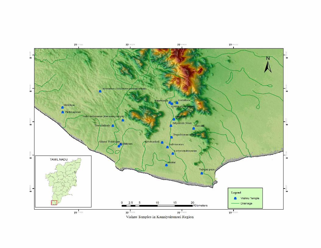

150
CHAPTER - VI
CONCLUSION
The study of micro region provides sufficient scope to understand various
intricacies involved in the formation of the region through the centuries. The
Kaṉyakumari region that evolved with all its manifestation in the field of social,
economic, political and cultural life of its people is, in fact, conditioned by its
ecosystem. Understandably studies centred on certain specified areas or regions must
adopt a holistic approach covering all of these different aspects, so as to have a
wholesome understanding of the said region and its history and culture.
The Kanyakumari region located in the southern most part of the Indian
Peninsula now forms part of Tamil Nadu. The region may be considered as one of the
most ancient and cultural zones of Tamil Nadu. It is endowed with considerable
natural resources and also flourished as a meeting place for different religious,
language and cultural groups. The formation of this region is very much in consonant
with the division of land as expounded in the early Sangam literature. The region is
geographically very small but the presence of mountains, rivers and fertile soil make
this region unique. This small area comprises all the four ecosystems namely kuṟuñji,
mullai, marutam and neital. The western and northern part of the region falls under
the mountainous zone, popularly called kuṟiñji tract. The northern part of Kalkuḷam
and Viḷavaṅkōḍu taluks falls under the category of pastoral tract namely mullai tract.
The third category, the fertile tract called marutam predominantly covers the whole of
Agastīswaram and the southern part of Thōvāḷai taluk. Finally, neithal tiṉai referring
to littoral zone is located on the western fringes of Viḷavaṅkōḍu, Kalkuḷam and
Agastīswaram taluks. As the entire regions is endowed with copious rainfall both
during the southwest and northeast monsoon. The region is bereft of arid land which
is referred to as pālai tiṉai. The scholars who have concentrated on dynastic imprints
fail to provide any detailed description on the nature of this zone. Unlike the great
dynasties like Pāṇḍyas, Chōḻas and Chēras, this region was controlled by the small
kingdoms like Āy and Vēṇāḍu kingdoms and in major part of their history they
151
served as subordinates. Therefore, the region did not receive the attention of either the
scholars of Kerala or the scholars from Tamil Nadu. The native scholar K.K. Pillay,
who hails from Viḷavaṅkōḍu taluk has pointed out this situation in his studies.
However, the native scholars like K.K. Pillay, S. Pathmanabhan and A.K. Perumal of
Nāgarkōil contributed much to this region. Their studies helped effectively to
understand the basic structure of this region. However, it must be pointed out that they
have not made adequate use of the available archaeological as well as epigraphical
evidences to the full extent. These scholars relied upon Saṅgam literary works and
foreigner accounts. Much of their energy is concentrated on submerged Lemūriā
continent as well as the continental drift theory. In order to prove its antiquity, the
history of the Ᾱy chieftains predominant in their discussion. The copying and
subsequent publication of inscriptions of Kaṉyākumari district by the Tamil Nadu
State Archaeology Department and by the individual scholars in the journal Āvanam
of Tamil Nadu Archaeological Society helped in many ways to reconstruct the history
of this region.
Making use of the limited epigraphical evidences they have written about the
later Pāṇḍyas, Chōḻās, Chōḻa-Pāṇḍyas as well as the accounts of rulers of Vēṇāḍu,
Vijayanagar, the Nāyakās of Madurai and Travancore kingdom as well as the social,
economic and political developments. However, in the present study an attempt is
made to identify political, socio-economic and cultural significance of this region
entirely based on epigraphical evidences.
In the introduction chapter, general introduction on the nature of previous
work, the nature of availability of primary sources both epigraphical and
archaeological is dealt. The major part of the primary source comes from 707
inscription documented in this region. The inferences are mainly derived from these
inscriptions and closely supported by the field data. In addition, the landscape of the
region and its signification is given.
The second chapter provides on the information on the intensive exploration carried
out in Kaṉyākumari region. This knowledge helps to reconstruct the historical and
cultural geography of the region in the given landscape. As a result of field study
carried out in the past and during my own fieldwork, the material remains of Iron Age
have been found in all the four taluks of Kaṉyākumari district and the remains of
152
Microlithic and Neolithic at a limited level. The remnants of the historical vestiges
have been located at 59 sites in all the four taluks such as Vilavaṅcōḍe (26), Thōvālai
(16), Kalkuḷam (11) and Agastīswaram (6). Among the prehistoric sites, the Iron Age
sites dominate the scene. The cultural vestiges prior to Iron Age are very scanty and
only a negligible amount of microlithic tools was recovered. The identification of
palaeolithic tools still eludes the scholars. The non-occurrence of certain cultural traits
is probably due to its geological settings. The geological and environmental factors
played a greater role in the formation of archaeological sites. Based on the available
sources, that encountered in the northern part of Tamil Nadu, it is assumed that the
cultural sequences occur in the order of Palaeolithic, Mesolithic, Neolithic, Iron Age
(megalithic), Early Historic and historic.1 Such cultural order is not witnessed
homogeneously though out Tamil Nadu and probably future discoveries may alter the
present scenario. Thus, the second chapter provides a complete picture on the
historical vestiges that were identified on the ground. Nearly 59 archaeological sites
were identified and were documented with GPS points. All these sites have been
placed on the map.
The third chapter provides on the general picture of various dynasties that
involved in the geopolitical formation of this region. Kaṉyākumari region,
irrespective of its political discourse maintained its identity. All the leading dynasties
of South India like Āy, Pāṇḍyas, Chōḻas, Chēras, Vēṇād, Vijayanagar, Nāyak
chieftains and Travāṉcōre kingdom were directly or indirectly associated with this
region. The literary and epigraphical sources shed a considerable light on the social,
economic and political conditions of Kaṉyākumari region. Understanding the
historical background of a region is important as it provides clue to understand the
transformation that had taken place in different social and economic spheres. The
efforts of individual rulers and collective initiation of different social groups or
communities played a crucial role in this process. The ruler or a state took various
welfare measures and administrative reforms to meet the aspiration of the people or to
meet the requirement of the state. This aspect has been studied to highlight the basic
political structure of the region. Unlike other regions, this region did not provide any
inscription of Early Historic times. Most of the inscriptions belong to the medieval
1 K.Rajan, “Situating the beginning of early historic times in Tamil Nadu: Some issues andreflections”, Social Scientist, vol.36, New Delhi, 2008, p.60.
153
period. However, the available literary source, particularly the Sangam literature,
helps some extent to reconstruct the political line of the Early Historic times.
Historically, this region has constituted as a distinctly separate unit and it is socially
and culturally different from the rest of Travancore, though in major part of history, it
was under the control of the rulers of Travancore. The region with greater amount of
agricultural production is popularly known as Nāñchilnāḍu and it played an important
role in the history of south India, for almost all the leading dynasties of South India
have been associated with Nāñcilnāḍu.
The historical geography of the region has been dealt in the chapter four. The
aim of the study is to understand the creation of territorial and administrative units
viz., Maṇḍalam, Vaḷanāḍu, Nāḍu / Kūṟṟam, Brahmadēyam, Maṅgaḷam, function of
Nagaram and local government that existed in this region from c.800 to 1300 CE. The
division of the country into Maṇḍalam, Vaḷanāḍu, Nāḍu, Ūr and other administrative
units formed the backbone of imperial Chōḻa administration and which mainly
contributed to the economic, social and cultural dominance of the Chōḻas over other
dynasties. Some fine aspects of these administrative units are discussed in detail with
the help of epigraphs and maps. Thus, the Kaṉyākumari region has undergone a
several changes in terms of their units due to the occupation of various dynasties.
Each dynasty attempted to implement administrative reforms in the line of their
administrative procedures. Irrespective of these inadequacies, the inscriptions dated
between 8th century and 18th century CE suggest that all the territorial divisions had
the suffix Nāḍu. During the reign of Rājarāja–I (985-1014 CE), the Pāṇḍināḍu was
known as Rājarāja Pāṇḍināḍu. It was divided into four major divisions and all the
smaller units were brought under these four divisions. The area between
Tāmaraparaṉi and Cape Comorin was known as Uthama-Chōḻa-Vaḷanāḍu and major
part of the Kaṉyākumari virtually falls in this territorial division. During the Chōḻa
period, the Vaḷanāḍu had some administrative significance. It helped the integration
of society beyond nāḍus. According to Subbarayalu, basically the nāḍu was not an
administrative division as it is usually conceived; rather it should have originated as a
cluster or grouping of peasant or agricultural settlements formed about the nucleus of
a common irrigation source like a channel or tank and bound together by kinship ties
between the people of an individual nāḍu. At the initial stage, the administrative
154
aspect is only a secondary one. The number of villages that were included in the
nāḍus shows much variation, according to the locality. Obviously they were
themselves not of any uniform size and the size must have been decided by the local
topographical and ecological factors added to the human factors.2 Thus, understanding
the formation of certain geographical units and their continued existence or change
requires deep knowledge on its historical development.
In the following chapter, an attempt is made to understand the cultural
landscape of the region based on place names. From the analysis of the place names,
it can be inferred that the suffix part of many of the modern place names can be traced
back to a very early period. The maximum number of ūr, maṅgaḷam, nallūr, puram,
kuḷa, kuḍi, chērry, dēsam and kōḍu suffixes are occurring during the Chōḻa, Chēra
and Pāṇḍya periods. This trend shows that the agrarian form of settlement got
expanded at that time. Besides, the suffix puram was found most prominently in the
said period. It shows that the commercial villages were also coming into existence in
between the period of 10th century itself. Further, several place names are associated
with the name of the rulers of Chōḻa and Pāṇḍya dynasty. This indirectly indicates the
establishments of several villages during their regime. These new settlements are
established through the creation irrigation facilities. The early pastoral tracts were
converted into new fertile agricultural zones. The surplus productions made in these
agricultural zones attracted the commercial centres like puram/paṭṭinam. Similarly,
the suffixes like puram, grāmam, kōḍu, thuṟai, paṭṭaṇam, chiṟai, etc., are all found
in the inscriptions between the period 947 CE and 1000 CE. During these periods, the
Kaṉyākumari region had flourished under the rulers like Chōḻas, Pāṇḍyās and Chēras.
Further, the suffix like puliyūr, thiṭṭai, kuṟichi, kari, ēri, puduvūr, āru, kuḻi, chērry,
pāḍi, malai, maḍam, kachērry, vēli, dēsam, agaram, muṭṭam and nagaram are all
found in the Kaṉyākumari inscriptions in between the period 1038 CE and 1494 CE.
The suffixes like kōvil, mēḍu, pērūr, viḷai, kāḍu, īswaram, viḷāgam, aṇai, kōṇam,
nagar, kuṇḍrathūr and giri are started appearing in the inscriptions of later period,
mostly assignable to later Pāṇḍyas, Vēṇāḍu, Nāyaka, Vijayanagar and Tiruvidancore
times; which belongs to the period between 1500 CE and 1906 CE. Thus, the above
2 Y.Subbarayalu, Historical Geography of South India, Indian History Congress 73rd Session, Mumbai,2012, pp.7-8.

155
study reveals that the appearance of certain place names in a particular period is due
to the historical process that had taken place during that period.
Thus, the study of Kaṉyākumari region helps immensely to understand the
existence of several settlements from the time immemorial, the emergence of new
agricultural based settlements, conversion of pastoral tracts, creation of mercantile
centres, construction of dams and tanks, formation of temple cities and making of new
community based settlements. The study also helps to realize the dynastic imprints
and their socio-economic welfare measures.

156
APPENDIX – I
List of Inscriptions in Kaṉyākumari Region
S.N
O
Villa
ge
Tk
Dy
na
sty
KIN
G
Da
te(in
CE
)
Scrip
ta
nd
La
ng
uag
e
Pla
ceof
the
inscrip
tion
Nā
ḍu
Ten
ure
Inscrip
tion
men
tion
edo
ther
villa
ges
Inscrip
tion
Men
tion
toS
ociety
Gist
TA
S/A
RE
/T
AA
R/S
TA
,N
O;
K.K
.In
scriptio
nV
ol:
I-VI
1 Āralvāimoḻi TOV
Early
Pāṇḍya
Māraṉ chaḍaiyaṉ
792
Vaṭṭeḷuttu andTamiḻ
Pathmaṉābapurampalace
Koḻuvūr kūṭṭram Perumūr
Koḻuvūr kūṭṭram andViḻiñjam
It is a herostoneinscriptionmemory ofRaṇakīrti lieutenant ofthe earlyPāṇḍya rular whofought withthe Chēra forces andlost his life.
TAS,VOL-I,P-232
KK.Ins,VOL-VI,2008,NO; 543/2004
2 Thirunandhikarai
KLM
800
Vaṭṭeḷuttu andTamiḻ
Easternside pillarof entrancegate in cavetemple
Sri Nanḍhi maṅgalam, Pākka maṅgalam
Mudukōṉūr, Pākka maṅgalam
Nambiyār
Thirunanḍhikaraipeople andtempleofficersdonatedland toThirunanḍhikaraiMahādēvar temple
TAS,VOL-III,DIVISION-II,P-202
KK.Ins,VOL-IV,1979,NO;1969 /38-F
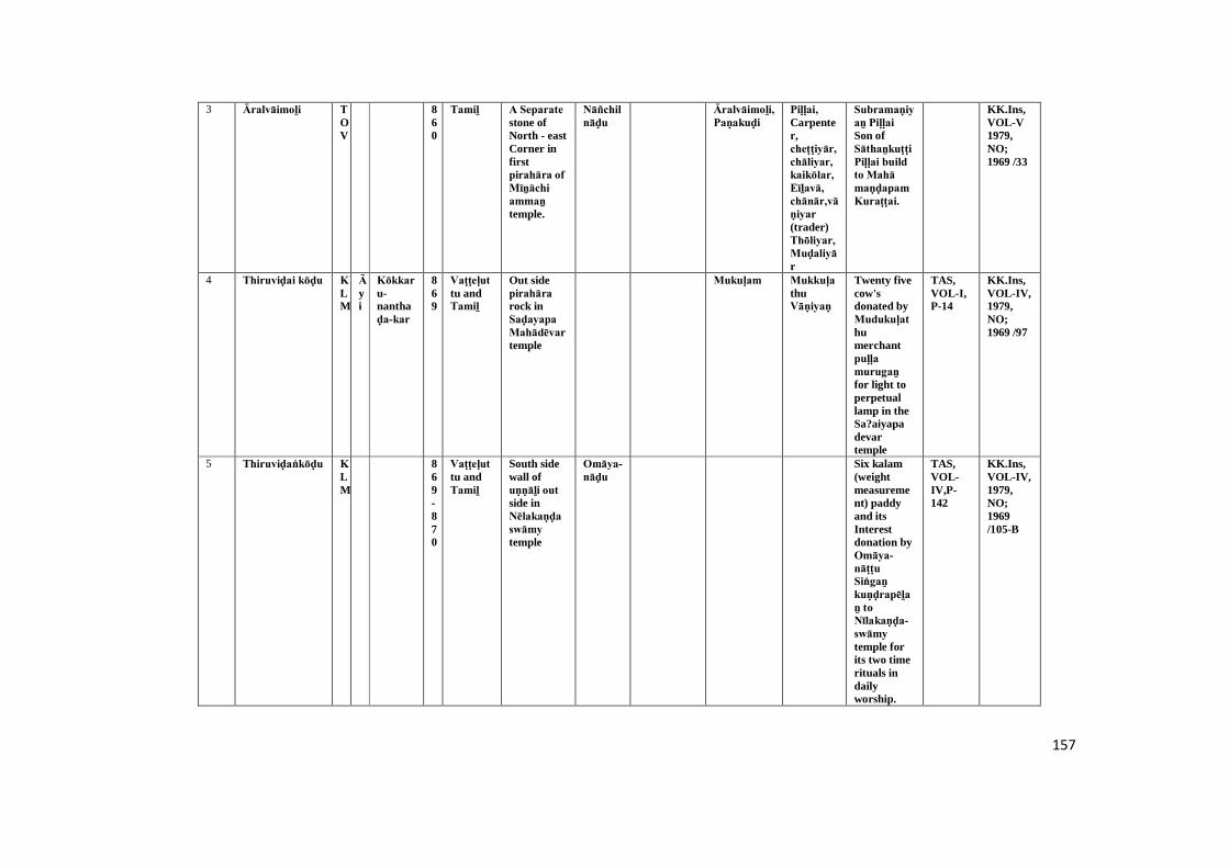
157
3 Āralvāimoḻi TOV
860
Tamiḻ A Separate stone ofNorth - eastCorner infirstpirahāra of Mīṉāchi ammaṉ temple.
Nāñchilnāḍu
Āralvāimoḻi, Paṇakuḍi
Piḷḷai, Carpenter,cheṭṭiyār, chāliyar, kaikōlar, Eīḻavā, chānār,vāṇiyar (trader)Thōliyar, Muḍaliyār
Subramaṇiyaṉ Piḷḷai Son ofSāthaṉkuṭṭi Piḷḷai build to Mahā maṇḍapam Kuraṭṭai.
KK.Ins,VOL-V1979,NO;1969 /33
4 Thiruviḍai kōḍu KLM
Āyi
Kōkkaru-nanthaḍa-kar
869
Vaṭṭeḷuttu andTamiḻ
Out sidepirahāra rock inSaḍayapa Mahādēvar temple
Mukuḷam MukkuḷathuVāṇiyaṇ
Twenty fivecow'sdonated byMudukuḷathumerchantpuḷḷa murugaṉ for light toperpetuallamp in theSa?aiyapadevartemple
TAS,VOL-I,P-14
KK.Ins,VOL-IV,1979,NO;1969 /97
5 Thiruviḍaṅkōḍu KLM
869-870
Vaṭṭeḷuttu andTamiḻ
South sidewall ofuṇṇāḻi out side inNēlakaṇḍa swāmy temple
Omāya-nāḍu
Six kalam(weightmeasurement) paddyand itsInterestdonation byOmāya-nāṭṭu Siṅgaṉ kuṇḍrapēḻaṉ to Nīlakaṇḍa-swāmy temple forits two timerituals indailyworship.
TAS,VOL-IV,P-142
KK.Ins,VOL-IV,1979,NO;1969/105-B
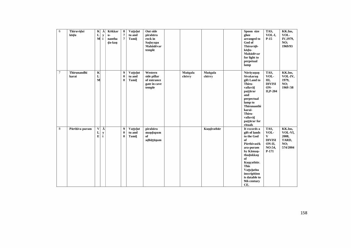
158
6 Thiruviḍai kōḍu
KLM
Āyi
Kōkkaru-nanthaḍa-kaṉ
877
Vaṭṭeḷuttu andTamiḻ
Out sidepirahāra rock inSaḍayapa Mahādēvar temple
Spoon sizegheearranged toGod ofThiruviḍi-kōḍu-Mahādēvar for light toperpetuallamp
TAS,VOL-I,P-15
KK.Ins,VOL-IV,1979,NO;1969/93
7 Thirunandhikarai
KLM
900
Vaṭṭeḷuttu andTamiḻ
Westernside pillarof entrancegate in cavetemple
Maṅgala chērry
Maṅgala chērry
Nārāyaṇaṇ Sivakaraṉ gift Land toThiru-vallavāḻ paṭṭārar andperpectuallamp toThirunanthikarai-Thiru-vallavāḻ paṭṭārar for rituals
TAS,VOL-III,DIVISION-II,P-204
KK.Ins,VOL-IV,1979,NO;1969 /38
8 Pārthiva puram VLE
Āyi
900
Vaṭṭeḷuttu andTamiḻ
pirahāra maṇḍapam ofaḍhiṭṭāṉam
Kuṇḍrathūr It records a gift of landsto the GodofPārthivasēkara-puramby Kāmaṉ-thaḍakkaṉ ofKuṉṟathūr. ThisVaṭṭeḻuthu inscripitionis datable to9th centuryCE.
TAS,VOL-VDIVISION-II,NO:54,P-171
KK.Ins,VOL-VI,2008,TARD,NO;574/2004
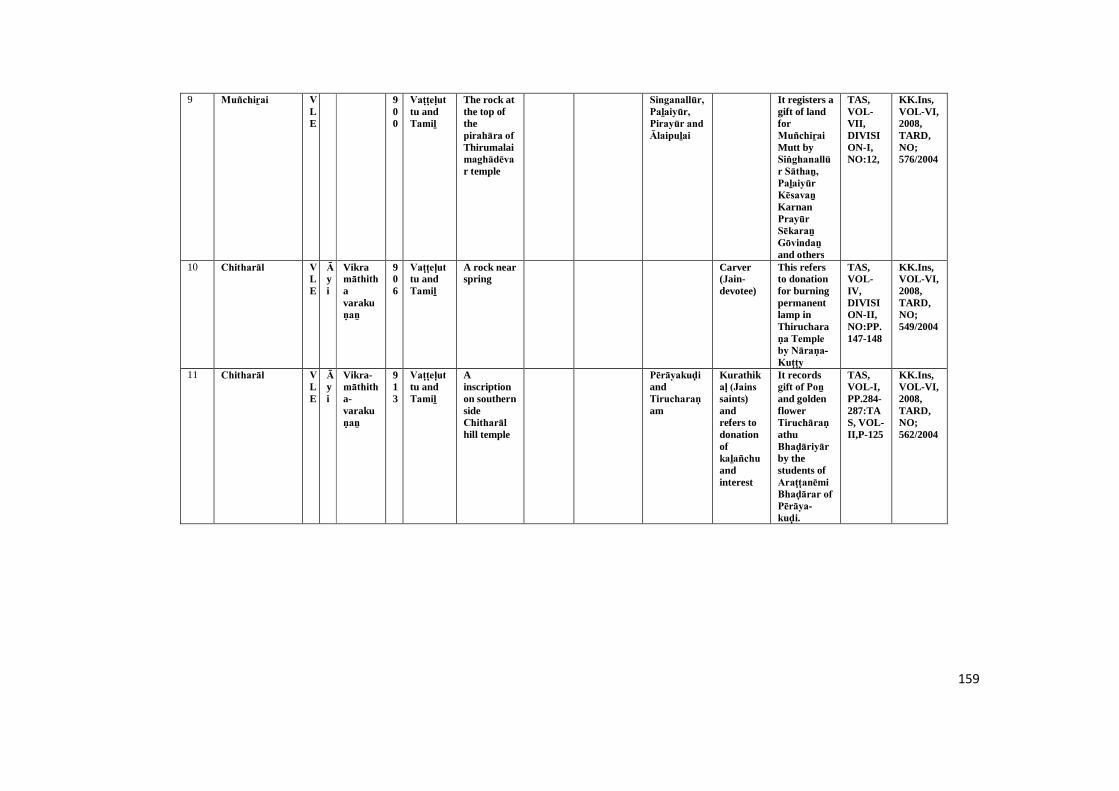
159
9 Muñchiṟai VLE
900
Vaṭṭeḷuttu andTamiḻ
The rock atthe top ofthepirahāra of Thirumalaimaghādēvar temple
Singanallūr, Paḻaiyūr, Pirayūr and Ālaipuḻai
It registers agift of landforMuñchiṟai Mutt bySiṅghanallūr Sāthaṉ, Paḻaiyūr Kēsavaṉ KarnanPrayūr Sēkaraṉ Gōvindaṉ and others
TAS,VOL-VII,DIVISION-I,NO:12,
KK.Ins,VOL-VI,2008,TARD,NO;576/2004
10 Chitharāl VLE
Āyi
Vikramāthithavarakuṇaṉ
906
Vaṭṭeḷuttu andTamiḻ
A rock nearspring
Carver(Jain-devotee)
This refersto donationfor burningpermanentlamp inThirucharaṇa Temple by Nāraṇa-Kuṭṭy
TAS,VOL-IV,DIVISION-II,NO:PP.147-148
KK.Ins,VOL-VI,2008,TARD,NO;549/2004
11 Chitharāl VLE
Āyi
Vikra-māthitha-varakuṇaṉ
913
Vaṭṭeḷuttu andTamiḻ
Ainscriptionon southernsideChitharāl hill temple
Pērāyakuḍi andTirucharaṇam
Kurathikaḷ (Jains saints)andrefers todonationofkaḻañchu andinterest
It recordsgift of Poṉ and goldenflowerTiruchāraṇathuBhaḍāriyār by thestudents ofAraṭṭanēmi Bhaḍārar of Pērāya-kuḍi.
TAS,VOL-I,PP.284-287:TAS, VOL-II,P-125
KK.Ins,VOL-VI,2008,TARD,NO;562/2004
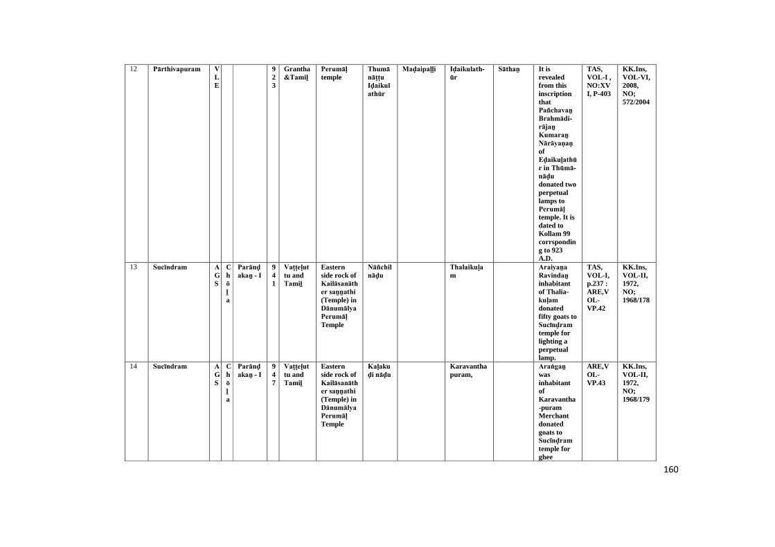
160
12 Pārthivapuram VLE
923
Grantha&Tamiḻ
Perumāḷ temple
Thumā nāṭṭu Iḍaikulathūr
Maḍaipaḷḷi Iḍaikulath-ūr
Sāthaṉ It is revealedfrom thisinscriptionthatPañchavaṉ Brahmādi-rājaṉ Kumaraṉ Nārāyaṇaṇ ofEḍaikuḻathūr in Thūmā-nāḍu donated twoperpetuallamps toPerumāḷ temple. It isdated toKollam 99corrsponding to 923A.D.
TAS,VOL-I ,NO:XVI, P-403
KK.Ins,VOL-VI,2008,NO;572/2004
13 Sucīndram AGS
Chōḻa
Parānḍakaṉ - I
941
Vaṭṭeḷuttu andTamiḻ
Easternside rock ofKailāsanāther saṉṉathi (Temple) inDānumālya Perumāḷ Temple
Nāñchilnāḍu
Thalaikuḷam
Araiyaṉa Ravindaṉ inhabitantof Thalia-kuḷam donatedfifty goats toSucīnḍram temple forlighting aperpetuallamp.
TAS,VOL-I,p.237 :ARE,VOL-VP.42
KK.Ins,VOL-II,1972,NO;1968/178
14 Sucīndram AGS
Chōḻa
Parānḍakaṉ - I
947
Vaṭṭeḷuttu andTamiḻ
Easternside rock ofKailāsanāther saṉṉathi (Temple) inDānumālya Perumāḷ Temple
Kaḷakuḍi nāḍu
Karavanthapuram,
Araṅgaṉ wasinhabitantofKaravantha-puramMerchantdonatedgoats toSucīnḍram temple forghee
ARE,VOL-VP.43
KK.Ins,VOL-II,1972,NO;1968/179
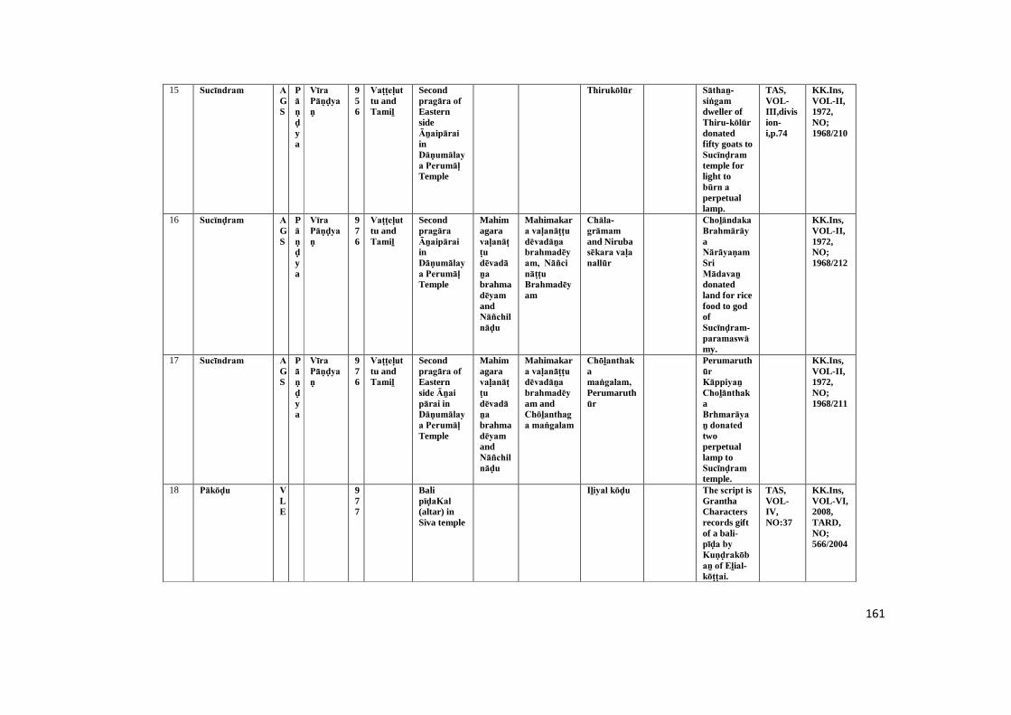
161
15 Sucīndram AGS
Pāṇḍya
Vīra Pāṇḍyaṇ
956
Vaṭṭeḷuttu andTamiḻ
Secondpragāra of EasternsideĀṉaipārai inDāṇumālaya Perumāḷ Temple
Thirukōlūr Sāthaṉ-siṅgam dweller ofThiru-kōlūr donatedfifty goats toSucīnḍram temple forlight tobūrn a perpetuallamp.
TAS,VOL-III,division-i,p.74
KK.Ins,VOL-II,1972,NO;1968/210
16 Sucīnḍram AGS
Pāṇḍya
Vīra Pāṇḍyaṇ
976
Vaṭṭeḷuttu andTamiḻ
Secondpragāra Āṉaipārai inDāṇumālaya Perumāḷ Temple
Mahimagaravaḷanāṭṭu dēvadāṉa brahmadēyam andNāñchilnāḍu
Mahimakara vaḷanāṭṭu dēvadāṉa brahmadēyam, Nāñci nāṭṭu Brahmadēyam
Chāla-grāmam and Nirubasēkara vaḷa nallūr
Choḻāndaka BrahmārāyaNārāyaṇam SriMādavaṉ donatedland for ricefood to godofSucīnḍram-paramaswāmy.
KK.Ins,VOL-II,1972,NO;1968/212
17 Sucīndram AGS
Pāṇḍya
Vīra Pāṇḍyaṇ
976
Vaṭṭeḷuttu andTamiḻ
Secondpragāra of Easternside Āṉai pārai in Dāṇumālaya Perumāḷ Temple
Mahimagaravaḷanāṭṭu dēvadāṉa brahmadēyam andNāñchilnāḍu
Mahimakara vaḷanāṭṭu dēvadāṉa brahmadēyam andChōḻanthaga maṅgalam
Chōḻanthakamaṅgalam, Perumaruthūr
Perumaruthūr Kāppiyaṉ ChoḻānthakaBrhmarāyaṉ donated twoperpetuallamp toSucīnḍram temple.
KK.Ins,VOL-II,1972,NO;1968/211
18 Pākōḍu VLE
977
BalipīḍaKal (altar) inSiva temple
Iḻiyal kōḍu The script is GranthaCharactersrecords giftof a bali-pīḍa by Kuṇḍrakōbaṉ of Eḻial-kōṭṭai.
TAS,VOL-IV,NO:37
KK.Ins,VOL-VI,2008,TARD,NO;566/2004

162
19 Sucīndram AGS
Chōḻa
Rājēnḍiraṉ.I
995
Vaṭṭeḷuttu andTamiḻ
Easternside rock inKailāsanāther Temple(outside)
Ehīḻanāḍu (Sri Lanka),Nāñchilnāḍu
Nāñci nāṭṭu Brahmadēyam
Eīḻathu (Sri Lanka)Māḻavarāyaṉ Cheṉṉikaṇḍaṇ donated fifty goats toSucīnḍram temple forlighting aperpetuallamp.
TAS,VOL-I,p.238 :ARE,VOL-VP.43
KK.Ins,VOL-II,1972,NO;1968/204
20 Sucīndram AGS
Pāṇḍya
Māraṉ saḍaiyaṉ
900-1000
Vaṭṭeḷuttu andTamiḻ
Easternside rock ofKailāsanāther saṉṉathi (Temple) inDānumālya Perumāḷ Temple
Malaināṭṭu Kāṉaiyar paḷḷi,
Malaiyar-nāṭṭu kāṇiyar paḷḷi
Eiyakkaṉ Sellaṉ inhabitantof Malai-nāṭṭu Kaṇaiyar paḷḷi donated aperpetuallamp andhundredgoats toSucīnḍram temple forlighting alamp.
TAS,VOL-IV,P.117
KK.Ins,VOL-II,1972,NO;1968/180
21 Sucīndram AGS
Pāṇḍya
Māraṉ saḍaiyaṉ
900-1000
Vaṭṭeḷuttu andTamiḻ
Southernside rock(outside) ofKailāsanāther saṉṉathi inDānumālya Perumāḷ Temple
Damaged Inseriptionmention aname of SriKōmārañ-chaḍaiyar.
KK.Ins,VOL-II,1972,NO;1968/172
22 Paṟakai AGS
EarlyPāṇḍya
900-1000
Vaṭṭeḷuttu andTamiḻ
Top portionstone ofarthamaṇḍapamentrance inAkkaraimahādēvar temple
Full text isnotavailable.Fragmentary one.
TAS,VOL-VI,DIVISION-II,NO :79 ,P-108
KK.Ins,VOL-VI,2008,TARD,NO;468/2004

163
23 Sucīndram AGS
Chōḻa
Rājēnḍiraṉ-I
999
Vaṭṭeḷuttu andTamiḻ
Āṉaipārai (outside ofKailāsanāther saṉṉathi) inDāṇumālayaPerumāḷ Temple
Rāja Rāja vaḷanāṭṭ brahmadēyam andNāñchilnāḍu
Rāja Rāja vaḷanāṭṭu Brahmadēyam and Nirubasēkara vaḷa nallūr dēvaḍāṉam
SriKāndalūr-sālai, Nirubasēkara-vaḷa-nallūr
Mūvēntha vēḷāṉ issue increaseland tax ofSucīnḍram dēvaḍāṉam land andpaid totemple.
TAS,VOL-IV,division-ii,p.129
KK.Ins,VOL-II,1972,NO;1968/226
24 Kaṉyākumari AGS
1000
Vaṭṭeḷuttu andTamiḻ
Bhagavathiammaṉ templeuṇṇāḻi of west sidewall
Kumarimaṅgalam
Kumarimaṅgalam
Twenty fivegoats weregift toBhagavathiTemple forlight toperpetuallamp.
KK.Ins,VOL-I,1972,NO;1968/48
25 Kaṉyākumari AGS
1000
Bhagavathiammaṉ templeuṇṇāḻi of west sidewall(northwestcorner)
Puṟathaya-nāḍu
Fragmented KK.Ins,VOL-I,1972,NO;1968/47
26 Kaṉyākumari AGS
1000
Vaṭṭeḷuttu andTamiḻ
Bhagavayhiammaṉ templeuṇṇāḻi of west sidewall
Damagescript's
KK.Ins,VOL-I,1972,NO;1968/49
27 Kaṉyākumari AGS
Pāṇḍya
1000
Tamiḻ Kanya Bhagavathitemple,Arthamaṇḍapamentrancewall of leftside
Udaiyar Damaged KK.Ins,VOL-I,1972,NO;1968/85
164
28 Sucīndram AGS
Pāṇḍya
Māraṉ saḍaiyaṉ
1000
Vaṭṭeḷuttu andTamiḻ
Ānaipārai inDāṇumālaya Perumāḷ Temple
Nirubasēkara vaḷa nallūr dēvaḍāṉam
Koḻuvūr kūṭṭram, KhīḻkuṇtrathuVeliyātrūr andNirubasēkara-vaḷa-nallūr
This refersto thedonation ofland andgold to GodSucīnḍram Perumāḷ by Sri Thoṅgap Pallavaraiyaṉ.
TAS,VOL-IV,division-ii,p.118
KK.Ins,VOL-II,1972,NO;1968/224
29 Sucīndram AGS
Pāṇḍya
Saḍaiyaṉ māraṉ
1000
Vaṭṭeḷuttu andTamiḻ
Easternside rock ofKailāsanāther saṉṉathi (Temple) inDānumālya Perumāḷ Temple
Kuṉdṟaṉ Sūlabāṇi donatedfifty goats toūr Sabhāi for lightinga perpetuallamb inSucīnḍram Mahādēvar temple.
TAS,VOL-IV,p.121
KK.Ins,VOL-II,1972,NO;1968/181
30 Sucīndram AGS
Pāṇḍya
Kōchaḍayamāraṉ
1000
Vaṭṭeḷuttu andTamiḻ
Secondpragāra Ānaipārai ofKailāsanāther saṉṉathi (Temple) inDāṇumālaya Perumāḷ Temple
Puṟanthayanāṭṭu Ehiḻakaṉ thuṟai, Nāñchilnāḍu
Puṟanthaya-nāḍu-Ehīḻakaṉ-thuṟai
Aṟugaivaṇigaṉ Kaṇṇipaḻañchi ( atrader)inhabitantofPuṟanthaya nāṭṭu Eiḻakanthuṟai donatedfifty goats toSucīnḍram temple forlightingperpetuallamp.
TAS,VOL-IV,division-ii,p.123
KK.Ins,VOL-II,1972,NO;1968/205
31 Sucīndram AGS
Pāṇḍya
Saḍaiyaṉ māraṉ
1000
Vaṭṭeḷuttu andTamiḻ
West side ofĀnaipārai inDānumālya Perumāḷ temple
This refersto thedonation ofSāvāmūvā pērāḍu to Sucīnḍram temple tolight adivine lamp.
KK.Ins,VOL-II,1972,NO;1968/222
165
32 Paṟakai AGS
Pāṇḍya
Saḍaiyaṉ māraṉ
1000
Tamiḻ Northern side Altarof firstpragāra wall inMadusūdaṉa Perumāḷ Temple
Nāñchilnāḍu
Iaḍapaṭṭi-vakkaṉi-nallūr, Khiḻār-maṅgalam
Gōvindaṉ donatedland to godofMathusūthaṉa Perumāḷ for itsrituals.
TAS,VOL-VI,DIVISION-II,P-108
KK.Ins,VOL-III,1972,NO;1968/289
33 Thiruviḍāṅkōḍu KLM
1000
Vaṭṭeḷuttu andTamiḻ
Westernside paṭṭi of uṇṇāḻi in Nēlakaṇḍa swāmy temple
Landdonation toNēlakaṇḍa swāmy temple forits ritualsand light toa lamp inKārthigai month lightfestival days
TAS,VOL-III,DIVISION-I,P.79
KK.Ins,VOL-IV,1979,NO;1969/104
34 Muṭṭak kāḍu KLM
1000
Tamiḻ A stand stone onpirahāra in Paṉṉipāgam temple
Thiru-paṉaikuḷam
Cheṭṭy Vikaḷaṅgaṉ Cheṭṭy donated 20coins toūrar for light aperpetuallamp in godof ThirupaṉaikuḷathuMahādēvar.
KK.Ins,VOL-IV,1979,NO;1969/128
35 Thiruviḍai kōḍu
KLM
1000
Vaṭṭeḷuttu andTamiḻ
Southernside rock ofsecondpirahāra in Saḍayapa Mahādēvar temple
ōmaya nāḍu
Maruḍathūr-thāmarai-kuḷam
Landdonation byOmāya-nāḍu-ūrvēḷāṉ to god ofThiruviḍaikōḍu Mahādēvar for light to aperpetuallamp and itsrituals.
TAS,VOL-III,DIVISION-II,PP.198-199
KK.Ins,VOL-IV,1979,NO;1969/79
166
36 Paṟakai AGS
Pāṇḍya
Saḍaiyaṉ māraṉ
1000
Vaṭṭeḷuttu andTamiḻ
ASabthamāthikka ininnerpirahāra
Nāñchilnāḍu
Khīḻār maṅgalam
Vakkaṉi-nallūr,
Chaṭṭar (Brahminstudent)
Kārāmbi Saṭṭar kumaraṉ Gōvindaṉ of Vakkaṇi-nallūr gifted some landsfor offeringtoMadhusūdhaṉa Viṇṇavar Emberumāṉ
KK.Ins,VOL-VI,2008,NO;464/2004
37 Kuṟathiyaṟai TOV
Chōḻa
Kōpparakēsari Parānḍakaṉ - I
1000
Vaṭṭeḷuttu andTamiḻ
Kuravaṉ thaṭṭupārai
Nāñchilnāḍu
Kuṇḍrapaḷḷi Kuṇḍrapaḷḷi Refers to Soverigndonationand taxesgiven toKōla-Perumāḷ by Kuṉḍṟapaḷḷi Eippikaavisiyaṉ Sāthaṉ Sirāvanaṉ Muṉṉūri-ravi-niyamam
TAS,VOL-VIII,P-25:ARE,7/1929
KK.Ins,VOL-VI,2008,NO;539/2004
38 Chitharāl VLE
1000
Vaṭṭeḷuttu andTamiḻ
Hangingrock
Tirunaruṅg koṇḍai Maylai paḷḷi
Tirunaruṅg koṇḍai-Mēylai-paḷḷi
It is gleanedfrom thisinscriptionthat animage ofTīrtaṅkara was donatedbyVīranandhi Aḍigaḷ of Mēlaippaḷḷi fromTirunaruṅgoṇḍai.
TAS,VOL-II,DIVISION-II,P-126
KK.Ins,VOL-VI,2008,NO;557/2004
167
39 Thirunandhikarai
KLM
Chērar
Vijaya-rāgha dēvar
1000
Vaṭṭeḷuttu andTamiḻ
Thirunandhikarai Sivatemple
Maṅgalathu-nallūr
Maṅgalathu-nallūr
Thedaughter ofKulasēkaradēvar and Kiḻāṉḍikaḷ, the queen ofVijayaRāghadēvar donated 30kaḻañju Poṉ for burningperpetuallamp toTirunandhikaraiPaṭṭārar.
TAS,VOL-IV,NO;38
KK.Ins,VOL-VI,2008,NO;512/2004
40 Chitharāl VLE
1000
Vaṭṭeḷuttu andTamiḻ
Hangingrock
Tiruṉeḍum pārai kāṭṭāmpaḷḷi
Tiruṉeḍumpārai-kāṭṭāmpaḷḷi
It revealsthe gift ofan image ofTīrtaṅkara byUthanandhiAḍigaḷ of Tiruneḍumbārai Kāṭṭammpaḷḷi. It is datble to10th C.A.D.
TAS,VOL-II,DIVISION-II,P-126
KK.Ins,VOL-VI,2008,NO;556/2004
41 Thikaṇaṅ kōḍu
KLM
1000
Vaṭṭeḷuttu andTamiḻ
Suthernsideadhiṭṭāṉam (incompleteinscription) of maghā-maṇḍapam in Perumāḷ temple
Khīḻ-maruthūr
Dēva kaṉmigaḷ (Brahminservantsfor God)
Sōmāṉi Nārāyaṇaṉ of Kiḻ Marudūr donatedlands to thetempleauthoritiesof the lordofTirukkaṇṇaṅ-kōḍu for conductingpūjās.
KK.Ins,VOL-VI,2008,TARD,NO;498/2004
168
42 Thikaṇaṅ kōḍu
KLM
1000
Vaṭṭeḷuttu andTamiḻ
Easternsideadhiṭṭāṉam of mughamaṇḍapam in Perumāḷ temple
This refersto a lampand 5buffaloesdonated totemplebyNārāyaṇaṉ ofTirukkaṇṇaṅ-kōḍu .
TAS,VOL-III,DIVISION-I,P-78
KK.Ins,VOL-VI,2008,TARD,NO;499/2004
43 Thikaṇaṅ kōḍu
KLM
1000
Tamiḻ Bali bīḍam (altar)
SriKalacheyapaṭṭiṇam
This refers"palikal"(Altar)givean byKumaranāraṇaṉ of Sri Kalāsaya paṭṭiṇam.
KK.Ins,VOL-VI,2008,TARD,NO;501/2004
44 Chitharāl VLE
1000
Vaṭṭeḷuttu andTamiḻ
Maṇḍapam pillar
Kuḍanāḍu nallūr
Tirucharaṇam andKuḍanāṭṭu-nallūr
It refers totheinstallationof five stonepillars inthe frontmaṇḍapam of thetemple ofTirucharaṇam byAruḷāki of Nallore inKuḍanāḍu. It is dated to10th C.A.D.
KK.Ins,VOL-VI,2008,TARD,NO;551/2004
45 Chitharāl VLE
1000
Vaṭṭeḷuttu andTamiḻ
Hangingrock
Sri Vēmpūr It records the donationof an imageofTīrtaṅkara bySāthaṅkuvaiVāthulavaṉ of SriVēmpūr. It is datable of10th C.A.D.
KK.Ins,VOL-VI,2008,TARD,NO;552/2004
169
46 Chitharāl VLE
1000
Vaṭṭeḷuttu andTamiḻ
Hangingrock
Jainasdonated theimages ofTīrtaṅkara wererevealed bythisinscriiptionwhich isdatable to10th C.A.D.
KK.Ins,VOL-VI,2008,TARD,NO;553/2004
47 Chitharāl VLE
1000
Vaṭṭeḷuttu andTamiḻ
Hangingrock
It recordsthe gift ofan image ofTīrtaṅkara by oneChandranandhiVairiyār, a student ofDiwākar. It is datable to10th C.A.D.
KK.Ins,VOL-VI,2008,TARD,NO;554/2004
48 Chitharāl VLE
1000
Vaṭṭeḷuttu andTamiḻ
Hangingrock
Tirucharaṇam
It recordsthe gift ofan image ofTīrtaṅkara by Saṭṭan Varaguṇaṉ. It is datablethe 10thC.A.D.
TAS,VOL-II,DIVISION-II,P-126
KK.Ins,VOL-VI,2008,TARD,NO;555/2004
49 Chitharāl VLE
1000
Vaṭṭeḷuttu andTamiḻ
Hangingrock
It refers tothe donationof an imageofTīrtaṅkara by SriAchcha-nandhi. Itis datable to10th C.A.D.
TAS,VOL-II,DIVISION-II,P-126
KK.Ins,VOL-VI,2008,TARD,NO;558/2004
170
50 Chitharāl VLE
1000
Vaṭṭeḷuttu andTamiḻ
Hangingrock
Refers tothe imagemade anddonated bychandira-nandhi
KK.Ins,VOL-VI,2008,TARD,NO;559/2004
51 Chitharāl VLE
1000
Vaṭṭeḷuttu andTamiḻ
Below theDuvāra bālakar sculpture
Thirubuvaṉam
This refersto the imageofDwārapālakar donatedbyThirubuvaṉa Sunḍaraṉ.
KK.Ins,VOL-VI,2008,TARD,NO;560/2004
52 Chitharāl VLE
1000
Vaṭṭeḷuttu andTamiḻ
Northportion ofDuvāra bālakar sculpture
Muñchiṟai This refers toDwārapālakar imagegiven ondonation.
KK.Ins,VOL-VI,2008,TARD,NO;561/2004
53 Chitharāl VLE
1000
Grantha Inscriptionfoundinfront oftank stepsinChitharāl-Bhagavathi-ammaṉ temple
It refers tothe donationof stone forthe entranceof the temle,byVijayabhadra-Vibhajit.
TAS,VOL-VI,DIVISION-II,NO:41,P-148
KK.Ins,VOL-VI,2008,TARD,NO;563/2004
54 Vaḍachērry AGS
Chōḻa
Rājarājaṉ -I
1001
Tamiḻ Pathmanāba purampalace
Nāñchilnāḍu TiruKōṭṭāṟu andTheṉkaraiArcotkūṭṭram
TiruKōṭṭāṟu,Theṉkarai Arcāḍu kuṭṭram and Kēraḷa
Muvēntha vēḷārs (Agri-culturalcultivaters)
It registers agift of landentrustedwith NeriyaMuvēntha vēḷārs for providingTiruAmuthu toPiḍāriyar Kommaṇḍai Naṅgai of Vaḍachērry. It is dated to1001 A.D.
TAS,VOL-VI,DIVISION-II,NO :103
KK.Ins,VOL-VI,2008,TARD,NO;484/2004
171
55 Thirunandhikarai
KLM
Chōḻa
Rājarājaṉ -I
1003
Vaṭṭeḷuttu andTamiḻ
Easternside wall incave temple
Rāja Rāja-theṉ-ṉāḍu,Vaḷḷuva-nāḍu, Vēṅgai-nāḍu,Kuḍamalai nāḍu
Kāndalūr-sālai,Mummuḍi-Chōḻa-nallūr
A villager ofRāja-Rāja-nāṭṭu vaḷḷuva nāḍu donated toThirunandhikarai-Mahādēvar temple forlight tosanthi lamp.
TAS,VOL-I,P-292
KK.Ins,VOL-IV,1979,NO;1969/38-I
56 Maṇavāḷa kuṟichi
KLM
Chōḻa
Rājarājaṉ-I
1012
Vaṭṭeḷuttu andTamiḻ
Ainscriptionlaid on rockinPeriyakuḷakarai
Vēṅgaināḍu Kaṅgaipāḍi, Kuḍamalaināḍu
Chēra maṅgalam Dēvaḍāṉa paḷḷichantham
Kāndalūr, Kaḍiya-paṭṭiṇam and Chēra-maṅgalam
This refersto landdonatedgiven byRāja-Rāja-Chōḻa. I to construct toanAnaicut(dam) toprevent abig tankdamages.
TAS,VOL-VI,DIVISION-II,NO:105:P-145
KK.Ins,VOL-VI,2008,NO;505/2004
57 Thpirahārarūr AGS
Chōḻa
Rājēnḍhira-ṉ-I
1015
Tamiḻ Suthern sideadhiṭṭāṇam inEiḷayanayiṉār temple
Nāñchilnāḍu
It records agift of landas kāraṇmai to Appi-Vēlaṉ by Rājēndra Chōḻa Tamiḻa-pēraiyan and alsogetting ashare of 60Kalam ofPaddy fromAppi-Vēlaṉ.
TAS,VOL-VI,DIVISION-II,NO :106,P-146
KK.Ins,VOL-VI,2008,TARD,NO;459/2004

172
58 Kaṉyākumari AGS
Chōḻa
Rājēnḍhira-ṉ-I
1019
Tamiḻ Kanyakumarytemple,entrance(leftside) ofArthamaṇḍapam northside
Sunḍaraṉ NagaripPerumāḷ gifted alamp tolight forKaṉyākumari temple.
STANO:VOL-VI,P.147
KK.Ins,VOL-I,1972,NO;1968/81
59 Kaṉyākumari AGS
Chōḻa
Rājēnḍhira-ṉ .II
1038
Tamiḻ Kōnērīswarar templesouth sidewall inkumutham
Puṟathayanāḍu
Paḻaiyūrthiṭṭai / Puliyūr
Paḻaiyūr-thiṭṭai Chōḻakulavalli giftedfifty goat'sfor aperpetuallamp lighttoKōnērīswarar temple.
STANO:VOL-I , Dviii,p.161
KK.Ins,VOL-I,1972,NO;1968/107
60 Kaṉyākumari AGS
Chōḻa
Rājēnḍhira-ṉ-I
1042
Tamiḻ Kōnērīswarar templewest side &north sidewall ofpaṭṭai
Nāñchilnāḍu
Dēvaraḍiyaḷ Kaṇḍaṉ Sōlai twenty five goat'sgifted toPudaṉ Gaṇapathi for aperpetuallamp lighttoKōnērīswarar temple
STANO:VOL-I ,Dxiv,p.240
KK.Ins,VOL-I,1972,NO;1968/115
61 Kaṉyākumari AGS
Chōḻa
Rājēnḍhira-ṉ- I
1042
Tamiḻ Kōnērīswarar templesouth sidewall inkumutham
Puṟathayanāḍu /Nāñchilnāḍu
Maḍil kuṟuchi
Vēḷāḷar Vēḷḷāḷaṉ-Appi-Poṉṉaṇḍi giftedtwenty fivegoat's toKōnērīswarar templefor light to aperpetuallamp.
STANO:VOL-I ,Dxiv,pp.239-240
KK.Ins,VOL-I,1972,NO;1968/117
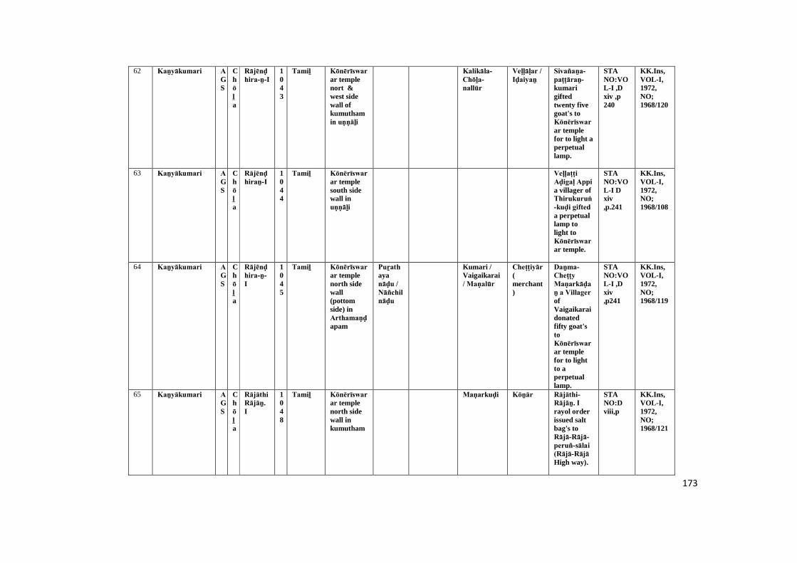
173
62 Kaṉyākumari AGS
Chōḻa
Rājēnḍhira-ṉ-I
1043
Tamiḻ Kōnērīswarar templenort &west sidewall ofkumuthamin uṇṇāḻi
Kalikāla-Chōḻa-nallūr
Veḷḷāḷar / Iḍaiyaṉ
Sivañaṉa-paṭṭāraṉ-kumarigiftedtwenty fivegoat's toKōnērīswarar templefor to light aperpetuallamp.
STANO:VOL-I ,Dxiv ,p240
KK.Ins,VOL-I,1972,NO;1968/120
63 Kaṉyākumari AGS
Chōḻa
Rājēnḍhiraṉ-I
1044
Tamiḻ Kōnērīswarar templesouth sidewall inuṇṇāḻi
Veḷḷaṭṭi Aḍigaḷ Appi a villager ofThirukuruṅ-kuḍi gifted a perpetuallamp tolight toKōnērīswarar temple.
STANO:VOL-I Dxiv,p.241
KK.Ins,VOL-I,1972,NO;1968/108
64 Kaṉyākumari AGS
Chōḻa
Rājēnḍhira-ṉ- I
1045
Tamiḻ Kōnērīswarar templenorth sidewall(pottomside) inArthamaṇḍapam
Puṟathayanāḍu / Nāñchilnāḍu
Kumari /Vaigaikarai/ Maṇalūr
Cheṭṭiyār (merchant)
Daṉma-Cheṭṭy Maṇarkāḍaṉ a Villager ofVaigaikaraidonatedfifty goat'stoKōnērīswarar templefor to lightto aperpetuallamp.
STANO:VOL-I ,Dxiv,p241
KK.Ins,VOL-I,1972,NO;1968/119
65 Kaṉyākumari AGS
Chōḻa
Rājāthi Rājāṉ. I
1048
Tamiḻ Kōnērīswarar templenorth sidewall inkumutham
Maṇarkuḍi Kōṉār Rājāthi-Rājāṉ. I rayol orderissued saltbag's toRājā-Rājā-peruñ-sālai (Rājā-Rājā High way).
STANO:Dviii,p
KK.Ins,VOL-I,1972,NO;1968/121
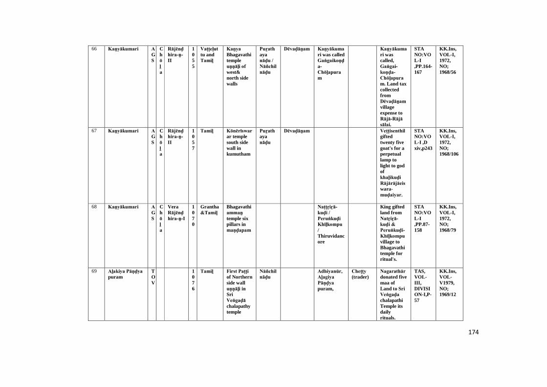
174
66 Kaṉyākumari AGS
Chōḻa
Rājēnḍhira-ṉ-II
1055
Vaṭṭeḷuttu andTamiḻ
Kaṉya Bhagavathitempleuṇṇāḻi of west&north sidewalls
Puṟathayanāḍu / Nāñchilnāḍu
Dēvaḍāṉam Kaṉyākumari was calledGaṅgaikoṇḍa-Chōḻapuram
Kaṉyākumari wascalled,Gaṅgai-koṇḍa-Chōḻapuram. Land taxcollectedfromDēvaḍāṉam villageexpense toRājā-Rājā sālai.
STANO:VOL-I,PP.164-167
KK.Ins,VOL-I,1972,NO;1968/56
67 Kaṉyākumari AGS
Chōḻa
Rājēnḍhira-ṉ- II
1057
Tamiḻ Kōnērīswarar templesouth sidewall inkumutham
Puṟathayanāḍu
Dēvaḍāṉam Veṭṭisenthil giftedtwenty fivegoat's for aperpetuallamp tolight to godofkhaḻikuḍi Rājārājāeiswara-muḍaiyar.
STANO:VOL-I ,Dxiv,p243
KK.Ins,VOL-I,1972,NO;1968/106
68 Kaṉyākumari AGS
Chōḻa
VeraRājēnḍhira-ṉ-I
1070
Grantha&Tamiḻ
Bhagavathiammaṉ temple sixpillars inmaṇḍapam
Naṭṭṟiṟā-kuḍi / Peruṅkuḍi Khīḻkompu /Thiruvidancore
King giftedland fromNatṟiṟā-kuḍi & Peruṅkuḍi- Khīḻkompu village toBhagavathitemple forritual's.
STANO:VOL-I,PP.87-158
KK.Ins,VOL-I,1972,NO;1968/79
69 Aḻakiya Pāṇḍya puram
TOV
1076
Tamiḻ First Paṭṭi of Northernside walluṇṇāḻi in SriVeṅgaḍā chalapathytemple
Nāñchilnāḍu
Adhiyanūr, Aḻagiya Pāṇḍya puram,
Cheṭṭy (trader)
Nagarathār donated fivemaa ofLand to SriVeṅgaḍa chalapathiTemple itsdailyrituals.
TAS,VOL-III,DIVISION-I,P-57
KK.Ins,VOL-V1979,NO;1969/12
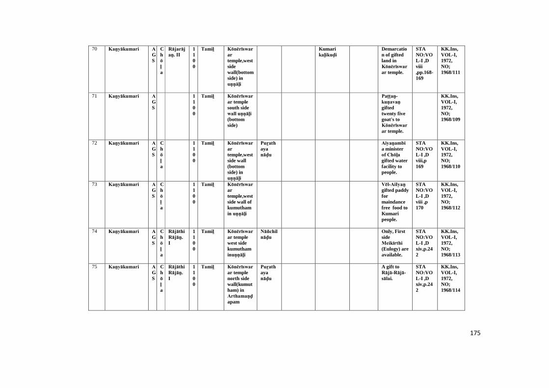
175
70 Kaṉyākumari AGS
Chōḻa
Rājarājaṉ. II
1100
Tamiḻ Kōnērīswarartemple,westsidewall(bottomside) inuṇṇāḻi
Kumarikaḻikuḍi
Demarcation of giftedland inKōnērīswarar temple.
STANO:VOL-I ,Dviii,pp.168-169
KK.Ins,VOL-I,1972,NO;1968/111
71 Kaṉyākumari AGS
1100
Tamiḻ Kōnērīswarar templesouth sidewall uṇṇāḻi (bottomside)
Paṭṭaṉ-kuṇavaṉ giftedtwenty fivegoat's toKōnērīswarar temple.
KK.Ins,VOL-I,1972,NO;1968/109
72 Kaṉyākumari AGS
Chōḻa
1100
Tamiḻ Kōnērīswarartemple,westside wall(bottomside) inuṇṇāḻi
Puṟathayanāḍu
Aiyaṉambi a ministerof Chōḻa gifted waterfacility topeople.
STANO:VOL-I ,Dviii,p169
KK.Ins,VOL-I,1972,NO;1968/110
73 Kaṉyākumari AGS
Chōḻa
1100
Tamiḻ Kōnērīswarartemple,westside wall ofkumuthamin uṇṇāḻi
Vēl-AiIyaṉ gifted paddyformaindancefree food toKumaripeople.
STANO:VOL-I ,Dviii ,p170
KK.Ins,VOL-I,1972,NO;1968/112
74 Kaṉyākumari AGS
Chōḻa
Rājāthi Rājāṉ. I
1100
Tamiḻ Kōnērīswarar templewest sidekumuthaminuṇṇāḻi
Nāñchilnāḍu
Only, FirstsideMeikīrthi (Eulogy) areavailable.
STANO:VOL-I ,Dxiv,p.242
KK.Ins,VOL-I,1972,NO;1968/113
75 Kaṉyākumari AGS
Chōḻa
Rājāthi Rājāṉ. I
1100
Tamiḻ Kōnērīswarar templenorth sidewall(kumutham) inArthamaṇḍapam
Puṟathayanāḍu
A gift toRājā-Rājā-sālai.
STANO:VOL-I ,Dxiv,p.242
KK.Ins,VOL-I,1972,NO;1968/114
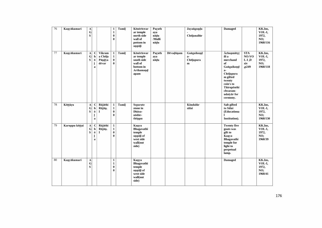
176
76 Kaṉyākumari AGS
1100
Tamiḻ Kōnērīswarar templenorth sidewall ofpottom inuṇṇāḻi
Puṟathayanāḍu /Mullināḍu
Jayaṅgoṇḍa-Chōḻanallūr
Damaged KK.Ins,VOL-I,1972,NO;1968/116
77 Kaṉyākumari AGS
Chōḻa
Vikrama Chōḻa Pāṇḍya dēvar
1100
Tamiḻ Kōnērīswarar templesouth sidewall ofbottom inArthamaṇḍapam
Puṟathayanāḍu
Dēvaḍāṉam Gaṅgaikoṇḍa-Chōḻapuram
Āchaṉmātṟṟili amerchandofGaṅgaikoṇḍa-Chōḻapuram giftedtwentycoin's toThirupēnthichvaram-udaiyār for cermony.
STANO:VOL-I ,Dxiv,p249
KK.Ins,VOL-I,1972,NO;1968/118
78 Kōṭṭāṟu AGS
Chōḻa
Rājāthi Rājāṉ. I
1100
Tamiḻ Separate stone inDhāsa-nādār-thōppu
Kāndalūr sālai
Salt giftedto Sālai (EducationalInstitution).
KK.Ins,VOL-I,1972,NO;1968/130
79 Karuppu kōṭṭai AGS
Chōḻa
Rājāthi Rājāṉ. I
1100
Kaṉya Bhagavathitempleuṇṇāḻi of west sidewall(outside)
Twenty fivegoats wasgift toKaṉya Bhagavathitemple forlight toperpetuallamp.
KK.Ins,VOL-I,1972,NO;1968/39
80 Kaṉyākumari AGS
1100
Kaṉya Bhagavathitempleuṇṇāḻi of west sidewall(outside)
Damaged KK.Ins,VOL-I,1972,NO;1968/41
177
81 Kaṉyākumari AGS
1100
Kaṉya Bhagavathitempleuṇṇāḻi of west sidewall(outside)
Damaged KK.Ins,VOL-I,1972,NO;1968/42
82 Kaṉyākumari AGS
1100
Kaṉya Bhagavathitempleuṇṇāḻi of west sidewall(outside)
Paṇḍāram
Damaged KK.Ins,VOL-I,1972,NO;1968/43
83 Kaṉyākumari AGS
Chōḻa
Rājēnḍhira-ṉ-I
1100
Bhagavathiammaṉ templeuṇṇāḻi of west sidewall
Puṟathayanāḍu
Araiyaṉ was gift toBhagavathi-ammaṉ Temple . Hebelong fromChōḻa maṇḍaḷam.
KK.Ins,VOL-I,1972,NO;1968/50
84 Kaṉyakumari AGS
Pāṇḍya
SriSunḍaraPāṇḍya dēvar
1100
Kaṉya Bhagavathitempleuṇṇāḻi of west sidewall
Paḻuvūr Peṇdāṭṭi-periyāṉ-siṅgam was gift fiftygoatstoKaṉya BhagavathiTemple forlight to aperpetuallamp.
STANO:VOL-VI,PP.150-151,(6/1095)
KK.Ins,VOL-I,1972,NO;1968/51
85 Kaṉyākumari AGS
1100
Kaṉya Bhagavathitempleuṇṇāḻi of north sidewall (northwestcorner)
Damagescript's
KK.Ins,VOL-I,1972,NO;1968/52
178
86 Kaṉyākumari AGS
1100
Kaṉya Bhagavathitemple leftside (south)wall inArthamaṇḍapamentrance
Puṟathayanāḍu
A lampgifted tolightKaṉyapagavathitemple.
KK.Ins,VOL-I,1972,NO;1968/59
87 Kaṉyākumari AGS
Chōḻa
Rājēnḍhira-ṉ-I
1100
Kaṉya Bhagavathitemplesouth side(left side)wall inArthamaṇḍapamentrance
Damaged KK.Ins,VOL-I,1972,NO;1968/62
88 Kaṉyākumari AGS
1100
Kaṉya Bhagavathitemplesouth side(left side)wall inArthamaṇḍapamentrance
SriRājēndira Chōḻa dēvar Perundaram Sōmāchi Amōgavaru gifted gheeto Kaṉya Bhagavathitemple forlight toperpetuallamp.
KK.Ins,VOL-I,1972,NO;1968/64
89 Kaṉyākumari AGS
1100
Tamiḻ Kaṉya Bhagavathitemplebottom sideof north inArthamaṇḍapam
Puṟathayanāḍu
Damaged KK.Ins,VOL-I,1972,NO;1968/66
90 Kaṉyākumari AGS
Chōḻa
SriSunḍara Chōḻa Pāṇḍya dēvar
1100
Kaṉya Bagavathitemple outside ofnorth inArthamaṇḍapam
Damaged STANO:VOL-VI,P.151,(3/1095)
KK.Ins,VOL-I,1972,NO;1968/69
179
91 Kaṉyākumari AGS
1100
Tamiḻ Kaṉya Bhagavathitemplenorth sideofArthamaṇḍapamentrance(left side)
Puṟathayanāḍu
Sāvā-mūvā-perāḍu (goats)twenty fivegifted toKaṉya Bagavathitemple forto lightperpetuallamp.
STANO:VOL-VI,P.152,(25/1087)
KK.Ins,VOL-I,1972,NO;1968/70
92 Sucīndram AGS
Chōḻa
SunḍaraChōḻa Pāṇḍyar
1100
Tamiḻ Eastern side rock ofKailāsanāther saṉṉathi (Temple) inDānumālya Perumāḷ Temple
Rāja Rāja Pāṇḍya nāḍu, Uthama-Chōḻa-vaḷanāḍu and,Nāñchilnāḍu
Sunḍara Chōḻa Charupethimaṅgalam
Kōṭṭāṟu,Mummuḍi Chōḻanallūr, Kāvaṇṇa karuvūraṉ
Madurānthaka pērayaṉ inhabitantof Kōṭṭāṟ Mummuḍi-Chōḻa-nallūr donatedthirty cow'stoSucīnḍram temple forlighting aperpetuallamp.
TAS,VOL-IV,pp,134-135
KK.Ins,VOL-II,1972,NO;1968/182
93 Sucīndram AGS
Chōḻa
Chōḻa-Pāṇḍya
1100
Tamiḻ Kailāsanāther saṉṉathi infront ofānaiparai west side inDāṇumālaya Perumāḷ Temple
Rāja Rāja Pāṇḍya nāḍu, Nāñchilnāḍu andThiruvalināḍu
Nāñcināṭṭu Sunḍara Chōḻa charupethimaṅgalam
Marudathūr
Fifty goatswere giftedby Vēlaṉ-Chōḻa Kēraḷaṉ-karikāla-Chōḻa-Dumbarāyaṉ to god of Sucīnḍram Mahādēvar for light toPerpetuallamp.
TAS,VOL-IV,p.137
KK.Ins,VOL-II,1972,NO;1968/166

180
94 Sucīndram AGS
Chōḻa
Rājēnḍhiraṉ.I
1100
Tamiḻ West side uṇṇāḻi of Vishnusaṉṉathi(Temple) inDāṇumālaya Perumāḷ Temple
Nāñchilnāḍu
Sunḍara Chōḻa Charupethimaṅgalam
Theṉthiruvēṅgaḍam, Ehīḻamaṇḍaḷam, Kēraḷa andSunḍara-Chōḻa-sarupethi-maṅgalam
Sāvā-mūvā-perāḍu (deadles offifty goats)donated toSucīnḍram temple forlightingperpetuallamp.
KK.Ins,VOL-II,1972,NO;1968/170
95 Sucīndram AGS
Chōḻa
Chōḻa-Pāṇḍya dēvar
1100
Tamiḻ Aanai parai (noticeboard) ofoutsideKailāsa nāther saṉṉathi (Temple) inDāṇumālaya Perumāḷ Temple
Rāja Rāja Pāṇḍya nāṭṭu UthamaChōḻa vaḷanāṭṭu Nāñcināṭṭu Sarupedimaṅgalam
Sunḍara-Chōḻa-Charupethi-maṅgalam, Khīḻkarai-puthaṉ-ēri, Chōḻa-maṇḍaḷathu-vaḍakarai andMadurānthakaCharupethimaṅgalam
A land soldby Sunḍara-Chōḻa-Charupēthi-maṅgalam-Sabhāi for lighting aperpetuallamp inSucīnḍram temple.
TAS,VOL-IV,pp.138-139
KK.Ins,VOL-II,1972,NO;1968/183
96 Sucīndram AGS
1100
Tamiḻ South side separetestone ofKailāsanāthersaṉṉathi(Temple) inDāṇumālaya Perumāḷ Temple
Thāḻaikuḍi Refers to a portion onlyand villagename ofThāḻaikuḍi.
KK.Ins,VOL-II,1972,NO;1968/176
97 Sucīndram AGS
1100
Tamiḻ East side separetestone ofKailāsanāthersaṉṉathi(Temple) inDāṇumālaya Perumāḷ Temple
Damaged Inscriptionmention toSāvā-mūvā-perāḍu (deadles offifty goats).
KK.Ins,VOL-II,1972,NO;1968/177
181
98 Sucīndram AGS
Pāṇḍya
Saḍaya varmar
1100
Vaṭṭeḷuttu andTamiḻ
EasternsideĀṉaipārai inDāṇumālaya Perumāḷ Temple
Rāja Rāja vaḷa nāṭṭu Brahmadēyamsarupedimaṅgalam
Inscriptionspeak aboutname ofSucīndram-Dāṇumālaya-Perumāḷ .
KK.Ins,VOL-II,1972,NO;1968/213
99 Chōḻapuram AGS
Chōḻa-Pāṇḍyar
Sunḍara Chōḻa Pāṇḍya dēvar
1100
Tamiḻ Mugamaṇḍapam ofSōlīswarar Temple ineastern wall(left sideentrancegate)
Nāñchilnāḍu,
Nāṭrāṭṭu pōkku brahmadēsam,Sarupethimaṅgalam, Sēvalluva maṅgalam
Sivallu-maṅgalam, Charuppethi-maṅgalam ,Mummuḍi-Chōḻa-nallūr
Dēvar-kaṉmigaḷ (Brahminwomen)
Public landdonated todēvarkaṉmigaḷ (Brhaminwomenserved totemple) ofRājēndira Eīswara muḍayār temple.
ARE,1896:TAS,VOL-VI,PP.11-12
KK.Ins,VOL-III,1972,NO;1968/267
100 Chōḻapuram AGS
Chōḻa
Kulōthuṅ-gaṉ -I
1100
Tamiḻ Western side wall ofSōlīswarar Templeuṇṇāḻi[out side]
Maṇṇināḍu, Ambarnāḍu,Rāja Rāja Pāṇḍya nāḍu
Dēvaḍāṉam, Rāsākka maṅgalam
Āṇḍaikuḍi,Mummuḍi-Chōḻa nallūr,Muḻiyūr, Kāñchi-pūram, Sucīnḍram-peru-vaḻi, Iḍaraikuḻi, Āaṉṉai kuḷam
Anthaikuḍi landrevenue taxdonated toRājēndira Sōlīswarar temple. Itwas issuedby SriKulōthuṅga Chōḻa dēvar.
ARE,31/1896:TAS,VOL-VI,PP.14-17
KK.Ins,VOL-III,1972,NO;1968/270
101 Chōḻapuram AGS
1100
Tamiḻ Soḻiswaram temple ofArthamaṇḍapam inNorthernside wall
Nāñchilnāḍu,
Mummuḍi-Chōḻanallūr
Villegers ofMummuḍi Chōḻa nallūr sold a land giftedtoMummuḍi Chōḻa nallūr Eīswara muḍayār temple.
KK.Ins,VOL-III,1972,NO;1968/259

182
102 Chōḻapuram AGS
Chōḻa-Pāṇḍya
Sunḍara Chōḻa Pāṇḍya dēvar
1100
Tamiḻ Mugamaṇḍapam ofSōlīswarar Temple insouthernwall bottom
Nāñchilnāḍu
Kōḍungkuḷam, Thiru-Kōṭṭāṟu
Āthithaṉ Raṇasiṅgaṉ vīra Pāṇḍya pallavarayan donatedfifty goats toRājēndira Sōlīswarar Mahādēvar for light toperpetuallamp.
TAS,VOL-VI,P-10
KK.Ins,VOL-III,1972,NO;1968/260
103 Chōḻapuram AGS
Chōḻa
Sunḍara Chōḻa Pāṇḍyar
1100
Tamiḻ Southern sidemugamaṇḍapam ofSōlīswarar Temple inbottomdivsion
Nāñchilnāḍu,Sīvalanāḍu,Khīḻ sempināḍu
Maruthūr Chandra-sēkara-paṭṭaṉ (Brahamin)donatedfifty goats toRājēndira Sōlīswarar Mahādēvar temple forlight toperpetuallamp.
ARE,1896 :TAS,VOL-VI,P.11
KK.Ins,VOL-III,1972,NO;1968/263
104 Chōḻapuram AGS
Chōḻa-Pāṇḍya
Sunḍara Chōḻa Pāṇḍya dēvar
1100
Tamiḻ Southern sidemugamaṇḍapam wallofSōlīswarar Temple inbottomdivsion
Nāñchilnāḍu,
Avūr, Mummuḍi-Chōḻanallūr
Vijayāthithaṉ vikiyaṇṇaṉ a king ofchalukyaruler giftedfifty cow toRājēndira Sōlīswarar Mahādēvar for ghee todailyworship.
ARE,44/1896:TAS,VOL-VI,P.8
KK.Ins,VOL-III,1972,NO;1968/265
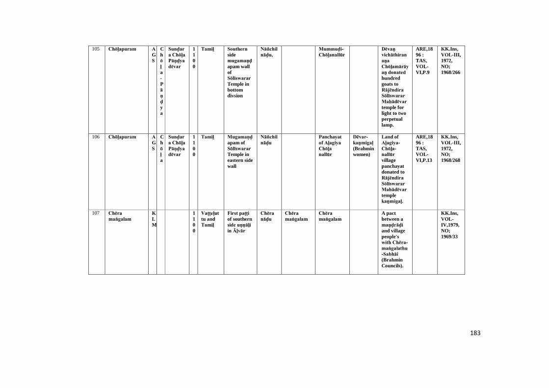
183
105 Chōḻapuram AGS
Chōḻa-Pāṇḍya
Sunḍara Chōḻa Pāṇḍya dēvar
1100
Tamiḻ Southern sidemugamaṇḍapam wallofSōlīswarar Temple inbottomdivsion
Nāñchilnāḍu,
Mummuḍi-Chōḻanallūr
Dēvaṉ vichāthiranaṉa Chōḻamārāyaṉ donated hundredgoats toRājēndira Sōlīswarar Mahādēvar temple forlight to twoperpetuallamp.
ARE,1896 :TAS,VOL-VI,P.9
KK.Ins,VOL-III,1972,NO;1968/266
106 Chōḻapuram AGS
Chōḻa
Sunḍara Chōḻa Pāṇḍya dēvar
1100
Tamiḻ Mugamaṇḍapam ofSōlīswarar Temple ineastern sidewall
Nāñchilnāḍu
Panchayatof Aḻagiya Chōḻa nallūr
Dēvar-kaṉmigaḷ (Brahminwomen)
Land ofAḻagiya-Chōḻa-nallūr villagepanchayatdonated toRājēndira Sōlīswarar Mahādēvar templekaṉmigaḷ.
ARE,1896 :TAS,VOL-VI,P.13
KK.Ins,VOL-III,1972,NO;1968/268
107 Chēra maṅgalam
KLM
1100
Vaṭṭeḷuttu andTamiḻ
First paṭṭi of southernside uṇṇāḻi in Āḻvār
Chēra nāḍu
Chēra maṅgalam
Chēra maṅgalam
A pactbetween amaṇḍrāḍi and villagepeople'swith Chēra-maṅgalathu-Sabhāi (BrahminCouncils).
KK.Ins,VOL-IV,1979,NO;1969/33
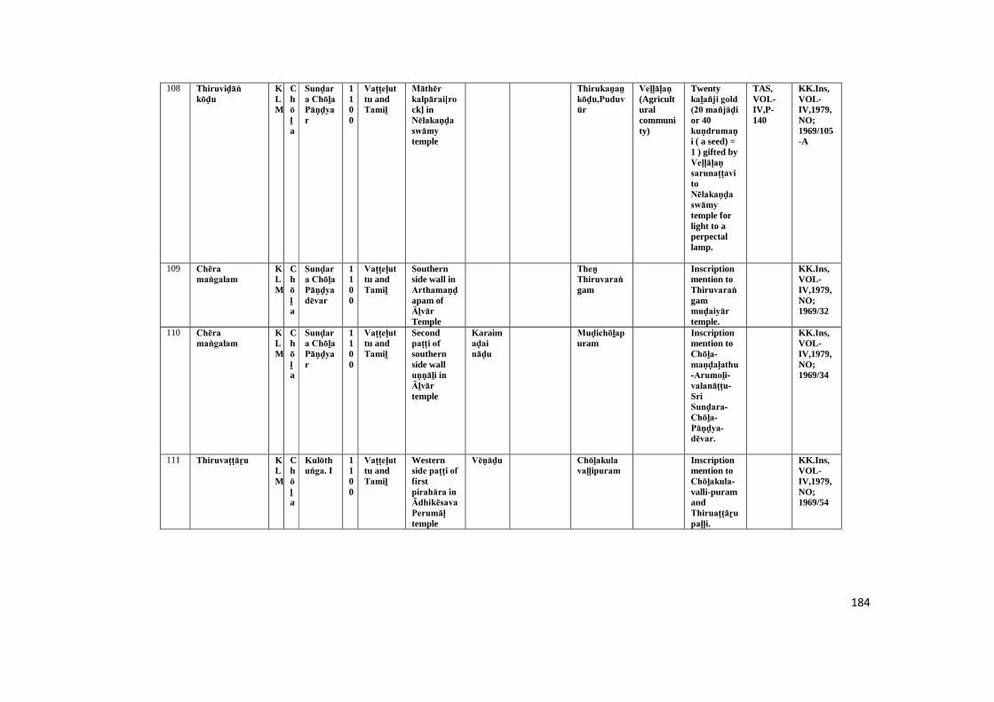
184
108 Thiruviḍāṅ kōḍu
KLM
Chōḻa
Sunḍara Chōḻa Pāṇḍyar
1100
Vaṭṭeḷuttu andTamiḻ
Māthēr kalpārai[rock] inNēlakaṇḍa swāmy temple
Thirukaṇaṉ kōḍu,Puduvūr
Veḷḷāḷaṇ (Agriculturalcommunity)
Twentykaḻañji gold (20 mañjāḍi or 40kuṇdrumaṇi ( a seed) =1 ) gifted byVeḷḷāḷaṇ sarunaṭṭavi toNēlakaṇḍa swāmy temple forlight to aperpectallamp.
TAS,VOL-IV,P-140
KK.Ins,VOL-IV,1979,NO;1969/105-A
109 Chēra maṅgalam
KLM
Chōḻa
Sunḍara Chōḻa Pāṇḍya dēvar
1100
Vaṭṭeḷuttu andTamiḻ
Southernside wall inArthamaṇḍapam ofĀḻvār Temple
Theṉ Thiruvaraṅgam
Inscriptionmention toThiruvaraṅgammuḍaiyār temple.
KK.Ins,VOL-IV,1979,NO;1969/32
110 Chēra maṅgalam
KLM
Chōḻa
Sunḍara Chōḻa Pāṇḍyar
1100
Vaṭṭeḷuttu andTamiḻ
Secondpaṭṭi of southernside walluṇṇāḻi in Āḻvār temple
Karaimaḍai nāḍu
Muḍichōḻapuram
Inscriptionmention toChōḻa-maṇḍaḷathu-Arumoḻi-valanāṭṭu-SriSunḍara-Chōḻa-Pāṇḍya-dēvar.
KK.Ins,VOL-IV,1979,NO;1969/34
111 Thiruvaṭṭāṟu KLM
Chōḻa
Kulōthuṅga. I
1100
Vaṭṭeḷuttu andTamiḻ
Westernside paṭṭi of firstpirahāra in Ādhikēsava Perumāḷ temple
Vēṇāḍu Chōḻakula vaḷḷipuram
Inscriptionmention toChōḻakula-valli-puramandThiruaṭṭāṟu paḷḷi.
KK.Ins,VOL-IV,1979,NO;1969/54
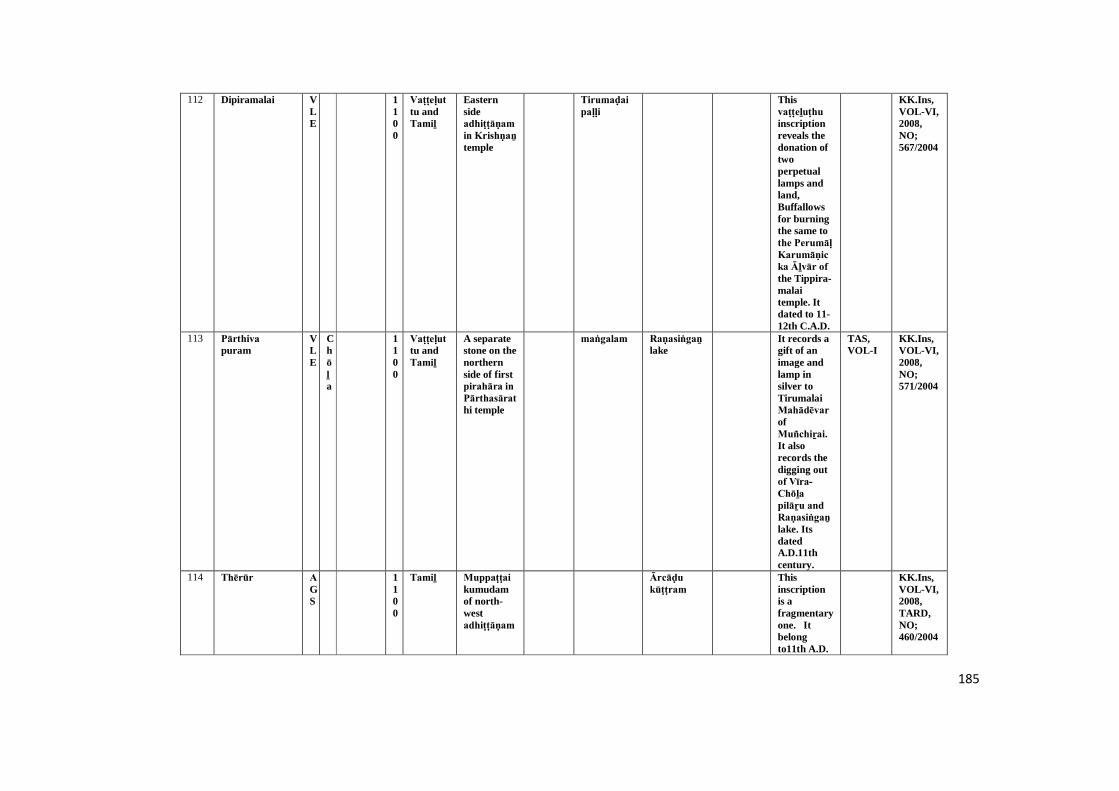
185
112 Dipiramalai VLE
1100
Vaṭṭeḷuttu andTamiḻ
Easternsideadhiṭṭāṇam in Krishṇaṉ temple
Tirumaḍai paḷḷi
Thisvaṭṭeḻuṭhu inscriptionreveals thedonation oftwoperpetuallamps andland,Buffallowsfor burningthe same tothe Perumāḷ Karumāṇicka Āḻvār of the Tippira-malaitemple. Itdated to 11-12th C.A.D.
KK.Ins,VOL-VI,2008,NO;567/2004
113 Pārthiva puram
VLE
Chōḻa
1100
Vaṭṭeḷuttu andTamiḻ
A separatestone on thenorthernside of firstpirahāra in Pārthasārathi temple
maṅgalam Raṇasiṅgaṉ lake
It records agift of animage andlamp insilver toTirumalaiMahādēvar ofMuñchiṟai. It alsorecords thedigging outof Vīra-Chōḻa pilāṟu and Raṇasiṅgaṉ lake. ItsdatedA.D.11thcentury.
TAS,VOL-I
KK.Ins,VOL-VI,2008,NO;571/2004
114 Thērūr AGS
1100
Tamiḻ Muppaṭṭai kumudamof north-westadhiṭṭāṇam
Ārcāḍu kūṭṭram
Thisinscriptionis afragmentaryone. Itbelongto11th A.D.
KK.Ins,VOL-VI,2008,TARD,NO;460/2004
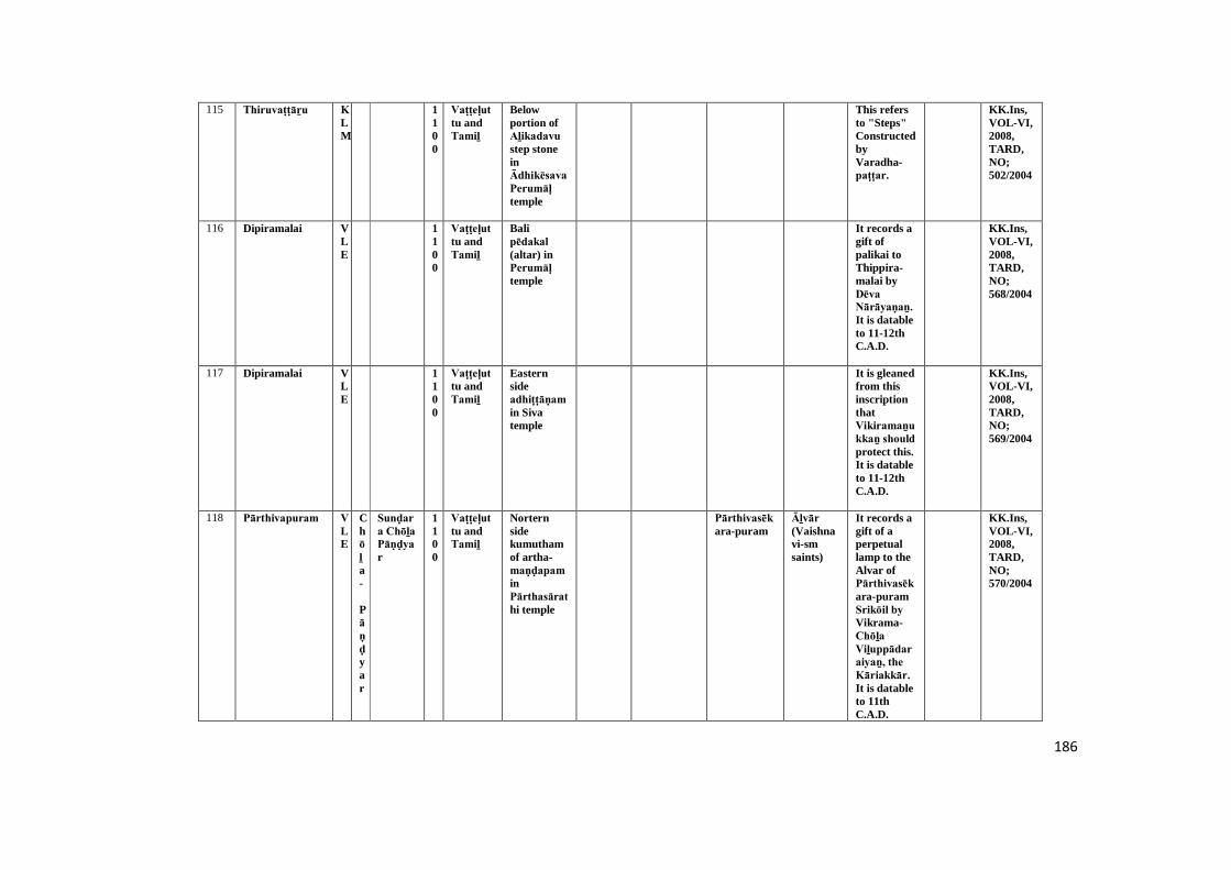
186
115 Thiruvaṭṭāṟu KLM
1100
Vaṭṭeḷuttu andTamiḻ
Belowportion ofAḻikadavu step stoneinĀdhikēsava Perumāḷ temple
This refersto "Steps"ConstructedbyVaradha-paṭṭar.
KK.Ins,VOL-VI,2008,TARD,NO;502/2004
116 Dipiramalai VLE
1100
Vaṭṭeḷuttu andTamiḻ
Balipēdakal (altar) inPerumāḷ temple
It records agift ofpalikai toThippira-malai byDēva Nārāyaṇaṉ. It is datableto 11-12thC.A.D.
KK.Ins,VOL-VI,2008,TARD,NO;568/2004
117 Dipiramalai VLE
1100
Vaṭṭeḷuttu andTamiḻ
Easternsideadhiṭṭāṇam in Sivatemple
It is gleanedfrom thisinscriptionthatVikiramaṉukkaṉ should protect this.It is datableto 11-12thC.A.D.
KK.Ins,VOL-VI,2008,TARD,NO;569/2004
118 Pārthivapuram VLE
Chōḻa-
Pāṇḍyar
Sunḍara Chōḻa Pāṇḍyar
1100
Vaṭṭeḷuttu andTamiḻ
Norternsidekumuthamof artha-maṇḍapam inPārthasārathi temple
Pārthivasēkara-puram
Āḻvār (Vaishnavi-smsaints)
It records agift of aperpetuallamp to theAlvar ofPārthivasēkara-puramSrikōil by Vikrama-Chōḻa Viḻuppādaraiyaṉ, the Kāriakkār. It is datableto 11thC.A.D.
KK.Ins,VOL-VI,2008,TARD,NO;570/2004

187
119 Muñchiṟai VLE
1100
Vaṭṭeḷuttu andTamiḻ
Ainscriptionlaid onback siderock inThirumalaimaghādēvar temple
It reveals agift of 6Kāsu (coin) for buringlamp to theSabhā of Muñchiṟai.
TAS,VOL-VII,DIVISION-I,NO:12,
KK.Ins,VOL-VI,2008,TARD,NO;577/2004
120 Muñchiṟai VLE
1100
Vaṭṭeḷuttu andTamiḻ
Ainscriptionlaid onback sideportionrock inThirumalaimaghādēvar temple
The Sabhā ofMuñchiṟai madedonationsfor burningperpetuallamp inTirumalaiMahādēvar temple asrevealed bythisinscription.
TAS,VOL-VII,DIVISION-I,NO:12,
KK.Ins,VOL-VI,2008,TARD,NO;578/2004
121 Sucīndram AGS
Chōḻa
Kulōthuṅ-gaṉ -I
1102
Tamiḻ Second pragāra of westernsideĀnaipārai inDāṇumālaya Perumāḷ Temple
Chelurmaṇ Pūvaṇavaṉ dweller ofChēilūrmaṇ installed afemale deityof Dēvi in Sucīndram temple.
TAS,VOL-IV,division-ii,p.130
KK.Ins,VOL-II,1972,NO;1968/209
122 Chōḻapuram AGS
Chōḻa
Kulōthuṅ-gaṉ -I
1109
Tamiḻ Sōlīswarar Templeuṇṇāḻi of southernside wall inbottomdivision
Nāñchilnāḍu,
Kōṭṭāṟu,Iraiyūr
Gaṅgaikoṇḍa-Chōḻa vichādara Pallavaraiyar donatedfifty goats toSōlīswarar Mahādēvar temple forlight toperpetuallamp.
TAS,VOL-I,PP.246-247
KK.Ins,VOL-III,1972,NO;1968/254

188
123 Vāriyūr AGS
Chōḻa
Kulōthuṅ-gaṉ -I
1111
Tamiḻ Pathmanāba purampalace
Rāja Rāja-Pāṇḍya-nāḍu,puṟathaya-nāḍu Vāriyūr
Amarāvathi maṅgalam
UthamaChōḻa vaḷa nāḍu Amarāvathi maṅgalam
It revealstheinstallationof aperpetuallamp in thename ofKulōthuṅgaṉ-Chōḻa in the templeofSucīnḍram byGurukularāyaṉ of Amarāvathi maṅgalam.
TAS,VOL-VII, NOQP:355
KK.Ins,VOL-VI,2008,NO;485/2004
124 Agastīswaram AGS
Pāṇḍya
Saḍaya varmaṉ srivallabadēvar
1123
Agastīswarar templewest wall ofuṇṇāḻi in firstpaṭṭigai
Gift ofmāḍaigaḷ (gold coin)to Thiru-Agastīsvarar -muḍaiyār Temple
STANO:9(1/1112)
KK.Ins,VOL-I,1972,NO;1968/13
125 Aḻakiya Pāṇḍya puram
TOV
1123
Tamiḻ First paṭṭi of West sidewall uṇṇāḻi in SriVēṅgaḍa chalapathytemple
Nagarathār donatedthree maa ofLand totemplePriest of SriVeṅgaḍa-chalapathitemple forits dailyrituals.
TAS,VOL-III,DIVISION-I,P-58
KK.Ins,VOL-V1979,NO;1969/16
126 Maṇalthiṭṭai TOV
1123
Tamiḻ A separate stone nearC.R. Takis.
Damaged KK.Ins,VOL-V1979,NO;1969/83
127 Agastīswaram AGS
Pāṇḍya
Saḍaya varmaṉ srivallabadēvar
1124
Agastīswarar templeSouth wallof unnaaḻi
Puṟathayanāḍu
Gift ofmāḍaigaḷ (gold coins)
STANO:46/1086
KK.Ins,VOL-I,1972,NO;1968/4
189
128 Sucīndram AGS
1125
Tamiḻ Northern outside wallof firstpragāra in Dāṇumālaya Perumāḷ Temple
Nāñchilnāḍu,
Nāñcilnāṭṭu Sucīnḍram Sivallamaṅgalam
This refersto thedonation ofland toMaghādēvar temple forinstallingimageSōmaskantha byThiruvikramaṉ.
VOL -VIII,p.32
KK.Ins,VOL-II,1972,NO;1968/149
129 Chōḻapuram AGS
Tiruviḍāṅ
core
Vīrakēraḷa panmar
1126
Tamiḻ Southern side wall ofartha-maṇḍapam inSōlīswarar Temple
Vēṇāḍu Dēvaḍāṉam Mummuḍi-Chōḻa-nallūr, Vaḍachērry, Maṇṉūr
Daṉañcheyaṅ-kaṇḍaṉ, Kēraḷa-siṅga-pallavaraiyaṉ and Kaṇṇaṉ-govinthaṉ donated toRājēndra Sōlīswarar-mahā-dēvar temple.
ARE,33/1896:TAS,VOL-IV,P.17
KK.Ins,VOL-III,1972,NO;1968/271
130 Agastīswaram AGS
Pāṇḍya
Saḍayavar-man srivallabadēvar
1127
Akastisvarair templewest wall ofuṇṇāḻi in thirdpaṭṭigai
Muṇṇutru maṅgalam
Muṇṉūtru maṅgalam
Gift of Landfor FreeFood toFifty Sivadevoties.
STANO:10(2/1112)
KK.Ins,VOL-I,1972,NO;1968/14
131 Sucīndram AGS
Chōḻa
Kēraḷaṉ vikramaChōḻa dēvar
1134
Tamiḻ Western side wall(out side) ofCheṇpagarāmaṇ maṇḍapam inDāṇumālaya Perumāḷ Temple
Nāñchilnāḍu
SucindraChōḻasadurvēdic maṅgalam andDēvaḍāṉa Theṉparakk-ai
Kēraḷa Kēraḷaṉ Vikrama-Chōḻa dēvar donatedseventyseven achu(coin) to godofSucīnḍram Nāyaṉār.
KK.Ins,VOL-II,1972,NO;1968/161
190
132 Thirunayiṉār kuṟichi
KLM
1139
Tamiḻ Southern side paṭṭi of uṇṇāḻi in Karaikaṇḍīswarartemple
Theṉṉāṭṭu Kuṟunāḍu
Kaḍigai paṭṭiṇam
Cheṭṭiyār Ādhichaṉ-kōthai donatedThirunandhavaṉam (templegardan) andperpetualLamp tokaḍigai pathirthuKaraikaṇḍīswararMahādēvar temple.
TAS,VOL-IV-,P-82
KK.Ins,VOL-IV,1979,NO;1969/38
133 Sucīndram AGS
Pāṇḍya
SriVallabadēvar
1140
Tamiḻ Northern side wall offirstpragāra in Dāṇumālaya Perumāḷ Temple
Mullināṭṭu Rāja Rāja sadurvēdicmaṅgalam,Nāñchilnāḍu andPuṟanthayanāḍu
Mulli nāṭṭu Rāja Rāja Sadurvēdic maṅgalam, Sucīndra sadur vēdic maṅgalam andPuṟanthaya nāṭṭu Pulla maṅgalam
Mullināṭṭu Rāja Rāja Chadurvedimaṅgalam ,Sunḍara Pāṇḍya Chadurvēdic maṅgalam Puṟanthaya-nāṭṭu-maṅgalam and Pulla-maṅgalam
Maṟavarmaṉ Sri Vallabaṉ (a king ofPāṇḍya) donated fewland ofPullamaṅgalam toSucīnḍram temple.
TAS,VOL-IV,pp.125-126
KK.Ins,VOL-II,1972,NO;1968/193
134 Chōḻapuram AGS
1140
Tamiḻ Southern sidemugamaṇḍapam wallofSōlīswarar Temple inbottomdivsion
Nāñchilnāḍu,
VikkiramaPāṇḍya puram
Mālātha-parathaṉ donatedgold tokuṉdra-merinthaPiḷḷaiyār temple fordailyrituals.
TAAR,VOL-VI,74/1084
KK.Ins,VOL-III,1972,NO;1968/262

191
135 Sucīndram AGS
Vēṇāḍu
SriKōthai Kēraḷa vanmar
1144
Tamiḻ First pragāra wall ofnorthernside inDāṇumālaya Perumāḷ Temple
Vēṇāḍu,Nāñchilnāḍu
Dēvaḍāṉam of Theṉvaḷa nallūr
Theṉ-vaḷa nallūr
This refersto thedonation ofSri Kōthai Kēraḷavarmaṉ to Sucīnḍram Maghādēvar forPerformingdaily Pūjās.
TAS,VOL-IV,p.20
KK.Ins,VOL-II,1972,NO;1968/148
136 Sucīndram AGS
1144
Tamiḻ First pragāra wall ofnorthernside inDāṇumālaya Perumāḷ Temple
Vēṇāḍu,Nāñchilnāḍu
Dēvaḍāṉam ofNirubhasekara nallūr
Nirubasekara-nallūr, Vaḷanallūr
Paṇḍāram,Thachaṉ (carpender)
This refersto theoffering tothiru-amudhu(foodoffered tothe divine)toMaghādēvar ofSucīnḍram.
KK.Ins,VOL-II,1972,NO;1968/146
137 Sucīndram AGS
1149
Tamiḻ First pragāra wall ofnorthernside inDāṇumālaya Perumāḷ Temple
Nāñchilnāḍu, Vēṇāḍu
Nirubasekara-nallūr, Vaḍanallūr
This refersto thedonation ofthis land toSucīndram Maghādēvar forperformingdailyrituals.
KK.Ins,VOL-II,1972,NO;1968/147
138 Puravachērry AGS
Pāṇḍya
SriVallabadēvar
1149
Tamiḻ Kumudam of westernside uṇṇāḻi in Perumāḷ Temple
Vaigunthavaḷanāḍu,Nāñchilnāḍu
Nāñci nāṭṭu brahmadeyam,Puṟavari sathurvethimaṅgalam, Dēvaḍāṉam and Vīra-Kēraḷa maṅgalam
Verakēraḷa-maṅgalam, Puṟavari-sadurvēdic-maṅgalam,
Kaṉmigaḷ (brahminwomenserved totemple)
Panchayatof Vīra-Kēraḷa maṅgalam donatedland toPerumāḷ temple forits dailyrituals.
TAS,VOL-VII,DIVISION-1,P-5
KK.Ins,VOL-III,1972,NO;1968/312
192
139 Puravachērry AGS
Pāṇḍya
Māra varmaṉ SriVallabadēvar
1149
Tamiḻ Kumudam of northernside walluṇṇāḻi in Perumāḷ Temple
Khīḻvembanāḍu, Nāñchilnāḍu,Veṇpagai nāḍu
Puṟavari sathurvethimaṅgalam
Puṟavari-sadurvēdic-maṅgalam,Thirunelveli,Venpaikuḍi,VeraKēraḷa-maṅgalam
Landdonation toPerumāḷ temple fordailyworship.
TAS,VOL-VII,DIVISION-I,PP.3-4
KK.Ins,VOL-III,1972,NO;1968/308
140 Sucīndram AGS
1154
Tamiḻ Damaged Inscription refers tokollam year330(A.D.1154).
KK.Ins,VOL-II,1972,NO;1968/135
141 Puravachērry AGS
1159
Tamiḻ Kumutham of southernsidearthamaṇḍapam wallin Perumāḷ Temple
Vikramachērry,
Kaṉmigaḷ Āṇ-kuḍi vēḷaṉ donated ofland toPerumāḷ temple forits dailyrituals.
TAS,VOL-VII,DIVISION-1,P-11
KK.Ins,VOL-III,1972,NO;1968/322
142 Puravachērry AGS
1160
Tamiḻ Kumudam of northernsidemugamaṇḍapam wallin Perumāḷ Temple
Dēvaḍāṉam, maṅgala chērry
Mummuḍi-Chōḻa-nallūr, mangala-chērry
Kaṉmigaḷ (brahminwomenserved totemple)
Landdonation toPerumāḷ temple forits dailyPūjās.
TAS,VOL-VII,DIVISION-I,PP.6-7
KK.Ins,VOL-III,1972,NO;1968/310
143 Puravachērry AGS
Vēṇāḍu
Vīraravivarmar
1161
Tamiḻ kumudam of southernside uṇṇāḻi in Perumāḷ Temple
Vēṇāḍu Puṟavari sathurvethimaṅgalam
Puṟavari sadurvēdic maṅgalam,
Paṇḍāram
Landdonated toPerumāḷ temple forits ritualsand light toperpetuallamp.
TAS,VOL-VII,DIVISION-I,P-8
KK.Ins,VOL-III,1972,NO;1968/306
144 Puravachērry AGS
1161
Tamiḻ uṇṇāḻi wall in Perumāḷ Temple
Theṉ-ṉāḍu
Puṟavari sathur-vethi-maṅgalam
Puṟavari sadurvēdic maṅgalam,Thiruveṇkāḍu
Ins. mentionsettlementpatten ofSathur-vēdic maṅgalam bysingaṉaraṅgaṉ a villagers oftheṉṉāṭṭu pasuṅkuḷam
TAS,VOL-VII,DIVISION-I,P-2
KK.Ins,VOL-III,1972,NO;1968/307
193
145 Kariyamāṇika puram
AGS
1163
Kailāsanāthar templeuṇṇāḻi of south sidefirst&secondpaṭṭigai
Rājaṇārāyaṇa sadurvēdic maṅgalam
Rājanārāyaṇa sadur-vēdic-maṅgalam /Aḻagiya-Chōḻa-nallūr
Aḻagiya-Chōḻa-nallūr / Rāja-ṇārāyaṇa sadurvēdic maṅgalam /VIlaūr
Gaṅgaikoṇḍa-Chōḻa-Vaḷḷuva Nādāḻvāṉ was giftland toKarumpaḻa sri kailāser Temple forritual's.
KK.Ins,VOL-I,1972,NO;1968/32
146 Thirunayiṉār kuṟichi
KLM
1163
Tamiḻ Southern side paṭṭi (outside)ofRishabhamaṇḍapam inKaraikaṇḍīswarartemple
Rāja Rāja Theṉṉāḍu, Kuṟunāḍu
Sivaṉukiṉiyār donated paddy togod ofKaraikaṇḍīswarara-mudaiyaNāyaṉār for festival dayrituals andThiru-nadakam(Religionsdrama).
TAS,VOL-VII,DIVISION-I,P-30
KK.Ins,VOL-IV,1979,NO;1969/38-B
147 Puravachērry AGS
1164
Tamiḻ Southern side uṇṇāḻi wall inPerumāḷ Temple
Puṟavari-sathur-vēdi-maṅgalam
Puṟavari-sadurvēdic-maṅgalam,
landdonation toPerumāḷ temple forfood offer tobrahmins.
TAS,VOL-VII,DIVISION-1,P-13
KK.Ins,VOL-III,1972,NO;1968/317
148 Thiruvaṭṭāṟu KLM
Vēṇāḍu
Vīraudhayamārthāṇḍa varmar
1172
Vaṭṭeḷuttu andTamiḻ
Southernside paṭṭi of firstpirahāra in Ādhikēsava Perumāḷ temple
KōthainallūrKhīḻchērry
Donation ofThiruvaṭṭāṟuĀdhikēsava Perumāḷ temple forits dailyworships.
TAS,VOL-VII,DIVISION-II,P-117
KK.Ins,VOL-IV,1979,NO;1969/49
149 Kiḷḷiyūr VLE
Vēṇāḍu
Vīra mārthāṇḍa varmarThiruvaḍi
1178
Vaṭṭeḷuttu andTamiḻ
A separatestone inPirāṭṭīswarer temple
Kiḷḷiyūr and Vayakkalūr
This refersto donationfor dailyPūjās for Mahādēvar ofPirāṭṭīswarer.
TAS,VOL-VII,DIVISION-II,NO:14,P-25
KK.Ins,VOL-VI,2008,TARD,NO;544/2004
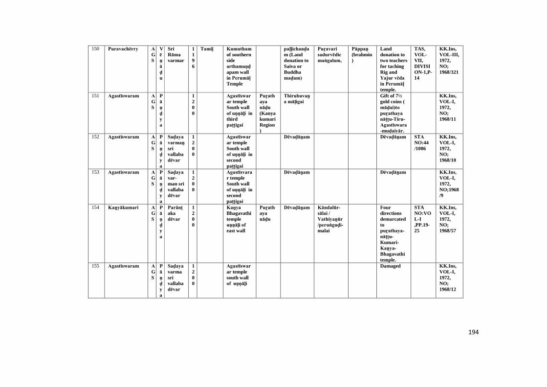
194
150 Puravachērry AGS
Vēṇāḍu
SriRāma varmar
1196
Tamiḻ Kumutham of southernsidearthamaṇḍapam wallin Perumāḷ Temple
paḷḷichanḍam (Landdonation toSaiva orBuddhamaḍam)
Puṟavari sadurvēdic maṅgalam,
Pāppaṉ (brahmin)
Landdonation totwo teachersfor tachingRig andYajur vēda in Perumāḷ temple.
TAS,VOL-VII,DIVISION-1,P-14
KK.Ins,VOL-III,1972,NO;1968/321
151 Agastīswaram AGS
Pāṇḍya
1200
Agastīswarar templeSouth wallof uṇṇāḻi in thirdpaṭṭigai
Puṟathayanāḍu (KanyakumariRegion)
Thirubuvaṉa māḷigai
Gift of 7½gold coins (māḍai)to puṟathaya nāṭṭu-Tiru-Agastīswara-muḍaiyār.
KK.Ins,VOL-I,1972,NO;1968/11
152 Agastīswaram AGS
Pāṇḍya
Saḍaya varmaṉ srivallabadēvar
1200
Agastīswarar templeSouth wallof uṇṇāḻi in secondpaṭṭigai
Dēvaḍāṉam Dēvaḍāṉam STA NO:44/1086
KK.Ins,VOL-I,1972,NO;1968/10
153 Agastīswaram AGS
Pāṇḍya
Saḍayavar-man srivallabadēvar
1200
Agastīsvarar templeSouth wallof uṇṇāḻi in secondpaṭṭigai
Dēvaḍāṉam Dēvaḍāṉam KK.Ins, VOL-I,1972,NO;1968/9
154 Kaṉyākumari AGS
Pāṇḍya
Parānṭakadēvar
1200
Kaṉya Bhagavathitempleuṇṇāḻi of east wall
Puṟathayanāḍu
Dēvaḍāṉam Kāndalūr-sālai / Vathiyaṉūr /peruṅguḍi-malai
Fourdirectionsdemarcatedtopuṟathaya-nāṭṭu-Kumari-Kaṉya-Bhagavathitemple.
STANO:VOL-I,PP.19-25
KK.Ins,VOL-I,1972,NO;1968/57
155 Agastīswaram AGS
Pāṇḍya
Saḍaya varmasrivallabadēvar
1200
Agastīswarar templesouth wallof uṇṇāḻi
Damaged KK.Ins,VOL-I,1972,NO;1968/12
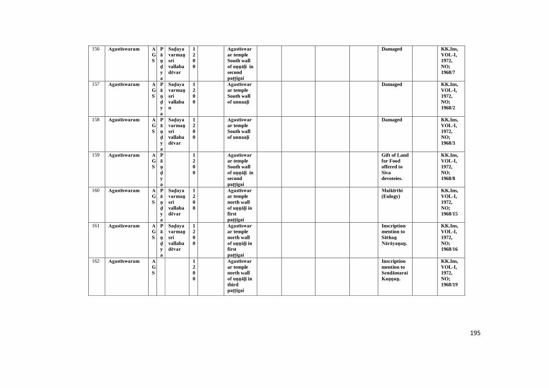
195
156 Agastīswaram AGS
Pāṇḍya
Saḍaya varmaṉ srivallabadēvar
1200
Agastīswarar templeSouth wallof uṇṇāḻi in secondpaṭṭigai
Damaged KK.Ins,VOL-I,1972,NO;1968/7
157 Agastīswaram AGS
Pāṇḍya
Saḍaya varmaṉ srivallaban
1200
Agastīswarar templeSouth wallof unnaaḻi
Damaged KK.Ins,VOL-I,1972,NO;1968/2
158 Agastīswaram AGS
Pāṇḍya
Saḍaya varmaṉ srivallabadēvar
1200
Agastīswarar templeSouth wallof unnaaḻi
Damaged KK.Ins,VOL-I,1972,NO;1968/3
159 Agastīswaram AGS
Pāṇḍya
1200
Agastīswarar templeSouth wallof uṇṇāḻi in secondpaṭṭigai
Gift of Landfor Foodoffered toSivadevoteies.
KK.Ins,VOL-I,1972,NO;1968/8
160 Agastīswaram AGS
Pāṇḍya
Saḍaya varmaṉ srivallabadēvar
1200
Agastīswarar templenorth wallof uṇṇāḻi in firstpaṭṭigai
Maikīrthi (Eulogy)
KK.Ins,VOL-I,1972,NO;1968/15
161 Agastīswaram AGS
Pāṇḍya
Saḍaya varmaṉ srivallabadēvar
1200
Agastīswarar templenorth wallof uṇṇāḻi in firstpaṭṭigai
Inscriptionmention toSāthaṉ Nārāyaṇaṉ.
KK.Ins,VOL-I,1972,NO;1968/16
162 Agastīswaram AGS
1200
Agastīswarar templenorth wallof uṇṇāḻi in thirdpaṭṭigai
Inscriptionmention toSendāmarai Kaṇṇaṉ.
KK.Ins,VOL-I,1972,NO;1968/19

196
163 Agastīswaram AGS
Pāṇḍya
Saḍaya varmaṉ srivallabadēvar
1200
Agastīswarar templeinside wallof south insecondpaṭṭai
Maikīrthi (Eulogy)
KK.Ins,VOL-I,1972,NO;1968/20
164 Karuppu kōṭṭai AGS
1200
Kailāsanāthar templeuṇṇāḻi of south sidesecondpaṭṭigai
Nāñchilnāḍu (Kaṉyā kumariRegion)
Gift of landto SriKailāsanāthamagadēvar.
KK.Ins,VOL-I,1972,NO;1968/33
165 Kaṉyākumari AGS
1200
Kaṉya Bhagavathitempleuṇṇāḻi of west sidewall
Damaged KK.Ins,VOL-I,1972,NO;1968/44
166 Agastīswaram AGS
Pāṇḍya
Saḍayavar-mansrivallabadēvar
1200
Agastīswarar templeSouth wallof unnaaḻi in secondpaṭṭigai
BrammadēyamMuṇṇūṭru maṅgalam
BrammadēyamMuṇṇūṭru maṅgalam
Gift of Landfor templeAdministration.
KK.Ins,VOL-I,1972,NO;1968/5
167 Kaṉyākumari AGS
Pāṇḍya
Kōchaḍayamarar
1200
Vaṭṭeḷuttu andTamiḻ
Kaṉya-Bhagavathitempleuṇṇāḻi of north sidewall
Puṟathayanāḍu
Kaḷakkāṭṭu Puḷḷa-nārāyaṇaṉ gifted aperpetuallamp tolightKaṉya-BhagavathiTemple.
STANO:VOL-VI,P.141,(29/1085)
KK.Ins,VOL-I,1972,NO;1968/55
168 Agastīswaram AGS
1200
Agastīswarar templeSouth wallof uṇṇāḻi in secondpaṭṭigai
Nambipraṭṭaiyar wife ofPāṇḍyan sri vallabaṉ.
KK.Ins,VOL-I,1972,NO;1968/6
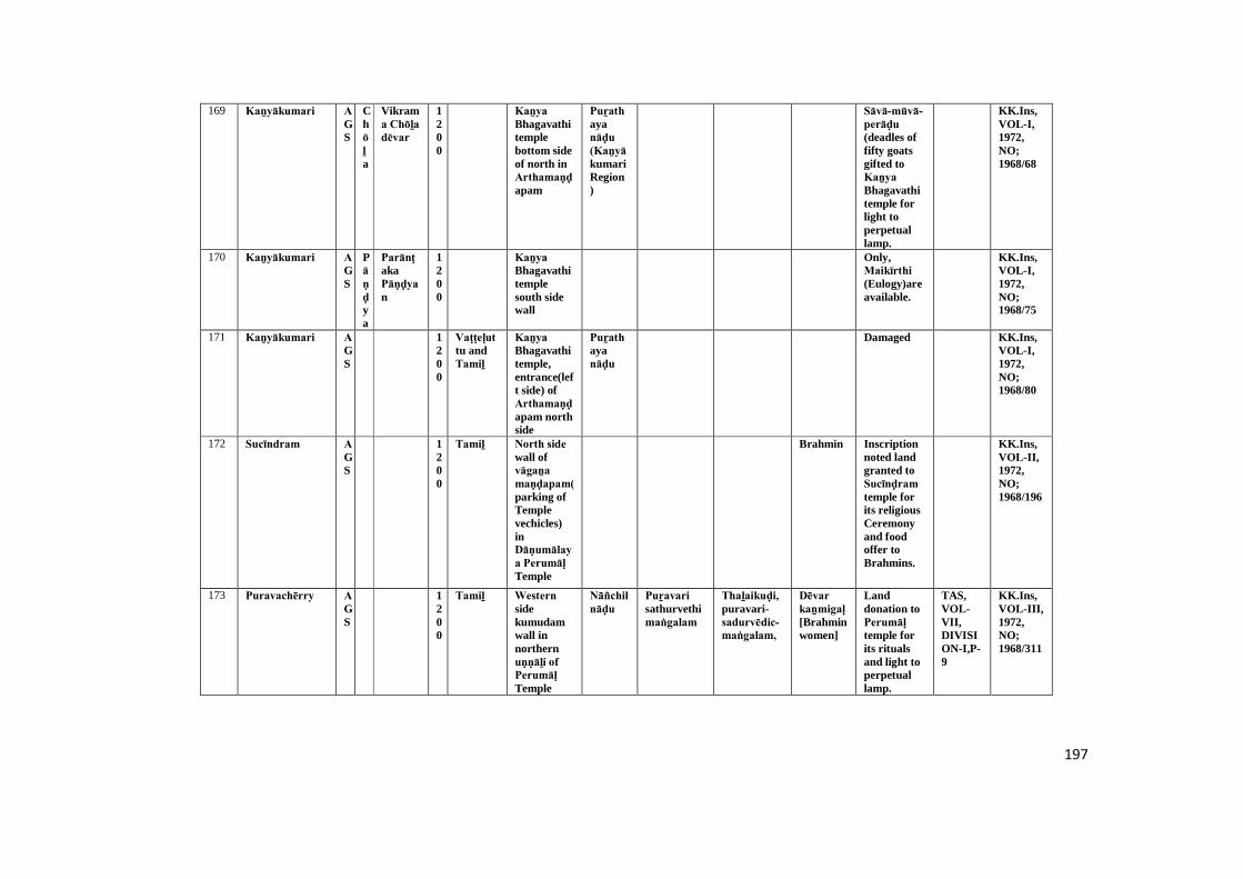
197
169 Kaṉyākumari AGS
Chōḻa
Vikrama Chōḻa dēvar
1200
Kaṉya Bhagavathitemplebottom sideof north inArthamaṇḍapam
Puṟathayanāḍu (Kaṉyā kumariRegion)
Sāvā-mūvā-perāḍu (deadles offifty goatsgifted toKaṉya Bhagavathitemple forlight toperpetuallamp.
KK.Ins,VOL-I,1972,NO;1968/68
170 Kaṉyākumari AGS
Pāṇḍya
ParānṭakaPāṇḍyan
1200
Kaṉya Bhagavathitemplesouth sidewall
Only,Maikīrthi (Eulogy)areavailable.
KK.Ins,VOL-I,1972,NO;1968/75
171 Kaṉyākumari AGS
1200
Vaṭṭeḷuttu andTamiḻ
Kaṉya Bhagavathitemple,entrance(left side) ofArthamaṇḍapam northside
Puṟathayanāḍu
Damaged KK.Ins,VOL-I,1972,NO;1968/80
172 Sucīndram AGS
1200
Tamiḻ North side wall ofvāgaṉa maṇḍapam(parking ofTemplevechicles)inDāṇumālaya Perumāḷ Temple
Brahmin Inscriptionnoted landgranted toSucīnḍram temple forits religiousCeremonyand foodoffer toBrahmins.
KK.Ins,VOL-II,1972,NO;1968/196
173 Puravachērry AGS
1200
Tamiḻ Western sidekumudamwall innorthernuṇṇāḻi of Perumāḷ Temple
Nāñchilnāḍu
Puṟavari sathurvethimaṅgalam
Thaḻaikuḍi,puravari-sadurvēdic-maṅgalam,
Dēvar kaṉmigaḷ [Brahminwomen]
Landdonation toPerumāḷ temple forits ritualsand light toperpetuallamp.
TAS,VOL-VII,DIVISION-I,P-9
KK.Ins,VOL-III,1972,NO;1968/311

198
174 Paṟakai AGS
Pāṇḍya
Māra varmaṉ SriVallabaṉ
1200
Tamiḻ Northern side floorof uṇṇāḻi in Madusūḍaṇa Perumāḷ Temple
Brahmin Damaged KK.Ins,VOL-III,1972,NO;1968/300
175 Thiruviḍāṅ kōḍu
KLM
Tiruviḍāṅ
core
1200
Vaṭṭeḷuttu andTamiḻ
Northernside wall ofuṇṇāḻi in Nēlakaṇḍa swāmy temple.
Rāja Rāja Theṉṉāḍu
Vēmbāṉūr /Thiruvāipāḍi
Fivebullucksdonation byVēmbāṉūr Araṅgaṉ memorialforThiruvāipāḍi Senthinaṅgai to light aperpetuallamp inNelakandaswāmy temple.
TAAR,VOL-III:Division-I,P.80
KK.Ins,VOL-IV,1979,NO;1969/105
176 Thirunandhikarai
KLM
1200
Vaṭṭeḷuttu andTamiḻ
Easternside wall(left side) incave temple
Nāñchilnāḍu
Kuṭṭy andMuthiraiyar ,Iḍaiyaṉ
Chithakuṭṭy Amphy @Aiñṉuṟṟuva Mutharayaṉ donated nine bullucktoThirunandhi-karaipaṭṭārar for light toperpetuallamp.
TAS,VOL-III,DIVISION-II,P-206
KK.Ins,VOL-IV,1979,NO;1969/38-H
177 Thiruvaṭṭāṟu KLM
Tiruviḍāṅcore
VeraviUdhayamārthāṇḍa varmar
1200
Vaṭṭeḷuttu andTamiḻ
Southernside paṭṭi of firstpirahāra in Ādhikēsava Perumāḷ temple
Inscriptionmention to adonare ofUdhaya-mārthāṇḍa-varma-thiruvaḍi.
TAS,VOL-VII,DIVISION-II,P-118
KK.Ins,VOL-IV,1979,NO;1969/46
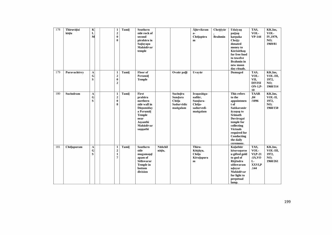
199
178 Thiruviḍai kōḍu
KLM
1200
Tamiḻ Southern side rock ofsecondpirahāra in Saḍayapa Mahādēvar temple
Āḷūrvikrama-Chōḻapūram
Cheṭṭiyār,Brahmin
Udaiyaṉ paṭṭaṉ karpakaCheṭṭy donatedmoney toKārisāthaṉ for free foodto towelveBrahmin innew moonday rituals.
TAS,VOL-VP-144
KK.Ins,VOL-IV,1979,NO;1969/81
179 Puravachērry AGS
1202
Tamiḻ Floor of Perumāḷ Temple
Ovaūr paḷḷi Uvayūr Damaged TAS, VOL-VII,DIVISION-1,P-10
KK.Ins,VOL-III,1972,NO;1968/314
180 Sucīndram AGS
1208
Tamiḻ First prahāra northernside wall inDāṇumālaya Perumāḷ TemplenearJayanthiMahādēvar saṉṉathi
Sucīnḍra Sunḍara Chōḻa Sadurvēdic maṅgalam
Iraṇasiṅga-nallūr, Sunḍara-Chōḻa-sadurvedi-maṅgalam
This refersto theappointment ofSaṅkaranārāyaṇaṉ to SrimathDuvāragai temple forcollectingVictualsrequired forConductingthe dailyceremony.
TAAR,84/1096
KK.Ins,VOL-II,1972,NO;1968/150
181 Chōḻapuram AGS
1217
Tamiḻ Southern sidemugamaṇḍapam ofSōlīswarar Temple inbottomdivision
Nāñchilnāḍu,
Thiru-Kōṭṭāṟu, Chōḻa Kēraḷapuram
Kuḷathūr kēsavaṉarasu gifted goldto god ofRājēndra sōlīswaramuḍayar Mahādēvar for light toperpetuallamp.
TAS,VOL-VI,P-21:IA,VOL-XXVI,P.144
KK.Ins,VOL-III,1972,NO;1968/261
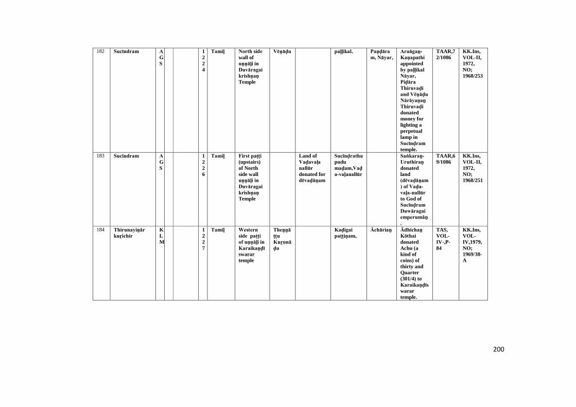
200
182 Sucīndram AGS
1224
Tamiḻ North side wall ofuṇṇāḻi in Duvāragai krishṇaṇ Temple
Vēṇāḍu paḷḷikal, Paṇḍāram, Nāyar,
Araṅgaṉ-Kaṇapathi appointedby paḷḷikal Nāyar, Piḍāra Thiruvaḍi and Vēṇāḍu Nārāyaṇaṉ Thiruvaḍi donatedmoney forlighting aperpetuallamp inSucīnḍram temple.
TAAR,72/1086
KK.Ins,VOL-II,1972,NO;1968/253
183 Sucīndram AGS
1226
Tamiḻ First paṭṭi (upstairs)of Northside walluṇṇāḻi in Duvāragai krishṇaṇ Temple
Land ofVaḍavaḷa nallūr donated fordēvaḍāṉam
Sucīnḍrathu pudumaḍam,Vaḍa-vaḷanallūr
Saṅkaraṉ- Uruthiraṉ donatedland(dēvaḍāṉam) of Vaḍa-vaḷa-nallūr to God ofSucīnḍram Duwāragai emperumāṉ.
TAAR,69/1086
KK.Ins,VOL-II,1972,NO;1968/251
184 Thirunayiṉār kuṟichir
KLM
1227
Tamiḻ Western side paṭṭi of uṇṇāḻi in Karaikaṇḍīswarartemple
Theṉṉāṭṭu Kuṟunāḍu
Kaḍigai paṭṭiṇam,
Āchāriaṉ Ādhichaṉ Kōthai donatedAchu (akind ofcoins) ofthirty andQuarter(301/4) toKaraikaṇḍīswarartemple.
TAS,VOL-IV-,P-84
KK.Ins,VOL-IV,1979,NO;1969/38-A

201
185 Sucīndram AGS
1228
Tamiḻ Western side wall(inside) ofCheṇpagarāmaṉ maṇḍapam inDāṇumālaya Perumāḷ Temple
Sommasimaṅgalam , Khīḻchērrry maṅgalam and Srivallamaṅgalam
Khīḻchērry Mullaimaṅgalam,Vaḍachērry
Āchāri (carpendor)
Only,TempleSabhāi shouldenjoy thetempleproperty.Temple landshould notbemortgagedor sold byanyone, Ifthey do so,they shouldpay fine of20 kaḻañju and 5kāṇam.
TAAR,2/1105
KK.Ins,VOL-II,1972,NO;1968/160
186 Sucīndram AGS
1228
Tamiḻ First paṭṭi (upstir) ofsouth sideuṇṇāḻi in Duvāragai krishṇaṇ Temple
Āchāri (writer)
Refers tolanddonated andtax collectedfrom templetank.
TAS,VOL-VIII,pp.35-36 :
KK.Ins,VOL-II,1972,NO;1968/247
187 Sucīndram AGS
1229
Tamiḻ A rock of the southwest cornerof uṇṇāḻi in Duvāragai krishṇaṇ Temple
Sri Chalavillage
It mentionsto templedonationand name ofSriGōvinḍaparaññaPaḍārar and SriSālagrāma Bhagavāṉ.
TAAR,82/1091
KK.Ins,VOL-II,1972,NO;1968/249
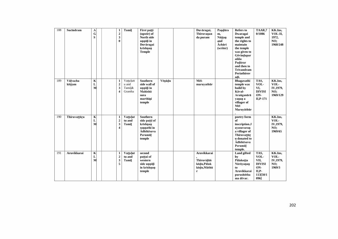
202
188 Sucīndram AGS
1230
Tamiḻ First paṭṭi (upstir) ofNorth sideuṇṇāḻi in Duvāragai krishṇaṇ Temple
Duvāragai, Thiruvaṉanda puram
Paṇḍāram,Nāṭṭaṉ andĀchāri (writer)
Refers toDwaragaitemple andthe rights tomaintainthe templewas given toGōvinḍaparaññaPaḍārar and then toTrivandramPeriathiruvaḍi.
TAAR,70/1086
KK.Ins,VOL-II,1972,NO;1968/248
189 Vāḷvacha kōṭṭam
KLM
1234
Vaṭṭeḷuttu andTamiḻ& Grantha
Southernside wall ofuṇṇāḻi in Mahishā suramarthiṉi temple
Vēṇāḍu Mēl-maruyathūr
Bhagavathitemple wasbuild byKāval-Araṅganārāyaṇaṉ a villager ofMēl Maruyāthūr.
TAS,VOL-VI,DIVISION-II,P-171
KK.Ins,VOL-IV,1979,NO;1969/129
190 Thiruvaṭṭāṟu KLM
1234
Vaṭṭeḷuttu andTamiḻ
Southernside paṭṭi of krishṇaṇ saṉṉathi in Ādhikēsava Perumāḷ temple
poetry formofinscription.Jayasuvaraṉ a villager ofThiruvaṭṭāṟu donated toĀdhikēsava Perumāḷ temple.
KK.Ins,VOL-IV,1979,NO;1969/65
191 Aruvikkarai KLM
1235
Vaṭṭeḷuttu andTamiḻ
secondpaṭṭai of westernside uṇṇāḻi in krishṇaṇ temple
Aruvikkarai,Thiruviḍāṅkōḍu,Pālak kōḍu,Māthūr
Land giftedbyPālakoṭṭu Nārāyaṇaṉ toAruvikkaraipurushōthama dēvar.
TAS,VOL-VII,DIVISION-II,P-113[50/1096]
KK.Ins,VOL-IV,1979,NO;1969/3
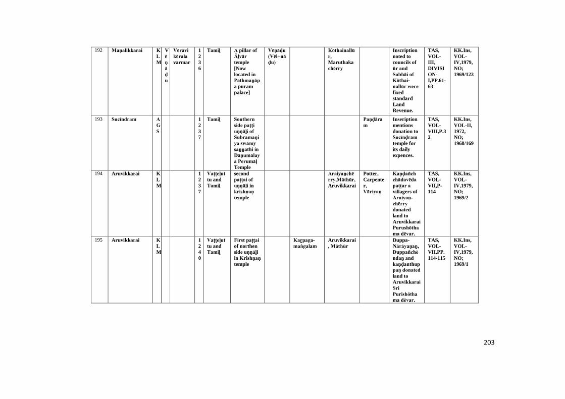
203
192 Maṇalikkarai KLM
Vēṇāḍu
Vēravi kērala varmar
1236
Tamiḻ A pillar of Āḻvār temple[Nowlocated inPathmaṉāpa purampalace]
Vēṇāḍu (Vēl+nāḍu)
Kōthainallūr,Maruthakachērry
Inscriptionnoted tocouncils ofūr and Sabhāi of Kōthai-nallūr were fixedstandardLandRevenue.
TAS,VOL-III,DIVISION-I,PP.61-63
KK.Ins,VOL-IV,1979,NO;1969/123
193 Sucīndram AGS
1237
Tamiḻ Southern side paṭṭi uṇṇāḻi of Subramaṇiya swāmy saṉṉathi in Dāṇumālaya Perumāḷ Temple
Paṇḍāram
Inseriptionmentionsdonation toSucīnḍram temple forits dailyexpences.
TAS,VOL-VIII,P.32
KK.Ins,VOL-II,1972,NO;1968/169
194 Aruvikkarai KLM
1237
Vaṭṭeḷuttu andTamiḻ
secondpaṭṭai of uṇṇāḻi in krishṇaṇ temple
Araiyaṉchērry,Māthūr,Aruvikkarai
Potter,Carpenter,Vāriyaṉ
Kaṇḍañch chādavēda paṭṭar a villagers ofAraiyaṉ-chērry donatedland toAruvikkaraiPurushōthama dēvar.
TAS,VOL-VII,P-114
KK.Ins,VOL-IV,1979,NO;1969/2
195 Aruvikkarai KLM
1240
Vaṭṭeḷuttu andTamiḻ
First paṭṭai of northenside uṇṇāḻi in Krishṇaṇ temple
Kaṟpaga-maṅgalam
Aruvikkarai, Māthūr
Duppa-Nārāyaṇaṉ, Duppañchēndaṉ and kaṇḍanthuppaṉ donated land toAruvikkaraiSriPurishōthama dēvar.
TAS,VOL-VII,PP.114-115
KK.Ins,VOL-IV,1979,NO;1969/1
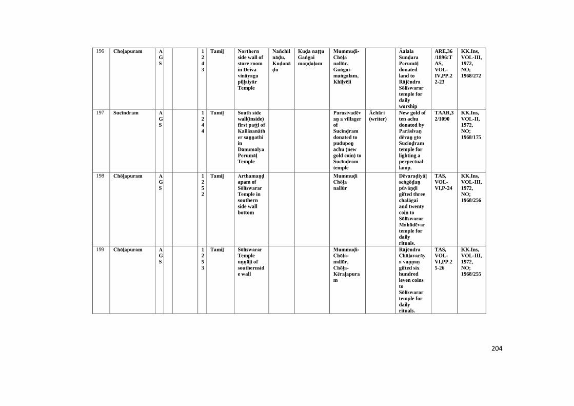
204
196 Chōḻapuram AGS
1243
Tamiḻ Northern side wall ofstore roomin Deivavināyaga piḷḷaiyār Temple
Nāñchilnāḍu, Kuḍanāḍu
Kuḍa nāṭṭu Gaṅgai maṇḍaḷam
Mummuḍi-Chōḻa nallūr, Gaṅgai-maṅgalam, Khīḻvēli
Āālāla Sunḍara Perumāḷ donatedland toRājēndra Sōlīswarar temple fordailyworship
ARE,36/1896:TAS,VOL-IV,PP.22-23
KK.Ins,VOL-III,1972,NO;1968/272
197 Sucīndram AGS
1244
Tamiḻ South side wall(inside)first paṭṭi of Kailāsanāther saṉṉathi inDānumālya Perumāḷ Temple
Parasivadēvaṉ a villager ofSucīnḍram donated topudupoṉ achu (newgold coin) toSucīnḍram temple
Āchāri (writer)
New gold often achudonated byParāsivaṉ dēvaṉ gto Sucīnḍram temple forlighting aperpectuallamp.
TAAR,32/1090
KK.Ins,VOL-II,1972,NO;1968/175
198 Chōḻapuram AGS
1252
Tamiḻ Arthamaṇḍapam ofSōlīswarar Temple insouthernside wallbottom
Mummuḍi Chōḻa nallūr
Dēvaraḍiyāḷ seṅgōḍaṉ pūvāṇḍi gifted threechalāgai and twentycoin toSōlīswarar Mahādēvar temple fordailyrituals.
TAS,VOL-VI,P-24
KK.Ins,VOL-III,1972,NO;1968/256
199 Chōḻapuram AGS
1253
Tamiḻ Sōlīswarar Templeuṇṇāḻi of southernside wall
Mummuḍi-Chōḻa-nallūr, Chōḻa-Kēraḷapuram
Rājēndra Chōḻavarāya vaṇṇaṉ gifted sixhundredleven coinstoSōlīswarar temple fordailyrituals.
TAS,VOL-VI,PP.25-26
KK.Ins,VOL-III,1972,NO;1968/255
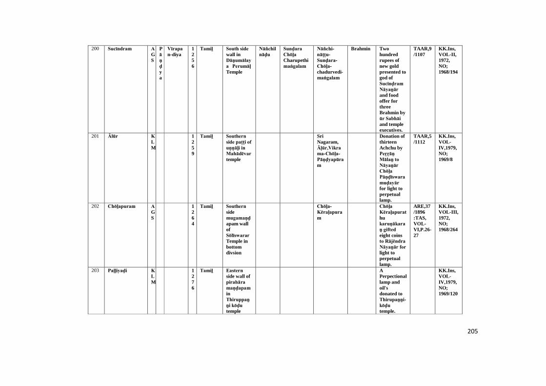
205
200 Sucīndram AGS
Pāṇḍya
Vīrapan-diya
1256
Tamiḻ South side wall inDāṇumālaya Perumāḷ Temple
Nāñchilnāḍu
Sunḍara Chōḻa Charupethimaṅgalam
Nāñchi-nāṭṭu-Sunḍara-Chōḻa-chadurvedi-maṅgalam
Brahmin Twohundredrupees ofnew goldpresented togod ofSucīnḍram Nāyaṉār and foodoffer forthreeBrahmin byūr Sabhāi and templeexecutives.
TAAR,9/1107
KK.Ins,VOL-II,1972,NO;1968/194
201 Ālūr KLM
1259
Tamiḻ Southern side paṭṭi of uṇṇāḻi in Mahādēvar temple
SriNagaram,Āḷūr,Vikrama-Chōḻa-Pāṇḍyapūram
Donation ofthirteenAchchu byPeṟṟāṉ Mālaṉ to Nāyaṉār Chōḻa Pāṇḍīswara muḍayār for light toperpetuallamp.
TAAR,5/1112
KK.Ins,VOL-IV,1979,NO;1969/8
202 Chōḻapuram AGS
1264
Tamiḻ Southern sidemugamaṇḍapam wallofSōlīswarar Temple inbottomdivsion
Chōḻa-Kēraḷapuram
Chōḻa Kēraḷapurathukaruṇākaraṉ gifted eight coinsto Rājēndra Nāyaṉār for light toperpetuallamp.
ARE,37/1896:TAS,VOL-VI,P.26-27
KK.Ins,VOL-III,1972,NO;1968/264
203 Paḷḷiyaḍi KLM
1276
Tamiḻ Eastern side wall ofpirahāra maṇḍapam inThiruppaṉṉi kōḍu temple
APerpectionallamp andoil'sdonated toThirupaṉṉi-kōḍu temple.
KK.Ins,VOL-IV,1979,NO;1969/120
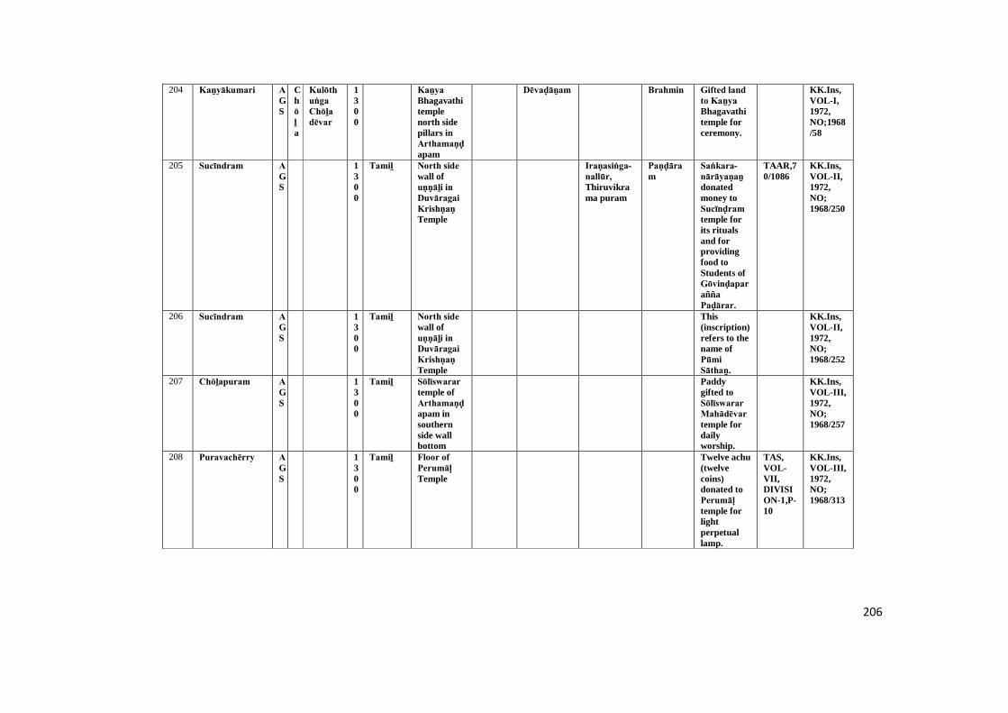
206
204 Kaṉyākumari AGS
Chōḻa
Kulōthuṅga Chōḻa dēvar
1300
Kaṉya Bhagavathitemplenorth sidepillars inArthamaṇḍapam
Dēvaḍāṉam Brahmin Gifted land to Kaṉya Bhagavathitemple forceremony.
KK.Ins,VOL-I,1972,NO;1968/58
205 Sucīndram AGS
1300
Tamiḻ North side wall ofuṇṇāḻi in Duvāragai Krishṇaṇ Temple
Iraṇasiṅga-nallūr, Thiruvikrama puram
Paṇḍāram
Saṅkara-nārāyaṇaṉ donatedmoney toSucīnḍram temple forits ritualsand forprovidingfood toStudents ofGōvinḍaparaññaPaḍārar.
TAAR,70/1086
KK.Ins,VOL-II,1972,NO;1968/250
206 Sucīndram AGS
1300
Tamiḻ North side wall ofuṇṇāḻi in Duvāragai Krishṇaṇ Temple
This(inscription)refers to thename ofPūmi Sāthaṉ.
KK.Ins,VOL-II,1972,NO;1968/252
207 Chōḻapuram AGS
1300
Tamiḻ Sōlīswarar temple ofArthamaṇḍapam insouthernside wallbottom
Paddygifted toSōlīswarar Mahādēvar temple fordailyworship.
KK.Ins,VOL-III,1972,NO;1968/257
208 Puravachērry AGS
1300
Tamiḻ Floor of Perumāḷ Temple
Twelve achu(twelvecoins)donated toPerumāḷ temple forlightperpetuallamp.
TAS,VOL-VII,DIVISION-1,P-10
KK.Ins,VOL-III,1972,NO;1968/313
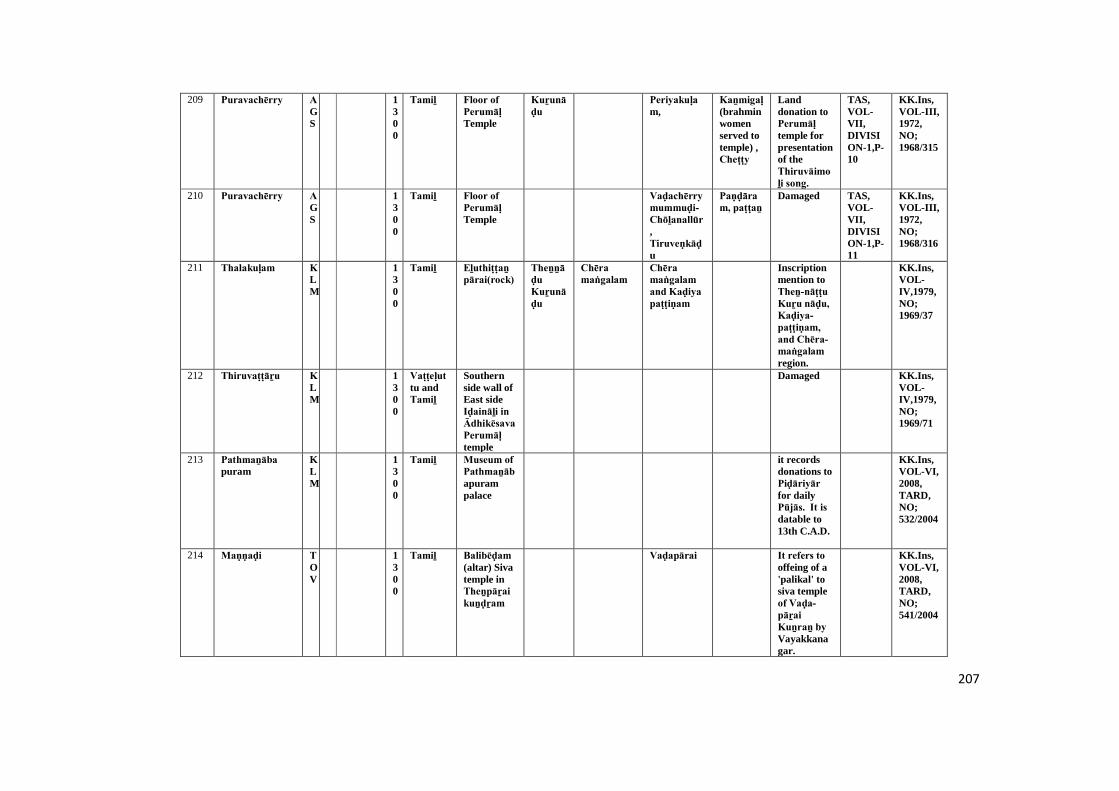
207
209 Puravachērry AGS
1300
Tamiḻ Floor of Perumāḷ Temple
Kuṟunāḍu
Periyakuḷam,
Kaṉmigaḷ (brahminwomenserved totemple) ,Cheṭṭy
Landdonation toPerumāḷ temple forpresentationof theThiruvāimoḻi song.
TAS,VOL-VII,DIVISION-1,P-10
KK.Ins,VOL-III,1972,NO;1968/315
210 Puravachērry AGS
1300
Tamiḻ Floor of Perumāḷ Temple
Vaḍachērry mummuḍi-Chōḻanallūr,Tiruveṇkāḍu
Paṇḍāram, paṭṭaṉ
Damaged TAS,VOL-VII,DIVISION-1,P-11
KK.Ins,VOL-III,1972,NO;1968/316
211 Thalakuḷam KLM
1300
Tamiḻ Eḻuthiṭṭaṉ pārai(rock)
Theṉṉāḍu Kuṟunāḍu
Chēra maṅgalam
Chēra maṅgalam and Kaḍiya paṭṭiṇam
Inscriptionmention toTheṉ-nāṭṭu Kuṟu nāḍu, Kaḍiya-paṭṭiṇam, and Chēra-maṅgalam region.
KK.Ins,VOL-IV,1979,NO;1969/37
212 Thiruvaṭṭāṟu KLM
1300
Vaṭṭeḷuttu andTamiḻ
Southernside wall ofEast sideIḍaināḻi in Ādhikēsava Perumāḷ temple
Damaged KK.Ins,VOL-IV,1979,NO;1969/71
213 Pathmaṉāba puram
KLM
1300
Tamiḻ Museum of Pathmaṉābapurampalace
it recordsdonations toPiḍāriyār for dailyPūjās. It is datable to13th C.A.D.
KK.Ins,VOL-VI,2008,TARD,NO;532/2004
214 Maṇṇaḍi TOV
1300
Tamiḻ Balibēḍam (altar) Sivatemple inTheṉpāṟai kuṉḍṟam
Vaḍapārai It refers to offeing of a'palikal' tosiva templeof Vaḍa-pāṟai Kuṉraṉ by Vayakkanagar.
KK.Ins,VOL-VI,2008,TARD,NO;541/2004
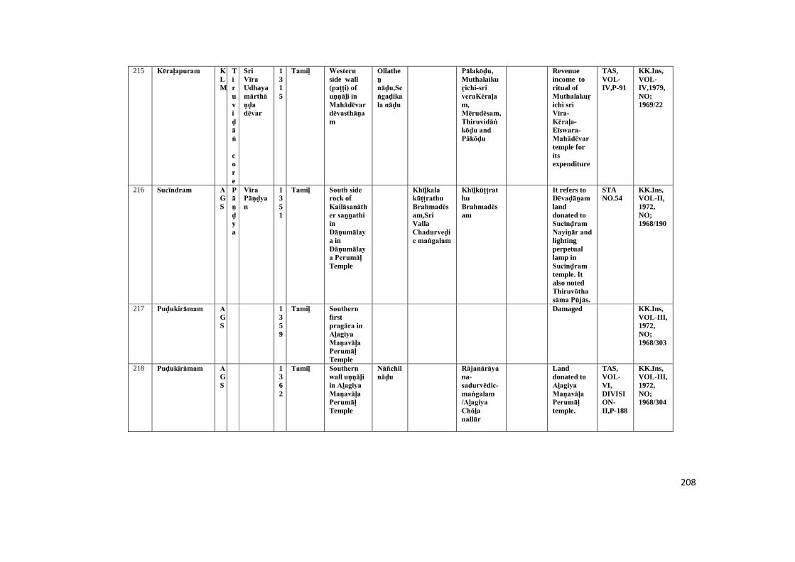
208
215 Kēraḷapuram KLM
Tiruviḍāṅ
core
SriVīra Udhayamārthāṇḍa dēvar
1315
Tamiḻ Western side wall(paṭṭi) of uṇṇāḻi in Mahādēvar dēvasthāṉam
Ollatheṉ nāḍu,Seṅgaḍikala nāḍu
Pālakōḍu, Muthalaikuṟichi-sri veraKēraḷam,Mērudēsam,Thiruvidāṅkōḍu and Pākōḍu
Revenueincome toritual ofMuthalakuṟichi sriVīra-Kēraḷa-Eīswara-Mahādēvar temple foritsexpenditure
TAS,VOL-IV,P-91
KK.Ins,VOL-IV,1979,NO;1969/22
216 Sucīndram AGS
Pāṇḍya
Vīra Pāṇḍyan
1351
Tamiḻ South side rock ofKailāsanāther saṉṉathi inDāṇumālaya inDāṇumālaya Perumāḷ Temple
Khīḻkala kūṭṭrathu Brahmadēsam,SriVallaChadurveḍic maṅgalam
KhīḻkūṭṭrathuBrahmadēsam
It refers toDēvaḍāṉam landdonated toSucīnḍram Nayiṉār and lightingperpetuallamp inSucīnḍram temple. Italso notedThiruvōtha sāma Pūjās.
STANO.54
KK.Ins,VOL-II,1972,NO;1968/190
217 Puḍukirāmam AGS
1359
Tamiḻ Southern firstpragāra in Aḻagiya Maṇavāḷa Perumāḷ Temple
Damaged KK.Ins,VOL-III,1972,NO;1968/303
218 Puḍukirāmam AGS
1362
Tamiḻ Southern wall uṇṇāḻi in Aḻagiya Maṇavāḷa Perumāḷ Temple
Nāñchilnāḍu
Rājanārāyana-sadurvēdic-maṅgalam /Aḻagiya Chōḻa nallūr
Landdonated toAḻagiya Maṇavāḷa Perumāḷ temple.
TAS,VOL-VI,DIVISION-II,P-188
KK.Ins,VOL-III,1972,NO;1968/304
209
219 Kuṟaṇḍi TOV
1363
Tamiḻ A separate stone nearPiḷḷaiyār temple
Vēṇāḍu (Vel+nāḍu) Uthayamārthāṇḍa kuraṇty,Nāñchilnāḍu,Mullināḍu&Pāṇḍyanāḍu
Rāja Rāja sadurvedamaṅgalam andKhīḻkala kūṭṭrru Srivalavaṉ maṅgalam
Uthayamārthāṇḍam , Aḻakiya-Chōḻanallūr andPāṇḍya-nāṭṭu-Khīḻkalakūṭṭrathu-chivalavaṉ-maṅgalam
This refersto Piḷḷaiyār installationand welldigging atKuṟaṇḍi and namedit asUthayamārthāṇḍam by Vēnāṭṭu kingUthayamārthāṇḍan.
KK.Ins,VOL-VI,2008,NO;538/2004
220 Chitharāl VLE
1364
Tamiḻ Inside maṇḍapa pillar inMountaintemple ofChitharāl
Tirukuḍakarai
Cheṭṭiyār This refers to landdonation forfemaledescendantsof kali byThanmaCheṭṭy Nārāyaṇaṉ ofThirukūḍakarai.
TAS,VOL-IV,DIVISION-II
KK.Ins,VOL-VI,2008,TARD,NO;550/2004
221 Puḍukirāmam AGS
1365
Tamiḻ Southern wallMaṇavāḷar uṇṇāḻi in Aḻagiya Maṇavāḷa Perumāḷ Temple
Nāñchilnāḍu
Rājaṇārayaṇa sadurveḍic maṅgalam
Rājanārāyana-sadurvēdic-maṅgalam
Landdonated toAḻagiya Maṇavāḷa Perumāḷ temple.
TAS,VOL-VI,DIVISION-II,P-188
KK.Ins,VOL-III,1972,NO;1968/305
222 Chōḻapuram AGS
Pāṇḍya
ParākkiramaPāṇḍyar
1371
Tamiḻ Northernsidearthamaṇḍapa wall inSōlīswarar Temple onkumudam
Nāñchilnāḍu
Mummuḍi-Chōḻanallūr
SriParākirama-Pāṇḍya-dēvar renovationto Rājēndra Sōlīswarar temple.
ARE,30/1896:TAS,VOL-VI,P.28
KK.Ins,VOL-III,1972,NO;1968/269
210
223 Kaṉyākumari AGS
1372
Tamiḻ Krishṇaṇ temple eastwall ofinsidepragāra
Thirukkaḍavūr
TempleKaṉmigaḷ (brahminwomenserved totemple)gifted toKrishṇaṇ temple.
KK.Ins,VOL-I,1972,NO;1968/122
224 Thiruvaṭṭāṟu KLM
1400
Vaṭṭeḷuttu andTamiḻ
Southernside paṭṭi of uṇṇāḻin in DaliyalMahādēvar temple
Damaged KK.Ins,VOL-IV,1979,NO;1969/50
225 Thiruvaṭṭāṟu KLM
1400
Vaṭṭeḷuttu andTamiḻ
Āṭṭrukkal [stone]infront inĀdhikēsava Perumāḷ temple
Damaged TAS,VOL-VII,DIVISION-II,P-119
KK.Ins,VOL-IV,1979,NO;1969/64
226 Thiruvaṭṭāṟu KLM
1400
Vaṭṭeḷuttu andTamiḻ
Southernside wall offirstpirahāra in Ādhikēsava Perumāḷ temple
Damaged KK.Ins,VOL-IV,1979,NO;1969/72
227 Āḻvārkōil KLM
Vēṇāḍu
Srikērala mārthāṇḍa varmathiruvaḍi
1403
Grantha&Tamiḻ
Museum ofPathmaṉābapurampalace
Iraṇasiṅga-nallūr Khīḻpārūr andSāthaṉūr
Muṭṭy reḍḍy
It registers agift of landto the Sivatemple ofIraṇasiṅga-nallūr for Ushā Pūja by SriVīrakēraḷa mārthāṇḍa varmar ofKīḻappērūr. It is dated toA.D.1403A.D.
KK.Ins,VOL-VI,2008,TARD,NO;518/2004

211
228 Sucīndram AGS
Tiruviḍāṅ
core
Mārthāṇḍa varmar
1410
Grantha Northernside pillarinfront ofJaganthīswarathuRāmēshwarersaṉṉathi in Dāṇumālaya Perumāḷ Temple
Thiruvidancore
A Sabhā maṇḍapam was built byMārthāṇḍa-varmar inSucīndram temple.
TAS,VOL-VIII,p.33
KK.Ins,VOL-II,1972,NO;1968/223
229 Kaṉyākumari AGS
1413
Tamiḻ Kaṉya Bhagavathitemple,third entranceof left sidepillar
Puṟathayanāḍu
Perumāḷ son ofKathānalla giftedmuppalamsandanakappu (sandal ring) to Kaṉya Bagavathitemple inKārthigai month.
STANO:VOL-VIII ,P.26
KK.Ins,VOL-I,1972,NO;1968/78
230 Chōḻapuram AGS
1416
Tamiḻ Soḻiswaram temple ofArthamaṇḍapam insouth sidewall
Damaged KK.Ins,VOL-III,1972,NO;1968/258
231 Thirunayiṉār kuṟichi
KLM
1432
Tamiḻ Western side wall incave temple
Chōḻa Kēraḷapuram
Inscriptionmention toKumbābhishēkam of Karaikaṇḍīswara-muḍaiyaṉār temple on26,Chithirai(January),1432 A.D.
TAS,VOL-VII,DIVISION-I,P-31
KK.Ins,VOL-IV,1979,NO;1969/38-D

212
232 Muñchiṟai VLE
Vēṇāḍu
Vīrakēraḷa mārthāṇḍa varmar
1434
Tamiḻ The rock at the top ofthepirahāra of Thirumalaimaghādēvar temple
It records agift for thedailyfeeding ofTirumalaiMahādēvar.
TAS,VOL-VII,DIVISION-I,NO:12,
KK.Ins,VOL-VI,2008,TARD,NO;575/2004
233 Kariyamāṇika puram
AGS
1437
Kariyamāṇika-Āḻvār templeeastern wallof Muga-maṇḍapam-paṭṭigai
Kulasēkara Nampirāṭṭiyar wasrenovated toKariyamāṇika Viṇṇagar Emperumāṉ Temple.
STANO:VOL-VI,P.44,(106/1099)
KK.Ins,VOL-I,1972,NO;1968/30
234 Akkarai AGS
1438
Agastīswarar templenearestscript rock
Puṟathayanāḍu/Nāñchilnāḍu
Uthayamārthāṇḍa sadurvedimaṅgalam/ Agaram
Uthaya-mārthāṇḍa-sadurvēdic-maṅgalam
Paṭṭars (Brahmin)
Gift of landtopaṭṭar(Brahmin)&poṭṭery making,study ofvedaslike,Rig,Yajur&Sama,Medical care ofsurgery etc.
STANO:VOL-VIII,P.3,(6/1103)
KK.Ins,VOL-I,1972,NO;1968/23
235 Agastīswaram AGS
1438
Agastīswarar templenearestrock
Puṟathayanāḍu/Nāñchilnāḍu
Sadurvedimaṅgalam / Agaram(Brahminsettlement)
Paraichērry
Gift of landtopattar(Brahmin) &potterymaking ,study ofvedaslike,Rig,Yajur & Sama,Medicalcare ofsurgery etc..
STANO:VOL-VIII,P.5,(7/1103)
KK.Ins,VOL-I,1972,NO;1968/22
213
236 Paṟakai AGS
1448
Tamiḻ Top portion pillar inpirahāra maṇḍapam
Tiruṇārayaṇa sadurveḍic maṅgalam andValikollikhiḻar maṅgalam
Khiḻār maṅgalam
Dēva kaṉmigaḷ(Brahminservantsfor God)
Kāña Irukkai Uḻa-kuḍi Periya Nayiṉār Mayilērum Perumāḷ donatedlands asTiruviḍaiyāṭṭam for the daily pujasofMadusūḍaṉa Viṇṇava-Emperumāṉ.
KK.Ins,VOL-VI,2008,NO;466/2004
237 Sucīndram AGS
Pāṇḍya
ParākiramaPāṇḍyan
1450
Tamiḻ South side wall ofCheṇpagarāmaṉ maṇḍapam inDāṇumālaya Perumāḷ Temple
Nāñchilnāḍu,Vāṉavanāḍu
Seṅgala kuṟichiyana Sunḍara Pāṇḍya nallūr dēvaḍāṉam
Sengalakuṟichi Sunḍara Pāṇḍyan nallūr
Parākrama-Pāṇḍyar donatedland to godofDānumālya Perumāḷ forcelepratinghis birthstar ofmirugaChirusa.AndestablishedParākrama-Pāṇḍyar Santhi.
TAS,VOL-I,p.281
KK.Ins,VOL-II,1972,NO;1968/165
214
238 Paṟakai AGS
1451
Tamiḻ Pillar maṇḍapam of pirahāra wall
maṅgala chērry,Tirunārāyaṇa sadurvedamaṅgalam and Khiḻār maṅgalam
Maṅgalachērry,Vaḍachērry &Thirunarayaṇa sadurvēdic maṅgalam
Dēva kaṉmigaḷ (Brahminservantsfor God)
It recordsgift of landbyMadusūḍaṉaDāmōdaraṉ &Madusūḍaṉa Padmaṉābaṉ of Maṅgalachēri to thetempleauthoritiesofMadusūḍaṉa Perumāḷ temple.
KK.Ins,VOL-VI,2008,NO;465/2004
239 Thiruvidāṅ kōḍu
KLM
1452
Vaṭṭeḷuttu andTamiḻ
A stonepillar foundnearwomenschool inThiruviḍāṅ kōḍu
Kōttūr and Perūr
Vēḷāḷar, Vēḷḷānāḍār,Muḍaliyār, Nāyar andPāppaṉ (Priest)
It registers aconflictbetween thetwocommunities of Vēḷḷāḷās andVēḷḷānāḍār.
TAS,VOL-VDIVISION-I,NO;26
KK.Ins,VOL-VI,2008,TARD,NO;514/2004
240 Kaḍukarai TOV
1459
Tamiḻ West side entrancestep ofMurugaṉ saṉṉathi in SriKaṇḍēswara Nayiṉār temple.
Nāñchilnāḍu
Aḻakiya Pāṇḍya puram
Incriptionrefer to SriKaṇḍēswara-muḍaya Nayiṉār of Nāñchilnāḍu Aḻakiya Pāṇḍyapuram Udaiyar.
KK.Ins,VOL-V1979,NO;1969/41
241 Krishṇaṇ kōil AGS
Tiruviḍāṅcore
Seṇbaga-āditha-vanmar
1460
Tamiḻ Krishṇaṇ temple,separate standstone innorth sidenearmugamaṇḍapam well
Seṇbaga-āditha-vanmaranaChiraivāimūthu renovation awell inKrishṇaṇ temple.
KK.Ins,VOL-I,1972,NO;1968/125
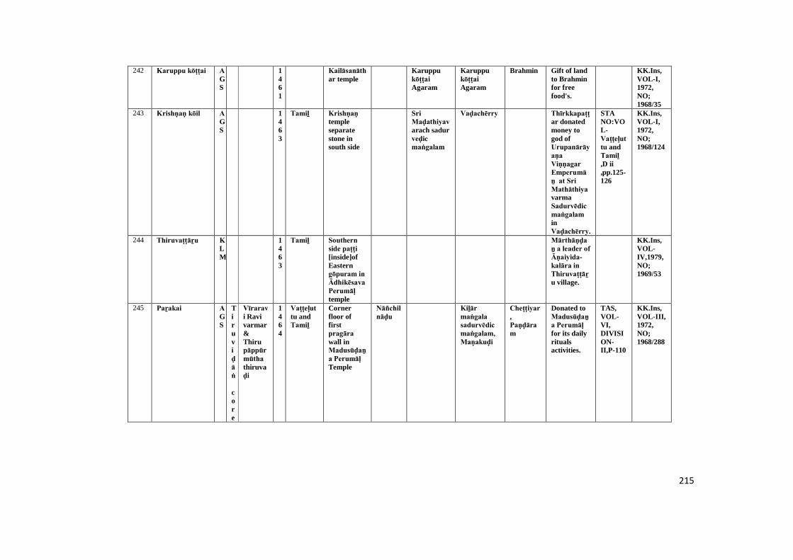
215
242 Karuppu kōṭṭai AGS
1461
Kailāsanāthar temple
Karuppukōṭṭai Agaram
Karuppukōṭṭai Agaram
Brahmin Gift of landto Brahminfor freefood's.
KK.Ins,VOL-I,1972,NO;1968/35
243 Krishṇaṇ kōil AGS
1463
Tamiḻ Krishṇaṇ templeseparatestone insouth side
SriMaḍathiyavarach sadurveḍic maṅgalam
Vaḍachērry Thīrkkapaṭṭar donatedmoney togod ofUrupanārāyaṇa Viṇṇagar Emperumāṉ at Sri MathāthiyavarmaSadurvēdic maṅgalam inVaḍachērry.
STANO:VOL-Vaṭṭeḷuttu andTamiḻ ,D ii,pp.125-126
KK.Ins,VOL-I,1972,NO;1968/124
244 Thiruvaṭṭāṟu KLM
1463
Tamiḻ Southern side paṭṭi [inside]ofEasterngōpuram in Ādhikēsava Perumāḷ temple
Mārthāṇḍaṉ a leader of Āṇaiyida-kalāra in Thiruvaṭṭāṟu village.
KK.Ins,VOL-IV,1979,NO;1969/53
245 Paṟakai AGS
Tiruviḍāṅ
core
Vīraravi Ravivarmar&Thirupāppūr mūtha thiruvaḍi
1464
Vaṭṭeḷuttu andTamiḻ
Cornerfloor offirstpragāra wall inMadusūḍaṉa Perumāḷ Temple
Nāñchilnāḍu
Kiḻār maṅgala sadurvēdic maṅgalam, Maṇakuḍi
Cheṭṭiyar,Paṇḍāram
Donated toMadusūḍaṉa Perumāḷ for its dailyritualsactivities.
TAS,VOL-VI,DIVISION-II,P-110
KK.Ins,VOL-III,1972,NO;1968/288
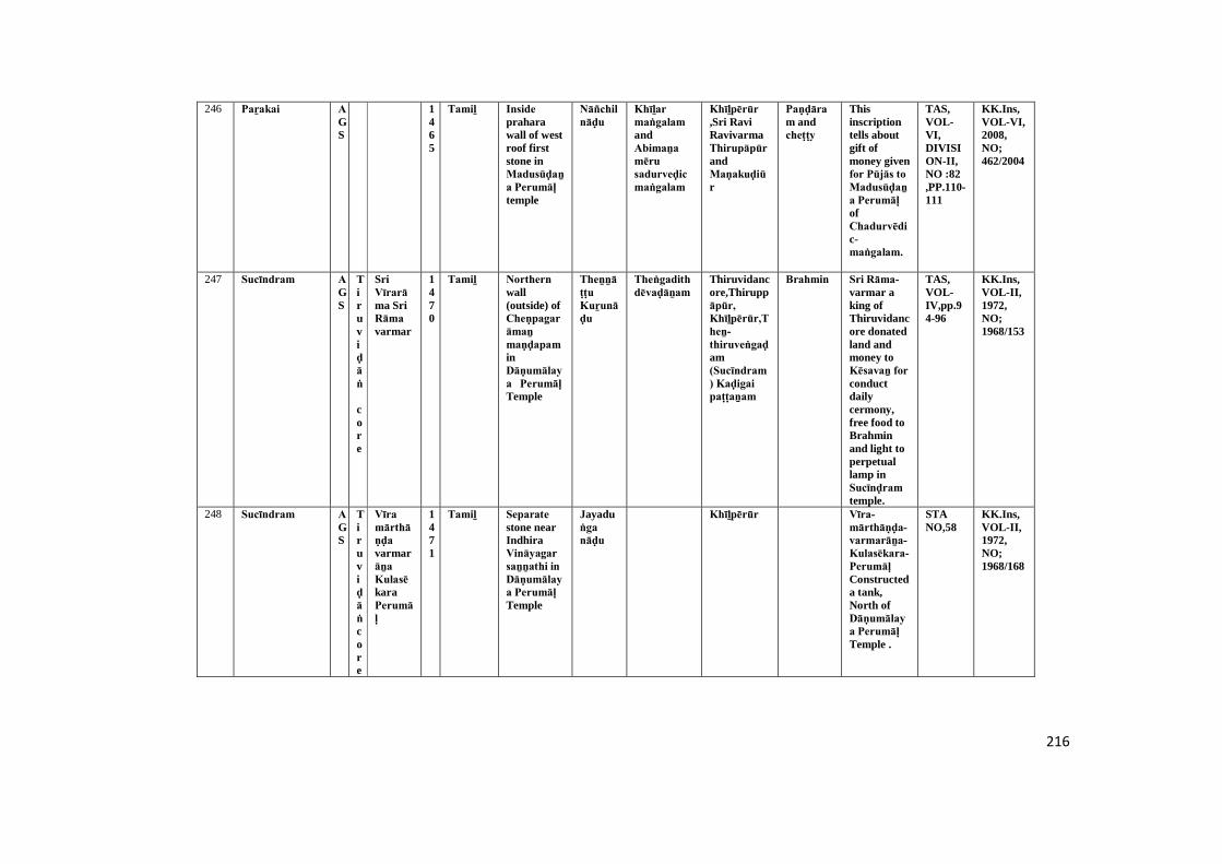
216
246 Paṟakai AGS
1465
Tamiḻ Inside praharawall of westroof firststone inMadusūḍaṉa Perumāḷ temple
Nāñchilnāḍu
Khīḻar maṅgalam andAbimaṉa mēru sadurveḍic maṅgalam
Khīḻpērūr ,Sri RaviRavivarmaThirupāpūr andMaṇakuḍiūr
Paṇḍāram andcheṭṭy
Thisinscriptiontells aboutgift ofmoney givenfor Pūjās to Madusūḍaṉa Perumāḷ ofChadurvēdic-maṅgalam.
TAS,VOL-VI,DIVISION-II,NO :82,PP.110-111
KK.Ins,VOL-VI,2008,NO;462/2004
247 Sucīndram AGS
Tiruviḍāṅ
core
SriVīrarāma SriRāma varmar
1470
Tamiḻ Northern wall(outside) ofCheṇpagarāmaṉ maṇḍapam inDāṇumālaya Perumāḷ Temple
Theṉṉāṭṭu Kuṟunāḍu
Theṅgadith dēvaḍāṉam
Thiruvidancore,Thiruppāpūr, Khīḻpērūr,Theṉ-thiruveṅgaḍam(Sucīndram) Kaḍigai paṭṭaṉam
Brahmin Sri Rāma-varmar aking ofThiruvidancore donatedland andmoney toKēsavaṉ for conductdailycermony,free food toBrahminand light toperpetuallamp inSucīnḍram temple.
TAS,VOL-IV,pp.94-96
KK.Ins,VOL-II,1972,NO;1968/153
248 Sucīndram AGS
Tiruviḍāṅcore
Vīra mārthāṇḍa varmarāṉa KulasēkaraPerumāḷ
1471
Tamiḻ Separate stone nearIndhiraVināyagar saṉṉathi in Dāṇumālaya Perumāḷ Temple
Jayaduṅga nāḍu
Khīḻpērūr Vīra-mārthāṇḍa-varmarāṉa-Kulasēkara-Perumāḷ Constructeda tank,North ofDāṇumālaya Perumāḷ Temple .
STANO,58
KK.Ins,VOL-II,1972,NO;1968/168
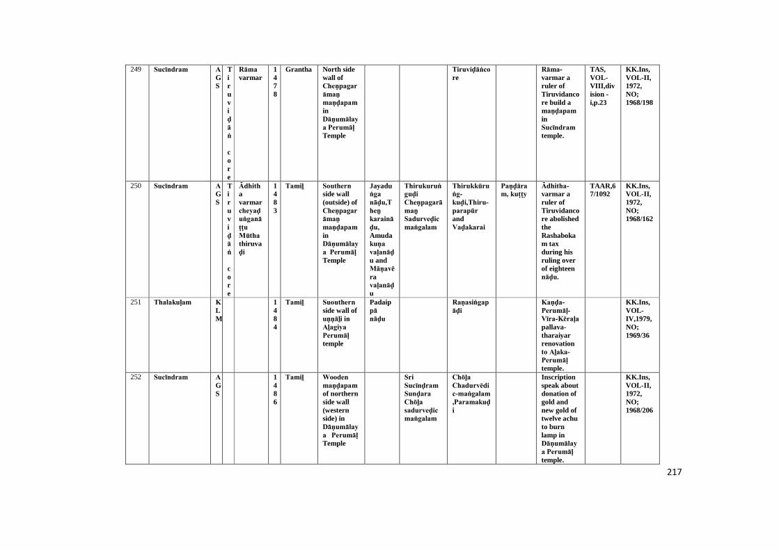
217
249 Sucīndram AGS
Tiruviḍāṅ
core
Rāma varmar
1478
Grantha North sidewall ofCheṇpagarāmaṉ maṇḍapam inDāṇumālaya Perumāḷ Temple
Tiruviḍāṅcore
Rāma-varmar aruler ofTiruvidancore build amaṇḍapam inSucīndram temple.
TAS,VOL-VIII,division -i,p.23
KK.Ins,VOL-II,1972,NO;1968/198
250 Sucīndram AGS
Tiruviḍāṅ
core
Ādhithavarmarcheyaḍuṅganāṭṭu Mūtha thiruvaḍi
1483
Tamiḻ Southern side wall(outside) ofCheṇpagarāmaṉ maṇḍapam inDāṇumālaya Perumāḷ Temple
Jayaduṅga nāḍu,Theṉ karaināḍu, Amudakuṇa vaḷanāḍu andMāṇavēravaḷanāḍu
Thirukuruṅguḍi Cheṇpagarāmaṉ Sadurveḍic maṅgalam
Thirukkūruṅg-kuḍi,Thiru-parapūr andVaḍakarai
Paṇḍāram, kuṭṭy
Ādhitha-varmar aruler ofTiruvidancore abolishedtheRashabokam taxduring hisruling overof eighteennāḍu.
TAAR,67/1092
KK.Ins,VOL-II,1972,NO;1968/162
251 Thalakuḷam KLM
1484
Tamiḻ Suouthern side wall ofuṇṇāḻi in Aḻagiya Perumāḷ temple
Padaippā nāḍu
Raṇasiṅgapāḍi
Kaṇḍa-Perumāḷ-Vīra-Kēraḷa pallava-tharaiyarrenovationto Aḻaka-Perumāḷ temple.
KK.Ins,VOL-IV,1979,NO;1969/36
252 Sucīndram AGS
1486
Tamiḻ Wooden maṇḍapam of northernside wall(westernside) inDāṇumālaya Perumāḷ Temple
SriSucīnḍram Sunḍara Chōḻa sadurveḍic maṅgalam
Chōḻa Chadurvēdic-maṅgalam ,Paramakuḍi
Inscriptionspeak aboutdonation ofgold andnew gold oftwelve achuto burnlamp inDāṇumālaya Perumāḷ temple.
KK.Ins,VOL-II,1972,NO;1968/206
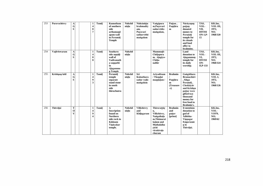
218
253 Puravachērry AGS
1487
Tamiḻ Kumutham of southernsidearthamaṇḍapam wallin Perumāḷ Temple
Nāñchilnāḍu
Nāñcināṭṭu brahmadēyam,Puṟavari sathurvēthi maṅgalam
Vaṅgipuram,Puṟavari sadurvēdic-maṅgalam,
Paṭṭan , Paṇḍāram
Nārāyaṇaṉ paṭṭaṉ donatedmoney toPerumāḷ temple forits ritualsand foodoffer tobrahmins.
TAS,VOL-VII,DIVISION-1,P-15
KK.Ins,VOL-III,1972,NO;1968/320
254 Vaḍivīswaram AGS
1488
Tamiḻ Southern side uṇṇāḻi wall ofVadivanatha saṉṉathi inAḻagammaṉ Temple
Nāñchilnāḍu
Mummuḍi-Chōḻapuram, Aḻagiya-Chōḻa-nallūr
Landdonation toAḻagammaṉ temple forits dailyworship.
TAS,VOL-VI,DIVISION-II,P-133
KK.Ins,VOL-III,1972,NO;1968/324
255 Krishṇaṇ kōil AGS
1493
Tamiḻ Perumāḷ templeseparatestand stonein southsidethiruchutru
Nāñchilnāḍu
SriKulasēkara sadur veḍic maṅgalam
Ariyadēsam / Thoṇḍai maṇḍaḷam /
Brahmin/Paṇḍāram(Treasure-r)
Gaṅgāthara Bramachāri, Siṅga Perumāḷ , Chokkiyār and Krishṇa paṭṭar were gifted twothousandmoney forfree food toBrahmin's.
KK.Ins,VOL-I,1972,NO;1968/126
256 Thōvāḷai TOV
1494
Tamiḻ A Inscriptionfound onNorthernside rock inKākkum Viṉāyakar temple.
Nāñchilnāḍu
Villichērry andKhīḻagaram
Thiruvaṭṭāṟu,Villichērry, Naṅgaikuḷam,Thāmaraikuḷam and Muthalaikuṟichi vīrakēraḷa churam
Brahminandpaṭṭer [priest]
It mentionsdonation togod ofĀdhitha- Viṇṇagar Emperumāṉ in Thōvāḷai.
KK.Ins,VOL-V1979,NO;1969/62
219
257 Kumarimuṭṭam
AGS
Tiruvida-n
core
1494
Tamiḻ Pathmaṉābapurampalace
Kumarimuṭṭam
Fisherman, rightand lefthandsclass
It referes toCoconet oilfor lamps,money andlanddonationofferd toKumari-muṭṭathu-paḷḷi and taxescollectedfromFisherman.
TAS,VOL-VI,DIVISION-II,NO:128:PP.179-180
KK.Ins,VOL-VI,2008,TARD,NO;487/2004
258 Kaḻuvaṉthiṭṭu viḷai
KLM
Vēṇāḍu
1494
Tamiḻ Museum of Pathmaṉābapurampalace
It is a royalorder of theVēṇāḍu king to stopthe supplyof Jaggeryby variousvagaiyars toMūpu vagai and Siṟavāi vagai. It isdated toA.D. 1494.
KK.Ins,VOL-VI,2008,TARD,NO;536/2004
259 Pathmaṉāpa puram
KLM
1495
Tamiḻ Museum of Pathmaṉābapurampalace
Thisrefers toLeft andRighthandsclases
It registeredgift of landto thePiḷḷaiyār of sālai by Chēramāṉ Perumāḷ .He also donateda templeland forbordingSaivaites asAñjiṉāṉ Pugaliḍam.
KK.Ins,VOL-VI,2008,TARD,NO;533/2004
220
260 Thirunayiṉār kuṟichi
KLM
1500
Tamiḻ Western side wall incave temple
Kēraḷa Paddy donated byKēraḷaṉ kuṇḍṟaṉ for constructand a Altartokūthadunth dēvar (streetDrama).
TAS,VOL-VII,DIVISION-I,P-35
KK.Ins,VOL-IV,1979,NO;1969/38-C
261 Paṟakai AGS
1500
Tamiḻ Inside prahāra wall of westroof secondstone inMadusūḍaṉa Perumāḷ temple
Valikoḷḷi khīḻār maṅgalam
ValikolliKhiḻār maṅgalam andMaṇakuḍi.
Cheṭṭy This inscriptiontells abboutthe Pūjās to he done toMadusūḍaṉa-Perumāḷ templetemple fromthe varioustaxescollectedfromValikolli-Khiḻār-maṅgalam.
TAS,VOL-VI,DIVISION-II,NO :82,PP.110-111
KK.Ins,VOL-VI,2008,NO;463/2004
262 Kuḻithuṟai VLE
1500
Vaṭṭeḷuttu andTamiḻ
Ainscriptioneredict on arock ofnorth sidepirahāra in Siva temple
Nāga maṅgalam
Kuṇdūr and Maruthaṅkōḍu
Brahmin This refersto donationof land andmoney giventoĀyiramaṉrathār for feedingBrahmins.
TAS,VOL-VDIVISION-II,NO:48,P-160
KK.Ins,VOL-VI,2008,NO;546/2004
263 Pūḍappāṇḍi TOV
1503
Tamiḻ Nandhi maṇḍapam pillar inPūthaliṅga swāmy temple.
Demaged KK.Ins,VOL-V1979,NO;1969/70
221
264 Nāgarkōil AGS
1505
Tamiḻ Outside prakara ofNāgarājā Temple inNorthernsidestandingsecondinscriptionin entranceof themugamaṇḍapam
Muṉaiyaṉūr paṭṭril paḷḷi chanḍam (Landdonation toSaiva orBuddhamaḍam)
Kōṭṭāṟu, Mummuḍi-Chōḻapuram,Muṉaiyaṉūr, Nāgarkōil,Vēḷasekaraṉēry
Guṇa-Vīrapaṇḍithaṉ and Kamalavāhaṉa paṇḍithaṉ donatedland forbuild apaḷḷichantham inNāgarājā temple.
TAS,VI,DIVISION-II,P-157
KK.Ins,VOL-III,1972,NO;1968/282
265 Eīthāmoḻi AGS
1509
Kariyamāṇika Āḻvār templesouthernwall
Chempināḍu
Khīḻār maṅgalathu maṅgala chērry
Khiḻār maṅgalathu maṅgala chērry
Paṇḍāram(Treasurer)
Araṅgaṉ Perumāḷ gift toKariyamāṇika Viṇṇagar Emperumāṉ Temple for ritual's.
STANO:VOL-VI,P.45,(109/1099)
KK.Ins,VOL-I,1972,NO;1968/28
266 Paṟakai AGS
1509
Tamiḻ Northern side wall ofCheṇpagarāmaṉ maṇḍapam inMadusūḍaṉa Perumāḷ Temple
Āsunāḍu,Nāñchilnāḍu
Sunḍara Pāṇḍya Sathurvēthi maṅgalam (Brahminsettlement)
Perunallūr Sunḍara-Pāṇḍyar-sadurvēdic-maṅgalam,seruppaḷḷi,Maṇakuḍi
Paṇḍāram, Lefthand,Righthand
Hariswāmy paṭṭan donatedmoney togod ofMadusūḍaṉa Perumāḷ for light tolamp.
TAS,VOL-VI,PP.111-12
KK.Ins,VOL-III,1972,NO;1968/287
267 Thiruviḍāṅ kōḍu
KLM
Vēṇāḍu
Chiraivāi mūtha thiruvaḍi mārthāṇḍa aḍigaḷ
1513
Tamiḻ Museum of Pathmaṉāba purampalace
Sātha maṅgalam
Sātha maṅgalam
Paṇḍāram
Thisinscriptionis a royalorder of thekingChiraivāi mūtha thiruvaḍi mārthāṇḍa aḍigaḷ. It records therelease of10,000, poṉ from thetreasury asa gift. Itdated to1513 A.D.
KK.Ins,VOL-VI,2008,NO;526/2004
222
268 Nāgarkōil AGS
1514
Tamiḻ Out side pragāra of Nāgarājā Templeinfront leftside of themugamaṇḍapam infourthstandingstone
Nāñchilnāḍu
Mummuḍi Chōḻa paḷḷi chanḍam
Mummuḍi-Chōḻapūram,Vīrakesarinallūr, Aipiḷḷai-puthūr
Guṇa-Vīrapaṇḍithaṉ and Kamalavāhaṉa paṇḍithaṉ donatedland forbuild apaḷḷichantham inNāgarājā temple.
TAS,VOL-VI,DIVISION-II,P-159
KK.Ins,VOL-III,1972,NO;1968/285
269 Paṟakai AGS
1514
Tamiḻ Western side wall ofCheṇpagarāmaṉ maṇḍapam inMadusūḍaṉa Perumāḷ Temple
Sunḍara Pāṇḍya Sathurvēthi maṅgalam (Brahminsettlement)
Khiḻār-maṅgalathu-maṅgala-chērry,
Paṇḍāram,vāṇiyaṇ (Merchant)
Saṅgaraṉ paramēswaraṉ gifted money toMadusūḍaṉa Perumāḷ for light aperpetuallamp.
TAS,VOL-VI,DIVISION-II,P-113
KK.Ins,VOL-III,1972,NO;1968/290
270 Nāgarkōil AGS
1516
Tamiḻ Out side pragāra in Nāgarājā Temple,Northernside fourthstandingstone inmugamaṇḍapamentrancegate
Nāgarkōil,Mummuḍi-Chōḻanallūr,Pāṇḍyapuram
Ten ma(landmeasure) oflanddonated toNāgarājā temple forits dailyrituals.
TAS,VOL-VI,DIVISION-II,P-160
KK.Ins,VOL-III,1972,NO;1968/275
271 Nāgarkōil AGS
1518
Tamiḻ Out side pragāra in Nāgarājā Temple,Northernside thirdstandingstone inmugamaṇḍapamentrancegate
paḷḷichanḍam (Landdonation toSaiva orBuddhamaḍam)
Kōṭṭāṟu, Mummuḍi-Chōḻanallūr,Chēraṉmādēviūr
Guṇa-Vīrapaṇḍithaṉ and Kamalavāhaṉa paṇḍithaṉ donatedland toNāgarājā temple.
TAS,VOL-VI,DIVISION-II,P-161
KK.Ins,VOL-III,1972,NO;1968/276
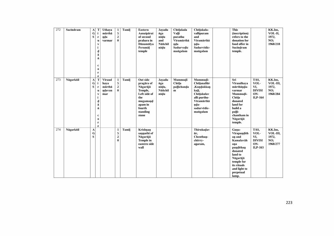
223
272 Sucīndram AGS
Tiruviḍāṅ
core
Uthayamārthāṇḍa varmar
1520
Tamiḻ Eastern Aanaipārai of secondprahara inDānumālya Perumāḷ temple
Jayaduṅga nāḍu andNāñchilnāḍu
Chōḻakula Vaḷḷi purathuVīramārthāṇḍa Sadurveḍic maṅgalam
Chōḻakula-vallipuramandVīramārthāṇḍa-Sadurvēdic-maṅgalam
This(inscription)refers to thedonation forfood offer inSucīnḍram temple.
KK.Ins,VOL-II,1972,NO;1968/218
273 Nāgarkōil AGS
Tiruviḍāṅ
core
Vīraudhayamārthāṇḍavanmar
1520
Tamiḻ Out side pragāra of Nāgarājā Temple,Left side ofthemugamaṇḍapam infourthstandingstone
Jayaduṅga nāḍu, Nāñchilnāḍu
Mummuḍi Chōḻa paḷḷichanḍam
Mummuḍi-Chōḻanallūr,Kuṇḍakkaṉkuḻi, Chōḻakulavalli purthu-Vīramārthāṇḍa-sadurvēdic-maṅgalam
SriVīraudhaya mārthāṇḍa-varmarMummuḍi-Chōḻa donatedland forbuild apaḷḷi-chantham inNāgarājā temple.
TAS,VOL-VI,DIVISION-II,P-164
KK.Ins,VOL-III,1972,NO;1968/284
274 Nāgarkōil AGS
1520
Tamiḻ Krishṇaṇ saṉṉathi of Nāgarājā Temple ineastern sidewall
Thirukaḍavūr, Chenthaṉ-chērry-agaram,
Guṇa-Vīrapaṇḍithaṉ and Kamalavāhaṉa paṇḍithaṉ donatedland toNāgarājā temple forits ritualsand light toperpetuallamp.
TAS,VOL-VI,DIVISION-II,P-163
KK.Ins,VOL-III,1972,NO;1968/277
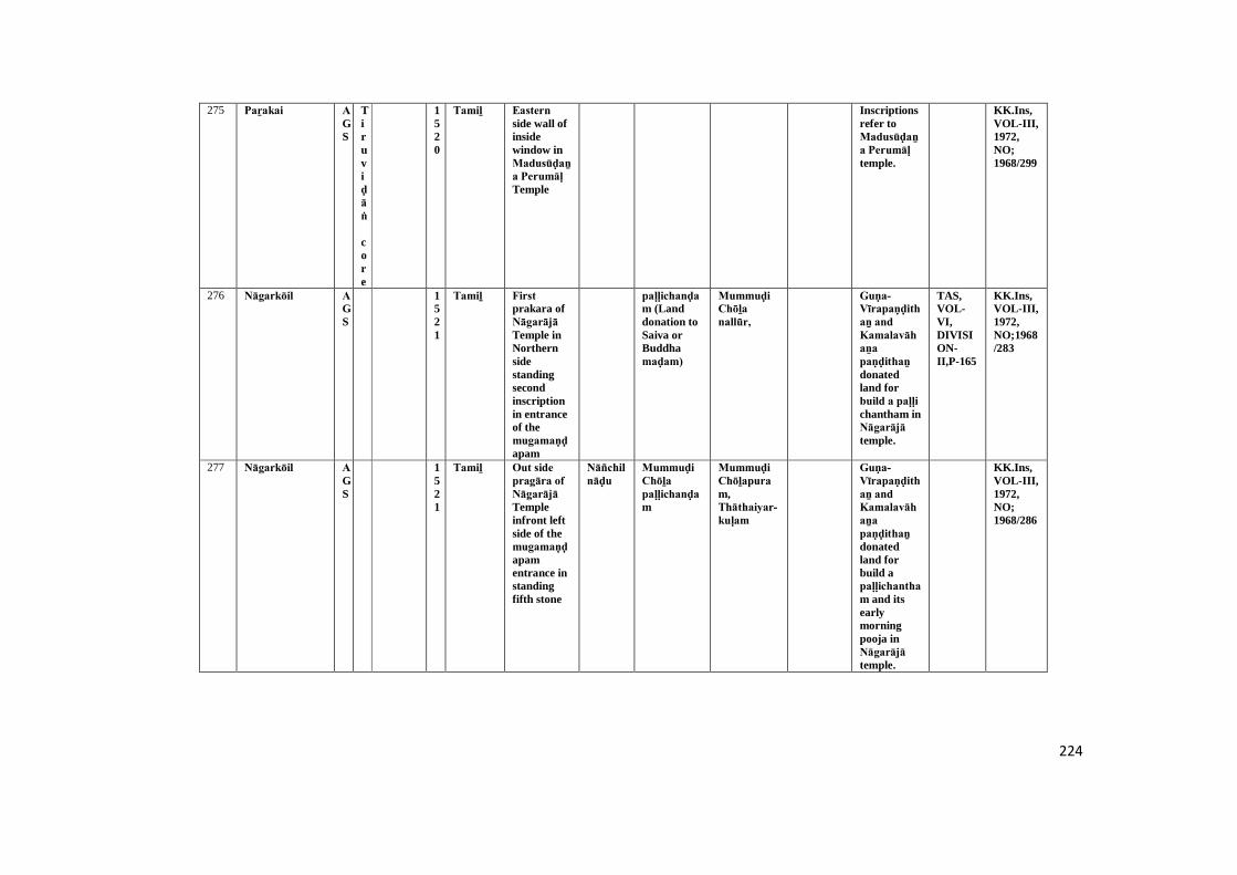
224
275 Paṟakai AGS
Tiruviḍāṅ
core
1520
Tamiḻ Eastern side wall ofinsidewindow inMadusūḍaṉa Perumāḷ Temple
Inscriptionsrefer toMadusūḍaṉa Perumāḷ temple.
KK.Ins,VOL-III,1972,NO;1968/299
276 Nāgarkōil AGS
1521
Tamiḻ First prakara ofNāgarājā Temple inNorthernsidestandingsecondinscriptionin entranceof themugamaṇḍapam
paḷḷichanḍam (Landdonation toSaiva orBuddhamaḍam)
Mummuḍi Chōḻa nallūr,
Guṇa-Vīrapaṇḍithaṉ and Kamalavāhaṉa paṇḍithaṉ donatedland forbuild a paḷḷi chantham inNāgarājā temple.
TAS,VOL-VI,DIVISION-II,P-165
KK.Ins,VOL-III,1972,NO;1968/283
277 Nāgarkōil AGS
1521
Tamiḻ Out side pragāra of Nāgarājā Templeinfront leftside of themugamaṇḍapamentrance instandingfifth stone
Nāñchilnāḍu
Mummuḍi Chōḻa paḷḷichanḍam
Mummuḍi Chōḻapuram,Thāthaiyar-kuḷam
Guṇa-Vīrapaṇḍithaṉ and Kamalavāhaṉa paṇḍithaṉ donatedland forbuild apaḷḷichantham and itsearlymorningpooja inNāgarājā temple.
KK.Ins,VOL-III,1972,NO;1968/286

225
278 Vāḷvacha kōṭṭam
KLM
1521
Tamiḻ Southern side wallinfront inpirahāra entrance
Mullaimaṅgalam
Mullaimaṅgalam
Mugha-maṇḍapam ofBhagavathitemple wasbuild byThiruvikramaṉ a villager ofMullai-maṅgalam.
TAS,VOL-VI,DIVISION-II,P-171
KK.Ins,VOL-IV,1979,NO;1969/130
279 Thōvāḷai TOV
Vēṇāḍu
Vīra Udhayamārthāṇḍa varmar
1524
Tamiḻ Southern side wallSantumSantoriuminKrishṇasāmy temple.
Jayaduṅga nāḍu
Chōḻakula vaḷḷipurathuVīramārthāṇḍa sadurveḍic maṅgalam
Vēṇāḍu rulerappointed atempleaccounter inThōvāḷai Krishṇaṇ temple andfixed hispayment.
KK.Ins,VOL-V1979,NO;1969/64
280 Kaṉyākumari AGS
Vēṇāḍu
Thambirāṉ chiraivāi mūthavar
1525
Tamiḻ Pathmaṉābapurampalace
Muṭṭamthuṟai
It refers toAñjiṉāṉ Pugaliḍam donated toMuṭṭam thuṟai residancepeoples.
TAS,VOL-VI,DIVISION-II,NO:129:P-181
KK.Ins,VOL-VI,2008,TARD,NO;491/2004
281 Vaḍachērry AGS
Tiruviḍāṅ
core
Uthayamārthāṇḍa vanmar
1532
Tamiḻ Southern sidemugamaṇḍapam wallin DaliyilMagadēvar Temple
Jayaduṅga nāḍu, Nāñchilnāḍu
Sucīnḍram ,Vaḍachērry,Chōḻakulavalli-puram,Vīra-mārthāṇḍa-sadurvēdic-maṅgalam
Paṇḍāram
Sri Uthaya-mārthāṇḍa-vanmarappointed atreasuaryaccounter inNānāthīswarar muḍaya Nāyaṉār temple
TAS,VOL-VI,DIVISION-II,P-130
KK.Ins,VOL-III,1972,NO;1968/323
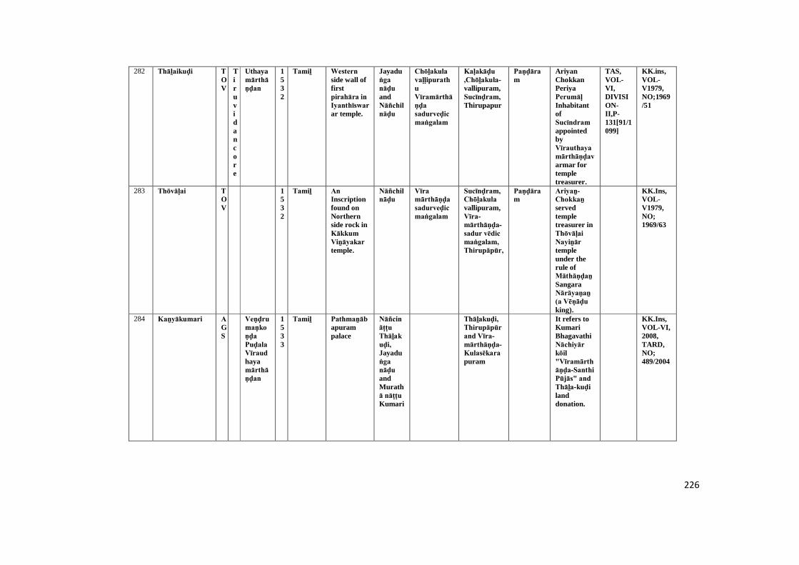
226
282 Thāḻaikuḍi TOV
Tiruvidancore
Uthayamārthāṇḍan
1532
Tamiḻ Western side wall offirstpirahāra in Iyanthīswarar temple.
Jayaduṅga nāḍu andNāñchilnāḍu
Chōḻakula vaḷḷipurathuVīramārthāṇḍa sadurveḍic maṅgalam
Kaḷakāḍu ,Chōḻakula-vallipuram,Sucīnḍram, Thirupapur
Paṇḍāram
AriyanChokkanPeriyaPerumāḷ InhabitantofSucīndram appointedbyVīrauthayamārthāṇḍavarmar fortempletreasurer.
TAS,VOL-VI,DIVISION-II,P-131[91/1099]
KK.ins,VOL-V1979,NO;1969/51
283 Thōvāḷai TOV
1532
Tamiḻ An Inscriptionfound onNorthernside rock inKākkum Viṉāyakar temple.
Nāñchilnāḍu
Vīra mārthāṇḍa sadurveḍic maṅgalam
Sucīnḍram,Chōḻakula vallipuram,Vīra-mārthāṇḍa-sadur vēdic maṅgalam, Thirupāpūr,
Paṇḍāram
Ariyaṉ-Chokkaṉ servedtempletreasurer inThōvāḷai Nayiṉār templeunder therule ofMāthāṇḍaṉ SangaraNārāyaṇaṉ (a Vēṇāḍu king).
KK.Ins,VOL-V1979,NO;1969/63
284 Kaṉyākumari AGS
Veṇḍrumaṇkoṇḍa Puḍala Vīraudhayamārthāṇḍan
1533
Tamiḻ Pathmaṉābapurampalace
Nāñcināṭṭu Thāḻakuḍi, Jayaduṅga nāḍu andMurathā nāṭṭu Kumari
Thāḻakuḍi, Thirupāpūr and Vīra-mārthāṇḍa-Kulasēkara puram
It refers toKumariBhagavathiNāchiyār kōil "Vīramārthāṇḍa-Santhi Pūjās" and Thāḻa-kuḍi landdonation.
KK.Ins,VOL-VI,2008,TARD,NO;489/2004
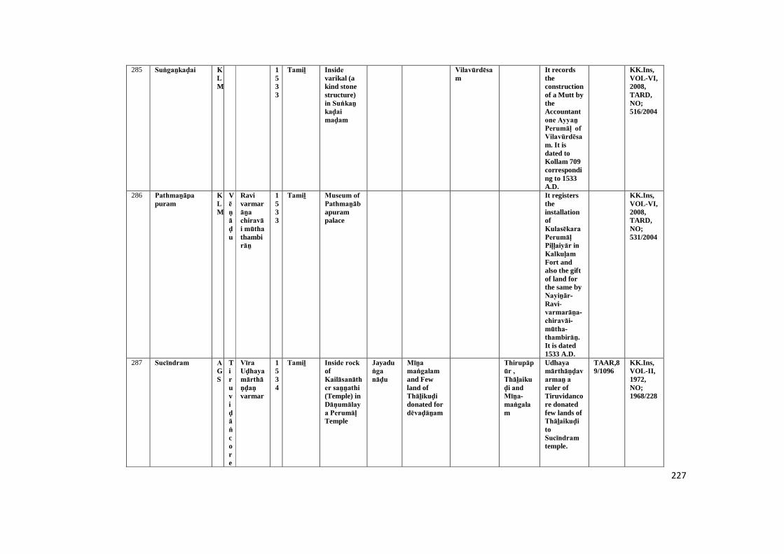
227
285 Suṅgaṉkaḍai KLM
1533
Tamiḻ Inside varikal (akind stonestructure)in Suṅkaṉ kaḍai maḍam
Vilavūrdēsam
It recordstheconstructionof a Mutt bytheAccountantone Ayyaṉ Perumāḷ of Vilavūrdēsam. It isdated toKollam 709corresponding to 1533A.D.
KK.Ins,VOL-VI,2008,TARD,NO;516/2004
286 Pathmaṉāpa puram
KLM
Vēṇāḍu
Ravivarmarāṉa chiravāi mūtha thambirāṉ
1533
Tamiḻ Museum of Pathmaṉābapurampalace
It registerstheinstallationofKulasēkara Perumāḷ Piḷḷaiyār in Kalkuḷam Fort andalso the giftof land forthe same byNayiṉār-Ravi-varmarāṉa-chiravāi-mūtha- thambirāṉ. It is dated1533 A.D.
KK.Ins,VOL-VI,2008,TARD,NO;531/2004
287 Sucīndram AGS
Tiruviḍāṅcore
Vīra Uḍhaya mārthāṇḍaṇ varmar
1534
Tamiḻ Inside rock ofKailāsanāther saṉṉathi (Temple) inDāṇumālaya Perumāḷ Temple
Jayaduṅga nāḍu
Mīṉa maṅgalam and Fewland ofThāḻikuḍi donated fordēvaḍāṉam
Thirupāpūr , Thāḻaikuḍi and Mīṉa-maṅgalam
Udhayamārthāṇḍavarmaṉ a ruler ofTiruvidancore donatedfew lands ofThāḻaikuḍi toSucīndram temple.
TAAR,89/1096
KK.Ins,VOL-II,1972,NO;1968/228
228
288 Vīranārāyaṇa chērry
KLM
1534
Tamiḻ Western side pillarof pirahāra maṇḍapam inPathmanātha swāmy temple
Kaṭṭukarai-dēsam
Four pillarsdonation byChappāṇi SayaUḻuthiraṉ in Bathmaswāmy temple.
KK.Ins,VOL-IV,1979,NO;1969/135
289 Sucīndram AGS
Tiruviḍāṅ
core
Pūḍivīswaramala verasri Ravivaṉmar
1536
Tamiḻ South side rock ofKailāsanāther saṉṉathi inDāṇumālaya inDāṇumālaya Perumāḷ Temple
Jayaduṅga nāḍu, Paṇakkuḍi murathā nāḍu
Dēvaḍāṉam,Paṇa-kuḍi Murathā nāṭṭu Irukaṉthuṟai paṭṭril maṅgalam
Murathā-nāṭṭu-Paṇakuḍi, Irukaṇ-thuṟai, Villi-chērry and Saṅkaraṉ-ēri
It refers toDēvaḍāṉam landdonated bySriRavivaṉmar to functionUthaymārthāṇḍa Santhi Pūjās and itsceremony inSucīnḍram temple.
TAS,VOL-IV,pp.102-103
KK.Ins,VOL-II,1972,NO;1968/189
290 Vaḍivīswaram AGS
Vēṇāḍu
SriRavivaṉmar
1536
Tamiḻ Southern side uṇṇāḻi wall ofVadivanātha saṉṉathi inAḻagammaṉ Temple
Jayaduṅga nāḍu, Nāñchilnāḍu
Kōṭṭāṟu old Dēvaḍāṉam
Kōṭṭāṟu, Paṇa-kuḍi
SriRavivaṉmar donatedland tovadivaṉāthaṉ saṉṉathi.
TAS,VOL-VI,DIVISION-II,P-134
KK.Ins,VOL-III,1972,NO;1968/325
291 Sucīndram AGS
Tiruviḍāṅ
core
Sakalakalaimārthāṇḍa varmar
1540
Tamiḻ South wall (westernside) ofCheṇpagarāmaṉ maṇḍapam inDāṇumālaya Perumāḷ Temple
Nāñchilnāḍu
Sucīnḍram templedēvaḍāṉam
Aḻakiya-Chōḻa-nallūr and Kēraḷa
Pappaṉ(priest)
Mārthāṇḍa-varmar(Travancore- kingPassedorder forirrigationfecility toDēvaḍāṉa LandCultivationofSucīnḍram temple.
TAAR,70/1092
KK.Ins,VOL-II,1972,NO;1968/164

229
292 Sucīndram AGS
Tiruviḍāṅ
core
Pūḍalavīra sri vīra Kēraḷa vaṉmar
1544
Tamiḻ Northern sidemaḍam(Eastern side) ofCheṇpagarāmaṉ maṇḍapam inDāṇumālaya Perumāḷ Temple
Nāñchilnāḍu,Karuṅguḍi nāḍu
Karuṅ-kuḍi-nāḍu,
Kuṭṭy,Paṇḍāram
Udhaiyaṉ Kuṭṭy and Perumāḷ appointedas post SriPaṇḍara Kaṇakku in Sucīnḍram temple;afterremoveingoldaccountant.
TAS,IV,p.105(85/1096)
KK.Ins,VOL-II,1972,NO;1968/159
293 Sucīndram AGS
Vijaya
nagar
Viṭṭalesar
1544
Grantha&Tamiḻ
Northernwall ofGōpuram(Tower)entrance inDāṇumālaya Perumāḷ Temple
In A.D.1544,Viṭṭalēsar and hisyoungerbrotherbuild aGōpuram (Tower) inSucīnḍram temple.
TAAR,1001/1096.,5/1111
KK.Ins,VOL-II,1972,NO;1968/240
294 Paṟakai AGS
1544
Tamiḻ Western side wall ofCheṇpagarāmaṉ maṇḍapam inMadusūḍaṉa Perumāḷ Temple
maṅgala chērry (brahminssettlements)
Khiḻār-maṅgalathu-maṅgala-chērry,Mummuḍi Chōḻapuram, Theṉ-chērry, Vaḍachērry
Paṇḍāram,
Konmaṇḍai nayiṉān donatedland toMadusūḍaṉa Viṇṇavar Emperumāṉ temple.
TAS,VOL-VI,DIVISION-II,P-114
KK.Ins,VOL-III,1972,NO;1968/291
295 Sucīndram AGS
1546
Tamiḻ Eastern wall (outside) ofCheṇpagarāmaṉ maṇḍapam inDāṇumālaya Perumāḷ Temple
Murathā nāṭṭu kumari
Sommasimaṅgalam and Kūtha maṅgalam
Muratha-nāṭṭu-kumari,Maṇakuḍi Thāmarai-kuḷam,Somachi-maṅgalam
Idaiyar This refersto thedonation ofland toSucīnḍram temple forPerformingCheṇpagarāmaṉ Santhi Pūjās food andoffering.
TAAR,12/1112
KK.Ins,VOL-II,1972,NO;1968/155
230
296 Sucīndram AGS
1546
Tamiḻ Eastern side Aanaipārai of secondpragāra in Dāṇumālaya Perumāḷ Temple
Kēraḷa, Kuṭṭy Kēraḷaṉ-kuṭṭy donated toCheṇpagarāmaṉ Santhi Pūjās in Sucīndram temple.
TAAR,12/1112
KK.Ins,VOL-II,1972,NO;1968/215
297 Sucīndram AGS
Tiruviḍāṅ
core
Pūḍala Vīra Rāma varmar
1546
Tamiḻ Northern wall ofGōpuram(Tower)entrance inDāṇumālaya Perumāḷ Temple
Jayaduṅga nāḍu
Malai-maṇḍaḷathu-Thalaikuḷam andTheṉ-Thiruveṅgaḍam (Sucīndram)
Pūthalavīra Rāma-varmardonatedmoney andpaddy toSucīnḍram temple forits ritualsand foodofferings.
TAAR,65/1092.,7/1111
KK.Ins,VOL-II,1972,NO;1968/241
298 Maṇalthiṭṭai TOV
1546
Tamiḻ A inscriptionon easternside maṇal thiṭṭai rock.
Nāñchilnāḍu
Nāñci-nāṭṭu maṅgalam
Thisinscriptionrecords totenant rightof SriPathmaṉābha Perumāḷ, Ādhikēsava-perumāl,Thērūr-Aḻakiyanambi, Nāñchil-nāṭṭu-Sucīndram udaiyanayainarPūdhapāṇḍīswara-muḍaiyār temples.
TAS,VOL-VII,DIVISION-I,P-36
KK.Ins,VOL-V1979,NO;1969/82

231
299 Sucīnḍram AGS
1548
Tamiḻ Eastern wall (outside) ofCheṇpagarāmaṉ maṇḍapam inDāṇumālaya Perumāḷ Temple
Nāñchilnāḍu
Sommasimaṅgalam
Nāñchi-nāṭṭu-Pudukramam,Nayinārdesam-Anumakethana-nallūr,
Brahmin,Paṇḍāram andKuṭṭy
It refers totheexercutionof documentin favour ofEīswaraṉ NambiSāmanthaṉ ofPudukkrāmam ofNāñchilnāḍu by anassembly ofthose whoparfomencethe ritualsinSucīnḍram temple.
TAAR,689/1092
KK.Ins,VOL-II,1972,NO;1968/154
300 Kariyamāṇika puram
AGS
1558
Kariyamāṇika Aḻvar templeeastern wallofMugamaṇḍapam
Maṅgala chērry
Maṅgala-chērry/ Mummuḍi-Chōḻapuram
Paṇḍāram(Treasure-r)/kuṭṭy/ Brahmin
Maṅgala-chērry Mathisūḍaṉa was landgift toIdalaikuḍi Nāyaṉār Kariyamāṇika Viṇṇagar Emperumāṉ Temple.
STANO:VOL-VI,P.48,(108/1099)
KK.Ins,VOL-I,1972,NO;1968/29-A
301 Kariyamāṇika puram
AGS
1558
Kariyamāṇika Aḻvar templeeastern wallofMugamaṇḍapam
Maṅgala chērry
Maṅgala-chērry
Brahmin Maṅgala chērry Mathisūdaṉaṉ was land gift toBrahmin forfree food.
STANO:VOL-VI,P.47,(107/1099)
KK.Ins,VOL-I,1972,NO;1968/29
302 Therisaṇaṅ kōppu
TOV
Vēṇāḍu
ĀḍhithavarmarSiraivāi mūtha Dambiraṇ
1558
Tamiḻ South wall of uṇṇāḻi in Rāgavēsura swāmy temple
Āḍhitha varmarSiraivāi mūtha Dambiraṇ donatedland toRāgavēsura swāmy
KK.Ins,VOL-V1979,NO;1969/60
232
temple forits dailyCeremony.
303 Muṭṭakkāḍu KLM
1559
Tamiḻ Northern side wall ofNandhimaṇḍapam inPaṉṉipāgam temple
Thirupaṉtrapāgam
Kuṭṭy Land donation toFlutemusician ofAmuthaṉ Ambikuṭṭy for music inThirupaṉdṟa pākathu Mahādēvar temple.
KK.Ins,VOL-IV,1979,NO;1969/127
304 Thāḻaikuḍi TOV
1559
Tamiḻ West wall of Northernside Mughamaṇḍapam inIyaṉthīswarar temple.
Nāñchilnāḍu
Dēvaḍāṉam Thiruthuṟai bank ofVīraKēraḷa lake andKaḍukarai
Landdonation toThirunandavaṉam (templegarden byChidamparanathaNayiṉār in habited ofThāḻaikuḍi Thiruthuṟai.
TAS,VOL-VI,DIVISION-I,P-102
KK.ins,VOL-V1979,NO;1969/49
305 Thāḻaikuḍi TOV
1568
Tamiḻ Northern side wallpaṭṭigai of firstpirahāra in Iyaṉthīswarar temple.
Thāḻaikuḍi, Pulithalaimēḍu,
Paṇḍāram
Chidamparam piḷḷai son ofAiyamPerumāḷ piḷḷai a villagers ofĀrai (Āralvāimoḻi) build apillar inKulasēkara Viṉāyakar temple.Present dayĀrai village called to,'Āralvāimoḻi'.
TAS,VOL-VI,DIVISION-I,P-103
KK.Ins,VOL-V1979,NO;1969/50

233
306 Kaṉyākumari AGS
1569
Tamiḻ Kaṉya Bhagavathitemple,stand stoneinmugamaṇḍapam
Chērntha maṅgalam
Chērntha maṅgalam
Paṇḍāram(Treasurer)
Dēviyar daughter ofĀṇḍichi Ammaigiftedhundredrupees toNāchiyar saṉṉathi Chi-Paṇḍāram forconstructeda flag mast.
TAAR,3/1111
KK.Ins,VOL-I,1972,NO;1968/93
307 Sucīndram AGS
1569
Tamiḻ South side wall(inside)ofCheṇpagarāmaṉ maṇḍapam Temple inDāṇumālaya Perumāḷ Temple
Karuṅguḍi nāḍu
Malaimaṇḍaḷathu Thiruvaṭṭāṟu andKēraḷa-chērry
ThambiĀdhichaṉ inhabitantofThiruvaṭṭāṟuMalaimaṇḍaḷam was appointedSri Paṇḍāra Kaṇaku (Templetreasurer)inSucīnḍram temple
TAAR,69/1092
KK.Ins,VOL-II,1972,NO;1968/163
308 Puthaṉkaḍai KLM
1570
Vaṭṭeḷuttu andTamiḻ
Uthupāṟai It records theinstallationof a sluice ina tank byThēraṉ Seyyaṉ. It also recordsthe diggingof a tank inthe landgiven byVillavar. Itis dated toA.D.1570.
KK.Ins,VOL-VI,2008,TARD,NO;506/2004
234
309 Sārōad KLM
Vēṇāḍu
NayinārRavivaṉmarānachiraivāi mūthavar
1572
Tamiḻ Museum of Pathmaṉābapurampalace
Theṉkaraināṭṭu Poṉṉayikuḍi
Theṉkarai nāṭṭu Poṉayikuḍi
It recordsand oflands,includingthe land inMukkalampāḍu to Poṉāyi-kuḍi Ravivarmarby Nayinār-Ravivaṉmarāna-chiraivāi-mūthavar. It is dated toKollam toyear in 1572A.D.
KK.Ins,VOL-VI,2008,TARD,NO;519/2004
310 Paṟakai AGS
1573
Tamiḻ West side wall ofCheṇpagarāmaṉ maṇḍapam inMadusūḍaṉa Perumāḷ Temple
Nāñchilnāḍu
Thiruvaṭṭāru,Vaḍachērry
Paṇḍāram
Ādhichaṉ donated toMadusūḍaṉa Perumāḷ temple forits regularpūjās.
TAS,VOL-VI,DIVISION-II,P-117
KK.Ins,VOL-III,1972,NO;1968/297
311 Paṟakai AGS
1575
Tamiḻ West side wall ofCheṇpagarāmaṉ maṇḍapam inMadusūḍaṉa Perumāḷ Temple
Paṇḍāram
Damaged KK.Ins,VOL-III,1972,NO;1968/294
312 Pathmaṉāpa puram
KLM
1578
Tamiḻ Thiṉṉai side wall ofwesternside kalasamaṇḍapam inNēlakaṇḍa swāmy temple
Karkuḷam Inscription mentions torenovationin theKarku?athuMahadevartemple.
TAS,VOL-VII,PP.127-128
KK.Ins,VOL-IV,1979,NO;1969/114
235
313 Pūḍappāṇḍi TOV
1578
Tamiḻ South - East side ofSivagāmi ammaṉ saṉṉathi in Pūthaliṅgam swāmy temple.
Nāñchilnāḍu
Puthūr Paṇḍāram andNambiyar
Aiyappaṉ Pariyērum Perumāḷ donatedland to godofPūḍappāṇḍichuraNayiṉār for light totwenty fivedivine lamp.
TAS,VOL-VII,DIVISION-II,P-81
KK.Ins,VOL-V1979,NO;1969/72
314 Pathmaṉāpa puram
KLM
1579
Tamiḻ Thinnai side wall ofkalasamaṇḍapam inNēlakaṇḍa swāmy temple
Inscriptionmentions toreconstruction ofAmbalamandrenovationof Mādēvar temple.
KK.Ins,VOL-IV,1979,NO;1969/116
315 Paṟakai AGS
1580
Tamiḻ Infront in bali bēḍam (altar) floor
Thisinscriptiondatable toKollam 755correspondsto 1580 A.D.Reveals onlyChronological data.
KK.Ins,VOL-VI,2008,TARD,NO;467/2004
316 Sucīndram AGS
1581
Tamiḻ Eastern wall ofCheṇpagarāmaṉ maṇḍapam inDāṇumālaya Perumāḷ Temple
Thiruvaṭṭāru
Paṇḍāram
This refersto thedonation ofa goldenPitcher andurn toSucīnḍram Thambirāṉ byYachammaiKuṭṭy of Thiruvaṭṭāṟu State.
KK.Ins,VOL-II,1972,NO;1968/156
236
317 Thiruvaṭṭāṟu KLM
1581
Grantha&Tamiḻ
Copperpaṭṭi of Duwajasthampam inĀdhikēsava Perumāḷ temple
Kuṭṭy Inscription notedfencing toflag mast intheAdhikesavaPerumāḷ temple.
TAS,VOL-VII,P-120
KK.Ins,VOL-IV,1979,NO;1969/74
318 Pūḍappāṇḍi TOV
1581
Tamiḻ East - South sidewall ofsivagamiammaṉ saṉṉathi in Pūthaliṅgam swāmy temple.
MalaimaṇḍaḷathuMudalanāḍu Perumānkuḻi dēsam
Perumaṉ-kuḻidēsam
Paṇḍāram andNambiyar
Kāḷipāpaṉ donatedhundredrupees togod ofPūdhappāṇḍichura Nayiṉār for templerituals.
TAS,VOL-VII,DIVISION-II,P-82-83
KK.Ins,VOL-V1979,NO;1969/73
319 Pūḍappāṇḍi TOV
1581
Tamiḻ East wall of south sideSivagamiammaṉ saṉṉathi in Pūthaliṅgam swāmy temple.
Landdonated toPūthaliṅgam swāmy temple forritual andfood offer.It donorEīswarakēsavaṉ inhabitandofKaḍikāvudēsam
TAS,VOL-VII,DIVISION-II,P-86
KK.Ins,VOL-V1979,NO;1969/76
320 Kōṭṭaviḷai KLM
Vēṇāḍu
Thambirāṉ chiraivāi mūthavar
1581
Tamiḻ A rock inscriptionin southernriver bankof Vaḷḷiyāru
Brahmin Thisinscriptionrefers to thedonation oflands toNākkā mutt of paḷḷikkal byNārāyaṇaṉ Kaṇṇaṉa SriTrailōkya Viḻuppādaraiar andKallāṉ Nāgaṉ.
KK.Ins,VOL-VI,2008,TARD,NO;494/2004
237
321 Kaṉyākumari AGS
1583
Tamiḻ Kaṉya Bhagavathitemple,firstentrancenear standpillar
Nāñchilnāḍu
Paṇḍāram(Treasurer)
Nāchiyar paid moneyto chi-paṇḍāram (treasurer).
KK.Ins,VOL-I,1972,NO;1968/92
322 Sucīndram AGS
1583
Tamiḻ Pillar of Murugansaṉṉathi in Dānumālya Perumāḷ Temple
Kēraḷa Inscription notedIlaiyanayiṉār donated apillar inDāṇumālya Perumāḷ temple.
KK.Ins,VOL-II,1972,NO;1968/172- A
323 Sucīndram AGS
1583
Tamiḻ South side paṭṭi of Peacockmaṇḍapam inDāṇumālaya Perumāḷ Temple
Kollam Paṇḍāram
Paṇḍāram Paṉaimaṟaithāḍi build a ūñchal maṇḍapam inSucīnḍram templesaṉṉathi.
KK.Ins,VOL-II,1972,NO;1968/201
324 Pūḍappāṇḍi TOV
1583
Tamiḻ North side wall ofSivagamiammaṉ saṉṉathi in Pūthaliṅgam samytemple.
Nāñchi-nāṭṭu Pūḍappāṇḍi
Aḻaga naḻaka sadur veḍic maṅgalam
Gaṅgayāḍipaṭṭar inhabitantofAḻakanaḻakaSadurvēdic maṅgalam donated twohundredrupees toPūthaliṅgam swāmy temple forThakshiṇamūrthi Pūjās.
TAS,VOL-VII,DIVISION-II,PP-83-84
KK.Ins,VOL-V1979,NO;1969/74
238
325 Sucīndram AGS
1583
Tamiḻ Top portion kabhōda of bellow linepillar atūñchal maṇḍapam inDānumālya Perumāḷ temple
Paṇḍāram
This is aninscriptionabout apillarerected intheSucīnḍram templeūñchal maṇḍapam forMāthāṇḍaṉ kuṭṭy.
KK.Ins,VOL-VI,2008,TARD,NO;472/2004
326 Paṟakai AGS
Tiruvidancore
Pūḍala vīraramavarmar
1586
Tamiḻ North side wall ofCheṇpagarāmaṉ maṇḍapam inMadusūḍaṉa Perumāḷ Temple
Nāñchilnāḍu
Khīḻār maṅgalam, Esānthi maṅgalam
Khiḻār maṅgalam, Sānthi maṅgalam, Thiruvidancore
Chiraivāi-mūthavar-Thambirāṉ (king ofTravancore)donatedland toMadusūḍaṉa Perumāḷ temple.
TAS,VOL-VI,DIVISION-II,P-119
KK.Ins,VOL-III,1972,NO;1968/298
327 Nāgarkōil AGS
1588
Tamiḻ Krishṇaṇ saṉṉathi of Nāgarājā Temple inback sideuṇṇāḻi wall
Kumpikuḷathu-Thirukurugai,Kōṭṭāṟu
Tiru-Kurugai-Perumāḷ gifted sixtyfive rupeesforThiruvananth-āḻvār pūjās.
TAS,VOL-VI,P-166
KK.Ins,VOL-III,1972,NO;1968/279
328 Sucīndram AGS
1590
Tamiḻ Northern wall ofGōpuram(Tower)entrance inDāṇumālaya Perumāḷ Temple
Nāñchilnāḍu
Nambiyar,Paṇḍāram
Refers toagreementby Uṇmai-nambi toburn lampinSucīnḍram-nayiṉār templereceivingRs.40 fromAruḷānanḍā Paṇḍāram.
TAAR,59/1092
KK.Ins,VOL-II,1972,NO;1968/238
239
329 Thiruviḍai kōḍu
KLM
1593
Tamiḻ Left stand stone ofNorthernsideentrance inSaḍayapa Mahādēvar temple
Inscriptionmention tokaṇakkar.
TAS,VOL-VPP.152-153
KK.Ins,VOL-IV,1979,NO;1969/92
330 Thiruviḍai kōḍu
KLM
1594
Tamiḻ uṇṇāḻi pillar inSaḍayapa Mahādēvar temple
Mācha kōḍu Muḍavampuram
PeriyathiruvadiNayiṉār thiruvaṉantha-āḻvār donatedhundredRupees toSaḍayapar Mahādēvar temple forbuilding aline ofpillars
KK.Ins,VOL-IV,1979,NO;1969/91
331 Pathmaṉāpa puram
KLM
1595
Tamiḻ Left side pillar ofkalasamaṇḍapam inNēlakaṇḍa swāmy temple
Karkuḷam Donation to god ofKalkuḷathu Mahādēvar inNēlakaṇḍa swāmy temple.
KK.Ins,VOL-IV,1979,NO;1969/118
332 Thiṟparappu KLM
1596
Tamiḻ Front side pillar ofuṇṇāḻi in Mahādēvar temple
Damaged KK.Ins,VOL-IV,1979,NO;1969/108
240
333 Karuppu kōṭṭai AGS
1600
Kailāsanāthar templeseparatestone
Nāñchilnāḍu
Brahmin/ Kuṭṭy
Kaliyukathu Meiyaṉ was giftland toBrahmin forhis parantsthithi (annualanniversary)
KK.Ins,VOL-I,1972,NO;1968/36
334 Paṟakai AGS
1600
Tamiḻ West side wall ofCheṇpagarāmaṉ maṇḍapam inMadusūḍaṉa Perumāḷ Temple
Maṅgala chērry
Vaḍachērry Brahmin, Paṇḍāram
Damaged KK.Ins,VOL-III,1972,NO;1968/295
335 Pathmaṉāpa puram
KLM
1600
Tamiḻ Left side entrance ofmaḍappaḷḷi inNēlakaṇḍa swāmy temple
Vāriyaṉ A line of pillars gifledby byvāriyaṉ vārthigānāgaṉ in Nēlakaṇḍa swāmy temple.
KK.Ins,VOL-IV,1979,NO;1969/115
336 Vīranārāyaṇa chērry
KLM
1600
Tamiḻ Western side pillarof pirahāra inPathmaṉātha swāmy temple
Māṅgāṭṭu nāḍu
Puḻiya paḷḷam
Nārāyaṇaṉ Suvaraṉ a villager ofPuḻuyapaḷḷam inMāṅgāṭṭu nāṭṭu Idaraḻi-dēsam.
KK.Ins,VOL-IV,1979,NO;1969/134
337 Thāḻaikuḍi TOV
1600
Tamiḻ South wall of firstpirahāra in Iyaṉthīswarar temple.
Landdonated toCheṇpagarāmaṉ pūjās by ArumaiMāthāṇḍa Choḻakaṉ ( a trader).
TAS,VOL-VI,DIVISION-I,P-103[20,19,18/1093;92/1099
KK.Ins,VOL-V1979,NO;1969/48

241
338 Aḻagiya maṇḍapam
KLM
1600
Tamiḻ A inscriptioneridict onAvuliyamaḍam pillar
Dēvaḍāṉam Mēlpara-kōḍu
It records agift of landforconductingthecharitableacts in themutt. It isdatable to16th C.A.D.Full text isnotavailable.
KK.Ins,VOL-VI,2008,NO;509/2004
339 Thollanthi TOV
1600
Tamiḻ A inscriptioneredict on arock
Vālaya maṅgalam
This refersto landdonationgiven fordoing Pūjās to sriSunḍara Perumāṉ in the name ofSaṅkara Nārāyaṇaṉ Mārthāṇḍam by SriPathmaṉābaṉ.
KK.Ins,VOL-VI,2008,TARD,NO;542/2004
340 Naṭṭālam VLE
1600
Vaṭṭeḷuttu andTamiḻ
Infront ofthe rock inSaṅkara nārāyaṇaṉ temple
Kōthanallūr-kala-kōḍu
Āḻvār This refers to land giftgiven byKaṇṇaṉ to readMahābāratham in SriNaṭṭālam Āḻvār temple.
TAS,VOL-VII,DIVISION-I,NO:10,P-17
KK.Ins,VOL-VI,2008,TARD,NO;548/2004
341 Thiruvaṭṭāṟu KLM
1602
Tamiḻ Eastern side pillarof firstpirahāra in Ādhikēsava Perumāḷ temple
Kuṭṭy Ins. noted to renovationofĀdhikēsava Perumāḷ temple ofpaṅguṉi month inkollam 778(A.D.1602).
KK.Ins,VOL-IV,1979,NO;1969/43

242
342 Thiruvaṭṭāṟu KLM
1603
Grantha&Tamiḻ
Northernside paṭṭi of akalmaṇḍapam inĀdhikēsava Perumāḷ temple
Srikhīḻpērūr, Thirupāpūr andThiruvaṉantha-puram
Inscriptionmention totemplerenovationand a siglestione buildin Maghā-maṇḍapam.
KK.Ins,VOL-IV,1979,NO;1969/68
343 Thiruviḍai kōḍu KLM
1604
Tamiḻ Out side maṇḍapam pillar inSaḍayapa Mahādēvar temple
Akarai-dēsam
It notedkuṟuṇi or Marakkāl (Weightmeasurmentto Paddy 8Nāḻi = 1 kuṟuṇi; 12 kuṟuṇi = 1 kalam).
KK.Ins,VOL-IV,1979,NO;1969/103
344 Thiruvaṭṭāṟu KLM
Tiruviḍāṅ
core
SriVīraravi-varmar
1604
Tamiḻ Eastern side paṭṭi of firstpirahāra in Ādhikēsavan temple
Thirupā-puliyūr,Khīḻ-pērūr, Thirupāpūr
Paṇḍāram
Sri Vīra-ravivarmarKulasēkara Perumāḷ build toPrahara,Maḍappali,andkalamaṇḍapam andrenovationofThiruvaṭṭāṟuĀdhikēsava Perumāḷ temple.
KK.Ins,VOL-IV,1979,NO;1969/39
345 Thiruvaṭṭāṟu KLM
1604
Tamiḻ Southern side paṭṭi of firstpirahāra in Ādhikēsava Perumāḷ temple
Vilavūr Paṇḍāram
Kaṇakkar Aiyapaṉ a donatior ofVilavūr-dēsam.
KK.Ins,VOL-IV,1979,NO;1969/47

243
346 Thiruvaṭṭāṟu KLM
1604
Tamiḻ Southern-east sidepillar offirstpirahāra in Ādhikēsava Perumāḷ temple
Kākaṉachērry
Kēsavaṉ Thiruvikramaṉ a villager ofKākaṉachērry build abrick line inĀdhikēsava Perumāḷ temple.
KK.Ins,VOL-IV,1979,NO;1969/52
347 Kēraḷapuram KLM
1606
Tamiḻ First pillar of firstpirahāra in Mahādēvar devasthanam(back sideuṇṇāḻi)
Vilavūr-dēsam
Ālaṉ Ravi donated toMahādēvar Temple forchithira-kaṇḍam.
KK.Ins,VOL-IV,1979,NO;1969/23
348 Kēraḷapuram KLM
1606
Tamiḻ Second pillar offirstpirahāra in Mahādēvar dēvasthāṉam ( Backside uṇṇāḻi)
Donation ofUṟuthūṇe (pillar) byPerumāḷ Thiruvāḻmāraṉ.
KK.Ins,VOL-IV,1979,NO;1969/24
349 Kēraḷapuram KLM
1606
Tamiḻ Third pillar of firstpirahāra in Mahādēvar dēvasthāṉam(back sideuṇṇāḻi)
Kēraḷa-puram andMēchērry
Donation ofUṟuthūṇe (pillar) byDēvaṉ Thiruvikramaṉ to Kēraḷapurathumaghādēvar temple.
KK.Ins,VOL-IV,1979,NO;1969/25
350 Kēraḷapuram KLM
1606
Tamiḻ Fourth pillar offirstpirahāra in Mahādēvar dēvasthāṉam (backside uṇṇāḻi)
Malaikōḍu-dēsam
Pāppaṉ (Priest)
Paṭṭayaṉ Pāppaṉ a villager ofMalaikōṭṭudēsam donatedUṟuthūṇe (pillar) toMahādēvar temple.
KK.Ins,VOL-IV,1979,NO;1969/26
244
351 Kēraḷapuram KLM
1606
Tamiḻ Fifth pillar of firstpirahāra in Mahādēvar dēvasthāṉam (backside uṇṇāḻi)
Parākirama maṅgala-dēsam
Kaṇakku Eīswaraṉ a villager ofParākirama maṅgala-dēsam donatedUṟuthūṇe (pillar) toMahādēvar temple.
KK.Ins,VOL-IV,1979,NO;1969/27
352 Kēraḷapuram KLM
1606
Tamiḻ Left side corridarofEasternside Nandhimaṇḍapam inMahādēvar dēvasthāṉam
Vilavūr-dēsam and Kēraḷapuram
Nāchiyār daughter ofNāchiyār was build aSri Rāmaṉ Uṟuthūṇe (pillar)inKēraḷapurathuMahādēvar temple.
KK.Ins,VOL-IV,1979,NO;1969/28
353 Thāḻaikuḍi TOV
1606
Tamiḻ South side wall paṭṭai of firstpirahāra in Iyaṉthīswarar temple.
Nāñchilnāḍu
Thāḻaikuḍi Thiru-pāpaṉ donated oilfor light to alamp and itsceremony.
TAS,VOL-VI,DIVISION-I,P-103[17/1093]
KK.Ins,VOL-V1979,NO;1969/47
354 Kanyakumari
AGS
Nāyakar
Muthu-vīrapa Nāyakar
1606
Tamiḻ Pairavar hall inBagavathiammaṉ temple
Murathā nāṭṭu kumari
Pullangkuṟichi,Murat-ha nāṭṭu Kumari,Thiru nelveliandSucīnḍram
Muḍali Nāyakar,piḷḷai,Cheṭṭy, Dīkshidar (priest)
Aninscriptionfor landdonationgiven fordaily Pūjās toBhagavathiammaṉ.
TAS,VOL-VDIVISION -I,NO :66
KK.Ins,VOL-VI,2008,TARD,NO;474/2004

245
355 Kēraḷapuram KLM
Tiruviḍāṅ
core
Vīra ravivaṉmarāṉa sri Kulasēkaraperumāḷ
1607
Grantha&Tamiḻ
Westernside uṇṇāḻi inMahādēvar dēvasthāṉam
Muthala-kurichy,Vīra-Kēraḷa puram,Kīḻām-pērūr,Thirupāp-ūr,Thiruvaṉantha-puram
Paṇḍāram
Vīra ravi vaṉmarāṉ sriKulasēkara Perumāḷ build tofourambalam ofThirumaḍapaḷḷi,Rishabamaṇḍapama andGōpuram to Mahādēvar temple.
TAS,VOL-I,P-179
KK.Ins,VOL-IV,1979,NO;1969/21
356 Pūḍappāṇḍi TOV
1607
Tamiḻ South wall of Sivagāmi ammaṉ saṉṉathi Pūthaliṅgam swāmy temple.
Nāñchi-nāṭṭu Maruṅgūr
Donation ofThreehundredrupees togod ofPūḍappāṇḍīswara-muḍaya Nayiṉār for templeCeremony.
TAS,VOL-VII,DIVISION-II,P-85
KK.Ins,VOL-V1979,NO;1969/75
357 Vaḍivīswaram AGS
1609
Tamiḻ Southern side ofVaḍivaṉāthaṉ uṇṇāḻi wall inAḻagammaṉ Temple
Dēvaḍāṉam, Agaram(Brahminssettlements)
Kōthacha-piḷḷai-agaram,
People ofKōthacha-piḷḷai-agaram(brahminvillage)donatedpaddy toAḻagammaṉ temple.
TAS,VOL-VI,DIVISION-II,P-135
KK.Ins,VOL-III,1972,NO;1968/326
358 Paṟakai AGS
1610
Tamiḻ South side wall ofCheṇpagarāmaṉ maṇḍapam inMadusūḍaṉa Perumāḷ Temple
Khīḻār maṅgalam
Khiḻār maṅgalam
Sāvithri ammaidonatedmoney toMadusūḍaṉa-Perumāḷ temple forits festival.
TAS,VOL-VI,DIVISION-II,P-120
KK.Ins,VOL-III,1972,NO;1968/292
246
359 Vaḍivīswaram AGS
1610
Tamiḻ Southern side ofVaḍivaṉāthaṉ uṇṇāḻi wall inAḻagammaṉ Temple
Paṉaiyarai, Dēvaṉīchuraṉ Kōṭṭāṟu
Dēvaṉīchuraṉ donated land toAḻagammaṉ temple.
TAS,VOL-VI,DIVISION-II,P-13
KK.Ins,VOL-III,1972,NO;1968/327
360 Thiruvidāṅ kōḍu
KLM
1611
Tamiḻ Eastern sidecorridar ofDuwārabālagarmaṇḍapam inNēlakaṇḍa swāmy temple
Kāñchaṅ kōḍu maṅgalam
Kañjaṅkōḍu
Inscriptionmention toKāñchaṅ-kōḍu.
KK.Ins,VOL-IV,1979,NO;1969/105-C
361 Thiruvaṭṭāṟu KLM
1611
Tamiḻ Bottom division ofDuwārabālagarsculpturenearDuwajasthampam inĀdhikēsava Perumāḷ temple
It noted toTamiḻ month ofpuraṭṭāsi and goddessofKiṭṭinamaṅ-Perumāḷ.
KK.Ins,VOL-IV,1979,NO;1969/76
362 Pūḍappāṇḍi TOV
1614
Tamiḻ South wall ofSivagāmiammaṉ saṉṉathi in Pūdhaliṅga swāmy temple.
Nāñchi-nāṭṭu-Mulai-nallūr
Vēlāyutha Perumāḷ inhabitantof Nāñchi-nāṭṭu Mulainallūr donatedhundredrupees toPūdhaliṅga-swāmy temple forammāvāsi Pūjās.
TAS,VOL-VII,DIVISION-II,P-88
KK.Ins,VOL-V1979,NO;1969/77

247
363 Paṟakai AGS
1616
Tamiḻ Left side executiveroom wallof temple inMadusūḍaṉa Perumāḷ templeentrance
Nāñchilnāḍu
Khīḻār maṅgalam
Khiḻār-maṅgalam
Paṇḍāram
Deivaṅkaladiyāṉ Sri Krishṇaṇ of Paṟakai village inNāñchilnāḍu donatedsome landsfor the dailypuja ofMadusūḍaṉa Perumāḷ temple.
KK.ins,VOL-VI,2008,NO;461/2004
364 Therisaṇaṅ kōppu
TOV
1618
Tamiḻ south side wallArthamaṇḍapam inRāgavēswara swāmy templeUlaganāyaki ammaṉ saṉṉathi
Nāñchilnāḍu
Thirupāpūr, Theṉṉūr
Inscriptionrefers toLanddonation toRāgavēswara swāmy temple andUlaganāyaki ammaṉ saṉṉathi for its dailyrituals andotherspecialPūjās.
KK.Ins,VOL-V1979,NO;1969/61
365 Pūḍappāṇḍi TOV
1618
Tamiḻ South wall of Sivagamiammaṉ saṉṉathi in Pūthaliṅgam swāmy temple.
Nāñchilnāḍu
RavivarmarKulasēkara Perumāḷ nattive ofTiruvidāṅkōḍu wrote a document toAriyakuṭṭy and alsomentiondonationmonth ofchithiraiPuranifestival.
TAS,VOL-VII,DIVISION-II,P-89
KK.Ins,VOL-V1979,NO;1969/78
248
366 Sucīndram AGS
1619
Tamiḻ Southern wall ofGōpuram (Tower)entrance inDāṇumālaya Perumāḷ Temple
Āḷūr-Vikrama-Pāṇḍya-Chōḻa-puram,Idalāikuḍi
Paṇḍāram
This refersto donationgiven forKārthigai festival toSucīnḍram Nāyaṉār by Templeworkers.
TAAR,103/1096.,60/1092
KK.Ins,VOL-II,1972,NO;1968/235
367 Sucīndram AGS
1620
Tamiḻ Northern wall ofGōpuram(Tower)entrance inDāṇumālaya Perumāḷ Temple
Nāñchi-nāṭṭu Thērūr,
Nāñchi-nāṭṭu-Thērūr
Thērūr Nāgammai installed aPāvai lamp and donatedfifty rupeesfor light toburn inSucīndram temple.
TAAR,101/19
KK.Ins,VOL-II,1972,NO;1968/239
368 Vāḷvacha kōṭṭam
KLM
1622
Tamiḻ Northern side wall ofinner sideentrancegate inMahishāsura marthiṉi temple
Mullaimaṅgalam
Mullai-maṅgalam
Dāmōdaraṉ a villager ofMullai-maṅgalam. Herenovationto manytemple andhis deathKollam yearin 798(A.D1622).
TAS,VOL-VI,DIVISION-II,P-172
KK.Ins,VOL-IV,1979,NO;1969/132
369 Ādhicheṉ puthūr
TOV
1622
Tamiḻ Western side wallpaṭṭi of maṇḍapam in Piḷḷaiyār temple.
Nāñchilnāḍu
Paradēsi (Priest) ofDaḻakuḍi Mādēvaṉ Aṇṇāmalai renovationtoAuvaiyārammaṉ temple
KK.Ins,VOL-V1979,NO;1969/24

249
370 Therisaṇaṅ kōppu
TOV
1623
Tamiḻ North side wallArthamaṇḍapam inRāgavēswara swāmy templeUlaganāyaki ammaṉ saṉṉathi
Theṉṉāṭṭu gurunāṭṭu kaikaṭṭiyapaṭṭaṇam
Guru nāṭṭu kaikattiyapaṭṭiṇam,
Paṇḍāram,Cheṭṭiyār
Deivaṅgalaḍiyaṉ inhabitandofKaikaṭṭiya-paṭṭiṇam of Guru-nāḍu donated onethousandand twohundred toChirāgavaṉ temple forarthasāma Pūjās.
KK.Ins,VOL-V1979,NO;1969/59
371 Sārōad KLM
Vēṇāḍu
Nayinār Ravivanmarāna chiraivāi mūthavar
1623
Tamiḻ Museum of Pathmaṉābapurampalace
Theṉkaraināṭṭu Poṉṉayi kuḍi
Theṉkarai-nāṭṭu Poṉṉayikuḍi
This refersto landterritory ofyoungerbrother Sripadmanābaṉ given by elderNayiṉār Ravivarmaṉ
KK.Ins,VOL-VI,2008,TARD,NO;520/2004
372 Puthēry TOV
1625
Tamiḻ A separate stone inNorthernstreetcorner
Nāñchilnāḍu
Kuṭṭa-maṅgalam
Kuṭṭa-maṅgalam,
Eīswaraṉ Gōvindaṉ donatedland toPuthēri temple muttand it referdemarcation of Land.
TAAR,53/110
KK.ins,VOL-V1979,NO;1969/68
373 Sucīndram AGS
1628
Tamiḻ A inscriptionon pothigaiof kalisculpture atChithirasabai inDānumālya Perumāḷ temple
Paṇḍāram
It register agift of astone pillarto the ChiraSabhā maṇḍapam ofSucīnḍram temple byThyānāthar Sōṉṇai Paṇḍāram one of theYōgakkār
KK.Ins,VOL-VI,2008,TARD,NO;473/2004
250
374 Sucīndram AGS
1629
Tamiḻ West side pillar ofChirsabaimaṇḍapam inDāṇumālaya Perumāḷ Temple
Nāñchilnāḍu
Vīra-kēraḷa-nallūr
Vīra-Kēraḷa-nallūr Viswanāthaṉ build a Vināyaka Perumāḷ temple.
KK.Ins,VOL-II,1972,NO;1968/187
375 Sucīndram AGS
1629
Tamiḻ Southern wall ofGōpuram( gateway) inDāṇumālaya Perumāḷ Temple
Paṇḍāram
Rāmaṉ-Thirudēvi -ammaiinhabitantofSucīnḍram Mullai landdonatedmoney toSucīnḍram temple forProducelamp.
KK.Ins,VOL-II,1972,NO;1968/208
376 Sucīndram AGS
1629
Tamiḻ Southern wall ofGōpuram(Tower)entrance inDāṇumālaya Perumāḷ Temple
Paṇḍāram
Rāmaṉ-Thirudēvi-ammaidonatedhundredrupees toSaṅkara Nārāyaṇaṉ saṉṉathi of Sucīndram for burninglamp.
TAAR,66/1092
KK.Ins,VOL-II,1972,NO;1968/234
377 Eiṟaichakuḷam TOV
1629
Tamiḻ East side wall of outsideMaṇimaṇḍapam inUthayamārthāṇḍavarmartemple.
Nāñchilnāḍu andJayaduṅga-nāḍu
Aḻagiya-Chōḻa-nallūr, Erichi-kuḷam,
Sāliyar (weaver)order tosettlementinNāñchilnāḍu.
KK.Ins,VOL-V1979,NO;1969/35
251
378 Sucīnḍram AGS
1631
Tamiḻ South side wall ofmaṇḍapam Gate wayin MunUdhithaNaṅgai ammaṉ Temple
Kuṭṭy Refer to donation ofland fordoing Pūjās and carfestivalsevery yearstoMuṉṉūṭru Naṅgai ammaṉ.
KK.Ins,VOL-II,1972,NO;1968/203
379 Vīravanallūr TOV
1635
Tamiḻ Southern side wall ofMughamaṇḍapam inKaṟpagha Viṉāyakar temple.
Nāñchilnāḍu
Vaḷḷiyūr sadurveḍic-maṅgalam
Tiru-nelveliPerumāḷ nattive ofVīra-kēraḷa-nallurdonatedland toKaṟpagha Viṉāyaka piḷḷaiyār,Tiru-nellai-nāther and Aḻagiya-nāchiyār temple.
TAS,VOL-VII,DIVISION-I,P-39
KK.ins,VOL-V1979,NO;1969/87
380 Anḍara puram
TOV
1635
Tamiḻ Southern side wallpaṭṭi of uṇṇāḻi in sāsthā temple.
Nāñchilnāḍu
Māthāṇḍa sadurveḍic maṅgalam and Thēr maṅgalam
Tiruviḍa-kōḍu
Kuṭṭy Sunḍara Chōḻapurathu Nayiṉār donatedland toTiruvempaḍai kaṇḍaṉ-sāsthā and Srikailāsanāther temple.
KK.Ins,VOL-V1979,NO;1969/2
381 Aḻakiya Pāṇḍya puram
TOV
1637
Tamiḻ East side pillar ofArthamaṇḍapam
A Pillardonated byPichiyār doughter ofPerumĀṇḍal Ammaiyār.
KK.Ins,VOL-V1979,NO;1969/5

252
382 Aḻakiya Pāṇḍya puram
TOV
1637
Tamiḻ West pillar ofArthamaṇḍapam inDesaĀchāriyāl SriVēraṅgai ammaṉ temple.
Incriptionnoted to apillardonation bydoughter ofPāppi ammaiyār.
KK.Ins,VOL-V1979,NO;1969/6
383 Nāgarkōil AGS
1641
Tamiḻ A Pillar of Nāgarājā Temple inmugamaṇḍapam
Kulasēkara Perumāḷ giftedGarlant ofkoṇṟai to God ofNāgarājār.
KK.Ins,VOL-III,1972,NO;1968/280
384 Nāgarkōil AGS
1643
Tamiḻ Krishṇaṇ saṉṉathi of Nāgarājā Tepmle inback sidewall uṇṇāḻi
Sunḍara Pāṇḍya Sathurveḍi maṅgalam (Brahminsettlement)
Damaged KK.Ins,VOL-III,1972,NO;1968/278
385 Sucīndram AGS
1644
Tamiḻ South side pillar ofDāṇumālaya Perumāḷ Templeinfront inDwajasTambham
Thisinscriptionrefers toNangnaiya-ammai ainhabitantofSucīndram.
KK.Ins,VOL-II,1972,NO;1968/199
386 Thoḍuveṭṭi (Mārthāṇḍam)
VLE
Tiruviḍāṅ
core
Ravivarmar
1644
Tamiḻ Museum of Pathmaṉābapurampalace
Kalkuḷam Paṇḍāram
This refersto apunishmentto undergobyKulasēkara Perumāḷ of Viḷakkuṉṉam.
TAS,VOL-VIII,P-38
KK.Ins,VOL-VI,2008,TARD,NO;591/2004
253
387 Nāgarkōil AGS
1645
Tamiḻ Out side prakarawall ofNāgarājā Temple,Northernsidestandingfirst stonein entranceof the mugamaṇḍapam
Kōṭṭāṟu, Kangayam
Paṇḍāram, Piḷḷai
Māḷuva Nambiyār Māḷuva Nambi andThambirāṉ-kuṭṭi Saḍayaṉ donated sixhundredrupee toNāgarājā Temple.
TAS,VOL-VI,DIVISION-II,PP.166-167
KK.Ins,VOL-III,1972,NO;1968/281
388 Sārōad KLM
1647
Tamiḻ Top portion of sanctumsantorumentrance inĀṉaisāsthā temple.
Puduchērry This refers toconstructionof sanctumsantorum ofĀṉṉai sāsthā temple byPuduchērry ThiruvikramaNārāyaṇaṉ and Lampgiven toThiruvikramā temple byTheṉsaragal Saṇguṇṇy.
TAS,VOL-VIII,P-28:ARE,11,1929
KK.Ins,VOL-VI,2008,TARD,NO;510/2004
389 Mēlapudūr TOV
1650
Tamiḻ A separate stoneinfront ofHari HaraViṉāyakar temple.
Nāñchilnāḍu
Aḻakiya Pāṇḍyapuram
Paṇḍāram
Paradēsi Mādava paṇḍārathār donationof Rice, Co-Conut,Pepper,Salt,Gheeand Gingerto HariHaraViṉāyakar temple inPudūr.
KK.Ins,VOL-V1979,NO;1969/85
254
390 Aruvikkarai KLM
1654
Tamiḻ Southern side wall ofMaḍappaḷḷi in Krishṇaṇ temple
Pālak-kōḍu Donation of pathi byPālak-kōḍu Sāthavēthaṉ-Sāvithiri to sriPurushothama dēvar temple.
TAS,VOL-VII,DIVISION-II,P-113
KK.Ins,VOL-IV,1979,NO;1969/4
391 Mēlapudūr TOV
1655
Tamiḻ A separate stoneinfront ofHari HaraViṉāyakar temple.
Nāñchilnāḍu
Kēsavaṉ-pudūr,AḻagiyaPāṇḍyapuram,Tirunelveli
Paṭṭer [Priest]
It registerdonation ofland to HariHaraViṉāyakar temple inKēsavaṉ-Pudūr for foodoffered.
KK.Ins,VOL-V1979,NO;1969/84
392 Rājāka maṅgalam
AGS
Vēṇāḍu
SriVēra ravivarmarchiravāimūthavar
1657
Tamiḻ Pathmaṉāba-puram-palace
Khīḻapērūr This is about Landdonationand wellexcavation.
KK.Ins,VOL-VI,2008,TARD,NO;482/2004
393 Pūḍappāṇḍi TOV
1658
Tamiḻ A separate stoneinfrontDwajasdampam inPūthaliṅgamm swāmy temple.
It recordedChiraivāi mūtha-thampirāṉ was stayedinPūdhapāṇḍi palace andissued reliefmeasure totenants oftemple land.
TAS,VOL-VII,DIVISION-II,P-91
KK.Ins,VOL-V1979,NO;1969/79

255
394 Vīravanallūr TOV
1658
Tamiḻ North side floor ofSecondepirahāra in Kaṟpagha Viṉāyakar temple.
Nāñchilnāḍu
Vīravanallūr,Tirunelvēli
Mālaiyiṭṭa Perumāḷ wasinhabitantofTirunelvēli donation toKaṟpaga viṉāyagar temple inVīrava nallūr for itsceremonials.
TAS,VOL-VII,DIVISION-I,P-40
KK.Ins,VOL-V1979,NO;1969/88
395 Thiruviḍai kōḍu
KLM
1659
Tamiḻ A pillar of pirahāra wall inSaḍayapa Mahādēvar temple
Nāñchilnāḍu
Kalkuḷam, Maṇalikkarai,
Kuṭṭy, Piḷḷai
Landdonation byPerumāḷ Dāṇuvaṉ to templeservants ofNāchiiyār-kuḷam.
TAS,VOL-VP-147
KK.Ins,VOL-IV,1979,NO;1969/98
396 Kanyakumari
AGS
Nāyaka
Chokkanātha- Nāyakar
1663
Tamiḻ A pillar of sakkaraithīrthamaḍam in Kaṉyākumari. Now, InPathmaṉābapurampalace
Nāñchilnāḍu
Kōṇa maṅgalam
Kumari,Paṉa-kuḍi,Vāriūr and Vīra-mārthāṇḍa lake
Paṇḍāram
It registersthe erectionof a mutt onthe banks ofSakkaraTīrtham by TirumalaiKoḻundhu piḷḷai and also donatedsome landsfor it.
TAS,VOL-VDIVISION-III,NO :79,P-108
KK.Ins,VOL-VI,2008,NO;457/2004
397 Kaṉyākumari AGS
1663
Tamiḻ Pathmaṉāba purampalace
Nāñchilnāḍu
Vīrāṇarāyaṇa maṅgalam
Paṉakuḍi and Vāriyūr
Nāyakar, piḷḷai and Paṇḍāram
This refersto landdonationgiven toKumariBhagavathiammaṉ, SakkaraiThīrthakarai mutt andfor Tiru-ñāṉasambandar-Paṇḍāram.
KK.Ins,VOL-VI,2008,NO;490/2004
256
398 Pathmaṉāpa puram
KLM
1664
Tamiḻ Museum of Pathmaṉāba purampalace
Nāñchilnāḍu
Palipaḷḷi Thāḻaikuḍi Muḍaliyār,Paṇḍāram
This refersto landgiven forconstrutionof a brickmutt forPūjās to piḷḷaiyār andMahēswarar in NorthStreet ofKalkuḷam fort byRavi ofThiruvaṭṭāṟu.
KK.Ins,VOL-VI,2008,NO;528/2004
399 Naṭṭālam VLE
1664
Vaṭṭeḷuttu andTamiḻ
Pathmaṉābapurampalace
It records agift of landbyTiruvikramaṉ Ravi of Naṭṭālamdēsam for theerection of amutt andconductingcharitableacts in it.
TAS,VOL-VII,DIVISION-I,NO:9,P-15
KK.Ins,VOL-VI,2008,TARD,NO;547/2004
400 Āḷūr KLM
1667
Tamiḻ Separate stoneinfront ofpirahāra wall in adome
Āḷūr,Vikrma Chōḻa Pāṇḍyapuram
Aiyar(priest) ,Paṇḍāram
Landdonation byNachathira-aiyar toGuruvālayam at Āḷūr in VikramaChōḻa Pāṇḍyapuram.
KK.Ins,VOL-IV,1979,NO;1969/6
257
401 Sucīndram AGS
1673
Tamiḻ Abhishega pitam ofChirsabaimaṇḍapam inDāṇumālaya Perumāḷ Temple
Kollam Cheṭṭiyār This inscriptionrefers to theConstructedof vithāṇam (templeceiling) andchirsabhai(theater) fordancing byChavari-kiṭṭiṇaṉ.
KK.Ins,VOL-II,1972,NO;1968/186
402 Āralvāimoḻi TOV
1673
Tamiḻ A Separate Stone inMaḍathuviḷai
PuduvurNāñchilnāḍu
Puduvūr, Vaḍavathu-kāṭṭūr , Vakkaṉa-viḷai,Puliyaṉ viḷai,Kaṉiyaṉ viḷai,Thōvāḷai
Eīswara Murthiya.piḷḷai son of Miṉāṭchinātha piḷḷai build apillar inKulasēkara Vināyakar temple.Those dayĀralvāimoḻi was called,'Ārai' village.
KK.Ins,VOL-V1979,NO;1969/32
403 Paṟakai AGS
1674
Tamiḻ Northern sidemaṇḍapam wall inSeṅgulakkaraiVināyagar Temple
Nāñchilnāḍu
Paṟakai, Sucīnḍram
Brahmin Chithiraputhaṉ donated land toSeṅgulakkaraiVināyagar temple.
KK.Ins,VOL-III,1972,NO;1968/301
404 Thāḻaikuḍi TOV
1677
Tamiḻ West wall inMaṇḍagapāḍi Piḷḷaiyār temple.
Nāñci nāṭṭu Sucīnḍram
Sucīnḍram, Aḻakiya-Pāṇḍyapuram,
AKalmaḍam (mutt) buildinThāḻaikuḍi by NallaPerumāḷ inhabitandofSucīndram for its dailyritualistic.
TAS,VOL-VI,P-104
KK.Ins,VOL-V1979,NO;1969/57
258
405 Vīravanallūr TOV
1678
Tamiḻ Out side wall ofWestPortionPiḷḷaiyār maḍam
Nāñchilnāḍu
Sucīnḍram, Vīravanallūr
Muḍaliyār,Paṇḍāram, piḷḷai, Pather,Brahmin,Kuṭṭy, Āāṇḍār andĀāṇḍichi
Rāmanāchi andParākkirama-Pāṇḍi- Perumāḷ gifted a landto SivaPāṇḍi Āāṇḍār for food offer inVīrava-nallūr mutt.
TAS,VOL-VII,DIVISION-I,P-42
KK.Ins,VOL-V1979,NO;1969/89
406 Kōṭṭāṟu AGS
Tiruviḍāṅ
core
1680
Tamiḻ In front wall of gurumaḍam
Nāñchilnāḍu
Vīrāṇarāyaṇa maṅgalam
Mummuḍi-Chōḻa-puram,Mēppāḍi nāṭṭu Aḻakiya Pāṇḍya puram,Cheṇbakaramaṉ puthūr Vaḷavallang kuḍi and Sucīnḍram
Paṇḍāram
It refers totheconstructionof a muṭṭ to the north aVaḷampuri Piḷḷaiyār by oneEchchakkuṭṭy Kai Koṇḍa Perumāḷ of Koṭṭāṟṟu Mummuḍi-Chōḻanallūr inNāñchilnāḍu.
KK.Ins,VOL-VI,2008,NO;452/2004
407 Thiruvaṭṭāṟu KLM
1681
Tamiḻ Museum of Pathmaṉābapurampalace
Nāñchilnāḍu Mathiyur
Nāñchi-nāṭṭu-Mathiyūr andAḻakiya-Pāṇḍyapuram
Kuṭṭy This refers to landdonated forconstrectionof Mutt andfor charityPurpose byRavikuṭṭi andPathmaṉābaṉ of Thiruvaṭṭāṟu.
KK.Ins,VOL-VI,2008,TARD,NO;524/2004
259
408 Iraṇiyal KLM
1682
Tamiḻ separate stone inkhīḻa street
Raṇasiṅga-nallūr,Pudu-kaḍai
Muḍaliyār
Cheṇpagarāmaṉ a villager ofRaṇasiṅga-nallūr donation ofmoney toumaiyorupaganMuḍaliyār mutt.
KK.Ins,VOL-IV,1979,NO;1969/10
409 Vīravanallūr TOV
1682
Tamiḻ Eastern side wall ofPiḷḷaiyār maḍam (mutt)
Nāñchilnāḍu
Agaram(Settlementof Brahmincommunity),Achuvamēda yāgam [Horsesacrificial]
Vīrakēraḷa-nallūr
Āāṇḍāṇ ,Āchi, Paṟaichi (Untouchables),Piḷḷai,Brahmin,Kuṭṭy
Parākkirama-Pāṇḍya Perumāḷ inhabitantof Vīra-Kēraḷa nallūr donatedland toPiḷḷaiyār mutt for itsdailyworship.
TAS,VOL-VII,DIVISION-I,P-44
KK.Ins,VOL-V1979,NO;1969/90
410 Sucīndram AGS
1685
Tamiḻ Northern side pillarof uṇṇāḻi maṇḍapam on top sidesculpture inDāṇumālaya Perumāḷ Temple
It refers tothe name,Aṉṉaiñja Perumāḷ piḷḷai.
KK.Ins,VOL-II,1972,NO;1968/221
411 Pathmaṉāpa puram
KLM
1686
Tamiḻ Museum of Pathmaṉābapurampalace
Nanchināṭṭu Thērkuḷam
Tiruvaṭṭāṟu This refers to land andplacesdonated forMahēswarer Pūjās and forconstructionof a brickmutt forPūjās in Pathmaṉābapuramwest streetby Kali
KK.Ins,VOL-VI,2008,TARD,NO;527/2004
260
Ravi SriPathmaṉāba ofThiruvaṭṭāṟu.
412 Thiruviḍāṅ kōḍu
KLM
1688
Tamiḻ A stone pillarinfront ofThiruvidaṅkōḍu mosque
paḷḷikaḷ Puduvūr Piḷḷai Dēvaṉ Ravi, theaccountantandEīswaraṉ Pollām Piḷḷaiyār of Pudvūr-dēsam constructeda mutt andalso donatedsome landsforconductingcharitableacts in it.
TAS,VOL-VDIVISION-I,NO;25
KK.Ins,VOL-VI,2008,NO;513/2004
413 Sucīndram AGS
1689
Tamiḻ Gateway of mughamaṇḍapam (Firstentrancehall) atreddy streetinKulasēkara Perumāḷ Temple
Nāñchilnāḍu
Sucīnḍrathu-VīraKēraḷa-sadurveḍic-maṅgalam
Vīra-Kēraḷa-chadurvēdic-maṅgalam (Nāñchilnāḍu)
Inscriptionspeaksabout Vīra-Kēraḷa-chadurvēdic-maṅgalam wasothernameofSucīndram.
STANO-87
KK.Ins,VOL-II,1972,NO;1968/242
261
414 Paṟakai AGS
1689
Tamiḻ West side wall ofCheṇpagarāmaṉ maṇḍapam inMadusūḍaṉa Perumāḷ Temple
Nāñchilnāḍu
Agaram ofSucīnḍram, Khiḻār maṅgalam
Paṇḍāram
Dāṇuvaṉ donatedfivehundredand fiftyrupees toMadusūḍaṉa-Perumāḷ temple forits dailyPūjās.
TAS,VOL-VI,DIVISION-II,P-122
KK.Ins,VOL-III,1972,NO;1968/296
415 Ravipuram KLM
1689
Tamiḻ bottom side entrancegate ofarthamaṇḍapam inPerumāḷ temple
Ravivaṉma puram,Kuḻikōḍu,
Paṇḍāram
Donation ofRice bykuḻikōḍu Aiyappaṉ to ritual ofPerumāḷ.
KK.Ins,VOL-IV,1979,NO;1969/11
416 Miḍālam VLE
1690
Tamiḻ Museum of Pathmaṉāba purampalace
Oṟṟu-nāḍu
Oṟṟu-nāḍu-Brahma-dēsam-Miḍālam
Oṟṟu-nāṭṭu-Brahma-dēsathu-Miḍālam
Piḷḷai Āthi-kkuṭṭy residing atpaḷḷikal Mēlchēry of Kaviyalūr made a giftof land asNanaGōthiram.
KK.Ins,VOL-VI,2008,NO;594/2004
417 Vīranārāyaṇa chērry
KLM
1691
Tamiḻ Stant stone infrontĀḍaviyar temple
SriKhīḻpērūr, Thirupāpūr andThiruvaṉantha-puram
Vaṇṇāṇ (washerman)
Aiyaṉ daughter ofSūriyan donation ofLand to godof Aḻagiya Piḷḷaiyār for Arthsāma rituals (Daynight).
KK.Ins,VOL-IV,1979,NO;1969/136
418 Pūḍappāṇḍi TOV
1691
Tamiḻ A separate stoneinscriptionin northernside streetcorner
Nāñchilnāḍu
Vaḍachērry Sāliya nagaratar
It recordsbeneficenceof Sāliya nagarathār inPūḍappāṇḍiswarertemple.
TAS,VOL-VII,DIVISION-II,P-93
KK.Ins,VOL-V1979,NO;1969/80
262
419 Paṟakai AGS
1694
Tamiḻ West side wall ofCheṇpagarāmaṉ maṇḍapam inMadusūḍaṉa Perumāḷ Temple
Nāñchilnāḍu
Khīḻār maṅgalam
Khiḻār maṅgalam
Paṇḍāram
Aṇaiñcha-Perumāḷ donatedland toMadusūḍaṉa Perumāḷ temple forits dailyrituals.
TAS,VOL-VI,DIVISION-II,P-123
KK.Ins,VOL-III,1972,NO;1968/293
420 Thiruviḍāṅ kōḍu
KLM
Vēṇāḍu
Vīra Kēraḷa varmaṉ chiraivāi mūthavar
1695
Tamiḻ Museum of Pathmaṉābapurampalace
Thōvāḷai This refers to the king'sorder toabolished acruel socialcustomcalledPulapēḍi andMaṇṇāpēḍi.
TAS,VOL-VII,DIVISION-II,NO;27
KK.Ins,VOL-VI,2008,TARD,NO;525/2004
421 Āralvāimoḻi TOV
Vēṇāḍu
Ravivaṉmarāna Siravāi mūtha Dambirāṉ
1696
Tamiḻ A separate stone inAgaligaiūṭṭru
Nāñchilnāḍu
AgaramBrahminsettlement]
Nārāyaṇaṉ pudukuḷam, Aḻakiya Pāṇḍya puram,Pūda-pāṇḍichvaram
Paṇḍāram, Kuṭṭy
Rāmaṉ a villager ofPudvūr donation ofLand forbiuld a well& maḍam (Mutt).
KK.Ins,VOL-V1979,NO;1969/34
422 Duvachi TOV
1696
Tamiḻ Kalmaḍathu pillar inKañchiraṅgkōṇam
Nāchikuḻa Brahmadēsam andUthyamārthāṇḍa sadur veḍa maṅgalam
Aḻakiya-Pāṇḍyapuram
This refersto landdonationgiven bySivakāmi, Aṇaiñja Perumāḷ, KuppaiĀṇḍi for constructionof AmbalamatKāñchiraṅg Kāḍēri.
KK.Ins,VOL-VI,2008,NO;540/2004
423 Āchiramam AGS
1697
SeikAbdullakhādar house
Nāñchilnāḍu
Vaḍachērry Vaḍachērry Nayaks / Brahmin/suthrar
Royalpunishmentto one whotake awaystealthilyrecord ofking.
KK.Ins,VOL-I,1972,NO;1968/26
263
424 Charalūr AGS
Vēṇāḍu
Vīra Kēraḷa varmar
1697
Tamiḻ Government ofKaṉyākumariMuseum
Vēṇāḍu Nāgarkōil and Saralūr
This refersto title"Kulasēkaranādān" offered toEmperumPeriyāṉukku byVēnāṭṭu kingVīraKēraḷa varmaṉ.
KK.Ins,VOL-VI,2008,TARD,NO;493/2004
425 Agastīswaram AGS
1700
Agastīswarar templenorth wallof uṇṇāḻi in secondpaṭṭigai
Damaged KK.Ins,VOL-I,1972,NO;1968/18
426 Agastīswaram AGS
Pāṇḍya
Saḍaya varmaṉ srivallabadēvar
1700
Agastīswarar templeinside southpillar
It refers toone of thepillar ofAgastīswaram templedonated byUlakuthoḻa niṉdṟāṉ.
KK.Ins,VOL-I,1972,NO;1968/21
427 Sucīndram AGS
1700
Tamiḻ South pillar of chirsabaimaṇḍapam inDāṇumālaya Perumāḷ Temple
Viswaṉāthaṉ donated a pillar withNo: 57marked.
KK.Ins,VOL-II,1972,NO;1968/197
428 Sucīndram AGS
1700
Tamiḻ Northern side pillarsculpture ofKaruḍāḻvār saṉṉathi(Temple) inDāṇumālaya Perumāḷ Temple
Paṟakai Inscription Speaksaboutdonation ofsixty tworupees forrenovatedworks inSucīndram temple.
KK.Ins,VOL-II,1972,NO;1968/225
429 Kumara kōil KLM
1700
Tamiḻ Eastern sideentrancesteps (leigthsteps in)
Kalkuḷam Inscription noted toKalkuḷam-dēsam.
KK.Ins,VOL-IV,1979,NO;1969/20
264
kumaratemple
430 Thiruvaṭṭāṟu KLM
1700
Tamiḻ Eastern side pillarof firstpirahāra in Ādhikēsava Perumāḷ temple
Paramakuḍi Panikkan, Kuṭṭy, Nāyar
Paramakuḍi Rāya-uvachaṉ, Ādhichamaṉ Cheṇpakarāma paṇikar andEichkuṭṭy DamukaraiNāyar build a brick linein Prahāra wall ofĀdhikēsava Perumāḷ temple.
KK.Ins,VOL-IV,1979,NO;1969/42
431 Thiruvaṭṭāṟu KLM
Tiruviḍāṅ
core
Kulasēkara-ravivaṉmar
1700
Sanskrit Southernside paṭṭi of firstpirahāra in Ādhikēsava Perumāḷ temple
ThisInscriptionnoted sameas to earliertamilInscription.
TAS,VOL-VII,P-112
KK.Ins,VOL-IV,1979,NO;1969/48
432 Thiruvaṭṭāṟu KLM
1700
Grantha Northernside wall offirstpirahāra in SriĀdhikēsava Perumāḷ temple
Damaged KK.Ins,VOL-IV,1979,NO;1969/57
265
433 Thiruvaṭṭāṟu KLM
Tiruviḍāṅ
core
SriKulasēkara Perumāḷ
1700
Tamiḻ Northern side wall ofaKalmaṇḍapam in SriĀdhikēsava Perumāḷ temple
Paṇḍāram
It noted totemplerenonvaterof Sri Ravivaṉmarāna SriKulasēkara Perumāḷ
KK.Ins,VOL-IV,1979,NO;1969/69
434 Kōṭṭāṟu AGS
1700
Tamiḻ A inscriptionon femalesculpture ingurumaḍam
Thisinscriptionengraved atthe foot of abas-reliefsculpture ofa ladymention itsname asAṉṇaiñja Perumāḷ , thedaughter ofAṉṇaiñja Perumāḷ Uḍaiyār.
KK.Ins,VOL-VI,2008,TARD,NO;451/2004
435 Vāḷvacha kōṭṭam
KLM
Tiruviḍāṅ
core
1700
M Back sidesculpturehead ofnorthportionpillar nearmughamaṇḍapam entrancegate
Thisinscriptionmentionsthe name oftheAccountandof the SriPaṇḍāram of thetemple ofVāḷvacha-kōṭṭam as Vāriyaṉ Kāḷi Saṅkaraṉ.
KK.Ins,VOL-VI,2008,TARD,NO;517/2004

266
436 Pākōḍu VLE
1700
Tamiḻ Maghādēvar temple
Mulachalūr Kāṇa Rāmaṉ of Muḷachal gifted animage ofDwārapālahās been recorded inthisinscription.It is datableto 17thC.A.D.
KK.Ins,VOL-VI,2008,TARD,NO;564/2004
437 Pākōḍu VLE
1700
Grantha&Tamiḻ
Nandhipēdam in Maghādēvar temple
It revealsgift of animage ofNandhi byTheṉ Gōvindaṉ of Akkara DesiĀru-vaḷḷi-kōvil. It is datable to17th C.A.D.
KK.Ins,VOL-VI,2008,TARD,NO;565/2004
438 Aṉantha puram
TOV
1705
Tamiḻ A separate stoneinfront ofPiḷḷaiyār temple.
Nāñchilnāḍu
Kaṉṉi maṅgalam
Paṉainḍar vilāgam , Ālaththuṟai and Ravipuduvūr
Kuṭṭy andPaṇḍāram
Maṇiyaṇ Krishaṇaṉ build amaṇḍapam.
KK.Ins,VOL-V1979,NO;1969/21
439 Thirunayiṉār kuṟichi
KLM
1706
Tamiḻ Cross paṭṭi of northernsidemaṇimaṇḍapam inKaraikaṇdeswarartemple
Rāja Rāja Theṉ-nāḍu,Kuṟu nāḍu
Perumpaṭṭra puliyūr
Sivaṉukiṉiyar build asōbhaṉa maṇḍapam, ritual waterto kalasam(Tower) andLanddonatgion toKaraikaṇdeswararNāyaṉār temple.
TAS,VOL-VII,DIVISION-I,PP.33-34
KK.Ins,VOL-IV,1979,NO;1969/38-E

267
440 Kaḍukarai TOV
1706
Tamiḻ Back side rock ofVeṅgadēsa Perumāḷ temple.
Nāñchilnāḍu
Adhiyaṉūr, Aḻakiya-Pāṇḍya-puram,Pudukuḷam, Kuṟichipārai dam,
Kuṭṭy , Paṇḍāram andAacari[car-pender]
Kēraḷaṉ Eḍuthāithameṉ donatedLand toUdhayamārthāṇḍanīswarar temple.
KK.Ins,VOL-V1979,NO;1969/37
441 Kaḍukarai TOV
1706
Tamiḻ Back side rock ofVeṅgadēsa Perumāḷ temple.
Nāñchilnāḍu
Adhiyaṉūr, Aḻakiya-Pāṇḍya-puram,
Paṇḍāram
Landdonation toPathmaṉāba Perumāḷ for a nameof worshipSaṅgaranārāyaṇa mārthāṇḍaṇ.
TAS,VOL-VIII,DIVISION-I,P-29
KK.Ins,VOL-V1979,NO;1969/38
442 Pathmaṉāpa puram
KLM
1710
Tamiḻ Museum of Pathmaṉābapurampalace
Dēvaḍāṉam Charaikōṇam andMuthalai-kuṟichi
Brahmin Cheṭṭu Vēlāyudha Perumāḷ Mādhava piḷḷai and ThiruNīlakaṇḍaṉ Mālai piḷḷai of Muṭṭalai kuṟichi donatedland forNīla Kaṇḍasāmy temple.
KK.Ins,VOL-VI,2008,NO;530/2004
443 Pēyaṅkuḻi KLM
1710
Tamiḻ Museum of Pathmaṉābapurampalace
Maṇakkarai andThāmarai-kuḷam
Paṇḍāram
Aṉṉa Sivaṉaiyuthaṉ Agṉīshwaraṉ constructeda stone muttand donatedland andPaṇam for themaintenance and alsoconducting
KK.Ins,VOL-VI,2008,TARD,NO;534/2004

268
charitableact in themutt,It isdated to1495 A.D.
444 Nallūr AGS
1726
Tamiḻ Out side pragāra in Nāgarājā Temple,Northernside thirdstandingstone inmugamaṇḍapamentrancegate
Nāñchilnāḍu
Nallūr, Brahmin, Piḷḷai, Paṇḍāram, Cheṭṭy (Merchantcommunity).
Kālakuṭṭi dāṇuvaṉ donatedland toDāṇu Piḷḷaiyār temple.
KK.Ins,VOL-III,1972,NO;1968/274
445 Thiruviḍai kōḍu KLM
1727
Tamiḻ Stand stone infrontmuṭṭupirai inSaḍayapa Mahādēvar temple
Rāja Rāja Theṉ-ṉāḍu,Kuṟu nāḍu
Kaḍigai paṭṭaṇam, Maṇavāḷa kuṟichi,Kaṉiñja-kōḍu
Brahmin,Paṇḍāram
Landdonation byMaṇavāḷa -kuṟichi Kaṇakku Perumāṉ Kaṇḍaṉ to Thirviḍai-kōḍu KoḍampīeswararNayiṉār temple forfree-food to54 Brahminin Duvādasi day rituals.
TAS,VOL-VP-149
KK.Ins,VOL-IV,1979,NO;1969/102
446 Thiṅgaḷsanthai KLM
Tiruviḍāṅcore
Sri vīra rāma varmarchiraivāi mūthavar
1730
Tamiḻ Museum of Pathmaṉābapurampalace
Neiyūrdēsam
It recordstheconstruct amutt anddigging of awell inNālālu Mūṭṭu marked byPerumāḷ of Raṇasiṅga-nallūr-dēsam.
KK.Ins,VOL-VI,2008,TARD,NO;521/2004

269
447 Pathmaṉāpa puram
KLM
1731
Tamiḻ Museum of Pathmaṉābapurampalace
Nāñchilnāḍu
Ayaṉikuḷam andEṟichikuḷam
Brahmin This refersto landdonation byKēsavaṉ and otherstoAyaṉikula templeDwādasi feedingrituals.
KK.Ins,VOL-VI,2008,TARD,NO;529/2004
448 Kāṭṭupudūr TOV
1740
Tamiḻ A separate stoneinfront inNethajiYouthSangam.
Nāñchilnāḍu
Cheṇpakarāmaṉ puduvūr,Adhiyaṉūr,Kēraḷa-puram,Pūdap-PāṇḍI
Paṇḍāram
A Landdonated togarden andPākakkarai bySivaṉaḍiyaṉ Nārāryaṇaṉ wasinhabitandof Nāñchi-nāṭṭu Cheṇpakarāsaṇ Puduvūr.
KK.Ins,VOL-V1979,NO;1969/42
449 Kumarakōil KLM
1743
Tamiḻ Separate stone ofwesternsidemaṇḍapam firstpirahāra wall inkumaratemple
Rāja Rāja Theṉ-ṉāṭṭu kaikaḍiyapaṭṭiṇam,Puṅganāḍu
Brammapuram,Vēlvimalai, Maṇṉaikuṟichy,Pudukuḷam, Thiruviḍai kōḍu,Kariñaṅg-kōḍu,Maruthūr
Cheṇpakarāmaṉ donatedland to godof Bramma-puramNayiṉār of Vēlvimalai Vēlāyudha Perumāḷ.
KK.Ins,VOL-IV,1979,NO;1969/19
450 Iṟaichakuḷam TOV
1743
Tamiḻ Inscription on loadbearingstone nearKalmaḍam
Puthēri Piḷḷai This inscriptionrefers to theerection of aload bearingstone inmemory ofSaṅgu piḷḷai andRāmalakshmi of
KK.Ins,VOL-VI,2008,TARD,NO;537/2004
270
Puthēri Villagewhich isdated to1733 A.D.
451 Thiruvaṭṭāṟu KLM
1744
Tamiḻ Southern sideshopanamaṇḍapam wall of outsidepirahāra in Ādhikēsava Perumāḷ temple
This refersto dated1744 A.D.only.
KK.Ins,VOL-VI,2008,TARD,NO;503/2004
452 Uthayagirikōṭṭai (Fort)
KLM
1745
Tamiḻ Bottom side (left side)Dome ofDelonoie
Kaḷakkāḍu Captain PenaticksDelonoieson ofPeoria(captain)was born inA.D.1745and he wasinjured inwar ofKaḷakāḍu. His death inA.D.1764 .
TAS,VOL-VI,P-52
KK.Ins,VOL-IV,1979,NO;1969/18
453 Uthayagirikōṭṭai (Fort)
KLM
1750
L DelonoieDome(East) onleft sideDome
Thiruvidancore
PetaveFlory acommandarofTirividancore. Heserved inTiruvidancore armyabove thirtysix yearsand died atthe age offifty five.
TAS,VOL-VI,P-57
KK.Ins,VOL-IV,1979,NO;1969/13

271
454 Paṉṉikōḍu KLM
1750
Tamiḻ Museum of Pathmaṉābapurampalace
Malaimaṇḍalam andNāñchilnāḍu
Aḻakiya Pāṇḍya puramVibalakēsavaṉ pudūr
Uḍaiyār andPaṇḍāram
Vēlāyudha Perumāḷ Uḍaiyār of Paṉṉi kōḍu dēsam in Malaimaṇḍaḷam constructeda mutt inRājapāthai (high wayroad) anddonatedland forconductingcharitableacts. It isdated to1750 A.D.
KK.Ins,VOL-VI,2008,TARD,NO;535/2004
455 Iraṇiyal KLM
1753
Tamiḻ separate standingstoneinfront ofSiṅgarachagaviṉāyagar temple
Nāñchilnāḍu
Raṇasiṅga-nallūr,Thalai-kuḷam,Valiya-kuṇḍarai,Vēmbāḍi
Piḷḷai,Muppanar
Donation ofValiyakuṇḍari, Nariyaṉ poṟṟai, Vēmbāḍi and Aravāḷ land tax toPiḷḷaiyār temple forits ritualsand light toperpetuallamp.
KK.Ins,VOL-IV,1979,NO;1969/9
456 Vīravanallūr TOV
1753
Tamiḻ Separate stoneinfront ofMuthārammaṉ temple
Nāñchilnāḍu
Vīra-Kēraḷa-nallūr, Puduvūr
Brahmin,Paṇḍāram,
NamachivāyamSivadāṇu Paṇḍāra Perumāḷ donatedland toVīra-Kēraḷa nallūr temple forits dailyritualceremony.
KK.Ins,VOL-V1979,NO;1969/91
272
457 Karuppu kōṭṭai AGS
1754
Kailāsanāthar temple
Nāñchilnāḍu
Brahmin Vīriya-Perumāḷ was giftland to SriKailāsanāthar Templeat Karuppukōṭṭai in Nāñchilnāḍu.
STANO:VOL-VI,PP.184-187(105/1099)
KK.Ins,VOL-I,1972,NO;1968/34
458 Karuppu kōṭṭai AGS
1754
Cultivateland
Karuppu-kōṭṭai
Piḷḷai / Paṇḍāram(Treasurer)
Nāgaruppiḷḷai daughterofVaḷḷiyammai gifted landtoVaḷḷivināyaga Piḷḷaiyār at Karuppukōṭṭai in Nāñchilnāḍu.
KK.Ins,VOL-I,1972,NO;1968/37
459 Thirunayiṉār kuṟichi
KLM
1755
Tamiḻ Museum of Pathmaṉābapurampalace
It refers tolanddonated bypaḷḷikēllil Perumāḷ to ArasaradiPiḷḷaiyār of Thiru-Nayiṉār-kurichy
KK.Ins,VOL-VI,2008,TARD,NO;523/2004
460 Kuḻikōḍu VLE
1756
Tamiḻ Museum of Pathmaṉābapurampalace
Paḍaippā nāḍu, Paraikōḍu , Maṇakarai
Raṇasiṅga-nallūr, Paraikōḍu Maṇakarai and Tiru-nandhikarai
Paṇḍāram
Perumāḷ constructeda mutt inSidhiVināyaka Piḷḷaiyār Kōvil in Raṇasiṅga-nallūr datedtoKollam931, Saka1672corresponding to 1756A.D.
KK.Ins,VOL-VI,2008,TARD,NO;588/2004
273
461 Aḻakiya Pāṇḍya puram
TOV
1758
Tamiḻ Southern side wall ofMughamaṇḍapam in Aḻagiya Nambitemple.
Paṇḍāram
Nagarathār of Nāñchi-nāṭṭu Aḻakiya Pāṇḍya puram weredonatedland to Sriveṅgaḍachalapathitemple.
KK.Ins,VOL-V1979,NO;1969/18
462 Koṭṭāram AGS
1767
Tamiḻ Inside pillar inMosque
Arippukkilai kachērry / Seguṉūr
Muḍaliyār
Seguṉūr Muḍaliyār gifted apillarfavourablefor Chēra Muḍaliyār-mūppaṉ.
KK.Ins,VOL-I,1972,NO;1968/128
463 Kōṭṭāṟu AGS
1767
Tamiḻ Inside pillar inMosque
Seguṉūr Muḍaliyār
Seguṉū Muḍaliyār gifted apillarfavourableforAuḷḷangkerasuAhamadhu.
KK.Ins,VOL-I,1972,NO;1968/129
464 Dipiramalai VLE
1768
Tamiḻ Museum of Pathmaṉābapurampalace
Pālūrdēsam It records the donationof land inTipramalai-dēsam for themaintenance of Muttsituated tothe east ofMukkālavaṭṭam.
KK.Ins,VOL-VI,2008,TARD,NO;593/2004
465 Krishṇaṇ kōil AGS
1769
Tamiḻ It was located atKrishṇaṇ temple inflage mastnear altar
Nāñchilnāḍu
Gaṇapathy a Villager ofKuḷathūr renovated aFlag mast inKrishṇa temple.
STANO:VOL-I ,Dii,p 129
KK.Ins,VOL-I,1972,NO;1968/123
274
466 Sucīnḍram AGS
1774
Tamiḻ Northern wall ofGōpuram(Tower)entrance inDāṇumālaya Perumāḷ Temple
Thiruvaṉantha-puram
Thisinscriptionrefers toland sold.
KK.Ins,VOL-II,1972,NO;1968/237
467 Akkarai AGS
1776
Thirupanandal maḍam-Aṇapalipuk kūda-uthiram
Vaithiliṅga swāmy was donated toĀchiramathuDharmapura maḍam.
KK.Ins,VOL-I,1972,NO;1968/25
468 Uthayagirikōṭṭai (Fort)
KLM
1780
Tamiḻ Delonoie Dome(East) onleft sideDome
Peter-pulory acamanderofking inUdhayakirifort. Heservedthirty nineyear's toruler andhis death atthe age offifty five.
TAS,VOL-VI,DIVISION-I,P-57
KK.Ins,VOL-IV,1979,NO;1969/14
469 Pañchavaṇ kōḍu
VLE
1781
Tamiḻ Museum of Pathmaṉāba purampalace
paḷḷi chanḍam (Landdonation toSaiva orBuddhamaḍam)
Nāgarkōvil andKōṭraṭṭu-Mummuḍi-Chōḻa-puram
Paṇḍāram andCheṭṭy
This refersto landdonation toPañchavaṉ-kāttu-sālai Mutt atNāgarkōil Seṅguḷa karai.
KK.Ins,VOL-VI,2008,NO;592/2004
275
470 Kuḻithuṟai VLE
1781
Tamiḻ Museum of Pathmaṉābapurampalace
Mañcha-vilākam and Ālivaṉ-kōḍu-kōṇam
Piḷḷai It registers a gift of aldby Kaṉṉam piḷḷai residing atMañchaViḷāgam of Kuḻithuṟaidēsam for the constructionof a muttand diggingof a well inthe oldmarket ofKuḻithuṟaidēsam. It is dated 1781A.D.
TAS,VOL-VDIVISION-II,NO:37,P-134
KK.Ins,VOL-VI,2008,TARD,NO;590/2004
471 Dēvakuḷam AGS
1782
Tamiḻ Ilai-Nayiṉār Temple,First paṭṭai in southernside wall ofuṇṇāḻi
Nāñchilnāḍu
Dēvakuḷam, Kaṇṇaṉ-chērry-kuḷam, Sucīnḍram, Suwāmy-maḍam, Thērūr
Paṇḍāram andĀdhiṉagurukkaḷ (Religious leaderofAshramam)
Landdonated toDēvakuḷam deivavināyaga Piḷḷaiyār temple forits festival.
KK.Ins,VOL-III,1972,NO;1968/273
472 Uthayagirikōṭṭai (Fort)
KLM
1782
Tamiḻ bottom side (left side)Dome ofDelonoie
wife ofcapatanEstas-DelonoisandMarikatha-Delonoiswasmartury ina tomb.
TAS,VOL-VI,P-55
KK.Ins,VOL-IV,1979,NO;1969/17
473 Viḷavaṅ kōḍu VLE
1782
Tamiḻ Museum of Pathmaṉābapurampalace
Kaviyalūr-mēchērry
This refersto landdonation asNanagōthram by Mēchērry Ādhikuṭṭi.
KK.Ins,VOL-VI,2008,TARD,NO;595/2004
276
474 Kalkuḷam KLM
1783
Tamiḻ A stone pillarinfront ofCheṭṭiyār maḍam
Raṇasiṅga-nallūr and kōṇam
Paṇḍāram
ChettuĀpathu Kāthāṉ of Māṅguḻi residing inthe weststreetdonatedsome landsforcompleteting theconstructionof Mālalar Mutt andalso toconduct theCharitableacts.
KK.Ins,VOL-VI,2008,TARD,NO;495/2004
475 Pūḍappāṇḍi TOV
1789
Tamiḻ Pūthaliṅgam sāmy templeinfronte ofDwajasdampam floor
Itrefer toDwajasdampamrenovation.
KK.Ins,VOL-V1979,NO;1969/69
476 Āḍhicheṉ puthūr
TOV
1792
Tamiḻ East side pillar ofMughamaṇḍapam in Auvaiyār temple.
Thāḻaikuḍi Rictuals performedtoĀdhikēsava permmal inSaṅkar Nārāyaṇa SiriVīra-rāma Vaṉmaṉ thirumaḍam. Thisplace calledto 'Añjiṉāṉ Pugaliḍam'.
KK.Ins,VOL-V1979,NO;1969/22
477 Thiruvaṭṭāṟu KLM
1796
Tamiḻ Udhaya mārthāṇḍa-maṇḍapam pillar inĀdhikēsava Perumāḷ temple
Kuṭṭy A pillar donated byNīlakaṇdaṉ Eīcha Kuṭṭy.
KK.Ins,VOL-IV,1979,NO;1969/75

277
478 Aḻakiyapāṇḍya puram
TOV
1798
Tamiḻ Northen side floor ofarthamaṇḍapam inAḻagiya Nambitemple
Donated tolight goldentemplesanthiyadēpam in SriVeṅgaḍachalapathitemple.
KK.Ins,VOL-V1979,NO;1969/19
479 Kuḻithuṟai VLE
1798
Tamiḻ Museum of Pathmaṉābapurampalace
Miḍālamūr It records a gift of landand Panamby MuthuKumaraṉ in front of theMiḍālam villagepanchayatmembersfor feedinghis fatherand also forthe poorer.It is dated to1798 A.D.
KK.Ins,VOL-VI,2008,TARD,NO;589/2004
480 Kariyamāṇika puram
AGS
1800
Muthārammaṉ temple uṇṇāḻi of north wall
Muthārammaṉ in A,D.1800.
KK.Ins,VOL-I,1972,NO;1968/31
481 Karuppukōṭṭai AGS
1800
A separatestone incultivatedland
Vēlvimalai Piḷḷai Nāgaruppiḷḷai daughterofVaḷḷiyammai was giftland toVaḷḷi-vināyagap Piḷḷaiyār at Karuppukōṭṭai in Nāñchilnāḍu.
KK.Ins,VOL-I,1972,NO;1968/38
278
482 Kōṭṭāṟu AGS
1800
Tamiḻ Eastern compoundwall ofVaḷampuri Viṉāyakar temple
It records agift made byVaḷḷiyammai, thedaughter ofNāgar piḷḷai toValampuriViṉāyakar.
KK.Ins,VOL-VI,2008,TARD,NO;453/2004
483 Kōṭṭāṟu AGS
1800
Tamiḻ Eastern compoundwall ofVaḷampuri Viṉāyakar temple
Theṉkarai Piḷḷai This inscriptionalso refersto a giftmade byTeṉkarai Muthu, theson ofNāgar piḷḷai toValampuriViṉāyakar.
KK.Ins,VOL-VI,2008,TARD,NO;454/2004
484 Kōṭṭāṟu AGS
1800
Tamiḻ Eastern compoundwall ofVaḷampuri Viṉāyakar temple
Thisinscriptionrefers to agift made byone Ayyaṉ Perumāḷ Mādēvaṉ to ValampuriViṉāyakar.
KK.Ins,VOL-VI,2008,TARD,NO;455/2004
485 Veṭṭurṇimaḍam AGS
1800
E&Tamiḻ
Paramārthaliṅgapuram
Arumaṉai andTiruvaṉantha-puram
A milestoneatArumaṉai Trivandram.
KK.Ins,VOL-VI,2008,TARD,NO;475/2004
486 Veṭṭurṇimaḍam AGS
1800
E&Tamiḻ
Near,Krishṇaṇ canal inParamārthaliṅgapuram
Kaṉyākumari andTiruvaṉantha-puram
It is a milestonemarking theroute fromKaṉyākumari-Trivandrum. It isdatable to18th C.A.D.
KK.Ins,VOL-VI,2008,TARD,NO;476/2004
279
487 Veṭṭurṇimaḍam AGS
1800
E&Tamiḻ
Near,Krishṇaṇ canal inParamārthaliṅgapuram
Arumaṉai andTiruvaṉantha-puram
It is a milestonemarking theroute fromArumaṉai - Trivandrum. It is databeto 18thC.A.D.
KK.Ins,VOL-VI,2008,TARD,NO;477/2004
488 Veṭṭurṇi maḍam
AGS
1800
E,Tamiḻ&L
Near,Krishṇaṇ canal inParamārthaliṅgapuram
Arumaṉai andTiruvaṉantha puram
It refersdistance asArumaṉai 5 andTrivandram45.
KK.Ins,VOL-VI,2008,TARD,NO;478/2004
489 Veṭṭurṇimaḍam AGS
1800
E,Tamiḻ&L
Near,Krishṇaṇ canal inParamārthaliṅgapuram
Arumaṉai andTiruvaṉantha-puram
Amilestonesrefers asArumaṉai 2 andTrivandrum48.
KK.Ins,VOL-VI,2008,TARD,NO;479/2004
490 Veṭṭurṇimaḍam AGS
1800
E,Tamiḻ&L
Near,Krishṇaṇ canal inParamārthaliṅgapuram
Arumaṉai andTiruvaṉantha-puram
Thisinscriptionis anothermilestonemarking theroute fromArumaṉai-Trivandrum. It isdatable to18th C.A.D.
KK.Ins,VOL-VI,2008,TARD,NO;480/2004
491 Uthayagirikōṭṭai (Fort)
KLM
1803
Tamiḻ Delonoie Dome onEasternside (leftside) Dome
Thiruvidancore
Major PeterCharles amilitaryofficer ofTiruvidancore ruler. Heserved inudhyagirifort and hisdeath at theage of thirtythree.
TAS,VOL-VI,P-56
KK.Ins,VOL-IV,1979,NO;1969/16
280
492 Thirunayiṉār kuṟichi
KLM
Vēṇāḍu
Vīra Kēraḷa varmaṉ chiraivāi mūthavar
1810
Tamiḻ Museum of Pathmaṉābapurampalace
Kaḍika paṭṭaṇam Tirunayiṉār-kuṟichi
Piḷḷai This refers to landdonated forambalamconstrutionand forcharitablePurpose byAṉṇainda Perumāḷ andNīlamapiḷḷai of Thiru-Nayiṉār-kuṟichy.
KK.Ins,VOL-VI,2008,TARD,NO;522/2004
493 Uthayagirikōṭṭai[Fort]
KLM
1811
E DelonoieDome inwesternside
JeanLeonarddaughters ofDouplueRousecondbuild aDomb.
KK.Ins,VOL-IV,1979,NO;1969/12
494 Uthayagirikōṭṭai (Fort)
KLM
1812-1813
E DelonoieDome onEasternside (leftside) Dome
A memorialtomb toAlexratfordand a childson of captnA.R.Hughes.
KK.Ins,VOL-IV,1979,NO;1969/15
495 Kōṭṭāṟu AGS
1815
Tamiḻ A load bearingstone inEgāliyar mutt.
It recordstheinstallationof a loadbearingstone inmemory ofPerumāḷ paṭṭaṅg-Kaṭṭy, the son ofBhūmi Pataṅgkaṭṭy.
KK.Ins,VOL-VI,2008,TARD,NO;450/2004
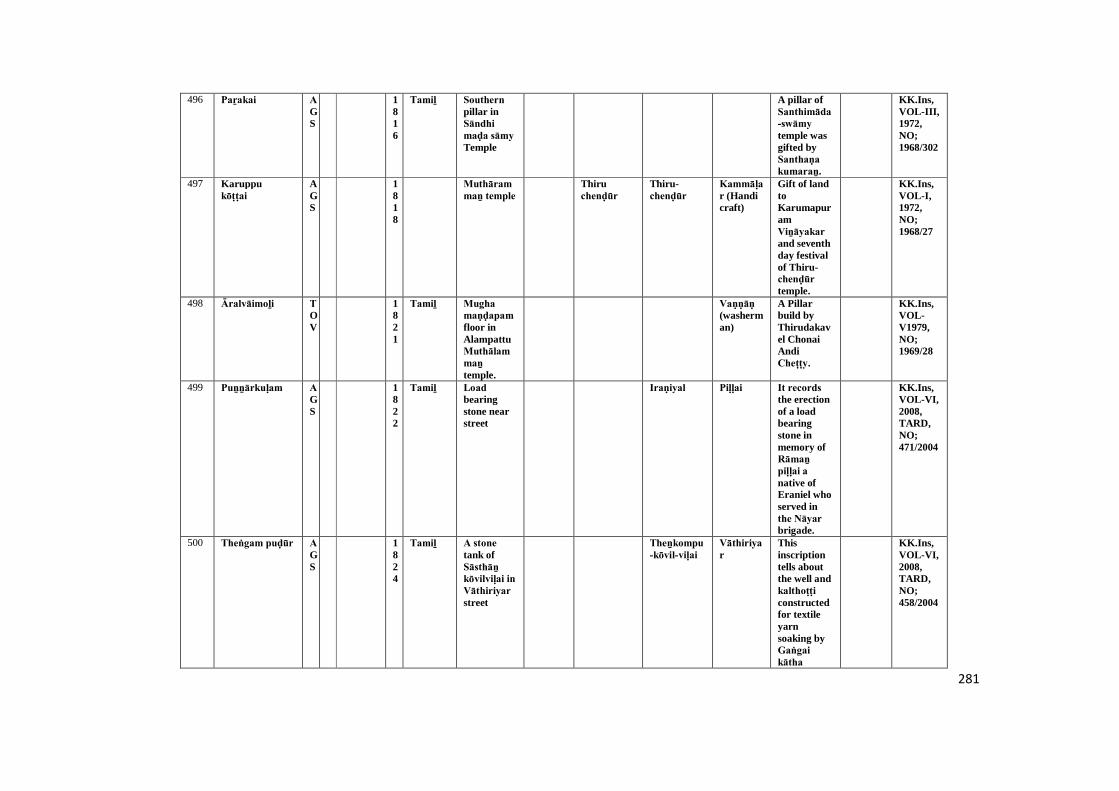
281
496 Paṟakai AGS
1816
Tamiḻ Southern pillar inSāndhi maḍa sāmy Temple
A pillar ofSanthimāda-swāmy temple wasgifted bySanthaṇa kumaraṉ.
KK.Ins,VOL-III,1972,NO;1968/302
497 Karuppukōṭṭai
AGS
1818
Muthārammaṉ temple
Thiruchenḍūr
Thiru-chenḍūr
Kammāḷar (Handicraft)
Gift of landtoKarumapuramViṉāyakar and seventhday festivalof Thiru-chenḍūr temple.
KK.Ins,VOL-I,1972,NO;1968/27
498 Āralvāimoḻi TOV
1821
Tamiḻ Mugha maṇḍapam floor inAlampattuMuthālammaṉ temple.
Vaṇṇāṇ (washerman)
A Pillarbuild byThirudakavel ChonaiAndiCheṭṭy.
KK.Ins,VOL-V1979,NO;1969/28
499 Puṉṉārkuḷam AGS
1822
Tamiḻ Load bearingstone nearstreet
Iraṇiyal Piḷḷai It records the erectionof a loadbearingstone inmemory ofRāmaṉ piḷḷai a native ofEraniel whoserved inthe Nāyar brigade.
KK.Ins,VOL-VI,2008,TARD,NO;471/2004
500 Theṅgam puḍūr AGS
1824
Tamiḻ A stone tank ofSāsthāṉ kōvilviḷai in Vāthiriyar street
Theṉkompu-kōvil-viḷai
Vāthiriyar
Thisinscriptiontells aboutthe well andkalthoṭṭi constructedfor textileyarnsoaking byGaṅgai kātha
KK.Ins,VOL-VI,2008,TARD,NO;458/2004
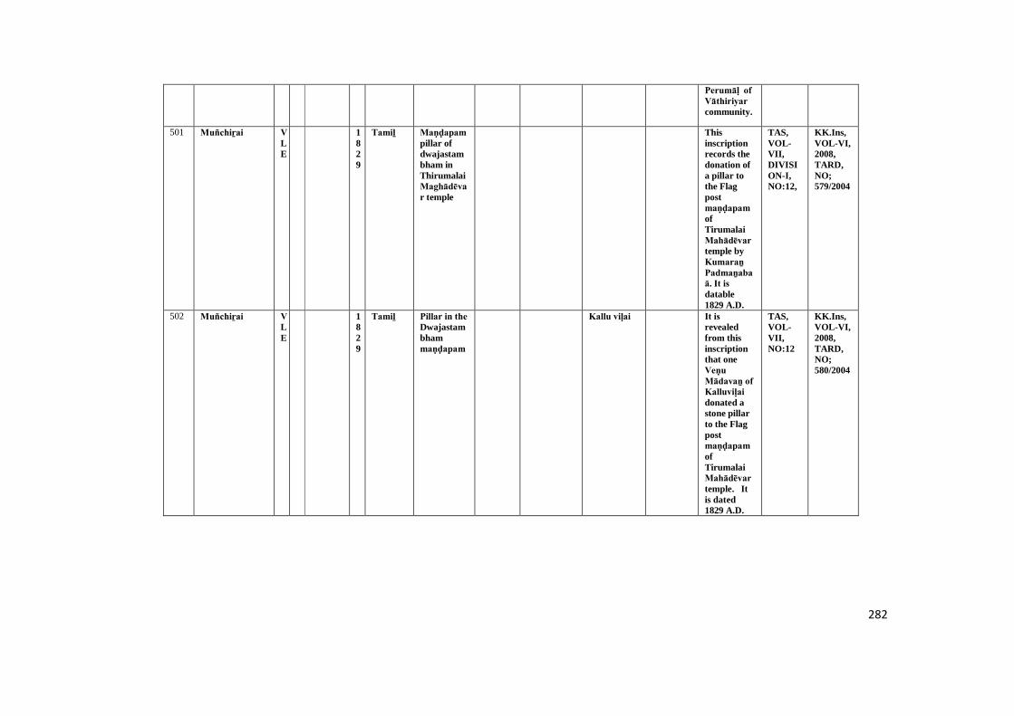
282
Perumāḷ of Vāthiriyar community.
501 Muñchiṟai VLE
1829
Tamiḻ Maṇḍapam pillar ofdwajastambham inThirumalaiMaghādēvar temple
Thisinscriptionrecords thedonation ofa pillar tothe Flagpostmaṇḍapam ofTirumalaiMahādēvar temple byKumaraṉ Padmaṉabaā. It is datable1829 A.D.
TAS,VOL-VII,DIVISION-I,NO:12,
KK.Ins,VOL-VI,2008,TARD,NO;579/2004
502 Muñchiṟai VLE
1829
Tamiḻ Pillar in the Dwajastambhammaṇḍapam
Kallu viḷai It is revealedfrom thisinscriptionthat oneVeṇu Mādavaṉ of Kalluviḷai donated astone pillarto the Flagpostmaṇḍapam ofTirumalaiMahādēvar temple. Itis dated1829 A.D.
TAS,VOL-VII,NO:12
KK.Ins,VOL-VI,2008,TARD,NO;580/2004
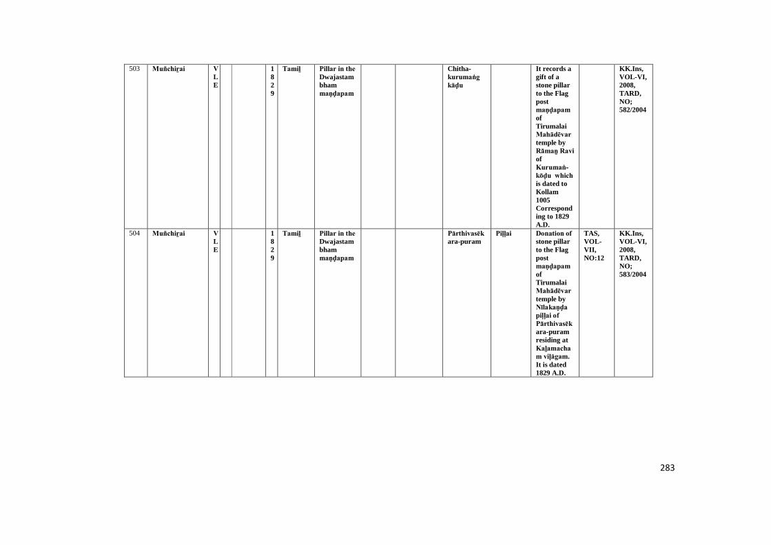
283
503 Muñchiṟai VLE
1829
Tamiḻ Pillar in the Dwajastambhammaṇḍapam
Chitha-kurumaṅg kāḍu
It records agift of astone pillarto the Flagpostmaṇḍapam ofTirumalaiMahādēvar temple byRāmaṉ Ravi ofKurumaṅ-kōḍu which is dated toKollam1005Corresponding to 1829A.D.
KK.Ins,VOL-VI,2008,TARD,NO;582/2004
504 Muñchiṟai VLE
1829
Tamiḻ Pillar in the Dwajastambhammaṇḍapam
Pārthivasēkara-puram
Piḷḷai Donation of stone pillarto the Flagpostmaṇḍapam ofTirumalaiMahādēvar temple byNīlakaṇḍa piḷḷai of Pārthivasēkara-puramresiding atKaḻamacham viḷāgam. It is dated1829 A.D.
TAS,VOL-VII,NO:12
KK.Ins,VOL-VI,2008,TARD,NO;583/2004
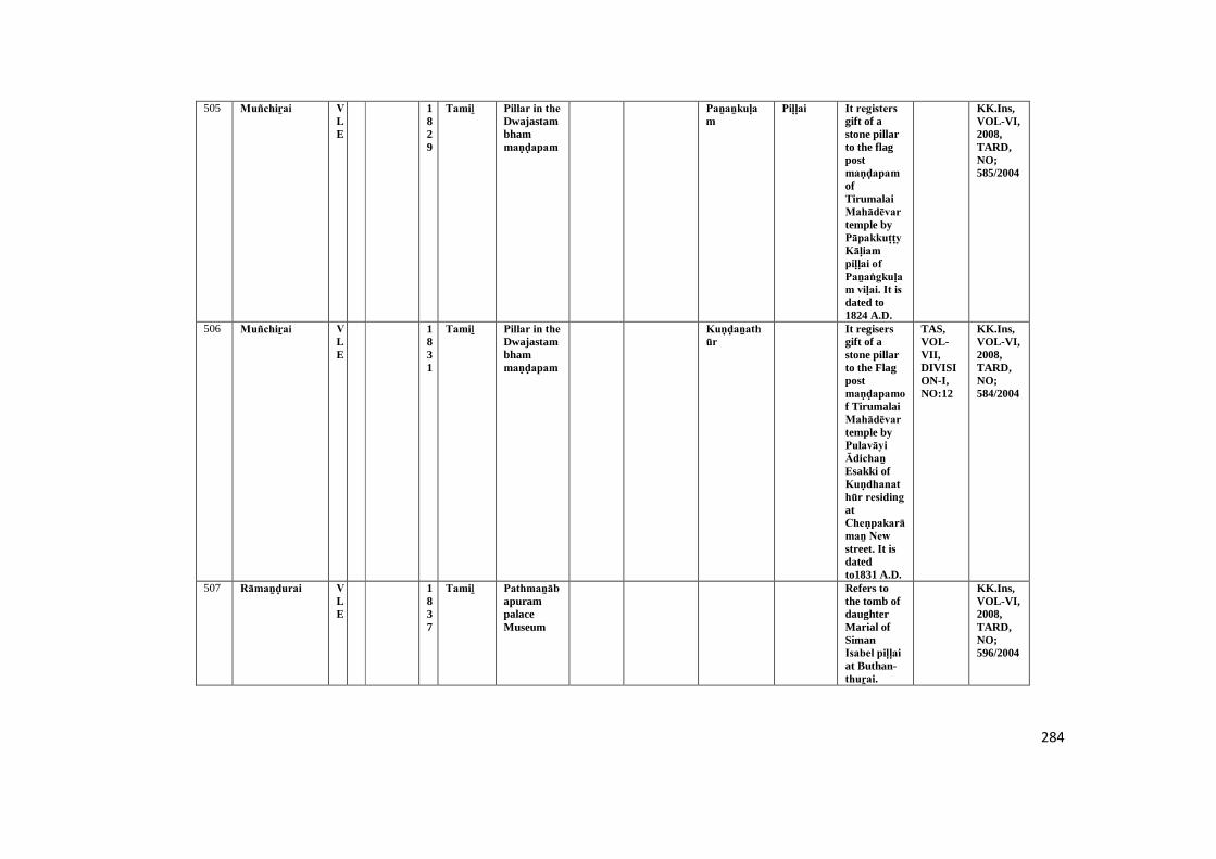
284
505 Muñchiṟai VLE
1829
Tamiḻ Pillar in the Dwajastambhammaṇḍapam
Paṉaṉkuḷam
Piḷḷai It registers gift of astone pillarto the flagpostmaṇḍapam ofTirumalaiMahādēvar temple byPāpakkuṭṭy Kāḷiam piḷḷai of Paṉaṅgkuḷam viḷai. It is dated to1824 A.D.
KK.Ins,VOL-VI,2008,TARD,NO;585/2004
506 Muñchiṟai VLE
1831
Tamiḻ Pillar in the Dwajastambhammaṇḍapam
Kuṇḍaṉathūr
It regisersgift of astone pillarto the Flagpostmaṇḍapamof TirumalaiMahādēvar temple byPulavāyi Ādichaṉ Esakki ofKuṇdhanathūr residing atCheṇpakarāmaṉ New street. It isdatedto1831 A.D.
TAS,VOL-VII,DIVISION-I,NO:12
KK.Ins,VOL-VI,2008,TARD,NO;584/2004
507 Rāmaṉḍurai VLE
1837
Tamiḻ PathmaṉābapurampalaceMuseum
Refers tothe tomb ofdaughterMarial ofSimanIsabel piḷḷai at Buthan-thuṟai.
KK.Ins,VOL-VI,2008,TARD,NO;596/2004

285
508 Thiruviḍaṅ kōḍu
KLM
1840
Tamiḻ Periyanāyaki mādhā church
Kollam It is a tombinscriptionof P.Adarianus,a catholicFatherworked inthe KollamMissionary.It is dated toA.D. 1860.
TAS,VOL-VII,DIVISION-I,NO;43,P-61
KK.Ins,VOL-VI,2008,TARD,NO;515/2004
509 Agastīswaram AGS
1863
Sēnthaṉ senthilapathi chekkaḍi Viṉāyagar temple ofeast wall
Nagarathār were gift toland forTemplebuildersstayed.
KK.Ins,VOL-I,1972,NO;1968/24
510 Aḻakiyapāṇḍya puram
TOV
1866
Tamiḻ Eastern side pillarof Maṇi maṇḍapam in Dēsa Āchāriyāl SriVēravanaṅgai ammaṉ temple
Inscriptionnoted to apillardonation bydaughter ofPāppi ammaiyār.
KK.Ins,VOL-V1979,NO;1969/8
511 Āḍhicheṉ puthūr
TOV
1867
Tamiḻ A load bearingstoneinfront inAuvaiyārammaṉ temple.
SangaraParadesi ofThāḻaikuḍi villagerCollectionof donationfrom otherfor build toPiḷḷaiyār temple.
KK.Ins,VOL-V1979,NO;1969/25
512 Puthēry AGS
1867
Tamiḻ Government ofKaṉyākumariMuseum
It registersinstallationof loadbearingstonememory ofMādēvaṉ of Puthēri. It is dated to
KK.Ins,VOL-VI,2008,TARD,NO;492/2004
286
Kollam year1042(A.D.1827).
513 Parakōḍu KLM
1868
Tamiḻ Misan stone inKanimasthaṉ shaibi mosque
Muḍaliyār
It is a tombinscriptionof Chēyrā Muḍaliyār Mārāṉ Gaṉi Masthāṉ Sāhib. It is datedtoHijra year1246corresponding to 1868A.D.
KK.Ins,VOL-VI,2008,TARD,NO;508/2004
514 Pathmaṉāpa puram
KLM
1877
Tamiḻ A domp in Kollakuḍi mukkumaḍamDampurāṉ temple
Thakkalai Inscriptionrefers tobirth anddeathdetailes ofManikavasaka Āchāri Sanskrit/o.Sadakuṭṭi Āchāri.
KK.Ins,VOL-VI,2008,TARD,NO;504/2004
515 Kaṇḍaṉ viḷai KLM
1877
Tamiḻ Inscription found neara domp ofChristionchurch
Nāṅguṉēri andAchaṉpāḍu
Nāḍār It is a tomb inscriptionofAruḷappaṉ, the son ofXavierMuthunāḍaṉ, the land lord ofAchaṉpāḍu inNāṅguṉēri Taluk.
KK.Ins,VOL-VI,2008,TARD,NO;507/2004
287
516 Ālūr KLM
1886
Tamiḻ Front floor ofNatarājar saṉṉathi in Mahādēvar temple
Ālūr Renovation of Chēra, Chōḻa, Pāṇḍya Mahādēvar Astapanthaṇam, sabāpathi, Swakāmi Ammai andKāraikāl Ammaiyār by Ālūr Nayiṉār.
TAAR,6/1112
KK.Ins,VOL-IV,1979,NO;1969/7
517 Sucīndram AGS
Tiruviḍāṅ
core
Rāma varmar
1887
Tamiḻ Indhira Vinayagarsaṉṉathi separatestone ofbackside inDāṇumālaya Perumāḷ Temple
TempleConstruction wasinauguratedin A.D. 1880andKumbhābisēkam (Renovation) performedin A.D.1887.
STANO,91
KK.Ins,VOL-II,1972,NO;1968/167
518 Thikaṉaṅkōḍu KLM
1887
Tamiḻ Top portion pillar inMaḍappaḷḷi (cookinghall)
Thikaṇaṅ kōḍu Mādēvar templeMaḍappaḷḷi
Mēkkūr It refers to the erectionofMaḍappaḷḷi inTirukaṇaṅ-kōḍu Mahādēvar templebythe SriKāriyam Nārāyaṇaṉ of Mēkkur. It is dated in1887 A.D.
KK.Ins,VOL-VI,2008,NO;500/2004
288
519 Vaḍivīswaram AGS
1889
Tamiḻ Iḍarthīrtha Perumāḷ Temple
Vaḍivīswaram
Mīnātchi muthulakshmi donatedtwo pillarsand steel toPerumāḷ temple.
KK.Ins,VOL-III,1972,NO;1968/332
520 Āralvāimoḻi TOV
1889
Tamiḻ Southern side pillarof Entrancegate inKulasēkara Viṉāyakar temple.
Āralvāimoḻi was called,Ārai
Piḷḷai Vaṇṇāṇ Nallamiḍaṉ (Washerman) build tofoundationof manimaṇḍapam and pīḍa kallu inAlampathuMuthālammaṉ temple.
KK.Ins,VOL-V1979,NO;1969/30
521 Āralvāimoḻi TOV
1889
Tamiḻ Southen side paṭṭi of Mughamaṇḍapam in Kulasēkara Viṉāyakar temple.
Āralvāimoḻi was called,Ārai
Piḷḷai Chidamparam piḷḷai son ofAiyamPerumāḷ piḷḷai a villagers ofĀrai (Āralvāimoḻi) build apillar inKulasēkara Viṉāyakar temple.Present dayĀrai village called to,'Āralvāimoḻi'.
KK.Ins,VOL-V1979,NO;1969/31
522 Āralvāimoḻi TOV
1890
Tamiḻ Northern side pillarof Entrancegate inKulasēkara Viṉāyakar temple.
Āralvāimoḻi was called,Ārai
Piḷḷai A Pillar build byKuṭṭy Aṉaichan Vēṇaṉ.
KK.Ins,VOL-V1979,NO;1969/29
289
523 Puthaṉḍurai AGS
1891
Tamiḻ Campus of Christionburialground
Poḻigainagar,
Thisepitombrecords thedetails ofXavierMuthaiahpiḷḷai, a son of aAccountantof Poḻigai Nagar whopassedaway. Italso revealsthat XavierMuthaiahpiḷḷai had passedMatriculation.
KK.Ins,VOL-VI,2008,TARD,NO;469/2004
524 Vaḍivīswaram AGS
1892
Tamiḻ Maḍappaḷḷi [mutt] mainfloor inKaṉṉi Viṉāyakar Temple
Maḍappaḷḷi Thiruvaṉantha-puram
AMaḍappaḷḷi(mutt) wasbuild byVarathaiyar.
KK.Ins,VOL-III,1972,NO;1968/331
525 Puthaṉḍurai AGS
1894
Tamiḻ Campus of Christionburialground
Kēsavaṉputhaṉ thuṟai
It is anotherepitombrecords thedemise ofFrancis K.Fernandez,anAccountantin 1894 A.D.
KK.Ins,VOL-VI,2008,TARD,NO;470/2004
526 Kochai piḍāram AGS
1896
Tamiḻ Separate stone inhigh school
Kalkuḷam Kaṇakku Eīswaraṉ Krishṇaṇ constructeda granitetank
KK.Ins,VOL-I,1972,NO;1968/127
527 Thakkalai KLM
1897
Tamiḻ Dēvasakāyam piḷḷai kurusaḍi
Prappamkōḍu kōṇam
Nāḍār This refers to deathdetails ofRāma Vaḍivuṇṇi Vaidhyanāt
KK.Ins,VOL-VI,2008,TARD,NO;511/2004
290
haṉ Kāṇḍrāct-kiṭṭaru Nāḍār.
528 Vaḍivīswaram AGS
1898
Tamiḻ Southern side uṇṇāḻi wall ofBālamurugaṉ saṉṉathi in Kaṉṉi Viṉāyakar Temple
Inscriptionsrefer toBālamurugaṉ saṉṉathi.
KK.Ins,VOL-III,1972,NO;1968/329
529 Āḍhicheṉputhūr TOV
1898
Tamiḻ Northern side wall ofuṇṇāḻi in Piḷḷaiyār temple.
Paṉaṅgkuḍi andThāḻaikuḍi
SundariSāthaṉ Kuṭṭi donatedland toNāñchi-nāṭṭu Paṇḍainthar viḷākattu Vīra-Chōḻa-Piḷḷaiyār for its dailyworship.
KK.Ins,VOL-V1979,NO;1969/23
530 Kalkuḷam KLM
1898
Tamiḻ Arumugha Viṉāyakar templepillar
Piḷḷai This refers to Templeconstructiondone byĀrumugathammal w/o.Ārumugam ofThakkalaiPaṉṇāyār (Land lord).
KK.Ins,VOL-VI,2008,TARD,NO;496/2004
531 Kaṉyākumari AGS
1900
Tamiḻ Kaṉya Bhagavathitemple ,thirdentrance offirst step
Damaged KK.Ins,VOL-I,1972,NO;1968/83
291
532 Vaḍivīswaram AGS
1900
Tamiḻ Northern side pillarofDwajasthampam inAḻagammaṉ Temple
Donated apillar toAḻagammaṉ temple.
KK.Ins,VOL-III,1972,NO;1968/328
533 Vaḍivīswaram AGS
1900
Tamiḻ Southern side uṇṇāḻi wall ofBālamurugaṉ saṉṉathi in Kaṉṉi Viṉāyakar Temple
Pūṅgāthuḍai
Muthaichichidambaravaḍivu donatedmoney toKaṉṉi Viṉāyakar temple.
KK.Ins,VOL-III,1972,NO;1968/330
534 Sivagiri KLM
1900
Sanskrit Westernside rock ofSivagiriTemple
Inscriptionmention toSri Rāma saraṇam.
KK.Ins,VOL-IV,1979,NO;1969/31
535 Thiruvaṭṭāṟu KLM
Tiruviḍāṅ
core
Rāma varmar
1900
E Southernside wall ofculvert inThiruvaṭṭāṟu
Thiruvaṭṭāṟu bridgecompletedin the yearA.D.1900.Inthe reign ofhis highnessRāma vurmaduring theadministration of DewanBahadur.K.Krishnaswāmy Rao.
KK.Ins,VOL-IV,1979,NO;1969/67
536 Muñchiṟai VLE
1900
Tamiḻ Pillar in the Dwajastambhammaṇḍapam
TheAccountantCheṇbagarāmaṉ Ādichaṉ donated astone pillarto the Flagpostmaṇḍapam ofTirumalaiMahādēvar
KK.Ins,VOL-VI,2008,TARD,NO;581/2004

292
temple asgleanedfrom thisinscriptionof 19thC.A.D.
537 Muñchiṟai VLE
1900
Tamiḻ Pillar in the Dwajastambhammaṇḍapam
Pēyaḍi viḷai It records gift of astone pillarto the flagpostmandappaofTirumalaiMahādēvar temple byAyyappaṉ Thāṇuvaṉ of Pēyaḍi-viḷai. It is datable to19th C.A.D.
KK.Ins,VOL-VI,2008,TARD,NO;586/2004
538 Muñchiṟai VLE
1900
Tamiḻ Pillar in the Dwajastambhammaṇḍapam
Kuṇḍaṉathūr
Piḷḷai It registers gift of astone pillarto the flagpostmaṇḍapam ofTirumalaiMahādēvar temple byVēlu-ūmaipiḷḷai ofKuṇḍaṉathūr residing atMēlaṅkuḷam NewHouse. It isdatable to19th C.A.D.
KK.Ins,VOL-VI,2008,TARD,NO;587/2004

293
539 Sivagiri KLM
1906
Tamiḻ A pillar of mugamaṇḍapam in Sivagiritemple
Mulaikāra paṭṭi
Piḷḷai Muthaiya piḷḷai, A. Aruṇāchalam piḷḷai and Nāgaliṅgam built amaṇḍapam in SivagiriTemple.
KK.Ins,VOL-IV,1979,NO;1969/30
540 Kōṭṭāṟu AGS
1906
Tamiḻ A pillar inscriptionin Piḷḷaiyār kuḷakarai
Saṅkaraiyaṉ constructeda templededicated toPiḷḷaiyār and also atank asrevealed bythisinscriiption.
KK.Ins,VOL-VI,2008,TARD,NO;456/2004
541 Thiruvaṭṭāṟu KLM
1000-1100
Vaṭṭeḷuttu andTamiḻ
Southernside pillarofarthamaṇḍapam inDaliyalMahādēvar temple
Cheṭṭiyār It may be noted adonation oftemple.
KK.Ins,VOL-IV,1979,NO;1969/51
542 Kaṉyākumari AGS
Chōḻa
1000-1100
Tamiḻ Pathmaṉābapurampalace
Maṇarkuḍi It refers to thedonationsgiven toMaṇarkuḍi people byRāja Rājēswaram Sālai People.
KK.Ins,VOL-VI,2008,TARD,NO;483/2004
543 Thikaṉaṅkōḍu KLM
1000-1100
Vaṭṭeḷuttu andTamiḻ
Suthernsideadhiṭṭāṇam ofarthamaṇḍapam inPerumāḷ temple
Thirumudhāṉ kōḍu
This refersto landdonated forThirukaṇṇaṅ-kōḍu God.
TAS,VOL-III,DIVISION-I,P-76
KK.Ins,VOL-VI,2008,TARD,NO;497/2004
294
544 Pārthivapuram VLE
1000-1100
Vaṭṭeḷuttu andTamiḻ
Westernsidemuppaṭṭai kumuthamin secondepirahāra
Rāja Rāja Vaḷḷuva nāḍu
Karithuṟai Paḻaiyūr and Kuḷ aichaūr
Pulaya ThePerumakkaḷ ofPārthivasēkhara-puramgifted landsto Kēraḷaṉ Ādichaṉ-varmaṉ Rāja Rāja Vaḷḷuva nāḍnāḻvāṉ ofKarithuṟai for burninga perpetuallamp in thePerumāḷ temple. It isdatable to10-11thC.A.D
TAS,VOL-III,P-55
KK.Ins,VOL-VI,2008,TARD,NO;573/2004
545 Kaṉyākumari AGS
1100-1200
KanyaBhagavathitempleuṇṇāḻi of south sidewall
Khīḻār nāḍu
Kumarimaṅgalam
Kumarimaṅgalam
Curd andghee weregifted toKaṉyapagavathiTemple forMaghā-navami dayfestival.
KK.Ins,VOL-I,1972,NO;1968/53
546 Sāmithōppu AGS
Chōḻa
Kulōthuṅ-gaṉ. I
1100-1200
Tamiḻ Separate stone invaṭṭa-thiṭṭu-thōppu
Aḻagiya-Chōḻa-Chithravilli,Uyakoṇḍa-Chōḻa -ChithravilliandKaṇḍarathithaChithravilliwere giftedtwoperpetuallamp.
KK.Ins,VOL-I,1972,NO;1968/130-A
295
547 Kaṉyākumari AGS
Chōḻa
Kōpara kēsari paṉmar
1100-1200
Vaṭṭeḷuttu andTamiḻ
Kaṉya Bhagavathitempleuṇṇāḻi of west sidewall
Puṟathayanāḍu
Khiḻar nāṭṭu vēḷāṉ gifted to Kaṉya BhagavathiTemple forlight toperpetuallamp.
STANO:VOL-VI,P.142,(36/1085)
KK.Ins,VOL-I,1972,NO;1968/54
548 Kaṉyākumari AGS
1100-1200
Tamiḻ Kaṉya Bhagavathitemplebottom sideof north inArthamaṇḍapam
Puṟathayanāḍu
Rājēndira Chōḻa gifted his 9thyears ruledperiod.
KK.Ins,VOL-I,1972,NO;1968/67
549 Kaṉyākumari AGS
1100-1200
Tamiḻ Kaṉya Bhagavathitemplenorth sidewall (leftside) inArthamaṇḍapamentrance
Theṉ-vāraṇāsi
Thiruvuṇaḻikaiyār received giftfor cermonyto Kaṉya Bhagavathitemple.
KK.Ins,VOL-I,1972,NO;1968/71
550 Kaṉyākumari AGS
Chōḻa
1100-1200
Tamiḻ Kayakumary templesouth sidewall (outside) inmugamaṇḍapam
Damaged KK.Ins,VOL-I,1972,NO;1968/72
551 Kaṉyākumari AGS
1100-1200
Tamiḻ Kaṉya Bhagavathitemple firstpragāra west sidewall
Only,Maikīrthi areavailable.
KK.Ins,VOL-I,1972,NO;1968/76
296
552 Kaṉyākumari AGS
1100-1200
Grantha Kaṉya Bhagavathitemple,entrance(left side) ofArthamaṇḍapam northside
A lampgifted tolightKaṉyapagavathitemple.
STANO:27/1087
KK.Ins,VOL-I,1972,NO;1968/82
553 Kaṉyṇkumari AGS
1100-1200
Tamiḻ Kaṉya Bhagavathitemple,south side wallinArthamaṇḍapam
Rāyarkuḍi Damaged KK.Ins, VOL-I,1972,NO;1968/87
554 Kaṉyākumari AGS
1100-1200
Tamiḻ Kaṉya Bhagavathitemple,south side wallinmugamaṇḍapam
Damaged KK.Ins,VOL-I,1972,NO;1968/88
555 Kaṉyākumari AGS
1100-1200
Tamiḻ Kaṉya Bhagavathitemple,south side wallinArthamaṇḍapam
Damaged KK.Ins,VOL-I,1972,NO;1968/90
556 Kaṉyākumari AGS
1100-1200
Tamiḻ Kaṉya Bhagavathitemple,south side wallinArthamaṇḍapam
Damaged KK.Ins,VOL-I,1972,NO;1968/91
297
557 Sucīndram AGS
1100-1200
Tamiḻ West side wall uṇṇāḻi of Vishnusaṉṉathi (Temple) inDānumālya Perumāḷ Temple
RājēndhiraChōḻa vaḷanāḍu,Nāñchilnāḍu
Nāñci nāṭṭu Brahmadēyam Sunḍara Chōḻa charupēthi maṅgalam
Nāñci nāṭṭu Chōḻa charupethimaṅgalam,
Cheṭṭiyār Māṇikaṉ Cheṭṭy donatedtwenty fiveachchu forlightingperpetuallamp andtwenty fivecow's toThenThiruvēṅgaḍa Paramaswāmy.
KK.Ins,VOL-II,1972,NO;1968/170- A
558 Sucīndram AGS
Chōḻa
Kulōthuṅ-gaṉ - I
1100-1200
Tamiḻ South side rock ofKailāsanāther saṉṉathi inDāṇumālaya Perumāḷ Temple
Inscriptionnoteddonation ofgoats in theSucindramtemple forlighting aperpetuallamp.
KK.Ins,VOL-II,1972,NO;1968/188
559 Sucīndram AGS
Chōḻa
Kulōthuṅ-gaṉ. I
1100-1200
Tamiḻ Eastern rock ofsecondpraharaĀaṉaipārai inDānumālya Perumāḷ temple
Chōḻadēsam This inscriptionrefers to thedonation offifty goats.
KK.Ins,VOL-II,1972,NO;1968/216
560 Aḻakiya Pāṇḍya puram
TOV
1100-1200
Tamiḻ First paṭṭi of Northernside walluṇṇāḻi in SriVeṅgaḍa chalapathytemple.
Koḍunthuṟai
Hundredand fiftyrupees giftby Sivakāmi Aḻager for build aSculpture inDeraĀchāriyāl Sri Vīra nangaiammaṉ Temple.
TAS,VOL-VII,DIVISION-II,P-107
KK.Ins,VOL-V1979,NO;1969/10
298
561 Aḻakiya Pāṇḍya puram
TOV
1100-1200
Tamiḻ First paṭṭi of Northernside walluṇṇāḻi in SriVeṅgaḍa chalapathytemple
Pillardonated byAnaingaPerumāḷ at the time ofammaṉ kōil renovation.
TAS,VOL-VII,DIVISION-II,P-107
KK.Ins,VOL-V1979,NO;1969/11
562 Aḻakiya Pāṇḍya puram
TOV
1100-1200
Tamiḻ Seconde paṭṭi of Northernside walluṇṇāḻi in SriVeṅgaḍa chalapathytemple
Vaṇṇāṇ (washerman)
Inscriptionnoted toLanddonation.
TAS,VOL-VII,DIVISION-II,P-106
KK.Ins,VOL-V1979,NO;1969/13
563 Aḻakiya Pāṇḍya puram
TOV
1100-1200
Tamiḻ Seconde paṭṭi of Northernside walluṇṇāḻi in SriVeṅgaḍa chalapathytemple
Pāppaṉ [priest]
Landdonation togodMāṇikka Perumāḷ of SriVeṅgaḍachalapathitemple forits dailyworships byAḻakiya Pāṇḍya puramKaṇṇaṉ dēvaṉ.
TAS,VOL-VII,P-107
KK.Ins,VOL-V1979,NO;1969/14
564 Aḻakiya Pāṇḍya puram
TOV
1100-1200
Tamiḻ Seconde paṭṭi of West sidewall uṇṇāḻi in SriVeṅgaḍa chalapathytemple
Oṉañjapulam
Cheṭṭy (trader),Nambiyar andNāyar
Nagarathār donated aland to SriVeṅgaḍachalapathitemple forlight to aperpetuallamp.
TAS,VOL-VII,DIVISION-II,P-107
KK.Ins,VOL-V1979,NO;1969/15

299
565 Aḻakiya Pāṇḍya puram
TOV
1100-1200
Tamiḻ First paṭṭi of Southside walluṇṇāḻi in SriVeṅgaḍa chalapathytemple
Thiruvikramaṉ Achaṉ andOṉañjapulamNambiyarweredonatedLand to SriVeṅgaḍachalapathitemple forits light to aSanthyaDēpam(light).
KK.Ins,VOL-V1979,NO;1969/17
566 Arumanallūr TOV
1100-1200
Tamiḻ A rock infront ofsāsthā temple
Nāñchilnāḍu andArumalaikūṭṭrathunāḍu
Udhayamaṅgalam
Vīrakēraḷam
Damaged KK.Ins,VOL-V1979,NO;1969/4
567 Pañchavaṇ kōḍu
AGS
1100-1200
Tamiḻ Pathmaṉāba purampalace
Vīrakēraḷa nallūr
Chōḻa dēvar Donatedland asAñjiṉāṉ Pugaliḍam to thenatives ofVīra-Kēraḷaṉallur as gleanedfrom thisinscription.
KK.Ins,VOL-VI,2008,TARD,NO;488/2004
568 Kaṉyākumari AGS
Pāṇḍya
SriSunḍaraPāṇḍya dēvar
1200-1300
Kaṉya Bhagavathitempleuṇṇāḻi of west sidewall(outside)
vaḷa nāḍu
Ten coinwas gift toKaṉya BhagavathiTemple forlight toperpetuallamp.
KK.Ins,VOL-I,1972,NO;1968/40
300
569 Kaṉyākumari AGS
1200-1300
Kaṉya Bhagavathitemple leftside(south)wall inArthamaṇḍapamentrance
Theṉ-vāraṇāsi / Theṉkāsi / Thiruvaraṅga nallūre
Gōvindaṉ gifted toTheṉ-vāraṇāsi-nāṭṭu KumariKaṉya Bhagavathitemple forlighted toperpetuallamp.
KK.Ins,VOL-I,1972,NO;1968/60
570 Kaṉyākumari AGS
1200-1300
Kaṉya Bhagavathitemplesouth side(left side)wall inArthamaṇḍapamentrance
Puṟathayanāḍu
Damaged KK.Ins,VOL-I,1972,NO;1968/61
571 Kaṉyākumari AGS
1200-1300
Kaṉya Bhagavathitemplesouth side(left side)wall inArthamaṇḍapamentrance
Puṟathayanāḍu
Damaged KK.Ins,VOL-I,1972,NO;1968/63
572 Kaṉyākumari AGS
1200-1300
Tamiḻ Kaṉya Bhagavathitemplesouth sidewall (outside)
Uthama-Chōḻa-vaḷanāḍu
Ritualpracticed inKaṉya Bagavathitemple.
KK.Ins,VOL-I,1972,NO;1968/73
573 Kaṉyākumari AGS
1200-1300
Tamiḻ Kaṉya Bhagavathitempleinside wallof south
Dayanallūr Every day, Rictualpracticed inKaṉya Bagavathitemple bydonation.
KK.Ins,VOL-I,1972,NO;1968/74
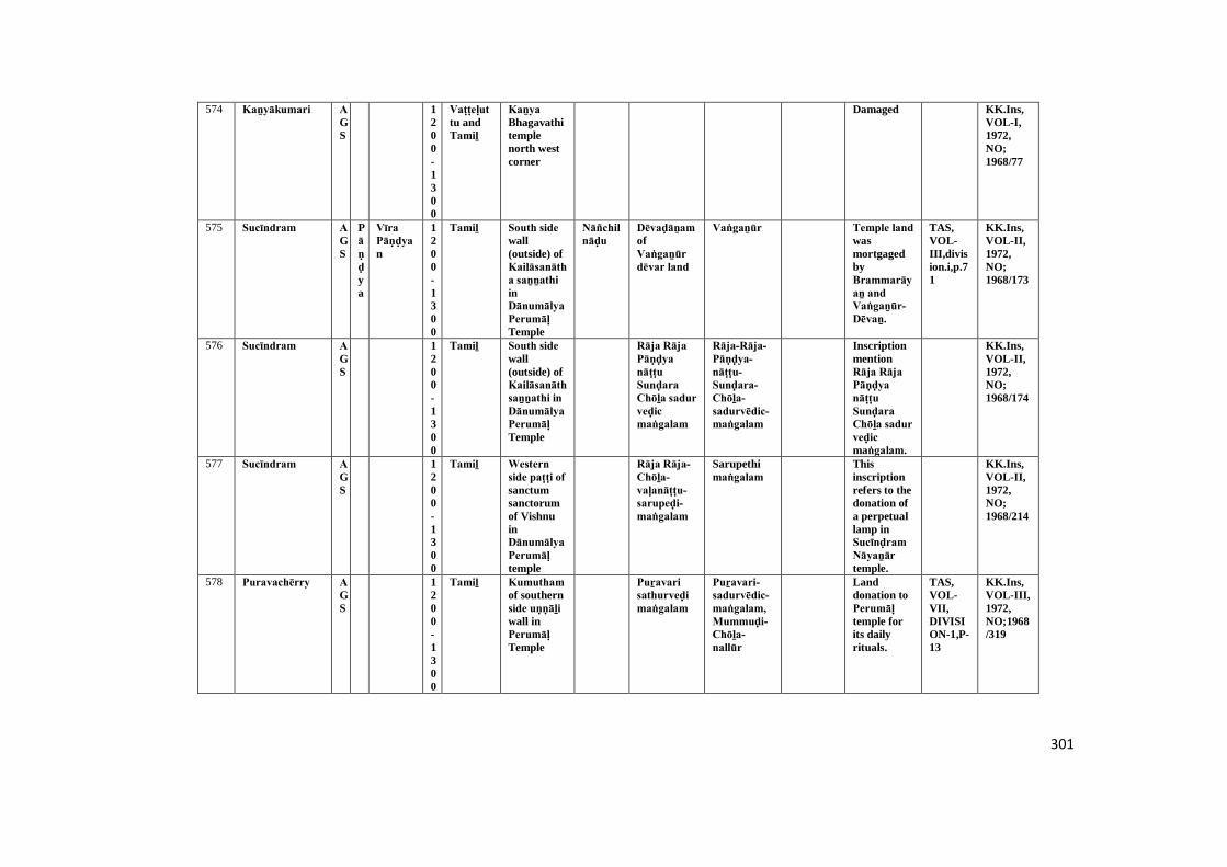
301
574 Kaṉyākumari AGS
1200-1300
Vaṭṭeḷuttu andTamiḻ
Kaṉya Bhagavathitemplenorth westcorner
Damaged KK.Ins,VOL-I,1972,NO;1968/77
575 Sucīndram AGS
Pāṇḍya
Vīra Pāṇḍyan
1200-1300
Tamiḻ South side wall(outside) ofKailāsanātha saṉṉathi inDānumālya Perumāḷ Temple
Nāñchilnāḍu
Dēvaḍāṉam ofVaṅgaṉūr dēvar land
Vaṅgaṉūr Temple land wasmortgagedbyBrammarāyaṉ and Vaṅgaṉūr-Dēvaṉ.
TAS,VOL-III,division.i,p.71
KK.Ins,VOL-II,1972,NO;1968/173
576 Sucīndram AGS
1200-1300
Tamiḻ South side wall(outside) ofKailāsanāth saṉṉathi in Dānumālya Perumāḷ Temple
Rāja Rāja Pāṇḍya nāṭṭu Sunḍara Chōḻa sadur veḍic maṅgalam
Rāja-Rāja-Pāṇḍya-nāṭṭu-Sunḍara-Chōḻa-sadurvēdic-maṅgalam
InscriptionmentionRāja Rāja Pāṇḍya nāṭṭu Sunḍara Chōḻa sadur veḍic maṅgalam.
KK.Ins,VOL-II,1972,NO;1968/174
577 Sucīndram AGS
1200-1300
Tamiḻ Western side paṭṭi of sanctumsanctorumof VishnuinDānumālya Perumāḷ temple
Rāja Rāja-Chōḻa-vaḷanāṭṭu-sarupeḍi-maṅgalam
Sarupethimaṅgalam
Thisinscriptionrefers to thedonation ofa perpetuallamp inSucīnḍram Nāyaṉār temple.
KK.Ins,VOL-II,1972,NO;1968/214
578 Puravachērry AGS
1200-1300
Tamiḻ Kumutham of southernside uṇṇāḻi wall inPerumāḷ Temple
Puṟavari sathurveḍi maṅgalam
Puṟavari-sadurvēdic-maṅgalam,Mummuḍi-Chōḻa-nallūr
Landdonation toPerumāḷ temple forits dailyrituals.
TAS,VOL-VII,DIVISION-1,P-13
KK.Ins,VOL-III,1972,NO;1968/319
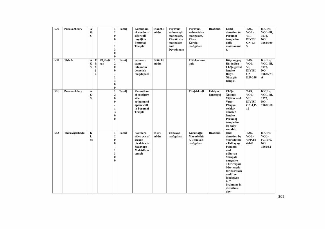
302
579 Puravachērry AGS
1200-1300
Tamiḻ Kumudam of northernside walluṇṇāḻi in Perumāḷ Temple
Nāñchilnāḍu
Puṟavari sathurveḍi maṅgalam, Vīrakēraḷa maṅgalam andDēvaḍāṉam
Puṟavari-sadurvēdic-maṅgalam,Vīra-Kēraḷa-maṅgalam
Brahmin Landdonation toPerumāḷ temple fordailymaintanance.
TAS,VOL-VII,DIVISION-I,P-5
KK.Ins,VOL-III,1972,NO;1968/309
580 Thērūr AGS
Chōḻa
Rājēnḍiraṉ
1200-1300
Tamiḻ Separate stoneinfront indemolishmaṇḍapam
Nāñchilnāḍu
Thērkarum-paḻu
Kōṉ-koṟṟaṉ Rājēnḍira-Chōḻa gifted land toIlaiya-Nāyaṉār temple.
TAS,VOL-VI,DIVISIONII,P-146
KK.Ins,VOL-III,1972,NO;1968/273A
581 Puravachērry AGS
1200-1300
Tamiḻ Kumutham of southernsidearthamaṇḍapam wallin Perumāḷ Temple
Thaḻai-kuḍi Udaiyar, kaṉmigaḷ
Chōḻa Āṇkuḍi Vēḷālar and Vīra-Pāṇḍya velalardonatedland toPerumāḷ temple forits dailyworship.
TAS,VOL-VII,DIVISION-1,P-12
KK.Ins,VOL-III,1972,NO;1968/318
582 Thiruviḍaikōḍu KLM
1200-1300
Tamiḻ Southern side rock ofsecondpirahāra in Saḍayapa Mahādēvar temple
Kuṟu nāḍu
Udhayaṉ maṅgalam
Kuṟunāṭṭu Marudathūr, Udhayaṉ-maṅgalam
Brahmin landdonation byMarudathūr Udhayaṉ Poṉāṉdi andudhayaṉ Maṅgala naṅgai to Thiruviḍaikōḍu temple for its ritialsand freefood givento 7brahmins induvathasiday.
TAS,VOL-VPP.144-145
KK.Ins,VOL-IV,1979,NO;1969/82
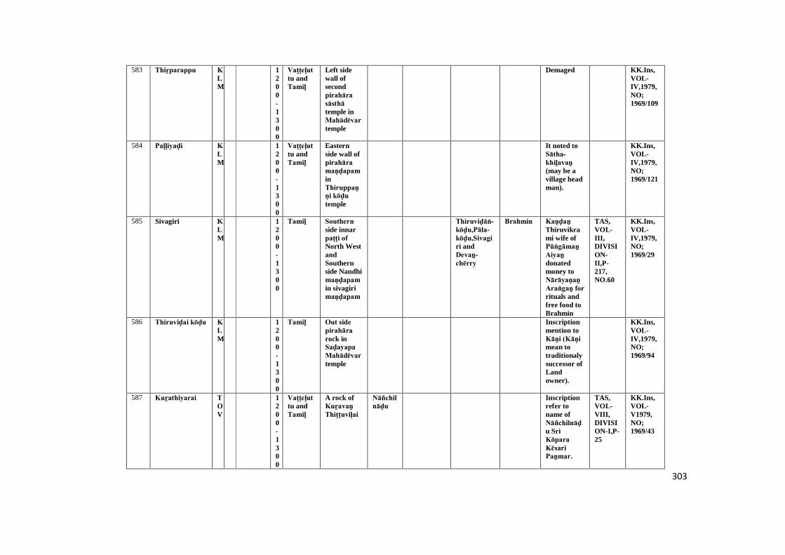
303
583 Thiṟparappu KLM
1200-1300
Vaṭṭeḷuttu andTamiḻ
Left sidewall ofsecondpirahāra sāsthā temple inMahādēvar temple
Demaged KK.Ins,VOL-IV,1979,NO;1969/109
584 Paḷḷiyaḍi KLM
1200-1300
Vaṭṭeḷuttu andTamiḻ
Easternside wall ofpirahāra maṇḍapam inThiruppaṇṇi kōḍu temple
It noted toSātha-khiḻavaṉ (may be avillage headman).
KK.Ins,VOL-IV,1979,NO;1969/121
585 Sivagiri KLM
1200-1300
Tamiḻ Southern side innarpaṭṭi of North WestandSouthernside Nandhimaṇḍapam in sivagirimaṇḍapam
Thiruviḍāṅ-kōḍu,Pāla-kōḍu,Sivagiri andDevaṉ-chērry
Brahmin Kaṇḍaṉ Thiruvikrami wife ofPūṅgāmaṉ Aiyaṉ donatedmoney toNārāyaṇaṉ Araṅgaṉ for rituals andfree food toBrahmin
TAS,VOL-III,DIVISION-II,P-217,NO.60
KK.Ins,VOL-IV,1979,NO;1969/29
586 Thiruviḍai kōḍu KLM
1200-1300
Tamiḻ Out side pirahāra rock inSaḍayapa Mahādēvar temple
Inscriptionmention toKāṇi (Kāṇi mean totraditionalysuccessor ofLandowner).
KK.Ins,VOL-IV,1979,NO;1969/94
587 Kuṟathiyarai TOV
1200-1300
Vaṭṭeḷuttu andTamiḻ
A rock ofKuṟavaṉ Thiṭṭuviḷai
Nāñchilnāḍu
Inscriptionrefer toname ofNāñchilnāḍu SriKōpara Kēsari Paṉmar.
TAS,VOL-VIII,DIVISION-I,P-25
KK.Ins,VOL-V1979,NO;1969/43
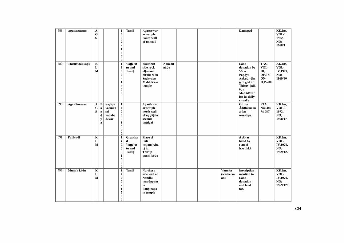
304
588 Agastīswaram AGS
1300-1400
Tamiḻ Agastīswarar templeSouth wallof unnaaḻi
Damaged KK.Ins,VOL-I,1972,NO;1968/1
589 Thiruviḍai kōḍu KLM
1300-1400
Vaṭṭeḷuttu andTamiḻ
Southernside rockof[secondpirahāra in Saḍayapa Mahādēvar temple
Nāñchilnāḍu
Landdonation byVīra-Pāṇḍya Āṇkuḍivēḷaṉ to god of Thiruviḍaikōḍu Mahādēvar for its dailyritual's
TAS,VOL-III,DIVISION-II,P-200
KK.Ins,VOL-IV,1979,NO;1969/80
590 Agastīswaram AGS
Pāṇḍya
Saḍaya varmaṉ srivallabadēvar
1400-1500
Agastīswarar templenorth wallof uṇṇāḻi in secondpaṭṭigai
Gift toĀḍithiruvōṇa dayworships.
STANO:4(47/1087)
KK.Ins,VOL-I,1972,NO;1968/17
591 Paḷḷiyaḍi KLM
1400-1500
Grantha&Vaṭṭeḷuttu andTamiḻ
Place ofPalibēḍam(Altar) inThirup-paṇṇi-kōḍu
A Altarbuild byclan ofKaṟukki.
KK.Ins,VOL-IV,1979,NO;1969/122
592 Muṭṭak kāḍu KLM
1400-1500
Tamiḻ Northern side wall ofNandhimaṇḍapam inPaṇṇipāgam temple
Vaṇṇāṇ (washerman)
Inscriptionmention toLanddonationand landtax.
KK.Ins,VOL-IV,1979,NO;1969/126
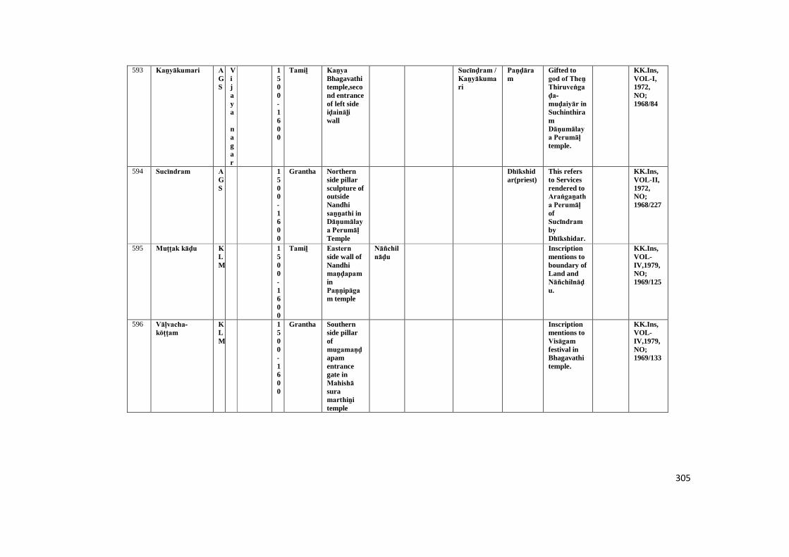
305
593 Kaṉyākumari AGS
Vijaya
nagar
1500-1600
Tamiḻ Kaṉya Bhagavathitemple,second entranceof left sideiḍaināḻi wall
Sucīnḍram / Kaṉyākumari
Paṇḍāram
Gifted togod of Theṉ Thiruveṅgaḍa-muḍaiyār in SuchinthiramDāṇumālaya Perumāḷ temple.
KK.Ins,VOL-I,1972,NO;1968/84
594 Sucīndram AGS
1500-1600
Grantha Northernside pillarsculpture ofoutsideNandhisaṉṉathi in Dāṇumālaya Perumāḷ Temple
Dhīkshidar(priest)
This refersto Servicesrendered toAraṅgaṉatha Perumāḷ ofSucīndram byDhīkshidar.
KK.Ins,VOL-II,1972,NO;1968/227
595 Muṭṭak kāḍu KLM
1500-1600
Tamiḻ Eastern side wall ofNandhimaṇḍapam inPaṇṇipāgam temple
Nāñchilnāḍu
Inscriptionmentions toboundary ofLand andNāñchilnāḍu.
KK.Ins,VOL-IV,1979,NO;1969/125
596 Vāḷvacha-kōṭṭam
KLM
1500-1600
Grantha Southernside pillarofmugamaṇḍapamentrancegate inMahishā suramarthiṉi temple
Inscriptionmentions toVisāgam festival inBhagavathitemple.
KK.Ins,VOL-IV,1979,NO;1969/133
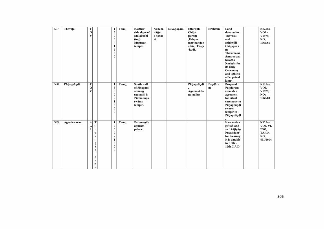
306
597 Thōvāḷai TOV
1500-1600
Tamiḻ Norther side slope ofMalai uchi(top)Murugaṉ temple.
Nāñchi-nāṭṭu Thōvāḷai
Dēvaḍāṉam Ethirvilli Chōḻa puram,Udaya-mārthāṇḍanallūr, Thaḻa -kuḍi,
Brahmin Landdonated toThōvāḷai andEthirvilliChōḻapuramThirumalaiAmararpathikathaNayiṉār for its dailyCeremonyand light toa Perpetuallamp.
KK.Ins,VOL-V1979,NO;1969/66
598 Pūḍappāṇḍi TOV
1500-1600
Tamiḻ South wall of Sivagāmi ammaṉ saṉṉathi in Pūdhaliṅga swāmy temple.
Pūḍappāṇḍi,Aṉumakēdaṉa-nallūr
Paṇḍāram
People ofPaṇḍāram records aagrementfor ritualceremony toPūḍappāṇḍīswarertemple inPūḍappāṇḍi.
KK.Ins,VOL-V1979,NO;1969/81
599 Agastīswaram AGS
Tiruviḍāṅ
core
1500-1600
Tamiḻ Pathmaṉābapurampalace
It records agift of landas "Añjiṉāṉ Pugaliḍam' for treasury.It is datableto 15th -16th C.A.D.
KK.Ins,VOL-VI,2008,TARD,NO;481/2004
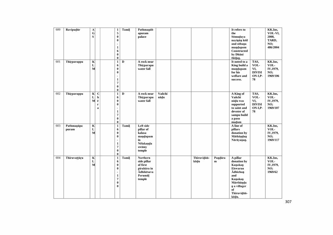
307
600 Ravipuḍūr AGS
1500-1600
Tamiḻ Pathmaṉābapurampalace
It refers totheSōmuḍaya nayiṉāṉ kōil and sōbaṉa maṇḍapam Constructedby Dhāni thōḻaṉ.
KK.Ins,VOL-VI,2008,TARD,NO;486/2004
601 Thiṟparappu KLM
1600-1700
D A rock nearThiṟparapu water fall
It noted to aKing build amaṇḍapam for hiswelfare andsuccess.
TAS,VOL-VI,DIVISION-I,P-78
KK.Ins,VOL-IV,1979,NO;1969/106
602 Thiṟparappu KLM
Chēra
1600-1700
D A rock nearThiṟparapu water fall
Vañchināḍu
A King ofVañchināḍu was supportedto saint anddevoter ofsampu builda pasumaḍam
TAS,VOL-VI,DIVISION-I,P-78
KK.Ins,VOL-IV,1979,NO;1969/107
603 Pathmaṉāpa puram
KLM
1600-1700
Tamiḻ Left side pillar ofkalasamaṇḍapam inNēlakaṇḍa swāmy temple
A line ofpillarsdonation byMāthāṇḍaṉ Nārāyaṇaṉ.
KK.Ins,VOL-IV,1979,NO;1969/117
604 Thiruvaṭṭāṟu KLM
1600-1700
Tamiḻ Northern side pillarof firstpirahāra in Ādhikēsava Perumāḷ temple
Thiruviḍāṅ-kōḍu
Paṇḍāram
A pillardonation byKaṇakaṉ Eīswaran Ādhichaṉ andKaṇakaṉ Mārthāṇḍaṉ a villager ofThiruviḍāṅ-kōḍu.
KK.Ins,VOL-IV,1979,NO;1969/62
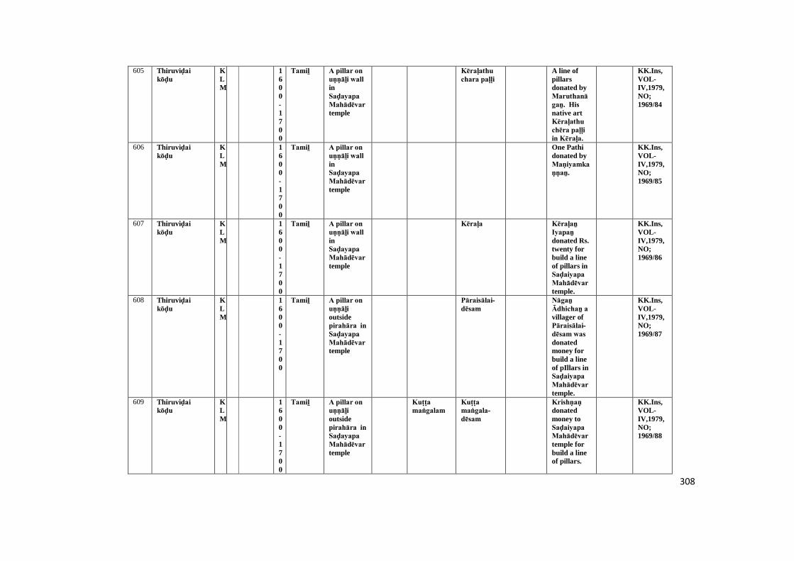
308
605 Thiruviḍai kōḍu
KLM
1600-1700
Tamiḻ A pillar on uṇṇāḻi wall inSaḍayapa Mahādēvar temple
Kēraḷathu chara paḷḷi
A line ofpillarsdonated byMaruthanāgaṉ. His native artKēraḷathu chēra paḷḷi in Kēraḷa.
KK.Ins,VOL-IV,1979,NO;1969/84
606 Thiruviḍai kōḍu
KLM
1600-1700
Tamiḻ A pillar on uṇṇāḻi wall inSaḍayapa Mahādēvar temple
One Pathidonated byMaṇiyamkaṇṇaṉ.
KK.Ins,VOL-IV,1979,NO;1969/85
607 Thiruviḍai kōḍu
KLM
1600-1700
Tamiḻ A pillar on uṇṇāḻi wall inSaḍayapa Mahādēvar temple
Kēraḷa Kēraḷaṉ Iyapaṉ donated Rs.twenty forbuild a lineof pillars inSaḍaiyapa Mahādēvar temple.
KK.Ins,VOL-IV,1979,NO;1969/86
608 Thiruviḍai kōḍu
KLM
1600-1700
Tamiḻ A pillar on uṇṇāḻi outsidepirahāra in Saḍayapa Mahādēvar temple
Pāraisālai-dēsam
Nāgaṉ Ādhichaṉ a villager ofPāraisālai-dēsam was donatedmoney forbuild a lineof pIllars inSaḍaiyapa Mahādēvar temple.
KK.Ins,VOL-IV,1979,NO;1969/87
609 Thiruviḍai kōḍu
KLM
1600-1700
Tamiḻ A pillar on uṇṇāḻi outsidepirahāra in Saḍayapa Mahādēvar temple
Kuṭṭa maṅgalam
Kuṭṭa maṅgala-dēsam
Krishṇaṇ donatedmoney toSaḍaiyapa Mahādēvar temple forbuild a lineof pillars.
KK.Ins,VOL-IV,1979,NO;1969/88
309
610 Thiruviḍai kōḍu
KLM
1600-1700
Tamiḻ A pillar on uṇṇāḻi wall inSaḍayapa Mahādēvar temple
Perumāḷ donatedmoney forbuild a lineof pillars inSaḍaiyapa Mahādēvar temple.
KK.Ins,VOL-IV,1979,NO;1969/89
611 Thiruviḍai kōḍu
KLM
1600-1700
Tamiḻ A pillar on uṇṇāḻi wall inSaḍayapa Mahādēvar temple
Marudathūr-dēsam
Kaṇakaṉ Eīswaraṉ a villager ofMarudathūr build aline ofpillarsdonated toSaḍaiyapa Mahādēvar temple.
KK.Ins,VOL-IV,1979,NO;1969/90
612 Mēlapuḍūr TOV
1600-1700
Tamiḻ A separate stoneinfront ofHari HaraViṉāyakar temple.
Pudūr Achuvamēda yāgam [Horsesacrificial]
SriParāṅgusanāther donatedfood offer toPudūr mutt at the daysof Duvādesi month.
KK.Ins,VOL-V1979,NO;1969/86
613 Kaṉyākumari AGS
1700-1800
Tamiḻ Kāsivisvanāther templetop sidepillar ofmugamaṇḍapam
Pulāṉ-thuṟai
Samaṇam
Nalla sivaṉ gifted apillar toKāsivisvanāther temple.
STANO:VOL-Vaṭṭeḷuttu andTamiḻ ,Diii,p.201,(16/1090)
KK.Ins,VOL-I,1972,NO;1968/103
614 Kaṉyākumari AGS
1700-1800
Tamiḻ Kāsivisvanāther templea top sidepillar ofmugamaṇḍapam
Kaḻikuḍi A puzzle table consist3 coloumn& numbers.Everycoloumn &every side'sadd equal tofifteen.
KK.Ins,VOL-I,1972,NO;1968/104

310
615 Kaṉyākumari AGS
1700-1800
Tamiḻ Kāsivisvanāther temple
Samaṇa-pārkaraṉ gifted toKāsivisvanāthertemple.
KK.Ins,VOL-I,1972,NO;1968/105
616 Kaṉyākumari AGS
1700-1800
Tamiḻ Kāsivisvanāther templetop sideentrance ofmugamaṇḍapam
ChidamparamconstructedtoMugamaṇḍapam inKāsivisvanāther temple.
KK.Ins,VOL-I,1972,NO;1968/100
617 Kaṉyākumari AGS
1700-1800
Tamiḻ Kāsivisvanāther templetop sidepillar ofmugamaṇḍapam
Muḍaliyār
Aḻagapa Muḍaliyār constructeda pillar inKāsivisvanāther temple.
STANO:VOL-Vaṭṭeḷuttu andTamiḻ ,Diii,p.201,(17/1090)
KK.Ins,VOL-I,1972,NO;1968/101
618 Kaṉyākumari AGS
1700-1800
Tamiḻ Kāsivisvanāther templetop sidepillar ofmugamaṇḍapam
Dēvaṅgkaṉiya pāgaṉ gifted apillar toKāsivisvanāther temple.
STANO:VOL-Vaṭṭeḷuttu andTamiḻ ,Diii,p.201,(15/1090)
KK.Ins,VOL-I,1972,NO;1968/102
619 Kaṉyākumari AGS
1700-1800
Latin Bhagavathiammaṉ temple,entrance ofArthamaṇḍapam inkumutham
Damaged KK.Ins,VOL-I,1972,NO;1968/65
311
620 Kaṉyākumari AGS
1700-1800
Danish At flagmastinBhagavathiammaṉ temple
Damaged KK.Ins,VOL-I,1972,NO;1968/86
621 Kaṉyākumari AGS
1700-1800
Grantha KanyaBhagavathitemple,kodikampapiḍam in mugamaṇḍapam
Damaged TAAR,29/1087;14/1107
KK.Ins,VOL-I,1972,NO;1968/89
622 Kaṉyākumari AGS
1700-1800
Tamiḻ Kāsivisvanāther temple,Arthamaṇḍapamfloor
Damaged KK.Ins,VOL-I,1972,NO;1968/94
623 Kaṉyākumari AGS
1700-1800
Tamiḻ Kāsivisvanāther temple,Arthamaṇḍapam floor
Madaṉa-kumārasāmyreconstructed toardhamaṇḍapamgroundfloor intemple.
KK.Ins,VOL-I,1972,NO;1968/95
624 Kaṉyākumari AGS
1700-1800
Tamiḻ Kāsivisvanāther temple,Arthamaṇḍapam floor
Chidamparamrenovated toardhamaṇḍapamgroundfloor inKāsivisvanāther temple.
STANO:VOL-Vaṭṭeḷuttu andTamiḻ ,Divisioniii,p.201,(19/1090)
KK.Ins,VOL-I,1972,NO;1968/96
312
625 Kaṉyākumari AGS
1700-1800
Tamiḻ Kāsivisvanāther templeentrancestep (top) ofArthamaṇḍapam
Chaṅgumuthuconstructedto steps inKāsivisvanāther temple.
KK.Ins,VOL-I,1972,NO;1968/97
626 Kaṉyākumari AGS
1700-1800
Tamiḻ Kāsivisvanāther templeentrancestep (top) ofArthamaṇḍapam
Pūlāṉ-thuṟai
Mention toSanctum -Santorum oftemple.
STANO:vol-v ,Divisioniii,p.201,(14/1090)
KK.Ins,VOL-I,1972,NO;1968/98
627 Kaṉyākumari AGS
1700-1800
Tamiḻ Kāsivisvanāther templeentrancestep ofArthamaṇḍapam
Nambiyar
Sagaṉāthaṉ Pūmināthaṉ renovatedardhamaṇḍapamentrancesteps inKāsivisvanāther temple.
KK.Ins,VOL-I,1972,NO;1968/99
628 Sucīndram AGS
1700-1800
Tamiḻ Southern wall ofChenbakaramanmandabaminDānumālya Perumāḷ temple
Chivaḷa maṅgalam and Mullamaṅgalam
Somasi-maṅgalam, Chivaḷa-maṅgalam and Mulla-maṅgalam
Paṇḍāram
Refers tovitnesenames ofgift.
KK.Ins,VOL-II,1972,NO;1968/151
629 Sucīndram AGS
1700-1800
Tamiḻ A pillar located infirstpragāra wall ofDāṇumālaya Perumāḷ Temple
Thiruvaṭṭār-dēsam,
Brahmin ThisInscriptionrefers to thedonation ofthis pillarby Pāppaṉ ofThiruvaṭṭardēsam.
KK.Ins,VOL-II,1972,NO;1968/131
313
630 Sucīndram AGS
1700-1800
Tamiḻ A pillar located infirstpragāra wall ofDāṇumālaya Perumāḷ Temple
Kumaranallūr maṅgāṭṭu
ThisInscriptionrefers to thedonation ofthis pillarbyMaṅgāṭṭu Varathasaṅkaran ofKumaranallūr.
KK.Ins,VOL-II,1972,NO;1968/132
631 Sucīndram AGS
1700-1800
Tamiḻ A pillar located infirstpragāra wall ofDāṇumālaya Perumāḷ Temple
Piḷḷai This Inscriptionrefers to thedonation ofthis pillarbyAiyappaṉ Thāṇupiḷḷai.
KK.Ins,VOL-II,1972,NO;1968/133
632 Sucīndram AGS
1700-1800
Tamiḻ A pillar located infirstpragāra wall ofDāṇumālaya Perumāḷ Temple
Malaimaṇḍaḷam
Nambiyar
ThisInscriptionrefers to thedonation ofthis pillarby Krishṇaṇ Nārāṇa.
KK.Ins,VOL-II,1972,NO;1968/134
633 Sucīndram AGS
1700-1800
Tamiḻ A pillar located infirstpragāra wall ofDāṇumālaya Perumāḷ Temple
Thiruvaṭṭār-dēsam
Brahmin This refersto thedonation ofthis pillarby Kaṇakar (accountant) Rāmaṉ of Thiruvaṭṭāṟu.
KK.Ins,VOL-II,1972,NO;1968/136
634 Sucīndram AGS
1700-1800
Tamiḻ A pillar located infirstpragāra wall ofDāṇumālaya Perumāḷ Temple
Vilavūr Brahmin This refers to thedonation ofthis pillarby Ayappaṉ Pāppaṉ of Vilavūr-dēsam.
KK.Ins,VOL-II,1972,NO;1968/137

314
635 Sucīndram AGS
1700-1800
Tamiḻ A pillar located infirstpragāra wall ofDāṇumālaya-Perumāḷ Temple
Thayāṭṭrai Stapathi This refers to thedonation ofthis pillarby SriRaṅganātha Chirpachri(Sculpturer)ofThayaṭṭru.
KK.Ins,VOL-II,1972,NO;1968/138
636 Sucīndram AGS
1700-1800
Tamiḻ A pillar located infirstpragāra wall ofDāṇumālaya Perumāḷ Temple
This refersto thedonation ofthis pillarby IlaiyaNayiṉāṉ.
KK.Ins,VOL-II,1972,NO;1968/139
637 Sucīndram AGS
1700-1800
Tamiḻ A pillar located infirstpragāra wall ofDāṇumālaya Perumāḷ Temple
Māḷigai maḍam
This refersto thedonation ofthis pillarby Pichaṉiṉ ThambiKāthaṉ of Māḷigai maḍam.
KK.Ins,VOL-II,1972,NO;1968/140
638 Sucīndram AGS
1700-1800
Tamiḻ A pillar located infirstpragāra wall ofDāṇumālaya Perumāḷ Temple
Kuṭṭy This inscriptionrefers to thedonation ofthis pillarbyCheṇbaka-mārthāṇḍa-kuṭṭy.
KK.Ins,VOL-II,1972,NO;1968/141
639 Sucīndram AGS
1700-1800
Tamiḻ A pillar located infirstpragāra wall ofDāṇumālaya Perumāḷ Temple
Thisinscriptionrefers to thedonation ofthis pillarby IlayaNayiṉāṉ.
KK.Ins,VOL-II,1972,NO;1968/142
315
640 Sucīndram AGS
1700-1800
Tamiḻ A pillar located infirstpragāra wall ofDāṇumālaya Perumāḷ Temple
Thisinscriptionrefers to thedonation ofthis pillarby Dēvaki ammāl W/o. Puduvētu Sāthavēthaṉ in lieu of themoney owedby her.
KK.Ins,VOL-II,1972,NO;1968/143
641 Sucīndram AGS
1700-1800
Tamiḻ A pillar located infirstpragāra wall ofDāṇumālaya Perumāḷ Temple
Kuṭṭy This inscriptionrefers to thedonation ofthis pillarbyChekakuṭṭy daughter ofUmmayammāl.
KK.Ins,VOL-II,1972,NO;1968/144
642 Sucīndram AGS
1700-1800
Tamiḻ A pillar located infirstpragāra wall ofDāṇumālaya Perumāḷ Temple
Thisinscriptionrefers to thedonation ofthis pillarby Krishṇaṇ Nāgapaṭṭan.
KK.Ins,VOL-II,1972,NO;1968/145
643 Sucīndram AGS
1700-1800
Tamiḻ Southern side wall ofChenbagaramanmaṇḍapam inDāṇumālaya Perumāḷ Temple(storeroom)
Jayaduṅga nāḍu
Paṇḍāram
This refersto theMailēyrum Perumāḷ andJayaduṅga nāḍu.
KK.Ins,VOL-II,1972,NO;1968/152
316
644 Sucīndram AGS
1700-1800
Tamiḻ Northern pillar ofkondraiyadi saṉṉathi inDāṇumālaya Perumāḷ Temple
Paṇḍāram piḷḷai
InscriptionMentionsPaṇḍāram piḷḷai kāman Vikramanmoneydonation.
KK.Ins,VOL-II,1972,NO;1968/157
645 Sucīndram AGS
1700-1800
Tamiḻ Southern pillar ofkondraiyadi saṉṉathi inDāṇumālaya Perumāḷ Temple
Paṇḍāram piḷḷai
A Pillardonated byPandarapiḷḷai Kamaṉ vikramaṉ.
KK.Ins,VOL-II,1972,NO;1968/158
646 Sucīndram AGS
1700-1800
Tamiḻ Northern side pillaron bellowsculptureof Nandisaṉṉathi in Dānumālya Perumāḷ Temple
Paravaikarai
Karumbaṉ inhabitantofParavaikarai donated apillar inDānumālya Perumāḷ temple.
KK.Ins,VOL-II,1972,NO;1968/171
647 Sucīndram AGS
1700-1800
Tamiḻ West side anuppumaṇḍapam of southpillar onsculpture inDāṇumālaya Perumāḷ Temple
A pillardonated byĀṇḍichi daughter ofMārāyaṉ vallāḷa dēvaṉ.
KK.Ins,VOL-II,1972,NO;1968/184
648 Sucīndram AGS
1700-1800
Tamiḻ West side pillar ofanuppumaṇḍapam onsculpture infront inDāṇumālaya Perumāḷ Temple
Kuṭṭy Eīchakuṭṭy inhabitantofSucīnḍram donated apillar inDānumālya Perumāḷ temple.
KK.Ins,VOL-II,1972,NO;1968/185
317
649 Sucīndram AGS
1700-1800
Tamiḻ Sculptural pillar ofsecondpragāra in Dāṇumālaya Perumāḷ Temple
A pillardonated bytheKuñjiumaidaughter ofNāchiyār in Dānumālya Perumāḷ temple.
KK.Ins,VOL-II,1972,NO;1968/191
650 Sucīndram AGS
1700-1800
Tamiḻ Sculptural pillar ofsecondpragāra in Dāṇumālaya Perumāḷ Temple
Cheṭṭiyār Thirumēṉi Cheṭṭiyār donated apillar to godof Perumāḷ .
KK.Ins,VOL-II,1972,NO;1968/192
651 Sucīndram AGS
1700-1800
Grantha&Tamiḻ
A sculptureon northside pillarinDāṇumālaya Perumāḷ Temple
A pillardonated bythe granddaughter ofKēsavaṉ Kēsavaṉ in Sucīnḍram.
KK.Ins,VOL-II,1972,NO;1968/195
652 Sucīndram AGS
1700-1800
Tamiḻ Western side floor ofPeacockmaṇḍapam inDāṇumālaya Perumāḷ Temple
Refers toVaḍuganāthaṉ donation.
KK.Ins,VOL-II,1972,NO;1968/200
653 Sucīndram AGS
1700-1800
Tamiḻ South side pillar ofPeacockmaṇḍapam inDāṇumālaya Perumāḷ Temple
Kuṭṭy Mārthāṇḍa-kuṭṭy wife of Ravidonatedmoney togod ofSucīnḍram Nayiṉār
KK.Ins,VOL-II,1972,NO;1968/202
318
654 Sucīndram AGS
1700-1800
Tamiḻ Southern side pillarofKondraiyadi saṉṉathi inDāṇumālaya Perumāḷ Temple
Kuṭṭy Inscription speak aboutthe donationof this pillarby Āṇḍār Rāya-Kuṭṭy.
KK.Ins,VOL-II,1972,NO;1968/207
655 Sucīndram AGS
1700-1800
Tamiḻ A pillar of secondpragāra in Dāṇumālaya Perumāḷ Temple
Nellai Inscriptionnotedonation ofa piller byVāchāṉ Thirunīlakaṇḍaṉ inhabitantof Nellai.
KK.Ins,VOL-II,1972,NO;1968/217
656 Sucīndram AGS
1700-1800
Tamiḻ Sculptural pillar ofsecondpragāra in Dāṇumālaya Perumāḷ Temple
Inscriptionspeak aboutdonation ofmoney byNāchiyār.
KK.Ins,VOL-II,1972,NO;1968/219
657 Sucīndram AGS
1700-1800
Tamiḻ A boṭṭom of pillarsculptureinfront inDāṇumālya Perumāḷ temple
Thērūr This inscriptionmention tothe dedicateservice ofNāgamaṇi daughter ofThērūr Nāgamaṇi.
KK.Ins,VOL-II,1972,NO;1968/220
658 Sucīndram AGS
1700-1800
Tamiḻ Eastern side pillarof officemaṇḍapam inDāṇumālaya Perumāḷ Temple
Inscrptionspeaksabout theancienttemple inthe city ofSucīndram.
KK.Ins,VOL-II,1972,NO;1968/229
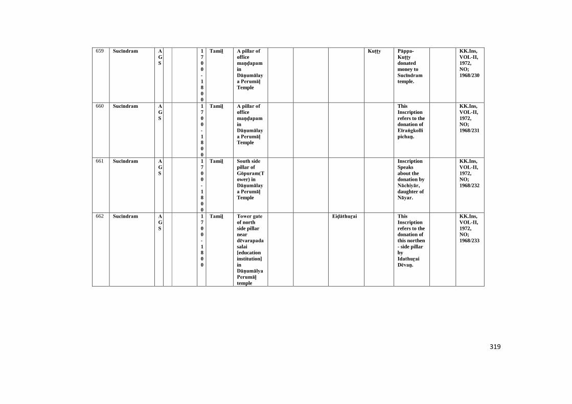
319
659 Sucīndram AGS
1700-1800
Tamiḻ A pillar of officemaṇḍapam inDāṇumālaya Perumāḷ Temple
Kuṭṭy Pāppa-Kuṭṭy donatedmoney toSucīndram temple.
KK.Ins,VOL-II,1972,NO;1968/230
660 Sucīndram AGS
1700-1800
Tamiḻ A pillar of officemaṇḍapam inDāṇumālaya Perumāḷ Temple
ThisInscriptionrefers to thedonation ofEīraṅgkollipichaṉ.
KK.Ins,VOL-II,1972,NO;1968/231
661 Sucīndram AGS
1700-1800
Tamiḻ South side pillar ofGōpuram(Tower) inDāṇumālaya Perumāḷ Temple
InscriptionSpeaksabout thedonation byNāchiyār, daughter ofNāyar.
KK.Ins,VOL-II,1972,NO;1968/232
662 Sucīndram AGS
1700-1800
Tamiḻ Tower gate of northside pillarneardēvarapada salai[educationinstitution]inDāṇumālya Perumāḷ temple
Eiḍāthuṟai This Inscriptionrefers to thedonation ofthis northen- side pillarbyIdathuṟai Dēvaṉ.
KK.Ins,VOL-II,1972,NO;1968/233
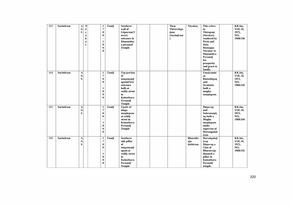
320
663 Sucīndram AGS
Nāyakar
1700-1800
Tamiḻ Southern wall ofGōpuram(Tower)entrance inDāṇumālaya perumalTemple
Theṉ Thiruvēṅgaḍam (Sucīnḍram )
Nāyakar, This refers toThirupaṇi (Services)rendered byPeria andSiriaRāmappa Nāyakar to Dāṇumālya Perumāḷ forprosperityand grace tofamily.
KK.Ins,VOL-II,1972,NO;1968/236
664 Sucīndram AGS
1700-1800
Tamiḻ Top portion ofmugamaṇḍapam(Firstentrancehall) atreddy streetinKulasēkara Perumāḷ Temple
Umaiyammai,Rāmaliṅgaṉ andSivakāmi built amugha-maṇḍapam.
KK.Ins,VOL-II,1972,NO;1968/243
665 Sucīndram AGS
1700-1800
Tamiḻ Upstir of mugamaṇḍapam at reddystreet inKulasēkara Perumāḷ Temple
Dāṇuvaṉ andSubramaṇiyaṉ built a Mughamaṇḍapam undersupervise ofDeivangaladiyan.
KK.Ins,VOL-II,1972,NO;1968/244
666 Sucīndram AGS
1700-1800
Tamiḻ Southern side pillarofmugamaṇḍapam atreddy streetinKulasēkara Perumāḷ Temple
Bharathvaja-kōthiram
Deivaṅgalaḍiyaṉ Dāṇuvaṉ a Clan ofBharatvajadonated apillar inKulasēkara Perumāḷ temple.
KK.Ins,VOL-II,1972,NO;1968/245
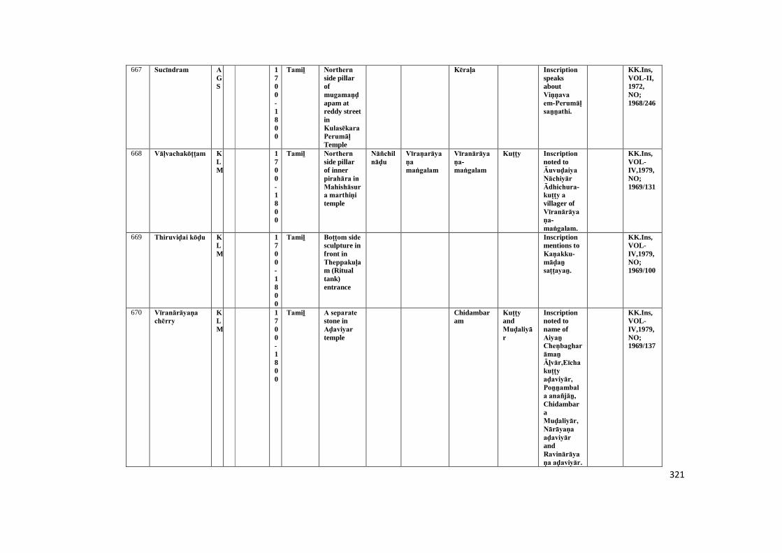
321
667 Sucīndram AGS
1700-1800
Tamiḻ Northern side pillarofmugamaṇḍapam atreddy streetinKulasēkara Perumāḷ Temple
Kēraḷa Inscription speaksaboutViṇṇava em-Perumāḷ saṉṉathi.
KK.Ins,VOL-II,1972,NO;1968/246
668 Vāḷvachakōṭṭam KLM
1700-1800
Tamiḻ Northern side pillarof innerpirahāra in Mahishāsura marthiṇi temple
Nāñchilnāḍu
Vīraṇarāyaṇa maṅgalam
Vīranārāyaṇa-maṅgalam
Kuṭṭy Inscription noted toĀuvuḍaiya Nāchiyār Ādhichura-kuṭṭy a villager ofVīranārāyaṇa-maṅgalam.
KK.Ins,VOL-IV,1979,NO;1969/131
669 Thiruviḍai kōḍu KLM
1700-1800
Tamiḻ Boṭṭom side sculpture infront inTheppakuḷam (Ritualtank)entrance
Inscriptionmentions toKaṇakku-māḍaṉ saṭṭayaṉ.
KK.Ins,VOL-IV,1979,NO;1969/100
670 Vīranārāyaṇa chērry
KLM
1700-1800
Tamiḻ A separate stone inAḍaviyar temple
Chidambaram
Kuṭṭy andMuḍaliyār
Inscriptionnoted toname ofAiyaṉ Cheṇbagharāmaṉ Āḻvār,Eīcha kuṭṭy aḍaviyār, Poṉṉambala anañjāṉ, ChidambaraMuḍaliyār, Nārāyaṇa aḍaviyār andRavinārāyaṇa aḍaviyār.
KK.Ins,VOL-IV,1979,NO;1969/137
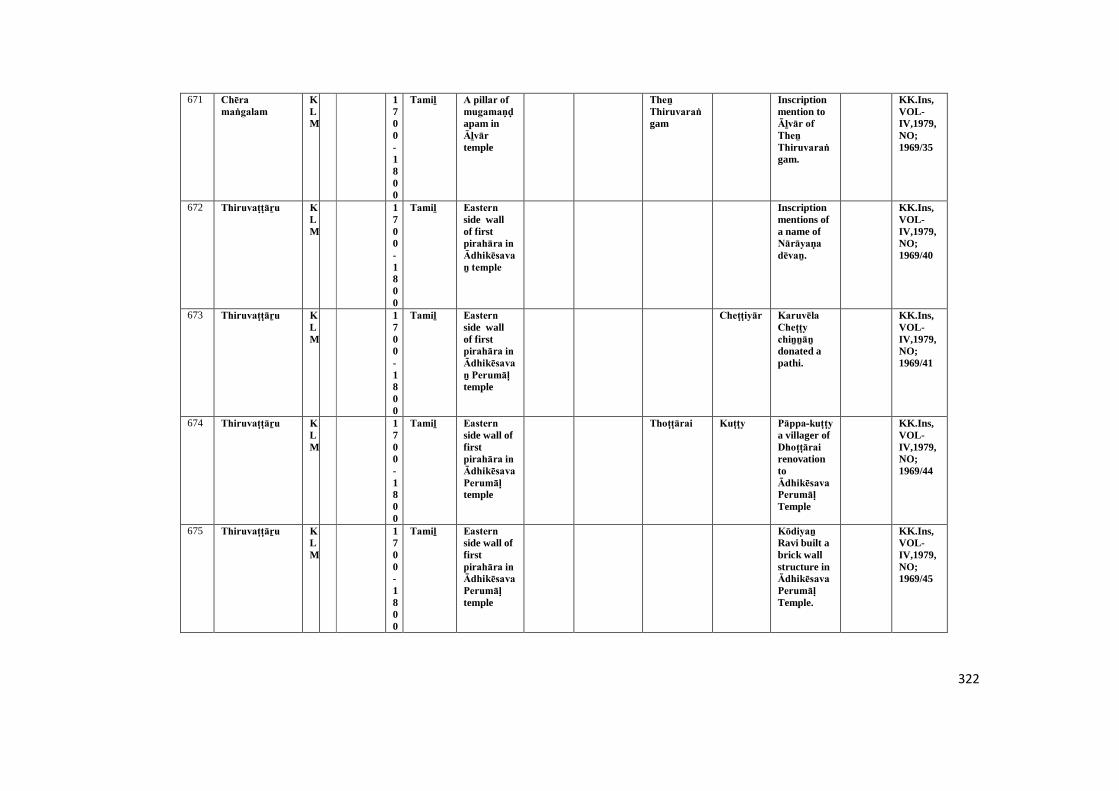
322
671 Chēra maṅgalam
KLM
1700-1800
Tamiḻ A pillar of mugamaṇḍapam inĀḻvār temple
Theṉ Thiruvaraṅgam
Inscriptionmention toĀḻvār of Theṉ Thiruvaraṅgam.
KK.Ins,VOL-IV,1979,NO;1969/35
672 Thiruvaṭṭāṟu KLM
1700-1800
Tamiḻ Eastern side wallof firstpirahāra in Ādhikēsavaṉ temple
Inscriptionmentions ofa name ofNārāyaṇa dēvaṉ.
KK.Ins,VOL-IV,1979,NO;1969/40
673 Thiruvaṭṭāṟu KLM
1700-1800
Tamiḻ Eastern side wallof firstpirahāra in Ādhikēsavaṉ Perumāḷ temple
Cheṭṭiyār Karuvēla Cheṭṭy chiṉṉāṉ donated apathi.
KK.Ins,VOL-IV,1979,NO;1969/41
674 Thiruvaṭṭāṟu KLM
1700-1800
Tamiḻ Eastern side wall offirstpirahāra in Ādhikēsava Perumāḷ temple
Thoṭṭārai Kuṭṭy Pāppa-kuṭṭy a villager ofDhoṭṭārai renovationtoĀdhikēsava Perumāḷ Temple
KK.Ins,VOL-IV,1979,NO;1969/44
675 Thiruvaṭṭāṟu KLM
1700-1800
Tamiḻ Eastern side wall offirstpirahāra in Ādhikēsava Perumāḷ temple
Kōdiyaṉ Ravi built abrick wallstructure inĀdhikēsava Perumāḷ Temple.
KK.Ins,VOL-IV,1979,NO;1969/45
323
676 Thiruvaṭṭāṟu KLM
1700-1800
Tamiḻ Western side wall offirstpirahāra in Ādhikēsava Perumāḷ temple
Paṇḍāram
RavivarmaKulasēkara Perumāḷ renovationtoĀdhikēsava Perumāḷ temple.
KK.Ins,VOL-IV,1979,NO;1969/55
677 Thiruvaṭṭāṟu KLM
1700-1800
Grantha Southernside paṭṭi of EasternGōpuram inĀdhikēsava Perumāḷ temple
Damaged KK.Ins,VOL-IV,1979,NO;1969/56
678 Thiruvaṭṭāṟu KLM
1700-1800
Tamiḻ Western side pillarof firstpirahāra in Ādhikēsava Perumāḷ temple
It may benoted adonation oftemple.
KK.Ins,VOL-IV,1979,NO;1969/58
679 Thiruvaṭṭāṟu KLM
1700-1800
Tamiḻ Northern side wall offirstpirahāra in SriĀdhikēsava Perumāḷ temple
Thiruvaṉantha-puram
Kaṇakar-kāḷa-Perumāḷ donated toĀdhikēsava Perumāḷ temple.
KK.Ins,VOL-IV,1979,NO;1969/59
680 Thiruvaṭṭāṟu KLM
1700-1800
Grantha Southernside paṭṭi of EasternGōpuram inĀdhikēsava Perumāḷ temple
Damaged KK.Ins,VOL-IV,1979,NO;1969/60
324
681 Thiruvaṭṭāṟu KLM
1700-1800
Tamiḻ Northern side pillarof firstpirahāra in Ādhikēsava Perumāḷ temple
Mēlaṅg-kōḍu-dēsam
Paṇḍāram
Eīswaraṉ Ādhichaṉ a villager ofMēlaṅg-kōḍu-dēsam renovationtoĀdhikēsava Perumāḷ temple.
KK.Ins,VOL-IV,1979,NO;1969/61
682 Thiruvaṭṭāṟu KLM
1700-1800
Tamiḻ Northern side wall offirstpirahāra in Ādhikēsava Perumāḷ temple
Inscriiptionmention to adonatedname ofKhirushṇaṉ.
KK.Ins,VOL-IV,1979,NO;1969/63
683 Thiruvaṭṭāṟu KLM
1700-1800
Tamiḻ Front side lamp postbottom ofKrishṇaṇ saṉṉathi [temple]inĀdhikēsava Perumāḷ temple
Kēraḷa maṇḍaḷam
A sculptureofĀdhikēsava Perumāḷ donated byNārāyaṇaṉ Thāṇḍavaṉ (Kēraḷa maṇḍaḷam) inĀdhikēsava Perumāḷ temple.
KK.Ins,VOL-IV,1979,NO;1969/70
684 Thiruvaṭṭāṟu KLM
1700-1800
Tamiḻ Western paṭṭi of Duwajasthampa-m inĀdhikēsava Perumāḷ temple
Chī-karaṇam Kuḷatharai Nārāyaṇaṉ build aDuwajasdampam inĀdhikēsava Perumāḷ temple.
KK.Ins,VOL-IV,1979,NO;1969/73
325
685 Thiruvaṭṭāṟu KLM
1700-1800
Tamiḻ Bottom division ofDuwāra Bālakar sculpturenear flagstaff inĀdhikēsava Perumāḷ temple
Kollam Inscriptionmentionyear ofkollam.
KK.Ins,VOL-IV,1979,NO;1969/77
686 Thiruvaṭṭāṟu KLM
1700-1800
Tamiḻ Bottom division ofDuwāra Bālakar sculpturenear flagstaff inĀdhikēsava Perumāḷ temple
Inscriiptionmention toĀdhikēsava.
KK.Ins,VOL-IV,1979,NO;1969/78
687 Thiruviḍai kōḍu
KLM
1700-1800
Tamiḻ A pillar on uṇṇāḻi wall inSaḍayapa Mahādēvar temple
Kaḻaikuṭṭa-dēsam
A line ofpillardonated byRāmaṉ dēvaṉ. Inscriptionmention toKaḻaikuṭṭadēsam.
KK.Ins,VOL-IV,1979,NO;1969/83
688 Aḻakiya Pāṇḍya puram
TOV
1700-1800
Tamiḻ Back side rock of SriVeṅgada chalapathytemple.
Añchiṉāṉ-pugaliḍam
Inscriptionnoted torenovationof templemaṇḍapam.
KK.Ins,VOL-V1979,NO;1969/20
689 Āralvāimoḻi TOV
1700-1800
Tamiḻ Northern side pillarofMughamaṇḍapam in NilapparaiKaṇḍa Sāthaṉ temple.
Cheṭṭiyār Inscription noted tolanddonation ofPiḷḷaiyār temple.
KK.Ins,VOL-V1979,NO;1969/26
326
690 Āralvāimoḻi TOV
1700-1800
Tamiḻ Southarn side pillarof Mughamaṇḍapam inNilapparaiKaṇḍa Sāthaṉ temple.
Northernside pillar ofMugha-Maṇḍapam inNilapparaiKaṇḍa Sāthaṉ temple.
KK.Ins,VOL-V1979,NO;1969/27
691 Iyaṉkōṇam TOV
1700-1800
Tamiḻ Inscription layed on arock.
This lithicrecorded todonation ofland toPathmaṉāba-Perumāḷ for dailywoeship.
KK.Ins,VOL-V1979,NO;1969/36
692 Kaḍukarai TOV
1700-1800
Tamiḻ South side pillar ofarthamaṇḍapam in SriKaṇḍeswara Nayiṉār temple.
Landdonation togod ofKhiḻbāl kāḍu kari Kāsiviswanāthar, Sivakāmi ammai andVeṅgadēsa Perumāḷ for itsexpectationof dailyrituals &otherrituals.
KK.Ins,VOL-V1979,NO;1969/39
693 Kaḍukarai TOV
1700-1800
Tamiḻ Noth side pillar ofarthamaṇḍapam in SriKaṇḍeswara Nayinār temple.
Muḍaliyār
A Pillarmade byNānasikāmaṇi Muḍaliyār.
KK.Ins,VOL-V1979,NO;1969/40
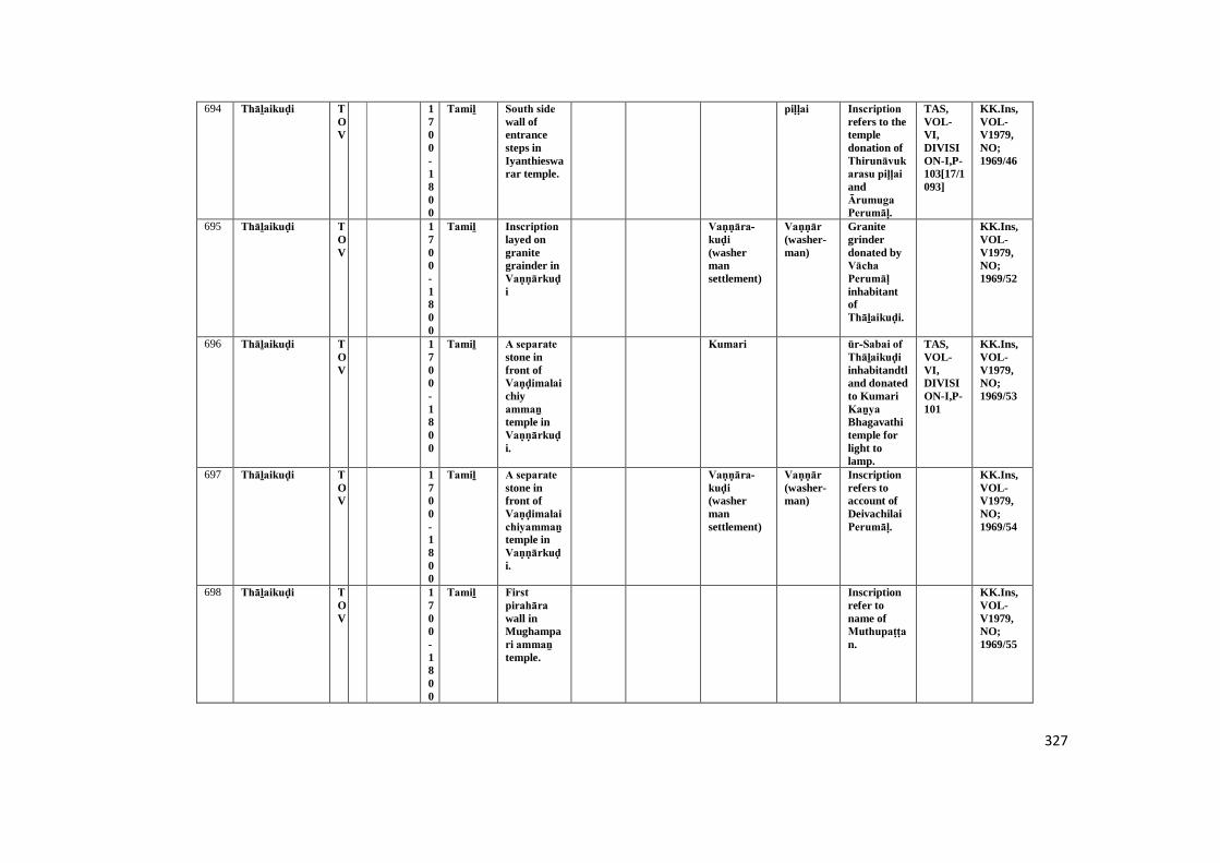
327
694 Thāḻaikuḍi TOV
1700-1800
Tamiḻ South side wall ofentrancesteps inIyanthieswarar temple.
piḷḷai Inscription refers to thetempledonation ofThirunāvukarasu piḷḷai andĀrumuga Perumāḷ.
TAS,VOL-VI,DIVISION-I,P-103[17/1093]
KK.Ins,VOL-V1979,NO;1969/46
695 Thāḻaikuḍi TOV
1700-1800
Tamiḻ Inscription layed ongranitegrainder inVaṇṇārkuḍi
Vaṇṇāra-kuḍi (washermansettlement)
Vaṇṇār (washer-man)
Granitegrinderdonated byVācha Perumāḷ inhabitantofThāḻaikuḍi.
KK.Ins,VOL-V1979,NO;1969/52
696 Thāḻaikuḍi TOV
1700-1800
Tamiḻ A separate stone infront ofVaṇḍimalai chiyammaṉ temple inVaṇṇārkuḍi.
Kumari ūr-Sabai of Thāḻaikuḍi inhabitandtland donatedto KumariKaṉya Bhagavathitemple forlight tolamp.
TAS,VOL-VI,DIVISION-I,P-101
KK.Ins,VOL-V1979,NO;1969/53
697 Thāḻaikuḍi TOV
1700-1800
Tamiḻ A separate stone infront ofVaṇḍimalai chiyammaṉ temple inVaṇṇārkuḍi.
Vaṇṇāra-kuḍi (washermansettlement)
Vaṇṇār (washer-man)
Inscriptionrefers toaccount ofDeivachilaiPerumāḷ.
KK.Ins,VOL-V1979,NO;1969/54
698 Thāḻaikuḍi TOV
1700-1800
Tamiḻ First pirahāra wall inMughampari ammaṉ temple.
Inscriptionrefer toname ofMuthupaṭṭan.
KK.Ins,VOL-V1979,NO;1969/55

328
699 Thāḻaikuḍi TOV
1700-1800
Tamiḻ Esten wall ofIyathīswarar templeuṇṇāḻi lingam
Thirupāpūr It tell us donation ofland toThirupāpūr Mūtha Iyathīswarar for itstempleCeremony.
KK.Ins,VOL-V1979,NO;1969/56
700 Sri pathmaṉāba nallūr
TOV
1700-1800
Tamiḻ Inscription found on arock.
SriPathmaṉābha-nallūr
Theinscriptiontells us thevillage nameof SriPathmaṉābha-nallūr.
KK.Ins,VOL-V1979,NO;1969/67
701 Aḻakiya Pāṇḍya puram
TOV
1700-1800
Tamiḻ Western side pillarof artha-maṇḍapam in Dēsa Āchāriyal SriVīravanaṅgai ammaṉ temple.
Demaged KK.Ins,VOL-V1979,NO;1969/7
702 Pūḍappāṇḍi TOV
1700-1800
Tamiḻ A separate stoneinfronte inNorthstreet ofJēvā librarycenter.
Añjiṉāṉ-pukaliḍam
It refers toUdhaya-mārthāṇḍa big streetandPūthalarāmaṉ big street of Añjiṉāṉ Pugaliḍam.
TAS,VOL-VII,DIVISION-II,P-81
KK.Ins,VOL-V1979,NO;1969/71
703 Kuḻithuṟai VLE
1700-1800
Tamiḻ A inscriptionbelow ofsculpture inKalmaḍam
It recordsonly thename ofwhom themutt wasconstructed.It is datableto 17th 18thC.A.D.
KK.Ins,VOL-VI,2008,TARD,NO;545/2004
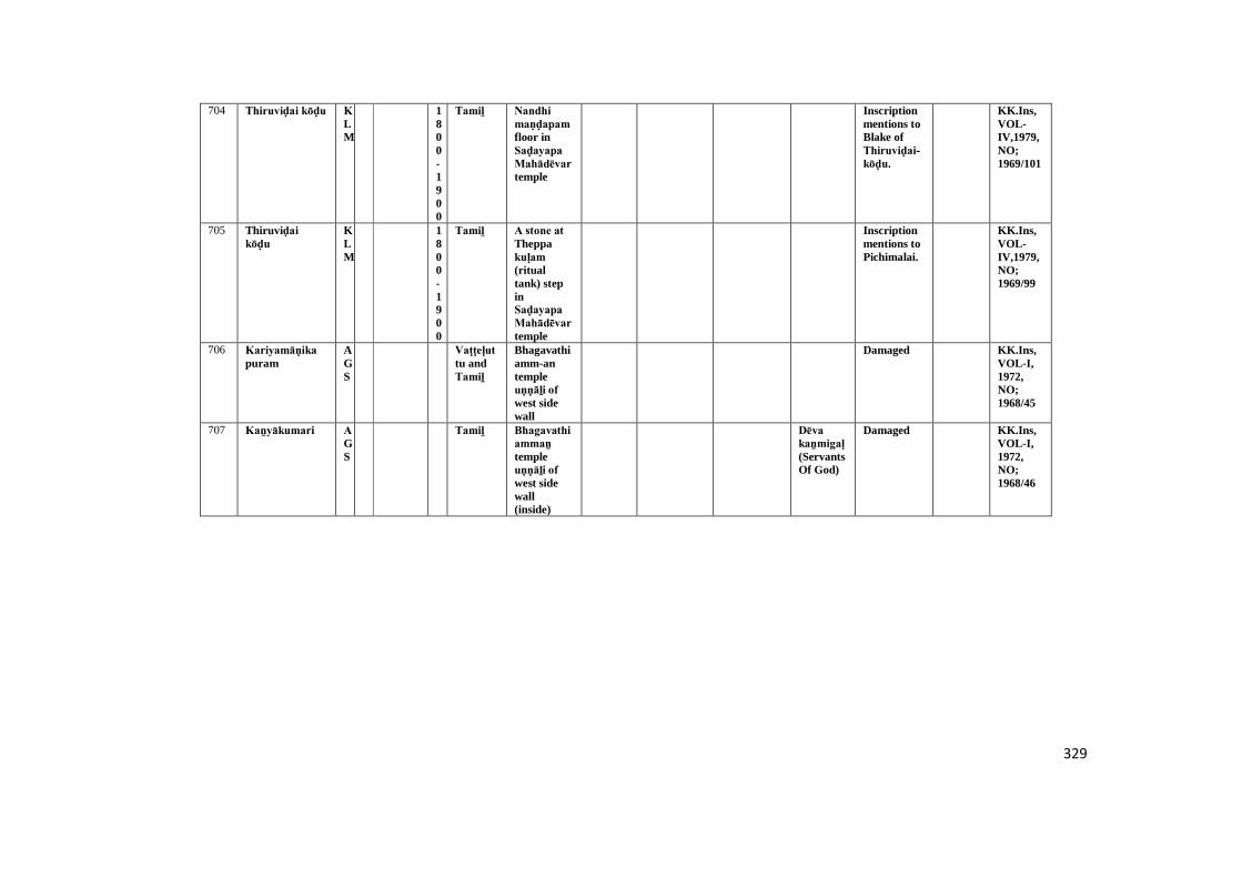
329
704 Thiruviḍai kōḍu KLM
1800-1900
Tamiḻ Nandhi maṇḍapam floor inSaḍayapa Mahādēvar temple
Inscriptionmentions toBlake ofThiruviḍai-kōḍu.
KK.Ins,VOL-IV,1979,NO;1969/101
705 Thiruviḍai kōḍu
KLM
1800-1900
Tamiḻ A stone at Theppakuḷam (ritualtank) stepinSaḍayapa Mahādēvar temple
Inscriptionmentions toPichimalai.
KK.Ins,VOL-IV,1979,NO;1969/99
706 Kariyamāṇika puram
AGS
Vaṭṭeḷuttu andTamiḻ
Bhagavathiamm-antempleuṇṇāḻi of west sidewall
Damaged KK.Ins,VOL-I,1972,NO;1968/45
707 Kaṉyākumari AGS
Tamiḻ Bhagavathi ammaṉ templeuṇṇāḻi of west sidewall(inside)
Dēva kaṉmigaḷ (ServantsOf God)
Damaged KK.Ins,VOL-I,1972,NO;1968/46
330
Abbreviations
KK.Ins., Kaṉyākumari Inscription
VOL Volume
TAS Travancore Archaeological Series.
ARE Archaeological Report on Epigraphy
TAAR Travancore Archaeological Annual report
STA Sucīnḍram Temple Appendix
TARD Tamilnāḍu Archaeological Research Department
Tk Taluk
Dt District
AGS Agastīswaram
TOV Thōvāḷai
VLE Viḷavaṅkōḍu
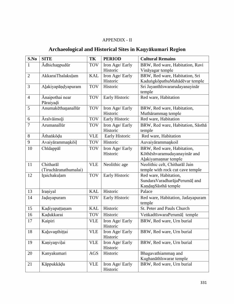
331
APPENDIX - II
Archaeological and Historical Sites in Kaṉyākumari Region
S.No SITE TK PERIOD Cultural Remains
1 Ādhichaṉpudūr TOV Iron Age/ Early
Historic
BRW, Red ware, Habitation, Ravi
Vināyagar temple
2 AkkaraiThalakuḷam KAL Iron Age/ Early
Historic
BRW, Red ware, Habitation, Sri
KaduṅgkōpathuMahādēvar temple
3 Aḻakiyapāṇḍyapuram TOV Historic Sri Jayanthīswararudayanayinār
temple
4 Ānaipothai near
Pāraiyaḍi
TOV Early Historic Red ware, Habitation
5 Anumakēthaṉanallūr TOV Iron Age/ Early
Historic
BRW, Red ware, Habitation,
Muthārammaṉ temple
6 Āralvāimoḻi TOV Early Historic Red ware, Habitation
7 Arumanallūr TOV Iron Age/ Early
Historic
BRW, Red ware, Habitation, Sāsthā
temple
8 Āthaṅkōḍu VLE Early Historic Red ware, Habitation
9 Avaiyārammaṉkōiḷ TOV Historic Auvaiyārammaṉkoil
10 Chīdappāl TOV Iron Age/ Early
Historic
BRW, Red ware, Habitation,
Kōthēshvaramudayanayinār and
Aḻakiyamaṇnar temple
11 Chitharāl
(Tiruchāranathumalai)
VLE Neolithic age Neolithic celt, Chitharāl Jain
temple with rock cut cave temple
12 Iṟaichakuḷam TOV Early Historic Red ware, Habitation,
SundaraVaradharājaPerumāḷ and
KaṇḍaṉSāsthā temple
13 Iraṇiyal KAL Historic Palace
14 Jaḍayapuram TOV Early Historic Red ware, Habitation, Jadayapuram
temple
15 Kaḍiyapaṭṭaṇam KAL Historic St. Peter and Pauls Church
16 Kaḍukkarai TOV Historic VeṅkadtīswaraPerumāḷ temple
17 Kaipiri VLE Iron Age/ Early
Historic
BRW, Red ware, Urn burial
18 Kaḻuvaṉthiṭṭai VLE Iron Age/ Early
Historic
BRW, Red ware, Urn burial
19 Kaṇiyaṉviḷai VLE Iron Age/ Early
Historic
BRW, Red ware, Urn burial
20 Kanyakumari AGS Historic Bhagavathiammaṉ and
Kughanāthīswarar temple
21 Kāppukkāḍu VLE Iron Age/ Early
Historic
BRW, Red ware, Urn burial
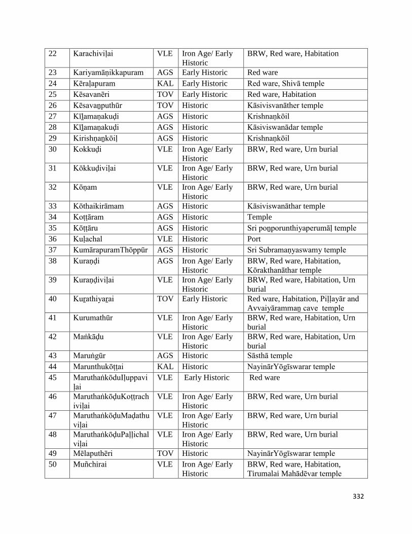
332
22 Karachiviḷai VLE Iron Age/ Early
Historic
BRW, Red ware, Habitation
23 Kariyamāṇikkapuram AGS Early Historic Red ware
24 Kēraḷapuram KAL Early Historic Red ware, Shivā temple
25 Kēsavanēri TOV Early Historic Red ware, Habitation
26 Kēsavaṉputhūr TOV Historic Kāsivisvanāther temple
27 Kīḻamaṇakuḍi AGS Historic Krishnaṇkōil
28 Kīḻamaṇakuḍi AGS Historic Kāsiviswanādar temple
29 Kirishṇaṉkōiḷ AGS Historic Krishnaṇkōil
30 Kokkuḍi VLE Iron Age/ Early
Historic
BRW, Red ware, Urn burial
31 Kōkkuḍiviḷai VLE Iron Age/ Early
Historic
BRW, Red ware, Urn burial
32 Kōṇam VLE Iron Age/ Early
Historic
BRW, Red ware, Urn burial
33 Kōthaikirāmam AGS Historic Kāsiviswanāthar temple
34 Koṭṭāram AGS Historic Temple
35 Kōṭṭāru AGS Historic Sri poṉporunthiyaperumāḷ temple
36 Kuḷachal VLE Historic Port
37 KumārapuramThōppūr AGS Historic Sri Subramaṇyaswamy temple
38 Kuraṇḍi AGS Iron Age/ Early
Historic
BRW, Red ware, Habitation,
Kōrakthanāthar temple
39 Kuraṇḍiviḷai VLE Iron Age/ Early
Historic
BRW, Red ware, Habitation, Urn
burial
40 Kuṟathiyaṟai TOV Early Historic Red ware, Habitation, Piḷḷayār and
Avvaiyārammaṉ cave temple
41 Kurumathūr VLE Iron Age/ Early
Historic
BRW, Red ware, Habitation, Urn
burial
42 Maṅkāḍu VLE Iron Age/ Early
Historic
BRW, Red ware, Habitation, Urn
burial
43 Maruṅgūr AGS Historic Sāsthā temple
44 Marunthukōṭṭai KAL Historic NayinārYōgīswarar temple
45 MaruthaṅkōduIḷuppavi
ḷai
VLE Early Historic Red ware
46 MaruthaṅkōḍuKoṭṭrach
iviḷai
VLE Iron Age/ Early
Historic
BRW, Red ware, Urn burial
47 MaruthaṅkōḍuMaḍathu
viḷai
VLE Iron Age/ Early
Historic
BRW, Red ware, Urn burial
48 MaruthaṅkōḍuPaḷḷichal
viḷai
VLE Iron Age/ Early
Historic
BRW, Red ware, Urn burial
49 Mēlaputhēri TOV Historic NayinārYōgīswarar temple
50 Muñchirai VLE Iron Age/ Early
Historic
BRW, Red ware, Habitation,
Tirumalai Mahādēvar temple
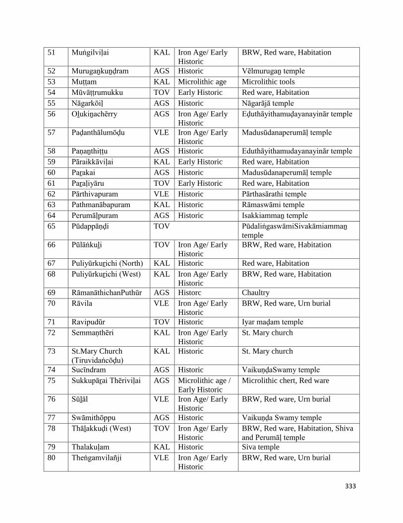
333
51 Muṅgilviḷai KAL Iron Age/ Early
Historic
BRW, Red ware, Habitation
52 Murugaṉkuṉḍram AGS Historic Vēlmurugaṉ temple
53 Muṭṭam KAL Microlithic age Microlithic tools
54 Mūvāṭṭrumukku TOV Early Historic Red ware, Habitation
55 Nāgarkōiḷ AGS Historic Nāgarājā temple
56 Oḻukiṉachērry AGS Iron Age/ Early
Historic
Eḍuthāyithamuḍayanayinār temple
57 Paḍanthālumōḍu VLE Iron Age/ Early
Historic
Madusūdanaperumāḷ temple
58 Paṇaṉthiṭṭu AGS Historic Eduthāyithamudayanayinār temple
59 Pāraikkāviḷai KAL Early Historic Red ware, Habitation
60 Paṟakai AGS Historic Madusūdanaperumāḷ temple
61 Paṟaḷiyāru TOV Early Historic Red ware, Habitation
62 Pārthivapuram VLE Historic Pārthasārathi temple
63 Pathmanābapuram KAL Historic Rāmaswāmi temple
64 Perumāḷpuram AGS Historic Isakkiammaṉ temple
65 Pūdappāṇḍi TOV PūdaliṅgaswāmiSivakāmiammaṉ
temple
66 Pūlāṅkuḻi TOV Iron Age/ Early
Historic
BRW, Red ware, Habitation
67 Puliyūrkuṟichi (North) KAL Historic Red ware, Habitation
68 Puliyūrkuṟichi (West) KAL Iron Age/ Early
Historic
BRW, Red ware, Habitation
69 RāmanāthichanPuthūr AGS Historc Chaultry
70 Rāvila VLE Iron Age/ Early
Historic
BRW, Red ware, Urn burial
71 Ravipudūr TOV Historic Iyar maḍam temple
72 Semmaṇthēri KAL Iron Age/ Early
Historic
St. Mary church
73 St.Mary Church
(Tiruvidaṅcōḍu)
KAL Historic St. Mary church
74 Sucīndram AGS Historic VaikuṇḍaSwamy temple
75 Sukkupāṟai Thēriviḷai AGS Microlithic age /
Early Historic
Microlithic chert, Red ware
76 Sūḻāl VLE Iron Age/ Early
Historic
BRW, Red ware, Urn burial
77 Swāmithōppu AGS Historic Vaikuṇḍa Swamy temple
78 Thāḻakkuḍi (West) TOV Iron Age/ Early
Historic
BRW, Red ware, Habitation, Shiva
and Perumāḷ temple
79 Thalakuḷam KAL Historic Siva temple
80 Theṅgamvilañji VLE Iron Age/ Early
Historic
BRW, Red ware, Urn burial
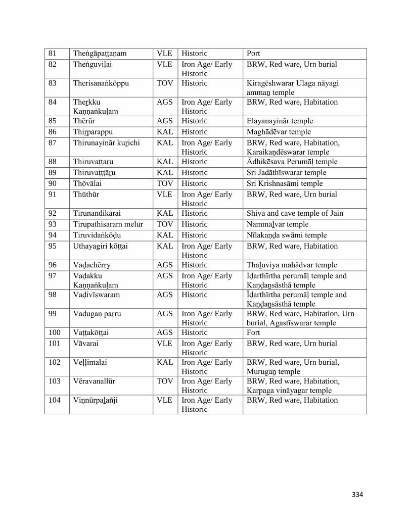
334
81 Theṅgāpaṭṭaṇam VLE Historic Port
82 Theṅguviḷai VLE Iron Age/ Early
Historic
BRW, Red ware, Urn burial
83 Therisanaṅkōppu TOV Historic Kiragēshwarar Ulaga nāyagi
ammaṉ temple
84 Theṟkku
Kaṇṇaṅkuḷam
AGS Iron Age/ Early
Historic
BRW, Red ware, Habitation
85 Thērūr AGS Historic Elayanayinār temple
86 Thiṟparappu KAL Historic Maghādēvar temple
87 Thirunayinār kuṟichi KAL Iron Age/ Early
Historic
BRW, Red ware, Habitation,
Karaikaṇdēswarar temple
88 Thiruvaṭṭaṟu KAL Historic Ādhikēsava Perumāḷ temple
89 Thiruvaṭṭṭāṟu KAL Historic Sri Jadāthīswarar temple
90 Thōvālai TOV Historic Sri Krishnasāmi temple
91 Thūthūr VLE Iron Age/ Early
Historic
BRW, Red ware, Urn burial
92 Tirunandikarai KAL Historic Shiva and cave temple of Jain
93 Tirupathisāram mēlūr TOV Historic Nammāḻvār temple
94 Tiruvidaṅkōḍu KAL Historic Nīlakaṇḍa swāmi temple
95 Uthayagiri kōṭṭai KAL Iron Age/ Early
Historic
BRW, Red ware, Habitation
96 Vaḍachērry AGS Historic Thaḻuviya mahādvar temple
97 Vaḍakku
Kaṇṇaṅkuḷam
AGS Iron Age/ Early
Historic
Īḍarthīrtha perumāḷ temple and
Kaṇḍaṉsāsthā temple
98 Vaḍivīswaram AGS Historic Īḍarthīrtha perumāḷ temple and
Kaṇḍaṉsāsthā temple
99 Vaḍugaṇ paṟṟu AGS Iron Age/ Early
Historic
BRW, Red ware, Habitation, Urn
burial, Agastīswarar temple
100 Vaṭṭakōṭṭai AGS Historic Fort
101 Vāvarai VLE Iron Age/ Early
Historic
BRW, Red ware, Urn burial
102 Veḷḷimalai KAL Iron Age/ Early
Historic
BRW, Red ware, Urn burial,
Murugaṉ temple
103 Vēravanallūr TOV Iron Age/ Early
Historic
BRW, Red ware, Habitation,
Karpaga vināyagar temple
104 Viṇnūrpaḻañji VLE Iron Age/ Early
Historic
BRW, Red ware, Habitation
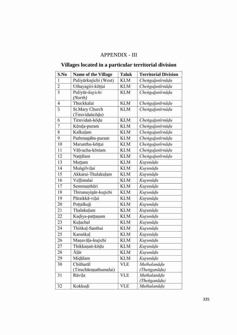
335
APPENDIX - III
Villages located in a particular territorial division
S.No Name of the Village Taluk Territorial Division
1 Puliyūrkuṟichi (West) KLM Cheṅgaḻunīrnāḍu
2 Uthayagiri-kōṭṭai KLM Cheṅgaḻunīrnāḍu
3 Puliyūr-kuṟichi (North)
KLM Cheṅgaḻunīrnāḍu
4 Thuckkalai KLM Cheṅgaḻunīrnāḍu
5 St.Mary Church(Tiruvidaṅcōḍu)
KLM Cheṅgaḻunīrnāḍu
6 Tiruvidaṅ-kōḍu KLM Cheṅgaḻunīrnāḍu
7 Kēraḷa-puram KLM Cheṅgaḻunīrnāḍu
8 Kalkuḷam KLM Cheṅgaḻunīrnāḍu
9 Pathmaṉāba-puram KLM Cheṅgaḻunīrnāḍu
10 Marunthu-kōṭṭai KLM Cheṅgaḻunīrnāḍu
11 Vāḷvacha-kōstam KLM Cheṅgaḻunīrnāḍu
12 Naṭṭālam KLM Cheṅgaḻunīrnāḍu
13 Muṭṭam KLM Kuṟunāḍu
14 Muṅgilviḷai KLM Kuṟunāḍu
15 Akkarai-Thalakuḷam KLM Kuṟunāḍu
16 Veḷḷimalai KLM Kuṟunāḍu
17 Semmaṇthēri KLM Kuṟunāḍu
18 Thirunayiṉār-kuṟichi KLM Kuṟunāḍu
19 Pāraikkā-viḷai KLM Kuṟunāḍu
20 Poṭṭalkuḻi KLM Kuṟunāḍu
21 Thalakuḷam KLM Kuṟunāḍu
22 Kaḍiya-paṭṭaṇam KLM Kuṟunāḍu
23 Kuḷachal KLM Kuṟunāḍu
24 Thiṅkaḷ-Santhai KLM Kuṟunāḍu
25 Karuṅkaḷ KLM Kuṟunāḍu
26 Maṇavāḷa-kuṟichi KLM Kuṟunāḍu
27 Thikkaṇaṅ-kōḍu KLM Kuṟunāḍu
28 Āḷūr KLM Kuṟunāḍu
29 Miḍālam KLM Kuṟunāḍu
30 Chitharāl (Tiruchāraṇathumalai)
VLE Muthalanāḍu (Theṅganāḍu)
31 Rāviḷa VLE Muthalanāḍu (Theṅganāḍu)
32 Kokkuḍi VLE Muthalanāḍu
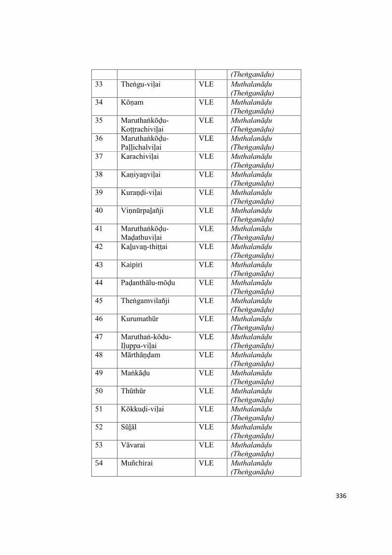
336
(Theṅganāḍu)
33 Theṅgu-viḷai VLE Muthalanāḍu (Theṅganāḍu)
34 Kōṇam VLE Muthalanāḍu (Theṅganāḍu)
35 Maruthaṅkōḍu-Koṭṭrachiviḷai
VLE Muthalanāḍu (Theṅganāḍu)
36 Maruthaṅkōḍu-Paḷḷichalviḷai
VLE Muthalanāḍu (Theṅganāḍu)
37 Karachiviḷai VLE Muthalanāḍu (Theṅganāḍu)
38 Kaṇiyaṉviḷai VLE Muthalanāḍu (Theṅganāḍu)
39 Kuraṇḍi-viḷai VLE Muthalanāḍu (Theṅganāḍu)
40 Viṇnūrpaḻañji VLE Muthalanāḍu (Theṅganāḍu)
41 Maruthaṅkōḍu-Maḍathuviḷai
VLE Muthalanāḍu (Theṅganāḍu)
42 Kaḻuvaṉ-thiṭṭai VLE Muthalanāḍu (Theṅganāḍu)
43 Kaipiri VLE Muthalanāḍu (Theṅganāḍu)
44 Paḍanthālu-mōḍu VLE Muthalanāḍu (Theṅganāḍu)
45 Theṅgamvilañji VLE Muthalanāḍu (Theṅganāḍu)
46 Kurumathūr VLE Muthalanāḍu (Theṅganāḍu)
47 Maruthaṅ-kōdu-Iḷuppa-viḷai
VLE Muthalanāḍu (Theṅganāḍu)
48 Mārthāṇḍam VLE Muthalanāḍu (Theṅganāḍu)
49 Maṅkāḍu VLE Muthalanāḍu (Theṅganāḍu)
50 Thūthūr VLE Muthalanāḍu (Theṅganāḍu)
51 Kōkkuḍi-viḷai VLE Muthalanāḍu (Theṅganāḍu)
52 Sūḻāl VLE Muthalanāḍu (Theṅganāḍu)
53 Vāvarai VLE Muthalanāḍu (Theṅganāḍu)
54 Muñchirai VLE Muthalanāḍu (Theṅganāḍu)

337
55 Kāppuk-kāḍu VLE Muthalanāḍu (Theṅganāḍu)
56 Āthaṅ-kōḍu VLE Muthalanāḍu (Theṅganāḍu)
57 Theṅgā-paṭṭaṇam VLE Muthalanāḍu (Theṅganāḍu)
58 Pārthiva-puram VLE Muthalanāḍu (Theṅganāḍu)
59 Pākōḍu VLE Muthalanāḍu (Theṅganāḍu)
60 Kuḻi-thuṟai VLE Muthalanāḍu (Theṅganāḍu)
61 Veṭṭuveṇṇi VLE Muthalanāḍu (Theṅganāḍu)
62 Thirithuva-puram VLE Muthalanāḍu (Theṅganāḍu)
63 Puthaṉ-thuṟai VLE Muthalanāḍu (Theṅganāḍu)
64 Kollam-kōḍu VLE Muthalanāḍu (Theṅganāḍu)
65 Kaliyakkā-viḷai VLE Muthalanāḍu (Theṅganāḍu)
66 VaḍakkuKaṇṇaṅkuḷam AGS Nāñchilnāḍu
67 Vaḍugaṉpaṟṟu AGS Nāñchilnāḍu
68 Therkku-Kaṇṇaṅ-kuḷam
AGS Nāñchilnāḍu
69 Oḻukiṉa-chērry AGS Nāñchilnāḍu
70 Kariyamāṇikka-puram AGS Nāñchilnāḍu
71 Nāgar-kōiḷ AGS Nāñchilnāḍu
72 Kirishṇaṉ-kōiḷ AGS Nāñchilnāḍu
73 Kōthai-kirāmam AGS Nāñchilnāḍu
74 Thērūr AGS Nāñchilnāḍu
75 Vaḍachērry AGS Nāñchilnāḍu
76 Koṭṭāram AGS Nāñchilnāḍu
77 Perumāḷ-puram AGS Nāñchilnāḍu
78 Kōṭṭāru AGS Nāñchilnāḍu
79 Vaḍivīswaram AGS Nāñchilnāḍu
80 Sucīndram AGS Nāñchilnāḍu
81 Maruṅgūr AGS Nāñchilnāḍu
82 Agastīswaram AGS Nāñchilnāḍu
83 Vaḻukkam-pārai AGS Nāñchilnāḍu
84 Kīḻamaṇa-kuḍi AGS Nāñchilnāḍu
85 Kīḻamaṇa-kuḍi AGS Nāñchilnāḍu
86 Paṟakai AGS Nāñchilnāḍu
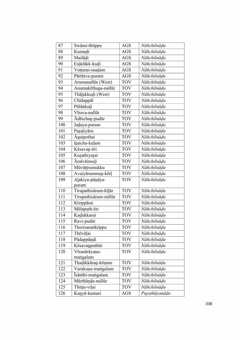
338
87 Swāmi-thōppu AGS Nāñchilnāḍu
88 Kuraṇḍi AGS Nāñchilnāḍu
89 Mailāḍi AGS Nāñchilnāḍu
90 Eiḍalākk-kuḍi AGS Nāñchilnāḍu
91 Veṭṭurṇi-maḍam AGS Nāñchilnāḍu
92 Pārthiva-puram AGS Nāñchilnāḍu
93 Arumanallūr (West) TOV Nāñchilnāḍu
94 Anumakēthaṉa-nallūr TOV Nāñchilnāḍu
95 Thāḻakkuḍi (West) TOV Nāñchilnāḍu
96 Chīdappāl TOV Nāñchilnāḍu
97 Pūlāṅkuḻi TOV Nāñchilnāḍu
98 Vīrava-nallūr TOV Nāñchilnāḍu
99 Ādhichaṉ-pudūr TOV Nāñchilnāḍu
100 Jaḍaya-puram TOV Nāñchilnāḍu
101 Paṟaḷiyāru TOV Nāñchilnāḍu
102 Āṉaipothai TOV Nāñchilnāḍu
103 Iṟaicha-kuḷam TOV Nāñchilnāḍu
104 Kēsavaṉ-ēri TOV Nāñchilnāḍu
105 Kuṟathiyaṟai TOV Nāñchilnāḍu
106 Āralvāimoḻi TOV Nāñchilnāḍu
107 Mūvāṭṭrumukku TOV Nāñchilnāḍu
108 Avaiyārammaṉ-kōiḷ TOV Nāñchilnāḍu
109 Aḻakiya-pāṇḍya-puram
TOV Nāñchilnāḍu
110 Tirupathisāram-kīḻūr TOV Nāñchilnāḍu
111 Tirupathisāram-mēlūr TOV Nāñchilnāḍu
112 Kīrippārai TOV Nāñchilnāḍu
113 Mēlaputh-ēri TOV Nāñchilnāḍu
114 Kaḍukkarai TOV Nāñchilnāḍu
115 Ravi-pudūr TOV Nāñchilnāḍu
116 Therisanaṅkōppu TOV Nāñchilnāḍu
117 Thōvāḷai TOV Nāñchilnāḍu
118 Pūdappāṇḍi TOV Nāñchilnāḍu
119 Kēsavaṉputhūr TOV Nāñchilnāḍu
120 Vīranārāyaṇa-maṅgalam
TOV Nāñchilnāḍu
121 Thaḍikkāraṉ-kōṇam TOV Nāñchilnāḍu
122 Varakuṇa-maṅgalam TOV Nāñchilnāḍu
123 Īsānthi-maṅgalam TOV Nāñchilnāḍu
124 Mārthāṇḍa-nallūr TOV Nāñchilnāḍu
125 Thiṭṭu-viḷai TOV Nāñchilnāḍu
126 Kaṉyā-kumari AGS Puṟathāyanāḍu
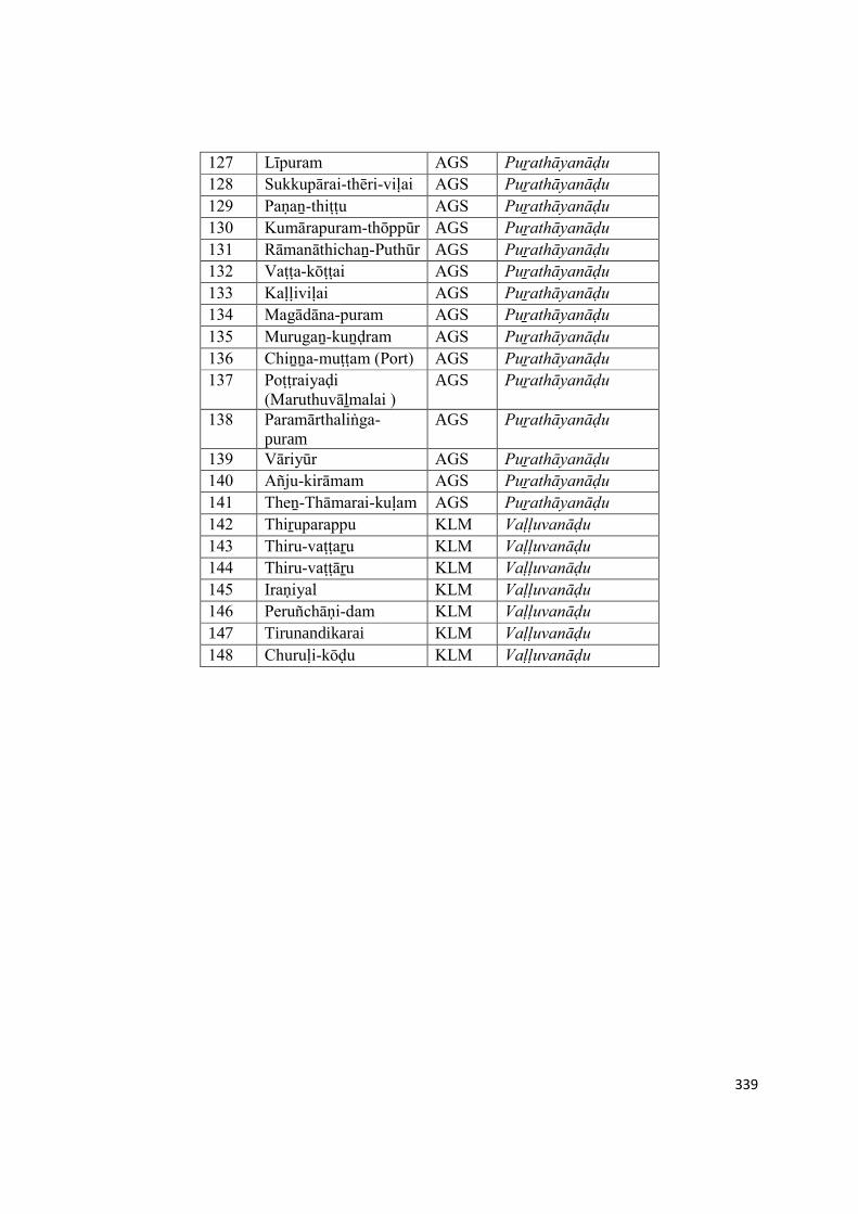
339
127 Līpuram AGS Puṟathāyanāḍu
128 Sukkupārai-thēri-viḷai AGS Puṟathāyanāḍu
129 Paṇaṉ-thiṭṭu AGS Puṟathāyanāḍu
130 Kumārapuram-thōppūr AGS Puṟathāyanāḍu
131 Rāmanāthichaṉ-Puthūr AGS Puṟathāyanāḍu
132 Vaṭṭa-kōṭṭai AGS Puṟathāyanāḍu
133 Kaḷḷiviḷai AGS Puṟathāyanāḍu
134 Magādāna-puram AGS Puṟathāyanāḍu
135 Murugaṉ-kuṉḍram AGS Puṟathāyanāḍu
136 Chiṉṉa-muṭṭam (Port) AGS Puṟathāyanāḍu
137 Poṭṭraiyaḍi (Maruthuvāḻmalai )
AGS Puṟathāyanāḍu
138 Paramārthaliṅga-puram
AGS Puṟathāyanāḍu
139 Vāriyūr AGS Puṟathāyanāḍu
140 Añju-kirāmam AGS Puṟathāyanāḍu
141 Theṉ-Thāmarai-kuḷam AGS Puṟathāyanāḍu
142 Thiṟuparappu KLM Vaḷḷuvanāḍu
143 Thiru-vaṭṭaṟu KLM Vaḷḷuvanāḍu
144 Thiru-vaṭṭāṟu KLM Vaḷḷuvanāḍu
145 Iraṇiyal KLM Vaḷḷuvanāḍu
146 Peruñchāṇi-dam KLM Vaḷḷuvanāḍu
147 Tirunandikarai KLM Vaḷḷuvanāḍu
148 Churuḷi-kōḍu KLM Vaḷḷuvanāḍu
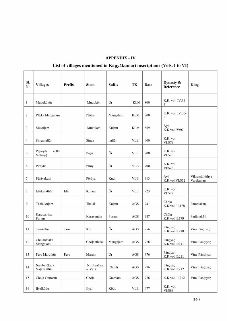
340
APPENDIX - IV
List of villages mentioned in Kaṉyākumari inscriptions (Vols. I to VI)
SI.No
Villages Prefix Stem Suffix TK DateDynasty &Reference
King
1 Mudukōṇūr Mudukōṇ Ūr KLM 800 K.K. vol. IV:38-F
2 Pākka Maṅgaḷam Pākka Maṅgalam KLM 800 K.K. vol. IV:38-F
3 Mukuḷam Mukuḷam Kuḷam KLM 869 Āyi K.K.vol.IV:97
4 Singanallūr Siṅga nallūr VLE 900 K.K. vol.VI:576
5Paḻaiyūr (Old Village)
Paḻai Ūr VLE 900 K.K. vol.VI:576
6 Pirayūr Piray Ūr VLE 900 K.K. vol.VI:576
7 Pērāyakuḍi Pērāya Kuḍi VLE 913 AyiK.K.vol.VI:562
Vikramāthithya Varakuṇaṉ
8 Iḍaikuḷathūr Iḍai Kuḷam Ūr VLE 923 K.K. vol.VI:572
9 Thalaikuḷam Thalai Kuḷam AGS 941 Chōḻa K.K.vol. II:178
Parāntakaṉ
10KaravanthaPuram
Karavantha Puram AGS 947Chōḻa K.K.vol.II:179
Parāntakā-I
11 Tirukōlūr Tiru Kōl Ūr AGS 956 Pāṇḍyaṉ K.K.vol.II:210
Vīra Pānḍiyaṉ
12Chōlānthaka Maṅgaḷam
Chōḻānthaka Maṅgaḷam AGS 976 Pāṇḍyaṉ K.K.vol.II:211
Vīra Pānḍiyaṉ
13 Peru Maruthūr Peru Maruth Ūr AGS 976 Pāṇḍyaṉ K.K.vol.II:211
Vīra Pānḍiyaṉ
14Nirubasēkara Vaḷa Nallūr
Nirubasēkara Vaḷa
Nallūr AGS 976 Pāṇḍyaṉ K.K.vol.II:212
Vīra Pānḍiyaṉ
15 Chōḻa Grāmam Chōḻa Grāmam AGS 976 K.K.vol. II:212 Vīra Pānḍiyaṉ
16 Iḻyalkōḍu Iḻyal Kōḍu VLE 977 K.K. vol.VI:566
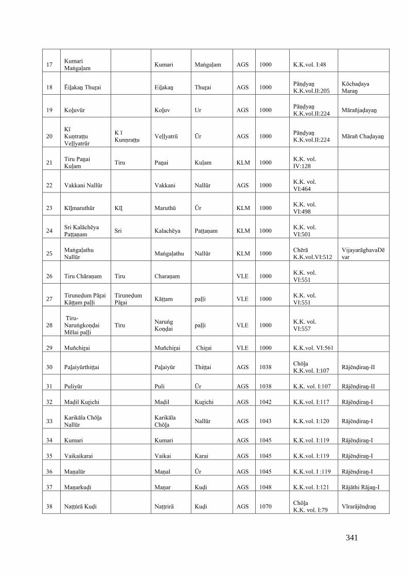
341
17KumariMaṅgaḷam
Kumari Maṅgaḷam AGS 1000 K.K.vol. I:48
18 Ēiḻakaṉ Thuṟai Eiḻakaṉ Thuṟai AGS 1000 Pāṇḍyaṉ K.K.vol.II:205
Kōchaḍaya Maraṉ
19 Koḻuvūr Koḻuv Ur AGS 1000 Pāṇḍyaṉ K.K.vol.II:224
Mārañjaḍayaṉ
20Kī Kuṇtraṭṭu Veḷḷyatrūr
K ī Kunṇraṭṭu
Veḷḷyatrū Ūr AGS 1000 Pāṇḍyaṉ K.K.vol.II:224
Mārañ Chaḍayaṉ
21Tiru Paṉai Kuḷam
Tiru Paṉai Kuḷam KLM 1000 K.K. vol.IV:128
22 Vakkani Nallūr Vakkani Nallūr AGS 1000 K.K. vol.VI:464
23 Kīḻmaruthūr Kīḻ Maruthū Ūr KLM 1000 K.K. vol.VI:498
24Sri Kalāchēya Paṭṭaṇam
Sri Kalachēya Paṭṭaṇam KLM 1000 K.K. vol.VI:501
25Maṅgaḷathu Nallūr
Maṅgaḷathu Nallūr KLM 1000 Chērā K.K.vol.VI:512
VijayarāghavaDēvar
26 Tiru Chāraṇam Tiru Charaṇam VLE 1000 K.K. vol.VI:551
27Tiruneḍum PāṟaiKāṭṭam paḷḷi
Tiruneḍum Pāṟai
Kāṭṭam paḷḷi VLE 1000 K.K. vol.VI:551
28Tiru-
Naruṅgkoṇḍai Mēlai paḷḷi
TiruNaruṅg Koṇḍai
paḷḷi VLE 1000 K.K. vol.VI:557
29 Muñchiṟai Muñchiṟai Chiṟai VLE 1000 K.K.vol. VI:561
30 Paḻaiyūrthiṭṭai Paḻaiyūr Thiṭṭai AGS 1038 Chōḻa K.K.vol. I:107
Rājēnḍiraṉ-II
31 Puliyūr Puli Ūr AGS 1038 K.K. vol. I:107 Rājēnḍiraṉ-II
32 Maḍil Kuṟichi Maḍil Kuṟichi AGS 1042 K.K.vol. I:117 Rājēnḍiraṉ-I
33Karikāla Chōḻa Nallūr
Karikāla Chōḻa
Nallūr AGS 1043 K.K.vol. I:120 Rājēnḍiraṉ-I
34 Kumari Kumari AGS 1045 K.K.vol. I:119 Rājēnḍiraṉ-I
35 Vaikaikarai Vaikai Karai AGS 1045 K.K.vol. I:119 Rājēnḍiraṉ-I
36 Maṇalūr Maṇal Ūr AGS 1045 K.K.vol. I :119 Rājēnḍiraṉ-I
37 Maṇarkuḍi Maṇar Kuḍi AGS 1048 K.K.vol. I:121 Rājāthi Rājaṉ-I
38 Naṭṭṅrā Kuḍi Naṭṭrirā Kuḍi AGS 1070 Chōḻa K.K. vol. I:79
Vīrarājēnḍraṉ
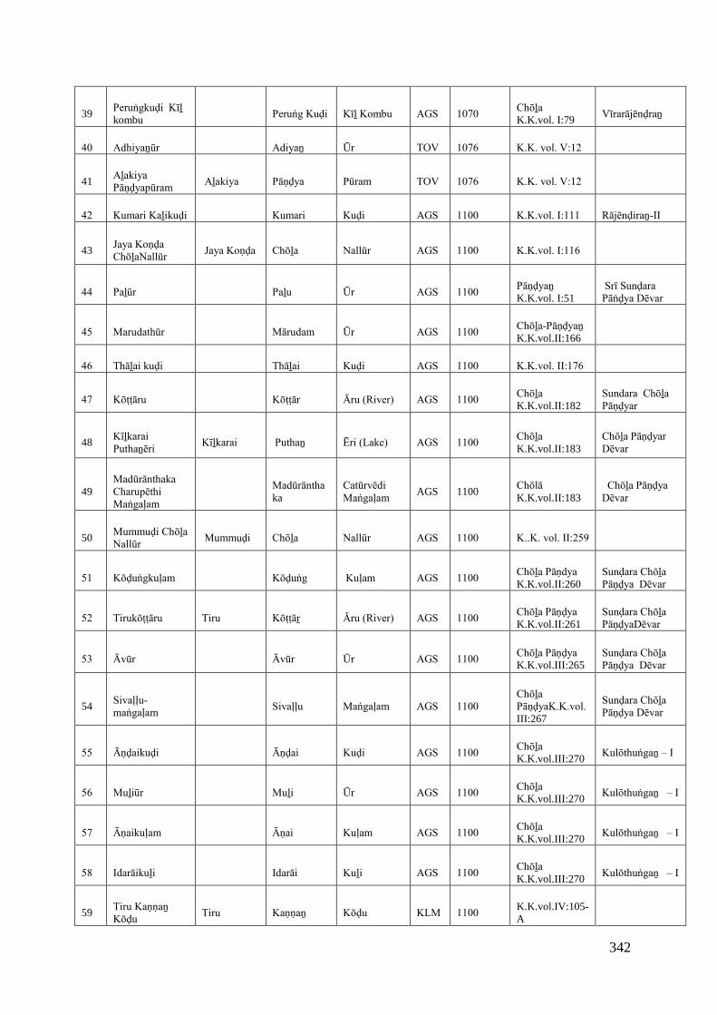
342
39Peruṅgkuḍi Kīḻ kombu
Peruṅg Kuḍi Kīḻ Kombu AGS 1070 Chōḻa K.K.vol. I:79
Vīrarājēnḍraṉ
40 Adhiyaṉūr Adiyaṉ Ūr TOV 1076 K.K. vol. V:12
41Aḻakiya Pāṇḍyapūram
Aḻakiya Pāṇḍya Pūram TOV 1076 K.K. vol. V:12
42 Kumari Kaḻikuḍi Kumari Kuḍi AGS 1100 K.K.vol. I:111 Rājēnḍiraṉ-II
43Jaya Koṇḍa ChōḻaNallūr
Jaya Koṇḍa Chōḻa Nallūr AGS 1100 K.K.vol. I:116
44 Paḻūr Paḻu Ūr AGS 1100 Pāṇḍyaṉ K.K.vol. I:51
Srī Sunḍara Pāṅḍya Dēvar
45 Marudathūr Mārudam Ūr AGS 1100 Chōḻa-Pāṇḍyaṉ K.K.vol.II:166
46 Thāḻai kuḍi Thāḻai Kuḍi AGS 1100 K.K.vol. II:176
47 Kōṭṭāru Kōṭṭār Āru (River) AGS 1100 Chōḻa K.K.vol.II:182
Sundara Chōḻa Pāṇḍyar
48Kīḻkarai Puthaṉēri
Kīḻkarai Puthaṉ Ēri (Lake) AGS 1100 Chōḻa K.K.vol.II:183
Chōḻa Pāṇḍyar Dēvar
49Madūrānthaka Charupēthi Maṅgaḷam
Madūrānthaka
Catūrvēdi Maṅgaḷam
AGS 1100Chōlā K.K.vol.II:183
Chōḻa Pāṇḍya Dēvar
50Mummuḍi Chōḻa Nallūr
Mummuḍi Chōḻa Nallūr AGS 1100 K..K. vol. II:259
51 Kōḍuṅgkuḷam Kōḍuṅg Kuḷam AGS 1100 Chōḻa Pāṇdya K.K.vol.II:260
Sunḍara Chōḻa Pāṇḍya Dēvar
52 Tirukōṭṭāru Tiru Kōṭṭāṟ Āru (River) AGS 1100 Chōḻa Pāṇḍya K.K.vol.II:261
Sunḍara Chōḻa PāṇḍyaDēvar
53 Āvūr Āvūr Ūr AGS 1100 Chōḻa Pāṇḍya K.K.vol.III:265
Sunḍara Chōḻa Pāṇḍya Dēvar
54Sivaḷḷu-maṅgaḷam
Sivaḷḷu Maṅgaḷam AGS 1100 Chōḻa PāṇḍyaK.K.vol.III:267
Sunḍara Chōḻa Pāṇḍya Dēvar
55 Āṇḍaikuḍi Āṇḍai Kuḍi AGS 1100 Chōḻa K.K.vol.III:270
Kulōthuṅgaṉ – I
56 Muḻiūr Muḻi Ūr AGS 1100 Chōḻa K.K.vol.III:270
Kulōthuṅgaṉ – I
57 Āṇaikuḷam Āṇai Kuḷam AGS 1100 Chōḻa K.K.vol.III:270
Kulōthuṅgaṉ – I
58 Idarāikuḻi Idarāi Kuḻi AGS 1100 Chōḻa K.K.vol.III:270
Kulōthuṅgaṉ – I
59Tiru Kaṇṇaṉ Kōḍu
Tiru Kaṇṇaṉ Kōḍu KLM 1100 K.K.vol.IV:105-A
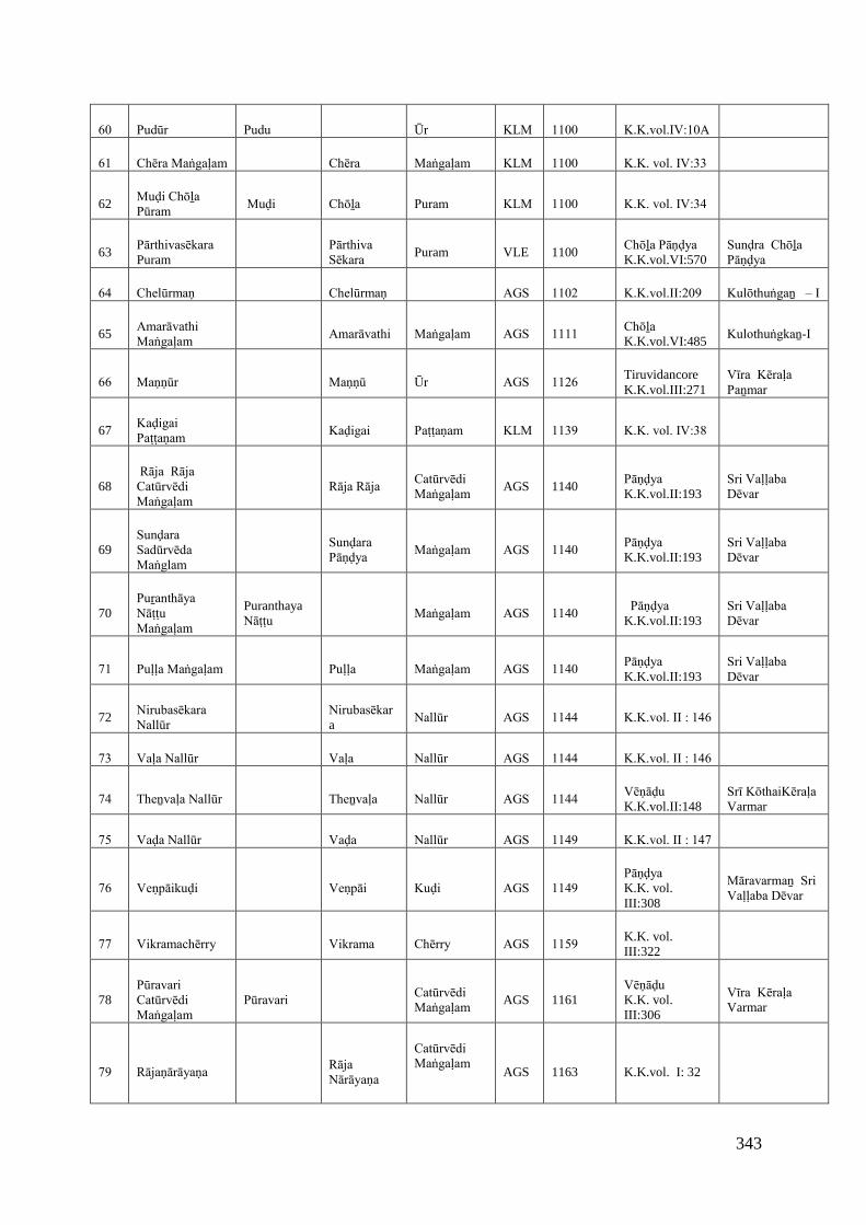
343
60 Pudūr Pudu Ūr KLM 1100 K.K.vol.IV:10A
61 Chēra Maṅgaḷam Chēra Maṅgaḷam KLM 1100 K.K. vol. IV:33
62Muḍi Chōḻa Pūram
Muḍi Chōḻa Puram KLM 1100 K.K. vol. IV:34
63Pārthivasēkara Puram
Pārthiva Sēkara
Puram VLE 1100Chōḻa Pāṇḍya K.K.vol.VI:570
Sunḍra Chōḻa Pāṇḍya
64 Chelūrmaṇ Chelūrmaṇ AGS 1102 K.K.vol.II:209 Kulōthuṅgaṉ – I
65Amarāvathi Maṅgaḷam
Amarāvathi Maṅgaḷam AGS 1111 Chōḻa K.K.vol.VI:485
Kulothuṅgkaṉ-I
66 Maṇṇūr Maṇṇū Ūr AGS 1126 TiruvidancoreK.K.vol.III:271
Vīra Kēraḷa Paṉmar
67Kaḍigai Paṭṭaṇam
Kaḍigai Paṭṭaṇam KLM 1139 K.K. vol. IV:38
68 Rāja Rāja Catūrvēdi Maṅgaḷam
Rāja Rāja Catūrvēdi Maṅgaḷam
AGS 1140Pāṇḍya K.K.vol.II:193
Sri Vaḷḷaba Dēvar
69Sunḍara Sadūrvēda Maṅglam
Sunḍara Pāṇḍya
Maṅgaḷam AGS 1140 Pāṇḍya K.K.vol.II:193
Sri Vaḷḷaba Dēvar
70Puṟanthāya Nāṭṭu Maṅgaḷam
PuranthayaNāṭṭu
Maṅgaḷam AGS 1140 Pāṇḍya K.K.vol.II:193
Sri Vaḷḷaba Dēvar
71 Puḷḷa Maṅgaḷam Puḷḷa Maṅgaḷam AGS 1140 Pāṇḍya K.K.vol.II:193
Sri Vaḷḷaba Dēvar
72Nirubasēkara Nallūr
Nirubasēkara
Nallūr AGS 1144 K.K.vol. II : 146
73 Vaḷa Nallūr Vaḷa Nallūr AGS 1144 K.K.vol. II : 146
74 Theṉvaḷa Nallūr Theṉvaḷa Nallūr AGS 1144 Vēṇāḍu K.K.vol.II:148
Srī KōthaiKēraḷa Varmar
75 Vaḍa Nallūr Vaḍa Nallūr AGS 1149 K.K.vol. II : 147
76 Veṇpāikuḍi Veṇpāi Kuḍi AGS 1149 Pāṇḍya K.K. vol.III:308
Māravarmaṉ Sri Vaḷḷaba Dēvar
77 Vikramachērry Vikrama Chērry AGS 1159 K.K. vol.III:322
78Pūravari Catūrvēdi Maṅgaḷam
Pūravari Catūrvēdi Maṅgaḷam
AGS 1161Vēṇāḍu K.K. vol.III:306
Vīra Kēraḷa Varmar
79 Rājaṇārāyaṇa Rāja Nārāyaṇa
Catūrvēdi Maṅgaḷam
AGS 1163 K.K.vol. I: 32
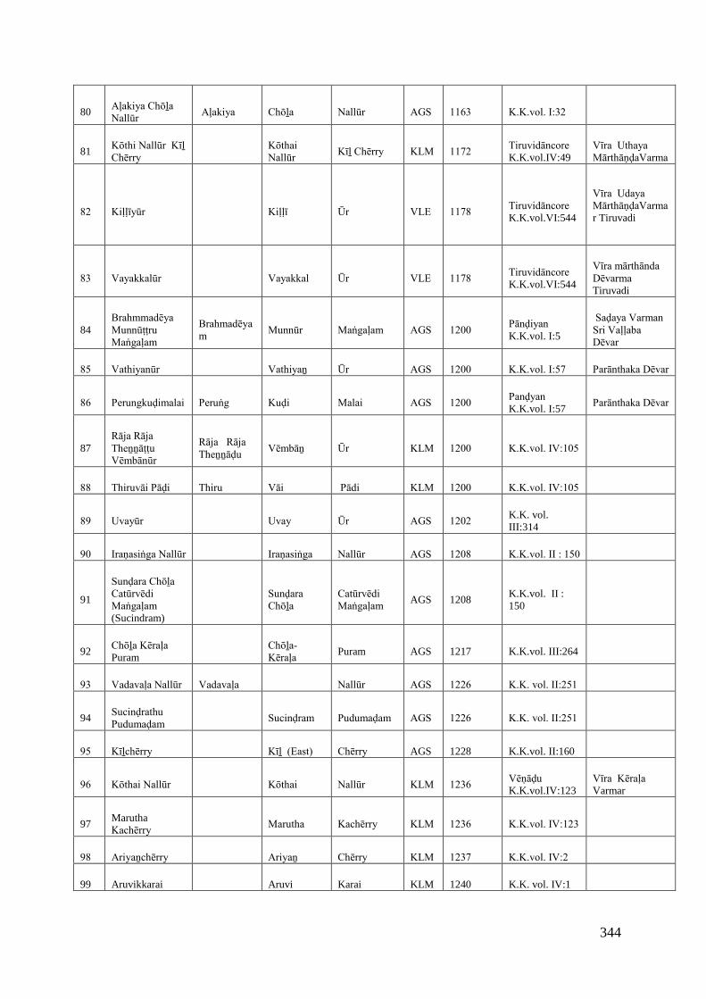
344
80Aļakiya Chōḻa Nallūr
Aļakiya Chōḻa Nallūr AGS 1163 K.K.vol. I:32
81Kōthi Nallūr Kīḻ Chērry
Kōthai Nallūr
Kīḻ Chērry KLM 1172 Tiruvidāncore K.K.vol.IV:49
Vīra Uthaya MārthāṇḍaVarma
82 Kiḷḷīyūr Kiḷḷī Ūr VLE 1178 Tiruvidāncore K.K.vol.VI:544
Vīra Udaya MārthāṇḍaVarmar Tiruvadi
83 Vayakkalūr Vayakkal Ūr VLE 1178 Tiruvidāncore K.K.vol.VI:544
Vīra mārthānda Dēvarma Tiruvadi
84Brahmmadēya Munnūṭṭru Maṅgaḷam
Brahmadēyam
Munnūr Maṅgaḷam AGS 1200 Pānḍiyan K.K.vol. I:5
Saḍaya Varman Sri Vaḷḷaba Dēvar
85 Vathiyanūr Vathiyaṉ Ūr AGS 1200 K.K.vol. I:57 Parānthaka Dēvar
86 Perungkuḍimalai Peruṅg Kuḍi Malai AGS 1200 Panḍyan K.K.vol. I:57
Parānthaka Dēvar
87Rāja Rāja Theṉṉāṭṭu Vēmbānūr
Rāja Rāja Theṉṉāḍu
Vēmbāṉ Ūr KLM 1200 K.K.vol. IV:105
88 Thiruvāi Pāḍi Thiru Vāi Pādi KLM 1200 K.K.vol. IV:105
89 Uvayūr Uvay Ūr AGS 1202 K.K. vol.III:314
90 Iraṇasiṅga Nallūr Iraṇasiṅga Nallūr AGS 1208 K.K.vol. II : 150
91
Sunḍara Chōḻa Catūrvēdi Maṅgaḷam (Sucindram)
Sunḍara Chōḻa
Catūrvēdi Maṅgaḷam
AGS 1208K.K.vol. II :150
92Chōḻa Kēraḷa Puram
Chōḻa-Kēraḷa
Puram AGS 1217 K.K.vol. III:264
93 Vadavaḷa Nallūr Vadavaḷa Nallūr AGS 1226 K.K. vol. II:251
94Sucinḍrathu Pudumaḍam
Sucinḍram Pudumaḍam AGS 1226 K.K. vol. II:251
95 Kīḻchērry Kīḻ (East) Chērry AGS 1228 K.K.vol. II:160
96 Kōthai Nallūr Kōthai Nallūr KLM 1236 Vēṇāḍu K.K.vol.IV:123
Vīra Kēraḷa Varmar
97MaruthaKachērry
Marutha Kachērry KLM 1236 K.K.vol. IV:123
98 Ariyaṉchērry Ariyaṉ Chērry KLM 1237 K.K.vol. IV:2
99 Aruvikkarai Aruvi Karai KLM 1240 K.K. vol. IV:1
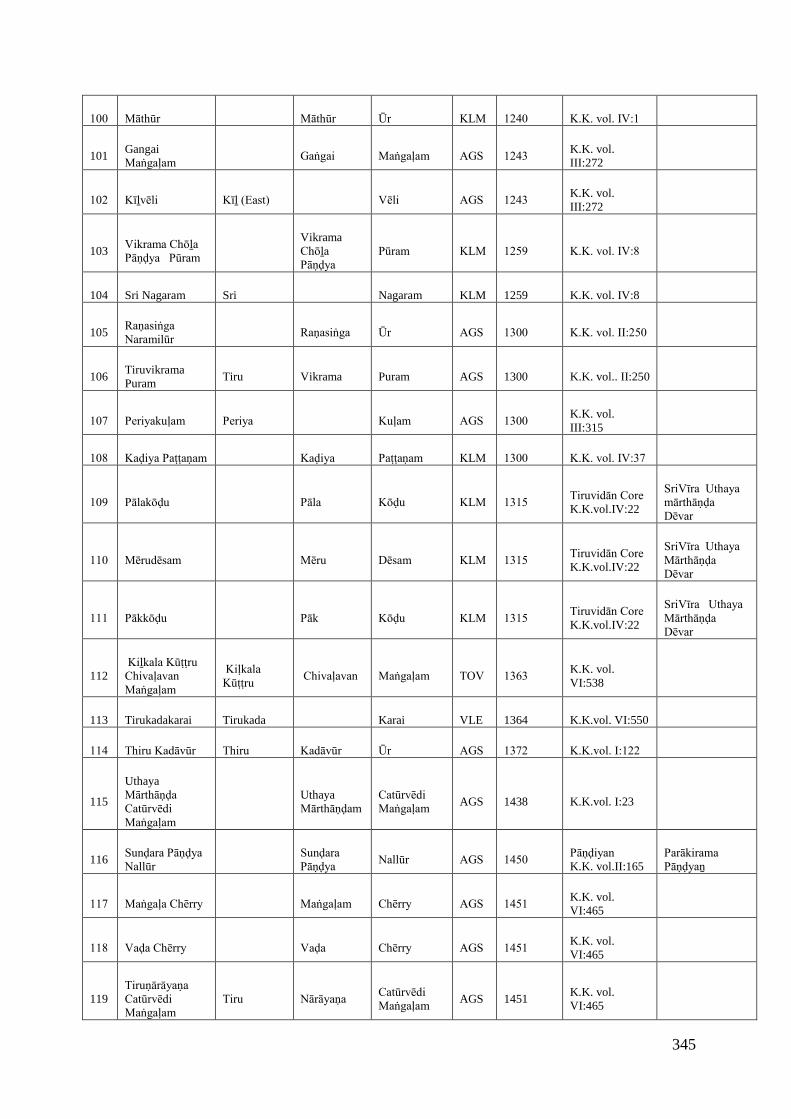
345
100 Māthūr Māthūr Ūr KLM 1240 K.K. vol. IV:1
101GangaiMaṅgaḷam
Gaṅgai Maṅgaḷam AGS 1243 K.K. vol.III:272
102 Kīḻvēli Kīḻ (East) Vēli AGS 1243 K.K. vol.III:272
103Vikrama Chōḻa Pāṇḍya Pūram
VikramaChōḻa Pāṇḍya
Pūram KLM 1259 K.K. vol. IV:8
104 Sri Nagaram Sri Nagaram KLM 1259 K.K. vol. IV:8
105Raṇasiṅga Naramilūr
Raṇasiṅga Ūr AGS 1300 K.K. vol. II:250
106TiruvikramaPuram
Tiru Vikrama Puram AGS 1300 K.K. vol.. II:250
107 Periyakuḷam Periya Kuḷam AGS 1300 K.K. vol.III:315
108 Kaḍiya Paṭṭaṇam Kaḍiya Paṭṭaṇam KLM 1300 K.K. vol. IV:37
109 Pālakōḍu Pāla Kōḍu KLM 1315 Tiruvidān Core K.K.vol.IV:22
SriVīra Uthaya mārthāṇḍa Dēvar
110 Mērudēsam Mēru Dēsam KLM 1315 Tiruvidān Core K.K.vol.IV:22
SriVīra Uthaya Mārthāṇḍa Dēvar
111 Pākkōḍu Pāk Kōḍu KLM 1315 Tiruvidān Core K.K.vol.IV:22
SriVīra Uthaya Mārthāṇḍa Dēvar
112 Kiḻkala Kūṭṭru Chivaḷavan Maṅgaḷam
Kiḷkala Kūṭṭru
Chivaḷavan Maṅgaḷam TOV 1363 K.K. vol.VI:538
113 Tirukadakarai Tirukada Karai VLE 1364 K.K.vol. VI:550
114 Thiru Kadāvūr Thiru Kadāvūr Ūr AGS 1372 K.K.vol. I:122
115
UthayaMārthāṇḍa Catūrvēdi Maṅgaḷam
UthayaMārthāṇḍam
Catūrvēdi Maṅgaḷam
AGS 1438 K.K.vol. I:23
116Sunḍara Pāṇḍya Nallūr
Sunḍara Pāṇḍya
Nallūr AGS 1450 Pāṇḍiyan K.K. vol.II:165
Parākirama Pāṇḍyaṉ
117 Maṅgaḷa Chērry Maṅgaḷam Chērry AGS 1451 K.K. vol.VI:465
118 Vaḍa Chērry Vaḍa Chērry AGS 1451 K.K. vol.VI:465
119Tiruṇārāyaṇa Catūrvēdi Maṅgaḷam
Tiru Nārāyaṇa Catūrvēdi Maṅgaḷam
AGS 1451K.K. vol.VI:465

346
120 Kōṭṭūr Kōṭṭūr Ūr KLM 1452 K.K. vol.VI:514
121 Pērūr Pērūr Pērūr KLM 1452 K.K. vol.VI:514
122Karuppu Kōṭṭai Agaram
Karuppukōṭṭai
Agaram AGS 1461 K.K.vol. I:35
123 Kīḻpērūr Kīḻ Pērūr AGS 1465 K.K. vol.VI:462
124Sri RaviRavivarmaTirupāpūr
Sri RaviRavivarma
Tirupāp Ūr AGS 1465 K.K. vol.VI:462
125Tirukaruṅg Kuḍi
Tiru Karuṅg Kuḍi AGS 1483 Tiruvidāncore K.K.vol.II :162
Ādhithavarmar Cheyaduṅga Nāṭṭu Mūthatiruvaḍi
126 Thiruparapūr Thiru Parapu Ūr AGS 1483 Tiruvidān Core K.K.vol. II:162
Ādhithavarmar Cheya Duṅga Nāṭṭu Muthatiruvaḍi
127 Vaḍakarai Vaḍa Karai AGS 1483 K.K.vol.II:162
Ādhithavarmar Cheya Duṅga Nāṭṭu Mūthatiruvaḍi
128 Raṇasiṅga Padi Raṇasiṅga Pāḍi KLM 1484 K.K. vol. IV:36
129 Vaṅgipūram Vaṅgi Puram AGS 1487 K.K. vol.III:320
130 Kumari Muṭṭam Kumari Muṭṭam AGS 1494 Tiruvidāncore K.K.vol.VI :487
131 Kuṇḍūr Kuṇḍū Ūr VLE 1500 K.K. vol.VI:546
132 Maruthaṅkōḍu Marutham Kōḍu VLE 1500 K.K. vol.VI:546
133 Muṉaiyaṇūr Muṉaiyaṉ Ūr AGS 1505 K.K. vol.III:282
134Kiḻār Maṅgaḷathu Maṅgaḷa Chērry
Kiļār Maṅgaḷa Chērry AGS 1509 K.K.vol. I:28
135 Sātha Maṅgaḷam Sātha Maṅgaḷam KLM 1513 Vēṇāḍu K.K.vol.VI :526
Chiravāi Mūtha ThiruvadiMāthaḍa Aḍigaḷ
136 Vīrakēsari Nallur Vīrakesari Nallūr AGS 1514 K.K. vol.III:285
137 Aipiḷḷai Puthūr Aipiḷḷai Puthūr Ūr AGS 1514 K.K. vol.III:285
138 Nāgarkōvil Nāgar Kōvil AGS 1516 K.K.vol. III:275
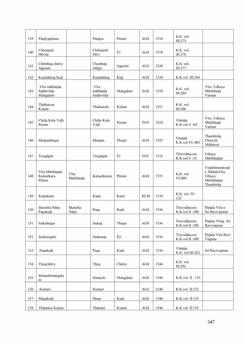
347
139 Pāṇḍyapūram Pāṇḍya Pūram AGS 1516 K.K. vol.III:275
140Chēraṉmā Dēviūr
Chēraṉmā Dēvi
Ūr AGS 1518 K.K. vol.III:276
141Chēnthaṉ chērry Agaram
Chenthaṉ chēṟṟy
Agaram AGS 1520K.K. vol.III:277
142 Kuṇdakkaṉ Kuļi Kuṇdakkaṉ Kuḻi AGS 1520 K.K.vol. III:284
143 Vīra māthāṇḍa Sadūrvēḍa Maṅgaḷam
Vīra māthāṇḍa Sadūrvēḍa
Maṅgaḷam AGS 1520 K.K. vol.III:284
Vīra Udhaya Mārthāṇḍa Varmar
144Thāthaiyar Kuḷam
Thathaiyūr Kuḷam AGS 1521 K.K. vol.III:286
145Chōḻa Kula Vaḷḷi Puram
Chōḻa Kula Vaḷḷi
Puram TOV 1524Vēṇāḍu K.K.vol.V :64
Vīra Udhaya Mārthāṇḍa Varmar
146 Muṭṭamthuṟai Muṭṭam Thuṟai AGS 1525 Vēṇāḍu K.K.vol.VI :491
Thambirāṉ Chiravāi Mūthavar
147 Tirupāpūr Tirupāpūr Ūr TOV 1532 TIruvidāncore K.K.vol.V :51
UthayaMārthāṇḍan
148Vīra Mārthāṇḍa Kulasēkara-Pūram
Vīra Mārthāṇḍa
Kulasēkaram Pūram AGS 1533 K.K. vol.VI:489
Veṇdrūmaṇkoṇḍa PūdalaVīra UthayaMārthāṇḍan Thambirāṉ
149 Kaṭṭukarai Kaṭṭu Karai KLM 1534 K.K. vol. IV:135
150Marutha Nāṭṭu Paṉakuḍi
MaruthaNāṭṭu
Paṉa Kuḍi AGS 1536 Tiruvidāncore K.K.vol.II :189
Pūḍala Vīra n Sri Ravivaṉmar
151 Irukathuṟai Irukaṉ Thuṟai AGS 1536 Tiruvidāncore K.K.vol.II :189
Pūḍala Vīraṉ Sri Ravivaṉmar
152 Saṅkaraṉēri Saṅkaraṉ Ēri AGS 1536 Tiruvidāncore K.K.vol.II :189
Pūḍala Vīra Ravi Vaṉmar
153 Paṉakuḍi Paṉa Kuḍi AGS 1536 Vēṇāḍu K.K. vol.III:325
Srī Ravivaṉmar
154 Theṉchērry Theṉ Chērry AGS 1544 K.K. vol.III:291
155Sōmachimaṅgaḷam
Sōmachi Maṅgaḷam AGS 1546 K.K.vol. II : 155
156 Kumari Kumari AGS 1546 K.K.vol. II:155
157 Maṇakuḍi Maṇa Kuḍi AGS 1546 K.K.vol. II:155
158 Thāmarai Kuḷam Thāmari Kuḷam AGS 1546 K.K.vol. II:155
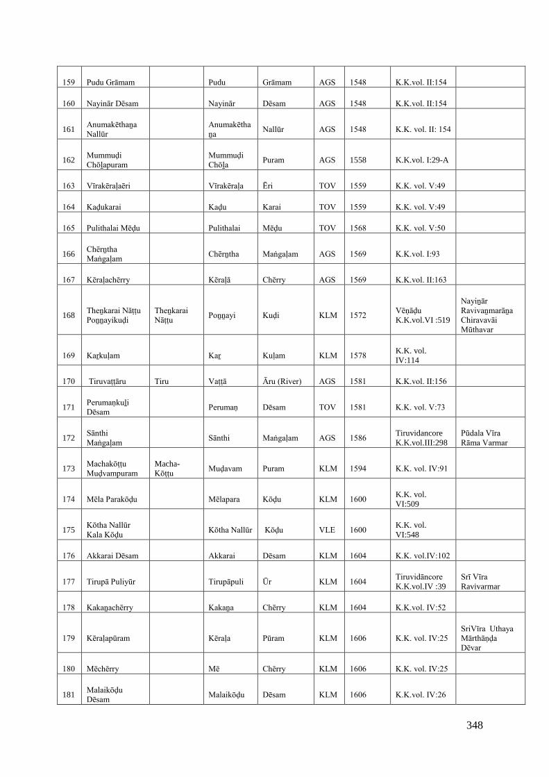
348
159 Pudu Grāmam Pudu Grāmam AGS 1548 K.K.vol. II:154
160 Nayinār Dēsam Nayinār Dēsam AGS 1548 K.K.vol. II:154
161Anumakēthaṉa Nallūr
Anumakēthaṉa
Nallūr AGS 1548 K.K. vol. II: 154
162Mummuḍi Chōḻapuram
Mummuḍi Chōḻa
Puram AGS 1558 K.K.vol. I:29-A
163 Vīrakēraḷaēri Vīrakēraḷa Ēri TOV 1559 K.K. vol. V:49
164 Kaḍukarai Kaḍu Karai TOV 1559 K.K. vol. V:49
165 Pulithalai Mēḍu Pulithalai Mēḍu TOV 1568 K.K. vol. V:50
166Chērṉtha Maṅgaḷam
Chērṉtha Maṅgaḷam AGS 1569 K.K.vol. I:93
167 Kēraḷachērry Kēraḷā Chērry AGS 1569 K.K.vol. II:163
168Theṉkarai Nāṭṭu Poṉṉayikuḍi
Theṉkarai Nāṭṭu
Poṉṉayi Kuḍi KLM 1572 Vēṇāḍu K.K.vol.VI :519
Nayiṉār Ravivaṉmarāṉa Chiravavāi Mūthavar
169 Kaṟkuḷam Kaṟ Kuḷam KLM 1578 K.K. vol.IV:114
170 Tiruvaṭṭāru Tiru Vaṭṭā Āru (River) AGS 1581 K.K.vol. II:156
171Perumaṇkuḻi Dēsam
Perumaṇ Dēsam TOV 1581 K.K. vol. V:73
172Sānthi Maṅgaḷam
Sānthi Maṅgaḷam AGS 1586 TiruvidancoreK.K.vol.III:298
Pūdala Vīra Rāma Varmar
173Machakōṭṭu Muḍvampuram
Macha-Kōṭṭu
Muḍavam Puram KLM 1594 K.K. vol. IV:91
174 Mēla Parakōḍu Mēlapara Kōḍu KLM 1600 K.K. vol.VI:509
175Kōtha Nallūr Kala Kōḍu
Kōtha Nallūr Kōḍu VLE 1600 K.K. vol.VI:548
176 Akkarai Dēsam Akkarai Dēsam KLM 1604 K.K. vol.IV:102
177 Tirupā Puliyūr Tirupāpuli Ūr KLM 1604 Tiruvidāncore K.K.vol.IV :39
Srī Vīra Ravivarmar
178 Kakaṉachērry Kakaṉa Chērry KLM 1604 K.K.vol. IV:52
179 Kēraḷapūram Kēraḷa Pūram KLM 1606 K.K. vol. IV:25 SriVīra Uthaya Mārthāṇḍa Dēvar
180 Mēchērry Mē Chērry KLM 1606 K.K. vol. IV:25
181Malaikōḍu Dēsam
Malaikōḍu Dēsam KLM 1606 K.K.vol. IV:26

349
182Parākirama Maṅgaḷa dēsam
Parākirama Maṅgaḷa
Dēsam KLM 1606 K.K. vol. IV:27
183 Pūlāṅkuṟichi Puḷḷāṅ Kuṟichi AGS 1606 Nāyakā K.K.vol.VI :474
Muthu Vīrappa Nāyāka
184 Muthalakuṟichi Muthala Kuṟichi KLM 1607 Tiruvidāncore K.K.vol.IV :21
Vīra Ravivaṉmarāṉa Sri Kulasēkara Perumāḷ
185 Vīrakēraḷapuram Vīrakēraḷa Puram KLM 1607 Tiruvidāncore K.K.vol.IV :21
Vīra ravivanmarāṉaSri Kulasēkara Perumāḷ
186 Kīḻāmpērūr Kīḻām Pērūr KLM 1607 Tiruvidāncore K.K.vol.IV :21
Vīra ravivarmarāṉa Sri Kulasēkara Perumāḷ
187Kōthacha piḷḷai Agaram
Kōthacha Piḷḷai
Agaram AGS 1609K.K. vol.III:326
188 Kiḻārmaṅgaḷam Kiḻār Maṅgaḷam AGS 1610 K. K. vol.III:292
189 Paṉaiyarai Paṉaiyarai AGS 1610 K.K. vol.III:327
190 Thēṉṇūr Thēṇṉūr Ūr TOV 1618 K.K. vol. V:61
191 Vikrama Pāṇḍya Chōḻa Puram
VikramaPāṇḍya Chōḻa
Pūram AGS 1619 K.K. vol. II: 235
192 Eiḍalāikuḍi Eiḍalāi Kuḍi AGS 1619 K.K. vol. II:235
193 Kaikaṭṭiya Paṭṭaṇam
Kaikaṭṭiya Paṭṭaṇam TOV 1623 K.K. vol. V:59
194 Kuṭṭamaṅgaḷam Kuṭṭa Maṅgaḷam TOV 1625 K.K. vol. V:68
195 Vīra kēraḷanallūr Vīrakēraḷa Nallūr AGS 1629 K.K.vol. II:187
196 Eiṟaichakuḷam Eiṟaicha Kuḷam TOV 1629 K.K. vol. V:35
197 Tiruvidānkōḍu Tiruvidān Kōḍu TOV 1635 K.K.vol. V:2
198 Kaikuḷam Kai Kuḷam KLM 1659 K.K. vol. IV:98
199 Maṇalikarai Maṇali Karai KLM 1659 K.K.vol. IV:98
200 Vāriyūr Vāri Ūr AGS 1663 Nāyāka K.K.vol.VI :457
Chokka Nātha Nāyakā
201Vaḍavathu Kāṭṭūr
Vaḍavathu Kāṭṭūr TOV 1673 K.K. vol. V:32
202 Vakkaṉaviḷai Vakkaṉa Viḷai TOV 1673 K.K. vol. V:32
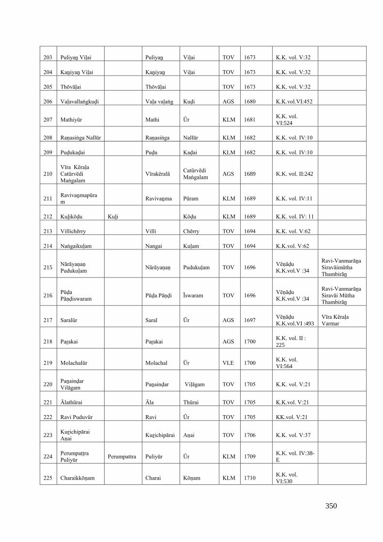
350
203 Puliyaṉ Viḷai Puliyaṉ Viḷai TOV 1673 K.K. vol. V:32
204 Kaṉiyaṉ Viḷai Kaṉiyaṉ Viḷai TOV 1673 K.K. vol. V:32
205 Thōvāḷai Thōvāḷai TOV 1673 K.K. vol. V:32
206 Vaḷavallaṅgkuḍi Vaḷa vaḷaṅg Kuḍi AGS 1680 K.K.vol.VI:452
207 Mathiyūr Mathi Ūr KLM 1681 K.K. vol.VI:524
208 Raṇasiṅga Nallūr Raṇasiṅga Nallūr KLM 1682 K.K. vol. IV:10
209 Puḍukaḍai Puḍu Kaḍai KLM 1682 K.K. vol. IV:10
210Vīra Kēraḷa Catūrvēdi Maṅgalam
Vīrakēralā Catūrvēdi Maṅgalam
AGS 1689 K.K. vol. II:242
211Ravivaṉmapūram
Ravivaṉma Pūram KLM 1689 K.K. vol. IV:11
212 Kuḻikōḍu Kuḻi Kōḍu KLM 1689 K.K. vol. IV: 11
213 Villichērry Villi Chērry TOV 1694 K.K. vol. V:62
214 Naṅgaikuḷam Nangai Kuḷam TOV 1694 K.K.vol. V:62
215Nārāyaṇaṇ Pudukuḷam
Nārāyaṇaṇ Pudukuḷam TOV 1696 Vēṇāḍu K.K.vol.V :34
Ravi-Vanmarāṉa Siravāimūtha Thambirāṉ
216Pūḍa Pāṇḍiswaram
Pūḍa Pāṇḍi Īswaram TOV 1696 Vēṇāḍu K.K.vol.V :34
Ravi-Vanmarāṉa Siravāi Mūtha Thambirāṉ
217 Saralūr Saral Ūr AGS 1697 Vēṇāḍu K.K.vol.VI :493
Vīra Kēraḷa Varmar
218 Paṟakai Paṟakai AGS 1700 K.K. vol. II :225
219 Molachalūr Molachal Ūr VLE 1700 K.K. vol.VI:564
220Paṉainḍar Vilāgam
Paṉainḍar Viḷāgam TOV 1705 K.K. vol. V:21
221 Ālathūrai Āla Thūrai TOV 1705 K.K.vol. V:21
222 Ravi Puduvūr Ravi Ūr TOV 1705 KK.vol. V:21
223Kuṟichipārai Aṇai
Kuṟichipārai Aṇai TOV 1706 K.K. vol. V:37
224Perumpaṭṭra Puliyūr
Perumpattra Puliyūr Ūr KLM 1709 K.K. vol. IV:38-E
225 Charaikkōṇam Charai Kōṇam KLM 1710 K.K. vol.VI:530
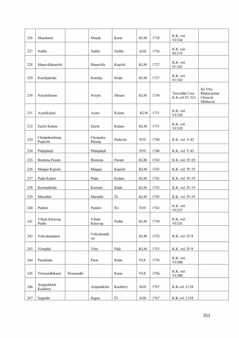
351
226 Maṇakarai Maṇak Karai KLM 1710 K.K. vol.VI:534
227 Nallūr Nallūr Nallūr AGS 1726 K.K. vol.III:274
228 Maṇavālakuṟichi Maṇavāla Kuṟichi KLM 1727 K.K. vol.IV:102
229 Kaniñjakōḍu Kaniñja Kōḍu KLM 1727 K.K. vol.IV:102
230 Neiyūrdēsam Neiyūr Dēsam KLM 1730 Tiruvidān Core K.K.vol.VI :521
Sri Vīra Rāmavarmar Chiravāi Mūthavar
231 Ayanikuḷam Ayani Kuḷam KLM 1731 K.K. vol.VI:529
232 Eṟichi Kuḷam Eṟichi Kuḷam KLM 1731 K.K. vol.VI:529
233Cheṇpakarāmaṉ Puḍuvūr
Cheṇpaka Rāmaṉ
Puduvūr TOV 1740 K.K. vol. V:42
234 Pūḍapāṇḍi Pūḍapāṇḍi TOV 1740 K.K. vol. V:42
235 Bramma Puram Bramma Puram KLM 1743 K.K. vol. IV:19
236 Maṉṉai Kuṟichi Maṉṉai Kuṟichi KLM 1743 K.K. vol. IV:19
237 Puḍu Kuḷam Puḍu Kuḷam KLM 1743 K.K. vol. IV:19
238 Karinaṅkōḍu Karinaṅ Kōḍu KLM 1743 K.K. vol. IV:19
239 Maruthūr Maruthū Ūr KLM 1743 K.K. vol. IV:19
240 Puthēri Puthēri Ēri TOV 1743 K.K. vol.VI:537
241Vibala Kēsavaṉ Pudūr
VibalaKēsavaṉ
Pudūr KLM 1750 K.K. vol.VI:535
242 Valiyakuṇḍarai Valiyakuṇḍarai
KLM 1753 K.K. vol. IV:9
243 Vēmpāḍi Vēm Pāḍi KLM 1753 K.K. vol. IV:9
244 Paraikōḍu Parai Kōḍu VLE 1756 K.K. vol.VI:588
245 Tirunandhikarai Tirunandhi Karai VLE 1756K.K. vol.VI:588
246ArippukkilaiKachērry
Arippukkilai Kachērry AGS 1767 K.K.vol. I:128
247 Segunūr Seguṇ Ūr AGS 1767 K.K.vol. I:128
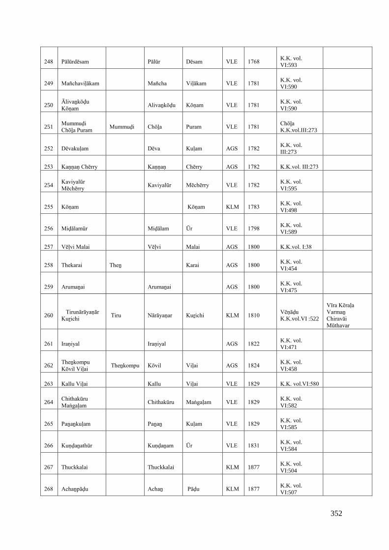
352
248 Pālūrdēsam Pālūr Dēsam VLE 1768 K.K. vol.VI:593
249 Mañchaviḷākam Mañcha Viḷākam VLE 1781 K.K. vol.VI:590
250Ālivaṉkōḍu Kōṇam
Alivaṉkōḍu Kōṇam VLE 1781 K.K. vol.VI:590
251Mummuḍi Chōḻa Puram
Mummuḍi Chōḻa Puram VLE 1781 Chōḻa K.K.vol.III:273
252 Dēvakuḷam Dēva Kuḷam AGS 1782 K.K. vol.III:273
253 Kaṇṇaṇ Chērry Kaṇṇaṇ Chērry AGS 1782 K.K.vol. III:273
254Kaviyalūr Mēchērry
Kaviyalūr Mēchērry VLE 1782 K.K. vol.VI:595
255 Kōṇam Kōṇam KLM 1783 K.K. vol.VI:498
256 Miḍālamūr Miḍālam Ūr VLE 1798 K.K. vol.VI:589
257 Vēḷvi Malai Vēḷvi Malai AGS 1800 K.K.vol. I:38
258 Thekarai Theṉ Karai AGS 1800 K.K. vol.VI:454
259 Arumaṉai Arumaṉai AGS 1800 K.K. vol.VI:475
260 Tirunārāyaṇār Kuṟichi
Tiru Nārāyaṇar Kuṟichi KLM 1810 Vēṇāḍu K.K.vol.VI :522
Vīra Kēraḷa Varmaṉ Chiravāi Mūthavar
261 Iraṇiyal Iraṇiyal AGS 1822 K.K. vol.VI:471
262Theṉkompu Kōvil Viḷai
Theṉkompu Kōvil Viḷai AGS 1824 K.K. vol.VI:458
263 Kallu Viḷai Kallu Viḷai VLE 1829 K.K. vol.VI:580
264Chithakūru Maṅgaḷam
Chithakūru Maṅgaḷam VLE 1829 K.K. vol.VI:582
265 Paṉaṉkuḷam Paṉaṉ Kuḷam VLE 1829 K.K. vol.VI:585
266 Kuṇḍaṉathūr Kuṇḍaṉam Ūr VLE 1831 K.K. vol.VI:584
267 Thuckkalai Thuckkalai KLM 1877K.K. vol.VI:504
268 Achaṉpāḍu Achaṉ Pāḍu KLM 1877 K.K. vol.VI:507
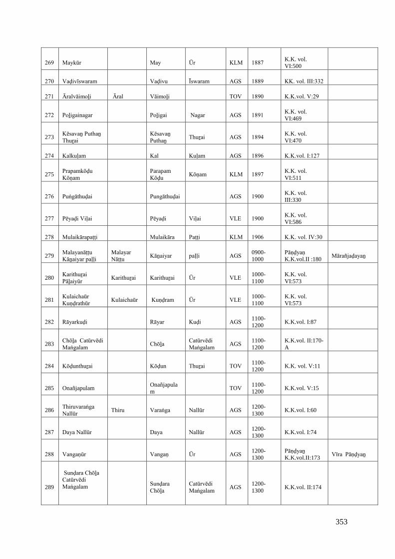
353
269 Maykūr May Ūr KLM 1887 K.K. vol.VI:500
270 Vaḍivīswaram Vaḍivu Īswaram AGS 1889 KK. vol. III:332
271 Āralvāimoḻi Āral Vāimoḻi TOV 1890 K.K.vol. V:29
272 Poḻigainagar Poḻigai Nagar AGS 1891 K.K. vol.VI:469
273Kēsavaṉ Puthaṉ Thuṟai
Kēsavaṉ Puthaṉ
Thuṟai AGS 1894 K.K. vol.VI:470
274 Kalkuḷam Kal Kuḷam AGS 1896 K.K.vol. I:127
275Prapamkōḍu Kōṇam
ParapamKōḍu
Kōṇam KLM 1897 K.K. vol.VI:511
276 Puṅgāthuḍai Pungāthuḍai AGS 1900 K.K. vol.III:330
277 Pēyaḍi Viḷai Pēyaḍi Viḷai VLE 1900 K.K. vol.VI:586
278 Mulaikārapaṭṭi Mulaikāra Paṭṭi KLM 1906 K.K. vol. IV:30
279Malayanāṭṭu Kāṉaiyar paḷḷi
MalayarNāṭṭu
Kāṉaiyar paḷḷi AGS 0900-1000
Pāṇḍyaṇ K.K.vol.II :180
Mārañjaḍayaṉ
280Karithuṟai Pāḻaiyūr
Karithuṟai Karithuṟai Ūr VLE 1000-1100
K.K. vol.VI:573
281Kulaichaūr Kuṇḍrathūr
Kulaichaūr Kuṇḍram Ūr VLE 1000-1100
K.K. vol.VI:573
282 Rāyarkuḍi Rāyar Kuḍi AGS 1100-1200
K.K.vol. I:87
283Chōḻa Catūrvēdi Maṅgalam
Chōḻa Catūrvēdi Maṅgalam
AGS1100-1200
K.K.vol. II:170-A
284 Kōḍunthuṟai Kōḍun Thuṟai TOV 1100-1200
K.K. vol. V:11
285 OnañjapulamOnañjapulam
TOV1100-1200
K.K.vol. V:15
286Thiruvaraṅga Nallūr
Thiru Varaṅga Nallūr AGS 1200-1300
K.K.vol. I:60
287 Daya Nallūr Daya Nallūr AGS 1200-1300
K.K.vol. I:74
288 Vangaṇūr Vangaṇ Ūr AGS 1200-1300
Pāṇḍyaṉ K.K.vol.II:173
Vīra Pāṇḍyaṉ
289
Sunḍara Chōḻa Catūrvēdi Maṅgalam Sunḍara
Chōḻa Catūrvēdi Maṅgalam
AGS1200-1300
K.K.vol. II:174

354
290Sarupēthi Maṅgaḷam
Sarupēthi Maṅgaḷam AGS 1200-1300
K.K. vol. II:214
291 Thērkarumpaḻūr Thēr Karumpaḻūr Ūr AGS 1200-1300
ChōḻaK.K.vol.III:273
Rājēnḍiraṉ-I
292 Sivagiri Siva Giri KLM1200-1300
K.K. vol. IV:29
293 Dēvaṉ Chērry Dēvaṉ Chērry KLM 1200-1300
K.K. vol. IV:29
294 Maruthathūr Marutham Ūr KLM 1200-1300
K.K. vol. IV:82
295UthayaMaṅgaḷam
Uthaya Maṅgaḷam KLM 1200-1300
K.K. vol. IV:82
296 Kanyākumari Kanyā Kumari AGS 1500-1600
VijayanagarK.K.vol.I :P.84
297Ethirvilli Chōḻa Puram
Ethirvilli Chōḻa Puram TOV 1500-1600
K.K. vol. V:66
298 Sucīnḍram Sucīnḍram AGS 1500-1600.
VijayanagarK.K. vol. 1:84
299Kēraḻathu Chērapaḷḷi
Kēraḷa Chēra Paḷḷi KLM 1600-1700
K.K. vol. IV:84
300 Pāraisālaidēsam Pārai Sālai Dēsam KLM 1600-1700
K.K. vol. IV:87
301Kuṭṭa Maṅgaḷam Dēsam
Kuṭṭa Maṅgaḷam
Dēsam KLM 1600-1700
K.K . vol. IV:88
302 Pūlāṉthuṟai Pūlāṉ Thūrai AGS 1700-1800
KK.vol. I:103
303 Kaḻikuḍi Kaḻi Kuḍi AGS 1700-1800
K.K.vol. I:104
304Thiruvaṭṭārudēsam
Tiru Vaṭṭāru Dēsam AGS 17001800 K.K.vol. II:131
305Kumāra Nallūr Maṅgāḍu
Kumāra Nallūr
Maṅgāḍu AGS 1700-1800
K.K.vol. II :132
306 Viḷāvūr Viḷavam Ūr AGS 1700-1800
K.K.vol. II : 137
307 Thāyāṭṭrai Thāyāṭṭrai AGS 1700-1800
K.K.vol. II : 138
308 Māḷigaimaḍam Māḷigai Maḍam AGS 1700-1800
K.K.vol. II: 140
309
Chivaḷa Maṅgaḷam
Chivaḷa Maṅgaḷam AGS 1700-1800
K.K.vol. II : 151
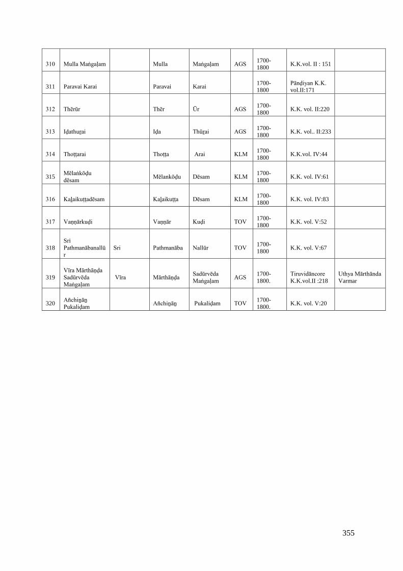
355
310 Mulla Maṅgaḷam Mulla Maṅgaḷam AGS 1700-1800
K.K.vol. II : 151
311 Paravai Karai Paravai Karai1700-1800
Pānḍiyan K.K. vol.II:171
312 Thērūr Thēr Ūr AGS 1700-1800
K.K. vol. II:220
313 Iḍathuṟai Iḍa Thūṟai AGS 1700-1800
K.K. vol.. II:233
314 Thoṭṭarai Thoṭṭa Arai KLM 1700-1800
K.K.vol. IV:44
315Mēlaṅkōḍu dēsam
Mēlankōḍu Dēsam KLM 1700-1800
K.K. vol. IV:61
316 Kaḻaikuṭṭadēsam Kaḻaikuṭṭa Dēsam KLM 1700-1800
K.K. vol. IV:83
317 Vaṇṇārkuḍi Vaṇṇār Kuḍi TOV 1700-1800
K.K. vol. V:52
318SriPathmanābanallūr
Sri Pathmanāba Nallūr TOV 1700-1800
K.K. vol. V:67
319Vīra Mārthāṇḍa Sadūrvēda Maṅgaḷam
Vīra Mārthāṇḍa Sadūrvēda Maṅgaḷam
AGS1700-1800.
Tiruvidāncore K.K.vol.II :218
Uthya Mārthānda Varmar
320Añchiṉāṉ Pukaliḍam
Añchiṉāṉ Pukaliḍam TOV 1700-1800.
K.K. vol. V:20
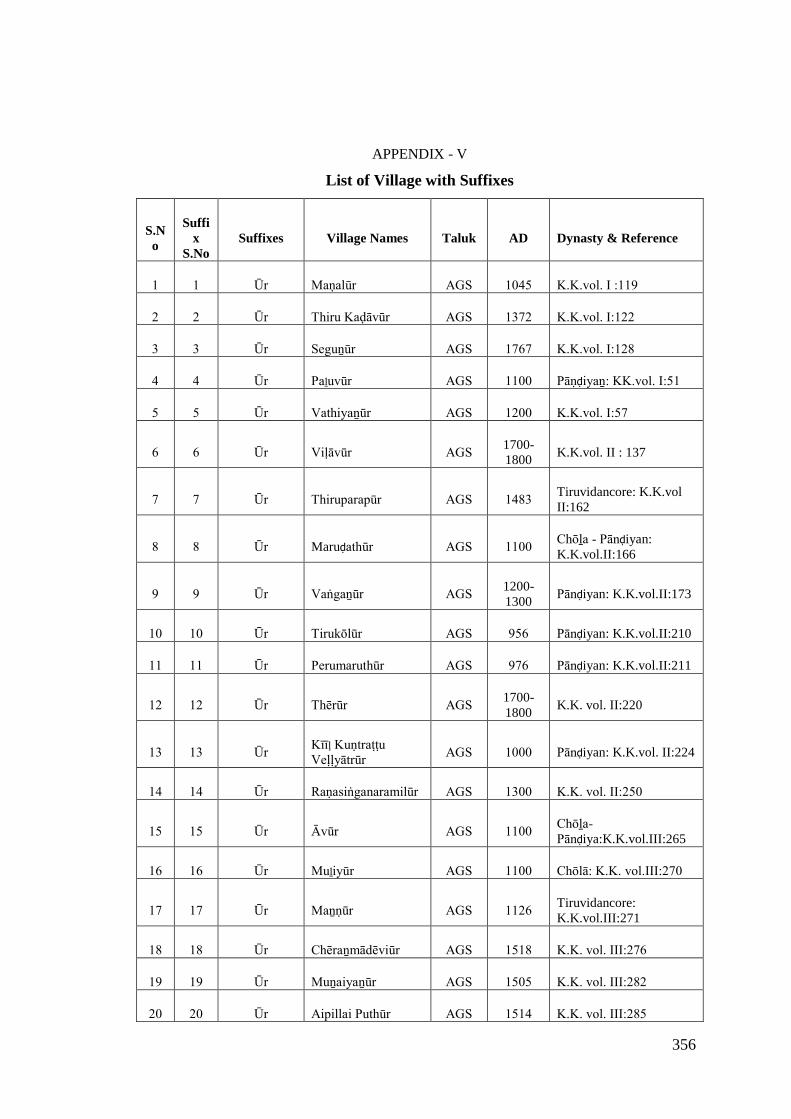
356
APPENDIX - V
List of Village with Suffixes
S.No
Suffix
S.NoSuffixes Village Names Taluk AD Dynasty & Reference
1 1 Ūr Maṇalūr AGS 1045 K.K.vol. I :119
2 2 Ūr Thiru Kaḍāvūr AGS 1372 K.K.vol. I:122
3 3 Ūr Seguṉūr AGS 1767 K.K.vol. I:128
4 4 Ūr Paḻuvūr AGS 1100 Pāṇḍiyaṉ: KK.vol. I:51
5 5 Ūr Vathiyaṉūr AGS 1200 K.K.vol. I:57
6 6 Ūr Viḷāvūr AGS 1700-1800
K.K.vol. II : 137
7 7 Ūr Thiruparapūr AGS 1483 Tiruvidancore: K.K.volII:162
8 8 Ūr Maruḍathūr AGS 1100 Chōḻa - Pānḍiyan:K.K.vol.II:166
9 9 Ūr Vaṅgaṉūr AGS 1200-1300
Pānḍiyan: K.K.vol.II:173
10 10 Ūr Tirukōlūr AGS 956 Pānḍiyan: K.K.vol.II:210
11 11 Ūr Perumaruthūr AGS 976 Pānḍiyan: K.K.vol.II:211
12 12 Ūr Thērūr AGS 1700-1800
K.K. vol. II:220
13 13 Ūr Kīīļ Kuṇtraṭṭu Veḷḷyātrūr
AGS 1000 Pānḍiyan: K.K.vol. II:224
14 14 Ūr Raṇasiṅganaramilūr AGS 1300 K.K. vol. II:250
15 15 Ūr Āvūr AGS 1100 Chōḻa-Pānḍiya:K.K.vol.III:265
16 16 Ūr Muḻiyūr AGS 1100 Chōlā: K.K. vol.III:270
17 17 Ūr Maṉṇūr AGS 1126 Tiruvidancore:K.K.vol.III:271
18 18 Ūr Chēraṉmādēviūr AGS 1518 K.K. vol. III:276
19 19 Ūr Muṉaiyaṉūr AGS 1505 K.K. vol. III:282
20 20 Ūr Aipillai Puthūr AGS 1514 K.K. vol. III:285
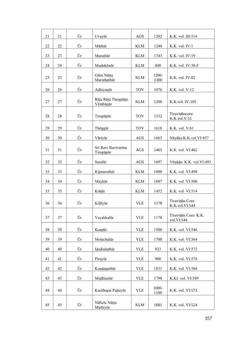
357
21 21 Ūr Uvayūr AGS 1202 K.K. vol. III:314
22 22 Ūr Māthūr KLM 1240 K.K. vol. IV:1
23 23 Ūr Maruthūr KLM 1743 K.K. vol. IV:19
24 24 Ūr Mudukōnūr KLM 800 K.K. vol. IV:38-F
25 25 Ūr Gūru Nāṭṭu Maruthathūr
KLM1200-1300
K.K. vol. IV:82
26 26 Ūr Adhiyaṉūr TOV 1076 K.K. vol. V:12
27 27 Ūr Rāja Rāja Theṉṉāṭṭu Vēmbāṉūr
KLM 1200 K.K.vol. IV:105
28 28 Ūr Tirupāpūr TOV 1532 Tiruviḍāncore: K.K.vol.V:51
29 29 Ūr Thēṉṉūr TOV 1618 K.K. vol. V:61
30 30 Ūr Vāriyūr AGS 1663 Nāyāka:K.K.vol.VI:457
31 31 Ūr Sri Ravi RavivarmaTirupāpūr
AGS 1465 K.K. vol. VI:462
32 32 Ūr Saralūr AGS 1697 Vēṇāḍu: K.K. vol.VI:493
33 33 Ūr Kiḻmaruthūr KLM 1000 K.K. vol. VI:498
34 34 Ūr Maykūr KLM 1887 K.K. vol. VI:500
35 35 Ūr Kōṭṭūr KLM 1452 K.K. vol. VI:514
36 36 Ūr Kiḷḷīyūr VLE 1178Tiruviḍān Core: K.K.vol.VI:544
37 37 Ūr Vayakkalūr VLE 1178 Tiruviḍān Core: K.K. vol.VI:544
38 38 Ūr Kuṇḍūr VLE 1500 K.K. vol. VI:546
39 39 Ūr Molachalūr VLE 1700 K.K. vol. VI:564
40 40 Ūr Iḍaikulathūr VLE 923 K.K. vol. VI:572
41 41 Ūr Pirayūr VLE 900 K.K. vol. VI:576
42 42 Ūr Kuṇḍaṉathūr VLE 1831 K.K. vol. VI:584
43 43 Ūr Miḍālamūr VLE 1798 K.KI. vol. VI:589
44 44 Ūr Karithuṟai Paḻaiyūr VLE 1000-1100
K.K. vol. VI:573
45 45 Ūr Nāñchi Nāṭṭu Mathiyūr
KLM 1681 K.K. vol. VI:524
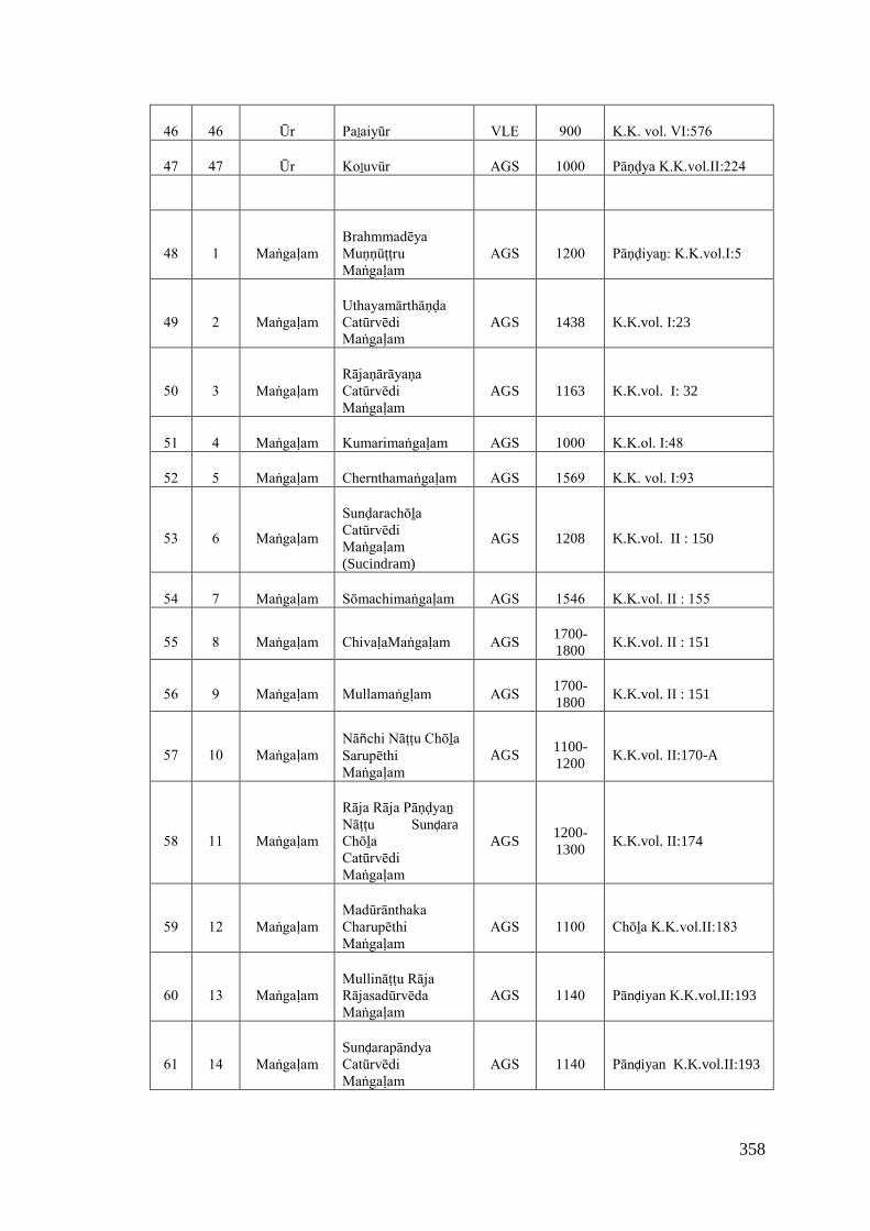
358
46 46 Ūr Paḻaiyūr VLE 900 K.K. vol. VI:576
47 47 Ūr Koḻuvūr AGS 1000 Pāṇḍya K.K.vol.II:224
48 1 Maṅgaḷam Brahmmadēya Muṇṇūṭṭru Maṅgaḷam
AGS 1200 Pāṇḍiyaṉ: K.K.vol.I:5
49 2 Maṅgaḷam Uthayamārthāṇḍa Catūrvēdi Maṅgaḷam
AGS 1438 K.K.vol. I:23
50 3 Maṅgaḷam Rājaṇārāyaṇa Catūrvēdi Maṅgaḷam
AGS 1163 K.K.vol. I: 32
51 4 Maṅgaḷam Kumarimaṅgaḷam AGS 1000 K.K.ol. I:48
52 5 Maṅgaḷam Chernthamaṅgaḷam AGS 1569 K.K. vol. I:93
53 6 Maṅgaḷam
Sunḍarachōḻa Catūrvēdi Maṅgaḷam (Sucindram)
AGS 1208 K.K.vol. II : 150
54 7 Maṅgaḷam Sōmachimaṅgaḷam AGS 1546 K.K.vol. II : 155
55 8 Maṅgaḷam ChivaḷaMaṅgaḷam AGS 1700-1800
K.K.vol. II : 151
56 9 Maṅgaḷam Mullamaṅgḷam AGS 1700-1800
K.K.vol. II : 151
57 10 Maṅgaḷam Nāñchi Nāṭṭu Chōḻa Sarupēthi Maṅgaḷam
AGS1100-1200
K.K.vol. II:170-A
58 11 Maṅgaḷam
Rāja Rāja Pāṇḍyaṉ Nāṭṭu SunḍaraChōḻa Catūrvēdi Maṅgaḷam
AGS1200-1300
K.K.vol. II:174
59 12 Maṅgaḷam Madūrānthaka Charupēthi Maṅgaḷam
AGS 1100 Chōḻa K.K.vol.II:183
60 13 Maṅgaḷam Mullināṭṭu Rāja Rājasadūrvēda Maṅgaḷam
AGS 1140 Pānḍiyan K.K.vol.II:193
61 14 Maṅgaḷam Sunḍarapāndya Catūrvēdi Maṅgaḷam
AGS 1140 Pānḍiyan K.K.vol.II:193
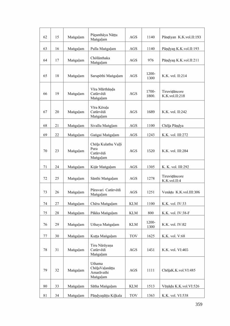
359
62 15 Maṅgaḷam Pūṟanthāya Nāṭṭu Maṅgaḷam
AGS 1140 Pānḍiyan K.K.vol.II:193
63 16 Maṅgaḷam Pulla Maṅgaḷam AGS 1140 Pāṇḍyaṉ K.K.vol.II:193
64 17 Maṅgaḷam Chōlānthaka Maṅgaḷam
AGS 976 Pāṇḍyaṉ K.K.vol.II:211
65 18 Maṅgaḷam Sarupēthi Maṅgaḷam AGS 1200-1300
K.K. vol. II:214
66 19 Maṅgaḷam Vīra Mārthāṇḍa Catūrvēdi Maṅgaḷam
AGS1700-1800.
Tiruviḍāncore K.K.vol.II:218
67 20 Maṅgaḷam Vīra Kēraḷa Catūrvēdi Maṅgaḷam
AGS 1689 K.K. vol. II:242
68 21 Maṅgaḷam Sivallu Maṅgḷam AGS 1100 Chōḻa Pāṇḍya
69 22 Maṅgaḷam Gaṅgai Maṅgaḷam AGS 1243 K.K. vol. III:272
70 23 Maṅgaḷam
Chōḻa Kulathu Vaḷḷi PuraCatūrvēdi Maṅgaḷam
AGS 1520 K.K. vol. III:284
71 24 Maṅgaḷam Kiḻār Maṅgaḷam AGS 1305 K. K. vol. III:292
72 25 Maṅgaḷam Sānthi Maṅgaḷam AGS 1278 Tiruviḍāncore K.K.vol.II:4
73 26 Maṅgaḷam Pūravari CatūrvēdiMaṅgaḷam
AGS 1251 Venāḍu K.K.vol.III:306
74 27 Maṅgaḷam Chēra Maṅgaḷam KLM 1100 K.K. vol. IV:33
75 28 Maṅgaḷam Pākka Maṅgaḷam KLM 800 K.K. vol. IV:38-F
76 29 Maṅgaḷam Uthaya Maṅgaḷam KLM 1200-1300
K.K. vol. IV:82
77 30 Maṅgaḷam Kuṭṭa Maṅgaḷam TOV 1625 K.K. vol. V:68
78 31 Maṅgaḷam Tiru Nārāyaṇa Catūrvēdi Maṅgaḷam
AGS 1451 K.K. vol. VI:465
79 32 Maṅgaḷam
UthamaChōḻaVaḷanāṭṭu Amarāvathi Maṅgaḷam
AGS 1111 ChōḻaK.K.vol.VI:485
80 33 Maṅgaḷam Sātha Maṅgaḷam KLM 1513 Vēṇāḍu K.K.vol.VI:526
81 34 Maṅgaḷam Pāṇḍyaṉāṭṭu Kiḻkala TOV 1363 K.K. vol. VI:538
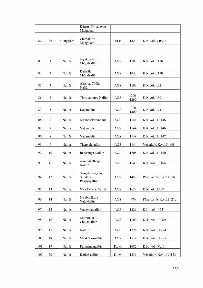
360
Kūṭṭṟu Chivaḷavaṉ Maṅgaḷam
82 35 Maṅgaḷam Chithakūru Maṅgaḷam
VLE 1829 K.K. vol. VI:582
83 1 Nallūr Jayakoṇḍa ChōḻaNallūr
AGS 1100 K.K.vol. I:116
84 2 Nallūr Kalikāla ChōḻaNallūr
AGS 1043 K.K.vol. I:120
85 3 Nallūr Aḻakiya Chōḻa Nallūr
AGS 1163 K.K.vol. I:32
86 4 Nallūr Thiruvaraṅga Nallūr AGS 1200-1300
K.K.vol. I:60
87 5 Nallūr Dayanallūr AGS 1200-1300
K.K.vol. I:74
88 6 Nallūr Nirubasēkaranallūr AGS 1144 K.K.vol. II : 146
89 7 Nallūr Vaḷanallūr AGS 1144 K.K.vol. II : 146
90 8 Nallūr Vaḍanallūr AGS 1149 K.K.vol. II : 147
91 9 Nallūr Theṉvaḷanallūr AGS 1144 Vēṇāḍu K.K.vol.II:148
92 10 Nallūr Iraṇasiṅga Nallūr AGS 1208 K.K.vol. II : 150
93 11 Nallūr Anumakēthaṉa Nallūr
AGS 1548 K.K. vol. II: 154
94 12 Nallūr Seṅgala KuṟichiSunḍara Pāṇḍyaṉallūr
AGS 1450 Pānḍiyan K.K.vol.II:165
95 13 Nallūr Vīra Kēraḷa Nallūr AGS 1629 K.K.vol. II:187
96 14 Nallūr Nirubasēkara VaḷaNallūr
AGS 976 Pānḍiyan K.K.vol.II:212
97 15 Nallūr Vaḍavaḷanallūr AGS 1226 K.K. vol. II:251
98 16 Nallūr MummuḍiChōḻaNallūr
AGS 1100 K..K. vol. II:259
99 17 Nallūr Nallūr AGS 1726 K.K. vol. III:274
100 18 Nallūr Vīrakēsarinallūr AGS 1514 K.K. vol. III:285
101 19 Nallūr Raṇasiṅganallūr KLM 1682 K.K. vol. IV:10
102 20 Nallūr Kōthai nallūr KLM 1236 Vēṇāḍu K.K.vol.IV:123
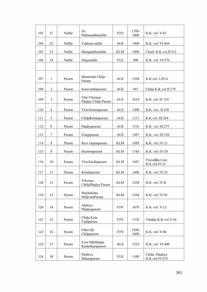
361
103 21 Nallūr SriPathmanābanallūr
TOV1700-1800
K.K. vol. V:67
104 22 Nallūr Vakkani nallūr AGS 1000 K.K. vol. VI:464
105 23 Nallūr Maṅgaḷathunallūr KLM 1000 Cherā K.K.vol.II:512
106 24 Nallūr Siṅganallūr VLE 900 K.K. vol. VI:576
107 1 PuramMummuḍi Chōḻa Puram
AGS 1558 K.K.vol. I:29-A
108 2 Puram Karavanthapuram AGS 947 Chōḻa K.K.vol.II:179
109 3 PuramĀlūr Vikrama Pāṇḍya Chōḻa Puram
AGS 1619 K.K. vol. II: 235
110 4 Puram Tiruvikramapuram AGS 1300 K.K. vol.. II:250
111 5 Puram ChōḻaKēraḷapuram AGS 1217 K.K.vol. III:264
112 6 Puram Pāṇḍyapuram AGS 1516 K.K. vol. III:275
113 7 Puram Vaṅgipuram AGS 1487 K.K. vol. III:320
114 8 Puram Ravi vaṉmapuram KLM 1689 K.K. vol. IV:11
115 9 Puram Brammapuram KLM 1743 K.K. vol. IV:19
116 10 Puram Vīra Kēraḷapuram KLM 1607 Tiruviḍān Core K.K.vol.IV:21
117 11 Puram Kēraḷapuram KLM 1606 K.K. vol. IV:25
118 12 PuramVikramaChōḻaPāṇḍya Puram
KLM 1259 K.K. vol. IV:8
119 13 PuramMachakōṭṭu MuḍvamPuram
KLM 1594 K.K. vol. IV:91
120 14 PuramAḻakiya Pāṇḍyapuram
TOV 1076 K.K. vol. V:12
121 15 PuramChōḻa Kula Vaḷḷipuram
TOV 1524 Vēṇāḍu K.K.vol.V:64
122 16 PuramEthirviḷḷi Chōḻapuram
TOV1500-1600
K.K. vol. V:66
123 17 PuramVera Mārthāṇḍa Kulasēkarapuram
AGS 1533 K.K. vol. VI:489
124 18 PuramPārthiva Sēkarapuram
VLE 1100Chōḻa -PānḍiyaK.K.vol.VI:570
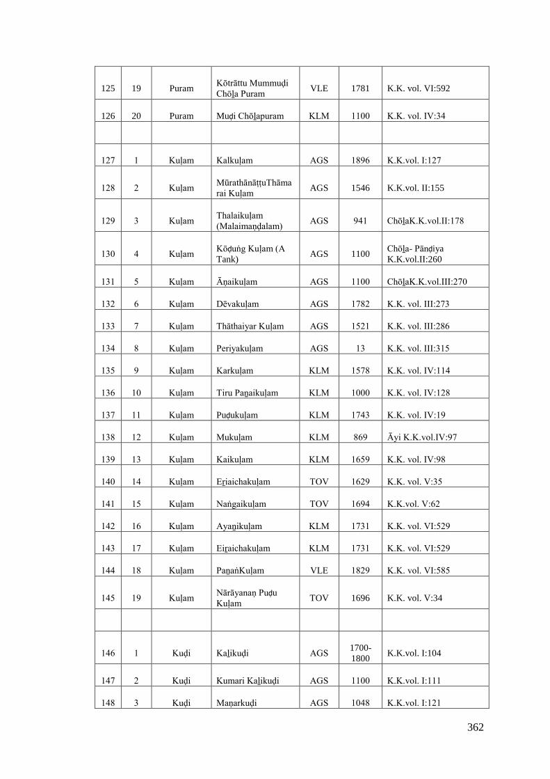
362
125 19 PuramKōtrāttu Mummuḍi Chōḻa Puram
VLE 1781 K.K. vol. VI:592
126 20 Puram Muḍi Chōḻapuram KLM 1100 K.K. vol. IV:34
127 1 Kuḷam Kalkuḷam AGS 1896 K.K.vol. I:127
128 2 KuḷamMūrathānāṭṭuThāmarai Kuḷam
AGS 1546 K.K.vol. II:155
129 3 KuḷamThalaikuḷam (Malaimaṇḍalam)
AGS 941 ChōḻaK.K.vol.II:178
130 4 KuḷamKōḍuṅg Kuḷam (A Tank)
AGS 1100Chōḻa- PānḍiyaK.K.vol.II:260
131 5 Kuḷam Āṇaikuḷam AGS 1100 ChōḻaK.K.vol.III:270
132 6 Kuḷam Dēvakuḷam AGS 1782 K.K. vol. III:273
133 7 Kuḷam Thāthaiyar Kuḷam AGS 1521 K.K. vol. III:286
134 8 Kuḷam Periyakuḷam AGS 13 K.K. vol. III:315
135 9 Kuḷam Karkuḷam KLM 1578 K.K. vol. IV:114
136 10 Kuḷam Tiru Paṉaikuḷam KLM 1000 K.K. vol. IV:128
137 11 Kuḷam Puḍukuḷam KLM 1743 K.K. vol. IV:19
138 12 Kuḷam Mukuḷam KLM 869 Āyi K.K.vol.IV:97
139 13 Kuḷam Kaikuḷam KLM 1659 K.K. vol. IV:98
140 14 Kuḷam Eṟiaichakuḷam TOV 1629 K.K. vol. V:35
141 15 Kuḷam Naṅgaikuḷam TOV 1694 K.K.vol. V:62
142 16 Kuḷam Ayaṉikuḷam KLM 1731 K.K. vol. VI:529
143 17 Kuḷam Eiṟaichakuḷam KLM 1731 K.K. vol. VI:529
144 18 Kuḷam PaṉaṅKuḷam VLE 1829 K.K. vol. VI:585
145 19 KuḷamNārāyanaṇ PuḍuKuḷam
TOV 1696 K.K. vol. V:34
146 1 Kuḍi Kaḻikuḍi AGS 1700-1800
K.K.vol. I:104
147 2 Kuḍi Kumari Kaḻikuḍi AGS 1100 K.K.vol. I:111
148 3 Kuḍi Maṇarkuḍi AGS 1048 K.K.vol. I:121
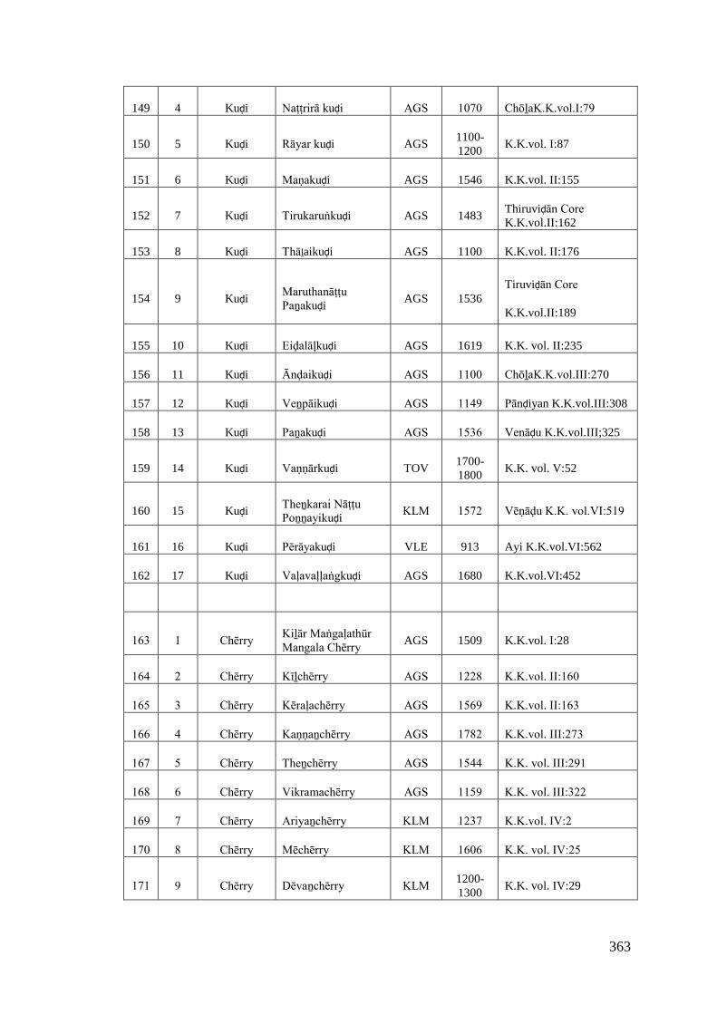
363
149 4 Kuḍi Naṭṭrirā kuḍi AGS 1070 ChōḻaK.K.vol.I:79
150 5 Kuḍi Rāyar kuḍi AGS1100-1200
K.K.vol. I:87
151 6 Kuḍi Maṇakuḍi AGS 1546 K.K.vol. II:155
152 7 Kuḍi Tirukaruṅkuḍi AGS 1483Thiruviḍān Core K.K.vol.II:162
153 8 Kuḍi Thāḻaikuḍi AGS 1100 K.K.vol. II:176
154 9 KuḍiMaruthanāṭṭu Paṉakuḍi
AGS 1536Tiruviḍān Core
K.K.vol.II:189
155 10 Kuḍi Eiḍalāļkuḍi AGS 1619 K.K. vol. II:235
156 11 Kuḍi Ānḍaikuḍi AGS 1100 ChōḻaK.K.vol.III:270
157 12 Kuḍi Veṉpāikuḍi AGS 1149 Pānḍiyan K.K.vol.III:308
158 13 Kuḍi Paṉakuḍi AGS 1536 Venāḍu K.K.vol.III;325
159 14 Kuḍi Vaṇṇārkuḍi TOV1700-1800
K.K. vol. V:52
160 15 KuḍiTheṉkarai NāṭṭuPoṉṉayikuḍi
KLM 1572 Vēṇāḍu K.K. vol.VI:519
161 16 Kuḍi Pērāyakuḍi VLE 913 Ayi K.K.vol.VI:562
162 17 Kuḍi Vaḷavaḷḷaṅgkuḍi AGS 1680 K.K.vol.VI:452
163 1 Chērry Kiḻār Maṅgaḷathūr Mangala Chērry
AGS 1509 K.K.vol. I:28
164 2 Chērry Kīḻchērry AGS 1228 K.K.vol. II:160
165 3 Chērry Kēraḷachērry AGS 1569 K.K.vol. II:163
166 4 Chērry Kaṇṇaṉchērry AGS 1782 K.K.vol. III:273
167 5 Chērry Theṉchērry AGS 1544 K.K. vol. III:291
168 6 Chērry Vikramachērry AGS 1159 K.K. vol. III:322
169 7 Chērry Ariyaṉchērry KLM 1237 K.K.vol. IV:2
170 8 Chērry Mēchērry KLM 1606 K.K. vol. IV:25
171 9 Chērry Dēvaṉchērry KLM 1200-1300
K.K. vol. IV:29
364
172 10 ChērryKōthinallūr Kīḻchērry
KLM 1172Tiruviḍān Core K.K.vol.IV:49
173 11 Chērry Kakaṉachērry KLM 1604 K.K. vol. IV:52
174 12 Chērry Villichērry TOV 1694 K.K. vol. V:62
175 13 Chērry Maṅgaḷachērry AGS 1451 K.K. vol. VI:465
176 14 Chērry Vaḍachērry AGS 1451 K.K. vol. VI:465
177 15 Chērry Kaviyalūr Mēchērry VLE 1782 K.K. vol. VI:595
178 1 Dēsam Thiruvaṭṭārudēsam AGS 1700-1800
K.K.vol. II:131
179 2 Dēsam Nayinārdēsam AGS 1548 K.K. vol. II:154
180 3 Dēsam Akkaraidēsam KLM 1604 K.K. vol. IV:102
181 4 Dēsam Mērudēsam KLM 1315 Tiruviḍān Core K.K. vol.IV:22
182 5 Dēsam Malaikōḍudēsam KLM 1606 K.K.vol. IV:26
183 6 Dēsam
Parākirama Maṅgaḷa Dēsam
KLM 1606 K.K. vol. IV:27
184 7 Dēsam Mēlaṅkōḍudēsam KLM 1700-1800
K.K. vol. IV:61
185 8 Dēsam Kaḻai kuṭṭadēsam KLM 1700-1800
K.K. vol. IV:83
186 9 Dēsam Paraisālaidēsam KLM 1600-1700
K.K. vol. IV:87
187 10 Dēsam Perumāṉ Kuḻidēsam TOV 1581 K.K. vol. V:73
188 11 Dēsam Neiyūrdēsam KLM 1730 Tiruviḍāncore K.K.vol.VI:521
189 12 Dēsam Pālūrdēsam VLE 1768 K.K. vol. VI:593
190 13 DēsamKuṭṭa Maṅgaḷadēsam
KLM1600-1700
K.K . vol. IV:88
191 1 Kōḍu Tiru Kaṇaṇkōḍu KLM 1100 K.K.vol. IV:105-A
192 2 Kōḍu Kuḻikōḍu KLM 1689 K.K. vol. IV: 11
365
193 3 Kōḍu Karinaṅkōḍu KLM 1743 K.K. vol. IV:19
194 4 Kōḍu Pālakōḍu KLM 1315 Tiruviḍāncore K.K.vol.IV:22
195 5 Kōḍu Pākōḍu KLM 1315 Tiruviḍāncore K.K.vol.IV:22
196 6 Kōḍu Mēla Parakōḍu KLM 1600 K.K. vol. VI:509
197 7 Kōḍu Maruthaṅkōḍu VLE 1500 K.K. vol. VI:546
198 8 KōḍuKōthanallūr Kalakōḍu
VLE 1600 K.K. vol. VI:548
199 9 Kōḍu Iḻiyalkōḍu VLE 977 K.K. vol. VI:566
200 10 Kōḍu Paraikōḍu VLE 1756 K.K.vol.VI:588
201 11 Kōḍu Tiruvidānkōḍu TOV 1635 K.K.vol. V:2
202 12 Kōḍu Kaniñjakōḍu KLM 1727 K.K. vol. IV:102
203 1 Karai Vaikaikarai AGS 1045 K.K. vol. I:119
204 2 Karai Vaḍakarai AGS 1483 K.K.vol. II:162
205 3 Karai Paravaikarai AGS1700-1800
Pānḍiyan K.K.vol.II:171
206 4 Karai Aruvikkarai KLM 1240 K.K. vol. IV:1
207 5 Karai Kaṭṭukarai KLM 1534 K.K.vol.IV:135
208 6 Karai Maṇalikarai KLM 1659 K.K.vol. IV:98
209 7 Karai Kaḍukarai TOV 1559 K.K. vol. V:49
210 8 Karai Theṉkarai AGS 1800 K.K. vol. VI:454
211 9 Karai Maṇakarai KLM 1710 K.K.vol.VI:534
212 10 Karai Tirukaḍakarai VLE 1364 K.K. vol. VI:550
213 11 Karai Tirunandhikarai VLE 1756 K.K. Vol. VI:588
214 1 Thuṟai Pūlāṉthuṟai AGS 1700-1800
KK.vol. I:103
215 2 Thuṟai Ēīḻakaṉthuṟai AGS 1000 Pāṇḍyaṉ
216 3 Thuṟai Eiḍathuṟai AGS 1700-1800
K.K. vol.. II:233
366
217 4 Thuṟai Kōḍunthuṟai TOV 1100-1200
K.K. vol. V:11
218 5 Thuṟai Ālathuṟai TOV 1705 K.K.vol. V:21
219 6 ThuṟaiKēsavaṉ Puthaṉthuṟai
AGS 1894 K.K. vol. VI:470
220 7 Thuṟai Muṭṭamthuṟai AGS 1525 Vēṇāḍu K.K.vol.VI:491
221 8 Thuṟai Irukaṉthuṟai AGS 1536 Tiruvidāncore K.K.vol.II:189
222 1 Kuṟichi Maḍilkuṟichi AGS 1042 K.K.vol. I:117
223 2 Kuṟichi Maṇavāḷakuṟichi KLM 1727 K.K. vol. IV:102
224 3 Kuṟichi Maṇṇaikuṟichi KLM 1743 K.K. vol. IV:19
225 4 Kuṟichi Muthalakuṟichi KLM 1607 Tiruvidāncore K.K.vol.IV:21
226 5 KuṟichiKaḍigaipaṭṭaṇam Tirunārāyaṇār Kuṟichi
KLM 1810 Vēṇāḍu K.K.vol.VI:522
227 6 Kuṟichi Pullāṅkuṟichi AGS 1606 K.K. vol. VI:474
228 1 Viḷai Vakkaṇaviḷai TOV 1673 K.K. vol. : V:32
229 2 Viḷai Puḷiyaṉviḷai TOV 1673 K.K. vol. V:32
230 3 Viḷai Kaṉiyaṉviḷai TOV 1673 K.K. vol. V:32
231 4 ViḷaiTheṉkompukōvil viḷai
AGS 1824 K.K. vol. VI:458
232 5 Viḷai Kalluviḷai VLE 1829 K.K. vol. VI:580
233 6 Viḷai Pēyaḍiviḷai VLE 1900 K.K. vol. VI:586
234 1 Ēri Kīḻkarai Puthaṉēri AGS 1100 Chola K.K.vol. II:183
235 2 Ēri Saṅgaraṉēri AGS 1536 Tiruviḍāncore K.K.vol.II:189
236 3 Ēri Vīrakēraḷa Ēri TOV 1559 K.K. vol. V:49
237 4 Ēri Puthēri TOV 1743 K.K. vol. VI:537

367
238 1 Paḷḷi Malayanāṭṭu Kāṉaiyar paḷḷi
AGS900-1000
Pāṇḍyaṉ K.K.vol.II:180
239 2 PaḷḷiTiruneḍum Pārai Kāṭṭam paḷḷi
VLE 1000 K.K. vol. VI:551
240 3 PaḷḷiTirunaruṅkoṇḍaimēlaipaḷḷi
VLE 1000 K.K. vol. VI:557
241 4 Paḷḷi Kēraļthu Chērapaḷḷi KLM 1600-1700
K.K. vol. IV:84
242 1 Paṭṭaṇam Kaḍiya Paṭṭaṇam KLM 1300 K.K. vol. IV:37
243 2 Paṭṭaṇam Kaḍigai Paṭṭaṇam KLM 1139 K.K. vol. IV:38
244 3 PaṭṭaṇamGūrunāṭṭu Kaikaṭṭiya Paṭṭaṇam
TOV 1623 K.K. vol. V:59
245 4 PaṭṭaṇamSri Kalachēya Paṭṭaṇam
KLM 1000 K.K. vol. VI:501
246 1 Puduvūr Ravi Puduvūr TOV 1705 KK.vol. V:21
247 2 Puduvūr Puduvūr KLM 1100 K.K. vol. IV:105-A
248 3 PuduvūrCheṇpakarāmaṇ Puduvūr
TOV 1740 K.K. vol. V:42
249 4 PuduvūrVibala Kēsava Pudvūr
KLM 1750 K.K. vol. VI:535
250 1 Kōṇam Charaikkōṇam KLM 1710 K.K. vol. VI:530
251 2 Kōṇam AlivaṉkōḍuKōṇam VLE 1781 K.K. vol. VI:590
252 3 Kōṇam Kōṇam KLM 1783 K.K. vol. VI:498
253 4 KōṇamPrapam KōḍuKōṇam
KLM 1897 K.K. vol. VI:511
254 1 Āru MalaimaṇḍalathuTiruvaṭṭāru
AGS 1581 K.K.vol. II : 156
255 2 Āru Kōṭṭāru AGS 1100 ChōḻaK.K.vol.II:182
256 3 Āru Tiru Kōṭṭāru AGS 1100 Chōḻa-Pāṇḍya K.K.vol.III:261
368
257 1 Pērūr Kīḻāmpērūr KLM 1607 Tiruviḍān Core K.K. v ol.IV:21
258 2 Pērūr Kīḻāmpērūr AGS 1465 K.K. vol. VI:462
259 3 Pērūr Pērūr KLM 1452 K.K. vol. VI:514
260 1 Pādi Raṇasiṅgapāḍi KLM 1484 K.K. vol. IV:36
261 2 Pādi Vēmpāḍi KLM 1753 K.K. vol. IV:9
262 3 Pādi Thiruvāi Pāḍi KLM 1200 K.K.vol. IV :105
263 1 AgaramKaruppukōṭṭai Agaram
AGS 1461 K.K.vol. I:35
264 2 AgaramChēnthaṉchērry Agaram
AGS 1520 K.K. vol. III:277
265 3 AgaramKōthachapiḷḷai Agaram
AGS 1609 K.K. vol. III:326
266 1 Kumari Kaṉyākumari AGS 1500-1600
Vijaya Nagar K.K.vol.I:84
267 2 Kumari Kumari AGS 1045 K.K.vol. I:119
268 3 KumariMurathānāṭṭu Kumari
AGS 1546 K.K.vol.II:155
269 1 Puliyūr Puliyūr AGS 1038 K.K. vol. I:107
270 2 Puliyūr Tirupā Puliyūr KLM 1604 Tiruvidān Core K.K.vol.IV:39
271 3 Puliyūr Perumpaṭṭra Puliyūr KLM 1709 K.K. vol. IV:38-E
272 1 KāḍuKumaranallūr Maṅgāṭṭūr
AGS1700-1800
K.K.vol. II : 132
273 2 Kāḍu Vaḍavathu Kāttūr TOV 1673 K.K. vol. V:32
274 1 Vilāgam Paṉainḍar Viḷāgam TOV 1705 K.K. vol. V:21
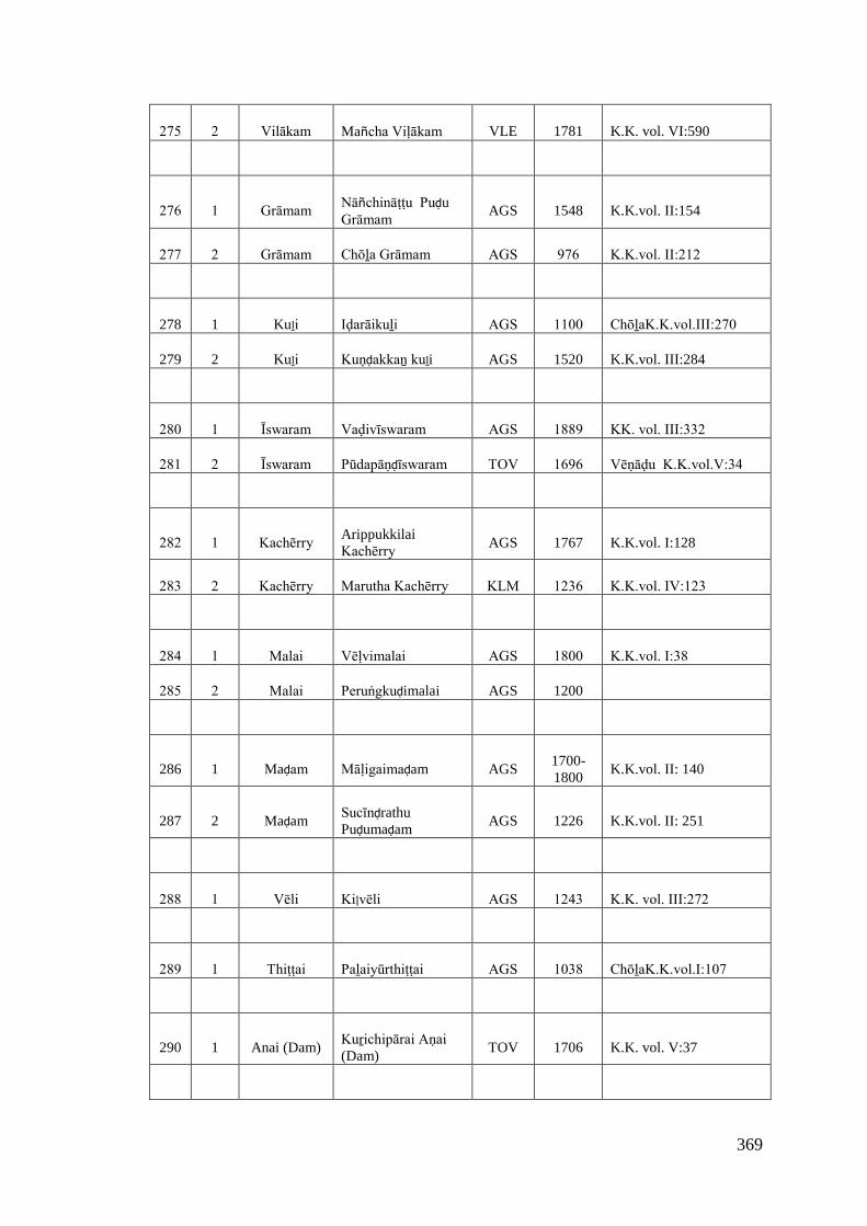
369
275 2 Vilākam Mañcha Viḷākam VLE 1781 K.K. vol. VI:590
276 1 Grāmam Nāñchināṭṭu PuḍuGrāmam
AGS 1548 K.K.vol. II:154
277 2 Grāmam Chōḻa Grāmam AGS 976 K.K.vol. II:212
278 1 Kuḻi Iḍarāikuḻi AGS 1100 ChōḻaK.K.vol.III:270
279 2 Kuḻi Kuṇḍakkaṉ kuḻi AGS 1520 K.K.vol. III:284
280 1 Īswaram Vaḍivīswaram AGS 1889 KK. vol. III:332
281 2 Īswaram Pūdapāṇḍīswaram TOV 1696 Vēṇāḍu K.K.vol.V:34
282 1 Kachērry ArippukkilaiKachērry
AGS 1767 K.K.vol. I:128
283 2 Kachērry Marutha Kachērry KLM 1236 K.K.vol. IV:123
284 1 Malai Vēḷvimalai AGS 1800 K.K.vol. I:38
285 2 Malai Peruṅgkuḍimalai AGS 1200
286 1 Maḍam Māḷigaimaḍam AGS1700-1800
K.K.vol. II: 140
287 2 MaḍamSucīnḍrathuPuḍumaḍam
AGS 1226 K.K.vol. II: 251
288 1 Vēli Kiļvēli AGS 1243 K.K. vol. III:272
289 1 Thiṭṭai Paḻaiyūrthiṭṭai AGS 1038 ChōḻaK.K.vol.I:107
290 1 Anai (Dam)Kuṟichipārai Aṇai (Dam)
TOV 1706 K.K. vol. V:37
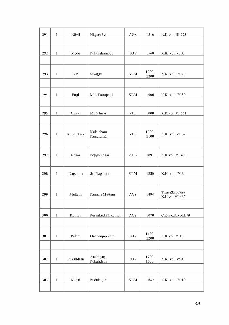
370
291 1 Kōvil Nāgarkōvil AGS 1516 K.K.vol. III:275
292 1 Mēdu Pulithalaimēḍu TOV 1568 K.K. vol. V:50
293 1 Giri Sivagiri KLM1200-1300
K.K. vol. IV:29
294 1 Paṭṭi Mulaikārapaṭṭi KLM 1906 K.K. vol. IV:30
295 1 Chiṟai Muñchiṟai VLE 1000 K.K.vol. VI:561
296 1 Kuṇḍrathūr Kulaichaūr Kuṉḍrathūr
VLE1000-1100
K.K. vol. VI:573
297 1 Nagar Poḻigainagar AGS 1891 K.K.vol. VI:469
298 1 Nagaram Sri Nagaram KLM 1259 K.K. vol. IV:8
299 1 Muṭṭam Kumari Muṭṭam AGS 1494 Tiruviḍān Cōre K.K.vol.VI:487
300 1 Kombu Peruṅkuḍikīḻ kombu AGS 1070 ChōḻaK.K.vol.I:79
301 1 Pulam Onanañjapulam TOV1100-1200
K.K.vol. V:15
302 1 Pukaliḍam Añchiṉāṉ Pukaliḍam
TOV1700-1800.
K.K. vol. V:20
303 1 Kaḍai Pudukaḍai KLM 1682 K.K. vol. IV:10
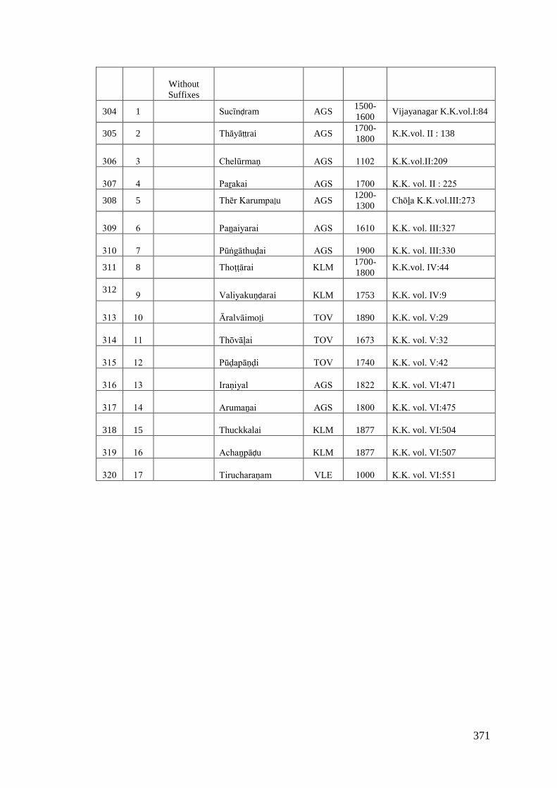
371
WithoutSuffixes
304 1 Sucīnḍram AGS1500-1600
Vijayanagar K.K.vol.I:84
305 2 Thāyāṭṭrai AGS1700-1800
K.K.vol. II : 138
306 3 Chelūrmaṇ AGS 1102 K.K.vol.II:209
307 4 Paṟakai AGS 1700 K.K. vol. II : 225
308 5 Thēr Karumpaḻu AGS1200-1300
Chōḻa K.K.vol.III:273
309 6 Paṉaiyarai AGS 1610 K.K. vol. III:327
310 7 Pūṅgāthuḍai AGS 1900 K.K. vol. III:330
311 8 Thoṭṭārai KLM 1700-1800
K.K.vol. IV:44
3129 Valiyakuṇḍarai KLM 1753 K.K. vol. IV:9
313 10 Āralvāimoḻi TOV 1890 K.K. vol. V:29
314 11 Thōvāḷai TOV 1673 K.K. vol. V:32
315 12 Pūḍapāṇḍi TOV 1740 K.K. vol. V:42
316 13 Iraṇiyal AGS 1822 K.K. vol. VI:471
317 14 Arumaṉai AGS 1800 K.K. vol. VI:475
318 15 Thuckkalai KLM 1877 K.K. vol. VI:504
319 16 Achaṉpāḍu KLM 1877 K.K. vol. VI:507
320 17 Tirucharaṇam VLE 1000 K.K. vol. VI:551

372
Bibliography
Primary Sources
Annual Report on Indian Epigraphy (33 volumes), Archaeological Survey of India.
Epigraphia Indica (48 volumes), Archaeological Survey of India.
Kalveṭṭu – Journal of Tamil Nadu State Department of Archaeology, Chennai.
Kaṇyākumari Māvaṭṭa Kalveṭṭukaḷ, (Vols. I to VI), Tamil Nadu State Department of
Archaeology, Chennai.
Pāṉḍyar Chepēḍugaḷ Paththu (Pandya Copper Plates Ten), International Tamil Research Centre,
Chennai, 1999.
South Indian Inscriptions (25 volumes), Archaeological Survey of India.
Travancore Archaeological Series (7 volumes), Trivandrum, 1910-1938.
Varalāṟu – Journal of M. Rajamanickanar Historical Research Centre, Tiruchirapalli.
Ᾱvaṉam – Journal of Tamil Nadu Archaeological Society, Thanjavur.
Journal
Āivukalañchiyam, Journal of History and Cultural Centre of Kanyakumari, Nagarkoil, 1998.
Proceedings of Indian History Congress 73rdSession, Mumbai, 2012.
Proceedings of South Indian History Congress, XXXII, Annual Session: Chennai, 2012.
Social Scientist, vol.36, New Delhi, 2008.
Web-site
French Institute of Pondicherry, et.al.2008. Historical Atlas of South India, htt://www.if
pindia.org/hatlas/

373
Secondary Sources
Aiya, V.Nagam, The Travancore State Manual, 3 vols. Asian Educational Services, Madras,1989.
Aiyar, A. Sathyanatha, History of Nayaks of Madurai, University of Madras, Madras, 1980.
Aiyar, K.V.Subramanya, Travancore Archaeological Series, Vol.-IV; part.II; CulturalPublication Department, Thiruvananthapuram, 1999.
Balasubramaniyan, C., A Study of the Literature of the Chera Country, University of Madras,Madras, 1980.
Bhagavathi, K., Ilakkiyathil Ūrpeyarkaḷ, International Institutes of Tamil Studies, Madras, 1984.
Bhargava, Gopal, (ed.), Encyclopedia of Art and Culture in India, (Kerala – In 27 Volumes)Vol.-3, ISHA books, Delhi, 2008.
Bhatt, S.C., (ed.), The Encyclopaedic District Gazetteers of India, Southern Zone, vol.2, GyanPublishing House, New Delhi, 1997.
Burton Stein, Essays on South India, Vikas Publishing House, New Delhi,1975.
Burton Stein, Peasant State and Society in Medieval South India, Oxford University Press,Delhi, 1994.
Caldwell, Bishop R., A History of Tinnevelly, Asian Educational Services, New Delhi, 1982.
Chakravarti, Ranabir (ed.,), Trade in Early India, Oxford University Press, New Delhi, 2001.
Champakalakshmi, R., Trade, Ideology and Urbanization South India 300 BC to CE 1300,Oxford University Press, New Delhi, 1996.
Champakalakshmi, R., (et. al.,), State and Society in Pre-modern South India, Cosmopublications, Trissure, 2002.
Chopra, P.N., (ed.), The Gazetteer of India, History and Culture, (Vol.II), Ministry ofInformation and Broadcasting, Government of India, 2003.
Chopra, P.N., India Society Religion and Literature in Ancient and Medieval periods,Publication Division, New Delhi, 2008.
Das, Gurcharan, The Study of Indian Business, Merchants of Tamilagam, Penguin books, NewDelhi, 2012.
Gopalakrishnan, M., (ed.), Gazetteer of Kanyakumari District, Tamil Nadu State Government,Chennai, 1995.
374
Gopalakrishnan, S., Census of India, Provisional Population Totals, (Tamil Nadu), RegistrarGeneral and Census Commissioner, India, 2011.
Govindarajan,C., Kalveṭṭu Kalaichol Agarāthi (From CE. 7thcentury to 12th century),MaduraiKamaraj University, Madurai, 1987.
Greeshmalatha, A.P., Historical Geography of Valluvanad, Ph.D. Thesis, Calicut University,Calicut, 2008.
Gunabalan, N., Studies in the History of the Kanyakumari Region, Unpublished Ph.D., Thesis,University of Madras, Madras, 1989.
Gurukkal, Rajan and M.R. RaghavaVarier (Ed.,), Cultural History of Kerala (From the earliestto the spread of Wet rice), vol. I, Department of Cultural Publication, Government of Kerala,1999.
Gurumurthy, Seetharaman, Kaṉyākumari Māvaṭṭa Kalveṭṭukkaḷ, (Vol. VI) State Department ofArchaeology, Chennai, 2008.
Gurumurthy, Seetharaman, Kaṉyākumari Māvaṭṭa Tholliyal Kaiyēḍu, State Department ofArchaeology, Chennai, 2008.
Gurunathan,V., Saṅgakāla Arasa Varalāṟu, Tamil University, Thanjavur, 2001.
Heitzman, James, Gift of power: Lordship in an Early Indian State, New Delhi, 1997.
Immanuel, M., Kanyakumari Aspects and Architects, Historical Research & Publications Trust,Nagarcoil, 2007.
Iyengar, P.T.Srinivas, History of the Tamils – From the Earliest Times to 600 A.D., AsianEducation Services, New Delhi, 1982.
Jayakaran, S.C., Kumari Nilanīṭchi, Kālachuvaḍu Puplication, Nagarkoil, 2007.
Karashima, Noboru, South Indian History and Society: Studies from Inscription, A.D. 850-1800,Oxford University Press, New Delhi, 1984.
Karashima, Noboru, et al., Vijayanagara Rule in Tamil Country As revealed through a statisticalstudy of revenue terms in Inscriptions, Institute for the Study of Language and Cultures of Asiaand Africa, Tokyo, 1988.
Karashima, Noboru, Towards a New Formation: South Indian Society under Vijayanagara Rule,Oxford University Press, New Delhi 1992.
Karashima, Noboru, Varalāṟṟu Pōkkil Theṉṉaka Samūgam-Chōḻar-Kālam (850-1300), TamilNadu Archaeological Society, Thanjavur, 1995.

375
Kenneth R.Hall, Structure and Society in Early South India, Oxford University Press, NewDelhi, 2001.
Kesavan, K. Chitha, Kēraḷam-Ūrum-Pērum, Palakkad District, Tirukkural Publications, Chennai,2009.
Maclean, C.D., (ed.,), Maclean’s Manual of the administration of the Madras Presidency,vol.III; Asian Educational Services, New Delhi, 1989.
Mahadevan, Iravatham, Early Tamil Epigraphy from the Earliest Times to the Sixth Century AD,Cre-A, Chennai & The Department of Sanskrit and Indian Studies, Harvard University, Harvard,USA, 2003.
Mahalingam, N., Kumari Kaṉdam, In Origin of Humanity and Origin of Language, InternationalLinguistic Centre, Chennai, 1997.
Mahalingam, T.V., A Topographical List of Inscriptions in the Tamil Nadu & Kerala States,vol.V., (Kanyakumari, Madras & Madurai District), S. Chand & Company, New Delhi, 1989.
Mahalingam, T.V., South Indian Polity, University of Madras, Madras, 1967.
Malliga Pushpam, T., Kanyakumari through the Ages, Annamalai University, Annamalai Nagar,1982.
Manmathan, M.R., (ed.), Archaeology in Kerala, Past and Present, Farook CollegePublications, Kozhikode, 2007.
Mathaiyan, P., Saṅgakāla Iṇakkuḻu Samudhāyamum Uruvākkamum, Pāvai Publications, Chennai, 2004.
Mathivanan, R., Kaḍal Koṇḍa Theṉṉādumuthal Sinduveḷi Nāgarigamvarai, Sekar Publications,Chennai, 2001.
Menon, A.Sreedharan, A Survey of Kerala History, S.Viswanathan Publishers, Chennai, 2006.
Menon, A.Sreedhara, Social and Cultural History of Kerala, Sterling Publication, New Delhi,1979.
Menon, K.P.Padmanaba, “History of Kerala”, in T.K.KrishnanMenon (ed.), History of Kerala: AHistory of Kerala written in the form of notes on Visscher’s letters from Malabar, vol.I, AsianEducational Services, New Delhi,1982.
Menon, P.Shungoony, History of Travancore from the Earliest Times, Asian EducationalServices, New Delhi, 1985.
Menon, T.K.Krishnan (ed.), History of Kerala: A History of Kerala written in the form of noteson Visscher’s letters from Malabar, (4 volumes), Asian Educational Services, New Delhi, 1982.
376
Murali, S., “Tamiḻaga Sivathalaṅgaḷ”, Chadura Publications, Chennai, 2001.
Murthi, S.S.Ramachandra, A Study of Telugu Place Names (Based on inscriptiopns from theearliest to the 13th century), Agam Kala Prakashan, Delhi, 1985.
Nagarajan, Karu., Cheṅgai Māvaṭṭa Ūrpeyarkaḷ, International Institute of Tamil Studies,Chennai, 1985.
Nagasamy, R., Kaṉyākumari Māvaṭṭa Kalveṭṭukkaḷ, Vols. IV to V, Tamil Nadu State Departmentof Archaeology, Chennai, vol.III,1979.
Nair, K.Sivasankaran, Early History of Kerala Upto CE. 1500, International Centre for KeralaStudies, University of Kerala, Kariyavattam, 2010.
Nair, T.P. Sankaran Kutty, ‘Pre-1857 Upheavals in Travancore’, In, S.Gopalakrishnan (ed.), TheSouth Indian Rebellions, (Before and after 1800), Palaniyappa Brothers, Chennai, 2008.
Nakkiran, A., Paṇḍaith Tamiḻaga Nākarikamum Paṇpāḍum, Tamiḻmaṇ Pathippakam, Chennai, 2000.
Nalini, M., Historical and Cultural Geography of the Tiruchirapalli District, Tamil Nadu, Fromthe 6th century to the 17th century with special reference to Mala Nāḍu and Vaḷḷuvapāḍi-Nāḍu,Ph.D., Thesis, Bharathidasan University, Tiruchirapalli, 1998.
Nalinikumar, D., Historical Approach to the Socio-Economic conditions of KanyakumariDistrict (1956-1986), Ph.D.Thesis, University of Madras, Chennai, 2001.
Nambiar, P.K. (ed.), Census of India-1961, vol.IX, (Madras), part, xi-D,The Manager ofPublication, New Delhi, 1968.
Narayanan, M.G.S., Political and Social conditions of Kerala under the Kulasekara empirec.800-1124 CE, Ph.D. Thesis, University of Kerala, Thiruvananthapuram, 1972.
Narayanan, M.G.S., Perumals of Kerala:Political and Social Conditions of Kerala under theCēra Perumals of Makotai (A.D.800.-1124), Xavier Press, Calicut, 1996.
Natana. Kasinathan, KaṉyākumariKalveṭṭukkaḷ, Vols. I to III, Tamil Nadu State Department ofArchaeology, Chennai, 1972.
Nilavathi, C., Tañjāvūr Vaṭṭāra Varalāṟṟu Nilaviyalum Samudāyamum (c.900 – 1400 CE),Ph.D., Thesis, Tamil Univerisity, Thanjavur, 2001.
Pandian, M.S.S., The Political Economy of Agrarian Change Nāñchilnāḍu 1880-1939, SAGEPublications, New Delhi, 1990.
Pate, H.R., Tinnevelly District Gazetteers (1916), Manonmaniyam Sundaranar University,Tirunelveli, 1993.
377
Pathmanabhan, S., Ancient Jain Centres in Kanyakumari, Ᾱyvukaḻañjiyam, Nagarcoil, 1998.
Perumal, A.K., Theṇkumariyiṉ Kathai (History of Kanyakumari District), United Writers,Chennai, 2003.
Perumal,A.K., Nāñchil Vaṭṭāra Vaḻakku-Lexicon, Tamiḻiṇi, Chennai, 2004.
Perumal, A.K., Ādhikēsava-Perumāḷ-Ālayam, Tamiḻiṇi, Chennai, 2007.
Pillai, K.K., Tamiḻaka Varalārum Makkaḷum Paṇpāḍum, International Institutes of TamilStudies, Chennai, 2007.
Pillai, K.N.Sivaraja, The Chronology of the Early Tamils, Asian Educational Services, NewDelhi, 1984.
Pillai, T.K.Velu, Travancore State Manual, 2 vols., Government of Travancore, Travandrum,1938, 1940.
Pillai, T.Ponnambalam, “The Antiquity of Nanji Nadu and Shenkottah”, In D.Savarirayan(ed.),The Tamilian Antiquity, Vol.-II, Asian Educational Services, New Delhi, 1986.
Pillay, K.K. The Sucindram Temple, Adayar Kalakshetra Publication, Madras, 1953.
Pillay, K.K., Studies in Indian History (with special reference to Tamil Nadu), published byauthor, Chennai, 1979.
Punkundram, R., Paṇḍaith-Tamiḻakathil-Arasu-Uruvākkam, Ph.D., Thesis, Tamil University,Thanjavur, 1999.
Rahmani, A.R., Important bird area in India-priority sites for Conservation, Bombay NatureHistory Society, Bombay, 2004.
Rajamani, Radhika, Society in Early Historic Tamilagam, Ph.D Thesis, Jawaharlal NehruUniversity, New Delhi,1993.
Rajan, K., Archaeological Explorations in North Arcot Region, A report submitted to the TamilUniversity, Tanjavur, 1992.
Rajan, K., Archaeological Gazetteer of Tamil Nadu, Manoo Pathippakam, Thanjavur, 1997.
Rajan,K., Excavation at Mayilāḍumpāṟai – A Preliminary Report, Manoo Pathippakam,Thanjavur, 2004.
Rajan, K., Kalveṭṭiyaḷ, Manoo Pathippakam, Thanjavur, 2006.
Rajan, K., Excavation of Saṅgam Age Site-Porunthal-Report preparation, A Report submitted toCentral institute of Classical Tamil, Pondicherry University, 2012.
378
Rajavelu, S., The Historical and Cultural Geography and Ethnography of Pudukkōṭṭai Region Upto A.D.1800, Ph.D. Thesis, Tamil University, Thanjavur, 2003.
Rajayyan, K., History of Tamil Nadu (1565-1965), Madurai Publishing House, Madurai, 1978.
Rajendran, G., (ed.), Heritage of the Tamils Temple Arts, International Institute of Tamil StudiesMadras, 1985.
Rajendran, N., (ed.) Sources: Construction and Reconstruction of South Indian history, IndianCouncil of Historical Research, New Delhi, 2006.
Rajesh, K.P., Historical Geography of Kolathunadu: A Study of the Regional formation inMedieval North Kerala, Ph.D. Thesis, University of Calicut, Calicut, 2011.
Ramanarayanan, ‘Popular Gods as seen from sculpture in the Temple of Tamil Nadu’, InS.V.Subramanian, Heritage of the Tamils-Temple Arts, International Institute of Tamil Studies,Chennai, 1985.
Ramasamy, Sumathi, Fabulous Geographies, Catastrophic Histories, ‘The lost land ofLemuriya’, Permanent Block, Delhi, 2005.
Ramusack, Barbara N., The New Cambridge History of India, (III.6), The Indian Princes andtheir States, Cambridge University, New York, 2004.
Rao, Gururaja B.K., Megalithic Culture of South India, Prasaranga, University of Mysore,Mysore, 1972.
Rao, T.A. Gopinatha, Travancore Archaeological Series, 8 vols., Department of CulturalPublication, Government of Kerala, Trivandrum, 1988.
Rottler, J.P., A Dictionary Tamil and English, Part III, International Institute of Tamil Studies,Chennai, 2000.
Santhlingam, C., Thoṇḍai Maṇḍalam-Nāḍum-Ūrum, Ph.D., Thesis, Madurai Kamaraj University,Madurai, 2003.
Sastri, K.A.Nilakanta, The Pāṇḍyan Kingdom From the earliest time to the sixteenth century,Luzac and Co., London, 1929.
Sastri, K.A.Nilakanta, The Pāṇḍyan Kingdom from the earliest times to the sixteenth century,Luzac and Co, London, 1929.
Sastri, K.A.Nilakanta, History of South India: From Prehistoric Times to the fall of Vijayanagar,Oxford University Press, New Delhi, 1958.
Sastri, K.A.Nilakanta, The Cōḻas, University of Madras, Chennai, 2000.
379
Sastri, K.A.Nilakanta, Foreign Notices of South India from Megasthenes to Mahuan, Universityof Madras, Chennai, 2001.
Sastri, K.S.Ramasamy, The Tamils, The People, Their History and Culture, Vol.-I, (AnIntroduction to Tamil History and Society), Cosmo publication, New Delhi, 2002.
Sathiyanesan, V., Social Changes in Kanyakumari District (1900 – 1975 CE), A Critical studyin the perspectives of Economic History, Ph.D. Thesis, Bharathidasan University, Tiruchirapalli,1988.
Savariroyan, D., (ed.,), The Tamilian Antiquary, Asian Educational Services, 2 vols.,New Delhi,1986.
Sethupillai, R., Tamiḻagam Ūrum Pērum, Pazhaniyappa Brothers, Chennai, 1968.
Shanmugam, Kodumudi, Kumarikaṇḍam Mūḻagavillai, Arul Publication, Chennai, 2001.
Shanmugam, P., The Revenue System of the Cholas 650-1279, New Era Publications, Chennai,1987.
Shetty, K. Ashok Vardhan, (ed.), Excavations at Mangudi, Tamil Nadu State Department ofArchaeology, Chennai, 2003.
Singh, R.Y., Geography of Settlement, Rawat Publications, New Delhi, 1994.
Sridhar, T.S., (ed.), Alagankulam an Ancient Roman Port city of Tamil Nadu, Department ofArchaeology, Government of Tamil Nadu, Chennai, 2005.
Sridhar, T.S., Kalveṭṭu, Tamil Nadu State Department of Archaeology, Chennai.
Srinivasan, K.R., Temple of South India, National Book Trust India, New Delhi, 1971.
Subbarayalu, Y., Political Geography of the Chola Country, State Department of Archaeology,Chennai, 1973.
Subbarayalu, Y., The State in Medieval South India, Ph.D., Thesis, Madurai Kamaraj University,Madurai, 1976.
Subbarayalu,Y., (ed.), Tamiḻ Kalveṭṭiyalum Varalāṟum, Tamil University, Thanjavur, 2001.
Subbarayalu, Y., Tamiḻ Kalveṭṭuch Chollakarāthi, vol. I-II, Santi Sadhana Publications, Chennai,2002.
Subbarayalu, Y., Tamiḻ Kalveṭṭuch Chollakarāthi, vol. I-II, Santi Sadhana Publications, Chennai,2003.
Subbarayalu, Y., South India under the Cholas, Oxford University press, New Delhi, 2012.
380
Subramaniyam, N., Saṅgam Polity-Administration and Social Life of the Tamils, EnnesPublications, Madurai, 1980.
Tamil Lexicon, University of Madras, vol. I to VI, Madras, 1982.
Thiyagarajan, L., Historical Archaeology of the Ariyalur Region upto CE. 1817: A Study, Ph.D.,Thesis, Barathidasan University, Tiruchirapalli, 1999.
Thurston, Edgar, Castes and Tribes of Southern India, Cosmo Publications, Delhi (Reprint),vols.I-VII, 1975.
Vaithyanathan, K.S., The Ancient Geography of the Kongu Country, Kalaimagal Kalvi Nilayam,Erode, 1983.
Vasudeva Poduval, R., Travancore Inscriptions, (A Topographical list), Asian EducationalServices, New Delhi, 1990.
Vedachalam,V., Tamil ilakkiyaṅgal kalveṭṭukaḷ kāṭṭum pāṉḍya nātṭu samuthāyam paṇpāḍum (c.1000-1300CE) (Society and culture of the Pandya country as gleaned from inscriptions),Ph.D.Thesis, Madurai Kamaraj University, Madurai, 1996.
Velappan, D., Nāñchilnāḍu (History, Economy, Tradition), Rohini Publications, Nagarcoil,2000.
Veluthat, Kesavan, The Early Medieval South India, Oxford University Press, New Delhi, 2011.
Victor, M.S., Kumarikaṇḍam, Nallōr Publication, Chennai, 2007.
Vijayavenugopal, G., (ed.,), Pondicherry Inscriptions, Part I-II, Institute Francais de Pondicherryand Ecole Francais de Extreme-Orient, Pondicherry, 2006.
Vivekananthan, Siva, Kumari Nāṭṭil Samaṇam-Tholliyal Pārvai, Kavya Publications, Chennai,2009.
Zingjee, Kumari Māvaṭṭa Ehḻuththālarkaḷ yār? Ever?, Masterly Publications, Kanyakumari,2002.