Harpswell Guideto
Outdoor Recreation
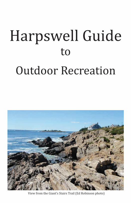
View from the Giant’s Stairs Trail (Ed Robinson photo)
Table of Contents1. Walking trails, beaches, picnic areas and other places to enjoy
the outdoors• Bowdoin College Coastal Studies Center....................................1• Cliff Trail...................................................................................................2• Curtis Farm Preserve...........................................................................3• Devil’s Back Trail..................................................................................4• Giant’s Stairs and McIntosh Lot Preserve..................................5• Hackett and Minot Trails...................................................................6• Houghton Graves Park.......................................................................7• Johnson Field Preserve and Mackerel Cove Lot......................8• Long Reach Preserve...........................................................................9• Mitchell Field.......................................................................................10• Pott’s Point Preserve.........................................................................11
2. Harpswell Map.....................................................................................12-133. More walking trails, beaches, picnic areas and other places to
enjoy the outdoors• Skolfield Shores Preserve...............................................................14• Stover’s Point Preserve....................................................................15• Widgeon Cove Trail...........................................................................16• Wilson’s Cove Trail............................................................................17
4. Harpswell’s Islands....................................................................................185. Historic Landmarks....................................................................................196. Town Landings.............................................................................................207. Areas for Play...............................................................................................228. Bicycling Areas............................................................................................239. Pump Out Stations......................................................................................2410. Resources for more Information.......................................................25
How to use this guide
• Check the map on pages 12-13 for locations of all the public access resources.
• On each page, look for the letters that correspond to the map.• Enjoy!

HIKING
GREAT FOR KIDS
DOGS ALLOWED
Directions: From Cook’s Corner in Brunswick, follow Rt 24 south for 10.7 miles. Take a right on Bayview Rd. Continue for approx. one mile until you see a kiosk on the right.
Visitor Guidelines• Park at the kiosk and do not drive
further into the property• Stay on the designated trails• Many ongoing research projects
occur at CSC, please respect any flags, markings, or other scientific equipment
• Do not collect anything• These trails are designed for foot traffic
only (no bicycles or motorized vehicles)• The trails are open dawn to dusk• Dogs must be on a leash and stay on the
main trails. Please carry out any waste left by pets
• Hunting is strictly forbidden• No camping, smoking, or fires allowed
on the property
SNOWSHOEING
WATER ACCESS
SCENIC VIEW
Bowdoin Coastal Studies CenterA
Bowdoin College’s Coastal Studies Center on Orr’s Island provides lovely coastal walking trails. A fine old farm with 2.5 miles of coastline, 3.6 miles of trails and a variety of habitats, it offers great views of Long Cove and Harpswell Sound and opportunities to view wildlife or just take a quiet walk in the woods.
1
HIKING
GREAT FOR KIDS
DOGS ALLOWED
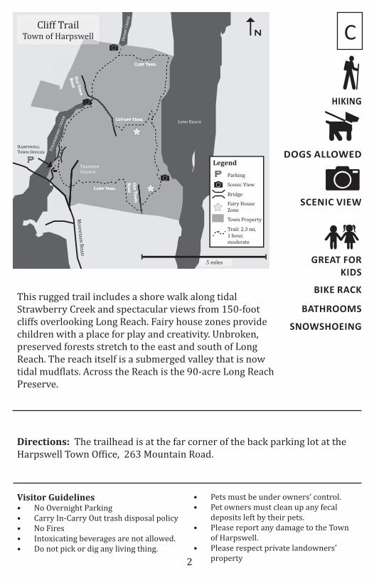
NCliff Trail
Town of Harpswell
O!"
T#$%
R#&"
O!"
T#$%
R#&"
C!'(( T)&'!
C!'(( T)&'!
C*+-#(( T)&'!
Legend
.5 miles
Scenic View
Bridge
Parking
P
P
M!"#$%&#
R!%'
H%()*+,-- T!+# O..&/,*
T(%#*.,( S$%$&!#
Fairy House Zone
Town Property
Trail: 2.3 mi, 1 hour,moderate
S$(%+0,((1
C(,,2
L!#3 R,%/4H,#(1
C(,,2
This rugged trail includes a shore walk along tidal Strawberry Creek and spectacular views from 150-foot cliffs overlooking Long Reach. Fairy house zones provide children with a place for play and creativity. Unbroken, preserved forests stretch to the east and south of Long Reach. The reach itself is a submerged valley that is now tidal mudflats. Across the Reach is the 90-acre Long Reach Preserve.
Directions: The trailhead is at the far corner of the back parking lot at the Harpswell Town Office, 263 Mountain Road.
Visitor Guidelines• No Overnight Parking• Carry In-Carry Out trash disposal policy• No Fires• Intoxicating beverages are not allowed.• Do not pick or dig any living thing.
C
• Pets must be under owners’ control.• Pet owners must clean up any fecal
deposits left by their pets.• Please report any damage to the Town
of Harpswell.• Please respect private landowners’
property
SNOWSHOEING
BIKE RACK
BATHROOMS
2
SCENIC VIEW

HIKING
GREAT FOR KIDS
DOGS ALLOWED
Bog
P
P
Legend
.25 miles
Scenic Views
Parking
Water Access
H!
"#$
%&'
' N
&()
R*
!+
(R
, 1
23
)
!$- P*./, R
*!+
B!
$./ P
*./
, R
*!
+
P
Trails: 1.25 mi, 1.5 hrs, moderate
Curtis Farm Preserve
Curtis Farm PreserveHarpswell Heritage Land Trust
T-& “P&00'&”
G**$& L&+1& R*!+
F!."-!2&/ L!/&
C3",.$ C*2& R*!+
W.''.!4$ F.&'+
B!$./ C*2&
C3",.$ C*2&
P*/+
Curtis Farm Preserve has much to offer. The 1.25-mile trail system takes visitors through field, forest and to coastal bays, with scenic views along the way. The Preserve includes nearly 2,000 feet of shoreline on both Curtis Cove and Basin Cove, gravel beaches, a freshwater pond, forested freshwater wetlands and 15 acres of intertidal mud flats for shellfish and wildlife nursery areas. On a clear day, the views across Middle Bay as far west as Mt. Washington are impressive.
Directions: There are two access points to the preserve. For the upland access, from the intersection of Rt 123 and Bath Rd at Bowdoin College in Brunswick, follow Rt 123 south for 11.4 miles. The parking lot is in a field on the right. For the shore access, follow Rt 123 south another .2 miles and then turn right on Ash Point Rd. Take your first right on Basin Point Rd and drive .5 miles to a parking lot on the right.
Visitor Guidelines• Carry in, carry out.• No open fires.• No dogs off leash during bird nesting
season, April 15-July 31. Dogs must be under voice control the rest of the year.
• Carry out all dog waste.• Hunting is allowed. Wear blaze
F
orange and take appropriate safety precautions during hunting season.
• Trapping is allowed with written permission from HHLT.
• Please respect wildlife, neighbors and other users.
• Power driven mobility devices are not allowed.
SNOWSHOEING
WATER ACCESS
SCENIC VIEW
3
HIKING
SCENIC VIEW
WATER ACCESS
DOGS ALLOWED
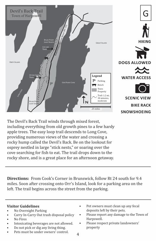
Devil’s Back TrailTown of Harpswell
H!"#$%&''
I$'!()$
R*!)
(R+.
24
)
Legend
.25 miles
Bench
Parking
PP
N
Town Property
Trail: 1.2 mi,30 minutes,moderate
B,'&$ P*-(+ L**# N*"+.
B,'&$ P*-(+ L**# S*/+.
O++&" C"&&0 T"!-'
C/+-*11 T"!-'
G/( P*-(+ C*2&
L*(3
C*2&
G"&!+ I$'!()
O""’$ I$'!()
The Devil’s Back Trail winds through mixed forest, including everything from old growth pines to a few hardy apple trees. The easy loop trail descends to Long Cove, providing numerous views of the water and crossing a rocky hump called the Devil’s Back. Be on the lookout for osprey nestled in large “stick nests,” or soaring over the cove searching for fish to eat. The trail drops down to the rocky shore, and is a great place for an afternoon getaway.
Directions: From Cook’s Corner in Brunswick, follow Rt 24 south for 9.4 miles. Soon after crossing onto Orr’s Island, look for a parking area on the left. The trail begins across the street from the parking.
SNOWSHOEING
Visitor Guidelines• No Overnight Parking• Carry In-Carry Out trash disposal policy• No Fires• Intoxicating beverages are not allowed.• Do not pick or dig any living thing.• Pets must be under owners’ control.
• Pet owners must clean up any fecal deposits left by their pets.
• Please report any damage to the Town of Harpswell.
• Please respect private landowners’ property
G
4
BIKE RACK
GREAT FOR KIDS
SCENIC VIEW
DOGS ALLOWED
Legend
.2 miles
T!"#$%& H'(%
Parking (at Episcopal Chapel)
P
W)*!+#,-'#
A.%#"%
O/%)# S-&%%-
G+)#-’* S-)+&*
N
P
Trail: .5 mi,15 minutes, easy
McIntosh Lot Preserve
Town Property
Bench
Giant’s StairsTown of Harpswell
McIntosh Lot Preserve
Harpswell Heritage Land Trust
Entire Trail isScenic
C)*/' B)0
-' H)&1*2%(( I*()#$* R')$ (R-. 24)
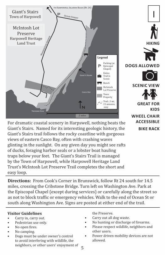
For dramatic coastal scenery in Harpswell, nothing beats the Giant’s Stairs. Named for its interesting geologic history, the Giant’s Stairs trail follows the rocky coastline with gorgeous views of eastern Casco Bay, often with crashing waves glinting in the sunlight. On any given day you might see rafts of ducks, foraging harbor seals or a lobster boat hauling traps below your feet. The Giant’s Stairs Trail is managed by the Town of Harpswell, while Harpswell Heritage Land Trust’s McIntosh Lot Preserve Trail completes the short and easy loop.
Directions: From Cook’s Corner in Brunswick, follow Rt 24 south for 14.5 miles, crossing the Cribstone Bridge. Turn left on Washington Ave. Park at the Episcopal Chapel (except during services) or carefully along the street so as not to block traffic or emergency vehicles. Walk to the end of Ocean St or south along Washington Ave. Signs are posted at either end of the trail.
Visitor Guidelines• Carry in, carry out.• Pedestrian use only.• No open fires.• No camping.• Dogs must be under owner’s control
to avoid interfering with wildlife, the neighbors, or other users’ enjoyment of
the Preserve.• Carry out all dog waste.• No hunting or discharge of firearms.• Please respect wildlife, neighbors and
other users.• Power driven mobility devices are not
allowed.
BIKE RACK
WHEEL CHAIR ACCESSIBLE
I
5
HIKING

HIKING
DOGS ALLOWED
N.25 miles
L!""#$%!$#& R&
H'()*+$## N$,- R.'& (R" 123)
P
T'((-E'"./ H.0*$
E#!1'2 K$##.33C20(,2
H'()*+$## H!*".(!,'#
S.,!$"4
C$/"$//!'# H'##
O#& M$$"!/3H.0*$
Hackett and Minot TrailsHarpswell Heritage Land Trust
LegendParking (at Historical Society)
P
HackettLand Preserve
MinotConservationEasement
Trail: 1 mi,30 minutes, easy
L..-.0" P.!/" R&
A##$/ P.!/" R&
M!&&#$ B'4
V$(/'# P..#
The Hackett and Minot Trails take visitors through a verdant, mossy forest with numerous lichen and club-moss glades, as well as a vernal pool. It’s a great place for a quiet woods walk. Visible to the west of Harpswell Neck Rd (Rt 123), this property complements Harpswell’s historic center, which includes the 1757 Old Meeting House, the 1842 Elijah Kellogg Church, the 1876 Centennial Hall and the 1783 Tarr-Eaton House, which is protected with a historic preservation easement.
Directions: From the intersection of Rt 123 and Bath Rd at Bowdoin College in Brunswick, follow Rt 123 south for 8.4 mi. Please park at the Harpswell Historical Society building on the left. Cross the road and walk down the private Littlefield Road until you see signs for the trail.
M
Visitor Guidelines• Carry in, carry out.• Pedestrian use only.• No open fires.• No camping.• No dogs off leash during bird nesting
season, April 15-July 31. Dogs must be under voice control the rest of the year.
• Carry out all dog waste.• Hunting is allowed. Wear blaze orange
and take appropriate safety precautions during hunting season.
• Please respect wildlife, neighbors and other users.
• Power driven mobility devices are not allowed.
SNOWSHOEING
6
HIKING
GREAT FOR KIDS
SCENIC VIEW
PICNIC SPOT
WATER ACCESS
DOGS ALLOWEDLegend
L!"#$$’% C!&#R!'(
.1 miles
Picnic Table
ParkingP
Water Access
B!"#’$ C%&!
P
H!"#$%
&'' I$'
!()$
R*!)
(R+ 24)
Houghton Graves ParkHarpswell Heritage Land Trust
Houghton Graves Park
Trail: .25 mi,15 minutes, easy
N
Scenic View
Marsh
O""’$ I$'!() P*$+ O,,-.&
O""’$ I$'!() L-/"!"0
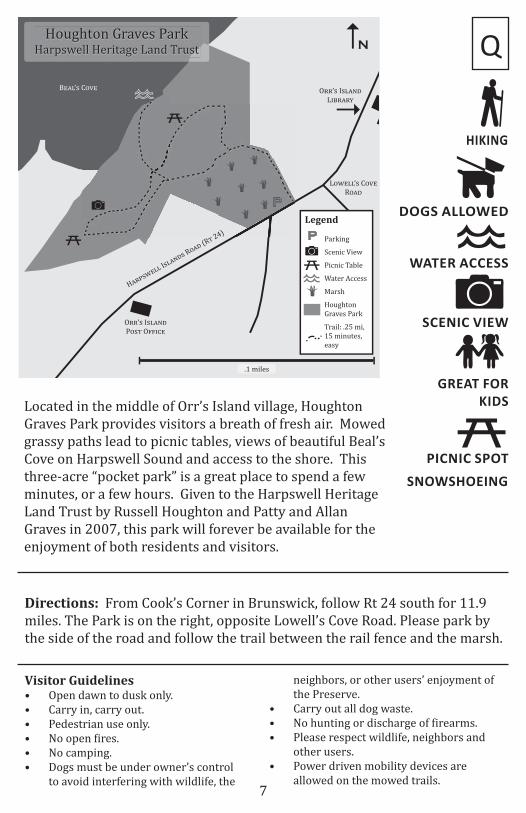
Located in the middle of Orr’s Island village, Houghton Graves Park provides visitors a breath of fresh air. Mowed grassy paths lead to picnic tables, views of beautiful Beal’s Cove on Harpswell Sound and access to the shore. This three-acre “pocket park” is a great place to spend a few minutes, or a few hours. Given to the Harpswell Heritage Land Trust by Russell Houghton and Patty and Allan Graves in 2007, this park will forever be available for the enjoyment of both residents and visitors.
Directions: From Cook’s Corner in Brunswick, follow Rt 24 south for 11.9 miles. The Park is on the right, opposite Lowell’s Cove Road. Please park by the side of the road and follow the trail between the rail fence and the marsh.
Visitor Guidelines• Open dawn to dusk only.• Carry in, carry out.• Pedestrian use only.• No open fires.• No camping.• Dogs must be under owner’s control
to avoid interfering with wildlife, the
Q
neighbors, or other users’ enjoyment of the Preserve.
• Carry out all dog waste.• No hunting or discharge of firearms.• Please respect wildlife, neighbors and
other users.• Power driven mobility devices are
allowed on the mowed trails.
SNOWSHOEING
7
SCENIC VIEW
WATER ACCESS
DOGS ALLOWED
Legend
.1 miles
Picnic Table
Parking P
Water Access
Swimming
N
A!"#$ P%&"'
R%()
H($*+,#-- I+-(
")+ R%()
(R'
24
)
B%(' H%.+#
P
Johnson Field Preserve
Town Property
Johnson Field PreserveHarpswell Heritage Land Trust
Mackerel Cove LotTown of Harpswell
M(/0#$#- C%1#
PL.!## L"
P.!-&/ B%(' L(."/2
Scenic View
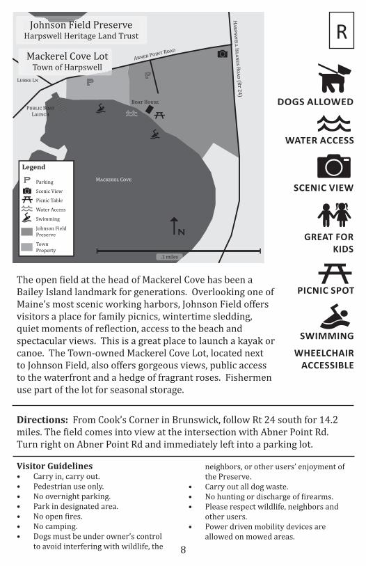
Directions: From Cook’s Corner in Brunswick, follow Rt 24 south for 14.2 miles. The field comes into view at the intersection with Abner Point Rd. Turn right on Abner Point Rd and immediately left into a parking lot.
R
The open field at the head of Mackerel Cove has been a Bailey Island landmark for generations. Overlooking one of Maine’s most scenic working harbors, Johnson Field offers visitors a place for family picnics, wintertime sledding, quiet moments of reflection, access to the beach and spectacular views. This is a great place to launch a kayak or canoe. The Town-owned Mackerel Cove Lot, located next to Johnson Field, also offers gorgeous views, public access to the waterfront and a hedge of fragrant roses. Fishermen use part of the lot for seasonal storage.
Visitor Guidelines• Carry in, carry out.• Pedestrian use only.• No overnight parking.• Park in designated area.• No open fires.• No camping.• Dogs must be under owner’s control
to avoid interfering with wildlife, the
neighbors, or other users’ enjoyment of the Preserve.
• Carry out all dog waste.• No hunting or discharge of firearms.• Please respect wildlife, neighbors and
other users.• Power driven mobility devices are
allowed on mowed areas.
PICNIC SPOT
SWIMMING
WHEELCHAIR ACCESSIBLE
GREAT FOR KIDS
8

HIKING
SCENIC VIEW
WATER ACCESS
DOGS ALLOWED
wwwwww
Bog
PT!"#$%&-S"''(!&)%
B$**#+(*,
Legend
.25 miles
Scenic View
Bridge
Parking
Water Access
H$
!-
./(*
* I.
*$%
,.
R)
$,
(R
& 2
4)
P
N
B)
0 T
!$
+*
Bog
Trail: 1.5 mi,1 hour,challenging
Long Reach Preserve
Long Reach PreserveHarpswell Heritage Land Trust
L)%0 R($12 L))-
P+%32$' P)+%& R,
L)%0 R($12
L)%0 R($12 L))-
This spectacular 95-acre preserve provides one of the longest hiking trails in Harpswell. A challenging 1.5-mile loop trail winds through several different forest types, passes a peat bog nestled between two prominent bedrock ridges and finally descends to the shores of Long Reach. This area is a prime example of Harpswell’s folded bedrock geology. Long steep ridges run parallel to the shore and trap water to form peaty wetlands. Long Reach itself is a submerged valley, and at low water, tidal mudflats. From the shore, visitors can look across to dramatic cliffs of weathered bedrock, at the top of which is the Cliff Trail.
Directions: From Cook’s Corner in Brunswick, follow Rt 24 south for 6.8 mi. The Preserve shares a parking lot with the Trufant-Summerton Ball Field, which will be on your right. The trailhead is to the right as you enter the parking lot.
Visitor Guidelines• Carry in, carry out.• Pedestrian use only.• No camping.• No open fires.• No dogs off leash during bird nesting
season, April 15-July 31. Dogs must be under voice control the rest of the year.
• Carry out all dog waste.
T
• Hunting is allowed. Wear blaze orange and take appropriate safety precautions during hunting season.
• Trapping is allowed with written permission from HHLT.
• Please respect wildlife, neighbors and other users.
• Power driven mobility devices are not allowed.
SNOWSHOEING
9
HIKING
GREAT FOR KIDS
SCENIC VIEW
PICNIC SPOT
WATER ACCESS
DOGS ALLOWEDLegend
.1 miles
Picnic Table
ParkingP
Water Access
Swimming
P
P
NTrail: 2.75 mi, 1.25 hours, moderate
H!"#$%&'' N&()
R*!+
(R, 1
23)
B-"(./&"& '0
Scenic View
Bench
Town Property
Mitchell FieldTown of Harpswell
B!0+$,!0+
C*//10-,2 G!"+&0
P-&"
M-++'& B!2
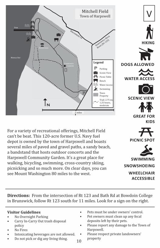
Directions: From the intersection of Rt 123 and Bath Rd at Bowdoin College in Brunswick, follow Rt 123 south for 11 miles. Look for a sign on the right.
V
Visitor Guidelines• No Overnight Parking• Carry In-Carry Out trash disposal
policy• No Fires• Intoxicating beverages are not allowed.• Do not pick or dig any living thing.
• Pets must be under owners’ control.• Pet owners must clean up any fecal
deposits left by their pets.• Please report any damage to the Town of
Harpswell.• Please respect private landowners’
property
For a variety of recreational offerings, Mitchell Field can’t be beat. This 120-acre former U.S. Navy fuel depot is owned by the town of Harpswell and boasts several miles of paved and gravel paths, a sandy beach, a bandstand that hosts outdoor concerts and the Harpswell Community Garden. It’s a great place for walking, bicycling, swimming, cross-country skiing, picnicking and so much more. On clear days, you can see Mount Washington 80 miles to the west.
SNOWSHOEING
WHEELCHAIR ACCESSIBLE
SWIMMING
10
SCENIC VIEW
WATER ACCESS
DOGS ALLOWED
Legend
.1 miles
Parking (roadside)
Swimming
P
Water Access
H!"#$%&'' N&() R*!+ (R, 123)
P*,,
’$ P*-.,
R+
(P"-/!,&
)P*,,’$ H!"0*"
M&""-(*.&!1 S*2.+
N
P
Entire Preserve is Scenic
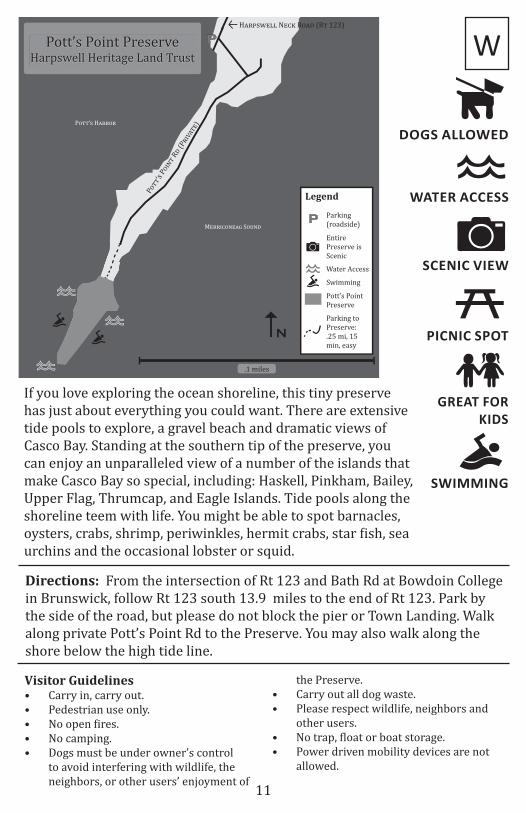
Pott’s Point Preserve
Pott’s Point PreserveHarpswell Heritage Land Trust
Parking to Preserve: .25 mi, 15 min, easy
Directions: From the intersection of Rt 123 and Bath Rd at Bowdoin College in Brunswick, follow Rt 123 south 13.9 miles to the end of Rt 123. Park by the side of the road, but please do not block the pier or Town Landing. Walk along private Pott’s Point Rd to the Preserve. You may also walk along the shore below the high tide line.
W
If you love exploring the ocean shoreline, this tiny preserve has just about everything you could want. There are extensive tide pools to explore, a gravel beach and dramatic views of Casco Bay. Standing at the southern tip of the preserve, you can enjoy an unparalleled view of a number of the islands that make Casco Bay so special, including: Haskell, Pinkham, Bailey, Upper Flag, Thrumcap, and Eagle Islands. Tide pools along the shoreline teem with life. You might be able to spot barnacles, oysters, crabs, shrimp, periwinkles, hermit crabs, star fish, sea urchins and the occasional lobster or squid.
Visitor Guidelines• Carry in, carry out.• Pedestrian use only.• No open fires.• No camping.• Dogs must be under owner’s control
to avoid interfering with wildlife, the neighbors, or other users’ enjoyment of
the Preserve.• Carry out all dog waste.• Please respect wildlife, neighbors and
other users.• No trap, float or boat storage.• Power driven mobility devices are not
allowed.
PICNIC SPOT
GREAT FOR KIDS
SWIMMING
11

B
C
E
G
IIH
H
Z
Y
V
U
T
P
EEO
NM
L
A
CC
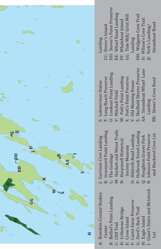
A: B
owdo
in C
oast
al S
tudi
es
Cent
erB:
Bet
hel’s
Poi
nt L
andi
ngC:
Clif
f Tra
ilD:
Cri
bsto
ne B
ridg
eE:
Cro
w Is
land
F:
Cur
tis F
arm
Pre
serv
eG:
Dev
il’s B
ack
Trai
lH
: Ea
gle
Isla
ndI:
Gia
nt’s
Stai
rs a
nd M
cInt
osh
Lot
J: G
arri
son
Cove
Lan
ding
K: G
rave
yard
Poi
nt L
andi
ngL:
The
Gos
lings
M:
Hac
kett
and
Min
ot T
rails
N:
Har
psw
ell H
isto
rica
l So
ciet
y M
useu
mO:
Hild
reth
Roa
d La
ndin
gP:
Hol
broo
k St
reet
Lan
ding
Q: H
ough
ton
Grav
es P
ark
R: J
ohns
on F
ield
Pre
serv
e an
d M
acke
rel C
ove
Lot
S: L
obst
erm
an S
tatu
eT:
Lon
g Re
ach
Pres
erve
U: L
ooko
ut P
oint
Lan
ding
V: M
itche
ll Fi
eld
W:
Pott
’s Po
int L
andi
ngX:
Pot
t’s P
oint
Pre
serv
e Y:
Old
Mee
ting
Hou
seZ:
Skolf
ield S
hore
s Pre
serv
eAA
: St
eam
boat
Wha
rf L
ane
Land
ing
BB:
Stov
er’s
Cove
Roa
d
Land
ing
CC:
Stov
er’s
Isla
nd
DD:
Stov
er’s
Poin
t Pre
serv
eEE
: W
harf
Roa
d La
ndin
g FF
: W
hale
boat
Isla
ndGG
: Ti
de M
ill/
Gris
t Mill
La
ndin
gH
H:
Wid
geon
Cov
e Tr
ail
II: W
ilson
’s Co
ve T
rail
JJ: Y
ork’
s Lan
ding
/ St
eam
boat
Roa
d
D
F
I
BB
GG
FFD
D
XW
S
AA
JJ
J
Q
R
K
H
HIKING
SCENIC VIEW
WATER ACCESS
N
M!""#$%%&!'(& F(")
Legend
.25 miles
Bridge
Water Access
Parking
Scenic View
PH("*+,!--
N!$.
R%(/
(R0
123)
H1+0%"1$ B%(0 H%#+!
M1//-! B(2 C%3!
Bench
S.%-41!
-/ P-($!
P
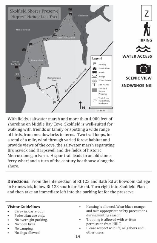
Skol5ield Shores Preserve
Trail: 1 mi,30 minutes, moderate
Skol5ield Shores PreserveHarpswell Heritage Land Trust
M!""#$%%&!'(& L%%*
H!)-%$. L%%*
S(-0 M("+6
Salt Marsh
Directions: From the intersection of Rt 123 and Bath Rd at Bowdoin College in Brunswick, follow Rt 123 south for 4.6 mi. Turn right into Skolfield Place and then take an immediate left into the parking lot for the preserve.
Z
Visitor Guidelines• Carry in, Carry out.• Pedestrian use only.• No overnight parking.• No open fires.• No camping.• No dogs allowed.
• Hunting is allowed. Wear blaze orange and take appropriate safety precautions during hunting season.
• Trapping is allowed with written permission from HHLT.
• Please respect wildlife, neighbors and other users.
With fields, saltwater marsh and more than 4,000 feet of shoreline on Middle Bay Cove, Skolfield is well-suited for walking with friends or family or spotting a wide range of birds, from meadowlarks to terns. Two trail loops, for a total of a mile, wind through varied forest habitat and provide views of the cove, the saltwater marsh separating Brunswick and Harpswell and the fields of historic Merrucoonegan Farm. A spur trail leads to an old stone ferry wharf and a turn of the century boathouse along the shore.
SNOWSHOEING
14

GREAT FOR KIDS
SCENIC VIEW
PICNIC SPOT
WATER ACCESS
DOGS ALLOWED
Legend
.1 Miles
Water Access (on Entire Preserve)
Swimming (on Entire Preserve)
Parking
W!"#$%&
L'"(
(#!&))
S)%*(&’$ P%!") R#
Bench
P
P
P
P
Entire Preserve is Scenic
N
Stover’sPoint Preserve
Stover’s Point PreserveHarpswell Heritage Land Trust
Salt Marsh
S'+) M'&$,
H'&-$.(++ H'&/%&
If you are looking for a beach day with friends or family, Stover’s Point is the place to go. With the convenience of being able to drive right on the gravel beach, this is a great place to spend a summer day exploring. The beach, tidal creek and salt marsh provide great swimming, crabs to catch and views across Harpswell Sound to the unique Cribstone Bridge connecting Orr’s and Bailey islands.
Directions: From the intersection of Rt 123 and Bath Rd at Bowdoin College in Brunswick, follow Rt 123 south for 12.2 mi. Turn left on Stover’s Cove Rd. Take your first right on Stover’s Point Rd. Veer left. Stay straight on Windsor Rd. Follow the road as it curves to the right then take a left on a gravel road. Being very careful of the undercarriage of your car, drive right out onto the beach. Once on the beach, please park on gravel surfaces only.
Visitor Guidelines• Carry in, carry out.• No overnight parking.• Motorized vehicles restricted to
designated areas.• No open fires.• No camping.• Dogs must be under owner’s control
to avoid interfering with wildlife, the
DD
neighbors, or other users’ enjoyment of the Preserve.
• Carry out all dog waste.• Please respect wildlife, neighbors and other
users.• The preserve is available for events, with
HHLT permission.• No trap, float or boat storage.• Power driven mobility devices are allowed
on gravel areas.
SWIMMING
15
HIKING
SCENIC VIEW
DOGS ALLOWED
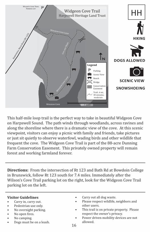
W!"#$%’# C$&' T()!" P)(*!%+ L$,
Legend
.1 miles
Scenic View
Bridge
Parking
Conservation Easement
H!"#$%&''
N&()
R*!+
(R,
123)
Widgeon Cove TrailHarpswell Heritage Land Trust
N
P
P
C-,-*..
T"!/'
Bench
W/+0&*1 C*2&
W/+0&*1 C*2& L**#
W/+0&*1
C*2&
L**#
Trail: .6 mi,30 minutes, moderate
P
This half-mile loop trail is the perfect way to take in beautiful Widgeon Cove on Harpswell Sound. The path winds through woodlands, across ravines and along the shoreline where there is a dramatic view of the cove. At this scenic viewpoint, visitors can enjoy a picnic with family and friends, take pictures or just sit quietly to observe waterfowl, wading birds and other wildlife that frequent the cove. The Widgeon Cove Trail is part of the 88-acre Dunning Farm Conservation Easement. This privately owned property will remain forest and working farmland forever.
Directions: From the intersection of Rt 123 and Bath Rd at Bowdoin College in Brunswick, follow Rt 123 south for 7.4 miles. Immediately after the Wilson’s Cove Trail parking lot on the right, look for the Widgeon Cove Trail parking lot on the left.
Visitor Guidelines• Carry in, carry out.• Pedestrian use only.• No overnight parking.• No open fires.• No camping.• Dogs must be on a leash.
HH
• Carry out all dog waste.• Please respect wildlife, neighbors and
other users.• This trail is on private property. Please
respect the owner’s privacy.• Power driven mobility devices are not
allowed.
SNOWSHOEING
16

HIKING
SCENIC VIEW
DOGS ALLOWED
W!"#$%’# C$&'
Legend
.25 miles
Scenic View
Parking
H()*#+'""
N',-
R$(.
(R/
123)
P
P
N
Trail: .25 mi,15 minutes, easy
Wilson’s Cove TrailHarpswell Heritage Land Trust
ConservationEasement
PW!.0'$% C$&' T)(!" P()-!%0
L$/
L$/ 5 R$(.
This short out-and-back trail brings hikers to a dramatic cliff overlooking Wilson’s Cove. The views up and down Middle Bay and across to Birch Island are spectacular. The end of the trail provides a quiet place to sit beneath the red oaks and take in the water, land and sky. On a still day, the reflection along the shore shimmers on the water and the retreating tide reveals seaweed-covered rocks for roosting gulls and cormorants. The Wilson’s Cove Trail is on privately owned land that is protected forever by a conservation easement.
Directions: From the intersection of Rt 123 and Bath Rd at Bowdoin College in Brunswick, follow Rt 123 south for 7.4 mi. Look for a small parking lot and sign on the right.
Visitor Guidelines• Open dawn to dusk only.• Carry in, carry out.• Pedestrian use only.• Stay on the trail.• No overnight parking.• No open fires.• No camping.• Dogs must be on the leash.
II
• Carry out all dog waste.• No hunting or discharge of firearms.• Please respect wildlife, neighbors and
other users.• This trail is on private property. Please
respect the owner’s privacy.• Power driven mobility devices are not
allowed.
SNOWSHOEING
17
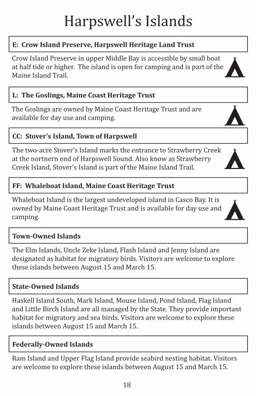
The Goslings are owned by Maine Coast Heritage Trust and are available for day use and camping.
FF: Whaleboat Island, Maine Coast Heritage Trust
Whaleboat Island is the largest undeveloped island in Casco Bay. It is owned by Maine Coast Heritage Trust and is available for day use and camping.
L: The Goslings, Maine Coast Heritage Trust
Federally-Owned Islands
Ram Island and Upper Flag Island provide seabird nesting habitat. Visitors are welcome to explore these islands between August 15 and March 15.
Harpswell’s Islands
Crow Island Preserve in upper Middle Bay is accessible by small boat at half tide or higher. The island is open for camping and is part of the Maine Island Trail.
E: Crow Island Preserve, Harpswell Heritage Land Trust
The Elm Islands, Uncle Zeke Island, Flash Island and Jenny Island are designated as habitat for migratory birds. Visitors are welcome to explore these islands between August 15 and March 15.
Town-Owned Islands
The two-acre Stover’s Island marks the entrance to Strawberry Creek at the nortnern end of Harpswell Sound. Also know as Strawberry Creek Island, Stover’s Island is part of the Maine Island Trail.
CC: Stover’s Island, Town of Harpswell
State-Owned Islands
Haskell Island South, Mark Island, Mouse Island, Pond Island, Flag Island and Little Birch Island are all managed by the State. They provide important habitat for migratory and sea birds. Visitors are welcome to explore these islands between August 15 and March 15.
18
Historic Landmarks
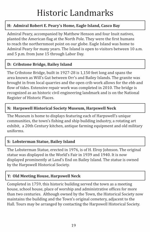
Completed in 1759, this historic building served the town as a meeting house, school house, place of worship and administrative offices for more than two centuries. Although owned by the Town, the Historical Society now maintains the building and the Town’s original cemetery, adjacent to the Hall. Tours may be arranged by contacting the Harpswell Historical Society.
Y: Old Meeting House, Harpswell Neck
The Museum is home to displays featuring each of Harpswell’s unique communities, the town’s fishing and ship building industry, a rotating art exhibit, a 20th Century kitchen, antique farming equipment and old military uniforms.
N: Harpswell Historical Society Museum, Harpswell Neck
Admiral Peary, accompanied by Matthew Henson and four Inuit natives, planted the American flag at the North Pole. They were the first humans to reach the northernmost point on our globe. Eagle Island was home to Admiral Peary for many years. The Island is open to visitors between 10 a.m. and 5 p.m. from June 15 through Labor Day.
H: Admiral Robert E. Peary’s Home, Eagle Island, Casco Bay
The Lobsterman Statue, erected in 1976, is of H. Elroy Johnson. The original statue was displayed in the World’s Fair in 1939 and 1940. It is now displayed prominently at Land’s End on Bailey Island. The statue is owned by the Harpswell Historical Society.
S: Lobsterman Statue, Bailey Island
The Cribstone Bridge, built in 1927-28 is 1,150 feet long and spans the area known as Will’s Gut between Orr’s and Bailey Islands. The granite was brought in from local quarries and the open crib work allows for the ebb and flow of tides. Extensive repair work was completed in 2010. The bridge is recognized as an historic civil engineering landmark and is on the National Register of Historic Places.
D: Cribstone Bridge, Bailey Island
19

Town Landings
B: Bethel’s Point, Cundy’s Harbor N 43.79092/W 69.91183
P: Holbrook Street Landing, Cundy’s Harbor N 43.79929/W 69.88821
J: Garrison Cove, Bailey Island N 43.74771/W 69.99186
K: Graveyard Point, Harpswell NeckN 43.74058/W 70.01530
O: Hildreth Road, Harpswell NeckN 43.82138/W 69.95183
Small Boat
Launch
Trailered Boat
Launch
This paved landing provides excellent access and has a great beach for swimming and walking. The beach and landing look north up Harpswell Sound. Limited parking is available at the top of the beach.
Bethel’s Point serves as public and commercial boat launch, however, there is no public parking available. There is limited permit parking issued by the town as well as ample parking in the nearby commercial lot, which requires a small fee.
Located at the end of the Graveyard Point Road on Harpswell Neck, this is an attractive gravel beach to launch a canoe or kayak or jump in the ocean to cool off. Parking for up to four cars along the road.
The public access point is off Mountain Rd west of Ewing Narrows Bridge. There is very limited parking on Hildreth Rd. The traditionally used launch point is down the gravel road. There is no public beach access. Please respect the private owners rights at the end of the gravel road.
20
Located off the east side of Cundy’s Harbor Road, this gently sloped boat launch includes limited parking for three cars.
X X
X
X X
X X
X X
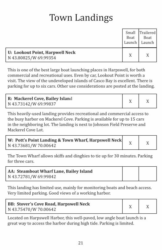
W: Pott’s Point Landing & Town Wharf, Harpswell NeckN 43.73681/W 70.00642
BB: Stover’s Cove Road, Harpswell Neck N 43.75470/W 70.00642
R: Mackerel Cove, Bailey Island N 43.73142/W 69.99837
AA: Steamboat Wharf Lane, Bailey Island N 43.72781/W 69.99842
U: Lookout Point, Harpwell Neck N 43.80825/W 69.99354
Small Boat
Launch
Trailered Boat
Launch
Town Landings
This is one of the best large boat launching places in Harpswell, for both commercial and recreational uses. Even by car, Lookout Point is worth a visit. The view of the undeveloped islands of Casco Bay is excellent. There is parking for up to six cars. Other use considerations are posted at the landing.
This heavily-used landing provides recreational and commercial access to the busy harbor on Mackerel Cove. Parking is available for up to 15 cars in the neighboring lot. The landing is next to Johnson Field Preserve and Mackerel Cove Lot.
The Town Wharf allows skiffs and dinghies to tie up for 30 minutes. Parking for three cars.
This landing has limited use, mainly for monitoring boats and beach access. Very limited parking. Good views of a working harbor.
Located on Harpswell Harbor, this well-paved, low angle boat launch is a great way to access the harbor during high tide. Parking is limited.
21
X X
X X
X X
X X
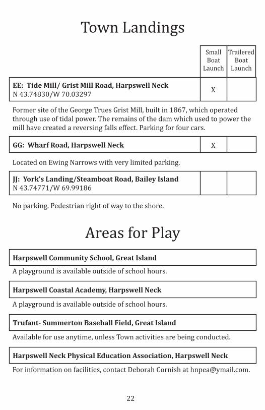
GG: Wharf Road, Harpswell Neck
JJ: York’s Landing/Steamboat Road, Bailey IslandN 43.74771/W 69.99186
EE: Tide Mill/ Grist Mill Road, Harpswell Neck N 43.74830/W 70.03297
Small Boat
Launch
Trailered Boat
Launch
Town Landings
Former site of the George Trues Grist Mill, built in 1867, which operated through use of tidal power. The remains of the dam which used to power the mill have created a reversing falls effect. Parking for four cars.
Located on Ewing Narrows with very limited parking.
No parking. Pedestrian right of way to the shore.
Harpswell Coastal Academy, Harpswell Neck
Available for use anytime, unless Town activities are being conducted.
Trufant- Summerton Baseball Field, Great Island
For information on facilities, contact Deborah Cornish at [email protected].
Harpswell Neck Physical Education Association, Harpswell Neck
A playground is available outside of school hours.
A playground is available outside of school hours.
Harpswell Community School, Great Island
Areas for Play
22
X
X
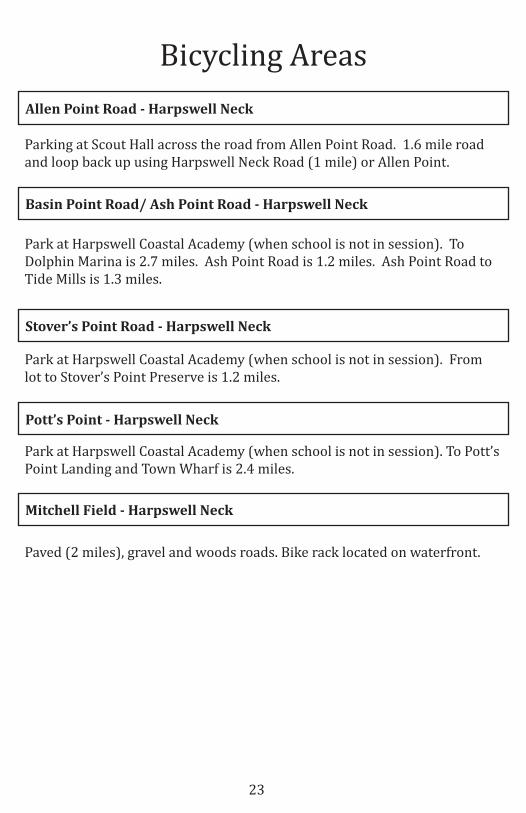
Bicycling Areas
Parking at Scout Hall across the road from Allen Point Road. 1.6 mile road and loop back up using Harpswell Neck Road (1 mile) or Allen Point.
Allen Point Road - Harpswell Neck
Park at Harpswell Coastal Academy (when school is not in session). To Dolphin Marina is 2.7 miles. Ash Point Road is 1.2 miles. Ash Point Road to Tide Mills is 1.3 miles.
Basin Point Road/ Ash Point Road - Harpswell Neck
Park at Harpswell Coastal Academy (when school is not in session). From lot to Stover’s Point Preserve is 1.2 miles.
Stover’s Point Road - Harpswell Neck
Park at Harpswell Coastal Academy (when school is not in session). To Pott’s Point Landing and Town Wharf is 2.4 miles.
Pott’s Point - Harpswell Neck
Paved (2 miles), gravel and woods roads. Bike rack located on waterfront.
Mitchell Field - Harpswell Neck
23

Pump Out Stations
This is a privately owned, free, boat-side service in Quahog Bay. Call Dave at (207) 522-1105 for service and more information.
Q.B. Conservation LLC - Quahog Bay
The Boatyard is located at the very top of Quahog Bay on the Western side. This pump out station is owned by the Boatyard, is a dockside service and is a public pumpout station costing no more than $5. For more information, visit www.greatislandboatyard.com or call the marina at (207) 729-1639.
Great Island Boatyard - Quahog Bay
The pumpout station is located on the lower Western side of Pott’s Harbor. The pumpout station is owned by the marina and is a public pumpout station costing no more than $5. For more information, visit www.dolphinmarinaandrestaurant.com or contact the marina at (207) 833-5343.
Dolphin Marina - Pott’s Harbor
Harpswell has a seasonal self-service pump-out float moored in Cundy’s Harbor. This facility contributes to cleaning up the New Meadows River and is monitored by the Holbrook Community Foundation. There is no fee to use this facility, donations can be sent to the Town of Harpswell, PO Box 39, Harpswell, ME 04079. Questions or comments should be directed to the Town’s Harbormaster, Jim Hays, at 751-9298.
New Meadows River - Cundy’s Harbor
24

Town of Harpswellwww.harpswell.maine.gov
Harpswell Heritage Land Trustwww.hhltmaine.org
Access Healthwww.accesshealthme.org
American Hiking Societywww.americanhiking.org
Bicycle Coalition of Mainewww.bikemaine.org
East Coast Greenwaywww.greenway.org
Friends of Peary’s Eagle Islandwww.pearyeagleisland.org
Healthy Maine Walkswww.healthymainewalks.com
Leave No Trace Principleswww.lnt.org
Maine Coast Heritage Trustwww.mcht.org
Maine Island Trail Associationwww.mita.org
Resources for More Information
25
This guide was created by:
Town of HarpswellRecreation DepartmentRecreation Committee
Town Lands CommitteeHarbor and Waterfront Committee
www.harpswell.maine.gov
andHarpswell Heritage Land Trust
www.hhltmaine.org
Updated May 2015