Global Geodetic Reference System in Support of Location based services
February 7, 2013 1
UZOCHUKWU OKAFOR
SURVEYOR-GENERAL
NAMIBIA United Nations Global Geospatial Information management
2nd High level forum- Doha, Qatar, 4- 6 February 2013

Global Geodetic Reference System in Support of Location
based services
UZOCHUKWU OKAFOR
SURVEYOR-GENERAL
NAMIBIA
February 7, 2013 United Nations Global Geospatial Information management
2nd High level forum- Doha, Qatar, 4- 6 February 2013

1. Location Based Services
4. Recommendations
2. GNSS Services
February 7, 2013 United nations Global Geospatial Information management High
level forum- Seoul, Korea 24-26 October 2011
OUTLINE
3. Issues in Location Based Services
5. Conclusion
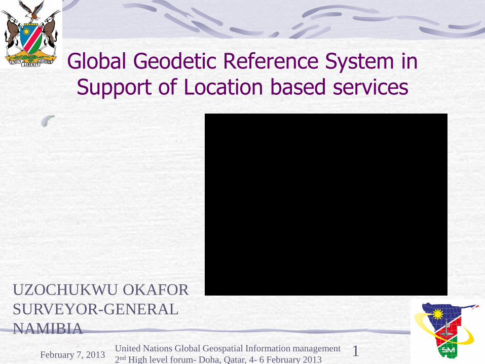
Definition of LBS
GI
Database
Mobile services
Internet
February 7, 2013 United Nations Global Geospatial Information management
2nd High level forum- Doha, Qatar, 4-6 February 2013 4
Web
GIS
Mobile
GIS
Mobile
Internet
LBS
A wireless IP service that uses geographic information to
serve a mobile user (OGC, 2005). Leverages a user’s current
physical location to provide an enhanced service or experience
Adapted: (Brimicombe, 2002)
•Cell ID used in
GSM/3G networks
•GPS
•Assisted GPS –
combination of
cellular networks &
GPS
NICT’s/

Location Data Information Available to LBS User
February 7, 2013 United Nations Global Geospatial Information management
2nd High level forum- Doha, Qatar, 4 – 6 February, 2013 5
Dahunsi, F.M., 2012

Different Types of context in LBS
February 7, 2013 United Nations Global Geospatial Information management
2nd High level forum- Doha, Qatar, 4 – 6 February, 2013 6
Dahunsi, 2012

DRIVERS OF LBS Explosion of smart phones, deployment of high speed broadband wireless infrastructure, digital cameras & GPS integrated circuits
Surge in social networking tools
Degree of fit between technical feasibility & marketing strategy guiding its use (bottom line $$-mobile advertising could exceed $12 billion by 2014 – (Shek, S., 2010)
February 7, 2013 7 United Nations Global Geospatial Information management
2nd High level forum- Doha, Qatar, 4 – 6 February, 2013
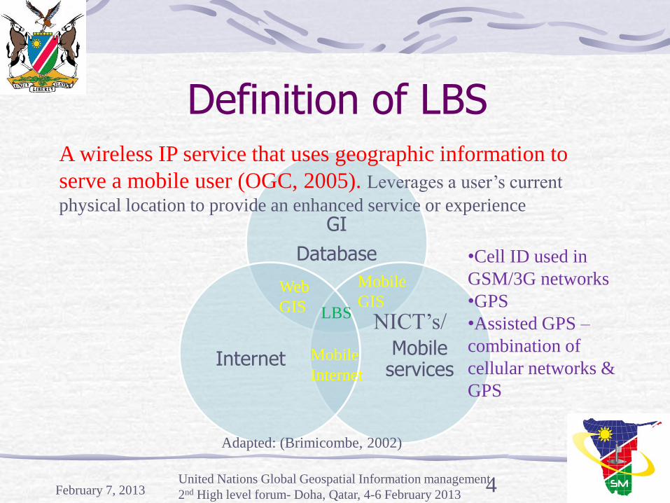
DRIVERS OF LBS Shift in consumer preferences
Quest for seamless integration of location information, customer needs $ vendor offerings
Regulatory pressures forcing Carriers to accurately position wireless emergency calls – E911 in the US & E112 in the EU.
Demand Drivers Point of need information
Niche Consumer applications
Industrial/Corporate
February 7, 2013 8 United Nations Global Geospatial Information management
2nd High level forum- Doha, Qatar, 4 – 6 February, 2013
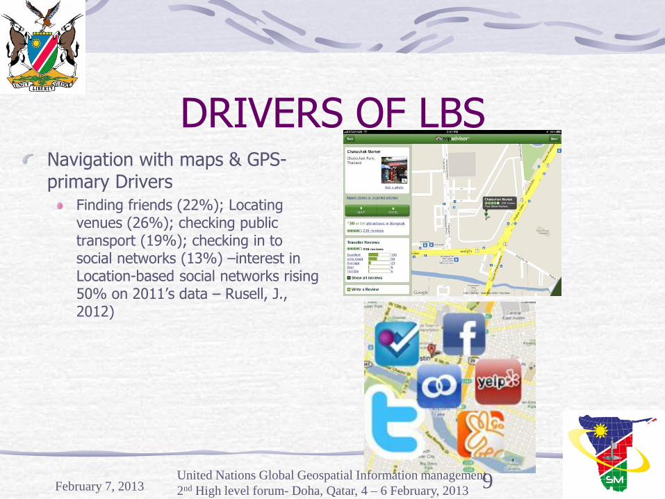
DRIVERS OF LBS Navigation with maps & GPS- primary Drivers
Finding friends (22%); Locating venues (26%); checking public transport (19%); checking in to social networks (13%) –interest in Location-based social networks rising 50% on 2011’s data – Rusell, J., 2012)
February 7, 2013 9 United Nations Global Geospatial Information management
2nd High level forum- Doha, Qatar, 4 – 6 February, 2013

Evolution of LBS Date Event
1996 Authorization for SA of GPS signals to be removed, implemented on 2 May 2000
1998 In the USA, cellular network providers compelled to provide the location of 911 calls as part of Enhanced 911
2000 Java Micro Edition standards first approved
2003 JSR 179 Location API reaches final release
2004 Qualcomm announces first successful test of assisted GPS on mobile phones (www.3G.co.uk, 2004)
2005 Google maps goes live (February). Google maps API released (June)
2006 Google Maps for Mobiles released
February 7, 2013 United Nations Global Geospatial Information management
2nd High level forum- Doha, Qatar, 4 – 6 February, 2013 10

Evolution of LBS… Year Event
2007 Apple releases the first iPhone; Wifi positioning
2008 Apple releases the App Store for iPhone -August
2008 The first Android-based phone is released (HTC Dream) – october – Wikipedia HTC Dream, 2010)
2009 IBM Seer application for wimbledon released, running on Wikitude augmented reality browser –June (Mobilizy, 2009)
Galileo – 5 dB improvement in signal power, ranging code signal that enables tracking of signals in extremely noisy environment, broadcast over wide bands –improved robustness/ to multipath
February 7, 2013 United Nations Global Geospatial Information management
2nd High level forum- Doha, Qatar, 4 – 6 February, 2013 11
February 7, 2013 United Nations Global Geospatial
Information management 2nd High
level forum- Doha, Qatar, 4 – 6
February, 2013
12
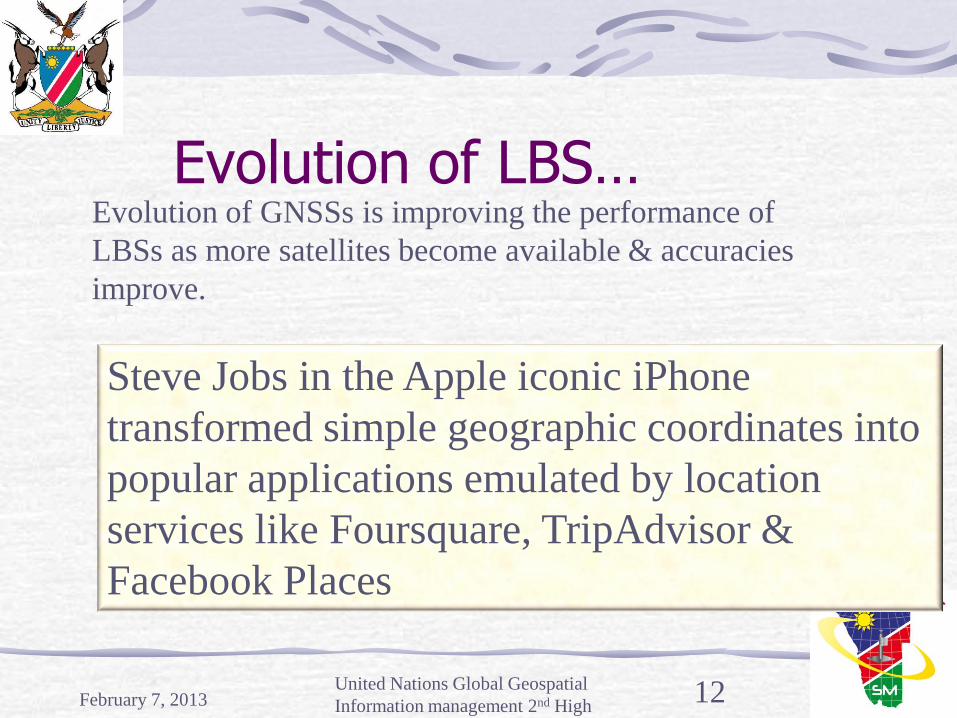
Evolution of LBS…
Steve Jobs in the Apple iconic iPhone
transformed simple geographic coordinates into
popular applications emulated by location
services like Foursquare, TripAdvisor &
Facebook Places
Evolution of GNSSs is improving the performance of
LBSs as more satellites become available & accuracies
improve.

Location based service (LBS) will become a 13B business
by 2013
February 7, 2013 United Nations Global Geospatial Information management
2nd High level forum- Doha, Qatar, 4-6 February 2013

Market Forecasts Market forecast undertaken for Galileo by the EC funded by the EC suggests that LBS will be the prime application wrt No of users & revenue potentials
Revenue from Middle East and Africa by 2013 - $20 million (13B) $60 million by 2014.
Traditional Advertising for Middle East & Africa –
2012 = $150 million; 2015= $300 million; 2017 = $360 million – (Johnson, L., 2012)
February 7, 2013 United Nations Global Geospatial Information management
2nd High level forum- Doha, Qatar, 4 – 6 February, 2013 14

Demographics of USA phone users making use of LBS applications
February 7, 2013 United Nations Global Geospatial Information management
2nd High level forum- Doha, Qatar, 4 – 6 February, 2013 15
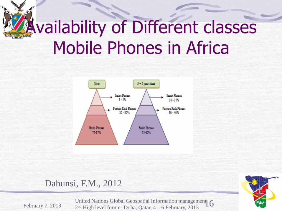
Availability of Different classes Mobile Phones in Africa
February 7, 2013 United Nations Global Geospatial Information management
2nd High level forum- Doha, Qatar, 4 – 6 February, 2013 16
Dahunsi, F.M., 2012

Location Based Services in 4 African Countries
Country Company Penetration Rate
Services
Egypt Mobinil, Vodafone, Etisalat
58% (05/2008) 66.3 million
Kenya Safaricom, Airtel-Zain, Orange Kenya, Yu-Essar telecom Kenya
51% (10/2010) 19.4 million
Vehicle tracking, emergency calls
Nigeria MTN, GloMobile, Airtel-Zain, Starcomms, Mtel, Etisalat, Multilinks – Telkom Visafone
60% (10/2010) 90 million
Person tracking
February 7, 2013 United Nations Global Geospatial Information management
2nd High level forum- Doha, Qatar, 4 – 6 February, 2013 17

Location Based Services in 4 African Countries
Country Company Penetration Rate
Services
South Africa Vodacom, MTN, Cell C, 8.ta, Virgin Mobile, Red Bull Mobile
92% (2010) 45 million
Emergency calls, Distress calls, person tracking, points of interest, Asset tracking,
February 7, 2013 United Nations Global Geospatial Information management
2nd High level forum- Doha, Qatar, 4 – 6 February, 2013 18
19
Positioning mechanisms Positioning with respect to LBS involves two steps:
Signal measurements
Location estimate based on measured signals
5 methods are widely used:
Mobile Positioning System (MPS) based on Cell Global Identity (CGI)
Cell Global Identity + Timing Advance (CGI + TA)

20
Positioning mechanisms Uplink Time of Arrival (TOA),
Enhanced Observed Time Difference (E-OTD) and
Global Positioning System (GPS) assisted.
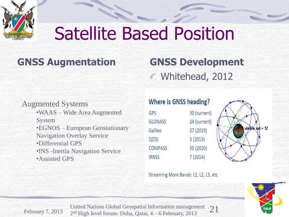
Satellite Based Position
GNSS Augmentation GNSS Development
Whitehead, 2012
February 7, 2013 United Nations Global Geospatial Information management
2nd High level forum- Doha, Qatar, 4 – 6 February, 2013 21
Augmented Systems •WAAS – Wide Area Augmented
System
•EGNOS – European Geostationary
Navigation Overlay Service
•Differential GPS
•INS -Inertia Navigation Service
•Assisted GPS

Comparison of different positioning methods (Chatre & Ludwig, 2003
Requirement
Cell-ID E-OTD OTDOA A-GPS
Accuracy Poor 200m-20km 2D only
Avg 100m-500m 2D only
Avg 40m-150m 3D
Very Good 5m-10m 3D
TTFF Excellent 1s Very good 5s Very Good 5s Very God 5s
Roaming Excellent Poor Poor Excellent
Expansion Excellent Poor Poor Excellent
Comp Excellent Poor Poor Excellent
Terminal Cost Negligible Medium Medium High
Overall cost Excellent Poor Average Good
Summary Average Average Average Good
February 7, 2013 United Nations Global Geospatial Information management
2nd High level forum- Doha, Qatar, 4 – 6 February, 2013 22

GNSS Services The ability to provide time-dependent coordinates to features is fundamental for many location based applications
A well defined global reference frame is essential for any meaningful and exploitable point positions
Global and Regional applications rely on the availability of ITRF
Components of the precise geodetic infrastructure combine in the realization of the ITRF.
February 7, 2013 United Nations Global Geospatial Information management
2nd High level forum- Doha, Qatar, 4 – 6 February, 2013 23

International Terrestrial Reference Frame
ITRF provides the anchor for nearly all ground based applications prominent among which is the LBS
ITRF is an indispensable reference required to ensure integrity & inter-operability of GNSS such as GPS, GLONASS, Galileo, Compass, etc
ITRF will require sufficient number & globally distributed co-location sites
February 7, 2013 United Nations Global Geospatial Information management
2nd High level forum- Doha, Qatar, 4 – 6 February, 2013 24

IGS Stations
February 7, 2013 United Nations Global Geospatial Information management
2nd High level forum- Doha, Qatar, 4 – 6 February, 2013 25

CORS in Africa
February 7, 2013 United Nations Global Geospatial Information management
2nd High level forum- Doha, Qatar, 4 – 6 February, 2013 26
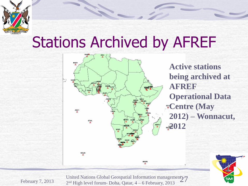
Stations Archived by AFREF
February 7, 2013 United Nations Global Geospatial Information management
2nd High level forum- Doha, Qatar, 4 – 6 February, 2013 27
Active stations
being archived at
AFREF
Operational Data
Centre (May
2012) – Wonnacut,
2012

Inter-disciplinary cooperation
February 7, 2013 United Nations Global Geospatial Information management
2nd High level forum- Doha, Qatar, 4 – 6 February, 2013 28
Number of disciplines
make use of GNSS
signal in space:
Geodesy: AFREF
Seismology: Africa Array
Meteorology: AMMA-GPS
Space weather: SCINDA Wonnacot, 2012
29
Issues in LBS Privacy of data, ownership of position data and permissions
Handset based vs handset assisted
International roaming
Accuracy due to various positioning techniques in different networks
Inter operability with the other operators results in mass marketing the services giving the necessary critical mass
Issues in LBS Integration of GNSS in the Geodetic infrastructure
Targeted approach to establishment and maintenance of geodetic network- user “hot spots” and specific applications
Method of access to real time signals (e.g. Smart phones); format of data (RTCM); & level of accuracy, integrity and security.
Non professional users with little understanding of accuracies and datum issues but with accuracy requirement exceeding that achievable without taking proper account of datum issues
February 7, 2013 United Nations Global Geospatial Information management
2nd High level forum- Doha, Qatar, 4 – 6 February, 2013 30
Issues in LBS Challenge of a plethora of wireless and GNSS standards wrt the provision of equipment that employs telecom networks to improve position accuracy and speed-
need for A-GNSS common standard –internetworking, interoperability,
backward compatibility- so as not to jeopardize the implementation of existing A-GPS in the future
For cost-effective & scalable LBS, targeting and feedback should be pinpointed and accurate in real-time at the planning, trafficking, creative and management levels.
February 7, 2013 United Nations Global Geospatial Information management
2nd High level forum- Doha, Qatar, 4 – 6 February, 2013 31
Issues in LBS
February 7, 2013 United Nations Global Geospatial Information management
2nd High level forum- Doha, Qatar, 4 – 6 February, 2013 32
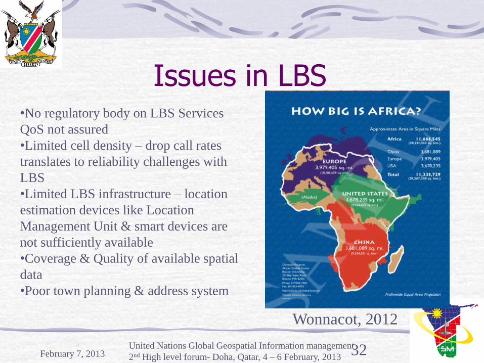
•No regulatory body on LBS Services
QoS not assured
•Limited cell density – drop call rates
translates to reliability challenges with
LBS
•Limited LBS infrastructure – location
estimation devices like Location
Management Unit & smart devices are
not sufficiently available
•Coverage & Quality of available spatial
data
•Poor town planning & address system
Wonnacot, 2012

Issues in Developing Effective Global Reference Frame
Policy makers and the Public are largely unaware of the nation’s reliance on geodetic infrastructure
Very limited sustainable long-term funding
Dilapidated and loss of geodetic stations
Sparse density of geodetic controls
Dearth of trained workforce to develop and maintain geodetic infrastructure.
February 7, 2013 United Nations Global Geospatial Information management
2nd High level forum- Doha, Qatar, 4 – 6 February, 2013 33
Issues in Developing Effective Global Reference Frame…
Different systems/frames although connected or related to ITRS/ITRF
WGS84 for GPS, PZ-90 for GLONASS; CGCS2000 for COMPASS; GTRF for Galileo; and JCS for QZSS
Six regional geodetic organizations
AFREF for Africa; NAREF & SIRGAS for North and South Americas; EUREF for Europe and APREF for Asia and Pacific, and SCAR for Antarctica
Defined wrt the ITRS/ITRF, realised and maintained by regional entities, eg. ETRS89 for Europe, NAD83 for North America; and SIRGAS for South America.
February 7, 2013 United Nations Global Geospatial Information management
2nd High level forum- Doha, Qatar, 4 – 6 February, 2013 34

Issues in Developing Effective Global Reference Frame…
Shared cost of deployment and maintenance New Zealand & Australian example
Commercial services; via commercial system owned & operated by Govt. With real-time corrections sold to industry
Wholly Govt. Owned that provide access to data for post-processing with value addition by private sector for real time capability
Consortium infrastructure –industry, academia, government & community group share costs, maintenance & benefits with value addition and distribution provided by private industry.
February 7, 2013
United Nations Global Geospatial Information management
2nd High level forum- Doha, Qatar, 4 – 6 February, 2013 35

Issues in Developing Effective Global Reference Frame...
Proliferation of active GNSS vis a vis compatibility with national datums; datum fragmentation & need for homogeneous geodetic infrastructure
Densities of Active and Passive GNSS’s
Status of classical geodetic network
Insufficient Enthusiasm & Commitment to regional cooperation, e.g AFREF
February 7, 2013 United Nations Global Geospatial Information management
2nd High level forum- Doha, Qatar, 4 – 6 February, 2013 36
Recommendations High precision GNSS national networks to be established and maintained similar to other infrastructure like roads, telecommunications and made available in real time without restrictions
National participation and support for international geodetic services and commitment to maintaining the ITRF –IAG -Global Geodetic Observing System
Improved funding and incentives to train requisite workforce
Shift from legacy datums to GNSS-supported reference frames - ITRF
February 7, 2013 United Nations Global Geospatial Information management
2nd High level forum- Doha, Qatar, 4 – 6 February, 2013 37

Recommendations Global Approach is needed – UN (GGIM)
Promote legal framework required to ensure standardization
Support regional initiatives for developing common frameworks and methodology
Technology governance
Data governance
Standards governance
February 7, 2013 United nations Global Geospatial Information management
High level forum- Seoul, Korea 24-26 October 2011 38
Recommendations Placement of Regional body within the structure of the political structure like the AU for AFREF.
National Geodetic networks should as a first step be converted to the regional frame, e.g. AFREF
A Global Reference Frame should be the goal using existing technology (and under development) to migrate to a Global Reference Frame
February 7, 2013 United Nations Global Geospatial Information management
2nd High level forum- Doha, Qatar, 4 – 6 February, 2013 39

Food for thought for all of us
Whitehead, 2012 has suggested different strategies for consideration
Scientific, commercial, Government (or a mix)
Sparse Density vs optimal Density
Static (Passive) vs Dynamic (Real Time)
Progression Plan –Evolution of technology
February 7, 2013 United Nations Global Geospatial Information management
2nd High level forum- Doha, Qatar, 4 – 6 February, 2013 40

Conclusion LBS realises its full potential and value when
anchored on a shared common framework, ITRF, and internationally accepted standards
A Common Framework and standard provide enhanced communication, cooperation and coordination and amplifies the impact of collaboration.