This article was downloaded by: [Pontificia Universidad Javeria]On: 23 January 2015, At: 07:33Publisher: Taylor & FrancisInforma Ltd Registered in England and Wales Registered Number: 1072954 Registeredoffice: Mortimer House, 37-41 Mortimer Street, London W1T 3JH, UK
International Journal of RemoteSensingPublication details, including instructions for authors andsubscription information:http://www.tandfonline.com/loi/tres20
Fuzzy segmentation for object‐basedimage classificationI. Lizarazo a & P. Elsner ba Cadastral Engineering and Geodesy Department , UniversidadDistrital Francisco Jose de Caldas , Bogota, Colombiab Birkbeck College , University of London , London, UnitedKingdomPublished online: 22 Apr 2009.
To cite this article: I. Lizarazo & P. Elsner (2009) Fuzzy segmentation for object‐basedimage classification, International Journal of Remote Sensing, 30:6, 1643-1649, DOI:10.1080/01431160802460062
To link to this article: http://dx.doi.org/10.1080/01431160802460062
PLEASE SCROLL DOWN FOR ARTICLE
Taylor & Francis makes every effort to ensure the accuracy of all the information (the“Content”) contained in the publications on our platform. However, Taylor & Francis,our agents, and our licensors make no representations or warranties whatsoever as tothe accuracy, completeness, or suitability for any purpose of the Content. Any opinionsand views expressed in this publication are the opinions and views of the authors,and are not the views of or endorsed by Taylor & Francis. The accuracy of the Contentshould not be relied upon and should be independently verified with primary sourcesof information. Taylor and Francis shall not be liable for any losses, actions, claims,proceedings, demands, costs, expenses, damages, and other liabilities whatsoever orhowsoever caused arising directly or indirectly in connection with, in relation to or arisingout of the use of the Content.
This article may be used for research, teaching, and private study purposes. Anysubstantial or systematic reproduction, redistribution, reselling, loan, sub-licensing,systematic supply, or distribution in any form to anyone is expressly forbidden. Terms &Conditions of access and use can be found at http://www.tandfonline.com/page/terms-and-conditions
Letter
Fuzzy segmentation for object-based image classification
I. LIZARAZO*{ and P. ELSNER{{Cadastral Engineering and Geodesy Department, Universidad Distrital Francisco Jose
de Caldas, Bogota, Colombia
{Birkbeck College, University of London, London, United Kingdom
(Received 30 April 2008; in final form 8 September 2008 )
This Letter proposes an object-based image classification procedure which is
based on fuzzy image-regions instead of crisp image-objects. The approach has
three stages: (a) fuzzification in which fuzzy image-regions are developed,
resulting in a set of images whose digital values express the degree of membership
of each pixel to target land-cover classes; (b) feature analysis in which contextual
properties of fuzzy image-regions are quantified; and (c) defuzzification in which
fuzzy image-regions are allocated to target land-cover classes. The proposed
procedure is implemented using automated statistical techniques that require very
little user interaction. The results indicate that fuzzy segmentation-based methods
produce acceptable thematic accuracy and could represent a viable alternative to
current crisp image segmentation approaches.
1. Introduction
How to produce accurate thematic maps from remotely sensed data sets remains an
important challenge for the remote sensing community. This task depends both on a
robust classifier and an appropriate classification method. The effective use of
multiple features of remotely sensed data is particularly significant for increasing
thematic accuracy (Lu and Weng 2007). An emerging classification method which is
becoming popular is segmentation-based classification, also known as object-based
image analysis (Jensen 2005).
Image segmentation aims to divide an image into parts that have high
correlation with geographic objects represented in the image. A complete
segmentation of an image R is a finite set of regions R1,…,RS, which fill
completely the image space without overlapping (Sonka et al. 2008). This ‘hard’ or
‘crisp’ segmentation produces image-objects that are delimited by clearly defined
boundaries. Measurement of spectral, textural and geometric properties of image-
objects at one or several spatial scales is conducted in order to enhance the vector
of features used in the subsequent classification stage (Blaschke et al. 2006). It has
been reported that this method is often more accurate than the traditional spectral
pixel-wise classification (Blaschke et al. 2006; Carleer et al. 2005). However, the
parameterization of crisp segmentation models commonly requires significant
user-interaction, making it difficult to employ such methods for the automated
processing of large data sets. This is particularly valid for urban landscapes. These
environments are heterogeneous and complex zones which result in images with
*Corresponding author. Email: [email protected]
International Journal of Remote Sensing
Vol. 30, No. 6, 20 March 2009, 1643–1649
International Journal of Remote SensingISSN 0143-1161 print/ISSN 1366-5901 online # 2009 Taylor & Francis
http://www.tandf.co.uk/journalsDOI: 10.1080/01431160802460062
Dow
nloa
ded
by [
Pont
ific
ia U
nive
rsid
ad J
aver
ia]
at 0
7:33
23
Janu
ary
2015
mixed signals at every scale, particularly at fine spatial resolution (Herold et al.
2003; Schiewe et al. 2001). This Letter proposes an alternative fuzzy segmentation-
based classification technique that requires very little user interaction. It is centred
on building fuzzy image-regions instead of producing clearly defined crisp image-
objects (Bezdeck and Pal 1992).
Pixel-based fuzzy classification is well established in environmental remote
sensing. An example is the analysis of spatial structures of ecological systems
without reducing them to arbitrary pure classes (Andrefout and Roux 1998; Foody
1996). Fuzzy concepts have also been combined with crisp image segmentation.
Aplin and Atkinson (2001), for example, proposed a method of subpixel mapping for
per-field classification based on soft-classification and vector data. Shackelford and
Davis (2003) presented an approach for urban land-cover classification that
produced a fuzzy classification and integrated properties of hard image-objects to
increase thematic accuracy. Benz et al. (2004) used a fuzzy classifier to allocate hard
image-objects to intended land-cover classes.
Fuzzy image segmentation for geographic object-based image analysis, however, is
a less explored territory. Recent research reported the use of unsupervised fuzzy
clustering algorithms for producing vague objects for change analysis and detection
(Fisher and Arnot 2007). This Letter now focuses on exploring the suitability of a
supervised fuzzy image segmentation approach.
Fuzzy segmentation produces fuzzy image-regions which are a set of images whose
digital values express degrees of membership of each pixel to target land-cover classes.
In opposition to the single layer space of crisp image-objects, a fuzzy image
segmentation produces an n-dimensional space in which there are as many layers of
fuzzy image-regions as target classes exist. Membership degree to regions is expressed
by any value in the interval [0, 1], expressing null, partial or full membership
possibility. The higher the membership degree is for a pixel, the more a pixel belongs to
the respective target class. Once fuzzy image-regions have been established, a number
of contextual properties may then be measured to enhance the set of attributes to be
used for the subsequent image classification (Lizarazo and Elsner 2008).
A fuzzy segmentation-based classification may be conducted by splitting the
classification process into three different stages:
(i) Fuzzification: the input image is converted into fuzzy image-regions which hold
degrees of membership of each pixel to a given number of target land-cover
classes. Note that fuzzy memberships must sum to 1 for a given pixel;
(ii) Feature analysis: contextual properties of fuzzy image-regions are measured
using contextual indices representing overlap between pairs of classes which are
spectrally similar; and
(iii) Defuzzification: fuzzy image-regions are allocated to target land-cover classes
according to their membership values and contextual properties. Final output is
a single classified image.
2. Data and methods
2.1 Data
The proposed method was evaluated by classifying the University image, a
hyperspectral data set of the University of Pavia (Italy) that was collected by the
Hysens project on 8th July 2002 (Gamba 2004). The University data set size is
1644 I. Lizarazo and P. Elsner
Dow
nloa
ded
by [
Pont
ific
ia U
nive
rsid
ad J
aver
ia]
at 0
7:33
23
Janu
ary
2015
6106339 pixels with 1.2 m spatial resolution and 112 hyperspectral channels ranging
from 400 to 1260 nm (Gamba 2004). This data set was chosen because it was used in
a previous study focusing on object-based image analysis (Aksoy 2006) which makes
it possible to evaluate directly the performance of the proposed fuzzy segmentation
approach. Seven spectral bands which roughly correspond to the middle of the
Landsat Thematic Mapper (TM) multi-spectral channel range were selected as input
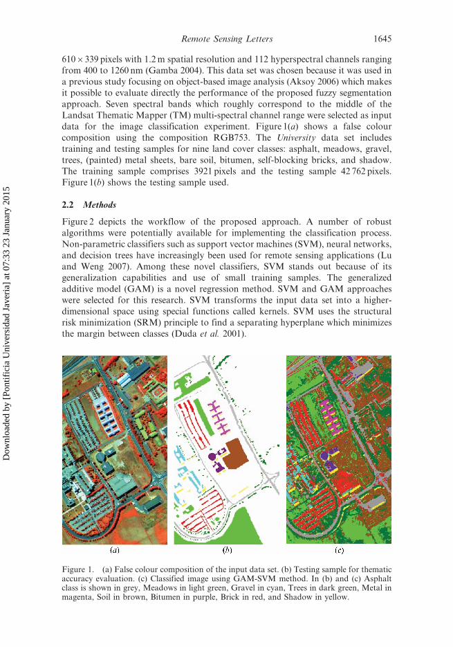
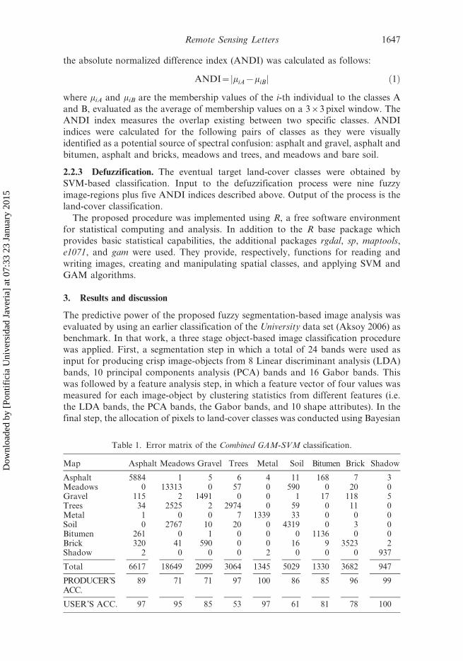
data for the image classification experiment. Figure 1(a) shows a false colour
composition using the composition RGB753. The University data set includes
training and testing samples for nine land cover classes: asphalt, meadows, gravel,
trees, (painted) metal sheets, bare soil, bitumen, self-blocking bricks, and shadow.
The training sample comprises 3921 pixels and the testing sample 42 762 pixels.
Figure 1(b) shows the testing sample used.
2.2 Methods
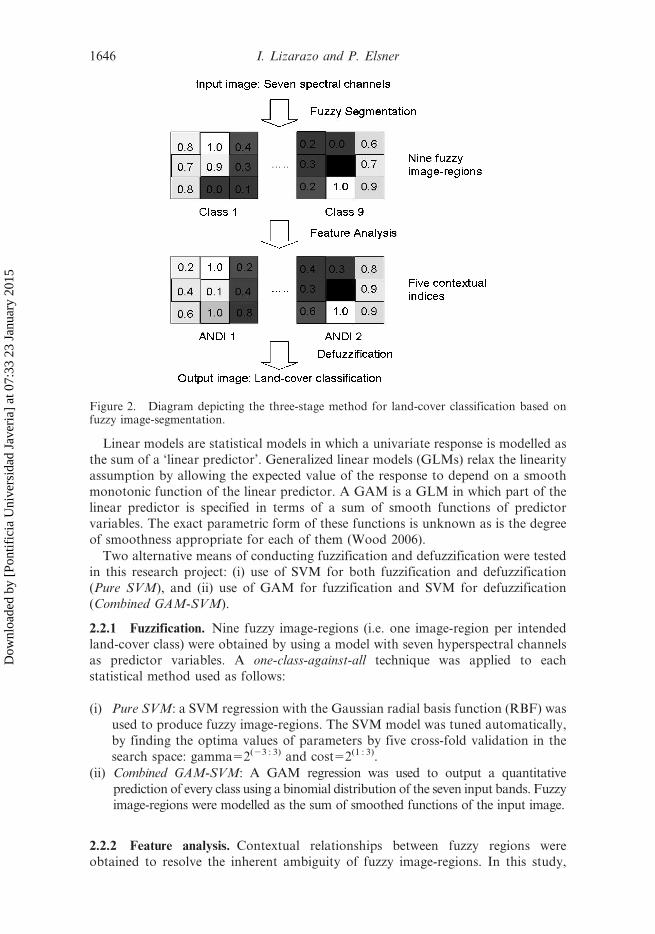
Figure 2 depicts the workflow of the proposed approach. A number of robust
algorithms were potentially available for implementing the classification process.
Non-parametric classifiers such as support vector machines (SVM), neural networks,
and decision trees have increasingly been used for remote sensing applications (Lu
and Weng 2007). Among these novel classifiers, SVM stands out because of its
generalization capabilities and use of small training samples. The generalized
additive model (GAM) is a novel regression method. SVM and GAM approaches
were selected for this research. SVM transforms the input data set into a higher-
dimensional space using special functions called kernels. SVM uses the structural
risk minimization (SRM) principle to find a separating hyperplane which minimizes
the margin between classes (Duda et al. 2001).
Figure 1. (a) False colour composition of the input data set. (b) Testing sample for thematicaccuracy evaluation. (c) Classified image using GAM-SVM method. In (b) and (c) Asphaltclass is shown in grey, Meadows in light green, Gravel in cyan, Trees in dark green, Metal inmagenta, Soil in brown, Bitumen in purple, Brick in red, and Shadow in yellow.
Remote Sensing Letters 1645
Dow
nloa
ded
by [
Pont
ific
ia U
nive
rsid
ad J
aver
ia]
at 0
7:33
23
Janu
ary
2015
Linear models are statistical models in which a univariate response is modelled as
the sum of a ‘linear predictor’. Generalized linear models (GLMs) relax the linearity
assumption by allowing the expected value of the response to depend on a smooth
monotonic function of the linear predictor. A GAM is a GLM in which part of the
linear predictor is specified in terms of a sum of smooth functions of predictor
variables. The exact parametric form of these functions is unknown as is the degree
of smoothness appropriate for each of them (Wood 2006).
Two alternative means of conducting fuzzification and defuzzification were tested
in this research project: (i) use of SVM for both fuzzification and defuzzification
(Pure SVM), and (ii) use of GAM for fuzzification and SVM for defuzzification
(Combined GAM-SVM).
2.2.1 Fuzzification. Nine fuzzy image-regions (i.e. one image-region per intended
land-cover class) were obtained by using a model with seven hyperspectral channels
as predictor variables. A one-class-against-all technique was applied to each
statistical method used as follows:
(i) Pure SVM: a SVM regression with the Gaussian radial basis function (RBF) was
used to produce fuzzy image-regions. The SVM model was tuned automatically,
by finding the optima values of parameters by five cross-fold validation in the
search space: gamma52(23 : 3) and cost52(1 : 3).
(ii) Combined GAM-SVM: A GAM regression was used to output a quantitative
prediction of every class using a binomial distribution of the seven input bands. Fuzzy
image-regions were modelled as the sum of smoothed functions of the input image.
2.2.2 Feature analysis. Contextual relationships between fuzzy regions were
obtained to resolve the inherent ambiguity of fuzzy image-regions. In this study,
Figure 2. Diagram depicting the three-stage method for land-cover classification based onfuzzy image-segmentation.
1646 I. Lizarazo and P. Elsner
Dow
nloa
ded
by [
Pont
ific
ia U
nive
rsid
ad J
aver
ia]
at 0
7:33
23
Janu
ary
2015
the absolute normalized difference index (ANDI) was calculated as follows:
ANDI~ miA{miBj j ð1Þ
where miA and miB are the membership values of the i-th individual to the classes A
and B, evaluated as the average of membership values on a 363 pixel window. The
ANDI index measures the overlap existing between two specific classes. ANDI
indices were calculated for the following pairs of classes as they were visually
identified as a potential source of spectral confusion: asphalt and gravel, asphalt and
bitumen, asphalt and bricks, meadows and trees, and meadows and bare soil.
2.2.3 Defuzzification. The eventual target land-cover classes were obtained by
SVM-based classification. Input to the defuzzification process were nine fuzzy
image-regions plus five ANDI indices described above. Output of the process is the
land-cover classification.
The proposed procedure was implemented using R, a free software environment
for statistical computing and analysis. In addition to the R base package which
provides basic statistical capabilities, the additional packages rgdal, sp, maptools,
e1071, and gam were used. They provide, respectively, functions for reading and
writing images, creating and manipulating spatial classes, and applying SVM and
GAM algorithms.
3. Results and discussion
The predictive power of the proposed fuzzy segmentation-based image analysis was
evaluated by using an earlier classification of the University data set (Aksoy 2006) as
benchmark. In that work, a three stage object-based image classification procedure
was applied. First, a segmentation step in which a total of 24 bands were used as
input for producing crisp image-objects from 8 Linear discriminant analysis (LDA)
bands, 10 principal components analysis (PCA) bands and 16 Gabor bands. This
was followed by a feature analysis step, in which a feature vector of four values was
measured for each image-object by clustering statistics from different features (i.e.
the LDA bands, the PCA bands, the Gabor bands, and 10 shape attributes). In the
final step, the allocation of pixels to land-cover classes was conducted using Bayesian
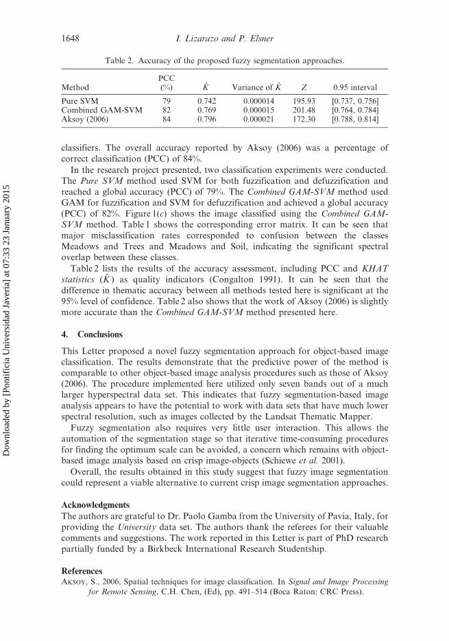
Table 1. Error matrix of the Combined GAM-SVM classification.
Map Asphalt Meadows Gravel Trees Metal Soil Bitumen Brick Shadow
Asphalt 5884 1 5 6 4 11 168 7 3Meadows 0 13313 0 57 0 590 0 20 0Gravel 115 2 1491 0 0 1 17 118 5Trees 34 2525 2 2974 0 59 0 11 0Metal 1 0 0 7 1339 33 0 0 0Soil 0 2767 10 20 0 4319 0 3 0Bitumen 261 0 1 0 0 0 1136 0 0Brick 320 41 590 0 0 16 9 3523 2Shadow 2 0 0 0 2 0 0 0 937
Total 6617 18649 2099 3064 1345 5029 1330 3682 947
PRODUCER’SACC.
89 71 71 97 100 86 85 96 99
USER’S ACC. 97 95 85 53 97 61 81 78 100
Remote Sensing Letters 1647
Dow
nloa
ded
by [
Pont
ific
ia U
nive
rsid
ad J
aver
ia]
at 0
7:33
23
Janu
ary
2015
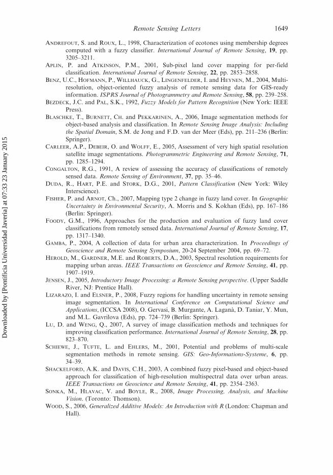
classifiers. The overall accuracy reported by Aksoy (2006) was a percentage of
correct classification (PCC) of 84%.
In the research project presented, two classification experiments were conducted.
The Pure SVM method used SVM for both fuzzification and defuzzification and
reached a global accuracy (PCC) of 79%. The Combined GAM-SVM method used
GAM for fuzzification and SVM for defuzzification and achieved a global accuracy
(PCC) of 82%. Figure 1(c) shows the image classified using the Combined GAM-
SVM method. Table 1 shows the corresponding error matrix. It can be seen that
major misclassification rates corresponded to confusion between the classes
Meadows and Trees and Meadows and Soil, indicating the significant spectraloverlap between these classes.
Table 2 lists the results of the accuracy assessment, including PCC and KHAT
statistics (K ) as quality indicators (Congalton 1991). It can be seen that the
difference in thematic accuracy between all methods tested here is significant at the
95% level of confidence. Table 2 also shows that the work of Aksoy (2006) is slightly
more accurate than the Combined GAM-SVM method presented here.
4. Conclusions
This Letter proposed a novel fuzzy segmentation approach for object-based image
classification. The results demonstrate that the predictive power of the method is
comparable to other object-based image analysis procedures such as those of Aksoy
(2006). The procedure implemented here utilized only seven bands out of a muchlarger hyperspectral data set. This indicates that fuzzy segmentation-based image
analysis appears to have the potential to work with data sets that have much lower
spectral resolution, such as images collected by the Landsat Thematic Mapper.
Fuzzy segmentation also requires very little user interaction. This allows the
automation of the segmentation stage so that iterative time-consuming procedures
for finding the optimum scale can be avoided, a concern which remains with object-based image analysis based on crisp image-objects (Schiewe et al. 2001).
Overall, the results obtained in this study suggest that fuzzy image segmentation
could represent a viable alternative to current crisp image segmentation approaches.
Acknowledgments
The authors are grateful to Dr. Paolo Gamba from the University of Pavia, Italy, for
providing the University data set. The authors thank the referees for their valuable
comments and suggestions. The work reported in this Letter is part of PhD researchpartially funded by a Birkbeck International Research Studentship.
ReferencesAKSOY, S., 2006, Spatial techniques for image classification. In Signal and Image Processing
for Remote Sensing, C.H. Chen, (Ed), pp. 491–514 (Boca Raton: CRC Press).
Table 2. Accuracy of the proposed fuzzy segmentation approaches.
MethodPCC(%) K Variance of K Z 0.95 interval
Pure SVM 79 0.742 0.000014 195.93 [0.737, 0.756]Combined GAM-SVM 82 0.769 0.000015 201.48 [0.764, 0.784]Aksoy (2006) 84 0.796 0.000021 172.30 [0.788, 0.814]
1648 I. Lizarazo and P. Elsner
Dow
nloa
ded
by [
Pont
ific
ia U
nive
rsid
ad J
aver
ia]
at 0
7:33
23
Janu
ary
2015
ANDREFOUT, S. and ROUX, L., 1998, Characterization of ecotones using membership degrees
computed with a fuzzy classifier. International Journal of Remote Sensing, 19, pp.
3205–3211.
APLIN, P. and ATKINSON, P.M., 2001, Sub-pixel land cover mapping for per-field
classification. International Journal of Remote Sensing, 22, pp. 2853–2858.
BENZ, U.C., HOFMANN, P., WILLHAUCK, G., LINGENFELDER, I. and HEYNEN, M., 2004, Multi-
resolution, object-oriented fuzzy analysis of remote sensing data for GIS-ready
information. ISPRS Journal of Photogrammetry and Remote Sensing, 58, pp. 239–258.
BEZDECK, J.C. and PAL, S.K., 1992, Fuzzy Models for Pattern Recognition (New York: IEEE
Press).
BLASCHKE, T., BURNETT, CH. and PEKKARINEN, A., 2006, Image segmentation methods for
object-based analysis and classification. In Remote Sensing Image Analysis: Including
the Spatial Domain, S.M. de Jong and F.D. van der Meer (Eds), pp. 211–236 (Berlin:
Springer).
CARLEER, A.P., DEBEIR, O. and WOLFF, E., 2005, Assessment of very high spatial resolution
satellite image segmentations. Photogrammetric Engineering and Remote Sensing, 71,
pp. 1285–1294.
CONGALTON, R.G., 1991, A review of assessing the accuracy of classifications of remotely
sensed data. Remote Sensing of Environment, 37, pp. 35–46.
DUDA, R., HART, P.E. and STORK, D.G., 2001, Pattern Classification (New York: Wiley
Interscience).
FISHER, P. and ARNOT, Ch., 2007, Mapping type 2 change in fuzzy land cover. In Geographic
Uncertainty in Environmental Security, A. Morris and S. Kokhan (Eds), pp. 167–186
(Berlin: Springer).
FOODY, G.M., 1996, Approaches for the production and evaluation of fuzzy land cover
classifications from remotely sensed data. International Journal of Remote Sensing, 17,
pp. 1317–1340.
GAMBA, P., 2004, A collection of data for urban area characterization. In Proceedings of
Geoscience and Remote Sensing Symposium, 20-24 September 2004, pp. 69–72.
HEROLD, M., GARDNER, M.E. and ROBERTS, D.A., 2003, Spectral resolution requirements for
mapping urban areas. IEEE Transactions on Geoscience and Remote Sensing, 41, pp.
1907–1919.
JENSEN, J., 2005, Introductory Image Processing: a Remote Sensing perspective. (Upper Saddle
River, NJ: Prentice Hall).
LIZARAZO, I. and ELSNER, P., 2008, Fuzzy regions for handling uncertainty in remote sensing
image segmentation. In International Conference on Computational Science and
Applications, (ICCSA 2008), O. Gervasi, B. Murgante, A. Lagana, D. Taniar, Y. Mun,
and M.L. Gavrilova (Eds), pp. 724–739 (Berlin: Springer).
LU, D. and WENG, Q., 2007, A survey of image classification methods and techniques for
improving classification performance. International Journal of Remote Sensing, 28, pp.
823–870.
SCHIEWE, J., TUFTE, L. and EHLERS, M., 2001, Potential and problems of multi-scale
segmentation methods in remote sensing. GIS: Geo-Informations-Systeme, 6, pp.
34–39.
SHACKELFORD, A.K. and DAVIS, C.H., 2003, A combined fuzzy pixel-based and object-based
approach for classification of high-resolution multispectral data over urban areas.
IEEE Transactions on Geoscience and Remote Sensing, 41, pp. 2354–2363.
SONKA, M., HLAVAC, V. and BOYLE, R., 2008, Image Processing, Analysis, and Machine
Vision. (Toronto: Thomson).
WOOD, S., 2006, Generalized Additive Models: An Introduction with R (London: Chapman and
Hall).
Remote Sensing Letters 1649
Dow
nloa
ded
by [
Pont
ific
ia U
nive
rsid
ad J
aver
ia]
at 0
7:33
23
Janu
ary
2015