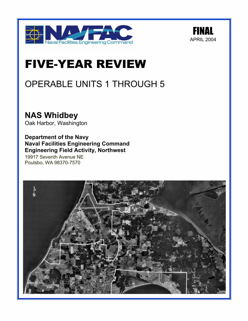
FINAL APRIL 2004
OPERABLE UNITS 1 THROUGH 5
FIVE-YEAR REVIEW
Department of the Navy Naval Facilities Engineering Command Engineering Field Activity, Northwest 19917 Seventh Avenue NE Poulsbo, WA 98370-7570
NAS Whidbey Oak Harbor, Washington

FINAL
FIVE-YEAR REVIEW
OPERABLE UNITS 1 THROUGH 5 NAVAL AIR STATION WHIDBEY ISLAND
OAK HARBOR, WASHINGTON
April 2004
Prepared for: Engineering Field Activity, Northwest
19917 Seventh Avenue, N.E. Poulsbo, Washington 98370
Prepared by:
The Environmental Company, Inc 1450 114th Ave S.E.
Suite 220 Bellevue, WA 98004


This page intentionally left blank.
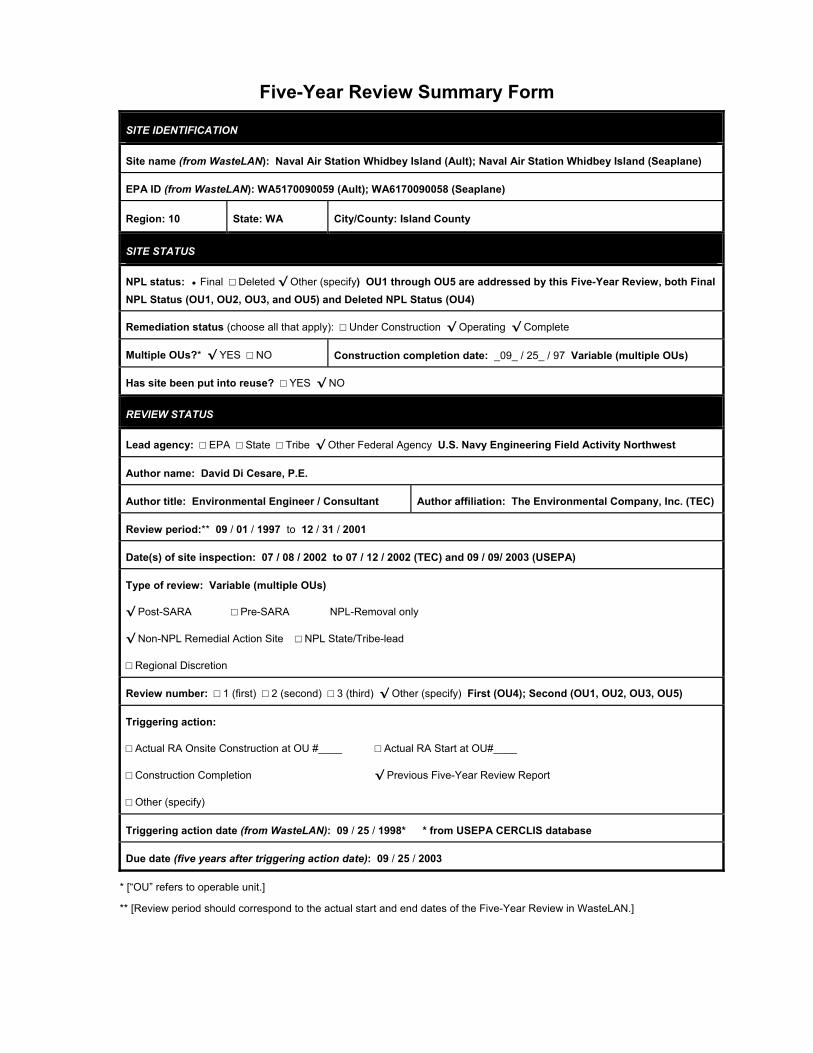
Five-Year Review Summary Form
SITE IDENTIFICATION
Site name (from WasteLAN): Naval Air Station Whidbey Island (Ault); Naval Air Station Whidbey Island (Seaplane)
EPA ID (from WasteLAN): WA5170090059 (Ault); WA6170090058 (Seaplane)
Region: 10 State: WA City/County: Island County
SITE STATUS
NPL status: • Final □ Deleted √ Other (specify) OU1 through OU5 are addressed by this Five-Year Review, both Final NPL Status (OU1, OU2, OU3, and OU5) and Deleted NPL Status (OU4)
Remediation status (choose all that apply): □ Under Construction √ Operating √ Complete
Multiple OUs?* √ YES □ NO Construction completion date: _09_ / 25_ / 97 Variable (multiple OUs)
Has site been put into reuse? □ YES √ NO
REVIEW STATUS
Lead agency: □ EPA □ State □ Tribe √ Other Federal Agency U.S. Navy Engineering Field Activity Northwest
Author name: David Di Cesare, P.E.
Author title: Environmental Engineer / Consultant Author affiliation: The Environmental Company, Inc. (TEC)
Review period:** 09 / 01 / 1997 to 12 / 31 / 2001
Date(s) of site inspection: 07 / 08 / 2002 to 07 / 12 / 2002 (TEC) and 09 / 09/ 2003 (USEPA)
Type of review: Variable (multiple OUs)
√ Post-SARA □ Pre-SARA NPL-Removal only
√ Non-NPL Remedial Action Site □ NPL State/Tribe-lead
□ Regional Discretion
Review number: □ 1 (first) □ 2 (second) □ 3 (third) √ Other (specify) First (OU4); Second (OU1, OU2, OU3, OU5)
Triggering action:
□ Actual RA Onsite Construction at OU #____ □ Actual RA Start at OU#____
□ Construction Completion √ Previous Five-Year Review Report
□ Other (specify)
Triggering action date (from WasteLAN): 09 / 25 / 1998* * from USEPA CERCLIS database
Due date (five years after triggering action date): 09 / 25 / 2003
* [“OU” refers to operable unit.]
** [Review period should correspond to the actual start and end dates of the Five-Year Review in WasteLAN.]
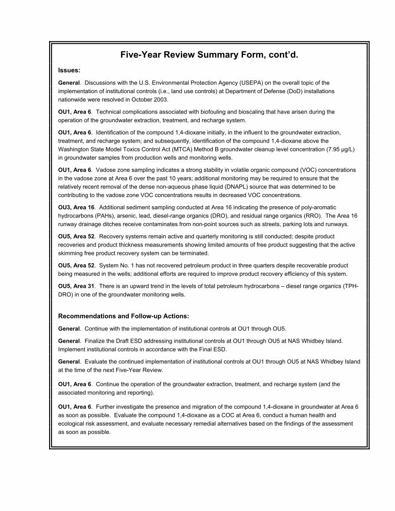
Five-Year Review Summary Form, cont’d. Issues:
General. Discussions with the U.S. Environmental Protection Agency (USEPA) on the overall topic of the implementation of institutional controls (i.e., land use controls) at Department of Defense (DoD) installations nationwide were resolved in October 2003.
OU1, Area 6. Technical complications associated with biofouling and bioscaling that have arisen during the operation of the groundwater extraction, treatment, and recharge system.
OU1, Area 6. Identification of the compound 1,4-dioxane initially, in the influent to the groundwater extraction, treatment, and recharge system; and subsequently, identification of the compound 1,4-dioxane above the Washington State Model Toxics Control Act (MTCA) Method B groundwater cleanup level concentration (7.95 µg/L) in groundwater samples from production wells and monitoring wells.
OU1, Area 6. Vadose zone sampling indicates a strong stability in volatile organic compound (VOC) concentrations in the vadose zone at Area 6 over the past 10 years; additional monitoring may be required to ensure that the relatively recent removal of the dense non-aqueous phase liquid (DNAPL) source that was determined to be contributing to the vadose zone VOC concentrations results in decreased VOC concentrations.
OU3, Area 16. Additional sediment sampling conducted at Area 16 indicating the presence of poly-aromatic hydrocarbons (PAHs), arsenic, lead, diesel-range organics (DRO), and residual range organics (RRO). The Area 16 runway drainage ditches receive contaminates from non-point sources such as streets, parking lots and runways.
OU5, Area 52. Recovery systems remain active and quarterly monitoring is still conducted; despite product recoveries and product thickness measurements showing limited amounts of free product suggesting that the active skimming free product recovery system can be terminated.
OU5, Area 52. System No. 1 has not recovered petroleum product in three quarters despite recoverable product being measured in the wells; additional efforts are required to improve product recovery efficiency of this system.
OU5, Area 31. There is an upward trend in the levels of total petroleum hydrocarbons – diesel range organics (TPH-DRO) in one of the groundwater monitoring wells.
Recommendations and Follow-up Actions:
General. Continue with the implementation of institutional controls at OU1 through OU5.
General. Finalize the Draft ESD addressing institutional controls at OU1 through OU5 at NAS Whidbey Island. Implement institutional controls in accordance with the Final ESD.
General. Evaluate the continued implementation of institutional controls at OU1 through OU5 at NAS Whidbey Island at the time of the next Five-Year Review.
OU1, Area 6. Continue the operation of the groundwater extraction, treatment, and recharge system (and the associated monitoring and reporting).
OU1, Area 6. Further investigate the presence and migration of the compound 1,4-dioxane in groundwater at Area 6 as soon as possible. Evaluate the compound 1,4-dioxane as a COC at Area 6, conduct a human health and ecological risk assessment, and evaluate necessary remedial alternatives based on the findings of the assessment as soon as possible.
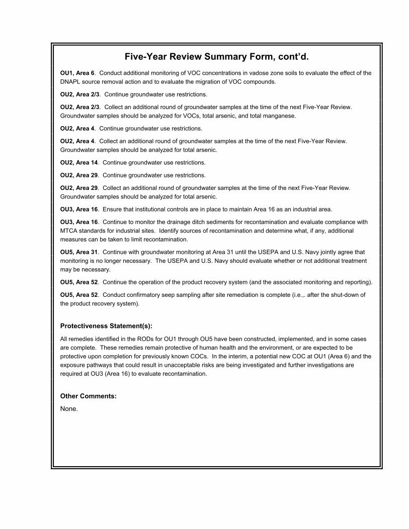
Five-Year Review Summary Form, cont’d. OU1, Area 6. Conduct additional monitoring of VOC concentrations in vadose zone soils to evaluate the effect of the DNAPL source removal action and to evaluate the migration of VOC compounds.
OU2, Area 2/3. Continue groundwater use restrictions.
OU2, Area 2/3. Collect an additional round of groundwater samples at the time of the next Five-Year Review. Groundwater samples should be analyzed for VOCs, total arsenic, and total manganese.
OU2, Area 4. Continue groundwater use restrictions.
OU2, Area 4. Collect an additional round of groundwater samples at the time of the next Five-Year Review. Groundwater samples should be analyzed for total arsenic.
OU2, Area 14. Continue groundwater use restrictions.
OU2, Area 29. Continue groundwater use restrictions.
OU2, Area 29. Collect an additional round of groundwater samples at the time of the next Five-Year Review. Groundwater samples should be analyzed for total arsenic.
OU3, Area 16. Ensure that institutional controls are in place to maintain Area 16 as an industrial area.
OU3, Area 16. Continue to monitor the drainage ditch sediments for recontamination and evaluate compliance with MTCA standards for industrial sites. Identify sources of recontamination and determine what, if any, additional measures can be taken to limit recontamination.
OU5, Area 31. Continue with groundwater monitoring at Area 31 until the USEPA and U.S. Navy jointly agree that monitoring is no longer necessary. The USEPA and U.S. Navy should evaluate whether or not additional treatment may be necessary.
OU5, Area 52. Continue the operation of the product recovery system (and the associated monitoring and reporting).
OU5, Area 52. Conduct confirmatory seep sampling after site remediation is complete (i.e.,. after the shut-down of the product recovery system).
Protectiveness Statement(s):
All remedies identified in the RODs for OU1 through OU5 have been constructed, implemented, and in some cases are complete. These remedies remain protective of human health and the environment, or are expected to be protective upon completion for previously known COCs. In the interim, a potential new COC at OU1 (Area 6) and the exposure pathways that could result in unacceptable risks are being investigated and further investigations are required at OU3 (Area 16) to evaluate recontamination.
Other Comments:
None.

This page intentionally left blank.
NAS Whidbey Island
April 2004 ES-1
EXECUTIVE SUMMARY
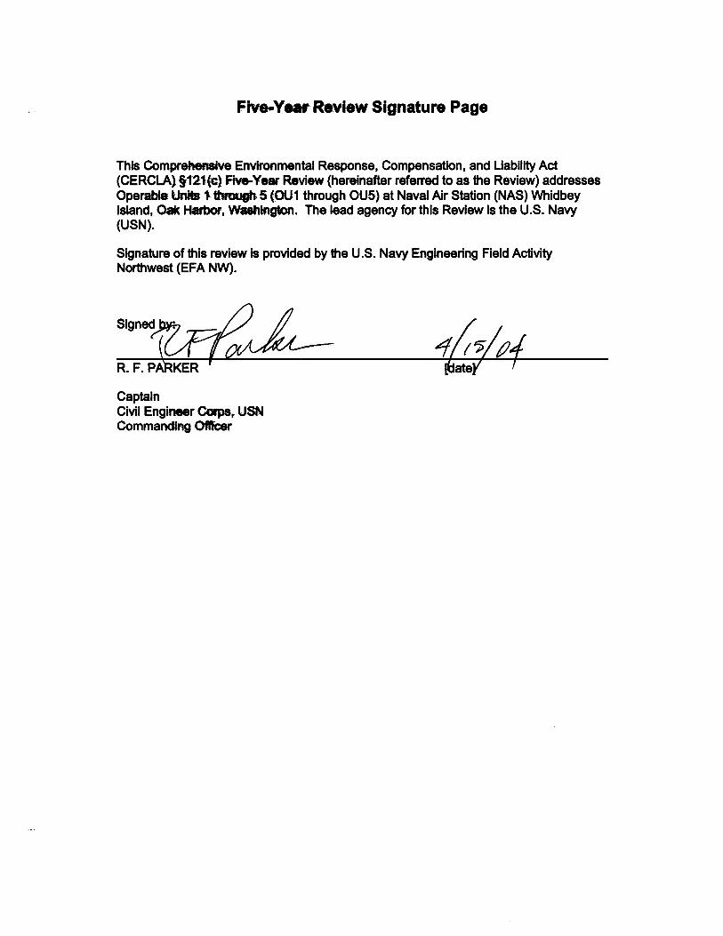
This Comprehensive Environmental Response, Compensation, and Liability Act (CERCLA) §121(c) Five-Year Review (hereinafter referred to as the Review) addresses Operable Units 1 through 5 (OU1 through OU5) at Naval Air Station (NAS) Whidbey Island, Oak Harbor, Washington.
This Review is the second review for NAS Whidbey Island and is being conducted to meet the statutory mandate under CERCLA §121(c). An initial Five-Year Review of OU1, OU2, OU3, and OU5 was conducted in 1997 (EFANW, 1998). A Five-Year Review of OU4 was not required by U.S. Environmental Protection Agency (USEPA) policy at the date of the initial Five-Year Review.
This Review evaluates the implementation and performance of remedies to determine if the remedies are and will continue to be protective of human health and the environment. Under CERCLA §121(c), a periodic review is required when hazardous substances, pollutants, or contaminants remain on-site above levels that allow for unlimited use and unrestricted exposure [40 CFR §300.430(f)(4)(ii)].
This Review was conducted in accordance with USEPA Comprehensive Five-Year Review Guidance, Office of Solid Waste and Emergency Response (OSWER) No. 9355.7-03B-P, June 2001 (USEPA, 2001). This Review was also conducted in accordance with the Records of Decision (RODs) addressing OU1 through OU5, CERCLA §121(c), the National Contingency Plan (NCP), and the initial Five-Year Review of OU1 through OU3, and OU5.
The Review process consists of establishing a Review Team; notifying potentially interested parties and involving the community in the review process; developing the draft Review report (document reviews, site inspections, interviews, and data evaluation); and ultimately signing and submitting the final Review report.
This Review documents the actions taken at OU1 through OU5 since the initial Five-Year Review (see Section 3.0). This Review also summarizes a technical assessment of the remedy(ies) implemented at each of the five OUs and presents any issues of concern (see Section 5.0).
This Review determined that the remedy(ies) implemented at each of the five OUs are functioning as intended; that exposure assumptions, toxicity data, cleanup levels, and remedial action objectives remain valid, and that no other information has come to light that could call into question the protectiveness of most of the remedy(ies). Exceptions are the recontamination of the runway drainage ditches at Area 16 and the potential new contaminant of concern (COC) (1,4-dioxane) at Area 6.
This Review provides recommendations and follow-up actions, both in general and specific to each of the five OUs (see Section 6.0). Two general recommendations are made, i.e., that an Explanation of Significant Differences (ESD) addressing OU1 through OU5 be finalized by NAS Whidbey Island, and that the continued implementation of institutional controls be evaluated at the time of the next Five-Year Review. Several
NAS Whidbey Island
April 2004 ES-2
specific recommendations are made with regard to individual areas within individual OUs and these recommendations address such actions as the collection of an additional round of groundwater samples at the time of the next Five-Year Review, the continued operation of existing remedial systems, and the continued monitoring of groundwater.
This Review also provides protectiveness statements (see Section 7.0). The following comprehensive protectiveness statement is made and addresses the remedies implemented at all five OUs:
All remedies identified in the RODs for OU1 through OU5 have been constructed, implemented, and in some cases are complete. These remedies remain protective of human health and the environment, or are expected to be protective upon completion for previously known COCs. In the interim, a potential new COC at OU1 (Area 6) and the exposure pathways that could result in unacceptable risks are being investigated and further investigations are required at OU3 (Area 16) to evaluate recontamination.
NAS Whidbey Island
April 2004 i
TABLE OF CONTENTS
1.0 INTRODUCTION ........................................................................................ 1-1
1.1 PURPOSE ........................................................................................ 1-1
1.2 METHODOLOGY ............................................................................. 1-1
1.3 BACKGROUND ................................................................................ 1-2 1.3.1 NAS Whidbey Island Mission ............................................... 1-2 1.3.2 Records of Decision .............................................................. 1-2 1.3.3 Operable Units ...................................................................... 1-4 1.3.4 Initial Five-Year Review ........................................................ 1-4
2.0 BACKGROUND, CHRONOLOGY, AND REMEDIAL ACTIONS ................ 2-1
3.0 ACTIONS SINCE INITIAL FIVE-YEAR REVIEW ....................................... 3-1
3.1 PROTECTIVENESS STATEMENT FROM INITIAL FIVE-YEAR REVIEW ............................................................................................ 3-1
3.2 GENERAL RECOMMENDATION AND ACTION TAKEN SINCE INITIAL FIVE-YEAR REVIEW .......................................................... 3-1 3.2.1 General Recommendation .................................................... 3-1 3.2.2 Action Taken Since Initial Five-Year Review ........................ 3-1
3.3 SPECIFIC RECOMMENDATIONS AND ACTIONS TAKEN SINCE INITIAL FIVE-YEAR REVIEW .......................................................... 3-2 3.3.1 Operable Unit 1 .................................................................... 3-2
3.3.1.1 Specific Recommendations.................................... 3-2 3.3.1.2 Actions taken Since Initial Five-Year Review ........ 3-3
3.3.1.2.1 Area 5 ................................................. 3-3 3.3.1.2.2 Area 6 ................................................. 3-4
3.3.2 Operable Unit 2 .................................................................... 3-7 3.3.2.1 Specific Recommendations.................................... 3-7 3.3.2.2 Actions taken Since Initial Five-Year Review ........ 3-7
3.3.3 Operable Unit 3 .................................................................... 3-8 3.3.3.1 Specific Recommendations.................................... 3-8 3.3.3.2 Actions taken Since Initial Five-Year Review ........ 3-9
3.3.4 Operable Unit 4 .................................................................... 3-9 3.3.4.1 Specific Recommendations.................................... 3-9 3.3.4.2 Actions taken Since Initial Five-Year Review ........ 3-10
3.3.5 Operable Unit 5 .................................................................... 3-11
NAS Whidbey Island
April 2004 ii
3.3.5.1 Specific Recommendations.................................... 3-11 3.3.5.2 Actions taken Since Initial Five-Year Review ........ 3-12
3.3.5.2.1 Area 1 ................................................. 3-12 3.3.5.2.2 Area 31 ............................................... 3-12 3.3.5.2.3 Area 52 ............................................... 3-14
4.0 FIVE-YEAR REVIEW PROCESS ............................................................... 4-1
4.1 REVIEW TEAM ................................................................................. 4-1
4.2 NOTIFYING POTENTIALLY INTERESTED PARTIES AND INVOLVING THE COMMUNITY ....................................................... 4-1
4.3 DEVELOPING THE FIVE-YEAR REVIEW REPORT ....................... 4-2
5.0 TECHNICAL ASSESSMENT AND ISSUES OF CONCERN ..................... 5-1
5.1 OPERABLE UNIT 1 .......................................................................... 5-1 5.1.1 Area 5 ................................................................................... 5-1
5.1.1.1 Discussion ............................................................. 5-1 5.1.1.2 Technical Assessment .......................................... 5-1
5.1.2 Area 6 ................................................................................... 5-1 5.1.2.1 Discussion ............................................................. 5-1
5.1.2.1.1 Scaling and Biofouling ........................ 5-4 5.1.2.1.2 Natural Attenuation ............................ 5-6 5.1.2.1.3 1,4-dioxane ........................................ 5-7 5.1.2.1.4 Residual VOCs in Vadose Zone ........ 5-8
5.1.2.2 Technical Assessment .......................................... 5-11
5.2 OPERABLE UNIT 2 .......................................................................... 5-11 5.2.1 Area 2/3 ................................................................................ 5-11
5.2.1.1 Discussion ............................................................. 5-11 5.2.1.2 Technical Assessment .......................................... 5-13
5.2.2 Area 4 ................................................................................... 5-13 5.2.2.1 Discussion ............................................................. 5-13 5.2.2.2 Technical Assessment .......................................... 5-13
5.2.3 Area 14 ................................................................................. 5-14 5.2.3.1 Discussion ............................................................. 5-14 5.2.3.2 Technical Assessment .......................................... 5-14
5.2.4 Area 29 ................................................................................. 5-14 5.2.4.1 Discussion ............................................................. 5-14 5.2.4.2 Technical Assessment .......................................... 5-15
NAS Whidbey Island
April 2004 iii
5.3 OPERABLE UNIT 3 .......................................................................... 5-15 5.3.1 Area 16 ................................................................................. 5-15
5.3.1.1 Discussion ............................................................. 5-15 5.3.1.2 Technical Assessment .......................................... 5-15
5.4 OPERABLE UNIT 4 .......................................................................... 5-16 5.4.1 Area 39 ................................................................................. 5-16
5.4.1.1 Discussion ............................................................. 5-16 5.4.1.2 Technical Assessment .......................................... 5-16
5.4.2 Area 41 ................................................................................. 5-16 5.4.2.1 Discussion ............................................................. 5-16 5.4.2.2 Technical Assessment .......................................... 5-16
5.4.3 Area 44 ................................................................................. 5-16 5.4.3.1 Discussion ............................................................. 5-16 5.4.3.2 Technical Assessment .......................................... 5-16
5.4.4 Area 48 ................................................................................. 5-16 5.4.4.1 Discussion ............................................................. 5-16 5.4.4.2 Technical Assessment .......................................... 5-17
5.4.5 Area 49 ................................................................................. 5-17 5.4.5.1 Discussion ............................................................. 5-17 5.4.5.2 Technical Assessment .......................................... 5-17
5.5 OPERABLE UNIT 5 .......................................................................... 5-17 5.5.1 Area 1 ................................................................................... 5-17
5.5.1.1 Discussion ............................................................. 5-17 5.5.1.1 Technical Assessment .......................................... 5-18
5.5.2 Area 31 ................................................................................. 5-18 5.5.2.1 Discussion ............................................................. 5-18 5.5.2.2 Technical Assessment .......................................... 5-22
5.5.3 Area 52 ................................................................................. 5-22 5.5.3.1 Discussion ............................................................. 5-22 5.5.3.2 Technical Assessment .......................................... 5-26
6.0 RECOMMENDATIONS / FOLLOW-UP ACTIONS ..................................... 6-1
6.1 GENERAL RECOMMENDATIONS / FOLLOW-UP ACTIONS ......... 6-1
6.2 SPECIFIC RECOMMENDATIONS / FOLLOW-UP ACTIONS .......... 6-1 6.2.1 Operable Unit 1 .................................................................... 6-1 6.2.2 Operable Unit 2 .................................................................... 6-1
NAS Whidbey Island
April 2004 iv
6.2.3 Operable Unit 3 .................................................................... 6-2 6.2.4 Operable Unit 4 .................................................................... 6-2 6.2.5 Operable Unit 5 .................................................................... 6-2
7.0 PROTECTIVENESS STATEMENT AND SUBSEQUENT FIVE-YEAR REVIEWS................................................................................ 7-1
7.1 COMPREHENSIVE PROTECTIVENESS STATEMENT .................. 7-1
7.2 INDIVIDUAL PROTECTIVENESS STATEMENTS ........................... 7-1 7.2.1 Operable Unit 1 .................................................................... 7-1 7.2.2 Operable Unit 2 .................................................................... 7-1 7.2.3 Operable Unit 3 .................................................................... 7-1 7.2.4 Operable Unit 4 .................................................................... 7-1 7.2.5 Operable Unit 5 .................................................................... 7-2
7.3 SUBSEQUENT FIVE-YEAR REVIEW............................................... 7-2
8.0 REFERENCES ........................................................................................... 8-1
APPENDIX A BACKGROUND, CHRONOLOGY, AND REMEDIAL ACTIONS
APPENDIX B OPERABLE UNIT PHOTOGRAPHS
APPENDIX C RESPONSE TO PUBLIC COMMENTS
APPENDIX D OPERABLE UNIT 1, AREA 6, CUMULATIVE DATA
APPENDIX E DECEMBER 2002, ENVIRONMENTAL MONITORING DATA
NAS Whidbey Island
April 2004 v
LIST OF FIGURES
Figure 1-1 NAS Whidbey Island Location Map
Figure 5-1 Area 6 - Concentration Contours for 1,4-dioxane, June 24-26 Sampling Event
Figure 5-2 Area 52 – Free Product Recovery Cumulative Summary
LIST OF TABLES
Table 1-1 Records of Decision, OU1 through OU5
Table 1-2 Overview of Operable Units 1 through 5
Table 4-1 Five-Year Review Completed Milestones
Table 5-1 Area 6 - 1,4-dioxane Sample Results, Production Wells
Table 5-2 Area 6 - 1,4-dioxane Sample Results, Monitoring Wells
Table 5-3 Area 31 - Free Product Recover Cumulative Summary
Table 5-4 Area 31 - Periodic Average Biodegradation Rates
Table 5-5 Area 31 - Semi-Annual Groundwater monitoring Results, July 1998 to January 2000
Table 5-6 Area 52 - DRO and GRO Concentrations (µg/L) at OWS-1 and MW31-09A
Table 5-7 Area 52 – Free Product Recovery Cumulative Summary
Table 5-8 Summary of Issues
Table 6-1 Recommendations / Follow-on Actions

NAS Whidbey Island
April 2004 vi
LIST OF ACRONYMS AND ABBREVIATIONS
ARAR applicable or relevant and appropriate requirement AVGAS aviation gasoline AWQC Ambient Water Quality Criteria bgs below ground surface C&D Construction and Demolition CAPT Captain CERCLA Comprehensive Environmental Response, Compensation, and Liability Act CFR Code of Federal Regulations CIC Community Involvement Coordinator CIP Community Involvement Plan CNO Chief of Naval Operations COC Contaminant of Concern CSR Current Situation Report CTO Contract Task Order CUL clean-up level DCA dichloroethane DCE dichloroethylene DDE p,p’-Dichlorodiphenyldichloroethylene DDT dichlorodiphenyl trichloroethane DNAPL dense non-aqueous phase liquid DO dissolved oxygen DoD United States Department of Defense DRO diesel range organics Ecology Washington State Department of Ecology EFANW Engineering Field Activity, Northwest ENGCOM Engineering Command EPA see USEPA ESD Explanation of Significant Differences FFA Federal Facilities Agreement FS Feasibility Study ft foot (feet) GRO gasoline range organics GSA General Services Administration IAS Initial Assessment Study IC institutional control
NAS Whidbey Island
April 2004 vii
IRP Installation Restoration Program JP-5 jet petroleum #5 MCL maximum contaminant level MFS Minimum Functional Standards MNA monitored natural attenuation msl mean sea level MTCA Model Toxics Control Act (Washington State) MW monitoring well NACIP Navy Assessment and Control of Installation Pollutants NAS Naval Air Station NAVFAC Naval Facilities NCP National Contingency Plan NPL National Priorities List O&M operation and maintenance OSWER Office of Solid Waste and Emergency Response OU operable unit PAH polynuclear aromatic hydrocarbon PC personal computer PCB polychlorinated biphenyl PCP pentachlorophenol POTW Publicly-Owned Treatment Works ppb parts per billion ppm parts per million PW production well RCRA Resource Conservation and Recovery Act Review CERCLA §121(c) Five-Year Review RI Remedial Investigation RI/FS Remedial Investigation/Feasibility Study ROD Record of Decision RRO Residual Range Organics SAP Sampling and Analysis Plan SARA Superfund Amendments and Reauthorization Act (1986) § Section SVM soil vapor monitor SVOC semi-volatile organic compound TAL Target Analyte List
NAS Whidbey Island
April 2004 viii
TCA trichloroethane TCE trichloroethene TCLP Toxicity Characteristic Leaching Procedure TDS total dissolved solids TEC The Environmental Company, Inc. TPH total petroleum hydrocarbons TSCA Toxic Substances Control Act U.S. United States USEPA U.S. Environmental Protection Agency USN U.S. Navy UST underground storage tank VC vinyl chloride VOC volatile organic compound yd3 cubic yards
NAS Whidbey Island
April 2004 1-1
1.0 INTRODUCTION
This Comprehensive Environmental Response, Compensation, and Liability Act (CERCLA) §121(c) Five-Year Review (hereinafter referred to as the Review) addresses Operable Units 1 through 5 (OU1 through OU5) at Naval Air Station (NAS) Whidbey Island, Oak Harbor, Washington. It has been conducted by The Environmental Company, Inc. (TEC) for the U.S. Navy under Contract No. N44255-98-D-4416, Task Order (CTO) 041.
1.1 PURPOSE This Review is the second review for NAS Whidbey Island and is being conducted to meet the statutory mandate under CERCLA §121(c). This Review evaluates the implementation and performance of remedies to determine if the remedies are and will continue to be protective of human health and the environment.
An initial Five-Year Review of OU1, OU2, OU3, and OU5 was conducted by the U.S. Navy in 1997 (EFANW, 1998). A Five-Year Review of OU4 was not required by U.S. Environmental Protection Agency (USEPA) policy at the date of the initial Five-Year Review.
Under CERCLA §121(c), a periodic review is required when hazardous substances, pollutants, or contaminants remain on-site above levels that allow for unlimited use and unrestricted exposure [40 CFR §300.430(f)(4)(ii)]. The periodic review is to be conducted no less often than every 5 years after the initiation of a remedial action to ensure that the remedy is operating as planned and remains protective of human health and the environment. The periodic review should also identify possible deficiencies and recommend corrective actions.
The conduct of a Five-Year Review may be discontinued when no hazardous substances, pollutants, or contaminants remain on-site above levels that allow for unlimited use and unrestricted exposure.
1.2 METHODOLOGY This Review was conducted in accordance with USEPA Comprehensive Five-Year Review Guidance, Office of Solid Waste and Emergency Response (OSWER) No. 9355.7-03B-P, June 2001 (USEPA, 2001). This Review was also conducted in accordance with the Records of Decision (RODs) addressing OU1 through OU5, CERCLA §121(c), the National Contingency Plan (NCP), and the initial Five-Year Review of OU1 through OU3, and OU5.
This Review covers all areas being remediated under the authority of CERCLA and where remaining on-site hazardous substances, pollutants, or contaminants are above levels that allow for unlimited use and unrestricted exposure (see Section 1.3 for a more complete discussion regarding the specific areas that comprise these areas at NAS Whidbey Island).
NAS Whidbey Island
April 2004 1-2
Details regarding the specific activities conducted in support of this Review are presented in Section 4.0.
1.3 BACKGROUND
Whidbey Island is located in Island County, Washington at the confluence of Puget Sound and the Strait of Juan de Fuca. The island is approximately 45 miles long and includes NAS Whidbey Island at its northern end. NAS Whidbey Island occupies approximately 7,000 acres of rural land and is located north of the city of Oak Harbor.
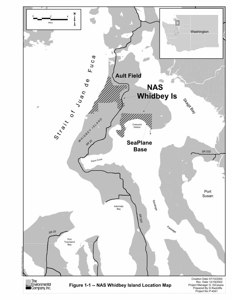
NAS Whidbey Island was commissioned on 21 September 1942 and is actually composed of two bases located approximately 5 miles apart: Seaplane Base and Ault Field. Seaplane Base is the center for military family activities, while Ault Field contains most of the NAS operational activities. The Family Service Center, Navy Housing Office, Commissary, and Exchange are located on Seaplane Base. Most of the families reside in military housing units on Seaplane Base with the remainder of housing and barracks on Ault Field. Figure 1-1 is a map illustrating the location of NAS Whidbey Island including both the Seaplane Base and Ault Field.
1.3.1 NAS WHIDBEY ISLAND MISSION The mission of NAS Whidbey Island is to provide the highest quality facilities, services, and materials to the aviation community and other organizations utilizing NAS Whidbey Island. To accomplish this mission, there are over 8,000 assigned military personnel, and 2,000 civilian personnel employed by NAS Whidbey Island.
NAS Whidbey Island is home to all of the U.S. Navy's electronic warfare squadrons flying the Grumman EA-6B Prowler. NAS Whidbey is also the west coast training and operation center for the remaining Grumman A-6 Intruder attack bomber squadrons. Additionally, NAS Whidbey Island is base to four Maritime Patrol Aviation squadrons flying the Lockheed P-3C Orion aircraft, one Fleet Air Reconnaissance squadron flying the EP-3E Aries, and a Fleet Logistics Support squadron flying the Douglas C-9B. NAS Whidbey Island is also the home of "Team Whidbey" Search and Rescue flying the Sikorski SH-3D Sea King helicopter.
NAS Whidbey Island also serves as a center of activity for northwest U.S. Navy Reserve and U.S. Marine Corps Reserve training exercises. Approximately 1,300 reservists from the states of Washington, Oregon, Idaho, and parts of Montana participate in mobilization exercises on a monthly basis. These reservists are supported by a core of over 200 active duty and civilian personnel.
1.3.2 RECORDS OF DECISION In February 1990, areas of Seaplane Base and Ault Field facilities of NAS Whidbey Island were placed on the USEPA CERCLA National Priorities List (NPL) of contaminated areas requiring environmental investigations and potential cleanup (6154 - 6164 Federal Register / Vol. 55, No. 35 / Wednesday, February 21, 1990 / Rules and Regulations).
SR 20
S t r
a i t
o f
F u
c a
J u
a n
d e
W H I D
B E
Y I
S L
A N D
PortTownsend
Bay
Penn Cove
SR 20
AdmirallyBay
SR 525
Passage
Saratoga
PortSusan
SR 532
CrescentHarbor
Ault Field
SeaPlane Base
Skagit Bay
NAS Whidbey Is
Figure 1-1 -- NAS Whidbey Island Location Map
M:\M
ilitar
y\N
AS W
hidb
ey\B
aseL
ocat
ion.
wor
Creation Date:Rev. Date:
Project Manager:Prepared By:
Project No:
07/10/200012/18/2002D. DiCesareD.RadcliffeP-4041
4
Miles
20 Washington
NAS Whidbey Island
April 2004 1-4
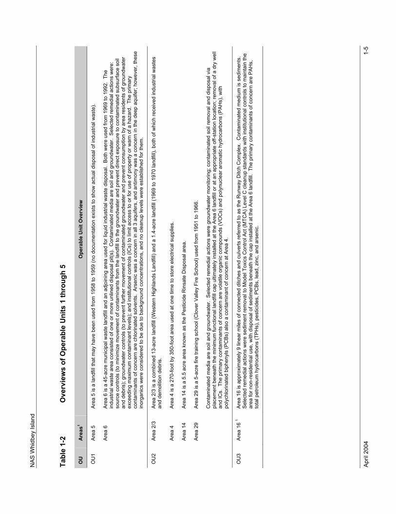
Between 1992 and 1996, five separate RODs were developed by the U.S. Navy and the USEPA addressing the five OUs at NAS Whidbey Island. Each ROD documents the conduct of a remedial investigations (RI) and Feasibility Study (FS); establishes the contaminants of concern (COCs) and the associated action levels; documents the evaluation of remedial alternatives; selects a remedial alternative (or combination of alternatives); and documents the overall U.S. Navy and USEPA decision process and selection of the remedial action.
The five RODs for OU1 through OU5 at NAS Whidbey Island are collectively identified in Table 1-1 below.
Table 1-1 Records of Decision, OU1 through OU5
Operable Unit ROD Identification ROD Date OU1 Interim Action ROD April 1992 OU1 EPA/ROD/R10-94/075 20 December 1993 OU2 EPA/ROD/R10-94/077 17 May 1994 OU3 EPA/ROD/R10-95/113 14 April 1995 OU4 EPA/ROD/R10-92/034 15 December 1993 OU5 EPA/ROD/R10-96/142 10 July 1996
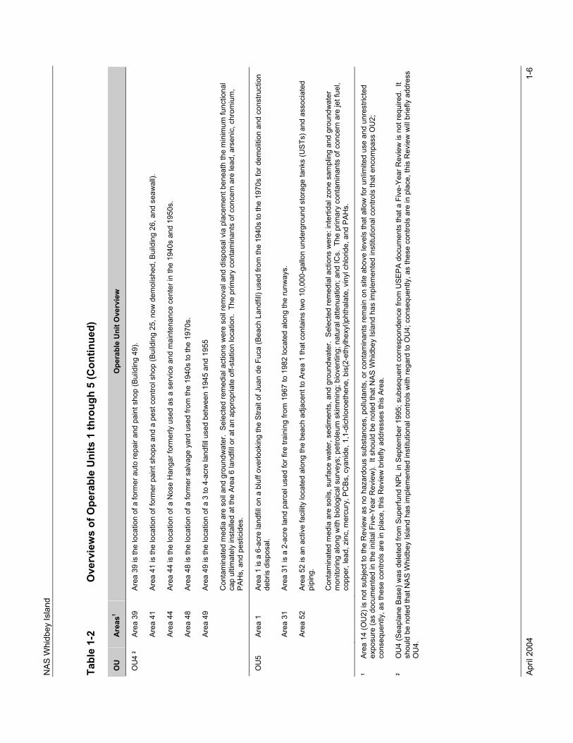
1.3.3 OPERABLE UNITS An overview of the five OUs is provided in Table 1-2; including a description of the areas associated with each OU, the contaminated media, the selected remedial action(s), and the COCs.
1.3.4 INITIAL FIVE-YEAR REVIEW An initial Five-Year Review addressing OU1, OU2, OU3, and OU5 was conducted in 1997 and is documented in Environmental Restoration Five-Year Review, NAS Whidbey Island, Ault Field, Oak Harbor, Washington (EFANW, 1998).
The initial Five-Year Review concluded that the remedies for OU1, OU2, OU3, and OU5 remained protective of human health and the environment. The initial Five-Year Review detailed recommendations with regard to each of the OUs that are addressed later in this document (see Section 3.0) and placed all OUs on a common review timeline.
A Five-Year Review of OU4 has not been conducted by the U.S. Navy. As referenced in the footnotes to Table 1-2; OU4 was deleted from the Superfund NPL by the USEPA in September 1995. Subsequent correspondence from the USEPA states that a Five-Year Review is not required; however, current USEPA guidance (USEPA, 2001) does require a review when hazardous substances, pollutants, or contaminants remain on-site above levels that allow for unlimited use and unrestricted exposure.
NAS
Whi
dbey
Isla
nd
April
200
4
1-5
Tabl
e 1-
2 O
verv
iew
s of
Ope
rabl
e U
nits
1 th
roug
h 5
OU
Ar
eas1
Ope
rabl
e U
nit O
verv
iew
OU
1 Ar
ea 5
Ar
ea 5
is a
land
fill t
hat m
ay h
ave
been
use
d fro
m 1
958
to 1
959
(no
docu
men
tatio
n ex
ists
to s
how
act
ual d
ispo
sal o
f ind
ustri
al w
aste
).
Ar
ea 6
Ar
ea 6
is a
45-
acre
mun
icip
al w
aste
land
fill a
nd a
n ad
join
ing
area
use
d fo
r liq
uid
indu
stria
l was
te d
ispo
sal.
Bot
h w
ere
used
from
196
9 to
199
2. T
he
indu
stria
l was
te a
rea
cons
iste
d of
one
or m
ore
unlin
ed d
ispo
sal p
it(s)
. C
onta
min
ated
med
ia a
re s
oil a
nd g
roun
dwat
er.
Sele
cted
rem
edia
l act
ions
wer
e:
sour
ce c
ontro
ls (t
o m
inim
ize
mov
emen
t of c
onta
min
ants
from
the
land
fill t
o th
e gr
ound
wat
er a
nd p
reve
nt d
irect
exp
osur
e to
con
tam
inat
ed s
ubsu
rface
soi
l an
d de
bris
); gr
ound
wat
er c
ontro
ls (t
o pr
even
t fur
ther
mov
emen
t of c
onta
min
ated
gro
undw
ater
and
pre
vent
con
sum
ptio
n by
are
a re
side
nts
of g
roun
dwat
er
exce
edin
g m
axim
um c
onta
min
ant l
evel
s); a
nd in
stitu
tiona
l con
trols
(IC
s) to
lim
it ac
cess
to o
r for
use
of p
rope
rty o
r war
n of
a h
azar
d. T
he p
rimar
y co
ntam
inan
ts o
f con
cern
are
chl
orin
ated
sol
vent
s. A
rsen
ic w
as a
con
cern
in a
ll 3
aqui
fers
, and
ant
imon
y w
as a
con
cern
in th
e de
ep a
quife
r; ho
wev
er, t
hese
in
orga
nics
wer
e co
nsid
ered
to b
e du
e to
bac
kgro
und
conc
entra
tions
, and
no
clea
nup
leve
ls w
ere
esta
blis
hed
for t
hem
.
OU
2 Ar
ea 2
/3
Area
2/3
is a
com
bine
d 13
-acr
e la
ndfil
l (W
este
rn H
ighl
ands
Lan
dfill)
and
a 1
.4-a
cre
land
fill (
1969
to 1
970
land
fill),
bot
h of
whi
ch re
ceiv
ed in
dust
rial w
aste
s an
d de
mol
ition
deb
ris.
Ar
ea 4
Ar
ea 4
is a
270
-foot
by
350-
foot
are
a us
ed a
t one
tim
e to
sto
re e
lect
rical
sup
plie
s.
Ar
ea 1
4 Ar
ea 1
4 is
a 5
.5 a
cre
area
kno
wn
as th
e Pe
stic
ide
Rin
sate
Dis
posa
l are
a.
Ar
ea 2
9 Ar
ea 2
9 is
a 5
-acr
e fir
e tra
inin
g sc
hool
(Clo
ver V
alle
y Fi
re S
choo
l) us
ed fr
om 1
951
to 1
966.
Con
tam
inat
ed m
edia
are
soi
l and
gro
undw
ater
. Se
lect
ed re
med
ial a
ctio
ns w
ere
grou
ndw
ater
mon
itorin
g; c
onta
min
ated
soi
l rem
oval
and
dis
posa
l via
pl
acem
ent b
enea
th th
e m
inim
um fu
nctio
nal l
andf
ill ca
p ul
timat
ely
inst
alle
d at
the
Area
6 la
ndfil
l or a
t an
appr
opria
te o
ff-st
atio
n lo
catio
n; re
mov
al o
f a d
ry w
ell
and
ICs.
The
prim
ary
cont
amin
ants
of c
once
rn a
re v
olat
ile o
rgan
ic c
ompo
unds
(VO
Cs)
and
pol
ynuc
lear
aro
mat
ic h
ydro
carb
ons
(PAH
s), w
ith
poly
chlo
rinat
ed b
iphe
nyls
(PC
Bs) a
lso
a co
ntam
inan
t of c
once
rn a
t Are
a 4.
OU
3 Ar
ea 1
6 1
Area
16
is a
ppro
xim
atel
y 9
linea
r mile
s of
con
nect
ed d
itche
s an
d cu
lver
ts re
ferre
d to
as
the
Run
way
Ditc
h C
ompl
ex.
Con
tam
inat
ed m
ediu
m is
sed
imen
ts.
Sele
cted
rem
edia
l act
ions
wer
e se
dim
ent r
emov
al to
Mod
el T
oxic
s C
ontro
l Act
(MTC
A) L
evel
C c
lean
up s
tand
ards
with
inst
itutio
nal c
ontro
ls to
mai
ntai
n th
e ar
ea fo
r non
-resi
dent
ial u
se, w
ith d
ispo
sal o
f sed
imen
ts b
enea
th th
e ca
p in
stal
led
at th
e Ar
ea 6
land
fill.
The
prim
ary
cont
amin
ants
of c
once
rn a
re P
AHs,
to
tal p
etro
leum
hyd
roca
rbon
s (T
PHs)
, pes
ticid
es, P
CBs
, lea
d, z
inc,
and
ars
enic
.
NAS
Whi
dbey
Isla
nd
April
200
4
1-6
Tabl
e 1-
2 O
verv
iew
s of
Ope
rabl
e U
nits
1 th
roug
h 5
(Con
tinue
d)
OU
Ar
eas1
Ope
rabl
e U
nit O
verv
iew
OU
4 2
Area
39
Area
39
is th
e lo
catio
n of
a fo
rmer
aut
o re
pair
and
pain
t sho
p (B
uild
ing
49).
Ar
ea 4
1 Ar
ea 4
1 is
the
loca
tion
of fo
rmer
pai
nt s
hops
and
a p
est c
ontro
l sho
p (B
uild
ing
25, n
ow d
emol
ishe
d, B
uild
ing
26, a
nd s
eaw
all).
Ar
ea 4
4 Ar
ea 4
4 is
the
loca
tion
of a
Nos
e H
anga
r for
mer
ly u
sed
as a
ser
vice
and
mai
nten
ance
cen
ter i
n th
e 19
40s
and
1950
s.
Ar
ea 4
8 Ar
ea 4
8 is
the
loca
tion
of a
form
er s
alva
ge y
ard
used
from
the
1940
s to
the
1970
s.
Ar
ea 4
9 Ar
ea 4
9 is
the
loca
tion
of a
3 to
4-a
cre
land
fill u
sed
betw
een
1945
and
195
5
Con
tam
inat
ed m
edia
are
soi
l and
gro
undw
ater
. Se
lect
ed re
med
ial a
ctio
ns w
ere
soil
rem
oval
and
dis
posa
l via
pla
cem
ent b
enea
th th
e m
inim
um fu
nctio
nal
cap
ultim
atel
y in
stal
led
at th
e Ar
ea 6
land
fill o
r at a
n ap
prop
riate
off-
stat
ion
loca
tion.
The
prim
ary
cont
amin
ants
of c
once
rn a
re le
ad, a
rsen
ic, c
hrom
ium
, PA
Hs,
and
pes
ticid
es.
OU
5 Ar
ea 1
Ar
ea 1
is a
6-a
cre
land
fill o
n a
bluf
f ove
rlook
ing
the
Stra
it of
Jua
n de
Fuc
a (B
each
Lan
dfill)
use
d fro
m th
e 19
40s
to th
e 19
70s
for d
emol
ition
and
con
stru
ctio
n de
bris
dis
posa
l.
Ar
ea 3
1 Ar
ea 3
1 is
a 2
-acr
e la
nd p
arce
l use
d fo
r fire
trai
ning
from
196
7 to
198
2 lo
cate
d al
ong
the
runw
ays.
Ar
ea 5
2 Ar
ea 5
2 is
an
activ
e fa
cilit
y lo
cate
d al
ong
the
beac
h ad
jace
nt to
Are
a 1
that
con
tain
s tw
o 10
,000
-gal
lon
unde
rgro
und
stor
age
tank
s (U
STs)
and
ass
ocia
ted
pipi
ng.
Con
tam
inat
ed m
edia
are
soi
ls, s
urfa
ce w
ater
, sed
imen
ts, a
nd g
roun
dwat
er.
Sele
cted
rem
edia
l act
ions
wer
e: in
terti
dal z
one
sam
plin
g an
d gr
ound
wat
er
mon
itorin
g al
ong
with
bio
logi
cal s
urve
ys; p
etro
leum
ski
mm
ing;
bio
vent
ing;
nat
ural
atte
nuat
ion;
and
ICs.
The
prim
ary
cont
amin
ants
of c
once
rn a
re je
t fue
l, co
pper
, lea
d, z
inc,
mer
cury
, PC
Bs, c
yani
de, 1
,1-d
ichl
oroe
then
e, b
is(2
-eth
ylhe
xyl)p
htha
late
, vin
yl c
hlor
ide,
and
PAH
s.
1 Ar
ea 1
4 (O
U2)
is n
ot s
ubje
ct to
the
Rev
iew
as
no h
azar
dous
sub
stan
ces,
pol
luta
nts,
or c
onta
min
ants
rem
ain
on s
ite a
bove
leve
ls th
at a
llow
for u
nlim
ited
use
and
unre
stric
ted
expo
sure
(as
docu
men
ted
in th
e in
itial
Fiv
e-Ye
ar R
evie
w).
It s
houl
d be
not
ed th
at N
AS W
hidb
ey Is
land
has
impl
emen
ted
inst
itutio
nal c
ontro
ls th
at e
ncom
pass
OU
2;
cons
eque
ntly
, as
thes
e co
ntro
ls a
re in
pla
ce, t
his
Rev
iew
brie
fly a
ddre
sses
this
Are
a.
2 O
U4
(Sea
plan
e Ba
se) w
as d
elet
ed fr
om S
uper
fund
NPL
in S
epte
mbe
r 199
5; s
ubse
quen
t cor
resp
onde
nce
from
USE
PA d
ocum
ents
that
a F
ive-
Year
Rev
iew
is n
ot re
quire
d. I
t sh
ould
be
note
d th
at N
AS W
hidb
ey Is
land
has
impl
emen
ted
inst
itutio
nal c
ontro
ls w
ith re
gard
to O
U4;
con
sequ
ently
, as
thes
e co
ntro
ls a
re in
pla
ce, t
his
Rev
iew
will
brie
fly a
ddre
ss
OU
4.
NAS Whidbey Island
April 2004 2-1
2.0 BACKGROUND, CHRONOLOGY, AND REMEDIAL ACTIONS
Appendix A provides a summary of the background, chronology, and remedial actions for each of the OUs. The summary addresses the chronology of each OU through the effective date of the ROD for the particular OU.
The initial Five-Year Review of OU1, OU2, OU3, and OU5 (EFANW, 1998) provides a summary of actions taken in the first 5 years post-ROD for each OU and is incorporated by reference in this Review.
NAS Whidbey Island
April 2004 2-2
This page intentionally left blank.
NAS Whidbey Island
April 2004 3-1
3.0 ACTIONS SINCE INITIAL FIVE-YEAR REVIEW
Section 3.1 presents the protectiveness statement from the initial Five-Year Review. Section 3.2 presents the general recommendations from the initial Five-Year Review and the actions taken during the five-year period that is addressed by this Review. Section 3.3 presents the specific recommendations from the initial Five-Year Review and the actions taken during the five-year period that is addressed by this Review.
3.1 PROTECTIVENESS STATEMENT FROM INITIAL FIVE-YEAR REVIEW A single comprehensive protectiveness statement that addressed OU1, OU2, OU3, and OU5 at NAS Whidbey Island was made in the initial Five-Year Review (EFANW, 1998). This protectiveness statement, indicating that the U.S. Navy certifies that the selected remedies remain protective of human health and the environment, was signed by CAPT L. J. Munns, the Commanding Officer of NAS Whidbey Island.
3.2 GENERAL RECOMMENDATION AND ACTIONS TAKEN SINCE INITIAL FIVE-YEAR REVIEW
3.2.1 GENERaL RECOMMENDATION One general recommendation was made in the initial Five-Year Review regarding OU1, OU2, OU3, and OU5. This general recommendation was associated with the implementation of institutional controls at NAS Whidbey Island and is as follows (EFANW, 1998):
A general administrative strategy to identify and implement processes to strengthen institutional controls area wide at NAS Whidbey Island will be developed jointly by EPA and the Navy. Currently, EPA recommends the preparation of an Explanation of Significant Differences for the existing RODs which would incorporate an Institutional Control Plan. The Navy believes that a separate Memorandum of Agreement is the appropriate approach. The strategy will be finalized by December 1998. Once the strategy is agreed to, procedures to implement that strategy will be in place by the end of May 1999.
3.2.2 ACTIONS TAKEN SINCE INITIAL FIVE-YEAR REVIEW Institutional controls have been implemented by NAS Whidbey Island at OU1 through OU5; however, the U.S. Navy and the USEPA are in the process of revising existing controls to strengthen them.
The U.S. Navy has prepared a Draft Explanation of Significant Differences (ESD) for the existing RODs at NAS Whidbey Island that incorporates an Institutional Control Plan in response to the above recommendation. This Draft ESD is under review. The Department of Defense (DoD) and the USEPA have been in formal dispute resolution discussions on the overall topic of the implementation of institutional controls (i.e., land use controls) at DoD installations nationwide. These issues were resolved in October 2003 and finalization of the draft ESD is expected soon.
NAS Whidbey Island
April 2004 3-2
NAS Whidbey Island has implemented institutional controls at OU1 through OU5 by posting signage at the OUs (as appropriate) and by amending NAS Whidbey Island general development maps, electronic master plan (includes a development constraints map for planning purposes), and site approval maps to include the potable water well and other development restrictions.
Each construction project that is planned at NAS Whidbey Island must be reviewed and approved by the Public Works Office, the Environmental Affairs Office, and the Occupational Safety and Health Department. A NAS Whidbey Island Instruction (NASWHIDBEYINST 11013.2, Site Approval Procedures, 10 June 1999) has been developed and implemented that formalizes this environmental review and site approval process. Institutional controls are considered and are to be clearly marked on project maps or planning documents for such construction projects during this review and approval process to ensure that they are considered in construction decisions. Compliance with all “conditions of approval” issued by reviewers is a requirement of the NAS Whidbey Island Instruction.
The General Services Administration (GSA) has opined that federal agencies do not have authority to impose deed restrictions on active installations. The U.S. Navy will notify the USEPA and the State of Washington at least 6 months in advance of such closure or transfer. At that time, the U.S. Navy, USEPA, State of Washington, and the future property owner should meet to discuss and agree on the manner in which the applicable institutional controls will be incorporated into a deed or other document that transfers property ownership.
3.3 SPECIFIC RECOMMENDATIONS AND ACTIONS TAKEN SINCE INITIAL FIVE-YEAR REVIEW
In addition to the general recommendation that is addressed in Section 3.2 of this document, specific recommendations were made in the initial Five-Year Review addressing OU1, OU2, OU3, and OU5 (EFANW, 1998). These recommendations and a summary of the actions taken since the initial Five-Year Review (both in regard to the specific recommendations and in general) are detailed in the following subsections.
3.3.1 OPERABLE UNIT 1
3.3.1.1 SPECIFIC RECOMMENDATIONS No specific recommendations were made in regard to Area 5 at OU1; however, the initial Five-Year Review simply noted that the implementation of groundwater use restrictions at Area 5 would be evaluated at the next Five-Year Review (EFANW, 1998).
Specific recommendations were made in regard to Area 6 at OU1. These specific recommendations addressed the operation and monitoring of the containment system (i.e., the landfill cap coupled with the groundwater extraction, treatment, and recharge system). These recommendations included (EFANW, 1998):
• that pump tests and a system evaluation would be conducted to recommend an appropriate configuration and optimize extraction rates to best achieve containment;
NAS Whidbey Island
April 2004 3-3
• that the groundwater monitoring schedule would be evaluated by the U.S. Navy and the USEPA on an annual basis to determine sampling requirements for the following year;
• that the U.S. Navy evaluation of conditions and processes for natural attenuation that was ongoing at Area 6 be completed and combined with the modeling efforts regarding groundwater flow in the shallow aquifer to determine the potential applicability of monitored natural attenuation to control plume magnitude and extent; and
• That a minimum of one new monitoring well will be installed on private property adjacent to the landfill to further define the western extent of the plume at the top of the shallow aquifer.
In addition to the specific recommendations made for Area 6, the initial Five-Year Review also stated that:
• the configuration and the rate of extraction for individual wells were being evaluated;
• the determinations from the evaluations were to be applied to optimize operation of the system as improvements were identified; and
• The containment operation would be the subject of the next Five-Year Review.
3.3.1.2 ACTIONS TAKEN SINCE INITIAL FIVE-YEAR REVIEW
3.3.1.2.1 Area 5 No action was deemed the appropriate remedial action for Area 5; however, the U.S. Navy decided to proactively conduct additional groundwater monitoring. As discussed in Appendix A, Section A.1.2, this groundwater monitoring was complete at the date of the initial Five-Year Review and is addressed in that document (EFANW, 1998). No additional remedial or monitoring actions at Area 5 are required or were conducted.
Institutional controls are implemented at Area 5 (see general discussion of institutional controls presented in Section 3.2.2). These institutional controls include groundwater use restrictions at Area 5 that specifically prohibit the installation of potable water wells in Area 5. Area 5 is also adequately demarcated with appropriate signage at approaches identifying the area as Area 5, a CERCLA site. The institutional controls are working, and no potable water wells have been installed at the site.
In an additional effort to further minimize any exposure pathways or contaminant migration pathways to groundwater, seven groundwater monitoring wells were properly abandoned in April 2000 (TEC, 2000). These wells had been previously installed at Area 5 for groundwater monitoring purposes (wells identified as 5-S-01, 5-S-02, 5-S-03, 5-S-04, N5-14, N5-15, and N5-16) and were no longer needed.
NAS Whidbey Island
April 2004 3-4
3.3.1.2.2 Area 6 The remedial action objectives for Area 6 are in the process of being met: groundwater containment operations, as well as the associated monitoring and reporting, are on-going (e.g., landfill cap maintenance, as well as the operation of the Area 6 groundwater extraction, treatment, and recharge system).
Institutional controls have been implemented at Area 6 (see general discussion of institutional controls presented in Section 3.2.2). Area 6 is adequately demarcated with appropriate signage at approaches identifying the area as Area 6, a CERCLA site. As an additional institutional control, Area 6 is surrounded by fencing with gated access points. The gates at the access points are locked and effectively control public access to the landfill.
The groundwater extraction, treatment, and recharge system at Area 6 was initiated in August 1995, and at the time of the initial Five-Year Review (EFANW, 1998) the system was already in operation in excess of 1,000 days. Since the initial Five-Year Review, system operation has continued, and several upgrades and modifications to the system have been made. These upgrades and modifications include the construction of a new office building, the installation of weather shelters for outside electrical panels, and various equipment replacements (flow meters, valves, pumps, etc.) as such equipment breaks down or reaches the end of its operational life.
The groundwater extraction, treatment, and recharge system is now operated via a dedicated personal computer (PC). The associated operating system software, Factor Link ECS (developed by USDATA) provides the human interface to system operations and allows for real-time graphical displays of operational values (water levels, flow rates, etc.) and archiving of operational data. In November 2000, a computer software program (pcANYWHERE, developed by SYMANTEC) was installed on the operational PC. This new software allows for remote access and limited remote control of well and treatment plant operations by the treatment plant operator.
The system is operated and maintained in accordance with the Final Combined Operations and Maintenance Manuals, Operable Unit 1, Area 6, Operable Unit 5, Areas 31 and 52, Naval Air Station Whidbey Island, Washington (Foster Wheeler, 2000f). This O&M manual not only addresses the operation and maintenance of the groundwater extraction, treatment, and recharge system, it also addresses landfill cap maintenance activities and contains a Sampling and Analysis Plan (SAP) for monitoring activities.
Quarterly technical reports are continually prepared addressing the groundwater extraction, treatment, and recharge system at Area 6. These quarterly technical reports document groundwater containment operations and results in detail to include the operation and maintenance (O&M) of the groundwater pump, treat, and recharge system, the monitoring of the system, the monitoring of groundwater levels, the monitoring of groundwater quality, and other relevant information and data pertinent to the groundwater containment system.
Landfill cap maintenance continues at Area 6 in accordance with the Final Operations and Maintenance (O&M) Manual (Foster Wheeler, 2000f). This maintenance includes

NAS Whidbey Island
April 2004 3-5
landfill cap inspection, mowing at regular intervals (and adherence to specific mowing patterns), and the prevention of the establishment of deep-rooted vegetation.
Both bioscaling and biofouling have been technical complications that arose during the operation of the groundwater extraction, treatment, and recharge system. Biofouling has reduced production well extraction rates, and bioscaling has reduced flows and increased pressures in pipelines distributing effluent to the recharge area. Bioscaling and biofouling have been addressed through chemical addition and equipment cleaning and maintenance. Sodium hypochlorite (NaOCl, an oxidant and a disinfectant) was added to the production wells in calendar year 1998; however, the addition of sodium hypochlorite was discontinued in calendar year 2000, as it was deemed largely ineffective. A befouling technical memorandum was developed that presented and evaluated possible remedies for biofouling in the groundwater extraction, treatment, and recharge system (Hart Crowser, 1999). A complete discussion of bioscaling and biofouling complications and response actions at Area 6 is presented in Section 5.1 (addressing the technical assessment and issues of concern for OU1).
The U.S. Geological Survey (USGS) evaluated the effectiveness of natural attenuation at meeting remediation objectives for chlorinated volatile organic compounds (VOCs) in shallow ground water at Area 6 (without utilization of the existing groundwater extraction, treatment, and recharge system). This evaluation is documented in the publication Natural Attenuation of Chlorinated Volatile Organic Compounds in Ground Water at Area 6, Naval Air Station Whidbey Island, Washington (Dinicola et al., 2000).
The Domenico (1987) analytical flow and transport model embedded within the BIOSCREEN computer program was used by the USGS to evaluate the effectiveness of natural attenuation for controlling down-gradient contaminant migration. The study realized that conditions contrast for the two distinct groundwater plumes present at the Area 6 landfill due to the differences in contaminant sources. The study concluded that natural attenuation is a viable alternative to the existing groundwater extraction, treatment, and recharge system for meeting remediation objectives in the vicinity of the southern contaminant plume; however, the study also concluded that natural attenuation is not currently a viable alternative for meeting remediation objectives in the western contaminant plume. A complete discussion regarding the USGS evaluation of natural attenuation is presented in Section 5.1 (addressing the technical assessment and issues of concern for OU1).
In April 2000, two groundwater monitoring wells at Area 6 were properly abandoned (TEC, 2000). These wells had been previously installed for groundwater monitoring purposes (wells identified as MW-3A and MW-4) and were no longer needed.
A Final Technical Memorandum, Soil Gas Survey and VOC Sampling (Foster Wheeler, 2001b) was developed. This memorandum provides a summary of conditions for the western and southern plumes. It concludes that data presented in the USGS study demonstrate the viability of MNA as an alternative to the existing pump and treat containment system for the southern plume.
A Draft Final Monitored Natural Attenuation (MNA) Plan, dated 14 December 2001, was also developed (Foster Wheeler, 2001a). The MNA plan addressed implementing MNA
NAS Whidbey Island
April 2004 3-6
at Area 6 and included: an assessment of groundwater flow, the determination of monitoring requirements, the implementation of the conversion to MNA, and associated reporting. The plan developed included the conduct of groundwater flow simulations using a computer model for the modified operations at Area 6. A two-dimensional groundwater flow model of the unconfined aquifer at Area 6, using the Flowpath numerical model that had been previously updated, was used. Under MNA, ceasing to extract groundwater from the southern plume and reducing the volume of treated water discharged to the infiltration swale would change the flow patterns for both the southern and western plumes. To represent these changes, new model simulations were run during the development of the MNA plan using the previously calibrated Flowpath Model to evaluate containment for the western plume when operating three extraction wells, and to predict flow and transport directions for monitoring of the southern plume with only three western plume extraction wells operating (Foster Wheeler, 2001a). A discussion of these results is presented in Section 5.1 (addressing the technical assessment and issues of concern for OU1).
Additional site characterization activities and removal actions were conducted during calendar year 2001 at the location of the former waste oil pit at Area 6 (western plume). These additional site characterization activities are documented in the Final Site Characterization Report, Site Characterization and Interim Removal Action at Area 6 Landfill, Naval Air Station Whidbey Island, Washington (Foster Wheeler, 2001c) and the removal actions are documented in the Final Interim Removal Report (Foster Wheeler, 2002a). A discussion of the site characterization activities and removal actions is discussed in Section 5.1.2.1.4.
Initiating in February 2002, an assessment was conducted to evaluate the fate and transport of residual VOCs that remain in the soils at the location of site 55 at Area 6. The conduct and the findings of this assessment is documented in Assessment of Fate and Transport for Residual VOCs in Vadose Zone in Vicinity of Site 55 (Foster Wheeler, 2002b). The purpose of this assessment was to estimate masses of VOCs remaining in the soil vadose zone; conduct modeling to estimate rates of continuing releases to the aquifer; model the aquifer reaction to the shutdown of extraction wells to support construction of new wells; and propose two new monitoring wells within the western plume to assist in the assessment of the source area. A discussion of the assessment findings is presented in Section 5.1.2.1.4.In December 2002, groundwater samples were collected from four deep wells at the site. As recommended in the initial Five-Year Review (EFANW, 1998), these samples were analyzed for chloride and total dissolved solids (TDS) to confirm that seawater intrusion had not occurred (see Section 5.1.2.1 for a detailed discussion of these groundwater sample results).
The compound 1,4-dioxane was recently identified in the influent to the groundwater treatment system at Area 6. A concentration of 14 parts per billion (ppb) of 1,4-dioxane was identified in one sample collected from the influent. This sampling was done at the request of the USEPA. The compound has recently become a COC at other sites with contaminates that are similar to Area 6.
Subsequent to this identification of 1,4-dioxane; groundwater monitoring for 1,4-dioxane was conducted at Area 6 during the third quarter monitoring event in June 2003. This
NAS Whidbey Island
April 2004 3-7
groundwater monitoring is documented in the Draft Third Quarter Technical Report, Area 6 Landfill, Groundwater Monitoring, June 2003, Naval Air Station Whidbey Island, Washington, August 2003 (TEC, 2003b). The compound 1,4-dioxane was detected in all eight production wells (PWs) sampled and in seven of the 12 groundwater monitoring wells sampled. A discussion of these 1,4-dioxane groundwater monitoring results is presented in Section 5.1.2.1.3.
Two additional groundwater monitoring wells and one additional production well were installed at Area 6 during February 2003. The locations of the wells were determined during a meeting attended by EFA NW and the USEPA Region 10 on 19 December 2002. The monitoring wells installed were identified as 6-S-30 and 6-S-31 and the production well installed was identified as PW-10. Well installation activities, well locations, and similar data are documented in the Technical Memorandum, Final Well Installation Report, Areas 6 and 31, NAS Whidbey Island, Washington, dated 4 April 2003 (TEC, 2003c).
3.3.2 OPERABLE UNIT 2
3.3.2.1 SPECIFIC RECOMMENDATIONS No specific recommendations were made in regard to any of the areas associated with OU2 (i.e., Area 2/3, Area 4, Area 14, and Area 29); however, the initial Five-Year Review noted that the implementation of groundwater use restrictions at OU2 will be the subject of future reviews (EFANW, 1998).
The initial Five-Year Review also noted that the Post-ROD Groundwater Monitoring Report (URS Consultants, 1997) calls for one more round of groundwater monitoring at the time of the next Five-Year Review (EFANW, 1998). This additional round of groundwater monitoring was to address the shallow aquifer at Area 2/3 (VOCs, Arsenic, and Manganese), Area 4 (Arsenic), and Area 29 (Arsenic).
As noted in Table 1-2, Area 14 at OU2 is not subject to a Five-Year Review as no hazardous substances, pollutants, or contaminants remain on site above levels that would not allow for unlimited use and unrestricted exposure. This statement, as well as the inapplicability of the Five-Year Review, is documented in the initial Five-Year Review (EFANW, 1998). Current USEPA guidance (USEPA, 2001) requires a Five-Year Review as NAS Whidbey Island has implemented institutional controls encompassing Area 14 and these controls do not allow for the unlimited use of Area 14. Consequently, this Review briefly addresses Area 14.
3.3.2.2 ACTIONS TAKEN SINCE INITIAL FIVE-YEAR REVIEW Actions completed at the date of the initial Five-Year Review (i.e., soil excavation and restoration activities at the various areas have been completed and remedial action objectives for OU2 areas have been met. These actions are documented in the initial Five-Year Review (EFANW, 1998).
Institutional controls continue to be implemented at OU2 areas (see general discussion of institutional controls presented in Section 3.2.2) during the period of this review.
NAS Whidbey Island
April 2004 3-8
These institutional controls include groundwater use restrictions that specifically prohibit the installation of potable water wells.
OU2 areas (Area 2/3, Area 4, Area 14, and Area 29) are adequately demarcated with appropriate signage at approaches identifying the areas as CERCLA sites.
The only additional action required at OU2 was a groundwater monitoring event referenced in the initial Five-Year Review that was to be completed at Area 2/3, Area 4, and Area 29 by the time of this Review (see Section 3.3.2.1). The initial Five-Year Review noted that the groundwater monitoring had been recommended in the Revised Technical Memorandum, Post-ROD Groundwater Monitoring for Operable Unit 2 (URS, 1997). This additional round of groundwater monitoring at OU2 was conducted in December 2002 (see Section 5.2.1.1 for a discussion of this groundwater monitoring). Documentation of this additional round of groundwater monitoring is provided in the Draft Technical Memorandum, Letter Report for Environmental Monitoring at NAS Whidbey Island, dated 7 March 2003 (TEC, 2003a).
As no additional remedial or monitoring actions are required at OU2 areas, the majority of the monitoring wells that were installed at OU2 areas for groundwater monitoring purposes were properly abandoned in April 2000 (TEC, 2000). These monitoring wells included:
• eighteen (18) groundwater monitoring wells installed at Area 2/3 (2-MW-1, 2-MW-2, 2-MW-3, 2-MW-4, 2-MW-5, 2-MW-6, 2-MW-7, 2-MW-8, 2-MW-9, N2-1, N2-2, N2-4, N2-7D, N2-10, 3-MW-1, 3-MW-3, N3-11, and N3-13);
• two (2) groundwater monitoring wells installed at Area 4 (4-MW-2 and 4-MW-4);
• three (3) groundwater monitoring wells installed at Area 14 (14-MW-1, 14-MW-3, and 14-MW-19); and
• five (5) groundwater monitoring wells installed at Area 29 (29-MW-1, 29-MW-2, 29-MW-3, N29-21, and N29-22S).
The abandonment of these unnecessary groundwater monitoring wells is a good management practice that eliminates both potential exposure pathways and contaminant migration pathways.
3.3.3 OPERABLE UNIT 3
3.3.3.1 SPECIFIC RECOMMENDATIONS No specific recommendations were made in regard to Area 16 at OU3; however, the initial Five-Year Review noted that remediation was completed as designed and no modifications were required, that OU3 remedies were considered complete, and that OU3 would not be subject to future Five-Year Reviews as no hazardous substances, pollutants, or contaminants remain on site above levels that would not allow for unlimited use and unrestricted exposure (EFANW, 1998).

NAS Whidbey Island
April 2004 3-9
Current USEPA guidance (USEPA, 2001) requires a Five-Year Review as NAS Whidbey Island has implemented institutional controls encompassing Area 16 and these controls do not allow for the unlimited use of Area 16. Consequently, this Review briefly addresses Area 16.
3.3.3.2 ACTIONS TAKEN SINCE INITIAL FIVE-YEAR REVIEW The remedial action objectives for Area 16 at OU3 have been met, and the soil excavation and confirmatory sampling have been completed. These actions were complete at the date of the initial Five-Year Review and addressed in that document (EFANW, 1998). No additional actions are required at OU3. The USEPA provided written confirmation that no additional actions are required at OU3 in correspondence dated 17 March 1997 (USEPA, 1997).
Institutional controls are implemented at Area 16 at OU3 (see general discussion of institutional controls presented in Section 3.2.2). Area 16 is within the airfield flight-line area; a restricted access area within Ault Field at NAS Whidbey Island.
As no additional remedial or monitoring actions are required at OU3, two monitoring wells that were installed at Area 16 for groundwater monitoring purposes (16-22, 16-26A) were properly abandoned in April 2000 (TEC, 2000). The abandonment of these unnecessary groundwater monitoring wells is a good management practice that eliminates potential contaminant migration pathways.
Six sediment samples were collected in December 2002 along the centerlines of selected Area 16 drainage ditches. All samples were analyzed for total petroleum hydrocarbons (TPHs), polycyclic aromatic hydrocarbons (PAHs), arsenic, and lead. Documentation of this drainage ditch sampling is provided in the Draft Technical Memorandum, Letter Report for Environmental Monitoring at NAS Whidbey Island, dated 7 March 2003 (TEC, 2003a). PAHs, arsenic, lead, diesel range organics (DRO), and residual range organics (RRO) were detected in all sediment samples from Area 16 (see Section 5.3.1.1 for a detailed discussion of these results).
3.3.4 OPERABLE UNIT 4
3.3.4.1 SPECIFIC RECOMMENDATIONS The initial Five-Year Review did not address OU4.
As noted in Table 1-2, OU4 (Seaplane Base) was officially deleted from the Superfund NPL in September 1995. USEPA written correspondence to NAS Whidbey Island documents that a Five-Year Review is not required for OU4 (USEPA, 1995a).
Current USEPA guidance (USEPA, 2001) requires a Five-Year Review as NAS Whidbey Island has implemented institutional controls encompassing OU4 areas (Area 39, Area 41, Area 44, Area 48, Area 49) and these controls do not allow for unlimited use and unrestricted exposure. Consequently, this Review briefly addresses OU4 areas.
NAS Whidbey Island
April 2004 3-10
3.3.4.2 ACTIONS TAKEN SINCE INITIAL FIVE-YEAR REVIEW The remedial action objectives established for OU4 in the associated ROD (URS, 1993b) have been met, and all remedial actions were completed in 1995.
Institutional controls remain implemented at OU4 (i.e., see general discussion of institutional controls presented in Section 3.2.2).
OU4 areas are adequately demarcated with appropriate signage at approaches identifying the areas as CERCLA sites.
The remedial actions at OU4 were conducted in accordance with the Final Remedial Design Report / Remedial Action Work Plan (URS, 1994) and upon completion a Remedial Action Report was prepared for OU4 (Ebasco, 1995). This remedial action report documents the remedial actions at OU4. As OU4 was not addressed in the initial Five-Year Review (EFANW, 1998); a summary of post-ROD actions from the associated remedial action report is presented in this subsection (despite this subsection being titled “Actions Taken since Initial Five-Year Review”).
COCs at the OU4 areas (Area 39, Area 41, Area 44, Area 40, and Area 49) were area-specific and included lead, chromium, arsenic, 4,4’-DDD, 4,4’-DDE, 4,4’-DDT, and PAHs. Remedial actions included excavating contaminated soil, collecting soil and water samples, disposing of soil and water, backfilling excavated locations, and re-vegetating. Contaminated soils from Areas 39, 41, and 44 were excavated, temporarily stockpiled, and characterized for disposal. Review of disposal characterization analytical results indicated that the stockpiled soils were acceptable for placement at the Area 6 landfill. Contaminated soils from Area 48 were characterized in place because of limited space at the temporary stockpile areas. Following review of analytical results, Area 48 soils were excavated and transported directly to the Area 6 landfill for disposal.
Remedial action objectives were in accordance with State of Washington MTCA Method B clean-up levels. Confirmation samples were collected from the bottoms of excavations at Areas 39, 41, and 44 to ascertain whether or not soil removal had met remedial action objectives. Analysis of confirmation samples demonstrated that the objectives were met, which then resulted in the backfilling of excavated areas. At Area 48, confirmation samples were collected and the excavation was backfilled immediately according to the Remedial Action Work Plan (URS, 1994). Analysis of the confirmation samples indicated that remedial action objectives had also been achieved; therefore, no further monitoring of Area 48 is necessary.
A borrow soil area at Maylor Point provided the backfill material. Analysis of a composite sample from the borrow soil area showed that the soil was free of contamination. The site restoration program began by completely backfilling the excavations and adding a 4-inch layer of topsoil to coincide with the existing ground surface elevations. Excavations at Areas 39 and 44 were hydro-seeded with grasses similar to the surrounding grasses. Excavations at Area 48 and the borrow soil area were hydro-seeded with native-type grass to blend with surrounding vegetation and provide erosion control.
NAS Whidbey Island
April 2004 3-11
In summary, initial excavations (totaling approximately 1,300 yd3) achieved all remedial action objectives at the OU4 areas and no additional excavation or remedial actions are necessary. The USEPA, in conjunction with the Washington Department of Ecology (Ecology) and NAS Whidbey Island determined that Seaplane Base (i.e., OU4) poses no significant threat to public health or the environment and no further CERCLA remedial measures are necessary.
OU4 was deleted from the Superfund NPL in September 1995 (the first U.S. Navy site to be deleted from the Superfund NPL). The Notice of Intent to Delete, which officially detailed the USEPA decision to delete the site from the Superfund NPL, was published in the Federal Register on 18 July 1995 and an advertisement placed in the Whidbey News Times. The comment period ended on 31 August 1995 and the USEPA received no comment on the deletion. The Notice of Delisting was published in the Federal Register on 21 September 1995.
As no remedial or monitoring actions are required at OU4 areas, several monitoring wells that were installed for groundwater monitoring purposes were properly abandoned in April 2000 (TEC, 2000). Specifically, these wells included:
• three (3) groundwater monitoring wells installed at Area 44 for groundwater monitoring purposes (44-MW-1, 44-MW-2, 44-MW-3); and
• seven (7) groundwater monitoring wells installed at Area 48 and Area 49 for groundwater monitoring purposes (MWS-1, MWS-2, MWS-3, MWS-4, MWS-5, MWS-6, MWS-7, and MWS-8).
The abandonment of these unnecessary groundwater monitoring wells is a good management practice that eliminates potential contaminant migration pathways.
3.3.5 OPERABLE UNIT 5
3.3.5.1 SPECIFIC RECOMMENDATIONS Specific recommendations were made in regard to all areas associated with OU5 (i.e., Area 1, Area 31, and Area 52).
In regard to Area 1, the initial Five-Year Review noted: that inorganics and cyanide in Area 1 groundwater seeps would be monitored at the time of the next review; that the next review would confirm that land use restrictions applied to the landfill area are reviewed regularly for adherence and that annual monitoring of shoreline stability is completed (EFANW, 1998).
In regard to Area 31 and Area 52, the initial CERCLA 121(c) Review recommended that the operation of the remedial systems at these areas continue until fuel recovery by skimming reaches its practical limits and that the U.S. Navy and USEPA would review the status of operations every 6 months to make this determination (EFANW, 1998).
NAS Whidbey Island
April 2004 3-12
3.3.5.2 ACTIONS TAKEN SINCE INITIAL FIVE-YEAR REVIEW
3.3.5.2.1 Area 1 The remedial action objectives for Area 1 at OU5 have essentially been met and remedial actions have been completed (such actions were complete at the date of the initial Five-Year Review).
Institutional controls are implemented at Area 1 at OU5 (see general discussion of institutional controls presented in Section 3.2.2). Area 1 is adequately demarcated with appropriate signage at approaches identifying the area as Area 1, a CERCLA site.
Visual monitoring of shoreline stability was required to be conducted at Area 1 on an annual basis for a period of 5 years beginning in calendar year 1998. This shoreline stability monitoring has been conducted by NAS Whidbey Island Environmental Affairs Office personnel and properly documented. The fifth (and final) shoreline stability monitoring event was recently completed by Environmental Affairs Office personnel in July 2002. This monitoring indicated that relatively minor shoreline erosion is occurring along the coastline of Area 1.
After the ROD for OU5 was issued, post-ROD groundwater monitoring was performed in 1996 to determine whether cyanide was present at concentrations that could adversely affect the marine environment (ecological risk from cyanide in groundwater was the only identified risk associated with Area 1). This monitoring is documented in the Final Technical Memorandum Post ROD Groundwater Monitoring at Operable Unit 5, Area 1, Naval Air Station Whidbey Island, Oak Harbor, Washington, April 1997 (Foster Wheeler, 1997b). Two inland groundwater monitoring wells and six intertidal groundwater seeps along the shoreline were sampled. The Final Remedial Action Report for OU5 (Foster Wheeler, 1997c) states that inorganics were not detected sufficiently in excess of the ROD cleanup levels (CULs) to require annual monitoring of groundwater or groundwater seeps; however, since detectable concentrations of copper and nickel were identified (coupled with the previous identification of elevated detectable concentrations of cyanide), that monitoring for inorganics and cyanide at Area 1 groundwater seeps were to be conducted at the time of the next Five-Year Review.
This groundwater seep sampling was conducted in December 2002. A total of five seep samples were collected from Area 1. All samples were analyzed for cyanide and inorganic compounds (inorganics). Documentation of this seep sampling is provided in Table 3, Appendix E Results showed only trace amounts of arsenic and low levels of manganese (see Section 5.5.1 for a more detailed discussion regarding these sample results).
3.3.5.2.2 Area 31 The remedial action objectives for Area 31 have been met and monitoring actions are ongoing. The remedial action objectives identified in the ROD included reducing the risk of human exposure by limiting site access and removing the source of contamination (see Section 2.0 and Appendix A to this document). Remedial activities conducted at Area 31, as delineated in the ROD, included ash pile and oil/water separator removal; fuel skimming (five skimming wells were installed initially with passive skimming devices;
NAS Whidbey Island
April 2004 3-13
however, a variety of product recovery techniques have been used to include absorbent socks and pneumatic skimmers); bioventing (ten bioventing wells, four nested observation wells, two blowers, and associated piping were installed in October 1996); institutional controls; and groundwater monitoring.
Institutional controls continue to be implemented at Area 31 (see general discussion of institutional controls presented in Section 3.2.2). Area 31 is adequately demarcated with appropriate signage at approaches identifying the area as Area 31, a CERCLA site.
The majority of the free project petroleum has been removed to date and the overall effectiveness of skimming and bioventing has reached a point of diminishing returns.
In a Quarterly Technical Report for Area 31 (addressing the operating period of July to September 1999) a decision was documented that the criteria of the ROD for Area 31 were satisfied and the system could be shut down (Foster Wheeler, 1999g). This decision was made by the participants of a September 1999 meeting that included representatives of the U.S. Navy (i.e., EFANW and NAS Whidbey Island), of USEPA Region 10, and of Foster Wheeler Environmental Corporation. This same decision and recommendations were documented again in subsequent Quarterly Technical Reports for Area 31 (Foster Wheeler, 2000b, Foster Wheeler, 2000g).
A Draft Areas 31 and 52 Assessment Report, Operable Unit 5, Areas 31 and 52, Former Runway and Jet Engine Test Cell Fire School, Naval Air Station Whidbey Island, Washington, dated 7 February 2000 has been prepared (Foster Wheeler, 2000a). This assessment report summarizes and evaluates product recovery and groundwater sampling at Area 31. This assessment report concludes (for Area 31) that semi-annual groundwater sampling results have shown that fuel contamination is not migrating off-site and that the product recoveries and thickness measurements have showed limited amounts of free product suggesting that product recovery, bioventing, and the associated respirometry testing may be terminated.
The termination of these efforts was discussed and concurred upon at a 19 April 2000 meeting between the USEPA, NAS Whidbey Island, and EFANW. The product recovery and bioventing systems were shut-down in March 2000. The USEPA provided formal concurrence with the shut-down of the systems in a letter dated 19 May 2000 indicating that the bioventing and groundwater skimming operations should be terminated (USEPA, 2000).
In this same letter, the USEPA requested that confirmation sampling be conducted around Area 31 (groundwater monitoring to verify that petroleum, manganese, and VOCs are not migrating and have naturally attenuated) and that private well sampling can be discontinued (USEPA, 2000). This confirmation sampling was conducted and confirmation results were reported to the USEPA on 21 November 2000.
During the interim, additional groundwater monitoring efforts are being conducted at Area 31. These groundwater monitoring activities are documented in three reports by The Environmental Company, Inc. (TEC 2002d, TEC 2002g, and TEC 2002h).
NAS Whidbey Island
April 2004 3-14
Two additional groundwater monitoring wells were installed at Area 31 during February 2003 to provide additional groundwater monitoring locations for further evaluation of Area 31 as concerns have been raised by EFA NW and USEPA Region 10. The locations of the wells were determined during a meeting attended by EFA NW and the USEPA Region 10 on 19 December 2002. The two monitoring wells installed were identified as MW31-34 and MW31-35. Well installation activities, well locations, and similar data are documented in the Technical Memorandum, Final Well Installation Report, Areas 6 and 31, NAS Whidbey Island, Washington, dated 4 April 2003 (TEC, 2003c).
3.3.5.2.3 Area 52 The remedial action objectives for Area 52 are in the process of being met and free product recovery operations, as well as the associated maintenance, and monitoring actions are on-going. Product recovery is to continue at Area 52 until recovery reaches its practical limits. Product thickness measurements and water table measurements are made on a quarterly basis. Seep sampling is conducted on a biennial basis.
Institutional controls are implemented at Area 52 (see general discussion of institutional controls presented in Section 3.2.2).
Area 52 is adequately demarcated with appropriate signage at approaches identifying the area as Area 52, a CERCLA site.
Free product is recovered from a variety of wells at Area 52, depending on product thickness measurements and product recovery rates. Through the period of the initial Five-Year Review, approximately 210 gallons of free product petroleum were recovered at Area 52 and product recovery rates were characterized as less than expected. Since that date, operating adjustments to the recovery systems have improved free product petroleum recovery rates, and as of the date of this Review, greater than 931 gallons of mixed product and water have been recovered (see Table 5-7, Figure 5-2, and the associated discussion that is presented in Section 5.5.3.1). Recovery of mixed product and water is continuously minimized by adjustments of the system intake depths and through efficient operation of the recovery pumps.
In September 1997, Foster Wheeler Environmental Corporation installed a temporary product recovery system in extraction well EW-1 at Area 52 (Foster Wheeler, 1998a). The temporary setup demonstrated that EW-1 is a productive well for free product recovery. The temporary setup was approved for long-term use by NAS Whidbey Island and continues to the date of this review.
On 13 and 14 July 1999, seep sampling was conducted at six locations (Foster Wheeler, 1999g). Seep sampling had been previously conducted at the same six locations.
A Draft Areas 31 and 52 Assessment Report, Operable Unit 5, Areas 31 and 52, Former Runway and Jet Engine Test Cell Fire School, Naval Air Station Whidbey Island, Washington, dated 7 February 2000 has been prepared (Foster Wheeler, 2000a). This assessment report concludes that the lack of fuel migration and the fact that product
NAS Whidbey Island
April 2004 3-15
recoveries and product thickness measurements are showing limited amounts of free product suggest that the active skimming may be terminated (Foster Wheeler, 2000a).
This information was discussed at a 19 April 2000 meeting between NAS Whidbey Island, EFA NW, and the USEPA. In subsequent USEPA correspondence dated 19 May 2000, the USEPA stated: that skimming operations at Area 52 would continue because there has not been a noticeable drop in product recovery (noting that Area 52 ROD objectives have been met); and that the intention is for on-going recovery activities at Area 52 to be handled under the state MTCA cleanup program for petroleum sites (USEPA, 2000).
The product recovery systems at Area 52 remain active and quarterly monitoring and reporting for Area 52 is on-going. The free product recovery system is currently operated and maintained in accordance with the Final Combined Operations and Maintenance Manuals, Operable Unit 1, Area 6, Operable Unit 5, Areas 31 and 52, Naval Air Station Whidbey Island, Washington (Foster Wheeler, 2000f). As stated, the intention is to continue to operate the free product recovery systems as long as the systems remain effective at recovering free product petroleum and to ultimately transfer the oversight of Area 52 to Washington Department of Ecology.
Active site work was briefly halted during a period from late May through August 2000. Both remedial skimming systems were inoperative during this time period. This inactivity was due to an unexpected delay during the transition of the EFA NW contract for operations and maintenance (O&M) at Area 32. Operation of both of the skimming systems, scheduled O&M, water level and free product level gauging operations, and field reporting resumed in September 2000 with the award of the O&M contract. Since the restart in September 2000, the product recovery systems and the associated O&M, level gauging, and reporting activities at Area 52 have been in normal operation status.
The most recent quarterly report (TEC, 2002j) concluded that System No. 2 at Area 52 continues to function as intended. Skimming operations in this system should continue until fuel recovery reaches its practical limits.
NAS Whidbey Island
April 2004 3-16
This page intentionally left blank.
NAS Whidbey Island
April 2004 4-1
4.0 FIVE-YEAR REVIEW PROCESS
As described in the USEPA Comprehensive Five-Year Review Guidance, the review process consists of establishing a Review Team; notifying potentially interested parties and involving the community in the review process; developing the draft Five-Year Review report (document reviews, site inspections, interviews, and data evaluation); and ultimately signing and submitting the final Five-Year Review report.
4.1 REVIEW TEAM The U.S. Navy is the lead agency responsible for the conduct of the Five-Year Review of OU1 through OU5 at NAS Whidbey Island.
The Review Team established for this Review consists of contracted personnel (environmental professionals from The Environmental Company, Inc. and CH2MHill, Inc.), EFA NW personnel (Mr. John Gordon), and NAS Whidbey Island Environmental Affairs Office personnel (Mr. John Moser).
4.2 NOTIFYING POTENTIALLY INTERESTED PARTIES AND INVOLVING THE COMMUNITY
Notification to potentially interested parties that a Five-Year Review was to be conducted at OU1 through OU5 at NAS Whidbey Island was made in June 2002. This notification consisted of the publication of a Notice of Intent (NOI) in the Whidbey News – Times on Wednesday, 5 June 2002 and again on Wednesday, 12 June 2002. The NOI provided the information recommended by the USEPA Comprehensive Five-Year Review Guidance (i.e., identification and location of the OU areas, identification of the U.S. Navy as the lead agency conducting the review, descriptions of remedies, summaries of contamination, a description of community involvement measures, contact information, and a scheduled completion date).
Community involvement (i.e., community relations) has been a component of this Review. Community relations have included the following activities:
• An initial publication of the NOI was made in the Whidbey News - Times (as previously described).
• An invitation to participate in the review of the Draft Five-Year Review document for OU1 through OU5 was made to the local Remedial Action Board (RAB) members and stakeholders.
• A joint EFANW – NAS Whidbey Island presentation regarding the Five-Year Review process, scope, and timeline was made to the local RAB members and stakeholders.
• Discussion of the Five-Year Review process and reporting by EFA NW and NAS Whidbey Island personnel at the regularly scheduled Remedial Action Board (RAB) meetings
NAS Whidbey Island
April 2004 4-2
• Publication of the Notice of Availability (Draft Review) and Fact Sheet in the Whidbey News – Times allowing for a 30-day public comment period for the Draft Five-Year Review was made.
• A response to public comments on the Draft Review would have been developed and included as Appendix C to this Final Review; however, no public comments on the Draft Review were received. Accordingly, Appendix C in this Final Review is reserved.
The USEPA Community Involvement Coordinator (CIC) for USEPA Region 10 was initially contacted by the Review Team at the onset of the Review to inform the USEPA of the U.S. Navy conduct of the Review and to inquire about the adequacy of planned community relations. The USEPA stated that they have not designated a single point-of-contact (POC) as the representative of the USEPA CIC who is specific to the U.S. Navy or NAS Whidbey Island for the OUs at NAS Whidbey Island (as is sometimes the case for higher-visibility and/or higher-activity CERCLA sites); and consequently, coordination with a specific USEPA representative during the Review process is not necessary. The Review Team discussed the planned approach for the Review (i.e., consistent with the USEPA Comprehensive Five-Year Review Guidance) and the approach for notifying potentially interested parties and involving the community in the Review process (i.e., publishing the NOI, involving the RAB, publishing a Fact Sheet and Notice of Availability, making the Draft Review report available for 30-day public comment period, etc.) and was informed by the USEPA that this approach is indeed appropriate and satisfactory.
4.3 DEVELOPING THE FIVE-YEAR REVIEW REPORT The development of this Review Report consists of four primary activities: document reviews, site inspections, personnel interviews, and data consolidation and evaluation.
Document Reviews. Document reviews were conducted by the Review Team throughout the development of this Review of OU1 through OU5 at NAS Whidbey Island. These documents included hard-copy information (e.g., previous studies and reports, technical memoranda, regulatory agency correspondence) and electronic (e.g., database downloads of monitoring data). Source references for the various data and information presented in this Review are listed in Section 8.0, References. References in addition to those source references presented in this Review are included in Section 8.0 as this reference list is intended to provide a complete list of the documents reviewed in support of this Review.
Site Inspections. As detailed in the USEPA Comprehensive Five-Year Review Guidance, a Five-Year Review is to include recent site inspections. For the purpose of a Five-Year Review, the USEPA interprets “recent” as no more than nine months from the expected signature date of the review. Site inspections were conducted by Review Team members at all of the subject areas at each of the five OUs at NAS Whidbey Island during the week of 8 July 2002. The purpose of these site inspections was to obtain information regarding the OU (and its associated areas) status and to visually confirm and document the conditions of remedy implementation, the OU area, and/or surrounding properties. Appendix B contains digital photographs of the OUs taken at the time of the site inspections.
NAS Whidbey Island
April 2004 4-3
Personnel Interviews. Interviews were conducted by the Review Team throughout the development of this Review. Interviews were conducted with personnel who are knowledgeable of the OUs and the associated areas, to include contractors who are performing remedial system operations and long-term monitoring activities. EFA NW and NAS Whidbey Island personnel also discussed the Five-Year Review process and reporting during regularly scheduled RAB meetings.
Data Consolidation and Evaluation. Data generated as a result of document reviews, site inspections, and personnel interviews were consolidated and evaluated by the Review Team. Data that is significantly relevant to this Review is either included and/or included by reference in this document as appropriate.
NAS Whidbey Island
April 2004 4-4
This page intentionally left blank.
NAS Whidbey Island
April 2004 5-1
5.0 TECHNICAL ASSESSMENT AND ISSUES OF CONCERN
This section presents the technical assessment of the remedy(ies) implemented at each of the five OUs at NAS Whidbey Island and issues of concern.
The purpose of the technical assessment during the Five-Year Review is to assess the protectiveness of the remedy(ies) at a particular OU. In accordance with the USEPA Comprehensive Five-Year Review Guidance, this assessment examines three questions that serve as the criteria for ensuring that relevant issues are considered in determining the protectiveness of a particular remedy. These assessment criteria are:
• Is the remedy functioning as intended by the decision documents?
• Are the exposure assumptions, toxicity data, cleanup levels, and remedial action objectives used at the time of the remedy selection still valid?
• Has any other information come to light that could call into question the protectiveness of the remedy?
Issues of concern are described by the USEPA as any issues that currently prevent the remedy from being protective, or may do so in the future, or any issues that are early indicators of potential remedy problems. Issues of concern are discussed in the following subsections and summarized on Table 5-8 (pages 5-27 and 5-28).
5.1 OPERABLE UNIT 1 5.1.1 AREA 5
5.1.1.1 DISCUSSION Post-ROD groundwater monitoring was completed at Area 5 at the date of the initial Five-Year and is addressed in that document (EFANW, 1998). Institutional controls, including groundwater use restrictions, remain in place at Area 5 (see Sections 3.2.2 and 3.3.1)
5.1.1.2 TECHNICAL ASSESSMENT The no action remedial alternative was implemented at Area 5 and institutional controls remain in place; all exposure assumptions, toxicity data, cleanup levels, and remedial action objectives used at the time of the remedy selection are still valid; and no other information has come to light that could call into question the protectiveness of the remedy.
5.1.2 AREA 6
5.1.2.1 DISCUSSION Miscellaneous shut-downs have occurred as a result of both scheduled and unscheduled maintenance; however, these shutdowns have a negligible effect on the overall system performance.
NAS Whidbey Island
April 2004 5-2
Historical quarterly technical reports (Foster Wheeler, 1998a, 1998b, 1999a, 1999c, 1999f, 2000b, 2000e, 2000f, 2000g, 2000h; TEC, 2002a, 2002b, 2002e, 2002f) were reviewed in support of this Review and these reports provide a detailed history of the groundwater extraction, treatment, and recharge system operations.
These reports (as do all the quarterly technical reports developed for Area 6) present a cumulative summary of the performance of groundwater containment operations in a series of tables and figures.
The following list of tables and figures have been extracted from the quarterly technical report dated July - September, 2002 (TEC, 2002f) and are included in this document as Appendix D. However, it should be noted that an additional four quarters of data have been collected from late-2002 through mid-2003 and are now available. The latest data show no significant deviations from previous trends.
Figure 3-1 Base Map for Area 6 Table 4-1 Influent Sample Cumulative Summary Table 4-4 Production Well Sample Cumulative Summary Table 4-5 Monitoring Well Sample Cumulative Summary Figure 4-1 Concentration Contours (µg/L) for Trichloroethylene, July 2002 Figure 4-2 Concentration Contours (µg/L) for 1,1,1-Trichloroethane, July 2002 Figure 4-3 Concentration Contours (µg/L) for 1,1-Dichloroethane, July 2002 Figure 4-4 Concentration Contours (µg/L) for cis-1,2-Dichloroethene, July 2002 Figure 4-5 Concentration Contours (µg/L) for 1,1-Dichloroethene, July 2002 Figure 4-6 Concentration Contours (µg/L) for Vinyl Chloride, July 2002 Figure 5-1 Contaminant Trends in Influent at the Area 6 Treatment Plant Figure 5-3 Contaminant Trends at 6-S-21 Figure 5-4 Contaminant Trends at 6-S-6 Figure 5-5 Contaminant Trends at 6-S-25 Figure 5-6 Contaminant Trends at 6-S-27 Figure 5-7 Contaminant Trends at 6-S-19
As of the above-referenced quarterly technical report (TEC, 2002f); the approximate cumulative volume of water treated since operations began at Area 6 is 714,694,163 gallons. Throughout the operational period of the groundwater extraction, treatment, and recharge system, the average quarterly volume of water that is treated by the system is approximately 22,260,000 gallons.
The following conclusions are presented in the most recent quarterly report (TEC, 2002f):
• The groundwater extraction, treatment, and recharge system is operating as designed and as intended.
NAS Whidbey Island
April 2004 5-3
• Figure 5-1 (Appendix D) illustrates the concentrations of selected VOCs over time in the treatment plant influent. In general, concentrations of VOCs in the influent are less than when the system began operation in February 1995.
• Figures 5-3 through 5-7 (Appendix D) illustrate trends in contaminant concentrations at selected wells located west and south of the containment extraction points. The graphs are presented sequentially moving from the northern edge of the area towards the south (see Figure 3-1, Appendix D). The trend graphs suggest that VOC concentrations remain stable or are decreasing over the prior 12-month period. Specifically;
- The TCE concentrations in productions wells PW-1 and PW-3 have declined dramatically (i.e., an order of magnitude) since the treatment plant began operations. Significant declines in TCE concentrations have also been observed in monitoring wells 6-S-6, MW-7, N6-37, and N6-38. The TCE concentrations in production well PW-5 have increased since operation of the treatment plant began; however, the concentrations appear to have stabilized. The wells in which the concentrations still consistently exceed the compliance level include PW-1, PW-3, PW-5, 6-S-6, MW-7, N6-37, and N6-38. All of these wells are located in the northern and central portions of the site.
- The 1,1,1-TCA concentrations in production wells PW-1, PW-3, and PW-5 have declined significantly since the treatment plant began operations. Significant declines have also occurred in monitoring wells 6-S-21, 6-S-24, 6-S-13, 6-S-25, MW-7, N6-37, and N6-38. The 1,1,1-TCA concentrations in monitoring well 6-S-6 increased significantly in late 1999 and have been fairly stable since. The wells in which the concentrations still consistently exceed the compliance level include PW-3, PW-5, 6-S-6, and 6-S-25. All of these wells are located in the central portions of the plume.
- The 1,1-DCE concentrations in production wells PW-1 and PW-3 have declined modestly since the treatment plant began operations, while PW-5 concentrations have remained relatively stable. Modest decreases have also been observed in monitoring wells 6-S-21, N6-38, and MW-7. The 1,1-DCE concentrations in monitoring well 6-S-6 increased significantly in 2000; however, the concentrations now appear to be on the decline. The wells in which the concentrations consistently exceed the compliance level include PW-1, PW-3, PW-5, PW-9, 6-S-6, 6-S-12, 6-S-19, 6-S-21, 6-S-25, 6-S-27, 6-S-28, MW-7, N6-37, and N6-38. These wells are located throughout the site, including in the southern portion.
- The 1,1-DCA, cis-1,2-DCE, and VC concentrations have remained stable to modestly declining in most production and monitoring wells. The wells in which the VC concentrations consistently exceed the compliance level include PW-2, PW-4, PW-6, PW-7, PW-8, PW-9, 6-S-19, 6-S-29, MW-8, and MW-10. These wells are located throughout the site, including in the southern portion.
NAS Whidbey Island
April 2004 5-4
Shallow rooted vegetation (grasses) is firmly established across the landfill area and no erosion problems are noted (see photographs in Appendix B). Mowing and other prevention measures (hand-pulling and herbicide application) has been successful at preventing the establishment of deep-rooted vegetation (primarily Scott’s Broom and Woody Lupine) across the area of the landfill cap. Two herbicides have been used recently at the Area 6 landfill for the control of deep-rooted vegetation (Arrowhead® and Confront©) and the application of herbicides versus hand-pulling of such vegetation is being evaluated. Regular inspections of the approximately 300-ft perforated poly-vinyl chloride (PVC) discharge pipe and the associated grassed recharge swale also continue at Area 6.
It should also be noted that two groundwater monitoring wells that had been previously installed at Area 6 for groundwater monitoring purposes (wells identified as MW-3A and MW-4) and that were no longer needed were properly abandoned in April 2000 (TEC, 2000).
In December 2002, groundwater samples were collected from four deep wells (6-D-1, 6-D-2, 6-D-3, and 6-D-5) at Area 6. Documentation of the groundwater monitoring is provided in the Draft Technical Memorandum, Letter Report for Environmental Monitoring at NAS Whidbey Island, dated 7 March 2003 (TEC, 2003a). Select tables and figures from this technical memorandum are provided in Appendix E. Table 1 (Appendix E) provides a summary of the groundwater monitoring samples collected at Area 6; Table 2 (Appendix E) provides a summary of water level and field measurement results; Figure 3 (Appendix E) provides the locations of the groundwater monitoring wells; and Table 6 (Appendix E) provides the analytical results associated with the groundwater monitoring at Area 6.
As recommended in the initial Five-Year Review (EFANW, 1998), these samples were analyzed for chloride and total dissolved solids (TDS) to confirm that seawater intrusion had not occurred. Chloride concentrations in these samples ranged from 22 to 30 mg/L. TDS concentrations ranged from 214 to 326 mg/L. These analytical results indicate that seawater intrusion has not occurred.
5.1.2.1.1 Scaling and Biofouling Bioscaling and biofouling are technical complications that have arisen during the operation of the groundwater extraction, treatment, and recharge system at Area 6.
Biofouling has resulted in a decrease in well flow rates (64 to 78 percent of assumed maximum flow rates) from the southern production wells (PW-4, PW-6, PW-7, PW-8, and PW-9). Biofouling has been addressed through chemical addition and equipment cleaning and maintenance. Hydrochloric acid (HCl) and sodium hypochlorite (NaOCl, an oxidant and disinfectant) have been added to the production wells. A major well-cleaning event occurred during March 1998 and included chemical addition (HCl, NaOCl, and/or surfactant) and swabbing of the wells. Immediately following the cleaning in April and May of 1998, continuous injection of NaOCl to the production wells occurred for approximately 1.5 months, which actually resulted in increased biofouling due to metal precipitation. New pumps were installed in three wells (PW-4, PW-7, and PW-9) in May 1998 immediately after NaOCl injection was stopped. Flow rates from these
NAS Whidbey Island
April 2004 5-5
three wells initially increased; however, flow subsequently dropped within 2 weeks of new pump installation. Following NaOCl addition, only HCl has been used to clean pumps and piping. Pumps have been bumped (pumping water backward through the pump) to remove biofilms from the pump intakes. More aggressive cleaning has been completed by adding HCl either to the pump or well and pumping the acid out. In December 1998, pumps were removed from PW-6 and PW-9 for inspection and cleaning. In March 1999, HCl addition and the use of a pressure washer wand in two wells (PW-4 and PW-9) resulted in an increase in flow rates. Periodic additions of HCl have temporarily increased well production; however, pumps that were removed from the wells appear corroded. The Grundfos submersible pumps are generally rated as having a 4-year operating life, but three pumps in the treatment system were replaced after only 2 or 3 years. Biofouling of the treatment system has resulted in higher operation and maintenance costs; however, it has not appreciably impacted the overall effectiveness of the treatment system.
In 1999, a biofouling technical memorandum (Hart Crowser, 1999) was prepared to discuss and evaluate possible remedies for biofouling in the groundwater pump and treat system. The technical memorandum, Biofouling Technical Memorandum Naval Air Station Whidbey Island, Operable Unit 1, Area 6 Landfill, Whidbey Island, Washington (Hart Crowser, 1999) evaluated technologies to remove bioscale and manage biofouling (the evaluation addressed feasibility, effectiveness, and cost). There is no practical method available that will eliminate bacteria, nutrients, dissolved iron, dissolved manganese, or dissolved oxygen (DO) from the southern production wells or from the treatment system because the wells are impacted by landfill leachate that contains dissolved metals and organic carbon sources. Despite actions that have been taken or are recommended by the memorandum, some biofouling is expected to continue to occur. Nonetheless, the technical memorandum recommended a modified well-cleaning program for maintaining extraction rates and minimizing biofouling. Specifically the recommended modified program included:
• a combined chemical and physical treatment involving jetting and surging chemicals into and out of the well formation to adequately clean the wells;
• continuous addition of a metal sequesterant (chelators, citric acid, and NuWell 310®) to the wells to extend the period between well cleanings; and
• the pilot testing and full-scale implementation of an automated adsorption and filtration system to replace the current bag filter system.
Because of the narrowing of pipe diameters due to iron bacteria (bioscaling), decreased flows and increased pressures have been observed. The presence of iron bacteria has been an on-going problem for all parts of the system and has led to past system alterations (installation of the hypochlorite injection system), increased maintenance (more frequent filter bag changes at the treatment plant and shut-downs for in-well cleaning), and changed operating schemes. On 11 September 2001, the discharge swale was shut down and all unnecessary valves (i.e., butterfly valves and check valves) on the swale line were removed in an effort to increase flow through the line.
NAS Whidbey Island
April 2004 5-6
Sodium hypochlorite (NaOCl) injection at the wells was discontinued in calendar year 2000 as the process was deemed largely ineffective. Routine mechanical cleaning, to include an increased frequency of mechanical cleaning, is the current manner implemented to address biofouling and bioscaling. This has resulted in higher operation and maintenance costs; however, routine mechanical cleaning remains effective at addressing these technical operational issues.
5.1.2.1.2 Natural Attenuation Study In accordance with the specific recommendations made in the initial Five-Year Review for Area 6, monitored natural attenuation was evaluated for its potential applicability.
The U.S. Geological Survey (USGS) evaluated the effectiveness of natural attenuation (without the utilization of the existing extraction, treatment, and recharge system) at meeting the remedial objectives for chlorinated volatile organic compounds (VOCs) in shallow ground water at Area 6. This study is documented in the publication Natural Attenuation of Chlorinated Volatile Organic Compounds in Ground Water at Area 6, Naval Air Station Whidbey Island, Washington (Dinicola et al., 2000).
The VOCs of concern at the site are TCA, TCE, 1,2-dichloroethane (CDA), cis-1,2-dichloroethene (cisDCE), 1,1-dichlorotethene (DCE), and VC. The evaluation considered changes in contaminant concentrations over time, groundwater chemistry evidence for contaminant degradation at the site, and results from laboratory experiments demonstrating the potential for degradation of selected compounds in the Area 6 aquifer materials under ambient conditions. The Domenico (1987) analytical flow and transport model embedded within the BIOSCREEN computer program was used by the USGS to evaluate the effectiveness of natural attenuation for controlling down-gradient contaminant migration.
The study concluded that conditions contrast for the two distinct groundwater plumes present at the Area 6 landfill due to the differences in contaminant sources, i.e., the solid waste landfill and the ground disposal of waste oils and solvents at an adjacent area.
The study concluded that natural attenuation is a viable alternative to pump and treat for meeting remediation objectives in the vicinity of the southern contaminant plume. The combination of historically low contaminant concentrations in groundwater, a landfill cap that limits source area contributions, favorable conditions for degradation of VC, and a relatively long down-gradient distance to potential receptors are all favorable for natural attenuation as a remediation alternative. Natural attenuation could effectively meet all but one remediation goal that extraction wells PW-2, PW-4, PW-6, PW-7, PW-8, and PW-9 are currently being employed to meet. The goal of preventing migration of all VC across the site boundary could not be met by natural attenuation. Some VC would migrate south of the U.S. Navy property boundary, but the potential for subsequent VC mineralization down-gradient of the base and the existing institutional controls would result in minimal additional risk from using natural attenuation.
The study also concluded that natural attenuation is not currently a viable alternative to pump and treat for meeting remediation objectives in the western contaminant plume. The pump and treat system appears to be more effective at limiting plume migration and
NAS Whidbey Island
April 2004 5-7
at removing TCA and TCE from shallow groundwater. Immediate cessation of the pump and treat in the western plume would allow the existing plume to spread southward off-base, and cleanup standards for TCA and DCE would likely be exceeded in a few years at down-gradient locations that could pose a risk to potential groundwater users. There is a possibility that the rates for reductive dechlorination of TCE and TCA could increase substantially if the plume was allowed to migrate beneath the adjacent Oak Harbor landfill, but there is not enough data to be certain of such an increase. Source area TCA and TCE concentrations have decreased substantially over the past 10 years and the extraction wells PW-3 and PW-5 in particular are removing a significant mass of contaminants from groundwater, so natural attenuation may be a viable alternative for the western plume at some point in the future.
Some possible side benefits of using natural attenuation as an alternative to pump and treat in the southern contaminant plume were identified. The first would be that the amount of treated water that would need to be recharged in the swale north of the landfill would be decreased resulting in less off-base migration of contamination across the western site boundary. The second benefit would be a substantial reduction in the amount of dissolved iron and manganese being extracted from the shallow aquifer and run through the treatment system. Removing that source of operation and maintenance problems would result in more effective containment and removal of contamination in the western contaminant plume.
The study noted that a critical data gap is the paucity of contaminant chemistry information down-gradient of the U.S. Navy boundary in the vicinity of the southern contaminant plume. Without such data, the behavior of the plume and the protectiveness of natural attenuation to down-gradient receptors cannot be verified, and field attenuation rates for VC cannot be determined directly. The existing long-term monitoring (LTM) plan would need to be reviewed if natural attenuation is selected as a remedy for the contamination in the southern plume and, in particular, additional performance monitoring wells may be required down-gradient of the property.
5.1.2.1.3 1,4-dioxane The compound 1,4-dioxane was very recently identified in the influent to the groundwater treatment system at Area 6. A concentration of 14 parts per billion (ppb) of 1,4-dioxane was identified in one sample collected. This sampling was done at the request of the USEPA. The compound has recently become a COC at other sites with contaminates that are similar to Area 6.
The compound, 1,4-dioxane is not specified in the ROD for Area 6 and there currently is no established maximum contaminant level (MCL).
The compound, 1,4-dioxane, was historically added to chlorinated solvents as a stabilizer (typically at 2 to 5% by volume) and is a cyclic ether compound that serves to inhibit reactions with metals, particularly aluminum salts. The compound is a probable human carcinogen and is known to damage human kidneys. The compound is characterized as being extremely mobile in groundwater. USEPA Region IX has established a "Practical Remediation Goal" of approximately 6 µg/L for 1,4-dioxane and the State of California has established "regulatory guidance" for 1,4-dioxane with a
NAS Whidbey Island
April 2004 5-8
Department of Health Services Drinking Water Action Level of 3 µg/L. The State of California explains a Drinking Water Action Level to be a precautionary level that requires the water provider to notify its customers and provide information of its potential risks. It is not a MCL that requires routine testing and may prohibit use. If no MCL has been established, and if an Action Level is based on cancer risk and concentrations are detected at 100 times an Action Level, then water use should be suspended. Massachusetts, Maine and Michigan have established Drinking Water Standards (i.e., MCLs) for 1,4-dioxane of 50 to 85 ppb.
The MTCA Method B groundwater cleanup level for 1,4-dioxane is 7.95 µg/L.
Subsequent to the identification of 1,4-dioxane in the influent to the groundwater treatment system; groundwater monitoring for 1,4-dioxane was conducted at Area 6 during the third quarter monitoring event in June 2003 . This groundwater monitoring is documented in the Draft Third Quarter Technical Report, Area 6 Landfill, Groundwater Monitoring, June 2003, Naval Air Station Whidbey Island, Washington, August 2003 (TEC, 2003b). Eight production wells (PWs) were sampled and the compound 1,4-dioxane was detected in all eight PWs (see Table 5-1 and Figure 5-1). The detected 1,4-dioxane concentrations ranged from a concentration of 4.5 µg/L in PW-5 to a concentration of 14 µg/L in PW-1. The MTCA Method B groundwater cleanup level concentration (7.95 µg/L) was exceeded in production wells PW-6 (8.3 µg/L), PW-7 (13 µg/L), and PW-1 (14 µg/L). Twelve groundwater monitoring wells were sampled and the compound 1,4-dioxane was detected in seven of the 12 monitoring wells (see Table 5-2 and Figure 5-1). The detected 1,4-dioxane concentrations ranged from 0.39 µg/L (monitoring well 6-S-6) to 8.4 µg/L (monitoring well 6-S-29). The MTCA Method B groundwater cleanup level concentration (7.95 µg/L) was only exceeded in one groundwater monitoring well (monitoring well 6-S-29, 8.4 µg/L).
It is anticipated that the technical memoranda and/or quarterly reports prepared for Area 6 subsequent to the date of this Review will address this emerging issue at Area 6. Should 1,4-dioxane be determined to be a future COC at Area 6; these studies and the next Five-Year Review shall address this compound.
It should also be noted that in the mid 1990s, the U.S. Navy offered to provide all landowners potentially affected by the solvent contamination with an alternative water supply. As additional investigations are conducted with regard to 1,4-dioxane, the U.S. Navy shall review this offer.
5.1.2.1.4 Residual VOCs in Vadose Zone Additional site characterization activities and removal actions were conducted during calendar year 2001 at the newly located waste oil pit suspected as the source of the Area 6 western plume. These activities are documented in the Final Site Characterization Report, Site Characterization and Interim Removal Action at Area 6 Landfill, Naval Air Station Whidbey Island, Washington (Foster Wheeler, 2001c) and in the Final Interim Removal Report (Foster Wheeler, 2002a).
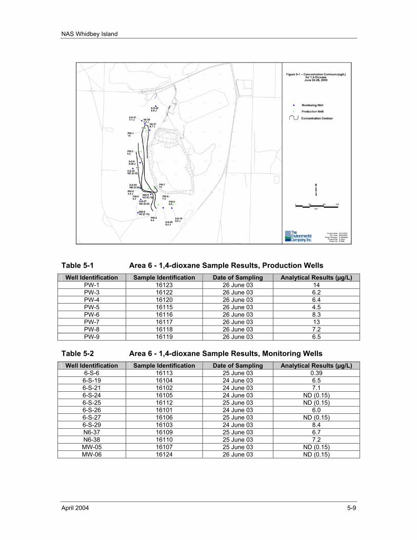
NAS Whidbey Island
April 2004 5-9
Table 5-1 Area 6 - 1,4-dioxane Sample Results, Production Wells Well Identification Sample Identification Date of Sampling Analytical Results (µg/L)
PW-1 16123 26 June 03 14 PW-3 16122 26 June 03 6.2 PW-4 16120 26 June 03 6.4 PW-5 16115 26 June 03 4.5 PW-6 16116 26 June 03 8.3 PW-7 16117 26 June 03 13 PW-8 16118 26 June 03 7.2 PW-9 16119 26 June 03 6.5
Table 5-2 Area 6 - 1,4-dioxane Sample Results, Monitoring Wells Well Identification Sample Identification Date of Sampling Analytical Results (µg/L)
6-S-6 16113 25 June 03 0.39 6-S-19 16104 24 June 03 6.5 6-S-21 16102 24 June 03 7.1 6-S-24 16105 24 June 03 ND (0.15) 6-S-25 16112 25 June 03 ND (0.15) 6-S-26 16101 24 June 03 6.0 6-S-27 16106 25 June 03 ND (0.15) 6-S-29 16103 24 June 03 8.4 N6-37 16109 25 June 03 6.7 N6-38 16110 25 June 03 7.2 MW-05 16107 25 June 03 ND (0.15) MW-06 16124 26 June 03 ND (0.15)
NAS Whidbey Island
April 2004 5-10
Soil borings and soil vapor monitoring during these site characterization activities showed significant contamination at the location of the former waste oil pit (Foster Wheeler, 2001c) and it appeared likely that residual DNAPL was contributing to residual VOCs in the vadose zone at Area 6. A removal action was conducted (Foster Wheeler, 2002a) that included excavation, transport and treatment/disposal of contaminated soils from the location of the waste oil disposal pit. Excavation activities were conducted from 24 September through 29 November 2001.
Approximately 1,360 cubic yards (2,040 tons) of contaminated, but non-hazardous soils and materials were excavated and transported off-site for thermal desorption and disposal; approximately 601 cubic yards (901 tons) of hazardous soils and materials were excavated and transported off-site for direct landfill disposal; and approximately 354 cubic yards (531 tons) of hazardous, land disposal restricted (LDR) soils and materials were excavated and transported off-site for pre-treatment (bioremediation) and landfill disposal.
Explorations for a suspected waste acid disposal pit were also conducted during the waste oil pit removal action. These explorations found wide-spread low levels of VOC contamination, but found no area indicative of the presence of an acid disposal pit (Foster Wheeler, 2002a).
A follow-on study evaluated the fate and transport of residual VOCs that remain in the soils at the location of site 55 at Area 6. The findings of this assessment are documented in Assessment of Fate and Transport for Residual VOCs in Vadose Zone in Vicinity of Site 55 (Foster Wheeler, 2002b).
The assessment concluded that there has been a strong stability in VOC concentrations in the vadose zone at Area 6 over the past 10 years; and that it appears likely that residual DNAPL was contributing to the stable soil gas concentrations observed.
The assessment stated that soil gas data collected for Area 6 in January 1991 and those collected in September 2000 (Foster Wheeler, 2001c) were similar in extent and concentration (despite the surveys occurring 9.5 years apart) and found that good correlation existed between collocated soil gas and soil concentration data from the six soil monitoring well installations; therefore, no additional off-site data was collected.
The assessment recommended that additional (future) vadose zone monitoring be conducted at Area 6 at select soil vapor monitor (SVM) locations to determine if the DNAPL source removal that was performed was effective at reducing VOC concentrations; however, no additional remediation of the vadose zone was recommended. The assessment recommended that this additional round of vadoze zone confirmation sampling be conducted after a years time to determine VOC concentration trends. Sampling is recommended for six SVM locations in Area 6 from the deepest depth interval (i.e., the depth interval immediately above the aquifer). Sampling is also recommended for two additional SVM locations, one adjacent to the former waste oil pit, and the second located near the property boundary, at four depth intervals. If VOC concentrations remained at or near current levels in this additional
NAS Whidbey Island
April 2004 5-11
sampling round, such results would provide an indication of a continuing source that should then be the subject of additional investigations.
The assessment also concluded that shutting down of extraction wells at Area 6 for testing purposes would not significantly impact plume capture for the intended durations of shutdown. The application of the vadose zone flux to groundwater flow modeling simulations at Area 6 appeared to confirm that VOCs present in the vadose zone have the potential to maintain contaminant concentrations in the shallow aquifer that are of similar magnitude to current concentrations observed through groundwater monitoring. The assessment proposed two groundwater monitoring well locations (referred to as 6-S-30 and 6-S-31) for new wells to support future monitoring.
5.1.2.2 TECHNICAL ASSESSMENT The groundwater extraction, treatment, and recharge system implemented as the remedial action at Area 6 is functioning as intended; all exposure assumptions, toxicity data, cleanup levels, and remedial action objectives used at the time of the remedy selection are still valid; and no other information has come to light that could call into question the protectiveness of the remedy; however, the emerging issue of 1,4-dioxane needs to be investigated as soon as possible
5.2 OPERABLE UNIT 2 The remedial action objectives have been met at OU2, and institutional controls, including groundwater use restrictions, have been implemented at all OU2 areas. The initial Five-Year Review (EFANW, 1998) referenced an additional groundwater monitoring event required for Areas 2/3, 4, and 29 at OU2. The results of this additional sampling are discussed in the subsections that follow.
5.2.1 AREA 2/3
5.2.1.1 DISCUSSION Institutional controls, including groundwater use restrictions, remain in place at Area 2/3 (see Sections 3.2.2 and 3.3.2)
In December 2002, groundwater samples were collected from seven monitoring wells at Area 2/3. The seven sampled wells were 3-MW-2, N2-3, N2-6C, N2-7S, N2-8, N2-9, and N3-12. All groundwater monitoring samples were analyzed for VOCs, total arsenic, and total manganese. Documentation of the groundwater monitoring is provided in the Draft Technical Memorandum, Letter Report for Environmental Monitoring at NAS Whidbey Island, dated 7 March 2003 (TEC, 2003a). Select tables and figures from this technical memorandum are provided in Appendix E. Table 1 (Appendix E) provides a summary of the groundwater monitoring samples collected at Area 2/3; Table 2 (Appendix E) provides a summary of water level and field measurement results; Figure 2 (Appendix E) provides the locations of the groundwater monitoring wells; and Table 4 (Appendix E) provides the analytical results associated with the groundwater monitoring.
VOCs were detected in trace amounts in the Area 2/3 groundwater samples. A total of 15 different VOCs were detected in the samples; however, 11 of these compounds were
NAS Whidbey Island
April 2004 5-12
detected only in the samples from N2-7S and N3-12. The VOCs were petroleum-related compounds (benzene, toluene, o-xylene, and naphthalene) and chlorinated hydrocarbons (e.g., dichlorodifluoromethane [CFC-12] and cis-1,2-dichloroethene). Almost all of the VOCs were detected at trace levels between the Method Detection Limits (MDLs) and the Reporting Limits (RLs). Only five VOCs were detected at levels above the RL, and all of these compounds were detected in the samples from N2-7S and N3-12. CFC-12 was detected at a concentration of 2.9 µg/L in N3-12. Vinyl chloride was detected at 11 µg/L, also at N3-12. Cis-1,2-dichloroethene was detected at 1.4 µg/L at N3-12 and 0.54 µg/L at N2-7S. Benzene was detected at 0.7 µg/L at N3-12 and 1.2 µg/L at N2-7S. Chlorobenzene was detected at 5.9 µg/L at N2-7S.
A comparison of the VOC results with those discussed in the Revised Technical Memorandum, Post-ROD Groundwater Monitoring for Operable Unit 2 (URS, 1997) shows that VOC concentrations at N3-12 have decreased or remained stable since the last sampling round at the site, whereas VOC concentrations have increased slightly at N2-7S . In that report, it was noted that VOCs were detected only at wells N2-7S and N3-12. The current round of sampling also found VOCs only at these two wells. Benzene levels at N3-12 had dropped from 2 µg/L to 0.7 µg/L, whereas levels of vinyl chloride and cis-1,2-dichloroethene had remained relatively stable. Only the vinyl chloride result exceeded the ROD Decision Criteria of 1 µg/L. During the previous sampling round, only chlorobenzene was detected at N2-7S. The current sample contained slightly higher levels of this analyte (5.9 µg/L in 2002, as opposed to 2 µg/L in 1997). Benzene and cis-1,2-dichloroethene were also detected at this well, but at levels below the ROD Decision Criteria.
Many of the inorganic results exceeded the ROD Decision Criteria. Arsenic was detected above the RL in the three groundwater samples collected from wells 3-MW-2, N2-3, and N3-12. Arsenic concentrations in these samples ranged from 8.65 to 55.6 µg/L. All three of these results were above the ROD Decision Criteria of 7.7 µg/L. Manganese was detected in the four samples collected from wells 3-MW-2, N2-3, N2-6C, and N3-12. Manganese concentrations in these samples ranged from 61.8 to 5,270 µg/L. Manganese levels in N2-6C and N3-12 exceeded the ROD Decision Criteria of 840 µg/L.
It should be noted that the USEPA maximum contaminant level (MCL) for arsenic was recently reduced from a concentration of 50 µg/L to 10 µg/L (reference 66 Federal Register 6976, dated 22 January 2001). The USEPA rationale for the MCL reduction was to statistically reduce the occurrences of non-fatal and fatal bladder cancer and non-fatal and fatal lung cancer, as well as to reduce the frequency of occurrences of non-carcinogenic diseases. As the ROD Decision Criteria for arsenic at Area 2/3 is 7.7 µg/L arsenic, and this concentration is less than the revised MCL (10 µg/L); the remedial action objectives remain valid and the protectiveness of the remedy is not called into question.
Sample results show that institutional controls, including groundwater use restrictions, should continue to be implemented at the site. The exceedences of the ROD Decision Criteria for arsenic and manganese, as well as the slight increase in the levels of VOCs at N2-7S, indicate that, as expected, contamination is still present at the site and the conclusions reached in the Revised Technical Memorandum, Post-ROD Groundwater
NAS Whidbey Island
April 2004 5-13
Monitoring for Operable Unit 2 (URS, 1997) still apply. As discussed in that report, groundwater use restrictions should remain in place at Area 2/3 (URS, 1997). Groundwater sampling for the next Five-Year Review should be conducted for the same parameters at Area 2/3 monitoring wells.
5.2.1.2 TECHNICAL ASSESSMENT The remedial actions implemented at Area 2/3 are complete and institutional controls remain in place; all exposure assumptions, toxicity data, cleanup levels, and remedial action objectives used at the time of the remedy selection are still valid; and no other information has come to light that could call into question the protectiveness of the remedy.
5.2.2 AREA 4
5.2.2.1 DISCUSSION Institutional controls, including groundwater use restrictions, remain in place at Area 4 (see Sections 3.2.2 and 3.3.2).
In December 2002, groundwater samples were collected from two monitoring wells at Area 4. The two sampled wells were 4-MW-1 and 4-MW-3. Both groundwater samples were analyzed for arsenic. Documentation of the groundwater monitoring is provided in the Draft Technical Memorandum, Letter Report for Environmental Monitoring at NAS Whidbey Island, dated 7 March 2003 (TEC, 2003a). Select tables and figures from this technical memorandum are provided in Appendix E. Table 1 (Appendix E) provides a summary of the groundwater monitoring samples collected at Area 4; Table 2 (Appendix E) provides a summary of water level and field measurement results; Figure 2 (Appendix E) provides the locations of the groundwater monitoring wells; and Table 4 (Appendix E) provides the analytical results associated with the groundwater monitoring at Area 4.
In both of these groundwater samples, arsenic was detected above the RL. Results were 8.8 µg/L at 4-MW-1 and 10.6 µg/L at 4-MW-3. Arsenic levels in both of these wells have decreased slightly since the last round of sampling (URS, 1997). The concentrations of the contaminant of concern at Area 4 appear to be stable; therefore, the remedies presented in the Post-ROD Technical Memorandum (URS, 1997) remain effective.
As previously noted, the USEPA maximum contaminant level (MCL) for arsenic was reduced from a concentration of 50 µg/L to 10 µg/L. As the ROD Decision Criteria for arsenic at Area 4 is 7.7 µg/L arsenic, and this concentration is less than the revised MCL (10 µg/L); the remedial action objectives remain valid and the protectiveness of the remedy is not called into question.
5.2.2.2 TECHNICAL ASSESSMENT The soil excavation and restoration remedial actions implemented at Area 4 are complete and institutional controls remain in place; all exposure assumptions, toxicity data, cleanup levels, and remedial action objectives used at the time of the remedy
NAS Whidbey Island
April 2004 5-14
selection are still valid; and no other information has come to light that could call into question the protectiveness of the remedy.
5.2.3 AREA 14
5.2.3.1 DISCUSSION Institutional controls, to include groundwater use restrictions, remain in place at Area 14 (see Sections 3.2.2 and 3.3.2). Groundwater monitoring is not conducted or required at Area 14.
5.2.3.2 TECHNICAL ASSESSMENT The soil excavation and restoration remedial actions implemented at Area 14 are complete and institutional controls remain in place; all exposure assumptions, toxicity data, cleanup levels, and remedial action objectives used at the time of the remedy selection are still valid; and no other information has come to light that could call into question the protectiveness of the remedy.
5.2.4 AREA 29
5.2.4.1 DISCUSSION Institutional controls, including groundwater use restrictions, remain in place at Area 29 (see Sections 3.2.2 and 3.3.2).
In December 2002, groundwater samples were collected from three monitoring wells at Area 29. The sampled wells were 29-MW-4, N29-20, and N29-22D. Documentation of the groundwater monitoring is provided in the Draft Technical Memorandum, Letter Report for Environmental Monitoring at NAS Whidbey Island, dated 7 March 2003 (TEC, 2003a). Select tables and figures from this technical memorandum are provided in Appendix E. Table 1 (Appendix E) provides a summary of the groundwater monitoring samples collected at Area 29; Table 2 (Appendix E) provides a summary of water level and field measurement results; Figure 2 (Appendix E) provides the locations of the groundwater monitoring wells; and Table 8 (Appendix E) provides the analytical results associated with the groundwater monitoring at Area 29.
All three groundwater samples were analyzed for arsenic. In all three of these samples, arsenic was detected above the RL. Results were 10.4 µg/L at 29-MW-4, 12.15 µg/L at N29-20, and 20.6 µg/L at N29-22D. These results were above the ROD Decision Criteria of 7.7 µg/L. Arsenic levels in these wells have remained relatively stable since the last round of sampling (URS, 1997), with concentration changes of less than 2 µg/L.
The concentrations of the contaminant of concern at Area 29 appear to be stable; therefore, the remedies presented in the Post-ROD Technical Memorandum (URS, 1997) remain effective.
As previously noted, the USEPA maximum contaminant level (MCL) for arsenic was reduced from a concentration of 50 µg/L to 10 µg/L. As the ROD Decision Criteria for arsenic at Area 29 is 7.7 µg/L arsenic, and this concentration is less than the revised
NAS Whidbey Island
April 2004 5-15
MCL (10 µg/L); the remedial action objectives remain valid and the protectiveness of the remedy is not called into question.
5.2.4.2 TECHNICAL ASSESSMENT The soil excavation and restoration remedial actions implemented at Area 29 are complete and institutional controls remain in place; all exposure assumptions, toxicity data, cleanup levels, and remedial action objectives used at the time of the remedy selection are still valid; and no other information has come to light that could call into question the protectiveness of the remedy.
5.3 OPERABLE UNIT 3 5.3.1 AREA 16
5.3.1.1 DISCUSSION Although Area 16 was remediated to cleanup levels that allow for unrestricted use, the area remains a limited access area due to NAS Whidbey Island airfield operational concerns and the U.S. Navy maintains the position that Area 16 is an industrial site and that cleanup standards that were defined in the ROD shall also apply to future dredging. Given this, institutional controls remain in place at Area 16 (see Section 3.2.2 and 3.3.3).
Documentation of additional sediment sampling that was conducted at Area 16 in December 2002 is provided in Table 7, Appendix E. Select tables and figures from this technical memorandum are provided in Appendix E. Table 1 (Appendix E) provides a summary of the sediment samples collected at Area 16; Figure 5 (Appendix E) provides the locations of the sediment samples; and Table 7 (Appendix E) provides the analytical results associated with the sediment samples.
PAHs were detected in all sediment samples collected at Area 16 with PAH concentrations in sample 5YRSED-1 being significantly elevated from the remainder of the sediment samples. Arsenic was detected in all sediment samples collected at Area 16 ranging in concentration from 3 to 14.3 mg/kg. Lead was also detected in all sediment samples collected at Area 16 ranging in concentration from 9.4 to 540 mg/kg (the highest concentration associated with sample 5YRSED-1). Diesel range organics (DRO) and residual range organics (RRO) were detected in all sediment samples collected at Area 16. DRO concentrations ranged from 21 to 670 mg/kg and RRO concentrations ranged from 210 to 4,000 mg/kg. Gasoline range organics (GRO) were not detected in any sediment samples.
5.3.1.2 TECHNICAL ASSESSMENT The sediment excavation and confirmatory sampling remedial actions implemented at Area 16 are complete and institutional controls are in place; all exposure assumptions, toxicity data, cleanup levels and remedial action objections used at the time of the remedy selection are still valid. While there was no human health risk identified at Area 16, the Five Year Review sampling identified that there are locations that exceed ROD cleanup levels for ecological risk that could call into question the on-going protectiveness of the remedy.
NAS Whidbey Island
April 2004 5-16
5.4 OPERABLE UNIT 4 Remedial actions at OU4, Seaplane Base, are complete, and OU4 was officially deleted from the Superfund NPL in September 1995. USEPA written correspondence to NAS Whidbey Island documents that a Five-Year Review is not required for OU4 (USEPA, 1995a); however, current USEPA guidance (USEPA, 2001) does require a review.
5.4.1 AREA 39
5.4.1.1 DISCUSSION Institutional controls remain in place at Area 39 (see Sections 3.2.2 and 3.3.4).
5.4.1.2 TECHNICAL ASSESSMENT The soil excavation and restoration remedial actions implemented at Area 39 are complete and institutional controls remain in place; all exposure assumptions, toxicity data, cleanup levels, and remedial action objectives used at the time of the remedy selection are still valid; and no other information has come to light that could call into question the protectiveness of the remedy.
5.4.2 AREA 41
5.4.2.1 DISCUSSION Institutional controls remain in place at Area 41 (see Sections 3.2.2 and 3.3.4).
5.4.2.2 TECHNICAL ASSESSMENT The soil excavation and restoration remedial actions implemented at Area 41 are complete and institutional controls remain in place; all exposure assumptions, toxicity data, cleanup levels, and remedial action objectives used at the time of the remedy selection are still valid; and no other information has come to light that could call into question the protectiveness of the remedy.
5.4.3 AREA 44
5.4.3.1 DISCUSSION Institutional controls remain in place at Area 44 (see Sections 3.2.2 and 3.3.4).
5.4.3.2 TECHNICAL ASSESSMENT The soil excavation and restoration remedial actions implemented at Area 44 are complete and institutional controls remain in place; all exposure assumptions, toxicity data, cleanup levels, and remedial action objectives used at the time of the remedy selection are still valid; and no other information has come to light that could call into question the protectiveness of the remedy.
5.4.4 AREA 48
5.4.4.1 DISCUSSION Institutional controls remain in place at Area 48 (see Sections 3.2.2 and 3.3.4).
NAS Whidbey Island
April 2004 5-17
5.4.4.2 TECHNICAL ASSESSMENT The soil excavation and restoration remedial actions implemented at Area 48 are complete and institutional controls remain in place; all exposure assumptions, toxicity data, cleanup levels, and remedial action objectives used at the time of the remedy selection are still valid; and no other information has come to light that could call into question the protectiveness of the remedy.
5.4.5 AREA 49
5.4.5.1 DISCUSSION Institutional controls remain in place at Area 49 (see Sections 3.2.2 and 3.3.4).
5.4.5.2 TECHNICAL ASSESSMENT The soil excavation and restoration remedial actions implemented at Area 49 are complete and institutional controls remain in place; all exposure assumptions, toxicity data, cleanup levels, and remedial action objectives used at the time of the remedy selection are still valid; and no other information has come to light that could call into question the protectiveness of the remedy.
5.5 OPERABLE UNIT 5 5.5.1 AREA 1
5.5.1.1 DISCUSSION Visual monitoring of shoreline stability was required to be conducted at Area 1 on an annual basis for a period of 5 years beginning in 1998. This shoreline stability monitoring has been conducted by Environmental Affairs Office personnel and properly documented. The documentation of shoreline stability monitoring is sent via Facsimile to the USEPA on an annual basis. The fifth (and final) shoreline stability monitoring event was recently completed by Environmental Affairs Office personnel in July 2002. This monitoring indicated that only minor shoreline erosion is occurring along the coastline of Area 1.
As prescribed in the initial Five-Year Review (EFANW, 1998), seep sampling was conducted along the coastline at Area 1 for this Review. Seep samples were collected from five locations during December 2002. These samples were analyzed for cyanide and inorganics (i.e., total and dissolved metals). Documentation of this seep sampling is provided in the Draft Technical Memorandum, Letter Report for Environmental Monitoring at NAS Whidbey Island, dated 7 March 2003 (TEC, 2003a). Select tables and figures from this technical memorandum are provided in Appendix E. Table 1 (Appendix E) provides a summary of the seep samples collected at OU5, Area 1; Figure 4 (Appendix E) provides the locations of the seep samples; and Table 3 (Appendix E) provides the analytical results associated with the seep samples.
Analytical results of seep samples (see Table 3, Appendix E) indicate only trace amounts of arsenic and low levels of manganese. There were no detections of cyanide in any of the seep samples. Antimony was only detected at levels below the RL in four of the samples; furthermore, these antimony results can probably be attributed to blank
NAS Whidbey Island
April 2004 5-18
contamination rather than actual contamination at the site. Total arsenic was detected above the RL only at Seep #5 at a concentration of 14.6 µg/L. Total manganese was detected in all five seep samples, with concentrations ranging from 55.5 to 334 µg/L. Dissolved manganese was also detected above the RL at Seeps #1 and #3, at concentrations of 6.3 and 119 µg/L, respectively.
The risk assessment conducted for the OU5 ROD (URS, 1996) demonstrated that no contaminants of concern at Area 1 groundwater exceeded risk based screening concentrations. Groundwater quality was therefore evaluated based on the protection of nearby marine surface water. All seep sample results are therefore compared to state marine water quality standards, as given in WAC 173-201A. Arsenic concentrations in the Area 1 seeps are well below the marine water quality standard of 36.0 ug/L. Marine water quality standards for manganese are not given; however, manganese levels found in the Area 1 seep samples are comparable to background manganese levels found elsewhere at NAS Whidbey Island.
5.5.1.2 TECHNICAL ASSESSMENT The remedial actions implemented and Area 1 are complete and remedial action objectives have essentially been met; all exposure assumptions, toxicity data, cleanup levels, and remedial action objectives used at the time of the remedy selection are still valid; and no other information has come to light that could call into question the protectiveness of the remedy.
5.5.2 AREA 31
5.5.2.1 DISCUSSION Recommendations were made that petroleum product recovery system components be shut down and mothballed by the end of December 1999 and periodic monitoring of groundwater conditions be conducted in support of the Five-Year Review. This decision was supported by a steady decline in fuel recovery (see Table 5-3) and the initial reduction and now steady low values for biodegradation rates (see also Table 5-4; note that biodegradation rates are expressed as milligrams of contaminant consumed per kilogram of soil per day).
The same decision and recommendations were reiterated in the quarterly technical reports for Area 31 for the operating periods of October - December 1999 (Foster Wheeler, 2000c) and January - March 2000 (Foster Wheeler, 2000d).
Four groundwater monitoring wells immediately down-gradient of Area 31 (wells identified as OWS-1, OWS-2, OWS-3, and OWS-4) were monitored on an intermittent basis for total petroleum hydrocarbons – gasoline range organics (TPH-GRO), total petroleum hydrocarbons – diesel range organics (TPH-DRO), and total petroleum hydrocarbons by Method 418.1 (TPH-418.1) (see Table 5-5). It was concluded from these monitoring results that groundwater contamination had not migrated (Foster Wheeler, 2000d).
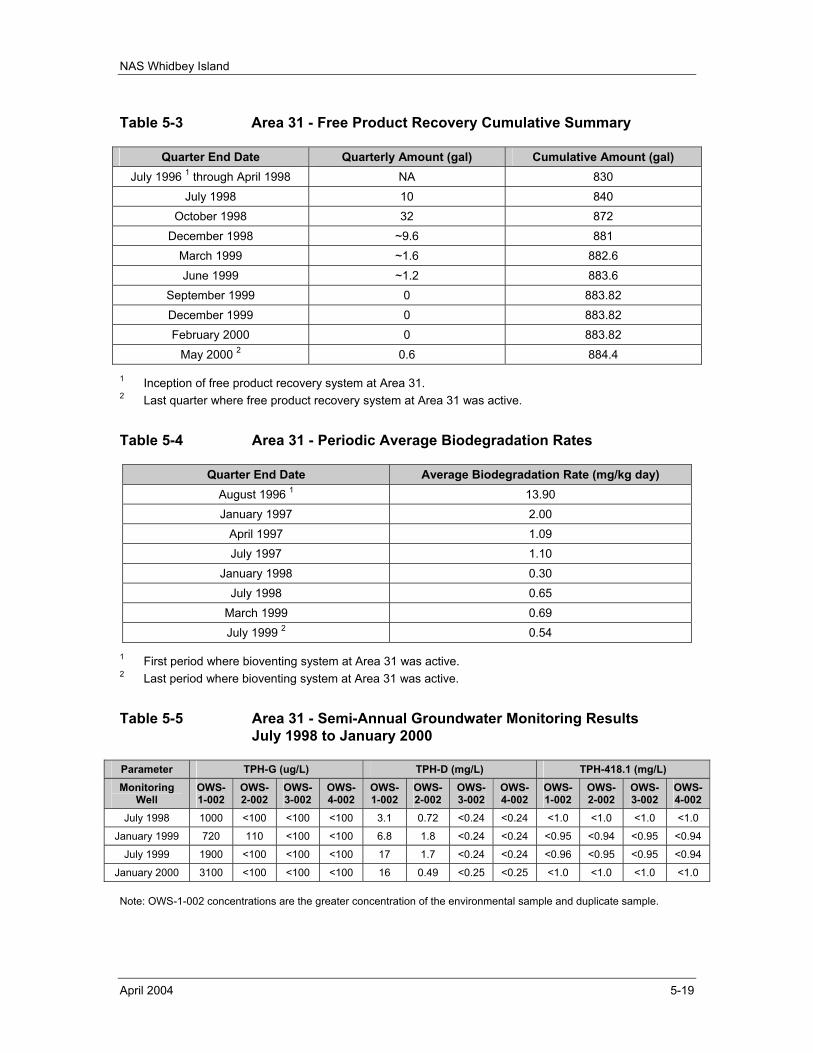
NAS Whidbey Island
April 2004 5-19
Table 5-3 Area 31 - Free Product Recovery Cumulative Summary
Quarter End Date Quarterly Amount (gal) Cumulative Amount (gal) July 1996 1 through April 1998 NA 830
July 1998 10 840 October 1998 32 872
December 1998 ~9.6 881 March 1999 ~1.6 882.6 June 1999 ~1.2 883.6
September 1999 0 883.82 December 1999 0 883.82 February 2000 0 883.82
May 2000 2 0.6 884.4
1 Inception of free product recovery system at Area 31. 2 Last quarter where free product recovery system at Area 31 was active.
Table 5-4 Area 31 - Periodic Average Biodegradation Rates
Quarter End Date Average Biodegradation Rate (mg/kg day) August 1996 1 13.90 January 1997 2.00
April 1997 1.09 July 1997 1.10
January 1998 0.30 July 1998 0.65
March 1999 0.69 July 1999 2 0.54
1 First period where bioventing system at Area 31 was active. 2 Last period where bioventing system at Area 31 was active.
Table 5-5 Area 31 - Semi-Annual Groundwater Monitoring Results July 1998 to January 2000
Parameter TPH-G (ug/L) TPH-D (mg/L) TPH-418.1 (mg/L) Monitoring
Well OWS-1-002
OWS-2-002
OWS-3-002
OWS-4-002
OWS-1-002
OWS-2-002
OWS-3-002
OWS-4-002
OWS-1-002
OWS-2-002
OWS-3-002
OWS-4-002
July 1998 1000 <100 <100 <100 3.1 0.72 <0.24 <0.24 <1.0 <1.0 <1.0 <1.0
January 1999 720 110 <100 <100 6.8 1.8 <0.24 <0.24 <0.95 <0.94 <0.95 <0.94
July 1999 1900 <100 <100 <100 17 1.7 <0.24 <0.24 <0.96 <0.95 <0.95 <0.94
January 2000 3100 <100 <100 <100 16 0.49 <0.25 <0.25 <1.0 <1.0 <1.0 <1.0
Note: OWS-1-002 concentrations are the greater concentration of the environmental sample and duplicate sample.
NAS Whidbey Island
April 2004 5-20
A Draft Areas 31 and 52 Assessment Report, Operable Unit 5, Areas 31 and 52, Former Runway and Jet Engine Test Cell Fire School, Naval Air Station Whidbey Island, Washington, dated 7 February 2000 was prepared (Foster Wheeler, 2000a). This assessment report summarized and evaluated product recovery and groundwater sampling at Area 31. This assessment report concluded (for Area 31) that semi-annual groundwater sampling results showed that fuel contamination was not migrating off-site. Furthermore, the product recoveries and thickness measurements showed only limited amounts of free product, suggesting that active skimming, bioventing, and respirometry testing could be terminated.The product recovery and bioventing systems were shut-down in March 2000. The USEPA provided formal concurrence with the shut-down of the systems in a letter dated 19 May 2000.
Groundwater monitoring is continuing at Area 31. Sampling has been conducted quarterly since November 2001. Groundwater monitoring has been conducted at monitoring wells OWS-1, OWS-2, OWS-3, OWS-4, and MW31-09A. Field activities during the quarterly monitoring events included well head integrity checks, groundwater and product thickness measurements, well purging, sample collection, and site management.
Monitoring results for three of the five sampled wells showed contaminant levels well below the cleanup levels (CULs), i.e., a CUL of 1,000 µg/L for TPH-DRO and a CUL of 1,000 µg/L for TPH-GRO. Samples from OWS-2 contained low levels of both TPH-GRO (79 to 210 µg/L) and TPH-DRO (120 to 340 µg/L). Samples from OWS-3 contained low levels of TPH-DRO (2.1 to 110 µg/L). Most of these results have been qualified as estimated, as they fall between the method detection limits and the practical quantization limits for that method. Analytical results for samples from OWS-4 were below method detection limits for both TPH-GRO and TPH-DRO.
Only two of the wells, OWS-1 and MW31-09A, showed results for TPH-GRO and TPH-DRO above the CULs. Table 5-6 presents the quarterly monitoring results for OWS-1 and MW31-9A.
In well OWS-1, the calendar year 2003 data for TPH-GRO show that TPH-GRO concentrations have decreased from the previous year by a factor of 2; however, for TPH-DRO concentrations, there is a clear upward trend from approximately 2,000 ppb identified in calendar year 2000 to approximately 11,000 ppb in July 2003.
The sample results for OWS-1 are relatively stable but do show seasonal fluctuations. Contaminant levels generally decrease in the wetter months, as increased water flow dilutes the contaminants. There is currently not enough data for MW31-09A to determine whether contaminant levels are stable and following the same seasonal trend.
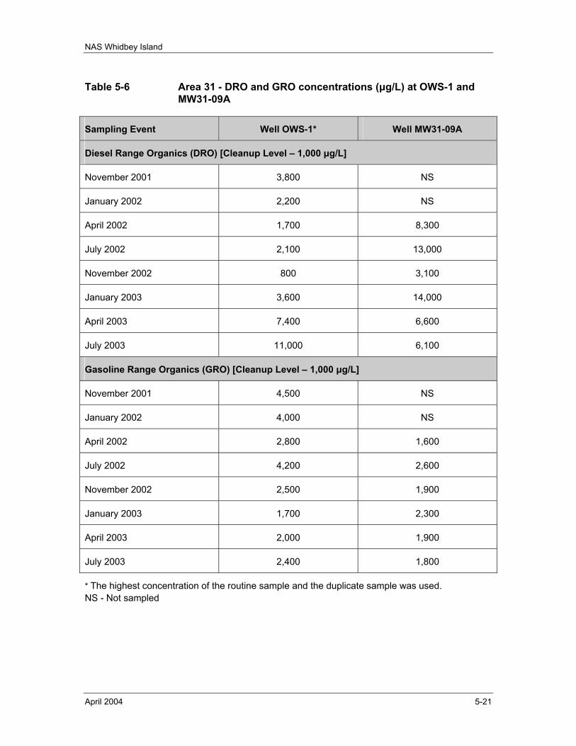
NAS Whidbey Island
April 2004 5-21
Table 5-6 Area 31 - DRO and GRO concentrations (µg/L) at OWS-1 and MW31-09A
Sampling Event Well OWS-1* Well MW31-09A
Diesel Range Organics (DRO) [Cleanup Level – 1,000 µg/L]
November 2001 3,800 NS
January 2002 2,200 NS
April 2002 1,700 8,300
July 2002 2,100 13,000
November 2002 800 3,100
January 2003 3,600 14,000
April 2003 7,400 6,600
July 2003 11,000 6,100
Gasoline Range Organics (GRO) [Cleanup Level – 1,000 µg/L]
November 2001 4,500 NS
January 2002 4,000 NS
April 2002 2,800 1,600
July 2002 4,200 2,600
November 2002 2,500 1,900
January 2003 1,700 2,300
April 2003 2,000 1,900
July 2003 2,400 1,800
* The highest concentration of the routine sample and the duplicate sample was used. NS - Not sampled
NAS Whidbey Island
April 2004 5-22
To facilitate the collection of additional data at Area 31; two additional groundwater monitoring wells were installed during February 2003 to provide additional groundwater monitoring locations for further evaluation of Area 31. The two monitoring wells installed were identified as MW31-34 and MW31-35. Well installation activities, well locations, and similar data are documented in the Technical Memorandum, Final Well Installation Report, Areas 6 and 31, NAS Whidbey Island, Washington, dated 4 April 2003 (TEC, 2003c). It is intended that these wells will be monitored from this point forward to provide additional monitoring data to support the evaluation of and decisions regarding Area 31.
It should be noted that the MTCA Method A groundwater cleanup levels have been revised since the date of the ROD for Area 31. MTCA Method A groundwater CULs are currently 500 µg/L for TPH-DRO (formerly 1,000 µg/L as established in the ROD for Area 31) and 800 µg/L for TPH-GRO (formerly 1,000 µg/L as established in the ROD for Area 31). Although the CULs for Area 31 were established by the ROD; these revised CULs are more stringent than the established CULs for Area 31 and warrant discussion in this Review. Considering these revised CULs; the same two wells, OWS-1 and MW31-09A, showed results for TPH-GRO and TPH-DRO above the revised CULs (see Table 5-6 and associated discussion presented previously). Also considering these revised CULs; no increased concerns are evident regard to potential contaminant migration (see Table 5-5 and associated discussion present previously).
It should also be noted the CUL for manganese in groundwater has been revised from a concentration of 125 µg/L to 767 µg/L base on updated reference doses (RfDs) within the USEPA Integrated Risk Information System (IRIS). As the revised CUL (767 µg/L) is less stringent than the CUL established for Area 31 (125 µg/L); the remedial action objectives remain valid and the revised CUL does not call into question the protectiveness of the remedy.
5.5.2.2 TECHNICAL ASSESSMENT The petroleum product recovery system implemented at Area 31 functioned as intended and petroleum product recovery subsequently has ceased; all exposure assumptions, toxicity data, cleanup levels, and remedial action objectives used at the time of the remedy selection are still valid; and no other information has come to light that could call into question the protectiveness of the remedy.
5.5.3 AREA 52
5.5.3.1 DISCUSSION The remedial action objectives for Area 52 are in the process of being met and free product recovery operations, the associated maintenance, and monitoring actions are on-going. Product recovery is to continue at Area 52 until recovery reaches its practical limits. Product thickness measurements and water table measurements are made on a quarterly basis. Seep sampling was conducted on a biennial basis until 1999.
Institutional controls remain in place at Area 52 (see Sections 3.2.2 and 3.2.5).
NAS Whidbey Island
April 2004 5-23
The free product recovery system is operated and maintained in accordance with the Final Combined Operations and Maintenance Manuals, Operable Unit 1, Area 6, Operable Unit 5, Areas 31 and 52, Naval Air Station Whidbey Island, Washington (Foster Wheeler, 2000f).
Free product is recovered from a variety of wells at Area 52, depending on product thickness measurements and product recovery rates. Through the period covered by the initial Five-Year Review, approximately 210 gallons of free product petroleum was recovered at Area 52. At the date of the initial Five-Year Review, product recovery rates were characterized as less than expected; however, operating adjustments have improved product recovery rates since the initial Five-Year Review (see discussion that follows).
In September 1997, Foster Wheeler Environmental Corporation installed a temporary fuel recovery system in extraction well EW-1 at Area 52 (Foster Wheeler, 1998c). The temporary setup demonstrated that EW-1 was a productive well for product recovery. This fuel recovery system was approved for long-term use by NAS Whidbey Island and continues to the date of this review.
Due to contractual issues, active site work was briefly halted at the direction of EFANW during a period from late May through August 2000. Both remedial skimming systems were inoperative during this time period. Foster Wheeler Environmental Corporation began operating both of the skimming systems, implementing scheduled operation and maintenance (O&M), water level and free product level gauging operations, and field reporting in September 2000. Since the restart in September 2000, the product recovery systems and the associated O&M, level gauging, and reporting activities at Area 52 have been in normal operation status.
Table 5-7 presents product recovery volumes for Area 52. Figure 5-2 illustrates the cumulative product recovered. In addition to the product recovery volumes listed in Table 5-7 and illustrated in Figure 5-2, a total of 931.5 gallons of mixed product and water have been recovered as well (TEC, 2002c). Recovery of mixed product and water is continuously minimized by adjustments of the system intake depths and through efficient operation of the recovery pumps. A decrease in the amount of mixed product and water extracted during one quarter from the previous quarter (as was identified in TEC, 2002c) generally indicates more efficient operation of the recovery system.
Seasonal variations in product recovery have been noted throughout the operation of the product recovery system. First quarter product recovery rates are consistently lower than other quarters. As the localized water table is lowered in proportion to mean sea level (msl) elevation and the groundwater flow gradient decreases, additional product recovery zone area becomes available in each system well. This lowering of the groundwater table (most prevalent in the second and third quarters of the calendar year) effectively increases the overall potential efficiency of the product recovery skimming systems.
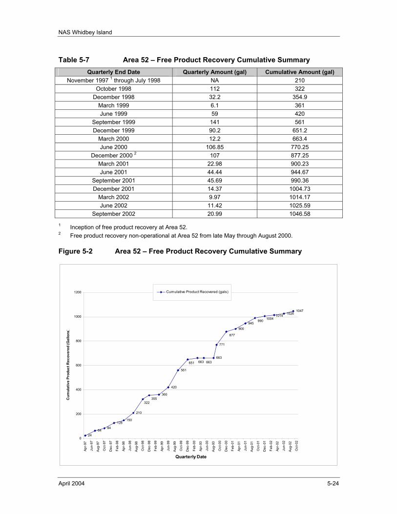
NAS Whidbey Island
April 2004 5-24
Table 5-7 Area 52 – Free Product Recovery Cumulative Summary Quarterly End Date Quarterly Amount (gal) Cumulative Amount (gal)
November 1997 1 through July 1998 NA 210 October 1998 112 322
December 1998 32.2 354.9 March 1999 6.1 361 June 1999 59 420
September 1999 141 561 December 1999 90.2 651.2
March 2000 12.2 663.4 June 2000 106.85 770.25
December 2000 2 107 877.25 March 2001 22.98 900.23 June 2001 44.44 944.67
September 2001 45.69 990.36 December 2001 14.37 1004.73
March 2002 9.97 1014.17 June 2002 11.42 1025.59
September 2002 20.99 1046.58
1 Inception of free product recovery at Area 52. 2 Free product recovery non-operational at Area 52 from late May through August 2000.
Figure 5-2 Area 52 – Free Product Recovery Cumulative Summary
2464
84128
150
210
360
420
561
663
771
945
10261047
990
900
322355
877
651 663663
10141004
0
200
400
600
800
1000
1200
Apr-
97
Jun-
97
Aug-
97
Oct
-97
Dec
-97
Feb-
98
Apr-
98
Jun-
98
Aug-
98
Oct
-98
Dec
-98
Feb-
99
Apr-
99
Jun-
99
Aug-
99
Oct
-99
Dec
-99
Feb-
00
Apr-
00
Jun-
00
Aug-
00
Oct
-00
Dec
-00
Feb-
01
Apr-
01
Jun-
01
Aug-
01
Oct
-01
Dec
-01
Feb-
02
Apr-
02
Jun-
02
Aug-
02
Oct
-02
Quarterly Date
Cum
ulat
ive
Prod
uct R
ecov
ered
(Gal
lons
)
Cumulative Product Recovered (gals)
NAS Whidbey Island
April 2004 5-25
On 13 and 14 July 1999, seep sampling was conducted at six locations (Foster Wheeler, 1999g). Seep sampling had been previously conducted at the same six locations.
Seep samples were analyzed for TPH-GRO, TPH-DRO, VOCs, and semi-volatile organic compounds (SVOCs). During this round of seep sampling, five detections were reported (Foster Wheeler, 1999g). Three VOCs were detected at sample location 6 (n-propylbenzene at 1 ug/L, sec-butylbenzene at 1 ug/L, and naphthalene at 12 ug/L.) TPH-GRO was also detected at sample location 6 at 220 ug/L. TPH-DRO was detected at sample location 4 at 0.84 mg/L and 1.1 mg/L (average of 0.97 mg/L) and at sample location 6 at 0.30 mg/L. The following bullets provide a comparison of the TPH-GRO and TPH-DRO sampling results with prior seep sampling results.
• TPH-GRO was previously detected at 280 ug/L at sample location 4 in July 1997 and not detected at sample location 4 in January 1998. Both detections (280 ug/L in July 1997 and 220 ug/L in July 1999) are below the MTCA Method A Cleanup Level (1,000 ug/L).
• TPH-DRO was previously detected at 270 ug/L at sample location 4 in July 1997 and not detected at location 4 in January 1998. TPH-DRO was previously not detected at sample location 6.
A Draft Areas 31 and 52 Assessment Report, Operable Unit 5, Areas 31 and 52, Former Runway and Jet Engine Test Cell Fire School, Naval Air Station Whidbey Island, Washington, dated 7 February 2000 was prepared (Foster Wheeler, 2000a). This assessment report provided a detailed summary of product recovery, product thickness measurements, water table measurements, and seep sampling at Area 52. For Area 52, this assessment report concluded the following.
• Analytical results from the three rounds of seep sampling did not show repeated detections at the same location, and only five VOCs were detected over the three rounds of sampling. It should be noted that none of the detected VOCs were listed in the ROD as contaminants of concern; furthermore, the detections were sporadic, with all but two detections being reported at the analytical method detection limit.
• Product recoveries at Area 52 are seasonally influenced, with little or no product received in spring quarters (first quarter) and up to 60 gallons being recovered during the summer quarters (second quarter).
• Data from two complete rounds of seep sampling have shown that no significant amounts of fuel or fuel-related VOCs are migrating from the site into the intertidal environment.
The assessment report concluded that the lack of fuel migration and the fact that product recoveries and product thickness measurements showed limited amounts of free product suggested that the active skimming could be terminated (Foster Wheeler, 2000a).
The recovery systems remain active and quarterly monitoring and reporting for Area 52 is on-going as the USEPA and the U.S. Navy agree that continued product recovery and
NAS Whidbey Island
April 2004 5-26
monitoring is appropriate. Seep sampling has been discontinued, although confirmatory seep sampling will be conducted after site remediation has been completed (EFANW, 1998). The most recent quarterly report (TEC, 2002j) concluded the following:
• Overall, System No. 2 at Area 52 continues to function as intended and continues to effectively remove fuel product, although at a reduced rate. Skimming operations should continue until fuel recovery reaches its practical limits.
• System No. 1 has not recovered product over the last three quarters, even though recoverable product has been measured in the system wells. Additional focus should be placed on improving the product skimming efficiency of this system.
5.5.3.2 TECHNICAL ASSESSMENT The product recovery system implemented at Area 52 is functioning as intended; all exposure assumptions, toxicity data, cleanup levels, and remedial action objectives used at the time of the remedy selection are still valid; and no other information has come to light that could call into question the protectiveness of the remedy.
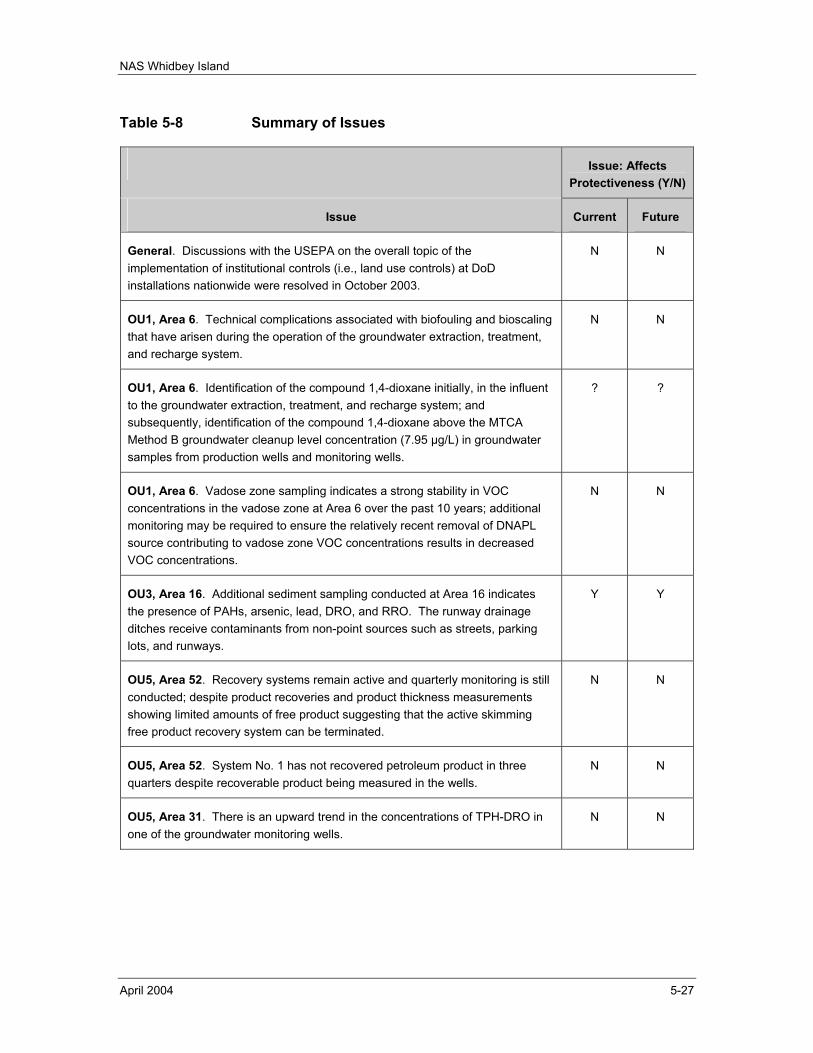
NAS Whidbey Island
April 2004 5-27
Table 5-8 Summary of Issues
Issue: Affects Protectiveness (Y/N)
Issue Current Future
General. Discussions with the USEPA on the overall topic of the implementation of institutional controls (i.e., land use controls) at DoD installations nationwide were resolved in October 2003.
N N
OU1, Area 6. Technical complications associated with biofouling and bioscaling that have arisen during the operation of the groundwater extraction, treatment, and recharge system.
N N
OU1, Area 6. Identification of the compound 1,4-dioxane initially, in the influent to the groundwater extraction, treatment, and recharge system; and subsequently, identification of the compound 1,4-dioxane above the MTCA Method B groundwater cleanup level concentration (7.95 µg/L) in groundwater samples from production wells and monitoring wells.
? ?
OU1, Area 6. Vadose zone sampling indicates a strong stability in VOC concentrations in the vadose zone at Area 6 over the past 10 years; additional monitoring may be required to ensure the relatively recent removal of DNAPL source contributing to vadose zone VOC concentrations results in decreased VOC concentrations.
N N
OU3, Area 16. Additional sediment sampling conducted at Area 16 indicates the presence of PAHs, arsenic, lead, DRO, and RRO. The runway drainage ditches receive contaminants from non-point sources such as streets, parking lots, and runways.
Y Y
OU5, Area 52. Recovery systems remain active and quarterly monitoring is still conducted; despite product recoveries and product thickness measurements showing limited amounts of free product suggesting that the active skimming free product recovery system can be terminated.
N N
OU5, Area 52. System No. 1 has not recovered petroleum product in three quarters despite recoverable product being measured in the wells.
N N
OU5, Area 31. There is an upward trend in the concentrations of TPH-DRO in one of the groundwater monitoring wells.
N N

NAS Whidbey Island
April 2004 5-28
This page intentionally left blank.
NAS Whidbey Island
April 2004 6-1
6.0 RECOMMENDATIONS / FOLLOW-UP ACTIONS
General recommendations / follow-up actions with regard to the OUs at NAS Whidbey Island are discussed in Section 6.1 and recommendations / follow-up actions specific to individual OUs are discussed in Section 6.2. Table 6-1 (pages 6-3 and 6-4) provides a summary list of all the recommendations / follow-up actions for this Review.
6.1 GENERAL RECOMMENDATIONS / FOLLOW-UP ACTIONS Three general recommendations / follow-up actions are made with regard to the OUs at NAS Whidbey Island.
• General. The Draft ESD addressing OU1 through OU5 at NAS Whidbey Island should be finalized, as appropriate. Implement institutional controls at OU1 through OU5 in accordance with the Final ESD.
• General. The continued implementation of institutional controls at OU1 through OU5 at NAS Whidbey Island will be evaluated at the time of the next Five-Year Review.
6.2 SPECIFIC RECOMMENDATIONS / FOLLOW-UP ACTIONS Various recommendations / follow-up actions are made in regard to specific OUs at NAS Whidbey Island. These are detailed in the following subsections.
6.2.1 OPERABLE UNIT 1
• Area 5. No specific recommendations made or follow-up actions necessary.
• Area 6. Continue the operation of the groundwater extraction, treatment, and recharge system (and the associated monitoring and reporting) in accordance with the Final Combined Operations and Maintenance Manuals, Operable Unit 1, Area 6, Operable Unit 5, Areas 31 and 562, Naval Air Station Whidbey Island, Washington (Foster Wheeler, 2000f). Further investigate the presence and migration of the compound 1,4-dioxane in groundwater at Area 6 as soon as possible. Evaluate the compound 1,4-dioxane as a COC at Area 6, conduct a human health and ecological risk assessment, and evaluate necessary remedial alternatives based on the findings of the assessment as soon as possible. Conduct additional monitoring of VOC concentrations in vadose zone soils to evaluate the effect of the DNAPL source removal action and to evaluate the migration of VOC compounds.
6.2.2 OPERABLE UNIT 2
• Area 2/3. Continue groundwater use restrictions. Collect an additional round of groundwater samples at the time of the next Five-Year Review. Groundwater samples should be analyzed for VOCs, total arsenic, and total manganese.
NAS Whidbey Island
April 2004 6-2
• Area 4. Continue groundwater use restrictions. Collect an additional round of groundwater samples at the time of the next Five-Year Review. Groundwater samples should be analyzed for total arsenic.
• Area 14. Continue groundwater use restrictions.
• Area 29. Continue groundwater use restrictions. Collect an additional round of groundwater samples at the time of the next Five-Year Review. Groundwater samples should be analyzed for total arsenic.
6.2.3 OPERABLE UNIT 3
• Area 16. Ensure that institutional controls are in place to maintain Area 16 as an industrial area. Continue to monitor the drainage ditch sediments for recontamination and evaluate compliance with Washington state MTCA standards for industrial sites. Identify sources of recontamination and determine what, if any, additional measures can be taken to limit recontamination.
6.2.4 OPERABLE UNIT 4
• Area 39. No specific recommendations made or follow-up actions necessary.
• Area 41. No specific recommendations made or follow-up actions necessary.
• Area 44. No specific recommendations made or follow-up actions necessary.
• Area 48. No specific recommendations made or follow-up actions necessary.
• Area 49. No specific recommendations made or follow-up actions necessary.
6.2.5 OPERABLE UNIT 5
• Area 1. No specific recommendations made or follow-up actions necessary.
• Area 31. Continue with groundwater monitoring at Area 31 until the USEPA and the U.S. Navy jointly agree that monitoring is no longer necessary. The USEPA and U.S. Navy should also evaluate whether or not additional treatment may be necessary.
• Area 52. Continue the operation of the product recovery system (and the associated monitoring and reporting) in accordance with the Final Combined Operations and Maintenance Manuals, Operable Unit 1, Area 6, Operable Unit 5, Areas 31 and 52, Naval Air Station Whidbey Island, Washington (Foster Wheeler, 2000f). Conduct confirmatory seep sampling after site remediation is complete (i.e., after the shut down of the product recovery system) as per the initial Five-Year Review (EFANW, 1998).
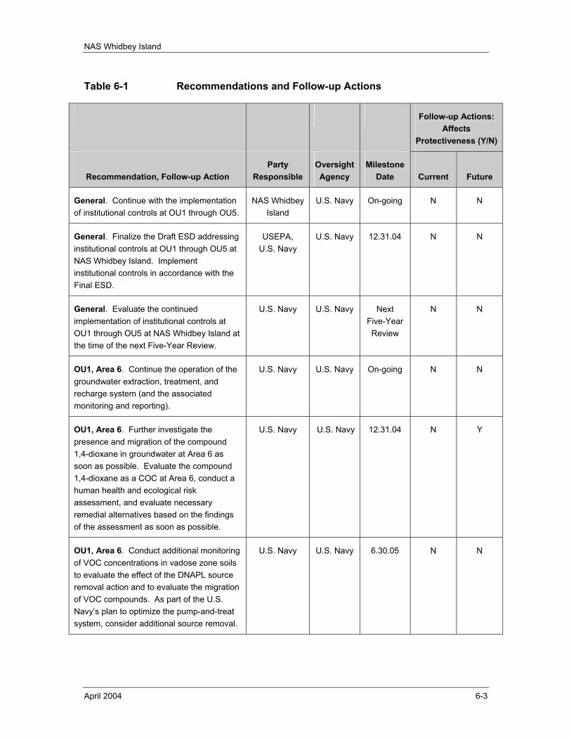
NAS Whidbey Island
April 2004 6-3
Table 6-1 Recommendations and Follow-up Actions
Follow-up Actions: Affects
Protectiveness (Y/N)
Recommendation, Follow-up Action
Party Responsible
Oversight Agency
Milestone Date
Current
Future
General. Continue with the implementation of institutional controls at OU1 through OU5.
NAS Whidbey Island
U.S. Navy On-going N N
General. Finalize the Draft ESD addressing institutional controls at OU1 through OU5 at NAS Whidbey Island. Implement institutional controls in accordance with the Final ESD.
USEPA, U.S. Navy
U.S. Navy 12.31.04 N N
General. Evaluate the continued implementation of institutional controls at OU1 through OU5 at NAS Whidbey Island at the time of the next Five-Year Review.
U.S. Navy U.S. Navy Next Five-Year Review
N N
OU1, Area 6. Continue the operation of the groundwater extraction, treatment, and recharge system (and the associated monitoring and reporting).
U.S. Navy U.S. Navy On-going N N
OU1, Area 6. Further investigate the presence and migration of the compound 1,4-dioxane in groundwater at Area 6 as soon as possible. Evaluate the compound 1,4-dioxane as a COC at Area 6, conduct a human health and ecological risk assessment, and evaluate necessary remedial alternatives based on the findings of the assessment as soon as possible.
U.S. Navy U.S. Navy 12.31.04 N Y
OU1, Area 6. Conduct additional monitoring of VOC concentrations in vadose zone soils to evaluate the effect of the DNAPL source removal action and to evaluate the migration of VOC compounds. As part of the U.S. Navy’s plan to optimize the pump-and-treat system, consider additional source removal.
U.S. Navy U.S. Navy 6.30.05 N N
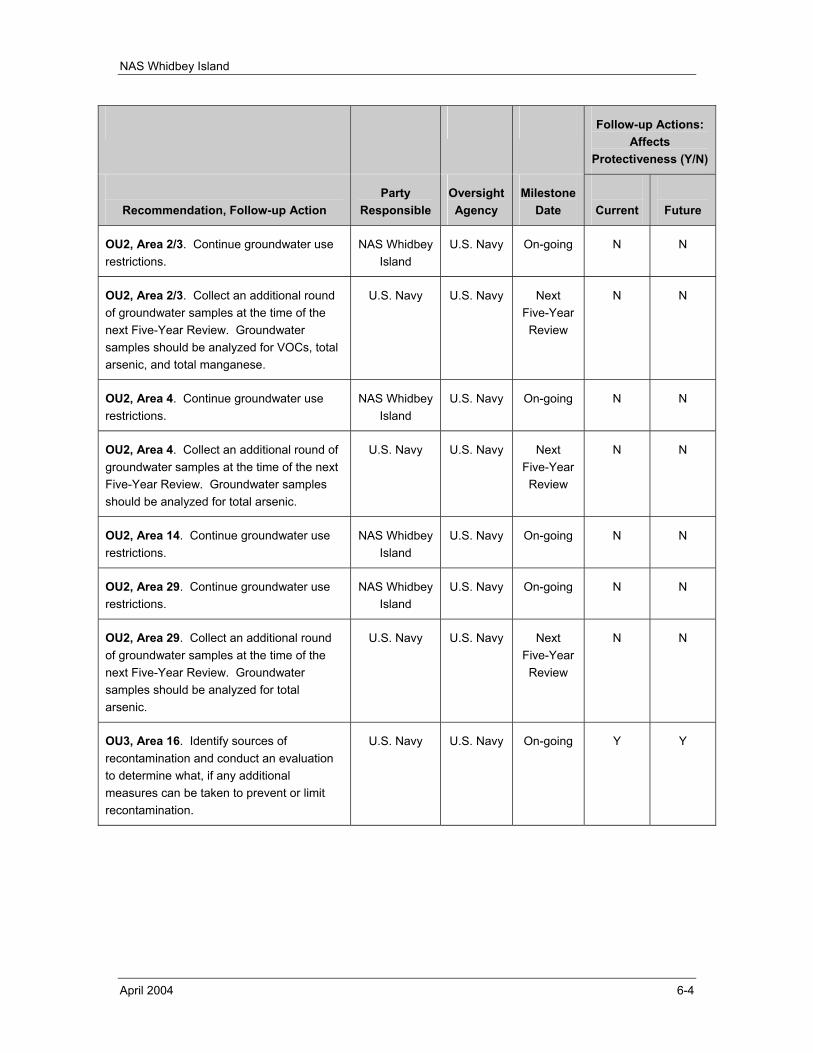
NAS Whidbey Island
April 2004 6-4
Follow-up Actions: Affects
Protectiveness (Y/N)
Recommendation, Follow-up Action
Party Responsible
Oversight Agency
Milestone Date
Current
Future
OU2, Area 2/3. Continue groundwater use restrictions.
NAS Whidbey Island
U.S. Navy On-going N N
OU2, Area 2/3. Collect an additional round of groundwater samples at the time of the next Five-Year Review. Groundwater samples should be analyzed for VOCs, total arsenic, and total manganese.
U.S. Navy U.S. Navy Next Five-Year Review
N N
OU2, Area 4. Continue groundwater use restrictions.
NAS Whidbey Island
U.S. Navy On-going N N
OU2, Area 4. Collect an additional round of groundwater samples at the time of the next Five-Year Review. Groundwater samples should be analyzed for total arsenic.
U.S. Navy U.S. Navy Next Five-Year Review
N N
OU2, Area 14. Continue groundwater use restrictions.
NAS Whidbey Island
U.S. Navy On-going N N
OU2, Area 29. Continue groundwater use restrictions.
NAS Whidbey Island
U.S. Navy On-going N N
OU2, Area 29. Collect an additional round of groundwater samples at the time of the next Five-Year Review. Groundwater samples should be analyzed for total arsenic.
U.S. Navy U.S. Navy Next Five-Year Review
N N
OU3, Area 16. Identify sources of recontamination and conduct an evaluation to determine what, if any additional measures can be taken to prevent or limit recontamination.
U.S. Navy U.S. Navy On-going Y Y
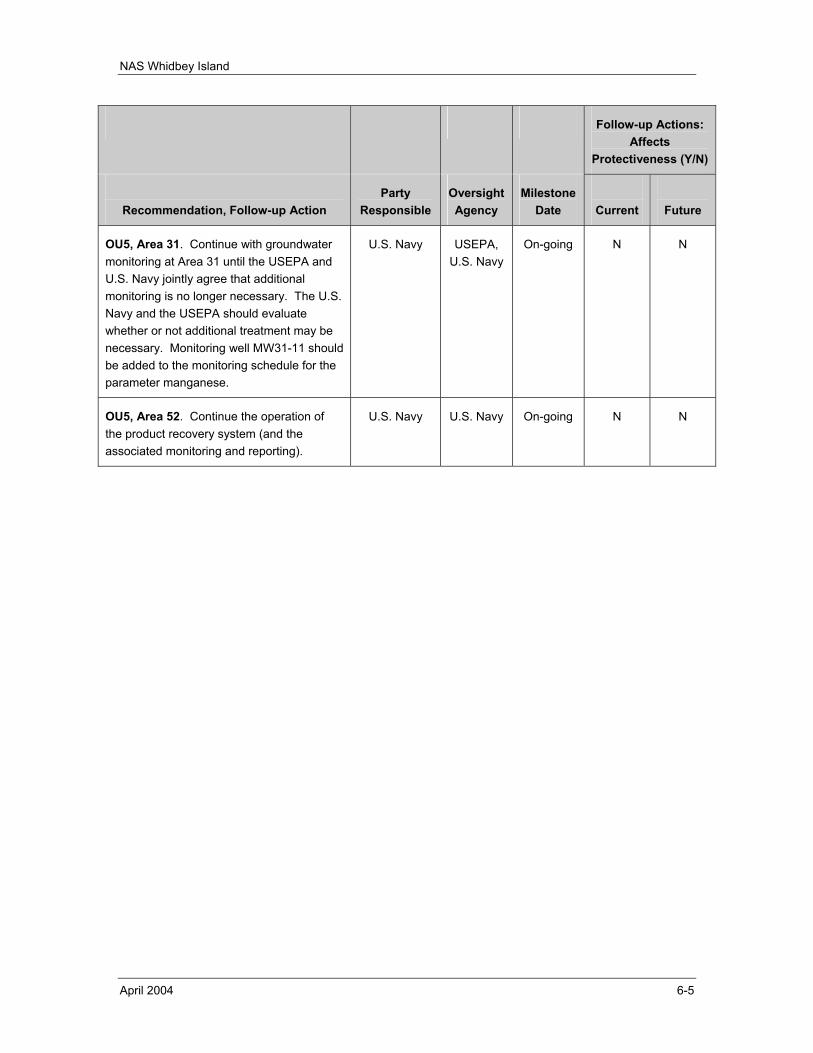
NAS Whidbey Island
April 2004 6-5
Follow-up Actions: Affects
Protectiveness (Y/N)
Recommendation, Follow-up Action
Party Responsible
Oversight Agency
Milestone Date
Current
Future
OU5, Area 31. Continue with groundwater monitoring at Area 31 until the USEPA and U.S. Navy jointly agree that additional monitoring is no longer necessary. The U.S. Navy and the USEPA should evaluate whether or not additional treatment may be necessary. Monitoring well MW31-11 should be added to the monitoring schedule for the parameter manganese.
U.S. Navy USEPA, U.S. Navy
On-going N N
OU5, Area 52. Continue the operation of the product recovery system (and the associated monitoring and reporting).
U.S. Navy U.S. Navy On-going N N
NAS Whidbey Island
April 2004 6-6
This page intentionally left blank.
NAS Whidbey Island
April 2004 7-1
7.0 PROTECTIVENESS STATEMENT AND SUBSEQUENT FIVE-YEAR REVIEWS
7.1 COMPREHENSIVE PROTECTIVENESS STATEMENT All remedies identified in the RODs for OU1 through OU5 have been constructed, implemented, and in some cases are complete. These remedies remain protective of human health and the environment, or are expected to be protective upon completion for previously known COCs. In the interim, a potential new COC at OU1 (Area 6) and the exposure pathways that could result in unacceptable risks are being investigated and further investigations are required at OU3 (Area 16) to evaluate recontamination.
7.2 INDIVIDUAL PROTECTIVENESS STATEMENTS 7.2.1 OPERABLE UNIT 1 The compound 1,4-dioxane was recently identified in groundwater from Area 6 (see Section 5.1.1.2.3). This sampling was done at the request of the USEPA because 1,4-dioxane has recently been identified at other sites with similar solvent contaminates. The presence of 1,4-dioxane is being investigated and will be addressed as soon as possible. Should 1,4-dioxane become a COC, remedial alternatives will be considered.
Although contamination was not detected in earlier sampling of private potable water wells for the existing COCs, the potentially threatened parties were connected to an alternate and secure water supply. Should 1,4-dioxane become a risk to additional private potable water wells, the U.S. Navy will consider extending the offer for connection to the alternative and secure water supply to additional parties. These questions will be addressed in ongoing investigations and the next Five-Year Review.
The current remedy at OU1 is expected to be protective of human health and the environment for the current COCs, and in the interim, exposure pathways that could result in unacceptable risks from 1,4-dioxane are being investigated.
7.2.2 OPERABLE UNIT 2 The remedy at OU2 is expected to be protective of human health and the environment upon completion, and in the interim, exposure pathways that could result in unacceptable risks are being controlled.
7.2.3 OPERABLE UNIT 3 Due to the discovery of elevated levels of contaminants in the runway drainage ditches, the remedy at OU3 may no longer be protective of human health and the environment; further evaluation is necessary.
7.2.4 OPERABLE UNIT 4 The remedy at OU4 remains protective of human health and the environment.
NAS Whidbey Island
April 2004 7-2
7.2.5 OPERABLE UNIT 5 The remedy at OU5 is expected to be protective of human health and the environment upon completion, and in the interim, exposure pathways that could result in unacceptable risks are being controlled.
7.3 SUBSEQUENT FIVE-YEAR REVIEW A subsequent Five-Year Review will be completed for the five OUs at NAS Whidbey Island on or before 5 years from the signature date of this review.
NAS Whidbey Island
April 2004 8-1
8.0 REFERENCES
Dinicola, R.S., Cox, S.E., Bradley, P.M., 2000. Natural Attenuation of Chlorinated Volatile Organic Compounds in Ground Water at Area 6, Naval Air Station Whidbey Island, Washington (Water Resources Investigations Report 00-4060), U.S. Geological Survey (USGS), 2000.
Domenico, P.A., 1987. An Analytical Model for Multidimensional Transport of a Decaying Contaminant Species: Journal of Hydrology, v. 91, p. 49-58.
Ebasco Environmental, 1995. Remedial Action Report, Operable Unit Number 4, Remedial Action, Naval Air Station Whidbey Island, Washington, 24 February 1995.
EFANW, 1998. Environmental Restoration Five-Year Review, NAS Whidbey Island, Ault Field, Oak Harbor, Washington, U.S. Navy, Naval Facilities Engineering Command, Engineering Field Activity, Northwest, 1998.
EFANW, 2002. Total Data Management System (TDMS), data download; all monitoring data associated with OU1, OU2, OU3, OU4, and OU5, NAS Whidbey Island, Washington (multiple Microsoft® Excel™ files, date of download 20 February 2002).
Foster Wheeler Environmental Corporation, 1997a. Remedial Action Report, Area 16, Operable Unit 3, Naval Air Station Whidbey Island, Washington, 10 January 1997, Revision 0.
Foster Wheeler Environmental Corporation, 1997b. Final Technical Memorandum, Post-ROD Groundwater Monitoring at Operable Unit 5, Area1, Naval Air Station Whidbey Island, Oak Harbor, Washington, April 1997.
Foster Wheeler Environmental Corporation, 1997c. Final Remedial Action Report, Operable Unit 5, Naval Air Station Whidbey Island, Washington, 21 July 1997.
Foster Wheeler Environmental Corporation, 1998a. Quarterly Technical Report, Operations of Interim Action Groundwater Extraction, Treatment, and Recharge System: Area 6 Landfill, Naval Air Station Whidbey Island, Washington, 14 August 1998.
Foster Wheeler Environmental Corporation, 1998b. Update to Flowpath Groundwater Model, Operations of Interim Action Groundwater Extraction, Treatment, and Recharge System, Area 6 Landfill, Naval Air Station Whidbey Island, Washington, 2 October 1998.
Foster Wheeler Environmental Corporation, 1998c. Quarterly Technical Report, Operable Unit 5, Area 52 Jet Engine Test Cell and Area 31 Former Runway Fire Training School, Naval Air Station Whidbey Island, Washington, 6 November 1998.
NAS Whidbey Island
April 2004 8-2
Foster Wheeler Environmental Corporation, 1998d. Quarterly Technical Report, Operating Period July - September 1998, Operations of Interim Action Groundwater Extraction, Treatment, and Recharge System: Area 6 Landfill, Naval Air Station Whidbey Island, Washington, 6 November 1998.
Foster Wheeler Environmental Corporation, 1999a. Quarterly Technical Report, Operating Period October – December 1998, Operations of Interim Action Groundwater Extraction, Treatment, and Recharge System: Area 6 Landfill, Naval Air Station Whidbey Island, Washington, 29 January 1999.
Foster Wheeler Environmental Corporation, 1999b. Quarterly Technical Report, Operable Unit 5, Area 52 Jet Engine Test Cell and Area 31 Former Runway Fire Training School, Operating Period November – December 1998, Naval Air Station Whidbey Island, Washington, 4 February 1999.
Foster Wheeler Environmental Corporation, 1999c. Quarterly Technical Report, Operating Period January – March 1999, Operations of Interim Action Groundwater Extraction, Treatment, and Recharge System: Area 6 Landfill, Naval Air Station Whidbey Island, Washington, 21 May 1999.
Foster Wheeler Environmental Corporation, 1999d. Quarterly Technical Report, Operable Unit 5, Area 52 Jet Engine Test Cell and Area 31 Former Runway Fire Training School, Operating Period January – March 1999, Naval Air Station Whidbey Island, Washington, 21 May 1999.
Foster Wheeler Environmental Corporation, 1999e. Quarterly Technical Report, Operable Unit 5, Area 52 Jet Engine Test Cell and Area 31 Former Runway Fire Training School, Operating Period April – June 1999, Naval Air Station Whidbey Island, Washington, 20 August 1999.
Foster Wheeler Environmental Corporation, 1999f. Quarterly Technical Report, Operating Period April - June 1999, Operations of Interim Action Groundwater Extraction, Treatment, and Recharge System: Area 6 Landfill, Naval Air Station Whidbey Island, Washington, 20 August 1999.
Foster Wheeler Environmental Corporation, 1999g. Quarterly Technical Report, Operable Unit 5, Area 52 Jet Engine Test Cell and Area 31 Former Runway Fire Training School, Operating Period July – September 1999, Naval Air Station Whidbey Island, Washington, 8 December 1999.
Foster Wheeler Environmental Corporation, 2000a. Draft Areas 31 and 52 Assessment Report, Operable Unit 5, Areas 31 and 52, Former Runway and Jet Engine Test Cell Fire School, Naval Air Station Whidbey Island, Washington, 7 February 2000.
Foster Wheeler Environmental Corporation, 2000b. Quarterly Technical Report, Operating Period October – December 1999, Operations of Interim Action Groundwater Extraction, Treatment, and Recharge System: Area 6 Landfill, Naval Air Station Whidbey Island, Washington, 25 February 2000.
NAS Whidbey Island
April 2004 8-3
Foster Wheeler Environmental Corporation, 2000c. Quarterly Technical Report, Operable Unit 5, Area 52 Jet Engine Test Cell and Area 31 Former Runway Fire Training School, Operating Period October – December 1999, Naval Air Station Whidbey Island, Washington, 25 February 2000.
Foster Wheeler Environmental Corporation, 2000d. Quarterly Technical Report, Operable Unit 5, Area 52 Jet Engine Test Cell and Area 31 Former Runway Fire Training School, Operating Period January – March 2000, Naval Air Station Whidbey Island, Washington, 31 May 2000.
Foster Wheeler Environmental Corporation, 2000e. Quarterly Technical Report, Operating Period January – March 2000, Operations of Interim Action Groundwater Extraction, Treatment, and Recharge System: Area 6 Landfill, Naval Air Station Whidbey Island, Washington, 31 May 2000.
Foster Wheeler Environmental Corporation, 2000f. Final Combined Operations and Maintenance Manuals, Operable Unit 1, Area 6, Operable Unit 5, Areas 31 and 52, Naval Air Station Whidbey Island, Washington, 28 June 2000.
Foster Wheeler Environmental Corporation, 2000g. Quarterly Technical Report, Operating Period April – June 2000, Operations of Interim Action Groundwater Extraction, Treatment, and Recharge System: Area 6 Landfill, Naval Air Station Whidbey Island, Washington, 17 October 2000.
Foster Wheeler Environmental Corporation, 2000h. Quarterly Technical Report, Operating Period July – September 2000, Operations of Interim Action Groundwater Extraction, Treatment, and Recharge System: Area 6 Landfill, Naval Air Station Whidbey Island, Washington, 30 November 2000.
Foster Wheeler Environmental Corporation, 2001a. Draft Final Monitored Natural Attenuation Plan for Area 6 Landfill, Naval Air Station Whidbey Island, Whidbey Island, Washington, 14 December 2001.
Foster Wheeler Environmental Corporation, 2001b. Final Technical Memorandum, Soil Gas Survey and VOC Sampling, 2001.
Foster Wheeler Environmental Corporation, 2001c. Final Site Characterization Report, Site Characterization and Interim Removal Action at Area 6 Landfill, Naval Air Station, Whidbey Island, Washington, 14 December 2001.
Foster Wheeler Environmental Corporation, 2002a. Final Interim Removal Report, Area 6 Landfill, Naval Air Station, Whidbey Island, Washington, 8 January 2002.
Foster Wheeler Environmental Corporation, 2002b. Assessment of Fate and Transport for Residual VOCs, Site Characterization and interim Removal Action at Area 6, Naval Air Station, Whidbey Island, Washington, RACII / Delivery Order No. 0101, September 13, 2002.
NAS Whidbey Island
April 2004 8-4
Hart Crowser, 1999. Biofouling Technical Memorandum, Naval Air Station Whidbey Island, Operable Unit 1, Area 6 Landfill, Whidbey Island, Washington, 5 April 1999.
NAS Whidbey Island, NAS Whidbey Instruction 11013.2, Site Approval Procedures (NASWHIDBEYINST 11013.2), 10 June 1999.
The Environmental Company, Inc. (TEC), 2000. Final Monitoring Well Closure Report for Facility and Field Sites at Naval Air Station Whidbey Island, June 2000.
The Environmental Company, Inc., 2001a. Final Quarterly Technical Report, Operable Unit 5, Area 52, Jet Engine Test Cell, Operating Period October – December 2000, Naval Air Station Whidbey Island, Washington, 7 June 2001.
The Environmental Company, Inc., 2001b. Final Quarterly Technical Report, Operable Unit 5, Area 52, Jet Engine Test Cell, Operating Period January – March 2001, Naval Air Station Whidbey Island, Washington, 22 June 2001.
The Environmental Company, Inc., 2001c. Final Quarterly Technical Report, Operable Unit 5, Area 52, Jet Engine Test Cell, Operating Period April – June 2001, Naval Air Station Whidbey Island, Washington, 7 June 2001.
The Environmental Company, Inc., 2001d. Final Quarterly Technical Report, Operable Unit 5, Area 52, Jet Engine Test Cell, Operating Period July – September 2001, Naval Air Station Whidbey Island, Washington, 7 June 2001.
The Environmental Company, Inc., 2002a. Final Quarterly Technical Report, Operating Period July – September 2001, Operations of Interim Action Groundwater Extraction, Treatment, and Recharge System, Area 6 Landfill, Naval Air Station Whidbey Island, Washington, January 2002.
The Environmental Company, Inc., 2002b. Final Quarterly Technical Report, Operating Period January - March 2002, Operations of Interim Action Groundwater Extraction, Treatment, and Recharge System, Area 6 Landfill, Naval Air Station Whidbey Island, Washington, June 2002.
The Environmental Company, Inc., 2002c. Final Quarterly Technical Report, Operable Unit 5, Area 52, Jet Engine Test Cell, Operating Period January – March 2002, Naval Air Station Whidbey Island, Washington, June 2002.
The Environmental Company, Inc., 2002d. Technical Memorandum, Final Letter Report for January 2002 Groundwater Monitoring, Area 31, Former Runway Fire Training School, NAS Whidbey Island, Washington, June 2002.
The Environmental Company, Inc., 2002e. Final Second Quarter Technical Report, Operations of Interim Action Groundwater Extraction, Treatment, and Recharge System, Area 6 Landfill, Operating Period April - June 2002, Naval Air Station Whidbey Island, Washington, October 2002.
NAS Whidbey Island
April 2004 8-5
The Environmental Company, Inc., 2002f. Final Third Quarter and Annual Technical Report, Operations of Interim Action Groundwater Extraction, Treatment, and Recharge System, Area 6 Landfill, Operating Period July - September 2002, Naval Air Station Whidbey Island, Washington, December 2002.
The Environmental Company, Inc., 2002g. Technical Memorandum, Final Letter Report for April 2002 Groundwater Monitoring, Area 31, Former Runway Fire Training School, NAS Whidbey Island, Washington, August 2002.
The Environmental Company, Inc., 2002h. Technical Memorandum, Final Letter Report for July 2002 Groundwater Monitoring, Area 31, Former Runway Fire Training School, NAS Whidbey Island, Washington, September 2002.
The Environmental Company, Inc., 2002i. Final Second Quarter Technical Report, Operable Unit 5, Area 52 Jet Engine Test Cell, Operating Period: April – June 2002, Naval Air Station Whidbey Island, Washington. October 2002.
The Environmental Company, Inc., 2002j. Final Third Quarter and Annual Technical Report, Operable Unit 5, Area 52 Jet Engine Test Cell, Operating Period: July – September 2002, Naval Air Station Whidbey Island, Washington. December 2002.
The Environmental Company, Inc., 2003a. Draft Third Quarter Technical Report, Area 6 Landfill, Groundwater Monitoring, June 2003, Naval Air Station Whidbey Island, Washington. August 2003.
The Environmental Company, Inc., 2003b. Draft Technical Memorandum, Environmental Services Monitoring, Environmental Monitoring, Contract No. N-44255-98-4416/CTO-055, Draft Letter Report for Environmental Monitoring at NAS Whidbey Island, Washington, 7 March 2003.
The Environmental Company, Inc., 2003c. Technical Memorandum, Final Well Installation Report, Areas 6 and 31, NAS Whidbey Island, Washington, 4 April 2003.
URS Consultants, 1993a. Final Remedial Investigation Report for Operable Unit 4, Naval Air Station Whidbey Island, 14 June 1993.
URS Consultants, 1993b. Final Feasibility Study Report for Operable Unit 4, Naval Air Station Whidbey Island, 9 August 1993.
URS Consultants, Inc., 1993c. Final Record of Decision, Operable Unit 1, Naval Air Station (NAS) Whidbey Island, Oak Harbor Washington, December 1993.
URS Consultants, Inc., 1993d. Record of Decision, Naval Air Station Whidbey Island, Ault Field, Operable Unit 2, Areas 2/3, 4, 14, and 29, Oak Harbor, Island County, Washington, December 1993.
URS Consultants, Inc., 1993e. Record of Decision, Naval Air Station Whidbey Island, Seaplane Base, Operable Unit 4, Areas 39. 41, 44, 48 and 49, Oak Harbor, Island County, Washington, December 1993.
NAS Whidbey Island
April 2004 8-6
URS Consultants, Inc., 1994. Final Remedial Design Report / Remedial Action Workplan for Operable Unit 3, Naval Air Station Whidbey Island, Washington, 1994.
URS Consultants, Inc., 1995. Final Record of Decision for Operable Unit 3, NAS Whidbey Island, March 1995.
URS Consultants, Inc., 1996. Record of Decision, Naval Air Station Whidbey Island, Seaplane Base, Operable Unit 5, Areas 1, 52, and 31, Oak Harbor, Island County, Washington, July 1996.
URS Consultants, Inc., 1997. Revised Technical Memorandum, Post-ROD Groundwater Monitoring for Operable Unit 2, NAS Whidbey Island, Oak Harbor, Washington, August 1997.
URS Consultants, 1999. Final Monitoring Well Closure Management Plan, NAS Whidbey Island, Oak Harbor, Washington, Volumes 1 and 2, February 1999.
U.S. Environmental Protection Agency, 1995a. USEPA correspondence to NAS Whidbey Island (Ms. Kathy Souders) re: Certification that the remedy implemented at NAS Whidbey Seaplane National Priorities List site has been completed, 29 June 1995.
U.S. Environmental Protection Agency, 1995b. USEPA correspondence to NAS Whidbey Island (Mr. Spendlove) re: Responsiveness Summary for Delisting of Seaplane Base from Washington State’s Hazardous Sites List, 25 July 1995.
U.S. Environmental Protection Agency, 1997. USEPA correspondence to EFANW (Mr. Dan Hayes) re: NAS Whidbey Island, Ault Field, Operable Unit 3, 17 March 1997.
U.S. Environmental Protection Agency, 2000. USEPA correspondence to EFANW (Mr. John Gordon) re: Area 31 and Area 52, 19 May 2000.
U.S. Environmental Protection Agency, 2001. Comprehensive Five-Year Review Guidance, EPA 540-R-01-007, OSWER No. 9355.7-03B-P, developed by the Office of Emergency and Remedial Response, June 2001.
NAS Whidbey Island
April 2004 Appendix A
APPENDIX A
CHRONOLOGY, BACKGROUND, AND REMEDIAL ACTIONS

NAS Whidbey Island
April 2004 Appendix A
This page intentionally left blank.
NAS Whidbey Island
April 2004 A-1
A.1 OPERABLE UNIT 1 OU1 is comprised of Area 5 and Area 6 located at Ault Field (see Figure A-1 at the end of this appendix).
Area 5. Area 5 is an area approximately 50 feet (ft) long by 500 ft wide, historically used for gravel excavation. It is bordered to the south by Ault Field Road and to the east by State Highway 20. Although there reportedly is no documentation that industrial wastes were disposed of at Area 5, the area may have been used as a landfill between 1958 and 1959. Additionally, herbicides and pesticides were historically applied in Area 5 for the purposes of weed and insect control.
Area 6. Area 6 encompasses approximately 260 acres. It is bordered to the north by Ault Field Road, to the east by State Highway 20, and to the south and southwest by the City of Oak Harbor solid waste landfill. Industrial waste disposal took place between 1969 and the early 1980s. The associated disposal pit was approximately 40 ft long by 15 ft wide by 10 ft deep and reportedly accepted a variety of industrial wastes including solvents, oily sludges, thinners, and other waste compounds. A separate portion of Area 6, consisting of approximately 40 acres, was used as a landfill for the disposal of household wastes generated by the U.S. Navy during the period from 1969 to 1992.
A.1.1 Chronology of Events A chronology of events for OU1 is presented in Table A-1.
Table A-1 Chronological Summary – Operable Unit 1
Date Event
September 1984 U.S. Navy conducted an Initial Assessment Study (IAS) at NAS Whidbey Island under the U.S. Navy Assessment and Control of Installation Pollutants (NACIP) program.
1985 USEPA proposed that both Ault Field and Seaplane Base be nominated to NPL as separate areas.
January 1988 U.S. Navy completed follow-up investigation and developed NAS Whidbey Island Current Situation Report (CSR).
Summer 1989 U.S. Navy performed an accelerated Initial Investigation of Area 6 to assess whether groundwater contamination was present and whether water supply wells in the vicinity were or could be affected. Groundwater contamination was confirmed. The investigation determined that local water supply wells were unaffected; however, the potential for future impacts on the water supply wells did exist.
1989 Washington State Department of Health (DOH) tested 13 public wells located within a one-mile radius of Area 6 and the Oak Harbor Landfill. No organic compounds were found, and the results indicated that the drinking water supplies were unaffected.
February 1990 USEPA officially included Ault Field on the NPL as a Superfund area.
NAS Whidbey Island
April 2004 A-2
Date Event
September 1990 U.S. Navy conducted a Remedial Investigation/Feasibility Study (RI/FS) to determine the nature and extent of soil and groundwater contamination and to evaluate alternatives for the cleanup of contaminated areas.
October 1990 The U.S. Navy, USEPA, and the Washington State Department of Ecology (Ecology) entered into a Federal Facilities Interagency Agreement (FFA). The U.S. Navy agreed to perform a Hazardous Waste Evaluation Study.
December 1990 to May 1991
Sampling conducted in six monitoring wells installed in the shallow aquifer within Area 5. Sampling also conducted in some of the 28 monitoring wells installed in the shallow aquifer within Area 6 and the three wells installed in the Oak Harbor Landfill.
Early 1991 During the RI/FS investigation, groundwater sampling results indicated that vinyl chloride concentrations in on-area monitoring wells within Area 6 exceeded maximum contaminant levels (MCLs) for drinking water and that contamination may be migrating off area.
February 1991 Six surface water samples were collected from the intermittent stream in Area 6. TCE was detected at a concentration less than the USEPA Ambient Water Quality Criteria (AWQC) for protection of aquatic organisms. Sediment samples were collected from the wetlands adjacent to Area 5, and analysis detected several inorganic analytes and pesticides. Sediment samples were collected from three locations in Area 6, and analysis detected several inorganic analytes and pesticides.
March 1991 Three surface water samples were collected from the wetland areas in Area 5. Analysis detected VOCs below the USEPA AWQC (TCE, 1,1-dichloroethane, and 1,1-dichloroethene) as well as several inorganic analytes above the USEPA AWQC (zinc. lead, copper, cadmium, and silver).
May 1991 U.S. Navy asks Washington State DOH to sample one public and six private wells in the vicinity of Area 6. The seven wells are located to the south, east and southwest of the current landfill boundary. No evidence of contamination was detected in these wells. As a precautionary measure, the U.S. Navy began a program of voluntary water hookups to the public water supply system for landowners who were potentially affected.
July 1991 to October 1991
Sampling conducted in six monitoring wells installed in the shallow aquifer within Area 5. Sampling conducted in some of the 28 monitoring wells installed in the shallow aquifer within Area 6 and the three wells installed in the City of Oak Harbor landfill.
April 1992 An Interim Action ROD was signed by the U.S. Navy, the USEPA, and the Washington State Ecology. This committed the U.S. Navy to construct a groundwater extraction and treatment system at Area 6 to halt the migration of VOCs from the former industrial waste area (containment operations). The system was to begin construction in 1993 and was scheduled to begin operation in the spring of 1994.
December 1992 Sampling conducted in some of the 28 monitoring wells installed in the shallow aquifer within Area 6 and the three wells installed in the Oak Harbor Landfill. Private wells adjacent to the landfill were re-sampled. No VOCs were detected; however, the U.S. Navy continued to provide connections to an alternate water supply to owners of private wells in the vicinity of Area 6.
June 1993 Public Notice on the Proposed Plan for OU1.
NAS Whidbey Island
April 2004 A-3
Date Event
July 1993 The U.S. Navy held a public meeting to discuss the Proposed Plan.
August 1993 The USEPA held a public information meeting to further discuss the technical details of the proposed remedial actions.
20 December 1993 Effective date of ROD for OU1 (URS, 1993c).
A.1.2 Remedial Actions Area 5. Based upon performance of risk assessments, ecological risk was identified for sediments and surface water in the wetlands adjacent to Area 5. No source area was identified, and it was determined that remedial action would cause more environmental harm than the low levels of existing chemical contaminants
No Action was deemed an appropriate remedial action for Area 5. The U.S. Navy decided to conduct additional sampling and monitoring to determine whether metals levels were consistent with background or elevated above levels of concern for human health. This monitoring was completed prior to the initial Five-Year Review and is discussed in that document (EFANW, 1998).
Area 6. Based upon performance of risk assessments, ecological risk was identified for Area 6 soils and for sediments and surface water from the intermittent stream at Area 6. No source area was identified, and it was determined that remedial action could cause more environmental harm than the low levels of existing chemical contaminants. It was also determined that the greatest potential risk to human health at Area 6 was posed by the future movement of organic chemicals in the groundwater.
There are two distinct groundwater plumes present at Area 6. The first plume is referred to as the western groundwater plume and is near the former industrial waste disposal area (i.e., the former waste oil pit). Multiple VOCs were detected at concentrations exceeding risk levels in the western groundwater plume The second plume is referred to as the southern plume, and is in the southern part of the landfill where contaminants originate from the capped landfill (i.e., landfill leachate is the source). Vinyl chloride was detected at concentrations exceeding risk levels in the southern groundwater plume.
The remediation method selected for Area 6 was a combination of landfill capping and groundwater control actions (i.e., groundwater extraction, treatment by air stripping, groundwater recharge). The selected remedy was aimed at restoring groundwater in the shallow aquifer to its beneficial use as drinking water by reducing contaminant concentrations to levels considered to be protective of human health and the environment. Significant components of the selected remedial action included:
• capping the landfill operations area trenches with a Minimum Functional Standards (MFS) cap;
NAS Whidbey Island
April 2004 A-4
• assessing the interim action extraction system to ensure that it achieves aquifer cleanup levels and to determine the need for additional source area extraction wells;
• extracting groundwater from the shallow aquifer at the western boundary of the landfill, treating it by air stripping, and returning the treated groundwater to the shallow aquifer at an on-site location;
• monitoring groundwater in the shallow, intermediate, and deep aquifers to assess the effectiveness of the groundwater treatment system;
• monitoring private drinking water wells in the vicinity of the landfill; and
• implementing institutional controls.
A.2 OPERABLE UNIT 2 OU2 is comprised of five areas located at Ault Field (see Figure A-2 at the end of this appendix). These areas are identified as follows:
• Area 2, Former Western Highlands Landfill;
• Area 3, Former 1969-1970 Landfill;
• Area 4, Former Walker Barn Storage Area;
• Area 14, Former Pesticide Rinsate Disposal Area; and
• Area 29, Former Clover Valley Fire School.
It should be noted that, based upon their similar nature and close proximity, Areas 2 and 3 were considered together in the RI/FS and the ROD and collectively identified as Area 2/3, as they are here.
Area 2/3. Area 2 is a 13-acre former landfill that is located southwest of the current fire training school. The southern boundary of Area 2 is defined by a gravel road and a fence, and a wetland is located near the eastern boundary of the area. From 1959 to 1969, the landfill was the principal disposal area for solid wastes generated on NAS Whidbey Island. Reportedly, the landfill received industrial wastes as well as construction and demolition (C&D) debris. The surface of the former landfill area is now covered with soil and is vegetated. Area 3 is a 1.5-acre land parcel that is located east of Area 2 and southeast of the current fire training school. Area 3 was used for disposal of solid wastes between 1969 and 1970 and the materials disposed of were similar to those at the Area 2 landfill. The surface of the former landfill area is now covered with soil and is vegetated. A forest of evergreen trees is located to the north of Area 3.
Area 4. Area 4 is a relatively flat parcel of land that is approximately 240 ft wide and 440 ft long and partially covered with native grasses. The area, which is fenced, is located approximately 400 yds west of Saratoga Street, northeast of the current fire training
NAS Whidbey Island
April 2004 A-5
school, and approximately 300 yds south of the U.S. Navy hospital. A gravel parking lot is located at the area of the former Walker Barn in the southern portion of Area 4.
Area 14. Area 14 is an approximately 0.5-acre fenced land parcel that is located immediately south of Building 2555 and west of Langley Boulevard. The southern and western boundaries of the area are defined by adjacent pasture lands. A drywell was installed on the north-central edge of the area in 1973. The drywell was located near an intermittent creek that originates from a spring in the northwestern corner of the area and flows southeast through Area 14 toward Langley Boulevard. The former activities at Area 14 that resulted in contamination were the disposal of pesticide rinsate solutions.
Area 29. Area 29 is a 4-acre parcel located west of the intersection of Clover Valley Road and Golf Course Road in the southwestern portion of Ault Field. The area is bounded by the U.S. Navy golf course to the south, Clover Valley Road to the north, and Golf Course Road to the east. A 1,600-square-foot concrete pad is located in the center of the area. A small surface drainage ditch extends northeast from the pad to another ditch along Clover Valley Road. This surface drainage ditch eventually discharges into the wetland between Area 2 and Area 3.
A.2.1 Chronology of Events A chronology of events for OU2 is presented in Table A-2.
Table A-2 Chronological Summary – Operable Unit 2
Date Event
September 1984 U.S. Navy conducted an IAS at NAS Whidbey Island under the NACIP program.
1985 USEPA proposed that both Ault Field and Seaplane Base be nominated to the NPL as separate areas.
January 1988 U.S. Navy completed follow-up investigation and developed NAS Whidbey Island CSR.
February 1990 USEPA officially included Ault Field on the NPL as a Superfund area.
October 1990 The U.S. Navy, USEPA, and Washington State Ecology entered into an FFA. The U.S. Navy agreed to perform a Hazardous Waste Evaluation Study.
1993 Final RI/FS Report issued
November 1993 Public Notice on the Proposed Plan for OU2.
December 1993 Public meeting on the Proposed Plan for OU2.
17 May 1994 Effective date of ROD for OU2 (URS, 1993d).
NAS Whidbey Island
April 2004 A-6
A.2.2 Remedial Actions A baseline risk assessment was conducted for OU2, including both a human health risk assessment and an ecological risk assessment. The primary components of the risk assessments were: a) identification of the chemicals (contaminants) of concern; b) exposure assessment; c) toxicity assessment; and d) risk characterization.
The potential human health risks calculated for OU2 resulted primarily from the presence of PCBs in soil at Area 4, bromacil and 2,4-dichlorophenol in groundwater at Area 14, and metals in groundwater at Areas 2/3, 4, and 29. The metals responsible for the majority of the potential human health risks were antimony, arsenic, and manganese.
The ecological risks calculated for OU2 resulted primarily from the presence of the PCB Aroclor 1260 and pentachlorphenol at Area 4, and 2,3,7,8-TCDD at Area 14. Most of the ecological risks to the aquatic organisms in the wetland between Areas 2 and 3 were determined to derive from elevated levels of aluminum in the surface water and elevated levels of manganese, nickel, and copper in the sediments.
The remedial actions selected for OU2 were intended to:
• reduce risks to hypothetical future residents from groundwater contaminants at Area 2/3;
• reduce the health risk to hypothetical future residents and the environmental risk to small mammals by remediating surface and near-surface soil containing PCB, PCP, and MCPP at Area 4 to meet state and federal standards;
• reduce risks to hypothetical future residents by removing the sources of organic contamination (i.e., the drywell and surrounding soils) at Area 14.
• reduce future exposure to Area 29 soil containing residual organic compounds that exceed state regulatory limits or present ecological risks;
• reduce risks to hypothetical future residents from inorganic groundwater contaminants at Areas 4 and 29 by implementing residential use deed restrictions and, if necessary, implementing groundwater use restrictions; and
• minimize the potential for migration of contaminants from surface soils to surface water or other media at Areas 4, 14, and 29.
After consideration of primary and alternative remedial strategies, the following remedies were selected for OU2 areas.
Area 2/3. A combination of institutional controls and a 6-month groundwater monitoring program was selected. The intent of the groundwater monitoring program was to confirm that concentrations of inorganics in groundwater were within background levels and below risk-based levels. Two rounds (one in wet season, one in dry season) of groundwater samples were to be collected from OU2 background wells and area monitoring wells for analysis of total and dissolved metals. In addition, the groundwater
NAS Whidbey Island
April 2004 A-7
was to be monitored for VOCs, concurrent with the inorganic sampling, and annually until the initial Five-Year Review.
Area 4. Excavation and off-area disposal of approximately 1,750 cubic yards (yd3) of PCB-contaminated soil were selected. The excavation was to be carried out to an approximate depth of 3 ft; samples of the excavated soils were to be analyzed by Toxicity Characteristics Leaching Procedure (TCLP) to determine whether stabilization was required; and the soils were to be transported off area to a Toxic Substances Control Act (TSCA) permitted landfill for final disposal. Confirmatory sampling was to be conducted to verify that cleanup levels had been met for the chemicals of concern (PCBs less than or equal to 1 ppm; PCP less than or equal to 8.33 ppm; and 2-(2-Methyl-4-Chlorophenoxy) Propanoic Acid (2-((4-Chloro-O-Tolyloxy) Propionic Acid (MCPP) less than or equal to 80 ppm, respectively), and the excavated area was to be backfilled with clean soil and seeded. In addition, low-stress groundwater monitoring was to be conducted to determine the level of inorganics in the groundwater for both on-area and background wells. It was determined that if the concentrations of inorganics exceeded established cleanup level objectives, then further actions such as institutional controls might be required.
Area 14. In Area 14, these remedies were selected: pumping out of the drywell and monitoring well 14-MW-1; treatment of the extracted water (approximately 1,000 gallons) by carbon adsorption; disposal of the treated water to a POTW; excavation of the drywell, monitoring well, and approximately 420 yd3 of surrounding contaminated soil; and off-area disposal of the soils and decontaminated well casings. Samples of the excavated soil were to be analyzed by TCLP to determine if solidification (treatment to immobilize contaminants within a solid mass such as concrete) was required prior to disposal. Confirmatory sampling was to be conducted to determine whether cleanup levels had been met for the chemicals of concern (dioxin less than or equal to 0.0067 ppb, and bromacil less than or equal to 7.0 ppm, respectively), and the excavated area was to be backfilled and re-vegetated. Following soil removal, monitoring well 14-MW-1 was to be reinstalled down-gradient of its original location and groundwater sampled during the wet season to confirm that the remediation effectively reduced 2,4-dichlorophenol and bromacil in the groundwater to below cleanup levels (2,4-dichlorophenol less than or equal to 48 ppb, and bromacil less than or equal to 70ppb, respectively).
Area 29. Excavation and disposal of approximately 1,400 yd3 of PCP- and PAH-contaminated soil from several locations surrounding the burn pad were selected. The soil was to be excavated to a depth of approximately 3 ft and transported to the NAS Whidbey Island landfill at Area 6 for final disposal. The timing of disposal was to be coordinated such that it would be placed in the Area 6 landfill prior to installation of an MFS cap at Area 6. Confirmatory sampling was to be conducted to verify that cleanup levels had been reached (PCP less than or equal to 8.33 ppm, and PAH less than or equal to 1 ppm, respectively), and the excavation was to be backfilled with clean soil and reseeded. In addition, low-stress groundwater monitoring was to be conducted to determine the level of inorganics in the groundwater for both on-area and background wells. If it was determined that concentrations of inorganics in the groundwater exceeded established cleanup level objectives, then further actions such as institutional controls might be required.
NAS Whidbey Island
April 2004 A-8
A.3 OPERABLE UNIT 3 OU3 is comprised only of Area 16, also known as the Runway Ditches, located at Ault Field (see Figure A-3 at the end of this appendix).
Initially, Area 31, also known as the Former Runway Fire School, was included as a part of OU3; however, based on the need for additional information and subsequent evaluation prior to making a decision regarding preferred remedial action for Area 31, the decision was made to remove Area 31 from OU3 and address it as part of OU5 (see Section A.5 in this appendix for detail regarding OU5).
Area 16 comprises the eastern portion of Ault Field, including the flight-line area and the on-site drainage areas through Clover Valley. The Clover Valley Lagoon and Dugualla Bay, which are both located east of the base boundary, were also included in the investigation because they are down-gradient from Area 16. The Runway Ditches consist of approximately 9 linear miles of connected ditches and 1 mile of culverts that drain the runway area and receive discharge from many of the NAS Whidbey Island storm drain inlets. The majority of the ditches eventually connect with the Clover Valley stream, which flows east toward the Clover Valley Lagoon and Dugualla Bay.
The Clover Valley Lagoon serves as a catchment basin for approximately 7,000 acres of land, including most of Ault Field and some surrounding areas. Discharge into the lagoon includes surface water from surrounding hills to the north and south, from wetlands in the southeastern portion of NAS Whidbey Island, and surface water runoff collected from Ault Field by the runway ditches and carried off-base by the Clover Valley stream. Water flow within this stream measured at 4.6 cubic feet per second (cfs) in June 1992. In the lower elevations of Clover Valley, the stream system may intersect the water table and receive groundwater input. The lagoon water surface is maintained at several feet below mean sea level (MSL) by pumping water over a dike into Dugualla Bay. Water from the uppermost portion of the lagoon is reportedly used to irrigate the surrounding agricultural fields and runoff from these fields drains into the lagoon.
One ditch, located north of Runway 7-25, discharges directly into the Strait of Juan de Fuca. This ditch only receives runoff from the runway and not from other storm drain inlets. Some of the ditches contain no water during the dry season.
The bottoms of the ditches near the runway vary in width from approximately 2 to 10 ft and range in elevation from slightly below MSL to 20 feet above MSL. The banks of the ditches typically have a 30 to 45-degree slope and rise to a height of 5 to 10 ft above the base of the ditch. Dense plant growth typical of wetlands is present in the base of the flowing ditches, except where the water exceeds 1 ft in depth. Sediment buildup in the ditches was greater than 1 ft in thickness near storm drain inlet discharges and was less than 6 inches in thickness within the ditches east of Runway 13-31. Until about 1981, the ditches were dredged with a dragline every 7 to 8 years. During dredging, sediment was removed from the ditch base and reportedly placed along the ditch banks. There is little or no evidence of dredged piles and the area is thickly vegetated.
Three baffles have been installed along the runway ditches with the intent of retaining sediment and preventing culverts from becoming clogged. The upstream (western-most) baffle, south of Taxiway C, is constructed of concrete. The two downstream
NAS Whidbey Island
April 2004 A-9
baffles are constructed of wood. The upstream baffle is constructed and operates in such a manner as to contain any floating petroleum product that may enter the ditches if a spill occurs on the flight-line. The upstream baffle used to be equipped with an oil/water separator with an electric oil skimming recovery system that removed and containerized the floating product retained by the baffle. The oil skimmer unit was inoperable at the time the ROD was issued (29 March 1995) and remains as such. NAS Whidbey Island adopted a strategy of responding immediately to spill events if and when they occurred, with oil skimming operations being performed on an as needed basis by a spill responder using a vacuum truck.
Because the runway ditch network is designed to handle stormwater drainage for Ault Field and the surrounding area, and because much of the land adjacent to the ditches is wetland area, Area 16 is assumed to lie within the 100-year flood plain.
Environmental media sampled during the OU3 investigation included surface and subsurface soils, groundwater, ditch sediment, lagoon sediment, marine sediment, ditch surface water, lagoon surface water, marine surface water, and marine shellfish tissue. In general, samples were analyzed for VOCs, SVOCs, pesticides, PCBs, chlorinated herbicides, total petroleum hydrocarbons (TPH), and TAL inorganics. Analyses for VOCs and TPH were not performed on shellfish tissues. In addition, one of the soil samples and one of the ditch sediment samples were analyzed for dibenzo-p-dioxins and dibenzo-p-furans. Dioxin and furan analyses were not part of the sampling scope developed in the project work plans, but the laboratory inadvertently analyzed the two samples for these parameters.
All of the chemicals detected at Area 16 were evaluated through a series of initial screening steps to identify chemicals of potential concern for each of the sampled media. The screening process included data validation to eliminate analytical results of inadequate quality, comparison with risk-based screening values, and comparison with background concentrations. Chemicals not eliminated by the initial screening steps were further evaluated to determine COCs for each sampled medium. COCs are defined as chemicals detected at concentrations that exceed human health and ecological risk threshold concentrations based on federal or state criteria.
The COCs were determined from the results of the baseline risk assessment and through comparison of maximum detected concentrations with applicable or relevant and appropriate requirements (ARARs) of state and federal regulations. The following COCs were identified for the sampled media at Area 16.
Soil: Arsenic, beryllium, and manganese in both surface and subsurface soils. Dioxin (2,3,7,8-TCDD), selenium, and TPH in surface soils.
Groundwater: Arsenic and manganese.
Surface water: Copper, lead, mercury, and silver in ditch surface water.
Sediment (Ditches): At the time of the OU3 investigation (1995), no ARARs existed for freshwater sediments. Numerous chemicals detected in
NAS Whidbey Island
April 2004 A-10
the ditch sediments were identified as COCs because of their significant contributions to ecological risk. These included arsenic, lead, zinc, SVOCs (including many PAHs), pesticides (DDD, DDT, endosulfan, fensulfothion, methyl azinphos), and PCBs.
Sediment (Lagoon): Cadmium, nickel, selenium, thallium, vanadium, and zinc in shallow area sediments. Dieldrin, dimethoate, nickel, thallium, and vanadium in deep area sediments.
A.3.1 Chronology of Events A chronology of events associated with OU3 is provided in Table A-3.
Table A-3 Chronological Summary – Operable Unit 3
Date Event
September 1984 U.S. Navy conducted an IAS at NAS Whidbey Island under the NACIP program.
1985 USEPA proposed that both Ault Field and Seaplane Base be nominated to the NPL as separate areas.
January 1988 U.S. Navy completed follow-up investigation and developed NAS Whidbey Island CSR.
February 1990 USEPA officially included Ault Field and Seaplane Base on the NPL as Superfund areas.
October 1990 The U.S. Navy, USEPA, and Washington State Ecology entered into an FFA. The U.S. Navy agreed to perform a Hazardous Waste Evaluation Study.
1992 An RI/FS was conducted for OU3, which included Areas 16 and 31 at the time.
January 1994 Final RI report issued.
April 1994 Final FS report issued.
July 1994 Proposed Plan addressing the U.S. Navy’s selection of preferred remedial actions was published for public comment.
July 1994 A public meeting was held to present the findings of the OU3 investigations and to receive comments on the Proposed Plan.
14 April 1995 Effective date of ROD for OU3 (URS, 1995).
A.3.2 Remedial Actions The major components of the selected remedy included the following actions.
• Sample and analyze sediments in the ditch segments identified as contaminated during the remedial investigation to determine the extent of contamination that needs to be removed.
NAS Whidbey Island
April 2004 A-11
• Compare the sample results to Resource Conservation and Recovery Act (RCRA) criteria for toxicity characteristic wastes (i.e., TCLP criteria in 40 CFR 261.24) to determine whether the dredged sediments would need to be treated and disposed as hazardous waste or dangerous waste.
• Dredge the sediments from those portions of the ditch segments determined by the sampling to be contaminated in comparison with the selected cleanup levels.
• For those sediments determined to be non-hazardous waste, haul and place the dredged sediments at the Area 6 landfill so they will be incorporated under the final cover.
• For any sediment determined to be hazardous waste, haul the dredged sediments to a permitted off-area facility for appropriate treatment and disposal.
A.4 OPERABLE UNIT 4 OU4 is comprised of the following five areas and is the sole OU that is located at Seaplane Base (see Figure A-4 at the end of this appendix):
• Area 39, Auto Repair and Paint Shop;
• Area 41, Building 25/26 Disposal Area;
• Area 44, Seaplane Base Nose Hangar;
• Area 48, Salvage Yard; and
• Area 49, Seaplane Base Landfill.
Seaplane Base is located on a peninsula that was built up with material dredged from Oak Harbor and Crescent Harbor in 1942. The original connection between Maylor Point and the mainland of Whidbey Island was a narrow sand spit. Most of the subsurface soils that are present result from past dredging operations. The groundwater immediately below the area is characterized as brackish. Potable water is piped in from the City of Anacortes. Surface water runoff flows into Oak Harbor and Crescent Harbor.
Area 39. Area 39 was the location of a former auto repair and paint shop that was housed in Building 49. From 1961 to 1965, an estimated 1,000 to 2,000 gallons of caustic radiator solvents were spilled on the ground northeast of Building 49. Approximately 2,000 gallons of radiator test tank water containing traces of sealant, antifreeze, soldering compounds, and acid were reportedly poured onto the ground south of Building 49 during the same period. From 1956 to 1982, wastewater from an 800-gallon paint booth was reportedly discharged up to once a week to the drainage ditch north of Building 49. The wastewater probably contained paint residues. As of 1993, the building was used as a lawn mower shop and self-service facility for base personnel.
Area 41. Area 41 is located west of Area 39 and included Building 25 (which was demolished and, as of 1993, consisted of a concrete foundation), Building 26, and the
NAS Whidbey Island
April 2004 A-12
rock seawall located immediately west of the buildings. Both buildings were used as paint shops in the 1940s and 1950s and later housed the pest control shop during the 1960s. Personnel reportedly discharged waste paint, thinners, solvents, and pesticides onto the seawall. Since 1993, Building 26 has been used for the storage of flammable materials.
Area 44. Area 44, the Nose Hangar, which has since been demolished, was located at the northern end of a large paved apron area east of Marina Drive. In the 1940s and 1950s, the Nose Hangar was used as a service and maintenance center for seaplanes. Operations included steam cleaning and washing, fueling, lubricating, and parts cleaning. Numerous 1 to 100-gallon aviation gas spills were reported that may have been washed into Oak Harbor through the Area 44 storm drain system. As of 1993, only the foundation and concrete apron remained, and the area was used for storage of recreational boats and vehicles.
Area 48 and Area 49. Areas 48 and 49 are located to the east of the main Seaplane Base area immediately adjacent to Crescent Harbor. Area 48 was a salvage yard for Seaplane Base from the 1940s to the late 1960s / early 1970s. In the mid-1960s, a fire involving stored flammable materials occurred there, which reportedly resulted in unknown quantities of solvents, thinners, strippers, and paints being spilled onto the ground and marsh area. Area 49 was a 3 to 4-acre landfill that was used between 1945 and 1955 to receive all of the solid waste from Seaplane Base operations. Seaplane Base repair and maintenance operations may have disposed of solvents, degreasers, paints, thinners, and strippers at this landfill. Both Area 48 and Area 49 were covered with native grasses and have been used for recreational purposes since 1993.
There is an area of wetlands located just north of Area 48 and Area 49, and the City of Oak Harbor operates a 20-acre wastewater stabilization lagoon within these wetlands. The outfall from the wastewater stabilization lagoon runs east of the former landfill and extends approximately 3,000 feet off-shore. Historically, the wetland was a saltwater marsh; however, the beach-line has since been built up with rip-rap, essentially cutting off the saltwater marsh. The wetland is hydro-geologically up-gradient of Area 48 and Area 49 and is fed by off-area streams. The groundwater is brackish and is tidally influenced. The ground slopes from the built-up area along the seawall toward East Pioneer Way. There is no drainage, nor are there culverts across the road. In Area 48 and in Area 49, rainwater ponds during heavy rains and eventually infiltrates the ground.
During the RI for OU4, surface and subsurface soil, marine sediment, groundwater, and surface water samples were collected and analyzed for VOCs, SVOCs, and TAL inorganics. In Area 39, Area 41, Area 48, and Area 49, soil samples were also analyzed for chlorinated pesticides and PCBs. In Area 41, where former activities included the activities of a pest control shop, additional analyses for organophosphorus pesticides and chlorinated herbicides were performed. Marine tissue samples (mussels) were analyzed for SVOCs, chlorinated pesticides, PCBs, chlorinated herbicides, and inorganics from samples collected adjacent to Area 41, Area 44, Area 48, and Area 49.
The following COCs were identified during the RI:
NAS Whidbey Island
April 2004 A-13
• Area 39. Chromium, lead, PAHs, and pesticides (4,4-DDE and 4,4-DDD) in surface soils and sediments. Lead and chromium were the most widespread COCs and were detected northeast of Building 49 and in the southern swale on the north side of the building. Pesticides were detected in the drainage ditch adjacent to a road culvert. The estimated volume of contaminated soil was approximately 260 yd3.
• Area 41. Pesticides (4,4-DDE and 4,4-DDT) were detected in shallow soils around the foundation of Building 25. The estimated volume of contaminated soil was 2 to 5 yd3. Pesticides were also detected in the marine sediments at depths greater than 4 to 8 inches, below the biologically active zone.
• Area 44. Lead and arsenic were identified in the sediments in the storm drain system (catch basin, sump, and manhole) as well as in the surface soils adjacent to the sump at the north edge of the concrete apron. The estimated volume of contaminated soils was 20 to 30 yd3. In addition, bis (2-ethylhexyl) phthalate was detected in suficial (0-4 inches) and subsurface (4-36 inches) sediment samples.
• Area 48 and Area 49. At the salvage yard in Area 48, PAHs were detected in soil samples. At Area 49, PAHs were detected in groundwater samples and in one marine sediment sample (0 to 4-inch depth). PCBs were detected in one subsurface (4-36 inches) sediment sample at Area 49.
Various inorganic and organic contaminants were detected in groundwater at all areas associated with OU4; however, the potential for exposure to contaminants in groundwater near the shore was estimated to be low. The groundwater in this area is not considered potable because coastal water bearing strata on Whidbey Island are at a high risk of saltwater intrusion, which would prevent the groundwater from being used as a potable water supply. In addition, Whidbey Island County Department of Health regulations prohibit the development of private or public drinking water wells within 100 feet of the mean high tide level.
Mussel tissue was collected from five stations at Area 41, three stations at Area 44, and three stations at Areas 48 and 49. Arsenic was the only COC detected in mussel tissue.
Freshwater sediment samples were collected from four stations on the southern border of the wetland area near Area 48 and 49. Samples were collected from three depth intervals (0 to 2 inches, 2 to 15 inches, and 15 to 36 inches) at each station. The following COCs were detected in the wetland sediment samples: arsenic, cadmium, chromium, copper, lead, nickel, 4,4-DDD, 4,4-DDE, and 4,4-DDT.
A single surface water sample was collected from the wetland area north of Area 48 and Area 49. The COCs identified in this sample included: aluminum, chromium, copper, iron, lead, mercury, zinc, 4,4-DDD, 4,4-DDE, 4,4-DDT, and benzo(a)anthracene.
A.4.1 Chronology of Events A chronology of events associated with OU4 is provided in Table A-4.
NAS Whidbey Island
April 2004 A-14
Table A-4 Chronological Summary – Operable Unit 4
Date Event
September 1984 U.S. Navy conducted an IAS at NAS Whidbey Island under the NACIP program.
1985 USEPA proposed that both Ault Field and Seaplane Base be nominated to the NPL as separate areas.
January 1988 U.S. Navy completed follow-up investigation and developed NAS Whidbey Island CSR.
February 1990 USEPA officially included Ault Field and Seaplane Base on the NPL as Superfund areas.
October 1990 The U.S. Navy, USEPA, and Washington State Ecology entered into an FFA. The U.S. Navy agreed to perform a Hazardous Waste Evaluation Study.
1992 An RI/FS was conducted for OU4, which included Areas 39, 41, 44, 48, and 49.
June 1993 Final RI report issued (URS, 1993a).
August 1993 Final FS report issued (URS, 1993b).
August 1993 Final Proposed Plan issued.
August 1993 Public Notice of Proposed Plan for OU4.
September 1993 Public meeting to present the Proposed Plan.
15 December 1993 Effective date of ROD for OU4 (URS, 1993e).
A.4.2 Remedial Actions Based on the results of the human health and ecological risk assessments, the U.S. Navy determined that contaminants identified in the shallow soils, groundwater, and marine sediments at OU4 posed some human health risk to hypothetical future residents. Several COCs exceeded the State of Washington Model Toxic Control Act (MTCA) criteria at Areas 39, 41, 44, and 48. Additionally, CERCLA human health risks were identified at Areas 39 and 41.
The remedial action objectives established for surface soils in Areas 39, 41, 44, and 48 were to:
• minimize contamination of surface soil;
• minimize direct contact of humans and animals with COCs;
• reduce concentrations of contaminants in the surface soil and Area 44 storm drain system sediments to comply with applicable state and federal regulations; and
NAS Whidbey Island
April 2004 A-15
• prevent further migration of the contaminants.
A “No action” objective was recommended for groundwater.
The U.S. Navy determined that the marine environment would be harmed more by the cleanup activities than if the contaminated marine sediments were left in place; therefore, it was decided that marine sediments would not be remediated.
The U.S. Navy determined that damage to the environment from remediation of the wetland north of Area 48 and Area 49 would be greater than the potential benefit of such remediation; therefore, it was decided that the wetland would also not be remediated. In an effort to establish that no contaminant migration pathways exist between Areas 48 and 49 and the wetland, it was decided that surface water samples would be collected at five locations (one at the existing station and four at new locations), and groundwater samples would be collected from four existing monitoring wells.
Based upon consideration of the requirements of CERCLA, the detailed analysis of the alternatives, and public, USEPA, and State of Washington comments; the U.S. Navy determined that Alternative 2 (deed restrictions) and Alternative 4 (excavation and on-station or off-site disposal of excavated soils at a landfill) were the most appropriate remedies for OU4. The selected remedies for OU4 were as follows.
• Area 39, Area 41, and Area 48. Excavation of contaminated soils and on-station disposal at the Area 6 landfill at NAS Whidbey Island Ault Field. This remedy involves the removal and disposal of approximately 456 yd3 of surface soil from Area 39, 5 yd3 of shallow soil from Area 41, and approximately 1,000 yd3 of surface soil from Area 48. The soil removal from Areas 39, 41, 44, and 48 was intended to meet regulatory soil cleanup standards established under the MTCA for the COCs.
• Area 44. Excavation, treatment if needed, and off-area disposal at an approved landfill of 1 yd3 of sediment and approximately 30 yd3 of surface soil. The storm drain sumps, catch basins, and manhole in Area 44 were to be visually inspected to confirm that they were clean following removal of the sediment. The removal was to be conducted in compliance with standards established under the MTCA for the identification and disposal of soils classified as dangerous waste. The surface soils and sediments from the storm drain system were to be treated prior to disposal if they were designated as dangerous or extremely dangerous waste.
• Area 49. Placement of notification regarding the existence of a historic construction and demolition debris landfill on the deed when and if the U.S. Navy disposes of the property.
A.5 OPERABLE UNIT 5 OU5 is comprised of the following three areas located on Ault Field (see Figure A-5 at the end of this appendix):
• Area 1, Beach Landfill;
NAS Whidbey Island
April 2004 A-16
• Area 31, Runway Fire Training Area; and
• Area 52, Jet Engine Test Cell.
It should be restated that Area 31 was originally included as part of OU3; however, based upon the need for further study and evaluation, and to avoid delaying the cleanup at the other OU3 area (Area 16), Area 31 was transferred to OU5.
Area 1. Area 1 is a 6-acre landfill located west of the intersection of Saratoga Street and Princeton Street and running parallel to the Strait of Juan de Fuca. The area originally consisted of low-lying beach ridges with several salt marshes seaward of the historical bluff located west of Saratoga Street. The area is now at an elevation similar to that of the former bluffs and has been completely filled in by U.S. Navy construction activities. Two small marsh areas remain: the central marsh, located in the middle of the landfill, which serves as a retention pond for a storm drain from Saratoga Street, and the southern marsh, located at the southwestern end of the landfill, which, as of 1996, remained at its original pre-landfill elevation. The topography of Area 1 consists of a series of manmade terraces descending approximately 30 feet from Saratoga Street to the beach. The landfill is located in the terraced area. As of 1996, vegetation covered Area 1, with the exception of locations where wave actions have eroded the toe of the bluff. Area 1 was used for disposal of demolition and construction debris (from the construction of Seaplane Base) between the 1940s and 1970s. Some of the station’s waste was not only deposited, but burned at the landfill from 1945 to 1958. Because the waste was burned, products of incomplete combustion may exist in the fill material. Erosion along the beachfront has exposed the fill in many areas. Timbers, refuse, metal, and concrete blocks are present in the exposed areas along the shoreline bluff. The approximately 10-foot high shoreline bluff that bounds the western edge of the landfill is situated above the high tide line. The bluff descends to a narrow beach consisting of fine to coarse sand and cobbles.
Area 31. Area 31, which occupies approximately 20 acres on the northern perimeter of the base, is located approximately 400 yds northeast of the intersection of Runways 13-31 and 7-25. The area was used for firefighting training from 1967 to 1982. Waste fuels such as aviation gasoline (AVGAS) and jet petroleum #5 (JP-5), waste oil, solvents, thinners, and other flammable materials were ignited and extinguished in a shallow concrete burn pad. The entire area consisted of 1 to 2 acres, sloping gently southwest. The burn pad, roughly 50 ft by 50 ft, consists of a retaining lip around the perimeter and a floor that slopes toward a drain in the center. A mixture of flammable liquids used for firefighting training was stored in a UST in the southeast corner of the area, approximately 175 ft from the burn pad. Oily water from the burn pad was drained through underground piping to an oil/water separator located in the southwest corner of the drill area, approximately 200 ft from the burn pad. After water was separated from floating product in the oil/water separator, it was discharged to a small earthen ditch that led to a depression in the southwest portion of Area 31 and subsequently drained to the runway ditches. The remains of some of the materials burned in the pad were removed from the pad and piled in various areas on or near the perimeter of the drill area. The piles consisted of ash and metal debris, including landing gear components and other aircraft parts.
NAS Whidbey Island
April 2004 A-17
Area 52. Area 52 is an active facility where jet engines are tested. The area is located southwest of the intersection of Saratoga Street and Enterprise Road. The jet engine test cell area is paved, and the test cell building and associated support facilities are located in the center of the area. As of 1996, the vegetation at Area 52 consisted of grasses and shrubs, and the unpaved western portion of the area was maintained as a volleyball court. Area 52 has also been elevated to its current topography by the historic placement of fill materials into a low marsh area. Two 10,000-gallon underground jet fuel storage tanks were located east of Saratoga Street. The above-ground ancillary equipment is enclosed within a chain link fence. An underground fuel supply line runs from the tanks to the engine test facilities. Several buried utilities, a large storm drain, and other underground pipelines exist in the vicinity of the area. Product releases associated with Area 52 include jet fuel, waste oil, and solvents. Two major releases of jet fuel were documented in 1986 and 1987, and the spills reportedly occurred when the two USTs were being filled. It was estimated that approximately 1,200 gallons of jet fuel was released from each spill and an unquantified portion of the spilled product was recovered at the time of the spill event. Another potential source of non-jet fuel waste was identified near the northwest corner of Building 2610. The source was an inactive sump that was constructed of concrete; however, little was known of the waste disposal practices employed at this location.
Both Area 1 and Area 52 are located adjacent to the Strait of Juan de Fuca, a tidally influenced saltwater body. Groundwater occurs under unconfined conditions within the beach deposits and glacial sands and gravels beneath the fill at both areas. During seasonal wet periods, groundwater may rise into the bottom of the fill materials. Groundwater beneath Area 1 and Area 52 generally moves northwesterly to the strait; however, water table fluctuations may cause variations in the direction of flow where seasonal water table and daily tidal fluctuations affect the groundwater gradient.
Environmental media sampled during the OU5 remedial investigation included surface and subsurface soils, groundwater, freshwater sediment, and surface water. The following COCs were identified:
• Area 1. Petroleum hydrocarbons, copper, lead, and zinc were detected in soils. Lead, mercury, zinc, PCBs (Aroclor 1254 and Aroclor 1260), and TPH were detected in surface water. Lead and PCBs (Aroclor 1254) were detected in sediment. Cyanide, zinc, 1,1-dichloroethene, and bis (2-ethylhexyl) phthalate were detected in groundwater.
• Area 31. Three phases of environmental sampling have occurred at Area 31. During the OU3 RI, Phase I (June to August 1992) and RI Phase II (December 1992), environmental sampling was conducted that involved the collection of surface and subsurface soil, groundwater, and ditch sediment samples. Phase III environmental sampling consisted of three separate investigations (September to October 1994, January to February 1995, and Fall 1995) and involved the removal of one 4,000-gallon UST; collection of subsurface soil samples near the UST and associated piping; surface soil sampling near the burn pad and oil/water separator; subsurface soil sampling near the oil/water separator; removal of PCB-contaminated surface soils and confirmation sampling of surface soils; groundwater sampling near the oil/water separator; and collection of soil and
NAS Whidbey Island
April 2004 A-18
groundwater samples from three monitoring wells/boreholes in the vicinity of the former UST. The COCs identified during these phases of environmental sampling included:
- Phases I and II. Beryllium, lead, indeno (1,2,3-cd) pyrene, PCBs (Aroclor 1260), dioxins, and TPH were detected in surface and subsurface soil. Lead was detected in ash samples. PCBs (Aroclor 1260), benzene, dioxins, lead, manganese (total and dissolved), mercury, naphthalene, TPH, and toluene were detected in groundwater.
- Phase III. PCBs (Aroclor 1260) and TPH were detected in surface and subsurface soil. Benzene, beryllium (total and dissolved), dioxins, lead, manganese (total and dissolved), pentachlorophenol, TPH, styrene, and vinyl chloride were detected in groundwater. In addition, floating petroleum product was found on shallow aquifer groundwater in one monitoring well located near the oil/water separator.
• Area 52. Petroleum hydrocarbons were detected in soils. Vinyl chloride (VC), benzo (a) anthracene, benzo (a) pyrene, benzo (b) fluoranthene, chrysene, indeno (1,2,3-cd) pyrene, and TPH were detected in groundwater. In addition, floating petroleum product (JP-5) was observed on the groundwater at Area 52. The apparent thickness of the floating petroleum product layer, as measured in monitoring wells from 1990 through 1995, was approximately 0.5 ft. Repeated measurements of the floating petroleum product indicated that the thickness of the layer was diminishing over time. In December 1994, a treatability test was conducted to extract groundwater and floating petroleum product at the water table surface. Active pumping was used in three extraction wells. The results of the treatability test demonstrated that the floating petroleum product was not efficiently recoverable by active pumping.
A.5.1 Chronology of Events A chronology of events associated with OU5 is provided in Table A-5.
Table A-5 Chronological Summary – Operable Unit 5
Date Event
September 1984 U.S. Navy conducted an IAS at NAS Whidbey Island under the NACIP program.
1985 USEPA proposed that both Ault Field and Seaplane Base be nominated to the NPL as separate areas.
January 1988 U.S. Navy completed follow-up investigation and developed NAS Whidbey Island CSR.
February 1990 USEPA officially included Ault Field and the Seaplane Base on the NPL as Superfund areas.
October 1990 The U.S. Navy, USEPA, and Washington State Ecology entered into an FFA. The
NAS Whidbey Island
April 2004 A-19
Date Event
U.S. Navy agreed to perform a Hazardous Waste Evaluation Study.
1992 An RI/FS was conducted for OU3 (re: Area 31).
January 1994 Final RI report issued for OU3 (re: Area 31).
1994 to 1995 RI/FS conducted for OU5 (re: Area 1 and Area 52).
June 1995 Final RI report issued for OU5 (re: Area 1 and Area 52).
September 1995 Final (revised) FS report issued for Area 31.
October 1995 Public Notice of the Proposed Plan for OU5 (now comprised of Area 1, Area 31, and Area 52).
10 July 1996 Effective date of ROD for OU5 (URS, 1996).
A.5.2 Remedial Actions Based upon human health and ecological risk assessments, one remedial action objective was established for groundwater at Area 1. The objective was to confirm protection of ecological receptors in the marine environment by determining compliance with the water quality standards for marine surface waters at the point of groundwater discharge.
Based upon the results of the risk assessments, the following remedial action objectives were established for groundwater at Area 52:
• Prevent the migration of floating petroleum product from groundwater to marine surface water.
• Confirm protection of ecological receptors in the marine environment by determining compliance with the water quality standards for marine surface waters at the point of groundwater discharge.
Based upon the results of risk assessments, one remedial action objective was established for soil, ditch sediment, and ash at Area 31. The objective was to prevent human exposure to lead in ash at concentrations above the USEPA soil action level. Two additional remedial action objectives were established for groundwater at Area 31:
• Prevent migration of floating petroleum product and dissolved COCs that are present above ARARs in groundwater.
• Prevent human exposure under the future residential scenario to the COCs in groundwater that are present at concentrations above state and federal cleanup levels.
NAS Whidbey Island
April 2004 A-20
Area 1. Alternative 2, (limited action – institutional controls and environmental monitoring), was chosen based upon its overall effectiveness in proportion to its cost. The institutional controls were intended to prevent potential future human exposure to landfill contents or groundwater by preventing future development that may disturb the landfill and to prevent the installation of drinking water wells. Land use restrictions were to be entered into the installation restoration area database that is part of the NAS Whidbey Island planning and management model. The restrictions, which would be implemented by the U.S. Navy, were to include special requirements for any construction activities that may disturb the landfill, including the development of activity-specific health and safety plans, environmental protection plans, and waste management plans. In the event of property transfer, restrictive covenants on the property were to be recorded with the Whidbey Island County register of deeds. The environmental monitoring program was to include groundwater sampling and biological surveys of the beach. Visual inspections of the physical condition of the landfill bluff were also to be conducted annually for the first 5 years and the results documented.
Area 31. Alternative 3, bioventing and oil skimming, was chosen based upon its overall effectiveness in proportion to its cost. Institutional controls were to be utilized to prevent human exposure to surface soil, subsurface soil, and groundwater containing COCs above cleanup levels. The oil skimming, oil/water separator removal, and bioventing actions were intended to meet the remedial action objectives of reducing the sources of petroleum hydrocarbons that may cause groundwater contamination and stopping the spread of contaminants. In addition, the U.S. Navy was to remove the ash piles at Area 31 and dispose of them in accordance with state and federal regulations. No confirmation sampling was to be conducted for the ash pile removal.
Area 52. Alternative 2, oil skimming, was selected to be implemented along with institutional controls and environmental monitoring. Removal of free product was intended to meet the remedial action objective of preventing migration of floating petroleum product from groundwater to marine surface water.
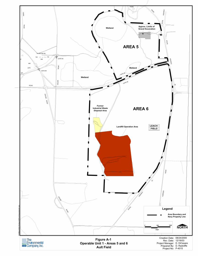
LEACH FIELD
FormerIndustrial WasteDisposal Area
Landfill Operation Area
Wetland
AREA 6
Wetland
Wetland
AREA 5
Approx. Limits of Gravel Excavation
STAT
E
ROAD
HIG
HW
AY
POND
GATE 89
GATE 90
STATE
HIG
HW
AY
20
RO
AD
20
TOR
PED
O
HIGHW
AY
STATE
298
GATE 88
GO
LDIE R
OAD
GOLDIE
ROAD
145GATE 60
RO
AD
N. GOLDIE RD.
ROAD
GO
LDIE
890
146
2576
YH
AWK
RO
AD
97
RD.
Figure A-1 Operable Unit 1 - Areas 5 and 6
Ault Field
M:\M
ilitar
y\N
AS W
hidb
ey\C
ERC
LA\O
pera
bleU
nit1
.wor
Creation Date:Rev. Date:
Project Manager:Prepared By:
Project No:
08/24/200012/18/03D. DiCesareD. RadcliffeP-4015
Legend
Area Boundary andNavy Property Line
10000 500
FEET
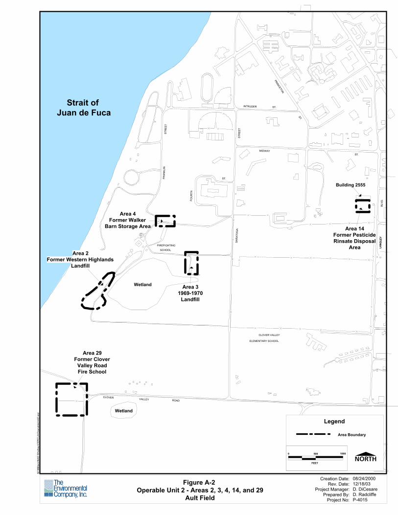
ST.
ST.
LAN
GL E
YLA
NG
L EY
B LV D
.
Area 14Former PesticideRinsate Disposal
Area
Building 2555
INTRUDER
FOU
RTH
SAR
ATO
GA
ST.
MIDWAY
STR
EET
ST.
PRINCETON
CLOVER VALLEY
ELEMENTARY SCHOOL
CLOVER VALLEY ROAD
Area 31969-1970
Landfill
Area 29Former Clover
Valley RoadFire School
Wetland
Wetland
FIREFIGHTING
SCHOOL
FRAN
KLIN
STR
EET
Area 4Former Walker
Barn Storage Area
Area 2Former Western Highlands
Landfill
Strait of Juan de Fuca
Figure A-2 Operable Unit 2 - Areas 2, 3, 4, 14, and 29
Ault Field
M:\M
ilitar
y\N
AS W
hidb
ey\C
ERC
LA\O
pera
bleU
nit2
.wor
Creation Date:Rev. Date:
Project Manager:Prepared By:
Project No:
08/24/200012/18/03D. DiCesareD. RadcliffeP-4015
Legend
Area Boundary
10000 500
FEET
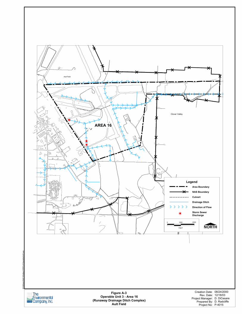
No Window
"A"
TA XIWA
Y
AIRCRAFT
RA MP
TA XIWA
Y
"K"
TAX
I WA
Y "B
"
Ault Field
TAXIWAY
TAXIWAY
"I "
"G"
RUN
WA
Y
RUNWAY
7- 25
TAX
IWAY
"F"
T AXIWAY
AIRCRAF T R
AMP
TORPEDO
CHARLE S
PORTER
AVE .
-
--
AREA 16
13- 31
Clover Valley
"C"
INT RE
PI D
RO
A D
HO
FFM
AN
RO
AD
SLEEPER RD.
FROSTAD RD.
I NTR
EPI D
ROAD
ROAD
Figure A-3Operable Unit 3 - Area 16
(Runaway Drainage Ditch Complex)Ault Field
M:\M
ilita
ry\N
AS W
hidb
ey\C
ERC
LA\O
pera
bleU
nit3
.wor
Creation Date:Rev. Date:
Project Manager:Prepared By:
Project No:
08/24/200012/18/03D. DiCesareD. RadcliffeP-4015
Legend
NAS Boundary
Area Boundary
Culvert
Drainage Ditch
Direction of Flow
Storm Sewer Discharge
2000
FEET
10000
-
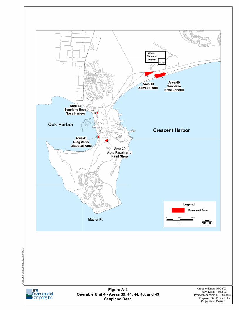
No Window
Figure A-4Operable Unit 4 - Areas 39, 41, 44, 48, and 49
Seaplane Base
M:\M
ilitar
y\N
AS W
hidb
ey\C
ERC
LA\O
pera
bleU
nit4
.wor
Creation Date:Rev. Date:
Project Manager:Prepared By:
Project No:
01/08/0312/18/03D. DiCesareD. RadcliffeP-4041
Waste Disposal Lagoon
Crescent Harbor
Area 48Salvage Yard
Area 49Seaplane
Base Landfill
Maylor Pt
Area 39Auto Repair and
Paint Shop
Area 41Bldg 25/26
Disposal Area
Area 44Seaplane BaseNose Hanger
Oak Harbor
2000
FEET
10000
LegendDesignated Areas
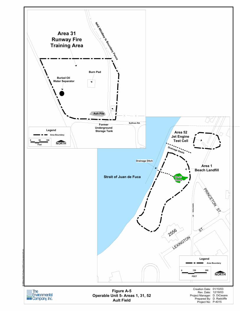
No Window
Figure A-5Operable Unit 5- Areas 1, 31, 52
Ault Field
M:\M
ilitar
y\N
AS W
hidb
ey\C
ERC
LA\O
pera
bleU
nit5
.wor
Creation Date:Rev. Date:
Project Manager:Prepared By:
Project No:
01/10/0312/18/03D. DiCesareD. RadcliffeP-4015
PRINCETON ST.
LEXINGTON
ST.
2556
SAR
ATO
GA
ST.SA
RA
TOG
A ST.
SAR
ATO
GA
ST.SA
RA
TOG
A ST.
SAR
ATO
GA
ST.SA
RA
TOG
A ST.
SAR
ATO
GA
ST.SA
RA
TOG
A ST.
SAR
ATO
GA
ST.SA
RA
TOG
A ST.
SAR
ATO
GA
ST.SA
RA
TOG
A ST.
SAR
ATO
GA
ST.SA
RA
TOG
A ST.
SAR
ATO
GA
ST.SA
RA
TOG
A ST.
SAR
ATO
GA
ST.SA
RA
TOG
A ST.
SAR
ATO
GA
ST.SA
RA
TOG
A ST.
SAR
ATO
GA
ST.SA
RA
TOG
A ST.
SAR
ATO
GA
ST.SA
RA
TOG
A ST.
SAR
ATO
GA
ST.SA
RA
TOG
A ST.
SAR
ATO
GA
ST.SA
RA
TOG
A ST.
SAR
ATO
GA
ST.SA
RA
TOG
A ST.
SAR
ATO
GA
ST.SA
RA
TOG
A ST.
SAR
ATO
GA
ST.SA
RA
TOG
A ST.
SAR
ATO
GA
ST.SA
RA
TOG
A ST.
SAR
ATO
GA
ST.SA
RA
TOG
A ST.
SAR
ATO
GA
ST.SA
RA
TOG
A ST.
SAR
ATO
GA
ST.SA
RA
TOG
A ST.
SAR
ATO
GA
ST.SA
RA
TOG
A ST.
SAR
ATO
GA
ST.SA
RA
TOG
A ST.
SAR
ATO
GA
ST.SA
RA
TOG
A ST.
SAR
ATO
GA
ST.
Marsh/Marsh/Marsh/Marsh/Marsh/Marsh/Marsh/Marsh/Marsh/Marsh/Marsh/Marsh/Marsh/Marsh/Marsh/Marsh/Marsh/Marsh/Marsh/Marsh/Marsh/Marsh/Marsh/Marsh/Marsh/Marsh/Marsh/Marsh/Marsh/Marsh/Marsh/Marsh/Marsh/Marsh/Marsh/Marsh/Marsh/Marsh/Marsh/Marsh/Marsh/Marsh/Marsh/Marsh/Marsh/Marsh/Marsh/Marsh/Marsh/SwampSwampSwampSwampSwampSwampSwampSwampSwampSwampSwampSwampSwampSwampSwampSwampSwampSwampSwampSwampSwampSwampSwampSwampSwampSwampSwampSwampSwampSwampSwampSwampSwampSwampSwampSwampSwampSwampSwampSwampSwampSwampSwampSwampSwampSwampSwampSwampSwamp
Area 1Beach Landfill
Marsh/Marsh/Marsh/Marsh/Marsh/Marsh/Marsh/Marsh/Marsh/Marsh/Marsh/Marsh/Marsh/Marsh/Marsh/Marsh/Marsh/Marsh/Marsh/Marsh/Marsh/Marsh/Marsh/Marsh/Marsh/Marsh/Marsh/Marsh/Marsh/Marsh/Marsh/Marsh/Marsh/Marsh/Marsh/Marsh/Marsh/Marsh/Marsh/Marsh/Marsh/Marsh/Marsh/Marsh/Marsh/Marsh/Marsh/Marsh/Marsh/SwampSwampSwampSwampSwampSwampSwampSwampSwampSwampSwampSwampSwampSwampSwampSwampSwampSwampSwampSwampSwampSwampSwampSwampSwampSwampSwampSwampSwampSwampSwampSwampSwampSwampSwampSwampSwampSwampSwampSwampSwampSwampSwampSwampSwampSwampSwampSwampSwamp
Drainage Swale
Area 52Jet Engine
Test Cell
Drainage Ditch
Strait of Juan de Fuca
LegendArea Boundary
1500
FEET
300
Sullivan Rd.
Buried Oil Water Separator
Ash Pile
Former Underground Storage Tank
Burn Pad
NAS Whidbey Is Boundary Fence
Area 31Runway FireTraining Area
100
Feet
0 50
LegendArea Boundary
NAS Whidbey Island
April 2004 A-26
This page intentionally left blank.
NAS Whidbey Island
April 2004 Appendix B
APPENDIX B
OPERABLE UNIT PHOTOGRAPHS
NAS Whidbey Island
April 2004 Appendix B
This page intentionally left blank.
NAS Whidbey Island
April 2004 B-1
Operable Unit 1, Area 5. View of a portion of Area 5 that is more heavily vegetated. Note the signage present demarcating Area 5 as a CERCLA site.
Operable Unit 1, Area 6. View of Area 6 landfill. Area 6 landfill is covered with a minimum functional geosynthetic cap with a vegetative cover. Note passive landfill gas vents in background.
NAS Whidbey Island
April 2004 B-2
Operable Unit 1, Area 6. View of Area 6 groundwater extraction, treatment, and recharge system (extraction components at location of a production well).
Operable Unit 1, Area 6. View of Area 6 groundwater extraction, treatment, and recharge system (grassed swale recharge area). Note the white perforated poly-vinyl chloride (PVC) discharge line.
NAS Whidbey Island
April 2004 B-3
Operable Unit 1, Area 6. View of Area 6 groundwater extraction, treatment, and recharge system (treatment components, stripper tower [white], holding tank [green] and associated pumps/piping).
Operable Unit 2, Area 2. View of a portion of Area 2 that shows typical vegetation. Note the signage present demarcating Area 2 as a CERCLA site.
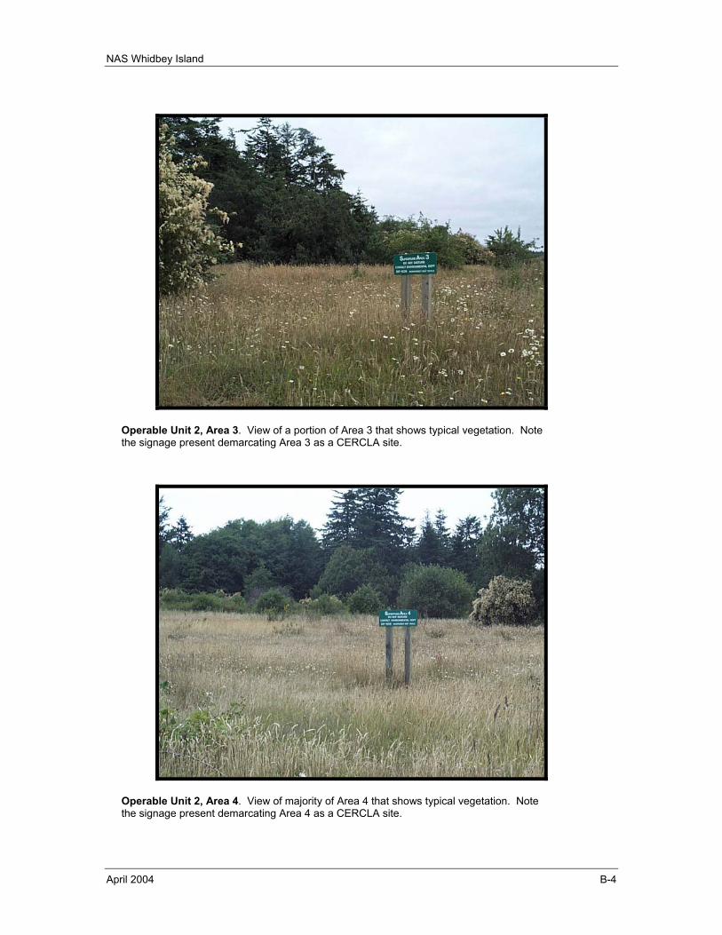
NAS Whidbey Island
April 2004 B-4
Operable Unit 2, Area 3. View of a portion of Area 3 that shows typical vegetation. Note the signage present demarcating Area 3 as a CERCLA site.
Operable Unit 2, Area 4. View of majority of Area 4 that shows typical vegetation. Note the signage present demarcating Area 4 as a CERCLA site.
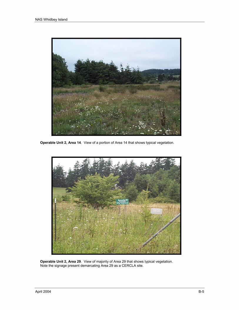
NAS Whidbey Island
April 2004 B-5
Operable Unit 2, Area 14. View of a portion of Area 14 that shows typical vegetation.
Operable Unit 2, Area 29. View of majority of Area 29 that shows typical vegetation. Note the signage present demarcating Area 29 as a CERCLA site.
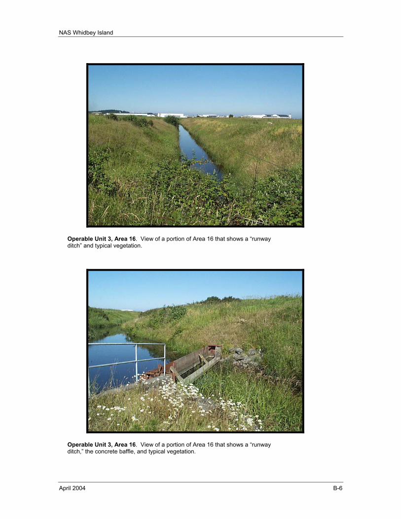
NAS Whidbey Island
April 2004 B-6
Operable Unit 3, Area 16. View of a portion of Area 16 that shows a “runway ditch” and typical vegetation.
Operable Unit 3, Area 16. View of a portion of Area 16 that shows a “runway ditch,” the concrete baffle, and typical vegetation.
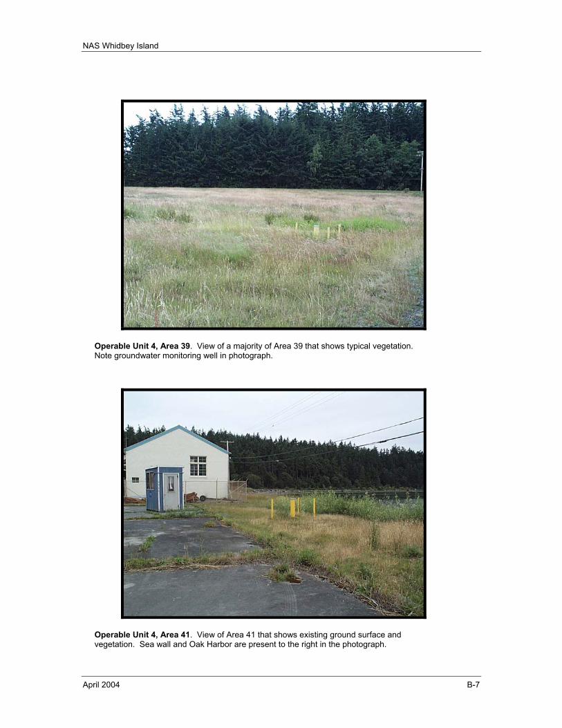
NAS Whidbey Island
April 2004 B-7
Operable Unit 4, Area 39. View of a majority of Area 39 that shows typical vegetation. Note groundwater monitoring well in photograph.
Operable Unit 4, Area 41. View of Area 41 that shows existing ground surface and vegetation. Sea wall and Oak Harbor are present to the right in the photograph.
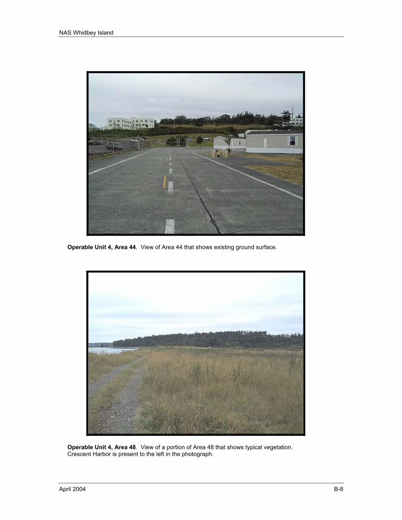
NAS Whidbey Island
April 2004 B-8
Operable Unit 4, Area 44. View of Area 44 that shows existing ground surface.
Operable Unit 4, Area 48. View of a portion of Area 48 that shows typical vegetation. Crescent Harbor is present to the left in the photograph.
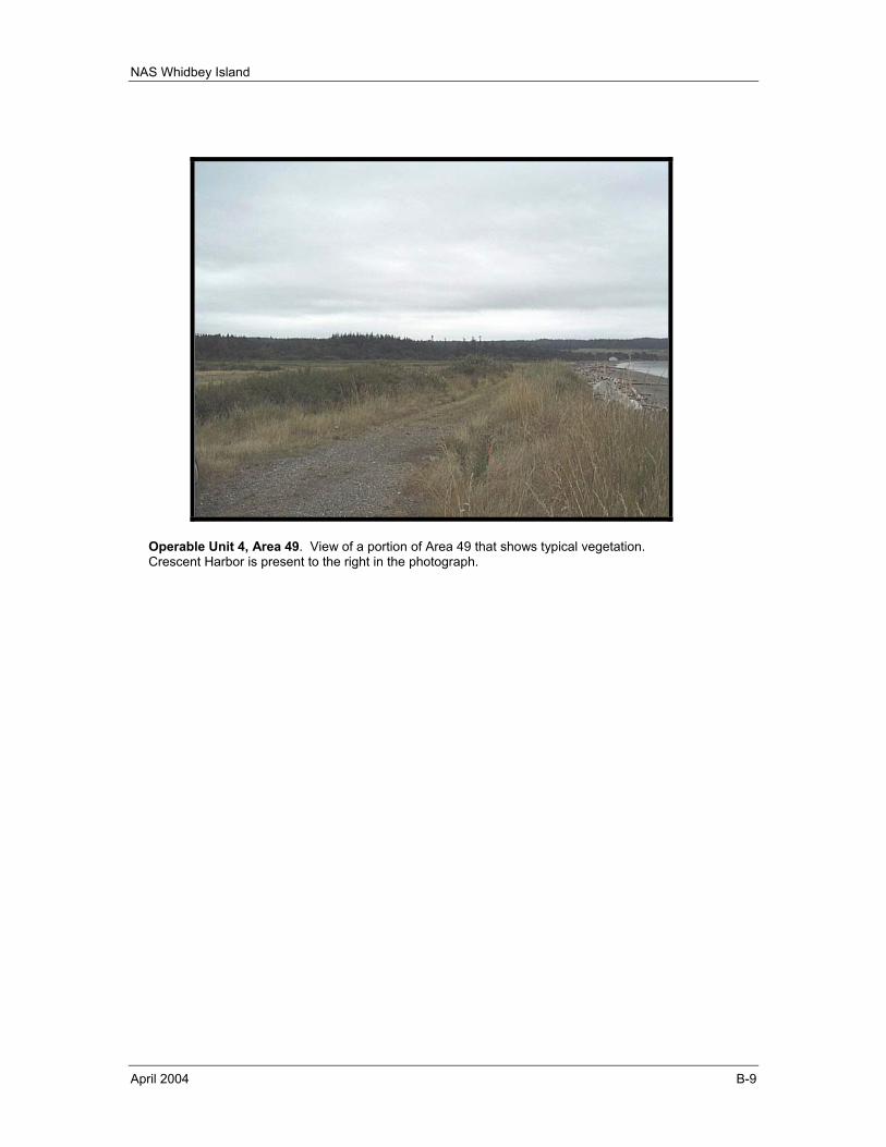
NAS Whidbey Island
April 2004 B-9
Operable Unit 4, Area 49. View of a portion of Area 49 that shows typical vegetation. Crescent Harbor is present to the right in the photograph.
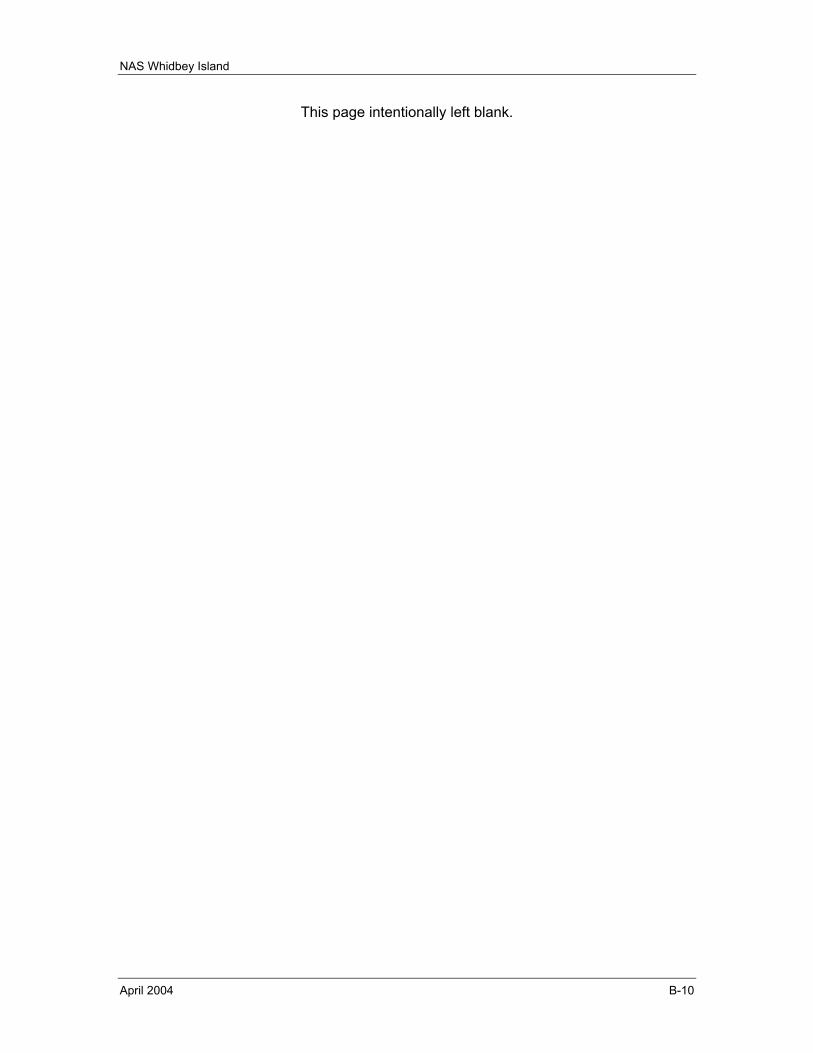
NAS Whidbey Island
April 2004 B-10
This page intentionally left blank.
NAS Whidbey Island
April 2004 Appendix C
APPENDIX C
RESPONSE TO PUBLIC COMMENTS
No public comments were received on the Draft Review; accordingly; Appendix C is reserved.

NAS Whidbey Island
April 2004 Appendix C
This page intentionally left blank.
NAS Whidbey Island
April 2004 Appendix D
APPENDIX D
OPERABLE UNIT 1, AREA 6, CUMULATIVE DATA
Appendix D contains excerpts from the Final Third Quarter and Annual Technical Report, Operations of Interim Action Groundwater Extraction, Treatment, and Recharge System, Area 6 Landfill, Operating Period July - September 2002, Naval Air Station Whidbey Island, Washington, (TEC, 2002f). Specifically, this appendix contains the following tables and figures from the above referenced technical report presented in the following order:
Figure 3-1 Base Map for Area 6 Table 4-1 Influent Sample Cumulative Summary Figure 5-1 Contaminant Trends in Influent at the Area 6 Treatment Plant Table 4-4 Production Well Sample Cumulative Summary Table 4-5a Monitoring Well Sample Cumulative Summary (6-S-21) Figure 5-3 Contaminant Trends at 6-S-21 Table 4-5b Monitoring Well Sample Cumulative Summary (6-S-6) Figure 5-4 Contaminant Trends at 6-S-6 Table 4-5c Monitoring Well Sample Cumulative Summary (6-S-25) Figure 5-5 Contaminant Trends at 6-S-25 Table 4-5d Monitoring Well Sample Cumulative Summary (6-S-27) Figure 5-6 Contaminant Trends at 6-S-27 Table 4-5e Monitoring Well Sample Cumulative Summary (6-S-19) Figure 5-7 Contaminant Trends at 6-S-19 Figure 4-1 Concentration Contours (µg/L) for Trichloroethylene, July 2002 Figure 4-2 Concentration Contours (µg/L) for 1,1,1-Trichloroethane, July 2002 Figure 4-3 Concentration Contours (µg/L) for 1,1-Dichloroethane, July 2002 Figure 4-4 Concentration Contours (µg/L) for cis-1,2-Dichloroethene, July 2002 Figure 4-5 Concentration Contours (µg/L) for 1,1-Dichloroethene, July 2002 Figure 4-6 Concentration Contours (µg/L) for Vinyl Chloride, July 2002

NAS Whidbey Island
April 2004 Appendix D
This page intentionally left blank.
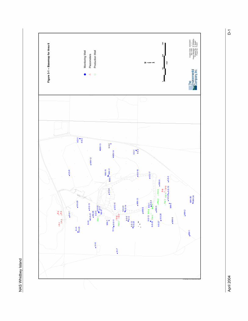
NAS
Whi
dbey
Isla
nd
April
200
4
D-1
˘
˘
˘̆
˘
˘
˘
˘
˘
˘
˘
˘
˘
˘
˘
˘
˘
˘
˘
˘
˘̆
˘
˘
˘
z z
zz
z
z
z7
7
˘
˘˘
˘
˘
˘
˘
˘
˘
˘
˘˘
˘
˘
˘
˘
˘
˘
˘
˘ ˘
˘
˘
˘
˘
˘
˘
˘
˘
˘
˘
˘
77
77
z
z7
7
˘
MW
-13
6-S
-5
MW
-14
6-D
-3
6-S
-2
MW
-12
6-D
-2
6-S
-1
6-S
-8
6-S
-17
6-S
-16
MW
-11
6-S
-9
MW
-15
RIW
-1
6-S
-19
PW
-8
P-6
MW
-9
P-5
6-S
-3
PW
-2M
W-5 MW
-4
PW
-4
6-S
-29
PW
-9
6-S
-23
6-S
-14
MW
-10
6-S
-15
PW
-6
MW
-8 PW
-7
6-D
-1 6-S
-4
6-S
-10
N6-3
8 6-S
-22
N6-3
76-I
-1
6-D
-5
MW
-6
MW
-2
MW
-1
MW
-3A
MW
-3B
P-3
P-4
P-1
P-2
6-S
-7
6-S
-26
6-I
-5
6-S
-20
MW
-7
6-I
-86-S
-21
PW
-1
6-S
-27
6-S
-28
PW
-5
6-S
-13
6-S
-25
6-S
-66-I
-3
6-S
-12
6-S
-24
6-I
-2
PW
-3P
-8 P-7
6-S
-11
6-I
-6
6-I
-7
10
10
1010
1010
10
10
10
10
01
00
10
01
00
10
01
00
10
01
00
10
01 1 11 11 1 11
0 0 00 00 0 00
M:\Military\NAS Whidbey\CTO 21\BaseMap.wor
1000
1500
0500
FE
ET
�
7 z
Pie
zo
me
ters
Pro
du
ctio
n W
ell
Fig
ure
3-1
--
Ba
se
ma
p f
or
Are
a 6
Cre
ation D
ate
:R
ev. D
ate
:P
roje
ct M
anager:
Pre
pare
d B
y:
Pro
ject N
o:
03/2
3/2
001
__/_
_/_
___
G. W
hitta
ker
D. B
edarf
P-4
021
˘M
on
ito
rin
g W
ell
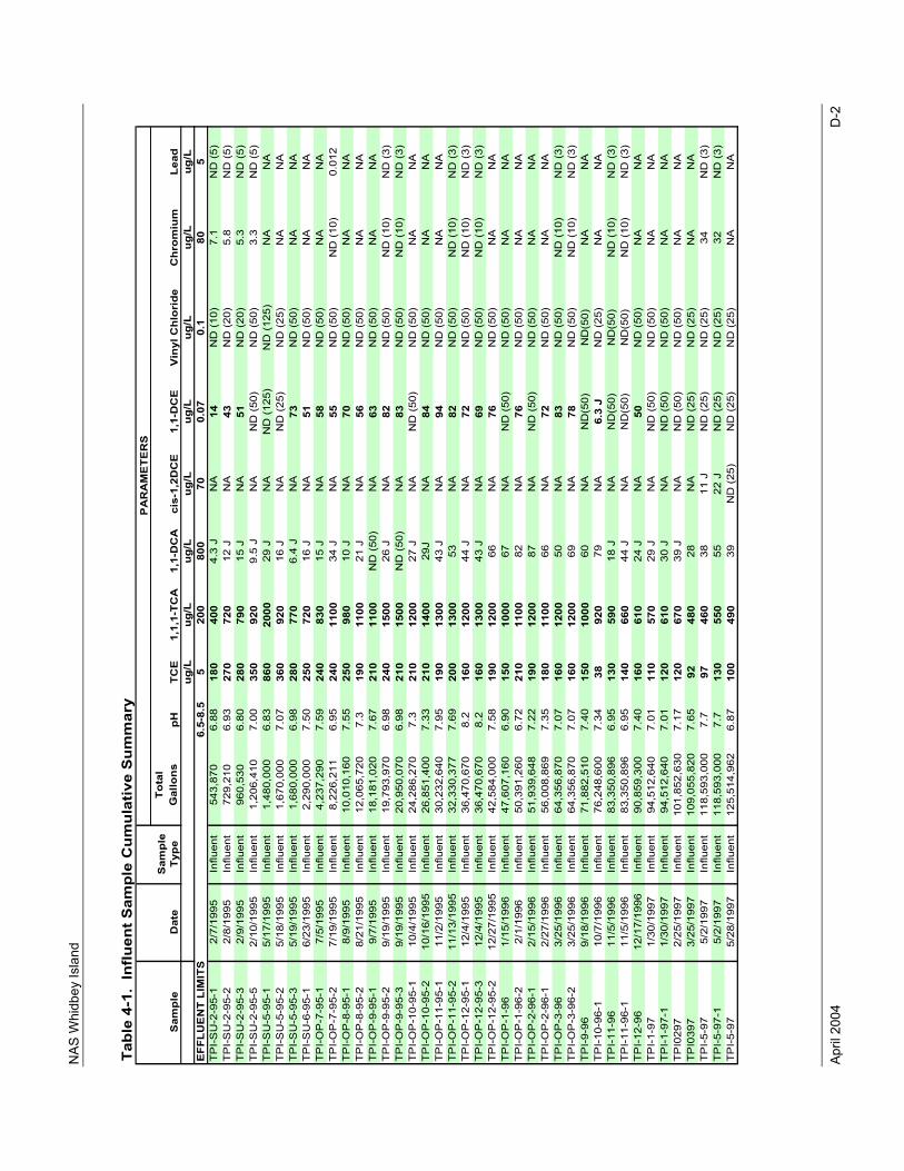
NAS
Whi
dbey
Isla
nd
April
200
4
D-2
Tabl
e 4-
1. I
nflu
ent S
ampl
e C
umul
ativ
e S
umm
ary
Tota
l G
allo
nspH
ug/L
ug/L
ug/L
ug/L
ug/L
ug/L
ug/L
ug/L
EFF
LUE
NT
LIM
ITS
6.5-
8.5
520
080
070
0.07
0.1
805
TP
I-S
U-2
-95-
12/
7/19
95In
fluen
t54
3,87
06.
8818
040
04.
3 J
NA
14N
D (
10)
7.1
ND
(5)
TP
I-S
U-2
-95-
22/
8/19
95In
fluen
t72
9,21
06.
9327
072
012
JN
A43
ND
(20
)5.
8N
D (
5)T
PI-
SU
-2-9
5-3
2/9/
1995
Influ
ent
960,
530
6.80
280
790
15 J
NA
51N
D (
20)
5.3
ND
(5)
TP
I-S
U-2
-95-
52/
10/1
995
Influ
ent
1,20
6,41
07.
0035
092
09.
5 J
NA
ND
(50
)N
D (
50)
3.3
ND
(5)
TP
I-S
U-5
-95-
15/
17/1
995
Influ
ent
1,48
0,00
06.
8386
020
0029
JN
AN
D (
125)
ND
(12
5)N
AN
AT
PI-
SU
-5-9
5-2
5/18
/199
5In
fluen
t1,
670,
000
7.07
360
920
16 J
NA
ND
(25
)N
D (
25)
NA
NA
TP
I-S
U-5
-95-
35/
19/1
995
Influ
ent
1,68
0,00
06.
9828
077
06.
4 J
NA
73N
D (
50)
NA
NA
TP
I-S
U-6
-95-
16/
23/1
995
Influ
ent
2,29
0,00
07.
5025
072
016
JN
A51
ND
(50
)N
AN
AT
PI-
OP
-7-9
5-1
7/5/
1995
Influ
ent
4,23
7,29
07.
5924
083
015
JN
A58
ND
(50
)N
AN
AT
PI-
OP
-7-9
5-2
7/19
/199
5In
fluen
t8,
226,
211
6.95
240
1100
34 J
NA
55N
D (
50)
ND
(10
)0.
012
TP
I-O
P-8
-95-
18/
9/19
95In
fluen
t10
,010
,160
7.55
250
980
10 J
NA
70N
D (
50)
NA
NA
TP
I-O
P-8
-95-
28/
21/1
995
Influ
ent
12,0
65,7
207.
319
011
0021
JN
A56
ND
(50
)N
AN
AT
PI-
OP
-9-9
5-1
9/7/
1995
Influ
ent
18,1
81,0
207.
6721
011
00N
D (
50)
NA
63N
D (
50)
NA
NA
TP
I-O
P-9
-95-
29/
19/1
995
Influ
ent
19,7
93,9
706.
9824
015
0026
JN
A82
ND
(50
)N
D (
10)
ND
(3)
TP
I-O
P-9
-95-
39/
19/1
995
Influ
ent
20,9
50,0
706.
9821
015
00N
D (
50)
NA
83N
D (
50)
ND
(10
)N
D (
3)T
PI-
OP
-10-
95-1
10/4
/199
5In
fluen
t24
,286
,270
7.3
210
1200
27 J
NA
ND
(50
)N
D (
50)
NA
NA
TP
I-O
P-1
0-95
-210
/16/
1995
Influ
ent
26,8
51,4
007.
3321
014
0029
JN
A84
ND
(50
)N
AN
AT
PI-
OP
-11-
95-1
11/2
/199
5In
fluen
t30
,232
,640
7.95
190
1300
43 J
NA
94N
D (
50)
NA
NA
TP
I-O
P-1
1-95
-211
/13/
1995
Influ
ent
32,3
30,3
777.
6920
013
0053
NA
82N
D (
50)
ND
(10
)N
D (
3)T
PI-
OP
-12-
95-1
12/4
/199
5In
fluen
t36
,470
,670
8.2
160
1200
44 J
NA
72N
D (
50)
ND
(10
)N
D (
3)T
PI-
OP
-12-
95-3
12/4
/199
5In
fluen
t36
,470
,670
8.2
160
1300
43 J
NA
69N
D (
50)
ND
(10
)N
D (
3)T
PI-
OP
-12-
95-2
12/2
7/19
95In
fluen
t42
,584
,000
7.58
190
1200
66N
A76
ND
(50
)N
AN
AT
PI-
OP
-1-9
61/
15/1
996
Influ
ent
47,6
07,1
606.
9015
010
0067
NA
ND
(50
)N
D (
50)
NA
NA
TP
I-O
P-1
-96-
22/
1/19
96In
fluen
t50
,391
,260
6.72
210
1100
82N
A76
ND
(50
)N
AN
AT
PI-
OP
-2-9
6-1
2/15
/199
6In
fluen
t51
,939
,648
7.22
190
1200
87N
AN
D (
50)
ND
(50
)N
AN
AT
PI-
OP
-2-9
6-1
2/27
/199
6In
fluen
t56
,008
,869
7.35
180
1100
66N
A72
ND
(50
)N
AN
AT
PI-
OP
-3-9
63/
25/1
996
Influ
ent
64,3
56,8
707.
0716
012
0050
NA
83N
D (
50)
ND
(10
)N
D (
3)T
PI-
OP
-3-9
6-2
3/25
/199
6In
fluen
t64
,356
,870
7.07
160
1200
69N
A78
ND
(50
)N
D (
10)
ND
(3)
TP
I-9-
969/
18/1
996
Influ
ent
71,8
82,5
107.
4015
010
0060
NA
ND
(50)
ND
(50)
NA
NA
TP
I-10
-96-
110
/7/1
996
Influ
ent
76,2
48,6
007.
3438
920
79N
A6.
3 J
ND
(25
)N
AN
AT
PI-
11-9
611
/5/1
996
Influ
ent
83,3
50,8
966.
9513
059
018
JN
AN
D(5
0)N
D(5
0)N
D (
10)
ND
(3)
TP
I-11
-96-
111
/5/1
996
Influ
ent
83,3
50,8
966.
9514
066
044
JN
AN
D(5
0)N
D(5
0)N
D (
10)
ND
(3)
TP
I-12
-96
12/1
7/19
96In
fluen
t90
,859
,300
7.40
160
610
24 J
NA
50N
D (
50)
NA
NA
TP
I-1-
971/
30/1
997
Influ
ent
94,5
12,6
407.
0111
057
029
JN
AN
D (
50)
ND
(50
)N
AN
AT
PI-
1-97
-11/
30/1
997
Influ
ent
94,5
12,6
407.
0112
061
030
JN
AN
D (
50)
ND
(50
)N
AN
AT
PI0
297
2/25
/199
7In
fluen
t10
1,85
2,63
07.
1712
067
039
JN
AN
D (
50)
ND
(50
)N
AN
AT
PI0
397
3/25
/199
7In
fluen
t10
9,05
5,82
07.
6592
480
28N
AN
D (
25)
ND
(25
)N
AN
AT
PI-
5-97
5/2/
1997
Influ
ent
118,
593,
000
7.7
9746
038
11 J
ND
(25
)N
D (
25)
34N
D (
3)T
PI-
5-97
-15/
2/19
97In
fluen
t11
8,59
3,00
07.
713
055
055
22 J
ND
(25
)N
D (
25)
32N
D (
3)T
PI-
5-97
5/28
/199
7In
fluen
t12
5,51
4,96
26.
8710
049
039
ND
(25
)N
D (
25)
ND
(25
)N
AN
A
PA
RA
ME
TER
S
Sam
ple
Dat
eTC
ES
ampl
e Ty
peC
hrom
ium
Lead
1,1,
1-TC
AV
inyl
Chl
orid
e1,
1-D
CA
cis-
1,2D
CE
1,1-
DC
E
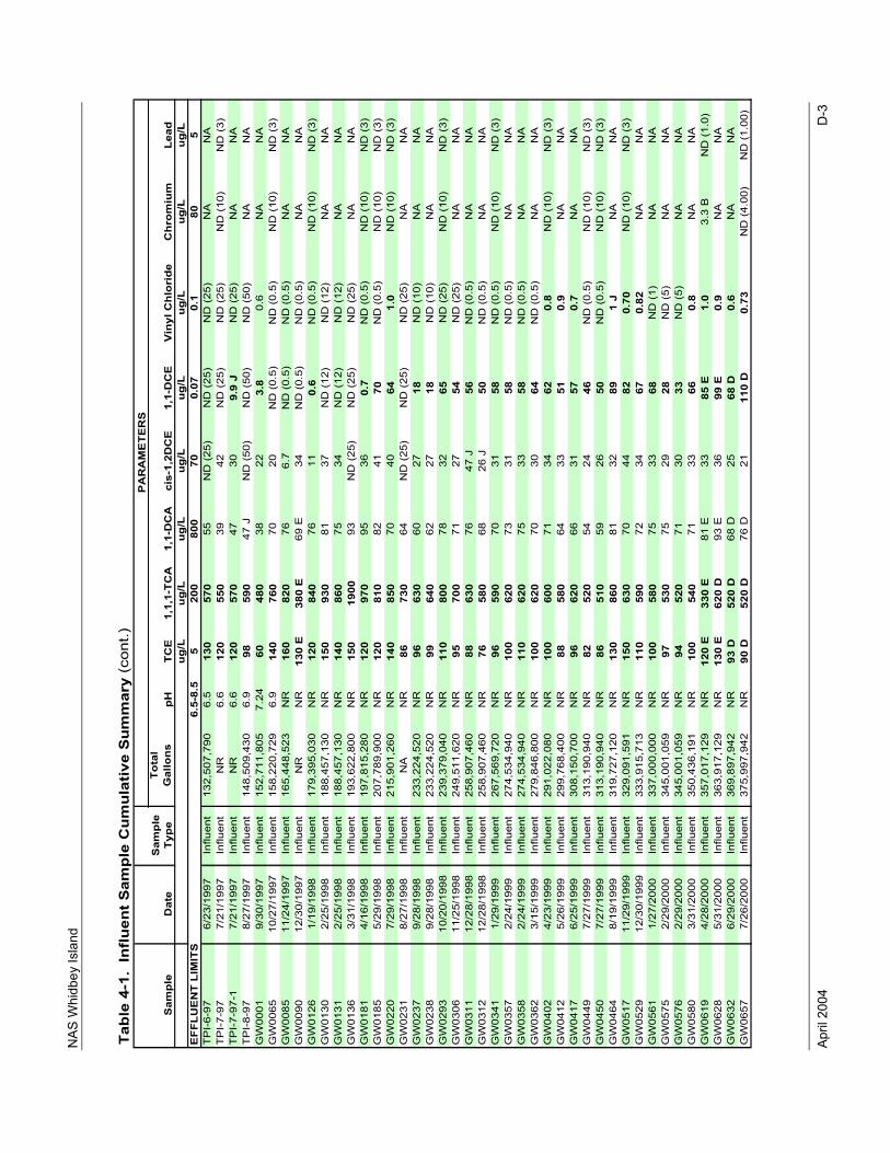
NAS
Whi
dbey
Isla
nd
April
200
4
D-3
Tabl
e 4-
1. I
nflu
ent
Sam
ple
Cum
ulat
ive
Sum
mar
y(c
ont.)
Tota
l G
allo
nspH
ug/L
ug/L
ug/L
ug/L
ug/L
ug/L
ug/L
ug/L
EFF
LUE
NT
LIM
ITS
6.5-
8.5
520
080
070
0.07
0.1
805
TP
I-6-
976/
23/1
997
Influ
ent
132,
507,
790
6.5
130
570
55N
D (
25)
ND
(25
)N
D (
25)
NA
NA
TP
I-7-
977/
21/1
997
Influ
ent
NR
6.6
120
550
3942
ND
(25
)N
D (
25)
ND
(10
)N
D (
3)T
PI-
7-97
-17/
21/1
997
Influ
ent
NR
6.6
120
570
4730
9.9
JN
D (
25)
NA
NA
TP
I-8-
978/
27/1
997
Influ
ent
148,
509,
430
6.9
9859
047
JN
D (
50)
ND
(50
)N
D (
50)
NA
NA
GW
0001
9/30
/199
7In
fluen
t15
2,71
1,80
57.
2460
480
3822
3.8
0.6
NA
NA
GW
0065
10/2
7/19
97In
fluen
t15
8,22
0,72
96.
914
076
070
20N
D (
0.5)
ND
(0.
5)N
D (
10)
ND
(3)
GW
0085
11/2
4/19
97In
fluen
t16
5,44
8,52
3N
R16
082
076
6.7
ND
(0.
5)N
D (
0.5)
NA
NA
GW
0090
12/3
0/19
97In
fluen
tN
RN
R13
0 E
380
E69
E34
ND
(0.
5)N
D (
0.5)
NA
NA
GW
0126
1/19
/199
8In
fluen
t17
9,39
5,03
0N
R12
084
076
110.
6N
D (
0.5)
ND
(10
)N
D (
3)G
W01
302/
25/1
998
Influ
ent
188,
457,
130
NR
150
930
8137
ND
(12
)N
D (
12)
NA
NA
GW
0131
2/25
/199
8In
fluen
t18
8,45
7,13
0N
R14
086
075
34N
D (
12)
ND
(12
)N
AN
AG
W01
363/
31/1
998
Influ
ent
193,
622,
800
NR
150
1900
93N
D (
25)
ND
(25
)N
D (
25)
NA
NA
GW
0181
4/16
/199
8In
fluen
t19
7,81
5,28
0N
R12
097
095
360.
7N
D (
0.5)
ND
(10
)N
D (
3)G
W01
855/
29/1
998
Influ
ent
207,
789,
900
NR
120
810
8241
70N
D (
0.5)
ND
(10
)N
D (
3)G
W02
207/
29/1
998
Influ
ent
215,
901,
260
NR
140
850
7040
641.
0N
D (
10)
ND
(3)
GW
0231
8/27
/199
8In
fluen
tN
AN
R86
730
64N
D (
25)
ND
(25
)N
D (
25)
NA
NA
GW
0237
9/28
/199
8In
fluen
t23
3,22
4,52
0N
R96
630
6027
18N
D (
10)
NA
NA
GW
0238
9/28
/199
8In
fluen
t23
3,22
4,52
0N
R99
640
6227
18N
D (
10)
NA
NA
GW
0293
10/2
0/19
98In
fluen
t23
9,37
9,04
0N
R11
080
078
3265
ND
(25
)N
D (
10)
ND
(3)
GW
0306
11/2
5/19
98In
fluen
t24
9,51
1,62
0N
R95
700
7127
54N
D (
25)
NA
NA
GW
0311
12/2
8/19
98In
fluen
t25
8,90
7,46
0N
R88
630
7647
J56
ND
(0.
5)N
AN
AG
W03
1212
/28/
1998
Influ
ent
258,
907,
460
NR
7658
068
26 J
50N
D (
0.5)
NA
NA
GW
0341
1/29
/199
9In
fluen
t26
7,56
9,72
0N
R96
590
7031
58N
D (
0.5)
ND
(10
)N
D (
3)G
W03
572/
24/1
999
Influ
ent
274,
534,
940
NR
100
620
7331
58N
D (
0.5)
NA
NA
GW
0358
2/24
/199
9In
fluen
t27
4,53
4,94
0N
R11
062
075
3358
ND
(0.
5)N
AN
AG
W03
623/
15/1
999
Influ
ent
279,
846,
800
NR
100
620
7030
64N
D (
0.5)
NA
NA
GW
0402
4/23
/199
9In
fluen
t29
1,02
2,08
0N
R10
060
071
3462
0.8
ND
(10
)N
D (
3)G
W04
125/
26/1
999
Influ
ent
299,
768,
400
NR
8858
064
3351
0.9
NA
NA
GW
0417
6/25
/199
9In
fluen
t30
8,15
0,70
0N
R96
620
6631
570.
7N
AN
AG
W04
497/
27/1
999
Influ
ent
313,
190,
940
NR
8252
054
2446
ND
(0.
5)N
D (
10)
ND
(3)
GW
0450
7/27
/199
9In
fluen
t31
3,19
0,94
0N
R86
510
5926
50N
D (
0.5)
ND
(10
)N
D (
3)G
W04
648/
19/1
999
Influ
ent
319,
727,
120
NR
130
860
8132
891
JN
AN
AG
W05
1711
/29/
1999
Influ
ent
329,
091,
591
NR
150
630
7044
820.
70N
D (
10)
ND
(3)
GW
0529
12/3
0/19
99In
fluen
t33
3,91
5,71
3N
R11
059
072
3467
0.82
NA
NA
GW
0561
1/27
/200
0In
fluen
t33
7,00
0,00
0N
R10
058
075
3368
ND
(1)
NA
NA
GW
0575
2/29
/200
0In
fluen
t34
5,00
1,05
9N
R97
530
7529
28N
D (
5)N
AN
AG
W05
762/
29/2
000
Influ
ent
345,
001,
059
NR
9452
071
3033
ND
(5)
NA
NA
GW
0580
3/31
/200
0In
fluen
t35
0,43
6,19
1N
R10
054
071
3366
0.8
NA
NA
GW
0619
4/28
/200
0In
fluen
t35
7,01
7,12
9N
R12
0 E
330
E81
E33
85 E
1.0
3.3
BN
D (
1.0)
GW
0628
5/31
/200
0In
fluen
t36
3,91
7,12
9N
R13
0 E
620
D93
E36
99 E
0.9
NA
NA
GW
0632
6/29
/200
0In
fluen
t36
9,89
7,94
2N
R93
D52
0 D
68 D
2568
D0.
6N
AN
AG
W06
577/
26/2
000
Influ
ent
375,
997,
942
NR
90 D
520
D76
D21
110
D0.
73N
D (
4.00
)N
D (
1.00
)
PA
RA
ME
TE
RS
1,1,
1-TC
AS
ampl
eD
ate
Sam
ple
Ty
peTC
E1,
1-D
CA
cis-
1,2D
CE
1,1-
DC
EV
inyl
Chl
orid
eC
hrom
ium
Lead
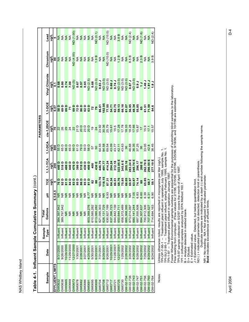
NAS
Whi
dbey
Isla
nd
April
200
4
D-4
Tabl
e 4-
1. I
nflu
ent S
ampl
e C
umul
ativ
e S
umm
ary
(con
t.)
Tota
l G
allo
nspH
ug/L
ug/L
ug/L
ug/L
ug/L
ug/L
ug/L
ug/L
EFF
LUE
NT
LIM
ITS
6.5-
8.5
520
080
070
0.07
0.1
805
GW
0632
8/31
/200
0In
fluen
t38
4,39
7,94
2N
R76
D44
0 D
55 D
2258
D0.
68N
AN
AG
W06
369/
26/2
000
Influ
ent
389,
797,
942
NR
92 D
510
D65
D26
69 D
0.80
NA
NA
GW
0665
10/2
6/20
00In
fluen
tN
RN
R81
D48
0 D
66 D
2969
D0.
74N
AN
AG
W06
6911
/29/
2000
Influ
ent
NR
NR
84 D
440
D65
D24
717.
00N
AN
AG
W06
7312
/27/
2000
Influ
ent
NR
NR
83 D
470
D60
D22
69 D
ND
(5)
ND
(4.
00)
ND
(1.
00)
GM
0678
1/30
/200
1In
fluen
tN
RN
R85
D38
0 D
61 D
21 D
72 D
0.67
NA
NA
GM
0682
2/28
/200
1In
fluen
tN
RN
R86
D51
0 D
79 D
20 D
86 D
0.57
NA
NA
GM
0686
3/27
/200
1In
fluen
tN
RN
R85
D43
0 D
59 D
23 D
62 D
0.65
NA
NA
GM
0691
4/25
/200
1In
fluen
t60
3,38
9,27
66.
7781
D40
0 D
58 D
20 D
63 D
ND
(2.
5)N
AN
AG
M06
955/
30/2
001
Influ
ent
610,
585,
282
NR
8240
057
1972
0.68
NA
NA
GM
0699
6/20
/200
1In
fluen
t61
3,08
5,28
2N
R88
430
E50
2479
ND
(3.
0)1.
9 B
ND
(0.
1)G
M07
047/
31/2
001
Influ
ent
621,
095,
303
NR
103.
7644
6.79
64.5
523
.92
86.6
10.
83 J
NA
NA
GM
0708
8/29
/200
1In
fluen
t62
6,13
1,72
9N
R11
8.15
491.
7784
.58
30.3
610
2.95
ND
(3.
0)N
AN
AG
M07
129/
26/2
001
Influ
ent
630,
927,
199
6.93
87.3
141
4.24
69.5
425
.79
77.5
5N
D (
3.0)
ND
(10
.0)
ND
(10
.0)
GM
0717
10/2
9/20
01In
fluen
t63
7,39
6,72
3N
R64
.34
294.
2443
.09
15.6
154
.71
0.66
JN
AN
AG
M07
2111
/28/
2001
Influ
ent
644,
842,
139
NR
66.5
131
2.18
43.7
715
.562
.75
0.74
JN
AN
AG
M07
2512
/27/
2001
Influ
ent
650,
644,
711
NR
68.7
632
2.05
E42
.11
17.2
859
.13
ND
(3.
0)1.
2 B
3.8
BG
M07
301/
29/2
002
Influ
ent
658,
372,
489
NR
75.8
534
5.6
E43
.63
17.7
866
.18
ND
(3.
0)N
AN
AG
M-0
2-73
42/
26/2
002
Influ
ent
665,
368,
395
NR
66.0
520
5.16
3618
.33
61.0
7N
D (
3.0)
NA
NA
GM
-02-
738
3/26
/200
2In
fluen
t67
3,01
4,09
7N
R69
.97
283.
24 E
46.8
818
.28
56.9
50.
87 J
8.5
BN
D (
2.4)
GM
-02-
743
4/29
/200
2In
fluen
t68
0,14
1,24
47.
0563
.87
245.
74 E
36.3
517
.66
48.3
4N
D (
3.0)
NA
NA
GM
-02-
747
5/28
/200
2In
fluen
t68
7,55
5,50
86.
8374
.14
296.
1737
.25
15.8
755
.85
0.9
JN
AN
AG
M-0
2-75
16/
24/2
002
Influ
ent
694,
307,
637
6.60
6926
0 E
3617
651
J2.
3 B
ND
(1.
6)G
M-0
2-75
67/
29/2
002
Influ
ent
700,
912,
306
6.39
65.8
526
2.78
E33
.05
15.9
61.5
11.
48 J
NA
NA
GM
-02-
760
8/29
/200
2In
fluen
t70
7,93
5,52
76.
3168
.729
0.55
E42
.817
.171
.59
1.81
JN
AN
AG
M-0
2-76
49/
24/2
002
Influ
ent
714,
694,
163
6.90
59.1
277.
19 E
38.4
515
.57
84.6
1.8
J3.
9 B
ND
(2.
4)
Not
es:
Unl
ess
othe
rwis
e no
ted,
res
ults
are
rep
orte
d in
mic
rogr
ams
per
liter
(ug
/L).
TP
I-O
P-7
-95-
1 -
- T
reat
men
t pla
nt in
fluen
t in
oper
atio
n Ju
ly 1
995,
sam
ple
No.
1.
TP
I-S
U-2
-95-
1 -
- T
reat
men
t pla
nt in
fluen
t, st
artu
p F
ebru
ary
1995
, sam
ple
No.
1.
TP
I-1-
97 -
- T
reat
men
t pla
nt in
fluen
t in
oper
atio
n Ja
nuar
y 19
97.
Fos
ter
Whe
eler
Env
ironm
enta
l sam
ple
num
bers
are
seq
uent
ial f
or th
e pu
rpos
es o
f sub
mitt
ing
blin
d sa
mpl
es to
the
labo
rato
ry.
TP
I-5-
97 s
ampl
e co
llect
ed o
n 5/
2/97
cov
ers
the
mon
th o
f Apr
il 19
97.
TP
I = (
influ
ent)
sam
ples
ana
lyze
d by
EP
A M
etho
d 16
0.1
B =
Ana
lyte
det
ecte
d in
met
hod
blan
k.D
= D
ilute
d.E
= E
stim
ated
val
ue.
J =
Est
imat
ed v
alue
. D
etec
ted,
but
bel
ow q
uant
itatio
n lim
it.N
D (
) =
indi
cate
d pa
ram
eter
not
det
ecte
d, d
etec
tion
limit
in p
aren
thes
is.
D
uplic
ate
sam
ples
are
indi
cate
d by
a d
ash
(-)
and
num
ber
follo
win
g th
e sa
mpl
e na
me.
NR
= N
o re
adin
g; N
A =
Not
ana
lyze
d fo
r in
dica
ted
para
met
er.
Bol
d in
dica
tes
exce
eden
ce o
f effl
uent
lim
its.
Flo
w r
eadi
ng fr
om c
ompu
ter.
(F
low
val
ues
for
2/1/
96, 2
/15/
96, 2
/27/
96, 3
/25/
96, 9
/18/
96, a
nd 1
0/7/
96 a
re e
stim
ated
PA
RA
ME
TER
S
Sam
ple
Dat
eS
ampl
e Ty
peTC
E1,
1,1-
TCA
1,1-
DC
Aci
s-1,
2DC
E1,
1-D
CE
Vin
yl C
hlor
ide
Chr
omiu
mLe
ad
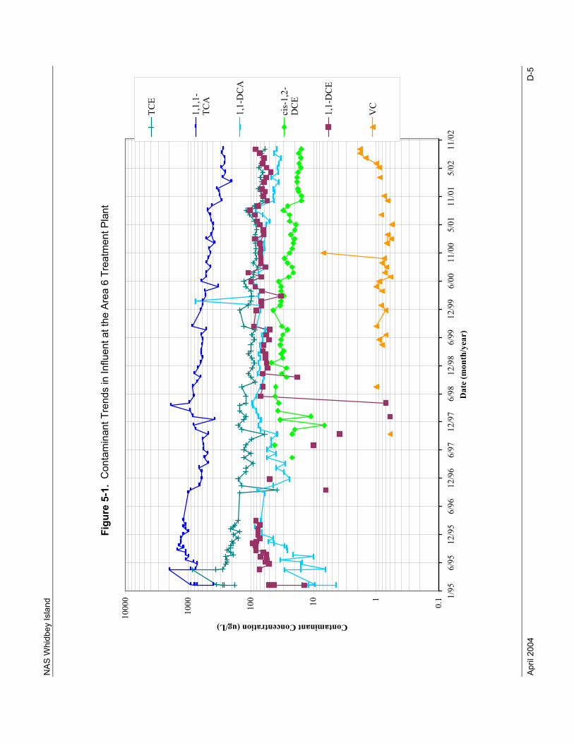
NAS
Whi
dbey
Isla
nd
April
200
4
D-5
Figu
re 5
-1.
Con
tam
inan
t Tre
nds
in In
fluen
t at t
he A
rea
6 Tr
eatm
ent P
lant
0.1110100
1000
10000 1/95
6/95
12/95
6/96
12/96
6/97
12/97
6/98
12/98
6/99
12/99
6/00
11/00
5/01
11/01
5/02
11/02
Dat
e (m
onth
/yea
r)
Contaminant Concentration (ug/L)
TCE
1,1,1-
TCA
1,1-DCA
cis-1,2-
DCE
1,1-DCE
VC
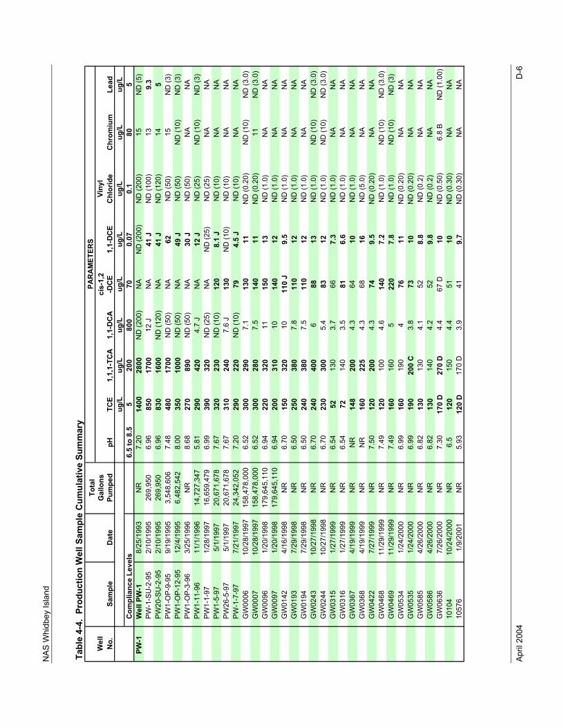
NAS
Whi
dbey
Isla
nd
April
200
4
D-6
Wel
lVi
nyl
No.
Chl
orid
eug
/Lug
/Lug
/Lug
/Lug
/Lug
/Lug
/Lug
/LC
ompl
ianc
e Le
vels
6.5
to 8
.55
200
800
700.
070.
180
5PW
-1W
ell P
W-1
8/25
/199
3N
R7.
2014
0028
00N
D (2
00)
NA
ND
(200
)N
D (2
00)
15N
D (5
)PW
-1-S
U-2
-95
2/10
/199
526
9,95
06.
9685
017
0012
JN
A41
JN
D (1
00)
139.
3PW
20-S
U-2
-95
2/10
/199
526
9,95
06.
9683
016
00N
D (1
20)
NA
41 J
ND
(120
)14
5PW
1-O
P-9-
959/
19/1
995
3,54
8,60
67.
4848
017
00N
D (5
0)N
A62
ND
(50)
15N
D (3
)PW
1-O
P-12
-95
12/4
/199
56,
482,
542
8.00
350
1000
ND
(50)
NA
49 J
ND
(50)
ND
(10)
ND
(3)
PW1-
OP-
3-96
3/25
/199
6N
R8.
6827
089
0N
D (5
0)N
A30
JN
D (5
0)N
AN
APW
1-11
-96
11/1
/199
614
,727
,347
5.81
290
420
4.7
JN
A12
JN
D (2
5)N
D (1
0)N
D (3
)PW
1-1-
971/
28/1
997
16,6
59,4
796.
9939
032
0N
D (2
5)N
AN
D (2
5)N
D (2
5)N
AN
APW
1-5-
975/
1/19
9720
,671
,678
7.67
320
230
ND
(10)
120
8.1
JN
D (1
0)N
AN
APW
26-5
-97
5/1/
1997
20,6
71,6
787.
6731
024
07.
6 J
130
ND
(10)
ND
(10)
NA
NA
PW-1
-7-9
77/
21/1
997
24,3
42,0
527.
2029
022
0N
D (1
0)79
4.5
JN
D (1
0)N
AN
AG
W00
0610
/28/
1997
158,
478,
000
6.52
300
290
7.1
130
11N
D (0
.20)
ND
(10)
ND
(3.0
)G
W00
0710
/28/
1997
158,
478,
000
6.52
300
280
7.5
140
11N
D (0
.20)
11N
D (3
.0)
GW
0096
1/20
/199
817
9,64
5,11
06.
9422
032
011
150
13N
D (1
.0)
NA
NA
GW
0097
1/20
/199
817
9,64
5,11
06.
9420
031
010
140
12N
D (1
.0)
NA
NA
GW
0142
4/16
/199
8N
R6.
7015
032
010
110
J9.
5N
D (1
.0)
NA
NA
GW
0193
7/29
/199
8N
R6.
5025
038
07.
811
012
ND
(1.0
)N
AN
AG
W01
947/
29/1
998
NR
6.50
240
380
7.5
110
12N
D (1
.0)
NA
NA
GW
0243
10/2
7/19
98N
R6.
7024
040
06
8813
ND
(1.0
)N
D (1
0)N
D (3
.0)
GW
0244
10/2
7/19
98N
R6.
7023
030
05.
483
12N
D (1
.0)
ND
(10)
ND
(3.0
)G
W03
151/
27/1
999
NR
6.54
5213
03.
766
7.3
ND
(1.0
)N
AN
AG
W03
161/
27/1
999
NR
6.54
7214
03.
581
6.6
ND
(1.0
)N
AN
AG
W03
674/
19/1
999
NR
NR
148
200
4.3
6410
ND
(1.0
)N
AN
AG
W03
684/
19/1
999
NR
NR
160
225
4.3
6816
ND
(5.0
)N
AN
AG
W04
227/
27/1
999
NR
7.50
120
200
4.3
749.
5N
D (0
.20)
NA
NA
GW
0468
11/2
9/19
99N
R7.
4912
010
04.
614
07.
2N
D (1
.0)
ND
(10)
ND
(3.0
)G
W04
6911
/29/
1999
NR
7.49
160
160
522
07.
8N
D (1
.0)
ND
(10)
ND
(3)
GW
0534
1/24
/200
0N
R6.
9916
019
04
7611
ND
(0.2
0)N
AN
AG
W05
351/
24/2
000
NR
6.99
190
200
C3.
873
10N
D (0
.20)
NA
NA
GW
0585
4/26
/200
0N
R6.
8213
013
04.
152
8.8
ND
(0.2
)N
AN
AG
W05
864/
26/2
000
NR
6.82
130
140
4.2
529.
8N
D (0
.2)
NA
NA
GW
0636
7/26
/200
0N
R7.
3017
0 D
270
D4.
467
D10
ND
(0.5
0)6.
8 B
ND
(1.0
0)10
104
10/2
4/20
00N
R6.
512
015
04.
451
10N
D (0
.30)
NA
NA
1057
61/
9/20
01N
R5.
9312
0 D
170
D3.
941
9.7
ND
(0.3
0)N
AN
A
Tabl
e 4-
4. P
rodu
ctio
n W
ell S
ampl
e Cu
mul
ativ
e Su
mm
ary
Sam
ple
Dat
epH
TCE
1,1,
1-TC
A1,
1-D
CA
Tota
l G
allo
nsPu
mpe
dci
s-1,
2-D
CE
1,1-
DCE
PAR
AM
ETER
S
Chr
omiu
mLe
ad
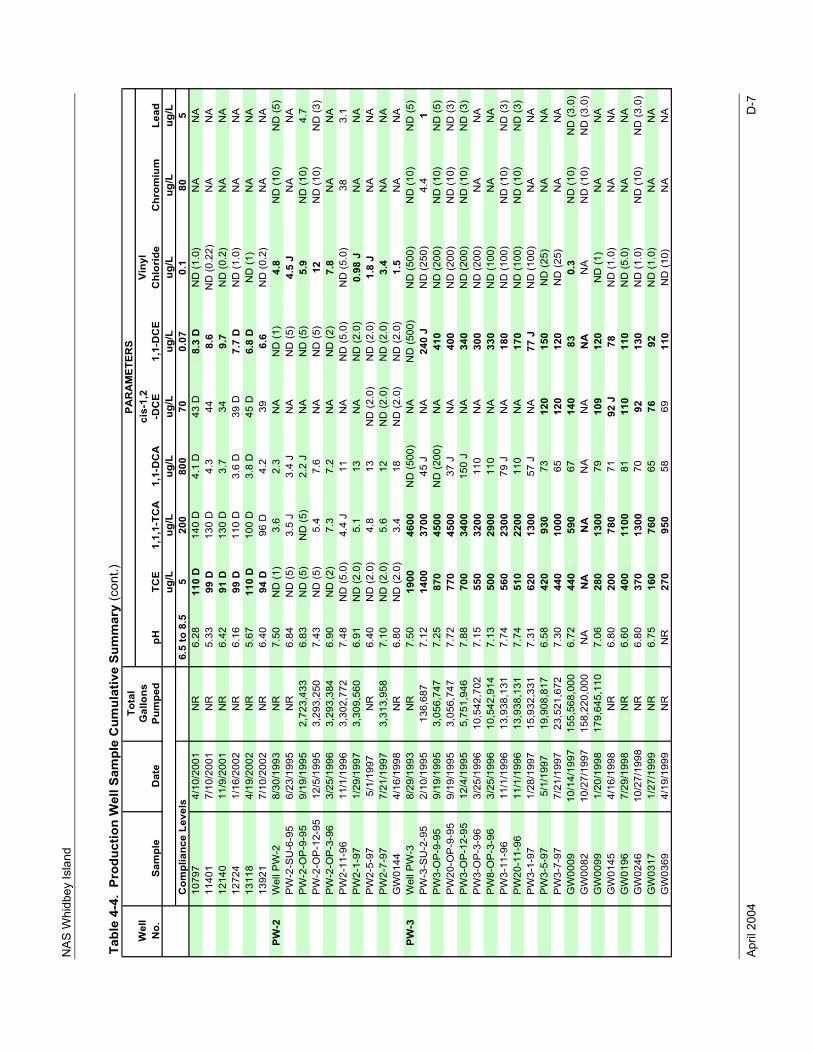
NAS
Whi
dbey
Isla
nd
April
200
4
D-7
Wel
lVi
nyl
No.
Chl
orid
eug
/Lug
/Lug
/Lug
/Lug
/Lug
/Lug
/Lug
/LC
ompl
ianc
e Le
vels
6.5
to 8
.55
200
800
700.
070.
180
510
797
4/10
/200
1N
R6.
2811
0 D
140
D4.
1 D
43 D
8.3
DN
D (1
.0)
NA
NA
1140
17/
10/2
001
NR
5.33
99 D
130
D4.
344
8.6
ND
(0.2
2)N
AN
A12
140
11/9
/200
1N
R6.
4291
D13
0 D
3.7
349.
7N
D (0
.2)
NA
NA
1272
41/
16/2
002
NR
6.16
99 D
110
D3.
6 D
39 D
7.7
DN
D (1
.0)
NA
NA
1311
84/
19/2
002
NR
5.67
110
D10
0 D
3.8
D45
D6.
8 D
ND
(1)
NA
NA
1392
17/
10/2
002
NR
6.40
94 D
96 D
4.2
396.
6N
D (0
.2)
NA
NA
PW-2
Wel
l PW
-28/
30/1
993
NR
7.50
ND
(1)
3.6
2.3
NA
ND
(1)
4.8
ND
(10)
ND
(5)
PW
-2-S
U-6
-95
6/23
/199
5N
R6.
84N
D (5
)3.
5 J
3.4
JN
AN
D (5
)4.
5 J
NA
NA
PW
-2-O
P-9
-95
9/19
/199
52,
723,
433
6.83
ND
(5)
ND
(5)
2.2
JN
AN
D (5
)5.
9N
D (1
0)4.
7P
W-2
-OP
-12-
9512
/5/1
995
3,29
3,25
07.
43N
D (5
)5.
47.
6N
AN
D (5
)12
ND
(10)
ND
(3)
PW
-2-O
P-3
-96
3/25
/199
63,
293,
384
6.90
ND
(2)
7.3
7.2
NA
ND
(2)
7.8
NA
NA
PW
2-11
-96
11/1
/199
63,
302,
772
7.48
ND
(5.0
)4.
4 J
11N
AN
D (5
.0)
ND
(5.0
)38
3.1
PW
2-1-
971/
29/1
997
3,30
9,56
06.
91N
D (2
.0)
5.1
13N
AN
D (2
.0)
0.98
JN
AN
AP
W2-
5-97
5/1/
1997
NR
6.40
ND
(2.0
)4.
813
ND
(2.0
)N
D (2
.0)
1.8
JN
AN
AP
W2-
7-97
7/21
/199
73,
313,
958
7.10
ND
(2.0
)5.
612
ND
(2.0
)N
D (2
.0)
3.4
NA
NA
GW
0144
4/16
/199
8N
R6.
80N
D (2
.0)
3.4
18N
D (2
.0)
ND
(2.0
)1.
5N
AN
APW
-3W
ell P
W-3
8/29
/199
3N
R7.
5019
0046
00N
D (5
00)
NA
ND
(500
)N
D (5
00)
ND
(10)
ND
(5)
PW
-3-S
U-2
-95
2/10
/199
513
6,68
77.
1214
0037
0045
JN
A24
0 J
ND
(250
)4.
41
PW
3-O
P-9
-95
9/19
/199
53,
056,
747
7.25
870
4500
ND
(200
)N
A41
0N
D (2
00)
ND
(10)
ND
(5)
PW
20-O
P-9
-95
9/19
/199
53,
056,
747
7.72
770
4500
37 J
NA
400
ND
(200
)N
D (1
0)N
D (3
)P
W3-
OP
-12-
9512
/4/1
995
5,75
1,94
67.
8870
034
0015
0 J
NA
340
ND
(200
)N
D (1
0)N
D (3
)P
W3-
OP
-3-9
63/
25/1
996
10,5
42,7
027.
1555
032
0011
0N
A30
0N
D (2
00)
NA
NA
PW
8-O
P-3
-96
3/25
/199
610
,542
,914
7.13
500
2900
110
NA
330
ND
(100
)N
AN
AP
W3-
11-9
611
/1/1
996
13,9
38,1
317.
7456
023
0079
JN
A18
0N
D (1
00)
ND
(10)
ND
(3)
PW
20-1
1-96
11/1
/199
613
,938
,131
7.74
510
2200
110
NA
170
ND
(100
)N
D (1
0)N
D (3
)P
W3-
1-97
1/28
/199
715
,932
,331
7.31
620
1300
57 J
NA
77 J
ND
(100
)N
AN
AP
W3-
5-97
5/1/
1997
19,9
08,8
176.
5842
093
073
120
150
ND
(25)
NA
NA
PW
3-7-
977/
21/1
997
23,5
21,6
727.
3044
010
0065
120
120
ND
(25)
NA
NA
GW
0009
10/1
4/19
9715
5,56
8,00
06.
7244
059
067
140
830.
3N
D (1
0)N
D (3
.0)
GW
0082
10/2
7/19
9715
8,22
0,00
0N
AN
AN
AN
AN
AN
AN
AN
D (1
0)N
D (3
.0)
GW
0099
1/20
/199
817
9,64
5,11
07.
0628
013
0079
109
120
ND
(1)
NA
NA
GW
0145
4/16
/199
8N
R6.
8020
078
071
92 J
78N
D (1
.0)
NA
NA
GW
0196
7/29
/199
8N
R6.
6040
011
0081
110
110
ND
(5.0
)N
AN
AG
W02
4610
/27/
1998
NR
6.80
370
1300
7092
130
ND
(1.0
)N
D (1
0)N
D (3
.0)
GW
0317
1/27
/199
9N
R6.
7516
076
065
7692
ND
(1.0
)N
AN
AG
W03
694/
19/1
999
NR
NR
270
950
5869
110
ND
(10)
NA
NA
1,1,
1-TC
A1,
1-D
CA
cis-
1,2
-DC
E1,
1-D
CE
Chr
omiu
mLe
ad
Tabl
e 4-
4. P
rodu
ctio
n W
ell S
ampl
e C
umul
ativ
e Su
mm
ary
(con
t.)To
tal
Gal
lons
Pum
ped
PAR
AM
ETER
S
Sam
ple
Dat
epH
TCE
NAS
Whi
dbey
Isla
nd
April
200
4
D-8
Wel
lVi
nyl
No.
Chl
orid
eug
/Lug
/Lug
/Lug
/Lug
/Lug
/Lug
/Lug
/LC
ompl
ianc
e Le
vels
6.5
to 8
.55
200
800
700.
070.
180
5G
W04
237/
27/1
999
NR
7.50
200
760
6065
89N
D (0
.20)
NA
NA
GW
0471
11/2
9/19
99N
R7.
4531
030
051
130
36N
D (1
.0)
ND
(10)
ND
(3)
GW
0536
1/24
/200
0N
R6.
9728
081
048
5336
ND
(0.2
0)N
D (1
0)N
D (3
)G
W05
874/
26/2
000
NR
6.63
240
1000
6241
120
ND
(0.2
)N
AN
AG
W06
377/
26/2
000
NR
6.97
280
D16
00 D
73 D
3121
0 D
0.3
JN
D (4
.00)
ND
(1.0
0)10
107
10/2
4/20
00N
R6.
720
091
055
J31
J12
0N
D (0
.30)
NA
NA
1057
71/
9/20
01N
R6.
3021
0 D
1100
D51
J26
J11
0 D
ND
(030
)N
AN
A10
798
4/10
/200
1N
R6.
3320
0 D
890
D55
D27
D11
0 D
ND
(5.0
0)N
AN
A11
402
7/10
/200
1N
R6.
1418
0 D
790
D47
D22
D91
DN
D (0
.43)
NA
NA
1213
211
/9/2
001
NR
5.95
180
D98
0 D
50 D
2312
0 D
0.2
JN
AN
A12
722
1/16
/200
2N
R6.
4917
0 D
770
D45
D19
D10
0 D
ND
(5.0
)N
AN
A13
119
4/19
/200
2N
R6.
216
0 D
650
D42
D18
D90
DN
D (4
)N
AN
A13
922
7/10
/200
2N
R6.
6417
0 D
600
D36
D18
D67
DN
D (0
.4)
NA
NA
PW-4
Wel
l PW
-48/
27/1
993
NR
7.40
ND
(1)
ND
(1)
ND
(1)
NA
ND
(1)
2.9
ND
(10)
ND
(5)
PW
-4-S
U-2
-95
2/10
/199
520
7,17
56.
95N
D (1
)2.
9N
D (1
)N
AN
D (1
)3.
4N
D (1
0)4.
4P
W-4
-OP
-9-9
59/
19/1
995
3,17
0,67
76.
70N
D (5
)N
D (5
)N
D (5
)N
AN
D (5
)3.
2 J
ND
(10)
ND
(3)
PW
-4-O
P-1
2-95
12/4
/199
55,
683,
690
7.91
ND
(5)
3.0
J1.
9 J
NA
ND
(5)
ND
(5)
ND
(10)
ND
(3)
PW
-4-O
P-3
-96
3/25
/199
610
,004
,154
7.23
ND
(2)
30.
48 J
NA
ND
(2)
4.7
NA
NA
PW
4-11
-96
11/1
/199
612
,826
,590
7.55
ND
(5.0
)3.
1 J
0.93
JN
AN
D (5
.0)
1.7
JN
D (1
0)N
D (3
)P
W4-
1-97
1/29
/199
714
,141
,370
6.87
ND
(2.0
)4.
2 J
0.95
JN
AN
D (2
.0)
ND
(2.0
)N
AN
AP
W4-
5-97
5/1/
1997
16,7
56,4
476.
47N
D (2
.0)
31.
2 J
ND
(2.0
)N
D (2
.0)
2.6
NA
NA
PW
4-7-
977/
21/1
997
19,5
50,0
727.
10N
D (2
.0)
2.6
1.4
JN
D (2
.0)
ND
(2.0
)1.
6 J
NA
NA
GW
0010
10/2
7/19
9715
8,22
0,00
07.
29N
D (0
.2)
5.3
3.1
ND
(0.2
0)N
D (0
.20)
1.6
18N
D (3
.0)
GW
0100
1/20
/199
817
9,64
5,11
07.
17N
D (0
.2)
5.1
4.1
ND
(0.2
0)N
D (0
.20)
1.6
NA
NA
GW
0146
4/16
/199
8N
R6.
90N
D (0
.2)
9.2
4.7
ND
(0.2
0)N
D (0
.20)
1.7
NA
NA
GW
0197
7/29
/199
8N
R6.
60N
D (0
.2)
4.1
4.5
ND
(0.2
0)N
D (0
.20)
ND
(1.0
)N
AN
AG
W02
4710
/27/
1998
NR
6.80
ND
(2.0
)3.
74.
1N
D (0
.20)
ND
(0.2
0)1.
1N
D (1
0)N
D (3
.0)
GW
0318
1/27
/199
9N
R6.
74N
D (0
.2)
22.
9N
D (0
.20)
ND
(0.2
0)N
D (1
.0)
NA
NA
GW
0370
4/26
/199
9N
RN
RN
D (0
.20)
2.7
3.9
ND
(0.2
0)N
D (0
.20)
ND
(1.0
)N
AN
AG
W04
247/
27/1
999
NR
7.60
ND
(0.2
0)4.
14.
4N
D (0
.20)
ND
(0.2
0)2.
8N
AN
AG
W04
7211
/29/
1999
NR
7.50
ND
(0.2
0)2.
55.
1N
D (0
.20)
ND
(0.2
0)N
D (1
.0)
ND
(10)
ND
(3)
GW
0537
1/24
/200
0N
R7.
06N
D (0
.20)
3.7
4.9
ND
(0.2
0)N
D (0
.24)
0.89
JN
AN
AG
W05
884/
28/2
000
NR
6.38
ND
(0.2
)4.
47.
9N
D (0
.2)
ND
(0.3
)2
NA
NA
GW
0638
7/26
/200
0N
R6.
95N
D (0
.50)
306.
5N
D (0
.50)
0.2
J1.
2N
D (4
.00)
ND
(1.0
0)10
111
10/2
4/20
00N
R6.
8N
D (0
.20)
706.
8N
D (0
.20)
0.3
J1.
1N
AN
A10
578
1/9/
2001
NR
6.25
ND
(020
)12
0 D
7.1
ND
(0.2
0)0.
4 J
1.3
NA
NA
1079
24/
10/2
001
NR
6.25
ND
(0.5
)12
0 D
8.3
ND
(0.5
0)0.
4 J
1.4
NA
NA
Tabl
e 4-
4. P
rodu
ctio
n W
ell S
ampl
e C
umul
ativ
e Su
mm
ary
(con
t.)To
tal
Gal
lons
Pum
ped
PAR
AM
ETER
S
Sam
ple
Dat
epH
TCE
Chr
omiu
mLe
ad1,
1,1-
TCA
1,1-
DC
Aci
s-1,
2-D
CE
1,1-
DC
E
NAS
Whi
dbey
Isla
nd
April
200
4
D-9
Wel
lVi
nyl
No.
Chl
orid
eug
/Lug
/Lug
/Lug
/Lug
/Lug
/Lug
/Lug
/LC
ompl
ianc
e Le
vels
6.5
to 8
.55
200
800
700.
070.
180
511
403
7/10
/200
1N
R6.
15N
D (0
.12)
988.
8N
D (0
.12)
0.49
J1.
4N
AN
A12
133
11/9
/200
1N
R6.
20N
D (0
.2)
53 D
10N
D (0
.1)
0.47
J1.
2N
AN
A12
721
1/16
/200
2N
R6.
21N
D (0
.8)
76 D
8 D
ND
(0.4
)N
D (0
.8)
1 JD
NA
NA
1312
04/
19/2
002
NR
6.31
ND
(1)
100
D9.
4 D
ND
(0.5
)N
D (1
)1.
1 JD
NA
NA
1392
67/
10/2
002
NR
6.86
ND
(0.2
)76
D11
ND
(0.1
)0.
710.
96N
AN
APW
-5W
ell P
W-5
8/29
/199
3N
R7.
89N
D (1
)13
0N
D (1
)N
AN
D (1
)N
D (1
)N
D (1
0)N
D (5
)PW
-5-S
U-2
-95
2/10
/199
521
7,21
67.
35N
D (2
5)34
0N
D (2
5)N
AN
D (2
5)N
D (2
5)5.
14.
6PW
5-O
P-9-
959/
19/1
995
2,70
3,56
97.
48N
D (1
00)
2100
57 J
NA
ND
(100
)N
D (1
00)
ND
(10)
ND
(3)
PW5-
OP-
12-9
512
/4/1
995
5,44
0,88
18.
31N
D (1
00)
2400
240
NA
72 J
ND
(100
)N
D (1
0)N
D (3
)PW
20-O
P-12
-95
12/4
/199
55,
440,
881
8.31
ND
(100
)24
0023
0N
A74
JN
D (1
00)
ND
(10)
ND
(3)
PW5-
OP-
3-96
3/25
/199
69,
348,
267
7.98
ND
(100
)27
0033
0N
A42
JN
D (1
00)
NA
NA
PW5-
11-9
611
/1/1
996
12,5
54,0
887.
99N
D (2
50)
2800
280
NA
55 J
ND
(250
)N
D (1
0)N
D (3
)PW
5-1-
971/
28/1
997
13,9
53,5
957.
65N
D (2
50)
3300
290
NA
ND
(250
)N
D (2
50)
NA
NA
PW5-
5-97
5/1/
1997
16,7
93,2
427.
20N
D (1
00)
2800
330
ND
(100
)13
0N
D (1
00)
NA
NA
PW5-
7-97
7/21
/199
719
,149
,742
7.70
ND
(100
)30
0028
0N
D (1
00)
120
ND
(100
)N
AN
AG
W00
1110
/14/
1997
155,
568,
000
7.30
1031
0023
014
130
0.47
ND
(10)
ND
(3.0
)G
W00
8310
/27/
1997
158,
220,
000
NA
NA
NA
NA
NA
NA
NA
ND
(10)
ND
(3.0
)G
W01
011/
20/1
998
179,
645,
110
7.72
2943
0037
021
210
ND
(1.0
)N
AN
AG
W01
474/
16/1
998
NR
7.20
2926
0039
019
130
ND
(1.0
)N
AN
AG
W01
987/
29/1
998
NR
7.00
3733
0032
024
190
ND
(1.0
)N
AN
AG
W02
4810
/27/
1998
NR
7.20
7635
0041
027
260
ND
(1.0
)N
D (1
0)N
D (3
.0)
GW
0319
1/27
/199
9N
R7.
4435
1900
290
2918
0N
D (1
.0)
NA
NA
GW
0371
4/19
/199
9N
RN
R67
1700
310
3619
0N
D (1
0)N
AN
AG
W04
257/
27/1
999
NR
7.50
9218
0031
050
230
ND
(0.2
0)N
AN
AG
W04
267/
27/1
999
NR
7.50
9418
0031
056
230
1.3
NA
NA
GW
0473
11/2
9/19
99N
R7.
8716
025
0030
019
037
0N
D (1
.0)
ND
(10)
ND
(3)
GW
0538
1/24
/200
0N
R7.
5512
024
0032
059
350
ND
(0.2
0)N
AN
AG
W05
894/
26/2
000
NR
7.59
130
1300
310
5228
0N
D (0
.2)
NA
NA
GW
0639
7/26
/200
0N
R7.
5116
0 D
1700
D44
0 D
68 D
450
D0.
73N
D (4
.00)
ND
(1.0
0)10
108
10/2
4/20
00N
R7.
212
012
0031
053
J26
00.
78 J
NA
NA
1057
91/
9/20
01N
R6.
6914
0 D
1300
D30
0 D
51 J
260
D0.
61 J
NA
NA
1079
3/17
094
4/10
/200
1N
R6.
8214
0 D
1100
D29
0 D
54 D
230
DN
D (5
.0)
NA
NA
1140
47/
10/2
001
NR
6.95
130
D10
00 D
270
D49
D24
0 D
0.54
JN
AN
A12
139
11/9
/200
1N
R6.
8015
0 D
1100
D24
0 D
4924
0 D
0.57
NA
NA
1272
01/
16/2
002
NR
6.46
150
D97
0 D
250
D43
D24
0 D
ND
(10)
NA
NA
Lead
1,1-
DC
Aci
s-1,
2-D
CE
Tabl
e 4-
4. P
rodu
ctio
n W
ell S
ampl
e C
umul
ativ
e Su
mm
ary
(con
t.)To
tal
Gal
lons
Pum
ped
PAR
AM
ETER
S
Sam
ple
Dat
epH
TCE
1,1,
1-TC
A1,
1-D
CE
Chr
omiu
m
NAS
Whi
dbey
Isla
nd
April
200
4
D-1
0
Wel
lVi
nyl
No.
Chl
orid
eug
/Lug
/Lug
/Lug
/Lug
/Lug
/Lug
/Lug
/LC
ompl
ianc
e Le
vels
6.5
to 8
.55
200
800
700.
070.
180
513
124
4/19
/200
2N
R6.
98N
D (4
)11
00 D
240
D47
D25
0 D
ND
(4)
NA
NA
1392
37/
10/2
002
NR
6.80
150
D11
00 D
190
D45
D19
0 D
ND
(1)
NA
NA
PW-6
Wel
l PW
-68/
30/1
993
NR
8.01
ND
(1)
1.1
ND
(1)
NA
ND
(1)
ND
(1)
ND
(10)
ND
(5)
PW-6
-SU
-2-9
52/
10/1
995
169,
911
6.97
ND
(1)
0.78
JN
D (1
)N
AN
D (1
)N
D (1
)N
D (1
0)N
D (5
)PW
6-O
P-9-
959/
19/1
995
3,18
7,95
27.
15N
D (2
)N
D (2
)N
D (2
)N
AN
D (2
)N
D (2
)N
D (1
0)N
D (3
)PW
6-O
P-12
-95
12/4
/199
55,
983,
057
7.95
ND
(5)
1.9
JN
D (5
)N
AN
D (5
)N
D (5
)N
D (1
0)N
D (3
)PW
6-O
P-3-
963/
25/1
996
9,79
3,62
47.
36N
D (1
)1.
3N
D (1
)N
AN
D (1
)N
D (1
)N
AN
APW
6-11
-96
11/1
/199
612
,751
,209
7.81
ND
(2.0
)1.
4 J
ND
(2.0
)N
AN
D (2
.0)
ND
(2.0
)N
D (1
0)N
D (3
)PW
6-1-
971/
28/1
997
14,1
78,3
387.
35N
D (2
.0)
1.5
JN
D (2
.0)
NA
ND
(2.0
)N
D (2
.0)
NA
NA
PW6-
5-97
5/1/
1997
16,7
44,6
766.
70N
D (1
.0)
0.52
JN
D (1
.0)
ND
(1.0
)N
D (1
.0)
0.30
JN
AN
APW
6-7-
977/
21/1
997
18,7
08,7
237.
20N
D (1
.0)
1.3
ND
(1.0
)N
D (1
.0)
ND
(1.0
)0.
43 J
NA
NA
GW
0012
10/2
7/19
9715
8,22
0,00
07.
17N
D (0
.20)
2N
D (0
.20)
ND
(0.2
0)N
D (0
.20)
0.5
16N
D (3
.0)
GW
0102
1/20
/199
817
9,64
5,11
07.
180.
77.
30.
32N
D (0
.20)
0.37
ND
(1)
NA
NA
GW
0148
4/16
/199
8N
R6.
80N
D (0
.20)
ND
(0.2
0)20
ND
(0.2
0)N
D (0
.20)
ND
(0.2
0)N
AN
AG
W01
997/
29/1
998
NR
6.60
ND
(0.2
0)2.
40.
38N
D (0
.20)
ND
(0.2
0)N
D (1
.0)
NA
NA
GW
0245
10/2
7/19
98N
R6.
80N
D (0
.20)
20.
38N
D (0
.20)
ND
(0.2
0)N
D (1
.0)
ND
(10)
ND
(3)
GW
0320
1/27
/199
9N
R6.
73N
D (0
.20)
ND
(0.5
0)N
D (0
.20)
ND
(0.2
0)N
D (0
.20)
ND
(1.0
)N
AN
AG
W03
724/
19/1
999
NR
NR
ND
(0.2
0)2.
20.
65N
D (0
.20)
ND
(0.2
0)N
D (1
.0)
NA
NA
GW
0427
7/27
/199
9N
R7.
60N
D (0
.20)
2.2
0.75
ND
(0.2
0)N
D (0
.20)
1.6
NA
NA
GW
0470
11/2
9/19
99N
R7.
18N
D (0
.20)
1.6
0.56
ND
(0.2
0)N
D (0
.20)
1.1
ND
(10)
ND
(3)
GW
0539
1/24
/200
0N
R6.
95N
D (0
.20)
1.7
0.79
JN
D (0
.20)
ND
(0.2
4)0.
62 J
NA
NA
GW
0590
4/26
/200
0N
R6.
87N
D (0
.2)
1.4
1.2
ND
(0.2
)N
D (0
.3)
0.8
NA
NA
GW
0640
7/26
/200
0N
R6.
96N
D (0
.50)
2.6
1.6
ND
(0.5
0)N
D (0
.50)
0.85
ND
(4.0
0)N
D (1
.00)
1010
910
/24/
2000
NR
6.8
ND
(0.2
0)2.
11.
8N
D (0
.20)
ND
(0.1
0)0.
74N
AN
A10
581
1/9/
2001
NR
6.31
ND
(0.2
0)2.
21.
8N
D (0
.20)
ND
(0.2
0)0.
7N
AN
A10
795
4/10
/200
1N
R6.
34N
D (0
.50)
ND
(2.3
)2.
6N
D (0
.50)
ND
(0.5
0)0.
9N
AN
A11
405
7/10
/200
1N
R6.
47N
D (0
.12)
2.1
2.9
ND
(0.1
2)N
D (0
.12)
0.93
NA
NA
1213
811
/9/2
001
NR
6.43
ND
(0.2
)2.
43.
5N
D (0
.1)
ND
(0.2
)0.
79N
AN
A12
719
1/16
/200
2N
R6.
13N
D (0
.2)
22.
8N
D (0
.1)
ND
(0.2
)0.
72N
AN
A13
125
4/19
/200
2N
R6.
42N
D (0
.2)
1.8
2.4
ND
(0.1
)N
D (0
.2)
0.55
NA
NA
1392
47/
10/2
002
NR
6.67
ND
(0.2
)2
2.3
ND
(0.1
)N
D (0
.2)
0.65
NA
NA
PW-7
Wel
l PW
-78/
27/1
993
NR
7.28
ND
(1)
3N
D (1
)N
AN
D (1
)4
ND
(10)
ND
(5)
PW-7
-SU
-2-9
52/
10/1
995
176,
428
6.90
ND
(1)
3.7
0.52
JN
AN
D (1
)3.
5N
D (1
0)N
D (5
)PW
7-O
P-9-
959/
19/1
995
3,10
6,93
26.
66N
D (5
)N
D (5
)1.
9 J
NA
ND
(5)
4.2
JN
D (1
0)N
D (3
)PW
7-O
P-12
-95
12/4
/199
55,
789,
868
7.70
ND
(5)
3.8
J5.
4N
AN
D (5
)N
D (5
)N
D (1
0)N
D (3
)
1,1-
DC
EC
hrom
ium
Lead
Tabl
e 4-
4. P
rodu
ctio
n W
ell S
ampl
e C
umul
ativ
e Su
mm
ary
(con
t.)To
tal
Gal
lons
Pum
ped
PAR
AM
ETER
S
Sam
ple
Dat
epH
TCE
1,1,
1-TC
A1,
1-D
CA
cis-
1,2
-DC
E
NAS
Whi
dbey
Isla
nd
April
200
4
D-1
1
Wel
lVi
nyl
No.
Chlo
ride
ug/L
ug/L
ug/L
ug/L
ug/L
ug/L
ug/L
ug/L
Com
plia
nce
Leve
ls6.
5 to
8.5
520
080
070
0.07
0.1
805
PW7-
OP-
3-96
3/25
/199
69,
148,
156
7.47
ND
(2)
3.8
8N
AN
D (2
)8.
8N
AN
APW
7-11
-96
11/1
/199
612
,095
,080
NR
ND
(5.0
)2.
3 J
10N
AN
D (5
.0)
1.7
JN
D (1
0)N
D (3
)PW
7-5-
975/
1/19
9716
,591
,460
6.48
ND
(5.0
)1.
1 J
15N
D (5
.0)
ND
(5.0
)2.
0 J
NA
NA
PW7-
7-97
7/21
/199
719
,239
,365
7.20
ND
(5.0
)1.
2 J
12N
D (5
.0)
ND
(5.0
)1.
9 J
NA
NA
GW
0013
10/2
7/19
9715
8,22
0,00
07.
19N
D (0
.20)
2.8
180.
97N
D (0
.20)
1.5
ND
(10)
ND
(3)
GW
0103
1/20
/199
817
9,64
5,11
07.
051.
68.
820
1.9
ND
(0.2
0)1
NA
NA
GW
0143
4/16
/199
8N
R6.
700.
212.
523
1.7
ND
(0.2
0)1.
5N
AN
AG
W01
494/
16/1
998
NR
6.70
ND
(0.2
0)N
D (0
.50)
ND
(0.2
0)N
D (0
.20)
ND
(0.2
0)N
D (1
.0)
NA
NA
GW
0200
7/29
/199
8N
R6.
60N
D (0
.20)
1.7
201
ND
(0.2
0)N
D (1
.0)
NA
NA
GW
0245
10/2
7/19
98N
R6.
80N
D (0
.20)
1.8
191.
2N
D (0
.20)
ND
(1.0
)N
D (1
0)N
D (3
)G
W03
211/
27/1
999
NR
6.70
ND
(0.2
0)1.
414
ND
(0.2
0)N
D (0
.20)
ND
(1.0
)N
AN
AG
W03
734/
19/1
999
NR
NR
ND
(0.2
0)1.
416
1.2
ND
(0.2
0)1.
6N
AN
AG
W04
287/
27/1
999
NR
7.60
ND
(0.2
0)1
131
ND
(0.2
0)N
D (0
.20)
NA
NA
GW
0474
11/2
9/19
99N
R7.
75N
D (0
.20)
1.2
143.
6N
D (0
.20)
ND
(1.0
)N
D (1
0)N
D (3
)G
W05
401/
24/2
000
NR
6.93
ND
(0.2
0)1.
213
1N
D (0
.24)
0.48
JN
AN
AG
W05
914/
26/2
000
NR
6.69
ND
(0.2
)0.
614
1N
D (0
.3)
1.4
NA
NA
GW
0641
7/26
/200
0N
R6.
96N
D (0
.50)
1.5
151.
1N
D (0
.50)
0.77
ND
(4.0
0)N
D (1
.00)
1011
010
/24/
2000
NR
6.8
ND
(0.2
0)1.
216
1.1
ND
(0.1
0)0.
7N
AN
A10
582
1/9/
2001
NR
6.32
ND
(0.2
0)1.
316
1.1
ND
(0.2
0)0.
7N
AN
A10
796
4/10
/200
1N
R6.
22N
D (0
.50)
ND
(1.1
)17
1.3
ND
(0.5
0)0.
72N
AN
A12
136/
1213
711
/9/2
001
NR
6.39
ND
(0.2
)1.
218
1.2
ND
(0.2
)0.
53N
AN
A12
717/
1271
81/
16/2
002
NR
6.12
ND
(0.2
)1.
115
1.1
ND
(0.2
)0.
57N
AN
A13
126
4/19
/200
2N
R6.
46N
D (0
.2)
115
0.96
ND
(0.2
)0.
58N
AN
A13
925
7/10
/200
2N
R6.
80N
D (0
.2)
113
0.97
ND
(0.2
)0.
61N
AN
APW
-8PW
8-9-
969/
18/1
996
NR
7.02
ND
(2.0
)8.
1N
D (2
.0)
NA
ND
(2.0
)2.
3N
AN
APW
8-11
-96
11/1
/199
611
5,03
07.
46N
D (5
.0)
3.9
JN
D (5
.0)
NA
ND
(5.0
)N
D (5
.0)
ND
(10)
ND
(3)
PW8-
1-97
1/29
/199
788
0,19
86.
80N
D (1
.0)
2.4
ND
(1.0
)N
AN
D (1
.0)
0.88
JN
AN
APW
8-5-
975/
3/19
971,
998,
863
6.43
ND
(2.0
)5.
2N
D (2
.0)
ND
(2.0
)N
D (2
.0)
2.7
NA
NA
PW8-
7-97
7/21
/199
73,
262,
497
6.70
ND
(2.0
)5
ND
(2.0
)N
D (2
.0)
ND
(2.0
)2.
7N
AN
AG
W00
1410
/27/
1997
158,
220,
000
7.08
0.26
6.9
0.6
ND
(0.2
0)N
D (0
.20)
2N
D (1
0)N
D (3
)G
W01
041/
20/1
998
179,
645,
110
7.02
ND
(0.2
0)7.
30.
93N
D (0
.20)
0.21
1.9
NA
NA
GW
0150
4/16
/199
8N
R6.
80N
D (0
.20)
ND
(0.5
0)N
D (0
.20)
ND
(0.2
0)N
D (0
.20)
ND
(1.0
)N
AN
AG
W02
017/
29/1
998
NR
6.60
ND
(0.2
0)9.
62
ND
(0.2
0)N
D (0
.20)
1.8
NA
NA
GW
0250
10/2
7/19
98N
R6.
50N
D (0
.20)
4.9
2.8
ND
(0.2
0)N
D (0
.20)
ND
(1.0
)N
D (1
0)N
D (3
)
1,1-
DCE
Chro
miu
mLe
ad
Tabl
e 4-
4. P
rodu
ctio
n W
ell S
ampl
e Cu
mul
ativ
e Su
mm
ary
(con
t.)To
tal
Gal
lons
Pum
ped
PARA
MET
ERS
Sam
ple
Date
pHTC
E1,
1,1-
TCA
1,1-
DCA
cis-
1,2
-DCE
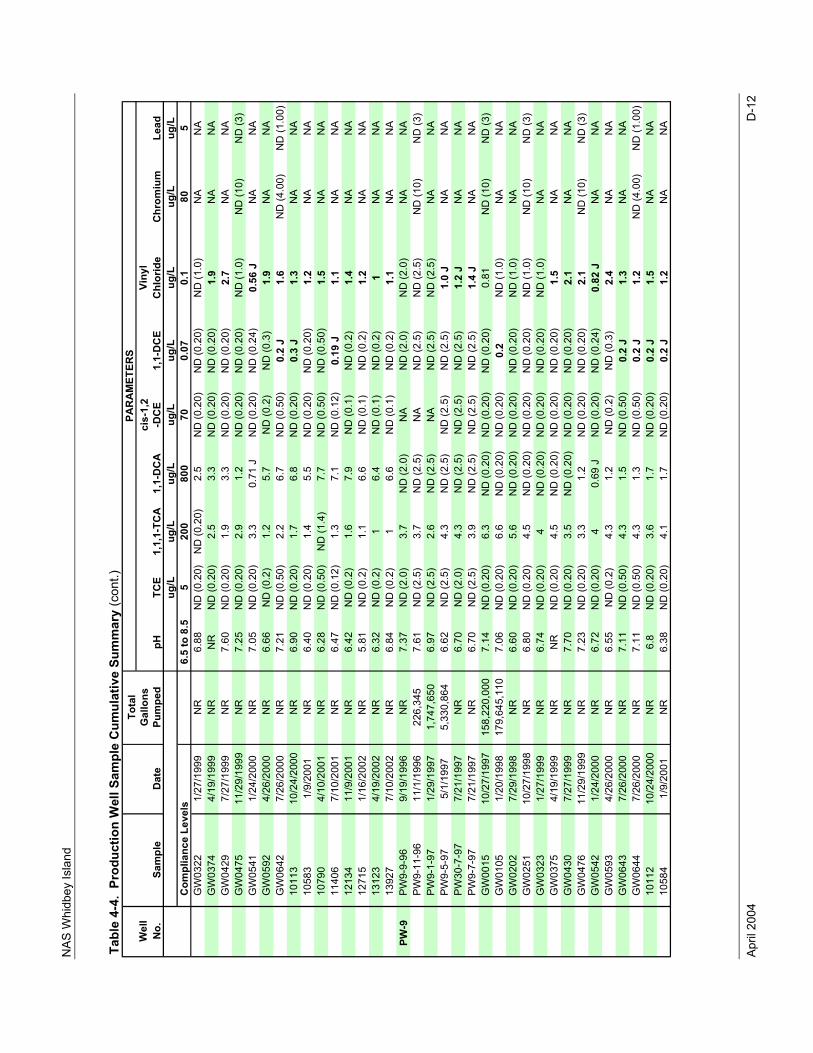
NAS
Whi
dbey
Isla
nd
April
200
4
D-1
2
Wel
lVi
nyl
No.
Chl
orid
eug
/Lug
/Lug
/Lug
/Lug
/Lug
/Lug
/Lug
/LC
ompl
ianc
e Le
vels
6.5
to 8
.55
200
800
700.
070.
180
5G
W03
221/
27/1
999
NR
6.88
ND
(0.2
0)N
D (0
.20)
2.5
ND
(0.2
0)N
D (0
.20)
ND
(1.0
)N
AN
AG
W03
744/
19/1
999
NR
NR
ND
(0.2
0)2.
53.
3N
D (0
.20)
ND
(0.2
0)1.
9N
AN
AG
W04
297/
27/1
999
NR
7.60
ND
(0.2
0)1.
93.
3N
D (0
.20)
ND
(0.2
0)2.
7N
AN
AG
W04
7511
/29/
1999
NR
7.25
ND
(0.2
0)2.
91.
2N
D (0
.20)
ND
(0.2
0)N
D (1
.0)
ND
(10)
ND
(3)
GW
0541
1/24
/200
0N
R7.
05N
D (0
.20)
3.3
0.71
JN
D (0
.20)
ND
(0.2
4)0.
56 J
NA
NA
GW
0592
4/26
/200
0N
R6.
66N
D (0
.2)
1.2
5.7
ND
(0.2
)N
D (0
.3)
1.9
NA
NA
GW
0642
7/26
/200
0N
R7.
21N
D (0
.50)
2.2
6.7
ND
(0.5
0)0.
2 J
1.6
ND
(4.0
0)N
D (1
.00)
1011
310
/24/
2000
NR
6.90
ND
(0.2
0)1.
76.
8N
D (0
.20)
0.3
J1.
3N
AN
A10
583
1/9/
2001
NR
6.40
ND
(0.2
0)1.
45.
5N
D (0
.20)
ND
(0.2
0)1.
2N
AN
A10
790
4/10
/200
1N
R6.
28N
D (0
.50)
ND
(1.4
)7.
7N
D (0
.50)
ND
(0.5
0)1.
5N
AN
A11
406
7/10
/200
1N
R6.
47N
D (0
.12)
1.3
7.1
ND
(0.1
2)0.
19 J
1.1
NA
NA
1213
411
/9/2
001
NR
6.42
ND
(0.2
)1.
67.
9N
D (0
.1)
ND
(0.2
)1.
4N
AN
A12
715
1/16
/200
2N
R5.
81N
D (0
.2)
1.1
6.6
ND
(0.1
)N
D (0
.2)
1.2
NA
NA
1312
34/
19/2
002
NR
6.32
ND
(0.2
)1
6.4
ND
(0.1
)N
D (0
.2)
1N
AN
A13
927
7/10
/200
2N
R6.
84N
D (0
.2)
16.
6N
D (0
.1)
ND
(0.2
)1.
1N
AN
APW
-9PW
9-9-
969/
19/1
996
NR
7.37
ND
(2.0
)3.
7N
D (2
.0)
NA
ND
(2.0
)N
D (2
.0)
NA
NA
PW9-
11-9
611
/1/1
996
226,
345
7.61
ND
(2.5
)3.
7N
D (2
.5)
NA
ND
(2.5
)N
D (2
.5)
ND
(10)
ND
(3)
PW9-
1-97
1/29
/199
71,
747,
650
6.97
ND
(2.5
)2.
6N
D (2
.5)
NA
ND
(2.5
)N
D (2
.5)
NA
NA
PW9-
5-97
5/1/
1997
5,33
0,86
46.
62N
D (2
.5)
4.3
ND
(2.5
)N
D (2
.5)
ND
(2.5
)1.
0 J
NA
NA
PW30
-7-9
77/
21/1
997
NR
6.70
ND
(2.0
)4.
3N
D (2
.5)
ND
(2.5
)N
D (2
.5)
1.2
JN
AN
APW
9-7-
977/
21/1
997
NR
6.70
ND
(2.5
)3.
9N
D (2
.5)
ND
(2.5
)N
D (2
.5)
1.4
JN
AN
AG
W00
1510
/27/
1997
158,
220,
000
7.14
ND
(0.2
0)6.
3N
D (0
.20)
ND
(0.2
0)N
D (0
.20)
0.81
ND
(10)
ND
(3)
GW
0105
1/20
/199
817
9,64
5,11
07.
06N
D (0
.20)
6.6
ND
(0.2
0)N
D (0
.20)
0.2
ND
(1.0
)N
AN
AG
W02
027/
29/1
998
NR
6.60
ND
(0.2
0)5.
6N
D (0
.20)
ND
(0.2
0)N
D (0
.20)
ND
(1.0
)N
AN
AG
W02
5110
/27/
1998
NR
6.80
ND
(0.2
0)4.
5N
D (0
.20)
ND
(0.2
0)N
D (0
.20)
ND
(1.0
)N
D (1
0)N
D (3
)G
W03
231/
27/1
999
NR
6.74
ND
(0.2
0)4
ND
(0.2
0)N
D (0
.20)
ND
(0.2
0)N
D (1
.0)
NA
NA
GW
0375
4/19
/199
9N
RN
RN
D (0
.20)
4.5
ND
(0.2
0)N
D (0
.20)
ND
(0.2
0)1.
5N
AN
AG
W04
307/
27/1
999
NR
7.70
ND
(0.2
0)3.
5N
D (0
.20)
ND
(0.2
0)N
D (0
.20)
2.1
NA
NA
GW
0476
11/2
9/19
99N
R7.
23N
D (0
.20)
3.3
1.2
ND
(0.2
0)N
D (0
.20)
2.1
ND
(10)
ND
(3)
GW
0542
1/24
/200
0N
R6.
72N
D (0
.20)
40.
69 J
ND
(0.2
0)N
D (0
.24)
0.82
JN
AN
AG
W05
934/
26/2
000
NR
6.55
ND
(0.2
)4.
31.
2N
D (0
.2)
ND
(0.3
)2.
4N
AN
AG
W06
437/
26/2
000
NR
7.11
ND
(0.5
0)4.
31.
5N
D (0
.50)
0.2
J1.
3N
AN
AG
W06
447/
26/2
000
NR
7.11
ND
(0.5
0)4.
31.
3N
D (0
.50)
0.2
J1.
2N
D (4
.00)
ND
(1.0
0)10
112
10/2
4/20
00N
R6.
8N
D (0
.20)
3.6
1.7
ND
(0.2
0)0.
2 J
1.5
NA
NA
1058
41/
9/20
01N
R6.
38N
D (0
.20)
4.1
1.7
ND
(0.2
0)0.
2 J
1.2
NA
NA
1,1-
DC
EC
hrom
ium
Lead
Tabl
e 4-
4. P
rodu
ctio
n W
ell S
ampl
e C
umul
ativ
e Su
mm
ary
(con
t.)To
tal
Gal
lons
Pum
ped
PAR
AM
ETER
S
Sam
ple
Dat
epH
TCE
1,1,
1-TC
A1,
1-D
CA
cis-
1,2
-DC
E
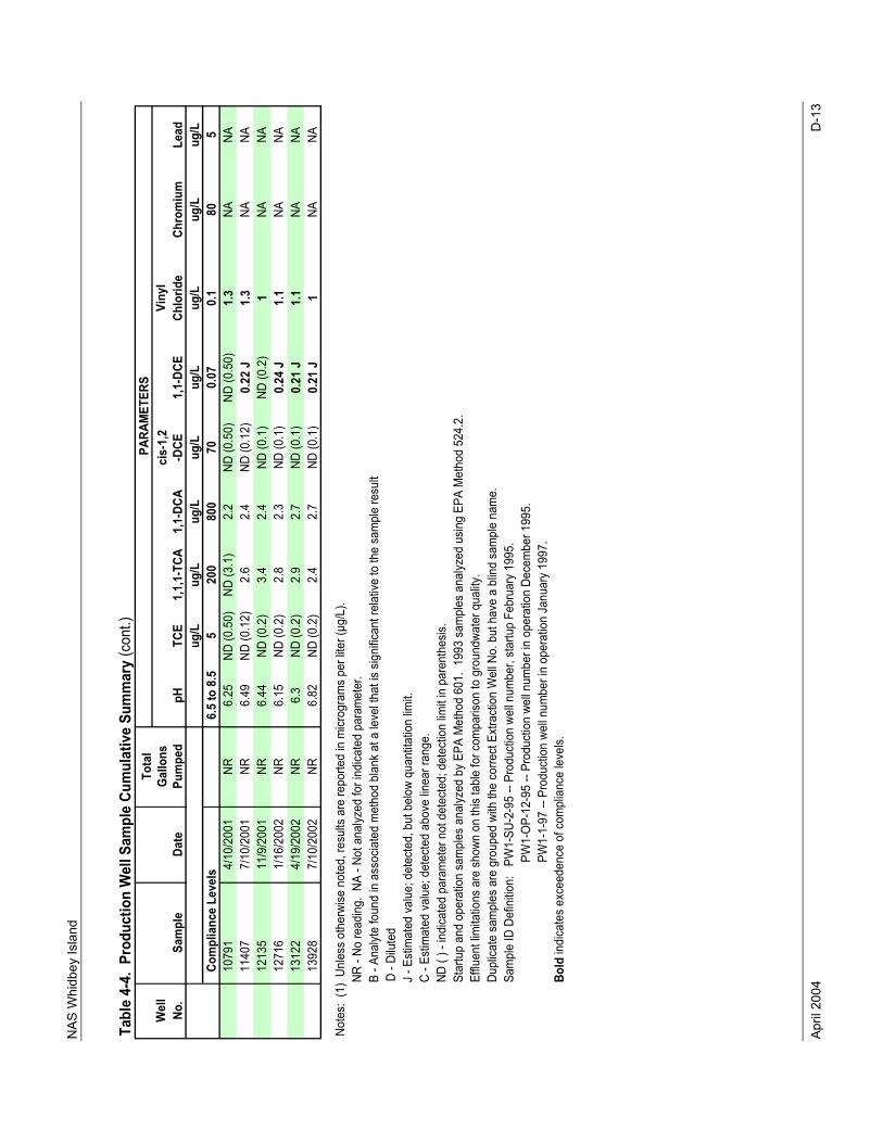
NAS
Whi
dbey
Isla
nd
April
200
4
D-1
3
Wel
lVi
nyl
No.
Chlo
ride
ug/L
ug/L
ug/L
ug/L
ug/L
ug/L
ug/L
ug/L
Com
plia
nce
Leve
ls6.
5 to
8.5
520
080
070
0.07
0.1
805
1079
14/
10/2
001
NR6.
25ND
(0.5
0)ND
(3.1
)2.
2ND
(0.5
0)ND
(0.5
0)1.
3NA
NA11
407
7/10
/200
1NR
6.49
ND (0
.12)
2.6
2.4
ND (0
.12)
0.22
J1.
3NA
NA12
135
11/9
/200
1NR
6.44
ND (0
.2)
3.4
2.4
ND (0
.1)
ND (0
.2)
1NA
NA12
716
1/16
/200
2NR
6.15
ND (0
.2)
2.8
2.3
ND (0
.1)
0.24
J1.
1NA
NA13
122
4/19
/200
2NR
6.3
ND (0
.2)
2.9
2.7
ND (0
.1)
0.21
J1.
1NA
NA13
928
7/10
/200
2NR
6.82
ND (0
.2)
2.4
2.7
ND (0
.1)
0.21
J1
NANA
Note
s: (
1) U
nles
s ot
herw
ise n
oted
, res
ults
are
repo
rted
in m
icrog
ram
s pe
r lite
r (µg
/L).
N
R - N
o re
adin
g. N
A - N
ot a
nalyz
ed fo
r ind
icate
d pa
ram
eter
.
B -
Anal
yte
foun
d in
ass
ocia
ted
met
hod
blan
k at
a le
vel t
hat i
s sig
nific
ant r
elat
ive to
the
sam
ple
resu
ltD
- Dilu
ted
J
- Es
timat
ed v
alue
; det
ecte
d, b
ut b
elow
qua
ntita
tion
limit.
C
- Es
timat
ed v
alue
; det
ecte
d ab
ove
linea
r ran
ge.
N
D ( )
- in
dica
ted
para
met
er n
ot d
etec
ted;
det
ectio
n lim
it in
par
enth
esis.
S
tartu
p an
d op
erat
ion
sam
ples
ana
lyzed
by
EPA
Met
hod
601.
199
3 sa
mpl
es a
nalyz
ed u
sing
EPA
Met
hod
524.
2.
Effl
uent
limita
tions
are
sho
wn o
n th
is ta
ble
for c
ompa
rison
to g
roun
dwat
er q
uality
.
Dup
licat
e sa
mpl
es a
re g
roup
ed w
ith th
e co
rrect
Ext
ract
ion
Wel
l No.
but
hav
e a
blin
d sa
mpl
e na
me.
S
ampl
e ID
Def
initio
n:
PW1-
SU-2
-95
-- Pr
oduc
tion
well n
umbe
r, st
artu
p Fe
brua
ry 1
995.
PW
1-O
P-12
-95
-- Pr
oduc
tion
well n
umbe
r in
oper
atio
n De
cem
ber 1
995.
PW
1-1-
97 --
Pro
duct
ion
well n
umbe
r in
oper
atio
n Ja
nuar
y 19
97.
B
old
indi
cate
s ex
ceed
ence
of c
ompl
ianc
e le
vels.
1,1,
1-TC
A1,
1-DC
Aci
s-1,
2-D
CE1,
1-DC
ECh
rom
ium
Lead
Tabl
e 4-
4. P
rodu
ctio
n W
ell S
ampl
e Cu
mul
ativ
e Su
mm
ary
(con
t.)To
tal
Gallo
nsPu
mpe
d
PARA
MET
ERS
Sam
ple
Date
pHTC
E
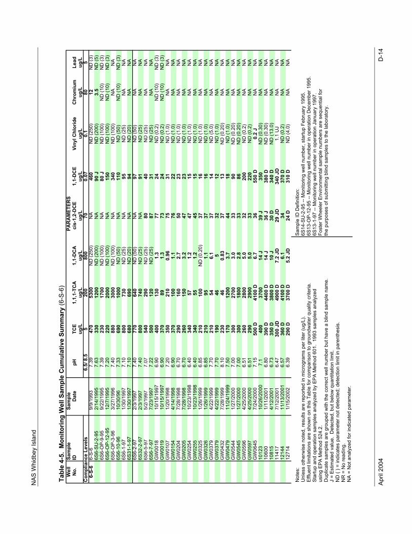
NAS
Whi
dbey
Isla
nd
April
200
4
D-1
4
Tabl
e 4-
5. M
onito
ring
Wel
l Sam
ple
Cum
ulat
ive
Sum
mar
y (6
-S-6
)W
ell
Sam
ple
Sam
ple
No.
IDD
ate
pHTC
E1,
1,1-
TCA
1,1-
DC
Aci
s-1,
2-D
CE
1,1-
DC
EVi
nyl C
hlor
ide
Chr
omiu
mLe
adug
/Lug
/Lug
/Lug
/Lug
/Lug
/Lug
/Lug
/L6.
5/ 8
.55
200
800
700.
070.
180
56-
S-6
6-S-
69/
9/19
937.
3947
053
00N
D (2
50)
NA
460
ND
(250
)12
ND
(3)
6S6-
SU-2
-95
2/14
/199
57.
6333
012
00N
D (2
00)
NA
90 J
ND
(200
)3.
5N
D (5
)6S
6-O
P-9-
959/
22/1
995
7.39
230
1700
ND
(100
)N
A80
JN
D (1
00)
ND
(10)
ND
(3)
6S6-
OP-
12-9
512
/7/1
995
7.20
220
2000
ND
(100
)N
A15
0N
D (1
00)
ND
(10)
ND
(3)
6S6-
OP-
3-96
3/27
/199
67.
4088
030
00N
D (1
00)
NA
340
ND
(100
)N
AN
A6S
6-10
-96
10/3
0/96
7.33
690
1000
ND
(50)
NA
110
ND
(50)
ND
(10)
ND
(3)
6S6-
1-97
1/30
/199
77.
1080
073
0N
D (2
5)N
A95
ND
(25)
NA
NA
6S31
-1-9
71/
30/1
997
7.10
680
690
ND
(20)
NA
94N
D (2
0)N
AN
A6S
6-2-
972/
3/19
977.
4077
064
0N
D (5
0)N
A97
ND
(50)
NA
NA
6S32
-2-9
72/
3/19
977.
4080
074
0N
D (2
5)N
A91
ND
(25)
NA
NA
6S6-
5-97
5/2/
1997
7.07
540
290
ND
(25)
8040
ND
(25)
NA
NA
6S6-
7-97
7/23
/199
77.
2250
012
0N
D (2
5)87
31N
D (2
5)N
AN
AG
W00
1810
/15/
1997
6.90
400
130
1.3
7724
ND
(0.2
)N
D (1
0)N
D (3
)G
W00
1910
/15/
1997
6.90
370
891.
373
24N
D (0
.2)
ND
(10)
ND
(3)
GW
0107
1/20
/199
87.
2035
021
00.
9675
31N
D (1
.0)
NA
NA
GW
0154
4/14
/199
86.
9037
010
01.
176
22N
D (1
.0)
NA
NA
GW
0204
7/28
/199
86.
7029
016
02.
750
23N
D (1
.0)
NA
NA
GW
0205
7/28
/199
86.
7026
015
03.
247
23N
D (1
.0)
NA
NA
GW
0254
10/2
3/19
986.
4034
057
1.2
4715
ND
(1.0
)N
AN
AG
W02
5510
/23/
1998
6.40
340
551.
245
15N
D (1
.0)
NA
NA
GW
0325
1/26
/199
96.
8521
010
0N
D (0
.20)
3716
ND
(1.0
)N
AN
AG
W03
261/
26/1
999
6.85
210
951.
137
16N
D (1
.0)
NA
NA
GW
0379
4/22
/199
97.
7021
054
6.1
3714
ND
(5.0
)N
AN
AG
W03
794/
22/1
999
7.70
190
465
3212
ND
(1.0
)N
AN
AG
W04
327/
28/1
999
8.10
230
460.
8337
13N
D (0
.20)
NA
NA
GW
0479
11/2
4/19
997.
5017
012
003.
744
18N
D (1
.0)
NA
NA
GW
0544
1/27
/200
07.
0030
027
003.
033
90N
D (0
.20)
NA
NA
GW
0545
1/27
/200
07.
0030
018
002.
833
86N
D (0
.20)
NA
NA
GW
0596
4/25
/200
06.
5126
028
005.
032
200
ND
(0.2
)N
AN
AG
W05
974/
25/2
000
6.51
290
2900
5.0
3322
0N
D (0
.2)
NA
NA
GW
0645
7/24
/200
07.
1550
0 D
4100
D6.
736
550
D0.
2 J
NA
NA
1012
310
/26/
2000
7.1
400
3700
14 J
39 J
350
ND
(0.3
0)N
AN
A10
600
1/11
/200
16.
8039
0 D
4400
D14
J36
J38
0 D
ND
(0.3
0)N
AN
A10
815
4/12
/200
16.
7335
0 D
3800
D10
J30
D34
0 D
ND
(13.
0)N
AN
A11
417
7/12
/200
16.
4730
0 JD
4900
D7.
2 JD
29 J
D34
0 JD
1.1
UJ
NA
NA
1214
411
/13/
2001
6.57
360
D41
00 D
6.1
3437
0 D
ND
(0.2
)N
AN
A12
714
1/15
/200
26.
3929
0 D
3700
D5.
2 JD
24 D
310
DN
D (4
.0)
NA
NA
Not
es:
Sam
ple
ID D
efin
ition
: U
nles
s ot
herw
ise
note
d, re
sults
are
repo
rted
in m
icro
gram
s pe
r lite
r (ug
/L).
6S14
-SU
-2-9
5 --
Mon
itorin
g w
ell n
umbe
r, st
artu
p Fe
brua
ry 1
995.
Efflu
ent l
imita
tions
are
sho
wn
on th
is T
able
for c
ompa
rison
to g
roun
dwat
er q
ualit
y cr
iteria
.6S
13-O
P-12
-95
-- M
onito
ring
wel
l num
ber i
n op
erat
ion
Dec
embe
r 199
5.St
artu
p an
d op
erat
ion
sam
ples
ana
lyze
d by
EPA
Met
hod
601.
199
3 sa
mpl
es a
naly
zed
6S13
-1-9
7 --
Mon
itorin
g w
ell n
umbe
r in
oper
atio
n Ja
nuar
y 19
97.
usin
g EP
A M
etho
d 52
4.2.
Fost
er W
heel
er E
nviro
nmen
tal s
ampl
e nu
mbe
rs a
re s
eque
ntia
l for
D
uplic
ate
sam
ples
are
gro
uped
with
the
corre
ct w
ell n
umbe
r but
hav
e a
blin
d sa
mpl
e na
me.
the
purp
oses
of s
ubm
ittin
g bl
ind
sam
ples
to th
e la
bora
tory
.J
= Es
timat
ed v
alue
. D
etec
ted,
but
bel
ow q
uant
itatio
n lim
it.N
D (
) = in
dica
tes
para
met
er n
ot d
etec
ted;
det
ectio
n lim
it in
par
enth
esis
.N
R =
No
read
ing.
N
A =
Not
ana
lyze
d fo
r ind
icat
ed p
aram
eter
.
PAR
AM
ETER
S
Com
plia
nce
Leve
ls
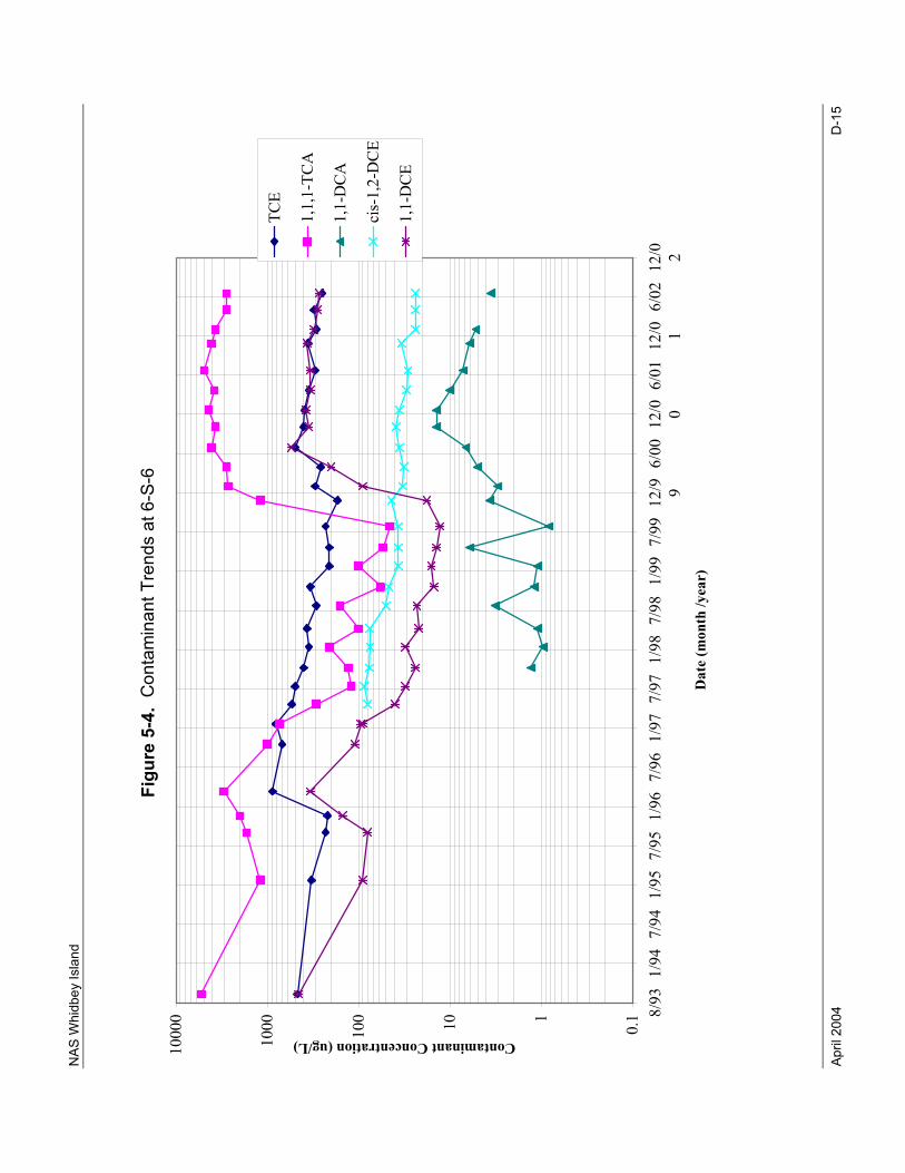
NAS
Whi
dbey
Isla
nd
April
200
4
D-1
5
Figu
re 5
-4.
Con
tam
inan
t Tre
nds
at 6
-S-6
0.1110100
1000
10000 8/93
1/94
7/94
1/95
7/95
1/96
7/96
1/97
7/97
1/98
7/98
1/99
7/99
12/9 96/00
12/0 06/01
12/0 16/02
12/0 2
Dat
e (m
onth
/yea
r)
Contaminant Concentration (ug/L)
TCE
1,1,1-TCA
1,1-DCA
cis-1,2-DCE
1,1-DCE
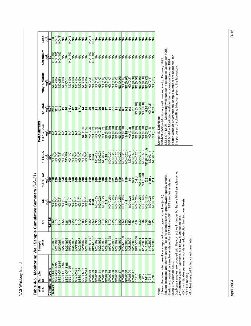
NAS
Whi
dbey
Isla
nd
April
200
4
D-1
6
Tabl
e 4-
5. M
onito
ring
Wel
l Sam
ple
Cum
ulat
ive
Sum
mar
y (6
-S-2
1)W
ell
Sam
ple
Sam
ple
No.
IDD
ate
pHTC
E1,
1,1-
TCA
1,1-
DC
Aci
s-1,
2-D
CE
1,1-
DC
EVi
nyl C
hlor
ide
Chr
omiu
mLe
adug
/Lug
/Lug
/Lug
/Lug
/Lug
/Lug
/Lug
/L6.
5/ 8
.55
200
800
700.
070.
180
56-
S-21
6S21
-SU
-2-9
52/
13/1
995
7.62
ND
(50)
810
ND
(50)
NA
29 J
ND
(50)
ND
(10)
0.8
6S21
-OP-
9-95
9/21
/199
58.
13N
D (5
0)92
0N
D (5
0)N
A32
JN
D (5
0)N
D (1
0)N
D (3
)6S
21-O
P-12
-95
12/1
0/95
7.14
ND
(25)
360
ND
(25)
NA
17 J
ND
(25)
ND
(10)
ND
(3)
6S21
-OP-
3-96
3/27
/199
67.
55N
D (1
0)35
0N
D (1
0)N
A11
ND
(10)
NA
NA
6S21
-OP-
8-96
8/27
/199
67.
012.
8 J
260
ND
(10)
NA
16N
D(1
0)N
AN
A6S
21-1
0-96
10/3
0/96
7.25
ND
(10)
240
ND
(10)
NA
7.9
JN
D (1
0)N
D (1
0)N
D (3
)6S
21-1
-97
1/31
/199
77.
20N
D (1
0)36
0N
D (1
0)N
A12
ND
(10)
NA
NA
6S21
-2-9
72/
3/19
977.
10N
D (1
0)34
0N
D (1
0)N
A10
ND
(10)
NA
NA
6S30
-1-9
71/
30/1
997
7.10
ND
(10)
160
ND
(10)
NA
8.7
JN
D (1
0)N
AN
A6S
21-5
-97
5/2/
1997
6.80
ND
(10)
290
ND
(10)
ND
(10)
14N
D (1
0)N
AN
A6S
21-7
-97
7/23
/199
77.
30N
D (1
0)24
0N
D (1
0)N
D (1
0)15
ND
(10)
NA
NA
GW
0028
10/1
4/19
977.
500.
2631
00.
64N
D (0
.2)
20N
D (0
.2)
ND
(10)
ND
(3)
GW
0029
10/1
4/19
977.
500.
2833
00.
64N
D (0
.2)
20N
D (0
.2)
ND
(10)
ND
(3)
GW
0110
1/20
/199
87.
30N
D (0
.2)
360
ND
(0.2
)N
D (0
.2)
21N
D (1
.0)
NA
NA
GW
0111
1/20
/199
87.
30N
D (0
.2)
340
ND
(0.2
)N
D (0
.2)
20N
D (1
.0)
NA
NA
GW
0159
4/14
/199
87.
10N
D (0
.2)
380
ND
(0.2
)N
D (0
.2)
18N
D (1
.0)
NA
NA
GW
0209
7/29
/199
86.
902.
130
00.
25N
D (0
.20)
17N
D (1
.0)
NA
NA
GW
0266
10/2
6/19
986.
70N
D (0
.20)
310
ND
(0.2
0)N
D (0
.20)
11N
D (1
.0)
NA
NA
GW
0330
1/25
/199
97.
25N
D (0
.20)
82N
D (0
.20)
ND
(0.2
0)7.
5N
D (1
.0)
NA
NA
GW
0386
4/22
/199
98.
10N
D (0
.20)
120
ND
(0.2
0)N
D (0
.20)
11N
D (1
.0)
NA
NA
GW
0437
7/28
/199
98.
00N
D (0
.20)
110
ND
(0.2
0)N
D (0
.20)
9.9
ND
(0.2
0)N
AN
AG
W04
9011
/24/
1999
7.50
ND
(0.2
0)87
ND
(0.2
0)N
D (0
.20)
8.0
ND
(1.0
)N
AN
AG
W05
501/
27/2
000
7.20
4.9
110
ND
(0.2
0)0.
28 J
9.2
ND
(0.2
0)N
AN
AG
W06
044/
28/2
000
6.50
ND
(0.2
)84
ND
(0.1
)N
D (0
.2)
9.7
ND
(0.2
)N
AN
AG
W06
477/
25/2
000
6.97
ND
(0.5
0)92
DN
D (0
.50)
ND
(0.5
0)7.
3N
D (0
.50)
NA
NA
1011
510
/25/
2000
6.6
ND
(0.2
0)0.
4 J
ND
(0.2
0)N
D (0
.20)
ND
(0.1
0)N
D (0
.30)
NA
NA
1059
61/
11/2
001
6.30
ND
(0.2
0)N
D (0
.20)
ND
(0.1
0)N
D (0
.20)
ND
(0.2
0)N
D (0
.30)
NA
NA
1081
24/
12/2
001
6.34
ND
(0.5
0)N
D (0
.50)
ND
(0.5
0)N
D (0
.50)
ND
(0.5
0)N
D (0
.50)
NA
NA
1141
57/
11/2
001
6.58
ND
(0.1
2)2.
8N
D (0
.091
U)
ND
(0.1
2)0.
64N
D (0
.22)
NA
NA
1211
711
/7/2
001
6.54
ND
(0.2
)0.
39 J
ND
(0.1
)N
D (0
.1)
ND
(0.2
)N
D (0
.1)
NA
NA
1270
31/
14/2
002
6.25
ND
(0.2
)2.
1N
D (0
.1)
ND
(0.1
)0.
31 J
ND
(0.2
)N
AN
A
Not
es:
Sam
ple
ID D
efin
ition
: U
nles
s ot
herw
ise
note
d, re
sults
are
repo
rted
in m
icro
gram
s pe
r lite
r (ug
/L).
6S14
-SU
-2-9
5 --
Mon
itorin
g w
ell n
umbe
r, st
artu
p Fe
brua
ry 1
995.
Efflu
ent l
imita
tions
are
sho
wn
on th
is T
able
for c
ompa
rison
to g
roun
dwat
er q
ualit
y cr
iteria
.6S
13-O
P-12
-95
-- M
onito
ring
wel
l num
ber i
n op
erat
ion
Dec
embe
r 199
5.St
artu
p an
d op
erat
ion
sam
ples
ana
lyze
d by
EPA
Met
hod
601.
199
3 sa
mpl
es a
naly
zed
6S13
-1-9
7 --
Mon
itorin
g w
ell n
umbe
r in
oper
atio
n Ja
nuar
y 19
97.
usin
g EP
A M
etho
d 52
4.2.
Fost
er W
heel
er E
nviro
nmen
tal s
ampl
e nu
mbe
rs a
re s
eque
ntia
l for
D
uplic
ate
sam
ples
are
gro
uped
with
the
corre
ct w
ell n
umbe
r but
hav
e a
blin
d sa
mpl
e na
me.
the
purp
oses
of s
ubm
ittin
g bl
ind
sam
ples
to th
e la
bora
tory
.J
= Es
timat
ed v
alue
. D
etec
ted,
but
bel
ow q
uant
itatio
n lim
it.N
D (
) = in
dica
tes
para
met
er n
ot d
etec
ted;
det
ectio
n lim
it in
par
enth
esis
.N
R =
No
read
ing.
N
A =
Not
ana
lyze
d fo
r ind
icat
ed p
aram
eter
.
PAR
AM
ETER
S
Com
plia
nce
Leve
ls
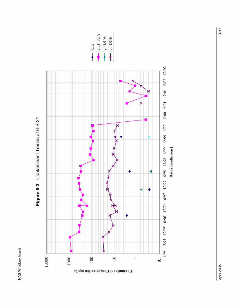
NAS
Whi
dbey
Isla
nd
April
200
4
D-1
7
Figu
re 5
-3.
Con
tam
inan
t Tre
nds
at 6
-S-2
1
0.1110100
1000
10000 1/95
7/95
12/956/96
12/966/97
12/976/98
12/986/99
12/996/00
12/006/01
12/016/02
12/02
Dat
e (m
onth
/yea
r)
Contaminant Concentration (ug/L)
TCE
1,1,1-TCA
1,1-DCA
1,1-DCE
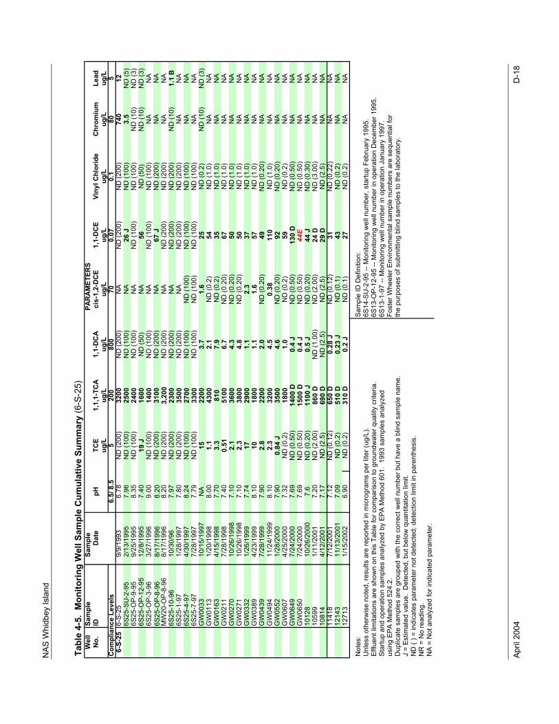
NAS
Whi
dbey
Isla
nd
April
200
4
D-1
8
Tabl
e 4-
5. M
onito
ring
Wel
l Sam
ple
Cum
ulat
ive
Sum
mar
y (6
-S-2
5)W
ell
Sam
ple
Sam
ple
No.
IDD
ate
pHTC
E1,
1,1-
TCA
1,1-
DCA
cis-
1,2-
DC
E1,
1-D
CE
Viny
l Chl
orid
eCh
rom
ium
Lead
ug/L
ug/L
ug/L
ug/L
ug/L
ug/L
ug/L
ug/L
6.5/
8.5
520
080
070
0.07
0.1
805
6-S-
256-
S-25
9/9/
1993
6.78
ND
(200
)32
00N
D (2
00)
NA
ND
(200
)N
D (2
00)
740
126S
25-S
U-2
-95
2/13
/199
57.
96N
D (1
00)
2500
ND
(100
)N
A26
JN
D (1
00)
3.5
ND
(5)
6S25
-OP-
9-95
9/25
/199
58.
35N
D (1
00)
2400
ND
(100
)N
AN
D (1
00)
ND
(100
)N
D (1
0)N
D (3
)6S
25-O
P-12
-95
12/8
/199
57.
4019
J16
00N
D (5
0)N
A56
ND
(50)
ND
(10)
ND
(3)
6S25
-OP-
3-96
3/27
/199
69.
00N
D (1
00)
1400
ND
(100
)N
AN
D (1
00)
ND
(100
)N
AN
A6S
25-O
P-8-
968/
17/1
996
8.20
ND
(200
)31
00N
D (2
00)
NA
67 J
ND
(200
)N
AN
AM
W20
-OP-
8-96
8/17
/199
68.
20N
D (2
00)
3,20
0N
D (2
00)
NA
ND
(200
)N
D (2
00)
NA
NA
6S25
-10-
9610
/30/
967.
97N
D (2
00)
2300
ND
(200
)N
AN
D (2
00)
ND
(200
)N
D (1
0)1.
1 B
6S25
-1-9
71/
28/1
997
7.80
ND
(200
)35
00N
D (2
00)
NA
ND
(200
)N
D (2
00)
NA
NA
6S25
-4-9
74/
30/1
997
8.24
ND
(100
)27
00N
D (1
00)
ND
(100
)N
D (1
00)
ND
(100
)N
AN
A6S
25-7
-97
7/28
/199
77.
79N
D (1
00)
3300
ND
(100
)N
D (1
00)
ND
(100
)N
D (1
00)
NA
NA
GW
0033
10/1
5/19
97N
A15
2200
3.7
1.6
25N
D (0
.2)
ND
(10)
ND
(3)
GW
0113
1/20
/199
88.
001.
143
002.
1N
D (0
.2)
54N
D (1
.0)
NA
NA
GW
0163
4/15
/199
87.
703.
381
07.
9N
D (0
.2)
35N
D (1
.0)
NA
NA
GW
0211
7/28
/199
87.
400.
5151
006.
7N
D (0
.20)
67N
D (1
.0)
NA
NA
GW
0270
10/2
6/19
987.
102.
136
004.
3N
D (0
.20)
50N
D (1
.0)
NA
NA
GW
0271
10/2
6/19
987.
102.
338
004.
8N
D (0
.20)
50N
D (1
.0)
NA
NA
GW
0332
1/26
/199
97.
7417
2900
1.1
2.3
37N
D (1
.0)
NA
NA
GW
0389
4/23
/199
98.
1010
1800
1.1
1.6
57N
D (1
.0)
NA
NA
GW
0439
7/28
/199
97.
902.
822
002.
0N
D (0
.20)
49N
D (0
.20)
NA
NA
GW
0494
11/2
4/19
998.
102.
332
004.
50.
3811
0N
D (1
.0)
NA
NA
GW
0552
1/28
/200
07.
900.
84 J
3500
4.6
ND
(0.2
0)92
ND
(0.2
0)N
AN
AG
W06
074/
25/2
000
7.32
ND
(0.2
)18
001.
0N
D (0
.2)
59N
D (0
.2)
NA
NA
GW
0649
7/24
/200
07.
69N
D (0
.50)
1400
D0.
4 J
ND
(0.5
0)13
0 D
ND
(0.5
0)N
AN
AG
W06
507/
24/2
000
7.69
ND
(0.5
0)15
00 D
0.4
JN
D (0
.50)
44E
ND
(0.5
0)N
AN
A10
128
10/2
6/20
007.
6N
D (0
.20)
1100
J0.
5 J
ND
(0.2
0)44
JN
D (0
.30)
NA
NA
1059
91/
11/2
001
7.20
ND
(2.0
0)86
0 D
ND
(1.0
0)N
D (2
.00)
24 D
ND
(3.0
0)N
AN
A10
814
4/12
/200
17.
17N
D (2
.5)
690
DN
D (2
.5)
ND
(2.5
)29
DN
D (2
.5)
NA
NA
1141
87/
12/2
001
7.12
ND
(0.1
2)65
0 D
0.28
JN
D (0
.12)
31N
D (0
.22)
NA
NA
1214
311
/13/
2001
7.09
ND
(0.2
)51
0 D
0.23
JN
D (0
.1)
43N
D (0
.2)
NA
NA
1271
31/
15/2
002
6.90
ND
(0.2
)31
0 D
0.2
JN
D (0
.1)
27N
D (0
.2)
NA
NA
Not
es:
Sam
ple
ID D
efin
ition
: U
nles
s ot
herw
ise
note
d, re
sults
are
repo
rted
in m
icro
gram
s pe
r lite
r (ug
/L).
6S14
-SU
-2-9
5 --
Mon
itorin
g w
ell n
umbe
r, st
artu
p Fe
brua
ry 1
995.
Efflu
ent l
imita
tions
are
sho
wn
on th
is T
able
for c
ompa
rison
to g
roun
dwat
er q
ualit
y cr
iteria
.6S
13-O
P-12
-95
-- M
onito
ring
wel
l num
ber i
n op
erat
ion
Dec
embe
r 199
5.St
artu
p an
d op
erat
ion
sam
ples
ana
lyze
d by
EPA
Met
hod
601.
199
3 sa
mpl
es a
naly
zed
6S13
-1-9
7 --
Mon
itorin
g w
ell n
umbe
r in
oper
atio
n Ja
nuar
y 19
97.
usin
g EP
A M
etho
d 52
4.2.
Fost
er W
heel
er E
nviro
nmen
tal s
ampl
e nu
mbe
rs a
re s
eque
ntia
l for
D
uplic
ate
sam
ples
are
gro
uped
with
the
corre
ct w
ell n
umbe
r but
hav
e a
blin
d sa
mpl
e na
me.
the
purp
oses
of s
ubm
ittin
g bl
ind
sam
ples
to th
e la
bora
tory
.J
= Es
timat
ed v
alue
. D
etec
ted,
but
bel
ow q
uant
itatio
n lim
it.N
D (
) = in
dica
tes
para
met
er n
ot d
etec
ted;
det
ectio
n lim
it in
par
enth
esis
.N
R =
No
read
ing.
N
A =
Not
ana
lyze
d fo
r ind
icat
ed p
aram
eter
.
PAR
AM
ETER
S
Com
plia
nce
Leve
ls
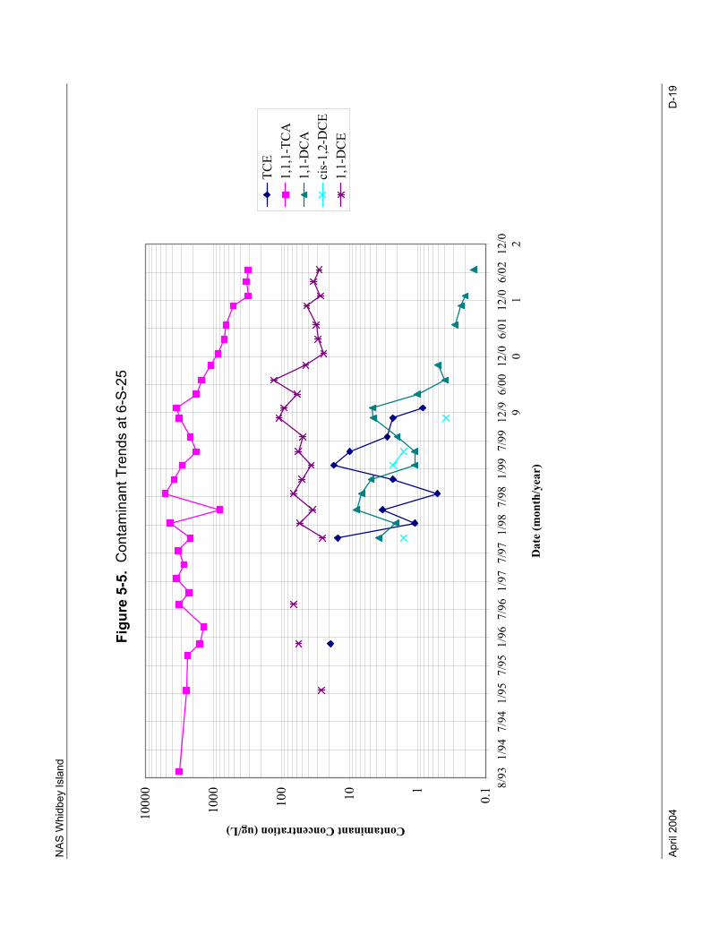
NAS
Whi
dbey
Isla
nd
April
200
4
D-1
9
Figu
re 5
-5.
Con
tam
inan
t Tre
nds
at 6
-S-2
5
0.1110100
1000
10000 8/93
1/94
7/94
1/95
7/95
1/96
7/96
1/97
7/97
1/98
7/98
1/99
7/99
12/9 96/00
12/0 06/01
12/0 16/02
12/0 2
Dat
e (m
onth
/yea
r)
Contaminant Concentration (ug/L)
TCE
1,1,1-TCA
1,1-DCA
cis-1,2-DCE
1,1-DCE
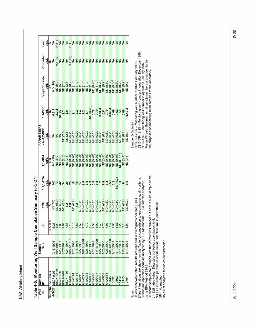
NAS
Whi
dbey
Isla
nd
April
200
4
D-2
0
Tabl
e 4-
5. M
onito
ring
Wel
l Sam
ple
Cum
ulat
ive
Sum
mar
y (6
-S-2
7)W
ell
Sam
ple
Sam
ple
No.
IDD
ate
pHTC
E1,
1,1-
TCA
1,1-
DC
Aci
s-1,
2-D
CE
1,1-
DC
EVi
nyl C
hlor
ide
Chro
miu
mLe
adug
/Lug
/Lug
/Lug
/Lug
/Lug
/Lug
/Lug
/L6.
5/ 8
.55
200
800
700.
070.
180
56-
S-27
6S27
-9-9
69/
16/1
996
8.26
ND
(10)
140
ND
(10)
NA
4.7
JN
D (1
0)N
AN
A6S
27-1
0-96
10/3
1/96
8.01
ND
(5.0
)73
ND
(5.0
)N
A3.
2 J
ND
(5.0
)N
D (1
0)N
D (3
)6S
27-1
-97
1/28
/199
77.
80N
D (5
.0)
42N
D (5
.0)
NA
ND
(5.0
)N
D (5
.0)
NA
NA
6S27
-5-9
75/
2/19
977.
81N
D (2
.5)
34N
D (2
.5)
ND
(2.5
)2.
7N
D (2
.5)
NA
NA
6S27
-7-9
77/
24/1
997
7.65
1.2
20N
D (2
.5)
ND
(2.5
)1.
9N
D (2
.5)
NA
NA
GW
0035
10/2
7/19
978.
101.
025
ND
(0.2
0)N
D (0
.20)
3.7
ND
(0.2
)N
D (1
0)N
D (3
)G
W01
141/
20/1
998
8.10
ND
(0.2
)18
ND
(0.2
0)N
D (0
.20)
2.1
ND
(1.0
)N
AN
AG
W01
644/
16/1
998
7.80
4.2
19N
D (0
.20)
ND
(0.2
0)2.
2N
D (1
.0)
NA
NA
GW
0212
7/27
/199
87.
50N
D (0
.20)
17N
D (0
.20)
ND
(0.2
0)1.
4N
D (1
.0)
NA
NA
GW
0273
10/2
3/19
987.
20N
D (0
.20)
9.8
ND
(0.2
0)N
D (0
.20)
1.2
ND
(1.0
)N
AN
A
GW
0333
1/26
/199
97.
72N
D (0
.20)
6.5
ND
(0.2
0)N
D (0
.20)
1.1
ND
(1.0
)N
AN
A
GW
0390
4/20
/199
97.
70N
D (0
.20)
2.3
ND
(0.2
0)N
D (0
.20)
ND
(0.2
0)N
D (1
.0)
NA
NA
G
W04
407/
26/1
999
7.50
ND
(0.2
0)5.
8N
D (0
.20)
ND
(0.2
0)0.
78N
D (0
.20)
NA
NA
G
W04
9711
/19/
1999
8.00
ND
(0.2
0)6.
8N
D (0
.20)
ND
(0.2
0)0.
79N
D (1
.0)
NA
NA
G
W05
531/
27/2
000
7.40
ND
(0.2
0)8.
2N
D (0
.20)
ND
(0.2
0)0.
94 J
ND
(0.2
0)N
AN
AG
W06
084/
25/2
000
7.23
ND
(0.2
)7.
8N
D (0
.2)
ND
(0.2
)0.
8N
D (0
.2)
NA
NA
GW
0651
7/25
/200
07.
93N
D (0
.50)
6.3
ND
(0.5
0)N
D (0
.50)
0.79
ND
(0.5
0)N
AN
A10
145
10/3
1/20
007.
6N
D (0
.20)
5.5
JN
D (0
.20)
ND
(0.2
0)0.
69 J
ND
(0.3
0)N
AN
A10
592
1/10
/200
17.
00N
D (0
.20)
5.2
ND
(0.1
0)N
D (0
.20)
0.69
ND
(0.3
0)N
AN
A10
802
4/11
/200
16.
67N
D (0
.50)
ND
(4.7
)N
D (0
.50)
ND
(0.5
0)0.
62N
D (0
.50)
NA
NA
1141
27/
11/2
001
7.23
ND
(0.1
2)5.
3N
D (0
.091
)N
D (0
.12)
0.59
ND
(0.2
2)N
AN
A12
115
11/6
/200
17.
2N
D (0
.2)
9N
D (0
.1)
ND
(0.1
)0.
88N
D (0
.2)
NA
NA
1270
41/
14/2
002
6.91
ND
(0.2
)5.
5N
D (0
.1)
ND
(0.1
)0.
49 J
ND
(0.2
)N
AN
A
Not
es:
Sam
ple
ID D
efin
ition
: U
nles
s ot
herw
ise
note
d, re
sults
are
repo
rted
in m
icro
gram
s pe
r lite
r (ug
/L).
6S14
-SU
-2-9
5 --
Mon
itorin
g w
ell n
umbe
r, st
artu
p Fe
brua
ry 1
995.
Efflu
ent l
imita
tions
are
sho
wn
on th
is T
able
for c
ompa
rison
to g
roun
dwat
er q
ualit
y cr
iteria
.6S
13-O
P-12
-95
-- M
onito
ring
wel
l num
ber i
n op
erat
ion
Dec
embe
r 199
5.St
artu
p an
d op
erat
ion
sam
ples
ana
lyze
d by
EPA
Met
hod
601.
199
3 sa
mpl
es a
naly
zed
6S13
-1-9
7 --
Mon
itorin
g w
ell n
umbe
r in
oper
atio
n Ja
nuar
y 19
97.
usin
g EP
A M
etho
d 52
4.2.
Fost
er W
heel
er E
nviro
nmen
tal s
ampl
e nu
mbe
rs a
re s
eque
ntia
l for
D
uplic
ate
sam
ples
are
gro
uped
with
the
corre
ct w
ell n
umbe
r but
hav
e a
blin
d sa
mpl
e na
me.
the
purp
oses
of s
ubm
ittin
g bl
ind
sam
ples
to th
e la
bora
tory
.J
= Es
timat
ed v
alue
. D
etec
ted,
but
bel
ow q
uant
itatio
n lim
it.N
D (
) = in
dica
tes
para
met
er n
ot d
etec
ted;
det
ectio
n lim
it in
par
enth
esis
.N
R =
No
read
ing.
N
A =
Not
ana
lyze
d fo
r ind
icat
ed p
aram
eter
.
PAR
AM
ETER
S
Com
plia
nce
Leve
ls
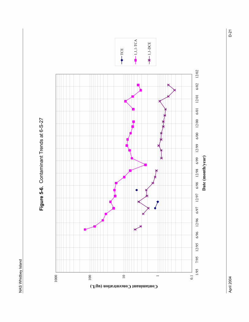
NAS
Whi
dbey
Isla
nd
April
200
4
D-2
1
Figu
re 5
-6.
Con
tam
inan
t Tre
nds
at 6
-S-2
7
0.1110100
1000
1/95
7/95
12/95
6/96
12/96
6/97
12/97
6/98
12/98
6/99
12/99
6/00
12/00
6/01
12/01
6/02
12/02
Dat
e (m
onth
/yea
r)
Contaminant Concentration (ug/L)
TCE
1,1,1-TCA
1,1-DCE
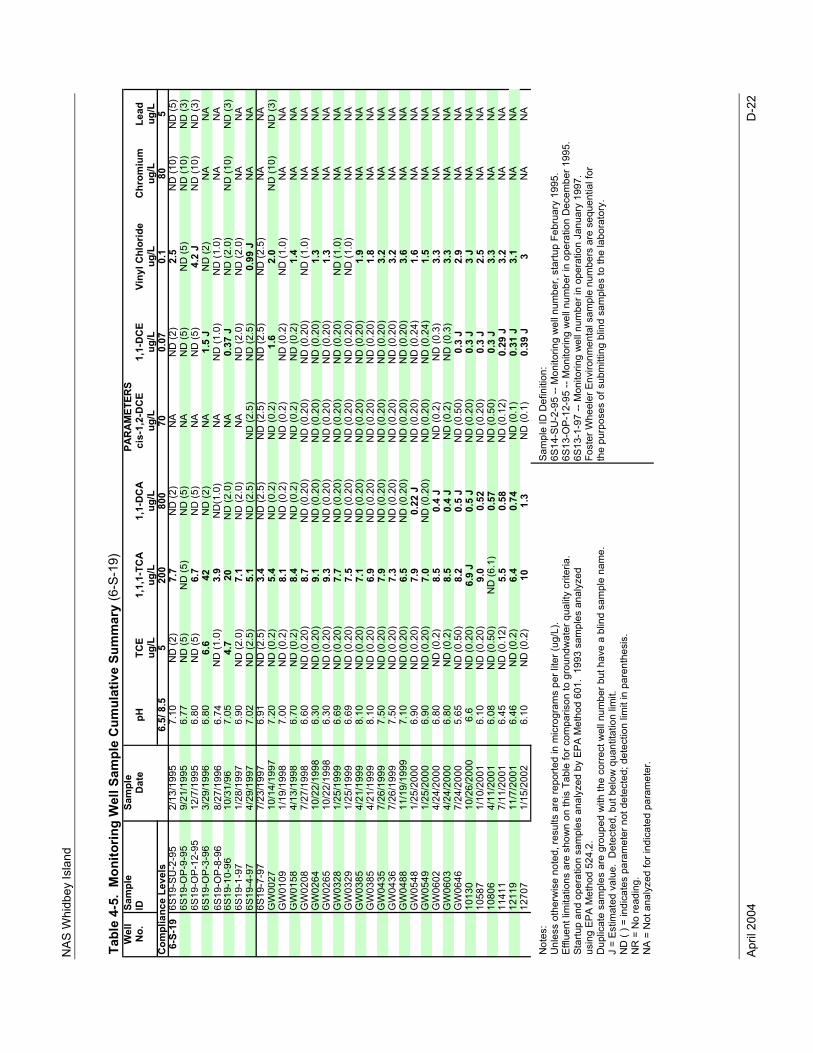
NAS
Whi
dbey
Isla
nd
April
200
4
D-2
2
Tabl
e 4-
5. M
onito
ring
Wel
l Sam
ple
Cum
ulat
ive
Sum
mar
y (6
-S-1
9)W
ell
Sam
ple
Sam
ple
No.
IDD
ate
pHTC
E1,
1,1-
TCA
1,1-
DCA
cis-
1,2-
DC
E1,
1-D
CE
Viny
l Chl
orid
eCh
rom
ium
Lead
ug/L
ug/L
ug/L
ug/L
ug/L
ug/L
ug/L
ug/L
6.5/
8.5
520
080
070
0.07
0.1
805
6-S-
196S
19-S
U-2
-95
2/13
/199
57.
10N
D (2
)7.
7N
D (2
)N
AN
D (2
)2.
5N
D (1
0)N
D (5
)6S
19-O
P-9-
959/
21/1
995
6.77
ND
(5)
ND
(5)
ND
(5)
NA
ND
(5)
ND
(5)
ND
(10)
ND
(3)
6S19
-OP-
12-9
512
/7/1
995
6.80
ND
(5)
6.7
ND
(5)
NA
ND
(5)
4.2
JN
D (1
0)N
D (3
)6S
19-O
P-3-
963/
29/1
996
6.80
6.6
42N
D (2
)N
A1.
5 J
ND
(2)
NA
NA
6S19
-OP-
8-96
8/27
/199
66.
74N
D (1
.0)
3.9
ND
(1.0
)N
AN
D (1
.0)
ND
(1.0
)N
AN
A6S
19-1
0-96
10/3
1/96
7.05
4.7
20N
D (2
.0)
NA
0.37
JN
D (2
.0)
ND
(10)
ND
(3)
6S19
-1-9
71/
28/1
997
6.90
ND
(2.0
)7.
1N
D (2
.0)
NA
ND
(2.0
)N
D (2
.0)
NA
NA
6S19
-4-9
74/
29/1
997
7.02
ND
(2.5
)5.
1N
D (2
.5)
ND
(2.5
)N
D (2
.5)
0.99
JN
AN
A6S
19-7
-97
7/23
/199
76.
91N
D (2
.5)
3.4
ND
(2.5
)N
D (2
.5)
ND
(2.5
)N
D (2
.5)
NA
NA
GW
0027
10/1
4/19
977.
20N
D (0
.2)
5.4
ND
(0.2
)N
D (0
.2)
1.6
2.0
ND
(10)
ND
(3)
GW
0109
1/19
/199
87.
00N
D (0
.2)
8.1
ND
(0.2
)N
D (0
.2)
ND
(0.2
)N
D (1
.0)
NA
NA
GW
0158
4/13
/199
86.
70N
D (0
.2)
8.4
ND
(0.2
)N
D (0
.2)
ND
(0.2
)1.
4N
AN
AG
W02
087/
27/1
998
6.60
ND
(0.2
0)8.
7N
D (0
.20)
ND
(0.2
0)N
D (0
.20)
ND
(1.0
)N
AN
AG
W02
6410
/22/
1998
6.30
ND
(0.2
0)9.
1N
D (0
.20)
ND
(0.2
0)N
D (0
.20)
1.3
NA
NA
GW
0265
10/2
2/19
986.
30N
D (0
.20)
9.3
ND
(0.2
0)N
D (0
.20)
ND
(0.2
0)1.
3N
AN
AG
W03
281/
25/1
999
6.69
ND
(0.2
0)7.
7N
D (0
.20)
ND
(0.2
0)N
D (0
.20)
ND
(1.0
)N
AN
AG
W03
291/
25/1
999
6.69
ND
(0.2
0)7.
5N
D (0
.20)
ND
(0.2
0)N
D (0
.20)
ND
(1.0
)N
AN
AG
W03
854/
21/1
999
8.10
ND
(0.2
0)7.
1N
D (0
.20)
ND
(0.2
0)N
D (0
.20)
1.9
NA
NA
GW
0385
4/21
/199
98.
10N
D (0
.20)
6.9
ND
(0.2
0)N
D (0
.20)
ND
(0.2
0)1.
8N
AN
AG
W04
357/
26/1
999
7.50
ND
(0.2
0)7.
9N
D (0
.20)
ND
(0.2
0)N
D (0
.20)
3.2
NA
NA
GW
0436
7/26
/199
97.
50N
D (0
.20)
7.3
ND
(0.2
0)N
D (0
.20)
ND
(0.2
0)3.
2N
AN
AG
W04
8811
/19/
1999
7.10
ND
(0.2
0)6.
5N
D (0
.20)
ND
(0.2
0)N
D (0
.20)
3.6
NA
NA
GW
0548
1/25
/200
06.
90N
D (0
.20)
7.9
0.22
JN
D (0
.20)
ND
(0.2
4)1.
6N
AN
AG
W05
491/
25/2
000
6.90
ND
(0.2
0)7.
0N
D (0
.20)
ND
(0.2
0)N
D (0
.24)
1.5
NA
NA
GW
0602
4/24
/200
06.
80N
D (0
.2)
8.5
0.4
JN
D (0
.2)
ND
(0.3
)3.
3N
AN
AG
W06
034/
24/2
000
6.80
ND
(0.2
)8.
50.
4 J
ND
(0.2
)N
D (0
.3)
3.3
NA
NA
GW
0646
7/24
/200
05.
65N
D (0
.50)
8.2
0.5
JN
D (0
.50)
0.3
J2.
9N
AN
A10
130
10/2
6/20
006.
6N
D (0
.20)
6.9
J0.
5 J
ND
(0.2
0)0.
3 J
3 J
NA
NA
1058
71/
10/2
001
6.10
ND
(0.2
0)9.
00.
52N
D (0
.20)
0.3
J2.
5N
AN
A10
806
4/11
/200
16.
08N
D (0
.50)
ND
(6.1
)0.
57N
D (0
.50)
0.3
J3.
3N
AN
A11
411
7/11
/200
16.
45N
D (0
.12)
5.5
0.58
ND
(0.1
2)0.
29 J
3.2
NA
NA
1211
911
/7/2
001
6.46
ND
(0.2
)6.
40.
74N
D (0
.1)
0.31
J3.
1N
AN
A12
707
1/15
/200
26.
10N
D (0
.2)
101.
3N
D (0
.1)
0.39
J3
NA
NA
Not
es:
Sam
ple
ID D
efin
ition
: U
nles
s ot
herw
ise
note
d, re
sults
are
repo
rted
in m
icro
gram
s pe
r lite
r (ug
/L).
6S14
-SU
-2-9
5 --
Mon
itorin
g w
ell n
umbe
r, st
artu
p Fe
brua
ry 1
995.
Efflu
ent l
imita
tions
are
sho
wn
on th
is T
able
for c
ompa
rison
to g
roun
dwat
er q
ualit
y cr
iteria
.6S
13-O
P-12
-95
-- M
onito
ring
wel
l num
ber i
n op
erat
ion
Dec
embe
r 199
5.St
artu
p an
d op
erat
ion
sam
ples
ana
lyze
d by
EPA
Met
hod
601.
199
3 sa
mpl
es a
naly
zed
6S13
-1-9
7 --
Mon
itorin
g w
ell n
umbe
r in
oper
atio
n Ja
nuar
y 19
97.
usin
g EP
A M
etho
d 52
4.2.
Fost
er W
heel
er E
nviro
nmen
tal s
ampl
e nu
mbe
rs a
re s
eque
ntia
l for
D
uplic
ate
sam
ples
are
gro
uped
with
the
corre
ct w
ell n
umbe
r but
hav
e a
blin
d sa
mpl
e na
me.
the
purp
oses
of s
ubm
ittin
g bl
ind
sam
ples
to th
e la
bora
tory
.J
= Es
timat
ed v
alue
. D
etec
ted,
but
bel
ow q
uant
itatio
n lim
it.N
D (
) = in
dica
tes
para
met
er n
ot d
etec
ted;
det
ectio
n lim
it in
par
enth
esis
.N
R =
No
read
ing.
N
A =
Not
ana
lyze
d fo
r ind
icat
ed p
aram
eter
.
PAR
AM
ETER
S
Com
plia
nce
Leve
ls
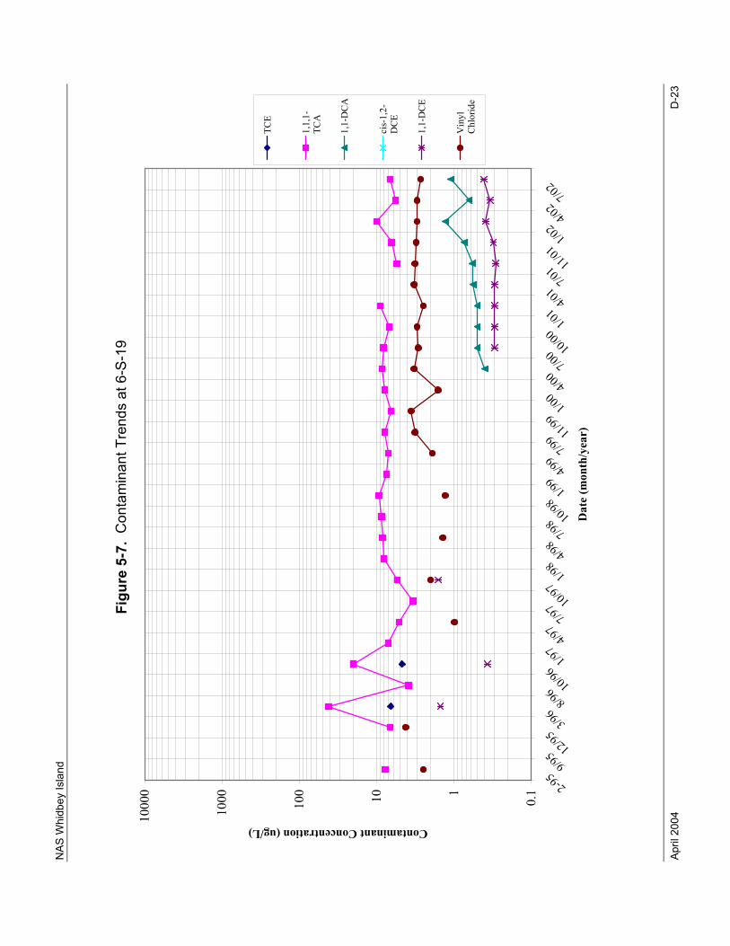
NAS
Whi
dbey
Isla
nd
April
200
4
D-2
3
Figu
re 5
-7.
Con
tam
inan
t Tre
nds
at 6
-S-1
9
0.1110100
1000
10000 2-9
59/9
5 12/953/9
68/9
6 10/961/9
74/9
77/9
7 10/971/9
84/9
87/9
8 10/981/9
94/9
97/9
9 11/991/0
04/0
07/0
0 10/001/0
14/0
17/0
1 11/011/0
24/0
27/0
2
Dat
e (m
onth
/yea
r)
Contaminant Concentration (ug/L)
TCE
1,1,1-
TCA
1,1-DCA
cis-1,2-
DCE
1,1-DCE
Vinyl
Chloride
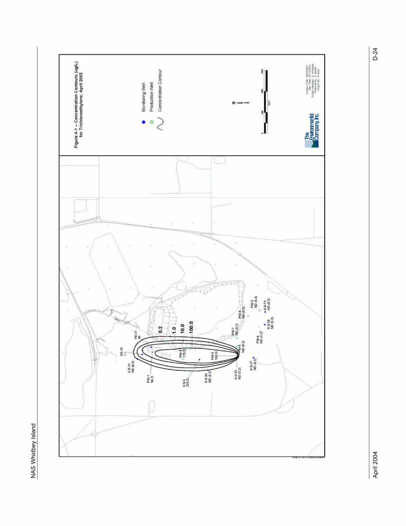
NAS
Whi
dbey
Isla
nd
April
200
4
D-2
4
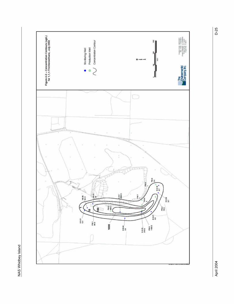
NAS
Whi
dbey
Isla
nd
April
200
4
D-2
5
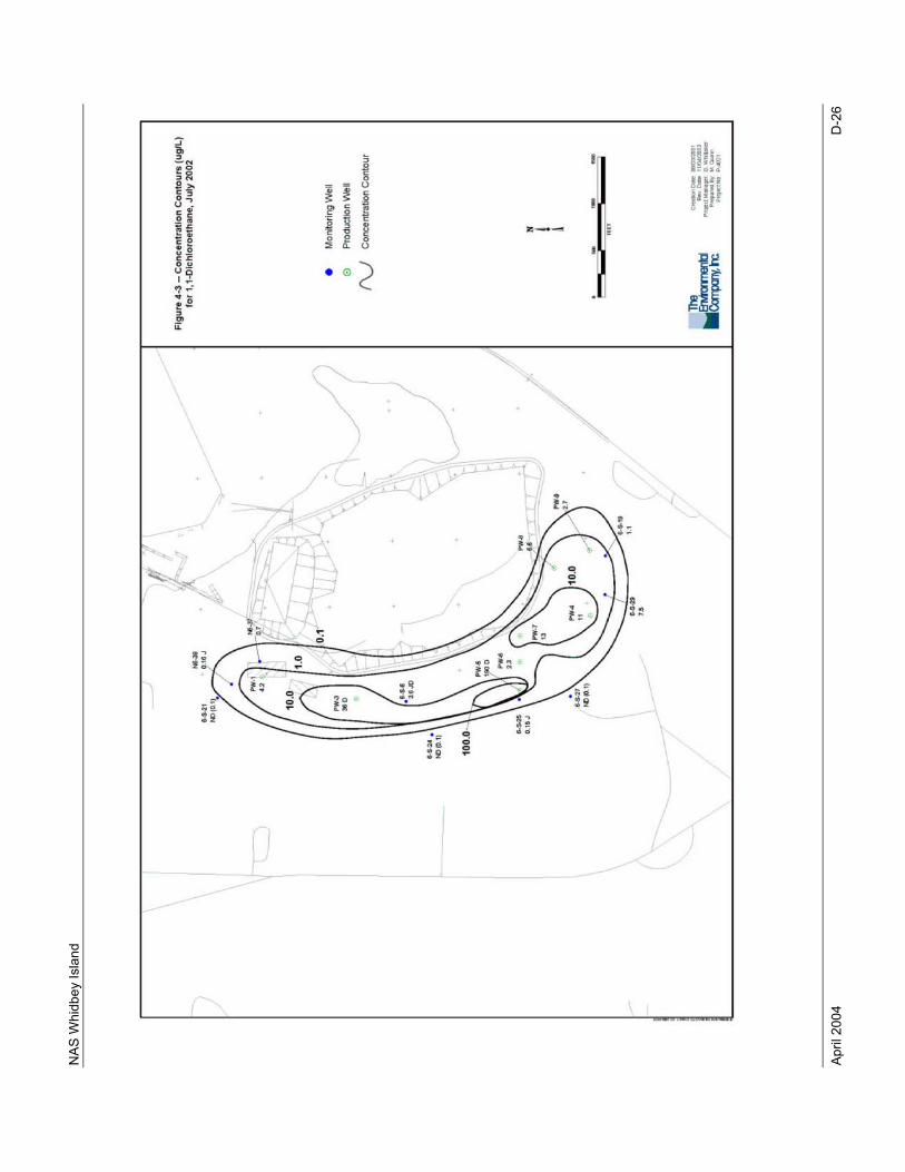
NAS
Whi
dbey
Isla
nd
April
200
4
D-2
6
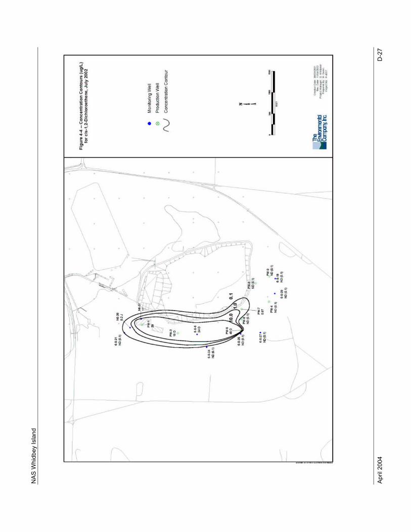
NAS
Whi
dbey
Isla
nd
April
200
4
D-2
7
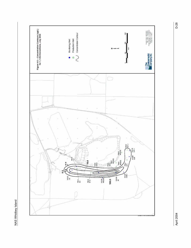
NAS
Whi
dbey
Isla
nd
April
200
4
D-2
8
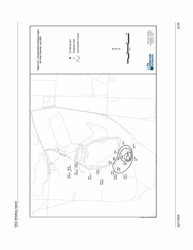
NAS
Whi
dbey
Isla
nd
April
200
4
D-2
9
NAS
Whi
dbey
Isla
nd
April
200
4
D-3
0
This
pag
e in
tent
iona
lly le
ft bl
ank.
NAS Whidbey Island
April 2004 Appendix E
APPENDIX E
ENVIRONMENTAL MONITORING
Appendix E contains excerpts from the Draft Technical Memorandum, Draft Letter Report for Environmetnal Monitoring at NAS Whidbey Island, Washington, 7 March 2003 (TEC, 2003a). Specifically, this appendix contains the following tables and figures from the above referenced technical memorandum presented in the following order:
Figure 1 Location of Study Areas Table 1 Summary of Sampling for NASWI Environmental Monitoring Table 2 Summary of Water Levels and Field Measurement Results for NASWI
Environmental Monitoring Table 3 Analytical Results for Area 1 Seep Sampling Figure 4 Area 1 Seep Locations Table 4 Analytical Results for Areas 2 and 3 Groundwater Sampling Table 5 Analytical Results for Area 4 Groundwater Sampling Table 8 Analytical Results for Area 29 Groundwater Sampling Figure 2 Well Locations at Areas 2,3,4, and 29 Table 6 Analytical Results for Area 6 Groundwater Sampling Figure 3 Well Locations at Area 6 Table 7 Analytical Results for Area 16 Sediment Sampling Figure 5 Area 16 Sediment Locations

NAS Whidbey Island
April 2004 Appendix E
This page intentionally left blank.
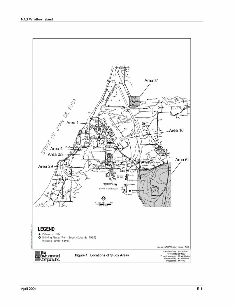
NAS Whidbey Island
April 2004 E-1
NAS Whidbey Island
April 2004 E-2
This page intentionally left blank.
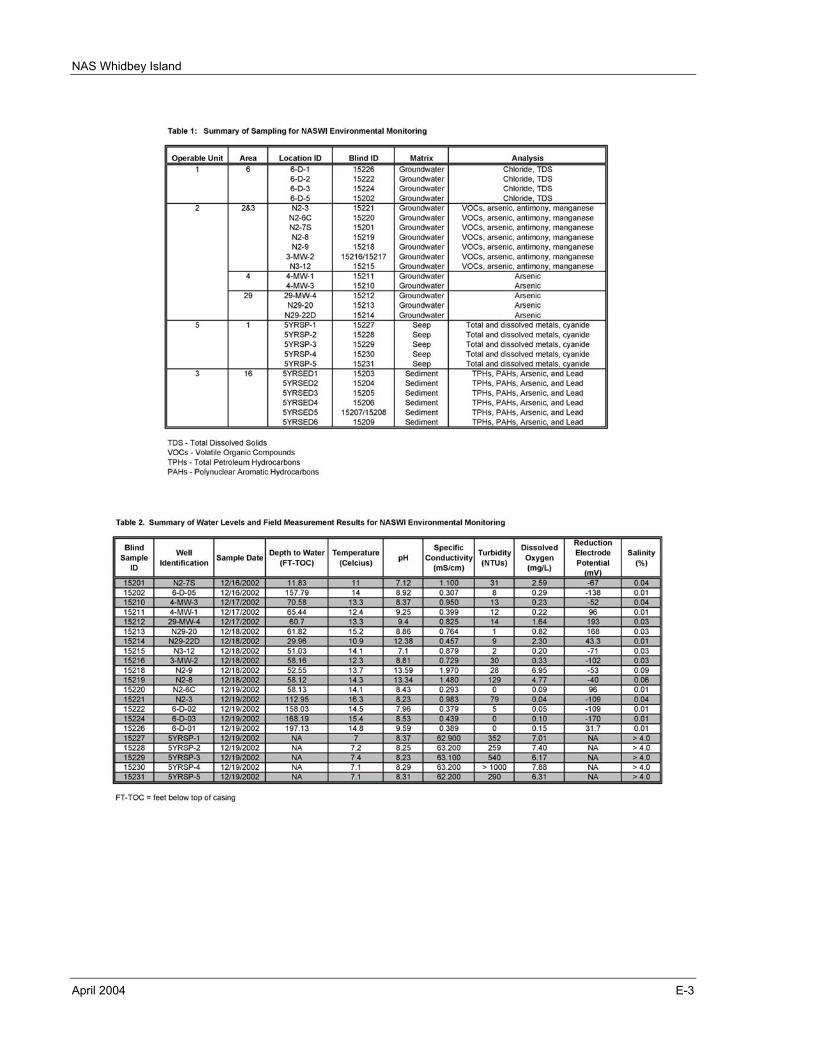
NAS Whidbey Island
April 2004 E-3
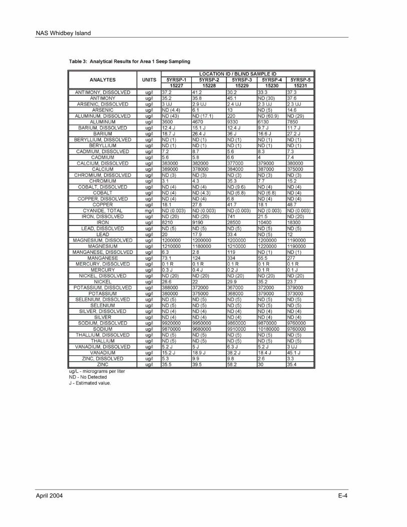
NAS Whidbey Island
April 2004 E-4
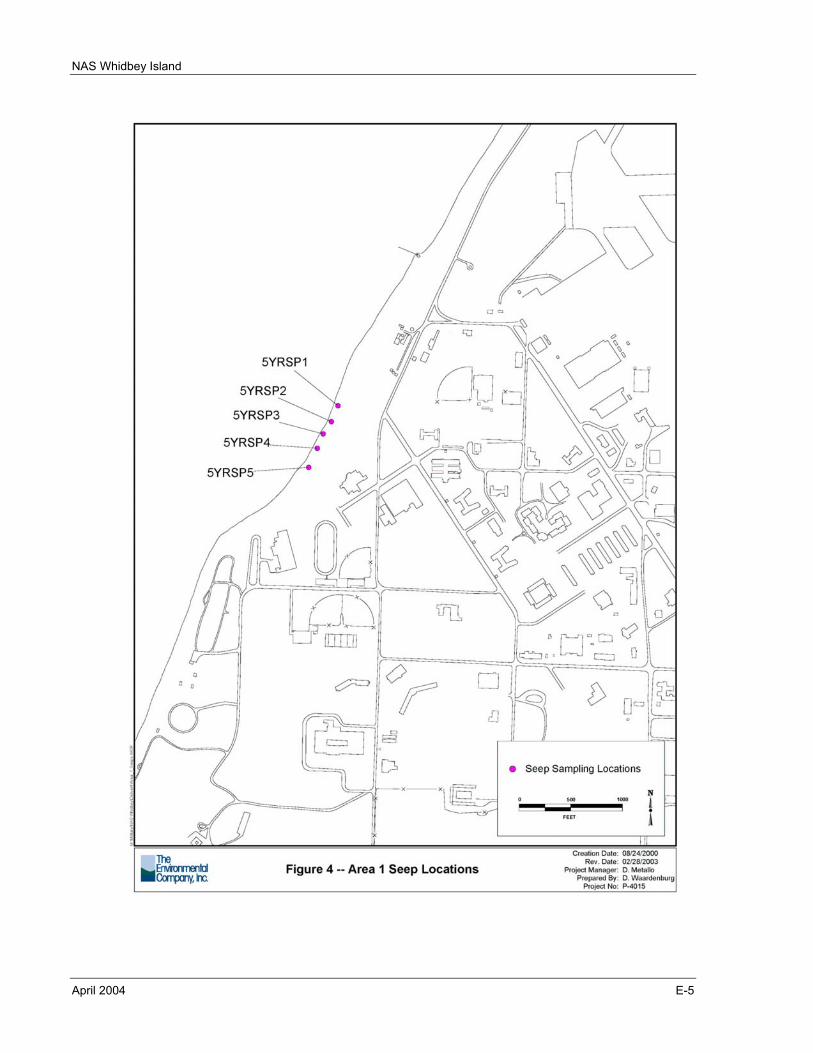
NAS Whidbey Island
April 2004 E-5
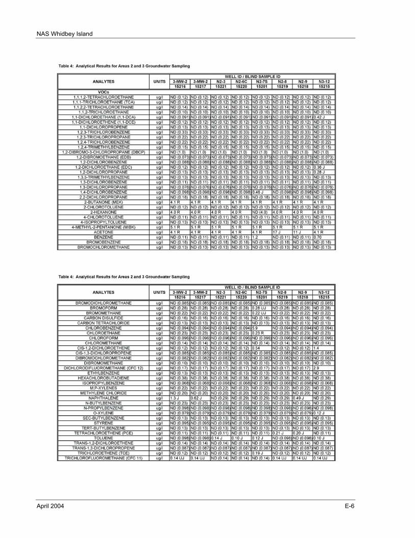
NAS Whidbey Island
April 2004 E-6
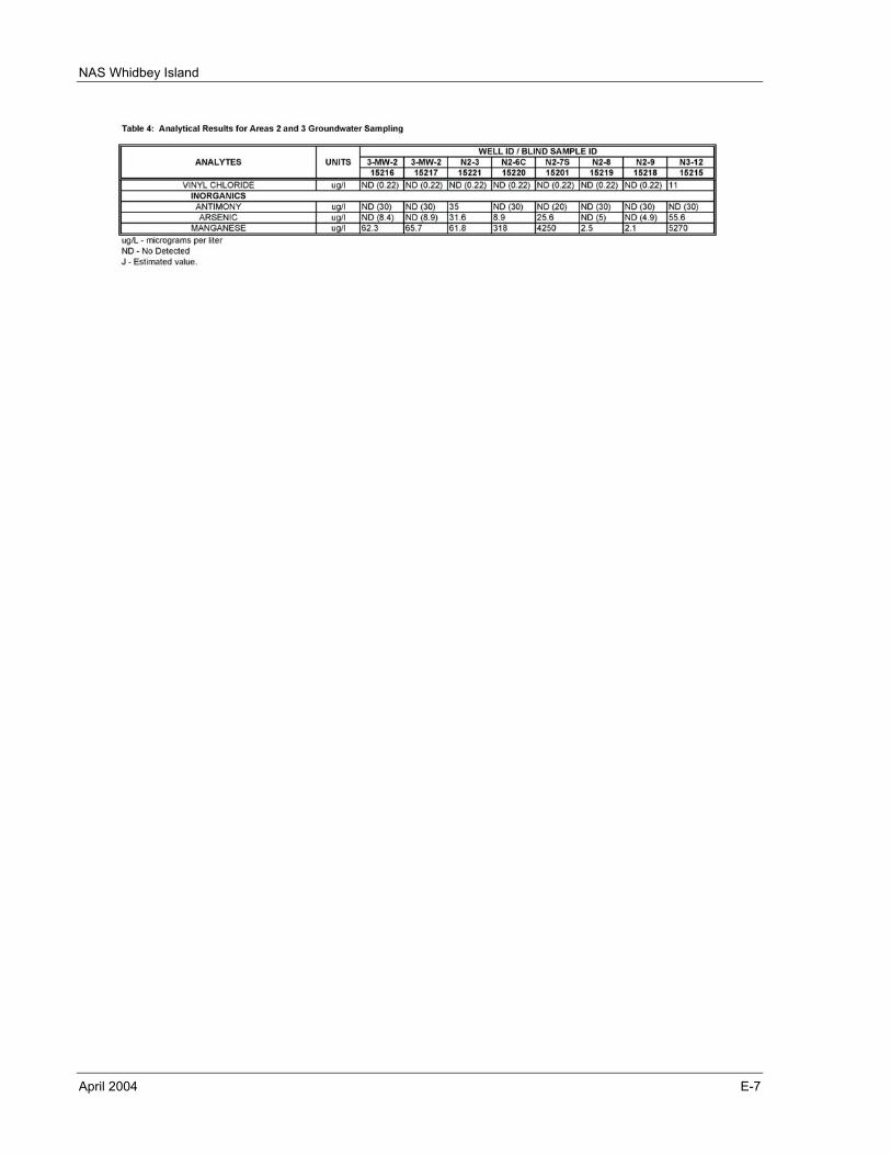
NAS Whidbey Island
April 2004 E-7
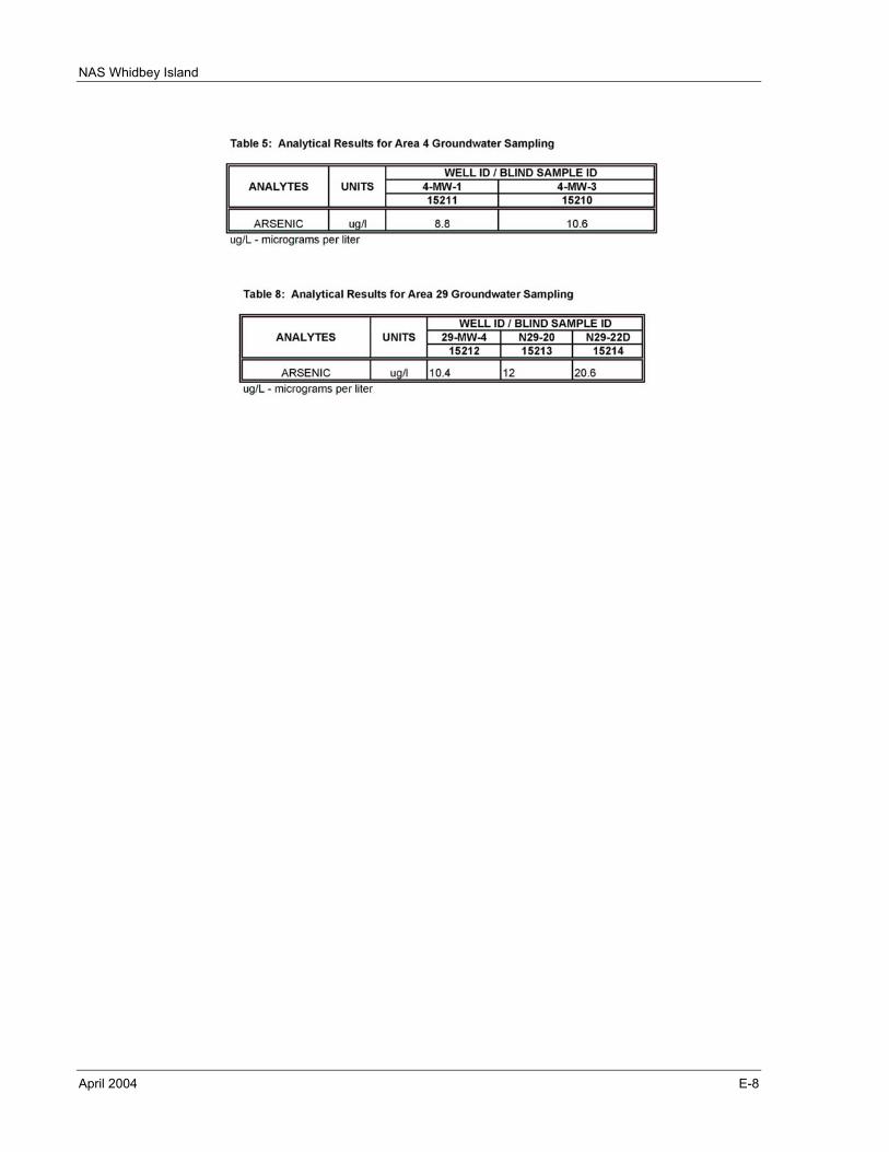
NAS Whidbey Island
April 2004 E-8
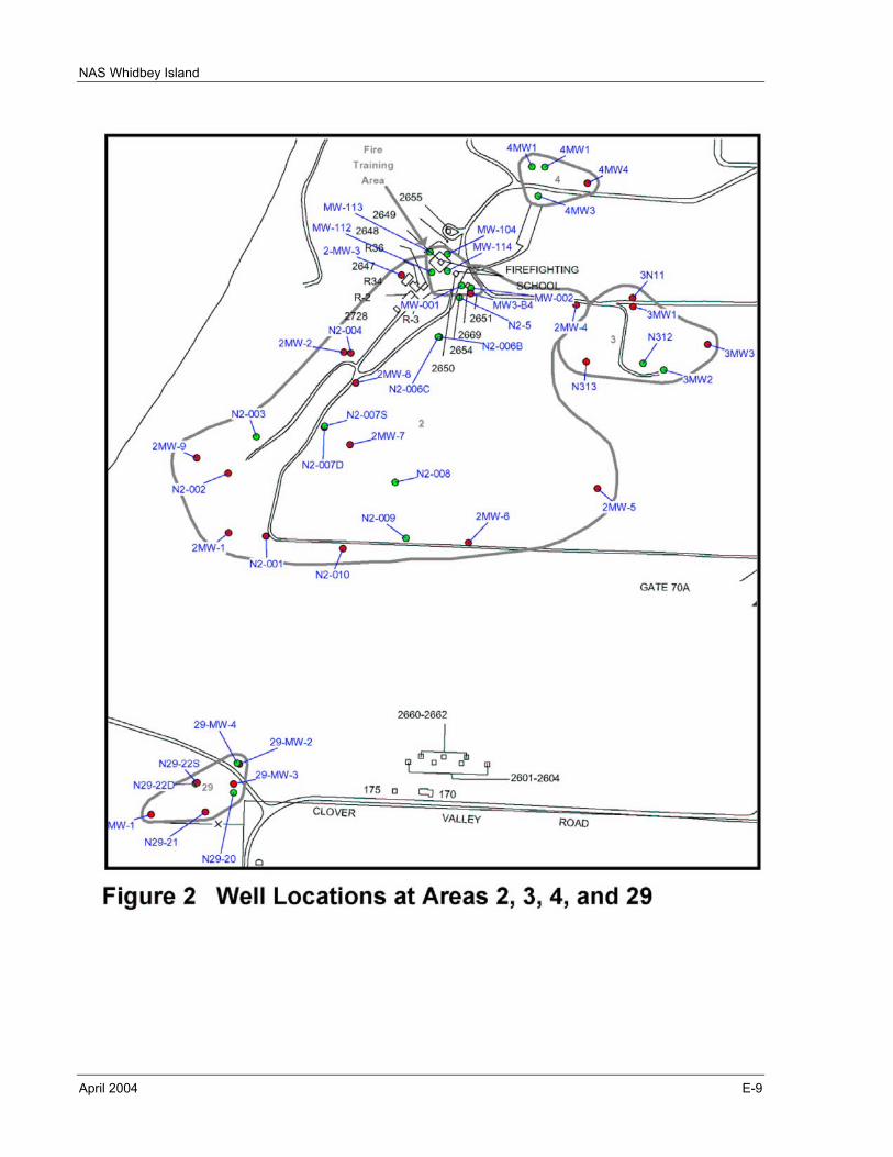
NAS Whidbey Island
April 2004 E-9
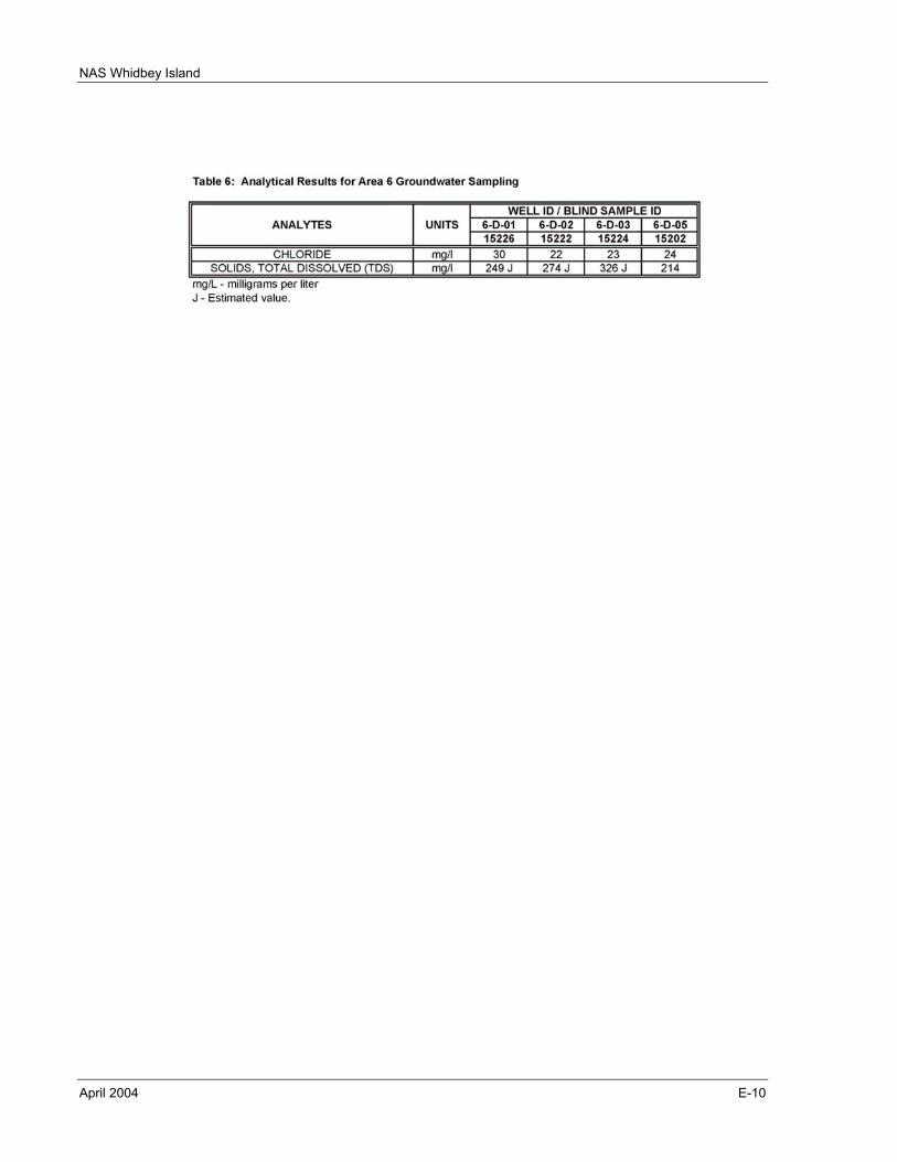
NAS Whidbey Island
April 2004 E-10
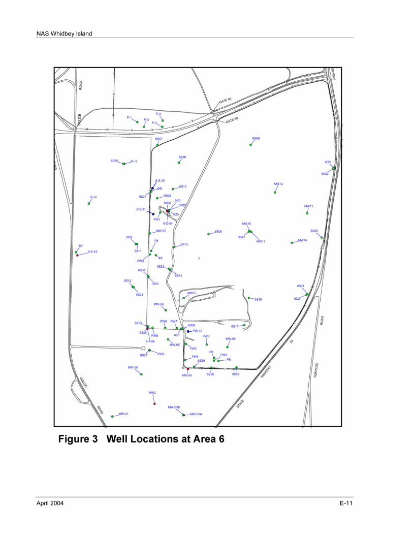
NAS Whidbey Island
April 2004 E-11
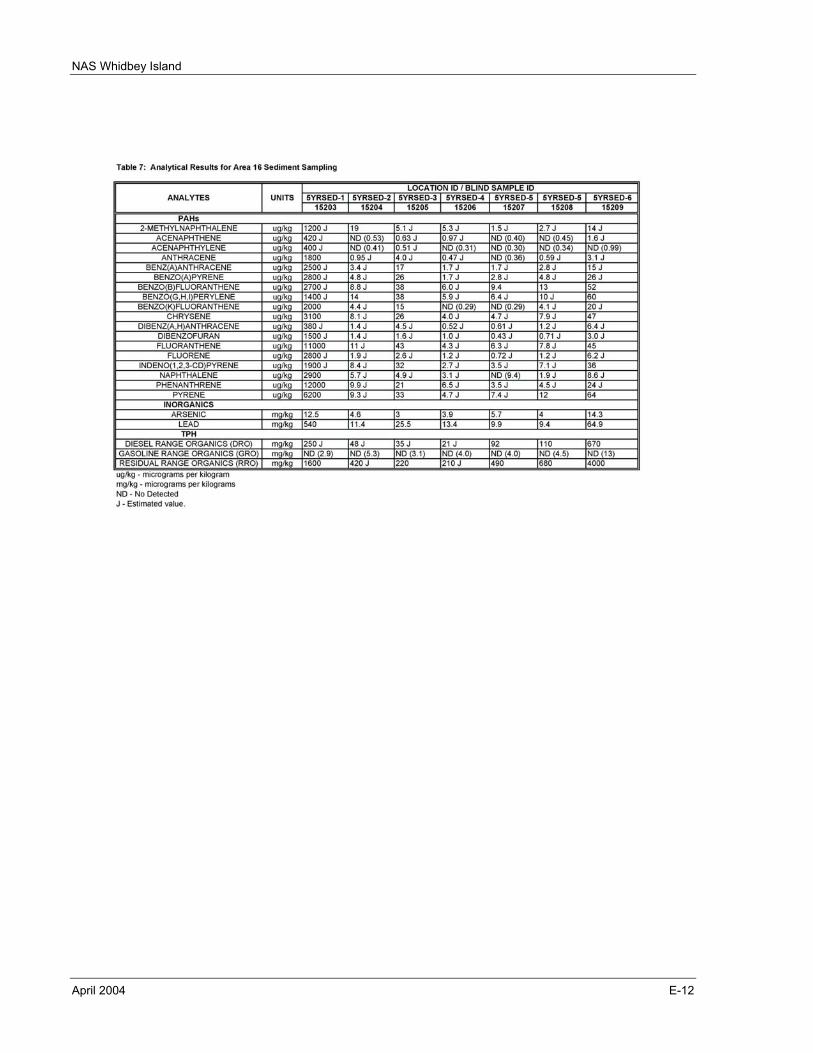
NAS Whidbey Island
April 2004 E-12
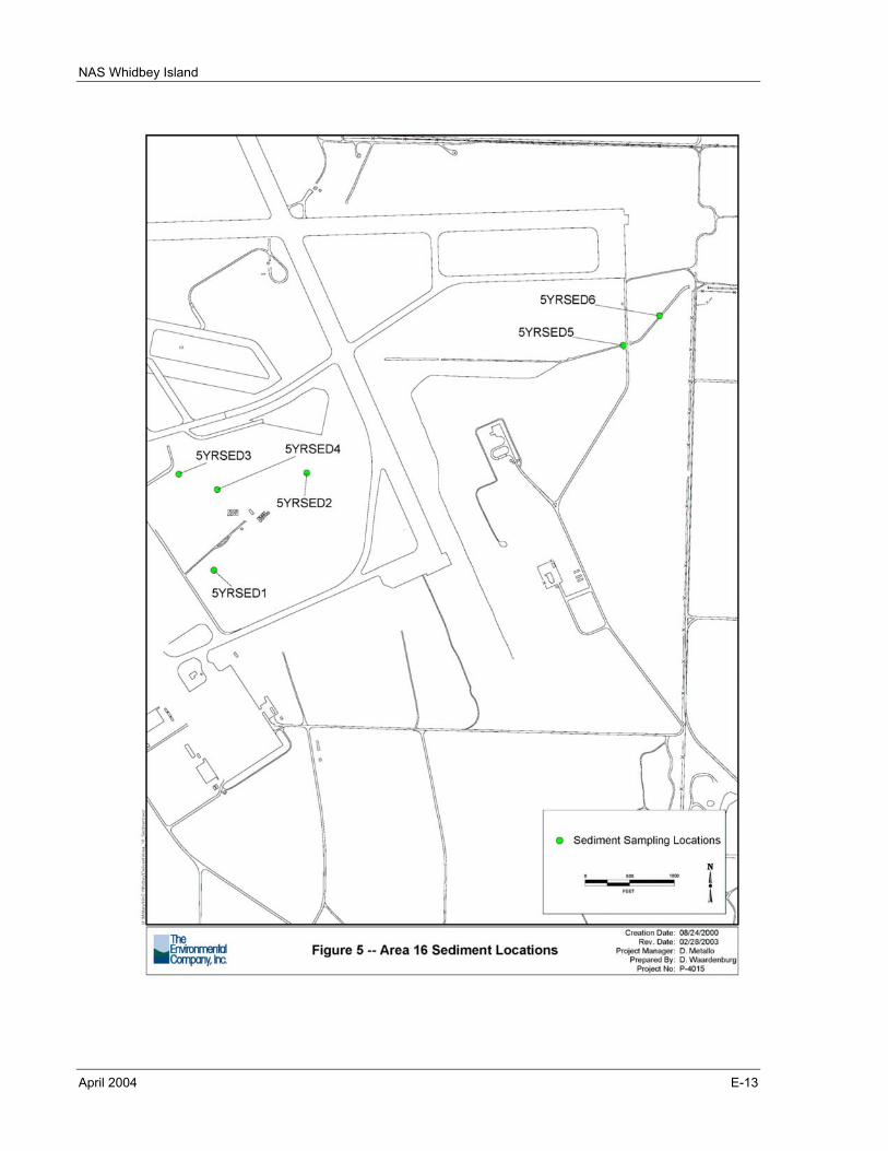
NAS Whidbey Island
April 2004 E-13

NAS Whidbey Island
April 2004 E-14
This page intentionally left blank.