Feasibility study on forecast based financing / trigger based action in Malawi
Echo funded project: Enhancing resilience in Malawi
Contents
Background and objectives ................................................................................................................................................. 3
Disaster risk analysis ........................................................................................................................................................... 5
Stakeholder mapping .......................................................................................................................................................... 8
Malawi Red Cross DRR setup ............................................................................................................................................ 11
Malawi Government DRR and social protection setup ..................................................................................................... 12
Hydro-Met setup ............................................................................................................................................................... 13
Target communities perception on forecasts and assistance ........................................................................................... 15
Beneficiary selection and registration .............................................................................................................................. 24
FbF risk matrix .................................................................................................................................................................. 27
Theory of Change .............................................................................................................................................................. 28
Conclusion and recommendations .................................................................................................................................... 29
Annex 1: Abbreviations ..................................................................................................................................................... 30
Annex 2: Supporting documents and relevant links .......................................................................................................... 30
Annex 3: Contact list ......................................................................................................................................................... 30
Annex 4: Maps .................................................................................................................................................................. 31
Annex 5: Additional qualitative FbF survey results ........................................................................................................... 35
Background and objectives
The Forecast-based Financing project in Malawi is a pilot project and one of the components of the ECHO Enhancing
Resilience in Malawi (ERIM) project. It is a consortium with Malawian, Belgian, Netherlands and Danish Red Cross
Societies. The ERIM project period is of 18 months starting from 01.07.2017. Target beneficiary group for the result 3
consists of 2.800 households.
Forecast-based Financing (FbF) is a mechanism that uses climate and weather forecasts to trigger timely humanitarian
action, before a hazard hits the exposed population. These actions are automatically funded when the triggering
forecast is released. This mechanism has been progressively developed since 2008. Several pilot projects are on-going,
which are contributing to build evidence about the potential to transform the current humanitarian system. Lessons,
best practices and recommendations from these projects are the base for the development of a solid Forecast-based
Financing knowledge management strategy. A successful Forecast-based Financing implementation will depend on
several aspects, ranging from availability of risk information to engagement of potential stakeholders.1
Geographical scope: The ECHO-ERIM technical committee in Malawi has decided to focus on Chikwawa (TA
Makhuwira) and Nsanje (TA Ndamera) which are districts positioned in the Lower Shire flood plain. Based mainly on
the 510 risk assessment toolbox the committee found that Zomba district is the least at risk district. Furthermore,
meteorological data is lacking from this district.
Objective: The objective of this feasibility study is to understand and analyse the conditions for establishing a
Forecast-based Financing mechanism including the cooperation of various stakeholders. The study will be shared with
the relevant stakeholders in order to take informed decisions and develop the roadmap for establishing and solidifying
FbF in Malawi.
Specific objectives:
1. Analyse disaster risks in Malawi
2. Assess MRCS experience and setup of DRR
3. Assess Malawi National DRR setup, climate change strategies, social protection and other policies
4. Conduct Malawi FbF stakeholder mapping
5. Assess capacities of national and international hydro-met institutions in providing reliable weather forecast
6. Assess target communities experiences and preferences to forecasts, early warning, early action and
assistance
7. Potential FbF activities
8. Assess various beneficiary selection and registration methods
9. Assess risks of FbF in Malawi
10. Develop theory of change
11. Propose recommendations for further FbF establishment in Malawi
1 FbF Manual: http://fbf.drk.de/manual.html#c28

Figure 1 - Map of Malawi
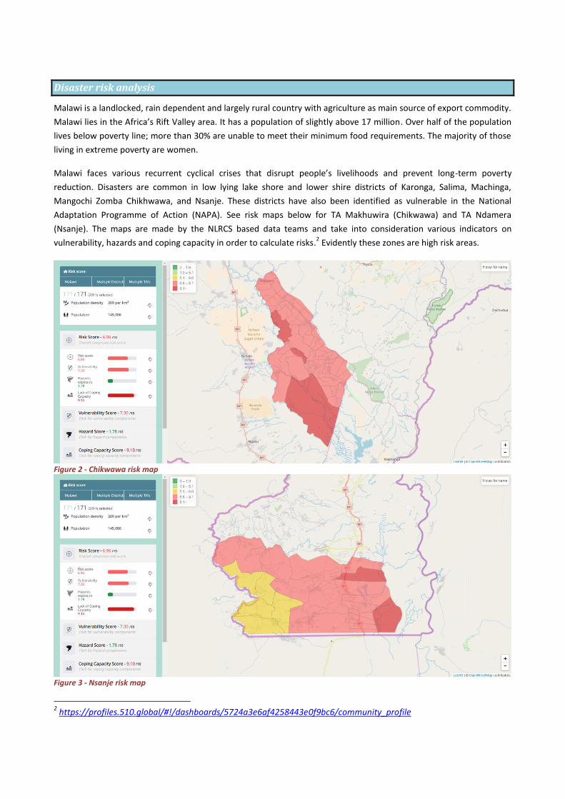
Disaster risk analysis
Malawi is a landlocked, rain dependent and largely rural country with agriculture as main source of export commodity.
Malawi lies in the Africa’s Rift Valley area. It has a population of slightly above 17 million. Over half of the population
lives below poverty line; more than 30% are unable to meet their minimum food requirements. The majority of those
living in extreme poverty are women.
Malawi faces various recurrent cyclical crises that disrupt people’s livelihoods and prevent long-term poverty
reduction. Disasters are common in low lying lake shore and lower shire districts of Karonga, Salima, Machinga,
Mangochi Zomba Chikhwawa, and Nsanje. These districts have also been identified as vulnerable in the National
Adaptation Programme of Action (NAPA). See risk maps below for TA Makhuwira (Chikwawa) and TA Ndamera
(Nsanje). The maps are made by the NLRCS based data teams and take into consideration various indicators on
vulnerability, hazards and coping capacity in order to calculate risks.2 Evidently these zones are high risk areas.
Figure 2 - Chikwawa risk map
Figure 3 - Nsanje risk map
2 https://profiles.510.global/#!/dashboards/5724a3e6af4258443e0f9bc6/community_profile
The causes of these crises are complex and diverse. On one hand, the country’s high exposure to climate risks –
primarily arising from hazards such as dry spells, drought and flooding (but also stormy rains, earthquakes, hailstorms,
landslides, pest infestation, diseases outbreaks, fire and accidents) – results in frequent shocks and emergencies. This
problem is compounded by underlying household vulnerability tied to food insecurity, population growth,
environmental degradation and seasonal patterns of production and consumption that exacerbate the impacts of
large, covariate shocks. Hence, a significant proportion of Malawi’s humanitarian needs originate from largely
predictable patterns, including normal seasonal variations in weather.3
Disaster risk management, together with social support, is considered within theme three “Social Support and Disaster
Risk Management” of the Malawi Growth and Development Strategy II (MGDS II); a national development strategy
that ensures that resources are targeted towards priority areas thereby contributing to the attainment of sustainable
development.
One of the worst disasters in Malawi happened in January 2015 with devastating impacts. Rainfall that year was the
highest on record for Malawi and constitutes a 1 in 500 year event, and caused significant flooding – predominantly in
the Southern Region, exacerbating an already precarious situation for rural households in this region. It is estimated
that the floods affected 1,101,364 people, displaced 230,000 and killed 106 people. Physical assets damaged by the
floods included 89.110ha land, 195.032 livestock, 508 classrooms, 23 health facilities, 523.347 houses, 2.991
boreholes, 1.220.53km road, 185 bridges and much more.
A state of disaster was declared for the following 15 districts: Nsanje, Chikwawa, Phalombe, Zomba, Blantyre,
Chiradzulu, Thyolo, Mulanje, Balaka, Machinga, Mangochi, Ntcheu, Salima, Rumphi and Karonga. Several of these
affected districts represent the poorest areas of the country. Based on the recent Integrated Malawi Household
Survey, the most highly affected districts – Nsanje, Chikwawa, Phalombe and Zomba – have poverty incidences above
the national average of 50.7 percent, ranging from 55 to 80 percent. 4
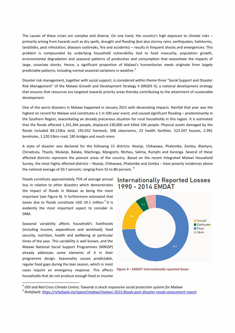
Floods constitute approximately 75% of average annual
loss in relation to other disasters which demonstrates
the impact of floods in Malawi as being the most
important (see Figure 4). It furthermore estimated that
losses due to floods constitute USD 24.1 million.5 It is
evidently the most important aspect to consider in
DRM.
Seasonal variability affects household’s livelihoods
(including income, expenditure and workload), food
security, nutrition, health and wellbeing at particular
times of the year. This variability is well known, and the
Malawi National Social Support Programmes (MNSSP)
already addresses some elements of it in their
programme design. Seasonality causes predictable,
regular food gaps during the lean season, which in most
cases require an emergency response. This affects
households that do not produce enough food or income
3 ODI and Red Cross Climate Centre; Towards a shock responsive social protection system for Malawi
4 Reliefweb: https://reliefweb.int/report/malawi/malawi-2015-floods-post-disaster-needs-assessment-report
Figure 4 – EMDAT internationally reported losses
to meet their needs throughout the year, and results in food-access deficits from October to March. Often, these food
gaps affect the same households in the same districts each year, even in the absence of unusual weather events. The
needs of these households are currently met through the annual Malawi Vulnerability Assessment Committee (MVAC)
emergency response.
Extreme or unusual climate shocks occur with relative frequency in Malawi and cause exceptional periods of acute
need (e.g. El Niño). Such shocks interact with underlying poverty and vulnerability, and can exacerbate poor
households’ vulnerability to seasonal variability thus increasing food insecurity and the scale of assistance needed.
Forecasting, advanced planning and preparedness, and risk-reduction approaches can mitigate their impacts by
enabling early response. Programmes in Malawi have recently piloted options to support households through
combined social protection and MVAC interventions. In addition, some social protection programmes seek to reduce
and mitigate the impacts of climate shocks by linking social support with complementary programmes (e.g. climate-
smart agriculture) and designing public works to increase economic resilience and protect natural resources. Efforts
can be strengthened in this area, however.6
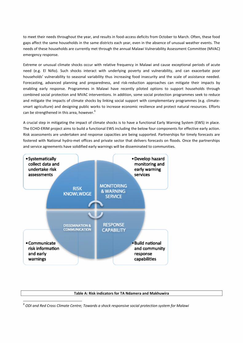
A crucial step in mitigating the impact of climate shocks is to have a functional Early Warning System (EWS) in place.
The ECHO-ERIM project aims to build a functional EWS including the below four components for effective early action.
Risk assessments are undertaken and response capacities are being supported. Partnerships for timely forecasts are
fostered with National hydro-met offices and private sector that delivers forecasts on floods. Once the partnerships
and service agreements have solidified early warnings will be disseminated to communities.
Table A: Risk indicators for TA Ndamera and Makhuwira
6 ODI and Red Cross Climate Centre; Towards a shock responsive social protection system for Malawi

Indicators Data Source
Exposed population 109.886 people https://data.humdata.org/dataset/malawi-admin-level-3-boundaries
Poverty incidence (living on less than $1.25 a day)
79.57% http://www.worldpop.org.uk/data/summary/?contselect=Africa&countselect=Malawi&typeselect=Poverty
Risk score (vulnerability+hazard exposure+lack of coping capacity/3)
7.8/10.0 https://profiles.510.global/#!/dashboards/5724a3e6af4258443e0f9bc6/community_profile
Average annual loss to floods in $ (country-wide)
$24.110.000 https://reliefweb.int/report/malawi/malawi-2015-floods-post-disaster-needs-assessment-report
Stakeholder mapping
Table B: Stakeholder mapping
INSTITUTION LINK TO PROJECT
Target communities (Chikwawa TA Makhuwira, Nsanje TA Ndamera)
9 communities in the project are setting up Local Early Warning Systems (EWS) teams across the Traditional Authorities (TAs) chosen for implementation of the ECHO-ERIM project. The EWS teams will setup rain and river gauges and will support in assessing the threat of floods and feed back information to other relevant stakeholders such as hydro-met offices. Indigenous forecasts of the communities exist and it remains to be determined how to incorporate these into the project EWS. The former ECHO project in Malawi is undergoing a study on the topic and the findings will be important in considering how these forecasts can be considered for the project.
Malawi Department of Climate Change and Meteorological Services (DCCMS) www.metmalawi.com. https://www.wmo.int/cpdb/malawi [email protected]
DCCMS is the Malawian meteorological institute. DCCMS They aim at providing reliable, responsive and high quality weather and climate services to meet national, regional and international obligations through timely dissemination of accurate and up to-date data and information for socio-economic development. They offer different services to the public on climate and weather such as on Aviation, Marine, Agriculture and livestock management, water resources etc. They have several rain gauges and weather stations around the country and provide forecasts on a daily basis, 5 and 10 days probabilistic forecasts and seasonal forecasts. They are responsible for issuing weather forecasts and warnings of severe weather to the general public and other specialized users.
Malawi Department of hydrology The department of hydrology monitors river catchments and currently has floods forecasts with a lead-time of 6 hours. They are currently developing their system for forecasting floods and aims to have a new system in place by Mid-2018. River gauges are installed in several locations around the country and the map and GIS will be shared with the Red Cross for improved coordination on further establishing of river gauges in the communities.
Malawi Department of disaster management affairs (DoDMA) http://www.preventionweb.net/organizations/4495
DoDMA is the Malawian national disaster management agency. They are responsible for coordinating and directing the implementation of disaster risk management programmes in the country. DRR programmes in Malawi have been aligned to the HFA, through a DRM policy that has the following six priority areas: 1 Mainstreaming disaster risk management into sustainable development; 2 Establishment of a comprehensive system for disaster risk identification, assessment and monitoring; 3 Development and strengthening of a people-centred early warning system; 4 Promotion of a culture of safety and adoption of

resilience-enhancing interventions; 5 Reduction of underlying risks; 6 Strengthening preparedness capacity for effective response and recovery.
Malawi National Social Support Programme (MNSSP) http://mnssp.org/
The MNSSP undertakes several social support initiatives including the Social Cash Transfer Programme (SCTP). The SCTP targets the poorest people in the country and regularly provides them with cash grants. The Red Cross cooperates with the SCTP and has acquired access to their database of beneficiaries in order to support these groups during floods.
Shire River Basin Management Programme (SRBMP) (consultancies: DHI, BRL and more) http://www.shirebasin.mw/ http://malawiodss.dhigroup.com/ODSS/
The objective of the SRBMP is to lay the foundation for more integrated investment planning and for modernized system operations for the Shire Basin. The SRBMP currently undertakes several hydrological projects. One such project is headed by the Danish engineer company DHI who developed the ODSS (Operation Decision Support System). The ODSS is able to give flood forecasts with 3 days lead time. The ODSS is able to send sms and email to a list of pre-identified individuals. Another project is undertaken by the company BRL who have developed several action plans for floods prevention.
Red Cross and Red Crescent Climate Centre http://www.climatecentre.org/
The Climate Centre, based in Netherlands, is a specialist reference centre of the International Federation of Red Cross and Red Crescent Societies (IFRC). Their mission is to help the Red Cross and Red Crescent Movement and its partners reduce the impacts of climate change and extreme-weather events on vulnerable people. Staffed largely by climate scientists, the Centre provides strategically important knowledge and advice on climate-smart practice throughout the Red Cross Red Crescent Movement and beyond. Our support for National Societies and the IFRC focuses on climate information for disaster preparedness and response, food security and health, training and technical back-up. They work with a huge range of humanitarian partners, climate specialists and non-specialists, principally Red Cross Red Crescent National Societies and the Geneva-based IFRC and ICRC.
Malawi Red Cross Society http://www.redcross.mw/ https://web.facebook.com/pg/malawiredcross/about/?ref=page_internal http://www.ifrc.org/en/what-we-do/where-we-work/africa/malawi-red-cross-society/
The Malawi Red Cross Society (MRCS) is a local humanitarian organization which started its operations in 1932. As an auxiliary to government, the Society continues to work closely with government ministries and departments, UN agencies, other Red Cross National Societies, international donor agencies and Red Cross partners. The Malawi Red Cross Society was originally established as a relief organization. However, over the years, the Society has diversified and strengthened its programming portfolio to blend development aspects in its humanitarian interventions throughout the disaster management circle. Recently MRCS has setup a data-unit to support the integration of technology into the humanitarian work. They work with mobile technology for data collection, GIS mapping and more. MRCS is the implementing partner in the ECHO-ERIM consortium.
Belgian Red Cross-Flanders (BRC-FL) https://www.rodekruis.be/
The BRC-FL is consortium lead on the ECHO funded project Enhancing Resilience in Malawi (ERIM), implemented in the districts of Zomba, Chikwawa and Nsanje.
Netherlands Red Cross Society (NLRCS) https://www.rodekruis.nl/
The NLRCS gives technical support to the data component of the ECHO-ERIM project. The NLRCS have a dynamic data team setup in Amsterdam that supports technology development in humanitarian work. They have developed the global510 which is an Interactive map that allows the user to instantly

assess the risk level (hazards + vulnerability + lack of coping capacity) in each county/district (see map below which highlights the areas in southern Malawi. A more detailed remote sensing assessment has been conducted using drones. The drones have been able to provide; elevation data for flood analysis, 3D layout of built environment and XXX.
Danish Red Cross (DRC) https://www.rodekors.dk/
The DRC gives technical support to the cash and FbF component of the ECHO-ERIM project. There has been a significant capacity building undertaken lately on cash transfer programming (CTP) within MRCS with support from DRC. CTP has been piloted in a few districts and guidelines and SOPs have been developed as well. Currently work is undertaken to assess feasibility of using cash for forecast based financing as early action to support communities at risk of flooding. DRC also supports the development of the forecast based financing, as a pilot within the ECHO-ERIM project. The DRC will provide the first financing for testing the FbF mechanism.
Malawi FbF Stakeholder Flowchart:
The below flowchart show the proposed links in FbF from actors and institutions in the Malawi Government, private
sector and humanitarian actors to the beneficiaries. It shows that services and information flows in both directions
between beneficiaries and public/private institutions. Although SRBMP is headed by the Government of Malawi the
actors are consultancy firms from private sector.
Malawi Red Cross DRR setup
Malawi Red Cross Society (MRCS) was established as a voluntary aid organisation by Act 51 of Parliament in 1966.
Through this act, MRCS enjoys a special mandate as an auxiliary to the public authorities and the State President is the
Patron of the National Society. MRCS is Malawi's largest humanitarian organization, with established presence in all 28
districts.
Volunteers are the backbone of MRCS and, across the country, approximately 30,000 volunteers are organized in 33
Divisions and many more Sub-divisions and work to empower communities and improve life for the most vulnerable in
Malawi. MRCS is well known for provision of First Aid services and disaster response and use this good reputation to
increase the general public’s awareness of other development work and initiatives carried out by MRCS. In addition, it
works in close ties with local communities as well as decision makers at all levels, in its capacity as an auxiliary to the
government, putting it in a position to influence the humanitarian agenda.
People affected by poverty and disaster are the main target groups for MRCS, but risks and hazards may vary
depending on situation and location. The varying degree of risks poses new challenges and a need for a more holistic
approach to Disaster Management. The disaster enhanced preparedness setup envisioned via this pilot FbF could
potentially be a significant factor in this regard.
The MRCS works with Community Based Disaster Management structures. By training teams of volunteers in disaster
prone areas, communities become better equipped to deal with shocks of disaster, which can help save lives and
livelihoods. However, in a setting where disasters are predicted to become even more frequent, focus must also be
put on reducing vulnerability by enabling communities to prepare for and prevent disaster from happening in the first
place. The development of Early Warning Systems will therefore be a priority for MRCS to ensure effective response.
Climate Change Adaptation activities will also come increasingly in demand, just as strategies for managing disasters in
urban settings.
The below table summarizes the key capacities of the MRCS with regards to EWS and FbF.
Table C: MRCS DRM setup
Topic Experience/Capacity
Experience in designing and implementation of DRR programmes
MRCS supported development of two ECHO disaster resilience projects
Experience in designing and implementation of CTP programmes
Two trainings have been undertaken in cooperation with DRC since 2016
MRCS participates in the Cash Working Group
Cash distribution to 2.268 bnf in Chikwawa from September 2016 to March 2017
Cash distribution to 15.789 bnf in Chikwawa, Neno and Mwanza in 2017
Cash distribution in Salima in February 2017
Karonga CTP in July/August 2017
MRCS CTP Guidelines and SOPs exists
MRCS contingency plans update and simulations frequency
Contingency plans are developed and updated annually in cooperation with DoDMA. The approach is bottom-up by focusing first on districts CPs that feed into the National CP.
Volunteer network able to support implementation of FbF (in terms of numbers for Ndamera and Makhuwira TAs)
Yes.
Branches in proximity of high risk prone areas (Ndamera and Makhuwira)
Yes, Nsanje and Chikwawa district offices
Extent of collaboration with DRR/CCA government department
MRCS has a close link and cooperation with DoDMA.
Extent of collaboration with Hydro-Meteorological Departments (DCCMS and department of hydrology)
The cooperation with hydro-met offices is not extensive nor formal. However, the DM department close follows the DCCMS information dissemination via the web or social media such as whatsapp. Former cooperation included a Finnish funded project.
Extent of collaboration with other government department and ministries (e.g. on MNSSP/SCTP)
MRCS makes use of the various registration approaches provided by the government programs. Recently MRCS has cooperated with the government on acquiring the beneficiary lists used in the social cash transfer program for intended use in FbF.
Malawi Government DRR and social protection setup
The principle goal in the development strategy of the Government of Malawi (GoM) is poverty reduction, which is set
to be achieved through economic growth and infrastructure development. But increasing impact of disasters on life,
livelihood and economic and environmental assets continue to pose serious threats to the abilities to come out of
poverty. Malawi Growth and Development Strategy (MGDS) and the National Disaster Risk Management (NDRM)
Policy continue to provide strategic direction to disaster risk management and ensure integration in development
planning by all sectors in the country.
However, the trend of both hazards and vulnerabilities are not well defined among most sectors and locations making
it difficult to design relevant Early Warning Systems (EWS). Furthermore, there is limited risk knowledge downscaled
to grass root levels, more especially in areas where there are no Disaster Risk Reduction (DRR) projects.
The Government of Malawi through DoDMA developed a framework for Disaster Risk Reduction with the purpose of
pursuing a proactive and integrated way to reduce risk to hazards through sustainable, innovative and realistic
strategies with stronger partnership of all stakeholders. The policy is linked to the MGDS and international
instruments such as The SADC Disaster Risk Reduction Strategy, the Africa Regional Strategy for Disaster Risk
Reduction (ARSDRR) and The Hyogo Framework for Action (HFA): 2005-2015.
The NDRM policy has 6 main priority areas which have been outlined in accordance with the HFA and amongst them
are; 1 mainstreaming disaster risk management into sustainable development; 2 the establishment of a
comprehensive system for disaster risk identification, assessment and monitoring; 3 development and strengthening
of a people-centred early warning system; 4 promotion of a culture of safety, and adoption of resilience-enhancing
interventions; 5 reduction of underlying risks and; 6 strengthening preparedness capacity for effective response and
recovery.7
The Malawi National Social Support Programme 2 (MNSSP 2) provides a platform which is linked to the DRM policy.
The MNSSP 2 has 3 thematic pillar which addresses social concerns at national and community level. The third pillar
concentrates on shock-sensitive social protection which details that the underlying food insecurity and seasonal
patterns of production and consumption result in recurrent cyclical crises and prevent long term poverty reduction.
This problem is compounded by Malawi’s high exposure to climate risks, primarily dry spells, drought, and flooding,
which creates frequent shocks and emergencies. As such, predictable seasonal patterns, and even minor weather
variations, can develop into humanitarian emergencies, if the right measures are not in place.
7 National disaster risk management policy: http://www.ifrc.org/docs/IDRL/43755_malawidrmpolicy2015.pdf

It is in this context the Government of Malawi intends to include shock-sensitiveness features in the social protection
system in order to promote resilience to shocks in anticipation of a crisis, prepare for shocks through, for example,
planning and coordinating in advance of shocks, support households in meeting their immediate needs in response to
a shock - for example through scaling up of existing social protection programs to reach a larger proportion of the
population affected and increasing transfers for those already in MNSSP programs in the event of a shock; and finally
support recovery efforts to shocks e.g. “building back better” through attention to program design which can build
resilience to shocks (linking directly to prevention and mitigation).
The Malawi Government launched a Social Cash Transfer Program (SCTP) in 2006. The program provides regular cash
payments to ultra-poor and labour-constrained households. It seeks to reduce poverty and hunger; increase school
enrolment and attendance; and improve the health, nutrition and well-being of vulnerable children. The program has
significant impact on the household economy whereby some of the beneficiaries used the money to renovate their
home or buy clothes, reducing (visible signs of) poverty and enhancing their dignity. On the context of disaster risk
reduction, the money that the beneficiaries received has been of greater value more especially in the incidences of
the disasters, however there have been calls to strengthen systems to ensure timely, reliable, and adequate cash
transfers
The observation of various adverse impacts from climatic change, climate variability, and extreme weather events has
led the GoM to undertake the preparation of a National Adaptation Programme of Action (NAPA) document so as to
respond to the urgent and immediate needs for adaptation to climate change. The NAPA has five priority areas
(including 31 adaptation options) as follows; 1 Improving community resilience to climate change through the
development of sustainable rural livelihoods; 2 Restoring forests in the Upper, Middle and Lower Shire Valleys
catchments to reduce siltation and the associated water flow problems; 3 Improving agricultural production under
erratic rains and changing climatic conditions; 4 Improving Malawi’s preparedness to cope with droughts and floods
and; 5 Improving climate monitoring to enhance Malawi’s early warning capability and decision making and
sustainable utilization of Lake Malawi and lakeshore areas resources.8
Hydro-Met setup
DCCMS: A meeting was conducted with the DCCMS on 17 October and 21 November 2017 to discuss the current
meteorological setup, services that may contribute to the FbF project and possible cooperation points for an MoU
with the Red Cross. They informed that reliable probabilistic weather forecasts are available at TA and GVH level with
a 10 day lead time and it would be possible to package forecasts for specific areas and forward to the Red Cross. These
would be updated continually, e.g. 5, 3 and 1 days.
It was emphasised that it’s key to combine medium to short term forecasts for better prediction, that interpretation
of forecasts is crucial and that DCCMS can support in that regard. It was also stated that during the past 3-4 years
techniques of forecasting in Malawi have improved, e.g. on impact based forecasting. However, impact based
forecasts with relation to floods is most essential with regards to supporting vulnerable communities mitigate and
prepare for disasters but it seems there is need for improvement in this area.
DCCMS monitor areas likely to have flash floods give forecasts on these areas 12 and 6 hours in advance. Historical
data on areas frequently flood would help the Red Cross in keeping focus on especially exposed areas and it has been
requested to have more data on this. Finally, it was mentioned that some climate change aspects are observed in
Malawi but relates mainly to variability; weather has become more extreme and more intense.
8 National Adaptation Programme of Action http://unfccc.int/resource/docs/napa/mwi01.pdf
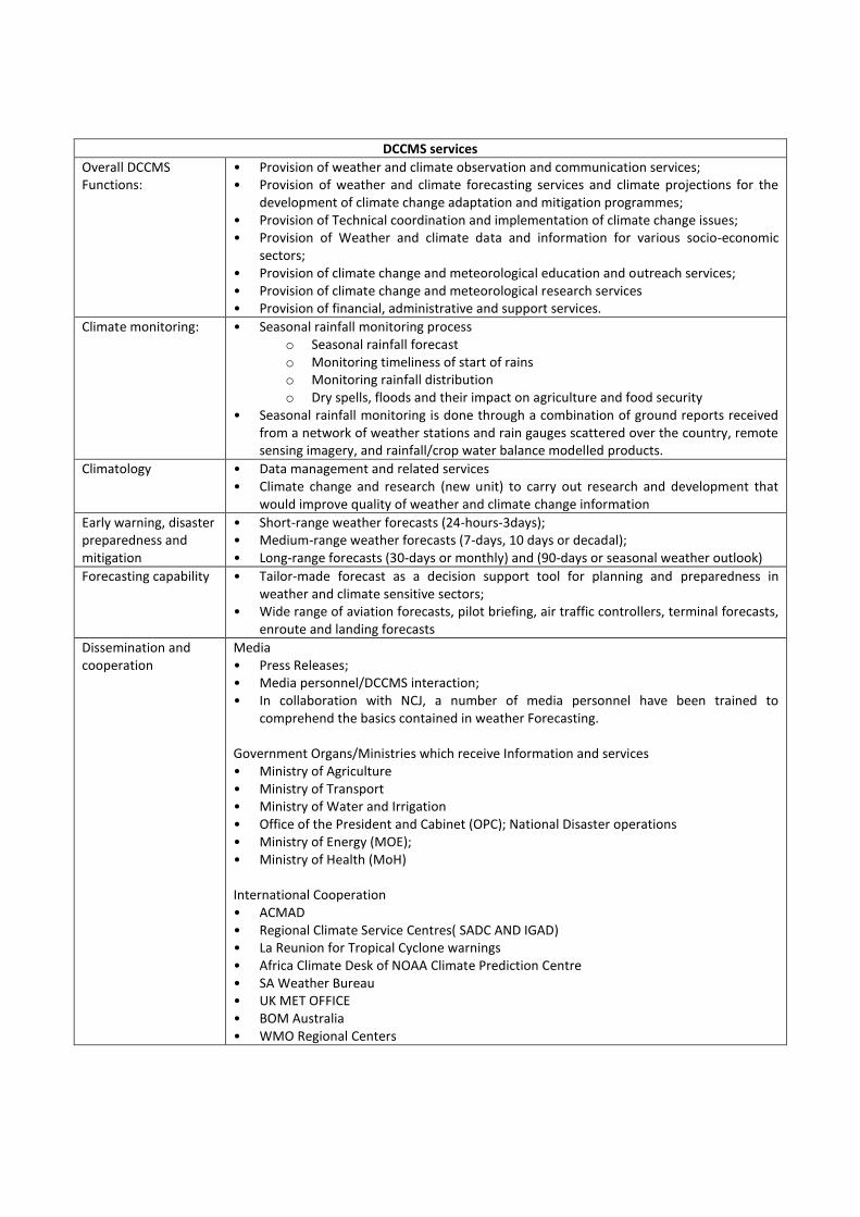
DCCMS services
Overall DCCMS Functions:
• Provision of weather and climate observation and communication services; • Provision of weather and climate forecasting services and climate projections for the
development of climate change adaptation and mitigation programmes; • Provision of Technical coordination and implementation of climate change issues; • Provision of Weather and climate data and information for various socio-economic
sectors; • Provision of climate change and meteorological education and outreach services; • Provision of climate change and meteorological research services • Provision of financial, administrative and support services.
Climate monitoring:
• Seasonal rainfall monitoring process o Seasonal rainfall forecast o Monitoring timeliness of start of rains o Monitoring rainfall distribution o Dry spells, floods and their impact on agriculture and food security
• Seasonal rainfall monitoring is done through a combination of ground reports received from a network of weather stations and rain gauges scattered over the country, remote sensing imagery, and rainfall/crop water balance modelled products.
Climatology
• Data management and related services • Climate change and research (new unit) to carry out research and development that
would improve quality of weather and climate change information
Early warning, disaster preparedness and mitigation
• Short-range weather forecasts (24-hours-3days); • Medium-range weather forecasts (7-days, 10 days or decadal); • Long-range forecasts (30-days or monthly) and (90-days or seasonal weather outlook)
Forecasting capability
• Tailor-made forecast as a decision support tool for planning and preparedness in weather and climate sensitive sectors;
• Wide range of aviation forecasts, pilot briefing, air traffic controllers, terminal forecasts, enroute and landing forecasts
Dissemination and cooperation
Media • Press Releases; • Media personnel/DCCMS interaction; • In collaboration with NCJ, a number of media personnel have been trained to
comprehend the basics contained in weather Forecasting.
Government Organs/Ministries which receive Information and services • Ministry of Agriculture • Ministry of Transport • Ministry of Water and Irrigation • Office of the President and Cabinet (OPC); National Disaster operations • Ministry of Energy (MOE); • Ministry of Health (MoH)
International Cooperation • ACMAD • Regional Climate Service Centres( SADC AND IGAD) • La Reunion for Tropical Cyclone warnings • Africa Climate Desk of NOAA Climate Prediction Centre • SA Weather Bureau • UK MET OFFICE • BOM Australia • WMO Regional Centers
Department of Hydrology: A meeting was conducted with the department of Hydrology on 1 November 2017 to
discuss the setup and services that may contribute to the FbF project. Floods forecasting are undertaken but is still
under construction and would probably be finished by middle of next year for the lower Shire valley. Current system
has lead time of 6 hours, for GVH level. Hydrological department have more capacity on flash floods forecasts than
riverine floods. Historical data on floods exists but have so far not been shared. Climate change has been observed,
e.g. first rains of the year come at varying times. Anthropological effects are also observed to influence on floods
impact, e.g. population growth leading to deforestation and cutting of trees all the way down to the catchment area
increases the floods flow speed and river bank erosion.
DHI: A meeting was conducted on 9 November with the Danish consultancy firm DHI working on the Shire River Basin
Management Program. They have developed a system called Operational Decision Support System (ODSS) which is
able to give floods forecasts with 3 days lead time. ODSS, combines weather forecasts, local river gauges and satellite
images to predict the floods. It has developed thresholds indicating when a certain area is in various danger levels:
green, yellow and red. The system automatically sends out an SMS to pre-registered subscribers on alerts. It is also
possible to visit their website to access various maps on forecasts.9
Table D: Hydro-Met setup
Malawi hydro-meteorological forecast capabilities
Scientific criteria Data available Source FbF Feasibility level
Short term: probabilistic 3-5 days rainfall and temperature forecasts
Yes DCCMS High
Short term: forecasts on floods occurrence within 3-5 days
Yes (3 days) ODSS. Medium
Short term: probabilistic 6-10 days rainfall and temperature forecasts
Yes DCCMS High
Seasonal: Probabilistic 3 months rainfall and temperature forecasts
Yes DCCMS High
Historical forecast data for more than 10 years Dependent area DCCMS -
Historical forecast data for more than 20 years Dependent area DCCMS -
Historical forecast data for ENSO (El Nino-Southern Oscillation)
El nino10
DCCMS High
Climate change models Yes DCCMS High
Impact based forecasting Yes DCCMS Medium
Alternative international forecast systems: GLOFAS : http://globalfloods.jrc.ec.europa.eu/ IRI : http://iridl.ldeo.columbia.edu/maproom/IFRC/?bbox=bb%3A-20%3A-40%3A55%3A40%3Abb ECMWF: https://www.predictwind.com/why-predictwind-forecast/
Target communities perception on forecasts and assistance
During the VCA 11
process carried out in October 2017 several focus group discussions on CTP and FbF were carried out
in addition to digital surveys on the same.
9 ODSS: http://malawiodss.dhigroup.com/ODSS/
10 http://www.preventionweb.net/go/55787 / http://www.preventionweb.net/go/51190
11 Vulnerability and Capacity assessment using participatory rural assessment tools

Communities reported that climate change is occurring especially with regards to the prolonged drought and changes
in rainfall pattern/distribution. Limited rain is observed and rains suddenly stops which is unusual. They also report
that they see the reasons for changes in weather being due to overpopulation and poverty which results in
deforestation because people cut trees for their livelihoods. Cutting of trees and settling near the river bank was
observed to be a reason for erosion and high impact of floods. These weather and environmental conditions impacts
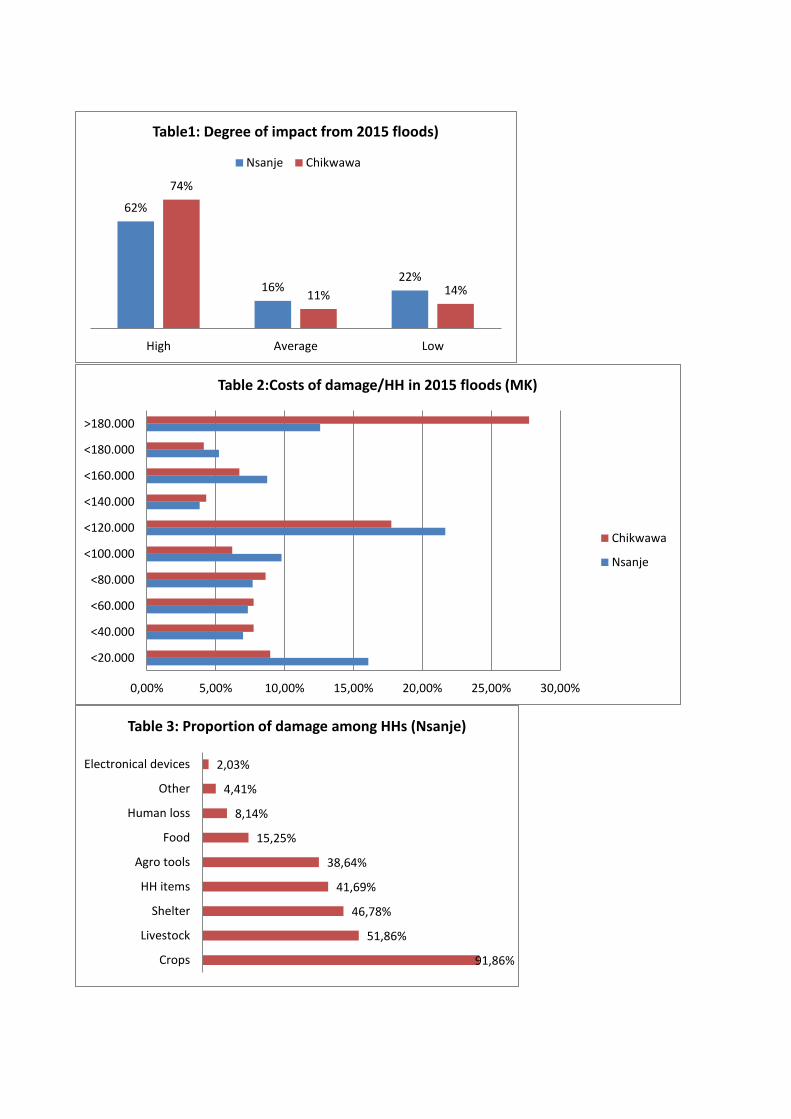
negatively food production, worsens access to clean water and floods has become a persistent problem. As per table
1, 62% and 74% reported a high level of impact from the 2015 floods, Nsanje and Chikwawa respectively. Costs of
damage were very high and in Chikwawa alone, around 27% reported damage worth more than MK180.000 (table 2).
Main damage was related to crops, livestock, shelter, HH items and agro tools (table 3). Only around 20% managed to
recover within 1 month (table 4). Main factors to recover after the floods were; winter cropping, humanitarian aid and
community support. Food, health, financial, NFIs and rescue were the top five aid types preferred by the communities
in Nsanje (table 5).
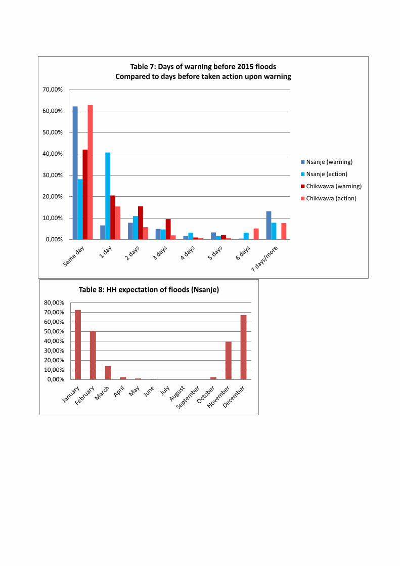
There were early warnings disseminated via radio, phones and a mobile public address system but communities
thought it was in adequate time to prepare. They are appreciative and satisfied with the mobile public address
system, but warnings came late in 2015 in both areas yet in Nsanje 60% reported they were only warned the same day
while the case was 40% for Chikwawa, the latter of which higher percentage were warned before and were able to
take early action (table 7). Many people did not prepare because they are used to the floods but the 2015 floods were
extensive and people were not expecting that level of floods. Only a few fled while many remained behind and got
shocked by the level of floods. They mentioned they are still interested in receiving early warnings in order not to lose
properties, livestock, crops and lives. They rely on both scientific and traditional warning signs. Rain gauges exist but it
seems unclear who knows how to operate it. Traditional signs include for drought include abundant fruits such as
mangos and pumpkins and ants collecting food. For floods it includes hippopotamus running away from the Shire to
higher land, crocodiles crossing the river, frog’s noise and presence of many ants. If they received forecasts on floods
today they would listen to the VCPC that encourage people to move with their belongings to higher grounds, prepare
evacuation centres (toilets and roofing), build dykes to direct water back to the Shire, prepare materials such as tents,
food and utensils. Some have built homes in the higher grounds or have family there whom they can live with. They
perceive key local capacities are there including well-functioning VCPC, CBOs, schools for evacuation and hospitals.
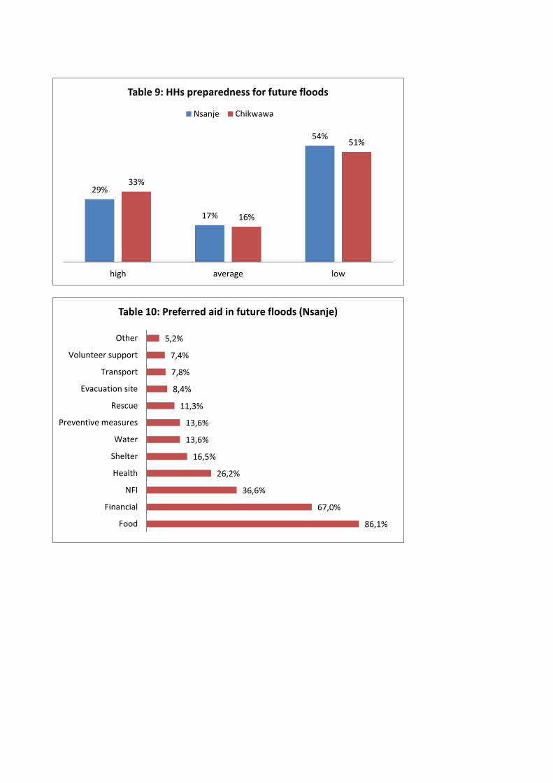
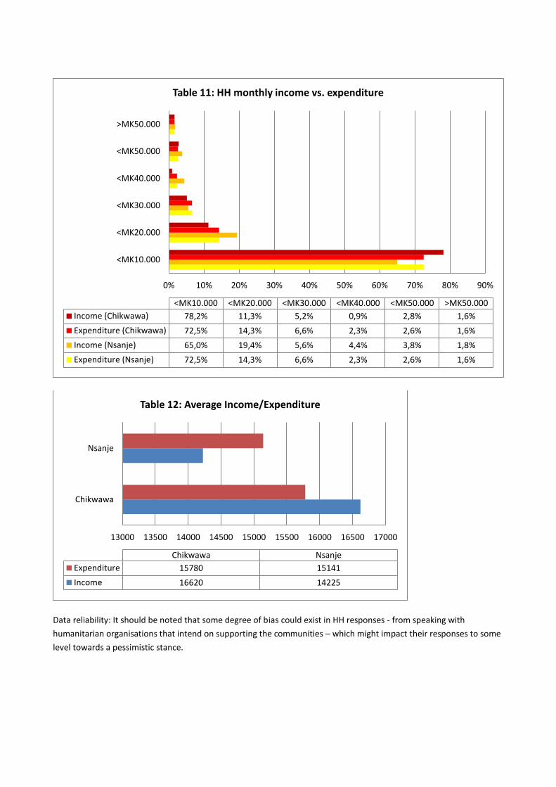
Respondents reported that peak month for floods in the coming rainy season are in January (table 8). However, in
both areas more than 50% assess they have a low level of preparedness (table 9). It was reported that for future
floods event, the top three preferred aid types would be food, financial and NFIs (table 10). Table 10 shows which aid
is preferred by Nsanje, top three includes: food aid, financial aid and NFI aid. While providing food and NFIs seems a
viable option several challenges remains towards this approach, including the specific needs and choice of
beneficiaries on these. Beneficiaries lose their freedom of choice when distributions of NFIs and food become
standardized. The communities also claim other needs they would like addressed. Finally, in-kind distribution includes
vast logistical processes for the MRCS in order to carry out such operations which may delay delivery. Cash has a lower
transaction cost than in-kind.
In light of these considerations cash seems the most viable solution which could cover the various needs of the
beneficiaries. While some HHs might have very particular needs such as either shelter or health those particular HHs
can address these needs independently with a potential cash grant. Additional rationale originates from respondents
who replied low preparedness for future floods because of lack of financial means and the ones who replied high
preparedness for future floods because they either have been able to build on higher grounds, stock of food or
implementing mitigation measures (annex 5). A cash grant can help these communities take early actions on
whichever their particular needs are. It is therefore recommended to precede with multipurpose cash grants.

Several cash solutions have been examined. Mobile solution proves to be challenging due to several factors; network
is provided by different network providers across the districts and even in some areas network is totally missing;
beneficiaries (as per table E) has very limited access to mobile phones, only 40% in Nsanje and 45% in Chikwawa, and
considering the project is targeting the most poor and vulnerable there would be an additional activity to train on
usage of phones; beneficiaries has to travel to retrieve their cash which increases the transaction costs; they
sometimes stay in their locality and retrieve their cash via local agents who sometimes charges up to 25% of the total
amount; given the narrow window of opportunity for FbF and early action, there is a need to find the most cost/time
efficient procedure; and finally, during the VCA focus group discussions communities voiced that cash in hand is the
ultimate mechanism because it makes funds readily available for all beneficiaries regardless of their condition
(although some mentioned the risk that funds would not be used for the right purposes). For these reasons the ECHO-
ERIM technical committee advices to use cash in hand for FbF.
For cash to be a viable aid mechanism markets needs to be functioning and able to absorb the beneficiaries various
demands. Market assessments and monitoring in the target areas need to be conducted. However, as per table E, 71%
and 40%, in Nsanje and Chikwawa respectively, reported that markets were functioning even during the extensive
2015 floods which assure that markets in the target areas are resilient. Some reported functioning markets were a 30-
90 minute walk from their community. See annex 4 for location of main markets in the TA.
Additional to ensuring the efficiency of any cash modality it is necessary to estimate the amount for communities to
receive. Respondents’ average monthly expenditure is MK14.558 and MK16.620, Nsanje and Chikwawa respectively
(see table 12). However, 65 and 78%, in Nsanje and Chikwawa respectively, have a monthly income of less than
MK10.000 (table 11). It is also observed from table 4 that 43% in both TAs needed more than 2 months to recover
from the 2015 floods. A decision on cash amounts should take these figures into account.
The ECHO-ERIM project notes that 2800 households will be targeted with a cash transfer of around 35000MWK. The
DRC has pledged to provide funds outside of the ECHO budget, of DKK 1.000.000/EUR134.37012
, to pilot test the
Forecast-based Financing mechanism.
Sensitization: Finally, it is essential to conduct awareness raising campaigns. In a scenario where hazards put people’s
lives at risk, it is important to stress the need to evacuate the area to the pre-identified evacuation sites. This should
be stipulated in the related SOP to each hazard and trigger level. Sensitization during floods should ideally also focus
on WASH aspects.
Timing: due to the highly time-bound approach of FbF it is key to ensure preparedness at all levels. Respondents
replied, according to table 7, that floods are most frequently occurring during November-February. These perceptions
should be triangulated with DoDMA, DCCMS and the department of hydrology.
Apart from cash modalities, alternative activities could include other preparedness and early actions:
Preparedness measures:13
Several preparedness activities can be undertaken in cooperation with relevant stakeholders. Some of the below
activities are already being processed including cash-preparedness and evacuation site identification. Below a list of
suggested preparedness activities:
Cash preparedness: pre-agreements with financial service providers (for CTP)
12
XE as of 23/11/17 13
German Red Cross, FbF manual
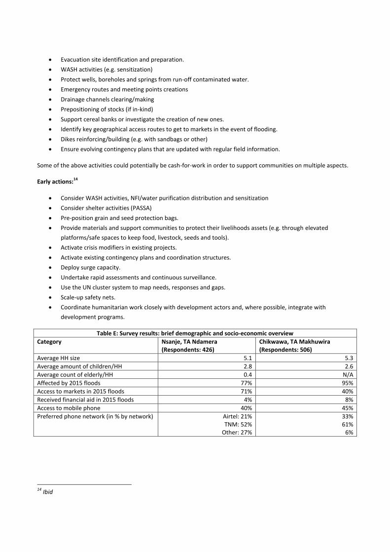
Evacuation site identification and preparation.
WASH activities (e.g. sensitization)
Protect wells, boreholes and springs from run-off contaminated water.
Emergency routes and meeting points creations
Drainage channels clearing/making
Prepositioning of stocks (if in-kind)
Support cereal banks or investigate the creation of new ones.
Identify key geographical access routes to get to markets in the event of flooding.
Dikes reinforcing/building (e.g. with sandbags or other)
Ensure evolving contingency plans that are updated with regular field information.
Some of the above activities could potentially be cash-for-work in order to support communities on multiple aspects.
Early actions:14
Consider WASH activities, NFI/water purification distribution and sensitization
Consider shelter activities (PASSA)
Pre-position grain and seed protection bags.
Provide materials and support communities to protect their livelihoods assets (e.g. through elevated
platforms/safe spaces to keep food, livestock, seeds and tools).
Activate crisis modifiers in existing projects.
Activate existing contingency plans and coordination structures.
Deploy surge capacity.
Undertake rapid assessments and continuous surveillance.
Use the UN cluster system to map needs, responses and gaps.
Scale-up safety nets.
Coordinate humanitarian work closely with development actors and, where possible, integrate with
development programs.
Table E: Survey results: brief demographic and socio-economic overview
Category Nsanje, TA Ndamera (Respondents: 426)
Chikwawa, TA Makhuwira (Respondents: 506)
Average HH size 5.1 5.3
Average amount of children/HH 2.8 2.6
Average count of elderly/HH 0.4 N/A
Affected by 2015 floods 77% 95%
Access to markets in 2015 floods 71% 40%
Received financial aid in 2015 floods 4% 8%
Access to mobile phone 40% 45%
Preferred phone network (in % by network) Airtel: 21% TNM: 52%
Other: 27%
33% 61%
6%
14
Ibid
62%
16% 22%
74%
11% 14%
High Average Low
Table1: Degree of impact from 2015 floods)
Nsanje Chikwawa
0,00% 5,00% 10,00% 15,00% 20,00% 25,00% 30,00%
<20.000
<40.000
<60.000
<80.000
<100.000
<120.000
<140.000
<160.000
<180.000
>180.000
Table 2:Costs of damage/HH in 2015 floods (MK)
Chikwawa
Nsanje
91,86%
51,86%
46,78%
41,69%
38,64%
15,25%
8,14%
4,41%
2,03%
Crops
Livestock
Shelter
HH items
Agro tools
Food
Human loss
Other
Electronical devices
Table 3: Proportion of damage among HHs (Nsanje)

0% 10% 20% 30% 40% 50%
1 month
2 months
> 2 months
Still not recovered
1 month 2 months > 2 monthsStill not
recovered
Chikwawa 21% 6% 43% 30%
Nsanje 20% 11% 43% 27%
Table 4: Time to recover from 2015 floods
69,48%
38,96%
31,17%
29,22%
23,38%
17,53%
14,29%
12,99%
11,04%
9,74%
3,90%
0,00%
Food
NFIs
Health
Financial
Rescue
Water
Evacuation site
Shelter
Volunteer support
Transport
Other
Preventive measures
Table 5: Preferred aid received in 2015 floods (Nsanje)
71,33%
32,33%
27,67%
13,33%
11,00%
7,33%
2,33%
Weather
Celestial bodies
Hydro-met
Plants
ACPC
Animals
Rain gauges
Table 6: Forecasts most frequently used by HHs (Nsanje)
0,00%
10,00%
20,00%
30,00%
40,00%
50,00%
60,00%
70,00%
Table 7: Days of warning before 2015 floods Compared to days before taken action upon warning
Nsanje (warning)
Nsanje (action)
Chikwawa (warning)
Chikwawa (action)
0,00%
10,00%
20,00%
30,00%
40,00%
50,00%
60,00%
70,00%
80,00%
Table 8: HH expectation of floods (Nsanje)
29%
17%
54%
33%
16%
51%
high average low
Table 9: HHs preparedness for future floods
Nsanje Chikwawa
86,1%
67,0%
36,6%
26,2%
16,5%
13,6%
13,6%
11,3%
8,4%
7,8%
7,4%
5,2%
Food
Financial
NFI
Health
Shelter
Water
Preventive measures
Rescue
Evacuation site
Transport
Volunteer support
Other
Table 10: Preferred aid in future floods (Nsanje)
Data reliability: It should be noted that some degree of bias could exist in HH responses - from speaking with
humanitarian organisations that intend on supporting the communities – which might impact their responses to some
level towards a pessimistic stance.
0% 10% 20% 30% 40% 50% 60% 70% 80% 90%
<MK10.000
<MK20.000
<MK30.000
<MK40.000
<MK50.000
>MK50.000
<MK10.000 <MK20.000 <MK30.000 <MK40.000 <MK50.000 >MK50.000
Income (Chikwawa) 78,2% 11,3% 5,2% 0,9% 2,8% 1,6%
Expenditure (Chikwawa) 72,5% 14,3% 6,6% 2,3% 2,6% 1,6%
Income (Nsanje) 65,0% 19,4% 5,6% 4,4% 3,8% 1,8%
Expenditure (Nsanje) 72,5% 14,3% 6,6% 2,3% 2,6% 1,6%
Table 11: HH monthly income vs. expenditure
13000 13500 14000 14500 15000 15500 16000 16500 17000
Chikwawa
Nsanje
Chikwawa Nsanje
Expenditure 15780 15141
Income 16620 14225
Table 12: Average Income/Expenditure

Beneficiary selection and registration
The pilot FBF project will support a group of 2.800 beneficiaries in the two districts of Chikwawa (in TA Makhuwira)
and Nsanje (in TA Ndamera).
The hazard history and patterns are known by the actors involved in the pilot project and ideally the affected
communities should be selected and registered before any triggers are activated. Yet, hazards can be unpredictable
and strike in unforeseen areas and that necessitate a certain level of flexibility. For this reason, the pilot should remain
open to register new beneficiaries should the hazards strike areas not already registered.
Various options are available for beneficiary registration. The Malawi Government is currently undertaking
encompassing registration exercises and the work is yet to be finalized. The FbF registration approach should be
decided upon in consultation with relevant stakeholders. Below some propositions:
For this to be possible, local branch volunteers will be trained to quickly deploy to an area for registration.
1. MRCS community based targeting processes
MRCS works closely with District, Area and Village Civil Protection Committees (ACPC and VCPC), the District Executive
Council (DEC) as well as the Ministry of Agriculture to obtain information about households and villages to benefit.
Based on the overall information, MRCS and the mentioned stakeholders allocate the number of beneficiaries to be
supported per village.
MRCS does not allow traditional chiefs to be directly involved in the targeting processes, but registration teams should
do their best to include them in terms of information sharing and explaining the processes. Rather, MRCS follows
community based targeting (CBT) approaches to reach a consensus on who are the most vulnerable households. The
CBT is led by the ACPC, VCPC and the community and observed by MRCS staff and volunteers.
Malawi Red Cross Society used the beneficiary household selection criteria as stipulated in the JEFAP manual. The
manual is a guideline on how to identify beneficiary households at national, district, TA and group village level (GVH).
The MRCS has the responsibility to steer the targeting of beneficiaries at village level.
2. JEFAP11 standardised selection criteria in Malawi
Used by WFP and the INGO Consortium in the form below since 2015 up to 2016/17 response season.
Adopted by MRCS in the 2016/17 response.
Assumes average household size of 5.5 people.
Community-based targeting
Beneficiaries need to meet at least one social and one economic criteria in combination.
Social Criteria Economic Criteria
Keeping orphans under 18 years No large livestock
Keeping an elderly person No IGA
Child headed household (orphan-headed or where there is no able adult member)
No formal wages
Keeping a chronically ill person Land size less than 2 acres
Female headed household Consumed harvest in < 2 months
Disabled person Dependence on piece work for food (Ganyu)
Pregnant and lactating mother (households with children receiving or in need of supplementary therapeutic feeding)
Household with two or more years of successive crop failure

Due to great concerns regarding the JEFAP criteria not being strong enough and not giving proper guidance on the
processes, the JEFAP is in an on-going process of revision by WFP and the INGO-consortium. Additionally, most
partners have experienced difficulties in correct targeting of the most vulnerable and a high incidence of corruption
and inclusion errors lead by traditional chiefs in the communities.
3. Social Cash Transfer Program (SCTP)
The SCTP targets the ultra-poor and labour constrained households:
Ultra poor households with the following characteristics:
The household has on average only one meal per day; and/or
The household survives from begging; and/or
The household is undernourished; and/or
The household does not possess any valuable assets; and/or
The household does not receive any monetary help, food, or gifts from others.
Labour-constrained household has the following characteristics:
No member in the age bracket 19-64 years fit for work;
Members in the age bracket 19-25 years attending school;
A dependency ratio > 3.
The ministry of welfare and economic planning, via their district extension workers, have recently provided the Red
Cross with the SCTP beneficiary lists for the districts of Nsanje, Chikwawa and Zomba. However, these lists do not take
into account locations of beneficiaries. In case of scenario with flood warning, using this approach would potentially
include a significant amount of people not living in high flood prone areas.
During the VCAs FGDs communities responded they would support the vertical support of beneficiaries on SCTP. They
confirmed that people registered in the SCTP are the most vulnerable in their communities.
4. Concern World Wide (CWW) beneficiary selection tool
The ECHO-ERIM project is partnering the CWW-COOPI consortium who is also running an ECHO funded project. CWW
have developed a predictive targeting tool aligned with Government selection tools: JEFAP, UBR and the SCTP. It is
well developed but for the FbF pilot there is a need to improve on the location criterion if using this approach.
Criterion / Programme i) Location • HH is located close to rivers that regularly floods, • HH is located in an area where there has been drought in 3 out of the last 5 years • HH is located in areas affected by strong winds in the previous 2 years • Housing would not withstand moderate flooding or high winds ii) Asset availability: Exclusion criteria: households having 2 or more of the following will be excluded on the basis of wealth. >1Cow, >Donkey, >1Pig>, >3Goats iii) Income Source: Exclusion criteria: households with a member on a formal wage or where the household has a regular income, other than ganyu. iv) HH demographics:
Looks after Chronically ill or members of the family living with disability

Child headed Household
Elderly Headed Household >60 years
Female Headed Household with >2 children under 5 years
Hh with large dependants>3 family members. v) Reproductive / nutritional status:
Households with a Pregnant or Lactating Woman at time of predictive screening;
Households with a Child(ren) registered for supplementary feeding at time of screening.
vi) Food Security: • Food from last harvest lasted <¸6 months • No. of meals eaten per day in the last week: 1 - 2 • Households with two or more years of successive crop failure
See complete document and tool from CWW:
Process & Criteria for
Predictive Targeting 26.9.2017.docx
Screening Tool
-Predictive Targeting V3 26.9.2017.xlsx
5. Hazard mapping
The above approaches take very little into account the geographic location of the beneficiaries. It is crucial to build a
GIS (geographic information system) mapping all of the flood prone areas in the target areas. Having recently
recruited a data-team within the MRCS that works in close cooperation with the NLRCS data-team the capacities are in
place to perform that exercise. The approach could include qualitative consultations with district MRCS, civil
protection committee, department of public works and community representatives. The accounts from these
stakeholders could inform on the drawing of hazard prone areas in the GIS. It could also be coupled with more
technology driven approaches including usage of drones images and satellite imagery from former floods. Using this
hazard mapping approach should be in combination with one of the vulnerability criteria outlined above.
Digital registration tool
For registration it has been an ECHO demand to use a digital platform for managing beneficiary data is called. There
has been extensive discussions on which tool is the most viable choice for MRCS.
SCOPE: Initially the choice fell on SCOPE, however, due to negative experiences during last trial MRCS is reluctant to
use this tool (MRCS cooperation with WFP on the tool ended abruptly without explanation). CWW-COOPI consortium
prefers using this tool. The tool is managed by WFP and fees are due for its usage, plastic cards and printing of cards.
The fee for usage has not been clarified so far although a request was sent.
MegaV: The other solution which is preferred by MRCS is to use the IFRC developed tool called MegaV in combination
with ODK. The software is free of charge and IFRC have already supported in guiding and it’s possible to have further
training. DM has experience in using this tool from previous operations. The tool can print out barcodes on paper (e.g.
thin plastic sheets) and there is no need to procure special printers. The barcodes can then be distributed to
beneficiaries and scanned during distributions with a handheld scanner or smartphone. MegaV also generates an
automated report after distributions.
With both tools it is possible to register beneficiaries in the field offline with a pc or smartphone for later uploading of
the data upon access to internet.
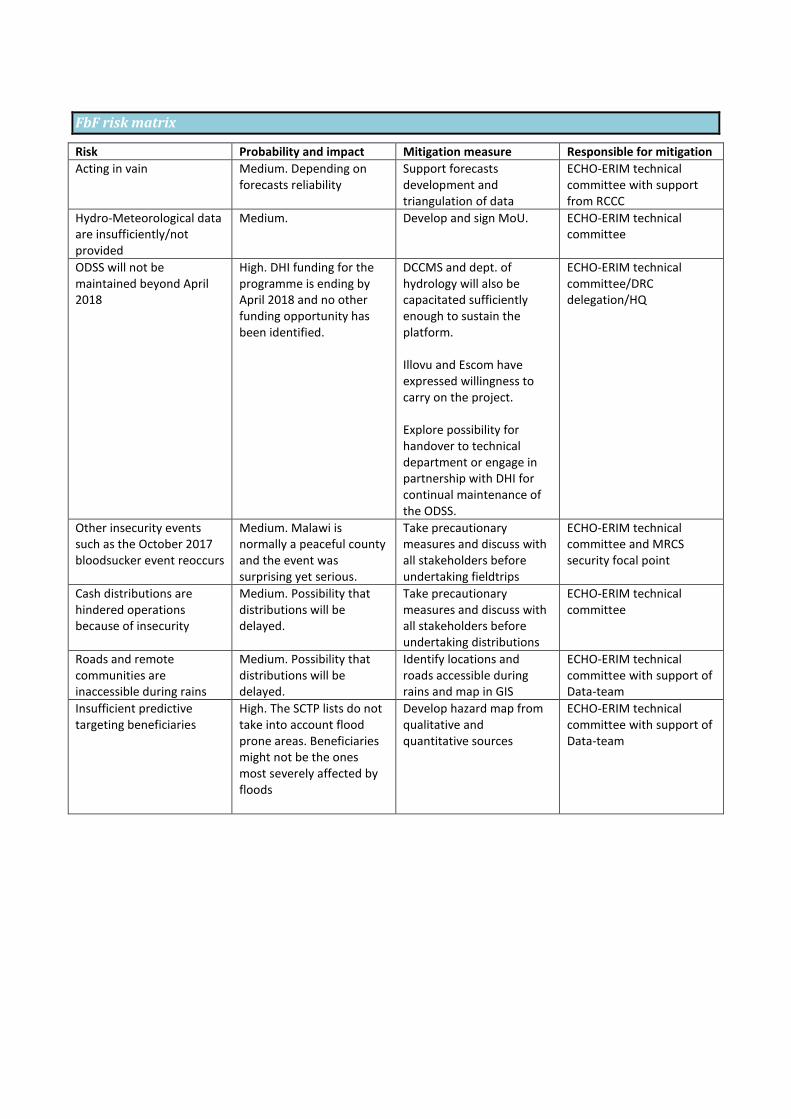
FbF risk matrix
Risk Probability and impact Mitigation measure Responsible for mitigation
Acting in vain Medium. Depending on forecasts reliability
Support forecasts development and triangulation of data
ECHO-ERIM technical committee with support from RCCC
Hydro-Meteorological data are insufficiently/not provided
Medium. Develop and sign MoU. ECHO-ERIM technical committee
ODSS will not be maintained beyond April 2018
High. DHI funding for the programme is ending by April 2018 and no other funding opportunity has been identified.
DCCMS and dept. of hydrology will also be capacitated sufficiently enough to sustain the platform. Illovu and Escom have expressed willingness to carry on the project. Explore possibility for handover to technical department or engage in partnership with DHI for continual maintenance of the ODSS.
ECHO-ERIM technical committee/DRC delegation/HQ
Other insecurity events such as the October 2017 bloodsucker event reoccurs
Medium. Malawi is normally a peaceful county and the event was surprising yet serious.
Take precautionary measures and discuss with all stakeholders before undertaking fieldtrips
ECHO-ERIM technical committee and MRCS security focal point
Cash distributions are hindered operations because of insecurity
Medium. Possibility that distributions will be delayed.
Take precautionary measures and discuss with all stakeholders before undertaking distributions
ECHO-ERIM technical committee
Roads and remote communities are inaccessible during rains
Medium. Possibility that distributions will be delayed.
Identify locations and roads accessible during rains and map in GIS
ECHO-ERIM technical committee with support of Data-team
Insufficient predictive targeting beneficiaries
High. The SCTP lists do not take into account flood prone areas. Beneficiaries might not be the ones most severely affected by floods
Develop hazard map from qualitative and quantitative sources
ECHO-ERIM technical committee with support of Data-team

Theory of Change

Conclusion and recommendations
Overall significant capacity is observed across the various stakeholders considered in the forecast-based finance and
EWS mechanism. In the conclusion FbF remains medium-highly feasible in Malawi Ndamera and Makhuwira (see table
D on hydro-met capacities). However, with the improvement of crucial building blocks the mechanism would
significantly become more viable, e.g. floods forecasts.
The Government of Malawi has various instruments in place to support the development of early warning early action,
particularly the MNSSP2, NDRM and NAPA documents. The hydro-met offices, DCCMS and department of hydrology,
have substantial capacity in delivering weather forecast and flash floods warnings (although the latter is with a short
12hrs lead time). Some steps have been taken towards impact based forecasts and more elaborate narrative on
impacts during extreme events would be crucial for the development of the mechanism. In contribution to the
forecasts the DHI developed tool ODSS and the EU forecast tool GLOFASS will be useful resources in adding to national
forecast on floods.
The Red Cross with all its partners including the climate centre is well placed to pilot an FbF project in Malawi. MRCS
has experience in cash transfer and DRM and their vast network of the Red Cross including the field based structures
and volunteers are vital in this regard. This is also relevant for the information and cooperation that should be two-
way between field and HQ/regional offices e.g. on forecasts for ground verification, first assessments/response etc.
Several recommendations are suggested upon the above study and should be scheduled for effective
implementation:
Conduct a training on FbF for MRCS key staff and external stakeholders
Conduct a workshop to develop FbF SOPs with relevant stakeholders such as hydro-met offices
Ensure CTP SOPs are understood by all relevant stakeholders, especially finance and procurement
departments
Design pre-selection methods for early beneficiary registration
Conduct scientific hazard mapping using GIS tool, historical satellite images during floods events and field
qualitative inputs
Ensure closer links with data-teams to build up information systems relevant to EWS
Conduct further mapping sessions in communities to fully map target areas for FbF (infrastructure at risk,
possible evacuation sites at high ground, markets in proximity functioning during floods etc)
Conduct lessons learned process and improve SOPs
Develop a multi-hazard FbF SOPs including drought and other hazards
Explore opportunities for the continuation of the ODSS maintenance after its current end-date
Support development of preparedness in MRCS
Support development of an emergency operations unit
Explore future options for financing of FbF
Conduct a session with the partners on developing an implementation plan for the strategy on Shock
Responsive Social Protection.
Participate in regional and global dialogue platforms on FbF
Support the development of impact based forecasting in Malawi in cooperation with WMO
Maintain a flexible and iterative approach in FbF design
Annex 1: Abbreviations
ECHO – European Commission Humanitarian Aid Office
ERIM – Enhancing Resilience in Malawi
TA – Traditional Authority
GVH – Group village head
CTP – Cash Transfer Programme
EWS – Early Warning Systems
Annex 2: Supporting documents and relevant links
Documents:
ODI and Red Cross Red Crescent Climate Centre, Shock Responsive Social Protection for Malawi, September
2017
UNISDR Global Assessment Report on DRR:
http://www.preventionweb.net/english/hyogo/gar/2015/en/profiles/GAR_Profile_MWI.pdf /
http://www.preventionweb.net/english/hyogo/gar/2015/en/home/data.php?iso=MWI
FbF manual: http://fbf.drk.de/
National Adaptation Programme of Action http://unfccc.int/resource/docs/napa/mwi01.pdf
2015 floods post disaster needs assessment: https://reliefweb.int/report/malawi/malawi-2015-floods-post-
disaster-needs-assessment-report
National disaster risk management policy: http://www.ifrc.org/docs/IDRL/43755_malawidrmpolicy2015.pdf
Links
510 risk toolbox https://profiles.510.global/#!/dashboards/5724a3e6af4258443e0f9bc6/community_profile
Engineer consultancy for SRBMP, BRL: https://frm-isp-malawi.brl.fr/
DCCMS: http://www.metmalawi.com/forecasts/forecasts.php
DHI ODSS tool http://malawiodss.dhigroup.com/ODSS/
GLOFAS, EU forecast: http://globalfloods.jrc.ec.europa.eu/glofas-forecasting/#
IASC, InfoRM http://www.inform-index.org/
Shire River Basin Management Programme: http://www.shirebasin.mw/
Shire River Basin Operational Decision Support System: http://malawiodss.dhigroup.com/ODSS/
Annex 3: Contact list
Institution Address Name Phone Email
Department of hydrology
Lilongwe/ Blantyre
Solomon Kalima 0999857731/088885773. [email protected]
Marcel Kaunda +265 999 370 160 [email protected]
Department of Climate Change and Metrological services (DCCMS)
Government Offices- South, P.O. Box 1808, Blantyre.
Yobu Kachiwanda 0888878603/0995155050
Charles Vanya +265 888 980 545 [email protected]
Director of DCCMS Mr. Nkokwe
Tel: (265) 1 822014 Fax: (265) 1 822215
[email protected] www.metmalawi.com [email protected]
Department of disaster management
Lilongwe Samuel Gama +265 999 673 535 [email protected]

affairs (DoDMA)
DHI (SRBMP) Lilongwe Dr John Mthandi +265 99 527 7800 [email protected]
Malawi RCS Lilongwe Joseph Moyo +265 995 338 800 [email protected]
Annex 4: Maps
Weather in Malawi (precipitation, max and min temperature)
Malawi has a sub-tropical climate, which is relatively dry and strongly seasonal. The warm-wet season stretches from November to April, during which 95% of the annual precipitation takes place. Annual average rainfall varies from 725mm to 2,500mm with Lilongwe having an average of 900mm, Blantyre 1,127mm, Mzuzu 1,289mm and Zomba 1,433mm. Extreme conditions include the drought that occurred in 1991/92 season and floods of 1988/89 season. The low-lying areas such as Lower Shire Valley and some localities in Salima and Karonga are more vulnerable to floods than higher grounds. A cool, dry winter season is evident from May to August with mean temperatures varying between 17 and 27 degrees Celsius, with temperatures falling between 4 and 10 degrees Celsius. In addition, frost may occur in isolated areas in June and July. A hot, dry season lasts from September to October with average temperatures varying between 25 and 37 degrees Celsius. Humidity ranges from 50% to 87% for the drier months of September/October and wetter months of January/February respectively.
15
15
Source; DCCMS: http://www.metmalawi.com/climate/climate.php

Figure 5 - Weather station records, source WMO (Chikwawa District)

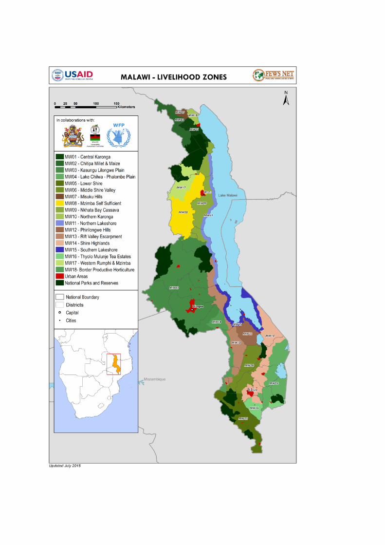

Figure 6 - Chikwawa hazard map
Figure 7 - Nsanje hazard map
Annex 5: Additional qualitative FbF survey results
HHs with LOW level of preparedness: Selected qualitative comments
Am an elderly person so I can’t do anything
We are an old couple and don't have the energy to construct strong houses which has can withstand some
of the disasters
It’s difficult to be prepared
Disasters are unpredictable
Accidents are inevitable
All the resources I had have been lost due to the first disaster event hence I have no capacity to retain the
lost assets

Because I am alone I can’t do anything
Don’t know ways to prepare for disasters
Due to dry spell we don't have enough food on the reserve
Even we get prepared something happens in different way
Floods are inevitable
I have no control over the weather
I have no money to build a better structure
I have no resources
I haven't yet constructed a house which is proper to sustain the hazards
It happens anyway
Lack of awareness on the hazards
Lack of food
Lack of reliable information sources
Lost hope in the government
No available resources i.e. farming tools, limited food, no access to an evacuation house
No plans in place
No preparations
No proper place for evaluating
No resources to build a better house
No resources to survive
No safe shelter
No warning alerts are available
The rains have been erratic
There is no predicting what happens tomorrow
Time for preparation is short
Wait for it to happen
We are poor
We just ignore the warning
We won't be prepared because of the areas where we're doing cultivation ....They are very close to water
sources which are prone to flooding
Because we know disaster will strike eventually
HHs with HIGH level of preparedness: Selected qualitative comments
Are well sensitized on the hazards
Because we are being taught how to prepare our fields
Can evacuate to a safer place
Due to last insident they dont want to go throught it again
Early cultivation and stocking of the food commodities in time
Early crop planting
Has moved to higher ground
Have a house in a safe and high ground
I have a place to seek refugee
I have a strong house

I have build my house on a raised ground and the river has been drenched and there is a dyke that will
protect us
I planted hedges near my field
I stay on a high ground already
Keeping of the household items safer the house is well located from hazard prone areas
Keeping livestock in safe places
preposition of food in time
The house is very safe and strong, and some food in stock
The household is well secured and we have food and livestock which can help me and my family sustain
from the disasters
The place where we're staying in is not very prone to disaster like flooding
We are aware of the situation
We plant trees to protect from running water and plant crops latter rains