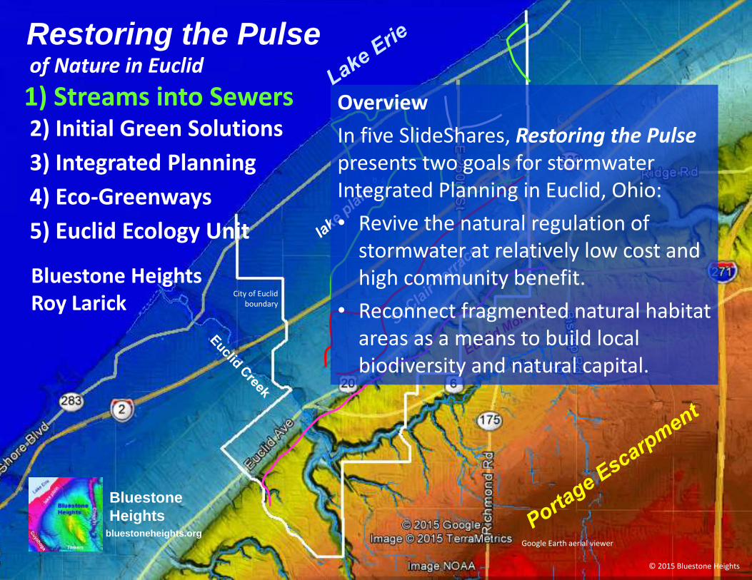
Restoring the Pulse
Bluestone HeightsRoy Larick
City of Euclid boundary
Google Earth aerial viewer
© 2015 Bluestone Heights
Bluestone
Heightsbluestoneheights.org
2) Initial Green Solutions
3) Integrated Planning
4) Eco-Greenways
1) Streams into Sewersof Nature in Euclid
5) Euclid Ecology Unit
Overview
In five SlideShares, Restoring the Pulsepresents two goals for stormwater Integrated Planning in Euclid, Ohio:
• Revive the natural regulation of stormwater at relatively low cost and high community benefit.
• Reconnect fragmented natural habitat areas as a means to build local biodiversity and natural capital.
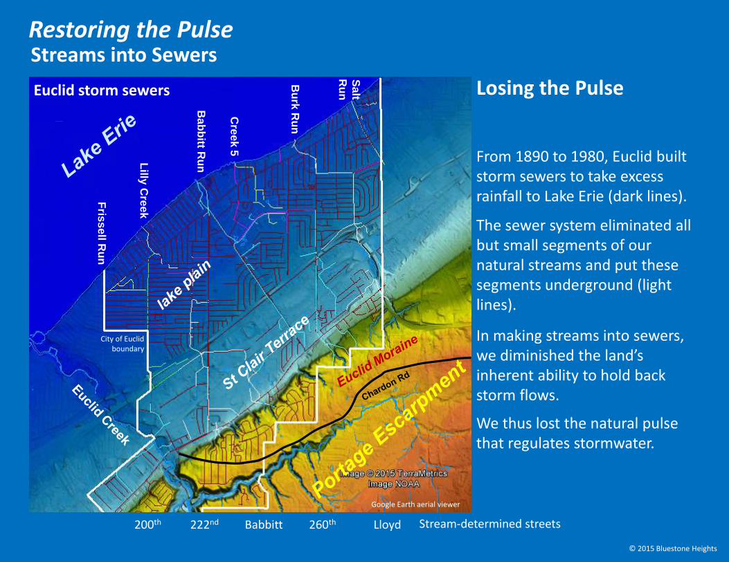
Streams into Sewers
From 1890 to 1980, Euclid built storm sewers to take excess rainfall to Lake Erie (dark lines).
The sewer system eliminated all but small segments of our natural streams and put these segments underground (light lines).
Restoring the Pulse
In making streams into sewers, we diminished the land’s inherent ability to hold back storm flows.
We thus lost the natural pulse that regulates stormwater.
Lilly
Cre
ek
Bab
bitt R
un
Cre
ek
5
Bu
rk R
un
Sa
lt
Ru
n
Fris
se
llR
un
Losing the Pulse
City of Euclid boundary
Google Earth aerial viewer
200th 222nd Babbitt 260th Lloyd
© 2015 Bluestone Heights
Stream-determined streets
Euclid storm sewers
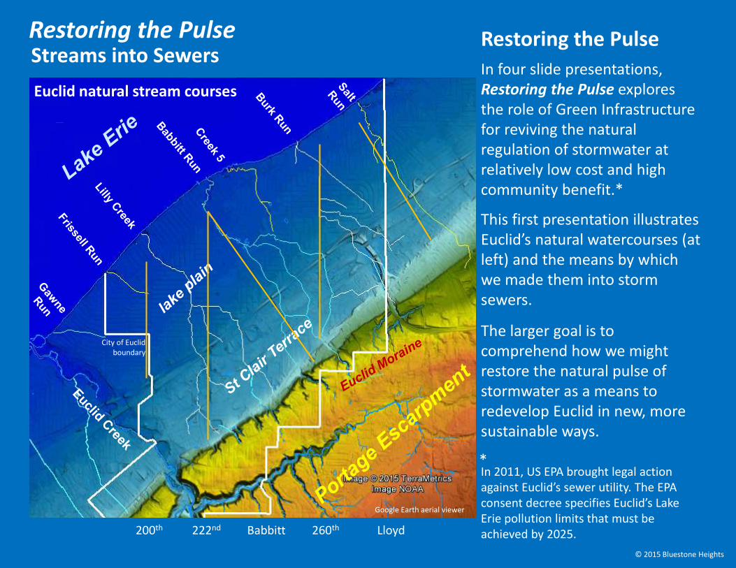
In four slide presentations, Restoring the Pulse explores the role of Green Infrastructure for reviving the natural regulation of stormwater at relatively low cost and high community benefit.*
This first presentation illustrates Euclid’s natural watercourses (at left) and the means by which we made them into storm sewers.
Streams into SewersRestoring the Pulse
City of Euclid boundary
Google Earth aerial viewer
In 2011, US EPA brought legal action against Euclid’s sewer utility. The EPA consent decree specifies Euclid’s Lake Erie pollution limits that must be achieved by 2025.
*
Restoring the Pulse
200th 222nd Babbitt 260th Lloyd
The larger goal is to comprehend how we might restore the natural pulse of stormwater as a means to redevelop Euclid in new, more sustainable ways.
© 2015 Bluestone Heights
Euclid natural stream courses

Key to understanding Euclid stormwater is the concept of watershed or stream catchment.
A watershed is the land surface upon which rainfall gravitates to a particular stream. As rainfall hits the ground, some is absorbed as groundwater, making way slowly through the catchment.
The remaining wetness becomes runoff to surface streams, which makes quick transit through the catchment and into Lake Erie.
Let’s look at Euclid’s ‘sheds in their regional and local contexts.
Streams into SewersRestoring the Pulse
City of Euclid boundary
Google Earth aerial viewer
The role of watersheds
200th 222nd Babbitt 260th Lloyd
© 2015 Bluestone Heights
Stream-determined streets
Euclid natural watersheds
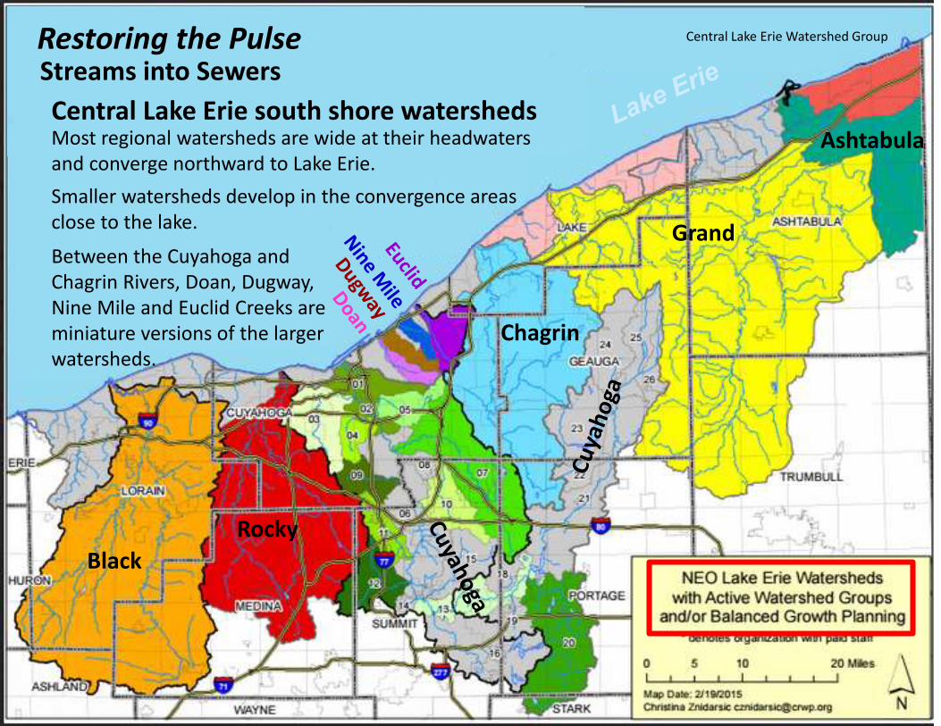
Central Lake Erie south shore watershedsMost regional watersheds are wide at their headwaters and converge northward to Lake Erie.
Smaller watersheds develop in the convergence areas close to the lake. Grand
Chagrin
Black
Rocky
Ashtabula
Between the Cuyahoga and Chagrin Rivers, Doan, Dugway, Nine Mile and Euclid Creeks are miniature versions of the larger watersheds.
Streams into SewersRestoring the Pulse Central Lake Erie Watershed Group
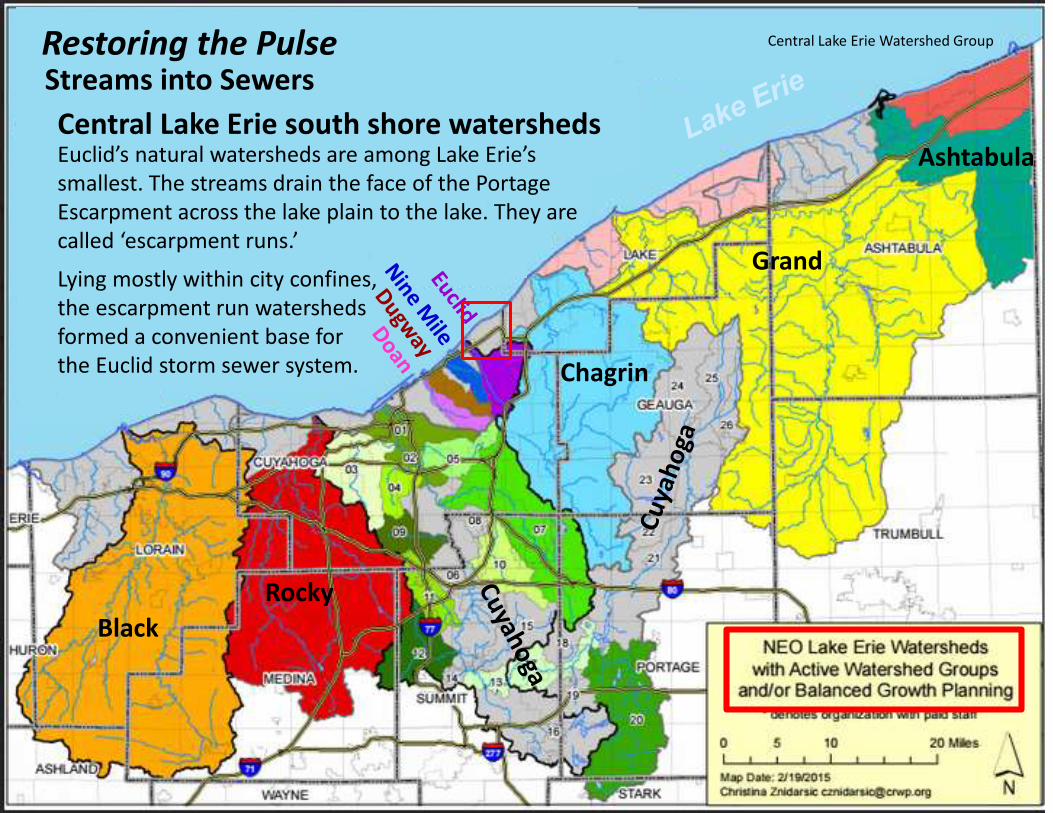
Lying mostly within city confines, the escarpment run watersheds formed a convenient base for the Euclid storm sewer system.
Grand
Chagrin
Black
Rocky
Ashtabula
Streams into SewersRestoring the Pulse
Central Lake Erie south shore watershedsEuclid’s natural watersheds are among Lake Erie’s smallest. The streams drain the face of the Portage Escarpment across the lake plain to the lake. They are called ‘escarpment runs.’
Central Lake Erie Watershed Group
Stream-determined streets
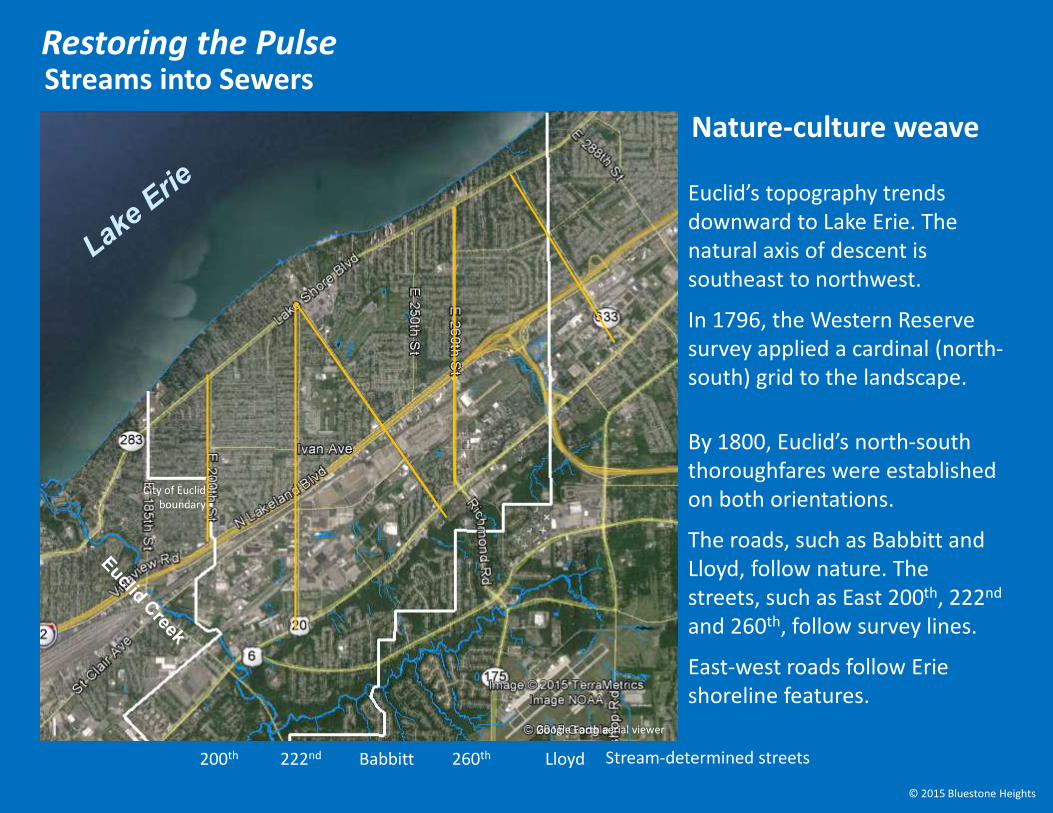
Euclid’s topography trends downward to Lake Erie. The natural axis of descent is southeast to northwest.
In 1796, the Western Reserve survey applied a cardinal (north-south) grid to the landscape.
By 1800, Euclid’s north-south thoroughfares were established on both orientations.
The roads, such as Babbitt and Lloyd, follow nature. The streets, such as East 200th, 222nd
and 260th, follow survey lines.
East-west roads follow Erie shoreline features.
Streams into SewersRestoring the Pulse
City of Euclid boundary
Google Earth aerial viewer
Nature-culture weave
200th 222nd Babbitt 260th Lloyd
© 2015 Bluestone Heights
Stream-determined streets
Streams into SewersRestoring the Pulse
City of Euclid boundary
Google Earth aerial viewer
200th 222nd Babbitt 260th Lloyd
© 2015 Bluestone Heights
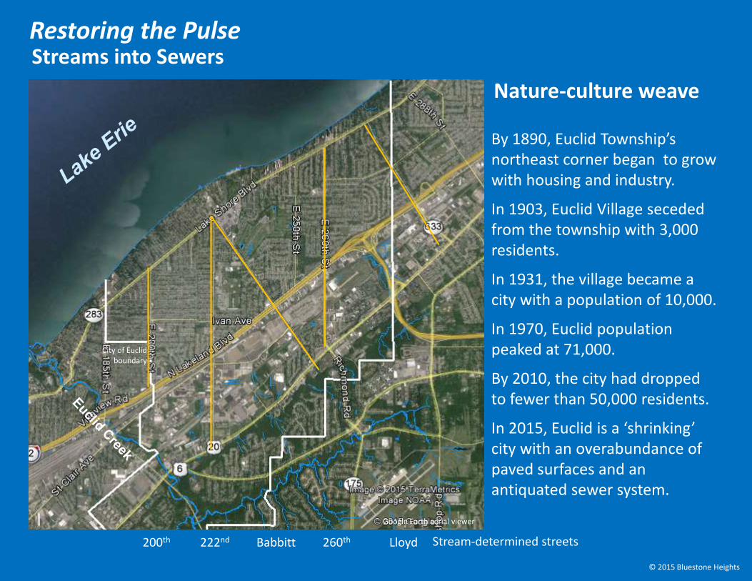
By 1890, Euclid Township’s northeast corner began to grow with housing and industry.
In 1903, Euclid Village seceded from the township with 3,000 residents.
In 1931, the village became a city with a population of 10,000.
In 1970, Euclid population peaked at 71,000.
By 2010, the city had dropped to fewer than 50,000 residents.
In 2015, Euclid is a ‘shrinking’ city with an overabundance of paved surfaces and an antiquated sewer system.
Nature-culture weave

Three major landforms:
The Portage Escarpment is a shale ‘massif’ capped with Euclid bluestone (fine, hard sandstone) and, above, the Euclid Moraine (a long ribbon of soft glacial debris).
Streams into SewersRestoring the Pulse
City of Euclid boundary
Google Earth aerial viewer
Euclid terrain basics
200th 222nd Babbitt 260th Lloyd
The St Clair Terrace has a shale surface leveled by the surf of ancient glacial lakes.
The lake plain is covered with soft glacial debris and lake bottom clay.
© 2015 Bluestone Heights
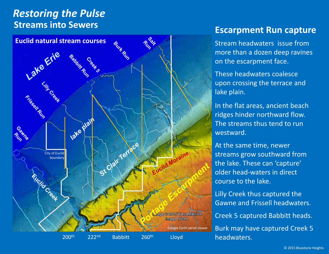
Stream headwaters issue from more than a dozen deep ravines on the escarpment face.
These headwaters coalesce upon crossing the terrace and lake plain.
In the flat areas, ancient beach ridges hinder northward flow. The streams thus tend to run westward.
At the same time, newer streams grow southward from the lake. These can ‘capture’ older head-waters in direct course to the lake.
Lilly Creek thus captured the Gawne and Frissell headwaters.
Creek 5 captured Babbitt heads.
Burk may have captured Creek 5 headwaters.
City of Euclid boundary
Google Earth aerial viewer
Escarpment Run capture
200th 222nd Babbitt 260th Lloyd
© 2015 Bluestone Heights
Streams into SewersRestoring the Pulse
Euclid natural stream courses
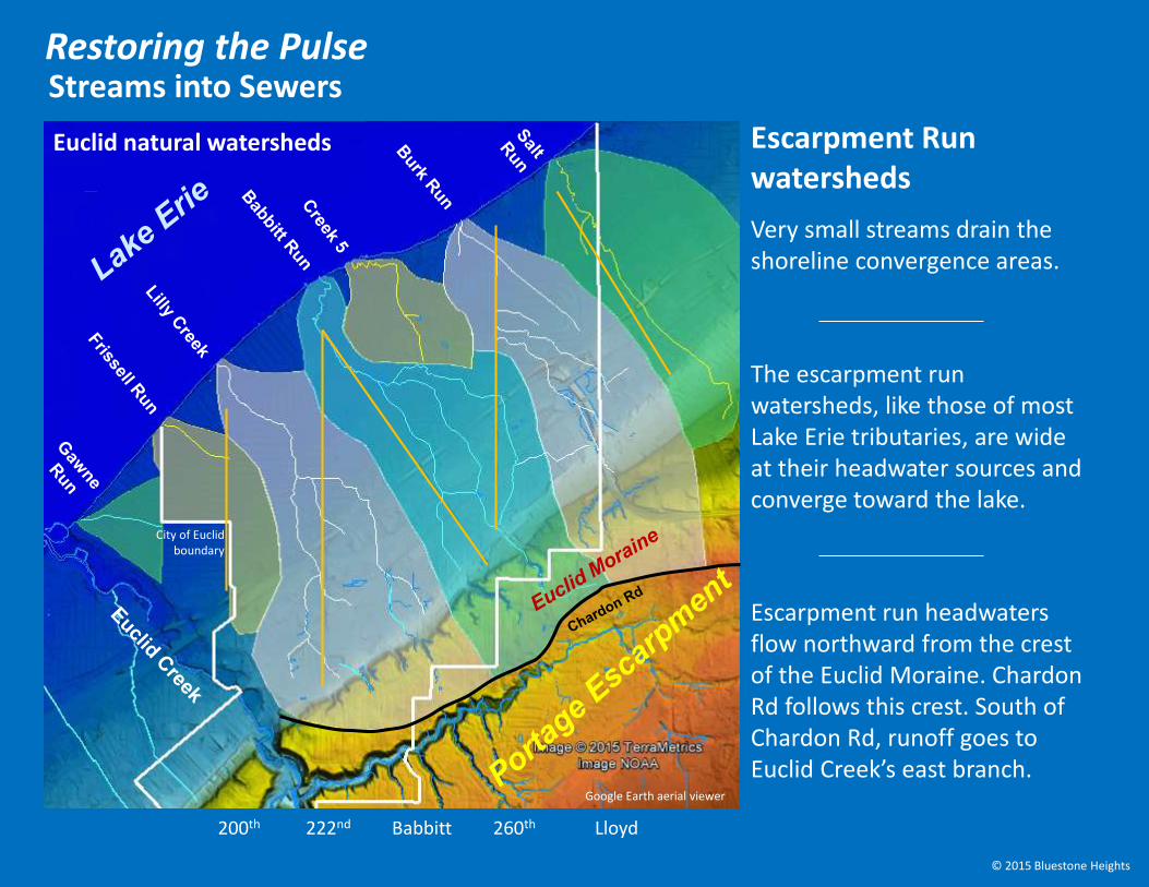
The escarpment run watersheds, like those of most Lake Erie tributaries, are wide at their headwater sources and converge toward the lake.
Escarpment run headwaters flow northward from the crest of the Euclid Moraine. Chardon Rd follows this crest. South of Chardon Rd, runoff goes to Euclid Creek’s east branch.
Very small streams drain the shoreline convergence areas.
City of Euclid boundary
Google Earth aerial viewer
Escarpment Run watersheds
200th 222nd Babbitt 260th Lloyd
© 2015 Bluestone Heights
Streams into SewersRestoring the Pulse
Euclid natural watersheds
Lilly
Cre
ek
Bab
bitt R
un
Cre
ek
5
Bu
rk R
un
Sa
lt
Ru
n
Fris
se
llR
un
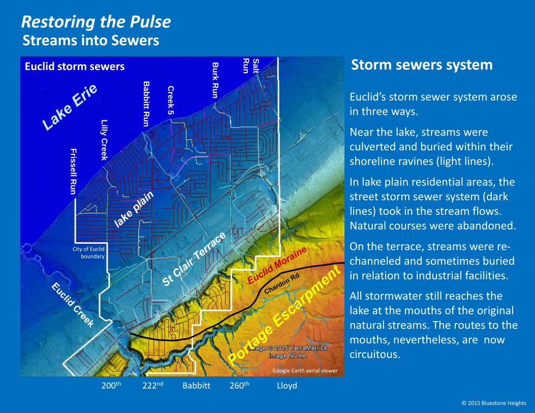
Euclid’s storm sewer system arose in three ways.
Near the lake, streams were culverted and buried within their shoreline ravines (light lines).
In lake plain residential areas, the street storm sewer system (dark lines) took in the stream flows. Natural courses were abandoned.
On the terrace, streams were re-channeled and sometimes buried in relation to industrial facilities.
All stormwater still reaches the lake at the mouths of the original natural streams. The routes to the mouths, nevertheless, are now circuitous.
City of Euclid boundary
Google Earth aerial viewer
Storm sewers system
200th 222nd Babbitt 260th Lloyd
© 2015 Bluestone Heights
Streams into SewersRestoring the Pulse
Euclid storm sewers
Lilly
Cre
ek
Bab
bitt R
un
Cre
ek
5
Bu
rk R
un
Sa
lt
Ru
n
Fris
se
llR
un
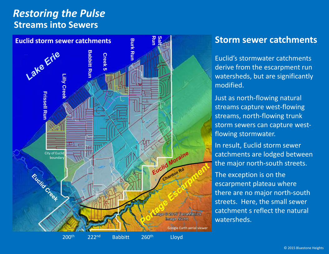
Euclid’s stormwater catchments derive from the escarpment run watersheds, but are significantly modified.
Just as north-flowing natural streams capture west-flowing streams, north-flowing trunk storm sewers can capture west-flowing stormwater.
In result, Euclid storm sewer catchments are lodged between the major north-south streets.
The exception is on the escarpment plateau where there are no major north-south streets. Here, the small sewer catchment s reflect the natural watersheds.
City of Euclid boundary
Google Earth aerial viewer
Storm sewer catchments
200th 222nd Babbitt 260th Lloyd
© 2015 Bluestone Heights
Streams into SewersRestoring the Pulse
Euclid storm sewer catchments

Public PresentationEuclid Public LibraryJune 10, 2015
City of Euclid boundary
Google Earth aerial viewer
© 2015 Bluestone Heights
Restoring the Pulse
Bluestone
Heightsbluestoneheights.org
2) Initial Green Solutions
3) Integrated Planning
4) Eco-Greenways
1) Streams into Sewersof Nature in Euclid
5) Euclid Ecology Unit

Roy Larick
Walk back in time Look to the Future
Bluestone Heights
© 2015 Bluestone Heights
A production by
bluestoneheights.org
[email protected] bluestone outcropDoan Brook, Cleveland OHR. Larick