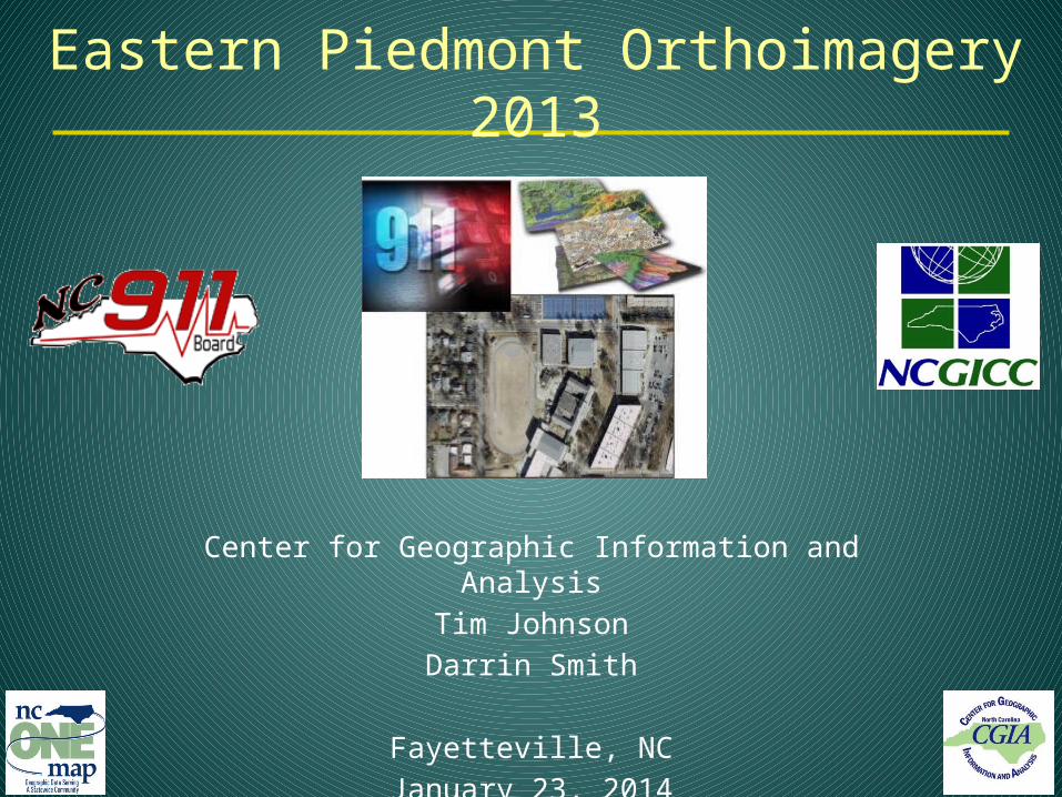
Eastern Piedmont Orthoimagery 2013
Center for Geographic Information and Analysis
Tim Johnson
Darrin Smith
Fayetteville, NC
January 23, 2014
Today
1. Introductions
2. Project overview
3. Portable drive contents
4. Technical Dialog
5. VOICE Recap
6. 60-Day Client Satisfaction Period
7. Expectations for data sharing
8. Online access: NC OneMap
9. Hand-off and next steps

Introduction• Acknowledgment
– NC 911 Board
– 128 Statewide Primary PSAPs– Randy Beeman
– Ft. Bragg Directorate of Plans, Training, Mobilization and Security
– Seymour Johnson AFB
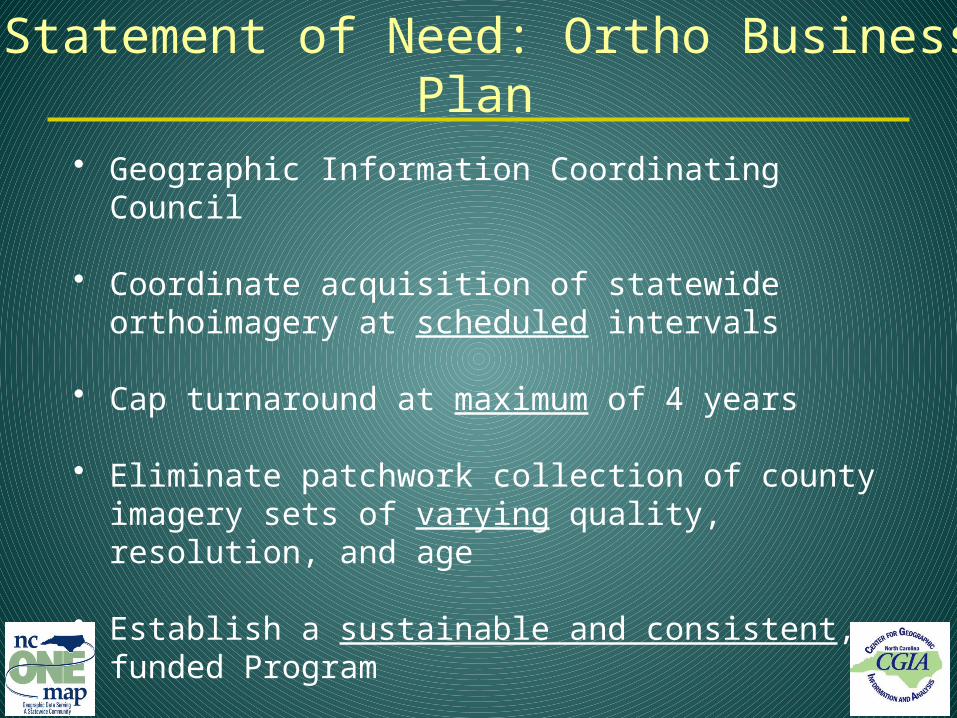
Statement of Need: Ortho Business Plan
• Geographic Information Coordinating Council
• Coordinate acquisition of statewide orthoimagery at scheduled intervals
• Cap turnaround at maximum of 4 years
• Eliminate patchwork collection of county imagery sets of varying quality, resolution, and age
• Establish a sustainable and consistent, funded Program
• Make it accessible to 911 Centers and the Public

CGIA Background• NC Center for Geographic Information and
Analysis • Lead state agency for GIS• Services Program – solutions for state and local
governments• Coordination Program – data sharing, informed
decision-making, and cost efficiencies

6
Statewide Ortho Program Approach
• Engage end-user quality review early• Common platform for concurrent review
• Visual consistency of imagery across study areas and Program phases
• Administer a Proactive approach to project delivery rather than engage in Reactive measures to quality issues

Organizational Structure
GICC
Atlas Geographic
Data
NC Geodetic Survey Global
Positioning SystemCORS Upgrade,
Camera Validation andHorizontal Quality
NC 911 Board
CGIAProject Manager, Contract Administration
QBS Quality Assurance, ProductDistribution and NC
OneMap Geospatial Portal
Working group for Ortho Planning:
NC Geodetic Survey, NC DENRNC Land Records ManagementNC Floodplain Mapping Program
NC DOT, NC Agriculture, Moore and Henderson Counties
US Geological Survey
Oversight and Advisory
NC DOTTechnical Advisory
ServicesPhotogrammetric QA
Level 2 QCSurdex
Corporation
Photo Science
Spatial Data Consultants
NC Department of the Secretary of State

The Program
Statewide Orthoimagery Acquisition Cycle
20132014
2015 2012
Business Plan for Orthoimagery
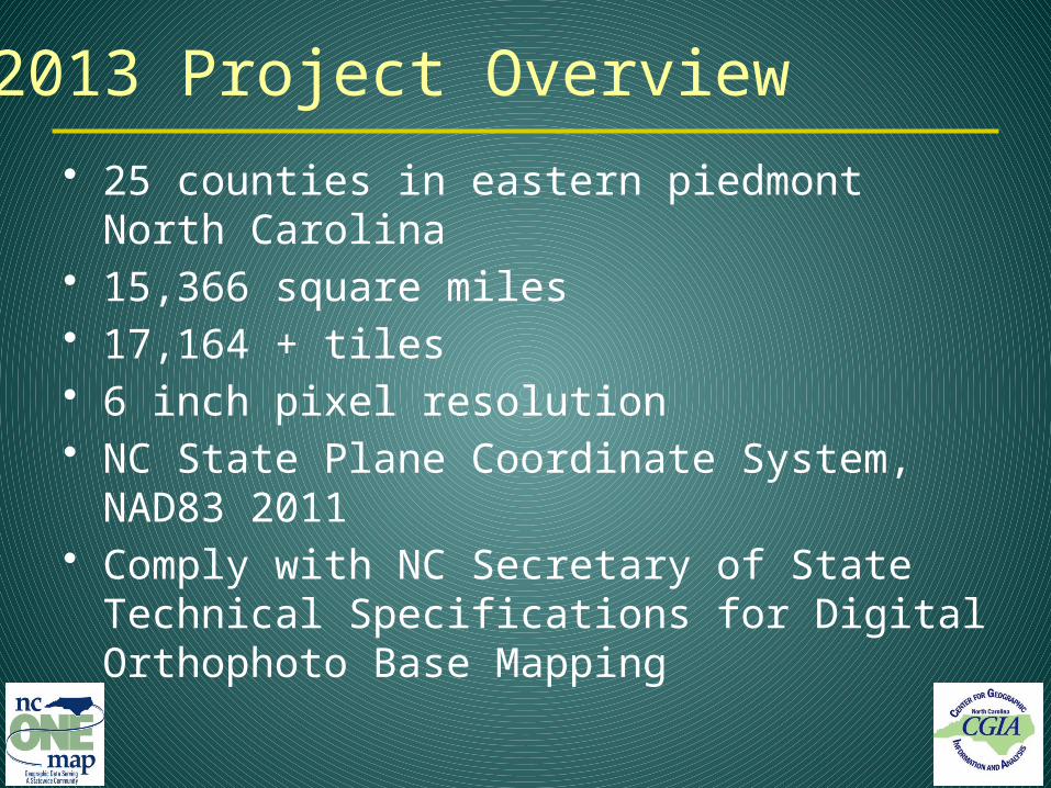
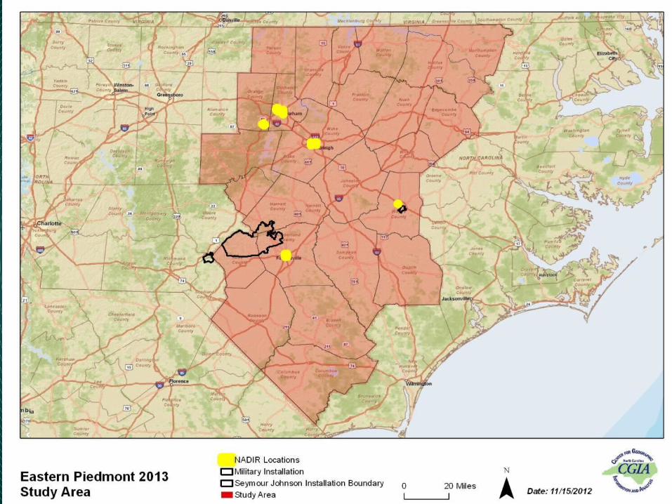
2013 Project Overview
• 25 counties in eastern piedmont North Carolina• 15,366 square miles• 17,164 + tiles• 6 inch pixel resolution• NC State Plane Coordinate System, NAD83
2011• Comply with NC Secretary of State Technical
Specifications for Digital Orthophoto Base Mapping

Durham – January 22
11

Raleigh– January 22
12
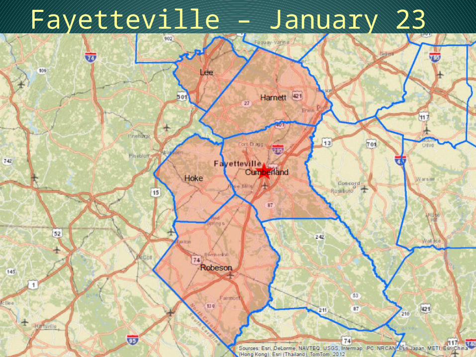
Fayetteville – January 23
13

Elizabethtown – January 23
14

Rocky Mount – January 27
15

Study Area 3 – Ft. Bragg
16

Distributing Imagery Products
State and FederalData Sharing
Partners
Contractors)
CGIAProject Manager
NC OneMapImagery server (map services)
Storage Data download
25 Counties 911 Operations
GIS

Workflow – Quality Control
ContractorQBSPre-
PlanningAcquisitionLandcover
Level 1
Client Review
(Levels 2-4)
Image Correction
NCGSHorizontal
60-Day Warranty
• Level 2 (30%) NCDOT
• Level 4 (25%)
(30 day) Counties
• Level 3 (5%)
CGIA
Five-Phased Approach
Image Delivery

• README• Full resolution TIFF imagery tiles• Compressed MRSID imagery tiles• Compressed MRSID for all adjacent (neighbor)
counties (20:1 compression)• County mosaics for county and adjacent (neighbor)
counties (50:1 compression)• Metadata• Geospatial reference data (including state/county
index and exposure footprints – seamline polygons)• Elevation modifications• Compliance and QC documentation 19
Portable Drive Contents

• Directorate of Plans, Training, Mobilization and Security• John Hodge• Jewel Johnson• Kirk Rutkofske
• Partnership and Collaboration• Airspace and acquisition• Full release to 911 Operations Centers• Partial release to general public
• Non-disclosure• Cumberland County, City of Fayetteville, Hoke
County, Harnett County, City of Dunn Police 20
Ft. Bragg Acknowledgement

• Non-disclosure• Cumberland County, City of Fayetteville, Hoke
County, Harnett County, City of Dunn Police
• Public portable drive containing unsecure blacked out areas of exclusion within the installation boundary
• Secure portable drive, containing full release of imagery, available at Ft. Bragg pending non-disclosure agreement
• Neighbor data is limited to unsecure data21
Ft. Bragg Acknowledgement
• Tile Definitions• NC Technical Specifications• Projections and GIS• Mosaics• Tile Naming• Documentation
22
Technical Notes
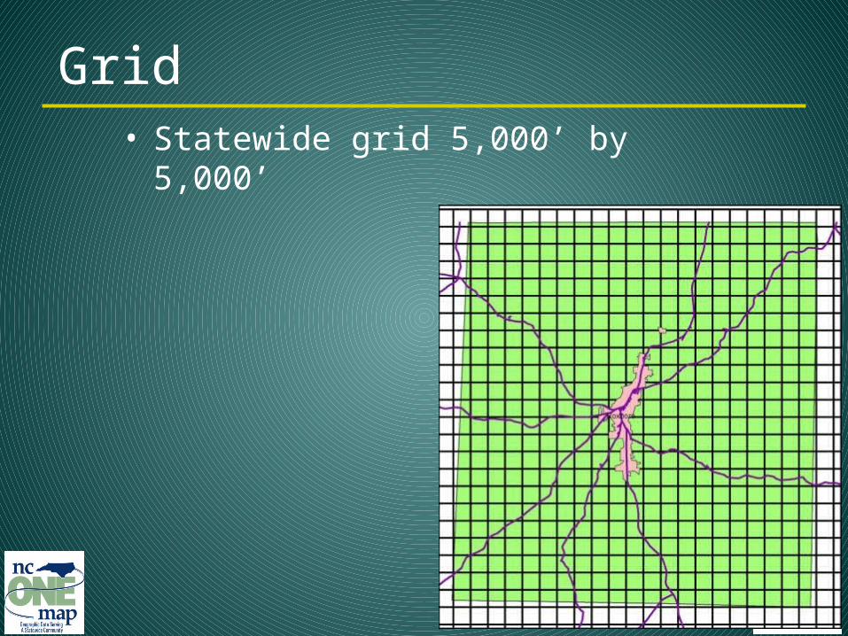
• Statewide grid 5,000’ by 5,000’
23
Grid

“NC Technical Specifications for Digital Orthophoto Base Mapping” from Land Records Management Program in the Secretary of State’s Office (2009):
• Methods• Formats• Quality and accuracy• Reports certified by surveyor
licensed in NC
24
NC Specifications
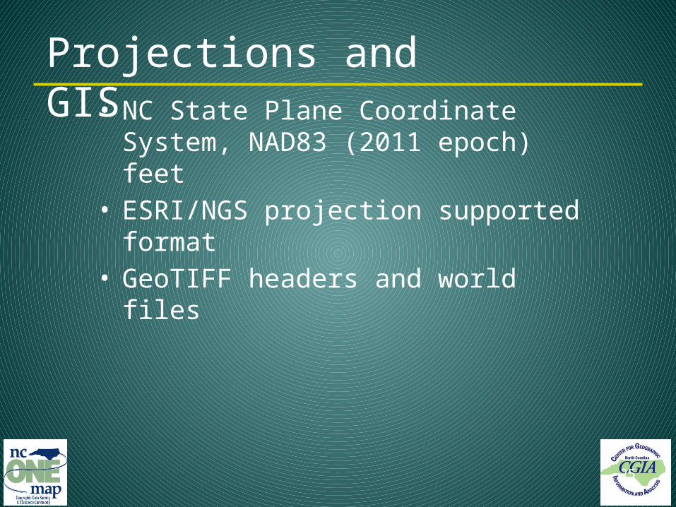
• NC State Plane Coordinate System, NAD83 (2011 epoch) feet
• ESRI/NGS projection supported format• GeoTIFF headers and world files
25
Projections and GIS
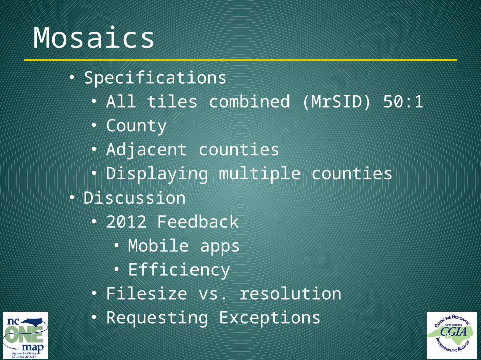
• Specifications• All tiles combined (MrSID) 50:1• County• Adjacent counties• Displaying multiple counties
• Discussion• 2012 Feedback
• Mobile apps• Efficiency
• Filesize vs. resolution• Requesting Exceptions 26
Mosaics


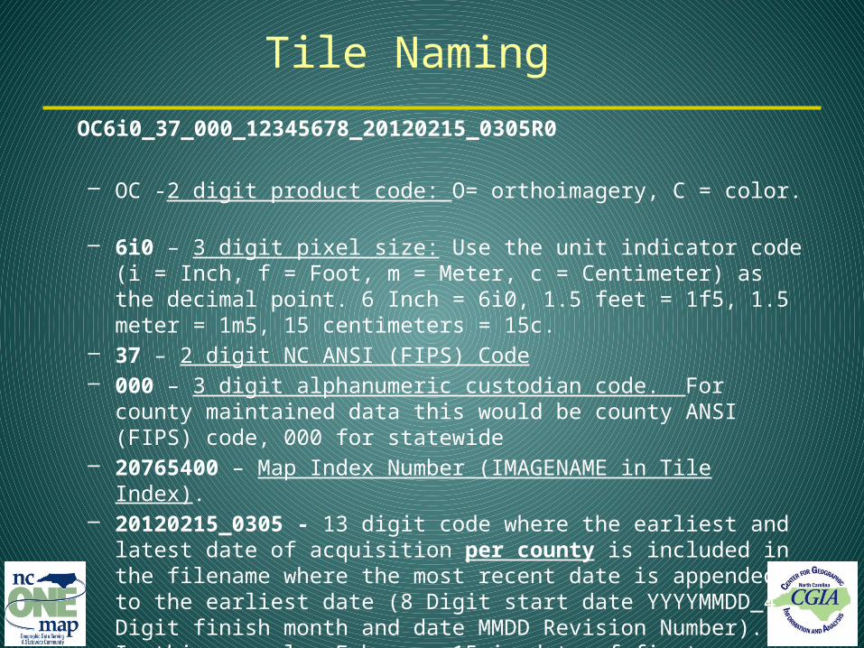
Tile Naming
OC6i0_37_000_12345678_20120215_0305R0
– OC -2 digit product code: O= orthoimagery, C = color.
– 6i0 – 3 digit pixel size: Use the unit indicator code (i = Inch, f = Foot, m = Meter, c = Centimeter) as the decimal point. 6 Inch = 6i0, 1.5 feet = 1f5, 1.5 meter = 1m5, 15 centimeters = 15c.
– 37 – 2 digit NC ANSI (FIPS) Code– 000 – 3 digit alphanumeric custodian code. For county maintained data
this would be county ANSI (FIPS) code, 000 for statewide– 20765400 – Map Index Number (IMAGENAME in Tile Index).– 20120215_0305 - 13 digit code where the earliest and latest date of
acquisition per county is included in the filename where the most recent date is appended to the earliest date (8 Digit start date YYYYMMDD_4 Digit finish month and date MMDD Revision Number). In this example, February 15 is date of first acquisition and March 5 is the latest

Documentation
• Compliance
• Attachment C: Flight and Control Plan • Attachment C-1: Control Surveys Report • Attachment D: Imagery Acquisition Compliance Report• Attachment E: Airborne GPS-IMU Post Processing & AT Report• Attachment G: Orthoimagery Quality Review Report
• Quality Review Outcome (Attachment G)– Local Government Participation– Results

Documentation – Acquisition Details

Documentation – Acquisition Details

Data – County Index

Quality Review Evolvement
• Statewide 2010• 911 Board – Post delivery QC• 90-Day• Data shuffling, Updates, DVDs, Hard Drives,
Communication, etc. • Vision – Centralization, real-time imagery
• Coastal 2012• 911 Board – Early concurrent review• Challenge – Risk, Cost, Benefit• VOICE

VOICE Recap
User Accounts Central Basemap Relevant data Pick tiles – Strategic Speed Tools Documentation
Help, Reference
Output – What became of a CALL?
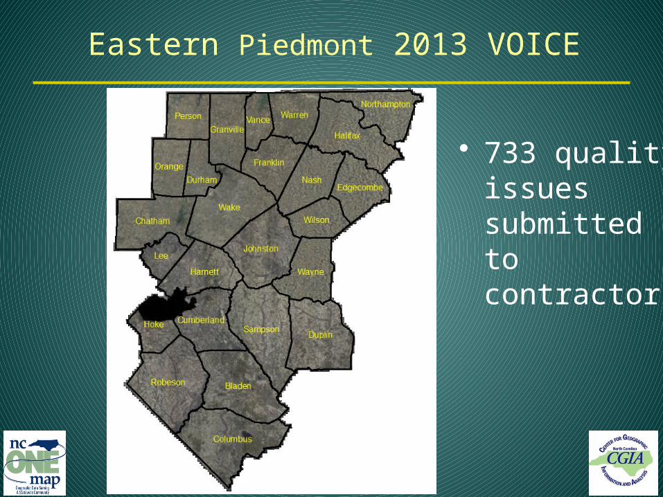
Eastern Piedmont 2013 VOICE
• 733 quality issues submitted to contractors

• Transportation• Major bridges• Urban areas• No seam lines cutting buildings or large structures• Areas of state importance• Color and contrast well balanced at seam edges between
contractors
Areas of great importance
• Highly vegetated areas• Water bodies (color and seam lines)• Utility lines above the ground
Areas of least importance
Expectations for Project

Documentation – Attachment G
State of North Carolina Office of Information Technology ServicesCenter for Geographic Information and AnalysisEastern Piedmont 2013Attachment G Product Review SummaryIssues reported by CGIA, NCDOT, and County PSAP and GIS
County: Franklin
Primary County PSAP Contact:Name: Christy ShearinPhone: 919-340-4320Email: [email protected]
Primary County GIS Contact:Name: James WilkinsPhone: 919-496-1197Email: [email protected]
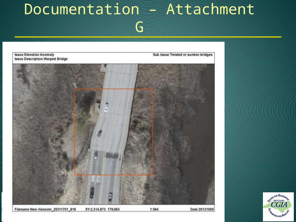
Documentation – Attachment G

40
What’s Next (60-Day Warranty)
• Timing – 60 Days from today• QC Period vs. Warranty Period
• Physical review of drive contents• Satisfaction• Delivery expectations

• What is a flaw that should be fixed?• Corrupt or missing files• Misplaced tiles (spatially)• Significant quality issues
• Regional scope in nature• Significant impact to man-made
structures (excluding tree lean)• Contact CGIA
• Email• VOICE
• 60-day period before final repairs 41
What if you find a flaw?

• Expected sharing:• PSAPs within your county• GIS operations in municipalities
• NC OneMap for online access (www.nconemap.gov)• Download• Imagery services
42
Share the Data

NC OneMap Geospatial Portal

44
Vector and Imagery Services
• Imagery• Orthoimagery Standalone – Per Year• Orthoimagery All - 1995-2012• Orthoimagery Most Recent
• http://services.nconemap.com/arcgis/rest/
Next Steps• CGIA continues with distribution• CGIA will follow up to assure quality and
usefulness in 911 and GIS• Derived Products – Color infrared• Future – Business Plan for Orthoimagery• Today’s Presentation
– http://www.nconemap.com/OrthoimageryforNorthCarolina/2013OrthoimageryProject.aspx

911 Board Feedback
• The Board needs your feedback
• 4-Year Statewide Orthoimagery Program
• Northern Piedmont and Mountains 2014

Acknowledgements• NC 911 Board• NC Center for Geographic Information and Analysis (CGIA)• NC Department of Transportation Photogrammetry Unit• NC Department of Public Safety, NC Geodetic Survey• Land Records Management, Secretary of State• GICC and Statewide Mapping Advisory Committee• Working Group for Orthophotography Planning• Private contractors• ESRI• Lizardtech• NC ITS: Enterprise Project Management Office; Hosting Services• State Chief Information Officer• Local Government Committee

Client Satisfaction

Questions?
???