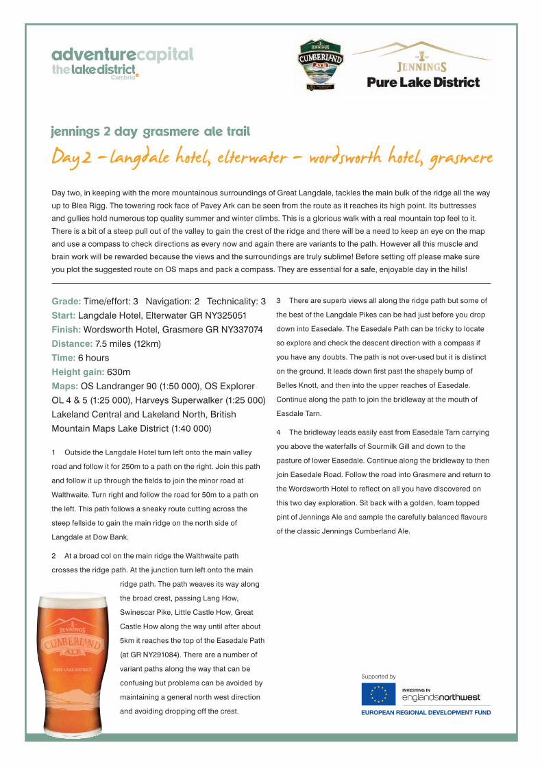
Day 2 - langdale hotel, elterwater - wordsworth hotel, grasmerejennings 2 day grasmere ale trail
Day two, in keeping with the more mountainous surroundings of Great Langdale, tackles the main bulk of the ridge all the way
up to Blea Rigg. The towering rock face of Pavey Ark can be seen from the route as it reaches its high point. Its buttresses
and gullies hold numerous top quality summer and winter climbs. This is a glorious walk with a real mountain top feel to it.
There is a bit of a steep pull out of the valley to gain the crest of the ridge and there will be a need to keep an eye on the map
and use a compass to check directions as every now and again there are variants to the path. However all this muscle and
brain work will be rewarded because the views and the surroundings are truly sublime! Before setting off please make sure
you plot the suggested route on OS maps and pack a compass. They are essential for a safe, enjoyable day in the hills!
Grade: Time/effort: 3 Navigation: 2 Technicality: 3
Start: Langdale Hotel, Elterwater GR NY325051
Finish: Wordsworth Hotel, Grasmere GR NY337074
Distance: 7.5 miles (12km)
Time: 6 hours
Height gain: 630m
Maps: OS Landranger 90 (1:50 000), OS Explorer
OL 4 & 5 (1:25 000), Harveys Superwalker (1:25 000)
Lakeland Central and Lakeland North, British
Mountain Maps Lake District (1:40 000)
1 Outside the Langdale Hotel turn left onto the main valley
road and follow it for 250m to a path on the right. Join this path
and follow it up through the fields to join the minor road at
Walthwaite. Turn right and follow the road for 50m to a path on
the left. This path follows a sneaky route cutting across the
steep fellside to gain the main ridge on the north side of
Langdale at Dow Bank.
2 At a broad col on the main ridge the Walthwaite path
crosses the ridge path. At the junction turn left onto the main
ridge path. The path weaves its way along
the broad crest, passing Lang How,
Swinescar Pike, Little Castle How, Great
Castle How along the way until after about
5km it reaches the top of the Easedale Path
(at GR NY291084). There are a number of
variant paths along the way that can be
confusing but problems can be avoided by
maintaining a general north west direction
and avoiding dropping off the crest.
3 There are superb views all along the ridge path but some of
the best of the Langdale Pikes can be had just before you drop
down into Easedale. The Easedale Path can be tricky to locate
so explore and check the descent direction with a compass if
you have any doubts. The path is not over-used but it is distinct
on the ground. It leads down first past the shapely bump of
Belles Knott, and then into the upper reaches of Easedale.
Continue along the path to join the bridleway at the mouth of
Easdale Tarn.
4 The bridleway leads easily east from Easedale Tarn carrying
you above the waterfalls of Sourmilk Gill and down to the
pasture of lower Easedale. Continue along the bridleway to then
join Easedale Road. Follow the road into Grasmere and return to
the Wordsworth Hotel to reflect on all you have discovered on
this two day exploration. Sit back with a golden, foam topped
pint of Jennings Ale and sample the carefully balanced flavours
of the classic Jennings Cumberland Ale.
Day 2 - langdale hotel, elterwater - wordsworth hotel, grasmerejennings 2 day grasmere ale trail