Trail Map
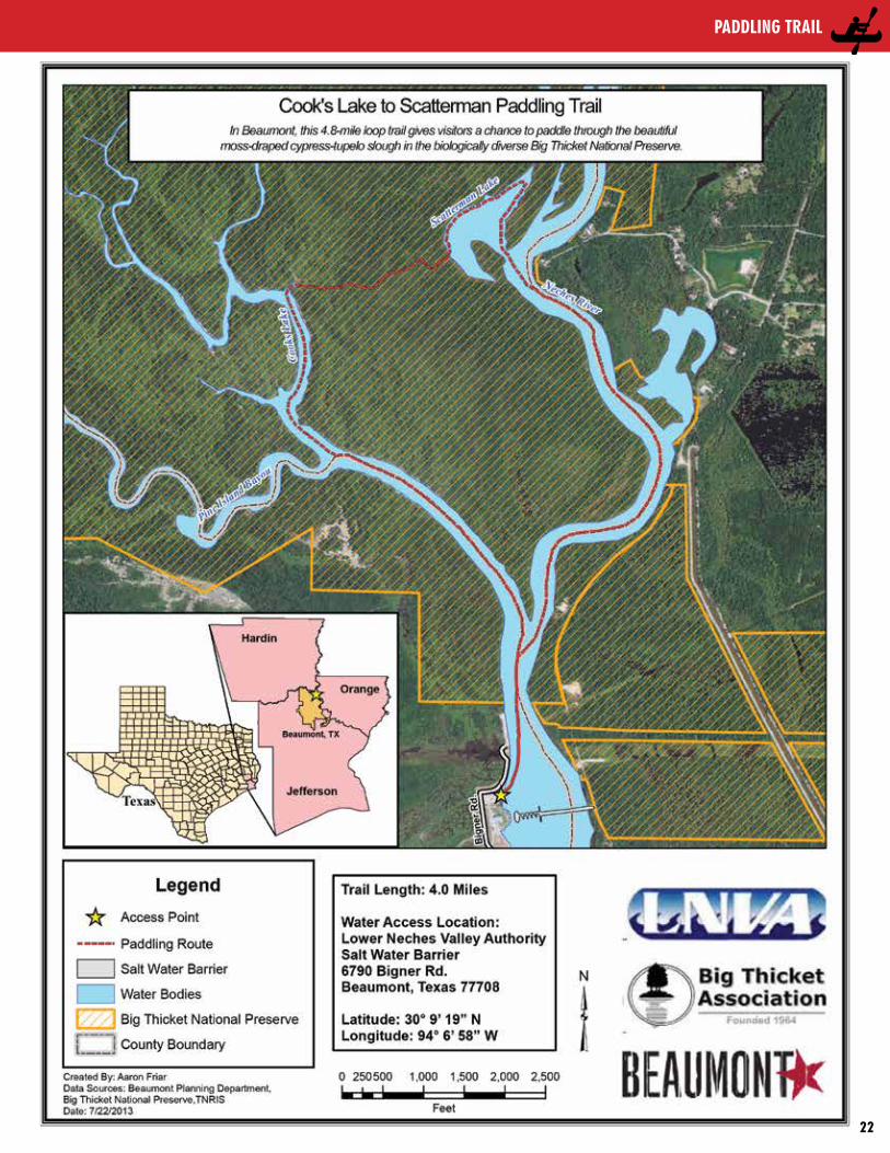
Cook’s Lake to sCatterman PaddLing traiL
This 4.8-mile loop trail gives visitors a chance to paddle through the beautiful moss-draped cypress-tupelo slough in the biologically diverse Big Thicket National Preserve. It is also home to the Neches River Rally, a group paddling event held each September.
GettinG thereAccess site:Lower Neches Valley Authority (LNVA) Saltwater Barrier Boat Ramp6790 Bigner Road Beaumont, TX (DD) 30.15523, -94.11588 From US Highway 69/96 in Beaumont take the Lucas Drive Exit and head east approximately one mile. Turn left heading North on Bigner Road and continue straight on Bigner Road until reaching the boat ramp in approximately 1.5 mile
Trail DescripTion & lanDmarks
Trail length: 4.8 mile loop Float Times: ~2- 5 hours Depending on wind speed, water levels, and time spent exploring
The paddling trail takes paddlers from the LNVA Saltwater Barrier Boat Ramp up the Neches River taking the left fork to Pine Island Bayou and into Cook’s Lake. This looped paddling trail gives paddlers a chance to paddle through a moss-draped cypress/tupelo slough in the biologically diverse Big Thicket National Preserve to Scatterman Lake and back to the Neches River. The seemingly short trail can actually become an all-day adventure since Cook’s Lake and Scatterman Lake are abandoned river channels that have become oxbow lakes which are fun to explore. This trail is relatively flat and very close to sea level giving paddlers a fairly easy paddle upstream; flow is generally quite low.
shuTTles & renTalsServices offered: Kayak Rentals, Canoe Rentals, Shuttle Services, Maps, Paddles, Lifejackets, Guided or Self-Guided Day Trips and Overnight Trips. Services will vary with each outfitter.
• BigThicketOutfitters 115 Connolly Road, Vidor, TX 77662 (409) 786-1884; bigthicketoutfitters.com
• EastexCanoeTrails/EastexOutfitters 50 Turtle Creek Dr., Silsbee, TX 77656 (409) 385-4700; eastexcanoes.com
• Sharp’s Canoe & Kayak Rentals 8632 Billy’s Drive, Silsbee, TX 77656 (409) 385-6241
• Shawl Canoe School Mary Carter; (409) 791-0040
FishingThe river and oxbow lakes support black (largemouth and spotted) bass. A favorite fish eaten by locals is catfish and blue, flathead (also called yellow), and channel catfish are present. This system supports a variety of sunfish, including bluegill, green, and longear sunfish. Spotted, alligator, and long-nose gar all inhabit these waters. Small lures such as jigs, plastic worms, spinner baits and light-line are recommended.
WilDliFe anD ecologyThe riparian corridor of the Neches River supports a great diversity of plant and animal life along the river and beyond the banks. Birds spotted here include: herons, egrets, cormorants, barred owl, belted kingfisher, osprey, pileated woodpecker, prothonotary warbler, roseate spoonbill, swallow-tailed kite, and wood duck. A variety of plants can be found along the river as well, including bald cypress, black tupelo, loblolly pine, oaks, river birch, ferns, cardinal flower, spider lilies, and Neches River rose mallow. Common wildlife encountered include bullfrog, leopard frog, opossum, red-eared slider, raccoon, river otter, American alligator, alligator snapping turtle, and a variety of water snakes.
lnVa salTWaTer BoaT ramp The primary trail head is located at the LNVA Saltwater Barrier. The Lower Neches River Authority operates and maintains the Barrier which was completed in 2003. The public boat ramp, public restrooms, picnic area, walking trail, and stocked fishing ponds provides the public world class facilities as well as increased access to the Neches River and the Big Thicket National Preserve.
Big Thicket National Preserve Visitor’s Center(409) 951-6700www.nps.gov/bith/index.htm
Big Thicket Association/Neches River Adventures (Eco Tours on-board the Ivory Bill)(409) 651- 5326www.bigthicket.org
PaddLing traiL
21
• TRAILS •
Trail Map
PaddLing traiL
22

• TRAILS • Village Creek 1-Paddling Route
Village Creek - FM 418 to SH 327
®
Legend
!. Access Point
! Mile Marker
River Stretch
Road
Big Thicket National Preserve Boundary
Roy E. Larsen Sandyland Sanctuary
®
!.
!.
418
418
1122
92
6996
96BUS
327TexasKountze, TX
Lumberton, TX
Silsbee, TX
!.
!.
418
418
1122
92
6996
96BUS
327TexasKountze, TX
Lumberton, TX
Silsbee, TX
Legend
!. Access Point
! Mile Marker
River Stretch
Road
Big Thicket National Preserve Boundary
Roy E. Larsen Sandyland Sanctuary
Trail Length: 8.6 Miles
Water Access Locations: 1.) FM 418 - Latitude 30°23’52.09”N Longitude 94°15’52.76”W
Directions: From Kountze on US 69, take FM 418 East for approximately 3.2 miles to Village Creek; turn right onto launch site road before crossing the bridge.
From Silsbee on Business 96, take FM 418 West for approximately 6.9miles to Village Creek; turn left ontolaunch site road after crossing the bridge.
2.) SH 327 - Latitude 30°20’49.30”N Longitude 94°14’20.58”W
Directions: From Kountze on US 69, take SH 327 East for approximately 2.1 miles to Village Creek; turn right onto launch site road before crossingthe bridge.
From Silsbee on Business 96, take SH 327 West for approximately 3.6 miles to Village Creek; turn left ontolaunch site road after crossing thebridge.
FM 418 to SH 327
!
!
!
!
!
!
!
!
!.
!.
8
7
6
5
4
3
2
1
418
327Texas
0 0.5 10.25
Miles
Village Creek - FM 418 to SH 327
®
Legend
!. Access Point
! Mile Marker
River Stretch
Road
Big Thicket National Preserve Boundary
Roy E. Larsen Sandyland Sanctuary
®
!.
!.
418
418
1122
92
6996
96BUS
327TexasKountze, TX
Lumberton, TX
Silsbee, TX
!.
!.
418
418
1122
92
6996
96BUS
327TexasKountze, TX
Lumberton, TX
Silsbee, TX
Legend
!. Access Point
! Mile Marker
River Stretch
Road
Big Thicket National Preserve Boundary
Roy E. Larsen Sandyland Sanctuary
Trail Length: 8.6 Miles
Water Access Locations: 1.) FM 418 - Latitude 30°23’52.09”N Longitude 94°15’52.76”W
Directions: From Kountze on US 69, take FM 418 East for approximately 3.2 miles to Village Creek; turn right onto launch site road before crossing the bridge.
From Silsbee on Business 96, take FM 418 West for approximately 6.9miles to Village Creek; turn left ontolaunch site road after crossing the bridge.
2.) SH 327 - Latitude 30°20’49.30”N Longitude 94°14’20.58”W
Directions: From Kountze on US 69, take SH 327 East for approximately 2.1 miles to Village Creek; turn right onto launch site road before crossingthe bridge.
From Silsbee on Business 96, take SH 327 West for approximately 3.6 miles to Village Creek; turn left ontolaunch site road after crossing thebridge.
Trail Length: 8.6 Miles
Water Access Locations: 1.) FM 418 - Latitude 30°23’52.09”N Longitude 94°15’52.76”W
Directions: From Kountze on US 69, take FM 418 East for approximately 3.2 miles to Village Creek; turn right onto launch site road before crossing the bridge.
From Silsbee on Business 96, take FM 418 West for approximately 6.9miles to Village Creek; turn left ontolaunch site road after crossing the bridge.
2.) SH 327 - Latitude 30°20’49.30”N Longitude 94°14’20.58”W
Directions: From Kountze on US 69, take SH 327 East for approximately 2.1 miles to Village Creek; turn right onto launch site road before crossingthe bridge.
From Silsbee on Business 96, take SH 327 West for approximately 3.6 miles to Village Creek; turn left ontolaunch site road after crossing thebridge.
0 0.5 10.25
Miles
N
E
S
W
®Legend
_̂ Start/Finish! Mile Marker
!³ Convenience Store
ÅB Route
www.beaumontcvb.com
www.visitportarthurtx.com
Village Creek - FM 418 to SH 327
®
Legend
!. Access Point
! Mile Marker
River Stretch
Road
Big Thicket National Preserve Boundary
Roy E. Larsen Sandyland Sanctuary
®
!.
!.
418
418
1122
92
6996
96BUS
327TexasKountze, TX
Lumberton, TX
Silsbee, TX
!.
!.
418
418
1122
92
6996
96BUS
327TexasKountze, TX
Lumberton, TX
Silsbee, TX
Legend
!. Access Point
! Mile Marker
River Stretch
Road
Big Thicket National Preserve Boundary
Roy E. Larsen Sandyland Sanctuary
Trail Length: 8.6 Miles
Water Access Locations: 1.) FM 418 - Latitude 30°23’52.09”N Longitude 94°15’52.76”W
Directions: From Kountze on US 69, take FM 418 East for approximately 3.2 miles to Village Creek; turn right onto launch site road before crossing the bridge.
From Silsbee on Business 96, take FM 418 West for approximately 6.9miles to Village Creek; turn left ontolaunch site road after crossing the bridge.
2.) SH 327 - Latitude 30°20’49.30”N Longitude 94°14’20.58”W
Directions: From Kountze on US 69, take SH 327 East for approximately 2.1 miles to Village Creek; turn right onto launch site road before crossingthe bridge.
From Silsbee on Business 96, take SH 327 West for approximately 3.6 miles to Village Creek; turn left ontolaunch site road after crossing thebridge.
Trail Length: 8.6 Miles
Water Access Locations: 1.) FM 418 - Latitude 30°23’52.09”N Longitude 94°15’52.76”W
Directions: From Kountze on US 69, take FM 418 East for approximately 3.2 miles to Village Creek; turn right onto launch site road before crossing the bridge.
From Silsbee on Business 96, take FM 418 West for approximately 6.9miles to Village Creek; turn left ontolaunch site road after crossing the bridge.
2.) SH 327 - Latitude 30°20’49.30”N Longitude 94°14’20.58”W
Directions: From Kountze on US 69, take SH 327 East for approximately 2.1 miles to Village Creek; turn right onto launch site road before crossingthe bridge.
From Silsbee on Business 96, take SH 327 West for approximately 3.6 miles to Village Creek; turn left ontolaunch site road after crossing thebridge.
Trail Map
PaddLing traiL
23
• TRAILS •
Æÿ
!
!
!
!.
!.
3
2
1
0 0.5 10.25
Miles
327Texas
Baby Galvez
Kiwanis Club
Æÿ
!
!
!
!.
!.
3
2
1
0 0.5 10.25
Miles
327Texas
Baby Galvez
Kiwanis Club
N
E
S
W
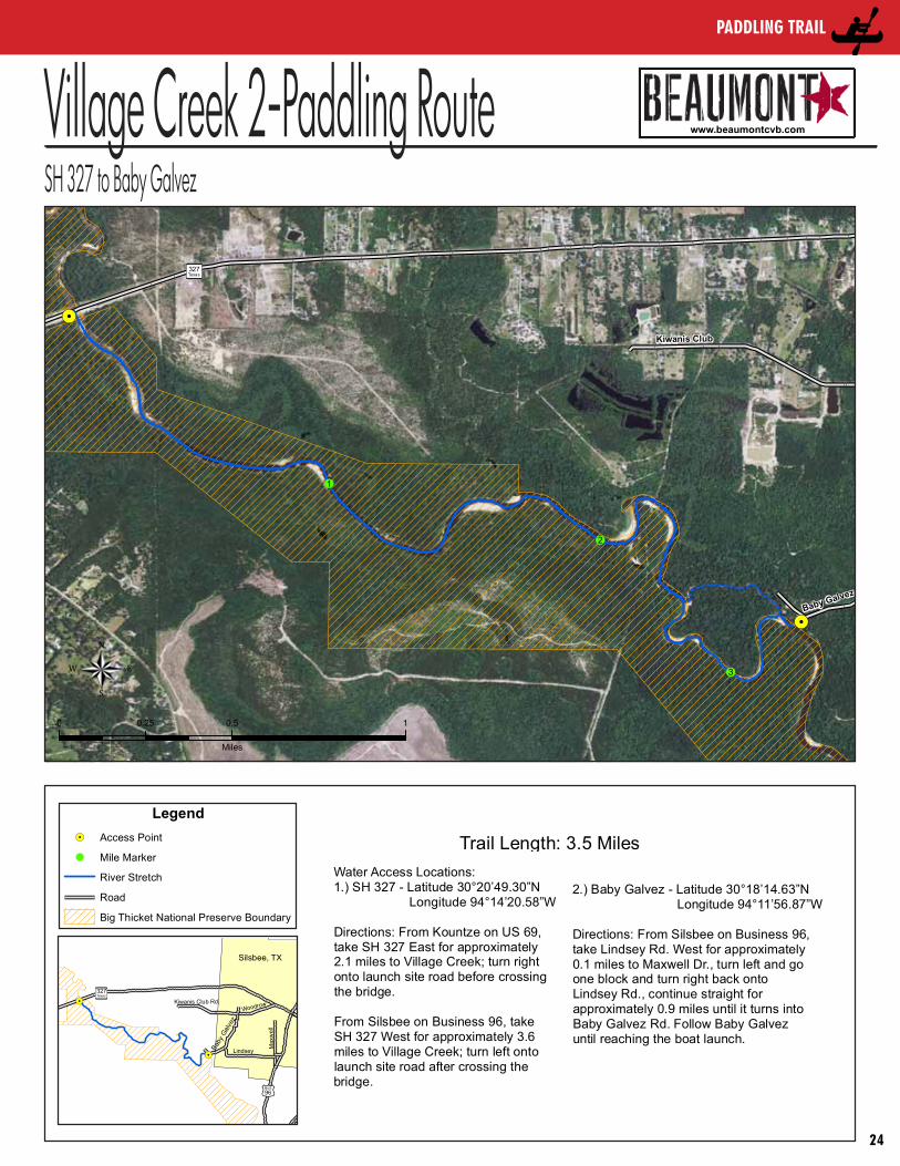
Village Creek 2-Paddling RouteSH 327 to Baby Galvez
® ®
Trail Length: 3.5 Miles
Water Access Locations: 1.) SH 327 - Latitude 30°20’49.30”N Longitude 94°14’20.58”W
Directions: From Kountze on US 69, take SH 327 East for approximately 2.1 miles to Village Creek; turn right onto launch site road before crossingthe bridge.
From Silsbee on Business 96, take SH 327 West for approximately 3.6 miles to Village Creek; turn left ontolaunch site road after crossing thebridge.
2.) Baby Galvez - Latitude 30°18’14.63”N Longitude 94°11’56.87”W
Directions: From Silsbee on Business 96, take Lindsey Rd. West for approximately 0.1 miles to Maxwell Dr., turn left and go one block and turn right back onto Lindsey Rd., continue straight for approximately 0.9 miles until it turns intoBaby Galvez Rd. Follow Baby Galvez until reaching the boat launch.
Village Creek - SH 327 to Baby Galvez
Legend!. Access Point
! Mile Marker
River Stretch
Road
Big Thicket National Preserve Boundary
Legend!. Access Point
! Mile Marker
River Stretch
Road
Big Thicket National Preserve Boundary
Æÿ
(/
!.
!.
327Texas
96BUS
Lindsey
Max
wel
l
Baby
Galv
ez
Kiwanis Club Rd.Woodrow
Silsbee, TX
Æÿ
(/
!.
!.
327Texas
96BUS
Lindsey
Max
wel
l
Baby
Galv
ez
Kiwanis Club Rd.Woodrow
Silsbee, TX
®Legend
_̂ Start/Finish! Mile Marker
!³ Convenience Store
ÅB Route
www.beaumontcvb.com
www.visitportarthurtx.com
Trail Map
PaddLing traiL
24
Village Creek 3-Paddling RouteBaby Galvez to US 96
(/
(/
(/
!
!
!
!
!
!.
!.
5
4
3
2
1
0 0.5 10.25
Miles
Baby Galvez
96
96
Lindsey Max
wel
l
BUS96
0 0.5 10.25
Miles
® ®
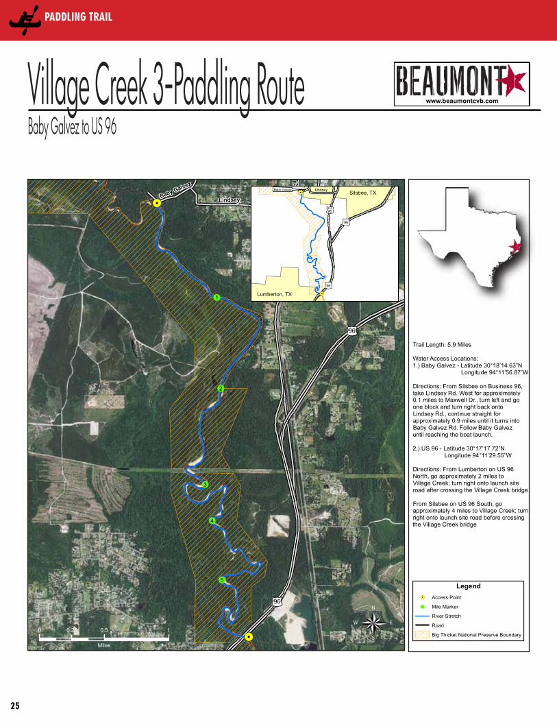
Trail Length: 5.9 Miles
Water Access Locations: 1.) Baby Galvez - Latitude 30°18’14.63”N Longitude 94°11’56.87”W
Directions: From Silsbee on Business 96, take Lindsey Rd. West for approximately 0.1 miles to Maxwell Dr., turn left and go one block and turn right back onto Lindsey Rd., continue straight for approximately 0.9 miles until it turns intoBaby Galvez Rd. Follow Baby Galvez until reaching the boat launch.
2.) US 96 - Latitude 30°17’17.72”N Longitude 94°11’29.55”W
Directions: From Lumberton on US 96 North, go approximately 2 miles to Village Creek; turn right onto launch site road after crossing the Village Creek bridge
From Silsbee on US 96 South, go approximately 4 miles to Village Creek; turn right onto launch site road before crossing the Village Creek bridge
Village Creek - Baby Galvez to US 96
Legend!. Access Point
! Mile Marker
River Stretch
Road
Big Thicket National Preserve Boundary
Legend!. Access Point
! Mile Marker
River Stretch
Road
Big Thicket National Preserve Boundary
Trail Length: 5.9 Miles
Water Access Locations: 1.) Baby Galvez - Latitude 30°18’14.63”N Longitude 94°11’56.87”W
Directions: From Silsbee on Business 96, take Lindsey Rd. West for approximately 0.1 miles to Maxwell Dr., turn left and go one block and turn right back onto Lindsey Rd., continue straight for approximately 0.9 miles until it turns intoBaby Galvez Rd. Follow Baby Galvez until reaching the boat launch.
2.) US 96 - Latitude 30°17’17.72”N Longitude 94°11’29.55”W
Directions: From Lumberton on US 96 North, go approximately 2 miles to Village Creek; turn right onto launch site road after crossing the Village Creek bridge
From Silsbee on US 96 South, go approximately 4 miles to Village Creek; turn right onto launch site road before crossing the Village Creek bridge
(/
(/
(/
!.
!.
!.
96BUS
LindseyBaby GalvezSilsbee, TX
96
96
Lumberton, TX
(/
(/
(/
!.
!.
!.
96BUS
LindseyBaby GalvezSilsbee, TX
96
96
Lumberton, TX
N
E
S
W
® ®
Trail Length: 5.9 Miles
Water Access Locations: 1.) Baby Galvez - Latitude 30°18’14.63”N Longitude 94°11’56.87”W
Directions: From Silsbee on Business 96, take Lindsey Rd. West for approximately 0.1 miles to Maxwell Dr., turn left and go one block and turn right back onto Lindsey Rd., continue straight for approximately 0.9 miles until it turns intoBaby Galvez Rd. Follow Baby Galvez until reaching the boat launch.
2.) US 96 - Latitude 30°17’17.72”N Longitude 94°11’29.55”W
Directions: From Lumberton on US 96 North, go approximately 2 miles to Village Creek; turn right onto launch site road after crossing the Village Creek bridge
From Silsbee on US 96 South, go approximately 4 miles to Village Creek; turn right onto launch site road before crossing the Village Creek bridge
Village Creek - Baby Galvez to US 96
Legend!. Access Point
! Mile Marker
River Stretch
Road
Big Thicket National Preserve Boundary
Legend!. Access Point
! Mile Marker
River Stretch
Road
Big Thicket National Preserve Boundary
Trail Length: 5.9 Miles
Water Access Locations: 1.) Baby Galvez - Latitude 30°18’14.63”N Longitude 94°11’56.87”W
Directions: From Silsbee on Business 96, take Lindsey Rd. West for approximately 0.1 miles to Maxwell Dr., turn left and go one block and turn right back onto Lindsey Rd., continue straight for approximately 0.9 miles until it turns intoBaby Galvez Rd. Follow Baby Galvez until reaching the boat launch.
2.) US 96 - Latitude 30°17’17.72”N Longitude 94°11’29.55”W
Directions: From Lumberton on US 96 North, go approximately 2 miles to Village Creek; turn right onto launch site road after crossing the Village Creek bridge
From Silsbee on US 96 South, go approximately 4 miles to Village Creek; turn right onto launch site road before crossing the Village Creek bridge
(/
(/
(/
!.
!.
!.
96BUS
LindseyBaby GalvezSilsbee, TX
96
96
Lumberton, TX
(/
(/
(/
!.
!.
!.
96BUS
LindseyBaby GalvezSilsbee, TX
96
96
Lumberton, TX
®Legend
_̂ Start/Finish! Mile Marker
!³ Convenience Store
ÅB Route
www.beaumontcvb.com
www.visitportarthurtx.com
Trail Map
PaddLing traiL
25