Coeur d’Alene Airport Master Plan Executive Summary
In association with
Coeur d’Alene Airport Kootenai County, ID
Prepared by
July 2012

EXECUTIVE SUMMARY COEUR D’ALENE AIRPORT MASTER PLAN
July 2012 ES-1
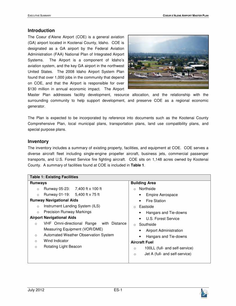
Introduction
The Coeur d’Alene Airport (COE) is a general aviation
(GA) airport located in Kootenai County, Idaho. COE is
designated as a GA airport by the Federal Aviation
Administration (FAA) National Plan of Integrated Airport
Systems. The Airport is a component of Idaho’s
aviation system, and the key GA airport in the northwest
United States. The 2008 Idaho Airport System Plan
found that over 1,000 jobs in the community that depend
on COE, and that the Airport is responsible for over
$130 million in annual economic impact. The Airport
Master Plan addresses facility development, resource allocation, and the relationship with the
surrounding community to help support development, and preserve COE as a regional economic
generator.
The Plan is expected to be incorporated by reference into documents such as the Kootenai County
Comprehensive Plan, local municipal plans, transportation plans, land use compatibility plans, and
special purpose plans.
Inventory
The inventory includes a summary of existing property, facilities, and equipment at COE. COE serves a
diverse aircraft fleet including single-engine propeller aircraft, business jets, commercial passenger
transports, and U.S. Forest Service fire fighting aircraft. COE sits on 1,148 acres owned by Kootenai
County. A summary of facilities found at COE is included in Table 1.
Table 1: Existing Facilities
Runways
o Runway 05-23: 7,400 ft x 100 ft
o Runway 01-19: 5,400 ft x 75 ft
Runway Navigational Aids
o Instrument Landing System (ILS)
o Precision Runway Markings
Airport Navigational Aids
o VHF Omni-directional Range with Distance
Measuring Equipment (VOR/DME)
o Automated Weather Observation System
o Wind Indicator
o Rotating Light Beacon
Building Area
o Northside
• Empire Aerospace
• Fire Station
o Eastside
• Hangars and Tie-downs
• U.S. Forest Service
o Southside
• Airport Administration
• Hangars and Tie-downs
Aircraft Fuel
o 100LL (full- and self-service)
o Jet A (full- and self-service)

EXECUTIVE SUMMARY COEUR D’ALENE AIRPORT MASTER PLAN
July 2012 ES-2
Aviation Activity Forecasts
Aviation activity forecasts provide a 20-year outlook on
the number of aircraft stored at COE, based aircraft, the
number of takeoffs and landings, aircraft operations.
Market potential for scheduled commercial passenger
airline service is investigated, and the number of
departing passengers, enplanements, and the number
of operations were forecasted.
Aviation activity forecasts expect single-engine GA
aircraft to remain the most common users at the Airport,
and business jet aircraft are expected to be the fastest growing users over the next 20 years. If market
conditions support scheduled commercial passenger airline service, it is expected that COE has the
facilities necessary to attract and support such operations until a dedicated passenger terminal could be
built. A summary of the aviation activity forecasts at COE is included in Table 2.
Table 2: Aviation Activity Forecast
Year Based Aircraft Aircraft
Operations
Passenger
Enplanements
Passenger Aircraft
Operations
2008 189 123,048 0 0
2013 225 136,895 18,814 1,668
2018 268 153,426 35,006 2,607
2028 388 197,141 51,199 3,546
Growth
Rate 3.7%(2008-2028) 2.4% (2008-2028) 6.9% (2013-2028)
4.7% (2013-2028)
Aviation activity forecasts were approved by the FAA in March, 2012. FAA national forecasts reflect a
similar growth pattern to COE forecasts, although there are factors outside of aviation that may influence
growth. Gas prices and global economic performance can affect aviation, and a downturn in one of these
indices may slow aviation growth at COE. Improvement projects developed in conjunction with the
aviation activity forecasts are intended to be need based. Subsequent plan elements assign an expected
year of project implementation; however, project implementation is subject to change provided growth in
aviation activity differs from the forecasts.
EXECUTIVE SUMMARY COEUR D’ALENE AIRPORT MASTER PLAN
July 2012 ES-3
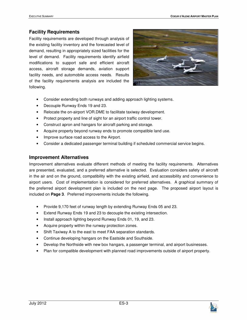
Facility Requirements
Facility requirements are developed through analysis of
the existing facility inventory and the forecasted level of
demand, resulting in appropriately sized facilities for the
level of demand. Facility requirements identify airfield
modifications to support safe and efficient aircraft
access, aircraft storage demands, aviation support
facility needs, and automobile access needs. Results
of the facility requirements analysis are included the
following.
• Consider extending both runways and adding approach lighting systems.
• Decouple Runway Ends 19 and 23.
• Relocate the on-airport VOR.DME to facilitate taxiway development.
• Protect property and line of sight for an airport traffic control tower.
• Construct apron and hangars for aircraft parking and storage.
• Acquire property beyond runway ends to promote compatible land use.
• Improve surface road access to the Airport.
• Consider a dedicated passenger terminal building if scheduled commercial service begins.
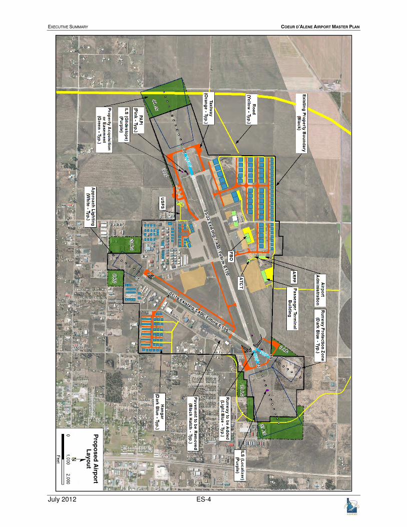
Improvement Alternatives
Improvement alternatives evaluate different methods of meeting the facility requirements. Alternatives
are presented, evaluated, and a preferred alternative is selected. Evaluation considers safety of aircraft
in the air and on the ground, compatibility with the existing airfield, and accessibility and convenience to
airport users. Cost of implementation is considered for preferred alternatives. A graphical summary of
the preferred airport development plan is included on the next page. The proposed airport layout is
included on Page 3. Preferred improvements include the following.
• Provide 9,170 feet of runway length by extending Runway Ends 05 and 23.
• Extend Runway Ends 19 and 23 to decouple the existing intersection.
• Install approach lighting beyond Runway Ends 01, 19, and 23.
• Acquire property within the runway protection zones.
• Shift Taxiway A to the east to meet FAA separation standards.
• Continue developing hangars on the Eastside and Southside.
• Develop the Northside with new box hangars, a passenger terminal, and airport businesses.
• Plan for compatible development with planned road improvements outside of airport property.
EXECUTIVE SUMMARY COEUR D’ALENE AIRPORT MASTER PLAN
July 2012 ES-4
Pro
po
se
d A
irpo
rt L
ay
ou
t

EXECUTIVE SUMMARY COEUR D’ALENE AIRPORT MASTER PLAN
July 2012 ES-5

EXECUTIVE SUMMARY COEUR D’ALENE AIRPORT MASTER PLAN
July 2012 ES-6
Financial Feasibility
Financial feasibility presents an overview of the
financial structure of the Airport, a review of rates and
charges at COE and nearby GA airports, and includes a
capital improvement plan (CIP) for the next 20 years.
The Airport generates over $500,000 in revenue per
year, with over 80% coming from leases. This money is
used to pay for staff, maintenance, and airport
improvements that are outside of federal and state
funding.
The CIP organizes improvement projects by priority, and includes cost estimates and potential funding
sources. The 20-year CIP supplements the Airport’s five year CIP that is on file with the FAA; allowing
FAA staff to program funding for larger projects as their implementation date approaches.
CIP funding is expected to come primarily from the FAA in the form of entitlement funds, awarded to the
Airport annually, and discretionary funds, competed for by Airports across the country. COE is eligible for
Idaho apportionment funds. Projects receiving FAA and state funding require a local match from the
Airport.
The CIP is presented in Table 3.
Table 3: CIP Summary 2012-2017
Year Project Cost
Funding Source
State FAA Local
2012 Runway 01-19 Rehabilitation $2,300,000 32% 63% 5%
Taxiway D South Rehabilitation $700,000 0% 95% 5%
2013 Seal Design Group III Area $1,000,000 74% 16% 10%
2014 Wildlife Assessment $50,000 0% 90% 10%
Extend Taxiway F $2,600,000 29% 61% 10%
2015 Reconstruct GA Apron $1,200,000 63% 38% 10%
2016 Shift Taxiway A $3,900,000 19% 71% 10%
2017 Construct Taxiway P $2,500,000 30% 60% 10%

EXECUTIVE SUMMARY COEUR D’ALENE AIRPORT MASTER PLAN
July 2012 ES-7
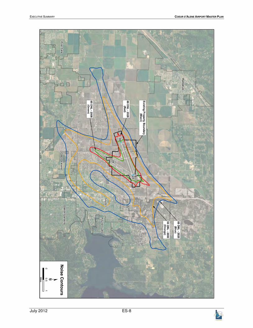
Land Use
Airport land use impacts extend beyond airport
property. Land use surrounding airports can impact
airport operations, and compromise well-being of
citizens living and working near the airport. The land
use analysis presents the existing land use surrounding
COE, evaluates land use compatibility strategies in the
comprehensive plans of communities nearby, and
analyzes the potential impact of aircraft noise resulting
from normal airport operations. A map of 2008 and
2028 noise exposure with forecasted operations is
included on Page 7.
Land use compatibility analysis includes guidelines to help local policy makers develop land near the
Airport. Recommendations from the land use analysis include the following.
• Develop a comprehensive overlay zone to support compatible land use development.
• Establish a joint multi-jurisdictional airport land use planning and zoning commission to develop
homogenous standards across multiple jurisdictions.
• Continue enforcing height restrictions in Idaho Airport Zoning Act.
• Continue including a notice of airport proximity on the title of properties near the Airport.
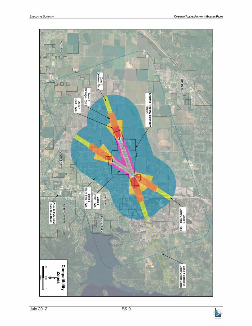
Land use compatibility guidance comes from the 2008 Idaho Airport System Plan and compatibility zones
in the 2012 Washington Department of Transportation Airports and Compatible Land Use Guidebook,
shown in Table 4 and the exhibit on Page 8.
Table 4: Safety Compatibility Zones
Zone Land Use Guidelines
1-Runway
Protection Zone
• Airport ownership encouraged
• Prohibit new structures
• Prohibit residential land uses
• Discouraged Non-airport uses
2-Inner Approach/
Departure Zone
• Limit residential to agricultural
• Limit non-residential uses
• Avoid concentrations of people
• Prohibit noise sensitive uses
• Prohibit hazardous materials
3-Inner Turning
Zone
• Limit residential to low density
• Avoid high-intensities of other uses
• Prohibit noise sensitive uses
• Prohibit hazardous materials
4-Outer Approach/
Departure Zone
• Avoid high-intensities of non-
residential land uses
• Limit residential to low density
• Prohibit noise sensitive uses
5-Sideline Zone
• Avoid residential uses
• Allow other uses that meet height
requirements
• Avoid high-intensities of non-
residential land uses
• Prohibit noise sensitive uses
6-Traffic Pattern
Zone
• Allow most non-residential use
• Avoid noise sensitive uses
• Allow residential use
• Avoid concentrations of
people
EXECUTIVE SUMMARY COEUR D’ALENE AIRPORT MASTER PLAN
July 2012 ES-8
No
ise C
on
tou
rs
EXECUTIVE SUMMARY COEUR D’ALENE AIRPORT MASTER PLAN
July 2012 ES-9
Co
mp
atib
ility
Zo
nes