Communications, Sensing & Navigation Lab
WIDEBAND INTERFEROMETRIC SENSING AND IMAGING POLARIMETRY 1
CEOS-SAR-Cal/Val-2011
International Workshop at University of Alaska Alaska Satellite Facility, Geophysical Institute
Fairbanks Princess Riverside Lodge, Alaska 2011 November 07 – 09
SESSION III: Advanced Calibration Methods Day 2 - Tuesday, 2011 November 08, 0900 – 1210
Wolfgang-Martin Boerner
University of Illinois at Chicago, Department of Electrical & Computer Engineering, Communications, Sensing & Navigation Laboratory, Chicago, IL/USA
“0900 – 0940, Why FULL-POL-SAR Imaging has become of Paramount Relevance, including Precision Calibration
and Noise Floor Suppression”

Communications, Sensing & Navigation Lab
WIDEBAND INTERFEROMETRIC SENSING AND IMAGING POLARIMETRY 2
Communications, Sensing & Navigation Lab
WIDEBAND INTERFEROMETRIC SENSING AND IMAGING POLARIMETRY 3
Communications, Sensing & Navigation Lab
WIDEBAND INTERFEROMETRIC SENSING AND IMAGING POLARIMETRY 4
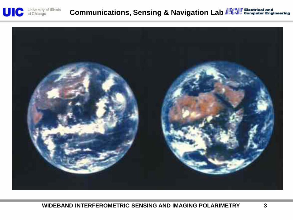
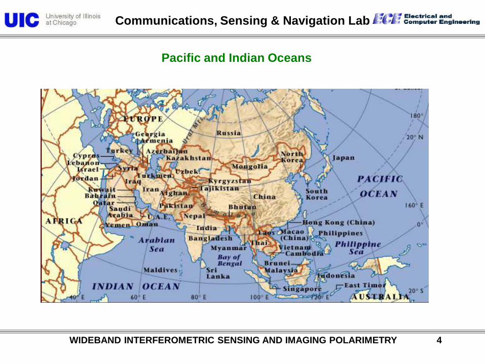
Pacific and Indian Oceans
Communications, Sensing & Navigation Lab
WIDEBAND INTERFEROMETRIC SENSING AND IMAGING POLARIMETRY 5
From BBC news site
Taiwan
Communications, Sensing & Navigation Lab
WIDEBAND INTERFEROMETRIC SENSING AND IMAGING POLARIMETRY 6
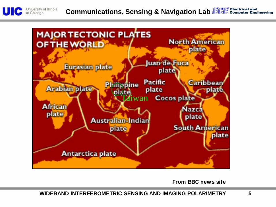
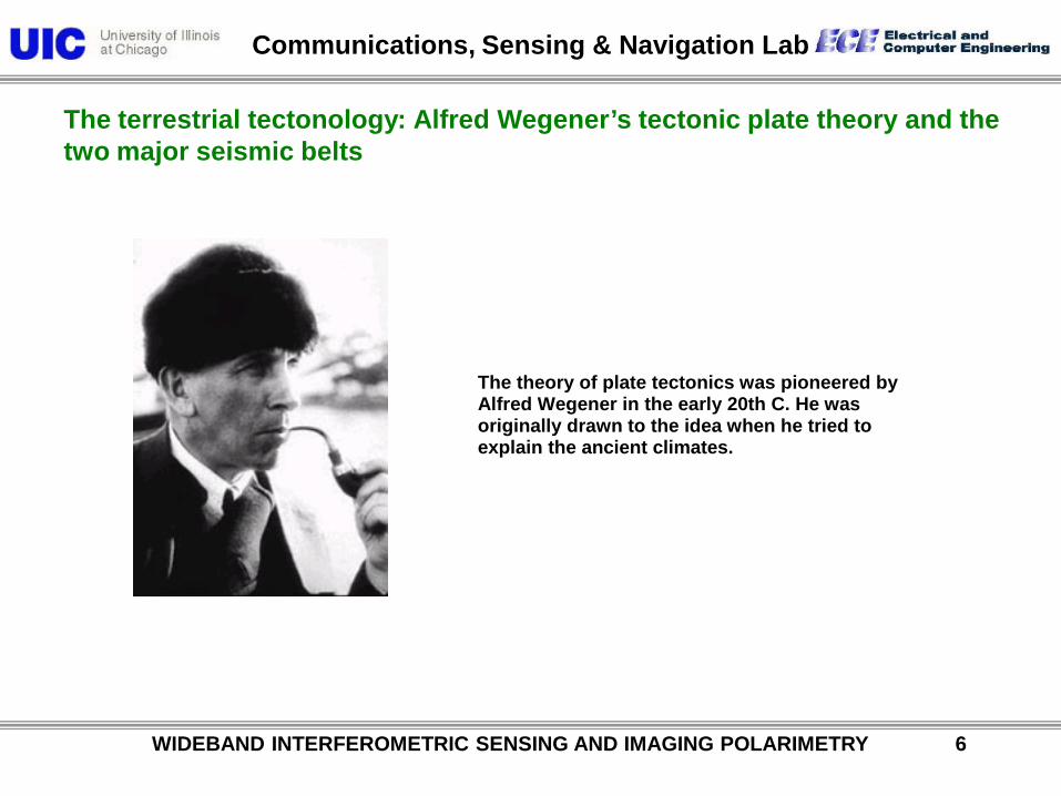
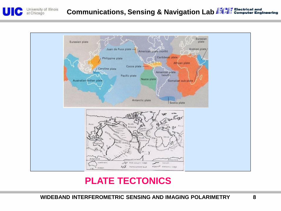
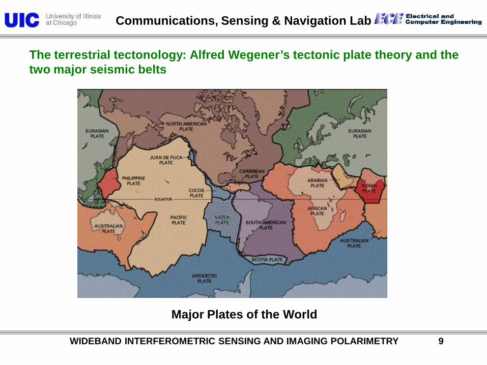
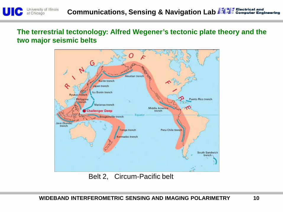
The terrestrial tectonology: Alfred Wegener’s tectonic plate theory and the two major seismic belts
The theory of plate tectonics was pioneered by Alfred Wegener in the early 20th C. He was originally drawn to the idea when he tried to explain the ancient climates.

Communications, Sensing & Navigation Lab
WIDEBAND INTERFEROMETRIC SENSING AND IMAGING POLARIMETRY 7
• Francis Bacon, who introduced inductive method in science in 1620 used the term “exporrecti” meaning expansion to describe the complementary outlines of Africa and South America depicted in the very first authentic map of the world.
• Since then many observers have attempted to explain the conspicuous matching characteristics of the two widely apart continents amongst them the work of German meteorologist Alfred Wegener (1912) attracted much attention.
• This however, had to face acrimonious criticisms specially from the renowned British geophysicist Sir Harold Jeffreys. The criticisms were not without reasons principally because of rigid nature of mantle and imperfect matching of the continents.
Communications, Sensing & Navigation Lab
WIDEBAND INTERFEROMETRIC SENSING AND IMAGING POLARIMETRY 8
PLATE TECTONICS
Communications, Sensing & Navigation Lab
WIDEBAND INTERFEROMETRIC SENSING AND IMAGING POLARIMETRY 9
The terrestrial tectonology: Alfred Wegener’s tectonic plate theory and the two major seismic belts
Major Plates of the World
Communications, Sensing & Navigation Lab
WIDEBAND INTERFEROMETRIC SENSING AND IMAGING POLARIMETRY 10
The terrestrial tectonology: Alfred Wegener’s tectonic plate theory and the two major seismic belts
Belt 2, Circum-Pacific belt
Communications, Sensing & Navigation Lab
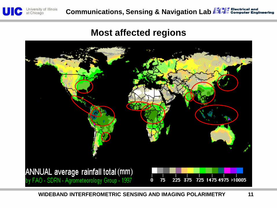
Most affected regions
WIDEBAND INTERFEROMETRIC SENSING AND IMAGING POLARIMETRY 11
Communications, Sensing & Navigation Lab
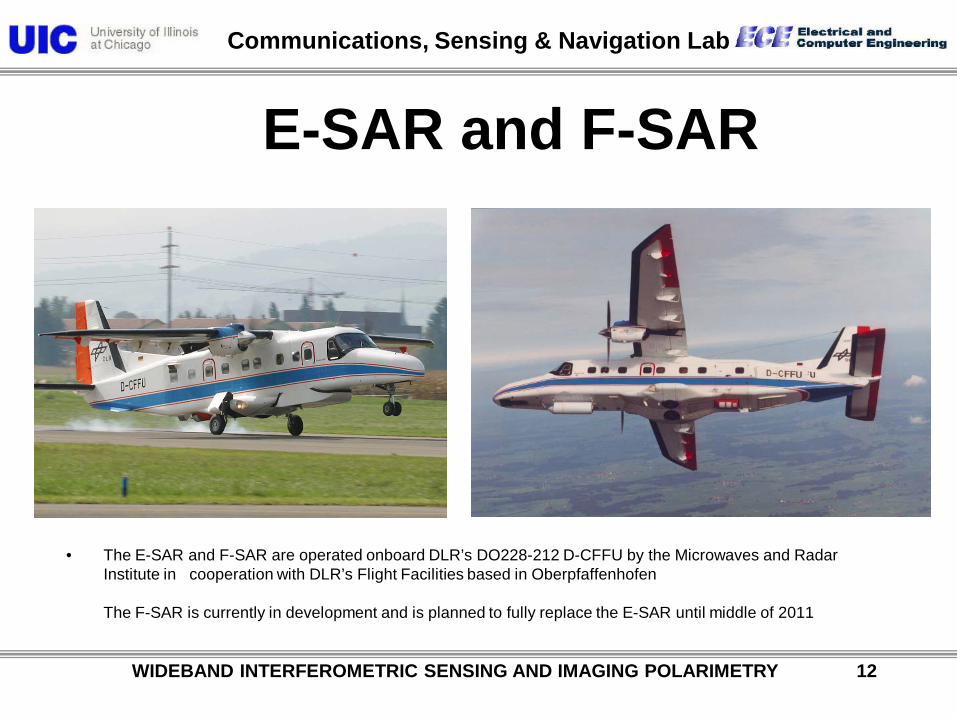
E-SAR and F-SAR
• The E-SAR and F-SAR are operated onboard DLR’s DO228-212 D-CFFU by the Microwaves and Radar Institute in cooperation with DLR’s Flight Facilities based in Oberpfaffenhofen The F-SAR is currently in development and is planned to fully replace the E-SAR until middle of 2011
WIDEBAND INTERFEROMETRIC SENSING AND IMAGING POLARIMETRY 12
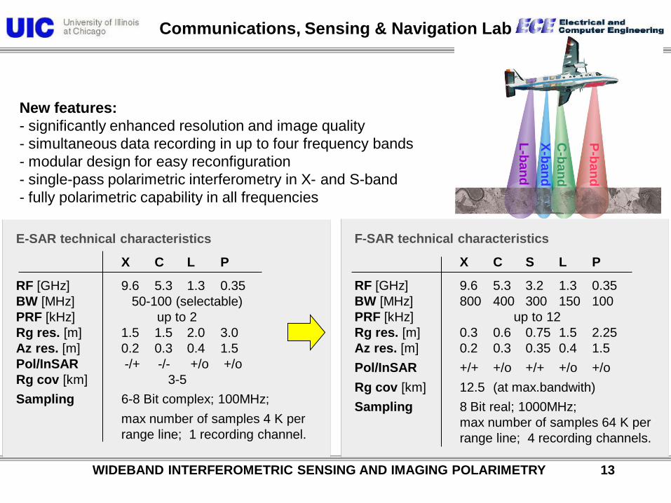
Communications, Sensing & Navigation Lab
F-SAR technical characteristics
X C S L P
RF [GHz] 9.6 5.3 3.2 1.3 0.35 BW [MHz] 800 400 300 150 100 PRF [kHz] up to 12 Rg res. [m] 0.3 0.6 0.75 1.5 2.25 Az res. [m] 0.2 0.3 0.35 0.4 1.5 Pol/InSAR +/+ +/o +/+ +/o +/o Rg cov [km] 12.5 (at max.bandwith) Sampling 8 Bit real; 1000MHz; max number of samples 64 K per range line; 4 recording channels.
E-SAR technical characteristics
X C L P
RF [GHz] 9.6 5.3 1.3 0.35 BW [MHz] 50-100 (selectable) PRF [kHz] up to 2 Rg res. [m] 1.5 1.5 2.0 3.0 Az res. [m] 0.2 0.3 0.4 1.5 Pol/InSAR -/+ -/- +/o +/o Rg cov [km] 3-5 Sampling 6-8 Bit complex; 100MHz; max number of samples 4 K per range line; 1 recording channel.
P-band
C-band
X-band L-band
New features: - significantly enhanced resolution and image quality - simultaneous data recording in up to four frequency bands - modular design for easy reconfiguration - single-pass polarimetric interferometry in X- and S-band - fully polarimetric capability in all frequencies
WIDEBAND INTERFEROMETRIC SENSING AND IMAGING POLARIMETRY 13
Communications, Sensing & Navigation Lab
WIDEBAND INTERFEROMETRIC SENSING AND IMAGING POLARIMETRY 14
Communications, Sensing & Navigation Lab
WIDEBAND INTERFEROMETRIC SENSING AND IMAGING POLARIMETRY 15
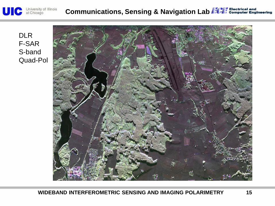
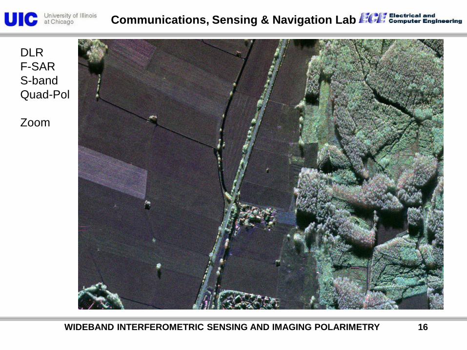
DLR F-SAR S-band Quad-Pol
Communications, Sensing & Navigation Lab
WIDEBAND INTERFEROMETRIC SENSING AND IMAGING POLARIMETRY 16
DLR F-SAR S-band Quad-Pol Zoom

Communications, Sensing & Navigation Lab
WIDEBAND INTERFEROMETRIC SENSING AND IMAGING POLARIMETRY 17
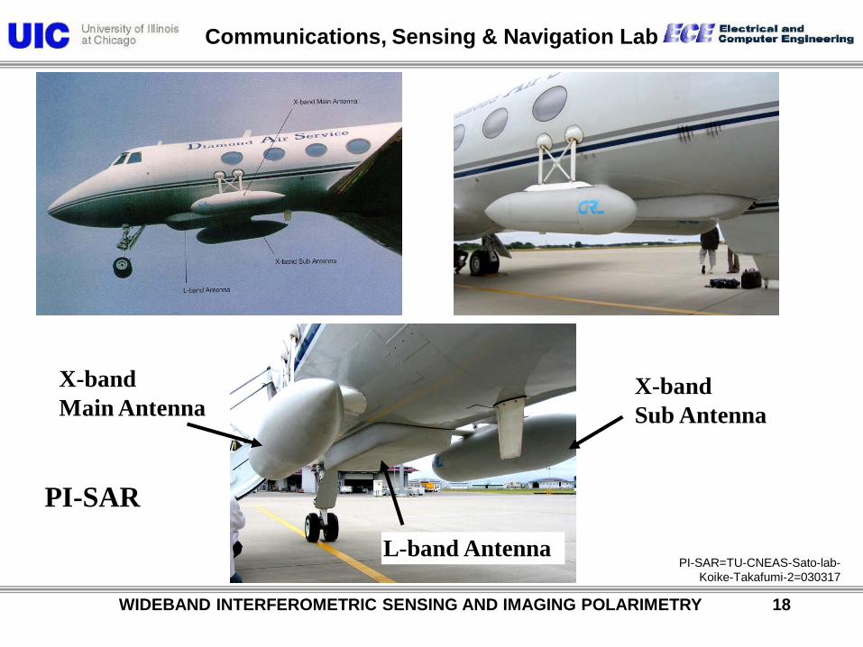
PI-SAR=TU-CNEAS-Sato-lab-Koike-Takafumi-1=030317
PI-SAR
Communications, Sensing & Navigation Lab
WIDEBAND INTERFEROMETRIC SENSING AND IMAGING POLARIMETRY 18
PI-SAR=TU-CNEAS-Sato-lab- Koike-Takafumi-2=030317
X-band Main Antenna
L-band Antenna
X-band Sub Antenna
PI-SAR
Communications, Sensing & Navigation Lab
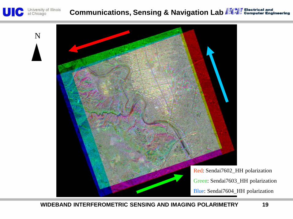
WIDEBAND INTERFEROMETRIC SENSING AND IMAGING POLARIMETRY 19
Red: Sendai7602_HH polarization
Green: Sendai7603_HH polarization
Blue: Sendai7604_HH polarization
N

Communications, Sensing & Navigation Lab
WIDEBAND INTERFEROMETRIC SENSING AND IMAGING POLARIMETRY 20
Square path data
Flight direction

Communications, Sensing & Navigation Lab
WIDEBAND INTERFEROMETRIC SENSING AND IMAGING POLARIMETRY 21

Communications, Sensing & Navigation Lab
WIDEBAND INTERFEROMETRIC SENSING AND IMAGING POLARIMETRY 22
POLARIMETRIC SPACEBORNE SAR SENSORS
ENVISAT / ASAR ESA (EU)
2002 C-Band (Sngl / Twin)
HH, VV, (HH,VV), (HH,HV), (HV,VV)
ALOS / PALSAR NASDA / JAROS (J)
2003 L-Band
HH,VV, (HH,HV), (VV,VH)
RADARSAT 2 CSA / MDA (CA)
2004 C-Band (Quad)
TERRASAR BMBF / DLR / ASTRIUM
2005 X-Band (Twin)
(HH,VV), (HH,HV), (HV,VV) L-Band (Quad)

Communications, Sensing & Navigation Lab
WIDEBAND INTERFEROMETRIC SENSING AND IMAGING POLARIMETRY 23
Table 1. Comparison of High-Level Parameters
Parameter PALSAR RADARSAT-2 TerraSAR-X
Orbit: LEO, circular Sun-synchronous Sun-synchronous Sun-synchronous
Repeat Period (days) 46 24 11
Equatorial Crossing time (hrs) 22:30 (ascending) 18:00 (ascending) 18.00 (ascending)
Inclination (degrees) 98.16 98.6 97.44
Equatorial Altitude (km) 692 798 515
Wavelength (Band) 23 cm (L) 5.6 cm (C) 3 cm (X)
Fully polarimetric mode Yes Yes Yes
ALOS / PALSAR Japanese Space Agency (JAXA)
L-Band (quad), 2006
TerraSAR-X German Aerospace Center (DLR) / Astirum
X-Band (quad), 2007
RadarSAT-II Canadian Space Agency (CSA)
C-Band (quad), 2007

Communications, Sensing & Navigation Lab
WIDEBAND INTERFEROMETRIC SENSING AND IMAGING POLARIMETRY 24
Launch Date June 2004Launch Vehicle H-IIASpacecraft Mass 4,000kgGenerated Power 7kW
Orbit 691.65kmSun Synchronous
Repeat Cycle(Sub-Cycle)
46 days( 2 days )
PRISM AVNIR-2
PALSAR
Data RelayAntenna
Solar Array
Star Tracker
GPS Antenna
Flight Direct io
nEarth
PRISM : Panchromatic Remote Sensing Instruments for Stereo Mapping AVNIR-2: Advanced Visible and Near Infrared Radiometer type 2 PALSAR: Phased Array type L-band Synthetic Aperture Radar
ALOS Satellite SystemALOS Satellite System
Communications, Sensing & Navigation Lab
WIDEBAND INTERFEROMETRIC SENSING AND IMAGING POLARIMETRY 25
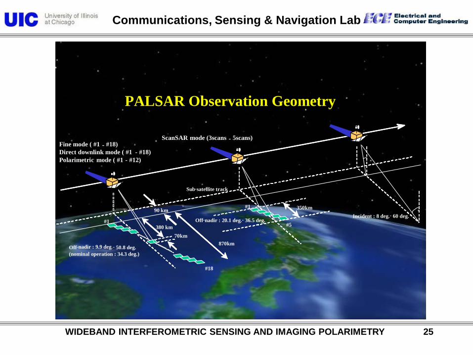
PALSAR Observation GeometryPALSAR Observation Geometry
Off-nadir : 9.9 deg. - 50.8 deg.(nominal operation : 34.3 deg.)
#1
#18
#1
#5
350km
Off-nadir : 20.1 deg. - 36.5 deg.
870km
90 kmIncident : 8 deg. - 60 deg.
Fine mode ( #1 - #18)Direct downlink mode ( #1 - #18)Polarimetric mode ( #1 - #12)
ScanSAR mode (3scans - 5scans)
380 km70km
Sub-satellite track
Communications, Sensing & Navigation Lab
WIDEBAND INTERFEROMETRIC SENSING AND IMAGING POLARIMETRY 26
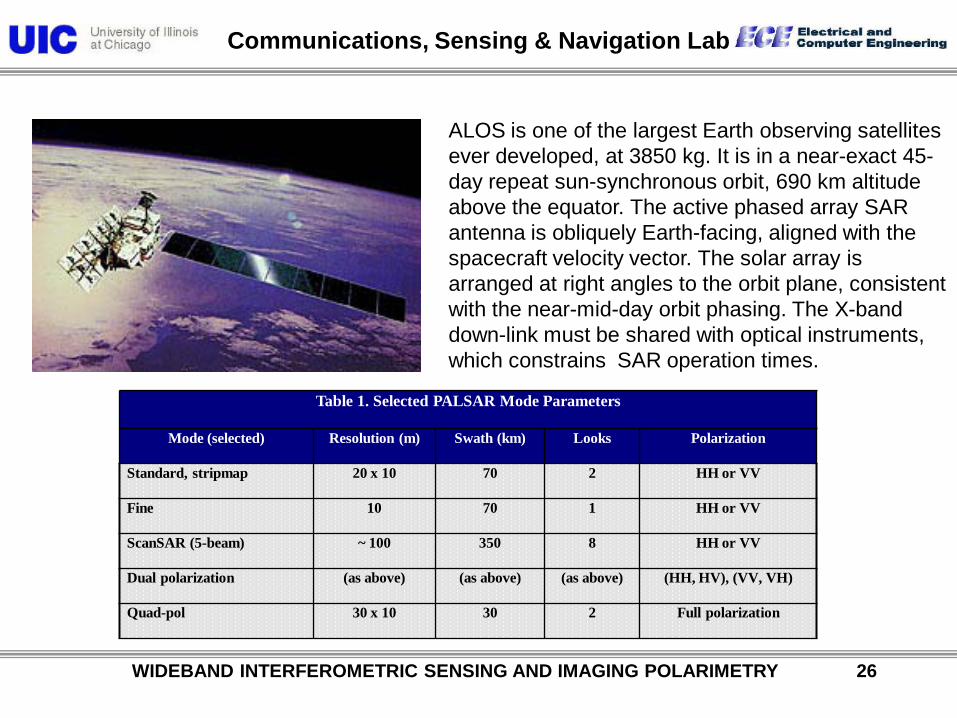
Table 1. Selected PALSAR Mode Parameters
Mode (selected) Resolution (m) Swath (km) Looks Polarization
Standard, stripmap 20 x 10 70 2 HH or VV
Fine 10 70 1 HH or VV
ScanSAR (5-beam) ~ 100 350 8 HH or VV
Dual polarization (as above) (as above) (as above) (HH, HV), (VV, VH)
Quad-pol 30 x 10 30 2 Full polarization
ALOS is one of the largest Earth observing satellites ever developed, at 3850 kg. It is in a near-exact 45-day repeat sun-synchronous orbit, 690 km altitude above the equator. The active phased array SAR antenna is obliquely Earth-facing, aligned with the spacecraft velocity vector. The solar array is arranged at right angles to the orbit plane, consistent with the near-mid-day orbit phasing. The X-band down-link must be shared with optical instruments, which constrains SAR operation times.
Communications, Sensing & Navigation Lab
Ascending
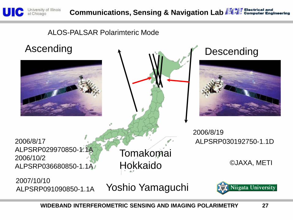
2006/8/17 ALPSRP029970850-1.1A 2006/10/2 ALPSRP036680850-1.1A
ALOS-PALSAR Polarimteric Mode
Tomakomai Hokkaido
Descending
ALPSRP030192750-1.1D 2006/8/19
ALPSRP091090850-1.1A 2007/10/10
Yoshio Yamaguchi
©JAXA, METI
WIDEBAND INTERFEROMETRIC SENSING AND IMAGING POLARIMETRY 27
Communications, Sensing & Navigation Lab
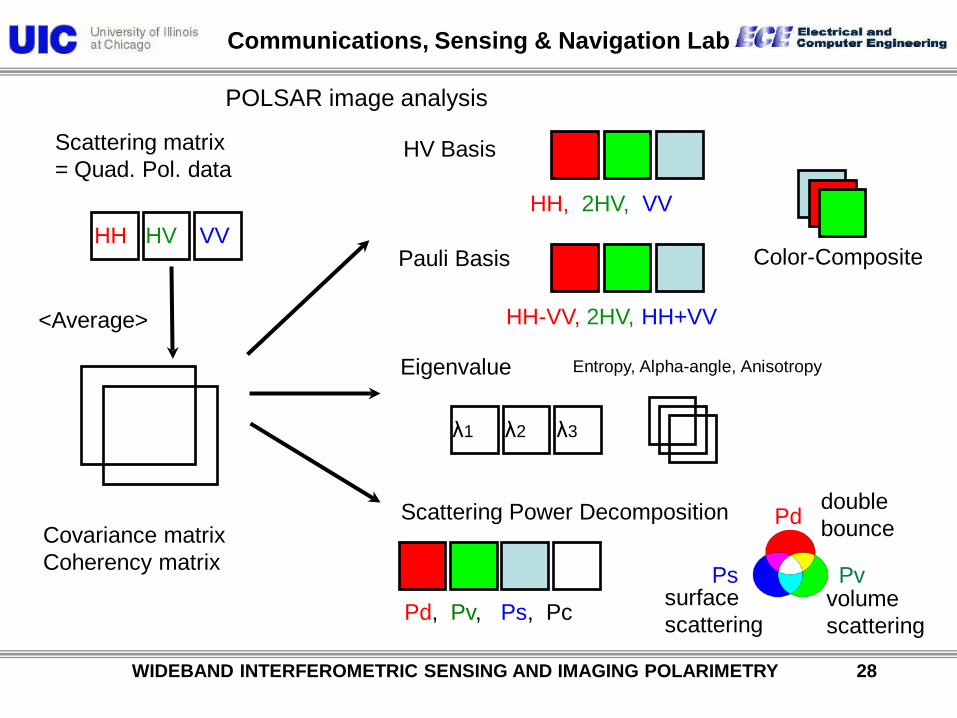
POLSAR image analysis
<Average>
Pauli Basis
Eigenvalue
Scattering Power Decomposition Covariance matrix Coherency matrix
Entropy, Alpha-angle, Anisotropy
Scattering matrix = Quad. Pol. data
Pd, Pv, Ps, Pc
VV HV HH Color-Composite
HH-VV, 2HV, HH+VV
λ1 λ2 λ3
HV Basis
HH, 2HV, VV
Ps Pv
Pd
volume scattering
double bounce
surface scattering
WIDEBAND INTERFEROMETRIC SENSING AND IMAGING POLARIMETRY 28
Communications, Sensing & Navigation Lab
WIDEBAND INTERFEROMETRIC SENSING AND IMAGING POLARIMETRY 29
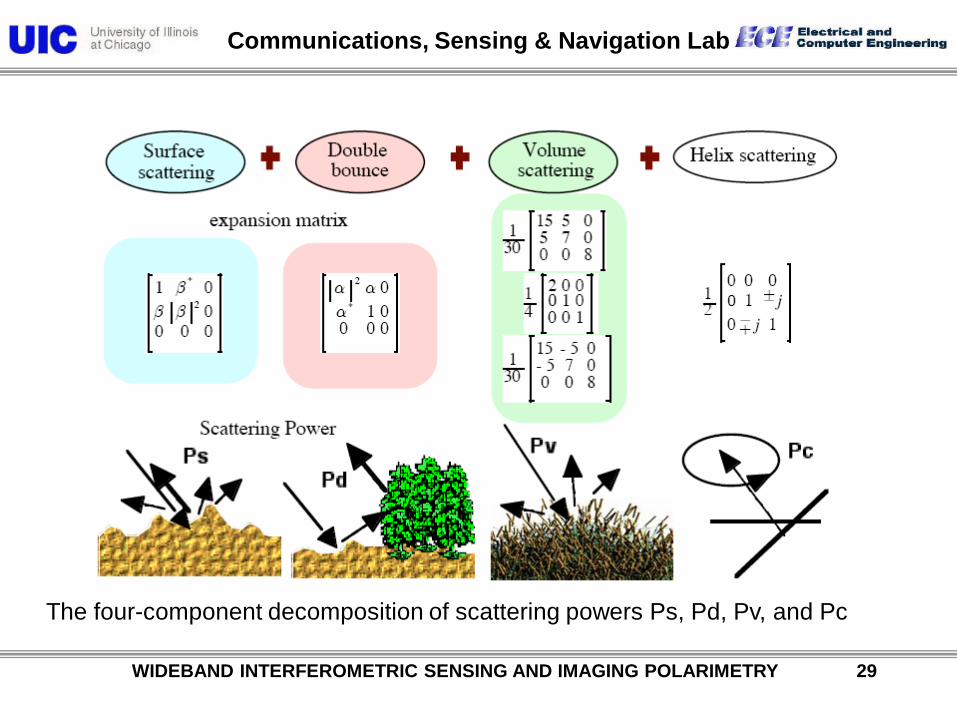
The four-component decomposition of scattering powers Ps, Pd, Pv, and Pc

Communications, Sensing & Navigation Lab
ALPSRP072570650-1.1A
Pauli-basis
HV-basis
©JAXA, METI HH, 2HV, VV
HH-VV, 2HV, HH+VV
Pd, Pv, Ps
Scattering power decomposition
Ps Pv
Pd
2007/6/5
32.825N 130.364E
Fugen-dake Unzen
WIDEBAND INTERFEROMETRIC SENSING AND IMAGING POLARIMETRY 30

Communications, Sensing & Navigation Lab
WIDEBAND INTERFEROMETRIC SENSING AND IMAGING POLARIMETRY 31
Rader line of sight
Deorientation
Rotation of imsge
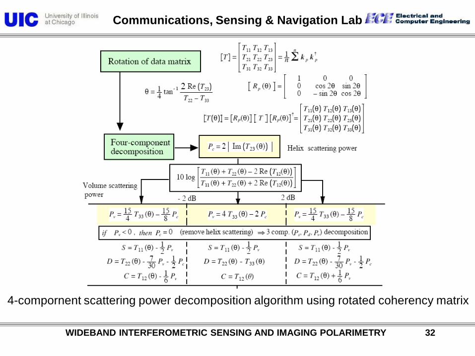
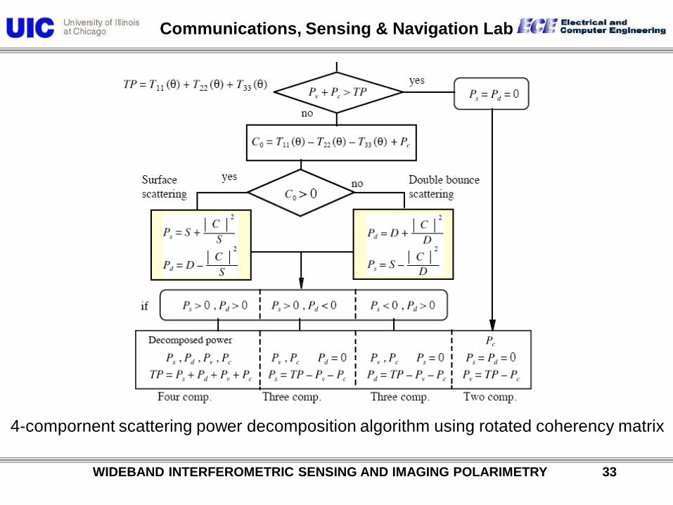
4-component scattering power decomposition algorithm using rotated coherency matrix
Communications, Sensing & Navigation Lab
WIDEBAND INTERFEROMETRIC SENSING AND IMAGING POLARIMETRY 32
4-compornent scattering power decomposition algorithm using rotated coherency matrix
Communications, Sensing & Navigation Lab
WIDEBAND INTERFEROMETRIC SENSING AND IMAGING POLARIMETRY 33
4-compornent scattering power decomposition algorithm using rotated coherency matrix
Communications, Sensing & Navigation Lab
WIDEBAND INTERFEROMETRIC SENSING AND IMAGING POLARIMETRY 34
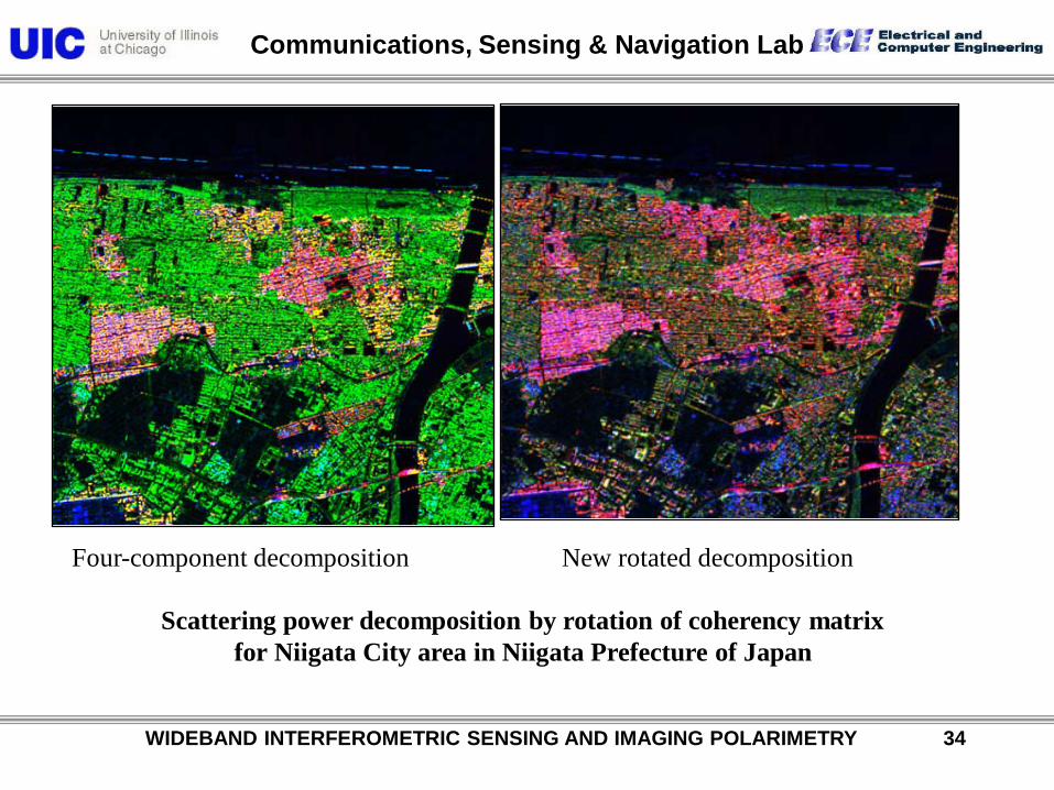
Four-component decomposition New rotated decomposition
Scattering power decomposition by rotation of coherency matrix for Niigata City area in Niigata Prefecture of Japan

Communications, Sensing & Navigation Lab
WIDEBAND INTERFEROMETRIC SENSING AND IMAGING POLARIMETRY 35
Deorientation
(a) Original decomposition (b) Decomposition after T33 rotation
(c) Patch A: orthogonal urban (d) Patch B: oriented urban (e) Patch C: forest
Kyoto City, Kyoto Prefecture, Japan

Communications, Sensing & Navigation Lab
WIDEBAND INTERFEROMETRIC SENSING AND IMAGING POLARIMETRY 36
Decomposed color coded image of Sapporo, Japan
Communications, Sensing & Navigation Lab
WIDEBAND INTERFEROMETRIC SENSING AND IMAGING POLARIMETRY 37
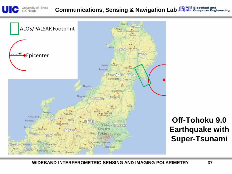
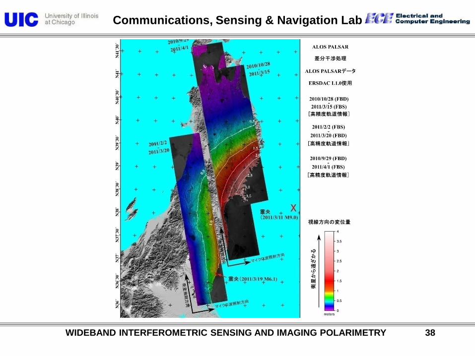
Off-Tohoku 9.0 Earthquake with Super-Tsunami
Communications, Sensing & Navigation Lab
WIDEBAND INTERFEROMETRIC SENSING AND IMAGING POLARIMETRY 38
Communications, Sensing & Navigation Lab
WIDEBAND INTERFEROMETRIC SENSING AND IMAGING POLARIMETRY 39
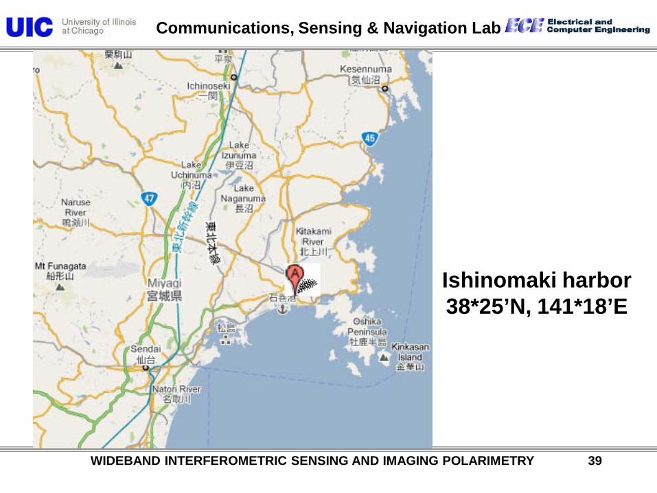
Ishinomaki harbor 38*25’N, 141*18’E

Communications, Sensing & Navigation Lab
WIDEBAND INTERFEROMETRIC SENSING AND IMAGING POLARIMETRY 40
Destruction of City and Harbor of Ishinomaki by 110311 Tsu-nami (Harbor-Wave)

Communications, Sensing & Navigation Lab
WIDEBAND INTERFEROMETRIC SENSING AND IMAGING POLARIMETRY 41
Communications, Sensing & Navigation Lab
WIDEBAND INTERFEROMETRIC SENSING AND IMAGING POLARIMETRY 42
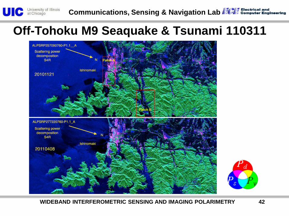
Off-Tohoku M9 Seaquake & Tsunami 110311
Communications, Sensing & Navigation Lab
WIDEBAND INTERFEROMETRIC SENSING AND IMAGING POLARIMETRY 43
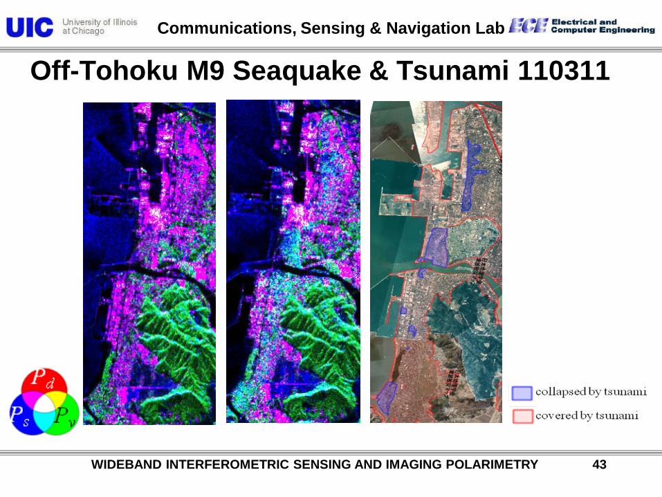
Off-Tohoku M9 Seaquake & Tsunami 110311

Communications, Sensing & Navigation Lab
WIDEBAND INTERFEROMETRIC SENSING AND IMAGING POLARIMETRY 44
Off-Tohoku M9 Seaquake & Tsunami 110311
Communications, Sensing & Navigation Lab
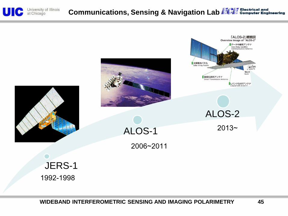
WIDEBAND INTERFEROMETRIC SENSING AND IMAGING POLARIMETRY 45
JERS-1
ALOS-1
ALOS-2
1992-1998
2006~2011
2013~
Communications, Sensing & Navigation Lab
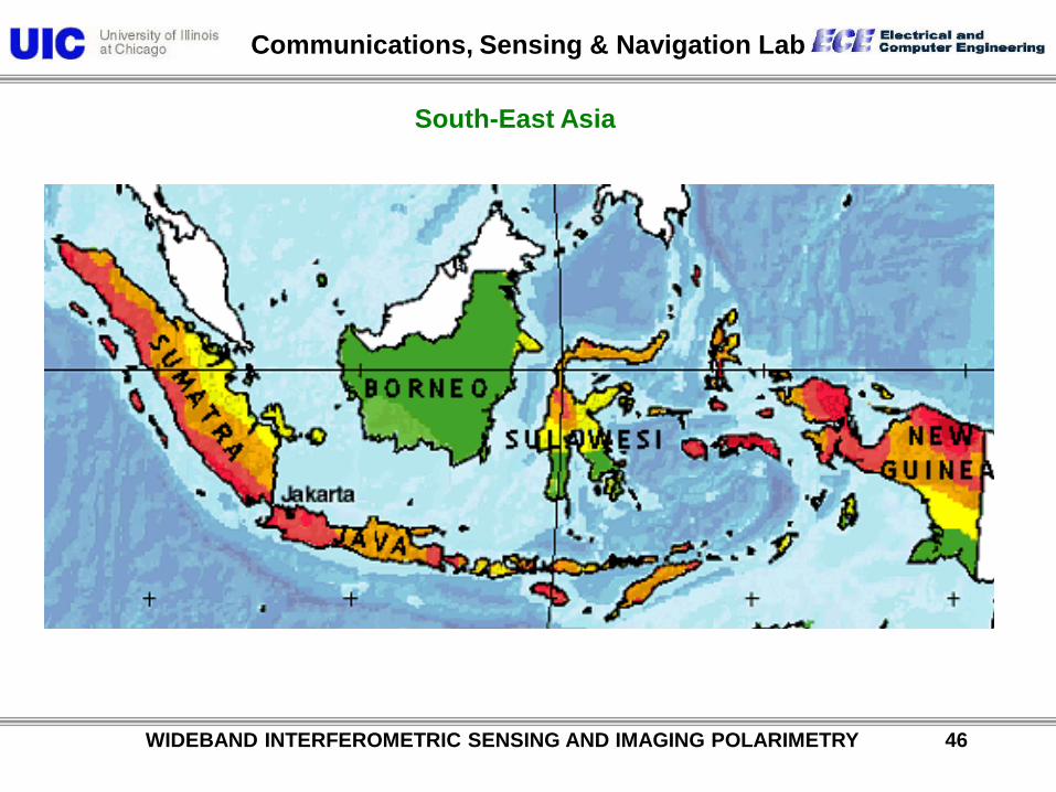
WIDEBAND INTERFEROMETRIC SENSING AND IMAGING POLARIMETRY 46
South-East Asia
Communications, Sensing & Navigation Lab
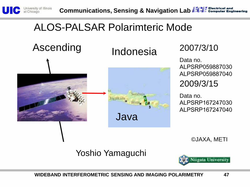
ALOS-PALSAR Polarimteric Mode
©JAXA, METI
2007/3/10 Data no. ALPSRP059887030 ALPSRP059887040
Yoshio Yamaguchi
Ascending
2009/3/15 Data no. ALPSRP167247030 ALPSRP167247040
WIDEBAND INTERFEROMETRIC SENSING AND IMAGING POLARIMETRY 47
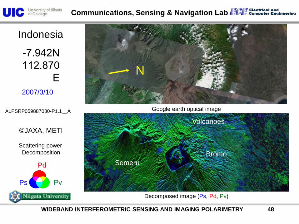
Indonesia
Java
Communications, Sensing & Navigation Lab
ALPSRP059887030-P1.1__A
2007/3/10
-7.942N 112.870
E
©JAXA, METI
Ps Pv
Pd
Indonesia
Scattering power Decomposition
Google earth optical image
Decomposed image (Ps, Pd, Pv)
N
WIDEBAND INTERFEROMETRIC SENSING AND IMAGING POLARIMETRY 48
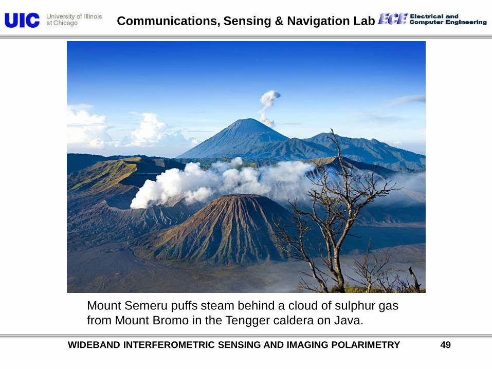
Bromo Semeru
Volcanoes
Communications, Sensing & Navigation Lab
WIDEBAND INTERFEROMETRIC SENSING AND IMAGING POLARIMETRY 49
Mount Semeru puffs steam behind a cloud of sulphur gas from Mount Bromo in the Tengger caldera on Java.
Communications, Sensing & Navigation Lab
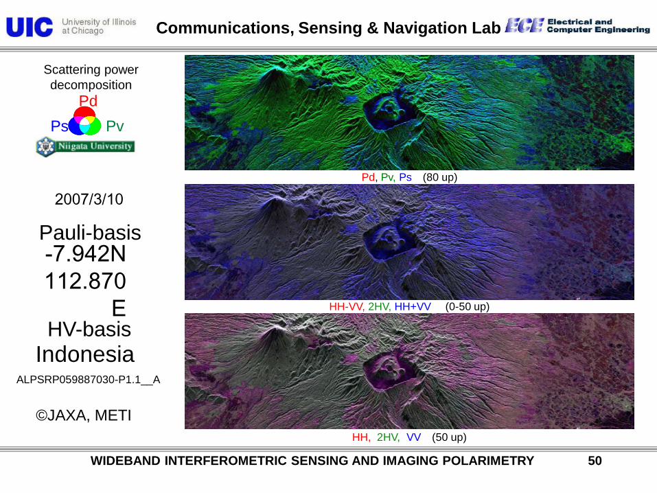
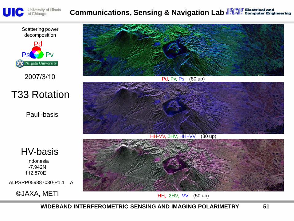
Scattering power decomposition
Ps Pv Pd
Pauli-basis
HV-basis
2007/3/10
-7.942N 112.870
E
Indonesia
©JAXA, METI
ALPSRP059887030-P1.1__A
HH, 2HV, VV (50 up)
HH-VV, 2HV, HH+VV (0-50 up)
Pd, Pv, Ps (80 up)
WIDEBAND INTERFEROMETRIC SENSING AND IMAGING POLARIMETRY 50
Communications, Sensing & Navigation Lab
©JAXA, METI
Scattering power decomposition
Ps Pv Pd
Pauli-basis
HV-basis
2007/3/10
-7.942N 112.870E
Indonesia
T33 Rotation
ALPSRP059887030-P1.1__A
HH, 2HV, VV (50 up)
HH-VV, 2HV, HH+VV (80 up)
Pd, Pv, Ps (80 up)
WIDEBAND INTERFEROMETRIC SENSING AND IMAGING POLARIMETRY 51
Communications, Sensing & Navigation Lab
WIDEBAND INTERFEROMETRIC SENSING AND IMAGING POLARIMETRY 52
“Natural hazards are inevitable. Natural disasters are not.”
Communications, Sensing & Navigation Lab
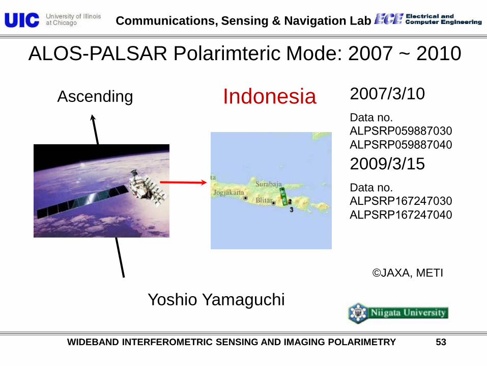
ALOS-PALSAR Polarimteric Mode: 2007 ~ 2010
©JAXA, METI
2007/3/10 Data no. ALPSRP059887030 ALPSRP059887040
Yoshio Yamaguchi
Ascending
2009/3/15 Data no. ALPSRP167247030 ALPSRP167247040
WIDEBAND INTERFEROMETRIC SENSING AND IMAGING POLARIMETRY 53
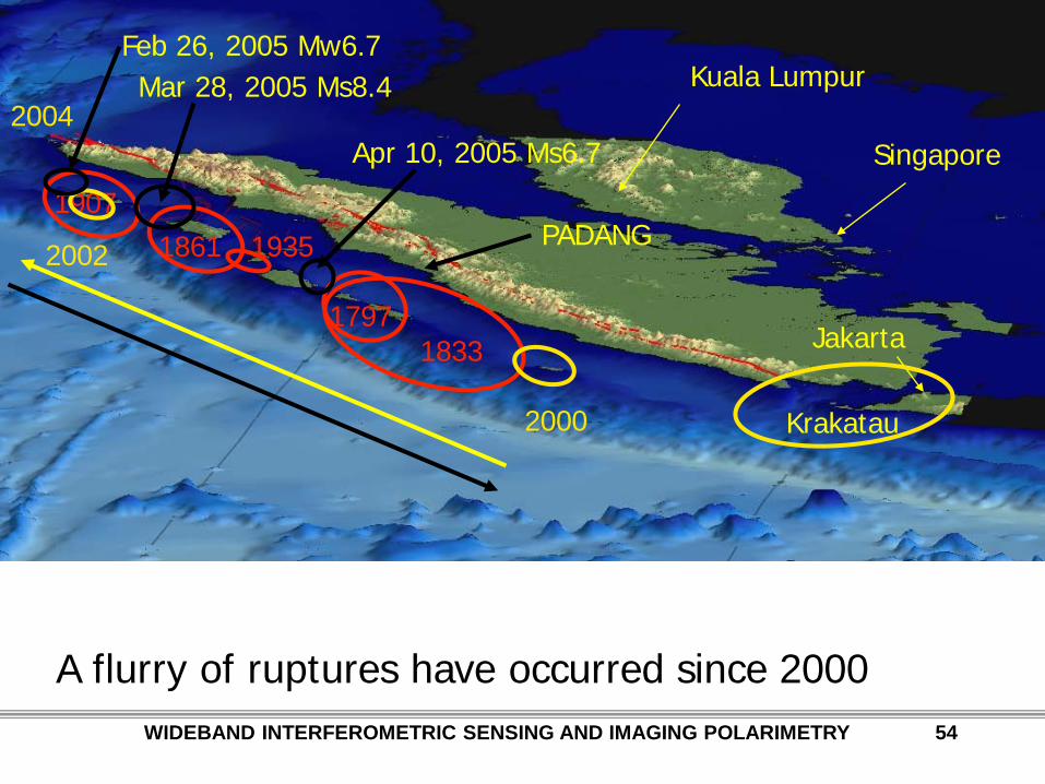
Indonesia
Communications, Sensing & Navigation Lab
Singapore
Jakarta
Kuala Lumpur
1833 1797
1861 1907
1935
A flurry of ruptures have occurred since 2000
2000
2002
2004 Mar 28, 2005 Ms8.4
Apr 10, 2005 Ms6.7
PADANG
Feb 26, 2005 Mw6.7
Krakatau
WIDEBAND INTERFEROMETRIC SENSING AND IMAGING POLARIMETRY 54
Communications, Sensing & Navigation Lab
WIDEBAND INTERFEROMETRIC SENSING AND IMAGING POLARIMETRY 55
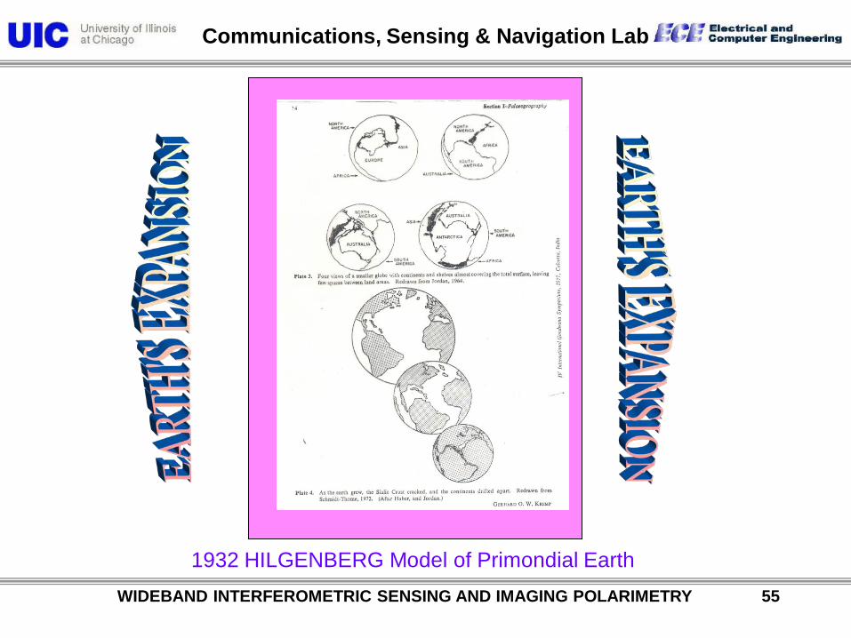
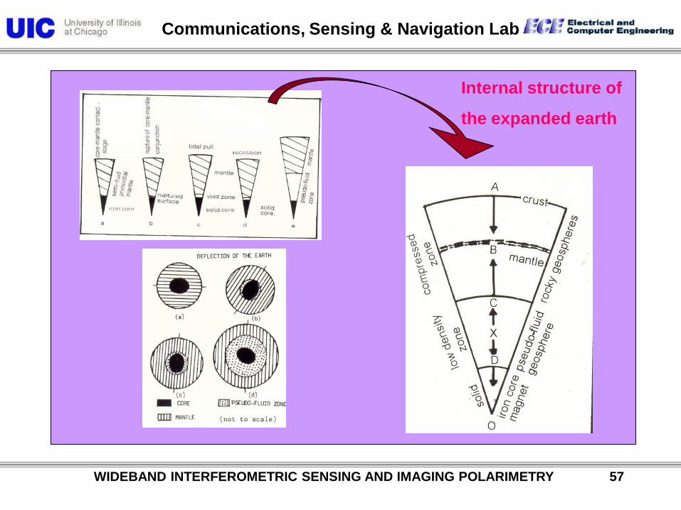
1932 HILGENBERG Model of Primondial Earth
Communications, Sensing & Navigation Lab
WIDEBAND INTERFEROMETRIC SENSING AND IMAGING POLARIMETRY 56
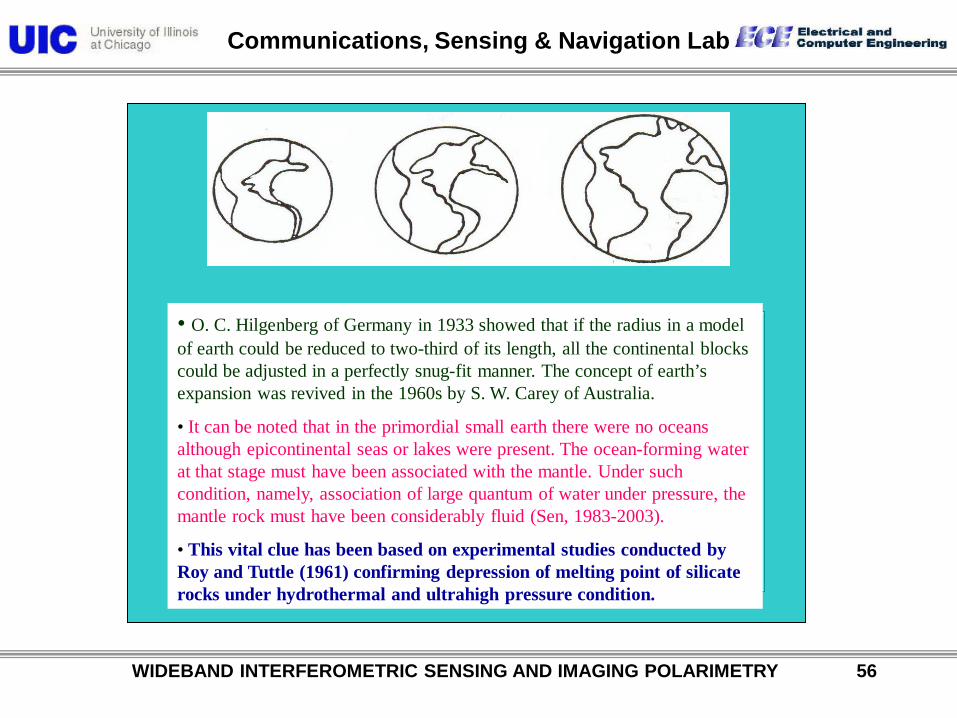
• O. C. Hilgenberg of Germany in 1933 showed that if the radius in a model of earth could be reduced to two-third of its length, all the continental blocks could be adjusted in a perfectly snug-fit manner. The concept of earth’s expansion was revived in the 1960s by S. W. Carey of Australia.
• It can be noted that in the primordial small earth there were no oceans although epicontinental seas or lakes were present. The ocean-forming water at that stage must have been associated with the mantle. Under such condition, namely, association of large quantum of water under pressure, the mantle rock must have been considerably fluid (Sen, 1983-2003).
• This vital clue has been based on experimental studies conducted by Roy and Tuttle (1961) confirming depression of melting point of silicate rocks under hydrothermal and ultrahigh pressure condition.
Communications, Sensing & Navigation Lab
WIDEBAND INTERFEROMETRIC SENSING AND IMAGING POLARIMETRY 57
Internal structure of
the expanded earth
Communications, Sensing & Navigation Lab
WIDEBAND INTERFEROMETRIC SENSING AND IMAGING POLARIMETRY 58
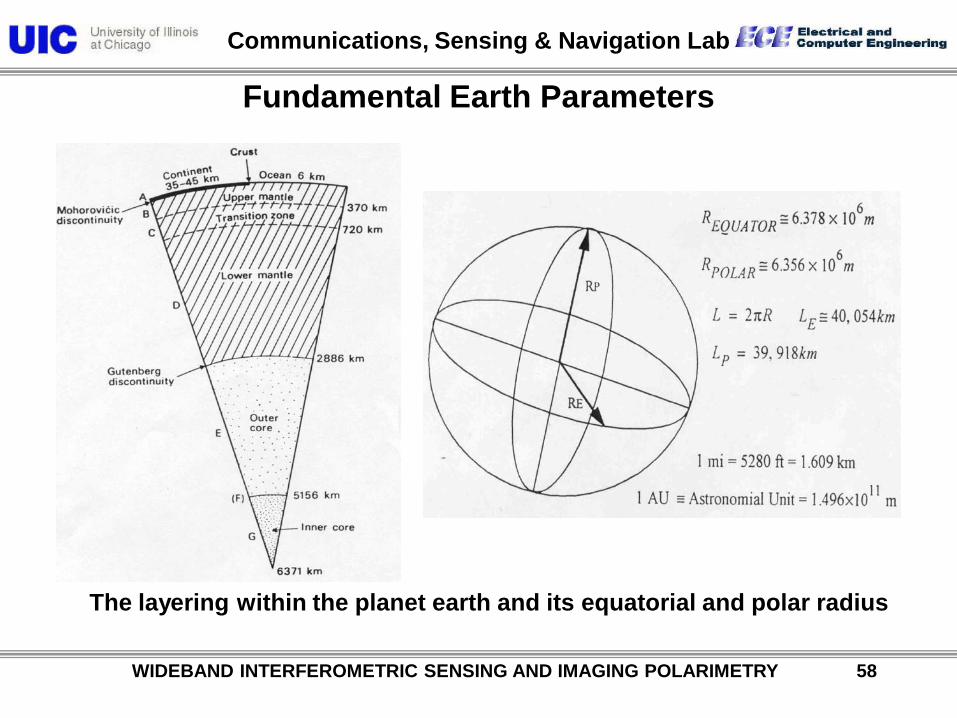
Fundamental Earth Parameters
The layering within the planet earth and its equatorial and polar radius
Communications, Sensing & Navigation Lab
WIDEBAND INTERFEROMETRIC SENSING AND IMAGING POLARIMETRY 59
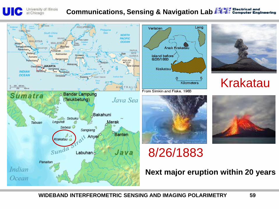
Krakatau
8/26/1883 Next major eruption within 20 years
Communications, Sensing & Navigation Lab
WIDEBAND INTERFEROMETRIC SENSING AND IMAGING POLARIMETRY 60
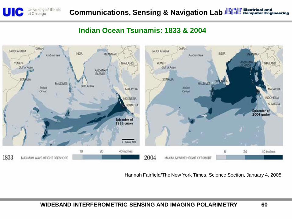
Indian Ocean Tsunamis: 1833 & 2004
Hannah Fairfield/The New York Times, Science Section, January 4, 2005
Communications, Sensing & Navigation Lab
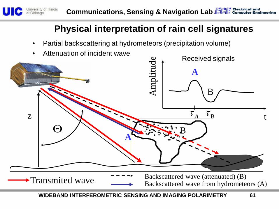
Physical interpretation of rain cell signatures • Partial backscattering at hydrometeors (precipitation volume) • Attenuation of incident wave
A B
t
Am
plitu
de
z Θ
A
B
B Aτ τ
Transmited wave Backscattered wave (attenuated) (B) Backscattered wave from hydrometeors (A)
Received signals
WIDEBAND INTERFEROMETRIC SENSING AND IMAGING POLARIMETRY 61
Communications, Sensing & Navigation Lab
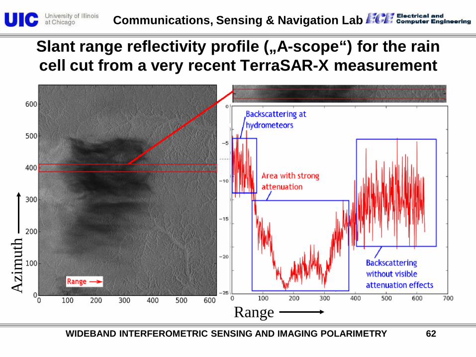
Slant range reflectivity profile („A-scope“) for the rain cell cut from a very recent TerraSAR-X measurement
Pow
er [d
B]
Azi
mut
h
Range WIDEBAND INTERFEROMETRIC SENSING AND IMAGING POLARIMETRY 62
Communications, Sensing & Navigation Lab
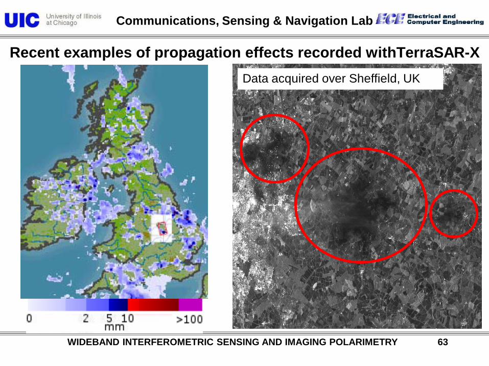
Recent examples of propagation effects recorded withTerraSAR-X Data acquired over Sheffield, UK
WIDEBAND INTERFEROMETRIC SENSING AND IMAGING POLARIMETRY 63
Communications, Sensing & Navigation Lab
WIDEBAND INTERFEROMETRIC SENSING AND IMAGING POLARIMETRY 64
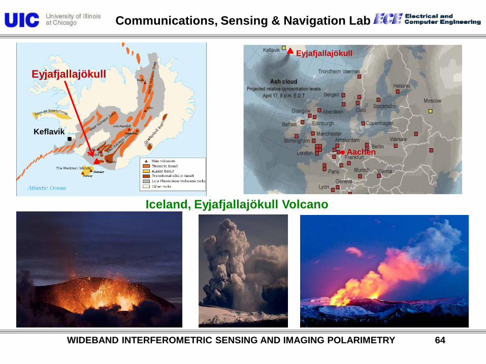
Iceland, Eyjafjallajökull Volcano
Aachen
Eyjafjallajökull
Eyjafjallajökull
Keflavik

Communications, Sensing & Navigation Lab
Iceland, Eyjafjallajökull Volcano
WIDEBAND INTERFEROMETRIC SENSING AND IMAGING POLARIMETRY 65
Communications, Sensing & Navigation Lab
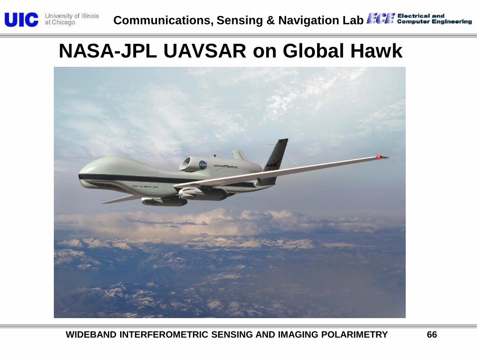
NASA-JPL UAVSAR on Global Hawk
WIDEBAND INTERFEROMETRIC SENSING AND IMAGING POLARIMETRY 66

Communications, Sensing & Navigation Lab
UAVSAR Gulf-Stream III L (Quad - Pol)
(HH-VV, HV, HH+VV)
Salton Sea – California ( March 2008 ) Upcoming High-altitude PolSAR Sensors
WIDEBAND INTERFEROMETRIC SENSING AND IMAGING POLARIMETRY 67

Communications, Sensing & Navigation Lab
TerraSAR – X (1 & 2) (2010)
Pol – InSAR Sensors TanDEM-X
WIDEBAND INTERFEROMETRIC SENSING AND IMAGING POLARIMETRY 68
Communications, Sensing & Navigation Lab
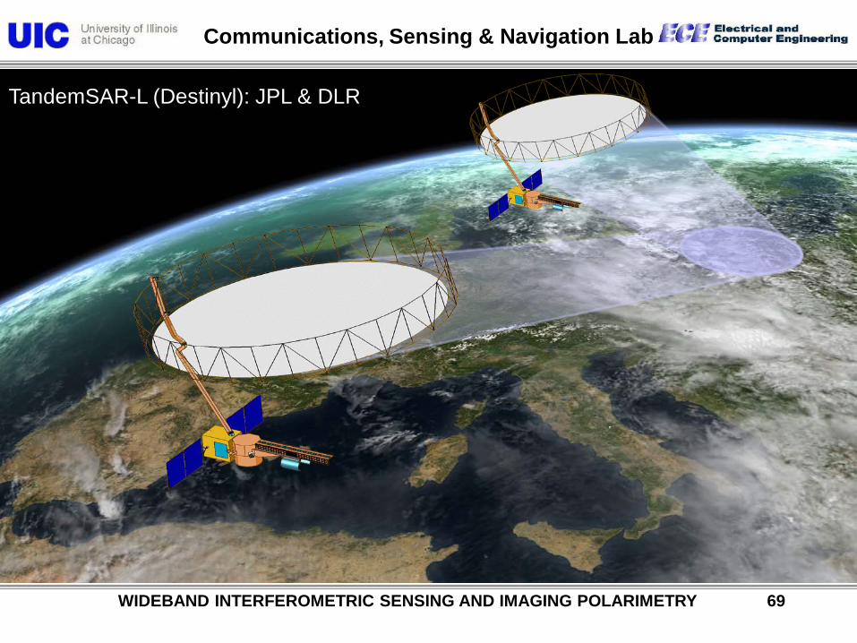
TandemSAR-L (Destinyl): JPL & DLR
WIDEBAND INTERFEROMETRIC SENSING AND IMAGING POLARIMETRY 69

Communications, Sensing & Navigation Lab
Monitoring the Earth’s Dynamics with Pol-InSAR
measurement of 3-D structures (vegetation) & their evolution
monitoring of geo-dynamics
(deformation) with high temporal
resolution
•L-band SAR
•single-pass interferometry (satellite formation)
•polarimetry
TanDEM-L – DESDynl
Courtesy of Pr. A. Moreira – POLINSAR09
WIDEBAND INTERFEROMETRIC SENSING AND IMAGING POLARIMETRY 70

Communications, Sensing & Navigation Lab
WIDEBAND INTERFEROMETRIC SENSING AND IMAGING POLARIMETRY 71
“Natural hazards are inevitable! Natural disasters are not & how can we reduce aftereffects?”
Major Paradigm for Remote Sensing from Air and Space of the Terrestrial Covers:
Accomplished with fully Polarimetric POLinSAR Sensors at all pertinent frequency bands:
Communications, Sensing & Navigation Lab
WIDEBAND INTERFEROMETRIC SENSING AND IMAGING POLARIMETRY 72
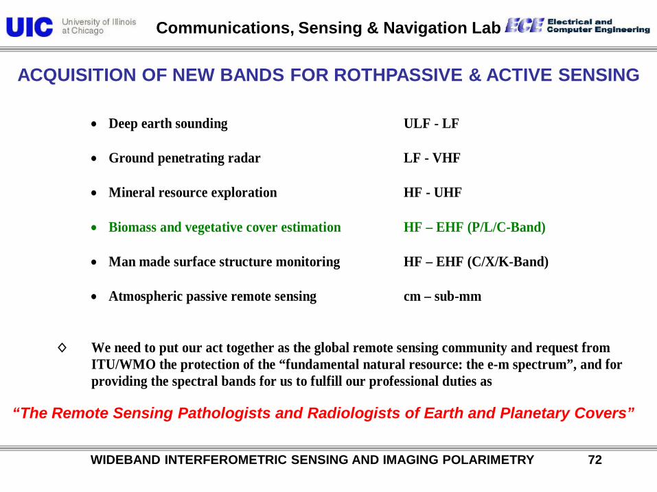
• Deep earth sounding ULF - LF • Ground penetrating radar LF - VHF
• Mineral resource exploration HF - UHF
• Biomass and vegetative cover estimation HF – EHF (P/L/C-Band)
• Man made surface structure monitoring HF – EHF (C/X/K-Band)
• Atmospheric passive remote sensing cm – sub-mm
◊ We need to put our act together as the global remote sensing community and request from
ITU/WMO the protection of the “fundamental natural resource: the e-m spectrum”, and for providing the spectral bands for us to fulfill our professional duties as
ACQUISITION OF NEW BANDS FOR ROTHPASSIVE & ACTIVE SENSING
“The Remote Sensing Pathologists and Radiologists of Earth and Planetary Covers”

Communications, Sensing & Navigation Lab
WIDEBAND INTERFEROMETRIC SENSING AND IMAGING POLARIMETRY 73 / 113
THE IMMINENT COLLISION:
Passive vs Active Spectrum Users, e. g. radio-astronomy vs global telecommunications complex
◊ CLEAN THE PROPAGATION SPACE FROM PROPAGATION LITTER:
- users not requiring free propagation space must be relegated to the use of the global EO fiber transmission network
◊ PRESERVE THE GLOBAL NATURAL RESOURCE – THE E-M SPECTRUM FROM MISUSE:
- misuse of spectral band acquisition by aggressive telecommunication complex must be put to an end
◊ ASSIST AERONOMISTS AND RADIO ASTRONOMERS IN ESTABLISHING THE
BACKGROUND NATURAL NOISE SIGNATURES OF TERRESTRIAL, PLANETARY AND GALACTIC ORIGIN
- establish natural background signatures in all spectral bands
◊ THERE DOES NOT EXIST A SINGLE SPECTRAL BAND IN WHICH THE TERRESTRIAL
COVERS DO NOT POSSESS DISTINCT EIGEN-RESONANCES
- the measurement and monitoring of natural eigen-resonances is essential for natural hazard prediction and mitigation – short term and long term

Communications, Sensing & Navigation Lab
WIDEBAND INTERFEROMETRIC SENSING AND IMAGING POLARIMETRY 74 / 113
Interference Obstruction: EMI-SAR

Communications, Sensing & Navigation Lab
WIDEBAND INTERFEROMETRIC SENSING AND IMAGING POLARIMETRY 75 / 113
ESTABLISHMENT OF WORLD NATURAL HERITAGE ELECTROMAGNETIC QUIET SITES
Radio Astronomic Planetary and Galactic Background Signature Validation across the Entire Electromagnetic Spectrum
ULF – ELF: earthquake prediction
LF – HF: lithospheric sounding and solar terrestrial interactions
VHF – UHF: layer soil and vegetation cover remote sensing
UHF – EHF: vegetation canopy remote sensing and atmospheric monitoring
mm – sub-mm: atmospheric – mesospheric absorption bands monitoring
mm – sub-mm: transmission windows remote sensing

Communications, Sensing & Navigation Lab
WIDEBAND INTERFEROMETRIC SENSING AND IMAGING POLARIMETRY 76
Recent Advances in Fully Polarimetric Space
SAR Development and Its Applications
Conclusions:
The Electromagnetic Spectrum: A Natural Global Treasure
Terrestrial Remote Sensing with PolSAR : The Diagnostics of the Health of the Earth
at all weather and volcanic conditions and at day and night