Beach groundwater dynamics
Diane P. Horn *
School of Geography, Birkbeck College, University of London, 7-15 Gresse Street, London W1T 1 LL, UK
Received 1 December 1999; received in revised form 3 September 2000; accepted 24 January 2002
Abstract
An understanding of the interaction between surface and groundwater flows in the swash zone is necessary to understand
beach profile evolution. Coastal researchers have recognized the importance of beach watertable and swash interaction to
accretion and erosion above the still water level (SWL), but the exact nature of the relationship between swash flows, beach
watertable flow and cross-shore sediment transport is not fully understood. This paper reviews research on beach groundwater
dynamics and identifies research questions which will need to be answered before swash zone sediment transport can be
successfully modelled. After defining the principal terms relating to beach groundwater, the behavior, measurement and
modelling of beach groundwater dynamics is described. Research questions related to the mechanisms of surface–subsurface
flow interaction are reviewed, particularly infiltration, exfiltration and fluidisation. The implications of these mechanisms for
sediment transport are discussed.
D 2002 Elsevier Science B.V. All rights reserved.
Keywords: Groundwater; Infiltration; Phreatic; Swash; Vadose; Watertable
1. Introduction
The section of beach above the still water level is
perhaps the area of the nearshore environment about
which least is known, yet it is of critical importance
because it is the section of the foreshore where final
wave energy dissipation occurs. Hughes and Turner
(1999) identified five features of the swash zone that
make it morphologically different from the rest of the
beach. First, it involves a moving land–water boun-
dary that travels across the intertidal beach at a range
of frequencies from incident waves to tides. The
second feature is that water depths in the swash zone
are very shallow, particularly in the backwash where
they are typically less than 5 cm. The nature of the
hydrodynamic processes operating in the swash zone,
particularly the small water depths, and high velocity,
rapidly oscillating bi-directional currents, means that
accurate measurement of swash processes can be
difficult. Interference between the instruments and
the very shallow flows can potentially result in
measurement error of as much as 10% of the flow
(Hughes, 1992). Third, these very shallow water
depths mean that sediment in the swash zone is often
transported as complicated, single-phase, granular-
fluid flows rather than as the better-understood two-
phase flows where the fluid and sediment in transport
are readily distinguished. A fourth feature of the
swash zone is that at least some part of the beachface
is usually unsaturated, which means that infiltration
into the beach and exfiltration from the watertable can
play an important role in sediment transport. Recent
0169-555X/02/$ - see front matter D 2002 Elsevier Science B.V. All rights reserved.
PII: S0169 -555X(02 )00178 -2
* Tel.: +44-207-631-6480; fax: +44-207-631-6498.
E-mail address: [email protected] (D.P. Horn).
www.elsevier.com/locate/geomorph
Geomorphology 48 (2002) 121–146
research suggests that internal flow within the beach
driven by hydraulic gradients due to watertable fluc-
tuations and/or swash infiltration/exfiltration may
influence the bed stability and thus sediment transport
(see Section 4). Finally, Puleo et al. (2000) described
several fundamental differences between the swash
zone and the surf zone, pointing out that swash is
fundamentally Lagrangian, so that fixed instruments
will record discontinuous time series as they are
alternately submerged and exposed. The discontinu-
ous nature of swash zone processes means that con-
cepts like wave period can become complicated by the
fact that it is probably duration of fluid coverage
rather than repeat time scale that may be most
influential on sediment transport.
This paper reviews research on beach groundwater
dynamics and identifies research questions that still
require answers before swash zone sediment transport
can be successfully modelled. The principal terms
relating to beach groundwater are defined first. The
behavior, measurement, and modelling of beach
groundwater dynamics are then described. Research
questions related to the mechanisms of surface-sub-
surface flow interaction are reviewed. Particularly
attention is paid to infiltration, exfiltration and fluid-
isation. The implications of these mechanisms for
sediment transport are discussed.
2. Background
Swash zone and beach groundwater processes are
of interest to geomorphologists who wish to deter-
mine beach erosion or deposition or aeolian sediment
transport, to marine biologists who are interested in
intertidal fauna, and to engineers who require data on
run-up, particularly on coastal structures such as
breakwaters. Over the past few decades, data on the
position of the shoreline, which is directly dependent
on swash zone processes, have emerged as one of the
principal sources of information for monitoring
coastal change (USGS, 1998). In some cases, the
shoreline position (identified as the maximum extent
of run-up) is used to establish legal boundaries, set-
back lines or flood hazard zones (Morton and Speed,
1998).
Marine biologists have an interest in the swash
zone (e.g., Jansson, 1967; Pollock and Humman,
1971; Reidl and Machan, 1972; McLachlan, 1989,
1996; McLachlan and Hesp, 1984; McLachlan et al.,
1985; McArdle and McLachlan, 1991, 1992; Defeo et
al., 1997), because the distribution and type of macro-
fauna inhabiting the intertidal zone of sandy beaches
appears to be related to the swash climate. Both the
interstitial fauna and the macrofauna of sandy beaches
are directly affected by swash and groundwater pro-
cesses: the former by infiltration, which is responsible
for flushing oxygen and organic materials into the
sand; and the latter by swash dynamics and the
position of the seepage face, which influence tidal
migrations and burrowing (McArdle and McLachlan,
1991). Differences in the spatial distribution and
abundance of beach fauna have been explained in
relation to sediment size and beach slope, but have not
yet been related successfully to swash dynamics
(McLachlan and Hesp, 1984).
Coastal engineers have long recognized the need
for a better understanding of swash zone processes,
largely concentrating on the measurement and mod-
elling of run-up on structures such as breakwaters.
Such studies are needed to establish design criteria,
particularly the elevation of the structure required to
prevent overtopping by the run-up of extreme waves.
Other engineering applications where knowledge of
beach groundwater dynamics is important include
water quality management in closed coastal lakes
and lagoons and the operation of water supply and
sewage waste disposal facilities in coastal dunes
(Turner, 1998), contaminant cycling in estuaries
(Drabsch et al., 1999) and coastal water resource
management issues such as salt water intrusion into
coastal aquifers, wastewater disposal from coastal
developments and pollution control (Nielsen, 1999).
Recently the commercial possibility of modifying
beach watertable elevation to control beach erosion
has been recognized, and several studies have inves-
tigated the use of beach dewatering as an alternative
to hard engineering practices. Beach dewatering in-
volves lowering the watertable artificially through a
system of buried drains and pumps. Although beach
dewatering systems have been shown in some cases to
be effective in inducing accretion and/or reducing
erosion, the mechanism responsible is not clear
(Turner and Leatherman, 1997). A beach drain system
is generally thought to operate by reducing backwash
sediment transport by lowering the beach watertable
D.P. Horn / Geomorphology 48 (2002) 121–146122

and thus increasing infiltration. However, there is
some evidence to suggest that flow generated by the
drain system may produce additional onshore trans-
port and onshore bar migration (Oh and Dean, 1994;
Sato et al., 1994). In order to operate a beach
dewatering system in a cost-effective manner, coastal
engineers need to know whether the drain enhances
the rate of accretion during normally accretive wave
climates or if the drain mitigates the effect of an
erosive wave climate (Weisman et al., 1995). At
present, engineers do not have sufficient physical
understanding of the system to enable them to design
the optimum system (Li et al., 1996). The effect of the
location of the drain on the performance of the system
is not clearly understood, in particular the depth below
and the distance behind the still water line; nor is the
dependence of system performance on discharge
known (Sato et al., 1994; Weisman et al., 1995).
Other sources of uncertainty include the effects of
tidal range and stage of the tidal cycle, sediment size
and sorting, beach slope, and the direction and fre-
quency of storm events. Until these effects can be
understood and quantified, it will not be possible to
predict the performance, or even the success of a
beach dewatering scheme, despite the potential of this
‘soft’ engineering technique. At present, the outcome
of many beach dewatering schemes is inconclusive as
to whether dewatering has had any net positive effect
in mitigating local erosion problems (Turner and
Leatherman, 1997).
An understanding of swash and beach groundwater
dynamics is also important in the modelling of beach
profile evolution. At present, most numerical models
of shoreline change do not include sediment transport
processes in the swash zone. This failure to model the
swash zone means that sediment transport at the
coastline will not be adequately represented. Cross-
shore sediment transport models (e.g., Roelvink and
Stive, 1989; Nairn and Southgate, 1993; Roelvink and
Brøker, 1993; Larson, 1995; Winyu and Shibayama,
1996, etc.) have demonstrated considerable success in
predicting eroding beach profiles on relatively fine
sand beaches. Predictions of accretionary events and
the behavior of coarser sediment beaches are generally
not as good, particularly in the inner surf zone and
swash zone (Seymour, 1986; Schoones and Theron,
1995). Existing cross-shore sediment transport models
generally predict only offshore transport unless there
is substantial tuning of the calibration coefficients
(Hughes et al., 1997b; Cox and Hobensack, in
review). Even under predominantly erosive condi-
tions, the observed net transport in the swash zone
can be onshore (Watanabe et al., 1980). This failure to
predict beach profile behavior adequately is probably
due at least in parts, to the lack of a realistic model for
the hydrodynamics and sediment transport in the
swash zone, as most models neglect or drastically
simplify the swash hydrodynamics (Hamm et al.,
1993; Roelvink and Brøker, 1993; Shah and Kam-
phuis, 1996). However, even recent models which
include swash zone processes in some form do not
predict accretionary features such as the berm cor-
rectly. Kobayashi and da Silva (1987) developed a
time-dependent model of sediment particle motion in
the swash zone that was successful in predicting run-
up oscillations in the lab and field. This model was not
able to predict net onshore transport beyond the still
water level, possibly due to permeability effects (Cox
and Hobensack, in review). Kawata and Kimura
(2000) developed a numerical model of beach profile
evolution including the swash zone in which the
direction of transport predicted for the swash zone
was the opposite of the transport direction predicted
for the region offshore. However, the model still
predicted overall net erosion, even with the swash
zone included. The lack of detailed knowledge of
swash and beach groundwater dynamics is probably
an important factor in the ability of profile models to
simulate accretionary events accurately, because an
accretionary event is defined by the deposition of
sediment above mean sea level.
Erosion and accretion of the beach profile, and the
resulting movement of the position of the shoreline,
are a direct result of sediment transport processes
occurring in the swash zone and inner surf zone.
Beach groundwater– swash dynamics provide an
important control on swash zone sediment transport,
which affects the morphology of the intertidal beach
by controlling the potential for offshore transport or
onshore sediment transport and deposition above the
still water level. Cyclic erosion and accretion of the
beachface as a result of relative elevations of the
beach watertable and swash have been substantiated
by researchers for many years (e.g., Bagnold, 1940;
Shepard and LaFond, 1940; Emery and Foster, 1948;
Longuet-Higgins and Parkin, 1962; Duncan, 1964;
D.P. Horn / Geomorphology 48 (2002) 121–146 123

Otvos, 1965; Strahler, 1966; Schwartz, 1967; Harri-
son, 1969, 1972; Waddell, 1976; Chappell et al.,
1979; Kirk, 1980; Clarke et al., 1984; Eliot and
Clarke, 1986, 1988; Nordstrom and Jackson, 1990;
Turner, 1990; Ogden and Weisman, 1991; Turner,
1993c, 1995a; Oh and Dean, 1994; Weisman et al.,
1995). Most of these studies suggest that beaches with
a low watertable tend to accrete and beaches with a
high watertable tend to erode. Recent observations
indicate that flows in the swash zone can also affect
the beach profile seaward of the intertidal profile,
influencing sediment transport in the bar region (Oh
and Dean, 1994; Sato et al., 1994).
Recent studies also indicate that longshore sediment
transport is closely related to the hydrodynamic motion
at the two boundaries of the surf zone—the break point
and the swash zone, suggesting that correct estimates of
mass and momentum fluxes inside the swash zone are
important for predicting longshore transport (Brocchini
and Peregrine, 1996;Wang, 1998). As with cross-shore
sediment transport models, in most longshore sediment
transport models the swash zone transport contribution
is either completely ignored or included as part of the
total sediment budget by applying a calibration coef-
ficient to the transport model to allow for transport in
the swash zone (van Wellen et al., 2000). This is likely
to introduce significant error, as studies have indicated
that the amount of longshore sediment transport in the
swash zone may be equal to or greater than that in the
surf zone (Bodge and Dean, 1987; Kamphuis, 1991).
Modelling work by Van Wellen et al. (2000) suggested
that 50–70% of total longshore sediment transport on a
steep gravel beach occurred in the swash zone.
Swash and beach groundwater interaction may
play a particularly important role in profile evolution
and sedimentation patterns on macrotidal beaches.
Many macrotidal beaches have two, and sometimes
three, distinct beach zones: a flat, dissipative low-tide
beach and a steeper, more reflective high-tide beach
(Wright et al., 1982; Jago and Hardisty, 1984; Short,
1991; Horn, 1993; Masselink, 1993; Masselink and
Short, 1993; Turner, 1993a,c; Masselink and Hegge,
1995). There is generally an abrupt decrease in beach
slope on macrotidal beaches where the watertable
intersects the beachface (Dyer, 1986; Turner, 1993c),
which may be also marked by a change in sediment
size between coarse and fine material (Carter and
Orford, 1993). Turner (1995a) developed a simple
numerical model that incorporated the interaction of
the tide and the beach watertable outcrop. This model
predicted the development of a break in slope result-
ing from landward sediment transport and berm
development across the alternately saturated and unsa-
turated upper beach, while the profile lowered and
widened across the saturated lower beach. Masselink
and Turner (1999) concluded that macrotidal beach
profiles could be divided into two distinct morpho-
logical domains: an upper intertidal region that is
alternately saturated/unsaturated through the tide
cycle, and a lower region within the intertidal profile
that remains in a permanently saturated state. Hughes
and Turner (1999) gave different empirical equations
for equilibrium slope on unsaturated and saturated
beachfaces.
Beach groundwater– swash interaction is also
likely to play a role in sediment sorting processes.
Carter and Orford (1993) suggested that the interac-
tion between beach groundwater and swash flows
may provide a mechanism for the shore-normal sort-
ing of coarse and fine material that is often observed
on macrotidal beaches, with dissipative, sandy low-
tide terraces at the base of steep, reflective high-tide
gravel ridges. Turner (1993c) surveyed 15 macrotidal
beaches on the Queensland coast in Australia and
found that a decrease in sediment size was strongly
correlated to an increase in the relative extent of the
lower gradient (saturated) lower region of the inter-
tidal profile. Masselink and Turner (1999) suggested
that the intersection of the saturated lower slope and
intermittently unsaturated upper slope marks a point
of divergent sediment transport, which may be rein-
forced by the selective sorting of coarser sediment
upslope and finer sediment downslope. Hughes et al.
(2000) suggested that infiltration might alter the
critical entrainment stresses that contribute to heavy
mineral sorting in the swash zone.
Common to all these studies is the observation that
when the watertable outcrops above the tide, two
zones are distinguished: a lower saturated zone that
promotes downslope (offshore) sediment transport,
and an upper region that alternates between saturated
and unsaturated conditions, with upslope (onshore)
sediment transport potentially enhanced by infiltra-
tion. However, the relative importance of infiltration
is not yet known, and will be discussed further in
Section 4.
D.P. Horn / Geomorphology 48 (2002) 121–146124

3. Beach groundwater
3.1. Definitions
The beach groundwater system is a highly
dynamic, shallow, unconfined aquifer in which flows
are driven though saturated and unsaturated sediments
by tides, waves and swash, and to a lesser extent by
atmospheric exchanges (evaporation and rainfall) and
exchanges with deeper aquifers. The complex inter-
action of surface and subsurface water in the swash
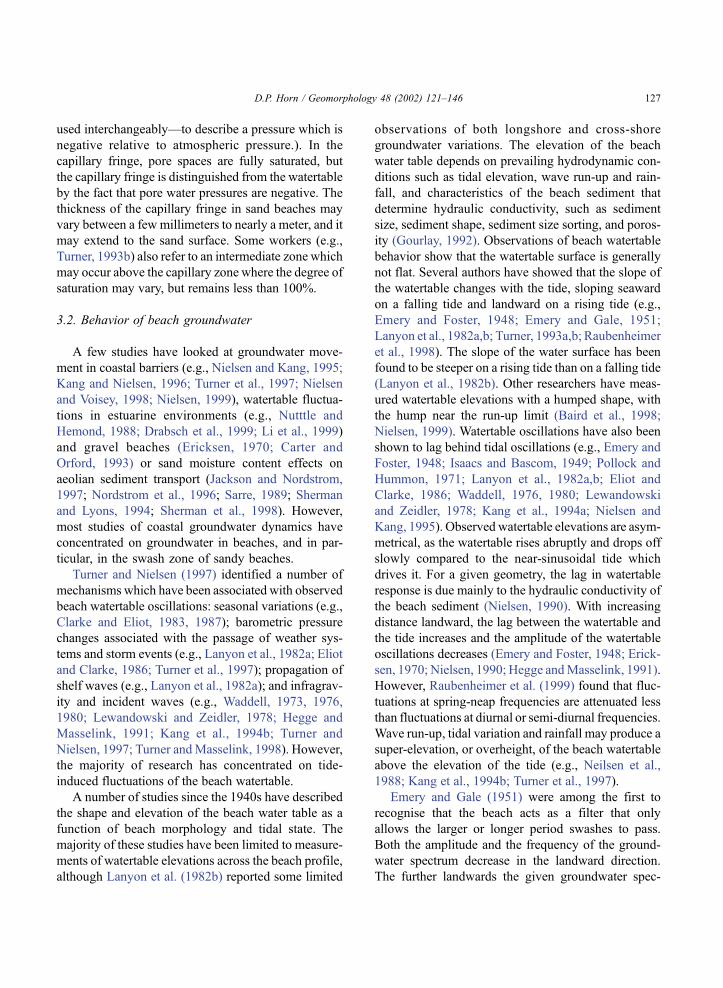
zone means that it is useful to define the terminology
(see Fig. 1). The still water level (SWL) is the water
surface in the hypothetical situation of no waves.
When the local water surface elevation is averaged
over a time span much longer than incident and
infragravity periods but shorter than the tidal period,
the result is the local mean water level, which traces
the mean water surface (MWS) (Nielsen, 1988). The
mean water surface in the surf and swash zones
generally has a gradient which balances the change
in the radiation stress (Longuet-Higgins and Stewart,
1962, 1964). Changes in radiation stress are balanced
by changes in hydrostatic pressure, in other words, by
changes in water level. This difference is known as
set-up or set-down. Set-up is a wave-induced increase
in the MWS, whereas set-down is a wave-induced
decrease in the MWS. Set-down occurs seaward of the
breakers, where radiation stress is at its maximum.
The positive gradient due to radiation stress is bal-
anced by a negative water surface gradient, resulting
in a lowering of the MWS to below SWL. Set-up
occurs inside the surf zone, where the decrease in
radiation stress due to energy dissipation is balanced
by the raising of the MWS above SWL. As long as
energy dissipation continues, set-up continues to
increase in the onshore direction and is greatest at
the shoreline.
The shoreline is the position where the MWS
(including the set-up) intersects the beachface; in other
words, the line of zero water depth. The shoreline
represents the land-water boundary and the limits of
shoreline excursion define the boundaries of the swash
zone, which migrates up and down the foreshore of the
beach over a tidal cycle. The swash zone migrates up
and down the foreshore of the beach over a tidal cycle.
The seaward and landward limits of the swash zone are,
respectively, the point of collapse of the wave or bore as
Fig. 1. Definition sketch of surface and subsurface water levels in the swash zone.
D.P. Horn / Geomorphology 48 (2002) 121–146 125
it reaches the shoreline, and the landward limit of wave
action. There are two components to the water motions
in the swash zone. The first is uprush, the landward-
directed flow; the second component is the backwash,
the downslope movement of the water which follows
maximum run-up. The swash cycle is essentially an
oscillation superimposed on the maximum MWS
(including set-up) inside the surf zone. Total wave
run-up represents the combined effect of set-up and
swash at incident and infragravity frequencies. The
maximum swash height, or maximum run-up eleva-
tion, is the maximum vertical height above SWL.Wave
run-down elevation is the lowest vertical height
reached by the backwash. The run-down elevation
may be below SWL.
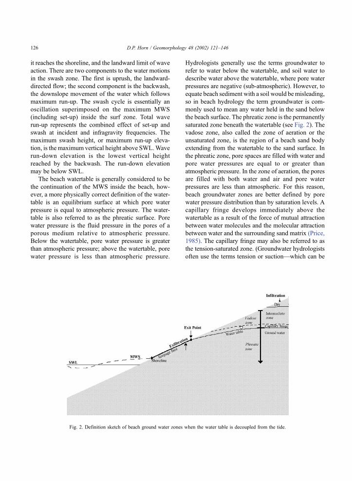
The beach watertable is generally considered to be
the continuation of the MWS inside the beach, how-
ever, a more physically correct definition of the water-
table is an equilibrium surface at which pore water
pressure is equal to atmospheric pressure. The water-
table is also referred to as the phreatic surface. Pore
water pressure is the fluid pressure in the pores of a
porous medium relative to atmospheric pressure.
Below the watertable, pore water pressure is greater
than atmospheric pressure; above the watertable, pore
water pressure is less than atmospheric pressure.
Hydrologists generally use the terms groundwater to
refer to water below the watertable, and soil water to
describe water above the watertable, where pore water
pressures are negative (sub-atmospheric). However, to
equate beach sediment with a soil would be misleading,
so in beach hydrology the term groundwater is com-
monly used to mean any water held in the sand below
the beach surface. The phreatic zone is the permanently
saturated zone beneath the watertable (see Fig. 2). The
vadose zone, also called the zone of aeration or the
unsaturated zone, is the region of a beach sand body
extending from the watertable to the sand surface. In
the phreatic zone, pore spaces are filled with water and
pore water pressures are equal to or greater than
atmospheric pressure. In the zone of aeration, the pores
are filled with both water and air and pore water
pressures are less than atmospheric. For this reason,
beach groundwater zones are better defined by pore
water pressure distribution than by saturation levels. A
capillary fringe develops immediately above the
watertable as a result of the force of mutual attraction
between water molecules and the molecular attraction
between water and the surrounding sand matrix (Price,
1985). The capillary fringe may also be referred to as
the tension-saturated zone. (Groundwater hydrologists
often use the terms tension or suction—which can be
Fig. 2. Definition sketch of beach ground water zones when the water table is decoupled from the tide.
D.P. Horn / Geomorphology 48 (2002) 121–146126
used interchangeably—to describe a pressure which is
negative relative to atmospheric pressure.). In the
capillary fringe, pore spaces are fully saturated, but
the capillary fringe is distinguished from the watertable
by the fact that pore water pressures are negative. The
thickness of the capillary fringe in sand beaches may
vary between a few millimeters to nearly a meter, and it
may extend to the sand surface. Some workers (e.g.,
Turner, 1993b) also refer to an intermediate zone which
may occur above the capillary zone where the degree of
saturation may vary, but remains less than 100%.
3.2. Behavior of beach groundwater
A few studies have looked at groundwater move-
ment in coastal barriers (e.g., Nielsen and Kang, 1995;
Kang and Nielsen, 1996; Turner et al., 1997; Nielsen
and Voisey, 1998; Nielsen, 1999), watertable fluctua-
tions in estuarine environments (e.g., Nutttle and
Hemond, 1988; Drabsch et al., 1999; Li et al., 1999)
and gravel beaches (Ericksen, 1970; Carter and
Orford, 1993) or sand moisture content effects on
aeolian sediment transport (Jackson and Nordstrom,
1997; Nordstrom et al., 1996; Sarre, 1989; Sherman
and Lyons, 1994; Sherman et al., 1998). However,
most studies of coastal groundwater dynamics have
concentrated on groundwater in beaches, and in par-
ticular, in the swash zone of sandy beaches.
Turner and Nielsen (1997) identified a number of
mechanisms which have been associated with observed
beach watertable oscillations: seasonal variations (e.g.,
Clarke and Eliot, 1983, 1987); barometric pressure
changes associated with the passage of weather sys-
tems and storm events (e.g., Lanyon et al., 1982a; Eliot
and Clarke, 1986; Turner et al., 1997); propagation of
shelf waves (e.g., Lanyon et al., 1982a); and infragrav-
ity and incident waves (e.g., Waddell, 1973, 1976,
1980; Lewandowski and Zeidler, 1978; Hegge and
Masselink, 1991; Kang et al., 1994b; Turner and
Nielsen, 1997; Turner andMasselink, 1998). However,
the majority of research has concentrated on tide-
induced fluctuations of the beach watertable.
A number of studies since the 1940s have described
the shape and elevation of the beach water table as a
function of beach morphology and tidal state. The
majority of these studies have been limited to measure-
ments of watertable elevations across the beach profile,
although Lanyon et al. (1982b) reported some limited
observations of both longshore and cross-shore
groundwater variations. The elevation of the beach
water table depends on prevailing hydrodynamic con-
ditions such as tidal elevation, wave run-up and rain-
fall, and characteristics of the beach sediment that
determine hydraulic conductivity, such as sediment
size, sediment shape, sediment size sorting, and poros-
ity (Gourlay, 1992). Observations of beach watertable
behavior show that the watertable surface is generally
not flat. Several authors have showed that the slope of
the watertable changes with the tide, sloping seaward
on a falling tide and landward on a rising tide (e.g.,
Emery and Foster, 1948; Emery and Gale, 1951;
Lanyon et al., 1982a,b; Turner, 1993a,b; Raubenheimer
et al., 1998). The slope of the water surface has been
found to be steeper on a rising tide than on a falling tide
(Lanyon et al., 1982b). Other researchers have meas-
ured watertable elevations with a humped shape, with
the hump near the run-up limit (Baird et al., 1998;
Nielsen, 1999). Watertable oscillations have also been
shown to lag behind tidal oscillations (e.g., Emery and
Foster, 1948; Isaacs and Bascom, 1949; Pollock and
Hummon, 1971; Lanyon et al., 1982a,b; Eliot and
Clarke, 1986; Waddell, 1976, 1980; Lewandowski
and Zeidler, 1978; Kang et al., 1994a; Nielsen and
Kang, 1995). Observed watertable elevations are asym-
metrical, as the watertable rises abruptly and drops off
slowly compared to the near-sinusoidal tide which
drives it. For a given geometry, the lag in watertable
response is due mainly to the hydraulic conductivity of
the beach sediment (Nielsen, 1990). With increasing
distance landward, the lag between the watertable and
the tide increases and the amplitude of the watertable
oscillations decreases (Emery and Foster, 1948; Erick-
sen, 1970; Nielsen, 1990; Hegge andMasselink, 1991).
However, Raubenheimer et al. (1999) found that fluc-
tuations at spring-neap frequencies are attenuated less
than fluctuations at diurnal or semi-diurnal frequencies.
Wave run-up, tidal variation and rainfall may produce a
super-elevation, or overheight, of the beach watertable
above the elevation of the tide (e.g., Neilsen et al.,
1988; Kang et al., 1994b; Turner et al., 1997).
Emery and Gale (1951) were among the first to
recognise that the beach acts as a filter that only
allows the larger or longer period swashes to pass.
Both the amplitude and the frequency of the ground-
water spectrum decrease in the landward direction.
The further landwards the given groundwater spec-
D.P. Horn / Geomorphology 48 (2002) 121–146 127
trum, the narrower its band and the more it is shifted
towards lower frequencies (Lewandowski and Zeidler,
1978). Waddell (1973, 1976) and Hegge and Masse-
link (1991) also showed that the beach acts to reduce
the amplitude and frequency of the input swash
energy. Based on observations such as these, the
beach has often been described as a low-pass filter
(meaning that only lower frequency oscillations are
transmitted through the beach matrix). High fre-
quency, small waves are damped and their effect is
limited to the immediate vicinity of the intertidal
beachface slope, whereas low frequency waves can
propagate inland. Comparison of run-up and ground-
water spectra shows a considerable reduction in dom-
inant energy and also a shift in dominant energy
towards lower frequencies (Hegge and Masselink,
1991).
Decoupling between the tide and the beach water-
table occurs when the groundwater exit point becomes
separated from the shoreline (shown in Fig. 2). This
occurs because the rate at which the beach drains is
less than the rate at which the tide falls, so the tidal
elevation generally drops more rapidly than the
watertable elevation and decoupling occurs, with the
watertable elevation higher than the tidal elevation.
The exit point is the position on the beach profile
where the decoupled watertable intersects the beach-
face. After decoupling occurs, the position of the exit
point is independent of the MWS until it is overtopped
by the rising tide. Below the exit point, a seepage face
develops where the watertable coincides with the
beachface. The seepage face is distinguished by a
glassy surface. The seepage face is different from the
watertable in that its shape is determined by beach
topography. However, water on the seepage face is at
atmospheric pressure, as is water on the watertable.
The extent of the seepage face depends on the tidal
regime, the hydraulic properties of the beach sedi-
ment, and the geometry of the beachface. Thus, the
degree of asymmetry in watertable response will vary
between beaches. This asymmetry is due mainly to the
fact that a beach tends to fill more easily than it drains.
At high tide, a greater area of the beach is available
for water to flow into the beach than at low tide, when
the area of the beach from which groundwater flows is
defined by the length of the beach under water (below
the tide) and the extent of the seepage face. No matter
how extensive, this length will always be less than the
saturated area of beach at high water. The exit point is
generally assumed to mark the boundary between a
lower section of the beach which is saturated and an
upper section which is unsaturated. However, this
assumption is probably an oversimplification.
3.3. Measurement of beach groundwater
Techniques for the measurement of beach ground-
water are discussed by Baird and Horn (1996) and
Turner (1998), and the concepts summarised here are
described more fully in these papers. Until quite
recently, most investigations of beach groundwater
behavior have concentrated on the measurement of
beach watertables in response to low frequency tidal
forcing. More recent studies such as Turner and
Nielsen (1997), Horn et al. (1998) and Turner and
Masselink (1998) have measured higher frequency
fluctuations due to waves. The choice of monitoring
system depends on the objectives of the monitoring
program. The most important parameters in a beach
groundwater system are the elevation of the beach
watertable, pore water pressures, hydraulic conductiv-
ity, specific yield and moisture content.
The elevation of the beach watertable can be meas-
ured by using wells which are perforated for their entire
length to allow water to flow freely between the sedi-
ment and the well at all depths (e.g., Baird et al., 1998).
These wells are commonly made of PVC pipe and
should be covered with a porous material to prevent
sand from entering the holes. The surface of the water
in the tube will be at atmospheric pressure and, by
definition, will give the position of the watertable. The
water surface can be measured manually with commer-
cially available electronic dipmeters which emit a noise
when the water surface is reached. However, Baird et
al. (1998) noted that these electronic dipmeters were
unreliable because films of salt water forming bridges
between the co-axial elements on the sensing tip caus-
ing erroneous readings. An alternative is to measure the
water level manually using a hollow graduated tube
through which the observer blows to locate the water
level. Manual measurements are generally sufficient
for monitoring low frequency oscillations where
watertable elevations only need to obtained every
15–20 min. However, pressure transducers should be
used if a continuous time series is required. The trans-
ducers should be lowered to the very bottom of the well
D.P. Horn / Geomorphology 48 (2002) 121–146128
so that the sensor elevation remains constant even if the
top of the well is disturbed. If higher frequency meas-
urements are required, such as groundwater fluctua-
tions in response to wave run-up, the pressure
transducers should be buried directly in the beach.
Turner (1998) recommended that the direct burial
method should be used for measurement of oscillations
at frequencies of less than 1 min. Pressure transducers
which are buried directly in the beach should have a
porous screen across the sensor port to stop sediment
from touching the sensor, and must also have vented
cable in order allow for changing atmospheric pressure.
Pore water pressures in the beach can be measured
with a piezometer, which consists of a tube open only
at the end, which may be fitted with a permeable tip.
As with groundwater wells, the lower end needs to be
screened to keep the piezometer from being filled with
sand. Water in the beach sand will rise up the
piezometer tube until it is at equilibrium with the pore
water pressure in the sand around the piezometer tip.
In hydrostatic conditions when the watertable is
horizontal, the water level in the piezometer will
correspond with the watertable. However, in hydro-
dynamic conditions, changes in hydraulic potential
with depth in the beach may not be linear and a
piezometer will no longer provide an adequate meas-
ure of watertable elevation. At least three piezometers
are required to determine the direction and hydraulic
gradient of groundwater flow. Two or more closely
spaced piezometers with their lower ends located at
different depths (nested piezometers) are used to
measure vertical head gradients. This layout is essen-
tial in areas where rates of vertical flow may be
significant (Turner, 1998). Piezometers have several
uses. Pore water pressure measurements can be used
to construct lines of equal hydraulic potential (the sum
of pore water pressure and elevation potential) and
therefore flow nets which can be used to estimate
discharge from a beach (e.g., Fetter, 1994). Pore water
pressure measurements can also be used to confirm
whether the simplifying assumptions of groundwater
flow models are met in practice. (For example, the
Dupuit–Forchheimer approximation discussed in Sec-
tion 3.4).
Baird and Horn (1996) noted that a key aspect of
the design of both piezometers and wells is the
response time of the instrument. A finite time is
required for water to flow into or out of the piezom-
eter or well to register a change in the pore water
pressure and watertable elevation. Response time
depends on the geometry of the instrument and the
hydraulic conductivity of the beach sediment. With
both piezometers and wells, instruments with a small
bore require less exchange of water to register
changes in the groundwater system, and in the swash
zone where there will be rapid changes in watertable
elevation and pore water pressures, relatively wide
bore piezometers and wells may prove too slow in
responding, giving a lagged and attenuated response.
Measurements of vertical pore water pressures in
the swash zone are commonly made with pressure
transducers buried at known vertical spacings (e.g.,
Turner and Nielsen, 1997; Turner and Masselink,
1998; Blewett et al., 2000). Buried pressure trans-
ducers generally measure pressures at spacings of
150–200 mm and depths of 10–340 mm below the
beach surface. Near-surface hydraulic gradients in the
beach can be measured at a much higher resolution by
a technique developed by Baldock and Holmes
(1996), which is described in detail in Horn et al.
(1998) and Baldock et al. (2001). The probe tips can
be arranged in a vertical array so that the pressures
and vertical hydraulic gradients can be obtained just
below the beach surface with spacings as small as 10
mm between probes. Vertical hydraulic gradients can
therefore be obtained within the upper 30 mm of the
beach sediment at a single position in the beach. Some
of the results obtained with this system will be
discussed in Section 4.3.
It is important to know the hydraulic conductivity
of the beach sediment for modelling purposes.
Hydraulic conductivity, K, may be defined as the
specific discharge per unit hydraulic gradient. The
hydraulic conductivity reflects the ease with which a
liquid flows and the ease with which a porous medium
permits the liquid to pass through it, and relates the
mean discharge flowing through a porous substance
per unit cross-section to the total gravitational and
potential force. Hydraulic conductivity has units of
velocity, usually m s� 1 in the case of beach ground-
water systems. Hydraulic conductivity should be dis-
tinguished from permeability (also referred to as
intrinsic or specific permeability), denoted by k,
which is the measure of the ability of a rock, soil or
porous substance to transmit fluids and refers only to
the characteristics of the porous medium and not to
D.P. Horn / Geomorphology 48 (2002) 121–146 129

the fluid which passes through it. Permeability has
dimensions of L2.
Another important parameter in groundwater
modelling is a dimensionless parameter known as
specific yield, denoted by s. The specific yield,
which is also known as the drainable porosity, is
defined as the volume of water that an unconfined
aquifer releases from storage per unit surface area of
aquifer per unit decline in watertable (Freeze and
Cherry, 1979). It should be noted that specific yield,
or drainable porosity, is not the same as porosity, and
the two terms should not be used interchangeably.
Porosity is the volume of the voids in a sediment or
rock divided by the total volume of the sediment or
rock. Porosity is denoted by n, and is usually
reported as a decimal fraction or percent. The mois-
ture content or volumetric water content, u, is
defined as the volume of water in a sediment or
rock sample divided by the total volume of the
sediment or rock. In saturated conditions, where
the pores are filled with water, the volumetric water
content, u, is equal to the porosity, n. In unsaturated
conditions, where the pores are only partially filled
with water, the volumetric water content is less than
the porosity. There is also a difference between
specific yield and specific storage, which is defined
as the volume of water that a confined aquifer
releases from storage under a unit decline in
hydraulic head (Freeze and Cherry, 1979). The term
specific storage refers to a unit decline in hydraulic
head below the watertable, in a saturated aquifer.
Releases from storage in unconfined aquifers (such
as beach sediments) represents an actual dewatering
of the pores, whereas releases from storage in con-
fined aquifers represent only the secondary effects of
water expansion and aquifer compaction caused by
changes in the fluid pressure (Freeze and Cherry,
1979).
Most studies calculate hydraulic conductivity by
collecting sediment samples and using one of the many
empirical formulas that relate the hydraulic conduc-
tivity, K, to some measure of the representative grain
size. A commonly used formula is that of Krumbein
and Monk (1943) where permeability, k (in units
of Darcies where 1 Darcy = 9.87� 10 � 13 m2), is
given by:
k ¼ 760D2e�1:31r ð1Þ
where D is the geometric mean grain diameter (mm),
and r is the sediment sorting (in phi units). Hydraulic
conductivity is then given by:
K ¼ kg
vð2Þ
where k is the permeability, v is the kinematic viscosity
of the beach groundwater (L2 T� 1) and g is accel-
eration due to gravity (L T� 2).
Although empirical equations such as Eqs. (1) and
(2) are often used to calculate hydraulic conductivity
from grain size, their use should be treated with
caution. For example, Baird et al. (1998) found that
there was an order of magnitude difference between
measured and calculated hydraulic conductivity. The
mean hydraulic conductivity of the sediment cores
measured with a permeameter was 0.225 cm s� 1,
while the mean hydraulic conductivity of the sand in
the permeameter cores calculated using the empirical
equation of Krumbein and Monk (1943) was 0.02 cm
s� 1. Another weakness of empirical equations relat-
ing sediment size to hydraulic conductivity is that they
are generally only applicable to sand-sized sediments
and may not be appropriate for coarser sediments or
mixed sediment distributions. A more accurate
approach to obtaining hydraulic conductivity is to
take samples of intact sediment from the beach using
a coring device and then measure hydraulic conduc-
tivity using a laboratory permeameter. Another
advantage of collecting sediment cores is that the
porosity and specific yield of the sample can also be
determined. Piezometers can also be used to estimate
hydraulic conductivity by performing slug tests in
which water is either added to or removed from the
piezometer. The rate of recovery of the water level in
the piezometer is then monitored and the hydraulic
conductivity can be calculated.
Hydraulic conductivity can be extremely variable.
For example, Baird et al. (1998) obtained a range of
values of hydraulic conductivity from their laboratory
permeameter measurements varying between 0.036
and 1.179 cm s� 1, with a coefficient of variation of
143%. Unfortunately, this degree of variability is not
unusual for hydraulic conductivity. In many ground-
water systems, hydraulic conductivity is known to
vary by orders of magnitude even over short distances
and the characterisation of hydraulic conductivity for
use in models has presented major conceptual diffi-
D.P. Horn / Geomorphology 48 (2002) 121–146130
culties (Baird and Horn, 1996). As Freeze and Cherry
(1979) remarked, there are few physical parameters
that take on values over 13 orders of magnitude! In
addition, some studies of beach groundwater behavior
ignore the importance of variations in the hydraulic
properties of the beach sediment. This may, perhaps,
be due to the use of models which use a single
‘‘representative’’ value of hydraulic conductivity or
the ratio of hydraulic conductivity to specific yield.
Since sediment size across a beach is not constant, it is
unlikely that hydraulic conductivity or specific yield
will be constant, which reinforces the importance of
collecting sediment cores to obtain an indication of
the variability of hydraulic conductivity across a
beach and with depth.
A potentially important, but poorly understood,
consideration in beach groundwater studies is the role
of air encapsulation during the wetting of beach sand.
A large body of evidence within the soil physics
literature suggests that few sediments below the
watertable are fully saturated (e.g., Constantz et al.,
1988; Fayer and Hillel, 1986; Faybishenko, 1995).
Pockets of gas can be formed in a variety of ways.
During rapid infiltration, air pockets may be trapped
by infiltrating water and bypassed by a rising water-
table. In sediments containing organic matter, bio-
genic gas production can also lead to gas pocket
formation (e.g., Romanowicz et al., 1995). Air encap-
sulation is thought to have large effects on the
hydraulic and storage properties of soils, particularly
hydraulic conductivity and specific yield. Encapsu-
lated gas will reduce hydraulic conductivity consid-
erably below true saturation values if it blocks
effective (i.e., water-conducting) pores. For example,
in field and laboratory infiltration experiments on
sand and gravel loam soils, Constantz et al. (1988)
found that air encapsulation reduced hydraulic con-
ductivities to between 0.1 and 0.2 of the value of the
saturated hydraulic conductivity. The volume of air
encapsulated in these soils ranged between 4% and
19% of total pore volume. Fayer and Hillel (1986)
found that the watertable rose more rapidly when air
was encapsulated than when it was not; the shallower
the watertable, the more pronounced the effect of
encapsulated air. In beach sediments, it is likely that
the top few centimetres are not fully saturated even
when the watertable is at the sand surface. Baldock et
al. (2001) suggested that in beach sediments which are
not fully saturated, dilation and contraction of encap-
sulated gas will slow the propagation of a pressure
wave, causing hydraulic gradients to develop.
Several techniques are available to measure mois-
ture content and thus air encapsulation, although none
of them are entirely satisfactory. The most common
technique is to collect sediment samples from the
beach and calculate the gravimetric moisture. This
technique is not capable of providing any time series
data of moisture content values. Turner (1993a) used a
neutron probe to measure moisture content above the
watertable, with an estimated confidence interval for
percentage saturation of F 12%. The main disadvant-
age of this technique is that it averages moisture
content over a relatively large volume of porous
medium and therefore cannot measure steep moisture
gradients or provide near-surface measurements of
moisture content (Turner, 1993a; Atherton et al.,
2001). An alternative technique was proposed by
Baird and Horn (1996), who suggested that the
presence of encapsulated air can be determined using
time domain reflectrometry (TDR) to measure the
volumetric water content of the soil. If the saturated
water content of the sediment can be measured, the
volume of encapsulated air can be calculated. TDR
measures the apparent dielectric constant in the region
between a pair of thin metal rods inserted into the
sediment by measuring the speed of electromagnetic
waves which travel in the waveguide formed by the
two rods. The apparent dielectric constant of a parti-
ally saturated sediment can be related empirically to
the volumetric water content (fresh or saline) of the
sediment. Standard TDR techniques can estimate soil
moisture content to an accuracy of F 2% of total soil
volume, which compares favourably with the thermal
neutron technique used by Turner (1993a). They have
the advantage that they do not need calibrating for
each individual application (Baird and Horn, 1996).
Recently, Atherton et al. (2001) used an instrument
called a ThetaProbe to measure near-surface beach
moisture content, which determines the impedance of
a sensing rod array and relates voltage outputs to
moisture content. The advantage of this device is that
it is possible to measure relatively small volumes of
sand (35 cm3) rapidly, enabling Atherton et al. (2001)
to make 445 measurements over part of a tidal cycle.
Although the method used by Atherton et al.
(2001) made it possible to measure moisture content
D.P. Horn / Geomorphology 48 (2002) 121–146 131
relatively rapidly (5–30 s), this rate of measurement is
still significantly slower than the frequency at which
moisture content in the swash zone may vary. Under
the action of swash, the surface sediment is constantly
re-worked and, during this process, air bubbles will be
both trapped and released. The air content at a given
point will vary between swashes, leading to highly
dynamic variations in dilation, contraction and
hydraulic conductivity. The degree of compaction,
and hence porosity, of sand in the swash zone will
also be highly variable, depending on the depth below
the surface, tidal stage and wave conditions (Heather-
shaw et al., 1981). Horn et al. (1998) showed data
indicating that regions which are fully and less fully
saturated appear to develop below the sand surface,
particularly a thin layer of totally saturated sediment
which moves up and down the beach with the swash.
These findings suggest a higher frequency method of
measuring moisture content needs to be devised in
order to improve understanding of beach ground-
water–swash interactions.
3.4. Modelling beach groundwater dynamics
An aquifer is a saturated geologic unit that can
transmit significant quantities of water under ordinary
hydraulic gradients (Freeze and Cherry, 1979). An
unconfined aquifer, or watertable aquifer, is one in
which the watertable forms the upper boundary.
Beach groundwater systems are generally treated as
unconfined aquifers because commonly the upper
boundary to groundwater flow is defined by the
watertable itself rather than by some surface layer of
impermeable material (Masselink and Turner, 1999).
The beach groundwater system is underlain by an
impermeable boundary at a depth which is often
unknown. The rate of flow (or specific discharge) of
water through unconfined aquifers, u, is given by
Darcy’s Law:
u ¼ �KBh
Bxð3Þ
where h is hydraulic head (units of length, L), x is the
distance (L) and K is hydraulic conductivity (L T� 1).
Darcy’s Law is valid as long as flow is laminar,
which is a reasonable assumption for sand beaches.
This may not be the case for gravel beaches (Pack-
wood and Peregrine, 1980). Darcy’s Law shows that
the rate of groundwater flow is proportional to the
hydraulic gradient, or slope of the watertable. The
hydraulic gradient (yh/yx) is the change in hydraulic
head (h) over distance. Water flows down the
hydraulic gradient in the direction of decreasing head.
The hydraulic head (h) is the sum of the elevation
head (z) and the pressure head (c), and is measured in
length units above a datum. There is no standard
datum used in beach hydrology, but many researchers
use the elevation of an impermeable layer beneath the
beach sediment, so that the vertical coordinate z is
measured from the impermeable base. Some workers
have considered the hydraulic head in a beach ground-
water system to be the elevation of the free water
surface, or watertable elevation. However, this is only
true when there is no vertical component to the flow;
in other words, when Dupuit–Forcheimer conditions
apply (see below).
Groundwater hydrologists generally model water
flow using Darcy’s Law in combination with an
equation of continuity that describes the conservation
of fluid mass during flow through a porous medium.
A common approach to modelling beach groundwater
flow in response to tidal forcing in sandy beaches uses
the one-dimensional form of the Boussinesq equation:
Bh
Bt¼ K
s
B
BxhBh
Bx
� �ð4Þ
where h is the elevation of the watertable (L), t is time
(T), K is hydraulic conductivity (L T� 1), s is the
specific yield (dimensionless), and x is horizontal
distance (L).
The main assumption in using Eq. (4) is that
groundwater flow in a shallow aquifer can be
described using the Dupuit–Forchheimer approxima-
tion. Dupuit–Forchheimer theory states that in a
system of shallow gravity flow to a sink when the
flow is approximately horizontal, the lines of equal
hydraulic head or potential are vertical and the gra-
dient of hydraulic head is given by the slope of the
watertable (Kirkham, 1967). In effect, the theory neg-
lects the vertical flow components. Using Dupuit–
Forchheimer theory, two-dimensional flow to a sink
can be approximated as one-dimensional flow, and the
resulting differential equation (Eq. (4)) is relatively
easily solved. In beaches that are underlain by rela-
tively impermeable material, it is likely that Dupuit–
D.P. Horn / Geomorphology 48 (2002) 121–146132
Forchheimer theory provides an adequate description
of groundwater flow, and field studies such as those of
Baird et al. (1998) and Raubenheimer et al. (1998)
support this assumption.
Where Dupuit–Forchheimer assumptions do not
apply, such as in artificially drained beaches (e.g., Li
et al., 1996), the beach aquifer should be considered
as a two-dimensional flow system. One approach is to
assume that the watertable is a free surface or flow
line so that
Bh
Bt¼ K
s
BH
Bz� Bh
Bx
BH
Bx
� �ð5Þ
where H is the total or hydraulic head (L) and z is
vertical distance (L). As in Eq. (4), h is the elevation
of the watertable (L), t is time (T), K is hydraulic
conductivity (L T� 1), s is the specific yield (dimen-
sionless), and x is horizontal distance (L). Eq. (4) is
much easier to solve than Eq. (5) and should be used
whenever the assumption of near-horizontal flow
through the beach sand is generally met.
A number of analytical and numerical models have
been developed which are able to predict beach watert-
able fluctuations in response to tides (Nielsen, 1990;
Turner, 1993a,b, 1995a,b; Kang and Nielsen, 1996; Li
et al., 1996, 1997a; Baird et al., 1996, 1997, 1998;
Raubenheimer et al., 1998, 1999). These Boussinesq
models, based on solutions to Eq. (4), have been
successful in reproducing observed fluctuations of
the beach watertable at diurnal and higher tidal fre-
quencies, and also reproduce observations such as the
shape and slope of the beach watertable, the lag and
landward attenuation of beach watertable oscillations,
and seepage face development. However, these models
generally underpredict the watertable elevations under
conditions when wave effects are important.
Models of beach watertable fluctuations that incor-
porate wave effects have been developed only very
recently (Kang and Nielsen, 1996; Li et al., 1997b; Li
and Barry, 2000). Nielsen et al. (1988) and Kang and
Nielsen (1996) proposed the use of a linearised
version of the Boussinesq equation (Eq. (4)) with an
additional term to model watertable fluctuations in the
zone of run-up infiltration:
Bh
Bt¼ Kda
s
B2h
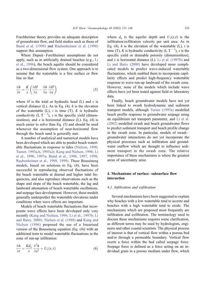
Bx2þ U1ðx; tÞ ð6Þ
where da is the aquifer depth and U1(x,t) is the
infiltration/exfiltration velocity per unit area. As in
Eq. (4), h is the elevation of the watertable (L), t is
time (T), K is hydraulic conductivity (L T� 1), s is the
specific yield or drainable porosity (dimensionless),
and x is horizontal distance (L). Li et al. (1997b) and
Li and Barry (2000) have developed more compli-
cated models to predict wave-induced watertable
fluctuations, which enabled them to incorporate capil-
larity effects and predict high-frequency watertable
response to wave run-up landward of the swash zone.
However, none of the models which include wave
effects have yet been tested against field or laboratory
data.
Finally, beach groundwater models have not yet
been linked to swash hydrodynamic and sediment
transport models, although Turner (1995a) modelled
beach profile response to groundwater seepage using
an equilibrium net transport parameter, and Li et al.
(2002) modelled swash and beach groundwater flows
to predict sediment transport and beach profile change
in the swash zone. In particular, models of swash–
groundwater interactions do not yet incorporate the
physical processes such as infiltration and ground-
water outflow which are thought to influence sedi-
ment transport in the swash zone. The relative
importance of these mechanisms is where the greatest
areas of uncertainty arise.
4. Mechanisms of surface–subsurface flow
interaction
4.1. Infiltration and exfiltration
Several mechanisms have been suggested to explain
why beaches with a low watertable tend to accrete and
beaches with a high watertable tend to erode. The
mechanisms which are proposed most frequently are
infiltration and exfiltration. The terminology used to
discuss these mechanisms requires some clarification,
as different terms may be used by hydrologists, engi-
neers and other coastal scientists. The physical process
of interest is that of vertical flow within a porous bed
and/or through a permeable boundary. Vertical flow
exerts a force within the bed called seepage force.
Seepage force is defined as a force acting on an in-
dividual grain in a porous medium under flow, which
D.P. Horn / Geomorphology 48 (2002) 121–146 133

is due to the difference in hydraulic head between the
front and back faces of the grain (Freeze and Cherry,
1979). The seepage force, F, is exerted in the direction
of flow and is directly proportional to the hydraulic
gradient, and is given by
F ¼ qgBh
Bzð7Þ
where q is the density of the fluid (M L� 3), g is
acceleration due to gravity (L T � 2) and yh/yz is the
hydraulic gradient (dimensionless). In the convention
used here, a positive hydraulic gradient represents a
downward-acting seepage force and a negative
hydraulic gradient represents an upward-acting seep-
age force.
The vertical flows which produce this seepage
force have been referred to in a number of different
ways in the literature: injection (or blowing) and
suction (Martin, 1970; Oldenziel and Brink, 1974;
Willets and Drossos, 1975; Conley and Inman, 1994;
Rao et al., 1994); influent and effluent (Watters and
Rao, 1971); transpiration (Kays, 1972); and bed
ventilation (Conley and Inman, 1992, 1994). The
condition of fluidisation at the surface has been
referred to as piping (Madsen, 1974; Higgins et al.,
1988), seepage erosion (Hutchinson, 1968), and
groundwater sapping (Higgins, 1982). In the case of
beach hydrology, the terms infiltration and exfiltration
are becoming common, and they will be used here.
Infiltration is the process by which water enters into
the surface horizon of a soil or porous medium, such
as beach sediment, in a downward direction from the
surface by means of pores or small openings. Infiltra-
tion is often used interchangeably with percolation,
which more correctly refers to the flow of water
through a soil or porous medium below the surface.
Recently the term exfiltration has been used to
describe outflow from the bed. Infiltration/exfiltration
velocity may also be referred to as seepage velocity.
Grant (1946, 1948) was among the first to suggest
a link between beach groundwater behavior and
swash zone sediment transport, proposing a simple
conceptual model which has been highly influential in
beach hydrology research. Grant defined a dry fore-
shore as one with a low watertable and an extensive
infiltration zone. On a dry foreshore, most of the water
infiltrates rapidly into the sand above the watertable.
This infiltration reduces the flow depth of the swash
and thus the velocity, allowing sediment deposition.
He suggested that near the swash limit, the velocity
decreases below the lower critical limit and the flow
will change from turbulent to laminar. Sediment is
rapidly deposited when this flow transition occurs.
When the backwash begins, the velocity is low and
laminar flow prevails for a short period. This laminar
flow decreases the likelihood of the backwash trans-
porting sediment down the foreshore. He reasoned
that laminar backwash persists for a longer time if the
slope of the beach is small and if the depth of water is
also small. Grant’s conceptual model also described
conditions on a wet foreshore, one whose watertable
is high and contiguous with the surface of most of the
foreshore. He reasoned that when the beach is in a
saturated condition throughout all of the foreshore the
backwash, instead of being reduced by infiltration,
retains its depth and is augmented by the addition of
water rising to the surface of what he called the
effluent zone (the seepage face). This increased veloc-
ity and depth of the backwash produces a turbulent
flow, which enhances offshore transport. Grant also
noted that groundwater outcropping at the beach sur-
face can cause dilation or fluidisation of the sand
grains, allowing them to be entrained more easily by
backwash flows.
The logic of Grant’s conceptual model has led many
researchers to concentrate on the effects of infiltration/
exfiltration on beach accretion and erosion (e.g., Bag-
nold, 1940; Emery and Foster, 1948; Emery and Gale,
1951; Isaacs and Bascom, 1949; Longuet-Higgins and
Parkin, 1962; Duncan, 1964; Strahler, 1966; Harrison,
1969, 1972; Waddell, 1976; Chappell et al., 1979;
Heathershaw et al., 1981; Lanyon et al., 1982a,b;
Carter and Orford, 1993; Turner, 1993a; Weisman et
al., 1995; Turner and Nielsen, 1997; Turner and Mas-
selink, 1998; Nielsen at al., 2000). Many of these
authors suggested that infiltration losses during swash
provide the main mechanism by which beach accretion
occurs above the still water level. Because the swash
and backwash are relatively shallow, a small change in
water volume due to infiltration (or addition of water
due to exfiltration) could influence uprush/backwash
flow asymmetry and therefore the energy available for
sediment transport. For example, Nelson and Miller
(1974) showed that a reduction of swash volume due to
infiltration into the sand matrix of a nonsaturated beach
will decrease the energy of the swash. The resulting
D.P. Horn / Geomorphology 48 (2002) 121–146134

mass loss does not have to be great for it to have a
significant effect on sediment transport. They found
that losses due to infiltration become more critical as
the waves become smaller or the beach slope lower.
Work by Packwood (1983) suggested that backwash
infiltration in particular could be important in affecting
sediment movement in the swash zone. Within the
swash zone, rapid watertable fluctuations due to swash
infiltration into the capillary fringe may also influence
sediment mobility (Li et al., 1997b, 2000; Turner and
Nielsen, 1997; Turner and Masselink, 1998). Ground-
water flow at deeper levels within the beach is also
influenced by infiltration during swash uprush,
although the hydraulic gradients developed tend to be
small (Waddell, 1973; Lewandowski and Zeidler,
1978; Hegge andMasselink, 1991; Turner and Nielsen,
1997; Raubenheimer et al., 1998).
Although most studies have concentrated on infil-
tration/exfiltration and possible effects on swash/
backwash asymmetry, researchers such as Nielsen
(1992, 1997), Turner and Nielsen (1997), Turner
and Masselink (1998) and Hughes and Turner
(1999) have identified other mechanisms by which
vertical flow through a porous bed could affect swash
zone sediment transport. These include an alteration in
the effective weight of the surface sediment due to
vertical fluid drag, which will act to stabilise the bed
under infiltration or destabilise under exfiltration, and
modified shear stresses exerted on the bed due to
boundary layer thinning due to infiltration or thicken-
ing due to exfiltration. Watters and Rao (1971)
described a number of effects of vertical flow through
a porous bed: the angle of attack at which the main
flow contacts the particles is altered; ‘dead’ water (the
nearly static fluid between adjacent particles) is
flushed out of the top bed layer, increasing the
exposed surface area of a particle to the main flow;
and the changed wake behind a particle not only
affects that particle but others in its lee. Turner and
Masselink (1998) summarised the effect of these
processes on the boundary layer, with streamlines
being drawn closer to the sediment–fluid interface
under infiltration and moved away from the sedi-
ment–fluid interface under exfiltration. The result is
a vertical shift of the boundary layer velocity profile,
with an increase of flow velocity and shear stress at
the bed under infiltration and a decrease under exfil-
tration.
Experimental work on the influence of seepage
flows within sediment beds provides conflicting
results concerning their effect on bed stability. Most
authors agree that infiltration increases shear stress
and skin friction at the bed, whereas exfiltration
decreases bed shear stress and friction. However, the
effects of infiltration and exfiltration on entrainment
and sediment transport is less clear. Martin (1970)
concluded that infiltration could either enhance or
hinder incipient sediment motion, depending on the
sediment size and permeability, whereas exfiltration
had no effect on incipient motion until the bed was
fluidised. In contrast, Watters and Rao (1971) reached
the conclusion that exfiltration inhibited the motion of
bed particles while infiltration enhanced the motion.
Oldenziel and Brink (1974) found that infiltration
decreased the transport rate and exfiltration increased
the transport rate. The experimental results of Willets
and Drossos (1975) indicated that entrainment and
transport rates were affected differently by infiltration.
They observed that sediment particles in the infiltra-
tion zone were dislodged less frequently, but once
entrained, travelled farther and faster than particles
elsewhere in the flow. Willets and Drossos (1975) also
argued that the transport path length had to be
considered, as their observations suggested that trans-
port rate would decay slowly with distance in the
transport direction in a long zone of uniform infiltra-
tion, whereas under other conditions infiltration would
increase the transport rate for a considerable length of
the infiltration zone. Conley and Inman (1992) sug-
gested that the sediment-mobilising properties of the
flow would be diminished under exfiltration condi-
tions due to decreased bed stress with turbulent kinetic
energy removed from the bed, which would be
characterised by thinner, less dense granular-fluid
layers. Flow experiencing infiltration would be char-
acterized by a more rapid and therefore distinct
boundary layer, enhancing sediment mobilisation.
They also suggested that different friction factors
would be required for flow influenced by infiltration
and exfiltration. Conley and Inman (1994) investi-
gated the effect of seepage flows on oscillatory
boundary layers in more detail, and suggested that
infiltration tended to stabilise the flow and exfiltration
tended to destabilise flow. Their experiments demon-
strated that during infiltration, mean velocities
throughout the boundary layer were uniformly greater
D.P. Horn / Geomorphology 48 (2002) 121–146 135

than the unventilated velocities, with a greater vertical
velocity gradient at the bed. The opposite was
observed under exfiltration. Rao et al. (1994) found
that seepage flow due to both infiltration and exfiltra-
tion could cause an increase or decrease in bed shear
stress when compared to the no-seepage condition,
depending on the relative magnitudes of the critical
shear stress under the no-seepage condition, the sedi-
ment concentration, and the seepage rate.
These contradictory results may be because the
effects of the seepage force and boundary layer
thinning tend to oppose each other. While infiltration
results in a stabilising seepage force, simultaneous
boundary layer thinning has the opposing effect of
enhancing sediment mobility, and vice versa for
exfiltration (Hughes and Turner, 1999). Nielsen et
al. (2001) suggested that the relative importance of
these opposing effects depends on the density of the
sediment and the permeability of the bed.
In a first attempt at quantifying these processes,
Nielsen (1997) proposed a revised Shields parameter
that includes the effects of infiltration/exfiltration:
hm ¼u2*0
1� a wu2
*0
� �
gd50 s� 1� b wK
� � ð8Þ
where w is the seepage velocity (L T� 1, with infiltra-
tion negative), u * 02 is the shear velocity without
seepage (L T � 1), s is relative density (dimensionless:
qs/q, where qs is the density of the sediment and q is
the density of the fluid), K is hydraulic conductivity
(L T� 1), g is acceleration due to gravity (L T � 2), d50is median grain diameter and a and b are constants,
defined by Neilsen et al. (2001) as 16 and 0.4,
respectively. The factor b is intended to quantify the
increase of the particle’s weight due to the vertical
seepage velocity, and is 1 for particles in the bed but
considerably smaller for particles on the surface
(Nielsen et al., 2001). The modified Shields parameter
in Eq. (8) was designed to account for the opposing
effects of infiltration, as the extra term in the numer-
ator represents the increase in shear stress due to the
thinning of the boundary layer and the extra term in
the denominator represents the effect of the downward
seepage drag on the effective weight of the grains
(Nielsen et al., 2001). Eq. (8) suggests that for a fixed
sediment density, as grain size (and therefore
hydraulic conductivity) decreases, the stabilising effect
will increase. Therefore, finer quartz sands (d50 < 0.58
mm) are likely to be stabilised by infiltration, whereas
the net effect of infiltration on beaches of coarser
sediment may be destabilising (Nielsen, 1997). Niel-
sen et al. (2001) extended this analysis to show that
infiltration is likely to enhance sediment mobility for
dense, coarse sediment where a(s� 1)>b[(u * 0)/K] and
impede sediment motion for light, fine sediment where
a(s� 1) < b[(u * 0)/K].
Turner and Masselink (1998) also followed this
approach, but included the effects of the seepage flow
on the bed shear stress (e.g., Turcotte, 1960; Conley
and Inman, 1994). They used their modified Shields
parameter, which incorporated an additional through-
bed term, to calculate the swash zone transport rate in
the presence of infiltration/exfiltration relative to the
case of no vertical flow through the bed. Their
modelling showed that altered bed stresses dominated
during uprush, indicating enhanced sediment mobility
relative to the case of an impermeable bed. They
found that altered bed stress effects were also domi-
nant during backwash. The net effect of combined
seepage force and altered bed stress was less pro-
nounced during backwash than during uprush. These
findings differ from those of Packwood (1983), whose
model suggested that the effect of infiltration into a
porous bed is felt much more in backwash than in
uprush. However, Packwood (1983) considered only
fluid loss into the beach due to infiltration. Turner and
Masselink (1998) concluded that the effects of com-
bined seepage force and altered bed stress enhanced
net onshore sediment transport on a saturated beach-
face.
Although recent work by Baldock and Holmes
(1998) showed that sediment transport over a fluidised
bed in the presence of a steady current may differ little
from that over a normal sediment bed, they also
suggested that a seepage flow might have a significant
effect on sediment transport during sheet flow. Sheet
flow conditions are likely to occur during backwash
(Bradshaw, 1982; Beach et al., 1992; Hughes, 1995;
Osborne and Rooker, 1997; Hughes et al., 1997a;
Masselink and Hughes, 1998) and probably also
during the uprush. Consequently, the fluid flow within
the near surface layers of a sand beach may signifi-
cantly affect swash zone sediment transport character-
istics.
D.P. Horn / Geomorphology 48 (2002) 121–146136

Nielsen et al. (2001) conducted laboratory meas-
urements to investigate the effects of infiltration on
sediment mobility of a horizontal sand bed under
regular non-breaking waves under conditions of
steady downward seepage, and compared these to
measurements without infiltration. Their experiments
showed that infiltration had the effect of reducing the
mobility of 0.2 mm sand. These experiments do not
reproduce swash zone conditions, with irregular
asymmetric waves alternately inundating and expos-
ing a sloping bed of sediment which is unlikely to be
uniformly sized. However, they suggested that infil-
tration effects on sediment mobility in the swash
zone would be minor if infiltration rates are in the
range reported by researchers such as Kang et al.
(1994a,b) and Turner and Nielsen (1997), where
w < 0.15 K.
4.2. Fluidisation
Although infiltration and exfiltration are the pri-
mary mechanisms by which groundwater flow is
thought to influence sediment transport in the swash
zone, the potential of beach groundwater fluctuations
to cause bed failure due to instantaneous fluidisation
has also been considered. Fluidisation of sediment
occurs when the upward-acting seepage force exceeds
the downward-acting immersed particle weight (i.e.,
when the effective stress becomes zero). In particular,
it has been suggested by a number of workers that
tidally induced groundwater outflow from a beach
during the ebb tide may enhance the potential for
fluidisation of sand, and thus the ease with which sand
can be transported by swash flows (e.g., Grant, 1946,
1948; Emery and Foster, 1948; Duncan, 1964; Chap-
pell et al., 1979; Heathershaw et al., 1981; Turner,
1990; Turner and Nielsen, 1997). However, tidally
induced groundwater outflow alone is unlikely to be
sufficient to induce fluidisation, because hydraulic
gradients under the sand surface will tend to be
relatively small, generally of the order of the beach
slope (1:100 to 1:10) (Baird et al., 1998). In addition,
Turner and Nielsen (1997) found that, rather than fast
watertable rise in the swash being the cause of upward
flow (and hence potential fluidisation), rapid water-
table rise within the swash zone resulted from a small
amount of infiltration of the swash lens. However,
upward-acting swash-induced hydraulic gradients that
are capable of fluidising the bed have been measured
within the top few centimetres of the beach. Horn et
al. (1998) and Blewett et al. (1999) presented field
measurements of large upward-acting hydraulic gra-
dients which considerably exceeded the fluidisation
criterion of Packwood and Peregrine (1980), who
observed that, for many sands and fine gravels, fluid-
isation occurs when the upward-acting hydraulic
gradient is greater than (i.e., more negative than)
about � 0.6 to � 0.7 (in the convention used here).
The mechanism responsible for these upward-acting
hydraulic gradients is not clear.
Baird et al. (1996, 1997) argued that fluidisation is
only generally possible in the presence of swash on a
seepage face. As a swash flow advances over the
saturated beach surface there will be a rapid increase
in pore water pressures below the beach surface. When
under swash flow, the beach sediment behaves like a
confined aquifer. The sediment is saturated and move-
ment of water into the beach is extremely limited since
changes in porosity due to expansion and contraction of
the mineral ‘skeleton’ will be minimal. However, water
pressures will propagate rapidly through the sediment.
As the swash retreats, there will be a release of pressure
on the beachface, potentially giving large hydraulic
gradients acting vertically upwards immediately below
the surface. The resultant seepage force associated with
these upward-acting hydraulic gradients could be suf-
ficient to induce fluidisation of the sand grains at the
surface. They showed theoretically how hydraulic
gradients in the saturated sediment beneath swash can
exceed, or at least come close to, the threshold for
fluidisation.
Baldock et al. (2001) compared field measurements
of swash-induced hydraulic gradients in the surface
layers of a sand beach to the predictions of a simple 1D
diffusion model based on Darcy’s law and the continu-
ity equation. The model allows for dynamic storage
within the sediment– fluid matrix due to loading/
unloading on the upper sediment boundary. The model
predicted minimal hydraulic gradients for a rigid, near
fully saturated sediment which were in accordance with
measurements close to the seaward limit of the swash
zone. The model also provided a good description of
themeasured hydraulic gradients, both very close to the
surface and deeper in the bed, for the region of the
beach where the beach surface is frequently exposed
between swash events. These model-data comparisons
D.P. Horn / Geomorphology 48 (2002) 121–146 137

suggest that the surface layers of a sand beach store and
release water under the action of swash, leading to the
generation of relatively large hydraulic gradients, as
suggested by Baird et al. (1996, 1997). However, the
model is not able to predict the very large near-surface
negative hydraulic gradients observed by Horn et al.
(1998), although, for the same swash events, the agree-
ment is good deeper in the bed. Baldock et al. (2001)
concluded that the very large upward-acting hydraulic
gradients observed in the upper part of the bed were not
simply due to pressure propagation during swash
loading/unloading or swash-generated 2D subsurface
flow cells. Instead, they suggested that these very large
negative hydraulic gradients are probably generated by
alternative mechanisms, possibly due to non-hydro-
static pressures developing within the sheet flow layer
that occurs during backwash.
4.3. Implications for sediment transport in the swash
zone
The implications of vertical flows and seepage
forces for sediment transport are not clear. Vertical
seepage forces are not themselves capable of trans-
porting sediment. They are also not likely to influence
swash flows directly in sand beaches, because the
flow across the sediment–fluid interface is insignif-
icant in terms of fluid volumes, due to the low
hydraulic conductivity of fine sand. Vertical seepage
forces are, therefore, unlikely to influence the free
stream surface flows in the swash zone (Baldock et
al., 2001). However, seepage forces may act to pro-
vide readily entrainable material which is then avail-
able for transport, onshore under uprush or offshore
under backwash. Madsen (1974) noted that the result
of momentary failure caused by the flow within the
bed was that the bed material is unable to resist any
additional force. He suggested that the instability of
the bed due to the flow induced in the bed may
significantly influence the amount of bed material
set in motion. Packwood and Peregrine (1980)
showed that pressure gradients under bores or steep-
fronted waves would produce an upward seepage flow
capable of fluidising the bed under the bore face. They
suggested that under such circumstances, the upward
velocity just forward of the wave crest would be able
to lift the fluidised material and inject the sediment
into the flow.
Nielsen et al. (2001) noted that their experiments
indicate only the effect of infiltration/exfiltration on
sediment mobility and did not necessarily suggest
anything about the direction of net sediment transport.
This is likely to be affected by other factors such as the
phase relationship between infiltration/exfiltration
induced effects on sediment transport and swash flows.
For example, Blewett et al. (1999) measured events in
which large upward-acting hydraulic gradients
occurred when the head of water at the surface, and
therefore the uprush or backwash flow, was zero. Under
these conditions, even if the sediment were to be
fluidised, it would not be transported. However, in
other data sets, Blewett et al. (1999) reported measure-
ments with upward-acting hydraulic gradients of
� 1.7, which are more than sufficient to fluidise the
bed. These hydraulic gradients lasted for approxi-
mately 4 s in waves with a period of 6.3 s under a
falling head of water, initially as deep as 40 mm, and
under offshore-directed flows of 0.7–1.4 m s� 1. This
suggests a possible erosional mechanism under back-
wash. Clearly the phasing between these potentially
destabilising hydraulic gradients and swash flows is
critical to the potential for sediment transport.
Nielsen et al. (2001) argued that if the beachface
tends to be fluidised during backwash as suggested by
Horn et al. (1998), a mechanism must exist to enhance
sediment transport during the uprush in order to
balance this effect, otherwise the beach would rapidly
disappear. Although the limited number of field meas-
urements of swash zone sediment transport are not
conclusive as to the relative magnitudes of sediment
transport in uprush and backwash, most studies sug-
gest that uprush transport is greater than backwash
transport (Hughes et al., 1997a,b; Masselink and
Hughes, 1998; Osborne and Rooker, 1999; Puleo et
al., 2000). However, the mechanism responsible for
this is not known. At least three mechanisms that may
favor uprush transport have been suggested: (1) Niel-
sen et al. (2001) suggest that enhanced uprush trans-
port might be produced by fluidisation due to strong
horizontal pressure gradients near bore fronts as
described by Madsen (1974); (2) Turner and Masse-
link (1998) demonstrated that the effect of altered bed
stress dominated over the change in effective weight
and that swash infiltration–exfiltration over a satu-
rated beachface enhances the upslope transport of
sediment; and (3) Hughes et al. (1997b), Masselink
D.P. Horn / Geomorphology 48 (2002) 121–146138
and Hughes (1998) and Osborne and Rooker (1999)
suggested that onshore transport in the uprush is likely
to be significantly influenced by turbulence and sedi-
ment advection from bores arriving at the beachface,
with sediment mobilised by bore collapse at the
initiation of uprush added to the sediment entrained
by the instantaneous uprush velocities.
Little is known about the response of beach ground-
water to bores. The large slope of the sea surface in the
vicinity of a bore results in significant hydraulic gra-
dients that may cause considerable beach groundwater
flows locally. Infiltration/exfiltration rates are deter-
mined by the bore amplitude, the water depth at the
bore front, and the thickness of the underlying aquifer.
As a bore propagates across a beach, its amplitude and
water depth will vary, as will the thickness of the
underlying local aquifer, causing variations in local
patterns of bore-induced groundwater flow (Li and
Barry, 2000). Packwood and Peregrine (1980) studied
bore-induced groundwater flows on a flat horizontal
porous bed and found that infiltration occurred across
the bed at the rear of the bore while exfiltration took
place on the front side. Li and Barry (2000) modelled
bores in the surf zone on a sloping beach, and obtained
similar results, with infiltration occurring across the
beachface on the back of the bore while exfiltration
took place below the bore front. The rates of infiltration
and exfiltration varied in response to changes in the
bore amplitude, the front water depth and the aquifer
thickness. However, the infiltration/exfiltration pattern
remained unchanged and moved across the beachface
with the bore. From their model results, Li and Barry
(2000) inferred a pattern of groundwater circulation
beneath the beachface in the vicinity of the bore. The
bore caused large horizontal and vertical heads in the
aquifer below it, with the heads at the back of the bore
being higher than those at the front over the whole
depth. The heads at the back of the bore decreased with
depth from the beachface, causing a downward flow,
while the heads at the bore front increased with depth,
giving an upward flow. Li and Barry (2000) also
considered cross-shore variations of the bore-induced
beach groundwater flow, and patterns of beach ground-
water flow in the swash zone. They found that exfiltra-
tion occurred as the bore approached and the front
reached the location. Infiltration started subsequently
as the bore centre moved shoreward. Without the bore
nearby, the beach groundwater flow was relatively
small. The hydraulic heads in the swash zone followed
a similar pattern to the swash depth. While the swash
lens covered the beachface, the vertical head gradients
were downward. As the swash lens retreated and the
swash depth reduced to zero, the heads likewise
declined. Their model predicted that infiltration
occurred at a steady rate for the whole of the time
under the swash lens, while exfiltration occurred only
for a short period when the swash depth was zero, and
was of a smaller magnitude. Exfiltration during zero
depth was observed in the field by Blewett et al. (1999),
who reported measurements of large upward-acting
gradients under zero water depths. This occurred only
intermittently, whereas large upward-acting hydraulic
gradients under backwash were measured more fre-
quently. Li and Barry’s model results suggested that
infiltration is dominant in the swash zone. However,
this has not been corroborated by the limited field data
available on infiltration and exfiltration in the swash
zone (Turner and Masselink, 1998; Blewett et al.,
2001). Li and Barry’s model also showed that vertical
and horizontal groundwater flows are of similar mag-
nitude. This result contrasts with the assumptions of
Turner and Masselink (1998) and Baldock et al. (2001)
that the horizontal gradients are several orders of
magnitude smaller than the vertical head gradients,
particularly during the latter stages of the backwash,
where horizontal gradients will be minimal since the
depth is typically relatively uniform in the cross-shore
direction (Hughes, 1992; Baldock and Holmes, 1997;
Blewett et al., 2001). Although Li and Barry (2000)
concluded that the magnitude of the instantaneous
beach groundwater flow in the swash zone was much
less than the bore-generated groundwater flow in the
surf zone, they also noted that the approach of the
swash lens generated a hydraulic gradient similar to
that due to a bore.
Hughes et al. (1997a,b) suggested an alternative
mechanism for net onshore transport in the swash
zone, reasoning that onshore transport in the uprush is
likely to be significantly influenced by turbulence and
sediment advection from bores arriving at the beach-
face. Masselink and Hughes (1998) argued that pro-
cesses that affect uprush and backwash differently,
such as flow acceleration/deceleration, infiltration/
exfiltration and bore collapse, all appear to assist
uprush transport more than backwash transport.
Osborne and Rooker (1999) concluded that high
D.P. Horn / Geomorphology 48 (2002) 121–146 139

concentrations measured during uprush are most
likely to be associated with intense turbulence and
high stresses associated with the front of onshore-
propagating bores. However, they also noted that
measurements with higher temporal and spatial reso-
lution are needed in order to resolve the relative
contribution of advection and locally generated sus-
pension in swash events. Puleo et al. (2000) also
identified the potential importance of bore turbulence
in swash zone sediment transport. They suggested that
bore-generated turbulence, which is concentrated in
the leading edge of a bore and spreads downward
towards the bed, differs from bottom shear turbulence,
and that the fundamental difference is the ability of
the bore turbulence to affect the bed directly and
significantly influence the bottom boundary layer.
Their data showed suspended sediment concentrations
in the uprush as much as two times larger than those
in the backwash near the bed, and up to seven times
larger than the backwash suspended sediment concen-
trations at 5 cm above the bed. They also observed
that backwash suspension was different from uprush
suspension in that there was less sediment suspension
up into the water column and the high suspended
sediment concentrations were confined to just above
the bed. In all of their data, the suspended sediment
load within the first 1.5 s of the uprush (the motion
associated with the leading edge) accounted for more
than 60% of the total uprush load. Their analysis of
the time-dependent cross-shore sediment flux indi-
cated that net transport was always onshore. Puleo
et al. (2000) also attempt to assess the importance of
bore-generated turbulence to swash zone sediment
transport and obtained a high correlation between
bore-generated turbulence and suspended sediment
transport. Although they were not able to say whether
or not the uprush flow behind the leading edge was
actively entraining sediment, they interpreted their
results as supporting the laboratory work of Yeh and
Ghazali (1988), who found that close to the shoreline,
the turbulence associated with a bore is advected with
the bore front and ultimately acts on a dry bed, while a
relatively calm flow occurred behind the bore front.
Puleo et al. (2000) suggested that this mechanism for
suspension in the uprush may be responsible for
onshore sediment transport in the swash zone.
At present little is known about the link between
bore-generated turbulence and swash zone sediment
transport, as very few measurements of either have
been made to date. Puleo et al. (2000) argued that
boundary layer shear stress may not be of primary
importance to swash sediment transport, as the near-
bed motion in the vicinity of the bore may be
dominated by this bore-derived turbulence. This sug-
gests that the work described in Section 4.1 on
modified shear stresses exerted on the bed due to
changes in the boundary layer by infiltration or
exfiltration may need to be extended. In addition,
there is some suggestion that infiltration and exfiltra-
tion may have an effect on turbulence, further com-
plicating the picture. Watters and Rao (1971) found
that infiltration had the effect of decreasing turbu-
lence, while exfiltration increased turbulence. Conley
and Inman (1994) investigated the effect of seepage
flows on oscillatory boundary layers in more detail,
and showed that turbulence levels near the bed were
higher with infiltration than with exfiltration, and that
the turbulence maximum was drawn closer to the bed
under infiltration. However, although turbulence due
to exfiltration was observed to be enhanced, the time
required for this to occur led to a greater vertically
averaged turbulence in the half-cycle of the oscillation
where infiltration was occurring. Turbulence gener-
ated in the infiltration half-cycle was maintained in a
compact layer much closer to the bed. Conley and
Inman (1994) considered the implications of these
findings for sediment transport (although not in the
swash zone), reasoning that if sediment transport is
approximated by the product of suspended sediment
and local velocity, and the level of suspension is
proportional to the instantaneous turbulence levels,
transport would be in the direction of flow during
infiltration. However, no studies of infiltration/exfil-
tration and turbulence in the swash zone have yet been
reported, so the significance of studies such of these
for swash zone sediment transport is not clear.
5. Conclusions
Despite the increased interest in swash zone pro-
cesses in recent years, the exact nature of the relation-
ship between swash flows, beach groundwater and
sediment transport in the swash zone is not yet known.
Most reviews of this topic have concluded pessimisti-
cally. Nielsen (1992) concluded that ‘‘it is beyond the
D.P. Horn / Geomorphology 48 (2002) 121–146140
present state of the art to model swash zone sediment
transport. Too little is known, at present, about boun-
dary layer flow and the corresponding shear stresses in
the swash zone. . .and the details of the mechanisms by
which flow perpendicular to the beach surface affects
beach accretion. . .to even attempt a description of the
basic sediment transport mechanisms in this area’’.
Turner and Leatherman (1997) concluded that ‘‘at this
time, even a basic description of the relative importance
of infiltration/exfiltration-induced transport is beyond
present understanding’’. As more measurements of
swash zone sediment transport are made, it becomes
clear that the basic physics of the processes have not yet
been represented adequately. Hughes et al. (1997b)
concluded that ‘‘the most important lesson learned so
far is that existing sediment transport models do not
adequately account for the processes governing swash
zone sediment transport’’. Masselink and Hughes
(1998) concluded that ‘‘the singular nature of swash
flow confounded by interactions with the beach
groundwater suggests that surf zone sediment transport
concepts cannot automatically be transferred to the
swash zone’’. Puleo et al. (2000) concluded that ‘‘Bag-
nold-type sediment transport equations are not
adequate for describing sediment transport in the swash
zone where complex fluid motions occur. This lack of
success implies that not all the fluid physics are
adequately described. . .’’.A number of processes that require further inves-
tigation have been identified. These include sheet flow
dynamics, accelerating vs. decelerating swash flows,
interactions between swash and beach groundwater,
excess suspended sediment present during the uprush
due to bore collapse, the relationship between water
depth, sediment advection and bore-generated turbu-
lence, grain inertia, intensity levels and vortex structure
of turbulence in swash flows, grain settling through
turbulence, and the phase relationship between bed
shear stress and horizontal flow velocity in the swash.
Much work remains to be done before swash zone
sediment transport can be modelled successfully.
Acknowledgements
This paper draws heavily on research in which I
have learned about measuring and modelling beach
groundwater and swash, which has been done
collaboratively with many colleagues—Andy Baird,
Tom Baldock, Joanna Blewett, Matthew Foote, Patrick
Holmes, Michael Hughes, Nancy Jackson, Travis
Mason, and Karl Nordstrom—on projects funded by
EPSRC, NATO, NERC, the Royal Geographical
Society and the Royal Society. I would particularly
like to thank Andy Baird for reading parts of this
manuscript: any errors which remain are despite his
thorough comments. I would also like to thank Dan
Cox, Michael Hughes and Peter Nielsen for allowing
me to read their manuscripts before publication.
Much of this paper was written when I was a Visiting
Scholar in the School of Geosciences at the University
of Sydney, to whom thanks are due for providing
research facilities.
References
Atherton, R.J., Baird, A.J., Wiggs, G.F.S., 2001. Inter-tidal dynam-
ics of surface moisture content on a meso-tidal beach. Journal of
Coastal Research 17, 482–489.
Bagnold, R.A., 1940. Beach formation by waves: some model-ex-
periments in a wave tank. Journal of the Institute of Civil En-
gineers 5237, 27–53.
Baird, A.J., Horn, D.P., 1996. Monitoring and modelling ground
water behaviour in sandy beaches. Journal of Coastal Research
12 (3), 630–640.
Baird, A.J., Mason, T.E., Horn, D.P., 1996. Mechanisms of beach
groundwater and swash interaction. Proceedings of the 25th
International Conference on Coastal Engineering. American So-
ciety of Civil Engineers, New York, pp. 4120–4133.
Baird, A.J., Mason, T.E., Horn, D.P., Baldock, T.E., 1997. Monitor-
ing and modelling groundwater behaviour in sandy beaches as a
basis for improved models of swash zone sediment transport. In:
Thornton, E.B. (Ed.), Coastal Dynamics ’97. American Society
of Civil Engineers, New York, pp. 774–783.
Baird, A.J., Horn, D.P., Mason, T.E., 1998. Validation of a Boussi-
nesq model of beach ground water behaviour. Marine Geology
148, 55–69.
Baldock, T.E., Holmes, P., 1996. Pressure gradients within sediment
beds. Proceedings of the 25th International Conference on
Coastal Engineering. American Society of Civil Engineers,
New York, pp. 4161–4173.
Baldock, T.E., Holmes, P., 1997. Swash hydrodynamics on a steep
beach. In: Thornton, E.B. (Ed.), Coastal Dynamics ’97. Ameri-
can Society of Civil Engineers, New York, pp. 784–793.
Baldock, T.E., Holmes, P., 1998. Seepage effects on sediment trans-
port by waves and currents. Proceedings of the 26th Interna-
tional Conference on Coastal Engineering. American Society of
Civil Engineers, New York, pp. 3601–3614.
Baldock, T.E., Baird, A.J., Horn, D.P., Mason, T., 2001. Measure-
ments and modelling of swash-induced pressure gradients in the
D.P. Horn / Geomorphology 48 (2002) 121–146 141
surface layers of a sand beach. Journal of Geophysical Research
106 (C2), 2653–2666.
Beach, R.A., Sternberg, R.W., Johnson, R., 1992. A fiber optic
sensor for monitoring suspended sediment. Marine Geology
103, 513–520.
Blewett, J.C., Holmes, P., Horn, D.P., 1999. Measurement and mod-
elling of swash hydrodynamics. In: Kraus, N.C., McDougal,
W.G. (Eds.), Coastal Sediments ’99. American Society of Civil
Engineers, New York, pp. 377–392.
Blewett, J.C., Holmes, P., Horn, D.P., 2000. Field measurements of
swash hydrodynamics on sand and shingle beaches: implica-
tions for sediment transport. Proceedings of the 27th Interna-
tional Conference on Coastal Engineering. American Society of
Civil Engineers, New York, pp. 597–609.
Bodge, K.R., Dean, R.G., 1987. Short-term impoundment of long-
shore transport. In: Kraus, N.C. (Ed.), Coastal Sediments ’87.
American Society of Civil Engineers, New York, pp. 468–483.
Bradshaw, M.P., 1982. Bores and swash on natural beaches. Coastal
Studies Unit Technical Report No. 82/4, University of Sydney,
107 pp.
Brocchini, M., Peregrine, D.H., 1996. Integral flow properties of the
swash zone and averaging. Journal of Fluid Mechanics 317,
241–273.
Carter, R.W.G., Orford, J.D., 1993. The morphodynamics of coarse
clastic beaches and barriers: a short- and long-term perspective.
Journal of Coastal Research Special Issue 15, 158–179.
Chappell, J., Eliot, I.G., Bradshaw, M.P., Lonsdale, E., 1979. Ex-
perimental control of beach face dynamics by water-table pump-
ing. Engineering Geology 14, 29–41.
Clarke, D.J., Eliot, I.G., 1983. Mean sea-level and beach-width
variation at Scarborough, Western Australia. Marine Geology
51, 251–267.
Clarke, D.J., Eliot, I.G., 1987. Groundwater-level changes in a
coastal dune, sea-level fluctuations and shoreline movement
on a sandy beach. Marine Geology 77, 319–326.
Clarke, D.J., Eliot, I.G., Frew, J.R., 1984. Variation in subaerial
beach sediment volume on a small sandy beach over a monthly
lunar cycle. Marine Geology 58, 319–344.
Conley, D.C., Inman, D., 1992. Field observations of the fluid–
granular boundary layer under near-breaking waves. Journal of
Geophysical Research 97 (C6), 9361–9643.
Conley, D.C., Inman, D., 1994. Ventilated oscillatory boundary
layers. Journal of Fluid Mechanics 273, 261–284.
Constantz, J., Herkelrath, W.N., Murphy, F., 1988. Air encapsula-
tion during infiltration. Journal of the Soil Science Society of
America 52, 10–16.
Cox, D.T., Hobensack, W.A., in review. Temporal and spatial bot-
tom stress variations in the swash zone. Journal of Geophysical
Research.
Defeo, O., Brazeiro, A., de Alava, A., Riestra, G., 1997. Is sandy
beach macrofauna only physically controlled? Role of substrate
and competition in isopods. Estuarine, Coastal and Shelf Sci-
ence 45, 453–462.
Drabsch, J.M., Parnell, K.E., Hume, T.M., Dolphin, T.J., 1999. The
capillary fringe and the water-table in an intertidal estuarine
sand flat. Estuarine, Coastal and Shelf Science 48, 215–222.
Duncan, J.R., 1964. The effects of water table and tidal cycle on
swash–backwash sediment distribution and beach profile devel-
opment. Marine Geology 2, 186–197.
Dyer, K.R., 1986. Coastal and Estuarine Sediment Dynamics. Wi-
ley, Chichester.
Eliot, I.G., Clarke, D.J., 1986. Minor storm impact on the beachface
of a sandy beach. Marine Geology 73, 61–83.
Eliot, I.G., Clarke, D.J., 1988. Semi-diurnal variation in beachface
aggradation and degradation. Marine Geology 79, 1–22.
Emery, K.O., Foster, J.F., 1948. Water tables in marine beaches.
Journal of Marine Research 7, 644–654.
Emery, K.O., Gale, J.F., 1951. Swash and swash mark. Transactions
of the American Geophysical Union 32, 31–36.
Ericksen, N.J., 1970. Measurement of tide induced change to water
table profiles in coarse and fine sand beaches along Pegasus
Bay, Canterbury. Earth Sciences Journal 4 (1), 24–31.
Faybishenko, B.A., 1995. Hydraulic behaviour of quasi-saturated
soils in the presence of entrapped air: laboratory experiments.
Water Resources Research 31, 2421–2435.
Fayer, M.J., Hillel, D., 1986. Air encapsulation: 1. Measurement in
a field soil. Journal of the Soil Science Society of America 50,
568–572.
Fetter, C.W., 1994. Applied Hydrogeology, 3rd edn. Macmillan,
New York.
Freeze, R.A., Cherry, J.A., 1979. Groundwater Prentice-Hall, Eng-
lewood Cliffs, NJ.
Gourlay, M.R., 1992. Wave set-up, wave run-up and beach water
table: interaction between surf zone hydraulics and groundwater
hydraulics. Coastal Engineering 17, 93–144.
Grant, U.S., 1946. Effects of groundwater table on beach erosion.
Geological Society American Bulletin 57, 1952 (abstract).
Grant, U.S., 1948. Influence of the water table on beach aggradation
and degradation. Journal of Marine Research 7, 655–660.
Hamm, L., Madsen, P., Peregrine, D.H., 1993. Wave transformation
in the nearshore zone: a review. Coastal Engineering 21, 5–39.
Harrison, W., 1969. Empirical equations for foreshore changes over
a tidal cycle. Marine Geology 7, pp. 529–551.
Harrison, W., 1972. Changes in foreshore sand volume on a tidal
beach: role of fluctuations in water table and ocean still-water
level. Proceedings of the 24th International Geological Confer-
ence, pp. 159–166.
Heathershaw, A.D., Carr, A.P., Blackley, M.W.L., Wooldridge, C.F.,
1981. Tidal variations in the compaction of beach sediments.
Marine Geology 41, 223–238.
Hegge, B.J., Masselink, G., 1991. Groundwater-table responses to
wave run-up: an experimental study from Western Australia.
Journal of Coastal Research 7 (3), 623–634.
Higgins, C.G., 1982. Drainage systems developed by sapping on
Earth and Mars. Geology 10, 147–152.
Higgins, C.G., Coates, D.R., Baker, V.R., Dietrich, W.E., Dunne, T.,
Keller, E.A., Norris, R.M., Parker, G.G., Pavich, M., Pewe, T.L.,
Robb, J.M., Rogers, J.D., Sloan, C.E., 1988. Landform develop-
ment. In: Back, W., Rosenheim, J.S., Seaber, P.R. (Eds.), Hydro-
geology. The Geology of North America, vol. 0-2. Geological
Society of America, Boulder, CO, pp. 383–400.
Horn, D.P., 1993. Sediment dynamics on a macrotidal beach. Jour-
nal of Coastal Research 9 (1), 189–208.
Horn, D.P., Baldock, T.E., Baird, A.J., Mason, T., 1998. Field meas-
D.P. Horn / Geomorphology 48 (2002) 121–146142

urements of swash induced pressure gradients within a sandy
beach. Proceedings of the 26th International Conference on
Coastal Engineering, pp. 2812–2825.
Hughes, M.G., 1992. Application of a non-linear shallow water
theory to swash following bore collapse on a sandy beach.
Journal of Coastal Research 8, 562–578.
Hughes, M.G., 1995. Friction factors for wave uprush. Journal of
Coastal Research 11 (4), 1089–1098.
Hughes, M., Turner, I., 1999. The beachface. In: Short, A.D. (Ed.),
Handbook of Beach and Shoreface Morphodynamics. Wiley,
Chichester, pp. 119–144.
Hughes, M.G., Masselink, G., Brander, R.W., 1997a. Flow velocity
and sediment transport in the swash zone of a steep beach.
Marine Geology 138, 91–103.
Hughes, M.G., Masselink, G., Hanslow, D., Mitchell, D., 1997b.
Towards a better understanding of swash zone sediment trans-
port. In: Thornton, E.B. (Ed.), Coastal Dynamics ’97. American
Society of Civil Engineers, New York, pp. 804–813.
Hughes, M.G., Keene, J.B., Joseph, R.G., 2000. Hydraulic sorting
of heavy mineral grains by swash on a medium-sand beach.
Journal of Sedimentary Research 70 (5), 994–1004.
Hutchinson, J.N., 1968. Mass movement. In: Fairbridge, R.W. (Ed.),
Encyclopedia of Geomorphology. Reinhold, New York, pp.
688–695 (cited by Higgins et al., 1988).
Isaacs, J.D., Bascom, W.N., 1949. Water tables elevations in some
Pacific coast beaches. Transactions of the American Geophys-
ical Union 30, 293–294.
Jackson, N.L., Nordstrom, K.F., 1997. Effects of time-dependent
moisture content of surface sediments on aeolian transport rates
across a beach. Earth Surface Processes and Landforms, vol. 22.
Wildwood, New Jersey, USA, pp. 611–621.
Jago, C.F., Hardisty, J., 1984. Sedimentology and morphodynamics
of a macrotidal beach, Pendine Sands, SW Wales. Marine Geol-
ogy 60, 123–154.
Jansson, B.O., 1967. Diurnal and annual variations of temperature
and salinity of intestitial water in sandy beaches. Ophelia 4,
173–201.
Kamphuis, J.W., 1991. Alongshore sediment transport rate distribu-
tion. In: Kraus, N.C., Gingerich, K.J., Kriebel, D.L. (Eds.),
Coastal Sediments ’91, pp. 170–183.
Kang, H.-Y., Nielsen, P., 1996. Watertable dynamics in coastal
areas. Proceedings of the 25th International Conference on
Coastal Engineering. American Society of Civil Engineers,
New York, pp. 4601–4612.
Kang, H.Y., Aseervatham, A.M., Nielsen, P., 1994a. Field measure-
ments of wave runup and the beach water table. Research report
no. CE148, Department of Civil Engineering, The University of
Queensland, May 1994.
Kang, H.-Y., Nielsen, P., Hanslow, D., 1994b. Watertable overheight
due to wave runup on a sandy beach. Proceedings of the 24th
International Conference on Coastal Engineering. American So-
ciety of Civil Engineers, New York, pp. 2115–2124.
Kawata, Y., Kimura, A., 2000. Theoretical study on beach profile
evolution including swash zone. Proceedings of the 27th Inter-
national Conference on Coastal Engineering. American Society
of Civil Engineers, New York, pp. 2536–2546.
Kays, W.M., 1972. Heat transfer to the transpired turbulent boun-
dary layer. International Journal of Heat Mass Transfer 15,
1023–1044 (cited by Conley and Inman, 1994).
Kirk, R.M., 1980. Mixed sand and gravel beaches: morphology,
processes and sediments. Progress in Physical Geography 4,
189–210.
Kirkham, D., 1967. Explanation of paradoxes in Dupuit – For-
chheimer seepage theory. Proceedings of the Soil Science Soci-
ety of America 10, 58–68.
Kobayashi, N., da Silva, G.S., 1987. Motion of sediment particles in
swash zone. Proceedings of Coastal Hydrodynamics 7, 15–730.
Krumbein, W.C., Monk, G.D., 1943. Permeability as a function of
the size parameters of unconsolidated sand. Transactions of the
American Institute of Mining and Metallurgical Engineers 151,
153–163.
Lanyon, J.A., Eliot, I.G., Clarke, D.J., 1982a. Observations of shelf
waves and bay sieches from tidal and beach groundwater re-
cords. Marine Geology 49, 23–42.
Lanyon, J.A., Eliot, I.G., Clarke, D.J., 1982b. Groundwater-level
variation during semidiurnal spring tidal cycles on a sandy
beach. Australian Journal of Marine and Freshwater Research
33, 377–400.
Larson, M., 1995. Model of beach profile change under random
waves. Journal of Waterways, Port, Coastal and Ocean Engi-
neering 121, 172–181.
Lewandowski, A., Zeidler, R.B., 1978. Beach ground-water oscil-
lations. Proceedings of the 16th Conference on Coastal Engi-
neering, pp. 2051–2065.
Li, L., Barry, D.A., 2000. Wave-induced beach groundwater flow.
Advances in Water Resources 23, 325–337.
Li, L., Barry, D.A., Pattiaratchi, C.B., 1996. Modelling coastal
groundwater response to beach dewatering. Journal of Water-
way, Port, Coastal and Ocean Engineering 122, 273–280.
Li, L., Barry, D.A., Pattiaratchi, C.B., 1997a. Numerical modelling
of tide-induced beach water table fluctuations. Coastal Engi-
neering 30 (1–2), 105–123.
Li, L., Barry, D.A., Parlange, J.-Y., Pattiaratchi, C.B., 1997b. Beach
water table fluctuations due to wave run-up: capillarity effects.
Water Resources Research 33, 935–945.
Li, L., Barry, D.A., Stagnitti, F., Parlange, J.-Y., 1999. Submarine
groundwater discharge and associated chemical input to a coast-
al sea. Water Resources Research 35 (11), 3253–3259.
Li, L., Barry, D.A., Stagnitti, F., Parlange, J.-Y., 2000. Groundwater
waves in a coastal aquifer: a new governing equation including
vertical effects and capillarity. Water Resources Research 36 (2),
411–420.
Li, L., Barry, D.A., Pattiaratchi, C.B., Masselink, G., 2002. Beach
Win: modelling groundwater effects on swash sediment trans-
port and beach profile changes. Environmental Modelling and
Software 17, 313–320.
Longuet-Higgins, M.S., Parkin, D.W., 1962. Sea waves and beach
cusps. Geographical Journal 128, 194–201.
Longuet-Higgins, M.S., Stewart, R.W., 1962. Radiation stress and
mass transport in gravity waves, with an application to surf
beats. Journal of Fluid Mechanics 13, 481–504.
Longuet-Higgins, M.S., Stewart, R.W., 1964. Radiation stresses in
water waves: a physical discussion, with applications. Deep-Sea
Research 11, 259–562.
D.P. Horn / Geomorphology 48 (2002) 121–146 143
Madsen, O.S., 1974. Stability of a sand bed under breaking waves.
Proceedings of the 14th International Conference on Coastal
Engineering, pp. 776–794.
Martin, C.S., 1970. Effect of a porous sand bed on incipient sedi-
ment motion. Water Resources Research 6, 1162–1174.
Masselink, G., 1993. Simulating the effects of tides on beach mor-
phodynamics. Journal of Coastal Research Special Issue 15,
180–197.
Masselink, G., Hegge, B., 1995. Morphodynamics of meso- and
macrotidal beaches: examples from central Queensland. Marine
Geology 129, 1–23.
Masselink, G., Hughes, M.G., 1998. Field investigation of sediment
transport in the swash zone. Continental Shelf Research 18,
1179–1199.
Masselink, G., Short, A.D., 1993. The effects of tide range on beach
morphodynamics and morphology. Journal of Coastal Research
9, 785–900.
Masselink, G., Turner, I., 1999. The effect of tides on beach mor-
phodynamics. In: Short, A.D. (Ed.), Handbook of Beach and
Shoreface Morphodynamics. Wiley, Chichester, pp. 204–229.
McArdle, S., McLachlan, A., 1991. Dynamics of the swash zone
and effluent line on sandy beaches. Marine Ecology Progress
Series 76, 91–99.
McArdle, S., McLachlan, A., 1992. Sand beach ecology: swash
features relevant to the macrofauna. Journal of Coastal Research
8 (2), 398–407.
McLachlan, A., 1989. Water filtration by dissipative beaches. Lim-
nology and Oceanography 34, 774–780.
McLachlan, A., 1996. Physical factors in benthic ecology: effects of
changing sand particle size on beach fauna. Marine Ecology
Progress Series 131, 205–217.
McLachlan, A., Hesp, P., 1984. Faunal response to morphology and
water circulation of a sandy beach with cusps. Marine Ecology
Progress Series 19, 133–144.
McLachlan, A., Eliot, A.G., Clarke, D.J., 1985. Water filtration
through reflective microtidal beaches and shallow sublittoral
sands and its implications for an inshore ecosystem in Western
Australia. Estuarine, Coastal and Shelf Science 21, 91–104.
Morton, R.A., Speed, F.M., 1998. Evaluation of shorelines and legal
boundaries controlled by water levels on sandy beaches. Journal
of Coastal Research 14 (4), 1373–1384.
Nairn, R.B., Southgate, H.N., 1993. Deterministic profile modelling
of nearshore processes: Part 2. Sediment transport and beach
profile development. Coastal Engineering 19, 57–96.
Nelson, C.L., Miller, R.L., 1974. The interaction of fluid and sedi-
ment on the foreshore. University of Chicago, Department of
Geophysical Sciences, Fluid Dynamics and Sediment Transport.
Laboratory Technical Report No. 15, 175 pp.
Nielsen, P., 1988. Wave setup: a field study. Journal of Geophysical
Research 93 (C12), 15643–15662.
Nielsen, P., 1990. Tidal dynamics of the water table in beaches.
Water Resources Research 26, 2127–2134.
Nielsen, P., 1992. Coastal Bottom Boundary Layers and Sediment
Transport. World Scientific, Singapore.
Nielsen, P., 1997. Coastal groundwater dynamics. In: Thornton,
E.B. (Ed.), Coastal Dynamics ’97. American Society of Civil
Engineers, New York, pp. 546–555.
Nielsen, P., 1999. Groundwater dynamics and salinity in coastal
barriers. Journal of Coastal Research 15 (3), 732–740.
Nielsen, P., Kang, H.Y., 1995. Ground water dynamics in beaches
and coastal barriers. In: Dally, W.R., Zeidler, R.B. (Eds.), Coast-
al Dynamics ’95. American Society of Civil Engineers, New
York, pp. 521–532.
Nielsen, P., Voisey, C.J., 1998. Watertable heights and salinity in
coastal barriers: field measurements. Research report no. CH49/
98, Department of Civil Engineering, The University of Queens-
land, October 1998.
Neilsen, P., Davis, G.A., Winterbourne, J.M., Elias, G., 1988. Wave
setup and the water table in sandy beaches. New South Wales
Public Works Department, Coastal Branch, Technical Memoran-
dum T.M. 88/1, 132 pp.
Nielsen, P., Robert, S., Møller-Christiansen, B., Oliva, P., 2001.
Infiltration effects on sediment mobility under waves. Coastal
Engineering 42, 105–114.
Nordstrom, K.F., Jackson, N.L., 1990. Migration of swash zone,
step and microtopographic features during tidal cycles on an
estuarine beach, Delaware Bay, New Jersey, USA. Marine Geol-
ogy 92, 147–154.
Nordstrom, K.F., Bauer, B.O., Davidson-Arnott, R.G.D., Gares,
P.A., Carter, R.W.G., Jackson, D.W.T., Sherman, D.J., 1996.
Offshore aeolian transport across a beach: Carrick Finn Strand,
Ireland. Journal of Coastal Research 12, 664–672.
Nutttle, W.K., Hemond, H.F., 1988. Salt marsh hydrology: implica-
tions for biochemical fluxes to the atmosphere and estuaries.
Global Biochemical Cycles 2, 91–114.
Ogden, M.R., Weisman, R.N., 1991. Beach stabilization using
drains—an experimental model study. In: Kraus, N.C., Ginger-
ich, K.J., Kriebel, D.L. (Eds.), Coastal Sediments ’91, pp.
1955–1969.
Oh, T.-M., Dean, R.G., 1994. Effects of controlled water table on
beach profile dynamics. Proceedings of the 24th International
Conference on Coastal Engineering, 2449–2460.
Oldenziel, D.M., Brink, W.E., 1974. Influence of suction and blow-
ing on entrainment of sand particles. Journal of the Hydraulics
Division, ASCE 100, pp. 935–949.
Osborne, P.D., Rooker, G.A., 1997. Surf zone and swash zone
sediment dynamics on high energy beaches: west Auckland,
New Zealand. In: Thornton, E.B. (Ed.), Coastal Dynamics
’97. American Society of Civil Engineers, New York, pp.
814–823.
Osborne, P.D., Rooker, G.A., 1999. Sand resuspension events in a
high energy infragravity swash zone. Journal of Coastal Re-
search 15 (1), 74–86.
Otvos, E.G., 1965. Sedimentation–erosion cycles of single tidal
periods on Long Island Sound beaches. Journal of Sedimentary
Petrology 35, 604–609.
Packwood, A.R., 1983. The influence of beach porosity on wave
uprush and backwash. Coastal Engineering 7, 29–40.
Packwood, A.R., Peregrine, D.H., 1980. The propagation of solitary
waves and bores over a porous bed. Coastal Engineering 3,
221–242.
Price, M., 1985. Introducing Groundwater. George Allen & Unwin,
London.
Pollock, L.W., Hummon, W.D., 1971. Cyclic changes in interstitial
D.P. Horn / Geomorphology 48 (2002) 121–146144
water content, atmospheric exposure and temperature in a ma-
rine beach. Limnology and Oceanography 10, 522–535.
Puleo, J.A., Beach, R.A., Holman, R.A., Allen, J.S., 2000. Swash
zone sediment suspension and transport and the importance of
bore-generated turbulence. Journal of Geophysical Research
105 (C7), 17021–17044.
Rao, A.R., Subrahmannyam, V., Thayumanavan, S., Namboodiri-
pad, D., 1994. Seepage effects on sand-bed channels. Journal of
Irrigation and Drainage Engineering 120 (1), 60–79.
Raubenheimer, B., Guza, R.T., Elgar, S., 1998. Watertable fluctua-
tions in a sandy ocean beach. Proceedings of the 26th Interna-
tional Conference on Coastal Engineering. American Society of
Civil Engineers, New York, pp. 3588–3600.
Raubenheimer, B., Guza, R.T., Elgar, S., 1999. Tidal watertable
fluctuations in a sandy ocean beach. Water Resources Research
35, 2313–2320.
Reidl, R.J., Machan, R., 1972. Hydrodynamic patterns in lotic in-
tertidal sediments and their bio-climatological implications. Ma-
rine Biology 13, 179–209.
Roelvink, J.A., Stive, M.J.F., 1989. Bar-generating flow mecha-
nisms on a beach. Journal of Geophysical Research 94 (C4),
4785–4800.
Roelvink, J.A., Brøker, I., 1993. Cross-shore engineering models.
Coastal Engineering 21, 163–191.
Romanowicz, E.A., Siegel, D.I., Chanton, J.P., Glaser, P.H., 1995.
Temporal variations in dissolved methane deep in the lake Agas-
siz peatlands, Minnesota. Global Biogeochemical Cycles 9,
197–212.
Sarre, R.D., 1989. Aeolian sand drift from the intertidal zone on a
temperate beach—potential and actual rates. Earth Surface Pro-
cesses and Landforms 14, 247–258.
Sato, M., Hata, S., Fukushima, M., 1994. An experimental study on
beach transformation due to waves under the operation of coast-
al drain system. Proceedings of the 24th International Confer-
ence on Coastal Engineering, pp. 2571–2582.
Schoones, J.S., Theron, A.K., 1995. Evaluation of ten cross-shore
sediment transport oblique morphological models. Coastal En-
gineering 25, 1–41.
Schwartz, M.L., 1967. Littoral zone tidal-cycle sedimentation. Jour-
nal of Sedimentary Petrology 37 (2), 677–683.
Seymour, R.J., 1986. Results of cross-shore transport experiments.
Journal of the Waterway, Port, Coastal and Ocean Division,
ASCE 112 (WW1), 168–173.
Shah, A.M., Kamphuis, J.W., 1996. The swash zone: a focus on low
frequency motion. Proceedings of the 25th International Confer-
ence on Coastal Engineering, pp. 1431–1442.
Shepard, F.P., LaFond, E.C., 1940. Sand movements near the beach
in relation to tides and waves. American Journal of Science 238,
272–285.
Sherman, D.J., Lyons, W., 1994. Beach-state controls on aeolian
sand delivery to coastal dunes. Physical Geography 15, 381–
395.
Sherman, D.J., Jackson, D.W.T., Namikas, S.L., Wang, J.K., 1998.
Wind-blown sand on beaches: an evaluation of models. Geo-
morphology 22, 113–133.
Short, A.D., 1991. Macro–meso tidal beach morphodynamics—an
overview. Journal of Coastal Research 7 (2), 417–436.
Strahler, A.N., 1966. Tidal cycle of changes in an equilibrium beach,
Sandy Hook, New Jersey. Journal of Geology 74, 247–268.
Turcotte, D.L., 1960. A sub-layer theory for fluid injection into
incompressible turbulent boundary layer. Journal of Aerospace
Science 27, 675–678.
Turner, I.L., 1993a. The total water content of sandy beaches. Jour-
nal of Coastal Research Special Issue 15, 11–26.
Turner, I.L., 1993b. Water table outcropping on macro-tidal
beaches: a simulation model. Marine Geology 115, 227–238.
Turner, I.L., 1993c. Beach face permeability, the groundwater efflu-
ent zone, and intertidal profiles of macro-tidal beaches: a con-
ceptual model. In: Thomas, M. (Ed.), Catchments and coasts of
eastern Australia. Department of Geography, University of Syd-
ney Monograph Series, vol. 5, 88–99.
Turner, I.L., 1995a. Simulating the influence of groundwater seep-
age on sediment transported by the sweep of the swash zone
across the intertidal profile of macrotidal beaches. Marine Geol-
ogy 125, 153–174.
Turner, I.L., 1995b. Simulating the time-varying extent of ground-
water seepage on tidal beaches. Software and Technical Bulle-
tin, Earth Surface Processes and Landforms 20, 833–843.
Turner, I.L., 1998. Monitoring groundwater dynamics in the littoral
zone at seasonal, storm, tide and swash frequencies. Coastal
Engineering 35, 1–16.
Turner, I.L., Leatherman, S.P., 1997. Beach dewatering as a ‘soft’
engineering solution to coastal erosion: a history and critical
review. Journal of Coastal Research 13 (4), 1050–1063.
Turner, I.L., Nielsen, P., 1997. Rapid watertable fluctuations within
the beachface: implications for swash zone sediment mobility?
Coastal Engineering 32, 45–59.
Turner, I.L., Masselink, G., 1998. Swash infiltration–exfiltration
and sediment transport. Journal of Geophysical Research 103
(C13), 30813–30824.
Turner, I.L., Coates, B.P., Acworth, R.I., 1997. Tides, waves and the
super-elevation of groundwater at the coast. Journal of Coastal
Research 13 (1), 46–60.
Turner, R.J., 1990. The effects of a mid-foreshore groundwater ef-
fluent zone on tidal-cycle sediment distribution in Puget Sound,
Washington. Journal of Coastal Research 6 (3), 591–610.
United States Geological Survey, 1998. SWASH: a new method
for monitoring coastal erosion. USGS Information Handout,
May 1998.
Van Wellen, E., Chadwick, A.J., Mason, T., 2000. A review
and assessment of longshore sediment transport equations
for coarsegrained beaches. Coastal Engineering 40 (3),
243–275.
Waddell, E., 1973. Dynamics of swash and implications to beach
response. Technical Report 139, Coastal Studies Institute, Loui-
siana State University, Baton Rouge.
Waddell, E., 1976. Swash–groundwater–beach profile interactions.
In: Davis, R.A., Etherington, R.L. (Eds.), Beach and Nearshore
Sedimentation. Society of Economic and Paleontological Min-
eralogists Special Publication, 24, pp. 115–125.
Waddell, E., 1980. Wave forcing of beach groundwater. Proceedings
of the 17th International Conference on Coastal Engineering,
pp. 1436–1452.
Wang, P., 1998. Longshore sediment flux in water column and
D.P. Horn / Geomorphology 48 (2002) 121–146 145

across surf zone. Journal of Waterway, Port, Coastal and Ocean
Engineering 124 (3), 108–117.
Watanabe, A., Riho, Y., Horikawa, K., 1980. Beach profiles and
on–offshore sediment transport. Proceedings of the 17th Inter-
national Conference on Coastal Engineering, pp. 1106–1121.
Watters, G.Z., Rao, M.V.P., 1971. Hydrodynamic effects of seepage
on bed particles. Journal of the Hydraulics Division, American
Society of Civil Engineers 97 (HY3), 421–439.
Weisman, R.N., Seidel, G.S., Ogden, M.R., 1995. Effect of water-
table manipulation on beach profiles. Journal of Waterway, Port,
Coastal and Ocean Engineering 121 (2), 134–142.
Willets, B.B., Drossos, M.E., 1975. Local erosion caused by rapid
infiltration. Journal of the Hydraulics Division, American Soci-
ety of Civil Engineers 101, 1477–1488.
Wright, L.D., Neilsen, P., Short, A.D., Green, M.O., 1982. Morpho-
dynamics of a macrotidal beach. Marine Geology 50, 97–128.
Winyu, R., Shibayama, T., 1996. Cross-shore sediment transport
and beach deformation model. Proceedings of the 25th Interna-
tional Conference on Coastal Engineering, pp. 3062–3075.
Yeh, H.H., Ghazali, A., 1988. On bore collapse. Journal of Geo-
physical Research 93, 6930–6936.
D.P. Horn / Geomorphology 48 (2002) 121–146146