Assessing Drought Impacts and Vulnerabilities for
Long-Term Planning and Mitigation Programs
Joe Abraham
Ph.D. Candidate
Department of Geography and Regional Development
The University of Arizona
December 6, 2006
Contact author prior to quoting portions of this document

2
CONTENTS
Introduction..............................................................................................................3
Drought Management and Planning in the United States........................................6
Drought Risk Assessment and Management .............................................10
Hazard, Disaster, and Climate Vulnerability .............................................11
Assessing Vulnerability .............................................................................14
Surveying State Drought Planning Processes ........................................................15
Identifying Planning Processes, Survey Participants, and Survey Data ....16
Interviews...................................................................................................17
Survey Results .......................................................................................................18
National Overview.....................................................................................21
Case Studies ...............................................................................................25
Kansas Water Office ......................................................................25
Hawaii Commission on Water Resource Management .................26
California Department of Water Resources...................................28
Colorado Water Conservation Board.............................................29
Discussion..............................................................................................................30
Conclusions............................................................................................................39
References..............................................................................................................41
Figure 1. Organizational structure of state drought planning processes..................8 Figure 2. Results of the drought planning survey ..................................................19 Figure 3. A proposed organizational structure of state drought planning..............38

3
INTRODUCTION
The number of U.S. states that developed a drought plan or management process
in the latter part of the 20th century grew from three in 1983 (Wilhite 2001) to at least
thirty-five in 2004. This growth in state drought planning has occurred despite the
absence of a federal mandate or incentive program. Numerous municipalities and
regional and multi-state entities have also developed plans for managing drought and
water shortages (National Drought Policy Commission 2000), but states have become the
predominant political scale for the management of drought impacts.
The National Drought Mitigation Center (NDMC) has played a central role in the
growth and maturation of drought planning in the United States and around the world by
assisting directly with plan development and acting as the primary clearinghouse for
guidance and information. Since the mid-1990s the NDMC has encouraged states to
mitigate drought vulnerability “pro-actively” (Knutson et al. 1998, Hayes et al. 2004).
This sentiment is echoed in a recent major review of hazard and disaster research, which
concluded that hazard management and policy must begin incorporating more pre-hazard
planning and mitigation programs aimed at reducing vulnerability (Mileti 1999). State
drought planning activities are usually activated after conditions worsen beyond a defined
threshold and rescinded shortly after drought conditions diminish. Planned activities
typically involve enhancing the gathering and dissemination of drought information,
assessing losses or deficits relative to pre-drought conditions (i.e., impacts), and
organizing and deploying resources to effectively anticipate and respond to impacts.

4
NDMC guidance on impact and vulnerability assessments is found in the Center’s
“risk assessment and management” planning model (Knutson et al. 1998, Wilhite 2000,
Wilhite 2001, Hayes et al. 2004). Drought risk is assessed through “an analysis of
vulnerability to understand what people and sectors may be most affected by drought,
why these impacts occur, and if these relationships are changing over time” (Hayes et al.
2004, pp. 107-108). Results of impact and vulnerability assessments are then used to
guide pre-drought planning and mitigation programs that diminish the risk of future
drought impacts, and in turn lessen the burden placed on response-oriented management.
Despite the diffusion of the NDMC’s risk assessment and management model to
state and local drought planning processes, a national survey on the ways states have thus
far assessed drought risk and used assessments has yet to be conducted. Furthermore, it is
unclear if states are sharing impact and vulnerability assessment methods, success stories,
etc. This paper presents results of a national survey of state drought planning processes in
the United States in 2004. The survey examined impact and vulnerability assessment
methods, and how assessments were being used to develop and improve short- and long-
term mitigation. How effectively are states assessing impacts and vulnerabilities? What
kinds of assessments are more informative for pro-active mitigation? How could
assessments be made more effective for long-term vulnerability mitigation programs?
By addressing these questions, the paper builds on existing drought planning
guidance. The documentation and analysis of contemporary impact and vulnerability
assessment methods within the context of state drought planning is important for at least
two reasons. First, a baseline can be established focusing discussion on the design,
5
implementation, and application of impact and vulnerability assessments. Also, a clearer
view of the “state of the art,” including its shortcomings, will facilitate more progressive
and targeted guidance. Second, state drought planners and policy makers need more
examples of successful methods and more accessible guidance. There are too few sources
of information to assist drought planners with assessment design, and very little of the
academic literature on vulnerability assessments is targeted to this audience.
This paper builds on recent impact and vulnerability assessment guidance but
articulates the alternative to short-term and reactive mitigation differently from the
NDMC. Specifically, the term “pro-active” is substituted with the broader concept “long-
term.” The NDMC emphasis on pro-active mitigation is a critique of the dominance of
reactive and short-term management and mitigation in state drought planning and the
management of hazards and disasters in general. “Pro-active” in this sense is synonymous
with “preventative,” referring to the reduction or elimination of future drought impacts
before the onset of a drought or intensification of drought conditions. Drought, however,
is a normal, recurring aspect of climate variability. What may appear to be mitigation and
planning before a drought may actually represent lessons learned from experiences with
the previous drought. Rather than a linear model of pre- and post-drought mitigation, the
paper employs a cyclical or continuous model of drought, drought impacts, and drought
management and mitigation. In doing so, “pro-active” efforts become a component of
“long-term” planning and mitigation that, in principle, have continuity and momentum
irrespective of drought conditions.

6
Next, the paper reviews sources of drought planning guidance and research on
vulnerability assessment. Survey methods are then introduced, followed by survey results
summarized on a national scale, followed by a brief section highlighting the vulnerability
assessments of four planning processes. The paper then discusses results of the national
survey, which are compared and contrasted with hazard, disaster, and climate
vulnerability research. Several recommendations are made to improve on contemporary
state planning process structures, and ultimately improve the effectiveness of impact and
vulnerability assessments for pro-active and sustained drought vulnerability reduction.
DROUGHT MANAGEMENT AND PLANNING IN THE UNITED STATES
A number of factors have contributed to the proliferation of state drought
planning since the mid-1980s. The effects of New Federalism initiatives during the early
1980s redistributed a greater share of governmental capabilities to the states, providing
incentives for states to act independently on drought management (Wilhite and Rhodes
1994). Since then, many state governments have developed or revised an existing drought
plan after experiencing a significant drought. Many of these states have received
assistance or guidance from the NDMC and the U.S. Bureau of Reclamation. Federal
efforts to assist states with local and regional drought impacts have been limited to U.S.
Department of Agriculture post-disaster financial aid, grants, and loans. As of 2004, other
forms of federal involvement have yet to move beyond legislation or workgroups (e.g.,

7
Small Business Drought Relief Act of 2003, National Drought Preparedness Act of 2003,
National Drought Policy Commission, Congressional Natural Hazards Caucus). Several
states have, as a result, established grant or loan programs to assist communities in
improving water system infrastructure or recovery from losses (National Drought Policy
Commission 2000).
Many drought plans have become increasingly sophisticated during this period.
Earlier state drought plans focused primarily on inter-agency coordination, emergency
response management, and the declaration of disaster areas to qualify for federal
assistance. Subsequent planning processes began to incorporate mitigation, although
many efforts were short-term or emergency response-oriented (Wilhite 1997). More and
more planning processes have established or leveraged existing climate monitoring
programs (e.g., see Dupigny-Giroux 2001a) to track the onset of droughts. States have
begun more recently to integrate climate data with impact data (e.g., reservoir levels, fire
hazard indices) to develop quantitative thresholds often referred to as “triggers.” These
triggers are then used as objective determinants of drought status that in turn set the
levels of restrictions or initiate mitigation activities (e.g., see Dupigny-Giroux 2001b,
Steinemann 2003).
Figure 1 presents the organizational structure of state drought planning processes
based on the recommendations of the NDMC (Wilhite et al. 2004). Drought task forces

8

9
are typically composed of representatives or heads of state and federal agencies and
departments, university researchers, and members of non-governmental organizations
representing primary industries and public interest groups. Monitoring groups are
typically composed of state, federal, and/or university scientists (e.g., climatologists,
meteorologists, hydrologists, engineers, etc.). Activities of monitoring groups may
include assessing recent and historical climate variability, establishing and supporting a
data collection system that collects climate and first-order drought impact data (like
precipitation, snowpack, stream flow, reservoir levels, soil moisture, etc.), and
recommending changes to official drought stage levels. Impact assessment committees
are often composed of government officials (e.g., program managers) and personnel that
spend time in the field (e.g., agriculture extension agents) and collect data from local
agencies, field representatives, and industry organizations. Impact assessment groups
collect a wider variety of data, including second-, third-, etc. order impacts that reflect the
permeation of first-order impacts into society via its appropriation and management of
environmental systems and services (e.g., rangeland conditions, agricultural losses, forest
fire hazard, aquatic habitat quality, municipal water shortages, tourism revenue losses).
The three groups—drought task forces, monitoring groups, and impact assessment
committees—produce and share information, and often respond to and support an
executive branch of the state government (e.g., the governor’s office) for disaster
declarations and to support legislation or special funding requests.
States have managed drought primarily through short-term response-oriented
processes (i.e., over days, weeks, months) focused on minimizing emergencies and

10
facilitating access to federal disaster relief programs. As a consequence of reactive
drought management there has often been little or no planning to mitigate drought
vulnerability during the sometimes lengthy periods between droughts. Although many
state drought planning processes have become more organized and sophisticated over
time, previous national assessments have revealed few instances where state programs
have pro-actively identified and mitigated drought risk (Wilhite 1991, Wilhite and
Rhodes 1994, Wilhite 1997). Thus, it is reasonable to conclude that in many states the
management of drought risk has consisted of short-term, response-oriented mitigation of
impacts.
Drought Risk Assessment and Management
Since the mid-1990s, the NDMC has advocated that states manage drought more
often through pre-drought planning and mitigation. This emphasis on pre-hazard
mitigation largely reflects concern over a growing vulnerability to hazards in the United
States that has contributed to increasing losses despite no clear evidence that droughts or
other hazards have actually become more extreme or frequent (Changnon et al. 2000).
Recently the NDMC has proposed a two-step risk assessment and management model
that has been adapted by several states and tribal governments (Hayes et al. 2004). In the
first step, risk is assessed as the product of two contributing factors: exposure to drought
(“hazard analysis”), and biophysical and social causes of drought impacts (“vulnerability

11
analysis”). Conducting hazard analysis includes evaluating climate forecasts and the
history and spatial patterns of drought in the state and broader region. Thus, hazard
analysis is likely to be conducted by monitoring committees. Vulnerability analysis
begins with acquiring data on first-, second-, third-, etc. order impacts. The causes of
impacts would then be explored by “tracing outwards from each impact the multiple
environmental, social and economic underlying factors that contribute to the resulting
impacts” (Hayes et al. 2004, p. 108). Thus, vulnerability analysis would likely be
conducted or led by impact assessment committees. The NDMC advocates significant
public involvement during the exploration of impact causality. In the second step of the
risk assessment and management model, the results of impact and vulnerability
assessments are used for developing and prioritizing targeted, long-term planning and
mitigation programs.
Hazard, Disaster, and Climate Vulnerability
In recent decades, there has been a growing emphasis on the concept of
vulnerability within the fields of hazards, disasters, and the human dimensions of global
change (White et al. 2001, Wisner et al. 2004, Patt et al. 2005). NDMC vulnerability
assessment guidance follows this broader trend. More specifically, NDMC guidance
draws on a subset of the vulnerability literature that began in the late 1970s as a critique
of popular explanations of disaster causality in the fields of hazards and disaster research

12
(Hewitt 1983). A brief review of this literature is provided as background for NDMC
guidance, the discussion of survey results, and recommendations for improving
vulnerability assessments.
In the late 1970s, mainstream hazard and disaster research and policy was
critiqued for underemphasizing the role of socio-cultural structures and political and
economic processes and institutions when explaining disaster losses. A large
interdisciplinary body of research has since advanced the study of vulnerability, which in
general examines how social, political decision-making, and economic processes and
institutions result in people and places becoming differently vulnerable before, during,
and after an extreme geophysical event (Varley 1994, Bohle et al. 1994, Ribot et al. 1996,
Mileti 1999, Wisner et al. 2004). This research perspective has also been widely adapted
to the study and assessment of climate change vulnerability (McCarthy et al. 2001,
Liverman et al. 2004, Patt et al. 2005).
Although a number of definitions of vulnerability have been proposed (Cutter
1996), most recent definitions include variants of three factors: exposure, sensitivity, and
adaptive capacity (McCarthy et al. 2001, Turner et al. 2003). Exposure refers to the
probability of the occurrence of an extreme event influencing a defined area. Exposure is
frequently expressed as the magnitude, spatial and temporal qualities, etc. of an extreme
geophysical event. As a hypothetical or modeled concept, exposure can refer to specific
areas that could be subject to extreme geophysical forces (e.g., floodplains, earthquake
zones, areas below sea level). Drought exposure is often defined geographically by
assigning a spatially averaged value within political, landscape, and watershed

13
boundaries. NDMC “hazard analysis” guidance is closely aligned with this description of
exposure.
Broadly defined, sensitivity reflects how well a human or natural system can
absorb the impacts of an event or manage them without much loss or expense. If
sustained precipitation deficits have little effect on the productivity of an economic
sector, for example, it is considered insensitive to drought exposure. Dryland farming and
free-range livestock operations, in contrast, rely on adequate rainfall for crop and range
quality and thus can be highly sensitive to drought exposure.
The third factor, adaptive capacity, refers to the “ability of a system to adjust to
perturbations and changes in variability or system states to moderate potential losses, to
take advantage of opportunities, or to cope with consequences” (McCarthy et al. 2001, p.
6). The term “system” refers to a variety of geographic scales: household, community,
landscape, region, nation, and global. It can also refer to spatially disaggregated systems
such as economic sectors, cultural groups, governments, and biomes. In terms of drought
planning, adaptive capacity refers to how effective a system is at mitigating the
consequences of first-, second-, third-, etc. order impacts. Adaptations can be pro-active
or reactive. Effective adaptation is contingent on sufficient capacity to adapt, which in
turn requires a broadening of vulnerability analyses to examine other factors, including
household dynamics, community cohesion and health, social change, political and
economic institutions, land-use change, and ecological dynamics.

14
Assessing Vulnerability
The assessment of vulnerability is an important theme in the aforementioned
literature (McCarthy et al. 2001, Patt et al. 2005, Schroter et al. 2005). Where science can
encourage and assist people to adapt in advance to project long-term environmental
changes, the concept of vulnerability has taken on importance among the global change
research community (Patt et al. 2005). “There are currently hundreds of vulnerability
studies underway in countries and regions around the globe, delivering a variety of
information packages” (ibid., p. 412). Assessments are attractive to decision makers
because they can help them to significantly improve their decision-making process.
Given the diversity of disciplines that contribute to the research on hazards,
disasters, and climate change, there are a variety of approaches to assessing vulnerability.
Many vulnerability assessments have been conducted by academics and non-
governmental organizations. The authors of most of these assessments focus on how
policy can incorporate their results to reduce vulnerability. However, many other
assessments, in particular those that critically address conceptual and methodological
issues, are tailored to an academic audience and published in peer-reviewed scientific
journals. This avenue for the dissemination of vulnerability assessment theory and
methods, unfortunately, is not likely to be a popular outlet for the non-academic
audiences that dominate the membership of state drought planning programs. The NDMC
has begun to bridge this gap with its risk assessment framework, but more research is

15
clearly needed to link the academic advancements of vulnerability theory and assessment
methods to the context of state and local government drought planning and assessments.
SURVEYING STATE DROUGHT PLANNING PROCESSES
I argue here that the integration of academic vulnerability research and state-run
drought risk assessments will improve significantly if both are informed by the myriad
ways states have thus far assessed impacts and vulnerabilities and used assessments to
mitigate drought risk. A national survey of state drought planning processes would
ground subsequent guidance on risk assessment and long-term planning in the “state of
the art.” A survey would also help apply vulnerability theory and methods, many of
which have been formulated from case studies involving primary production in the Third
World, to the state-sanctioned assessment of drought vulnerability in a capitalist and
largely postindustrial society.
Motivated by these opportunities, a national survey was conducted of recent and
ongoing state drought planning processes. The survey was conducted and completed in
2004, and sought to evaluate three issues. First, how have states assessed drought impacts
and vulnerabilities? Second, how have states used assessments to guide and develop
long-term planning and mitigation programs? Third, how can hazard vulnerability
research be more effectively integrated into drought planning guidance? The survey
included an email questionnaire, interviews with drought planners, and content analysis
of drought planning documents, reports, and web pages.

16
Identifying Planning Processes, Survey Participants, and Survey Data
Initially, state drought planning contacts were identified using the NDMC state
drought planning contact list (National Drought Mitigation Center 2004a). All survey
participants received an email that included three elements: background information on
the purpose of the study; a short questionnaire to determine if their state’s drought
planning process had included assessing drought impacts and the “causes of impacts”
(vulnerabilities); and a request to conduct interviews with people that have had a direct
role in the assessment of drought impacts and/or vulnerabilities in their state during the
most recent active phase of the planning process. Concurrently, state drought planning
documents and web sites were obtained and identified through the NDMC state drought
plan web page (National Drought Mitigation Center 2004b) and performing keyword
Internet searches (e.g., “Texas Drought Plan”) using the Google® Internet search engine.
Online plans, related planning documents and reports, and web pages were obtained and
reviewed to help determine which planning processes were appropriate for the survey and
to identify appropriate contacts to interview, and were included in the analysis of state
planning processes as supplemental data. To ensure the survey was not omitting
important state planning processes or contacts, drought planning experts with the NDMC
were consulted throughout the survey.

17
Interviews
At the national level there are myriad possible drought impacts, and consequently
a wide range of frameworks and techniques that could be used to assess impacts. This
was recognized before the survey, and interviews were conducted so as to be as inclusive
as possible. Thus, definitions of what constitute a drought impact, impact assessment, and
vulnerability assessment were similarly inclusive. Despite a variety of impacts and
assessments, it is not possible to reflect this entirely in the present paper. Thus, the
omission of impacts may, for example, be significant or widespread in some states but
may not be represented by examples presented in the survey results and discussion.
Prospective interviewees were contacted before interviews to verify their
responses to the email questionnaire and confirm their ability to provide information
relevant to the study. Interviews were conducted by telephone, and each lasted
approximately one hour. In most cases, one person per state or regional planning process
was interviewed. In a few cases (i.e., California, North Carolina, Florida, Texas, Utah),
two or more people were interviewed. Interviews were conducted using a semi-structured
format and addressed three general questions: How have drought impacts been assessed
in your state? Has your state process attempted to determine the causal nature of the
identified impacts (i.e., vulnerabilities)? How have assessment results been used in the
mitigation of drought impacts and vulnerabilities?
Broad definitions of “impacts,” “vulnerabilities,” and the “use of assessment
results” were applied during interviews to encourage the inclusion of marginally relevant
efforts. Results of the survey are presented here in qualitative format, and provide an

18
empirical basis for making recommendations to improve the effectiveness of assessments
for long-term planning and mitigation programs, and for providing insight into how
hazard vulnerability research can be more effectively integrated into and adopted by state
drought planning processes.
SURVEY RESULTS
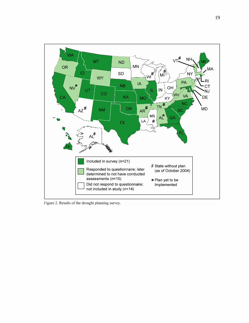
Representatives of 36 state drought planning processes responded to the initial
email questionnaire. Of these, 24 contacts from 21 state and regional planning processes
were interviewed for the survey (Figure 2, dark green shaded states). The remaining 15
states that responded to the questionnaire were excluded from the survey (light green
shaded states). Questionnaire results and/or follow-up phone conversations revealed that
in these states the planning process had either not included assessing impacts and/or
vulnerability or that their state plan had yet to be implemented. Another 14 states did not
reply to the email questionnaire despite multiple and varied solicitations. Thus, 29 states,
many of which did not have a formal plan or had not implemented their plan as of
October 2004, are not represented in the survey.
19

20
The measures taken to secure participation from people with the most experience
and knowledge were effective. People with direct involvement in assessments were easily
identified through post-email questionnaire/pre-interview screening. Questionnaire data
were unfortunately of limited use for the main aims of the survey since most drought
planning contacts provided “yes,” “no,” or very brief answers to questions about impact
and vulnerability assessments. The questionnaire, however, was very useful as a starting
point for identifying which states to include in the survey (i.e., states that had conducted
impact and/or vulnerability assessments). In several states, the people who responded to
the initial questionnaire (i.e., NDMC “drought planning contacts”) were appropriate
interviewees. In other states, questionnaire respondents were helpful for identifying other
officials with more direct experience with assessments.
The professional backgrounds and job titles of interviewees varied. All
interviewees, however, had been affiliated with or employed by state or regional
government agencies and departments (e.g., water, natural resources, and planning
departments). All interviewees were directly involved in their state’s most recent drought
planning process, and were members of impact assessment groups and task forces or
oversaw entire planning processes.
Survey results are summarized and discussed in two sections. In the first section,
results of the entire survey are summarized to provide a national overview of impact and
vulnerability assessments, and the application of assessments to long-term planning and
mitigation programs. In the second section, four different state agencies’ drought
planning efforts are presented: the Kansas Water Office, the Hawaii Commission on
21
Water Resource Management, the California Department of Water Resources, and the
Colorado Water Conservation Board. The four examples reviewed in greater detail
represent the only states determined to have conducted some type of a vulnerability
assessment. Together, the national summary and the review of the four state processes
offer both broad and focused analyses of drought planning in the United States, and
facilitate discussion of issues pertinent on a national scale, while also highlighting
innovative drought vulnerability assessment processes that have potential for application
in other states.
National Overview
The survey revealed the limited amount of resources being devoted to state
drought planning nationwide. Few states have permanent drought planning offices or
coordinators, and all states rely on existing state agencies (e.g., department of natural
resources, water, or emergency management) to lead or significantly support drought
planning efforts. Task forces and monitoring and assessment groups are often composed
of officials who must divert time and resources from regular job duties to attend to
drought management. When a drought has been declared formally, task force and impact
assessment groups mobilize and meet regularly (e.g., monthly) as long as drought
conditions persist. In many states, drought planning efforts are coordinated with seasonal
water, agriculture, and fire hazard management objectives and thus can be relatively

22
inactive during the winter part of the year. When droughts are declared to be over, task
force and assessment groups typically dissolve and drought management processes
remain relatively inactive until the next time a drought is declared. Monitoring groups,
however, are responsible for assessing conditions on a regular basis to anticipate the
development of drought conditions and thus are considered to be continually active. The
prevalence of limited and short-term appropriation of resources for drought planning
most likely limits opportunities for enhancing the assessment of impacts and
vulnerabilities, and the development and implementation of long-term mitigation
programs.
State drought planning processes have, however, developed a number of ways to
assess drought impacts. The most common approach mentioned in survey responses
involves formation of government agency-led impact assessment groups similar to those
described by NDMC guidance. Groups were often categorized by resource area, such as
agriculture, municipal and industrial water, forest health, etc. To collect information on
drought impacts, assessment groups almost exclusively rely on leveraging and “tapping
into” agency social networks and existing regulatory reporting requirements. Examples of
agency networks and regulatory reporting requirements include agricultural extension
services and other state and federal agricultural reporting programs, local agricultural and
watershed management groups, annual or quarterly state fish and wildlife agency surveys
and reports, existing reporting requirements of municipal and regional water management
issues (e.g., water shortages, reservoir levels, water quality issues), and other existing
state and federal natural resource management programs. Impact assessments, in most

23
cases, consist of summaries of quantitative first-order impact data on, for example,
stream flow, reservoir levels, soil moisture deficits, forest fire risk, and other agricultural
and natural resource parameters monitored regularly.
Several planning processes surveyed have also conducted novel impact
assessments that establish new communication networks independent of existing
regulatory reporting requirements. In all of these cases, public participation was
necessary to obtain data. These assessments were also more likely to include a mixture of
quantitative and qualitative data representing second-, third-, etc. order impacts such as
residential water quality and quantity problems, lost business or income potential,
community stress, and local conflicts regarding water allocation and management.
A variety of approaches were used by states to obtain impact data and public
input. Several states organized “town hall” meetings where government officials traveled
to different parts of the state to obtain input from the public and from industry
representatives. Online and mail surveys were also used in a few states to target specific
economic sectors and geographic regions. In two states, private research firms were
contracted to conduct phone surveys and interviews with a variety of stakeholders. In one
of these states, a large percentage of residents rely on private (and often shallow) wells,
and a phone survey estimated the number of residents experiencing water shortages or
quality problems. A third state set up a phone “hotline” during water shortages to answer
questions, which also helped residents inform hotline operators of household water
shortages and outages. Another state organized and supported local public drought
24
assessment groups throughout the state that provided information on local drought
impacts.
The analysis of email questionnaire responses, state plans, and related planning
documents indicated that many drought planning processes had assessed, or planned to
assess, the causal nature of impacts (i.e., vulnerabilities). Subsequent screening and
phone interviews, however, revealed that most of these claims were largely unfounded. In
fact, only four of these planning processes had completed some version of a drought
vulnerability assessment. These four planning processes are described below in greater
detail.
Finally, the survey revealed that impact assessments have been used
predominantly to enhance emergency response management. Assessments were used, for
example, to help define boundaries of agricultural disaster areas; to internally coordinate
distribution of state and federal resources for mitigation programs; and to provide content
for press releases on drought conditions, impacts, resource use or land access restrictions,
and government aid programs. The survey identified only four state processes,
highlighted below, that had completed a vulnerability assessment of some kind. Three of
the four had only recently completed the vulnerability assessment. In these cases, results
of the assessment had not been finalized or acted on. The other state’s assessment of
vulnerable public water suppliers, however, was used to identify suppliers that qualified
for assistance from state programs that would help address vulnerabilities identified in the
study, such as basic source, distribution, treatment facility, and contractual limitations.
25
Case Studies
Kansas Water Office
Kansas has established an operations plan for a Governor’s Drought Response
Team charged with monitoring and evaluating drought conditions and implementing
restrictions and emergency programs. The assessment and mitigation of drought
vulnerability, however, has been integrated into the state’s long-term water planning
process. Since the 1970s, the Kansas Water Office has emphasized conservation,
management, and protection of water resources. Ratified by the state government in
1985, the Kansas State Water Plan is updated regularly and includes a variety of
preparedness and response programs.
In 1998 the Kansas State Water Plan included several goals to be reached by
2010, including a reduction in the number of “drought vulnerable” public water suppliers
to fewer than 5% of all suppliers in the state. In a 1992 assessment of public water
providers during the 1988-1991 drought, 181 water suppliers were determined to be
drought vulnerable as a result of several supply, distribution, and treatment limitations.
The Kansas Water Office updated the 1992 study in 2001, using a similar definition of
drought-vulnerable water suppliers (adding a category for vulnerability due to purchase
contract provisions), conducting a survey of public water suppliers, and relying on
reporting requirements of local water managers in the Kansas Water Plan. The updated

26
study estimated that the number of drought-vulnerable water suppliers decreased from
181 in 1992 to 88 in 1998. Results of the study have been used to target state resources at
the basin or local level to reduce drought vulnerability, including special efforts to
achieve the 2010 objective of fewer than 5% of water suppliers vulnerable to drought.
Hawaii Commission on Water Resource Management
Drought planning and management in Hawaii has leveraged resources for
administering the state water code as well as for developing and implementing the state
hazard mitigation plan. In 2003, revisions to the first phase of the Hawaii drought plan
completed in 2000 included a quantitative assessment of drought risk that used the
NDMC definition of risk as the product of exposure and vulnerability. The Drought Risk
and Vulnerability Assessment and GIS Mapping Project was funded through a Federal
Emergency Management Agency pre-disaster mitigation planning grant and was
conducted primarily by researchers at the University of Hawaii (Hawaii Commission on
Water Resource Management 2003). A GIS was developed to produce a statewide
assessment of drought risk by integrating spatially modeled drought frequency and
severity with spatial measures of vulnerability. Spatially interpolated Standard
Precipitation Index (SPI) and historical rainfall data were used to create ordinal drought
intensity maps (i.e., moderate, severe, and extreme) using 3- and 12-month SPI
timescales. Vulnerability was represented by data on land use, population, past wildfire

27
frequency and spatial extent, water resources (wells, rainfall catchment), and agricultural
designation (irrigated and dryland). Relative risk maps were created by overlaying the
exposure and vulnerability components. Separate maps were created for each SPI
timescale, drought severity level, and sector (water supply, agriculture and commerce,
and environment and public safety), and are provided in the pre-final draft of the Hawaii
Drought Plan (Hawaii Commission on Water Resource Management 2004).
Although no public participation or input was involved in the development of the
risk maps, the maps will be evaluated locally. Specifically, the risk maps are being used
as an initial assessment of vulnerability that will undergo local re-interpretation in the
development of local natural hazard mitigation plans and programs. County drought
mitigation projects are developed through the coordination of local and/or county drought
committees, the Hawaii Drought Council, and the State Drought Coordinator as part of
the Hawaii multi-hazard mitigation program. According to the pre-final draft of the
Hawaii Drought Plan (Hawaii Commission on Water Resource Management 2004, p. 66),
the maps:
…should be reviewed by county agencies and local stakeholders to verify that they accurately represent drought risk areas on each of the islands. As part of these follow-on actions, residents and businesses affected by drought should also be interviewed to determine the magnitude of past drought impacts, identify existing response mechanisms used to address drought occurrences, and assess what type of mitigation measures worked best and were the most effective.

28
California Department of Water Resources
Currently, there is no statewide drought plan or planning process in California.
The state delegates drought planning to all public water providers with more than 3,000
connections or that deliver more than 3,000 acre-feet per year. In 1983 the California
state legislature passed the Urban Water Management Planning Act, partly in response to
drought impacts in the state in 1976 and 1977. Amended several times since 1983, the act
encourages the approximately 300-400 public water providers in the state to develop and
submit updated water management plans every five years to the state Department of
Water Resources. One California Department of Water Resources official who was
interviewed estimated that, as of 2004, more than 90% of all public water providers that
fall within the 3,000 connection/3,000 acre-foot criteria have submitted an updated plan
to the state.
Although no formal process has been established at the state level to assess and
document drought impacts, public water providers in California are required to assess
certain drought vulnerabilities when creating and updating local water management
plans. Based on demographic and customer base data, water providers must analyze past,
current, and future demand for water (up to 20 years in advance), identify and quantify
current and future surface and groundwater supplies and water rights, analyze the
reliability of current and future water supplies based on several short- and long-term
drought scenarios, and document existing and planned conservation and demand
management measures. As a result, local water providers furnish the state with

29
periodically updated information to help identify local vulnerabilities to short- and long-
term drought, and become eligible for state assistance to improve system resilience to
drought. Additionally, it allows the Department of Water Resources to identify common
local issues and inadequacies that may be addressed with legislation at the state level.
Colorado Water Conservation Board
Since 1981, the Colorado drought mitigation and response plan has been revised
three times. Impact assessments were conducted and published in 2002 and 2003 by the
state’s eight sector-based impact assessment groups (IAGs) and a water availability task
force (WATF) (Colorado Water Availability Task Force 2002, 2003). Both reports
include qualitative and quantitative descriptions and analyses of sector-based impacts,
and recommend specific mitigation programs. The 2003 report also details governmental
entities responsible for the mitigation programs identified.
In addition to the WATF and the IAGs, the Colorado Water Conservation Board
(CWCB) has been involved in drought assessment, planning, and mitigation efforts in
Colorado. Created in 1937, the CWCB is one of four Department of Natural Resources
sub-agencies focusing on water quantity issues, and is the state executive branch agency
responsible for supporting state and local water and drought planning. In 2004, the
CWCB completed a drought and water supply assessment (Colorado Water Conservation
Board 2004) that involved the participation of numerous local, state, and federal

30
government agencies and collaboration with various consulting firms. The assessment
involved interviewing and surveying more than 500 local, state, and federal stakeholders
on several issues pertaining to drought impacts and water management: current water use
and carry-over storage, current limitations on water supply, drought and water
conservation planning, drought impacts, concerns for meeting future water demands,
structural and non-structural project needs for drought mitigation, funding needs, use of
cooperative agreements, and the role of the state in future drought planning and
mitigation efforts. Participants were surveyed in person, over the phone, and on the
Internet using a web-based survey instrument. In addition to the large-scale survey, a
more in-depth, interview-based study was conducted with five persons in different parts
of the state. Results of the survey supported a set of recommendations for mitigating
drought vulnerabilities and improving long-term water management.
DISCUSSION
The national survey revealed that, as of 2004, at least twenty-one state planning
processes had assessed impacts, but only four had assessed vulnerabilities and only one
had used impact and vulnerability assessments to inform or develop long-term planning
and mitigation programs. This finding is almost certainly influenced by a lack of political
support for long-term drought planning and mitigation programs after a drought has
diminished, rather than an inability to produce informative assessments. The issue of
sustained political and public support is certainly important for implementing long-term
31
drought planning and mitigation programs. The survey, however, was not intended to
explore this issue and it is not discussed in detail here. Nevertheless, the survey revealed
several issues worthy of discussion.
In general, there has been a lack of documentation, organization, and public
access to impact assessments. In several instances, assessment results were documented
as appendices in voluminous drought planning documents, buried in lengthy web pages,
or never published or made available to the public outside of press releases. In several
cases, hardcopy or electronic versions of assessments were not readily accessible (e.g.,
“on someone’s computer”), or had been lost, and were revealed by interviewees only
through repeated requests. Also, very few assessment reports or summaries that were
available on websites or obtained in hardcopy included descriptions of assessment
methods, assumptions, discussion of findings, or recommendations for action.
Assessment groups may be composed of people not involved in previous drought
planning processes. In cases where there was significant turnover from one task force to
the next, it is expected that past “lessons learned” had to have been re-learned by
subsequent drought task forces. To address this institutional memory loss, drought
planning processes must be much more diligent by publishing any and all reports in both
hardcopy and electronic format and archiving reports in multiple places. Such a
requirement would be helpful for compiling data and information on impact and
vulnerability assessments, coordinating those involved to comment on experiences, and
making clear recommendations for what measures need to be taken to mitigate
vulnerabilities before the next drought develops.

32
Of the impact assessments that were obtained or discussed in the survey, the most
common approach to collecting data for impact assessments was through the leveraging
of existing reporting requirements intended for planning and regulatory programs other
than drought impact assessment. Most of the data from these assessments were
quantitative, instrumental measurements that represented first-order drought impacts.
This approach to gathering data is quite practical for states faced with limited funding,
and has been most efficient when impact assessment group members and their contacts
received training or other guidance for documenting impacts as comprehensively as
possible. Several interviewees, for example, mentioned agricultural extension agents and
other field-based officials who played key roles in soliciting for and providing
information on the agricultural impacts of drought.
In general, the data obtained by leveraging existing data reporting requirements
was limited to first-order drought impact data such as reduced snowpack, lower reservoir
levels, reduced stream flow, reduced soil moisture, increased vegetation stress,
depreciated water quality, and increased wildfire risk. In several cases, impact
assessments consisted of mostly instrumental monitoring data, some of which was also
used by drought monitoring groups for determining drought triggers, stages, and inter-
annual and decadal climate variability.
First-order impact data is important for assessing drought exposure. Data were
reportedly most useful for developing and implementing short-term, reactive drought
management options. Drought planning contacts from several states indicated that
assessment data derived from leveraging existing reporting requirements were used

33
primarily to coordinate and appropriate resources for short-term drought management
objectives (i.e., avoiding or addressing emergencies).
The leveraging of existing data reporting requirements, however, should not be
considered a sufficient data collection process for assessing vulnerability. Leveraging
existing reporting requirements is effective for assessing drought exposure, but is
inadequate for assessing system sensitivity or adaptive capacity. The assessment of
drought sensitivity is particularly challenging without, for example, data on crop failures,
lost tourism revenue, fire management expenditures, or community water system
shortages. Such data would be necessary to establish sensitivity-based relationships
between drought exposure and exposed biological, economic, and other systems. Also,
many of the assessment data cited in interviews and in drought planning documents were
inappropriate for analyzing how decision making, planning, policies, rules, or other
socio-economic and political institutions affect impacts. Thus, assessments that draw
conclusions exclusively from first-order impact data are not likely to accurately
characterize sensitivity and, thus, vulnerability. Such assessments would provide little
insight into how existing policy, social practices, and social change contribute to second-,
third-, etc. order impacts such as water shortages, crop failures, economic losses,
community stress, and ecological degradation.
The Kansas Water Office example demonstrates the value of considering non-
physical determinants of drought sensitivity. Surface water level data for rivers, streams,
and reservoirs were useful for determining the amount of water remaining in a storage
system. Also, the effects of climate variability on water availability (i.e., physically

34
determined sensitivity) could be ascertained when these data were evaluated against
precipitation, soil moisture, and other environmental data. This information, however,
was insufficient for articulating public water system vulnerability. Which systems would
have priority rights to below-average surface water during a drought? Which systems
would not? When would these latter systems begin to experience shortages? To answer
these and other supply-side questions, Kansas Water Office officials considered system
water rights, contractual agreements, state and federal environmental law, and other
institutional arrangements and entitlements. In doing so, systems most likely to
experience shortages during a drought were probably more accurately identified than if
this data were not considered. The statewide vulnerability assessment conducted by the
Kansas Water Office has since been used to assist the most vulnerable systems with
source, distribution, and treatment capacity limitations. As a result, the state claims there
were fewer drought-vulnerable public water providers in the late 1990s compared to the
late 1980s.
The Kansas Water Office, however, did not adequately incorporate adaptive
capacity into its assessment. To do so would have required a much closer examination of
how individual systems and system customers would adapt to less-than-adequate water
supply, and what factors would enable and limit the kinds of adaptations possible. The
CWCB drought and water supply assessment included five brief case studies that
attempted to reveal these kinds of issues. Social scientists participating in the study
interviewed an owner of a rafting company, a farmer and calf-cow rancher, a dryland
farmer, an owner of a plant nursery, and a “truck” farmer (Charney et al. 2004). Each

35
case study revealed specific information on local and regional second-, third-, etc. order
impacts, how each person adapted to these impacts, and how their adaptations were either
constrained or enabled by particular opportunities or entitlements. In one of the case
studies, the authors report what was described as “a ripple effect” that extended and
dispersed the effects of drought along modes of production. Sustained precipitation
deficits were traced through farm product commodity chains revealing a nested ordering
of impacts. Lower-order impacts were described as outcomes of higher-order impacts, of
the ways in which higher-order impacts were mediated by social, political, and economic
systems, and of how groups and individuals in turn adapted. The case studies, while
limited to fairly specific situations and parts of the state, illuminated the importance of
considering adaptive capacity in the overall characterization of vulnerability. The CWCB
assessment did not indicate how the case studies were being used to formulate policy to
reduce vulnerability, but nonetheless represents an example of a more complete
assessment of vulnerability.
The CWCB assessment also highlights another important consideration for
assessing vulnerability. Few state agencies involved with state drought planning have
staff social scientists capable of conducting in-depth case studies, surveys, focus groups,
and other methods of data collection from human subjects. In the Colorado case, private
consultants experienced in social science study design, data collection, and analysis
conducted the five case studies. The collection and analysis of data from surveys, focus
groups, interviews, and other social science methodologies requires specific experience
and training that is rare or absent in many government agencies charged with, for
36
example, managing natural resources or commerce. The study of adaptation, in particular,
often requires collecting and analyzing qualitative data. The CWCB accomplished this by
drawing on expertise from outside government agencies.
Given the limited membership of social scientists in state drought planning
processes, it is expected that many impact assessment groups have lacked the capacity to
conduct focus groups, interviews, and large-scale surveys. Planning processes that
include social scientists or officials trained to design and conduct interviews, focus
groups, and surveys, I argue, are more likely to effectively analyze drought sensitivity
and, in particular, adaptive capacity. Additionally, such planning processes are far more
likely to collect more and higher quality second-, third-, etc. order impact data.
Thus, state drought planning processes need to actively incorporate social science
research into the assessment of impacts and vulnerability. To do so would improve the
assessment of impacts and vulnerability, and arguably improve the relevance of such
studies for developing long-term mitigation programs. To continue neglecting this issue
will constrain future efforts to assess vulnerability. In most states, universities and
colleges include programs, faculty, and graduate students capable of filling this
methodological gap in state drought planning. Many non-profit and non-governmental
agencies employ social scientists that could do so as well. At the University of Arizona,
for example, the Climate Assessment for the Southwest (CLIMAS) project has conducted
numerous studies on the sensitivity of human systems to climate variability and climate
change (Morehouse et al. 2002, Finan et al. 2002, Vasquez-Leon et al. 2003, Bales et al.
2004, Lemos and Morehouse 2005). CLIMAS is one of eight Regional Integrated Science

37
Assessment programs in the United States funded by the U.S. National Oceanic and
Atmospheric Administration. In addition to several physical scientists, CLIMAS includes
faculty and graduate student anthropologists, agricultural economists, and geographers.
Social scientists have greatly improved the understanding of climate vulnerability in
Arizona and New Mexico, and they have participated in numerous studies driven by
national, state, and local policy agendas.
Figure 3 presents a modified organizational structure that incorporates these
recommendations. The structure is adapted from NDMC guidance presented in Figure 1.
The primary difference is the addition of vulnerability assessment teams (VATs) that
maintain research relationships with impact assessment groups and the public. Impact
assessment groups primarily collect quantitative, first-order impact data that is provided
to the Drought Task Force and VATs as necessary. VATs, however, focus on the use of
social science methods to collect both quantitative and qualitative second-, third-, etc.
order impact data, and study drought sensitivity and adaptive capacity. Additionally,
VATs are responsible for synthesizing assessments of vulnerability by incorporating data
from impact assessment groups. Importantly, the addition of VATs to the organizational
structure presented in Figure 1 does not jeopardize the effectiveness of existing roles of
the Drought Task Force and monitoring and impact groups. Thus, depending on the
resources available to a state drought planning process, VATs can be quite small and
focused on narrowly targeted projects, or have large memberships and multiple projects
and drive policy formation. It is also important to note that, despite the predominance of

38
limited post-drought task force activity, VATs can act as an anchor for enhancing the
long-term lifecycle of drought planning processes.
In addition to the proposed VATs, the survey revealed other effective strategies
for improving the collection of second-, third-, etc. order impact data. During and after
drought, task forces often create “wish lists” of data that, if available, would greatly
improve their ability to assess conditions, improve reactive management, and formulate
effective long-term programs. However, it is often unlikely that drought planning will
receive committed, multi-year funding to collect this data in-house. As a compromise,

39
existing data reporting requirements are modified to include reporting some of the data
from the wish lists. In California, Department of Water Resources officials involved in
local drought management issues have had data requirements added to the Urban Water
Management Planning Act several times since the Act’s inception. The addition of these
data requirements, it was argued, improved the state’s capacity to assess the drought
vulnerability of local water providers.
CONCLUSIONS
This paper presented results of a national survey of state drought planning
processes in the United States. Given the substantial growth in the numbers of state
planning processes in the United States during the past two decades, it is important to
periodically survey the field to determine the current trajectory of drought management
and evaluate this trajectory against recent research and planning guidance. This paper
provides results of a first-ever survey of how states have thus far assessed impacts and
vulnerabilities. Although states have been largely effective at assessing first-order
impacts, as a whole they have been far less successful at assessing second-, third-, etc.
order impacts and vulnerabilities. Impact assessments are argued to be marginally
effective for assessing vulnerability, and vulnerability assessments have been conducted
by fewer than 15% of states with drought plans. The survey, however, illuminated several
areas for improvement, including documentation and publication of assessments, the

40
recruitment of social scientists to participate in vulnerability assessments, and
modification of conceptual organization of drought planning to include vulnerability
assessment teams.
The results of the survey suggest that, despite consistent interest, communication
between state planning processes is low. A number of states were are unaware of
innovative approaches that other states have developed, yet indicated enthusiastically
their interest in what other states were doing. That said, future efforts to improve state
drought planning in the United States should include organizing regional and national
meetings where state planning representatives can share ideas and present results of
recent assessments.
Finally, there is a need for greater integration and cross-fertilization between
drought planners and hazard and disaster vulnerability researchers. Impact and
vulnerability assessment guidance will only improve with increased collaboration
between hazard planners and managers and researchers studying hazard impact and
vulnerability assessment. In turn, hazard and disaster vulnerability research needs to be
more responsive to agendas driven by theoretical and methodological shortcomings of
hazard planners and managers. In addition, future hazard vulnerability research should
include more active participation in state and local impact and vulnerability assessments.
Social scientists, in particular, are most likely to significantly contribute as members of
vulnerability assessment teams.

41
REFERENCES CITED
Bales, R.C., Liverman, D.M., Morehouse B.J.: 2004. Integrated assessment as a step
toward reducing climate vulnerability in the Southwestern United States,” Bul. Am. Met.
Soc., 85, 1727-1745.
Bohle, H. G., Downing, T. E., and Watts, M. J.: 1994. Climate Change and Social
Vulnerability, Glob. Env. Change, 4, 37-48.
Changnon, S. A., Pielke, R.A., Changnon, D., Sylves, R.T., and Pulwarty R.: 2000.
Human Factors Explain the Increased Losses from Weather and Climate Extremes, Bul.
Am. Met. Soc., 81, 437-442.
Charney, S., Bouvette, T., and Weiner, J.: 2004. Perceptions of Drought and Drought
Impacts, Colorado Case Studies, Colorado Water Conservation Board Drought and Water
Supply Assessment (Chapter 2), 1-8.
Colorado Water Availability Task Force: 2002, Impact Task Force Drought Impacts and
Recommendations,
http://www.cwcb.state.co.us/owc/Drought_Planning/ITF_Assess_Recomm_Report.pdf,
visited October 2004.

42
Colorado Water Availability Task Force: 2003, 2003 Drought Impact and Mitigation
Report.
http://www.cwcb.state.co.us/owc/Drought_Planning/2003_Drought_Impact_and_Mitigati
on_Report_Final.pdf, visited October 2004.
Colorado Water Conservation Board: 2004. Drought and Water Supply Assessment,
http://cwcb.state.co.us/owc/Drought_Water/index_DWSA.html, visited October 2004.
Cutter, S. L.: 1996. Vulnerability to Environmental Hazards, Progress in Human
Geography, 20, 529-539.
Dupigny-Giroux, L.: 2001a. Towards Characterizing and Planning for Drought in
Vermont – Part I: A Climatological Perspective, J. of the Am. Water Res. Assoc., 37, 505-
525.
Dupigny-Giroux, L.: 2001b. Towards Characterizing and Planning for Drought in
Vermont – Part II: Policy Implications, J. of the Am. Water Res. Assoc., 37, 527-531.
Finan, T. J., West, C. T., Austin, D., and McGuire, T.: 2002. Processes of adaptation to
climate variability: a case study from the US Southwest, Climate Research, 3, 299-310.

43
Hayes, M., Willhelmi, O. V., Knutson, C. L.: 2004. Reducing Drought Risk: Bridging
Theory and Practice”, Nat. Haz. Rev., 5, 106-113.
Hawaii Commission on Water Resource Management: 2003. Drought Risk and
Vulnerability Assessment and GIS Mapping Project, Hawaii Department of Land and
Natural Resources, Honolulu.
Hawaii Commission on Water Resource Management: 2004. Hawaii Drought Plan, Pre-
Final Draft (July 2004), http://www.state.hi.us/dlnr/cwrm/drought/info/HDP2a.pdf,
visited October 2004.
Hewitt, K.: 1983. Interpretations of Calamity, Allen and Unwin Inc, London.
Knutson, C., Hayes, M. J., and Phillips, T.: 1998, How to Reduce Drought Risk, Western
Drought Coordination Council report.
Lemos, M.C., Morehouse, B.J.: 2005. The co-production of science and policy in
integrated climate assessments, Glob. Env. Change-Hum. and Pol. Dim., 15, 57-68.
Liverman, D.M., B. Yarnal, and Turner, B.L. 2004. The Human Dimensions of Global
Environmental Change. Chapter in G. Gaile and C. Wilmott. Geography in America at
the dawn of the 21 st Century. Oxford University Press, New York.

44
McCarthy, J.J., Canziani, O. F., Leary, N. A., Dokken, D. J., White, K. S.: 2001. Climate
Change 2001: Impacts, Adaptation and Vulnerability. Cambridge University Press,
Cambridge.
Mileti, S. D.: 1999, Disasters by Design, Joseph Henry Press, Washington D.C.
Morehouse, B.J., Carter, R.H., Tschakert, P.: 2002. Sensitivity of urban water resources
in Phoenix, Tucson, and Sierra Vista, Arizona, to severe drought, Clim. Res., 21, 283-
297.
National Drought Mitigation Center: 2004a. Online directory of state drought contacts.
http://www.drought.unl.edu/plan/direct.htm, visited November 2004.
National Drought Mitigation Center: 2004b. Online directory of state drought plans.
http://www.drought.unl.edu/plan/stateplans.htm, visited November 2004.
National Drought Policy Commission: 2000. Preparing for Drought in the 21st Century,
National Drought Policy Commission final report.
Patt, A., Klein, R.J.T., and de la Vega-Leinert, A.: 2005. Taking the
Uncertainty in Climate-Change Vulnerability Assessment Seriously,

45
Comptes Rendus Geoscience, 337, 411-424.
Ribot, J. C., Magalhaes, A. R., and Panagides, S. S.: 1996. Climate Variability, Climate
Change and Social Vulnerability in the Semi-arid Tropics, Cambridge University Press,
Cambridge.
Schroter, D., Polsky, C., Patt, A.G.: 2005. Assessing Vulnerabilities to the Effects of
Global Change: An Eight Step Approach, Mit. and Adapt. Strat. for Glob. Change, 10,
573-595.
Steinemann, A.: 2003. Drought indicators and triggers: a stochastic approach to
evaluation, J. of the Am. Water Res. Assoc., 39, 1217-1233.
Turner, B. L., Kasperson, R. E., Matson, P. A., McCarthy, J. J., Corell, R. W.,
Christensen, L., Eckley, N., Kasperson, J. X., Luers, A., Martello, M. L., Polsky, C.,
Pulsipher, A., and Schiller, A.: 2003, A framework for vulnerability analysis in
sustainability science, Proc. of the Nat. Academy of Sci. of the United States of America,
100, 8074-8079.
Varley, A.: 1994. Disasters, Development and Environment, John Wiley and Sons,
Chichester.

46
Vasquez-Leon, M., West, C. T., and Finan, T. J.: 2003. A comparative assessment of
climate vulnerability: agriculture and ranching on both sides of the US-Mexico border,
Glob. Env. Change-Hum. and Policy Dim., 13, 159-173.
White, G. F., Kates, R. W., Burton, I.: 2001. Knowing better and losing even more: the
use of knowledge in hazard management, Global Environmental Change Part B:
Environmental Hazards, 13, 81-92.
Wilhite, D.A.: 1991. Drought Planning and State Government: Current Status, Bul. of the
Am. Met. Soc., 72, 1,531–1,536.
Wilhite, D. A., and Rhodes, S. L.: 1994. State-Level Drought Planning in the United-
States - Factors Influencing Plan Development, Water Int., 19, 15-24.
Wilhite, D. A.: 1997. State Actions to Mitigate Drought: Lessons Learned, J. of the Am.
Water Res. Assoc., 33, 961-968.
Wilhite, D. A.: 2000. Drought planning and risk assessment: Status and future directions,
Ann. of Arid Zone, 39, 211-230.
Wilhite, D. A.: 2001. Moving Beyond Crisis Management. Forum, 16, 20-28.

47
Wilhite, D. A., Hayes, M. J., Knutson, C., Smith, K. H.: 2004. The Basics of Drought
Planning: A 10-Step Process. http://www.drought.unl.edu/plan/handbook/10step.pdf,
visited November 2004.
Wisner, B., Blaikie, P., Cannon, T., Davis, I.: 2004. At Risk: Natural Hazards, People’s
Vulnerability, and Disasters (2nd Ed.). Routledge: New York.