DRAFT
ŌTAKI TO NORTH OF LEVIN
SH1-SH57 Connection
Report on Multi-Criteria Analysis of Options
Prepared for New Zealand Transport Agency
November 2013
Allan Planning & Research Ltd

ŌTAKI TO NORTH OF LEVIN
SH1-SH57 Connection
Report on Multi-Criteria Analysis of Options
Prepared for New Zealand Transport Agency Author Sylvia Allan
B Sc (Hons), Dip TP, FNZPI
Disclaimer
This document has been prepared for the benefit of The New Zealand Transport Agency. All efforts have been made to ensure its accuracy. No liability is accepted by this company with respect to its use by any other person. This disclaimer shall apply notwithstanding that the report may be made available to other persons for an application for permission or approval to fulfil a legal requirement.
Status: Draft November 2013 Prepared for New Zealand Transport Agency Report on Multi Criteria Analysis of Options
i Our ref: Ōtaki to North of Levin SH1-SH57 Connection
EXECUTIVE SUMMARY
This report is one of a number of appendices to the SH1-SH57 Scoping Report (the Scoping Report),
prepared for the New Zealand Transport Agency by MWH NZ Ltd as part of the investigations for the
Ōtaki to North of Levin Roads of National Significance project.
The report describes the methodology, information base, process and outcome involved in the analysis
of six route options through a formal Multi Criteria Analysis process between September and November
2013. Five of the six route options were identified by the project team and were the subject of detailed
investigations and a structured workshop to “score” the options for further analysis. The sixth option
arose from consultation with local tāngata whenua and was investigated and analysed post-workshop.
The five options initially identified arose from ongoing investigations of possible safety and efficiency
improvements. These options were developed by the project team to a stage suitable for further
detailed evaluation. A number of technical specialists were involved in a briefing and then carried out
more detailed investigations of effects, based on the description and preliminary plans of each of the
routes proposed. These specialists included experts in landscape and visual evaluations, archaeology
and heritage, ecological values, tāngata whenua values, productive land values and hydrological
resources. Reports on each of these aspects were prepared. Additional criteria were also identified,
and information on these was drawn from the knowledge of the project team.
The eleven criteria taken into account were landscape and visual impacts, ecological effects,
implications in terms of archaeology and heritage, cultural values, effects on productive landuses, social
and community impacts, fit with district and regional plan provisions, alignment with transport
objectives, effects on specific types of land ownership and landuses, engineering degree of difficulty,
and costs.
The workshop process confirmed the criteria and shared knowledge and information about each of the
criteria and how each of the routes would relate to each criterion. The scoring system ranged from 1
(where a route performed well under that criterion) and 5 (where a route had particular problems in
terms of that criterion). Working together, workshop attendees scored the route options under all
criteria. The scores ranged across the whole numeric range (1 to 5), depending on the criterion. It was
considered whether any of the options contained fatal flaws in terms of any of the criteria, and it was
decided that there were no fatal flaws.
The scores from the workshop were then evaluated on the basis of six weighting systems. One of the
weightings was derived by agreement at the workshop, where attendees determined that all criteria
should be weighted equally. The remaining five weighting systems were developed on the basis of a
section 6, Resource Management Act emphasis (emphasis on matters of national importance) and the
“quadruple bottom line” considerations of social, environmental, cultural and economic aspects formed
the basis for the remaining four weightings.
Status: Draft November 2013 Prepared for New Zealand Transport Agency Report on Multi Criteria Analysis of Options
ii Our ref: Ōtaki to North of Levin SH1-SH57 Connection
The analysis demonstrated that the preferred route is Option 5A, which follows the west side of the
North Island Main Trunk railway from north of Manakau to north of the Ohau River and then crosses
back to rejoin State Highway 1, while a new State Highway 57 crosses both the railway and State
Highway 1, to follow a new route across country to join Arapaepae Road north of its intersection with
Kimberley Road.
Option 5A was the clearly preferred option under four of the six weighting systems (the workshop
weighting and social, cultural and economic weightings), while Option T (the option which arose from
tāngata whenua consultation) was preferred under one of the weighting systems (the ecological
weighting). For the final weighting system (the Resource Management Act section 6 weighting), Options
5A and T were preferred, but the preference was not sufficiently significant to differentiate a preference
between the two. Overall, there was no option other than Option 5A which rated consistently well
across the analysis.
The investigations, process and findings make a worthwhile contribution to understanding the
implications of a range of alternative route options in the area, and will assist NZTA in making a final
decision on the preferred route option.

Status: Draft November 2013 Prepared for New Zealand Transport Agency Report on Multi Criteria Analysis of Options
Our ref: Ōtaki to North of Levin SH1 - SH57 Connection
CONTENTS EXECUTIVE SUMMARY ................................................................................................................................ i
1 INTRODUCTION ................................................................................................................................. 1
2 OPTIONS FOR ANALYSIS ................................................................................................................. 2
2.1 Geographic Area .................................................................................................................. 2
2.2 Description of Options ......................................................................................................... 2
3 MULTI-CRITERIA ANALYSIS METHOD ............................................................................................ 5
3.1 Background .......................................................................................................................... 5
3.2 Methodology ........................................................................................................................ 6
3.3 Decision-making in the Multi-criteria Framework ................................................................. 6
4 ADDITIONAL INFORMATION ............................................................................................................ 8
4.1 Background .......................................................................................................................... 8
4.2 Scope, Analysis and Reporting ............................................................................................ 8
5 APPLICATION OF THE MULTI-CRITERIA ANALYSIS .................................................................... 10
5.1 Choice of Attributes or Criteria ........................................................................................... 10
5.2 Description of Criteria ........................................................................................................ 11
5.3 Scoring System .................................................................................................................. 13
5.4 Decision Process ............................................................................................................... 14
6 ANALYSIS AND OUTCOMES .......................................................................................................... 15
6.1 Scoring Process ................................................................................................................. 15
6.2 Fatal Flaws ......................................................................................................................... 17
6.3 Weighting ........................................................................................................................... 18
6.4 Analysis .............................................................................................................................. 19
6.5 Findings from Analysis ....................................................................................................... 22
7 CONCLUSION .................................................................................................................................. 24
Figures
Figure 1: Multi-criteria Analysis Process Figure 2: Multi-criteria Analysis Scoring and Weighting (Source: Steve Oldfield, MWH) Figure 3: Analysis of Route Options on Workshop Weightings Figure 4: Analysis of Route Options on RMA S6 Weightings Figure 5: Analysis of Route Options for Social Weightings Figure 6: Analysis of ‘Route Options on Environmental Weightings Figure 7: Analysis of Route Options on Cultural Weightings Figure 8: Analysis of Route Options on Economic Weightings Tables Table 1: Description of Route Options Table 2: Assignment of Criteria to Generic Evaluation Frameworks

Status: Draft November 2013 Prepared for New Zealand Transport Agency Report on Multi Criteria Analysis of Options
Our ref: Ōtaki to North of Levin SH1 - SH57 Connection
Table 3: Basis for Scoring Used in the Multi-criteria Analysis Table 4: Scoring of Options Table 5: Commentary on Scores Table 6: Analysis of Route Options (scores x weights for different weighting systems) Table 7: Analysis of Sensitivities, Summary Outcome if all Alternative Scores Applied
Appendices
Appendix 1: Options to be Evaluated
Appendix 2: Technical Experts Briefing Material
Appendix 3: Ōtaki to Levin RoNS (SH1 to SH57) Landscape Report on Route Options
Appendix 4: Ōtaki to Levin Route Options: Ecology Constraints
Appendix 5: An Assessment of the Archaeological Risks Associated with Proposed Upgrades to the
Connection of SH1 and SH57: Manakau to Levin
Appendix 6: State Highway 1 to State Highway 57 – Report on Māori Cultural Issues on Alternative
Route Proposals
Appendix 7: Ōtaki to Levin Roading Realignment Proposals – Land Resources Assessment
Appendix 8: SH1-SH57 MCA Options Evaluation, Hydrology Assessment
Appendix 9: Short Reports
Appendix 10: Workshop Background and Notes
Appendix 11: Weighting Systems Applied in Analysis

Status: Draft November 2013 Prepared for New Zealand Transport Agency Report on Multi Criteria Analysis of Options
1 Our ref: Ōtaki to North of Levin SH1-SH57 Connection
1 INTRODUCTION
The New Zealand Transport Agency (NZTA) has been investigating a package of improvements to the
existing state highways between Ōtaki and North of Levin as part of its strategic approach to achieving
safety and efficiency benefits in the short to medium term, while retaining a long-term option to achieve
a four lane highway in the project area.
Since 2011 the project has proceeded through investigation of the opportunities and constraints of an
expressway within the wider project area, to investigations to identify feasible targeted improvement
projects, and through several stages of consultation. Some of the specific projects have required further
consideration following Stage 3 consultation in April and May 2013.
The connection between State Highway 1 (SH1) and State Highway 57 (SH57) is one such project where
it proved appropriate to identify a range of route options which could then be subject to a range of
analysis to help identify the “best” option to proceed with.
This report explains the basis and outcomes of the analyses undertaken. The method applied is known
as multi-criteria analysis or MCA, which is an accepted method when a number of options with a wide
range of impacts, benefits and costs need to be evaluated. The methodology follows a series of process
steps which are fully explained in this report.
The identification and consideration of options is an important component of investigations which lead
to notices of requirement for designations under the Resource Management Act (the RMA), so the
process set out in this report, and its findings, will contribute to future statutory processes to secure the
preferred route and gain RMA approvals.
This report is presented as an Appendix (Appendix K) to the report entitled “Ōtaki to North of Levin,
SH1-SH57 Connection, Scoping Report” (the Scoping Report) prepared by MWH NZ Ltd, November 2013.
The structure of the remainder of this report is as follows:
a description of the area and the six options for evaluation (section 2)
a description of the multi-criteria analysis method and approach to analysis (section 3)
information requirements and technical specialist studies (section 4)
application of the multi-criteria analysis (section 5)
analysis and outcome from the multi-criteria process (section 6)
conclusions (section 7).
Considerable supporting material is provided through a number of appendices attached to this report,
as listed in the Contents pages.
Status: Draft November 2013 Prepared for New Zealand Transport Agency Report on Multi Criteria Analysis of Options
2 Our ref: Ōtaki to North of Levin SH1-SH57 Connection
2 OPTIONS FOR ANALYSIS
2.1 Geographic Area
The area for evaluation encompasses land that lies in the vicinity of SH1 and SH57, between Manakau
township in the south and Levin in the north. The present state highway routes within this area
incorporate various features and characteristics which require improvement or alternative resolution.
The problems have been fully documented in earlier reports1 and various options considered for each
section.
Between April and August 2013, further work was done on the various route options, taking into
account additional design considerations and the findings of Stage 3 consultation. This resulted in
identification of five route options, evolved from earlier possibilities as described in section 7 of the
Scoping Report for further consideration, as shown in Appendix 1.
For the purpose of analysis each route option had to serve an equivalent function, so each was
considered to commence at a common point at the southern end, approximately 1.5 km north of
Manakau township. The northern end of each route option was taken to be north of the junction with
Kimberley Road on SH1 and/or north of the junction of Kimberley and Arapaepae Roads on SH57.
Later in the process, a further option arose from consultation with tāngata whenua associated with
Tukorehe and Wehiwehi maraes2. This was described as a “hybrid option” and it was decided that,
although not as well developed as the other five options under consideration, it should be added to the
range of options to be evaluated in terms of the multi-criteria analysis3. A broad sketch was prepared
and is also included in Appendix 1.
2.2 Description of Options
Table 1 on the following page sets out the key features of the options to be evaluated. More detail of
most of the options, including geometry, staging considerations, and connections to the network are
provided in the Scoping Report. Option T, which emerged later, has not been detailed in the Scoping
Report. It can be considered to have similarities in description to parts of Options 7A and 3C, with a
different central section, and different location for a bridge crossing the Ohau River.
1 E.g. Project Feasibility Reports for NZTA early 2013 addressing Manakau Ohau Bridge (Report 3), Ohau Settlement (Report 4) and SH1-SH57 Arapaepae Curve, MWH NZ Ltd. 2 Email – Morrie Love to Phil Peet, 22
nd October 2013.
3 As discussed later in this report, a different analytical method was applied, due to the late identification of this option.

Status: Draft November 2013 Prepared for New Zealand Transport Agency Report on Multi Criteria Analysis of Options
3 Our ref: Ōtaki to North of Levin SH1-SH57 Connection
Table 1: Description of Route Options
Route Option Number Description and key features (from south to north)
3C
Route realigns existing SH1 to the west of the North Island Main Trunk railway line (the NIMT) between new bridges over the Waikawa Stream and Ohau River. North of Ohau the route bifurcates with SH1 comprising two improved lanes on the existing route, , and SH57 connecting to Kimberley Road via an overbridge over both SH1 and the NIMT, with an improved large-radius corner then connecting with Arapaepae Road.
Key features:
four lanes through Ohau (long term)
two new river bridges west of NIMT
overbridges north of Ohau
maximises use of existing highways.
4A
Route realigns existing SH1 to the west of the NIMT between new bridges over the Waikawa Stream and Ohau River. Route bifurcates just south of Ohau with structures for SH57 crossing SH1 and the NIMT to run through vineyard blocks and cross-country to intersect with Arapaepae Road just north of present Arapaepae Road-Kimberley Road junction. SH1 continues on present route north from south of Ohau.
Key features:
two lanes retained through Ohau with reduced traffic volumes
two new river bridges west of NIMT
overbridges south of Ohau
affects numerous rural properties
minimises length of SH1-SH57 connection.
5A
Route realigns existing SH1 to the west of NIMT between new bridges over the Waikawa Stream and Ohau River. Route bifurcates just north of the Ohau River with more complex structures providing cross-country connection to SH57. SH1 continues on its present route north from just north of Ohau River and through Ohau, while SH57 follows a route further south than Option 4A, avoiding the existing vineyard to the east of SH1 and the totara reserve area.
Key features:
two lanes retained through Ohau with reduced traffic volumes
complex overbridges result in three new river bridges west of the
NIMT
overbridges well south of Ohau
affects numerous rural properties
straighter approach to Arapaepae Road merge more closely
aligned with property boundaries in this area.

Status: Draft November 2013 Prepared for New Zealand Transport Agency Report on Multi Criteria Analysis of Options
4 Our ref: Ōtaki to North of Levin SH1-SH57 Connection
6A
Route realigns existing SH1 to the west of the NIMT with new bridge over the Waikawa Stream, until just south of the Ohau River. From a bifurcation south of the river, the SH1 connection crosses the river on a new structure, and then rejoins the existing SH1 route. The SH57 overbridge crossing of the existing SH1 and the NIMT occurs just north of the urupa, travelling along the south side of the Ohau River with a new bridge crossing just over 1km to the east of the existing SH1 bridge. From the crossing, it traverses farmland to approximately follow the Option 5A alignment to Arapaepae Road.
Key features:
two lanes retained through Ohau with reduced traffic volumes
three new river bridges – two west of the NIMT and one
substantially to the east
reduced number of rural properties affected
straighter approach to Arapaepae Road merge more closely
aligned with property boundaries in this area.
7A
Route approximately follows the existing SH1 route between new bridges across the Waikawa Stream and the NIMT at the southern end, and the angle change near St Stephens Church. From this point the route continues approximately 1km north before bifurcating with the SH1 component swinging slightly west to cross the Ohau River 500m east of the current bridge on a new structure. The SH57 connection continues north to merge with the route of Option 6A beyond a new bridge over the Ohau River north of the river.
Key features:
two lanes retained through Ohau with reduced traffic volumes
three new river bridges east of NIMT
affects a similar number of rural properties to Option 6A (but
different properties south of Ohau River).
T
Route follows existing SH1 route to angle change near St Stephens Church, then continues north for approximately 500m before swinging west and crossing the Ohau River and rejoining the existing route of SH1 just south of the vineyard. It then follows the alignment of Option 3A connection to Arapaepae Road via Kimberley Road.
Key features:
four lanes through Ohau
two new river bridges east of NIMT
affects a smaller number of rural properties than all options except
3C.
These options, except for Option T, as noted earlier, were developed to preliminary design stage as
provided in the Scoping Report so that their likely environmental and other implications could be
reasonably understood for the purposes of information gathering and multi-criteria analysis. As Option T
is predominantly a hybrid of other options, its implications are well understood.
Status: Draft November 2013 Prepared for New Zealand Transport Agency Report on Multi Criteria Analysis of Options
5 Our ref: Ōtaki to North of Levin SH1-SH57 Connection
3 MULTI-CRITERIA ANALYSIS METHOD
3.1 Background
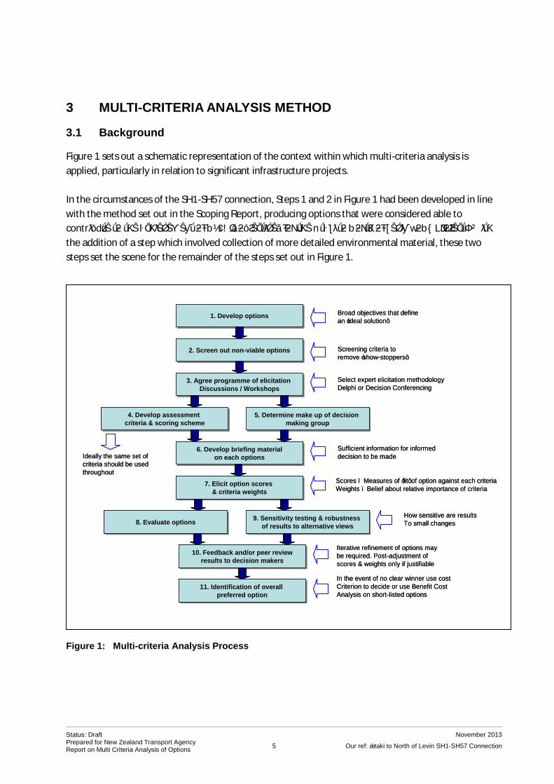
Figure 1 sets out a schematic representation of the context within which multi-criteria analysis is
applied, particularly in relation to significant infrastructure projects.
In the circumstances of the SH1-SH57 connection, Steps 1 and 2 in Figure 1 had been developed in line
with the method set out in the Scoping Report, producing options that were considered able to
contribute to the achievement of NZTA’s objectives for the Ōtaki to North of Levin RoNS project. With
the addition of a step which involved collection of more detailed environmental material, these two
steps set the scene for the remainder of the steps set out in Figure 1.
Figure 1: Multi-criteria Analysis Process
1. Develop options1. Develop options
2. Screen out non-viable options2. Screen out non-viable options
4. Develop assessment
criteria & scoring scheme
4. Develop assessment
criteria & scoring scheme5. Determine make up of decision
making group
5. Determine make up of decision
making group
3. Agree programme of elicitation
Discussions / Workshops
3. Agree programme of elicitation
Discussions / Workshops
7. Elicit option scores
& criteria weights
7. Elicit option scores
& criteria weights
6. Develop briefing material
on each options
6. Develop briefing material
on each options
8. Evaluate options8. Evaluate options 9. Sensitivity testing & robustness
of results to alternative views
9. Sensitivity testing & robustness
of results to alternative views
Screening criteria to
remove ‘show-stoppers’
Select expert elicitation methodology
Delphi or Decision Conferencing
Ideally the same set of
criteria should be used
throughout
Broad objectives that define
an ‘ideal solution’
Sufficient information for informed
decision to be made
11. Identification of overall
preferred option
11. Identification of overall
preferred option
In the event of no clear winner use cost
Criterion to decide or use Benefit Cost
Analysis on short-listed options
10. Feedback and/or peer review
results to decision makers
10. Feedback and/or peer review
results to decision makers
Iterative refinement of options may
be required. Post-adjustment of
scores & weights only if justifiable
How sensitive are results
To small changes
Scores – Measures of ‘fit’ of option against each criteria
Weights – Belief about relative importance of criteria

Status: Draft November 2013 Prepared for New Zealand Transport Agency Report on Multi Criteria Analysis of Options
6 Our ref: Ōtaki to North of Levin SH1-SH57 Connection
3.2 Methodology
The multi-criteria analysis methodology is a key element of analysis, and a useful aid to decision-making.
Multi-criteria analysis is particularly applicable when there are several options to choose between, and
where there are numerous complex considerations involved. Multi-criteria analysis is thus commonly
used in assessments of options for infrastructure. It is a useful tool for evaluations, including those
under the RMA and Local Government Act (LGA), to compare and assess alternative proposals where
there are multiple objectives, and where there are a range of diverse potential adverse and beneficial
effects affecting different areas and/or communities4. The range of attributes that are relevant to a
decision between options can be numerous and varied, and it is necessary in such circumstances to
bring together the information in a reliable and credible way.
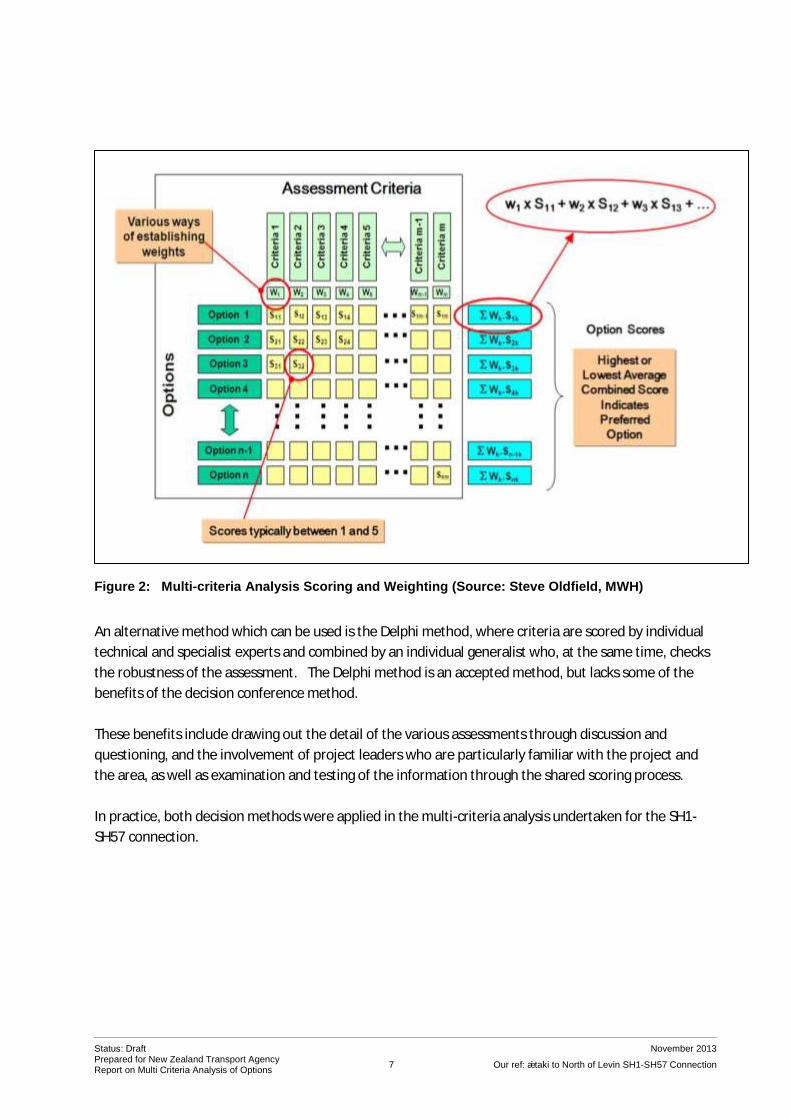
Figure 2 on the following page shows how multi-criteria analysis is applied. Key aspects to be taken into
account in the decision are identified, defined, and scored on a consistent basis. Once scored, they can
then be weighted as appropriate and combined into a single option score. In multi-criteria analysis
processes, the scores can be seen as surrogates for measures of value for an aspect (allowing for the
effects of diverse criteria, with different units, to be combined). The weights represent beliefs or
assumptions about what is important in a particular situation or to a particular group of decision
makers.
It is possible to strengthen the analysis by applying a range of different weightings to see whether the
preference changes due to weighting systems. It is also appropriate to test the sensitivity of the process
by carefully reviewing the scoring and identifying the extent to which scoring would need to change to
result in a difference preference.
3.3 Decision-making in the Multi-criteria Framework
Decisions on criteria, scoring and weighting are ideally made by a group of informed people through a
process that allows for testing through discussion, questions and answers. When the criteria are diverse
and areas of specialist judgment are called-for, the preferred method is through a “decision conference”
or facilitated workshop session, at which a participating group of specialists and generalists share
information and work through the issues, finally deciding on the score for each criterion5. Ideally
consensus is reached on the scores.
This reduces individual bias and keeps the process transparent.
4 The use of multi-criteria analysis is recommended by the NAMS (the New Zealand National Asset Managers Support organisation) and is a key element of the Optimised Decision Making Guidelines promoted by that organisation. It also finds favour (used in conjunction with CBA) in “Decision-making on Mega-projects: Cost-benefit Analysis, Planning and Innovation”, Priemus, H; Flybrjerg, B and van Wee, I, Eds – 2008. 5 The method is based on the demonstrated hypothesis (from international research in the early 1990s on roading projects) that groups of people, given the same information and the opportunity to test the information, will make similar decisions on preferences, regardless of their backgrounds.
Status: Draft November 2013 Prepared for New Zealand Transport Agency Report on Multi Criteria Analysis of Options
7 Our ref: Ōtaki to North of Levin SH1-SH57 Connection
Figure 2: Multi-criteria Analysis Scoring and Weighting (Source: Steve Oldfield, MWH)
An alternative method which can be used is the Delphi method, where criteria are scored by individual
technical and specialist experts and combined by an individual generalist who, at the same time, checks
the robustness of the assessment. The Delphi method is an accepted method, but lacks some of the
benefits of the decision conference method.
These benefits include drawing out the detail of the various assessments through discussion and
questioning, and the involvement of project leaders who are particularly familiar with the project and
the area, as well as examination and testing of the information through the shared scoring process.
In practice, both decision methods were applied in the multi-criteria analysis undertaken for the SH1-
SH57 connection.

Status: Draft November 2013 Prepared for New Zealand Transport Agency Report on Multi Criteria Analysis of Options
8 Our ref: Ōtaki to North of Levin SH1-SH57 Connection
4 ADDITIONAL INFORMATION
4.1 Background
Information on the range of constraints that may apply in terms of any route within the area of the
Ōtaki to North of Levin RoNS project had been collected early in the project investigations. This
information had been added to thorough consultation processes, and as part of the Project Feasibility
Reports. However, it was identified that more detailed information would be needed across a range of
aspects in order to undertake an adequate evaluation of the identified options.
Aspects where further information was considered to be necessary included:
archaeological values
landscape and visual impacts
terrestrial and aquatic ecological values
productive land values (soil and landuse implications)
tāngata whenua values
the hydrology of the waterways to be crossed, particularly the Ohau River.
Technical specialists were engaged to undertake an appropriate level of investigation. Some had been
part of earlier studies on the project, and others were added to the team. They were asked to consider
the implications of each of the six route options identified in the Scoping Report in terms of their areas
of expertise, to prepare for involvement in a multi-criteria analysis workshop process. Each was to
prepare a report.
In addition, project team members with appropriate technical backgrounds were selected and asked to
consider information relevant to other aspects of the project which would be applicable to the analysis.
This included social and community impacts, district and regional plan provisions and consentability,
landowner impacts and implications in terms of engineering and construction.
4.2 Scope, Analysis and Reporting
Prior to undertaking the investigations, the experts attended a briefing workshop on the options. The
Agenda and subsequent Memo are provided in Appendix 2 to this report.
Following the workshop, each expert developed their own scope of work for approval by MWH and
NZTA.
Field work as necessary was carried out between mid September 2013 and mid October 2013. With few
exceptions, field work relied on observation from roads and public areas, although access to the
vineyard area was provided by agreement with the landowner for the land specialist investigations.

Status: Draft November 2013 Prepared for New Zealand Transport Agency Report on Multi Criteria Analysis of Options
9 Our ref: Ōtaki to North of Levin SH1-SH57 Connection
The analysis was requested to be completed at a relatively high level, with any scoring of route qualities
undertaken by a technical specialist using a “+” and “–” based scale. It was explained that this was
because the workshop process may reach a different scoring. The approach is set out in Appendix 2,
and has been followed in the reports.
The reports produced are provided as Appendices to this report as follows:
Appendix 3 – Ōtaki to Levin RONS (SH1 to SH57) Landscape Report on Route Options, Isthmus
Appendix 4 – Ōtaki to Levin Route Options: Ecology Constraints, Forbes Ecology
Appendix 5 – An Assessment of the Archaeological Risks Associated with Proposed Upgrades to
the Connection of SH1 and SH57: Manakau to Levin, inSite Archaeology Ltd
Appendix 6 – State Highway 1 to State Highway 57 – Report on Māori Cultural Issues on
Alternative Route Proposals, Raukura Consultants
Appendix 7 – Otaki to Levin Road Realignment Proposals – Land Resources Assessment,
LandVision
Appendix 8 – SH1-SH57 MCA Options Evaluation, Hydrology Assessment, MWH NZ Ltd.
A number of other short reports were also prepared relating to the aspects under analysis at the multi-
criteria analysis workshop. These are provided as Appendix 9 to this report.

Status: Draft November 2013 Prepared for New Zealand Transport Agency Report on Multi Criteria Analysis of Options
10 Our ref: Ōtaki to North of Levin SH1-SH57 Connection
5 APPLICATION OF THE MULTI-CRITERIA ANALYSIS
5.1 Choice of Attributes or Criteria
The attributes for assessment, or assessment criteria, are based on the aspects identified for
investigation at earlier stages of the project, and were discussed amongst the project team as well as at
the briefing workshop for the technical specialists. The criteria are relatively broadly-based, as is
appropriate for the stage of project development, the scale of the project and the nature of the route
options being evaluated.
The assessment criteria need to reflect matters that are important within the RMA, and the Land
Transport Management Act 2003 and its amendments6, taking into account the decision criteria that will
eventually be brought to bear through RMA processes. They should also be able to be categorized
across all of the “four well-being” considerations – social, environmental, cultural and economic, which
are part of the sustainable development principles in the Local Government Act 2002. This assessment
is shown in Table 2.
The choice of criteria also reflected the area which the route options passed through. Thought was given
to whether natural hazards should be a criterion. It was determined that the area had a similarity of
exposure to natural hazards, so this would not be a potentially distinguishing factor 7. Any natural
hazards effects (such as hydrological hazards) were built into cost and engineering degree of difficulty.
Similarly, it was considered whether any routes could have impacts on life lines sufficient to justify a "life
lines" criterion. It was found that no life lines were affected by any route option.
As can be seen from Appendix 2, the specialists were required to scope their own criterion or criteria.
This was subject to review as part of the workshop processes. A brief description of the scope of each of
the criteria follows in section 5.2.
Table 2: Assignment of Criteria to Generic Evaluation Frameworks
Criterion NZTS Objective*, and GPS** Priorities, Impacts and Principles
Examples of relevant RMA Aspects
LGA Sustainable Development Principle (S14)
1. Landscape/Visual
Impacts
Reducing Adverse Environmental Effects
S5, S6(b), S7(c) and (f)
Environmental
2. Ecology Reducing Adverse S5, S6(a) and (c), Environmental
6 The LTMA includes an overall objective and requires that NZTA exhibits a sense of social and environmental responsibility and acts in a transparent manner (section 96), and incorporates the Crown's responsibility to take appropriate account of the principles of the Treaty of Waitangi (section 4). 7 Note that a specialist hydrological report was nevertheless prepared to address risk and any other implications for river crossings.

Status: Draft November 2013 Prepared for New Zealand Transport Agency Report on Multi Criteria Analysis of Options
11 Our ref: Ōtaki to North of Levin SH1-SH57 Connection
Criterion NZTS Objective*, and GPS** Priorities, Impacts and Principles
Examples of relevant RMA Aspects
LGA Sustainable Development Principle (S14)
Environmental Effects S7(d)
3. Archaeology/Heritage Reducing Adverse Environmental Effects
S5, S6(f) Cultural
4. Tāngata Whenua
Values
All Objectives S5, S6(e) and (g), S7(a), S8
Cultural
5. Productive Land Uses Economic Growth and Productivity
S5, S7(b) and (g) Social/Economic
6. Social/Community
Impacts
Reducing Adverse Environmental Effects/Access and Mobility/Positive Health Outcomes/Urban Planning Principles
S5, S7(c) Social
7. District/Regional Plan
Fit/Consentability
Reducing Adverse Environmental Effects/Economic Growth and Productivity/Urban Planning Principles
S5, S104, S171 All aspects
8. Fit to Project Objectives All Impacts and Principles S5, S7(b), S171 Social/Economic
9. Specific Land
Ownership
Economic Growth and Productivity
S5, S171 All aspects
10. Engineering Degree of
Difficulty
Environmental Sustainability/Economic Growth and Productivity
S5 Environmental/ Economic
11. Cost Economic Growth and Productivity, Value for Money
S5, S7(b) Economic
* New Zealand Transport Strategy (current version, 2008). **Government Policy Statement on Land Transport Funding 2012. The focus is on strategic priorities of economic growth and productivity, value for money, and road safety, but alongside these strategic goals are set out a series of "short to medium term impacts" to be achieved.
5.2 Description of Criteria
The scope and extent of each criterion was initially determined by the specialist, or person who had
investigated the aspect, and fully discussed and confirmed at the workshop. A brief description follows.
1. Landscape/Visual – This took into account existing landscape character (including degree of modification and presence of structures), route length and presence of dwellings nearby, any outstanding landscape or natural character components, and important landscape/natural features.

Status: Draft November 2013 Prepared for New Zealand Transport Agency Report on Multi Criteria Analysis of Options
12 Our ref: Ōtaki to North of Levin SH1-SH57 Connection
2. Ecology – This criterion focused on terrestrial ecology values8, particularly those relating to patches of indigenous vegetation which are nationally, regionally or locally significant in terms of habitat values and presence of known species.
3. Archaeology/Heritage – This criterion took into account presence of known archaeological and
heritage sites and features, and also archaeological risks (i.e. the likelihood of encountering archaeological site).
4. Tāngata Whenua Values – This took into account the range of cultural values including values
relating to the natural environment (waterways and wetlands, areas of indigenous vegetation), key areas of settlement (marae, papakainga) and use (food gathering areas), and known wāhi tapu.
5. Productive Land Uses – As reported and discussed at the workshop, this criterion took into account soils and the New Zealand Land Use Capability Classification, in particular classes 1 to 4 (productive land), the current productive landuse pattern, and potential severance effects on productive units.
6. Social/Community Impacts – This incorporated a range of considerations including severance
effects, access to and from settlement areas and townships, general urban amenity, connectivity to community services and facilities, recreational effects, and construction impacts. (Note – direct effects on land including dwellings were included under specific land ownership effects.)
7. District and Regional Plans and Consentability – This criterion includes consideration of both
zoning and plan objectives and policies, and any major impediments through the plans to a route location.
8. Fit to Project Objectives – This criterion covered levels of service, and efficiency and
effectiveness (in terms of best value solutions). The assessment took into account the local network and the various state highway components.
9. Specific Land Owner/Land Use Effects – This criterion considered impacts on areas which could
potentially pose difficulties for the location of an option – including Crown Land, Māori multiple-owned land, QEII Trust conservation land, as well as particular landuses.
10. Engineering Degree of Difficulty – This was assessed on the basis of physical components such
as volume and balance of earthworks (cut and fill suitability of/issues with material), structures, temporary works, access management, risks around “unknowns”, additional provisions to address natural hazards such as hydrological impact, and general degree of difficulty in construction.
11. Costs – Costs took into account the actual capital construction costs, including the range of matters identified under constructability, plus contingencies.
In assessing options, reasonable mitigation was taken into account.
8 While aquatic ecological values were considered, it was determined that effects would be localised and similar between all options. They would be largely mitigated through design and managed through the construction stage.

Status: Draft November 2013 Prepared for New Zealand Transport Agency Report on Multi Criteria Analysis of Options
13 Our ref: Ōtaki to North of Levin SH1-SH57 Connection
There are 11 assessment criteria, which is an acceptable number9. The number and scope of the criteria
were confirmed by the workshop.
It was noted at the workshop that there was some potential for double counting, particularly with
constructability and cost, hazards and lifelines, aspects of social assessment (e.g. visual impact and
social impacts), productive land and specific land owner effects, and archaeology/heritage and tāngata
whenua values. It was decided that these issues could best be handled during the scoring and weighting
discussions. It was also noted that in some cases, the same aspects could justifiably be assessed under
two criteria (such as the separate heritage and cultural values associated with some marae and urupa,
and the separate ecological and cultural values of streams, waterways and bush). The possibility of
removing cost from the analysis and considering it as a separate item was also raised.
It was noted that specific technical advice on noise and air quality had not been sought at this stage.
This was not considered to be an issue, as there are usually available options for noise mitigation;
transport-related air quality issues are unlikely to be a distinguishing aspect between route options; and
both noise and air quality would be partly captured under the social/community impacts criterion. An
air quality and noise study undertaken for the RoNS project immediately to the south10, had confirmed
that air quality effects are directly related to the number of people exposed and the volume of traffic –
i.e. a route with fewer dwellings and sensitive activities in close proximity would be preferred to one
where a greater number of nearby dwellings and sensitive activities are exposed to greater traffic
volumes. This would be likely to align with the social/community criteria assessment in terms of other
effects.
The acoustic assessment for that project acknowledged that introducing new noise effects into an area
with low noise levels can be detrimental, depending on the number of new people affected and
whether there are corresponding benefits elsewhere. In terms of the SH1-SH57 route options, there
would be acoustic benefits from options that removed stage highway traffic from the route section
between the two bridges and that resulted in a reduction in traffic volumes through Ohau. A small
number of rural dwellings would be affected to a slightly greater extent as a consequence. Noise
mitigation would need to be considered as part of detailed design overall, and the differences would be
unlikely to affect the outcome of a multi-criteria analysis.
5.3 Scoring System
For the multi-criteria analysis, the scoring system moved from the provisional assessment provided by
the specialists, to a five-point numerical system, as set out in Table 3 on the following page.
9 Eight to twelve criteria is the ideal. With an increasing number of criteria, each criterion reduces in importance and it can become difficult to distinguish between options. 10 The Peka Peka to Ōtaki RoNS, described in a letter URS (Michail Smith, Peter Stacey, Dr Stephen Chiles) to S Allan, APR, dated 27
th July 2011, included as Appendix 13 to “Roads of National Significance, Peka Peka to Ōtaki Expressway, Route Options
Review”, Allan Planning and Research Ltd, July 2011.

Status: Draft November 2013 Prepared for New Zealand Transport Agency Report on Multi Criteria Analysis of Options
14 Our ref: Ōtaki to North of Levin SH1-SH57 Connection
Table 3: Basis for Scoring Used in the Multi-criteria Analysis
Score Description
1 The corridor option presents few difficulties on the basis of the criterion being evaluated, taking into account reasonable mitigation proposals. There may be significant benefits in terms of the attribute.
2 The corridor option presents only minor areas of difficulties on the basis of the criterion being evaluated, taking into account reasonable mitigation proposals. There may be some benefits in terms of the attribute.
3 The corridor option presents some areas of reasonable difficulty in terms of the criterion being evaluated. Effects cannot be completely avoided. Mitigation is not readily achievable at reasonable cost, and there are few or no apparent benefits.
4 The corridor option includes extensive areas of difficulty in terms of the criterion being evaluated, which outweigh perceived benefits. Mitigation is not readily achievable.
5 The corridor option includes extreme difficulties in terms of achieving the project on the basis of the criterion being evaluated.
5.4 Decision Process
The structured workshop proceeded in accordance with the agenda and process set out in Appendix 10,
which also includes the introductory presentation and the background notes for the workshop. The
workshop results and analysis are further outlined in section 6 of this report.
As has been noted, Option T was identified after the workshop as a result of more detailed Iwi
consultation. The Delphi technique was used to add this option to the assessment. This involved asking
workshop participants by email to score the additional route. All those involved in the workshop
responded, with three participants11 providing scores for all the criteria and the others providing a score
for the aspect they had been responsible for at the original workshop. The scoring was undertaken in
accordance with the process in section 3.3 of this report, and is incorporated in the discussion of the
analysis in the next section.
11 Phil Peet, Gavin Lister and Sylvia Allan.

Status: Draft November 2013 Prepared for New Zealand Transport Agency Report on Multi Criteria Analysis of Options
15 Our ref: Ōtaki to North of Levin SH1-SH57 Connection
6 ANALYSIS AND OUTCOMES
6.1 Scoring Process
The scoring process was done on the basis of a structured workshop involving the 12 participants from
diverse and relevant backgrounds set out in Appendix 10. The necessary protocols were followed to
ensure that the outcome would be as reliable as possible.
Following preliminary discussion12, each aspect was described and discussed by the presenter,
identifying issues relating to each option. This was followed by questions and discussion. GIS
information was presented in relation to some criteria as a visual way of comparing alternatives (this
information is provided in some of the specialist reports in the Appendices).
The workshop then proceeded to the evaluation stage, giving each option a specific score for each
aspect. Each aspect was evaluated for all options in turn. This was to encourage a balanced view of the
relative merits of each option for each aspect before moving to the next aspect. To avoid patterning,
the order of scoring options was varied each time a new aspect was evaluated.
The outcomes are presented in Table 4. Note that Table 4 also includes scores for Option T. These were
added post-workshop through the Delphi process set out in section 5.4, but this scoring was informed
by the previous involvement of the participants in the workshop process.
Table 4: Scoring of Options
Option
Lan
dsc
ape
/ vi
sual
Eco
logy
Arc
hae
olo
gy /
her
itag
e
Tān
gata
wh
enu
a va
lues
Pro
du
ctiv
e la
nd
use
Soci
al /
co
mm
un
ity
Dis
tric
t &
Re
gio
nal
Pla
n
fit
Tran
spo
rt e
ffec
tive
nes
s
and
pro
ject
ob
ject
ives
Spec
ific
lan
do
wn
er
effe
cts
Engi
nee
rin
g d
egre
e o
f d
iffi
cult
y
Co
st
Option 3C 5 3 3 3 2 5 3/4 2 4 5 4
Option 4A 4 5 3/5 4 5 2 3 1 3 2 2
Option 5A 2 5 3 4 3 2 2 1 3 2 2
Option 6A 3 5 2 3/5 4 3 2 2 3 4 2
Option 7A 4 4 1 5 4 4 2 2 4 3 3
Option T 5 3 3 2 2 5 2 2 3 5 4
12 Which included an outline of the options proposed, a presentation on the multi-criteria analysis methodology to be applied, and a discussion which confirmed the appropriateness and content of the various criteria.
Status: Draft November 2013 Prepared for New Zealand Transport Agency Report on Multi Criteria Analysis of Options
16 Our ref: Ōtaki to North of Levin SH1-SH57 Connection
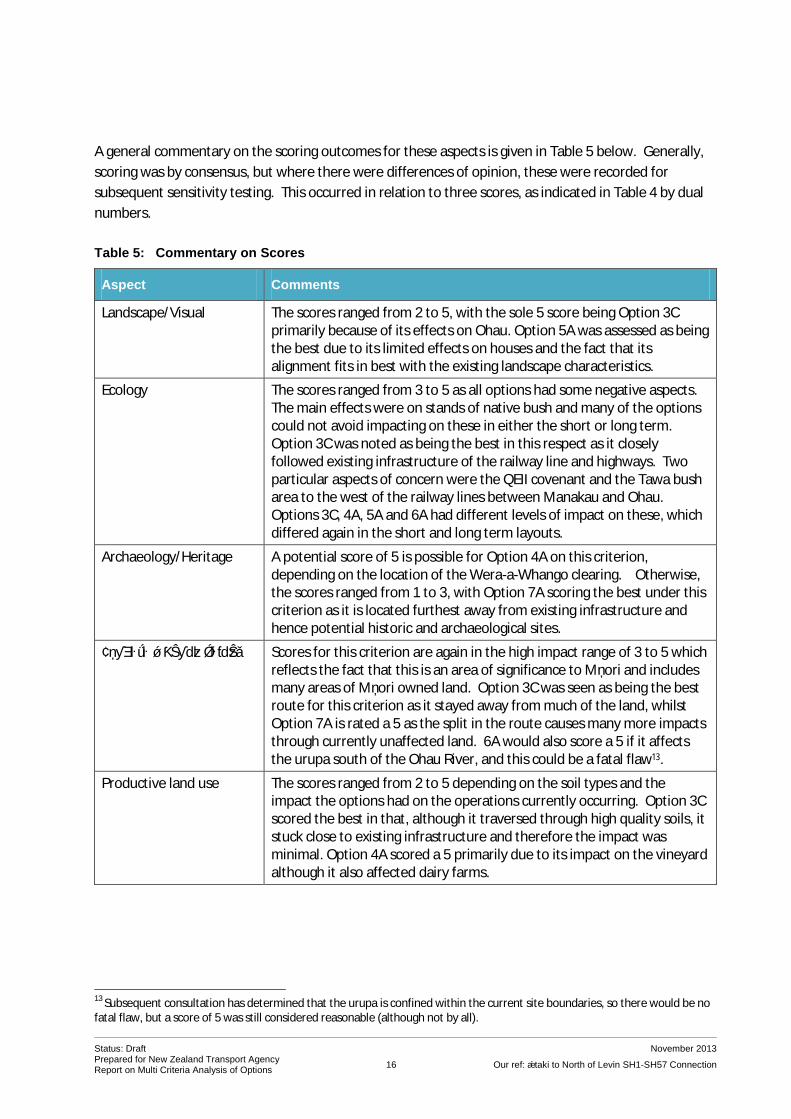
A general commentary on the scoring outcomes for these aspects is given in Table 5 below. Generally,
scoring was by consensus, but where there were differences of opinion, these were recorded for
subsequent sensitivity testing. This occurred in relation to three scores, as indicated in Table 4 by dual
numbers.
Table 5: Commentary on Scores
Aspect Comments
Landscape/Visual The scores ranged from 2 to 5, with the sole 5 score being Option 3C primarily because of its effects on Ohau. Option 5A was assessed as being the best due to its limited effects on houses and the fact that its alignment fits in best with the existing landscape characteristics.
Ecology The scores ranged from 3 to 5 as all options had some negative aspects. The main effects were on stands of native bush and many of the options could not avoid impacting on these in either the short or long term. Option 3C was noted as being the best in this respect as it closely followed existing infrastructure of the railway line and highways. Two particular aspects of concern were the QEII covenant and the Tawa bush area to the west of the railway lines between Manakau and Ohau. Options 3C, 4A, 5A and 6A had different levels of impact on these, which differed again in the short and long term layouts.
Archaeology/Heritage A potential score of 5 is possible for Option 4A on this criterion, depending on the location of the Wera-a-Whango clearing. Otherwise, the scores ranged from 1 to 3, with Option 7A scoring the best under this criterion as it is located furthest away from existing infrastructure and hence potential historic and archaeological sites.
Tāngata whenua values Scores for this criterion are again in the high impact range of 3 to 5 which reflects the fact that this is an area of significance to Māori and includes many areas of Māori owned land. Option 3C was seen as being the best route for this criterion as it stayed away from much of the land, whilst Option 7A is rated a 5 as the split in the route causes many more impacts through currently unaffected land. 6A would also score a 5 if it affects the urupa south of the Ohau River, and this could be a fatal flaw13.
Productive land use The scores ranged from 2 to 5 depending on the soil types and the impact the options had on the operations currently occurring. Option 3C scored the best in that, although it traversed through high quality soils, it stuck close to existing infrastructure and therefore the impact was minimal. Option 4A scored a 5 primarily due to its impact on the vineyard although it also affected dairy farms.
13
Subsequent consultation has determined that the urupa is confined within the current site boundaries, so there would be no fatal flaw, but a score of 5 was still considered reasonable (although not by all).
Status: Draft November 2013 Prepared for New Zealand Transport Agency Report on Multi Criteria Analysis of Options
17 Our ref: Ōtaki to North of Levin SH1-SH57 Connection
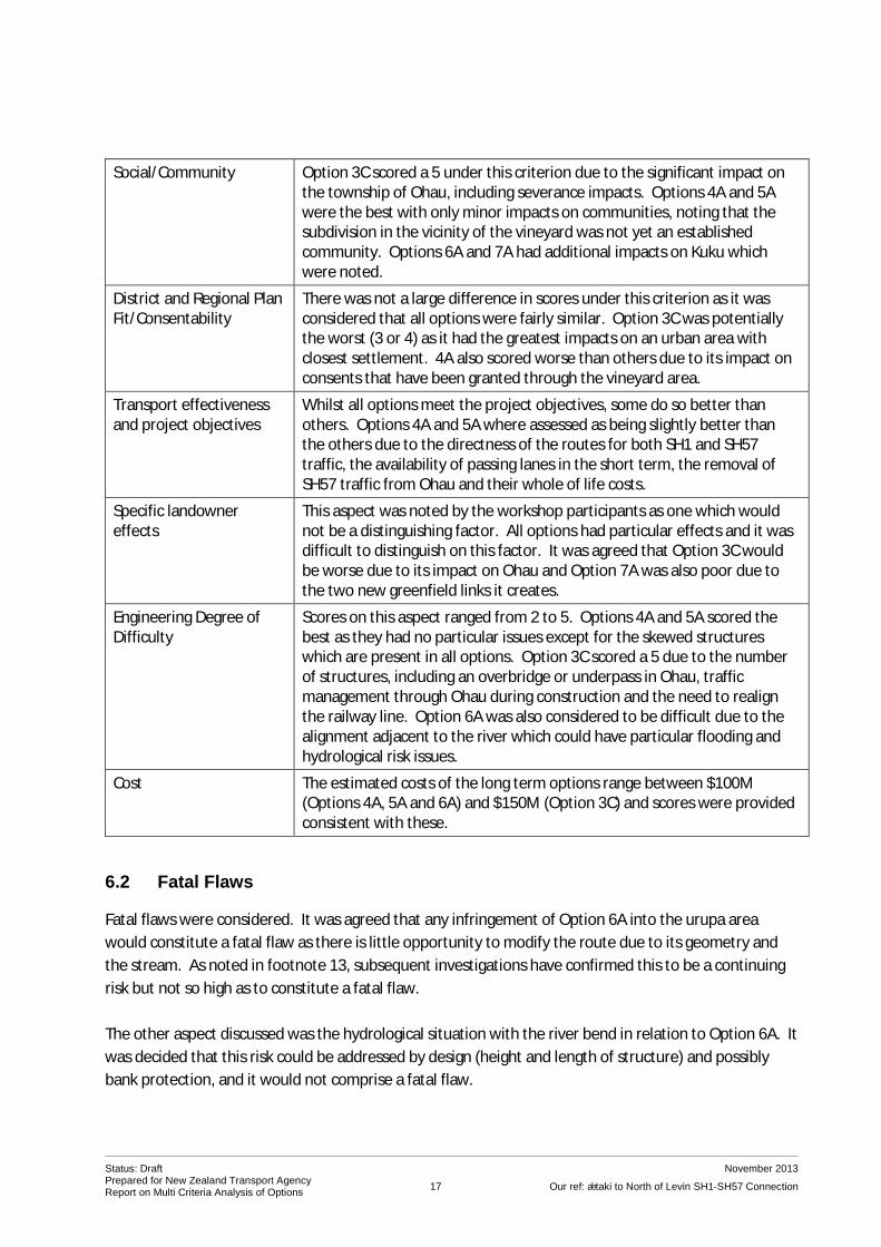
Social/Community Option 3C scored a 5 under this criterion due to the significant impact on the township of Ohau, including severance impacts. Options 4A and 5A were the best with only minor impacts on communities, noting that the subdivision in the vicinity of the vineyard was not yet an established community. Options 6A and 7A had additional impacts on Kuku which were noted.
District and Regional Plan Fit/Consentability
There was not a large difference in scores under this criterion as it was considered that all options were fairly similar. Option 3C was potentially the worst (3 or 4) as it had the greatest impacts on an urban area with closest settlement. 4A also scored worse than others due to its impact on consents that have been granted through the vineyard area.
Transport effectiveness and project objectives
Whilst all options meet the project objectives, some do so better than others. Options 4A and 5A where assessed as being slightly better than the others due to the directness of the routes for both SH1 and SH57 traffic, the availability of passing lanes in the short term, the removal of SH57 traffic from Ohau and their whole of life costs.
Specific landowner effects
This aspect was noted by the workshop participants as one which would not be a distinguishing factor. All options had particular effects and it was difficult to distinguish on this factor. It was agreed that Option 3C would be worse due to its impact on Ohau and Option 7A was also poor due to the two new greenfield links it creates.
Engineering Degree of Difficulty
Scores on this aspect ranged from 2 to 5. Options 4A and 5A scored the best as they had no particular issues except for the skewed structures which are present in all options. Option 3C scored a 5 due to the number of structures, including an overbridge or underpass in Ohau, traffic management through Ohau during construction and the need to realign the railway line. Option 6A was also considered to be difficult due to the alignment adjacent to the river which could have particular flooding and hydrological risk issues.
Cost The estimated costs of the long term options range between $100M (Options 4A, 5A and 6A) and $150M (Option 3C) and scores were provided consistent with these.
6.2 Fatal Flaws
Fatal flaws were considered. It was agreed that any infringement of Option 6A into the urupa area
would constitute a fatal flaw as there is little opportunity to modify the route due to its geometry and
the stream. As noted in footnote 13, subsequent investigations have confirmed this to be a continuing
risk but not so high as to constitute a fatal flaw.
The other aspect discussed was the hydrological situation with the river bend in relation to Option 6A. It
was decided that this risk could be addressed by design (height and length of structure) and possibly
bank protection, and it would not comprise a fatal flaw.

Status: Draft November 2013 Prepared for New Zealand Transport Agency Report on Multi Criteria Analysis of Options
18 Our ref: Ōtaki to North of Levin SH1-SH57 Connection
6.3 Weighting
After reviewing the scoring and considering fatal flaws, the workshop discussed the weighting system to
apply. It was determined that all criteria should be given the same weight. This can be regarded as the
agreed view of the key technical and specialist advisors involved in the project. The workshop was
aware that additional analyses would be undertaken as a later stage, along with sensitivity analysis
applying the different scores elicited at the workshop.
Weighting systems are usually much more challengeable than scoring, as they can be readily developed
from a range of different perspectives. Thus a single result is always vulnerable to criticism that the
weighting system is wrong. An alternative means of investigating the robustness of a preference is to
subject the scoring to a range of weightings and review the outcomes in terms of their consistency and
range of differences.
To analyse the route option preferences, a range of weighting systems was developed subsequently.
These are shown in Appendix 11 and are described in general terms below. Note that the first weighting
system is the only one subject to discussion by a group. The other five systems have been developed by
Allan Planning and Research on the basis of understanding a range of possible relevant considerations14.
Workshop Weighting – this weighting was developed in discussion and agreement at the
workshop and could be described as the technical view of NZTA’s project advisors. All criteria
are weighted equally.
RMA Section 6 Emphasis Weighting – this places maximum weight on three of the four section
6 RMA aspects potentially at play in respect of the project (ecology, heritage and tāngata
whenua values). Landscape values have not been elevated to the same level in this analysis, as
“outstanding” qualities and elements were not identified in the area affected by the route
options by the specialist involved, and it would thus be inappropriate to elevate them to a very
high weight. Some weight is placed on the district plan analysis in this case, as reflective of
section 6 matters, but other criteria are left at low levels.
The remaining weighting systems are related to quadruple bottom line considerations. The analysis on
this basis is relevant to matters to be taken into account under the LTMA and other national
infrastructure policy approaches. It is also pertinent to RMA and LGA considerations.
Social – all criteria have a social component, so all are given some weight. The highest
weighting is given to social and community impacts, followed by tāngata whenua and
archaeological risk aspects which have a high social component in this area, ownership effects
and district plan considerations. All other criteria have some social relevance in this productive
rural area, with engineering aspects least relevant.
14 This type of process has been applied in similar analyses for major infrastructure in the past, to ensure robustness in analysis.

Status: Draft November 2013 Prepared for New Zealand Transport Agency Report on Multi Criteria Analysis of Options
19 Our ref: Ōtaki to North of Levin SH1-SH57 Connection
Environment – this places the highest weight on the physical environmental element of ecology,
with other criteria which integrate physical environmental considerations with
social/community values also given some weighting. Criteria without a physical environment
component are omitted.
Cultural – this highly weights tāngata whenua cultural values and archaeology/heritage,
followed by ecological and social/community impacts but also acknowledged cultural
significance in the established rural landscape and its settlement pattern, and its remaining
ecological values, which have a cultural dimension through their protected status.
Economic – this excludes a number of criteria which have little or no direct economic bearing on
the project or the local economy. It emphasises cost and productive landuses, but applies some
weighting to other criteria with an economic component15.
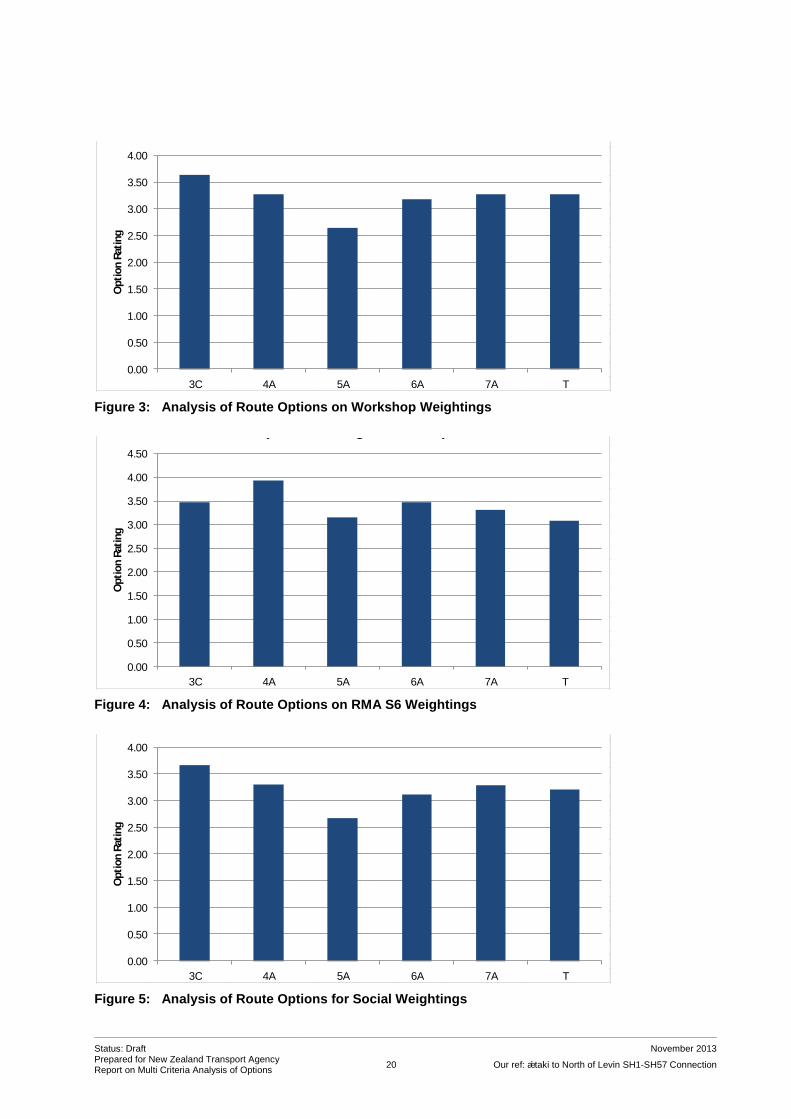
6.4 Analysis
The six weighting systems have been applied to the workshop scores set out in Table 6, and shown graphically in Figures 3 to 9 on the following pages. The same analysis was performed without the cost scores included. This did not change the preferences in the table below.
Table 6: Analysis of Route Options (scores x weights for different weighting systems)
Weighting Systems
Option
3C 4A 5A 6A 7A T
Workshop 3.64 3.27* 2.64 3.18 3.27* 3.27*
RMA 56 3.47* 3.93 3.15* 3.47* 3.31 3.07*
Social 3.67 3.30 2.67 3.11 3.29 3.21
Environmental 3.29 4.67 3.75* 4.08 3.75* 3.17
Cultural 3.61 4.09 3.18 3.48 3.39 3.30
Economic 3.58 3.63 2.21 2.95 3.34 3.45
Notes: - the asterisk (*) denotes where the difference between options is not, or is only marginally, significant - preferred option highlighted in blue.
As can be seen from Table 6 and Figures 3 to 9, Option 5A is the most frequently-preferred route, being
a clear preference under four out of the six weighting systems applied, including the workshop
weighting). In these four cases, the difference is significant. Removing the cost criterion retains the
preferences, indicating that cost considerations are not causing any distortion to the more subjective
scoring systems.
15 This quadruple bottom-line weighting is a different type of evaluation from the Benefit Cost Ratio (BCR) evaluation normally undertaken by NZTA.
Status: Draft November 2013 Prepared for New Zealand Transport Agency Report on Multi Criteria Analysis of Options
20 Our ref: Ōtaki to North of Levin SH1-SH57 Connection
Figure 3: Analysis of Route Options on Workshop Weightings
Figure 4: Analysis of Route Options on RMA S6 Weightings
Figure 5: Analysis of Route Options for Social Weightings
10 1 1 1 1 1 1 1 1 1 1 1
9
8
7
6
5
4
3
2
1
0
Att
rib
ute
s
Lan
dscap
e / v
isu
al
Eco
log
y
Arc
haeo
log
y / h
eri
tag
e
Tan
gata
wh
en
ua v
alu
es
Pro
du
cti
ve lan
d u
se
So
cia
l / co
mm
un
ity
Dis
tric
t &
Reg
ion
al P
lan
fit
/ co
nsen
tab
ilit
y
Tra
nsp
ort
eff
ecti
ven
ess
an
d p
roje
ct
ob
jecti
ves
Sp
ecif
ic lan
do
wn
er
eff
ects
En
gin
eeri
ng
deg
ree o
f
dif
ficu
lty
Co
st
Weight: 10 10 10 10 10 10 10 10 10 10 10
0.00
0.50
1.00
1.50
2.00
2.50
3.00
3.50
4.00
3C 4A 5A 6A 7A T
Op
tio
n R
atin
gOption Evaluation Results
(Lowest Rating is Preferred)
10 1 1 1
9
8
7
6 1
5 1
4
3 1 1
2 1 1 1 1
1
0
Att
rib
ute
s
Lan
dscap
e / v
isu
al
Eco
log
y
Arc
haeo
log
y / h
eri
tag
e
Tan
gata
wh
en
ua v
alu
es
Pro
du
cti
ve lan
d u
se
So
cia
l / co
mm
un
ity
Dis
tric
t &
Reg
ion
al P
lan
fit
/ co
nsen
tab
ilit
y
Tra
nsp
ort
eff
ecti
ven
ess
an
d p
roje
ct
ob
jecti
ves
Sp
ecif
ic lan
do
wn
er
eff
ects
En
gin
eeri
ng
deg
ree o
f
dif
ficu
lty
Co
st
Weight: 6 10 10 10 3 3 5 2 2 2 2
0.00
0.50
1.00
1.50
2.00
2.50
3.00
3.50
4.00
4.50
3C 4A 5A 6A 7A T
Op
tio
n R
atin
g
Option Evaluation Results(Lowest Rating is Preferred)
10 1
9
8 1 1 1 1
7
6
5 1 1 1 1 1
4
3 1
2
1
0
Att
rib
ute
s
Lan
dscap
e / v
isu
al
Eco
log
y
Arc
haeo
log
y / h
eri
tag
e
Tan
gata
wh
en
ua v
alu
es
Pro
du
cti
ve lan
d u
se
So
cia
l / co
mm
un
ity
Dis
tric
t &
Reg
ion
al P
lan
fit
/ co
nsen
tab
ilit
y
Tra
nsp
ort
eff
ecti
ven
ess
an
d p
roje
ct
ob
jecti
ves
Sp
ecif
ic lan
do
wn
er
eff
ects
En
gin
eeri
ng
deg
ree o
f
dif
ficu
lty
Co
st
Weight: 5 5 8 8 5 10 8 5 8 3 5
0.00
0.50
1.00
1.50
2.00
2.50
3.00
3.50
4.00
3C 4A 5A 6A 7A T
Op
tio
n R
atin
g
Option Evaluation Results(Lowest Rating is Preferred)

Status: Draft November 2013 Prepared for New Zealand Transport Agency Report on Multi Criteria Analysis of Options
21 Our ref: Ōtaki to North of Levin SH1-SH57 Connection
Figure 6: Analysis of ‘Route Options on Environmental Weightings
Figure 7: Analysis of Route Options on Cultural Weightings
Figure 8: Analysis of Route Options on Economic Weightings
10 1
9
8
7
6
5 1
4
3 1 1 1
2
1
0 1 1 1 1 1 1
Att
rib
ute
s
Lan
dscap
e / v
isu
al
Eco
log
y
Arc
haeo
log
y / h
eri
tag
e
Tan
gata
wh
en
ua v
alu
es
Pro
du
cti
ve lan
d u
se
So
cia
l / co
mm
un
ity
Dis
tric
t &
Reg
ion
al P
lan
fit
/ co
nsen
tab
ilit
y
Tra
nsp
ort
eff
ecti
ven
ess
an
d p
roje
ct
ob
jecti
ves
Sp
ecif
ic lan
do
wn
er
eff
ects
En
gin
eeri
ng
deg
ree o
f
dif
ficu
lty
Co
st
Weight: 5 10 3 3 3 0 0 0 0 0 0
0.00
0.50
1.00
1.50
2.00
2.50
3.00
3.50
4.00
4.50
5.00
3C 4A 5A 6A 7A T
Op
tio
n R
atin
g
Option Evaluation Results(Lowest Rating is Preferred)
10 1 1
9
8
7
6
5 1 1
4
3 1
2
1
0 1 1 1 1 1 1
Att
rib
ute
s
Lan
dscap
e / v
isu
al
Eco
log
y
Arc
haeo
log
y / h
eri
tag
e
Tan
gata
wh
en
ua v
alu
es
Pro
du
cti
ve lan
d u
se
So
cia
l / co
mm
un
ity
Dis
tric
t &
Reg
ion
al P
lan
fit
/ co
nsen
tab
ilit
y
Tra
nsp
ort
eff
ecti
ven
ess
an
d p
roje
ct
ob
jecti
ves
Sp
ecif
ic lan
do
wn
er
eff
ects
En
gin
eeri
ng
deg
ree o
f
dif
ficu
lty
Co
st
Weight: 5 3 10 10 0 5 0 0 0 0 0
0.00
0.50
1.00
1.50
2.00
2.50
3.00
3.50
4.00
4.50
3C 4A 5A 6A 7A T
Op
tio
n R
atin
g
Option Evaluation Results(Lowest Rating is Preferred)
10 1
9
8 1
7
6
5 1 1 1 1
4
3
2
1
0 1 1 1 1 1
Att
rib
ute
s
Lan
dscap
e / v
isu
al
Eco
log
y
Arc
haeo
log
y / h
eri
tag
e
Tan
gata
wh
en
ua v
alu
es
Pro
du
cti
ve lan
d u
se
So
cia
l / co
mm
un
ity
Dis
tric
t &
Reg
ion
al P
lan
fit
/ co
nsen
tab
ilit
y
Tra
nsp
ort
eff
ecti
ven
ess
an
d p
roje
ct
ob
jecti
ves
Sp
ecif
ic lan
do
wn
er
eff
ects
En
gin
eeri
ng
deg
ree o
f
dif
ficu
lty
Co
st
Weight: 0 0 0 0 8 5 0 5 5 5 10
0.00
0.50
1.00
1.50
2.00
2.50
3.00
3.50
4.00
3C 4A 5A 6A 7A T
Op
tio
n R
atin
g
Option Evaluation Results(Lowest Rating is Preferred)
Status: Draft November 2013 Prepared for New Zealand Transport Agency Report on Multi Criteria Analysis of Options
22 Our ref: Ōtaki to North of Levin SH1-SH57 Connection
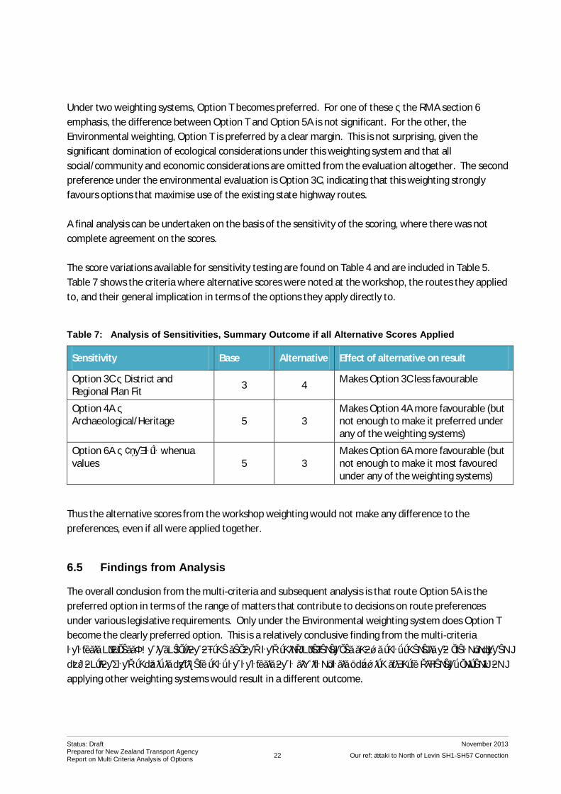
Under two weighting systems, Option T becomes preferred. For one of these – the RMA section 6
emphasis, the difference between Option T and Option 5A is not significant. For the other, the
Environmental weighting, Option T is preferred by a clear margin. This is not surprising, given the
significant domination of ecological considerations under this weighting system and that all
social/community and economic considerations are omitted from the evaluation altogether. The second
preference under the environmental evaluation is Option 3C, indicating that this weighting strongly
favours options that maximise use of the existing state highway routes.
A final analysis can be undertaken on the basis of the sensitivity of the scoring, where there was not
complete agreement on the scores.
The score variations available for sensitivity testing are found on Table 4 and are included in Table 5.
Table 7 shows the criteria where alternative scores were noted at the workshop, the routes they applied
to, and their general implication in terms of the options they apply directly to.
Table 7: Analysis of Sensitivities, Summary Outcome if all Alternative Scores Applied
Sensitivity Base Alternative Effect of alternative on result
Option 3C – District and Regional Plan Fit
3 4 Makes Option 3C less favourable
Option 4A – Archaeological/Heritage 5 3
Makes Option 4A more favourable (but not enough to make it preferred under any of the weighting systems)
Option 6A – Tāngata whenua values 5 3
Makes Option 6A more favourable (but not enough to make it most favoured under any of the weighting systems)
Thus the alternative scores from the workshop weighting would not make any difference to the
preferences, even if all were applied together.
6.5 Findings from Analysis
The overall conclusion from the multi-criteria and subsequent analysis is that route Option 5A is the
preferred option in terms of the range of matters that contribute to decisions on route preferences
under various legislative requirements. Only under the Environmental weighting system does Option T
become the clearly preferred option. This is a relatively conclusive finding from the multi-criteria
analysis process. An inspection of the second and third preferences shows that there is no clear “runner
up” option, and thus it is unlikely that an analysis on a similar basis but with slightly different criteria or
applying other weighting systems would result in a different outcome.

Status: Draft November 2013 Prepared for New Zealand Transport Agency Report on Multi Criteria Analysis of Options
23 Our ref: Ōtaki to North of Levin SH1-SH57 Connection
The work involved to reach that finding has been rigorous, including:
development of an appropriate range of route options in the wider area, and a technical check
of their practicality
detailed investigation of impacts of options across a range of aspects
investigation of options by people with a range of backgrounds within a framework suitable for
multi-criteria analysis
a multi-criteria workshop, eliciting scoring and a single weighting system
analysis of results on the basis, and subsequent further analysis applying additional weighting
systems and alternative scorings (the latter from the workshop).
The outcome of the analysis can assist both the community and NZTA in that it provides an
understanding of the range of aspects that need to be taken into account when considering route
options, and provides more detailed levels of information about these aspects. For NZTA, recognising
that multi-criteria analysis is an aid to decision-making, but does not make the decision on behalf of
NZTA, it will provide assistance in determining the preferred option to proceed with.

Status: Draft November 2013 Prepared for New Zealand Transport Agency Report on Multi Criteria Analysis of Options
24 Our ref: Ōtaki to North of Levin SH1-SH57 Connection
7 CONCLUSION
This report sets out the basis, process and findings of an analysis of alternative routes undertaken for
NZTA for the SH1 to SH57 connection as part of the Ōtaki to North of Levin RoNS project.
The process has included a review of six route options in the general area, including one option
developed from consultation with tāngata whenua.
The process involved preliminary development of the options to an extent where their effects could be
assessed in a preliminary manner and to confirm their technical feasibility, followed by specialist
investigations of the implications of each of the route options taking into account effects on adjacent
land. The analyses by the specialists were brought together through a multi-criteria analysis process,
involving best practice techniques such as decision conferencing through a facilitated workshop at which
information about the options was shared and tested. As one option was identified later, it was subject
to a Delphi analysis methodology. The outcomes have been analysed on the basis of a range of
weighting systems, and have also been subject to further sensitivity analysis.
On most analyses, Option 5A was preferred. This takes the route to the west of the NIMT north of
Manakau, bifurcating just north of the Ohau River with SH1 remaining more-or-less on its current route
to Levin, and SH57 crossing the NIMT and travelling cross-country to run parallel with and then join
Arapaepae Road north of its present intersection, with Kimberley Road.
The information this report and its appendices, and the analysis described above, will help contribute to
a decision on the preferred route option for the State Highways 1 and 57 between north of Manakau
and south of Levin.

APPENDIX 1: OPTIONS TO BE EVALUATED


APPENDIX 2: TECHNCIAL EXPERTS BRIEFING MATERIAL

AGENDA
Briefing Meeting for Technical Experts, SH1 – SH57 Connection
Date: Thursday 11th September, 10am to 12 noon
Venue: MWH Offices, 123 Taranaki Street, Wellington
1. Introductions – all
2. General background to the O2L Project, where we're heading, general timelines, etc – Jo
3. Explanation/descriptions of the Options for SH1-SH57 connection – Phil
4. Outline of anticipated issues, consultation findings – Sylvia
5. Preliminary "cut" of possible issues and further work needed – Gavin, Adam, Lachie, others
6. Timetable for investigations, reporting, lead in to MCA process – Phil/Jon

NOTES ON TECHNICAL EXPERTS’ WORK AND BACKGROUND REPORTS – O2L, SH1 + SH57 CONNECTION OPTIONS
These notes are just to clarify the work you are undertaking in preparation for our Multi Criteria Analysis (MCA) Workshop on 17th October 2013. The individual studies you are all engaged in will contribute to an overall evaluation of the implications of the five options we are going to analyse (Options 3C, 4A, 5A, 6A and 7A – as per Phil Peet’s email of 20th September 2013). This will be via a structured workshop process, and we will send out more notes on this prior to the Workshop. In the meantime, please take into account the following in your current investigations and report preparation: 1. A key aspect in the statutory decision-making for any proposal under the RMA which may
have significant adverse effects is a demonstration that alternatives have been considered. For designations, this includes “routes and methods” for achieving NZTA’s objectives. The current process will contribute to the documentation of the overall process and the options considered.
2. The MCA process which we will be using to bring all the considerations together relies on sharing information and as far as possible, undertaking the evaluation through consensus. The individual studies will involve investigation by technical experts who will share their knowledge at the Workshop. It is important that the expert studies and reports do not undertake the final evaluation – rather they are a step on the way.
3. The criteria16 you are individually working on will broadly encompass:
ecological implications (terrestrial and aquatic)
landscape/visual implications
archaeological/heritage values
tāngata whenua impacts
impacts in terms of soils/land quality, plus rural production implications.
Your work will need to include a description of all the aspects that are encompassed within
your criterion, and a single criterion above may be broken into several sub-criteria (if there
is a potential for overlap between criteria, e.g. tāngata whenua values and heritage, don’t
worry too much as we will address that at the Workshop).
4. While we are looking at the routes provided by Phil, take into account the implications of each route on the aspect you are considering, which may extend some distance beyond the actual draft alignment. The extent of the receiving environment will differ depending on your particular specialization (i.e. probably greater for social and cultural effects than for effects on ecological values).
16
Please note we will also include criteria encompassing engineering degree of difficulty/constructability (including river crossings), social implications, planning/consentability, property implications, alignment with NZTA’s objectives and cost.

5. Please note that, to be comparable, the routes will need to all be assessed as covering the same equivalent “length”. This means that each assessment will need to cover the complete route from the take-off point for Option 7A at the south to the merge with Arapaepae Road, at the north end.
6. We will also be looking for “fatal flaws”. When considering major impediments or fatal flaws, it is important to note that there is still some room to move with the route options. A true fatal flaw would probably have to stretch right across the route and be unavoidable.
7. In carrying out your work, please can you undertake a coarse evaluation of the options (we suggest a scale ++, +, 0, –, – –) with descriptions as below, identifying the key considerations that lead to your conclusion.
Notation Interpretation
++ Route option is, on average, very good in terms of this attribute
+ Route option is, on average, good in terms of this attribute
0 Route option is neutral, or neither good or problematic, on average, in terms of this attribute
– Route option includes, on average, minor or intermediate issues or concerns in terms of this attribute
– – Route option includes, on average, major or intermediate issues or concerns in terms of this attribute
If you reach an overall conclusion by first evaluating different sub-sections of options, or by
considering different aspects within your area of expertise, please briefly record your
method.
This is a coarse assessment method which is just to help us gain an overview of the
individual experts’ first-cut relative evaluation of the options. Don’t get too worried about
this assessment – just apply your best judgment.
8. The attribute is to be defined in terms of your area of expertise, taking into account all the aspects that you would normally take into account when doing an assessment of effects on the environment. In your report, can you explain what you have taken into account, and the particular considerations that have led you to the score that you have give for each option.
9. We will do a more comprehensive MCA at the Workshop. Your assistance will be needed in refining the attributes, scoring them and looking at possible weighting systems.
10. It will not be necessary to have completed your reports before the Workshop, but they will be needed by the end of October. The reports need to reflect your work before the Workshop and your own opinions, regardless of where the Workshop process gets to. Your work will need to be sufficiently advanced for each person to make a short presentation about each of the options in terms of the subject at the Workshop and to contribute to an overall MCA evaluation.

APPENDIX 3: ŌTAKI TO LEVIN RONS (SH1 to SH57) LANDSCAPE REPORT ON ROUTE OPTIONS

OTAKI TO LEVIN RONS (SH1 TO SH57)
LANDSCAPE REPORT ON ROUTE OPTIONS
131108_2923_GL_Otaki to Levin RONS (SH1 to SH57)_Landscpae Report on Route Options_page 2
Client: NZTA
Project: Otaki to Levin RONS (SH1 to SH57)
Report: Landscape Report on Route Options
Status: Final
Date: 8 November 2013
Author: Gavin Lister
Isthmus
PO Box 90 366
Auckland 1142
+64 9 309 7281
No. Date Details Author QA
1 30.10.13 Draft to MWH Gavin Lister GL
2 08.11.13 Final Gavin Lister GL

131108_2923_GL_Otaki to Levin RONS (SH1 to SH57)_Landscpae Report on Route Options_page 3
CONTENTS
INTRODUCTION .................................................................................................................. 4
EXISTING LANDSCAPE ......................................................................................................... 4
PROPOSAL .......................................................................................................................... 4
COMPARISON BETWEEN ROUTE OPTIONS ........................................................................... 5
Approach and Method ........................................................................................................ 5
Findings ............................................................................................................................. 5
Summary of findings ........................................................................................................... 6
OPPORTUNITIES TO AVOID, REMEDY OR MITIGATE ADVERSE EFFECTS ................................. 7
OVERALL SUMMARY ........................................................................................................... 7
APPENDIX 1: SECTION-BY-SECTION COMMENTARY.............................................................. 8

131108_2923_GL_Otaki to Levin RONS (SH1 to SH57)_Landscpae Report on Route Options_page 4
INTRODUCTION
1 The project is a sub-set of assessments into the Otaki to Levin RONS and concerns
connections between SH1 and SH57. Five alternative routes were scoped based on
earlier assessment work and preliminary consultation. A sixth option (Option T) was
subsequently proposed as a result of consultation.
2 This report analyses the options in terms of landscape matters to provide information
for the multi-criteria analysis (MCA) process designed to select a preferred route.
EXISTING LANDSCAPE
3 The landscape comprises flat to gently rolling coastal plain and river terraces, against a
backdrop of the Tararua Ranges and foothills. It is a productive (‘working’) landscape
including dairying and other pastoral farming, substantial areas of cultivated ground, a
vineyard, and more intensive uses such a stud farm, poultry farms and a nursery.
4 The main natural features are
Ohau River;
Waikawa Stream;
Kuku Stream;
Stands of remnant totara bush on the terraces north of Ohau River; and
Other scattered small stands of remnant lowland forest, such between Kuku
Beach Road and Waikawa Stream and south of McLeavy Road.
5 Housing patterns in the landscape include (i) traditional rural housing typically located
in fenced sections close to the road, (ii) scattered lifestyle properties and (iii) a
comprehensive lifestyle development south of Ohau based around a vineyard and
backdrop of totara bush.
6 The main settlement is Ohau which straddles both sides of SH1. The core settlement
comprises an historic street grid west of SH1, but there are additional houses and most
of the community facilities east of SH1. Such facilities include the school, play-centre,
sports fields, historic church, and café / restaurant (the former diary factory).
7 There are two maraes with associated housing and urupa, both of which are adjacent to
SH1. Wehi Wehi Marae is between North Manakau Road and Whakahoro Road, and
Tukuorehe Marae is north of Kuku Road.
PROPOSAL
8 The options are depicted on plans prepared by MWH, ‘Otaki to Levin Scoping Options,
26 August 2013’. Each of the options comprises a four-lane extension of SH1 to a point
at which SH57 and SH1 would peel away from each other by way of overpass bridges.
Both SH1 and SH57 would be two-lane wide north of the ‘bifurcation point’.

131108_2923_GL_Otaki to Levin RONS (SH1 to SH57)_Landscpae Report on Route Options_page 5
COMPARISON BETWEEN ROUTE OPTIONS
Approach and Method
9 For the purpose of comparison the area was subdivided into eight equivalent
geographic sections (including sections devoted to the Waikawa Stream and Ohau River
crossings respectively). The relative landscape effects were assessed taking into
account the following:
Effects on natural character of the streams and river (including number of
bridges required and their proximity to existing bridges and already modified
natural character)
Effects on other specific natural features (mainly the totara bush and other
remnant native trees)
Effects on settlements including Ohau and the two marae
Effects on houses;
Fit with underlying cadastral and landuse pattern;
Prominence and footprint of the interchange between SH1 and SH57.
Findings
10 Appendix 1 comprises a tabulated commentary comparing the routes section-by-section
in terms of the effects listed above. The findings are also collated in Tables 1 and 2
below which compare the routes respectively in terms of (i) types of effect; and (ii)
geographic section. Note that the comparison between options is similar across both
means of collation (effects and geographic section).
Table 1: Summary comparison of route options in terms of types of effect
3C 4A 5A 6A 7A T
Natural character effects
Good 0
Good 0
Good 0
Worst (additional river crossing)
Worst (additional river crossing)
Good 0
Effects on vegetation
Good 0
Better
Worst (effects on totara)
Bad (effects on totara)
Bad (effects on totara)
Better
Effects on communities
Worst significant
Bad
Better
Better
Better
Worst significant
Effects on houses
Worst
Worse
Best
Best
Middle 0
Worst
‘Fit’ with cadastral and paddock pattern
Middle 0
Middle 0
Best ‘fit’
Middle 0
Worst ‘fit’
Middle 0
Obtrusiveness of interchange location
Middle 0
Best
Best
Middle 0
Worst
Middle 0

131108_2923_GL_Otaki to Levin RONS (SH1 to SH57)_Landscpae Report on Route Options_page 6
Table 2: Summary comparison of route options in terms of geographic section
Section 3C 4A 5A 6A 7A T
North Manakau Road to Waikawa Stream
Worse
Worse
Worse
Worse
Better
Better
Waikawa Stream
Better
Better
Better
Better
OK 0
OK 0
Waikawa Stream to Kuku Beach Road or Kuku East Road
Worst
Better
2
Better
Better
Worse
Worse
Kuku Beach Road or Kuku East Road to Ohau River
Better
Best
Best
Better
Worst
Better
Ohau River Better
Better
Better
Worse
Worse
OK 0
Ohau River to Muhunoa East Road
Best
Worst
OK 0
Better
Better
Better
Mahunoa East Road to McLeavey Road
Worst
Better
Better
Better
Better
Worst
McLeavy Rd to Arapaepae Road
Worst
Worse
Better
Better
Better
Worse
Summary of findings
11 The landscape is generally similar for each of the options: they all traverse a productive
rural landscape and they all require crossing the Ohau and Waikawa Streams. The main
differences relate to specific features:
11.1 Options 3C and T will have significant severance effects on Ohau settlement.
11.2 Options 3C and T would also affect the greatest number of houses (66 and 65
respectively)1 while options 5A and 6A would affect the least (34 and 35).
11.3 Option 4A will have significant adverse effects on the comprehensively
designed vineyard lifestyle subdivision south of Ohau –it would affect the
amenity as a whole of this development.
11.4 Option 5A, 6A and 7C would have adverse effects on remnant stands of totara
bush (although these effects could be avoided or minimised by fine-tuning the
alignment).
1 Note that the figures for 3C and T include 8 houses in the Kimberley Centre which may be unoccupied.

131108_2923_GL_Otaki to Levin RONS (SH1 to SH57)_Landscpae Report on Route Options_page 7
11.5 Options 6A and 7C will have greater effects on the natural character of the
Ohau River because they would require a crossing in a location with higher
natural character in addition to crossing points adjacent to the existing bridges.
OPPORTUNITIES TO AVOID, REMEDY OR MITIGATE ADVERSE EFFECTS
12 There may be potential to avoid or remedy effects on the stands of totara bush by fine-
tuning alignments, in which case the relative ranking of options 5A-7A would improve.
13 It is not possible, however, to avoid the effects of options 3C and T on Ohau , or the
effects of option 4C on the vineyard subdivision.
14 With all the options there are likely to be options to reduce effects on some houses by
fine-tuning the alignment, and more particularly the realignment of access roads and
intersections. However, there would be unavoidable effects on individual properties
and houses with all the options.
OVERALL SUMMARY
15 Taking these factors together, options 3C, 7A and T ranked worst in terms of landscape
matters, option 5A ranked best, and options 4A and 6A ranked in the middle.
Table 3: Overall Ranking in terms of Landscape Factors
Option 3C 4A 5A 6A 7A T
Ranking Worst
Worse
Best
Middle 0
Worst
Worst
Gavin Lister
Isthmus
30 October 2013

APPENDIX 1: SECTION-BY-SECTION COMMENTARY
Section 3C 4A 5A 6A 7A T
North Manakau Road
to Waikawa Stream
700-1750
As for 4A, 5A, 6A
Open, cultivated paddocks. Wehi Wehi Marae (including urupa) and settlement on west side of SH1.
Follows existing SH1 alignment, but abandons curve over railbridge and continues on west side of rail line. Fits cadastral and paddock layout.
Widening to four lanes will have frontage effects on approximately 7 houses and marae currently facing the west side of SH1 between 900 and 1250 (which are currently accessed from SH1)
Close in front of 2 houses at 1350.
Close to 1 house at 1600
Removal of 2 houses at 1600 and 1700
(3 houses on opposite side of railway line at 1350-1600 will benefit from removal of SH1 rail overbridge)
700-1750
As for 3C, 5A, 6A
700-1750
As for 3C, 4A, 6A
700-1750
As for 3C, 4A, 5A
500-1750
As for T
Open, cultivated paddocks. Prominent shelter belts near Waikawa Stream
Curvilinear alignment although fits reasonably well with cadastral and paddock layout.
Flyover rail bridge close to 5 houses on east and west at 900-1000 (some positive effects because shifts road further from marae and several other houses in settlement)
Moderately close to 3 houses at 1300, 1350 and 1500 (although behind houses and readily screened)
500-1750
As for 7A
Waikawa Stream
1750
Same as 4A, 5A, 6A
Parallel with and alongside railway bridge.
Section of stream already affected by existing crossing.
Existing SH1 bridge to be removed –minor net positive effect on natural character
1750
Same as 3C, 5A, 6A
1750
Same as 3C, 4A, 6A
1750
Same as 3C, 4A, 5A
1750
As for T
Adjacent to existing SH1 bridge which would be demolished.
Modified section of stream
No net change in natural character
1750
As for 7A
Waikawa Stream to
Kuku Beach Road or
Kuku East Road
1800-4000
Open, cultivated paddocks. Small plantation. Two stands of bush.
Alignment is parallel with but separated approximately 100+ from railway line.
1800-4000
Same as 5A, 6A
Open, cultivated paddocks. Small plantation. Two stands of bush.
Alignment is parallel with and adjacent to railway line
Alignment square with the
1800-4000
Same as 4A, 6A
1800-4000
Same as 4A, 5A
1800-3600
As for T
Open, cultivated paddocks.
Small Kuku Stream (heavily modified in productive landscape).
Alignment mostly follows existing SH1 alignment but
1800-3600
As for 7A

131108_2923_GL_Otaki to Levin RONS (SH1 to SH57)_Landscpae Report on Route Options_page 9
Section 3C 4A 5A 6A 7A T
Alignment reasonably square with the cadastral and paddock layout.
Cuts through stand of bush at 3400 (could be fine-tuned to avoid) and close to bush at 2300-2400
Very close to 2 houses at 2450. Removal of 1 house at 1 cottage at 2750
Reasonably close to1 house at 3400 (house will be affected by views of interchange
Removal of 4 houses at Kuku Beach Road interchange. Reasonably close to 1 further house at interchange.
Encroaches onto poultry farm at Kuku Beach Rd (new access road could be fine-tuned to avoid)
cadastral and paddock layout (minimal effects)
Moderately close to 2 houses at 2450 and 1 house and 1 cottage at 2750.
Close to poultry farm (4000)
would be widened to four lanes.
Alignment fits existing cadastral and paddock layout (minimal effects).
However, road widening would have frontage effects on properties facing SH1 including 15 houses: On east side at 2100 (appears unoccupied), 2200, 2300 2400, 2650, 3400, 3600, 3750, 3775, 3800. On west side at 2700 (may require removal), 3050 (may require removal), 3400, 3425, 3650
Access road would require removal of 2 of these houses on east at 2400 and 3400.
Frontage effects on St Stephens Church at 3550.
Frontage effects on commercial properties including Kennels, former diary factory and former nursery site.
Kuku Beach Road or
Kuku East Road to
Ohau River
4000-5000
Open, low lying cultivated paddocks. Scattered trees.
Alignment is parallel with but separated approximately 100+ from railway line.
Alignment square with the cadastral and paddock layout.
Very close to 1 house at 4750 (likely require removal). Close to 2 houses at 4800 and 4900 (latter appears abandoned)
4000-5000
Same as 5A
Open, low lying cultivated paddocks. Scattered trees.
Alignment parallel with and alongside railway line
Alignment square with the cadastral and paddock layout –minimal effects
Close to 2 houses at 4800 and 4900 (latter appears abandoned)
4000-5000
Same as 4A
4000–5000 and 0-2400
Open, low lying cultivated paddocks. Scattered trees.
Alignment swings away to west before swinging back to cross railway line and follow the south bank of the Ohau River.
SH57 section has curvilinear alignment that cuts across cadastral and paddock layout. Close to urupa adjacent to railway. Parallel with and reasonably close to south bank of Ohau River. Would affect scattered native trees.
Close to 1 house at Kuku Beach Road at 4000
SH1 section close to 1 house at 4750 and close to 2 houses at 4800 and 4900 (latter appears abandoned)
SH57 section close to 1 house at 1250.
Interchange over-passes will be in open paddocks west of railway line –relatively benign location
4000-5200 and 0-600 and 0-850
Open, flat, cultivated paddocks.
Alignment is diagonal to cadastral and paddock layout.
Interchange will be in prominent location in middle of open landscape behind (east of) Tukuorehe Marae.
Interchange and diverging SH1 and SH57 sections will affect productive land.
4000-5200
Similar to SH1 section of 7A
Open, flat, cultivated paddocks.
Alignment similar to SH1 section of 7A except will be four lanes, and will eschew interchange.
Alignment reasonably square to cadastral and paddock layout.

131108_2923_GL_Otaki to Levin RONS (SH1 to SH57)_Landscpae Report on Route Options_page 10
Section 3C 4A 5A 6A 7A T
Ohau River 5000
Parallel and close to existing road bridge (100m) and short distance downstream of rail bridge (200m)
Existing road bridge will be demolished
Section of river already affected by two existing bridges and overhead transmission line. In vicinity of concrete plant.
Negligible change from existing
5000
Immediately adjacent to existing road bridge (to be demolished and short distance downstream of rail bridge (100m).
Section of river already affected by two existing bridges and overhead transmission line. In vicinity of concrete plant.
Negligible change from existing.
5000
Similar to 3C
Two Bridges Required
Bridge 1 (5000)
Similar to 3C except narrower (2 lane) bridge
Bridge 2 (2400)
Modified rural landscape setting, but river corridor relatively natural and unaffected by existing infrastructure.
Relatively wide and braided river bed. Appears to be regenerating vegetation on both banks
Two Bridges Required
Bridge 1 (5250)
Short distance upstream of rail bridge, and adjacent to concrete plant.
Section of river already affected by existing infrastructure.
Relatively narrow bridge (2 lane)
Bridge 2 (850)
Similar to 6A Bridge 2
5200
Similar to 7A Bridge 1, except four lanes.
Short distance upstream of rail bridge, and adjacent to concrete plant.
Section of river already affected by existing infrastructure.
Ohau River to
Muhunoa East Road
5000-6200
Flat, cultivated paddocks, with ‘oasis-like’ heavily treed Strathcarron Stud Farm
Curvilinear alignment that roughly echoes existing SH1 -cuts across corners of existing cadastral and paddock layout. But bisects Strathcarron Stud Farm (racing stables etc).
Very close to house at 5200
Close to cottage at 5400 on Strathcarron Stud Farm.
(houses on corner of SH1 and
Muhunoa East Road discussed in
section on Ohau)
5000-6200 and 0-1300 and 0-900
Flat, cultivated paddocks. Heavily treed Strathcarron Stud Farm west of SH1. Vineyard lifestyle park and stands of totara bush east of SH1.
Alignment bisects Strathcarron Stud Farm and bisects middle of the vineyard lifestyle park which currently contains 10 houses and undeveloped lots –would detract from amenity of the subdivision as a whole.
Removal of 1 house north of Ohau River at 5250
Removal of 2 houses on SH1 at ‘900’.
Close to 1 cottage on east side at ‘800’ –would be dominated by overpass and interchange
Passes close in front of 1 house at ‘1300’
Close to 1 house at 850.
Interchange will be in open land north of the stand of trees at Strathcarron Stud Farm.
5000–6200 and 0–1300 and 0-1100
Flat, cultivated paddocks. Heavily treed Strathcarron Stud Farm west of SH1. Vineyard and stands of totara bush east of SH1.
Alignment bisects Strathcarron Stud and crosses rear fringes of vineyard (including undeveloped lifestyle lots). Separated from centre of lifestyle park by totara bush.
Crosses cultivated paddocks nearer Mahunoa East Road.
Curvilinear alignment cuts across pattern of paddocks.
Cuts through edges of two stands of totara bush and scattered totara trees.
Removal of 1 house north of Ohau River at 5200
Close to 2 houses at 850 and 900 (will be affected by outlook to overbridge to south)
(Moderately close to houses in vineyard subdivision and on Muhunoa East Road but on opposite side of bush)
Interchange will be visually anchored by the stand of trees at Strathcarron Stud Farm.
5000–6200 and 2500-3400
SH1 section similar to 3C except two lanes (rather than four).
Curvilinear alignment that roughly echoes existing SH1 -cuts across corners of existing cadastral and paddock layout. But bisects Strathcarron Stud Farm (racing stables etc).
Very close to 1 house at 5200
Close to 1 cottage at 5400 on Strathcarron Stud Farm.
SH57 section flat low terraces. Mostly open pasture with stands of totara bush.
Cuts through edge of stand of totara bush (but could be fine-tuned to avoid)
(Moderately close to 1 house on Muhunoa East Road but on opposite side of bush)
5300-6200 and 900-1900
SH1 section passes close to concrete plant and through corner of vineyard.
Requires rail overpass .
Very close to 2 houses at 5700 and 5850 (likely require removal of both).
Close to 1 house at 5900
(houses on corner of SH1 and Muhunoa East Road discussed in section on Ohau)
SH57 section same as 6A. Flat low terraces. Mostly open pasture with stands of totara bush.
Cuts through edge of stand of totara bush (but could be fine-tuned to avoid)
(Moderately close to 1 house on Muhunoa East Road but on opposite side of bush)
5300-6300
Similar to SH1 section of 7A except
four lanes.
Passes close to concrete plant and through corner of vineyard.
Requires rail overpass .
Very close to 2 houses at 5700 and 5850 (likely require removal of both).
Close to 1 house at 5900
(houses on corner of SH1 and Muhunoa East Road discussed in section on Ohau)

131108_2923_GL_Otaki to Levin RONS (SH1 to SH57)_Landscpae Report on Route Options_page 11
Section 3C 4A 5A 6A 7A T
Mahunoa East Road to
McLeavey Road
6200-7200
Same as T
Ohau – a small urban settlement on terrace edge above Ohau River valley. Cultivated paddocks on terrace north of Ohau.
Would exacerbate severance between east and west halves of settlement. Require underpass on Muhunoa West and East Roads. Main part of settlement is west of SH1. School, play centre, sports fields, historic church are east of SH1.
Embankment and deep cuttings to negotiate edge of terrace
Close to 1 house and shop on south-west corner of intersection of SH1 and Muhunoa West Road (but they already front existing SH1)
Removal of café (former dairy factory) on north-east corner of intersection.
Immediately adjacent to Ohau School and (historic) St John the Baptist Church.
Removal of 2 houses east side at 6350 and 6400.
Very close to 3 houses on east side at 7250 - 7400 which would be dominated by rail overpass.
Removal of 3 houses on west side at 7250 and 7400.
New Ohau access road would be very close to 1 house at 7300 and require removal of 3 houses at 7050 and 7100
Realignment of railway estimated to require removal of 4 houses at 6700-6800.
Realigned railway would be close to 2 houses at 6600-6650
1000-1800
Undulating terrace –rolling pasture and cultivated paddocks. Scattered lifestyle properties (Ohau Terraces rural residential settlement to west of route with some overlook)
Alignment diagonal to cadastral and paddock layout
Close to 1 house at 1000
Removal of 1 house at 1200
Close to 1 house on east at 1600
Close to 1 house on west at 1700
Very close to 1 house to east on McLeavey Rd (1800) –would probably require removal
Very close to 1 house on west at 1800. Realigned intersection would probably require removal.
Moderately close to 2 houses at 1800-1850 on east and west respectively.
1100-2200
Same as 6A and 7A
Undulating terraces -rolling pasture and cultivated paddocks. Scattered lifestyle properties
Alignment is diagonal to cadastral and paddock layout (but slightly better fit than 4A). Low embankment and moderate cuttings.
Passes near stand of bush at McLeavey Road
Moderately close to 3 houses on Mahunoa Road East at 1200-1400.
Close to 1 house on east at 1650
Removal of 1 house at 1800
Moderately close to 1 house at 2100
Close to 2 houses at McLeavy Road (2200) – realignment of intersection would require removal of both houses
2500-4500
Same as 5A and 7A
1900–3000
Same as 5A and 6A
6200-7200
Same as 3C
McLeavy Road to
Arapaepae Road
7200–8000 and 400–1600 and 0-
2000
Same as T
Flat land. Cultivated paddocks. Glasshouses. Some lifestyle
1800-3400
Flat to gently rolling. Pasture and cultivated paddocks. Horse training track. Prominent
2200-4000
Same as 6A and 7A
Flat to gently rolling. Pasture and cultivated paddocks. Prominent shelter belt mid-
1200-2900
Same as 5A and 7A
1200-2900
Same as 5A and 6A
7200–2000
Same as 3C

131108_2923_GL_Otaki to Levin RONS (SH1 to SH57)_Landscpae Report on Route Options_page 12
Section 3C 4A 5A 6A 7A T
properties. Former Kimberley Centre institution on south side of Kimberley Road.
Alignment partly follows existing Kimberley Road but large curves at north and south ends of this section (i.e. connections to SH1 and Arapaepae Road) cut across existing cadastral and paddock layout
Loss of some substantial trees along Kimberley Road frontage (e.g. oaks, poplar, plane, eucalpyt amongst other species)
Very close to 1 house on west side at 7550 –will be dominated by overpass. House may require removal. Existing fruit stall would be removed.
Very close to 1 house at 1200 (will be sandwiched between lanes, likely to require removal).
Removal of 8 houses (may not be occupied) on Kimberley Centre site at 1500-1700
Road reconstruction may affect frontages of 2 houses on Kimberley Road at 250 and 350.
Removal of possibly 2 houses at 900-1000 (difficult to tell from roadside and aerial photo) .
Close to 1 house and cottage at 1150
Close to 3 houses on Arapaepae Road at 1350, 1450
Removal of 1 house and 1 cottage at 1500.
shelter belt mid-block between McLeavey Rd and Kimberley Rd.
Alignment diagonal to cadastral and paddock layout
Moderately close behind 1 house on west at 2500.
Close to 2 houses west and east at Kimberley Road at 2600
Removal of 1 house at Kimberley Road at 2700
Moderately close to 1 house on west at Kimberley Road at 2750
Close to 1 house on east at 2900
Very close to 1 house at 3050
Removal of 3 houses at 3000, 3150 and 3200
block between McLeavey Rd and Kimberley Rd.
Alignment reasonably square to cadastral and paddock pattern.
Close to 1 house on west at 2950
Very close to 1 house at Kimberley Rd (3100) -may require removal
Close to 1 house at 3250
Very close to 2 houses at 3300 and 3500 (Both houses may be untenable due to proximity)
Close to 1 cottage at 3550.

APPENDIX 4: ŌTAKI TO LEVIN ROUTE OPTIONS:
ECOLOGY CONSTRAINTS

Otaki to Levin Route Options: Ecology
Constraints
Prepared for the New Zealand Transport Agency
Adam Forbes (MSc)
Forbes Ecology
November 2013

New Zealand Transport Agency Otaki to Levin Route Options: Ecology Constraints
Author Details:
Author Signed Date
Adam Forbes
9/11/2013
Adam Forbes (MSc)
Principal Ecologist
Forbes Ecology
PO Box 8740
Havelock North
Hastings (4157)
Cover photograph: Podocarp dominant indigenous forest remnant at Muhunoa East Road.

New Zealand Transport Agency Otaki to Levin Route Options: Ecology Constraints
Status: FINAL i November 2013 Our ref: NZTA Otaki – Levin State Highway V3
TABLE OF CONTENTS
1.0 INTRODUCTION ..................................................................................................................................... 1
1.1 Objectives .......................................................................................................................................... 1
1.2 Assessment Parameters and Scope................................................................................................... 1
1.3 Options Assessed ............................................................................................................................... 2
2.0 METHOD ................................................................................................................................................ 4
2.1 Desk Top Assessment ........................................................................................................................ 4
2.2 Field Assessment ............................................................................................................................... 4
2.3 Evaluation of Route Options ............................................................................................................. 5
3.0 RESULTS AND DISCUSSION .................................................................................................................... 6
3.1 Ecological Setting ............................................................................................................................... 6
3.2 Ecological Constraints of State Highway Route Options................................................................... 7
4.0 CONCLUSIONS ..................................................................................................................................... 12
4.1 Summary of Ecology Evaluations .................................................................................................... 12
REFERENCES .................................................................................................................................................... 13
ATTACHMENT 1: SITE PHOTOGRAPHS ............................................................................................................ 14
ATTACHMENT 2: FRESHWATER FISH DATABASE RECORDS ............................................................................ 16
New Zealand Transport Agency Otaki to Levin Route Options: Ecology Constraints
Status: FINAL 1 November 2013 Our ref: NZTA Otaki – Levin State Highway V3
1.0 INTRODUCTION
1.1 Objectives
This report describes the process and results of an assessment of ecology constraints
associated with six potential state highway alignment options running between Otaki and
Levin, in the Horowhenua District of New Zealand.
The objective of the assessment is to identify and consider specific ecology features
within land areas potentially affected by each alignment option. Ecology features are
considered in the context of the level of constraint they present to establishment and
operation of a state highway alignment. In this assessment the level of constraint is
derived from the ecological value of a given ecological feature.
1.2 Assessment Parameters and Scope
1.2.1 Ecology Criterion
The ecology criterion spans terrestrial, freshwater, and wetland ecology aspects. It views
the ecological characteristics and values of a site in the context of its ecological setting.
To provide the necessary context for an understanding of this assessment the site’s
ecological setting is described later in this report.
1.2.2 Route Parameters
The parameters for the options are based on the mapped Alignment Option Layout Plans
provided by MWH New Zealand Limited (see Table 1). In essence, those plans set out the
extent of physical disturbance associated with each alignment option. During field
assessment the position of alignment options were visualised using the plans, and the
basic understanding that each alignment would affect an approximate width of 50 m was
applied, while acknowledging that additional width would be necessary in areas of
cutting/filling or where extra design features such as intersection connections would be
required.

New Zealand Transport Agency Otaki to Levin Route Options: Ecology Constraints
Status: FINAL 2 November 2013 Our ref: NZTA Otaki – Levin State Highway V3
Route Option Technical Drawing Plan Reference
Overview of Options 3C, 4A, 5A, 6A, 7A 80500902-05-005-G000 Rev. A
Option 3C 80500902-05-003-C001 Rev. A
80500902-05-003-C002 Rev. A
80500902-05-003-C003 Rev. A
80500902-05-003-C004 Rev. A
80500902-05-003-C005 Rev. A
Option 4A 80500902-05-004-C001 Rev. A
80500902-05-004-C002 Rev. A
80500902-05-004-C003 Rev. A
80500902-05-004-C004 Rev. A
Option 5A 80500902-05-005-C001 Rev. A
80500902-05-005-C002 Rev. A
80500902-05-005-C003 Rev. A
80500902-05-005-C004 Rev. A
Option 6A 80500902-05-006-C001 Rev. A
80500902-05-006-C002 Rev. A
80500902-05-006-C003 Rev. A
80500902-05-006-C004 Rev. A
Option 7A 80500902-05-007-C001 Rev. A
80500902-05-007-C002 Rev. A
80500902-05-007-C003 Rev. A
80500902-05-007-C004 Rev. A
Option T 80500902-05-005-G000 Rev. A
(annotated)
Table 1: Technical drawing plan references used for this assessment.
1.3 Options Assessed
Six options have been assessed. Described here in a south – north direction—Options 3C,
4A, 5A, and 6A share a common alignment (with some subtle differences between
options) up until the Ohau River at which point the alignment options diverge, crossing at
different points to the east where all options converge at the existing State Highway (SH)
57 alignment, around Tararua Road. Options 7A and T generally follow the existing SH 1
alignment in the southern section, up until Kuku, at which point Option 7A takes on two
‘legs’ – one crossing directly to the north towards existing SH 1, and the second to the
north-east towards Muhunoa Road, and beyond to SH 57. From Kuku north, Option T
follows the northern leg of 7A, then converges with Option 3C before the Kimberly area.

New Zealand Transport Agency Otaki to Levin Route Options: Ecology Constraints
Status: FINAL 3 November 2013 Our ref: NZTA Otaki – Levin State Highway V3
Figure 1: General arrangement of options 3C, 4A, 5A, 6A, and 7A. Indicative only—alignment options
may not be accurately aligned with topographic layer in this Figure. Option T not shown.
Levin
SH 57
SH 1

New Zealand Transport Agency Otaki to Levin Route Options: Ecology Constraints
Status: FINAL 4 November 2013 Our ref: NZTA Otaki – Levin State Highway V3
2.0 METHOD
2.1 Desk Top Assessment
Desk top assessment of ecological sites and values associated with the project area
covered the following sources:
Threatened Environments Classification (LCR, 2007),
New Zealand Freshwater Fish Database (NIWA, 2013),
Department of Conservation DOCgis (DOC, 2013a),
Department of Conservation BioWeb—flora, herpetofauna (DOC, 2013b),
Manawatu Plains Ecological District Survey Report for the Protected Natural Areas
Programme (DOC, 1995),
Queen Elizabeth II Conservation Covenant GIS shape file layer (QEII, n.d),
Horowhenua District Plan (1999),
Horizons Regional Council, Proposed One Plan (2010).
2.2 Field Assessment
The alignment options were investigated in the field from public roads, vehicle accesses
points and other vantages points over two days on the 28th and 29th of September 2013.
The GPS track from that investigation shows the area covered during the field based
assessment (Figure 2).
Figure 2: GPS track from field based assessment carried out over the 28th and 29th of
September 2013.

New Zealand Transport Agency Otaki to Levin Route Options: Ecology Constraints
Status: FINAL 5 November 2013 Our ref: NZTA Otaki – Levin State Highway V3
2.3 Evaluation of Route Options
In order to provide an evaluation consistent with other disciplines involved with this
assessment of options, the ecology assessment adopts the following coarse scoring
system. A scoring of each route option is applied based on the constraints identified for
each respective passage in the Results and Discussion section which follows.
Notation Interpretation
++ Route option is, on average, very good in terms of this
attribute
+ Route option is, on average, good in terms of this attribute
0 Route option is neutral, or neither good or problematic, on
average, in terms of this attribute
– Route option includes, on average, minor or intermediate
issues or concerns in terms of this attribute
– – Route option includes, on average, major or intermediate
issues or concerns in terms of this attribute
Table 2: Coarse evaluation criteria adopted by this assessment.

New Zealand Transport Agency Otaki to Levin Route Options: Ecology Constraints
Status: FINAL 6 November 2013 Our ref: NZTA Otaki – Levin State Highway V3
3.0 RESULTS AND DISCUSSION
3.1 Ecological Setting
The area between Otaki and Levin (the project area) falls within the Manawatu Plains
Ecological District (MPED) (DOC, 1995). The MPED is characterised by moderate
temperatures, moderate rainfall of even distribution throughout the year, moderate
hours of sunshine and a considerable amount of wind. At Levin, long term average
temperature is around 13 °C, average annual rainfall is approximately 1,120 mm, and
average daily wind run is a striking 185 km—from a predominantly west-south-west
direction.
Overall these conditions are very favourable for plant growth; which is today reflected in
both the predominantly production land use, but also in accounts of pre-human land
cover (DOC, 1995). Prior to human settlement of the area, tall indigenous forest covered
most of the MPED. Those forests (of varying types), and the MPED as a whole, had a high
diversity of species. This can be expected from an area of fertile soils, mild climate,
reliable rainfall and generally stable landforms (DOC, 1995).
Today, however, after the impacts associated with 500 – 600 years of human occupation,
as well as a series of naturally occurring disturbances such as lightning strikes and
wildfires, only a very small proportion of habitats resembling anything close to pre-human
times remain. In fact, only ca. <2% of indigenous vegetation cover remains within the
MPED, and what does remain are predominantly secondary indigenous communities.
Forests in this category are communities which have managed to recover (to varying
degrees and levels of development) from past disturbance.
These remnant sites provide a very important natural resource in many aspects of their
ecology—from delineating species ranges and life history attributes and retaining diversity
at various levels of ecological organisation, to provision of ecological services – such as
maintenance of biodiversity and pollination, to provision of an important social reference
to the identity of indigenous vegetation communities and their linkages to people – sense
of place, and the rest.
The project area falls within an environment categorised as “Acutely Threatened” (LCR,
2007). The basis for this classification rests on the species-area relationship, which is a
well-accepted ecological premise that larger areas can be expected to hold a greater
diversity of life. In New Zealand’s terrestrial ecosystems it is estimated that a species-
area threshold exists, where in the scenario of diminishing area of indigenous cover a
tipping-point is reached (i.e., ca. 20% indigenous cover remaining) beyond which for each
further increment of indigenous cover which is removed, a disproportionally large loss in
biological diversity results (LCR, 2007).

New Zealand Transport Agency Otaki to Levin Route Options: Ecology Constraints
Status: FINAL 7 November 2013 Our ref: NZTA Otaki – Levin State Highway V3
In application, areas (such as the project area) where indigenous cover is only a few
percent remaining are usually isolated from other areas of indigenous cover, suffer from
the effects of high forest edge : area ratios and pest invasions, and as a consequence will
not function in their usual ways. These isolated sites often have a reduced resilience to
effects of activities occurring within the landscape around them. In this context,
remaining indigenous cover takes on a heightened ecological importance. In functional
terms individual specimens or small clusters of mature trees can serve important roles
with regard to seasonal food supplies and reserves of genetic diversity.
3.2 Ecological Constraints of State Highway Route Options
3.2.1 Option 3C
Option 3C crosses three main waterways, as described below:
Waikawa Stream. The Waikawa Stream has all Proposed One Plan (POP) Zone
Wide Values relevant to it. The Stream is known to hold nine freshwater fish
species—three of which hold Declining (Allibone et al., 2010) status. One species,
brown trout, is introduced.
Kuku Stream. A tributary to the Ohau River, and not specifically recognised in the
POP. This alignment option crosses the Kuku Stream main-stem and a principal
tributary. Five freshwater fish species have been recorded from the Kuku
Stream—one of which holds a Declining (Allibone et al., 2010) threat status.
Lower Ohau River. The POP recognises all Zone Wide Values as being relevant to
the lower Ohau River. Of relevance to ecology constraints is the Reach Specific
Value of the lower river reaches as a Regionally Significant Trout Fishery, and its
role as a trout spawning resource. In total fifteen freshwater fish species have
been found in the Ohau River—six of those hold Declining (Allibone et al., 2010)
threat status. One, brown trout, is an introduced species.
Option 3C receives differing levels of constraint from the following terrestrial features:
Option passes close (i.e., <20 m) to one tawa dominant, QEII protected,
indigenous forest remnant at 2,300 – 2,500 m, which is on the western side of
option alignment and railway tracks.
There would be a direct and substantial effect to the tawa dominant forest
remnant at 3,400 m. This is a high value site and the alignment would directly
affect ca. 50% of it. See Photograph 1 for a view of this site.
Direct effect/very close to indigenous treeland (at 4,600 – 4,700 m) to the south
of market garden, south of Ohau River crossing.
Direct effect/very close to scattered indigenous trees to the north of Ohau River
crossing (ca. 5,050 m), within the vicinity of the three-cable transmission line, ca.
5,050 m.
Direct effect/very close to individual indigenous trees amongst exotic trees, north
of market gardens (ca. 5,350 m).

New Zealand Transport Agency Otaki to Levin Route Options: Ecology Constraints
Status: FINAL 8 November 2013 Our ref: NZTA Otaki – Levin State Highway V3
Evaluation: – – Route option includes, on average, major or intermediate issues or
concerns in terms of this attribute.
3.2.2 Option 4A
Option 4A crosses three main waterways, as described below:
Waikawa Stream. The Waikawa Stream has all Proposed One Plan (POP) Zone
Wide Values relevant to it. The Stream is known to hold nine freshwater fish
species—three of which hold Declining (Allibone et al., 2010) status. One species,
brown trout, is introduced.
Kuku Stream. A tributary to the Ohau River, and not specifically recognised in the
POP. This alignment option crosses the Kuku Stream main-stem and a principal
tributary. Five freshwater fish species have been recorded from the Kuku
Stream—one of which holds a Declining (Allibone et al., 2010) threat status.
Lower Ohau River. The POP recognises all Zone Wide Values as being relevant to
the lower Ohau River. Of relevance to ecology constraints is the Reach Specific
Value of the lower river reaches as a Regionally Significant Trout Fishery, and its
role as a trout spawning resource. In total fifteen freshwater fish species have
been found in the Ohau River—six of those hold Declining (Allibone et al., 2010)
threat status. One, brown trout, is an introduced species.
Option 4A receives differing levels of constraint from the following terrestrial features:
Option passes close (i.e., <50 m) to one tawa dominant, QEII protected,
indigenous forest remnant at 2,300 – 2,400 m, which is on the western side of
option alignment and railway tracks.
Passes close to tawa dominant forest remnant at 3,400 m.
Direct effect/very close to scattered indigenous trees to the north of Ohau River
crossing, within the vicinity of the three-cable transmission line, ca. 5,050 m.
Direct effect/very close to individual indigenous trees amongst exotic trees, north
of market gardens (I) (ca. 5,350 m).
Option passes close to four podocarp remnants of Muhunoa East Road area.
Evaluation: – Route option includes, on average, minor or intermediate issues or
concerns in terms of this attribute.
3.2.3 Option 5A
Option 5A crosses three main waterways, as described below:
Waikawa Stream. The Waikawa Stream has all Proposed One Plan (POP) Zone
Wide Values relevant to it. The Stream is known to hold nine freshwater fish
species—three of which hold Declining (Allibone et al., 2010) status—one species,
brown trout, is introduced.

New Zealand Transport Agency Otaki to Levin Route Options: Ecology Constraints
Status: FINAL 9 November 2013 Our ref: NZTA Otaki – Levin State Highway V3
Kuku Stream. A tributary to the Ohau River, and not specifically recognised in the
POP. This alignment option crosses the Kuku Stream main-stem and a principal
tributary. Five freshwater fish species have been recorded from the Kuku
Stream—one of which holds a Declining (Allibone et al., 2010) threat status.
Lower Ohau River. The POP recognises all Zone Wide Values as being relevant to
the lower Ohau River. Of relevance to ecology constraints is the Reach Specific
Value of the lower river reaches as a Regionally Significant Trout Fishery, and its
role as a trout spawning resource. In total fifteen freshwater fish species have
been found in the Ohau River—six of those hold Declining (Allibone et al., 2010)
threat status. Brown trout, is an introduced species.
Option 5A receives differing levels of constraint from the following terrestrial features:
Option passes close (i.e., <50 m) to one tawa dominant , QEII protected,
indigenous forest remnant at 2,300 – 2,400 m, which is on the western side of
option alignment and railway tracks.
Passes close to tawa dominant forest remnant at 3,400 m.
Direct effect/very close to indigenous treeland (at 4,600 – 4,700 m) to the south
of market garden, south of Ohau River crossing.
Direct effect/very close to scattered indigenous trees to the north of Ohau River
crossing, within the vicinity of the three-cable transmission line, ca. 5,050 m.
Direct effect/very close to individual indigenous trees amongst exotic trees, north
of market gardens (ca. 5,350 m).
Option passes close to six podocarp remnants of Muhunoa East Road area.
Direct effect to small isolated areas of podocarp forest at 1,100 – 1,300 m, near
the 90° bend of Muhunoa East Road.
Direct effect to eastern edge of rewarewa/tawa forest located to the south of
McLeavey Road at ca. 2,370 m. This is a high value site. See Photograph 2.
Evaluation: – – Route option includes, on average, major or intermediate issues or
concerns in terms of this attribute.
3.2.4 Option 6A
Option 6A crosses three main waterways, as described below:
Waikawa Stream. The Waikawa Stream has all Proposed One Plan (POP) Zone
Wide Values relevant to it. The Stream is known to hold nine freshwater fish
species—three of which hold Declining (Allibone et al., 2010) status. One species,
brown trout, is introduced.
Kuku Stream. A tributary to the Ohau River, and not specifically recognised in the
POP. This alignment option crosses the Kuku Stream main-stem and a principal
tributary. Five freshwater fish species have been recorded from the Kuku
Stream—one of which holds a Declining (Allibone et al., 2010) threat status.

New Zealand Transport Agency Otaki to Levin Route Options: Ecology Constraints
Status: FINAL 10 November 2013 Our ref: NZTA Otaki – Levin State Highway V3
Lower Ohau River (2 × crossings). The POP recognises all Zone Wide Values as
being relevant to the lower Ohau River. Of relevance to ecology constraints is the
Reach Specific Value of the lower river reaches as a Regionally Significant Trout
Fishery, and its role as a trout spawning resource. In total fifteen freshwater fish
species have been found in the Ohau River—six of those hold Declining (Allibone
et al., 2010) threat status. One, brown trout, is an introduced species.
Option 6A receives differing levels of constraint from the following terrestrial features:
Option passes close (i.e., <50 m) to one tawa dominant, QEII protected,
indigenous forest remnant at 2,300 – 2,400 m, which is on the western side of
option alignment and railway tracks.
Passes close to tawa dominant forest remnant at 3,400 m.
Direct effect/very close to indigenous treeland (at 4,600 – 4,700 m) to the south
of market garden, south of Ohau River crossing.
Direct effect/very close to scattered indigenous trees to the north of Ohau River
crossing, within the vicinity of the three-cable transmission line, ca. 5,050 m.
Direct effect to indigenous forest at 1,300/2,300 m—on the Ohau River flats
(Photograph 3).
Direct effect to podocarp forest remnant at the 90° bend of Muhunoa East Road.
This is a high value site which carries a high level of constraint.
Very close to rewarewa/tawa forest located on the brow of the hill to the south of
McLeavey Road. This is a high value site. See Photograph 2.
Evaluation: – – Route option includes, on average, major or intermediate issues or
concerns in terms of this attribute.
3.2.5 Option 7A
Option 7A crosses three main waterways, as described below:
Waikawa Stream. The Waikawa Stream has all Proposed One Plan (POP) Zone
Wide Values relevant to it. The Stream is known to hold nine freshwater fish
species—three of which hold Declining (Allibone et al., 2010) status. One species,
brown trout, is introduced.
Kuku Stream. A tributary to the Ohau River, and not specifically recognised in the
POP. This alignment option crosses the Kuku Stream main-stem and a principal
tributary. Five freshwater fish species have been recorded from the Kuku
Stream—one of which holds a Declining (Allibone et al., 2010) threat status.
Lower Ohau River (2 × crossings). The POP recognises all Zone Wide Values as
being relevant to the lower Ohau River. Of relevance to ecology constraints is the
Reach Specific Value of the lower river reaches as a Regionally Significant Trout
Fishery, and its role as a trout spawning resource. In total fifteen freshwater fish
species have been found in the Ohau River—six of those hold Declining (Allibone
et al., 2010) threat status. One, brown trout, is an introduced species.

New Zealand Transport Agency Otaki to Levin Route Options: Ecology Constraints
Status: FINAL 11 November 2013 Our ref: NZTA Otaki – Levin State Highway V3
Option 7A receives differing levels of constraint from the following terrestrial features:
Option passes close to Tatum Park (at 2,000 m) – which includes a mixed
exotic/indigenous forest stand.
Direct effect to indigenous forest remnant at 5,500 m (at the back of the
aggregate industrial site) (north-eastern leg, see Photograph 4).
Close to indigenous forest remnant at 250/550 m.
Direct effect to podocarp forest remnant at the 90° bend of Muhunoa East Road.
This is a high value site which carries a very high level of constraint.
Direct effect to rewarewa/tawa forest located on the brow of the hill to the south
of McLeavey Road. This is a high value site. DoC Herpetofauna database records
of ornate skink (At Risk, Declining) (15/08/1993, Brown’s Bush). See Photograph
2.
Evaluation: – – Route option includes, on average, major or intermediate issues or
concerns in terms of this attribute.
3.2.6 Option T
Option T crosses three main waterways, as described below:
Waikawa Stream. The Waikawa Stream has all Proposed One Plan (POP) Zone
Wide Values relevant to it. The Stream is known to hold nine freshwater fish
species—three of which hold Declining (Allibone et al., 2010) status. One species,
brown trout, is introduced.
Kuku Stream. A tributary to the Ohau River, and not specifically recognised in the
POP. This alignment option crosses the Kuku Stream main-stem and a principal
tributary. Five freshwater fish species have been recorded from the Kuku
Stream—one of which holds a Declining (Allibone et al., 2010) threat status.
Lower Ohau River. The POP recognises all Zone Wide Values as being relevant to
the lower Ohau River. Of relevance to ecology constraints is the Reach Specific
Value of the lower river reaches as a Regionally Significant Trout Fishery, and its
role as a trout spawning resource. In total fifteen freshwater fish species have
been found in the Ohau River—six of those hold Declining (Allibone et al., 2010)
threat status. One, brown trout, is an introduced species.
Option T receives differing levels of constraint from the following terrestrial features:
Option passes close to Tatum Park (at 2,000 m) – which includes a mixed
exotic/indigenous forest stand.
Close to indigenous forest remnant at 250/550 m.
Direct effect to indigenous forest remnant at 5,500 m (at the back of the
aggregate industrial site) (north-eastern leg, see Photograph 4).
Evaluation: – Route option includes, on average, minor or intermediate issues or
concerns in terms of this attribute.

New Zealand Transport Agency Otaki to Levin Route Options: Ecology Constraints
Status: FINAL 12 November 2013 Our ref: NZTA Otaki – Levin State Highway V3State Highway
4.0 CONCLUSIONS
4.1 Summary of Ecology Evaluations
(++) Route option is, on average, very good
in terms of this attribute
(+) Route option is, on average, good in terms
of this attribute
(0) Route option is neutral, or neither
good or problematic, on average, in terms of
this attribute
(–) Route option includes, on average,
minor or intermediate issues or concerns in
terms of this attribute
(– –) Route option includes, on average, major or intermediate issues or concerns in
terms of this attribute
Option 3C ●
Option 4A ●
Option 5A ●
Option 6A ●
Option 7A ●
Option T ●

New Zealand Transport Agency Otaki to Levin Route Options: Ecology Constraints
Status: FINAL 13 November 2013 Our ref: NZTA Otaki – Levin State Highway V3
REFERENCES
Allibone, R., David, B., Hitchmough, R., Jellyman, D., Ling, N., Ravenscroft, P., Waters, J.,
2010. Conservation status of New Zealand freshwater fish, 2009. New Zealand Journal of
Marine and Freshwater Research 44, 271-287.
Department of Conservation (a). (2013). DOCgis. Retrieved 09/2013.
Department of Conservation (b). (2013). DOCgis. Retrieved 2011.
Department of Conservation. (1995). Manawatu Plains Ecological District. Survey Report
for the Protected Natural Areas Programme.
Horizons Regional Council. (2010). Proposed One Plan as Amended by Decisions August
2010.
Horowhenua District Council. (1999). Horowhenua District Plan (Operative).
Landcare Research. (2007). Guide for Users of the Threatened Environments
Classification.
National Institute of Water and Atmosphere. (2013). New Zealand Freshwater Fish
Database. Retrieved on 14/10/2013.
QEII. (n.d). GIS shapefile layer.

New Zealand Transport Agency Otaki to Levin Route Options: Ecology Constraints
Status: FINAL 14 November 2013 Our ref: NZTA Otaki – Levin State Highway V3
ATTACHMENT 1: SITE PHOTOGRAPHS
Photograph 1: Part of tawa forest at 3,400 directly affected by Option 3C.
Photograph 2: Part of rewarewa/tawa forest near McLeavey Road, affected by Options 5A, 6A, 7A.

New Zealand Transport Agency Otaki to Levin Route Options: Ecology Constraints
Status: FINAL 15 November 2013 Our ref: NZTA Otaki – Levin State Highway V3
Photograph 3: Indigenous forest affected by Option 6A.
Photograph 4: Part of indigenous forest affected by Option 7A and T.

New Zealand Transport Agency Otaki to Levin Route Options: Ecology Constraints
Status: FINAL 16 November 2013 Our ref: NZTA Otaki – Levin State Highway V3
ATTACHMENT 2: FRESHWATER FISH DATABASE RECORDS
New Zealand Freshwater Fish Database Records retrieved 14/10/2013.
Ohau River Kuku Stream Waikawa Stream
Common name Threat status Common name Threat status Common name Threat status
Shortfin eel Shortfin eel Shortfin eel
Longfin eel Declining Longfin eel Declining Longfin eel Declining
Torrentfish Inanga Torrentfish
Koaro Declining Common bully Inanga
Banded kokopu Koura Shortjaw kokopu Declining
Inanga Upland bully
Shortjaw kokopu Declining Redfin bully Declining
Lamprey Declining Koura
Crans bully Brown trout Introduced
Upland bully
Common bully
Bluegill bully Declining
Redfin bully Declining
Koura
Brown trout Introduced

APPENDIX 5: AN ASSESSMENT OF THE ARCHAEOLOGICAL
RISKS ASSOCIATED WITH PROPOSED UPGRADES TO THE
CONNECTION OF SH1 AND SH5: MANAKAU TO LEVIN

APPENDIX 6: STATE HIGHWAY 1 TO STATE HIGHWAY 57
– REPORT ON MĀORI CULTURAL ISSUES ON
ALTERNATIVE ROUTE PROPOSALS

STATE HIGHWAY 1 TO STATE HIGHWAY 57 – NORTH OF OTAKI TO NORTH OF LEVIN
REPORT ON MĀORI CULTURAL ISSUES ON ALTERNATIVE ROUTE PROPOSALS
MORRIE LOVE, RAUKURA CONSULTANTS - 4 NOVEMBER 2013
INTRODUCTION
This section of the O2L project along State Highway 1 runs from just north of Waikawa
Beach Road to the junction with SH 57 and along SH 57 where it becomes Arapaepae Road.
This report will look at 6 potential options on the connection between SH 1 and SH 57. The
factors that come into play with the options include but are not limited to the following:
1. Māori sites of significance including; Urupa, Pā or Marae, Māori archaeological sites
and other known sites.
2. Māori land being one of the 5 classes of Māori land under Te Ture Whenua Māori.
3. Māori ecological sites including where taonga species are located, are taken or
protected.
4. Land with the potential for use in the settlement of Treaty of Waitangi claims.
5. Māori businesses.
There are two marae along this part of the State Highways which are currently in active use
for all the usual functions of a marae. Associated with these marae are two active urupa also
located on SH 1. It could be said as a general rule, that the more westerly the route goes the
more likely it is to interact with important Māori sites of significance and the converse for
the routes which are more eastward.
It is noted that there are many sites of importance to Māori that are on land that is no
longer owned by Māori. Much of this land was Māori owned with some only recently being
alienated. Of these some key ones are the old Pā site where Te Uawhaki meeting house
stood located on the south side of the Waikawa Stream bordering the railway. The full
extent of the old Pā extended around where the old meeting house was located. A remnant
of bush remains of the important site known as the Wehipeihana Bush. This Bush is just
south of Kuku Beach Road. In the not too distant past the bush was much larger and today is
still a significant nesting site for Ruru (owl) and Kereru (wood pigeon). This bush is adjacent
to the Kuku Stream and close to the Waikokopu Stream. Many of the options will
compromise these important sites along with other Maori sites west of the Railway between
Kuku and Ohau.
The largest piece of Crown-owned land which could be used in Treaty claim settlements is
the old Kimberley Centre currently held by the Mid-Central District Health Board. The 46
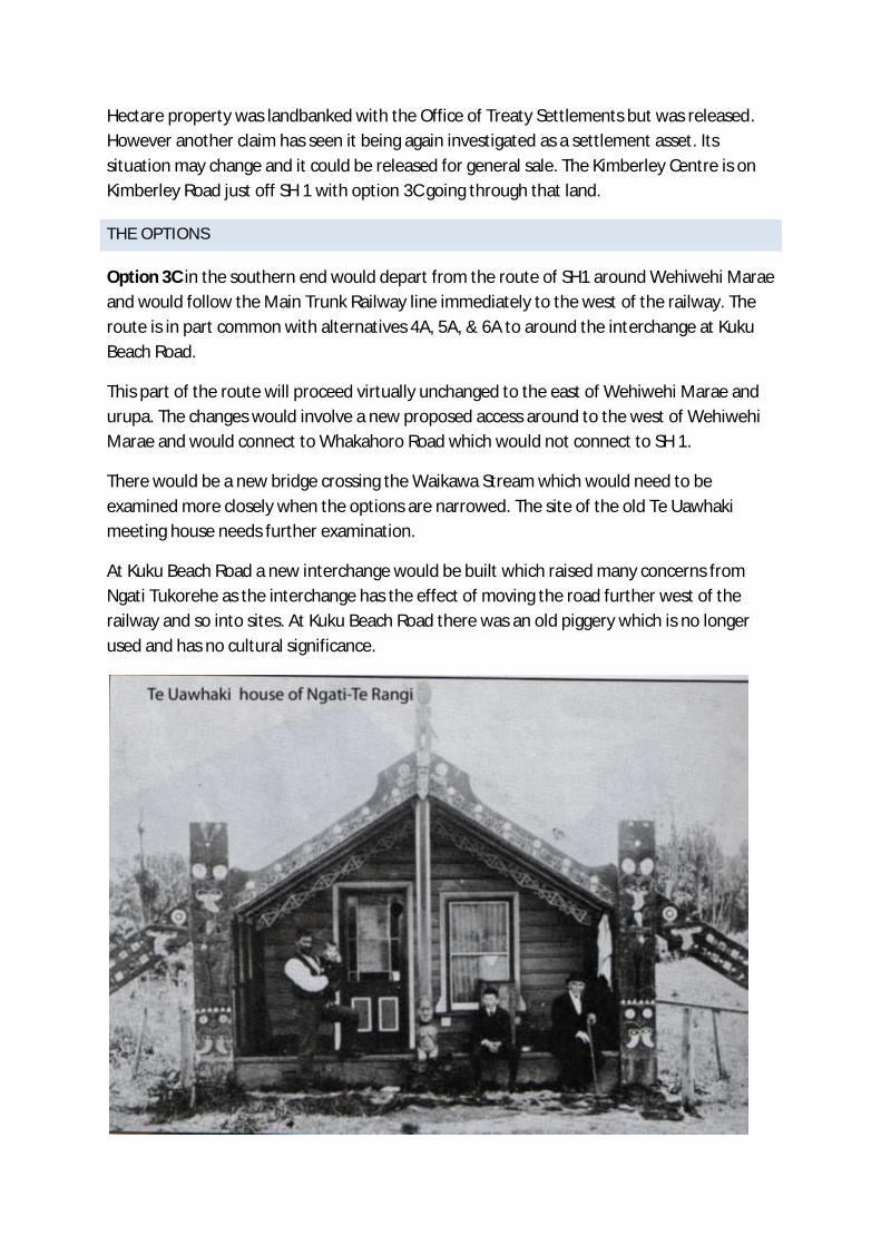
Hectare property was landbanked with the Office of Treaty Settlements but was released.
However another claim has seen it being again investigated as a settlement asset. Its
situation may change and it could be released for general sale. The Kimberley Centre is on
Kimberley Road just off SH 1 with option 3C going through that land.
THE OPTIONS
Option 3C in the southern end would depart from the route of SH1 around Wehiwehi Marae
and would follow the Main Trunk Railway line immediately to the west of the railway. The
route is in part common with alternatives 4A, 5A, & 6A to around the interchange at Kuku
Beach Road.
This part of the route will proceed virtually unchanged to the east of Wehiwehi Marae and
urupa. The changes would involve a new proposed access around to the west of Wehiwehi
Marae and would connect to Whakahoro Road which would not connect to SH 1.
There would be a new bridge crossing the Waikawa Stream which would need to be
examined more closely when the options are narrowed. The site of the old Te Uawhaki
meeting house needs further examination.
At Kuku Beach Road a new interchange would be built which raised many concerns from
Ngati Tukorehe as the interchange has the effect of moving the road further west of the
railway and so into sites. At Kuku Beach Road there was an old piggery which is no longer
used and has no cultural significance.

This house was close to the Waikawa Stream near SH1 on the south side of the river
This option however from Ohau north (Muhunoa Road – East and West) brought less
objection from Ngati Tukorehe. It is likely that the old Kimberley Centre would be cleared
from the Treaty Settlement Landbanking freeing it for sale by Mid- Central Health.
Overall from the cultural perspective this option is rated [ - - ]
Option 4A
This option has the problem of the Te Uawhaki site at Waikawa, however it location closer
to the Main Trunk Railway takes it away from patches of bush such as the Wehipeihana
bush. This option avoids the important urupa adjacent to the SH 1 Rail bridge just south of
the Ohau River (Ngati Tukorehe). The section of this option from the Ohau River north and
east, raised issues not only about Māori sites and the proposed road, but also about what
happens to maintain access after the existing old bridge(s) are closed. The river crossing of
the Ohau is probably a preferred location from the cultural perspective.
This option south of Muhunoa East Road stays clear of the important stand of totara which
has some cultural significance.
This option would go through a block of Maori land although little was known about this
block and the owners have not had a significant presence (Block Muhunoa 1B1B is managed
by the Maori Trustee). This route compared with 5A tends to cut the Māori block in half
making it much less useable.
Rating [ 0 ]
Option 5A
This option is similar to 4A going through the Te Uawhaki site at Waikawa and goes through
the more preferred route close to the west of the railway line. From just south of the Kuku
Beach Road this route swings west away from the railway. That route over to the Ohau River
swings eastward more or less parallel to Muhunoa East Road. In this route it runs to the
south of the large stand of totara. Like option 4A it cuts through the Maori block Muhunoa
1B1B, but in this case closer to the Ohau River and so the piece cut off that block is smaller
but on balance the effect is similar.
Rating [ 0 ]
Option 6A
This option is in common with the other options with respect to the Te Uawhaki site. This
route runs a little away from the rail in the south. The route veers west, south of Kuku Beach

Road and starts to split into two with the lane going to SH57 perhaps even cutting into the
Tukorehe Urupa. The route heads east more or less parallel to the Ohau River to cross the
river well upstream. This part of the route then heads over to the Arapaepae Road. From
the hapu perspective this is a very bad option. The SH1 route is also not acceptable cutting
into a number of sites before joining the existing SH1. Many from the hapu thought this
route was fatally flawed.
Rating [ - - ]
Option 7A
This option follows a very different route to the others but from the hapu perspective has
some attractive points. The route veers left off the existing SH 1 just south of the Wehiwehi
Marae and then crosses the Waikawa Stream avoiding Te Uawhaki and Wehiwehi and
crossing the railway to a new river bridge over the Waikawa stream to the east of the
existing SH1 and re-joining SHI. The route departs from the existing SH 1 where the road
turns due north and follows a similar direction which is around North East. The route
bifurcates with the SH1 section heading due north to Ohau joining the existing SH1 at the
Muhunoa Road intersection. On route this travels to the east of Tukorehe Marae without
going through any houses. That part crosses the Ohau River to the east of the existing
bridge. This part of the route is vey favoured by the hapu from Tukorehe who are land-
owners even along that part of the route. It is favoured because it avoids most if not all of
the sites of significance for Maori.
The part connecting to SH57 would head in a north easterly direction to cross the Ohau
River and joins Option 5A to connect to Arapaepae Road
Rating [+ ]
Option T
This option arose from the hui with Tukorehe and is a hybrid which takes part of the
alignment to the south of Ohau of option 7A. This option would not bifurcate to go to SH 57.
In this option it would connect with part of Option 3C at Ohau and to go along the present
SH 1 with the split with the route going through Kimberley and then to the SH 57.
The support for this proposal hinges in the section from Wehiwehi marae to Ohau village.
The significant sites for Māori in some places coincides with bush areas to the west of the
Railway line. This route avoids the stretch of SH 1 in front of Tukorehe Marae and would
significantly improve conditions there. There would also be significant improvements for
Wehiwehi as their frontage would become a local road.

This option does not involve two road bridges over the Ohau River as with 7A. The route
would involve some Māori land in the southern section, however in discussion with Māori
land owners they saw gains in this option compared with the others.
The section from Ohau along the existing SH 1 raised few issues for Māori. The route
through the old Kimberley centre raised few issues.
Rating [ + +]

APPENDIX 7: ŌTAKI TO LEVIN ROAD REALIGNMENT
PROPOSALS - LAND RESOURCES ASSESSMENT

1
Otaki to Levin Road Realignment
Proposals
Land Resources Assessment
October 2013
LandVision Ltd
PO Box 7191
WANGANUI

1 SUMMARY
In evaluating the six different proposals on soil quality and landuse, it highlighted the following:
The elite soils (the Levin silt loam soils) occur at the northern and southern ends of the realignment options. These
soils have negligible limitations to productive capability and are noted in both the District and Regional Plans.
Avoiding these elite soils is not practical or possible however some options have less impact than others.
At the southern end of the re-alignment, options 7A and T generally follow the existing road line through the elite soils
and the other options follow the railway line. Consequently all options have limited impact on these soils at the
southern end. At the northern end of the re-alignment, the options that have the greatest impact on the elite soils are
4A, 5A, 6A, 7A and T. The other options generally follow the existing road corridor but with some corner re-alignment.
Other soils within the area have varying productive potential. There is a large area of stony soils that has a lower
productive potential under pasture, however the soil physical properties are ideally suited to growing grapes. The Te
Horo silt loam soils on the intermediate terrace have the ability to grow grass but they can be prone to pugging and
treading damage by heavy cattle when wet. The Te Horo silt loam compared with the Levin soils is less suited to
market gardening due to the inability to work this soil in the spring and autumn.
There are approximately five dairy farms within the realignment area. The sizes of these units are considered small to
average. Four of the options have a significant impact to at least one or two of the dairy units (not always the same
dairy unit) making them an unviable economic unit(s) by reducing the productive land area or creating access issues
when the farm is divided. This is especially so where the road realignment is a cutting. None of the dairy properties
have a common boundary and there are no opportunities for land swapping to negate any access issues. The least
impact on dairying comes from options 5A and T.
The vineyard is located on stony soils that are particularly suited to grapes. The impact to the vineyard from the
different options varies significantly. Options 6A, 7A and T have insignificant impact whilst the other options will
reduce the grape canopy cover by between 5 ha and 10 ha.
The impact on gardening is difficult to ascertain. Often gardening land is leased to gardeners for 2 to 5 years and
then returned back to pastoral farming. Gardening however is generally concentrated on the good to elite soils (i.e.
the Levin and Manawatu soils and occasionally the Te Horo silt loam soils) and generally in small pockets.
The impact on land use and the soil quality from the six options was analysed using a scoring system from - - to ++ where
++ has less impact or degree of difficulty to achieve the re-alignment option. The overall results of this are shown in the
following table.
Option 3c Option 4a Option 5a Option 6A Option 7A Option T
Critical analysis
scoring (1-5)
+ _ 0 _ _ ++

2 TABLE OF CONTENTS
1 SUMMARY ........................................................................................................................................................................ 2
2 TABLE OF CONTENTS ..................................................................................................................................................... 3
3 BACKGROUND INFORMATION ....................................................................................................................................... 4
4 LAND RESOURCES ......................................................................................................................................................... 4
5 LANDUSE .......................................................................................................................................................................... 5
6 DISCUSSION .................................................................................................................................................................... 6
7 APPENDIX 1 – CRITICAL ANALYSIS SCORING CRITERIA ........................................................................................... 8
8 APPENDIX 2: SOIL RESOURCES.................................................................................................................................... 9
9 APPENDIX 3: LAND USE CAPABILITY .......................................................................................................................... 13
10 APPENDIX 4: MAPS FOR THE GENERAL AREA .......................................................................................................... 19
11 APPENDIX 5: SOIL MAP FOR THE VINEYARD ............................................................................................................ 24

3 BACKGROUND INFORMATION
MWH have requested land resource information along the lines of the different road realignment scenarios
between Otaki and Levin. In total there are six options that need to be investigated.
Access to the land along most options has been somewhat restrictive, so a range of information sources has been
relied on. The area occupied by the Ohau vineyard has been most closely investigated.
4 LAND RESOURCES
The land resources in the region have been described and evaluated according to the Land Resource Inventory
(LRI) and Land Use Capability (LUC) Classification system.
The LRI system involves mapping landscape units according to five inventory factors. These include rock type,
soil unit, slope class, erosion type and severity, and vegetation.
From the LRI assessment, the area was then classified into LUC classes according to the level of limitations
present for productive use. LUC classes range from class I land (elite land) through to class VIII land (no
productive value) The LUC classes are then further broken down according to the most dominant limitation to
production. These limitations include erosion, wetness, soil or climate. Finally the LUC unit is derived from a
combination of the LUC class and subclass along with the five land resource inventory factors. Hence it groups
land with similar productive capability, levels of limitations, and land resource inventory factors.
A detailed land resources survey was undertaken of the vineyard at a scale of 1:7,000 scale. Outside the
vineyard, the mapping scale was significantly reduced due to access and varied between 1:20,000 and 1:50,000
scale.
Appendix 2 and 3 details the soils and landuse capability units found in the area and the extent of these is shown
in Appendix 4. A detailed soils map of the vineyard is shown in Appendix 5.
The land resources present can best be described using the cross sectional diagram shown below.
Both the northern and southern parts of the area containing the six different options occur on the high terrace. The
soils present are the Levin silt loam and the Waitopu silt loam soils formed from moderately weathered quartzo
feldspathic loess derived from greywacke. The main difference between the two soils is the drainage with the
Levin series being well drained and the Waitopu series being moderately well drained. Both these soils

(particularly the Levin silt loam) are considered very elite soils and have very little physical limitations to intensive
land use.
The land use capability classification of the high terrace is class Ic1 land where it is flat. As this slope increases to
undulating or slightly rolling the LUC classification changes to class IIe1 or IIIe1 land.
In the middle of the cross section, the landforms drop down from the high terrace to the intermediate terrace. The
intermediate terrace is where the river level was during the last glaciation (8-15,000 yrs ago). Loess material was
blown from this terrace up on to the high terrace during the last glaciation. Since then the river has cut down
through the gravels of the intermediate terrace to its current level on the low terrace.
On the intermediate terrace the soils are formed from deep alluvial gravels derived from greywacke. The stone
content and the depth of topsoil or soil development will vary significantly and will determine the soil type present.
Where the soils are well drained and there is greater than 35% content of stone present the soils are classified as
the Ashhurst stony series. Where there is less than 35% stone content they are classed as Te Horo soils. Where
the drainage is imperfectly to poor then they are called the Paraha stony silt loam soils.
The landuse capability units found on the intermediate terrace are influenced by soil type or depth to the stones.
Where there is significant soil depth they are classified as Class IIs3 land. As the soil depth decreases, so does
the classification to class IIIs2 land.
On the low terrace the drainage patterns and the soil texture also influence the soil type. The free draining areas
prone to frequent flooding are the Rangitikei series whilst the poorly drained soils prone to flooding are the
Parawanui series. On a slightly elevated part of this terrace that is well drained are the Manawatu series. These
soils are also prone to flooding but very infrequently.
The landuse capability classification of the low terrace reflects the drainage class and texture present. Those
areas of free draining Manawatu soils are classed as IIs1 land whilst the poorer draining Parawanui series are
classified as IIIw1 land.
5 LANDUSE
Landuse with the area was determined from a combination of ‘on the ground visual’ and the use of the Land Cover
Data Base (2008). The dominant economic land uses include dairying (estimated 5 dairy farms within the area),
dry stock farming, gardening (vegetable crops), horticulture, and grapes (44 hectares).
The extent of gardening in the region is never fixed. Often the land that is gardened is leased for several years
before returning back to pastoral farming.
When determining the impacts on dairying several things are taken into account. These include the amount of
area lost to production, whether this reduced area renders the property unviable, whether the new road will create
access difficulties if the property is divided. Also considered is the ability to undertake land swaps as a result of
dividing properties.
When considering production losses for dairying, typical production figures on this sort of country should be
producing 1,200 kg milk solids per hectare at $7/kg ($8,400/ha gross). Approximately half of this will be production
costs. The minimum size for an economic dairy unit is about 180-250 cows and is dependent on debt levels.
The financial impact on grapes can be based on the lost area. Currently grapes are net returning around $10K per
hectare.

6 DISCUSSION
Generally the soil types and land forms run perpendicular to the proposed re-alignment options. The elite soils are
found at the northern and southern boundaries up on the high terrace. In between these elite soils are a range of
soil types where the quality can vary significantly from very stony gravels with limited topsoil through to deep
alluvial soils with very few limitations.
Ideally elite soils should be kept for production purposes and policies in both the District and Regional Plans
promote this. In this situation however, it is not practical or possible to avoid the elite soils with any of the options.
What is possible is to minimise their destruction by locating the options along existing roading corridors or
adjacent to the railway line. To a certain degree this has happened, especially in the southern part of the area.
Since avoidance of elite soils is not possible or practical then consideration needs to be given to landuse within
the proposed re-alignment area. To minimise the impact on productivity, emphasis needs to be placed on avoiding
economic units or at least minimising the impact to these. The following table summarises the impact on landuse
from the different options.
Option 3c Option 4a Option 5a Option 6A Option 7A Option T
Probably
significantly affects
one dairy unit
potentially making it
unviable (removes
10 ha from a 55 ha
dairy unit – 12,000
kg MS reduction).
Minor effect on
another dairy unit.
Significant impact
on the vineyard
(probably affecting
9 ha out of 44 ha –
estimated $90K per
year net reduction).
Some effect on
gardening but not
sure of the extent.
Probably
significantly
affects one dairy
unit potentially
making it unviable
(removes 10 ha
from a 55 ha dairy
unit – 12,000 kg
MS reduction).
Minor effect on
another dairy unit
Significant impact
on the vineyard
(probably
affecting 9 ha out
of 44 ha –
estimated $90K
per year net
reduction when
vineyard fully
productive).
Some effect on
gardening but not
sure of the extent.
Reduction in
canopy of
vineyard by about
5.8 ha ($58K/yr
net income).
Greatest impact
appears to be on
dry stock farming
plus lifestyle
blocks. Plus some
gardening.
The Manawatu
soils are slowly
accumulating and
can be prone to
infrequent
flooding (once
every 5-10 years).
Significant impact
on two dairy units
– probably making
one marginally
viable (removal of
10 ha out of an
estimated 80 ha)
and creating
access difficulties
through the other.
Approach to the
Ohau River
(Shannon branch)
is on an outside
bend which would
require armouring.
Probably affects
about 3.5 ha of
grapes.
Dissects 3 dairy
units probably
making 2 of
them unviable.
Certainly
creates access
difficulties.
Minor impact on 2
dairy units
creating access
difficulties only.
Impact on the
vineyard
(probably
affecting around
1.8 ha out of 44
ha – estimated
$18 K per year
net reduction
when vineyard
fully productive).
Limited impact on
access apart from
needing to cross
the state highway.
This approach is not suggesting that smaller blocks with non-traditional farming land uses have no value. It does
work on the principle that their productive opportunities are significantly reduced when compared with a larger
property.

Following consideration of above the impact of the different options on landuse and soil resources was evaluated
using the method described in Appendix 1. The results of this are shown in the following table.
Option 3c Option 4a Option 5a Option 6A Option 7A Option T
Critical analysis
scoring
+ _ 0 _ _ ++

7 APPENDIX 1 – CRITICAL ANALYSIS SCORING CRITERIA
The following table details the scoring descriptions used in the evaluation.
SCORE DESCRIPTION
++ Route option is, on average, very good in terms of this attribute
+ Route option is, on average, good in terms of this attribute
0 Route option is neutral, or neither good or problematic, on average, in terms of this attribute
– Route option includes, on average, minor or intermediate issues or concerns in terms of this attribute
– – Route option includes, on average, major or intermediate issues or concerns in terms of this attribute

8 APPENDIX 2: SOIL RESOURCES
The following table describes the dominant soils found in the general area of the different scenarios.
Name: Ashhurst stony silt loam.
LUC map symbol: AH2
Parent material: Alluvium over gravels.
Drainage status: Well drained.
Soil consistence: Friable when moist, plastic when wet.
Degree of topsoil development: Moderately to weakly developed.
Compaction susceptibility: Low.
Profile description: 10-15 cm moderately to weakly developed, medium nut and
crumb, friable when moist, plastic when wet, dark blackish brown (10 YR 2/2) stony
silt loam with few fine to small gravels. On: 20 cm weakly developed, medium to fine
crumb and nut, very friable when moist, plastic when wet, dark blackish brown (10
YR 2/2) stony silt loam with profuse small to medium gravels. On: weakly developed,
medium to fine crumb and nut, very friable when moist, plastic when wet, dark
yellowish brown (10 YR 5/4) stony silt loam with profuse small to medium gravels.
On alluvium over gravels.
Comments: Predominant soil on the property found on the intermediate terrace.
Management considerations: Ideal soil for growing grapes due to fertility and
drainage.
Name: Te Horo stony silt loam
LUC map symbol: TH1
Parent material: Alluvium over gravels.
Drainage status: Moderately well drained.
Soil consistence: Friable when moist, plastic when wet.
Degree of topsoil development: Moderately to weakly developed.
Compaction susceptibility: Low.
Profile description: 15cm moderately to weakly developed, medium nut and
crumb, friable when moist, plastic when wet, dark yellowish brown (10 YR 3/3) stony
silt loam with few fine to small gravels. On: weakly developed, medium to fine crumb
and nut, very friable when moist, plastic when wet, yellowish brown (10 YR 5/6)
stony silt loam with profuse small to medium gravels. On alluvium over gravels.
Comments: Found on the intermediate terrace.
Management considerations: Ideal soil for growing grapes due to fertility and
drainage.

Name: Paraha stony silt loam
LUC map symbol: Pa2
Parent material: Alluvium over gravels.
Drainage status: Imperfectly drained.
Soil consistence: Friable when moist, plastic when wet.
Degree of topsoil development:
Compaction susceptibility: Moderate.
Profile description: 15-20 cm moderately to weakly developed, medium nut and
crumb, friable when moist, plastic when wet, greyish brown (10 YR 5/2) fine stony
silt loam with few fine to small gravels. On: weakly developed, medium to fine crumb
and nut, very friable when moist, plastic when wet, brown (10 YR 5/3) stony silt loam
with profuse small to medium gravels. On alluvium over gravels.
Comments: Found on the intermediate terrace.
Management considerations: Limited area of this soil. Care with machinery when
wet to minimise compaction damage.
Name: Parewanui silt loam.
LUC map symbol: P1
Parent material: Alluvium over gravels.
Drainage status: Imperfectly to poorly drained.
Soil consistence: Friable when moist, very plastic when wet.
Degree of topsoil development: Moderately to weakly developed.
Compaction susceptibility: High.
Profile description: 12-15 cm moderately to weakly developed, medium nut and
crumb, friable when moist, very plastic when wet, greyish brown 10 YR 4/2 silt loam
with few gley and orange mottles. On: moderately to weakly developed, medium nut
and crumb, friable when moist, very plastic when wet, light greyish brown 10 YR 4/3
silt loam with few to many gley and orange mottles and many small to medium
gravels. On alluvium over gravels.
Comments: Found on the lower terrace.
Management considerations: Limited area of this soil. Less suited to growing
grapes due to poorer drainage. Care with machinery when wet to minimise
compaction damage.

Name: Levin silt loam.
Soil map symbol: L1
Parent material: Loess.
Drainage status: Moderately well drained.
Soil consistence: Friable when moist, plastic when wet.
Degree of topsoil development: Moderately to weakly developed.
Pugging susceptibility: Moderate to low.
Effluent application risk: Low.
Profile description: 25 cm moderately to weakly developed, fine to medium nut
and crumb, friable when moist, plastic when wet, 10 YR 4/3 silt loam. On:
moderately to weakly developed, fine to medium nut and crumb, friable when moist,
plastic when wet, 10 YR 6/6 fine sandy silt loam. On loess.
Comments: Levin silt loam is a well drained soil having a dark brown, well
structured, friable silt loam textured A horizon overlying yellowish brown nd brownish
yellow, friable, generally non mottled silt loam or silty clay loam textured Bw horizons
with moderately developed nut and granular structure. Wet consistence is smeary
and non sticky throughout, with the upper Bw horizon having a weak to moderate
reaction to the NaF field test. Matrix colours are always yellowish brown or brownish
yellow throughout. Few (up to 2%) low chroma colours can occur with the Levin silt
loam but usually only at depths exceeding 80 cm. few (up to 2%) ochreous mottles
sometimes occur between 60 and 80 cm.
Name: Manawatu fine sandy loam
LUC map symbol: M3
Parent material: Recent undifferentiated alluvium.
Drainage status: Moderately well to well drained.
Soil consistence: Friable when moist, slightly plastic when wet.
Degree of topsoil development: Weakly developed.
Profile description: 12 cm weakly developed, fine crumb and nut, friable when
moist, slightly plastic when wet, pale orange grey (WO 1e) fine sandy silt. On:
weakly developed, fine crumb and nut, friable to loose when moist, slightly plastic
when wet, greyish weak orange (WO 2d) fine sandy silt. On recent undifferentiated
alluvium.
Comments: found on the low terrace. Prone to occasional flooding. Potential for
seasonal soil moisture deficits. Potential for wind erosion if vegetative cover is
removed.
Management considerations: Use cultivation methods such as zero-tillage and
direct drilling to maintain vegetative cover.
Name: Waitohu silt loam
LUC map symbol: W1
Parent material: Moderately weathered, stiff, uncemented, quartzo-feldspathic
loess from greywacke.
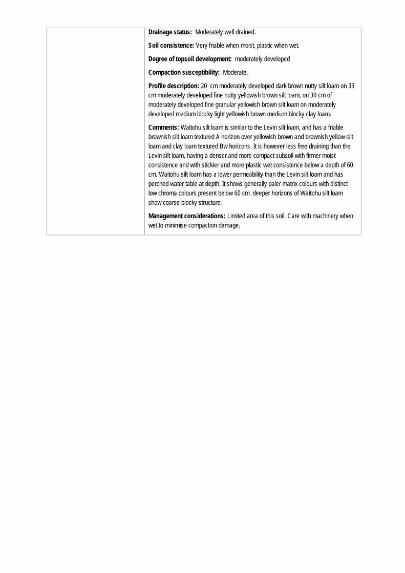
Drainage status: Moderately well drained.
Soil consistence: Very friable when moist, plastic when wet.
Degree of topsoil development: moderately developed
Compaction susceptibility: Moderate.
Profile description: 20 cm moderately developed dark brown nutty silt loam on 33
cm moderately developed fine nutty yellowish brown silt loam, on 30 cm of
moderately developed fine granular yellowish brown silt loam on moderately
developed medium blocky light yellowish brown medium blocky clay loam.
Comments: Waitohu silt loam is similar to the Levin silt loam, and has a friable
brownish silt loam textured A horizon over yellowish brown and brownish yellow silt
loam and clay loam textured Bw horizons. It is however less free draining than the
Levin silt loam, having a denser and more compact subsoil with firmer moist
consistence and with stickier and more plastic wet consistence below a depth of 60
cm. Waitohu silt loam has a lower permeability than the Levin silt loam and has
perched water table at depth. It shows generally paler matrix colours with distinct
low chroma colours present below 60 cm. deeper horizons of Waitohu silt loam
show coarse blocky structure.
Management considerations: Limited area of this soil. Care with machinery when
wet to minimise compaction damage.

9 APPENDIX 3: LAND USE CAPABILITY
This section details the Land Use Capability units found in the general area of the different scenarios and that within the vineyard property.
9.1 General Area Land Use Capability
LUC description Parent material Dominant soil
type
Slope (0) Strengths Limitations Landuse
suitability
Conditions of use
Ic1
Flat to gently undulating, high and
medium-height terraces with a
mantle of loess and minor tephra.
The soils are deep, fertile and
well drained. The terraces
typically occur between 10-60 m
a.s.l. where rainfall is 1000-1200
mm p.a. Occurs between
Shannon and Otaki.
Loess and minor
tephra.
Levin silt loam
(L1)
0-3 Contour.
Access.
Deep, fertile soils.
Good natural
drainage.
Potential to dry out
slightly in the
summer.
Intensive pastoral
farming.
Maintain soil health and
fertility.

LUC description Parent material Dominant soil
type
Slope (0) Strengths Limitations Landuse
suitability
Conditions of use
IIe1
Undulating high and medium-
height terraces with a mantle of
loess and minor tephra. The soils
are deep, fertile and well drained.
There is a potential for slight
sheet and rill erosion when
cultivated. Occurs in the Levin
district.
Loess and minor
tephra.
Levin silt loam
(L1)
4-7 Contour.
Access.
Deep, fertile soils.
Good natural
drainage.
Potential for slight
sheet and rill erosion
when cultivated.
Intensive pastoral
farming.
Care with cultivation to
avoid sheet and rill erosion.
Use minimum tillage
techniques.
IIs1
Flat, low river terraces and levees
of the floodplains with alluvial
soils. The soils are sandy in
texture and moderately deep
overlying gravels. They are fertile
and well drained although they
tend to dry out in summer.
Occurs on Manawatu, Ohau and
Waikanae floodplains.
Fine-grained
alluvium.
Manawatu fine
sandy loam
(M3).
0-3 Contour.
Access.
Deep, fertile soils.
Good natural
drainage.
Potential to dry out
slightly in the
summer.
Potential for slight
streambank erosion
where adjacent to a
stream.
Intensive pastoral
farming.
Avoid over-cropping.
Maintain soil health and
fertility.
Plant shrub willows on
pressure points of the
stream.

LUC description Parent material Dominant soil
type
Slope (0) Strengths Limitations Landuse
suitability
Conditions of use
IIs3
Flat, medium-height alluvial
terraces with well drained,
moderately deep soils overlying
gravel. Soils dry out in summer.
Fine-grained
alluvium over
gravels.
Te Horo silt
loam (TH1)
0-3 Contour.
Access.
Good natural
drainage.
Dries out in the
summer.
Intensive pastoral
farming.
Care with cultivation to
avoid soil exposure to wind
erosion. Use minimum
tillage techniques.
Maintain a vegetative cover
through grazing
management and soil
fertility.
IIIe1
Dissected terrace land formed
from unconsolidated sands and
conglomerate. Soils are
intergrades between yellow-
brown earths and yellow-brown
loams developed from loess and
minor tephra. Potential for
moderate sheet and rill erosion
when cultivated.
Loess and minor
tephra.
Waitohu silt
loam (W1)
4-15 Contour.
Access.
Good natural
drainage.
Potential for
moderate sheet and
rill erosion when
cultivated.
Intensive pastoral
farming.
Contour cultivation to
reduce potential for sheet
and rill erosion.
Use minimum tillage
techniques.

LUC description Parent material Dominant soil
type
Slope (0) Strengths Limitations Landuse
suitability
Conditions of use
IIIw1
Flat, narrow alluvial valley floors
with imperfectly to poorly drained
soils developed from fine-grained
alluvium.
Fine-grained
alluvium over
gravels.
(Al/Gr)
Parewanui silt
loam (P1)).
0-3 (A) Contour.
Access.
Fertile soils.
Potential for
compaction from
machinery when soils
are wet.
Prone to occasional
flooding (every 5
years).
Moderately high
water table.
Vineyard. Avoid compaction from
machinery.
Maintain soil health and
fertility.
IIIs2
Flat, medium height alluvial
terraces with somewhat
excessively drained soils
developed from stony alluvium.
Alluvium over
gravels.
(Al/Gr)
Ashhurst stony
silt loam (AH2).
Te Horo stony
silt loam (TH1)).
Paraha stony
silt loam (Pa2).
0-3 (A) Contour.
Access.
Good drainage.
May dry out in
summer.
Vineyard. Maintain soil health and
fertility.

LUC description Parent material Dominant soil
type
Slope (0) Strengths Limitations Landuse
suitability
Conditions of use
VIIs2
Flat river terraces in with alluvial
soils varying in texture from
coarse sandy to bouldery. Soils
are free draining and subject to
periods of soil moisture deficits.
Some areas may be prone to
flooding.
Gravels & coarse
alluvium.
Rangitikei
series (R1)
0-3 No susceptibility for
pugging or treading
damage.
Ideal winter cattle
country.
Sheltered country.
Low natural fertility.
Summer dry.
Limited pasture
production potential
during summer and
autumn.
Some areas prone to
flooding.
Extensive
pastoral farming.
Winter feed pad
potential.
Maintain vegetative cover
during summer.
Consider fertiliser policy for
N based rather than P
based due to the summer
dryness.
Protection planting of
stream banks.

9.2 Vineyard Land Use Capability
The following table describes the land resource inventory and land use capability units (LUC) units found on the vineyard.
LUC description Total
Area
(ha)
Parent
material
Dominant
soil type
Slope
(degrees)
Vegetatio
n
Area
(ha)
Strengths Limitations Landuse
suitability
Conditions of use
IIIw1
Flat, narrow alluvial valley floors
with imperfectly to poorly drained
soils developed from fine-grained
alluvium.
0.3 Fine-grained
alluvium
over
gravels.
(Al/Gr)
Parewanui
silt loam
(P1).
0-3 (A) Vineyard
(cG).
0.3 Contour.
Access.
Fertile soils.
Potential for
compaction from
machinery when
soils are wet.
Prone to
occasional
flooding (every 5
years).
Moderately high
water table.
Vineyard. Avoid compaction from
machinery.
Maintain soil health and
fertility.
IIIs2
Flat, medium height alluvial
terraces with somewhat
excessively drained soils
developed from stony alluvium.
44.3 Alluvium
over
gravels.
(Al/Gr)
Ashhurst
stony silt
loam
(AH1).
Te Horo
stony silt
loam
(TH1).
Paraha
stony silt
loam
(Pa2).
0-3 (A) Vineyard
(cG).
44.3 Contour.
Access.
Good drainage.
May dry out in
summer.
Vineyard. Maintain soil health and
fertility.

10 APPENDIX 4: MAPS FOR THE GENERAL AREA


11 APPENDIX 5: SOIL MAP FOR THE VINEYARD

APPENDIX 8: SH1-SH57 MCA OPTIONS EVALUATION,
HYDROLOGY ASSESSMENT

SH1 - SH57 MCA Options Evaluation: Hydrology
Assessment
Prepared for NZTA
30/10/2013


SH1 - SH57 MCA Options Evaluation: Hydrology AssessmentSH1i - SH57 MCA Options Evaluation: Hydrology Assessment
Status: Draft Project No.: 80500902 30/10/2013 Our ref: \\NZWGN1s01\Projects\Z19000up\Z19257 - Levin- Otaki\80500902 Otaki_Levin I&R PFRs\2 Technical_Deliverables\0602 Scoping Report 1_SH1 SH57\MCA Workshop\Report\Appendix 8 - SH1 to SH57 MCA Hydrology Report .docx
This document has been prepared for the benefit of NZTA. No liability is accepted by this company or any employee or sub-consultant of this company with respect to its use by any other person.
This disclaimer shall apply notwithstanding that the report may be made available to other persons for an application for permission or approval to fulfil a legal requirement.
QUALITY STATEMENT
PROJECT MANAGER PROJECT TECHNICAL LEAD
Jon England
PREPARED BY
……… …............... …30/10/2013… Kristin Stokes
CHECKED BY
………… ............ …25/11/2013 Alistair Osborne
REVIEWED BY
……… ………............... …25/11/2013 Tom Kerr
APPROVED FOR ISSUE BY
………………………………............... ……/……/……
WELLINGTON Level 1, 123 Taranaki Street, Wellington 6011 PO Box 9624, Te Aro, Wellington 6141 TEL +64 4 381 6700, FAX +64 4 381 6739

SH1 - SH57 MCA Options Evaluation: Hydrology AssessmentSH1i - SH57 MCA Options Evaluation: Hydrology Assessment
Status: Draft 30/10/2013 Project No.: 80500902 Our ref: Appendix 8 - SH1 to SH57 MCA Hydrology Report .docx
NZTA
SH1 - SH57 MCA Options Evaluation: Hydrology Assessment
CONTENTS
1 Introduction ......................................................................................................................................... 1
2 Data Collection ................................................................................................................................... 1
3 Hydrology ........................................................................................................................................... 1
4 Flood Frequency Analysis .................................................................................................................. 3
4.1 Uncertainty and Climate Change ................................................................................................... 4
5 HEC-RAS Model Build ........................................................................................................................ 4
6 Modelling Results ............................................................................................................................... 8
6.1 Flood levels ................................................................................................................................... 8
7 Options Assessment ......................................................................................................................... 15
7.1 Crossings ..................................................................................................................................... 15
7.2 Option 6A Alignment ...................................................................................................................... 1
LIST OF TABLES
Table 6-1: Modelled 1% AEP water levels in the Ohau River .................................................................. 8
Table 7-1: Scoring Guide ....................................................................................................................... 15
Table 7-2: Option Scores ......................................................................................................................... 1
LIST OF FIGURES
Figure 3-1: Ohau River Catchment and Ohau at Rongomatane Level Recorder Location ........................ 1
Figure 3-2: Ohau River Aerial Photo 1942 (existing SH1 road alignment shown in red) ........................... 2
Figure 3-3: Ohau River Aerial Photo 1999 (existing SH1 road alignment shown in red) ........................... 2
Figure 4-1: Flood Frequency analysis provided by Horizons Regional Council, including historic floods. . 3
Figure 5-1: Extension of cross section 53 using LiDAR ............................................................................. 4
Figure 5-2: HEC-RAS model extent and cross section locations ............................................................... 6
Figure 5-3: LiDAR of riverbed and floodplain ............................................................................................. 7
Figure 6-1: Long Section Profile of Modelled 1% AEP ............................................................................... 9
Figure 6-2: Flood Extent of 1% AEP dark blue is 1% AEP plus 20% uncertainty .................................... 10
Figure 6-3: 1% AEP Water levels at cross section 45 SH1 Bridge, 2011 extended survey ..................... 11
Figure 6-4: 1% AEP Flood extent at cross section 45 SH1 Bridge, 2011 extended survey. Dark blue is 1% AEP plus 20% uncertainty. ................................................................................................................ 11
Figure 6-5: 1% AEP Water levels at cross section 47, 2011 extended survey ........................................ 12
Figure 6-6: Flood extent at cross section 45 SH1 Bridge, 2011 extended survey ................................... 12
Figure 6-7: 1% AEP Water levels at cross section 48 SH1 Bridge, 2011 extended survey ..................... 13

SH1 - SH57 MCA Options Evaluation: Hydrology AssessmentSH1i - SH57 MCA Options Evaluation: Hydrology Assessment
Status: Draft 30/10/2013 Project No.: 80500902 Our ref: Appendix 8 - SH1 to SH57 MCA Hydrology Report .docx
Figure 6-8: Flood extent at cross section 48 SH1 Bridge, 2011 extended survey ................................... 13
Figure 6-9: 1% AEP Water levels at cross section 52, 2011 extended survey ........................................ 14
Figure 6-10: Flood extent at cross section 47, 2011 extended survey ..................................................... 14
Figure 7-1: Alignments of the five Options around the Ohau River .......................................................... 16
Figure 7-2: Flood Levels and Option 6A Alignment levels ......................................................................... 2
Figure 7-3: Path of Option 6A Alignment used for elevation (road alignment highlighted in yellow) .......... 2
Figure A-1: Catchment Rainfall Map (Source: http://wrenz.niwa.co.nz/webmodel/) .................................. 1
Figure B-1: Catchment Mean Runoff Map (Source: http://wrenz.niwa.co.nz/webmodel/) .......................... 1
APPENDICES
Appendix A Rainfall Distribution Map
Appendix B Runoff Distribution Map
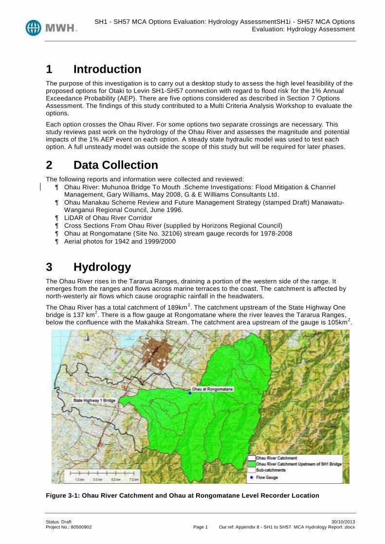
SH1 - SH57 MCA Options Evaluation: Hydrology AssessmentSH1i - SH57 MCA Options Evaluation: Hydrology Assessment
Status: Draft 30/10/2013 Project No.: 80500902 Page 1 Our ref: Appendix 8 - SH1 to SH57 MCA Hydrology Report .docx
1 Introduction The purpose of this investigation is to carry out a desktop study to assess the high level feasibility of the proposed options for Otaki to Levin SH1-SH57 connection with regard to flood risk for the 1% Annual Exceedance Probability (AEP). There are five options considered as described in Section 7 Options Assessment. The findings of this study contributed to a Multi Criteria Analysis Workshop to evaluate the options.
Each option crosses the Ohau River. For some options two separate crossings are necessary. This study reviews past work on the hydrology of the Ohau River and assesses the magnitude and potential impacts of the 1% AEP event on each option. A steady state hydraulic model was used to test each option. A full unsteady model was outside the scope of this study but will be required for later phases.
2 Data Collection The following reports and information were collected and reviewed:
Ohau River: Muhunoa Bridge To Mouth .Scheme Investigations: Flood Mitigation & Channel Management, Gary Williams, May 2008, G & E Williams Consultants Ltd.
Ohau Manakau Scheme Review and Future Management Strategy (stamped Draft) Manawatu-Wanganui Regional Council, June 1996.
LiDAR of Ohau River Corridor
Cross Sections From Ohau River (supplied by Horizons Regional Council)
Ohau at Rongomatane (Site No. 32106) stream gauge records for 1978-2008
Aerial photos for 1942 and 1999/2000
3 Hydrology The Ohau River rises in the Tararua Ranges, draining a portion of the western side of the range. It emerges from the ranges and flows across marine terraces to the coast. The catchment is affected by north-westerly air flows which cause orographic rainfall in the headwaters.
The Ohau River has a total catchment of 189km2. The catchment upstream of the State Highway One
bridge is 137 km2. There is a flow gauge at Rongomatane where the river leaves the Tararua Ranges,
below the confluence with the Makahika Stream. The catchment area upstream of the gauge is 105km2.
Figure 3-1: Ohau River Catchment and Ohau at Rongomatane Level Recorder Location

SH1 - SH57 MCA Options Evaluation: Hydrology AssessmentSH1i - SH57 MCA Options Evaluation: Hydrology Assessment
Status: Draft 30/10/2013 Project No.: 80500902 Page 2 Our ref: Appendix 8 - SH1 to SH57 MCA Hydrology Report .docx
The rainfall map provided by NIWA shows that the mean catchment rainfall is 2204 mm, however the mean annual rainfall varies considerably across the catchment, from above 4000mm in the headwaters in the Tararua Ranges to 1000mm on the coastal plains (refer to Appendix A). Mean annual runoff follows a very similar pattern with high runoff in the ranges and much lower runoff on the coastal plains (refer to Appendix B).
Figure 3-2: Ohau River Aerial Photo 1942 (existing SH1 road alignment shown in red)
Figure 3-3: Ohau River Aerial Photo 1999 (existing SH1 road alignment shown in red)
The aerial photos from 1942 and 1999 (Figure 3-2 and Figure 3-3) show that the river channel has drifted south, closer to Option 6A and the river bends around Option 6A and 7A bridges have migrated downstream. It appears that there is active erosion where the Option 6A and 7A bridges leave the left bank. A willow planting scheme may account for some of the increase in vegetation on the edges of the riverbed.

SH1 - SH57 MCA Options Evaluation: Hydrology AssessmentSH1i - SH57 MCA Options Evaluation: Hydrology Assessment
Status: Draft 30/10/2013 Project No.: 80500902 Page 3 Our ref: Appendix 8 - SH1 to SH57 MCA Hydrology Report .docx
4 Flood Frequency Analysis The design level for Roads of National Significance is that “the finished surface level of the expressway main alignment pavement shall have a 500mm freeboard to the 1% AEP flood level where crossing floodplains”.
The Horizons Regional Council carried out a flood frequency analysis for the Ohau at Rongomatane flow gauge site. When historic floods in 1940, 1949, 1950 and 1959 were included they found the 1 % AEP flood peak was 656 m
3/s including flow measurements up to 2006. Analysis was undertaken for this
study using Tideda for flow gauge data from July 1978 to January 2008 provided by Horizons Regional Council. Using the Log Pearson III Distribution, and without the historic floods this provided a 1% AEP of 652 m
3/s650 m
3/s was adopted as the 1% AEP flood flow at the Ohau at Rongomatane flow gauge for
input to the hydraulic model. This was the value used by Williams (2008).
The flow gauge is located 12.6km upstream of the State Highway 1 Bridge. To account for the 32km2 of
catchment that contributes to the Ohau River between the flow gauge at Rongomatane and the State Highway One bridge the peak flow was adjusted by a factor of 1.31 (based on the difference in catchment size) to give a 1% AEP estimate of 850 m
3/s. This is likely to be a conservative estimate as
the rainfall in the additional 32 km2 is between 1000 and 1500 mm compared to rainfall in excess of
4000 in the upper reaches of the catchment.
Figure 4-1: Flood Frequency analysis provided by Horizons Regional Council, including historic floods.
2.33 5 10 20 50 100 200
y = 5.2369x2 + 69.221x + 183.56 R² = 0.9798
0
100
200
300
400
500
600
700
800
-2 0 2 4 6
Flo
w (
m3
/s)
Gumbel Reduced Variate (y)
Fitted Extreme Value Distribution of Annual Flow Maxima for Ohau at
Rongomatane (1979-2006 Incl + 4 Historic Since 1940)
Annual Maxima GEV by L Moments
Log Pearson 3 Poly. (Annual Maxima)
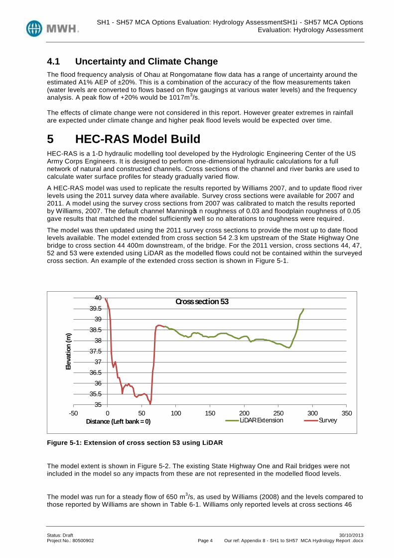
SH1 - SH57 MCA Options Evaluation: Hydrology AssessmentSH1i - SH57 MCA Options Evaluation: Hydrology Assessment
Status: Draft 30/10/2013 Project No.: 80500902 Page 4 Our ref: Appendix 8 - SH1 to SH57 MCA Hydrology Report .docx
4.1 Uncertainty and Climate Change
The flood frequency analysis of Ohau at Rongomatane flow data has a range of uncertainty around the estimated A1% AEP of ±20%. This is a combination of the accuracy of the flow measurements taken (water levels are converted to flows based on flow gaugings at various water levels) and the frequency analysis. A peak flow of +20% would be 1017m
3/s.
The effects of climate change were not considered in this report. However greater extremes in rainfall are expected under climate change and higher peak flood levels would be expected over time.
5 HEC-RAS Model Build HEC-RAS is a 1-D hydraulic modelling tool developed by the Hydrologic Engineering Center of the US Army Corps Engineers. It is designed to perform one-dimensional hydraulic calculations for a full network of natural and constructed channels. Cross sections of the channel and river banks are used to calculate water surface profiles for steady gradually varied flow.
A HEC-RAS model was used to replicate the results reported by Williams 2007, and to update flood river levels using the 2011 survey data where available. Survey cross sections were available for 2007 and 2011. A model using the survey cross sections from 2007 was calibrated to match the results reported by Williams, 2007. The default channel Manning’s n roughness of 0.03 and floodplain roughness of 0.05 gave results that matched the model sufficiently well so no alterations to roughness were required.
The model was then updated using the 2011 survey cross sections to provide the most up to date flood levels available. The model extended from cross section 54 2.3 km upstream of the State Highway One bridge to cross section 44 400m downstream, of the bridge. For the 2011 version, cross sections 44, 47, 52 and 53 were extended using LiDAR as the modelled flows could not be contained within the surveyed cross section. An example of the extended cross section is shown in Figure 5-1.
Figure 5-1: Extension of cross section 53 using LiDAR
The model extent is shown in Figure 5-2. The existing State Highway One and Rail bridges were not included in the model so any impacts from these are not represented in the modelled flood levels.
The model was run for a steady flow of 650 m3/s, as used by Williams (2008) and the levels compared to
those reported by Williams are shown in Table 6-1. Williams only reported levels at cross sections 46
35
35.5
36
36.5
37
37.5
38
38.5
39
39.5
40
-50 0 50 100 150 200 250 300 350
Ele
vati
on
(m
)
Distance (Left bank = 0)
Cross section 53
LiDAR Extension Survey
SH1 - SH57 MCA Options Evaluation: Hydrology AssessmentSH1i - SH57 MCA Options Evaluation: Hydrology Assessment
Status: Draft 30/10/2013 Project No.: 80500902 Page 5 Our ref: Appendix 8 - SH1 to SH57 MCA Hydrology Report .docx
and 53 within the model extent. A steady state model for the increased flows of 850 m3/s at the bridge,
and the additional uncertainty factor of + 20%, 1017 m3/s were modelled.
An unsteady state model was not run as it was outside the scope of this study. Any backwater and volumetric effects are therefore not considered.
The results were mapped using RAS-Mapper which is a built in tool within HEC-RAS which uses the water surface profile calculated by HEC-RAS and creates a floodplain boundary based on a digital elevation model of the underlying terrain. This provides an indication of the flood extents based on the terrain but assumes a constant water level across the entire cross section and lateral flows are not accounted for within HEC-RAS.
The intention was not to create a new hydraulic model. Rather the intention was to use HEC-RAS to replicate the results reported by Williams to allow the extents he found to be mapped and compared to the route option locations. It has also enabled an investigation of the effects of the updated survey and increased flow at the location of interest. The LiDAR digital terrain model used for the floodplain boundary mapping is shown in Figure 5-3.

SH1 - SH57 MCA Options Evaluation: Hydrology AssessmentSH1i - SH57 MCA Options Evaluation: Hydrology Assessment
Status: Draft 30/10/2013 Project No.: 80500902 Page 6 Our ref: Appendix 8 - SH1 to SH57 MCA Hydrology Report .docx
Figure 5-2: HEC-RAS model extent and cross section locations

SH1 - SH57 MCA Options Evaluation: Hydrology AssessmentSH1i - SH57 MCA Options Evaluation: Hydrology Assessment
Status: Draft 30/10/2013 Project No.: 80500902 Page 7 Our ref: Appendix 8 - SH1 to SH57 MCA Hydrology Report .docx
Figure 5-3: LiDAR of riverbed and floodplain
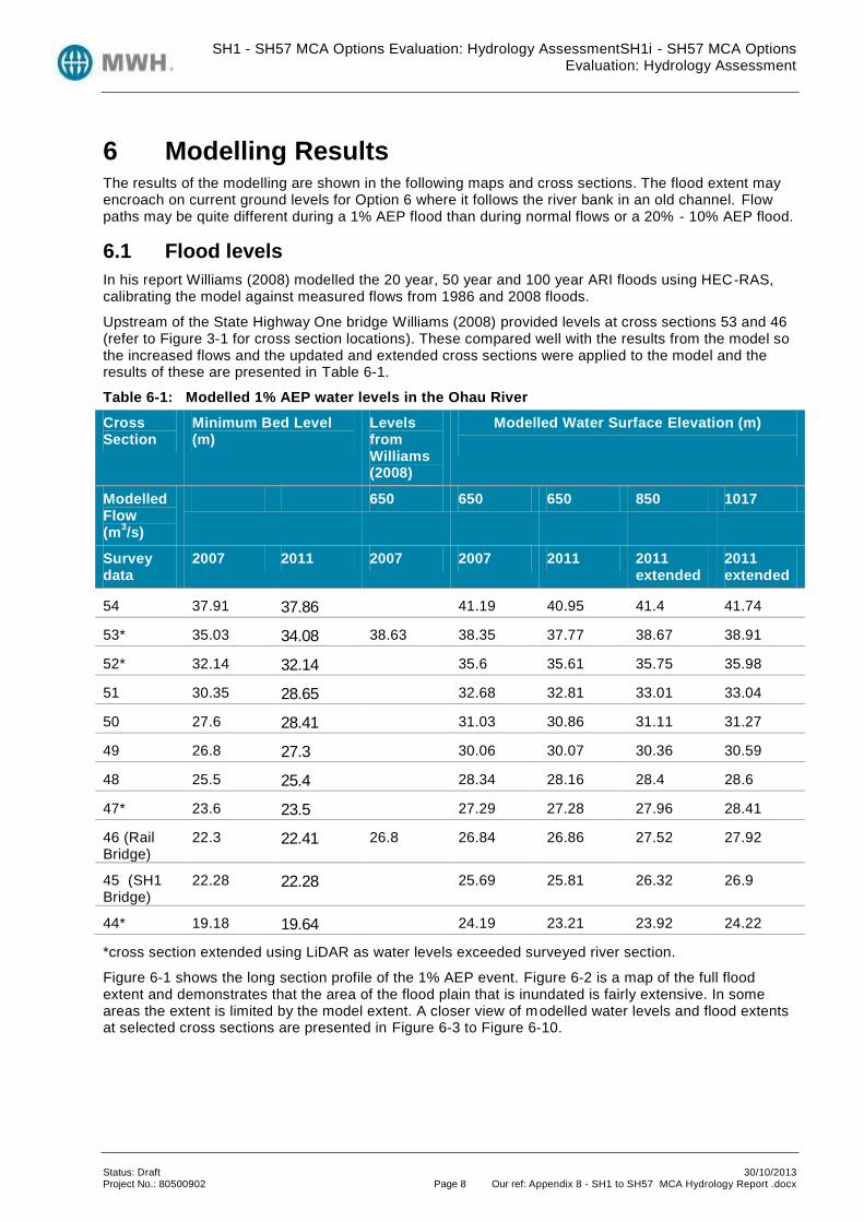
SH1 - SH57 MCA Options Evaluation: Hydrology AssessmentSH1i - SH57 MCA Options Evaluation: Hydrology Assessment
Status: Draft 30/10/2013 Project No.: 80500902 Page 8 Our ref: Appendix 8 - SH1 to SH57 MCA Hydrology Report .docx
6 Modelling Results The results of the modelling are shown in the following maps and cross sections. The flood extent may encroach on current ground levels for Option 6 where it follows the river bank in an old channel. Flow paths may be quite different during a 1% AEP flood than during normal flows or a 20% - 10% AEP flood.
6.1 Flood levels
In his report Williams (2008) modelled the 20 year, 50 year and 100 year ARI floods using HEC-RAS, calibrating the model against measured flows from 1986 and 2008 floods.
Upstream of the State Highway One bridge Williams (2008) provided levels at cross sections 53 and 46 (refer to Figure 3-1 for cross section locations). These compared well with the results from the model so the increased flows and the updated and extended cross sections were applied to the model and the results of these are presented in Table 6-1.
Table 6-1: Modelled 1% AEP water levels in the Ohau River
Cross Section
Minimum Bed Level (m)
Levels from Williams (2008)
Modelled Water Surface Elevation (m)
Modelled Flow (m
3/s)
650 650 650 850 1017
Survey data
2007 2011 2007 2007 2011 2011 extended
2011 extended
54 37.91 37.86 41.19 40.95 41.4 41.74
53* 35.03 34.08 38.63 38.35 37.77 38.67 38.91
52* 32.14 32.14 35.6 35.61 35.75 35.98
51 30.35 28.65 32.68 32.81 33.01 33.04
50 27.6 28.41 31.03 30.86 31.11 31.27
49 26.8 27.3 30.06 30.07 30.36 30.59
48 25.5 25.4 28.34 28.16 28.4 28.6
47* 23.6 23.5 27.29 27.28 27.96 28.41
46 (Rail Bridge)
22.3 22.41 26.8 26.84 26.86 27.52 27.92
45 (SH1 Bridge)
22.28 22.28 25.69 25.81 26.32 26.9
44* 19.18 19.64 24.19 23.21 23.92 24.22
*cross section extended using LiDAR as water levels exceeded surveyed river section.
Figure 6-1 shows the long section profile of the 1% AEP event. Figure 6-2 is a map of the full flood extent and demonstrates that the area of the flood plain that is inundated is fairly extensive. In some areas the extent is limited by the model extent. A closer view of modelled water levels and flood extents at selected cross sections are presented in Figure 6-3 to Figure 6-10.
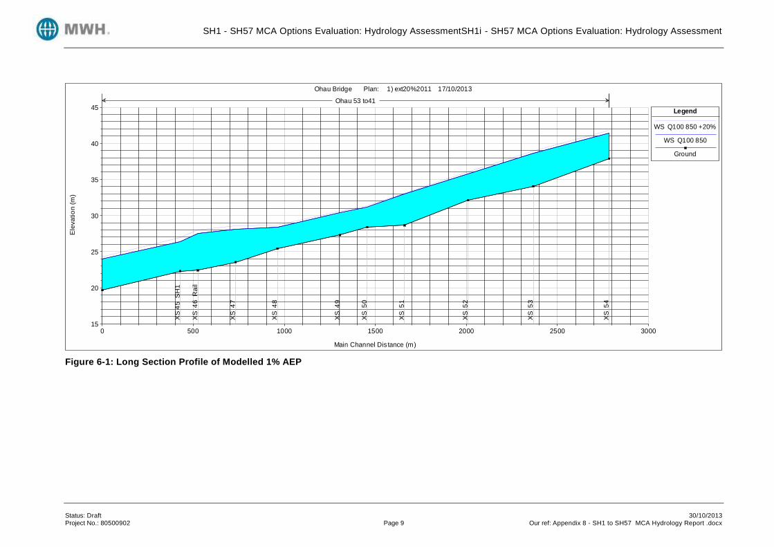
SH1 - SH57 MCA Options Evaluation: Hydrology AssessmentSH1i - SH57 MCA Options Evaluation: Hydrology Assessment
Status: Draft 30/10/2013 Project No.: 80500902 Page 9 Our ref: Appendix 8 - SH1 to SH57 MCA Hydrology Report .docx
Figure 6-1: Long Section Profile of Modelled 1% AEP
0 500 1000 1500 2000 2500 300015
20
25
30
35
40
45
Ohau Bridge Plan: 1) ext20%2011 17/10/2013
Main Channel Dis tance (m)
Ele
vatio
n (
m)
Legend
WS Q100 850 +20%
WS Q100 850
Ground
XS
45
S
H1
XS
4
6 R
ail
XS
4
7
XS
4
8
XS
4
9
XS
5
0
XS
5
1
XS
5
2
XS
5
3
XS
5
4
Ohau 53 to41

SH1 - SH57 MCA Options Evaluation: Hydrology AssessmentSH1i - SH57 MCA Options Evaluation: Hydrology Assessment
Status: Draft 30/10/2013 Project No.: 80500902 Page 10 Our ref: Appendix 8 - SH1 to SH57 MCA Hydrology Report .docx
Figure 6-2: Flood Extent of 1% AEP dark blue is 1% AEP plus 20% uncertainty

SH1 - SH57 MCA Options Evaluation: Hydrology AssessmentSH1i - SH57 MCA Options Evaluation: Hydrology Assessment
Status: Draft 30/10/2013 Project No.: 80500902 Page 11 Our ref: Appendix 8 - SH1 to SH57 MCA Hydrology Report .docx
Figure 6-3: 1% AEP Water levels at cross section 45 SH1 Bridge, 2011 extended survey
Figure 6-4: 1% AEP Flood extent at cross section 45 SH1 Bridge, 2011 extended survey. Dark blue is 1% AEP plus 20% uncertainty.
20
22
24
26
28
30
32
0 20 40 60 80 100 120 140 160
Ele
vati
on
(m
)
Distance (Left bank = 0)
Cross Section 45 (SH1 Bridge)
Survey 1% AEP Flood Level (26.3m) 1% AEP Flood Level +20%(26.9m)

SH1 - SH57 MCA Options Evaluation: Hydrology AssessmentSH1i - SH57 MCA Options Evaluation: Hydrology Assessment
Status: Draft 30/10/2013 Project No.: 80500902 Page 12 Our ref: Appendix 8 - SH1 to SH57 MCA Hydrology Report .docx
Figure 6-5: 1% AEP Water levels at cross section 47, 2011 extended survey
Figure 6-6: Flood extent at cross section 45 SH1 Bridge, 2011 extended survey
22
24
26
28
30
32
34
36
38
40
0 50 100 150 200 250 300 350
Ele
vati
on
(m
)
Distance (Left bank = 0)
Cross Section 47
Surveyed Bed Level 1% AEP Flood Level (28.0m) 1% AEP Flood Level +20%(28.5m)

SH1 - SH57 MCA Options Evaluation: Hydrology AssessmentSH1i - SH57 MCA Options Evaluation: Hydrology Assessment
Status: Draft 30/10/2013 Project No.: 80500902 Page 13 Our ref: Appendix 8 - SH1 to SH57 MCA Hydrology Report .docx
Figure 6-7: 1% AEP Water levels at cross section 48 SH1 Bridge, 2011 extended survey
Figure 6-8: Flood extent at cross section 48 SH1 Bridge, 2011 extended survey
25
26
27
28
29
30
31
0 50 100 150 200 250 300
Ele
vati
on
(m
)
Distance (Left bank = 0)
Cross Section 48
Survey 1% AEP Flood Level (28.4m) 1% AEP Flood Level +20%(28.6m)

SH1 - SH57 MCA Options Evaluation: Hydrology AssessmentSH1i - SH57 MCA Options Evaluation: Hydrology Assessment
Status: Draft 30/10/2013 Project No.: 80500902 Page 14 Our ref: Appendix 8 - SH1 to SH57 MCA Hydrology Report .docx
Figure 6-9: 1% AEP Water levels at cross section 52, 2011 extended survey
Figure 6-10: Flood extent at cross section 47, 2011 extended survey
32
32.5
33
33.5
34
34.5
35
35.5
36
36.5
37
0 50 100 150 200 250 300
Ele
vati
on
(m
)
Distance (Left bank = 0)
Cross Section 52
Survey 1% AEP Flood Level (35.8m) 1% AEP Flood Level +20%(36.0m)

SH1 - SH57 MCA Options Evaluation: Hydrology AssessmentSH1i - SH57 MCA Options Evaluation: Hydrology Assessment
Status: Draft 30/10/2013 Project No.: 80500902 Page 15 Our ref: Appendix 8 - SH1 to SH57 MCA Hydrology Report .docx
7 Options Assessment There are five options to be assessed; these are Option 3C, 4A, 5A, 6A and 7A (refer Figure 7-1 for option alignments).The purpose of this report is to consider the potential impacts of 1 % AEP flood event in the Ohau River for each option. Scores presented in this report are based on hydrological assessment prior to the MCA assessment workshop held to assess the options.
7.1 Crossings
Options 3C, 4A and 5A have one crossing of the Ohau River at a location just downstream of the existing State Highway One bridge.
Option 6A splits before the Ohau River and there are two bridges- one just downstream of the existing State Highway One bridge and another after the State Highway 57 alignment follows alongside the river for approximately 1 km, crossing the Ohau River 1.3 km upstream of the existing State Highway One bridge.
Option 7A also has two bridges, the SH57 bridge at the same location as Option 6A and the State Highway One bridge 500m upstream of the existing State Highway One bridge.
7.2 Scoring
The options were rated using scoring as described in Table 7-1. The scores given to each different option are shown in Table 7-2.
Table 7-1: Scoring Guide
Score Description
++ The option presents few difficulties on the basis of the criterion being evaluated, taking into account reasonable mitigation proposals. There may be significant benefits in terms of the criterion.
+ The option presents only minor areas of difficulties on the basis of the criterion being evaluated, taking into account reasonable mitigation proposals. There may be some benefits in terms of the aspect.
0 The option presents some areas of reasonable difficulty in terms of the criterion being evaluated. Effects cannot be completely avoided. Mitigation is not readily achievable at reasonable cost, and there are few or no apparent benefits.
- The option includes extensive areas of difficulty in terms of the criterion being evaluated, which outweigh perceived benefits. Mitigation is not readily achievable.
- - The option includes extreme difficulties in terms of achieving the project on the basis of the criterion being evaluated.

SH1 - SH57 MCA Options Evaluation: Hydrology AssessmentSH1i - SH57 MCA Options Evaluation: Hydrology Assessment
Status: Draft 30/10/2013 Project No.: 80500902 Page 16 Our ref: Appendix 8 - SH1 to SH57 MCA Hydrology Report .docx
Figure 7-1: Alignments of the five Options around the Ohau River

SH1 - SH57 MCA Options Evaluation: Hydrology AssessmentSH1i - SH57 MCA Options Evaluation: Hydrology Assessment
Table 7-2: Option Scores
Score Rating Rationale
Option 3C
+
Proposed bridge location similar to existing State Highway One bridge
Proposed bridge located at a natural constriction with high ground on either side
Option 4A
+
Proposed bridge location similar to existing State Highway One bridge
Proposed bridge located at a natural constriction with high ground on either side
Option 5A
+
Bridge location similar to existing State Highway One bridge
Proposed bridge located at a natural constriction with high ground on either side
Option 6A
-
Road runs alongside potential floodplain and existing ground levels do not have the required freeboard above the 1% AEP flood
Proposed State Highway One bridge location 100m downstream of existing State Highway One bridge
Proposed State Highway 57 bridge crosses the flood plain where it is wide and no natural constriction
Option 7A
-
Proposed State Highway One bridge location is located in an area with lower ground and crosses the flood plain where it is wide
Proposed State Highway 57 bridge located in an area with lower ground and crosses the flood plain where it is wide
The higher rated options are those that cross at the existing State Highway One bridge location as the bank levels are higher compared to bed levels and the channel width is restricted. Options 3C, 4A and 5A were all considered similar as the bridge locations were similar and so were given similar ratings. Options 6A and 7A have a second bridge. In the case of Option 6A the first bridge has a location similar to those in Options 3C, 4A and 5A, the second bridge crosses the Ohau River in the wide floodplain upstream of the State Highway One bridge. The riverbed may change course here – there is evidence of recent flood channels adjacent to the main active river channel and historic aerial photos show the active channel was further to the north. Migration of the bends in the river in a downstream direction, which is evident from historic photos, may also threaten Options 6A and 7A. Option 7A has both bridges located in the floodplain. Constrict ing the active floodplain in two locations may change the flow dynamics and the geomorphology of the river. Further investigations would be required if Option 7A was pursued.
7.3 Option 6A Road Alignment
Option 6A runs beside the river for approximately 1 km. Figure 7-2 shows the ground level of the Option 6A road alignment from LiDAR between cross sections 47 and 51 and also the estimated 1% AEP flood

SH1 - SH57 MCA Options Evaluation: Hydrology AssessmentSH1i - SH57 MCA Options Evaluation: Hydrology Assessment
level and the 0.5m freeboard level. The ground level of the Option 6 road alignment is below the projected 1% AEP flood levels and freeboard at the lower end of the profile, upstream of cross section 47. Protection from flooding would be necessary for the road at this location.
Figure 7-2: Flood Levels and Option 6A Alignment levels
Figure 7-3: Path of Option 6A Alignment used for elevation (road alignment highlighted in yellow)
25
26
27
28
29
30
31
32
33
34
35
0 100 200 300 400 500 600 700 800 900
Option 6A Alignment ground level 1% AEP Flood Level 0.5m freeboard

SH1 - SH57 MCA Options Evaluation: Hydrology AssessmentSH1i - SH57 MCA Options Evaluation: Hydrology Assessment
Appendix A Rainfall Distribution Map
Figure A-1: Catchment Rainfall Map (Source: http://wrenz.niwa.co.nz/webmodel/)

SH1 - SH57 MCA Options Evaluation: Hydrology AssessmentSH1i - SH57 MCA Options Evaluation: Hydrology Assessment
Appendix B Runoff Distribution Map
Figure B-1: Catchment Mean Annual Runoff Map (Source: http://wrenz.niwa.co.nz/webmodel/)

APPENDIX 9: SHORT REPORTS

ŌTAKI TO NORTH OF LEVIN – SH1-SH57 CONNECTION
MCA ANALYSIS
NOTES ON SOCIAL/COMMUNITY IMPACTS
Scope
applies to generic “community” effects, not individual effects
includes amenity effects – noise, odour, public safety
includes physical severance and access consideration
includes social severance – i.e. loss or gain in social cohesion.
Option Notes
3C:
reduced severance, improved amenity and public safety in Kuku community
increased severance, reduced amenity and public safety in Ohau
suggested rating “ – – “.
4A, 5A:
reduced severance, improved amenity and public safety in Kuku
reduced severance, improved amenity and public safety in Ohau
note: vineyard area not regarded as a community because few houses as yet – little to
distinguish these two options
suggested ratings “ + “.
6A:
reduced severance, improved amenity and public safety at Kuku, but amenity for
population cluster just south of northern bridge reduced, so not as good as three
options above for this community
reduced severance, improved amenity and public safety in Ohau
suggested rating “ 0 “.

7A:
reduced severance for part of Kuku, and partial improvement in amenity and public
safety (northern end)
reduced severance, improved amenity and public safety in Ohau
suggested rating “ – “ or “ 0 “.
T:
similar to Option 7A for part of Kuku
increased severance, reduced amenity and public safety in Ohau
suggested rating “ – – “.
Sylvia Allan
16th October 2013

TO: Sylvia Allan DATE: 29 October 2013
CC: REF: 80500902
FROM: Steve Kerr, Principal Planner MWH New Zealand Ltd
SUBJECT: October 2013 MCA Planning Input
This memo outlines the analysis that was the basis of the input to the MCA Workshop on 17 October
2017. It has been updated to include the analysis of the new Option ‘T’.
Option
MCA Criteria and Score
Comments District
Plan
Land Use/
Ownership
7A ‘-‘ ‘--‘ No direct impact on items or ONA/ONL protected in the district
plan
Notable severances in the rural greenfield areas, particularly in
the north
Potentially impacts on residentially zoned land to the west of
SH1 (Muhunoa West Rd). This land is to be subdivided in
accordance with a structure plan in the district plan (08,
Schedule 8).
3 river crossings
Potential loss of café/store
Move alignment closer to school and heritage church
Change property access arrangements
Avoids residential lifestyle/vineyard17 area (area of investment
and known contention) east of SH1 Ohau. This area is to be
subdivided in accordance with a structure plan in the distr ict
plan (09, Schedule 8).
Impacts on areas of bush and trees
6A ‘-‘ ‘--‘ Notable severances in the rural greenfield areas, particularly in
the north.
Change property access arrangements
2 river crossings
No direct impact on items or ONA/ONL protected in the district
plan
Avoids residential lifestyle/vineyard area (area of investment
and known contention) east of SH1 Ohau.
Minor impact on other residentially zoned land
Passes through Tatum Park
High risk to urupa at Kuku village
17 This land is zoned “Greenbelt Residential’.

Option
MCA Criteria and Score
Comments District
Plan
Land Use/
Ownership
5A ‘-‘ ‘--‘ No direct impact on items or ONA/ONL protected in the district
plan
Avoids residential lifestyle/vineyard area (area of investment
and known contention) east of SH1 Ohau.
Impacts on areas of bush and trees
Change some property access arrangements
Potentially affect access to the Allied concrete plant by Ohau
River to extent it may require relocation.
Impacts on residentially zoned land
Notable severances though the rural greenfield areas,
particularly in the north.
Avoids the residential land to the west of SH1 at Ohau
(Muhunoa West Rd).
2 river crossings
4A ‘-‘ ‘--‘ No direct impact on items or ONA/ONL protected in the district
plan
Impacts on residentially zoned land
Directly impacts on residential lifestyle/vineyard area (area of
investment and known contention) east of SH1 Ohau.
Change some property access arrangements
Notable severances though the rural greenfield area,
particularly in the north.
Avoids the residential land to the west of SH1 at Ohau
(Muhunoa West Rd).
2 river crossings
3C ‘-‘ ‘--‘ No direct impact on items or ONA/ONL protected in the district
plan
Avoids residential lifestyle/vineyard area (area of investment
and known contention) east of SH1 Ohau.
4 laning through Ohau, with limited access mitigation possible
Potentially impacts on residentially zoned land in Ohau.
Move alignment closer to school and heritage church
Change some property access arrangements
Potential loss of café/store
Minimises potential severances in the rural greenfield areas.
River crossing
Passes through Tatum Park
Avoids areas of notable bus and trees

Option
MCA Criteria and Score
Comments District
Plan
Land Use/
Ownership
T18 ‘-‘ ‘--‘ No direct impact on items or ONA/ONL protected in the district
plan
Impacts on residentially zoned land
Avoids residential lifestyle/vineyard area (area of investment
and known contention) east of SH1 Ohau
4 laning through Ohau, with limited access mitigation possible
Potential loss of café/store
Move alignment closer to school and heritage church
Change some property access arrangements
Minimises potential severances though the greenfield areas
(rural and residential).
2 river crossings
Keeps clear of local urupa near SH1
Avoids areas of notable bush and trees
18 New option variant. Dated Fri 25 October 2013.

Option 3c Option 4a Option 5a Option 6a Option 7a Option T
To provide best value solutions which will progressively meet (via a staged approach) the long-term RoNS goal for this corridor of achieving a high quality four lane route to the bifurcation of SH1 and SH57, and high quality improved routes beyond that point
++ Significant improvement. Eliminates substandard structures and this option has only two major structures (bifurcation and crossing of the Ohau River). Construction and whole of life costs are relatively low, and better than the existing situation.
++ Significant improvement. Eliminates substandard structures and this option has only two major structures (bifurcation and crossing of the Ohau River). Construction and whole of life costs are relatively low, and better than the existing situation.
++ Significant improvement. Eliminates substandard structures and this option has only two major structures (bifurcation and crossing of the Ohau River). Construction and whole of life costs are relatively low, and better than the existing situation.
- Negative. Although eliminating substandard existing structures, this option has three major structures (bifurcation and crossings of the Ohau River) which represent an additional construction and whole of life cost over and above options 3c, 4a and 5a.
- - Significantly negative. Although eliminating substandard existing structures, this option has four major structures (Manakau Rail overbridge, bifurcation, and two Ohau River Crossings) which represent an additional construction and whole of life cost over and above options 3c, 4a, 5a and 6a.
- Negative. Although eliminating substandard existing structures, this option has three major structures (Manakau Rail overbridge, bifurcation, and crossing of the Ohau River) which represent an additional construction and whole of life cost over and above options 3c, 4a and 5a.
To provide better Levels of Service, particularly for journey time and safety, between north of Otaki and north of Levin
+ Significant improvement, though the need for all through traffic to pass through Ohau for the foreseeable future represents a journey time and safety risk. Allows for new passing lane.
++ Significant improvement over existing. Taking road away from side friction on existing carriageway reduces journey time and safety level of service risks. Allows for new passing lane.
++ Significant improvement over existing. Taking road away from side friction on existing carriageway reduces journey time and safety level of service risks. Though the alignment of bifurcation is not as optimal as Option 4a, this is still significantly positive. Allows for new passing lane.
+ Improvement over existing. Taking road away from side friction on existing carriageway reduces journey time and safety level of service risks. However, this option reduces viability of new passing lane.
++ Significant improvement over existing. New alignment and service roads as appropriate reduces journey time and safety level of service risks.
+ Significant improvement over existing, with new alignment and service roads as appropriate south of Ohau reducing journey times and safety level of service risks, though the need for all through traffic to pass through Ohau for the foreseeable future represents a journey time and safety risk. Allows for new passing lane.

To remove or improve at-grade intersections between north of Otaki and north of Levin
+ Significant improvement to SH1/57 and Kimberley/Arapaepae intersections, but need to retain route through Ohau retains pressure on Muhunoa East Road. Good solution for Kuku Beach Road likely.
++ Significant improvement to SH1/57 and Kimberley/Arapaepae intersections, as well as alleviating pressure on Muhunoa East Road. Good solution for Kuku Beach Road likely.
++ Significant improvement to SH1/57 and Kimberley/Arapaepae intersections, as well as alleviating pressure on Muhunoa East Road. Good solution for Kuku Beach Road likely.
+ Improvement to SH1/57 and Kimberley/Arapaepae intersections, as well as alleviating pressure on Muhunoa East Road. Compromised solution for Kuku Beach Road likely.
++ Significant improvement to SH1/57 and Kimberley/Arapaepae intersections, as well as alleviating pressure on Muhunoa East Road. Good solution for Kuku Beach Road likely.
+ Significant improvement to SH1/57 and Kimberley/Arapaepae intersections, but need to retain route through Ohau retains pressure on Muhunoa East Road. Good solution for Kuku Beach Road likely.
To engage effectively with key stakeholders
This objective does not differ by option.
This objective does not differ by option.
This objective does not differ by option.
This objective does not differ by option.
This objective does not differ by option.
This objective does not differ by option.
To lodge Notices of Requirement and resource consents as appropriate with the relevant consent authorities for the first individual project by the 2013/14 financial year
This objective does not differ by option.
This objective does not differ by option.
This objective does not differ by option.
This objective does not differ by option.
This objective does not differ by option.
This objective does not differ by option.

Otaki to North of Levin: SH1-SH57 Connection
MCA Analysis – Engineering Degree of Difficulty
This report has been prepared for the benefit of NZ Transport Agency. No liability is accepted by this company or any employee or sub-consultant of this company with respect to its use by any other person. This disclaimer shall apply notwithstanding that the report may be made available to Horowhenua District Council and other persons for an application for permission or approval or to fulfil a legal requirement.
Rev. No. Date Description Prepared By Reviewed By Approved By
- 25/10/13 Draft for Comment P Peet M Oppenhuis P Peet
8 Introduction As part of the Otaki to North of Levin Road of National Significance investigation, a scoping study is currently being prepared for the SH1 – SH57 Connection south of Levin. As part of this scoping study, a Multi Criteria Analysis (MCA) is being undertaken to help inform a decision on which option(s) to take forward into the Detailed Business Case. This short report focuses on the Engineering Degree of Difficulty aspect for the MCA. The information below was initially compiled for Options 3C, 4A, 5A, 6A and 7A before the MCA workshop on 17 October. Subsequently, Option T has been added to the evaluation but this has been on the basis of little background information.
9 Engineering Degree of Difficulty Scores The scores in the table below reflect the above. These are discussed briefly in the subsequent sections.
Option
Terr
ain
Stru
ctu
res
Rai
lwa
y Li
ne
s
Tru
nk
Uti
litie
s
Riv
ers
an
d
Stre
ams
Traf
fic
Man
age
me
nt
3C + - - - - 0 0 - -
4A ++ - 0 0 0 -
5A ++ - 0 0 0 -
6A + - - 0 0 - - - -
7A ++ - 0 0 - - -
T + - - - 0 0 - -
10 Engineering Degree of Difficulty Criteria The criteria used are listed below along with a brief summary of issues which could create difficulties in constructing the option. 10.1 Terrain
3C, T issues through Ohau
5A, 6A, 7A minor issues near McLeavy
6A potential issues adjacent to river

10.2 Structures
Option W
aika
wa
Stre
am
Ku
ku B
eac
h R
d R
ail
Ku
ku B
eac
h R
oad
I/C
Oh
au R
ive
r
Mu
hu
no
a R
oad
Un
de
rpas
s
SH5
7 N
BD
off
ram
p
ove
r SH
1
Rai
l in
arc
h c
ulv
ert
Loca
l ro
ad in
arc
h
culv
ert
3C 1 1 Future 1 Future 1 ½ 1
4A 1 1 Future 1 1 1 1
5A 1 1 Future 1 1 1 1
6A 1 1 Future 2 1 2 2
7A 1 2 1 2
T 1 1 Future 1 2 1
10.3 Railway lines
3C requires relocation of railway lines
3C, 4A, 5A, 6A have issues with railway line near Kuku interchange
3C, 4A, 5A, 6A have issues with railway line near SH1 – 57 split
7A, T issues with rail at southern and northern end 10.4 Truck Utilities
Not investigated yet
All options avoid major gas pipelines and major transmission lines 10.5 Rivers and Streams
Options 3C, 4A, 5A have two river crossings
Options 6A and 7A have three river crossings
In addition option 6A runs parallel to the Ohau River 10.6 Likelihood of future structures
3C, 4A, 5A, 6A all would need interchange at Kuku
3C, T would also need underpass (or other solution) at Ohau
7A, T would need to tie into four laning past Manakau (unknown solution but maybe I/C near current tie in point)
10.7 Traffic Management
3C, 4A, 5A, 6A issues at Manakau Rail Overbridge
3C, T big problems through Ohau
3C, T problems on Kimberly Road
4A, 5A, 6A and 7A issues with local road connectivity during construction
6A issues at current Ohau railway overbridge vs new SH57 ramps
7A, T issues along current SH1 with property access
7A, T issues at northern SH1 tie in (due to road over rail at tie in).

APPENDIX 10: WORKSHOP BACKGROUND AND NOTES

DRAFT AGENDA
OTAKI TO LEVIN RoNS SH1 + SH57 CONNECTION OPTIONS WORKSHOP
Thursday 17th October 2013, 1.30pm to 5.30pm
Venue: Matiu Room, Chapman Tripp, 10 Customhouse Quay, Wellington
Person Item Approx. Time
JD Welcome and reason for Workshop 1.30 – 1.35pm
All Introductions, housekeeping 1.35 – 1.45pm
SA Purpose of afternoon (confirm agenda, background to MCA, discussion of criteria and scoring system)
1.45 – 1.55pm
PP Description and explanation of options (how we got them and what they’re like)
1.55 – 2.00pm
As listed Presentations/discussions about criteria and scoring (order to be determined)
landscape/visual implications (GL)
ecological implications (AF)
archaeology/heritage aspects (DP)
tāngata whenua implications (ML)
productive landuse aspects (LG)
social/community impacts (SA)
District Plan/consentability (CvH)
transport effectiveness/fit with project transport objectives (JD/PP)
specific land ownership effects (JD, CvH)
engineering degree of difficulty/constructability (PP)
cost (PP)
Review of scores
2.00 – 5.00pm
(includes 10min afternoon tea break at about 3.15pm)
SA/PP Weighting of criteria and next steps 5.00 – 5.15pm
JD Overall project update 5.15 – 5.30pm

NOTES TO ACCOMPANY DRAFT AGENDA
OTAKI TO LEVIN RoNS SH1 + SH57 CONNECTION OPTIONS WORKSHOP
Thursday 17th October 2013, 1.30pm to 5.30pm
Venue: Matiu Room, Chapman Tripp, 10 Customhouse Quay, Wellington
1. These notes provide background for the workshop later this week. At the start of the workshop there will be a chance to talk through the purpose of the workshop and the process. It is important that we come with open minds and work collaboratively with questioning and testing of the values and issues around all the options we are looking at.
2. The workshop is intended to develop and apply a multi-criteria analysis (MCA) on the five
options that have been developed earlier in this process, including the two options that went out for consultation in May this year. The project we are evaluating includes the concept of changes over time, so involves both the short-term improvements and the longer-term changes, including the 4-laning and the progressive improvements at Kuku Beach Road (short-term at- grade staggered intersection, and long-term grade-separation further to the south as shown on the schematics).
3. The attributes the workshop is looking at are the advantages and disadvantages, or positive
and negative effects, for the criteria listed in the Agenda. We will discuss the list early in the workshop to decide whether all criteria are appropriate and meaningful for an assessment of alternatives; whether some should be split into more than one, or whether some should be combined. Note that it is ideal to have 10 to 12 criteria in an MCA, so we have about the right number. Also, we will be weighting the criteria later in the process, so if some seem less important, they can be given a lower weighting.
4. In terms of “scoping” the criteria and what needs to be taken into account under each
heading, we are relying on the expert advisor to guide the workshop on that, and there will be an opportunity to discuss the scope of each criterion during the workshop (i.e. during the presentation session). We may want to break down and analyse a criterion under several headings (for example, using some secondary criteria) or by section of route, and recombine them with a single overall score per route alternative. We will document the scope of each criterion as part of the workshop record.
5. We are asking each expert (initials on the agenda) to come prepared to explain their aspect
and discuss their preliminary scoring for each corridor. There will be a maximum of 5 to 10 minutes for each presentation, followed by discussion and scoring (or we can leave all

scoring until the end). Presentations (simple power-point) would be good, but there will be maps, aerials; etc available for people to refer/talk to for those who haven’t organised that.
6. We will score each attribute as a group, on a 1 to 5 scale as set out below (note: cost is not
amenable to this scale and will be scored on a relative basis). The preliminary (++ to - -) scoring that experts have done will be a guide, but the workshop (rather than the expert alone) should do the scoring. Ideally we will reach consensus on a score for each attribute, but if we can’t, we will note the different views and use that for sensitivity analysis at a later stage. We will review the scores at the end of the session to make sure that we are all comfortable with them.
SCORE DESCRIPTION
1 The option presents few difficulties on the basis of the criterion being evaluated, taking into account reasonable mitigation proposals. There may be significant benefits in terms of the criterion.
2 The option presents only minor areas of difficulties on the basis of the criterion being evaluated, taking into account reasonable mitigation proposals. There may be some benefits in terms of the aspect.
3 The option presents some areas of reasonable difficulty in terms of the criterion being evaluated. Effects cannot be completely avoided. Mitigation is not readily achievable at reasonable cost, and there are few or no apparent benefits.
4 The option includes extensive areas of difficulty in terms of the criterion being evaluated, which outweigh perceived benefits. Mitigation is not readily achievable.
5 The option includes extreme difficulties in terms of achieving the project on the basis of the criterion being evaluated.
7. We will be endeavouring to develop a “workshop-agreed” weighting system for the criteria
towards the end of the workshop. This will be complemented in later analyses by other weighting systems to make sure we have a robust outcome.

Otaki to Levin RoNS
SH1 + SH57 Connection
Options
MCA Workshop
17/10/2013
Allan Planning &Research Ltd
PURPOSE OF WORKSHOP
• Analyse five alternatives for SH1 + SH57 connection
• Carefully consider information presented by experts
• Apply MCA process in structured, defensible manner
• Keep notes of key points
Allan Planning &Research Ltd

MCA PROCESS
Allan Planning &Research Ltd
MCA - Scoring and Weighting
Option 1
Option 2
Option 3
Option 4
Option n-1
Option n
W1 W2 W3 W4 W5 Wm-1 Wm
Cri
teria 1
Cri
teria 2
Cri
teria 3
Cri
teria 4
Cri
teria 5
Cri
teria m
-1
Cri
teria m
S11 S12 S13 S14 S1m-1 S1m
S21 S22 S23 S24
S31 S32
Snm
…………
……
......
......
......
...
Assessment Criteria
Op
tio
ns
Various ways
of establishing
weights
Scores typically between 1 and 5
Wk.S1k
Wk.S2k
Wk.S3k
Wk.S4k
Wk.Sn-1k
Wk.Snk
Option Scores
Highest or
Lowest Average
Combined Score
Indicates
Preferred
Option
w1 x S11 + w2 x S12 + w3 x S13 + …
WORKSHOP PROCESS
Allan Planning &Research Ltd
• Model is:
Presentation by Nominated Person
Discussion/questions (general)
Discussion/scoring
• We will work towards consensus in scoring if possible
• Scores = raw data for further analysis
• If there are strongly-held different views, they will be recorded and used in sensitivity analysis
• Key points from Workshop, including scope of criteria and reasons for scores to be recorded
WORKSHOP PROCESS cont...
Allan Planning &Research Ltd
• Decisions to be made now:
- All discussion now then scoring; group criteria and score; or one by one?
- Any obvious issues with any attributes?
- Order of attributes?
• Later:
- Opportunity to quickly review scores
- Develop workshop weighting of attributes

APPLYING SCORES
Allan Planning &Research Ltd
• Basically 1 = Good, 5 = Bad
• Each option must be scored for each attribute
• Can’t use “0” or NA, as it would have a positive implication
• Don’t need to use all scores in range for any (or all) attributes
PROCESS TO DATE
Allan Planning &Research Ltd
• Development of alternatives following initial consultation on two options
• Identified five “best” alternatives
• Preliminary technical investigations
• Specialist investigations and evaluations

MEETING ATTENDEES
Meeting Name SH1 + SH57 Connections Options MCA Workshop Meeting
Meeting Venue Conference Room, 10 Customhouse Quay, Wellington
Date Of Meeting 17 October 2013 Time Of Meeting 1:30pm – 5:40pm
Facilitator Sylvia Allan Recorder Jon England
Attendees Organisation
Jo Draper NZTA
Phil Peet MWH
Jon England MWH
Sylvia Allan Allan Planning and Research
Steve Kerr MWH
Gavin Lister Isthmus
Kristin Stokes MWH
Daniel Parker InSite Archaeology
Jamie Mitchington Beca (representing HDC)
Lachie Grant LandVision
Morrie Love Raukura Consultants
Adam Forbes Forbes Ecology

APPENDIX 11: WEIGHTING SYSTEMS APPLIED IN ANALYSIS

Workshop Participant Weighting
RMA S6 Weighting
Social Weighting
10 1 1 1 1 1 1 1 1 1 1 1
9
8
7
6
5
4
3
2
1
0
Att
rib
ute
s
Lan
dscap
e / v
isu
al
Eco
log
y
Arc
haeo
log
y / h
eri
tag
e
Tan
gata
wh
en
ua v
alu
es
Pro
du
cti
ve lan
d u
se
So
cia
l / co
mm
un
ity
Dis
tric
t &
Reg
ion
al P
lan
fit
/ co
nsen
tab
ilit
y
Tra
nsp
ort
eff
ecti
ven
ess
an
d p
roje
ct
ob
jecti
ves
Sp
ecif
ic lan
do
wn
er
eff
ects
En
gin
eeri
ng
deg
ree o
f
dif
ficu
lty
Co
st
Weight: 10 10 10 10 10 10 10 10 10 10 10
0.00
0.50
1.00
1.50
2.00
2.50
3.00
3.50
4.00
3C 4A 5A 6A 7A T
Op
tio
n R
atin
g
Option Evaluation Results(Lowest Rating is Preferred)
10 1 1 1
9
8
7
6 1
5 1
4
3 1 1
2 1 1 1 1
1
0
Att
rib
ute
s
Lan
dscap
e / v
isu
al
Eco
log
y
Arc
haeo
log
y / h
eri
tag
e
Tan
gata
wh
en
ua v
alu
es
Pro
du
cti
ve lan
d u
se
So
cia
l / co
mm
un
ity
Dis
tric
t &
Reg
ion
al P
lan
fit
/ co
nsen
tab
ilit
y
Tra
nsp
ort
eff
ecti
ven
ess
an
d p
roje
ct
ob
jecti
ves
Sp
ecif
ic lan
do
wn
er
eff
ects
En
gin
eeri
ng
deg
ree o
f
dif
ficu
lty
Co
st
Weight: 6 10 10 10 3 3 5 2 2 2 2
0.00
0.50
1.00
1.50
2.00
2.50
3.00
3.50
4.00
4.50
3C 4A 5A 6A 7A T
Op
tio
n R
atin
g
Option Evaluation Results(Lowest Rating is Preferred)
10 1
9
8 1 1 1 1
7
6
5 1 1 1 1 1
4
3 1
2
1
0
Att
rib
ute
s
Lan
dscap
e / v
isu
al
Eco
log
y
Arc
haeo
log
y / h
eri
tag
e
Tan
gata
wh
en
ua v
alu
es
Pro
du
cti
ve lan
d u
se
So
cia
l / co
mm
un
ity
Dis
tric
t &
Reg
ion
al P
lan
fit
/ co
nsen
tab
ilit
y
Tra
nsp
ort
eff
ecti
ven
ess
an
d p
roje
ct
ob
jecti
ves
Sp
ecif
ic lan
do
wn
er
eff
ects
En
gin
eeri
ng
deg
ree o
f
dif
ficu
lty
Co
st
Weight: 5 5 8 8 5 10 8 5 8 3 5
0.00
0.50
1.00
1.50
2.00
2.50
3.00
3.50
4.00
3C 4A 5A 6A 7A T
Op
tio
n R
atin
g
Option Evaluation Results(Lowest Rating is Preferred)

Environmental Weighting
Cultural Weighting
Economic Weighting
10 1
9
8
7
6
5 1
4
3 1 1 1
2
1
0 1 1 1 1 1 1
Att
rib
ute
s
Lan
dscap
e / v
isu
al
Eco
log
y
Arc
haeo
log
y / h
eri
tag
e
Tan
gata
wh
en
ua v
alu
es
Pro
du
cti
ve lan
d u
se
So
cia
l / co
mm
un
ity
Dis
tric
t &
Reg
ion
al P
lan
fit
/ co
nsen
tab
ilit
y
Tra
nsp
ort
eff
ecti
ven
ess
an
d p
roje
ct
ob
jecti
ves
Sp
ecif
ic lan
do
wn
er
eff
ects
En
gin
eeri
ng
deg
ree o
f
dif
ficu
lty
Co
st
Weight: 5 10 3 3 3 0 0 0 0 0 0
0.00
0.50
1.00
1.50
2.00
2.50
3.00
3.50
4.00
4.50
5.00
3C 4A 5A 6A 7A T
Op
tio
n R
atin
g
Option Evaluation Results(Lowest Rating is Preferred)
10 1 1
9
8
7
6
5 1 1
4
3 1
2
1
0 1 1 1 1 1 1
Att
rib
ute
s
Lan
dscap
e / v
isu
al
Eco
log
y
Arc
haeo
log
y / h
eri
tag
e
Tan
gata
wh
en
ua v
alu
es
Pro
du
cti
ve lan
d u
se
So
cia
l / co
mm
un
ity
Dis
tric
t &
Reg
ion
al P
lan
fit
/ co
nsen
tab
ilit
y
Tra
nsp
ort
eff
ecti
ven
ess
an
d p
roje
ct
ob
jecti
ves
Sp
ecif
ic lan
do
wn
er
eff
ects
En
gin
eeri
ng
deg
ree o
f
dif
ficu
lty
Co
st
Weight: 5 3 10 10 0 5 0 0 0 0 0
0.00
0.50
1.00
1.50
2.00
2.50
3.00
3.50
4.00
4.50
3C 4A 5A 6A 7A T
Op
tio
n R
atin
g
Option Evaluation Results(Lowest Rating is Preferred)
10 1
9
8 1
7
6
5 1 1 1 1
4
3
2
1
0 1 1 1 1 1
Att
rib
ute
s
Lan
dscap
e / v
isu
al
Eco
log
y
Arc
haeo
log
y / h
eri
tag
e
Tan
gata
wh
en
ua v
alu
es
Pro
du
cti
ve lan
d u
se
So
cia
l / co
mm
un
ity
Dis
tric
t &
Reg
ion
al P
lan
fit
/ co
nsen
tab
ilit
y
Tra
nsp
ort
eff
ecti
ven
ess
an
d p
roje
ct
ob
jecti
ves
Sp
ecif
ic lan
do
wn
er
eff
ects
En
gin
eeri
ng
deg
ree o
f
dif
ficu
lty
Co
st
Weight: 0 0 0 0 8 5 0 5 5 5 10
0.00
0.50
1.00
1.50
2.00
2.50
3.00
3.50
4.00
3C 4A 5A 6A 7A T
Op
tio
n R
atin
g
Option Evaluation Results(Lowest Rating is Preferred)