H U O N
BUND WALL, LANDSCAPING
AND VEGETATION MANAGEMENT PLAN
(BWL&VMP)
AND REHABILITATION PLAN
FOR
SRC OPERATIONS PTY LTD
PATONS LANE RESOURCE RECOVERY CENTRE
ORCHARD HILLS
July 2019
Rodney Cox BLArch MEnvStud
Environmental Landscapes
Design • Construction • Maintenance • Restoration
31 Jones Road Kenthurst NSW 2156 0413 514 740
ABN: 55 637 015 284
Final
confidential

2 Bund Wall Landscaping and Vegetation Management Plan and Rehabilitation Plan
Patons Lane Resource Recovery Centre Orchard Hills
Huon Designs July 2019
TABLE OF CONTENTS PAGE
1.0 Introduction and Executive Summary…..................................................................... 5 1.1 Purpose of Plans. .................................................................................................. 5 1.2 Overview… .......................................................................................................... 5 1.3 Management Plan Framework… ......................................................................... 6 1.4 Statement of Aims and Objectives… ................................................................... 8 1.5 Scope of Site Works and Activities Included in Stage 1… .................................. 9 1.6 Project Approval and Consent Conditions ............................................................ 17
2.0 Site Description… ....................................................................................................... 26 2.1 Location and Ownership… ................................................................................... 26 2.2 Abiotic Factors… .................................................................................................. 26 2.2.1 Climate… ........................................................................................................ 26 2.2.2 Geology and Soils… ....................................................................................... 26 2.2.3 Topography and Aspect… .............................................................................. 26 2.2.4 Catchment and Drainage… ............................................................................ 26 2.2.5 Erosion… ........................................................................................................ 26 2.2.6 Acoustics and Scenic Amenity… ................................................................... 27 2.3 Biotic Factors… .................................................................................................... 27 2.3.1 Flora… ............................................................................................................ 27 2.3.2 Fauna… ........................................................................................................... 27 2.4 Condition of Bushland and Weeds… .................................................................... 28 2.4.1 Site Resilience ..................................................................................................28 2.4.2 Causes of weed invasion… ............................................................................. 29 2.4.3 Weed Management Zones… ............................................................................ 30 2.4.4 Weeds… .......................................................................................................... 30
3.0 Site Management.......................................................................................................... 31 3.1 Zone 1: Conserve areas of moderate resilience - Riparian Zone… ...................... 31 3.2 Zone 2: Restore and rehabilitate areas of low resilience – Property
Boundaries… ........................................................................................... 31 3.3 Zone 3: Maintain and control weeds in grazing/quarry areas of no
resilience… .............................................................................................. 32 3.4 Erosion Strategy… ................................................................................................ 32
3.4.1 Overland water flow across disturbed bushland areas and cleared areas. ........................................................................................ 33
3.4.2 Storm water runoff along bio swales and dam overflow… ................. 33 3.4.3 Storm water runoff down roadways and drainage swales… ................ 33
3.5 Fencing Strategy… ................................................................................................ 33 3.5.1 Protective Fencing – Exclusion and site delineation. ........................... 34 3.5.2 Erosion and Sediment Fencing… ........................................................ 34 3.5.3 Vegetation Fencing… .......................................................................... 34
3.6 Weed Management Strategy… .............................................................................. 34

3 Bund Wall Landscaping and Vegetation Management Plan and Rehabilitation Plan
Patons Lane Resource Recovery Centre Orchard Hills
Huon Designs July 2019
3.6.1 Management of Causes of Weed Invasion… ...................................... 35 3.6.2 Management of Weed Removal and Encouragement of Natural
Regeneration… ................................................................................... 35 3.7 Site Establishment – Rehabilitation and Landscaping… ..................................... 36 3.8 Stage 1 Landform Rehabilitation and /Landscaping Plan. ................................... 47
3.8.1 Hydromulching Techniques… ........................................................... 48 3.9 Dust management Strategies… ............................................................................ 49
4.0 Maintenance, Monitoring and Key Performance Indicators… .................................. 50
5.0 Restoration Works Program ....................................................................................... 52
6.0 Restoration Works Budget… ..................................................................................... 53
7.0 Plan Review and Modification Procedures. ............................................................... 57
8.0 Summary and Conclusion… ...................................................................................... 57
List of Tables
Table 1A: Project Approval and Consent Conditions BWL&VMP… ................................. 17 Table 1B: Project Approval and Consent Conditions Rehabilitation Plan… ........................ 23 Table 2: Causes of weed invasion… ..................................................................................... 29 Table 3: Weeds on site at time of inspection… .................................................................... 30 Table 4: Addressing causes of weed invasion… .................................................................. 35 Table 5: Revegetation Species List… ................................................................................... 46 Table 6: Hydromulching Seed Mix List… ............................................................................ 48 Table 7: Key Performance Indicators… ................................................................................ 52 Table 8: Restoration Works Program .................................................................................... 52 Table 9: Restoration Works Budget. ..................................................................................... 54
List of Figures
Figure 1: Management Plan Framework… ........................................................................... 7 Figure 2: Management Plan Approval Process… ................................................................. 7 Figure 3: Site Establishment… ............................................................................................ 12 Figure 4: Recycling and Reprocessing Area… .................................................................... 14 Figure 5: Cell 1 General Arrangement… .............................................................................. 16 Figure 6: Indicative Emplacement and Cell Rehabilitation Staging ..................................... 38 Figure 7: Stage 0 Operations from the FMPPR… ................................................................ 39 Figure 8: Northern Face Typical Sections… ......................................................................... 40 Figure 9: Indicative Deconstruction of the Eastern Face… ................................................... 40 Figure 10: Rehabilitation Status Following Site Establishment… ........................................ 42 Figure 11: Final Landform and Landscaping ..........................................................................43 Figure 12: Schematic Landscape Plan Appendix 3 MPPR… ................................................ 44 Figure 13: Native Plant Revegetation Planting Matrix .......................................................... 45

4 Bund Wall Landscaping and Vegetation Management Plan and Rehabilitation Plan
Patons Lane Resource Recovery Centre Orchard Hills
Huon Designs July 2019
Appendices Page
1. Site Establishment – Rehabilitation and Landscaping Plan, 58 Drawing No PL2017/09/A dated 10 January 2017,
2. Landform and Rehabilitation/Landscaping Plan, 61 Drawing No PL 2017/10/A dated 10 January 2017
Attachments
1. Approval from DP&E to Stage Plan 62
2. Approval from DP&E for Huon Designs to undertake Plan 66
3. GHD Plans and Cross sections for Bund Reshaping and Related Works
81
4. Survey of Riparian Zone and DPI Water policies and guidelines 96
5. Report on EEC Impacts Project Approval Document Schedule 6 Condition 5 c.
109
6. Reconciliation of the Requirements of Schedule 7 of the Project Approval.
114
7. Response from Agency Consultation 113

5 Bund Wall Landscaping and Vegetation Management Plan and Rehabilitation Plan
Patons Lane Resource Recovery Centre Orchard Hills
Huon Designs July 2019
1.0 INTRODUCTION AND EXECUTIVE SUMMARY
Rodney Cox of Huon Designs has been engaged by SRC Operations Pty Ltd (SRC) to provide a Bund Wall, Landscaping and Vegetation Management Plan (BWL&VMP), and a Rehabilitation Plan for the Patons Lane Resource Recovery Centre (RRC) (the Project).
1.1 Purpose of Plans
The specific purpose of the attached plans and report is to address and fulfill the Project Approval Consent Conditions of MP09 0074 as outlined in Tables 1A and 1B below which also identify where each of the consent conditions is addressed in this Plan. The two plans have been combined for ease of reference given the overlap of issues and documents relating to the two respective plans
The BWL&VMP and Rehabilitation Plan (the “Plan”) comprises three documents including this report, Site Establishment – Rehabilitation and Landscaping Plan, Drawing No PL2017/09/A dated 10 January 2017, and Landform and Rehabilitation/Landscaping Plan, Drawing No PL 2017/10/A dated 10 January 2017 (Appendices 1 & 2 respectively). These plans and report acknowledge, incorporate and further develop the following relevant approved plans and reports in the project approval:
▪ Further Modified Preferred Project Report (FMPPR) ▪ Schematic Landscape Plans and Schedules as prepared by Richard Lamb and
Associates ▪ Flora Assessment dated September 2009 prepared by Geoff Cunningham and
Response to Point 1.(e) Short Minutes of Order, 12 May 2011 ▪ Fauna Assessment dated September 2009 prepared by Aquila Ecological Surveys
1.2 Overview The Patons Lane Resource Recovery Centre (‘the Project’), located in Orchard Hills, NSW is a resource management facility comprising Lot 40, DP 738126, within the former Erskine Park Quarry owned by SRC Operations Pty Ltd (‘the Principal’). Project Approval MP09_0074 was granted by the Land and Environment Court for the establishment and operation of the resource recovery centre in August 2012 and approved for the landfilling of commercial and industrial (C&I) and construction and demolition (C&D) waste types (general solid (non-putrescible) waste). The objectives of the Patons Lane Resource Recovery Centre (RRC) are to:
▪ Provide a facility to assist the NSW Government to meet the recycling targets for C&I and C&D waste
▪ Recover a high proportion of clay/shale resources for the brick and construction industry ▪ Receive and emplace wastes and residuals from the on-site recycling ▪ Progressively rehabilitate a disused quarry to re-instate the agriculturally productive land
consistent with the surrounding lands.
6 Bund Wall Landscaping and Vegetation Management Plan and Rehabilitation Plan
Patons Lane Resource Recovery Centre Orchard Hills
Huon Designs July 2019
1.3 Management Plan Framework
Approval was obtained from the Department of Planning and Environment (DP&E) pursuant to Condition 32 of Schedule 3 of the Project Approval to submit all but two plans (the Ste Establishment Noise Management Plan and the Construction Traffic Management Plan) in stages. Stage 1 is defined as being works and activities up to the completion of the extraction of Cell 1, and is estimated to take five to seven years. Stage 1 plans, apart from those outlined above, will need to be updated prior to undertaking subsequent Stages 2 and 3.
In accordance with the requirements of the Project Approval, this plan and other plans of management relevant to Site Establishment for the Project were approved by the DP&E and verified via a Pre-Site Establishment Audit process, prior to the commencement of the Site Establishment works and activities (i.e. construction works). Prior to the commencement of operations (i.e. the receipt of any waste materials) additional plans must be prepared and approved by DP&E (in accordance with the Project Approval) and verified via a separate Pre-Operational Compliance Audit.
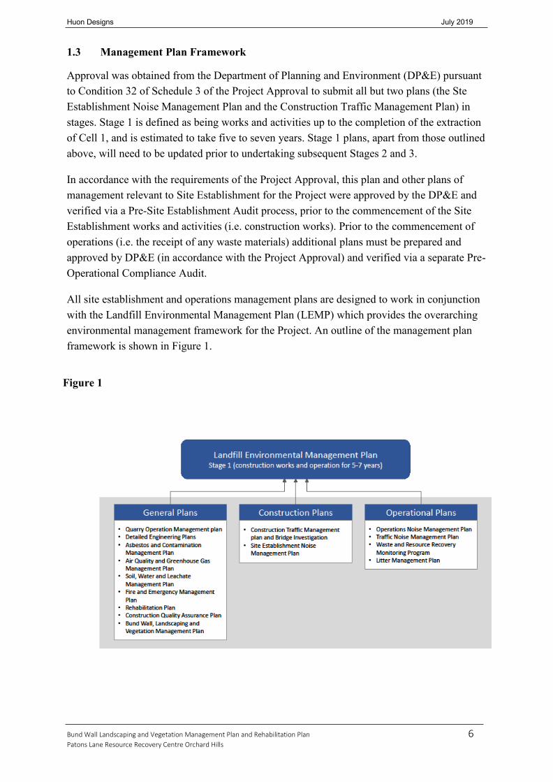
All site establishment and operations management plans are designed to work in conjunction with the Landfill Environmental Management Plan (LEMP) which provides the overarching environmental management framework for the Project. An outline of the management plan framework is shown in Figure 1.
Figure 1

7 Bund Wall Landscaping and Vegetation Management Plan and Rehabilitation Plan
Patons Lane Resource Recovery Centre Orchard Hills
Huon Designs July 2019
The management plan approval process is outlined in Figure 2.
Figure 2

8 Bund Wall Landscaping and Vegetation Management Plan and Rehabilitation Plan
Patons Lane Resource Recovery Centre Orchard Hills
Huon Designs July 2019
1.4 Statement of Aims and Objectives
The aim of the Plan is to provide the technical detail required for SRC Operations Pty Ltd to protect, conserve and enhance the native plant communities in the area. The life of the project is estimated at 25 years and at the end of its operation and restoration it will be returned to pasture land and native bushland, as intended in the FMPPR.
In keeping with the intent of the FMPPR, the aim is to restore and maintain any disturbed areas. This will minimize the impact of the proposed development on the site’s surrounding natural ecosystem and the adjacent land uses. The aim of the plan is to ensure the development has positive impacts on the visual amenity of the area and the health of the vegetation communities within the area, now and into the future.
The objectives of this plan are to identify the abiotic and biotic factors relating to the site in order to discuss the management strategies required to:
▪ satisfy the Project Approval Consent Conditions, ▪ satisfy the aims identified above with reference to managing existing and new native
vegetation areas; weed and erosion threats; final land use and visual aesthetic amenity, ▪ provide a framework to implement, maintain and monitor the rehabilitation of the site
There are two key vegetation communities associated with this site. They are the Cumberland Plain Woodland (CPW) and the River Flat Eucalyptus Forest (RFEF).
The Cumberland Plain Woodland is primarily located in Commonwealth Defence Department land to the west, south west and south of the site. It is an Endangered Ecological Community (EEC) and remnant species still exist on site. They occur where the land has been undisturbed by previous quarry operations along the property boundaries and in the vicinity of Blaxland Creek.
The River Flat Eucalyptus Forest is also an Endangered Ecological Community and occurs in the northwest corner of the site. It is the vegetation community associated with the riparian zone of Blaxland Creek.

9 Bund Wall Landscaping and Vegetation Management Plan and Rehabilitation Plan
Patons Lane Resource Recovery Centre Orchard Hills
Huon Designs July 2019
1.5 Scope of Site Works and Activities Included in Stage 1
Staging
The Project will operate in accordance with three key stages. Stage 1 is defined as being up to the completion of excavation of Cell 1 which includes all site establishment works and Cells 1A, 1B and 1C. Management plans will be updated in future prior to additional works being commenced (such as Cells 2 and 3) as part of Stages 2 and 3.
Stage 1 works and activities are made up of the following components:
▪ Site establishment works and activities ▪ Construction of the recycling and reprocessing area (RRA) ▪ Operation of the landfill and the RRA and cell construction up to the completion of the
excavation of Cell 1 (made up of Cells 1A, 1B and 1C).
Stage 1 is expected to take 5-7 years to complete.
Plans for Stage 1 have been prepared based on the impacts of the above activities being carried out at full operational level i.e. up to the maximum permitted tonnages and vehicle movements as permitted by the Project Approval. General construction and operating parameters are summarised in the following sections.
▪ Hours of Construction:
1. Monday to Friday, 7am to 6pm
2. Saturday, 8am to 1pm
3. Sunday, no work
▪ Total input: up to 450,000 tonnes per annum (tpa)
▪ Waste recycled: up to 350,000 tpa
▪ Waste landfilled: up to 205,000 tpa
▪ Heavy vehicles: up to 250 heavy vehicle movements per day
▪ Maximum resource export rate: 160,000 tpa
▪ Maximum stockpile height: RL 54 m AHD
▪ Construction: 10 to 15 people
▪ Operation: 20 people full time, plus up to 10 part-time contractors
▪ Hours of operation:
1. Monday to Friday 7am to 5pm
2. Saturday 8am to 2pm.

10 Bund Wall Landscaping and Vegetation Management Plan and Rehabilitation Plan
Patons Lane Resource Recovery Centre Orchard Hills
Huon Designs July 2019
Site Establishment and Construction of the RRA
The details of these works and activities are set out below.
These construction activities are expected to take 18 months to complete and will be carried out within the following parameters:
▪ Hours of Construction:
1. Monday to Friday 7am to 6pm
2. Saturday 8am to 1pm
3. Sunday, no work
▪ Personnel:
1. Construction: 10 to 15 people.
Site Establishment
The site establishment works and activities are as follows:
▪ Construction/shaping of the northern face and much of the eastern face to their final rehabilitated
landform and landscaping of those faces. Construction of the northern face will be achieved through the following:
1. Reshaping the existing north eastern and north western bund walls, by reducing its height in some areas, raising its height in other areas to create an even northern face with a maximum elevation of 53 m AHD, and a more gentle northerly slope than currently exists. The new northern face and acoustic mound will provide acoustic protection for earthmoving and landfilling equipment/vehicles operating within Cells 1 and 2. The acoustic mound will be removed at the conclusion of capping in Cell 2 when it is no longer needed for acoustic protection
2. Areas to the north of the acoustic mound will be regraded to their final rehabilitated landform with slopes of approximately 5%. Final landscaping of these areas will occur during site establishment.
▪ Partial rehabilitation of the existing southern and southwestern bund walls through the reduction
in the elevation to an approximate elevation of between 57 m AHD and 58 m AHD such that they will not be visible from any residence within The Vines Estate. Once re-shaped, the surface and adjoining batter slopes will be revegetated
▪ Upgrading and sealing of Patons Lane and upgrading the entrance to the site (from Patons Lane) together with the installation of three weighbridges and upgrade of associated office building

11 Bund Wall Landscaping and Vegetation Management Plan and Rehabilitation Plan
Patons Lane Resource Recovery Centre Orchard Hills
Huon Designs July 2019
▪ Site preparatory works within the recycling and re-processing area to create the required landform and create a suitable pad for the materials recycling facility warehouse and mobile recycling equipment
▪ Construction and commissioning of the on-site wheel wash facility
▪ Upgrading and sealing the internal road network beyond the proposed wheel wash facility to the exit point from the recycling and re-processing area
▪ Building and construction works and infrastructure works as shown in Figure 3.
Figure 3 Site Establishment Works

12 Bund Wall Landscaping and Vegetation Management Plan and Rehabilitation Plan
Patons Lane Resource Recovery Centre Orchard Hills
Huon Designs July 2019
These works and activities will be undertaken generally in the order set out below (and referenced on Figure 3) noting that the scheduling of specific works will be dependent on factors such as weather, commercial factors including contractor availability, specific logistical requirements and many other issues and will vary accordingly. In addition, many of the works and activities will need to be undertaken simultaneously. The works and activities associated with site establishment are as follows:
1. Construct surface water controls (integrate dams as required)
2. Excavation of stockpiled clay/shale and construct northern face (external and Internal slopes)
3. Regrading/shaping areas north of the northern face
4. Dewatering of quarry void
5. Landscaping northern face
6. Construct track for Transgrid access
7. Construct raw material stockpiles
8. Excavate recycling and re-processing area to 48 m AHD to 49 m AHD. Extraction of clay to form required landform
9. Clay/shale extraction in Cell 1A, then 1B and 1C
10. Install leachate riser and drainage layer in Cell 1A and then 1B
11. Construct Initial Leachate Evaporation Pond
12. Construction of recycling and re-processing area infrastructure (see Figure 4 for details)
13. Maintain height of the eastern face of 57 m to 58 m AHD (outer slope reduced for landscaping)
14. Construct/re-establish Dam 3 (3A&B)
15. Construct/re-establish Dam 4 (4A)
16. Construct/re-establish Dam 5(5A)
17. Construct Dam 6
18. Establish contingency stockpile area
19. Upgrade internal road network [sealed]
20. Upgrade internal road network [unsealed]

13 Bund Wall Landscaping and Vegetation Management Plan and Rehabilitation Plan
Patons Lane Resource Recovery Centre Orchard Hills
Huon Designs July 2019
21. Construct wheel wash facility
22. Upgrade site entrance
23. Install weighbridges
24. Construct car park
25. Construct site office
26. Reduction in height from southwestern face
27. Establish workshop area
28. Construct acoustic mound.
Construction of the RRA
The management plans have been based on the impacts of the construction of the entire RRA. The layout of the RRA is set out below in Figure 4. These items are largely buildings and structures that will be subject to Construction Certificates, BCA regulations and Occupation Certificates certified by an approved certifying authority.

14 Bund Wall Landscaping and Vegetation Management Plan and Rehabilitation Plan
Patons Lane Resource Recovery Centre Orchard Hills
Huon Designs July 2019
Figure 4 Layout of Recycling and Reprocessing Area
The infrastructure permitted to be constructed as part of the RRA will be undertaken generally in the order set out below (and referenced on Figure 4) noting that the scheduling of specific works will be dependent on factors such as weather, commercial factors including contractor availability, specific logistical requirements and other issues and will vary accordingly. In addition, many of the following works and activities will need to be undertaken simultaneously:

15 Bund Wall Landscaping and Vegetation Management Plan and Rehabilitation Plan
Patons Lane Resource Recovery Centre Orchard Hills
Huon Designs July 2019
1. Drainage works
2. C&D / C&I Recycling Building
3. Product Bays
4. Delivery Area
5. Road network
6. Crushing and Screening Area
7. Recycling Facility Warehouse
8. Amenities building
9. Carpark.
Operation
The specific works and activities associated with Stage 1 operations are the:
▪ Emplacement of wastes into Cell 1A
▪ Construction of Cell 1B and 1C including the selective extractive operations to extract the clay/shale resource and related stockpiling activities
▪ Receipt and processing of wastes in the RRA with residuals being compacted, baled, and emplaced in Cell 1A and 1B.
Figure 5 shows the general arrangement of Cell 1.
Compacted and baled residual waste will be transported form the RRA to the landfill cell via a dedicated on-site heavy vehicle fitted with a walking floor trailer.
Mobile plant and equipment to be used for the placement of waste into the cells include an excavator with a detachable grab attachment for handling the baled waste, and a bucket attachment for movement of daily cover. A compactor will also be used to provide further compaction of residual waste.
Bulldozers, dump trucks and excavators will be used for the excavation of cells 1B and 1C.

16 Bund Wall Landscaping and Vegetation Management Plan and Rehabilitation Plan
Patons Lane Resource Recovery Centre Orchard Hills
Huon Designs July 2019
Figure 5 – Cell 1 General Arrangement

17 Bund Wall Landscaping and Vegetation Management Plan and Rehabilitation Plan
Patons Lane Resource Recovery Centre Orchard Hills
Huon Designs July 2019
1.6 Project Approval and Consent Conditions
Table 1 below details the specific Project Approval Consent Conditions and where they have been addressed. Table 1A Project Approval and Consent Conditions BWL&VMP
Project Approval Schedule and consent Condition Numbering
Project Approval Consent Condition specifically for BWL&VMP
Section of this report where the Conditions are addressed and comments
4.40 BUND WALL, LANDSCAPING AND VEGETATION MANAGEMENT PLAN (BWL&VMP)
The Proponent shall prepare and implement a Bund Wall, Landscaping and Vegetation Management Plan to achieve the final landform and landscaping in Figure 2.22 of the Further Modified Preferred Project Report (Ex Z in Appeal No 10928 of 2010). This plan must
It is noted that the DP&E provided approval to submit plans on a staged basis on 1 June 2016. An error was made in not including the BWL&VMP in this request. A request was made to submit this plan on staged basis as permitted with the other plans as approved by DP&E on 12 November 2016. The DP&E approved the submission of the BWL&VMP on a staged basis on 12 December 2016. This correspondence is provided as Attachment 1. Accordingly, this plan is being prepared on a staged basis as per the other plans i.e. it deals with Stage 1 which is the completion of Site Establishment Works and the completion of the excavation of Cell 1.
4.40.a be prepared in consultation with OEH, EPA and NOW by a suitably qualified and experienced expert(s);
Huon Designs have been approved by the DP&E as suitably qualified experts in correspondence dated 31 August 2015 (see Attachment 2).
.
This Plan has been forwarded to the following authorities for consultation;
NOW (this is the former New South Wales Office of Water – this Department is now known as DPI Water). The contact is [email protected] Attention John Galea
EPA – Contact Kathy Falconer [email protected] [email protected]
Office of Environment and Heritage (OEH) Note – Kathy Falconer is also the contact for consultation with OEH
Penrith City Council – Contact Peter Wood Manager Assessments
18 Bund Wall Landscaping and Vegetation Management Plan and Rehabilitation Plan
Patons Lane Resource Recovery Centre Orchard Hills
Huon Designs July 2019
Project Approval Schedule and consent Condition Numbering
Project Approval Consent Condition specifically for BWL&VMP
Section of this report where the Conditions are addressed and comments
[email protected] Robert Craig Principal Planner [email protected]
Carlie Fulton Senior Environmental Health Officer [email protected]
Note the project approval did not require the proponent to consult with PCC re the BWL&VMP. However, the proponent is required to consult with PCC re the Rehabilitation Plan so the Plan is being forwarded to PCC.
The agency comments (which were favourable) from PCC and DPI Water are attached as Appendix 7. Note EPA and OEH advised that they had no comments
4.40.b be approved by the Director- General prior to the commencement of site establishment;
Approved by DP&E on 9 August 2017
4.40.c specify the staging milestones for implementation of landscaping works;
This Plan is prepared for Stage 1 which is defined in Section 1. This staging is shown on Plans “Site Establishment – Rehabilitation and Landscaping Plan”, Drawing No PL2017/09/A dated 10 January 2017, and “Landform and Rehabilitation/Landscaping Plan”, Drawing No PL 2017/10/A dated 10 January 2017 attached to this report. Staging Milestones for the Plans are based on the Stage 1 approved by DP&E:
1. Site Establishment Works 2. Excavation and partial restoration of Cell
1. The works in this Plan cover the staging shown in the FMPPR Table 2.5 Indicative Emplacement and Cell Rehabilitation Staging up to year 5 (approximately). i.e. the completion of the staging of Cell 1. This is represented in Figure 2.10a Stage 0 Operations and Figure 2.21 Rehabilitation Following Site Establishment.

19 Bund Wall Landscaping and Vegetation Management Plan and Rehabilitation Plan
Patons Lane Resource Recovery Centre Orchard Hills
Huon Designs July 2019
Project Approval Schedule and consent Condition Numbering
Project Approval Consent Condition specifically for BWL&VMP
Section of this report where the Conditions are addressed and comments
4.40.d detail specifications for the approved removal, reshaping and/or landscaping of the bund walls;
See Section 3.0 Site Management,in particular Section 3.7 Site Establishment – Rehabilitation and Landscaping Plan. The detailed specifications implemented for the approved removal, reshaping and/or landscaping of the bund walls have been developed in accordance with the project approval based on the following high level project approval documents; The FMPPR provides the requirements for the bund wall works as follows: 1. Page 53, paragraph 4. 2. Section 2.9 Existing Bund Wall
Management” also commencing on page 53, 3. Section 2.3 Site Establishment page 16. 4. Section 2.15 Rehabilitation. 5. Figure 2.21, Figure 2.22and Attachment A in
Appendix 3 of the Modified Preferred Project Report (MPPR) Schematic Landscape Plans and Schedules.
6. The resultant detailed specifications for the approved removal, reshaping and design of the bund walls as required in the FMPPR and Site Establishment works are set out in Attachment 3 – GHD Plans and Cross Sections. The landscape treatment of these bunds shown in the plans is set out in Huon Designs Plan “Site Establishment – Rehabilitation and Landscaping Plan”, Drawing No PL2017/09/A dated 10 January 2017, and in Section 3.0 and in particular Section 3.7 of this report.
4.40.e specify riparian zone management within 50m of Blaxland Creek (measured from the top of the bank);
See Huon Designs Plan “Site Establishment – Rehabilitation and Landscaping Plan”, Drawing No PL2017/09/A dated 10 January 2017 and Section 3.0 of this report. In particular Sections 3.1 Zone 1: Conserve areas of moderate resilience – Riparian Zone and Section 3.7 Riparian Zone management has been extended in places up to 100m in this plan.
The riparian zone is now defined as being 40m (measured from the top of the bank) pursuant to the Guidelines issued by DPI Office of Water (formerly NOW) in 2012.

20 Bund Wall Landscaping and Vegetation Management Plan and Rehabilitation Plan
Patons Lane Resource Recovery Centre Orchard Hills
Huon Designs July 2019
Project Approval Schedule and consent Condition Numbering
Project Approval Consent Condition specifically for BWL&VMP
Section of this report where the Conditions are addressed and comments
4.40.e (cont.)
“On 1 July 2012 new rules commenced regarding controlled activities within riparian corridors. The new rules amend the riparian corridor widths that apply to watercourses, providing more flexibility in how riparian corridors can be used and making it easier for applicants to determine the Office of Water controlled activity approval requirements.”
These guidelines and related DPI Water documents have been followed in the formulation of this plan and the controlled activity approval application to be submitted to DPI Water for works carried out within the riparian zone. DPI Water guidelines and policies are appended to this report as Attachment along with a survey defining the riparian zone.
4.40.f include measures to minimise native vegetation loss and additional tree planting to offset this loss;
See Section 3.0 Site Management of this report In particular Sections 3.1, 3.2 and 3.3 and Huon Design Plans “Site Establishment – Rehabilitation and Landscaping Plan”, Drawing No PL2017/09/A dated 10 January 2017, and “Landform and Rehabilitation/Landscaping Plan”, Drawing No PL 2017/10/A dated 10 January 2017 attached to this report
4.40.g include a landscape plan identifying locations of planting and identifying species to be planted;
See Huon Designs Plan “Site Establishment – Rehabilitation and Landscaping Plan”, Drawing No PL2017/09/A dated 10 January 2017, and Section 3.0 In particular Section 3.7 of this report.
4.40.h specify the use of only indigenous species propagated from local provenance seed;
See Table 5 Revegetation Species List of this report.
4.40.i specify the measures which shall be undertaken to protect the EECs on adjacent lands (particularly to the southern and western boundaries of the site), in particular measures to:
See Section 3.0 of this report. In particular Section 3.7
Consultants have previously provided information on the impacts of dust, surface water and groundwater upon the vegetation within the riparian zone and EEC within the conservation zone both on and off the Project Site See Attachment 5 (Consent Condition Schedule 6 Condition 5c. This information has been used to assist developing strategies which are included

21 Bund Wall Landscaping and Vegetation Management Plan and Rehabilitation Plan
Patons Lane Resource Recovery Centre Orchard Hills
Huon Designs July 2019
Project Approval Schedule and consent Condition Numbering
Project Approval Consent Condition specifically for BWL&VMP
Section of this report where the Conditions are addressed and comments
i) stabilize exposed soils;
ii) control of invasive weeds to prevent weeds from migrating to the EECs;
iii) prevent dust from impacting on the EECs;
iv) control sediment, stormwater and surface run-off from impacting on the EECs;
v) prevent leachate from entering into the groundwater or migrating off-site; and
vi) include all of the above measures in corresponding management plans.
in this plan protect the EECs on adjacent lands. These issues are dealt with in section 3.0 of this Report and Section 4.0 Maintenance, Monitoring and Key Performance Indicators of this Report
See Section 3.0 of this report. In particular Section 3.4 Erosion Strategy. In addition, see Soil, Water and Leachate Management Plan (SWLMP)
See Section 3, in particular Sections 3.1, 3.2, 3.3 and 3.6 Weed Management
See Section 3.9 – Dust Management strategies. In addition other dust management strategies relating to site operations not related to rehabilitation are set out in the Air Quality and Greenhouse Gas Management plan (AQMP) and summarised in this Plan.
See and Section 3.4 SWLMP and LEMP which focuses on surface water control to keep surface water out of the leachate systems. See specific reference in the SWLMP and LEMP.
4.40.j identify protection measures for the vegetation and controls for each phase of the development;
See Section 3.5 Fencing Strategy and Section 4.0 Maintenance, Monitoring and Key Performance Indicators of this Report
4.40.k specify details of maintenance actions to ensure the vegetation is maintained at all times including
See Section 4.0 Maintenance, Monitoring and Key Performance Indicators of this Report.

22 Bund Wall Landscaping and Vegetation Management Plan and Rehabilitation Plan
Patons Lane Resource Recovery Centre Orchard Hills
Huon Designs July 2019
Project Approval Schedule and consent Condition Numbering
Project Approval Consent Condition specifically for BWL&VMP
Section of this report where the Conditions are addressed and comments
during the operations and for the post-closure period stipulated by the OEH and EPA;
Note that post closure issues are not relevant for this Plan as it only required to deal with Stage 1 up to the end of the excavation of Cell 1.
4.40.l specify details of a monitoring and compliance program;
See Section 4.0 Maintenance, Monitoring and Key Performance Indicators of this Report
4.40.m require an annual review for inclusion in the Annual Environmental Management Review that reports on the performance of the landscaping and vegetation management, including further recommendations to ensure the successful establishment of vegetation.
See Section 4.0 Maintenance, Monitoring and Key Performance Indicators of this Report

23 Bund Wall Landscaping and Vegetation Management Plan and Rehabilitation Plan
Patons Lane Resource Recovery Centre Orchard Hills
Huon Designs July 2019
Table 1B Project Approval and Consent Conditions Rehabilitation Plan
Project Approval Schedule and consent Condition Numbering
Project Approval Consent Condition specifically for Rehabilitation Plan
Section of this report where the Conditions are addressed and comments
4.46 REHABILITATION PLAN The Proponent shall prepare and implement a Rehabilitation Plan to achieve the final landform and landscaping in Figure 2.22 of the Further Modified Preferred project Report (Exhibit in Appeal No 10928 of 2010), This plan must:
It is noted that the DP&E provided approval to submit plans including this Rehabilitation Plan on a staged basis on 1 June 2016. This correspondence is provided as Attachment 1. This plan is being prepared on a staged basis as per the other plans i.e. it deals with Stage 1 i.e. the completion of Site Establishment Works and the completion of the excavation of Cell 1.
Accordingly, the works in this Plan cover the staging shown in Table 2.5 Indicative Emplacement and Cell Rehabilitation Staging up to year 5 (approximately). i.e. the completion of the staging of Cell 1. This is represented in Figure 2.10a Stage 0 Operations and Figure 2.21 Rehabilitation Following Site Establishment.
4.46.a be prepared by a suitably qualified expert whose appointment has been approved by the Director- General;
Huon Designs have been approved by the DP&E as suitably qualified experts in correspondence dated 31 August 2015 (see Attachment 2).
4.46.b be prepared in consultation with EPA, NOW and Council
Approved by DP&E on 9 August 2017. NOW (this is the former New South Wales Office of Water – this Department is now known as DPI Water). The contact is [email protected] Attention John Galea
EPA – Contact Kathy Falconer [email protected] [email protected]
Office of Environment and Heritage (OEH) Note – Kathy Falconer is also the contact for consultation with OEH
Penrith City Council – Contact Peter Wood Manager Assessments [email protected]

24 Bund Wall Landscaping and Vegetation Management Plan and Rehabilitation Plan
Patons Lane Resource Recovery Centre Orchard Hills
Huon Designs July 2019
Project Approval Schedule and consent Condition Numbering
Project Approval Consent Condition specifically for Rehabilitation Plan
Section of this report where the Conditions are addressed and comments
Robert Craig Principal Planner [email protected]
Carlie Fulton Senior Environmental Health Officer [email protected]
The agency comments (which were favourable) from PCC and DPI Water are attached as Appendix 7. Note EPA and OEH advised that they had no comments.
4.46.c be submitted to and approved by the Director-General prior to commencement of the site establishment works;
Approved by DPE on 9 August 2017
4.46.d define the objectives and criteria for rehabilitation and closure;
See Sections 1.0 and 4.0 of this Report
4.46.e comply with the minimum design specifications and operational/post closure requirements in Schedule 7 unless specified by the EPA;
Satisfied as detailed in Sections 1.0, 3.8, and 4.0 of this Report. In addition, Schedule 7 of the project approval is attached to this report with details of where these requirements are addressed in various reports.
4.46.f identify the works required and the progressive timing to complete the rehabilitation of each part of the Project;
See Section 3.0 of this report and Section 5.0 ‘Restoration Works Program” of this Report
4.46.g investigate options for the removal of Dam 2 outside the riparian corridor as of the final landform once the operational purpose of the dam is complete;
Not applicable in Stage 1 of the Plan
4.46.h investigate options for the future use of the site;
Not applicable in Stage 1 of the Plan
4.46.i include provisions to monitor and manage settlement impacts during and after the operations;
Not applicable in Stage 1 of the Plan except as interim preloading waste emplacement with stockpiles of quarried materials to minimize future settlement impacts. See Section 4.0 of this report
4.46.j describe the measures that would be implemented to achieve the specified objectives and criteria for the rehabilitation and closure;
See Section 3.0 and Section 4.0 of this Report.

25 Bund Wall Landscaping and Vegetation Management Plan and Rehabilitation Plan
Patons Lane Resource Recovery Centre Orchard Hills
Huon Designs July 2019
Project Approval Schedule and consent Condition Numbering
Project Approval Consent Condition specifically for Rehabilitation Plan
Section of this report where the Conditions are addressed and comments
4.46.k calculate the cost of implementing these measures;
See Section 6.0 “Restoration Works Budget” of this Report
4.46.l describe how the performance of these measures would be monitored over time;
See Section 4.0 of this Report
4.46.m address the issue of settlement post-closure and provide designs and ongoing maintenance procedures such as backfilling to maintain slope, drainage and prevent ponding.
See Section 4.0 of this Report and notes above in reference to 4.46.i

26 Bund Wall Landscaping and Vegetation Management Plan and Rehabilitation Plan
Patons Lane Resource Recovery Centre Orchard Hills
Huon Designs July 2019
2.0 SITE DESCRIPTION
2.1 Location and Ownership
Patons Lane Resource Recovery Centre, Lot 40, DP 738126 occupies an area of 60 hectares located at the end of Patons Lane, Orchard Hills in the Local Government area of Penrith City Council. The site is owned by SRC Operations Pty Ltd and is bordered to the west and south by bush land owned by the Commonwealth Defence Department, and by private farming land to the north and east.
2.2 Abiotic Factors
2.2.1 Climate
The climate in the suburb of Orchard Hills has the historic recording associated with the western parts of the Sydney Basin and nearby Penrith. The hottest days have been recorded in summer where temperatures can reach as high as 43 degrees celcius. Winter temperatures can range from below freezing with occasional frosts, to an average of 17 degrees celcius. Rainfall averages about 800mm per annum but is often variable, with the highest rainfall generally occurring in the late spring/summer months.
2.2.2 Geology and Soils
The geology and soils of the Orchard Hills area is part of the Hawkesbury River flood plain and is typified by Wianamatta Shale soils. This has resulted in relatively rich natural soils and abundance of underlying shale. The valuable light-firing shale was the resource exploited in the previous quarry operations and is to be further utilized in the ongoing operations of the site. The soil is dispersive and relatively erosive.
Large amounts of various fill materials have been imported onto the site and this will be reused in the operation of the landfill as cover material and capping material.
2.2.3 Topography and Aspect
The property has a predominantly neutral aspect as it has been almost totally impacted by previous quarry operations, including the construction of surrounding bund walls. The surrounding topography however is generally flat undulating with a slight southerly aspect. Once complete, the final landform will be a low hill with grades of 2-10%.
2.2.4 Catchment and Drainage
The property is part of the Blaxland Creek Catchment that ultimately drains into the Hawkesbury- Nepean Catchment. Very little of the current site drains off the property as it is contained by the surrounding bund walls and collected in existing dams. The north and west perimeter of the site drains into Blaxland Creek. The south and east drain into the depression running east alongside Patons Lane.
2.2.5 Erosion
Erosion is present in previously disturbed areas and is primarily occurring inside the existing bund walls where runoff is then directed into internal dams and ponds. The surrounding bund walls are generally stable and well vegetated. Blaxland Creek has some erosion along its banks, more due to flash floods from upstream than any impacts created on the site.
27 Bund Wall Landscaping and Vegetation Management Plan and Rehabilitation Plan
Patons Lane Resource Recovery Centre Orchard Hills
Huon Designs July 2019
2.2.6 Acoustics and Scenic Amenity The site is currently dormant and has no activities that would impact on the acoustic or scenic amenity of the area. A few cattle, kangaroos and feral animals graze on the site. Only the visual impact of the bund walls is significant due to their relative height, uniformity and lack of bush land vegetation.
2.3 Biotic Factors
2.3.1 Flora
The site and surrounding area contains two (2) plant communities as listed in the Introduction and Executive Summary. The two key vegetation communities associated with this site are the Cumberland Plain Woodland and the River Flat Eucalyptus Forest. The remainder of the site is bare exposed soil or covered with pasture grasses and a range of perennial and herbaceous weeds.
The Cumberland Plain Woodland is primarily located in Defence Department land to the west, southwest and south of the site. It is an Endangered Ecological Community (EEC) and remnant species still exist on site or have germinated here. It occurs where the land has been undisturbed by previous quarry operations and in the vicinity of Blaxland Creek.
The River Flat Eucalyptus Forest is also an Endangered Ecological Community and occurs in the northwest corner of the site. It is the vegetation community that makes up the riparian zone of Blaxland Creek.
Plant species list and those suitable for revegetation are to be sourced from these communities and are listed in Table 5. The list is also a compilation of those prepared by Richard Lamb and Associates (Schematic Landscape Plans and Schedules) and Geoff Cunningham (Flora Assessment Report September 2009 and Response to Point 1.(e) Short Minutes of Order, 12 May 2011). According to the Flora Assessment there are no records of threatened plant species on the site or in the vicinity and this was confirmed by field surveys undertaken by Geoff Cunningham and Huon Designs.
2.3.2 Fauna
Potential native fauna populations on the site have been identified in fauna studies undertaken and included in the Fauna Assessment prepared by Aquila Ecological Surveys September 2009. The adjacent Defence Department land is well fenced, as is the farming land. The only sizeable access onto the site is via the opening to the southeast corner of the site at the end of Patons Lane.
The site itself does not currently provide significant habitat other than ponds/dams and pasture/ grasslands. Despite the high level of disturbance on the site native fauna would still be frequenting much of the site to forage, drink and take advantage of isolated trees and vegetation. Sightings of wallabies, reptiles and a variety of birdlife have been reported anecdotally. It should be anticipated that pest species would also frequent the site due to surrounding land uses and reported populations. This would include foxes, rabbits and feral cats and dogs.
Once the perimeter security fencing is complete, there will be limited access or through movement of larger species. They will only be able to enter and leave if they capitalize on the opportune use of open gates and breaks in the fencing.

28 Bund Wall Landscaping and Vegetation Management Plan and Rehabilitation Plan
Patons Lane Resource Recovery Centre Orchard Hills
Huon Designs July 2019
As stated in Aquila’s report, if managed appropriately, “the Project would not have any impact upon the fauna and fauna habitat on the adjoining Commonwealth land managed by the Department of Defence.” Aquila’s report also states that, the limited and modified habitats represented on the site may support a narrow range of native fauna that are common in the surrounding region. Furthermore it states that: “whilst three fauna species listed as vulnerable on the Threatened Species Conservation (TSC) Act occur or are likely to occur, there is unlikely to be a significant effect on these species or their habitats”. Once complete the project will provide an increase in the amount of valuable habitat, in contrast to the decrease in the surrounding areas due to future residential and commercial development pressures.
2.4 Condition of bush land and weeds
Intact and undisturbed areas of native vegetation are non-existent on the site. The vast majority of the site (as identified in Cunningham’s assessment) is weed invaded disturbed land. The weeds present are listed in Table 3 of this report and the native grasses present are included in Table 5 Revegetation Species List.
The Cumberland Plain Woodland represented on the neighbouring Department of Defence land is relatively intact with moderate disturbance caused by tracks, fire/security management practices and some weeds. Most weeds are impacting the site due to a range of causal factors as outlined in Table 2.
The riparian zone of Blaxland Creek is intact but disturbed by weeds, manmade activities, and domestic/feral animal grazing. The narrow strip of land on the boundaries of the site between the bund walls and the security fencing is largely intact in terms of site soils but is also severely disturbed by weeds, manmade activities, and domestic/feral animal grazing.
Both areas are likely to have a healthy seed bank of native species. They have been hampered in their ability to regenerate due to domestic grazing, weeds and pasture grasses. There is also undoubtedly a substantial seed bank of weed species present. One noxious weed was recorded on the site, being African Boxthorn (Lycium ferocissum) a Class 4 Weed. Methods for the treatment and removal of weeds are discussed in Section 3.6.2 Management of Weed Removal and Encouragement of Natural Regeneration
2.4.1 Site Resilience
Site resilience relates to the ability of the natural areas to recover or ‘bounce back’ after disturbance. It is one of the main considerations in prioritizing actions set out in this Plan.
In the areas of high resilience, the site soils have not been disturbed, the water regime remains the same and no extra nutrients have been introduced. There is also a good representation of all native vegetation strata levels showing varying stages of maturity; an intact native seed bank present in the soil; potential habitat including hollow-bearing trees; connectivity to other natural areas and areas of a size large enough to reduce levels of edge effects. There are no areas of high resilience on the site.
Moderately resilient areas have had some disturbance; are adjacent to disturbed areas and/or will be affected by runoff from disturbed areas; the native vegetation structure is not indicative of a highly resilient area and habitat is threatened. The riparian zone adjoining Blaxland Creek exhibits moderate resilience.

29 Bund Wall Landscaping and Vegetation Management Plan and Rehabilitation Plan
Patons Lane Resource Recovery Centre Orchard Hills
Huon Designs July 2019
Areas of low to nil resilience have experienced significant disturbance such as removal of topsoil; addition of fill; changes in water flow; erosion; weeds dominating over native species and loss of habitat. It is necessary to stabilize low resilient areas to reduce resources required to preserve and conserve high to moderately resilient areas now and into the future.
The narrow strip of land between the bund walls and the security fence may well have low to moderate resilience but is severely impacted by weeds and grazing. The ability for this zone to bounce back will only be recognized over time as the management practices outlined in this Plan are implemented. If it is identified that some of this area has good resilience due to a healthy native seed bank, it may be possible to carry out a soil translocation operation as detailed in Section 3.7 below. Fundamentally, the theory is to use current bush regeneration techniques to control weeds and encourage natural regeneration. This may include revegetation works also.
The remainder of the site and the bund walls has been severely impacted with no original topsoil. It will be further impacted and has no worthwhile resilience. These areas need to be stabilized and managed in such a manner to control weeds and to ensure that negative impacts do not place undue pressure on the other zones, hence increasing costs.
The methods for managing areas of varying resilience are outlined in Sections 3.1, 3.2 and 3.3 below.
2.4.2 Causes of Weed Invasion
Identifying the cause of weed invasion is necessary to determine work priorities; to prevent further encroachment and to reduce the need for high levels of ongoing resources required to achieve outcomes. The major causes of weed invasion on site as per the table below are classified as physical disturbance of soil; imported soil; dumped garden refuse; physical disturbance of vegetation; wind, water and fauna dispersal.
Most causes of weed invasion listed below occur on the site. The methods to control these factors are an important part of this Plan and are outlined below in Section 3 Site Management Recommendations.
Table 2: Causes of weed invasion (Hawkesbury-Nepean Catchment Management Trust 2000)
Cause of weed invasion Code Symptoms Physical disturbance of soil S Weed established on bare soil Imported soil F Weeds established on imported soil Dumped garden refuse D Weeds centered on dumped garden refuse Physical disturbance of vegetation V Evident that moving or trampling has allowed weed growth Impacts from storm water R Growing in wet areas below storm water outlets Fauna dispersal O Weeds established in otherwise undisturbed areas Wind w Weeds established in otherwise undisturbed areas/animals not cause Water a Weeds centred on creek where weeds present in headwaters Neighbouring property n Weeds spread from neighbouring property
Measures to control the causes of weed invasion are discussed in detail in Section 3.6.1 Management of Causes of Weed Invasion.
2.4.3 Weed Management Zones
Weed management zones are based on site resilience, position in the landscape, weeds present, causes of weed invasion and treatment requirements. Zone 1 includes areas mapped with moderate

30 Bund Wall Landscaping and Vegetation Management Plan and Rehabilitation Plan
Patons Lane Resource Recovery Centre Orchard Hills
Huon Designs July 2019
resilience and Zone 2 includes areas of low resilience. The remainder of the site is Zone 3, has no resilience and will be highly modified over the course of the project. It will be subject to rehabilitation into the future, including pasture grasses and some native vegetation. The Weed Management Zones are shown on the attached plans PL2017/09/A and PL2017/10/A, dated 10 January 2017.
In general terms Zone 1 represents the restoration and expansion of the Blaxland Creek Riparian corridor, River Flat Eucalyptus Forest. Zone 2 represents the establishment and expansion of the Cumberland Plain Woodland and its consolidation as a buffer to the neighbouring EEC. Zone 3 is primarily the vast proportion of the site. Zone 3 has been severely impacted and will continue to be severely impacted. Ultimately it will be returned to domestic grazing land with pockets of native vegetation in a staged process as quarry and filling works are completed.
2.4.4 Weeds
The following Table 3 lists the weeds known or likely to occur on the site. Field surveys by Geoff Cunningham and Huon Designs have corroborated this information. Much of the site (about 55%) is water, bare soil, hardstand, roads and bare stockpiles. This is unlikely to change significantly until Site Establishment is complete and site rehabilitation occurs. Primarily this will involve the reshaping and stabilization of the new bund walls. It will also include rehabilitation of the boundary areas and the vicinity of Blaxland Creek. The distribution and density of the weeds present on site have been expressed as a percentage in the table below to give some indication of the problems they entail and as a baseline indicator of how successful future management techniques are.
Table 3: Weeds on site at time of inspection
Botanial Name Common Name Classification Method of dispersal/spread % Estimate
of Site Cover
Ageratina adenophora Crofton Weed Perennial Herb Seed/Wind/Water 2% Andropogon virginicus Whiskey Grass Perennial Grass Seed/Wind/Water 2% Araujia hortorum Moth Vine Perennial Vine Seed/Wind 1% Chloris gayana Rhodes Grass Perennial Grass Seed/Wind/Water 2% Chloris virgata Rhodes Grass Perennial Grass Seed/Wind/Water 2% Conyza bonariensis Fleabane Perennial Herb Seed/Wind/Water 2% Cynodon dactylon Couch Grass Perennial Grass Underground Stolons 5% Dittrichia graveolens Stinkwort Perennial Herb Seed/Wind/Bird/Water 1% Echinopogon ovatus Forest Hedgehog Grass Perennial Grass Seed/Wind/Water 1% Eragrostis curvula African Lovegrass Perennial Grass Seed/Wind/Water 2% Genista monspessulana Montpellier Broom Woody Seed/Bird/Water 2% Hypochaeris radicata Flatweed Perennial Herb Seed/Wind/Water 1% Lantana camara Lantana Woody Seed/Bird/Water 1% Lycium ferrocissum African Boxthorn Woody Seed/Bird/Water 2% Onopordum acanthium Scotch Thistle Perennial Herb Seed/Wind 1% Paspalum dilatatum Paspalum Perennial Grass Seed/Wind /Water 2% Pennisetum clandestinum Kikuyu Perennial Grass Stolons/Imported soil/Water 5% Phytolacca octandra Inkweed Perennial Herb Seed/Bird/Water/Tubers 1% Ricinus communis Castor Oil Plant Perennial Herb Seed/Bird/Tubers 1% Senecio madagascariensis Fireweed Perennial Herb Seed/Wind/Water 1% Setaria pumila Pale Pigeon Grass Perennial Grass Seed/Wind/Water 2% Sida rhombifolia Paddy’s Lucerne Woody Seed/Water 1% Solanum sisymbrifolium Sticky Nightshade Perennial Herd Seed/Bird/Water 1% Solanum mauritianum Wild Tobacco Small Tree Seed/Bird/Water 1% Sporobolus africanus Parramatta Grass Perennial Grass Seed/Wind/Water 2% Verbena bonariensis Wild Stattice Perennial Herb Seed/Wind/Water 1%

31 Bund Wall Landscaping and Vegetation Management Plan and Rehabilitation Plan
Patons Lane Resource Recovery Centre Orchard Hills
Huon Designs July 2019
3.0 SITE MANAGEMENT
All Site Resilience/Weed Management Zones are mapped on Huon Designs Drawing Nos PL2017/09/A and PL2017/10/A. The location, shape and final finish of the bund walls, dams and bioswales are as designed by GHD Group Pty Ltd and as shown on Drawing nos. SK010 and SK024. The site management techniques contained within this report are based on these landforms and refer to the above Huon Design Plans. Huon Designs will act as the Project Manager on behalf of SRC Operations Pty Ltd (SRC), owners of the facility, in order to implement this Plan.
3.1 Zone 1: Conserve areas of moderate resilience - Riparian Zone
The areas mapped with moderate resilience are to be allowed to regenerate. Additional management techniques are detailed in Section 3.7 Site Establishment. Actions to take should include but are not to be limited to the following:
▪ Control water flow to minimize erosion and the spread of weed species (refer to section 3.4
Erosion Strategy); ▪ Restrict vehicle and contractor access to existing tracks and designated construction zone
only (refer to section 3.5.1 Protective Fencing); ▪ Exclude domestic stock ▪ Close unnecessary tracks; ▪ Facilitate appropriate fencing requirements (refer to section 3.5 Fencing Strategy); ▪ Identify and treat encroaching weed species by using best practice Bush Regeneration
techniques (refer to section 3.6 Weed Management Strategy); ▪ Monitor areas for future weed encroachment by regular (weekly) inspections and adapt work
program to suit new threats; ▪ Revegetate Zone 1 with native tubestock of local provenance as per Table 5: Revegetation
Species List (River Flat Eucalyptus Forest) and Drawing No PL2017/09/A; ▪ Monitor for herbivore activity (scats, digging, damaged vegetation) and protect regenerating
native species and revegetated areas with protective fencing or plant guards as required (refer to section 3.5.5 Vegetation Fencing); and
▪ Monitor to identify areas requiring replacement and/or additional revegetation.
3.2 Zone 2: Restore and rehabilitate areas of low resilience - Property Boundaries The priority of working areas of low resilience will be dependent upon their location in respect to moderate resilient areas and the potential of the low resilient areas to affect the surrounding areas. These areas of low resilience must not become the source of weed encroachment into other zones. Treatment is aimed at suppressing weed growth and stabilizing disturbed soil. Weeds must not be allowed to seed and spread. Clearly the areas to the northwest, west and southwest of the site are the areas of particular importance as the Plan strives to establish and protect the two EECs that are present here. Boundary areas to the north, east and south east are less of a priority as they will have less impact on the EECs. Additional management techniques are detailed in Section 3.7 Site Establishment. Actions to take should include but are not to be limited to the following:
▪ Control water flow to minimize erosion and the spread of weed species (refer to section 3.4
Erosion Strategy); ▪ Vehicle and contractor access kept to existing tracks and designated construction zone (refer
to section 3.5.1 Protective Fencing); ▪ Exclude domestic stock ▪ Close unnecessary tracks; ▪ Facilitate appropriate fencing requirements (refer to section 3.5 Fencing Strategy);

32 Bund Wall Landscaping and Vegetation Management Plan and Rehabilitation Plan
Patons Lane Resource Recovery Centre Orchard Hills
Huon Designs July 2019
▪ Identify and treat weed species using best practice Bush Regeneration techniques (refer to section 3.6 Weed Management Strategy);
▪ Monitor areas for future weed encroachment by regular (weekly) inspections and adapt work program to suit new threats;
▪ Revegetate Zone 2 with native tubestock of local provenance as per Table 5: Revegetation Species List (Cumberland Plain Woodland) and areas shown on Drawing No PL2017/09/A;
▪ Monitor for herbivore activity (scats, digging, damaged vegetation) and protect regenerating native species and revegetated areas with protective fencing or plant guards as required (refer to section 3.5.5 Vegetation Fencing); and
▪ Monitor to identify areas requiring replacement and/or additional revegetation.
3.3 Zone 3: Maintain and control weeds in grazing/quarry areas of no resilience The priority of working areas of no resilience will be dependent upon their location in respect to medium and low resilient areas and their potential to affect the surrounding areas. These areas of no resilience must not become the source of weed encroachment into other zones. Treatment is aimed at suppressing weed growth and stabilizing disturbed soil. Weeds must not be allowed to seed and spread. Actions to take should include but are not to be limited to the following:
▪ Control water flow to minimize erosion and the spread of weed species (refer to section 3.4
Erosion Strategy); ▪ Vehicle and contractor access kept to existing tracks and designated construction zone (refer
to section 3.5.1 Protective Fencing); ▪ Close unnecessary tracks; ▪ Facilitate appropriate fencing requirements (refer to section 3.5 Fencing Strategy); ▪ Identify and treat weed species using best practice Bush Regeneration techniques (refer to
section 3.6 Weed Management Strategy); ▪ Monitor areas for future weed encroachment by regular (monthly) inspections and adapt work
program to suit new threats; ▪ Revegetation and native screen planting with native tubestock of local provenance as per Table
5: Revegetation Species List (Cumberland Plain Woodland) and areas shown on Drawing No PL2017/09/A and Drawing No PL2017/10/A; and
▪ Maintain pasture grasses and reseed non-invasive grasses as required.
It is required that the landowner engage a qualified Bush Regeneration company to provide assistance and guidance in these works to successfully restore and protect the natural bushland communities associated with the site.
3.4 Erosion Strategy
The comments in this report are intended to support and compliment the Soil, Water and Leachate Management Plan (SWLMP) prepared by GHD Group Pty Ltd. Besides managing erosion, the control of surface water is integral to controlling leachate generation and the potential for leachate to impact on adjoining EECs.
Overland flow across areas of disturbed soil/vegetation and general storm water runoff on the site has caused soil erosion. Erosion has also occurred down the roadways and along open gutter swales beside roads, stockpiles and bunds. Construction activities (vehicles, access, services, stockpiles and building activities) can also create erosion problems and must be controlled by appropriate protective fencing, sediment fencing (refer to section 3.5 Fencing Strategy) and designated access tracks. The number of access tracks should be minimized and clearly defined.

33 Bund Wall Landscaping and Vegetation Management Plan and Rehabilitation Plan
Patons Lane Resource Recovery Centre Orchard Hills
Huon Designs July 2019
Fortunately the site currently is well contained and most erosion runoff ends up in existing dams. This is not a long-term solution as the site is developed. A number of other problems will occur if soils are lost and storm water is not managed properly. The SWLMP addresses these issues and still relies on a series of dams and bioswales to clean the water prior to discharge off the site.
Erosion can aid the spread and establishment of weeds. It can also hinder the growth and establishment of the native plant communities. The strategies used to control erosion work closely and concurrently with those used to enhance native plant communities. They will prevent weed encroachment and help with the establishment of native vegetation cover.
To mitigate the effects of soil erosion (including the current situation of the dams acting as silt traps), targeted water management techniques are to be incorporated into site works. The aim is to reduce water velocity, disperse water to enable greater absorption into the soil, and re-establish native vegetation as outlined in sections 3.4.1, 3.4.2, and 3.4.3 below.
3.4.1 Overland water flow across disturbed bushland areas and cleared areas
▪ Mulching; ▪ Hydromulching of bunds and long term stockpiles with non-invasive pasture grasses and
natives; ▪ Strategic placement of rocks and logs (rocks taken from site/excavation works, and logs from
weed trees/shrubs to be removed); ▪ Revegetation with native tubestock of local provenance (refer to Table 5 and section 3.5.5
Vegetation Fencing); ▪ Natural regeneration to be encouraged using bushland regeneration techniques.
3.4.2 Storm water runoff along bioswales and dam overflows
▪ Install small rock check dams at regular intervals along swales to allow silt to drop out; ▪ Install large rocks as armouring and energy dissipation to protect banks and to avoid scouring
in spillways, dam overflows and Blaxland Creek (refer to Blue Book and Department of Primary Industries guidelines);
▪ Stabilize and revegetate channels, dam wall, spillways and overflow with native tube stock of local provenance (refer to Table 5 and section 3.5.5 Vegetation Fencing); and
▪ Natural regeneration to be encouraged using bushland regeneration techniques.
3.4.3 Storm water runoff down roadways and drainage swales. ▪ Install small rock check dams at regular intervals along swales to allow silt to drop out (using
rock from site construction activities not bushland areas) ▪ Along straight steep grades build a crowned road profile to shed water to the gutter swales. ▪ Install a number of grade reversals along the steeper sections of the road in the form of a
“speed bump” to interrupt the water flow and direct it into the swales.
It is required that the landowner engage a qualified Bush Regeneration company to provide assistance and guidance in these works to successfully control erosion and the impacts of storm water.
3.5 Fencing Strategy
The purpose of the fencing strategy is limit the amount of site soils disturbed by construction activities, to control erosion through the use of silt fences and to protect rehabilitated areas from unintentional damage caused by vehicles, livestock, feral animals, site works or other human activities. The fencing is to be installed as noted on Sections AA, BB and CC of Drawing No

34 Bund Wall Landscaping and Vegetation Management Plan and Rehabilitation Plan
Patons Lane Resource Recovery Centre Orchard Hills
Huon Designs July 2019
PL2017/09/A and Sections AA of Drawing No PL2017/10/A. Exclusion zone fencing and extent of tree protection will be undertaken on site in conjunction with a representative of Huon Designs in attendance and/or the Bush Regeneration company.
3.5.1 Protective Fencing – Exclusion and site delineation
Protective fencing will be required on site during site establishment and project operation to delineate the construction site from the NO GO ZONES. This will protect native areas and areas undergoing rehabilitation from construction activities. It will ensure the construction footprint is kept to a minimum, including the movement of vehicles and machinery, the delivery and storage of materials, installation of services and the disposal of site excavated materials. NO GO ZONES are areas excluded from any construction activities, stockpiles or storage.
Protective fencing between construction site and NO GO ZONES will be a mixture of temporary and long term measures. For long term protection the following measures shall be employed :
▪ 1200mm high star pickets at maximum 2.5 metre spacing; ▪ four strands of (12 gauge) wire; ▪ 900mm high silt fencing may be attached if required; and
Temporary measures shall include: ▪ Flagging and bunting suspended on star pickets similar to systems used on RMS projects. ▪ Signposting and notices
Location is shown in the site sections on Drawing No PL2017/09/A and Drawing No PL2017/10/A.
3.5.2 Erosion and Sediment Fencing
Sediment and erosion control fences to be located as per site sections on Drawing No PL2017/09/A and Drawing No PL2017/10/A. They are to be installed and maintained in accordance with “Managing Urban Stormwater – Landcom (March 2004)” to protect the site from construction activities. Industry standard silt barrier (900mm high minimum and 150mm minimum buried depth) is to be installed to the downhill side of all disturbed areas, to all boundary fences, as required to any intermediate fences, and as required to all NO GO ZONE protective fencing constructed as detailed above.
The silt fencing will also aid in the control of feral animals and the spread of weeds. For this particular reason it will be incorporated wherever possible to maximize the effectiveness of all the site fences, permanent and temporary.
3.5.3 Vegetation Fencing
Additional fencing may be required to protect areas of regeneration and/or revegetation from domestic or feral animal damage. This is to be determined following monitoring of site for scats, digging and/or vegetation damage. Fencing type to be appropriate for identified herbivore. Generally the attachment of 900mm silt fencing to Protective Fencing as outlined above will be appropriate. This will also help to control the dispersion of weeds into the revegetation zones.
3.6 Weed Management Strategy
The Weed Management Strategy is to address the site resilience and cause of disturbance across the site. Consideration is given to the abiotic and biotic components with the goal of restoring and

35 Bund Wall Landscaping and Vegetation Management Plan and Rehabilitation Plan
Patons Lane Resource Recovery Centre Orchard Hills
Huon Designs July 2019
preserving the natural ecological communities. To achieve the goal, the strategy is to prevent further weed invasion, remove existing weeds, suppress weed species with natural regeneration and revegetate areas of poor resilience with species of local provenance.
3.6.1 Management of Causes of Weed Invasion
In order to prevent further weed invasion, the causes need to be addressed as detailed in Table 4 below. The causes have been identified in 2.4.2 Causes of Weed invasion and Table 3.
Table 4: Addressing causes of weed invasion
Cause Code Mitigation Physical disturbance of soil
s No further soil disturbance is to occur outside the designated construction zones. All access and tracks are to be limited, controlled and clearly defined. Carry out best practice bush regeneration techniques and timing. Use erosion controls and fencing.
Imported soil f No imported soil to enter rehabilitated areas of site or be used on areas for revegetation until it has been stockpiled and assessed for weed species. Any identified imported soil with weed propagules and seeds are to be used elsewhere and out of permanent revegetation zones where possible.
Dumped garden refuse
d Remove and exclude any garden refuse to prevent spread of exotic plant species. Avoid the increase of nutrient levels which will encourage further weed growth.
Physical disturbance of vegetation
v No further disturbance of existing native vegetation is to occur. Existing and restored vegetation to be protected from activities associated with the Resource Recovery Centre (its site establishment and operation) by limited and controlled access and the use of exclusion fencing. Implement best practice bush regeneration techniques. Implement erosion/stormwater controls and silt/exclusion fencing.
Impacts from storm water
r Erosion control (3.4 Erosion strategy)
Weed dispersal o,w,a Strategically timed weed removal to prevent additional weed incursions and/or weed seed production, remove and dispose of properly any weed vegetative propagules, monitor for outbreaks.
Neighbouring property
n Address any source of weeds from neighbour’s property with neighbour’s cooperation to prevent ongoing incursion and therefore management. Silt fencing or barriers may be incorporated if neighbour is non-compliant to offering assistance.
3.6.2 Management of Weed Removal and Encouragement of Natural Regeneration
The concept of restoring bushland after it has been adversely impacted is to embark upon long-term strategies to suppress weeds and encourage the natural resilience of the native bushland to recover and thrive. The current weed species present (see Table 3: Weed Species) are established and will spread rapidly if not treated. Their management and control is to be undertaken according with this plan and in consultation with a qualified bush regeneration company. Continual monitoring of the site and regular inspections will allow an adaptive approach to be implemented. From these observations it is possible to plan work practices according to the changing conditions.
Treatment of weeds is to be undertaken with best practice Bush Regeneration techniques aimed at minimal use of herbicides, encouragement of natural regrowth, the use of non-invasive grass species and the prevention of weed seed or spread. Weed management work zones are outlined in Sections 3.1, 3.2 and 3.3 above, and identified on the plans Drawing No PL2017/09/A and Drawing No PL2017/10/A.

36 Bund Wall Landscaping and Vegetation Management Plan and Rehabilitation Plan
Patons Lane Resource Recovery Centre Orchard Hills
Huon Designs July 2019
Annual and perennial weed species and grasses are opportunistic to areas of disturbance and areas of increased light, water and nutrient flows. They can be prolific seeders and can spread rapidly. Timing of annual and perennial weed species treatment is to be aimed at the prevention of seed formation. This will reduce the density and spread of weeds and therefore reduce levels of ongoing treatment requirements. Treatment will require a combination of the following:
▪ hand removal including underground reproductive structures (see Table 3: Weed Species); ▪ de-seeding (if flowering and seeding has occurred); ▪ large infestations may require herbicide application as recommended on herbicide label
(spraying an annual in flower will not prevent or kill seed); ▪ soil and/or leaf litter translocation; and ▪ creation of canopy and competition through native regeneration and revegetation.
Woody weed treatment (including for African Boxthorn) will require a combination of the following:
▪ hand removal; ▪ cut and paint; ▪ scrape and paint; and ▪ foliar spray herbicide application (not the preferred option).
Any reproductive propagules, flowers and seeds are to be disposed of in an appropriate manner that they will not be able to thrive and spread.
Undisturbed soil and untouched bushland is an invaluable resource and will be retained and protected, as it requires little or no input to manage. By allowing minimal site disturbance in Zones 1 and 2, the success and ease of implementing the management plan will be greatly enhanced. Refer to the section below for guidance on the use of soil translocation. This technique can be very successful in smothering weeds. It also is good for establishing a topsoil layer with a good native seed bank and high potential for natural regeneration.
3.7 Site Establishment – Rehabilitation and Landscaping Plan
As per Table 1A (Schedule 4, condition 40(d)), rehabilitation and landscaping is to be implemented in accordance with Figure 10 (Figure 2.22 (Final Landform) of the FMPPR). Additionally, Figure 11 ( figure 2.22 in the FMPPR - Rehabilitation Status following site establishment) also needs to needs to be considered in implementing the approved design specification as do other sections of the FMPPR. For clarities sake, the high level design requirements contained in the approval documents relating to bund wall and landscaping issues relevant to this plan (noted in Table 1A) are summarised below and have been incorporated into Drawing No PL2017/10/A . Relevant excepts of these documents are attached as an Appendix to this report.
• Figure 7
This figure shows the anticipated progression of cell rehabilitation noted as Stage 0 in the FMPPR. Note this equates approximately to Stage 1 works and activities as defined by the DP&E in Section 1.

37 Bund Wall Landscaping and Vegetation Management Plan and Rehabilitation Plan
Patons Lane Resource Recovery Centre Orchard Hills
Huon Designs July 2019
• Figure 6
This table sets out the indicative emplacement and cell rehabilitation staging which shows that based on maximum permitted inputs, the excavation of Cell 1 is likely to be completed in approximately year 5. Accordingly, allowing for market fluctuations, the Proponent estimates that the completion of the excavation of Cell 1 will take 5 – 7 years. In addition, the capping of Cells 1 A and 1B will be interim capping and rehabilitation only to allow for settlement prior to final capping.
• FMPPR Section 2.3 Site Establishment
This Section of the FMPPR sets out the construction/shaping of the final rehabilitated landform along the northern and eastern sides of the property together with the northern, eastern and south eastern bunds as shown in Figure 3 of this report.
• Section 2.9 Bund Wall Management
Further details are provided of the bund wall design – as shown in Figure 8. Additionally, this section states “an important component of the management of the northern and eastern faces would be the early completion and landscaping of both faces such that no further earthmoving activities are necessary after the site establishment phase. Only maintenance of the landscaping would be required beyond the site establishment phase.” These works will be undertaken as a priority during Site Establishment. Figures 8 and 9 provide high level designs for the northern and eastern bunds. The Site Establishment Noise Management Plan (SENMP) includes additional details in relation to implementing these works and complying with noise criteria for the project.
• Figure 8
This figure sets out the rehabilitation works specifically required during Site Establishment. These works are incorporated into this Plan.
• Figure 11
This figure sets out the Final landform upon completion of landfilling and capping works on site after 25 years. As this Plan covers Stage 1 which is 5-7 years, which means that much of Figure 8 is not relevant for this Plan. However, the detailed landform plans developed are based on this figure and are generally consistent with the project approval.
• Appendix 3 – Visual Assessment Modified Preferred Project Report
This report contains the landscaping specifications for Site Establishment activities including layouts and planting specifications that were used to develop Figure 2.21 in the FMPPR (Figures 10, 12 and 13 in this report).
All these Plans and tables are set out below for ease of reference. Additionally, the Site Establishment Noise Management Plan sets out methodologies for the deconstruction of the bund walls and the details requirements for the use of noise control barriers.

38 Bund Wall Landscaping and Vegetation Management Plan and Rehabilitation Plan
Patons Lane Resource Recovery Centre Orchard Hills
Huon Designs July 2019
Figure 6
As outlined in Sections 3.1, 3.2 and 3.3 above, the conservation, restoration and maintenance of the site will require an ongoing, adaptive and multi-pronged management system.

39 Bund Wall Landscaping and Vegetation Management Plan and Rehabilitation Plan
Patons Lane Resource Recovery Centre Orchard Hills
Huon Designs July 2019
Figure 7
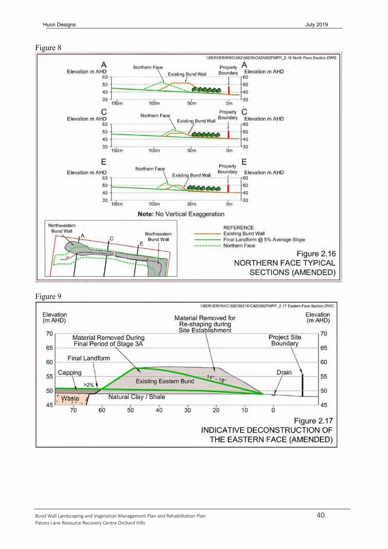
40 Bund Wall Landscaping and Vegetation Management Plan and Rehabilitation Plan
Patons Lane Resource Recovery Centre Orchard Hills
Huon Designs July 2019
Figure 8
Figure 9

41 Bund Wall Landscaping and Vegetation Management Plan and Rehabilitation Plan
Patons Lane Resource Recovery Centre Orchard Hills
Huon Designs July 2019
Revegetation planting is to occur as indicated on the attached plan Drawing No PL2017/09/A particularly around dams, along the boundaries, in bioswales, on the bund walls and in the Blaxland Creek Riparian Zone. This will supplement natural regeneration and provide enhanced competition against encroaching weed species. Clumped planting along drainage swales to be undertaken to stabilize disturbed areas prone to erosion.
During the site establishment construction works it is essential to minimize the disturbance of site soils. The only areas where the site soil will be disturbed is to build new dams, construct spillways, desilt existing dams, stabilize creek banks, construct access tracks and form up bioswales. Site topsoils are valuable for the rehabilitation works, particularly if they contain a healthy seed bank of native species. Its preservation aids the ability of the site to be rehabilitated through natural regeneration. To benefit from these soils it is proposed to reuse it by translocating the top 100- 200mm of topsoil prior to any earthworks progressing. To maintain the viability of the seed bank it cannot be stockpiled and must be respread in a 100-200mm layer.
Translocating soil will greatly assist the rehabilitation of the site. Initially the first topsoil stripped from a work area can be spread in a temporary location where it will not be disturbed. Once a reasonable section of earthworks are completed this topsoil (or topsoil stripped from current work areas) can then be directly respread to restore disturbed areas such as bioswales, dam walls, edges of access tracks, stockpile sites, and new bund walls. It is preferable to move the soil in one operation if possible as it is more efficient and effective. This is easily achieved by progressing the work in such a fashion that as works progress forward, topsoil is stripped and carried back to be spread on areas behind the work face that need restoration.
Applying the bush regeneration and revegetation techniques (including soil relocation) to the northwest, west and southwest boundaries will establish and protect the EECs present as detailed later in this section. This will help to reduce ongoing maintenance, assist erosion control on disturbed ground and establish increased levels of natural bushland. The same techniques to the southern and eastern boundaries will expand and establish a good strip of native vegetation also, reflecting the Cumberland Plain Woodland Community once common to the area.
All plants will be sourced from locally endemic seed stock, according to the species list for each plant community. All plants to be supplied as forestry tubes, hiko tubes or viro cells for some species and ground covers. The species list of each plant community is attached in Table 5. The location of tree planting will occur to ensure they maximize site screening and add variety to the uniformity of the landform. All revegetation works fall within two Plant Communities and the plants will be selected as per Table 5: Revegetation Species List. The communities are:
• Cumberland Plain Woodland Community • River Flat Eucalyptus Forest Community

42 Bund Wall Landscaping and Vegetation Management Plan and Rehabilitation Plan
Patons Lane Resource Recovery Centre Orchard Hills
Huon Designs July 2019
Figure 10

43 Bund Wall Landscaping and Vegetation Management Plan and Rehabilitation Plan
Patons Lane Resource Recovery Centre Orchard Hills
Huon Designs July 2019
Figure 11
Figure 12

44 Bund Wall Landscaping and Vegetation Management Plan and Rehabilitation Plan
Patons Lane Resource Recovery Centre Orchard Hills
Huon Designs July 2019

45 Bund Wall Landscaping and Vegetation Management Plan and Rehabilitation Plan
Patons Lane Resource Recovery Centre Orchard Hills
Huon Designs July 2019
The planting density will vary and is to be determined on site according to levels of disturbance, erosion and natural regeneration. Five plants per square metre are considered a minimum, whether through natural regeneration or revegetation work. The aim is to establish a minimum planting density of five native species per square metre (5/m2). A variety of strata levels is to be achieved that includes trees, shrubs and ground covers. The planting matrix as depicted in Richard Lambs Report forms the basis of the rehabilitation and revegetation works, as shown in Figure 13 below.
Plant protection is to be installed if required following monitoring inspections. Protection can be either fencing (refer to 3.5.3.Vegetation Fencing) or individual plant protectors. “Terracottum” crystals will be mixed into the site soils to minimize maintenance, increase growth rates and reduce plant losses. To ensure the standard of 90% survival rate, revegetated areas are to undergo regular maintenance of watering, weeding, replacement of dead or dying plants and adjustment of rabbit bags or protective fencing where necessary.
At the completion of site establishment works, the landform will be rehabilitated primarily with native riparian and woodland planting. Planting of temporary bunds with grasses for stabilization and woodland species for screening will also have been completed.
Planting of grasses to stabilize bund walls and other disturbed areas will be undertaken using appropriate hydromulching techniques. These are outlined in Section 3.8.1 below.
Figure 13: Native Plant Revegetation Planting Matrix (source Richard Lamb and Associates)

46 Bund Wall Landscaping and Vegetation Management Plan and Rehabilitation Plan
Patons Lane Resource Recovery Centre Orchard Hills
Huon Designs July 2019
Table 5: Revegetation Species List
Cumberland Plain Woodland Community River Flat Eucalyptus Forest Community Botanical Name Common Name Botanical Name Common Name Trees Trees Acacia parramattensis subsp. parramattensis *
Parramatta Green Wattle Acacia parramattensis subsp. parramattensis *
Parramatta Green Wattle
Acacia decurrens * Sydney Green Wattle Angophora floribunda# * Rough-barked Apple Corymbia maculata, * Spotted Gum Casuarina glauca # * Swamp She-Oak Eucalyptus moluccana * Grey Box Eucalyptus tereticornis * Forest Red Gum Eucalyptus euginioides * Thin-leaved Stringybark Eucalyptus amplifolia #* Cabbage Gum Eucalyptus crebra * Narrow-leaf Ironbark Eucalyptus moluccana * Grey Box Eucalyptus tereticornis * Forest Red Gum Melaleuca decora * White Feather Honeymyrtle Exocarpos cupressiformis Cherry ballart Melaleuca linarifolia * Snow-in-summer Melaleuca linearifolia * Tea-tree Low Trees and Shrubs Low Trees and Shrubs Acacia falcata * Silver Leafed Wattle Acacia implexa * Black Wattle Acacia implexa * Black Wattle Bursaria spinosa # * Blackthorn Acacia elongata Wattle Grevillea juniperina Grevillea Astroloma humifusum Cranberry Heath Melaleuca thymifolia Thyme Honey-myrtle Bossiaea prostrata Bossiaea Solanum prinophyllum Forest Nightshade Breynia oblongifolia Breynia Bursaria spinosa # * Blackthorn Ground Layers Chloris truncata # Windmill Grass Altemathera denticulata Lesser Joyweed Daviesia ulicifolia Gorse Bitter Pea Carex appressa + Tall sedge Dillwynia sieberi Prickly Parrot Pea Glycine sp. Glycine/Climbing Pea Dodonaea viscose Wedge-Leaf Hop Bush Persicaria decipiens Spotted Knotweed Indigofera australis Australian Indigo Entolasia stricta Entolasia Lissanthe strigosa Native Cranberry Juncus usitatus #+ Common Rush Melaleuca nodosa Tea-tree Themeda australis Kangaroo Grass Melaleuca styphelioides#* Prickly-leaved Tea-tree Microlaena stipoides Weeping Rice Grass Pultenaea mycrophylla Bush Pea Pratia purpurascens White Root Solanum prinophyllum Forest Nightshade Lomandra longifolia + Lomandra/Mat Rush
Lomandra multiflora Lomandra/Mat Rush
Ground Layers Aristida vagans Wire/Spear Grass
Austrodanthonia racemosa
#
Wallaby Grass
Brunoniella australis + Blue Trumpets Desmodium varians Slender Tick-trefoil Dichondra repens Kidney Weed Dianella revolute + Blue Flax Lily Dichelachne micrantha Short-haired Plume Grass Dodonaea viscose Hop Bush Einadia nutans # Climbing Saltbush Entolasia stricta Entolasia Glycine sp. Glycine/Climbing Pea Ponds, Dams and Bioswales Lomandra filiformis + Lomandra/Wattle Mat Rush Cyperus sp. # + Themeda australis Kangaroo grass Juncus sp. #+ Rush Wahlenbergia gracilis Native Bluebell Typha sp. #+ Cumbungi * Indicates plants suitable for use as canopy screen planting in revegetation areas of bund walls # Indicates plants already represented on the site + Indicates plants suitable for planting in ponds, dams and bioswales

47 Bund Wall Landscaping and Vegetation Management Plan and Rehabilitation Plan
Patons Lane Resource Recovery Centre Orchard Hills
Huon Designs July 2019
Note: All plants to be indigenous species propagated from local provenant seed. An allocation has been included in the budget for collecting seed and propogating plants. The proposed rehabilitation works are important for the protection, enhancement and restoration of the Endangered Ecological Communities (EECs) located on the site and adjacent to the site. The boundary planting of Cumberland Plain Woodland achieves four main objectives:
▪ Expands the size of the current, adjacent community ▪ Protects the current community by providing a buffer ▪ Increases connectivity ▪ Re-establishes the original community and habitat that was once in the area
The revegetation and rehabilitation of the River Flat Eucalyptus Forest achieves the same four main objectives:
▪ Expands the size of the current on site and adjacent community ▪ Protects the current community by providing an expanded buffer ▪ Increases connectivity to other communities ▪ Re-establishes the original community and habitat that was once in the area
3.8 Stage 1 Landform Rehabilitation and Landscaping Plan
Rehabilitation of completed areas is to occur as indicated on the attached plan Drawing No PL2017/10/A particularly on bund walls surrounding Cell 1 and in areas of Cell 1 that have been filled, capped and final landform achieved. The works should be carried out as quickly as possible and will include expansion of the already completed Cumberland Plain Woodland plantings, installed during site establishment. It will primarily include vast areas of pastureland/grassland, implemented through hydromulching techniques as detailed below.
It is noted that prior to final capping and rehabilitation of the site, finished stages of each cell may be subject to static stockpile loadings. The purpose of this is to limit the amount of unnecessary movement of cover materials, reduce double handling and most importantly to limit the amount of future post closure settlement that may occur. The site sections depicting this process are shown on drawing no. PL2017/10/A.
The purpose of the timely rehabilitation works is to provide competition against encroaching weed species and therefore reduce ongoing maintenance of existing revegetated areas. It will also assist erosion control on disturbed ground and provide stable vegetation cover to the final landform. At the completion of staged site rehabilitation, the final landform will revegetated, primarily by pasture grasses and woodland planting. Planting of temporary or modified bunds with grasses for stabilization and woodland species for screening will continue to be undertaken.
As these works enter their maintenance phases, the appropriate protective fencing and silt fencing will be adjusted where existing and installed into new locations. Maintenance and monitoring will commence on newly completed areas. Initially the maintenance will be quite high but as these areas become established and more mature the weight of the work will progressively shift into the newer areas of rehabilitation. (See Section 4 Maintenance, Monitoring and Key Performance Indicators)
The entire boundary areas of the site are completed in the initial Site Establishment stage. The remainder of the site is progressively rehabilitated as the landfill cells are filled, capped and completed and will take place over about 25 years. The vast majority of this work is the

48 Bund Wall Landscaping and Vegetation Management Plan and Rehabilitation Plan
Patons Lane Resource Recovery Centre Orchard Hills
Huon Designs July 2019
establishment of pasture/grassland as outlined above, with some further pockets of woodland planting.
As feasible sections of the site are completed they will be rehabilitated in this progressive manner, and maintenance commenced. This will continue in regular stages until the Final Landform and Landscaping is achieved as outlined in Figure 11 (Figure 2.22 of the Further Modified Preferred Project Report). This is shown in greater detail and with minor modifications in Huon Designs plan number PL2017/11/A Final Landform and Landscaping, dated 10 January 2017. The key changes are increased areas of native vegetation, modified dam layouts and more variety in the grades of the landform. All these are intended to achieve a more natural looking landscape. It is possible that the final configuration of woodland planting, dams and gradients may alter slightly as the project progresses in order to achieve improved environmental outcomes.
3.8.1 Hydromulching Techniques
Revegetation of grasses to areas of pasture will be undertaken using appropriate hydromulching techniques. The same technique and seed mixture will be used to stabilize stockpiles and bund walls. Although more expensive than other seed mixes, it is a crucial aspect of this VMP. This mixture will help to suppress the growth of weeds and reduce erosion without bringing more weeds onto the site. In the medium and long term this will help to keep ongoing maintenance costs lower. Native grass seeds will be sourced from locally endemic seed stock. The seed mix below is based on current best practice industry standards but has been further enhanced through the increase in application rates.
Prior to hydromulch application, the site soils are to be ripped to 200mm and finely cultivated to a depth of 100mm. Once applied it will be necessary to perform establishment maintenance practices on the newly seeded areas until they are firmly stabilized. This will require watering, weed control, over seeding, erosion monitoring and finally mowing/slashing and/or whipper snipping.
Table 6: Hydromulching Seed Mix List
Botanical Name Common Name % of Seed Mix Kilograms/hectare Native Grass Species Austrodanthonia racemosa
Wallaby Grass 10% 5kg/ha
Dichelachne micrantha Short-haired plume grass 10% 5kg/ha Microlaena stipoides Weeping Rice Grass 10% 5kg/ha Themeda australis Kangaroo grass 10% 5kg/ha Zoysia sp. Nara grass 10% 5kg/ha Non Native Cover Crops/Grasses Bromus catharticus Prairie Grass 10% 5kg/ha Festuca arundinacea Tall Fescue 10% 5kg/ha Lolium perenne Perennial Ryegrass 30% 15kg/ha Application products and fertiliser Organic fertiliser 200kg/ha Wood fibre mulch 2500kg/ha Tackifier binding agent 75litres/ha Water 20000litres/ha

49 Bund Wall Landscaping and Vegetation Management Plan and Rehabilitation Plan
Patons Lane Resource Recovery Centre Orchard Hills
Huon Designs July 2019
3.9 Dust Management Strategies
In respect of the landscaping and rehabilitation activities, particular care will be paid to implementing dust management strategies which are summarized as follows: • Minimising areas to be disturbed as any one time. • Implementing hydromulching, broad acre mulching or planting immediately following the
disturbance of the areas to be rehabilitated. • Stabilising temporary stockpiles with hydromulch or a proprietary surface binding agent to
mitigate any dust emissions. • Wetting disturbed areas with sprinklers and irrigation systems. • Postponing/ceasing the disturbance of any areas in adverse weather conditions i.e. high winds –
particularly where the wind direction may result in adverse impacts on neighbours. • Stabilising/wetting of temporary access roads servicing rehabilitation activities.
Additionally, section 5.2 of the Air Quality Plan sets out additional dust mitigation measures as follows • Site induction to include air quality management requirements to ensure awareness of potential
air quality impacts; • Activities are to be assessed during adverse weather conditions and modified as required (e.g.
cease activity where reasonable levels of dust cannot be maintained using the available means); • Visual surveillance of dust plumes from all activity; • Haul roads and plant should be sited away from sensitive receptors where possible; • The site will have an acoustic bund which can act as a wind break to minimise on-site wind
erosion; and, • Direct traffic to designated entrance and exit points. • The area of exposed surfaces should be kept to a minimum, such as by shaping stockpiles in a
manner which reduces the exposed surface area, or by covering exposed surfaces; • Exposed areas and stockpiles should be watered on a daily basis (or more frequently as required)
to keep moisture levels sufficient to minimise wind erosion; • Exposed areas should have barriers or coverings or should be temporarily rehabilitated if inactive
for periods of greater than three months; • Stockpiles should be located as far away from sensitive receptors as possible; • All material to be stored in designated storage bays to reduce exposed surface and wind flows
over material; • By scheduling material logistics, the amount of stockpiled materials on-site can be minimised by
reducing their residence time by methods such as by receiving deliveries only when the amount of materials on-site is considered low or by focusing on delivery of materials to customers when there are high amounts of material on-site. An appropriate storage amount should be used, such that there would be no shortage of materials;
• Construction activities should be progressively staged. The size of staging areas should be minimised by working on small areas and completing them before progressively proceeding to disturb another area;
• Completed sections will have commenced rehabilitation within three months; and, • Ancillary vehicles should be kept off exposed areas to avoid potential disturbances of these areas. • When loading and unloading material, the drop height of the material should be minimised, the
front end loader should tip the bucket only when it is close to the ground, the bed of the truck or the material pile being added to;
• Minimise spillage from loading/unloading and clean up any spillage immediately;

50 Bund Wall Landscaping and Vegetation Management Plan and Rehabilitation Plan
Patons Lane Resource Recovery Centre Orchard Hills
Huon Designs July 2019
• Use of watering to ensure moisture content of material handling is sufficient to minimise dust generation; and,
• During periods of high wind speeds (>8m/s) and winds blowing towards the sensitive receivers, the material handling activities should be minimised or cease when excessive visible plumes of dust cannot be abated
• Haul roads should be watered regularly using water carts such that the road surface has sufficient moisture to minimise on-road dust generation but not so much as to cause mud/dirt track out to occur;
• Roads that are heavily used or used for a long term and cannot be maintained in a low-dust state by watering should be sealed;
• Sealed haul roads should be cleaned regularly on a weekly basis or more frequently as required using a street sweeper or similar type of equipment. When spillage occurs, it should be cleaned as soon as possible;
• Vehicle traffic should be restricted to designated routes that can be managed by regular watering; • A speed limit of no more 40 kilometres per hour should be imposed on-site; • To minimise mud or dirt track out (e.g. during prolonged wet rainy periods), a wheel wash or
grids are to be installed and used near exit points; • Public streets should be cleaned regularly on a weekly basis or more frequently as required to
remove any dirt tracked onto sealed roads; • Vehicle loads should be secured and covered when transporting materials off-site. The exposed
surface of dusty materials to be hauled may be watered if necessary; • Materials should be loaded onto vehicles in a uniform, level manner and not be higher than the
highest part of the vehicle load compartment; and, • The number of trips should be minimised by maximising the vehicle load but not overloading.
4.0 MAINTENANCE, MONITORING AND KEY PERFORMANCE INDICATORS
Once the project commences, weed management and maintenance of the existing and proposed vegetation becomes the most critical aspect of the Plan. As the works progress over the 25 year life of the project, the areas to maintain will increase significantly but established areas will gradually require less intense maintenance. In effect the maintenance effort and costs will largely remain constant over the length of the project. This will include 5 years of post closure maintenance.
As such an ongoing maintenance budget for 30 years is calculated as follows:
Say 40hrs/week, for 52 weeks/year for a total of 30 years @ $45/hour = 40 x 52 x 30 x 45 = $2,808,000 plus CPI or an average of $93000/year
The maintenance works will be guided at all times by the principles outlined in this Plan and according to best practice Bush Regeneration techniques. For this reason, it is necessary that the works be undertaken by an approved and qualified bush regeneration company. The native plant communities that are created during the Site Establishment stage will largely maintain themselves once they are well watered and survived the first summer. The majority of the maintenance work involves the management and control of weeds. This work is to be carried out on an ongoing basis from the commencement of the project and according to the best practice Bush Regeneration techniques outlined specifically in Section 3.6 Weed Management Strategy.
All the management principals as outlined in Section 3.0 Site Management, are to be part of this maintenance strategy, including erosion/stormwater controls, fencing, follow up seeding and

51 Bund Wall Landscaping and Vegetation Management Plan and Rehabilitation Plan
Patons Lane Resource Recovery Centre Orchard Hills
Huon Designs July 2019
revegetation of native forest and woodlands. Particular attention will be paid to identifying and addressing areas of post closure settlement. Attention is drawn to the fact that it is proposed to place temporary stockpiles on completed sections of each cell in order to provide static loading and hence reduce the incidence of post closure settlement. Where necessary filling, topdressing and reseeding will be undertaken. If it does occur, it is likely to be in the pasture/grasslands of the site. The site will be monitored on a regular basis and will include monthly and annual reporting.
Monthly reports will cover the following:
▪ Revegetation and fencing works undertaken (areas, distance, quantities and locations) ▪ Maintenance works undertaken (areas, techniques, herbicides used and locations) ▪ Significant incidents in terms of weather events, impacts by RRC activities, pests, disease,
feral animals ▪ Analyse and adjust works program to suit site conditions and progress
Annual reports will summarize the year’s activities and performance as follows:
▪ Areas stabilized and revegetated ▪ Analysis of plant growth rates and survival rates ▪ Analysis of weed densities, varieties and distribution ▪ Maintenance works undertaken and handover of stable areas as new areas come online ▪ Monitor and address any areas of settlement or areas where unwanted ponding occurs ▪ Reassess restoration works program and budget ▪ Make recommendations of what changes could be incorporated into the Plan to better achieve
the stated aims and objectives
At the end of each year the works will be subject to independent audit as per consent conditions and application will be made for partial release of bond monies. Those areas that are completed and signed off will enter the maintenance phase of the project. They should be fenced off and access limited to maintenance staff. Key Performance Indicators (KPIs) will be used to assess progress on the site and will include the following:
▪ Photo Monitoring Points (as located on Drawings PL2017/09/A and PL2017/10/A) ▪ Photo Monitoring Points will also include Commonwealth Land to the south and west of the
site, and private land to the north and east of the site ▪ Analysis of plant growth/survival rates through % calculations of native plant density/size ▪ Analysis of weed infestation and controls through % calculations of weed density/size, and
weed species/distribution
The % values that the Plan is aiming for is as detailed in Table 7 below. The existing situation is regarded as the baseline level. In regards to native plants, the datum/baseline level is currently 1/m2 and 150mm high. In regards to weeds, the whole site is considered to be heavily infested by dense plumes of numerous species as indicated in Table 3 above. As rehabilitation progresses further Photo Monitoring points will be added to assess newly completed areas.

52 Bund Wall Landscaping and Vegetation Management Plan and Rehabilitation Plan
Patons Lane Resource Recovery Centre Orchard Hills
Huon Designs July 2019
Table 7: Key Performance Indicators
PERFORMANCE CRITERIA DURATION/TIME LEVEL REQUIRED % Reduction in weeds on site (density/size) Year 1 50%
Year 2 60% Year 3 70% Year 4 80% Year 5 (ongoing) 90% % Reduction in weeds on site (species/distribution) Year 1 10%
Year 2 20% Year 3 30% Year 4 40% Year 5 (ongoing) 50% % Increase in native plant density Year 1 200%
Year 2 50% Year 3 10% Year 4 10% Year 5 (ongoing) 10% % Increase in native plant size Year 1 100%
Year 2 100% Year 3 100% Year 4 80% Year 5 60%
5.0 RESTORATION WORKS PROGRAM
Based on the current information for the operation of the Resource Recovery Centre, the following program has been developed. It will be subjected to regular modifications as the project is delivered and the annual reports are prepared and analysed.
Table 8: Estimated Restoration Works Program
TASK ITEM DURATION/TIME RESPONSIBILITY Stage 1 Site Establishment Works 12 Months/Week 1 Appoint manager and bush regeneration team 1 week/week 1 SRC Source and pre-order tubestock for revegetation ongoing/week 2 SRC and Huon Mow/slash boundary Zone 2 1 week/week 2 Target and address erosion/stormwater problems Ongoing/week 2 SRC and Huon Erect exclusion fencing and sediment fencing 3-4 weeks/week 3 SRC and Huon Target and remove flowering, spreading weeds in Zones 2 and 3
24 weeks/week 4 SRC and Huon
Revegetation works to Zone 2 (earthworks complete) 4 weeks/week 24 SRC and Huon Erect/modify exclusion and sediment fencing Zone 2 1 week/week 24 SRC and Huon Revegetation works to Zone 3 (earthworks complete) 4 weeks/week 36 SRC and Huon Erect/modify exclusion and sediment fencing Zone 3 1 week/week 36 SRC and Huon Ongoing maintenance and monitoring Ongoing SRC and Huon

53 Bund Wall Landscaping and Vegetation Management Plan and Rehabilitation Plan
Patons Lane Resource Recovery Centre Orchard Hills
Huon Designs July 2019
TASK ITEM DURATION/TIME RESPONSIBILITY Stage 1a Site Establishment Works – Riparian Zone 12 Months/Week 1 Appoint manager and bush regeneration team 1 week/week 1 SRC Source and pre-order tubestock for revegetation ongoing/week 2 SRC and Huon Target and address erosion/stormwater problems ongoing/week 2 SRC and Huon Erect exclusion fencing and sediment fencing 1 weeks/week 2 SRC and Huon Target / remove flowering, spreading weeds in Zone 1 3-4 weeks/week 3 SRC and Huon Revegetation works to Zone 1 (earthworks complete) 1-2 weeks/week 8 SRC and Huon Ongoing maintenance and monitoring Ongoing SRC and Huon
TASK ITEM DURATION/TIME RESPONSIBILITY Stage 2 Rehabilitation Phase (Stage 1 Cell 1) 12 Months/Year 2-3 Appoint manager and bush regeneration team 1 week/week 1 SRC Source and pre-order tubestock for revegetation ongoing/week 2 SRC and Huon Cultivate and prepare soils for rehabilitation progressively/week 2 SRC and Huon Target and address erosion/stormwater problems ongoing/week 2 SRC and Huon Erect exclusion fencing and sediment fencing 1 weeks/week 3 SRC and Huon Revegetation works to Zone 3 (earthworks complete) 1-2 weeks/week 4 SRC and Huon Hydromulching to Zone 3 1 week/week 5 SRC and Huon Ongoing maintenance and monitoring Ongoing SRC and Huon
TASK ITEM DURATION/TIME RESPONSIBILITY STAGE 3 On-going Rehabilitation/Maintenance and Monitoring Phase
25-30 Years/Year 2
Rehabilitation of sections of site as earthworks complete and as per Stage 2 above
Ongoing SRC and Huon
Ongoing maintenance and monitoring (All Zones) Ongoing SRC and Huon Monthly Reports Monthly SRC and Huon Annual Reports Annually SRC and Huon
As each new section of the site is completed, capped and handed over for rehabilitation, the program for its final rehabilitation, sign off and closure will proceed as outlined above in Stage 2 Rehabilitation Phase. Progressively this process will work through Stage 2 Cell 1 to Stage 6 Cell 1 and so on until completed for instance at Stage 6 Cell 3.
6.0 RESTORATION WORKS BUDGET
The restoration works budget has been prepared to give an accurate outline of the expected costs to implement the BWL&VMP. It includes all costs up to and including 5 years post closure maintenance and monitoring.
As part of the monitoring process and annual reporting, both the budget and the program will be assessed and modified as required. All costs are based on current industry rates in 2017 dollar terms and will require the application of annual CPI increases for future budgets.

54 Bund Wall Landscaping and Vegetation Management Plan and Rehabilitation Plan
Patons Lane Resource Recovery Centre Orchard Hills
Huon Designs July 2019
Table 9: Restoration Works Budget Estimated Quantity for Life of Project and Allocation (2017 dollars)
Zone
Details
Description
Units
Quantity
Rate
Year 1
Year 2
Year 3
Year 4
Year 5
Year 6-30
Total
Zone Totals
All
Site setup
Inductions, SWMS, programs, administration.
Item
8
$1,000.00
$1,000
$1,000
$1,000
$5,000
$8,000
Collect seeds and propagate
Collect and propagate locally endemic species
Seedlings
120,000
$0.50
$10,000
$10,000
$10,000
$5,000
$25,000
$60,000
Annual reporting
Prepare and present annual reports as per Plan
Yearly item
30
$500.00
$500
$500
$500
$500
$500
$12,500
$15,000
Monthly reporting
Prepare and present monthly reports as per Plan
Monthly item
360
$100.00
$1,200
$1,200
$1,200
$1,200
$1,200
$30,000
$36,000
$119,000 Yearly total $12,700 $11,700 $12,700 $6,700 $2,700 $72,500
1
Riparian Zone
River Flat Eucalyptus Forest
Fencing
Supply and install stock/exclusion/silt fencing
metre
500
$25.00
$10,000
$1,500
$1,000
$12,500
Bioswales
Shape swales and respread stripped topsoil
metre
200
$30.00
$5,000
$1,000
$6,000
Access tracks
Strip topsoil, shape and compact track with site gravel
metre
150
$40.00
$5,000
$1,000
$6,000
Erosion controls - General
Supply and place jute, stones, boulders and coir logs
metre
250
$40.00
$3,000
$2,000
$5,000
$10,000
Erosion controls - Construction works Controlled Activity Approval Works
Desilting of Dam 2, installation of outlet structures including spillways and erosion protection of the dam discharge and other water flows to Blaxland Creek as per CAA Application
Item
1
$75,000.00
$75,000
$75,000
Weed management
Implement VMP and target weed outbreaks and sources
square metre
15,000
$10.00
$30,000
$30,000
$30,000
$20,000
$15,000
$25,000
$150,000

55 Bund Wall Landscaping and Vegetation Management Plan and Rehabilitation Plan
Patons Lane Resource Recovery Centre Orchard Hills
Huon Designs July 2019
Zone
Details
Description
Units
Quantity
Rate
Year 1
Year 2
Year 3
Year 4
Year 5
Year 6-30
Total
Zone Totals
Revegetation
Supply and install endemic tubestock to restoration areas
square metre
12,000
$10.00
$40,000
$40,000
$20,000
$2,000
$1,000
$17,000
$120,000
Maintenance and monitoring
Monitor and maintain weeds, revegetation, erosion and regrowth
square metre
15,000
$10.00
$30,000
$30,000
$30,000
$20,000
$10,000
$30,000
$150,000
$529,500 Yearly total $198,000 $105,500 $80,000 $42,000 $26,000 $78,000
2
Boundary Zone
Cumberland Plain Woodland
Fencing
Supply and install stock/exclusion/silt fencing
metre
3,600
$25.00
$30,000
$30,000
$20,000
$10,000
$90,000
Bioswales
Shape swales and respread stripped topsoil
metre
4,000
$30.00
$40,000
$40,000
$20,000
$20,000
$120,000
Access tracks
Strip topsoil, shape and compact track with site gravel
metre
2,700
$35.00
$40,000
$40,000
$10,000
$90,000
Erosion controls
Supply and place jute, stones and coir logs
metre
2,000
$20.00
$20,000
$10,000
$10,000
$40,000
Slashing
Slash pastures and prepare for weed control / revegetation
square metre
40,000
$0.50
$10,000
$5,000
$1,000
$500
$500
$3,000
$20,000
Weed management
Implement VMP and target weed outbreaks and sources
square metre
40,000
$10.00
$50,000
$50,000
$50,000
$40,000
$30,000
$180,000
$400,000
Revegetation
Supply and install endemic tubestock to restoration areas
square metre
35,000
$10.00
$60,000
$60,000
$50,000
$5,000
$5,000
$170,000
$350,000
Maintenance and monitoring
Monitor and maintain weeds, revegetation, erosion and regrowth
square metre
40,000
$10.00
$45,000
$45,000
$40,000
$10,000
$10,000
$250,000
$400,000
$1,510,000 Yearly total $295,000 $280,000 $201,000 $55,500 $45,500 $633,000
3
Quarry/Landfill Zone
Pasture land and screen planting
Fencing
Supply and install stock/exclusion/silt fencing
metre
3,000
$25.00
$20,000
$20,000
$10,000
$25,000
$75,000
Bioswales
Shape swales and respread stripped topsoil
metre
1,000
$30.00
$5,000
$5,000
$20,000
$30,000

56 Bund Wall Landscaping and Vegetation Management Plan and Rehabilitation Plan
Patons Lane Resource Recovery Centre Orchard Hills
Huon Designs July 2019
Zone
Details
Description
Units
Quantity
Rate
Year 1
Year 2
Year 3
Year 4
Year 5
Year 6-30
Total
Zone Totals
Access tracks (temporary)
Strip topsoil, shape and compact temporary track with site material
metre
3,000
$20.00
$10,000
$10,000
$10,000
$30,000
$60,000
Erosion Controls
Supply and place jute, stones and coir logs
metre
3,000
$20.00
$5,000
$5,000
$5,000
$45,000
$60,000
Slashing
Slash pastures and prepare for weed control / revegetation
square metre
530,000
$0.50
$10,000
$10,000
$5,000
$5,000
$5,000
$230,000
$265,000
Weed management
Implement VMP and target weed outbreaks and sources
square metre
530,000
$1.00
$20,000
$20,000
$20,000
$10,000
$10,000
$450,000
$530,000
Revegetation
Supply and install endemic tubestock to restoration areas
square metre
40,000
$5.00
$30,000
$30,000
$20,000
$20,000
$20,000
$100,000
$220,000
Zone
Details
Description
Units
Quantity
Rate
Year 1
Year 2
Year 3
Year 4
Year 5
Year 6-30
Total
Zone Totals
Hydromulching
Apply hydromulch to disturbed and completed landforms
square metre
530,000
$2.00
$60,000
$60,000
$20,000
$20,000
$20,000
$880,000
$1,060,000
Maintenance and monitoring
Monitor and maintain weeds, revegetation, erosion and regrowth
square metre
530,000
$2.00
$20,000
$20,000
$20,000
$20,000
$20,000
$960,000
$1,060,000
$3,360,000 Yearly total $180,000 $180,000 $95,000 $90,000 $75,000 $2,740,000
TOTAL $685,700 $577,200 $388,700 $194,200 $149,200 $3,523,500 $5,518,500 $5,518,500

57 Bund Wall Landscaping and Vegetation Management Plan and Rehabilitation Plan
Patons Lane Resource Recovery Centre Orchard Hills
Huon Designs July 2019
7.0 PLAN REVIEW AND MODIFICATION PROCEDURES
As discussed previously in this plan, the success of the entire rehabilitation process is dependent upon a number of unknown and dynamic natural processes taking place on the site. The principles of bush regeneration recognize these factors and must work with their impacts constantly in mind. These natural processes include the following:
▪ Changing weather and soil conditions ▪ Varying rates of plant growth ▪ Uncertain seed banks ▪ Changing sources and causes of weed outbreaks ▪ Uncertain rates of natural regeneration
Short term and long term changes in any of these factors will affect the rehabilitation works being undertaken. It is for this reason that the Plan presented here is an adaptive management plan. This allows the scope of works to be adjusted and modified on a regular basis and as required. The annual and monthly reports will monitor and identify any opportunities or constraints that may occur. The regular reporting will then formulate the best work procedures to adopt and modify the plan to suit the site conditions. This will enable prioritization of the budget and manpower to capitalize on any advantageous conditions and to control any threatening processes.
8.0 SUMMARY AND CONCLUSION
The current site is an environmentally degraded site. The proposed Resource Recovery Centre has an opportunity to restore the entire site into a valuable and usable landscape that combines stock grazing with native bush land of high ecological significance and biodiversity. It will help protect, conserve and enhance a number of EECs and restore the rural setting of the site. Implementation and on-going management of the site as proposed in this Bund Wall, Landscaping and Vegetation Management Plan and the associated Rehabilitation Plan will achieve the required outcomes if it is implemented thoroughly and in a timely manner. The Plan complies with all the relevant conditions of approval.
The Plan will exceed the environmental outcomes specified in the FMPPR and project approval. The four key factors to be achieved by this Plan are detailed above and summarized below:
▪ Control unnecessary further degradation during the site establishment and operation phases
by limiting the footprint created by the earthworks, quarrying activities and the delivery of services on the site.
▪ Monitor and treat weed outbreaks with best practice bush regeneration techniques while encouraging native regeneration and undertaking revegetation.
▪ Restore the site to the natural mature landscape as quickly as possible. ▪ Protect the two Ecologically Endangered Communities – Cumberland Plain Woodland
and River Flat Eucalyptus Forest.
Rodney Cox AAILA

Huon Designs June 2017
Appendix 1
Site Establishment – Rehabilitation and Landscaping Plan, Drawing No PL2017/09/A dated 10 January 2017
confidentialRon Chio
Bingo IndustriesBingo IndustriesNov 01, 2017 18:37
confidentialRon Chio
Bingo IndustriesNov 01, 2017 18:37

Huon Designs June 2017
Appendix 2
Landform and Rehabilitation/Landscaping Plan, Drawing No PL 2017/10/A dated 10 January 2017
confidentialRon Chio
Bingo IndustriesBingo IndustriesNov 01, 2017 18:37
confidentialRon Chio
Bingo IndustriesNov 01, 2017 18:37
Huon Designs June 2017
Attachment 1
Approval from DP&E to Stage Plan
confidentialRon Chio
Bingo IndustriesBingo IndustriesNov 01, 2017 18:37
confidentialRon Chio
Bingo IndustriesNov 01, 2017 18:37

Huon Designs June 2017
Attachment 2
Approval from DP&E for Huon Designs to undertake Plan
confidentialRon Chio
Bingo IndustriesBingo IndustriesNov 01, 2017 18:37
confidentialRon Chio
Bingo IndustriesNov 01, 2017 18:37

Huon Designs June 2017
Attachment 3
GHD Plans and Cross sections for Bund Reshaping and Related Works
confidentialRon Chio
Bingo IndustriesBingo IndustriesNov 01, 2017 18:37
confidentialRon Chio
Bingo IndustriesNov 01, 2017 18:37

Huon Designs June 2017
Attachment 4
Survey of Riparian Zone and DPI Water policies and guidelines
confidentialRon Chio
Bingo IndustriesBingo IndustriesNov 01, 2017 18:37
confidentialRon Chio
Bingo IndustriesNov 01, 2017 18:37

Huon Designs June 2017
Attachment 5
Report on EEC Impacts Project Approval Document Schedule 6 Condition 5 c.
confidentialRon Chio
Bingo IndustriesBingo IndustriesNov 01, 2017 18:37
confidentialRon Chio
Bingo IndustriesNov 01, 2017 18:37

Huon Designs June 2017
Attachment 6
Reconciliation of the Requirements of Schedule 7 of the Project Approval.
confidentialRon Chio
Bingo IndustriesBingo IndustriesNov 01, 2017 18:37
confidentialRon Chio
Bingo IndustriesNov 01, 2017 18:37

Huon Designs June 2017
Attachment 7
Response from Agencies
confidentialRon Chio
Bingo IndustriesBingo IndustriesNov 01, 2017 18:37
confidentialRon Chio
Bingo IndustriesNov 01, 2017 18:37

Appendix 1
Site Establishment – Rehabilitation and Landscaping Plan, Drawing No PL2017/09/A dated 10 January 2017
Page 58 of 136
confidentialRon Chio
Bingo IndustriesNov 01, 2017 18:37
confidentialRon Chio
Bingo IndustriesNov 01, 2017 18:37

Pag
e 59
of 1
36
confi
dent
ial
Ron
Chi
oB
ingo
Indu
strie
sN
ov 0
1, 2
017
18:3
7
confi
dent
ico
nfide
nti
fidco
nfide
nco
nfide
nti
onfid
enti
entinti
confi
den
cconfi
dent
ico
nfide
nti
confi
den
confi
den
confi
dent
ien
tiieen
tinc
nnnaaalaaaaaaa
Ron
Chi
oB
ingo
Indu
strie
sN
ov 0
1, 2
017
18:3
7

Appendix 2
Landform and Rehabilitation/Landscaping Plan, Drawing No PL 2017/10/A dated 10 January 2017
Page 60 of 136
confidentialRon Chio
Bingo IndustriesNov 01, 2017 18:37
confidentialRon Chio
Bingo IndustriesNov 01, 2017 18:37

Pag
e 61
of 1
36
confi
dent
ial
Ron
Chi
oB
ingo
Indu
strie
sN
ov 0
1, 2
017
18:3
7
confi
dent
ial
Ron
Chi
oB
ingo
Indu
strie
sN
ov 0
1, 2
017
18:3
7

Attachments 1
Approval from DP&E to Stage Plan
Page 62 of 136
confidentialRon Chio
Bingo IndustriesNov 01, 2017 18:37
confidentialRon Chio
Bingo IndustriesNov 01, 2017 18:37

Page 63 of 136
confidentialRon Chio
Bingo IndustriesNov 01, 2017 18:37
confidentialRonRonRonon ChChChhhhioiooo
BinBBBBBinBinBinBinBinBinBinBinBinBininiBinBinnBinBinBinBBinBinBinBinBinBinnBinBinBinininBinBinBiniinnBinBiniinBinBBinnnnnnBinnnnngogogogogogogogogoogoogoogoogoogoooooogooooo IndInIndInIndIndIndIndndIndIndIndIndndndndIndIndInddIndndIndIndIndIndIndIndInddIndnnddIndInddndIndInndndndnIndIndn ustustustustustststststustusttustuststustustustststtustusustuustususttuusttuussusstusu rrierierierierieiiririeirierieririerierierriierieirriierieieeriiierierrririeerieerier sssssssssssssssssssNNov 0101, 220177 181 :37

Page 64 of 136
confidentialRon Chio
Bingo IndustriesNov 01, 2017 18:37
confidentialconfidentialRonnRonRonRonRon ChChChChChChioioioioioio
Bingo IndustriesBinBinBinnngooo I dI dIndIndII ustttstriiriei sNov 01, 2017 18:37

Page 65 of 136
confidentialRon Chio
Bingo IndustriesNov 01 2017 18:37Nov 01, 2017 18:37
confidentialRonRonRonRonRonRonRo ChChChChCChChiooooo
BinBingogo IndInduustriesBinngogo IndIndustriesNov 01, 2017 18:37

Attachment 2
Approval from DP&E for Huon Designs to undertake Plan
Page 66 of 136
confidentialRon Chio
Bingo IndustriesNov 01, 2017 18:37
confidentialRon Chio
Bingo IndustriesNov 01, 2017 18:37

Page 67 of 136
confidentialRon Chio
Bingo IndustriesNov 01, 2017 18:37
confidentialRonRonRonRon ChChChChioiii
BinBinBinBinBingogogogogo IndIndIndIndustustustu rierierieeessssNov 01, 2017 18:37NovNovNovNov 0101010101 222017017017017017 181818188:37:37:373737

Möbius p a r t n e r s ACN 605 342 550
MarketingEducationPlanningMediaCommunicationIssuesManagementStrategySustainabilityRecoveryRecyclingWasteDiversionTechnology
4 August 2015 Ms Carolyn McNally Secretary Department of Planning and Environment (DP&E) GPO Box 39, Sydney NSW 2001 Attention Mr Chris Ritchie Manager Industry by Email: [email protected] Re : Orchard Hills Waste Project - Land & Environment Court – Director Generals Approval for Engagement of Consultants and Auditors for Pre-Site Establishment Works Further to our letter of 27 April 2015 and conversations that your David Mooney has had with our Ben Haynes from Jensen Bowers since our meeting on 9 June 2015, we provide an amended schedule of consultants to address the issues raised by DP&E. The changes to Table 1 (previously provided) have been highlighted in red for ease of reference. These changes have been summarised below.
1. Noise Expert assisting Lead Auditor – Richard Hayden of Acoustic Dynamics
We have replaced EMMGA with Richard Hayden of Acoustic Dynamics to assist the lead Auditor in addressing the noise issues relating to the audit. Richard’s CV is also attached.
2. Civil and Structural Engineers assessing capacity of Road Bridge on Luddenham Road - Taylor Thompson Whiting
We understand that DP&E had some concerns that the traffic engineer Craig Hazel did not have the technical expertise to undertake the investigations relating to the structural capacity of the Bridge on Luddenham Road south of the Mamre Road intersection. We confirm that we propose to use TTW, a very reputable firm of structural and civil consulting engineers to undertake this specialist task. Details of this firm can be found at http://www.ttw.com.au/. We note the Consent requirement for “The investigation must be carried out in consultation with Council and to the satisfaction of the Director General.” 3. Quarry Operation Management Plan – Greg Thompson of VGT
We propose Greg Thompson of VGT to undertake the preparation of the Quarry Operation Management Plan. Greg has considerable experience in this field and was the preferred consultant for CSR Brickmaking who wish to extract the clay and shale resource.
We note that no formal DP&E approval / endorsement of the consultants undertaking this task was required by the Consent for this task. We have however, provided a CV as a courtesy.
Page 68 of 136
confidentiMMRon ChioMMBingo Industries
Nov 01, 2017 18:37
confidentialRon Chio
Bingo IndustriessManagementSsManagementSNov 01, 2017 18:37esManagementStresManagementStr

Re : Director General’s Approval for Engagement of Consultants and Auditors for Pre-Site Establishment Works
Page 2 of 3
4. Asbestos and Contamination Management Plan (and CLM Act Audit Statement)
a. Preparation of Asbestos and Contamination Plan - HIBBS & ASSOCIATES PTY LTD Occupational Health & Safety Consultants, Environmental Management Consultants.
We previously nominated SGA – KPMG for this role. Hibbs and Associates have considerable experience with asbestos related issues and we believe that this firm is better suited to this particular task. CVs for each of the staff members for this project including the principal Philip Hibbs are attached for DP&E review. We disclose that Hibbs and Associates provided the previous owner with a quotation for hourly rates to undertake works on the site. We confirm that no works were undertaken whatsoever and no payments we made to Hibbs and Assocaites in respect of this project by anyone. Under these circumstances, Hibbs and Associates meet the requirement of the Consent that they are independent. We attach the only document relating to Hibbs and Associates which is a two page quotation.
b. Audit – Dr Ian Swane (Jacobs) We also wish to clarify that the Audit component of these works will be undertaken by Dr Ian Swane who is also an accredited EPA auditor. Dr Swane’s CV details have been provided previously.
5. Establishment of Community Liaison Committee and Website Construction and Communications Plan – OFP Communications
These two tasks will be undertaken by Diana Forrester and Oliver Forrester of OFP Communications.
We note that no formal DP&E approval / endorsement of the consultants undertaking this task was required by the Consent for this task. We have however, provided a CV as a courtesy. We also advise that the scope of works undertaken by OFP will include broader community consultation and liaison issues as we discussed during our last meeting on 9th June 2015. A CV for OFP is also attached confirming their experience with quarrying and waste related projects.
We would appreciate your early response to our nominations.
Yours sincerely
David White – Director Mobius Partners
Mobile : 0434 560 022 Email : [email protected]
Page 69 of 136
confidentialants and Auants and AuconfidentialRon Chio
Bingo Industriesentent Plan (andPl ( dNov 01, 2017 18:37mentment Plan (and Plan (and
confidentialRon Chio
Bingo IndustriesNov 01, 2017 18:37

Re : Director General’s Approval for Engagement of Consultants and Auditors for Pre-Site Establishment Works
Page 3 of 3
Attachments
Table 1 – Audit Tasks and Consent Conditions – cross referenced to nominated consultants – changes to original Table 1 highlighted in red. CVs
1. Noise Expert assisting Lead Auditor – Richard Hayden of Acoustic Dynamics 2. Quarry Operation Management Plan – Greg Thompson of VGT 3. Preparation of Asbestos and Contamination Plan - HIBBS & ASSOCIATES PTY LTD Occupational
Health & Safety Consultants, Environmental Management Consultants. a. CVs b. Quotation Document
4. Establishment of Community Liaison Committee and Website Construction and Communications Plan – OFP Communications
Page 70 of 136
confidentialants and Auants and AuconfidentialRon Chio
Bingo IndustriesNov 01, 2017 18:37
confidentialRon Chio
Bingo IndustriesNov 01, 2017 18:37

TABL
E1
Audi
tTas
ksan
dCo
nsen
tCon
ditio
ns–
cros
sref
eren
ced
tono
min
ated
cons
ulta
nts
Subm
issi
on o
f Pan
el o
f Exp
erts
for A
ppro
val b
y D
epar
tmen
t of P
lann
ing
and
Envi
ronm
ent i
n ac
cord
ance
with
Con
ditio
ns o
f App
rova
lD
etai
led
CVs
sub
mitt
ed a
s se
para
te a
ttach
men
tsC
heck
list o
f Pre
-site
est
ablis
hmen
t and
pre
-wor
k co
nditi
ons
rela
ting
to p
re-w
ork
man
agem
ent p
lans
, stra
tegi
es a
nd p
rogr
ams
(the
"wor
ks")
.
Audi
tTas
kN
umbe
r
Cons
ent
sche
dule
and
cond
ition
num
berin
g
Cons
entC
ondi
tion
Colu
mn
AGe
nera
lCon
sulta
nts
Non
inde
pend
ente
xper
tsw
hich
the
Prin
cipa
liss
eeki
ngto
enga
geto
doth
ew
orks
.Nee
dto
beap
prov
edby
DP&
Eun
less
othe
rwis
est
ated
Colu
mn
BIn
depe
nden
tCon
sulta
nts
Inde
pend
ente
xper
tsth
atPr
inci
pali
sse
ekin
gto
enga
geto
unde
rtak
eth
ew
orks
.Nee
dto
beap
prov
edby
DP&
Eun
less
othe
rwis
est
ated
Colu
mn
CAu
ditT
eam
Cons
ulta
nts
Inde
pend
ente
xper
tsth
atth
ePr
inci
pali
ssee
king
toen
gage
fort
heAu
ditT
eam
toun
dert
ake
audi
tof
the
wor
ks(t
he"a
udit
wor
ks")
13.
6De
taile
dEn
gine
erin
gPl
ans
1.A.
Doug
lasP
artn
ers(
geo
tech
nica
l/lan
dfill
engi
neer
ing/
leac
hate
and
grou
ndw
ater
)
1.A.
1Jo
hnRu
ssel
l,1.
A.2
Jam
esPi
tche
r1.
A.3
Mik
eN
ash
1.A.
4M
ike
Thom
Inho
use
NPE
R3En
gine
erre
quire
d.N
ofo
rmal
DP&
Eap
prov
al/
endo
rsem
ento
fcon
sulta
nts
requ
ired
byCo
nsen
tfor
this
task
.
Prev
ious
lyw
orke
don
proj
ect.
1.B
Not
requ
ired
1.C
DrIa
nSw
ane
Jaco
bs(G
eote
chni
cal/l
andf
illen
gine
erin
g/le
acha
tean
dgr
ound
wat
er)
Tabl
e1
Nom
inat
ion
ofCo
nsul
tant
sand
Audi
tors
307
151
of10
Pag
e 71
of 1
36
confi
dent
ial
Ron
Chi
oB
ingo
Indu
strie
sN
ov 0
1, 2
017
18:3
7
confi
dent
ial
Ron
Chi
oB
ingo
Indu
strie
sN
ov 0
1, 2
017
18:3
7

TABL
E1
Audi
tTas
ksan
dCo
nsen
tCon
ditio
ns–
cros
sref
eren
ced
tono
min
ated
cons
ulta
nts
Subm
issi
on o
f Pan
el o
f Exp
erts
for A
ppro
val b
y D
epar
tmen
t of P
lann
ing
and
Envi
ronm
ent i
n ac
cord
ance
with
Con
ditio
ns o
f App
rova
lD
etai
led
CVs
sub
mitt
ed a
s se
para
te a
ttach
men
tsC
heck
list o
f Pre
-site
est
ablis
hmen
t and
pre
-wor
k co
nditi
ons
rela
ting
to p
re-w
ork
man
agem
ent p
lans
, stra
tegi
es a
nd p
rogr
ams
(the
"wor
ks")
.
Audi
tTas
kN
umbe
r
Cons
ent
sche
dule
and
cond
ition
num
berin
g
Cons
entC
ondi
tion
Colu
mn
AGe
nera
lCon
sulta
nts
Non
inde
pend
ente
xper
tsw
hich
the
Prin
cipa
liss
eeki
ngto
enga
geto
doth
ew
orks
.Nee
dto
beap
prov
edby
DP&
Eun
less
othe
rwis
est
ated
Colu
mn
BIn
depe
nden
tCon
sulta
nts
Inde
pend
ente
xper
tsth
atPr
inci
pali
sse
ekin
gto
enga
geto
unde
rtak
eth
ew
orks
.Nee
dto
beap
prov
edby
DP&
Eun
less
othe
rwis
est
ated
Colu
mn
CAu
ditT
eam
Cons
ulta
nts
Inde
pend
ente
xper
tsth
atth
ePr
inci
pali
ssee
king
toen
gage
fort
heAu
ditT
eam
toun
dert
ake
audi
tof
the
wor
ks(t
he"a
udit
wor
ks")
23.
11Pr
eSi
teEs
tabl
ishm
entA
udit
2.A
Not
requ
ired
see
Colu
mn
C
2.B
Not
requ
ired
see
Colu
mn
C
2.C.
1
Lead
Audi
tor
Trev
orBr
own
Trev
orBr
own
and
Asso
ciat
es,
Alte
rnat
es
2.C.
2Ke
nHo
lmes
KMH
Envi
ronm
enta
l
2.C.
3Ju
lieDi
ckso
nDE
CA
33.
13Su
rren
dero
fExi
stin
gCo
nsen
ts
3.A
Tobe
done
byPr
ojec
tMan
ager
sN
ofo
rmal
DP&
Eap
prov
al/
endo
rsem
ento
fcon
sulta
nts
requ
ired
byCo
nsen
tfor
this
task
.
3.B
Not
requ
ired
see
Colu
mn
C
3.C
Not
requ
ired
done
byLe
adAu
dito
r
43.
15O
btai
ning
Lice
nces
(EPL
)and
othe
rAp
prov
als
4.A
Tobe
done
byPr
ojec
tMan
ager
sN
ofo
rmal
DP&
Eap
prov
al/
endo
rsem
ento
fcon
sulta
nts
requ
ired
byCo
nsen
tfor
this
task
.
4.B
Not
requ
ired
see
Colu
mn
C
4.C
Not
requ
ired
done
byLe
adAu
dito
r
Tabl
e1
Nom
inat
ion
ofCo
nsul
tant
sand
Audi
tors
307
152
of10
Pag
e 72
of 1
36
confi
dent
ial
Ron
Chi
oB
ingo
Indu
strie
sN
ov 0
1, 2
017
18:3
7
confi
dent
ial
Ron
Chi
oB
ingo
Indu
strie
sN
ov 0
1, 2
017
18:3
7

TABL
E1
Audi
tTas
ksan
dCo
nsen
tCon
ditio
ns–
cros
sref
eren
ced
tono
min
ated
cons
ulta
nts
Subm
issi
on o
f Pan
el o
f Exp
erts
for A
ppro
val b
y D
epar
tmen
t of P
lann
ing
and
Envi
ronm
ent i
n ac
cord
ance
with
Con
ditio
ns o
f App
rova
lD
etai
led
CVs
sub
mitt
ed a
s se
para
te a
ttach
men
tsC
heck
list o
f Pre
-site
est
ablis
hmen
t and
pre
-wor
k co
nditi
ons
rela
ting
to p
re-w
ork
man
agem
ent p
lans
, stra
tegi
es a
nd p
rogr
ams
(the
"wor
ks")
.
Audi
tTas
kN
umbe
r
Cons
ent
sche
dule
and
cond
ition
num
berin
g
Cons
entC
ondi
tion
Colu
mn
AGe
nera
lCon
sulta
nts
Non
inde
pend
ente
xper
tsw
hich
the
Prin
cipa
liss
eeki
ngto
enga
geto
doth
ew
orks
.Nee
dto
beap
prov
edby
DP&
Eun
less
othe
rwis
est
ated
Colu
mn
BIn
depe
nden
tCon
sulta
nts
Inde
pend
ente
xper
tsth
atPr
inci
pali
sse
ekin
gto
enga
geto
unde
rtak
eth
ew
orks
.Nee
dto
beap
prov
edby
DP&
Eun
less
othe
rwis
est
ated
Colu
mn
CAu
ditT
eam
Cons
ulta
nts
Inde
pend
ente
xper
tsth
atth
ePr
inci
pali
ssee
king
toen
gage
fort
heAu
ditT
eam
toun
dert
ake
audi
tof
the
wor
ks(t
he"a
udit
wor
ks")
53.
3Di
lapi
datio
nRe
port
5.A
Tobe
done
byre
gist
ered
cons
ultin
gen
gine
erN
ofo
rmal
DP&
Eap
prov
al/e
ndor
sem
ento
fcon
sulta
nts
requ
ired
byCo
nsen
tfor
this
task
.
5.B
Not
requ
ired
see
Colu
mn
C
5.C
Lead
Audi
tora
ssist
edby
Mar
kTo
oker
NPC
Cons
ultin
g(c
ivil
engi
neer
ing)
64.
7As
best
osan
dCo
ntam
inat
ion
Man
agem
ent
Plan
(and
CLM
ActA
udit
Stat
emen
t)
6.A
Cons
entc
ondi
tion
requ
irest
hat
inde
pend
entc
onsu
ltant
beus
edfo
rth
ese
wor
ks.
6.B
Phili
pHi
bbsa
ndAs
soci
ates
Asbe
stos
and
Cont
amin
atio
nM
anag
emen
tPla
n.
6.B.
1Ph
iliip
Hibb
s6.
B.2
Mic
hael
Fish
er6.
B.3
Sam
anth
aO
'Cal
lagh
an6.
B.4
Vane
ssa
Bann
atyn
e
6.C.
1
DrIa
nSw
ane
(asb
esto
sand
cont
amin
ated
land
issue
sand
audi
t).
74.
16Ai
rQua
lity
and
Gree
nhou
seGa
sM
anag
emen
tpla
n
7.A
Alek
sTod
oros
kiTo
doro
skiA
irSc
ienc
es(a
irqu
ality
and
gree
nhou
sega
s).
7.B
Not
requ
ired
7.C
Iain
Cow
anER
M(a
irqu
ality
and
gree
nhou
sega
s)
Tabl
e1
Nom
inat
ion
ofCo
nsul
tant
sand
Audi
tors
307
153
of10
Pag
e 73
of 1
36
confi
dent
ial
Ron
Chi
oB
ingo
Indu
strie
sN
ov 0
1, 2
017
18:3
7
confi
dent
ial
Ron
Chi
oB
ingo
Indu
strie
sN
ov 0
1, 2
017
18:3
7

TABL
E1
Audi
tTas
ksan
dCo
nsen
tCon
ditio
ns–
cros
sref
eren
ced
tono
min
ated
cons
ulta
nts
Subm
issi
on o
f Pan
el o
f Exp
erts
for A
ppro
val b
y D
epar
tmen
t of P
lann
ing
and
Envi
ronm
ent i
n ac
cord
ance
with
Con
ditio
ns o
f App
rova
lD
etai
led
CVs
sub
mitt
ed a
s se
para
te a
ttach
men
tsC
heck
list o
f Pre
-site
est
ablis
hmen
t and
pre
-wor
k co
nditi
ons
rela
ting
to p
re-w
ork
man
agem
ent p
lans
, stra
tegi
es a
nd p
rogr
ams
(the
"wor
ks")
.
Audi
tTas
kN
umbe
r
Cons
ent
sche
dule
and
cond
ition
num
berin
g
Cons
entC
ondi
tion
Colu
mn
AGe
nera
lCon
sulta
nts
Non
inde
pend
ente
xper
tsw
hich
the
Prin
cipa
liss
eeki
ngto
enga
geto
doth
ew
orks
.Nee
dto
beap
prov
edby
DP&
Eun
less
othe
rwis
est
ated
Colu
mn
BIn
depe
nden
tCon
sulta
nts
Inde
pend
ente
xper
tsth
atPr
inci
pali
sse
ekin
gto
enga
geto
unde
rtak
eth
ew
orks
.Nee
dto
beap
prov
edby
DP&
Eun
less
othe
rwis
est
ated
Colu
mn
CAu
ditT
eam
Cons
ulta
nts
Inde
pend
ente
xper
tsth
atth
ePr
inci
pali
ssee
king
toen
gage
fort
heAu
ditT
eam
toun
dert
ake
audi
tof
the
wor
ks(t
he"a
udit
wor
ks")
84.
2So
il,W
ater
and
Leac
hate
Man
agem
entP
lan
8.A.
1(s
ee1.
A.1
4)
Jam
esPi
tche
r,Jo
hnRu
ssel
l,M
ike
Nas
h,M
ike
Thom
Doug
lasP
artn
ers
(Lea
chat
ean
dgr
ound
wat
er)
8.A.
2
Crai
gBa
gnal
lN
iche
EH(s
urfa
cew
ater
,soi
ls).
8.A.
3
Mar
kW
ainw
right
BMT
WBM
(sur
face
wat
er,s
oils)
.
Allp
revi
ously
wor
ked
onpr
ojec
t.
8.B
Not
requ
ired
8.C.
1(s
ee1.
C)
DrIa
nSw
ane
Jaco
bs(G
eote
chni
cal/L
and
llen
gine
erin
g)
8.C.
2(s
ee5.
2)
Mar
kTo
oker
NPC
Cons
ultin
g(s
urfa
cew
ater
/soi
ls/ci
vile
ngin
eerin
g)
Tabl
e1
Nom
inat
ion
ofCo
nsul
tant
sand
Audi
tors
307
154
of10
Pag
e 74
of 1
36
Ron
Chi
oB
ingo
Indu
strie
sN
ov 0
1, 2
017
18:3
7
confi
dent
ial
Ron
Chi
oB
ingo
Indu
strie
sN
ov 0
1, 2
017
18:3
7

TABL
E1
Audi
tTas
ksan
dCo
nsen
tCon
ditio
ns–
cros
sref
eren
ced
tono
min
ated
cons
ulta
nts
Subm
issi
on o
f Pan
el o
f Exp
erts
for A
ppro
val b
y D
epar
tmen
t of P
lann
ing
and
Envi
ronm
ent i
n ac
cord
ance
with
Con
ditio
ns o
f App
rova
lD
etai
led
CVs
sub
mitt
ed a
s se
para
te a
ttach
men
tsC
heck
list o
f Pre
-site
est
ablis
hmen
t and
pre
-wor
k co
nditi
ons
rela
ting
to p
re-w
ork
man
agem
ent p
lans
, stra
tegi
es a
nd p
rogr
ams
(the
"wor
ks")
.
Audi
tTas
kN
umbe
r
Cons
ent
sche
dule
and
cond
ition
num
berin
g
Cons
entC
ondi
tion
Colu
mn
AGe
nera
lCon
sulta
nts
Non
inde
pend
ente
xper
tsw
hich
the
Prin
cipa
liss
eeki
ngto
enga
geto
doth
ew
orks
.Nee
dto
beap
prov
edby
DP&
Eun
less
othe
rwis
est
ated
Colu
mn
BIn
depe
nden
tCon
sulta
nts
Inde
pend
ente
xper
tsth
atPr
inci
pali
sse
ekin
gto
enga
geto
unde
rtak
eth
ew
orks
.Nee
dto
beap
prov
edby
DP&
Eun
less
othe
rwis
est
ated
Colu
mn
CAu
ditT
eam
Cons
ulta
nts
Inde
pend
ente
xper
tsth
atth
ePr
inci
pali
ssee
king
toen
gage
fort
heAu
ditT
eam
toun
dert
ake
audi
tof
the
wor
ks(t
he"a
udit
wor
ks")
94.
26N
oise
Man
agem
entP
lans
9.A
John
Was
serm
anan
dBr
ian
Clar
keW
ilkin
son
Mur
ray
(Aco
ustic
Cons
ulta
nts)
Prev
ious
lyw
orke
don
proj
ect
9.B
Not
requ
ired
9.C
Rich
ard
Hayd
enAc
oust
icDy
nam
ics(
Prin
cipa
l/Man
agin
gDi
rect
or)
104.
3Co
nstr
uctio
nTr
affic
Man
agem
entP
lan
and
Brid
geIn
vest
igat
ion
10.A
No
form
alDP
&E
appr
oval
/en
dors
emen
tofc
onsu
ltant
sre
quire
dby
Cons
entf
orth
ista
sk.
Crai
gHa
zel
Traf
ficSo
lutio
nsPt
yLt
d(T
raffi
cEn
gine
ers)
.Pre
viou
slyw
orke
don
proj
ect
Brid
geIn
vest
igat
ions
bein
gun
dert
aken
bysp
ecia
lists
truc
tura
lan
dci
vile
ngin
eerin
gfir
mTT
W(T
aylo
rTho
mps
onW
hitin
g)
10.B
Not
requ
ired
10.C
Tim
Roge
rsan
d/or
Josh
Holli
sCo
lston
Budd
Hunt
&Ka
fesP
tyLt
d(T
raffi
cEn
gine
ers)
.
Tabl
e1
Nom
inat
ion
ofCo
nsul
tant
sand
Audi
tors
307
155
of10
Pag
e 75
of 1
36
confi
dent
ial
Ron
Chi
oB
ingo
Indu
strie
sN
ov 0
1, 2
017
18:3
7
confi
dent
ial
Ron
Chi
oB
ingo
Indu
strie
sN
ov 0
1, 2
017
18:3
7

TABL
E1
Audi
tTas
ksan
dCo
nsen
tCon
ditio
ns–
cros
sref
eren
ced
tono
min
ated
cons
ulta
nts
Subm
issi
on o
f Pan
el o
f Exp
erts
for A
ppro
val b
y D
epar
tmen
t of P
lann
ing
and
Envi
ronm
ent i
n ac
cord
ance
with
Con
ditio
ns o
f App
rova
lD
etai
led
CVs
sub
mitt
ed a
s se
para
te a
ttach
men
tsC
heck
list o
f Pre
-site
est
ablis
hmen
t and
pre
-wor
k co
nditi
ons
rela
ting
to p
re-w
ork
man
agem
ent p
lans
, stra
tegi
es a
nd p
rogr
ams
(the
"wor
ks")
.
Audi
tTas
kN
umbe
r
Cons
ent
sche
dule
and
cond
ition
num
berin
g
Cons
entC
ondi
tion
Colu
mn
AGe
nera
lCon
sulta
nts
Non
inde
pend
ente
xper
tsw
hich
the
Prin
cipa
liss
eeki
ngto
enga
geto
doth
ew
orks
.Nee
dto
beap
prov
edby
DP&
Eun
less
othe
rwis
est
ated
Colu
mn
BIn
depe
nden
tCon
sulta
nts
Inde
pend
ente
xper
tsth
atPr
inci
pali
sse
ekin
gto
enga
geto
unde
rtak
eth
ew
orks
.Nee
dto
beap
prov
edby
DP&
Eun
less
othe
rwis
est
ated
Colu
mn
CAu
ditT
eam
Cons
ulta
nts
Inde
pend
ente
xper
tsth
atth
ePr
inci
pali
ssee
king
toen
gage
fort
heAu
ditT
eam
toun
dert
ake
audi
tof
the
wor
ks(t
he"a
udit
wor
ks")
114.
39La
ndsc
apin
gat
202
Ludd
enha
mRd
11.A
No
form
alDP
&E
appr
oval
/en
dors
emen
tofc
onsu
ltant
sre
quire
dby
Cons
entf
orth
ista
sk.
Huon
Desig
ns(L
ands
cape
Arch
itect
sla
ndfo
rmde
sign,
cons
truc
tion,
rest
ora
onan
dm
aint
enan
ce)
11.A
.1Ro
dCo
x11
.A.2
Roby
nCo
x
11.B
Not
requ
ired
11.C
Alex
Fras
erFr
aser
Envi
ronm
enta
l(S
tatu
tory
com
plia
nce,
envi
ronm
enta
lre
habi
litat
ion,
natu
ralr
esou
rce
man
agem
ent)
124.
4Bu
ndW
all,
Land
scap
ing
and
Vege
tatio
nM
anag
emen
tPla
n
12.A
(see
11.A
)
No
form
alDP
&E
appr
oval
/en
dors
emen
tofc
onsu
ltant
sre
quire
dby
Cons
entf
orth
ista
sk.
Huon
Desig
ns(L
ands
cape
Arch
itect
sla
ndfo
rmde
sign,
cons
truc
tion,
rest
orat
ion
and
mai
nten
ance
).
12.B
Not
requ
ired
12.C
(see
11.C
)
Alex
Fras
erFr
aser
Ecol
ogic
alCo
nsul
ting
(Sta
tuto
ryco
mpl
ianc
e,en
viro
nmen
tal
reha
bilit
atio
n,na
tura
lres
ourc
em
anag
emen
t)
Tabl
e1
Nom
inat
ion
ofCo
nsul
tant
sand
Audi
tors
307
156
of10
Pag
e 76
of 1
36
confi
dent
ial
Ron
Chi
oB
ingo
Indu
strie
sN
ov 0
1, 2
017
18:3
7
confi
dent
ial
Ron
Chi
oB
ingo
Indu
strie
sN
ov 0
1, 2
017
18:3
7
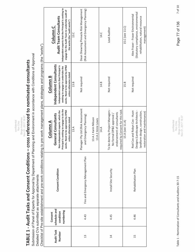
TABL
E1
Audi
tTas
ksan
dCo
nsen
tCon
ditio
ns–
cros
sref
eren
ced
tono
min
ated
cons
ulta
nts
Subm
issi
on o
f Pan
el o
f Exp
erts
for A
ppro
val b
y D
epar
tmen
t of P
lann
ing
and
Envi
ronm
ent i
n ac
cord
ance
with
Con
ditio
ns o
f App
rova
lD
etai
led
CVs
sub
mitt
ed a
s se
para
te a
ttach
men
tsC
heck
list o
f Pre
-site
est
ablis
hmen
t and
pre
-wor
k co
nditi
ons
rela
ting
to p
re-w
ork
man
agem
ent p
lans
, stra
tegi
es a
nd p
rogr
ams
(the
"wor
ks")
.
Audi
tTas
kN
umbe
r
Cons
ent
sche
dule
and
cond
ition
num
berin
g
Cons
entC
ondi
tion
Colu
mn
AGe
nera
lCon
sulta
nts
Non
inde
pend
ente
xper
tsw
hich
the
Prin
cipa
liss
eeki
ngto
enga
geto
doth
ew
orks
.Nee
dto
beap
prov
edby
DP&
Eun
less
othe
rwis
est
ated
Colu
mn
BIn
depe
nden
tCon
sulta
nts
Inde
pend
ente
xper
tsth
atPr
inci
pali
sse
ekin
gto
enga
geto
unde
rtak
eth
ew
orks
.Nee
dto
beap
prov
edby
DP&
Eun
less
othe
rwis
est
ated
Colu
mn
CAu
ditT
eam
Cons
ulta
nts
Inde
pend
ente
xper
tsth
atth
ePr
inci
pali
ssee
king
toen
gage
fort
heAu
ditT
eam
toun
dert
ake
audi
tof
the
wor
ks(t
he"a
udit
wor
ks")
134.
43Fi
rean
dEm
erge
ncy
Man
agem
entP
lan
13.A
Plan
ager
Pty
Ltd
(Risk
Asse
ssm
ent
and
Emer
genc
yPl
anni
ng)
13.A
.1Ka
rinN
ilsso
n13
.A.2
Anne
Lew
is
13.B
Not
requ
ired
13.C
Dean
Shew
ring
Pinn
acle
Risk
Man
agem
ent
(Risk
Asse
ssm
enta
ndEm
erge
ncy
Plan
ning
)
144.
45In
stal
lSite
Secu
rity
14.A
Tobe
done
byPr
ojec
tMan
ager
sN
ofo
rmal
DP&
Eap
prov
al/
endo
rsem
ento
fcon
sulta
nts
requ
ired
byCo
nsen
tfor
this
task
.
14.B
Not
requ
ired
14.C
Lead
Audi
tor
154.
46Re
habi
litat
ion
Plan
15.A
(see
11.A
)
Rod
Cox
and
Roby
nCo
xHu
onDe
signs
(Lan
dsca
peAr
chite
cts
land
form
desig
n,co
nstr
uctio
n,re
stor
atio
nan
dm
aint
enan
ce)
15.B
Not
requ
ired
15.C
(see
11.C
)
Alex
Fras
erFr
aser
Envi
ronm
enta
l(S
tatu
tory
com
plia
nce,
envi
ronm
enta
lre
habi
litat
ion,
natu
ralr
esou
rce
man
agem
ent)
Tabl
e1
Nom
inat
ion
ofCo
nsul
tant
sand
Audi
tors
307
157
of10
Pag
e 77
of 1
36
confi
dent
ial
Ron
Chi
oB
ingo
Indu
strie
sN
ov 0
1, 2
017
18:3
7
confi
dent
ial
Ron
Chi
oB
ingo
Indu
strie
sN
ov 0
1, 2
017
18:3
7

TABL
E1
Audi
tTas
ksan
dCo
nsen
tCon
ditio
ns–
cros
sref
eren
ced
tono
min
ated
cons
ulta
nts
Subm
issi
on o
f Pan
el o
f Exp
erts
for A
ppro
val b
y D
epar
tmen
t of P
lann
ing
and
Envi
ronm
ent i
n ac
cord
ance
with
Con
ditio
ns o
f App
rova
lD
etai
led
CVs
sub
mitt
ed a
s se
para
te a
ttach
men
tsC
heck
list o
f Pre
-site
est
ablis
hmen
t and
pre
-wor
k co
nditi
ons
rela
ting
to p
re-w
ork
man
agem
ent p
lans
, stra
tegi
es a
nd p
rogr
ams
(the
"wor
ks")
.
Audi
tTas
kN
umbe
r
Cons
ent
sche
dule
and
cond
ition
num
berin
g
Cons
entC
ondi
tion
Colu
mn
AGe
nera
lCon
sulta
nts
Non
inde
pend
ente
xper
tsw
hich
the
Prin
cipa
liss
eeki
ngto
enga
geto
doth
ew
orks
.Nee
dto
beap
prov
edby
DP&
Eun
less
othe
rwis
est
ated
Colu
mn
BIn
depe
nden
tCon
sulta
nts
Inde
pend
ente
xper
tsth
atPr
inci
pali
sse
ekin
gto
enga
geto
unde
rtak
eth
ew
orks
.Nee
dto
beap
prov
edby
DP&
Eun
less
othe
rwis
est
ated
Colu
mn
CAu
ditT
eam
Cons
ulta
nts
Inde
pend
ente
xper
tsth
atth
ePr
inci
pali
ssee
king
toen
gage
fort
heAu
ditT
eam
toun
dert
ake
audi
tof
the
wor
ks(t
he"a
udit
wor
ks")
165.
1Es
tabl
ishm
ento
fCom
mun
ityLi
aiso
nCo
mm
ittee
16.A
.
Dian
aFo
rres
ter
OFP
Cons
ulng
No
form
alDP
&E
appr
oval
/en
dors
emen
tofc
onsu
ltant
sre
quire
dby
Cons
entf
orth
ista
sk.
16.B
Not
requ
ired
16.C
Lead
Audi
tor
175.
4Q
uarr
yO
pera
tions
Man
agem
entP
lan
17.A
MrG
reg
Thom
pson
VGT
Cons
ulng
No
form
alDP
&E
appr
oval
/en
dors
emen
tofc
onsu
ltant
sre
quire
dby
Cons
entf
orth
ista
sk.
17.B
Not
requ
ired
17. C
Phil
Tow
ler
EMGA
Mitc
hell
McL
enna
n(E
nviro
nmen
tala
sses
smen
t&m
anag
emen
t)
Tabl
e1
Nom
inat
ion
ofCo
nsul
tant
sand
Audi
tors
307
158
of10
Pag
e 78
of 1
36
Ron
Chi
oB
ingo
Indu
strie
sN
ov 0
1, 2
017
18:3
7
confi
dent
ial
Ron
Chi
oB
ingo
Indu
strie
sN
ov 0
1, 2
017
18:3
7

TABL
E1
Audi
tTas
ksan
dCo
nsen
tCon
ditio
ns–
cros
sref
eren
ced
tono
min
ated
cons
ulta
nts
Subm
issi
on o
f Pan
el o
f Exp
erts
for A
ppro
val b
y D
epar
tmen
t of P
lann
ing
and
Envi
ronm
ent i
n ac
cord
ance
with
Con
ditio
ns o
f App
rova
lD
etai
led
CVs
sub
mitt
ed a
s se
para
te a
ttach
men
tsC
heck
list o
f Pre
-site
est
ablis
hmen
t and
pre
-wor
k co
nditi
ons
rela
ting
to p
re-w
ork
man
agem
ent p
lans
, stra
tegi
es a
nd p
rogr
ams
(the
"wor
ks")
.
Audi
tTas
kN
umbe
r
Cons
ent
sche
dule
and
cond
ition
num
berin
g
Cons
entC
ondi
tion
Colu
mn
AGe
nera
lCon
sulta
nts
Non
inde
pend
ente
xper
tsw
hich
the
Prin
cipa
liss
eeki
ngto
enga
geto
doth
ew
orks
.Nee
dto
beap
prov
edby
DP&
Eun
less
othe
rwis
est
ated
Colu
mn
BIn
depe
nden
tCon
sulta
nts
Inde
pend
ente
xper
tsth
atPr
inci
pali
sse
ekin
gto
enga
geto
unde
rtak
eth
ew
orks
.Nee
dto
beap
prov
edby
DP&
Eun
less
othe
rwis
est
ated
Colu
mn
CAu
ditT
eam
Cons
ulta
nts
Inde
pend
ente
xper
tsth
atth
ePr
inci
pali
ssee
king
toen
gage
fort
heAu
ditT
eam
toun
dert
ake
audi
tof
the
wor
ks(t
he"a
udit
wor
ks")
185.
5La
ndfil
lEnv
ironm
enta
lMan
agem
entP
lan
LEM
P
18.A
.1(s
ee1.
A.1
4)
John
Russ
ell,
Mik
eN
ash,
Mik
eTh
omDo
ugla
sPar
tner
s(Le
acha
tean
dgr
ound
wat
er)
18.A
.1(s
ee8.
A.2
and
8.A.
3)
Crai
gBa
gnal
lN
iche
EHan
dM
ark
Wai
nwrig
htBM
TW
BM(s
urfa
cew
ater
,soi
ls).
Allp
revi
ously
wor
ked
onpr
ojec
t.
18.B
Not
requ
ired
18.C
.1(s
ee1.
A)
DrIa
nSw
ane
Jaco
bs(G
eote
chni
cal/L
and
ll)
18.C
.2(s
ee5.
C)
Mar
kTo
oker
NPC
Cons
ultin
g(s
urfa
cew
ater
/soi
ls/ci
vile
ngin
eerin
g)
195.
1W
ebsit
eCo
nstr
uctio
nan
dCo
mm
unic
atio
nsPl
an
19.A
Dian
aFo
rres
ter
OFP
Cons
ulng
No
form
alDP
&E
appr
oval
/en
dors
emen
tofc
onsu
ltant
sre
quire
dby
Cons
entf
orth
ista
sk.
19.B
Not
requ
ired
19.C
Lead
Audi
tor
Tabl
e1
Nom
inat
ion
ofCo
nsul
tant
sand
Audi
tors
307
159
of10
Pag
e 79
of 1
36
confi
dent
ial
Ron
Chi
oB
ingo
Indu
strie
sN
ov 0
1, 2
017
18:3
7
confi
dent
ial
Ron
Chi
oB
ingo
Indu
strie
sN
ov 0
1, 2
017
18:3
7

TABL
E1
Audi
tTas
ksan
dCo
nsen
tCon
ditio
ns–
cros
sref
eren
ced
tono
min
ated
cons
ulta
nts
Subm
issi
on o
f Pan
el o
f Exp
erts
for A
ppro
val b
y D
epar
tmen
t of P
lann
ing
and
Envi
ronm
ent i
n ac
cord
ance
with
Con
ditio
ns o
f App
rova
lD
etai
led
CVs
sub
mitt
ed a
s se
para
te a
ttach
men
tsC
heck
list o
f Pre
-site
est
ablis
hmen
t and
pre
-wor
k co
nditi
ons
rela
ting
to p
re-w
ork
man
agem
ent p
lans
, stra
tegi
es a
nd p
rogr
ams
(the
"wor
ks")
.
Audi
tTas
kN
umbe
r
Cons
ent
sche
dule
and
cond
ition
num
berin
g
Cons
entC
ondi
tion
Colu
mn
AGe
nera
lCon
sulta
nts
Non
inde
pend
ente
xper
tsw
hich
the
Prin
cipa
liss
eeki
ngto
enga
geto
doth
ew
orks
.Nee
dto
beap
prov
edby
DP&
Eun
less
othe
rwis
est
ated
Colu
mn
BIn
depe
nden
tCon
sulta
nts
Inde
pend
ente
xper
tsth
atPr
inci
pali
sse
ekin
gto
enga
geto
unde
rtak
eth
ew
orks
.Nee
dto
beap
prov
edby
DP&
Eun
less
othe
rwis
est
ated
Colu
mn
CAu
ditT
eam
Cons
ulta
nts
Inde
pend
ente
xper
tsth
atth
ePr
inci
pali
ssee
king
toen
gage
fort
heAu
ditT
eam
toun
dert
ake
audi
tof
the
wor
ks(t
he"a
udit
wor
ks")
207.
F.n
Plan
forD
ispos
alof
Wat
erin
Cell
1
20.A
Doug
lasP
artn
ers.
No
form
alDP
&E
appr
oval
/en
dors
emen
tofc
onsu
ltant
sre
quire
dby
Cons
entf
orth
ista
sk.
20.B
Not
requ
ired
20.C
(see
1.A)
DrIa
nSw
ane
Jaco
bs(G
eote
chni
cal/L
and
ll)
20.C
.2(s
ee5.
C)
Mar
kTo
oker
NPC
Cons
ultin
g(s
urfa
cew
ater
/soi
ls/ci
vile
ngin
eerin
g)
217.
IIn
stal
latio
nan
dM
onito
ring
ofPi
ezom
eter
s
21.A
(see
1.A)
Doug
lasP
artn
ers
No
form
alDP
&E
appr
oval
/en
dors
emen
tofc
onsu
ltant
sre
quire
dby
Cons
entf
orth
ista
sk.
21.B
Not
requ
ired
21.C
(see
1.C)
DrIa
nSw
ane
Jaco
bs(G
eote
chni
cal/L
andf
ill)
227.
JCo
nstr
uctio
nQ
ualit
yAs
sura
nce
Plan
22.A
(see
1.A)
Doug
lasP
artn
ers
No
form
alDP
&E
appr
oval
/en
dors
emen
tofc
onsu
ltant
sre
quire
dby
Cons
entf
orth
ista
sk.
22.B
Not
requ
ired
22.C
.1(s
ee1.
C)
DrIa
nSw
ane
Jaco
bs(G
eote
chni
cal/L
and
ll)
22.C
.2(s
ee5.
C)
Mar
kTo
oker
NPC
Cons
ultin
g(s
urfa
cew
ater
/soi
ls/ci
vile
ngin
eerin
g)
Tabl
e1
Nom
inat
ion
ofCo
nsul
tant
sand
Audi
tors
307
1510
of10
Pag
e 80
of 1
36
confi
dent
ial
Ron
Chi
oB
ingo
Indu
strie
sN
ov 0
1, 2
017
18:3
7
confi
dent
ial
Ron
Chi
oB
ingo
Indu
strie
sN
ov 0
1, 2
017
18:3
7

Attachment 3
GHD Plans and Cross sections for Bund Reshaping and Related Works
Page 81 of 136
confidentialRon Chio
Bingo IndustriesNov 01, 2017 18:37
confidentialRon Chio
Bingo IndustriesNov 01, 2017 18:37

SEDI
MENT
DAM
4 RE
LOCA
TION
(4.01
)
CONT
INGE
NCY
STOC
KPILE
ARE
A (6
.01 A
ND 6.
02)
NORT
HEAS
TERN
BUN
D(1
.01 A
ND 1.
02)AD
DITI
ONAL
TRI
MMIN
G FO
RNO
RTHE
ASTE
RN B
UND
(INCL
UDED
IN 1.
01 A
ND 1.
02)
ADDI
TION
AL T
RIMM
ING
FOR
NORT
HWES
TERN
BUN
D(IN
CLUD
ED IN
1.03
AND
1.04
)
NORT
HWES
TERN
BUND
(1.03
AND
1.04
)
SOUT
H AN
D SO
UTHW
ESTE
RNBU
ND (1
.05)
RRA
PLAT
FORM
(5.01
AND
5.02
)
NORT
HERN
RRA
BUN
D (5
.03)
SOUT
HERN
RRA
BUN
D (5
.04)
INIT
IAL L
EACH
ATE
EVAP
ORAT
ION
DAM
(3.01
AND
3.02
)
SEDI
MENT
DAM
5 (4
.02)
LOCA
TION
UND
ER R
EVIE
W
CELL
1 (2
.01 A
ND 2.
02)
CELL
2 (2
.03 A
ND 2.
04)
CELL
3 (2
.05)
INTE
RCEL
L BUN
DEX
CAVA
TION
(2.06
)
EAST
/WES
T BU
ND B
OUND
ARY
NORT
HEAS
TERN
BUN
D EX
CAVA
TION
- DE
LAYE
D W
ORKS
(1.06
)
date
for A
1re
v no
.jo
b no
.sc
ale
appr
oved
(PD
)
Con
ditio
ns o
f Use
: Thi
s do
cum
ent m
ay o
nly
be u
sed
by G
HD
's c
lient
(and
any
oth
erpe
rson
who
GH
D h
as a
gree
d ca
n us
e th
is d
ocum
ent)
for t
he p
urpo
se fo
r whi
ch it
was
prep
ared
and
mus
t not
be
used
by
any
othe
r per
son
or fo
r any
oth
er p
urpo
se.
rev
desc
riptio
nap
p'd
date
SK
Leve
l 15,
133
Cas
tlere
agh
Stre
et, S
ydne
y N
SW
200
0 A
ustra
liaT
61 2
923
9 71
00F
61 2
923
9 71
99E
sydm
ail@
ghd.
com
W w
ww
.ghd
.com
Plo
t Dat
e:C
ad F
ile N
o:11
Oct
ober
201
6 -
4:29
PM
N:\A
U\S
ydne
y\P
roje
cts\
21\2
5736
\CA
DD
\Dra
win
gs\2
1-25
736-
SK
001.
dwg
Plo
tted
by:
Alis
on H
orly
ck
SR
C P
RO
PE
RTI
ES
PTY
LTD
PA
TON
S L
AN
E R
RC
BU
LK E
AR
THW
OR
KS
001
B21-2
5736
PR
ELI
MIN
AR
Y
1:10
0S
EP
201
6
AIN
ITIA
L IS
SU
EA
D06
.09.
16
BR
EV
ISE
DA
D10
/10/
16
NLE
GEND
EX
ISTI
NG C
ONTO
URS
(1 m
INCR
EMEN
T)
NOTE
S1.
BASE
D ON
SUR
VEY
PROV
IDED
BY
MATT
HEW
FRE
EBUR
NLA
ND, E
NGIN
EERI
NG &
MIN
ING
SURV
EYOR
S, D
ATED
AUGU
ST 20
07 A
ND S
EPTE
MBER
2016
2.TO
BE
READ
IN C
ONJU
NCTI
ON W
ITH
PREL
IMIN
ARY
BULK
EART
HWOR
KS E
STIM
ATES
(GHD
, 201
6)3.
SUBJ
ECT
TO C
HANG
E BA
SED
ON D
ETAI
LED
DESI
GNW
ORKS
PE
RIME
TER
BUND
S (G
HD)
LIM
IT O
F EX
TRAC
TION
(FMP
PR)
PR
OPOS
ED E
XTEN
T OF
LAND
FILL
ING
CO
NTIN
GENC
Y ST
OCKP
ILE A
REA
(GHD
)
RR
A PL
ATFO
RM (F
MPPR
)
Pag
e 82
of 1
36
confi
dent
ial
Ron
Chi
oB
ingo
Indu
strie
sN
ov 0
1, 2
017
18:3
7
confi
dent
ial
Ron
Chi
oB
ingo
Indu
strie
sN
ov 0
1, 2
017
18:3
7

CH 0
CH 20
0CH
400
CH 50
0CH
600
CH 70
0
CH 80
0
CH 90
0
CH 10
00
CH 11
00
CH 0
CH 10
0
CH 20
0
CH 30
0
CH 40
0CH 50
0
CH 70
0
CH 80
0
CH 10
0
CH 30
0
CH 12
00
CH 60
0
CH 0
CH 10
0
CH 20
0
CH 30
0
NORT
HERN
BUN
DRE
FER
SK00
3 - S
K005
NORT
HERN
BUN
DRE
FER
SK00
3 - S
K005
SOUT
HERN
BUN
DRE
FER
SK00
6 - S
K008 SO
UTHE
RN B
UND
REFE
R SK
006 -
SK0
08
RRA
BUND
REFE
R SK
009
date
for A
1re
v no
.jo
b no
.sc
ale
appr
oved
(PD
)
Con
ditio
ns o
f Use
: Thi
s do
cum
ent m
ay o
nly
be u
sed
by G
HD
's c
lient
(and
any
oth
erpe
rson
who
GH
D h
as a
gree
d ca
n us
e th
is d
ocum
ent)
for t
he p
urpo
se fo
r whi
ch it
was
prep
ared
and
mus
t not
be
used
by
any
othe
r per
son
or fo
r any
oth
er p
urpo
se.
rev
desc
riptio
nap
p'd
date
SK
Leve
l 15,
133
Cas
tlere
agh
Stre
et, S
ydne
y N
SW
200
0 A
ustra
liaT
61 2
923
9 71
00F
61 2
923
9 71
99E
sydm
ail@
ghd.
com
W w
ww
.ghd
.com
Plo
t Dat
e:C
ad F
ile N
o:11
Oct
ober
201
6 -
4:23
PM
N:\A
U\S
ydne
y\P
roje
cts\
21\2
5736
\CA
DD
\Dra
win
gs\2
1-25
736-
SK
002.
dwg
Plo
tted
by:
Alis
on H
orly
ck
SR
C P
RO
PE
RTI
ES
PTY
LTD
PA
TON
S L
AN
E R
RC
RE
VIS
ED
PE
RIM
ETE
R B
UN
DS
002
C21-2
5736
PR
ELI
MIN
AR
Y
1:20
00O
CT
2016
AIN
ITIA
L IS
SU
EA
D14
.09.
16
CR
EV
ISE
DA
D10
.10.
16
NLE
GEND
EX
ISTI
NG C
ONTO
URS
(1 m
INCR
EMEN
T)
NOTE
S1.
BASE
D ON
SUR
VEY
PROV
IDED
BY
MATT
HEW
FRE
EBUR
NLA
ND, E
NGIN
EERI
NG &
MIN
ING
SURV
EYOR
S, D
ATED
AUGU
ST 20
07 A
ND S
EPTE
MBER
2016
2.SU
BJEC
T TO
CHA
NGE
BASE
D ON
DET
AILE
D DE
SIGN
WOR
KS
PE
RIME
TER
BUND
S (G
HD)
LIM
IT O
F EX
TRAC
TION
(FMP
PR)
PR
OPER
TY B
OUND
ARY
PR
OPOS
ED E
XTEN
T OF
LAND
FILL
ING
CO
NTIN
GENC
Y ST
OCKP
ILE A
REA
(GHD
)
RR
A PL
ATFO
RM (F
MPPR
)
0
SCAL
E 1:2
000
AT O
RIGI
NAL S
IZE
4020
8010
0m60
Pag
e 83
of 1
36
Ron
Chi
oB
ingo
Indu
strie
sN
ov 0
1, 2
017
18:3
7
confi
dent
ial
Ron
Chi
oB
ingo
Indu
strie
sN
ov 0
1, 2
017
18:3
7
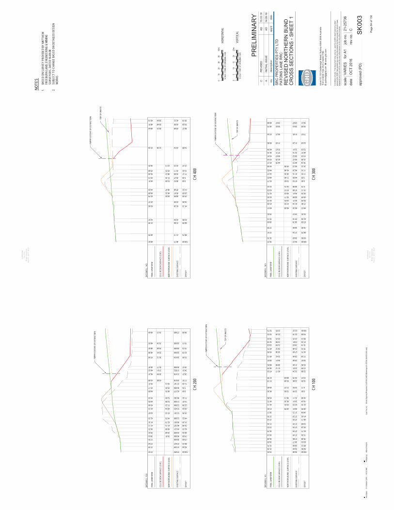
CH 10
0
-100.0036.0835.05-94.9036.6035.39-89.5238.0035.75-83.6338.7736.09-78.4837.8636.28
-72.2637.5936.53
-65.7137.5936.79
-59.2437.5937.05-53.8437.5937.26
-46.7137.5937.54-41.4337.5937.76
-34.9437.7338.27-28.9940.0140.9941.82
-22.1042.3343.9544.13-16.6439.0146.3044.75-10.9835.1148.7345.40
0.0033.9953.0046.30
6.1133.9251.2746.60
16.9933.8645.9847.1422.0733.7646.0447.39
32.8833.3443.1747.9337.9933.0141.1248.1843.4031.0038.9848.45
50.8729.0036.0148.81
57.3428.4633.4249.13
64.7527.0930.4849.4970.1625.4828.3249.7576.1424.0325.9450.0381.2623.8123.9850.1886.5323.3523.2550.33
93.8422.1823.3050.55
100.0022.2223.9550.73
OFFS
ET
EXIS
TING
SUR
FACE
NORT
HERN
BUN
D S
URFA
CE LE
VEL
CELL
DES
IGN
SURF
ACE
LEVE
L
FINA
L LAN
DFOR
M
DATU
M R.
L. 9.5
CH 30
0
-100.0036.2236.22-93.9636.6936.70
-84.7937.3437.41
-76.8938.0037.99
-67.5838.7838.69-62.3839.1839.13
-54.4539.5739.82
-44.5540.5840.91
-37.4042.3441.69-32.2942.3142.12-26.6944.0043.7142.42
-20.3946.0146.0342.75-15.1247.6847.9743.03
-9.1948.9850.1543.32
0.0047.5353.0043.775.6944.0051.4644.05
11.9541.1648.3644.3717.7640.2045.4844.65
24.3240.3344.4844.9830.2440.5344.3945.2735.4840.4742.2945.5441.0338.5240.0745.8146.9135.1637.7246.1052.0332.0135.6746.34
62.6431.2431.4346.86
77.0731.0530.2747.56
90.0830.6330.0548.1996.0129.8729.9748.48
OFFS
ET
EXIS
TING
SUR
FACE
FINA
L LAN
DFOR
M
DATU
M R.
L. 16
.5
CH 40
0
-100.0040.7740.62
-88.7641.1340.99
-68.9941.8641.99-63.8642.0442.07
-41.3342.3043.06
-34.4643.0043.37
-25.0044.0044.4243.78-20.0045.6746.3244.00-14.3247.6848.4744.26
0.0048.9253.0044.915.3045.2751.3545.15
11.5743.0048.2245.4416.9243.1145.5545.68
25.3743.3343.1346.05
54.8943.5432.3847.28
86.5743.6828.2348.64
93.2843.0028.4448.91
99.7842.5228.6449.18
OFFS
ET
EXIS
TING
SUR
FACE
FINA
L LAN
DFOR
M
DATU
M R.
L. 14
.5
TOP
OF W
ASTE
TOP
OF W
ASTE
TOP
OF W
ASTE
NORT
HERN
BUN
D S
URFA
CE LE
VEL
CELL
DES
IGN
SURF
ACE
LEVE
L
NORT
HERN
BUN
D S
URFA
CE LE
VEL
CELL
DES
IGN
SURF
ACE
LEVE
L
CH 20
0
-100.0037.09337.03
-92.0437.35937.39-86.5537.62737.64
-79.6038.00037.95-74.0940.00038.63 39.01-68.3643.00039.42 39.68-62.3344.22140.25 40.40-56.4846.50741.12 41.16-51.0949.69141.92 42.79
-44.5252.00042.35 44.76
-35.9652.26142.87 47.33
-28.6052.45343.33 49.54-22.9852.00043.68 51.23-16.9151.00044.05 53.00-11.0248.38244.34 52.05
0.0042.57744.89 46.935.5640.00045.17 45.05
12.3037.16745.51 45.1217.9734.01843.8045.80
28.2131.41939.9446.31
34.5131.85237.6146.6239.5730.00035.7746.87
55.8428.03430.1247.68
63.7828.00029.4548.08
70.7428.00029.4048.42
79.1528.00029.3448.83
96.9027.60929.2249.69
OFFS
ET
EXIS
TING
SUR
FACE
DATU
M R.
L. 15
.0
40.88
41.5642.05
FINA
L LAN
DFOR
M
CELL
DES
IGN
SURF
ACE
LEVE
L
NORT
HERN
BUN
D S
URFA
CE LE
VEL
FMPP
R EX
TENT
OF
EXTR
ACTI
ON
FMPP
R EX
TENT
OF
EXTR
ACTI
ON
FMPP
R EX
TENT
OF
EXTR
ACTI
ON
FMPP
R EX
TENT
OF
EXTR
ACTI
ON
date
for A
1re
v no
.jo
b no
.sc
ale
appr
oved
(PD
)
Con
ditio
ns o
f Use
: Thi
s do
cum
ent m
ay o
nly
be u
sed
by G
HD
's c
lient
(and
any
oth
erpe
rson
who
GH
D h
as a
gree
d ca
n us
e th
is d
ocum
ent)
for t
he p
urpo
se fo
r whi
ch it
was
prep
ared
and
mus
t not
be
used
by
any
othe
r per
son
or fo
r any
oth
er p
urpo
se.
rev
desc
riptio
nap
p'd
date
SK
Leve
l 15,
133
Cas
tlere
agh
Stre
et, S
ydne
y N
SW
200
0 A
ustra
liaT
61 2
923
9 71
00F
61 2
923
9 71
99E
sydm
ail@
ghd.
com
W w
ww
.ghd
.com
Plo
t Dat
e:C
ad F
ile N
o:11
Oct
ober
201
6 -
10:5
2 A
MN
:\AU
\Syd
ney\
Pro
ject
s\21
\257
36\C
AD
D\D
raw
ings
\21-
2573
6-S
K00
3-00
6.dw
gP
lotte
d by
:A
lison
Hor
lyck
SR
C P
RO
PE
RTI
ES
PTY
LTD
PA
TON
S L
AN
E R
RC
RE
VIS
ED
NO
RTH
ER
N B
UN
DC
RO
SS
SE
CTI
ON
S -
SH
EE
T 1
003
C21-2
5736
PR
ELI
MIN
AR
Y
VA
RIE
SO
CT
2016
AIN
ITIA
L IS
SU
EA
D14
.09.
16
CR
EV
ISE
DA
D10
.10.
16
NOTE
S1.
BASE
D ON
SUR
VEY
PROV
IDED
BY
MATT
HEW
FREE
BURN
LAND
, ENG
INEE
RING
& M
ININ
GSU
RVEY
ORS,
DAT
ED 16
-09-
082.
SUBJ
ECT
TO C
HANG
E BA
SED
ON D
ETAI
LED
DESI
GNW
ORKS
05
2025
m15
10
SCAL
E 1:5
00 A
T OR
IGIN
AL S
IZE
SCAL
E 1:1
000
AT O
RIGI
NAL S
IZE
2010
040
50m
30
HORI
ZONT
AL
VERT
ICAL P
age
84 o
f 136
confi
dent
ial
Ron
Chi
oB
ingo
Indu
strie
sN
ov 0
1, 2
017
18:3
7
confi
dent
ial
Ron
Chi
oB
ingo
Indu
strie
sN
ov 0
1, 2
017
18:3
7

CH 50
0
-100.0041.7041.48-94.0841.7541.46
-85.4041.8041.45
-78.8641.8141.50-73.0141.8541.59
-66.1041.8941.73-61.0841.9041.84
-53.5142.0842.05-48.2043.0342.28-42.7741.2342.51-37.5742.2042.74-32.0242.8543.5942.98-26.4045.9945.3743.24-21.3649.0046.9843.48
-14.9549.1349.0343.78
-8.8147.0151.0044.07
0.0042.9453.0044.50
10.7839.9648.4945.01
18.2940.0144.8645.38
27.7140.0742.4445.83
45.2840.2036.8246.68
51.7840.2632.7547.0056.8641.7329.3647.24
66.6043.8329.0347.72
73.2943.4929.2348.05
84.5443.4029.5548.60
93.5843.7029.8049.04
100.0043.8929.9749.36
OFFS
ET
EXIS
TING
SUR
FACE
FINA
L LAN
DFOR
M
DATU
M R.
L. 16
.0
CH 60
0
-100.0040.0640.00
-92.2940.2440.26
-84.9140.4640.51
-70.9641.0041.13
-55.6741.5741.95
-49.0041.6942.28
-35.2641.9943.1942.93-29.4745.7044.9243.20-24.3248.9946.4543.45
-16.4550.0648.8043.82-10.7548.0050.4944.09
0.0044.2753.0044.61
6.4543.2050.7744.92
22.4743.7843.6745.69
31.5444.0543.9546.12
38.9844.2742.1646.46
49.2544.9437.2946.93
57.9144.8532.2247.3263.6746.4330.0747.57
72.9845.3630.3648.00
82.0844.5930.6448.43
89.9444.4430.8848.8195.3844.5431.0449.07
OFFS
ET
EXIS
TING
SUR
FACE
FINA
L LAN
DFOR
M
DATU
M R.
L. 17
.0
CH 70
0
-100.0040.5940.57
-92.0640.8940.71
-75.0941.3941.18
-50.1842.0041.91
-43.3042.0242.18
-33.6242.1742.63-28.0444.4043.7042.89
-21.7747.9745.9643.19
0.0050.8353.0344.19
24.1950.8044.2145.38
37.8050.6145.1146.0443.2450.7645.7346.2749.0950.8746.2346.54
69.3251.2843.6047.46
95.7351.0140.8848.75
OFFS
ET
EXIS
TING
SUR
FACE
FINA
L LAN
DFOR
M
DATU
M R.
L. 26
.0
CH 80
0
-100.0042.40
-92.2342.68
-83.7242.71
-73.3042.8643.44
-66.8043.0043.54
-59.1843.2243.72
-49.5343.2843.94
-37.2343.2844.00-32.0044.0044.7144.00-26.6046.9946.6744.68-21.2350.0048.6245.43
-9.5752.2052.8546.25
0.0052.0955.0846.51
7.6152.0351.7246.63
14.7751.2548.2246.68
26.3251.1445.4446.6831.4751.0845.4446.68
39.0750.9545.4846.6544.2451.0045.6646.6049.6451.1045.8646.54
55.8651.0045.8946.46
65.6050.1546.2046.40
72.5249.0946.4146.3277.6948.5946.3646.27
84.0647.8046.7546.2289.2146.9546.8846.1995.0946.1644.5846.16
OFFS
ET
EXIS
TING
SUR
FACE
FINA
L LAN
DFOR
M
DATU
M R.
L. 28
.5
TOP
OF W
ASTE
TOP
OF W
ASTE
TOP
OF W
ASTE
NORT
HERN
BUN
D S
URFA
CE LE
VEL
CELL
DES
IGN
SURF
ACE
LEVE
L
NORT
HERN
BUN
D S
URFA
CE LE
VEL
CELL
DES
IGN
SURF
ACE
LEVE
L
NORT
HERN
BUN
D S
URFA
CE LE
VEL
CELL
DES
IGN
SURF
ACE
LEVE
L
NORT
HERN
BUN
D S
URFA
CE LE
VEL
CELL
DES
IGN
SURF
ACE
LEVE
L
FMPP
R EX
TENT
OF
EXTR
ACTI
ON
FMPP
R EX
TENT
OF
EXTR
ACTI
ON
FMPP
R EX
TENT
OF
EXTR
ACTI
ON
FMPP
R EX
TENT
OF
EXTR
ACTI
ON
date
for A
1re
v no
.jo
b no
.sc
ale
appr
oved
(PD
)
Con
ditio
ns o
f Use
: Thi
s do
cum
ent m
ay o
nly
be u
sed
by G
HD
's c
lient
(and
any
oth
erpe
rson
who
GH
D h
as a
gree
d ca
n us
e th
is d
ocum
ent)
for t
he p
urpo
se fo
r whi
ch it
was
prep
ared
and
mus
t not
be
used
by
any
othe
r per
son
or fo
r any
oth
er p
urpo
se.
rev
desc
riptio
nap
p'd
date
SK
Leve
l 15,
133
Cas
tlere
agh
Stre
et, S
ydne
y N
SW
200
0 A
ustra
liaT
61 2
923
9 71
00F
61 2
923
9 71
99E
sydm
ail@
ghd.
com
W w
ww
.ghd
.com
Plo
t Dat
e:C
ad F
ile N
o:11
Oct
ober
201
6 -
10:5
3 A
MN
:\AU
\Syd
ney\
Pro
ject
s\21
\257
36\C
AD
D\D
raw
ings
\21-
2573
6-S
K00
3-00
6.dw
gP
lotte
d by
:A
lison
Hor
lyck
SR
C P
RO
PE
RTI
ES
PTY
LTD
PA
TON
S L
AN
E R
RC
RE
VIS
ED
NO
RTH
ER
N B
UN
DC
RO
SS
SE
CTI
ON
S -
SH
EE
T 2
004
C21-2
5736
PR
ELI
MIN
AR
Y
VA
RIE
SO
CT
2016
AIN
ITIA
L IS
SU
EA
D14
.09.
16
CR
EV
ISE
DA
D10
.10.
16
NOTE
S1.
BASE
D ON
SUR
VEY
PROV
IDED
BY
MATT
HEW
FREE
BURN
LAND
, ENG
INEE
RING
& M
ININ
GSU
RVEY
ORS,
DAT
ED 16
-09-
082.
SUBJ
ECT
TO C
HANG
E BA
SED
ON D
ETAI
LED
DESI
GNW
ORKS
05
2025
m15
10
SCAL
E 1:5
00 A
T OR
IGIN
AL S
IZE
SCAL
E 1:1
000
AT O
RIGI
NAL S
IZE
2010
040
50m
30
HORI
ZONT
AL
VERT
ICAL P
age
85 o
f 136
Ron
Chi
oB
ingo
Indu
strie
sN
ov 0
1, 2
017
18:3
7
confi
dent
ial
Ron
Chi
oB
ingo
Indu
strie
sN
ov 0
1, 2
017
18:3
7

CH 90
0
-100.0044.2644.29
-83.6144.5544.73
-62.1044.9145.46-56.6544.9945.64
-48.4346.0046.6245.91-42.9648.9847.7746.39-37.8951.7348.8347.09-31.8854.1050.0848.03
-23.6253.9951.8149.32
-16.3153.8953.3450.00
-9.0553.9854.8550.00
0.0053.3156.0550.08
19.1451.6348.8950.49
35.8351.0043.7050.8541.0648.3741.2150.8847.0145.7238.3850.91
54.3046.0034.0950.9960.1445.5733.2651.13
87.5145.5532.9951.3792.9847.9332.9351.43
100.0048.6332.8751.45
OFFS
ET
EXIS
TING
SUR
FACE
FINA
L LAN
DFOR
M
DATU
M R.
L. 20
.0
CH 10
00
-100.0045.83
-93.7745.8745.95
-76.6845.9046.00-70.7845.9946.00
-45.5646.3946.87
-38.2347.0048.4547.23-33.2149.7949.6947.54-28.0152.6650.9647.85
0.0055.6456.7250.32
8.6355.0053.3350.5213.9451.6851.0450.6419.3248.3149.5050.77
41.5447.2043.0151.2947.4147.2240.1651.43
59.6847.5334.6251.72
82.1447.4235.0052.2487.8647.4435.0052.3693.2548.0035.0052.48
100.0050.7034.4052.63
OFFS
ET
EXIS
TING
SUR
FACE
FINA
L LAN
DFOR
M
DATU
M R.
L. 21
.5
CH 11
00
-100.0047.17
-90.3447.35
-80.8347.5647.29
-66.2747.7547.81
-52.3047.9948.00
-38.6748.3448.00
-28.4448.3348.8648.00-22.4149.0050.9248.00-16.6351.9152.8948.53-10.7255.6754.9649.32
0.0056.5857.3850.135.2856.5254.9950.24
21.2856.0049.6750.6027.1553.0049.5150.7232.8750.0046.7950.8538.0649.0144.3250.96
66.7849.3229.0451.55
72.9149.4229.1151.68
86.4349.3629.2651.93
98.5749.3229.3952.13
OFFS
ET
EXIS
TING
SUR
FACE
FINA
L LAN
DFOR
M
DATU
M R.
L. 16
.5
CH 12
00
-100.0047.50
-89.9447.5446.72
-80.1047.5247.37-75.0847.5947.46
-68.2447.6147.43-62.8547.5947.47-56.9647.6547.59
-48.9347.6647.60
-39.4047.6947.56
-32.6147.6047.68-27.0548.0048.8247.82-21.5951.4950.9647.95-16.0755.0053.1248.01-10.0958.9955.4648.20
0.0058.5358.0448.47
6.8058.5155.2948.66
16.9659.0050.8548.9022.1256.0048.9849.0127.4152.4849.0649.0932.9649.0048.3649.12
57.8648.8834.2149.75
75.3749.3530.3850.06
100.0049.9230.6650.29
OFFS
ET
EXIS
TING
SUR
FACE
FINA
L LAN
DFOR
M
DATU
M R.
L. 17
.5
TOP
OF W
ASTE
TOP
OF W
ASTE
TOP
OF W
ASTE
TOP
OF W
ASTE
NORT
HERN
BUN
D S
URFA
CE LE
VEL
CELL
DES
IGN
SURF
ACE
LEVE
L
NORT
HERN
BUN
D S
URFA
CE LE
VEL
CELL
DES
IGN
SURF
ACE
LEVE
L
NORT
HERN
BUN
D S
URFA
CE LE
VEL
CELL
DES
IGN
SURF
ACE
LEVE
L
NORT
HERN
BUN
D S
URFA
CE LE
VEL
CELL
DES
IGN
SURF
ACE
LEVE
L
FMPP
R EX
TENT
OF
EXTR
ACTI
ON
FMPP
R EX
TENT
OF
EXTR
ACTI
ON
FMPP
R EX
TENT
OF
EXTR
ACTI
ON
FMPP
R EX
TENT
OF
EXTR
ACTI
ON(IN
FERR
ED A
T TH
IS LO
CATI
ON)
date
for A
1re
v no
.jo
b no
.sc
ale
appr
oved
(PD
)
Con
ditio
ns o
f Use
: Thi
s do
cum
ent m
ay o
nly
be u
sed
by G
HD
's c
lient
(and
any
oth
erpe
rson
who
GH
D h
as a
gree
d ca
n us
e th
is d
ocum
ent)
for t
he p
urpo
se fo
r whi
ch it
was
prep
ared
and
mus
t not
be
used
by
any
othe
r per
son
or fo
r any
oth
er p
urpo
se.
rev
desc
riptio
nap
p'd
date
SK
Leve
l 15,
133
Cas
tlere
agh
Stre
et, S
ydne
y N
SW
200
0 A
ustra
liaT
61 2
923
9 71
00F
61 2
923
9 71
99E
sydm
ail@
ghd.
com
W w
ww
.ghd
.com
Plo
t Dat
e:C
ad F
ile N
o:11
Oct
ober
201
6 -
4:07
PM
N:\A
U\S
ydne
y\P
roje
cts\
21\2
5736
\CA
DD
\Dra
win
gs\2
1-25
736-
SK
003-
006.
dwg
Plo
tted
by:
Alis
on H
orly
ck
SR
C P
RO
PE
RTI
ES
PTY
LTD
PA
TON
S L
AN
E R
RC
RE
VIS
ED
NO
RTH
ER
N B
UN
DC
RO
SS
SE
CTI
ON
S -
SH
EE
T 3
005
C21-2
5736
PR
ELI
MIN
AR
Y
VA
RIE
SO
CT
2016
AIN
ITIA
L IS
SU
EA
D14
.09.
16
CR
EV
ISE
DA
D10
.10.
16
NOTE
S1.
BASE
D ON
SUR
VEY
PROV
IDED
BY
MATT
HEW
FREE
BURN
LAND
, ENG
INEE
RING
& M
ININ
GSU
RVEY
ORS,
DAT
ED 16
-09-
082.
SUBJ
ECT
TO C
HANG
E BA
SED
ON D
ETAI
LED
DESI
GNW
ORKS
05
2025
m15
10
SCAL
E 1:5
00 A
T OR
IGIN
AL S
IZE
SCAL
E 1:1
000
AT O
RIGI
NAL S
IZE
2010
040
50m
30
HORI
ZONT
AL
VERT
ICAL P
age
86 o
f 136
confi
dent
ial
Ron
Chi
oB
ingo
Indu
strie
sN
ov 0
1, 2
017
18:3
7
confi
dent
ial
Ron
Chi
oB
ingo
Indu
strie
sN
ov 0
1, 2
017
18:3
7

CH 0
-100.0048.31
-92.7748.08
-75.0347.4747.53-69.5947.5747.65
-60.6047.2447.50
-53.0247.0347.42
-46.2047.0047.35
-37.2248.0047.31
-30.6848.1748.05-24.7547.1048.21
-11.7547.1048.56
-5.7047.1048.690.0047.1048.72
6.8147.1048.81
13.5047.1048.91
47.1447.1049.14
55.3747.1049.19
63.6547.1049.2568.8547.1049.28
76.1247.1049.3181.5147.1049.31
100.0047.1049.14
OFFS
ET
EXIS
TING
SUR
FACE
FINA
L LAN
DFOR
M
RRA
PLAT
FORM
DATU
M R.
L. 32
.5
CH 10
0
-100.0051.34
-92.0651.55
-85.1751.62
-77.8051.56
-70.7851.50
-59.6951.0051.13
-53.5151.0650.98
-36.5050.2850.66-31.1150.0750.63-25.6452.6350.61-19.7655.7450.45-14.2559.7050.5056.22
0.0061.4550.6757.15
8.9061.0150.8257.5014.1158.6350.9857.2719.1855.8051.0355.7525.0352.0151.0955.05
31.2250.3551.1452.86
38.8050.0851.2250.18
48.0449.8551.3349.39
57.3949.8251.4949.34
65.8549.8351.5849.29
72.4549.9851.6349.2677.5050.1351.6749.2383.3850.3951.7149.2088.8150.6351.7549.1794.0350.7151.7849.1499.6250.5351.8249.11
OFFS
ET
EXIS
TING
SUR
FACE
CELL
DES
IGN
LEVE
L
FINA
L LAN
DFOR
M
SOUT
HERN
BUN
D DE
SIGN
LEVE
L
RRA
PLAT
FORM
DATU
M R.
L. 36
.0
CH 20
0
-100.0055.84
-92.0955.52
-83.8056.01
-75.9556.00
-67.1155.97
-60.6855.87
-51.0755.5255.62
-42.9455.2255.33
-31.8655.2155.14-26.1255.0655.05
-19.9857.9955.0357.06-14.9760.4955.0257.14
0.0063.6554.9657.36
14.6763.0654.9357.58
21.0560.9954.9557.6826.5458.0154.9757.7631.9457.9854.9936.9851.6754.93
44.0349.6054.83
51.4649.7654.76
58.7750.0054.77
72.7150.0954.6878.7249.7054.66
91.0349.2154.53
99.9749.2154.48
OFFS
ET
EXIS
TING
SUR
FACE
FINA
L LAN
DFOR
M
RRA
PLAT
FORM
DATU
M R.
L. 36
.0
CH 30
0
-100.0057.88
-58.5057.7756.00
-44.1257.6456.00
-30.7257.0156.00-25.4459.7456.0058.16-19.9162.8256.0058.06
-12.6665.0756.0057.90
0.0064.8556.0057.61
11.1664.0056.0057.36
18.1263.4656.0057.22
25.4263.1856.0057.08
31.9660.0156.0056.9936.9958.0056.0056.9142.1656.1156.00
49.0355.1756.00
56.9353.9956.0062.9052.7555.9368.6252.3855.82
75.8952.3355.7081.0151.3855.60
89.2150.9155.4794.8550.0055.37
100.0049.4955.29
OFFS
ET
EXIS
TING
SUR
FACE
FINA
L LAN
DFOR
M
RRA
PLAT
FORM
DATU
M R.
L. 36
.0
CELL
DES
IGN
LEVE
L
SOUT
HERN
BUN
D DE
SIGN
LEVE
L
CELL
DES
IGN
LEVE
L
SOUT
HERN
BUN
D DE
SIGN
LEVE
L
CELL
DES
IGN
LEVE
L
SOUT
HERN
BUN
D DE
SIGN
LEVE
L
56.5754.63
52.07
49.19
49.15
49.0949.06
49.00
48.95
55.95
54.19
52.1951.5251.65
51.2950.33
49.7149.2849.14
date
for A
1re
v no
.jo
b no
.sc
ale
appr
oved
(PD
)
Con
ditio
ns o
f Use
: Thi
s do
cum
ent m
ay o
nly
be u
sed
by G
HD
's c
lient
(and
any
oth
erpe
rson
who
GH
D h
as a
gree
d ca
n us
e th
is d
ocum
ent)
for t
he p
urpo
se fo
r whi
ch it
was
prep
ared
and
mus
t not
be
used
by
any
othe
r per
son
or fo
r any
oth
er p
urpo
se.
rev
desc
riptio
nap
p'd
date
SK
Leve
l 15,
133
Cas
tlere
agh
Stre
et, S
ydne
y N
SW
200
0 A
ustra
liaT
61 2
923
9 71
00F
61 2
923
9 71
99E
sydm
ail@
ghd.
com
W w
ww
.ghd
.com
Plo
t Dat
e:C
ad F
ile N
o:11
Oct
ober
201
6 -
10:5
6 A
MN
:\AU
\Syd
ney\
Pro
ject
s\21
\257
36\C
AD
D\D
raw
ings
\21-
2573
6-S
K00
6-00
8.dw
gP
lotte
d by
:A
lison
Hor
lyck
SR
C P
RO
PE
RTI
ES
PTY
LTD
PA
TON
S L
AN
E R
RC
RE
VIS
ED
SO
UTH
ER
N B
UN
DC
RO
SS
SE
CTI
ON
S -
SH
EE
T 1
006
B21-2
5736
PR
ELI
MIN
AR
Y
1:10
00O
CT
2016
AIN
ITIA
L IS
SU
EA
D14
.09.
16
BR
EV
ISE
DA
D10
.10.
16
NOTE
S1.
BASE
D ON
SUR
VEY
PROV
IDED
BY
MATT
HEW
FREE
BURN
LAND
, ENG
INEE
RING
& M
ININ
GSU
RVEY
ORS,
DAT
ED 16
-09-
082.
SUBJ
ECT
TO C
HANG
E BA
SED
ON D
ETAI
LED
DESI
GNW
ORKS
05
2025
m15
10
SCAL
E 1:5
00 A
T OR
IGIN
AL S
IZE
SCAL
E 1:1
000
AT O
RIGI
NAL S
IZE
2010
040
50m
30
HORI
ZONT
AL
VERT
ICAL P
age
87 o
f 136
confi
dent
ial
Ron
Chi
oB
ingo
Indu
strie
sN
ov 0
1, 2
017
18:3
7
confi
dent
ial
Ron
Chi
oB
ingo
Indu
strie
sN
ov 0
1, 2
017
18:3
7

CH 40
0
-100.0054.5954.52
-93.8054.5854.63-87.9854.5754.67
-67.8254.9354.70
-61.1455.0654.70
-54.6155.0054.72
-36.1954.8854.92-30.3957.5655.01-24.9960.2455.1058.76-19.4463.0055.1858.74
0.0064.3955.4358.66
10.6464.7655.5658.62
16.8964.0055.6558.6022.7363.0055.7258.57
31.0659.2655.7958.4436.4556.6955.83
44.6554.0055.88
51.7252.0055.91
57.8650.0855.93
67.7749.7655.94
87.2149.4555.93
93.8549.5255.92
100.0049.6155.89
OFFS
ET
EXIS
TING
SUR
FACE
FINA
L LAN
DFOR
M
RRA
PLAT
FORM
DATU
M R.
L. 36
.0
CH 50
0
-100.0052.65
-90.8352.4952.59
-77.3552.6752.65
-56.6252.8152.85
-46.9852.9052.99
-40.0352.9753.11
-33.4053.0053.22-28.0856.0053.32-22.7559.0053.4157.87-17.6561.8953.4957.95
0.0063.2953.7958.23
10.2263.0053.9158.45
16.3960.0054.0058.59
22.4758.8754.0558.9027.7057.0054.09
35.1753.8954.1440.3450.8554.17
48.0348.6954.2153.0948.7654.23
62.6848.0054.2668.6247.6854.28
82.6647.9554.30
94.1548.1654.30100.0048.2854.29
OFFS
ET
EXIS
TING
SUR
FACE
FINA
L LAN
DFOR
M
RRA
PLAT
FORM
DATU
M R.
L. 35
.0
CH 60
0
-100.0050.4450.35
-90.8150.4450.33
-82.0950.3850.38-76.4550.3550.36
-61.2550.2950.27
-53.2150.2350.28
-45.1850.1150.24
-34.7551.0050.44-28.9754.5850.50-23.4658.0050.6057.40-18.4561.0850.7357.44
-6.6662.8351.0557.54
0.0062.9251.2357.60
14.5363.0051.6257.7420.0761.0051.7757.7925.2358.0051.9157.84
31.4354.0052.0036.6151.0052.21
45.7550.5752.49
54.8250.6952.84
62.1850.9053.12
73.7550.9353.5779.1351.0053.78
86.8351.6654.0092.1951.7154.00
99.7051.7254.00
OFFS
ET
EXIS
TING
SUR
FACE
FINA
L LAN
DFOR
M
RRA
PLAT
FORM
DATU
M R.
L. 35
.0
CH 70
0
-100.0052.6151.23
-93.8752.4251.02-88.7652.0050.88
-82.6052.8950.71
-75.7152.8750.50-70.1152.8650.32
-62.4552.6350.21-57.0452.7150.17
-49.9252.5250.14-44.0052.1950.16-38.5851.4150.20
-32.5051.4950.29-26.8151.6550.38
-20.1154.0050.54-14.9056.3450.69
-8.4659.9950.8757.50
0.0062.8951.1157.32
8.7362.6951.3757.1914.2563.1551.5456.9719.9959.3051.7054.11
26.1455.1851.8851.04
32.2351.1052.0648.0037.8448.6252.1747.61
47.7847.1345.3352.40
64.9446.5236.3952.62
81.7447.0129.9652.8687.0747.0029.9252.9192.4546.3029.8852.9698.4344.4329.8352.98
OFFS
ET
EXIS
TING
SUR
FACE
FINA
L LAN
DFOR
M
RRA
PLAT
FORM
DATU
M R.
L. 17
.0
CELL
DES
IGN
LEVE
L
SOUT
HERN
BUN
D DE
SIGN
LEVE
L
CELL
DES
IGN
LEVE
L
SOUT
HERN
BUN
D DE
SIGN
LEVE
L
CELL
DES
IGN
LEVE
L
SOUT
HERN
BUN
D DE
SIGN
LEVE
L
CELL
DES
IGN
LEVE
L
SOUT
HERN
BUN
D DE
SIGN
LEVE
L
56.98
53.55
50.50
48.89
48.92
48.96
48.97
48.99
57.32
54.6552.68
49.6048.48
48.4648.44
48.46
48.4848.50
55.4553.37
49.71
47.91
47.93
47.9747.98
48.0048.01
48.03
FMPP
R EX
TENT
OF
EXTR
ACTI
ON
date
for A
1re
v no
.jo
b no
.sc
ale
appr
oved
(PD
)
Con
ditio
ns o
f Use
: Thi
s do
cum
ent m
ay o
nly
be u
sed
by G
HD
's c
lient
(and
any
oth
erpe
rson
who
GH
D h
as a
gree
d ca
n us
e th
is d
ocum
ent)
for t
he p
urpo
se fo
r whi
ch it
was
prep
ared
and
mus
t not
be
used
by
any
othe
r per
son
or fo
r any
oth
er p
urpo
se.
rev
desc
riptio
nap
p'd
date
SK
Leve
l 15,
133
Cas
tlere
agh
Stre
et, S
ydne
y N
SW
200
0 A
ustra
liaT
61 2
923
9 71
00F
61 2
923
9 71
99E
sydm
ail@
ghd.
com
W w
ww
.ghd
.com
Plo
t Dat
e:C
ad F
ile N
o:11
Oct
ober
201
6 -
10:5
5 A
MN
:\AU
\Syd
ney\
Pro
ject
s\21
\257
36\C
AD
D\D
raw
ings
\21-
2573
6-S
K00
6-00
8.dw
gP
lotte
d by
:A
lison
Hor
lyck
SR
C P
RO
PE
RTI
ES
PTY
LTD
PA
TON
S L
AN
E R
RC
RE
VIS
ED
SO
UTH
ER
N B
UN
DC
RO
SS
SE
CTI
ON
S -
SH
EE
T 2
007
B21-2
5736
PR
ELI
MIN
AR
Y
1:10
00O
CT
2016
AIN
ITIA
L IS
SU
EA
D14
.09.
16
BR
EV
ISE
DA
D10
.10.
16
NOTE
S1.
BASE
D ON
SUR
VEY
PROV
IDED
BY
MATT
HEW
FREE
BURN
LAND
, ENG
INEE
RING
& M
ININ
GSU
RVEY
ORS,
DAT
ED 16
-09-
082.
SUBJ
ECT
TO C
HANG
E BA
SED
ON D
ETAI
LED
DESI
GNW
ORKS
05
2025
m15
10
SCAL
E 1:5
00 A
T OR
IGIN
AL S
IZE
SCAL
E 1:1
000
AT O
RIGI
NAL S
IZE
2010
040
50m
30
HORI
ZONT
AL
VERT
ICAL P
age
88 o
f 136
confi
dent
ial
Ron
Chi
oB
ingo
Indu
strie
sN
ov 0
1, 2
017
18:3
7
confi
dent
ial
Ron
Chi
oB
ingo
Indu
strie
sN
ov 0
1, 2
017
18:3
7

CH 80
0
-100.0050.8350.95
-82.8550.6650.59
-55.4050.1150.01
-33.6649.3749.85
-23.2649.4649.59-18.0452.9949.47-12.1857.0149.32
-6.8660.6649.1957.19
0.0064.7849.0257.20
7.8463.7348.8957.19
14.0163.0948.9554.7619.0760.0549.0452.4725.1456.0449.2249.6831.0752.0249.4648.11
37.6548.2949.7148.1143.3747.8945.8249.91
56.7348.4739.4550.21
63.6249.0035.3150.3568.6950.1831.9350.40
74.8351.0028.9750.47
80.9650.9628.9150.5286.3349.2628.8650.5791.4147.0028.8150.58
99.8845.9928.7350.61
OFFS
ET
EXIS
TING
SUR
FACE
FINA
L LAN
DFOR
M
RRA
PLAT
FORM
DATU
M R.
L. 16
.0
CELL
DES
IGN
LEVE
L
SOUT
HERN
BUN
D DE
SIGN
LEVE
L
FMPP
R EX
TENT
OF
EXTR
ACTI
ON
date
for A
1re
v no
.jo
b no
.sc
ale
appr
oved
(PD
)
Con
ditio
ns o
f Use
: Thi
s do
cum
ent m
ay o
nly
be u
sed
by G
HD
's c
lient
(and
any
oth
erpe
rson
who
GH
D h
as a
gree
d ca
n us
e th
is d
ocum
ent)
for t
he p
urpo
se fo
r whi
ch it
was
prep
ared
and
mus
t not
be
used
by
any
othe
r per
son
or fo
r any
oth
er p
urpo
se.
rev
desc
riptio
nap
p'd
date
SK
Leve
l 15,
133
Cas
tlere
agh
Stre
et, S
ydne
y N
SW
200
0 A
ustra
liaT
61 2
923
9 71
00F
61 2
923
9 71
99E
sydm
ail@
ghd.
com
W w
ww
.ghd
.com
Plo
t Dat
e:C
ad F
ile N
o:11
Oct
ober
201
6 -
10:5
5 A
MN
:\AU
\Syd
ney\
Pro
ject
s\21
\257
36\C
AD
D\D
raw
ings
\21-
2573
6-S
K00
6-00
8.dw
gP
lotte
d by
:A
lison
Hor
lyck
SR
C P
RO
PE
RTI
ES
PTY
LTD
PA
TON
S L
AN
E R
RC
RE
VIS
ED
SO
UTH
ER
N B
UN
DC
RO
SS
SE
CTI
ON
S -
SH
EE
T 3
008
B21-2
5736
PR
ELI
MIN
AR
Y
1:10
00O
CT
2016
AIN
ITIA
L IS
SU
EA
D14
.09.
16
BR
EV
ISE
DA
D10
.10.
16
NOTE
S1.
BASE
D ON
SUR
VEY
PROV
IDED
BY
MATT
HEW
FREE
BURN
LAND
, ENG
INEE
RING
& M
ININ
GSU
RVEY
ORS,
DAT
ED 16
-09-
082.
SUBJ
ECT
TO C
HANG
E BA
SED
ON D
ETAI
LED
DESI
GNW
ORKS
05
2025
m15
10
SCAL
E 1:5
00 A
T OR
IGIN
AL S
IZE
SCAL
E 1:1
000
AT O
RIGI
NAL S
IZE
2010
040
50m
30
HORI
ZONT
AL
VERT
ICAL P
age
89 o
f 136
confi
dent
ial
Ron
Chi
oB
ingo
Indu
strie
sN
ov 0
1, 2
017
18:3
7
confi
dent
ial
Ron
Chi
oB
ingo
Indu
strie
sN
ov 0
1, 2
017
18:3
7

CH 0
-100.0046.0054.79 31.13
-89.0245.6954.79 31.29-83.7046.0054.76 31.83
-52.5946.6654.52 42.26
-44.9146.7654.45 44.79
-35.8646.8654.33 46.86
-27.8547.0054.24 47.79-22.8447.5554.18 49.64-17.2148.5554.10 51.46-11.6449.2754.03 53.25
-6.4749.8153.93 54.92
0.0050.4953.76 57.005.5950.8953.58
14.1651.5753.3219.8951.5953.15
26.6352.0052.9432.5352.6152.7538.1353.0052.6044.1253.2652.4149.1253.4652.2854.7153.4652.1859.9153.3852.0765.8153.5952.0171.3153.8652.00
77.7353.8852.0082.9753.5052.00
89.9053.3852.02
96.0653.6452.10
OFFS
ET
EXIS
TING
SUR
FACE
FINA
L LAN
DFOR
M
DESI
GN S
URFA
CE
DATU
M R.
L. 18
.5
CH 10
0
-100.0049.0056.31 32.18
-90.0549.0056.25 32.45-84.3647.0056.21 32.61
-74.7147.0056.15 32.53
-61.7647.0056.07 32.37
-55.1346.6756.03 35.91
-44.9346.5955.86 41.44
-34.8846.8055.64 46.39
-28.6047.0055.50 47.00
-15.9147.0055.22 50.96
-5.8047.0054.99 54.770.0046.7354.86 57.00
6.0646.4654.73 55.93
13.8746.4054.55 47.89
20.6246.5554.40 47.89
27.8446.8954.24
39.4646.9854.00
45.6047.0054.00
52.3646.9954.00
60.2347.6354.00 48.0966.0848.2154.00 48.12
73.9148.9654.00 48.1679.1449.3054.00 48.1984.4749.6554.00 48.2289.9049.9054.00 48.24
96.1349.7054.00 48.28
OFFS
ET
EXIS
TING
SUR
FACE
DATU
M R.
L. 19
.5
CH 20
0
-100.0049.7253.91-94.7049.4853.97-89.2849.4154.02
-72.9049.2554.14-67.4749.0054.18
-60.9349.0054.22
-54.1649.0054.26
-42.6549.0054.30-37.5949.0454.31-32.3249.3454.32
-25.7049.7454.31
-17.6850.0054.29
-11.1750.0054.26
0.0050.0054.18
6.5550.0054.11
13.3450.0054.03
20.4750.8253.92
27.1953.0053.7632.2953.3653.65
39.9554.0053.4945.6552.0053.3551.4150.6453.2057.4150.0053.30
65.9248.8653.43
72.2148.6753.53
78.3548.4753.63
85.6048.2453.74
92.0648.0453.84
98.9347.6053.95
OFFS
ET
EXIS
TING
SUR
FACE
DATU
M R.
L. 18
.0
CH 30
0
-100.0048.5448.49 48.54
-92.8648.8248.65 48.82
-86.8248.8348.80 48.83
-80.2649.0048.94 49.00-74.9649.0049.06 49.00-69.8949.8949.20 49.89-64.5050.0049.36 50.00-59.2649.1449.52 49.14
-50.7249.1049.77 49.10
-38.0549.4650.13 50.57-32.3349.5650.28 51.53
-22.0249.5550.54 53.26-16.9749.6550.60 54.12
-6.3750.0050.81 55.92
0.0050.0150.95 57.00
13.6550.3751.23 52.14
23.1550.6151.43 48.62
33.3051.0051.64 48.6039.0651.5851.76 48.5944.0952.5251.87 48.5749.3755.0051.98 48.5655.1557.0052.00 48.55
62.6957.0052.06 48.53
68.8453.0452.22 48.5273.9349.8752.37 48.5179.8449.0052.55 48.5084.9749.0052.70 48.49
95.5148.6553.02 48.46
OFFS
ET
EXIS
TING
SUR
FACE
DATU
M R.
L. 29
.5
FINA
L LAN
DFOR
M
DESI
GN S
URFA
CE
FINA
L LAN
DFOR
M
DESI
GN S
URFA
CE
FINA
L LAN
DFOR
M
DESI
GN S
URFA
CE
FMPP
R EX
TENT
OF
EXTR
ACTI
ON
FMPP
R EX
TENT
OF
EXTR
ACTI
ON
FMPP
R EX
TENT
OF
EXTR
ACTI
ON
31.0231.1631.31
31.6832.70
37.00
41.87
47.4149.0449.34
49.74
51.15
53.24
57.00
56.25
52.27
48.76
48.1848.19
48.2048.2148.2248.23
48.25
48.26
48.27
48.28
48.29
48.30
56.58
53.0753.68
54.0954.2854.4754.7654.8154.7154.8355.1755.16
55.0855.00
54.88
55.05
47.93
47.99
48.02
48.05
TOP
OF W
ASTE
CLAY
SHA
LE IN
TERF
ACE
TOP
OF W
ASTE
CLAY
SHA
LE IN
TERF
ACE
TOP
OF W
ASTE
CLAY
SHA
LE IN
TERF
ACE
CLAY
SHA
LE IN
TERF
ACE
RRA
PLAT
FORM
RRA
PLAT
FORM
RRA
PLAT
FORM
RRA
PLAT
FORM
CELL
3
CELL
3CE
LL 3
date
for A
1re
v no
.jo
b no
.sc
ale
appr
oved
(PD
)
Con
ditio
ns o
f Use
: Thi
s do
cum
ent m
ay o
nly
be u
sed
by G
HD
's c
lient
(and
any
oth
erpe
rson
who
GH
D h
as a
gree
d ca
n us
e th
is d
ocum
ent)
for t
he p
urpo
se fo
r whi
ch it
was
prep
ared
and
mus
t not
be
used
by
any
othe
r per
son
or fo
r any
oth
er p
urpo
se.
rev
desc
riptio
nap
p'd
date
SK
Leve
l 15,
133
Cas
tlere
agh
Stre
et, S
ydne
y N
SW
200
0 A
ustra
liaT
61 2
923
9 71
00F
61 2
923
9 71
99E
sydm
ail@
ghd.
com
W w
ww
.ghd
.com
Plo
t Dat
e:C
ad F
ile N
o:11
Oct
ober
201
6 -
10:5
4 A
MN
:\AU
\Syd
ney\
Pro
ject
s\21
\257
36\C
AD
D\D
raw
ings
\21-
2573
6-S
K00
9.dw
gP
lotte
d by
:A
lison
Hor
lyck
SR
C P
RO
PE
RTI
ES
PTY
LTD
PA
TON
S L
AN
E R
RC
NO
RTH
ER
N R
RA
BU
ND
CR
OS
S S
EC
TIO
NS
- S
HE
ET
1
009
B21-2
5736
PR
ELI
MIN
AR
Y
1:10
00O
CT
2016
AIN
ITIA
L IS
SU
EA
D14
.09.
16
BR
EV
ISE
DA
D10
.10.
16
NOTE
S1.
BASE
D ON
SUR
VEY
PROV
IDED
BY
MATT
HEW
FREE
BURN
LAND
, ENG
INEE
RING
& M
ININ
GSU
RVEY
ORS,
DAT
ED 16
-09-
082.
SUBJ
ECT
TO C
HANG
E BA
SED
ON D
ETAI
LED
DESI
GNW
ORKS
05
2025
m15
10
SCAL
E 1:5
00 A
T OR
IGIN
AL S
IZE
SCAL
E 1:1
000
AT O
RIGI
NAL S
IZE
2010
040
50m
30
HORI
ZONT
AL
VERT
ICAL P
age
90 o
f 136
confi
dent
ial
Ron
Chi
oB
ingo
Indu
strie
sN
ov 0
1, 2
017
18:3
7
confi
dent
ial
Ron
Chi
oB
ingo
Indu
strie
sN
ov 0
1, 2
017
18:3
7

35
35
35
35
35
35
40
40
40
45
45
45
45
50
50
50
55
55
55
55
50
50
20
20
25
25
30
30
30
30
3030
3030
30
30
30
30
30
30
30
30 30
30
30
30
30
3030
30 35
35
35
35
3535
35
35
353535
35
35
35
35
35
35
35
35
3535
35
35
35
35 35
35
35
40
40
40
40
40
40
40
40
45
45
45
45
30
35
35
35
40
40
40
40
4040
40
40
40 45
45
45
45
45
45
45
4545
45
4545
45
45
505050
50
50
5050
50
5050
50
5050
50
50
50
50
555555
55
55
55 5555
40
45
4545
45
50
5050
50
40
50
50
50
55
55
55
5550
55
55
55
5050
50
50
50
5555
55
50
50
5050
55
55
5555
45
45
45
50
50
50
50
50
ASK
021
BSK
021
CSK
022
DSK
022
ESK
023
EXTE
NT O
F TR
ANSM
ISSI
ON LI
NE E
ASME
NT
30m
PYLO
N EX
CLUS
ION
ZONE
30m
PYLO
N EX
CLUS
ION
ZONE
30m
PYLO
N EX
CLUS
ION
ZONE
date
for A
1re
v no
.jo
b no
.sc
ale
appr
oved
(PD
)
Con
ditio
ns o
f Use
: Thi
s do
cum
ent m
ay o
nly
be u
sed
by G
HD
's c
lient
(and
any
oth
erpe
rson
who
GH
D h
as a
gree
d ca
n us
e th
is d
ocum
ent)
for t
he p
urpo
se fo
r whi
ch it
was
prep
ared
and
mus
t not
be
used
by
any
othe
r per
son
or fo
r any
oth
er p
urpo
se.
rev
desc
riptio
nap
p'd
date
SK
Leve
l 15,
133
Cas
tlere
agh
Stre
et, S
ydne
y N
SW
200
0 A
ustra
liaT
61 2
923
9 71
00F
61 2
923
9 71
99E
sydm
ail@
ghd.
com
W w
ww
.ghd
.com
Plo
t Dat
e:C
ad F
ile N
o:11
Oct
ober
201
6 -
4:26
PM
N:\A
U\S
ydne
y\P
roje
cts\
21\2
5736
\CA
DD
\Dra
win
gs\2
1-25
736-
SK
020.
dwg
Plo
tted
by:
Alis
on H
orly
ck
SR
C P
RO
PE
RTI
ES
PTY
LTD
PA
TON
S L
AN
E R
RC
RE
VIS
ED
DE
SIG
N S
UR
FAC
E 020
A21-2
5736
PR
ELI
MIN
AR
Y
1:20
00S
EP
201
6
AIN
ITIA
L IS
SU
EA
D10
.10.
16
NLE
GEND
DE
SIGN
CON
TOUR
S (1
m IN
CREM
ENT)
NOTE
S1.
BASE
D ON
SUR
VEY
PROV
IDED
BY
MATT
HEW
FREE
BURN
LAND
, ENG
INEE
RING
& M
ININ
GSU
RVEY
ORS,
DAT
ED A
UGUS
T 20
07 A
ND S
EPTE
MBER
2016
2.SU
BJEC
T TO
CHA
NGE
BASE
D ON
DET
AILE
D DE
SIGN
WOR
KS
PE
RIME
TER
BUND
S (G
HD)
LIM
IT O
F EX
TRAC
TION
(FMP
PR)
PR
OPER
TY B
OUND
ARY
PR
OPOS
ED E
XTEN
T OF
LAND
FILL
ING
CO
NTIN
GENC
Y ST
OCKP
ILE A
REA
(GHD
)
RR
A PL
ATFO
RM (F
MPPR
)
0
SCAL
E 1:2
000
AT O
RIGI
NAL S
IZE
4020
8010
0m60
Pag
e 91
of 1
36
confi
dent
ial
Ron
Chi
oB
ingo
Indu
strie
sN
ov 0
1, 2
017
18:3
7
confi
dent
ial
Ron
Chi
oB
ingo
Indu
strie
sN
ov 0
1, 2
017
18:3
7

SECT
ION
ASK
020
2000
SCAL
E 1 :
SECT
ION
BSK
020
2000
SCAL
E 1 :
032.632.632.39
2035.6335.6334.47
4036.9536.9535.45
6037.6437.6436.32
8037.5937.5937.06
10037.637.637.9
12039.0845.9344.46
14034.45346.28
16033.8346.3547.23
18032.7940.2548.13
20026.632.3548.79
22020.1624.2749.01
24020.161849.1
26020.161849.02
28023.1524.0948.93
30023.7427.8349.27
32023.5528.0449.67
34028.2428.349.97
36043.9528.550.02
38051.3728.9649.78
40052.2535.6749.21
42054.0645.8348.65
44060.0750.3348.17
46063.7457.2548
48053.4653.4648.37
498.8649.3649.3649.06
CHAI
NAGE
EXIS
TING
SUR
FACE
LEVE
L
DESI
GN S
URFA
CE LE
VEL
FINA
L LAN
DFOR
M
DATU
M RL
. -10
3.0
039.9139.9139.88
2042.541.3141.41
4046.1245.8442.67
6048.265343.65
8041.3644.6144.66
10040.3840.6745.66
12031.1632.6946.65
14030.8830.1747.63
16029.6229.9448.62
18028.8929.7249.62
20028.6229.550.62
22028.5829.2851.61
24028.7529.2252.51
26030.2529.4453.39
28031.6229.6654.19
30040.1329.8854.55
32044.1430.0854.79
34044.8830.354.9
36044.6130.5254.98
38045.1432.4955.09
40046.0133.3355.2
42045.9234.4355.16
44046.0944.854.98
46046.549.2454.72
48047.1556.4154.44
50047.7747.6854.06
52048.3847.853.51
54050.0947.953.16
56051.794853.2
58052.7548.153.23
60053.0348.253.27
62049.5948.353.74
64047.848.454.2
66049.648.554.53
68051.5748.654.87
70053.1948.755.21
72050.6948.855.55
74049.7548.955.9
76050.0251.5056
78061.4356.756
80064.2757.2956
82064.6957.9356
84057.2157.2156848.8657.4657.4656
CHAI
NAGE
EXIS
TING
SUR
FACE
LEVE
L
DESI
GN S
URFA
CE LE
VEL
FINA
L LAN
DFOR
M
DATU
M RL
. -92
.0
FMPP
R EX
TENT
OF
EXTR
ACTI
ON
FMPP
R EX
TENT
OF
EXTR
ACTI
ON
FMPP
R EX
TENT
OF
EXTR
ACTI
ON
FMPP
R EX
TENT
OF
EXTR
ACTI
ON
CLAY
/ SHA
LE IN
TERF
ACE
NORT
HWES
T BU
ND
CELL
1
CELL
1 SU
MPTO
P OF
WAS
TECL
AY / S
HALE
INTE
RFAC
ESO
UTHE
RN B
UND
FINA
L LAN
DFOR
M
CLAY
/ SHA
LE IN
TERF
ACE
NORT
HWES
T BU
ND
CELL
1
TOP
OF W
ASTE
CLAY
/ SHA
LE IN
TERF
ACE
NORT
HERN
RRA
BUN
D
FINA
L LAN
DFOR
M
RRA
PLAT
FORM
SOUT
HERN
RRA
BUN
D
INDI
CATI
VE T
EMPO
RARY
EXC
AVAT
ION
BATT
ER
date
for A
1re
v no
.jo
b no
.sc
ale
appr
oved
(PD
)
Con
ditio
ns o
f Use
: Thi
s do
cum
ent m
ay o
nly
be u
sed
by G
HD
's c
lient
(and
any
oth
erpe
rson
who
GH
D h
as a
gree
d ca
n us
e th
is d
ocum
ent)
for t
he p
urpo
se fo
r whi
ch it
was
prep
ared
and
mus
t not
be
used
by
any
othe
r per
son
or fo
r any
oth
er p
urpo
se.
rev
desc
riptio
nap
p'd
date
SK
Leve
l 15,
133
Cas
tlere
agh
Stre
et, S
ydne
y N
SW
200
0 A
ustra
liaT
61 2
923
9 71
00F
61 2
923
9 71
99E
sydm
ail@
ghd.
com
W w
ww
.ghd
.com
Plo
t Dat
e:C
ad F
ile N
o:11
Oct
ober
201
6 -
3:28
PM
N:\A
U\S
ydne
y\P
roje
cts\
21\2
5736
\CA
DD
\Dra
win
gs\2
1-25
736-
SK
021-
23.d
wg
Plo
tted
by:
Alis
on H
orly
ck
SR
C P
RO
PE
RTI
ES
PTY
LTD
PA
TON
S L
AN
E R
RC
RE
VIS
ED
DE
SIG
N S
UR
FAC
ELO
NG
SE
CTI
ON
S
021
A21-2
5736
PR
ELI
MIN
AR
Y
1:20
00S
EP
201
6
AIN
ITIA
L IS
SU
EA
D10
.10.
16
N
0
SCAL
E 1:2
000
AT O
RIGI
NAL S
IZE
4020
8010
0m60
Pag
e 92
of 1
36
confi
dent
ial
Ron
Chi
oB
ingo
Indu
strie
sN
ov 0
1, 2
017
18:3
7
confi
dent
ial
Ron
Chi
oB
ingo
Indu
strie
sN
ov 0
1, 2
017
18:3
7

SECT
ION
C SK02
020
00SC
ALE
1 :
SECT
ION
D SK02
020
00SC
ALE
1 :
041.0641.0641.25
2041.6441.6442.27
4045.9845.1143.2
6046.8551.0544.14
8043.1448.5945.1
10044.0243.7946.08
12044.1936.2947
14045.0930.1847.94
16044.4130.7748.89
18044.7631.3749.83
20049.6931.9750.8
22050.5932.3151.78
24045.431.7152.58
26045.6831.753.31
28046.0532.353.63
30046.5332.953.88
32054.4934.9853.94
34054.6729.9453.96
3604829.3653.96
38048.8629.5153.86
40049.3429.9853.6
42054.8630.4153.29
44055.0430.2453.02
46049.2830.8252.62
48049.6231.452.14
50050.0531.2151.58
52050.1430.650.91
54050.0736.2750.36
56049.8646.6349.92
58049.5849.5849.53
60048.7148.7149.13
62048.1648.1648.82
64047.9747.9748.62
66047.147.148.72
68047.147.148.8
70047.147.148.98
72047.147.149.12
74047.147.149.04
76047.0447.0448.95
78047.147.148.85
80047.147.148.67
82047.147.148.16
84047.1647.1647.61848.8647.3247.3247.76
CHAI
NAGE
EXIS
TING
SUR
FACE
LEVE
L
DESI
GN S
URFA
CE LE
VEL
FINA
L LAN
DFOR
M
DATU
M RL
. -91
.0
038.6838.6838.76
2042.7942.7939.92
4033.0233.0243.44
6020.161847.41
8020.161850
10020.161850.38
12023.4318.2950.79
14025.1326.751.19
16027.0328.7451.58
18027.2228.3351.97
20027.6228.6152.15
22028.4628.8352.5
24028.7629.0552.62
26028.9329.2752.73
28028.8829.4952.86
30029.0829.5653
32030.8730.0353.12
34036.8130.7453.26
36044.5631.5953.4
38044.529.8753.53
40044.529.9253.6
42046.5529.9853.63
44045.3930.1853.56
46045.0330.3753.49
48045.1330.5653.41
50045.2730.7653.26
52045.3330.9553.14
54045.3631.1553.06
56045.5331.3452.9
58045.631.5352.92
60045.831.7352.59
62045.9631.9252.34
64045.9332.1452.08
66045.9232.451.84
68046.3640.8251.41
70046.4149.1650.96
72053.3255.8250.5
74054.6653.1750.05
76051.149.0147.32
78045.3845.3845.86790.745.345.345.66
CHAI
NAGE
EXIS
TING
SUR
FACE
LEVE
L
DESI
GN S
URFA
CE LE
VEL
FINA
L LAN
DFOR
M
DATU
M RL
. -10
3.0
FMPP
R EX
TENT
OF
EXTR
ACTI
ONFM
PPR
EXTE
NT O
F EX
TRAC
TION
FMPP
R EX
TENT
OF
EXTR
ACTI
ONFM
PPR
EXTE
NT O
F EX
TRAC
TION
NORT
HEAS
T BU
ND
CELL
2
TOP
OF W
ASTE
CLAY
/ SHA
LE IN
TERF
ACE
FINA
L LAN
DFOR
M
CELL
3
CELL
1
TOP
OF W
ASTE
CLAY
/ SHA
LE IN
TERF
ACE
FINA
L LAN
DFOR
M
CELL
2
CELL
1 SU
MPNO
RTHE
AST
BUND
INDI
CATI
VE T
EMPO
RARY
EXC
AVAT
ION
BATT
ER
CLAY
/ SHA
LE IN
TERF
ACE
INDI
CATI
VE T
EMPO
RARY
EXC
AVAT
ION
BATT
ER
date
for A
1re
v no
.jo
b no
.sc
ale
appr
oved
(PD
)
Con
ditio
ns o
f Use
: Thi
s do
cum
ent m
ay o
nly
be u
sed
by G
HD
's c
lient
(and
any
oth
erpe
rson
who
GH
D h
as a
gree
d ca
n us
e th
is d
ocum
ent)
for t
he p
urpo
se fo
r whi
ch it
was
prep
ared
and
mus
t not
be
used
by
any
othe
r per
son
or fo
r any
oth
er p
urpo
se.
rev
desc
riptio
nap
p'd
date
SK
Leve
l 15,
133
Cas
tlere
agh
Stre
et, S
ydne
y N
SW
200
0 A
ustra
liaT
61 2
923
9 71
00F
61 2
923
9 71
99E
sydm
ail@
ghd.
com
W w
ww
.ghd
.com
Plo
t Dat
e:C
ad F
ile N
o:11
Oct
ober
201
6 -
11:4
1 A
MN
:\AU
\Syd
ney\
Pro
ject
s\21
\257
36\C
AD
D\D
raw
ings
\21-
2573
6-S
K02
1-23
.dw
gP
lotte
d by
:A
lison
Hor
lyck
SR
C P
RO
PE
RTI
ES
PTY
LTD
PA
TON
S L
AN
E R
RC
RE
VIS
ED
DE
SIG
N S
UR
FAC
ELO
NG
SE
CTI
ON
S
022
A21-2
5736
PR
ELI
MIN
AR
Y
1:20
00S
EP
201
6
AIN
ITIA
L IS
SU
EA
D10
.10.
16
N
0
SCAL
E 1:2
000
AT O
RIGI
NAL S
IZE
4020
8010
0m60
Pag
e 93
of 1
36
Ron
Chi
oB
ingo
Indu
strie
sN
ov 0
1, 2
017
18:3
7
confi
dent
ial
Ron
Chi
oB
ingo
Indu
strie
sN
ov 0
1, 2
017
18:3
7

SECT
ION
E SK02
020
00SC
ALE
1 :
042.1342.1342.1
2044.6244.6243.03
4036.0436.1645.63
6034.7328.7348.8
8035.2228.0850.22
10034.1628.6550.67
12032.8229.2751.12
14034.9329.8851.57
16035.1530.0352.02
18035.6329.4352.47
20035.7329.5752.92
22037.1830.1453.37
24039.3430.6453.82
26040.731.2254.26
28044.3430.6854.7
30044.7730.4855.14
32044.9533.2355.58
34045.431.6156.01
36045.9631.4556.29
38047.0131.2456.51
40046.8431.1156.63
42046.9130.9456.62
44047.1330.7756.42
46048.930.656.17
48050.4130.4455.95
50051.1430.2755.52
52051.4830.155.08
54051.7829.9454.64
56052.2329.7754.2
58052.8829.653.77
60054.3929.4453.33
62052.0129.2752.89
64047.9529.0952.45
66047.8828.9152.01
68047.7436.0451.54
70047.7846.3751.08
72054.650.8250.61
74055.9856.6550.15
76051.2251.348.09
78047.2647.3847.38790.747.1847.1847.08
CHAI
NAGE
EXIS
TING
SUR
FACE
LEVE
L
DESI
GN S
URFA
CE LE
VEL
FINA
L LAN
DFOR
M
DATU
M RL
. -92
.0
FMPP
R EX
TENT
OF
EXTR
ACTI
ONFM
PPR
EXTE
NT O
F EX
TRAC
TION
CELL
1
TOP
OF W
ASTE
CLAY
/ SHA
LE IN
TERF
ACE
FINA
L LAN
DFOR
M
CELL
3
NORT
HEAS
T BU
NDIN
DICA
TIVE
TEM
PORA
RY E
XCAV
ATIO
N BA
TTER
CLAY
/ SHA
LE IN
TERF
ACE
date
for A
1re
v no
.jo
b no
.sc
ale
appr
oved
(PD
)
Con
ditio
ns o
f Use
: Thi
s do
cum
ent m
ay o
nly
be u
sed
by G
HD
's c
lient
(and
any
oth
erpe
rson
who
GH
D h
as a
gree
d ca
n us
e th
is d
ocum
ent)
for t
he p
urpo
se fo
r whi
ch it
was
prep
ared
and
mus
t not
be
used
by
any
othe
r per
son
or fo
r any
oth
er p
urpo
se.
rev
desc
riptio
nap
p'd
date
SK
Leve
l 15,
133
Cas
tlere
agh
Stre
et, S
ydne
y N
SW
200
0 A
ustra
liaT
61 2
923
9 71
00F
61 2
923
9 71
99E
sydm
ail@
ghd.
com
W w
ww
.ghd
.com
Plo
t Dat
e:C
ad F
ile N
o:11
Oct
ober
201
6 -
11:4
1 A
MN
:\AU
\Syd
ney\
Pro
ject
s\21
\257
36\C
AD
D\D
raw
ings
\21-
2573
6-S
K02
1-23
.dw
gP
lotte
d by
:A
lison
Hor
lyck
SR
C P
RO
PE
RTI
ES
PTY
LTD
PA
TON
S L
AN
E R
RC
RE
VIS
ED
DE
SIG
N S
UR
FAC
ELO
NG
SE
CTI
ON
S
023
A21-2
5736
PR
ELI
MIN
AR
Y
1:20
00S
EP
201
6
AIN
ITIA
L IS
SU
EA
D10
.10.
16
N
0
SCAL
E 1:2
000
AT O
RIGI
NAL S
IZE
4020
8010
0m60
Pag
e 94
of 1
36
confi
dent
ial
Ron
Chi
oB
ingo
Indu
strie
sN
ov 0
1, 2
017
18:3
7
confi
dent
ial
Ron
Chi
oB
ingo
Indu
strie
sN
ov 0
1, 2
017
18:3
7

LOT
4DP
2429
68
LOT
2DP
5860
93
LOT
2DP
2380
92
LOT
42DP
7381
26
PATO
NS LA
NE
PATO
NS LA
NE
EAST
/WES
T BU
NDBO
UNDA
RY
INIT
IAL
LEAC
HATE
EVAP
ORAT
ION
DAM
RRA
PLAT
FORM
CELL
3
CELL
2CE
LL 1
LONG
-TER
MLE
ACHA
TEEV
APOR
ATIO
NDA
M
CONT
INGE
NCY
STOC
KPILE
AREA
NORT
HEAS
TERN
BUND
NORT
HWES
TERN
BUND
SOUT
H AN
DSO
UTHW
ESTE
RNBU
ND
NORT
HERN
RRA
BUND
SOUT
HERN
RRA
BUN
D
ADDI
TION
AL T
RIMM
ING
FOR
NORT
HEAS
TERN
BUN
D
ADDI
TION
AL T
RIMM
ING
FOR
NORT
HWES
TERN
BUN
D
SEDI
MENT
DAM
5(P
RELIM
INAR
Y CA
PACI
TY 5.
3ML.
SUBJ
ECT
TO D
ESIG
N)
SEDI
MENT
DAM
6(C
APAC
ITY
3.3ML
. SUB
JECT
TO
DESI
GN)
OUTL
ET A
ND S
PILL
WAY
TO
ADJA
CENT
PRO
PERT
Y
LAND
FILL
CEL
LAC
CESS
ROA
D
HAUL
ROA
D
SEDI
MENT
DAM
4A(P
RELIM
INAR
YCA
PACI
TY 7.
5ML.
SUBJ
ECT
TO D
ESIG
N)
PROP
OSED
COM
BINE
DOU
TLET
STR
UCTU
RE
30m
PYLO
N EX
CLUS
ION
ZONE
SEDI
MENT
DAM
3B(P
RELIM
INAR
Y CA
PACI
TY 3.
1 ML.
SUBJ
ECT
TO D
ESIG
N)
OUTL
ET T
O AD
JACE
NT P
ROPE
RTY
SEDI
MENT
DAM
6A(IF
REQ
UIRE
D)
30m
PYLO
N EX
CLUS
ION
ZONE
SPILL
WAY
BLAX
LAND
CRE
EK
OUTL
ET T
O BL
AXLA
ND C
REEK
DUPL
ICAT
E CU
LVER
TTH
ROUG
H BU
ND T
O IN
CASE
OF
BLOC
KAGE
AVER
AGE
CHAN
NEL
GRAD
E ~
1.3%
AVER
AGE
CHAN
NEL
GRAD
E ~
1.9%
AVER
AGE
CHAN
NEL
GRAD
E ~
3.0%
AVER
AGE
CHAN
NEL
GRAD
E ~
1.6%
AVER
AGE
CHAN
NEL
GRAD
E ~
2.3%
EXTE
NT O
F TR
ANSM
ISSI
ON LI
NE E
ASME
NT
SEDI
MENT
DAM
3A(P
RELIM
INAR
Y CA
PACI
TY 3.
1 ML.
SUBJ
ECT
TO D
ESIG
N)
BIOS
WAL
ECO
NVEY
ING
DAM
3A O
UTFL
OW
SEDI
MENT
DAM
2A(C
APAC
ITY
SUBJ
ECT
TO D
ESIG
N)
EXIS
TING
DAM
2
date
for A
1re
v no
.jo
b no
.sc
ale
appr
oved
(PD
)
Con
ditio
ns o
f Use
: Thi
s do
cum
ent m
ay o
nly
be u
sed
by G
HD
's c
lient
(and
any
oth
erpe
rson
who
GH
D h
as a
gree
d ca
n us
e th
is d
ocum
ent)
for t
he p
urpo
se fo
r whi
ch it
was
prep
ared
and
mus
t not
be
used
by
any
othe
r per
son
or fo
r any
oth
er p
urpo
se.
rev
desc
riptio
nap
p'd
date
SK
Leve
l 15,
133
Cas
tlere
agh
Stre
et, S
ydne
y N
SW
200
0 A
ustra
liaT
61 2
923
9 71
00F
61 2
923
9 71
99E
sydm
ail@
ghd.
com
W w
ww
.ghd
.com
Plo
t Dat
e:C
ad F
ile N
o:16
Dec
embe
r 201
6 -
4:33
PM
G:\2
1\25
736\
CA
DD
\Dra
win
gs\2
1-25
736-
SK
010.
dwg
Plo
tted
by:
Alis
on H
orly
ck
SR
C P
RO
PE
RTI
ES
PTY
LTD
PA
TON
S L
AN
E R
RC
SU
RFA
CE
WA
TER
010
F21-2
5736
PR
ELI
MIN
AR
Y
1:20
00D
EC
201
6
ER
EV
ISE
DA
D08
.12.
16
FR
EV
ISE
DA
D16
.12.
16
NLE
GEND
EX
ISTI
NG C
ONTO
URS
(1 m
INCR
EMEN
T)
NOTE
S1.
BASE
D ON
SUR
VEY
PROV
IDED
BY
MATT
HEW
FREE
BURN
- LA
ND, E
NGIN
EERI
NG &
MIN
ING
SURV
EYOR
S, D
ATED
SEP
TEMB
ER 20
16.
2.TO
BE
READ
IN C
ONJU
NCTI
ON W
ITH
SK01
1CA
TCHM
ENT
PLAN
(GHD
, 201
6)3.
SUBJ
ECT
TO C
HANG
E BA
SED
ON D
EVEL
OPME
NT O
FCO
NCEP
T DE
SIGN
4.ON
-SIT
E DR
AINA
GE T
O BE
DES
IGNE
D TO
PRO
VIDE
CAPA
CITY
FOR
THE
1 IN
20 Y
EAR
AVER
AGE
RECU
RREN
CE IN
TERV
AL (A
RI) S
TORM
EVE
NT5.
INTE
RNAL
ROA
D CU
LVER
TS A
ND P
IPES
THR
OUGH
BUND
S TO
BE
DESI
GNED
FOR
1 IN
100 Y
EAR
ARI
STOR
M CA
PACI
TY6.
SEDI
MENT
BAS
INS
TO B
E DE
SIGN
ED T
O PR
OVID
E FO
R90
TH P
ERCE
NTILE
5 DA
Y RA
INFA
LL C
APAC
ITY
INAC
CORD
ANCE
WIT
H TH
E RE
QUIR
EMEN
TS O
FMA
NAGI
NG U
RBAN
STO
RMW
ATER
- SO
ILS A
NDCO
NSTR
UCTI
ON M
ANUA
L (DE
CC, 2
004)
7.SE
DIME
NT D
RAIN
AGE
CHAN
NELS
GEN
ERAL
LY T
OCO
MPRI
SE G
RASS
ED S
WAL
ES LA
ID O
N ER
OSIO
NCO
NTRO
L MAT
TING
AND
UND
ERLA
IN B
Y TO
PSOI
L8.
BIOR
ETEN
TION
DRA
INS
GENE
RALL
Y TO
COM
PRIS
EGR
ASSE
D CH
ANNE
L UND
ERLA
IN B
Y BE
LOW
GRO
UND
FILT
ER M
EDIA
9.PE
RIME
TER
DRAI
NS T
O CO
NVEY
SED
IMEN
T LA
DEN
RUNO
FF D
URIN
G BU
ND R
ESHA
PING
WOR
KS A
SSH
OWN.
TO
BE C
ONVE
RTED
TO
CLEA
N W
ATER
DRAI
NS F
OLLO
WIN
G BU
ND R
EVEG
ETAT
ION.
10.
ROCK
RIP
RAP
OUTL
ET P
ROTE
CTIO
N TO
BE
PROV
IDED
AT O
UTLE
TS O
F AL
L SED
IMEN
T BA
SINS
11.
ALL S
EDIM
ENT
BASI
NS T
O IN
CORP
ORAT
E GA
BION
OR
ROCK
LINE
D EM
ERGE
NCY
SPILL
WAY
12.
SEDI
MENT
AND
ERO
SION
SOU
RCE
CONT
ROLS
TO
BESH
OWN
SEPA
RATE
LY O
N SE
DIME
NT A
ND E
ROSI
ONCO
NTRO
L PLA
N IN
CORP
ORAT
ING
STAG
ING
OFES
TABL
ISHM
ENT
WOR
KS13
.AL
L CAP
ACIT
IES
AND
SIZI
NGS
ARE
INDI
CATI
VE O
NLY
AND
SUBJ
ECT
TO D
ESIG
N.
DA
M
CL
EAN
WAT
ER D
RAIN
AGE
CHAN
NEL
SE
DIME
NT D
RAIN
AGE
CHAN
NEL
HE
ADW
ALL A
ND C
ULVE
RT
AC
CESS
ROA
D
RO
CK C
HECK
DAM
LOW
LEVE
L BER
M TO
EXC
LUDE
CLEA
N W
ATER
RUN
-ON
Pag
e 95
of 1
36
confi
dent
ial
Ron
Chi
oB
ingo
Indu
strie
sN
ov 0
1, 2
017
18:3
7
confi
dent
ial
Ron
Chi
oB
ingo
Indu
strie
sN
ov 0
1, 2
017
18:3
7

Attachment 4
Survey of Riparian Zone and DPI Water policies and guidelines
Page 96 of 136
confidentialRon Chio
Bingo IndustriesNov 01, 2017 18:37
confidentialRon Chio
Bingo IndustriesNov 01, 2017 18:37
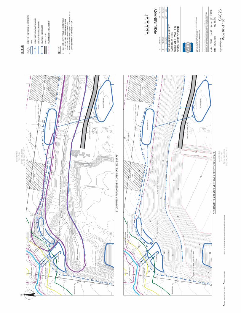
35
35
40
40
40
20
30
35
35
35
30
35
35
35
40
40
40
4545
45
4545
45
45
50
50
5050
50
50
5040
4545
45
5050
50
40
20
40
PROP
OSED
COM
BINE
DOU
TLET
STR
UCTU
RE
40m
RIPA
RIAN
COR
RIDO
R BU
FFER
20m
RIPA
RIAN
COR
RIDO
R BU
FFER
RIPA
RIAN
COR
RIDO
R
PROP
OSED
DAM
3A
RELO
CATE
D DA
M 4A
PROP
OSED
NOR
THW
ESTE
RN B
UND
PYLO
N EX
CLUS
ION
ZONE
PYLO
N EX
CLUS
ION
ZONE
PROP
OSED
DAM
2A
EXIS
TING
DAM
2
BLAX
LAND
CRE
EK
SITE
BOU
NDAR
Y
SITE
BOU
NDAR
Y
DAM
4 OUT
LET
TO D
AM 3B
WES
TERN
BOU
NDAR
Y CL
EAN
WAT
ER D
RAIN
DAM
3B C
LEAN
WAT
ER O
VERF
LOW
DAM
2A O
UTLE
T TO
DAM
2
DAM
3A O
VERF
LOW
TO
DAM
2A
date
for A
1
rev
no.
job
no.
scal
e
appr
oved
(PD
)
Con
ditio
ns o
f Use
: Thi
s do
cum
ent m
ay o
nly
be u
sed
by G
HD
's c
lient
(and
any
oth
erpe
rson
who
GH
D h
as a
gree
d ca
n us
e th
is d
ocum
ent)
for t
he p
urpo
se fo
r whi
ch it
was
prep
ared
and
mus
t not
be
used
by
any
othe
r per
son
or fo
r any
oth
er p
urpo
se.
rev
desc
riptio
nap
p'd
date
SK
Leve
l 15,
133
Cas
tlere
agh
Stre
et, S
ydne
y N
SW
200
0 A
ustra
liaT
61 2
923
9 71
00F
61 2
923
9 71
99E
sydm
ail@
ghd.
com
W w
ww
.ghd
.com
Plo
t Dat
e:C
ad F
ile N
o:8
Dec
embe
r 201
6 -
11:4
4 A
MN
:\AU
\Syd
ney\
Pro
ject
s\21
\257
36\C
AD
D\D
raw
ings
\21-
2573
6-S
K02
6.dw
gP
lotte
d by
:A
lison
Hor
lyck
SR
C P
RO
PE
RTI
ES
PTY
LTD
PA
TON
S L
AN
E R
RC
SU
RFA
CE
WA
TER
026
C21-2
5736
PR
ELI
MIN
AR
Y
1:10
00
DE
C 2
016
BR
EV
ISE
DA
D07
.12.
16
CR
EV
ISE
DA
D08
.12.
16
NLE
GEND
EX
ISTI
NG C
ONTO
URS
(1 m
INCR
EMEN
T)
NOTE
S1.
BASE
D ON
SUR
VEY
PROV
IDED
BY
MATT
HEW
FREE
BURN
- LA
ND, E
NGIN
EERI
NG &
MIN
ING
SURV
EYOR
S, D
ATED
SEP
TEMB
ER 20
162.
PROP
OSED
WOR
KS A
RE S
UBJE
CT T
O CH
ANGE
BAS
EDON
DEV
ELOP
MENT
OF
DETA
ILED
DESI
GN
DA
M
CL
EAN
WAT
ER D
RAIN
AGE
CHAN
NEL
SE
DIME
NT D
RAIN
AGE
CHAN
NEL
HE
ADW
ALL A
ND C
ULVE
RT
AC
CESS
ROA
D
STOR
MWAT
ER A
RRAN
GEME
NT O
VER
EXIS
TING
SUR
VEY
STOR
MWAT
ER A
RRAN
GEME
NT O
VER
PROP
OSED
SUR
FACE
SCAL
E 1:1
000
AT O
RIGI
NAL S
IZE
2010
040
50m
30
TR
ANSM
ISSI
ON LI
NE E
ASEM
ENT
Pag
e 97
of 1
36
confi
dent
ial
Ron
Chi
oB
ingo
Indu
strie
sN
ov 0
1, 2
017
18:3
7
confi
dent
ial
Ron
Chi
oB
ingo
Indu
strie
sN
ov 0
1, 2
017
18:3
7

CONTROLLED ACTIVITIES ON WATERFRONT LAND
Guidelines for instream works onwaterfront land These guidelines relate to the design and construction of works within a watercourse or on waterfront land. Instream works include modifications or enhancements to the watercourse, channel realignment, bed control structures, pipe laying and cable trenching etc.
Instream works are regulated by the controlled activity provisions of the Water Management Act 2000(WM Act). The NSW Office of Water administers the WM Act and is required to assess the impact of any proposed controlled activity to ensure that no more than minimal harm will be done to waterfront land as a consequence of carrying out the controlled activity.
Waterfront land includes the bed and bank of any river, lake or estuary and all land within 40 metres of the highest bank of the river, lake or estuary.
This means that a controlled activity approval must be obtained from the NSW Office of Water before commencing the controlled activity.
What are the aims and objectives for instream works? The design and construction of works or activities within a watercourse or adjoining waterfront land should protect and enhance water flow, water quality, stream ecology and existing riparian vegetation. Impacts on the hydrologic, hydraulic and geomorphic functions of a watercourse should also be minimised.
Consultation with relevant government agencies at the concept stage of development and during the design phase is recommended so that good outcomes can be identified, planned for and achieved.
The design and construction footprint and the extent of disturbances within waterfront land should be minimised.
Asset protection zones and all ancillary infrastructure such as utility easements, detention basins and water quality control structures, roads, paths/cycle ways, should be located outside the riparian corridor or in accordance with the NSW Office of Water guidelines for riparian corridors which may allow some works to be located within the outer 50 per cent of the vegetated riparian zone
All waterfront land disturbed by the construction or installation of a controlled activity should be rehabilitated in such a way that the integrity of the watercourse and its riparian corridor is restored or rehabilitated.
What should be considered? The design and construction of instream works should consider, but not be limited to, the following:
Identify the width of the riparian corridor in accordance with the NSW Office of Water guidelines for riparian corridors.
Consider the full width of the riparian corridor and its functions in the design and construction of any instream works. Where possible, the design should accommodate fully structured native vegetation.
Identify alternative options and detail the reasons for selecting the preferred option/s. Minimise the design and construction footprint and proposed extent of disturbances to soil and
vegetation within watercourse or waterfront land. Maintain or mimic existing or natural hydraulic, hydrologic, geomorphic and ecological functions of the
watercourse. Demonstrate the instream works will not have a detrimental impact on these functions.
Page 98 of 136
confidentialRon Chio
Bingo IndustriesBNov 01, 2017 18:37NNovv 001, 20017
confidentialconfidentialRon Chio
Bingo IndustriesNov 01, 2017 18:37

Maintain the natural geomorphic processes. o Accommodate natural watercourse functions. o Establish natural bed and bank profiles, for example meanders, chain of ponds, surface water
pools and riffles and bed controls. o Allow for the movement of sediment and woody debris. o Prevent increased scour and erosion of the watercourse bed or banks in any storm events. o Avoid locating works or structures on bends in the channel unless they are structures to restore
stability.o Address existing bed degradation to protect structures and restore channel and bed stability.
Maintain the natural hydrological regimes. o Accommodate site hydrological conditions, for example maintain low flows. o Do not alter natural bank full or floodplain flows. Modifications to watercourses should be based on
roughness coefficients that represent the ‘natural’ state including fully structured mature riparian vegetation.
o Do not change the gradient of the bed except to address existing bed and bank degradation. o Do not increase velocities by constricting flows.
Protect against scour by designing and providing necessary scour protection, for example, rock rip-rap and vegetation.
Stabilise and rehabilitate all disturbed areas including topsoiling, revegetation, mulching, weed control and maintenance in order to adequately restore the integrity of the riparian corridor.
Monitor and maintain all in-stream works until suitably stabilised.
What information should be submitted for assessment? When seeking approval to construct instream works, the NSW Office of Water will rely on the above information to undertake its assessment and to determine if the activity should be approved. All instream works/activities should be designed and certified by suitably qualified persons.
The following additional information will also be required:
Detailed design drawings of proposed works (engineering certification may also be required). Detailed design drawings which include a surveyed plan, cross sections (across the watercourse) and
a long section of the watercourse, showing the proposed works relative to existing and proposed bed and bank profiles and water levels. The cross section should extend to the landward limit of the identified riparian corridor. All plans must include a scale bar.
Detailed report of pre and post construction hydraulic conditions. The report should address bank full discharge, velocity, tractive force or sheer stress, afflux (Modified RTA method is acceptable), Froude and Manning’s ‘n’ roughness values, relative to the proposed structure.
Detailed plans of permanent bed and bank stabilisation works for scour protection. Photographs of the site. To assist with future monitoring and reporting, all photo points should be
identified by GPS coordinates or by survey - particularly for large scale earthworks or extractive industries.
A vegetation management plan prepared in accordance with NSW Office of Water guidelines for vegetation management plans.
Sediment and erosion control plan. A site management plan incorporating a works schedule, sequence and duration of works,
contingencies (in case of flood or similar), erosion and sediment controls and proposed monitoring and reporting periods.
Costing of all works (materials, labour) and stages of works (channel stabilisation, rehabilitation). Copies of other relevant approvals, for example land owner’s consent or development consent.
Page 99 of 136
confidentialRon Chio
Bingo IndustriesNov 01, 2017 18:37
confidentialRon Chio
Bingo IndustriesNov 01, 2017 18:37

Controlled activities on waterfront land – Guidelines for instream works on waterfront land
3 NSW Office of Water, July 2012
Will a maintenance period be necessary? Applicants will also need to provide for a maintenance period of between three and five years after practical completion of each stage, or until the site is stable. The maintenance period will depend on the scope, size and level of risk. Engineering certification may be required at the end of the maintenance period.
Maintenance includes sediment and erosion control; the replacement of any works, vegetation or areas damaged or destroyed by flows and flooding or vandalism; and any other requirements necessary to ensure a naturalised stable watercourse system is functioning by the end of the maintenance period.
Maintenance should include sediment and erosion control, replacement of any works/areas damaged or destroyed by flows and flooding or vandalism, and any other requirements necessary to ensure a naturalised stable watercourse system is functioning by the end of the maintenance period.
Will a security deposit be required ? Applicants should note that if the likelihood of significant impact on the watercourse or waterfront land is identified, security (as bank guarantees) may be required before the controlled activity is commenced. The amount of security is usually based on the costings provided.
Where do I go for additional information? Find out more about controlled activities at the Office of Water website www.water.nsw.gov.au.
Contact us Contact a water regulatory officer as listed on the Office of Water website www.water.nsw.gov.au,free call the licensing information on 1800 353 104 or email [email protected].
© State of New South Wales through the Department of Trade and Investment, Regional Infrastructure and Services 2012. You may copy, distribute and otherwise freely deal with this publication for any purpose, provided that you attribute the Department of Trade and Investment, Regional Infrastructure and Services as the owner.
Disclaimer: The information contained in this publication is based on knowledge and understanding at the time of writing (June 2012). However, because of advances in knowledge, users are reminded of the need to ensure that information upon which they rely is up to date and to check currency of the information with the appropriate officer of the Department of Primary Industries or the user’s independent adviser.
Published by the Department of Primary Industries, a division of NSW Department of Trade and Investment, Regional Infrastructure and Services.
NOW 12_136_b
Page 100 of 136
confidentialRon Chioes on watees on wate
Bingo IndustriesBingo IndustriesNov 01, 2017 18:37
confidentialRon Chio
Bingo IndustriesNov 01, 2017 18:37

CONTROLLED ACTIVITIES ON WATERFRONT LAND
Guidelines for outlet structures onwaterfront land These guidelines relate to the design of stormwater outlets and spillways from infrastructure including roads, buildings, constructed basins/wetlands, swales or other drainage works into a watercourse or waterfront land.
Outlet structures on waterfront land are a controlled activity under the Water Management Act 2000(WM Act).The NSW Office of Water administers the WM Act and is required to assess the impact of any proposed controlled activity to ensure that no more than minimal harm will be done to waterfront land as a consequence of carrying out the controlled activity.
Waterfront land includes the bed and bank of any river, lake or estuary and all land within 40 metres of the highest bank of the river, lake or estuary.
This means a controlled activity approval must be obtained from the NSW Office of Water before commencing the controlled activity.
What are the aims and objectives for outlet structures? The design and construction of stormwater outlets should aim to be natural, yet provide a stable transition from a constructed drainage system to a natural flow regime as seen in Figure 1.
Figure 1. Natural outlet structure.
Page 101 of 136
confidentialRon Chio
Bingo IndustriesBNov 01, 2017 18:37NNovv 001, 20017
confidentialconfidentialRon Chio
Bingo IndustriesNov 01, 2017 18:37

The design and construction footprint and extent of disturbance within the riparian corridor should be minimised even allowing for the intended discharge function to be achieved. Refer to the NSW Office of Water guidelines for riparian corridors.
All ancillary drainage infrastructure, such as oil or grease interceptors, sediment and litter traps, constructed wetland, detention basins or any works requiring on-going access or maintenance should be located outside the riparian corridor or in accordance with the NSW Office of Water guidelines for riparian corridors.
Water run-off from the site should be of appropriate quality and quantity before being discharged into a riparian corridor or watercourse.
Appropriate rehabilitation of disturbed areas following the installation of outlet structures should adequately restore the integrity of the riparian corridor.
What should be considered in the design and construction of outlet structures? The design and construction of outlet structures should consider, but not be limited to, the following:
Define the infrastructure route and identify the specific point of discharge. Where possible select a route along an existing cleared or disturbed area that avoids trees, preferably beyond their drip line.
Choose a stable section of the stream for the discharge point, preferably mid-way between bends. Alternatively, incorporate outlet discharge points into disturbed/eroded areas which are to be stabilised or rehabilitated.
Minimise construction footprint and proposed extent of disturbance to soil and vegetation within the watercourse or waterfront land.
Demonstrate that changes to the hydrology of the receiving watercourse have been assessed and there is no detrimental impact on discharge volumes and channel velocities. Discharge velocities and flow rates should mimic natural flows and not initiate erosion.
Discharge from an outlet should not cause bed or bank instability. Protect the bed of the watercourse below the outlet if not bedrock, or if bed scour is likely. Consider
bank material and outlet jet effect and protect the opposite streambank if required. Point outlet structure and direct discharge downstream. The outlet should not protrude beyond the streambank but tie in with the adjoining bank alignment. Calculate tractive stresses generated from outlet discharges and from bank full discharges to
determine appropriate rock size requirements for the structure. Rock rip-rap is the preferred material to provide a natural outlet. Rip-rap should extend for the full
extent of the design scour apron and adjoining flanks/streambank. Rip-rap must be appropriately keyed in to withstand the velocities of runoff or discharge from the site and cut-off trenches should be provided where necessary.
Rip-rap should consist of durable, angular run-of-quarry rock placed over a bedding layer of angular cobbles over geotextile. Where possible, incorporate vegetation such as sedges and rushes into scour management as Figure 1 for further stability.
Grade scour apron to bed level of the watercourse or just below any permanent water created by any stable feature such as a rock bar within the watercourse.
Stabilise and rehabilitate all disturbed areas including topsoiling, revegetation and regeneration, mulching, weed control and maintenance.
What information should be submitted for assessment? When seeking approval to outlet structures across a watercourse or waterfront land, the NSW Office of Water will rely on the above information to undertake its assessment and to determine if the activity should be approved. All works and activities within watercourses should be designed by suitably qualified persons.
Page 102 of 136
confidentialRon Chio
Bingo IndustriesNov 01, 2017 18:37
confidentialRon Chio
Bingo IndustriesNov 01, 2017 18:37

Controlled activities on waterfront land – Guidelines for outlet structures on waterfront land
3 NSW Office of Water, July 2012
The following additional information may also be required:
Detailed design drawings which include a surveyed plan, cross sections across the watercourse and a long section of the watercourse showing proposed works relative to existing and proposed bed and bank profiles and water levels. The cross section is to extend to the landward limit of the identified riparian corridor. All plans must include a scale bar.
Detailed plans should include a location plan, plan view, elevation view and cross section of the proposed outlet structure.
Detailed plans of any permanent bed and bank stabilisation works for scour protection. Sediment and erosion control plan. Detailed report of pre and post construction hydraulic, hydrologic and geomorphic conditions. Photographs of the site should be supplied. To assist with future monitoring and reporting, all photo
points should be identified by GPS coordinates or by survey, particularly for large scale earthworks or extractive industries.
A vegetation management plan prepared in accordance with the NSW Office of Water guidelines for vegetation management plans.
A site management plan incorporating a works schedule, sequence and duration of works, contingencies such as in case of flooding, erosion and sediment controls and proposed monitoring and reporting periods.
Costing of all works including materials and labour and stages of works including outlet structure installation and rehabilitation.
Copies of other relevant approvals, for example development consent.
Will a maintenance period be necessary? Applicants may need to allow for a minimum maintenance period of two years after practical completion of each stage or until the site is stable. The maintenance period will depend on the scope, size and level of risk. Engineering certification may be required at the end of the maintenance period. Maintenance until stable includes sediment and erosion control; the replacement of any works, vegetation or areas damaged or destroyed by flows and flooding or vandalism; and any other requirements necessary to ensure a naturalised stable watercourse system is functioning by the end of the maintenance period.
Will a security deposit be required? Applicants should note that if the likelihood of significant impact on the watercourse or waterfront land is identified, security (as bank guarantees) may be required before the controlled activity is commenced. The amount of security is usually based on the costings provided.
Where do I go for additional information? Find out more about controlled activities at the Office of Water website www.water.nsw.gov.au.
Contact us Contact a water regulatory officer as listed on the Office of Water website www.water.nsw.gov.au,free call the licensing information on 1800 353 104 or email [email protected].
© State of New South Wales through the Department of Trade and Investment, Regional Infrastructure and Services 2012. You may copy, distribute and otherwise freely deal with this publication for any purpose, provided that you attribute the Department of Trade and Investment, Regional Infrastructure and Services as the owner.
Disclaimer: The information contained in this publication is based on knowledge and understanding at the time of writing (June 2012). However, because of advances in knowledge, users are reminded of the need to ensure that information upon which they rely is up to date and to check currency of the information with the appropriate officer of the Department of Primary Industries or the user’s independent adviser.
Published by the Department of Primary Industries, a division of NSW Department of Trade and Investment, Regional Infrastructure and Services.
NOW 12_136_d
Page 103 of 136
es on waterfes on waterfRon Chio
Bingo IndustriesNov 01, 2017 18:37
confidentialRon Chio
Bingo IndustriesNov 01, 2017 18:37

CONTROLLED ACTIVITIES ON WATERFRONT LAND
Guidelines for riparian corridors on waterfront land Controlled activities carried out in, on or under waterfront land are regulated by the Water Management Act 2000 (WM Act). The NSW Office of Water administers the WM Act and is required to assess the impact of any proposed controlled activity to ensure that no more than minimal harm will be done to waterfront land as a consequence of carrying out the controlled activity.
Waterfront land includes the bed and bank of any river, lake or estuary and all land within 40 metres of the highest bank of the river, lake or estuary.
This means that a controlled activity approval must be obtained from the Office of Water before commencing the controlled activity.
What is a riparian corridor? A riparian corridor (RC) forms a transition zone between the land, also known as the terrestrial environment, and the river or watercourse or aquatic environment. Riparian corridors perform a range of important environmental functions such as:
providing bed and bank stability and reducing bank and channel erosion protecting water quality by trapping sediment, nutrients and other contaminants providing diversity of habitat for terrestrial, riparian and aquatic plants (flora) and animals (fauna) providing connectivity between wildlife habitats conveying flood flows and controlling the direction of flood flows providing an interface or buffer between developments and waterways providing passive recreational uses.
The protection, restoration or rehabilitation of vegetated riparian corridors is important for maintaining or improving the shape, stability (or geomorphic form) and ecological functions of a watercourse.
Changes to controlled activities within riparian corridors On 1 July 2012 new rules commenced regarding controlled activities within riparian corridors. The new rules amend the riparian corridor widths that apply to watercourses, providing more flexibility in how riparian corridors can be used and making it easier for applicants to determine the Office of Water controlled activity approval requirements. Key aspects of the changes include:
Provision of greater flexibility in the allowable uses and works permitted within riparian corridors. The core riparian zone and vegetated buffer have been combined into a single vegetated riparian
zone (VRZ). The width of the VRZ within the riparian corridor has been pre-determined and standardised for
first, second, third and fourth order and greater watercourses. Where suitable, applicants may undertake non-riparian corridor works or development within the
outer 50 per cent of a VRZ, as long as they offset this activity by connecting an equivalent area to the RC within the development site.
A new ‘riparian corridors matrix’ enables applicants to determine what activities can be considered in riparian corridors.
Page 104 of 136
confidentialRon Chio
Bingo IndustriesBNov 01, 2017 18:37NNovv 001, 20017
confidentialconfidentialRon Chio
Bingo IndustriesNov 01, 2017 18:37

These changes will simplify the controlled activities application and assessment process, provide greater flexibility, help make more land available for housing, support floodplain, stormwater and bush fire management, and allow riparian corridors to be used for public amenity whilst continuing to deliver environmental outcomes required under the WM Act.
The riparian corridor consists of:
the channel which comprises the bed and banks of the watercourse (to the highest bank) and the vegetated riparian zone (VRZ) adjoining the channel.
Figure 1. The riparian corridor
Riparian corridor widths The Officer of Water recommends a VRZ width based on watercourse order as classified under the Strahler System of ordering watercourses and using current 1:25 000 topographic maps (see Figure 2 and Table 1). The width of the VRZ should be measured from the top of the highest bank on both sides of the watercourse.
Figure 2. The Strahler System Table 1. Recommended riparian corridor (RC) widths
Watercourse type VRZ width
(each side of watercourse)
Total RC width
1st order 10 metres 20 m + channel width
2nd order 20 metres 40 m + channel width
3rd order 30 metres 60 m + channel width
4th order and greater (includes estuaries, wetlands and any parts of rivers influenced by tidal waters)
40 metres 80 m + channel width
Note: where a watercourse does not exhibit the features of a defined channel with bed and banks, the Office of Water may determine that the watercourse is not waterfront land for the purposes of the WM Act
Page 105 of 136
Ron ChioBingo Industries
Nov 01, 2017 18:37
confidentialRon Chio
Bingo IndustriesNov 01, 2017 18:37

Objectives for riparian corridor management The overarching objective of the controlled activities provisions of the WM Act is to establish and preserve the integrity of riparian corridors.
Ideally the environmental functions of riparian corridors should be maintained or rehabilitated by applying the following principles:
Identify whether or not there is a watercourse present and determine its order in accordance with the Strahler System.
If a watercourse is present, define the RC/VRZ on a map in accordance with Table 1. Seek to maintain or rehabilitate a RC/VRZ with fully structured native vegetation in accordance
with Table 1. Seek to minimise disturbance and harm to the recommended RC/VRZ. Minimise the number of creek crossings and provide perimeter road separating development from
the RC/VRZ. Locate services and infrastructure outside of the RC/VRZ. Within the RC/VRZ provide multiple
service easements and/or utilise road crossings where possible. Treat stormwater run-off before discharging into the RC/VRZ.
The Office of Water however, does allow for a range of works and activities on waterfront land and in riparian corridors to better meet the needs of the community, so long as they cause minimal harm as outlined in the riparian corridor matrix below.
Riparian corridor matrix The riparian corridor matrix enables applicants to identify certain works and activities that can occur on waterfront land and in riparian corridors. Applicants should note that the matrix relates to controlled activity approvals under the WM Act only. They are still required to comply with other relevant government legislation, such as threatened species, flood planning levels and fisheries guidelines.
Table 2. Riparian corridor matrix
Detention basins
Road crossingsStreamorder
Vegetated Riparian
Zone(VRZ)
RC off-setting for non
RC uses
Cyclewaysand paths
Only within 50%outerVRZ
Online
Stormwater outlet
structures and
essential services
Streamrealignment
Any Culvert Bridge
1st 10m ● ● ● ● ● ● ●
2nd 20m ● ● ● ● ● ●
3rd 30m ● ● ● ● ● ●
4th + 40m ● ● ● ● ● ●
KeyStream order: The watercourse order as classified under the Strahler System based on 1:25,000, 1:50,000 or 1:100,000 topographic maps whichever is the smallest scale available. A full list is provided at Part 2, Schedule 2 of the Water Management (General) Regulation 2011. Vegetated riparian zone (VRZ): The required width of the VRZ measured from the top of the high bank on each side of the watercourse. Riparian corridor (RC) off-setting for non RC uses: Non-riparian uses, such as Asset Protection Zones are allowed within the outer 50 per cent of the VRZ, so long as offsets are provided in accordance with the averaging rule as seen in Figure 3.
Page 106 of 136
confidentialRon Chio
Bingo IndustriesNov 01, 2017 18:37
confidentialRon Chio
Bingo IndustriesNov 01, 2017 18:37
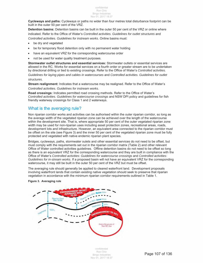
Cycleways and paths: Cycleways or paths no wider than four metres total disturbance footprint can be built in the outer 50 per cent of the VRZ. Detention basins: Detention basins can be built in the outer 50 per cent of the VRZ or online where indicated. Refer to the Office of Water’s Controlled activities. Guidelines for outlet structures and Controlled activities. Guidelines for instream works. Online basins must: be dry and vegetated be for temporary flood detention only with no permanent water holding have an equivalent VRZ for the corresponding watercourse order not be used for water quality treatment purposes.
Stormwater outlet structures and essential services: Stormwater outlets or essential services are allowed in the RC. Works for essential services on a fourth order or greater stream are to be undertaken by directional drilling or tied to existing crossings. Refer to the Office of Water’s Controlled activities.Guidelines for laying pipes and cables in watercourses and Controlled activities. Guidelines for outlet structures. Stream realignment: Indicates that a watercourse may be realigned. Refer to the Office of Water’s Controlled activities. Guidelines for instream works. Road crossings: Indicates permitted road crossing methods. Refer to the Office of Water’s Controlled activities. Guidelines for watercourse crossings and NSW DPI policy and guidelines for fish friendly waterway crossings for Class 1 and 2 waterways.
What is the averaging rule? Non riparian corridor works and activities can be authorised within the outer riparian corridor, so long as the average width of the vegetated riparian zone can be achieved over the length of the watercourse within the development site. That is, where appropriate 50 per cent of the outer vegetated riparian zone width may be used for non-riparian uses including asset protection zones, recreational areas, roads, development lots and infrastructure. However, an equivalent area connected to the riparian corridor must be offset on the site (see Figure 3) and the inner 50 per cent of the vegetated riparian zone must be fully protected and vegetated with native endemic riparian plant species.
Bridges, cycleways, paths, stormwater oulets and other essential services do not need to be offset, but must comply with the requirements set out in the riparian corridor matrix (Table 2) and other relevant Office of Water controlled activities guidelines. Offline detention basins do not need to be offset so long as there is an equivalent VRZ for the corresponding watercourse and they are built in compliance with the Office of Water’s Controlled activities: Guidelines for watercourse crossings and Controlled activities: Guidelines for in-stream works. If a proposed basin will not have an equivalent VRZ for the corresponding watercourse, it may still be built in the outer 50 per cent of the VRZ but must be offset.
The averaging rule should generally be applied to cleared waterfront land. Development proposals involving waterfront lands that contain existing native vegetation should seek to preserve that riparian vegetation in accordance with the minimum riparian corridor requirements outlined in Table 1.
Figure 3. Averaging rule
Page 107 of 136
confidentialRon Chio
Bingo IndustriesNov 01, 2017 18:37
confidentialRon Chio
Bingo IndustriesNov 01, 2017 18:37

Controlled activities on waterfront land - Guidelines for riparian corridors on waterfront land
5 NSW Office of Water, July 2012
Applications for controlled activity approvals Applications for controlled activities approvals should be informed by the riparian corridor matrix shown in Table 2 and prepared using the Application for a Controlled Activity Approval for works on waterfront landform and the Guideline for completing an application for a Controlled Activity Approval.
Other controlled activity guidelines are available on the Office of Water website and outline relevant considerations for applicants when proposing activities and works on waterfront lands.
Streamlined assessment Where applications are presented in accordance with the riparian corridor matrix (Table 2) and other Office of Water controlled activity guidelines, they will be assessed under a streamlined process. This may decrease the amount of time it takes the Office of Water to make a determination, saving applicants time and money.
Applications that do not conform to the matrix and/or relevant Office of Water controlled activity guidelines will continue to be subject to merit assessment to ensure that the proposals meet the requirements of the WM Act. All applications will still need to demonstrate that minimal harm will occur to waterfront land before a controlled activity approval will be issued.
Where do I go for additional information? Find out more about controlled activities at the Office of Water website www.water.nsw.gov.au.
Contact us Contact a water regulatory officer as listed on the Office of Water website www.water.nsw.gov.au, free call the licensing information on 1800 353 104 or email [email protected].
© State of New South Wales through the Department of Trade and Investment, Regional Infrastructure and Services 2012. You may copy, distribute and otherwise freely deal with this publication for any purpose, provided that you attribute the Department of Trade and Investment, Regional Infrastructure and Services as the owner.
Disclaimer: The information contained in this publication is based on knowledge and understanding at the time of writing (June 2012). However, because of advances in knowledge, users are reminded of the need to ensure that information upon which they rely is up to date and to check currency of the information with the appropriate officer of the Department of Primary Industries or the user’s independent adviser.
Published by the Department of Primary Industries, a division of NSW Department of Trade and Investment, Regional Infrastructure and Services.
NOW 12_136_e
Page 108 of 136
confidentials on waterfrs on waterfrRon Chio
Bingo IndustriesNov 01, 2017 18:37
confidentialRon Chio
Bingo IndustriesNov 01, 2017 18:37

Attachment 5
Report on EEC Impacts Project Approval Document Schedule 6 Condition 5 c.
Page 109 of 136
confidentialRon Chio
Bingo IndustriesNov 01, 2017 18:37
confidentialRon Chio
Bingo IndustriesNov 01, 2017 18:37
Page 110 of 136
confidentialRon Chio
Bingo IndustriesNov 01, 2017 18:37
confidentialRon Chio
Bingo IndustriesNov 01, 2017 18:37
Page 111 of 136
confidentialRon Chio
Bingo IndustriesNov 01, 2017 18:37
confidentialRon Chio
Bingo IndustriesNov 01, 2017 18:37

Page 112 of 136
confidentialRon Chio
Bingo IndustriesNov 01, 2017 18:37
confidentialRon Chio
Bingo IndustriesNov 01, 2017 18:37

Page 113 of 136
confidentialRon Chio
Bingo IndustriesNov 01, 2017 18:37
confidentialRon Chio
Bingo IndustriesNov 01, 2017 18:37

Attachment 6
Reconciliation of the Requirements of Schedule 7 of the Project Approval.
Page 114 of 136
confidentialRon Chio
Bingo IndustriesNov 01, 2017 18:37
confidentialRon Chio
Bingo IndustriesNov 01, 2017 18:37

118
SCH
ED
UL
E 7
– M
INIM
UM
DE
SIG
N S
PEC
IFIC
AT
ION
S A
ND
O
PER
AT
ION
AL
/PO
ST C
LO
SUR
E R
EQ
UIR
EM
EN
TS.
Comments–whereminimum
design
requirem
entsareaddressedin
Reportsanddocumentation
A. M
inim
um d
esig
n re
quir
emen
ts fo
r C
&I W
aste
stoc
kpile
bu
ildin
g/st
orm
wat
er/le
acha
te sy
stem
s Th
e C
&I W
aste
Sto
ckpi
le b
uild
ing
mus
t inc
lude
the
follo
win
g m
easu
res
unle
ss
othe
rwis
e ap
prov
ed b
y th
e EP
A:
a. S
torm
wat
er m
anag
emen
t mea
sure
s
i. Th
e de
sign
of t
he C
&I s
tora
ge fa
cilit
y st
orm
wat
er c
onve
yanc
e sy
stem
mus
t be
for t
he 2
0 ye
ar A
RI s
torm
wat
er e
vent
and
di
scha
rge
to st
orm
wat
er m
anag
emen
t sys
tem
(SM
S).
ii. T
he se
dim
ent d
ams s
tora
ge fo
r the
SM
S is
are
to b
e de
sign
ed
for a
90t
h pe
rcen
tile
5 da
y ra
infa
ll ev
ent t
o en
sure
that
stor
mw
ater
an
d le
acha
te a
re n
ot m
ixed
. The
con
veya
nce
syst
em is
to b
e de
sign
ed fo
r the
20
year
AR
I sto
rmw
ater
eve
nt.
b. L
each
ate
man
agem
ent m
easu
res
i. W
ashd
own
wat
er fr
om w
ithin
the
C&
I Was
te S
tock
pile
bui
ldin
g is
to b
e se
para
ted
from
stor
mw
ater
and
man
aged
as l
each
ate.
ii. T
he S
MS
and
the
LMS
mus
t be
com
plet
ely
sepa
rate
aro
und
the
bord
er o
f the
C&
I was
te st
ockp
ile b
uild
ing.
iii. T
he c
oncr
ete
floor
mus
t be
desi
gned
to su
ppor
t the
mas
s of
C&
I was
te a
nd to
shed
was
hdow
n w
ater
to th
e LM
S. T
he c
oncr
ete
floor
mus
t hav
e a
slop
e to
faci
litat
e flo
ws o
f was
hdow
n w
ater
into
th
e le
acha
te m
anag
emen
t sys
tem
(LM
S).
Item
s A. a
. and
b. h
ave
been
add
ress
ed in
the
desi
gn o
f the
C&
I Was
te
Stoc
kpile
Bui
ldin
g sh
own
in th
e A
ppen
dice
s of t
he L
EMP
spec
ifica
lly
Dra
win
g V
augh
an C
onst
ruct
ion
SK01
0D –
Des
ign
and
Ope
ratio
n of
the
C&
I W
areh
ouse
show
ing
Mat
eria
l and
veh
icle
mov
emen
ts
Item
s A. a
. and
b. h
ave
been
add
ress
ed in
the
desi
gn o
f the
C&
I Was
te
Stoc
kpile
Bui
ldin
g sh
own
in th
e A
ppen
dice
s of t
he L
EMP
spec
ifica
lly
Dra
win
g V
augh
an C
onst
ruct
ion
SK01
0D –
Des
ign
and
Ope
ratio
n of
the
C&
I W
areh
ouse
show
ing
Mat
eria
l and
veh
icle
mov
emen
ts Pag
e 11
5 of
136
confi
dent
ial
Ron
Chi
oB
ingo
Indu
strie
sN
ov 0
1, 2
017
18:3
7
confi
dent
ial
Ron
Chi
oB
ingo
Indu
strie
sN
ov 0
1, 2
017
18:3
7

218
SCH
ED
UL
E 7
– M
INIM
UM
DE
SIG
N S
PEC
IFIC
AT
ION
S A
ND
O
PER
AT
ION
AL
/PO
ST C
LO
SUR
E R
EQ
UIR
EM
EN
TS.
Comments–whereminimum
design
requirem
entsareaddressedin
Reportsanddocumentation
B
. Min
imum
des
ign
requ
irem
ents
for
Gas
col
lect
ion
syst
ems
a. T
he la
tera
l col
lect
ion
pipe
s of t
he g
as c
olle
ctio
n sy
stem
are
to b
e lo
cate
d no
t mor
e th
an 5
0m a
part.
b. C
him
ney
drai
ns a
re to
be
no m
ore
than
200
met
res a
part
and
mus
t co
mpr
ise
non
calc
areo
us g
ranu
lar m
ater
ial w
ith a
per
mea
bilit
y gr
eate
r th
an 1
x10-
3 m
/sec
.
c. C
him
ney
drai
ns w
ill b
e in
stal
led
on th
e si
de li
ner t
o fa
cilit
ate
gas
vent
ing
and
prev
ent p
erch
ing
of le
acha
te.
d. T
he la
ndfil
l gas
man
agem
ent s
yste
m sh
ould
be
desi
gned
in
acco
rdan
ce w
ith th
e H
andb
ook
for t
he d
esig
n, c
onst
ruct
ion,
ope
ratio
n,
mon
itorin
g an
d m
aint
enan
ce o
f a p
assi
ve la
ndfil
l gas
dra
inag
e an
d bi
ofilt
ratio
n sy
stem
, UN
SW a
nd G
HD
, NSW
DEC
CW
, Mar
ch 2
010
unle
ss o
ther
wis
e ap
prov
ed b
y th
e EP
A.
C
. Min
imum
des
ign
requ
irem
ents
for
Cel
l lin
ers
a. T
he c
lay
basa
l lin
er w
ithin
eac
h ce
ll m
ust:
i. Ex
tend
up
the
side
of t
he q
uarr
y w
all f
or a
t lea
st 2
m to
pro
vide
fo
r cap
ture
of l
each
ate
and
prev
ent l
eaka
ge a
t the
join
of t
he H
DPE
si
de li
ner a
nd th
e cl
ay b
ase
liner
.
ii. A
chie
ve a
n in
filtra
tion
rate
equ
ival
ent t
o or
less
than
90c
m o
f co
mpa
cted
cla
y w
ith a
max
imum
per
mea
bilit
y of
1 x
10-
9 m
/sec
.
iii. T
he e
xten
sion
of t
he c
lay
liner
up
the
side
of t
he q
uarr
y w
all
Pag
e 11
6 of
136
confi
dent
ial
Ron
Chi
oB
ingo
Indu
strie
sN
ov 0
1, 2
0DD
017
18:3
7Comm
Comm
0
confi
dent
ial
Ron
Chi
oB
ingo
Indu
strie
sN
ov 0
1, 2
017
18:3
7

318
SCH
ED
UL
E 7
– M
INIM
UM
DE
SIG
N S
PEC
IFIC
AT
ION
S A
ND
O
PER
AT
ION
AL
/PO
ST C
LO
SUR
E R
EQ
UIR
EM
EN
TS.
Comments–whereminimum
design
requirem
entsareaddressedin
Reportsanddocumentation
shal
l be
of e
quiv
alen
t thi
ckne
ss (w
hen
mea
sure
d pe
rpen
dicu
lar t
o th
e lin
er su
rfac
e) a
nd p
erm
eabi
lity
as th
e ba
sal l
iner
.
iv. R
efer
to a
dditi
onal
con
ditio
ns re
gard
ing
cell
2 be
low
.
b. A
gro
undw
ater
dep
ress
uris
atio
n sy
stem
(as d
escr
ibed
in A
ppen
dice
s of
the
(Rev
ised
) Ove
rvie
w R
epor
t for
the
Furth
er M
odifi
ed P
roje
ct
Rep
ort (
Ex Z
in A
ppea
l No
1092
8 of
201
0), a
ccom
pany
ing
the
Furth
er
Mod
ified
Pre
ferr
ed P
roje
ct R
epor
t (Ex
Z in
App
eal N
o 10
928
of 2
010)
m
ust b
e in
stal
led
betw
een
the
land
fill c
ell l
iner
and
the
natu
ral g
eolo
gy
whe
re th
e ce
lls a
re b
elow
the
grou
nd le
vel.
The
desi
gn fo
r the
gr
ound
wat
er d
epre
ssur
isat
ion
syst
em m
ust b
e in
clud
ed in
the
desi
gn fo
r th
e la
ndfil
l cel
ls a
nd a
ccom
pany
the
appl
icat
ion
for t
he E
PL.
c. T
he H
DPE
side
line
r mus
t:
i. O
verla
p w
ith th
e ba
sal c
lay
liner
(whi
ch m
ust e
xten
d up
the
side
w
all f
or a
t lea
st 2
m).
ii. B
e pl
aced
aga
inst
an
appr
opria
te g
eote
xtile
cus
hion
mat
eria
l ag
ains
t the
side
of t
he q
uarr
y w
all.
iii. I
f, in
the
opin
ion
of a
cer
tifie
d C
QA
ass
esso
r, th
e H
DPE
will
be
dam
aged
by
the
roug
hnes
s of t
he in
side
wal
l sur
face
, the
n a
com
posi
te c
lay-
HD
PE li
ner s
yste
m m
ust b
e pl
aced
aga
inst
the
entir
e qu
arry
wal
l unl
ess o
ther
wis
e ap
prov
ed b
y th
e EP
A.
iv. H
ave
a m
inim
um th
ickn
ess o
f 1.5
mm
, and
con
form
to th
e re
leva
nt A
ustra
lian
Stan
dard
s.
d. G
eote
xtile
mus
t be
plac
ed o
n ei
ther
side
of t
he H
DPE
side
line
r.
Pag
e 11
7 of
136
confi
dent
ial
Ron
Chi
oB
ingo
Indu
strie
sN
ov 0
1, 2
0DD
017
18:3
7Comm
Comm
0
confi
dent
ial
Ron
Chi
oB
ingo
Indu
strie
sN
ov 0
1, 2
017
18:3
7

418
SCH
ED
UL
E 7
– M
INIM
UM
DE
SIG
N S
PEC
IFIC
AT
ION
S A
ND
O
PER
AT
ION
AL
/PO
ST C
LO
SUR
E R
EQ
UIR
EM
EN
TS.
Comments–whereminimum
design
requirem
entsareaddressedin
Reportsanddocumentation
e. A
ll ce
ll co
nstru
ctio
n w
orks
are
to b
e as
sess
ed b
y th
e C
QA
ass
esso
r an
d ce
rtifie
d as
suita
ble
befo
re e
mpl
acem
ent o
f was
te b
egin
s.
f. A
ll ce
lls a
nd su
b ce
lls m
ust i
nclu
de a
n ac
tive
leac
hate
ext
ract
ion
or
drai
nage
syst
em a
s per
Sec
tion
2.8.
4 of
the
FMPP
R.
D
. Min
imum
des
ign
requ
irem
ents
for
Cap
ping
a. T
he c
appi
ng d
esig
n m
ust b
e th
e m
odifi
ed c
ap d
esig
n in
corp
orat
ing
a ge
omem
bran
e lin
er a
nd d
rain
age
laye
r (as
spec
ified
in T
able
2.4
of t
he
FMPP
R) (
note
that
the
drai
nage
laye
r is n
ot o
ptio
nal).
b. T
he d
rain
age
laye
r per
mea
bilit
y m
ust b
e gr
eate
r tha
n 1x
10-3
m/s
ec.
The
aggr
egat
e us
ed in
the
drai
nage
laye
r mus
t not
incl
ude
crus
hed
conc
rete
.
c. T
he se
alin
g cl
ay la
yer m
ust b
e a
min
imum
of 6
00m
m th
ick
and
have
a
perm
eabi
lity
of n
ot g
reat
er th
an 1
0 -8
m/s
ec.
d. T
he su
bsoi
l lay
er m
ust b
e a
min
imum
thic
knes
s of 7
50m
m
e. T
he b
und
wal
ls o
n th
e no
rth e
aste
rn a
nd e
aste
rn b
ound
arie
s of t
he si
te
mus
t be
cond
ition
ed a
s par
t of t
he si
te d
evel
opm
ent w
orks
and
bef
ore
any
was
te is
pla
ced
on th
e si
te.
f. A
ll ba
rrie
r and
dra
inag
e la
yers
, inc
ludi
ng g
eom
embr
ane,
mus
t be
the
Pag
e 11
8 of
136
confi
dent
ial
Ron
Chi
oB
ingo
Indu
strie
sN
ov 0
1, 2
0DD
017
18:3
7Comm
Comm
0
confi
dent
ial
Ron
Chi
oB
ingo
Indu
strie
sN
ov 0
1, 2
017
18:3
7

518
SCH
ED
UL
E 7
– M
INIM
UM
DE
SIG
N S
PEC
IFIC
AT
ION
S A
ND
O
PER
AT
ION
AL
/PO
ST C
LO
SUR
E R
EQ
UIR
EM
EN
TS.
Comments–whereminimum
design
requirem
entsareaddressedin
Reportsanddocumentation
subj
ect o
f app
rova
l by
the
EPA
.
E. M
inim
um d
esig
n re
quir
emen
ts fo
r C
ell 2
A
n ad
ditio
nal g
roun
dwat
er d
epre
ssur
isat
ion
laye
r beh
ind
the
HD
PE si
de li
ner
of C
ell 2
mus
t be
inst
alle
d if
requ
ired
to re
lieve
gro
undw
ater
pre
ssur
e ca
used
by
the
incr
ease
in d
epth
.
F. L
andf
ill o
pera
tiona
l req
uire
men
ts
1. In
add
ition
to th
e le
acha
te m
anag
emen
t sys
tem
spec
ifica
tions
indi
cate
d ab
ove,
the
land
fill o
pera
tion
mus
t com
ply
with
the
follo
win
g re
quire
men
ts to
en
sure
that
leac
hate
is m
inim
ised
and
that
leac
hate
is se
para
ted
from
st
orm
wat
er th
roug
hout
the
oper
atio
n of
the
Proj
ect u
nles
s oth
erw
ise
appr
oved
by
the
EPA
:
a. T
he a
ctiv
e la
ndfil
ling
face
mus
t not
exc
eed
420
m2
in p
lan
area
at a
ny
time.
b. T
he d
aily
cov
er m
ust b
e pl
aced
on
the
activ
e la
ndfil
l are
a to
a
min
imum
thic
knes
s of 1
50m
m. T
he a
rea
of la
ndfil
led
was
te w
ith d
aily
co
ver s
houl
d no
t exc
eed
1ha.
c. T
he a
ctiv
e ce
ll m
ust b
e co
vere
d w
ith in
term
edia
te c
over
of c
lay
rich
soil,
to a
min
imum
thic
knes
s of 3
00m
m sh
ould
it n
ot b
e la
ndfil
led
with
in
90 d
ays o
f pla
cem
ent o
f dai
ly c
over
.
d. T
he c
ombi
ned
area
of d
aily
cov
er a
nd in
term
edia
te c
over
shou
ld n
ot
exce
ed 3
ha
at a
ny o
ne ti
me,
exc
ludi
ng te
mpo
rary
bat
ter s
lope
s and
any
su
b-ce
ll th
at is
und
ergo
ing
final
cap
ping
and
reve
geta
tion,
unl
ess
othe
rwis
e ap
prov
ed b
y th
e EP
A.
Pag
e 11
9 of
136
confi
dent
ial
Ron
Chi
oB
ingo
Indu
strie
sN
ov 0
1, 2
0DD
017
18:3
7Comm
Comm
0
confi
dent
ial
Ron
Chi
oB
ingo
Indu
strie
sN
ov 0
1, 2
017
18:3
7

618
SCH
ED
UL
E 7
– M
INIM
UM
DE
SIG
N S
PEC
IFIC
AT
ION
S A
ND
O
PER
AT
ION
AL
/PO
ST C
LO
SUR
E R
EQ
UIR
EM
EN
TS.
Comments–whereminimum
design
requirem
entsareaddressedin
Reportsanddocumentation
e. B
atte
r slo
pes m
ust b
e co
vere
d w
ith in
term
edia
te c
over
whe
re e
xpos
ed
for m
ore
than
90
days
. The
fina
l cap
ping
and
reve
geta
tion
wor
ks o
f any
su
bcel
l sho
uld
be c
ompl
eted
with
in 3
mon
ths o
f all
of th
e la
ndfil
led
was
te in
that
subc
ell r
each
ing
the
appr
oved
fina
l lan
dfor
m, u
nles
s ot
herw
ise
appr
oved
by
the
EPA
.
f. Th
e ce
ll m
ust b
e pr
ogre
ssiv
ely
capp
ed w
ith th
e fin
al c
appi
ng p
rofil
e as
pe
r con
ditio
n D
(a-f
) of S
ched
ule
7.
g. T
he a
ctiv
e la
ndfil
ling
face
s mus
t be
bund
ed to
pre
vent
run-
off a
nd
run-
on o
f sto
rmw
ater
/leac
hate
from
the
expo
sed
was
te.
h. C
olle
ct a
nd e
xtra
ct st
orm
wat
er ru
noff
from
dai
ly a
nd in
term
edia
te
cove
red
area
s and
dis
char
ge th
is w
ater
as s
torm
wat
er su
bjec
t to
test
ing
and
com
plia
nce
with
the
spec
ifica
tions
in th
e EP
L.
i. A
ll le
acha
te d
rain
age
and
capp
ing
drai
nage
mat
eria
l mus
t ach
ieve
a
perm
eabi
lity
of g
reat
er th
an 1
x10-
3 m
/sec
and
com
pris
e no
n ca
lcar
eous
gr
anul
ar m
ater
ial.
j. Th
e le
acha
te h
ead
is to
be
mon
itore
d as
par
t of t
he m
onito
ring
prog
ram
.
k. T
he le
acha
te h
ead
on th
e lin
er sy
stem
shou
ld n
ot e
xcee
d 30
0mm
ab
ove
the
cell
floor
thro
ugho
ut th
e op
erat
ion
of th
e fa
cilit
y, u
nles
s le
acha
te is
requ
ired
to b
e st
ored
in th
e la
ndfil
l und
er e
xtre
me
wet
w
eath
er c
ondi
tions
.
Pag
e 12
0 of
136
confi
dent
ial
Ron
Chi
oB
ingo
Indu
strie
sN
ov 0
1, 2
0DD
017
18:3
7Comm
Comm
0
confi
dent
ial
Ron
Chi
oB
ingo
Indu
strie
sN
ov 0
1, 2
017
18:3
7

718
SCH
ED
UL
E 7
– M
INIM
UM
DE
SIG
N S
PEC
IFIC
AT
ION
S A
ND
O
PER
AT
ION
AL
/PO
ST C
LO
SUR
E R
EQ
UIR
EM
EN
TS.
Comments–whereminimum
design
requirem
entsareaddressedin
Reportsanddocumentation
l. If
the
leac
hate
hea
d ex
ceed
s 300
mm
, add
ition
al le
acha
te, e
xtra
ctio
n m
easu
res a
re to
be
impl
emen
ted
imm
edia
tely
to re
duce
the
leac
hate
hea
d to
acc
epta
ble
leve
l. m
. The
Lea
chat
e M
anag
emen
t Pla
n m
ust i
nclu
de c
ontin
genc
y m
easu
res
in th
e ev
ent o
f fai
lure
or s
ever
e st
orm
eve
nt o
r exc
ess l
each
ate
volu
mes
gr
eate
r tha
n th
e m
odel
led
pred
ictio
ns o
r fug
itive
leac
hate
em
issio
n.
n. D
urin
g si
te e
stab
lishm
ent,
the
mat
eria
l with
in th
e da
m in
the
Cel
l 1
area
is to
be
treat
ed a
s fol
low
s:
i. W
ater
is to
be
test
ed p
rior t
o pu
mpi
ng a
nd a
ppro
pria
tely
di
spos
ed o
f;
ii. S
edim
ent i
s to
be te
sted
, cla
ssifi
ed a
nd a
ppro
pria
tely
dis
pose
d of
;
iii. T
estin
g pr
oced
ures
are
to b
e ca
rrie
d ou
t in
acco
rdan
ce w
ith
EPA
pro
cedu
res a
nd fo
r EPA
ana
lyte
list
.
Pag
e 12
1 of
136
confi
dent
ial
Ron
Chi
oB
ingo
Indu
strie
sN
ov 0
1, 2
0DD
017
18:3
7Comm
Comm
0
confi
dent
ial
Ron
Chi
oB
ingo
Indu
strie
sN
ov 0
1, 2
017
18:3
7

818
SCH
ED
UL
E 7
– M
INIM
UM
DE
SIG
N S
PEC
IFIC
AT
ION
S A
ND
O
PER
AT
ION
AL
/PO
ST C
LO
SUR
E R
EQ
UIR
EM
EN
TS.
Comments–whereminimum
design
requirem
entsareaddressedin
Reportsanddocumentation
G. W
aste
insp
ectio
n pr
oced
ures
1.
Det
aile
d w
aste
scre
enin
g pr
oced
ures
for a
ll w
aste
rece
ived
at t
he si
te a
nd a
ll w
aste
ext
ract
ed fr
om b
und
wal
ls a
re to
be
prep
ared
and
impl
emen
ted
to e
nsur
e th
at a
ll w
aste
mee
ts th
e cl
assi
ficat
ion
of g
ener
al so
lid (n
on-p
utre
scib
le) o
r sp
ecia
l was
te fo
r asb
esto
s rec
over
ed fr
om th
e on
-site
bun
ds. T
he p
roce
dure
s m
ust i
nclu
de:
a. V
isua
l ins
pect
ion
of a
ll re
ceiv
ed w
aste
;
b. A
ll st
aff m
embe
rs th
at m
onito
r the
site
ent
ranc
e sh
all b
e tra
ined
in th
e id
entif
icat
ion
and
clas
sific
atio
n of
solid
was
te. V
ehic
les w
ith
unac
cept
able
load
s of w
aste
will
be
refu
sed
entry
to th
e si
te;
c. R
equi
re d
ocum
enta
tion
for a
ll so
ils re
ceiv
ed fr
om th
e si
te to
con
firm
th
eir o
rigin
;
d. R
ando
m sa
mpl
ing
and
test
ing
of so
ils to
con
firm
that
they
mee
t the
cl
assi
ficat
ion
of g
ener
al so
lid (n
on-p
utre
scib
le) w
aste
;
e. P
rom
inen
t sig
nage
at t
he e
ntra
nce
to th
e la
ndfil
l def
inin
g ac
cept
able
w
aste
s and
dire
ctin
g us
ers t
o co
ntac
t the
gat
eper
son
for i
nfor
mat
ion
rega
rdin
g di
spos
al o
f oth
er w
aste
s;
f. R
ando
m d
aily
insp
ectio
n of
veh
icle
s ent
erin
g th
e la
ndfil
l. A
ll ve
hicl
es
susp
ecte
d of
con
tain
ing
unac
cept
able
was
te w
ill b
e re
fuse
d pe
rmis
sion
to
dep
osit
was
te u
ntil
the
was
te is
ver
ified
as b
eing
acc
epta
ble.
Sta
ff
shal
l req
uire
and
col
lect
app
ropr
iate
evi
denc
e fr
om th
e dr
iver
of t
he
vehi
cle,
eg.
test
cer
tific
ate,
app
rova
ls, e
tc, a
s app
ropr
iate
, as v
erifi
catio
n th
at th
e w
aste
is a
ccep
tabl
e;
Pag
e 12
2 of
136
confi
dent
ial
Ron
Chi
oB
ingo
Indu
strie
sN
ov 0
1, 2
0DD
017
18:3
7Comm
Comm
0
confi
dent
ial
Ron
Chi
oB
ingo
Indu
strie
sN
ov 0
1, 2
017
18:3
7

918
SCH
ED
UL
E 7
– M
INIM
UM
DE
SIG
N S
PEC
IFIC
AT
ION
S A
ND
O
PER
AT
ION
AL
/PO
ST C
LO
SUR
E R
EQ
UIR
EM
EN
TS.
Comments–whereminimum
design
requirem
entsareaddressedin
Reportsanddocumentation
g. D
irect
ing
vehi
cles
with
una
ccep
tabl
e w
aste
s to
an a
ppro
pria
te d
ispo
sal
faci
lity;
h. R
ando
m m
onito
ring
and
insp
ectio
n of
was
tes a
s the
y ar
e di
scha
rged
fr
om v
ehic
les a
t the
was
te d
ispo
sal a
reas
by
site
per
sonn
el. A
ll w
aste
su
spec
ted
of b
eing
una
ccep
tabl
e w
ill b
e se
greg
ated
and
che
cked
as t
o its
ac
cept
abili
ty, e
g. b
y de
taile
d in
spec
tion
and/
or te
stin
g, a
s dee
med
ap
prop
riate
by
site
staf
f;
i. M
onito
ring
of th
e de
posi
ted
was
te d
urin
g sp
read
ing,
com
pact
ion
and
cove
ring
at th
e la
ndfil
l or s
tock
pilin
g at
the
site
. All
was
te su
spec
ted
of
bein
g un
acce
ptab
le w
ill b
e se
greg
ated
and
che
cked
to d
eter
min
e its
ac
cept
abili
ty e
g. b
y de
taile
d in
spec
tion
and/
or te
stin
g, a
s dee
med
ap
prop
riate
by
site
staf
f; an
d
j. R
ecor
ding
of a
ll in
cide
nces
of i
dent
ifica
tion
of u
nacc
epta
ble
was
tes i
n th
e si
te’s
dai
ly lo
g. T
he re
cord
will
incl
ude:
i. D
etai
ls o
f the
was
te e
g. ty
pe;
ii. S
ourc
e of
the
was
te e
g. v
ehic
le id
entif
icat
ion,
driv
er
iden
tific
atio
n an
d ge
nera
tor o
f the
was
te;
iii. R
ecom
men
ded
was
te m
anag
emen
t fac
ility
(s);
iv. R
esul
t(s) o
f con
tact
ing
the
was
te m
anag
emen
t fac
ility
; and
v. D
ate
cont
actin
g th
e EP
A.
Pag
e 12
3 of
136
Ron
Chi
oB
ingo
Indu
strie
sN
ov 0
1, 2
0DD
017
18:3
7Comm
Comm
0
confi
dent
ial
Ron
Chi
oB
ingo
Indu
strie
sN
ov 0
1, 2
017
18:3
7
1018
SCH
ED
UL
E 7
– M
INIM
UM
DE
SIG
N S
PEC
IFIC
AT
ION
S A
ND
O
PER
AT
ION
AL
/PO
ST C
LO
SUR
E R
EQ
UIR
EM
EN
TS.
Comments–whereminimum
design
requirem
entsareaddressedin
Reportsanddocumentation
k. In
the
even
t tha
t una
ccep
tabl
e w
aste
is id
entif
ied
in a
n in
com
ing
vehi
cle,
the
vehi
cle
will
be
refu
sed
entry
, re-
dire
cted
, and
det
ails
of t
he
inci
dent
reco
rded
as d
escr
ibed
abo
ve. S
ite p
erso
nnel
will
adv
ise th
e dr
iver
of t
he v
ehic
le o
f app
ropr
iate
was
te m
anag
emen
t fac
ilitie
s, or
to
cont
act t
he E
PA fo
r adv
ice
on a
ppro
pria
te m
anag
emen
t of t
he
unac
cept
able
was
te;
l. In
the
even
t tha
t una
ccep
tabl
e w
aste
is id
entif
ied
durin
g de
posi
tion
by
a ve
hicl
e, st
aff w
ill im
med
iate
ly se
greg
ate
and
cont
ain
the
was
te a
way
fr
om th
e ac
tive
land
fillin
g ar
ea o
r rec
yclin
g &
re-p
roce
ssin
g ar
ea. S
ite
pers
onne
l will
reco
rd th
e de
tails
of t
he w
aste
, suc
h as
type
, the
sour
ce,
and
the
vehi
cle
and
driv
er id
entif
icat
ion.
Site
per
sonn
el w
ill a
dvis
e th
e dr
iver
of t
he v
ehic
le th
at th
e w
aste
is n
ot a
ccep
tabl
e an
d m
ay lo
ad th
e w
aste
bac
k on
to th
e ve
hicl
e w
here
pra
ctic
al a
nd sa
fe to
do
so. T
he
vehi
cle
will
then
be
esco
rted
from
the
land
fill b
y Si
te p
erso
nnel
. Site
pe
rson
nel w
ill a
dvis
e th
e dr
iver
of t
he v
ehic
le to
con
tact
the
EPA
for
advi
ce o
n th
e ap
prop
riate
man
agem
ent o
f the
una
ccep
tabl
e w
aste
;
m. I
n th
e ev
ent t
hat u
nacc
epta
ble
was
te is
iden
tifie
d du
ring
the
spre
adin
g an
d co
mpa
ctio
n of
dep
osite
d w
aste
or s
tock
pilin
g at
the
site
, site
pe
rson
nel w
ill se
greg
ate
and
cont
ain
the
was
te a
way
from
the
activ
e w
aste
dis
posa
l or r
ecyc
ling
& re
-pro
cess
ing
area
s. Si
te p
erso
nnel
will
m
ake
all p
ract
ical
eff
orts
to id
entif
y th
e so
urce
of t
he w
aste
, inc
ludi
ng:
i. In
spec
ting
the
was
te fo
r pos
sibl
e id
entif
icat
ion
labe
ls o
n co
ntai
ners
; and
ii. Id
entif
ying
the
type
of w
aste
and
con
sequ
ently
the
poss
ible
Pag
e 12
4 of
136
Ron
Chi
oB
ingo
Indu
strie
sN
ov 0
1, 2
0DD
017
18:3
7Comm
Comm
0
confi
dent
ial
Ron
Chi
oB
ingo
Indu
strie
sN
ov 0
1, 2
017
18:3
7

1118
SCH
ED
UL
E 7
– M
INIM
UM
DE
SIG
N S
PEC
IFIC
AT
ION
S A
ND
O
PER
AT
ION
AL
/PO
ST C
LO
SUR
E R
EQ
UIR
EM
EN
TS.
Comments–whereminimum
design
requirem
entsareaddressedin
Reportsanddocumentation
sour
ces
n. S
ite p
erso
nnel
will
con
tact
the
EPA
to c
onfir
m a
ppro
pria
te
man
agem
ent o
ptio
ns a
nd w
ill d
ocum
ent t
he fi
nal d
ispo
sitio
n of
the
unac
cept
able
was
te in
acc
orda
nce
with
the
EPA
's re
quire
men
ts.
o. In
the
case
of a
sbes
tos a
nd o
ther
was
te c
onta
ined
in th
e bu
nd w
alls
a
scre
enin
g pr
oced
ure
mus
t be
deve
lope
d ba
sed
on in
form
atio
n co
ntai
ned
in th
e Pr
elim
inar
y In
-Situ
Was
te C
lass
ifica
tion
date
d Se
ptem
ber 2
009
to
iden
tify
the
proc
edur
es fo
r ens
urin
g al
l ext
ract
ed w
aste
from
the
bund
s is
appr
opria
tely
cla
ssifi
ed a
nd m
anag
ed. T
his p
roce
dure
shou
ld b
e im
plem
ente
d be
fore
was
te a
ctiv
ities
com
men
ce a
t the
site
.
H. S
urfa
ce w
ater
and
gro
undw
ater
man
agem
ent
1. A
min
imum
tota
l of s
even
gro
undw
ater
obs
erva
tion
bore
s will
be
drill
ed
arou
nd th
e pe
rimet
er o
f the
faci
lity
as p
art o
f the
site
est
ablis
hmen
t wor
ks.
Bor
e co
nstru
ctio
n w
ill b
e in
acc
orda
nce
with
EPA
requ
irem
ents
and
sam
plin
g w
ill b
e ca
rrie
d ou
t in
acco
rdan
ce w
ith m
onito
ring
plan
in th
e LE
MP
and
in
acco
rdan
ce w
ith th
e EP
L.
2. P
rior t
o co
mm
ence
men
t of w
aste
em
plac
emen
t the
gro
undw
ater
will
be
sam
pled
and
mon
itore
d fo
r an
EPA
app
rove
d an
alyt
e lis
t usi
ng th
e bo
res t
o es
tabl
ish
back
grou
nd c
ondi
tions
in su
rfac
e w
ater
and
gro
undw
ater
.
3. G
roun
dwat
er w
ill b
e sa
mpl
ed a
nd m
onito
red
thro
ugho
ut th
e op
erat
ion
of th
e fa
cilit
y an
d po
st c
losu
re fo
r as l
ong
as d
eem
ed n
eces
sary
by
the
EPA
and
at
inte
rval
s spe
cifie
d by
the
EPA
.
Pag
e 12
5 of
136
confi
dent
ial
Ron
Chi
oB
ingo
Indu
strie
sN
ov 0
1, 2
0DD
017
18:3
7Comm
Comm
0
confi
dent
ial
Ron
Chi
oB
ingo
Indu
strie
sN
ov 0
1, 2
017
18:3
7
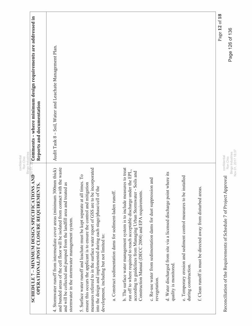
1218
SCH
ED
UL
E 7
– M
INIM
UM
DE
SIG
N S
PEC
IFIC
AT
ION
S A
ND
O
PER
AT
ION
AL
/PO
ST C
LO
SUR
E R
EQ
UIR
EM
EN
TS.
Comments–whereminimum
design
requirem
entsareaddressedin
Reportsanddocumentation
4. S
torm
wat
er ru
noff
from
inte
rmed
iate
cov
er a
reas
(min
imum
300
mm
thic
k)
and
bund
ed a
reas
of t
he c
ell f
loor
will
be
isol
ated
from
con
tact
with
the
was
te
and
will
be
colle
cted
and
pum
ped
from
the
land
fill a
rea
and
treat
ed a
s st
orm
wat
er in
the
stor
mw
ater
man
agem
ent s
yste
m.
5. S
urfa
ce w
ater
runo
ff a
nd le
acha
te m
ust b
e ke
pt se
para
te a
t all
times
. To
ensu
re th
is o
ccur
s the
app
lican
t is t
o en
sure
the
cont
rol a
nd m
itiga
tion
mea
sure
s ref
erre
d to
in th
e su
rfac
e w
ater
repo
rt of
GSS
are
to b
e in
corp
orat
ed
into
the
desi
gn a
nd im
plem
ente
d du
ring
each
stag
e/ph
ase/
cell
of th
e de
velo
pmen
t, in
clud
ing
but n
ot li
mite
d to
:
a. C
onst
ruct
sedi
men
tatio
n da
ms f
or se
dim
ent-l
aden
runo
ff.
b. T
he su
rfac
e w
ater
man
agem
ent s
yste
m is
to in
clud
e m
easu
res t
o tre
at
run
off t
o w
here
requ
ired
to re
ach
acce
ptab
le d
isch
arge
und
er th
e EP
L,
acco
rdin
g to
gui
delin
es fr
om M
anag
ing
Urb
an S
torm
wat
er -
Soils
and
C
onst
ruct
ion
Man
ual (
DEC
C 2
004)
and
EPA
requ
irem
ents
.
c. R
e-us
e w
ater
from
sedi
men
tatio
n da
ms f
or d
ust s
uppr
essi
on a
nd
reve
geta
tion.
d. W
ater
dis
char
ged
from
site
via
a li
cens
ed d
isch
arge
poi
nt w
here
its
qual
ity is
mon
itore
d.
e. T
empo
rary
ero
sion
and
sedi
men
t con
trol m
easu
res t
o be
inst
alle
d du
ring
cons
truct
ion.
f. C
lean
runo
ff is
mus
t be
dire
cted
aw
ay fr
om d
istu
rbed
are
as.
Pag
e 12
6 of
136
confi
dent
ial
Ron
Chi
oB
ingo
Indu
strie
sN
ov 0
1, 2
0DD
017
18:3
7Comm
Comm
0
confi
dent
ial
Ron
Chi
oB
ingo
Indu
strie
sN
ov 0
1, 2
017
18:3
7

1318
SCH
ED
UL
E 7
– M
INIM
UM
DE
SIG
N S
PEC
IFIC
AT
ION
S A
ND
O
PER
AT
ION
AL
/PO
ST C
LO
SUR
E R
EQ
UIR
EM
EN
TS.
Comments–whereminimum
design
requirem
entsareaddressedin
Reportsanddocumentation
g. M
aint
enan
ce o
f sed
imen
t con
trol s
truct
ures
.
h. C
ontin
genc
y pr
oced
ures
for b
reac
hes a
nd c
ross
-con
tam
inat
ion
betw
een
stor
mw
ater
and
leac
hate
.
6. O
nly
stor
mw
ater
is to
be
reus
ed o
nsite
for d
ust s
uppr
essi
on a
nd
reve
geta
tion,
with
exc
ess s
torm
wat
er m
anag
ed a
nd tr
eate
d w
here
requ
ired
for
mon
itore
d lic
ense
d di
scha
rge.
7. T
he S
torm
wat
er S
oil,
Wat
er a
nd L
each
ate
Man
agem
ent P
lan
mus
t ide
ntify
th
e lo
catio
n of
lice
nsed
dis
char
ge p
oint
s for
stor
mw
ater
, and
mon
itorin
g pa
ram
eter
s and
freq
uenc
y of
mon
itorin
g.
8. T
he st
orm
wat
er sy
stem
mus
t be
desi
gned
in a
ccor
danc
e w
ith th
e M
anag
ing
Urb
an S
torm
wat
er –
Soi
ls a
nd C
onst
ruct
ion
Man
ual (
the
“Blu
e B
ook”
) –
DEC
C, 2
004.
9. M
onito
ring
requ
irem
ents
for s
urfa
ce w
ater
and
gro
undw
ater
(par
amet
ers
and
freq
uenc
y) m
ust b
e in
clud
ed in
the
Plan
.
I. M
onito
ring
1. A
ll gr
ound
wat
er p
iezo
met
ers m
ust b
e in
stal
led
arou
nd th
e si
te a
s per
A
nnex
ure
5 in
App
endi
x 1
cont
aine
d th
e C
ell D
esig
n an
d G
roun
dwat
er
Ass
essm
ent (
Aqu
ater
ra 2
010)
. The
se p
iezo
met
ers m
ust b
e in
stal
led
and
appr
opria
tely
sam
pled
dur
ing
site
est
ablis
hmen
t, an
d be
fore
any
was
te is
re
ceiv
ed a
t the
site
, to
dete
rmin
e ba
ckgr
ound
gro
undw
ater
cha
ract
eris
tics
(gro
undw
ater
qua
lity
and
grou
ndw
ater
flow
con
ditio
ns).
Pag
e 12
7 of
136
confi
dent
ial
Ron
Chi
oB
ingo
Indu
strie
sN
ov 0
1, 2
0DD
017
18:3
7Comm
Comm
0
confi
dent
ial
Ron
Chi
oB
ingo
Indu
strie
sN
ov 0
1, 2
017
18:3
7

1418
SCH
ED
UL
E 7
– M
INIM
UM
DE
SIG
N S
PEC
IFIC
AT
ION
S A
ND
O
PER
AT
ION
AL
/PO
ST C
LO
SUR
E R
EQ
UIR
EM
EN
TS.
Comments–whereminimum
design
requirem
entsareaddressedin
Reportsanddocumentation
2. T
he p
iezo
met
ers m
ust b
e sa
mpl
ed d
urin
g th
e de
taile
d en
gine
erin
g de
sign
an
d si
te e
stab
lishm
ent p
hase
s to
iden
tify
and
conf
irm b
ackg
roun
d gr
ound
wat
er
char
acte
ristic
s and
cla
rify
the
conn
ectiv
ity b
etw
een
grou
ndw
ater
and
the
cree
k.
3. T
he o
pera
tor m
ust e
ngag
e an
inde
pend
ent p
arty
(or p
artie
s) to
mon
itor t
he
follo
win
g du
ring
the
life
of th
e pr
ojec
t in
acco
rdan
ce w
ith th
e LE
MP
and
the
EPL:
a. G
roun
dwat
er le
vels
and
qua
lity;
b. L
each
ate
leve
ls in
cel
ls a
nd q
ualit
y;
c. L
each
ate
leve
ls in
dam
s and
qua
lity;
d. S
urfa
ce w
ater
qua
lity
at o
ffsi
te d
isch
arge
poi
nt;
e. C
over
and
cap
ping
ope
ratio
ns o
n w
aste
cel
ls;
f. B
ackg
roun
d gr
ound
wat
er c
hara
cter
istic
s; a
nd
g. C
larif
y th
e co
nnec
tivity
bet
wee
n th
e gr
ound
wat
er a
nd B
laxl
and
Cre
ek.
Pag
e 12
8 of
136
confi
dent
ial
Ron
Chi
oB
ingo
Indu
strie
sN
ov 0
1, 2
0DD
017
18:3
7Comm
Comm
0
confi
dent
ial
Ron
Chi
oB
ingo
Indu
strie
sN
ov 0
1, 2
017
18:3
7

1518
SCH
ED
UL
E 7
– M
INIM
UM
DE
SIG
N S
PEC
IFIC
AT
ION
S A
ND
O
PER
AT
ION
AL
/PO
ST C
LO
SUR
E R
EQ
UIR
EM
EN
TS.
Comments–whereminimum
design
requirem
entsareaddressedin
Reportsanddocumentation
4. L
each
ate
mod
ellin
g m
ust b
e va
lidat
ed th
roug
h in
depe
nden
t ass
essm
ent a
nd
mon
itorin
g of
leac
hate
flow
s, le
vels
and
vol
umes
in le
acha
te st
orag
e po
nds.
5. If
val
idat
ion
asse
ssm
ent o
f the
leac
hate
mod
el in
dica
tes e
xces
s lea
chat
e st
orag
e is
requ
ired
then
pot
entia
l con
tinge
ncy
arra
ngem
ents
mus
t be
deve
lope
d an
d im
plem
ente
d to
the
satis
fact
ion
of th
e EP
A. I
f dire
cted
by
the
EPA
, fur
ther
w
aste
rece
ipt m
ust b
e su
spen
ded
until
the
EPA
is sa
tisfie
d w
ith th
e ar
rang
emen
ts.
6. R
esul
ts o
f lea
chat
e va
lidat
ion
asse
ssm
ent c
ompa
red
to th
e m
odel
pro
visi
ons
mus
t be
prov
ided
to th
e EP
A u
pon
requ
est.
J. C
onst
ruct
ion
Qua
lity
Ass
uran
ce P
lan
1. A
Con
stru
ctio
n Q
ualit
y A
ssur
ance
Pla
n (C
QA
) mus
t be
prep
ared
and
im
plem
ente
d fo
r the
ent
ire si
te, i
nclu
ding
dev
elop
men
t wor
ks, c
ell
cons
truct
ion,
stor
mw
ater
and
leac
hate
man
agem
ent m
easu
res,
capp
ing
and
post
clo
sure
reha
bilit
atio
n.
2. T
he C
QA
pla
n m
ust i
nclu
de p
rovi
sion
s for
the
follo
win
g in
acc
orda
nce
with
th
e PO
EO A
ct:
a. S
ourc
es o
f con
stru
ctio
n m
ater
ial;
b. T
estin
g of
con
stru
ctio
n m
ater
ials
;
c. In
spec
tion
and
test
ing
proc
edur
es fo
r con
stru
cted
cel
l lin
ers (
basa
l and
si
de);
Pag
e 12
9 of
136
Ron
Chi
oB
ingo
Indu
strie
sN
ov 0
1, 2
0DD
017
18:3
7Comm
Comm
0
confi
dent
ial
Ron
Chi
oB
ingo
Indu
strie
sN
ov 0
1, 2
017
18:3
7

1618
SCH
ED
UL
E 7
– M
INIM
UM
DE
SIG
N S
PEC
IFIC
AT
ION
S A
ND
O
PER
AT
ION
AL
/PO
ST C
LO
SUR
E R
EQ
UIR
EM
EN
TS.
Comments–whereminimum
design
requirem
entsareaddressedin
Reportsanddocumentation
d. C
onst
ruct
ion
met
hodo
logy
for c
ompa
ctin
g cl
ays,
incl
udin
g nu
mbe
r of
lifts
and
moi
stur
e co
nditi
onin
g fo
r eac
h ce
ll;
e. In
spec
tion
and
test
ing
proc
edur
es fo
r HD
PE a
nd g
eom
embr
ane
liner
s;
f. R
ectif
icat
ion
of n
on c
onfo
rmin
g co
mpo
nent
s;
g. C
ertif
icat
ion
/ sig
n of
f by
suita
bly
qual
ified
ass
esso
r on
the
com
plet
ion
of e
ach
of th
e sp
ecifi
ed w
orks
;
h. A
n in
depe
nden
t cer
tific
atio
n re
port
mus
t be
prep
ared
to c
onfir
m th
at
each
of t
he sp
ecifi
ed w
orks
wer
e co
mpl
eted
as r
equi
red
and
in
acco
rdan
ce w
ith th
e C
QA
pla
n an
d an
y EP
L co
nditi
ons.
This
repo
rt is
to
be su
bmitt
ed to
the
EPA
at t
he c
ompl
etio
n of
eac
h of
the
spec
ified
w
orks
;
i. Th
e C
QA
pla
n m
ust b
e in
clud
ed in
the
LEM
P;
j. C
ontin
genc
y m
easu
res i
n th
e ev
ent o
f fai
lure
or s
ever
stor
m e
vent
or
fugi
tive
leac
hate
em
issi
on; a
nd
k. L
each
ate
mod
ellin
g fo
r the
Pro
ject
mus
t be
prov
ided
to c
onfir
m th
e ef
ficac
y/ad
equa
cy o
f the
pro
pose
d fin
al le
acha
te m
anag
emen
t and
su
rfac
e w
ater
man
agem
ent d
esig
n an
d in
corp
orat
ed in
to th
e SW
LMP.
Pag
e 13
0 of
136
confi
dent
ial
Ron
Chi
oB
ingo
Indu
strie
sN
ov 0
1, 2
0DD
017
18:3
7Comm
Comm
0
confi
dent
ial
Ron
Chi
oB
ingo
Indu
strie
sN
ov 0
1, 2
017
18:3
7
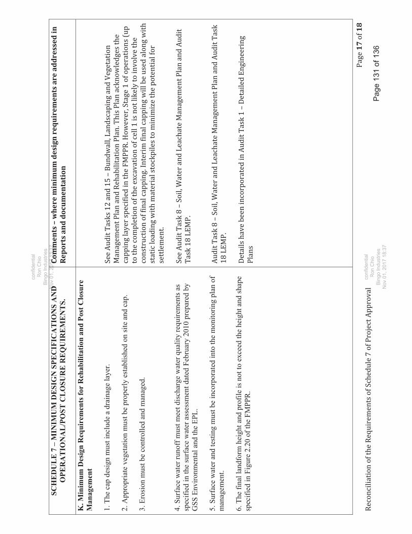
1718
SCH
ED
UL
E 7
– M
INIM
UM
DE
SIG
N S
PEC
IFIC
AT
ION
S A
ND
O
PER
AT
ION
AL
/PO
ST C
LO
SUR
E R
EQ
UIR
EM
EN
TS.
Comments–whereminimum
design
requirem
entsareaddressedin
Reportsanddocumentation
K. M
inim
um D
esig
n R
equi
rem
ents
for
Reh
abili
tatio
n an
d Po
st C
losu
re
Man
agem
ent
1. T
he c
ap d
esig
n m
ust i
nclu
de a
dra
inag
e la
yer.
2. A
ppro
pria
te v
eget
atio
n m
ust b
e pr
oper
ly e
stab
lishe
d on
site
and
cap
.
3. E
rosi
on m
ust b
e co
ntro
lled
and
man
aged
. 4.
Sur
face
wat
er ru
noff
mus
t mee
t dis
char
ge w
ater
qua
lity
requ
irem
ents
as
spec
ified
in th
e su
rfac
e w
ater
ass
essm
ent d
ated
Feb
ruar
y 20
10 p
repa
red
by
GSS
Env
ironm
enta
l and
the
EPL.
5. S
urfa
ce w
ater
and
test
ing
mus
t be
inco
rpor
ated
into
the
mon
itorin
g pl
an o
f m
anag
emen
t.
6. T
he fi
nal l
andf
orm
hei
ght a
nd p
rofil
e is
not
to e
xcee
d th
e he
ight
and
shap
e sp
ecifi
ed in
Fig
ure
2.20
of t
he F
MPP
R.
Pag
e 13
1 of
136
confi
dent
ial
Ron
Chi
oB
ingo
Indu
strie
sN
ov 0
1, 2
0DD
017
18:3
7Comm
Comm
0
confi
dent
ial
Ron
Chi
oB
ingo
Indu
strie
sN
ov 0
1, 2
017
18:3
7

1818
SCH
ED
UL
E 7
– M
INIM
UM
DE
SIG
N S
PEC
IFIC
AT
ION
S A
ND
O
PER
AT
ION
AL
/PO
ST C
LO
SUR
E R
EQ
UIR
EM
EN
TS.
Comments–whereminimum
design
requirem
entsareaddressedin
Reportsanddocumentation
7. In
ord
er to
ens
ure
ther
e is
no
need
to in
crea
se th
e he
ight
of t
he la
ndfo
rm,
any
settl
emen
t are
as th
at m
ay re
sult
in p
ondi
ng o
f sur
face
wat
er w
ill n
eed
to
be b
ackf
illed
and
this
pro
cess
will
con
tinue
unt
il th
e EP
A d
eter
min
es th
at th
e fa
cilit
y is
stab
le a
nd d
oes n
ot re
pres
ent a
risk
to h
uman
hea
lth o
r the
en
viro
nmen
t. Th
e fo
llow
ing
actio
ns m
ust b
e un
derta
ken:
a. R
egul
ar m
aint
enan
ce o
f slo
pes t
hrou
gh b
ackf
illin
g an
d re
vege
tatio
n of
se
ttled
are
as to
pre
vent
pon
ding
of w
ater
and
faci
litat
e ru
noff
; and
b. A
ll ba
ckfil
ling
activ
ities
are
to b
e un
derta
ken
with
subs
oil o
f the
sam
e co
mpo
sitio
n as
pro
pose
d su
bsoi
l (on
site
cla
ys) r
efer
red
to th
e in
the
cap
prof
ile.
8. R
egul
ar in
spec
tion
and
repo
rting
by
an in
depe
nden
t, su
itabl
y qu
alifi
ed
asse
ssor
, on
an a
nnua
l bas
is to
ass
ess t
he in
tegr
ity o
f the
cap
, the
gra
de a
nd th
e ex
iste
nce
of d
iffer
entia
l set
tlem
ent a
reas
whe
re p
ondi
ng c
ould
occ
ur.
9. A
ll re
ports
iden
tifie
d ab
ove
are
to b
e pr
ovid
ed to
the
EPA
and
rele
vant
ce
rtify
ing
bodi
es w
ithin
four
wee
ks o
f the
insp
ectio
n da
te. R
epor
ts a
re a
lso
to
be m
ade
publ
icly
.
10. M
onito
ring
is to
con
tinue
unt
il th
e EP
A d
eter
min
es th
e fa
cilit
y is
stab
le
and
no lo
nger
repr
esen
ts a
risk
to h
uman
hea
lth o
r the
env
ironm
ent.
Pa g
e 13
2 of
136
Ron
Chi
oB
ingo
Indu
strie
sN
ov 0
1, 2
0DD
017
18:3
7Comm
Comm
0
confi
dent
ial
Ron
Chi
oB
ingo
Indu
strie
sN
ov 0
1, 2
017
18:3
7

Huon Designs June 2017
Attachment 7
Response from Agencies
Page 133 of 136
confidentialRon Chio
Bingo IndustriesBingo IndustriesNov 01, 2017 18:37
confidentialRon Chio
Bingo IndustriesNov 01, 2017 18:37

From: Irene ZingerTo: [email protected]: John GaleaSubject: OUT17/10124-DPI Water response - PLRRC Bund Wall, Landscaping and Vegetation Management Plan and
RehabilitationDate: Monday, 6 March 2017 9:00:41 PMAttachments: OUT17_10124 DPI Water response - PLRRC Bund Wall, Landscaping and Vegetation Management Plan and
Rehabilitation.pdf
Hi David
Please fiend enclosed DPI Water's comments.
For further information please contact John Galea, Water Regulation Officer, ParramattaOfficer, telephone 8838 7520 or email [email protected].
Best regardsIrene
Irene Zinger | A/Regional Manager - MetroWater Regulation OperationsNSW Department of Primary Industries - WaterLevel 11, 10 Valentine Avenue | Parramatta NSW 2150PO Box 3720 | Parramatta NSW 2124T: 02 9842 8513 M: 0419 406416 F: 02 9895 7501E: [email protected]: www.dpi.nsw.gov.au, www.industry.nsw.gov.au
This message is intended for the addressee named and may contain confidential information. If you are not the intended recipient,please delete it and notify the sender. Views expressed in this message are those of the individual sender, and are not necessarilythe views of their organisation.
Page 134 of 136
confidentialRon Chio
Bingo IndustriesNov 01 2017 18:37Nov 01, 2017 18:37
confidentialRon Chio
Bingo IndustriesNov 01, 2017 18:37

Level 11 Macquarie Tower, 10 Valentine Ave, Parramatta NSW 2150 | Locked Bag 5123 Parramatta NSW 2124 t 1800 353 104 | www.water.nsw.gov.au
Contact John Galea Phone (02) 8838 7520 Email [email protected] Our ref OUT17/10124
David White Via email: [email protected]
Dear Mr White
Bund Wall, Landscaping and Vegetation Management Plan and Rehabilitation Plan – Patons Lane Resource Recovery Centre
I refer to your email of 6 February 2017 inviting the Department of Primary Industries – Water (DPI Water) to comment on the Bund Wall, Landscaping and Vegetation Management Plan and Rehabilitation Plan for the Patons Lane Resource Recovery Centre. DPI Water has no objections to the proposed management measures outlined in the supplied documents. DPI Water encourages the company to undertake the works within the riparian zone of Blaxland Creek as outlined in the document and would like to be kept informed of the progress of these rehabilitation works. For further information please contact John Galea, Water Regulation Officer, Parramatta Officer, telephone 8838 7520 or email [email protected]. Yours sincerely
Irene Zinger, Regional Manager - Metro Water Regulation
Page 135 of 136
confidentialRon Chio
Bingo IndustriesNov 01, 2017 18:37Noov 1, 01, 220
| www.wa | www.waRon Chio
Bingo IndustriesNov 01, 2017 18:37

David, I refer to the recently submitted Bund Wall, Landscaping and Vegetation Management Plan and Rehabilitation Plan (final draft, as updated 9/2/17) prepared by Rodney Cox of Huon Designs for 123-179 Patons Lane, Orchard Hills. Council’s Biodiversity Officer and Water Management Officer have reviewed this document and have not raised any issues of concern subject to the proposed works being carried out in their entirety and in a manner consistent with the requirements of the NSW Office of Water. Regards. Robert Craig Principal Planner E [email protected] T +612 4732 7593 | F +612 4732 7958 | PO Box 60, PENRITH NSW 2751 www.visitpenrith.com.au www.penrithcity.nsw.gov.au
Follow us
Page 136 of 136
confidentialRon Chio
Bingo IndustriesNov 01, 2017 18:37
confidentialdeRon Chio
Bingo IndustriesNov 01, 2017 18:37