An Intelligent Parking Management System using RFID
Technology based on User Preferences
Amir Shimi1 . Mohammad Reza Ebrahimi Dishabi12 . Mohammad Abdollahi Azgomi1
Abstract Due to the tremendous progress in the automotive industry, the growth of the urban
population, the number of vehicles is increasing and this creates parking challenges. Intelligent parking
management systems offer an optimal solution for finding empty parking space so that drivers can
quickly find their car parking space. To solve these problems, it is necessary to design an intelligent
parking system, in addition to providing comfort to drivers, which is also economically viable. This
paper proposes an intelligent multi-storey car parking system with the help of RFID technology and
examining user preferences that can effectively solve car parking problems. The proposed method is a
multi-objective decision-making method to reduce the problem of car parking, which is called MODM-
RPCP. Therefore, the proposed MODM-RPCP method can allocate the best space for their stopping
place by using the decision-making system and based on the priorities considered by the users. The
simulation results show that the MODM-RPCP reduces the average booking time more than 19.2% and
27.1%, and decreases the response time of central parking management server more than 20.1% and
29.78% compared to MOGWOLA and ODPP approaches.
Keywords Parking Management System . Smart parking . Multi-objective method . Decision-making method
1 Introduction Due to the increasing number of vehicles, traffic congestion is a worrying problem around the world
and it is increasing day by day. Almost every day, about 40% of car traffic congestion in all countries
of the world is due to the search for car parking space, and it takes an average of 10 to 12 minutes for
Amir Shimi
Mohammad Reza Ebrahimi Dishabi
Mohammad Abdollahi Azgomi
1 Department of Computer Engineering Miyaneh Branch, Islamic Azad University, Miyaneh, Iran
Preprints (www.preprints.org) | NOT PEER-REVIEWED | Posted: 30 November 2020 doi:10.20944/preprints202011.0738.v1
© 2020 by the author(s). Distributed under a Creative Commons CC BY license.

the driver to find the parking space for the car. Such issues lead to traffic congestion, leading to
increased waiting times for drivers and wasted car energy due to parking searches. The car parking
problem needs an optimal solution to save driver time, reduce pollution and economic losses [1, 2].
Smart parking systems can be solved with the help of innovative solutions, by integrating different
resources to upgrade facilities and parking management. These parking systems can provide real-time
updates to users about the nearest available parking spaces. It can also provide a smart parking
management system for booking and checking empty spaces remotely. These parking systems consist
of low-cost sensors, real-time data collection and automated mobile payment systems for booking [3].
With RFID after intelligent parking identification, additional features such as fast car recovery,
parking adjustment, parking gate management can also be used. Smart parking can be modelled as a
parking gate. In each parking slot, a sensor is placed to detect the presence or absence of a vehicle that
creates an access map to guide parking and other services. Such a system can also be considered as a
problem of managing multiple parking lots because it has to manage multiple parking lots distributed
in different internal and external areas. To design intelligent parking systems, the connection of the
sensor measurement to a physical location is essential [4].
Instead of deploying all vehicles with GPS capability, it is preferable to have only a few vehicles
on the network to identify their exact location via GPS. These vehicles are referred to as anchor or
reference vehicles. Other network nodes will be able to show their position close to anchor nodes by
measuring the received signal strength (RSS) and arrival time. These methods have made significant
progress in computational accuracy and timing. Figure 1 shows the proposed method architecture
where different drivers are communicating with the parking management server in order to determine
the empty parking spaces.
Fig. 1 Multi-objective decision-making method to reduce the problem of car parking architecture
This study presents a smart multilevel parking management system using RFID and checking users'
priorities, which can efficiently solve the parking problems. The proposed method called MODM-RPCP
is a multi-objective decision-making method that reduces the parking problem.
The rest of the paper is organized as follows: Section 2 presents related works. In Sect. 3 brings the
proposed MODM-RPCP solution. The parameters used for assessing the performance are studied and
Preprints (www.preprints.org) | NOT PEER-REVIEWED | Posted: 30 November 2020 doi:10.20944/preprints202011.0738.v1

simulation outcomes are deliberated in Section 4. Finally, conclusion of this research is discussed in
Section 5.
2 Related works Cyprus International Airport decided to use the Hikvision smart parking system to minimize the
problems caused by parking cars and protecting them. They left the access control system, the smart
airport parking system, and also monitoring other parts of the airport to the closed-circuit camera system
of Hikvision. In this solution of Hikvision, the barriers installed in the car park entrance are controlled
smartly using sensors and special radar. Efficiency of this model has other advantages in addition to
easy installation and setup which include not being affected by environmental factors like lighting, dust,
and rain. In addition to the automatic and smart barrier control capability, this system can leave some of
the control manually to the operator. By using smart algorithms and modern technologies in the security
and closed-circuit field, the Hikvision smart system can present valuable statistical and analytical
information to the managers so that, if necessary, they can make important decisions using this
information and increase security and customer satisfaction levels [5].
In some studies that Zung et al. conducted for understanding the decisions in car parks by modeling
the structural equation, they have created a structural equation for analyzing parking decisions. The data
used in this study was obtained from Information Park in Beijing. The relationships between the three
parking decisions were studied. The results show a two-way correlation between street park and
duration. These findings can be used for developing some measures for regulating interact Analysis of
parking in the car park and the parking mechanism for balancing parking time-time distribution and also
formulating parking management policies [6].
Maravel et al. have solved the problem of automatic parking using a rear-wheel drive vehicle using
a biometric model based on the direct connection between the perception of the vehicle and actions.
This problem has been inspired using the external approach where the vehicle controller does not need
to know the car communique and dynamics. Also, it does not require previous knowledge of the
environment’s map. The main point in the proposed approach is the definition of performance indicators
that happen to automatic parking and actions are injected to the car robot controller in real time. This
solution is in the form of a multi-objective dynamic optimization problem and is extremely analytical.
Using the genetic algorithm, they have obtained a very simple and effective solution [7].
In the studies Zhao et al. have conducted on analyzing the activity-based trip chain in the parking fee
network program, they incorporated the chaining behavior of activity-based trip in analyzing network
stability and an integrated model has been presented for describing the passenger’s behavior, which is a
combination of Beckman link congestion terms and type two logit demand function. The convexity
conditions and equivalence of the model have been discussed. Based on the integrated model, a two-
layer model has been designed for maximizing social welfare through suitable parking cost. Also, an
extensive network for eliminating services and trips in the main network has been developed. Then, the
Simulated annealing (SA) method has been used for solving the proposed two-layer model. Numerical
examples have been presented for studying the availability of the model and the effects of parking fee
scheme on passengers’ behavior and social welfare, which indicate that this model is effective in
describing the trip chaining behavior in the network [8].
To solve the traffic pressure caused by container trucks in ports, Chang et al. proposed an
underground container logistics service (UCLS) between Shanghai terminal and north west of logistics
park. To ensure the connection between the system and the terminal, designing an underground parking
Preprints (www.preprints.org) | NOT PEER-REVIEWED | Posted: 30 November 2020 doi:10.20944/preprints202011.0738.v1

is proposed. Underground parking is a buffer that is used for loading and unloading underground
vehicles (UGVs). A nonlinear ordinary planning model (MNIP) has been designed for UGVs and
outdoor cranes in order to minimize the overall cost of the cranes in line for UGVs and terminals. Then,
the optimization model has been implemented using MATLAB software [9].
Oren Steen et al. have designed a parking management system that comprises a central dataset in
communication with the server, at least one user device, at least one merchant console, and one parking
control device in a network. The central database is presented for receiving and storing data from several
parking systems. A process has been presented for analyzing the information received by the central
data base. A dynamic data engine has been presented for analyzing the data received from a number of
parking systems and generating dynamic data. Targeted advertising engine has been presented for
analyzing user’s data and creating a targeted advertisement. Dynamic pricing information are given to
user’s device so that the user can reserve the parking space from one of the parking systems. Targeted
promotion is given to user’s device so that the user can choose an advertisement from a merchant [10].
Works carried out in Iran related to smart car parks:
a) designing a smart parking management and guidance system and its role in securing and increasing
road capacity according to paper [11]. To obtain information, first they have referred to the reality of
the society and through interviews, questionnaires, and case studies addressed the issues and problems
present regarding car parks. This paper is conducted using the descriptive method and on 70 citizens
(driver). In the following, we address some of these questions and tables.
According to Table 1, the results of this study regarding the satisfaction level of drivers from parking
services around the city were at the low and medium level and only 6 percent have high satisfaction.
Table 1 Satisfaction level with services [7].
Low Medium High Overall
27 39 4 70
38% 56% 6% 100%
According to Table 2, it shows that locating a parking location by asking the people of the region is the
highest at 48 percent. Drivers trying to find a parking spot on the street is second with 30 percent and
routing systems with 3 percent has had the lowest usage by drivers.
Table 2 Results of asking people [7].
Asking people of the region Using
locators
Using traffic
signs
Using city
map
None, try to find a
spot on the street
Overall
34 2 9 4 21 70
48% 3% 13% 6% 30% 100%
According to the results of Table 3, this question has been raised that how important the factors affecting
a parking spot are and therefore, the drivers were asked to score the factors mentioned in the
questionnaire according to their effect on choosing a parking spot from one to ten. These results show
that some parameters affecting parking selection play a more important role while other factors are less
important.
Preprints (www.preprints.org) | NOT PEER-REVIEWED | Posted: 30 November 2020 doi:10.20944/preprints202011.0738.v1

Table 3 Importance weight of different factors effective in ranking
Parameter effective in ranking Importance weight
Access time to parking 0.42
Geographic distance 0.45
Parking fee 0.51
Security and safety 0.32
Parking difficulty 0.12
Predicting the future regarding vehicle exit 0.24
And in the final question where drivers were asked about highest services to the customers, they ranked
mentioned factors from one to four and the results are presented in Table 4. which shows the importance
of providing better parking services with regard to market work with the highest share at 38 percent.
Table 4 Maximum services provided to the customers by car parks
Parameter Importance weight
During office hours 0.38
With respect to market work 0.32
With respect to recreational, cultural, and tourism centers 0.17
During Norouz, eves, religious festivals, and holidays 0.14
Works carried out abroad related to smart car parks:
a) Parking Guidance and Information System (PGIS): As a part of smart transportation systems, it can
be useful for solving traffic problems. The state of traffic in big city areas has become severe due to
looking for parking spots. Advanced parking guidance and information system is considered one of the
most effective traffic management approaches which can control and effect the usage of vehicles,
especially in crowded and busy parts of the city. Beijing was chosen to host the 2008 Olympics and the
government of China has acknowledged that these games would be the most splendid in Olympics
history. Before holding these games, it was evaluated in an overall analysis that one of the factors that
would affect Olympic games was the traffic system and Beijing officials decided to provide a
comfortable, safe, and accurate traffic system to reduce the negative effects of this matter on Olympic
games. Despite the fact that nowadays many traffic indicators of china like road network congestion,
number of licensed cars, and number of daily passengers are at the top of global rankings, infrastructure
facilities of Beijing are behind the global trend with regards to traffic management [11].
Traffic properties of Olympics are defined as follows:
• Short-term events
• High congestion
• High demand
One of the tools used by Beijing officials in managing Olympics traffic was controlling and scheduling
the traffic in Olympics village. From 1997, Chinese Academy of Sciences has started two massive
projects in order to research and develop regarding traffic issues. The initial name of this project was
“Urban Traffic Flow Guidance System”. Jilin University was responsible for carrying out one of these
Preprints (www.preprints.org) | NOT PEER-REVIEWED | Posted: 30 November 2020 doi:10.20944/preprints202011.0738.v1

projects. Due to this reason, a research group was formed to design and build a system for the
information and management of car parks. This system was named “Urban Traffic Flow Guidance
System” [12]. The scheme for integrating parking guidance with traffic flow guidance in smart
transportation systems is shown in Figure 2.
Fig. 2 The scheme for integrating parking guidance with traffic flow guidance in smart transportation systems [12].
Comparison of targeted car parking is shown in Figure 3.
Fig. 3 Comparison of targeted car parking duration before and after utilizing the PGIS system in on of Beijing’s regions
[12].
b) Smart Driver Location System for Smart Parking: Often, finding a parking spot is tiresome for the
drivers and the car park itself is expensive in all the major cities of the world. In [13], a crowdsourced
Preprints (www.preprints.org) | NOT PEER-REVIEWED | Posted: 30 November 2020 doi:10.20944/preprints202011.0738.v1

solution has been proposed that gathers the real information of available car parks using the sensors in
smartphones. This system is designed based on cell phones which can follow the driver’s route until he
or she wants to leave the car park. In this paper, it has been focused on the efficiency and accuracy of
using mobile phones for depicting the driver’s walking route, which is carried out using the pedestrian
dead reckoning (PDR) method installed on the belly and can measure the driver’s moving distance with
high accuracy. Also, an algorithm synchronous with the map has been designed to measure route errors
while the driver is indoors (interior environment). It has carried out this deed by utilizing existing floor
maps of buildings. The results have shown that it can guess user’s walking distance with an approximate
accuracy of 98 percent, which along with location errors is about 0.48 meters. In this paper, it has been
focused on how to detect the exiting car park activity. This idea is very simple because if the phone
detects that the driver is approaching where his or her car is parked, it seems like the driver wants to
leave the spot and the parking spot will be available soon.
In [13], a driver, who has parked recently, can provide a message regarding when he or she wants to
leave the spot and this information might be sold to another driver who wants to pay (using virtual
money, like Bitcoin). Once the buyer reaches the parking spot when it is close to the departure time of
the seller, he can occupy the spot after the seller leaves. Therefore, drivers only exchange the information
regarding available car parks. This action is carried out automatically in this paper, i.e. the act of
registering and removing parking spots is done automatically. The main focus of this paper is on how
the walking path of the driver, which is the key to this method, can be efficiently and accurately depicted.
According to this paper [13] and all their previous research, previous systems all worked manually and
could not automatically carry out the park registration and removal operation and so the users needed to
apply this operation manually. In order for his system to be able to carry out this operation automatically,
it needs to monitor user’s behaviour.
In [14] the authors proposed a method that uses a machine learning method to predict parking
occupancy, which in turn is used to deduce occupied driving prices for the entry of vehicles. Parking
data on Seattle City Street has been used to train, test and compare different models of machine learning.
This is the first time a parking occupancy forecasting system has been used to generate an occupancy-
based parking price for a Seattle street parking system.
In [16], the authors proposed a multifunctional gray wolf optimization technique with the aim of
minimizing the localization error. For telemetry and geometric constraints, two objective functions are
considered. In our research for the optimal localization of wireless sensor nodes with IoT capability to
determine their positions in smart parking with the aim of developing a model based on the optimization
of multifunctional gray wolf. Objective functions include distance and topological constraints. Using
the multi-purpose gray wolf optimization (MOGWO), the Pareto optimal solution is obtained to
determine the optimal solution. The goal of localization is to achieve efficiency and reduce the number
of anchor nodes.
3 The proposed MODM-RPCP solution
As the number of cars increases, finding a parking space becomes a challenge. The drivers usually do
not know if there is a space for them to park their car or not. Also, finding a proper space in the large
multilevel parking facilities for users, especially those who park for a short time, is difficult and a
waste of time. Therefore, the parking issue has become one of the main issues in urban transportation
management, because the urban spatial resources are limited and parking cost is high. Due to limited
parking space, many vehicles spent much time in the streets to find a proper parking slot, and wait in
Preprints (www.preprints.org) | NOT PEER-REVIEWED | Posted: 30 November 2020 doi:10.20944/preprints202011.0738.v1

long queues to park or retrieve their car. Smart multilevel parking facilities are constructed at the
center of most large cities to handle these limitations and develop an intelligent approach to inform
the drivers to select parking facilities. This study presents a smart multilevel parking management
system using RFID and checking users' priorities, which can efficiently solve the parking problems.
The proposed method called MODM-RPCP is a multi-objective decision-making method that reduces
the parking problem.
3.1 The General Architecture of the MODM-RPCP
A short-range wireless communication technology capable of detecting radio frequency is called RFID
technology, which can read or write related data via radio signals without any mechanical or optical
communication. It also has the ability to identify specific targets. The proposed MODM-RPCP method
introduces a multilevel parking space management method based on priorities, including parking
management, and reducing search time. The management system of the parking space information
also implements the parking guide management and parking costs in each parking. This system
manages parking space using RFID tags and parking search time reduction criteria called CRPST.
The proposed MODM-RPCP method comprises the following sections: decision-making, input
control, and output control. The multilevel parking space management structure is shown in Figure 4.
Fig. 4 The general architecture of the multilevel parking space management
3.2 Phase 1: Decision-Making
In this phase, a model is introduced for optimal allocation of the vehicles to the spaces existing in the
intelligent multilevel parking aiming to reduce the waiting time, cost, and energy loss. Some symbols
are used in this section, which are described in the following.
These symbols include the input cars, parking floors, parking locations on each floor, as shown in
Table 5.
Preprints (www.preprints.org) | NOT PEER-REVIEWED | Posted: 30 November 2020 doi:10.20944/preprints202011.0738.v1

Table 5 Symbols
Symbol Description
',M MI I Input cars {𝐼𝑀{1,2, 3, …,
',F FP P Parking floors {𝑃𝐹{1,2, 3, …
',L LF F Parking locations at each floor { 𝐹𝐿{1,2, 3, …,
3.2.1 Introducing the Parameters
The parameters of the proposed method include time interval, duration (how long a car parks), and time
to space index, as given in Table 6.
Table 6 Decision-making parameters
Parameter Description
/L FF PT Time interval of FL at PF
VST The time that the vehicle V parks at the parking.
VA The space required to park the vehicle V.
VCRPST Park hours of each vehicle per unit space of vehicle V.
Decision-making, including definitions like allocating a vehicle to a parking floor, and selecting a
parking space in the corresponding floor is introduced as in Table 7.
Table 7 Decision-making variables
Variable Description
/ FV P 1, if the vehicle V is allocated to PF.
0 otherwise.
/L FF P 1, if FL is allocated to PF.
0 otherwise.
3.2.2 Decision model for allocating a vehicle to the parking
The decision-making model for allocating a vehicle to parking spaces is a nonlinear objective (cost)
function, including integer variables aiming to reduce the total time of allocating the vehicles to the
specified parking slot. This function comprises elements like the total number of allocated vehicles,
and the time interval of the allocated parking slot from the entrance/exit.
( )/ /
/
/
*
2* *L F L F
L
F
F ML F
L
F P F P
F
V P
P IF P
F
T
Minx
=
(1)
'/ ' '
'
/
' , V PF
V P FFV FV
CRPS PT C V VRPST P (2)
Preprints (www.preprints.org) | NOT PEER-REVIEWED | Posted: 30 November 2020 doi:10.20944/preprints202011.0738.v1

' '' '/ /
' * ,* L F L F
L F P L L L F FF PF F F F P P (3)
/ 1F
F
V P
P
V = (4)
/ 1L F
F
LF P
P
F (5)
( ) ( )/ / F L F
L
FV P F P
V F
P (6)
/ 1 ,0,L F L FF P F P (7)
/ ,0,1F FV P V P (8)
In the proposed model, constraints (2) and (3) are considered to ensure that a vehicle allocated to floor
PF and location FL has a smaller CRPST than the vehicles allocated to floor 𝑃𝐹′ and 𝐹𝐿
′. Because floor
𝑃𝐹 and location 𝐹𝐿 are closer to the entrance/exit compared to 𝑃𝐹′ and 𝐹𝐿
′. Since one vehicle can be
allocated to only one location in one parking level, the constraint (4) is used. On the other hand,
constraint (5) represents that a parking location 𝐹𝐿 can be allocated to one parking floor. Finally, the
vehicles on floor 𝑃𝐹 and location 𝐹𝐿 should be balanced as represented in constraint (6). The constraints
(7) and (8) apply the dual (binary) constraints to the decision variables. As seen in the model, in the
first constraint, the vehicle with smaller CRPST is allocated to a lower level. This criterion that is
represented by constraint (9) is obtained through dividing the time that the vehicle V parks at the
parking by the space required to park the vehicle V. In this equation, 𝑆𝑇𝑉 is the time that the vehicle V
stops at the parking and 𝑅𝑆𝑉 is the space required to park the vehicle V.
VV
V
STCRPST
RS=
(9)
According to Eq. (9), if the duration demand of the vehicle is reduced, its CRPST is decreased, and the
vehicle with shorter requested duration at the parking has a higher priority for parking in floors and
locations closer to the exit/entrance.
3.3 Phase 2: Entrance to the Parking using MODM-RPCP
In the proposed MODM-RPCP method, the general schematic of the parking is shown in Figure 5.
Preprints (www.preprints.org) | NOT PEER-REVIEWED | Posted: 30 November 2020 doi:10.20944/preprints202011.0738.v1

Fig. 5 Entrance to the parking
The hardware employed in the input control includes antenna, tag reader, automatic card issuance,
automatic rail, decision-making terminal, and positioning, which is aware of the vacant space of each
parking facility.
The RFID tag reader includes an antenna, tags, and readers. The reader device reads the label
information, which contains a unique number, when the label enters the cover of the electromagnetic
wave emitted by the antenna. Then, using the decision-making terminal and based on the previous
discussion, the location and floors of the parking, which is a serial number similar to the tag is allocated
to the input vehicle. First, the input vehicles receive an entrance card via the automatic card issuance
device, if all parking slots are full, the device does not issue any card and announces that the parking is
full; if there are vacant spaces in the parking, the vehicle enters. Each specific vehicle receives an RFID
tag from the card issuance device, which includes information of the vehicle, personal information of
the driver, including account number and duration. Then, the parking information stored in the database
is examined, and a vacant space in correspondence with the individual’s request is allocated to the
vehicle.
A vehicle is controlled via RFID when it enters the coverage area of the EM waves emitted by the
antenna. If the tag is valid, and a space is allocated to the vehicle, the input rail goes up, and the vehicle
enters the parking without stops to reach the allocated location; if the tag is invalid, the rail does not go
up.
As mentioned in the decision-making section, if the user wants to park for a shorter time, it is
allocated to a closer space in the lower levels using the decision-making system. When the vehicle
enters, its entrance time is automatically recorded in the database, then the rail goes up automatically
to let the vehicle in, and when the vehicle enters the rail goes down.
Since the parking is multilevel and has many spaces, after allocating a space to a user, the user
should be directed to find the space faster. In this method, the public guidance used in the conventional
parking management cannot be used. Therefore, in the proposed method, a fast positioning system with
a user display system is used. This system helps the user find its parking space fast. This system is
Preprints (www.preprints.org) | NOT PEER-REVIEWED | Posted: 30 November 2020 doi:10.20944/preprints202011.0738.v1

comprised of the previous hardware facilities, including control, reader, RFID tags, antenna.
The parking floors are plotted on the planar electronic map; the users can use this map to find the
parking space easily. When the user reaches the parking space of interest, enters its parking card
received automatically at the entrance to the installed terminal. Then, the user carries the tag with
himself/herself to find the parking space considering the terminal reminder. The positioning system of
the multilevel parking is shown in Figure 6.
Fig. 6 Positioning and parking space representation
As shown in Figure 6, each parking space on each floor is represented by a unique ID. The bold cells
represent the occupied spaces, the empty cells represent the empty spaces, and the parking space of
interest is represented in green, which blinks. The graphical electronic map shown in Figure 6 is
relatively simple, and it is only used as an example. In real conditions, the map is 2D and plotted based
on the parking space distribution. The parking positioning system and the representation terminal are
installed at the entrance of all parking facilities; only some spaces are shown in the figure. This
terminal simplifies finding the parking space and making queries. The process performed at the
entrance and finding the allocated parking space is shown in Figure 7.
3.4 Phase 3: Fast Exit from the Parking in MODM-RPCP Method
As fast entrance to the parking is important and reduces waste of time, fast exit from the parking also
plays an essential role in reducing waste of time. The required devices for exit control are as follows:
A common computer with the entrance system and control database, card reader and antenna, card
restoration device, automatic rail, parking cost display based on duration, and the paid bill printer.
Preprints (www.preprints.org) | NOT PEER-REVIEWED | Posted: 30 November 2020 doi:10.20944/preprints202011.0738.v1

Fig. 7 Parking entrance flowchart, allocating space by the decision-making system and finding the allocated space
Since the parking space is very large and the parking spaces are similar, the users might forget their
parking space. However, they can use the parking card and the electronic map terminal to find the
information about the parking space. When a user enters the area covered by the EM waves, the system
automatically reads and records the parking card information. After finding the vehicle, when the user
leaves the parking, the parking card should be returned to the card restoration device. Then, the system
automatically reads the card information, records the duration, and calculates the costs, and the costs
Yes
No
Start
Is there an empty
space in the
parking?
Leaving the parking
Giving the vehicle information and personal information like account number to the card issue device
Receiving card from the automatic issuance device
Recording information in the database
Deciding based on user information, stopping time, empty spaces of the parking
Displaying the parking space allocated to the user by the positioning system on the electronic map
Recording the entrance time in the database
The rail goes up and down automatically after entrance
Finding the space and entering the card into the installed terminal
End
Requesting parking from the card issue device
Selecting a proper space corresponding to the users’ request
Preprints (www.preprints.org) | NOT PEER-REVIEWED | Posted: 30 November 2020 doi:10.20944/preprints202011.0738.v1

are deposited from the users' account using RFID tags when exiting the parking. After paying the bill,
the rail goes up automatically, and the user exits. The flowchart of fast exit control is shown in Figure
8.
Fig. 8 Flowchart of exit from the parking
4 Evaluating the Performance
This section evaluates the qualitative performance in the form of numerical results to validate the
performance of the proposed MODM-RPCP method. To demonstrate a feasibility study, the
performance analysis of MODM-RPCP has been divided into two parts:
1) Average booking time,
2) Response time of central parking management server
Yes
No
Start
Finding the vehicle and recording the exit information
Giving the card to the card restoration device
Recording the information in the database
Depositing the costs automatically from the users’ account
The rail goes up automatically and comes down after exit
End
Inserting the card on the terminal of the electronic map to see the parking location
Calculating the costs based on the stop time
Is there an empty
space in the parking? Going to the location of interest
Preprints (www.preprints.org) | NOT PEER-REVIEWED | Posted: 30 November 2020 doi:10.20944/preprints202011.0738.v1

4.1 Performance metrics
The proposed MODM-RPCP method has been simulated and its performance evaluated in Network
Simulator version 2 (NS-3) running on Linux Ubuntu 18.04 LTS. The results were compared with both
methods (ODPP [14] and MOGWOLA [16-25]).
4.2 Simulation results
All three methods are evaluated according to Table 9 under three scenarios. Table 9 displays the
significant parameters used in the simulation. In this section, the performance of our proposed
approach is evaluated using NS-3 on Linux Ubuntu 18.04 LTS as the simulation tool, and the results
are discussed further. Table 8 displays the significant parameters used in the simulation [26-32].
Table 8 Parameters used.
Parameters Value
Operating System Linux Ubuntu
Topology 200m X 200m
Number of vehicles 200
Days Saturday, Sunday, and Monday
Maximum iterations 10
Technology RFID
Transmission range 30, 40, 50, and 60
MAC Protocol 802.11p
Simulation time 1000 second
Packet size 64 bytes
Table 9 Parameters used for four scenarios.
Scenario #1 Scenario #2
Day Saturday Day Sunday
Topology 300m X 300m Topology 300m X 300m
Time 1000 Time 1000
Scenario #3
Day Monday
Topology 300m X 300m
Time 1000
Table 10-15 compares the performance of MODM-RPCP solution vs ODPP and MOGWOLA methods
in terms of average booking time, and response time [33-38].
Preprints (www.preprints.org) | NOT PEER-REVIEWED | Posted: 30 November 2020 doi:10.20944/preprints202011.0738.v1
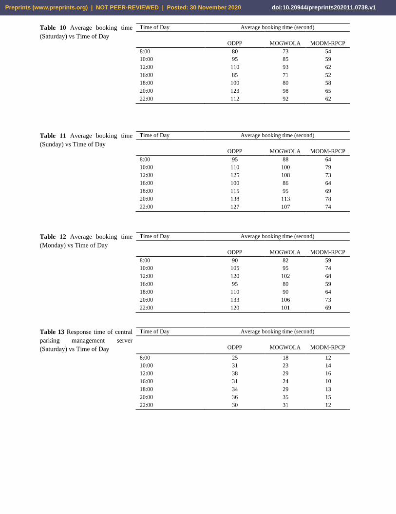
Table 10 Average booking time
(Saturday) vs Time of Day
Time of Day Average booking time (second)
ODPP
MOGWOLA
MODM-RPCP
8:00 80 73 54
10:00 95 85 59
12:00 110 93 62
16:00 85 71 52
18:00 100 80 58
20:00 123 98 65
22:00 112 92 62
Table 11 Average booking time
(Sunday) vs Time of Day
Time of Day Average booking time (second)
ODPP
MOGWOLA
MODM-RPCP
8:00 95 88 64
10:00 110 100 79
12:00 125 108 73
16:00 100 86 64
18:00 115 95 69
20:00 138 113 78
22:00 127 107 74
Table 12 Average booking time
(Monday) vs Time of Day
Time of Day Average booking time (second)
ODPP
MOGWOLA
MODM-RPCP
8:00 90 82 59
10:00 105 95 74
12:00 120 102 68
16:00 95 80 59
18:00 110 90 64
20:00 133 106 73
22:00 120 101 69
Table 13 Response time of central
parking management server
(Saturday) vs Time of Day
Time of Day Average booking time (second)
ODPP
MOGWOLA
MODM-RPCP
8:00 25 18 12
10:00 31 23 14
12:00 38 29 16
16:00 31 24 10
18:00 34 29 13
20:00 36 35 15
22:00 30 31 12
Preprints (www.preprints.org) | NOT PEER-REVIEWED | Posted: 30 November 2020 doi:10.20944/preprints202011.0738.v1

Table 14 Response time of central
parking management server
(Sunday) vs Time of Day
Time of Day Average booking time (second)
ODPP
MOGWOLA
MODM-RPCP
8:00 29 22 15
10:00 35 27 17
12:00 43 33 19
16:00 36 27 14
18:00 37 30 17
20:00 39 31 18
22:00 34 32 15
Table 15 Response time of central
parking management server
(Monday) vs Time of Day
Time of Day Average booking time (second)
ODPP
MOGWOLA
MODM-RPCP
8:00 24 17 10
10:00 30 22 12
12:00 35 28 14
16:00 30 22 9
18:00 33 25 12
20:00 34 26 13
22:00 29 27 12
Average booking time: Figure 9 shows the simulation results of average booking time in three days of
the week for the proposed method, ODPP, and MOGWOLA. As shown, this metric is shorter for the
proposed method than the two other methods in all three days. In the ODPP method, the machine
learning-based methods are used to predict the parking occupancy, and the learning is carried out using
the collected data, while the users might have different requests for which the machine is not learned. In
MOGWOLA, the grey wolf optimization is used to reduce the computation error, and as a result, the
node is localized and positioned faster. Thus, MOGWOLA outperforms ODPP. However, this method
also does not consider the user requests and does not discriminate between the users with different
durations (how long a user parks). In the proposed MODM-RPCP method, the system makes decisions
based on the users' requests and its duration and allocates a proper parking space to the user. As shown
in Figure 9, in all three days, at the first hours of the morning, the average booking time increases
because the offices are open and the number of users that need a parking space increases, and it decreases
at noon. Then, it increases again in the afternoon as the stores open and the requests increase. However,
the critical point is that in all hours of the day for all three simulated days, the proposed method
outperforms the other two methods and has a shorter average booking time. The main reason is that the
decision-making system decides based on each user's information and its duration.
Preprints (www.preprints.org) | NOT PEER-REVIEWED | Posted: 30 November 2020 doi:10.20944/preprints202011.0738.v1

A: Saturday
B: Sunday
C: Monday
Fig. 9 Average booking time vs Time of Day.
Response time of central parking management server: As shown in Figure 10, the server's response
time in different hours of the day in three days of the week for MODM-RPCP is shorter than ODPP and
MOGWOLA. Because in the proposed MODM-RPCP method, the decision-making system selects a
parking for each user based on its requirement and duration, and the users with shorter duration are
allocated to spaces close to the entrance/exit. On the other hand, in the proposed MODM-RPCP method,
a positioning terminal is used in each parking, that the user can use it with the RFID tag on the card and
the electronic map to find its parking slot fast. Also, in the proposed method, all payments are made
automatically using the RFID tag that reduces the response time. As seen in Figure 10, from 9 to noon,
the response time is increasing, because the offices are open and the requests for parking facilities is
high; thus, the number of requests to servers is high. From 12 to 16, as the offices are closed, the response
time decreases, and it increases again in the afternoon as the stores and markets open, and the requests
increase. The response time decreases again at the end of the night when the requests decrease. The
Preprints (www.preprints.org) | NOT PEER-REVIEWED | Posted: 30 November 2020 doi:10.20944/preprints202011.0738.v1

critical point is that in all hours of the day, the proposed method's response time is shorter than the two
other methods because of employing the decision-making system.
A: Saturday
B: Sunday
C: Monday
Fig. 10 Response time of central parking management server vs Time of Day
Therefore, the proposed MODM-RPCP method can allocate the best parking space using the decision-
making system and considering the users’ priorities. Also, using the RFID technology with the decision-
making system provides the possibility of fast entrance/exit to/from the multilevel parking without wasting
time and reducing energy consumption.
5 Conclusion
This paper proposes a way to find empty space in the parking lot using RFID technology. In the first phase,
the proposed MODM-RPCP method, using the decision-making system, and based on the preferences of
users, allocated the best space for parking the car. Then, in the second phase, using RFID technology along
with the decision-making system, it provides fast entry and exit from the large multi-storey car park without
wasting time and reducing energy consumption. The proposed MODM-RPCP was effective in terms of
parking space, according to the proposed optimal solution in all three different scenarios. In addition, the
simulation results show that the MODM-RPCP improves the average booking time, and response time of
Preprints (www.preprints.org) | NOT PEER-REVIEWED | Posted: 30 November 2020 doi:10.20944/preprints202011.0738.v1

the central parking management server, significantly. The proposed method calculated the optimal solution
in less time. It also ensured faster vehicle placement in the empty space and improved network
performance.
Conflict of Interest
None.
Reference 1. Lou, L., Li, Q., Zhang, Z., Yang, R., & He, W. (2020). An IoT Driven Vehicle Detection Method Based on Multi
source Data Fusion Technology for Smart Parking Management System. IEEE Internet of Things Journal.
2. Juwita, P. S., Fadhil, R., Damayanti, T. N., & Ramadan, D. N. (2020). Smart parking management system using SSGA
MQTT and real-time database. Telkomnika, 18(3).
3. Fotohi, R., Ebazadeh, Y., & Geshlag, M. S. (2016). A new approach for improvement security against DoS attacks in
vehicular ad-hoc network. International Journal of Advanced Computer Science and Applications, 7(7), 10-16.
4. Fotohi, R., & Jamali, S. (2014). A comprehensive study on defence against wormhole attack methods in mobile Ad
hoc networks. International journal of Computer Science & Network Solutions, 2, 37-56.
5. Jung, I. (2020). An IoT-based smart parking management system. International Journal of Computational Vision and
Robotics, 10(2), 122-132.
6. Perković, T., Šolić, P., Zargariasl, H., Čoko, D., & Rodrigues, J. J. (2020). Smart Parking Sensors: State of the Art
and Performance Evaluation. Journal of Cleaner Production, 262, 121181.
7. Zong, F., Yu, P., Tang, J., & Sun, X. (2019). Understanding parking decisions with structural equation modeling.
Physica A: Statistical Mechanics and its Applications, 523, 408-417.
8. Fotohi, R., Jamali, S., Sarkohaki, F., & Behzad, S. (2013). An Improvement over AODV routing protocol by limiting
visited hop count. International Journal of Information Technology and Computer Science (IJITCS), 5(9), 87-93.
9. Fotohi, R., Jamali, S., & Sarkohaki, F. (2013). Performance Evaluation of AODV, LHC-AODV, OLSR, UL-OLSR,
DSDV Routing Protocols. International Journal of Information Technology and Computer Science (IJITCS), 5, 21.
10. Zong, F., Yu, P., Tang, J., & Sun, X. (2019). Understanding parking decisions with structural equation modeling.
Physica A: Statistical Mechanics and its Applications, 523, 408-417.
11. Maravall, D., & de Lope, J. (2007). Multi-objective dynamic optimization with genetic algorithms for automatic
parking. Soft Computing, 11(3), 249-257.
12. Gao, G., Sun, H., & Wu, J. (2019). Activity-based trip chaining behavior analysis in the network under the parking
fee scheme. Transportation, 46(3), 647-669.
13. Fotohi, R., & Effatparvar, M. (2013). A cluster based job scheduling algorithm for grid computing. International
Journal of Information Technology and Computer Science (IJITCS), 5(12), 70-77.
14. Fotohi, R., Heydari, R., & Jamali, S. (2016). A Hybrid routing method for mobile ad-hoc networks. Journal of
Advances in Computer Research, 7(3), 93-103.
15. Zhang, C., Wang, Q., Wang, M., Chen, J., Liu, H., & Fu, S. (2018, August). Intelligent Parking Management System
Design from a Mobile Edge Computing (MEC) Perspective. In 2018 IEEE 88th Vehicular Technology Conference
(VTC-Fall) (pp. 1-5). IEEE.
16. Ornstein, J., Ornstein, J., & Rathod, N. (2019). U.S. Patent Application No. 16/142,113.
17. Segwick, T. (2002). THE KEY ROLE OF PARKING IN AN INTELLIGENT TRANSPORT INDUSTRY. In 9th
World Congress on Intelligent Transport SystemsITS America, ITS Japan, ERTICO (Intelligent Transport Systems
and Services-Europe).
18. Fotohi, R., Nazemi, E., & Aliee, F. S. (2020). An Agent-Based Self-Protective Method to Secure Communication
between UAVs in Unmanned Aerial Vehicle Networks. Vehicular Communications, 100267.
19. Fotohi, R., Firoozi Bari, S., & Yusefi, M. (2020). Securing wireless sensor networks against denial‐of‐sleep attacks
using RSA cryptography algorithm and interlock protocol. International Journal of Communication Systems, 33(4),
e4234.
20. Yang, Z., & Ma, D. (2002). Study on the implement technologies of urban traffic flow guidance system. In Traffic
And Transportation Studies (2002) (pp. 690-695).
Preprints (www.preprints.org) | NOT PEER-REVIEWED | Posted: 30 November 2020 doi:10.20944/preprints202011.0738.v1

21. Lan, K. C., & Shih, W. Y. (2014). An intelligent driver location system for smart parking. Expert Systems with
Applications, 41(5), 2443-2456.
22. Saharan, S., Kumar, N., & Bawa, S. (2020). An efficient smart parking pricing system for smart city environment: A
machine-learning based approach. Future Generation Computer Systems, 106, 622-640.
23. Fotohi, R. (2020). Securing of Unmanned Aerial Systems (UAS) against security threats using human immune system.
Reliability Engineering & System Safety, 193, 106675.
24. Fotohi, R., & Bari, S. F. (2020). A novel countermeasure technique to protect WSN against denial-of-sleep attacks
using firefly and Hopfield neural network (HNN) algorithms. The Journal of Supercomputing, 1-27.
25. Khalkhali, H., & Hosseinian, S. H. (2020). Multi-stage stochastic framework for simultaneous energy management of
slow and fast charge electric vehicles in a restructured smart parking lot. International Journal of Electrical Power &
Energy Systems, 116, 105540.
26. Zaminkar, M., Sarkohaki, F., & Fotohi, R. A method based on encryption and node rating for securing the RPL
protocol communications in the IoT ecosystem. International Journal of Communication Systems, e4693.
27. Faraji-Biregani, M., & Fotohi, R. (2020). Secure communication between UAVs using a method based on smart agents
in unmanned aerial vehicles. The Journal of Supercomputing, 1-28.
28. Zaminkar, M., & Fotohi, R. (2020). SoS‑RPL: Securing Internet of Things Against Sinkhole Attack Using RPL
Protocol‑Based Node Rating and Ranking Mechanism. WIRELESS PERSONAL COMMUNICATIONS.
29. Sarkohaki, F., Fotohi, R., & Ashrafian, V. (2020). An efficient routing protocol in mobile ad-hoc networks by using
artificial immune system. arXiv preprint arXiv:2003.00869.
30. Mabodi, K., Yusefi, M., Zandiyan, S., Irankhah, L., & Fotohi, R. (2020). Multi-level trust-based intelligence schema
for securing of internet of things (IoT) against security threats using cryptographic authentication. The Journal of
Supercomputing, 1-26.
31. Seyedi, B., & Fotohi, R. (2020). NIASHPT: a novel intelligent agent-based strategy using hello packet table (HPT)
function for trust Internet of Things. The Journal of Supercomputing, 1-24.
32. Jamali, S., Fotohi, R., & Analoui, M. (2018). An artificial immune system based method for defense against wormhole
attack in mobile adhoc networks. Tabriz Journal of Electrical Engineering, 47(4), 1407-1419.
33. Jamali, S., & Fotohi, R. (2017). DAWA: Defending against wormhole attack in MANETs by using fuzzy logic and
artificial immune system. the Journal of Supercomputing, 73(12), 5173-5196.
34. Jamali, S., & Fotohi, R. (2016). Defending against wormhole attack in MANET using an artificial immune system.
New Review of Information Networking, 21(2), 79-100.
35. Ghorpade, S. N., Zennaro, M., & Chaudhari, B. S. (2020). GWO Model for Optimal Localization of IoT-Enabled
Sensor Nodes in Smart Parking Systems. IEEE Transactions on Intelligent Transportation Systems.
36. Buldakov, N., Khalilev, T., Distefano, S., & Mazzara, M. (2020, May). An Open Source Solution for Smart Contract-
Based Parking Management. In IFIP International Conference on Open Source Systems (pp. 55-69). Springer, Cham.
37. Jung, S., & Kim, S. (2020). A Study of Promoting Method a traditional market by implementing RFID technology
and 6W1H context awareness. Journal of Convergence for Information Technology, 10(10), 9-14.
38. Salah, B. (2020). Design, simulation, and performance-evaluation-based validation of a novel RFID-based automatic
parking system. SIMULATION, 96(5), 487-497.
Preprints (www.preprints.org) | NOT PEER-REVIEWED | Posted: 30 November 2020 doi:10.20944/preprints202011.0738.v1