22
33
11
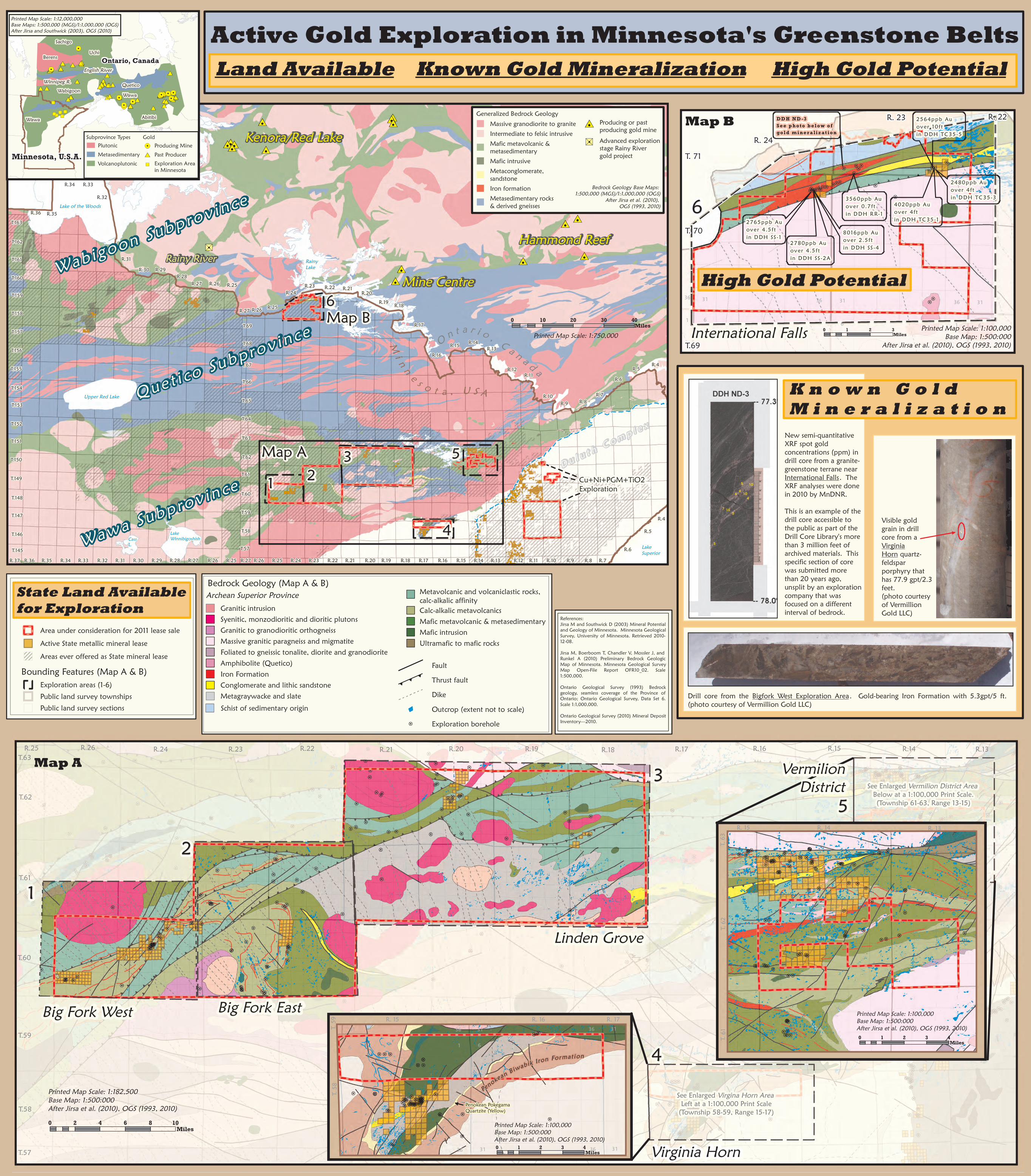
Map A
44Big Fork West Big Fork East
Linden Grove
Virginia Horn
3136 3631 31
61616
31363131 36
See Enlarged Vermilion District Area Below at a 1:100,000 Print Scale.(Township 61-63, Range 13-15)
See Enlarged Virgina Horn Area Left at a 1:100,000 Print Scale(Township 58-59, Range 15-17)
0 1 2 3 4Miles
0 2 4 6 8 10Miles
0 1 2 3 4Miles
VermilionDistrict
T.145
T.146
T.147
T.148
T.149
T.150
T.151
T.152
T.153
T.154
T.155
T.156
T.157
T.158
T.159
T.160
T.161
T.162
T.163R.36 R.35
R.34 R.33R.32
R.31R.30 R.29
R.28R.27 R.26 R.25
R.27 R.26 R.25R.24
R.23 R.22 R.21 R.20R.19 R.18
R.17
R.16R.15 R.14
R.13
R.12 R.11
R.10R.9 R.8
R.7
R.6R.5 R.4
T.69
T.68
T.67
T.66
T.65
T.64
T.63
T.62
T.61
T.60
T.59
T.58
T.57 R.6
R.5R.4
D u l u t h C o m p l e x
Cu+Ni+PGM+TiO2Exploration
T.62
R.26R.25 R.24 R.23 R.22 R.21 R.20 R.19T.63
T.61
T.60
T.59
T.58
T.57
R.18 R.17 R.16 R.15 R.14 R.13
T. 59 R. 15 R. 16 R. 17
55R. 14 R. 13R. 15
T. 62
T. 61
Que t i co Subprov in ce
Wawa Subprov in ce
Wab igoon Subp rov ince
Rainy River
Kenora/Red Lake
Mine Centre
Hammond Reef
Map AMap A
Map BMap B
332211
55
44
66
R.25R.26R.27R.28R.29R.30R.31R.32R.33R.34R.35R.36 R.27 R.25R.26 R.24 R.23 R.22 R.21 R.20 R.19 R.18 R.17 R.16 R.15 R.14 R.13 R.12 R.11 R.10 R.9 R.8 R.7R.37
Upper Red Lake
Lake of the Woods
LakeWinnibigoshishCassL.
O n t a r i o , C a n a d a
M i n n e s o t a , U S A
Minnesota, U.S.A.
Ontario, Canada
Wawa
WabigoonWinnipeg R.
English RiverQueticoWawa
Abitibi
UchiBerens
Sachigo
Penokean B iwabik Iron Format ion
Penokean Pokegama Quartzite (Yellow)
Printed Map Scale: 1:182,500Base Map: 1:500:000After Jirsa et al. (2010), OGS (1993, 2010)
0 10 20 30 40Miles
Printed Map Scale: 1:750,000
Printed Map Scale: 1:100,000Base Map: 1:500:000After Jirsa et al. (2010), OGS (1993, 2010)
Printed Map Scale: 1:100,000Base Map: 1:500:000After Jirsa et al. (2010), OGS (1993, 2010)
Printed Map Scale: 1:12,000,000Base Maps: 1:500,000 (MGS)/1:1,000,000 (OGS)After Jirsa and Southwick (2003), OGS (2010) Active Gold Exploration in Minnesota's Greenstone BeltsHigh Gold PotentialLand Available Known Gold Mineralization
Bounding Features (Map A & B)Exploration areas (1-6)
Public land survey sectionsPublic land survey townships
Active State metallic mineral leaseArea under consideration for 2011 lease sale
Areas ever offered as State mineral lease
PlutonicMetasedimentaryVolcanoplutonic
Subprovince TypesProducing MinePast ProducerExploration Areain Minnesota
Gold
Visible goldgrain in drillcore from aVirginiaHorn quartz-feldsparporphyry thathas 77.9 gpt/2.3feet.(photo courtesyof VermillionGold LLC)
Drill core from the Bigfork West Exploration Area. Gold-bearing Iron Formation with 5.3gpt/5 ft.(photo courtesy of Vermillion Gold LLC)
New semi-quantitativeXRF spot goldconcentrations (ppm) indrill core from a granite-greenstone terrane nearInternational Falls. TheXRF analyses were donein 2010 by MnDNR.This is an example of thedrill core accessible tothe public as part of theDrill Core Library's morethan 3 million feet ofarchived materials. Thisspecific section of corewas submitted morethan 20 years ago,unsplit by an explorationcompany that wasfocused on a differentinterval of bedrock.
K n o w n G o l d M i n e r a l i z a t i o n
Granitic intrusionSyenitic, monzodioritic and dioritic plutonsMassive granitic paragneiss and migmatite
Schist of sedimentary origin
Foliated to gneissic tonalite, diorite and granodioriteAmphibolite (Quetico)
Granitic to granodioritic orthogneiss
Metagraywacke and slateIron FormationConglomerate and lithic sandstone
Bedrock Geology (Map A & B)Archean Superior Province
Exploration borehole
Fault
DikeThrust fault
Outcrop (extent not to scale)
Mafic intrusionUltramafic to mafic rocksMafic metavolcanic & metasedimentaryCalc-alkalic metavolcanicsMetavolcanic and volcaniclastic rocks, calc-alkalic affinity
T. 58
T. 63
References:Jirsa M and Southwick D (2003) Mineral Potentialand Geology of Minnesota. Minnesota GeologicalSurvey, University of Minnesota. Retrieved 2010-12-08.Jirsa M, Boerboom T, Chandler V, Mossler J, andRunkel A (2010) Preliminary Bedrock GeologicMap of Minnesota. Minnesota Geological SurveyMap Open-File Report OFR10_02. Scale1:500,000.Ontario Geological Survey (1993) Bedrockgeology, seamless coverage of the Province ofOntario; Ontario Geological Survey, Data Set 6.Scale 1:1,000,000.Ontario Geological Survey (2010) Mineral DepositInventory—2010.
LakeSuperior
RainyLake
Massive granodiorite to graniteIntermediate to felsic intrusive
Mafic intrusive
Iron formationMetaconglomerate, sandstone
Metasedimentary rocks& derived gneisses
Mafic metavolcanic & metasedimentary
Generalized Bedrock Geology
Bedrock Geology Base Maps: 1:500,000 (MGS)/1:1,000,000 (OGS)After Jirsa et al. (2010), OGS (1993, 2010)
36
1 6
36 31
1 6
3136 31
6
1 6
36 31 36 31
1 6 16
DD H N D -3S e e p h o to b e l o w o fgo l d m i n e r a li z at i o n
2564ppb Auover 10 f tin DDH TC35-5
2480ppb Auover 4 f tin DDH TC35-33560ppb Au
over 0 .7 f tin DDH RR-1
2780ppb Auover 4 .5 f tin DDH SS -2A
2765ppb Auover 4 .5 f tin DDH SS -1
4020ppb Auover 4 f tin DDH TC35-1
Map B
66
R. 22R. 23R. 24
T. 70
T. 71
T.69Printed Map Scale: 1:100,000Base Map: 1:500:000After Jirsa et al. (2010), OGS (1993, 2010)
0 1 2 3MilesInternational Falls
High Gold Potential
8016ppb Au over 2 .5 f tin DDH SS -4
Producing or past producing gold mineAdvanced explorationstage Rainy Rivergold project
State Land Availablefor Exploration