DRAFT ENVIRONMENTAL IMPACT REPORTCITY OF GLENDALE BIOGAS RENEWABLE GENERATION PROJECT
ENVIRONMENTAL IMPACT ANALYSIS
4.105
4.3 BIOLOGICAL RESOURCES
Acronyms
AMSL Above mean sea level
BMP Best Management Practice
BRTR Biological Resources Technical Report
BSA Project Biological Study Area
CCH Consortium of California Herbaria
CDFW California Department of Fish and Wildlife
CEQA California Environmental Quality Act
CFR Code of Federal Regulations
CNDDB California Natural Diversity Database
CNPS California Native Plant Society
CRPR California Rare Plant Rank
CWA Clean Water Act
dbh Diameter at breast height
EPA Environmental Protection Agency
ESA Endangered Species Act
FE Federally Endangered
FT Federally Threatened
GPS Global positioning system
MBTA Migratory Bird Treaty Act
MCVII A Manual of California Vegetation
NPPA Native Plant Protection Act
O&M Operations and maintenance
R4SBA Riverine, Intermittent, Streambed, Temporary Flooded
RWQCB Regional Water Quality Control Board
SA Special Animal
SCLF Scholl Canyon Landfill
SE State Endangered
SEA Significant Ecological Area
SFP State Fully Protected
SSC Species of Special Concern
ST State Threatened
USACE United States Army Corps of Engineers
USFWS United States Fish and Wildlife Service
USGS United States Geological Survey
WDR Waste Discharge Requirements
WEAP Worker Environmental Awareness Program
WL Watch List

DRAFT ENVIRONMENTAL IMPACT REPORTCITY OF GLENDALE BIOGAS RENEWABLE GENERATION PROJECT
ENVIRONMENTAL IMPACT ANALYSIS
4.106
4.3.1 Environmental Setting
This section describes the effects to biological resources that may result from the implementation of the
proposed Project. An analysis was conducted within a 235-acre Project Biological Study Area (BSA),
which includes the southern and western sections of the Scholl Canyon Landfill (SCLF) and adjacent
lands proposed for the development of the proposed Project components and a surrounding 300-foot
buffer area. The analysis included field evaluations, which involved reconnaissance-level surveys, habitat
assessments, and focused rare plant surveys, as well as a literature review to determine special-status
plants, wildlife, and vegetation communities that have been documented within the vicinity of the
proposed Project. A complete Biological Resources Technical Report (BRTR) can be found in Appendix
C.
In addition, this section includes vegetation communities and land cover types within the proposed Project
area to characterize the botanical resources and potential for wildlife to occur on the proposed Project
site. Biotic habitats suitable for the occurrence of plant and wildlife species of special-status (State and
Federally listed threatened and endangered species, Federal candidate species, California Native Plant
Society List species, California Fully Protected species, and California Species of Special Concern) are
also described.
4.3.1.1 Baseline Data Collection Methodology
Stantec biologists conducted several surveys within the BSA to evaluate potential Project impacts on
biological resources. Field evaluations were conducted on October 21, 2015, November 3, 2015, January
15, 2016, and July 11, 2017, with focused rare plant surveys occurring on January 15, April 15, and
September 8, 2016. The results of these surveys were presented in a BRTR prepared by Stantec, dated
July 20, 2017.
An additional reconnaissance-level survey was completed on April 29, 2019, which was proceeded by
preliminary literature review of resources relevant to environmental conditions within the BSA, including
the 2017 BRTR. The field assessment included a non-protocol24 survey for plants, wildlife, and other
biological resources intended to detect the presence of special-status plant and wildlife species, including
nesting birds. The survey was conducted on foot within the BSA where accessible based on terrain,
vegetative cover, and accessibility.
4.3.1.2 Literature Review
A literature search focused on the BSA was completed prior to the field survey. The BSA is located within
the United States Geological Survey (USGS) Pasadena, California, 7.5-minute topographic quadrangle. A
search of the California Department of Fish and Wildlife (CDFW) California Natural Diversity Database
(CNDDB) was conducted for this quadrangle to determine whether special-status plants, wildlife, and
24 Outside of the previous seasonally timed surveys and did not involve multiple visits to the project area throughout the season “inorder to properly capture the floristic diversity at a level necessary to determine if special status plants are present (CDFW 2009).
DRAFT ENVIRONMENTAL IMPACT REPORTCITY OF GLENDALE BIOGAS RENEWABLE GENERATION PROJECT
ENVIRONMENTAL IMPACT ANALYSIS
4.107
vegetation communities have been documented within the vicinity of the BSA25. The following eight
adjacent quadrangles were also included in the database search to encompass potential occurrences of
special-status species in the region surrounding the BSA:
Sunland
Condor Peak
Chilao Flat
Burbank
Mount Wilson
Hollywood
Los Angeles
El Monte
Additional data regarding the potential occurrence of special-status species and policies relating to these
special-status natural resources were gathered from the following sources:
State and federally listed endangered and threatened animals of California26;
Special Animals List27;
List of California Sensitive Natural Terrestrial Communities28;
Inventory of Rare and Endangered Vascular Plants of California29; and
Consortium of California Herbaria (CCH, 2018).
4.3.1.3 Habitat Assessment and Biological Surveys
Site Reconnaissance and Wildlife Surveys
In order to document the environmental conditions, present within the BSA, Stantec conducted a habitat
assessment and reconnaissance-level survey on April 29, 2019; Stantec previously conducted
reconnaissance-level surveys of the area in October/November 2015, January/April/September 2016, and
July 2017. The primary goal of the surveys was to identify and assess habitat that may be capable of
supporting special-status plant or wildlife species and to determine the potential need for additional
focused surveys for special-status resources. Biologists also recorded all incidental plant and wildlife
observations.
Experienced field biologists walked transects through accessible portions of the BSA at an average pace
of approximately 1.5 kilometer/hour while visually scanning for signs and sounds of wildlife including
songs and calls. Biologists halted approximately every 50 meters to listen for wildlife or as necessary to
identify, record, or enumerate any detected species. Terrestrial insects and other invertebrates were
searched for on flowers and leaves, under loose bark, and under stones and logs on the ground
throughout the BSA. Randomly selected areas within appropriate micro habitats (e.g., leaf litter, woody
25 CDFW (California Department of Fish and Wildlife). 2019. RAREFIND database ed.3.1.1. Electronic database managed by theCalifornia Natural Diversity Data Base, Wildlife Data and Habitat Analysis Branch, California Department of Fish and Wildlife.Sacramento, CA.26 CDFW. 2018. State and Federally Listed Endangered and Threatened Animals of California. August.27 CDFW. 2018b. Special Animals List. November.28 CDFW. 2018c. California Natural Diversity Data Base List of California Sensitive Natural Terrestrial Communities.https://www.wildlife.ca.gov/Data/VegCAMP/Natural-Communities29 CNPS (California Native Plant Society). 2019. Inventory of rare and endangered plants. California Native Plant Society.Sacramento. (online edition, v8-03 0.39). Website http://www.rareplants.cnps.org. Accessed May 2019.

DRAFT ENVIRONMENTAL IMPACT REPORTCITY OF GLENDALE BIOGAS RENEWABLE GENERATION PROJECT
ENVIRONMENTAL IMPACT ANALYSIS
4.108
debris piles, etc.) were hand raked or visually inspected to determine the presence/absence of
gastropods, reptiles, small mammals, and amphibians. Species present were identified and recorded
through direct visual observation, sound, or their sign (e.g., scat, tracks, etc.) and all potential refugia
sites search were returned to their original state after inspection. Species identifications conform to the
most up-to-date field guides and technical literature.
The surveys were conducted during the recognized bird breeding/nesting season30 and time of day when
resident and migratory birds would be expected to be present and potentially exhibiting nesting activity,
where small mammals would be active and detectable visually or by sign, and above-ground amphibian
and reptile movement would generally be detectable. However, it should be noted that some wildlife
species and/or individuals may have been difficult to detect due to their elusive nature, cryptic
morphology, or nocturnal behavior. Surveys were conducted during daylight hours when temperatures
were such that reptiles and other wildlife would be active (i.e., between 65-95° Fahrenheit).
Vegetation Mapping
Vegetation mapping was conducted concurrently with the reconnaissance survey; please refer to Figure
4.3-1 for Vegetation Communities and Land Coverage Types. Vegetation descriptions and nomenclature
are based on Sawyer et al. (2009), where applicable, and have been defined at least to the alliance level.
Vegetation maps were prepared by recording tentative vegetation type boundaries over recent aerial
photograph base maps using the Esri® Collector for ArcGIS app on an Apple® iPad® coupled with a Bad
Elf® GNSS Surveyor sub-meter external global positioning system (GPS) unit. Mapping was further
refined in the office using ArcGIS (version 10.4) with aerial photograph base maps with an accuracy of
one foot. Most boundaries shown on the maps are accurate within approximately three feet; however,
boundaries between some vegetation types are less precise due to difficulties interpreting aerial imagery
and accessing stands of vegetation.
Vegetation communities can overlap in many characteristics and over time may shift from one community
type to another. Note also that all vegetation maps and descriptions are subject to variability for the
following reasons:
* In some cases, vegetation boundaries result from distinct events, such as wildfire or flooding, butvegetation types usually tend to integrate on the landscape, without precise boundaries betweenthem. Even distinct boundaries caused by fire or flood can be disguised after years of post-disturbance succession. Mapped boundaries represent best professional judgment, but usuallyshould not be interpreted as literal delineations between sharply defined vegetation types.
* Natural vegetation tends to exist in generally recognizable types, but also may vary over time andgeographic region. Written descriptions cannot reflect all local or regional variation. Many (perhapsmost) stands of natural vegetation do not strictly fit into any named type. Therefore, a mapped unit isgiven the best name available in the classification system being used, but this name does not implythat the vegetation unambiguously matches written descriptions.
* Vegetation tends to be patchy. Small patches of one named type are often included within largerstands mapped as units of another type.
30 February 1 – September 15

!(!(
4.3-1
City of Glendale Water and PowerBiogas Renewable Generation ProjectEnvironmental Impact Report
185804356Glendale, Ca
Prepared by DL on 2019-05-2TR by RB on 2019-05-17
IR Review by SR on 2019-05-22
Vegetation Communities & Land Cover TypesNotes1. Coordinate System: WGS 1984 Web Mercator Auxiliary Sphere2. Background: Source: Esri, DigitalGlobe, GeoEye, Earthstar Geographics, CNES/AirbusDS, USDA, USGS, AeroGRID, IGN, and the GIS User Community
($$¯Project Location
Client/Project
Figure No.
Title
0 170 340metres
(At original document size of 11x17) 1:8,941
Biological Study Area
Potentially Jurisdictional Drainage FeaturesVegetation Communities & Landcover Types
Annual Brome Grassland
Black Sage Scrub
California Buckwheat Scrub
California Sagebrush - California Buckwheat Scrub
California Sagebrush Scrub
Chamise Chaparral
Coast Live Oak Woodland
Fountain Grass Swards
Laurel Sumac Scrub
Ornamental Woodland
Disturbed/ Developed
Project Components
Proposed Power Plant Facility Boundary
Proposed Water Pipeline
Proposed Gas Pipeline
!( New Water Tank

DRAFT ENVIRONMENTAL IMPACT REPORTCITY OF GLENDALE BIOGAS RENEWABLE GENERATION PROJECT
ENVIRONMENTAL IMPACT ANALYSIS
4.110
This page has been intentionally left blank.

DRAFT ENVIRONMENTAL IMPACT REPORTCITY OF GLENDALE BIOGAS RENEWABLE GENERATION PROJECT
ENVIRONMENTAL IMPACT ANALYSIS
4.111
Regional Setting
The proposed Project is located within the City of Glendale in Los Angeles County, CA, just south of Flint
Peak in the San Rafael Hills to the north of California State Route 134. The BSA ranges in elevation from
approximately 940 feet (~286 meters) above mean sea level (AMSL) along Glenoaks Canyon Drive at the
western boundary of the BSA to 1,530 feet (~466 meters) AMSL at its southeastern extent. The majority
of the lands within the BSA are developed with active and reclaimed areas of the landfill occupying a
significant portion of the BSA and other urban infrastructure including residential developments,
roadways, and recreational open space. The slopes along the northern and southern edges of the BSA
are undeveloped and support swathes of relatively undisturbed native habitat as described in further
detail below.
The lands immediately surrounding the BSA primarily consist of open space within the San Rafael Hills,
though residential developments about the SCLF to the west and northeast. Beyond the buffer of
relatively undeveloped hillside encircling the SCLF, the region is significantly built out with urban
infrastructure, thus creating a small “island” of the San Rafael Hills that includes areas of undisturbed
native habitat.
Habitat in the BSA includes a variety of upland communities, native and ornamental woodlands, and
developed/disturbed lands. Predominantly located within the western and southern portions of the BSA
upland scrub plant communities are dominated by black sage (Salvia mellifera), laurel sumac (Malosma
laurina), and chamise (Adenostoma fasciculatum). Along the west-facing slope of the landfill is a
reclaimed area that has been planted with a variety of ornamental trees including Peruvian pepper
(Schinus molle), southern silky oak (Grevillea robusta), fan palm (Washingtonia robusta), and eucalyptus
(Eucalyptus spp.).
Existing ConditionsVegetation
Generally, mapping and description of plant communities follows the classification system described in
the second edition of A Manual of California Vegetation (MCVII) (Sawyer et al., 2009). As defined in
MCVII, an alliance is defined as “a category of vegetation classification which describes repeating
patterns of plants across a landscape. Each alliance is defined by plant species composition, and reflects
the effects of local climate, soil, water, disturbance, and other environmental factors.” Vegetation
communities and land cover types mapped within the BSA are presented below in Table 22. It should be
noted that due to changes in the nomenclature for some of the vegetation communities mapped within the
BSA, as well as minor variations in site conditions, the names of mapped vegetation community and land
cover types from the 2019 surveys do not always match those from the 2017 surveys. Table 22 presents
a cross-listing of vegetation communities and land cover types for ease of comparison (where applicable).
Species’ scientific and common names correspond to those described in the second edition of the Jepson
Manual (Baldwin et al., 2012). Within the BSA, nine plant communities defined by Sawyer et al. (2009)
and two additional land cover types, classified as ornamental woodland and disturbed/developed land
were mapped. Characteristics of these land cover types are summarized below, and their locations are
depicted in Appendix C.

DRAFT ENVIRONMENTAL IMPACT REPORTCITY OF GLENDALE BIOGAS RENEWABLE GENERATION PROJECT
ENVIRONMENTAL IMPACT ANALYSIS
4.112
Table 22 Project Temporary and Permanent Site Modification
Vegetation Community / Land Cover Type Total Acres in Survey Area
2019 Survey 2017 Survey2019 Survey
(Acres)2017 Survey
(Acres)
Annual Brome Grassland -- 10.48 --
Black Sage Scrub California Encelia-Black SageScrub
8.0 5.67
California Buckwheat Scrub -- 1.75 --
California Sagebrush Scrub California Sagebrush Scrub 0.44 0.31
California Sagebrush-CaliforniaBuckwheat Scrub
California Buckwheat Scrub 2.84 7.11
Chamise chaparral Scrub Oak -ChamiseChaparral
4.82 2.40
Coast live oak woodland Coast live oak woodland 2.95 1.3
Fountain Grass Swards -- 14.49 --
Laurel Sumac Scrub Lauren Sumac ChamiseScrub
70.57 50
Developed / Disturbed Cleared / Developed 87.18 86.75
Ornamental Woodland Ornamental/ Non- Native 31.75 39.14
Total: 235.27 192.68
Vegetation Community Descriptions
BROMUS (DIANDRUS, HOREDEACEUS) – BRACHYPODIUM DISTACHYON HERBACEOUS SEMI-
NATURAL ALLIANCE
Annual brome grasslands
Approximately 10.48 acres of this vegetation community occur within the BSA in several disturbed areas
of the SCLF. It was dominated by early successional, non-native, grasses and forbs (90 percent to 100
percent absolute aerial coverage), including invasive species such as red brome ripgut brome (Bromus
diandrus), (Bromus madritensis var. rubens), redstem filaree (Erodium cicutarium), California burclover
(Medicago polymorpha), shortpod mustard (Hirschfeldia incana), cheeseweed (Malva parviflora), wild
radish (Raphanus sativus), Russian thistle (Salsola tragus), and yellow sweetclover (Melilotus indica).
Due to changes in site conditions, expansion of the BSA, and differences in nomenclature, this
community was not detailed during surveys prior to 2019. During the previous survey efforts, the areas
comprising this vegetation community were mapped as a mixture of Cleared/Developed Land, Disturbed,
Ornamenta/Non-Native, California Sagebrush Scrub, and California Buckwheat Scrub.

DRAFT ENVIRONMENTAL IMPACT REPORTCITY OF GLENDALE BIOGAS RENEWABLE GENERATION PROJECT
ENVIRONMENTAL IMPACT ANALYSIS
4.113
SALVIA MELLIFERA SHRUBLAND ALLIANCE
Black sage scrub
Approximately 8.0 acres of this vegetation community occur within the BSA on a south-facing slope to the
west of the SCLF. Black sage (Salvia mellifera) is the dominant species with California bush sunflower
(Encelia californica) being a near co-dominant. Other associated shrub species observed included laurel
sumac (Malosma laurina), chamise (Adenostoma fasciculatum), and the understory in openings within the
scrub consisted of native and non-native grasses and forbs common to the BSA.
ERIOGONUM FASCICULATUM SHRUBLAND ALLIANCE
California buckwheat scrub
Approximately 1.75 acres of this habitat type occur in a small area between the SCLF and the golf course
to the north. This community appears to occupy a previously disturbed area and is likely the result of a
revegetation effort. California buckwheat (Eriogonum fasciculatum) is the dominant species, but other
species observed included bush monkeyflower (Mimulus aurantiacus), black sage, California fuchsia
(Epilobium canum), sawtooth goldenbush (Hazardia squarrosa), and the invasive species fountain grass
(Pennisetum setaceum) and shortpod mustard (Hirschfeldia incana).
ARTEMISIA CALIFORNICA SHRUBLAND ALLIANCE
California sagebrush scrub
Approximately 0.44 acre of this habitat type occurs within a small, sloped area near the western edge of
the BSA, adjacent to E. Glenoaks Boulevard. This disturbed slope has been revegetated with a planting
mixture including California sagebrush (Artemisia californica) and California buckwheat, though non-
native species have since filled in the opening in the shrub layer, including Russian thistle and annual
grasses.
ARTEMISIA CALIFORNICA – ERIOGONUM FASCICULATUM SHRUBLAND ALLIANCE
California sagebrush – California buckwheat scrub
Approximately 2.84 acres of this habitat type occur along thin strips of steep, north-facing slopes adjacent
to Scholl Canyon Road along the southern border of the SCLF. Within the BSA, these areas are
dominated by California sagebrush and California buckwheat though scrub oak (Quercus berberidifolia) is
also present in the shrub layer along with non-native species including shortpod mustard and Russian
thistle, and annual grasses and fobs in the understory.
DRAFT ENVIRONMENTAL IMPACT REPORTCITY OF GLENDALE BIOGAS RENEWABLE GENERATION PROJECT
ENVIRONMENTAL IMPACT ANALYSIS
4.114
ADENOSTOMA FASCICULATUM SHRUBLAND ALLIANCE
Chamise chaparral
Approximately 4.82 acres of this vegetation community occurs on a south facing slope immediately south
of the baseball field in the northern portion of the BSA. It is dominated by chamise (Adenostoma
fasciculatum) with other components of the shrub layer including toyon (Heteromeles arbutifolia),
California buckwheat, bush monkeyflower, California sagebrush, and hollyleaf cherry (Prunus ilicifolia).
Understory occupying openings within the shrub layer is comprised primarily of sparse non-native grasses
and forbs.
QUERCUS AGRIFOLIA WOODLAND ALLIANCE
Coast live oak woodland
A small area (approximately 2.95 acres) occupied by this plant community occurs on the north-facing
slope between the SCLF and residential area to the west, in the western portion of the BSA. Cover in this
area is dominated by coast live oak trees (Quercus agrifolia), though toyon and laurel sumac shrubs were
also observed interspersed throughout this area.
PENNISETUM SETACEUM HERBACEOUS SEMI-NATURAL ALLIANCE
Fountain grass swards
Within the BSA, approximately 14.49 acres of this community occurs on the slopes of a reclaimed area of
the SCLF in the northern portion of the BSA, to the south of the golf course. The reclamation process
appears to have included revegetation of the slopes with a planting mixture consisting of non-native
fountain grass. This perennial species is known to become invasive in southern California and it has
come to dominate this area. Native species are also present at lower cover, including California
buckwheat, sawtooth goldenbush, and California fuchsia.
Due to changes in site conditions, expansion of the BSA, and differences in nomenclature, this
community was not detailed during surveys prior to 2019. During the previous survey efforts, the areas
comprising this vegetation community were mapped as a mixture of Cleared/Developed Land,
Ornamenta/Non-Native, and California Buckwheat Scrub.
MALOSMA LAURINA SHRUBLAND ALLIANCE
Laurel sumac scrub
This is the most prominent native plant community within the BSA, approximately 70.57 acres of which
occur along the hillsides bordering the southern and northern boundaries of the BSA. Laurel sumac is
nearly co-dominant with chamise throughout these areas. Other associated species observed included
lemonade berry (Rhus integrifolia), toyon, purple sage (Salvia leucophylla), black sage, deerweed
DRAFT ENVIRONMENTAL IMPACT REPORTCITY OF GLENDALE BIOGAS RENEWABLE GENERATION PROJECT
ENVIRONMENTAL IMPACT ANALYSIS
4.115
(Acmispon glaber), bush monkeyflower, bigpod ceanothus (Ceanothus megacarpus), California
brickellbush (Brickellia californica), and non-native Russian thistle.
Land Cover Type Descriptions
DEVELOPED/DISTURBED LAND
This classification, which is not described in the MCVII, was used to map the portions of the BSA
(approximately 87.18 acres) that are heavily disturbed and/or developed. Developed/disturbed lands
include portions of the SCLF and areas occupied by urban infrastructure such as residential
developments, recreational areas (baseball diamond and golf course), paved areas such as roads and
parking lots, and landscaped areas associated with those developments. In general, these areas are
populated with ornamental species or are unvegetated. Where vegetation does occur, it is comprised of
ornamental species or ruderal pioneer plant species that readily colonize open disturbed soil and thrive as
a result of anthropogenic impacts. Some of the plants present within this cover type included red-stem
filaree, tocalote (Centaurea melitensis), wild oats (Avena fatua), and other non-native grasses and forbs.
ORNAMENTAL WOODLAND
This classification, which is not described in the MCVII, was used to map approximately 31.75 acres
within the central portion of the BSA. This west-facing slope is a reclaimed area of the landfill that has
been planted with a variety of ornamental trees including Peruvian pepper (Schinus molle), southern silky
oak (Grevillea robusta), fan palm (Washingtonia robusta), and eucalyptus (Eucalyptus spp.). Other non-
native species observed consisted of castor bean (Ricinis communis), pampas grass (Cortaderia
selloana), fountain grass, English plantain (Plantago lanceolata), red-stem filaree, lamb’s quarters
(Chenopodium album), Russian thistle, and annual grasses.
Jurisdictional Wetlands/Waters
The National Wetlands Inventory (USFWS, 2018a) has mapped R4SBA (Riverine, Intermittent,
Streambed, Temporary Flooded) habitat within the BSA that consist of the headwaters in the hills along
its southern boundary (data is dated March 2006). While a formal delineation of jurisdictional waters has
not been conducted, the south-facing canyons in this area of the BSA did support conditions indicative of
this type of feature, with flows originating from within the BSA entering into the storm drain system
adjacent to the Eagle Rock Reservoir and likely ending up in the Arroyo Seco. Additionally, concrete-lined
drainage channels were observed throughout the landfill and reclaimed areas that contribute flows to the
stormwater conveyance system through Scholl Canyon, downslope of the SCLF, and ultimately into the
Verdugo Wash. Based on field observations, the concrete-lined channels and headwaters described
above may qualify as United States Army Corps of Engineers (USACE)/ Regional Water Quality Control
Board (RWQCB) non-wetland waters of the U.S. and/or California Department of Fish and Wildlife
(CDFW) jurisdictional waters.

DRAFT ENVIRONMENTAL IMPACT REPORTCITY OF GLENDALE BIOGAS RENEWABLE GENERATION PROJECT
ENVIRONMENTAL IMPACT ANALYSIS
4.116
Common Wildlife
This section describes the common wildlife observed during the reconnaissance survey and species that
are expected to occur within the BSA based on habitat characteristics/suitability and species known to
occur in the region. A complete list of wildlife observed during the surveys are located in Appendix C.
Invertebrates and Gastropods
A focused insect survey was not performed within the BSA; however, a variety of common insects are
known to occur in the area. Habitat conditions in the BSA provide a suite of microhabitat conditions for a
wide variety of terrestrial insects and other invertebrates. As in all ecological systems, invertebrates in the
BSA play a crucial role in a number of biological processes. They serve as the primary or secondary food
source for a variety of bird, reptile, and mammal predators; they provide important pollination vectors for
numerous plant species; they act as efficient components in controlling pest populations; and they
support the naturally occurring maintenance of an area by consuming detritus and contributing to
necessary soil nutrients. The reconnaissance survey of the BSA detected a wide variety of common and
non-native invertebrates. Some of the orders identified in the BSAs included Hemiptera (true bugs),
Coleoptera (beetles), Diptera (flies), Lepidoptera (moths and butterflies), Hymenoptera (wasps, bees and
ants), and Orthoptera (grasshoppers).
Fish
Based on the historic land uses, topography within the BSA, and a lack of suitable aquatic habitat fish are
not expected to occur nor were any observed during the 2019 surveys.
Amphibians
Amphibians often require a source of standing or flowing water to complete their life cycle; however,
some terrestrial species can survive in drier areas by remaining in moist environments found beneath leaf
litter and fallen logs, or by burrowing into the soil. Amphibian species were not observed during the
reconnaissance surveys within the BSA. Their potential to occur within much of the BSA is greatly
reduced because of the continual disturbance associated with the land use. However, they may inhabit
other less disturbed areas within the BSA, such as the slopes surrounding SCLF. Species not observed in
the BSA but known to occur in the region include the Baja California treefrog (Pseudacris
hypochondriaca), western toad (Anaxyrus boreas), and the non-native bullfrog (Lithobates catesbeiana).
These species all require aquatic habitat for all or part of their life cycle, which is only present during and
immediately after substantial rain events, and therefore are not likely to occur within the BSA outside of
the rainy season, generally from November through March. These species are highly cryptic and often
difficult to detect. Downed logs, bark, and other woody material in various stages of decay (often referred
to as coarse woody debris), present in a limited section of the BSA, could provide shelter and feeding
sites for a variety of wildlife, including amphibians and reptiles.31 32
31 Maser, C. and J.M. Trappe, tech eds. 1984. The seen and unseen world of the fallen tree. Gen. Tech. Rep. PNW-164. Portland,OR: U.S. Department of Agriculture, Forest Service, Pacific Northwest Research Station. 56 pp.32 Aubry, K. B., L. L. C. Jones, and P. A. Hall. 1988. Use of woody debris by plethodontid salamanders in Douglas-fir in Washington.Pages 32-37 in R. C. Szabo, K. E. Severson, and D. R. Patton, technical coordinators. Management of amphibians, reptiles and

DRAFT ENVIRONMENTAL IMPACT REPORTCITY OF GLENDALE BIOGAS RENEWABLE GENERATION PROJECT
ENVIRONMENTAL IMPACT ANALYSIS
4.117
Reptiles
The number and type of reptile species that may occur at a given site is related to a number of biotic and
abiotic features. These include the diversity of plant communities, substrate, soil type, and presence of
refugia such as rock piles, boulders, and native debris. Weather conditions were favorable during the
survey for reptile activity.
The only reptiles observed during the site reconnaissance were a single western fence lizard (Sceloporus
occidentalis) and western rattlesnake (Crotalus viridis). Although not observed, several other common
reptiles likely occur in the BSA. Many reptile species, even if present, are difficult to detect because they
are cryptic and their life history characteristics (e.g., foraging, thermoregulatory behavior, fossorial nature,
camouflage etc.) limit their ability to be observed during most surveys. Further, many species are only
active within relatively narrow thermal limits, avoiding both cold and hot conditions, and most take refuge
in microhabitats that are not directly visible to the casual observer, such as rodent burrows, in crevices,
under rocks and boards, and in dense vegetation where they are protected from unsuitable environmental
conditions and predators.33. In some cases, they are only observed when flushed from their refugia.
Although other reptiles were not detected, suitable habitat conditions for a number of common reptiles
were observed within the BSA at the time of the survey. Other species that may occur in limited areas
within the BSA based on the presence of suitable habitat include western skink (Plestiodon skiltonianus),
southern alligator lizard (Elgaria multicarinata), and San Diego gopher snake (Pituophis catenifer
annectens).
Birds
Birds were identified by sight and sound and were observed throughout the BSA. Some of these included
mourning dove (Zenaida macroura), California towhee (Melozone crissalis), house finch (Haemorhous
mexicanus), Allen’s hummingbird (Selasphoris sasin), western kingbird (Tyrannus verticalis), northern
mockingbird (Mimus polyglottos), western scrub jay (Aphelocoma californica), and common raven
(Corvus corax). All avian species identified in the BSA during the biological survey are listed in the BRTR
(Appendix C) It is possible that many other birds use the BSA either as wintering habitat, seasonal
breeding, or as occasional migrants. Species known to occur commonly in the vicinity of the BSA but not
observed during the April 2019 survey include California quail (Callipepla californica), Anna’s
hummingbird (Calypte anna), American crow (Corvus branchyrhynchos), cedar waxwing (Bombycilla
cedrorum), bushtit (Psaltriparus minimus), lesser goldfinch (Spinus psaltria), and white-throated swift
(Aeronautes saxitalis).
Mammals
Generally, the distribution of mammals on a given site is associated with the presence of factors such as
access to perennial water, topographical and structural components (e.g., rock piles, vegetation) that
provide cover and support prey base, and the presence of suitable soils for fossorial mammals (e.g.,
small mammals in North America. General technical report RM-166. U.S. Forest Service, Rocky Mountain Research Station, FortCollins, Colorado.33 USACE and CDFW. 2010. Newhall Ranch Resource Management and Development Plan and Spineflower Conservation PlanJoint Environmental Impact Statement and Environmental Impact Report. SCH No. 2000011025.

DRAFT ENVIRONMENTAL IMPACT REPORTCITY OF GLENDALE BIOGAS RENEWABLE GENERATION PROJECT
ENVIRONMENTAL IMPACT ANALYSIS
4.118
sandy areas). No mammal species were observed during the biological survey within the BSA. Though
not observed, a number of common mammals habituated to urban environments may occur within the
BSA, including California ground squirrel (Otospermophilus beecheyi), Audubon’s cottontail (Sylvilagus
audubonii), Virginia opossum (Didelphis virginiana), and raccoon (Procyon lotor).
Although bats were not detected in the BSA, they likely forage and roost in the riparian corridors in the
region where insect abundance is high.34 Because this type of foraging habitat does not occur in the BSA,
it is unlikely that bats permanently inhabit or forage in significant numbers within the BSA.
4.3.1.4 Special Status Biological Resources
The information gathered from the literature review and field surveys was used to generate a list of
special-status natural communities and special-status plant and animal taxa that either occur or may have
the potential to occur within the proposed Project area and/or adjacent habitats. For the purposes of this
report, special-status taxa are defined as plants or animals that:
Have been designated as either rare, threatened, or endangered by CDFW or the United StatesFish and Wildlife Service (USFWS), and are protected under either the California or FederalEndangered Species Acts (ESA);
Are candidate species being considered or proposed for listing under these same acts;
Are recognized as Species of Special Concern by the CDFW;
Are ranked as CRPR 1, 2, 3 or 4 plant species;
Are fully protected by the CDFW Code, Sections 3511, 4700, 5050, or 5515; or
Are of expressed concern to resource/regulatory agencies, or local jurisdictions.
Special Status Natural Communities
Special-status natural communities are defined by CDFW (2009) as, “...communities that are of limited
distribution statewide or within a county or region and are often vulnerable to environmental effects of
projects.” All vegetation within the state is ranked with an “S” rank; however, only those that are of special
concern (S1-S3 rank) are generally evaluated under CEQA. No such communities occur within the BSA.
The BSA does not occur within an area covered by any Natural Community Conservation Plan and/or
Habitat Conservation Plan.
While coast live oak woodland occurs within the BSA, it has a S4 rank which is not generally evaluated
under CEQA. The City of Glendale however has an “Indigenous Tree Ordinance” which provides
protection for native California tree species, such as coast live oak and scrub oak, that are 6 or more
inches in diameter at breast height (dbh) for single trunk trees and eight inches dbh for multitrunked trees.
Both of these species occur within the BSA.
34 CDFW. 2000. “Spotted Bat.” California Wildlife Habitat Relationships System California Department of Fish and Game CaliforniaInteragency Wildlife Task Group.

DRAFT ENVIRONMENTAL IMPACT REPORTCITY OF GLENDALE BIOGAS RENEWABLE GENERATION PROJECT
ENVIRONMENTAL IMPACT ANALYSIS
4.119
Designated Critical Habitat
Critical habitat is defined by the USFWS (2018b) as “…a term defined and used in the Endangered
Species Act. It is specific geographic areas that contain features essential to the conservation of an
endangered or threatened species and that may require special management and protection. Critical
habitat may also include areas that are not currently occupied by the species but will be needed for its
recovery.”
Critical habitat within ten miles of the BSA is present for Santa Ana sucker (Catostomus santaanae),
which occurs approximately eight miles to the north and Braunton’s milk vetch, which occurs
approximately ten miles to the east. Santa Ana sucker (Catostomus santaanae) are not expected to occur
within the BSA due to lack of suitable habitat and Braunton’s milk vetch has a moderate potential to occur
within the BSA due to marginal habitat present but the nearest recorded occurrence 10 miles from the
BSA.
Special Status Plants
Record searches of the CNDDB, the California Native Plant Society (CNPS) Online Inventory, and the
Consortium of California Herbaria (CCH) were performed for special-status plant taxa. Each of the taxa
identified in the record searches was assessed for their potential to occur within the BSA based on the
following criteria:
Present: Taxa were observed within the BSA during recent botanical surveys or population hasbeen acknowledged by CDFW, USFWS, or local experts.
High: Both a documented recent record (within ten years) exists of the taxa within the BSA orimmediate vicinity (approximately five miles) and the environmental conditions (including soiltype) associated with taxa presence occur within the BSA.
Moderate: Both a documented recent record (within ten years) exists of the taxa within the BSAor the immediate vicinity (approximately five miles) and the environmental conditions associatedwith taxa presence are marginal and/or limited within the BSA or the BSA is located within theknown current distribution of the taxa and the environmental conditions (including soil type)associated with taxa presence occur within the BSA.
Low: A historical record (over ten years) exists of the taxa within the BSA or general vicinity(approximately ten miles) and the environmental conditions (including soil type) associated withtaxa presence are marginal and/or limited within the BSA.
Not Likely to Occur: The environmental conditions associated with taxa presence do not occurwithin the BSA.
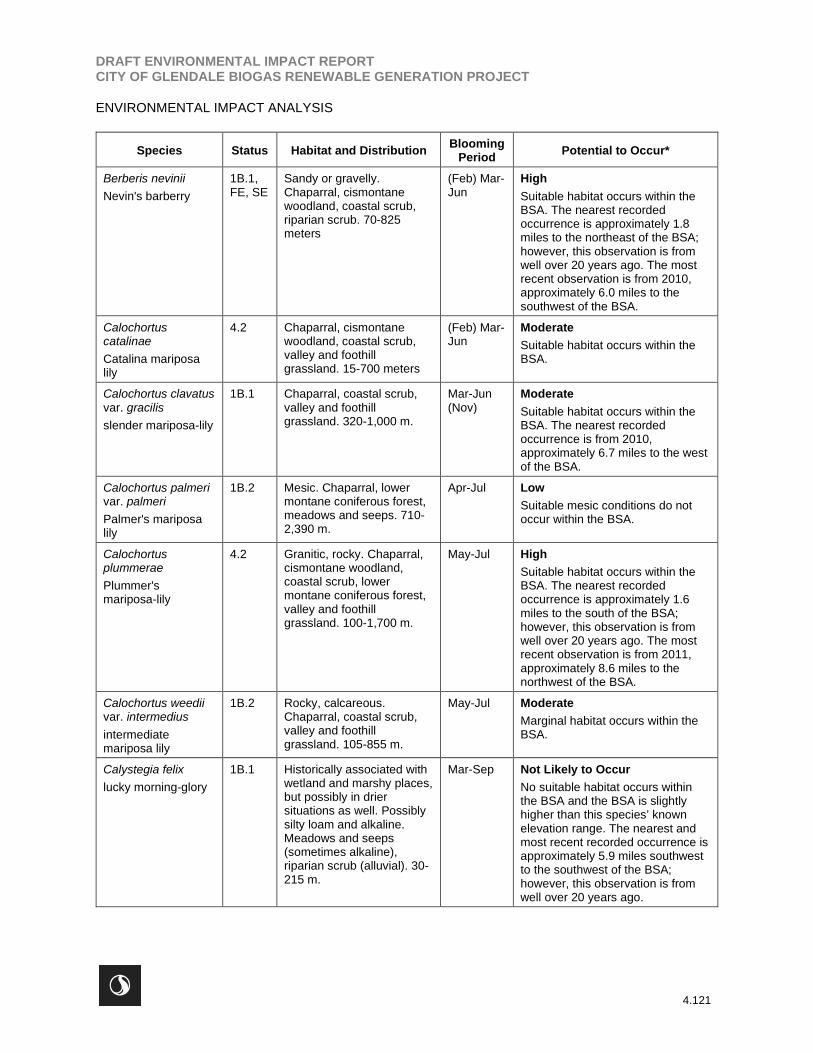
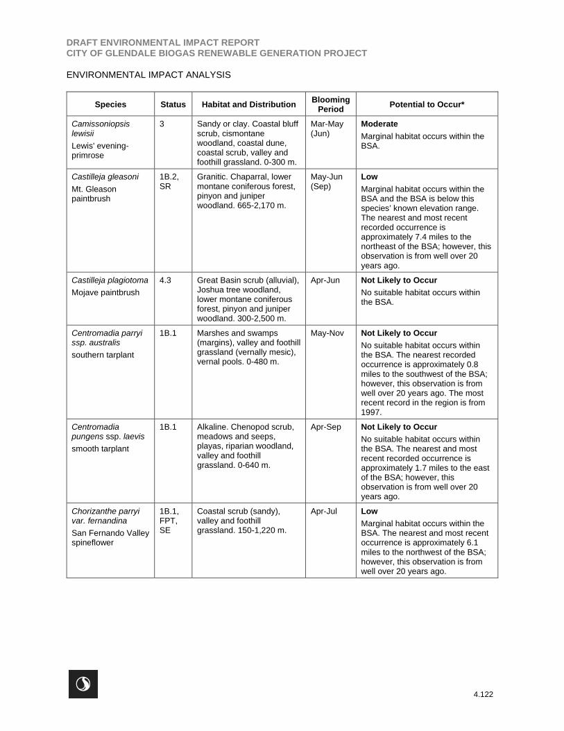
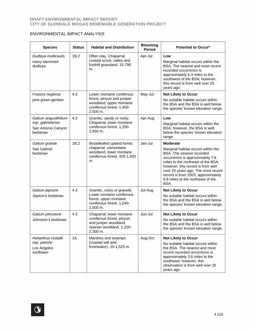
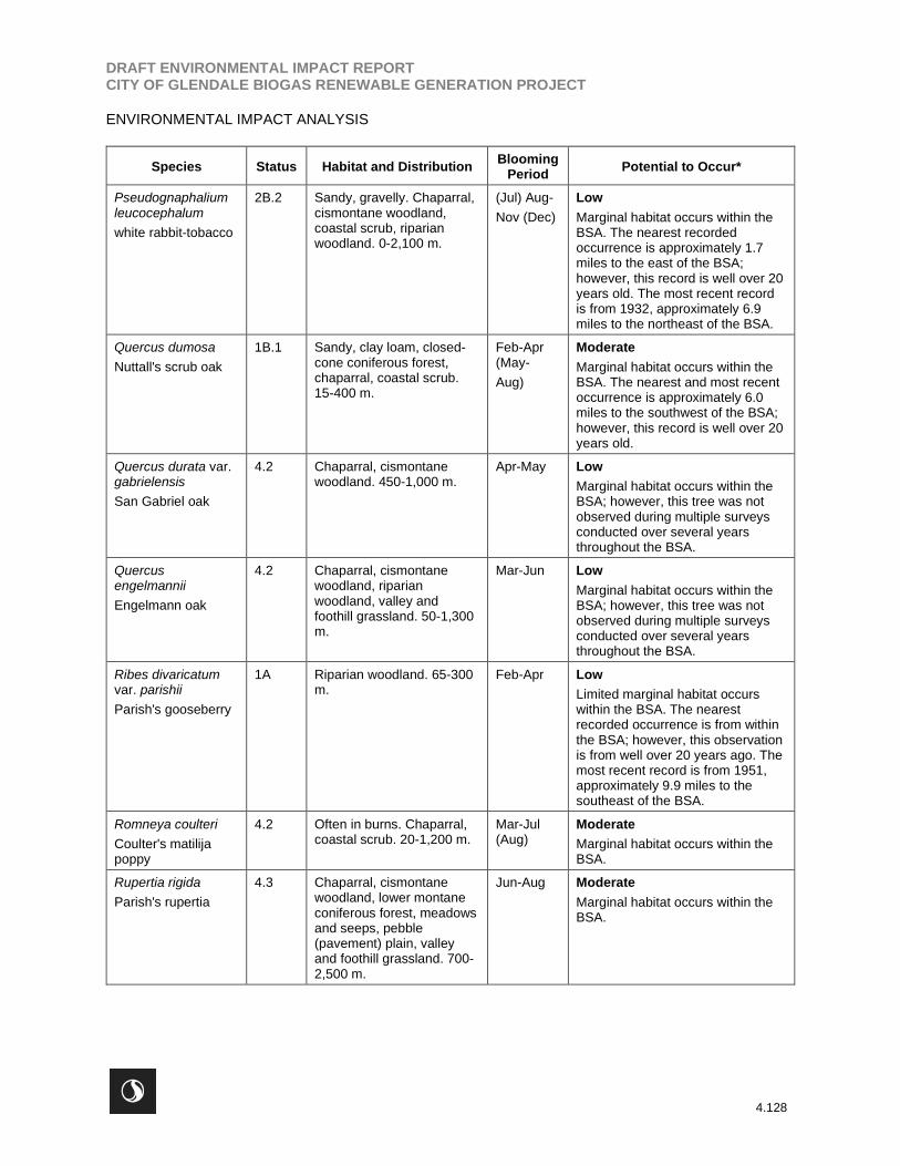
Table 23 presents a list of special-status plants, including federally- and state listed species and CRPR 1-
4 species that are known to occur in the vicinity of the BSA. No special-status plant species were
observed during any of the reconnaissance-level or focused surveys.

DRAFT ENVIRONMENTAL IMPACT REPORTCITY OF GLENDALE BIOGAS RENEWABLE GENERATION PROJECT
ENVIRONMENTAL IMPACT ANALYSIS
4.120
Table 23 Known and Potential Occurrences of Special-Status Plant Taxa within theBSA
Species Status Habitat and DistributionBlooming
PeriodPotential to Occur*
Acanthoscyphusparishii var. parishii
Parish's oxytheca
4.2 Sandy or gravelly.Chaparral, lower montaneconiferous forest. 1,220-2,600m.
Jun-Sep Low
Marginal habitat occurs within theBSA; however, the BSA is wellbelow the species’ known elevationrange.
Arctostaphylosglandulosa ssp.gabrielensis
San Gabrielmanzanita
1B.2 Chaparral (rocky). 595-1,500 m.
Mar Low
Marginal habitat occurs within theBSA; however, the BSA is belowthe species’ known elevation range.
Arctostaphylosparryana ssp.tumescens
interior manzanita
4.3 Chaparral (montane),cismontane woodland.2,100-2,310 m.
Feb-Apr Low
Marginal habitat occurs within theBSA; however, the BSA is wellbelow the species’ known elevationrange.
Arenaria paludicola
marsh sandwort
1B.1,
FE, SE
Sandy, openings. Marshesand swamps (freshwater orbrackish). 3-170m.
May-Aug Not Likely to Occur
Suitable habitat is not presentwithin the BSA.
Aspleniumvespertinum
western spleenwort
4.2 Rocky. Chaparral,cismontane woodland,coastal scrub 180-1,000 m.
Feb-Jun Moderate
Suitable habitat occurs within theBSA.
Astragalusbrauntonii
Braunton's milk-vetch
1B.1,FE
Recent burns or disturbedareas, usually sandstonewith carbonate layers.Chaparral, coastal scrub,valley and foothillgrassland. 4-640 m.
Jan-Aug Moderate
Marginal habitat and disturbedareas occur within the BSA. Thenearest recorded occurrence isfurther than 10 miles from the BSA.
Astragaluspycnostachyus var.lanosissimus
Ventura marsh milk-vetch
1B.1,FE, SE
Coastal dunes, coastalscrub, marshes andswamps (edges, coastalsalt or brackish). 1-35 m.
(Jun) Aug-Oct
Not Likely to Occur
Suitable habitat is not presentwithin the BSA and the BSA is wellbelow the species’ known elevationrange.
Atriplex parishii
Parish's brittlescale
1B.1 Alkaline. Chenopod scrub,playas, vernal pools. 25-1,900 meters
Jun-Oct Not Likely to Occur
Suitable habitat is not presentwithin the BSA. The nearestrecorded occurrence isapproximately 6.6 miles to thewest.
Atriplex serenanavar. davidsonii
Davidson's saltscale
1B.2 Alkaline. Coastal bluffscrub, coastal scrub. 10-200 meters
Apr-Oct Not Likely to Occur
Suitable habitat does not occurwithin the BSA. The nearestrecorded occurrence isapproximately 6.9 miles to thesouthwest of the BSA; however,this observation is from well over20 years ago.
DRAFT ENVIRONMENTAL IMPACT REPORTCITY OF GLENDALE BIOGAS RENEWABLE GENERATION PROJECT
ENVIRONMENTAL IMPACT ANALYSIS
4.121
Species Status Habitat and DistributionBlooming
PeriodPotential to Occur*
Berberis nevinii
Nevin's barberry
1B.1,FE, SE
Sandy or gravelly.Chaparral, cismontanewoodland, coastal scrub,riparian scrub. 70-825meters
(Feb) Mar-Jun
High
Suitable habitat occurs within theBSA. The nearest recordedoccurrence is approximately 1.8miles to the northeast of the BSA;however, this observation is fromwell over 20 years ago. The mostrecent observation is from 2010,approximately 6.0 miles to thesouthwest of the BSA.
Calochortuscatalinae
Catalina mariposalily
4.2 Chaparral, cismontanewoodland, coastal scrub,valley and foothillgrassland. 15-700 meters
(Feb) Mar-Jun
Moderate
Suitable habitat occurs within theBSA.
Calochortus clavatusvar. gracilis
slender mariposa-lily
1B.1 Chaparral, coastal scrub,valley and foothillgrassland. 320-1,000 m.
Mar-Jun(Nov)
Moderate
Suitable habitat occurs within theBSA. The nearest recordedoccurrence is from 2010,approximately 6.7 miles to the westof the BSA.
Calochortus palmerivar. palmeri
Palmer's mariposalily
1B.2 Mesic. Chaparral, lowermontane coniferous forest,meadows and seeps. 710-2,390 m.
Apr-Jul Low
Suitable mesic conditions do notoccur within the BSA.
Calochortusplummerae
Plummer'smariposa-lily
4.2 Granitic, rocky. Chaparral,cismontane woodland,coastal scrub, lowermontane coniferous forest,valley and foothillgrassland. 100-1,700 m.
May-Jul High
Suitable habitat occurs within theBSA. The nearest recordedoccurrence is approximately 1.6miles to the south of the BSA;however, this observation is fromwell over 20 years ago. The mostrecent observation is from 2011,approximately 8.6 miles to thenorthwest of the BSA.
Calochortus weediivar. intermedius
intermediatemariposa lily
1B.2 Rocky, calcareous.Chaparral, coastal scrub,valley and foothillgrassland. 105-855 m.
May-Jul Moderate
Marginal habitat occurs within theBSA.
Calystegia felix
lucky morning-glory
1B.1 Historically associated withwetland and marshy places,but possibly in driersituations as well. Possiblysilty loam and alkaline.Meadows and seeps(sometimes alkaline),riparian scrub (alluvial). 30-215 m.
Mar-Sep Not Likely to Occur
No suitable habitat occurs withinthe BSA and the BSA is slightlyhigher than this species’ knownelevation range. The nearest andmost recent recorded occurrence isapproximately 5.9 miles southwestto the southwest of the BSA;however, this observation is fromwell over 20 years ago.
DRAFT ENVIRONMENTAL IMPACT REPORTCITY OF GLENDALE BIOGAS RENEWABLE GENERATION PROJECT
ENVIRONMENTAL IMPACT ANALYSIS
4.122
Species Status Habitat and DistributionBlooming
PeriodPotential to Occur*
Camissoniopsislewisii
Lewis' evening-primrose
3 Sandy or clay. Coastal bluffscrub, cismontanewoodland, coastal dune,coastal scrub, valley andfoothill grassland. 0-300 m.
Mar-May(Jun)
Moderate
Marginal habitat occurs within theBSA.
Castilleja gleasoni
Mt. Gleasonpaintbrush
1B.2,SR
Granitic. Chaparral, lowermontane coniferous forest,pinyon and juniperwoodland. 665-2,170 m.
May-Jun(Sep)
Low
Marginal habitat occurs within theBSA and the BSA is below thisspecies’ known elevation range.The nearest and most recentrecorded occurrence isapproximately 7.4 miles to thenortheast of the BSA; however, thisobservation is from well over 20years ago.
Castilleja plagiotoma
Mojave paintbrush
4.3 Great Basin scrub (alluvial),Joshua tree woodland,lower montane coniferousforest, pinyon and juniperwoodland. 300-2,500 m.
Apr-Jun Not Likely to Occur
No suitable habitat occurs withinthe BSA.
Centromadia parryissp. australis
southern tarplant
1B.1 Marshes and swamps(margins), valley and foothillgrassland (vernally mesic),vernal pools. 0-480 m.
May-Nov Not Likely to Occur
No suitable habitat occurs withinthe BSA. The nearest recordedoccurrence is approximately 0.8miles to the southwest of the BSA;however, this observation is fromwell over 20 years ago. The mostrecent record in the region is from1997.
Centromadiapungens ssp. laevis
smooth tarplant
1B.1 Alkaline. Chenopod scrub,meadows and seeps,playas, riparian woodland,valley and foothillgrassland. 0-640 m.
Apr-Sep Not Likely to Occur
No suitable habitat occurs withinthe BSA. The nearest and mostrecent recorded occurrence isapproximately 1.7 miles to the eastof the BSA; however, thisobservation is from well over 20years ago.
Chorizanthe parryivar. fernandina
San Fernando Valleyspineflower
1B.1,FPT,SE
Coastal scrub (sandy),valley and foothillgrassland. 150-1,220 m.
Apr-Jul Low
Marginal habitat occurs within theBSA. The nearest and most recentoccurrence is approximately 6.1miles to the northwest of the BSA;however, this observation is fromwell over 20 years ago.

DRAFT ENVIRONMENTAL IMPACT REPORTCITY OF GLENDALE BIOGAS RENEWABLE GENERATION PROJECT
ENVIRONMENTAL IMPACT ANALYSIS
4.123
Species Status Habitat and DistributionBlooming
PeriodPotential to Occur*
Chorizanthe parryivar. parryi
Parry's spineflower
2B.2 Sandy or rocky, openings.Chaparral, cismontanewoodland, coastal scrub,valley and foothillgrassland. 275-1,220 m.
Apr-Jun Moderate
Marginal habitat occurs within theBSA. The nearest recordedoccurrence is approximately 1.7miles to the north of the BSA;however, the date of thisobservation cannot be confirmed.The most recent occurrence forwhich the date is known is from1919, approximately 3.8 miles tothe northeast of the BSA.
Cladium californicum
California saw-grass
2B.2 Meadows and seeps,marshes and swamps(alkaline or freshwater). 60-1,600 m.
Jun-Sep Not Likely to Occur
No suitable habitat occurs withinthe BSA. The nearest and mostrecent recorded occurrence isapproximately 9.9 miles to the eastof the BSA; however, this record isfrom well over 20 years ago.
Clinopodiummimuloides
monkey-flowersavory
4.2 Streambanks, mesic.Chaparral, north coastconiferous forest. 305-1,800m.
Jun-Oct Not Likely to Occur
No suitable habitat occurs withinthe BSA.
Convolvulussimulans
small-floweredmorning-glory
4.2 Clay, serpentinite seeps.Chaparral (openings),coastal scrub, valley andfoothill grassland. 30-740m.
Mar-Jul Not Likely to Occur
No suitable habitat occurs withinthe BSA.
Cuscuta obtusifloravar. glandulosa
Peruvian dodder
1B.1 Marshes and swamps(freshwater). 15-280 m.
Jul-Oct Not Likely to Occur
No suitable habitat occurs withinthe BSA. The nearest recordedoccurrence is approximately 9.3miles to the southeast of the BSA;however, the date of thisobservation cannot be confirmed.
Diplacus johnstonii
Johnston'smonkeyflower
4.3 Lower montane coniferousforest (scree, disturbedareas, rocky or gravelly,roadside). 975-2,920 m.
(Apr) May-Aug
Not Likely to Occur
No suitable habitat occurs withinthe BSA and the BSA is well belowthe species’ known elevation range.
Dodecahemaleptoceras
slender-hornedspineflower
1B.2,FE, SE
Sandy. Chaparral,cismontane woodland,coastal scrub (alluvial fan).200-760 m.
Apr-Jun Moderate
Marginal habitat occurs within theBSA. The nearest recordedoccurrence is approximately 1.8miles to the north of the BSA;however, this record is from wellover 20 years ago. The most recentobservation is from 2003,approximately 4.5 miles to thenorthwest of the BSA.
DRAFT ENVIRONMENTAL IMPACT REPORTCITY OF GLENDALE BIOGAS RENEWABLE GENERATION PROJECT
ENVIRONMENTAL IMPACT ANALYSIS
4.124
Species Status Habitat and DistributionBlooming
PeriodPotential to Occur*
Dudleya multicaulis
many-stemmeddudleya
1B.2 Often clay. Chaparral,coastal scrub, valley andfoothill grassland. 15-790m.
Apr-Jul Low
Marginal habitat occurs within theBSA. The nearest and most recentrecorded occurrence isapproximately 6.3 miles to thesouthwest of the BSA; however,this record is from well over 20years ago.
Frasera neglecta
pine green-gentian
4.3 Lower montane coniferousforest, pinyon and juniperwoodland, upper montaneconiferous forest. 1,400-2,500 m.
May-Jul Not Likely to Occur
No suitable habitat occurs withinthe BSA and the BSA is well belowthe species’ known elevation range.
Galium angustifoliumssp. gabrielense
San Antonio Canyonbedstraw
4.3 Granitic, sandy or rocky.Chaparral, lower montaneconiferous forest. 1,200-2,650 m.
Apr-Aug Low
Marginal habitat occurs within theBSA; however, the BSA is wellbelow the species’ known elevationrange.
Galium grande
San Gabrielbedstraw
1B.2 Broadleafed upland forest,chaparral, cismontanewoodland, lower montaneconiferous forest. 425-1,500m.
Jan-Jul Moderate
Marginal habitat occurs within theBSA. The nearest recordedoccurrence is approximately 7.8miles to the northeast of the BSA;however, this record is from wellover 20 years ago. The most recentrecord is from 2003, approximately9.8 miles to the northeast of theBSA.
Galium jepsonii
Jepson's bedstraw
4.3 Granitic, rocky or gravelly.Lower montane coniferousforest, upper montaneconiferous forest. 1,540-2,500 m.
Jul-Aug Not Likely to Occur
No suitable habitat occurs withinthe BSA and the BSA is well belowthe species’ known elevation range.
Galium johnstonii
Johnston's bedstraw
4.3 Chaparral, lower montaneconiferous forest, pinyonand juniper woodland,riparian woodland. 1,220-2,300 m.
Jun-Jul Not Likely to Occur
No suitable habitat occurs withinthe BSA and the BSA is well belowthe species’ known elevation range.
Helianthus nuttalliissp. parishii
Los Angelessunflower
1A Marshes and swamps(coastal salt andfreshwater). 10-1,525 m.
Aug-Oct Not Likely to Occur
No suitable habitat occurs withinthe BSA. The nearest and mostrecent recorded occurrence isapproximately 3.6 miles to thesoutheast; however, thisobservation is from well over 20years ago.

DRAFT ENVIRONMENTAL IMPACT REPORTCITY OF GLENDALE BIOGAS RENEWABLE GENERATION PROJECT
ENVIRONMENTAL IMPACT ANALYSIS
4.125
Species Status Habitat and DistributionBlooming
PeriodPotential to Occur*
Heucheracaespitosa
urn-floweredalumroot
4.3 Rocky. Cismontanewoodland, lower montaneconiferous forest, riparianforest (montane), uppermontane coniferous forest.1,155-2,650 m.
May-Aug Not Likely to Occur
No suitable habitat occurs withinthe BSA and the BSA is well belowthe species’ known elevation range.
Hordeumintercedens
vernal barley
3.2 Coastal dunes, coastalscrub, valley and foothillgrassland (saline flats anddepressions), vernal pools.5-1,000 m.
Mar-Jun Not Likely to Occur
No suitable habitat occurs withinthe BSA.
Horkelia cuneatavar. puberula
mesa horkelia
1B.1 Sandy or gravelly.Chaparral (maritime),cismontane woodland,coastal scrub. 70-810 m.
Feb-Jul(Sep)
Low
Marginal habitat occurs within theBSA. The nearest recordedoccurrence is approximately 1.5miles to the west; however, thisrecord is well over 20 years old.The most recent record is from1967, approximately 4.7 miles tothe northeast of the BSA.
Hulsea vestita ssp.gabrielensis
San GabrielMountains sunflower
4.3 Rocky. Lower montaneconiferous forest, uppermontane coniferous forest.1,500-2,500 m.
May-Jul Not Likely to Occur
No suitable habitat occurs withinthe BSA and the BSA is well belowthe species’ known elevation range.
Imperata brevifolia
California satintail
2B.1 Mesic. Chaparral, coastalscrub, Mojavean desertscrub, meadows and seeps(often alkali), riparian scrub.0-1,215 m.
Sep-May Not Likely to Occur
No suitable habitat occurs withinthe BSA.
Juglans californica
Southern Californiablack walnut
4.2 Alluvial. Chaparral,cismontane woodland,coastal scrub, riparianwoodland. 50-900 m.
Mar-Aug Low
Marginal habitat occurs within theBSA; however, this tree was notobserved during multiple surveysconducted over several yearsthroughout the BSA.
Lasthenia glabratassp. coulteri
Coulter's goldfields
1B.1 Marshes and swamps(coastal salt), playas, vernalpools.1-1,220 m.
Feb-Jun Not Likely to Occur
No suitable habitat occurs withinthe BSA. The nearest and mostrecent recorded occurrence isapproximately 1.7 miles to the east;however, this observation is fromwell over 20 years ago.
Lepechinia fragrans
fragrant pitcher sage
4.2 Chaparral. 20-1,310 m. Mar-Oct Moderate
Marginal habitat occurs within theBSA.

DRAFT ENVIRONMENTAL IMPACT REPORTCITY OF GLENDALE BIOGAS RENEWABLE GENERATION PROJECT
ENVIRONMENTAL IMPACT ANALYSIS
4.126
Species Status Habitat and DistributionBlooming
PeriodPotential to Occur*
Lepidium virginicumvar. robinsonii
Robinson's pepper-grass
4.3 Chaparral, coastal scrub. 1-885 m.
Jan-Jul Moderate
Marginal habitat occurs within theBSA. The nearest and most recentoccurrence is approximately 4.8miles to the northeast of the BSA;however, this record is from over20 years ago.
Lilium humboldtiissp. ocellatum
ocellated Humboldtlily
4.2 Openings. Chaparral,cismontane woodland,coastal scrub, lowermontane coniferous forest,riparian woodland. 30-1,800m.
Mar-Jul(Aug)
Moderate
Marginal habitat occurs within theBSA.
Linanthus concinnus
San Gabriellinanthus
1B.2 Rocky, openings.Chaparral, lower montaneconiferous forest, uppermontane coniferous forest.1,520-2,800 m.
Apr-Jul Not Likely to Occur
No suitable habitat occurs withinthe BSA and the BSA is well belowthe species’ known elevation range.The nearest and most recentrecorded occurrence isapproximately 7.4 miles to thenortheast of the BSA from 2003.
Linanthus orcuttii
Orcutt's linanthus
1B.3 Openings. Chaparral, lowermontane coniferous forest,pinyon and juniperwoodland. 915-2,145 m.
May-Jun Low
Marginal habitat occurs within theBSA; however, the BSA is wellbelow the species’ known elevationrange.
Lupinus peirsonii
Peirson's lupine
1B.3 Gravelly or rocky. Joshuatree woodland, lowermontane coniferous forest,pinyon and juniperwoodland, upper montaneconiferous forest. 1,000-2,500 m.
Apr-Jun Not Likely to Occur
No suitable habitat occurs withinthe BSA and the BSA is well belowthe species’ known elevation range.
Malacothamnusdavidsonii
Davidson's bush-mallow
1B.2 Chaparral. Cismontanewoodland, coastal scrub,riparian woodland. 185-1,140 m.
Jun-Jan Moderate
Marginal habitat occurs within theBSA. The nearest recordedoccurrence is approximately 6.9miles to the northwest of the BSA;however, this record is from wellover 20 years ago. The most recentrecord is from 2018, approximately8.4 miles to the northeast of theBSA.
Monardella australisssp. cinereal
gray monardella
4.3 Lower montane coniferousforest, subalpine coniferousforest, upper montaneconiferous forest. 1,800-3,050 m.
Jul-Aug Not Likely to Occur
No suitable habitat occurs withinthe BSA and the BSA is well belowthe species’ known elevation range.

DRAFT ENVIRONMENTAL IMPACT REPORTCITY OF GLENDALE BIOGAS RENEWABLE GENERATION PROJECT
ENVIRONMENTAL IMPACT ANALYSIS
4.127
Species Status Habitat and DistributionBlooming
PeriodPotential to Occur*
Muhlenbergiacalifornica
California muhly
4.3 Mesic, seeps andstreambanks. Chaparral,coastal scrub, lowermontane coniferous forest,meadows and seeps. 100-2,000 m.
Jun-Sep Not Likely to Occur
No suitable habitat occurs withinthe BSA. The nearest and mostrecent recorded occurrence isapproximately 6.3 miles to thenortheast; however, this record isfrom well over 20 years ago.
Nasturtium gambelii
Gambel's watercress
1B.1,FE, ST
Marshes and swamps(freshwater or brackish). 5-330 m.
Apr-Oct Not Likely to Occur
No suitable habitat occurs withinthe BSA.
Navarretia prostrata
prostrate vernal poolnavarretia
1B.1 Mesic. Coastal scrub,meadows and seeps, valleyand foothill grassland(alkaline), vernal pools. 3-1,210 m.
Apr-Jul Not Likely to Occur
No suitable habitat occurs withinthe BSA. The nearest and mostrecent recorded occurrence isapproximately 6.6 miles to thesouthwest; however, this record isfrom well over 20 years ago.
Opuntia basilarisvar. brachyclada
short-joint beavertail
1B.2 Chaparral, Joshua treewoodland, Mojavean desertscrub, pinyon and juniperwoodland. 425-1,800 m.
Apr-Jun(Aug)
Moderate
Marginal habitat occurs within theBSA.
Orobanche validassp. valida
Rock Creekbroomrape
1B.2 Granitic. Chaparral, pinyonand juniper woodland.1,250-2,000 m.
May-Sep Low
Marginal habitat occurs within theBSA; however, the BSA is wellbelow the species’ known elevationrange.
Phacelia hubbyi
Hubby's phacelia
4.2 Gravelly, rocky, talus.Chaparral, coastal scrub,valley and foothillgrassland. 0-1,000 m.
Apr-Jul Moderate
Marginal habitat occurs within theBSA.
Phaceliamohavensis
Mojave phacelia
4.3 Sandy or gravelly.Cismontane woodland,lower montane coniferousforest, meadows andseeps, pinyon and juniperwoodland. 1,400-2,500 m.
Apr-Aug Low
Marginal habitat occurs within theBSA; however, the BSA is wellbelow the species’ known elevationrange.
Phacelia stellaris
Brand's star phacelia
1B.1 Coastal dunes. Coastalscrub. 1-400 m.
Mar-Jun Not Likely to Occur
No suitable habitat occurs withinthe BSA.
Pickeringia montanavar. tomentosa
woolly chaparral-pea
4.3 Gabbroic, granitic, clay.Chaparral. 0-1,700 m.
May-Aug Low
Marginal habitat occurs within theBSA, though suitable substratesare not present.
DRAFT ENVIRONMENTAL IMPACT REPORTCITY OF GLENDALE BIOGAS RENEWABLE GENERATION PROJECT
ENVIRONMENTAL IMPACT ANALYSIS
4.128
Species Status Habitat and DistributionBlooming
PeriodPotential to Occur*
Pseudognaphaliumleucocephalum
white rabbit-tobacco
2B.2 Sandy, gravelly. Chaparral,cismontane woodland,coastal scrub, riparianwoodland. 0-2,100 m.
(Jul) Aug-
Nov (Dec)
Low
Marginal habitat occurs within theBSA. The nearest recordedoccurrence is approximately 1.7miles to the east of the BSA;however, this record is well over 20years old. The most recent recordis from 1932, approximately 6.9miles to the northeast of the BSA.
Quercus dumosa
Nuttall's scrub oak
1B.1 Sandy, clay loam, closed-cone coniferous forest,chaparral, coastal scrub.15-400 m.
Feb-Apr(May-
Aug)
Moderate
Marginal habitat occurs within theBSA. The nearest and most recentoccurrence is approximately 6.0miles to the southwest of the BSA;however, this record is well over 20years old.
Quercus durata var.gabrielensis
San Gabriel oak
4.2 Chaparral, cismontanewoodland. 450-1,000 m.
Apr-May Low
Marginal habitat occurs within theBSA; however, this tree was notobserved during multiple surveysconducted over several yearsthroughout the BSA.
Quercusengelmannii
Engelmann oak
4.2 Chaparral, cismontanewoodland, riparianwoodland, valley andfoothill grassland. 50-1,300m.
Mar-Jun Low
Marginal habitat occurs within theBSA; however, this tree was notobserved during multiple surveysconducted over several yearsthroughout the BSA.
Ribes divaricatumvar. parishii
Parish's gooseberry
1A Riparian woodland. 65-300m.
Feb-Apr Low
Limited marginal habitat occurswithin the BSA. The nearestrecorded occurrence is from withinthe BSA; however, this observationis from well over 20 years ago. Themost recent record is from 1951,approximately 9.9 miles to thesoutheast of the BSA.
Romneya coulteri
Coulter's matilijapoppy
4.2 Often in burns. Chaparral,coastal scrub. 20-1,200 m.
Mar-Jul(Aug)
Moderate
Marginal habitat occurs within theBSA.
Rupertia rigida
Parish's rupertia
4.3 Chaparral, cismontanewoodland, lower montaneconiferous forest, meadowsand seeps, pebble(pavement) plain, valleyand foothill grassland. 700-2,500 m.
Jun-Aug Moderate
Marginal habitat occurs within theBSA.

DRAFT ENVIRONMENTAL IMPACT REPORTCITY OF GLENDALE BIOGAS RENEWABLE GENERATION PROJECT
ENVIRONMENTAL IMPACT ANALYSIS
4.129
Species Status Habitat and DistributionBlooming
PeriodPotential to Occur*
Scutellaria bolanderissp. austromontana
southern mountainsskullcap
1B.2 Mesic. Chaparral,cismontane woodland,lower montane coniferousforest. 425-2,000 m.
Jun-Aug Moderate
Marginal habitat occurs within theBSA. The nearest and most recentoccurrence is approximately 9.3miles to the southeast of the BSA,though the date of this recordcannot be confirmed.
Senecio astephanus
San Gabriel ragwort
4.3 Rocky slopes. Coastal bluffscrub, chaparral. 400-1,500m.
May-Jul Moderate
Marginal habitat occurs within theBSA.
Sidalceaneomexicana
salt springcheckerbloom
2B.2 Alkaline, mesic. Chaparral,coastal scrub, lowermontane coniferous forest,Mojavean desert scrub,playas. 15-1,530 m.
Mar-Jun Not Likely to Occur
No suitable mesic habitat occurswithin the BSA. The nearestrecorded occurrence isapproximately 1.7 miles to the northof the BSA; however, this record isfrom well over 20 years ago. Themost recent record is from1920,approximately 6.6 miles to thesouthwest of the BSA.
Sidothecacaryophylloides
chickweed oxytheca
4.3 Lower montane coniferousforest (sandy). 1,114-2,600m.
Jul-Sep(Oct)
Not Likely to Occur
No suitable habitat occurs withinthe BSA and the BSA is well belowthis species’ known elevationrange.
Spermolepislateriflora
western bristlyscaleseed
2A Rocky or sandy. SonoranDesert scrub. 365-670 m.
Mar-Apr Not Likely to Occur
No suitable habitat occurs withinthe BSA.
Symphyotrichumdefoliatum
San Bernardinoaster
1B.2 Near ditches, streams,springs. Cismontanewoodland, coastal scrub,lower montane coniferousforest, meadows andseeps, marshes andswamps, valley and foothillgrassland (vernally mesic).2-2,040 m.
Jul-Nov(Dec)
Not Likely to Occur
No suitable habitat occurs withinthe BSA. The nearest recordedoccurrence is approximately 7.6miles to the southwest of the BSA;however, this record is from wellover 20 years ago.
Symphyotrichumgreatae
Greata's aster
1B.3 Mesic. Broadleafed uplandforest, chaparral,cismontane woodland,lower montane coniferousforest, riparian woodland.300-2,010 m.
Jun-Oct Not Likely to Occur
No suitable mesic habitat occurswithin the BSA. The nearestrecorded occurrence isapproximately 1.6 miles to thesouth of the BSA; however, thisrecord is from well over 20 yearsago. The most recent record isfrom2014, approximately 7.7 milesto the northeast of the BSA.

DRAFT ENVIRONMENTAL IMPACT REPORTCITY OF GLENDALE BIOGAS RENEWABLE GENERATION PROJECT
ENVIRONMENTAL IMPACT ANALYSIS
4.130
Species Status Habitat and DistributionBlooming
PeriodPotential to Occur*
Thelypteris puberulavar. sonorensis
Sonoran maiden fern
2B.2 Meadows and seeps (seepsand streams). 50-610 m.
Jan-Sep Not Likely to Occur
No suitable habitat occurs withinthe BSA. The nearest and mostrecent recorded occurrence isapproximately 4.3 miles to thenortheast of the BSA; however, thisrecord is from well over 20 yearsago.
Source: Baldwin et al. 2012; CDFW, 2019a; CNPS, 2019.
* Species listings for which nearest/most recent data are not provided originated from the CNPS database. Metadata is notavailable for these records.
Status Codes
US Fish and Wildlife Service (Fed.) Designations:
FE: Federally listed, endangered
FT: Federally listed, threatened
FPT: Federally proposed, threatened
California Department of Fish and Wildlife (State) Designations:
SE: State listed, endangered.
ST: State listed, threatened.
SR: State listed, rare
California Rare Plant Rank (CRPR) designation
1A Plants presumed extinct in California.
1B Plants rare, threatened, or endangered in California and elsewhere.
2B Plants presumed extinct in California but more common elsewhere.
3 Plants about which we need more information – a review list.
4 Plants of limited distribution – a watch list.
.1 Seriously threatened in California (high degree/immediacy of threat).
.2 Fairly threatened in California (moderate degree/immediacy of threat).
.3 Not very threatened in California (low degree/immediacy of threats or no current threats known).
Special Status Wildlife
Special-status taxa include those listed as threatened or endangered under the federal or California
ESAs, taxa proposed for such listing, Species of Special Concern, and other taxa that have been
identified by the USFWS, CDFW, or local jurisdictions as unique or rare and which have the potential to
occur within the BSA.
The CNDDB was queried for occurrences of special-status wildlife taxa within the USGS topographical
quadrangles in which the BSA occurs and the eight surrounding quadrangles. No special-status taxa
were observed or assumed to be present within, or immediately adjacent to the BSA, based on the results
of the CNDDB query and 2019 field surveys. A total of 31 taxa known to occur in the general region were
reviewed and 22 taxa were determined to have a low, moderate or high potential to occur in the BSA
based on existing recorded occurrences, known geographic range, and/or the presence of suitable
habitat. Table 24 summarizes the special-status wildlife taxa known to regionally occur and their potential
for occurrence in the BSA. A detailed list of all taxa present in the BSA is included in Appendix C of this

DRAFT ENVIRONMENTAL IMPACT REPORTCITY OF GLENDALE BIOGAS RENEWABLE GENERATION PROJECT
ENVIRONMENTAL IMPACT ANALYSIS
4.131
document. Each of the taxa identified in the database reviews/searches were assessed for its potential to
occur within the BSA based on the following criteria:
Present: Taxa (or sign thereof) were observed in the BSA or in the same watershed (aquatic taxaonly) during the most recent surveys, or a population has been acknowledged by CDFW,USFWS, or local experts.
High: Habitat (including soils) for the taxa occurs onsite and a known occurrence occurs withinthe BSA or adjacent areas (within five miles of the BSA) within the past 20 years; however, thesetaxa were not detected during the most recent surveys.
Moderate: Habitat (including soils) for the taxa occurs onsite and a known regional record occurswithin the database search, but not within five miles of the BSA or within the past 20 years; or aknown occurrence occurs within five miles of the BSA and within the past 20 years and marginalor limited amounts of habitat occurs onsite; or the taxa’s range includes the geographic area andsuitable habitat exists.
Low: Limited habitat for the taxa occurs within the BSA and no known occurrences were foundwithin the database search and the taxa’s range includes the geographic area.
Not Likely to Occur: The environmental conditions associated with taxa presence do not occurwithin the BSA.
Threatened, Endangered, or Special-Status Invertebrates
No threatened, endangered, or special-status invertebrates were detected in the BSA. While suitable food
plants for one CDFW Special Animal, Crotch bumble bee (Bombus crotchii), occur within the BSA the
most recent recorded occurrence is approximately 4.2 miles to the northeast and is more than 20 years
old; this species has a low potential of occurrence within the BSA.
Threatened, Endangered, or Special-Status Fish
No threatened, endangered, or special-status fish species were detected in the BSA. Santa Ana sucker
(federally threatened), arroyo chub (Gila orcuttii [California Species of Special Concern]), and Santa Ana
speckled dace (Rhinichtys osculus ssp. 3 [federally threatened and a California Species of Special
Concern]), while known from the region, are not expected to occur within the BSA due to the lack of
suitable aquatic habitat.
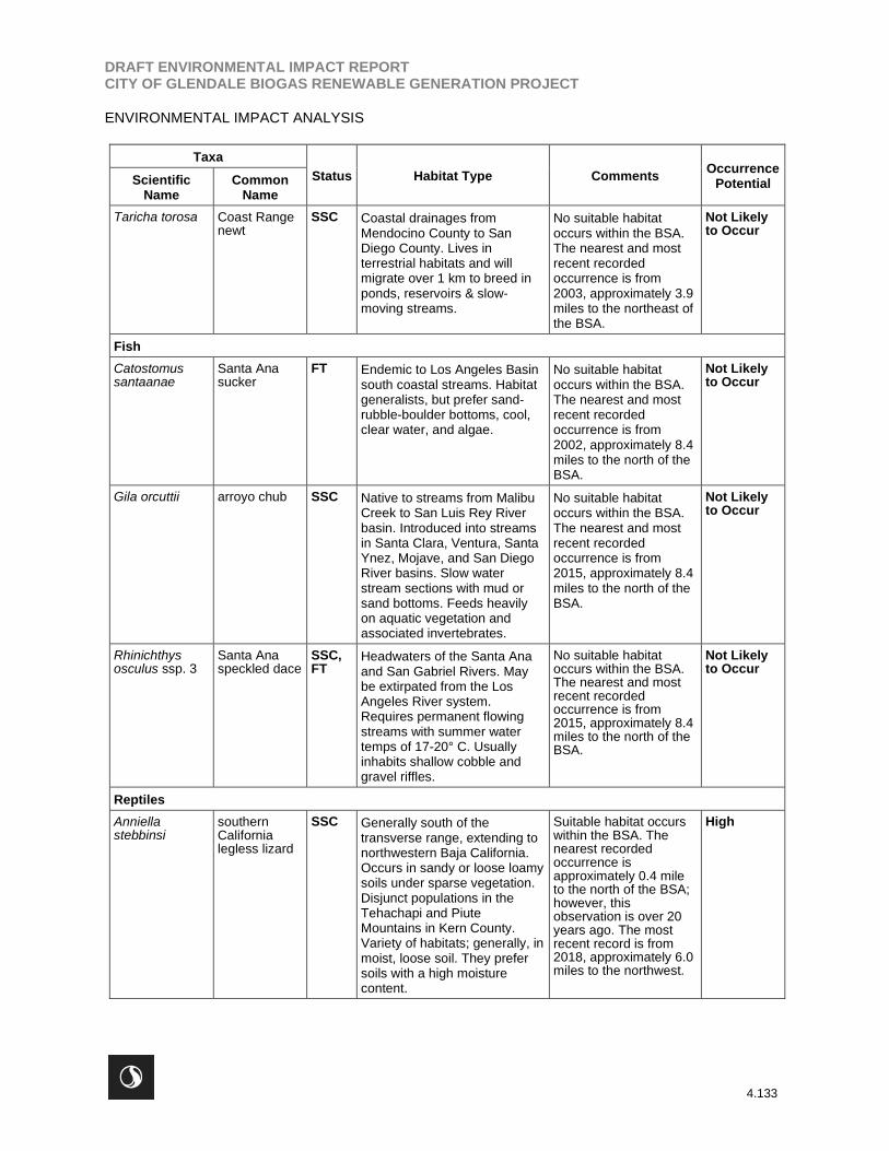
Threatened, Endangered, or Special-Status Reptiles
No threatened, endangered, or special-status reptile species were detected in the BSA. Four California
Species of Special Concern, while not observed, have some potential of occurrence within the BSA;
southern California legless lizard (Anniella stebbinsi), California glossy snake (Arizona elegans
occidentalis), coastal whiptail (Aspidoscelis tigris stejnegeri), coast horned lizard (Phrynosoma blainvillii).
Threatened, Endangered, or Special-Status Amphibians
Surveys conducted in the BSA did not detect any threatened, endangered, or special-status amphibians.
Southern mountain yellow-legged frog (Rana mucosa), federally and state listed as endangered and a
federal watchlist species, and coast range newt (Taricha torosa), a California Species of Special Concern
DRAFT ENVIRONMENTAL IMPACT REPORTCITY OF GLENDALE BIOGAS RENEWABLE GENERATION PROJECT
ENVIRONMENTAL IMPACT ANALYSIS
4.132
are both known from the general region of the BSA; suitable aquatic habitat for these species is not
present within the BSA.
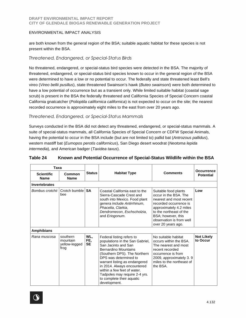
Threatened, Endangered, or Special-Status Birds
No threatened, endangered, or special-status bird species were detected in the BSA. The majority of
threatened, endangered, or special-status bird species known to occur in the general region of the BSA
were determined to have a low or no potential to occur. The federally and state threatened least Bell’s
vireo (Vireo bellii pusillus), state threatened Swainson’s hawk (Buteo swainsoni) were both determined to
have a low potential of occurrence but as a transient only. While limited suitable habitat (coastal sage
scrub) is present in the BSA the federally threatened and California Species of Special Concern coastal
California gnatcatcher (Polioptila californica californica) is not expected to occur on the site; the nearest
recorded occurrence is approximately eight miles to the east from over 20 years ago.
Threatened, Endangered, or Special-Status Mammals
Surveys conducted in the BSA did not detect any threatened, endangered, or special-status mammals. A
suite of special-status mammals, all California Species of Special Concern or CDFW Special Animals,
having the potential to occur in the BSA include (but are not limited to) pallid bat (Antrozous pallidus),
western mastiff bat (Eumopos perotis californicus), San Diego desert woodrat (Neotoma lepida
intermedia), and American badger (Taxidea taxus).
Table 24 Known and Potential Occurrence of Special-Status Wildlife within the BSA
Taxa
Status Habitat Type CommentsOccurrence
PotentialScientificName
CommonName
Invertebrates
Bombus crotchii Crotch bumblebee
SA Coastal California east to theSierra-Cascade Crest andsouth into Mexico. Food plantgenera include Antirrhinum,Phacelia, Clarkia,Dendromecon, Eschscholzia,and Eriogonum.
Suitable food plantsoccur in the BSA. Thenearest and most recentrecorded occurrence isapproximately 4.2 milesto the northeast of theBSA; however, thisobservation is from wellover 20 years ago.
Low
Amphibians
Rana muscosa southernmountainyellow-leggedfrog
WL,FE,SE
Federal listing refers topopulations in the San Gabriel,San Jacinto and SanBernardino Mountains(Southern DPS). The NorthernDPS was determined towarrant listing as endangeredin 2014. Always encounteredwithin a few feet of water.Tadpoles may require 2-4 yrs.to complete their aquaticdevelopment.
No suitable habitatoccurs within the BSA.The nearest and mostrecent recordedoccurrence is from2009, approximately 3. 9miles to the northeast ofthe BSA.
Not Likelyto Occur
DRAFT ENVIRONMENTAL IMPACT REPORTCITY OF GLENDALE BIOGAS RENEWABLE GENERATION PROJECT
ENVIRONMENTAL IMPACT ANALYSIS
4.133
Taxa
Status Habitat Type CommentsOccurrence
PotentialScientificName
CommonName
Taricha torosa Coast Rangenewt
SSC Coastal drainages fromMendocino County to SanDiego County. Lives interrestrial habitats and willmigrate over 1 km to breed inponds, reservoirs & slow-moving streams.
No suitable habitatoccurs within the BSA.The nearest and mostrecent recordedoccurrence is from2003, approximately 3.9miles to the northeast ofthe BSA.
Not Likelyto Occur
Fish
Catostomussantaanae
Santa Anasucker
FT Endemic to Los Angeles Basinsouth coastal streams. Habitatgeneralists, but prefer sand-rubble-boulder bottoms, cool,clear water, and algae.
No suitable habitatoccurs within the BSA.The nearest and mostrecent recordedoccurrence is from2002, approximately 8.4miles to the north of theBSA.
Not Likelyto Occur
Gila orcuttii arroyo chub SSC Native to streams from MalibuCreek to San Luis Rey Riverbasin. Introduced into streamsin Santa Clara, Ventura, SantaYnez, Mojave, and San DiegoRiver basins. Slow waterstream sections with mud orsand bottoms. Feeds heavilyon aquatic vegetation andassociated invertebrates.
No suitable habitatoccurs within the BSA.The nearest and mostrecent recordedoccurrence is from2015, approximately 8.4miles to the north of theBSA.
Not Likelyto Occur
Rhinichthysosculus ssp. 3
Santa Anaspeckled dace
SSC,FT
Headwaters of the Santa Anaand San Gabriel Rivers. Maybe extirpated from the LosAngeles River system.Requires permanent flowingstreams with summer watertemps of 17-20° C. Usuallyinhabits shallow cobble andgravel riffles.
No suitable habitatoccurs within the BSA.The nearest and mostrecent recordedoccurrence is from2015, approximately 8.4miles to the north of theBSA.
Not Likelyto Occur
Reptiles
Anniellastebbinsi
southernCalifornialegless lizard
SSC Generally south of thetransverse range, extending tonorthwestern Baja California.Occurs in sandy or loose loamysoils under sparse vegetation.Disjunct populations in theTehachapi and PiuteMountains in Kern County.Variety of habitats; generally, inmoist, loose soil. They prefersoils with a high moisturecontent.
Suitable habitat occurswithin the BSA. Thenearest recordedoccurrence isapproximately 0.4 mileto the north of the BSA;however, thisobservation is over 20years ago. The mostrecent record is from2018, approximately 6.0miles to the northwest.
High

DRAFT ENVIRONMENTAL IMPACT REPORTCITY OF GLENDALE BIOGAS RENEWABLE GENERATION PROJECT
ENVIRONMENTAL IMPACT ANALYSIS
4.134
Taxa
Status Habitat Type CommentsOccurrence
PotentialScientificName
CommonName
Arizona elegansoccidentalis
Californiaglossy snake
SSC Patchily distributed from theeastern portion of SanFrancisco Bay, southern SanJoaquin Valley, and the Coast,Transverse, and PeninsularRanges, south to BajaCalifornia. Generalist reportedfrom a range of scrub andgrassland habitats, often withloose or sandy soils.
Suitable habitat occurswithin the BSA. Thenearest recordedoccurrence isapproximately 4.5 milesto the northwest of theBSA; however, thisspecies has not beenobserved within 10 milesof the BSA within thelast 20 years.
Low
Aspidoscelistigris stejnegeri
coastalwhiptail
SSC Found in deserts and semi-aridareas with sparse vegetationand open areas. Also found inwoodland & riparian areas.Ground may be firm soil,sandy, or rocky.
Marginal habitat occurswithin the BSA. Thenearest recordedoccurrence isapproximately 8.7 milesto the northeast of theBSA; however, thisobservation is was over20 years ago. The mostrecent record is from2015, approximately 9.9miles to the northwest ofthe BSA.
Moderate
Emysmarmorata
western pondturtle
SSC A thoroughly aquatic turtle ofponds, marshes, rivers,streams and irrigation ditches,usually with aquatic vegetation,below 6000 ft elevation. Needsbasking sites and suitable(sandy banks or grassy openfields) upland habitat up to 0.5km from water for egg-laying.
No suitable habitatoccurs within the BSA.The nearest and mostrecent recordedoccurrence is from1987, approximately 5.0miles to the northeast ofthe BSA.
Not Likelyto Occur
Phrynosomablainvillii
coast hornedlizard
SSC Frequents a wide variety ofhabitats, most common inlowlands along sandy washeswith scattered low bushes.Open areas for sunning,bushes for cover, patches ofloose soil for burial, andabundant supply of ants andother insects.
Suitable habitat occurswithin the BSA. Thenearest recordedoccurrence isapproximately 1.4 milesto the northwest of theBSA; however, thisspecies has not beenobserved within 10 milesof the BSA within thelast 20 years.
Moderate
Birds
Aimophilaruficepscanescens
southernCaliforniarufous-crownedsparrow
WL Resident in southern Californiacoastal sage scrub and sparsemixed chaparral. Frequentsrelatively steep, often rockyhillsides with grass and forbpatches.
Suitable habitat occurswithin the BSA. Thenearest and most recentrecorded occurrence isfrom 2014,approximately 8.5 milesto the southwest of theBSA.
Moderate
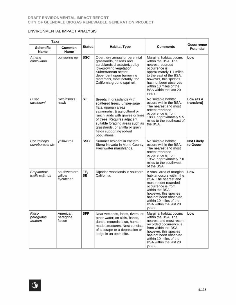
DRAFT ENVIRONMENTAL IMPACT REPORTCITY OF GLENDALE BIOGAS RENEWABLE GENERATION PROJECT
ENVIRONMENTAL IMPACT ANALYSIS
4.135
Taxa
Status Habitat Type CommentsOccurrence
PotentialScientificName
CommonName
Athenecunicularia
burrowing owl SSC Open, dry annual or perennialgrasslands, deserts andscrublands characterized bylow-growing vegetation.Subterranean nester,dependent upon burrowingmammals, most notably, theCalifornia ground squirrel.
Marginal habitat occurswithin the BSA. Thenearest recordedoccurrence isapproximately 1.7 milesto the east of the BSA;however, this specieshas not been observedwithin 10 miles of theBSA within the last 20years.
Low
Buteoswainsoni
Swainson'shawk
ST Breeds in grasslands withscattered trees, juniper-sageflats, riparian areas,savannahs, & agricultural orranch lands with groves or linesof trees. Requires adjacentsuitable foraging areas such asgrasslands, or alfalfa or grainfields supporting rodentpopulations.
No suitable habitatoccurs within the BSA.The nearest and mostrecent recordedoccurrence is from1880, approximately 5.5miles to the southeast ofthe BSA.
Low (as atransient)
Coturnicopsnoveboracensis
yellow rail SSC Summer resident in easternSierra Nevada in Mono County.Freshwater marshlands.
No suitable habitatoccurs within the BSA.The nearest and mostrecent recordedoccurrence is from1952, approximately 7.0miles to the southwestof the BSA.
Not Likelyto Occur
Empidonaxtraillii extimus
southwesternwillowflycatcher
FE,SE
Riparian woodlands in southernCalifornia.
A small area of marginalhabitat occurs within theBSA. The nearest andmost recent recordedoccurrence is fromwithin the BSA;however, this specieshas not been observedwithin 10 miles of theBSA within the last 20years.
Low
Falcoperegrinusanatum
Americanperegrinefalcon
SFP Near wetlands, lakes, rivers, orother water; on cliffs, banks,dunes, mounds; also, human-made structures. Nest consistsof a scrape or a depression orledge in an open site.
Marginal habitat occurswithin the BSA. Thenearest and most recentrecorded occurrence isfrom within the BSA;however, this specieshas not been observedwithin 10 miles of theBSA within the last 20years.
Low

DRAFT ENVIRONMENTAL IMPACT REPORTCITY OF GLENDALE BIOGAS RENEWABLE GENERATION PROJECT
ENVIRONMENTAL IMPACT ANALYSIS
4.136
Taxa
Status Habitat Type CommentsOccurrence
PotentialScientificName
CommonName
Polioptilacalifornicacalifornica
coastalCaliforniagnatcatcher
SSC,FT
Obligate, permanent resident ofcoastal sage scrub below 2,500ft in southern California. Low,coastal sage scrub in aridwashes, on mesas and slopes.Not all areas classified ascoastal sage scrub areoccupied.
Limited marginal habitatoccurs within the BSA.The nearest recordedoccurrence isapproximately 8.0 milesto the east of the BSA;however, thisobservation is was over20 years ago. The mostrecent record is from2005, approximately10.0 miles to thesoutheast.
Low
Riparia riparia bank swallow ST Colonial nester; nests primarilyin riparian and other lowlandhabitats west of the desert.Requires vertical banks/cliffswith fine-textured/sandy soilsnear streams, rivers, lakes,ocean to dig nesting hole.
No suitable habitatoccurs within the BSA.The nearest and mostrecent recordedoccurrence is from1894, approximately 0.8mile to the south of theBSA.
Not Likelyto Occur
Vireo belliipusillus
least Bell'svireo
FE,SE
Summer resident of southernCalifornia in low riparian invicinity of water or in dry riverbottoms; below 2,000 ft. Nestsplaced along margins ofbushes or on twigs projectinginto pathways, usually willow,Baccharis, mesquite.
No suitable habitatoccurs within the BSA.The nearest recordedoccurrence is fromwithin the BSA;however, thisobservation was over 20years ago. The mostrecent record is from2015, approximately 5.7miles to the northeast ofthe BSA.
Low (as atransient)
Mammals
Antrozouspallidus
pallid bat SSC Desert, grasslands, shrublands,woodlands and forests. Mostcommon in open, dry habitatswith rocky areas for roosting.Roosts must protect bats formhigh temperatures. Verysensitive to disturbance ofroosting sits.
Marginal habitat occurswithin the BSA. Thenearest recordedoccurrence isapproximately 1.7 milesto the east of the BSA;however, this specieshas not been observedwithin 10 miles of theBSA within the last 20years.
Low
Corynorhinustownsendii
Townsend'sbig-eared bat
SSC Throughout California in a widevariety of habitats. Mostcommon in mesic sites. Roostsin the open, hanging from wallsand ceilings. Roosting siteslimiting. Extremely sensitive tohuman disturbance.
Marginal habitat occurswithin the BSA, thoughongoing humanactivities in the areareduce the potential forthis species to use thesite. The nearest andmost recent recordedoccurrence isapproximately 10.0miles to the east of theBSA.
Low
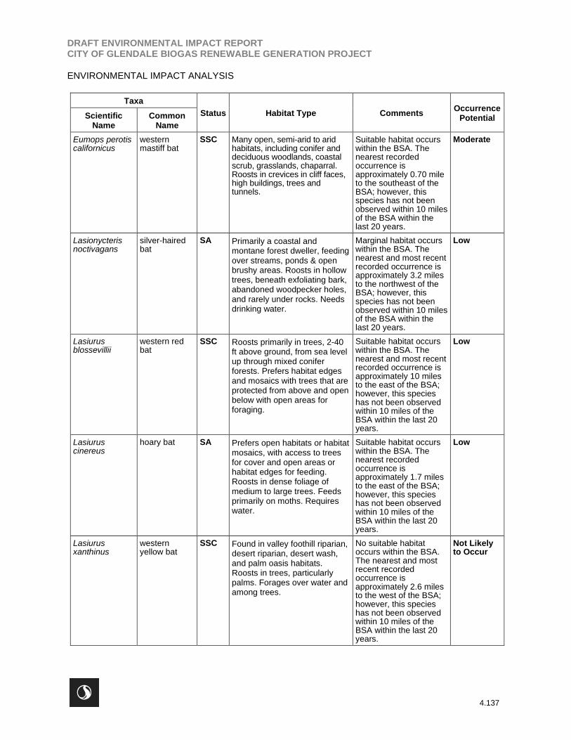
DRAFT ENVIRONMENTAL IMPACT REPORTCITY OF GLENDALE BIOGAS RENEWABLE GENERATION PROJECT
ENVIRONMENTAL IMPACT ANALYSIS
4.137
Taxa
Status Habitat Type CommentsOccurrence
PotentialScientificName
CommonName
Eumops perotiscalifornicus
westernmastiff bat
SSC Many open, semi-arid to aridhabitats, including conifer anddeciduous woodlands, coastalscrub, grasslands, chaparral.Roosts in crevices in cliff faces,high buildings, trees andtunnels.
Suitable habitat occurswithin the BSA. Thenearest recordedoccurrence isapproximately 0.70 mileto the southeast of theBSA; however, thisspecies has not beenobserved within 10 milesof the BSA within thelast 20 years.
Moderate
Lasionycterisnoctivagans
silver-hairedbat
SA Primarily a coastal andmontane forest dweller, feedingover streams, ponds & openbrushy areas. Roosts in hollowtrees, beneath exfoliating bark,abandoned woodpecker holes,and rarely under rocks. Needsdrinking water.
Marginal habitat occurswithin the BSA. Thenearest and most recentrecorded occurrence isapproximately 3.2 milesto the northwest of theBSA; however, thisspecies has not beenobserved within 10 milesof the BSA within thelast 20 years.
Low
Lasiurusblossevillii
western redbat
SSC Roosts primarily in trees, 2-40ft above ground, from sea levelup through mixed coniferforests. Prefers habitat edgesand mosaics with trees that areprotected from above and openbelow with open areas forforaging.
Suitable habitat occurswithin the BSA. Thenearest and most recentrecorded occurrence isapproximately 10 milesto the east of the BSA;however, this specieshas not been observedwithin 10 miles of theBSA within the last 20years.
Low
Lasiuruscinereus
hoary bat SA Prefers open habitats or habitatmosaics, with access to treesfor cover and open areas orhabitat edges for feeding.Roosts in dense foliage ofmedium to large trees. Feedsprimarily on moths. Requireswater.
Suitable habitat occurswithin the BSA. Thenearest recordedoccurrence isapproximately 1.7 milesto the east of the BSA;however, this specieshas not been observedwithin 10 miles of theBSA within the last 20years.
Low
Lasiurusxanthinus
westernyellow bat
SSC Found in valley foothill riparian,desert riparian, desert wash,and palm oasis habitats.Roosts in trees, particularlypalms. Forages over water andamong trees.
No suitable habitatoccurs within the BSA.The nearest and mostrecent recordedoccurrence isapproximately 2.6 milesto the west of the BSA;however, this specieshas not been observedwithin 10 miles of theBSA within the last 20years.
Not Likelyto Occur
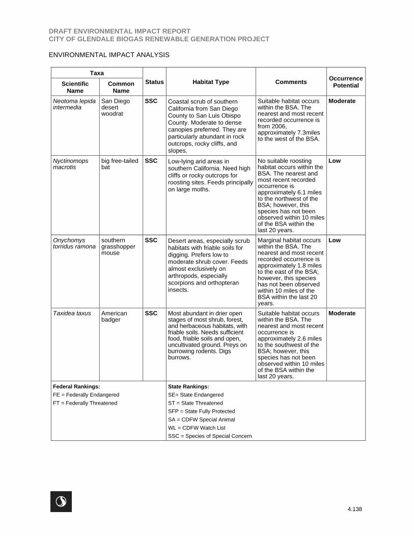
DRAFT ENVIRONMENTAL IMPACT REPORTCITY OF GLENDALE BIOGAS RENEWABLE GENERATION PROJECT
ENVIRONMENTAL IMPACT ANALYSIS
4.138
Taxa
Status Habitat Type CommentsOccurrence
PotentialScientificName
CommonName
Neotoma lepidaintermedia
San Diegodesertwoodrat
SSC Coastal scrub of southernCalifornia from San DiegoCounty to San Luis ObispoCounty. Moderate to densecanopies preferred. They areparticularly abundant in rockoutcrops, rocky cliffs, andslopes.
Suitable habitat occurswithin the BSA. Thenearest and most recentrecorded occurrence isfrom 2006,approximately 7.3milesto the west of the BSA.
Moderate
Nyctinomopsmacrotis
big free-tailedbat
SSC Low-lying arid areas insouthern California. Need highcliffs or rocky outcrops forroosting sites. Feeds principallyon large moths.
No suitable roostinghabitat occurs within theBSA. The nearest andmost recent recordedoccurrence isapproximately 6.1 milesto the northwest of theBSA; however, thisspecies has not beenobserved within 10 milesof the BSA within thelast 20 years.
Low
Onychomystorridus ramona
southerngrasshoppermouse
SSC Desert areas, especially scrubhabitats with friable soils fordigging. Prefers low tomoderate shrub cover. Feedsalmost exclusively onarthropods, especiallyscorpions and orthopteraninsects.
Marginal habitat occurswithin the BSA. Thenearest and most recentrecorded occurrence isapproximately 1.8 milesto the east of the BSA;however, this specieshas not been observedwithin 10 miles of theBSA within the last 20years.
Low
Taxidea taxus Americanbadger
SSC Most abundant in drier openstages of most shrub, forest,and herbaceous habitats, withfriable soils. Needs sufficientfood, friable soils and open,uncultivated ground. Preys onburrowing rodents. Digsburrows.
Suitable habitat occurswithin the BSA. Thenearest and most recentoccurrence isapproximately 2.6 milesto the southwest of theBSA; however, thisspecies has not beenobserved within 10 milesof the BSA within thelast 20 years.
Moderate
Federal Rankings:
FE = Federally Endangered
FT = Federally Threatened
State Rankings:
SE= State Endangered
ST = State Threatened
SFP = State Fully Protected
SA = CDFW Special Animal
WL = CDFW Watch List
SSC = Species of Special Concern

DRAFT ENVIRONMENTAL IMPACT REPORTCITY OF GLENDALE BIOGAS RENEWABLE GENERATION PROJECT
ENVIRONMENTAL IMPACT ANALYSIS
4.139
Wildlife Corridors and Special Linkages
Linkages and corridors facilitate regional animal movement and are generally centered in or around
waterways, riparian corridors, flood control channels, contiguous habitat, and upland habitat. Drainages
generally serve as movement corridors because wildlife can move easily through these areas, and fresh
water is available. Corridors also offer wildlife unobstructed terrain for foraging and for dispersal of young
individuals.
As the movements of wildlife species are more intensively studied using radio-tracking devices, there is
mounting evidence that some wildlife species do not necessarily restrict their movements to some
obvious landscape element, such as a riparian corridor. For example, recent radio-tracking and tagging
studies of Coast Range newts, California red-legged frogs, southwestern pond turtles, and two-striped
garter snakes found that long-distance dispersal involved radial or perpendicular movements away from a
water source with little regard to the orientation of the assumed riparian “movement corridor” (Hunt, 1993;
Rathbun et al., 1992; Bulger et al., 2002; Trenham, 2002; Ramirez, 2002, 2003a, 2003b). Likewise,
carnivores do not necessarily use riparian corridors as movement corridors, frequently moving overland in
a straight line between two points when traversing large distances (Newmark, 1995; Beier, 1993, 1995;
Noss, et al., 1996; Noss et al., no date). In general, the following corridor functions can be utilized when
evaluating impacts to wildlife movement corridors:
Movement corridors are physical connections that allow wildlife to move between patches ofsuitable habitat. Simberloff et al. (1992) and Beier and Loe (1992) correctly state that, for mostspecies, we do not know what corridor traits (length, width, adjacent land use, etc.) are requiredfor a corridor to be useful. But, as Beier and Loe (1992) also note, the critical features of amovement corridor may not be its physical traits but rather how well a particular piece of landfulfills several functions, including allowing dispersal, plant propagation, genetic interchange, andrecolonization following local extirpation.
Dispersal corridors are relatively narrow, linear landscape features embedded in a dissimilarmatrix that links two or more areas of suitable habitat that would otherwise be fragmented andisolated from one another by rugged terrain, changes in vegetation, or human-alteredenvironments. Corridors of habitat are essential to the local and regional population dynamics ofa species because they provide physical links for genetic exchange and allow animals to accessalternative territories as dictated by fluctuating population densities.
Habitat linkages are broader connections between two or more habitat areas. This term iscommonly used as a synonym for a wildlife corridor (Meffe and Carroll, 1997). Habitat linkagesmay themselves serve as source areas for food, water, and cover, particularly for small- andmedium-size animals.
Travel routes are usually landscape features, such as ridgelines, drainages, canyons, or ripariancorridors within larger natural habitat areas that are used frequently by animals to facilitatemovement and provide access to water, food, cover, den sites, or other necessary resources. Atravel route is generally preferred by a species because it provides the least amount oftopographic resistance in moving from one area to another yet still provides adequate food,water, or cover (Meffe and Carroll, 1997).

DRAFT ENVIRONMENTAL IMPACT REPORTCITY OF GLENDALE BIOGAS RENEWABLE GENERATION PROJECT
ENVIRONMENTAL IMPACT ANALYSIS
4.140
Wildlife crossings are small, narrow areas of limited extent that allow wildlife to bypass anobstacle or barrier. Crossings typically are manmade and include culverts, underpasses, drainagepipes, bridges, and tunnels to provide access past roads, highways, pipelines, or other physicalobstacles. Wildlife crossings often represent “choke points” along a movement corridor becauseuseable habitat is physically constricted at the crossing by human-induced changes to thesurrounding areas (Meffe and Carroll, 1997).
Wildlife Movement within the BSA
The BSA is situated in the San Rafael Hills, which functions as an “island” in which patches of native
habitat occur surrounded by the heavily developed City of Glendale and the greater Los Angeles area.
This relatively small expanse of native habitat and isolation from wider areas of open space would
significantly constrain the movement of certain types of wildlife, particularly megafauna, within the San
Rafael Hills and by extension, within the BSA. The BSA is characterized primarily by open space;
however much of that land is occupied by the SCLF and recreational facilities (baseball field and golf
course) that generally lack the cover, presence of refugia, or other characteristics conducive the
permanent use of and/or movement through a habitat by many native wildlife species.
Other barriers to terrestrial wildlife movement within the BSA include residential development, fencing,
and roadways. There are localized portions of open space occupied by native habitat within the BSA such
as the slopes to the north and south of the SCLF. These more open areas likely provide “live-in habitat”
for a variety of common species habituated to life in urban environments such as Virginia opossum,
raccoon, Audubon’s cottontail, California ground squirrel, and other small rodents. Mammalian carnivores
are not typically deterred by the open conditions within the landfill areas because they are less dependent
on cover. Although some species may use the SCLF for movement, the majority of species have been
known to avoid the area and use the more natural adjacent canyons and watersheds. It is likely that the
ridgelines on and off the SCLF property would serve as the principal wildlife movement and dispersal
corridors for most species found on or in the immediate vicinity of the proposed Project, and species will
not need to cross through open, disturbed areas of the SCLF (Sanitation Districts of Los Angeles County
and AECOM, 2014).
The Pacific Flyway, a major bird migration route, passes through California from Oregon to the north and
Mexico to the south. The proposed Project does not fall within the Pacific Flyway’s major or principal bird
migration routes.
4.3.2 Laws, Ordinances, Regulations, and Standards
4.3.2.1 Federal
Federal Endangered Species Act
Federal ESA provisions protect federally listed threatened and endangered species and their habitats
from unlawful take and ensure that federal actions do not jeopardize the continued existence of a listed
species or result in the destruction or adverse modification of designated critical habitat. Under the ESA,
“take” is defined as “to harass, harm, pursue, hunt, shoot, wound, kill, trap, capture, or collect, or to
attempt to engage in any of the specifically enumerated conduct.” The USFWS regulations define harm to
DRAFT ENVIRONMENTAL IMPACT REPORTCITY OF GLENDALE BIOGAS RENEWABLE GENERATION PROJECT
ENVIRONMENTAL IMPACT ANALYSIS
4.141
mean “an act which actually kills or injures wild-life.” Such an act “may include significant habitat
modification or degradation where it actually kills or injures wildlife by significantly impairing essential
behavioral patterns, including breeding, feeding or sheltering” (50 CFR § 17.3). Critical habitat is defined
in Section 3(5)(A) of the ESA as “(i) the specific areas within the geographical area occupied by the
species on which are found those physical or biological features (I) essential to the conservation of the
species, and (II) which may require special management considerations or protection; and (ii) specific
areas outside the geographical area occupied by the species upon a determination by the Secretary of
Commerce or the Secretary of the Interior (Secretary) that such areas are essential for the conservation
of the species.” The effects analyses for designated critical habitat must consider the role of the critical
habitat in both the continued survival and the eventual recovery (i.e., the conservation) of the species in
question, consistent with the Ninth Circuit judicial opinion, Gifford Pinchot Task Force v. USFWS.
Activities that may result in “take” of individuals are regulated by the USFWS. The USFWS produced an
updated list of candidate species December 6, 2007 (72 FR 69034). Candidate species are not afforded
any legal protection under ESA; however, candidate species typically receive special attention from
Federal and State agencies during the environmental review process.
Migratory Bird Treaty Act
The Migratory Bird Treaty Act (MBTA) of 1918 (16 U.S.C. 703-711) makes it unlawful to possess, buy,
sell, purchase, barter or “take” any migratory bird listed in Title 50 of the Code of Federal Regulations
(CFR) Part 10. “Take” is defined as possession or destruction of migratory birds, their nests or eggs.
Disturbances that cause nest abandonment and/or loss of reproductive effort or the loss of habitats upon
which these birds depend may be a violation of the MBTA. The MBTA prohibits killing, possessing, or
trading in migratory birds except in accordance with regulations prescribed by the Secretary. This act
encompasses whole birds, parts of birds, and bird nests and eggs.
Bald and Golden Eagle Protection Act of 1940 (16 USC 668)
The Bald Eagle Protection Act of 1940 (16 USC 668, enacted by 54 Stat. 250) protects bald and golden
eagles by prohibiting the taking, possession, and commerce of such birds and establishes civil penalties
for violation of this Act. Take of bald and golden eagles is defined as follows: “disturb means to agitate or
bother a bald or golden eagle to a degree that causes, or is likely to cause, based on the best scientific
information available, (1) injury to an eagle, (2) a decrease in its productivity, by substantially interfering
with normal breeding, feeding, or sheltering behavior, or (3) nest abandonment, by substantially
interfering with normal breeding, feeding, or sheltering behavior’’ (72 FR 31132; 50 CFR 22.3).
The USFWS is the primary federal authority charged with the management of golden eagles in the United
States. A permit for take of golden eagles, including take from disturbance such as loss of foraging
habitat, may be required if this Project affects such resources. USFWS guidance on the applicability of
current Eagle Act statutes and mitigation is currently under review. On November 10, 2009, the USFWS
implemented new rules (74 FR 46835) governing the “take” of golden and bald eagles. The new rules
were released under the existing Bald and Golden Eagle Act which has been the primary regulation
protection unlisted eagle populations since 1940. All activities that may disturb or incidentally take an
eagle or its nest as a result of an otherwise legal activity must be permitted by the USFWS under this act.
The definition of disturb (72 FR 31132) includes interfering with normal breeding, feeding, or sheltering

DRAFT ENVIRONMENTAL IMPACT REPORTCITY OF GLENDALE BIOGAS RENEWABLE GENERATION PROJECT
ENVIRONMENTAL IMPACT ANALYSIS
4.142
behavior to the degree that it causes or is likely to cause decreased productivity or nest abandonment. If
a permit is required, due to the current uncertainty on the status of golden eagle populations in western
United States, it is expected permits would only be issued for safety emergencies or if conservation
measures implemented in accordance with a permit would result in a reduction of ongoing take or a net
take of zero.
Federally Regulated Habitats
Areas meeting the regulatory definition of “Waters of the U.S.” (Jurisdictional Waters) are subject to the
jurisdiction of the USACE under provisions of Section 404 of the Clean Water Act (CWA) (1972) and
Section 10 of the Rivers and Harbors Act (1899). These waters may include all waters used, or potentially
used, for interstate commerce, including all waters subject to the ebb and flow of the tide, all interstate
waters, all other waters (intrastate lakes, rivers, streams, mudflats, sandflats, playa lakes, natural ponds,
etc.), all impoundments of waters otherwise defined as “Waters of the U.S.,” tributaries of waters
otherwise defined as “Waters of the U.S.,” the territorial seas, and wetlands (termed Special Aquatic
Sites) adjacent to “Waters of the U.S.” (33 CFR, Part 328, Section 328.3). Wetlands on non-agricultural
lands are identified using the Corps of Engineers Wetlands Delineation Manual (Environmental
Laboratory, 1987). The BSA falls within the South Pacific Division of the USACE and is under the
jurisdiction of the Los Angeles District.
Construction activities within jurisdictional waters are regulated by the USACE. The placement of fill into
such waters must comply with permit requirements of the USACE. No USACE permit would be effective
in the absence of State water quality certification pursuant to Section 401 of the CWA. As a part of the
permit process the USACE works directly with the USFWS to assess potential project impacts on
biological resources.
4.3.2.2 State
California Environmental Quality Act
The California Environmental Quality Act (CEQA) establishes State policy to prevent significant,
avoidable damage to the environment by requiring changes in projects through the use of alternatives or
mitigation measures. CEQA applies to actions directly undertaken, financed, or permitted by State lead
agencies. Regulations for implementation are found in the State CEQA Guidelines published by the
Resources Agency. These guidelines establish an overall process for the environmental evaluation of
projects.
California Endangered Species Act
Provisions of the California ESA protect State-listed Threatened and Endangered species. The CDFW
regulates activities that may result in “take” of individuals (“take” means “hunt, pursue, catch, capture, or
kill, or attempt to hunt, pursue, catch, capture, or kill”). Habitat degradation or modification is not expressly
included in the definition of “take” under the California Fish and Game Code. Additionally, the California
Fish and Game Code contains lists of vertebrate species designated as “fully protected” (California Fish &
Game Code §§ 3511 [birds], 4700 [mammals], 5050 [reptiles and amphibians], 5515 [fish]). Such species
may not be taken or possessed.

DRAFT ENVIRONMENTAL IMPACT REPORTCITY OF GLENDALE BIOGAS RENEWABLE GENERATION PROJECT
ENVIRONMENTAL IMPACT ANALYSIS
4.143
In addition to Federal and State-listed species, the CDFW also has produced a list of Species of Special
Concern to serve as a “watch list.” Species on this list are of limited distribution or the extent of their
habitats has been reduced substantially, such that threat to their populations may be imminent. Species
of Special Concern may receive special attention during environmental review, but they do not have
statutory protection.
Birds of prey are protected in California under the State Fish and Game Code. Section 3503.5 states it is
“unlawful to take, possess, or destroy any birds of prey (in the order Falconiformes or Strigiformes) or to
take, possess, or destroy the nest or eggs of any such bird except as otherwise provided by this Code or
any regulation adopted pursuant thereto.” Construction disturbance during the breeding season could
result in the incidental loss of fertile eggs or nestlings or otherwise lead to nest abandonment.
Disturbance that causes nest abandonment and/or loss of reproductive effort is considered “take” by the
CDFW. Under Sections 3503 and 3503.5 of the State Fish and Game Code, activities that would result in
the taking, possessing, or destroying of any birds-of-prey, taking or possessing of any migratory nongame
bird as designated in the MBTA, or the taking, possessing, or needlessly destroying of the nest or eggs of
any raptors or non-game birds protected by the MBTA, or the taking of any non-game bird pursuant to
Fish and Game Code Section 3800 are prohibited.
Native Plant Protection Act (Fish & Game Code 1900-1913)
California’s Native Plant Protection Act (NPPA) requires all State agencies to utilize their authority to carry
out programs to conserve endangered and rare native plants. Provisions of NPPA prohibit the taking of
listed plants from the wild and require notification of the CDFW at least 10 days in advance of any change
in land use. This allows CDFW to salvage listed plant species that would otherwise be destroyed. The
Applicant is required to conduct botanical inventories and consult with CDFW during project planning to
comply with the provisions of this act and sections of CEQA that apply to rare or endangered plants.
Sections 3503 & 3503.5 of the Fish and Game Code
Under these sections of the Fish and Game Code, the Applicant is not allowed to conduct activities that
would result in the taking, possessing, or destroying of any birds-of-prey, taking or possessing of any
migratory non-game bird as designated in the MBTA, or the taking, possessing, or needlessly destroying
of the nest or eggs of any raptors or non-game birds protected by the MBTA, or the taking of any non-
game bird pursuant to Fish and Game Code Section 3800.
Porter-Cologne Water Quality Control Act
RWQCBs regulate the “discharge of waste” to “waters of the State.” All projects proposing to discharge
waste that could affect waters of the State must file a waste discharge report with the appropriate regional
board. The board responds to the report by issuing waste discharge requirements (WDR) or by waiving
WDRs for that project discharge. Both terms “discharge of waste” and “waters of the State” are broadly
defined such that discharges of waste include fill, any material resulting from human activity, or any other
“discharge.” Isolated wetlands within California, which are no longer considered “waters of the United
States” as defined by Section 404 of the CWA, are addressed under the Porter-Cologne Act.
DRAFT ENVIRONMENTAL IMPACT REPORTCITY OF GLENDALE BIOGAS RENEWABLE GENERATION PROJECT
ENVIRONMENTAL IMPACT ANALYSIS
4.144
State-Regulated Habitats
The State Water Resources Control Board is the State agency (together with the RWQCBs) charged with
implementing water quality certification in California. The BSA falls under the jurisdiction of the Los
Angeles RWQCB.
The CDFW extends the definition of stream to include “intermittent and ephemeral streams, rivers,
creeks, dry washes, sloughs, blue-line streams (USGS-defined), and watercourses with subsurface flows.
Canals, aqueducts, irrigation ditches, and other means of water conveyance can also be considered
streams if they support aquatic life, riparian vegetation, or stream-dependent terrestrial wildlife” (CDFW,
1994).
Activities that result in the diversion or obstruction of the natural flow of a stream; or which substantially
change its bed, channel, or bank; or which utilize any materials (including vegetation) from the
streambed, may require that the project applicant enter into a Streambed Alteration Agreement with the
CDFW.
4.3.2.3 Local
City of Glendale General Plan – Open Space and Conservation Element
The Open Space and Conservation Element of the City of Glendale General Plan (Glendale 1993)
contains policies and programs which are designed to identify and manage natural resources within the
City. It provides a broad overview of existing conditions, issues, and opportunities and a comprehensive
approach to the management of natural resources.
The Policies relative to natural resources that apply to the BSA are as follows:
Policy 1: Natural resources, including open spaces, biological habitats, and native plant communities
should be maintained and, where necessary, restored.
Policy 4: Natural and man-made aesthetic features should be recognized and identified as important
natural resources to the community that require proper management.
Policy 5: Proper management of environmental resources, especially natural resources, can assist in
reducing hazards to the life and property of the City's residents and should be considered in project
planning.
Policy 7: Projects proposed by public agencies, special districts and private developers should
demonstrate compliance with the policies, goals and objectives of this element prior to proceeding.
The Goals and Objectives relative to natural resources that apply to the BSA are as follows:
Goal 1: Continue identification, acquisition, and protection of open space land vital to ensure
enhancement of the quality of life within the City.
DRAFT ENVIRONMENTAL IMPACT REPORTCITY OF GLENDALE BIOGAS RENEWABLE GENERATION PROJECT
ENVIRONMENTAL IMPACT ANALYSIS
4.145
Objective 3: Develop a fee structure for open space acquisition and management in connection
with the development review process.
Objective 5: During the environmental and development review processes, on- and off-site
impacts of development on open space and related biological and geological systems should be
evaluated. Mitigation measures should be applied to alleviate specific impacts through site
planning and design modifications that will protect the integrity of valuable open spaces.
Goal 2: Protect vital or sensitive open space areas including ridgelines, canyons, streams, geologic
formations, watersheds and historic, cultural, aesthetic and ecologically significant areas from the
negative impacts of development and urbanization.
Objective 3: Continue to apply and monitor open space protection measures as part of the
environmental and development review processes.
Objective 5: During the environmental and development review processes, on- and off-site
impacts of development on open space and related biological and geological systems should be
evaluated. Mitigation measures should be applied to alleviate specific impacts through site
planning and design modifications that will protect the integrity of valuable open spaces.
Goal 4: Develop a program that sustains the quality of Glendale’s natural communities.
Objective 2: Prevent development that jeopardizes or diminishes the integrity and value of native
plant and animal communities.
Objective 4: Naturalize, through native revegetation programs, disturbed areas, and prevent the
invasion of exotic plant materials.
Objective 5: Encourage the development of landscape plans that incorporate native species in
those areas adjoining open space land.
Goal 12: Continue to conserve water resources and provide for the protection and improvement of water
quality.
Objective 6: Continue to monitor, inventory land uses and coordinate with the Environmental
Protection Agency (EPA) to avoid ground water pollution and improve groundwater quality with
particular emphasis on industrial areas and landfills.
City of Glendale Indigenous (Protected) Tree Program
The indigenous oak, bay, and sycamore trees within the city are natural aesthetic resources which help
define the character of the city. These trees are worthy of protection in order to preserve the natural
environment and to protect the city’s native plant life heritage for the benefit of all residents. Oak, bay,
and sycamore trees are unique because of their size and beauty and their relative abundance adds
distinction and character to certain neighborhoods within the community. It is pertinent to the public
interest, health and welfare that these trees be protected from mutilation, indiscriminate cutting, damage,
destruction or removal in order to provide for conservation purposes, for counteracting air and noise

DRAFT ENVIRONMENTAL IMPACT REPORTCITY OF GLENDALE BIOGAS RENEWABLE GENERATION PROJECT
ENVIRONMENTAL IMPACT ANALYSIS
4.146
pollution and minimizing soil erosion and related environmental damage, as well as for the preservation of
the natural beauty which the oak, bay, and sycamore trees lend to the city. It is the intent of this ordinance
to create favorable conditions for the preservation of indigenous trees in the community while respecting
individual rights to develop, maintain and enjoy private property to the fullest possible extent consistent
with the public interest, health and welfare. (Ord. 5719, § 1, 12-7-2010)
Except as provided in sections 12.44.030 and 12.44.060 of the Glendale Municipal Code, a permit shall
be required of any person who proposes to cut, remove, encroach upon, or relocate a protected
indigenous tree. (Ord. 5719, § 1, 12-7-2010).
4.3.2.4 Other Applicable Plans, Regulations, and Standards
California Native Plant Society Rare Plant Program
The mission of the CNPS Rare Plant Program is to develop current, accurate information on the
distribution, ecology, and conservation status of California’s rare and endangered plants, and to use this
information to promote science-based plant conservation in California. Once a species has been
identified as being of potential conservation concern, it is put through an extensive review process. Once
a species has gone through the review process, information on all aspects of the species (e.g., listing
status, habitat, distribution, threats, etc.) are entered into the online CNPS Inventory and given a
California Rare Plant Rank (CRPR). In 2011, the CNPS officially changed the name “CNPS List” to
“CRPR.” The Program currently recognizes more than 1,600 plant taxa (species, subspecies and
varieties) as rare or endangered in California.
Vascular plants listed as rare or endangered by the CNPS, but which might not have a designated status
under State endangered species legislation, are defined by the following CRPR:
CRPR 1A - Plants considered by the CNPS to be extinct in California
CRPR 1B - Plants rare, threatened, or endangered in California and elsewhere
CRPR 2 - Plants rare, threatened, or endangered in California, but more numerous elsewhere
CRPR 3 - Plants about which we need more information – a review list
CRPR 4 - Plants of limited distribution – a watch list
In addition to the CRPR designations above, the CNPS adds a Threat Rank as an extension added onto
the CRPR and designates the level of endangerment by a 1 to 3 ranking, with 1 being the most
endangered and 3 being the least endangered. These are described as follows:
0.1 – Seriously threatened in California (high degree/immediacy of threat)
0.2 – Fairly threatened in California (moderate degree/immediacy of threat)
0.3 – Not very threatened in California (low degree/immediacy of threats or no current threatsknown)

DRAFT ENVIRONMENTAL IMPACT REPORTCITY OF GLENDALE BIOGAS RENEWABLE GENERATION PROJECT
ENVIRONMENTAL IMPACT ANALYSIS
4.147
4.3.3 Methodology and Thresholds of Significance
4.3.3.1 Methodology
The analysis below examines the potential impacts to plant and wildlife resources that may occur as a
result of implementation of the proposed Project. For the purpose of this assessment, project-related
impacts take two forms, direct and indirect. Direct impacts are those that involve the loss, modification or
disturbance of natural habitats (i.e., vegetation or plant communities), which in turn, directly affect plant
and wildlife species dependent on that habitat. Direct impacts also include the destruction of individual
plants or wildlife, which is typically the case in species of low mobility (i.e., plants, amphibians, reptiles,
and small mammals). The collective loss of individuals in these manners may also directly affect regional
population numbers of a species or result in the physical isolation of populations thereby reducing genetic
diversity and, hence, population stability.
Indirect impacts are those that involve the effects of increases in ambient levels of sensory stimuli (e.g.,
noise, light), unnatural predators (e.g., domestic cats and other non-native animals), and competitors
(e.g., exotic plants, non-native animals). Indirect impacts may be associated with the construction and/or
eventual habitation/operation of a project; therefore, these impacts may be both short-term and long-term
in their duration. These impacts are commonly referred to as “edge effects” and may result in changes in
the behavioral patterns of wildlife and reduced wildlife diversity and abundance in habitats adjacent to
project sites.
Operational impacts include both direct and potential indirect impacts to biological resources. Ongoing
Operations and Maintenance (O&M) impacts would occur during routine inspection and maintenance of
proposed Project components and would include such activities as routine inspection of proposed Project-
related facilities and emergency repairs. Operational impacts would also include weed abatement and
vegetation management activities including but not limited to mechanical removal or mowing, hand removal,
or herbicide treatment. These impacts would remain an ongoing source of disturbance for many plants and
wildlife species that occur.
The determination of impacts in this analysis is based on both the proposed Project development and the
biological values of the habitat and/or sensitivity of plant and wildlife species to be affected.
The biological values of resources within, adjacent to, and outside the area to be affected by the
proposed Project were determined by consideration of several factors, as applicable. These included the
overall size of habitats to be affected, the previous land uses and disturbance history, the surrounding
environment and regional context, the on-site biological diversity and abundance, the presence of special-
status plant and wildlife species, the importance to regional populations of these species, and the degree
to which on-site habitats are limited or restricted in distribution on a regional basis and, therefore, are
considered sensitive in themselves. Therefore, the focus of this impact analysis is on sensitive plant
communities/habitats, resources that play an important role in regional biological systems, and special-
status species.
DRAFT ENVIRONMENTAL IMPACT REPORTCITY OF GLENDALE BIOGAS RENEWABLE GENERATION PROJECT
ENVIRONMENTAL IMPACT ANALYSIS
4.148
4.3.3.2 Thresholds of Significance
As determined in the Initial Study, the proposed Project would not conflict with the provisions of an
adopted Habitat Conservation Plan, Natural Community Conservation Plan, or other approved local,
regional, or state habitat conservation plan. According to the Glendale General Plan, there is no habitat
conservation plan or natural habitat community conservation plan in the City. There is, however, a
Significant Ecological Area (SEA) program in the City, intended to preserve these designated sensitive
areas. The Project site is not located within a SEA. As such, implementation of the proposed Project
would not conflict with the SEA program or other Habitat conservation plans. There would be no impact in
this regard.
In accordance with Appendix G of the State CEQA Guidelines, the proposed Project would have a
significant impact related to biological resources if it would:
Have a substantial adverse effect, either directly or through habitat modifications, on any speciesidentified as a candidate, sensitive, or special status species in local or regional plans, policies, orregulations, or by the California Department of Fish and Game or USFWS.
Have a substantial adverse effect on any riparian habitat or other sensitive natural communityidentified in local or regional plans, policies, regulations, or by the California Department of Fishand Game or USFWS.
Have a substantial adverse effect on federally protected wetlands (including, but not limited to,marsh, vernal pool, coastal, etc.) through direct removal, filling, hydrological interruption, or othermeans.
Interfere substantially with the movement of any native resident or migratory fish or wildlifespecies or with established native resident or migratory wildlife corridors or impede the use ofnative wildlife nursery sites.
Conflict with any local polices or ordinances protecting biological resources, such as a treepreservation policy or ordinance.
4.3.4 Project Impacts
Threshold: Would the Project have a substantial adverse effect, either directly or through habitat
modifications, on any species identified as a candidate, sensitive, or special status species in
local or regional plans, policies, or regulations, or by the California Department of Fish and Game
or U.S. Fish and Wildlife Service?
Candidate, Sensitive, or Special-Status Plants
State or federally listed and special-status plant species were not detected within proposed Project impact
areas. General botanical surveys of the proposed Project site were conducted in 2015, 2016, 2017, and
2019; focused rare plant surveys were conducted in the spring and summer of 2016. Seasonal rainfall
across Southern California in from 2015 – 2017 was extremely limited, which may have reduced the
potential to detect sensitive plants within the proposed Project areas. Southern California experienced
average to above average rainfall in 2018/2019, which provided ideal conditions for species to occur.
DRAFT ENVIRONMENTAL IMPACT REPORTCITY OF GLENDALE BIOGAS RENEWABLE GENERATION PROJECT
ENVIRONMENTAL IMPACT ANALYSIS
4.149
Although the recent droughts may have limited the detectability of some annual plants, plant expression
was considered good to excellent in the majority of the proposed Project area that was surveyed.
Direct impacts to listed or special-status plants would include for example, trampling or crushing from
heavy equipment, vehicles, or foot traffic, alterations to the native seed bank due to soil compaction, and
modifications to existing hydrological conditions. Potential indirect impacts could include the disruption of
native seed banks through soil alterations, the accumulation of fugitive dust, increased erosion and
sediment transport, and the colonization of non-native, invasive plant species. Excessive dust can
decrease or limit plant survivorship by decreasing photosynthetic output, reducing transpiration, and
adversely affecting reproductive success. Ground-disturbing activities that would occur during the
proposed Project can result in the proliferation and spread of non-native invasive plants to new areas.
Because noxious weeds can permanently degrade rare plant and animal habitats, their proliferation could
adversely affect listed plant species if they are present.
Operational impacts from routine maintenance and inspection would include trampling or crushing,
increased erosion, exposure to fugitive dust, and the spread and colonization of noxious weeds. Listed or
special-status plant species were not identified during focused surveys of the proposed Project area.
If present during construction, impacts to listed plant species would be considered significant and require
mitigation.
Mitigation Measures
BIO-1: Implement a Worker Environmental Awareness Program.
Prior to any Project activities on the site (i.e., surveying, mobilization, fencing, grading, or
construction), a Worker Environmental Awareness Program (WEAP) shall be prepared and
implemented by a qualified biologist(s). The WEAP shall be finalized and administered prior to
construction mobilization, and implemented throughout the duration of the construction activities,
such as when new contractor employees or subcontractors begin working on-site.
The WEAP shall include, at a minimum, the following items:
o Training materials and briefings shall include but not be limited to: a discussion of theFederal and State Endangered Species Acts, Bald and Golden Eagle Protection Act,and the Migratory Bird Treaty Act; the consequences of non-compliance with these acts;identification and values of plant and wildlife species and significant natural plantcommunity habitats; hazardous substance spill prevention and containment measures;a contact person and phone number in the event wildlife needs to be relocated or deador injured wildlife is discovered; and a review of mitigation requirements.
- A discussion of measures to be implemented for avoidance of the sensitive resourcesdiscussed above and the identification of an onsite contact in the event of the discoveryof sensitive species on the site; this shall include a discussion on microtrash.
- Protocols to be followed when roadkill is encountered in the work area or along accessroads and the identification of an onsite representative to whom the roadkill will bereported. Roadkill shall be reported to the appropriate local animal control agency within24 hours.

DRAFT ENVIRONMENTAL IMPACT REPORTCITY OF GLENDALE BIOGAS RENEWABLE GENERATION PROJECT
ENVIRONMENTAL IMPACT ANALYSIS
4.150
- Maps showing the known locations of special-status wildlife, populations of rare plantsand sensitive vegetation communities, seasonal depressions and known waterbodies,wetland habitat, exclusion areas, and other construction limitations (e.g. limitedoperating periods, etc.). These features shall be included on the proposed Project plansand specifications drawings.
- Literature and photographs or illustrations of potentially occurring special-status plantand/or wildlife species shall be provided to all Project contractors and heavy equipmentoperators.
Evidence that all onsite construction and security personnel have completed the WEAP prior tothe start of site mobilization. A special hardhat sticker or wallet size card shall be issued to allpersonnel completing the training, which shall be carried with the trained personnel at all timeswhile on the proposed Project site. All new personnel shall receive this training and may work inthe field for no more than five days without participating in the WEAP, accompanied by staff thathas undergone the training. A log of all personnel who have completed the WEAP training shallbe kept on-site.
The contract specification books shall include all project conditions as they relate to biologicalresources and shall be kept on-site at all times (e.g., in the break room, construction foreman’svehicle, construction trailer, etc.) for the duration of the construction. This information shall beeasily accessible for personnel in all active work areas.
Develop a standalone version of the WEAP, that covers all previously discussed items above,and that can be used as a reference for maintenance personnel during Project operations.
An environmental monitor shall be retained during construction of the proposed project and shallbe directly involved with the implementation and enforcement of the WEAP. A log of all personnelwho have completed the WEAP training shall be kept on-site.
BIO-2 Implement Best Management Practices
Best Management Practice (BMP) shall be implemented as standard operating procedures during all
ground disturbance and construction-related activities to avoid or minimize Project impacts on biological
resources. These BMPs shall include, but are not limited to, the following:
Compliance with BMPs shall be documented and provided in a written report upon conclusion ofconstruction activities. The report shall include a summary of the construction activitiescompleted, a review of the sensitive plants and wildlife encountered, a list of compliance actionsand any remedial actions taken to correct the actions, and the status of ongoing mitigation efforts.
Prior to ground disturbance of any kind, the project work areas shall be clearly delineated bystakes, flags, or other clearly identifiable system.
Vehicles and equipment shall be parked on pavement, existing roads, and previously disturbedareas to the extent practicable.
No vehicles or equipment shall be refueled within 100 feet of an ephemeral drainage or wetlandunless a bermed and lined refueling area is constructed. Spill kits shall be maintained on-site.
All general trash, food-related trash items (e.g., wrappers, cans, bottles, food scraps, cigarettes,etc.) and other human-generated debris shall be stored in animal proof containers and/orremoved from the site each day. No deliberate feeding of wildlife shall be allowed.

DRAFT ENVIRONMENTAL IMPACT REPORTCITY OF GLENDALE BIOGAS RENEWABLE GENERATION PROJECT
ENVIRONMENTAL IMPACT ANALYSIS
4.151
All pipes and culverts removed from (that remain on-site after removal) or brought on-site as partof new construction, with a diameter of greater than 4 inches, shall be capped or taped closed.Prior to capping or taping the pipe/culvert shall be inspected for the presence of wildlife by aqualified biologist. If encountered, wildlife shall be allowed to escape unimpeded.
No firearms shall be allowed on the project site, unless otherwise approved for securitypersonnel.
To prevent harassment or mortality of listed, special-status species and common wildlife, ordestruction of their habitats, no domesticated animals of any kind shall be permitted in any projectarea.
Use of chemicals, fuels, lubricants, or biocides shall be in compliance with all local, state andfederal regulations, and shall include secondary containment. All uses of such compounds shallobserve label and other restrictions mandated by the U.S. Environmental Protection Agency,California Department of Food and Agriculture, and other state and federal legislation, as well asadditional project-related restrictions deemed necessary by the USFWS and CDFW.
Any contractor or employee that inadvertently kills or injures a special-status animal, or finds oneeither dead, injured, or entrapped, shall immediately report the incident to the onsiterepresentative identified in the WEAP. The representative shall contact the USFWS, CDFW, andthe City of Glendale by telephone by the end of the day, or at the beginning of the next workingday if the agency office is closed. In addition, formal notification shall be provided in writing withinthree working days of the incident or finding. Notification shall include the date, time, location andcircumstances of the incident. Any threatened or endangered species found dead or injured shallbe turned over immediately to CDFW or USFWS for care, analysis, or disposition.
o Avoidance of vegetation removal or any other construction activities outside of theproposed Project boundaries. All Project impact areas must be clearly flagged prior toinitiating work. In areas of temporary impacts, native vegetation shall be cut to groundlevel and the root system left intact to permit resprouting following work (unless withinrequired fire clearance areas). All non-native vegetation within the temporary impactarea shall be removed initially, and any regrowth eliminated throughout construction, thehabitat restoration period and during the O&M phase.
o Avoidance and minimization of construction activities resulting in impacts to streambedsand banks of any ephemeral drainage.
o All excavation, steep-walled holes or trenches in excess of 6 inches in depth shall becovered at the close of each working day by plywood or similar materials or providedwith one or more escape ramps constructed of earth dirt fill or wooden planks. Trenchesshall also be inspected for entrapped wildlife each morning prior to onset of constructionactivities and immediately prior to covering with plywood at the end of each working day.Before such holes or trenches are filled, they shall be thoroughly inspected forentrapped wildlife. Any wildlife discovered shall be allowed to escape beforeconstruction activities are allowed to resume or removed from the trench or hole by aqualified biologist holding the appropriate permits (if required).
BIO-3 Implement Biological Construction Monitoring
Prior to the commencement of ground disturbance or site mobilization activities, the City of Glendale
shall retain a qualified biologist(s) to monitor Project construction. The biologist will have
demonstrated expertise with special- status plants, terrestrial mammals, reptiles, and birds.

DRAFT ENVIRONMENTAL IMPACT REPORTCITY OF GLENDALE BIOGAS RENEWABLE GENERATION PROJECT
ENVIRONMENTAL IMPACT ANALYSIS
4.152
Monitoring will occur continuously during initial ground disturbance for the duration of construction.
Once initial ground disturbance is complete, monitoring will occur periodically during all construction
activities. The qualified biologist(s) shall be present at all times during ground-disturbing activities
immediately adjacent to, or within, habitat that supports populations of listed or special- status
species. Any special-status plants shall be flagged for avoidance. Any special-status terrestrial
species found within a Project impact area shall be relocated by the authorized biologist to suitable
habitat outside the impact area. Surveys for special-status species shall be conducted by the
authorized biologist prior to the initiation of construction each day during initial ground disturbance,
and weekly thereafter. If nesting birds are found during the pre-construction surveys, buffers shall be
installed (as prescribed in Mitigation Measure BIO-5 Conduct Pre-construction Surveys for Nesting
and Breeding Birds and Implement Avoidance Measures discussed below.
If, during construction, the biological monitor observes a dead or injured special-status wildlife
species on the construction-site, a written report shall be sent to the City of Glendale, CDFW, and
USFWS (as appropriate) within five calendar days. The report will include the date, time of the
finding or incident (if known), and location of the carcass or injured animal and circumstances of its
death or injury (if known). Injured animals will be taken immediately to the nearest appropriate
veterinary or wildlife rehabilitation facility. The biological monitor shall, immediately upon finding the
remains or injured animal, coordinate with the onsite construction foreman to discuss the events that
caused the mortality or injury, if known, and implement measures to prevent future incidents. Details
of these measures shall be included with the report. Species remains shall be collected and frozen
as soon as possible, and CDFW and USFWS, as appropriate, shall be contacted regarding ultimate
disposal of the remains.
BIO-4 Conduct Pre-construction Surveys
Conduct pre-construction surveys for State and federally Threatened, Endangered, Proposed,
Petitioned, Candidate, and Special-status Plants and Avoid Any Located Occurrences of Listed
Plants or Perform other Conservation Strategy. The City of Glendale shall conduct focused surveys
for federal- and state-listed and other special-status plants. All special-status plant species (including
listed threatened or endangered species, and all CRPR 1A, 1B, 2, 3, and 4 species) subject to
disturbance shall be documented in a pre-construction survey report. Surveys shall be conducted
during the appropriate season in all suitable habitat located within the proposed Project disturbance
areas and within 100 feet of disturbance areas and access roads and be conducted by a qualified
botanist. The field surveys and reporting must conform to current CDFW botanical field survey
protocols (CDFW, 2009) or more recent updates, if available. The report will describe any conditions
that may have prevented target species from being located or identified, even if they are present as
dormant seed or below-ground rootstock (e.g., poor rainfall, recent grazing, or wildfire).
If federally or State-listed plants are detected in disturbance areas or within 100-feet of the
disturbance areas, the City of Glendale would avoid these populations and notify the USFWS and
CDFW as appropriate.
The City of Glendale shall avoid impacts to any State or federally listed plants to the extent feasible.
If Project activities result in the loss of more than ten percent of the known individuals within a

DRAFT ENVIRONMENTAL IMPACT REPORTCITY OF GLENDALE BIOGAS RENEWABLE GENERATION PROJECT
ENVIRONMENTAL IMPACT ANALYSIS
4.153
special-status plant species (List 1.B and List 2 only) occurrence/population to be impacted, the City
of Glendale shall consult with USFWS and CDFW regarding the most appropriate conservation
strategy for the particular species being impacted.
Level of Significance After Mitigation
Implementation of Mitigation Measures BIO-1 (Implement a Worker Environmental Education Program),
BIO-2 (Implement Best Management Practices), BIO-3 (Implement Biological Construction Monitoring)
would minimize impacts to special-status plant species. These measures include worker education
describing the sensitive biological resources that occur on the proposed Project site, implementation of
BMPs to minimize and avoid impacts, and conducting biological monitoring during ground- disturbing and
other construction-related activities. In addition, implementation of Mitigation Measure BIO-4 (Conduct
Pre-construction Surveys) would protect occurrences of listed plant species and require compensation for
impacts to special-status plant species. Implementation of these mitigation measures would reduce
impacts to listed or special-status plants to a less than significant level.
Candidate, Sensitive, or Special-Status Wildlife
Surveys conducted within the proposed Project impact areas in 2015, 2016, 2017, and 2019, did not
result in the observation of state or federally listed and special-status wildlife species. Project related
impacts to state or federally listed and special-status wildlife species would be as follows:
Special-Status Invertebrates and Reptiles
Construction activities associated with the proposed Project could result in the direct loss of sensitive
invertebrates and reptiles. Given the ecology of these species and cryptic nature, it is likely that some or
all of the species may occur in or near the proposed Project site. Direct impacts could result from potential
mechanical crushing during construction, fugitive dust, and general disturbance due to increased human
activity. proposed Project implementation may also result in permanent loss of habitat from the removal of
debris piles or trampling of soft friable soils required for burrowing. Indirect impacts could include
compaction of soils and the introduction of exotic plant species.
Operational impacts include increased human presence, the spread of noxious weeds due to the use of
new or improved access roads, and increased perch sites for avian predators. Inspection and
maintenance of the underground gen-tie lines could result in trampling or crushing of small invertebrates
and reptiles by vehicular or foot traffic, alterations in topography and hydrology, increased erosion and
sedimentation, and the introduction of non-native, invasive plants due to increased human presence.
Special-Status Birds
Construction activities associated with the proposed Project could result in direct and indirect impacts to a
variety of sensitive resident and migratory birds. Direct impacts to most listed species are not anticipated
because nesting habitat for most listed birds is not present on-site.
Project activities have the potential to impact nesting birds through direct impacts such as ground-
disturbing activities associated with excavation of the existing levee, construction of new heightened

DRAFT ENVIRONMENTAL IMPACT REPORTCITY OF GLENDALE BIOGAS RENEWABLE GENERATION PROJECT
ENVIRONMENTAL IMPACT ANALYSIS
4.154
levee, and increased human presence. During the breeding season, construction activities could result in
the displacement of breeding birds and the abandonment of active nests. Potential indirect impacts could
include the deterioration of habitat as a result of the spread of noxious weeds, increased noise levels from
heavy equipment and sheet pile installation, exposure to fugitive dust, and human presence during
repairs to the levees and floodwalls or routine inspection of the facilities. Weed management could also
affect nesting.
During O&M of the proposed Project, impacts to nesting birds would include increased human
disturbance, exposure to fugitive dust, the spread of noxious weeds, and disruption of breeding or
foraging activity due to routine inspection and maintenance activities. Weed abatement through herbicide
application or mechanized tools could also affect nesting.
If project construction were to occur during the avian nesting season (generally considered to be between
February 15th through September 15th; although some raptors species may nest as early as January)
indirect impacts to nesting birds could occur; the MBTA of 1918 (16 USC 703-711) does not allow for take
of migratory birds.
The MBTA makes it unlawful to possess, buy, sell, purchase, barter or “take” any migratory bird listed in
Title 50 of the CFR Part 10. “Take” is defined as possession or destruction of migratory birds, their nests
or eggs. Disturbances that cause nest abandonment and/or loss of reproductive effort or the loss of
habitats upon which these birds depend may be a violation of the MBTA. The MBTA prohibits killing,
possessing, or trading in migratory birds except in accordance with regulations prescribed by the
Secretary. This act encompasses whole birds, parts of birds, and bird nests and eggs.
Project activities that result in the degradation to habitat for or the loss of endangered, threatened, or
other special-status species would be considered a significant adverse impact requiring mitigation.
Special Status Mammals
No special-status mammal species were detected within proposed Project impact areas. The proposed
Project area and adjacent habitats have the potential to support a variety of special-status mammals
including the American badger and the San Diego desert woodrat, both CDFW Species of Special
Concern. Direct impacts to these species would include mechanical crushing by vehicles and construction
equipment, trampling, and loss of habitat. Construction disturbance can also result in the flushing of small
animals from refugia which increases the predation risk for small rodents. Potential indirect impacts
include exposure to fugitive dust, alteration of soils, such as compaction, that could preclude burrowing,
the spread of exotic weeds, and increased noise levels.
During O&M of the proposed Project, impacts to sensitive mammals would include increased human
disturbance, exposure to fugitive dust, the spread of noxious weeds, and disruption of breeding or
foraging activity due to routine inspection and maintenance activities. Weed abatement through herbicide
application or mechanized tools could also affect mammal species.
Because the proposed Project would remove or disturb vegetation and these animals would be subject to
mortality from the construction of the proposed Project, impacts to these species would be considered
significant adverse effects requiring mitigation.

DRAFT ENVIRONMENTAL IMPACT REPORTCITY OF GLENDALE BIOGAS RENEWABLE GENERATION PROJECT
ENVIRONMENTAL IMPACT ANALYSIS
4.155
Mitigation Measures
BIO-1 Implement a Worker Environmental Education Program
BIO-2 Implement Best Management Practices (BMPs)
BIO-3 Implement Biological Construction Monitoring
BIO-5 Conduct Pre-construction Surveys for Nesting and Breeding Birds and Implement
Avoidance Measures
Prior to construction activities (i.e., mobilization, staging, grading, or construction) the City of
Glendale shall retain a qualified avian biologist to conduct pre-construction surveys for nesting birds
within the recognized breeding season in all areas within 500 feet of all proposed Project
components (i.e., pipelines, staging areas, and access road locations). Surveys for raptors shall be
conducted for all areas from January 1 to August 15. The required survey dates may be modified
based on local conditions, as determined by the qualified avian biologist, in coordination with CDFW
and USFWS. Measures intended to exclude nesting birds shall not be implemented without prior
approval by CDFW and USFWS.
If breeding birds with active nests are found prior to or during construction, the qualified avian
biologist shall establish a 300 foot buffer (500 foot for raptors) around the nest and no activities will
be allowed within the buffer(s) until the young have fledged from the nest or the nest fails.
The prescribed buffers may be adjusted by the qualified avian biologist in coordination with the
USFWS and/or CDFW based on existing conditions around the nest, planned construction activities,
tolerance of the species, and other pertinent factors. The qualified avian biologist shall conduct
regular monitoring of the nest to determine success/failure and to ensure that Project activities are
not conducted within the buffer(s) until the nesting cycle is complete or the nest fails. The avian
biologist shall be responsible for documenting the results of the surveys, nest buffers implemented,
and the results of ongoing monitoring and will provide a copy of the monitoring reports for impact
areas to the City of Glendale.
Surveys shall be conducted to include all impact areas on the proposed Project site as well as all
construction equipment. If birds are found to be nesting in facility structures or construction
equipment and the nests contain eggs or young, buffers as described above shall be implemented.
If trees with nests are to be removed as part of Project construction activities, this will be done
outside of the nesting season to avoid additional impacts to nesting raptors. If removal during the
nesting season cannot be avoided, all trees will be inspected for active nests by the avian biologist.
If nests are found within these trees and contain eggs or young, no activities within a 300-footbuffer
for nesting birds and/or a 500-foot buffer for nesting raptors shall occur until the young have fledged
the nest.

DRAFT ENVIRONMENTAL IMPACT REPORTCITY OF GLENDALE BIOGAS RENEWABLE GENERATION PROJECT
ENVIRONMENTAL IMPACT ANALYSIS
4.156
BIO-6 Conduct Surveys for Terrestrial Herpetofauna and Implement Monitoring,Avoidance, and Minimization Measures
Prior to ground disturbance or vegetation clearing at all Project locations, the City of Glendale shall retain
a qualified biologist to conduct surveys for terrestrial herpetofauna where suitable habitat is present and
directly impacted by construction vehicle access. Focused surveys shall consist of a minimum of three
daytime surveys and one nighttime survey within one week of vegetation clearing. The qualified biologist
will be present full time during all vegetation removal activities immediately adjacent to or within habitat
that supports terrestrial herpetofauna, and part time for all remaining activities. Surveys for terrestrial
herpetofauna shall be conducted by the qualified biologist prior to the initiation of each day of vegetation
removal activities in suitable habitat. Terrestrial herpetofauna found within the area of disturbance or
potentially affected by the proposed Project will be relocated to the nearest suitable habitat that will not
be affected by the proposed Project.
Level of Significance After Mitigation
To reduce impacts to special-status wildlife, the City of Glendale would implement Mitigation Measures
BIO-1 (Implement a Worker Environmental Education Program), BIO-2 (Implement Best Management
Practices), BIO-3 (Implement Biological Construction Monitoring), BIO-5 (Conduct Pre-construction
Surveys for Nesting and Breeding Birds and Implement Avoidance Measures), and BIO-6 (Conduct
Surveys for Terrestrial Herpetofauna and Implement Monitoring, Avoidance, and Minimization Measures).
These measures include worker education describing the sensitive biological resources that occur on the
proposed Project site, implementation of BMPs to minimize and avoid impacts, conducting pre-
construction nesting bird and herpetofauna surveys, and conducting biological monitoring during ground-
disturbing and other construction-related activities. Implementation of these mitigation measures would
reduce impacts to special-status wildlife to a less-than-significant level.
Threshold: Would the Project have a substantial adverse effect on any riparian habitat or other
sensitive natural community identified in local or regional plans, policies, regulations, or by the
California Department of Fish and Game or U.S. Wildlife Service?
Riparian Habitats and Sensitive Natural Communities
Construction of the proposed Project would result in 8.01 acres of permanent and 2.06 acres of
temporary disturbance to vegetation communities and land cover types including annual brome
grassland, black sage scrub, California buckwheat scrub, California sagebrush scrub, California
sagebrush-California buckwheat scrub, chamise chaparral, coast live oak woodland, fountain grass
swards, laurel sumac scrub, developed/disturbed, and ornamental woodland. Proposed Project impacts
to vegetation communities and land cover types are shown in Table 25. Just over 96%Just over 96
percent of these impacts would be to non-native communities or developed/disturbed lands. The vast
majority of these impacts are directly related to fire department vegetation clearance requirements within
the vicinity of the proposed Project. Permanent impacts to native vegetation would be limited to 0.22
acres of California sagebrush-California buckwheat scrub and 3.21 acres of Laurel Sumac Scrub.

DRAFT ENVIRONMENTAL IMPACT REPORTCITY OF GLENDALE BIOGAS RENEWABLE GENERATION PROJECT
ENVIRONMENTAL IMPACT ANALYSIS
4.157
Table 25 Proposed Project Impacts to Vegetation Communities and Land CoverTypes
Vegetation Community / Land Cover TypeTotal Acres in Survey
AreaProject Impacts
2019 Survey 2017 Survey2019
Survey(Acres)
2017Survey(Acres)
2019 Survey(Acres)*
2017 Survey(Acres)
Temp Perm Temp Perm
Annual BromeGrassland
-- 10.48 -- 0.22 0.80 -- --
Black Sage Scrub California Encelia-Black Sage Scrub
8.0 5.67 -- -- -- --
California BuckwheatScrub
-- 1.75 -- -- -- -- --
California SagebrushScrub
CaliforniaSagebrush Scrub
0.44 0.31 -- -- -- --
California Sagebrush-California BuckwheatScrub
CaliforniaBuckwheat Scrub
2.84 7.11 -- 0.22 0.02 0.29
Chamise chaparral Scrub Oak -Chamise Chaparral
4.82 2.40 -- -- -- --
Coast live oakwoodland
Coast live oakwoodland
2.95 1.3 0.00 -- -- --
Fountain GrassSwards
-- 14.49 -- 0.34 0.03 -- --
Laurel Sumac Scrub Lauren SumacChamise Scrub
70.57 50 0.16 3.21 0.09 0.39
Developed / Disturbed Cleared /Developed
87.18 86.75 0.91 3.73 1.13 1.45
Ornamental Woodland Ornamental/ Non-Native
31.75 39.14 0.42 0.03 0.92 0.06
Total 235.27 192.68 2.06 8.01 2.16 2.19
*These acreages include impacts related to updated Fire Department brush clearance requirements not required as part of the2017 impact acreage calculations.
Construction of the proposed Project would remove vegetation, alter soil conditions, and potentially result
in the loss of native seed banks. Construction activities could also result in the spread of noxious weeds
within the proposed Project site and adjacent habitats. Vehicle travel on access roads and paved streets
could result in increased fugitive dust to native vegetation in adjacent areas. Wind-blown dust can
degrade soils and vegetation over a wide area (Okin et al., 2001). Dust can have deleterious
physiological effects on plants and may affect their productivity and nutritional qualities (Sharifi et al.,
1997). Fugitive dust can kill plants by burial and abrasion, interrupt natural processes of nutrient
accumulation, and allow the loss of soil resources. The destruction of plants and soil crusts by windblown
dust exacerbates the erodibility of soil and accelerates the loss of nutrients (Okin et al., 2001).

DRAFT ENVIRONMENTAL IMPACT REPORTCITY OF GLENDALE BIOGAS RENEWABLE GENERATION PROJECT
ENVIRONMENTAL IMPACT ANALYSIS
4.158
Operational impacts would occur during routine inspection and maintenance of the proposed Project
components. These impacts could include trampling or crushing of native vegetation by foot traffic,
alterations in topography and hydrology, increased erosion and sedimentation, and the introduction of
non-native, invasive plants due to increased human presence on foot or equipment.
While not considered a sensitive community for the purposes of CEQA, coast live oak and scrub oak are
protected under the City of Glendale’s “Indigenous Tree Ordinance.” Depending on the dbh of the
impacted trees a permit and replacement trees may be required. The City of Glendale would be required
to seek a permit for impacts to protected trees to comply with the “Indigenous Tree Ordinance.”
Because of their suitability to support several special-status species, the loss of and impacts to native
habitat associated with the proposed Project would be considered a significant adverse impact for which
mitigation would be required (Class II).
Mitigation Measures
BIO-1 Implement a Worker Environmental Education Program
BIO-2 Implement Best Management Practices (BMPs)
BIO-3 Implement Biological Construction Monitoring
BIO-7 Vegetation Removal and Replacement
Construction activities shall be done in such a manner as to minimize the removal of native vegetation. If
impacts to native vegetation removal cannot be avoided, all temporarily impacted plant communities shall
be restored at a mitigation ratio of 1:1; permanent impacts to native communities shall be
restored/mitigated at a 2:1 ratio. Sensitive communities, including jurisdictional wetlands, shall be
restored/replaced at a mitigation ration of 2:1 for all temporary and 3:1 for all permanent impacts. The
compensation for the loss of habitats may be achieved either by a) on-site habitat creation or
enhancement of impacted communities with similar species compositions to those present prior to
construction, b) off-site creation or enhancement of California sycamore woodlands and southern riparian
scrub communities, or c) participation in an established mitigation bank program.
Prior to the removal of native vegetation, if on or off-site mitigation is required, a Habitat Mitigation and
Monitoring Plan shall be prepared that will guide all restoration and monitoring activities. This plan shall
include, at a minimum, the following:
Proposed species list for creation/enhancement;
Planting/seeding methodology;
Irrigation plan;
Weeding schedule;
Success criteria;
Monitoring methodology and schedule; and
Reporting requirements.
DRAFT ENVIRONMENTAL IMPACT REPORTCITY OF GLENDALE BIOGAS RENEWABLE GENERATION PROJECT
ENVIRONMENTAL IMPACT ANALYSIS
4.159
Level of Significance After Mitigation
Implementation of Mitigation Measures BIO-1 (Implement a Worker Environmental Education Program),
BIO-2 (Implement Best Management Practices), BIO-3 (Implement Biological Construction Monitoring),
and BIO-7 (Vegetation Removal and Replacement) would minimize impacts to sensitive or protected
communities. These measures include worker education describing the sensitive biological resources that
occur on the proposed Project site, implementation of BMPs to minimize and avoid impacts, and
conducting biological monitoring during ground- disturbing and other construction-related activities.
Implementation of these mitigation measures would reduce impacts to listed or special-status plants to a
less than significant level.
Threshold: Would the Project have a substantial adverse effect on state or federally protected
wetlands (including, but not limited to, marsh, vernal pool, coastal, etc.) through direct removal,
filling, hydrological interruption, or other means?
A formal delineation of jurisdictional wetlands, other “waters of the U.S.,” waters of the State, and CDFW
jurisdictional waters was not conducted; however, during reconnaissance level surveys potentially
jurisdictional features were mapped and are presented on Figure 3 in Appendix C of this document. The
project has been designed such that all gas and water pipelines would be installed overhead or below all
potentially jurisdictional features.
Should they occur, direct impacts to federal non-wetland Waters of the U.S. and CDFW jurisdictional
waters could include the removal of native vegetation, the discharge of fill, degradation of water quality,
and increased erosion and sediment transport. Potential indirect impacts could include alterations to the
existing topographical and hydrological conditions and the introduction of non-native, invasive plant
species. Operational impacts to wetland habitats would be similar to direct and potential indirect impacts.
As required by law, the City would comply with the regulations regarding conducting Project activities in
water courses and habitats under the jurisdiction of the State and federal government. Therefore, the City
would obtain required permits pursuant to Section 401 and 404 of the CWA, the State Porter- Cologne
Act, and Fish and Game Code Section 1605. Due to the importance of jurisdictional habitats and
ephemeral/perennial drainages and their suitability to support special-status species, the loss of these
habitats associated with the proposed Project would be considered a significant adverse impact requiring
mitigation.
Mitigation Measures
BIO-1 Implement a Worker Environmental Education Program
BIO-2 Implement Best Management Practices (BMPs)
BIO-3 Implement Biological Construction Monitoring
Level of Significance After Mitigation
DRAFT ENVIRONMENTAL IMPACT REPORTCITY OF GLENDALE BIOGAS RENEWABLE GENERATION PROJECT
ENVIRONMENTAL IMPACT ANALYSIS
4.160
Implementation of Mitigation Measures BIO-1 (Implement a Worker Environmental Education Program),
BIO-2 (Implement Best Management Practices), and BIO-3 (Implement Biological Construction
Monitoring) would minimize impacts to potentially jurisdictional features. These measures include worker
education describing the sensitive biological resources that occur on the proposed Project site,
implementation of BMPs to minimize and avoid impacts, and conducting biological monitoring during
ground- disturbing and other construction-related activities. Implementation of these mitigation measures
would reduce impacts to potentially jurisdictional features to a less than significant level.
Threshold: Would the Project interfere substantially with the movement of any native resident or
migratory fish or wildlife species or with established native resident or migratory wildlife
corridors, or impede the use of native wildlife nursery sites?
Wildlife Movement and Migratory Corridors
Studies suggest that habitat fragmentation and isolation of natural areas ultimately results in the loss of
native species within those communities (Soulé et al., 1988). The ability for wildlife to move freely among
populations is important to long-term genetic variation and demography. Fragmentation and isolation of
natural habitat may cause loss of native species diversity in fragmented habitats. In the short term, wildlife
movement may also be important to an animal’s ability to occupy home ranges, if a species range
extends across a potential movement barrier. These considerations are especially important for rare,
threatened, or endangered species, and wide-ranging species such as large mammals, which exist in low
population densities.
Direct impacts resulting from the construction of the proposed Project include the placement of physical
structures such as pipelines. Ground- disturbing activities would be expected to interfere with terrestrial
wildlife movement during construction of the proposed Project. The Project could also affect wildlife in
adjacent habitats by interfering with movement patterns or causing animals to temporarily avoid areas
adjacent to the construction zone. More mobile species such as birds and larger mammals would likely
disperse into adjacent habitat areas during ground disturbing activities.
Potential indirect impacts include human disturbance, colonization or expansion of invasive weeds, and
vehicle traffic. Operational impacts would be the same as described for direct and potential indirect
impacts.
Construction activities may temporarily limit terrestrial wildlife movement within the proposed Project area;
however, the broad geographic range and habitat that occurs in the region would remain available to
wildlife. The Project would not substantially interfere with the movement of any native resident or
migratory fish, reptile, or amphibian species. Existing barriers to movement (i.e., landfill and associated
structures) and surrounding land uses (i.e., residential and recreational) currently constrain or limit
movement in the proposed Project area.
There are no known bird or bat migratory corridors that would be directly impeded by the proposed
Project. Large concentrations of migrants are not known to utilize any specific portion of the proposed
Project site and Project activities are not expected to preclude use of the area. Migrating birds would have
access to native habitat communities within adjacent areas. Although species would be disrupted during

DRAFT ENVIRONMENTAL IMPACT REPORTCITY OF GLENDALE BIOGAS RENEWABLE GENERATION PROJECT
ENVIRONMENTAL IMPACT ANALYSIS
4.161
certain activities, impacts to wildlife movement and migratory corridors from the proposed Project would
not be significant.
Threshold: Would the Project conflict with any local policies or ordinances protecting biological
resources, such as a tree preservation ordinance?
Local Policies and Ordinances
The City has an “Indigenous Tree Ordinance” which provides protection for native California tree species,
such as coast live oak and scrub oak, that are six or more inches in dbh for single trunk trees and eight
inches dbh for multitrunked trees. While both of these species occur within the BSA, neither of the
protected species are within the impact areas of the proposed Project, therefore, there would be no
impact.
4.3.5 Cumulative Impacts
The majority of construction related impacts to sensitive wildlife, sensitive plants, and jurisdictional waters
would be temporary and indirect. Operational impacts would not result in additional impacts. There are no
known bird or bat migratory corridors that would be directly impeded by the proposed Project. Large
concentrations of migrants are not known to utilize any specific portion of the proposed Project site and
construction and O&M activities are not expected to preclude use of the area. Migrating birds would have
access to suitable habitat within the adjacent areas. Although species would be disrupted during certain
activities, impacts to migratory corridors from the proposed Project would not be significant. Impacts to
sensitive wildlife, sensitive plants, jurisdictional waters and wildlife corridors, when combined with past,
present, and probable future projects, would not be cumulatively considerable.
However, the proposed Project would result in minimal direct impacts to native vegetation known to
support-special status plants and wildlife including San Diego desert woodrat, southern California legless
lizard, and coast horned lizard. The majority of potential impacts would be temporary and indirect in
nature. Although impacts to native habitat (coast live oak woodland and California sagebrush – California
buckwheat scrub) as part of the proposed Project would be minimal, because of the overall loss of these
communities within California, and their suitability to support several special- status species, the loss of
this habitat when combined with past, present, and probable future projects would be a cumulatively
significant impact.
Implementation of Mitigation Measures BIO-1 through BIO-6 would reduce the proposed Project’s
contribution of cumulative impacts. These measures include worker education describing the sensitive
biological resources that occur on the proposed Project site, implementation of BMPs to minimize and
avoid impacts, pre-construction surveys, nesting bird buffer protocols, and conducting biological
monitoring during ground-disturbing and other construction-related activities. Implementation of these
mitigation measures would reduce the proposed Project’s contribution to cumulative impacts such that
they would not be cumulatively considerable.

DRAFT ENVIRONMENTAL IMPACT REPORTCITY OF GLENDALE BIOGAS RENEWABLE GENERATION PROJECT
ENVIRONMENTAL IMPACT ANALYSIS
4.162
This page has been intentionally left blank.