2
3 4
1
Scranton Army Ammunition Plant
TobyhannaArmy Dep
Lk Scra
nton
Nesbitt Reservoir
Curt
is R
eserv
oir
Boman Crk
Locklin Pond
Deer
Lk
Elmhurst Reser
voir
Lk Car
obet
h
Bear Creek Lk
Ford L k
Eagle Lk
Crystal Lk
Lk
Hen
ry
Lk Catalpa
CrystalLk
Elk Lk
Lk Lodore
Sick
lers
P
on
d
Lk Carey
Bra
dys
Lk
BearLk
HuntsvilleReservoir
Lk Arie l
Paupackan Lk
Tunkhan
nock
Crk
Tun
khan
nock
Cr k
Prom
pt on Lk
W allenpaupa
ck C
rk
Newton Lk
Susquehanna R
iv
Ransom twp 63432
Thornhurst twp 76601
West Abingtontwp 82360
Madison twp 46480
Clifton twp 14256
Glenburn twp 29504
Roaring Brooktwp 65224
Elmhursttwp 23336
Benton twp 05696
La Plumetwp 41504
Greenfield twp 31016
Newton twp 54136
Covington twp 16664
Jefferson twp 37896
South Abington twp 71872
Scott twp 68400
Abington twp 00140
North Abingtontwp 54680
Spring Brook twp 72896
Fell twp25560
Carbondaletwp 11240
Clinton twp
Lemon twp
Dreher twp
Hanover twp
Plains twp
Northmoreland twp
Tunkhannock twp
Kingston twp
Franklin twp
Wilkes-Barre twp
Wright twp
Overfield twp
Dallas twp
Canaan twp
Exeter twp
Clifford twp
Tobyhanna twp
Barrett twp
South Canaan twp
Texas twp
Rice twp
Lehigh twp
Newport twp
Bear Creek twp
Clinton twp
Monroetwp
Auburntwp
Dennison twp
Washingtontwp
Fairview twp
Slocumtwp
Plymouth twp
Greene twp
Salem twp
Dyberry twp
Springville twp
Exeter twp
Lehman twp
Buck twp
Lenox twp
Paradise twp
Jenkins twp
Pittston twp
Eaton twp
Sterling twp
Falls twp
CherryRidge twp
Nicholson twp
Lake twp
Dorrance twp
Palmyra twp
Lathrop twp
Paupack twp
Jackson twp
Coolbaugh twp
WA
YN
E 1
27
SUSQ
UEH
AN
NA
115
MONROE 089
PIKE 103
W
AYNE 127PIKE 103
WYO
MIN
G 1
31
LAC
KAW
AN
NA
069
LAC
KA
WA
NN
A 0
69
WA
YN
E 1
27
WYOMING 131
LUZERNE 079
MONROE
089
LUZ
ERNE 079
SUSQUEHANNA 115
WYOMING 131
MONROE 089
WAYNE 127
SUSQUEHANNA 115
LACKAWANNA 069
LAC
KA
WA
NNA 0
69M
ON
RO
E 08
9
LUZ
ER
NE
07
9
LAC
KA
WA
NN
A 0
69
Simpson 70840
Big BassLake 06236
EagleLake
20634
Chinchilla13480
Waverly 81664
Mount Cobb 51536
Glenburn 29496
WallenpaupackLake Estates
Big Bass Lake
Trucksville
Chase
Georgetown
Lake Winola
WestFalls
PoconoSprings
The Hideout
Gouldsboro
Plains
Hudson
Hilldale
Inkerman
Browntown
Shavertown
MountainTop
Upper Exeter
Vandling° 79792
Old Forge°56576
Throop°76648
Scranton° 69000
Moscow° 51208
Archbald° 02832
Blakely°06928
Carbondale° 11232
Clarks Green° 13864
ClarksSummit°
13880
Dalton° 18088
Jermyn° 38096
Jessup° 38160
Mayfield° 48176
DicksonCity° 19160
Dunmore°20352
Olyphant°56792
Taylor° 76184
Moosic°50880
Factoryville°
Nanticoke°
Dallas°
Nicholson°
Luzerne°
Nuangola°
Pittston°
Plymouth°
Wyoming°
Yatesville°
Mount Pocono°
Avoca°
Exeter°
Forty Fort°
Hughestown°
Kingston°
Laflin°
Larksville°
Laurel Run°
Prompton°
Waymart°
Tunkhannock°
Bethany°
Ashley°Bear Creek Village°
Pringle°
SugarNotch°
Swoyersville°
Warrior Run°
West Pittston°
West Wyoming°
Wilkes-Barre°
Courtdale°
Dupont°
Edwardsville°
Duryea°
Forest City°
476
81
81
8181
84
84
380
380
476
380
476
476
81
81
81
81
81
380
81
81
84
81
81
380
81
476
81
247
6
307
347
106
2017
92
2013
690
247
292
292
9229
307
309
309
115
309
29
309
106
1003
307
1008
1029
2017
292
2023
191
191
390
309
2018
29
2003
29
2001
2002
92
1062035
423
292
292
92
2007
2023
374
2004
29
435
435
307
247
1007
1025
1014
1017
307
106
107
1031
107
1014
92
374
2016
107
1001
2035
29
315
92
315
3013
447
447
2011
2004
502
2013
2036
435423
423
29
1011
29
1006
4019
374
407
3743023
2007
1011
1013
247
435
1002
2012
92
2002
1035
2005
20072005 92
2005
1004
1001
92
4008
1005
107107
1027 92
6
6
611
6
611
11
11
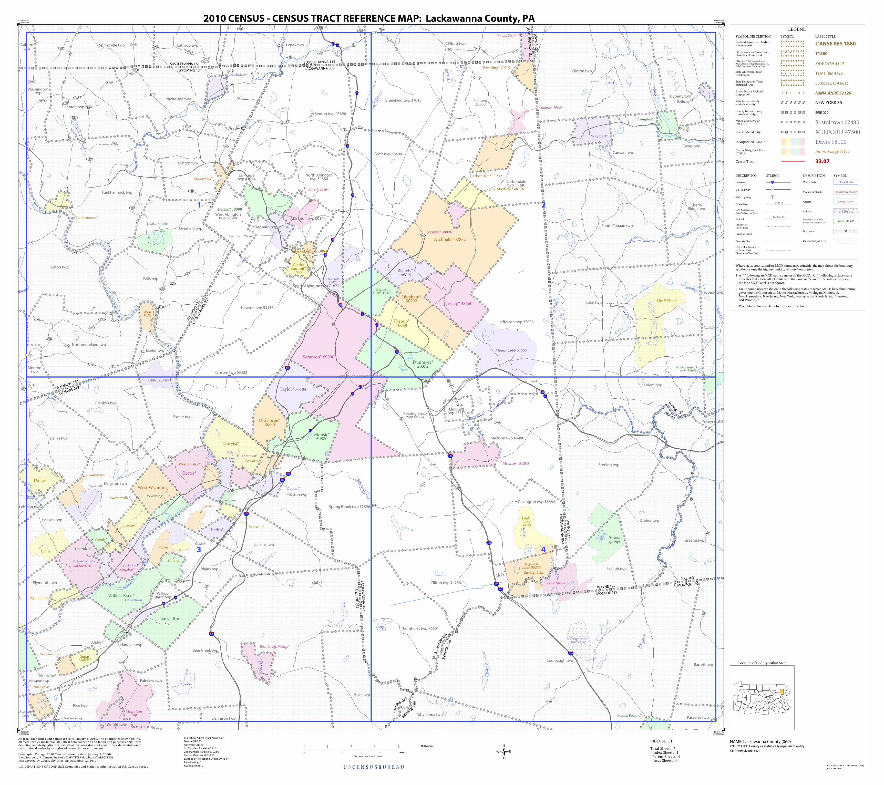
LEGEND
SYMBOL DESCRIPTION SYMBOL LABEL STYLE
Federal American IndianReservation L'ANSE RES 1880
Off-Reservation Trust Land,Hawaiian Home Land T1880
Oklahoma Tribal Statistical Area,Alaska Native Village Statistical Area,Tribal Designated Statistical Area
KAW OTSA 5340
State American IndianReservation Tama Res 4125
State Designated TribalStatistical Area Lumbee STSA 9815
Alaska Native RegionalCorporation NANA ANRC 52120
State (or statisticallyequivalent entity) NEW YORK 36
County (or statisticallyequivalent entity) ERIE 029
Minor Civil Division(MCD)1,2 Bristol town 07485
Consolidated City MILFORD 47500
Incorporated Place 1,3 Davis 18100Census Designated Place(CDP) 3 Incline Village 35100
Census Tract 33.07
DESCRIPTION SYMBOL DESCRIPTION SYMBOL
Interstate 3
U.S. Highway 2
State Highway 4
Other RoadMarsh Ln
4WD Trail, Stairway,
Alley, Walkway, or Ferry
RailoadSouthern RR
Pipeline orPower Line
Ridge or Fence
Property Line
Nonvisible Boundaryor Feature NotElsewhere Classified
Water Body Pleasant Lake
Swamp or Marsh Okefenokee Swamp
Glacier Bering Glacier
Military Fort Belvoir
National or State Park,
Forest, or Recreation AreaYosemite NP
Inset Area A
Outside Subject Area
Where state, county, and/or MCD boundaries coincide, the map shows the boundarysymbol for only the highest-ranking of these boundaries.
1 A ' ° ' following an MCD name denotes a false MCD. A ' ° ' following a place name indicates that a false MCD exists with the same name and FIPS code as the place; the false MCD label is not shown.
2 MCD boundaries are shown in the following states in which MCDs have functioning governments: Connecticut, Maine, Massachusetts, Michigan, Minnesota, New Hampshire, New Jersey, New York, Pennsylvania, Rhode Island, Vermont, and Wisconsin.
3 Place label color correlates to the place fill color.
U S C E N S U S B U R E A U
Location of County within State
2010 CENSUS TRACT REF MAP (INDEX)
205042069000
INDEX SHEET
41.677952N75.986261W
41.665638N75.268369W
41.127519N75.287593W
41.139733N75.999621W
All legal boundaries and names are as of January 1, 2010. The boundaries shown on thismap are for Census Bureau statistical data collection and tabulation purposes only; theirdepiction and designation for statistical purposes does not constitute a determination ofjurisdictional authority or rights of ownership or entitlement.
U.S. DEPARTMENT OF COMMERCE Economics and Statistics Administration U.S. Census Bureau
Geographic Vintage: 2010 Census (reference date: January 1, 2010)Data Source: U.S. Census Bureau's MAF/TIGER database (TAB10ST42)Map Created by Geography Division: December 12, 2010
ENTITY TYPE: County or statistically equivalent entity
NAME: Lackawanna County (069) Projection: Albers Equal Area Conic
Datum: NAD 83
Spheroid: GRS 80
1st Standard Parallel: 40 11 11
2nd Standard Parallel: 42 02 60
Central Meridian: -77 37 15
Latitude of Projection's Origin: 39 43 14
False Easting: 0
False Northing: 0
Total Sheets: 5- Index Sheets: 1- Parent Sheets: 4- Inset Sheets: 0
ST: Pennsylvania (42)
0 2 4 6 8 10 Kilometers10 Kilometers
0 1 2 3 4 5 Miles5 Miles
The plotted map scale is 1:81880
2010 CENSUS - CENSUS TRACT REFERENCE MAP: Lackawanna County, PA


![REVENCYT-RedidiCiencia.Un estudio de la democracia ...bdigital.ula.ve/storage/pdf/38096.pdf · ideales supremos de la sociología […] Alvin Gouldner, La crisis de la sociología](https://static.cupdf.com/doc/110x72/5bca948e09d3f26d178cde92/revencyt-estudio-de-la-democracia-bdigitalulavestoragepdf38096pdf.jpg)