History of sedimentary infilling and faulting in Subic Bay, Philippines
revealed in high-resolution seismic reflection profiles
Ma. Edweena Joan A. Cabatoa, Kelvin S. Rodolfoa,b,*, Fernando P. Siringana
aNational Institute of Geological Sciences, University of the Philippines, Diliman QC 1101, PhilippinesbDepartment of Earth and Environmental Sciences (M/C 186), University of Illinois at Chicago, 845 W Taylor Street, Chicago, IL 60607-7059, USA
Received 11 February 2004; revised 3 August 2004; accepted 3 August 2004
Abstract
Subic Bay sediments and faults identified in seismic-reflection profiles were dated using sea-level curves. The oldest sedimentary packages
are marine sediments subaerially exposed and eroded 20 ka. Fluvio-marine to wholly marine sediments were deposited during the ensuing
transgression, and prograding units were deposited during stillstands or minor sea-level falls. Faults within the bay have three age ranges. The
oldest set cuts through the pre-d18O Stage 2 rock units, O18 ka; a second disrupts 10.2–11.3 ka sediments; and the youngest, which cut the
uppermost sedimentary package, show that movements occurred about every 2 ky, most recently about 3 ka. Northwest–southeast faults that
parallel onshore structures associated with Paleogene emplacement of the Zambales Ophiolite Complex to the west and north likely represent
rejuvenated tectonism. The northern coastline and north–south-trending axial bay islands appear related to a lineament that dissects
Mt Pinatubo farther northeast. A breach in the caldera of Mt Natib is the most likely source of a presumed pyroclastic deposit in the eastern
bay that is associated with sediments about 11.3–18 ka, indicating that a Natib eruption occurred much more recently than previously
documented for this volcano.
q 2004 Elsevier Ltd. All rights reserved.
1. Introduction
Subic Bay in west-central Luzon, Philippines, a north–
south embayment 15 km long and 7 km wide (Figs. 1
and 2), used to be the site of the largest US naval base
overseas. Since the base was vacated in 1992, the bay
region has experienced rapid commercial and industrial
growth under the direction of the Subic Bay Metropolitan
Authority. The bay region is actively seismic and
volcanic, and its burgeoning economy and population
require careful evaluation of the potential for future
earthquakes and volcanism.
Regional faults or lineaments have previously been
identified or postulated. From an INTERA side-looking
airborne radar image, the Philippine National Oil
1367-9120/$ - see front matter q 2004 Elsevier Ltd. All rights reserved.
doi:10.1016/S1367-9120(04)00170-1
* Corresponding author. Address: Department of Earth and Environmen-
tal Sciences (M/C 186), University of Illinois at Chicago, 845 W Taylor
Street, Chicago, IL 60607-7059, USA. Tel.: C1 312 996 3154; fax: C1 312
243 8241.
E-mail address: [email protected] (K.S. Rodolfo).
Corporation (1988) delineated a lineament that trends
northwest through Mt Natib and emerges along the eastern
shore of Subic Bay. Yumul et al. (1990) and Yumul and
Dimalanta (1997) interpreted gravity data and petrographic
discontinuities of rock suites of the Zambales Ophiolite
Complex to postulate a ‘Subic Bay Fault Zone’ trending
northwestward through the bay. From an enhanced Marine
Observation Satellite image, Javelosa (1994) delineated
major lineaments at the head of Subic Bay that trend both
north–northwestward and north–south through Mt Pinatubo.
Using high-resolution seismic-reflection profiles, we
have identified and delineated packages of the sedimentary
bay fill, and faults that deform them. We have combined this
information with onshore data in order to characterize
regional lineaments and structures, identify other structures,
reconstruct the depositional and tectonic history of the bay,
and gain some sense of the frequency and magnitude of the
seismic events it experiences. An unanticipated result of this
work was the identification of volcanic deposits that indicate
a more recent eruption of the adjacent Mt Natib volcano
than previously recognized.
Journal of Asian Earth Sciences 25 (2005) 849–858
www.elsevier.com/locate/jaes
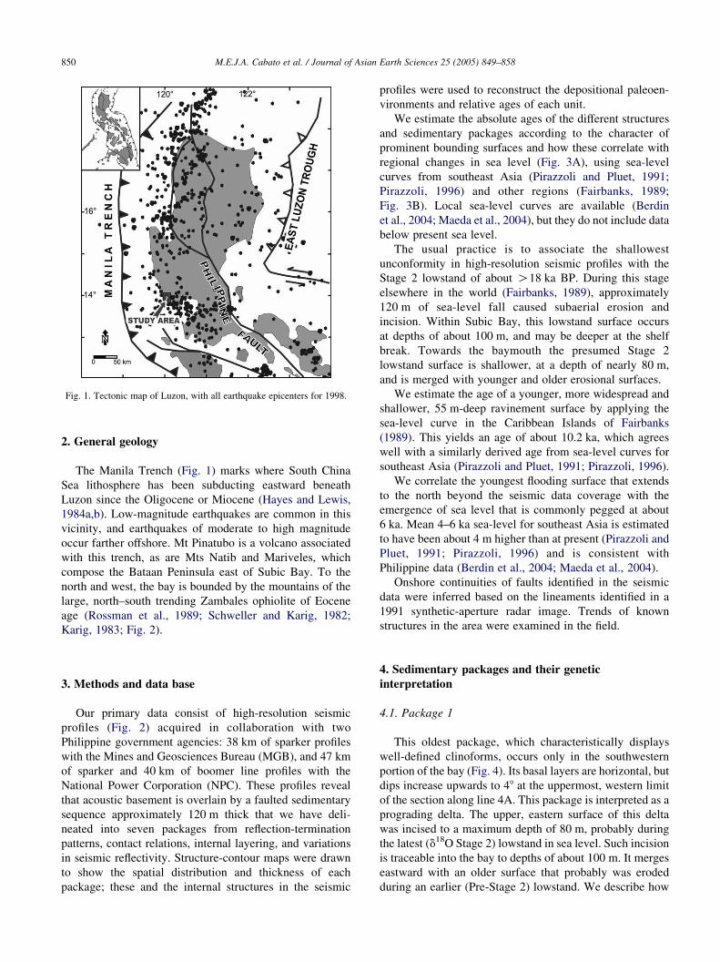
Fig. 1. Tectonic map of Luzon, with all earthquake epicenters for 1998.
M.E.J.A. Cabato et al. / Journal of Asian Earth Sciences 25 (2005) 849–858850
2. General geology
The Manila Trench (Fig. 1) marks where South China
Sea lithosphere has been subducting eastward beneath
Luzon since the Oligocene or Miocene (Hayes and Lewis,
1984a,b). Low-magnitude earthquakes are common in this
vicinity, and earthquakes of moderate to high magnitude
occur farther offshore. Mt Pinatubo is a volcano associated
with this trench, as are Mts Natib and Mariveles, which
compose the Bataan Peninsula east of Subic Bay. To the
north and west, the bay is bounded by the mountains of the
large, north–south trending Zambales ophiolite of Eocene
age (Rossman et al., 1989; Schweller and Karig, 1982;
Karig, 1983; Fig. 2).
3. Methods and data base
Our primary data consist of high-resolution seismic
profiles (Fig. 2) acquired in collaboration with two
Philippine government agencies: 38 km of sparker profiles
with the Mines and Geosciences Bureau (MGB), and 47 km
of sparker and 40 km of boomer line profiles with the
National Power Corporation (NPC). These profiles reveal
that acoustic basement is overlain by a faulted sedimentary
sequence approximately 120 m thick that we have deli-
neated into seven packages from reflection-termination
patterns, contact relations, internal layering, and variations
in seismic reflectivity. Structure-contour maps were drawn
to show the spatial distribution and thickness of each
package; these and the internal structures in the seismic
profiles were used to reconstruct the depositional paleoen-
vironments and relative ages of each unit.
We estimate the absolute ages of the different structures
and sedimentary packages according to the character of
prominent bounding surfaces and how these correlate with
regional changes in sea level (Fig. 3A), using sea-level
curves from southeast Asia (Pirazzoli and Pluet, 1991;
Pirazzoli, 1996) and other regions (Fairbanks, 1989;
Fig. 3B). Local sea-level curves are available (Berdin
et al., 2004; Maeda et al., 2004), but they do not include data
below present sea level.
The usual practice is to associate the shallowest
unconformity in high-resolution seismic profiles with the
Stage 2 lowstand of about O18 ka BP. During this stage
elsewhere in the world (Fairbanks, 1989), approximately
120 m of sea-level fall caused subaerial erosion and
incision. Within Subic Bay, this lowstand surface occurs
at depths of about 100 m, and may be deeper at the shelf
break. Towards the baymouth the presumed Stage 2
lowstand surface is shallower, at a depth of nearly 80 m,
and is merged with younger and older erosional surfaces.
We estimate the age of a younger, more widespread and
shallower, 55 m-deep ravinement surface by applying the
sea-level curve in the Caribbean Islands of Fairbanks
(1989). This yields an age of about 10.2 ka, which agrees
well with a similarly derived age from sea-level curves for
southeast Asia (Pirazzoli and Pluet, 1991; Pirazzoli, 1996).
We correlate the youngest flooding surface that extends
to the north beyond the seismic data coverage with the
emergence of sea level that is commonly pegged at about
6 ka. Mean 4–6 ka sea-level for southeast Asia is estimated
to have been about 4 m higher than at present (Pirazzoli and
Pluet, 1991; Pirazzoli, 1996) and is consistent with
Philippine data (Berdin et al., 2004; Maeda et al., 2004).
Onshore continuities of faults identified in the seismic
data were inferred based on the lineaments identified in a
1991 synthetic-aperture radar image. Trends of known
structures in the area were examined in the field.
4. Sedimentary packages and their genetic
interpretation
4.1. Package 1
This oldest package, which characteristically displays
well-defined clinoforms, occurs only in the southwestern
portion of the bay (Fig. 4). Its basal layers are horizontal, but
dips increase upwards to 48 at the uppermost, western limit
of the section along line 4A. This package is interpreted as a
prograding delta. The upper, eastern surface of this delta
was incised to a maximum depth of 80 m, probably during
the latest (d18O Stage 2) lowstand in sea level. Such incision
is traceable into the bay to depths of about 100 m. It merges
eastward with an older surface that probably was eroded
during an earlier (Pre-Stage 2) lowstand. We describe how
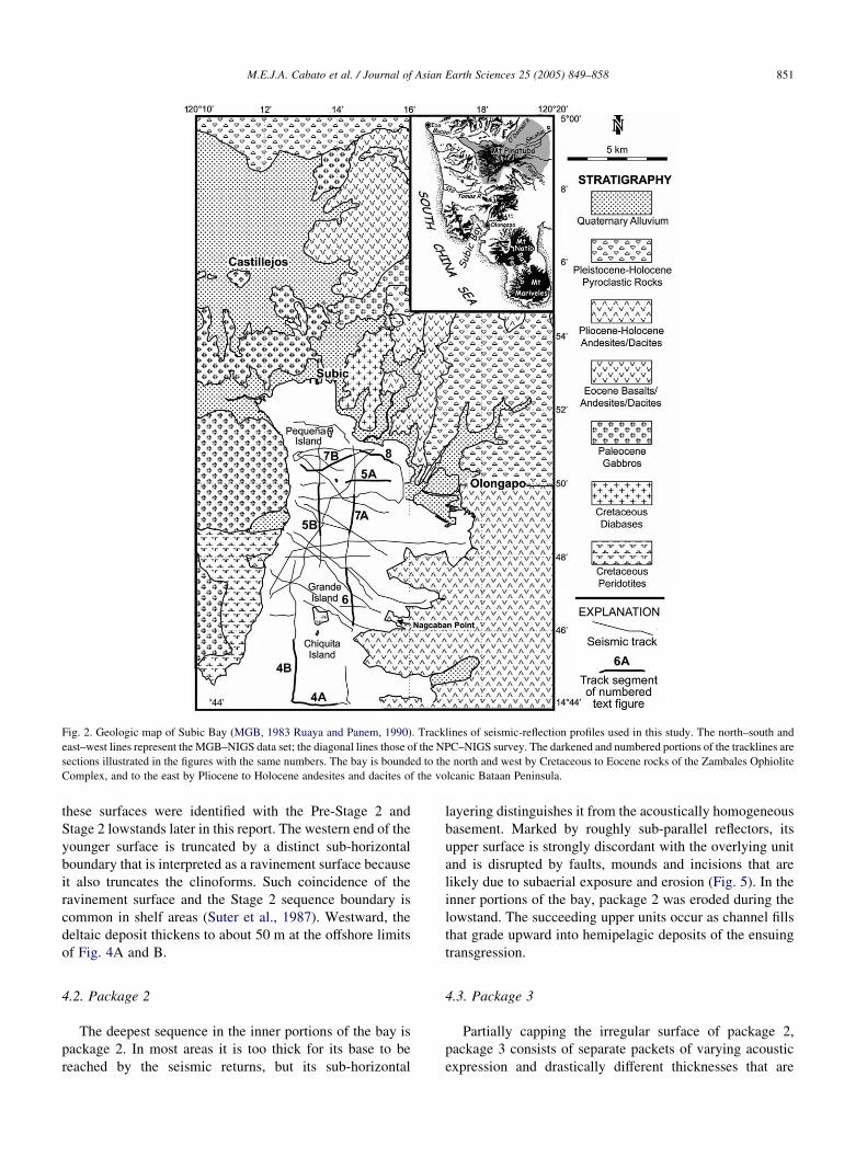
Fig. 2. Geologic map of Subic Bay (MGB, 1983 Ruaya and Panem, 1990). Tracklines of seismic-reflection profiles used in this study. The north–south and
east–west lines represent the MGB–NIGS data set; the diagonal lines those of the NPC–NIGS survey. The darkened and numbered portions of the tracklines are
sections illustrated in the figures with the same numbers. The bay is bounded to the north and west by Cretaceous to Eocene rocks of the Zambales Ophiolite
Complex, and to the east by Pliocene to Holocene andesites and dacites of the volcanic Bataan Peninsula.
M.E.J.A. Cabato et al. / Journal of Asian Earth Sciences 25 (2005) 849–858 851
these surfaces were identified with the Pre-Stage 2 and
Stage 2 lowstands later in this report. The western end of the
younger surface is truncated by a distinct sub-horizontal
boundary that is interpreted as a ravinement surface because
it also truncates the clinoforms. Such coincidence of the
ravinement surface and the Stage 2 sequence boundary is
common in shelf areas (Suter et al., 1987). Westward, the
deltaic deposit thickens to about 50 m at the offshore limits
of Fig. 4A and B.
4.2. Package 2
The deepest sequence in the inner portions of the bay is
package 2. In most areas it is too thick for its base to be
reached by the seismic returns, but its sub-horizontal
layering distinguishes it from the acoustically homogeneous
basement. Marked by roughly sub-parallel reflectors, its
upper surface is strongly discordant with the overlying unit
and is disrupted by faults, mounds and incisions that are
likely due to subaerial exposure and erosion (Fig. 5). In the
inner portions of the bay, package 2 was eroded during the
lowstand. The succeeding upper units occur as channel fills
that grade upward into hemipelagic deposits of the ensuing
transgression.
4.3. Package 3
Partially capping the irregular surface of package 2,
package 3 consists of separate packets of varying acoustic
expression and drastically different thicknesses that are
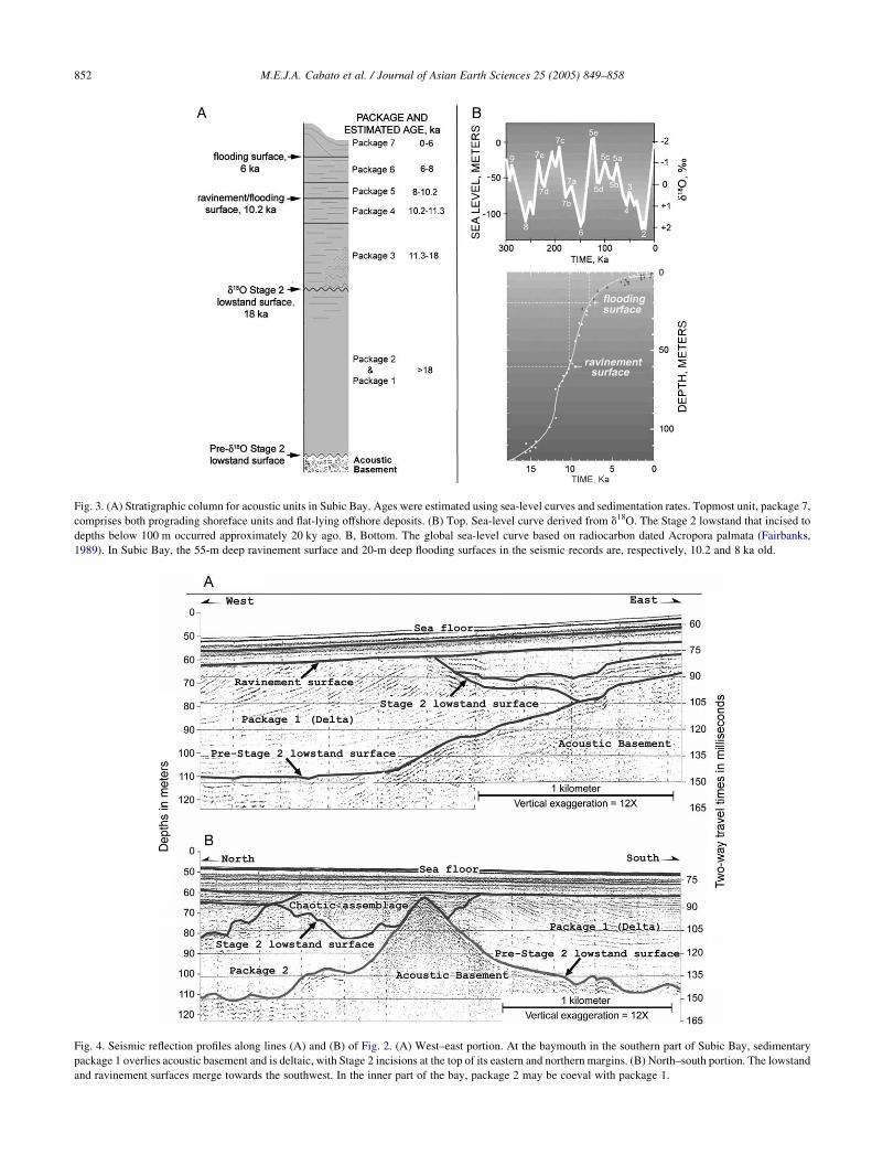
Fig. 3. (A) Stratigraphic column for acoustic units in Subic Bay. Ages were estimated using sea-level curves and sedimentation rates. Topmost unit, package 7,
comprises both prograding shoreface units and flat-lying offshore deposits. (B) Top. Sea-level curve derived from d18O. The Stage 2 lowstand that incised to
depths below 100 m occurred approximately 20 ky ago. B, Bottom. The global sea-level curve based on radiocarbon dated Acropora palmata (Fairbanks,
1989). In Subic Bay, the 55-m deep ravinement surface and 20-m deep flooding surfaces in the seismic records are, respectively, 10.2 and 8 ka old.
Fig. 4. Seismic reflection profiles along lines (A) and (B) of Fig. 2. (A) West–east portion. At the baymouth in the southern part of Subic Bay, sedimentary
package 1 overlies acoustic basement and is deltaic, with Stage 2 incisions at the top of its eastern and northern margins. (B) North–south portion. The lowstand
and ravinement surfaces merge towards the southwest. In the inner part of the bay, package 2 may be coeval with package 1.
M.E.J.A. Cabato et al. / Journal of Asian Earth Sciences 25 (2005) 849–858852
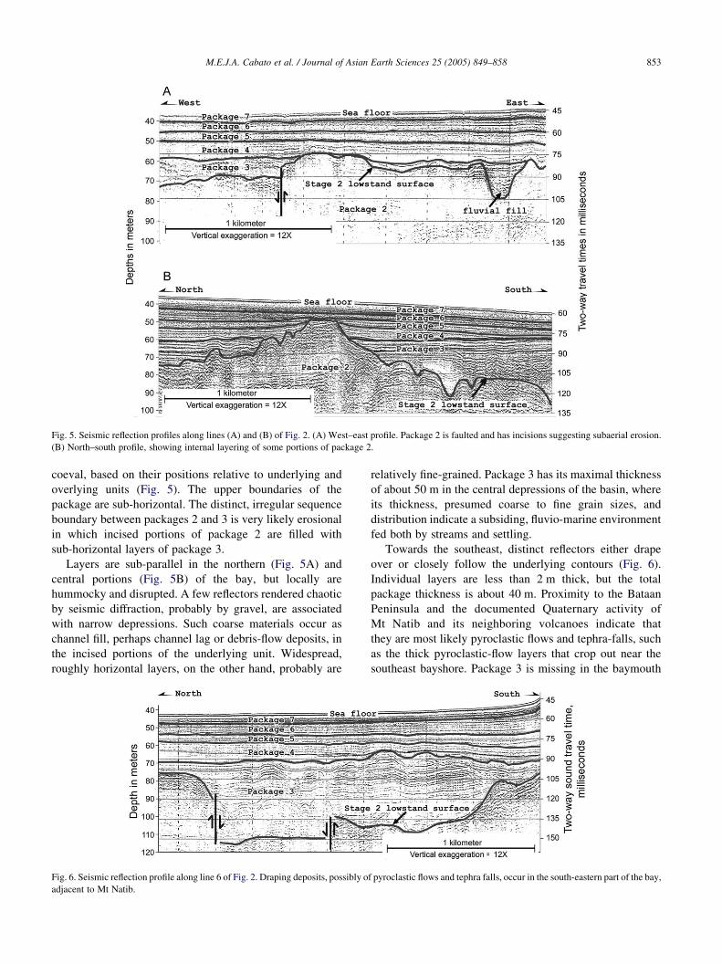
Fig. 5. Seismic reflection profiles along lines (A) and (B) of Fig. 2. (A) West–east profile. Package 2 is faulted and has incisions suggesting subaerial erosion.
(B) North–south profile, showing internal layering of some portions of package 2.
M.E.J.A. Cabato et al. / Journal of Asian Earth Sciences 25 (2005) 849–858 853
coeval, based on their positions relative to underlying and
overlying units (Fig. 5). The upper boundaries of the
package are sub-horizontal. The distinct, irregular sequence
boundary between packages 2 and 3 is very likely erosional
in which incised portions of package 2 are filled with
sub-horizontal layers of package 3.
Layers are sub-parallel in the northern (Fig. 5A) and
central portions (Fig. 5B) of the bay, but locally are
hummocky and disrupted. A few reflectors rendered chaotic
by seismic diffraction, probably by gravel, are associated
with narrow depressions. Such coarse materials occur as
channel fill, perhaps channel lag or debris-flow deposits, in
the incised portions of the underlying unit. Widespread,
roughly horizontal layers, on the other hand, probably are
Fig. 6. Seismic reflection profile along line 6 of Fig. 2. Draping deposits, possibly o
adjacent to Mt Natib.
relatively fine-grained. Package 3 has its maximal thickness
of about 50 m in the central depressions of the basin, where
its thickness, presumed coarse to fine grain sizes, and
distribution indicate a subsiding, fluvio-marine environment
fed both by streams and settling.
Towards the southeast, distinct reflectors either drape
over or closely follow the underlying contours (Fig. 6).
Individual layers are less than 2 m thick, but the total
package thickness is about 40 m. Proximity to the Bataan
Peninsula and the documented Quaternary activity of
Mt Natib and its neighboring volcanoes indicate that
they are most likely pyroclastic flows and tephra-falls, such
as the thick pyroclastic-flow layers that crop out near the
southeast bayshore. Package 3 is missing in the baymouth
f pyroclastic flows and tephra falls, occur in the south-eastern part of the bay,
M.E.J.A. Cabato et al. / Journal of Asian Earth Sciences 25 (2005) 849–858854
area farther south, either because it was not deposited, or
because it was eroded during a subsequent transgression.
Package 3, being atop the Stage 2 lowstand surface, we
assign an age of 18–11.3 ka. This estimate considers the fact
that Subic Bay was probably partly subaerial for some time
even as sea-level transgressed starting approximately 20 ka.
From 120 m below present sea-level, which is below the
depth of the shelf break, transgression would not have
inundated the embayment until a few thousand years later.
Hence, the extensive hemipelagic sediments in the bay must
have been deposited much later, although the incisions
would already have had older, fluvial fill. Laterally, this
deposit grades into thinner, flat-lying, normal hemipelagic
layers. The draping pattern is more pronounced in the upper
portion of the package. This might indicate deposition in an
environment that shifted from shallow marine to subaerial,
but sub-parallel drapes also have been recognized in
submarine pyroclastic-flow deposits elsewhere (Catane,
personal communication, 1999).
4.4. Package 4
In the southern part of the bay, package 4 is composed of
deltaic deposits with an uppermost limit at K55 m.
Truncation is evident in other parts of this package
(Fig. 7A). To the north, nearly horizontal and conformable
reflectors characterize this package (Fig. 7B). These deltaic
Fig. 7. Seismic reflection profiles along lines (A) and (B) of Fig. 2. (A) In th
displacements of 5–10 m. (B) Along this profile aligned generally west–east, so
recurrent activity, as evidenced by the inconsistent thicknesses of the packages th
bodies indicate episodic still-stands during a general rise in
sea level (Fig. 7A). They also mark paleo-sea level positions,
and hence, paleo-shorelines. Localized high energy towards
the south may have eroded deposits, thereby removing some
of the transgressive deposits and making erosional surfaces
that merge atop the delta. Fairbank’s (1989) sea-level curve
yields an age of around 10.2 ka for this surface.
4.5. Packages 5 and 6
Both of these packages are nearly horizontal and
conformable, each bounded at its base and top by distinct
surfaces (Figs. 6 and 7). Generally, these deposits are sheet-
like and wedge toward the bay margins. Thicknesses are
commonly about 7 m but range between 5 and 15 m. Less
distinct than the boundaries, internal layering roughly 2 m
thick suggests that the beds have similar lithologies but are
too thin to be resolved by seismic reflection. Divergence of
reflections towards the margin of the bay to form the wedge
is simply due to the tilt of depositional surfaces and
thickening of the sediments towards their source.
4.6. Package 7
Situated near the northeast shore of the bay, package 7
comprises two units that share a boundary marked by
a change in reflector orientation (Fig. 8). The lower unit,
is north–south profile, package 2 is cut by faults with apparent vertical
me of the faults that cut through younger sediment packages experienced
ey disrupt.
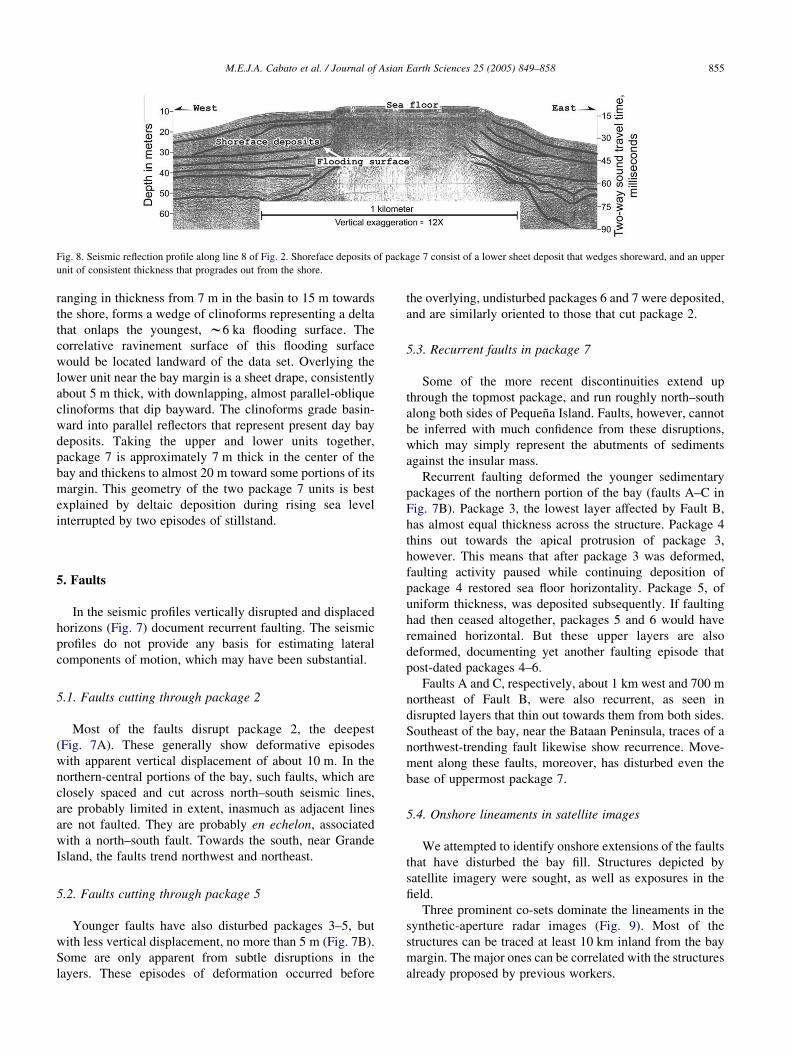
Fig. 8. Seismic reflection profile along line 8 of Fig. 2. Shoreface deposits of package 7 consist of a lower sheet deposit that wedges shoreward, and an upper
unit of consistent thickness that progrades out from the shore.
M.E.J.A. Cabato et al. / Journal of Asian Earth Sciences 25 (2005) 849–858 855
ranging in thickness from 7 m in the basin to 15 m towards
the shore, forms a wedge of clinoforms representing a delta
that onlaps the youngest, w6 ka flooding surface. The
correlative ravinement surface of this flooding surface
would be located landward of the data set. Overlying the
lower unit near the bay margin is a sheet drape, consistently
about 5 m thick, with downlapping, almost parallel-oblique
clinoforms that dip bayward. The clinoforms grade basin-
ward into parallel reflectors that represent present day bay
deposits. Taking the upper and lower units together,
package 7 is approximately 7 m thick in the center of the
bay and thickens to almost 20 m toward some portions of its
margin. This geometry of the two package 7 units is best
explained by deltaic deposition during rising sea level
interrupted by two episodes of stillstand.
5. Faults
In the seismic profiles vertically disrupted and displaced
horizons (Fig. 7) document recurrent faulting. The seismic
profiles do not provide any basis for estimating lateral
components of motion, which may have been substantial.
5.1. Faults cutting through package 2
Most of the faults disrupt package 2, the deepest
(Fig. 7A). These generally show deformative episodes
with apparent vertical displacement of about 10 m. In the
northern-central portions of the bay, such faults, which are
closely spaced and cut across north–south seismic lines,
are probably limited in extent, inasmuch as adjacent lines
are not faulted. They are probably en echelon, associated
with a north–south fault. Towards the south, near Grande
Island, the faults trend northwest and northeast.
5.2. Faults cutting through package 5
Younger faults have also disturbed packages 3–5, but
with less vertical displacement, no more than 5 m (Fig. 7B).
Some are only apparent from subtle disruptions in the
layers. These episodes of deformation occurred before
the overlying, undisturbed packages 6 and 7 were deposited,
and are similarly oriented to those that cut package 2.
5.3. Recurrent faults in package 7
Some of the more recent discontinuities extend up
through the topmost package, and run roughly north–south
along both sides of Pequena Island. Faults, however, cannot
be inferred with much confidence from these disruptions,
which may simply represent the abutments of sediments
against the insular mass.
Recurrent faulting deformed the younger sedimentary
packages of the northern portion of the bay (faults A–C in
Fig. 7B). Package 3, the lowest layer affected by Fault B,
has almost equal thickness across the structure. Package 4
thins out towards the apical protrusion of package 3,
however. This means that after package 3 was deformed,
faulting activity paused while continuing deposition of
package 4 restored sea floor horizontality. Package 5, of
uniform thickness, was deposited subsequently. If faulting
had then ceased altogether, packages 5 and 6 would have
remained horizontal. But these upper layers are also
deformed, documenting yet another faulting episode that
post-dated packages 4–6.
Faults A and C, respectively, about 1 km west and 700 m
northeast of Fault B, were also recurrent, as seen in
disrupted layers that thin out towards them from both sides.
Southeast of the bay, near the Bataan Peninsula, traces of a
northwest-trending fault likewise show recurrence. Move-
ment along these faults, moreover, has disturbed even the
base of uppermost package 7.
5.4. Onshore lineaments in satellite images
We attempted to identify onshore extensions of the faults
that have disturbed the bay fill. Structures depicted by
satellite imagery were sought, as well as exposures in the
field.
Three prominent co-sets dominate the lineaments in the
synthetic-aperture radar images (Fig. 9). Most of the
structures can be traced at least 10 km inland from the bay
margin. The major ones can be correlated with the structures
already proposed by previous workers.
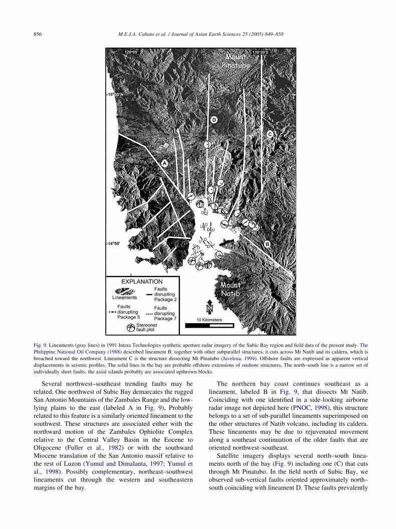
Fig. 9. Lineaments (gray lines) in 1991 Intera Technologies synthetic aperture radar imagery of the Subic Bay region and field data of the present study. The
Philippine National Oil Company (1988) described lineament B; together with other subparallel structures, it cuts across Mt Natib and its caldera, which is
breached toward the northwest. Lineament C is the structure dissecting Mt Pinatubo (Javelosa, 1994). Offshore faults are expressed as apparent vertical
displacements in seismic profiles. The solid lines in the bay are probable offshore extensions of onshore structures. The north–south line is a narrow set of
individually short faults; the axial islands probably are associated upthrown blocks.
M.E.J.A. Cabato et al. / Journal of Asian Earth Sciences 25 (2005) 849–858856
Several northwest–southeast trending faults may be
related. One northwest of Subic Bay demarcates the rugged
San Antonio Mountains of the Zambales Range and the low-
lying plains to the east (labeled A in Fig. 9), Probably
related to this feature is a similarly oriented lineament to the
southwest. These structures are associated either with the
northward motion of the Zambales Ophiolite Complex
relative to the Central Valley Basin in the Eocene to
Oligocene (Fuller et al., 1982) or with the southward
Miocene translation of the San Antonio massif relative to
the rest of Luzon (Yumul and Dimalanta, 1997; Yumul et
al., 1998). Possibly complementary, northeast–southwest
lineaments cut through the western and southeastern
margins of the bay.
The northern bay coast continues southeast as a
lineament, labeled B in Fig. 9, that dissects Mt Natib.
Coinciding with one identified in a side-looking airborne
radar image not depicted here (PNOC, 1998), this structure
belongs to a set of sub-parallel lineaments superimposed on
the other structures of Natib volcano, including its caldera.
These lineaments may be due to rejuvenated movement
along a southeast continuation of the older faults that are
oriented northwest–southeast.
Satellite imagery displays several north–south linea-
ments north of the bay (Fig. 9) including one (C) that cuts
through Mt Pinatubo. In the field north of Subic Bay, we
observed sub-vertical faults oriented approximately north–
south coinciding with lineament D. These faults prevalently
M.E.J.A. Cabato et al. / Journal of Asian Earth Sciences 25 (2005) 849–858 857
cut through the Paleogene ophiolitic rocks, and in fewer
instances through Plio-Pleistocene pyroclastic deposits.
Fresh aphanitic andesites near the northeastern coast of
the bay, probably among the youngest volcanic rocks in the
area, are cut by well-defined, steeply dipping, sub-parallel
faults trending north–northeast (Siringan et al., 2000). The
mylonitized zone along one of these shows reverse move-
ment. North of the bay, extremely macerated and weathered
rocks characterize a low-lying area traversed by the national
road to Castillejos. Along this trend, north–south faulting
was identified only through juxtaposed rocks of contrasting
weathered products. Shear joints are common throughout
the vicinity, but lack apparent general trends and do not lend
themselves to interpretation of specific structures.
6. Discussion
6.1. Correlating faults in the seismic profiles
with onshore structures
Faults in the bay fill cut through Late Pleistocene to
Recent sediments (Fig. 9). These cannot be correlated easily
with more ancient structures, delineated from satellite
images by previous authors and during the present study,
that dissect the much older ophiolite complex.
The northwest-trending faults in the southern part of
the bay probably are associated with similar trending
lineaments that dissect Mt Natib. Lineaments on the
satellite mosaic cut other structures on Mt Natib. Also, the
northern outline of the caldera probably collapsed due to a
northwest-directed explosion that produced flows faintly
evident on the satellite image. If so, the pyroclastic
materials would simply have flowed down the northwest-
trending linear depressions to be deposited in the adjacent
portion of the bay. It is possible, however, that Quaternary
volcanism in the Bataan Peninsula, as well as the sub-
parallel faults in the bay fill, represent rejuvenation of
older tectonic structures.
The structures observed in the field, plotted as
stereonets centered on sites, may be correlated with
lineaments on the satellite images. The north–south faults,
shear zones, and dikes north of the bay may be extensions
of similarly oriented faults that have uplifted the islands
and created the linear northern margins of the bay. Such
tectonic features may also be related with both the
lineament dissecting Mt Pinatubo to the northeast and the
roughly south-trending volcanic chain of Mts Pinatubo,
Natib, and Mariveles.
Other structures identified in the field, however, do not
coincide with the lineaments. This might be because
available outcrops bias field measurements; furthermore,
structures in outcrop scale belong to a three-dimensional
strain field that on the scale of the satellite mosaic is
generalized as a single, major lineament.
6.2. Recurrence of faulting
Faulting has considerably disturbed the units older than
the d18O Stage 2, O18 ka. Younger faults, some with
recurrent activity, have also cut the overlying sedimentary
packages. At least five episodes of faulting since 11.3 ka can
be reconstructed from the seismic data (Fig. 7B). An
average recurrence interval of about 2 ky is estimated for
these faults. The latest movement may have occurred about
3 ka because the fault trace extends halfway to the surface
from the 6 ka horizon.
The lineaments in the satellite images and most of the
faults observed in the field, on the other hand, are apparently
older than those documented in the seismic profiles. Such
structures are commonly associated with the emplacement
of the Zambales Ophiolite and intermittent volcanism in the
Bataan Peninsula before the Pleistocene. However, the
deformation within the bay possibly might be associated
with renewed tectonism along the structures that dissect the
ophiolite complex to the west and the volcanic arc to the
east.
6.3. Implications of the pyroclastic deposits in package 3
for Mt Natib volcanism
Inasmuch as this thick packet belongs to package 3, it has
a probable age of about 18–11.3 ka, nearly half that of the
youngest age for Mt Natib rocks previously available, which
is 27 ka for a sample taken from its eastern flank (Newhall,
personal communication, 1999). A breach on the side of the
caldera facing Subic Bay (Fig. 9) is most likely related to the
eruption that produced the presumed pyroclastic materials.
Such an eruption would have collapsed the northwest
portion of the caldera and generated flows into the eastern
portion of the bay. Thus, the presumed pyroclastic materials
are significantly younger than dated samples from the
eastern flank. Moreover, at the caldera and towards the other
side of the volcano, northwest-trending lineaments are
superimposed on other structures. These lineaments most
likely represent the latest deformational episode for this
area.
7. Conclusions
Seismically imaged sedimentary packages in Subic Bay,
all of late Pleistocene to Holocene age, document distinct
periods of emergence followed by fluvio-marine conditions.
The older sedimentary packages consist of incised channel
fill that grade upwards into extensive, nearly horizontal
deposits that form wedges towards the shore. Such sheet-
like units show lobes that indicate shorelines that back-
stepped during transgression. Progression towards fully
marine conditions was punctuated by volcanism in the
Bataan Peninsula, as evidenced by thick, draping deposits
that are best explained as pyroclastic.
M.E.J.A. Cabato et al. / Journal of Asian Earth Sciences 25 (2005) 849–858858
Faults within the bay are of three age ranges. Those of the
oldest set cut through the Pre-d18O Stage 2 rock units, hence
are older than 18 ka. The north–south faults in the central
portion of the bay are probably related to the north–south
structures that dissect onshore areas in the north and
northeast. In satellite images, these structures are mani-
fested in the linear northern margin of Subic Bay and
dissecting Mt Pinatubo. Northeast- and northwest-trending
faults of the same age in the south are probably cosets of the
structures associated with volcanism in the Bataan Penin-
sula. Another fault set that disrupts package 5 of this study is
probably 8–10.2 ka old, based on sea-level curves. These
run through the same portions as the older set, and may
represent rejuvenated activity.
The youngest fault set includes the north–south disrup-
tions near Pequena Island. Southwest of this island and
towards the southeast reaches of the bay, fault trends are
difficult to establish, but recurrent activity is apparent. The
age for the latest movement along these faults is about 3 ka.
Northwest-trending lineaments superimposed on other
structures of Mt Natib are most reasonably related to the
draping deposits southeast of the bay. These suggest a latest
eruption about 11.3–18 ka, significantly later than the 27 ka
previously documented for this volcano.
Acknowledgements
Messrs Angel Bravo and Joel Natividad of the Mines and
Geosciences Bureau of the Department of Environment and
Natural Resources provided the set of north–south and east–
west seismic profiles. Messrs Tom Valencia, Ging Lauden-
cia, Benjie Punay, Gener Autor, and Ray Teh San and Ms
Bethel Bogtong provided equipment and assistance in the
field for obtaining the second set of profiles, which used a
generator generously loaned by the Subic Bay Metropolitan
Authority and its then Chairman, Mr Richard J. Gordon. We
thank Dr Christopher Newhall for a thorough, thoughtful
and very useful review. Drs Mario Aurelio, Joseph Foronda,
Eddie Listanco, and Graciano Yumul made many useful
comments. The Office of the Vice Chancellor for Research
and development of the University of the Philippines funded
the later portion of the fieldwork.
References
Berdin, R.D., Siringan, F.P., Maeda, Y., 2004. Holocene sea-level
highstand and its implications for the vertical stability of Panglao
Island, southwest Bohol, Philippines. Quaternary International
115–116, 27–37.
Fairbanks, R.G., 1989. A 17,000-year glacio-eustatic sea level record:
influence of glacial melting rates on the Younger Dryas event and deep-
ocean circulation. Nature 342 (250), 637–642.
Fuller, R.M., Williams, I.S., McCabe, R., Encina, R.W., Almasco, J.,
Geary, E.E., Kay, R.W., 1982. Petrological and geochemical docu-
mentation of ocean floor metamorphism in the Zambales Ophiolite,
Philippines. In: Hayes, D.E. (Ed.), The Tectonic and Geologic
Evolution of Southeast Asia Seas and Islands, Part 2 AGU Geophysical
Monograph Series 27, pp. 139–159.
Hayes, D.E., Lewis, S.D., 1984a. A geophysical study of the Manila
Trench, Luzon, Philippines, Part 1: Crustal structure, gravity, and
regional tectonic evolution. Journal of Geophysical Research 89, 9171–
9195.
Hayes, D.E., Lewis, S.D., 1984b. A geophysical study of the Manila
Trench, Luzon, Philippines, Part 2: Forearc basin: structural and
stratigraphic evolution, 89, pp. 9196–9214.
Javelosa, R.S., 1994. Active Quaternary environments in the Philippine
Mobile Belt, 20. ITC Publication, pp. 179.
Karig, D.E., 1983. Accreted terranes in the northern part of the Philippine
archipelago. Tectonics 2, 211–236.
Maeda, Y., Siringan, F., Omura, A., Berdin, R., Hosono, Y., Atsumi, S.,
Nakamura, T., 2004. Higher-than-present Holocene mean sea levels in
Ilocos, Palawan and Samar, Philippines. Quaternary International 115–
116, 15–26.
Mines and Geosciences Bureau, 1983. Geologic maps of San Antonio,
Zambales; Dinalupihan, Bataan; and Silanguin Island: 1:50,000; 3
sheets, Geological survey division. Department of Environment and
Natural Resources, Manila, Philippines.
(PNOC) Philippine National Oil Company, 1988. Environmental manage-
ment report for the PNOC geothermal exploration project in Mt Natib,
Bataan 1988.
Pirazzoli, P.A., 1996. Sea level Changes: the Last 20,000 years. Wiley,
West Sussex, England, pp. 211.
Pirazzoli, P.A., Pluet, J., 1991. World Atlas of Holocene Sea level Changes.
Elsevier, Amsterdam, pp. 300.
Rossman, D.L., Castaneda, G.C., Bacuta, G.C., 1989. Geology of the
zambales ophiolite, Luzon, Philippines. Tectonophysics 168, 1–23.
Ruaya, J.R., Panem, C.C., 1990. Mt Natib, Philippines: A geochemical
model of a caldera-hosted geothermal system. Journal of Volcanology
and Geothermal Research 45, 255–265.
Schweller, W.J., Karig, D.E., 1982. Emplacement of the Zambales
Ophiolite into the West Luzon margin. American Association of
Petroleum Geology Memoir 1982;, 34.
Siringan, F.P., Cabato, J.A., Mateo, Z.P., 2000. Marine geological
investigation: sedimentation and tectonics of Subic Bay and vicinity.
Report Submitted for the Subic Bay Protected Areas Management Plan
Project, Woodward Clyde, Inc.
Suter, J.R., Berryhill, H.L., Pentland, S., 1987. Late Quaternary sea level
fluctuations and depositional sequence, southeast Louisiana continental
shelf, In: Nummendal, D. (Ed.), Sea level Fluctuations and Coastal
Evolution, 41. Society of Economic Paleontologists and Mineralogists
Special Publication, pp. 199–219.
Yumul Jr., G.P., Dimalanta, C.B., 1997. Geology of the southern Zambales
Ophiolite Complex (Philippines): Juxtaposed terranes of diverse origin.
Journald of Asian Earth Sciences 15, 413–421.
Yumul Jr., G.P., Datuin, R.T., Manipon, J.C., 1990. Geology and
geochemistry of the Cabangan-San Antonio massifs, Zambales
Ophiolite Complex, Philippines: Tectonically juxtaposed marginal
basin-island arc terranes. Journal of the Geological Society of the
Philippines 45, 69–100.
Yumul Jr., G.P., Dimalanta, C.B., Faustino, D.V., de Jesus, J.V., 1998.
Translation and docking of an arc terrane: geological and geochemical
evidence from the southern Zambales Ophiolite Complex, Philippines.
Tectonophysics 293, 255–272.