1/15/2014
1
Environmental Science Ch. 10:
Urbanization and Land
Ch. 10-1: Land Use &
Urbanization
Key Terms • Infrastructure
• Land-use Plan
• Suburban Sprawl
• Urbanization
Ch 10-1:
Why Do I Need To Know This?
1. Because we all use land every day for
places to live and to provide the food,
minerals, materials and resources that we
need.
2. Because almost all of NEW JERSEY is
already an urban center with many of the
problems associated with urban centers.
3. Since the 2000 Census, the state's
population rose by 293,389. http://www.newjerseynewsroom.com/state/census-estimates-show-population-growth-in-new-jersey
Lesson 10.1 Land Use and Urbanization
For the first time in history, there are now more urban residents than rural residents.
Land Cover and Land Use
• Land cover: Vegetation and structures that cover land.
• Land use: Human activities that occur on land
• Humans change land cover, especially in urban areas. These changes have environmental and economic effects.
Urban and Rural Areas
Rural: Any other type
of land use or land
cover (includes forests,
cropland, etc.)
Urban: Land mostly
covered with buildings and
roads (includes suburbs)

1/15/2014
2
The Urban-Rural Connection • According to the U.S. Census Bureau, any
area that has over 5,000 people living in a square mile is an urban area.
• About 80% of all Americans live in an urban area.
• By the year 2025, about 66.66% of all the world’s people will live in an urban center.
• All of these people need to get their food and resources from someplace.
• Consequently, it takes a lot more land to support life in the city than just the land in the city. So it is very important for people living in urban areas to take care of and maintain non-urban areas.
• Occurs when people
move from rural areas
to cities
• Cities are not new, but the
enormous size of today’s
cities is. More than 20
cities have at least 10
million residents.
Urbanization-1
The Urban-Rural Connection-
Land Use in the United States Urbanization - 2
• Urbanization happened rapidly in most countries starting in the 1850s.
• Urbanization happened as a result of:
1. Improvements in farming techniques;
2. Improvements in technology (specifically the Industrial Revolution);
3. located near a transportation route such as a large body of water, railroad, or highway.
4. Improvements in Health Care.
Did You Know? Since 1950, the world’s
urban population has more than quadrupled.
According to U.N. projections, it will double
again by 2050.
Chicago’s location on Lake Michigan helped it
grow into a large and prosperous city.
The Urban Crisis • The rapid rise of cities has
created a world-wide problem
called the urban crisis.
• The urban crisis has to do with
the fact that the cities have
more people living in them than
the infrastructure can support.
• This overpopulation has led to
mass unemployment, mass
homelessness, and massive
health problems.
• It is presently estimated that by
2020 over 25% of the world’s
population will be homeless.
The Urban Crisis—World’s
Population Density Map

1/15/2014
3
The Urban Crisis—The World’s
Urban Population Map Environmental Costs of Urbanization
Lesson 10.1 Land Use and Urbanization
Pollution: Increased waste, industrial byproducts, noise
pollution, light pollution
Heat islands: Cities, several
degrees warmer than
surrounding areas, affect
local weather and
trap pollutants.
Imported resources: Fossil
fuels are burned to import
food, water, fuel, and
raw materials.
Environmental Benefits of Urbanization
• Efficiency: Less fuel and resources
needed to distribute goods and
services to residents
• Universities and research centers:
Urban areas tend to foster education
and innovation.
• Land Preservation: Dense urban
centers leave room for agriculture,
wilderness, biodiversity, and privacy.
Lesson 10.1 Land Use and Urbanization
10.2 Sprawl
In 1950, 65% of the U.S. population lived in urban (including suburban) areas, while 35%
lived rurally. In 2010, 89% was urban and only 11% rural.
Los Angeles, CA,
is one the most
sprawling U.S.
cities.
Suburban Sprawl • Suburban sprawl is characterized by unplanned and
uncontrolled development consisting primarily of houses and strip malls surrounding large cities (urban core).
• Suburban sprawl is a major problem in developed countries such as the United States.
• Often, growth of suburban areas outpaces population growth because suburbs allow more space per person than cities.
Las Vegas, Nevada
Left: 1972; Right: 2002
Primary Contributors to Sprawl
• Population growth
• Increased per capita land consumption
• On average, these two factors are equally important, but one may be more important than another in a specific city.
Lesson 10.2 Sprawl

1/15/2014
4
Patterns of Sprawl
1. Uncentered commercial strip development
2. Low-density single-use residential development
3. Scattered, or leapfrog, development
4. Sparse street network
Impacts of Sprawl
• Transportation: Little to no public transportation
• Pollution: Increased driving leads to pollution.
• Public health: May promote inactivity, and by extension obesity and high blood pressure
• Land Use: Less land left as open space, forests, and farms
• Economics: Wealth tending to concentrate in suburbs, leaving urban areas poor
Lesson 10.2 Sprawl
Did You Know? Every year, more than 1 million hectares (2.5 million acres) of rural land are converted to urban land in the United States.
Lesson 10.3 Sustainable Cities
More than 600 “new urbanist” communities are planned or in
construction across North America.
City Planning and Zoning
• City planners attempt to design cities that both work well and look and feel appealing.
• Zoning: Classification of land areas for different types of development and land use
• An area can be mixed use or single use.
• Involves restrictions on the use of private land
Lesson 10.3 Sustainable Cities
Urban Growth Boundaries (UGBs)
• A line drawn around a city to separate urban areas from rural
areas, with limited permission for development
• Advantages: Saves 20% in infrastructure costs compared with
sprawl; decreases per capita land use; promotes economic
development within the city
• Disadvantages: Does not completely stop sprawl; limits rights of
private landowners

1/15/2014
5
Smart Growth
• Focuses on economic and environmental approaches to avoiding sprawl
• Builds “up,” not “out”
• Maintains open spaces by redeveloping existing urban areas, waterfronts, and industrial sites
• Urban Renewal – Redevelop older parts of cities and towns
Lesson 10.3 Sustainable Cities
“New Urbanism”
• Seeks to design neighborhoods that minimize the need to drive
• Requires good public transportation systems
• Sometimes impossible due to zoning restrictions
Lesson 10.3 Sustainable Cities
Did You Know? A 2004 study found that residents of sprawling areas were heavier on average for their height, and had increased instances of high blood pressure.
• Public transportation a key factor in the quality of urban life
• Buses, subways, trains more efficient, less polluting than cars
• Cities encourage mass transit with fuel taxes, vehicle taxes, rewarding carpoolers, and encouraging bicycle and bus use.
Transportation Options
Lesson 10.3 Sustainable Cities
Did You Know? Paris, France
removed 200,000 parking spaces
to encourage the use of public
transportation within the city.
Open Space
• Provides greenery, beauty, freedom of movement, recreation opportunities
• Includes parks, playgrounds, community gardens, greenways
• Regulates climate, produces oxygen, filters air and water, provides habitat
Lesson 10.3 Sustainable Cities
Did You Know? More than 24,000 km of abandoned public rail line in the U.S. have been converted to trails for walking, jogging, and biking.
Green Building Design
• The goals of a green
building are to save
energy and resources
without sacrificing
people’s comfort.
• Ashland High School
near Boston,
Massachusetts is a
sophisticated green
building that saves the
school system more
than $75,000 a year in
energy costs.
Lesson 10.3 Sustainable Cities
Urban Sustainability Successes
• Curitiba, Brazil
• Efficient bus network
• Recycling and environmental
education provided
• New York City
• Plan underway to reduce
greenhouse gas emissions,
improve public transit, plant
trees, clean up polluted sites,
and improve open space access
Lesson 10.3 Sustainable Cities
The tube at this Curitiba bus
stop handles fare collection for
passengers boarding or exiting.

1/15/2014
6
How We Use Land
Key Terms • Clear Cutting
• Desertification
• Mineral Resources
• Overgrazing
• Reclamation
How we use land:
Why Do I Need To Know This?
1. Because mining and ranching are two of the most important and largest industries in the United States.
2. Because we rely on mining and ranching to supply the food we eat and the raw materials we need for everything that we use.
3. Because if we don’t manage our resources wisely, we will run end up destroying them or running out of them.
How We Use Land
• Only about 2% of all the land in the U.S. is used for cities. That means about 98% of all the land is non-urban and used for:
1. Farming/Ranching
2. Forests
3. Mining
4. Open Spaces
• If we are not careful, we can overuse our non-urban lands, making them inefficient or depleted.
Harvesting Trees
• Trees are the major source of heating and cooking around the world.
– The average person uses about 1800 cm3 of wood a day
– The average American uses about 3.5 times that amount. That’s equivalent to each American using a 100 ft. tall tree each year!
• Fuelwood isn’t the only use for forests. In developing countries many forests are cleared to make way for farming and ranching operations.
Deforestation • As a result of all the logging and removal of trees,
over 5 million acres of forest land are lost around the world each year!
– That’s almost 570 acres an hour of forest being lost!
• The 2 main ways of logging are:
1. Clear-cutting
2. Selective cutting
• Clear-cutting is the removal of all the trees in an area for logging purposes
• Selective cutting is the removal of only certain trees to allow an ecosystem to continue after the logging is done.
– In the U.S. most states require loggers to only use selective cutting.
• Both clear-cutting and selective cutting have advantages and disadvantages.
Harvesting Trees

1/15/2014
7
• Reforestation is the planting of new trees to replace those trees taken by loggers.
– This is still a slow process that can take between 20 to 50 years for the area to recover.
– When loggers use clear-cutting methods, this is the only way for an area to recover.
• Many governments require logging companies to plant new trees after they are done logging an area.
– The U.S. requires reforestation on all publicly owned lands.
• However, over 90% of all wood in the world comes from areas that does not require reforestation!
Reforestation Protecting Forests
• Most state governments are working to protect forests.
– In New Jersey there have been many efforts to save the Pine Barrens in Southern Jersey.
– There have been many bond initiatives to buy land for the state to protect forests as well.
• Additionally, many charities and non-profit groups are buying up forest land to prevent them from being used for logging.
Ranching
• Ranching provides us many of the supplies that we need daily.
• Ranchers use the grasses and shrubs on the rangeland to graze their animals.
• It is estimated that worldwide, we will need a 40% increase in production from ranching by 2030!
Problems on the Range
• Grasses and shrubs have many unique features that make them able to survive droughts, fires, frost and grazing.
• Grasses and shrubs have thick and fibrous roots that hold the soil on the ranges together.
• When an area is overgrazed, the plants die and the roots no longer hold the soil together.
– The topsoil then erodes very quickly, and the area no longer can grow anything at all.
– This process is called desertification.
Maintaining the Range
• In the U.S. many efforts have been made to try and save the rangelands.
• Laws have been passed to limit the sizes of herds to an amount the range can safely accommodate.
• Laws have also been passed to move herds in ways that limit their impact on the environment.
• Finally, efforts have been made to try and remove the exotic plants that have invaded and destroyed the ranges.
Mining
• More dirt is moved every year in mining than is moved by all the rivers in the world.
• Mining seeks to find minerals, which are pure substances (either a pure element or a pure compound) that has beneficial uses.
• Industry then uses the minerals to produce almost everything that we use today.
• The two most common forms of mining are:
1. Open-pit mining;
2. Strip Mining

1/15/2014
8
The Effects of Mining • If you connected all the strip mines and
open-pit mines in the U.S. together, you’d make a hole a mile wide, a mile deep and it would stretch across the U.S.
• Mines are some of the biggest point sources for pollution in the country because the mineral bearing rocks often have very harmful substances in them, such as sulfur.
– Most rocks only contain small amounts of useful minerals, so for every ton of the mineral produced, the mine can produce hundreds or thousands of tons of waste and pollution!
Responsible Mining • In the U.S., laws have been
passed requiring mining companies to reclaim the land.
• To reclaim land, miners remove the topsoil from the land they want to mine and set it aside.
• When the miners are done, they fill the strip or pit in and replace the topsoil, plant new trees, and restore the land as best they can to its pre-mining condition.
• However, the 2 best way to reduce the harmful effects from mining is to use fewer resources and to recycle as much as possible so that we do not need to mine as much in the future!
Public Land In the United States
Key Terms • Wilderness
Public Land In the United States:
Why Do I Need To Know This?
1. Because you are a part owner of over 40% of the land in the U.S. and may wish to use them someday.
2. Because every year there are ballot initiatives to buy more land to be owned by the public.
3. Because publicly owned lands play a very important part in maintaining our nation’s environment.
Public Lands in the United States
• In 1870, Congress set aside over 2 million acres to create Yellowstone National Park. – Yellowstone was the first
National Park in the world.
– The land in a National Park is permanently set aside and may not be used for any development.
• Today there are over 55 National Parks and over 320 National Monuments in the United States!
Public Lands in the United States
1/15/2014
9
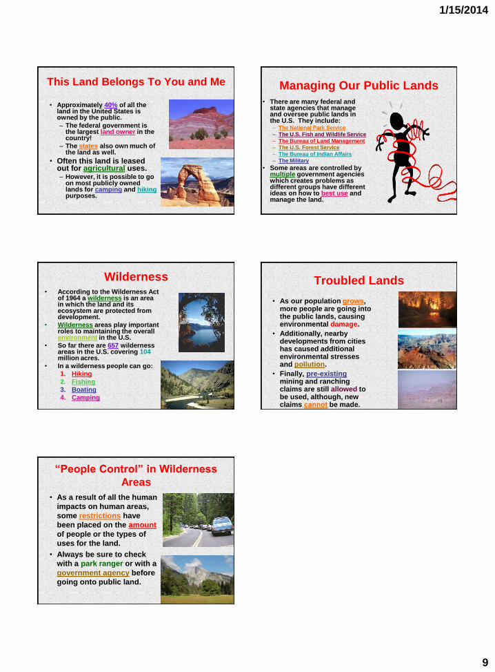
This Land Belongs To You and Me
• Approximately 40% of all the land in the United States is owned by the public.
– The federal government is the largest land owner in the country!
– The states also own much of the land as well.
• Often this land is leased out for agricultural uses. – However, it is possible to go
on most publicly owned lands for camping and hiking purposes.
Managing Our Public Lands
• There are many federal and state agencies that manage and oversee public lands in the U.S. They include: – The National Park Service
– The U.S. Fish and Wildlife Service
– The Bureau of Land Management
– The U.S. Forest Service
– The Bureau of Indian Affairs
– The Military
• Some areas are controlled by multiple government agencies which creates problems as different groups have different ideas on how to best use and manage the land.
Wilderness • According to the Wilderness Act
of 1964 a wilderness is an area in which the land and its ecosystem are protected from development.
• Wilderness areas play important roles to maintaining the overall environment in the U.S.
• So far there are 657 wilderness areas in the U.S. covering 104 million acres.
• In a wilderness people can go:
1. Hiking
2. Fishing
3. Boating
4. Camping
Troubled Lands
• As our population grows, more people are going into the public lands, causing environmental damage.
• Additionally, nearby developments from cities has caused additional environmental stresses and pollution.
• Finally, pre-existing mining and ranching claims are still allowed to be used, although, new claims cannot be made.
“People Control” in Wilderness
Areas
• As a result of all the human
impacts on human areas,
some restrictions have
been placed on the amount
of people or the types of
uses for the land.
• Always be sure to check
with a park ranger or with a
government agency before
going onto public land.