1
भूजल सूचना पुस्तिका बााँका स्जला, बबहार
Ground Water Information Booklet Banka District, Bihar State
केन्द्रीय भमूिजल बोर्ड जल संसाधन िंत्रालय (भारि सरकार) िध्य-परू्वी क्षेत्र पटना
Central Ground water Board Ministry of Water Resources
(Govt. of India) Mid-Eastern Region
Patna
मसिंबर 2013 September 2013
SHAMBHUGANJ
AMARPUR
RAJAUN
BANKA
BELHAR
DHURAIYA
BARAHAT
BAUSI
KATORIA
CHANDAN
PULLIDUMAR
District Boundary
Block Boundary
Road
Railway
River
Block Head-quarter
Exploratory Tubewell
Hydrogroph Network Station
ADMINISTRATIVE MAP BANKA DISTICT, BIHAR
N
S
W E
B H A G A L P U R
M
U
N
G
E
R
D U
M
K A
D E O G H A R
J
A
M
U
I
G
O
D
D
ABADUA RESERVOIR
BA
DU
A N
.
CH
AN
DA
N R
.
BU
RIG
ER
IA N
.
Km.5 5Km.0
Scale
LEGEND
86°-45' 87°-0'
86°-45' 87°-0'
24°
45'
25°
0'
24°
45'
25°
0'

2
PREPARED BY - Shri S. Tarafdar, STA (HG)
UNDER SUPERVISION OF - Shri A.K.Agrawal, Scientist’D’
CARTOGRAPHY - Shri Lokendra Kumar, Draughtsman
UPDATED BY - Shri S.N. Dwivedi, Sc - C & Dr. Fakhre Alam, STA(Hg)

3
Ground Water Information Booklet Banka District, Bihar
CONTENTS
Sl.No TITLES PAGE NO.
1.0 Introduction (Administration, Drainage, irrigation Practices, activity by CGWB)
6-8
2.0 Rainfall and Climate 8 3.0 Geomorphology and Soil types 8-9 4.0 Ground Water Scenario 9-13 4.1 Hydrogeology 4.2 Ground Water Resources 4.3 Ground Water Quality 4.4 Status of Ground Water Development 5.0 Ground Water Management Strategy 13-14 5.1 Ground Water Development 5.2 Water Conservation and Artificial Recharge 6.0 Ground Water related issue and problems 14 7.0 Mass Awareness and Training Activity 14 7.1 Mass Awareness Programme(MAP) & Water Management
Training Programme by CGWB
7.2 Participation in Exhibition, Mela, Fair
7.3 Presentation and lecture delivered in public forum/Radio/T.V etc.
8.0 Area Notified by CGWB/SGWA 15 9.0 Recommendations 15
FIGURES 1.0 Index Map showing location of block’ HQ, boundary,
drainage, location of EW, Pz, GW observation wells of CGWB
2.0 Hydrogeological map (showing water bearing formations, yield potential, bore well statistics, high yield bore well, lineaments.
3.0 Pre monsoon depth to water level map May 2006 4.0 Post monsoon depth to water level map November
2006
5.0 Block-wise Stage of Ground Water Development
TABLES 1.0 Landuse category of the district Banka. 2.0 3.0
Dynamic ground water resource of Banka district(as on 31March 2009). Chemical parameters & range of major constituents in ground water.
4.0 Feasibility of ground water structure in Banka District.

4
BANKA DISTRICT AT A GLANCE
Sl. No.
ITEMS Statistics
1. GENERAL INFORMATION i) Geographical area (SqKm) 3019
Administrative Division i) Number of Tehsil/ Block 11 ii) Number of Punchyat/Villages 199/2131 iii) Population (As on 2011 Census) 2029339 iv) Average Annual Rainfall (mm) 1168
2. GEOMORPHOLOGY Major physiographic unit :
Alluvial Plain,Hills & Pediments
Major Drainages:
Chandan,Badua & Burigeria rivers
3. LAND USE (SqKm) a) Forest area: 460 b) Net area sown: 1460 c) Cultivable area: 1730
4. MAJOR SOIL TYPE
5. AREA UNDER PRINCIPAL CROPS 6. IRRIGATION BY DIFFERENT SOURCES
(Areas in Hectare and Number of Structures)
Area(SqKm)
Dugwell Tubewell/Borewell Tank/ponds
20 270 190
Canals 330 Other sources 340 Net irrigated area Gross irrigated area 1150
7. NUMBER OF GROUND WATER MONITORING WELLS OF CGWB (2011)
No of Dug wells 9 No of Piezometers
9. HYDROGEOLOGY Major Water bearing formation
Quaternary Alluvium, Granite Gneiss
(Pre-monsoon Depth to water level during 2011) m bgl.
2.85-8.76
(Post-monsoon Depth to water level during 2011) m bgl.
1.62-5.55
Long term water level trend in 10 yrs (2002-2011) in m/yr

5
10. GROUND WATER EXPLORATION BY CGWB (As on 31-03-2013)
No of wells drilled (EW, OW, PZ, SH, Total) 20,3, ,4 Depth range (m) Discharge(m3/hr)
54 to 202 m 60 to107m3/hr
Storativity (S) 2.75 x10⁻³ to 4.75x10⁻³ Transmissivity (m2/day) 63 to 1265
11. GROUND WATER QUALITY Presence of Chemical constituents more than permissible limit (e.g EC, F, As, Fe)
Type of water Potable 12. DYNAMIC GROUND WATER
RESOURCES(as on 31st March 2009)- in mcm
Annual Replenishable Ground water Resources
42738
Net Annual Ground Water Draft 5791 Projected Demand for Domestic and industrial Uses up to 2025
4333
Stage of Ground Water Development(%) 38.4 13. AWARENESS AND TRAINING ACTIVITY NIL
Mass Awareness Programmes organized Date: Place: No of participant : Training Programmes organized Date Place No of participant
14. EFFORT OF ARTIFICIAL RECHARGE & RAIN WATER HARVESTING
Project completed by CGWB(No & Amount spent)
Project under technical guidance of CGWB (Numbers)
15. GROUND WATER CONTROL AND REGULATION
Number of OE Blocks Nil Number of Critical Blocks Nil Number of Blocks notified Nil
18 MAJOR GROUND WATER PROBLEMS AND ISSUES

6
“Ground Water Information Booklet” Banka district, Bihar
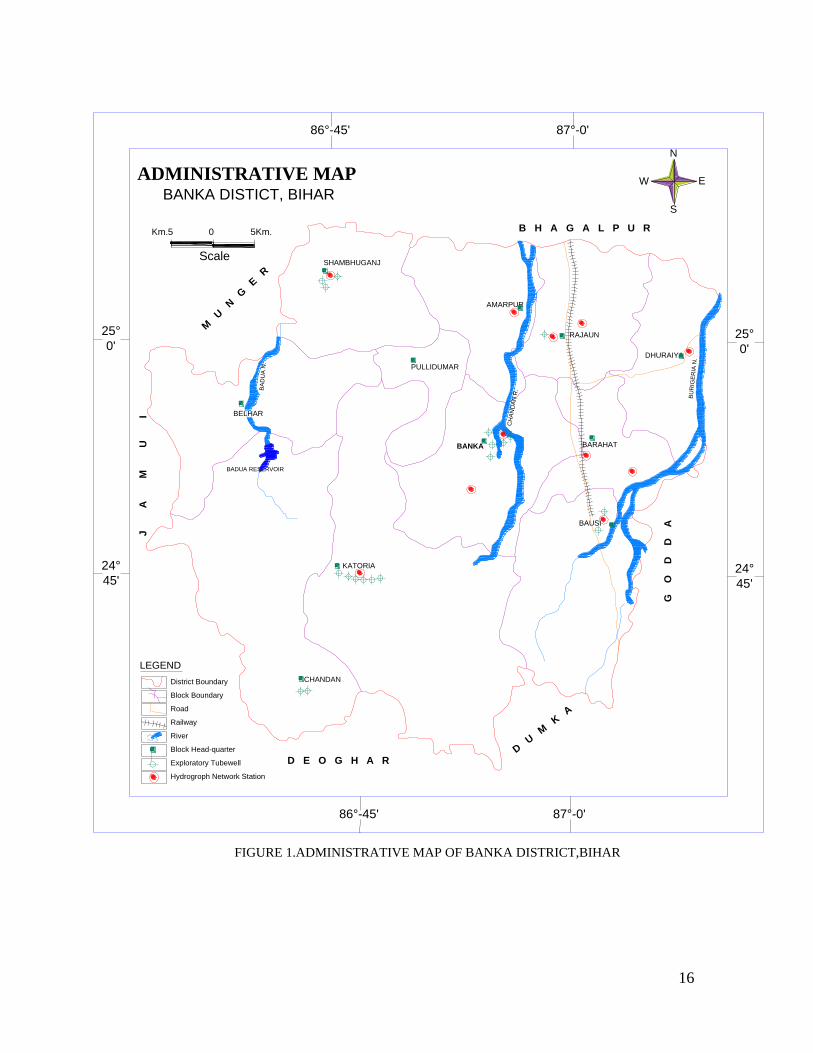
1.0 Introduction 1.1 Administration
Banka district was a sub-division of erstwhile Bhagalpur district and
was upgraded into a full-fledged district on 21st Feburary,1991. The
district lies between north latitude 24o30’0’’ to 25o 07’0’’ and east longitude
86o30’00’’to 87o12’00’’. It covers a parts the degree sheet number 72K,
72O, 72L and 72P of Survey of India. The geographical area of the district
is 3019.5 km2. It’s district Headquarter is in Banka town. The district is
bounded in the north by Bhagalpur, in the south by Deoghar, in the east
by Godda, in the west by Jamui, in the NW by Munger and in the
southeast by Dumka districts. There are 11 development blocks in the
district. It’s population is 2029339 (2011 census). There are two statutory
towns namely Banka and Amarpur. The most populous block is Dhuraiya
and the least populous is Phulidumar. The administrative map of the
district is given in Figure 1.
1.2 Basin/sub-basin, Drainage The Banka district lies in south of the river Ganga and constitutes a
part of the Ganga River Basin. It falls under Badua –Chandan sub-basin.
It has three watershed,namely Badua Nala ,Chandan river watershed and
the left bank watershed of Burigeria Nala. The major part of the district
falls under Chandan river watershed.
Three major rivers/nalas, namely Badua N.(forming the north
western boundary),Chandan R. which flows through the central part of the
district and the Burigeria N.(forming the eastern boundary of the district)
drains the area. All the three rivers/nalas originate from the hilly tracks
present in the south of the district and flows from south to north direction.
The streams namely Kudar, Orni, Panchkatia are the main tributaries of
Chandan,while Lohargara,Karunior,Belharna are the main tributaries of
Badua. All the rivers are ephemeral in nature.

7
1.3 Irrigation Practices The various major surface water irrigation schemes present in the district
are as follows:
1. Chandan Reservoir Irrigation Scheme
2. Kajia Danr Irrigation Scheme
3. Badua Reservoir Project-shambhuganj and Belhar blocks
4. Chandan,Bilasi Irrigation Scheme - Banka
5. Orhni Reservoir Irrigation Project – Banka ,Pullidumer
6. Laxmipur Reservoir Irrigation Project-Bounsi Block
The Chandan reservoir is major irrigation project in the Banka district.Its
command area falls in the Banka,Barahat,Rajaun and Dhuraiya block of Banka
district. The gross command area is 1.40 m ha. and the surface water irrigation
facility is available only to 0.64 m ha in kharif and 7690 ha during rabi (this is
inclusive of water directed from small structures like ahar etc.
As per the available statistics of 1994-1995, area irrigated by different sources
e.g canals,tubewells,dugwells,other sources etc. constitute 66% of the total
cultivated area in the district.canal is the most important source of irrigation in the
district. The area irrigated by ground water constitutes 9.44 %( private shallow
tubewells 7.9%, other wells 1.5%) of the gross irrigated.
The major landuse categories of the district are given in tabular form(Table.1)
Landuse Area(in hectare)
Forest 46000
barren and uncultivable land 43000
Land under non-agricultural uses 42000
Permanent pasture and grazing land 2000
cultivable waste other than fallow 8000
source : 1999 directorate of statistics and evaluation,Bihar,Patna)
1.3 Studies/ activities carried out by CGWB Central Ground Water Board issued a report unpublished report on
Hydrogeological condition, Ground Water Resources and development potential

8
of Bhagalpur district in the year 1985 (unpublished report C.G.W.B) . Quaternary
geology and geomorphology mapping of parts of Chandan-Badua sub-basin in
undivided Bhagalpur district was carried out by Geological Survey of India in the
year 1990.
The district was covered under reappraisal survey during 1995. Under
Ground Water Exploration 20 EW and 2 OW were constructed through
departmental Rigs by CGWB. One of the EW at Jagatpur, Banka block, had been
abandoned. Nine Hydrograph Network Stations (HNS) are being monitored four
times in a year as per the ground water regime-monitoring plan of Central
Ground Water Board.
2.0 Rainfall and Climate The climate of the district is characterized by hot summer and a pleasant
winter. April to June comprises summer month while November to March makes
cold season. The southwest monsoon breaks in the month of June and continues
upto the end of September. The average annual rainfall in the district is 1168
mm. The district receives major amount (86%) of precipitation during the
monsoon period.
3.0 Geomorphology and Soil 3.1 Geomorphology
The district can be broadly divided into two broad physiographic division
viz. alluvial plain in the north and the hilly track in the south. The regional slope
from south to north is prominent. The west of the alluvial plain of the river Ganga
is bordered by the Munger-Kharagpur hills. The hills of the district are generally
moderate in height, denuded and irregularly scattered.Geomorphologically the
area is being divided into five distinct units.These units given below are in
chronological order from youngest to oldest.
1) Diara Surface: It is the youngest morpho-unit of the area comprising of
yellow-brown to brownish-grey compact clay. It is the recent flood plain
of the major rivers passing through the district.
2) Belhar Surface: It is a flat alluvial low land usually free from regular
annual flooding, but is prone to water logging in the patches. The
9
surface overlies the recent flood plain surface .The soil is buff to brown
colour and rich in silt, sand or silty clay.
3) Sautadih Surface: The surface belongs to the older alluvial upland
bordering the pediplains and the hilly area. The soil profile is well
developed and characterised by deeply oxidesed yellow to brownish
red clay with ferruginous concretions.
4) Pediplain Surface: The surface borders the northen margin of the
distrct. These rocky units are essentially produced by the erosional
process. The surface has developed primarily on the granite gneisses
and is characterized by lack of good soil profile and colluvial deposits
of weathered material.
5) Hilly /Rocky upland: This includes the hilly area of the Chotanagpur
plateau, consisting of granite gneiss, quartzites, phyllites and mica
schist.
3.2 Soils Banka district is characterized by a wide variety of soils, which can be
broadly grouped into two categories, the alluvial soil and hilly soil. The
alluvial soil derived partly from the older alluvium deposit and partly
form the newer flood plain deposit is characterized by light grey to dark
grey colour and fine texture. The hilly soil derived from the weathered
product of rocks is coarse grained, ferruginous, low in nitrogen
,medium to high potash and acidic in nature.
4.0 Ground Water Scenario 4.1 Hydrogeology The Banka district can be sub-divided broadly into two hydrogeological
units.(figure-2)
1) Alluvial Formation: It occupies the northern part of the district.The
Quaternary alluvial deposits consisting of sand ,silt and clay forms a
good repository of the ground water. The ground water occurs in the
porous material under both unconfined and semi-confined to confined
conditions depending on the disposition of aquifers.
10
2) Fissured Formation: The fissured formation constitutes the
Chotanagpur Granite Gneissic Complex and meta sedimentaries.
Ground water occurs in these rocks under confined to semi-confined
conditions. The secondary porosity e.g. fractures,joints and fault
planes acts as aquifer and controls the storage and movement of
ground water.
Ground water in the alluvial track of the district
The thickness of Quaternary Alluvial deposit generally ranges from 15m to
100m in the northern part of the district. The maximum depth to bedrock is at
Raipura which is 99m.The sandy layers in the alluvial terrain form the main
repository of ground water in the northern part of the district. The thickness of
alluvial deposit increases from south to north. Ground water usually occurs under
both unconfined conditions in aquifer disposed at shallower depth and under
semi-confined to confined condition at deeper depths. The thickness of granular
zone ranges between 18-25 m at a depth ranging between 50 and 99 m below
ground level. The yield ranges between 60m3/hr to 124 m3/hr for a drawdown of
21 m and 8.00 m respectively. The available data indicate that in Shambhuganj
block there exist a number of granular zones in shallow and deeper levels. In this
block there is a wide scope of ground water development through shallow
tubewells upto 50m depth. The deep tube wells up to 100m depth may give a
discharge of 75-100 m3/hr. The exploratory data indicate that there is a wide
variation of the transmissivity value which varies from 63.7 m2/day at Khirri to
1265 m2/day at Rudpai.The transmissivity is found to be increasing towards
northwestern part of the district, where the thickness of the aquifer is also more.
The storage co-efficient value as estimated has been 2.75 x 10⁻³ at Warshabad,
which shows that aquifer are under semi-confined condition.
Ground water in the hard rock formation
As the southern part of the district is underlain by Precambrian formations, the
movement, occurrence and distribution of the ground water is primarily controlled
11
by nature and distribution of joints, fissures and other structural zones of
weakness. At places the granites and meta-sedimataries are weathered and
extensively jointed. Ground water occurs in this weathered formation in
unconfined condition, Whereas the deeper fracture within the hard rocks also
form a very good repository of ground water.
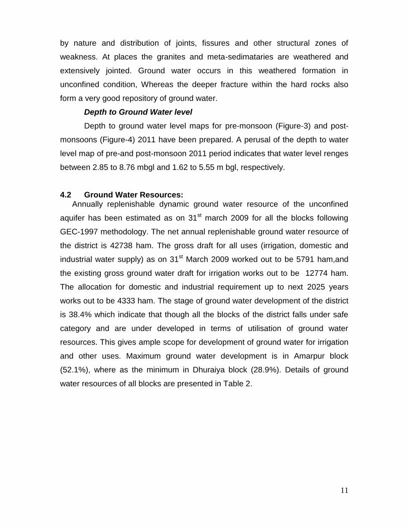
Depth to Ground Water level
Depth to ground water level maps for pre-monsoon (Figure-3) and post-
monsoons (Figure-4) 2011 have been prepared. A perusal of the depth to water
level map of pre-and post-monsoon 2011 period indicates that water level renges
between 2.85 to 8.76 mbgl and 1.62 to 5.55 m bgl, respectively.
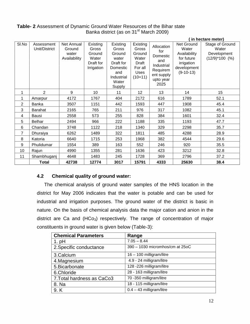
4.2 Ground Water Resources: Annually replenishable dynamic ground water resource of the unconfined
aquifer has been estimated as on 31st march 2009 for all the blocks following
GEC-1997 methodology. The net annual replenishable ground water resource of
the district is 42738 ham. The gross draft for all uses (irrigation, domestic and
industrial water supply) as on 31st March 2009 worked out to be 5791 ham,and
the existing gross ground water draft for irrigation works out to be 12774 ham.
The allocation for domestic and industrial requirement up to next 2025 years
works out to be 4333 ham. The stage of ground water development of the district
is 38.4% which indicate that though all the blocks of the district falls under safe
category and are under developed in terms of utilisation of ground water
resources. This gives ample scope for development of ground water for irrigation
and other uses. Maximum ground water development is in Amarpur block
(52.1%), where as the minimum in Dhuraiya block (28.9%). Details of ground
water resources of all blocks are presented in Table 2.
12
Table- 2 Assessment of Dynamic Ground Water Resources of the Bihar state Banka district (as on 31st March 2009)
( in hectare meter)
Sl.No Assessment Unit/District
Net Annual Ground water
Availability
Existing Gross
Ground Water
Draft for Irrigation
Existing Gross
Ground water
Draft for Domestic
and Industrial
Water Supply
Existing Gross
Ground Water Draft
For all Uses
(10+11)
Allocation for
Domestic and
Industrial Requirement supply upto year
2025
Net Ground Water
Availability for future irrigation
development (9-10-13)
Stage of Ground Water
Development (12/9)*100 (%)
1 2 9 10 11 12 13 14 15
1 Amarpur 4172 1767 404 2172 616 1789 52.1
2 Banka 3507 1151 442 1593 447 1908 45.4
3 Barahat 2165 765 211 976 317 1082 45.1
4 Bausi 2558 573 255 828 384 1601 32.4
5 Belhar 2494 966 222 1188 335 1193 47.7
6 Chandan 3748 1122 218 1340 329 2298 35.7
7 Dhuraiya 6262 1489 322 1811 485 4288 28.9
8 Katoria 6640 1715 253 1968 382 4544 29.6
9 Phulidumar 1554 389 163 552 246 920 35.5
10 Rajun 4990 1355 281 1636 423 3212 32.8
11 Shambhuganj 4648 1483 245 1728 369 2796 37.2
Total 42738 12774 3017 15791 4333 25630 38.4
4.2 Chemical quality of ground water:
The chemical analysis of ground water samples of the HNS location in the
district for May 2006 indicates that the water is potable and can be used for
industrial and irrigation purposes. The ground water of the district is basic in
nature. On the basis of chemical analysis data the major cation and anion in the
district are Ca and (HCo3) respectively. The range of concentration of major
constituents in ground water is given below (Table-3):
Chemical Parameters Range
1. pH 7.05 – 8.44
2.Specific conductance 390 – 1030 micromhos/cm at 25oC
3.Calcium 16 – 100 milligram/litre
4.Magnesium 4.9 - 24 milligram/litre
5.Bicarbonate 128 -226 milligram/litre
6.Chloride 28 - 163 milligram/litre
7.Total hardness as CaCo3 70 -350 milligram/litre
8. Na 18 - 115 milligram/litre
9. K 0.4 – 43 milligram/litre

13
4.3 Status of Ground Water Development- Block wise In Banka district the stage of ground water development is 38.4%(Figure-5).
The low utilization of ground water for irrigation in the district can be visualized
The structures like dug well, private shallow tube well, deep tube well are the
main source of ground water abstraction structures.Till the year 1995 state
tubewell existed in the district. However,eight exploratory wells constructed in the
alluvial tracks of the district by CGWB ,opened new avenue for ground water
utilization. Surface water irrigation plays important role in providing assured
irrigation in the district.
Only the towns have drinking water supply. The rural area depends on dug
well,private shallow tubewells,river hand pumps and ponds for drinking water
purposes.
5.0 Ground Water Management Strategy 5.1 Ground Water Development
A perusal of Table 2 indicates that most of the blocks have low ground
water development except Amarpur, Banka, Belhar & Barahat blocks which
have the stage of ground water more than 40%. As per the available record the
present utilization of ground water for irrigation is low as compared to the surface
water. Surface water canal is the most important source of irrigation. In the
pediplain the large diameter dug wells should be preferred to tubewell. The tube
well site should be scientifically located after hydrogeological and geophysical
studies. A shallow tube well can yield upto 25m3/hr discharge.
In the alluvial tracks shallow tubewell upto a depth of 50m may yield 50 m3/hr by
tapping the granular zones thickness. A deep tube well of 100m depth may yield
upto 75-100 m3/hr (Table 4).

14
Table 4. Feasibility of Ground Water Structures in Banka district.
Type of
Structure
Diameter(m) Depth
range(m)
Expected
thickness
of aquifer
/fracture
Expected
yield
range(m3/hr)
Command
area(Ha)
Hydrogeological
setting
Dug well 3 10-15 2-3 5 0.5 Alluvial plain/Granite
gneiss
Shallow
Tube well 100 40-50 10-15 40-50 5
Alluvial Plain/ Granite
gneiss
Deep tube
well 150 75-100 15-25 75-100 10-12 Alluvial Plain
Shallow
bore well 125 40-50 5-10 15 15
Pediplain/Granite
gneiss
Deep bore
well 150 100-125 10-20 25-30 5 Granite gneiss
5.2 Water Conservation and Artificial Recharge As the southern portion of the district is dominantly hilly and is surrounded
by gently sloping pediment surfaces, there is ample scope to conserve water by
water conservation structures like contour bunds, tanks and ponds. Construction
of any water conservation structure should be done after taking into
consideration the local topography, slope, depth to ground water level and public
participation. By these conservation structure will help recharge ground water.
6. 0 Ground water related issue and problems: Water-Logging and Flooding: The alluvial plain of the district is by and large
free from any major flood or water logging problems. But due to excessive load of
sediments in the streams during the peak monsoon, flash flood occurs in the
district. Most affected blocks are Banka, Rajaun and Amarpur.
Low ground water development: The overall stage of ground water
development in the district 32.7% which is very low and the contribution of
ground water towards irrigation is minimal.
7. 0 Mass Awareness and Training Activity: 7.1 Mass Awareness Programme: No mass awareness and training activitie have been carried out in this district.

15
8.0 Area notified by CGWA/SGWA All blocks of Banka district are under safe category for ground water
development point of view. So far no block has been notified by either Central
Ground Water Board or by State Ground Water Authorities.
9.0 Recommendation (1) Keeping in view the fact that huge volumes of ground water exist, a
ground water development plan may be taken up. In the hard rock
gneissic terrain large diameter dug wells are preferred to borewell.
However, with proper scientific approach shallow borewell of 40-50 m
depth and deep bore well of 100-125 m depth are feasible in gneissic
rocks. In alluvial area shallow tubewell upto 50m depth is preferred as
compared to dugwell. The shallow tubewell can yield 50m3/hr, while deep
deep tubewell upto a depth of 100 m (specially in Shambhuganj block) can
yield upto 100 m3/hr.
(2) In Chandan Badua command area conjunctive use of surface and ground
water may be practiced.In Shambhuganj block the augmentation of canals
by ground water resource can be done and a portion of surface water can
be diverted to adjacent areas where ground is scarce.
(3) Artificial recharge in the hilly and pedimental landscape area should be
taken up by consideration the post monsson ground water level. As it can
be observed from the post monsoon water table map ,the southern area of
blocks Chandan and Katoria blocks are suitable for articial recharge.
(4) Flooding in the district can be minimized by constructing a series of check
dams and gully head plugs.
16
SHAMBHUGANJ
AMARPUR
RAJAUN
BANKA
BELHAR
DHURAIYA
BARAHAT
BAUSI
KATORIA
CHANDAN
PULLIDUMAR
District Boundary
Block Boundary
Road
Railway
River
Block Head-quarter
Exploratory Tubewell
Hydrogroph Network Station
ADMINISTRATIVE MAP BANKA DISTICT, BIHAR
N
S
W E
B H A G A L P U R
M
U
N
G
E R
D U
M
K A
D E O G H A R
J
A
M
U
I
G
O
D
D
A
BADUA RESERVOIR
BA
DU
A N
.
CH
AN
DA
N R
.
BU
RIG
ER
IA N
.
Km.5 5Km.0
Scale
LEGEND
86°-45' 87°-0'
86°-45' 87°-0'
24°
45'
25°
0'
24°
45'
25°
0'
FIGURE 1.ADMINISTRATIVE MAP OF BANKA DISTRICT,BIHAR

17
B H A G A L P U R
M
U
N
G
E R
D U
M
K A
D E O G H A R
J A
M
U
I
ShambhuganjAmarpur
Chandan
BANKA
Bausi
Katoria
Belhar
Rajun
Dhuraiya
Barahat
1200
1100
900
1000
900 1000
1100
1200
HYDROGEOLOGICAL MAP
BANKA DISTRICT, BIHAR
Km.5 5Km.0
Scale
86°-30' 86°-45' 87°-0'
25°
0'
24°
45'
24°
30'
86°-30' 86°-45' 87°-0'
25°
0'
24°
45'
24°
30'
AGE GROUP LITHOLOGY HYDROGEOLOGICAL
CONDITION
GROUNDWATER
POTENTIALPOROUS FORMATION
Recent Alluvium, Clay, Silt,
Sand, Gravel, Calcareous
concretions etc.
FISSURED FORMATION
Granite-Gneiss, Biotite-Gneiss
Hornblend-Gneiss Amphibolite
Ouartzite, Mica-Schist
HYDROGEOLOGICAL FEATURES
Quaternary
Pre-CambrianGroundwater restricted to
Weathered residium and frac -
tured zone down to 125 m.
Moderately thick Regionally
Extensive UnConfined to
con-fined aquifer down to 90m.
Large Yield Prospect
40-100 m3/hr.
Large Yield Prospect
below 25 m3/hr.
Lineament
CGWB Exploratory Well
River and Stream
Raingauge Station
Observation Well
Isohyetal Contour (mm)1000
N
S
W E
G O
D
D
A
BADUA RESERVOIR
BA
DU
A N
.
CH
AN
DA
N R
.
BU
RIG
ER
IA N
.
Tronsmissivity
(m2/day)
Discharge
(m3/hr.)
StorativityDepth
(m)
LEGEND
107 252
59 4.75
60 63
59
FIGURE 2. HYDROGEOLOGICAL MAP OF BANKA DISTRICT,BIHAR

18
Fig. 3 Depth to water level map of pre-monsoon 2011.

19
Fig. 4 Depth to water level map of post-monsoon 2011

20
Fig. 5 Block-wise stage of ground water development of the district


![x अनुक्रमांक 32906 13 141025] प्रश्न पुस्तिका संख्या - Untitled](https://static.cupdf.com/doc/110x72/63212287b71aaa142a041ab9/x-32906-13-141025-.jpg)